Grimbosq Battlefield Tour RMD and our UK contingent are working up a scenario about the battle of the Grimbosq bridgehead in Normandy.
|
|
|
- Amy Chambers
- 5 years ago
- Views:
Transcription

1 Grimbosq Battlefield Tour RMD and our UK contingent are working up a scenario about the battle of the Grimbosq bridgehead in Normandy. We wargamers often forget that when we push our toys around the table, the actual battle was fought over real towns, hills, and rivers, and some of the scars of these battles still are visible. Mr. Davies took a tour of this battlefield and made lots of photographs to show what the battlefield really looks like. The first few photos show where the photos were taken.
2

3 Here are the photos themselves 01 The valley of the River Orne was a considerable military obstacle, with very few practicable crossing points for a modern, mechanised army. This photo, taken at Clécy, a few miles upstream from Grimbosq and Thury- Harcourt, clearly demonstrates how defensible some crossing points on the Orne were. 02 As 01 above.
4 03 The southern half of the bridgehead at the villages of Le Bas and Brieux, seen from British positions west of the Orne. 04 As 03, but looking toward the south and Thury-Harcourt.

5 05 As 03, but zoomed in on Le Bas and Brieux. 06 The café at the western end of the Le Bas bridge.
 is exactly the same as it was in 1944.")

6 07 The same spot as 06, but looking east, across the bridge. The large building (a former water mill) is exactly the same as it was in The railway crossing is also still as it was. 07a The bridge as it appeared in Note the light Bailey Bridge spanning the blown span. This Bailey bridge was sufficient to get light vehicles across, but a heavier Bailey had to be built alongside the original bridge in order to get tanks across.


7 08 The same spot as 06, but looking north, down the Orne valley. It was in the further field that the first ford was found by the Staffordshire infantry. 09 The same spot as 06, now looking south, up the Orne Valley.


8 10 This photo was taken from the fallen telegraph pole visible in 09. Again, I m looking south, up the Orne valley. Note the large pool created by the weir for Le Bas hydro-electric power station. 11 Moving on to Le Bas bridge, there is this small memorial on the parapet. This is the only memorial to the Battle of Grimbosq.


9 12 A closer view of the old mill and railway halt at Le Bas. 12a The bridge and old mill seen in 1944 from the heavier Bailey bridge on the southern side. As can be seen, this was a Class 40 bridge, which meant that Churchill tanks could now cross over into the bridgehead.


10 13 The Le Bas hydro-electric power station and weir, as seen from Le Bas bridge. It might look modern, but it is clear from RAF recce photos that this was here in Looking north, down the Orne from Le Bas bridge. The infantry first forded the Orne at the far bend in the photo. The river was quite deep and fast when we visited, so it was hard to imagine how they managed it! This photo gives a very good impression of the deep, steep-sided and thicklywooded Orne valley, which formed such a considerable military obstacle.
11 15 Having moved east from the bridge to Le Bas, up a deep sunken road, we turned left (north) into open fields and paused to take a few photos of the southern half of the bridgehead. Here we look back at Le Bas village. It is most noticeable that there has been almost no development since 1944 the houses and village/farm layouts are largely the same and the field boundaries and woods are still much where they were. The orchards have thinned out somewhat, however.
12 16 The same spot as 15, but lookin back across the Orne to Goupillières village on the British-held high ground to the west. I took 03, 04 and 05 from the edge of the thick woods to the right of the photo.
13 17 Much the same photo as 16, but panned slightly to the right now looking due west across the Orne.
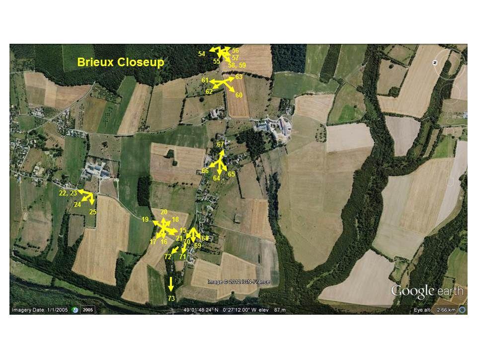
14 18 The same spot as 15, but looking south-east to Brieux. The high ground of the Forêt du Grimbosq, from where Kampfgruppe Wüsche launched its attack, is visible in the background.
15 19 The same spot as 15, but looking north toward Grimbosq. The thick patch of isolated woodland on the right is exactly the same as it was in Much the same photo as 19, but panned slightly to the right, looking due west toward the Forêt du Grimbosq.

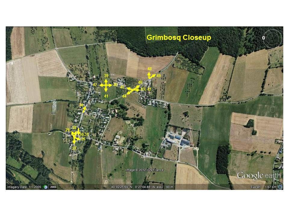
16 21 The same spot as 15 again; I stood here for quite a while! Now looking due south, back down the road to Le Bas. 22 At last I ve moved on, northwards to the farm at the southern edge of Grimbosq village.


17 23 The same spot as 22, but zoomed in on the roadsign! 24 The same spot as 22, but looking north-west, toward the large chateau on the western bank of the Orne.

18 25 Much the same photo as 24, but panned slightly to the left, now looking west.

19 26 Now in Grimbosq itself, here is the tower at the western end of Grimbosq church.


20 27 The same spot as 26, looking west. Note that the ground drops quite steeply away. Note the cemetery on the slope many graves lie shattered and scarred by shot and shell. 28 The same spot as 26, looking east, past the Mairie on the left and the church on the right (and wife and dad!).

21 29 Much the same spot as 28, looking north-east to the Mairie, which looks as it did in Moving to the eastern end of the church, the WW1 war memorial looks as though it was Professionally Painted (in ebay terminology).

22 31 The war memorial is liberally peppered with damage from bullets coming from the German-held high ground to the east.

23 32 Similarly, the eastern end of the church is peppered with bullet-holes and scars from shell-splinters.

24 33 The same spot as 31, looking east, up the main street of Grimbosq, which is barely changed from how it looked in 1944.

25 34 More battle-damage on the south-eastern corner of the church.

26 35 More bullet-strikes can be seen on the WW1 shell-cases surrounding the war memorial.
27 36 As 35.

28 37 This is the front door of the building seen at the left in 28. A large chunk of stone has been knocked out of the door-pillar by a shell-splinter, which is still lodged deep in the stone.

29 38 We are now moving east up Grimbosq s main street. Again, this would undoubtedly be familiar to anyone who was here in 1944.
30 39 Now standing at the south-eastern corner of Grimbosq, we look eastward, through the remnants of a heavily-shelled orchard, to the threatening Forêt du Grimbosq, which is now only 200m away. This area of the forest was very heavily shelled during the battle; the trees were largely wiped off the map and had to be re-planted after the war.

31 40 The same spot as 39, looking south along the road toward the calvary. 41 The same spot as 39, looking west, across Grimbosq and the Orne, to the British-held heights beyond the western bank.


32 42 The same spot as 39, looking north, at the western end of Grimbosq. 43 Moving south, we come to the calvary at the crossroads between Grimbosq and Brieux. Like the war memorial, the stonework of the calvary bears the scars of battle.


33 44 The same spot as 43, looking north-west, in the direction of Grimbosq church. Note the fully-planted orchard the entire area was filled with orchards like this in The same spot as 43, looking north, back along the way we have come, toward Grimbosq. Note that the barn is the same one visible in 40.


34 46 The same spot as 44, looking south-east, along the road to the Forêt du Grimbosq, where we are going next. Here there is some rare new building development, built on what was orchard in A closeup of the battle-damage on the calvary.

35 48 Moving slightly south-east, we pause to take a photo of the No-Man s Land between the Forêt du Grimbosq and the eastern edge of the village. This area was subject to tremendous DF missions from the Royal Artillery, and these are consequently young trees that have re-grown since the war.

36 49 The same spot as 48, but looking south-east, along the road into the forest. 50 Moving up to the crest of the forest, it is now obvious from the small girth of the trees, that this has been re-grown since the war, due to the volumes of British DF artillery fire missions directed into this area.

37 51 The forest was and is a very densely-planted hunting park, with plenty of undergrowth and cover for game animals. Wünsche s panzers were therefore restricted to one of two roads or a number of parallel rides running east-west through the forest (this being one of them).

38 52 As we reach the crest of the ridge, the trees are obviously more mature, having been subjected to less artillery fire than the area closer to Grimbosq village. This gives a better impression of how the forest must have looked to Wünsche s men, as they passed along this road.


39 53 Having reached the t-junction with the main road running east out of Brieux, we turn right, to follow Wünsche s main axis of attack into Brieux. 54 One of the more overgrown rides through the forest.


40 55 The same spot as 54, just inside the forest, looking west toward Brieux. 56 At the edge of the forest east of Brieux, this is where the bulk of Wünsche s vehicles must have emerged from the forest.


41 57 The same spot as 56, looking south-west. 58 The same spot as 56, again looking south-west at a large farm on the south-eastern corner of the British bridgehead.

42 59 The same spot as 56, again looking south-west. 60 Moving down the road toward Brieux, we emerge from the forest into No-Man s Land.


43 61 The same spot as 60, looking north-east, back toward the forest. Note the scattered apple-trees this was a far denser orchard in The same spot as 60, now looking due north, again through the old orchard. Des vaches Normandes!

44 63 The same spot as 60, now looking due south. 64 We ve now moved down the hill, through Brieux, and are now looking west from Brieux toward Le Bas.

45 65 The same spot as 64, looking south. It was somewhere in this area that Captain Jamieson of the Royal Norfolks won his VC, standing on a Churchill tank under enemy fire and indicating targets to the tank commander. 66 The same spot as 64, looking north-west, past the western edge of Brieux, toward the Orne valley.

46 67 The same spot as 64, looking east, back up the hill, through Brieux. 68 We ve now almost come full-circle and are back at Le Bas village. Here, we re standing on the main road at the northern edge of the village, looking south.


47 69 The same spot as 68, looking south-west toward Goupillières in the distance. 70 We re now driving back down the road from Le Bas to the bridge.


48 71 The crossroads at the bottom of Le Bas village. Ahead of us is the bridge and to the right is the road to Grimbosq that we took earlier. 72 The road from Le Bas to the bridge and railway halt cuts deeply down into the steep hillside. This was virtually the only vehicular exit from the bridge to the bridgehead.

49 73 The roadsign warns us of the railway crossing and ahead of us lies Le Bas bridge once again. The tour s over.
Lordenshaw. What are cup & ring marks?
 Lordenshaw Lordenshaw hill has one of the largest clusters of ancient cup and ring marked stones in the UK. We ve chosen four interesting spots we d like to share with you. What are cup & ring marks? The
BRANDENBURGERS IN TUNISIA
 BRANDENBURGERS IN TUNISIA 1942-43 BY MIKE HAUGHT Updated on 1 January 201 1 Brandenburgers Aloft In December 1942, British, American and Free French forces were closing in on the Axis forces in Tunisia
Ystwyth and Rheidol Bridleway Routes. Route 2:Llanilar Circular
 Ystwyth and Rheidol Bridleway Routes Route 2:Llanilar Circular Route overview and terrain: A long circle using connecting ridges with fine views to link the Rheidol and Ystwyth river valleys. The route
Ardennes 1944: 75 th Anniversary Battle of the Bulge Small Group Battlefield Tour 2-6 October, 2019
 Ardennes 1944: 75 th Anniversary Battle of the Bulge Small Group Battlefield Tour 2-6 October, 2019 The War seemed to be close to an end, but then Hitler s last major offensive on the Western Front took
CWMGIEDD FROM ABERCRAVE
 Abercrave to Cwmgiedd Walk Page 1 Starting from The Abercrave Inn. Grid Ref: SN 824128 From the Abercrave Inn, an 11.3km (7 miles) walk to the foothills of the Cribarth Mountain, then through forest to
Byelorussian Battlefields
 Byelorussian Battlefields All Flames Of War battles need terrain! Battles in the Second World War were rarely fought over open plains with unobstructed lines of sight. In Flames Of War, wide open tables
11/6/2018. The Battle of the Somme. 1 July Darkest Day in the History of the British Army. 1 July 18 November 1916
 The Battle of the Somme 1 July 1916 Darkest Day in the History of the British Army 1 2 The Battle of the Somme 1 July 18 November 1916 Battle began with a British preliminary artillery bombardment Last
Battlefield and Remembrance Tour
 Welcome This tour offers a rare opportunity to follow the 2 Lincolns during WWII. Based on actions covered in the Battalion history Mettle and Pasture published in 2016, the tour will be presented by author
Wicklow Mountains Path Survey
 Wicklow Mountains Path Survey Ballinacor Croaghanmoira Fananierin Start to Finish: T 11723 86602 to T 11175 89057 Altitude (lowest highest): 385m 664m Weather: Hot Access: Coolgarrow forest entrance Surveyed
Fort Ticonderoga Carillon Battlefield Walking Trail Guide
 Fort Ticonderoga Carillon Battlefield Walking Trail Guide Copyright Fort Ticonderoga. Photo Credit Carl Heilman II Length: Approximately 1¾ mile Welcome to Fort Ticonderoga s Walking Trail Blue markers
The Mendip Way. Route Directions and Maps Uphill to Wells
 The Mendip Way Route Directions and Maps Uphill to Wells Website: www.mendiphillsaonb.org.uk Email: mendip@mendiphillsaonb.org.uk Facebook & Twitter: @MendipHillsAONB Phone: 01761462338 1 Uphill to Loxton
A Possible Roman Road Discovered in Lanarkshire
 A Possible Roman Road Discovered in Lanarkshire In the eighteenth century, William Roy documented the Roman road network that provided communication between the Castledykes fort (near Carstairs, Lanarkshire)
Major Battles During WWII Events that Changed the Course of the War
 The Battle of Britain Major Battles During WWII Events that Changed the Course of the War With all of Europe under its control, as the last hold out The English Channel is only at the most narrow point
Leaden Boot Challenge ROUTE INSTRUCTIONS
 Leaden Boot Challenge ROUTE INSTRUCTIONS Section 1 Alstonefield to Ilam From the village hall car park turn R then L and pass through the village keeping to the R to enter Church Street. Pass the Church
Leaden Boot Challenge 2016 ROUTE INSTRUCTIONS
 Leaden Boot Challenge 2016 ROUTE INSTRUCTIONS Section 1 Alstonefield to Ilam (CP2) From the village hall car park turn R then L and pass through the village keeping to the R to enter Church Street. Pass
Investigative Report #2 Old Montauk Highway May 18, 1999
 archived as http://www.stealthskater.com/documents/montauk_trip_02.pdf more related documents at http://www.stealthskater.com/px.htm note: because important websites are frequently "here today but gone
DEFENCE AREA 48 CANEWDON
 DEFENCE AREA 48 CANEWDON 1. Area details: Canewdon is 8 miles N of Southend-on-Sea, 1 mile S of the River Crouch. County: Essex. Parish: Canewdon. NGR: centre of area, TQ 905945. 1.1 Area Description:
Canada s Contributions Abroad WWII
 Canada s Contributions Abroad WWII Battle of the Atlantic (1939-1945) Struggle between the Allied and German forces for control of the Atlantic Ocean. The Allies needed to keep the vital flow of men and
Pontfadog. Walk A. Walk A
 Walk A A Bird s eye view of the village 2km. (1 1 /2 miles); height gain 45m. (150ft) about 45 minutes. Six minutes walk along the main road towards Glyn Ceiriog reach a signpost to Llwynmawr. Take the
-2- The 34th moved up and the First Special Service troops pulled back to our position. I then moved out T.D.'s up to a position about one hundred yar
 On the offense from the Anzio beachead "A" Company was attached to the 3rd. Division and were assigned to the 601st. T.D. Bn. We' joined them late in the afternoon on May 23rd. on the road from Anzio to
ID: 283 Distance: 6.2 miles Height gain: 500 Metres Map: Explore OL 19 Contributor David and Chris Stewart
 Walkingworld Wild Boar Fell ID: 283 Distance: 6.2 miles Height gain: 500 Metres Map: Explore OL 19 Contributor David and Chris Stewart Features Birds, Great Views, Hills or Fells Description: Wild Boar
World War II Secret City Gates (As published in The Oak Ridger s Historically Speaking column on April 5, 2006)
") From 1943 to 1949 the city of Oak Ridge (fifth largest city in Tennessee) was not on any maps and existed as a secure gated community. The installation of fences and guard portals at the various roads
From 1943 to 1949 the city of Oak Ridge (fifth largest city in Tennessee) was not on any maps and existed as a secure gated community. The installation of fences and guard portals at the various roads
FOUNDATIONS OF ARCHAEOLOGY A WALK IN VERNDITCH CHASE
 FOUNDATIONS OF ARCHAEOLOGY A WALK IN VERNDITCH CHASE 1. A Tale of two Long Barrows Long barrows were constructed as earthen or drystone mounds with flanking ditches and acted as funerary monuments during
Sponsored by. statestreet.com
 /STATESTREETISLANDWALK #ISLANDWALKJSY Sponsored by statestreet.com Important Information If you forget everything else PLEASE remember the following.» Remember to check OUT of every checkpoint» If you
Beautiful Walks from the Blue Ball Inn
 Walk No. 2 WINSTONS WALK Countisbury, Wind Hill, Watersmeet, Ash Bridge and Winston s path. 5 Miles approx. Walking time- Two and a half hours approx. (Not including Breaks) OS 1:25,000 Sheet 64/74 Lynton
Use pages to answer the following questions
 Use pages 569-573 to answer the following questions 1.Why was winning the Battle of the Atlantic so crucial to the fortunes of the Allies? 2.Why was the Battle of Stalingrad so important? 3.Why did you
Jump Chart Main Chart flagship Ship List
 Getting Started This file helps you get started playing the game Jutland. If you have just finished installing the game, then the Jutland main program should be running soon. Otherwise, you should start
Wicklow Mountains Path Survey
 Wicklow Mountains Path Survey Glenmacnass Tonelagee Start to Finish: O 114 030 to O 085 016 Altitude (lowest highest): 370m 817m Weather: Sunny day, hot Access: Military Road, Glenmacnass Surveyed by:
Outdoor Education Worksheets
 Outdoor Education Worksheets OUTDOORS You will need: First Aid Kit Appropriate clothing for whole group (sunny/wet weather) Charged mobile phones and appropriate numbers of adult helpers in case of group
Hadleigh Castle and Chalkwell Oaze
 1 Hadleigh Castle and Chalkwell Oaze Benfleet station Hadleigh Park Hadleigh Castle Leigh-on-Sea Chalkwell station A short stroll through the lush woods of Hadleigh Park high above the Thames-side marshes,
DEFENCE AREA 73 FRESHWATER BAY
 DEFENCE AREA 73 FRESHWATER BAY 1. Area details: The defence area is 3½ miles from The Needles and 10 miles W of Newport. County: Isle of Wight. Parish: Freshwater. NGR: centre of area, SZ 346860. 1.1 Area
HARDMOORS 55 RACE ROUTE 2018 HELMSLEY - GUISBOROUGH
 HARDMOORS 55 RACE ROUTE 2018 HELMSLEY - GUISBOROUGH HELMSLEY - CHECKPOINT 1 (WHITE HORSE) 1. Leave RACE START, continue ahead on road (Baxtons Sprunt) At crossroads turn right down Canons Garth eventualy
Architectural Analysis in Western Palenque
 Architectural Analysis in Western Palenque James Eckhardt and Heather Hurst During the 1999 season of the Palenque Mapping Project the team mapped the western portion of the site of Palenque. This paper
D-Day. June 6th, 1944
 D-Day June 6th, 1944 The Move on to France Because the Germans were being fought in Italy, the allies planned to move forward with their plan to open up the western front in Europe The Plan Winston Churchill
DOWNLOAD OR READ : OVERLORD 6TH JUNE 1944 FREEDOM HARDCOVER BY SERGE SAINT MICHEL DRAWINGS PDF EBOOK EPUB MOBI
 DOWNLOAD OR READ : OVERLORD 6TH JUNE 1944 FREEDOM HARDCOVER BY SERGE SAINT MICHEL DRAWINGS PDF EBOOK EPUB MOBI Page 1 Page 2 overlord 6th june 1944 freedom hardcover by serge saint michel drawings overlord
O n the morning of May 20, 1941, hundreds of German planes appeared in
 O n the morning of May 0, 9, hundreds of German planes appeared in the Cretan sky. The invasion of Crete, codenamed Unternehmen Merkur, had just begun. About,000 German Fallschirmjäger were dropped onto
Daniel Morgan, Count Pulaski and General Lafayette were familiar figures
 The Willits-Andrews Farmstead (Pulaski Headquarters Site) is a Valuable, Nationally Recognized Local Landmark Daniel Morgan, Count Pulaski and General Lafayette were familiar figures The written history
HB/VD-034 La Dôle. February 22, 2015 Paul HB9DST
 HB/VD-034 La Dôle February 22, 2015 Paul HB9DST Summary: So many options, your choice will depend on conditions. As in previous hikes, most of the work is in the second half. Not a technically difficult
Newsletter - Winter 2017
 Newsletter - Winter 2017 Our next talk 'Pinebanks - the house and its history' by John Balls' Thursday 16th February - at the There will be a charge of 3 per person. Recent Events We have been enjoying
COWAL WAY MULTI-USE ACCESS NOTES
 COWAL WAY MULTI-USE ACCESS NOTES The Cowal Way is a 57 mile long distance path. Starting at Portavadie, it winds its way up through the Cowal peninsula via Tighnabruich, Glendaruel, Strachur, Lochgoilhead
Orienteering. The fundamental outdoors skill!
 The fundamental outdoors skill! Orienteering Nothing will make you feel more confident in the out of doors like knowing how to find your way in the woods. Orienteering Prepared by: Jeffrey Lybarger Assistant
NORMANDY TO THE BULGE
 1 75TH ANNIVERSARY OF THE D-DAY INVASION NORMANDY TO THE BULGE 11-NIGHTS IN EUROPE $6,490 PER PERSON BASED ON DOUBLE OCCUPANCY $1,250 SINGLE OCCUPANCY SUPPLEMENT IF ROOMING ALONE $300 PER PERSON DEPOSIT
Lava Mountain Trail Distance: Elevation Range: Trail Type: Difficulty: Season: Driving Distance: Driving Time: USGS Maps: Pros Cons
 Lava Mountain Trail Distance: 13.4 miles (including the side trip to North Star Lake) Elevation Range: 5900'-8330' Trail Type: singletrack Difficulty: moderate Season: late June-October Driving Distance:
General Summer and Winter Views
 ENVIRONMENTAL INFORMATION REPORT VOLUME 4 APPENDIX 11. 2 General Summer and Winter Views Table of Contents Section APPENDIX 11.2 Page 1 General Views... 1-1 Tansy Lane, Portishead... 1-2 Galingale Way,
SECTION 1: MARYLAND TO PA nd CROSSING MASON DIXON LINE TO RAINSBURG GAP BUCHANAN STATE FOREST, PRIVATE LAND, SGL 97
 SECTION 1: MARYLAND TO PA 326 2 nd CROSSING MASON DIXON LINE TO RAINSBURG GAP BUCHANAN STATE FOREST, PRIVATE LAND, SGL 97 Web Update, August 2010 http://www.hike mst.org Section 1 follows Tussey Mountain
SOPs for Cedar Valley Airport UT10
 SOPs for Cedar Valley Airport UT10 Cedar Valley Airport is a privately owned airport located approximately 10 miles west of Lehi, Ut and 5 miles northeast of Cedar Fort, UT. The airport location is N40.3572
DEFENCE AREA 39 DEANGATE RIDGE, HOO
 DEFENCE AREA 39 DEANGATE RIDGE, HOO 1. Area details: The defence area is 4 miles NE of Rochester and 8 miles E of Gravesend. County: Kent. Parishes: Hoo St. Werburgh / High Halstow. NGR: centre of area,
A Tour of the Valle del Gizio
 Walk 25 A Tour of the Valle del Gizio Walking time 5hrs 30mins (4hrs if Colle Mitra is omitted) Difficulty 2 (likely to be snowbound in winter months); 1 (if Colle Mitra is omitted) Ascent/descent 570m/570m
Darwin s gigantic blunder
 Trail Darwin s gigantic blunder Explore how ice shaped the landscape and why Charles Darwin made a nice mess of Glen Roy Time: 1hr 10 mins Distance: 2 miles Landscape: rural At Glen Roy a curious feature
Sites of Civil War Trails Signs The First Campaign, 1861, in the Mountains
 Sites of Civil War Trails Signs The First Campaign, 1861, in the Mountains (Website deactivated) The First Campaign, 1861, in the Mountains Virginia's western counties had little in common at the outset
TOP FUNDRAISING TIPS ON THE RIDE
 PEDAL TO PARIS 2018 TOP FUNDRAISING TIPS ON THE RIDE Social Media. - Post images of you setting off and throughout the ride and remind people what youʼre doing! - Post on your Facebook or Instagram story
ANZAC DAY ON THE WESTERN FRONT
 INFO PACK ANZAC DAY ON THE WESTERN FRONT The team at Pillow would like to say thank you for showing interest in our ANZAC Day tour on the Western Front. Whether you are visiting this history enriched area
The Teams and Their Plans
 The Setup Neither my Trinovantes nor my Spartans had had an outing recently and as their previous encounters had been over two years ago I thought it was time for them to have another opportunity to fight
BURGHCLERE PARISH RIGHTS OF WAY
 BURGHCLERE PARISH RIGHTS OF WAY Full descriptions compiled by Neill & Miggie Bruce All photos Miggie Bruce FP23 on Ridgemoor, looking south, with FP22 crossing by the bush FP1. From C183 Aldern Bridge
EL GHENESA (THE CHURCH) OF GEBEL KHALAK
 OF GEBEL KHALAK") Going through Gebel Khalak is a tradition for us, or better to say a well established habit. Whether coming down from the path of the oil getting along the old track of water or going around the ridge
Going through Gebel Khalak is a tradition for us, or better to say a well established habit. Whether coming down from the path of the oil getting along the old track of water or going around the ridge
IATA ECONOMIC BRIEFING DECEMBER 2008
 ECONOMIC BRIEFING DECEMBER 28 THE IMPACT OF RECESSION ON AIR TRAFFIC VOLUMES Recession is now forecast for North America, Europe and Japan late this year and into 29. The last major downturn in air traffic,
September Newsletter. Search for Ayios Georgios. Sharing experiences as we journey together
 Sharing experiences as we journey together Search for Ayios Georgios This is my third newsletter this year and comes 6 months after I published the last one. I decided to change the format for this edition
Ribbon Cliff - Ribbon Mesa text and photos by Charlie Hickenbottom
 Ribbon Cliff - Ribbon Mesa text and photos by Charlie Hickenbottom Looking for something a little different than Sage Hills or Saddlerock? Perhaps something a little wilder, a little less traveled? Look
Attractions. All In The Memorial The Memorial
 The Memorial 1815 The Memorial Buried at the foot of the Lion's Mound, the Memorial 1815 enables you to experience one of the most turbulent times in our History... as if you were there. Guided by a soldier
Anderson Mt. Proposed Wilderness Additions to the Rogue-Umpqua Divide Wilderness-- T30S R3E (mostly) Sections 4 & 9, and T29S R3E Section 33
 Sections 4 & 9, and T29S R3E Section 33") Anderson Mt. Proposed Wilderness Additions to the Rogue-Umpqua Divide Wilderness-- T30S R3E (mostly) Sections 4 & 9, and T29S R3E Section 33 When the 35,701 acre Rogue-Umpqua Divide Wilderness was designated
Anderson Mt. Proposed Wilderness Additions to the Rogue-Umpqua Divide Wilderness-- T30S R3E (mostly) Sections 4 & 9, and T29S R3E Section 33 When the 35,701 acre Rogue-Umpqua Divide Wilderness was designated
Channel Islands Occupation Society
 INTRODUCTION The subject of the Conservation Statement is Kempt Tower, built in 1834 in St Ouen s Bay, Jersey. The primary purpose of the statement is to draw together existing information, to set down
Beautiful Walks from the Blue Ball Inn
 Walk No. 5 RIVER VALLEYS AND MOOR Countisbury, Watersmeet, Hillsford Bridge, Cheriton, Shilstone Hill, Rockford and Chiselcombe. 8.5 MILES APPROX. Walking time four and a half hours approx. OS 1;25,000
The Remnant. Colton Harrell. Copyright (c) 2017
 2017") The Remnant By Colton Harrell Copyright (c) 2017 FADE IN: EXT. CAFE SIGN - NIGHT We see the flickering of an old cafe sign with the eerie buzzing coming from it. EXT. CAFE The night is quiet in the small
The Remnant By Colton Harrell Copyright (c) 2017 FADE IN: EXT. CAFE SIGN - NIGHT We see the flickering of an old cafe sign with the eerie buzzing coming from it. EXT. CAFE The night is quiet in the small
The Bridestone Rocks from Lydgate
 Print this page Back to results The Bridestone Rocks from Lydgate Ancient tracks and gritstone outcrops, with terrific views of the steepsided Cliviger Valley. Distance 5 miles (8km) Minimum time 2hrs
North Africa and Italy Campaigns
 North Africa and Italy Campaigns Why Fight in North Africa? The North African military campaigns of World War II were waged between Sept. 1940 and May 1943 were strategically important to both the Western
IST battlefields exhibition 2010
 IST Battlefields 2010. Page 1 IST battlefields exhibition 2010 Visitor Guide and Activity Pack Exhibition guide Introduction World War One took place between 1914-1918. During that time 20 million people
Guthega to Mt Twynam. 2183m. 1583m. 6 hrs 45 mins 14.8 km Return. Experienced only. 913m
 Guthega to Mt Twynam 6 hrs 45 mins 14.8 km Return Experienced only 5 913m This walk starts from Guthega and makes its way along the Snowy River to the Illawong Lodge, via the Blue Cow Creek flying fox.
LONDON TO PARIS CYCLE
 UK, FRANCE CYCLE CHALLENGING ABOUT THE CHALLENGE Cycling from London to Paris is one of the great cycle experiences in Europe. Passing through picturesque Kent countryside, we cross the Channel and continue
IRON BARK and COLENSO HUTS 260 Series Map: 1:50, U21 NZ Grid GPS: Geodetic Datum 1949
 IRON BARK and COLENSO HUTS 260 Series Map: 1:50,000 260-U21 NZ Grid GPS: Geodetic Datum 1949 Topo50 Map: BK36 Taoroa Junction GPS: on WGS84 How to get to START: Exit Taupo on SH1 down the lake to Turangi
beach. Make the ford and follow the trail out to the junction with Red Creek Tr in an open grassy area.
 Description: This is a moderate to slightly strenuous 22.8 mile backpack (add 2.6 miles if you do the packless out and back to the Lion s Head) that will have you exploring nearly every thing that is The
75TH ANNIVERSARY OF THE D-DAY INVASION
 1 75TH ANNIVERSARY OF THE D-DAY INVASION D-DAY TO THE RHINE 12-NIGHTS IN EUROPE $6,750 PER PERSON BASED ON DOUBLE OCCUPANCY $1,450 SINGLE OCCUPANCY SUPPLEMENT IF ROOMING ALONE $300 PER PERSON DEPOSIT TO
Hindhead, Keffolds Copse and Gibbet Hill
 point your feet on a new path, Keffolds Copse and Gibbet Hill Distance: 6 km=4 miles Region: Surrey Author: Schwebefuss Refreshments: Punch Bowl Café moderate walking Date written: 14-apr-2015 Last update:
Climbing Oak and Brushy Top Mountains
 Climbing Oak and Brushy Top Mountains Story and photographs by Vann Helms www.blueridgeimpressions.org Brushy Top Mountain- February 2, 2014 Brushy top summit After a January of record breaking cold weather,
War Begins. p
 War Begins p. 758-763 War Begins September 1, 1939, Hitler sent his armies into Poland. Two days later, Great Britain & France declared war on Germany & WWII began. Sep. 1 Germany invades Poland Sep. 3
GOOSENECK SWAMP INFORMATION DAY - Saturday 14 th December 2013
 GOOSENECK SWAMP INFORMATION DAY - Saturday 14 th December 2013 Progress of a restoration trial at Gooseneck Swamp - Grampians National Park, Victoria Gooseneck Swamp is situated at the far south-eastern
Reservoir Tin workings
 The workings are quite over-grown and covered in moss, suggesting that they date to the earliest period of mining. This is supported by the fact that their head race was cut off by the reservoir (D49/47)
20 June May Born in Kingston (Texas) Died at the Brush Mountain - plane crash Buried at the Arlington National Cemetery
 Died at the Brush Mountain - plane crash Buried at the Arlington National Cemetery") Audie Murphy 20 June 1925-28 May 1971 Born in Kingston (Texas) Died at the Brush Mountain - plane crash Buried at the Arlington National Cemetery During the Second World War it was: First Lieutenant of
Audie Murphy 20 June 1925-28 May 1971 Born in Kingston (Texas) Died at the Brush Mountain - plane crash Buried at the Arlington National Cemetery During the Second World War it was: First Lieutenant of
29 Plas Derwen. Exploring Abergavenny
 29 Plas Derwen Exploring Abergavenny Cover: rhythm 2 plas derwen EXPLORING ABERGAVENNY For several years the Abergavenny and District Civic Society has been studying the streets, spaces and buildings of
Looking north from the SW shieling site with Lub na Luachrach in the foreground
 Looking north from the SW shieling site with Lub na Luachrach in the foreground Upper Gleann Goibhre - Shieling sites Two shieling sites in the upper reaches of the Allt Goibhre were visited and recorded
1st battle of the marne By: Jacob
 1st battle of the marne 1914 By: Jacob The Battle The First Battle of the Marne marked the end of the German sweep into France and the beginning of the trench warfare that was to characterise World War
GALLIPOLI THE WICKHAM CONNECTION
 GALLIPOLI THE WICKHAM CONNECTION The eight-month campaign which took place between 25 April 1915 9 January 1916 on the Gallipoli peninsula in the Ottoman Empire. It was one of the Allies great disasters
Okinawa: The Last Battle Of World War II By Robert Leckie READ ONLINE
 Okinawa: The Last Battle Of World War II By Robert Leckie READ ONLINE United States Army in World War II. The War in the Pacific. Okinawa: The Last Battle. by Roy E. More Reviews on The Second World War
Abbotts Falls Walking Track
 Abbotts Falls Walking Track 3 hrs 7.3 km Circuit Hard track 329m This circuit takes you through both dry and moist forest, using a combination of walking trails and wider tracks. The side trip to the dammed
FIRST FLYING TECHNIQUES - APPROACH AND LANDING
 FIRST FLYING TECHNIQUES - APPROACH AND LANDING 1. Introduction We aim to teach and demonstrate how to operate a general aviation aircraft and show some basic techniques and manoeuvres that every real pilot
Slad over to Pitchcombe and back
 The walk climbs up from Slad over Wickridge Hill, descends to near Pitchcombe, then climbs back over Wickridge hill and round the back of Slad. Page 1 Start Point: SO 8718 0732 The Woolpack, Slad Length:
C E N T R A L C A T S K I L L S
 120 C E N T R A L C A T S K I L L S Central Catskills Once out of the southern parts of the Catskills, the Long Path enters the more well traveled and civilized regions. The trail joins the Devil s Path,
The Battle of Quebec: 1759
 The Battle of Quebec: 1759 In the spring of 1759, the inhabitants of Quebec watched the river with worried eyes. They waited anxiously to see whether the ships of the French, or those of the British fleet,
POSTCARDS AND OLD PHOTOS OF THE PARK ERA, The Midway
 POSTCARDS AND OLD PHOTOS OF THE PARK ERA, 1885-1911 The majority of these photographs appear to have been taken during the latter period of the park, circa 1905 to 1911. The Midway A lovely afternoon at
Gatwick Stream Riverside Garden Park, Horley
 Gatwick Stream Riverside Garden Park, Horley An Advisory Visit by the Wild Trout Trust January 2014 1 1. Introduction This report is the output of a Wild Trout Trust visit to the Gatwick Stream in Horley,
A Retrospective 50 Year Memory Tour of Western National Parks & Other Sites 1964 & 2014
 A Retrospective 50 Year Memory Tour of Western National Parks & Other Sites 1964 & 2014 Introduction: In 1964, Paul & Marilyn Koch took a 10 week camping trip through National Parks and other locations
Location: Height: Access: Distance: Elevation: Season: Difficulty: Lat/Long: Directions:
 Upper Eagle Falls Upper Eagle Falls (~20 ft.) is a short hike up from the roadside at the Eagle Falls picnic area. It is very difficult to get a parking spot here during the day, so it is recommended to
Images: ThinkStock
 The frontline trenches were made up of three different trenches. These were the fire line, the support trench and the reserve trench. Communication trenches joined them together. Trenches were meant to
Bill and Chuck on furlough January 1946 Dad, Mother, Ginny CROSSING THE ATLANTIC ON USS COALDALE TROOP SHIP
 CAMP PICKETT, VIRGINIA After celebrating Christmas at the base, we headed home to Trenton for a fortyfive day furlough. En-route by train, our unit stopped for a couple of days at Camp Pickett near Blackstone,
Location: Mametz Wood in France Locations are given in latitude and longitude.
 Location: in France Locations are given in latitude and longitude. 6 50.05237, 2.68814 5 50.01605, 2.69723 4 3 1 W N E 2 S The maps are intended as a guide to help you walk the route. We recommend using
With Grateful Thanks to the Organiser, Margret McDermott and her assistants, Pat Gorey and Sue Harlin.
 With Grateful Thanks to the Organiser, Margret McDermott and her assistants, Pat Gorey and Sue Harlin. Friday 9 th September We assembled at our usual pick-up point on Alderdale Road, High Lane to meet
A487 PONT SEIONT ARCHAEOLOGICAL RECORDING REPORT NO Y mddiriedolaeth Archaeolegol Gwynedd Gwynedd Archaeological Trust
 A487 PONT SEIONT ARCHAEOLOGICAL RECORDING REPORT NO. 148 Y mddiriedolaeth Archaeolegol Gwynedd Gwynedd Archaeological Trust A487 PONT SEIONT ARCHAEOLOGICAL RECORDING prepared for Welsh Office Highways
The Italian Front. Saturday, September 10 th / Friday, September 16 th 2016
 The Italian Front Saturday, September 10 th / Friday, September 16 th 2016 This exciting tour studies the Italian Campaign and visits the British, Italian and American sectors of the Italian battlefields.
BISHOPSTONE CIRCULAR WALK
 BISHOPSTONE CIRCULAR WALK 4½ miles (7¼ km) - allow 2 hours (see maps on final pages) Introduction This walk is within the North Wessex Downs Area of Outstanding Natural Beauty and starts from the small,
Berkhamsted and Hemel Hempstead from Iver Marina
 UK Canal Boating UK Canal Boating Escape with a canal boating holiday! Telephone : 01395 443545 Email : contact@ukcanalboating.com Booking Office : PO Box 57, Budleigh Salterton. Devon. EX9 7ZN. England.
Much of the information which follows is included by kind permission of the Tynedale Council (now defunct) and is based on its brochure.
 and is based on its brochure.") The Tyne Green Trail This easy going circular walk is on level ground throughout. It follows the course of the River Tyne between Hexham Bridge and the turning point just past Watersmeet. The return is
The Tyne Green Trail This easy going circular walk is on level ground throughout. It follows the course of the River Tyne between Hexham Bridge and the turning point just past Watersmeet. The return is