Peak?» Rachel Schowe. Displayed with permission The American Surveyor April 2014 Copyright 2014 Cheves Media
|
|
|
- Carol May
- 6 years ago
- Views:
Transcription
1


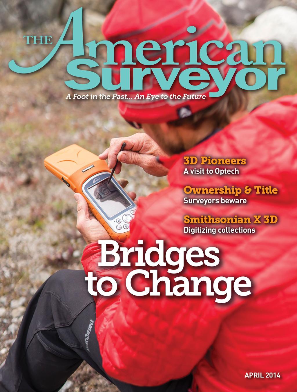
2 New Record for Southeast Asia s Highest Peak?» Rachel Schowe


3 ince 1925, the people of Myanmar have been taught from an early age that the highest peak in all of Southeast Asia was the great Mount Hkakabo Razi. Often swathed in stormy clouds obscuring it from view, Hkakabo Razi lies in the Himalayan mountain range on the border junction of Myanmar, China, and India, its frosted tip stretching 5,881 meters up into the sky. At that height, one could theoretically stand atop its peak and look down on all of the surrounding countries comprising Southeast Asia. At least, that has been the widely-held belief for the past 90 years. However, a recent expedition up virgin peak Gamlang Razi may have overturned that belief, suggesting that the view from Hkakabo Razi may not actually be the best in the house. New Data Suggests Historic Errors In recent years, digital analysis suggests that the 1925 surveys of Hkakabo Razi were overstated, and the peak s actual elevation is as much as 100 meters lower than originally believed. At the same time, digital analysis has suggested that the elevation of second-tallest The team rests at base camp before beginning the climb up Mount Gamlang Razi.


4 Right: The climbers were forced to cross many rivers by way of dangerous bridges on their trek to the base of Mount Gamlang Razi. Inset: The team celebrates at the peak of Gamlang Razi, while the Juniper Systems Archer Field PC collects GPS data in the background. Below: Team leader, Andy Tyson, gets accustomed to the Archer Field PC before attempting the summit. peak Gamlang Razi originally measured at 5,834 meters has been understated, and may actually be taller than Hkakabo Razi. Idea for the Trip The idea for the expedition first arose when Victor, Idaho resident, Andy Tyson, found a discrepancy between Google Earth s maps of Myanmar s mountains and data from satellite imagery and LiDAR. An experienced climber and a specialist in remote summit expeditions in the Himalayas, Antarctica, and the Americas, Tyson has been an instructor for the National Outdoor Leadership School (NOLS), a guide for Alpine Ascents International and Exum Mountain Guides,

5 and the author of Glacier Mountaineering and Climbing: Self-Rescue (with Molly Loomis). He has also led training expeditions in an effort to spur the development of Burmese climbers. With his seasoned background in mountaineering, Tyson s intrigue with the inconsistent elevation reports stirred him to set out in search of sponsors and a team of climbers for a journey to Gamlang Razi. The final expedition team that would attempt the summit consisted of five Americans and two Burmese climbers. A Device for the Job From his study of satellite imagery and Lidar data, Tyson s theory was that Gamlang Razi was in fact the tallest peak in Southeast Asia. His aim, then, in leading an expedition team to the top of Gamlang Razi, was to collect actual GPS data at the peak to support that claim. To do that, the team would need a device that could not only record the necessary GPS data, but one that could also hold up against the extreme conditions of the trip, which included both the hot, wet environment of the jungle, as well as the freezing temperatures of the mountain peak. Tyson and his team approached Juniper Systems looking for a rugged handheld for the job. In response, Juniper Systems loaned the team an Archer Field PC with a Hemisphere GPS XF101 receiver. The Archer was designed to operate in extreme temperatures and was waterproof and dustproof, which would be key to successfully capturing the data they needed. Data Collection Protocol Juniper Systems carefully developed a data collection protocol for the summit team. The data collection methodology would need to consider both the unique circumstances associated at extreme altitude and the technical data requirements in order to accurately record a mean sea level (MSL) unit of measure. Common GPS elevation measurements based on ellipsoid Earth models such as WGS84 are known to have

6 significant errors. Therefore, the summit team s Archer Field PC was equipped with Esri ArcPad mobile software with an EZSurv GNSS driver capable of collecting the additional GPS data required for postprocessing against geoid models to more accurately reflect the Earth s uneven surface. Expecting that the summit team would likely be fatigued at such high altitude atop Gamlang Razi, Juniper Systems trained Tyson on a relatively simple data collection protocol to achieve professional results. The Journey In August of last year, the team set out for Myanmar. After enjoying a weekend of hospitality in Yangon, the team headed to Machinbaw by vehicle, and then set off from Machinbaw on foot, headed for the base of Gamlang Razi. Accompanying the seven climbers were 10 people from the Htoo Foundation, the expedition s primary sponsor, plus around 70 porters carrying equipment. The hike to base camp was a tough one, covering 200 miles of jungle terrain, and taking a full two weeks to complete. During the day, the climbers trudged through miles of mud and river, struggling to fend off the swarms of bees, mosquitoes, and sand flies that filled the air, and constantly on the look-out for vipers and cobras along the trail. Leeches became a sort of body adornment, and the incessantly wet conditions put the climbers at risk for infections like trench foot. At night, the team would stop to rest in the villages along the way, sleeping in villagers homes, which consisted of small huts built on stilts. They even passed through one of the only known pygmy villages in Asia and had to take a brief, but illegal detour through Chinese-controlled Tibet. After safely making it to their base camp at the ankles of Gamlang Razi, the climbers began their ascent. What at first was rain turned to snow as they made their way up the mountainside, and the terrain became very difficult, even for the experienced climbers. Their path crossed several glacier


7 Andy Tyson prepares to collect critical GPS data at the summit using the Archer Field PC. crevasse fields, almost ending in disaster when several team members fell into a 600- foot crevasse. Fortunately, the fallen climbers were unharmed and were rescued by the other team members. Ten days after reaching base camp, and 35 days after setting out on foot, six of the seven expedition members took the first steps ever atop Gamlang Razi. Collecting the GPS Data On top of Gamlang Razi, the team powered up the Archer Field PC and XF101 GPS receiver from Juniper Systems and opened up Esri ArcPad with Effigis GNSS Driver to enable post-processing. According to Juniper Systems instructions, the team first allowed the XF101 receiver to track satellites for 15 minutes in order to acquire a complete almanac. Once the handheld was finished, the team placed the Archer in an unobstructed position on the summit and allowed the handheld to collect 20 minutes of data one data point every second for a total of 1,200 data points. The final elevation figure would consist of a single data point calculated from the average of those 1,200 data points. This data was sent to Juniper Systems via satellite phone for analysis. Data Analysis Using Effigis EZSurv software, Juniper Systems post-processed the data by comparing it with a known terrestrial reference point a base station in Llasa, Tibet. By post-processing the data, they were able to eliminate much of the error introduced by the variations in the shape of the earth s surface, significantly improving the confidence level in the results. Results The verdict? After post-processing the data, Juniper Systems found the resulting height of Gamlang Razi to be 5,870 meters, ± 2 meters, which was also analyzed and confirmed by Effigis in Montreal, Canada. When this new figure is compared to the recent digital elevation measurements of Hkakabo Razi, Gamlang Razi is indeed the taller peak, meaning that Southeast Asia may need to update their record books. Resistance to the New Record When compared to the current digital elevation data of Hkakabo Razi, the newly recorded elevation point of Gamlang Razi suggests the latter to be the highest peak. However, Hkakabo Razi s 1925 elevation data still would suggest that Hkakabo Razi remains the tallest peak. And even while current surveying data asserts that the 1925 survey of Hkakabo Razi was overstated, there are many, particularly Burmese natives, who are not yet ready to accept that Gamlang Razi has taken Hkakabo s place as Southeast Asia s tallest peak. This includes Myanmar s president, Thein Sein, who wrote a letter to the expedition team soon after their successful ascent, congratulating them for summiting Southeast Asia s second-tallest peak. Andy Tyson stands strong in his assertion that Gamlang Razi is the country s highest peak, but suggests that the controversy may not be resolved until someone actually climbs Hkakabo Razi and measures it in person, using the technology of the day. However, in the upcoming months, there may be new data revealed that may shed additional light on the controversy. According to Scott Walker, a digital cartography specialist at the Harvard Map Collection, a German radar topographic mapping project is currently in progress that will provide highly-accurate survey data, including elevation measurements. The data is expected to be available later this year. Looking Forward Also forthcoming later this year is a film that documents the entire journey of the Gamlang Razi expedition and offers a unique cultural perspective of remote Myanmar. The film, Myanmar: Bridges to Change, is scheduled to release on June 14, 2014 in Yangon, Myanmar. Ultimately, while the Burmese people may be reluctant to accept a change to their elevation records even in the face of additional data, there is much to be gained from this foreign expedition to the beautiful country of Myanmar. Not only did it serve as an experience of a lifetime for the expedition members, but the trip and the upcoming film will also instill a greater appreciation for the Burmese culture in people all over the world. Images courtesy of Mark Fisher, Rachel Schowe is a freelance writer from Colorado who enjoys spending her free time in the great outdoors. She is an avid hiker, camper, and skier, and lives with her trusty companion, an Irish setter named Wallace.
The height of Machu is 6630m on the Swiss map, 6612m on the Russian map and 6603m on Google Earth.
 Hispar Expedition 2017 Expedition Final Report MEF reference: 17-42 Country and region visited: Pakistan, Hunza Valley, Karakoram. Objective To make the first ascent of Machu (6630m) by the southwest and
Mount Kilimanjaro Climbing via Rongai Route 8 day-itinerary
 Mount Kilimanjaro Climbing via Rongai Route 8 day-itinerary Total hiking distance: Approximately 70 kms The Rongai route ascends Kilimanjaro from the north-eastern side of the mountain, along the border
INSTRUCTIONS: Fill out all items highlighted in yellow. Read all item highlighted in green.
 AMERICAN CLIMBER SCIENCE PROGRAM 2016 Cordillera Blanca Expedition Application Send applications to: John All, PhD, JD Email: climberscience@gmail.com Due: May 1, 2015 Note: Applications will be considered
KUSHILAND Expeditions & Tour Safaris Ltd
 KILIMANJARO TREK MACHAME ROUTE TOUR CODE KMC 02 7 DAYS MACHAME ROUTE Kilimanjaro s Machame Route, often referred to as the Whiskey route, is more scenic and is longer than Marangu. The minimum duration
Images Made in the Mountains
 IMAGES MADE IN THE MOUNTAINS CHUCK GRAHAM Mountain camp below Mount Tyndall at sunrise in the Eastern Sierra, CA Images Made in the Mountains Chuck Graham I left my truck at 1:00 am at the top of the Whitney
MOUNT SIDLEY EXPEDITION 2019
 MOUNT SIDLEY EXPEDITION 2019 TRIP NOTES MOUNT SIDLEY 2019 Expedition Notes All material Copyright Adventure Consultants Ltd 2018/2019 During the southern summer of 2018/2019, Adventure Consultants will
Mount Kilimanjaro Climbing via Marangu Route 6 day-itinerary
 Mount Kilimanjaro Climbing via Marangu Route 6 day-itinerary (For the 5-day route, simply exclude the additional acclimatisation day at Horombo hut - day 3 on the itinerary below.) Total hiking distance:
MT KILIMANJARO TREK- LEMOSHO ROUTE
 #Trekking MT KILIMANJARO TREK- LEMOSHO ROUTE 10 Days 9 Nights Overview Take the challenging and less-travelled Lemosho route up to the highest peak in Africa, considered by many to be the most beautiful
Travel deals available for adventures and backpackers.
 Mount Kilimanjaro is an overall winner of African leading Tourist Attraction in 2017. Mount Kilimanjaro beautiful Geographical features to be seen when climbing to summit are Coffee farms, nature forest,
PERUVIAN ANDES ADVENTURES. ARTESONRAJU CLIMB 6025m (19767 ft) Grade: D+ to TD/ Technical. Routes: The two routes to climb Artesonraju are;
 Grade: D+ to TD/ Technical. Routes: The two routes to climb Artesonraju are;") PERUVIAN ANDES ADVENTURES ARTESONRAJU CLIMB 6025m (19767 ft) Grade: D+ to TD/ Technical Routes: The two routes to climb Artesonraju are; *Via the Paron Valley South East Ridge 5 days (option for 6 with
PERUVIAN ANDES ADVENTURES ARTESONRAJU CLIMB 6025m (19767 ft) Grade: D+ to TD/ Technical Routes: The two routes to climb Artesonraju are; *Via the Paron Valley South East Ridge 5 days (option for 6 with
RUSSIA. Elbrus. I
 RUSSIA Elbrus RUSSIA Elbrus Mount Elbrus is the highest peak in Russia and Europe and although many mountaineers visit the area to climb the mountain, there are also many other attractions here. On the
Mind Hike, The Lakes September 2017
 I made new, life-long friends and smashed what I thought were my own personal limits. Mind Hike, The Lakes September 2017 Registration fee: 85 Minimum sponsorship 675 www.mind.org.uk/hike2017 Reg. Charity
Two Peaks in the Headwaters of Karcha Nala JAC Tokai to the Indian Himalayas
 KAZUO HOSHI Two Peaks in the Headwaters of Karcha Nala JAC Tokai to the Indian Himalayas The Tokai Section of the Japanese Alpine Club (hereinafter described as JAC Tokai) conducted 11 expeditions to the
CHALLENGE OVERVIEW. ACCOMMODATION. You will be accommodated in friendly, simple hotels and tents whilst on the mountain.
 CHALLENGE OVERVIEW Mount Kilimanjaro is one of the seven Natural Wonders of the World and for many people, standing on its summit is a life-long ambition. The snow-capped peak was first reached by German
Trek2Kili P.O. Box 2112 Moshi TZ Whatsapp
 Trek2Kili P.O. Box 2112 Moshi TZ Whatsapp +255 673 360 trek2kili@gmail.com MT. KILIMANJARO SHIRA 8 DAY 7 NIGHT TREK Very similar to Lemosho route, however it starts at 3,600 meters and is therefore not
Itinerary Overview. Sawatch Range Mountaineering Ages days
 Itinerary Overview Sawatch Range Mountaineering Ages 14-16 22 days Course Description Welcome, you re in for an experience of a lifetime! Imagine hiking through rolling forests, sharing alpine meadows
Adventure Tourism & Trekking Mt. Everest Region of Himalaya, Nepal
 PRT 188 Summer 2019 Adventure Tourism & Trekking Mt. Everest Region of Himalaya, Nepal Instructors: John Abbott, Ed. D. Dept. of Parks, Recreation & Tourism Rubenstein School of Environment & Natural Resources
6 DAYS MACHAME ROUTES ON KILIMANJARO
 6 DAYS MACHAME ROUTES ON KILIMANJARO Day 1: Moshi Machame camp In the morning, we depart from our base hotel at approximately 8:00 AM for the Machame village where you begin the trek. From the park entrance
Looking back across Emerald Lake at Wapta Mountain (on the left) and Mount Burgess (on the right):
 and Mount Burgess (on the right):") YOHO LAKE FROM EMERALD LAKE, YOHO NATIONAL PARK, BRITISH COLUMBIA, CANADA We decided to hike to Yoho Lake from Emerald Lake even though the distance is longer than the trail from Takakkaw Falls (about
YOHO LAKE FROM EMERALD LAKE, YOHO NATIONAL PARK, BRITISH COLUMBIA, CANADA We decided to hike to Yoho Lake from Emerald Lake even though the distance is longer than the trail from Takakkaw Falls (about
3D SURVEYING AND VISUALIZATION OF THE BIGGEST ICE CAVE ON EARTH
 CO-015 3D SURVEYING AND VISUALIZATION OF THE BIGGEST ICE CAVE ON EARTH BUCHROITHNER M.F., MILIUS J., PETTERS C. Dresden University of Technology, DRESDEN, GERMANY ABSTRACT The paper deals with the first
MGT Homework #2 Spring 2018
 MGT 233 - Homework #2 Spring 2018 This homework assignment is due at the beginning of class on Monday, October 8, 2018. Instructions: Use proper probability notation for all parts of each problem. Show
Guide Training Ski TAP APPLICATION PACKAGE. Hello and thank you for your interest in applying to the ACMG Training and Assessment Program (TAP).
.") Hello and thank you for your interest in applying to the ACMG Training and Assessment Program (TAP). As of April 30, 2018, the ACMG will be running the program for an undetermined period. For any courses
Hello and thank you for your interest in applying to the ACMG Training and Assessment Program (TAP). As of April 30, 2018, the ACMG will be running the program for an undetermined period. For any courses
Koroc River Palmer River Loop
 parkscanada.gc.ca Multi-Day Hiking Route Koroc River Palmer River Loop Torngat Mountains National Park T. Knight, Parks Canada 425000m.E. 64 15'0"W 30 64 10'0"W 35 64 5'0"W 40 64 0'0"W 45 63 55'0"W 50
Hiking/ Trekking. Vocabulary. Kontakt
 Hiking/ Trekking Vocabulary altitude sickness - an illness caused from being at high elevations a canteen - a container used for carrying drinking water dehydration - a physical condition caused by not
Dear Hike Leader, Thank you for volunteering to be a FSPW Hike Leader!
 Board and Staff Phil Hough, Exec. Director Sagle, Idaho phil@scotchmanpeaks.org Doug Ferrell, Chairman Montana Director Trout Creek, Montana Carol Jenkins, Secretary Sagle, Idaho Brad Williams, Treasurer
Trek2Kili P.O. Box 2112 Moshi TZ Whatsapp
 Trek2Kili P.O. Box 2112 Moshi TZ Whatsapp +255 673 360 trek2kili@gmail.com MT. KILIMANJARO RONGAI 6 DAY 5 NIGHT TREK Less crowded because of its remote location the route offers trekkers a unique wilderness
Stok Kangri Trek 2013
 Stok Kangri Trek 2013 Area: Ladakh Duration: 11 Days Altitude: 6153 mts Grade: Moderate to Challenging Towering at an impressive 6153 m, Stok Kangri is a serious challenge. Although at such an impressive
AUGUST 2017 GNSS REVIEW. Survey Economics Chances of success. Mobile Mapping Airport scanning. Stag s Leap Winery Pre-construction plan
 AUGUST 2017 GNSS REVIEW Survey Economics Chances of success Stag s Leap Winery Pre-construction plan Mobile Mapping Airport scanning RISING PERFORMANCE» ERIK DAHLBERG Civil aviation is an outlier. It s
Itinerary Overview. Maroon Bells Mountaineering 22-days. Course Description
 Itinerary Overview Maroon Bells Mountaineering 22-days Course Description Welcome, you re in for an experience of a lifetime! Imagine hiking through rolling forests, sharing alpine meadows with mountain
Dates: March 4 th -13 th Location: Bariloche, Patagonia, Argentina. Brief Description:
 [Type text] Page 0 Patagonia Remote Medicine Expedition is an exciting experience offered through the section of Wilderness & Environmental Medicine of the Emergency Department at University of Colorado
TREK THE ROCKIES ABOUT THE CHALLENGE TREK THE ROCKIES FOR HIGHLAND HOSPICE CANADA TREK DEMANDING
 TREK THE ROCKIES CANADA TREK DEMANDING ABOUT THE CHALLENGE The Canadian Rockies are justifiably world-famous for their magnificent scenery: the combination of impressive, jagged mountains, bright turquoise
RISING PERFORMANCE. Civil aviation is an outlier. It s BY ERIK DAHLBERG
 RISING PERFORMANCE Compact mobile mapping systems can be installed on small passenger cars. Civil aviation is an outlier. It s among the few industries where tight government regulations are widely accepted
It was breakfast. I was just cutting into my second. Where my Help Comes from
 Where my Help Comes from It was breakfast. I was just cutting into my second pancake when Shirley and Helen pushed the dining room door open, their faces red and their hair damp with sweat. They don t
Machame 7 Days 6 Nights
 Machame 7 Days 6 Nights If Marangu is the Coca Cola route, then the Machame Route is the Whiskey route. It is the second most popular and one of the most scenic routes on the mountain. All climbers sleep
Itinerary Overview. Colorado San Juan Mountaineering 15-days
 Itinerary Overview Colorado San Juan Mountaineering 15-days Course Description Welcome, you re in for an experience of a lifetime! Imagine hiking through rolling forests, sharing alpine meadows with mountain
Rongai 6 Days 5 Nights
 Rongai 6 Days 5 Nights The Rongai Route is one of the easiest routes and the success rate is very high. The route starts on the North side of the mountain just South of the Kenyan border and is one of
USDA Trails Strategy WRI: ENGLISH PEAK SURVEY. Theodore Mendoza San Diego State University June 6 th 2016 August 18 th Advisor: Sam Commarto
 WRI: ENGLISH PEAK SURVEY Theodore Mendoza San Diego State University June 6 th 2016 August 18 th 2016 Advisor: Sam Commarto Klamath National Forest Submitted: March 21, 2017 Table of Contents Acknowledgements
Mountaineering- Mt Kilimanjaro
 Mountaineering- Mt Kilimanjaro Mount Kilimanjaro is the highest mountain in Africa and is one of the seven summits. This mountain speaks for itself with several thousand visitors summiting each year. We
Lesson 5: Ice in Action
 Everest Education Expedition Curriculum Lesson 5: Ice in Action Created by Montana State University Extended University and Montana NSF EPSCoR http://www.montana.edu/everest Lesson Overview: Explore glaciers
NEPAL. Everest Base Camp
 NEPAL Everest Base Camp Nepal TRIP GRADE: Hard DURATION: 16 Days Everest Base Camp Nepal is the Himalayan country known as the land of the Mt. Everest and the birthplace of Lord Buddha. The country is
DALHOUSIE WINTER TREKKING EXPEDITION
 DALHOUSIE WINTER TREKKING EXPEDITION Winter Himalayan Trekking Expedition 2016-17 To groom the youngsters in the field of adventures and environmental awareness, Invincible NGO presents the most interactive
climb Mount Elbrus at a glance trip highlights
 climb actionchallenge on Our ascent of begins in the foothills of the lower Caucasus. Elbrus, an inactive volcano, is one of the famous Seven Summits and, at 5,642 m, is the highest mountain in Europe.
5 DAYS MARANGU ROUTE ON KILIMANJARO
 5 DAYS MARANGU ROUTE ON KILIMANJARO Day 1: Drive to Kilimanjaro National Park Marangu Gate, Hike to Mandara Hut After breakfast and briefing, drive to the Kilimanjaro National Park Gate (about 1 hour),
VINSON MASSIF EXPEDITIONS 2017/2018 TRIP NOTES
 VINSON MASSIF EXPEDITIONS 2017/2018 TRIP NOTES VINSON MASSIF 2017/2018 Expedition Notes All material Copyright Adventure Consultants Ltd 2017/2018 During the southern summer of 2017/2018, Adventure Consultants
Mt. Elbert East Ridge
 Mt. Elbert East Ridge Difficulty: Class 1 Exposure: None Summit Elev.: 14,440 feet Trailhead Elev.: 10,400 feet Elevation Gain: 4,100 feet Roundtrip Length: 8.5 miles Trailhead: South Elbert (near Twin
INDIA HIMALAYA STOK KANGRI ASCENT 21 DAYS
 INDIA HIMALAYA STOK KANGRI ASCENT 21 DAYS No words can describe the overwhelming experience of being among the world s greatest mountains you really have to be here! The enormous glaciated peaks, challenging
Backpacking Trip Planning. Presenters: Dana Perry Christine Fogarty
 Backpacking Trip Planning Presenters: Dana Perry Christine Fogarty 1 Agenda New to planning trips? Location and physical trail Common terminology Trip selection & research The Trip Flow Plan What is it
Trek2Kili P.O. Box 2112 Moshi TZ Whatsapp
 Trek2Kili P.O. Box 2112 Moshi TZ Whatsapp +255 673 360 trek2kili@gmail.com MT. KILIMANJARO MACHAME 7 DAY 6 NIGHT TREK Known as the Whisky Route, this is one of the most scenic and therefore popular routes
Aconcagua Leadership and Guide Training Course
 Aconcagua Leadership and Guide Training Course Cerro Aconcagua is located in the central Andes of Argentina near the border with Chile. At 22,841ft (6,962m), it is one of the seven summits and the only
USDA TRAILS STRATEGY PROGRAM
 USDA TRAILS STRATEGY PROGRAM WRPI Program: English Peak Survey Jorge D. Briceño Southwestern Community College Internship Time Period: June 6, 2016 August 8, 2016 Advisor: Sam Commarto Recreation Officer
MOUNT KILIMANJARO TREK
 TANZANIA TREK EXTREME ABOUT THE CHALLENGE Climb the highest freestanding mountain in the world! Kilimanjaro is the highest mountain on the African continent at 5896m. Its snow-capped summit rises high
From Rassa to Sumur..a journey of exploration and climbing.
 From Rassa to Sumur..a journey of exploration and climbing. In 2001, a glimpse of Rassa glacier, during our expedition to Arganglas valley indicated great opportunity for exploration and climbing. In July
Carnarvon Station Reserve, Qld Camping Information
 Carnarvon Station Reserve. Photo: Katrina Blake Carnarvon Station Reserve, Qld Camping Information Quick facts Acquired: 2001 Area: 59,000 ha Traditional owners: Bidjara Location: Central Highlands region,
TREK KILIMANJARO ABOUT THE CHALLENGE KILIMANJARO TREK - 11 DAY TANZANIA TREK RED 3
 TREK KILIMANJARO TANZANIA TREK RED 3 ABOUT THE CHALLENGE Climb the highest freestanding mountain in the world! Kilimanjaro is the highest mountain on the African continent at 5896m. Its snow-capped summit
KUSHILAND Expeditions & Tour Safaris Ltd
 KILI CHARITY CLIMB 5 DAYS MARANGU ROUTE TOUR CODE KMR 01/5 5 DAYS MARANGU ROUTE Marangu Route, often referred to as the Coca Cola route, is Kilimanjaro s shortest and easiest route. Because of this, it
MT. KILIMANJARO SHIRA ROUTE 8 days
 MT. KILIMANJARO SHIRA ROUTE 8 days Activities: Trekking Difficulty: Moderate to Adventurous Max Elevation: 5,895m/ 19,340 ft at summit Meal: Full board on trek Accommodation: Hotel in Moshi/ tent on trek
Greenland. Polar Express Liverpool Land
 Greenland Polar Express Liverpool Land Itinerary Greenland Polar Express 18 days 17 Nights Reykjavik Constable Point Liverpool Land Carlsberg Fjord Istorvet Glacier Pedersens Age Nielsens Glacier Constable
Course Description. North Cascades Alpine Backpacking for Veterans
 Course Overview Join other Veterans in the North Cascades Range of Washington for the opportunity to connect outside of the military in one of the most remote and beautiful alpine environments in the lower
Snow Way by Beth Geiger
 6 th Grade ELA SAMPLES OF STANDARDS STUDENTS ARE LEARNING THIS NINE WEEKS: STANDARDS: RI.6.2, RI.6.3, RI.6.5, RI.6.8, W.6.2 Snow Way by Beth Geiger Where will you find the world s best spot for stargazing?
18 day itinerary: ACONCAGUA Normal Route 15 day trek. T r i p I t i n e r a r y
 T r i p I t i n e r a r y HIGHLIGHTS Summit the highest mountain in South America, and the second highest of the Seven Summits Breath-taking views of the Andes Three days set aside for the summit attempt
TOUR ITINERARY CLIMB KILIMANJARO: 8-day tour MACHAME ROUTE (6 days of trekking)
") TOUR ITINERARY CLIMB KILIMANJARO: 8-day tour MACHAME ROUTE (6 days of trekking) DAY 1. ARRIVAL Arrival at Kilimanjaro International Airport (JRO), where you will meet an Altezza Travel representative,
TOUR ITINERARY CLIMB KILIMANJARO: 8-day tour MACHAME ROUTE (6 days of trekking) DAY 1. ARRIVAL Arrival at Kilimanjaro International Airport (JRO), where you will meet an Altezza Travel representative,
Mt. Kilimanjaro Trek. WanderTours P.O. Box Seattle WA Itinerary dates: January 23 - February 1, 2019 Tour Escort: Beth Whitman
 WanderTours P.O. Box 16102 Seattle WA 98116 Mt. Kilimanjaro Trek Itinerary dates: January 23 - February 1, 2019 Tour Escort: Beth Whitman HIGHLIGHTS The six-day Machame Route to Uhuru Peak, considered
If you are looking for a book by William CAREY Travel and Adventure in Tibet, Including the Diary of Miss Annie R. Taylor's Remarkable Journey from
 Travel And Adventure In Tibet, Including The Diary Of Miss Annie R. Taylor's Remarkable Journey From Tau-Chau To Ta-Chien-Lu Through The Heart Of The Forbidden Land By William CAREY READ ONLINE If you
ANUMC Ski Mountaineering Expedition. Classic Haute Route ANUMC Expedition Fund Application By Andrew Gough
 ANUMC Ski Mountaineering Expedition Classic Haute Route 2010 ANUMC Expedition Fund Application By Andrew Gough Introduction: The Haute route (or High Mountaineers Route ) is one of the worlds most famous
TOUR ITINERARY CLIMB KILIMANJARO: 9 DAY RONGAI ROUTE
 TOUR ITINERARY CLIMB KILIMANJARO: 9 DAY RONGAI ROUTE DAY 1. ARRIVAL Arrival at Kilimanjaro International Airport (JRO), where you will meet an Altezza Travel representative, and transfer to the hotel under
The Summits of Canada Expedition Information and Education Summary
 The Summits of Expedition Information and Education Summary A historic Canadian adventure, the Summits of Expedition, will take place in 2006 to put the first Canadian Team on the highest point of s thirteen
Survey of Deadwater Fell and Peel Fell
 4 December 2014 Survey of Deadwater Fell and Peel Fell Team: John Barnard, Chris Crocker, Richard Cooper and Graham Jackson 1) Introduction Deadwater Fell (Hill 3542, Section 33, OS 1:50000 Map 80, OS
Stok Kangri Peak (6120m) 2 to 16 September 2018 Explore the hidden kingdom of Ladakh with Stok Kangri Peak
 2 to 16 September 2018 Explore the hidden kingdom of Ladakh with Stok Kangri Peak") Stok Kangri Peak (6120m) 2 to 16 September 2018 Explore the hidden kingdom of Ladakh with Stok Kangri Peak Stok Kangri is a perfect objective for fit trekkers without climbing experience, and is one of
Stok Kangri Peak (6120m) 2 to 16 September 2018 Explore the hidden kingdom of Ladakh with Stok Kangri Peak Stok Kangri is a perfect objective for fit trekkers without climbing experience, and is one of
U.S.A. W0N - Nebraska
 Summits on the Air U.S.A. W0N - Nebraska Association Reference Manual Document Reference S100.1 Issue number 1.0 Date of issue 1 st February 2014 Participation start date 1 st February 2014 Authorised
KILIMANJARO 2018 RUN & TREK February 28 March 12
 KILIMANJARO 2018 RUN & TREK February 28 March 12 Wednesday 28 Feb Depart USA to Kilimanjaro International Airport, Tanzania, Africa Thursday 01 March Arrive Kilimanjaro. Met upon arrival at the Kilimanjaro
MT FRIENDSHIP TREK. A Mountaineering Expedition in Pir Panjal Range of Himalayas!
 MT FRIENDSHIP TREK A Mountaineering Expedition in Pir Panjal Range of Himalayas! With a view to promote Youth into the less explored field of Mountaineering or Mountain Hiking, Invincible the youth run
TOUR ITINERARY CLIMB KILIMANJARO: 9-day tour LEMOSHO ROUTE (7 days of trekking)
") TOUR ITINERARY CLIMB KILIMANJARO: 9-day tour LEMOSHO ROUTE (7 days of trekking) DAY 1. ARRIVAL Arrival at Kilimanjaro International Airport (JRO), where you will meet an Altezza Travel representative,
TOUR ITINERARY CLIMB KILIMANJARO: 9-day tour LEMOSHO ROUTE (7 days of trekking) DAY 1. ARRIVAL Arrival at Kilimanjaro International Airport (JRO), where you will meet an Altezza Travel representative,
Mt. Gunnbjörn, the Highest Peak in Greenland (IMG65)
") 2018 Mt. Gunnbjörn, the Highest Peak in Greenland (IMG65) Snow shoe or Ski ascent of the highest peak in the Greenland Arctic - Expedition manual - Content overview Expedition overview Further information
2018 Mt. Gunnbjörn, the Highest Peak in Greenland (IMG65) Snow shoe or Ski ascent of the highest peak in the Greenland Arctic - Expedition manual - Content overview Expedition overview Further information
RTM 151C Winter Mountaineering (2 units) Department of Recreation and Tourism Management California State University Northridge
 Department of Recreation and Tourism Management California State University Northridge") RTM 151C Winter Mountaineering (2 units) Department of Recreation and Tourism Management California State University Northridge Spring 2017 Redwood Hall 151 Sat. 9:00-10:40 Class Meetings on Jan 21 plus
RTM 151C Winter Mountaineering (2 units) Department of Recreation and Tourism Management California State University Northridge Spring 2017 Redwood Hall 151 Sat. 9:00-10:40 Class Meetings on Jan 21 plus
Marymount International School Itinerary Nepal Expedition, October 2014
 Marymount International School Itinerary Nepal Expedition, October 2014 Nepal is a landlocked magical country placed between Tibet, Bhutan, India and Kashmir. It has arguably the most dramatic and accessible
Mt. Rainier Three-Day Muir Climb
 Mt. Rainier Three-Day Muir Climb Details below provided by AAI Elevation: 14,411 feet Guide Service: Alpine Ascents International (AAI) Fundraising minimum: $5,000.00 USD Muir Three-Day Overview Our three-day
Grizzly Peak A - East Ridge July 15, 2012
 Grizzly Peak A - East Ridge July 15, 2012 Difficulty: Difficult Class 2/Class 3 Upper Elevation: 13,995 feet Trailhead Elevation: 11,360 feet Elevation Gain: 3,000 feet Round-trip Length: 6.0 miles Trailhead:
Glacier National Park
 Glacier National Park West Glacier, MO Page 1 Page 3-6 Report Rough Draft Glacier National Park Glacier National Park is located in the northwest corner of Montana and extends into Canada. It is located
Remote and magical The Antarctic plateau
 Remote and magical The Antarctic plateau The voice of adventure is calling you Antarctica awaits. Introducing a unique opportunity to be part of a driving expedition across Antarctica Nov/Dec 2016 Up until
Itinerary Overview. Continental Divide Alpine Backpacking 22 days Ages Course Description
 Itinerary Overview Continental Divide Alpine Backpacking 22 days Ages 16-18 Course Description Welcome, you re in for an experience of a lifetime! Imagine hiking through rolling forests, sharing alpine
COAST TO COAST RAINFOREST TREK
 COSTA RICA TREK TOUGH ABOUT THE CHALLENGE Our adventurous coast to coast rainforest trek involves crossing from Costa Rica's Pacific Coast to the Caribbean. Enroute we take in the country s highest active
Avalanches and the Mount Whitney Basin
 Avalanches and the Mount Whitney Basin 10 April 2006 by Bob Rockwell Prelude Avalanches are a fact of life in high mountains in winter, and we take courses to find out about them. We learn how to assess
Trekking the W Route in Patagonia. 7 Days
 Trekking the W Route in Patagonia 7 Days Trekking the W Route in Patagonia On Patagonia's famous W route, you'll hike deep in the remote wilderness of southern Chile and experience the wondrous landscapes
Welcome! Overview. Destination: Overall Trip Cost: Price Breakdown: Grading: Trip Duration: Accommodation: Climbing Route: Group Size:
 CONQUER KILIMANJARO Welcome! Thank you for your interest in the Kilimanjaro Challenge in support of Anza! We hope this pack contains everything you need to make the decision to join us on an incredible
Himalaya Nelles Map: Incl. Tibet / Kashmir / Nepal / Sikkim / Bhutan 3rd (third) Revised Edition By Nelles Published By Nelles Verlag GmbH (2006)
 Revised Edition By Nelles Published By Nelles Verlag GmbH (2006)") Himalaya Nelles Map: Incl. Tibet / Kashmir / Nepal / Sikkim / Bhutan 3rd (third) Revised Edition By Nelles Published By Nelles Verlag GmbH (2006) READ ONLINE If looking for the book Himalaya Nelles Map:
Himalaya Nelles Map: Incl. Tibet / Kashmir / Nepal / Sikkim / Bhutan 3rd (third) Revised Edition By Nelles Published By Nelles Verlag GmbH (2006) READ ONLINE If looking for the book Himalaya Nelles Map:
Mind Hike 2019 Islands or Highlands
 I made new, life-long friends and smashed what I thought were my own personal limits. Mind Hike 2019 Islands or Highlands Registration fee: 95 Minimum sponsorship 690 www.mind.org.uk/mindhike Reg. Charity
Nepal 7-Day Hiking Adventure. 7 Days
 Nepal 7-Day Hiking Adventure 7 Days Nepal 7-Day Hiking Adventure A world of thrilling adventure awaits on this great introduction to Nepal's mighty Himalaya, ideal for trekkers with limited time. Kick
Itinerary Overview. Sangre de Cristo Alpine Backpacking 22 days Ages Course Description
 Itinerary Overview Sangre de Cristo Alpine Backpacking 22 days Ages 16-18 Course Description Welcome, you re in for an experience of a lifetime! Imagine hiking through rolling forests, sharing alpine meadows
Morning Star Peak Avalanche Accident
 Morning Star Peak Avalanche Accident Saturday, December 4, 2010 Date: 2010-12-13 Submitted by: Oyvind Henningsen Everett Mountain Rescue and Mark Moore NWAC Place: Morning Star Peak, north-central WA Cascades
! Kilimanjaro Expedition
 ! Kilimanjaro Expedition Tanzania 2016 Climb Only: $4,350 (land costs) Feb 4-12; June 12-20; July 10-18; Aug 6-14; Sept 11-19; Dec 4-12 2016 Climb & Safari: $5,850 (land costs) Feb 4-15; June 12-23; July
Retreating Glaciers of the Himalayas: A Case Study of Gangotri Glacier Using Satellite Images
 Retreating Glaciers of the Himalayas: A Case Study of Gangotri Glacier Using 1990-2009 Satellite Images Jennifer Ding Texas Academy of Mathematics and Science (TAMS) Mentor: Dr. Pinliang Dong Department
TOUR ITINERARY CLIMB KILIMANJARO: 10 DAY NORTHERN CIRCUIT
 TOUR ITINERARY CLIMB KILIMANJARO: 10 DAY NORTHERN CIRCUIT DAY 1. ARRIVAL Arrival at Kilimanjaro International Airport (JRO), where you will meet an Altezza Travel representative, and transfer to the hotel
REPORT. MANASLU EXPEDITION (8163 m) Track NE (traditional)
 Track NE (traditional)") REPORT MANASLU EXPEDITION (8163 m) Track NE (traditional) Contents Expedition passport 2 Description of the route 3 Description of the expedition 4-5 Scheme of the route 6 Map of the route 7 Map of the
REPORT MANASLU EXPEDITION (8163 m) Track NE (traditional) Contents Expedition passport 2 Description of the route 3 Description of the expedition 4-5 Scheme of the route 6 Map of the route 7 Map of the
TROOP FIVE BOY SCOUTS OF AMERICA (
 TROOP FIVE BOY SCOUTS OF AMERICA (http://www.troop5.net) HISTORIC MOUNT WASHINGTON HIKE LOCATION: White Mountain National Forest, New Hampshire DATE: Friday - Monday, June 25-28 th, 2010. TIME: Be at the
GUIDE INDIA HIMALAYAS 21 DAYS SUMMER 2019
 GUIDE INDIA HIMALAYAS SUMMER 2019 21 DAYS WHERE ARE YOU GOING? INDIA HIMALAYA No words can describe the overwhelming experience of being among the world s greatest mountains you really have to be here!
Lidar Imagery Reveals Maine's Land Surface in Unprecedented Detail
 Maine Geologic Facts and Localities December, 2011 Lidar Imagery Reveals Maine's Land Surface in Unprecedented Detail Text by Woodrow Thompson, Department of Agriculture, Conservation & Forestry 1 Introduction
Oregon Region Report from the Oregon Mountain Rescue Council
 Oregon Region Report from the Oregon Mountain Rescue Council More current information can be found on each team s web site or at the Oregon Mountain Rescue Council s web site at http://corvallismountainrescue.org/omrc/
DIGITAL TERRAIN AND VIEWSHED ANALYSIS CRATER LAKE NATIONAL PARK
 DIGITAL TERRAIN AND VIEWSHED ANALYSIS OF FINDING THE IDEAL CAMPSITE ALONG THE PACIFIC CREST TRAIL Source: Outdoor Travel Blog DON RYAN DIGITAL TERRAIN ANALYSIS GEOG 593 PROJECT OVERVIEW LOCATION HISTORY
PERUVIAN ANDES ADVENTURES. EXPEDITION Climbing Alpamayo & Huascaran. PEAKS: Maparaju 5350m Alpamayo 5947m Huascaran Sur 6768m
 PERUVIAN ANDES ADVENTURES EXPEDITION Climbing Alpamayo & Huascaran PEAKS: Maparaju 5350m Alpamayo 5947m Huascaran Sur 6768m 23 days Huaraz to Huaraz Grade: Technical, physically demanding This is a comprehensive
SYNOPSIS WEATHER AND SNOWPACK
 Peak 6996 Avalanche Fatality Incident Report Glacier National Park, MT Date of Avalanche: 31 March 2010 Date of Investigation: 2 April 2010 Investigation Team: Erich Peitzsch (USGS), Ted Steiner (Chugach