glacial drift: all deposits associated with glaciation; covers 8% of Earth s surface above sealevel, and 25% of North America
|
|
|
- Ambrose Robinson
- 5 years ago
- Views:
Transcription
1 Glacial depositional features glacial drift: all deposits associated with glaciation; covers 8% of Earth s surface above sealevel, and 25% of North America i) nonstratified drift till: transported & deposited by ice itself; unsorted; many lithologies; angular basal or lodgement till: deposited in subglacial environment under pressure of overlying ice ablation till: debris concentrated at or near the surface & dropped as ice melts Type of till & mode of emplacement are determined from texture of deposit & arrangement of particles, or fabric (eg. orientation of clasts through motion = lodgement till)

2 Pinedale till over Bull Lake till, MT
3 ii) stratified drift sediment transported by moving water before final deposition & thus stratified, sorted, & rounded; also called fluvioglacial sediments deposited beyond the terminal margin of the ice in the proglacial environment form outwash well sorted, rounded sands & gravels from bedload of stream channels Also classify drift & depositional landforms by location relative to ice: ice-contact environment: stratified, non-stratified, or combination marginal: stagnant ice in front of active glacial zone & end moraines interior moraines: depositional features with form independent of subjacent topography, constructed by accumulation of drift which is mostly ice-deposited proglacial: stratified


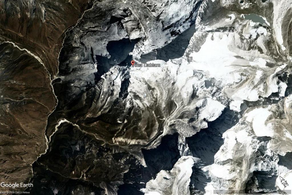
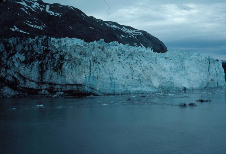
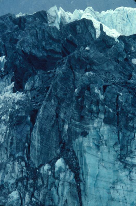
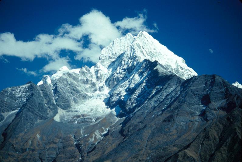
4 glacier-outburst flood & mass movements from cirque, Ama Dablam, Nepal outwash fans, Glacier Bay, Alaska
5
6 Stratified Marginal Features kames: moundlike hills of layered sand & gravel from minor swells to 50 m high kame terraces: drift deposited in narrow lake or stream channels between the valley side & lateral edge of stagnating ice kettle holes: circular depressions from burial of isolated ice blocks by stratified drift; ice melts & drift collapses esker: ridges of fluvioglacial drift formed in tunnels beneath the ice, in crevasses, or in supraglacial channels


7 kettles, Wind River Range, Wyoming kame terrace, Scotland mountain front kame terrace, nw MT
8 Moraines (marginal) end: at or near edges of active glaciers terminal: end moraine at farthest point of advance lateral: sides of valley interlobate: at junction of two lobes medial: at junction of two valley glaciers ground: beneath glacier Interior features ground moraine: smoothly undulating plains < 10 m total relief fluted surfaces: narrow, regularly spaced, parallel ridges & grooves < 5m high & several hundred m long drumlins: elongated parallel to ice flow, 1-2 km long, m wide, 5-50 m high, tend to cluster together; may be erosional (streamline pre-existing drift), or depositional (ice deposits & molds material as it moves)

9 Glacier Bay, Alaska
10 Talkeetna, Alaska


11 lateral moraine, Rocky Mountain National Park Nepal lateral moraine, Jasper National Park, Canada


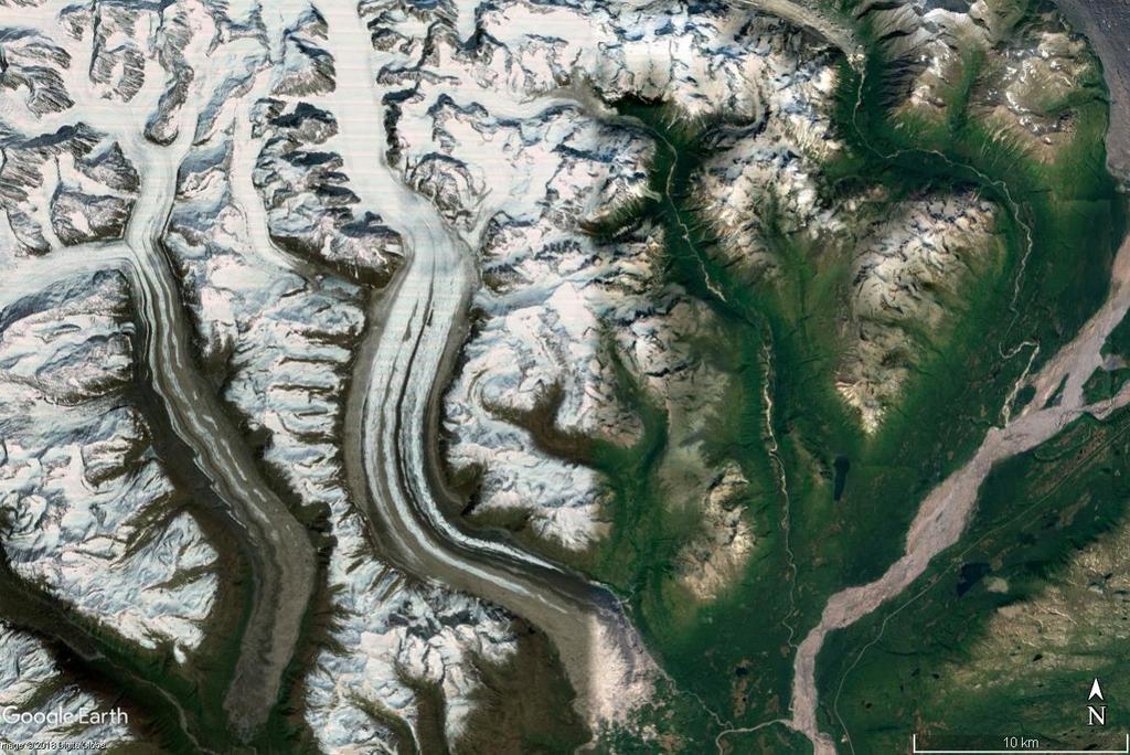
12 moraine-dammed lake & lateral moraines, Wind River Range, Wyoming Holocene moraines, Longs Peak, CO recent moraine, Great Basin N.P., Nevada

13 Moraine Park, Rocky Mountain NP


14 medial & recessional moraines, Storjuvbreein Glacier, Norway
15 Greenland

16 Sawtooth Mountains, Idaho
17


18 recessional moraines, Mt. Rainier, WA recessional moraines, Athabaska Glacier, Canada
19 Proglacial sandur (plural sandar): large plain of outwash; similar to alluvial fans valley sandur: created by one main river & anabranches (called valley trains in US) plain sandur: coalescence of many braided rivers (called outwash plain in US) sandar are composed of sand & gravel (fines deflated) Three zones of sandar are proximal: close to ice, rivers entrenched, pitted surface (kettled sandar) due to kettleholes intermediate: channels wide, shallow, braided & rapidly laterally shifting distal: channels so shallow that rivers merge to a single sheet of water at high flow Sandar form via a large sediment supply & high floods such as jokulhlaups sudden release of lake water dammed within ice
20 Vatnajokul Iceland
21

22 sandur, s. Iceland


23 Matanuska Glacier & braided river, Alaska glacial outwash fan, Yoho National Park, Canada outwash fan, Glacier Bay, Alaska


24 Fairweather Range, Alaska glacial lacustrine sediments, Nepal river with glacial flour, Yoho National Park, Canada
PHYSICAL GEOGRAPHY GEOGRAPHY EARTH SYSTEMS COASTAL SYSTEMS FLUVIAL SYSTEMS
 PHYSICAL GEOGRAPHY EARTH SYSTEMS FLUVIAL SYSTEMS COASTAL SYSTEMS PHYSICAL GEOGRAPHY CORRIES / CIRQUES A Corrie or Cirque is the armchair shaped hollow that was the birthplace of a glacier. It has steep,
Glaciers and Glaciation Earth - Chapter 18 Stan Hatfield Southwestern Illinois College
 Glaciers and Glaciation Earth - Chapter 18 Stan Hatfield Southwestern Illinois College Glaciers Glaciers are parts of two basic cycles: 1. Hydrologic cycle 2. Rock cycle A glacier is a thick mass of ice
glacier Little Ice Age continental glacier valley glacier ice cap glaciation firn glacial ice plastic flow basal slip Chapter 14
 Little Ice Age glacier valley glacier continental glacier ice cap glaciation firn glacial ice plastic flow basal slip glacial budget zone of accumulation zone of wastage glacial surge abrasion glacial
Glaciers Earth 9th Edition Chapter 18 Mass wasting: summary in haiku form Glaciers Glaciers Glaciers Glaciers Formation of glacial ice
 1 2 3 4 5 6 7 8 9 10 11 12 13 14 15 Earth 9 th Edition Chapter 18 Mass wasting: summary in haiku form Ten thousand years thence big glaciers began to melt - called "global warming." are parts of two basic
GEOMORPHOLOGY EXAM #3
 Formation of Glaciers GEOMORPHOLOGY EXAM #3 - Transformation of snow into glacial ice - Density; SNOW = 0.07 0.18 g/cc FIRN(Neve) = 0.4 0.8 g/cc (Pellets) GLACIAL ICE = 0.8 0.9 g/cc - Firn / Ice Boundary
Gifts of the Glaciers
 Gifts of the Glaciers Gifts of the Glaciers Moving ice of glacier was responsible for water, landforms, and soil characteristics and patterns of today Sculpturing of bedrock materials Glacial Landforms
READING QUESTIONS: Glaciers GEOL /WI 60 pts. a. Alpine Ice from larger ice masses flowing through a valley to the ocean
 READING QUESTIONS: Glaciers GEOL 131 18/WI 60 pts NAME DUE: Tuesday, March 13 Glaciers: A Part of Two Basic Cycles (p. 192-195) 1. Match each type of glacier to its description: (2 pts) a. Alpine Ice from
Glaciers. Valley or Alpine glaciers. Ice sheets. Piedmont - foot of the mountain glaciers. Form in mountainous areas Move downslope in valleys
 Glaciers & Ice Ages Glaciers Valley or Alpine glaciers Form in mountainous areas Move downslope in valleys Ice sheets Move outward from center Continental glaciers - large scale, ice age type. Presently
The Physical Geography of Long Island
 The Physical Geography of Long Island A Bit About Long Island Length 118 miles Brooklyn to Montauk Geo202 Spring 2012 Width 23 miles at it s widest Area 1,400 square miles Formation of Long Island River
READING QUESTIONS: Chapter 7, Glaciers GEOL 131 Fall pts. a. Alpine Ice from larger ice masses flowing through a valley to the ocean
 READING QUESTIONS: Chapter 7, Glaciers GEOL 131 Fall 2018 63 pts NAME DUE: Tuesday, October 23 Glaciers: A Part of Two Basic Cycles (p. 192-195) 1. Match each type of glacier to its description: (2 pts)
1 Glacial Erosion and
 www.ck12.org Chapter 1. Glacial Erosion and Deposition CHAPTER 1 Glacial Erosion and Deposition Lesson Objectives Discuss the different erosional features formed by alpine glaciers. Describe the processes
Recrystallization of snow to form LARGE. called FIRN: like packed snowballs. the weight of overlying firn and snow.
 Chapter 11 Glaciers BFRB P. 103-104, 104, 108, 117-120120 Process of Glacier Formation Snow does NOT melt in summer Recrystallization of snow to form LARGE crystals of ice (rough and granular) called
Glaciers Earth Chapter 18 Chapter 18 Glaciers & Glaciation Glaciers: A Part of Two Basic Cycles Glaciers: A Part of Two Basic Cycles Valley Glacier
 1 2 3 4 5 6 7 8 9 10 11 12 Glaciers Earth Chapter 18 Chapter 18 Glaciers & Glaciation A glacier is a thick mass of ice that forms, over hundreds and thousands of years, by the accumulation, compaction,
1.4 Understand how moving ice acts as an agent of erosion and deposition. (Chap. 2)
") 1.4 Understand how moving ice acts as an agent of erosion and deposition. (Chap. 2) There are two types of glaciation. Alpine Glaciation Continental Glaciation Distinguish between the terms alpine glaciation
1.4 Understand how moving ice acts as an agent of erosion and deposition. (Chap. 2) There are two types of glaciation. Alpine Glaciation Continental Glaciation Distinguish between the terms alpine glaciation
Chapter 14. Glaciers and Glaciation
 Chapter 14 Glaciers and Glaciation Introduction Pleistocene Glaciations: A series of "ice ages" and warmer intervals that occurred 2.6 million to 10,000 years ago. The Little Ice Age was a time of colder
Glacial Origins and Features of Long Island
 Glacial Origins and Features of Long Island Interior Coastal Plain Continental Shelf Long Island s Geology 0 Ma Phanerozoic 540 Ma Proterozoic 2500 Ma Archean 3800 Ma Hadean 4600 Ma C M P Geologic Time
Glaciers and Glaciation
 Chapter 18 Lecture Earth: An Introduction to Physical Geology Eleventh Edition Glaciers and Glaciation Tarbuck and Lutgens Glaciers: A Part of Two Basic Cycles A glacier is a thick mass of ice that forms,
GLACIATION. The Last Ice Age (see Chapter 12) and. Pleistocene Ice Cap. Glacial Dynamics 10/2/2012. Laurentide Ice Sheet over NYS
 and. Pleistocene Ice Cap. Glacial Dynamics 10/2/2012. Laurentide Ice Sheet over NYS") GLACIATION and New York State Prof. Anthony Grande The Last Ice Age (see Chapter 1) The Pleistocene Epoch began 1.6 mya. During this time, climates grew colder. There were numerous ice ages starting 100,000000
GLACIATION and New York State Prof. Anthony Grande The Last Ice Age (see Chapter 1) The Pleistocene Epoch began 1.6 mya. During this time, climates grew colder. There were numerous ice ages starting 100,000000
Shaping of North America. Physical Geography II of the United States and Canada. The Last Ice Age. The Ice Age. Pleistocene Polar Ice Cap 2/14/2013
 Physical Geography II of the United States and Canada Prof. Anthony Grande AFG 2012 Shaping of North America The chief shaper of the landscape of North America is and has been running water. Glaciation
LAB P - GLACIAL PROCESSES AND LANDSCAPES
 Introduction LAB P - GLACIAL PROCESSES AND LANDSCAPES Ice has been a significant force in modifying the surface of the earth at numerous times throughout Earth s history. Though more important during the
ENVI2030L - ALPINE AND CONTINENTAL GLACIATION
 NAME ENVI2030L - ALPINE AND CONTINENTAL GLACIATION I. Introduction Glaciers are slowly moving ice sheets. They are very effective erosional agents and can drastically modify the landscapes over which they
2. (1pt) From an aircraft, how can you tell the difference between a snowfield and a snow-covered glacier?
 From an aircraft, how can you tell the difference between a snowfield and a snow-covered glacier?") 1 GLACIERS 1. (2pts) Define a glacier: 2. (1pt) From an aircraft, how can you tell the difference between a snowfield and a snow-covered glacier? 3. (2pts) What is the relative size of Antarctica, Greenland,
1 GLACIERS 1. (2pts) Define a glacier: 2. (1pt) From an aircraft, how can you tell the difference between a snowfield and a snow-covered glacier? 3. (2pts) What is the relative size of Antarctica, Greenland,
Glaciers. Chapter 17
 Glaciers Chapter 17 Vocabulary 1. Glacier 2. Snowfield 3. Firn 4. Alpine glacier 5. Continental glacier 6. Basal slip 7. Internal plastic flow 8. Crevasses 9. Glacial grooves 10. Ice shelves 11. Icebergs
Dynamic Planet Practice Test Written by Samuel Bressler
 Dynamic Planet Practice Test 2013 Written by Samuel Bressler Part 1: Multiple Choice 1. Which of the following is NOT related to alpine glaciation? a) Serac b) Kame c) Col d) Paternoster Lake 2. The common
Please make sure that all teachers and chaperones attending the field study are aware of the following information:
 Dear Teacher, Thank you for signing up for The Ice Age at the Lost Valley Visitor Center in Glacial Park. The visitor center is located in the middle of Glacial Park. Follow the signs from the Harts Road
Glaciers. Glacier Dynamics. Glacier Dynamics. Glaciers and Glaciation. Types of Glaciers. Chapter 15
 Chapter 15 Glaciers and Glaciation Glaciers A glacier is a large, permanent (nonseasonal) mass of ice that is formed on land and moves under the force of gravity. Glaciers may form anywhere that snow accumulation
Dynamic Planet: Glaciers
 Team Name+Number Teammate 1 name Teammate 2 name Dynamic Planet: Glaciers (by Shad160) The following test is 80 questions long, split up into four different sections. The first 20 questions are worth 40
Chapter 16 Glaciers and Glaciations
 Chapter 16 Glaciers and Glaciations Name: Page 419-454 (2nd Ed.) ; Page 406-439 (1st Ed.) Part A: Anticipation Guide: Please read through these statements before reading and mark them as true or false.
I. Types of Glaciers 11/22/2011. I. Types of Glaciers. Glaciers and Glaciation. Chapter 11 Temp. B. Types of glaciers
 Why should I care about glaciers? Look closely at this graph to understand why we should care? and Glaciation Chapter 11 Temp I. Types of A. Glacier a thick mass of ice that originates on land from the
Glacial Geomorphology Exercise
 James Madison University Field Course in western Ireland Glacial Geomorphology Exercise 3-day road log (abbreviated) Striations Large kame terrace Cirque with moraines Kame delta Striations Eskers Raised
traverse from the outwash plain terminal moraine and recessional (Sag Harbor, Greenport and Southold
 1 27 DEGLACIATION OF EASTERN LONG ISLAND: THE TERMINAL MORAINE. RECESSIONAL MORAINES. OUTWASH PLAINS. PROGLACIAL LAKES AND MELTWATER CHANNELS LES SIRKIN. EARTH SCIENCE. ADELPHI UNIVERSITY. GARDEN CITY.
MIDDLE SCHOOL CURRICULUM TR AILING ICE AGE M YST ERI E S SEARCHING GLACIAL FEATURES
 MIDDLE SCHOOL CURRICULUM TR AILING ICE AGE M YST ERI E S SEARCHING GLACIAL FEATURES CONTENTS I. Enduring Knowledge... 3 II. Teacher Background... 3 III. Before Viewing the Video... 5 IV. Viewing Guide...
MIDDLE SCHOOL CURRICULUM TR AILING ICE AGE M YST ERI E S ICE AGE TREKKING
 MIDDLE SCHOOL CURRICULUM TR AILING ICE AGE M YST ERI E S ICE AGE TREKKING CONTENTS I. Enduring Knowledge... 3 II. Teacher Background... 3 III. Before Viewing this Video... 5 IV. Viewing Guide... 5 V. Discussion
12: MELTWATER LANDFORM IDENTIFICATION
 Glacial Geology 12. Meltwater Landform Identification 12: MELTWATER LANDFORM IDENTIFICATION 60 Points Objective: learn how to identify meltwater landforms and their characteristics in photos and on topographic
GC 225 Lecture Exam #2
 GC 225 Lecture Exam #2 Direction- path along which something is moving. 3 Types; - COMPASS DIRECTIONAL NAME (32 in total) - BEARING (four 0 o - 90 o ) - AZIMUTHS (0 o - 360 o ) Compass (32 named points)
Chapter 17. Glacial & Periglacial Landscapes
 Chapter 17 Glacial & Periglacial Landscapes Cryosphere Cryosphere - the portions of Earth's surface where water is in solid form, including sea ice, lake ice, river ice, snow cover, glaciers, ice caps,
Glaciers. Glacier Dynamics. Glaciers and Glaciation. East Greenland. Types of Glaciers. Chapter 16
 Chapter 16 Glaciers A glacier is a large, permanent (nonseasonal) mass of ice that is formed on land and moves under the force of gravity. Glaciers may form anywhere that snow accumulation exceeds seasonal
E arth s climate strongly influences
 Section 7.1 7.1 Glaciers 1 FOCUS Section Objectives 7.1 Describe the different types of glaciers and where each type is found. 7.2 Explain how glaciers move and describe the different types of glacial
Glaciology. Water. Glacier. Moraine. Types of glacier-dammed lakes. Mechanics of jökulhlaup
 A Jökulhlaup Jökulhlaup. Catastrophic events where large amounts of water are suddenly discharged. Jökulhlaup s are a sudden and rapid draining of a glacier dammed lake or of water impounded within a glacier.
Name Team Number. 1. The famous question: What percent of Earth's surface is covered by glaciers? A) 5% D) neve
 5% D) neve") Part I: Multiple Choice (30pts) Directions: Please choose the best answer for each question. There is only one correct answer for each question unless otherwise stated. There are 30 questions. Each one
Part I: Multiple Choice (30pts) Directions: Please choose the best answer for each question. There is only one correct answer for each question unless otherwise stated. There are 30 questions. Each one
Glaciers and Periglaciers
 Glaciers and Periglaciers Chapter 9, page 132 Glaciation!1836 Louis Agassiz theorized that parts of Europe and North America were covered by huge ice sheets.!known as the Pleistocene Ice Ages Why do we
Teacher s Guide For. Glaciers
 Teacher s Guide For Glaciers For grade 7 - College Program produced by Centre Communications, Inc. for Ambrose Video Publishing, Inc. Executive Producer William V. Ambrose Teacher's Guide by Mark Reeder
Parts of a Glacier Division A Study Guide- Part 2
 Parts of a Glacier Division A Study Guide- Part 2 Zones of a glacier Zone of Accumulation: The region where snowfall adds ice to the glacier. It occurs where the temperature remains cold enough year-round
NYS Invitational Science Olympiad April 2005 DYNAMIC PLANET: GLACIERS
 NYS Invitational Science Olympiad April 2005 School Team # DYNAMIC PLANET: GLACIERS 1. What type of glacier is shown in the photo? 2. a. What is the name of the feature labeled A? b. How did feature A
Geologic Trips, Sierra Nevada
 ISBN 0-9661316-5-7 GeoPress Excerpt from Geologic Trips, Sierra Nevada by Ted Konigsmark All rights reserved. No part of this book may be reproduced without written permission, except for critical articles
c. 1 inch = 0.6 miles e. 1:100,000 f. 1:250,000 f. 1 inch = 4.0 miles
 High School Advance Geology Map Test 2014 Name Use the information on each map to provide the best answer to the questions. Fill in the bubble of the best answer on your answer sheet. Answer questions
NEW OBSERVATIONS ON THE GLACIAL GEOMORPHOLOGY OF LONG ISLAND FROM A DIGITAL ELEVATION MODEL (DEM) Bennington, J Bret,
 Bennington, J Bret,") 1 NEW OBSERVATIONS ON THE GLACIAL GEOMORPHOLOGY OF LONG ISLAND FROM A DIGITAL ELEVATION MODEL (DEM) Abstract Bennington, J Bret, geojbb@hofstra.edu Department of Geology 114 Hofstra University, Hempstead,
1 NEW OBSERVATIONS ON THE GLACIAL GEOMORPHOLOGY OF LONG ISLAND FROM A DIGITAL ELEVATION MODEL (DEM) Abstract Bennington, J Bret, geojbb@hofstra.edu Department of Geology 114 Hofstra University, Hempstead,
47I THE LAS ANIMAS GLACIER.
 THE LAS ANIMAS GLACIER. ONE of the largest of the extinct glaciers of the Rocky Mountains was that which occupied the valley of the Las Animas river. This stream originates in the San Juan mountains in
CHAPTER. ICE-MARGINAL TERRESTRIAL LANDSYSTEMS: SOUTHERN LAURENTIDE ICE SHEET MARGIN Patrick M. Colgan, David M. Mickelson and Paul M.
 06-Evans-Glacial-06-ppp 23/5/03 12:02 pm Page 111 CHAPTER 6 ICE-MARGINAL TERRESTRIAL LANDSYSTEMS: SOUTHERN LAURENTIDE ICE SHEET MARGIN Patrick M. Colgan, David M. Mickelson and Paul M. Cutler 6.1 INTRODUCTION
Alpine Glacial Features along the Chimney Pond Trail, Baxter State Park, Maine
 Maine Geologic Facts and Localities September, 2009 Alpine Glacial Features along the Chimney Pond Trail, Baxter State Park, Maine 45 54 57.98 N, 68 54 41.48 W Text by Robert A. Johnston, Department of
Glaciers. Clicker Question. Glaciers and Glaciation. How familiar are you with glaciers? West Greenland. Types of Glaciers.
 Chapter 21 Glaciers A glacier is a large, permanent (nonseasonal) mass of ice that is formed on land and moves under the force of gravity. Glaciers may form anywhere that snow accumulation exceeds seasonal
Q: What is a period of time whereby the average global temperature has decreased? Q: What is a glacier?
 Q: What is a glacier? A: A large sheet of ice which lasts all year round. Q: What is a period of time whereby the average global temperature has decreased? A: A glacial. Q: What is an interglacial? Q:
Ice-marginal geomorphology and Holocene expansion of debris-covered Tasman Glacier, New Zealand
 Debris-Covered Glaciers (Proceedings of a workshop held at Seattle, Washington, USA, September 2000). IAHS Publ. no. 264, 2000. 211 Ice-marginal geomorphology and Holocene expansion of debris-covered Tasman
A trip to Steindalen. - geology and landscape on the way to the glacier. Geoffrey D. Corner
 A TRIP TO STEINDALEN Excursion guide Please take this with you on your trip, but don t leave it behind as litter. A trip to Steindalen - geology and landscape on the way to the glacier A part of Geologiskolen,
Glaciers. Reading Practice
 Reading Practice A Glaciers Besides the earth s oceans, glacier ice is the largest source of water on earth. A glacier is a massive stream or sheet of ice that moves underneath itself under the influence
Identification and Classification of Kettle Chains Using 2 meter Digital Elevation Model of Long Island! -Sean Tvelia-!
 Identification and Classification of Kettle Chains Using 2 meter Digital Elevation Model of Long Island -Sean Tvelia- Recently released 2.0 meter Digital Elevation Models (DEMs) of the central and eastern
THE INFLUENCE OF DEBRIS ON THE FLOW OF GLACIERS.
 THE INFLUENCE OF DEBRIS ON THE FLOW OF GLACIERS. THE behavior of ice under various conditions is frequently illustrated by experiments with pitch or other similar viscous fluids or plastic solids. If sand
The Potentially Dangerous Glacial Lakes
 Chapter 11 The Potentially Dangerous Glacial Lakes On the basis of actively retreating glaciers and other criteria, the potentially dangerous glacial lakes were identified using the spatial and attribute
Great Science Adventures
 Great Science Adventures Lesson 18 How do glaciers affect the land? Lithosphere Concepts: There are two kinds of glaciers: valley glaciers which form in high mountain valleys, and continental glaciers
Glaciated Landscapes. New A Level Subject Content Overview Authors: Dr Richard Waller and Dr Peter Knight
 Glaciated Landscapes New A Level Subject Content Overview Authors: Dr Richard Waller and Dr Peter Knight Dr Peter Knight is Reader at the School of Physical and Geographical Sciences, Keele University
USGS/Austin Post. (b)
") TYPES OF GLACIERS 525 NASA/GSFC/MITI/ERSDAC/JAROS, and U.S./Japan ASTER Science Team (a) USGS/Austin Post (b) FIGURE 19.2 Glaciers that flow into the sea or a deep lake undergo calving, the process by
TYPES OF GLACIERS 525 NASA/GSFC/MITI/ERSDAC/JAROS, and U.S./Japan ASTER Science Team (a) USGS/Austin Post (b) FIGURE 19.2 Glaciers that flow into the sea or a deep lake undergo calving, the process by
Changing Landscapes: Glaciated Landscapes. What are glaciers?
 Changing Landscapes: Glaciated Landscapes What are glaciers? What you need to know Types of ice mass at a range of scales including cirque glaciers, valley glaciers, highland ice field, piedmont glaciers,
Making glacial connections
 Student task A 1. Cut and arrange the cards below to make four sets of four connections: Four connections Matterhorn drumlin lateral U-shaped valley outwash plain truncated spur Lauterbrunnen ground medial
GLACIER STUDIES OF THE McCALL GLACIER, ALASKA
 GLACIER STUDIES OF THE McCALL GLACIER, ALASKA T John E. Sater* HE McCall Glacier is a long thin body of ice shaped roughly like a crescent. Its overall length is approximately 8 km. and its average width
raft iiii mi.{.i.v mul\ illliiilli 1 : IB I RbBsJKHR Hfffl attwit ttinli
 ; raft iiii mi.{.i.v m I H I mul\ HI illliiilli 111 1 : IB I RbBsJKHR Hfffl attwit...;','-' ffliill IB ttinli URBANA STATE OF ILLINOIS HENRY HORNER, Governor DEPARTMENT OF REGISTRATION AND EDUCATION
A new technique for identifying rock-avalanche-sourced sediment in moraines and some palaeoclimatic implications
 GSA DATA REPOSITORY 2012090 SUPPLEMENTARY INFORMATION A new technique for identifying rockavalanchesourced sediment in moraines and some palaeoclimatic implications Natalya V. Reznichenko 1*, Timothy R.H.
The Northeast: America's Gateway to the World
 The Northeast: America's Gateway to the World Living in the Shadow of the Ice a lesson on the impact of glaciation on Northeast landscapes INTRODUCTION: The region we call the Northeast has a very long
Long Island Subglacial Drainage Patterns Reveal the Direction of Glacial Flow
 Long Island Subglacial Drainage Patterns Reveal the Direction of Glacial Flow Waldemar Pacholik Introduction: The debate regarding the chronology of the development of Long Island s (LI s) topography is
Did It. naturalists. Young. Moving and melting ice shaped many of Minnesota s land features. 30 Minnesota Conservation Volunteer
 Young naturalists by Mary Hoff Photography by Gary Alan Nelson T he Glacier Did It Moving and melting ice shaped many of Minnesota s land features. Shut your eyes. Imagine that it s a sunny summer day
Durham Research Online
 Durham Research Online Deposited in DRO: 10 June 2010 Version of attached le: Published Version Peer-review status of attached le: Peer-reviewed Citation for published item: Bennett, G. L. and Evans, D.
Lesson. Glaciers Carve the Land A QUICK LOOK. Overview. Big Idea. Process Skills Key Notes
 EARTH S CHANGING SURFACE CLUSTER 2 HOW THE EARTH S SURFACE CHANGES Lesson 62 Glaciers Carve the Land A QUICK LOOK Big Idea Moving water, ice, and wind break down rock, transport materials, and build up
Glacier facts and information about Nigardsbreen
 Glacier facts and information about Nigardsbreen Fact sheet for Jostedalen Breførarlag made by Marthe Gjerde 1/1/2014 University of Bergen Marthe Gjerde J.C. Dahl Time WHAT IS A GLACIER? A glacier is a
Geoscape Toronto The Oak Ridges Moraine Activity 2 - Page 1 of 10 Information Bulletin
 About 13,000 years ago as the Laurentide Ice Sheet melted, glacial meltwater accumulated between the ice sheet and the Niagara Escarpment. This formed a lake basin into which gravel and sand were deposited.
MORAINE OF THE PUGET SOUND GLACIER
 THE TERMINAL MORAINE OF THE PUGET SOUND GLACIER I. GENERAL CHARACTER OF THE COUNTRY SOUTH OF PUGET SOUND The region of Puget Sound, inclosed between the Olympic and Cascade ranges, is a heavily drift-covered
Physical Geography: Learning and teaching in a discipline so dynamic that textbooks can t keep up!
 MATTERS Physical Geography: Learning and teaching in a discipline so dynamic that textbooks can t keep up! PETER G. KNIGHT ABSTRACT: Physical geography is a dynamic discipline. This makes geography exciting,
GLACIATED VALLEY LANDSYSTEMS
 15-Evans-Glacial-15-ppp 5/27/03 2:38 PM Page 372 CHAPTER 15 GLACIATED VALLEY LANDSYSTEMS Douglas I. Benn, Martin P. Kirkbride, Lewis A. Owen and Vanessa Brazier 15.1 INTRODUCTION The concept of the glaciated
Geography 120, Instructor: Chaddock In Class 13: Glaciers and Icecaps Name: Fill in the correct terms for these descriptions: Ablation zone: n zne:
 Geography 120, Instructor: Chaddock In Class 13: Glaciers and Icecaps Name: Fill in the correct terms for these descriptions: Ablation zone: The area of a glacier where mass is lost through melting or
Lidar Imagery Reveals Maine's Land Surface in Unprecedented Detail
 Maine Geologic Facts and Localities December, 2011 Lidar Imagery Reveals Maine's Land Surface in Unprecedented Detail Text by Woodrow Thompson, Department of Agriculture, Conservation & Forestry 1 Introduction
Landscapes in the UK: Glaciation 1. Extent of ice cover across the UK during the last ice age.
 Landscapes in the UK: Glaciation 1. Extent of ice cover across the UK during the last ice age. Key idea: Ice was a powerful force in shaping the landscape of the UK. As the climate has changed in the past,
How Glaciers Change the World By ReadWorks
 How Glaciers Change the World How Glaciers Change the World By ReadWorks Glaciers are large masses of ice that can be found in either the oceans or on land. These large bodies of frozen water have big
Fláajökull Field trip and Excursion Report Glacial geology (JAR407)
") University of Iceland School of Engineering and Natural Science Earth Science Fláajökull Field trip and Excursion Report Glacial geology (JAR407) Students in group 8: Björg Jónsdóttir Einar Ragnar Sigurðsson
University of Iceland School of Engineering and Natural Science Earth Science Fláajökull Field trip and Excursion Report Glacial geology (JAR407) Students in group 8: Björg Jónsdóttir Einar Ragnar Sigurðsson
GY 301: Geomorphology Lab 9: Alpine Glaciers and Geomorphology
 Name: Raw score: /45 Percentage: /100% Your Task: Today s lab deals with the interpretation of geomorphological features that typically result from alpine glacial activity. The exercises should be able
THE DEPARTMENT OF HIGHER EDUCATION UNIVERSITY OF COMPUTER STUDIES FIFTH YEAR
 THE DEPARTMENT OF HIGHER EDUCATION UNIVERSITY OF COMPUTER STUDIES FIFTH YEAR (B.C.Sc./B.C.Tech.) RE- EXAMINATION SEPTEMBER 2018 Answer all questions. ENGLISH Time allowed: 3 hours QUESTION I Glaciers A
Using LiDAR to study alpine watersheds. Chris Hopkinson, Mike Demuth, Laura Chasmer, Scott Munro, Masaki Hayashi, Karen Miller, Derek Peddle
 Using LiDAR to study alpine watersheds Chris Hopkinson, Mike Demuth, Laura Chasmer, Scott Munro, Masaki Hayashi, Karen Miller, Derek Peddle Light Detection And Ranging r t LASER pulse emitted and reflection
Red Tarn, Lake District They are all features of glacial erosion
 Ribbon Lake Lake Windermere, Lake District Arete Striding Edge, Lake District 1 2 3 Pyramidal Peak Corrie & Tarn 4 Matterhorn, Switzerland Red Tarn, Lake District They are all features of glacial erosion
Description of units in the geomorphic database of Sweden
 Description of units in the geomorphic database of Sweden Gustaf Peterson & Colby A. Smith Mars 2013 SGU-rapport 2013:4 Hillshade of a detailed digital elevation model (H) beneath digitised geomorphic
BLASTING GLACIAL ICE AND SNOW ABSTRACT
 BLASTING GLACIAL ICE AND SNOW HERB BLEUER ABSTRACT This presentation, with the aid of slides, is about methods of blasting large quantities of glacial ice and snow. The project illustrated here involved
What is a Glacier? GLACIOLOGY vs. GLACIAL GEOLOGY. snow corn firn glacier snow = neve ice
 What is a Glacier? Mass of Ice Derived from Snow Lasts from Year to Year Moves Due to Its Own Weight GLACIOLOGY vs. GLACIAL GEOLOGY Transformation of Snow to Glacial Ice snow corn firn glacier snow = neve
THE OHIO JOURNAL OF SCIENCE
 THE OHIO JOURNAL OF SCIENCE VOL. XXXI NOVEMBER, 1931 No. 6 GLACIATION OF NORTHWESTERN HOLMES COUNTY, OHIO.* GEORGE W. WHITE, University of New Hampshire. CONTENTS. PAGE INTRODUCTION AND ACKNOWLEDGMENTS
Recent glacier advances at Glaciar Exploradores, Hielo Patagónico Norte, Chile
 Bulletin of Glaciological Research,. (,**1).3 /1 Japanese Society of Snow and Ice 49 Recent glacier advances at Glaciar Exploradores, Hielo Patagónico Norte, Chile Masamu ANIYA +, Gonzalo BARCAZA, and
Geomorphology. Glacial Flow and Reconstruction
 Geomorphology Glacial Flow and Reconstruction We will use simple mathematical models to understand ice dynamics, recreate a profile of the Laurentide ice sheet, and determine the climate change of the
Landscapes in the UK: Glaciation 1. Extent of ice cover across the UK during the last ice age.
 Landscapes in the UK: Glaciation 1. Extent of ice cover across the UK during the last ice age. Key idea: Ice was a powerful force in shaping the landscape of the UK. In the past the climate has got colder
Tidewater Glaciers: McCarthy 2018 Notes
 Tidewater Glaciers: McCarthy 2018 Notes Martin Truffer, University of Alaska Fairbanks June 1, 2018 What makes water terminating glaciers special? In a normal glacier surface mass balance is always close
AGAP Antarctic Research Project Visualizing Data Learning About Antarctica From RADAR Data? Student Version
 AGAP Antarctic Research Project Visualizing Data Learning About Antarctica From RADAR Data? Student Version Name Date Image of Subglacial Lake network courtesy of NSF Ice Sheet: A large glacier that covers
INVESTIGATIONS OF TWO ESKERS AT EASTERN BREIDAMERKURJOKULL, ICELAND
 1 Arctic and Alpine Research, Vol. 3, No. 4, 1971, pp. 305-318. NVESTGATONS OF TWO ESKERS AT EASTERN BREDAMERKURJOKULL, CELAND PHLP J. HOWARTH Departnzent of Geography McMaster University Hanzilton, Ontario,
What is a Glacier? GLACIOLOGY vs. GLACIAL GEOLOGY. snow corn firn glacier snow = neve ice
 What is a Glacier? Mass of Ice Derived from Snow Lasts from Year to Year Moves Due to Its Own Weight GLACIOLOGY vs. GLACIAL GEOLOGY Transformation of Snow to Glacial Ice snow corn firn glacier snow = neve
Barbara Borowiecki University of Wisconsin - Milwaukee
 POTENTIAL SIGNIFICANCE OF DRu}~IN FIELD MODIFICATION Barbara Borowiecki University of Wisconsin - Milwaukee Spatial characteristics of numerous drumlin fields, including the one in Wisconsin, have been
THE GLACIATION OF THE UINTA MOUNTAINS'
 THE GLACIATION OF THE UINTA MOUNTAINS' WALLACE W. ATWOOD The University of Chicago OUTLINE Location and General Physical Features of the Range. The Extent of Glaciation. Comparison of the Glaciation of
ROCK GLACIERS IN ALASKA'
 ROCK GLACIERS IN ALASKA' It is a generally admitted fact among observers of present-day geologic processes in high latitudes, but one upon which too little emphasis has been placed, that processes of weathering
GLACATIONS OF THE DAVAATIIN REGION OF THE HANGAY NURUU, CENTRAL MONGOLIA
 Coggan, B. and Burenjargal, U. 2007. 20th Annual Keck Symposium; http://keck.wooster.edu/publications GLACATIONS OF THE DAVAATIIN REGION OF THE HANGAY NURUU, CENTRAL MONGOLIA BRIAN COGGAN,Whitman College