Using LiDAR to study alpine watersheds. Chris Hopkinson, Mike Demuth, Laura Chasmer, Scott Munro, Masaki Hayashi, Karen Miller, Derek Peddle
|
|
|
- Dwayne McKenzie
- 5 years ago
- Views:
Transcription

1 Using LiDAR to study alpine watersheds Chris Hopkinson, Mike Demuth, Laura Chasmer, Scott Munro, Masaki Hayashi, Karen Miller, Derek Peddle
2 Light Detection And Ranging r t LASER pulse emitted and reflection timed Measures distance from source to object r = range c = speed of light t = time r = (c x t) / 2
 of point on ground need")
 2.")
 Sensor attitude (ω) Chris")
3 Pulse origin & vector To compute location (b) of point on ground need to know: b = f (a,r,θ,ω) 1. position of pulse start (a) 2. laser pulse vector Range (r) Scan angle (θ) Sensor attitude (ω) Chris Hopkinson 2006 b r θ a


4 Comparison of watershed attributes derived from three DEM sources Chris Hopkinson, Masaki Hayashi, Karen Miller, Derek Peddle To generate DEMs from three typical sources: BC TRIM Softcopy aerial photogrammetry Airborne lidar Compare derived GIS watershed attributes

5 TRIM contour data
6 Stereo photo point data

7 Lidar shaded relief

8 Watershed extents LiDAR Photo TRIM
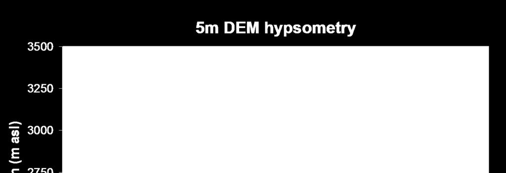
9 Hypsometry

10 Summary Elevations/hypsometry: Photo / TRIM appear stretched - Orientation control TRIM biased downwards - Watershed extent Photo/TRIM overestimate alpine - Gulleys invisible Watershed extents: Photo slightly larger than Lidar Terrain variation TRIM much greater than Lidar Stream topology Stream network: Topology problems with TRIM data Contour spacing Photo ok but imperfect topology Shadows/forests Lidar maps gulley water courses Active illumination


11 Variations in GIS glacial melt prediction with terrain resolution Chris Hopkinson, Laura Chasmer, Scott Munro, Michael N. Demuth Assess impact of DEM resolution on melt prediction: Eight resolutions: 1 m to 1000 m Half hour time step Compare: Total melt Temporal distribution
12 Scale effects on Glacier DEM attributes
13 Δ Diurnal melt rate with resolution m 25 m 100 m 250 m 500 m 1000 m Melt (mm/hr) Scale-based morphology variations impact timing of melt at each resolution Time


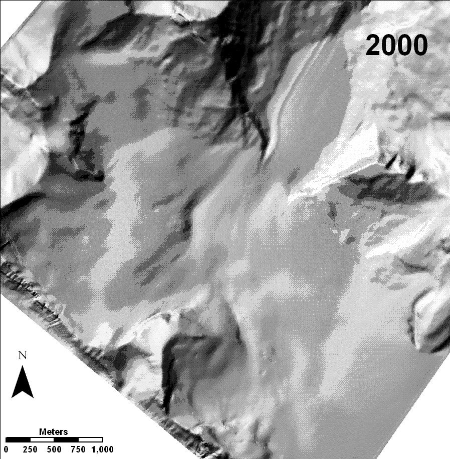
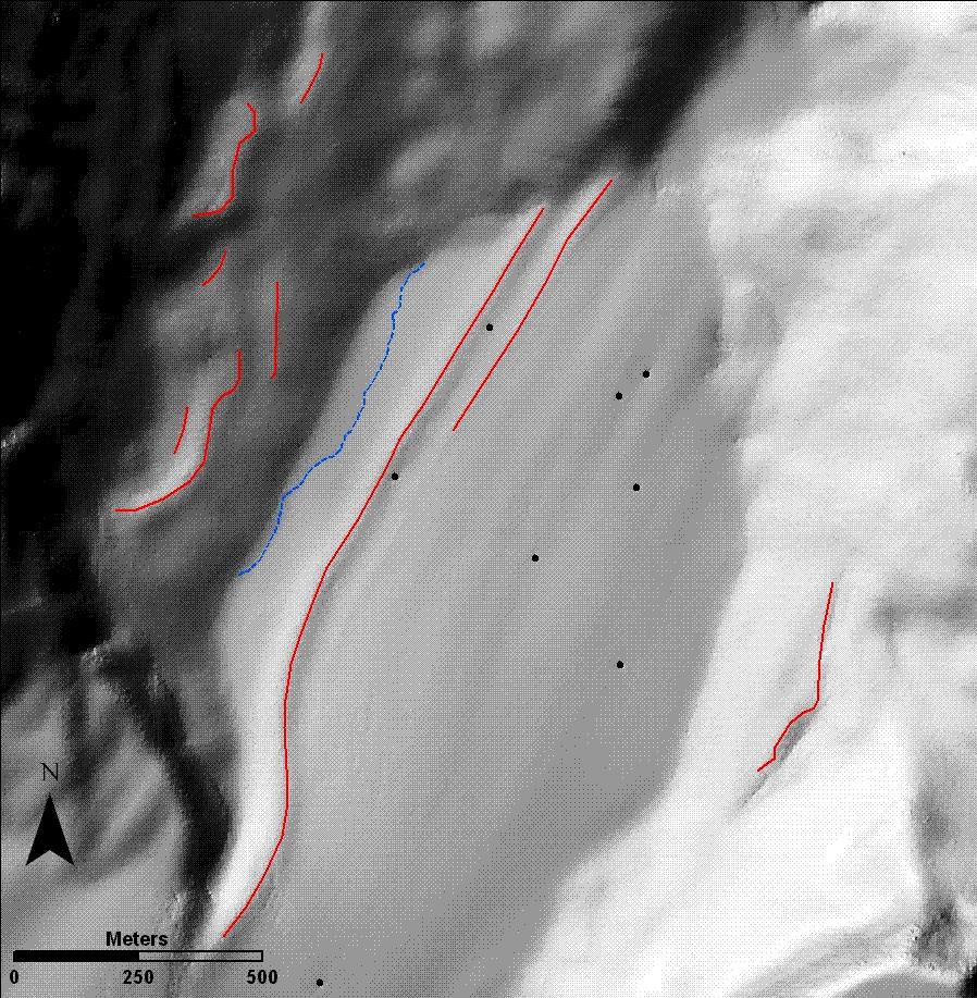
14 Assessing glacier dynamics from multitemporal lidar imagery Chris Hopkinson & Michael N. Demuth Assess glacial / periglacial rates of downwasting & motion 4 lidar datasets: 2000, 02, 06, 07
15 Local context Glacier wastage impacts water resources in western Canada Several studies suggest that mean annual contribution: Is significant (1% to 12%) Depends on size of basin & glacier cover Will reduce as glacier sizes diminish Is wastage decreasing, leveling off or increasing?
16
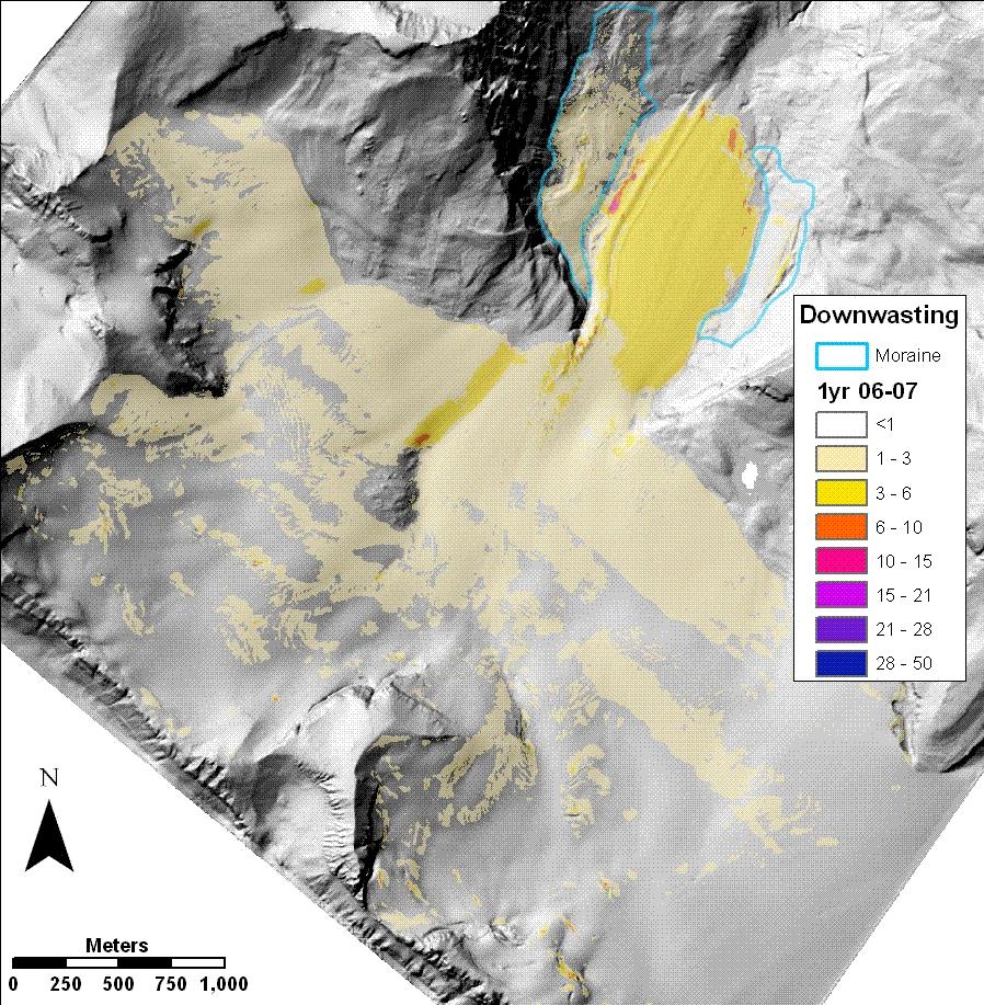
17
18 Observed glacial dynamics Glacier area reduced by ~ 12% from 12.5 km 2 to 11.0 km 2 Downwasting > 40 m in parts of the ablation zone, Mean melt depth increased from 1.0 m p.a. (2000) to 1.6 m p.a. (2007) Mean loss of glacial ice of 14.1 x 10 6 m 3 p.a.


19 Glacial storage capacity reducing
20
21 Observed glacial dynamics Lateral moraine downwasting ~ 1.0 m p.a Annual loss from moraines ranged from 3.7% to 4.8% Ablation zone moulin motion ~ 6 m p.a. Accumulation zone debris movement up to 15 m p.a. Constricted icefall motion up to 20 m p.a. Moraines moving up to 6 m p.a. laterally towards margins

22 Moraine storage capacity increasing

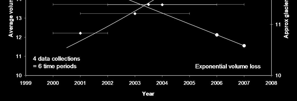
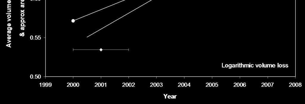
23 Peyto glacier is rapidly losing mass Summary Rate of loss still increasing through time Accumulation zone rapidly transporting mass to ablation zone Ablation zone stagnating Glacial ice loss increasing at exponential rate as volume diminishes Ice cored moraine loss increasing at logarithmic rate as storage capacity increases Ice cored moraine melt water production is increasing as glacier cover diminishes. Its contribution to the river water resource will become critical in the next few decades Hydrological models need to explicitly account for this increasingly important alpine flow component


24 Thank you!
Lidar Imagery Reveals Maine's Land Surface in Unprecedented Detail
 Maine Geologic Facts and Localities December, 2011 Lidar Imagery Reveals Maine's Land Surface in Unprecedented Detail Text by Woodrow Thompson, Department of Agriculture, Conservation & Forestry 1 Introduction
Place Glacier terrain modeling and 3D laser imaging
 Place Glacier terrain modeling and 3D laser imaging Report prepared for the National Glaciology Program of the Geological Survey of Canada In fulfillment of contract # TSD051603X By Dr. Chris Hopkinson,
THE NET VOLUMETRIC LOSS OF GLACIER COVER WITHIN THE BOW VALLEY ABOVE BANFF, /
 THE NET VOLUMETRIC LOSS OF GLACIER COVER WITHIN THE BOW VALLEY ABOVE BANFF, 1951-1993 1/ ABSTRACT CHRIS HOPKINSON 2/ Three methods have been used to explore the volumetric change of glaciers in the Bow
GEOSPATIAL ANALYSIS OF GLACIAL HAZARDS PRONE AREAS OF SHIGAR AND SHAYOK BASINS OF PAKISTAN. By Syed Naseem Abbas Gilany
 GEOSPATIAL ANALYSIS OF GLACIAL HAZARDS PRONE AREAS OF SHIGAR AND SHAYOK BASINS OF PAKISTAN By Syed Naseem Abbas Gilany PRESENTATION OUTLINE Introduction Problem Statement / Rationale Objectives Material
NORTH CASCADE SLACIER CLIMATE PROJECT Director: Dr. Mauri S. Pelto Department of Environmental Science Nichols College, Dudley MA 01571
 NORTH CASCADE SLACIER CLIMATE PROJECT Director: Dr. Mauri S. Pelto Department of Environmental Science Nichols College, Dudley MA 01571 INTRODUCTION The North Cascade Glacier-Climate Project was founded
The SHARE contribution to the knowledge of the HKKH glaciers, the largest ice masses of our planet outside the polar regions
 The SHARE contribution to the knowledge of the HKKH glaciers, the largest ice masses of our planet outside the polar regions Claudio Smiraglia 1 with the collaboration of Guglielmina Diolaiuti 1 Christoph
Glaciers Earth 9th Edition Chapter 18 Mass wasting: summary in haiku form Glaciers Glaciers Glaciers Glaciers Formation of glacial ice
 1 2 3 4 5 6 7 8 9 10 11 12 13 14 15 Earth 9 th Edition Chapter 18 Mass wasting: summary in haiku form Ten thousand years thence big glaciers began to melt - called "global warming." are parts of two basic
Glacial lakes as sentinels of climate change in Central Himalaya, Nepal
 Glacial lakes as sentinels of climate change in Central Himalaya, Nepal Sudeep Thakuri 1,2,3, Franco Salerno 1,3, Claudio Smiraglia 2,3, Carlo D Agata 2,3, Gaetano Viviano 1,3, Emanuela C. Manfredi 1,3,
CHANGES IN GLACIATION OF THE BALKHASH-ALAKOL BASIN OVER THE PAST 60 YEARS
 CHANGES IN GLACIATION OF THE BALKHASH-ALAKOL BASIN OVER THE PAST 60 YEARS I. Severskiy Слайд 1 Glacier Systems of the Balkhash-Alakol basin Research Results Monitoring the Mass Balance of the Tuyuksu Glacier
Using airborne lidar to assess the influence of glacier downwasting on water resources in the Canadian Rocky Mountains
 Can. J. Remote Sensing, Vol. 32, No. 2, pp. 212 222, 2006 Using airborne lidar to assess the influence of glacier downwasting on water resources in the Canadian Rocky Mountains Chris Hopkinson and Michael
Retreating Glaciers of the Himalayas: A Case Study of Gangotri Glacier Using Satellite Images
 Retreating Glaciers of the Himalayas: A Case Study of Gangotri Glacier Using 1990-2009 Satellite Images Jennifer Ding Texas Academy of Mathematics and Science (TAMS) Mentor: Dr. Pinliang Dong Department
Observation of cryosphere
 Observation of cryosphere By Sagar Ratna Bajracharya (email: sagar.bajracharya@icimod.org) Samjwal Ratna Bajracharya Arun Bhakta Shrestha International Centre for Integrated Mountain Development Kathmandu,
Glaciers. Valley or Alpine glaciers. Ice sheets. Piedmont - foot of the mountain glaciers. Form in mountainous areas Move downslope in valleys
 Glaciers & Ice Ages Glaciers Valley or Alpine glaciers Form in mountainous areas Move downslope in valleys Ice sheets Move outward from center Continental glaciers - large scale, ice age type. Presently
Glaciers and Glaciation Earth - Chapter 18 Stan Hatfield Southwestern Illinois College
 Glaciers and Glaciation Earth - Chapter 18 Stan Hatfield Southwestern Illinois College Glaciers Glaciers are parts of two basic cycles: 1. Hydrologic cycle 2. Rock cycle A glacier is a thick mass of ice
glacial drift: all deposits associated with glaciation; covers 8% of Earth s surface above sealevel, and 25% of North America
 Glacial depositional features glacial drift: all deposits associated with glaciation; covers 8% of Earth s surface above sealevel, and 25% of North America i) nonstratified drift till: transported & deposited
CRYOSPHERE ACTIVITIES IN SOUTH AMERICA. Bolivia. Summary
 WORLD METEOROLOGICAL ORGANIZATION GLOBAL CRYOSPHERE WATCH (GCW) CryoNet South America Workshop First Session Santiago de Chile, Chile 27-29 October 2014 GCW-CNSA-1 / Doc. 3.1.2 Date: 20 October 2014 AGENDA
The Role of Glaciers in the Hydrologic Regime of the Nepal Himalaya. Donald Alford Richard Armstrong NSIDC Adina Racoviteanu NSIDC
 The Role of Glaciers in the Hydrologic Regime of the Nepal Himalaya Donald Alford Richard Armstrong NSIDC Adina Racoviteanu NSIDC Outline of the talk Study area and data bases Area altitude distributed
2. (1pt) From an aircraft, how can you tell the difference between a snowfield and a snow-covered glacier?
 From an aircraft, how can you tell the difference between a snowfield and a snow-covered glacier?") 1 GLACIERS 1. (2pts) Define a glacier: 2. (1pt) From an aircraft, how can you tell the difference between a snowfield and a snow-covered glacier? 3. (2pts) What is the relative size of Antarctica, Greenland,
1 GLACIERS 1. (2pts) Define a glacier: 2. (1pt) From an aircraft, how can you tell the difference between a snowfield and a snow-covered glacier? 3. (2pts) What is the relative size of Antarctica, Greenland,
Using of space technologies for glacierand snow- related hazards studies
 United Nations / Germany international conference on International Cooperation Towards Low-Emission and Resilient Societies Using of space technologies for glacierand snow- related hazards studies Bonn,
Recent Changes in Glacier Tongues in the Langtang Khola Basin, Nepal, Determined by Terrestrial Photogrammetry
 Snow and Glacier Hydrology (Proceedings of the Kathmandu Symposium, November 1992). IAHSPubl. no. 218,1993. 95 Recent Changes in Glacier Tongues in the Langtang Khola Basin, Nepal, Determined by Terrestrial
I. Types of Glaciers 11/22/2011. I. Types of Glaciers. Glaciers and Glaciation. Chapter 11 Temp. B. Types of glaciers
 Why should I care about glaciers? Look closely at this graph to understand why we should care? and Glaciation Chapter 11 Temp I. Types of A. Glacier a thick mass of ice that originates on land from the
Evolution of Ossoue glacier, French Pyrenees: Tools and methods to generate a regional climate-proxy
 Evolution of Ossoue glacier, French Pyrenees: Tools and methods to generate a regional climate-proxy Renaud MARTI ab, Simon GASCOIN a, Thomas HOUET b, Dominique LAFFLY b, Pierre RENE c a CESBIO b GEODE,
The dynamic response of Kolohai Glacier to climate change
 Article The dynamic response of Kolohai Glacier to climate change Asifa Rashid 1, M. R. G. Sayyed 2, Fayaz. A. Bhat 3 1 Department of Geology, Savitribai Phule Pune University, Pune 411007, India 2 Department
READING QUESTIONS: Glaciers GEOL /WI 60 pts. a. Alpine Ice from larger ice masses flowing through a valley to the ocean
 READING QUESTIONS: Glaciers GEOL 131 18/WI 60 pts NAME DUE: Tuesday, March 13 Glaciers: A Part of Two Basic Cycles (p. 192-195) 1. Match each type of glacier to its description: (2 pts) a. Alpine Ice from
Active Glacier Protection in Austria - An adaptation strategy for glacier skiing resorts
 in Austria - An adaptation strategy for glacier skiing resorts Presented by Marc Olefs Ice and Climate Group, Institute of Meteorology And Geophysics, University of Innsbruck Centre for Natural Hazard
Glaciology. Water. Glacier. Moraine. Types of glacier-dammed lakes. Mechanics of jökulhlaup
 A Jökulhlaup Jökulhlaup. Catastrophic events where large amounts of water are suddenly discharged. Jökulhlaup s are a sudden and rapid draining of a glacier dammed lake or of water impounded within a glacier.
The Potentially Dangerous Glacial Lakes
 Chapter 11 The Potentially Dangerous Glacial Lakes On the basis of actively retreating glaciers and other criteria, the potentially dangerous glacial lakes were identified using the spatial and attribute
Glaciers. Clicker Question. Glaciers and Glaciation. How familiar are you with glaciers? West Greenland. Types of Glaciers.
 Chapter 21 Glaciers A glacier is a large, permanent (nonseasonal) mass of ice that is formed on land and moves under the force of gravity. Glaciers may form anywhere that snow accumulation exceeds seasonal
Geomorphology. Glacial Flow and Reconstruction
 Geomorphology Glacial Flow and Reconstruction We will use simple mathematical models to understand ice dynamics, recreate a profile of the Laurentide ice sheet, and determine the climate change of the
Helicopter Vector IFR
 Helicopter Vector IFR Gerry Wiseman IFR Survey Manager Contents What is IFR? Land IFR Method Dynamic IFR Survey Helicopter IFR Survey Northern Alberta Project MWD Relies on the Earth s Magnetic Field MWD
1.4 Understand how moving ice acts as an agent of erosion and deposition. (Chap. 2)
") 1.4 Understand how moving ice acts as an agent of erosion and deposition. (Chap. 2) There are two types of glaciation. Alpine Glaciation Continental Glaciation Distinguish between the terms alpine glaciation
1.4 Understand how moving ice acts as an agent of erosion and deposition. (Chap. 2) There are two types of glaciation. Alpine Glaciation Continental Glaciation Distinguish between the terms alpine glaciation
Introduction to Safety on Glaciers in Svalbard
 Introduction to Safety on Glaciers in Svalbard Content Basic info on Svalbard glaciers Risk aspects when travelling on glaciers Safe travel on glaciers UNIS safety & rescue equipment Companion rescue in
EVALUATION OF DIFFERENT METHODS FOR GLACIER MAPPING USING LANDSAT TM
 EVALUATION OF DIFFERENT METHODS FOR GLACIER MAPPING USING LANDSAT TM Frank Paul Department of Geography, University of Zurich, Switzerland Winterthurer Strasse 190, 8057 Zürich E-mail: fpaul@geo.unizh.ch,
Mapping changing temperature patterns over a glacial moraine using oblique thermal imagery and lidar
 Can. J. Remote Sensing, Vol. 36, Suppl. 2, pp. S257 S265, 2010 Research note / Note de recherche Mapping changing temperature patterns over a glacial moraine using oblique thermal imagery and lidar C.
Glacier Monitoring Internship Report: Grand Teton National Park, 2015
 University of Wyoming National Park Service Research Center Annual Report Volume 38 Article 20 1-1-2015 Glacier Monitoring Internship Report: Grand Teton National Park, 2015 Emily Baker University of Colorado-Boulder
SVALBARD EXPEDITION 2017
 SVALBARD EXPEDITION 2017 POST-EXPEDITION REPORT Expedition Dates: 28 th June 22 nd July 2017 A team of 8 undergraduate Geography BSc students from Newcastle University ventured to Longyearbyen, Svalbard,
Tidewater Glaciers: McCarthy 2018 Notes
 Tidewater Glaciers: McCarthy 2018 Notes Martin Truffer, University of Alaska Fairbanks June 1, 2018 What makes water terminating glaciers special? In a normal glacier surface mass balance is always close
READING QUESTIONS: Chapter 7, Glaciers GEOL 131 Fall pts. a. Alpine Ice from larger ice masses flowing through a valley to the ocean
 READING QUESTIONS: Chapter 7, Glaciers GEOL 131 Fall 2018 63 pts NAME DUE: Tuesday, October 23 Glaciers: A Part of Two Basic Cycles (p. 192-195) 1. Match each type of glacier to its description: (2 pts)
LAB P - GLACIAL PROCESSES AND LANDSCAPES
 Introduction LAB P - GLACIAL PROCESSES AND LANDSCAPES Ice has been a significant force in modifying the surface of the earth at numerous times throughout Earth s history. Though more important during the
Revised Draft: May 8, 2000
 Revised Draft: May 8, 2000 Accepted for publication by the International Association of Hydrological Sciences. Paper will be presented at the Debris-Covered Glaciers Workshop in September 2000 at the University
A high resolution glacier model with debris effects in Bhutan Himalaya. Orie SASAKI Kanae Laboratory 2018/02/08 (Thu)
") A high resolution glacier model with debris effects in Bhutan Himalaya Orie SASAKI Kanae Laboratory 2018/02/08 (Thu) Research flow Multiple climate data at high elevations Precipitation, air temperature
A high resolution glacier model with debris effects in Bhutan Himalaya Orie SASAKI Kanae Laboratory 2018/02/08 (Thu) Research flow Multiple climate data at high elevations Precipitation, air temperature
TEACHER PAGE Trial Version
 TEACHER PAGE Trial Version * After completion of the lesson, please take a moment to fill out the feedback form on our web site (https://www.cresis.ku.edu/education/k-12/online-data-portal)* Lesson Title:
Glaciers. Glacier Dynamics. Glacier Dynamics. Glaciers and Glaciation. Types of Glaciers. Chapter 15
 Chapter 15 Glaciers and Glaciation Glaciers A glacier is a large, permanent (nonseasonal) mass of ice that is formed on land and moves under the force of gravity. Glaciers may form anywhere that snow accumulation
2010 International Snow Science Workshop
 MAPPING EXPOSURE TO AVALANCHE TERRAIN Cam Campbell* and Peter Marshall Canadian Avalanche Centre, Revelstoke, British Columbia ABSTRACT: During the winter of 2009-10, several signs were created in collaboration
Section 2 North Slope Ecoregions and Climate Scenarios
 Section 2 North Slope Ecoregions and Climate Scenarios North Slope Ecoregions The geographic/ecological scope of the workshop will be freshwater and terrestrial systems of the North Slope of Alaska, with
Glaciers. Glacier Dynamics. Glaciers and Glaciation. East Greenland. Types of Glaciers. Chapter 16
 Chapter 16 Glaciers A glacier is a large, permanent (nonseasonal) mass of ice that is formed on land and moves under the force of gravity. Glaciers may form anywhere that snow accumulation exceeds seasonal
ENSC454 Snow and Ice: Glaciers April Roger Wheate (NRES)
") ENSC454 Snow and Ice: Glaciers April 1 2015 Roger Wheate (NRES) Roger.Wheate@unbc.ca Sólheimajökull, Iceland The main purpose of snow: it makes glaciers April 1 other uses of snow April 1 uses of glaciers:
ENSC454 Snow and Ice: Glaciers April 1 2015 Roger Wheate (NRES) Roger.Wheate@unbc.ca Sólheimajökull, Iceland The main purpose of snow: it makes glaciers April 1 other uses of snow April 1 uses of glaciers:
GLACIER CONTRIBUTION TO THE NORTH AND SOUTH SASKATCHEWAN RIVERS
 GLACIER CONTRIBUTION TO THE NORTH AND SOUTH SASKATCHEWAN RIVERS A Thesis Submitted to the College of Graduate Studies and Research in Partial Fulfillment of the Requirements for the Degree of Master of
GY 301: Geomorphology Lab 9: Alpine Glaciers and Geomorphology
 Name: Raw score: /45 Percentage: /100% Your Task: Today s lab deals with the interpretation of geomorphological features that typically result from alpine glacial activity. The exercises should be able
Integration Of Reflectance To Study Glacier Surface Using Landsat 7 ETM+: A Case Study Of The Petermann Glacier In Greenland
 Integration Of Reflectance To Study Glacier Surface Using Landsat 7 ETM+: A Case Study Of The Petermann Glacier In Greenland Félix O. Rivera Santiago Department Of Geology, University Of Puerto Rico, Mayaguez
Glaciological and Historical Analyses at the Boundary Glacier, Canadian Rocky Mountains
 Western Geography, 10/11(2000/01), pp. 30 42 Western Division, Canadian Association of Geographers Glaciological and Historical Analyses at the Boundary Glacier, Canadian Rocky Mountains N.K. Jones Professor
Rapid decrease of mass balance observed in the Xiao (Lesser) Dongkemadi Glacier, in the central Tibetan Plateau
 Dongkemadi Glacier, in the central Tibetan Plateau") HYDROLOGICAL PROCESSES Hydrol. Process. 22, 2953 2958 (2008) Published online 8 October 2007 in Wiley InterScience (www.interscience.wiley.com).6865 Rapid decrease of mass balance observed in the Xiao
HYDROLOGICAL PROCESSES Hydrol. Process. 22, 2953 2958 (2008) Published online 8 October 2007 in Wiley InterScience (www.interscience.wiley.com).6865 Rapid decrease of mass balance observed in the Xiao
GC 225 Lecture Exam #2
 GC 225 Lecture Exam #2 Direction- path along which something is moving. 3 Types; - COMPASS DIRECTIONAL NAME (32 in total) - BEARING (four 0 o - 90 o ) - AZIMUTHS (0 o - 360 o ) Compass (32 named points)
Alpine Glacial Features along the Chimney Pond Trail, Baxter State Park, Maine
 Maine Geologic Facts and Localities September, 2009 Alpine Glacial Features along the Chimney Pond Trail, Baxter State Park, Maine 45 54 57.98 N, 68 54 41.48 W Text by Robert A. Johnston, Department of
Geoscape Toronto The Oak Ridges Moraine Activity 2 - Page 1 of 10 Information Bulletin
 About 13,000 years ago as the Laurentide Ice Sheet melted, glacial meltwater accumulated between the ice sheet and the Niagara Escarpment. This formed a lake basin into which gravel and sand were deposited.
Dynamic response of glaciers of the Tibetan Plateau to climate change
 Christoph Schneider 1/23 Christoph Schneider Yao, Tandong Manfred Buchroithner Tobias Bolch Kang, Shichang Dieter Scherer Yang, Wei Fabien Maussion Eva Huintjes Tobias Sauter Anwesha Bhattacharya Tino
New measurements techniques
 2 nd Asia CryoNetWorkshop New measurements techniques Xiao Cunde (SKLCS/CAS and CAMS/CMA) Feb.5, 2016, Salekhard, Russia Outline Definition of New Some relative newly-used techniques in China -- Eddy covariance
GLACIER STUDIES OF THE McCALL GLACIER, ALASKA
 GLACIER STUDIES OF THE McCALL GLACIER, ALASKA T John E. Sater* HE McCall Glacier is a long thin body of ice shaped roughly like a crescent. Its overall length is approximately 8 km. and its average width
The influence of a debris cover on the midsummer discharge of Dome Glacier, Canadian Rocky Mountains
 Debris-Covered Glaciers (Proceedings of a workshop held at Seattle, Washington, USA, September 2000). IAHS Publ. no. 264, 2000. 25 The influence of a debris cover on the midsummer discharge of Dome Glacier,
Motion 2. 1 Purpose. 2 Theory
 Motion 2 Equipment Capstone, motion sensor, meter stick, air track+ 2 gliders, 2 blocks, and index cards. Air Tracks In this experiment you will be using an air track. This is a long straight triangular
Q: What is a period of time whereby the average global temperature has decreased? Q: What is a glacier?
 Q: What is a glacier? A: A large sheet of ice which lasts all year round. Q: What is a period of time whereby the average global temperature has decreased? A: A glacial. Q: What is an interglacial? Q:
Glaciers. Reading Practice
 Reading Practice A Glaciers Besides the earth s oceans, glacier ice is the largest source of water on earth. A glacier is a massive stream or sheet of ice that moves underneath itself under the influence
Shrinkage of the Khumbu Glacier, east Nepal from 1978 to 1995
 Debris-Covered Glaciers (Proceedings of a workshop held at Seattle, Washington, USA, September 2000). IAHS Publ. no. 264, 2000. 235 Shrinkage of the Khumbu Glacier, east Nepal from 1978 to 1995 TSUTOMU
Climate Change and State of Himalayan Glaciers: Issues, Challenges and Facts
 Climate Change and State of Himalayan Glaciers: Issues, Challenges and Facts D.P. Dobhal dpdobhal@wihg.res.in Wadia Institute of Himalayan Geology Dehra Dun Major Issues Are the Himalayan glaciers receding
Chapter 16 Glaciers and Glaciations
 Chapter 16 Glaciers and Glaciations Name: Page 419-454 (2nd Ed.) ; Page 406-439 (1st Ed.) Part A: Anticipation Guide: Please read through these statements before reading and mark them as true or false.
P. Kasser and H. Siegenthaler, Laboratory of Hydraulics, Hydrology and
 THICKNESS CHANGES OF SWISS GLACIERS (Aerial photogrammetrie maps) Silvretta, Verstancla and Chamm glaciers, surveys 1959 and 1973; 1:10,000 (1976) Limmern and Plattalva glaciers, surveys 1947 and 1977;
Regional implementation of Electronic Terrain and Obstacle data (e-tod) (Presented by Jeppesen)
 (Presented by Jeppesen)") International Civil Aviation Organization SAM/IG/13-WP/39 South American Regional Office 5/04/14 Thirteenth Workshop/Meeting of the SAM Implementation Group English only (SAM/IG/13) - Regional Project
International Civil Aviation Organization SAM/IG/13-WP/39 South American Regional Office 5/04/14 Thirteenth Workshop/Meeting of the SAM Implementation Group English only (SAM/IG/13) - Regional Project
Present health and dynamics of glaciers in the Himalayas and Arctic
 Present health and dynamics of glaciers in the Himalayas and Arctic AL. Ramanathan and Glacilogy Team School of Environmental Sciences, Jawaharlal Nehru University AL. Ramanthan, Parmanand Sharma, Arindan
Unmanned Aerial Vehicles for Environmental Applications
 Unmanned Aerial Vehicles for Environmental Applications John Rankin, President, J.R. Canadian Mapping Ltd. 10 th Annual Professional Biology Conference April 23 rd, 2015 UAVs Our System Suitable Sites
UAS to GIS Utilizing a low-cost Unmanned Aerial System (UAS) for Coastal Erosion Monitoring
 for Coastal Erosion Monitoring") UAS to GIS Utilizing a low-cost Unmanned Aerial System (UAS) for Coastal Erosion Monitoring Agenda Scope of today s presentation Demonstration Objectives Wrightsville Beach Test Area Masonboro Inlet Jetties
UAS to GIS Utilizing a low-cost Unmanned Aerial System (UAS) for Coastal Erosion Monitoring Agenda Scope of today s presentation Demonstration Objectives Wrightsville Beach Test Area Masonboro Inlet Jetties
Quantifying Changes in Glacier Thickness and Area Using Remote Sensing and GIS: Taku Glacier System, AK
 Quantifying Changes in Glacier Thickness and Area Using Remote Sensing and GIS: Taku Glacier System, AK by Lara Hughes-Allen A Thesis Presented to the Faculty of the USC Graduate School University of Southern
RESEARCH AT HUASCARAN NATIONAL PARK
 FINAL REPORT RESEARCH AT HUASCARAN NATIONAL PARK June 30 July 22, 2012 Prepared By: Daene McKinney, Rachel Chisolm, Marcelo Somos-Valenzuela University of Texas at Austin Alton Byers, Katalyn Voss The
Glacier Retreat/ Developement in Glacier National Park
 Geog 413 Term Project Glacier Retreat/ Developement in Glacier National Park Heather Miller December 01, 2004 Abstracts Introduction / background Data Source Data Manipulation Spatial analysis method/process
along a transportation corridor in
 Rockfall hazard and risk assessment along a transportation corridor in the Nera Valley, Central Italy Presentation on the paper authored by F. Guzzetti and P. Reichenbach, 2004 Harikrishna Narasimhan Eidgenössische
Remote sensing estimates of glacier mass balances in the Himachal Pradesh (Western Himalaya, India).
.") Remote sensing estimates of glacier mass balances in the Himachal Pradesh (Western Himalaya, India). E. Berthier, Y. Arnaud, K. Rajesh, A. Sarfaraz, P. Wagnon, P. Chevallier To cite this version: E. Berthier,
Remote sensing estimates of glacier mass balances in the Himachal Pradesh (Western Himalaya, India). E. Berthier, Y. Arnaud, K. Rajesh, A. Sarfaraz, P. Wagnon, P. Chevallier To cite this version: E. Berthier,
Glaciological measurements and mass balances from Sperry Glacier, Montana, USA, years
 Earth Syst. Sci. Data, 9, 47 61, 2017 doi:10.5194/essd-9-47-2017 Author(s) 2017. CC Attribution 3.0 License. Glaciological measurements and mass balances from Sperry Glacier, Montana, USA, years 2005 2015
Twentieth century surface elevation change of the Miage Glacier, Italian Alps
 Debris-Covered Glaciers (Proceedings of a workshop held at Seattle, Washington, USA, September 2000). IAHS Publ. no. 264, 2000. 219 Twentieth century surface elevation change of the Miage Glacier, Italian
Dating the Asulkan s East Spill Over Zone. Cali Bingham, Kara Piman, Blair Underhill, Martin Demidow, Sam Ward, Derek Heathfield and Ahmed Mumeni
 Dating the Asulkan s East Spill Over Zone Cali Bingham, Kara Piman, Blair Underhill, Martin Demidow, Sam Ward, Derek Heathfield and Ahmed Mumeni Purpose and Objectives Establish approximate dates of terminal
UPDATING THE SURFACE AREA AND VOLUME EQUATIONS OF LAKE NASSER USING MULTIBEAM SYSTEM
 UPDATING THE SURFACE AREA AND VOLUME EQUATIONS OF LAKE NASSER USING MULTIBEAM SYSTEM Nader M. Shafik Researcher, Nile Research Institute, E-mail: shafik_nader@yahoo.com ABSTRACT Lake Nasser is the main
Project Completion Rocky Mountains Cooperative Ecosystem Studies Unit
 Project Completion Rocky Mountains Cooperative Ecosystem Studies Unit Project Title: Glacier Change at Rocky Mountain National Park Discipline: Natural Resources Physical Science Type of Project: Technical
Guidelines for Snow Avalanche Risk Determination and Mapping. David McClung University of British Columbia
 Guidelines for Snow Avalanche Risk Determination and Mapping David McClung University of British Columbia Why do we need guidelines? Costs: 14 fatalities/year, $0.5 M/year property damage, $10 M/year avalanche
A new method for deriving glacier centerlines applied to glaciers in Alaska and northwest Canada
 The Cryosphere, 8, 503 519, 2014 doi:10.5194/tc-8-503-2014 Author(s) 2014. CC Attribution 3.0 License. The Cryosphere Open Access A new method for deriving glacier centerlines applied to glaciers in Alaska
MIDDLE SCHOOL CURRICULUM TR AILING ICE AGE M YST ERI E S SEARCHING GLACIAL FEATURES
 MIDDLE SCHOOL CURRICULUM TR AILING ICE AGE M YST ERI E S SEARCHING GLACIAL FEATURES CONTENTS I. Enduring Knowledge... 3 II. Teacher Background... 3 III. Before Viewing the Video... 5 IV. Viewing Guide...
Platform and Products
 International Partnership Space Programme Earth Observation for the Preservation of Ecological Bacalar Corridor Platform and Products Terri Freemantle, Raffaella Guida, Paula Marti, Pasquale Iervolino
glacier Little Ice Age continental glacier valley glacier ice cap glaciation firn glacial ice plastic flow basal slip Chapter 14
 Little Ice Age glacier valley glacier continental glacier ice cap glaciation firn glacial ice plastic flow basal slip glacial budget zone of accumulation zone of wastage glacial surge abrasion glacial
Temperature-index modelling of runoff from a declining Alpine glacier. Jason David Bradley
 Temperature-index modelling of runoff from a declining Alpine glacier Jason David Bradley M.Sc. Thesis 2014 Temperature-index modelling of runoff from a declining Alpine glacier Jason David Bradley School
How Glaciers Change the World By ReadWorks
 How Glaciers Change the World How Glaciers Change the World By ReadWorks Glaciers are large masses of ice that can be found in either the oceans or on land. These large bodies of frozen water have big
Dynamic Planet C Test
 Northern Regional: January 19 th, 2019 Dynamic Planet C Test Name(s): Team Name: School Name: Team Number: Rank: Score: Dynamic Planet B/C Glaciers (87 total points) Multiple choice/fill in the blank (23
HEAD-UP DISPLAY (HUD), EQUIVALENT DISPLAYS AND VISION SYSTEMS
, EQUIVALENT DISPLAYS AND VISION SYSTEMS") ATT 2.B-1 ATTACHMENT 2.B HEAD-UP DISPLAY (HUD), EQUIVALENT DISPLAYS AND VISION SYSTEMS Supplementary to 2.2.2.2, 2.4.15.1, 3.4.2.7 and 3.6.12 Introduction The material in this attachment provides guidance
ATT 2.B-1 ATTACHMENT 2.B HEAD-UP DISPLAY (HUD), EQUIVALENT DISPLAYS AND VISION SYSTEMS Supplementary to 2.2.2.2, 2.4.15.1, 3.4.2.7 and 3.6.12 Introduction The material in this attachment provides guidance
Assessment of glacier water resources based on the Glacier Inventory of China
 104 Annals of Glaciology 50(53) 2009 Assessment of glacier water resources based on the Glacier Inventory of China KANG Ersi, LIU Chaohai, XIE Zichu, LI Xin, SHEN Yongping Cold and Arid Regions Environmental
Long term mass and energy balance monitoring of Nepalese glaciers (GLACIOCLIM project): Mera and Changri Nup glaciers
: Mera and Changri Nup glaciers") Long term mass and energy balance monitoring of Nepalese glaciers (GLACIOCLIM project): Mera and Changri Nup glaciers ICIMOD IRD collaboration Cryosphere team Who? o o o o The cryosphere team of ICIMOD,
Long term mass and energy balance monitoring of Nepalese glaciers (GLACIOCLIM project): Mera and Changri Nup glaciers ICIMOD IRD collaboration Cryosphere team Who? o o o o The cryosphere team of ICIMOD,
Flight Testing the Wake Encounter Avoidance and Advisory system: First results
 Flight Testing the Wake Encounter Avoidance and Advisory system: First results Dr. Fethi Abdelmoula, Tobias Bauer DLR Institute of Flight Systems Paris, May 15 th & 16 th, 2013 WakeNet-Europe Workshop
Part 1 Glaciers on Spitsbergen
 Part 1 Glaciers on Spitsbergen What is a glacier? A glacier consists of ice and snow. It has survived at least 2 melting seasons. It deforms under its own weight, the ice flows! How do glaciers form? Glaciers
Changes in Clemenceau Icefield and Chaba Group glaciers, Canada, related to hypsometry, tributary detachment, length slope and area aspect relations
 Annals of Glaciology 50(53) 2009 133 Changes in Clemenceau Icefield and Chaba Group glaciers, Canada, related to hypsometry, tributary detachment, length slope and area aspect relations Hester JISKOOT,
Glacier dammed lakes impacting different Alaskan drainages after 30 years of warming temperatures
 Glacier dammed lakes impacting different Alaskan drainages after 3 years of warming temperatures Dave Wolfe A remote sensing thesis project from Alaska Pacific University, Anchorage, Alaska Globe image
Digital Terrain Analysis of Archer Mountain
 Digital Terrain Analysis of Archer Mountain Identifying a potential new recreational trail Photo: Justin Bush GEOG 593 - Duh Marcus Tobey Justin Bush Project Overview Background Project Area Overview Questions
Ice-marginal geomorphology and Holocene expansion of debris-covered Tasman Glacier, New Zealand
 Debris-Covered Glaciers (Proceedings of a workshop held at Seattle, Washington, USA, September 2000). IAHS Publ. no. 264, 2000. 211 Ice-marginal geomorphology and Holocene expansion of debris-covered Tasman
EXPERIENCES WITH THE NEW HYDRO-METEOROLOGICAL
 EXPERIENCES WITH THE NEW HYDRO-METEOROLOGICAL STATION VERNAGTBACH LUDWIG N. BRAUN, HEIDI ESCHER-VETTER, ERICH HEUCKE, MATTHIAS SIEBERS AND MARKUS WEBER Commission for Glaciology, Bavarian Academy of Sciences
Using LiDAR for Precise Vegetation Management
 Using LiDAR for Precise Vegetation Management Quantum Spatial is a proven partner to airport planners, engineers, facility managers, and contractors whose objective is to build, expand, and make improvements
Glacier change, kinematic waves, and outburst floods at. Nisqually Glacier, Mountain Rainier, Washington
 Glacier change, kinematic waves, and outburst floods at Introduction Nisqually Glacier, Mountain Rainier, Washington Data Analysis and Review By Jonathan Skloven Gill and Andrew G. Fountain, Department