Route Optimisation Programme Results and Final Year Update
|
|
|
- Elfrieda Singleton
- 5 years ago
- Views:
Transcription
1 Board Meeting 02 July 2015 Agenda item no Open Session Route Optimisation Programme Results and Final Year Update Recommendations That the Board: i. Notes the update report for the third year of the route optimisation programme. ii. Notes the direction for the route optimisation programme to be incorporated into the broadened Network Operating Plan (NOP) Optimisation programme. Executive summary Route optimisation is an established programme to provide network efficiency, defined in terms of movement of people and goods, through traffic signal optimisation in conjunction with corridor operational assessment and minor improvements. The programme is currently in its final year of a four year programme. This report covers the third year results. Since the introduction of the route optimisation programme, the strategic direction has steadily broadened to include additional metrics related to improving network efficiencies for all modes, and has been applied using the Auckland Network Operating Plan (ANOP), which translates strategic modal priorities into aspirational performance levels for routes on the network based on place and function, with priorities varied by time of day as and when appropriate. Within the city centre, walking experience has been improved by reducing average waiting times at traffic signals, typically by 10 to 15s per intersection. Improvements to bus use has also taken place, particularly along the busy Fanshawe Street corridor, where the introduced bus lane has provided a consistent and reliable journey experience for the route. Improved coordination between traffic signals on key corridors both within the city centre, but more so in routes outside the city centre has generally improved travel times for both general traffic and freight.
2 Board Meeting 02 July 2015 Agenda item no Open Session A summary and results for the (third year of the programme) are: a further 30% of the region s 334km of urban arterial roads (30 routes and approximately 100km) was optimised, bringing the accumulative coverage for the programme to 70%. greater emphasis on multi-modal accessibility and optimisation in the city centre. Routes outside the city centre had greater emphasis on through movement functionality. optimisation focused on signal changes and minor works projects, such as changes to lanes, providing additional pedestrian crossings and rationalising turning movements at signals. Capital works have been undertaken to the value of $2.1 million. estimated first year Benefit Cost Ratio (BCR) as follows: routes within the city centre: 14.0 routes outside the city centre: 13.4 The current route optimisation programme forms the final year of the programme and is set to: optimise the remaining 30% of the arterial network incorporate traffic signal phasing improvements and related minor capital works projects in the Central isthmus, South and 2 routes in the North implement capital works to the value of $2.5 million, comprising minor capital works projects primarily developed through the year programme, and implemented during the year, due to programme timing results for this final year will be reported next year. The four year route optimisation programme as a whole is estimated to have: overall combined first year BCR of 11.0, for combined capital works totalling $6.5 million. Going forward, the future direction for the programme is two-fold: 1. Continue Routine Optimisation or traffic signal review across the network, approximately a quarter of the arterial network per year over four year cycles. In doing so, the network remains at a high level of efficiency. 2. Broaden the current scope of the route optimisation programme into the Network Operating Plan (NOP) Optimisation programme. The NOP Optimisation programme considers the wider and multi-modal network, and incorporates the context of the One Network, combining with the Metro-Efficiency Projects (MEP) programme being developed jointly with NZTA regarding the arterial and State Highway network. For , the NOP Optimisation programme will have a particular focus on network efficiencies through the optimisation of movement within ten metropolitan centres, in the similar way to how the city centre optimisation has been undertaken. The programme will also
3 Board Meeting 02 July 2015 Agenda item no Open Session implement remaining capital works projects developed through the final year of the four year route optimisation programme and additional NOP-related efficiency improvement projects. Strategic context Route optimisation is an established programme to provide network efficiency, defined in terms of movement of people and goods, through traffic signal optimisation in conjunction with corridor operational assessment and minor improvements. It directly improves the efficiency and flow of general traffic, freight, public transport, pedestrians and cyclists on the arterial roads of the Auckland region, thereby forming strong linkages to the following Auckland Transport strategic themes: build network optimisation and resilience (through the route and network-wide optimisation, network options, transport development and congestion management); prioritise rapid, high frequency public transport (in particular around the latter); and transform and elevate customer focus and experience (by supporting improved customer travel experience and place-making, and enabling modal choices). The current region-wide route optimisation programme provides a coordinated approach and regular review of the signal performance and operation on strategic routes throughout the wider region on a four year cycle. By broadening this programme to adopt the recently approved ANOP, it provides increased ability to enable the Auckland road network to perform to plan, in closer alignment with the Integrated Transport Programme, Auckland Transport Strategies, and the Auckland Plan. Background The long term projected outcome of the route optimisation programme is to maximise use of the existing arterial network by ensuring the traffic signals are working as efficiently as possible, as well as provide an understanding of specific operational issues on the arterial routes relative to the ANOP. This programme also identifies opportunities of a minor capital nature, such as the introduction of bus and/or transit lanes, additional pedestrian facilities and phasing, and further contributes to optimising the existing network from a multi-modal perspective. To date 70% of the Auckland arterial roads network has been reviewed through the route optimisation programme, with the remaining 30% being covered in the final year ( ) quarter part of the programme. In , Auckland routes with obvious congestion were improved and this resulted in large benefits relative to expenditure. In , there were more moderate benefits as some of the routes covered were already operating at relatively efficient levels.
4 Board Meeting 02 July 2015 Agenda item no Open Session The programme focused on the city centre, to align network operations to accommodate recent changes to the Public Transport services and land use changes that have required increased attention to pedestrian movements. By actively applying the ANOP, modal priorities adjusted by time of day were able to be applied, effectively resulting in significant multi-modal benefits. Routes optimised to date in this programme are shown in Attachment 1. Routes being optimised in are shown in Attachment 2. Achieved Benefits for the year and overall programme The programme targeted the inner city for efficiency with increased access and safety improvements. Gains achieved for public transport and pedestrians within the city centre played a significant role in contributing to increased efficiencies (BCR of 14). Typically, benefits associated with network improvements are determined based on travel time reductions for private vehicle users, reductions in vehicle operating costs, improved safety and reduced maintenance costs. This approach was applied for those routes outside the city centre, and resulted in first year benefits of 97,000 hours of travel time savings and 190 tonnes of CO2 emissions reduction. For routes within the city centre, the inclusion of pedestrian, cyclist and public transport user benefits were considered due to the significance thereof relative to the ANOP and the particular magnitude of the pedestrian and public transport movements within the city centre. Details regarding the benefits achieved are reported in Attachment 3.
5 Overall summary of the measured results of the programme to date is tabled below: Year Network Optimised % Km Cost $ Board Meeting 02 July 2015 Agenda item no Open Session First Year m 11.4 * m 5.5 * m 13.7 ** m 10 *** Notes: Total m 11.0 **** 1. * Reported in previous Board reports. 2. ** Measured results for are for city centre routes and 2 routes in outlying areas. The average of the achieved BCR is used in this table (14 and 13.4). 3. *** Anticipated BCR for the route optimisation programme in progress. NOP business case document cites expected BCR based on past delivery ranging between 10 and 18. The lower/conservative value is used here. 4. **** Estimated BCR for the overall four year programme based on the average for the previous three years. BCR Based on benefit results from the first three years of the four year programme, and anticipated benefits in the current final year, the programme as a whole is estimated to have a combined first year BCR of 11.0, for combined capital works totalling $6.5 million. Issues and options The route optimisation programme is currently in the final year of its initial four year programme. With continued increase in travel demand related to Auckland growth and changing travel patterns, benefits achieved in the first year of the route optimisation programme can quickly diminish by 10% to 40% in the five year period post-optimisation. This can best be quantified by comparing route efficiency trends where there is no routine optimisation, and where routine optimisation is undertaken, shown in Attachment 4. There is therefore a need for continued and regular routine optimisation of arterial routes to retain optimised performance of the network, beginning with those routes last optimised close to four years ago.
6 Future direction for the programme as Network Operating Plan Optimisation programme Board Meeting 02 July 2015 Agenda item no Open Session Since its inception in the route optimisation programme has achieved on-going benefits as the programme progressed, particularly as multi-modal approach was adopted into the programme through the application of the ANOP. The programme however has tended to be primarily focussed on traffic signal operation, which significantly contributes to corridor efficiency, but does not necessarily address broader network-wide and multi-modal deficiencies. Consequently, based on the above and the need for routine optimisation to enable optimised traffic signal operation, the future direction for the programme is being developed to take a two-fold approach, as follows: 1. Undertake Routine Optimisation review of the arterial network, over a four year cycle maintaining an optimised level of efficiency. 2. Broaden the current scope of the route optimisation programme into the Network Operating Plan (NOP) Optimisation programme. The NOP Optimisation programme considers the wider and multi-modal network, and incorporates the context of the One Network, combining with Metro-Efficiency Projects (MEP) programme being developed jointly with New Zealand Transport Agency (NZTA) regarding the arterial and State Highway network. NZTA (Auckland) have a current commitment to deliver MEP projects within Auckland to an average value of $6 million/year for the next three years. The NOP Optimisation programme is intended to compliment this NZTA commitment with MEP-related projects located on the organisations network. Given the State Highway-related nature of the MEP programme, these projects tend to be primarily people and freight throughput focussed. For , the NOP Optimisation programme has a particular focus on the optimisation of movement and network efficiencies within ten metropolitan centres, in the similar approach way to the city centre optimisation. The programme will also implement remaining capital works projects developed under the final year of the four year route optimisation programme and additional NOP-related efficiency improvement projects. Next steps Complete the current Route Optimisation programme, with related projects being incorporated into the NOP Optimisation Capital Works programme. Prepare and develop a prioritised Routine Optimisation programme for the next four years, in collaboration with Auckland Transport Operations Centre (ATOC) and NZTA.
7 Board Meeting 02 July 2015 Agenda item no Open Session Continue and further develop the NOP Optimisation programme, incorporating metropolitan centre-related projects, MEP projects and additional NOP-related efficiency improvement projects. Attachments Attachment Number Description 1 GIS map of Route Optimisation completed to date 2 GIS map of Route Optimisation programme for Additional information on Achieved Benefits for the programme 4 Benefits of Routine Optimisation Technical note Document ownership Submitted by Recommended by Randhir Karma Manager Network Operations and Safety Andrew Allen General Manager Transport Services Approved for submission David Warburton Chief Executive
8 Board Meeting 02 July 2015 Agenda item no Open Session Glossary Acronym NOP ANOP BCR MEP NZTA ATOC Description Network Operating Plan Auckland Network Operating Plan Benefit Cost Ratio Metro-Efficiency Project New Zealand Transport Agency Auckland Transport Operations Centre
9 Published Path: \\atalgisau01\d$\data\projects\capitaldevelopment\infrastructuredevelopment\routeoptimisation_stefanlauber\outputs\ _routeoptprog2011_12_13_14_complete.pdf ± CBD Rodney Map Document Path: \\atalgisau01\d$\data\projects\capitaldevelopment\infrastructuredevelopment\routeoptimisation_stefanlauber\workspaces\ _routeoptprog2011_12_13_14_complete.mxd Routes Completed 2011/ /13 1 Quay Street: Lower Hobson Street to Tangihua Street 2 Fanshawe Street: Beaumont Street to Hobson Street 3 Customs Street West: Fanshawe Street to Britomart Place 4 Customs Street East: Customs Street West to Anzac Avenue 5 Beach Road: Stanley Street to Anzac Avenue 6 Symonds Street: Waterloo to Mt Eden Road 7 Dominion Road: SH20 to Mt Albert Road 8 Dominion Road: Mt Albert Road to New North Road 9 St Lukes Road: SH16 to St Andrews Road 10 Greenlane East: Greenlane East to Remuera Road 11 Greenlane West: St Andrews Road to Great South Road 12 Great South Road: Ellerslie Panmure Highway to Princess Street 13 Great South Road: Mangere Road to Nicholson Avenue 14 Great South Road: Broadway to Central Park (Sultan Street) 15 Broadway: Khyber Pass Road to Manukau Road 16 Khyber Pass Road: Symonds Street to Broadway 17 Great South Road / Cavendish Drive / Te Irirangi Drive 18 Remuera Road: Market Road to Broadway 19 Richardson Road / Stoddard Road / Maioro Road: New North Road to May Road to New Windsor Road 20 Mt Albert Road / Carrington Road: Point Chevalier Road to Pah Road 21 Walmsley Road / Saleyards Road / Portage Road: Mangere Road to Great South Road 22 Great North Road: Premier Avenue to Ponsonby Road 23 Gillies Avenue / The Drive: Greenlane West to SH1 Interchange 24 West Coast Road: Janet Clews Place to Rosier Road 25 Albany Expressway & Grevillle Road: Oteha Valley Road Extension to Hugh Green Drive 26 Wairau Road / Taharoto Road / Northcote Road: Forrest Hill Road to Sunnybrae Road 27 Onewa Road / Mokoia Road: Mokoia Ped X to Sylvan Avenue 28 Constellation Drive / Upper Harbour Drive: East Coast Road to Paul Matthews Road 29 Lunn Avenue: Abbotts Way to Ellerslie Panmure Highway 30 Hibiscus Coast Highway: SH1 to West Hoe Road 31 Whangaparaoa Road: SH17 to Whangaparaoa Town Centre 32 Albany Highway: Rosedale Road to Albany Expressway 33 Albany Highway: Rosedale Road to Upper Harbour Drive 34 New North Road: Symonds Street to Kitenui Avenue 35 Trafalgar Street / Onehunga Mall: Manukau Road to Mt Smart Road 36 Church Street: Neilson Street to Selwyn Street 37 Carbine Road: Panama Road to Waipuna Road & South Eastern Arterial: Carbine Road to Waipuna Road 38 Walmsley Road: Robertson Road to McKenzie Road 39 Atkinson Avenue: Princess Street to Mangere Road 40 Massey Road / Mangere Road: Great South Road to George Bolt Memorial Drive 41 Station Road / St George Street: Hillcrest Road to Wallace Road 42 Blockhouse Bay Road: Hillsborough Road to Great North Road 43 Great North Road: Cowley Street to Rosebank Road 44 Taharoto Road: Dominion Street to Auburn Street 45 New North Road: Blockhouse Bay Road to Kitenui Avenue Routes Completed 2013/ Quay Street: Lower Hobson Street to Solent Street 47 Customs Street: Lower Hobson Street to The Strand 48 Victoria Street: Hobson Street to Stanley Street 49 Victoria Street: Beaumont Street to Hobson Street 50 Wellesley Street: Gaunt Street/Halsey Street to Hobson Street 51 Wellesley Street: Hobson Street to Grafton Road 52 Mayoral Drive/Cook Street: Wellesley Street to Nelson Street 53 Nelson Street: SH1 to Fanshawe Street 54 Hobson Street: Quay Street to SH1 55 Karangahape Road: Ponsonby Road to Grafton Road 56 Fanshawe Street: Customs Street to Beaumont Street 57 Ponsonby Road: Redmond Street to Karangahape Road 58 Stanley Street/The Strand: Quay Street to Alten Road 59 College Hill/Jervois Road: Beaumont Street to Wharf Street 60 Newton Road: Symonds Street to Karangahape Road 61 Albert Street: Quay Street to Hopetoun Street 62 Queen Street: Quay Street to Newton Road 63 Highbrook Drive/Smales Road: Chapel Road to Hellabys Road 64 Harris Road/Springs Road/East Tamaki Road: Ti Rakau Drive to Preston Road 65 Neilson Street: Onehunga Mall to SH20 66 Symonds Street: Mt Eden Road to Customs Street 67 Grafton Road: Khyber Pass Road to Symonds Street This map/plan is illustrative only and all information should be independently verified on site before taking any action. Copyright Auckland Transport. Land Parcel Boundary information from LINZ (Crown Copyright Reserved). Whilst due care has been taken, Auckland Transport gives no warranty as to the accuracy and completeness of any information on this map/plan and accepts no liability for any error, omission or use of the information. Height datum: Auckland Legend Complete Routes 2011/ / / / /2014 Route Optimisation Programme Completed Kilometres Scale A3 Date: Draft Rev1 Drawn By: Rev2
10 Published Path: \\atalgisau01\d$\data\projects\capitaldevelopment\infrastructuredevelopment\routeoptimisation_stefanlauber\outputs\ _routeoptprog2014_15_planned.pdf 6 7 ± Map Document Path: \\atalgisau01\d$\data\projects\capitaldevelopment\infrastructuredevelopment\routeoptimisation_stefanlauber\workspaces\ _routeoptprog2014_15_planned.mxd 8 4 Planned Routes 2014/ Glenfield Road: Sunset Road to Downing Street 3 Lake Road: Northcroft Street to Williamson Avenue 4 Rata Street: Rosebank Road to Margan Avenue 5 Rosebank Road: Jomac Place to Blockhouse Bay Road 6 Lincoln Road: SH16 to Great North Road 7 Henderson Town Centre 8 Great North Road:Norcross Avenue to Clark Street 9 Papakura Town Centre 10 Chapel Road: Kilkenney Drive to Dawson Road 11 Great South Road: Redoubt Road to Mahia Road 12 Ti Rakau Drive: Gossamer Drive to Chapel Road (subject to roadworks) 13 Pakuranga Road: Bucklands Beach Road to Glenmore Road 14 Manukau Road/Pah Road: Great South Road to SH20 15 Manukau Station Road/Wiri Station Road: Redoubt Road to Roscommon Road 16 Ormiston Road: Preston Road to Murphy's Road 17 Te Irirangi Road/Botany Road: Cascades Road to Dawson Road (subject to roadworks) 18 East Tamaki Road: Preston Road to Great South Road 19 Browns Road: Roscommon Road to Orams Road 20 Roscommon Road: SH20 to Browns Road 21 Mt Wellington Highway: Waipuna Road to Sylvia Park Road 22 Tiverton Road/Wolverton Street: Maioro Road to Portage Road 23 Parnell Road: St Stephens Avenue to Khyber Pass Road This map/plan is illustrative only and all information should be independently verified on site before taking any action. Copyright Auckland Transport. Land Parcel Boundary information from LINZ (Crown Copyright Reserved). Whilst due care has been taken, Auckland Transport gives no warranty as to the accuracy and completeness of any information on this map/plan and accepts no liability for any error, omission or use of the information. Height datum: Auckland Legend Stage 1 Planned Stage 2 Investigation Stage 3 Traffic Signal Changes Route Optimisation Programme 2014/ Kilometres Scale A3 Date: Draft Rev1 Drawn By: Rev2
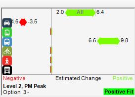
11 Attachment 3 Additional information on Achieved Benefits for the programme The SmartRoads tool used in conjunction with the ANOP enables net benefits associated with multi-modal changes to be translated and represented in terms of overall network performance impacts of the optimisation introduced. This also considers the network by time of day. The figure below is a snapshot of the SmartRoads tool representing overall benefits achieved during the interpeak periods, where significant benefits for pedestrians in particular were possible through several measures. These measures included: reducing average waiting times for pedestrians at the traffic signals. This was generally applied at all traffic signals during the interpeak, and to a lesser degree during peak periods where specifically appropriate and possible. pedestrian phase re-introduction (whereby a pedestrian phase is able to be re-introduced after it has already been run, during the same vehicle phase it is associated with). This particularly applies across one-way approaches and between traffic islands where appropriate. Examples are at all pedestrian crossings across Hobson Street at all intersections along the route; and across High Street at Victoria Street. additional pedestrian crossings where these were previously missing. A good example is at the Sturdee St/Fanshawe St/Nelson St/Market Pl intersection, where additional pedestrian crossings are complete across Fanshawe Street east, Sturdee Street and Market Place. extended pedestrian green times, where pedestrian green times are able to be greater than the standard 6 seconds, such as across Tangihua Street at Beach Rd. exclusive pedestrian phasing and Barnes Dance, such as introduced at Quay St/Lower Hobson St/Viaduct and Quay St/Lower Albert St. Being the interpeak period, the benefits to pedestrians achieved came at little or no disbenefit to other modes and the network as a whole, as the changes effectively reduced the spare capacity that existed on the network. The benefits are shown visually below using the SmartRoads tool, whereby multi-modal performance before and after the intervention are input into the tool.


12 In a similar way, the SmartRoads tool was particularly useful in translating and representing overall network performance benefits associated with the introduction of the westbound bus lane on Fanshawe Street, which was undertaken in conjunction with the route optimisation programme as an accelerated project. Positive overall people-movement benefits achieved through this particular improvement during the afternoon peak periods are represented below, where it can be seen that the significant benefits achieved for commuters travelling by bus outweigh the moderate dis-benefit incurred by general traffic commuters.


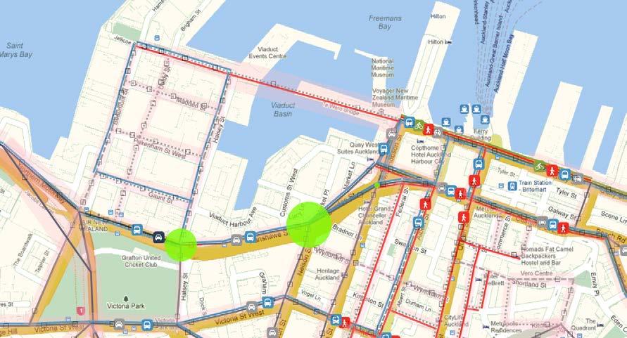


13 Fanshawe Street, before and after the introduction of the westbound bus lane, is pictured below.
.")

14 To accurately quantify these benefits is complex; the methodology adopted involved a detailed investigation of the benefits achieved for one of the five city centre sub-zones. This was undertaken by T2 Traffic and Transportation Engineers and reported in their 2014 report (a copy of which can be received upon request). Benefits achieved in the one zone were then assumed representative of benefits achieved across the city centre. It was noted that in some instances, the increase in benefits to pedestrians and public transport passengers resulted in some disbenefit to general traffic. However, in all instances the overall net benefit was positive and was in alignment with the NOP. Based on estimated costs of the city centre optimisation, benefits achieved equated to a BCR of between Example: Sturdee St/Fanshawe St/Nelson St/Market Pl intersection example of improvements through NOP/Route Optimisation. Pedestrian crossings and phasing (highlighted below), with bus lane provision (in both directions) on Fanshawe Street were provided. For routes outside the city centre, the optimisation was also carried out in alignment with the NOP. Ten capital works projects were completed and work was in progress on a further 7 projects. With these routes being outside of activity centres, benefits are determined by travel time savings, emission reductions and fuel savings. These have an average first year BCR of 13.4 based on traffic signal improvements implemented on these routes. Detailed calculation for two of the non-city centre routes included first year savings of 97,000 hours of travel time savings, 84,000 litres fuel savings and 190 tonnes of CO2 emissions reduction.
15 Attachment 4 Benefits of Routine Optimisation Technical Note The benefits of routine optimisation can best be quantified by comparing annual route efficiency trends where there is no routine optimisation, with where routine optimisation is undertaken (in this case every four years). This is illustrated below for a corridor that experiences moderate traffic growth of 2% per annum for 3 years, and 1% thereafter. 40,000 Route Efficiency with and without Routine Optimisation Routine optimisation every 4 years Efficiency * (person trip productivity) 35,000 30,000 25,000 20,000 15,000 Prior to route optimisation 10-20% Diminishing efficiency over 4 year period 30-40% Efficiency without routine optimisation Efficiency with routine optimisation ** 10,000 5, Year
16 * Efficiency is defined as corridor (person trip) productivity ( = average travel speed x vehicular volume x average occupancy). ** Estimated performance of a route subject to 2% traffic growth for 3 years, and 1% thereafter, and diminishing travel speed (reduces by half over 10 years). Efficiencies achieved in the first year of the route optimisation programme can diminish by over 10%. In some instances this can be as high as 20%. By addressing this increasing deficiency through routine optimisation within a four year cycle, will mitigate this from worsening any further, noting that if left unattended this can be as high as 40% less efficient than optimised in eight years time, depending on traffic growth and travel pattern changes. There is therefore a need for continued and regular routine optimisation of arterial routes to retain optimised performance of the network, beginning with those routes last optimised close to four years ago.
Draft City Centre Transport Proposals
 Draft City Centre Transport Proposals Introduction This draft position paper provides an overview of the current City Centre transport issues, including concepts of the possible future City Centre transport
AUCKLAND $1.2 BILLION $1.9 BILLION $149 MILLION 15% SPEND $5.7 BILLION
 AUCKLAND AUCKLAND $5.7 BILLION FORECAST TOTAL AUCKLAND INVESTMENT The next 10 years are expected to underline Auckland s performance as the fastest growing major city in Australasia. The city is expected
18pt. Bus services for Auckland's Central Suburbs are changing from Sunday 8 July 2018
 18pt Bus services for Auckland's Central Suburbs are changing from Sunday 8 July 2018 Adapted in accordance with Section 69 of the Copyright Act 1994 by the Royal New Zealand Foundation of the Blind,
CHRISTCHURCH MOTORWAYS. Project Summary Statement February 2010
 CHRISTCHURCH MOTORWAYS Project Summary Statement February 2010 Table of Contents 1. Purpose of Document 2. Strategic Context 3. Benefits 4. Project Scope and Economics 5. Implementation Plan 1 ROADS OF
$960 $1,175 $91 OVERVIEW National Land Transport Programme Auckland AUCKLAND REGIONAL SUMMARY
 2015 18 National Land Transport Programme Auckland AUCKLAND REGIONAL SUMMARY OVERVIEW Achieving an effective and efficient transport system is central to supporting Auckland s future. Auckland is home
Bus Reliability and Punctuality Performance
 Bus Reliability and Punctuality Performance Recommendation(s) That the Board: Board Meeting 26 August 2014 i. Notes the changes to the reporting of bus reliability and punctuality. As at July 2014 the
Auckland City Centre: Transport Capacity and Access Trends
 Auckland City Centre: Transport Capacity and Access Trends Final Report Prepared for: Auckland Council Date: 8 August 2018 Version: Final QUALITY ASSURANCE REGISTER Issue Description Prepared by Reviewed
CITY RAIL LINK. New Public Transport Stations and Development Opportunities at Karangahape Road, Newton and Aotea Quarter
 134 AC_BEU_CCMP_3_TM5_8_FD.indd 134 20/07/12 12:30 PM 05 CITY RAIL LINK New Public Transport Stations and Development Opportunities at Karangahape Road, Newton and Aotea Quarter 5 MO VE 0 1 2 8 KEY 1 Britomart
Transport Indicators Report June 2018
 Transport Indicators Report June 2018 Board Meeting 21 August 2018 Recommendation That the Board: i. Receives this report. Executive summary 1. The attached Monthly and Quarterly Indicator Reports provide
[REGIONAL LAND TRANSPORT PROGRAM AND REGIONAL FUEL TAX SUBMISSION ]
![[REGIONAL LAND TRANSPORT PROGRAM AND REGIONAL FUEL TAX SUBMISSION ]](/thumbs/89/99007492.jpg "[REGIONAL LAND TRANSPORT PROGRAM AND REGIONAL FUEL TAX SUBMISSION ]") 2018 Ben Ross Talking Southern Auckland Picture 1: Manukau Bus Station with MIT and rail station in the background [REGIONAL LAND TRANSPORT PROGRAM AND REGIONAL FUEL TAX SUBMISSION ] Submission to the
2018 Ben Ross Talking Southern Auckland Picture 1: Manukau Bus Station with MIT and rail station in the background [REGIONAL LAND TRANSPORT PROGRAM AND REGIONAL FUEL TAX SUBMISSION ] Submission to the
Routes. 66 Pt Chevalier Beach, Mt Albert, Mt Roskill, Three Kings, Royal Oak, Penrose, Sylvia Park
 Mt Wellington Pt England Central Bus Timetable Your guide to buses in this area 32 298 6 782 66 743 321 323 744 Routes 32 Mangere Town,, 66 Pt Chevalier Beach, Mt Albert, Mt Roskill, Three Kings, Royal
Kilometres. Blacktown. Penrith. Parramatta. Liverpool Bankstown. Campbelltown
 0 5 10 15 20 Kilometres Penrith Blacktown Parramatta Liverpool Bankstown Campbelltown accessibility outcomes Legend Outcomes targeted in Western Sydney are: public transport that is accessible throughout
CBD Rail Link Business Case
 CBD Rail Link Business Case Executive Summary: CBD Link Business Case (Nov 2010) Background The CBD Rail Link will be the most significant improvement to Auckland s transport network since the opening
Puketapapa Local Board
 ATTACHMENT A July September 2017 Puketapapa Local Board This report provides a picture of Auckland Transport activities over the July September 2017 Quarter. The report is in two sections: (a) Information
transformational an overview PoPulation Growth auckland s PoPulation will increase by up to million PeoPle over the next 30 years.
 auckland s PoPulation will increase by up to million PeoPle over the next 30 years. an overview Auckland s time has come. We now have a shared vision to be the world s most liveable city and, for the first
Wellington $312 $49 $456 OVERVIEW WELLINGTON REGIONAL SUMMARY
 National Land Transport Programme 2015 18 Wellington WELLINGTON REGIONAL SUMMARY OVERVIEW The Wellington region is made up of a number of cities, urban areas and supporting rural hinterland. The city is
130 Display Locations AK West Motel Accommodation Henderson Waitakere City Dalma Court Motor Inn Accommodation Henderson Waitakere City Henderson
 AK West Motel Accommodation Henderson Waitakere City Dalma Court Motor Inn Accommodation Henderson Waitakere City Henderson Rental Cars Transport Henderson Waitakere City Lincoln Court Motel Accommodation
$244 $45 OVERVIEW National Land Transport Programme Bay of Plenty BAY OF PLENTY REGIONAL SUMMARY
 2015 18 National Land Transport Programme Bay of Plenty BAY OF PLENTY REGIONAL SUMMARY OVERVIEW Transport investment in the Bay of Plenty is targeted to support significant residential growth, new industrial
David acts an Independent Hearing Commissioner and has considered plan changes, resource consents and notices of requirements.
 Director David is a Director with Hill Young Cooper Ltd, a resource management, environmental policy and planning consultancy with offices in Auckland and Wellington. David has over 25 years experience
Designing & Building for People on Bikes within evolving constraints Auckland Central City
 Designing & Building for People on Bikes within evolving constraints Auckland Central City Asia Pacific Cycle Congress 19 October 2017 Graeme Bean MEngSc (Transport), BE (Civil), PGDipBus (Mktg), MEngNZ,
WELLINGTON $422 MILLION $614 MILLION $83 MILLION 22% SPEND $1.9 BILLION
 WELLINGTON WELLINGTON $1.9 BILLION FORECAST TOTAL WELLINGTON INVESTMENT The Wellington region s transport challenges are dominated by the region s concentration of population in the metropolitan cities,
Auckland Regional Public Transport Plan
 Auckland Regional Public Plan 2010 www.arta.co.nz Published in June 2010 by: The Auckland Regional Authority Private Bag 92 236 Auckland, New Zealand This document is available on the ARTA website: www.arta.co.nz
HARBOUR EDGE STITCH. Uniting the Waterfront with the City Centre
 78 AC_BEU_CCMP_2_TM1_4 _FD.indd 78 20/07/12 12:04 PM 01 HARBOUR EDGE STITCH Uniting the Waterfront with the City Centre 01 VISION OUR 2032 VISION IS: Quay Street as a high-quality Harbour Edge space that
Auckland Transport - Transport Indicators Report June 2013
 Thousands Auckland Transport Transport Indicators Report June 213 Economic Indicators 5 4 3 2 1 % 1 2 3 4 9 8 3 2 1 Auckland Economic Activity Composite index of Economic Activity Auckland Source : ANZ
Appendix 1 Table 1A: Auckland Transport Proposed Funded Capital Programme for AT Board approval (20th June 2018)
") Appendix Table A: Auckland Transport Proposed Funded Capital Programme for AT Board approval (0th June 08) Attachment Funded Duration 08/9 09/0 00/ 0/ 0/3 03/4 Albany Station P&R Extension stage 08/9 0.5
Appendix Table A: Auckland Transport Proposed Funded Capital Programme for AT Board approval (0th June 08) Attachment Funded Duration 08/9 09/0 00/ 0/ 0/3 03/4 Albany Station P&R Extension stage 08/9 0.5
5 Rail demand in Western Sydney
 5 Rail demand in Western Sydney About this chapter To better understand where new or enhanced rail services are needed, this chapter presents an overview of the existing and future demand on the rail network
HE MIHI. E ngā iwi whānui ki ngā topito o Tāmaki Makaurau He mihi manahau ki a koutou katoa. Topuni ki te Raki. Rakitu ki te Rāwhiti
 HE MIHI E ngā iwi whānui ki ngā topito o Tāmaki Makaurau He mihi manahau ki a koutou katoa Topuni ki te Raki Rakitu ki te Rāwhiti Puketutu ki te Tonga Oaia ki te Uru Tāmaki herehere o ngā waka e! Tihei
waterview connection Completing the Western Ring Route the Waterview Connection
 waterview connection MAY 2009 Completing the Western Ring Route the Waterview Connection The NZ Transport Agency (NZTA) has a new proposal to complete the Western Ring Route around Auckland by connecting
CONGESTION MONITORING THE NEW ZEALAND EXPERIENCE. By Mike Curran, Manager Strategic Policy, Transit New Zealand
 CONGESTION MONITORING THE NEW ZEALAND EXPERIENCE 26 th Australasian Transport Research Forum Wellington New Zealand 1-3 October 2003 By, Manager Strategic Policy, Transit New Zealand Abstract New Zealand
Sarawia Street Laxon Terrace Rail Level Crossing Removal
 Sarawia Street Laxon Terrace Rail Level Crossing Removal Recommendations It is recommended that the Board: Receives the report. Executive summary The removal of the Sarawia Street to Laxon Terrace rail
Regional summary - Wellington
 Regional summary Wellington Regional summary - Wellington This is a summary of data relevant to transportation in this region, viewed from a Land Transport NZ perspective. It s purpose is to inform the
Interstate 90 and Mercer Island Mobility Study APRIL Commissioned by. Prepared by
 Interstate 90 and Mercer Island Mobility Study APRIL 2017 Commissioned by Prepared by Interstate 90 and Mercer Island Mobility Study Commissioned by: Sound Transit Prepared by: April 2017 Contents Section
Proposed Bicycle Lanes on Yonge Street from Queens Quay to Front Street
 STAFF REPORT ACTION REQUIRED Proposed Bicycle Lanes on Yonge Street from Queens Quay to Front Street Date: March 12, 2007 To: From: Toronto and East York Community Council Director, Transportation Infrastructure
Cycling as part of the NZ transport system
 Cycling as part of the NZ transport system New Zealand s journey so far and where we re headed next Asia Pacific Cycle Congress, 19 October 2017, Christchurch Claire Pascoe, Lead Advisor Multi-modal, NZ
Working document. Updates underway to executive summary, costs and economics. February 2017
 Working document. Updates underway to executive summary, costs and economics February 2017 East-West Midtown PT Link Project no: IZ047400 Document title: Indicative Business Case Document no: IZ061800-0000-CT-RPT-002
Report on Hamilton to Auckland Passenger Rail
 Report on Hamilton to Auckland Passenger Rail Date: 12 April 2017 To: From: Subject: Hamilton City Council, Waikato District Council, Waikato Regional Council, NZ Transport Agency, Auckland Council, and
EAST WEST RAIL EASTERN SECTION. prospectus for growth
 EAST WEST RAIL EASTERN SECTION prospectus for growth September 2018 executive summary The East West Rail Consortium, a partnership of local authorities, rail operators and Network Rail, continues to promote
12, 14 and 16 York Street - Amendments to Section 16 Agreement and Road Closure Authorization
 REPORT FOR ACTION 12, 14 and 16 York Street - Amendments to Section 16 Agreement and Road Closure Authorization Date: April 27, 2018 To: Toronto and East York Community Council From: Senior Strategic Director,
Roundhouse Way Transport Interchange (Part of NATS City Centre Package)
") Roundhouse Way Transport Interchange (Part of NATS City Centre Package) 15/16 16/17 17/18 18/19 19/20 Total TOTAL COST Roundhouse Way Transport Interchange 0.5m 0.5m FUNDING CIL 0.05m 0.05m Growth Deal
Roundhouse Way Transport Interchange (Part of NATS City Centre Package) 15/16 16/17 17/18 18/19 19/20 Total TOTAL COST Roundhouse Way Transport Interchange 0.5m 0.5m FUNDING CIL 0.05m 0.05m Growth Deal
EDEN PARK REDEVELOPMENT COMPLETED STADIUM DESIGN
 1 INTRODUCTION New Zealand was awarded the Rugby World Cup 2011 hosting rights in November 2005. A condition of the winning bid was the provision of a 60,000 seat stadium for the finals. New Zealand s
Sunshine Coast Council Locked Bag 72 Sunshine Coast Mail Centre QLD Submitted via online portal. 2 June 2017.
 Sunshine Coast Council Locked Bag 72 Sunshine Coast Mail Centre QLD 4560 Submitted via online portal 2 June 2017 Dear Sir /Madam, RE: DRAFT ENVIRONMENTAL AND LIVEABILITY STRATEGY The Green Building Council
PO Box 257 PO Box 257 PARRAMATTA NSW 2124 PARRAMATTA NSW 2124
 31 March 2017 Sean O Toole Sheridan Dudley District Commissioner - West District Commissioner - South West Greater Sydney Commission Greater Sydney Commission PO Box 257 PO Box 257 PARRAMATTA NSW 2124
FUTURE TRANSPORT STRATEGY AND GREATER SYDNEY SERVICES AND INFRASTRUCTURE PLAN. Western Parkland City
 FUTURE TRANSPORT STRATEGY AND GREATER SYDNEY SERVICES AND INFRASTRUCTURE PLAN Western Parkland City 2 Transport for NSW Future Transport Strategy and Greater Sydney Services and Infrastructure Plan Western
National Land Transport Programme Auckland
 National Land Transport Programme 2009 2012 Auckland Table of contents Introduction from the Regional Director 1 Regional maps 4 Regional summary 7 Regional tables 14 Glossary 36 Key to map abbreviations
FEDERAL BUDGET PRIORITIES FOR THE SOUTH WEST METROPOLITAN REGION 2018 TO 2022
 A Co-operative venture of the municipalities of: Cockburn, East Fremantle, Fremantle, Kwinana, Melville & Rockingham Tuesday, 5 December 2017 Enquiries: Mick McCarthy 9364 0631 Our Ref: Federal Budget
Auckland Unitary Plan Operative in part
 Auckland Unitary Plan Operative in part PROPOSED PLAN CHANGE 7 (PC7) Additions to Schedule 14 Historic Heritage Schedule, Statements and Maps in the Auckland Unitary Plan (Operative in part) Public notification:
Clyde Waterfront and Renfrew Riverside Project Glasgow Airport Investment Area Project
 Item 1 To: Leadership Board On: 3 June 2015 Report by: Director of Development and Housing Services Heading: City Deal Strategic Business Cases 1. Summary 1.1 This report seeks approval from the Board
Have your say... on the Ian McKinnon Drive Cycleway Project
 Have your say... on the Ian McKinnon Drive Cycleway Project The missing cycleway link connecting the Northwestern Cycleway and Dominion Road cycle lanes to the Grafton Gully Cycleway, Te Ara I Whiti Lightpath
Report to: Greater Cambridge Partnership Joint Assembly 18 January A10 Foxton level crossing bypass and travel hub
 Report to: Greater Cambridge Partnership Joint Assembly 18 January 2018 Lead officer: Chris Tunstall GCP Director of Transport A10 Foxton level crossing bypass and travel hub 1. Purpose 1.1 The list of
Draft Auckland Regional Land Transport Plan
 1 Table of Contents Table of Contents Table of Contents 2 01. Our Vision 3 02. Purpose and Scope of the Regional Land Transport Plan 5 03. Auckland s Challenges 12 04. Addressing Auckland s Challenges
Agenda Item 5: Rail East Midlands Rail Franchise Consultation
 Strategic Transport Forum 15 th September 2017 Agenda Item 5: Rail East Midlands Rail Franchise Consultation Recommendation: It is recommended that the Forum agree (subject to any amendments agreed by
A TRANSPORT SYSTEM CONNECTING PEOPLE TO PLACES
 THE MAYOR'S VISION FOR TRANSPORT A TRANSPORT SYSTEM CONNECTING PEOPLE TO PLACES VISION We will build a transport system that works for everyone, connecting people to the places they want to go within the
TWELFTH AIR NAVIGATION CONFERENCE
 International Civil Aviation Organization AN-Conf/12-WP/8 7/5/12 WORKING PAPER TWELFTH AIR NAVIGATION CONFERENCE Montréal, 19 to 30 November 2012 Agenda Item 3: Interoperability and data through globally
Routes. 802 Bayswater, Esmonde Rd, Wellesley St, City Centre (Mayoral Dr) (Monday to Friday peak only) Devonport to City Ferry
 (Monday to Friday peak only) Devonport to City Ferry") Hauraki Northern Bus & Ferry Timetable Your guide to buses and ferries in this area Routes,, 802, Esmonde Rd, Wellesley St, City Centre (Mayoral Dr) ( peak only) 806 Stanley Point, 807 Cheltenham, 814,
Hauraki Northern Bus & Ferry Timetable Your guide to buses and ferries in this area Routes,, 802, Esmonde Rd, Wellesley St, City Centre (Mayoral Dr) ( peak only) 806 Stanley Point, 807 Cheltenham, 814,
ROTORUA INTEGRATED NETWORK STRATEGY
 ROTORUA INTEGRATED NETWORK STRATEGY 2012-2042 May 2013 This photo provided by RDC Cover photos provided by RDC and BOPRC Contents Context Issues for the Strategy to Address Outcomes and Interventions Implementation
Business Case Summary
 This document is AT s internal business case to facilitate the Gateway Review process prior to letting contracts for enabling works construction. It is not a joint business case with government. Contents
Secret access ways in the inner city
 Secret access ways in the inner city Did you know that there are over 60 public access routes through, around or via private buildings throughout the central city? Bonus floor provisions allow developers
EAST-WEST STITCH. Connecting the Western Edge of the City to the Centre
 98 AC_BEU_CCMP_2_TM1_4 _FD.indd 98 20/07/12 12:06 PM 02 EAST-WEST STITCH Connecting the Western Edge of the City to the Centre 01 02 Northern Motorway Daldy Street Fanshawe Street Nelson Street Hobson
Capital Metro is the first stage of a light rail network that will have a transformative effect on Canberra. capitalmetro.act.gov.
 Artist impression Nullabor Avenue Harrison Business Case overview Capital Metro is the first stage of a light rail network that will have a transformative effect on Canberra. capitalmetro.act.gov.au Why
Urban Cycleways Programme Announcement Questions and Answers
 Urban s Programme Announcement Questions and Answers 1. What is the Urban s Programme? The Urban s Programme is an investment of $100 million over the next four years, dedicated to urban cycling infrastructure.
STRATEGIC FIT THE MASTERPLAN IS A NON-STATUTORY SUPPORTING DOCUMENT TO THE AUCKLAND PLAN, AND IS AN INPUT TO THE UNITARY PLAN.
 28 STRATEGIC FIT THE MASTERPLAN IS A NON-STATUTORY SUPPORTING DOCUMENT TO THE AUCKLAND PLAN, AND IS AN INPUT TO THE UNITARY PLAN. Together, the Auckland Plan and the Unitary Plan provide the overall vision
Glasgow Street Traffic Review
 Glasgow Street Traffic Review Recommendation That the Standing Policy Committee on Transportation recommend to City Council: 1. That the Administration proceed with removing the pinch points installed
Board meeting
 Board meeting 28.11.17 Secretariat memorandum Author: Vincent Stops Agenda item: 8 Ref: LTW568 Drafted: 13.11.17 Oxford Street bus changes associated with pedestrianisation 1 Purpose of report 1.1. To
Flight Centre business hours over Discover Europe weekend of Saturday 5 and Sunday 6 October
 Flight Centre business hours over Discover Europe weekend of Saturday 5 and Sunday 6 October SATURDAY SUNDAY City Store Name Open Hours Close Hours Open Hours Close Hours Address Phone Number Email Alexandra
The Government s Aviation Strategy Transport for the North (TfN) response
 response") The Government s Aviation Strategy Transport for the North (TfN) response Transport for the North Background Good transport links are a crucial part of a strong economy supporting labour markets and delivering
The Government s Aviation Strategy Transport for the North (TfN) response Transport for the North Background Good transport links are a crucial part of a strong economy supporting labour markets and delivering
Guildford Borough Transport Strategy 2017, Topic Paper: Transport, June 2017 (accompanying Local Plan 2017) Local Plan Transport Strategy 2017
 Local Plan Transport Strategy 2017") Guildford Society Transport Group Position Paper August 2017 Based on submissions in response to the June/July 2017 Local Plan consultation including material presented to Drop-in Session 15 July 2017.
Guildford Society Transport Group Position Paper August 2017 Based on submissions in response to the June/July 2017 Local Plan consultation including material presented to Drop-in Session 15 July 2017.
A Response to: Belfast On The Move Transport Masterplan for Belfast City Centre, Sustainable Transport Enabling Measures
 West Belfast Partnership 218-226 Falls Road Belfast BT12 6AH T: 02890809202 A Response to: Belfast On The Move Transport Masterplan for Belfast City Centre, Sustainable Transport Enabling Measures Issued
Submission to Infrastructure Victoria s Draft 30-Year Infrastructure Strategy
 Submission to Infrastructure Victoria s Draft 30-Year Infrastructure Strategy 1. Introduction This submission is a response to Infrastructure Victoria s assessment of the need to construct a heavy rail
Unitary Plan Parking Provision Rules. Auckland City Centre Fringe
 Auckland City Centre Fringe June 2012 Project: Title: Document Reference: Prepared by: Project Manager Reviewed by: Unitary Plan Parking Provision Rules Auckland City Centre Fringe S:\ACUP\004 UP PArking
Pedestrian Safety Review Spadina Avenue
 STAFF REPORT ACTION REQUIRED Pedestrian Safety Review Spadina Avenue Date: October 13, 2015 To: Toronto and East York Community Council From: Director, Transportation Services, Toronto and East York District
Draft Greater Sydney Region Plan
 Powered by TCPDF (www.tcpdf.org) Draft Greater Sydney Region Plan Submission_id: 31119 Date of Lodgment: 12 Dec 2017 Origin of Submission: Online Organisation name: Serapark Pty Ltd Organisation type:
Travel Expo Saturday 10 and Sunday 11 August. Flight Centre stores business hours over Travel Expo weekend. SATURDAY SUNDAY Open Hours.
 Travel Expo Saturday 10 and Sunday 11 August Flight Centre stores business hours over Travel Expo weekend SATURDAY SUNDAY City Store Name Open Hours Close Hours Open Hours Close Hours Address Alexandra
The Cobham Room, Novotel Hamilton Tainui, 7 Alma Street, Hamilton
 Board Meeting Minutes Date & time Location Board Membership Apologies NZTA staff in attendance 12 August 2016, 8.00am 12.30pm Board Strategy Session 1.00pm 2.30pm The Cobham Room, Novotel Hamilton Tainui,
Wynyard Precinct: Urban Design Framework February 2014
 Wynyard Precinct: Urban Design Framework February 2014 Contents 0 Introduction Realising Auckland s Waterfront Potential 1 Introduction 2 Background 3 Purpose 4 Relationship to the Operative District
Technical Report to support Assessment of Environmental Effects (City Rail Link Notice of Requirement): Built Heritage Assessment
: Built Heritage Assessment") Technical Report to support Assessment of Environmental Effects (City Rail Link Notice of Requirement): Built Heritage Assessment APPENDIX D Schedule of Built Heritage in Study Area Mapping Limitations
Technical Report to support Assessment of Environmental Effects (City Rail Link Notice of Requirement): Built Heritage Assessment APPENDIX D Schedule of Built Heritage in Study Area Mapping Limitations
Re-opening of the Skipton to Colne Railway Executive Summary
 Re-opening of the to Colne Railway Executive Summary SELRAP SELRAP is the East Lancashire Rail Action Partnership. It was established with the objective of campaigning for the reinstatement of the railway
Northern Beaches Transport Action Plan
 Northern Beaches Transport Action Plan The NSW Government is taking action now to deliver transport improvements for the Northern Beaches, as well as planning for the future growth of the area. $633 million
REPORT ON SUBMISSION TO LET S GET WELLINGTON MOVING
 CITY DIRECTION COMMITTEE 31 JANUARY 2018 REPORT ON SUBMISSION TO LET S GET WELLINGTON MOVING PURPOSE This paper outlines the submission made by the Chief Executive under delegated authority to Let s Get
Hamilton City Council Transport Strategy
 Hamilton City Council Transport Strategy Where Does Access Hamilton Fit? Strategic Vision Deliver an affordable, integrated, safe, responsive and sustainable transport system. Support economic, social,
David acts an Independent Hearing Commissioner and has considered plan changes, resource consents and notices of requirements.
 Director David is a Director with Hill Young Cooper Ltd, a resource management, environmental policy and planning consultancy with offices in Auckland and Wellington. David has over 25 years experience
Part 005 Implementation Strategy _
 Part 0 Implementation Strategy www. landlab.co.nz Queenstown Town Centre Masterplan Version 7 14 June 28 Section 0 Page 4 5.1 Implementation Plan The projects and initiatives contained within the Queenstown
128 Display Locations
 Waiwera Infinity Thermal Spa Resort Accommodation/Things to do Waiwera Rodney District Orewa Motor Lodge Accommodation Orewa Rodney District Pillows Travellers Lodge Accommodation Orewa Rodney District
33 Horseferry Road HP20 1UA London SW1P 4DR. Tuesday 10 th October Dear Sir,
 East Midlands Rail Franchise Programme Office Consultation Co-ordinator c/o Buckinghamshire County Council Zone 2/21 County Hall Department for Transport Walton Street Great Minster House Aylesbury 33
Auckland Port and the Unitary Plan Dr Douglas Fairgray
 Auckland Port and the Unitary Plan Dr Douglas Fairgray Source: Auckland 1886 - Sir George Grey Special Collections, Auckland Libraries, NZ Map 374 Scope The interface between the Unitary Plan and the Port
Regional summary - Auckland
 Regional summary Auckland Regional summary - Auckland This is a summary of data relevant to transportation in the Auckland region, viewed from a New Zealand Transport Agency perspective. The purpose of
Statement of Intent 2017/ /20
 Statement of Intent 2017/18-2019/20 E ngā iwi whānui ki ngā topito o Tāmaki Makaurau He mihi manahau ki a koutou katoa Topuni ki te Raki Rakitu ki te Rāwhiti Puketutu ki te Tonga Oaia ki te Uru Tāmaki
Strategic Transport Forum 7 th December 2018
 Strategic Transport Forum 7 th December 2018 Agenda Item 7: East West Rail Recommendation: It is recommended that the Forum: a) Endorse the East West Rail Consortium s position in relation to the draft
Your Transport Levy Your Transport Future. Sunshine Coast Council Transport Levy Annual Report
 Your Transport Levy Your Transport Future Sunshine Coast Council Transport Levy Annual Report 2016-2017 www.sunshinecoast.qld.gov.au T 07 5475 7272 F 07 5475 7277 Locked Bag 72 Sunshine Coast Mail Centre
SYDNEY S SECOND AIRPORT
 COLLIERS RADAR SYDNEY S SECOND AIRPORT The Catalytic Effect of Transport Infrastructure By Sass J-Baleh Manager Research sass.jbaleh@colliers.com Summary Industrial land values across the Sydney markets
Statement of Intent 2017/ /20
 Statement of Intent 2017/18-2019/20 E ngā iwi whānui ki ngā topito o Tāmaki Makaurau He mihi manahau ki a koutou katoa Topuni ki te Raki Rakitu ki te Rāwhiti Puketutu ki te Tonga Oaia ki te Uru Tāmaki
Congestion. Addressing urban congestion in SEQ. How do you define congestion? South East Queensland is growing. Sustained growth in motorised travel
 How do you define congestion? Addressing urban congestion in SEQ Engineer: traffic volume exceeds road capacity Russell Murray Director Urban Congestion Task Force Department of Transport and Main Roads
Crossrail Business Case Update: Summary Report July 2011
 Crossrail Business Case Update: Summary Report July 2011 This report provides an update to the July 2010 Crossrail business case, including taking into account a number of changes to the costs and revenues
Agenda 11. Strathclyde Bus Alliance progress update. Date of meeting 9 December 2016 Date of report 15 November 2016
 Agenda 11 Strathclyde Bus Alliance progress update Date of meeting 9 December 2016 Date of report 15 November 2016 Report by Assistant Chief Executive (Operations) 1. Object of report The object of this
Rail Delivery Group. Consultation on the future of the East Midlands rail franchise
 Rail Delivery Group Response to: Department for Transport Consultation on the future of the East Midlands rail franchise Date: 11 October 2017 Rail Delivery Group Limited Registered Office, 2nd Floor,
West London Economic Prosperity Board. 21 March Summary. Title Orbital Rail in West London
 West London Economic Prosperity Board 21 March 2017 Title Orbital Rail in West London Report of Status Urgent Enclosures Officer Contact Details Amar Dave (LB Brent) Public No Appendix 1: Specification
NATIONAL AIRSPACE POLICY OF NEW ZEALAND
 NATIONAL AIRSPACE POLICY OF NEW ZEALAND APRIL 2012 FOREWORD TO NATIONAL AIRSPACE POLICY STATEMENT When the government issued Connecting New Zealand, its policy direction for transport in August 2011, one
APRA AMCOS NEW ZEALAND NATIONAL SONGWRITER POSTCODE RANKINGS
 APRA AMCOS NEW ZEALAND NATIONAL SONGWRITER POSTCODE RANKINGS 2003-2013 National songwriter postcode rankings: top 20 2013 1 Grey Lynn / Kingsland (1021) 2 Newtown / Brooklyn (6021) Wellington 3 Mt Eden
Infrastructure Policy Priorities for New Zealand
 Infrastructure Policy Priorities for New Zealand The problem Transport investment international comparisons Funding gap Solutions: Debt financing: Infrastructure Bonds, PPPs Tax Increment Financing TIF
8 CROSS-BOUNDARY AGREEMENT WITH BRAMPTON TRANSIT
 8 CROSS-BOUNDARY AGREEMENT WITH BRAMPTON TRANSIT The Transportation Services Committee recommends the adoption of the recommendations contained in the following report dated May 27, 2010, from the Commissioner
PSP 75 Lancefield Road. Northern Jacksons Creek Crossing Supplementary Information
 PSP 75 Lancefield Road Northern Jacksons Creek Crossing Supplementary Information September 2017 The northern crossing of Jacksons Creek proposed within the Lancefield Road PSP is a key part of the ultimate