Jewellery Quarter Neighbourhood Development Plan. Node Design Brief Summer 2016
|
|
|
- Howard O’Neal’
- 5 years ago
- Views:
Transcription

1 Jewellery Quarter Neighbourhood Development Plan Node Design Brief Summer 2016
2 Introduction Neighbourhood Plans give you the opportunity to help shape the future of the community you live and work in. In the coming months we want you to get involved and tell us what you think of our draft Neighbourhood Plan for the Jewellery Quarter. We will be running a formal consultation towards the end of the year but we are keen to get as much involvement from the community as possible now that we are developing an overall vision for the Jewellery Quarter. Keep an eye on our social media channels for details of future events, to be involved in the discussion and to give us your feedback, as well as submitting you node visions: Facebook /JQNeighbourhoodplan Instagram JQ Plan Background Neighbourhood planning was introduced by Government through the Localism Act in It allows local communities to help shape development in their local area by implementing a Neighbourhood Plan. A Neighbourhood Plan is a legal document drafted by the community, which contains a set of planning policies that the local authority has to adopt as part of the local planning process. These policies will be used to help determine the outcome of future planning applications. The JQ Plan is a product of the community coming together and working for what they want to see the Jewellery Quarter become in the future. Countless hours of work have been undertaken by volunteers to get to this point, shaped by the community who have given their views and opinions. This process is being driven directly by the community. It is up to us to demonstrate what the community wants to achieve and work out how we are going to make it happen. Whilst the Plan will eventually be adopted by Birmingham City Council, they cannot influence its contents.
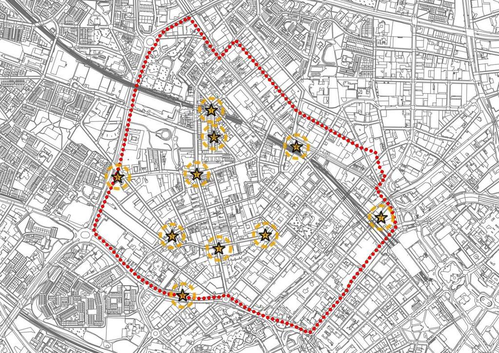
3 We need you! Imagine you were in charge with unlimited budget and maximum vision We need your help to produce aspirational visions of what the Jewellery Quarter could look like in the medium to long-tem. These images will complement the policies contained in the JQ Plan and provide a clear vision that can be taken forward through the life-time of the Neighbourhood Plan. We are appealing to designers and creative industries across the Jewellery Quarter as we re sure there must be some great ideas out there. We have focused our brief around the idea of nodes of activity across the Jewellery Quarter. These will be attractive places that are strategically positioned to draw visitors through the Jewellery Quarter, can be enjoyed by the community and make people proud to live and work here. They will be individual in their design but should have reference to the heritage of the Jewellery Quarter. This pack contains 10 nodes that have been identified as key points throughout the Jewellery Quarter, but do not feel that you are limited to these areas alone, if you have a great idea for somewhere else. We are not looking for an exhaustive level of detail. Your ideas should be represented in one or two picture or sketches at the most and they will need to be easily understood by members of the public. You may wish to annotate your designs; however, we are not expecting any significant amount of text. You do not have to provide ideas for every node this pack has been designed so that individual nodes can be printed off and scribbled on! Be bold; don t be too constrained by current streets and boundaries; and be visionary! It is important to remember that the remit of the JQ Plan is strictly limited to development planning and can therefore only directly influence schemes where planning permission is sought. In the case of public realm schemes there is no guarantee that funding will be available to bring forward the schemes during the Plan period. What we do want to create, however, is a vision that integrates land use planning with urban realm, movement and transport planning, which can be easily bought into by developers and Birmingham City Council. By submitting your work we are giving you the opportunity to shape the future of your Jewellery Quarter, with the best ideas being taken forward for use within the final JQ Plan. All submissions, if chosen, will be referenced with either the name of the organisation and/or designer and can be used both in the Plan document itself and on other promotional material, such as during public consultation. You must therefore be happy for your submission to be published and have all necessary rights to the materials. Even if your designs are not used within the Plan, they will be a useful evidence base to show the sort of changes that the people of the Jewellery Quarter want to see. Unfortunately we are unable to provide you with any digital mapping due to our licencing arrangements with Birmingham City Council. You may not use the information within this pack for any other purpose other than in connection with the Jewellery Quarter Neighbourhood Plan.


4 Hockley Square The space at the junction of Spencer Street, Hockley Street and Northampton Street is currently dominated by a large roundabout, despite a low traffic flow. There is a small grassed area to one side; however the majority of the space is paved or tarmacked. The square is within a short distance of the Jewellery Quarter railway and Midland Metro station and is flanked by a number of food and drink venues, including the Jewellers Arms and the Drop Forge. It is therefore proposed that the space could provide a stronger focus to visitor and leisure activities, with integration with the railway station key to attracting more visitors to the area. The square is surrounded by a high concentration of listed buildings and is close to the Museum of the Jewellery Quarter. The design should therefore be sensitive to its setting.
5 Imagine you were in charge with unlimited budget and maximum vision... What would you do?...to Node 1: Hockley Square We can't wait to see what you come up with. You can share your designs and find out more via our website ( or Twitter Instagram and Facebook (/JQNeighbourhoodPlan) m Crown copyright and database rights 2014 Ordnance Survey You are not permitted to copy, sub-license, distribute or sell and of this data to third parties in any form.

6 Chamberlain Clock The Chamberlain Clock is arguably the symbolic heart of the Jewellery Quarter and is an iconic symbol. The area around The Chamberlain Clock is currently dominated by vehicles with wide carriageways, few facilities for pedestrians and no dedicated provision for cyclists. The junction itself is currently hard for pedestrians to cross due to a lack of facilities on key desire lines and the volume of traffic. A number of bus services use the junction, as well as HGVs that access the nearby shops and businesses on a regular basis. Designs need not be bound by buses using Vittoria Street and are at liberty to assume that it may be possible for buses to be rerouted along Frederick Street. Designs may wish to change the street layout and pedestrian space. For continuity, designs may wish (though are not required) to acknowledge or extend the design of the recently completed Golden Square, which is located to the rear of the Rose Villa Tavern.
7 Imagine you were in charge with unlimited budget and maximum vision... What would you do?...to Node 2: Chamberlain Clock We can't wait to see what you come up with. You can share your designs and find out more via our website ( or Twitter Instagram and Facebook (/JQNeighbourhoodPlan) m Crown copyright and database rights 2014 Ordnance Survey You are not permitted to copy, sub-license, distribute or sell and of this data to third parties in any form.


8 Ramgarhia Square The junction of Graham Street, Frederick Street, Legge Lane and Newhall Hill is best known as the location of the Ramgarhia Sikh Temple and Community Centre. This is an important facility for the community of the Jewellery Quarter. Traffic lights have been installed due to the Paradise development. There is a recommendation to reroute inbound bus services to be rerouted from Vittoria Street to Frederick Street. The presence of the traffic lights helps to achieve this by allowing the buses to negotiate the tight corners. The scope of this design needs to acknowledge that there is limited scope for development within the public highway; however it may be worthwhile considering the opportunities presented by the surrounding privately-owned land. High traffic speeds and no dedicated pedestrian crossing points on Newhall Hill and Frederick Street should also be addressed.
9 Imagine you were in charge with unlimited budget and maximum vision... What would you do?...to Node 3: Ramgarhia Square We can't wait to see what you come up with. You can share your designs and find out more via our website ( or Twitter Instagram and Facebook (/JQNeighbourhoodPlan) m Crown copyright and database rights 2014 Ordnance Survey You are not permitted to copy, sub-license, distribute or sell and of this data to third parties in any form.


10 Newhall Corner The corner of Newhall Street, where Baker & Finnemore is currently based, is a large corner that is on a commuter route for pedestrians to the city centre. It is also a loading area for Baker & Finnemore. The view from the top of Newhall Street is currently to the Baker & Finnemore frontage, which being close to a right angle, is effectively a blank wall. There is currently an issue with vehicles travelling at high speeds around the corner, often ignoring the central white line. Pedestrians also often enter the carriageway to shorten their path around the outside of the bend. Designs should be visible from a long distance to entice people into the Jewellery Quarter from the city centre. They should also seek to reduce vehicle speeds and create more direct pedestrian routes that are fully accessible.
11 Imagine you were in charge with unlimited budget and maximum vision... What would you do?...to Node 4: Newhall Corner We can't wait to see what you come up with. You can share your designs and find out more via our website ( or Twitter Instagram and Facebook (/JQNeighbourhoodPlan) m Crown copyright and database rights 2014 Ordnance Survey You are not permitted to copy, sub-license, distribute or sell and of this data to third parties in any form.


12 Dayus Square Dayus Square is a recently developed area of shared space; however it lacks usability with limited seating and shelter. The high-quality materials used within the square itself are in stark contrast the surrounding areas of parking and concrete hard-standing. The ongoing development of this part of the Jewellery Quarter will lead to a significantly greater residential population and this space will be on one of the main routes into the city centre. The renovation of the former George and Dragon public house would also benefit from the completion of this space.
13 Imagine you were in charge with unlimited budget and maximum vision... What would you do?...to Node 5: Dayus Square We can't wait to see what you come up with. You can share your designs and find out more via our website ( or Twitter Instagram and Facebook (/JQNeighbourhoodPlan) m Crown copyright and database rights 2014 Ordnance Survey You are not permitted to copy, sub-license, distribute or sell and of this data to third parties in any form.


14 Assay Triangle The triangular area between Warstone Lane, Carver Street and Icknield Street is currently a grassed area of land with a former public convenience, which has been converted into a small commercial unit. The space is on a key gateway to the Jewellery Quarter from the ring road and is adjacent to the recently opened Assay Office, as well as a number of other businesses and the Hockley Medical Centre. Swept-path analysis has shown that large vehicles are able to turn left onto the ring road from the traffic lights; therefore it can be assumed that it would be possible to close the short section of Warstone Lane to through traffic, such that the Assay Triangle was no longer isolated from the adjacent block.
15 Imagine you were in charge with unlimited budget and maximum vision... What would you do?...to Node 6: Assay Triangle We can't wait to see what you come up with. You can share your designs and find out more via our website ( or Twitter Instagram and Facebook (/JQNeighbourhoodPlan) m Crown copyright and database rights 2014 Ordnance Survey You are not permitted to copy, sub-license, distribute or sell and of this data to third parties in any form.


16 Lionel Street Steps This area will be a continuation of the route from Colmore Row and the Snowhill development to the Snow Hill metro stop. For the first time a walkway will cross Great Charles Street Queensway adjacent to the extended metro line, offering a new route into the Jewellery Quarter. The design should clearly acknowledge this location as a gateway and direct pedestrians through the viaduct arch and into the Jewellery Quarter. The arch itself will need considerable work to make it a safe and attractive route.
17 Imagine you were in charge with unlimited budget and maximum vision... What would you do?...to Node 7: Lionel Street Steps We can't wait to see what you come up with. You can share your designs and find out more via our website ( or Twitter Instagram and Facebook (/JQNeighbourhoodPlan) m Crown copyright and database rights 2014 Ordnance Survey You are not permitted to copy, sub-license, distribute or sell and of this data to third parties in any form.


18 Livery Street Wedge This section of Livery Street between Northwood Street and Great Hampton Street can be seen from Colmore Row and therefore has the potential to be an attractive and interesting visual to draw people into the Jewellery Quarter from the city centre core. There is currently a high collision rate for vehicles at the junction of Northwood Street and Livery Street, in part due to the high vehicle speeds along Livery Street. It is therefore proposed that the short section of road between Northwood Street and Great Hampton Street is closed to motor vehicles and retained as a direct route for cyclists, linking up with future upgrades along Great Hampton Street. Designs should be visible from a long distance to entice people into the Jewellery Quarter from the city core. It should be noted that sections of the area are above the railway line and therefore there are limitations to physical alterations to the space.
19 Imagine you were in charge with unlimited budget and maximum vision... What would you do?...to Node 8: Livery Street Wedge We can't wait to see what you come up with. You can share your designs and find out more via our website ( or Twitter Instagram and Facebook (/JQNeighbourhoodPlan) m Crown copyright and database rights 2014 Ordnance Survey You are not permitted to copy, sub-license, distribute or sell and of this data to third parties in any form.


20 Summer Hill Terrace Summer Hill Terrace is raised up above the A457 Summer Hill Road, which has been designed as a high-capacity route, previously feeding Paradise Circus. Ongoing works at Paradise have meant that traffic volumes have been significantly reduced. It is hoped a reduction in traffic volumes can be maintained following the completion of Paradise, therefore designs can assume that downgrading of the route may become an option in the future. The raised section of road is fronted by several attractive buildings and is screened by trees and shrubbery. There is some existing seating and planting where the terrace meets the main road, however this is sparse and dominated by the road. It is anticipated that any improvement of this area will focus firstly on improving the image of the Jewellery Quarter to people passing in cars, buses and by bicycle, with a long-term option to benefit from the downgrading and rationalisation of vehicles using the A457, providing a more pedestrian friendly atmosphere and greater links with the neighbouring St Marks area.
21 Imagine you were in charge with unlimited budget and maximum vision... What would you do?...to Node 9: Summer Hill Terrace We can't wait to see what you come up with. You can share your designs and find out more via our website ( or Twitter Instagram and Facebook (/JQNeighbourhoodPlan) m Crown copyright and database rights 2014 Ordnance Survey You are not permitted to copy, sub-license, distribute or sell and of this data to third parties in any form.


22 Northampton Street Island This isolated area of grass is located to the rear of the Vyse Street multi-storey car park. It currently only accommodates recycling bins in one corner, however is located on a key route between Caroline Street and Hockley Square. It is hoped that the development of this space will cause a greater pedestrian flow along Northampton Street and Augusta Street, helping to extend the retail and leisure heart of the Jewellery Quarter and increasing footfall to the adjacent businesses. Redesign of the road and access alignments may give the opportunity to stop-up Northampton Street at Hockley Square meaning that this becomes a largely pedestrian and cycle route with access retained where necessary.
23 Imagine you were in charge with unlimited budget and maximum vision... What would you do?...to Node 10: Northampton Street Island We can't wait to see what you come up with. You can share your designs and find out more via our website ( or Twitter Instagram and Facebook (/JQNeighbourhoodPlan) m Crown copyright and database rights 2014 Ordnance Survey You are not permitted to copy, sub-license, distribute or sell and of this data to third parties in any form.
24
Display of 1 no. internally illuminated advertisement hoarding
 Committee Date: 22/08/2013 Application Number: 2013/04695/PA Accepted: 01/07/2013 Application Type: Advertisement Target Date: 26/08/2013 Ward: Ladywood Summer Row, Birmingham, B3 1JU Display of 1 no.
Swallow House, 10 Swallow Street, Birmingham, B1 1BD
 Committee Date: 20/02/2014 Application Number: 2013/08477/PA Accepted: 29/11/2013 Application Type: Full Planning Target Date: 28/02/2014 Ward: Ladywood Swallow House, 10 Swallow Street, Birmingham, B1
Open Day Programme 2016
 Open Day Programme 2016 School of Jewellery Vittoria Street Saturday 8 October Saturday 19 November 9am 3pm bcu.ac.uk/opendays 1 2 Welcome to the School of Jewellery, Vittoria Street Located in the heart
Proposals for the Harrogate Road / New Line Junction Improvement Scheme. August / September Supported by:
 Proposals for the Harrogate / New Line Junction Improvement Scheme August / September 2016 Supported by: Introduction Key Benefits Proposals are currently being developed for changes to the junction of
EAST-WEST STITCH. Connecting the Western Edge of the City to the Centre
 98 AC_BEU_CCMP_2_TM1_4 _FD.indd 98 20/07/12 12:06 PM 02 EAST-WEST STITCH Connecting the Western Edge of the City to the Centre 01 02 Northern Motorway Daldy Street Fanshawe Street Nelson Street Hobson
HISTORY IN THE MAKING. The UK s most important city centre development outside London. Being delivered by:
 UPDATE JANUARY 2016 HISTORY IN THE MAKING The UK s most important city centre development outside London. Being delivered by: THE HEART OF THE CITY St Philip s Square Birmingham Museum & Art Gallery A
Roundhouse Way Transport Interchange (Part of NATS City Centre Package)
") Roundhouse Way Transport Interchange (Part of NATS City Centre Package) 15/16 16/17 17/18 18/19 19/20 Total TOTAL COST Roundhouse Way Transport Interchange 0.5m 0.5m FUNDING CIL 0.05m 0.05m Growth Deal
Roundhouse Way Transport Interchange (Part of NATS City Centre Package) 15/16 16/17 17/18 18/19 19/20 Total TOTAL COST Roundhouse Way Transport Interchange 0.5m 0.5m FUNDING CIL 0.05m 0.05m Growth Deal
Perth and Kinross Council Development Management Committee 20 February 2013 Report of Handling by Development Quality Manager
 Perth and Kinross Council Development Management Committee 20 February 2013 Report of Handling by Development Quality Manager 4(4)(ii) 13/80 Replacement and re-positioning of street furniture, The Birks,
Schedule of Planning Applications Committee Date: 23 May Reference: 06/18/0064/F Great Yarmouth Officer: Mr J Beck Expiry Date:
 Schedule of Planning Applications Committee Date: 23 May 2018 Reference: 06/18/0064/F Great Yarmouth Officer: Mr J Beck Expiry Date: 24-04-2018 Applicant: Proposal: Site: Mr Mavroudis Clear weather hoardings
WELCOME WELCOME TO OUR PUBLIC EXHIBITION FOR THE BOND STREET PUBLIC REALM PROJECT.
 WELCOME WELCOME TO OUR PUBLIC EXHIBITION FOR THE BOND STREET PUBLIC REALM PROJECT. Bond Street Development Plan is one of the key initiatives outlined in the West End Partnership s vision. Bond Street
ASHTON GATE SPORTS & CONVENTION CENTRE. A New Home For Bristol Flyers
 ASHTON GATE SPORTS & CONVENTION CENTRE A New Home For Bristol Flyers THE VISION I n 2016 Ashton Gate/ Bristol Sport delivered the 45m redevelopment of the home of Bristol City FC and Bristol Bears Rugby.
Public Realm & Landscape
 Town Centre Context Public Realm & Landscape 1. Public realm in the Town Centre varies significantly in quality. Areas of particularly good quality public realm are located around the Minster and outside
Scala House, 36 Holloway Circus, Queensway, Birmingham, B1 1EQ
 Committee Date: 31/10/2013 Application Number: 2013/06196/PA Accepted: 15/08/2013 Application Type: Full Planning Target Date: 14/11/2013 Ward: Nechells Scala House, 36 Holloway Circus, Queensway, Birmingham,
Councillor Briefing on Elvetham Chase
 Councillor Briefing on Elvetham Chase In partnership with the Calthorpe Estate, Wates Developments vision for Elvetham Chase is to provide an outstanding new community for Hart District that will become
Welcome WINSTON GROUP. Welcome to our public exhibition on the Winston Group s proposals to redevelop 110 Walm Lane, Willesden Green.
 Welcome Our proposed scheme (image for illustrative purposes only) Welcome to our public exhibition on the Winston Group s proposals to redevelop 110 Walm Lane, Willesden Green. The purpose of our exhibition
Borough High Street Low Emission Neighbourhood
 Borough High Street Low Emission Neighbourhood Colourful Crossings Design Brief Better Bankside Business Improvement District Brief for Graphic Consultants December 2017 Page 1 of 10 1. Introduction Borough
Leicester Square Action Plan Summary
 Leicester Square Action Plan Summary The Leicester Square Action Plan was developed by Westminster City Council, together with the Leicester Square Association, the Metropolitan Police Service, and the
3. COLTA / HUGA CONNECTIONS - PRELIMINARY
 9 3. COLTA / HUGA CONNECTIONS - PRELIMINARY 3.1 COLTA The Chain of Lakes Trail Association (COLTA) trail, formerly identified as the Chester Spur Line, was completed and opened for use in June 2011. The
As part of our transport vision, Leeds City Council, working with the West Yorkshire Combined Authority and Leeds Bradford Airport Company, is
 As part of our transport vision, Leeds City Council, working with the West Yorkshire Combined Authority and Leeds Bradford Airport Company, is considering options for improving surface access and connectivity
Sainsburys Store, Mere Green Road, Sutton Coldfield, Birmingham, B75 5BT
 Committee Date: 7/0/013 Application Number: 013/04/PA Accepted: 1/04/013 Application Type: Variation of Condition Target Date: 1/07/013 Ward: Sutton Four Oaks Sainsburys Store, Mere Green Road, Sutton
A303. Sparkford to Ilchester Dualling Scheme Preferred Route Announcement
 A303 Sparkford to Ilchester Dualling Scheme Preferred Route Announcement About this booklet This booklet presents the preferred route for the A303 Sparkford to Ilchester dualling scheme and a summary of
The Point Roundabout Improvement Scheme
 The Point Roundabout Improvement Scheme Background and Existing Situation The junction of North Wall Quay, East Wall Road and the East Link Bridge, also known as the Point roundabout, is located in the
M621. Junctions 1 to 7 Improvement scheme. Share your views
 M621 Junctions 1 to 7 Improvement scheme Share your views Investing in your roads Every road user wants less congested roads to enable swift, safe, comfortable and informed travel. On behalf of the government,
B4100 Moor Street Queensway, City Centre, Birmingham, B4. Display of 8 non-illuminated lamppost advertisement banners
 Committee Date: 21/08/2014 Application Number: 2014/04720/PA Accepted: 01/07/2014 Application Type: Advertisement Target Date: 26/08/2014 Ward: Ladywood B4100 Moor Street Queensway, City Centre, Birmingham,
Conservation Area Consent for demolition of existing building
 Committee Date: 19/09/2013 Application Number: 2013/02378/PA Accepted: 03/05/2013 Application Type: Conservation Area Target Date: 28/06/2013 Consent Ward: Ladywood 34 Carver Street, Jewellery Quarter,
Proposed Lidl Food store West Hendford, Yeovil
 Proposed Lidl Food store West Hendford, Yeovil Lidl Travel Plan October 2015 CONTENTS Page 1.0 INTRODUCTION 1 1.1 Background 1 1.2 Aim of Travel Plan 1 1.3 Contents 2 2.0 TRANSPORT CONTEXT 3 2.1 Site Location
Lichfield Road/Aston Hall Road, Junction of, Aston, Birmingham
 Committee Date: 21/03/2013 Application Number: 2012/08360/PA Accepted: 17/12/2012 Application Type: Full Planning Target Date: 18/03/2013 Ward: Nechells Lichfield Road/Aston Hall Road, Junction of, Aston,
Review of Highcliffe Shopping Centre
 Review of Highcliffe Shopping Centre A Summary M W Mawbey 15 th December 2013 INTRODUCTION Concern for the health of high streets is common theme across the country. High streets have been affected by
Non-technical summary
 Introduction NTS1 NTS2 NTS3 Troika Developments Ltd (Troika) has submitted a planning application to Bournemouth Borough Council (BBC) for an extension of time to implement planning permission 7/2004/16450/G,
Calderdale MBC. Wards Affected: Town. Economy and Investment Panel: 20 October Halifax Station Gateway Masterplan
 Calderdale MBC Wards Affected: Town Economy and Investment Panel: 20 October 2016 Halifax Station Gateway Masterplan Report of the Acting Director, Economy and Environment 1. Purpose of the Report 1.1
Land off Stonnal Grove, & Rowden Drive (Phase 1A), Lyndhurst Estate, Sutton Road, Erdington, Birmingham, B23 5US
, Lyndhurst Estate, Sutton Road, Erdington, Birmingham, B23 5US") Committee Date: 07/03/2013 Application Number: 2013/00204/PA Accepted: 11/01/2013 Application Type: Reserved Matters Target Date: 12/04/2013 Development Ward: Erdington Land off Stonnal Grove, & Rowden
Committee Date: 07/03/2013 Application Number: 2013/00204/PA Accepted: 11/01/2013 Application Type: Reserved Matters Target Date: 12/04/2013 Development Ward: Erdington Land off Stonnal Grove, & Rowden
M56. New Junction 11a Summary of the consultation report
 M56 New Junction 11a Summary of the consultation report August 2017 M56 New Junction 11a Summary of the public consultation The scheme The M56 New Junction 11a scheme is part of our continued programme
Open Report on behalf of Richard Wills, Executive Director for Environment and Economy
 Agenda Item 7 Executive Open Report on behalf of Richard Wills, Executive Director for Environment and Economy Report to: Executive Date: 02 September 2014 Subject: Lincoln East West Link Road Phase 1
The decision on whether to take enforcement action falls outside the scope of delegated powers.
 5k 16/0031 Reg d: 19.01.2016 Expires: 15.03.201 6 Ward: Nei. 24.02.201 BVPI Full Number of 11/8 On Con. 6 Target Weeks on Target? Exp: Cttee Day: GE No LOCATION: PROPOSAL: TYPE: Phillips Court, 32 Goldsworth
M54 to M6/M6 Toll Link Road Public consultation
 to M6/M6 Toll Link Road Public consultation 15 September 2017 to 13 October 2017 Contents Introduction 4 5 Why do we need this scheme? 6 Previous consultation 7 8 Modified options 9 Option B West 10 Option
Perth and Kinross Council Development Management Committee 27 March 2013 Report of Handling by Development Quality Manager
 Perth and Kinross Council Development Management Committee 27 March 2013 Report of Handling by Development Quality Manager 4(3)(ii) 13/138 Erection of a Structure for Floral Display in the Public Park,
Hamilton School, Hamilton Road, Birmingham, B21 8AH
 Committee Date: 12/12/2013 Application Number: 2013/07822/PA Accepted: 17/10/2013 Application Type: Full Planning Target Date: 12/12/2013 Ward: Handsworth Wood Hamilton School, Hamilton Road, Birmingham,
WELCOME. Members of the development team are on hand to answer questions and feedback forms are available for your comments.
 WELCOME Thank you for attending our public consultation in respect of TJX Europe s proposed new landmark office building opposite Watford Junction Station. The purpose of the consultation is to present
Derry Hill and Bingley Road, Menston. Accidents waiting to happen.
 Derry Hill and Bingley Road, Menston. Accidents waiting to happen. School Bus unable to pass on Hawksworth Drive References: Derry Hill - 10/04551/MAF Bingley Road - 10/06229/MAO Bingley Road - 11/05691/OUT
WELCOME TO PROJECT EVERGREEN 3 CHILTERN S PROPOSED NEW OXFORD TO LONDON ROUTE
 PROJECT EVERGREEN 3 WELCOME TO PROJECT EVERGREEN 3 CHILTERN S PROPOSED NEW OXFORD TO LONDON ROUTE Chiltern Railways is proposing a railway improvement scheme between Oxford and Bicester (the Evergreen
Nelson Mandela Community School, Colville Road, Sparkbrook, Birmingham, B12 8EH. Erection of single storey detached learning pod building
 Committee Date: 7/07/204 Application Number: 204/0362/PA Accepted: 22/05/204 Application Type: Full Planning Target Date: 7/07/204 Ward: Sparkbrook Nelson Mandela Community School, Colville Road, Sparkbrook,
URBAN DESIGN REPORT. Proposed Residential Development, Old Church Road, Caledon East
 Proposed Residential Development, Old Church Road, Caledon East TABLE CONTENTS: 1.0 DEVELOPMENT 1.1 Introduction-Analysis of Guiding Principles and Documents 1.2 Community Design and Architectural Design
Bridge School, Longmoor Campus, Coppice View Road, Sutton Coldfield, Birmingham, B73 6UE
 Committee Date: 22/01/2015 Application Number: 2014/05949/PA Accepted: 08/12/2014 Application Type: Full Planning Target Date: 02/02/2015 Ward: Sutton Vesey Bridge School, Longmoor Campus, Coppice View
A63 Preferred Route Announcement
 Safe roads, Reliable journeys, Informed travellers Castle Street Improvements A63 Preferred Route Announcement Preferred Route Announcement i An Executive Agency of the Introduction During Spring 2009,
We further recognise that some pain and changes are required from the entire City in order to construct and deliver the project.
 70 Merivale Street PO Box 2001 South Bank QLD 4101 Ph: 07 3846 5191 Email: janinew@businesssouthbank.com.au www.businesssouthbank.com.au ABN 28 285 012 048 21 May 2018 The Right Honourable Lord Mayor Councillor
PART VIII APPLICATION FOR REVISED SOUTH SIDE TRAFFIC MANAGEMENT WORKS TO FACILITATE LUAS BXD PLANNING REPORT ROADS & TRAFFIC DEPARTMENT
 PART VIII APPLICATION FOR REVISED SOUTH SIDE TRAFFIC MANAGEMENT WORKS TO FACILITATE LUAS BXD PLANNING REPORT ROADS & TRAFFIC DEPARTMENT NOVEMBER 2012 1.0 INTRODUCTION This report has been prepared in support
Part 005 Implementation Strategy _
 Part 0 Implementation Strategy www. landlab.co.nz Queenstown Town Centre Masterplan Version 7 14 June 28 Section 0 Page 4 5.1 Implementation Plan The projects and initiatives contained within the Queenstown
Stainforth & Keadby Canal Installation of Multiuser Path
 Stainforth & Keadby Canal Installation of Multiuser Path Introduction North Lincolnshire Council has entered into an agreement with Canal & River Trust to develop proposals to introduce a multiuser path
Birmingham Hotel Market Overview
 Birmingham Hotel Market Overview January 2014 1 1. Birmingham hotel market performance headlines for December 2013 While the occupancy rate dropped slightly between November and December detailed analysis
Appendix 8 Sawston Greenway Review
 Appendix 8 Sawston Greenway Review Nigel Brigham & Associates A report for 1 Introduction This report is based on fieldwork carried out in 2016 to review the Greenway network around Cambridge as shown
Seek the Board s approval for the Donald Place kerb and channel renewal to progress to final design, tender and construction; and
 3. DONALD PLACE - KERB AND CHANNEL RENEWAL General Manager responsible: General Manager City Environment Officer responsible: Transport and City Streets Manager Author: Michelle Flanagan, Streets Capital
M56. New Junction 11a Preferred route announcement
 New Junction 11a Preferred route announcement August 2017 New Junction 11a Preferred route announcement Introduction The New Junction 11A scheme introduces a new motorway junction to the motorway between
PCAL Case Study Retail Areas: Rouse Hill Town Centre
 PCAL Case Study Retail Areas: Rouse Hill Town Centre Introduction Rouse Hill Town Centre is a new mixed use development on a greenfield site in Sydney s North West. It has been planned to be a major hub
CITY & COUNTY OF SWANSEA SWANSEA TALL BUILDINGS STRATEGY STATEMENT OF REPRESENTATION
 CITY & COUNTY OF SWANSEA SWANSEA TALL BUILDINGS STRATEGY STATEMENT OF REPRESENTATION On Behalf of: Mr Garip Demirci Relating to: Proposal: Site: Swansea Tall Buildings Strategy Inclusion of land in the
Residential and Retail Development Site at Jim Bush Drive, Prestonpans, East Lothian, EH32 9GP
 Residential and Retail Development Site at Jim Bush Drive, Prestonpans, East Lothian, EH32 9GP Development site with planning permission for 14 apartments and 5 retail units (15/00487/P) Approx. 0.59 acres
Map showing location of public transport projects in vicinity of railway station
 Map showing location of public transport projects in vicinity of railway station Market Town Transport Strategy 2013 39 ID PT1a Specific Location Approach at Detail of Project Develop Area Master plan
32-36 Gildas Avenue, Kings Norton, Birmingham, B38 9HR. Application for prior notification of proposed demolition
 Committee Date: 08/08/2013 Application Number: 2013/05430/PA Accepted: 23/07/2013 Application Type: Demolition Determination Target Date: 20/08/2013 Ward: Kings Norton 32-36 Gildas Avenue, Kings Norton,
John Betts School Crossing Review
 John Betts School Crossing Review Paddenswick Road London Borough of Hammersmith & Fulham August 2015 DOCUMENT CONTROL Project Centre has prepared this report in accordance with the instructions from the
Vision Planning for Metropolitan Areas. Ian Macleod Head of Development (East) and Planning Strategy Birmingham City Council
 and Planning Strategy Birmingham City Council") Vision Planning for Metropolitan Areas Ian Macleod Head of Development (East) and Planning Strategy Birmingham City Council The Regeneration Story Past and present 1950-1960: Motor City Planning for the
Vision Planning for Metropolitan Areas Ian Macleod Head of Development (East) and Planning Strategy Birmingham City Council The Regeneration Story Past and present 1950-1960: Motor City Planning for the
Chapter 25 Route Window SE6 Plumstead portal. Transport for London
 Chapter 25 Route Window SE6 Plumstead portal PLUMSTEAD PORTAL 25 Route Window SE6 Plumstead portal Introduction 25.1 The Crossrail route will follow the present alignment of the North Kent Line from a
LYNDHURST NEW URBAN DEVELOPMENT AREA STRUCTURE PLAN. Lyndhurst New Urban Development Area Structure Plan OUTCOMES AND PERFORMANCE STANDARDS
 APPENDIX 15.1-3 LYNDHURST NEW URBAN DEVELOPMENT AREA STRUCTURE PLAN Purpose of the Structure Plan Lyndhurst New Urban Development Area Structure Plan OUTCOMES AND PERFORMANCE STANDARDS LSP-P1 The District
Context. Site Development. Brassington Avenue
 1 Context This public exhibition is being held to present NEW proposals for the development of the Brassington Ave site in Sutton Coldfield town centre. NEW Come and see proposals for We would very much
Appendix 6 Fulbourn Greenway Review
 Appendix 6 Fulbourn Greenway Review Nigel Brigham & Associates A report for 1 Introduction This report is based on fieldwork carried out in 2016 to review the Greenway network around Cambridge as shown
Commissioning Director - Environment
 Finchley and Golders Green Area Committee 27 April 2017 Title Report of Wards Status Urgent Key Enclosures Summers Lane,N12 Request for Pedestrian Improvements Commissioning Director - Environment Woodhouse
Report to: Greater Cambridge Partnership Joint Assembly 18 January A10 Foxton level crossing bypass and travel hub
 Report to: Greater Cambridge Partnership Joint Assembly 18 January 2018 Lead officer: Chris Tunstall GCP Director of Transport A10 Foxton level crossing bypass and travel hub 1. Purpose 1.1 The list of
Yew Tree Road, Chamberlain House, Moseley, Birmingham, B13 8QG. Listed Building Consent for various external and internal alterations.
 Committee Date: 19/09/2013 Application Number: 2013/06022/PA Accepted: 09/08/2013 Application Type: Listed Building Target Date: 04/10/2013 Ward: Moseley and Kings Heath Yew Tree Road, Chamberlain House,
Arrangements for the delivery of minor highway maintenance services by Town and Parish Councils
 Arrangements for the delivery of minor highway maintenance services by Town and Parish Councils Cabinet Date of Meeting 8 March 2017 Officer Cllr Peter Finney, Cabinet Member for Environment, Infrastructure
22-24 Station Road, Erdington, Birmingham, B23 6UB
 Committee Date: 16/10/2014 Application Number: 2014/05377/PA Accepted: 24/07/2014 Application Type: Full Planning Target Date: 18/09/2014 Ward: Erdington 22-24 Station Road, Erdington, Birmingham, B23
INFORMATION FOR STANWELL MOOR AND STANWELL COMMUNITIES
 Proposed north west runway Stanwell Moor Stanwell All maps contain OS data Crown copyright and database right 2018 INFORMATION FOR STANWELL MOOR AND STANWELL COMMUNITIES JANUARY 2018 Airport Expansion
Next Generation Cycleway Design. Improving connectivity and cycling behaviours through design
 Next Generation Cycleway Design Improving connectivity and cycling behaviours through design Safe segregation between Place Users to offer improved safety and a defined space for each user group Elevated
CARILLION HOUSE 84 SALOP STREET, WOLVERHAMPTON, WV3 0SR
 FOR SALE / MAY LET Investment Summary The former Carillion headquarters office building is prominently located in Wolverhampton city centre, overlooking the Chapel Ash Island on the Wolverhampton Ring
Old Limberlost Sports Club, Butlers Road, Handsworth Wood, Birmingham, B20 2NT
 Committee Date: 07/03/2013 Application Number: 2012/07986/PA Accepted: 29/11/2012 Application Type: Variation of Condition Target Date: 24/01/2013 Ward: Handsworth Wood Old Limberlost Sports Club, Butlers
All reports. 1. Governance Service receive draft report Name of GSO DPR
 DELEGATED POWERS REPORT NO. SUBJECT: Redevelopment at Grahame Park Estate, NW9, Phase 1B Sub-phase 1 Highways Agreement under Sections 38 and 278 of the Highways Act 1980. Control sheet All of the following
Meteor Building, St Mary's Row, Moseley, Birmingham, B13 9EG
 Committee Date: 16/10/2014 Application Number: 2014/01972/PA Accepted: 24/03/2014 Application Type: Variation of Condition Target Date: 23/06/2014 Ward: Moseley and Kings Heath Meteor Building, St Mary's
Reference: 06/13/0594/F Parish: Fritton & St Olaves Officer: Mrs M Pieterman Expiry Date:
 Schedule of Planning Applications Committee Date: 21 st January 2014 Reference: 06/13/0594/F Parish: Fritton & St Olaves Officer: Mrs M Pieterman Expiry Date: 20-01-2014 Applicant: Proposal: Site: Lord
Date: 11 th January, From: Plaistow & Ifold Parish Neighbourhood Plan - Steering Group. Plaistow & Ifold Parish Council
 Date: 11 th January, 2017 From: Plaistow & Ifold Parish Neighbourhood Plan - Steering Group To: Plaistow & Ifold Parish Council Re: Neighbourhood Plan Report to Parish Council Meeting 17 Jan 2017 The Steering
Resort Municipality Initiative Annual Report 2015
 Resort Municipality Initiative Annual Report 2015 Submitted by: City of Rossland in association with Tourism Rossland Prepared by: Deanne Steven Acknowledgements The City of Rossland would like to thank
A30 Chiverton to Carland Cross Improvement Scheme Preferred route announcement
 A30 Chiverton to Carland Cross Improvement Scheme Preferred route announcement Introduction The Government s Road Investment Strategy, published in 2014, sets out the vision for the strategic road network
CITY RAIL LINK. New Public Transport Stations and Development Opportunities at Karangahape Road, Newton and Aotea Quarter
 134 AC_BEU_CCMP_3_TM5_8_FD.indd 134 20/07/12 12:30 PM 05 CITY RAIL LINK New Public Transport Stations and Development Opportunities at Karangahape Road, Newton and Aotea Quarter 5 MO VE 0 1 2 8 KEY 1 Britomart
Kent Pedestrian Guard Railing Assessment
 Kent Pedestrian Guard Railing Assessment Canterbury Final Report for JTB March 2012 Project Number B1649000 Jacobs Eng UK Ltd, Miller House, Lower Stone Street, Maidstone, Kent ME15 6GB Document control
2.2 For these reasons the provision of tourist signing will only be considered:
 TOURIST SIGNING POLICY 2015 1. DEFINITION 1.1 A tourist destination is defined as a permanently established attraction which attracts or is used by visitors to an area and is open to the public without
Welcome. Welcome to our public exhibition which explains our proposed changes to the Brentford Community Stadium development, at Lionel Road South.
 Welcome Recent aerial view of the site with Griffin Park, the existing stadium, in the background. Welcome to our public exhibition which explains our proposed changes to the Brentford Community Stadium
Economic Development Sub- Committee
 Report title: Economic Development Sub- Committee Item No. Date of meeting: 24 November 2016 A47 Road Investment Strategy - update Responsible Chief Tom McCabe Executive Director, Community Officer: and
Appendix C Stage 1 Road Safety Audit
 Monaghan County Council N2 Monaghan Town to Emyvale Road Improvements Part 8 Application Description of Proposed Development Appendix C Stage 1 Road Safety Audit Draft 1 11 April 2013 \\DUBNTS03\DUBLIN_JOBS\218000\218692-00\4.
THE OLD POST OFFICE, VICTORIA STREET, DERBY DE1 1EQ FREEHOLD CITY CENTRE DEVELOPMENT OPPORTUNITY
 THE OLD POST OFFICE, VICTORIA STREET, DERBY DE1 1EQ FREEHOLD CITY CENTRE DEVELOPMENT OPPORTUNITY Executive Summary - Prime development opportunity located within Derby City Centre - Situated within Derby
Pre-application submission for Committee: Phase 4 development at West Hendon
 Pre-application submission for Committee: Phase 4 development at West Hendon 1. Development Details Phase 4 of the West Hendon Estate Regeneration. 2. Background The redevelopment of the West Hendon Estate
Sunshine Coast Airport Master Plan September 2007
 Sunshine Coast Airport Master Plan September 2007 Contents CONTENTS... I ACKNOWLEDGEMENT... II DISCLAIMER... III 1 EXECUTIVE SUMMARY...IV 1 INTRODUCTION... 1 2 AVIATION DEMAND FORECAST... 5 3 AIRCRAFT
Bartlett Square Welcome. Investment Framework. London Airport Ltd
 1 Welcome Welcome to Luton s public exhibition on proposals for the (formerly known as Stirling Place) project which will comprise 2.5 acres of commercial development, providing up to 2,000 jobs for local
BUSINESS BAROMETER December 2018
 Credit: Chris Orange BUSINESS BAROMETER December Credit: Nigel Moore 1 Contents Summary of findings 3 Annual monthly performance: visitor attractions..4 Visit Herts Team update 5 National context.8 Visitor
IOW Ramblers Submission Paper to the Sept 2016 ROW Improvement Plan Consultation.
 IOW Ramblers Submission Paper to the Sept 2016 ROW Improvement Plan Consultation. The current Island Rights of Way Improvement Plan is a comprehensive document and much of its content is still relevant
Steps in the Management Planning Process
 Steps in the Management Planning Process Developing a management plan for Kalamalka Lake Park will follow a multi-stage process. The planning process for this park is currently in the Draft Management
Sky Temporary Car Park Transport Statement
 001 Issue 26 August 2016 This report takes into account the particular instructions and requirements of our client. It is not intended for and should not be relied upon by any third party and no responsibility
Riverbank Precinct Footbridge
 The Adelaide City Council invites feedback from the community about the Riverbank Precinct Footbridge Project Summary The Riverbank Precinct Footbridge is a State Government initiated project involving
an engineering, safety, environmental, traffic and economic assessment of each option to inform a preferred route option choice; 3) Development and as
 Development and as") Page: 42 Infrastructure Services REPORT TO ABERDEENSHIRE COUNCIL COMMITTEE 26 APRIL 2018 A96 ABERDEEN TO INVERNESS DUALLING POSITION STATEMENT 1 Recommendations Aberdeenshire Council is recommended to:
Page: 42 Infrastructure Services REPORT TO ABERDEENSHIRE COUNCIL COMMITTEE 26 APRIL 2018 A96 ABERDEEN TO INVERNESS DUALLING POSITION STATEMENT 1 Recommendations Aberdeenshire Council is recommended to:
Residential Development Opportunity with Planning Permission in Principle
 Residential Development Opportunity with Planning Permission in Principle Land at Fardalehill, B7081/Irvine Road, Kilmarnock, East Ayrshire KA1 2LA A Development By Location The site is located in Kilmarnock,
Perth and Kinross Council Development Control Committee 12 December 2012 Report of Handling by Development Quality Manager
 Perth and Kinross Council Development Control Committee 12 December 2012 Report of Handling by Development Quality Manager 4(3)(i) 12/570 Alterations and replacement windows at Milnathort Town Hall, 1
2.0 POLICY AND DEVELOPMENT FRAMEWORK. Introduction. Transport21. Celbridge Development Plan 2002
 2.0 POLICY AND DEVELOPMENT FRAMEWORK Introduction 2.1 This section of the report highlights the key elements of both Transport21, and the Celbridge Development Plan 2002, both of which include a number
Business Case Approved. Under Construction. Business Case Approved. Under Construction
 Item 6 Appendix A: LGF Project Summary for South Essex Update September Project and A127 Network Resilience (Essex) Basildon Integrated Transport Package (Essex) Range of improvements at key locations
Longmont to Boulder Regional Trail Jay Road Connection DRAFT FINAL REPORT
 Longmont to Boulder Regional Trail Jay Road Connection DRAFT FINAL REPORT December 2018 Project Summary Boulder County, Colorado, in partnership with the City of Boulder, is evaluating options for multi-use
West of England. Priority Places Requiring Public Investment
 West of England Priority Places Requiring Public Investment Development Urban Regeneration & Suburban Intensification Bristol Central Area Bristol Central Area; Stokes Croft, Temple Meads & St Philips