Coachella Valley Multiple Species Habitat Conservation Plan/ Natural Community Conservation Plan
|
|
|
- Pearl Roberts
- 5 years ago
- Views:
Transcription

1 Coachella Valley Multiple Species Habitat Plan/ Natural Community Plan 2011 Annual Report For the Period January 1, 2011 to December 31, 2011 Submitted by the Coachella Valley Commission November 2012
2 2011 Annual Report Coachella Valley Multiple Species Habitat Plan/ Natural Community Plan Table of Contents Table of Contents... 1 I. Introduction... 2 II. Status of Areas: and Authorized... 4 III. Biological Monitoring Program... 5 IV. Land Management Program... 6 V. Land Acquisition to Achieve the Goals and Objectives of the CVMSHCP... 7 VI. and Authorized Within Areas VII. Covered Activities Outside Areas VIII. Status of Covered Species IX. Significant Issues in Plan Implementation X. Expenditures for CVMSHCP: 2011/2012 Budget XI. Compliance Activities of Permittees XII. Annual Audit XIII. Unauthorized Activities and Enforcement Annual Report (January 1, 2011 December 31, 2011)
3 I. Introduction The Coachella Valley Multiple Species Habitat Plan/Natural Community Plan (CVMSHCP) is a regional multi-agency conservation plan that provides for the long-term conservation of ecological diversity in the Coachella Valley region of Riverside County. The California Department of Fish and Game (CDFG) issued the Natural Community Plan (NCCP) Permit for the CVMSHCP on September 9, The U.S. Fish and Wildlife Service (USFWS) issued the federal permit on October 1, 2008, completing a planning process that was initiated in The term of the permits is 75 years, which is the length of time required to fully fund implementation of the CVMSHCP. The CVMSHCP includes an area of approximately 1.1 million acres in the Coachella Valley region within Riverside County. The plan area boundaries were established to incorporate the watersheds of the Coachella Valley within the jurisdictional boundaries of CVAG and within Riverside County. Indian Reservation Lands are not included in the CVMSHCP although coordination and collaboration with tribal governments has been ongoing. The Coachella Valley Commission (CVCC) was established in 2006, prior to permit issuance, as the agency responsible for CVMSHCP implementation. The CVCC is comprised of elected representatives of the Local Permittees including Riverside County, the cities of Cathedral City, Coachella, Indian Wells, Indio, La Quinta, Palm Desert, Palm Springs, and Rancho Mirage, the Coachella Valley Water District, and the Imperial Irrigation District. The Riverside County Flood Control and Water District (County Flood Control), Riverside County Regional Park and Open Space District (County Parks), and Riverside County Waste Resources Management District (County Waste) are also Local Permittees. Other Permittees include three state agencies, the California Department of Parks and Recreation (State Parks), the Coachella Valley Mountains Conservancy (CVMC), and the California Department of Transportation (CalTrans). The major amendment process to include the City of Desert Hot Springs and Mission Springs Water District as Permittees was formally begun in The CVMSHCP involves the establishment of an MSHCP Reserve System to ensure the conservation of the covered species and conserved natural communities in perpetuity. The existing conservation lands managed by local, state, or federal agencies, or non-profit conservation organizations form the backbone of the MSHCP Reserve System. To complete the assembly of the MSHCP Reserve System, lands are acquired or otherwise conserved by the CVCC on behalf of the Permittees, or by Permittee contributions in three major categories: Lands acquired or otherwise conserved by the CVCC on behalf of the Permittees, or through Permittee contributions Lands acquired by state and federal agencies to meet their obligations under the CVMSHCP Complementary lands including lands acquired to consolidate public ownership in areas such as Joshua Tree National Park and the Santa Rosa and San Jacinto Mountains National Monument. These acquisitions are not a Permittee obligation but are complementary to the Plan Annual Report (January 1, 2011 December 31, 2011)

4 In addition to acquisition, land in the MSHCP Reserve System may be conserved through dedication, deed restriction, granting a conservation easement, or other means of permanent conservation. To meet the goals of the CVMSHCP, the Permittees are obligated to acquire or otherwise conserve 100,600 acres in the Reserve System. State and federal agencies are expected to acquire 39,850 acres of conservation land. Complementary conservation is anticipated to add an additional 69,290 acres to the MSHCP Reserve System. Figure 1 shows the progress as of December 31, 2011 toward the land acquisition goals identified in Table 4-1 of the CVMSHCP. Table 1 shows the breakdown of Credit since the issuance of the federal permit. Figure 1: CVMSHCP Progress Toward Goals , , ,850 49, , ,156 0 Federal - State Permittee Complementary Goal () Progress () Table 1: of Credit Credit Goal Total Progress Towards Goal Federal - State 39,850 21,250 18, , Permittee 100,600 6,170 4,255 1, Complementary 69,290 49,120 41,319 2, ,317 Total 209,740 76,540 64,456 3,811 2,954 5, Annual Report (January 1, 2011 December 31, 2011)
5 Reporting Requirements: The CVMSHCP describes the requirements for an Annual Report which is to be submitted by March 30 of each year to the Wildlife Agencies and the Permittees. This Annual Report describes the activities for the period from January 1, 2011 to the end of the calendar year on December 31, The required elements are presented in this Annual Report in the order they are listed. As required by Section 6.4 of the CVMSHCP, this Annual Report will also be presented at the CVCC meeting of November 8, 2012, which will serve as a public workshop where the report will be made available to the public. II. Status of Areas: and Authorized The CVMSHCP identifies both qualitiative and quantitative conservation goals and objectives that must be met to ensure the persistence of the Covered Species and natural communities. The CVMSHCP is based on a very quantitative approach that is designed to be as objective as possible. The CVMSHCP includes specific acreage requirements for both the amount of authorized disturbance that can occur and the acres that must be conserved within each Area. These acreage requirements are identified in conservation objectives for each Covered Species and natural community as well as for essential ecological processes and biological corridors and linkages. The conservation objectives provide one measure of the progress toward meeting the requirements of the CVMSHCP under the state and federal permits. This report provides a detailed accounting of the status of the conservation objectives for each of the Areas up to December 31, The planning process for the CVMSHCP was initiated on November 11, 1996, which is the baseline date for the acreages listed in the tables in Sections 4, 9, 10 and throughout the CVMSHCP document. This Annual Report provides an update of these baseline tables to account for all the and Authorized that has occurred between January 1, 2011 and December 31, Table 2 provides a summary of the amount of conservation and the acres of disturbance authorized within Areas in 2011 Authorized disturbance results from development projects in the Areas. There was no disturbance authorized in Annual Report (January 1, 2011 December 31, 2011)
6 Table 2: and Authorized Within Areas Area Goal in 2011 Since 1996 Allowed Authorized Authorized in 2011 Total Authorized Since 1996 Cabazon 2, CV Stormwater Channel and Delta 3, Desert Tortoise and Linkage 46, ,453 5, Dos Palmas 12, ,164 1, East Indio Hills 2, Edom Hill 3, , Hi ghwa y 111 / I Indio Hills Palms 2, , Indio Hills / Joshua Tree National Park Linkage 10, ,822 1, Joshua Tree National Pa rk 35, ,376 1, Long Canyon Mecca Hills / Orocopia Mountains 23, ,882 2, Santa Rosa and San Jacinto Mountains 55,890 3,356 28,211 5, Snow Creek / Windy Poi nt 2, , Stubbe and Cottonwood Canyons 2, Thousand Palms 8, , Upper Mission Creek / Big Morongo Canyon 10, , West Deception Ca nyon 1, Whitewater Canyon 1, Whitewater Floodplain 4, Willow Hole 4, , Total 234,793 5,319 76,540 22, III. Biological Monitoring Program The complete Biological Monitoring Report can be found in Appendix Annual Report (January 1, 2011 December 31, 2011)
7 IV. Land Management Program Management of lands acquired by CVCC and other local Permittees is coordinated with management of the existing conservation lands owned by state, federal and non-profit agencies. The Reserve Management Oversight Committee (RMOC) is the inter-agency group that provides a forum for coordination of management and monitoring lands within the Reserve System and makes recommendations to the CVCC. The Reserve Management Oversight Committee held regular quarterly meetings on January 26, April 27, July 27, and October 26, The May 25, 2011 special meeting was acheduled to review the Reserve Management and Monitoring Work Plans and Priority Activities as well as make recommendations to the CVCC for the 2011/2012 budget. Each RMOC meeting included a report regarding the Monitoring Program and the Land Management Program. The recommendations from the RMOC were incorporated into the CVCC budget for FY 2011/12 and presented to the CVCC at their June 2011 meeting. Some of the recommendations for the monitoring program included the following priority activities: Continue sand dune ecosystem monitoring Continue Sahara mustard control experiment Implement burrowing owl monitoring Develop mesquite hummock restoration plan Create new natural communities map for the Plan area Participate in bighorn sheep monitoring Complete new properties survey methodology Significant progress on the Reserve Management Unit Plans (RMUPs) was made during The Reserve Management Unit Plans are scheduled for completion in The schedule for timely completion of the RMUPs was developed in coordination with the RMUCs and RMOC. The RMUP development process also included coordination with the Monitoring Program team to ensure that monitoring and research activities inform and support management of the Reserve Management Units. Reserve Management Unit Committees The six Reserve Management Units (RMUs) facilitate coordinated management by local, state and federal agencies to achieve the Objectives within the MSHCP Reserve System. Initial meetings for some of the RMUCs were held in late Activities of these committees are described below: Unit 1. Valley Floor Reserve Management Unit. The Valley Floor Reserve Management Unit Committee met on March 9, The RMUC discussed the priority management issues on the valley floor and coordination with monitoring activities. The Valley Floor RMUP is scheduled for completion in early Unit 2. Joshua Tree National Park Reserve Management Unit. This RMUC includes the National Park Service and the CVCC Land Manager. No meetings of this RMUC have been held yet. They will be scheduled as needed in coordination with the National Park Service. Unit 3. Desert Tortoise and Linkage, and Mecca Hills/Orocopia Mountains Reserve Management Unit. The lands within this RMUC are those owned by the Bureau of Land Management. Meetings if this RMUC with the Land Manager will occur when necessary; no meetings were held in Annual Report (January 1, 2011 December 31, 2011)
8 Unit 4. Dos Palmas Reserve Management Unit. The Dos Palmas Reserve Management Unit Plan was adopted by CVCC at the July 14, 2011 meeting. A meeting regarding water issues at Dos Palmas was held on January 4, Unit 5. Coachella Valley Stormwater Channel and Delta Reserve Management Unit. The RMUP for this Reserve Management Unit is scheduled for completion in Unit 6. Santa Rosa and San Jacinto Mountains Reserve Management Unit. A meeting of the RMUC for this Area was held on June 28, The RMUP for this Reserve Management Unit is scheduled for completion in Trails Management Subcommittee The Trails Management Subcommittee meetings were held on January, March, May, July, September, and November During 2011, the Trails Management Subcommittee continued with the working groups established in The Subcommittee continued work with jurisdictions on existing ordinances that relate to trail use, including ordinances related to dogs on trails. The City of Palm Desert approved revised ordinances and policies to be consistent with the Trails Plan in Work with other jurisdictions will continue in The Subcommittee also continued work on the bighorn sheep and trails research program. However, in 2010, the decision was made not to proceed with the research program as the funding available to initiate and complete the research was not certain. The Subcommittee will assist with proposals for ongoing research as part of the adaptive management approach as required by the CVMSHCP. V. Land Acquisition to Achieve the Goals and Objectives of the CVMSHCP In 2011, CVCC completed 20 transactions acquiring 34 parcels totaling 403 acres at a cost of $2.2 million in CVCC funds, and $1 million in federal grant funds. Of this total, 280 acres were purchased with CVCC funds and credit to the Local Permittees, 21 acres were purchased with EEM grants and the remaining 89 acres were purchased with Section 6 grants. These acquisitions are listed in Table 3. These parcels were acquired at an average cost per acre of $7,990. A table of acquisitions and/or otherwise conserved lands recorded during the period from January 1, 2011 to December 31, 2011 can be found in Appendix 2. Parcels acquired are listed by Assessor Parcel Number (APN). Acreage is based Riverside County Assessor information Annual Report (January 1, 2011 December 31, 2011)
9 Table 3: Lands Acquired by CVCC in 2011 Project Area Purchase Price Notes Stayboldt 5.00 Dos Palmas $0 Donation Hollenbeck Dos Palmas $0 Donation Takayama Santa Rosa and San Jacinto Mountains $5,000 Point Happy Santa Rosa and San Jacinto Mountains $0 Donation Voorhis 7.50 Thousand Palms $90,000 Cross Mitigation 3.00 Thousand Palms $0 Donation Gabison (Etziony) Thousand Palms Funded by Section 6 and EEM $1,000,000 Grants Gastelum Juan 5.00 Thousand Palms $50,000 Stieber Thousand Palms $100,000 Kading Upper Mission Creek / Big Morongo Canyon $320,000 Dehart Upper Mission Creek / Big Morongo Canyon $368,000 Sandoval Upper Mission Creek / Big Morongo Canyon $95,000 Consolidated Investments Upper Mission Creek / Big Morongo Canyon Funded by Section 6 $350,000 Grant Gluck Upper Mission Creek / 2.50 Big Morongo Canyon $0 Donation Lee Arce Dev Co Upper Mission Creek / Big Morongo Canyon $715,000 Pieper 0.25 Willow Hole $18,000 Barco 0.30 Willow Hole $22,000 Lopez 0.24 Willow Hole $18,000 Vilarino 0.23 Willow Hole $18,000 Total Purchases $3,169, Annual Report (January 1, 2011 December 31, 2011)
10 As shown in Table 4, CVCC also completed two transactions receiving 73 parcels in Land Transfers totaling 1,413 acres in Table 4: Lands Transferred to CVCC in 2010 Project Area Notes Friends of the Desert Mountains Edom Hill and Phase Willow Hole Stubbe and Cottonwood Canyons, Thousand Palms, Willow Hole Friends of the and Upper Mission Desert Mountains Creek / Big Morongo Phase Canyon Total Transfers 1,413 Transfer from Friends of the Desert Mountains to CVCC. Transfer from Friends of the Desert Mountains to CVCC Annual Report (January 1, 2011 December 31, 2011)


11 Figure 2: Total Acquisitions in 2011 by Area Stubbe and Cottonwood Canyons 3% Acquisitions in 2011 by Area Upper Mission Creek / Big Morongo Canyon 5% Desert Tortoise and Linkage 7% Joshua Tree National Park 14% Santa Rosa/San Jacinto Mountains 63% Annual Report (January 1, 2011 December 31, 2011)


12 Figure 3: CVCC Acquisitions in 2011 by Area CVCC Acquisitions in 2011 by Area Dos Palmas 14% Santa Rosa / San Jacinto Mountains 6% Upper Mission Creek / Big Morongo Canyon 56% Thousand Palms 24% Annual Report (January 1, 2011 December 31, 2011)
 will pave the way for future acquisitions of many five and ten-acre parcels that are now surrounded by conserved land.")
13 Thousand Palms Area Priority acquisitions continued in the Thousand Palms Area during 2011 with 95 acres acquired for conservation by the Coachella Valley Commission (CVCC). These acquistions (seen in Figure 4) will pave the way for future acquisitions of many five and ten-acre parcels that are now surrounded by conserved land. Figure 4: CVCC Acquisitions in Thousand Palms Area Upper Mission Creek / Big Morongo Canyon Area in the Morongo Wash has been the focus of the Upper Mission Creek / Big Morongo Canyon Area. In 2011, CVCC acquired 222 acres within the Morongo Wash as seen in Figure Annual Report (January 1, 2011 December 31, 2011)

14 Figure 5: CVCC Acquisitions in Morongo Wash VI. and Authorized Within Areas The progress toward achieving the Goals and Objectives for the CVMSHCP is reported here from two different perspectives, by Objective and by Covered Species or natural community. The CVMSHCP includes Objectives for conserving Core Habitat for Covered Species and conserved natural communities, Essential Ecological Processes necessary to maintain habitat viability, and Biological Corridors and Linkages within each of the 21 Areas. The amount of conservation and the amount of disturbance are reported in the same tables for comparative purposes. This Annual Report includes the conservation and authorized disturbance from January 1 to December 31, The progress toward our goals in terms of the Objectives is presented in Appendix Annual Report (January 1, 2011 December 31, 2011)
15 VII. Covered Activities Outside Areas The CVMSHCP allows for development and other Covered Activities outside the Areas which does not have to meet specific conservation objectives A table that includes an accounting of the number of acres of Core Habitat and Other Habitat for the Covered Species and conserved natural communities that have been developed or impacted by Covered Activities outside the Areas can be found in Appendix 4. This information is listed for each of the Permittees with lands impacted by covered activities outside the Areas. Development inside Areas has been carefully tracked and subject to review under the 1996 Memorandum of Understanding that began the planning process for the MSHCP. For development outside Areas, the acre figures in the table are estimates derived from the Developed area of the California Department of, Division of Land Resource Protection, Farmland Mapping and Monitoring Program GIS coverages from 1996 and See for more detail on the Farmland Mapping and Monitoring Program. VIII. Status of Covered Species An overview of the status of each of the Covered Species for each Area can be found in Appendix 3. IX. Significant Issues in Plan Implementation The implementation of the Local Development Mitigation Fee (LDMF) and the overall financing of the Coachella Valley Multiple Species Habitat Plan (MSHCP) have been significant concerns for several years. The 2010 Annual Report provides the details on these issues through the end of In 2011, CVCC prepared a new Nexus Study for the Local Development Mitigation Fee and a Revised Fee Ordinance to address these concerns. All the cities of the Coachella Valley and the County of Riverside adopted the Nexus Study and the Revised Fee Ordinance resolving the overall funding issues and the implementation of the LDMF. In order to determine current land values in all the Areas for use in the Nexus Study, CVCC prepared a Market Study. Staff worked to develop funding scenarios that would address the numerous changes in potential revenue for the MSHCP since the 2007 Nexus Study. The LDMF in the 2007 Nexus Study was only to be used for land acquisition-related costs. The average value of land and the rate of development that would generate the LDMF have changed significantly since The costs for land management, biological monitoring and the establishment of an endowment, were to be funded by the existing County tipping fee on waste generated in the Coachella Valley and fees generated by the Eagle Mountain Landfill. Furthermore, the Eagle Mountain Landfill was expected to generate a sufficient stream of revenue Annual Report (January 1, 2011 December 31, 2011)
16 such that a loan from the Eagle Mountain Landfill income could be made to the land acquisition program; this loan made it possible for the approximately 90,000 acres expected to be acquired by CVCC to be completed in 30 years. In November 2009, the United States Court of Appeals for the Ninth Circuit confirmed a lower court ruling that the federal land swap for Eagle Mountain Landfill was deficient. While Eagle Mountain Landfill may yet overcome legal challenges, it is not being considered as a revenue source in the 2011 Nexus Study. The existing County tipping Fee is also down about one third from what was expected in 2007 when the funding plan was developed. Furthermore, the 2007 Nexus Study anticipated that development would continue at the same rate as the period from 1988 to 2004, 1,370 acres per year. The rate of development in the last year for the Coachella Valley jurisdictions participating in the MSHCP was less than 20% of the historical average year. The Market Study determined the average per acre value of $2,739 per acre was lower than the average per acre value of the 2006 Market Study of $3,729 per acre. Most notable, however, was the distribution of value changes across the Areas. Much of the land within Areas is extremely remote, has little development potential and has changed little in value since In contrast, the portion of land on the Valley floor with realistic development potential in areas like Thousand Palms has significantly declined in value since 2006, but these areas are still, on average, much higher values/per acre than the average acre values across all conservation areas. CVCC has focused acquisition efforts in these areas as they contain some of the most biologically sensitive properties with the greatest development threat. A number of funding scenarios were examined to address the changes since the 2007 Nexus Study. CVCC was seeking a solution that would fully fund the MSHCP but would not result in raising the current LDMF amount. In considering the findings of the Market Study and the CVCC practice of purchasing the most biologically sensitive land with the greatest development potential, the possibility of revising the acquisition period from 30 years to 45 years and following CVCC practice on future land acquisition was explored. This approach allows CVCC to bargain hunt sensitive land today avoiding what are likely to be much higher prices when the economy recovers. Under this scenario the LDMF could fully fund the MSHCP at an amount slightly less than the current fee. The above scenario was discussed with the U.S. Fish and Wildlife Service, California Department of Fish and Game, Desert Valleys Builders Association, Building Industry Association, Riverside County, Sierra Club, Friends of the Desert Mountains and representatives of the Permittees. These organizations were generally receptive to the recommendation of the CVCC Subcommittee to revise the LDMF to fully fund the MSHCP while controlling costs by increasing the acquisition period from 30 years to 45 years. The Nexus Study presents the technical documentation required to update the LDMF. The analysis recognized the following changes in key program assumptions: An increase in the acquisition period from 30 years to 45 years. Land acquisition for the Reserve System that occurred since late 2006 has reduced the amount of acreage CVCC must acquire in future years. Land price estimates have been adjusted to reflect the CVCC s recent experience and priority locations in the short run, and updated market study values in the long run Annual Report (January 1, 2011 December 31, 2011)
17 Estimates of annual land development have been revised downward to reflect actual, recent development patterns in the Coachella Valley and the constraints of the current economic climate. Eagle Mountain Landfill is no longer considered a source of revenue. The City of Desert Hot Springs (DHS) has begun the process of a Major Amendment to the MSHCP so that the city can be a Local Permittee. The Nexus Study considers both the current status of the MSHCP without DHS and the adjustment to the LDMF when DHS becomes a Permittee. The Nexus Study supports lowering the LDMF from $5730 to $5600 per disturbed acre. The residential per unit fee is adjusted accordingly as shown in the table below. Current based on 2007 Nexus Study 2011 Nexus Study 2011 Nexus Study with Desert Hot Springs Commercial/Industrial Per acre $5,730 $5,600 $5,150 Residential 0-8 units per unit $1,284 $1,254 $1, units per unit $533 $521 $ units per unit $235 $230 $211 The Revised Ordinance maintains most of the language of the original Ordinance. The major changes are: Language changes to reflect that the revised fee supports conservation in perpetuity including land acquisition, land management, biological monitoring, law enforcement and administration Clarification of how the fee is applied to mixed use projects that contain both residential and commercial /industrial uses and mixed use on the same parcel Clarification of how the fee is applied in cases of the construction of additional Residential Units, subsequent development of portions of a commercial or industrial parcel for which the Fee was not originally collected, or changes in land use Elimination of the term being improved Point of collection is moved to building permit with the allowance that jurisdictions that collect all other fees assessed pursuant to the Mitigation Fee Act a later time may collect the LDMF concurrently with the payment of all such other fees Refund of the fee for the Fringe-toed Lizard Habitat Plan (FTL HCP) for projects that paid the FTL HCP fee and then pay the LDMF To ensure the validity of the Nexus Study and compliance with the CVMSHCP, the LDMF must be applied consistently across jurisdictions. Therefore, the Revised Ordinance requires the approval of all the cities participating in the CVMSHCP and the County of Riverside to go into effect. If any jurisdiction fails to approve the Revised Ordinance, the current ordinance and Nexus Study would remain in effect and the LDMF would remain at $5730 per acre in all jurisdictions Annual Report (January 1, 2011 December 31, 2011)
18 The Revised Ordinance now contains language allowing limited exemptions as follows: Projects are exempt from paying the fee provided they meet each of the following three conditions: 1. Completion of required infrastructure improvements including, but not limited to, underground utilities, exterior project area walls, streets and curbs and were issued at least one building permit for a discrete primary structure, such as a single family home, prior to October 1, 2008 (date of MSHCP Permit Approval). 2. Continuous construction activity since October 1, 2008 as demonstrated by issuance of a building permit for a discrete primary structure and/or a certificate of occupancy permit for a discrete primary structure in each six month period between October 1, 2008 and April 1, City registration of the Project and proposed lots to be exempted, in accordance with CVCC procedures, by September 1, Projects not meeting the standard exemption criteria above, that made verifiable payments, as part of a legal settlement, to specifically fund acquisition of habitat for a species listed as endangered under the federal Endangered Species Act are required to pay the LDMF but are eligible to receive a refund, on a pro rata per acre basis based on the actual acreage being assessed the LDMF. Any such Projects and proposed lots to be exempted must be registered in accordance with CVCC procedures by September 1, In 2011, CVCC was able to resolve the difficult issues of funding and exemptions of projects permitted before permit issuance during a deep recession with minimal impact to overall revenue. All the Coachella Valley cities and the County of Riverside have adopted the new ordinances and all are complying with the limits on exemptions contained in the ordinances Annual Report (January 1, 2011 December 31, 2011)

19 X. Expenditures for CVMSHCP: 2011/2012 Budget Annual Report (January 1, 2011 December 31, 2011)
20 XI. Compliance Activities of Permittees All Permittees are in compliance with requirements of the CVMSHCP. CVCC completed 2 Joint Project Reviews in CVCC prepared a new Nexus Study for the Local Development Mitigation Fee and a Revised Fee Ordinance to address these concerns. All the cities of the Coachella Valley and the County of Riverside adopted the Nexus Study and the Revised Fee Ordinance resolving the overall funding issues and the implementation of the Local Development Mitigation Fee (LDMF). All the cities are complying with the exemption language in the new ordinances (there are no exempted projects under county jurisdiction). All jurisdictions report their LDMF activity and remit the revenue to CVCC monthly. CVCC reviews all LDMF reports and receipts monthly. XII. Annual Audit CVCC approved their FY 2011/2012 budget at their July 2011 meeting. The budget can be downloaded from the CVAG website at The first audit of the expenditures for the period July 1, 2010 to June 30, 2011 was completed on February 2, The financial report was designed to provide citizens, members, and resource providers with a general overview of the CVCC s finances, and to show accountability for the money it receives. Questions about this report or for additional financial information can be obtained by contacting the CVCC Auditor, at Fred Waring Drive, Suite 200, Palm Desert, CA XIII. Unauthorized Activities and Enforcement Off road vehicles and dumping continue to be issues. Currently CVCC forwards reports of ORVs and dumping to the appropriate law enforcement agency. CVCC is working to develop an agreement with the Bureau of Land Management (BLM) under which CVCC would contribute funds to hire additional BLM law enforcement rangers to focus on the Areas. CVCC also works with code enforcement to resolve issues of unauthorized grading/development. Riverside County Code Enforcement currently has several outstanding cases in the Thousand Palms Area that were detected and reported by CVCC. CVCC received one report of trespass during The March 25, 2011 report can be seen in Appendix Annual Report (January 1, 2011 December 31, 2011)
21 Appendix 1 Biological Monitoring Report
22 CVCC-FODM Coachella Valley Wildlife Corridor Analysis Interim Progress Report 1 May 2012 Prepared by: Michelle L. Murphy, M.S. and Cameron W. Barrows, Ph.D. Primary Objective: A continuation of previously funded Friends of the Desert Mountains research to evaluate the utility of existing Coachella Valley highway underpasses as corridors for connecting wildlife populations. In total, 732 wildlife occurrences, 55 domestic animal occurrences, and 272 human-related activities have been detected by the motion sensitive cameras at all sites from September 2011 through April Of the wildlife detections, 14 (1.9%) were reptiles, 150 (20.5%) were birds, 226 (30.9%) were small mammals (comprised small rodent species and ground squirrel species), 206 (28.1%) were medium-bodied mammals (comprised of cottontail and jack rabbits), and 136 (18.6%) were large-bodied mammals (comprised of bobcats and coyotes). Of the domestic animals detected by the cameras, 3 (5.5%) were domestic felines, 32 (58.2%) were canines, 3 (5.5%) were of burros or horses, and 17 (30.9%) were of cows. Of the human activities detected, 173 (63.6%) were of humans on foot, 55 (20.2%) were of offhighway vehicles, and 44 (16.2%) were of full-sized vehicles. Stubbe Underpass Stubbe underpass is comprised of two structures, the Western opening, referred to as Stubbe West, and the eastern opening, referred to as Stubbe East. These openings are separated by a distance of approximately 30-m. During the interim period between contracts (September January 2012) one motion sensitive camera remained active in the field at the Stubbe West structure, enabling continued data collection during this period. An additional camera was deployed at the Stubbe East structure in mid-march and has thus far avoided detection/theft by humans, which was a primary concern during the previous monitoring period. A portion of substrate within the Stubbe West structure has been eroded over the years due to flood events, making a complete traverse by full-sized vehicles unlikely. Off-highway vehicles (n= 24) and humans on foot (n= 42) have been recorded within the underpass corridor with some frequency (figs. 1a & 9). Cottontail rabbits (n= 50) were the most frequently recorded wildlife species (figs. 1b & 8).
 cameras at both openings (north and south) of Cottonwood underpass remained active in the field without")

23 Figure 1. (a.) Image of a human on an off-highway vehicle, and (b.) Cottontail rabbit near the entrance of Stubbe West. Cottonwood Underpass During the interim period between contracts (September 2011-January 2012) cameras at both openings (north and south) of Cottonwood underpass remained active in the field without being monitored, enabling continued data collection. The camera at the northern opening was discovered in November 2011 and therefore was removed from the site until other arrangements could be made to disguise and secure it. In mid-january, a crew from Riverside County Flood Control and Water District began clearing the accumulated sediment and debris within the structure (fig.2a). After this clearing activity, which lasted roughly two weeks, no vegetation remained at the northern opening of the structure where the concrete drainage channel begins, thus the camera at that opening has not been returned to the site. Efforts to disguise and anchor the camera will need to be undertaken at the northern opening before it is safe to return the camera. At this underpass, human related activity (n= 56) has the highest relative frequency (fig. 9), followed by small rodent species (n= 48), ground squirrel species (n= 21; fig. 2b), and cottontail rabbits (n= 16; fig. 8). Other than domestic canines (n= 3) no other large-bodied mammals were detected near the underpass during the monitoring period.
 California ground squirrel near the opening of Cottonwood underpass Whitewater Underpass As with the Stubbe West and Cottonwood cameras, the cameras at both openings of Whitewater underpass")

24 Figure 2. (a.) Clearing of the sediment and debris near and within Cottonwood underpass, and (b.) California ground squirrel near the opening of Cottonwood underpass Whitewater Underpass As with the Stubbe West and Cottonwood cameras, the cameras at both openings of Whitewater underpass remained active in the field during the interim period between contracts. The camera at the southern opening has had to be relocated several times in an effort to increase animal detection as the topography of the wash has changed due to the river removing sediment. Wildlife detections at the southern opening have been low due to mediocre camera positioning, however detections at the northern opening have been abundant. Of the wildlife images collected, 64 (50%) were of bobcats at this underpass. Due to the frequency of bobcat utilization of the underpass it is highly likely that a resident bobcat has set up a den nearby. In fact, in September 2011 an adult bobcat was recorded being closely followed by a juvenile bobcat (fig. 3a & 3b). Both were exiting from the underpass structure implying that the juvenile bobcat has been taught through example to utilize the underpass as a corridor. Additionally, bird species were the next highest proportion of wildlife detected (n= 32; figs. 4 & 8), followed by rodent species (n= 23), and domestic canines (n= 13). Humans on foot was the only human activity detected (n= 44; fig. 9).

, with humans on foot comprising the largest proportion (n= 38, fig. 9).")
25 Figure 3. Images of (a.) an adult bobcat being closely followed by (b.) a juvenile bobcat near the Whitewater underpass opening. Figure 4. Roadrunner near the opening of Whitewater underpass. Highway 111 Underpass The cameras at both opening of Highway 111 underpass remained active in the field during the interim period between contracts. During this period, human activities had the greatest occurrence (n= 52), with humans on foot comprising the largest proportion (n= 38, fig. 9). Bobcats and cottontails made up the most wildlife species occurrences (both n= 9; figs. 5 & 8), followed by small rodent species (n= 5).

, jackrabbits (n= 8), and bobcats (n= 7). Domestic cows (n= 17) and canines (n= 3) were the only domestic animals observed within the canyon.")
26 Figure 5. Image of a bobcat after having just exited from Highway 111 underpass. Cottonwood Canyon The camera within Cottonwood canyon remained active in the field during the interim between contracts. During this period, cottontail rabbits (n= 97) were the most frequently observed wildlife, followed by bird species (n= 26), small rodent species (n=21), coyotes (n= 17; figs. 6 & 8), jackrabbits (n= 8), and bobcats (n= 7). Domestic cows (n= 17) and canines (n= 3) were the only domestic animals observed within the canyon. Humans on foot (hikers and hunters) was the only human-related activity (n= 12, fig. 9). Figure 6. Image of a coyote near the camera within Cottonwood canyon.
 followed by ground squirrel species (n=17), cottontail rabbits (n=12), small rodent species (n=7), coyotes (n=7, fig. 7b) and bobcats (n=6).")

27 Snow Creek Canyon The camera within Snow Creek canyon remained active in the field during the interim between contracts. Bird species made up the highest frequency of wildlife occurrences (n=47; figs. 7a & 8) followed by ground squirrel species (n=17), cottontail rabbits (n=12), small rodent species (n=7), coyotes (n=7, fig. 7b) and bobcats (n=6). Human activity was comprised only of humans on foot (n=4; fig. 9). Figure 7. Images of (a.) a Le Conte s Thrasher and (b.) a coyote near the camera within Snow Creek canyon. Interim Conclusions A wide variety of wildlife species have been detected as having utilized the underpass structures during the monitoring period of September 2011 through April As was found during the previous monitoring period, the underpasses experience differential use by certain species (fig. 8). Bobcats, coyotes and jackrabbits were not detected near the openings of Cottonwood underpass, nor were bobcats or jackrabbits detected near the Stubbe structures, despite those species being detected within nearby Cottonwood canyon. Compared to the Whitewater and Highway 111 underpass sites, Stubbe and Cottonwood underpasses have a greater area of residential development and roadways which bisects the canyon from the underpasses; this may be influencing wildlife movement patterns in the area. Another pattern which may be affecting wildlife movement in this area is human activities. Cottonwood and Stubbe Underpasses both have higher proportions of vehicle activity relative to Whitewater and Highway 111 underpasses (fig. 9). This higher level of vehicle activity may be negatively impacting wildlife near these structures, and influencing avoidance by large-bodied mammals. A trend which has prevailed is the tendency of bobcats to avoid the underpass structures during times when human activity is at its highest (fig. 10). Bobcats have been known to adjust their behavior to spatially and temporally avoid human activities (Tigas et al. 2002), lending support to this finding.
28 100% 90% 80% 70% 60% 50% 40% 30% 20% 10% Bobcat Coyote Jackrabbit Cottontail Bird Ground Squirrel Small Rodent Reptile 0% Cottonwood Canyon Cottonwood Underpass Highway 111 Underpass Whitewater Underpass Snow Creek Canyon Stubbe West Underpass Figure 8. Percentages of wildlife categories at each underpass and canyon site. 100% 90% 80% 70% 60% 50% 40% 30% Full-Sized Vehicles Off-Highway Vehicles Humans on Foot 20% 10% 0% Cottonwood Canyon Cottonwood Underpass Highway 111 Underpass Whitewater Underpass Snow Creek Canyon Stubbe West Underpass Figure 9. Percentages of human-related activities at each underpass and canyon site.
29 Bobcats Human Activity Number of Bobcat Occurrences Number of Human Occurrences Time of day (00:00 hrs) 0 Figure 10. The number of bobcats utilizing the underpass structures by time of day compared to humans. Human occurrences include humans on foot, off-highway vehicles and full-sized vehicles.
30 Appendix 2 Table of Acquisitions for in 2011
31 CVMSHCP Annual Report Acquisitions for Area / Acquiring Agency / APN Acreage Dos Palmas 55 Coachella Valley Commission Desert Tortoise and Linkage 354 Friends of the Desert Mountains Edom Hill 122 Friends of the Desert Mountains Highway 111-I10 47 Friends of the Desert Mountains Annual Report (January 1, 2011 December 31, 2011) 1
32 Area / Acquiring Agency / APN Acreage Joshua Tree National Park 708 Friends of the Desert Mountains Mojave Desert Land Trust Mecca Hills / Orocopia Mountains 5 Friends of the Desert Mountains Stubbe and Cottenwood Canyons 168 Friends of the Desert Mountains Snow Creek / Windy Point 114 Friends of the Desert Mountains Annual Report (January 1, 2011 December 31, 2011) 2
33 Area / Acquiring Agency / APN Acreage Santa Rosa and San Jacinto mountains 3355 Coachella Valley Commission Friends of the Desert Mountains Thousand Palms 97 Coachella Valley Commission Annual Report (January 1, 2011 December 31, 2011) 3
34 Area / Acquiring Agency / APN Acreage Upper Mission Creek / Big Morongo Canyon 276 Coachella Valley Commission Friends of the Desert Mountains Willow Hole' 6 Coachella Valley Commission Whitewater Floodplain 14 Friends of the Desert Mountains Annual Report (January 1, 2011 December 31, 2011) 4
35 Appendix 3 Status of Objectives by Area
36 Cabazon Area - Riverside County CVMSHCP Annual Report Objectives by Area Total in Area of Authorized Remaining To Be Since 1996 in 2011 Percentage of Required Acquired of Permitted of Rough Step Peninsular Bighorn Sheep - Essential Habitat % 0 18 Mesquite hummocks % 0 0 Southern sycamore-alder riparian woodland % 0 0 Sand Source % 0 18 Sand Transport % 0 0 Fornat Wash Corridor % 0 1 Coachella Valley Stormwater Channel and Delta Area - Riverside County Desert Pupfish - Core Habitat % 0 0 Crissal Thrasher - Core Habitat % 5 4 California Black Rail - Other Habitat % 0 1 Yuma Clapper Rail - Other Habitat % 0 1 Le Conte's Thrasher - Other Habitat % 5 3 Mesquite hummocks % 0 1 Coastal and valley freshwater marsh % 0 1 Desert sink scrub % 0 11 Desert saltbush scrub % Annual Report (January 1, 2011 December 31, 2011) 1 of 20
37 Total in Area of Authorized Remaining To Be Since 1996 in 2011 Percentage of Required Acquired of Permitted of Rough Step Desert Tortoise and Linkage Area - Coachella Desert Tortoise - Core Habitat % 0 3 Le Conte's Thrasher - Other Habitat % 0 3 Desert dry wash woodland % 0 1 Desert Tortoise and Linkage Area - Riverside County Desert Tortoise - Core Habitat % Orocopia Sage - Core Habitat % 0 4 Mecca Aster - Core Habitat % 0 39 Le Conte's Thrasher - Other Habitat % Desert dry wash woodland % Desert Tortoise and Linkage Corridor % Annual Report (January 1, 2011 December 31, 2011) 2 of 20
38 Total in Area of Authorized Remaining To Be Since 1996 in 2011 Percentage of Required Acquired of Permitted of Rough Step Dos Palmas Area - Riverside County Crissal Thrasher - Core Habitat % 0 18 Desert Pupfish - Refugia Locations % 0 0 California Black Rail - Other Habitat % 0 31 Le Conte's Thrasher - Other Habitat % Yuma Clapper Rail - Other Habitat % 0 31 Predicted Flat-tailed Horned Lizard - Other Habitat % 0 67 Desert fan palm oasis woodland % 0 4 Arrowweed scrub % 0 1 Mesquite bosque % 0 17 Desert sink scrub % Desert dry wash woodland % 0 25 Cismontane alkali marsh % 0 22 Mesquite hummocks % 0 1 East Indio Hills Area - Coachella Le Conte's Thrasher - Other Habitat % 0 1 Palm Springs Pocket Mouse - Other Habitat % 0 0 Coachella Valley Round-tailed Ground Squirrel - Other Habitat % 0 0 Predicted Flat-tailed Horned Lizard - Other Habitat % Annual Report (January 1, 2011 December 31, 2011) 3 of 20
39 East Indio Hills Area - Indio Total in Area of Authorized Remaining To Be Since 1996 in 2011 Percentage of Required Acquired of Permitted of Rough Step Le Conte's Thrasher - Other Habitat % 0 1 Palm Springs Pocket Mouse - Other Habitat % 0 1 Coachella Valley Round-tailed Ground Squirrel - Other Habitat % 0 1 Predicted Flat-tailed Horned Lizard - Other Habitat % 0 1 Mesquite hummocks % 0 0 Stabilized shielded sand fields % 0 1 East Indio Hills Area - Riverside County Le Conte's Thrasher - Other Habitat % 0 18 Mecca Aster - Core Habitat % 0 16 Coachella Valley Round-tailed Ground Squirrel - Other Habitat % 0 12 Predicted Flat-tailed Horned Lizard - Other Habitat % 0 5 Palm Springs Pocket Mouse - Other Habitat % 0 13 Active desert dunes % 0 0 Desert saltbush scrub % 0 0 Stabilized desert sand fields % 0 3 Mesquite hummocks % 0 0 Stabilized shielded sand fields % Annual Report (January 1, 2011 December 31, 2011) 4 of 20
40 Total in Area of Authorized Remaining To Be Since 1996 in 2011 Percentage of Required Acquired of Permitted of Rough Step Edom Hill Area - Cathedral City Coachella Valley Round-tailed Ground Squirrel - Other Habitat % 0 11 Coachella Valley Milkvetch - Other Habitat % 0 12 Palm Springs Pocket Mouse - Other Habitat % 0 9 Le Conte's Thrasher - Other Habitat % 0 26 Sand Source % 0 26 Edom Hill Area - Riverside County Coachella Valley Giant Sand-treader Cricket - Other Habitat % 0 5 Coachella Valley Milkvetch - Other Habitat % Coachella Valley Fringe-toed Lizard - Other Habitat % 0 5 Coachella Valley Round-tailed Ground Squirrel - Other Habitat % Palm Springs Pocket Mouse - Other Habitat % 0 90 Le Conte's Thrasher - Other Habitat % Active sand fields % 0 4 Stabilized desert sand fields % 0 1 Sand Source % Sand Transport % Annual Report (January 1, 2011 December 31, 2011) 5 of 20
41 Total in Area of Authorized Remaining To Be Since 1996 in 2011 Percentage of Required Acquired of Permitted of Rough Step Highway 111/I-10 Area - Riverside County Coachella Valley Round-tailed Ground Squirrel - Other Habitat % 0 9 Coachella Valley Jerusalem Cricket - Other Habitat % 0 8 Le Conte's Thrasher - Other Habitat % 0 9 Coachella Valley Milkvetch - Other Habitat % 0 8 Palm Springs Pocket Mouse - Other Habitat % 0 9 Indio Hills Palms Area - Riverside County Mecca Aster - Core Habitat % Le Conte's Thrasher - Other Habitat % 0 0 Desert fan palm oasis woodland % 0 1 Desert dry wash woodland % 0 4 Mesquite hummocks % 0 0 Indio Hills/Joshua Tree National Park Linkage Area - Riverside County Desert Tortoise - Core Habitat % Le Conte's Thrasher - Other Habitat % Sand Transport % Sand Source % Indio Hills / Joshua Tree National Park Corridor % Annual Report (January 1, 2011 December 31, 2011) 6 of 20
42 Total in Area of Authorized Remaining To Be Since 1996 in 2011 Percentage of Required Acquired of Permitted of Rough Step Joshua Tree National Park Area - Riverside County Gray Vireo - Other Habitat % Le Conte's Thrasher - Other Habitat % 0 10 Desert Tortoise - Core Habitat % Desert dry wash woodland % 0 20 Mojave mixed woody scrub % Desert fan palm oasis woodland % 0 0 Mojavean pinyon & juniper woodland % Mecca Hills/Orocopia Mountains Area - Riverside County Desert Tortoise - Core Habitat % Le Conte's Thrasher - Other Habitat % Orocopia Sage - Core Habitat % Mecca Aster - Core Habitat % 0 78 Desert fan palm oasis woodland % 0 0 Desert dry wash woodland % Santa Rosa and San Jacinto Mountains Area - Cathedral City Desert Tortoise - Other Habitat % 0 2 Le Conte's Thrasher - Other Habitat % 0 0 Peninsular Bighorn Sheep - Rec Zone 2 - Essential Habitat % 0 2 Desert dry wash woodland % Annual Report (January 1, 2011 December 31, 2011) 7 of 20
43 Santa Rosa and San Jacinto Mountains Area - Indian Wells Total in Area of Authorized Remaining To Be Since 1996 in 2011 Percentage of Required Acquired of Permitted of Rough Step Desert Tortoise - Other Habitat % 0 11 Le Conte's Thrasher - Other Habitat % 0 2 Peninsular Bighorn Sheep - Rec Zone 3 - Essential Habitat % 0 11 Desert dry wash woodland % 0 1 Santa Rosa and San Jacinto Mountains Area - La Quinta Desert Tortoise - Other Habitat % 0 32 Le Conte's Thrasher - Other Habitat % 0 9 Peninsular Bighorn Sheep - Rec Zone 3 - Essential Habitat % 0 25 Desert dry wash woodland % 0 2 Santa Rosa and San Jacinto Mountains Area - Palm Desert Le Conte's Thrasher - Other Habitat % 0 0 Desert Tortoise - Other Habitat % 0 82 Peninsular Bighorn Sheep - Rec Zone 3 - Essential Habitat % 0 1 Peninsular Bighorn Sheep - Rec Zone 2 - Essential Habitat % 0 74 Desert dry wash woodland % Annual Report (January 1, 2011 December 31, 2011) 8 of 20
44 Santa Rosa and San Jacinto Mountains Area - Palm Springs Total in Area of Authorized Remaining To Be Since 1996 in 2011 Percentage of Required Acquired of Permitted of Rough Step Le Conte's Thrasher - Other Habitat % 0 66 Peninsular Bighorn Sheep - Rec Zone 1 - Essential Habitat % Desert Tortoise - Other Habitat % Peninsular Bighorn Sheep - Rec Zone 2 - Essential Habitat % Gray Vireo - Other Habitat % Desert dry wash woodland % 0 4 Peninsular juniper woodland & scrub % Semi-desert chaparral % 0 5 Southern sycamore-alder riparian woodland % 0 0 Sonoran cottonwood-willow riparian forest % 0 0 Desert fan palm oasis woodland % 0 6 Southern arroyo willow riparian forest % 0 0 Santa Rosa and San Jacinto Mountains Area - Rancho Mirage Desert Tortoise - Other Habitat % Le Conte's Thrasher - Other Habitat % 0 0 Peninsular Bighorn Sheep - Rec Zone 2 - Essential Habitat % Desert dry wash woodland % Annual Report (January 1, 2011 December 31, 2011) 9 of 20
45 Total in Area of Authorized Remaining To Be Since 1996 in 2011 Percentage of Required Acquired of Permitted of Rough Step Santa Rosa and San Jacinto Mountains Area - Riverside County Peninsular Bighorn Sheep - Rec Zone 2 - Essential Habitat % Le Conte's Thrasher - Other Habitat % Triple-ribbed Milkvetch - Known Locations % 0 0 Peninsular Bighorn Sheep - Rec Zone 1 - Essential Habitat % Gray Vireo - Other Habitat % Peninsular Bighorn Sheep - Rec Zone 3 - Essential Habitat % Desert Tortoise - Other Habitat % Peninsular Bighorn Sheep - Rec Zone 4 - Essential Habitat % Southern sycamore-alder riparian woodland % 0 2 Red shank chaparral % Semi-desert chaparral % Peninsular juniper woodland & scrub % Southern arroyo willow riparian forest % 0 0 Desert dry wash woodland % Desert fan palm oasis woodland % Annual Report (January 1, 2011 December 31, 2011) 10 of 20
46 Snow Creek/Windy Point Area - Palm Springs Total in Area of Authorized Remaining To Be Since 1996 in 2011 Percentage of Required Acquired of Permitted of Rough Step Coachella Valley Milkvetch - Core Habitat % 0 35 Peninsular Bighorn Sheep - Essential Habitat % 0 2 Coachella Valley Round-tailed Ground Squirrel - Core Habitat % 0 35 Coachella Valley Fringe-toed Lizard - Core Habitat % 0 33 Coachella Valley Giant Sand-treader Cricket - Core Habitat % 0 33 Coachella Valley Jerusalem Cricket - Core Habitat % 0 34 Palm Springs Pocket Mouse - Core Habitat % 0 35 Le Conte's Thrasher - Other Habitat % 0 30 Ephemeral sand fields % 0 28 Active desert dunes % 0 5 Highway Whitewater River Biological Corridor % Annual Report (January 1, 2011 December 31, 2011) 11 of 20
47 Snow Creek/Windy Point Area - Riverside County Total in Area of Authorized Remaining To Be Since 1996 in 2011 Percentage of Required Acquired of Permitted of Rough Step Coachella Valley Milkvetch - Core Habitat % 0 76 Coachella Valley Round-tailed Ground Squirrel - Core Habitat % 0 95 Coachella Valley Fringe-toed Lizard - Core Habitat % 0 39 Peninsular Bighorn Sheep - Essential Habitat % 0 5 Coachella Valley Giant Sand-treader Cricket - Core Habitat % 0 39 Le Conte's Thrasher - Other Habitat % Coachella Valley Jerusalem Cricket - Core Habitat % 0 41 Ephemeral sand fields % 0 38 Stabilized shielded sand fields % 0 1 Highway Whitewater River Biological Corridor % 0 5 Stubbe and Cottonwood Canyons Area - Riverside County Desert Tortoise - Core Habitat % Le Conte's Thrasher - Other Habitat % 0 74 Desert dry wash woodland % 0 14 Sonoran cottonwood-willow riparian forest % 0 0 Sand Transport % 0 74 Stubbe Canyon Wash Corridor % Annual Report (January 1, 2011 December 31, 2011) 12 of 20
48 Total in Area of Authorized Remaining To Be Since 1996 in 2011 Percentage of Required Acquired of Permitted of Rough Step Thousand Palms Area - Riverside County Coachella Valley Round-tailed Ground Squirrel - Core Habitat % Coachella Valley Milkvetch - Core Habitat % 4 80 Desert Pupfish - Refugia Locations % 0 0 Coachella Valley Fringe-toed Lizard - Core Habitat % 0 76 Le Conte's Thrasher - Other Habitat % Predicted Flat-tailed Horned Lizard - Core Habitat % 0 79 Mecca Aster - Core Habitat % Coachella Valley Giant Sand-treader Cricket - Core Habitat % 0 76 Palm Springs Pocket Mouse - Core Habitat % Desert dry wash woodland % 0 0 Active sand fields % 0 75 Active desert dunes % 0 1 Desert fan palm oasis woodland % 0 0 Sonoran cottonwood-willow riparian forest % 0 0 Mesquite hummocks % 0 0 Sand Transport % Sand Source % Thousand Palms Linkage % Annual Report (January 1, 2011 December 31, 2011) 13 of 20
49 Total in Area of Authorized Remaining To Be Since 1996 in 2011 Percentage of Required Acquired of Permitted of Rough Step Upper Mission Creek/Big Morongo Canyon Area - Desert Hot Springs Coachella Valley Jerusalem Cricket - Other Habitat % 0 0 Le Conte's Thrasher - Other Habitat % 0 87 Palm Springs Pocket Mouse - Core Habitat % 0 82 Little San Bernardino Mountains Linanthus - Core Habitat % 0 14 Desert dry wash woodland % 0 1 Sand Transport % 0 89 Sand Source % 0 0 Highway 62 Corridor % 0 1 Upper Mission Creek/Big Morongo Canyon Area - Palm Springs Le Conte's Thrasher - Other Habitat % 0 0 Palm Springs Pocket Mouse - Other Habitat % Annual Report (January 1, 2011 December 31, 2011) 14 of 20
50 Total in Area of Authorized Remaining To Be Since 1996 in 2011 Percentage of Required Acquired of Permitted of Rough Step Upper Mission Creek/Big Morongo Canyon Area - Riverside County Desert Tortoise - Core Habitat % Triple-ribbed Milkvetch - Core Habitat % 0 37 Coachella Valley Jerusalem Cricket - Other Habitat % 10-1 Le Conte's Thrasher - Other Habitat % 0 44 Palm Springs Pocket Mouse - Core Habitat % 0 47 Little San Bernardino Mountains Linanthus - Core Habitat % 0 43 Southern sycamore-alder riparian woodland % 0 7 Desert dry wash woodland % 0 4 Sonoran cottonwood-willow riparian forest % 0 8 Sand Transport % 0 63 Sand Source % Highway 62 Corridor % 0 8 West Deception Canyon Area - Riverside County Sand Source % 0 86 Whitewater Canyon Area - Desert Hot Springs Desert Tortoise - Core Habitat % 0 0 Sand Source % Annual Report (January 1, 2011 December 31, 2011) 15 of 20
51 Total in Area of Authorized Remaining To Be Since 1996 in 2011 Percentage of Required Acquired of Permitted of Rough Step Whitewater Canyon Area - Riverside County Desert Tortoise - Core Habitat % 0 86 Arroyo Toad - Core Habitat % 0 75 Little San Bernardino Mountains Linanthus - Other Habitat % 0 32 Triple-ribbed Milkvetch - Core Habitat % 0 32 Desert fan palm oasis woodland % 0 0 Sonoran cottonwood-willow riparian forest % 0 11 Sand Transport % 0 38 Sand Source % 0 71 Whitewater Canyon Corridor % 0 2 Whitewater Floodplain Area - Cathedral City Coachella Valley Milkvetch - Core Habitat % 0 1 Coachella Valley Round-tailed Ground Squirrel - Core Habitat % 0 1 Coachella Valley Fringe-toed Lizard - Core Habitat % 0 1 Le Conte's Thrasher - Other Habitat % 0 1 Palm Springs Pocket Mouse - Core Habitat % 0 1 Coachella Valley Giant Sand-treader Cricket - Core Habitat % 0 1 Active sand fields % 0 1 Whitewater River Corridor % Annual Report (January 1, 2011 December 31, 2011) 16 of 20
52 Total in Area of Authorized Remaining To Be Since 1996 in 2011 Percentage of Required Acquired of Permitted of Rough Step Whitewater Floodplain Area - Palm Springs Coachella Valley Round-tailed Ground Squirrel - Core Habitat % 0 86 Coachella Valley Milkvetch - Core Habitat % 0 81 Palm Springs Pocket Mouse - Core Habitat % 0 89 Coachella Valley Fringe-toed Lizard - Core Habitat % 0 80 Coachella Valley Giant Sand-treader Cricket - Core Habitat % 0 80 Le Conte's Thrasher - Other Habitat % 0 94 Ephemeral sand fields % 0 35 Stabilized desert sand fields % 0 4 Active sand fields % 0 34 Whitewater River Corridor % Annual Report (January 1, 2011 December 31, 2011) 17 of 20
53 Whitewater Floodplain Area - Riverside County Total in Area of Authorized Remaining To Be Since 1996 in 2011 Percentage of Required Acquired of Permitted of Rough Step Coachella Valley Milkvetch - Core Habitat % 0 1 Coachella Valley Round-tailed Ground Squirrel - Core Habitat % 0 1 Coachella Valley Giant Sand-treader Cricket - Core Habitat % 0 1 Coachella Valley Fringe-toed Lizard - Core Habitat % 0 1 Palm Springs Pocket Mouse - Core Habitat % 10-5 Le Conte's Thrasher - Other Habitat % 10-5 Ephemeral sand fields % 0 1 Stabilized desert sand fields % 0 0 Whitewater River Corridor % Annual Report (January 1, 2011 December 31, 2011) 18 of 20
54 Total in Area of Authorized Remaining To Be Since 1996 in 2011 Percentage of Required Acquired of Permitted of Rough Step Willow Hole Area - Cathedral City Coachella Valley Round-tailed Ground Squirrel - Core Habitat % 0 74 Coachella Valley Milkvetch - Core Habitat % 0 26 Coachella Valley Fringe-toed Lizard - Core Habitat % 0 14 Palm Springs Pocket Mouse - Core Habitat % 0 71 Le Conte's Thrasher - Other Habitat % 0 77 Ephemeral sand fields % 0 11 Active sand fields % 0 3 Stabilized desert sand fields % 0 1 Stabilized desert dunes % 0 0 Sand Transport % 0 67 Sand Source % Annual Report (January 1, 2011 December 31, 2011) 19 of 20
55 Total in Area of Authorized Remaining To Be Since 1996 in 2011 Percentage of Required Acquired of Permitted of Rough Step Willow Hole Area - Riverside County Coachella Valley Fringe-toed Lizard - Core Habitat % 2 32 Coachella Valley Milkvetch - Core Habitat % Palm Springs Pocket Mouse - Core Habitat % Le Conte's Thrasher - Other Habitat % Desert saltbush scrub % 1 14 Mesquite hummocks % 0 10 Desert fan palm oasis woodland % 0 0 Stabilized desert sand fields % 0 7 Stabilized desert dunes % 2 21 Ephemeral sand fields % 0 25 Sand Transport % Sand Source % 0 1 Mission Creek / Willow Wash Biological Corridor % Annual Report (January 1, 2011 December 31, 2011) 20 of 20
56 Appendix 4 Covered Activity Impact Outside Areas
57 CVMSHCP Annual Report Covered Activity Impact Outside Areas Objective / Estimated Disturbed Jurisdiction Outside Areas Arroyo Toad Riverside County 0 Arroyo Toad Total 0 California Black Rail Coachella 0 Indio 0 Riverside County 0 California Black Rail Total 0 Coachella Valley Fringe-toed Lizard Cathedral City 237 Coachella 0 Indian Wells 424 Indio 358 La Quinta 402 Palm Desert 394 Palm Springs 332 Rancho Mirage 534 Riverside County 198 Coachella Valley Fringe-toed Lizard Total 2879 Coachella Valley Giant Sandtreader Cricket Cathedral City 237 Coachella 0 Indian Wells 424 Indio 358 La Quinta 402 Palm Desert 394 Palm Springs 332 Rancho Mirage 534 Riverside County 198 Coachella Valley Giant Sandtreader Cricket Total Annual Report (January 1, 2011 December 31, 2011)
58 Coachella Valley Jerusalem Cricket Cathedral City 245 Desert Hot Springs 0 Palm Desert 5 Palm Springs 332 Rancho Mirage 494 Riverside County 58 Coachella Valley Jerusalem Cricket Total 1134 Coachella Valley Milkvetch Cathedral City 197 Desert Hot Springs 0 Indian Wells 334 La Quinta 0 Palm Desert 394 Palm Springs 301 Rancho Mirage 534 Riverside County 194 Coachella Valley Milkvetch Total 1954 Coachella Valley Round-tailed Ground Squirrel Cathedral City 372 Coachella 51 Desert Hot Springs 0 Indian Wells 706 Indio 735 La Quinta 500 Palm Desert 518 Palm Springs 340 Rancho Mirage 540 Riverside County 1351 Coachella Valley Round-tailed Ground Squirrel Total Annual Report (January 1, 2011 December 31, 2011)
59 Crissal Thrasher Cathedral City 0 Coachella 6 Desert Hot Springs 0 Indian Wells 21 Indio 203 La Quinta 30 Riverside County 56 Crissal Thrasher Total 316 Desert Pupfish Indian Wells 0 NULL 0 Desert Pupfish Total 0 Desert Tortoise Cathedral City 1 Coachella 0 Desert Hot Springs 0 Indian Wells 212 Indio 0 La Quinta 235 Palm Desert 351 Palm Springs 3 Rancho Mirage 65 Riverside County 637 Desert Tortoise Total 1504 Gray Vireo Palm Springs 0 Riverside County 5 Gray Vireo Total Annual Report (January 1, 2011 December 31, 2011)
60 Le Conte's Thrasher Cathedral City 250 Coachella 65 Desert Hot Springs 0 Indian Wells 814 Indio 760 La Quinta 661 Palm Desert 755 Palm Springs 348 Rancho Mirage 672 Riverside County 1848 Le Conte's Thrasher Total 6173 Least Bell's Vireo - Breeding Habitat Cathedral City 0 Coachella 2 Desert Hot Springs 0 Indian Wells 21 Indio 30 La Quinta 30 Palm Springs 0 Rancho Mirage 0 Riverside County 3 Least Bell's Vireo - Breeding Habitat Total 86 Least Bell's Vireo - Migratory Habitat Cathedral City 0 Coachella 4 Desert Hot Springs 0 Indian Wells 187 Indio 173 La Quinta 55 Palm Desert 167 Palm Springs 0 Rancho Mirage 45 Riverside County 201 Least Bell's Vireo - Migratory Habitat Total Annual Report (January 1, 2011 December 31, 2011)
61 Little San Bernardino Mountains Linanthus Desert Hot Springs 0 Riverside County 0 Little San Bernardino Mountains Linanthus Total 0 Mecca Aster Indio 1 Riverside County 0 Mecca Aster Total 1 Orocopia Sage Riverside County 7 Orocopia Sage Total 7 Palm Springs Pocket Mouse Cathedral City 372 Coachella 44 Desert Hot Springs 0 Indian Wells 724 Indio 679 La Quinta 499 Palm Desert 591 Palm Springs 346 Rancho Mirage 584 Riverside County 1591 Palm Springs Pocket Mouse Total 5430 Peninsular Bighorn Sheep Cathedral City 1 Indian Wells 1 La Quinta 37 Palm Desert 156 Palm Springs 0 Rancho Mirage 1 Riverside County 134 Peninsular Bighorn Sheep Total Annual Report (January 1, 2011 December 31, 2011)
62 Potential Flat-tailed Horned Lizard Cathedral City 0 Desert Hot Springs 0 Palm Springs 12 Riverside County 7 Potential Flat-tailed Horned Lizard Total 19 Predicted Flat-tailed Horned Lizard Cathedral City 220 Coachella 22 Indian Wells 424 Indio 401 La Quinta 383 Palm Desert 394 Palm Springs 320 Rancho Mirage 533 Riverside County 395 Predicted Flat-tailed Horned Lizard Total 3092 Southern Yellow Bat Cathedral City 0 Desert Hot Springs 0 Palm Springs 0 Rancho Mirage 0 Riverside County 0 Southern Yellow Bat Total 0 Southwestern Willow Flycatcher - Breeding Habitat Cathedral City 0 Coachella 0 Desert Hot Springs 0 Indio 0 Palm Springs 0 Rancho Mirage 0 Riverside County 0 Southwestern Willow Flycatcher - Breeding Habitat Total 0 Southwestern Willow Flycatcher - Migratory Habitat Cathedral City Annual Report (January 1, 2011 December 31, 2011)
63 Coachella 6 Desert Hot Springs 0 Indian Wells 209 Indio 203 La Quinta 86 Palm Desert 167 Palm Springs 0 Rancho Mirage 45 Riverside County 204 Southwestern Willow Flycatcher - Migratory Habitat Total 920 Summer Tanager - Breeding Habitat Cathedral City 0 Coachella 0 Desert Hot Springs 0 Indio 0 Palm Springs 0 Rancho Mirage 0 Riverside County 0 Summer Tanager - Breeding Habitat Total 0 Summer Tanager - Migratory Habitat Cathedral City 0 Coachella 6 Desert Hot Springs 0 Indian Wells 209 Indio 203 La Quinta 86 Palm Desert 167 Palm Springs 0 Rancho Mirage 45 Riverside County 204 Summer Tanager - Migratory Habitat Total Annual Report (January 1, 2011 December 31, 2011)
64 Triple-ribbed Milkvetch Palm Springs 0 Riverside County 0 Triple-ribbed Milkvetch Total 0 Yellow Warbler - Breeding Habitat Cathedral City 0 Coachella 0 Desert Hot Springs 0 Indio 0 Palm Springs 0 Rancho Mirage 0 Riverside County 0 Yellow Warbler - Breeding Habitat Total 0 Yellow Warbler - Migratory Habitat Cathedral City 0 Coachella 6 Desert Hot Springs 0 Indian Wells 209 Indio 203 La Quinta 86 Palm Desert 167 Palm Springs 0 Rancho Mirage 45 Riverside County 204 Yellow Warbler - Migratory Habitat Total 920 Yellow-breasted Chat - Breeding Habitat Cathedral City 0 Coachella 0 Desert Hot Springs 0 Indio 0 Palm Springs 0 Rancho Mirage 0 Riverside County 0 Yellow-breasted Chat - Breeding Habitat Total 0 Yellow-breasted Chat - Migratory Habitat Cathedral City Annual Report (January 1, 2011 December 31, 2011)
65 Coachella 6 Desert Hot Springs 0 Indian Wells 209 Indio 203 La Quinta 86 Palm Desert 167 Palm Springs 0 Rancho Mirage 45 Riverside County 204 Yellow-breasted Chat - Migratory Habitat Total 920 Yuma Clapper Rail Coachella 0 Indio 0 Riverside County 0 Yuma Clapper Rail Total 0 Active desert dunes Palm Springs 0 Riverside County 2 Active desert dunes Total 2 Active sand fields Cathedral City 0 Palm Springs 0 Riverside County 121 Active sand fields Total 121 Arrowweed scrub Riverside County 0 Arrowweed scrub Total 0 Chamise chaparral Riverside County 0 Chamise chaparral Total 0 Cismontane alkali marsh Riverside County 0 Cismontane alkali marsh Total 0 Coastal and valley freshwater marsh Coachella 0 Indio 0 Riverside County Annual Report (January 1, 2011 December 31, 2011)
66 Coastal and valley freshwater marsh Total 0 Desert dry wash woodland Cathedral City 0 Coachella 0 Desert Hot Springs 0 Indian Wells 187 Indio 0 La Quinta 55 Palm Desert 167 Palm Springs 0 Rancho Mirage 45 Riverside County 88 Desert dry wash woodland Total 542 Desert fan palm oasis woodland Cathedral City 0 Desert Hot Springs 0 Palm Springs 0 Rancho Mirage 0 Riverside County 0 Desert fan palm oasis woodland Total 0 Desert saltbush scrub Coachella 4 Indio 173 La Quinta 0 Riverside County 52 Desert saltbush scrub Total 229 Desert sink scrub Riverside County 60 Desert sink scrub Total Annual Report (January 1, 2011 December 31, 2011)
67 Ephemeral sand fields Cathedral City 0 Palm Springs 72 Riverside County 7 Ephemeral sand fields Total 79 Interior live oak chaparral Palm Springs 0 Riverside County 0 Interior live oak chaparral Total 0 Mesquite bosque Riverside County 0 Mesquite bosque Total 0 Mesquite hummocks Cathedral City 0 Coachella 2 Desert Hot Springs 0 Indian Wells 21 Indio 30 La Quinta 30 Riverside County 3 Mesquite hummocks Total 86 Mojave mixed woody scrub Desert Hot Springs 0 Riverside County 0 Mojave mixed woody scrub Total 0 Mojavean pinyon & juniper woodland Riverside County 0 Mojavean pinyon & juniper woodland Total 0 Peninsular juniper woodland & scrub Palm Springs 0 Riverside County 0 Peninsular juniper woodland & scrub Total 0 Red shank chaparral Riverside County Annual Report (January 1, 2011 December 31, 2011)
68 Red shank chaparral Total 0 Semi-desert chaparral Palm Springs 0 Riverside County 0 Semi-desert chaparral Total 0 Sonoran cottonwood-willow riparian forest Coachella 0 Indio 0 Palm Springs 0 Riverside County 0 Sonoran cottonwood-willow riparian forest Total 0 Sonoran creosote bush scrub Cathedral City 0 Coachella 47 Desert Hot Springs 0 Indian Wells 24 Indio 243 La Quinta 172 Palm Desert 183 Palm Springs 2 Rancho Mirage 20 Riverside County 524 Sonoran creosote bush scrub Total Annual Report (January 1, 2011 December 31, 2011)
69 Sonoran mixed woody & succulent scrub Cathedral City 9 Desert Hot Springs 0 Indian Wells 0 Indio 1 La Quinta 7 Palm Desert 0 Palm Springs 12 Rancho Mirage 0 Riverside County 413 Sonoran mixed woody & succulent scrub Total 442 Southern arroyo willow riparian forest Palm Springs 0 Riverside County 0 Southern arroyo willow riparian forest Total 0 Southern sycamore-alder riparian woodland Palm Springs 0 Riverside County 0 Southern sycamore-alder riparian woodland Total 0 Stabilized desert dunes Cathedral City 0 Riverside County 0 Stabilized desert dunes Total 0 Stabilized desert sand fields Cathedral City 0 Indio 0 Palm Springs 0 Riverside County 0 Stabilized desert sand fields Total Annual Report (January 1, 2011 December 31, 2011)
70 Stabilized shielded sand fields Cathedral City 237 Coachella 0 Indian Wells 424 Indio 358 La Quinta 402 Palm Desert 315 Palm Springs 260 Rancho Mirage 534 Riverside County 67 Stabilized shielded sand fields Total Annual Report (January 1, 2011 December 31, 2011)
71 Appendix 5 March 25, 2011 Trespass Report


.")


 and headed back opposite")

.")
.")

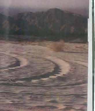
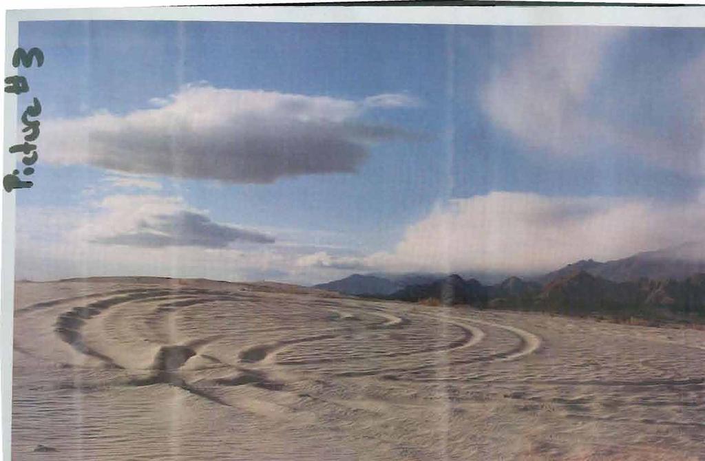
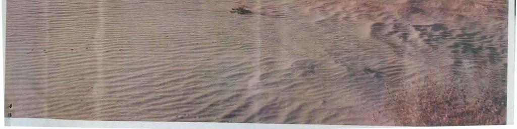
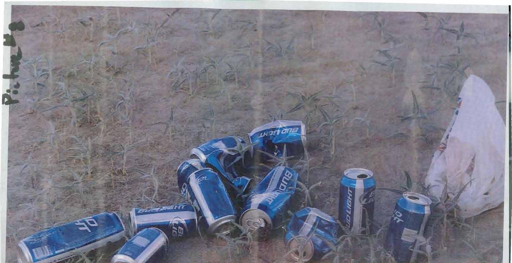
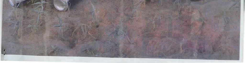
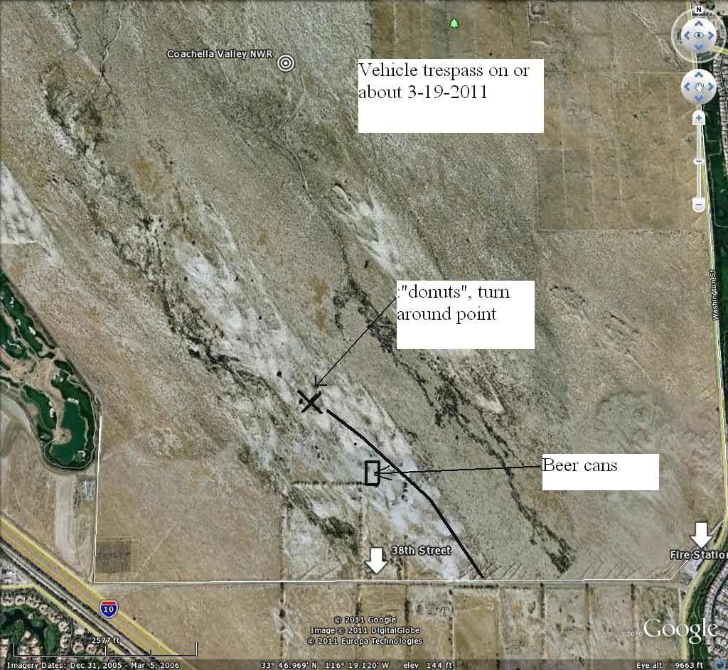
72 United States Department ofthe Interior U.s. FIS H & WJI,DI.IFR SERVICE FISH AND WILDLIFE SERVICE Sonny Bono Salt9n Sea National Wildlife Refuge Complex 906 West Sinclair Road Calipatria, CA Fax ~ u~.,-tu,\~ Memorandum Date: 3/25111 To: From: Subject: Files Ryan Woody, Biological Aide, Coachella Valley NWR Trespass at CVNWR On Monday 03/21111 around 0730 at the Coachella Valley NWR. I noticed vehicle tracks going off of 38 th avenue onto the Active Sand Dunes. (See photo #1). It was clearly evident that two vehicles had had made an entrance onto the refuge. In addition to the route that was taken from the vehicles, there was other damage to the face ofthe dune where these vehicles didn't reach the highest point (See photo 1). The route that was taken crossed a fence line at the top ofthe dune. Once inside the fence line, the tracks went through mass amounts of Dicoria canescens (See photo #2), and continued on north west throughout the main active dune aproximately 1600 meters, damaging this plant and others. At this point, the tracks circled (See pictures #3 circling and #4 for the most north western point in relation to the the golf course maintenance yard, next to the CVNWR) and headed back opposite direction. I followed the tracks to a low spot in the same dune ecosystem, and found empty beer cans scattered randomly (within 100 meters ofeach other See picture #5,#6). It was apperent that two vehicles were in this low spot for some time, climbing the embankments ofthe dune. (See picture #7). I picked up the beer cans and took a picture (See picture #8) I spoke with KD Fleming from University Of California Riverside. Mrs. Fleming works on the CVNWR and was out on the dunes the mornining of Saturday the 19 th ofmarch She told me that she hadn't seen any evidence oftrespass as ofthat morning. Unfortuanetly, the wind was really blowing throughtout the CVNWR the weekend ofthis incident, which in return covered most ofthe damage. Also, it was a full moon on Saturday night.

73

74
75
7.0 Take Authorization for Covered Activities and Term of Permit
 7.0 Take Authorization for Covered Activities and Term of Permit The proposed action is the issuance of a long-term (75-year) Permit for the Take of Covered Species to the Permittees. Covered Species include
METROPOLITAN COUNCIL 390 North Robert Street, St. Paul, MN Phone (651) TDD (651)
 TDD (651)") DATE: March 27, 2012 METROPOLITAN COUNCIL 390 North Robert Street, St. Paul, MN 55101 Phone (651) 602-1000 TDD (651) 291-0904 TO: Metropolitan Parks and Open Space Commission FROM: Arne Stefferud, Planning
DATE: March 27, 2012 METROPOLITAN COUNCIL 390 North Robert Street, St. Paul, MN 55101 Phone (651) 602-1000 TDD (651) 291-0904 TO: Metropolitan Parks and Open Space Commission FROM: Arne Stefferud, Planning
Rule Governing the Designation and Establishment of All-Terrain Vehicle Use Trails on State Land
 Rule Governing the Designation and Establishment of All-Terrain Vehicle Use Trails on State Land 1.0 Authority 1.1 This rule is promulgated pursuant to 23 V.S.A. 3506. Section 3506 (b)(4) states that an
DATE: January 19, WCA Governing Board. Johnathan Perisho, Project Manager. Mark Stanley, Executive Officer
 Item 14 DATE: January 19, 2017 TO: FROM: THROUGH: SUBJECT: WCA Governing Board Johnathan Perisho, Project Manager Mark Stanley, Executive Officer Item 14: Consideration of a resolution to accept an acquisition
County of Riverside - PSEC Project General Habitat Assessment Appendix A
 County of Riverside - PSEC Project General Habitat Assessment Appendix A Lake Elsinore Lake Elsinore The Lake Elsinore study area is located in the hills directly adjacent to Lake Elsinore, in the City
MONTEREY REGIONAL AIRPORT MASTER PLAN TOPICAL QUESTIONS FROM THE PLANNING ADVISORY COMMITTEE AND TOPICAL RESPONSES
 MONTEREY REGIONAL AIRPORT MASTER PLAN TOPICAL QUESTIONS FROM THE PLANNING ADVISORY COMMITTEE AND TOPICAL RESPONSES Recurring topics emerged in some of the comments and questions raised by members of the
January 14, Orange County Transportation Authority Attn: M2 NCCP/HCP 550 South Main Street P.O. Box Orange, CA
 Equestrian Trails, Inc. Corral 357 P.O. Box 1026 Trabuco Canyon, CA 92678 http://saddlebackcanyonriders.com/ President: James Iacono... 714-612-1789 January 14, 2016 Orange County Transportation Authority
California State University Long Beach Policy on Unmanned Aircraft Systems
 California State University, Long Beach June 14, 2016 Policy Statement: 16-04 California State University Long Beach Policy on Unmanned Aircraft Systems The following policy statement was recommended by
EMERY COUNTY PUBLIC LAND MANAGEMENT ACT OF 2018 S. 2809/H.R. 5727
 EMERY COUNTY PUBLIC LAND MANAGEMENT ACT OF 2018 S. 2809/H.R. 5727 September 25, 2018 OVERVIEW The Emery County Public Land Management Act of 2018 is a significant step backwards for wilderness and conservation
Alternative 3 Prohibit Road Construction, Reconstruction, and Timber Harvest Except for Stewardship Purposes B Within Inventoried Roadless Areas
 Roadless Area Conservation FEIS Summary Table S-1. Comparison of Key Characteristics and Effects by Prohibition Alternative. The effects summarized in this table A would occur in inventoried roadless areas
County of Riverside - PSEC Project General Habitat Assessment Appendix A
 County of Riverside - PSEC Project General Habitat Assessment Appendix A Paradise Paradise The Paradise study area is located in the mountains within the eastern portion of the City of Norco. Existing
White Mountain National Forest Saco Ranger District
 United States Department of Agriculture Forest Service White Mountain National Forest Saco Ranger District 33 Kancamagus Highway Conway, NH 03818 Comm: (603) 447-5448 TTY: (603) 447-3121 File Code: 1950
Phoenix Habitat Restoration Projects
 Phoenix Habitat Restoration Projects Spur Cross Ranch Cave Creek (Estergard) Regional Tree and Shade Summit March 9, 2010 Desert Riparian Ecosystems Healthy riparian areas like this once existed along
Sawtooth National Forest Fairfield Ranger District
 United States Department of Agriculture Forest Service Sawtooth National Forest Fairfield Ranger District P.O. Box 189 Fairfield, ID. 83327 208-764-3202 Fax: 208-764-3211 File Code: 1950/7700 Date: December
Creating a User-Driven Long-Distance OHV Trail Through Partnering
 Joseph Raffaele Outdoor Recreation Planner U.S. Bureau of Land Management Yuma, Arizona Creating a User-Driven Long-Distance OHV Trail Through Partnering BLM is a multiple-use land management agency within
FEASIBILITY CRITERIA
 This chapter describes the methodology and criteria used to evaluate the feasibility of developing trails throughout the study areas. Land availability, habitat sensitivity, roadway crossings and on-street
Daisy Dean Trail 628/619 ATV Trail Construction
 Background and Purpose and Need The Daisy Dean ATV Trail Construction Project is located in the Little Belt Mountains, Musselshell Ranger District, Lewis and Clark National Forest approximately 32 miles
Form I-924, Application for Regional Center under the Immigrant Investor Pilot Program
 U.S. Citizenship and Immigration Services Immigrant Investor Program Washington, DC 20529 February 26, 2014 Sean Runnels 74040 Hwy 111, #210 Palm Desert, CA 92260 Application: Applicant(s): Form I-924,
COASTAL CONSERVANCY. Staff Recommendation June 5, 2008 GUALALA BLUFF TRAIL OPERATIONS AND MAINTENANCE
 COASTAL CONSERVANCY Staff Recommendation June 5, 2008 GUALALA BLUFF TRAIL OPERATIONS AND MAINTENANCE File No. 08-047-01 Project Manager: Deborah Hirst RECOMMENDED ACTION: Consideration and possible Conservancy
PORT OF SEATTLE MEMORANDUM. COMMISSION AGENDA Item No. 4g ACTION ITEM Date of Meeting February 9, 2016
 PORT OF SEATTLE MEMORANDUM COMMISSION AGENDA Item No. 4g ACTION ITEM Date of Meeting February 9, 2016 DATE: TO: FROM: Michael Ehl, Director, Airport Operations Wayne Grotheer, Director, Aviation Project
Pinellas County Environmental Lands
 Pinellas County Environmental Lands In addition to traditional parks and recreation facilities, Pinellas County owns and manages a system of environmental lands that provides specialized resource-based
COASTAL CONSERVANCY. Staff Recommendation December 2, 2010 CITY OF SAN DIEGO NCCP PROGRAM VERNAL POOL HABITAT CONSERVATION PLAN
 COASTAL CONSERVANCY Staff Recommendation December 2, 2010 CITY OF SAN DIEGO NCCP PROGRAM VERNAL POOL HABITAT CONSERVATION PLAN Project No. 98-011-02 Project Manager: Mary Small RECOMMENDED ACTION: Authorization
COASTAL CONSERVANCY. Staff Recommendation December 2, 2004 COYOTE HELLYER COUNTY PARK BAY AREA RIDGE TRAIL
 COASTAL CONSERVANCY Staff Recommendation December 2, 2004 COYOTE HELLYER COUNTY PARK BAY AREA RIDGE TRAIL File No. 04-057 Project Manager: Amy Hutzel RECOMMENDED ACTION: Authorization to disburse up to
(Also known as the Den-Ice Agreements Program) Evaluation & Advisory Services. Transport Canada
 Evaluation & Advisory Services. Transport Canada") Evaluation of Transport Canada s Program of Payments to Other Government or International Agencies for the Operation and Maintenance of Airports, Air Navigation, and Airways Facilities (Also known as the
Evaluation of Transport Canada s Program of Payments to Other Government or International Agencies for the Operation and Maintenance of Airports, Air Navigation, and Airways Facilities (Also known as the
Establishes a fare structure for Tacoma Link light rail, to be implemented in September 2014.
 RESOLUTION NO. R2013-24 Establish a Fare Structure and Fare Level for Tacoma Link MEETING: DATE: TYPE OF ACTION: STAFF CONTACT: PHONE: Board 09/26/2013 Final Action Ric Ilgenfritz, Executive Director,
Official Journal of the European Union L 7/3
 12.1.2010 Official Journal of the European Union L 7/3 COMMISSION REGULATION (EU) No 18/2010 of 8 January 2010 amending Regulation (EC) No 300/2008 of the European Parliament and of the Council as far
Parkland County Municipal Development Plan Amendment Acheson Industrial Area Structure Plan
 Parkland County Municipal Development Plan Amendment Acheson Industrial Area Structure Plan New Plan Acheson Industrial Area Structure Plan Amendment Parkland County Municipal Development Plan Board Reference
112th CONGRESS. 1st Session H. R. 113 IN THE HOUSE OF REPRESENTATIVES
 HR 113 IH 112th CONGRESS 1st Session H. R. 113 To provide for additions to the Cucamonga and Sheep Mountain Wilderness Areas in the Angeles and San Bernardino National Forests and the protection of existing
Wilderness Areas Designated by the White Pine County bill
 Wilderness Areas Designated by the White Pine County bill SEC. 321. SHORT TITLE. This subtitle may be cited as the `Pam White Wilderness Act of 2006'. SEC. 322. FINDINGS. Congress finds that-- The White
HIGHWAY 17 WILDLIFE and REGIONAL TRAIL CROSSINGS
 HIGHWAY 17 WILDLIFE and REGIONAL TRAIL CROSSINGS Agenda and Meeting Format 7:00-7:15 Welcome 7:15-8:00 Presentation 8:00-8:30 Open House 8:30 Recap 9:00 Conclusion 2 Meeting Goals: Introduce the project
Submission to NSW Koala Strategy Consultation Process. March 2017
 Submission to NSW Koala Strategy Consultation Process March 2017 Table of contents Opening 3 Response 3 Whole-of-government NSW koala strategy 3 State Environment Planning Policy (SEPP) 44 3 The draft
PROPOSED PARK ALTERNATIVES
 8 Chimne y Rock State Park M a ster Pl an 2011 PROPOSED PARK ALTERNATIVES Introduction Three different park development concepts were prepared and presented to the citizens of North Carolina through a
Monterey Coast-Sierra de Salinas Linkage Study. Conducted by The Big Sur Land Trust & Pathways for Wildlife
 Monterey Coast-Sierra de Salinas Linkage Study Conducted by The Big Sur Land Trust & Pathways for Wildlife Objectives & Goals 1) To increase our understanding of wildlife movement throughout the Central
Tahoe National Forest Over-Snow Vehicle Use Designation
 Tahoe National Forest Over-Snow Vehicle Use Designation USDA Forest Service Tahoe National Forest February 20, 2015 Introduction The Forest Service, U.S. Department of Agriculture will prepare an Environmental
County of Riverside - PSEC Project General Habitat Assessment Appendix A
 County of Riverside - PSEC Project General Habitat Assessment Appendix A Glen Avon Glen Avon The Glen Avon study area is located north of State Route 60 in the Jurupa Mountains, approximately 1 mile south
BACKCOUNTRY TRAIL FLOOD REHABILITATION PROGRAM
 BACKCOUNTRY TRAIL FLOOD REHABILITATION PROGRAM Backcountry Trail Flood Rehabilitation A June 2013 Flood Recovery Program Summary In June 2013, parts of Southern Alberta were devastated from significant
Decision Memo for Desolation Trail: Mill D to Desolation Lake Trail Relocation
 for Salt Lake County, Utah Uinta-Wasatch-Cache National Forest Salt Lake Ranger District 1. Background The present location of the Desolation Trail (#1159) between Mill D and Desolation Lake follows old
Proposed Action. Payette National Forest Over-Snow Grooming in Valley, Adams and Idaho Counties. United States Department of Agriculture
 United States Department of Agriculture Forest Service January 2012 Proposed Action Payette National Forest Over-Snow Grooming in Valley, Adams and Idaho Counties Payette National Forest Valley, Adams
ANGLIAN WATER GREEN BOND
 ANGLIAN WATER GREEN BOND DNV GL ELIGIBILITY ASSESSMENT Scope and Objectives Anglian Water Services Financing Plc is the financing subsidiary of Anglian Water Services Limited. References in this eligibility
Final Environmental Impact Statement for the Merced Wild and Scenic River. Comprehensive Management Plan, Yosemite National Park, Madera and Mariposa
 This document is scheduled to be published in the Federal Register on 02/26/2014 and available online at http://federalregister.gov/a/2014-04061, and on FDsys.gov DEPARTMENT OF THE INTERIOR 4312-FF NATIONAL
FINAL TESTIMONY 1 COMMITTEE ON RESOURCES UNITED STATES HOUSE OF REPRESENTATIVES. July 13, 2005 CONCERNING. Motorized Recreational Use of Federal Lands
 FINAL TESTIMONY 1 STATEMENT OF DALE BOSWORTH CHIEF Of the FOREST SERVICE UNITED STATES DEPARTMENT OF AGRICULTURE Before the SUBCOMMITTEE ON FORESTS AND FOREST HEALTH And the SUBCOMMITTEE ON NATIONAL PARKS,
David Magney Environmental Consulting
 David Magney Environmental Consulting DELINEATION OF JURISDICTIONAL WATERS AND RIPARIAN HABITATS FOR LYONS CANYON RANCH, NEWHALL, CALIFORNIA Prepared for: UNITED STATES ARMY CORPS OF ENGINEERS and CALIFORNIA
Planning Wildlife Crossings in Canada's Mountain Parks SESSION: Highway Mitigation: new insights for practitioners
 Planning Wildlife Crossings in Canada's Mountain Parks ID95 SESSION: Highway Mitigation: new insights for practitioners Trevor Kinley, Project Manager Lake Louise Yoho Kootenay Field Unit, Parks Canada
1.0 Project Background Mission Statement and Goals Objectives of this Sustainable Master Plan
 TABLE OF CONTENTS CHAPTER 1 INTRODUCTION 10 Project Background 1-1 11 Mission Statement and Goals 1-1 12 Objectives of this Sustainable Master Plan 1-2 CHAPTER 2 INVENTORY 20 Airport Background 2-1 201
EAST DON TRAIL ENVIRONMENTAL ASSESSMENT. Community Liaison Committee Meeting #3 July 15, :30 to 8:30 pm Flemingdon Park Library
 EAST DON TRAIL ENVIRONMENTAL ASSESSMENT Community Liaison Committee Meeting #3 July 15, 2013 6:30 to 8:30 pm Flemingdon Park Library Agenda 1. Welcome 2. Housekeeping and Updates a) Housekeeping b) CLC
Ecological Corridors: Legal Framework for the Baekdu Daegan Mountain System (South Korea) Katie Miller* Kim Hyun**
 Katie Miller* Kim Hyun**") Ecological Corridors: Legal Framework for the Baekdu Daegan Mountain System (South Korea) Katie Miller* Kim Hyun** Information concerning the legal instruments discussed in this case study is current as
Ecological Corridors: Legal Framework for the Baekdu Daegan Mountain System (South Korea) Katie Miller* Kim Hyun** Information concerning the legal instruments discussed in this case study is current as
For questions about this policy, please contact the Office of the Vice President for Research and Innovation at
 POLICY 0.00.00 UNMANNED AIRCRAFT SYSTEMS POLICY [DRAFT] Reason for Policy The purpose of this Policy is to facilitate the operation of unmanned aircraft systems ( UAS ) and model aircraft for teaching
Form I-924, Application for Regional Center Under the Immigrant Investor Pilot Program
 U.S. Citizenship and Immigration Services Immigrant Investor Program Washington, DC 20529 8/16/16 Ginny Fang C/O Golden Gate Global (formerly San Francisco Bay Area Regional Center) 1 Sansome St., Suite
Lake Tahoe Airport Master Plan Public Meeting March 16, 2015
 Lake Tahoe Airport Master Plan Public Meeting March 16, 2015 What is an Airport Master Plan? a comprehensive study of an airport [that] usually describes the short, medium, and long term development plans
USCIS Foreign Trader, Investor and Regional Center Program (FTIRCP)
") USCIS Foreign Trader, Investor and Regional Center Program (FTIRCP) EXECUTIVE SUMMARY FUNCTIONS The U.S. Citizenship and Immigration Service s (USCIS) Foreign Trader, Investor and Regional Center Program
USCIS Foreign Trader, Investor and Regional Center Program (FTIRCP) EXECUTIVE SUMMARY FUNCTIONS The U.S. Citizenship and Immigration Service s (USCIS) Foreign Trader, Investor and Regional Center Program
(i) Adopted or adapted airworthiness and environmental standards;
 Adopted or adapted airworthiness and environmental standards;") TECHNICAL ARRANGEMENT FOR THE ACCEPTANCE OF AIRWORTHINESS AND ENVIRONMENTAL APPROVAL OF CIVIL AERONAUTICAL PRODUCTS BETWEEN THE CIVIL AVIATION BUREAU, MINISTRY OF LAND, INFRASTRUCTURE AND TRANSPORT, JAPAN
TECHNICAL ARRANGEMENT FOR THE ACCEPTANCE OF AIRWORTHINESS AND ENVIRONMENTAL APPROVAL OF CIVIL AERONAUTICAL PRODUCTS BETWEEN THE CIVIL AVIATION BUREAU, MINISTRY OF LAND, INFRASTRUCTURE AND TRANSPORT, JAPAN
I. Call to Order. A. Invocation. B. Pledge of Allegiance. Employee Awards. Public Information Update. 1. PIO Update- Page: 6
 Agenda Okaloosa County Board of Commissioners Tuesday, April 16, 2019 8:30 AM Okaloosa County Administration Building In accordance with Section 286.011, Florida Statutes, this meeting was publicly noticed
Blueways: Rivers, lakes, or streams with public access for recreation that includes fishing, nature observation, and opportunities for boating.
 Parks, Open Space and Trails PRINCE WILLIAM COUNTY 2008 COMPREHENSIVE PLAN TRAILS PLAN CONTENTS The components of the trails plan are: Intent Definitions Goals, Policies, and Action Strategies Trails Map
12, 14 and 16 York Street - Amendments to Section 16 Agreement and Road Closure Authorization
 REPORT FOR ACTION 12, 14 and 16 York Street - Amendments to Section 16 Agreement and Road Closure Authorization Date: April 27, 2018 To: Toronto and East York Community Council From: Senior Strategic Director,
COASTAL CONSERVANCY. Staff Recommendation March 25, 2004 SONOMA COUNTY COASTAL TRAIL, PHASE I. File No Project Manager: Richard Retecki
 COASTAL CONSERVANCY Staff Recommendation March 25, 2004 SONOMA COUNTY COASTAL TRAIL, PHASE I File No. 03-142 Project Manager: Richard Retecki RECOMMENDED ACTION: Authorization to disburse up to $455,000
APPENDIX OFFICIAL MAP ORDINANCE OF HAMILTONBAN TOWNSHIP OFFICIAL MAP NARRATIVE
 APPENDIX A OFFICIAL MAP ORDINANCE OF HAMILTONBAN TOWNSHIP OFFICIAL MAP NARRATIVE INTRODUCTION: The Official Map of Hamiltonban Township has been prepared to identify those lands and features that Hamiltonban
Memorandum. Roger Millar, Secretary of Transportation. Date: April 5, Interstate 90 Operations and Mercer Island Mobility
 Memorandum To: From: The Honorable Dow Constantine, King County Executive; The Honorable Ed Murray, City of Seattle Mayor; The Honorable Bruce Bassett, City of Mercer Island Mayor; The Honorable John Stokes,
Business Item No XXX. Proposed Action That the Metropolitan Council approve the Coon Creek Regional Trail Master Plan.
 Business Item No. 2015-XXX Metropolitan Parks and Open Space Commission Meeting date: July 7, 2015 For the Community Development Committee meeting of July 20, 2015 For the Metropolitan Council meeting
THE BURBANK-GLENDALE-PASADENA AIRPORT AUTHORITY S UPDATE REGARDING ITS NOISE IMPACT AREA REDUCTION PLAN AND ITS PART 161 STUDY SECOND QUARTER 2015
 THE BURBANK-GLENDALE-PASADENA AIRPORT AUTHORITY S UPDATE REGARDING ITS NOISE IMPACT AREA REDUCTION PLAN AND ITS PART 161 STUDY SECOND QUARTER 2015 Pursuant to the California Department of Transportation
White Mountain National Forest Saco Ranger District
 United States Department of Agriculture Forest Service White Mountain National Forest 33 Kancamagus Highway Conway, NH 03818 Comm: (603) 447-5448 TTY: (603) 447-3121 File Code: 1950 Date: February 26,
Welcome and thank you for being here! Kick-Off Public Workshop November 19, 2014
 Welcome and thank you for being here! Kick-Off Public Workshop November 19, 2014 OPEN SPACE MATTERS: Boise s First Reserve Master Plan Julia Grant Foothills and Open Space Manager City of Boise Ellen Campfield
Map 1.1 Wenatchee Watershed Land Ownership
 Map 1.1 Wenatchee Watershed Land Ownership Map 1.1 Wenatchee Watershed Land Ownership The Wenatchee watershed lies in the heart of Washington state in Chelan County. Just larger than the state of Rhode
Nova Southeastern University Joint-Use Library Agreement: Review of Public Usage
 Exhibit 1 Nova Southeastern University Joint-Use Library Agreement: Robert Melton, CPA, CIA, CFE, CIG County Auditor Audit Conducted by: Gerard Boucaud, CISA, Audit Manager Dirk Hansen, CPA, Audit Supervisor
8 CROSS-BOUNDARY AGREEMENT WITH BRAMPTON TRANSIT
 8 CROSS-BOUNDARY AGREEMENT WITH BRAMPTON TRANSIT The Transportation Services Committee recommends the adoption of the recommendations contained in the following report dated May 27, 2010, from the Commissioner
COASTAL CONSERVANCY. Staff Recommendation September 22, 2011 BAY AREA RIDGE TRAIL: HOOD MOUNTAIN TO HIGHWAY 12
 COASTAL CONSERVANCY Staff Recommendation September 22, 2011 BAY AREA RIDGE TRAIL: HOOD MOUNTAIN TO HIGHWAY 12 File No. 11-039-001 Project Manager: Betsy Wilson RECOMMENDED ACTION: Authorization to disburse
M E M O R A N D U M. Status of the Environmental Cleanup of the Shipyard
 ECONOMIC AND WORKFORCE DEVELOPMENT MICHAEL COHEN, DIRECTOR CITY AND COUNTY OF SAN FRANCISCO GAVIN NEWSOM, MAYOR M E M O R A N D U M TO: Members of the Health Commission FROM: Michael Cohen CC: Mitch Katz,
THE BURBANK-GLENDALE-PASADENA AIRPORT AUTHORITY S UPDATE REGARDING ITS NOISE IMPACT AREA REDUCTION PLAN AND ITS PART 161 STUDY FIRST QUARTER 2015
 THE BURBANK-GLENDALE-PASADENA AIRPORT AUTHORITY S UPDATE REGARDING ITS NOISE IMPACT AREA REDUCTION PLAN AND ITS PART 161 STUDY FIRST QUARTER 2015 Pursuant to the California Department of Transportation
APPENDIX G. The WAP Conservation Landscape and Focal Areas
 APPENDIX G The WAP Conservation Landscape and Focal Areas Focal areas were identified as discrete landscape units using the natural basin and range geography of the Nevada landscape. These units were prioritized
Business Plan INTRODUCTION AIRPORT ENTERPRISE FUND OVERVIEW. Master Plan Guiding Principles
 5 Business Plan INTRODUCTION Just as previous chapters have outlined plans for the airport s physical development, this chapter outlines a plan for the airport s financial development. More specifically,
Table 7-12: Approved Trails, Allowed Uses, and Restrictions
 Draft Revision: April 04 CVMSHCP Public Use and s Management for the Santa Rosa and San Jacinto Mountains Table 7-: s, Uses, and s The general geographic extent of recovery regions in the Plan Area is
CHAPTER III: TRAIL DESIGN STANDARDS, SPECIFICATIONS & PERMITS
 CHAPTER III Trail Design Standards, Specifications & Permits This chapter discusses trail standards, preferred surface types for different activities, permits, and other requirements one must consider
SUMMARY REPORT ON THE SAFETY OVERSIGHT AUDIT FOLLOW-UP OF THE CIVIL AVIATION AUTHORITY OF SLOVENIA
 ICAO Universal Safety Oversight Audit Programme SUMMARY REPORT ON THE SAFETY OVERSIGHT AUDIT FOLLOW-UP OF THE CIVIL AVIATION AUTHORITY OF SLOVENIA (Ljubljana, 7 to 8 March 2002) International Civil Aviation
DECISION MEMO. Rawhide Trail #7073 Maintenance and Reconstruction
 Page 1 of 6 Background DECISION MEMO USDA Forest Service Jefferson Ranger District Jefferson County, Montana Rawhide Trail #7073 is located in the Elkhorn Mountain Range approximately 10 miles east of
Preferred Recreation Recommendations Stemilt-Squilchuck Recreation Plan March 2018
 Preferred Recreation Recommendations Stemilt-Squilchuck Recreation Plan March 2018 Below are the recommended recreation ideas and strategies that package together the various recreation concepts compiled
BERMUDA DUNES AIRPORT (UDD)
") BERMUDA DUNES AIRPORT (UDD) FOR SALE: 105 Acres in Coachella Valley, Southern California More information online at: BERMUDADUNESAIRPORT.ORG AIRPORTPROPERTY.COM (480) 483-1985 John Meyer DESIGNATED BROKER
BERMUDA DUNES AIRPORT (UDD) FOR SALE: 105 Acres in Coachella Valley, Southern California More information online at: BERMUDADUNESAIRPORT.ORG AIRPORTPROPERTY.COM (480) 483-1985 John Meyer DESIGNATED BROKER
Rockin River Ranch State Park
 Rockin River Ranch State Park Public Meeting No. 3 August 16 th, 2017 Arizona State Parks and Trails (ASPT) Welcome Executive Director Sue Black Park budget = $4 million Balance of recreation uses, environment,
Executive Summary. MASTER PLAN UPDATE Fort Collins-Loveland Municipal Airport
 Executive Summary MASTER PLAN UPDATE Fort Collins-Loveland Municipal Airport As a general aviation and commercial service airport, Fort Collins- Loveland Municipal Airport serves as an important niche
Austin-Bergstrom International Airport Master Plan Update
 FINAL REPORT Prepared for: City of Austin Department of Aviation 3600 Presidential Boulevard Austin, Texas 78719 Prepared by: P&D Aviation A Division of P&D Consultants, Inc. 999 Town & County Road, 4
Classifications, Inventory and Level of Service
 Classifications, Inventory and Level of Service Section 3 Kenmore Park, Recreation and Open Space Plan 1 P a g e Classifications and Inventory Park Classifications Kenmore classifies its parks based upon
CHAPTER 1: INTRODUCTION
 CHAPTER 1: INTRODUCTION Purpose and Scope The information presented in this report represents the study findings for the 2016 Ronan Airport Master Plan prepared for the City of Ronan and Lake County, the
U.S. Department of Homeland Security U.S. Citizenship and Immigration Services Washington, DC 20529
 U.S. Department of Homeland Security U.S. Citizenship and Immigration Services Washington, DC 20529 HQ DOMO 70/6.1 AFM Update AD07-04 Memorandum TO: Field Leadership FROM: Donald Neufeld /s/ Acting Associate
Colorado s Instream Flow Program at 40. Celebrating 40 Years of Success and Challenges January 15, 2014 Denver, Colorado
 Colorado s Instream Flow Program at 40 Celebrating 40 Years of Success and Challenges January 15, 2014 Denver, Colorado ISF Program established in 1973 by Senate Bill 97 Recognized the need to correlate
Partners: Michigan California Timber Company Shasta-Trinity National Forest Pacific Crest Trail Association The Trust for Public Land
 Partners: Michigan California Timber Company Shasta-Trinity National Forest Pacific Crest Trail Association The Trust for Public Land Describe the project location, size, opportunities, and timing. Provide
STAFF REPORT. Airport Land Use Plan Consistency Review: Santa Barbara Airport Master Plan. MEETING DATE: November 19, 2015 AGENDA ITEM: 7D
 STAFF REPORT SUBJECT: Airport Land Use Plan Consistency Review: Santa Barbara Airport Master Plan MEETING DATE: AGENDA ITEM: 7D STAFF CONTACT: Peter Imhof, Andrew Orfila RECOMMENDATION: Adopt findings
REVIEW OF THE STATE EXECUTIVE AIRCRAFT POOL
 STATE OF FLORIDA Report No. 95-05 James L. Carpenter Interim Director Office of Program Policy Analysis And Government Accountability September 14, 1995 REVIEW OF THE STATE EXECUTIVE AIRCRAFT POOL PURPOSE
Department of Legislative Services Maryland General Assembly 2009 Session
 Department of Legislative Services Maryland General Assembly 2009 Session SB 650 FISCAL AND POLICY NOTE Senate Bill 650 (Senators Pipkin and Astle) Finance and Budget and Taxation Medevac Helicopter Improvement
Request for Proposals
 E CONOMIC DEVELOPMENT AUTHORITY of the City of Norfolk Board of Directors Officers Robert E. Garris, Jr., Chairman Executive Director Michael W. Lee, Vice Chairman Peter Chapman Jeffrey F. Brooke Kim Brown
Decision Memo Broken Wheel Ranch Equestrian Outfitter Special-Use Permit Proposed Action
 Decision Memo Broken Wheel Ranch Equestrian Outfitter Special-Use Permit USDA Forest Service Mississippi Bluffs Ranger District, Shawnee National Forest Jackson and Union Counties, Illinois Proposed Action
Dungeness Recreation Area County Park Master Plan
 Dungeness Recreation Area County Park Public Outreach Meeting October 10, 2007 Project Overview USFWS Site Dungeness Recreation Area County Park Meeting Objectives: Re-Introduce project; provide status
Rogue River Access and Management Plan Draft Alternatives
 Rogue River Access and Management Plan Draft Alternatives The Rogue River Access and Management Plan was initiated in December, 2011 and is being led by Jackson County Parks (JCP) and Oregon Department
RE: Access Fund Comments on Yosemite National Park Wilderness Stewardship Plan, Preliminary Ideas and Concepts
 September 30, 2016 Superintendent Yosemite National Park Attn: Wilderness Stewardship Plan P.O. Box 577 Yosemite, CA 95389 RE: Access Fund Comments on Yosemite National Park Wilderness Stewardship Plan,
ROAD AND TRAIL PROJECT APPROVAL
 ROAD AND TRAIL PROJECT APPROVAL www.marincountyparks.org Marin County Parks, 3501 Civic Center Dr, Suite 260, San Rafael, CA 94903 DATE: July 12, 2017 PRESERVE: Gary Giacomini Open Space Preserve PROJECT:
Northeast Quadrant Distinctive Features
 NORTHEAST QUADRANT Northeast Quadrant Distinctive Features LAND USE The Northeast Quadrant includes all the area within the planning area that is east of Interstate 5 and to the north of State Route 44.
Galveston Bay Estuary Program. Carla G. Guthrie, Ph.D. Galveston Bay Council Member Texas Water Development Board
 Galveston Bay Estuary Program Carla G. Guthrie, Ph.D. Galveston Bay Council Member Texas Water Development Board The statements contained in this presentation are my current views and opinions and are
Crown of the Continent Ecosystem The Glacier-Great Bear Connectivity Conservation Area Briefing
 Crown of the Continent Ecosystem The Glacier-Great Bear Connectivity Conservation Area Briefing By: Rob Ament & Tyler Creech October 2016 The Glacier-Great Bear Connectivity Conservation Area The Crown
COMMISSION IMPLEMENTING REGULATION (EU)
") 18.10.2011 Official Journal of the European Union L 271/15 COMMISSION IMPLEMENTING REGULATION (EU) No 1034/2011 of 17 October 2011 on safety oversight in air traffic management and air navigation services
18.10.2011 Official Journal of the European Union L 271/15 COMMISSION IMPLEMENTING REGULATION (EU) No 1034/2011 of 17 October 2011 on safety oversight in air traffic management and air navigation services
THE BURBANK-GLENDALE-PASADENA AIRPORT AUTHORITY S UPDATE REGARDING ITS NOISE IMPACT AREA REDUCTION PLAN AND ITS PART 161 STUDY SECOND QUARTER 2017
 THE BURBANK-GLENDALE-PASADENA AIRPORT AUTHORITY S UPDATE REGARDING ITS NOISE IMPACT AREA REDUCTION PLAN AND ITS PART 161 STUDY SECOND QUARTER 2017 Pursuant to the California Department of Transportation
San Juan Resource Area Recreation Impact Inventory/Monitoring
 San Juan Resource Area Recreation Impact Inventory/Monitoring Indian Creek Climbing Area Overview & Summary of Findings 2007 Pam Foti, Professor Aaron Divine, Lecturer Janet Lynn, Program Coordinator Northern
Section II. Planning & Public Process Planning for the Baker/Carver Regional Trail began in 2010 as a City of Minnetrista initiative.
 Section II Planning & Public Process Planning for the began in 2010 as a City of initiative. city staff began discussions with the Park District on the possibility of a north/south regional trail connection
 Existing Conditions AIRPORT PROFILE Passenger Terminal Complex 57 air carrier gates 11,500 structured parking stalls Airfield Operations Area 9,000 North Runway 9L-27R 6,905 Crosswind Runway 13-31 5,276