Introduction And Background
|
|
|
- Clifton Bradford
- 5 years ago
- Views:
Transcription
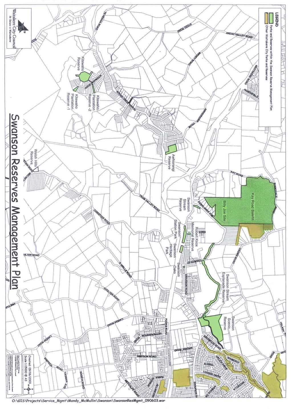
1 Part 1 Introduction And Background By the 1870 s, when it became evident that the kauri resources were not limitless and that millers interests were in conflict with the nation s, William Swanson, became the most vehement critic of the timbermen and their practices himself. He was a conspicuous exception to the rule that self interest outweighs the consideration for the common good. (P.37 A History of Waitemata). This Plan includes the following Reserves: Swanson Scenic Reserve Swanson Stream Esplanade Reserve Swanson Stream Reserve Robert Knox Memorial Park Swanson Station Park Swanson Heritage Park (working title) Swanson Oaks Awhiorangi Reserve Kitewaho Plantation Reserve 1 Kitewaho Plantation Reserve 2 Kitewaho Reserve Welsh Hills Reserve Kay Road Balefill Billy Joe Stream Site 7
2 In 2001, Council began preparing a Management Plan for the reserves within the Swanson area. The intention to prepare this Plan was publicly notified in October 2001 and submissions closed in February Subsequently the decision was made to include Kay Road balefill and the adjacent 16 ha site containing the Billy Joe Stream, in this Reserves Management Plan. The publication of the draft Plan was delayed to allow time for the procedures required to include Kay Road in the overall Plan. Kay Road balefill is an historical landfill which ceased operations in 1996 and, as such, is not currently designated as a reserve nor open to the public, but is under the management of Council s Aftercare Services. The purpose of this Plan is to propose an integrated plan for the best development and future use of the Swanson Reserves. As the balefill will be designated as a reserve in the future when the Aftercare issues are resolved, it is proposed that the site be included in this Plan in order that it undergo the process of community consultation regarding its future development and overall role in the reserves network. Likewise, the site below the balefill that contains the Billy Joe Stream has been retained by Aftercare due to its geographical relationship to the balefill. While it is not currently a reserve it is proposed that this site or parts of it, be eventually designated as reserve for reasons outlined in the Plan. Therefore this site, hereafter referred to as the Billy Joe site, is also included in this Plan. The 12 reserves plus the balefill and Billy Joe site included in this draft Management Plan all lie within the Waitakere Ward. They are collectively known hereafter as the Swanson Reserves and are the subject of this Management Plan. The reserves included in this Plan have a range of ecological and amenity values, and fall into two main categories: 1. Green Network Reserves These have nigh natural or ecological values and are only suitable for passive recreation. There are two types; (a) (b) Esplanade reserves - include streams and their riparian margins. These are Swanson Esplanade Reserve, Swanson Stream Reserve, Swanson Scenic Reserve, and the Billy Joe site. Bush reserves - regenerating bush with high ecological values include Swanson Scenic Reserve, the Kitewaho Reserves, Awhiorangi Reserve, Welsh Hills Reserve, the Billy Joe site and Kay Road balefill. 2. Township / Community Reserves These are located within Swanson Village itself, have high recreational and little or no ecological values. They include Robert Knox Memorial Park, Swanson Station Park, Swanson Oaks and Swanson Heritage Park (note that this is a working title only - in use at the time this Plan was adopted). The community is well served by this variety, each category offering a different and complimentary recreational experience. The Green Network reserves primary purpose is to provide opportunities for passive recreation in a natural environment - through walkways and access to the streams and bush. The primary purpose of the township reserves to provide local purpose facilities for community recreation such as events and gatherings. At present there are no reserves in Swanson providing sports or active recreation facilities. This Management Plan seeks to protect and enhance the special recreational, ecological and cultural values of the reserves, at the same time balancing the requirements of their classifications and meeting the needs of both the local and wider community. This Management Plan sets out the objectives and policies for the management of the Swanson reserves. The Plan has been produced within the context of Waitakere City s wider objectives. 8
3 1.0 Context This section introduces the context for the reserves. 1.1 Swanson Environment The Waitakere Ranges and their foothills are a unique ecosystem. The foothills lie on the eastern side of the Waitakere Ranges and are the rolling hills, ridges and gullies of the catchments that drain out to the Waitemata Harbour. Swanson lies in these foothills to the east of the Waitakere Ranges. The Waitakere Ranges were formed by an ancient massive uplift of hard volcanic basalt. Over time, soft rock has worn away from the hills and silt has collected in the valleys and lowlands, a process facilitated by the high rainfall. In the foothills to the east of the Ranges, around Swanson, the soils are more sedimentary than volcanic and are known as Waitemata soils. The low-lying hills and valleys of the foothills were sheltered from the Tasman coastal airflows and, in pre- European times, they were covered by a warm lowland forest ecosystem. Along the ridges, the emergent trees were kauri, tanekaha and rimu; on the valley sides, puriri, rata, rimu and kahikatea; in the more fertile gullies were abundant ponga, mahoe, nikau and other broadleaf shrubs and trees. The dense nature of the forest meant that lines of communication were generally along ridgelines or waterways. The Swanson catchment is one of the major catchments of the Waitakere foothills environment, covering some 2270 hectares in total. The catchment is drained by many small streams, feeding into the Swanson Stream, which enters the upper Waitemata Harbour through the Huruhuru Inlet, under the northwestern motorway in Massey. The foothills topography is characterised by undulating land, strongly dissected with gullies and streams. Swanson village itself is located in a valley floor with the land generally rising to the north and south. Immediately north of the valley floor an escarpment rises above the Swanson Stream. Pastoral farming has been a predominant land use in this area, through the farms were never large. Over time, the scale of holdings has reduced and is now quite fragmented. The area is characterised by a mixture of bush and rural residential farmland, with a small urban, residential and industrial area located around the village. Swanson is a foothills environment, a buffer between the Waitakere ranges and the more developed land to the east. In order to regulate future development within this foothills landscape, Council has proposed the Swanson Structure Plan. The Swanson Structure Plan identifies the predominant land uses of the area as: Bush Living and Rural Residential. Through the Structure Plan, the area is expected to accommodate some 140 additional lots. To the south of Swanson lies Ranui, a predominantly medium density, low-cost, residential suburb. To the east lies Te Rangi Hiroa, the home of the Massey Pony Club and one of the two major equestrian centres in west Auckland. Figure 1 Context Map 9
4 10
5 1.1.1 Kay Road Balefill Between the years of 1983 and 1996, Kay Road was the balefill site for west Auckland domestic and other refuse. In 1993, the original consents expired and Council looked to extend the life of the balefill beyond the planned November 1993 closure. This move was opposed by members of the community and after extensive community consultation, Council entered into mediation with the community to settle the matter. A number of concessions were made by both parties during the negotiation process and, in August 1993, a Mediation Agreement was signed between the Swanson residents and the Waitakere City Council. Under the terms of this Agreement, the life of the Balefill was extended for three years until November 30 th 1996 and the Community was paid compensation, the money gong to a Trust fund. In addition, the Agreement approves a Site Management Plan and establishes a Site Management Committee consisting of 3 members of the Swanson community and 3 elected representatives to oversee the implementation of and improvements to this Management Plan. The Mediation Agreement states that at the end of operations, closure and aftercare operations will commence. The aftercare and monitoring activities will continue for a period of 30 years, during which time the site will be revegetated and progressively developed as a passive reserve. The following terms of the Mediation Agreement relate to the future of the balefill as a reserve: 1. In the event that Waitakere acquires other property adjoining the site for the purposes of the balefill then so much of the land as is used for balefill purposes shall be included within the definition of the site for this agreement. 12. (d) (f) Works to develop the site as a recreation reserve; Recreational uses as follows: i) for the first 30 years as a passive recreation reserve; ii) thereafter as a recreation reserve within the classification in the Reserves Act 1977 or such other enactment as may then be in force. 23. Prior to the termination of the use of the site as a balefill in accordance with para 3 Waitakere will in consultation with the residents decide on a name for the reserve on the site. Since 1995, the Site Management Plan has been kept under continuous review with the input of the Site Management Committee. After landfill operations ceased in 1997, the Site Management Plan was updated to become a Post Closure Plan. The original Post Closure Management Plan (Worleys 1995) stated that on closure, the site would be open to the public as a passive recreation reserve, in accordance with the wishes of the local community. It was then intended that the site would be vested for this purpose within 6 months of the final bale being placed. Capping and restoration of the site was completed in April However, it became apparent during the initial post-closure phase that public access to the site would be difficult to manage for reasons of health and safety. There were a number of control and monitoring facilities remaining on the site, including: Monitoring boreholes Gas flaring equipment Gas collection vents Stormwater ponds and drains A leachate collection system 11
6 Since closure, the Kay Road site has been under the management of Council s Aftercare Services. The site has remained closed for public access while Aftercare and the SMC have implemented an extensive and ongoing programme of revegetation and weed control work, as specified in the Site Management Plan. The site has been recontoured and covered with topsoil to level the surface of the platforms as the bales have settled and an extensive programme of planting eco-sourced native seedlings has been carried out. As it is Council s priority to ensure public health and safety, as well as to protect the landfill monitoring and control infrastructure and the investment which they have made in revegetating the site, the site is not considered suitable for public access yet. As recently as November 2002, the Site Management Plan stated There will be no active promotion of the site as a Council Reserve until such time as the WCC are satisfied with the level of security of the site. While the active aftercare life of the balefill is hard to predict, it is envisaged that this may be around 30 years from the date of closure. Until that time, the balefill site, or at least part of it, will remain closed to public access. The timetable for the vesting of the site as a reserve will be reviewed on an ongoing basis. In 1996, Council began preparing a combined draft Reserves Management Plan for the Kay Road Balefill site and Crows Park, which backs onto it. This was publicly notified and, following the process of public consultation required under the Reserves Act (1977), a draft Plan was produced. However, due to ongoing Aftercare issues, the Kay Road site was subsequently withdrawn from this draft Plan and Crows Road Reserve continued the process on its own, with the Crows Road Reserve Management Plan being adopted by the Waitakere Community Board in March The site cannot currently be vested as a reserve due to the presence of the landfill gas extraction system and the extensive revegetation programme. However, as both the Kay Road Balefill Site Weed Management and Revegetation Plans expired in 2003, Council considered that it would be an appropriate time to review the direction of development, assess community expectations for access and include Parks input into the management and development of the balefill site with a view to its eventual handover as a reserve. For these reasons the balefill site is in the Swanson Reserves Management Plan. Directly below the balefill lies a 16 ha site that runs down a steep south facing incline to join Parklands Ave and a paper road. The Billy Joe Stream that drains the balefill gully runs through this site and into the Swanson Stream at the bottom. The site is currently covered in a mixture of scrub, tall pines, regenerating bush and weeds, with pockets of quite good native vegetation. Council acquired this site for its strategic location below the balefill. Future development on this site would be limited due to the steep contour, its function in draining the balefill and the fact that it acts as a buffer between the landfill and the residential area in the valley below. The balefill and the Billy Joe site have an integral role to play in providing future linkages between Crows Park and the Swanson Stream corridor. The inclusion of these sites allows for the development of an integrated reserves network and includes them in the submission process for the overall Swanson Plan. 12

7 1.1.2 Crows Park The Crows Park Management Plan was adopted by the Community Board in The Plan recommends that, given the significant natural values of the reserve, the reserve be formally classified as a Scenic Reserve, a process now complete. This still provides for recreational access but only to the extent that it is compatible with the principal or primary purposes of the retention and preservation of the natural or scenic values. Lots 1-5 on Sunnyvale Road have been classified as Recreation Reserve as this was a condition of the Meditation Agreement. Crows Park reserve was originally taken as a developers reserve contribution (vested in the Crown) in March The Park is a significant place in terms of native flora and fauna values. Although small in area, it contains a wide variety of plant species commonly found in regenerating kauri forest associations. Its relative anonymity and the lack of easy public access has resulted in the establishment of a number of species such as ground orchids, moss mounds and sundews which are normally the first species to decrease in abundance where areas are developed and made more accessible to the public. The significance of the vegetation associations within the reserve has been formally recognised in the District Plan and in the Draft Tamaki Protected Natural Area Survey. The Protected Natural Areas Survey identified the vegetation in Crows Park as the fourth biggest example of kanuka/manuka forest associations within Waitakere City. The Parks Strategy recognises the high natural values of Crows Park and that the bush area is of significance to the whole of Waitakere City. The main vegetation associations are gumland and regenerating kauri forest. These vegetation associations extend into Kay Road balefill and the Billy Joe Stream site. The size of the total area enhances the species diversity and is a critical element in the restoration of the area as a habitat for native wildlife, and prevention of weed invasion. It is therefore important that these sites are managed jointly. Bush Across Swanson Stream 13
8 1.2 The Purpose of the Reserves Management Plan The purpose of this Reserve Management Plan is to provide sporting, ecological and recreational opportunities for the local and wider community in a manner that is in keeping with the existing character of the area and within the capabilities of its natural resources. The Plan sets out the management objectives and policies intended to achieve this purpose. The Plan has been produced within the context of Waitakere City s wider objectives. The key objectives of the Reserve Management Plan are outlined below: To increase the use and enjoyment of the reserves by the local and City-wide communities and to maximise the opportunities for sustainable and high quality recreational activities in a way that is consistent with the purposes and values of the reserves. To recognise and protect the significant native biodiversity within the reserves. In particular, give priority to those ecosystems that support threatened species, but also including all indigenous flora and fauna in the reserves. To recognise, protect and, as appropriate, promote the Maori cultural and historical values of the Reserves and their wider catchment, and to work in partnership with Iwi on the management of issues of significance on the reserves. To recognise, protect and, as appropriate, promote the non-maori cultural and historical values of the reserves, and to work in partnership with the west Auckland community on the management of issues of significance on the reserves. To minimise obstacles to free access and circulation throughout the reserves without compromising the natural or recreational values of the reserves. To restore and enhance the life-supporting capacity of the water in the Swanson Stream and its tributaries, including drains, through the reserves. To protect and enhance the natural character and landscape values of the Swanson Reserves and ensure that the potential adverse effects of structures and physical processes on the landscape are avoided, remedied or mitigated. To provide the optimum conditions for the establishment and health of local populations of native flora and fauna within the reserves through the progressive removal and/or control of invasive weed species. To ensure the reserves are managed in terms of their reserve classifications for the enjoyment and use of the local and regional community, now and in the future. 14
9 1.3 The Management Plan Process The process that was followed in the production of this Plan was in accordance with the provisions of the Reserves Act 1977 and included extensive public consultation. Below is a table outlining the steps taken in this process. September 2001 Public notification of intention to prepare Management Plan November / December 2001 Public workshops for Management Plan Issues February 2002 Submissions closed for ideas to be considered during the preparation of the draft Reserve Managment Plan March September 2002 Continuing consultation with user and interest groups October - December 2002 Program put on hold to allow a seperate consultation process for Kay Road Balefill January - April 2003 Reconstitution of the Kay Road Balefill Site Management Committee July 2003 Draft Reserve Management Plan produced and notified for public submissions following approval by the Waitakere Community Board October 2003 Submissions to draft Plan close February - July 2004 Additional time allowed for negotiations over Swanson Scenic Reserve Carpark August 2004 Hearing of submissions on draft Plan by Waitakere Community Boards and decisions on recommendations. Waitakere Community Board adopts Final Plan on behalf of Council pending sign off by Chairperson of approved amendments to Plan Plan kept under continual review by Waitakere City Council 15


10 1.5 How to use this Management Plan The Management Plan is laid out in three parts: Part 1 is the background. This contains a broad introduction to the reserves and their context. There is a brief explanation of the statutory and strategic framework of the Reserve Management Plan. Part 1 also contains an index to the reserves and their legal classification and describes the current condition of the reserves. Part 2 contains detailed Objectives for the management of the reserves and an explanation of these. It outlines Policies which will enable the Objectives to be met and the method of their implementation Part 3 includes Concept Plans, Design Guidelines and Table of Works for the reserves showing how future development is to be implemented in specific detail. The Appendices contain detailed material relating to aspects of the Plan. Redwood Park Golf Course Twin Streams-Community Planting Swanson Stream
11 2.0 STATUTORY REQUIREMENTS This section contains the background information relating to the statutory framework within which the Reserve Management Plan must be prepared. 2.1 Reserves Act 1977 The current legislation for administering reserves in New Zealand is the Reserves Act The purpose of the Reserves Act is set out in s 3 of the Act; Providing for the preservation and management of areas for the benefit and enjoyment of the public. Ensuring, as far as possible, the survival of all indigenous species of flora and fauna. Ensuring, as far as possible, the preservation of access for the public. Providing for the preservation of representative samples of all classes of natural ecosystems and landscape. Promoting the protection of the natural character of the coastal environment and the margins of lakes and rivers. The Reserves Act requires that every reserve (other than Local Purpose reserves) has a Management Plan. Once this Plan has been adopted by the responsible authority, it is subject to continuous review, so that it adapts to changing circumstances or increased knowledge about the reserve. This review procedure is outlined in the Reserves Act and requires a public notification and submission process. The Reserves Act also requires that all Reserves be classified and gazetted according to the classifications laid down by the Act. The reserves covered by this Plan have different classifications under the Act. Some of them have been classified or reclassified under the Reserves Act during the process of preparing this Plan. Kay Road balefill is to be classified as Recreation Reserve at such time as it is ready to be handed over to Parks management. The Reserves and their classifications and purposes are described in detail in the Reserve Index Part Resource Management Act 1991 The purpose of the Act is to promote the sustainable management of natural and physical resources. The Act requires this Management Plan to consider the following matters of national importance : (a) (b) (c) (d) (e) The preservation of the natural character of the coastal environment, wetlands, and lakes and rivers and their margins, and the protection of them from inappropriate subdivision, use, and development, The protection of outstanding natural features and landscapes from inappropriate subdivision, use, and development, The protection of areas of significant indigenous vegetation and significant habitats of indigenous fauna, The maintenance and enhancement of public access to and along the coastal marine area, lakes and rivers, The relationship of Maori and their culture and traditions with their ancestral lands, water, sites, waahi tapu and other taonga. 17
12 2.3 Waitakere City Council District Plan Swanson is set in the Waitakere Foothills Environment. The Foothills Environment is characterised by: Fingers of bush in upper catchments Streams The dominance of the natural over the built features Un-kerbed roads which follow the ridgelines Orchards and vineyards The quietness of the area Buildings along the roads Low traffic levels Relatively sparse settlement Absence of urban type activities Not outstanding but valued character of city The boundary of the Metropolitan Urban Limit, (identified in the District Plan), runs along the path of the Swanson Stream. All the Swanson reserves covered by this Plan are outside the Metropolitan Urban Limit (MUL), except for the section of esplanade reserve on the south bank of Swanson Stream, which lies within the MUL. Under the District Plan, all land within the region is categorised under a Natural and Human Environment rating system. The Natural Areas system classifies all areas of natural vegetation, wildlife habitat and potential habitat (restoration areas) as following: General Natural Areas - are characterised by little or no vegetation cover. Restoration Natural Areas those areas in the city that cover over 300m2 and have between 20 and 50% native vegetation cover. Managed Natural Areas - are important landscape features characterised by significant native vegetation, (greater than 50 %), wildlife habitats and water systems. Significant Areas - have over 50% native species plus some other criteria. Protected Natural Area is part of the City s Green Network. Ecological Linkage Opportunity those areas that have been identified as probable linkages between isolated patches of significant vegetation, or between restoration areas and significant vegetation. 18

13 Under the Natural Areas classification of the Plan, the Kay Road balefill platform is identified as Ecological Linkage Opportunity linking significant and outstanding vegetation, with the surrounding bush as Managed, and some Protected Natural Area. The Swanson Stream esplanade is an Ecological Linkage Opportunity as it joins Significant Vegetation. The Billy Joe site includes Protected, Managed and Restoration Natural Areas. The Esplanade Reserve is a mixture of Protected and Managed Natural Area. The Swanson Scenic Reserve grassed area is General, with the bush to the north of the stream as both Protected and Managed. Roughly 75% of Swanson Scenic Reserve s northern escarpment (the eastern section) comprises Managed Natural Area, although it is unclear why this distinction is drawn, as the whole of the escarpment contains vegetation of high quality. Awhiorangi is a mixture of Protected and Managed Natural Area, while the Kitewaho Reserves (including 1&2) and Welsh Hills are Managed Natural Area. The Swanson Stream has a 20 m margin throughout until just above the Swanson Scenic Reserve where the margin reduces to 15 m. The riparian margin on the northern bank of the Swanson Stream, opposite Redwood Park, between Parklands Ave and the Swanson Esplanade Reserve, is an unformed road. Under the Human Environments system, all Waitakere City s parks are classified as Open Space Environment. Under the Human Environments classification, Kay Road balefill is identified as a Special Area, the Billy Joe site (north) as Foothills Environment and Bush Living (south). Awhiorangi Reserve and Kitewaho Plantation reserves are identified as Open Space surrounded by Bush Living Environment, while Kitewaho Reserve is Open Space surrounded by Bush Living along Kitewaho Road and Waitakere Ranges behind. This Management Plan will be used to manage impacts on the reserves themselves. It also provides detailed management and planning for the placement of any buildings, paths, and active recreation areas in relation to the specific environment of the parks. The District Plan rules will be used to manage the effects of activities on surrounding areas, in particular, noise, lighting, traffic movements and the placement of structures at the boundary, together with effects on the natural environment with regard to earthworks, vegetation clearance and impermeable surfaces. Swanson Stream 19
14 The District Plan also lists sites of outstanding vegetation and habitat, including these associated with the Swanson reserves; Appendix e - Sites of outstanding vegetation (as identified in the Waitakere Protected Natural Areas survey as the best representative examples of each vegetation community in this ecological district) Area Map Location Description 125 Swanson Scenic Reserve and west along the Swanson Stream 126 Between Swanson Stream and Crows Road Lowland Kanuka Forest in floodplain alluvium Lowland Tanekaha Forest in Waitakere Foothills 127 Crows Park south and west Lowland Kanuka Forest in Waitakere Foothills 128 Headwaters of Bobby Joe Stream west of Kay Road Swanson Lowland broadleaf - tree fern forest in Waitakere Foothills 129 Swanson Stream and Crows Road Lowland broadleaf - tree fern scrub in Waitakere Foothills Appendix f - Sites of outstanding and significant fauna habitat (as identified by the New Zealand Wildlife Service wildlife habitat inventory) Area Map SSWI Ranking Features 36 Sunnyvale Road and Crows Road Moderate Medium sized area containing the headwaters of the Pakonui, Makorua and Billy Joe Stream. Ridges dominated by Kanuka Forest with kauri regenerating in the understorey. Gullies are dominated by broadleaf forest with regenerating kahikatea. More common native bird species present include tui, grey warbler and faintail. 2.5 The Swanson Structure Plan - District Plan Variation 88 The Swanson Structure Plan has been developed by Waitakere City Council as an amendment to the District Plan. The Swanson Structure Plan allows provision for a greater density of development than would have been allowed under normal controls for the area. The Structure Plan allows provision for 141 additional lots in the Structure Plan area, which is expected to result in some increase in local population. 20
15 3.0 Reserve Index and Maps Reserve Name Legal Description Area CT / Gazette Ref Former Reserves Act Status Swanson Scenic Reserve Lot ha Gaz not 1925/3391 Scenic Reserve - SPA Lot ha Gaz not 1982/2860 Recreation Reserve Lot 12 DP m2 Pt CT 1000/300 Esplanade Reserve - CAA Lot 13 DP m2 All CT 49C/130 Esplanade Reserve Lot 1 DP m2 CT 48A/576 Scenic Reserve Lot 3 DP m2 Pt CT 1038/37 Esplanade Reserve - CAA Swanson Stream Esplanade Lot 3 DP m2 Pt CT 26A/1152 Local purpose (Esplanade) Reserve - LGA Lot 5 DP ha Pt CT 55B/1294 Local purpose (Esplanade) Reserve - LGA No Certificate of Title 5370m2 Pt Allot 74 Parish of Waipareira Crown Lan Reserve status under Land Act 1885 Lot 2 DP m2 All CT 98C/392 Local purpose (Esplanade) Reserve - RMA Lot 4 DP m2 Pt CT 14B/743 Local purpose (Esplanade) Reserve - RMA Lot 3 DP m2 All CT 106B/102 Local purpose (Esplanade) Reserve - RMA Lot 4 DP m2 Pt CT 14B/472 Gaz not 1996/3081 Local purpose (Esplanade) Reserve - RMA Swanson Stream Reserve Part Lot 20 DP m2 Pt CT 871/166 Recreation Reserve - CAA Robert Knox Memorial Park Lot 7 DP m2 Gaz not C reg 1996 Recreation Reserve Swanson Station Park Lot 1 DP m2 All CT 118A/505 Council Freehold Not a Reserve Swanson Heritage Park Lot 2 DP m2 All CT 118A/506 Gaz not Council Freehold Not a Reserve Swanson Oaks Lot 1 DP m2 All CT 129D/873 Council Freehold Not a Reserve Awhiorangi Reserve Part Lot 68 DP ha Pt Ct 906/52 Council Freehold Not a Reserve Kitewaho Reserve Plant Reserve 1 Lot 156 DP m2 Pt CT 714/85 Plantation Reserve Sec 44 CAA Kitewaho Reserve Plant Reserve 2 Lot 143 DP m2 Not a Reserve Kitewaho Reserve Lot 40 DP ha Pt CT 174/85 Recreation Reserve Sec 44 CAA Lot 3 DP m2 Pt CT 38A/233 Recreation Reserve Sec 306(4)LGA Welsh Hills Reserve Lot 15 Deeds Plan m2 Deeds plan not deposited Recreation Reserve Kay Road Balefill Pt Lot ha CT 50C/792 Not a Reserve Pt Lot 177 CT 50C/793 Not a Reserve Billy Joe Stream site Not a Reserve 21
16 No Name of Reserve Function Parks Classification Previous Legal Status New Classification (RA 1977) 1 Robert Knox Memorial Community / Township Local Domain Recreation Reserve RA (1977) As is 2 Swanson Heritage Park Community / Township Local Domain WCC Freehold Local Purpose (Community) 3 Swanson Oaks Community / Township Local Domain WCC Freehold Local Purpose (Community) 4 Swanson Station Reserve Community / Township Local Domain WCC Freehold Local Purpose (Community) 5 Swanson Scenic Reserve 1. Lot Lot Ecological Linkage Green Network Green Network Green Network Green Network Scenic Reserve RA (1977) Crown owned WCC Control and Manage Recreation Reserve RA (1977) Esplanade Reserve CAA (1961) Esplanade Reserve CA (1961) 6 Swanson Esplanade Reserve Ecological Linkage Green Network Local Purpose (Esplanade) RMA (1991) and LGA (1987) As is Local Purpose (Esplanade) 7 Swanson Stream Reserve Ecological Linkage Green Network Recreation Reserve CAA (1961) Local Purpose (Esplanade) 8 Awhiorangi Bush Ecosystem Green Network WCC Freehold Scenic Reserve 19 (1b) 9 Kitewaho Bush Ecosystem Green Network Recreation Reserve CAA (1961) Recreation Reserve 10 Kitewaho Plantation 1 Bush Ecosystem Green Network Plantation Reserve CAA (1961) Recreation Reserve 11 Kitewaho Plantation 2 Bush Ecosystem Green Network WCC Freehold Recreation Reserve 12 Welsh Hills Reserve Bush Ecosystem Green Network No Title Deed Recreation Reserve 13 Kay Road Landfill Remediation WCC Freehold Recreation Reserve (Proposed) 14 Billy Joe Site Landfill Remediation WCC Freehold Recreation Reserve (Proposed) 15 Crows Park Lots 1-5 Sunnyvale Road Bush Ecosystem Green Network Recreation Reserve Plantation Reserve WCC Freehold Scenic Reserve 19 (1b) Recreation Reserve * Notes Swanson Scenic Reserve is in fact in two parts - Lot 662 and (5.85ha) is Crown Land. Under the Reserves Act 1977, WCC has been appointed to control and manage the Reserve for scenic purposes (this includes section of Esplanade Reserve) in There are two additional titles - both along the south bank of the Swanson Stream, one extending to the east of the Recreation Reserve, the other a small piece of Esplanade to the east of the Recreation reserve. 663 (1.35ha) was vested in Council as Recreation Reserve by the Crown in * Robert Knox Memorial was vested in the Crown as a Post Office site by sec 17 Land Laws Amendment Act /10/23. Declared Rec reserve 20/02/96 Kitewaho Plantation Reserves were originally subdivision contributions. 22
17 4.0 STRATEGIC CONTEXT The Swanson reserves lie within the Waitakere Ward. The Swanson Stream is identified as a City-wide Green Network linkage, which links together a number of areas of ecological significance. A number of strategic and local issues influence this Plan. This section contains the background information relating to the strategic framework within which the Reserve Management Plan has been prepared. 4.1 Green Network The objective of the Green Network is to link existing open space, streams and bush remnants into an ecologically continuous, vegetated, Green Network extending from the ranges, along the stream and road networks and across open spaces to the sea. Within this corridor, which includes both private and public land, the full natural progression of coastal to mountain vegetation, habitats and processes is able to take place. The Green Network will be used: To protect significant natural vegetation and wildlife habitats; To develop ecological corridors which will allow for the movement of wildlife, and the slow migration of plants; To protect significant landforms; To protect water quality in streams and waterways bordered by the network; To make the city a more attractive place visually; Potentially to service households and business needs; As a flood protection tool; To provide public access to and along the coast, streams, lakes and other waterways; To help integrate the City s natural and urban environments and To help create a new city form separated by the Green Network but also linked by means of walkways and cycle ways. The Swanson Stream is one of the major waterways that connects the Ranges and the Waitemata Harbour and therefore provides a significant opportunity to implement the objectives of the Green Network. Several of the Swanson reserves lie along the margins of the Swanson Stream (Swanson Scenic Reserve, Stream Reserve and Esplanade Reserve). The value of these reserves is in the fact that together they operate as a corridor or linkage to surrounding areas of vegetation on the hills to the north, in particular, Kay Road, the Billy Joe Stream site, Crows Park and Swanson Scenic Reserve. In addition, the corridor is buffered to the south by Redwood Park, which, while not containing significant vegetation, is a large area of green, open space with high recreation values. Other reserves in the upper catchment included in this Plan are directly connected to the larger vegetation mass of the Waitakere Ranges and protect the headwaters of the Cassell and upper Swanson Streams. The Swanson Stream corridor is important to the Green Network because it contains one the of the major streams of the major catchment in Waitakere City, links significant areas of protected bush in the surrounding catchment and offers key opportunities to demonstrate the Green Network itself. 23

18 4.2 Project Twin Streams Project Twin Streams aims to improve and protect the stream banks and stream water quality of the major streams that flow into the Waitemata Harbour. The Project originally focused on the Oratia and the Opanuku Streams and now includes the Swanson Stream. Catchment goals are achieved through partnerships between the Council and the Community and involve on the ground activities such as planting, weeding and clearing, as well as involvement in community celebrations such as festivals. All activities help to raise awareness of streams and their ecology and emphasise the importance of caring for them. Community Planting Day - Swanson Esplanade Reserve August Parks Strategy The Swanson Reserves Management Plan is being prepared in the context of the Parks Strategy, which provides guidelines on the management of parks within the City. The Parks Strategy has been developed in accordance with Waitakere City s Greenprint and outlines an integrated vision for the future of Waitakere City parks based on ten objectives: Increase the use and enjoyment of parks Extend and improve the city s natural ecosystems Increase the opportunities for people to enjoy nature on parks Sustainably manage parks as part of the wider landscape Increase the use, range and quality of sports facilities within the city Protect the heritage values within the city Provide quality local and neighbourhood parks that are within walking distance throughout the city Work in partnership with iwi on the management of Waahi Tapu Involve communities in the design and management of parks Improve the management and administration of parks. The Parks Strategy identifies three different categories of reserve according to their purpose, City-wide, Local and Neighbourhood. Swanson Scenic Reserve is a City-wide reserve, the balance are local or neighbourhood. In addition, many of the reserves have a Green Network function. 24
19 The Green Network reserves are Swanson Scenic Reserve, Swanson Stream Esplanade Reserve, Welsh Hills Reserve, Kitewaho Reserve, Kitewaho Plantation 1 and 2, and Awhiorangi Reserve. Kay Road and the Billy Joe site also fall into the Green Network category. These esplanade and scenic/bush reserves allow public access to significant natural local features, provide for bush protection, ecological enhancement, passive recreation and retention of local amenity. The remainder are Local or Neighbourhood township reserves located within Swanson Village. These reserves provide for a variety of other local recreational needs and include Swanson Station Reserve, Swanson Heritage Park, Robert Knox Memorial Reserve and Swanson Oaks. The Parks Strategy classifies the Swanson Stream Corridor as a City-wide corridor with a Green Network focus. The Strategy also identifies the Swanson Stream as one of three streams in the City with enough parkland beside them to become an ecological corridor. The following Parks Strategy objectives relate directly to the Swanson reserves: Objective 2 Extend and improve the city s natural ecosystems 2.2 A representative range of ecosystems should be represented within the parks network, including the following ecosystems: Outstanding bush areas around Sunnyvale and Crows Roads, Swanson, Colwill scarp and Huruhuru scarp in Massey 2.4 A continuous corridor of natural ecosystems should be established along the Opanuku, Paremuka and Swanson Streams. Objective 3 Increase the opportunities for people to enjoy nature on parks 3.2 A high priority should be given to developing access to the Waitemata coastline and to the Opanuku, Paremuka and Swanson Streams 3.3 Walkways through native ecosystems should be developed so that they connect to a comprehensive walking network 3.4 Establish an esplanade reserve or access strip beside the coastline and all streams and rivers in the city that are greater than 3m in width Objective 5 Increase the use, range and quality of sports facilities within the City The Waitakere Ward has a low standard of provision of sports fields and courts. Swanson in particular, needs to have a local park upgraded to provide areas for formal sport use. 25
20 4.4 Weed Strategy The goal of the WCC Weed Strategy is the Protection of the quality, resilience, biodiversity and ecological integrity of Waitakere City s natural habitat from the impacts of environmental weeds. The Strategy directs Council s approach to the management of environmental weeds. It describes Council s long-term goals and objectives, and provides a framework to guide the Council in carrying out its roles and responsibilities with regard to identifying, prioritising and managing weed impacts. Council has also prepared specific documents that relate directly to the management of weeds within the Swanson reserves. 4.5 Swanson Reserves and Public Access Plan. Council commissioned the draft Reserves And Public Access Plan as part of the Swanson Structure Plan to in order to assess the effectiveness of the local reserve network and to guide the future development of reserves in the Swanson area. The RAPAP aims to develop a reserve network that will cater for existing and future local populations through community consultation. The draft Swanson RAPAP report identified the following areas where specific additions and/or improvements could be made to the reserves network: The establishment of a local domain as a community focal point providing for most of the communities passive and informal active recreational needs. Improved public access throughout the existing Reserve Network and Local Area. The establishment of safe bridle trails. Enhance and link the existing Green Network. Some increases to the Green Network to improve public access to protect and enhance particularly significant natural areas. 4.6 Te Kawerau A Maki Trust Resource Management Statement In 1840, John White, a travelling European in the west, observes that in the produce of the land and sea, Kawerau do not pay tribute to any chief, nor could they be commanded by any adjoining tribe or hapu to assist in any act whatever, nor could a chief go to any of the Kawerau fishing grounds without the express permission of the Kawerau people (Rules Section, District Plan 1998 p3). The Resource Management Statement outlines the concerns and goals of the Kawerau a Maki Trust with regard to the sustainable management of the Taonga within the tribal area of Te Kawerau a Maki. Resource management issues are addressed by the Kawerau a Maki Trust within the context of achieving a balance between: The maintenance of spiritual and cultural values, Environmental and heritage protection and enhancement, and Social and economic development. In general, Te Kawerau a Maki support any activities occurring on reserves that: Encourage a sense of community and community ownership, Promote natural values and sustainability, summed up in the Eco-City vision, and Promote cultural diversity. 26
21 Te Kawerau a Maki supports the ability of community groups to apply to use reserves for non-profit purposes, such as cultural activities, educational purposes or programmes with environmental benefits. Te Kawerau a Maki actively encourage activities consistent with their own objectives, particularly: Native revegetation and planting schemes. Activities that raise awareness of tangata whenua issues, such as kaitiakitanga, tribal history of the area. Historical cultural and ecological interpretation, such as signage with information of historical relevance, or explaining the traditional uses of certain plants. Sustainable collection of plant materials for cultural purposes such as medicine or weaving, with prior consent of the Parks department. Any activities consistent with Maori culture, such as Hangi, Kapa Haka etc. 4.7 Ngati Whatua Ngati Whatua exercises kaitiakitanga over the material and non-material resources of their tribal area through their relationship with Council (see section 6 RMA91). Ngati Whatua customary rights are sourced in the continued occupation and use of resources within this area. Implicit in the Maori resource management principle (kaitiakitanga) is reciprocity. Tangata Whenua are therefore obligated to protect and restore the natural and cultural resources of the same area. These ancestral resources since 1840, the time of European settlement, have declined dramatically. Ngati Whatua through their relationship with Council therefore seeks: the restoration of the mauri and protection of these resources. the restoration and protection of bio-diversity. The restoration and protection of customary practices and traditions. 5.0 Management Plan Objectives 5.1 An Integrated Vision for the Reserves There are 14 separate reserves in this Management Plan - including the future reserves; the balefill and Billy Joe site. They are distributed throughout the catchment, but geographically located in two main groups. The largest group is clustered around the Swanson Stream and its tributaries, and is related by its connection to the Stream corridor. A smaller group consisting of the four local purpose reserves lies nearby, clustered around Swanson Road. The remaining bush reserves are scattered through the catchment and are connected by their shared ecological values as part of the greater foothills bush environment. The reserves are bound by their recreational value to the Swanson and wider community and their environmental value in protecting the ecosystems within the reserves. This Plan proposes to take a holistic approach to their evaluation and management in order that these recreational and natural values are best managed in the context of the wider community and the environment. The protection of the natural character of the reserves, in particular the unique Swanson Foothills vegetation and landscape, and the provision for appropriate local recreational use and development forms the primary focus of the Plan. 5.2 Approach to Preparing Policies In recognition of the need to evaluate and manage the Swanson Reserves in an integrated and holistic manner, a generic approach has been taken to the development of policies. The Management Plan acknowledges that the reserves must meet the needs of both local and City-wide user groups whilst retaining their environmental values. The reserves generally share similar management issues and therefore require a consistent approach in terms of policy. 27
22 Objectives and Policies are based on the various issues associated with the reserves. In some cases there are issues and/or development opportunities that are specific to a particular reserve. These issues are addressed in Part 3 of the Plan, by way of the Table of Works, which prioritises specific proposals for each reserve. 5.3 Community Expectations for the Reserves The process of preparing this Management Plan began with public notification of the intention to draft a Plan and an initial submission period beginning in November In February 2002, an informal public workshop was held at Swanson School. This was well-attended and comments and suggestions noted. When the submissions period closed in March 2002, a total of 10 written submissions had been received, including a petition of 56 signatures and a submission from the Residents and Ratepayers Ass. The draft reserve Management Plan was publicly notified in August 2003 and, at the close of submissions in October 2003, 5 written submissions had been received. An Advisory Group consisting of members of the Waitakere Community Boards, Council staff and Taumata Runanga was established to facilitate both the public consultation and the development of this Management Plan. Township Reserves The Swanson community has a historical tradition of independent thought and active participation in local and regional politics - as embodied in the life of William Swanson, which continues today. This tradition resulted in the Kay Road balefill Mediation Agreement and is evident in the initiation and development of the town centre reserves in Swanson. The land for Swanson Station Park and Swanson Heritage Park was purchased by the community with funds from the Trust established following the Mediation Agreement. These parks were subsequently developed through the Swanson 2000 study and planning process and are held in trust by Council for the community. Swanson Oaks was purchased with Council funding, but has been developed through the same Swanson 2000 study and planning process. The development of the Station Park and facilities, including the relocation of the old railway station from Avondale, was completed in The other town centre reserves; Swanson Oaks and Swanson Heritage Park are being developed as a joint initiative by the community and Council. Swanson Oaks was completed in 2003/4. The detailed design for the Heritage Park (working title) was completed in the 2002/2003 financial year, with the physical works being budgeted in the 2004/5 Annual Plan. These parks are to be managed by Council, with the Parks dept responsible for their maintenance and upkeep, with ongoing community liaison. Council is responsible for gazetting the appropriate classifications for these three reserves under the Reserves Act Local Purpose (Community Purpose) was proposed as the most appropriate classification of all the classifications possible under the Reserves Act, it allows for the highest degree of flexibility and is the only one to grant the administering body the right to grant lease and licenses without seeking the approval of the Department of Conservation. The primary purpose of a Local Purpose Reserve is land reserved for the purpose of providing and retaining areas for such educational, community, social, or other local purposes as specified in the classification (8/39 Reserves Act Guide). Swanson Scenic Reserve Carpark Ritchie s Transport Holdings operate out of a depot next to the Swanson Scenic Reserve. Prior to 2001, Ritchie s staff used the Swanson Scenic Reserve carpark for all-day, off-road parking. The Scenic Reserve carpark has two entrances off Swanson Road. The carpark has a rough grass surface with an underlying layer of metal and is often unusable in winter months. The carpark area is a historical landfill and was filled with clean fill between 1975 and
23 In May 2001, a report was presented to the Waitakere Community Board detailing the fact that the high use of the carpark was causing damage to the metal/grass surface. The board recommended that P 180 restrictions be placed on the carpark. Subsequently, in June 2001, John Ritchie of Ritchies Transport approached the Community Board with a request that the parking restrictions be lifted and in return, he would pay for an upgrade of the carpark. Ritchie s proposal was that to excavate an area of the carpark, compact base course metal an area suitable for 40 cars and seal the eastern entry. It was subsequently agreed that the Swanson Reserves Management Plan would be the best place to resolve the issue, as it would allow the proposal to be viewed in the context of an integrated Plan for the reserve and provide the opportunity for community input. Through the consultation process, the community expressed reservations about the proposal and Ritchies were asked to present a detailed design including engineers drawings of the proposed carpark, to be constructed to Council standards. In doing so, it became apparent to Ritichies that the costs of the development outweighed the advantages, and Ritchie s subsequently withdrew their proposal on July Swanson Beyond 2000 Between May and October 1998, the Swanson community participated in a vision development process, known as Swanson The project was largely community initiated and resourced through time contributed by members of the Swanson Residents and Ratepayers Association and funding of consultants by the Swanson Balefill Trust. Waitakere City staff and politicians also had some input. The aim of the project was to develop a long-term vision for the evolution of Swanson as a distinctive community. The project involved extensive community consultation with local groups, stakeholders and individuals. Two public meetings were held, attended by 140 and 90+ residents. The Swanson 2000 Concept that was developed included 8 key areas. The following three relate directly to the objectives and policies of this Management Plan: Enhanced local character and identity - Create strong feeling of entry to and departure from Swanson using elements of native planting, distinctive design of bridge railings and sculptural features located in the two parks - Use materials that reinforce local character and rural qualities Strengthened community focus - Reinforce and extend community facilities/rooms at historic Swanson Station Building - Develop Station parks to provide activities and interest for the youth of the community - Involve the youth of the community in the detailed design and construction of the station parks A green network with recreation opportunities and ecological enhancement - Restoration work and creation of walking/bridle/cycle pathway along the Swanson Stream Esplanade Reserve - Connection of pathway to Te Rangi Hiroa and Kay Road reserves - Retain and enhance views from Swanson Road into and across the golf course. 29


24 Kay Road In 1983, Waitemata City Council acquired the land that contains the Kay Road balefill. involved public consultation, notification and a hearing. This process In May 1996, Council notified its intention to prepare a draft Reserves Management Plan for the Kay Road balefill site and adjoining Crows Park. A community workshop was held at the Swanson School in August 1996, providing an opportunity for residents to make comments and suggestions in the development and management of the reserves. The Kay Road Reserve and Crows Park draft Management Plan was produced in August 1996, at which time the landfill was still operative. Due to ongoing engineering and Aftercare issues, the balefill was subsequently removed from the draft Plan and the Crows Park Reserves Management Plan was adopted by the Waitakere Community Board in The original submissions to the Kay Road Reserve and Crows Park draft Management Plan have been considered in the development of this Plan. In 2003, the Kay Road Site Management Committee was reconvened in order to oversee the provisions of the draft Swanson Reserves Management Plan that relate to the future management of Kay Road. This Committee, established by the 1997 Mediation Agreement between community and Council, includes 3 members of the community and 3 from Council. Views across Kay Road Balefill 30
25 6. Reserve Value Descriptions For the sake of a few serviceable trunks, sometimes whole forests are burnt down and desolated The woods are ransacked and ravaged with fire and sword. During my stay in Auckland I was able to observe from my windows, during an entire fortnight, dense clouds of smoke whirling up, which arose from an enormous destructive conflagration of the woods nearest to the town. When the fire had subsided a large beautiful track of forest lay there in ashes Extract from the diary of the German naturalist Hochstetter describing the deforestation of the Waitakere s, 1860 s. 6.1 Natural Environment Brief Description Of Reserves Township Reserves The Station Park sits between the railway line and Swanson Road. The station building serves a dual purpose, as train station and café. Beside the station building itself, this compact and well-detailed reserve contains a carpark, large children s play area, amenity planting (specimen trees and gardens), walkway and seating. Across the road lies Robert Knox Memorial Park, a small children s playground on the corner of Swanson and Knox Roads. The Heritage Park lies adjacent to the Station Park also between the road and railway line and will eventually link to the station. As work is yet to begin on developing this park, it is currently overgrown. Swanson Oaks is a small corner site on the same side of the road further towards the town See Concept Plans Part 3. These reserves have no great ecological value. Awhiorangi Reserve Awhiorangi Reserve comprises part of a larger secondary forest remnant in the headwaters of Swanson Stream. Awhiorangi Reserve itself encompasses the upper slopes of a steep gully with a northeasterly aspect. The reserve is bounded by residential properties to the west and southwest, with a single house on an otherwise bush-covered property to the east (some relatively recent bush clearance has been undertaken up to the reserve boundary on the eastern margin). Privately owned forest and scrub to extends the north and east of the reserve, and to the south beyond Scenic Drive North. Reserve boundaries are unclear in places, and no formal public accessway is presently provided, though the reserve can be easily accessed from the roadside on Scenic Drive North. Kitewaho Reserves The Kitewaho Reserves (Kitewaho Reserve and the two adjacent Plantation reserves) are located in the headwaters of Cassell Stream, a tributary of the Swanson Stream. The reserves are situated on the northeastern margin of the Waitakere Ranges forest tract, much of which is Auckland Regional Council reserve. Kitewaho Reserve adjoins an area of privately owned, undeveloped indigenous forest and scrub to the west, and residential properties to the east. Both Plantation reserves are bounded by private properties, though the property to the north of Plantation Reserve #1 has not yet been developed. All residential properties are largely bush-covered, and surrounding land to the south and east is also bush-covered. 31
26 Reserve boundaries are unclear in places, particularly in the Plantation reserves, and no formal public accessways or tracks are provided in any of these reserves. The accessway to Kitewaho Reserve has been incorporated into neighbouring gardens and overrun with weeds making this route largely inaccessible. Thus Kitewaho Reserve has been accessed via private land at the end of Kitewaho Road. Swanson Scenic Reserve Swanson Scenic Reserve is effectively made of two parts. To the north of Swanson Stream, the reserve encompasses part of a larger secondary forest remnant on a south-facing escarpment. This forested escarpment is in fact Crown-owned Scenic reserve, with control and management vested in the Council. To the south of the stream, the reserve includes the riparian margin and a grassed domain. This southern part is Council-owned Recreation Reserve. The reserve extends from the domain, along the both banks of the stream corridor to the east to link up with Birdwood Road. Together Swanson Scenic and Swanson Esplanade Reserve encompass 13.5 ha of secondary forest on the escarpment above Swanson Stream. Vegetation within the Scenic Reserve is of high quality, consisting of kanuka forest with puriri composite forest in gullies and lower slopes, and kauri-kanuka forest on ridges. However, the riparian margins of Swanson Stream are substantially modified, with much of the reach to the west of the Scenic Reserve dominated by exotic vegetation. Swanson Stream Reserves The Council-owned reserves along Swanson Stream include Swanson Scenic Reserve, Swanson Stream Esplanade Reserve, (including what was formerly Swanson Stream Marginal Strip) and Swanson Stream Reserve. They all comprise the riparian margins of Swanson Stream and they are considered together. Swanson Stream Esplanade Reserve and Swanson Stream Reserve encompass sections of the Swanson Stream margins to the west of Swanson Scenic Reserve. To the north of Swanson Stream Esplanade Reserve, the esplanade adjoins an area of privately-owned indigenous forest and scrub, including the northern stream margin. A substantial portion of the privately-owned land to the north of Swanson Stream Esplanade Reserve has been cleared. The Redwood Park Country Club golf course encompasses the whole of the southern margin of Swanson Stream between Swanson Scenic Reserve and Swanson Stream Reserve. Riparian vegetation is confined to a narrow strip (generally no more than 10m wide), with cut grass extending to the crest of the bank. No public access is provided for in any of these reserves, except for the grassed domain in Swanson Scenic Reserve. Swanson Scenic Reserve can be accessed from the Redwood Park Country Club golf course, via a small bridge over Swanson Stream that leads to a tee on the northern stream bank within the Scenic Reserve. Welsh Hills Reserve Welsh Hills Reserve is a small reserve located in the headwaters of Swanson Stream, on the northeastern margin of the Waitakere Ranges forest tract, much of which is in Regional Council reserve. This reserve falls within the Waitakere Ranges Ecological District, and is located on its eastern boundary. Welsh Hills reserve adjoins an area of secondary forest and scrub on private land that extends to the margin of Swanson Stream. Reserve boundaries are unclear in places, and no formal public accessway is provided, though the site can be easily accessed from Christian Road. 32


27 Swanson Station Park Kitewaho Reserve Entrance 33


28 View From Kitewaho Plantation Reserve 1 Water Feature - Swanson Oaks Swanson Scenic Reserve 34
29 Kay Road and the Billy Joe Site The Kay Road Balefill is located on a block of some Ha, which is owned by Waitakere City Council. The actual balefill, which was closed in 1997, comprises some 12ha of this block. The balefill is located in a steep gully situated above the Swanson Stream, with its entrance from Kay Road. The northern boundary of the block is formed by Sunnyvale Road, the western boundary by Kay Road, with Crows Park and the rear of residential properties along Crow s Road, to the east. Below the site, a 16ha site containing the Billy Joe Stream drains the gully containing the balefill along its southern boundary. This site is owned by Waitakere City Council. Redwood Park Country Club and Golf Course lies to the south and east across the Swanson Stream. Swanson Road runs 700 metres south of the site. The balefill site is fenced along the Kay Road and Sunnyvale Road boundaries to the west and north. Access has not been developed through Crows Park to the east and the Billy Joe site to the south. Therefore access to the site is restricted to a locked gate and internal road that runs in a southeasterly direction from Kay Road towards the lower stormwater Geology and Soils The Waitakere Ranges are composed mainly of volcaniclastic rocks. The Waitakere Foothills have formed from sediments. The local geology of the area comprises of tertiary Miocene sediments of the East Coast Bays formation, part of the Waitemata Group. These sediments consist of a sequence of sandstone, siltstone and clay beds of various thicknesses that weather to silts and clays. Outcrops of the Waitemata Group sediments are exposed in cuttings into the steep slopes that surround the Kay Road balefill. The Swanson district as a whole is a combination of well-drained hill country clays, and lowland terrace complex silts, separated by a thin buffer of accumulated erosion built clays. They are generally yellow clays, consisting of thick-bedded, graded, gritty volcanic sandstone and thin-bedded, fine sandstone and siltstone over inter-bedded graded sandstone and mudstone. The fine composition of these layers makes them particularly susceptible to erosion when they are exposed to weathering or when vegetation layers are removed. Clays originating from the parent material are the predominant soil type. Cornwallis clays cover the hillier regions north and west of Swanson township. On the Swanson flood plain, the soils are Whakapara silt loam and clay loam. Mahurangi and Hikerenui fine sandy loams form the gently rolling hills in between. On the hills and ridges, soils are generally thin. Here, topsoil consists of a thin layer of forest litter over clay, which originates from the sandstone and siltstone. Such soils are commonly associated with a range of gumland type plants, which thrive in areas of low soil fertility. These associations are regionally rare as a result of gumland vegetation being a seral vegetation type, which is eventually replaced by other species. Soils are generally more fertile in the base of the valleys, which are more sheltered from the prevailing winds and where the presence of larger trees has allowed the development of good humus layers Vegetation Awhiorangi The original ecosystem of Awhiorangi reserve was kauri/podocarp/broadleaf forest. Today Awhiorangi Reserve forms part of a large, predominantly indigenous mosaic of secondary forest and scrub, substantial areas of which are privately owned. This connection, and the intactness and diversity of the vegetation, contributes to the habitat value and ecological significance of this reserve. This reserve also provides a buffer to the headwaters of Swanson Stream. 35
30 According to the draft Ecological Survey of Waitakere City Lowlands (Julian et al 1998), Awhiorangi Reserve contains the 6 th largest kahikatea - broadleaf gully forest remnant, and the 9 th largest kauri - tanekaha - rimu forest remnant in the Waitakere Lowlands. The forest of which Awhiorangi is a part, also adjoins Awhiorangi Wetland, a privately owned raupo wetland, grading into maire tawake forest. Vegetation of Awhiorangi Reserve comprises tall kanuka forest (to 15 m) with scattered emergent pine, kauri, kahikatea, tanekaha, rewarewa and rimu, and occasional kowhai, nikau, pigeonwood, lancewood, tawa and cabbage trees in the canopy. Mahoe, mapou, mamaku and ponga form the sub canopy, with an understorey of common broadleaved shrubs including five-finger, wineberry, hangehange, Coprosma grandifolia, shining karamu, mingimingi and heketara. The ground cover is somewhat sparse, comprising clumps of gahnia, scattered ferns (kiokio, rasp fern) and numerous kahikatea seedlings. A mosaic of the above vegetation type interspersed with kauri rickers on ridgelines, and puriri composite forest in gullies and lower slopes, covers a large area of land to the north of Awhiorangi Reserve. Kitewaho Reserves The original ecosystem of the Kitewaho reserves was Kauri/podocarp/broadleaf forest. Today, Kitewaho Reserve and the associated Plantation Reserves form part of the margin of the main Waitakere Ranges forest tract. Though of only moderate diversity themselves, these reserves form a buffer to the wider forest area, and to the Swanson Stream. Vegetation within these reserves has significant regenerative potential due to their proximity to a large forest tract of high quality. The vegetation within these reserves is generally intact, with few weed problems beyond the immediate reserve margins. The vegetation of Kitewaho Reserve and Kitewaho Plantation Reserve 2 is comprised of tall kanuka forest (to 13 m) with local manuka with a sub canopy of mahoe, mapou, mamaku, pate, and scattered nikau. Common broadleaved shrubs including hangehange, Coprosma grandifolia, karamu, mingimingi, etc form the understorey. The canopy is over-mature and fragmented in places, and local patches of ponga frequently occur in these gaps. The ground cover is somewhat sparse, comprising scattered hook sedge, ferns (hound s tongue, kiokio, shining spleenwort, rasp fern) and seedlings of secondary forest species (kahikatea, pigeonwood, tanekaha). A few emergent kahikatea and tanekaha are scattered through these reserves. Kitewaho Plantation Reserve 1 encompasses part of a stand of secondary kauri podocarp forest (kahikatea with scattered totara, tanekaha and rimu), with a sub canopy of kanuka interspersed with lancewood, five-finger, manuka, nikau and mamaku. A mosaic of the above vegetation types, along with kauri rickers on ridgelines and puriri composite forest in gullies and lower slopes, covers a large area of land surrounding Kitewaho Reserve and the two Plantation Reserves. The weed populations within Kitewaho Reserve and associated Plantation reserves are largely confined to the reserve margins, adjacent to roadsides and residential properties. Weeds recorded include extensive patches of plectranthus and wandering Jew, and local patches of garden nasturtium, tuber ladder fern, agapanthus, Japanese honeysuckle, montbretia, blackberry, climbing asparagus, kahili ginger, gorse, Chinese privet and monkey apple along roadsides. Within the main body of Kitewaho Reserve, weeds recorded include a few small, unthrifty patches of gorse, occasional kahili ginger seedlings, and scattered to locally common jasmine vines. A flame tree has been recorded in bush within Plantation Reserve 2. 36
31 Welsh Hills Welsh Hills Reserve forms part of a larger mosaic of secondary forest and scrub, and is contiguous with the main Waitakere Ranges forest tract. Though small, this reserve is relatively diverse and of high quality, with several mature trees and vigorous regeneration. The vegetation of Welsh Hills Reserve comprises kanuka mixed podocarp forest (to 15 m) with scattered emergent kahikatea and rimu and rewarewa, and occasional manuka, puriri, nikau, pigeonwood and cabbage trees in the canopy. Mahoe, mapou, mamaku and ponga form the sub canopy, with an understorey of common broadleaved shrubs including hangehange, karamu, mapou and pate. The ground cover is somewhat sparse, comprising clumps of gahnia, kiekie, scattered ferns (kiokio, hound s tongue, rasp fern) and numerous seedlings of secondary forest species, with abundant leaf litter. Farm stock may previously have had access to the forest stand, which would explain the lack of ground cover vegetation, as this takes some time to develop due to the impact of trampling on plants and soil structure. A mosaic of the above vegetation type interspersed with kauri rickers on ridgelines, and puriri composite forest in gullies and lower slopes, covers a large area of land to the north of the Reserve. Weeds identified within Welsh Hills Reserve include wandering Jew, giant reed, arum lily, pampas, impatiens, agapanthus, climbing asparagus, kahili ginger, Japanese honeysuckle, jasmine and watsonia. Weed populations within Welsh Hills Reserve are largely confined to the roadside margins, and probably occur as a result of previous weed dumping. Some control of wandering Jew appears to have been undertaken, but reinvasion is occurring from surrounding infestations. Swanson Scenic Reserve The original ecosystem of Swanson Scenic Reserve was podocarp/broadleaf forest in the valley bottom and podocarp/kauri/broadleaf forest on the hill slope. Today, Swanson Scenic Reserve and the various esplanade reserves form part of a large, predominantly indigenous mosaic of secondary forest and scrub, substantial areas of which are privately-owned. This connection, along with the diverse mix of forest types and the presence of comparatively old kauri rickers and mixed broadleaf forest remnants, contributes to the habitat value and ecological significance of Swanson Scenic Reserve. The key values of the esplanade reserves are as a buffer to the stream environment, and as an ecological linkage between forest remnants. In addition, parts of the riparian vegetation within the esplanade reserves (including much of the northern stream margin and remnants along the southern margin), comprise relatively intact secondary forest with characteristic riparian components such as kowhai. According to the draft Ecological Survey of Waitakere City Lowlands (Julian et al 1998), Swanson Scenic Reserve contains the 3 rd largest kanuka remnant, and the 7 th largest broadleaf forest remnant in the Waitakere Lowlands. Julian et al (1998) recommends the formal protection of the Swanson Valley forests and riparian margins ecological management area, which includes Swanson Scenic Reserve and associated esplanade reserves. Vegetation of the Swanson Scenic Reserve escarpment predominantly comprises kanuka forest interspersed with rewarewa, kahikatea and occasional rimu. Puriri composite forest, with tawa, titoki, kohekohe, nikau and taraire, is present in the gullies and lower slopes, with kauri - kanuka forest on the ridges. Scattered emergent pine trees are present on the crest of the escarpment. Within the main body of Swanson Scenic Reserve (excluding stream margins), the only weed infestations identified and targeted are climbing asparagus, Taiwanese cherry, loquat and monkey apple. 37
32 Swanson Stream Reserves The original ecosystem of Swanson Stream Reserve and Swanson Stream Esplanade Reserve was lowlands podocarp/broadleaf forest. The southern margins of the Swanson Stream are substantially modified, with much of the reach to the west of the Scenic Reserve dominated by crack willow and Chinese privet. Patches of rank grass, exotic herbs and lianes are also common, comprising at least 10% of the vegetation cover. Swanson Stream Reserve contains little indigenous vegetation, with crack willow comprising ~90% of the forest canopy. A few oak trees are present, along with kanuka, cabbage trees, and young rimu. Chinese privet is common in the understorey, and wandering Jew forms the ground cover, interspersed with a variety of weed species. Mahoe scrub interspersed with mamaku, ponga and mapou, and an understorey of hangehange and karamu, comprises roughly 40% of the riparian vegetation within Swanson Stream Esplanade Reserve and Marginal Strip. Vegetation on the northern bank of Swanson Stream mainly comprises secondary kanuka forest, with scattered tanekaha, rewarewa, rimu, tawa, cabbage trees and putaputaweta. Small remnants of this forest type are occasionally present along the southern stream bank. Weed populations within Swanson Scenic Reserve and Swanson Esplanade Reserve are largely confined to the margins of Swanson Stream, though some relatively large, local infestations are present in these areas. Large infestations of selaginella, Chinese privet and wandering Jew are present throughout the esplanade reserves, and within 10m of the stream margin in Swanson Scenic Reserve. Chinese privet and wandering Jew have been targeted during previous control operations. Roughly 25% of Chinese privet trees (and all juveniles) were poisoned (a number of trees were retained to keep an intact canopy over the watercourse), while all wandering Jew infestations were targeted. Chinese privet control has been largely successful, with only limited regeneration of juveniles and evidence of vigorous growth of adjacent mahoe trees to capture the light gap. Wandering Jew control has been variable, with some areas remaining more or less clear, and others exhibiting vigorous regeneration. Substantial Japanese honeysuckle infestations, many of which were overtopping mahoe trees, have also been cleared from the southern margins of Swanson Stream. The mahoe trees have subsequently produced abundant new growth, indicating a positive outcome of the weed control in the short term, however many young honeysuckle plants were noted during a 2003 survey. Several local infestations of kahili ginger are also present, most of which have been substantially cleared during previous weed control operations, but have resprouted in a few places. Monkey apple seedlings and a few young trees are present throughout the esplanade reserves. Arum lily, montbretia, watsonia, pink bindweed and gorse are common in clearings and disturbed sites throughout the esplanade reserves. Small patches of mistflower and a few moth plant and woolly nightshade seedlings were noted along the southern stream margin. Periwinkle occurs locally in areas of rank grassland and weedfield. A large clump of bamboo is present towards the eastern end of Swanson Stream Esplanade Reserve Fauna An ecological survey in November 2002 recorded the presence of the common birds of New Zealand forest and scrub in all the Swanson Reserves. These include: fantail, blackbird, silvereye, kingfisher, tui and grey warbler. In addition to these species, Rosella and kereru were present in Swanson Scenic Reserve and the Swanson Stream Reserves. Pukeko were present in rank grassland on the Swanson Stream margins and kereru were recorded in the Kitewaho Reserves. A 2003 survey noted no obvious signs of possums or other animal pests in the esplanade and bush 38
33 6.1.5 Landscape This is a typical foothills landscape of steep gullies, streams and remnant secondary forest and scrub, especially on the steep slopes. Originally kauri forest, the landscape has been highly modified, and is now characterized by poor soils, erosion, weeds, pines and regenerating bush. Swanson village is located along Swanson Road on the central valley floor. The large flat surrounding area including Redwood Park is part of this valley floor. The surrounding land rises steeply away to the north. The upper catchment is steep and undulating. Roads generally follow the ridgelines or valley floors and are significant defining features. While there is some residential subdivision and industrial development around the village, the landscape is predominantly rural. There are no amenities such as reticulated wastewater, footpaths or street lighting. Land in the catchment is primarily in pasture or regenerating native vegetation, which is occurring mainly along stream margins and gully areas that are relatively inaccessible. Often pasture, as well as stream and bush margins, is infested with weeds. The most significant areas of vegetation are located in the upper catchment areas of Welsh Hills Road and between Christian Road and Tram Valley Road and the eastern side of Sunnyvale Road. The prominent ridge running from Sunnyvale Road at the top of Kay Road balefill and the top of the Scenic Reserve has been identified as a broad sensitive ridge in the District Plan. This bush-covered ridge overhangs the reserves that lie along the valley below. It is a significant landscape feature, one that lends a distinctive foothills character to the reserves and dominates the views north from Swanson village Water The Swanson Stream drains the catchment and is identified as a City-wide Green Network corridor. All of the streams in the Swanson catchment drain into the Swanson Stream. They are all identified in the District Plan as Ecological Linkage Opportunity and are central to maintaining and improving water quality entering the Huruhuru Creek and the upper Waitemata Harbour. All the reserves included in this Management Plan except the township reserves, directly impact on the water quality of the catchment streams. The Awhiorangi and Welsh Hills reserves are located at the headwaters of the Swanson Stream, the Kitewaho reserves at the headwaters of the Cassell Stream - a tributary of the Swanson Stream and one of the major streams of the Swanson catchment, while the Kay Road Balefill and the Billy Joe site surround the headwaters and margins of the Billy Joe Stream, another major stream of the catchment and tributary of the Swanson Stream. WCC have established a native fish-monitoring programme, which also monitors stream values and health. This programme includes monitoring sites on the Swanson and Billy Joe streams (see Appendix 5). In 2003 report long-finned eel, short finned eel, koura, common bully and crans bully were recorded. The Billy Joe stream contained these species plus the Banded Kokupu. In 1998, Waitakere City Council commissioned a report on the freshwater fisheries and habitat values of the upper Swanson Stream catchment Pest species noted in this report included the noxious goldfish (carassius auratus), and the Regional Plant Pests Potamogeton crispus. P crispus and Parrot s feather (Myriophyllum acquaticum). Native pondweed (Potamogeton ochreatus) was found near the golf course. Riparian Zones Riparian zones are increasingly recognised as areas of great importance. Their value is primarily related to their effect on water quality. Appropriately vegetated riparian zones perform a number of ecological functions both terrestrial (biodiversity, linkages) and aquatic (biodiversity, water quality). Therefore, from an ecological perspective, the riparian margins are one of the most important of all the remnant natural features in a landscape. Lack of or inappropriate vegetation, (ie weeds), along riparian margins is a major contributor to the poor water quality of streams because it contributes to soil erosion and flooding, allowing sediments and pollutants to enter the waterway. 39
34 Revegetation of riparian margins with the appropriate native species has many benefits including: The restoration of water quality. The reduction in flood events. The reduction in the erosion of stream banks. Filtering out of pollutants and sediments before they reach waterways. Providing improved habitat for aquatic species, including endangered fish. Because of their direct relationship to the streams of the catchment, the Swanson Reserves have the capacity to protect and improve the water quality and habitat values of these streams and indirectly, the upper Waitemata Harbour. The riparian margins within most of the bush reserves are in good condition, with the natural vegetation intact. However, Swanson Stream Esplanade Reserve, due to its current degraded state, offers an opportunity for substantial riparian margin restoration. Revegetation of the margins with native species would provide an ecological linkage for the passage of fish, birds and invertebrates, connecting them to the upper catchment. At the same time, the development of an informal low-impact walkway adjacent to or along the riparian margins would offer an opportunity for education and enjoyment by demonstrating the principles of the Green Network. Water at the Kay Road Balefill Site Ground and surface water drainage on the balefill site is towards the southwest and the Swanson Stream. The Billy Joe Stream, which originally drained the balefill gully, has been diverted over the landfill and now runs approximately 900 metres from the stormwater outflow to the Swanson Stream in the south. Groundwater has been diverted beneath the balefill. Originally it drained via the stormwater sedimentation pond into the Billy Joe Stream, however, due to the high levels of suspended solids and trigger levels of ammonia, chloride and potassium (possible evidence of leachate impact), the groundwater underdrain flow was sealed off and the groundwater is currently being pumped into the trade waste discharge sewer system. Since the balefill closed, water quality monitoring has been carried out as specified in ARC Resource Consent No 9151 to This monitoring involves the measurement of stormwater outflow and groundwater underdrain composition from boreholes on the site. In addition, a special condition of this water monitoring requires annual biological surveys of the macroinvertibrates and aquatic plants at three stream sites. Water samples are taken from three sites adjacent to the Kay Road Balefill, one on the Billy Joe Stream and two on the Swanson Stream. Of the two on the Swanson Stream, one of these sites is above the conjunction of the Billy Joe and Swanson Streams, the other below. These annual stream surveys have been carried out since The purpose of this monitoring has been to determine the impact of the balefill on the water quality of the Swanson Stream. The testing involves both chemical and biological monitoring. The chemical monitoring analyses the water chemistry of the stream for suspended solids and heavy metals. The biological monitoring involves the taking of stream samples to measure the macrofauna, in order to measure habitat quality. Overall, during the six-year monitoring period, the water quality of the Billy Joe Stream has shown a slight improvement, this being also reflected in the Swanson Stream below the Billy Joe confluence. The 2002 monitoring report concludes that the stormwater outflow from the Kay Road Balefill site appears to be having little impact on the water quality in the Billy Joe and Swanson Streams and suggests that the main Swanson Stream is in a slightly more polluted state than the inflowing Billy Joe Stream which drains the balefill site. 6.2 Cultural Heritage and History Maori Heritage and Archaeological Sites The first peoples of the Auckland region were the Patupaiarehe or Turehu (the people who arose from the earth ). They were human in appearance with reddish hair, fair skin, musical voices and superhuman abilities. All tribes of the region today claim descent from the Turehu. 40
35 Since the time of the Turehu, the land between the west coast, the Waitemata and Manukau Harbours, and the Whau portage has seen more than a thousand years of Maori occupation and use. Originally, the Waitakere Ranges were the domain of the Kawerau people. The Kawerau a Maki have been a distinct tribal entity since the early 1600 s when their ancestor Maki and his people settled the Waitakere area. However they have ancestral links with people occupying the area at least as early as the 14 th century. Toi te Huatahi, an ancestor of Kawerau, was said to have visited Waitakere and some of his people settled in the area. From his niece Pare-ira comes the name Waiapeira or in full Wai o pareira. Ngati Whatua also have links to west Auckland. They established themselves on the Auckland Isthmus in the mid 17 th century after defeating the Waiohua peoples under the leadership of rangatira Tuperiri and Te Wahaakiaki. Around 1680, war broke out between the Kawerau and the Ngati Whatua. Skirmishes continued on and off until 1710 when the chief of the Ngati Whatua was killed while attacking a Kawerau Pa. Eventually peace prevailed and, because of the important marriages between them, Te Kawerau were left in peace in the Waitakere Ranges and west Auckland. The tribal boundary stretched from Te Taupaki on the cliffs south of Muriwai eastward to Papatawhara (Mt Taupaki) and on to Rangitopuni or Riverhead. It then ran south to the Whau River, and on to the Manukau Harbour. By 1800, the Kawerau tribe remaining in the Waitakere Ranges numbered less than 400. By the signing of the Treaty in 1840, only members remained at the Kawerau pa site at Te Henga. The Ngapuhi incursions in the 1820 s had a severe effect on both Te Kawerau and Ngati Whatua and much of the isthmus was abandoned until the 1830 s when they returned under the protection of Te Wherowhero. Ngati Whatua who had occupied their Karangahape Paa at Cornwallis up to 1837, moved to their Orakei settlement as their estate was also rapidly alienated. By the 1850 s, the Crown had purchased the Waitakere land east of the main ridge and, following the purchase of the land west of the ridge in 1854, the remaining Kawerau people were reduced to living in Native Reserves near the west coast. Despite this, some traditional patterns of settlement continued well into the 20th Century. Maori settlement in west Auckland was largely based around the coast and the redhills soils that were suitable for growing kumara. Fishing and resource gathering settlements were numerous along the coastal edges. The harbours and adjacent land were used extensively, particularly during the summer months, for fishing camps and the collection of resources from the forests and coasts, including timber, birds and plant fibres. The Whau Portage, Riverhead Portage, the Kaipara to Whau walking track and the Te Henga to Whau walking track formed the backbone of a comprehensive communications network through west Auckland. The Swanson catchment was heavily forested, damp and featured heavy clay soils. For this reason, it was never permanently occupied by Maori. The main ridgelines were however used as pathways between the Waitakere coastline and the Waitemata, the Swanson area and in particular the Swanson Stream, was traditionally known as wai whauwhau the stream of the five finger tree. There is a record of William Swanson living at whai-wau-wau in 1855, but thereafter, the name appears to have dropped from common usage. Although Te Kawerau a Maki are no longer in permanent occupation of their ancestral domain, they are still regarded as holding the mana whenua or traditional ownership of their land, which includes Swanson. 41
36 6.2.2 Non-Maori Heritage and Archaeological Sites He (Swanson) was, by all accounts, a man of principal, humility, generosity and integrity. In a time of New Zealand s history when the values of pillage and extraction from the land were the norm, he stood out. A remarkable man on many counts, Swanson has not received his due in local - or national - history. And in his own time his humble origins, his bluntness, a certain lack of polish, and no doubt his three Maori marriages (not all formalised according to European custom) contributed to keeping him out of established circles (p 56 Fire on the Clay D. Scott). Swanson is named after William Swanson who came to the area in His firm cut trees in the area but did not erect a mill there, rather, they drove the logs downstream to two driving dams on the Cassell and Huruhuru Creeks, from where they were floated to Freemans Bay or Henderson s mill to be sawn. Swanson was active in Auckland provincial affairs from and later, parliamentary affairs from 1871 to William Swanson was a contemporary of Thomas Henderson, and the two men had some similarities. They were both Scotsmen and timber miller-turned politicians. However, while much is made of Thomas Henderson and his business acumen as a pioneering force in the history of West Auckland, less is known of Swanson, perhaps because his legacy was more in the terms of his unconventional values than his financial wealth. It is worth recounting a brief history of William Swanson, as it may be argued that he has left his stamp on the Swanson of today where the values he stood for, particularly with respect for the environment and his preparedness to speak out for it, linger on. (Much of the information here is gleaned from Dick Scott s excellent history of west Auckland, Fire on the Clay ). Swanson was born in 1819 in Leith, Scotland. Orphaned at early age, he received little education, as his family could not afford the shilling a week required to go to school. He served as an apprentice as a shipwright, emigrating to Sydney in 1844 and then on to Auckland in In the late 1840 s, he left his Maori wife and two small boys well-provided for while he sailed for the Californian goldfields in a boat he had built himself. There, he made his fortune as a tradesman. While he was away, his wife was told he had died and returned to Waikato where she became pregnant. She never recovered from the shock of his return and, having given birth to a deaf and blind child, died not long after. In 1852, he took up forested land in the Swanson Valley and felled kauri. He was the first person to mill the Swanson Stream, which abounded in magnificent kauri. The logs were flushed out through a system of wooden driving dams; one on Cassell Stream, another on Gin Bottle Stream, and a holding dam at the tidal headwaters of the Huruhuru Creek into which the Swanson Stream flows. The dam on Cassell Stream stood 13 metres above the stream bed and was reputed to be the largest in the Waitakeres. It held enough water to drive the logs all the way to the holding dam where they were chained together and floated to Freemans Bay to be milled. Swanson lived in the bush with his second wife, Timata Titoko. The first sawmill in Swanson was erected by Ebenzer Gibbons about 1885 and this continued to operate till He built a tramway up the valley leading back to the hills to bring logs from the bush down to his mill and used the railway to transport sawn timber to Auckland. Swanson represented the west ward on Auckland s first local authority in 1863 and for 40 years until, his death in 1903, was member of the Provincial Council, Parliament or the Legislative Council. According to fellow political Alfred Saunders, Willy Swanson was painfully aware of his own educational deficiencies, he did not allow this to prevent him from speaking out courageously when the occasion required it. He was intolerant of the religious hypocrisy of the time, a powerful supporter of introducing secular education into the Education Act 1877 and uncovering abuse of children in denominational schools. 42
37 While he was made wealthy from timber, he used his wealth to benefit others. During the depression he personally funded Auckland s relief expenditure out of his own pocket on the understanding that the provincial government would reimburse him when it had the funds. In politics as in every day life he was scrupulously honest and generous but lacking in the social graces and formal education (and without the all important inherited social position in class ruled Victorian society), he has never been accorded due credit for his part in the history of Waitemata and New Zealand. A certain tendency to take the unorthodox path, typified by his three official and defacto marriages with Maori women, did not endear him to polite society. In return he held the trappings of social rank in equal disdain and shied way from any ostentation in public life, for example, his rejection of an offer of cabinet ranking in government (P.59 A History of Waitemata). He would not sit down to an evening meal until everyone in the household, including servants, were seated at the table. He believed that the well being of the people - no particular class mind you, but humanity as a whole - is the great significant question, beside which historical state privileges, conservative crotchets, and the claims of class, must subside in the obscurity of neglect (Clutha Times profile). His humanity extended to Maori, not a common 19 th Century concept. He was not afraid of expressing an unpopular opinion and practised what he preached. He spoke out against the land wars and against the government s robbing and swindling of Maori in order to gain possession of their land. He himself had three marriages to Maori women, the last being to Ani Ranitunoa, a member of a prominent Hawkes Bay family. This gave him opportunity to acquire Maori land should he have wished, but he refused to accept any. He also provided generously for his children, ensuring they were well educated. He could have been a very rich man, but he was honest and practised what he preached, in business as in his private life. He built his first home in Swanson Street Auckland, which is named after him. He was generous to his employees at a time when there was little legislation to ensure their fair treatment. When any worker died he allowed the widow and family to live on rent-free in his cottages. By the 1870 s, when it became evident that the kauri resources were not limitless and that millers interests were in conflict with the nation s, William Swanson, became the most vehement critic of the timbermen and their practices himself. He was a conspicuous exception to the rule that self interest outweighs the consideration for the common good. (P.37 A History of Waitemata). Swanson s main criticism was of the damage done by the logging methods used to extract trees from deep in the Waitakeres. As the tree line retreated further and further into the ranges, millers resorted to more and more reckless practises to get access to kauri and to transport logs. The hunger for timber caused waste on a vast scale. Stands of bush in the way of kauri were burnt with little compunction. Many logs were driven and marred beyond use. Stream banks were gouged out, others were deliberately cut away and cleared of vegetation to facilitate the passage of logs downstream, causing streams to become wider and shallower. This process was repeated throughout the ranges, leading to soil erosion on a massive scale, the most fertile land being washed away in whatever was the closest stream to it. Settlers occupying the land downstream from dams suffered damage to their crops, gardens, pasture, orchards and occasionally houses and other buildings, from the flooding that followed a log drive. Probably less than half the logs cut in the Waitakeres found their way downstream to the stream mouth. Those that did, were often substantially damaged by their bruising voyage, rending much of the timber useless. Landowners and farmers affected by the flooding received no compensation for the damage. When they complained, the Government bought in a Timber Floating Bill to protect the interests of the mill owners. It was into this climate that Swanson appeared before a parliamentary Select Committee called to hear evidence on the Bill. A man may have his house near one of these creeks and there may be above a jam of logs, which will be a perpetual source of terror for months. A fresh flood may come at any time, night or day, and sweep away the house or any crop he may have on the land, especially if it is cut, and there is no protection in this bill (P. 68 Ibid). He went on to propose that the extraction of logs by tramway would be a more profitable system. The Bill was passed. 43
38 By 1881, the Swanson railway extension linked the mills east of the Waitakere Ranges to Auckland. A number of branch tracks brought timber to the Swanson railway station to be freighted by rail to Auckland. A wooden tramway connected to the railway, ran 5.5 kms up the Swanson Valley beside the Cassell Stream, along what is now known as Tram Valley Road. The 1880 s saw a final onslaught to the remaining remote kauri forests, but by 1885, a slump in prices saw the beginning of the end for the timber industry. The bushmen were followed by gum diggers who came to dig for gum over the many acres of wasteland left behind. When the gumfields were worked out, Dalmatian diggers bought up many of the cheapest blocks of land. As early as the 1880 s, Swanson was considered a prospective centre for a future wine industry in the Waitemata, but this never eventuated. Instead the emphasis was on the mass production of fortified wines. In fact, licensed hotels remained outlawed in west Auckland until the early 1970s! To encourage farming in the 1880 s, land in Swanson was offered cheaply in a government scheme to settle families in the west. Settlers were lured by the promise of long-term low payments with no deposit on perpetual leasehold land. In reality however, the land was poor and many families found themselves tied to one acre in Swanson village, which supported a homestead and working 50 acres of pastureland. New settlers were equipped with only the barest essentials; - the standard farmyard animals, a vegetable plot, a small grove of fruit trees and firewood in the shape of still more scrub to be cut. They were often committed to a life of unprofitable hardship and were not wealthy landowners. During the depression, Gibbons sawmill, together with the flax mill and bush factory, all helped to provide employment for those in the district. The government of the time subsidised the milling of flax in order to provide some economic security for struggling settlers. The last timber mill only closed in During the 1880 s, many of the Swanson residents were outspoken in demanding from the relevant authorities the various amenities considered essential for their welfare. The first Post Office in Swanson was started in April 1886 in the grocery store of Mr Letts who agreed to act as postmaster saw the development of the first full scale specialised orchard in the west, the Pomaria Estate, which was situated on 40 ha between the Henderson and Swanson Creeks. From this time on, orcharding developed rapidly in the fertile belt between Swanson and Oratia. The Dalmatian families who had been drawn there by gum digging, turned to horticulture when the gumfields were worked out. These immigrants were largely tough peasant farmers. Through their patient efforts and long years of hard manual labour, land thought to be unusable and barren was made fertile. Most of the bricks for the Waitakere tunnel were made close to Swanson Station by Archibald Hepburn, but some were shipped by James Hepburn from the Whau River to Priors Landing at the head of Swanson Creek and hauled to the tunnel site. Despite the hardships of daily life, it appears that the early settlers were a fun-loving community. An annual picnic was held on New Years day. There were all-night dances held in the old school room, concerts and parties. The people of Swanson are said to have been as one huge family whether it be amateur theatricals, surprise parties, picnics, concerts etc. At one time there was a Debating Society, an Improvement Club and a Band of Hope (P. 33 Swanson School Centennial Booklet). Many places around Swanson are named after early settlers. Robert Knox was a local resident after whom the Robert Knox Memorial Park is named. Knox s Store was built in the 1890s and closed in Crows Road and McEntee Road were the original roads to Waitakere township. Joe Crowe was a local carrier and landowner and Crowes Road and reserve are named after him. McEntee was a farmer and lived on McEntee Road. 44
39 The land, which was the Kay Road balefill is in two titles; one was owned by Mr Grange and the other by Mr McEntee. In the 1930 s, Grange cleared his property except for a large stand of regenerating kauri located by the corner of Kay Road and McEntee Road of which there are two remaining today. During the 1950 s, a fire caused extensive damage to regrowth. The land south of the balefill was owned by Nicol and this is where the pine plantings in the area come from. Nicol s land joined the land now known as Redwood Park Country Club, which was once known throughout the Auckland region as a popular and picturesque venue for picnics. The land, some 44 acres, was purchased in 1921 by Mr Robertson and was named the Swanson Park and Recreation Ground. In 1929, the first picnic took place there. It subsequently became popular as a place for annual gatherings, often for thousands of people. In 1934, 3000 redwood trees were planted there, though most of them died during a severe storm in In 1936, 6 trains took 7,500 people to the recreation ground for what was the largest picnic held in New Zealand at that time. In 1940, the park was taken over by the army until 1943, when the RNZAF took occupancy. At the end of the war in 1945, the park was returned to its former owners and by 1946 it was operating as one of the largest motor camps at the time. On many occasions people were turned away. The first concrete swimming pool was constructed there in It was 60 feet long and 20 feet wide and was further extended another 40 feet in Additional pools were added in By then the name had changed to Redwood Park. Special trains carried people there and at times there were three trains per day in the weekends. Special tickets were issued including fare and park admission. Redwood Park was extremely popular, attracting some 500,000 people per year. In the 1970 s the park hosted New Zealand s first pop concert, Redwood In 1971, the park was sold and became the Redwood Park Country Club Incorporated as it is today. As a result of subdivision, Council later acquired the 20 m esplanade reserve, which included parts of the golf course. This has subsequently been leased back to Redwood Park so that it can continue to function as part of the golf course. In 1983, the Waitemata City Council acquired a site of some 33.8 ha to the north of the Redwood Park Country Club and Golf Course and Swanson Stream for use as a future landfill. The land use and planning issues were covered by a variation to the Waitemata City Council District scheme. The site of what came to be known as the Kay Road Balefill, was located in a gully between Crows Road, Sunnyvale Road and Kay Road. During the period the landfill was operational ( ), it accepted baled municipal waste collected at the WCC Concourse Refuse Recycling and Baling Station in Henderson, as well as putrescible cleanfill and topsoil. Since the 1997 closure, Council has placed topsoil to level the surface of the platforms as the bales have settled and also embarked on an extensive programme of planting native seedlings to revegetate the site. As it is the Council s priority to ensure public health and safety, as well as to protect the landfill monitoring and control infrastructure and the investment which they have made in revegetating the site, the site has not been considered suitable for public access. 45


40 Billy Joe Site - Below The Balefill Gas Flare - Kay Road Balefill Wetland - Kay Road Balefill 46

.")
41 6.3 Recreation And Use The reserves are divided into two main categories; Green Network Reserves i.e bush reserves and stream margins. These have high ecological and passive recreation values and include Swanson Scenic Reserve, Swanson Stream Esplanade Reserves, Kitewaho Reserves, Awhiorangi and Welsh Hills). Kay Road and the Billy Joe Site also fit into this category. Welsh Hills Swanson Stream 47


42 Township reserves i.e local purpose community parks. These are highly modified, multi-use urban reserves and include Swanson Station Park, Swanson Oaks, Heritage Park and Robert Knox Memorial. Robert Knox Memorial Park Swanson Station 48
1 INFORMATION REQUIREMENTS
 1 INFORMATION REQUIREMENTS 1.1 BACKGROUND 2 1.2 WHAT IS THE DISTRICT PLAN 3 1.3 DISTRICT PLAN STRUCTURE 4 1.4 HOW TO USE THE DISTRICT PLAN 5 1.5 STRATEGIC FRAMEWORK 6 Whanganui District Plan (15 January
Park-specific management and policies Wainuiomata Recreation Area
 Park-specific management and policies Wainuiomata Recreation Area 6.8 Wainuiomata Recreation Area 6.8.1 Legal status Title held: Legislative status: Wellington Regional Council Administered under Local
PROTECTED AREAS ZONE - POLICY
 PROTECTED AREAS ZONE - POLICY.1 Introduction The Protected Areas Zone applies to the land depicted on the Ruapehu District Plan Maps as: Amenity Policy Area. Protected Areas - Conservation. (c) Protected
Potential additions to Aoraki/Mount Cook National Park and the World Heritage Area
 Topic Paper: Potential additions to Aoraki/Mount Cook National Park and the World Heritage Area. Purpose This paper provides the relevant background and matters for consideration regarding potential additions
Hawke s Bay Regional Parks Network. Pekapeka Regional Park Individual Park Plan
 Hawke s Bay Regional Parks Network Pekapeka Regional Park Individual Park Plan 2015-2024 Hawke s Bay Regional Council 159 Dalton Street Private Bag 6006 Napier 4110 Hawke s Bay New Zealand Telephone: 0800
The Sunshine Coast is part of the global community and generates wealth through export, high-value industries and new investment.
 3.2 Strategic intent 3.2.1 Shaping growth an overview In 2031, the Sunshine Coast is renowned for its vibrant economy, ecological values, unique character and strong sense of community. It is Australia
Conservation Partners for the National Reserve System Program: a Western NSW focus
 Conservation Partners for the National Reserve System Program: a Western NSW focus Cooper, N. 1, Webber, L. 2, Nicolson, K. 3 1 Department of Environment, Climate Change and Water NSW, PO Box 788 Broken
Land Management Summary
 photo credit: ANGAIR Anglesea Heath Land Management Summary The Anglesea Heath (6,501 ha) was incorporated into the Great Otway National Park in January 2018. This provides an opportunity to consider the
Hauraki Maori Trust Board STRATEGIC PLAN
 Hauraki Maori Trust Board STRATEGIC PLAN FOR THE CUSTOMARY FISHERIES OF HAURAKI 2002-2052 1 This strategic planning document was developed for and approved by the Hauraki Maori Trust Board on 12 February
Submission on the Tukituki Catchment Proposal: EPA reference numbers; NSP 13/ , NSP 13/ , NSP 13/ , NSP 13/02.
 Hutt Valley Tramping Club PO Box 30 883 LOWER HUTT 5045 Tukituki Catchment Proposal Environmental Protection Agency Private Bag 63 002 WELLINGTON 6140 29 July 2013 Submission on the Tukituki Catchment
F6. Coastal Ferry Terminal Zone
 F6. Coastal Ferry Terminal Zone F6.1. Zone description The purpose of the Coastal Ferry Terminal Zone is to provide for the integrated and efficient operation and development of ferry terminal facilities.
Pre-application submission for Committee: Phase 4 development at West Hendon
 Pre-application submission for Committee: Phase 4 development at West Hendon 1. Development Details Phase 4 of the West Hendon Estate Regeneration. 2. Background The redevelopment of the West Hendon Estate
Blueways: Rivers, lakes, or streams with public access for recreation that includes fishing, nature observation, and opportunities for boating.
 Parks, Open Space and Trails PRINCE WILLIAM COUNTY 2008 COMPREHENSIVE PLAN TRAILS PLAN CONTENTS The components of the trails plan are: Intent Definitions Goals, Policies, and Action Strategies Trails Map
Frequently Asked Questions South Head Paper Roads By the South Head Action Group
 Frequently Asked Questions South Head Paper Roads By the South Head Action Group May 2010 What is the issue about? The Rodney District Council is planning to close a safe public vehicle accessway to the
LYNDHURST NEW URBAN DEVELOPMENT AREA STRUCTURE PLAN. Lyndhurst New Urban Development Area Structure Plan OUTCOMES AND PERFORMANCE STANDARDS
 APPENDIX 15.1-3 LYNDHURST NEW URBAN DEVELOPMENT AREA STRUCTURE PLAN Purpose of the Structure Plan Lyndhurst New Urban Development Area Structure Plan OUTCOMES AND PERFORMANCE STANDARDS LSP-P1 The District
Appendix F Public authorities responses
 Planning Proposal under sec 55 of the EP&A Act LEP Refinements Appendix F Public authorities responses Appendix F Public authorities responses Prior to public exhibition, consultation was made with the
Watchorn Provincial Park. Management Plan
 Watchorn Provincial Park Management Plan 2 Watchorn Provincial Park Table of Contents 1. Introduction... 3 2. Park History... 3 3. Park Attributes... 3 3.1 Natural... 4 3.2 Recreational... 4 3.3 Additional
The original needs analysis carried out in 2001 identified three options for acquiring or leasing land for the crèche:
 5. REDCLIFFS/SUMNER COMMUNITY CRÈCHE RELOCATION Officer responsible Author Property Manager Kevin Mara, DDI 941 6401 The purpose of this report is to update the Council on the status of this project, in
NATIONAL AIRSPACE POLICY OF NEW ZEALAND
 NATIONAL AIRSPACE POLICY OF NEW ZEALAND APRIL 2012 FOREWORD TO NATIONAL AIRSPACE POLICY STATEMENT When the government issued Connecting New Zealand, its policy direction for transport in August 2011, one
A Master Plan is one of the most important documents that can be prepared by an Airport.
 The Master Plan A Master Plan is one of the most important documents that can be prepared by an Airport. A Master Plan is a visionary and a strategic document detailing planning initiatives for the Airport
Reference: 06/13/0594/F Parish: Fritton & St Olaves Officer: Mrs M Pieterman Expiry Date:
 Schedule of Planning Applications Committee Date: 21 st January 2014 Reference: 06/13/0594/F Parish: Fritton & St Olaves Officer: Mrs M Pieterman Expiry Date: 20-01-2014 Applicant: Proposal: Site: Lord
E40. Temporary activities
 E40. Temporary activities E40.1. Background Temporary activities contribute to Auckland's vibrancy and to the social, cultural and economic well-being of communities. Temporary activities also enable filming
A summary of Draft Makara Peak Mountain Bike Park Master Plan
 A summary of Draft Makara Peak Mountain Bike Park Master Plan OVEMBER 216 Image: Peter Marshall 2 3 Introduction Since it was established in 1998, the Makara Peak Mountain Bike Park (Makara Peak) has grown
URBAN DESIGN REPORT. Proposed Residential Development, Old Church Road, Caledon East
 Proposed Residential Development, Old Church Road, Caledon East TABLE CONTENTS: 1.0 DEVELOPMENT 1.1 Introduction-Analysis of Guiding Principles and Documents 1.2 Community Design and Architectural Design
Draft Marine and Harbour Facilities Strategy
 Draft Marine and Harbour Facilities Strategy Vision The Coromandel peninsula is a destination of choice for safe, sustainable and accessible marine and harbour facilities that are fit for purpose to meet
TOWN PLANNING SUBMISSION TO THE GREATER SYDNEY COMMISSION LANDS AT ARTARMON
 TOWN PLANNING SUBMISSION TO THE GREATER SYDNEY COMMISSION LANDS AT ARTARMON March 2017 TABLE OF CONTENTS 1.0 INTRODUCTION 3 2.0 THE SUBJECT SITE 4 3.0 STRATEGIC PLANNING CONTEXT 6 4.0 SUMMARY AND CONCLUSIONS
Schedule of Planning Applications Committee Date: 23 May Reference: 06/18/0064/F Great Yarmouth Officer: Mr J Beck Expiry Date:
 Schedule of Planning Applications Committee Date: 23 May 2018 Reference: 06/18/0064/F Great Yarmouth Officer: Mr J Beck Expiry Date: 24-04-2018 Applicant: Proposal: Site: Mr Mavroudis Clear weather hoardings
Rule Governing the Designation and Establishment of All-Terrain Vehicle Use Trails on State Land
 Rule Governing the Designation and Establishment of All-Terrain Vehicle Use Trails on State Land 1.0 Authority 1.1 This rule is promulgated pursuant to 23 V.S.A. 3506. Section 3506 (b)(4) states that an
15. BEXLEY RESERVE NORTH AVON BMX CLUB FORMALISATION OF LEASE/LICENCE
 15. BEXLEY RESERVE NORTH AVON BMX CLUB FORMALISATION OF LEASE/LICENCE General Manager responsible: General Manager City Environment, DDI 941-8608 Officer responsible: Authors: PURPOSE OF REPORT Transport
PSP 75 Lancefield Road. Northern Jacksons Creek Crossing Supplementary Information
 PSP 75 Lancefield Road Northern Jacksons Creek Crossing Supplementary Information September 2017 The northern crossing of Jacksons Creek proposed within the Lancefield Road PSP is a key part of the ultimate
Pembina Valley Provincial Park. Draft Management Plan
 Pembina Valley Provincial Park Draft Management Plan 2 Pembina Valley Provincial Park Table of Contents 1. Introduction... 3 2. Park History... 3 3. Park Attributes... 3 3.1 Natural... 3 3.2 Recreational...
Park-specific management and policies Belmont Regional Park
 Park-specific management and policies Belmont Regional Park 6.3 Belmont Regional Park 6.3. Legal status Territorial Authority: Hutt City Council, Porirua City Council, Wellington City Council Title Held
Continental Divide National Scenic Trail Legislative History and Planning Guidance
 Continental Divide National Scenic Trail Legislative History and Planning Guidance Legislation, Policy, and Direction Regarding National Scenic Trails The National Trails System Act, P.L. 90-543, was passed
Planning & Building Department
 Page 1 of Report Planning & Building Department To: Subject: Community Development Committee Protecting Escarpment Rural Land (PERL) Proposed Niagara Escarpment Plan Amendment Niagara Escarpment Commission
Report of Commissioning Director, Growth and Development. Wards Child s Hill, Golders Green and West Hendon. Summary
 ACTION TAKEN UNDER DELEGATED POWERS BY OFFICER 26 April 2016 Title Brent Cross Cricklewood Gowling Wragge Lawrence Graham (UK) LLP Report of Commissioning Director, Growth and Development Wards Child s
Marchand Provincial Park. Management Plan
 Marchand Provincial Park Management Plan 2 Marchand Provincial Park Table of Contents 1. Introduction... 3 2. Park History... 3 3. Park Attributes... 4 3.1 Natural... 4 3.2 Recreational... 4 3.3 Additional
This is a submission to Council s Delivery Plan and Operational Plan
 Goulburn Mulwaree Council Locked Bag 22 Goulburn NSW 2580 Emailed: strategy@goulburn.nsw.gov.au and council@goulburn.nsw.gov.au Marulan/Tallong Community Network C/O 843 Marulan South Road Marulan NSW,
1. The purpose of this report is to seek the Works, Traffic and Environment Committee s recommendation for:
 6. POUND ROAD ROAD STOPPING AND LAND SWAP General Manager responsible: General Manager City Environment, DDI 941-8608 Officer responsible: Authors: PURPOSE OF REPORT Asset and Network Planning Manager
Wanaka Community Board 15 April Report for Agenda Item: 4
 Wanaka Community Board 15 April 2015 Department: Infrastructure Report for Agenda Item: 4 Mt Burke Station Stopping and Vesting of Road Purpose 1 To obtain the Board s support for a stakeholder agreement
Submission to NSW Koala Strategy Consultation Process. March 2017
 Submission to NSW Koala Strategy Consultation Process March 2017 Table of contents Opening 3 Response 3 Whole-of-government NSW koala strategy 3 State Environment Planning Policy (SEPP) 44 3 The draft
PROUDLY BRINGING YOU CANADA AT ITS BEST. Management Planning Program NEWSLETTER #1 OCTOBER, 2000
 PROUDLY BRINGING YOU CANADA AT ITS BEST VUNTUT NATIONAL PARK Management Planning Program NEWSLETTER #1 OCTOBER, 2000 INTRODUCTION This newsletter launches the development of the first management plan for
Local Development Scheme
 Local Development Scheme August 2014 Local Development Scheme (August 2014) / Page 2 Contents Section 1: Introduction Great Yarmouth s Development Plan 4 Section 2: Plan Making Process Public participation
MAORI AFFAIRS SELECT COMMITTEE
 TUWHARETOA MAORI TRUST BOARD MAORI AFFAIRS SELECT COMMITTEE Ngati Tuwharetoa, Raukawa, and Te Arawa River Iwi Waikato River Bill Submission From: TUWHARETOA MAORI TRUST BOARD Contact Address: P.O. Box
Beaver Creek Provincial Park. Management Plan
 Beaver Creek Provincial Park Management Plan 2 Beaver Creek Provincial Park Table of Contents 1. Introduction... 3 2. Park History... 3 3. Park Attributes... 4 3.1 Natural... 4 3.2 Recreational... 4 4.
Report of the Strategic Director of Place to the meeting of Executive to be held on 11 September 2018
 Report of the Strategic Director of Place to the meeting of Executive to be held on 11 September 2018 Subject: M Arrangements for the establishment of a West Yorkshire Urban Traffic Management Control
Implementation Framework. Expression of Interest. Queensland Ecotourism Investment Opportunities. Ecotourism Facilities on National Parks
 Queensland Ecotourism Investment Opportunities Implementation Framework Expression of Interest Ecotourism Facilities on National Parks Great state. Great opportunity. Contents Introduction...1 Purpose
APPENDIX OFFICIAL MAP ORDINANCE OF HAMILTONBAN TOWNSHIP OFFICIAL MAP NARRATIVE
 APPENDIX A OFFICIAL MAP ORDINANCE OF HAMILTONBAN TOWNSHIP OFFICIAL MAP NARRATIVE INTRODUCTION: The Official Map of Hamiltonban Township has been prepared to identify those lands and features that Hamiltonban
FILE NO. ANMICALGIC-1
 MUNICIPAL GOVERNMENT BOARD FILE NO. ANMICALGIC-1 IN TEE MATTER OF THE "Municipal Government Act" AND IN THE MATTER OF an application by the City of Calgary, in the Province of Alberta, to annex certain
Establishing a National Urban Park in the Rouge Valley
 STAFF REPORT ACTION REQUIRED Establishing a National Urban Park in the Rouge Valley Date: March 29, 2012 To: From: Wards: Reference Number: Executive Committee Deputy City Manager, Cluster B All p:\2012\cluster
Response to the London Heathrow Airport Expansion Public Consultation
 Response to the London Heathrow Airport Expansion Public Consultation Summary This report sets out the response to the Heathrow Airport s consultation on airport expansion and airspace change. The consultation
Committee. Presentation Outline
 CW-33-15 11/9/2015 Community and Corporate Services Committee November 10, 2015 1 Presentation Outline Background Vision and Objectives Study Process and Timeline Public and Stakeholder Engagement Organization
Rangitīkei District Council
 Rangitīkei District Council Assets and Infrastructure Committee Meeting Agenda Thursday 21 March 2019 9:30 a.m. Contents 1 Welcome...2 2 Council Prayer...2 3 Public Forum...2 4 Apologies/leave of Absence...2
Research Briefing Flood and Coastal Erosion Risk Management in Wales
 Research Briefing Flood and Coastal Erosion Risk Management in Wales Author: Wendy Dodds Date: September 2017 National Assembly for Wales Research Service The National Assembly for Wales is the democratically
COASTAL CONSERVANCY. Staff Recommendation December 2, 2004 COYOTE HELLYER COUNTY PARK BAY AREA RIDGE TRAIL
 COASTAL CONSERVANCY Staff Recommendation December 2, 2004 COYOTE HELLYER COUNTY PARK BAY AREA RIDGE TRAIL File No. 04-057 Project Manager: Amy Hutzel RECOMMENDED ACTION: Authorization to disburse up to
I508. Devonport Peninsula Precinct
 I508. Devonport Peninsula Precinct I508.1. Precinct description The purpose of the Devonport Peninsula precinct is to provide for the comprehensive residential development of the former Navy housing land
AUCKLAND WATERFRONT VISION 2040
 AUCKLAND WATERFRONT VISION 2040 HARBOUR BRIDGE WESTHAVEN MARINA WYNYARD POINT WESTERN RECLAMATION VIADUCT HARBOUR FANSHAWE STREET VICTORIA PARK PRINCES WHARF QUEENS WHARF PORT CAPTAIN COOK WHARF QUAY STREET
Appendix 7 Local Green Spaces - Detailed Evidence
 Appendix 7 Local Green Spaces - Detailed Evidence Neigh Bridge Country Park, Somerford Keynes General information Neigh Bridge Country Park is situated at the southern entrance to Somerford Keynes village.
Date: 11 th January, From: Plaistow & Ifold Parish Neighbourhood Plan - Steering Group. Plaistow & Ifold Parish Council
 Date: 11 th January, 2017 From: Plaistow & Ifold Parish Neighbourhood Plan - Steering Group To: Plaistow & Ifold Parish Council Re: Neighbourhood Plan Report to Parish Council Meeting 17 Jan 2017 The Steering
Safety Regulatory Oversight of Commercial Operations Conducted Offshore
 Page 1 of 15 Safety Regulatory Oversight of Commercial Operations Conducted Offshore 1. Purpose and Scope 2. Authority... 2 3. References... 2 4. Records... 2 5. Policy... 2 5.3 What are the regulatory
Parkland County Municipal Development Plan Amendment Acheson Industrial Area Structure Plan
 Parkland County Municipal Development Plan Amendment Acheson Industrial Area Structure Plan New Plan Acheson Industrial Area Structure Plan Amendment Parkland County Municipal Development Plan Board Reference
Visual and Sensory Aspect
 Updated All Wales LANDMAP Statistics 2017 Visual and Sensory Aspect Final Report for Natural Resources Wales February 2018 Tel: 029 2043 7841 Email: sw@whiteconsultants.co.uk Web: www.whiteconsultants.co.uk
Old Limberlost Sports Club, Butlers Road, Handsworth Wood, Birmingham, B20 2NT
 Committee Date: 07/03/2013 Application Number: 2012/07986/PA Accepted: 29/11/2012 Application Type: Variation of Condition Target Date: 24/01/2013 Ward: Handsworth Wood Old Limberlost Sports Club, Butlers
Rangitīkei District Council
 Rangitīkei District Council Assets and Infrastructure Committee Meeting Agenda Thursday 9 August 2018 9:30 AM Contents 1 Welcome...3 2 Council Prayer...3 3 Apologies/leave of Absence...3 4 Members conflict
Draft Western District Plan
 Powered by TCPDF (www.tcpdf.org) Draft Western District Plan Submission_id: 31732 Date of Lodgment: 15 Dec 2017 Origin of Submission: Online Organisation name: APP Corporation Pty Ltd Organisation type:
Perth and Kinross Council Development Control Committee 27 August 2008 Recommendation by Development Quality Manager
 Perth and Kinross Council Development Control Committee 27 August 2008 Recommendation by Development Quality Manager 5(7) 08/414 Erection of kennels and cattery at Baltree Farm, Hatchbank, Kinross, KY13
Garapuà beach. Eco-Tourism Project. Morro de San Paolo - Bahía Nord Est del Brasile
 Garapuà beach Eco-Tourism Project Morro de San Paolo - Bahía Nord Est del Brasile INDEX 1) MORRO SAO PAOLO - Introduction 2) TAMACA - Location 3) TAMACA Phases of the project of urban development 4) TAMACA
Draft Greater Sydney Region Plan
 Powered by TCPDF (www.tcpdf.org) Draft Greater Sydney Region Plan Submission_id: 31119 Date of Lodgment: 12 Dec 2017 Origin of Submission: Online Organisation name: Serapark Pty Ltd Organisation type:
2.2 For these reasons the provision of tourist signing will only be considered:
 TOURIST SIGNING POLICY 2015 1. DEFINITION 1.1 A tourist destination is defined as a permanently established attraction which attracts or is used by visitors to an area and is open to the public without
The South Gippsland Koala. For over 60 years, the plantation industry has shared a unique relationship with the Strzelecki Koala. protection.
 The South Gippsland Koala For over 60 years, the plantation industry has shared a unique relationship with the Strzelecki Koala. protection harmony THE CO-EXISTENCE OF THE KOALA WITH THE PLANTATIONS co-existence
FURTHER SUBMISSION BY THE BOARD OF AIRLINE REPRESENTATIVES OF NEW ZEALAND ON THE DRAFT QUEENSTOWN LAKES DISTRICT COUNCIL DRAFT PLAN
 FURTHER SUBMISSION BY THE BOARD OF AIRLINE REPRESENTATIVES OF NEW ZEALAND ON THE DRAFT QUEENSTOWN LAKES DISTRICT COUNCIL DRAFT PLAN BARNZ is an incorporated society comprising 20 member airlines operating
QLDC Council 14 December Report for Agenda Item: 13
 QLDC Council 14 December 2017 Department: Property & Infrastructure Report for Agenda Item: 13 New licence to E-Skate Limited to undertake guided electric skateboard tours along the Frankton Track Purpose
SUBMISSION BY THE BOARD OF AIRLINE REPRESENTATIVES OF NEW ZEALAND ON THE DRAFT QUEENSTOWN LAKES DISTRICT COUNCIL DRAFT PLAN
 SUBMISSION BY THE BOARD OF AIRLINE REPRESENTATIVES OF NEW ZEALAND ON THE DRAFT QUEENSTOWN LAKES DISTRICT COUNCIL DRAFT PLAN Background to BARNZ BARNZ is an incorporated society comprising 19 member airlines
HEAD OF ECONOMIC PROMOTION AND PLANNING Nathan Spilsted, Senior Planning Officer Tel:
 7. TRAVELLER SITES ALLOCATIONS DOCUMENT REPORT OF: Contact Officer: Wards Affected: Key Decision: Report to: HEAD OF ECONOMIC PROMOTION AND PLANNING Nathan Spilsted, Senior Planning Officer Email: nathan.spilsted@midsussex.gov.uk
Global Sustainable Tourism Destinations Criteria
 Global Sustainable Tourism Destinations Criteria Draft destination level Global Sustainable Tourism Criteria as proposed after Destinations and International Standards joint working group meeting and follow-up
JOINT CORE STRATEGY FOR BROADLAND, NORWICH AND SOUTH NORFOLK EXAMINATION MATTER 3C EASTON/COSTESSEY
 Matter 3C Easton/Costessey Representor No. 8826 JOINT CORE STRATEGY FOR BROADLAND, NORWICH AND SOUTH NORFOLK EXAMINATION MATTER 3C EASTON/COSTESSEY SUBMISSION ON BEHALF OF TAYLOR WIMPEY DEVELOPMENTS AND
Airdrie - Bathgate Railway and Linked Improvements Bill. Environmental Statement Page 1
 Environmental Statement Page 1 1.0 INTRODUCTION 1.1 The Scheme Proposal The scheme proposals are to re-open the Airdrie to Bathgate section of the former Bathgate and Coatbridge Railway (Monklands Railway)
TOWPATH MOWING GUIDELINES
 TOWPATH MOWING GUIDELINES 24 September 2007 CONTENTS Introduction Scope and Status of Guidelines Influences on the Guidelines Health and Safety Biodiversity INTRODUCTION Towpath management is a key issue
Te Kowhai COMMUNITY PLAN
 1 2011-2021 Te Kowhai COMMUNITY PLAN Vision To realise a lifestyle potential 2 Map of Te Kowhai area 3 4 History of the plan In 2004 the Te Kowhai Community Group Committee and the residents put together
Perth and Kinross Council Development Management Committee 20 February 2013 Report of Handling by Development Quality Manager
 Perth and Kinross Council Development Management Committee 20 February 2013 Report of Handling by Development Quality Manager 4(4)(ii) 13/80 Replacement and re-positioning of street furniture, The Birks,
RESPONSE TO AIRPORT EXPANSION CONSULTATION 27 MARCH 2018 Submitted online by Helen Monger, Director
 RESPONSE TO AIRPORT EXPANSION CONSULTATION 27 MARCH 2018 Submitted online by Helen Monger, Director 1. Expanding Heathrow The expansion of Heathrow will be one of the largest infrastructure projects in
ENVIRONMENT ACTION PLAN
 ENVIRONMENT ACTION PLAN 2015 16 Airservices Australia 2015 This work is copyright. Apart from any use as permitted under the Copyright Act 1968, no part may be reproduced by any process without prior written
Supporting information to an application for preapplication 3 rd February 2017
 Development Services, West Lindsey District Council, Guildhall, Marshall s Yard, Gainsborough DN21 2NA Supporting information to an application for preapplication advice. 3 rd February 2017 Proposal for
Agreement Between the West Somerset Railway PLC and the West Somerset Steam Railway Trust Ltd
 Agreement Between the West Somerset Railway PLC and the West Somerset Steam Railway Trust Ltd This Agreement between the West Somerset Steam Railway Trust Ltd ( the Trust ) (company no. 1079916, registered
ARTWEI ARTWEI ARTWEI
 Protection / Management Plans for Natura 2000 areas and Maritime Spatial Plan for internal sea waters - including the Szczecin Lagoon Szczecin, 7th May 2011 Andrzej Zych Inspectorate of Coast Protection
Living & Working Tourism
 Living & Working Tourism 5.10Tourism Background 5.10.1 Tourism is a major rural industry in Dorset, contributing over 600 million in visitor expenditure and supporting over 21,000 jobs directly and indirectly
SUMMARY OF DECISIONS REQUESTED
 AUCKLAND UNITARY PLAN OPERATIVE IN PART PROPOSED PLAN CHANGE 12 Hobsonville Corridor Precinct SUMMARY OF DECISIONS REQUESTED Enclosed: Explanation Summary of Decisions Requested 1 of 9 Explanation You
Tourism Development Framework for Scotland. Executive Summary- Development Framework to 2020 for the Visitor Economy (Refresh 2016)
") Tourism Development Framework for Scotland Executive Summary- Development Framework to 2020 for the Visitor Economy (Refresh 2016) Introduction The Tourism Development Framework for Scotland refresh 2016:
Tourism Development Framework for Scotland Executive Summary- Development Framework to 2020 for the Visitor Economy (Refresh 2016) Introduction The Tourism Development Framework for Scotland refresh 2016:
Cooloolabin Dam Recreation Management Discussion Paper. November 2013
 Cooloolabin Dam Recreation Management Discussion Paper November 2013 Contents November 2013... 1 Background... 3 Overview of Cooloolabin Dam... 6 Weed Management... 7 Cultural Heritage... 7 Commercial
Rocky Lake Provincial Park. Draft Management Plan
 Rocky Lake Provincial Park Draft Management Plan Rocky Lake Provincial Park Draft Management Plan Table of Contents 1. Introduction... 3 2. Park History... 3 3. Park Attributes... 4 3.1 Location/Access...4
Public Submissions in response to the Bill closed on 2 July 2015 and Council lodged a copy of the submission provided as Attachment 1.
 54 PLANNING AND ECONOMIC COMMITTEE 8 JULY 2015 3 SUSTAINABLE PORTS DEVELOPMENT BILL Neil Quinn 1/58/14 #4771706 RECOMMENDATION: That Council endorses the Submission made to the Infrastructure, Planning
SUBMISSION FROM BIG SCRUB LANDCARE ON THE DRAFT NSW BIODIVERSITY CONSERVATION BILL AND ACCOMPANYING LEGISLATION AND CODES
 TP Draft 23 June 2016 SUBMISSION FROM BIG SCRUB LANDCARE ON THE DRAFT NSW BIODIVERSITY CONSERVATION BILL AND ACCOMPANYING LEGISLATION AND CODES ABOUT THIS SUBMISSION 1. This submission by Big Scrub Landcare
Perth and Kinross Council Development Control Committee 12 December 2012 Report of Handling by Development Quality Manager
 Perth and Kinross Council Development Control Committee 12 December 2012 Report of Handling by Development Quality Manager 4(3)(i) 12/570 Alterations and replacement windows at Milnathort Town Hall, 1
Cumberland Conservation Corridor
 Cumberland Conservation Corridor A concept for protecting and managing the remnant Ecological Communities of the Cumberland Plain. A call for the NSW Government to commit funding and resources towards
Consultation on Draft Airports National Policy Statement: new runway capacity and infrastructure at airports in the South East of England
 Tony Kershaw Honorary Secretary County Hall Chichester West Sussex PO19 1RQ Telephone 033022 22543 Website: www.gatcom.org.uk If calling ask for Mrs. Paula Street e-mail: secretary@gatcom.org.uk 22 May
Criteria for an application for and grant of, or a variation to, an ATOL: fitness, competence and Accountable Person
 Consumer Protection Group Air Travel Organisers Licensing Criteria for an application for and grant of, or a variation to, an ATOL: fitness, competence and Accountable Person ATOL Policy and Regulations
Llandudno Junction. Regeneration Proposals for the Future. December 2009
 Llandudno Junction Regeneration Proposals for the Future December 2009 Llandudno Junction - Vision Statement 1 Purpose 1.1 The purpose of this document is to describe key priorities to support the regeneration
Port Bruce. Interim Management Statement
 Port Bruce Interim Management Statement Port Bruce Interim Management Statement August 3, 1999 This Port Bruce Provincial Park Interim Management Statement provides direction for the custodial management
Northeast Quadrant Distinctive Features
 NORTHEAST QUADRANT Northeast Quadrant Distinctive Features LAND USE The Northeast Quadrant includes all the area within the planning area that is east of Interstate 5 and to the north of State Route 44.
Te Manahuna Consulting
 Assessment of the natural values at the proposed centre pivot irrigation site and surrounds on Ben Ohau Station, Mackenzie Basin, New Zealand August 2016 Abstract The natural values of the area proposed
Section 1 Introduction to Sustainable Tourism
 Section 1 Introduction to Sustainable Tourism What is Sustainable Tourism? In defining Sustainable Tourism it is useful to start with an understanding of sustainable development. A term popularised following