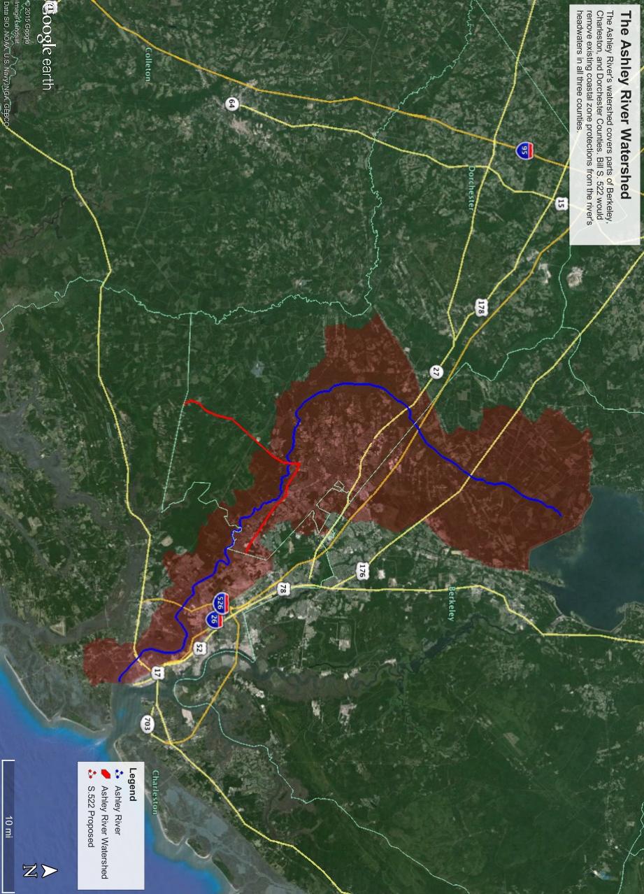
Re: Environmental Subcommittee Hearing; Senate Bill S.522; Dorchester County/Coastal Zone
|
|
|
- Debra Deirdre Cook
- 5 years ago
- Views:
Transcription

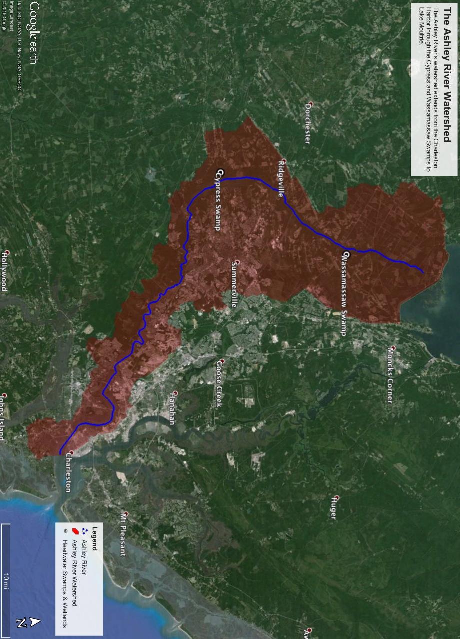
1 April 1, 2015 Senate Agricultural and Natural Resources Committee Environmental Subcommittee Gressette Building 1101 Pendleton Street Columbia, South Carolina Re: Environmental Subcommittee Hearing; Senate Bill S.522; Dorchester County/Coastal Zone Dear Senators, Thank you for the opportunity to speak today on this important issue. My name is Andrew Wunderley and I m Your Charleston Waterkeeper. I m here today on behalf of the Ashley River system and its people those who fish, swim, recreate, and earn a living from this wonderful river system. Understanding the way the Ashley River works, it s simply unwise to remove existing coastal zone protections from the headwaters of this system. We are opposed to bill S.522 and urge this committee to vote no. Although, this issue is much bigger than the Ashley River and even Dorchester County potentially effecting river systems in all 8 coastal counties our Ashley River provides an excellent example of how the proposed bill would impact coastal river systems state wide. The Ashley River s watershed is huge. You ll notice on the map that it extends through parts of Charleston County, into Dorchester County and then ends near lake Moultrie in Berkeley County. A watershed is simply an area of land that feeds all the water under it, or on it, into a waterway. All the rain that falls into this area eventually makes its way past White Point Gardens and to the Atlantic Ocean. What we do up in Berkeley County impacts Dorchester County, and finally impacts Charleston County. In a watershed all living things plants, animals, and humans are connected by our relationship with water. In the headwater swamps and wetlands of a coastal river system there is almost no distinction between land and water. They re one.
2 The Ashley River doesn't begin at Bacons Bridge Road. And its protections shouldn t begin there either. The Ashley River begins just west of Moncks Corner near Lake Moultire in the Wassamassaw Swamp. From there it flows South under 176, Interstate 26, and 78. In the Cypress Swamp it passes just Southeast of Ridgeville and bends gently East past Summerville. This area is the Ashley River s headwaters. Its coastal swamps and wetlands act like a giant filter for pollutants, sediment, and nutrients before they reach the lower Ashley River. They help ensure the quality of downstream tidelands and coastal waters. From the Wassamassaw and Cypress Swamps the Ashley flows under Bacons Bridge Road and widens as it passes Old Fort Dorchester State Park, Middleton Place, Millbrook Plantation, Magnolia Plantation, and Drayton Hall. This is the heart of the Scenic Ashley River so designated and recognized by the General Assembly in 1998 for its unique and outstanding river resources. Along its entire length, the river provides high quality fish and wildlife habitat and harbors rare plants and animals as well as relics of our past. It provides countless recreational opportunities from fishing to paddling to sailing. The General Assembly recognized the connection between headwater swamps and wetlands and coastal river systems when it designated our 8 coastal counties as the coastal zone in the 1970s. They understood that protecting the Ashley River s coastal waters and tidelands wouldn't mean much without protecting its source waters in the Cypress and Wassamassaw Swamps. Protecting a broad coastal zone is only one approach states take. Delaware and Virginia define the coastal zone more narrowly, however they also have additional protections in stand alone wetlands laws that provide special protections for coastal swamps and wetlands. As it stands now, in South Carolina, coastal zone consistency review is the chief regulatory mechanism that requires a consideration of the relationship between upstream headwaters and downstream coastal waters and tidelands. That is a reflection of the special character of our critical area resources like those in the Ashley River and the public s desire to maintain them in high quality for the benefit of future generations. The Clean Water Act s section 404 analysis is much narrower in scope, considering a project s impact on immediate wetland areas and compensatory requirements. It does not, to my knowledge, require a broader consideration of how upstream wetland loss will impact downstream tidelands and coastal waters. That s what coastal zone consistency review does. Coastal zone consistency review also serves as a check on state and federal government permitting activity. We know government tries, but it doesn t always get it right. We need this set of checks and balances on permitting activity in our coastal zone to ensure our tidelands and coastal waters are adequately protected for the public s benefit. It makes sense that our coastal zone needs more protections. That s where the greatest development pressure was historically and is now. And coastal zone protections are especially important during this time of unprecedented population and economic growth.
3 Development without regard for conservation of the Ashley River s headwater resources threatens the rivers water quality, fish and wildlife, and downstream tidelands and coastal waters. The Ashley River is one snapshot of what s at risk if costal zone protections are rolled back from the headwater swamps and wetlands of our river systems. Similar efforts in other counties would threaten the Edisto River, the Black River, and the Pee Dee River, to name a few, unnecessarily risking coastal waters and tidelands. The Ashley River doesn t begin at Bacons Bridge Road. Removing protections from the headwaters of our coastal rivers undermines downstream protections for coastal waters and tidelands. Charleston Waterkeeper strongly encourages this subcommittee to vote no on bill S Sincerely, Andrew J. Wunderley, Esq. Your Charleston Waterkeeper
4
5
 Tri County State Owned Deficient Bridge Status June 1, 2018 Route Bridge Feature Intersected Bridge Location Bridge Functional Class Bridge AADT Structurally Federal Aid Posting Status Deficient Eligible
Geoscape Toronto The Oak Ridges Moraine Activity 2 - Page 1 of 10 Information Bulletin
 About 13,000 years ago as the Laurentide Ice Sheet melted, glacial meltwater accumulated between the ice sheet and the Niagara Escarpment. This formed a lake basin into which gravel and sand were deposited.
$850,000 Awarded to 20 Organizations
 $850,000 Awarded to 20 Organizations The Conservation Alliance is pleased to fund the following organizations to support their efforts to protect wild lands and waterways for their habitat and recreation
Finn Creek Park. Management Direction Statement Amendment
 Finn Creek Park Management Direction Statement Amendment November 2013 Management Direction Statement Amendment Approved by: Jeff Leahy Regional Director, Thompson Cariboo BC Parks November 12, 2013 Date
WEKIVA WILD AND SCENIC RIVER ACT OF 2000
 PUBLIC LAW 106 299 OCT. 13, 2000 WEKIVA WILD AND SCENIC RIVER ACT OF 2000 VerDate 11-MAY-2000 01:59 Oct 20, 2000 Jkt 069139 PO 00000 Frm 00001 Fmt 6579 Sfmt 6579 E:\PUBLAW\PUBL299.106 APPS27 PsN: PUBL299
Roadless Forest Protection
 Roadless Forest Protection On January 12, 2001, after nearly three years of analysis and the greatest public outreach in the history of federal rulemaking, the U.S. Forest Service adopted the Roadless
NARRABEEN LAGOON SUMMIT am Wednesday, 13 April 2005 Warringah Council Chambers, 725 Pittwater Road, Dee Why.
 NARRABEEN LAGOON SUMMIT 9.15 9.30am Wednesday, 13 April 2005 Warringah Council Chambers, 725 Pittwater Road, Dee Why. NSW Minister for the Environment, the Hon. Bob Debus I am very pleased to be here to
INFORMATION NOTICE 15-2 Limited & Excluded Lands
 INFORMATION NOTICE 15-2 Limited & Excluded Lands Schedule 1 (Land Description) of onshore petroleum Agreements issued by the Department of Energy details the total hectares calculated. Total hectares are
Case Study: 1. The Clarence River Catchment
 Case Study: 1. The Clarence River Catchment The NSW coastline is a great natural asset, making an enormous contribution to the economy. The resources of coastal catchments such as the Clarence River Catchment,
Good afternoon Chairman Cantwell, Ranking Member Ayotte, and members of the
 Testimony of Doug Parker, CEO of US Airways Senate Committee on Commerce, Science and Transportation Subcommittee on Aviation Operations, Safety and Security Hearing on Airline Industry Consolidation June
The Partnership Wild & Scenic Rivers Program
 BUDGET REQUEST FISCAL YEAR 2017 Proven, cost-effective protection for 770 miles of rivers and thousands of acres of riparian land Westfield River, MA (L) and Farmington River, CT (R) Partnership Wild &
The Vision for the San Juan Islands Scenic Byway
 The Vision for the San Juan Islands Scenic Byway 2 Judd Cove, Orcas Island, Courtesy of Kurt Thorson (kurtthorson.com) and San Juan County Land Bank Vision for the San Juan Islands Scenic Byway The San
National Protected Area Systems Analysis Case Study: Gra Gra Lagoon National Park
 ational Protected Area ystems Analysis Case tudy: Gra Gra Lagoon ational Park Problem statement: How does Gra Gra Lagoon ational Park fit in the ational Protected Areas ystem and how does it relate to
NCC SUBMISSION ON EXPLANATION OF INTENDED EFFECT: STATE ENVIRONMENTAL PLANNING POLICY NO 44 KOALA HABITAT PROTECTION
 Director, Planning Frameworks NSW Department of Planning and Environment GPO Box 39 Sydney NSW 2001 16 December 2016 NCC SUBMISSION ON EXPLANATION OF INTENDED EFFECT: STATE ENVIRONMENTAL PLANNING POLICY
I INTRODUCTION AND BACKGROUND
 I INTRODUCTION AND BACKGROUND INTRODUCTION AND BACKGROUND - I I INTRODUCTION AND BACKGROUND a. project setting Looking south to the project site The Davenport Cement Plant (also referred to as the Cemex
Southern Shenandoah Valley Chapter
 Southern Shenandoah Valley Chapter June 7, 2018 Members of the State Water Control Board c/o Office of Regulatory Affairs, Department of Environmental Quality P.O. Box 1105 Richmond, Virginia 23218 citizenboards@deq.virginia.gov
Re: Definition of Waters of the United States - Recodification of Pre-Existing Rules
 The Honorable Scott Pruitt Administrator U.S. Environmental Protection Agency 1200 Pennsylvania Avenue, N.W. Washington, DC 20460 August 28, 2017 Re: Definition of Waters of the United States - Recodification
Galveston Bay Estuary Program. Carla G. Guthrie, Ph.D. Galveston Bay Council Member Texas Water Development Board
 Galveston Bay Estuary Program Carla G. Guthrie, Ph.D. Galveston Bay Council Member Texas Water Development Board The statements contained in this presentation are my current views and opinions and are
Blue Trails: Protecting Rivers, Fostering Stewardship
 Blue Trails: Protecting Rivers, Fostering Stewardship What Are Blue Trails? Blue Trails are the water equivalent of hiking trails. They are created to facilitate recreation in and along rivers and water
S Central Coast Heritage Protection Act APRIL 21, 2016
 STATEMENT OF GLENN CASAMASSA ASSOCIATE DEPUTY CHIEF, NATIONAL FOREST SYSTEM U.S. FOREST SERVICE U.S. DEPARTMENT OF AGRICULTURE BEFORE THE UNITED STATES SENATE COMMITTEE ON ENERGY AND NATURAL RESOURCES
April 7, WISE & Healthy Aging presents Southern Charm. Featuring Charleston, Savannah, Hilton Head Island, Jekyll Island and Beaufort.
 CST No. 2018390-40 presents Southern Charm Featuring Charleston, Savannah, Hilton Head Island, Jekyll Island and Beaufort April 7, 2019 (7 Days) Tour Highlights Charleston s Historic District and visit
4th Grade Social Studies 2nd Nine Weeks Test
 4th Grade Social Studies 2nd Nine Weeks Test Multiple Choice Identify the choice that best completes the statement or answers the question. 1 Which is the largest city in the United States? A Philadelphia,
Community Meetings By City
 Community Meetings By City Aiken Center for The Arts 122 Laurens St. SW Aiken SC 29801 10/17 at 2 p.m. Golden Corral 2265 Whiskey Rd. Aiken SC 29803 10/23 at 10 a.m. Aiken Center for The Arts 122 Laurens
FINAL TESTIMONY 1 COMMITTEE ON RESOURCES UNITED STATES HOUSE OF REPRESENTATIVES. July 13, 2005 CONCERNING. Motorized Recreational Use of Federal Lands
 FINAL TESTIMONY 1 STATEMENT OF DALE BOSWORTH CHIEF Of the FOREST SERVICE UNITED STATES DEPARTMENT OF AGRICULTURE Before the SUBCOMMITTEE ON FORESTS AND FOREST HEALTH And the SUBCOMMITTEE ON NATIONAL PARKS,
The Palmetto Trail: Linking the Mountains to the Sea
 The Palmetto Trail: Linking the Mountains to the Sea Jana Locklair Pine Ridge Middle School jlock794@aol.com Overview Students will be given the opportunity to become familiar with the landform regions
Paul Sturm Roberto Viqueira Ríos
 Paul Sturm Roberto Viqueira Ríos In this talk Brief Background on Land Based Sources Historical Perspective Guánica watershed characteristics/ issues High priority restoration projects Other key issues
STORNETTA BROTHERS COASTAL RANCH
 STORNETTA BROTHERS COASTAL RANCH Location: Surrounding Point Arena Lighthouse and immediately south of Manchester State Park Mendocino Co., CA Acres: 1,860 Resources: Over two miles of Pacific Ocean coastline
PLEASE OPPOSE H.R. 399, THE SECURE OUR BORDERS FIRST ACT OF 2015
 Adirondack Council * Allegheny Defense Project * Alliance for Global Justice * Alliance for the Wild Rockies * American Rivers * Arizona Wilderness Coalition * Asian Americans Advancing Justice * Bark
Map 1.1 Wenatchee Watershed Land Ownership
 Map 1.1 Wenatchee Watershed Land Ownership Map 1.1 Wenatchee Watershed Land Ownership The Wenatchee watershed lies in the heart of Washington state in Chelan County. Just larger than the state of Rhode
Thank you for this third opportunity to comment on the proposed revisions to the Coconino National Forest Management plan.
 March 19, 2014 Flagstaff Biking Organization PO Box 23851 Flagstaff, AZ 86002 Vern Keller Coconino National Forest Attn: Plan Revision 1824 South Thompson Street Flagstaff, Arizona 86001 coconino_national_forest_plan_revision_team@fs.fed.us
STREAKED HORNED LARK. Conservation of a threatened species in an industrial landscape. Cat Brown US Fish and Wildlife Service
 STREAKED HORNED LARK Conservation of a threatened species in an industrial landscape Cat Brown US Fish and Wildlife Service HISTORICAL & CURRENT RANGE Streaked Horned Lark Distribution Historical Range:
FRIENDS OF AMERICA S BYWAYS
 FRIENDS OF AMERICA S BYWAYS The Honorable John L. Mica The Honorable Nick Rahall Chairman, Transportation and Ranking Member, Transportation and Infrastructure Committee Infrastructure Committee U.S. House
The mission of South River Watershed Alliance is to protect and restore the water quality and biodiversity of the South River watershed to the
 The mission of South River Watershed Alliance is to protect and restore the water quality and biodiversity of the South River watershed to the beneficial use of people and wildlife. December 2015 In this
PREPARED STATEMENT OF BRIAN WYNNE PRESIDENT AND CEO, ASSOCIATION FOR UNMANNED VEHICLE SYSTEMS INTERNATIONAL
 PREPARED STATEMENT OF BRIAN WYNNE PRESIDENT AND CEO, ASSOCIATION FOR UNMANNED VEHICLE SYSTEMS INTERNATIONAL U.S. Senate Committee on Commerce, Science & Transportation Subcommittee on Aviation Operations,
Conservation of Critical Environmental Resources in Chatham Park
 Conservation of Critical Environmental Resources in Chatham Park Elaine Chiosso, Haw Riverkeeper Haw River Assembly Haw River As Seen From Chatham Park "Spreading southwestward from the banks of the Haw
Land Protection Accomplishments
 2017 Land Protection Accomplishments Conserving Open Space and Recreational Access On the Pacific Crest National Scenic Trail View from the Pacific Crest Trail of Donomore Meadows near the California/Oregon
Town of Oakfield Agricultural and Farmland Protection Plan
 SECTION III COMMUNITY OVERVIEW A. Regional Setting / Location The Town of Oakfield is located in the northwestern portion of Genesee County. Located west of New York's Finger Lakes, the Town is uniquely
Terrestrial Protected Area Nomination: Central Mangrove Wetland South-West, Grand Cayman
 Terrestrial Protected Area Nomination: Central Mangrove Wetland South-West, Grand Cayman The attached nomination, proposing that a parcel of land in the Central Mangrove Wetland be made a Protected Area
142 Water Wheel Road, Ridgeville, SC 29472
 For Sale ±98.259 Acres Ridgeville, SC 142 Water Wheel Road, Ridgeville, SC 29472 THE INFORMATION CONTAINED HEREIN HAS BEEN GIVEN TO US BY THE OWNER OF THE PROPERTY OR OTHER SOURCES WE DEEM RELIABLE. WE
WAREHOUSE SPACE 2115 MONROVIA STREET CHARLESTON, SOUTH CAROLINA. 7,850 Square Feet for Lease in Upper Peninsula Presented by CC&T
 WAREHOUSE SPACE 2115 MONROVIA STREET CHARLESTON, SOUTH CAROLINA 7,850 Square Feet for Lease in Upper Peninsula Presented by CC&T March 8, 2017 PROPERTY OVERVIEW. 2115 Monrovia Street 26 HIGHLIGHTS. 7,850
112th CONGRESS. 1st Session H. R. 113 IN THE HOUSE OF REPRESENTATIVES
 HR 113 IH 112th CONGRESS 1st Session H. R. 113 To provide for additions to the Cucamonga and Sheep Mountain Wilderness Areas in the Angeles and San Bernardino National Forests and the protection of existing
White Mountain National Forest Saco Ranger District
 United States Department of Agriculture Forest Service White Mountain National Forest Saco Ranger District 33 Kancamagus Highway Conway, NH 03818 Comm: (603) 447-5448 TTY: (603) 447-3121 File Code: 1950
Wilderness Stewardship Plan Scoping Newsletter Winter 2013
 Olympic National Park National Park Service U.S. Department of the Interior Wilderness Stewardship Plan Scoping Newsletter Winter 2013 Dear Friends and Neighbors, The Olympic Wilderness was established
Voluntary Certification Nature-Based Tourism in the Atchafalaya Basin
 Voluntary Certification Nature-Based Tourism in the Atchafalaya Basin Voluntary Certification A voluntary procedure which assesses, monitors, and gives written assurance of conformity to specific requirements.
Public Notice ISSUED: December 10, 2018 EXPIRES: January 9, 2019
 APPLICANT: REFER TO: St. Louis and Lake Counties Regional Rail Authority 2018-01942-ARC Public Notice ISSUED: December 10, 2018 EXPIRES: January 9, 2019 SECTION:404 - Clean Water Act 1. APPLICATION FOR
Hungry 4 History Trivia VA Studies 2010 and beyond
 Hungry 4 History Trivia VA Studies 2010 and beyond Level 1 1 What may be described using terms that show connections between two places such as: next to, near, or bordering? 2 3 What two large bodies of
Information on Ecological and Biological Significant Marine Areas in Albania
 Information on Ecological and Biological Significant Marine Areas in Albania The report is assembled from the draft strategic plan for marine and coastal protected areas in Albania, supported by the GEF-UNDP
Jill Hawk Chief Ranger, Mount Rainier National Park Tahoma Woods, Star Route Ashford, WA 98304
 January 21, 2003 Jill Hawk Chief Ranger, Mount Rainier National Park Tahoma Woods, Star Route Ashford, WA 98304 Re: Analysis of the Mount Rainier Climbing Program; Proposal to Increase Special Fee Dear
Header i
 Header i 048285014.10 Header Sub Title Body Text here. Body text here. Body text here. Section 1... 1 Executive Summary... 1 Opportunities and Constraints... 3 Overall Opportunities and Constraints Map
Charleston Festival of Houses and Gardens, March 18 20
 Charleston Festival of Houses and Gardens, March 18 20 Do you want to know more? The Meeting Street Crawl. Meeting Street is in many ways Charleston s Main Street, connecting commercial arteries to the
Eco Explorer. Steps. Purpose
 Eco Explorer A n eco explorer is a person who investigates environmental issues and works to make positive changes to the environment. In this badge, you ll be an eco explorer as you take a look at different
A Vision for South Skunk River and Chichaqua Bottoms Greenbelt
 A Vision for South Skunk River and Chichaqua Bottoms Greenbelt Photo: Jim Pease Chichaqua Bottoms Booklet 7 of 8 Greater Des Moines Water Trails and Greenways 1 2016 Table of Contents Booklet 1: Water
SITE. Hudson Rogers (o) (m)
 (m)") .52 Acre Full Access Site 828 St. Andrews Blvd. Charleston, SC Center to be redeveloped Highlights.52 acre full access site Price: $599,000 Could potentially be combined with adjacent vacant parcel to
.52 Acre Full Access Site 828 St. Andrews Blvd. Charleston, SC Center to be redeveloped Highlights.52 acre full access site Price: $599,000 Could potentially be combined with adjacent vacant parcel to
3.0 EXISTING PARK & RECREATION SPACE
 3.0 EXISTING PARK & RECREATION SPACE TOWN PARK & RECREATION SPACE An inventory of current parks and recreation area in the Town of Cedarburg is shown in Table 3. These areas total roughly 381.89 acres.
National Park Service Proposed 2005 Management Policies Revision
 February 16, 2006 Bernard Fagan, Room 7252 National Park Service Office of Policy 1849 C Street, NW, Washington, D.C. 20240 RE: National Park Service Proposed 2005 Management Policies Revision Dear Mr.
Meeting Minutes Del Mar San Dieguito Lagoon Committee. Chair: Jim Tucker Vice Chair: Terry Kopanski Secretary: Ellen Breen
 Meeting Minutes Del Mar San Dieguito Lagoon Committee Chair: Jim Tucker Vice Chair: Terry Kopanski Secretary: Ellen Breen WEDNESDAY, April 15th, 2015 6:00PM DEL MAR LIBRARY CALL TO ORDER 6:04 ROLL CALL
WORKSHEET 1 Wilderness Qualities or Attributes Evaluating the Effects of Project Activities on Wilderness Attributes
 WORKSHEET 1 Wilderness Qualities or Attributes Evaluating the Effects of Project Activities on Wilderness Attributes Date: 3/7/2017 Roadless Area: Ruby South Description of Project Activity or Impact to
CHAPTER 4 -- THE LAND USE PLAN: DESCRIPTIONS AND POLICIES FOR THIRTEEN PLANNING AREAS
 CHAPTER 4 -- THE LAND USE PLAN: DESCRIPTIONS AND POLICIES FOR THIRTEEN PLANNING AREAS NORTH CENTRAL CAC AREA LITTLE VALLEY ROAD TO JUG HANDLE CREEK PLANNING AREA This planning area includes Cleone, Noyo,
Conservation Area Management Statement
 Conservation Area Management Statement Miller Creek Wildlife Area Resolution #: Approval: Issue Date: Date of Last Revision: Table of Contents 1. Purpose....... 1 2. Property Description...... 1 2.1. Legal
TOWARDS SUSTAINABLE MANAGEMENT OF MARINE AND COASTAL HABITATS ASIA- PACIFIC DAY FOR THE OCEAN
 TOWARDS SUSTAINABLE MANAGEMENT OF MARINE AND COASTAL HABITATS WANNAKIAT THUBTHIMSANG PHUKET MARINE BIOLOGICAL CENTER, DMCR, THAILAND ASIA- PACIFIC DAY FOR THE OCEAN 20 NOVEMBER 2018, CONFERENCE ROOM 4,
a commerce park designed for the needs of the next generation of business CampHall.com Charleston, South Carolina
 a commerce park designed for the needs of the next generation of business CampHall.com Charleston, South Carolina Santee Cooper began with research, asking the workforce what mattered most to them. Being
CARVER S FALLS. Cumberland County s Natural Beauty. What s Included In This Information Packette
 Cumberland County s Natural Beauty What s Included In This Information Packette History of the Falls Boy Scouts have acquired Right of Use Guidelines for Usage Application Check-out Report HISTORY AND
proof Northwest District
 1 Northwest District The Northwest Florida Water Management District is the most rural of all five water management districts. From just east of Tallahassee west to the Florida/Alabama line, and from the
For Lease Magi Road Hanahan, South Carolina
 For Lease 7409 Magi Road Hanahan, South Carolina Located in North Pointe Business Campus ±91,000 s.f. industrial building Class A space Gated truck court and secure building access Central location within
LOUISIANA Department of Culture, Recreation, & Tourism
 Management Plan Louisiana LOUISIANA Department of Culture, Recreation, & Tourism National Park Service U. S. Department of the Interior Management Plan Newsletter 2 Public Comment Summary for Dear Friends,
Economic Impact, Significance, and Values of Delaware Water Gap National Recreation Area
 Canoing on the Delaware River, NPS photo Economic Impact, Significance, and Values of Delaware Water Gap National Recreation Area Technical Report April 2015 Prepared by The Harbinger Consulting Group
The Casco Bay Estuary Partnership (CBEP, formerly the Casco
 The Casco Bay Estuary Partnership The Casco Bay Estuary Partnership (CBEP, formerly the Casco Bay Estuary Project) is a collaborative effort to preserve and protect the bay s resources. The partners include
Adapting to climate change by promoting sustainable livelihoods, human and food security, and resilient ecosystems
 Adapting to climate change by promoting sustainable livelihoods, human and food security, and resilient ecosystems ICRI Indian Ocean Day December 13, 2011 Regional Challenges Atlantic Caribbean Challenge
Ronald Stork Senior Policy Advocate Friends of the River
 Ronald Stork Senior Policy Advocate Friends of the River Testimony on H.R. 869 To clarify the definition of flood control operations for the purposes of the operation and maintenance of Project No. 2179
Stephens Rd. Nature Preserve
 Stephens Rd. Nature Preserve History Stephens Road Nature Preserve (SRNP) is a 350-acre nature preserve in Huntersville that comprises nine properties purchased between 1994 and 2008. Parcels included
KOOTENAY LAKE PROVINCIAL PARK (MIDGE CREEK SITE)
") KOOTENAY LAKE PROVINCIAL PARK (MIDGE CREEK SITE) PURPOSE STATEMENT AND ZONING PLAN February 2003 Approved by: KOOTENAY LAKE PROVINCIAL PARK (Midge Creek Site) Purpose Statement and Zoning Plan Primary
KOOTENAY LAKE PROVINCIAL PARK (MIDGE CREEK SITE) PURPOSE STATEMENT AND ZONING PLAN February 2003 Approved by: KOOTENAY LAKE PROVINCIAL PARK (Midge Creek Site) Purpose Statement and Zoning Plan Primary
Arthur Carhart National Wilderness Training Center s Wilderness Investigations High School
 Arthur Carhart National Training Center s Investigations High School 101/Lesson 2 (OPTION 2B) Introducing the Act Goal: Students will understand the difference between wild spaces and federally designated
INTERNATIONAL BIRD STRIKE COMMITTEE Amsterdam, April 2000 PHOENIX RIO SALADO/TEMPE TOWN LAKE
 INTERNATIONAL BIRD STRIKE COMMITTEE IBSC25/WP-AV1 Amsterdam, 17-21 April 2000 PHOENIX RIO SALADO/TEMPE TOWN LAKE Paul Eschenfelder US Air Line Pilots Association, 16326 Cranwood, Spring, Texas 77379, USA
BREWERIES. Charleston Favorites HOLY CITY REVELRY BREWING CO PALMETTO BREWING CO WESTBROOK BREWING CO COAST BREWING CO
 CHARLESTON BREWERIES HOLY CITY 4155 Dorchester Rd, Charleston, SC 29405 (843) 225-6089 11:00 am 8:00 pm REVELRY BREWING CO 10 Conroy St, Charleston, SC 29403 (843) 203-6194 4:00 10:00 pm PALMETTO BREWING
For Sale. 0 Myers Road Summerville, South Carolina Myers Road GREAT LOCATION IN SUMMERVILLE. For More Information, Contact:
 For Sale 0 Myers Road Summerville, South Carolina 29483 GREAT LOCATION IN SUMMERVILLE Myers Road For More Information, Contact: Johnny Bevon, CCIM Senior Vice President General Commericial Brokerage O
White Mountain National Forest Saco Ranger District
 United States Department of Agriculture Forest Service White Mountain National Forest 33 Kancamagus Highway Conway, NH 03818 Comm: (603) 447-5448 TTY: (603) 447-3121 File Code: 1950 Date: February 26,
Skyland Ranch. At a Glance: Property Features
 Property Features Ideally positioned in an ox box of the mighty Apalachicola River, Skyland Ranch s 2 ½ miles of river frontage form the foundation of this distinctive property. Coveted by recreational
White Oak Creek. Recreational Use Attainability Analysis Summary of Findings. Texas Institute for Applied Environmental Research Stephenville, Texas
 White Oak Creek Recreational Use Attainability Analysis Summary of Findings Texas Institute for Applied Environmental Research Stephenville, Texas August 8, 2016 Sulphur Springs, Texas August 9, 2016 Mount
OMINEACA PROVINCIAL PARK
 OMINEACA PROVINCIAL PARK AND PROTECTED AREA PURPOSE STATEMENT AND ZONING PLAN March 2003 OMINECA PROVINCIAL PARK AND PROTECTED AREA Purpose Statement and Zoning Plan Omineca Park and Omineca Protected
Seminar/Workshop on USOAP Continuous Monitoring Approach (CMA) and State Aviation Security Tools (SAST)
 and State Aviation Security Tools (SAST)") International Civil Aviation Organization Seminar/Workshop on USOAP Continuous Monitoring Approach (CMA) and State Aviation Security Tools (SAST) Critical Elements of a State s Safety Oversight System
International Civil Aviation Organization Seminar/Workshop on USOAP Continuous Monitoring Approach (CMA) and State Aviation Security Tools (SAST) Critical Elements of a State s Safety Oversight System
Communicating the Economic and Social Importance of Coral Reefs for South East Asian countries
 Communicating the Economic and Social Importance of Coral Reefs for South East Asian countries This fact sheet will provide you with information extracted from economic studies BASICS Coral reefs are among
Lake Myra County Park. Wake County, North Carolina Community Forum #2 June 12, 2008
 Lake Myra County Park Wake County, North Carolina Community Forum #2 June 12, 2008 Welcome and Introduction Meeting Agenda Welcome Introductions of Project Team Master Plan Process Community Forum #1 Updates
Table. 1. Ramsar Designations in the United States showing date, location and size.
 Table. 1. Ramsar Designations in the United States showing date, location and size. Ash Meadows National Wildlife Refuge 18/12/86 Nevada 9,509 ha Bolinas Lagoon 1/9/1998 California 445 ha Cache-Lower White
1. Title slide: Great Wagon Roads
 1. Title slide: Great Wagon Roads a. Going to discuss how our ancestors may have come to South Carolina b. Of course could have come aboard ship to Charleston c. Many came overland from the more northern
Quintessential Rare Plant Site Protected, Forever Celebrating the New Wilsons Lake Conservation Lands
 Quintessential Rare Plant Site Protected, Forever Celebrating the New Wilsons Lake Conservation Lands A hotspot for Canadian endangered species conservation has been protected, forever, in Nova Scotia.
For Sale. Cross County Industrial Park Cross County Road & Dorchester Road North Charleston, South Carolina ACRE LOTS AVAILABLE
 7 8 11 10 12 9 13 14 15 For Sale Cross County Industrial Park Cross County Road & Dorchester Road North Charleston, South Carolina 29418 6 5 4 CROSS COUNTY ROAD DORCHESTER RD 2 3 1.5-3.4 ACRE LOTS AVAILABLE
COASTAL CONSERVANCY. Staff Recommendation June 5, 2008 GUALALA BLUFF TRAIL OPERATIONS AND MAINTENANCE
 COASTAL CONSERVANCY Staff Recommendation June 5, 2008 GUALALA BLUFF TRAIL OPERATIONS AND MAINTENANCE File No. 08-047-01 Project Manager: Deborah Hirst RECOMMENDED ACTION: Consideration and possible Conservancy
TONGASS NATIONAL FOREST
 TONGASS NATIONAL FOREST UNITED STATES DEPARTMENT OF AGRICULTURE-FOREST SERVICE Contact: Dennis Neill Phone: 907-228-6201 Release Date: May 17, 2002 SEIS Questions and Answers Q. Why did you prepare this
Key Findings from a Nationwide Voter Survey Conducted August 29 September 8,
 Key Findings from a Nationwide Voter Survey Conducted August 29 September 8, 2016 220-4634 Methodology 800 telephone interviews with likely voters nationwide Conducted August 29 September 8, 2016 via landline
Captiva Community Panel MINUTES Dec. 14, Attending: Rick Hayduk, Mike Kelly, Rene Miville, Mike Mullins, Nathalie Pyle, Harry Silverglide,
 Captiva Community Panel MINUTES Dec. 14, 2010 Attending: Rick Hayduk, Mike Kelly, Rene Miville, Mike Mullins, Nathalie Pyle, Harry Silverglide, Audience: 8. The meeting convened at 9:05 a.m. with Hayduk
Potomac Gorge. Resource Booklet. A Natural Monument in the Shadow of National Monuments. Bridging the Watershed. Potomac Gorge 75
 Potomac Gorge Potomac Gorge A Natural Monument in the Shadow of National Monuments Resource Booklet Bridging the Watershed An outreach program of the Alice Ferguson Foundation in partnership with the National
SYNERGIES BETWEEN BIODIVERSITY STEWARDSHIP AND GOVERNMENT PROGRAMMES
 SYNERGIES BETWEEN BIODIVERSITY STEWARDSHIP AND GOVERNMENT PROGRAMMES Biodiversity Stewardship as a mechanism is key in supporting the implementation of the following conservation-related programmes 1.
Fort Lauderdale City Commission Transit Presentation. July 21, 2009 CAR
 Fort Lauderdale City Commission Transit Presentation July 21, 2009 CAR 109 0932 Agenda Overview City Transit Vision Commission Direction 2035 LRTP Long Range Transportation Plan THOR Transit/Housing Oriented
Ecosystem context in the Environmental Impact Assessment of the Dredging Operations in the Argentina s Santa Fe
 Ecosystem context in the Environmental Impact Assessment of the Dredging g Operations in the Argentina s Santa Fe Confluencia Waterway (Paraná River) Authors: Claudio Daniele (Estudio de Ambiente y Desarrollo
Pantanal Forever Programme
 Pantanal Forever Programme The Pantanal Basin Upper Paraguay River Basin Bolivia + Paraguay + Brazil = 624.320 km2 Pantanal = 158.592 km2 Plateau = 465.728 km2 Cattle ranching and agriculture are the most
Cheryl Floyd, Vice-Chairman Allie Brooks Dwight Johnson Mark Fountain Jeffrey Tanner. Doris Lockhart Karon Epps Ted Greene
 Minutes Regular Meeting of the Florence County Planning Commission Tuesday, September 25, 2018 at 6:00 p.m. County Complex, Room 803 180 N. Irby St., Florence, South Carolina 29501 The Florence County
Section 1 Introduction to Sustainable Tourism
 Section 1 Introduction to Sustainable Tourism What is Sustainable Tourism? In defining Sustainable Tourism it is useful to start with an understanding of sustainable development. A term popularised following
Kelly Motorized Trails Project Proposed Action
 Kelly Motorized Trails Project Proposed Action November 28, 2011 The Flagstaff Ranger District of the Coconino National Forest is seeking public input on the proposed Kelly Motorized Trails Project (formerly
Leasing Brochure. Park Plaza Shopping Center 1150 N. Federal Highway, Pompano Beach, Florida Under Construction - Coming Very Soon
 Park Plaza Shopping Center 1150 N. Federal Highway, Pompano Beach, Florida 33062 Leasing Brochure Under Construction - Coming Very Soon Exclusive Leasing Broker 2048 East Sample Road, Lighthouse Point,
A GUIDE TO MANITOBA PROTECTED AREAS & LANDS PROTECTION
 A GUIDE TO MANITOBA PROTECTED AREAS & LANDS PROTECTION Manitoba Wildands December 2008 Discussions about the establishment of protected lands need to be clear about the definition of protection. We will