Kakabeka Falls. Park Management Plan
|
|
|
- Winfred Curtis
- 5 years ago
- Views:
Transcription


1 Kakabeka Falls Park Management Plan
2
3 NOTE: This document has been scanned and formatted, and therefore is slightly different from the original version. -March , Queen s Printer for Ontario Printed in Ontario, Canada Additional copies of this publication are available from the Ministry of Natural Resources at the following location: Kakabeka Falls Provincial Park c/o Ontario Parks Northwest Zone Suite 221d 435 James St. S. Thunder Bay, Ontario P7E 6S8 (807) k P.R ISBN
4 Dear Sir/Madam: I am pleased to approve the Kakabeka Falls Provincial Park Management Plan as the official policy for the management and development of this park. The plan reflects the Ministry of Natural Resources and Ontario Parks intent to protect the natural and cultural features of Kakabeka Falls Provincial Park and maintain and develop high quality opportunities for outdoor recreation and heritage appreciation for the residents of Ontario and visitors to the Province. The plan outlines a prioritized implementation strategy for the plan s elements and summarizes the public consultation that occurred as part of the planning process. The public is given a final opportunity to review the approved Management Plan for a period of forty-five (45) days after its formal release. This allows interested participants in the planning program a final opportunity to determine if their concerns have been considered, and if necessary, to initiate an appeal concerning the plan s contents. The plan for Kakabeka Falls Provincial Park will be used to guide the management of the park. It may be reviewed to address changing issues or conditions. A mandatory review is to be held after 10 years. I wish to extend my sincere thanks to all those who participated in the public consultation process. Yours truly, Adair Ireland-Smith Date Managing Director Ontario Parks
5 Table of Contents Statement of Environmental Values and the Environmental Bill of Rights Introduction Summary of Significant Issues Park Classification Goal Objectives Protection Objective Heritage Appreciation Objective Tourism Objective Recreation Objective Park Boundary Park Zoning Nature Reserve Zones Historical Zone Natural Environment Zones Development Zone Resource Stewardship Policies Natural Resources Cultural Resources Operational Policies Natural Heritage Education Recreation Management Tourism Services Marketing Research Development Policies Access and Circulation Campgrounds Comfort Stations Day-use Areas Trails Viewing Pods and Boardwalks Utilities Recreation and Tourism Services Interpretive Facilities Park Maintenance and Operation Plan Implementation and Review Resource Stewardship Development Operations/Administration Project Screening Social and Economic Impact Analysis Plan Review and Amendment Summary of Public Consultation References 24 Tables and Figures
6 Table 1 13 Table 2 14 Figure 1 4 Figure 2 10 Figure 3 17 Resource Stewardship Policies for Kakabeka Falls Provincial Park Permitted Recreation Uses by Park Zone for Kakabeka Falls Provincial Park Regional Setting Park Zoning Existing Development
7 Statement of Environmental Values and the Environmental Bill of Rights In accordance with the provisions of The Environmental Bill of Rights, the Ministry of Natural Resources prepared a Statement of Environmental Values. It describes how the purposes of the Environmental Bill of Rights are to be considered whenever decisions are made which might significantly affect the environment. This includes decisions made as a result of the park management planning process. The primary purpose of the Environmental Bill of Rights is to protect conserve and, wherever reasonable, restore the integrity of the environment. From the Ministry s perspective, that broad statement of purpose translates into four objectives in its Statement of Environmental Values: To ensure the long-term health of ecosystems by protecting and conserving our valuable soil, aquatic resources, forest and wildlife resources as well as their biological foundations; To ensure the continuing availability of natural resources for the long-term benefit of the people of Ontario; To protect natural heritage and biological features of provincial significance; and, To protect human life, the resource base and the physical property from the threats of forest fires, floods and erosion. The Ministry s Statement of Environmental Values has been considered in the development of this Park Management Plan for Kakabeka Falls Provincial Park. 1.0 INTRODUCTION Kakabeka Falls Provincial Park is located 32 km west of Thunder Bay on the Kaministiquia River in the Municipality of Oliver Paipoonge, immediately adjacent to the Village of Kakabeka Falls (population 350 in 1997) (Figure 1). The park was established in 1957, and since 1967, has been classified as a Natural Environment Park. The park was first regulated under the Provincial Parks Act in 1967 (Ontario Reg. 245/67) and last amended in 1991 (Ontario Reg. 412/91). In May 1991 the park area was increased by adding approximately 150 ha on the south boundary. Presently the park occupies an area of 500 ha. The park is significantly smaller than the recommended 2,000 ha size for Natural Environment Parks. Its classification reflects the provincial significance of the natural features it was established to protect. The park contains Kakabeka Falls, one of Northwestern Ontario s best known natural features. Kakabeka, derived from Ojibwa, means thundering water. There is a rich cultural history associated with the waterfall, and with the Kaministiquia River. The river was an important water corridor linking Lake Superior to the west. Prior to and during European exploration and the fur trade, Kakabeka Falls represented one of the most formidable obstacles to travel along this route. In addition to year-round viewing opportunities of the falls, the park offers visitors camping, swimming and picnicking during summer, and cross-country skiing, snowmobiling and snowshoeing during winter. In recent years, visitation has ranged from 250,000 to 300,000 annually, with three-quarters of visitors coming between May and October. Most visitors enter the park with the singular purpose of viewing the falls. The two principal user groups include highway travellers, who may stop briefly to view the falls or to use the campground, as well as Thunder Bay area residents who travel to the park to view the falls, camp, picnic, swim or ski. Residents of the Village of Kakabeka Falls may easily walk from the town to the day-use facilities. Kakabeka Falls draws increasing numbers of tourists from the United States, Europe and Asia. Tourism industry trends indicate growing interest in the outdoors, and natural and cultural heritage. The park and the village are well positioned as an international attraction with potential for growth in this market segment. A Park Master Plan was prepared for Kakabeka Falls Provincial Park in This document provided the background information for the present planning process. A Minor Amendment was made to the Park Management Plan in 1994 to allow the Ministry of Transportation to undertake maintenance and highway improvement on the right-of-ways within the park for highways 11/17 and 590. The Park Management Plan has evolved from the public review of the Background Information and the Preliminary Management Plan. This document 3
8 replaces the 1978 Master Plan and sets direction for the next 20 years by establishing policy and identifying appropriate development consistent with Ontario Parks goals and objectives. 4

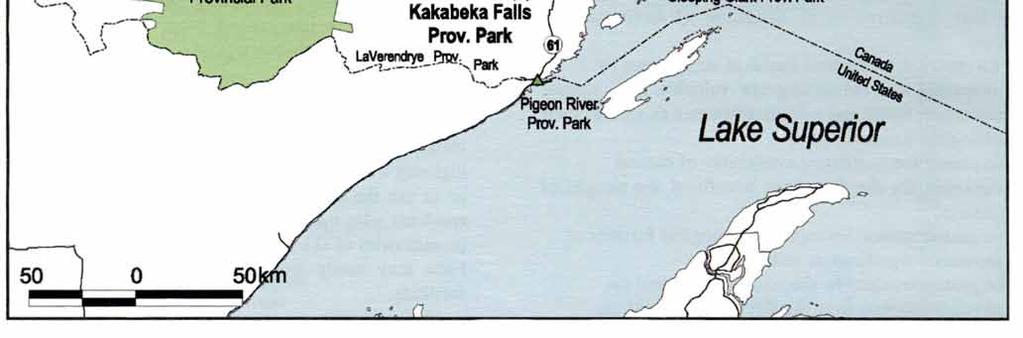
9 Figure 1: Regional Setting 5
10 2.0 SUMMARY OF SIGNIFICANT ISSUES (Not Ranked) Park users, local residents, park staff, as well as other groups and individuals, identified the following concerns related to the management of Kakabeka Falls. 2.1 Water Flow over Kakabeka Falls Adequate water flow over Kakabeka Falls is crucial to the very essence of the park because it determines the aesthetic quality of the viewing experience of the falls. In order to ensure adequate flow, Ontario Parks will formalize an agreement with Ontario Hydro Services Company regarding minimum flow, as well as establishing a long-term framework for water flow. (Refer to sections 8.0 and 8.1.2). 2.2 The Relationship between the Park and the Village of Kakabeka Falls The relationship of the park and the Village of Kakabeka Falls has a number of unique facets. There is a strong indication in the responses received that the park and the village businesses should cooperate in ways that would be mutually beneficial (e.g. marketing and promotion). Local business people consider the village economy to be dependent upon Kakabeka Falls Provincial Park and perceive that the park is in direct competition with them as its operations become more entrepreneurial. They have expressed their desire to participate in discussions regarding any expansion of commercial activities within the park and marketing of the park. In order to ensure a positive relationship between the park and the village, Ontario Parks will engage in discussions with representatives of the Municipality of Oliver Paipoonge regarding marketing and commercial initiatives that the park may undertake. Ontario Parks will endeavor to optimize opportunities for mutual benefit with the village in marketing and entrepreneurial activities. (Refer to sections 9.0, 9.1.1, 9.2, 9.2.6, 9.3 and 9.4). 2.3 The Greater Park Ecosystem The greater park ecosystem of Kakabeka Falls Provincial Park considers the ecological, social and economic relationships with the surrounding area, including links to the Village of Kakabeka Falls, the Municipality of Oliver Paipoonge, the City of Thunder Bay, and the Kaministiquia River corridor. Ontario Parks will participate in land use planning initiatives that affect the greater park ecosystem and to connect the park to other natural areas. There are many activities and sites within a short drive that can attract visitors and help keep them in the park area for several days. Ontario Parks will support the provision of information to connect recreational activities and economic benefits both within and around the park. The Park s Natural Heritage Education program will provide information about the park, the parks system and local attractions. (Refer to sections 5.1, 9.0, 9.1.1, 9.2, 9.2.6, 9.3 and 9.4). 2.4 Permitted Uses on the Park Trails The trail system at Kakabeka Falls Provincial Park is used primarily for hiking and for cross-country skiing, as well as for some interpretation. Natural Environment Zone 2 has been established to provide the flexibility to manage these trails for cross-country skiing in the winter and mountain biking (potentially) and hiking in the summer. The permitted uses for the Beaver Meadows and River Terrace trails may be expanded to include mountain biking, subject to a trail/site inventory and in accordance with a trail/site plan. To minimize potential conflict between trail users, Ontario Parks may post trail courtesy signage if necessary. To minimize potential impacts to the trails during periods of wet weather and/or during the spring thaw, Ontario Parks will restrict access to the trails by mountain bikes. During the public consultation for the Preliminary Management Plan, a petition was received from local equestrians requesting access to the Poplar Point, Beaver Meadows and River Terrace trails. The permitted uses on the Poplar Point trail may be expanded to include horseback riding subject to a trail/site inventory and in accordance with a trail/site plan. To minimize potential conflict between trail users Ontario Parks will allow access to the trail by horses only during the snow-free spring and autumn shoulder seasons (e.g. prior to May 15 and after October 1). Ontario Parks will not permit horseback riding on the River Terrace and Beaver Meadows trails, due to the potential for conflicts with other trail users, as well as the potential for trail erosion, braiding and the introduction of exotic plant species into the park s NR2 zone by way of horse manure. (Refer to sections 7.3, 9.2.4, 9.2.5, and Table 2). 6
11 2.5 The Bridge and Traffic Circulation The structural integrity of the main access bridge over the Kaministiquia River is an ongoing concern. Ontario Parks will continue to monitor the structural integrity of the bridge. In the event that the bridge requires extensive repairs or replacement exceeding available financial resources, Ontario Parks will consider reconfiguration of access to and circulation within the park. (Refer to section 10.1). 3.0 PARK CLASSIFICATION All provincial parks in Ontario fall into one of six classes: Wilderness, Nature Reserve, Historical, Natural Environment, Waterway and Recreation. Natural Environment parks incorporate "outstanding recreational landscapes with representative natural features and historical resources to provide high quality recreational and educational experiences " (Ontario Provincial Parks: Planning and Management Guidelines, 1992). Despite its small size of 500 ha, Kakabeka Falls Provincial Park is classified as a Natural Environment park. The Natural Environment status reflects the park's provincially significant natural features, as well as its rich historical legacy and recreational values. 4.0 GOAL To protect the outstanding landscape and provincially significant natural and cultural features of Kakabeka Falls Provincial Park and to provide opportunities for compatible heritage appreciation, recreation, and tourism activities. 5.0 OBJECTIVES Ontario s provincial park system has four objectives: protection, recreation, heritage appreciation, and tourism. Each park in the system contributes in some way to each of these objectives, depending on its resource base. Kakabeka Falls Provincial Park contributes to the achievement of all four objectives. 5.1 Protection Objective To protect the provincially significant natural and cultural features of the park including the falls, the Gunflint formation, and the microfossil site. Kakabeka Falls Provincial Park contains a variety of natural and cultural resources that are provincially significant. These include: The falls; The Kaministiquia River which was used as a transportation route by aboriginal people, fur traders, coureurs-de-bois, and explorers travelling westward from Lake Superior; and The geological contact between the Archean intrusive rocks and the Proterozoic metasedimentary rocks at the upper rapids area, and The algal chert, which contains stromatolites of blue-green algae, some of the oldest known life forms on earth. The protection objective will be accomplished through appropriate park zoning, resource management policies (land use controls), research, monitoring, and a greater park ecosystem approach to park planning and management. The greater park ecosystem is defined as the area of influence surrounding the park from an ecological, social and economic perspective. It is the area where most of the cross-boundary impacts affecting the park and the surrounding area will occur, and vice versa Earth Science Kakabeka Falls Provincial Park straddles the boundary between the Superior Structural Province and the Southern Structural Province of the Precambrian Shield. The low, rolling topography is familiar to those who have travelled through northwestern Ontario. Northern portions of the park are in the Superior Structural Province, and consist mainly of granitic rocks, primarily quartz monzonite. The remainder of the park is underlain by rocks of the Gunflint Formation (Animikie Group) and is in the Southern Structural Province of the Canadian Shield. The Gunflint formation is made up of shale, chert-carbonate, and siliceous iron formation with algal chert. Within the lower algal chert submember, there are the remains of very primitive life forms, one-celled organisms that lived within a bioherm called a stromatolite. Believed to be from 1.85 to 2.1 billion years old, these stromatolites are considered to be among some of the oldest known specimens in the world. The most spectacular feature in the park is Kakabeka Falls, a typical example of a waterfall that has developed along a river course where easilyeroded rocks are overlain by a capping of hard resistant material (Pye, 1969). The falls have a 7
12 vertical drop of 39 m, a width of approximately 71 m, and a gorge 30 m deep extending downstream for some 700 m. The falls are the focal point of the park and are important to the region from a geological, historical, and scenic point of view. The formation of this gorge and of Kakabeka Falls is an integral part of the glacial history of Northwestern Ontario. Glacial Lake Kaministiquia drained through the Kaministiquia spillway into a post-duluth glacial lake called Lake Beaver Bay. The Kaministiquia spillway, in conjunction with the Kashabowie spillway north of Dog Lake, became a major drainage channel for the melting ice lobes. The large volumes of glacial meltwater provided the force required to deepen the fractured zone in the Kaministiquia spillway bed, thus forming the gorge and Kakabeka Falls (Grootenboer, 1971). Earth science values are protected within Nature Reserve and Natural Environment zones Life Science The park is located within the northern limit of the Quetico Section of the Great Lakes - St. Lawrence Forest Region and the southern boundary of the Superior Section of the Boreal Forest Region (Rowe, 1972). Consequently, the park s vegetation is transitional and representative of both forest regions. Vegetation consists of trembling aspen, white birch and jack pine mixed with white spruce and balsam fir on higher ground, while black spruce and birch favour low-lying areas. The prominence of these boreal species results from disturbances such as logging, fire and agriculture. Some black ash and American elm, typical of more southerly areas, are found adjacent to the river s edge. Moss species are well established on the vertical rock faces of the gorge where they are subject to spray from the falls. The wildlife of the park is typical of the Boreal Forest Region and includes black bear, moose, white-tailed deer, beaver, snowshoe hare, red fox, striped skunk, and chipmunk. Wolf, porcupine and raccoon are transient park residents. Avifauna includes ruffed grouse, raven, wood warblers, and thrushes. Leopard frog, boreal chorus frog, spring peeper, common toad, eastern garter snake, and blue spotted salamander reside within the park. Kakabeka Falls represents an insurmountable obstacle to fish travelling up the Kaministiquia River. Eighteen species have been identified in the four kilometers below the falls. The major species living in the river near the falls are white sucker, walleye, northern pike, burbot, and smallmouth bass. Salmon have been introduced to the Kaministiquia River from a hatchery that is located adjacent to the hydro generating station, across the river from the park. Sturgeon are also inhabitants of the Kaministiquia River. Life science values are protected within Nature Reserve and Natural Environment zones. 5.2 Heritage Appreciation Objective To provide both structured and individual opportunities for exploration and appreciation of the natural and cultural heritage of Kakabeka Falls Provincial Park, including early inhabitants, exploration, the fur trade, and industrial heritage, as well as the earth and life science features of the park. Unstructured self-use facilities such as trails, displays and viewing platforms, allow users to experience a dramatic landscape that illustrates a chronology of geological events and processes spanning two billion years. The park's variable terrain provides excellent vantage points for observing dynamic, ongoing processes associated with the modern day Kakabeka Falls. This objective will be achieved through the provision of accurate up-to-date information to park visitors regarding the natural, cultural and recreational resources of the park using signage, park literature, trail guides and interpretive displays. Staff-led interpretation programs based from the Visitor Centre / Amphitheatre during July and August will provide park visitors with the opportunity to appreciate and understand the area's natural and cultural resources. Themes include early exploration, the fur trade, the logging era and hydroelectric development, as well as the park's earth and life science features. A Natural Heritage Education Plan will be developed to guide the operation of the park s Visitor Centre / Amphitheatre. 5.3 Tourism Objective To provide both Ontario residents and out-ofprovince visitors with opportunities to discover and to experience the unique natural and cultural features of Kakabeka Falls Provincial Park, through the provision of year-round viewing opportunities as well as seasonal day-use, car-camping and tourism facilities and services. 8
13 Kakabeka Falls Provincial Park receives the highest annual visitation of any provincial park in Northwestern Ontario. Total visitation for the park can account for more than one third of all park visitation for the Northwest Zone. In 1999, 286,913 visitors came to Kakabeka Falls, while total park visitation for the zone was 786,372. In the same operating season, Kakabeka Falls received 254,031 day-users that accounted for approximately 71% of total day-use for Northwest Zone (353,661). Most people visit Kakabeka for the single purpose of viewing the falls. The relatively high levels of visitation for the park are due to the combination of the attraction of the falls and its accessibility. The Trans Canada Highway, with heavy vacation traffic in the summer months, passes directly through the park. Tourists travelling this route participate primarily in viewing the falls, with day use and stopover camping. The park s proximity to Thunder Bay attracts area residents for viewing, camping, and day-use activities. Daytrippers from Northern Minnesota also make the park a primary destination. Tourism industry trends such as an aging population, increasing concern for the environment, and interest in educational experiences, indicate market growth potential for soft adventure and ecotourism. Examples of products include experiences in natural environments/cultural heritage with packaging of wildlife/scenic viewing, water- and land-based recreation. Trend analyses of visitors from overseas (Europe and Asia) indicates strong interest in the outdoors, natural and cultural heritage, especially that of First Nations. Kakabeka Falls Provincial Park and the surrounding locale are well positioned as an international attraction where there is opportunity for growth with independent tourists, package tours, bus tours, and Great Lakes cruises. Kakabeka Falls Provincial Park provides day-use and camping opportunities for stopover visitors travelling Highway 11/17 as well as travellers specifically destined to view the falls. The tourism objective is achieved by having an outstanding natural feature with the high quality infrastructure and customer service that will optimize opportunities to attract and retain visitors. 5.4 Recreation Objective To provide park visitors with opportunities for recreation such as camping, picnicking, hiking, horseback riding, mountain biking, swimming, cross-country skiing and viewing, through the provision of appropriate facilities and services. Kakabeka Falls Provincial Park provides opportunities for a variety of high quality recreational uses compatible with the character of the park. The park provides day-use opportunities for viewing the falls from viewing pods or by hiking along the gorge trails, as well as using the beach area for family picnics and swimming. During the winter, the park provides high quality cross-country skiing opportunities. Part of the Trans-Provincial Snowmobile Trail passes through the park. The TransCanada Trail, a multi purpose trail initiative, will be accommodated for trail uses that are permissible within the park. The recreation objective will be achieved through appropriate development and natural environment zoning; the identification of management policies to prevent any compromise of significant natural and/or cultural heritage values; market research and monitoring; and mitigating impacts of recreational use. Any outdoor recreation skills programs will be compatible with the park s resource base and will relate to the park s themes. 6.0 PARK BOUNDARY Kakabeka Falls Provincial Park is bounded by the Kaministiquia River on the east while the west boundary is essentially Lucken s Road. The north and south boundaries coincide with township and concession survey lines in the Municipality of Oliver Paipoonge, Conmee and O Connor townships (Figure 2). Contiguous park expansion is limited to the west by roads, to the north by Ontario Power Generation development and to the east by the Kaministiquia River, Ontario Power Generation. development and the Village of Kakabeka Falls. If any lands nearby or adjacent to the park become available for acquisition, they will be evaluated with regard to their contribution to park objectives and available funding. The park is bisected by the Trans-Canada Highway, Highway 11-17, the major east-west link in this part of Ontario, and by Highway 590. The land surrounding the park is predominantly patented. Most of this land, which was once farmed, can now be classified as non-farm residential or speculative property. Adjacent to the park are highway rights-ofway, a hydro dam, an aqueduct, a generating 9
14 station, the CNR line, an Ontario Ministry of Transportation yard, and a gravel pit. The park contains a hydroelectric and telephone transmission line, and a small research plantation. 7.0 PARK ZONING Zoning is a key part of a Park Management Plan. Zones fulfill a variety of functions that include: Providing recognition of the features and attributes of a park; Delineating areas on the basis of their requirements to protect and buffer provincially significant representative features; Delineating areas on the basis of their ability to support various recreational activities; and Identifying uses that will protect significant features, yet allow opportunities for recreation and heritage education. (Tables 1 and 2). The four zones, which will guide the resource management and development of Kakabeka Falls Provincial Park, are Development, Natural Environment, Nature Reserve and Historical (Figure 2). 7.1 Nature Reserve Zones Nature Reserve zones include significant earth and life science features that require management distinct from that in adjacent zones as well as a protective buffer with a minimum of development. Development is limited to trails, signs and temporary facilities for research and management. Nature Reserve Zone 1 (8 ha) (Contact Zone) Nature Reserve Zone 1 incorporates two significant earth science features, the geological contact and the microfossils. The primary role of Nature Reserve Zone 1 is to highlight the significance of these resources. The contact, adjacent to the heavily used beach-picnicking area, is durable. The microfossils, although sensitive to sample collection, are afforded a degree of natural protection by the site's small size and relatively isolated location. Nature Reserve Zone 2 (287 ha) (Terrace Zone) This zone is comprised of the southern half of the park. It protects a variety of earth science features and associated processes related to the Kaministiquia River spillway-gorge complex. The zone's primary resources are highly durable by most indicators of resource fragility, and not generally dependent upon restrictive management policies. Low-intensity recreational use, emphasizing resource appreciation and interpretation is permitted. Acceptable recreation activities include hiking, snowshoeing, viewing, photography and nature study. Natural Environment Zone 2 (Corridor) is located within this zone Zone Management Policies Management will be directed towards the maintenance of an evolving natural succession, unless the rationale for an alternative approach can be documented. 7.2 Historical Zone Historical zones protect the provincially significant cultural resources of a park which require management distinct from that of other zones. They generally focus on a specific site (e.g. building) and its relationship to the surrounding landscape. Historical zones support the minimum development required for visitor exploration and appreciation, and scientific research. Historical Zone (8 ha) (The Mountain Portage) This zone has been established to ensure that proper recognition is granted to the park s most important historical element - The Mountain Portage. Recreational opportunities vary within the zone. In addition to historical interpretation, the upland portion of the zone contains viewing opportunities of the falls, the main gorge and the northern edge of the western gorge. It also contains geomorphologic features associated with the formation of both the main and the western gorges. Development in this zone consists of viewing pods, interpretive displays and a network of interconnecting trails. The Mountain Portage Trail is constructed to a condition and alignment that approximates that of the original route Zone Management Policies New development is limited to trails, necessary signs, interpretive, educational, research and management facilities, and historical reconstruction where appropriate. All decisions regarding the type, extent and location of facilities must be supported by a site inventory. All development will be carried out in accordance with approved site and development plans; will conform to high standards of historical authenticity; and will complement the historical resource. 10
15 7.3 Natural Environment Zones Natural Environment zones include important natural and cultural landscapes in which minimum development is required to support low-intensity recreational activities. Development is limited to simple facilities. Natural Environment zones often serve as buffers between Development or Access zones and the more protective Historical or Nature Reserve zones. Natural Environment Zone 1 (102 ha) (Buffer Zone) Natural Environment Zone 1 has six parts. Part one (10 ha), part two (28 ha), and part three (26 ha) occupy the northeastern corner of the park, north of Highway 590 and Highway 11-17, and west of the Kaministiquia River. These portions possess relatively low capabilities to sustain use and associated development. 11

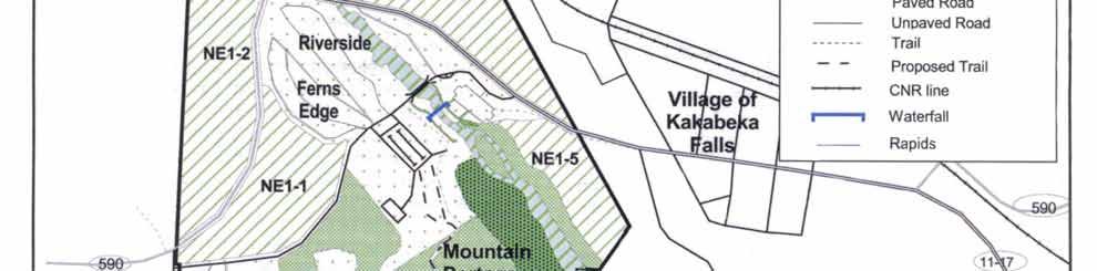


16 Figure 2: Park Zoning 12
17 Their primary function is to ensure visual aesthetics and site protection. Part four (16 ha) has two purposes: the granitic outcrop provides an alternative for low-intensity recreation, such as hiking and nature appreciation, adjacent to the high-intensity activity of the beachpicnicking area; it also serves as a visual buffer for the development to the east and southeast. Part five (6 ha) functions as a visual buffer between the Kaministiquia River and the Village of Kakabeka Falls. Part six (14 ha) consists of the Kaministiquia River bed. Natural Environment Zone 2 (8 ha) (Corridor Zone) Natural Environment Zone 2 is the six metre wide trail corridor through the Nature Reserve Zone 2 for the Beaver Meadows and River Terrace trails. This zone is intended to provide the flexibility to manage these trails for cross-country skiing in the winter and mountain biking (potentially) and hiking in the summer Zone Management Policies Management will normally be directed towards the maintenance of an evolving natural succession, unless the rationale for an alternative approach can be documented. Existing and new development is limited to trails and signs. Development will be supported by a resource inventory and will be undertaken in accordance with approved site and development plans. Details on the proposed new trail in this zone can be found in section (Trails). 7.4 Development Zone Development zones provide the main access to the park and facilities for a wide range of day-use and camping activities. They constitute a relatively small portion of most parks. Development may include roads, visitor control structures, beaches, picnic areas, campgrounds, commercial service facilities, and orientation, interpretive, educational, research and management facilities. One development zone has been designated in Kakabeka Falls Provincial Park. Development Zone (97 ha) The development zone incorporates the existing area of intensive recreational use and development, including the beach-picnicking area, the falls viewing area, the Visitor Centre, the Ferns Edge and Riverside campgrounds, the Whispering Hills campground, the Group Camping area, the Portage Group Camping area, the Poplar Point Trail, the existing roads and bridges and the maintenance and office areas. Resource management will maintain the integrity of the resource base where it is subjected to the impacts of use and development. The zone s cultural resources (three recognized archaeological sites) will be managed as funds permit. Recreational opportunities provided within the zone include viewing, interpretation, education, swimming, picnicking, hiking, mountain biking, crosscountry skiing, horseback riding (potentially), car camping, and group camping. Hot-air balloon departure may also be permitted in this zone. Judicious site selection and facility design will be the principal agents for effective integration of such diverse and potentially conflicting activities Zone Management Policies Development will be subject to a site inventory to mitigate detrimental impacts on the values of the park. All development will be carried out in accordance with approved site and development plans. Archeological sites will be protected. New development may include signs, secondary and tertiary roads, park administration and maintenance facilities, utilities, staff facilities, beaches, picnic areas, alternative accommodation, campgrounds, stores, displays and facilities for natural heritage education, research and management. 8.0 RESOURCE STEWARDSHIP POLICIES The management of Kakabeka Falls Provincial Park natural and cultural resources will conform with the policies identified for Natural Environment class parks in Ontario Provincial Parks: Planning and Management Guidelines Additional policy direction is provided in the following section. 8.1 Natural Resources Landform The management of the park's land base will be directed towards maintaining the natural landscape. Mineral exploration and mining are prohibited within the 13
18 boundaries of the park. Aggregate extraction from sources within the park is prohibited. Aggregate for park purposes will be acquired from commercial sources outside the park. Erosion control work to protect park values and public safety is permitted in the Development, Historical, and Natural Environment 1 zones. Monitoring the stability of the bedrock footings for the viewing pods and the walkways will be ongoing to ensure visitor safety. Restorative capping of the eastern side of Kakabeka Falls was completed in The rate of the recession of the lip of the falls will be monitored on an ongoing basis. In the event of significant erosion, restorative capping may be undertaken subject to completion of an Environmental Study Report in accordance with Ontario Parks Policy Water The Kaministiquia River is the significant aquatic resource of the park, providing the falls viewing opportunity as well as the water and shoreline areas for the beach activities. There are several small ephemeral streams draining into the Kaministiquia River within the park. The most important of these is a wetland area that enters the park from the south and drops over a small scenic waterfall before entering the Kaministiquia River. Water quality for fisheries habitat and recreational purposes will be maintained. Water quality, adjacent to development zones and where camping occurs, will be monitored on a regular basis in accordance with Provincial health standards. Several dams in the Kaministiquia River headwaters as well as a dam immediately adjacent to the park on the northeast boundary control the Kaministiquia River water flow. Water flow over Kakabeka Falls will be maintained at the following level as currently practiced by Ontario Hydro Services Company and the Ministry of Natural Resources: Scenic water for Kakabeka Falls during daylight hours of the tourist season (May 24 to Thanksgiving weekend, inclusive) is 4.25 m 3 /sec on weekdays and 8.5 m 3 /sec on weekends and statutory holidays. Ontario Parks will formalize this current operating practice. In light of the divestment process that is being undertaken by the former Ontario Hydro, and the pending individual water management planning processes for the province s hydro plants, Ontario Parks will remain vigilant to ensure that the scenic water flow levels will be maintained and any formal or informal waterflow agreement will be included/reconfirmed Vegetation Management of vegetation within the park will be directed towards the maintenance of an evolving natural succession of communities. Commercial timber harvesting is prohibited within the park. Infestations of forest insects and diseases will be monitored and assessed. Non-native species will be controlled, and native species may be controlled. If control measures are undertaken, they will be applied to minimize effects on the general park environment. Biological controls will be used wherever possible. The removal of hazard trees will be permitted in all zones where safety is a concern (e.g. trails, and campgrounds). Areas experiencing adverse use impacts will be rehabilitated whenever possible using plant species native to the park. Landscaping will be permitted in the development zones. Brushing along primary and secondary roads will be permitted to improve sight lines and/or traffic flow. Herbicide applications will be discouraged for vegetation management. Development that necessitates the removal of vegetation will be supported by a vegetation inventory in accordance with approved site plans Fire Given the small size of the park, the capital investment within the park, and the surrounding private land, natural and human caused fires in all zones will be suppressed. Fire suppression techniques which have the least residual impact on the park s natural environment will be used whenever possible. Prescribed burning may be used to replace natural processes under the proper circumstances Wildlife 14
19 Wildlife management may be undertaken on an as required basis in order to protect the health and safety of the park visitors or to protect park facilities. Hunting is prohibited, by regulation, within the boundaries of Kakabeka Falls Provincial Park. Commercial fur trapping is prohibited within the boundaries of Kakabeka Falls Provincial Park. Nuisance animals will be trapped and removed under the supervision of, or directly by Ontario Parks staff. This control will be exercised as a last resort when it is essential for the protection of human health and safety, the health of animal species, or the protection of infrastructure. Status Indians having treaty rights to carry out traditional natural resource harvesting activities shall be permitted to carry on these activities in accordance with the terms of their treaty within their treaty areas. 15
20 Table 1: Resource Stewardship Policies by Zone Category for Kakabeka Falls Provincial Park RESOURCE MANAGEMENT POLICIES PARK ZONES D NR HI NE Lands and Waters Mineral exploration / extraction Aggregate extraction Commercial hydro development Water control structures (new) Y M M Y Land disposition commercial outpost camps, lodges Flora Vegetation Management Y M M Y Commercial logging Insect / disease suppression Native Non-native Y Y Y Fire suppression Natural & Human-caused Y Y Y Y Prescribed burning M M M* M Y M Y Fauna Commercial trapping Status Indians only Wildlife population management M M M M Bait fishing Fish stocking Native species Y Y Y Non-native species Fish habitat management Y M M Y Recreation Management Commercial tourist operations New M Restrictions on vehicles, aircraft, motor boats Private Commercial M M Y Y Y Y M M Legend Note: This table does not include policies/zones that are not relevant to /present in Kakabeka Falls Park. Y compatible in zone category Blank not permitted M may be required Ma may be encouraged if authentic to the historic zone M* in the event of a prescribed fire in the NR2, it would not be possible to exclude the NE2 16
21 Table 2: Permitted Recreational Uses By Park Zone for Kakabeka Falls Provincial Park ACTIVITIES AND FACILITIES ZONES NE 1 NE 2 NR 1 NR 2 D H All terrain Vehicle (ATV) Travel Hot Air Balloon (take-off) M Boating (powered) commercial private M M Campgrounds Car Group Y Y Canoeing-Kayaking M Demonstration Areas (e.g. logging Exhibits) M Ma Hiking Y Y Y Y Y Y Historical Appreciation self guided M M M Y Y Y Horseback Riding Designated Trail M Mountain Biking - Designated Trails M Y Nature Appreciation self guided Y Y Y Y Y Y Orienteering Y Y Y Y Y Y Painting/Photography Y Y Y Y Y Y Picnic Grounds Y Playgrounds Y Recreation Programs (organized) Y Y Ma Resorts/Lodges M Restaurants food and beverage M Rock / Ice Climbing Skiing cross-country Y M Y Snowshoeing Y Y Y Y M Ice Skating Y Tobogganing Designated Hill Y Snowmobiling- Designated Trail Y Sport Fishing Y Y Swimming facility based Y Legend Note: activities not in this list are prohibited within the park (e.g. scuba & skin diving, sailing and sailboarding, spelunking, sport hunting, outfitting services, commercial outpost camps) Y permitted use in designated zone Blank not permitted M may be permitted in designated zone Ma may be encouraged if authentic to the historic zone 17
22 8.1.6 Fisheries The Thunder Bay District Fisheries Management Plan identifies strategies for the Kaministiquia River, but not specifically for the park. Rehabilitation of degraded walleye habitat may occur. Sport fishing is permitted in the park. All fishing activity will be subject to the policies and regulations of Division 21 of the Ontario Fishing Regulations. Fishing at the base of the falls is becoming more popular. The Park Superintendent may restrict sport fishing at certain times and locations for the purposes of fisheries management and/or public safety. Stocking and spawn collection by permit is allowed. Commercial fishing and commercial bait fishing are prohibited in park waters. Status Indians having treaty rights to carry out traditional natural resource harvesting activities shall be permitted to carry on these activities in accordance with the terms of their treaty within their treaty areas. 8.2 Cultural Resources The focus of cultural/heritage representation in Ontario Parks is the protection of significant landscape-related cultural resources. Kakabeka Falls contains four archaeological and historic sites, representing the Paleo-Indian occupation, the Laurel culture and the Fur Trade. Cultural resources will be managed to ensure their protection, and to provide opportunities for heritage appreciation and research where these activities do not impair the resource. This will be achieved through zoning and by controlling any recreational activities, development and research that may occur in these areas. Ontario Parks will continue to work with the Ministry of Citizenship, Culture and Recreation in the inventory, protection and maintenance of archaeological and historic sites. If deemed appropriate for the protection and preservation of cultural resources, such inventory may include excavations of archaeological sites. Excavations by authorized licensed personnel with appropriate research permits will be conducted under the approval and supervision of the above Ministries. Upon completion of an excavation, the site or portions of the site will be returned to their original condition, or will be developed for the purposes of interpreting the cultural resources of the site. The type and extent of such development will be determined by the findings from the excavation. Periodic inspection of significant sites will occur with protective controls established as required. The removal of artifacts or destruction of historical features is illegal and is prohibited. Additional significant archaeological discoveries may necessitate alterations to future development plans. 9.0 OPERATIONAL POLICIES Operations policies deal with topics such as Natural Heritage Education, recreation management, and the provision of recreation services, business planning and research. The Park Operating Plan provides park staff with the necessary information required to operate the park on a day-to-day basis. In addition to addressing operations policies, the Operating Plan will include such topics as budget, staffing, maintenance schedules, enforcement and emergency services. The provisions of the Operating Plan will be consistent with the approved Ontario Provincial Parks Minimum Operating Standards (1992). The Operating Plan will be reviewed annually and revised as required. A Sign Plan will be prepared. 9.1 Natural Heritage Education As outlined in the Strategic Plan for Natural Heritage Education in Ontario Parks (1997), the goal of the Natural Heritage Education (NHE) program is to develop visitor awareness and appreciation of Ontario Parks natural and cultural heritage, fostering a commitment to its protection for all generations. Opportunities to do so will be educational and recreational, formal and informal, and accessible to all people. The objectives of the Natural Heritage Education program are to provide basic information in all parks; interpretation of Ontario s natural and cultural heritage in Provincial Parks; and outdoor recreation in representative landscapes in Ontario. There are three levels of NHE service in the Provincial Parks system: Self-use, Seasonal, and Major Activity. Kakabeka Falls presently offers a seasonal level of programming. A Natural Heritage Education Plan will be prepared for Kakabeka Falls. Direction will be taken from provincial policy, the Northwest Zone Natural Heritage Education Plan, and the Park Management Plan. Kakabeka Falls Natural Heritage Education 18
23 plan will be reviewed and updated annually. The scope and intent of all Natural Heritage Education activities will be carefully defined to ensure their compatibility with park features. The Visitor Centre/Amphitheatre offers a central location for Natural Heritage Education programs and self-guided heritage appreciation and recreation opportunities. The Park Store is presently located in the Visitor Centre. The Visitor Centre may be expanded for use as a trailhead facility for crosscountry skiing Park Information The public information program (Parks Guide, park tabloid and the Ontario Parks website) will be continued. It will provide visitors with information about the park and its resources, environment and facilities. This information emphasizes the visitor's role in maintaining the natural environment of the park, appropriate behaviour in the park, safety in the outdoors, and nuisance animals. Park literature will also advise visitors about commercial services and attractions in the Village of Kakabeka Falls, the local area and other provincial parks. The park map and brochures enable visitors to explore and use the park. A respect the environment ethic is promoted in order to minimize human impact on the park environment. The importance of respecting other users is also stressed Interpretation Interpretive programs and facilities provide park visitors with a greater appreciation for and understanding of the natural and cultural features of Kakabeka Falls Provincial Park. Interpretive programs, printed material, self-use facilities and informal personal contact will be the primary means of interpretation. The park's primary interpretive theme relates to its geological significance (Geology and Landscape) and how this geology has affected cultural activities (e.g. the use of this section of the Kaministiquia River by fur traders; the timber industry having to divert logs around Kakabeka Falls, the industrial history of hydroelectric development). Other themes include Pre-European settlement, Early European Exploration, Logging Era, Boreal Forest and Wildlife. Innovative ways of cooperative portrayal of these themes will be pursued with other agencies Recreation Basic recreation information provided on the park map will acquaint visitors with the attributes of the park, its dangers (e.g. vertical cliffs) and safety considerations. Outdoor recreation skills programs will be compatible with the park s resource base and the park s themes, and may include hiking, cross-country skiing, snowshoeing, camping and orienteering 9.2 Recreation Management Recreation management provides a variety of recreational opportunities while aspiring to minimize environmental impacts in recognition of the park's significant landscape. Recreational activities that are incompatible with the park goal or with specific zones are prohibited or restricted. Prevention and control of such activities will be achieved through education of park visitors concerning appropriate uses in the park in general and within specific zones (Figure 3 and Table 2) Viewing Pods and Boardwalks In 1981, viewing pods were built along both sides of the gorge to mitigate the compaction and erosion impacts of the large numbers of visitors viewing the falls. A program is in place to monitor the stability of the bedrock on which the viewing pods have been built. Monitoring will continue and, if the need arises, the viewing pods and boardwalks will be modified and/or redeveloped to maintain an acceptable standard of public safety. Any changes or development of new pods and boardwalks will be supported by a site inventory in accordance with approved site and development plans Day Use Areas Most visitors who come to view the falls, park in the lot on the east bank of the river. In 1996, a pay and display fee collection system was installed in order to collect fees on a year-round basis. Visitors also use parking lots near the Information Centre and at the beach area. There are 560 parking spaces Campgrounds Kakabeka Falls Provincial Park has two main campgrounds with a total of 169 sites, 90 of which have electrical service. The July/August occupancy of 69% (1999) is greater than the Northwest Zone average (57%). Kakabeka Falls has a higher than 19
24 average proportion of recreational vehicle users compared to other provincial parks. The Riverside and Ferns Edge campgrounds will be monitored to ensure their continued viability; this will include necessary improvements to bring them to Ontario Parks operating standards. Should the need for additional / replacement sites be justified, development of up to 117 sites in the Whispering Hills campground will be undertaken, as per the 1978 site plan. 20


25 Figure 3: Existing Development 21
Ouimet Canyon Provincial Nature Reserve. Management Plan
 Ouimet Canyon Provincial Nature Reserve Management Plan NOTE: This document has been scanned and formatted, and therefore is slightly different from the original version. -March 2002 Additional copies
Nakina Moraine Provincial Park. Interim Management Statement. Ontario. Ministry of Natural Resources
 Nakina Moraine Provincial Park Interim Management Statement Ontario Ministry of Natural Resources 1999, Queen's Printer for Ontario Printed in Ontario, Canada Additional copies of this publication can
Whitemouth Falls Provincial Park. Draft Management Plan
 Whitemouth Falls Provincial Park Draft Management Plan Whitemouth Falls Provincial Park Draft Management Plan Table of Contents 1. Introduction... 3 2. Park History... 3 3. Park Attributes... 4 3.1 Natural...
Continental Divide National Scenic Trail Legislative History and Planning Guidance
 Continental Divide National Scenic Trail Legislative History and Planning Guidance Legislation, Policy, and Direction Regarding National Scenic Trails The National Trails System Act, P.L. 90-543, was passed
MANAGEMENT DIRECTION STATEMENT June, 1999
 Thompson River District MANAGEMENT DIRECTION STATEMENT June, 1999 for Roche Lake Provincial Park Ministry of Environment Lands and Parks BC Parks Division Table of Contents I. Introduction A. Setting
As outlined in the Tatshenshini-Alsek Park Management Agreement, park management will:
 Management Strategy General Strategy The priority management focus for the park is to ensure that its internationally significant natural, cultural heritage and recreational values are protected and that
MANAGEMENT DIRECTION STATEMENT June, 1999
 Thompson River District MANAGEMENT DIRECTION STATEMENT June, 1999 for Clearwater River Corridor (Addition to Wells Gray Park) Ministry of Environment Lands and Parks BC Parks Division ii Table of Contents
Marchand Provincial Park. Management Plan
 Marchand Provincial Park Management Plan 2 Marchand Provincial Park Table of Contents 1. Introduction... 3 2. Park History... 3 3. Park Attributes... 4 3.1 Natural... 4 3.2 Recreational... 4 3.3 Additional
Yard Creek Provincial Park. Management Plan
 Yard Creek Provincial Park Management Plan Draft January 2010 Yard Creek Provincial Park Management Plan Approved by: telàlsemkin/siyam/chief Scott Benton Bill Williams Squamish Executive Director ation
Approval Statement. Brian Pfrimmer, Central Zone Manager Ontario Parks
 Approval Statement I am pleased to approve this Interim Management Statement for Dividing Lake Provincial Nature Reserve. This Nature Reserve contains biological features of provincial significance and
5.0 OUTDOOR RECREATION OPPORTUNITIES AND MANAGEMENT
 5.0 OUTDOOR RECREATION OPPORTUNITIES AND MANAGEMENT 5.1 Introduction This section describes the range of recreational activities that currently take place in Marble Range and Edge Hills Parks, as well
MacMurchy Township End Moraine. Interim Management Statement
 MacMurchy Township End Moraine Interim Management Statement 2006 Approval Statement I am pleased to approve this Interim Management Statement for MacMurchy Township End Moraine Provincial Park (P1591).
2.1 Physical and Biological Description Matabitchuan River Watershed
 2.1 Physical and Biological Description Watershed 2.1.1 Physical Description The system watershed has a total area of about 933 km 2 and is a tributary system to Lake Temiskaming and the Ottawa River Drainage
ISBN c 1988 Government of Ontario Printed in Ontario, Canada
 Single copies of this publication are available for $2.00 from the Ontario Ministry of Natural Resources, Espanola District Office, P.O. Box 1340, 148 Fleming Street, Espanola, Ontario, POP 1CO, telephone:
Wallace Lake Provincial Park. Management Plan
 Wallace Lake Provincial Park Management Plan 2 Wallace Lake Provincial Park Table of Contents 1. Introduction... 3 2. Park History... 3 3. Park Attributes... 4 3.1 Natural... 4 3.2 Recreational... 4 4.
Watchorn Provincial Park. Management Plan
 Watchorn Provincial Park Management Plan 2 Watchorn Provincial Park Table of Contents 1. Introduction... 3 2. Park History... 3 3. Park Attributes... 3 3.1 Natural... 4 3.2 Recreational... 4 3.3 Additional
Sand Lakes Provincial Park. Draft Management Plan
 Sand Lakes Provincial Park Draft Management Plan 2 Sand Lakes Provincial Park Table of Contents 1. Introduction... 3 2. Background... 3 3. Park Purpose... 5 4. Park Management Guidelines... 6 Appendix...
Dividing Lake Provincial Nature Reserve
 - Do Not Remove i, '" i ' Dividing Lake Provincial Nature Reserve I!.' Interim Management Statement Amendment 2001-001 Park Boundary Amendment Approved: r.in'r entral Zone, Ontario Parks PJ Date 2. ()/
Clearwater Lake Provincial Park. Draft Management Plan
 Clearwater Lake Provincial Park Draft Management Plan Clearwater Lake Provincial Park Draft Management Plan Table of Contents 1. Introduction... 3 2. Park History... 4 3. Park Attributes... 4 3.1 Location/Access...4
Pinawa Provincial Park. Draft Management Plan
 Pinawa Provincial Park Draft Management Plan Pinawa Provincial Park Draft Management Plan Table of Contents 1. Introduction... 3 2. Park History... 3 3. Park Attributes... 4 3.1 Natural... 4 3.2 Recreational...
Birch Point Provincial Park. Management Plan
 Birch Point Provincial Park Management Plan 2 Birch Point Provincial Park Table of Contents 1. Introduction... 3 2. Park History... 3 3. Park Attributes... 4 3.1 Natural... 4 3.2 Recreational... 4 4. Park
Wallace Lake Provincial Park. Draft Management Plan
 Wallace Lake Provincial Park Draft Management Plan Wallace Lake Provincial Park Draft Management Plan Table of Contents 1. Introduction... 3 2. Park History... 3 3. Park Attributes... 4 3.1 Natural...
Sasagiu Rapids Provincial Park. Draft Management Plan
 Sasagiu Rapids Provincial Park Draft Management Plan 2 Sasagiu Rapids Provincial Park Table of Contents 1. Introduction... 3 2. Background and Park Attributes... 3 2.1 Park History.... 3 2.2 Natural Features...
Ontario. Tide Lake Provincial Nature Reserve. Interim Management Statement. Ministry of Natural Resources
 Ontario Tide Lake Provincial Nature Reserve nterim Management Statement Ministry of Natural Resources Tide Lake Provincial Nature Reserve nterim Management Statement Ontario Ministry of Natural Resources
MANAGEMENT DIRECTION STATEMENT
 Lower Mainland District MAAGEMET DIRECTIO STATEMET January 2001 for Liumchen Ecological Reserve Ministry of Environment Lands and Parks BC Parks Division Table of Contents Page Introduction... 1 Purpose
Numaykoos Lake Provincial Park. Management Plan
 Numaykoos Lake Provincial Park Management Plan 2 Numaykoos Lake Provincial Park Table of Contents 1. Introduction... 3 2. Background... 3 3. Park Purpose... 5 4. Park Management Guidelines... 6 Appendix...
MANAGEMENT DIRECTION STATEMENT
 Skeena District MAAGEMET DIRECTIO STATEMET July, 2000 for Driftwood Canyon Provincial Park Ministry of Environment Lands and Parks BC Parks Division i Table of Contents Driftwood Canyon Park Approvals
Longlac North Conservation Reserve (C2207) Statement of Conservation Interest
 Statement of Conservation Interest") Longlac North Conservation Reserve (C2207) Statement of Conservation Interest April 2003 Prepared for the Ontario Ministry of Natural Resources, Northwest Region by Rebecca Zeran and Natalie Kolody OLL
Longlac North Conservation Reserve (C2207) Statement of Conservation Interest April 2003 Prepared for the Ontario Ministry of Natural Resources, Northwest Region by Rebecca Zeran and Natalie Kolody OLL
Ottertooth CONSERVATION RESERVE C2262 STATEMENT OF CONSERVATION INTEREST. Ministry of Natural Resources. Thunder Bay District.
 Ottertooth CONSERVATION RESERVE C2262 STATEMENT OF CONSERVATION INTEREST Ministry of Natural Resources Thunder Bay District January 2003 Information Management By Jason Biggar Thunder Bay District Ottertooth
Flow Stand Up Paddle Board Parkway Plan Analysis
 Regional Parks Department Jeffrey R. Leatherman, Director County of Sacramento Divisions Administration Golf Leisure Services Maintenance Rangers Therapeutic Recreation Services Flow Stand Up Paddle Board
A GUIDE TO MANITOBA PROTECTED AREAS & LANDS PROTECTION
 A GUIDE TO MANITOBA PROTECTED AREAS & LANDS PROTECTION Manitoba Wildands December 2008 Discussions about the establishment of protected lands need to be clear about the definition of protection. We will
South Atikaki Provincial Park. Draft Management Plan
 South Atikaki Provincial Park Draft Management Plan South Atikaki Provincial Park Draft Management Plan Table of Contents 1. Introduction... 3 2. Park History... 3 3. Park Attributes... 3 3.1 Natural...
NOV UPPER MADAWASKA RIVER PROVINCIAL PARK INTERIM MANAGEMENT STATEMENT. Ontario
 NOV 1 3 2001 UPPER MADAWASKA RIVER PROVINCIAL PARK INTERIM MANAGEMENT STATEMENT Ontario . BACKGROUND INFORMATION NAME: Upper Madawaska River REGIONAL SETTING MAP PROPOSED CLASS: U.N.R. DISTRICT: U.N.R.
White Lake Peatlands. Interim Management Statement
 White Lake Peatlands Interim Management Statement 2007 APPROVAL STATEMENT I am pleased to approve this Interim Management Statement for White Lake Peatlands Provincial Park. This park was regulated under
Pembina Valley Provincial Park. Draft Management Plan
 Pembina Valley Provincial Park Draft Management Plan 2 Pembina Valley Provincial Park Table of Contents 1. Introduction... 3 2. Park History... 3 3. Park Attributes... 3 3.1 Natural... 3 3.2 Recreational...
Appendix A BC Provincial Parks System Goals
 Appendix A BC Provincial Parks System Goals The British Columbia Provincial Parks System has two mandates: To conserve significant and representative natural and cultural resources To provide a wide variety
PROUDLY BRINGING YOU CANADA AT ITS BEST. Management Planning Program NEWSLETTER #1 OCTOBER, 2000
 PROUDLY BRINGING YOU CANADA AT ITS BEST VUNTUT NATIONAL PARK Management Planning Program NEWSLETTER #1 OCTOBER, 2000 INTRODUCTION This newsletter launches the development of the first management plan for
FINGER-TATUK PROVINCIAL PARK
 FINGER-TATUK PROVINCIAL PARK PURPOSE STATEMENT AND ZONING PLAN March 2003 FINGER-TATUK PROVINCIAL PARK Purpose Statement and Zoning Plan Finger-Tatuk Provincial Park is 17,151 ha in size. It includes the
Seager Wheeler Lake. Representative Area. -- Concept Management Plan --
 Seager Wheeler Lake Representative Area -- Concept Management Plan -- Saskatchewan Environment and Resource Management January, 1999 Saskatchewan s Representative Areas Network Program The Government of
13.1 REGIONAL TOURISM ISSUES AND SUMMARY OF FINDINGS
 13 REGIONAL TOURISM T he County of Mariposa s recreation needs and facilities fall within two categories: regional tourism and local recreation. This Element focuses on regional tourism issues related
Ontario s Approach to Wilderness: A Policy May 1997 (Version 1.0)
") Ontario s Approach to Wilderness: A Policy May 1997 (Version 1.0) 1.0. Introduction Wilderness is important to Ontarians, important to the sustained, healthy functioning of Ontario s ecosystems. The Ministry
Ontario s Approach to Wilderness: A Policy May 1997 (Version 1.0) 1.0. Introduction Wilderness is important to Ontarians, important to the sustained, healthy functioning of Ontario s ecosystems. The Ministry
Cavern Lake Provincial Nature Reserve. Management Plan
 Cavern Lake Provincial Nature Reserve Management Plan NOTE: This document has been scanned and formatted, and therefore is slightly different from the original version. - March 2002 Additional copies of
Beaver Creek Provincial Park. Management Plan
 Beaver Creek Provincial Park Management Plan 2 Beaver Creek Provincial Park Table of Contents 1. Introduction... 3 2. Park History... 3 3. Park Attributes... 4 3.1 Natural... 4 3.2 Recreational... 4 4.
BACKCOUNTRY TRAIL FLOOD REHABILITATION PROGRAM
 BACKCOUNTRY TRAIL FLOOD REHABILITATION PROGRAM Backcountry Trail Flood Rehabilitation A June 2013 Flood Recovery Program Summary In June 2013, parts of Southern Alberta were devastated from significant
Rule Governing the Designation and Establishment of All-Terrain Vehicle Use Trails on State Land
 Rule Governing the Designation and Establishment of All-Terrain Vehicle Use Trails on State Land 1.0 Authority 1.1 This rule is promulgated pursuant to 23 V.S.A. 3506. Section 3506 (b)(4) states that an
STONE MOUNTAIN PROVINCIAL PARK Purpose Statement and Zoning Plan
 1 STONE MOUNTAIN PROVINCIAL PARK Purpose Statement and Zoning Plan Stone Mountain Provincial Park is situated 140 km west of Fort Nelson at Kilometre 595 of the Alaska Highway. The 25 690 ha park is located
ANAGEMENT. LAN November, 1996
 M ANAGEMENT P LAN November, 1996 for Paul Lake Provincial Park Ministry of Environment, Lands and Parks BC Parks Department Paul Lake Provincial Park M ANAGEMENT P LAN Prepared by BC Parks Kamloops Area
Rocky Lake Provincial Park. Draft Management Plan
 Rocky Lake Provincial Park Draft Management Plan Rocky Lake Provincial Park Draft Management Plan Table of Contents 1. Introduction... 3 2. Park History... 3 3. Park Attributes... 4 3.1 Location/Access...4
Trappist Monastery Provincial Park. Management Plan
 Trappist Monastery Provincial Park Management Plan 2 Trappist Monastery Provincial Park Table of Contents 1. Introduction... 3 2. Park History... 3 3. Park Attributes... 4 3.1 Natural... 4 3.2 Recreational...
APPENDIX. Alberta Land Stewardship Act AMENDMENTS TO THE SOUTH SASKATCHEWAN REGIONAL PLAN
 APPENDIX Alberta Land Stewardship Act AMENDMENTS TO THE SOUTH SASKATCHEWAN REGIONAL PLAN 1 All references to Alberta Environment and Sustainable Resource Development, Environment and Sustainable Resource
Bayview Escarpment. Interim Management Statement
 Bayview Escarpment Interim Management Statement Bayview Escarpment Provincial Nature Reserve Interim Management Statement January 15, 1995 REGIONAL DIRECTOR'S APPROVAL STATEMENT This Interim Management
Procedure for the Use of Power-Driven Mobility Devices on Mass Audubon Sanctuaries 1 September 17, 2012
 Procedure for the Use of Power-Driven Mobility Devices on Mass Audubon Sanctuaries 1 September 17, 2012 Background As part of Mass Audubon s mission to preserve the nature of Massachusetts for people and
Land Management Summary
 photo credit: ANGAIR Anglesea Heath Land Management Summary The Anglesea Heath (6,501 ha) was incorporated into the Great Otway National Park in January 2018. This provides an opportunity to consider the
MAIN LAKE PROVINCIAL PARK
 MAIN LAKE PROVINCIAL PARK PURPOSE STATEMENT AND ZONING PLAN March 2003 MAIN LAKE PROVINCIAL PARK Purpose Statement and Zoning Plan Primary Role The primary role of Main Lake Park is to protect a biologically
Portage Spillway Provincial Park. Draft Management Plan
 Portage Spillway Provincial Park Draft Management Plan 2 Portage Spillway Provincial Park Table of Contents 1. Introduction... 3 2. Park History... 3 3. Park Attributes... 4 3.1 Natural... 4 3.2 Recreational...
WASHINGTON STATE PARKS LAND CLASSIFICATION SYSTEM
 WASHINGTON STATE PARKS LAND CLASSIFICATION SYSTEM Administrative Code Establishing Land Classification System WAC 352-16-020 Land classification system. State park areas are of statewide natural, cultural,
Restore and implement protected status that is equivalent, or better than what was lost during the mid-1990 s
 THE ROSSLAND RANGE, OLD GLORY AREA. Executive summary. The Friends of the Rossland Range Society, on behalf of the local outdoor community, seeks to accomplish the following with respect to the Old Glory
Grand Rapids Provincial Park. Draft Management Plan
 Grand Rapids Provincial Park Draft Management Plan Grand Rapids Provincial Park Draft Management Plan Table of Contents 1. Introduction... 3 2. Park History... 3 3. Park Attributes... 4 3.1 Location/Access...4
Steel River Provincial Park. Interim Management Statement. Ministry of Natural Resources. Ontario. Ministry of Natural Resources.
 Steel River Provincial Park Interim Management Statement Ontario Ministry of Natural Resources (j) Ontario Ministry of Natural Resources Additional copies of this publication are obtainable only from:
Outdoor Recreation Opportunities Management
 Outdoor Recreation Opportunities Management Introduction A major role of a management plan is to provide direction regarding the types of recreation that are appropriate, and to outline the steps that
MANAGEMENT DIRECTION STATEMENT March 2003
 Skeena Region MAAGEMET DIRECTIO STATEMET March 2003 for Meziadin Lake Provincial Park Ministry of Water, Land and Air Protection Environmental Stewardsh Division This page left blank on purpose ii Table
KANANASKIS COUNTRY PROVINCIAL RECREATION AREAS MANAGEMENT PLAN DRAFT TERMS OF REFERENCE - November 20, 2007
 KANANASKIS COUNTRY PROVINCIAL RECREATION AREAS MANAGEMENT PLAN DRAFT TERMS OF REFERENCE - November 20, 2007 BACKGROUND There are 42 Provincial Recreation Areas (PRAs) within Kananaskis Country located
Trappist Monastery Provincial Park. Draft Management Plan
 Trappist Monastery Provincial Park Draft Management Plan 2 Trappist Monastery Provincial Park Table of Contents 1. Introduction... 3 2. Park History... 3 3. Park Attributes... 3 3.1 Natural... 3 3.2 Recreational...
Daisy Dean Trail 628/619 ATV Trail Construction
 Background and Purpose and Need The Daisy Dean ATV Trail Construction Project is located in the Little Belt Mountains, Musselshell Ranger District, Lewis and Clark National Forest approximately 32 miles
Finn Creek Park. Management Direction Statement Amendment
 Finn Creek Park Management Direction Statement Amendment November 2013 Management Direction Statement Amendment Approved by: Jeff Leahy Regional Director, Thompson Cariboo BC Parks November 12, 2013 Date
Conservation Area Management Statement
 Conservation Area Management Statement Miller Creek Wildlife Area Resolution #: Approval: Issue Date: Date of Last Revision: Table of Contents 1. Purpose....... 1 2. Property Description...... 1 2.1. Legal
Connie Rudd Superintendent, Black Canyon of the Gunnison National Park
 National Park Service U.S. Department of the Interior Black Canyon of the Gunnison National Park and Curecanti National Recreation Area Information Brochure #1 Wilderness and Backcountry Management Plan
FILE: /PERM EFFECTIVE DATE: May 16, 2014 AMENDMENT:
 APPROVED AMENDMENTS: Effective Date Briefing Note /Approval Summary of Changes: FILE: 11000-00/PERM EFFECTIVE DATE: May 16, 2014 AMENDMENT: Table of Contents 1. POLICY APPLICATION... 1 2. PRINCIPLES AND
MASTER PLAN EXECUTIVE SUMMARY
 Biscuit Run State Park Scottsville Road (State Route 20) Charlottesville, VA 22902 Biscuit Run State Park MASTER PLAN EXECUTIVE SUMMARY Department of Conservation and Recreation Division of Planning and
White Mountain National Forest Saco Ranger District
 United States Department of Agriculture Forest Service White Mountain National Forest 33 Kancamagus Highway Conway, NH 03818 Comm: (603) 447-5448 TTY: (603) 447-3121 File Code: 1950 Date: February 26,
camping means the temporary occupation of Crown land using a camping unit, but does not include commercial tourism occupations;
 Ontario Ministry of Natural Resources Subject FREE USE POLICY Compiled by - Branch Lands & Waters Section Land Management Policy PL 3.03.01 Replaces Directive Title Same title Number Same number Dated
Criddle/Vane Homestead Provincial Park. Management Plan
 Criddle/Vane Homestead Provincial Park Management Plan 2 Criddle/Vane Homestead Provincial Park Table of Contents 1. Introduction... 3 2. Park History.... 3 3. Park Attributes.... 4 3.1 Natural.... 4 3.2
Parkland County Municipal Development Plan Amendment Acheson Industrial Area Structure Plan
 Parkland County Municipal Development Plan Amendment Acheson Industrial Area Structure Plan New Plan Acheson Industrial Area Structure Plan Amendment Parkland County Municipal Development Plan Board Reference
VARGAS ISLAND PROVINCIAL PARK
 VARGAS ISLAND PROVINCIAL PARK PURPOSE STATEMENT AND ZONING PLAN February 2003 VARGAS ISLAND PROVINCIAL PARK Purpose Statement and Zoning Plan Primary Role The primary role of Vargas Island Park is to protect
Wilderness Areas Designated by the White Pine County bill
 Wilderness Areas Designated by the White Pine County bill SEC. 321. SHORT TITLE. This subtitle may be cited as the `Pam White Wilderness Act of 2006'. SEC. 322. FINDINGS. Congress finds that-- The White
Norris Lake Provincial Park. Draft Management Plan
 Norris Lake Provincial Park Draft Management Plan 2 Norris Lake Provincial Park Table of Contents 1. Introduction... 3 2. Park History... 3 3. Park Attributes... 4 3.1 Natural... 4 3.2 Recreational...
S Central Coast Heritage Protection Act APRIL 21, 2016
 STATEMENT OF GLENN CASAMASSA ASSOCIATE DEPUTY CHIEF, NATIONAL FOREST SYSTEM U.S. FOREST SERVICE U.S. DEPARTMENT OF AGRICULTURE BEFORE THE UNITED STATES SENATE COMMITTEE ON ENERGY AND NATURAL RESOURCES
WORKSHEET 1 Wilderness Qualities or Attributes Evaluating the Effects of Project Activities on Wilderness Attributes
 WORKSHEET 1 Wilderness Qualities or Attributes Evaluating the Effects of Project Activities on Wilderness Attributes Date: 3/7/2017 Roadless Area: Ruby South Description of Project Activity or Impact to
Establishing a National Urban Park in the Rouge Valley
 STAFF REPORT ACTION REQUIRED Establishing a National Urban Park in the Rouge Valley Date: March 29, 2012 To: From: Wards: Reference Number: Executive Committee Deputy City Manager, Cluster B All p:\2012\cluster
2.0 PARK VISION AND ROLES
 2.0 PARK VISION AND ROLES 2.1 Significance in the Protected Area System Marble Range and Edge Hills provincial parks protect 6.8% of the Pavillion Ranges Ecosection, which is located in the Southern Interior
Decision Memo Broken Wheel Ranch Equestrian Outfitter Special-Use Permit Proposed Action
 Decision Memo Broken Wheel Ranch Equestrian Outfitter Special-Use Permit USDA Forest Service Mississippi Bluffs Ranger District, Shawnee National Forest Jackson and Union Counties, Illinois Proposed Action
Preferred Recreation Recommendations Stemilt-Squilchuck Recreation Plan March 2018
 Preferred Recreation Recommendations Stemilt-Squilchuck Recreation Plan March 2018 Below are the recommended recreation ideas and strategies that package together the various recreation concepts compiled
CRAZY HORSE TRAIL GUIDE
 CRAZY HORSE TRAIL GUIDE Abridged Version: July 2016 This is a short form of our interpretive trail guide for the Crazy Horse Trail. The full version of the guide has a more detailed description of the
SUMMER VILLAGE OF SILVER SANDS. Municipal Development Plan
 SUMMER VILLAGE OF SILVER SANDS Municipal Development Plan Bylaw 253-2014 Adopted August 22, 2014 Summer Village of Silver Sands Municipal Development Plan Bylaw No. 253-2014 Page 2 1 INTRODUCTION 1.1 SETTING
NECHAKO CANYON PROTECTED AREA
 NECHAKO CANYON PROTECTED AREA PURPOSE STATEMENT AND ZONING PLAN March 2003 1 Nechako Canyon Protected Area Purpose Statement and Zoning Plan The Nechako Canyon Protected Area (1,246 hectares) is located
SANTA-BOCA PROVINCIAL PARK
 SANTA-BOCA PROVINCIAL PARK PURPOSE STATEMENT AND ZONING PLAN March 2003 SANTA-BOCA PROVINCIAL PARK Purpose Statement and Zoning Plan Primary Role The primary role of Santa-Boca Park is to provide marine-based
ANAGEMENT P LAN. February, for Elk Lakes and Height of the Rockies Provincial Parks. Ministry of Environment, Lands and Parks BC Parks Division
 M ANAGEMENT P LAN February, 1999 for Elk Lakes and Height of the Rockies Provincial Parks Ministry of Environment, Lands and Parks BC Parks Division Elk Lakes & Height of the Rockies Provincial Parks M
Labrador - Island Transmission Link Target Rare Plant Survey Locations
 27-28- Figure: 36 of 55 29-28- Figure: 37 of 55 29- Figure: 38 of 55 #* Figure: 39 of 55 30- - east side Figure: 40 of 55 31- Figure: 41 of 55 31- Figure: 42 of 55 32- - secondary Figure: 43 of 55 32-
MARBLE RIVER PROVINCIAL PARK
 MARBLE RIVER PROVINCIAL PARK PURPOSE STATEMENT AND ZONING PLAN March 2003 MARBLE RIVER PROVINCIAL PARK Purpose Statement and Zoning Plan Primary Role The primary role of Marble River Park is to protect
DECISION MEMO. Rawhide Trail #7073 Maintenance and Reconstruction
 Page 1 of 6 Background DECISION MEMO USDA Forest Service Jefferson Ranger District Jefferson County, Montana Rawhide Trail #7073 is located in the Elkhorn Mountain Range approximately 10 miles east of
AMENDMENT NO. 03 TO THE OFFICIAL PLAN FOR THE TOWNSHIP OF ADJALA-TOSORONTIO OAK RIDGES MORAINE CONSERVATION PLAN
 AMENDMENT NO. 03 TO THE OFFICIAL PLAN FOR THE TOWNSHIP OF ADJALA-TOSORONTIO OAK RIDGES MORAINE CONSERVATION PLAN Adopted by Council July 19 th, 2004 Approved with modifications by the Province of Ontario
Criddle/Vane Homestead Provincial Park. Draft Management Plan
 Criddle/Vane Homestead Provincial Park Draft Management Plan 2 Criddle/Vane Homestead Provincial Park Table of Contents 1. Introduction... 3 2. Park History.... 3 3. Park Attributes.... 3 3.1 Natural....
Ojibway Provincial Park. Management Plan
 Ojibway Provincial Park Management Plan ISBN O-7729-9448-X 1992, Queen s Printer for Ontario Printed in Ontario, Canada Single copies of this publication are available at no charge from the address noted
Rainbow Falls. Park Management Plan
 Rainbow Falls Park Management Plan 2004, Queen s Printer for Ontario Printed in Ontario, Canada Additional copies of this publication are available from the Ministry of Natural Resources at the following
Blueways: Rivers, lakes, or streams with public access for recreation that includes fishing, nature observation, and opportunities for boating.
 Parks, Open Space and Trails PRINCE WILLIAM COUNTY 2008 COMPREHENSIVE PLAN TRAILS PLAN CONTENTS The components of the trails plan are: Intent Definitions Goals, Policies, and Action Strategies Trails Map
@ Ontario. Pigeon River Provincial Park. Management Plan. Ministry of The Natural Resources
 Pigeon River Provincial Park Management Plan @ Ontario Ministry of The Natural Resources Canadian Le Reseau Heritage de rivieres Riven du patrimoine System canadien 1994, Queen's Printer for Ontario Printed
PROPOSED ACTION South 3000 East Salt Lake City, UT United States Department of Agriculture
 United States Department of Agriculture Forest Service Uinta-Wasatch-Cache National Forest Salt Lake Ranger District 6944 South 3000 East Salt Lake City, UT 84121 801-733-2660 File Code: 1950/2300 Date:
Stuart River Provincial Park Purpose Statement and Zoning Plan
 Stuart River Provincial Park Purpose Statement and Zoning Plan Stuart River Provincial Park protects three-quarters of the 110 kilometer long Stuart River corridor between Stuart Lake and the Nechako River.
Public Consultation Program Phase One Response. Pukaskwa National Park
 Public Consultation Program Phase One Response Pukaskwa National Park Parks Canada Parcs Canada In February, 1978, an agreement was signed between the Province of Ontario and the federal government creating
THE REGION LAKE SUPERIOR THE GITCHI-GAMI TRAIL & THE NORTH SHORE
 LAKE SUPERIOR THE GITCHI-GAMI TRAIL & THE NORTH SHORE 7 LAKE SUPERIOR: Water covers 70% of the earth s surface area, but only 3% of it is freshwater. Saltwater makes up 97% of the earth s water supply.