JUNE Kootenay National Park of Canada
|
|
|
- Samantha Powell
- 5 years ago
- Views:
Transcription
1
2
3 JUNE 2010 Kootenay National Park of Canada Management Plan
4 Her Majesty the Queen in right of Canada, represented by the Chief Executive Officer of Parks Canada, Également offert en français. For more information about Kootenay National Park: Kootenay National Park P.O. Box 220 Radium Hot Springs, BC V0A 1M0 Library and Archives Canada Cataloguing in Publication Parks Canada. Kootenay National Park of Canada management plan. Issued also in French under the title: Plan directeur - Parc national du Canada Kootenay. ISBN: Cat. No. R61-34/2010E-PDF ii

5 Foreword Canada s national historic sites, national parks and national marine conservation areas offer Canadians from coast-to-coast-to-coast unique opportunities to experience and understand our wonderful country. They are places of learning, recreation and inspiration where Canadians can connect with our past and appreciate the natural, cultural and social forces that shaped Canada. From our smallest national park to our most visited national historic site to our largest national marine conservation area, each of these places offers Canadians and visitors several experiential opportunities to enjoy Canada s historic and natural heritage. These places of beauty, wonder and learning are valued by Canadians - they are part of our past, our present and our future. Our Government s goal is to ensure that Canadians form a lasting connection to this heritage and that our protected places are enjoyed in ways that leave them unimpaired for present and future generations. We see a future in which these special places will further Canadians appreciation, understanding and enjoyment of Canada, the economic well-being of communities, and the vitality of our society. Our Government s vision is to build a culture of heritage conservation in Canada by offering Canadians exceptional opportunities to experience our natural and cultural heritage. These values form the foundation of the new management plan for Kootenay National Park of Canada. I offer my appreciation to the many thoughtful Canadians who helped to develop this plan, particularly to our dedicated team from Parks Canada, and to all those local organizations and individuals who have demonstrated their good will, hard work, spirit of co-operation and extraordinary sense of stewardship. In this same spirit of partnership and responsibility, I am pleased to approve the Kootenay National Park of Canada Management Plan. Jim Prentice Minister of the Environment iii
6 iv Kootenay National Park of Canada Management Plan
7 Recommendations Recommended by: Alan Latourelle Chief Executive Officer Parks Canada Pamela L. Veinotte Field Unit Superintendent Lake Louise, Yoho and Kootenay v
8 vi Kootenay National Park of Canada Management Plan
9 Executive Summary This updated management plan for Kootenay National Park provides strategic direction for the integrated delivery of Parks Canada s mandate for protection, visitor experience and education. It sets out a vision for the future that seeks to protect the unique natural and cultural heritage of the park while providing memorable experiences that allow Canadians to make meaningful connections with their heritage. The management plan includes key strategies that describe the overarching management approach to the park, as well as area concepts which provide more detailed direction for specific geographic areas. The plan also includes key performance indicators and measures that will allow Parks Canada to measure and report on progress over time. The development of the plan included a public participation program that provided opportunities for Aboriginal people, stakeholders, community residents, park visitors and the general public to share their views and aspirations for this special place. The key strategies and highlights of management actions that will be implemented during the fifteen-year-life of this plan are summarised below. Each strategy for the park as a whole, or the more detailed direction in the area concepts, is dependent on the others to achieve full delivery of Parks Canada s mandate. No one strategy, objective or action should be viewed in isolation when considering the intent of this management plan. Showcases of Conservation Innovation and Environmental Stewardship Many Canadians are passionate about sustaining the integrity of park resources and the quality of the facilities that support memorable park experiences. Parks Canada will work with local residents, stakeholders, visitors and volunteers to resolve conservation challenges and implement actions to reduce the impact of park operations in ways that enhance visitor experience and learning. Knowledge to support park decision making will be enhanced by working collaboratively with others while maintaining a high degree of scientific rigour. Key actions include: Implement solutions to reduce the impact of Highway 93 South on native biodiversity, with an emphasis on reducing vehicle speed and wildlife mortality, and controlling the spread of non-native plants. Develop communication products to raise awareness of the Redstreak Restoration Project and bighorn sheep monitoring programs. Lead or support research that increases understanding of park ecosystems and processes, environmental change, and cultural resources. vii
10 Experiencing the Dramatic Effects of Fire and Water Connecting Canadians with experiences that are real and inspiring within wellfunctioning and healthy ecosystems is integral to the management and sustainability of the park. A primary focus will be to welcome and orient visitors, and provide an expanded range of opportunities that respond to visitors needs and expectations at all stages of the trip cycle. Key actions include: Prepare and implement detailed area planning strategies for the Kootenay Corridor and the Sinclair Canyon area, in an effort to enhance visitor experience, increase opportunities for learning, and achieve ecological objectives. Create a strong sense of arrival and welcome, and provide for a complete experience, from wishing and planning through post-visit memories, and from one end of the park to another. Engage non-traditional partners and motorists travelling regularly along Highway 93 South, in understanding and crafting solutions to the issues of speeding and wildlife mortality. Expand the range of recreational, leisure and learning opportunities, in collaboration with communities, environmental groups, tourism stakeholders, and private operators, and subject to an assessment process at both the local and national level. Celebrating History, Culture and the World Heritage Site Kootenay National Park protects a unique cultural legacy reflecting early and contemporary Aboriginal use, European exploration and settlement, development of transportation infrastructure, and conservation and tourism. This rich cultural heritage allows visitors to experience a vivid sense of the past, and to personally connect with and contribute to this continuing human legacy. As part of the Canadian Rocky Mountain Parks World Heritage Site, Kootenay is also part of a broader celebration of heritage that is of significance to the global community. This strategy aims to increase the profile of this heritage, and integrate it into the contemporary experience of park visitors. Key actions include: Complete a cultural resource management plan. Conduct research and monitoring of archaeological sites. Strengthen involvement of Aboriginal people in documenting and presenting their relationship with the land. Encourage the Ktunaxa and other First Nations to travel regularly into the park to host special events focused on Aboriginal tradition and culture. Develop new interpretive and outreach materials to communicate the significance of cultural resources and the World Heritage Site. viii
11 Bringing the Mountains to People Where They Live Connecting with Canadians who may not have an opportunity to visit Kootenay in person allows Parks Canada to communicate the value of protected heritage and helps Kootenay remain relevant to Canada s diverse population. Through this connection to Canadians, Parks Canada will be more successful in garnering support to protect the natural and cultural heritage represented by Kootenay National Park. This strategy focuses on extending the reach of Kootenay National Park, by using a range of media to bring engaging content to Canadians and create the excitement of being virtually here. Key actions include: Engage Alberta and BC residents who regularly travel Highway 93 South to increase their involvement with and connection to the park. Target youth, urban Canadians, and new Canadians with content on unique aspects of the park such as the Redstreak Restoration Project, Paint Pots and the Burgess Shale-type outcrops in Kootenay. Ensuring Healthy Park Ecosystems Parks Canada will maintain or restore ecological integrity by ensuring that native species exist in viable populations, and that natural ecological processes continue to function normally. Protecting healthy ecosystems is also critical to ensuring that visitors continue to have outstanding opportunities to experience, enjoy, and learn about the unique natural heritage of Kootenay National Park. Key actions include: Use prescribed fire and carefully controlled natural fires to maintain healthy forest ecosystems and diverse wildlife habitat. Maintain or restore wildlife movement patterns by improving terrestrial and aquatic habitat connectivity and maintaining important movement corridors. Incorporate meaningful opportunities for visitor experience and education into ecosystem research, monitoring and restoration programs. Reduce wildlife mortality and speeding on park roads. Maintain or improve habitat security for grizzly bears. Collaborate with other responsible agencies in recovery planning for species at risk. In addition to the five (5) key strategies outlined above, more detailed area concepts have been developed for the Kootenay Corridor, the Rockwall, and Sinclair Canyon- Radium. These concepts describe a future best, current strengths and challenges, and key actions to help achieve each area s future best. The performance management framework includes broad ecological integrity and cultural heritage indicators shared with the other national parks in the montane bioregion. The management framework also includes strategic national indicators ix
12 for public appreciation and understanding, and visitor experience. Data from these indicators will be used to prepare a State of the Park Report prior to the next five-year review of this management plan. A strategic environmental assessment of this management plan was conducted to evaluate potential environmental effects. This assessment concluded that the plan is likely to result in many positive environmental effects. Potential negative effects can be reduced and mitigated by implementing an integrated management approach and paying close attention to desired outcomes for ecological integrity. x
13 Table of Contents Foreword Recommendations Executive Summary Table of Contents iii v vii xi A Vision for Kootenay National Park 1 1. Introduction Management Plan Review Process Regulatory and Policy Context Measuring Success Collaborative Planning and Management 7 2. Importance of Kootenay National Park 9 3. Planning Context Sources of Information State of the Park Summary Ecological Context Visitation Trends Management Priorities and Challenges Key Strategies Showcasing Conservation Innovation and Environmental Stewardship Experiencing the Dramatic Effects of Fire and Water Celebrating History, Culture and the World Heritage Site Bringing the Mountains to People Where They Live Ensuring Healthy Park Ecosystems 29 xi
14 5. Area Concepts Kootenay Corridor Rockwall Backcountry Area Sinclair Canyon Radium Zoning and Wilderness Area Declaration The National Park Zoning System Declared Wilderness Areas Monitoring and Reporting Condition Monitoring Management Effectiveness Monitoring Summary of the Strategic Environmental Assessment Summary of Priority Actions 57 Appendix 1: Performance Management Framework 59 Appendix 2: Grizzly Bear Habitat Security Estimates by Landscape Management Units 62 List of Maps Map 1: Planning Areas in Kootenay National Park 37 Map 2: Park Management Plan Zones 50 Map 3: Landscape Management Units in Kootenay National Park 63 List of Figures Figure 1: Main Elements of the Park Management Plan 5 xii
15 A Vision for Kootenay National Park Kootenay National Park is a place of intriguing extremes from the grasslands and cacti of the Columbia Valley to the glaciers of the continental divide. Within this wide array of landscapes, visitors discover not only a magnificent drive, but also, a truly memorable national park experience. Whether frozen in a glacial embrace, flowing swiftly from the continental divide on its way to the Pacific Ocean, or percolating up from the depths beneath the Radium Hot Springs and the Paint Pots, water in all its forms defines the character of the park and is at the heart of most educational opportunities and visitor experiences. While ice scours the high peaks, fire moulds the forest below. Evidence of wildfires and prescribed burning is reflected in the different stages of forest regeneration. Fire has created more effective habitat for wildlife, while also opening views of the landscape to expose fascinating mountain topography that exemplifies the Canadian Rockies. Beyond simply viewing the effects of fire, park visitors learn about its role in restoring ecosystems through on-site exhibits, interpretive trails, and digital media products. Entering from the Columbia Valley through the impressive Sinclair Canyon, visitors are welcomed not only to the park, but also to the Canadian Rocky Mountain Parks World Heritage Site. Relocated entry facilities provide an impressive sense of arrival, befitting this special place. A network of trails link the Village of Radium Hot Springs to the park s southern corner, providing the opportunity for residents and visitors to travel in safety between the community and the hot springs pools via lofty viewpoints and along clear mountain streams. Traversing the entire length of the park, Highway 93 South through the Kootenay Corridor provides an inspiring introduction to the broad valleys of the glacially fed Vermilion and Kootenay rivers. Wildlife is abundant. The lack of trees in fire-affected areas, combined with the wide spaces bordering the highway, makes elk and black bears easier to spot. Attractive signage, crossing structures, fencing and other alert systems remind travellers of the need to slow down and watch closely for wildlife, in an effort to help reduce wildlife mortality. Species at risk, such as badger and rubber boa, and other sensitive wildlife, such as westslope cutthroat trout, bighorn sheep and grizzly bears, find healthy, connected habitat, ensuring stable or increasing populations. In addition to improving habitat structure and improving native biodiversity, restoration programs related to wildlife, fire and aquatics offer the opportunity for new visitor experiences. Hiking whether a short stroll on a much travelled trail, or a multi-day backpacking trip into the wilderness of the Rockwall remains the park s most popular activity. In winter, these same trails, now covered in snow, are enjoyed by an increasing number of cross-country skiers and snowshoers. Activities respond to the changing interests of new and returning visitors. Visitor facilities along Highway 93 South are renewed, consolidated and enhanced in a sensitive and cohesive way, providing for a complete experience from one end of the park to another. Roadside viewpoints and interpretive stops raise curiosity and 1
16 capture attention. Countless outdoor recreation opportunities encourage visitors to pull off for rest and relaxation, and to venture beyond the highway. Kootenay National Park reveals itself slowly and majestically, making the park a memorable destination for visitors and creating a perpetual longing for regional residents to stop and revisit. Whether a family stroll through Marble Canyon or an overnight adventure to remote wilderness, Kootenay impresses all who experience its dynamic charms. 2
17 1. Introduction National parks are some of Canada s most recognized treasures, each a celebrated part of our nation-wide family of special places. Among our most rewarding and memorable destinations, each national park is integral to Canada s vision of protecting natural environments that represent the diversity of our land and our people. These are places of renewal and deep connection, where we experience, first hand, the wonder and richness of our heritage. When Canadians work together to protect these spaces and build upon our park system, we are doing much more than preserving the integrity of our nature we are preserving the very essence of what defines us as Canadians. The Canada National Parks Act requires each national park to have a management plan. These plans reflect the legislation and policies of the Government of Canada, and are prepared in consultation with Canadians. Management plans are reviewed every five (5) years. This management plan will guide the overall direction of Kootenay National Park for the next 10 to 15 years, and will serve as a framework for all planning and decisions within the park. PARKS CANADA S MANDATE On behalf of the people of Canada, we protect and present nationally significant examples of Canada s natural and cultural heritage, and foster public understanding, appreciation and enjoyment in ways that ensure their ecological and commemorative integrity for present and future generations. Parks Canada s corporate outcome statement, which frames all program activities, is: Canadians have a strong sense of connection, through meaningful experiences, to their national parks, national historic sites, and national marine conservation areas and these protected places are enjoyed in ways that leave them unimpaired for future generations. Corporate priorities that influence the management plan for Kootenay include: Parks Canada will continue to lead active management projects in national parks to improve key ecological integrity indicators. Investments will be made in a strategic manner to achieve results on the ground. A greater percentage of Canadians will report awareness and understanding of the heritage places managed by Parks Canada. As well, more Canadians will be aware of the increasing number of opportunities created for their involvement. 3

18 Targeted Parks Canada initiatives will attract a greater number of visitors to national parks, national historic sites and national marine conservation areas as experiential travel destinations through a Parks Canada focused approach on the creation of visitor experience opportunities. Connecting Canadians with their protected heritage requires that national parks remain relevant and meaningful. Parks Canada will work to ensure relevance by providing experience opportunities that respond to the needs and interests of Canadians, in a manner that respects and reinforces protection and education objectives. Refreshing, enhancing, expanding and promoting the existing family of visitor experience products will be a priority for Kootenay National Park. Parks Canada will also seek to introduce new recreational, leisure and learning activities that support Parks Canada s mandate. New offerings will be developed in collaboration with external proponents and stakeholders from all sectors, and subject to an assessment process at the national and local levels. Parks Canada / C. Siddal 1.1 Management Plan Review Process This management plan builds on the foundation of the Kootenay National Park of Canada Management Plan (2000). The 2000 plan provided important guidance which improved the ecological health of the park and helped steer investments and decision-making in support of Kootenay s role as one of Canada s premier national parks. The plan was reviewed in 2005, at which time it was found to still provide sufficient direction, so no amendments were required. 4
19 Parks Canada s approach to management planning has evolved over the years. In 2008, the Parks Canada Agency finalized new national management planning guidelines. These guidelines aim to ensure that management plans provide strategic direction, as opposed to specific prescriptive measures, and that they more effectively integrate the three key elements of Parks Canada s mandate: protection, visitor experience, and education. The second five-year review of the Kootenay National Park of Canada Management Plan (2000) coincides with an opportunity to substantially update and reorganize the plan so it is aligned with the new planning guidelines and corporate priorities. This updated plan carries forward existing policy direction from 2000 for the ecological integrity of Kootenay National Park and integrates it with new content that identifies opportunities and direction for visitor experience and education. The seven (7) mountain national parks Banff, Yoho, Kootenay, Jasper, Mount Revelstoke, Glacier and Waterton Lakes share many features and issues in common. Visitors travel among the parks, and stakeholders often have interest in several parks. Consequently, the management plans for the mountain parks have been reviewed and amended concurrently through a common process. Each contains a common mountain park vision, and key strategies that often share common threads. Overarching Direction Vision Context Key Strategies Area Specific Direction Area Concepts Figure 1: Main Elements of the Park Management Plan The structure of the management plan is shown in Figure 1. Each plan begins with a vision for the individual park that highlights what is distinctive about the park, and Canadians collective aspirations for the park s future. The vision will guide future planning and decision-making. Key strategies provide overarching direction that applies to the whole park. Elements of each key strategy are shared with the other mountain parks, however each strategy responds to the unique context of Kootenay National Park. 5
20 Each plan also contains area concepts, in which detailed direction is provided for specific geographic areas of the park. The management actions outlined in each concept integrate objectives around protection, education, and visitor experiences, and reflect the heritage values and ecological sensitivity of each area. Policy and regulatory decisions, key strategies and specific direction to advance the area concepts, collectively provide management direction for the park and should be considered as an integrated whole. Key strategies for Kootenay National Park: Showcasing Conservation Innovation and Environmental Stewardship Experiencing the Dramatic Effects of Fire and Water Celebrating History, Culture and the World Heritage Site Bringing the Mountains to People Where They Live Ensuring Healthy Park Ecosystems Area concepts for Kootenay National Park: Kootenay Corridor Rockwall Backcountry Area Sinclair Canyon Radium 1.2 Regulatory and Policy Context Management authorities and accountabilities for national parks are established under the Parks Canada Agency Act and the Canada National Parks Act. The park management plan provides strategic direction for a national park and is mandated by Section 11 of the Canada National Parks Act. By law, the maintenance or restoration of ecological integrity must be the first priority in the management of the park. Providing opportunities for Canadians to connect to their heritage through meaningful experiences in national parks is a fundamental part of achieving this goal. Other important statutes and regulations form part of the legal framework that defines Parks Canada s accountabilities. Some examples include: The Canadian Environmental Assessment Act and Parks Canada s Policy on Strategic Environmental Assessment ensure thorough, science-based consideration of potential environmental effects, and appropriate public review, in advance of any development, licensing, or policy decision. Parks Canada has specific obligations under the Species at Risk Act, and works with other responsible agencies to support recovery planning for species at risk. Large areas of the park are legislatively protected as wilderness under the National Parks Declared Wilderness Area Regulations. The strategic direction contained in this management plan outlines Parks Canada s approach to meeting these legislated accountabilities in Kootenay National Park. Additionally, all operational and business planning decisions are subject, on an 6
21 ongoing basis, to policies and guidelines that frame Parks Canada s approach to all national parks and national historic sites. Specific management direction in this plan should be viewed in the context of these policies, including: Parks Canada Guiding Principles and Operational Policies; Parks Canada Cultural Resource Management Policy; Redevelopment Guidelines for Outlying Commercial Accommodations and Hostels in the Rocky Mountains National Parks; Management Bulletin Recreational Activity and Special Event Assessment. In addition to preparing annual reports, Parks Canada will continue to publicly account for its performance by preparing a State of the Park Report every five (5) years that provides a synopsis of the current condition of the park based on key indicators, and assesses performance in advancing the Agency s mandate. 1.3 Measuring Success Parks Canada s protected areas measure their performance by using common, consistent national indicators for all three elements of the mandate, as shown in Appendix 1. The indicators are supported by both national and local measures. To reflect current Parks Canada guidelines, indicators and measures for public appreciation and understanding and for visitor experience are updated from those used in the Kootenay National Park of Canada State of the Park Report (2008). Indicators are categorized under the main program areas for which Parks Canada is accountable, as outlined in the corporate performance management framework. The strategic direction contained in this management plan describes an integrated approach to the delivery of the mandate, so that the successful implementation of any of the key strategies should be reflected in improvements to a broad range of the indicators. 1.4 Collaborative Planning and Management Kootenay National Park shares boundaries with Banff and Yoho national parks, and Mount Assiniboine Provincial Park. These parks, together with Jasper National Park, and Hamber and Mount Robson provincial parks in British Columbia have been designated the Canadian Rocky Mountain Parks World Heritage Site by the United Nations Educational, Scientific and Cultural Organization (UNESCO). Other boundaries of Kootenay National Park adjoin public land administered by the Province of British Columbia, and private lands in the Columbia and Kootenay valleys. These parks collectively comprise the core protected area in the Central Rockies Ecosystem. Joint preparation of the mountain national park management plans in 2010 helps fulfill this important role by ensuring the management strategies of these parks are coordinated and complementary. 7
22 The mountain national parks share a common vision that aligns with, and frames, each national park s specific vision. A Vision for the Mountain National Parks Canada s mountain national parks are renowned living examples of all that is best in the conservation of mountain ecosystems and history, facilitation of authentic nature-based experience, shared initiative, meaningful learning, and mountain culture. Visitors to these places feel welcomed into experiences that exceed their expectations. The silent peaks, forest mosaics, living waters, wildlife, people, clean air and endless capacity to inspire bring rejuvenation, hope and self-discovery to future generations, just as they have for the many generations that came before. Together, these national parks represent the Columbia Mountains and Rocky Mountains natural regions. They are the result of the conscious choice of Canadians to preserve a large part of their mountain heritage in a natural condition, so that future generations can continue to be inspired by the kinds of experiences that Canada s mountain environments offer. Visitors, through-travellers, residents, and all Canadians benefit from and can contribute to this heritage. Dating back over 10,000 years, traditional use on these lands by Aboriginal people is evidenced by archaeological sites and cultural artefacts, as well as the oral traditions of Aboriginal communities. The mountain national parks also contain 15 national historic sites representing major themes in Canadian history. While much of the direct management of Kootenay National Park is the responsibility of Parks Canada, the advice and support of others is critical to success. In collaboration with partners such as the Village of Radium Hot Springs, the Radium Chamber of Commerce, the Friends of Kootenay National Park, and others, together with the involvement of many Canadians in the development of this management plan, Parks Canada shares with others the leadership and challenge of managing this treasured place. 8

23 2. Importance of Kootenay National Park Kootenay National Park was established in 1920 as part of an agreement between the provincial and federal governments to build the Banff-Windermere Highway the first motor road across the central Canadian Rockies. A strip of land 8 km wide on each side of the highway was set aside as a national park to protect the natural mountain landscape along the route. Today, the park protects 1,406 km² of the Western Ranges and Western Main Ranges of the Rocky Mountains Natural Region. The park shares boundaries with Banff National Park and Mount Assiniboine Provincial Park to the east, and Yoho National Park to the north, and is an important component of the 23,069 km² Canadian Rocky Mountain Parks World Heritage Site. Kootenay National Park extends from the icefields of the continental divide to the semi-arid slopes of the Columbia Valley. Glacial erosion and avalanches exert a strong influence on the alpine and sub-alpine areas. Wildfire and periodic population eruptions of forest insects are the main ecosystem drivers in the drier montane areas at lower elevation. The park protects the watersheds of the Vermilion and part of the upper Kootenay rivers, which are excellent examples of broad, westslope drainage systems. The river valleys provide habitat for ungulates such as elk and deer, and movement corridors for carnivores including wolves and grizzly bears. The drier southern section of the park provides important habitat for Rocky Mountain bighorn sheep, and the American badger, a species at risk. The rivers provide habitat for native westslope cutthroat trout, and small wetland areas provide important habitat for a variety of water fowl. The park abounds with opportunities for people to connect to the unique natural and cultural heritage of the west slope of the Canadian Rockies. More than 200 km of trails in the park provide a range of short strolls, challenging day hikes, and multi-day backpacking adventures, while the rivers offer exciting opportunities for experienced paddlers. The northern section of the park provides ideal conditions for winter pursuits such as ski touring, snowshoeing and ice climbing. Parks Canada / T. Keith 9
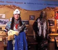
 people. The park includes the Paint Pots ochre spring and the Radium Hot Springs, two sites of great traditional and spiritual significance for First Nations.")
24 For thousands of years, the area that is now Kootenay National Park was part of the traditional lands used by several First Nations, including the Ktunaxa (Kootenay), Stoney, Kinbasket (Shuswap), and Secwepemc (Shuswap) people. The park includes the Paint Pots ochre spring and the Radium Hot Springs, two sites of great traditional and spiritual significance for First Nations. The valleys of the Kootenay and Vermilion rivers were used as travel corridors between the Columbia Valley and the Bow Valley and adjacent plains east of the Canadian Rockies. Kootenay National Park also has an important role in protecting the Burgess Shale fossil deposits. First discovered by C.D. Walcott in 1909 in neighbouring Yoho National Park, the Burgess Shale is recognized as one of the most significant fossil deposits in the world. There are several known Burgess Shale localities within Kootenay National Park. Most of these have only been subject to preliminary scientific investigations. As the only national park that protects a portion of the western ranges of the Canadian Rockies, Kootenay contributes significantly to the representation of the Rocky Mountains Natural Region. Protected habitat in the park provides an important link between the Columbia Valley in British Columbia and the Bow Valley in Alberta. The Vermilion and Kootenay river valleys provide important travel corridors that link wildlife populations on both sides of the continental divide. The Kootenay Valley also provides an important north-south wildlife movement corridor. The southwestern portion of the park is the only place within the national park system where the Douglas fir-ponderosa pine-wheatgrass vegetation type is found. This area of the park provides important winter habitat for wildlife, especially Rocky Mountain bighorn sheep. Parks Canada / T. Keith 10
25 3. Planning Context 3.1 Sources of Information Parks Canada evaluates programs and activities to ensure that they are meeting the objectives outlined in the management plan for protection, experience and education. A major tool for assessing and reporting on the condition of the park and the effectiveness of Parks Canada s management actions is the State of the Park Report (SOPR). Prepared every five (5) years, these reports are based on the results of ongoing monitoring of natural and cultural resources, and social science data gathered from visitors and other Canadians. The State of the Park Report plays an important role in identifying deficiencies in current park management approaches, emerging issues and information gaps, and determining the scope of management plan reviews. The Kootenay National Park of Canada State of the Park Report (2008) rated the state of ecological integrity as fair and stable based on available research and monitoring data. Cultural resource condition was also rated as fair. No trend was assessed due to data limitations. Fewer data were available to quantify the state of visitor experience and public education. Based on available data, including high visitor satisfaction ratings tempered by concern about aging facilities, the park visitor experience was assessed to be fair and stable. Public education was assessed to be fair and improving. Since the 2008 SOPR, several surveys on specific topics such as camping trends, hiking trails, special events, and winter use have helped to fill in some knowledge gaps. These data were supplemented by a qualitative visitor experience assessment, focus groups, and a consultant s review of social science data and trends in order to develop key strategies for visitor experience in this plan. Ongoing dialogue with the public, stakeholders, and park staff also helped to shape plan content. 3.2 State of the Park Summary The Kootenay National Park of Canada State of the Park Report (2008) included the following key findings: Native biodiversity is considered fair and stable. There is concern regarding the population stability of some species such as grizzly bear, and the American badger. Wildlife mortality and excessive driving speeds on Highway 93 South are prime concerns, which pose a threat to several species. The connectivity of aquatic ecosystems is a concern, due to aging or poorly designed infrastructure that hinders movement and passage of some aquatic species. Past fire suppression has caused the loss of some habitat types and an increase in forest insect and disease issues. There is a need to adjust forest management strategies to respond to these concerns, especially relative to the effects of the mountain pine beetle. The spread of non-native vegetation is also a concern. Regional population growth and development adjacent to the park create pressures that can affect ecosystems within the park. 11

26 Evidence of a warming climate is measured in reduced snowpack, increasing temperatures, and receding glaciers. Cultural resources are in fair condition. Inventories require updating, and a cultural resource management plan is needed. Basic knowledge of visitation and visitor characteristics exists, and satisfaction is generally high. However, there is a need to reinvest in aging frontcountry infrastructure that has reached the end of its life cycle (e.g. campgrounds and day use areas). There is an increase in weekend commuter traffic on Highway 93 South. Many of these travellers pass through the park without stopping to explore the park or use park facilities. Visitor satisfaction with educational programs is high, although participation rates are low. Better tools are required to evaluate the effectiveness and reach of communication programs. Additional research is required in order to understand and monitor how park experiences and outreach help to influence attitudes and connect Canadians to the park. Parks Canada / C. Siddal 3.3 Ecological Context The mountain landscape of Kootenay National Park is characterised by three distinct ecoregions: the montane, subalpine and alpine. The montane ecoregion occupies the valley bottom and lower slopes in the Kootenay Valley, the valley bottom of a portion 12
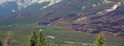
27 of the Vermilion and Simpson rivers, and the lower elevations in the southwestern corner of the park. These areas have the mildest climate and receive less precipitation than the rest of the park. Montane forests are characterised by Douglas fir, lodgepole pine, white spruce, trembling aspen and cottonwood. Ponderosa pine and cacti also grow in the driest areas at the extreme south end of the park. The montane makes up less than one-third of the park (31%), but is the most critical to the parks ecological integrity as it supports the greatest biodiversity and provides important movement corridors for wildlife. The Kootenay River montane area, in particular, provides critical winter habitat for ungulates, and year-round movement corridors for wildlife. The Kootenay valley is traversed by Highway 93 South, and also contains Settlers Road, McLeod Meadows Campground, Kootenay Crossing operations area, and several day use areas. Wildlife populations move up and down this valley and across park boundaries onto lands in the lower Kootenay valley to the south and the Beaverfoot Valley to the north. Parks Canada must work cooperatively with the British Columbia government to manage these shared wildlife populations. The majority of the park, including the entire northern portion, is within the subalpine (50%) and alpine (19%) ecoregions, with forests dominated by Engelmann spruce and subalpine fir, and meadows dotted with wildflowers above treeline. The subalpine throughout the park supports whitebark pine, a species of special concern in British Columbia (Blue List). Alpine larch occurs near treeline along the continental divide, and western larch occurs in the Kootenay and Sinclair valleys. Much of the alpine consists of bare rock, glacial ice and rugged terrain which limit its value for most wildlife. Fire plays an important role in maintaining healthy forest ecosystems in the montane, and to a lesser extent sub-alpine forests. These forest ecosystems have been affected by decades of fire suppression, and a recent population explosion of mountain pine beetle, a native insect in western pine forests. In 2003, the Tokumm-Verendrye wildfire burned 17,409 ha in the northern section of the park. Prescribed burning is being used to restore fire in other sections of the park, with recent burns completed on Mitchell Ridge in the Kootenay Valley, and on the Redstreak Bench near Radium Hot Springs. Prescribed fires and Fire Smart facility protection projects are also being used to reduce the threat of catastrophic wildfires. Aquatic ecosystems have been affected by the development of the highway and other roads, which sometimes act as barriers to fish passage, and the introduction of nonnative fish species. Efforts are underway to restore natural aquatic connectivity, and to address the impacts of non-native fish. Recovery measures are being planned for the westslope cutthroat trout. The British Columbia population of this species has recently been designated under the federal Species at Risk Act as a population of special concern. The southwestern portion of the park is embedded within a regional landscape that has been modified significantly by forest harvesting, transportation infrastructure, ranching, tourism, and real estate development. Development pressures and human population are increasing in this region. 3.4 Visitation Trends Over the last decade visitation to Kootenay has fluctuated annually, with a high of 455,000 in 2007/08 to a low of 390,000 recorded in 2003/04 when significant 13
28 wildfires affected travel to the Canadian Rockies and to Kootenay National Park in particular. From 2000/01 to 2007/08 visitation rose by almost 8%. Visitation to date in 2009/10 is up 3.5% from the previous year, which was down almost 8% due in large part to the global economic recession. Recent visitor surveys indicate that nearly half of all visitors are Canadian, roughly 30% are from the United States, with the remainder arriving from other countries. Alberta and British Columbia residents account for one-third of visitors. Visitor use during July and August accounts for 40% of total visitation, and 76% of all visits occur between early May and late September. Only 9% of visits are recorded during the winter months of December to February, while March and April account for 12% of visits. The Radium Hot Springs are popular year-round. Of the people who visit Kootenay National Park annually, over 90% are independent travellers, while 10% are on commercial group tours. Visitors to the park participate most commonly in the activities of sightseeing (86%), walking (78%) and hiking a trail (66%) 1. Ski touring and ice climbing are popular winter activities. Many other travellers pass through the park without stopping on their way between Alberta and British Columbia. A significant proportion of this traffic is attributed to Alberta residents travelling to their recreational homes in the Columbia Valley. These travellers are a priority market in the park, and a focus audience for outreach activities. Visitors to Kootenay enjoy the spectacular 94 km scenic drive through the Vermilion and Kootenay valleys, while stopping to visit popular natural attractions like Marble Canyon, the Paint Pots, Sinclair Canyon, and the Radium Hot Springs. Visitor satisfaction remains high, although congestion can be a problem at the park gate near Radium. There are popular day hiking opportunities at the north and south end of the park. Marble Canyon and McLeod Meadows campgrounds and Kootenay Park Lodge provide accommodation along the Highway 93 South corridor. Redstreak Campground, the largest in the park, provides popular accommodation near Radium Hot Springs. The Rockwall area is a premium multi-day backpacking destination, and other trails lead to backcountry opportunities in Banff, Yoho and Mount Assiniboine parks. Approximately 98% of the park is a declared wilderness, which provides outstanding recreation opportunities with minimal facilities. Recent social science analysis has expanded understanding of the social values and travel motivations of park visitors. This work will allow Parks Canada to better match existing and potential new opportunities to the needs and expectations of distinct visitor segments. The general growth in visitation to Kootenay National Park has not kept pace with regional population growth. This suggests a relative shift of public interest away from visiting Kootenay, and in that sense reflects a broader phenomenon that has seen visitation stagnate or fall off in national parks and national historic sites across Canada in recent years. A primary consideration in the management of Kootenay National Park must be to ensure its continued relevance in a changing, more urban Canada. For Kootenay to achieve its full potential as a national park, a key priority is to renew and reinvent visitor experience in ways that respond to the motivations and interests of the full range of Canadians. Meeting this challenge will promote increased visitation and, through that, the deep personal connections that arise IPSOS REID Online Panel Composition Overview, Parks Listens, March

29 through personal experience of real, inspiring places. Those connections are the basis for continually renewing the constituency for heritage conservation that is essential to sustain Canada s protected areas legacy into the future. Parks Canada 3.5 Management Priorities and Challenges Since the previous management plan was approved, the park has made progress addressing some of the most pressing park management challenges. Forest thinning and prescribed burning have been used to restore open forest and bighorn sheep habitat on the Redstreak Bench. Some aging infrastructure has been acquired and removed from Sinclair Canyon in preparation for the next phase of this restoration project. The Marble Canyon hiking trail has been restored following damage caused by the 2003 wildfires. During the winter of 2009 the Fay Hut, a popular visitor facility in the park operated by the Alpine Club of Canada, was sadly lost due to fire. Management priorities for Kootenay National Park include: Reducing wildlife mortality on Highway 93 South. Improving the condition of native biodiversity through active management programs. Developing detailed area planning strategies for the Highway 93 South and Sinclair Canyon areas. Increasing engagement of Aboriginal people. Reaching new markets by responding better to evolving needs and expectations and by promoting new and refreshed visitor experiences. 15

30 Improving aquatic connectivity. Encouraging more drive-through traffic to stop along Highway 93 South. Reducing speeding by providing pre-trip messages to commuter traffic to encourage them to slow down and engage with the park. Improving the sense of arrival and welcome at the park s west gate. Completing the Redstreak Restoration Project. Ensuring that wildlife can safely use important habitat and movement corridors. Increasing understanding of the impact of climate change and developing adaptation strategies. Increasing engagement with Canadians who do not visit the park through various media. Cooperating with partners to develop and promote day adventure programs in the park. Parks Canada / T. Keith 16
31 4. Key Strategies Key strategies are the guiding concepts that define the approach Parks Canada takes to setting priorities, selecting and implementing actions, and evaluating the success of park management. Each key strategy has a primary focus and is intended to complement other strategies in the plan. For Parks Canada to fulfill its mandate in an integrated way, implementation of these strategies will be done in concert with one another. Similarly, policy direction for Kootenay National Park must be viewed as the collection of these strategies and subsequent area concepts. The following five key strategies summarize the overall approach to achieving Parks Canada s mandate in the unique context of Kootenay National Park. 4.1 Showcasing Conservation Innovation and Environmental Stewardship Conservation challenges associated with managing protected areas in a changing world are many and complex. Canada s mountain national parks have long been at the forefront of efforts to re-think and re-design the way in which people interact with protected landscapes. Given Parks Canada s mandated obligation to ensure that parks remain unimpaired for future generations, and the high value that Canadians also attach to the ecological well-being and cultural heritage of their mountain national parks, Kootenay will continue to focus research attention, innovation and investment on important conservation challenges. Many of these challenges are shared with other mountain landscapes in the world. As part of a community of protected areas, Kootenay National Park has benefited from experience gained in other places in Canada and the world, and from fresh thinking by knowledgeable people who share an interest in this special place. Beginning with a strong knowledge base, and working collaboratively with others, facilitates the development and implementation of creative conservation solutions that add value to visitor experiences and ensure that the natural and cultural heritage of the park is protected for generations to come. This approach can be observed in the park s approach to restoring fire on the landscape, and will be used in planning and implementing measures to address wildlife mortality on Highway 93 South. Continued research on ecosystems, wildlife and cultural heritage will provide insight, understanding and objective data to support science-based decision making. Park research will also provide opportunities to enhance visitor experience and collective learning through the engagement of stakeholders, park visitors and local community members. As the understanding of park ecosystems continues to evolve, research findings will be integrated into ecological management approaches and into park stories shared with visitors, stakeholders, and Canadians across the country. Many Canadians are passionate about sustaining the integrity of park resources and the quality of the facilities that support memorable park experiences. Parks Canada will actively engage stakeholders, park visitors and other volunteers in as many stewardship activities as possible, making the protection and management of the park an enriching source of meaningful experience and personal connection. 17
32 Objective #1: Knowledge for decision-making is improved and visitor learning opportunities are enhanced by ongoing investigations that increase our understanding of park landscapes, ecosystems, and cultural resources. Research and monitoring approaches maintain a high degree of scientific rigour and statistical validity, and stress collaboration with others. Actions: Lead, or support, research activities that contribute to an increased understanding of park ecosystems, ecological processes, environmental change, and cultural resources. Consider the creation of common spaces, such as a Bighorn Sheep Common Room at reception facilities, where scientists, volunteers and visitors can share knowledge and coordinate research and monitoring efforts. Participate in regional and national planning initiatives to help enhance knowledge sharing and improve decision-making within the regional ecosystem. Objective #2: The environmental impact of park operations is reduced by expanding the use of evolving technologies and encouraging commercial operators in the park to do the same. Actions: Ensure that the management and operation of the park minimizes impacts to park ecosystems by collaborating with partners to continually expand and improve the use of environmental technologies such as renewable energy, waste composting, recycling and water and energy conservation in campgrounds, day use areas, backcountry campgrounds, patrol cabins, and other built facilities. Encourage the development and/or use of alternative energy sources to improve efficiency, and reduce greenhouse gas emissions associated with fossil fuel energy generation, in ways that do not negatively affect natural and cultural features or visitor experience. Objective #3: Community residents in the Village of Radium Hot Springs, regional stakeholders, park visitors, volunteers and broader communities of interest are fully engaged in opportunities to create new conservation solutions and environmental stewardship in the park. Actions: Engage a diverse community of interested Canadians in sharing information, imagining solutions, and collaborating to implement strategies that address conservation challenges including wildlife mortality on Highway 93 South. Design and implement conservation measures such as prescribed fires, salvage archaeology, and trail design and relocations in ways that provide opportunities for visitors and stakeholders to witness the action and learn about the reasons for undertaking these measures. 18

33 Provide opportunities for the public and park stakeholders to share in the active stewardship of the park by participating in volunteer activities such as citizen science initiatives designed around core ecological monitoring, restoration activities, and trail stewardship. Objective #4: The environmental literacy of Canadians is enhanced through in-park messages and external communications, by making research, conservation success, and environmental stewardship a part of the national park visitor experience and of the stories the park tells the world. Actions: Share the results of ongoing research, monitoring, restoration and stewardship projects with park visitors, students and educators, and others in the region through Internet and new media. The communication focus will be on the Redstreak Restoration Project and the bighorn sheep monitoring program and, as work progresses, on the Highway 93 South mitigation project. Use new environmental technologies to reduce the impact of park operations on the environment and communicate the results of these initiatives to raise awareness of the importance of environmental protection. Provide visitors with timely and relevant information so they can make choices that will ensure their personal safety and protect park wildlife and ecosystems. Engage visitors in shared stewardship of the park, and tailor opportunities to the interests of specific audiences. Parks Canada / L. Halverson 19
34 4.2 Experiencing the Dramatic Effects of Fire and Water Connecting Canadians with experiences that are real and inspiring within wellfunctioning and healthy ecosystems is integral to the management and sustainability of the park. A renewed focus on authentic and meaningful visitor experiences, tailored to key visitor segments, will set the stage for the best national park experience possible. This effort will be evident in every program and activity, and in every aspect of service delivery. Heritage tourism, which results in a net benefit for the social, economic, natural and cultural environments of the area, plays an important role in making these connections and providing these experiences. In national parks, heritage tourism actively fosters an appreciation of nature, history and culture and is an important part of facilitating stewardship of these important places. Heritage tourism strategies exist for each mountain national park and are required of operators undertaking redevelopment in Kootenay National Park. Kootenay National Park was established in conjunction with the construction of the Banff-Windermere Highway. This setting provides a remarkable opportunity to engage visitors in a variety of recreational and learning opportunities as they travel through the scenic heart of the park. The natural forces of fire, water, snow and ice shape this landscape, and visitors have many opportunities to witness the effects of these processes, and learn about the role they play in maintaining healthy, diverse ecosystems. The presence of the road also requires focused management attention in order to minimize impacts on wildlife and ecosystems, which in turn provides excellent opportunities to share information on road ecology with park visitors. For those travelling through Kootenay for the first time, the broad valleys and fire-generated open slopes reveal stunning mountain topography and provide an introduction to one of the great iconic landscapes of the Canadian west. For regular through-travellers or those making a return visit, the park offers unique opportunities to observe forest renewal and regeneration, as fires and new growth continually redefine the views. For urban and new Canadians, the park offers contrast and a chance to recharge or experience nature in safe surroundings. For youth, the park offers opportunities for adventure and discovery in one of the mountain parks best backcountry areas. Parks Canada and its municipal and tourism industry partners recognize that visitors to national parks are not all the same. Extensive demographic and psychographic information, product development and promotional activities acknowledge that visitors have different needs and desires, and connect with the park in many different ways. Products and programs will welcome, attract attention, and satisfy the needs of visitors at all stages of their visit from pre-trip planning to post-trip memories. Visitors will find in Kootenay National Park the ability to create the experiences that are most meaningful and rewarding to them, within the context of a unique national park setting Welcoming Visitors to Mountain Heritage Welcome will be a recurring theme, reflected in visitor infrastructure, local ambassadors, Parks Canada staff and other service providers. Visitors to Kootenay National Park whether from the east or west, north or south will be acutely aware 20

35 of having arrived in a special place, containing abundant wildlife in a landscape greatly affected by two of the earth s major elements: fire and water. Objective #1: Visitors are welcomed to mountain ecosystems, the park s natural and cultural heritage, and to the Canadian Rocky Mountain Parks World Heritage Site in a manner that reflects the significance of this special place. Actions: Invest in new and enhanced reception and orientation facilities in the Sinclair Canyon area and at the north entrance to Kootenay that will create a strong sense of arrival and welcome. Position View from the Edge experiences in the Marble Canyon/Paint Pots as an introduction to the park and an invitation to explore further. Create a communications and learning strategy around the concept of welcome, which is employed throughout the park and echoed by all who work in the park and live in adjacent communities. Parks Canada / H. Furher Connecting Visitors to Exceptional Experiences Like the other mountain national parks, Kootenay s visitor experience strategy is based on five (5) types of engagement that will be used to plan for and provide opportunities for visitors: Virtual Experience; Drive Through Awareness; View from the Edge; Step into the Wild; and Immersion in Mountain Wilderness. The identification of these engagement types is a step in making stronger connections 21
36 Five Types of Engagement for Visitor Experiences The Virtual Experience is targeted to visitors with an interest in nature and mountains, anywhere in the world within reach of technology. These visitors will benefit from brief, intense visual and/or auditory experiences of mountain heritage, delivered through technology or print media. For reluctant travellers, these experiences may be the visit; for others, they may be instrumental at the imagining and wishing stage of the trip cycle, and may provoke an actual visit. Whether they visit or not, this experience will contribute to awareness of and support for Kootenay National Park, a key component in maintaining or improving the ecological integrity of the park. Drive Through Awareness travellers who currently journey through the park without stopping are targeted in the next type of experience. To date, these visitors have been largely ignored, even though they represent a significant volume on Highway 93 South where wildlife mortality is a major concern. There is a tremendous opportunity for Parks Canada to strengthen the connection of through-travellers with Kootenay by encouraging learning and environmental stewardship. For this segment, a drive along the Banff-Windermere Highway to recreational properties in the Columbia Valley complete with wildlife alert systems, fencing, crossing structures and complementary signage will provoke curiosity, inquiry and understanding. Although still primarily a visual experience, subtle interpretation will promote understanding of and support for the protection of the scenic mountain panorama, and may inspire a return visit to experience the park in more depth. A View from the Edge experience appeals to the second largest visitor group, those who prefer to stay close to civilization, or stop briefly for a break on their way to other places. These travellers may stop to snap a picture, have a picnic, go for a short stroll, or relax in the hot springs. For this segment, better maintained infrastructure, clustered opportunities and an enhanced level of interpretation will set the stage for a deeper connection to place, in which all of the senses are engaged. Meaning and value will be added to this View from the Edge experience, through heritage programming and dynamic media that bring the wilderness to the campsite, village or gathering place. This will be particularly appealing for those seeking hassle-free travel, rejuvenation and relaxation, or freedom and excitement in outdoor settings described as no hassle travellers, gentle explorers, rejuvenators and free spirits. Additionally, many of the facilities and services used by these visitors form the basis for visitors in the next two segments. For this reason, investment here reaches a large proportion of multiple target markets. A Step into the Wild experience is targeted to visitors who stop and stay in the parks for more than a few hours, but who do not venture far physically or perceptually for too long. They may be staying in Radium, in one of the outlying commercial accommodations in Kootenay, or in neighbouring Banff National Park. This group may take advantage of commercial guiding and transportation services to journey further from the road in relative safety. Lesser in volume than the previous group, this segment has more time for personal reflection, in-depth learning, and possibilities of memorable moments with wildlife. The park experience of these cultural explorers and free spirits will give them renewal, freedom and authentic connection to nature and mountain culture, as well as volunteer opportunities to help maintain or improve ecological conditions. Visitors who seek Immersion in Mountain Wilderness have an inherent affinity for nature or have gained experience and comfort through repeated outdoor adventure experiences over time. These authentic experiencers become physically and perceptually immersed in the natural environment, leaving behind at the trailhead the built human environment that characterizes daily life. Their carefully planned, intensely personal experiences may include long, challenging day hikes, such as Kindersley Pass, mountaineering trips along the continental divide, or lengthy, unguided backpacking trips to the Rockwall, or other backcountry areas. These visitors already have a strong connection to the park, and this connection will be maintained through the provision of off-site trip planning information, unobtrusive assistance, and when desired, contact with certified guides. These adventurers will be encouraged to deepen their connection to place, as ambassadors or stewards, passing on their passion for Kootenay to friends, family and colleagues. 22
37 between Canadians and their park, and will result in more meaningful and varied visitor experiences. The five types share a common foundation: they occur in, are based on and must contribute to a whole and well-functioning ecosystem. Objective #2: Visitors are increasingly aware and appreciative of the unique nature of Kootenay National Park as a distinct destination in the Canadian Rockies, worthy of protection and support. Actions: Use the historic and continuing presence of fire and forest regeneration along the length of the park as a way of differentiating Kootenay from other mountain parks. Target regional residents in the Columbia Valley, the Bow Valley and Calgary through outreach, external communications and on-site interpretation designed to keep visitors knowledgeable and informed about Kootenay s features and management. Engage non-traditional partners and motorists travelling regularly along Highway 93 South, in understanding and crafting solutions to the issues of speeding and wildlife mortality. Work with Banff National Park and partners such as the Village of Radium, the Radium Chamber of Commerce, the East Kootenays Tourism Association and the Friends of Kootenay to promote the park. Objective #3: Visitor experiences are enriched using a systematic approach to planning opportunities based on the natural ecosystem and cultural heritage that Kootenay National Park protects and presents. Actions: Prepare detailed area planning strategies for Highway 93 South and the Sinclair Canyon - Radium areas. Enhance visitor experience at all stages of the visit from wishing for and planning through to post-trip memories. Improve services and products by considering the specific needs and interests of different market segments (such as no hassle travellers, gentle explorers, rejuvenators, free spirits, cultural explorers and authentic experiencers). Develop targeted promotions, setting expectations that are compatible with the landscape and ecological objectives. Communicate with visitors post-trip to build loyalty, add value and encourage repeat visitation. 23
38 Invite visitors to move from one type of experience to another for those who wish to do so. Measure success in facilitating a memorable visitor experience. Objective #4: Connection to place is deepened through expanded opportunities and increased visitation, while respecting protection goals and character of place. Actions: Expand the range of recreational, leisure and learning opportunities, in collaboration with communities, environmental and tourism stakeholders, and private operators, and subject to an assessment process at national and local levels. Produce and install informative signage to enhance Drive-Through Awareness. Develop and promote opportunities for View from the Edge experiences at popular locations such the Marble Canyon/Paint Pots, Vermilion Crossing, and McLeod Meadows/Dolly Varden. Increase the number of visitors to the park by 3% annually during the next five (5) years, by focusing on attracting residents of the Southern Interior, the Columbia Valley, the Bow Valley, and Calgary. Create special events to encourage visitation in seasons and locations with available capacity. Influence patterns of use and direct additional visitation to opportunities and activity nodes designed for intensive use, where ecological and visitor impacts can be managed. Provide visitors to Radium Hot Springs pools with information on other activities available in the park. Support the efforts of the tourism industry in attracting international visitors by promoting the Canadian Rocky Mountain Parks World Heritage Site to international markets. Objective #5: Kootenay National Park is known and enjoyed not only as a drive-through park but as a premier location for day adventures within a protected heritage environment. Actions: Use social science data to determine the opportunities, founded on Kootenay s natural and cultural attributes, best suited for authentic experiencers, cultural explorers, gentle explorers and rejuvenators. Work cooperatively with community, private sector and First Nation partners to develop a menu of opportunities. 24
39 Promote the day adventure program through existing channels of distribution managed by the Canadian Tourism Commission, provincial marketing agencies and destination marketing organizations. Use the Radium Hot Springs foyer as an in-park promotional venue and the starting point for day adventures. Measure the effectiveness of the day adventure program in providing benefits for partners, attracting new visitor segments, and establishing connections to Kootenay National Park. 4.3 Celebrating History, Culture and the World Heritage Site Kootenay National Park protects a unique and rich cultural legacy. The stories that pervade this mountain landscape are inspired by early and contemporary Aboriginal use, European exploration, and the development of transportation and tourism infrastructure. Key themes include the Aboriginal importance of sites such as the Radium Hot Springs and the Paint Pots, the chronicling of the main river valleys by the Palliser expedition, the development of the first motor transportation route across the central Canadian Rockies, and the emergence of modern tourism based on an appreciation of the beauty of the Canadian Rockies. This rich cultural heritage allows visitors to experience a vivid sense of the past, and to personally connect with and contribute to this continuing human legacy. As part of the Canadian Rocky Mountain Parks World Heritage Site, Kootenay is also part of a much broader celebration of heritage. World Heritage Sites are places of outstanding universal value that are recognised as part of the common heritage of all people. The Canadian Rocky Mountain Parks were designated for their exceptional natural beauty, and for their significant ongoing geological processes. Aboriginal history and traditions are an important part of the heritage of Kootenay and the World Heritage Site. Archaeological evidence indicates that the park has been an east-west travel route for many centuries. The Ktunaxa regularly travelled through the valleys and passes to hunt bison on the plains to the east. Aboriginal people from both sides of the continental divide came to the Paint Pots site for ceremonial purposes, and to collect ochre. The Radium Hot Springs was an important spiritual site that was also used for bathing by Aboriginal people long before European explorers recorded its existence. Historical accounts also record the Aboriginal use of the Kootenay Trail which passes through the Kootenay Valley in the park. Parks Canada is committed to building strong and mutually beneficial working relationships with Aboriginal people, in order to better understand and incorporate Aboriginal knowledge and perspectives into park management, and to showcase Aboriginal heritage and cultural traditions. This strategy aims to increase awareness of the rich, still-evolving cultural heritage of Kootenay National Park and the World Heritage Site. The cultural resources and traditions within the park will be profiled so that history, culture and landscape become integrated into the ways in which people experience, understand and support the unique heritage in Kootenay National Park. Objective #1: Significant cultural resources are conserved and restored. 25
40 Actions: Complete a cultural resource management plan for the park and invest strategically to ensure that these touchstones to our past and future remain intact, and contribute to the contemporary visitor experience. Conduct research and monitor the condition of archaeological sites. Include the stories of Kootenay s cultural history in visitor opportunities and outreach efforts. Objective #2: Aboriginal people are actively involved in documenting and presenting to visitors their cultures and relationships to park landscapes. Actions: Facilitate the gathering and recording of traditional knowledge about park ecosystems, traditional land use, cultural resources, and relationships with landscapes, in ways that respect the Aboriginal traditions and ownership of the knowledge. Identify and facilitate opportunities for Aboriginal people to present their culture, history and perspectives to park visitors. Develop and implement measures to support Aboriginal access to the park for spiritual and ceremonial purposes. Work with the Ktunaxa Nation on an annual special event that helps to reconnect their people to the park and creates opportunities for new visitor experiences. Foster cultural awareness among Parks Canada and its partners. Objective #3: The profile of cultural resources and the World Heritage Site is elevated through linking the stories associated with historic resources and events to the broader park landscape, to contemporary visitor experience, and to the stories that define Canada. Actions: Use the topics of conservation and restoration in park stories, as the basis for new visitor experience products, and for outreach and education programs. Develop new interpretive and outreach materials to enhance the profile of cultural heritage sites such as the Paint Pots, Sir George Simpson commemorative plaque, backcountry patrol cabins, and archaeological sites. Collaborate with partners to make information on the World Heritage Site more visible and more widely available. Incorporate the history and stories of Kootenay National Park into renewed facilities and interpretive exhibits along Highway 93 South and at the Radium Hot Springs pools. 26
41 Link the stories associated with historic resources and events to the broader park landscape, to contemporary visitor experiences, and to the development of the national park system under Commissioner J.B. Harkin. 4.4 Bringing the Mountains to People Where They Live To promote, beyond our boundaries, an ongoing dialogue and lifelong passion for parks, Parks Canada will bring stories of mountain culture, science, recreation and park management to people who may not otherwise have an opportunity to learn about, visit or become involved in our national parks and national historic sites. An increasing proportion of Canadians live in urban centres, and more than 20% were born outside of Canada. Parks Canada will reach out to these audiences through innovative communications programming. Outreach initiatives such as environmental education programs at schools, extension events for special groups, real-time content on Parks Canada and partner websites, publications, mass media contacts and community events will bring the mountain parks into people s homes and communities. Wherever they may live, work or gather, Canadians will be introduced to their nation s remarkable mountain heritage. Canadians will understand and value Kootenay National Park and be able to connect with wild places, culture and history. Making this connection with Canadians, whether they visit the park or not, is an important way of remaining relevant to Canada s diverse population, and demonstrating the value of our national parks. Through this connection to Canadians, Parks Canada will be more successful in protecting the natural and cultural heritage represented by Kootenay National Park. The stories of the nature and history of Kootenay, and the knowledge that the park is part of a healthy and well- functioning ecosystem, will form the basis of a growing personal connection with the park. Objective #1: Stories of Kootenay National Park s mountain culture, science, recreation and park management are widely available to people who may not otherwise have an opportunity to learn about, visit, or become involved with the park. Actions: Develop partnering arrangements with the Village of Radium Hot Springs and other communities in the Columbia Valley that enhance mountain park outreach and education around restoration and conservation projects, including fire ecology, Redstreak restoration, aquatic health, species at risk, and Highway 93 South wildlife mitigation efforts. In collaboration with the Royal Ontario Museum (ROM) in Toronto, develop the premier website on the Burgess Shale highlighting, among other themes, the recent work carried out in Kootenay National Park. Investigate the potential to establish a Parks Canada presence in Toronto through the strong relationship with the ROM. Enhance the park website by ensuring content is timely, relevant and up-to-date. 27
42 Objective #2: Young Canadians, urban Canadians and recent immigrants to Canada make virtual connections to Kootenay National Park, the Canadian Rocky Mountain Parks World Heritage Site, and the defining stories of Canada. Actions: Provide targeted programming that links these audiences to unique aspects of the park, such as the Paint Pots, the Redstreak restoration area, and the Burgess Shale. Raise awareness of the World Heritage Site among new Canadians by associating it with other iconic World Heritage Sites from their former home countries. Objective #3: Albertans driving to their recreational properties in the Columbia Valley, and other travellers who normally drive though the park without stopping, develop a sense of connection to the park based on an increased appreciation and understanding of what it has to offer. Actions: Engage travellers commuting to recreational homes in the Columbia Valley, and other travellers who drive through the park without stopping in their home, on Highway 93 South, and in the Columbia Valley to increase their sense of place and connection to Kootenay National Park. Build awareness of the potential impacts of roads on natural ecosystems, encourage support for efforts to reduce wildlife mortality on the highway, and invite travellers to make a brief stop to connect with the park through a View from the Edge or a Step into the Wild experience. Objective #4: Regional residents in British Columbia become more aware and are more appreciative of the protected heritage in Kootenay National Park. Actions: Collaborate with natural and cultural heritage organizations and institutions, and media outlets in the Columbia Valley to deliver programs on unique features, places, events, and people in Kootenay National Park. Collaborate with the Columbia Basin Environmental Education Network and school boards in the East and West Kootenays to support the Wild Voices for Kids speaker series in the area schools, and increase the mountain park content in this program. Collaborate with provincial education authorities to tie national park themes such as ecological restoration, road ecology and cultural heritage into school curricula at targeted levels. 28
43 4.5 Ensuring Healthy Park Ecosystems Parks Canada will maintain or restore the ecological integrity of Kootenay National Park by striving to ensure that native plants and animals continue to exist in viable populations, and that ecological processes continue to function within their natural range of variability. By protecting healthy ecosystems, Parks Canada also ensures that visitors to Kootenay National Park continue to have outstanding opportunities to connect with environments that represent the west slope of the Rocky Mountains Natural Region, in ways that build support and sustain this heritage for future visitors. Visitors to the park find intact ecosystems that are still governed by natural ecosystem processes, particularly fire. These healthy and evolving ecosystems support a range of naturebased recreational experiences that constantly attract new and returning visitors to the park. While maintaining the ecological integrity of the entire park, Parks Canada will emphasize the restoration and intensive management of ecosystem processes and components that have the potential to yield significant conservation gains, or are rare or most vulnerable. Wherever possible, new visitor experience and learning opportunities will be incorporated into the management or restoration of these ecosystem features Restoration of Ecological Processes Perhaps nowhere else in the mountain parks are the effects of fire and water as accessible and integral to the visitor experience as in Kootenay National Park. Many processes influence the pattern and structure of park ecosystems and wildlife communities including fire, the effects of insects, erosion and deposition by ice and water, wind disturbance, animal migration and movement, predation and herbivory. These processes maintain a diverse array of habitat for wildlife, create a distinctive, variable landscape, and provide excellent wildlife viewing opportunities that define a visit to Kootenay National Park. Mountain landscapes are fragmented by their very nature. The construction of the Banff-Windermere Highway and various forms of land use and development adjacent to park boundaries have increased fragmentation by creating physical barriers to wildlife movement and introducing serious causes of wildlife mortality. Parks Canada will strive to restore terrestrial and aquatic connectivity and maintain conditions that allow animals to travel through the park landscape with minimal obstacles. Part of this initiative will include efforts to raise awareness among visitors and stakeholders of the challenges faced by wildlife, actions Parks Canada is taking to improve habitat connectivity, and opportunities for engaged citizens to get involved. Objective #1: Ecological processes are understood and active management initiatives are employed, where necessary, to ensure these processes continue to play their traditional role in shaping park ecosystems. Actions: Use prescribed fires and carefully managed natural fires to achieve 50% of the long-term fire cycle in areas currently below this target. 29
44 Complete the Redstreak Restoration Project to restore native grassland and open forest that provides important habitat for bighorn sheep and many other species. Conduct periodic, low-intensity burns to maintain open habitat characteristics in the Redstreak restoration area. Use research and monitoring of bighorn sheep movements and distribution to identify priority corridors between winter and summer ranges, and apply prescribed fire as a primary tool to achieve restoration objectives for bighorn sheep movement. Incorporate meaningful opportunities for visitor experience and education into ecosystem research, monitoring and restoration programs. Recover mule deer and elk populations in montane areas of the park through reduction of highway mortality and provision of suitable habitat through use of fire. Develop and implement an ecological restoration program for disturbed sites, such as old road alignments and depleted portions of the Snow Creek and Settlers Road gravel pits. Objective #2: Connectivity of terrestrial and aquatic habitat is maintained, and where impaired, is restored through active management and in cooperation with external agencies and interested members of the public. Actions: Collaborate with scientists, interested community members, citizen scientists and park visitors to maintain and restore secure wildlife corridors at the continental scale (e.g. Yellowstone to Yukon). Maintain significant regional wildlife corridors, with an emphasis on the Kootenay Valley wildlife corridor, and the Vermilion-Wolverine-Dainard corridor, which provides the only connection through the Vermilion Range. Develop and implement measures to reduce wildlife mortality on the highway. Develop communication products for park visitors and external audiences that raise awareness of wildlife movement patterns, barriers to dispersal, and efforts to improve connectivity. Restore connectivity of streams and wetlands where they have been impaired. Objective #3: Improvements to wildlife movement, reduced mortality, and restoration activities provide park visitors with opportunities to view wildlife, witness the effects of fire, learn the role of ecological processes in maintaining healthy ecosystems, and get involved. 30
45 Actions: Develop and periodically update communication products as fire and forest patterns change, to build awareness and understanding of fire and vegetation dynamics. Increase the survival of large predators by reducing wildlife mortality on Highway 93 South, and encourage visitors to stop at key roadside facilities to learn more about this important initiative. Incorporate volunteer and voluntourism opportunities into efforts to improve terrestrial and aquatic wildlife movement Grizzly Bears Grizzly bears are wide-ranging species requiring a variety of habitat types throughout the year. Rarely does a single jurisdiction provide all the habitat needs for this species. As a result, management efforts for grizzly bears are integrated with adjacent Banff and Yoho national parks. Grizzly Bear Conservation Grizzly bears are an enduring symbol of the wilderness of the Canadian Rockies. This wide-ranging species is broadly accepted as an indicator of the health and diversity of mountain ecosystems, and as a measure of sustainable land use practices. Where grizzly bears are thriving, we can feel confident that the life requirements of many other mountain species are being met. The survival of reproductive females is the key factor affecting population persistence especially in light of research findings showing that the mountain park grizzly bear population has the lowest reproductive rate documented for this species in North America. Parks Canada, along with provincial partners in British Columbia and Alberta, has established a goal of maintaining a non-declining grizzly bear population in the Canadian Rockies. Grizzly bear research across North America has led to the development of key concepts and analytical tools for managing grizzly bears. These include ensuring habitat security, especially in core reproductive areas. Parks Canada will apply these concepts, in conjunction with the most recent knowledge of bear habitat use and behaviour in the mountain parks, in order to ensure a sustainable, viable population of grizzly bears, and provide visitors with the opportunity for wilderness travel in a landscape also occupied by bears. Grizzly bear habitat is considered secure when the animals have a low probability of encountering humans, and can go about their activities with little human-caused disturbance. Areas with high habitat security are also likely to be high quality environments for wilderness recreation. Managing for habitat security will help to maintain grizzly bears, while also maintaining the unique character of place that contributes to visitor experience and enjoyment. Predictability of human activity helps bears avoid people. When human activity is predictable in space and time, there are fewer bear-human conflicts, fewer human injuries, and fewer human-caused bear mortalities. Parks Canada will continue to use grizzly bear habitat security targets as a key decision-making tool in managing development and use levels, based on validated, current analytic models. To that end, the park has been divided into seven (7) landscape management units (LMUs) that are roughly equivalent in size to the area of a single female grizzly s home range (see Map 3, Landscape Management Units in Kootenay National Park). Parks Canada will strive to maintain habitat security in each of these landscape management units (see Appendix 2, Grizzly Bear Habitat Security Estimates by Landscape Management Units). 31
46 Objective #1: Grizzly bears have access to available habitat and unnatural mortality and humanbear conflict is minimized. Actions: Identify and implement solutions to reduce grizzly mortality on Highway 93 South. Maintain wilderness recreation opportunities geared toward self-reliant travel with minimal infrastructure in areas with high habitat security. Work with adjacent land managers to maintain, and where possible improve, habitat connectivity through secure high quality corridors, allowing exchange between adjacent grizzly bear populations. Use the Mountain Parks Trail and Back Country Facility Design Guidelines to support backcountry use while minimising the risk of human-wildlife conflicts. Restrict off-trail travel by commercial groups in high quality grizzly habitat to minimize conflict and maintain habitat security. Use educational messages at trailheads and in print material to discourage offtrail travel by independent travellers. Objective #2: Public awareness and understanding of bear ecology and behaviour is enhanced. Actions: Provide educational programming and develop electronic and print media to increase visitor understanding of bear ecology, and to influence visitor behaviour on how to co-exist with bears. Consider seasonal closures or control of recreational use of areas important for grizzly feeding and travel, minimize food attractants, and educate visitors on risk management in bear country Protecting the Full Complement of Native Species Kootenay National Park is home to a diverse community of plants and animals. Outstanding opportunities to see mountain wildlife and forest communities in the park, including bighorn sheep, mountain goats and alpine larch forest, draws many visitors to Kootenay. Objective #1: All native species that are expected to occur in Kootenay National Park continue to persist at viable population levels. 32
47 Actions: Work cooperatively with responsible federal and provincial agencies in planning and implementing recovery measures for species listed in Schedule 1 of the Species at Risk Act as shown in Table 1. Collaborate with stakeholders to implement proactive measures that will keep species from being added to Canada s list of threatened and endangered mountain species. Investigate ways to improve opportunities to view native wildlife species, while decreasing the potential for habituation, disturbance, and human-wildlife conflict. Species Ranking American badger (Taxidea taxus jeffersonii) Endangered Rubber boa (Charina bottae) Special Concern Western toad (Bufo boreas) Special Concern Westslope cutthroat trout (Oncorhynchus clarkii lewisi), BC Population Special Concern Table #1: Species listed in Schedule 1 of the federal Species at Risk Act that occur in Kootenay National Park. Objective # 2: The occurrence and distribution of non-native species that are invasive, or threaten the stability of native species populations, is reduced. Actions: Develop and promote new visitor experience opportunities by engaging anglers and other interested Canadians in activities to eliminate or reduce populations of non-native fish species that pose a risk to native fish populations through displacement or hybridization. Prevent the introduction of new non-native species and engage park visitors and volunteers in efforts to control existing non-native species that are invasive, or harmful to native species Managing Development Most visitor infrastructure in the park is located in the valleys, in close proximity to the highway. Although the majority of the park is legislatively protected as a wilderness area where major developments will not occur, much of the valley bottoms are not included in this designation. These valley bottoms are valued by visitors, but they also include much of the most productive wildlife habitat. Consequently, development and associated activities must be managed carefully to ensure the natural and cultural attributes of the mountain parks are not compromised. Stronger and more meaningful connections of visitors with the park must be based on whole and well-functioning natural ecosystems and authentic cultural resources. Recent restoration efforts in Kootenay National Park have reduced the development footprint, created new visitor experience opportunities, and improved wildlife habitat in key corridors near Radium Hot Springs. 33
48 Objective #1: Development and growth in Kootenay National Park are carefully managed to support quality mountain heritage experiences, while safeguarding the natural and cultural attributes that make those experiences possible. Actions: Design and construct frontcountry and backcountry wastewater and sanitation facilities to minimize or eliminate effects on water quality. Enhance, modify, add, or consolidate visitor facilities in the park, such as campgrounds, day use areas and trails, to achieve experience, education and protection objectives. Restore disturbed areas no longer required for facilities or infrastructure. Develop and support special events and new recreational activities that promote public understanding and appreciation of the park, in ways that also support relevant ecological and cultural heritage objectives. Use the Redevelopment Guidelines for Outlying Commercial Accommodations and Hostels in the Rocky Mountain National Parks (2007) to guide any changes to commercial accommodations in the park. Use design guidelines that demonstrate environmental leadership and are sympathetic with the unique natural and cultural attributes of the park when creating or renewing facilities and infrastructure. Do not release additional park land for commercial accommodation. Objective #2: Travel corridors are managed in order to provide safe and efficient services to park residents and visitors in ways that minimize potential impacts on visitor experience, ecological and cultural resources. Actions: Prepare a long-term gravel extraction plan for the mountain national parks to support future highway and road requirements. Restore all depleted gravel pits to appropriate functioning ecosystems. Include future ecological restoration costs in highway construction and recapitalization budgets, and apply these funds to ecological restoration of depleted gravel sources and old disturbed sites in accordance with a long-term restoration plan. Improve highway signage and the visibility of main attractions to increase awareness of opportunities throughout the corridor and make it easier for travellers to stop along the way. Develop, with partners, best practices for managing potential contaminants, including procedures for minimizing road salt application, and spill response protocols for hazardous materials. 34
 5.1.")
49 5. Area Concepts 5.1 Kootenay Corridor (Highway 93 South, the Banff-Windermere Highway) Future Best From the icefields of the continental divide to the semi-arid forests and grasslands of the Columbia Valley, the Kootenay Corridor provides visitors with an unparalleled journey along the western spine of the central Canadian Rockies. Parks Canada / C. Siddal This scenic 93-kilometre highway, which transects the park, is itself historic. Constructed in 1922 as the Banff Windermere Highway, it was the first motor road to cross the central Canadian Rockies. The broad valleys and gentle slopes provide sweeping views of distant mountains. Sightings of bear, deer, moose, sheep even the elusive wolf add to the magic. Healthy wildlife populations and their continuing survival are evidence of active management and a well functioning ecosystem. Travelling the length of the Corridor, visitors experience the dramatic effects of fire and water. For visitors coming from Banff National Park and travelling south, the Corridor begins beneath the towering limestone peaks of the Main Ranges and then descends dramatically into the broad valleys of the Vermilion and Kootenay Rivers. Through the Vermilion River Valley, travellers witness the influence of the wildfires of 2003 which burned 13 percent of the park. They understand the important role fire plays in the life of a forest and are encouraged by the sight of regeneration, knowing that the blackened timbers provide food and shelter for a variety of wildlife species. 35
50 Those who come from the Columbia Valley and travel north to Banff and Lake Louise pass through the dramatic Sinclair Canyon and climb to the spectacular viewpoint overlooking the Kootenay River Valley. This is a landscape that has changed over time, where more evidence of fire can be seen, in this case the result of Parks Canada s extensive prescribed burn program. The fascinating science of fire is vividly and graphically expressed on roadside panels and on the landscape itself. No matter the direction, travellers experience a true sense of arrival. Attractive signage and outdoor exhibits welcome visitors to this special place - a protected heritage area, a distinctive national park and an important component of an acclaimed world heritage site. Those planning a visit to Kootenay are well prepared, having received helpful and intriguing information at home via the Internet. They have already decided and booked a series of exciting day adventures along the Kootenay Corridor. Stanley Glacier, Marble Canyon and the Paint Pots are inspirational and spiritual places, not to be missed. Visitors staying overnight find the experience they seek in the water-sculpted Marble Canyon, at McLeod Meadows campgrounds, or at the historic Kootenay Park Lodge. Throughout the Kootenay Corridor, day use areas provide an opportunity for rest, relaxation and adventure. Roadside pull offs, picnic sites and short trails are clustered at scenic spots along the Corridor, providing travellers with interesting reasons to stop and inviting them to return and explore further. Outdoor exhibits and digital media afford an intriguing glimpse into road ecology and efforts to reduce wildlife mortality and restore habitat connectivity. For those seeking a Step into the Wild or Immersion in Mountain Wilderness, trailhead kiosks provide a captivating introduction to the park for casual walkers and critical information on current conditions for backcountry adventurers. Travellers through Kootenay are aware that they are in a national park. Attractive signage, crossing structures, fencing and other alert systems remind them of the need to slow down and watch closely for wildlife on the highway. From time to time these travellers pull off, attracted by the promise of a restful stroll along the banks of the Kootenay and Vermilion rivers. Members of the Ktunaxa and other First Nations travel regularly into Kootenay, gathering at locations such as Crooks Meadows, to celebrate their connection to this special place. They are sometimes joined by other visitors who participate in new special events focused on Aboriginal tradition and culture Current Situation Strengths Highway 93 South through Kootenay National Park is used as a popular travel route between the Columbia Valley and the Bow Valley/Calgary area. This provides an opportunity to connect with regional residents as they travel between the two areas. The Columbia Valley, adjacent to Kootenay, is an attractive destination in itself, providing a visitor base from which to draw and make meaningful connections. There are a number of attractive day-use areas and trailheads for short strolls or 36

51 Map 1: Planning Areas in Kootenay National Park 37
52 day hikes along the highway. For the more adventurous, the corridor is the entry point to rigorous multi-day backpacking trips into the Rockwall area, or to adjacent backcountry opportunities in Yoho and Banff national parks, or Mount Assiniboine Provincial Park. The corridor also provides access to popular winter ski touring and ice climbing in the Marble Canyon Haffner Creek area. The valley bottoms of the Kootenay and lower Vermilion rivers are in montane habitat which provides important winter and summer range for ungulates. These valleys, through which Highway 93 South passes, are also important travel corridors for carnivores and ungulates. These factors often provide exceptional wildlife viewing opportunities throughout the corridor, but also increase the importance of developing effective education programs and highway management approaches that reduce the potential for wildlife mortality on the roadway. The Radium Hot Springs pool is another draw within Kootenay that attracts park visitors who may otherwise not visit the national park. Partners in the Columbia Valley such as chambers of commerce are eager to promote Kootenay to regional visitors, helping extend the reach of Parks Canada. The Vermilion and Kootenay rivers are never far from the highway and both are suitable for canoeing, kayaking and rafting, although infrastructure is minimal and use levels are presently low. Challenges The Kootenay Corridor is a major travel route between Alberta and the East Kootenay region of British Columbia. Many users are regular commuters travelling to recreational homes in the Columbia Valley. Others choose Highway 93 South as a scenic route on the way to other destinations east or west. Many of these travellers do not stop to engage in park activities. Excessive speeding is a significant problem on Highway 93 South, increasing the risk to other travellers and wildlife. Wildlife mortality due to vehicle collisions is a major issue for the park. Increasing truck traffic raises the risk of accidents that could release hazardous materials into park ecosystems. Several small day use areas are scattered along the corridor. Some of these are in poor condition and receive little use. A cohesive and systematic approach to how these areas provide visitor opportunities is lacking. Visitors and drive-through traffic have an expectation of cell phone service, as is found in the Columbia and Bow valleys, for emergency communication. Most of the visitor infrastructure along the highway is old, and was designed during a time when traffic volumes were lower and driving speeds were slower than they are today. Much infrastructure has not received regular maintenance and upkeep, making revitalization more costly than would otherwise be the case. There is a lack of washroom facilities along the corridor, and little information to help travellers find the facilities they need. 38
53 5.1.3 Objectives: An increased percentage of travellers on Highway 93 South choose to stop in the park for a View from the Edge or a Step into the Wild. Wildlife mortality is reduced on Highway 93 South, with the support of partners and park users. Infrastructure and development is managed to protect key ecological values, such as wetland habitat, winter range for ungulates, and wildlife movement corridors through the Kootenay and Vermilion river valleys. Visitor facilities are renewed and consolidated in a cohesive and systematic way, providing for a complete experience from one end of the park to the other. A range of visitor needs is catered to at key locations and habitat conditions along the corridor are improved. Fire continues to shape the forest landscape, and visitors have opportunities to witness and learn about this important ecological process Key Actions Undertake a major review of the visitor opportunities and ecological issues along the highway, and prepare a detailed area planning strategy to address ecological objectives and renew and update the visitor offer based on the needs and expectations of different markets, with an emphasis on View from the Edge and Step into the Wild experiences. Consider the following in this review Investing in infrastructure for first-time campers, group campers, and those seeking hassle-free or alternative camping options. Improve the appearance and functionality of trailhead kiosks and signage to provide key information and encourage visitors to Step into the Wild. Cluster multiple visitor opportunities in and around the Marble Canyon/ Paint Pots, Vermilion Crossing, and McLeod Meadows/Dolly Varden areas. Enhance the park trail system outside of priority wildlife habitat areas, using linkages to create loop trail opportunities and, where appropriate, connect to adjacent hiking and biking trail systems. In conjunction with the above review, work to minimize the effects of the highway on native biodiversity, with an emphasis on preventing wildlife mortality and controlling the introduction and spread of non-native plants. 39
54 Reduce wildlife mortality using innovative measures such as roadway design, highway fencing, crossing structures, reduced speed zones, and the use of prescribed fire in strategic locations to lure wildlife away from the Highway 93 South corridor into regenerating habitat. Design and install new on-site media at one or more high profile day use areas that will increase awareness and understanding of measures to prevent humancaused mortality and maintain habitat connectivity. Develop communication and outreach programs, and upgrade on-site signage, to increase awareness of visitor opportunities available along the corridor, particularly among target audiences in Calgary and the Columbia Valley. Improve the sense of arrival and welcome at the northern entrance. Introduce visitors to the west slope, the broad valleys of the Vermilion and Kootenay rivers, and the park s fire-driven forest landscape. Work with partners to develop a Circle Tour linking the communities of Banff, the Village of Radium Hot Springs, Golden, Field and Lake Louise. Allow the commercial redevelopment of Kootenay Park Lodge consistent with the direction provided in the outlying commercial accommodation guidelines. Engage the mountain biking community to better understand user needs, and to examine the feasibility of creating new or expanded trails that allow users to Step into the Wild in areas where there is little risk of human-wildlife conflict and ecological impacts can be mitigated. Engage the paddling community to better understand user needs and identify ways to support paddling opportunities on the Vermilion and Kootenay rivers. Restore disturbed areas where facilities are closed or relocated. Use prescribed fire to restore open meadow communities in the Kootenay River valley. Continue to support existing use of Settlers Road, but refrain from developing park facilities in this area, and discourage use of this road by national park visitors. Consider proposals to establish towers for wireless communications along the corridor. Changes to the boundaries of designated wilderness areas may be required. 5.2 Rockwall Backcountry Area The unique and special nature of the Rockwall area of Kootenay s backcountry warrants the inclusion of this area concept. Appropriate policy direction from the entire plan also applies to other backcountry areas of Kootenay. 40
55 5.2.1 Future Best The Rockwall, a massive limestone escarpment extending for more than 50 kilometres along the northwestern edge of Kootenay National Park, is an iconic destination for backcountry enthusiasts. The characteristics for which this planning area is valued abundant wildlife, few signs of civilization, moderate levels of summer use, and the beauty of wild landscapes continue to be evident. Four trails provide loop options to adjust the length of the trip from the Kootenay corridor. Strong hikers can reach Floe Lake, a scenic highlight, and return to their vehicle in one long day. The visitor experience has been enhanced through well-maintained trails, attention to the semi-primitive backcountry camping experience, and trip-planning information tailored to the needs of experienced hikers. The design and location of backcountry facilities ensures that wildlife continues to effectively use and move through important habitat. Successful promotion ensures that this demanding, scenic trail is consistently one of the most popular and highly rated backcountry hiking destinations in the Canadian Rockies Current Situation Strengths The Rockwall area consists of the backcountry area between the Floe Lake Trail and the border of Yoho National Park. Four (4) valley trails provide links to Highway 93 South. Backcountry campgrounds are located at Floe Lake, Numa Creek, Tumbling Creek and Helmet Falls. The carrying capacity for overnight users has been set at eighteen (18) campsites at each location, which helps maintain a quality wilderness experience for backcountry adventurers. Backcountry campgrounds are all located a reasonable day-hike apart from one another making the Rockwall a premium destination for moderately challenging, multi-day backpacking trips. Six (6) additional campsites are located at the junction of Helmet and Ochre Creeks. The former campground at the junction of Tumbling and Ochre creeks, which was seldom used, has been removed to allow wildlife movement through the Wolverine Pass Tumbling Creek corridor. The Rockwall trail provides access to exceptionally scenic alpine landscapes, including sheer limestone cliffs, alpine meadows, glaciers, and lakes. Portions of the Rockwall route can be completed as long day hikes by strong hikers. Challenges The valleys along which most of the trails are located are also important wildlife travel corridors, particularly the Ochre-Wolverine and Ochre-Ottertail valleys. Wolverine Pass is designated an Environmentally Sensitive Site in recognition of its importance as a wildlife corridor and link to high quality habitat on provincial Crown 41
56 lands in the upper Kootenay River Valley, the Beaverfoot Valley, and Yoho National Park. It is also one of the largest alpine meadows in the park. Trails have deteriorated in some places, due to erosion and trail braiding. Fires are not permitted along the Rockwall trail system. Backcountry campgrounds are not used to full capacity, partially due to a lack of promotion of the Rockwall experience. Trail runners have begun to use the trail network increasingly in recent years. This creates the potential for increased human-wildlife conflict and conflicts with traditional backpackers Objectives: The Rockwall is widely regarded as one of the premier multi-day wilderness backpacking destinations in the Rocky Mountains. Conflicts between humans and wildlife, and between different trail users, are minimised Actions: Improve trail sightlines, and trail conditions where significant deterioration has taken place, consistent with Parks Canada backcountry trail standards. Ensure that trails are designed and maintained so as to minimize impacts on the alpine meadows within the Wolverine Pass Environmentally Sensitive Site. Conduct social science research to determine user perceptions regarding the current Rockwall experience, social carrying capacity, and desires for the future. Use targeted promotions to raise awareness of the premier hiking opportunities along the Rockwall, and increase overnight visitor use within the existing capacity. Maintain effective wildlife movement through the Wolverine Pass Environmentally Sensitive Site by minimizing any potential increase in the physical footprint of facilities along the Wolverine Pass Tumbling Creek segment of the trail network. Promote proper trail ethics and etiquette to help reduce human-wildlife conflict and conflicts among different trail user groups. 42

57 5.3 Sinclair Canyon Radium Future Best The Sinclair Canyon - Radium area marks the beginning of the historic Banff- Windermere Highway and lies at the southern entrance of Kootenay and the Canadian Rocky Mountain Parks World Heritage Site. Regular travellers and new visitors alike are intrigued and captivated by Sinclair Canyon s striking features. The narrowness of the canyon, the winding highway, and the reduced speed zone encourage travellers to slow down and watch for Bighorn sheep. Parks Canada On the way through the canyon drivers pass by visitors parked at several improved pull-offs, taking pictures and heading to the Radium Hot Springs. Drive through visitors notice the on-going rock scaling and marvel at the engineering feat required to complete the Banff-Windermere Highway. Many travellers choose to stop at the Radium Hot Springs, the largest natural hot pool in the Canadian Rockies some to take a dip or enjoy the spa, others to join a day adventure originating in the pool foyer. Further along, past the Hot Pools, is the park s re-located entry gate. Dwarfed by the steep cliffs of the Redwall Fault, the small facility blends into its impressive surroundings. While some travellers choose the drive through lane, others stop to purchase a park entry pass that meets their needs, chatting with the knowledgeable and helpful staff, and picking up maps and other literature. Located in the ample parking area is an outdoor exhibit which introduces them to the park and the world heritage site. 43
58 Pedestrians heading into the park to the Hot Pools walk in safety along a well lit path. The sound of water from Sinclair Creek provides a soothing backdrop as it tumbles through the narrow ravine. Attractive panels, similar to those in the Village, provide a colourful introduction to the park and its defining stories. High above the Hot Springs, park visitors and community residents hike on the interpretive trail which winds past towering Douglas fir and western red cedar, before emerging onto the Redstreak Bench. In this dramatic clearing they learn about Parks Canada s efforts to restore open forest-grassland habitat for bighorn sheep and other rare and at-risk species. Many of the hikers are staying overnight or are on an extended stay at the Redstreak Campground, ever increasing in popularity, thanks to an enhanced array of activities and facilities designed for families, first time campers and new Canadians. This is an area anchored by the vibrant Village of Radium Hot Springs which works cooperatively with Parks Canada and other organizations to provide quality facilities, services and activities for residents and park visitors Current Situation Strengths Sinclair Canyon Radium has long been the main visitor use area of the park adjacent to the Village of Radium Hot Springs. It includes the dramatic Sinclair Canyon and Redwall Fault, the park entry gate, Radium Hot Springs pools, the Redstreak Campground (242 sites), and Radium Hot Springs Lodge. This area provides a wide range of opportunities for View from the Edge and Step into the Wild experiences. The pools, campground, and village are linked by several interesting and scenic trails. There is also a cement sidewalk adjacent to the highway that connects the village with the hot pools. A short interpretive trail on the Redstreak Bench explores part of the Redstreak restoration area where forest thinning and prescribed fire are being used to restore open forest-grassland habitat for bighorn sheep and other rare and at-risk species. This area has the warmest and driest climate in the mountain national parks. Two environmentally sensitive sites and a Zone I - Special Preservation area (Dry Gulch/ Stoddart Creek) contribute to the uniqueness of this area. Two species at risk, the rubber boa and American badger, also occur in Sinclair Canyon-Radium. The Radium Hot Springs are a natural wonder imbued with Aboriginal significance. The soothing mineral waters provide a unique opportunity for relaxation and rejuvenation, and are a popular attraction year-round. Challenges The park gate is located at a narrow point along the road, which creates congestion problems during the summer season, and busy weekends at other times of year. The gate is perceived as a pay station only, and does not provide travellers with a sense of arrival and welcome to the park. 44
59 Radium Hot Springs Lodge is the only remaining commercial accommodation in Sinclair Canyon. Located adjacent to the highway and opposite the hot springs, the lodge s architectural style, design and signs do not reflect current park architectural guidelines. The site is located within an important wildlife corridor which is slated for ecosystem restoration. Poor signage and trailhead design on the Redstreak Bench make it difficult for visitors to locate designated trails. Several informal trails have been created through the restoration area. Migration corridors for provincially blue-listed bighorn sheep that link winter ranges in the valley with summer ranges in the alpine are currently degraded due to forest encroachment. Bighorn sheep rely on their keen eyesight to detect and evade predators, and therefore prefer open habitats for travelling. There is a risk that bighorn sheep will abandon migratory behaviour if the quality of their migratory corridors continues to deteriorate Objectives: Visitors experience a welcoming and informative arrival when entering Kootenay National Park. Park infrastructure and trails are optimised to support the needs and interests of visitors, and to ensure the success of ecosystem restoration initiatives. Facilities are designed and maintained so that each contributes to the area being a cohesive and attractive visitor node. Collaboration between the park, the Village, and community organizations is a cornerstone of successful management. Visitors to the Radium Hot Springs pools are enticed to explore other opportunities in this area of the park. Wildlife is able to effectively use available habitat within and move through the park to access habitat adjacent to the park Actions In collaboration with the Village of Radium Hot Springs and other partners, undertake a major review of the visitor facilities and ecological issues in the area, and prepare a detailed area planning strategy that addresses ecological objectives and renews and updates the visitor experience in a way that supports and complements the area strategy for Highway 93 South. This review will: Consider ways to improve the sense of arrival and welcome to Kootenay National Park and the Canadian Rocky Mountain Parks World Heritage Site at the southwest entrance. Explore the feasibility of relocating the entry kiosk/west gate to an area above the Hot Springs. 45

60 Refocus the purpose of the entry gate from primarily fee collection to providing information and interpretive services, with interpretation of the Redstreak Restoration Project being a central focus. Assess with trail users the existing designated and informal trails in the area and explore opportunities to enhance hiking and biking trails in ways that minimize ecological impacts and respect the significant investments that have been made in wildlife habitat restoration. Consider options to improve directional signage and trailhead design to help visitors find designated trail options that are suited to their interests. Develop itineraries and suggestions for hot pools visitors that introduce them to other activities and locations in the park, and raise awareness of wildlife mortality issues on Highway 93 South. Allow the lease for Radium Hot Springs Lodge to expire at the end of the existing term, on November 30, Remove all buildings and restore the site following expiry of the lease. Complete remaining priority actions of the Redstreak Restoration Project, including the removal of remaining infrastructure on the west side of the highway and on the Redstreak Bench, and the completion of forest thinning and prescribed burning. Conduct low-intensity prescribed fires to maintain the open forest-grassland ecosystem. Continue to use restoration efforts and monitoring as the basis for outreach stories of environmental stewardship and integrating protection and visitor experience. Parks Canada / C. Siddal 46
61 6. Zoning and Wilderness Area Declaration 6.1 The National Park Zoning System The zoning system is an integrated approach used to manage land and water use in a national park. The zoning plan is an important management tool that helps to support the park vision by directing development and visitor use levels to compatible areas of the park, while ensuring that rare, sensitive or exceptional ecological and cultural resources are protected. The zoning plan for Kootenay National Park is illustrated in Map 2, and the individual zones are described below. This plan has not changed significantly from the zoning described in the Kootenay National Park of Canada Management Plan (2000) Zone I Special Preservation The Zone I designation applies to those areas of the park that are among the very best examples of the features that characterise the natural region, or that support outstanding or rare ecological or cultural features. This zone may also be used to protect areas that are too sensitive to accommodate facility development or large numbers of visitors. Preservation is the primary objective. Motorized access is not permitted. Zone I areas in Kootenay National Park include the Mount Wardle wildlife area, the Ice River Igneous Complex, Burgess Shale fossil sites, and the Dry Gulch-Stoddart Creek area. The Mount Wardle Zone I area encompasses the summer and winter range of the largest mountain goat population in the park. It is the only area in the four contiguous Rocky Mountain parks where goats winter at montane elevations. It also provides important habitat for grizzly bears and cougars. There are no developed trails or facilities. The Ice River Igneous Complex is the largest igneous intrusion in the Canadian Rockies. This igneous rock unit contrasts sharply with the typical sedimentary rocks that comprise the vast majority of the Canadian Rockies. Even compared to other igneous rocks, the Ice River complex is of relatively unusual composition, consisting of alkaline rocks such as nepheline syenite, pyroxinite and carbonatite. Blue sodalite, an uncommon mineral often sought by collectors, has been quarried from the complex just outside the park boundaries. The Burgess Shale fossils sites are recognized as one of the most significant palaeontological localities in the world. Protection of these sites in Kootenay and in neighbouring Yoho National Park is an international obligation. All known Burgess Shale fossil sites within the Stephen Formation in Kootenay National Park are designated as Zone I areas. Visitor access to these areas is not encouraged. The Dry Gulch Stoddart Creek Zone I area contains the only dry Douglas firponderosa pine-wheatgrass vegetation community in the entire Canadian national park system. The warm, dry climate of this area also supports prickly pear cactus. It 47
62 includes significant winter and summer range for bighorn sheep, mountain goat, and mule deer, and is also important cougar habitat Zone II Wilderness Zone II wilderness includes large areas of natural landscape preserved in a wilderness state. These areas provide visitors an opportunity to experience nature with minimal human intrusion or built facilities. Public motorized access is not permitted. The majority of Kootenay National Park is designated Zone II, to ensure that large representative landscapes are maintained. Visitor facilities may include trails, bridges, backcountry campgrounds, alpine huts and backcountry patrol cabins Zone III Natural Environment There are no Zone III areas within Kootenay National Park Zone IV Outdoor Recreation The Zone IV designation is applied to areas that support a wide range of visitor activities, supported by frontcountry facilities and park roads. Public motorized access is one of the primary characteristics of these zones. Zone IV areas in the park include the Highway 93 South corridor, the Settlers Road corridor, park campgrounds, and park day use areas along the highway, including the Radium Hot Springs Zone V Park Services Zone V includes those areas of a park where there is a concentration of services and built facilities. The McKay Creek Operations Compound in Sinclair Canyon is the only Zone V area in the park Environmentally Sensitive Sites This designation applies to areas that are sensitive to development, and which require special protection. Environmentally sensitive sites within Kootenay National Park include: Radium Hot Springs the area around the original hot springs includes unique geology, and rare flora and fauna including the rubber boa (Charina bottae), listed as a species of Special Concern under the federal Species at Risk Act. Bighorn Sheep Habitat these sites provide important habitat for bighorn sheep on the south and western margins of the park. It includes areas important for female sheep with young in the Kootenay Ranges north of Sinclair Canyon, as well as areas south of the canyon where ecosystem restoration work is ongoing. 48

63 Sora and Sundew Ponds this site, near Kootenay Crossing, contains important amphibian and waterfowl breeding habitat, and also includes rare plants. Wolverine Pass this site is the only pass through the Vermilion Range, and thus is an important wildlife corridor connecting Kootenay to the Dainard Creek and Moose Creek watersheds on provincial Crown lands. It is particularly important for grizzly bears and goats. It is also one of the largest alpine meadows in the park. Moonwort site near Marble Canyon this small site encompasses occurrences of boreal moonwort (Botrychium boreale), a plant that is red-listed by the British Columbia Conservation Data Centre, meaning it is threatened or endangered. Wardle Flats this riparian area is a significant habitat for wolves, grizzly bears and black bears. 6.2 Declared Wilderness Areas Lands within national parks may be legally declared as wilderness areas under section 14 of the Canada National Parks Act. Declared wilderness areas demonstrate Parks Canada s commitment to Canadians to protect these areas for the long-term. Within a wilderness area, no activity that would alter the wilderness character of the place will be authorised. Infrastructure will be of a rudimentary nature, such as hiking trails and backcountry campsites. Motorised access is not permitted, except as may be required for park management purposes. In October 2000, the majority of Kootenay National Park was declared to be wilderness areas within the national park under the National Parks Wilderness Area Declaration Regulations. Some minor adjustments to the established wilderness area boundaries may be required in future years to support the establishment of communications infrastructure. Parks Canada / J. Jazvac 49

64 Map 2: Park Management Plan Zones 50
Role of the Protected Area
 Role of the Protected Area Provincial and Regional Context Height of the Rockies and Elk Lakes provincial parks lie in southeastern British Columbia in the Rocky Mountains, about 85 km southwest of Calgary,
PROUDLY BRINGING YOU CANADA AT ITS BEST. Management Planning Program NEWSLETTER #1 OCTOBER, 2000
 PROUDLY BRINGING YOU CANADA AT ITS BEST VUNTUT NATIONAL PARK Management Planning Program NEWSLETTER #1 OCTOBER, 2000 INTRODUCTION This newsletter launches the development of the first management plan for
Banff National Park. Management Plan
 Banff National Park Management Plan June 2010 Banff National Park of Canada Management Plan Her Majesty the Queen in right of Canada, represented by the Chief Executive Officer of Parks Canada, 2010 Également
2.0 PARK VISION AND ROLES
 2.0 PARK VISION AND ROLES 2.1 Significance in the Protected Area System Marble Range and Edge Hills provincial parks protect 6.8% of the Pavillion Ranges Ecosection, which is located in the Southern Interior
Management Plan 2012 Amendment
 Riding Mountain National Park of Canada and Riding Mountain Park East Gate Registration Complex National Historic Site of Canada Management Plan 2012 Amendment Visit the Riding Mountain National Park of
APPENDIX. Alberta Land Stewardship Act AMENDMENTS TO THE SOUTH SASKATCHEWAN REGIONAL PLAN
 APPENDIX Alberta Land Stewardship Act AMENDMENTS TO THE SOUTH SASKATCHEWAN REGIONAL PLAN 1 All references to Alberta Environment and Sustainable Resource Development, Environment and Sustainable Resource
As outlined in the Tatshenshini-Alsek Park Management Agreement, park management will:
 Management Strategy General Strategy The priority management focus for the park is to ensure that its internationally significant natural, cultural heritage and recreational values are protected and that
Backgrounder Plains Bison Reintroduction to Banff National Park
 Backgrounder Plains Bison Reintroduction to Banff National Park Introduction The five-year reintroduction project is a small- scale initiative that would inform future decisions regarding the feasibility
Waterton Lakes National Park Management Plan Review Concept
 November 6, 2009 Parks Canada Park Management Plan Concept Waterton Lakes National Park Management Plan Review Concept Minister s Message Waterton Lakes National Park was established in 1895, building
Kootenay. National Park of Canada. Management Plan Implementation Report
 Kootenay National Park of Canada Management Plan Implementation Report 2012-2013 Kootenay National Park of Canada - Management Plan Implementation Report 2012-2013 1 Superintendent s Message It is with
Proposal to Redevelop Lower Kananaskis River-Barrier Lake. Bow Valley Provincial Park. Frequently Asked Questions
 Proposal to Redevelop Lower Kananaskis River-Barrier Lake Bow Valley Provincial Park Frequently Asked Questions What is being proposed? What are the details of the proposal? Where is the project area located?
ANAGEMENT P LAN. February, for Elk Lakes and Height of the Rockies Provincial Parks. Ministry of Environment, Lands and Parks BC Parks Division
 M ANAGEMENT P LAN February, 1999 for Elk Lakes and Height of the Rockies Provincial Parks Ministry of Environment, Lands and Parks BC Parks Division Elk Lakes & Height of the Rockies Provincial Parks M
Kootenay National Park
 PROUDLY BRINGING YOU CANADA AT ITS BEST Kootenay National Park of Canada Management Plan Kootenay National Park of Canada Management Plan May 2000 Cover photo: Tumbling Glacier Minister of Public Works
Jasper National Park Management Plan Review
 November 6, 2009 Parks Canada Management Plan Review Update 1 Jasper National Park Management Plan Review Minister s Message Jasper National Park was established in 1907, expanding on Canada s early commitment
Ministry of Parks, Culture and Sport. Plan for saskatchewan.ca
 Ministry of Parks, Culture and Sport Plan for 2018-19 saskatchewan.ca Table of Contents Statement from the Minister... 1 Response to Government Direction... 2 Operational Plan... 3 Highlights... 7 Financial
BACKCOUNTRY TRAIL FLOOD REHABILITATION PROGRAM
 BACKCOUNTRY TRAIL FLOOD REHABILITATION PROGRAM Backcountry Trail Flood Rehabilitation A June 2013 Flood Recovery Program Summary In June 2013, parts of Southern Alberta were devastated from significant
RE: Access Fund Comments on Yosemite National Park Wilderness Stewardship Plan, Preliminary Ideas and Concepts
 September 30, 2016 Superintendent Yosemite National Park Attn: Wilderness Stewardship Plan P.O. Box 577 Yosemite, CA 95389 RE: Access Fund Comments on Yosemite National Park Wilderness Stewardship Plan,
Proposal to Redevelop Lower Kananaskis River-Barrier Lake. Bow Valley Provincial Park
 Frequently Asked Questions Proposal to Redevelop Lower Kananaskis River-Barrier Lake Bow Valley Provincial Park Frequently Asked Questions What has been decided? What are the details of the plan? What
The Sunshine Coast is part of the global community and generates wealth through export, high-value industries and new investment.
 3.2 Strategic intent 3.2.1 Shaping growth an overview In 2031, the Sunshine Coast is renowned for its vibrant economy, ecological values, unique character and strong sense of community. It is Australia
Map 1.1 Wenatchee Watershed Land Ownership
 Map 1.1 Wenatchee Watershed Land Ownership Map 1.1 Wenatchee Watershed Land Ownership The Wenatchee watershed lies in the heart of Washington state in Chelan County. Just larger than the state of Rhode
Yard Creek Provincial Park. Management Plan
 Yard Creek Provincial Park Management Plan Draft January 2010 Yard Creek Provincial Park Management Plan Approved by: telàlsemkin/siyam/chief Scott Benton Bill Williams Squamish Executive Director ation
Pillar Park. Management Plan
 Pillar Park Management Plan January 2014 Pillar Park Management Plan Approved by: Jeff Leahy Regional Director Thompson Cariboo Region BC Parks January 9, 2014 Date Brian Bawtinheimer Executive Director
Fred Antoine Park. Management Plan. Final Public Review Draft
 Fred Antoine Park Management Plan Final Public Review Draft March 2016 Fred Antoine Park Management Plan Approved by: Jeff Leahy Regional Director Thompson Cariboo Region BC Parks Date Brian Bawtinheimer
Conexus is committed to innovation and bringing financial services to market with speed. We have a long history of innovation, including:
 Corporate Profile Saskatchewan's largest and Canada's sixth largest credit union, Conexus has been serving its members for over 80 years. Today we manage more than $7.14 billion in funds and our 900 plus
Planning Wildlife Crossings in Canada's Mountain Parks SESSION: Highway Mitigation: new insights for practitioners
 Planning Wildlife Crossings in Canada's Mountain Parks ID95 SESSION: Highway Mitigation: new insights for practitioners Trevor Kinley, Project Manager Lake Louise Yoho Kootenay Field Unit, Parks Canada
A GUIDE TO MANITOBA PROTECTED AREAS & LANDS PROTECTION
 A GUIDE TO MANITOBA PROTECTED AREAS & LANDS PROTECTION Manitoba Wildands December 2008 Discussions about the establishment of protected lands need to be clear about the definition of protection. We will
WATERTON LAKES NATIONAL PARK OF CANADA
 WATERTON LAKES NATIONAL PARK OF CANADA Management Plan June 2010 Parks Canada Waterton Lakes National Park of Canada : Management Plan. Publié aussi en français sous le titre: Parc national des Lacs-Waterton
National Park Service Wilderness Action Plan
 National Park Service U.S. Department of the Interior National Park Service Wilderness Action Plan National Wilderness Steering Committee National Park Service "The mountains can be reached in all seasons.
Land Management Summary
 photo credit: ANGAIR Anglesea Heath Land Management Summary The Anglesea Heath (6,501 ha) was incorporated into the Great Otway National Park in January 2018. This provides an opportunity to consider the
MANAGEMENT DIRECTION STATEMENT June, 1999
 Thompson River District MANAGEMENT DIRECTION STATEMENT June, 1999 for Roche Lake Provincial Park Ministry of Environment Lands and Parks BC Parks Division Table of Contents I. Introduction A. Setting
Maligne Valley Action Plan. September 2016
 Maligne Valley Action Plan September 2016 Introduction In 2013, Parks Canada announced its intention at the Jasper National Park Annual Public Forum to develop an implementation strategy or action plan
Tourism and Wetlands
 CONVENTION ON WETLANDS (Ramsar, Iran, 1971) 43 rd Meeting of the Standing Committee Gland, Switzerland, 31 October 4 November 2011 DOC. SC43-27 Tourism and Wetlands Action requested. The Standing Committee
Recreational Services Plan. Gatineau Park. Phase 1: Planning Framework
 Recreational Services Plan Gatineau Park Phase 1: Planning Framework 1 Plan Planning in Gatineau Park Gatineau Park : an overview Trends Preliminary assessment Strategic framework 2 Unique natural and
Mackinnon Esker Ecological Reserve Draft - Management Plan
 Mackinnon Esker Ecological Reserve Draft - Management Plan May 2011 Photo Credit: This document replaces the direction provided in the Carp Lake Provincial Park and Protected Area and Mackinnon Esker Ecological
Continental Divide National Scenic Trail Legislative History and Planning Guidance
 Continental Divide National Scenic Trail Legislative History and Planning Guidance Legislation, Policy, and Direction Regarding National Scenic Trails The National Trails System Act, P.L. 90-543, was passed
Ecological Integrity and the Law
 FACULTY OF LAW Ecological Integrity and the Law Shaun Fluker Associate Professor of Law October 6, 2016 Ecological integrity issues are understood more as a matter of politics than ethics or law The judiciary
KANANASKIS COUNTRY PROVINCIAL RECREATION AREAS MANAGEMENT PLAN DRAFT TERMS OF REFERENCE - November 20, 2007
 KANANASKIS COUNTRY PROVINCIAL RECREATION AREAS MANAGEMENT PLAN DRAFT TERMS OF REFERENCE - November 20, 2007 BACKGROUND There are 42 Provincial Recreation Areas (PRAs) within Kananaskis Country located
Crown Corporation BUSINESS PLANS FOR THE FISCAL YEAR Trade Centre Limited. Table of Contents. Business Plan
 Crown Corporation BUSINESS PLANS FOR THE FISCAL YEAR 2014 2015 Trade Centre Limited Business Plan 2014 2015 Table of Contents Message from the CEO and the Chair... Mission... Planning Context... Strategic
Establishing a National Urban Park in the Rouge Valley
 STAFF REPORT ACTION REQUIRED Establishing a National Urban Park in the Rouge Valley Date: March 29, 2012 To: From: Wards: Reference Number: Executive Committee Deputy City Manager, Cluster B All p:\2012\cluster
Appendix A BC Provincial Parks System Goals
 Appendix A BC Provincial Parks System Goals The British Columbia Provincial Parks System has two mandates: To conserve significant and representative natural and cultural resources To provide a wide variety
The Vision for the San Juan Islands Scenic Byway
 The Vision for the San Juan Islands Scenic Byway 2 Judd Cove, Orcas Island, Courtesy of Kurt Thorson (kurtthorson.com) and San Juan County Land Bank Vision for the San Juan Islands Scenic Byway The San
Restore and implement protected status that is equivalent, or better than what was lost during the mid-1990 s
 THE ROSSLAND RANGE, OLD GLORY AREA. Executive summary. The Friends of the Rossland Range Society, on behalf of the local outdoor community, seeks to accomplish the following with respect to the Old Glory
Draft Executive Summary
 Draft Executive Summary The Juneau Tourism Plan development process was undertaken by Egret Communications and ARA Consulting in April 2001, under contract with the City and Borough of Juneau, Alaska.
Marchand Provincial Park. Management Plan
 Marchand Provincial Park Management Plan 2 Marchand Provincial Park Table of Contents 1. Introduction... 3 2. Park History... 3 3. Park Attributes... 4 3.1 Natural... 4 3.2 Recreational... 4 3.3 Additional
FINGER-TATUK PROVINCIAL PARK
 FINGER-TATUK PROVINCIAL PARK PURPOSE STATEMENT AND ZONING PLAN March 2003 FINGER-TATUK PROVINCIAL PARK Purpose Statement and Zoning Plan Finger-Tatuk Provincial Park is 17,151 ha in size. It includes the
Accelerating Indigenous Tourism Growth
 Accelerating Indigenous Tourism Growth INDIGENOUS TOURISM ASSOCIATION OF CANADA / INDIGENOUSTOURISM.CA Table of Contents A Message from Keith Henry 3 New Accelerated Targets for Growth 4 Development 4
Northern Rockies District Value of Tourism Research Project December 2007
 Northern Rockies District Value of Tourism Research Project December 2007 Project Partners: Northern Rockies Regional District, Tourism British Columbia, Northern Rockies Alaska Highway Tourism Association,
UNITED STATES DEPARTMENT OF THE INTERIOR BUREAU OF LAND MANAGEMENT MANUAL TRANSMITTAL SHEET
 Form 1221-2 (June 1969) UNITED STATES DEPARTMENT OF THE INTERIOR BUREAU OF LAND MANAGEMENT MANUAL TRANSMITTAL SHEET Release 8-83 Date Subject 8353 Trail Management Areas Secretarially Designated (Public)
Tourism as a profit-making enterprise existing ethically and sustainably alongside ecotourism. Case Study the Canadian Rockies World Heritage Site.
 Tourism as a profit-making enterprise existing ethically and sustainably alongside ecotourism. Case Study the Canadian Rockies World Heritage Site. Sue Davies Sue Davies Cultural & Heritage Associates
Official Journal of the European Union L 337/43
 22.12.2005 Official Journal of the European Union L 337/43 PROTOCOL on the implementation of the Alpine Convention of 1991 in the field of tourism Tourism Protocol Preamble THE FEDERAL REPUBLIC OF GERMANY,
S h o r t - H a u l C o n s u m e r R e s e a r c h. S u m m a r y A p r i l
 S h o r t - H a u l C o n s u m e r R e s e a r c h S u m m a r y A p r i l 2 0 1 5 S t u d y B a c k g r o u n d a n d O b j e c t i v e s The short-haul markets of British Columbia, Alberta, and Washington
The Challenges for the European Tourism Sustainable
 The Challenges for the European Tourism Sustainable Denada Olli Lecturer at Fan S. Noli University, Faculty of Economy, Department of Marketing, Branch Korça, Albania. Doi:10.5901/mjss.2013.v4n9p464 Abstract
SUGARBOWL-GRIZZLY DEN PROVINCIAL PARK AND SUGARBOWL-GRIZZLY DEN PROTECTED AREA Purpose Statement and Zoning Plan
 SUGARBOWL-GRIZZLY DEN PROVINCIAL PARK AND SUGARBOWL-GRIZZLY DEN PROTECTED AREA Purpose Statement and Zoning Plan Located one hour east of Prince George on Highway 16, Sugarbowl-Grizzly Den Provincial Park
April 10, Mark Stiles San Juan Public Lands Center Manager 15 Burnett Court Durango, CO Dear Mark,
 Mark Stiles San Juan Public Lands Center Manager 15 Burnett Court Durango, CO 81301 Dear Mark, We are pleased to offer the following comments on the draft San Juan Public Lands Center management plans
Nakina Moraine Provincial Park. Interim Management Statement. Ontario. Ministry of Natural Resources
 Nakina Moraine Provincial Park Interim Management Statement Ontario Ministry of Natural Resources 1999, Queen's Printer for Ontario Printed in Ontario, Canada Additional copies of this publication can
A Report on Plans and Priorities
 parks canada agency 2008-2009 Estimates A Report on Plans and Priorities Historic Interpreters: Fort George NHS, J. Bénard, 2004 Cove Head Lighthouse: PEI NP, J. Ricou, 1995 Flowers: Ukkusiksalik NP, L.
Helping to create memories and connections. Association Museums New Brunswick November 6, 2014
 Helping to create memories and connections Association Museums New Brunswick November 6, 2014 A Natural Partnership National Historic Sites focus on the place and capture it s spirit and meaning, and the
ENVIRONMENT ACTION PLAN
 ENVIRONMENT ACTION PLAN 2015 16 Airservices Australia 2015 This work is copyright. Apart from any use as permitted under the Copyright Act 1968, no part may be reproduced by any process without prior written
What is Pimachiowin Aki? What is The Land that Gives Life?
 What is Pimachiowin Aki? What is The Land that Gives Life? Pimachiowin Aki is Canada s newest and first mixed (cultural and natural) World Heritage Site. In Anishaabemowin, the Ojibwe language, Pimachiowin
MANAGEMENT DIRECTION STATEMENT June, 1999
 Thompson River District MANAGEMENT DIRECTION STATEMENT June, 1999 for Clearwater River Corridor (Addition to Wells Gray Park) Ministry of Environment Lands and Parks BC Parks Division ii Table of Contents
National Strategy for a Sustainable Trail System
 National Strategy for a Sustainable Trail System Forest Service December 30, 2016 Message from the Chief The Forest Service manages the largest trail system in the country, with unparalleled opportunities
Wallace Lake Provincial Park. Management Plan
 Wallace Lake Provincial Park Management Plan 2 Wallace Lake Provincial Park Table of Contents 1. Introduction... 3 2. Park History... 3 3. Park Attributes... 4 3.1 Natural... 4 3.2 Recreational... 4 4.
WORKSHEET 1 Wilderness Qualities or Attributes Evaluating the Effects of Project Activities on Wilderness Attributes
 WORKSHEET 1 Wilderness Qualities or Attributes Evaluating the Effects of Project Activities on Wilderness Attributes Date: 3/7/2017 Roadless Area: Ruby South Description of Project Activity or Impact to
Bridge River Delta Park. Management Plan. Final Public Review Draft
 Bridge River Delta Park Management Plan Final Public Review Draft March 2016 Bridge River Delta Park Management Plan Approved by: Jeff Leahy Regional Director Thompson Cariboo Region BC Parks Date Brian
TURTLE SURVIVAL ALLIANCE EXECUTIVE DIRECTOR
 Transforming passion for turtles into effective conservation action through a global network of living collections and recovery programs. TURTLE SURVIVAL ALLIANCE BACKGROUND TURTLE SURVIVAL ALLIANCE EXECUTIVE
Implementation Strategy for the Lethbridge Destination Management Organization (LDMO)
") Implementation Strategy for the Lethbridge Destination Management Organization (LDMO) IMPLEMENTATION AND TRANSITION STRATEGY LDMO MANDATE: To establish a destination management organization that provides
Implementation Strategy for the Lethbridge Destination Management Organization (LDMO) IMPLEMENTATION AND TRANSITION STRATEGY LDMO MANDATE: To establish a destination management organization that provides
Outdoor Recreation Opportunities Management
 Outdoor Recreation Opportunities Management Introduction The natural features of Height of the Rockies and Elk Lakes provincial parks provide a wide variety of outdoor recreational activities. However,
Nova Scotia Tourism Agency Department of Economic and Rural Development and Tourism Statement of Mandate
 Nova Scotia Tourism Agency Department of Economic and Rural Development and Tourism Statement of Mandate 2014-15 Message from the Minister and the CEO Tourism is a key economic driver for communities throughout
Michipicoten Island Regional Plan
 Michipicoten Island Regional Plan This is one of twenty Regional Plans that support implementation of the Lake Superior Biodiversity Conservation Strategy (Strategy). The Strategy, prepared and overseen
Proposed National Marine Conservation Area Reserve Southern Strait of Georgia PROJECT UPDATE Spring 2012
 Proposed National Marine Conservation Area Reserve Southern Strait of Georgia PROJECT UPDATE Spring 2012 National marine conservation areas (NMCAs) are established to protect, conserve and present examples
MANAGEMENT DIRECTION STATEMENT
 Skeena District MAAGEMET DIRECTIO STATEMET July, 2000 for Driftwood Canyon Provincial Park Ministry of Environment Lands and Parks BC Parks Division i Table of Contents Driftwood Canyon Park Approvals
October 31, OAK RIDGES MORAINE FOUNDATION 120 BAYVIEW PARKWAY, NEWMARKET, ON L3Y 3W
 October 31, 2016 Land Use Planning Review Ministry of Municipal Affairs and Housing Ontario Growth Secretariat 777 Bay Street, Suite 425 (4th Floor) Toronto, ON M5G 2E5 RE: Oak Ridges Moraine Foundation
School Group Permits for Kananaskis Country Parks and Protected Areas-Memo
 Parks and Protected Areas School Group Permits for Parks and Protected Areas-Memo From: Date: January 4, 2005 Alberta Parks and Protected Areas Telephone: (403) 678-5508 To: All Alberta School Boards and
Policy PL Date Issued February 10, 2014
 Subject RENEWABLE ENERGY ON CROWN LAND Compiled by Renewable Energy Program, Biodiversity Branch Replaces Policy Directives Waterpower Site Release Crown Land Onshore Windpower Development - Crown Land
Land Claims as a Mechanism for Wilderness Protection in the Canadian Arctic
 Land Claims as a Mechanism for Wilderness Protection in the Canadian Arctic Vicki Sahanatien Abstract Northern land claims agreements support establishing national parks and wilderness protection but are
Global Sustainable Tourism Destinations Criteria
 Global Sustainable Tourism Destinations Criteria Draft destination level Global Sustainable Tourism Criteria as proposed after Destinations and International Standards joint working group meeting and follow-up
Management Plan 2017
 2017 2017 Wapusk National Park of Canada ii Her Majesty the Queen in Right of Canada, represented by the Chief Executive Officer of Parks Canada, 2017. Cette publication est aussi disponible en français.
ECOTOURISM AND BIODIVERSITY CONSERVATION
 ECOTOURISM AND BIODIVERSITY CONSERVATION OUTLINE Overview of biodiversity and Philippine Biodiversity Concept of Ecotourism and Guiding Principles in Ecotourism Development Ecotourism Planning and Management
Victor Lake Park. Management Plan
 Victor Lake Park Management Plan November 2012 Victor Lake Park Management Plan Approved by: Jeff Leahy, Regional Director Thompson Cariboo Region BC Parks March 28, 2012 Date Brian Bawtinheimer, Executive
A Proposed Framework for the Development of Joint Cooperation On Nature Conservation and Sustainable Tourism At World Heritage Natural sites.
 Introduction: A Proposed Framework for the Development of Joint Cooperation On Nature Conservation and Sustainable Tourism At World Heritage Natural sites Between The tourism industry and the UNESCO, World
FINAL TESTIMONY 1 COMMITTEE ON RESOURCES UNITED STATES HOUSE OF REPRESENTATIVES. July 13, 2005 CONCERNING. Motorized Recreational Use of Federal Lands
 FINAL TESTIMONY 1 STATEMENT OF DALE BOSWORTH CHIEF Of the FOREST SERVICE UNITED STATES DEPARTMENT OF AGRICULTURE Before the SUBCOMMITTEE ON FORESTS AND FOREST HEALTH And the SUBCOMMITTEE ON NATIONAL PARKS,
Mackay Region. Destination Tourism Strategy
 Mackay Region Destination Tourism Strategy 2012 2016 Mackay Region The Mackay region offers an abundance of natural attractions including national parks, gorges, the Great Barrier Reef, numerous islands
Western Highways Transportation Corridor: Adaptation and Challenges for Preserving a Cultural Landscape Today
 16 Western Highways Transportation Corridor: Adaptation and Challenges for Preserving a Cultural Landscape Today Gwénaëlle Le Parlouër, Cultural Resource Management Advisor, Parks Canada Agency, 30 Victoria
Wilderness Research. in Alaska s National Parks. Scientists: Heading to the Alaska Wilderness? Introduction
 Wilderness Research in Alaska s National Parks National Park Service U.S. Department of Interior Scientists: Heading to the Alaska Wilderness? Archeologist conducts fieldwork in Gates of the Arctic National
The Strategic Commercial and Procurement Manager
 Item 3 To: Procurement Sub Committee On: 8 June 2016 Report by: The Strategic Commercial and Procurement Manager Heading: Renfrewshire Council s Community Benefit Strategy 2016 1. Summary 1.1. The purpose
National Wilderness Steering Committee
 National Wilderness Steering Committee Guidance White Paper Number 1 Issue: Cultural Resources and Wilderness Date: November 30, 2002 Introduction to the Issue Two of the purposes of the National Wilderness
Preferred Recreation Recommendations Stemilt-Squilchuck Recreation Plan March 2018
 Preferred Recreation Recommendations Stemilt-Squilchuck Recreation Plan March 2018 Below are the recommended recreation ideas and strategies that package together the various recreation concepts compiled
LEAVE NO TRACE CENTER FOR OUTDOOR ETHICS CONSULTING SERVICES
 LEAVE NO TRACE CENTER FOR OUTDOOR ETHICS CONSULTING SERVICES LEAVE NO TRACE PURPOSE Americans love the outdoors. Today, more than 300 million people visit America s national parks and another 150 million
MINNESOTA S PARKS & TRAILS LEGACY PROGRAM: ACCOMPLISHMENTS & PROSPECTS
 MINNESOTA S PARKS & TRAILS LEGACY PROGRAM: ACCOMPLISHMENTS & PROSPECTS PAU L P U R M A N M I N N E S OTA D E PA R T M E N T O F N AT U R A L R E S O U R C E S, PA R K S & T R A I L S L EG 5/15/2016 1 A
Connie Rudd Superintendent, Black Canyon of the Gunnison National Park
 National Park Service U.S. Department of the Interior Black Canyon of the Gunnison National Park and Curecanti National Recreation Area Information Brochure #1 Wilderness and Backcountry Management Plan
26 Utah s Patchwork Parkway SCENIC BYWAY CORRIDOR MANAGEMENT PLAN (SR 143)
") Natural Natural Quality applies to those features in the visual environment that are in a relatively undisturbed state. These features predate the arrival of human populations and may include geological
Natural Natural Quality applies to those features in the visual environment that are in a relatively undisturbed state. These features predate the arrival of human populations and may include geological
This is a submission to Council s Delivery Plan and Operational Plan
 Goulburn Mulwaree Council Locked Bag 22 Goulburn NSW 2580 Emailed: strategy@goulburn.nsw.gov.au and council@goulburn.nsw.gov.au Marulan/Tallong Community Network C/O 843 Marulan South Road Marulan NSW,
SUSTAINING OUR ENVIRONMENT, PLANNING FOR OUR FUTURE
 SUSTAINING OUR ENVIRONMENT, PLANNING FOR OUR FUTURE Key Recommendations to Inform the 2015 Provincial Review of the Oak Ridges Moraine Conservation Plan APRIL 2015 KEY RECOMMENDATIONS TO INFORM THE 2015
TOURISM STRATEGY TOURISM STRATEGY
 The Time is Now 2010-2013 TOURISM STRATEGY 2010-2013 TOURISM STRATEGY www.gnb.ca/tourism www.tianb.com We re at the start of an exciting new path. 2 2010-2013 TOURISM STRATEGY 3 TABLE OF CONTENTS The time
Gravel and Rock Extraction Highway Maintenance, Recapitalization and Twinning
 Gravel and Rock Extraction Highway Maintenance, Recapitalization and Twinning Backgrounder: Mountain National Parks A Need for Change Existing supplies of aggregate (sand and gravel) for highway maintenance,
TOWN OF PORT HEDLAND INNOVATE RECONCILIATION ACTION PLAN
 TOWN OF PORT HEDLAND INNOVATE RECONCILIATION ACTION PLAN www.porthedland.wa.gov.au Chief Executive Officer s Message The Town of Port Hedland is committed to reconciliation with its Aboriginal and Torres
Disclosure Document for Castle Mountain Resort Future Development
 Disclosure Document for Castle Mountain Resort Future Development September 2018 1._ Introduction Castle Mountain Resort Inc. (CMR) has completed a Master Development Plan that proposes to expand the existing
Whitemouth Falls Provincial Park. Draft Management Plan
 Whitemouth Falls Provincial Park Draft Management Plan Whitemouth Falls Provincial Park Draft Management Plan Table of Contents 1. Introduction... 3 2. Park History... 3 3. Park Attributes... 4 3.1 Natural...
White Mountain National Forest Saco Ranger District
 United States Department of Agriculture Forest Service White Mountain National Forest Saco Ranger District 33 Kancamagus Highway Conway, NH 03818 Comm: (603) 447-5448 TTY: (603) 447-3121 File Code: 1950
Criddle/Vane Homestead Provincial Park. Management Plan
 Criddle/Vane Homestead Provincial Park Management Plan 2 Criddle/Vane Homestead Provincial Park Table of Contents 1. Introduction... 3 2. Park History.... 3 3. Park Attributes.... 4 3.1 Natural.... 4 3.2