Visit for more information about this project.
|
|
|
- Elfreda McKinney
- 5 years ago
- Views:
Transcription
1 Acknowledgements
2 This material is based upon work supported by the National Science Foundation under Grant No Any opinions, findings, and conclusions or recommendations expressed in this material are those of the authors and do not necessarily reflect the views of the National Science Foundation. This work is a component of a larger project titled Developing a Research Community and Capacity for the Study of Cultural Heritage in Conflict. This project aims to develop common definitions and coding standards that will enable the future development of large- scale datasets documenting and quantifying the intentional destruction to cultural heritage during ethnonationalist and sectarian conflicts. Principal Investigator: Dr. Richard M. Leventhal, University of Pennsylvania Co- Principal Investigator: Dr. Brian I. Daniels, University of Pennsylvania Co- Principal Investigator: Corine Wegener, Smithsonian Institution Co- Principal Investigator: Dr. Susan Wolfinbarger, AAAS This report was authored and edited by the staff of the Geospatial Technologies and Human Rights Project ( as part of the Scientific Responsibility, Human Rights and Law Program of the American Association for the Advancement of Science (AAAS) the world's largest multidisciplinary scientific membership organization. Dr. Susan Wolfinbarger, Project Director Jonathan Drake, Senior Program Associate Eric Ashcroft, Senior Project Coordinator Dr. Katharyn Hanson, AAAS Visiting Scholar The University of Pennsylvania Museum s Penn Cultural Heritage Center ( provided additional information for this report and conducted editorial and technical review. Dr. Brian I. Daniels, Director of Research and Programs Dr. Salam Al Kuntar, Research Associate Dr. Katharyn Hanson, Post- Doctoral Fellow Jamie O Connell, Research Assistant Visit for more information about this project. Disclaimer The opinions, findings, and conclusions or recommendations expressed in this publication are those of the author(s) and do not necessarily reflect the views of the AAAS Board of Directors, its Council, or membership. Contact AAAS welcomes comments and questions regarding its work. Please send information, suggestions, and any comments to the Geospatial Technologies Project at geotech@aaas.org. Copyright 2014 American Association for the Advancement of Science Scientific Responsibility, Human Rights and Law Program 1200 New York Avenue, NW Washington, DC USA 2
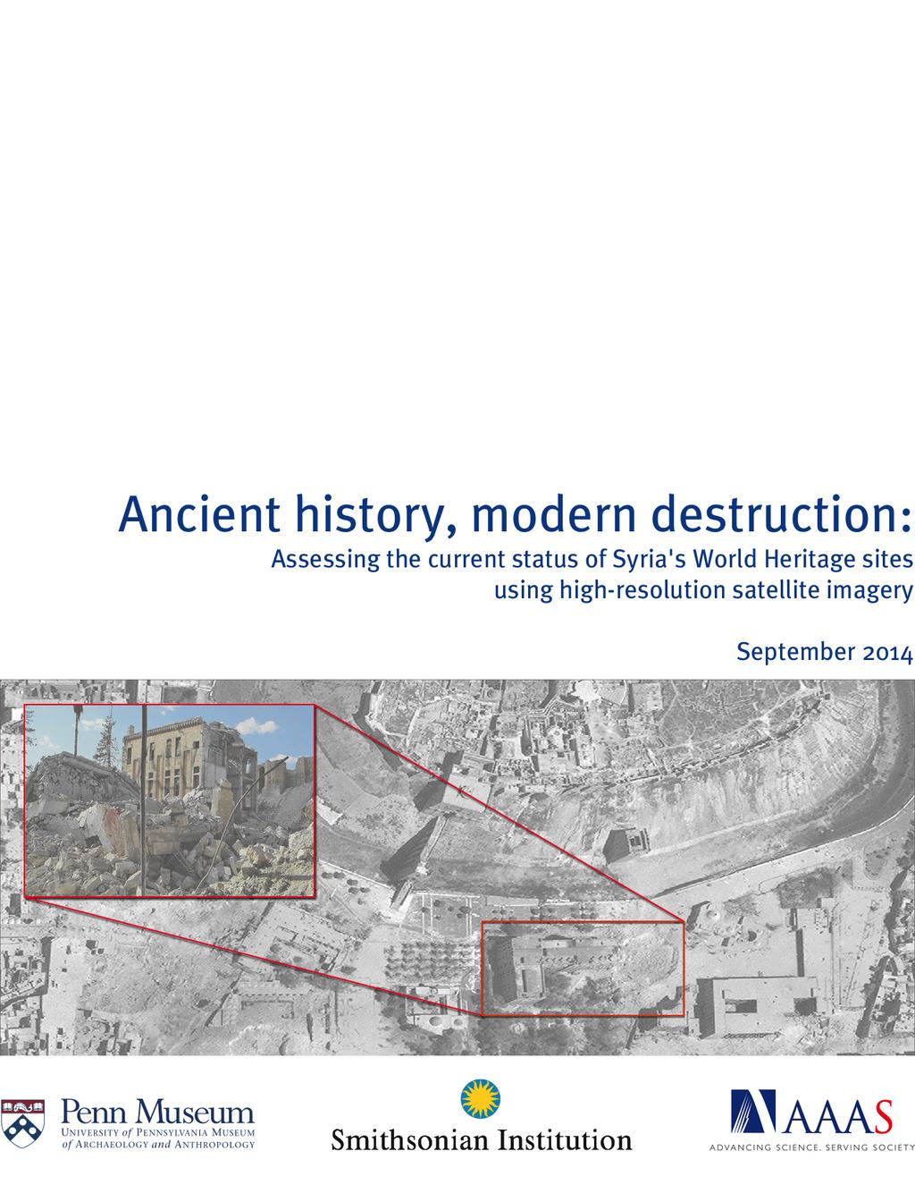
3 Ancient History, Modern Destruction: Assessing the Current Status of Syria s World Heritage Sites Using High- Resolution Satellite Imagery Executive Summary In partnership with the University of Pennsylvania Museum of Archaeology and Anthropology s Penn Cultural Heritage Center (PennCHC) and the Smithsonian Institution, and in cooperation with the Syrian Heritage Task Force, the Geospatial Technologies and Human Rights Project of the American Association for the Advancement of Science (AAAS) undertook an assessment of Syria s World Heritage sites using high- resolution satellite imagery (Figure 1). Syria has six World Heritage sites: the Ancient City of Aleppo, the Ancient City of Bosra, the Ancient City of Damascus, the Ancient Site of Palmyra, the Ancient Cities of Northern Syria, and Crac des Chevaliers and Qal at Salah El- Din. 1 The purpose of the assessment was to determine the current status of each site. Analysis indicates that five of the six World Heritage sites exhibit significant damage; damage was observed at every site except for the Ancient City of Damascus. Figure 1: Overview of Syrian World Heritage sites Map: AAAS Introduction 1 3
4 Damage to Syria s cultural heritage has been widely reported in the news and in social media since the outset of the present civil war in The potential for harm extends to all six Syrian sites that have been inscribed on the World Heritage list. By their date of inscription, these are: the Ancient City of Damascus (1979), the Ancient City of Bosra (1980), the Site of Palmyra (1980), the Ancient City of Aleppo (1986), the Crac des Chevaliers and Qal at Salah El- Din (2006), and the Ancient Villages of Northern Syria (2011). In 2013, the World Heritage Committee took the significant step of placing all six of these sites on the List of World Heritage in Danger maintained by UNESCO s World Heritage Centre. 2 A number of reports summarizing damage to Syria s cultural heritage have appeared since the onset of the conflict in Syria in To date, overviews have been published on World Heritage sites and the destruction of museums, historic structures, and archaeological sites. These include periodic reports by UNESCO, 3 governmental 4 and non- governmental organizations, 5 activist groups, 6 and scholarly articles. 7 AAAS previously released reports on the conflict in Aleppo, which included an analysis of damage to the World Heritage area. 8 However, no work to date has documented the extent of damage to all of Syria s World Heritage sites using recent high- resolution satellite imagery coupled with news media, social media, and verified, on- the- ground information. This report provides an assessment of all six Syrian World Heritage sites by comparing each site prior to the current conflict to their current status, as visible in satellite imagery. Since this is an overview assessment, this report will be followed by future in- depth analysis and time- series reviews of the data available for each individual site in order to construct a site based timeline of damage syrian- cultural- heritage/ _2013Apr11_HIU_U771.pdf 5 syrianheritage.org; new- satellite- images- show- homs- shelling; E. Cunliffe, (2012) document_2107.pdf Archaeology; 7 C. Ali, (2013) Syrian heritage under threat, Journal of Eastern Mediterranean Archaeology and Heritage Studies, 1(4), ; S. Al Quntar, (2013) Syrian cultural property in the crossfire: Reality and effectiveness of protection efforts, Journal of Eastern Mediterranean Archaeology and Heritage Studies, 1(4), ; J. Casana, (2014) Satellite- based monitoring of looting and damage to archaeological sites in Syria, Journal of Eastern Mediterranean Archeology and Heritage Studies; E. Cunliffe, (2013) No longer lost in the wilderness: Cultural property crimes in conflict, Journal of Eastern Mediterranean Archaeology and Heritage Studies, 1(4), ; K. Hanson, (in review) Cultural Heritage in Crisis: An Analysis of Archaeological Sites in Syria through Google Earth and Bing Map Satellite Imagery, Journal of Archaeological Science. 8 ; 4
5 Data and Methods AAAS acquired the most recently available high- resolution satellite imagery covering each of Syria s world heritage sites. Imagery was available for all sites, with varying pre- conflict dates. Regardless, an image from prior to the conflict was compared with the most recently acquired image. The imagery used was collected by satellites owned and operated by DigitalGlobe, and the relevant acquisition information is listed in tables in the following subsections. World Heritage Site Analysis 1. Ancient City of Aleppo Overview As one of the oldest continuously inhabited cities in the world, Aleppo has long been the urban, commercial, and cultural center of northwestern Syria. Aleppo s role as a commercial hub and a trade center that began in the 2 nd millennium BC and reached its peak during the 16 th - 18 th centuries AD In the center of the ancient city, the Aleppo citadel rises 50m above the surrounding area and dates to the 10 th century BC, or earlier, and stands on the remains of Hittite, Hellenistic, Roman, Byzantine, Seljuk, and Ayyubid period buildings. The surrounding walled city dates to the same periods, with still standing structures and architectural remains. Surviving remains include medieval gates, 6 th century Christian structures, Roman period street plans, Ayyubid and Mamluk mosques and schools, and many Ottoman period homes and palaces. One of the most well- known cultural sites in Aleppo is the Great Mosque, which was founded in the Umayyad period and rebuilt in the 12 th century with a Mamluk minaret dated to AD Next to the Umayyad Mosque is a Byzantine cathedral that later became the al Halawyah Madrassa a Koranic school. The Ancient City of Aleppo was inscribed on the World Heritage List in During the past two years, Aleppo has been the frontlines in the present conflict. On 15 July 2012, the International Committee of the Red Cross characterized the escalating conflict as a civil war, a designation that has since entered into common usage in the news media. 10 Since 19 July 2012, reports indicate that government and opposition forces have continued to clash both in and around the city. Accounts of the conflict in Aleppo describe a conflict characterized by heavy fighting, widespread shelling by tanks and artillery, and numerous civilian casualties middle- east release/2014/ syria- damascus- aleppo- violence- civilians.htm; 5
 of Aleppo were acquired and analyzed to assess damage to the Ancient City (Figure 2).")
6 Data Table 1: Aleppo imagery acquired Date Sensor Image ID 6 December 2011 WorldView FA1E July 2014 WorldView August 2014 WorldView F00 All imagery acquired via DigitalGlobe, NextView license Three images (Table 1) of Aleppo were acquired and analyzed to assess damage to the Ancient City (Figure 2). An image captured on 6 December 2011 was used to assess the ancient city prior to the start of the current conflict. An image from 14 July 2014 was the most recent multi- spectral image available at the time of analysis. An additional image, captured on 10 August 2014, was acquired to supplement the 14 July 2014 image. This image revealed considerable damage to the old city between 14 July and 10 August Analysis Figure 2: Boundary of the Ancient City of Aleppo Image 2014, DigitalGlobe, NextView License Analysis AAAS. The city of Aleppo has experienced some of the heaviest fighting of the Syrian civil war. A report, published by AAAS in August 2013 and titled Conflict in Aleppo, Syria: A Retrospective Analysis, documented the effect of the war on the city as of 26 May Considerable damage was seen within the old city, including damage to the Great Mosque of Aleppo and the ancient Suq al- Madina covered market. Since that time, the fighting in Aleppo has intensified, which has led to damage to multiple important historical sites throughout the Ancient City. Destruction is visible throughout the site. Debris is present across the area and blocks of structures have been reduced to rubble. Many of these are large and built with durable materials, such as stone, bricks, and mud brick adobe, suggesting intense bombing. The 6

 and 14 July 2014, the roof of the Suq al- Madina was damaged (green arrow), the minaret of the")
7 destroyed structures include historic mosques and madrassas, government buildings, and civilian structures. In spring 2013, it was reported that the minaret of the Great Mosque of Aleppo had been destroyed during the fighting. AAAS documented this damage in its August 2013 report. Since that time, two additional craters have appeared along the eastern wall of the mosque. The nearby Suq al- Madina was also heavily damaged, as were multiple other structures (Figure 3). Figure 3: Damage to the Great Mosque, Suq al- Madina, and surrounding area Between 6 December 2011 (top) and 14 July 2014, the roof of the Suq al- Madina was damaged (green arrow), the minaret of the Great Mosque was destroyed (red arrow) and two craters appear on the eastern wall (blue arrows). In addition, multiple nearby structures were heavily damaged (yellow arrows). Images 2014, DigitalGlobe, NextView License Analysis AAAS. Coordinates: 36.19N, 37.15E. 7

8 Much of the heaviest damage was concentrated in the area immediately south of the citadel. This area contains government buildings, such as the Ministry of Justice headquarters, a police headquarters, and the Grand Serail of Aleppo, which was the main government building in the city under the French Mandate. Other historic structures that were damaged and destroyed include the Hammam Yalbougha an- Nasry (late 15 th century), the Khusruwiye Mosque (mid- 16 th century), and the Carlton Citadel Hotel (19 th century). By 14 July 2014, the Carlton Citadel Hotel and several adjacent structures had been completely destroyed, while the Khusriwiye Mosque, the Ministry of Justice building, and the police headquarters had been heavily damaged. Between 14 July 2014 and 10 August 2014, the Khusriwiye Mosque was almost completely destroyed, leaving a crater 40m in diameter where the building formerly stood. Similarly, a second 40m crater eliminated the east wing of the Grand Serail. The dome of the public bathhouse was also destroyed. Figure 4: Damage to the area south of the citadel 8
. The Carlton Citadel Hotel (blue arrow) was completely destroyed along with many surrounding structures (yellow arrows).")
. Images 2014, DigitalGlobe, NextView License Analysis AAAS. Coordinates 36.")
9 Between 6 December 2011 (top) and 14 July 2014 (middle), the Ministry of Justice building was heavily damaged (red arrow), as was the Khusriwiye Mosque (green arrow). The Carlton Citadel Hotel (blue arrow) was completely destroyed along with many surrounding structures (yellow arrows). By 10 August 2014, the Khusriwiye Mosque had been almost completely demolished (green arrow), the Grand Serail was heavily damaged (orange arrow) and the dome of the Hammam Yalbougha an- Nasry was destroyed (purple arrow). Images 2014, DigitalGlobe, NextView License Analysis AAAS. Coordinates 36.19N, 37.16E. 9
 to the late Ottoman period (19 th century).")
10 Satellite imagery also revealed substantial damage in the area north of the citadel. This area contains buildings dating from the late Mamluk period (13 th - 16 th century) to the late Ottoman period (19 th century). The east wall Khan Qurt Bey caravanserai, a historic site dating to the end of the 15 th century, was also heavily damaged. In addition, most of the structures in the neighborhood immediately east of the caravanserai have been completely destroyed and nearby structures heavily damaged. Figure 5: Ground view of the Grand Serail in Aleppo Ground view of the Grand Serail in Aleppo (The orange arrow in figure 4). Photo: Aleppo Archaeology September ( Archaeology) 10


11 Figure 6: Damage to the Kahn Qurt Bey caravanserai Between 6 December 2011 (top) and 14 July 2014, the east wall of the Kahn Qurt Bey caravanserai was demolished (blue arrow). Multiple other nearby structures were also heavily damaged (yellow arrows). Images 2014, DigitalGlobe, NextView License Analysis AAAS. Coordinates: 36.20N, 37.15E. 11
12 2. Ancient City of Bosra Overview Located in the southern Syrian Da ara governorate, the ancient city of Bosra is best known as a major archaeological site with remains from the Roman, Byzantine, and early Islamic periods. The city rose to prominence in the Islamic period when it became an important node on the pilgrim route to Mecca and, at its height, Bosra once included approximately 80,000 residents. However, the city began to decline in the 17 th century, though it remains an important local urban center. The Ancient City of Bosra includes significant Roman remains from its period as the northern capital of the Nabataean kingdom of the Roman province of Arabia. The 2 nd century AD Roman theatre is one of the best preserved examples from this period, and there are extensive Roman archaeological remains nearby. After the 5 th century AD, the theater was fortified as a citadel to protect the route to Damascus. During the Byzantine period, Bosra became an important religious city and caravan stop evidenced by the Bosra Basilica of the Martyrs (6 th century) and the Cathedral of Bosra. Islamic period architectural remains in Bosra include the Al- Omari Mosque (AD 720), one of the oldest mosques in the world, and the Madrasa Jami' Mabrak an- Naqua (12 th century). Bosra has long been recognized as an important archaeological site and was inscribed on the World Heritage List in Bosra and its surrounding region in the Da ara governorate have seen increasing violence during the conflict. Since the autumn of 2012, there are reports of damage to parts of the ancient city caused by tank shelling and bombs. 13 During 2013, there were reports of snipers regularly shooting from the Roman Theater/Fortress. 14 Data AAAS acquired imagery of Bosra from two dates: a pre- conflict image acquired during February 2011, and a current image from April The details of this imagery are outlined in Table 2. Table 2: Bosra imagery acquired Date Sensor Image ID 23 February 2011 WorldView C April 2014 WorldView A400 All imagery acquired via DigitalGlobe, NextView license forces- bury- cradle- of- kings.html; Qr8 12
13 Analysis Signs of conflict were evident in imagery of Bosra, and included phenomena such as roadblocks, destroyed buildings, and earthen fortifications in the modern city. Within the boundaries of the World Heritage site, the Roman theater, often considered the primary attraction of the Ancient City, showed no visible signs of damage, although an earthen ramp has been constructed over a staircase on its eastern entrance and that entryway is surrounded by berms (Figure 7). One hundred fifty meters to the west of the Roman theater, at an area of the site identified as the site of a second amphitheater, a vehicle track was observed leading to a low hillock, adjacent to a government building (Figure 7). In the northern portion of the heritage site, near its boundary with the modern city, two small high- albedo areas are visible, in a pattern that is consistent with mortar impacts. A hole observed in the nearby Al- Omari Mosque (AD 720) provides further evidence that this area was bombarded by mortars. Substantial damage was observed to a few modern buildings, and the shelling appears to have affected a relatively small portion of the Ancient City (Figure 8). 13
14 Figure 7: Earthen ramps and berms at the Bosra Roman Theater and nearby road excavations On 23 February 2011 (top), the Roman theatre and nearby archaeological site are undisturbed. By 29 April 2014, however, earthen ramps and berms have been constructed near the theater s east entrance, and a small hill at the site to the west has been partially excavated (arrows). Images 2014, DigitalGlobe, NextView License Analysis AAAS. Coordinates: 32.51N, 36.48E. 14


15 Figure 8: Shell craters and structural damage at the Bosra World Heritage site Between October 2009 and April 2014, a number of probable shell craters associated with structural damage have appeared in the Bosra World Heritage site (yellow arrows) including a hole in the roof of the Al- Omari Mosque. A probable shell crater is also present in the standing ancient Roman ruins. Images 2014, DigitalGlobe, NextView License Analysis AAAS. Coordinates: 32.51N, 36.48E. 15
16 3. Ancient City of Damascus Overview Damascus is Syria s capital and one of the oldest cities in the world. Beginning with the Aramaic kingdom (11 th - 7 th centuries BC), Damascus grew into the political and urban hub for the region. Today, the ancient city encompasses over 125 cultural heritage sites that represent Damascus long history, including archaeological and architectural remains from the Hellenistic, Roman, Byzantine, Islamic, and Ottoman periods. The ancient city still follows the orientation established during the Hellenistic period and the Roman city street plan and city walls are visible today. Damascus is perhaps best known for the surviving remains from when the city was the capitol of the Umayyad caliphate. The best- preserved architecture from the Umayyad building program is the Great Mosque (8 th century), which lies on top of an Assyrian temple, Roman temple and Christian basilica. The Ayyubid Citadel is another famous Damascus site with massive defensive architecture and courtyards (11 th century). Today, most historic buildings within the Ancient City of Damascus World Heritage site boundary date from the period after the Ottoman conquest (16 th century). The ancient city of Damascus was inscribed on the World Heritage List in The Syrian Ministry of Culture's Directorate- General of Antiquities and Museums has reported mortar damage in the vicinity of the Old City. 15 These claims have been repeated in a recent report by the American Schools of Oriental Research. 16 The AAAS analysis has not been able to identify or locate this damage. The Ancient City of Damascus has been largely protected from the violence that has heavily impacted neighborhoods surrounding the city. Isolated incidents, such as car bombs and firefights, have taken place in central neighborhoods in Damascus, with no known reports of damage inside the ancient walled city. 17 In contrast, the outskirts of Damascus have been heavily impacted by clashes and many suburbs have been decimated, though, as of this writing, there are no known reports of this conflict impacting the area inside the World Heritage site boundaries of the Ancient City. 18 Data Table 3: Damascus imagery acquired Date Sensor Image ID 11 May 2011 WorldView A8B0F00 12 August 2014 WorldView All imagery acquired via DigitalGlobe, NextView license syrianheritage.org/shi- weekly- report- i- august syria- idusbre8280g ; mortar- fire- kills- 12- in- damascus- hrw- accuses- regime- of- barrel- bomb- civilians/; middle- east syria- crisis- impact- idusbrea3118e

17 Analysis Figure 9: Ancient City of Damascus Image 2014, DigitalGlobe, NextView License Analysis AAAS. Two images of the Ancient City of Damascus were acquired and analyzed (Table 3). The first, from 11 May 2011, was captured around the time that protests against the Syrian government were starting. The second, captured on 12 August 2014, was the most recent image available. Analysis of these images revealed no major signs of conflict within the Ancient City. Though damage to structures, as well as roadblocks, were observed in other areas of Damascus, neither were observed within the boundary of the Ancient City. The density of structures within the Ancient City obscured the view of many streets, so it is possible that structures were damaged in ways that were not observable from the overhead vantage point provided by satellite imagery. 17
18 4. Ancient Site of Palmyra Overview In the middle of Syrian desert, Palmyra s monumental Greco- Roman and Persian ruins were one of the major tourist attractions in Syria prior to the present conflict. The Ancient Site of Palmyra gained its position of prominence through its location as the main stop for caravan trade from approximately 44 BC to 272 AD. Palmyra s grand colonnade is a 1,100m long Roman period street that connects a temple to the god Bel with the area known as the Camp of Diocletian. Other archaeological remains in the ancient city of Palmyra include an agora, theatre, urban quarters, and other temples that comprise what is generally considered by scholars to be the finest example of surviving Roman architecture in the Eastern Mediterranean. Four cemeteries outside the city wall are in an area known as the Valley of the Tombs. Also in the archaeological zone of Palmyra stands the Fakhr- al- Din al- Ma'ani Castle (also known as the Palmyra Castle or Qal at ibn Mann). This heavy fortification dates to the 13 th century and overlooks the rest of the site. The northern portion of Palmyra also hosts a modern camel racetrack. Palmyra was inscribed on the World Heritage List in The Ancient Site of Palmyra and its surrounding archaeological area have all sustained significant damage, as it has been caught in the middle of intense firefights accompanied by extensive military occupation. Reports of looting and thefts in the Palmyra archaeological zone and thefts began in spring 2012 and continue. 20 By March 2013, the first reports of shelling damage to the site emerged 21 and around that same time were the first reports of snipers positioned in the Roman theater and in other standing ruins. 22 Throughout 2013, the Syrian military forces ramped up its efforts to control the area and used the site to house its equipment. Reports indicated the presence of rocket launchers and tanks inside the archaeological site. 23 As the Syrian Arab Republic Government (SARG) s military forces gained ground, extensive defensive berm and road construction were reported throughout Palmyra / experts- sound- alarm- over- syria- archaeological- treasures.ashx#ixzz1rl7tzd6a; today.com/index.php/life/ sos- for- a- precious- legacy; 93&type=1&relevant_count=1&ref=nf; s- ancient- city- of- Palmyra- on- brink- of- destruction.html 21 s- ancient- city- of- Palmyra- on- brink- of- destruction.html; of- bel- damaged- syria_n_ html dky syrian- city- archaeological- site- palmyra- in- danger- of- collapse &type=1&relevant_count=1&ref=nf content/uploads/2014/03/26- March pdf; war- takes- heavy- toll- at- a- crossroad- of- cultures.html?_r=1 18
19 Data The current state of the Palmyra World Heritage Site was assessed using imagery from 2009 and 2014, as described in Table 4. Table 4: Palmyra imagery acquired Date Sensor Image ID 10 October 2009 WorldView C60F00 8 March 2014 WorldView DAE2400 All imagery acquired via DigitalGlobe, NextView license Analysis A comparison of imagery revealed that the site of Palmyra had been substantially altered from its pre- conflict state. New roads, flanked by earthen berms, were cut through the center of the Northern area of the Palmyra Archaeological Park, and groups of military vehicles were visible occupying fortified positions at that location, as well as at a parking area built atop the ancient city wall, which was destroyed by this construction (Figures 10-12). Comparing this imagery to video acquired by ground- based activists reveals that some of these vehicles are BM- 21 Grad multiple launch rocket systems. Also confirmed by ground- based imagery was the construction of temporary structures adjacent to Fakhr- al- Din al- Ma'ani Castle, in the northwestern corner of the site (Figure 11). Additional earthen fortifications, though unoccupied at the time of image acquisition, were scattered throughout the site (Figures 10 and 12). The effect of this massive earth movement on the site s archaeological integrity is unknown, but appears to be substantial. Within the Roman barracks of Diocletian s camp the previously well- defined outlines of ancient ruins appear to have been softened, though the precise reason for this is unclear (Figure 12). Ground- based photos show that several walls at the site, formerly intact, have been demolished and their building materials strewn about, providing one possible explanation for the phenomenon (Figure 13). 19
, the northern section of the Palmyra Archaeolgoical Park has been disrupted by the construction of a")
. Images 2014, DigitalGlobe, NextView License Analysis AAAS. Coordinates: 34.55N, 38.26E.")
20 Figure 10: Disruptions in the Northern Section of the Palmyra Archaeological Park Between 10 October 2009 (top) and 8 March 2014 (bottom), the northern section of the Palmyra Archaeolgoical Park has been disrupted by the construction of a new road traversing the site, and numerous earthen berms (pink arrows), many of which are being used to provide cover for military vehicles (yellow arrows). Images 2014, DigitalGlobe, NextView License Analysis AAAS. Coordinates: 34.55N, 38.26E. 20

.")
21 Figure 11: Trailers on the Fakhr- al- Din al- Ma'ani Castle Between October 2009 (top) and March 2014 (bottom), the road leading to Fakhr- al- Din al- Ma'ani Castle has been reinforced with earthen berms, and two trailers have been emplaced near the citadel an observation which corresponds to ground- based photographs (bottom, inset). Photo: Association for the Protection of Syrian Archaeology, August 2014 ( ). Satellite images 2014, DigitalGlobe, NextView License Analysis AAAS. Coordinates: 34.55N, 38.26E. 21
 are intact in October 2009 (top).")
, and the terrain in the camp has softened.")
22 Figure 12: Destruction of the ancient city wall and terrain softening The ancient city wall of Palmyra (yellow arrow) and the barracks of Diocletian s camp (purple arrow) are intact in October 2009 (top). By March 2014 (bottom), a portion of the wall has been destroyed for a military encampment (pink arrow), fortified by earthen berms (blue arrows), and the terrain in the camp has softened. Images 2014, DigitalGlobe, NextView License Analysis AAAS. Coordinates: 34.55N, 38.26E. 22

23 Figure 13: Ground view of possible causes of terrain softening Photo: Association for the Protection of Syrian Archaeology, August 2014 ( ) 5. Ancient Villages of Northern Syria Overview The Ancient Villages of Northern Syria, also known as the Dead Cities, are archaeological parks in northwestern Syria. This cultural landscape is marked by an abundance of standing archaeological ruins that date primarily to the Late Antique and Byzantine periods (approximately the 1 st - 7 th centuries). Inscribed on UNESCO s World Heritage List in 2011, this cultural heritage site is comprised of eight parks (Jebel al A la, Jebel Barisha, Jebel Seman 1, Jebel Seman 2, Jebel Seman 3, Jebel Wastani, Jebel Zawiye 1, and Jebel Zawiye 2), and these include forty individual village sites. 25 Altogether, the sites within these park boundaries and additional sites in surrounding areas outside the boundaries total nearly 180. Analysis was limited by the availability of recent imagery, and as a result, the archaeological parks of Jebel Zawiye 1, Jebel Zawiye 2, and the sites outside the World Heritage site were not included in this study. When new imagery becomes available, AAAS will update these sites and analyze the full extent of the Dead Cities, not only those within the World Heritage site boundaries
24 Figure 14: Location of the archaeological parks included in the Ancient Cities of Northern Syria Map: AAAS A significant risk for the Dead Cities is their proximity to contested areas. Bab al- Hawa is a major border crossing between Syria and Turkey and the entry point for supplies to armed combatants throughout Syria. According to news reports, these supplies were stored in warehouses at the nearby Byzantine site of Babisqa in the Jebel Barisha World Heritage archaeological park. In December 2013, a firefight took place in the area, resulting in damage to the site and military force buildup in the surrounding area of the archaeological park. 26 It is 26 idleb- villes- antiques- du- nord- de- la- syrie- destruction- des- monuments- byzantins- a- babisqa- 2.html; 24
25 important to note that not all damage is visible in high- resolution satellite imagery, and the many reports of looting at these archaeological parks cannot be verified through this analysis. Affiliated ground assessments of this type of damage are ongoing (Figure 15). In northwestern Syria, there is particular concern over the status and condition of internally displaced persons (IDPs). Established Syrian IDP camps have been analyzed with satellite imagery through UNITAR; 27 however, no work to date has documented the extent of the displacement crisis outside of established camps. The World Heritage archaeological parks in this region have been broadly reported to be housing IDPs as well as armed combatants. The Jebel Seman 1-3 parks are the closest to Aleppo, and, as the conflict in Aleppo intensified, IDPs and rebel groups have passed through or set up camp in the archaeological park. Jebel Zawiye 1 and 2 have seen an influx of IDPs due to the impact of major fighting nearby at Maarat al- Numan beginning in October Maarat al- Numan is a strategically significant town located on the highway between Damascus and Aleppo. Rebels seized the town on 9 October 2012, followed by heavy fighting and raids by government jets. 28 On 14 April 2013, the Syrian Army broke the siege of the military compounds outside of Maarat al- Numan and heavy fighting engulfed the area. 29 Since that time fighting in the region has escalated, 30 and many international news sources have reported that IDPs who fled the violence in the vicinity of Maarat al- Numan are living inside ancient tombs and among the ruins of the Dead Cities. 31 As part of this study, a review was undertaken of IDPs across the archaeological parks of the Ancient Villages of Northern Syria World Heritage site and the broader Dead Cities region. The results will not be detailed in this report. Upon examination of the findings and after consultations with humanitarian aid organizations, this project s investigators have determined that discussing the spatial distribution of IDPs would place them at undue risk for harm. This portion of the study will be made available to humanitarian organizations upon request europe ; loyalists- breach- rebels- blockade- of- military- bases.html?_r=0; understandingwar.org/backgrounder/syria- update- regime- breaks- siege- wadi- al- deif VBT3c8Z5- LE 31 syrians- find- shelter- in- ancient- dead- cities; in- need- has- helped- almost syrians- refugees- in- idlib- provided- with- shelter- blankets- and- food; refugees- fight- for- survival- in- dead- cities/ 25


26 Figure 15: Ground photos of a tomb from the site of Al Bara in the Jebel Zawiya Archaeological Park Ground photos of a tomb from the site of Al Bara in the Jebel Zawiya archaeological park illustrate looting that is not visible in satellite imagery. Source kept anonymous for protection. Distributed by Le patrimoine archéologique syrien en danger (PASD),
27 Jebel al A la - Ancient Villages of Northern Syria Data Table 5: Jebel al A la imagery acquired Date Sensor Image ID 7 July 2011 WorldView CBEB June 2014 WorldView All imagery acquired via DigitalGlobe, NextView license Two images of the Jebel al A la Ancient Village Park were acquired and analyzed (Table 5). The first, from 7 July 2011, was captured prior to the start of major fighting. The second, from 16 June 2014, was the most recent image available at the time of analysis. Analysis of the imagery did not reveal any damage to archeological sites within the Park. In addition, only a small number of new structures in the Park were observed. These new structures were primarily near existing settlements, with none were constructed on or near archeological sites. Jebel Barisha - Ancient Villages of Northern Syria Data Table 6: Jebel Barisha imagery acquired Date Sensor Image ID 7 July 2011 WorldView CBEB July 2013 WorldView C92A00 7 September 2013 WorldView February 2014 WorldView C91FC00 23 March 2014 WorldView D May 2014 WorldView August 2014 WorldView BDC900 All imagery acquired via DigitalGlobe, NextView license Two images of the Jebel Barisha Ancient Village Park were initially acquired and analyzed. The first was captured on 7 July 2011, and shows the park at the start of the Syrian civil war. The second, captured on 10 August 2014, was the most recent image available at the time of analysis. Analysis of the two initial images revealed the creation of three compounds: two within the Park boundaries and one just outside the park (Figure 16). An armored vehicle was observed at one of the compounds, suggesting a military function. Six additional images between 23 March 2013 and 23 May 2014, were acquired to further investigate these compounds. 27
.")

.")

28 Figure 16: New compounds at Jebel Barisha Three new compounds were constructed between 7 July 2011 (left) and 10 August 2014 (right). An armored vehicle (green square) was observed at one compound inside the park boundary Image 2014, DigitalGlobe, NextView License Analysis AAAS. Coordinates: 36.21N, 36.67E. Construction of the compounds was underway by 17 July 2013 and appears to have been completed by 6 February It involved the construction of two compounds in the southern area and one in a northern location (Figure 17). Heavy vehicles were observed at the southern two compounds, but the only distinctly military equipment observed was the armored vehicle present on 10 August Figure 17: Construction of the three compounds Construction on all three compounds had begun by 17 July 2013 (yellow arrows, left) and was completed by 6 February 2014 (right). Image 2014, DigitalGlobe, NextView License Analysis AAAS. Coordinates: 36.21N, 36.67E. 28


.")
, the tents had been rearranged slightly and two larger structures had been added (yellow")
29 At the northern compound, 148 structures, possibly tents, were observed on 7 September The structures had dimensions of approximately 4x4m and were laid out in orderly rows, which suggest a military purpose. By 6 February 2014, the tents had been rearranged slightly, and nine new tents were present, bringing the total to 157. In addition, two larger structures had been added. By 23 March 2014, only 39 tents remained at the site and all had been removed by 23 May 2014 (Figure 18). Figure 18: Tents at the north compound On 7 September 2013 (A), 148 tents were observed at the north compound. By 6 February 2014 (B), the tents had been rearranged slightly and two larger structures had been added (yellow arrows). On 3 March 2013 (C) only 39 tents were present and all had been removed by 23 May 2014 (D). Image 2014, DigitalGlobe, NextView License Analysis AAAS. Coordinates: 36.22N, 36.67E. 29

. New structures were also observed within the site of Bamuqa (Figure 20).")
 and 10 August 2014 (right), a standing ruin was")

30 In addition to the construction of military compounds in and around the park, damage to two archeological sites was observed. At the ancient village site of Dar Qita, standing ruins were knocked down to make way for a new road (Figure 19). New structures were also observed within the site of Bamuqa (Figure 20). Bamuqa straddles the park boundary, but new structures were observed on both sides of the boundary. Figure 19: Damage to Dar Qita Between 7 July 2011 (left) and 10 August 2014 (right), a standing ruin was knocked down to make way for a new road (yellow arrow). Image 2014, DigitalGlobe, NextView License Analysis AAAS. Coordinates: 36.21N, 36.66E. Figure 20: New structures at Bamuqa Multiple tents (yellow arrows) appear at Bamuqa between 7 July 2011 and 10 August Image 2014, DigitalGlobe, NextView License Analysis AAAS. Coordinates: 36.20N, 36.63E. 30


31 Jebel Seman 1 - Ancient Villages of Northern Syria Two images of the Ancient Village Park of Jebel Seman 1 were acquired and analyzed (Table 7). The first, captured on 1 November 2010, shows the Park prior to the outbreak of the Syrian civil war. The image captured on 26 August 2014 was the most recent image available at the time of analysis. Analysis of the Park revealed new structures on or near several archeological sites. In addition, at one site, Takleh, a road had been constructed near the site leading to what appears to be a small quarrying operation. A similar phenomenon was observed within both the Jebel Seman 2 and Jebel Seman 3 at a larger scale. As a result, this will be discussed in greater detail in those sections. Data Table 7: Jebel Seman 1 imagery acquired Date Sensor Image ID 1 November 2010 WorldView DB3B August 2014 WorldView F8A600 All imagery acquired via DigitalGlobe, NextView license In addition to the damage to Takleh, new structures were observed on and near archeological sites. At the Dead City site of Refade, multiple tent- like structures were observed within the ruins (Figure 21). Several new structures were also observed near the town of Deir Semaan. The town is situated between archeological sites. Between 1 November 2010 and 26 August 2014, structures were built on, or in close proximity to, some of these sites (Figure 22). Finally, a tent- like structure was erected inside the walls of the Basilica of Saint Simeon (Figure 23). Figure 21: New structures near Refade Multiple new structures (yellow arrows) appear between 1 November 2010 (left) and 26 August 2014 (right). Image 2014, DigitalGlobe, NextView License Analysis AAAS. Coordinates: 36.31N, 36.82E. 31
 and 26 August")


.")
32 Figure 22: New structures at Deir Semaan Multiple new structures appear between 1 November 2010 (left) and 26 August 2014 (yellow arrows, right). Image 2014, DigitalGlobe, NextView License Analysis AAAS. Coordinates: 36.21N, 36.83E. Figure 23: New structure within the Basilica of Saint Simeon A tent- like structure (yellow arrow) was observed within the Basilica of Saint Simeon on 26 August 2014 (right). Image 2014, DigitalGlobe, NextView License Analysis AAAS. Coordinates: 36.33N, 36.84E. 32
33 Jebel Seman 2 - Ancient Villages of Northern Syria Data Table 8: Jebel Seman 1 imagery acquired Date Sensor Image ID 1 November 2010 WorldView DB3B100 3 July 2014 WorldView F790A00 All imagery acquired via DigitalGlobe, NextView license The archaeological features of the site consist of several foundation clusters spread across an area of approximately 80 km 2, the western boundary of which is located two kilometers to the east of Jebel Seman 1. As was the case at the Jebel Seman 1, this site shows evidence of substantial mining activity between 2010 and 2014, with areas of previously undisturbed rock removed and pushed aside, while new access roads were constructed to enable access to the existing transportation network. The establishment of these extractive industries was observed to have taken place in close proximity to ancient foundations (Figure 24). Several modern villages also exist within the boundaries of the Jebel Seman 2 archaeological park. Between 2010 and 2014, a small number of new structures were erected on the periphery of these settlements; however, due to their small number, this development most likely represents regular population expansion. Figure 24: Mining activity in close proximity to ancient city Between 2010 (left) and 2014 (right), mining activity (yellow arrow) has taken place directly adjacent to Kafr Nabo, an archaeological site inside the Jebel Seman 2 World Heritage Site (red arrows). Image 2014, DigitalGlobe, NextView License Analysis AAAS. Coordinates: 36.35N, 36.91E. 33
34 Jebel Seman 3 - Ancient Villages of Northern Syria Jebel Seman 3 encompasses a 4.5 km x 12.5 km strip of territory oriented along a north- south axis. The northern edge is approximately three kilometers south of Jebel Seman 2. As at Jebel Seman 1 and 2, new roads and earthmoving activity consistent with mining activities were observed. Available evidence suggests that, while the disturbed areas have expanded, the extractive activity itself pre- dates the present conflict. No unambiguous signs of damage related to the current conflict were observed at this site. Jebel Wastani - Ancient Villages of Northern Syria Data Table 9: Jebel Wastani imagery acquired Date Sensor Image ID 5 December 2010 WorldView E July 2014 WorldView B8E200 All imagery acquired via DigitalGlobe, NextView license Two images of Jebel Wastani were acquired and analyzed (Table 9). The first, captured on 5 December 2010, shows the park before the start of the conflict. The second, from 15 July 2014, was the most recent image available at the time of analysis. Analysis of the imagery did not reveal any damage to archeological sites within the park. Only a small number of new structures were observed within the park during this time period. These were primarily near existing settlements and not constructed on or near archaeological sites. 6. Crac des Chevaliers and Qal at Salah El- Din Overview Located on high ridges, these two castles are in key defensive positions and represent the best- preserved examples of Crusader fortification architecture. These sites are, therefore, known as Crusader castles, but their still- standing architectural elements date from the Byzantine through Islamic periods. Crac des Chevaliers is also known as Qal'at al- Hosn, and originally dates to the 11 th century. It was first called the Castle of the Kurds. Crac des Chevaliers was rebuilt by the Hospitaller Order during the Crusader period and again in the late 13th century by the Mamluks. The Qal'at Salah El- Din, also known as the Fortress of Sayun or Chateau de Saone, originally dates to the 10 th century, was rebuilt in 12 th century, and added to in the late 12 th to mid- 13 th century. Although it is less well preserved than Crac des Chevaliers, its Byzantine through Ayyubid period architectural elements are still visible
35 Reports of damage to Crac des Chevaliers and violence in the surrounding region have been plentiful. As early as May 2012, there were reports of gunmen at the castle. 33 By July 2012, Free Syrian Army fighters were reported to be using the site, and, in response, the Syrian military shelled the castle, including the historic chapel. 34 Airstrikes on Crac des Chevaliers were reported in January 2013, 35 May 2013, 36 July 2013, 37 and March 2014, 38 and the shelling continued and intensified until the World Heritage site was captured by the Syrian Arab Republic Government s military forces on 20 March ,40,41 In contrast, there are no currently known reports of damage at Qal at Salah El- Din. Data The Crac des Chevaliers World Heritage site was imaged on three dates, as shown in Table 10. Data Table 10: Crac des Chevaliers imagery acquired Date Sensor Image ID 3 December 2008 WorldView E729D September 2013 WorldView D44A00 26 October 2013 WorldView A All imagery acquired via DigitalGlobe, NextView license Qal at Salah El- Din, northwest of Crac des Chevaliers, was analyzed using the imagery described in Table 11. Data Table 11: Qal at Salah El- Din imagery acquired Date Sensor Image ID 1 November 2010 WorldView E July 2014 WorldView F8D400 All imagery acquired via DigitalGlobe, NextView license 33 cultural- treasures- latest- uprising- victim/ fisk- syrias- ancient- treasures- pulverised html 35 shows- airstrikes- near- crusader- castle- in- syria/ East/2013/Jul- 13/ syrias- famed- crusader- fort- hit- in- air- raid.ashx#axzz2ywaudssk &feature=youtu.be 39 show/conditions- crac- des- chevaliers- syria- 2009%E2%80% violence- and- death- in- the- valley- of- the 41 show/conditions- crac- des- chevaliers- syria- 2009%E2%80%
36 Analysis Crac des Chevaliers appears to have sustained moderate structural damage. Its southeast tower has sustained damage measuring approximately 6m across, with an associated debris apron upon the lower parts of the structure. Three additional craters are visible on the northern areas of the castle, although, unlike the impact on the south tower, none of these appear to have penetrated the roof (Figure 25). At Qal at Salah El- Din, no damage to the structure was apparent, although a single structure, which may have been temporary, was observed to have disappeared from the car park between 2010 and
Ministry of Culture Directorate General of Antiquities & Museums STATE PARTY REPORT. On The State of Conservation of The
 Ministry of Culture Directorate General of Antiquities & Museums STATE PARTY REPORT On The State of Conservation of The Syrian Cultural Heritage Sites (Syrian Arab Republic) For Submission By 1 February
Dura Europos (Tell al-salilhiye) دورا أسوبورو
 دورا أسوبورو") Dura Europos (Tell al-salilhiye) دورا أسوبورو Deir Ez-Zor Governorate Temple of Bel in Dura Europos/Photo: Wikimedia Commons Satellite-based Damage Asessment to Historial Sites in Syria April 2, 2014 DIG
Dura Europos (Tell al-salilhiye) دورا أسوبورو Deir Ez-Zor Governorate Temple of Bel in Dura Europos/Photo: Wikimedia Commons Satellite-based Damage Asessment to Historial Sites in Syria April 2, 2014 DIG
Turkey Targets Archaeological Sites in Afrin
 Turkey Targets Archaeological Sites in Afrin Tourism and Protection of Relics Commission Aljazeera Region /http://desteya-shunwaran.com 2/2/2018 In Afrin region, there are hundreds of important archaeological
Weekly Report 6 September 15, Heritage for Peace posted its newsletter Damage to Syria s Heritage 14 September 2014.
 ASOR Syrian Heritage Initiative (SHI): Planning for Safeguarding Heritage Sites in Syria 1 NEA- PSHSS- 14-001 Heritage Timeline Weekly Report 6 September 15, 2014 Michael D. Danti and Kurt W. Prescott
Museums. 2 sites. Moderately Damaged. Possibly Damaged. Severely Damaged. No Visible Damage. Destroyed
 Museums Museum of Popular Art and Traditions (Bayt Ajiqbash) National Museum of Aleppo 2 sites 0 1 1 0 0 Destroyed Severely Damaged Moderately Damaged Possibly Damaged No Visible Damage 96 / THE STATE
STATE PARTY REPORT. Syrian Cultural Heritage Sites (Syrian Arab Republic) On The State of Conservation of The
 On The State of Conservation of The") Ministry of Culture Directorate General of Antiquities & Museums STATE PARTY REPORT On The State of Conservation of The Syrian Cultural Heritage Sites (Syrian Arab Republic) For Submission By 1 February
Ministry of Culture Directorate General of Antiquities & Museums STATE PARTY REPORT On The State of Conservation of The Syrian Cultural Heritage Sites (Syrian Arab Republic) For Submission By 1 February
oi.uchicago.edu AQABA Donald Whitcomb
 ARCHAEOLOGY Donald Whitcomb The city of Aqaba has a dual role in the nation of modern Jordan; first, it is a major port for maritime commerce and may soon become a free port for this region. This commerce
Castles of Syria (Syria) No THE PROPERTY Description 1. BASIC DATA 2. ACTIONS
 No THE PROPERTY Description 1. BASIC DATA 2. ACTIONS") Castles of Syria (Syria) No 1229 1. BASIC DATA State Party: Arab Republic of Syria Name of property: Castles of Syria Location: Crac des Chevaliers is in municipality of Al Hosn (Homs Governorate); Fortress
Castles of Syria (Syria) No 1229 1. BASIC DATA State Party: Arab Republic of Syria Name of property: Castles of Syria Location: Crac des Chevaliers is in municipality of Al Hosn (Homs Governorate); Fortress
Satellite Imagery Briefing: Monitoring Endangered Cultural Heritage Sites
 Satellite Imagery Briefing: Monitoring Endangered Cultural Heritage Sites Early Warning and Threat Monitoring System for Cultural Heritage Sites in the Developing World March 2011 Endangered Global Heritage
Territory and Habitat
 1 Hauran 6 Physical Features Syria lies on the eastern coast of the Mediterranean Sea, bounded by Turkey in the north, Iraq in the east, Jordan in the south and Lebanon and the Mediterranean Sea in the
Cyprus and Greece. We spent time enjoying the views over the sea and slowly strolled back to the hotel to complete our introductory day.
 Cyprus and Greece We are traveling again, this time spending two weeks in the Eastern Mediterranean, first in Cyprus and then in Greece. We have visited both countries before but it has been about 20 years
Violations Documentation Center in Syria. Summary of Breaches of Security Council Resolution 2401
 ﻣﺮﻛــــﺰ ﺗﻮﺛﻴـــــﻖ اﻻﻧﺘﻬﺎﻛـــــــﺎت ﻓﻲ ﺳﻮرﻳـــﺎ Summary of Breaches of Security Council Resolution 2401 Tuesday, 27 February 2018 The Violations Documentation Center (VDC) prepared and documented the
Gebel Barkal (Sudan) No 1073
 No 1073") Gebel Barkal (Sudan) No 1073 1. BASIC DATA State Party : Republic of Sudan Name of property: Gebel Barkal and the Sites of the Napatan Region Location: Northern state, province of Meroe Date received:
Gebel Barkal (Sudan) No 1073 1. BASIC DATA State Party : Republic of Sudan Name of property: Gebel Barkal and the Sites of the Napatan Region Location: Northern state, province of Meroe Date received:
FOUNDATIONS OF ARCHAEOLOGY A WALK IN VERNDITCH CHASE
 FOUNDATIONS OF ARCHAEOLOGY A WALK IN VERNDITCH CHASE 1. A Tale of two Long Barrows Long barrows were constructed as earthen or drystone mounds with flanking ditches and acted as funerary monuments during
100 th Anniversary of Armenian Scouting
 100 th Anniversary of Armenian Scouting ANNIVERSARY JAMBOREE August 3-11, 2012 BYURAKAN, ARMENIA For: 14-22 years old (no age limit for Contingent Leaders) Fee: Euros 200 Official languages: English, Armenian
archeological site LOS MILLARES
 archeological site LOS MILLARES Aerial view of the plain of Los Millares between the Rambla de Huéchar and the River Andarax The archaeological site of Los Millares is located in the township of Santa
CARLUNGIE EARTH HOUSE
 Property in Care (PIC) ID: PIC015 Designations: Scheduled Monument (SM90059) Taken into State care: 1953 (Guardianship) Last reviewed: 2004 HISTORIC ENVIRONMENT SCOTLAND STATEMENT OF SIGNIFICANCE CARLUNGIE
Petra, The World wonder
 City Tourism Petra, The World wonder ITM / Jordan Jordan s most valuable treasure and greatest tourist attraction. Al dier monastery petra gohoto The giant red mountains and vast mausoleums of a departed
Concept Document towards the Dead Sea Basin Biosphere Reserve and World Heritage Listing. This report has been presented to the public and to
 Concept Document towards the Dead Sea Basin Biosphere Reserve and World Heritage Listing. This report has been presented to the public and to political decision makers both regionally and internationally
Comment: Travel through the more remote regions of eastern Turkey and Cappadocia is always interesting. Some days do have long drives.
 +44 (0)20 8741 7390 Turkey and Syria: On part one of your epic journey, follow in the footsteps of some of the great medieval travellers such as Marco Polo and Ibn Battuta as you follow the Silk Road.
TH E FIRST SEASON of investigations at the
 QUSEIR AL-QADIM Janet H. Johnson & Donald Whitcomb TH E FIRST SEASON of investigations at the ancient port of Quseir al-qadim on the Red Sea in Egypt took place in winter, 1978; the investigations were
CAESAREA By Jim Pitts
 CAESAREA By Jim Pitts M ARITIMA CAESAREA BY THE SEA is located 30 miles north of Jaffa and 70 miles northwest of Jerusalem and was established by Herod the Great (37-4 BC) on the site of an ancient marina
Antinoupolis. Ongoing Destruction. Pre-2006 crops. Modern cemetery covering. ancient cemetery. Antinoupolis, ancient city. North cemetery (ancient).
.") Antinoupolis Ongoing Destruction Ongoing Destruction North cemetery (ancient). Pre-2006 crops Modern cemetery covering ancient cemetery. Antinoupolis, ancient city. Modern village of el Sheikh Abada Nile
Antinoupolis Ongoing Destruction Ongoing Destruction North cemetery (ancient). Pre-2006 crops Modern cemetery covering ancient cemetery. Antinoupolis, ancient city. Modern village of el Sheikh Abada Nile
Dr. Dimitris P. Drakoulis THE REGIONAL ORGANIZATION OF THE EASTERN ROMAN EMPIRE IN THE EARLY BYZANTINE PERIOD (4TH-6TH CENTURY A.D.
 Dr. Dimitris P. Drakoulis THE REGIONAL ORGANIZATION OF THE EASTERN ROMAN EMPIRE IN THE EARLY BYZANTINE PERIOD (4TH-6TH CENTURY A.D.) ENGLISH SUMMARY The purpose of this doctoral dissertation is to contribute
Frankfurter elektronische Rundschau zur Altertumskunde 2 (2006) Hazar Lake Sunken City. Çiğdem Özkan-Aygün
 Hazar Lake Sunken City. Çiğdem Özkan-Aygün") Hazar Lake Sunken City Çiğdem Özkan-Aygün Abstract In October 2005, an underwater survey was undertaken at Lake Hazar, where a sunken walled settlement was discovered which might confirm reports by travelers
Hazar Lake Sunken City Çiğdem Özkan-Aygün Abstract In October 2005, an underwater survey was undertaken at Lake Hazar, where a sunken walled settlement was discovered which might confirm reports by travelers
EAST MEDITERRANEAN. Syria, Lebanon, Egypt, Turkey & Cyprus. w w w. c i c - c r u i s e s. c o m. Make Yourself at Home
 2011 EAST MEDITERRANEAN w w w. c i c - c r u i s e s. c o m Make Yourself at Home 2011 EAST MEDITERRANEAN PROFILE Last refurbishment 2009 Rebuilt 2000 Gross Tonnage 5 888 ton Length 118m Breadth 16,50m
THE HEUGH LINDISFARNE
 LINDISFARNE COMMUNITY ARCHAEOLOGY THE HEUGH LINDISFARNE Archaeological excavations in June 2017 Invitation to volunteers THE HEUGH, LINDISFARNE, NORTHUMBERLAND: ARCHAEOLOGICAL EXCAVATIONS 2017 INTRODUCTION
Ancient History of Jordan escorted Small Group educational Tours. From $4,750 AUD. Ancient History of Jordan escorted Small Group educational Tours
 From $4,750 AUD Single $4,995 AUD Twin share $4,750 AUD 9 days Duration Middle East Destination Level 1 - Introductory to Moderate Activity Ancient History of Jordan escorted Small Group educational Tours
The Mamilla Cemetery in West Jerusalem A Heritage Site at the Crossroads of Politics and Real Estate
 The Mamilla Cemetery in West Jerusalem A Heritage Site at the Crossroads of Politics and Real Estate The Mamilla Cemetery with Jerusalem high-rises in the background Location and Significance The Mamilla
Your consultant: Anu Arora. Phone:
 Eye of Jordan Your consultant: Anu Arora Phone: + 91-9899685829 E-mail: worldwide@cultureholidaysindia.com 10 Sep Arrival Amman Upon arrival at Amman airport, clear the immigrations and customs, look
ARCHAEOLOGY OF LEBANON
 ARCHAEOLOGY OF LEANON 7 days ARCHAEOLOGY OF LEANON Countries visited Lebanon Tour Highlights Experience eirut's beguiling mix of antiquity and modernity The National Museum in eirut yblos, birthplace of
Merowe Dam Archaeological Salvage Project (MDASP)
") Merowe Dam Archaeological Salvage Project (MDASP) Salah Mohamed Ahmed Introduction The idea of building a dam at the 4 th Cataract of the Nile dates to the period of the Anglo-Egyptian administration in
Merowe Dam Archaeological Salvage Project (MDASP) Salah Mohamed Ahmed Introduction The idea of building a dam at the 4 th Cataract of the Nile dates to the period of the Anglo-Egyptian administration in
Deakin Research Online
 Deakin Research Online This is the published version: Isakhan, Benjamin 2012, Australian scholar visits important Iraqi heritage sites to assess war damage, Australia ICOMOS Email News, vol. 560, no. Article
Palmyra: Heritage Adrift
 Palmyra: Heritage Adrift Detailed report on all damage done to the archaeological site between February 2012 and June 2015 Cheikhmous ALI* The Association for the Protection of Syrian Archaeology www.apsa2011.com
The Semna South Project
 The Semna South Project Louis V. Zabkar For those who have never visited the area of southern Egypt and northern Sudan submerged by the waters of the new Assuan High Dam, and who perhaps find it difficult
Measures!to!Protect!World!Heritage!Sites!in!Areas!of!Conflict! Student'Officer:! Kyu!Hwan!Choi,!Head!Chair!of!General!Assembly!Three!
 Forum: GeneralAssemblyThree SAIGONMODELUNITEDNATIONS2017 Issue: MeasurestoProtectWorldHeritageSitesinAreasofConflict StudentOfficer: KyuHwanChoi,HeadChairofGeneralAssemblyThree Introduction Throughout
HIGHLIGHTS: TOUR INCLUDES:
 1-877-725-6674 The Hashemite Kingdom of Jordan lies at the heart of a region whose development and culture has played a pivotal part in the history of the world for the past two thousand years. This short
MEMPHIS AND ITS NECROPOLIS THE PYRAMID FIELDS FROM GIZA TO DAHSHUR WORLD HERITAGE SITE, EGYPT
 MEMPHIS AND ITS NECROPOLIS THE PYRAMID FIELDS FROM GIZA TO DAHSHUR WORLD HERITAGE SITE, EGYPT Designated a World Heritage Site in 1979 WHY IS THIS A WORLD HERITAGE SITE? Memphis was the capital of the
Lesson: Analyzing the Geography of Iberian Castles to Learn about the Geography of Oregon. By Jack Davis
 1 Lesson: Analyzing the Geography of Iberian Castles to Learn about the Geography of Oregon. Grade level: 9-12 By Jack Davis Subject Area(s): Social Science, Language Arts (possible for incorporation)
MALTA THE JEWEL OF THE MEDITERRANEAN SEA
 MALTA THE JEWEL OF THE MEDITERRANEAN SEA 2018 Fabio Besta High School 13 th September- 14 th October MALTA MALTA IS AN ARCHIPELAGO OF THREE ISLANDS MALTA, GOZO AND COMINO- IN THE MEDITERRANEAN SEA. ITS
As both one of the few substantially preserved pharaonic Egyptian. expulsion, the site of Deir el-ballas is of great archaeological and historic
 The 2017 Season at Deir el-ballas Peter Lacovara As both one of the few substantially preserved pharaonic Egyptian settlements as well as the forward capital for the Theban kings during the Hyksos expulsion,
Settlement Patterns West of Ma ax Na, Belize
 SETTLEMENT PATTERNS WEST OF MA AX NA, BELIZE 1 Settlement Patterns West of Ma ax Na, Belize Minda J. Hernke Faculty Sponsor: Kathryn Reese-Taylor, Department of Sociology/Archaeology ABSTRACT The focus
Provincial Archaeology Office Annual Review
 2017 Provincial Archaeology Office Annual Review Provincial Archaeology Office Department of Tourism, Culture, Industry and Innovation Government of Newfoundland and Labrador March 2018 Volume 16 A brief
HIGHLIGHTS OF EGYPT. Day One MONDAY / USA/Cairo. Flight from USA to Egypt. Day Two TUESDAY / Cairo
 HIGHLIGHTS OF EGYPT Duration: 9 days Location: Egypt Price: per person, land only. $1,490.00, Single supplement $600.00 Departure Date: October 15, 2018 Group minimum 10 passengers Day One MONDAY / USA/Cairo
THIRD HOMEWORK ASSIGNMENT Settlement Patterns
 Tulane University Chris Rodning NAME INTRODUCTION TO ARCHAEOLOGY ANTH 334 F2008 SCORE of 30 points THIRD HOMEWORK ASSIGNMENT Settlement Patterns This assignment asks you to discuss settlement pattern data
Suggested Arrival Group Flight If you arrive on this flight, group transportation will be provided to your lodging.
 UCF ABROAD ITINERARY Program: Greek Art & Architecture/Greek Science & Astronomy Dates: June 24 - July 11, 2018 Flight Airline & Number Departure Time from MCO Flight Arrival Time Suggested Arrival Group
HEATHROW COMMUNITY NOISE FORUM
 HEATHROW COMMUNITY NOISE FORUM 3Villages flight path analysis report January 216 1 Contents 1. Executive summary 2. Introduction 3. Evolution of traffic from 25 to 215 4. Easterly departures 5. Westerly
The City-Wall of Nineveh
 The City of Nineveh Nineveh has a very long history, with finds dating already back at fifth millennium. As part of the Assyrian empire, the city served as a regional center during the Middle and Early
ANNUAL REPORT: ANCIENT METHONE ARCHAEOLOGICAL PROJECT 2014 FIELD SCHOOL
 ANNUAL REPORT: ANCIENT METHONE ARCHAEOLOGICAL PROJECT 2014 FIELD SCHOOL Director(s): Co- Director(s): Professor Sarah Morris, Cotsen Institute of Archaeology, UCLA John K. Papadopoulos, Cotsen Institute
Norninati on Location State Party. The Old City of Dubrovnik Zupanija of Dubrovnik-Neretva Croatia 2 Septernber 1993
 WORLD HERITAGE LIST Dubrovnik No 95 Identification Norninati on Location State Party The Old City of Dubrovnik Zupanija of Dubrovnik-Neretva Croatia 2 Septernber 1993 Justification by State Party The immediate
aiton.new 1/4/04 3:48 AM Page 2
 aiton.new 1/4/04 3:48 AM Page 2 Below: An aerial view of area A of the excavations. A massive square building that appears to be a fortress was discovered in this area at the top of the tell. aiton.new
VAST Challenge 2017 Reviewer Guide: Mini-Challenge 1
 VAST Challenge 2017 Reviewer Guide: Mini-Challenge 1 This document provides information to support peer review of submissions to VAST Challenge 2017, Mini-Challenge 1. It covers background about the submission
New Studies in the City of David The Excavations
 The 2013-2014 Excavations Israel Antiquities Authority The intensive archaeological work on the city of David hill during the period covered in this article has continued in previously excavated areas
4. Bronze Age Ballybrowney, County Cork Eamonn Cotter
 4. Bronze Age Ballybrowney, County Cork Eamonn Cotter Illus. 1 Location map of the excavated features at Ballybrowney Lower (Archaeological Consultancy Services Ltd, based on the Ordnance Survey Ireland
A GIS Analysis of Probable High Recreation Use Areas in Three Sisters Wilderness Deschutes and Willamette National Forests
 Lindsey Kiesz Geo 565 Term Project 3/15/2010 A GIS Analysis of Probable High Recreation Use Areas in Three Sisters Wilderness Deschutes and Willamette National Forests Introduction The Three Sisters Wilderness
Excavations in a Medieval Market Town: Mountsorrel, Leicestershire,
 Excavations in a Medieval Market Town: Mountsorrel, Leicestershire, by John Lucas Mountsorrel is situated 12 kms north of Leicester and forms a linear settlement straddling the A6, Leicester to Derby road.
oi.uchicago.edu ARCHEOLOGY
 ARCHEOLOGY Janet H. Johnson and Donald Whitcomb Quseir al-qadim The small port of Quseir al-qadim, Egypt, is situated on the north bank of the Wadi Quseir al-qadim where the wadi meets the Red Sea; it
HIGHLIGHTS: TOUR INCLUDES: +44 (0)
") +44 (0)20 8741 7390 The Hashemite Kingdom of Jordan lies at the heart of a region whose development and culture has played a pivotal part in the history of the world for the past two thousand years. This
+44 (0)20 8741 7390 The Hashemite Kingdom of Jordan lies at the heart of a region whose development and culture has played a pivotal part in the history of the world for the past two thousand years. This
Experiential Journeys
 A venture of Akbar Travels of India Experiential Journeys PRESENTATION Specially tailored for PROGRAM OVERVIEW DAY 01 : Amman Airport Visit Mt. Nebo & Madaba DAY 02 : Full Day Petra Tour Stay in Aqaba
World Leaders: Ramses the Great
 World Leaders: Ramses the Great By Encyclopaedia Britannica, adapted by Newsela staff on 03.15.17 Word Count 879 Level 1050L TOP: A statue of Ramses the Great. SECOND: View of the temple of Ramses II.
EXCAVATIONS AT AIXONIDAI HALAI VOULA FIELD SCHOOL
 EXCAVIONS HALAI J A N U A R Y 8-2 7, 2 0 1 8 I N S T R U C T O R : D R. J O H N K A R A V A S VOULA FIELD SCHOOL EXCAVIONS HALAI COURSE DETAILS Dates : January Students who have a serious interest in archaeology
Ground Penetrating Radar Survey Report:
 Ground Penetrating Radar Survey Report: German Hospice in Jerusalem, Israel Data Acquired June 19, 2003 Report compiled August 26, 2003 Survey and Report Published by Mnemotrix Systems, Inc. Copyright
KAMPALA: THE GARDEN CITY
 KAMPALA: THE GARDEN CITY Kampala is urbanizing rapidly. The city has a population of over three million people and accounts for over sixty percent of Uganda's GDP. According the to the Kampala City Council
Mausoleum of Khoja Ahmed Yasawi (Kazakhstan) (C 1103)
 (C 1103)") Mausoleum of Khoja Ahmed Yasawi (Kazakhstan) (C 1103) The report on the state of conservation of mausoleum of Khoja Ahmed Yasawi according to the decision 38 COM 7В.16 Almaty 2016 CONTENTS 1. History (I)
Mausoleum of Khoja Ahmed Yasawi (Kazakhstan) (C 1103) The report on the state of conservation of mausoleum of Khoja Ahmed Yasawi according to the decision 38 COM 7В.16 Almaty 2016 CONTENTS 1. History (I)
By Marwan Tahtah. PHOTO ESSAY tahtah. A scene from one of the few markets left intact in Homs.
 HOMS:The City In the alleys of Homs in western Syria, my camera looks for what is left of the city and struggles to find any remnants. On the sidewalk lies a stray cat that does not let out a sound. It
Desert Locust Outbreak
 Desert Locust Outbreak SW Libya and SE Algeria January - June 2012 Desert Locust Information Service, Rome www.fao.org/ag/locusts 1 June 2012 update Desert Locust outbreak in SW Libya: overview In early
The Status of Syrian Antiquities since the Beginning of the Crisis until Feb 1, 2013, and their Protection Measures
 The Status of Syrian Antiquities since the Beginning of the Crisis until Feb 1, 2013, and their Protection Measures The painful events taking place in Syria all through the current crisis have reflected
IAS Prelims Exam: Ancient History NCERT Questions: The Harappan Civilisation Set II
 IAS Prelims Exam: Ancient History NCERT Questions: The Harappan Civilisation Set II Questions asked from Ancient Indian History section in IAS Prelims Exam are quite easy but the candidates need to memorise
12th Summer School on IoT and Business
 12th Summer School on IoT and Business The oldest summer school of IoT July 2nd to July 8th, 2017 Cyprus University of Technology Limassol, Cyprus Join us at SenZations 2017!!! SenZations 2017, Limassol,
The$Cisterns$of$No.on$ $ Angela$Commito$
 The$Cisterns$of$No.on$ $ Angela$Commito$ Aerial$view$of$No.on,$looking$northeast$ View$looking$up$cistern$sha
I C 0 h:f 0 S. That the proposed cultural property be included on the World Heritage List on the basis of criteria I, III and IV.
 I C 0 h:f 0 S WORLD HERITAGE LIST NO 374 A) IDENTIFICATION Nomination : The Castles and Town Walls of King Edward I in Gwynned Location : Gwynned, North Wales State Party : United Kingdom Date : December
Executive Summary. State Party PALESTINE. State, Province or Region WESTBANK Hebron/Al-Khalil. Name of Property. Hebron/Al-Khalil Old Town
 Executive Summary State Party PALESTINE State, Province or Region WESTBANK Hebron/Al-Khalil Name of Property Hebron/Al-Khalil Old Town Geographical coordinates to the nearest second The property is located
Cave and Basin & Castle Internment Camp Site Visit Report Sarah Beaulieu December 7, 2015
 Cave and Basin & Castle Internment Camp Site Visit Report Sarah Beaulieu December 7, 2015 Figure 1.1 Cave and Basin National Historic Site Internment Exhibit Banff National Park was the site of two internment
TOWERBUTTE. Lewis and Clark s. >> By Jerry Penry, LS
 4.95 Lewis and Clark s TOWERBUTTE >> By Jerry Penry, LS Have you ever felt like you are standing on hallowed ground, knowing that some very important surveyors had previously occupied that same location?
The Byzantine Empire
 Do not dwell in the past, do not dream of the future, concentrate the mind on the present moment. -- Buddha Name: The Byzantine Empire Aim: To what extent was the Byzantine Empire, the new Rome? Development
archaeological site GADES Columbaria Roman Theatre Salting Factory
 archaeological site GADES Columbaria Roman Theatre Salting Factory In the final days of the Roman Republic and the early years of Augustus rule, the city of Gades experienced a period of economic and political
U3 Theory 2015 Tejas Chavan, Enrico Fornasa, Yanqi Huang. Staré Město / Old Town A Closer Look at Roads
 Tejas Chavan, Enrico Fornasa, Yanqi Huang As water is the essence of life form and many primitive settlement were often found in close promiximity to a water body, Prague is not an exception. The earliest
Weekly Report 7 September 22, APSA posted a report on their website, including two videos, detailing the illicit excavations at Apamea.
 ASOR Syrian Heritage Initiative (SHI): Planning for Safeguarding Heritage Sites in Syria 1 NEA- PSHSS- 14-001 Weekly Report 7 September 22, 2014 Michael D. Danti and Kurt W. Prescott Heritage Timeline
The Archaeology of Israelite Society in Iron Age II
 The Archaeology of Israelite Society in Iron Age II A VRAHAM FAUST Translated by RUTH LUDLUM Winona Lake, Indiana EISENBRAUNS 2012 Copyright 2012 Eisenbrauns All rights reserved. Printed in the United
A Near Eastern Megalithic Monument in Context
 Special Volume 3 (2012), pp. 143 147 Mike Freikman A Near Eastern Megalithic Monument in Context in Wiebke Bebermeier Robert Hebenstreit Elke Kaiser Jan Krause (eds.), Landscape Archaeology. Proceedings
Abandoned Mine Sites Policy
 SUBJECT: Abandoned Mine Sites Policy Policy Number: MRE 006 2004 C. R. File Number: 565 00 0002 Effective Date: September 1, 2004 To Be Reviewed: September 1, 2008 Approval: Original signed by W. David
Name: Period: Date: Mediterranean Sea , '13"N 18 48'30"E. Nile River , '14.06"N 31 26'27.
 Name: : Date: Directions: Label the items in this column on the map. Mediterranean Sea 35.603719, 18.808594 35 36'13"N 18 48'30"E Nile River 26.853906, 3440919 26 51'14.06"N 31 26'27.31"E River Current
Gorse Stacks, Bus Interchange Excavations Interim Note-01
 Gorse Stacks, Bus Interchange Excavations 2015 Prepared for: Cheshire West & Chester Council Interim Note-01 1 Introduction & Summary Background Since c. 2000 investigations associated with redevelopment
CLASSICAL TURKEY 10 days
 10 days Countries visited Turkey Tour Highlights Admire the stunning Blue Mosque Learn about life in Ottoman times in Topkapi Palace Appreciate the genius in the design of Hagha Sophia Experience the Grand
Zhulieta Harasani, MBA PhD. Petrit Harasani The shared Transboundary Natural and Cultural Heritage of the Lake Ohrid Region
 Zhulieta Harasani, MBA PhD. Petrit Harasani The shared Transboundary Natural and Cultural Heritage of the Lake Ohrid Region The natural and cultural heritage of the Ohrid Region comprises the ancient city
Documentation of Mosaic Tangible Heritage in Jordan Jarash Governorate
 Documentation of Mosaic Tangible Heritage in Jordan Jarash Governorate Catreena Hamarneh, Abdel Majeed Mjalli, Mohamed al-balawneh Introduction In the year 2005 a project was launched to build up a data
Text 1: Minoans Prosper From Trade. Topic 5: Ancient Greece Lesson 1: Early Greece
 Text 1: Minoans Prosper From Trade Topic 5: Ancient Greece Lesson 1: Early Greece VOCABULARY Crete Aegean Sea fresco Mycenanean Arthur Evans Minoans Knossos shrine Minoans Prosper From Trade The island
Position Paper In the Air and Underground the Jerusalem Cable Car Project and its potential impact on the Historic Basin
 13 June 2017 Position Paper In the Air and Underground the Jerusalem Cable Car Project and its potential impact on the Historic Basin During a government meeting on Jerusalem Day (28 May 2017), the ministers
We treat you like Royalty
 Jordan Road Travel & Tourism Beauty of Jordan tour 5 Days / 4 Nights We treat you like Royalty Itinerary Day 1 Amman Airport - Amman Upon arrival you will be assisted by our representative and transferred
From Sketch. Site Considerations: Proposed International Eco Research Center and Resort, Republic of Malta. Introduction.
 Vectorworks: From Sketch ToBIM Site Considerations: Proposed International Eco Research Center and Resort, Republic of Malta Introduction The client for this project is a North American corporation that
Following the initial soil strip archaeology is sprayed up prior to planning and excavation
 Barton Quarry & Archaeology Over the past half century quarries have been increasingly highlighted as important sources of information for geologists, palaeontologists and archaeologists, both through
Westover Metropolitan Airport Master Plan Update
 Westover Metropolitan Airport Master Plan Update June 2008 INTRODUCTION Westover Metropolitan Airport (CEF) comprises the civilian portion of a joint-use facility located in Chicopee, Massachusetts. The
A Brief History of Dublin
 A Brief History of Dublin Although Dublin was officially established as a Viking settlement in 998AD, references to the city date back as far as the second century when the Egyptian geographer Ptolemy
Burgos lies on the main highway from France to
 Burgos Then and Now: the Sierge of 1812 By Gareth Glover The Napoleon Series BURGOS IN 1812 Burgos lies on the main highway from France to Valladolid, at a point where the road south to Madrid forks off.
Alternatives Study of Alignment
 Project: 4-lanning of Barhi Rajauli Section of NH-31 Sheet: 1 of 6 Alternatives Study of Alignment 1 Objectives The following objectives were kept in view while locating the alternative bypass alignments:
SYRIA & JORDAN: Crossroads of civilisations October 2010
 SYRIA & JORDAN: Crossroads of civilisations 4 24 October 2010 For thousands of years, Syria and Jordan controlled the inland caravan routes along which goods were transported from the Orient to the Mediterranean.
A day with Macedonian Archaeology Arheo Park Brazda
 A day with Macedonian Archaeology Arheo Park Brazda The archeological site Gradiste Brazda is situated nearly 15 km north of Skopje, on a humble hill that rises over the village of Brazda. According to
If the Nile shines, the Earth is joyous
 If the Nile shines, the Earth is joyous Every stomach is full of rejoicing, Every spine is happy, Every jawbone crushes its food, --Hymn to the Nile What is the tone of this hymn? What does the Nile shines
Urbanization and Landscape Change along Croatia s Adriatic Sea:
 Urbanization and Landscape Change along Croatia s Adriatic Sea: ANT477 Field Research in Archaeology Croatia (Summer 2016); 3 cr May June 12 Gen.Ed.: Cultural Diversity and International Perspectives;
REQUEST FOR EXTENSION OF THE TIME LIMIT SET IN ARTICLE 5 TO COMPLETE THE DESTRUCTION OF ANTI-PERSONNEL MINES. Summary. Submitted by Senegal
 MEETING OF THE STATES PARTIES TO THE CONVENTION ON THE PROHIBITION OF THE USE, STOCKPILING, PRODUCTION AND TRANSFER OF ANTI-PERSONNEL MINES AND ON THEIR DESTRUCTION 22 October 2008 ENGLISH Original: FRENCH