Azoria Project Final Report 2016 DRAFT August 6, 2016 July 16-August 6, 2016 INSTAP-SCEC
|
|
|
- David Atkins
- 5 years ago
- Views:
Transcription
1 A z o r i a P r o j e c t F i n a l S u m m a r y R e p o r t Azoria Project Final Report 2016 DRAFT August 6, 2016 July 16-August 6, 2016 INSTAP-SCEC Donald C. Haggis, University of North Carolina at Chapel Hill Department of Classics; Curriculum in Archaeology; Research Laboratories of Archaeology Margaret S. Mook, Iowa State University Program in Classical Studies, Department of World Languages and Cultures Introduction Fieldwork was conducted at the site of Azoria (Kavousi, Ierapetra) in northeastern Crete for 11 weeks, including preparation (May 21-29); excavation and closing of trenches (May 30-July 15); architectural conservation and wall consolidation (July 18-29); and finds processing, object conservation, study, and reporting at the INSTAP Study Center for East Crete in Pacheia Ammos (July 18-August 6). The work was conducted by the University of North Carolina at Chapel Hill (UNC-CH), Department of Classics, under the auspices of the American School of Classical Studies at Athens (ASCSA), by permission of the Ephorate of Antiquities of Lasithi, and with the support of the Institute for Aegean Prehistory Study Center for East Crete (INSTAP-SCEC). The institutions contributing funding, technical and consultant support, and student participants were the UNC-CH Department of Classics, Curriculum in Archaeology and Research Laboratories of Archaeology; Iowa State University, Program in Classical Studies; Trent University, Department of Anthropology; and the Azoria Project Volunteer Program (UNC-CH Department of Classics). The 2016 field staff consisted of D.C. Haggis (director); M.S. Mook (field director and pottery specialist); R.D. Fitzsimons (architect); C.M. Scarry (archaeobotanist); F. Dibble (zooarchaeologist); M. Eaby (assistant director); S. Triantaphyllou (bioarchaeologist); T. Carter (lithics specialist); A. Cabaniss (surveyor and GIS specialist); J. Martini (registrar); E. Kasotakis (excavation foreman); R. Blewitt (archaeobotany assistant); G. Purcell (pottery assistant); Fani Skyvalida (illustrator). Primary excavation and documentation were conducted by seven trench supervisors C. Beeby (UNC- CH), C. Judson (UNC-CH), N. Gkiokas (Duke University), O. Vanwalleghem (University of Bordeaux), J. Juhasz (Florida State University), H. Senn (Macquarie University), and E. Driscoll (University of California, Berkeley) assisted by 29 student trench assistants from universities in North America and Greece; and 28 workmen from the local villages of Kavousi, Pacheia Ammos, and Kentri. There were five pottery washers from Kavousi. The plan, reporting, and review of site conservation were conducted by Dr. Stephania Chlouveraki (T.E.I Athens; INSTAP-SCEC). The on-site work was conducted by the excavation foreman, Manolis Kasotakis (Kavousi), and supervised by the Project Director Haggis. Results were reviewed by Klio Zervaki, chief conservator of the Archaeological Museum in Ayios Nikolaos (Lasithi ephorate). Object conservation was conducted by Matina Tzari (INSTAP-SCEC). Administrative support was provided by Eleanor Huffman (INSTAP-SCEC). The representative of the Greek Archaeological Service (Ephorate of Antiquities of Lasithi) was Evanthi Saliaka (Ianos Ike, Ayios Nikolaos). (Complete staff list is appended below).
2 A z o r i a P r o j e c t F i n a l S u m m a r y R e p o r t Summary of work at Azoria in 2016 Trenches (sample units) excavated: 33 (17 new units) Loci (stratigraphic units) defined: 182 Pottery pails/stratigraphic units defined: 816 (798 containing pottery) Objects/small finds catalogued (non-pottery artifacts): 275 Pottery sherds recovered/processed: 39,902; kilos (as of 25 July 2016) Soil samples collected: 389 (of 203 pottery pails containing soil samples) Liters of soil floated and sorted: 3873 Floatation samples studied: 450 samples (light and heavy fractions), including samples from 2015 GPS statistics (units plotted): points: 15,339 (10,166 architectural; 3393 elevations); objects: 147; soil samples: 130; pottery pails: 96. Unless specific dates are given, in this report, the term protoarchaic means late 8th and early to mid- 7th c. B.C., roughly contemporary with the Orientalizing or Early Archaic periods. The term archaic refers to the 6th century B.C. (including the end of the 7th through to the beginning of the 5th century B.C.). Late Archaic refers to late 6th and early 5th centuries B.C. Normally we use the term archaic to refer the 6th and early 5th century, unless a more specific date is possible and relevant to the discussion. The term Hellenistic (HL) refers to the late 3rd and early 2nd centuries B.C. In 2016, we completed the excavation of the Monumental Civic Building (MCB) and the adjacent west slope, clarifying the transition between the Northwest Building and the civic complex, and defining a system of roads that linked buildings along the west slope (Area D). The civic complex consists of the Monumental Civic Building, the Service Building, and the Communal Dining Building (CDB). A series of five exploratory trenches were also opened along the lower west slope, below the terrace of the MCB and road system in order to recover evidence of occupation to the west of the civic complex. The principal goal of work is to understand the settlement structure in the Archaic period, and the transition from the 7th to the 6th centuries B.C. The spatial extent, functional components, and stratigraphic history of the Service Building and the Communal Dining Building continued to be studied. In the southwest quadrant of the site (Area B) we expanded the area of excavation in order to examine the organization of the Southwest Buildings and their relationship to a street (B5400 -B5500) exposed in 2015, running along the west side of the buildings. We also exposed part of a new building on the southern edge of the excavated area (B5800; B6200); and a street and spine wall (B6100) below and west of B5500. Stratigraphic work was also conducted in archaic rooms of the Communal Dining Building (Area A). We completed the excavation of A3400, a 6th century room that had been only partially exposed in 2015; and conducting stratigraphic soundings on the third terrace (A3300, A3200, A2800), in order to examine the chronology and early history of the building. Finally we completed work in the South Building 2 by excavating a single room (G1700), evidently used for food processing in Late Archaic. As part of our conservation efforts on the east side of the site, a fallen boulder was removed from the north room of B1100, allowing us to excavate the remaining material of the Hellenistic dump, as well as preserved Archaic occupation debris and north wall of the archaic room. Four areas were investigated in 2016 (fig. 1):
3 A z o r i a P r o j e c t F i n a l S u m m a r y R e p o r t (1) Area D consisted of nine trenches on the west slope of the South Acropolis, immediately west and downslope of the Monumental Civic Building, extending from the southern wall of the Northwest Building (D1600) to the northern edge of B4300: D2000; D2400; D2500; D2600; D2700; D2800; D2900; D3000; D3100. The area also included trenches contiguous to rooms of the Northwest Building (D700; D2200; D2300; D1700; and D2100) and south and east of the Monumental Civic Building (D200; D1900). (2) Area B is principally the southwest quadrant and slope of the excavated area of the site, immediately south of Area D along the west slope: B4300; B3600; B6100; B6200; B6000; B5900; and B5800. Area B also included the southeast area of the hilltop (B600; B1100) where we cleared fallen boulders in order to complete excavation of open trenches. (3) Area A is the upper west slope of the hilltop composed of rooms on the third and fourth terraces of the Communal Dining Building: A3400; A3300; A3200; A2800; and A2900. (4) Area G is the area of the South Buildings (south and southeast areas of the South Acropolis). In 2016 we excavated a single room in South Building 2 (G1700), which had been left unexcavated in (1) Area D (Area of west slope below and northwest of the Monumental Civic Building): D2000; D2100; D1700; D2400; D2600; D2700 (figs. 1-3) Excavation in Area D exposed a series of long north-south retaining walls supporting three architectural terraces. The walls are composed of regular dolomite and sideropetra field-stones in the outer western faces of the walls, though occasionally very large dolomite boulders were used creating megalithic facades as is the north and south ends of the uppermost terrace 1. The walls are preserved one to four courses ( in preserved height), and are bedded on the natural and modified bedrock slope segments of wall incorporate outcrops of bedrock in their construction. The terrace fill supported by these walls consists of densely-packed large cobble to small boulder-sized stones, and in other areas small to medium-size cobble fill typical of archaic foundations and floor and wall bedding on the site. In some segments, especially in the lower courses, it is clear that larger stones were set on the inside of the terrace partially overlapping and thus bonding with the stones of the wall face, thus creating stable structures on the steep-sloping terrain. As with archaic cobble fill, it is clear that the stone packing would have facilitated drainage behind the walls and through the terraces, across the steep bedrock contour. Another element of construction is the use of one or more interior terrace walls. That is within the terrace itself within the cobble matrix of the terrace fill walls were constructed to retain the stones, adding stability to the terrace. That is to say, walls appear to have been ultimately covered by the terrace fill, serving only as an internal structuring element. The uppermost terrace (1) in D2000 is m long and runs north-south across the entire west side of the Monumental Civic Building (hall and hearth shrine), from B1700 in the north to the southwest corner of D500 in the south. The terrace wall (D2001) is preserved two to four courses high variously along its facade, and at three points at the northern and southern ends and a segment opposite the northern end of D500 it has large dolomite boulders in its foundation. This terrace wall supported a wide ramp-like street, bedded on bedrock, and extending from D2100 in the north, climbing gradually with the terrain from north to south up to the level of the stepped façade of the Hearth Shrine, and then leading to a 5.0 m- wide open terrace (terrace 1) directly in front of the hall of the MCB (D500). This street and terrace should have been the main public and ceremonial, if not processional entrance to the Monumental Civic Building.
4 A z o r i a P r o j e c t F i n a l S u m m a r y R e p o r t The street, as preserved at the northern end of the terrace (D2100), is constructed of hard-packed cobble fill on bedrock. The street begins as a 2.5 m wide ramp leading from a spacious vestibule in D1700, and then ascending up slope to the south along the direction of the terrace. The street surface is well preserved for a distance of about 7.5 m along the upward incline of the ramp, where sets of risers were exposed, spaced at ca. 2.0 m intervals along the ramp s ascent to contain the cobble fill. Two sets of risers are well-preserved while the bedding for two more sets are in evidence. The vestibule or entrance hall in D1700 was partially excavated in The space is defined by the south wall of the Northwest Building (D1600) on the north and an impressive east wall of small dolomite boulders (9-11 courses preserved). A short spur wall was constructed against the worked bedrock outcrop on the south, forming the east jamb for the entrance to the ramp and street. The floor of the vestibule, some 25 square meters in area, is weathered phyllite clay on a bedding of cobble, gravel, and phyllite-clay packing. Traces of roofing material and burning were recovered from the east side of the space, indicating that the room may have been partially or entirely roofed. The street of terrace 1 would have widened from meters in D2100 to 5.0 meters directly in front of the southwest half of the building, where we have reconstructed the entrance to the main hall. Excavation within this terrace (D2000) exposed the foundations of the west wall of the main hall of the Monumental Civic Building (D500). The wall is an impressive construction of dolomite boulders, one meter wide, and extant to about 5.0 meters in length. The segment bonds and forms a right angle with the north wall of the main hall, allowing us to project the full interior width of the building along the north (ca. 7.5 m), as well as the line of the west wall which would have originally extended 23 meters at an angle with the terrace. The shape of the building is thus trapezoidal, with approximate right angles at both northwest and southeast corners; the projected interior width on the south is thus about 12 m. Within the space and fill of terrace 1 is a secondary internal terrace wall, preserved for some meters in a northeast-southwest direction and crossing the area of the terrace at an angle. Built partially on bedrock and fill, the wall itself supports a massive deposit of cobble and small boulder fill evidently the wall forms an internal or secondary retaining wall for the fill of the terrace, converging and bonding with the actual terrace wall at the southern end. Alternatively the wall may have supported an original terrace that was expanded with the construction of the street and ramp to the north. Excavation within the eroded terrace fill and slope wash at the southern end of terrace 1 revealed a room of Late Minoan IIIC date (D2015). A cut-bedrock socle ( H) formed the east wall of the room indeed the projected line of the west wall of the main hall (D500) would have reused this same bedrock socle as its foundation. The north wall of the room is built of dolomite and sideropetra fieldstones, and is preserved to 1.0 m. at its highest preserved point where it is built against the bedrock foundation. The wall is extant to some 3.0 m. in length (east-west), which is the approximate east-west dimensions of the space of the room some wide; about 10.5 m sq. in area. The room s south wall is not well preserved some two courses, and extant to about 1.5 m. While the upper courses of the walls would have been leveled for the construction of the archaic terrace, a large boulder, presumably fallen from the southern part of the west wall of the main hall, largely destroyed the room s south and east walls. The floor of the room was constructed of yellow and greenish gray phyllite clay, containing fragments of cups, deep bowls, pithoi, and cooking pots (D2015). It is likely that the building continued to the south perhaps through a doorway in the south wall, though excavations in D200 revealed LM IIIC pottery but no extant architecture or deposits. Terrace 2 (D2400), situated roughly parallel to and downslope from terrace 1 is about m wide and fronted on the west by a retaining wall identical in construction techniques to that of terrace 1. The west wall face uses large dolomite and sideropetra field stones and boulders; in segments is bonded with heavy stone fill on its interior; and converges with terrace 1 and the boulder wall on the south side of the
5 A z o r i a P r o j e c t F i n a l S u m m a r y R e p o r t entrance ramp in D2100. The matrix of the terrace is cobble fill that is densely packed angular fist-sized stones with sections of heavier fill, that is large cobble and small boulders. It is likely that this terrace 2, while preserved only to a few courses today, would have formed a visible facade rising to a platform in front of terrace 1 and level with its lowest course. Immediately below the terrace wall (D2001) and built into the cobble fill of terrace 2, at its southern end, is a cluster of four dolomite fieldstones and a schist slab forming a crude cist, ca. 15 x 20 cm. Set within the opening was a small secondary burial. On preliminary examination by S. Triantaphyllou (Aristotle University, Thessaloniki), the skeletal remains belong to an individual, nine to ten years of age based on tooth formation: the upper skeleton (fragments of the skull; pectoral girdle; arms; hands) and thorax (ribs) as well as a few permanent teeth in formation. No elements of the lower skeleton were apparent. Although the date of the burial is uncertain no finds are directly associated with it the construction of structural cobble-fill deposits on site is dated to the late 7th century, coinciding with the archaic rebuilding horizon at the site. Given the position of this burial, under the level of the bottom of the terrace wall 1 that is within the matrix of the terrace 2 fill the burial should be contemporary with or later than the late 7th century construction of the terrace. Terrace 3 (D2400) is situated below terrace 2. It is not well preserved, as the slope is extremely steep, but the form may defined by segments of terrace wall running parallel to the well-preserved wall of terrace 2. The terrace, ca. 3.0 m wide and descending in a sharp slope along the west side of terrace 2, supports a street, a continuation of the street segments discovered in B4000 and along the southwest slope. At this juncture, below the southwest corner of the terrace of the Monumental Civic Building, the street is paved for a distance of about 10 meters along the slope. The surface is unfortunately badly damaged by both the collapse of the terraces to the east and continuous erosion along the hillslope, but several of the paving stones survive in situ or are only slightly displaced. They are large (ca dimensions) thick slabs of schist and sideropetra set on top of cobble fill and bedrock, and possibly stepped as the road descends from south to north. The paved street is also bisected by a well-built drain, evidently collecting runoff through the cobble fill on the slope below terrace 2 to the east. The drain is constructed of sideropetra (2-3 courses high); it is 0.30 m wide and exposed and preserved to about 1.5 m in length. While only one paving stone was found in situ capping the drain, it is clear that the street was meant to extend over the top of the drain and to continue downslope to a landing above a stair that provided access to the terrace below (terrace 4). At the landing the road climbed upslope to the north along the line of the terrace wall in a northeastward direction, eventually running along the west side of terrace 2. This street has been exposed in part in D2500. We suggest that the direction of this street would have extended northward, providing access to the vestibule and ramp (D2100 and D1700), as well as the stepped entrance into the vestibule of the Northwest Building (D1600-1). The stair at the bottom of the paved street opens onto a corridor (D2700) leading south to a doorway and paved landing (D2600) that provided access to the terrace below. The doorway is well preserved, but the landing is eroded bedrock. Further excavation to the west (D3000) is needed to clarify the transition from this terrace to the buildings below. (2) Area D. The West Building (D3000; D2900; D2800; D3100; and D2500) (fig. 4) Below the street (terrace 3) and north of D2700, excavation uncovered eroded cobble fill on exposed bedrock, evidently contained by a high wall that formed the back of a series of rooms on the terrace to the west. These rooms are called for now the West Building, though we were not able to complete excavation in 2016 most of the rooms were excavated to the level of wall collapse and roofing material, leaving floor levels and occupation debris unexcavated. Thus, communication between the rooms is as yet
6 A z o r i a P r o j e c t F i n a l S u m m a r y R e p o r t uncertain. It is likely that they comprise more than one building. From south to north there are five discernable architectural spaces or notional rooms: D3000 is unexcavated, but evidently has a long segment of east wall (3.80 m) forming a corner in the northeast with a spur wall (1.50 m) in the northeast. The eastern end of the spur wall is likely to be the jamb of a doorway opening north into D2900, which consists of two rooms. The south room of D2900 is about 4.20 m long (north-south); no certain west wall has been exposed as yet its foundations are likely preserved below the floor level but the extant floor surface is preserved to at least 4.0 meters to the west. A cross wall separates this room from a narrower room to the north, about 1.70 m wide. This cross wall is preserved only to two courses, and a doorway is indicated by a break in the wall at its eastern end between the cross wall and the room s east wall. The floor surfaces across D2900 are phyllite clay, bedded on bedrock, with traces of burning (reddish discoloration and charcoal), including carbonized wood fragments, probably elements of the roofing substructure. The floor of the north room is slightly lower than that of the south. The east wall is well preserved, standing 1.40 m in height and constructed of dolomite boulders in the foundations and courses eight preserved of smaller dolomite and sideropetra blocks. The pottery on the floor is Late Archaic in date. The adjacent room to the north (D2800-D3100) has not been completely excavated and while the top extant course of the wall separating the space from D2900 is exposed, no doorway is discernable as yet. Communication between these rooms is, however, likely. Within the room, a one-meter deep deposit of slope wash was excavated down to a dense layer of wall stones ca m deep reaching a level of roofing clay mixed with more collapsed wall stones. For lack of time at the end of the season we discontinued excavation. This area will be excavated in At the bottom of the tumble layer against the east wall in the southeast area of the room a secondary burial was recovered but not examined by bioarchaeologist Triantaphyllou. It appears to be a collection of bone belonging to a single individual long bones; pelvis; scapula; cranium, mandible; vertebrae; ribs; carpals tarsals gathered and deposited on top of the consolidated and settled roofing clay and tumble layer. That is, the bones were deposited after the ceiling had collapsed and settled, but when much of the upper courses of the walls were still standing but in ruined condition. There is no built feature, structure, deposit, or assemblage associated with the burial, nor any container or built cist. The bones appear as a cluster or concentration. One equid (horse) mandible was discovered with the human bones, while other horse bones were recovered from the tumble layer to the south and west of the burial. Given the scattered Hellenistic pottery found in the upper tumble layers, it is possible, but not provable that the burial belongs to the 3rd or 2nd centuries B.C. The east wall stands visible, as excavated, already to an impressive preserved height of 1.80 m (eight to ten courses), and uses large dolomite boulders with numerous schist and sideropetra chinking stones. A niche or shelf was built into the east wall. It is constructed of two courses of fieldstones, has a schist lintel block, and its back face is a sideropetra boulder. The north side of the niche has two blocks of dolomite and the south side has a block of schist and one of dolomite separated with a leveling course of schist slabs or shims. While the walls of the niche have been laterally displaced, the space was originally regular, about 0.35 in dimensions (0.35 deep; wide; and 0.33 m high.). The east wall abuts an outcrop of bedrock at its north end, using the modified bedrock as the wall face and for the foundation for the upper courses which are not extant. A spur wall extends some two meters from the bedrock outcrop, forming the edge of a deep bench or platform (D3100). As excavated the bench stands 0.70 m high; m deep; and about 2.70 m wide. Above the bench in the northeast corner, the cut bedrock wall foundation forms a socle that supports a schist and sideropetra string course for the highest preserved courses of the dolomite wall. The platform is capped by a layer of phyllite clay that has
7 A z o r i a P r o j e c t F i n a l S u m m a r y R e p o r t charcoal and other evidence of burning; recovered from the bench were a number of vessels including a fragmentary cookpot and a lamp. We excavated D2800 and D3100 as separate units, expecting the spur wall forming the southern edge of the bench in D3100 to be a cross wall and perhaps the jamb of a door. As excavated in 2016, the area of D2800 and D3100 appears as a single room, nearly 9.5 meters in length (north-south). A cross wall dividing this space is likely, but preserved at a deeper level than the tumble exposed so far across the space. The north wall of D3100 is extant over 5.0 meters long and preserved as excavated to a height of about 1.70 m. No doorway is as yet apparent indicating communication between D3100 and D2500 to the north. Excavation of D2500 was, as with the room to the south, left unfinished in We were able to expose the room s north, south and east walls. The east wall stands as exposed to height about m, but only the top extant two courses of the north wall are visible. A doorway is however visible at the west end of the north wall indicating a continuation of the building to the north. The slope wash and erosive debris across the surface of D2500 was extremely deep about 0.75 m. Excavation through an unusually deep and dense layer of wall collapse ( m deep), exposed the top of a deposit of phyllite clay roofing material (0.60 m) mixed with wall stones. As in D2800 and D3100, excavation was discontinued in The function of the West Building is not certain, as the floor was reached only in the two rooms of D2900, which had been largely cleared of its contents at abandonment, and had no built features the pottery included the normal range of Late Archaic wares: e.g., an Attic skyphos; high necked cup; krater; Aiginetan cookpot. The pottery from the rooms recovered so far indicates a Late Archaic destruction date. The deep and well preserved deposits of wall collapse and ceiling clay and evidence of burning are characteristic of the early 5th century destruction deposits on the site. The definition of buildings and use of rooms is not yet possible while pithoi were found in D2500 and D3100, we cannot yet attribute a specific function to rooms, nor define the buildings as residential or civic in character. The pottery studied to date, however, from the floor of D2900 and loci within roofing clay and wall collapse of the rooms to the north, includes a number of imported fine and course wares. Attic imports are common. In an upper level of D2500, we found a bronze tripod foot (a basin or podanipter stand) of Corinthian or Lakonian manufacture, and a terracotta daidalic plaque ( ), most likely fallen from the Hearth Shrine on the terrace to the east. (3) Southwest Buildings (Area B): B5800; B5900; B6200; B6100; and B3600 (figs. 5-6) Work was conducted in a number of areas of the Southwest Buildings in order to understand the system of roads along the west slope (B6100; B ); and to clarify the plan and function of the building on the lower terrace. The Southwest Buildings are two separate structures on adjacent parallel terraces, which were excavated and in earlier seasons. The rooms of the Protoarchaic Building (8th and early 7th c. date) occupy the upper terrace, from B4300 in the north to B5900 in the south. Rooms B3700, B3800, B3900, and B4600 continued in use or were open into the Archaic period. The second building to the west consists of five rooms: from south to north, B5600, B3500, B3400, B3200, and B3600. Though in earlier reports we have presented the building as part of a unified residential complex, its spatial organization and function have remained problematic and somewhat elusive, largely because of the obliteration of Archaic occupation levels during the extensive rebuilding of B3500 in the Hellenistic period. B3400 appears to have been a hall; B3200 and B3600 certainly served storage functions; and B5600, excavated in 2015, may have been a vestibule or hallway, though the occupation surface at the northern end of the room is eroded to floor
8 A z o r i a P r o j e c t F i n a l S u m m a r y R e p o r t packing and cobble fill, as was the large southern part of B3500. The erosion and HL rebuilding in B3500 has frustrated our efforts to understand the form and function of the buildings. In 2016 we expanded excavation to the south, discovering a room in B6200, connected to B5600 by a doorway; as well as an adjacent room in B5800; the latter has a southern aspect and there is no direct communication with contiguous rooms B6200 or B5600. To the north, in B3600, we established the western wall of a storeroom excavated in 2005, as well as a parallel oblong storage room immediately to the west of similar dimensions, excavated also as B3600. We were unable to complete excavation of B6200 down to the level of the floor surface for lack of time, though we were able to determine that it is interior space that is, another room of the building. The pottery is Late Archaic in date and the roofing matrix is severely burned, suggesting conditions of the early 5th century destruction horizon common on the site. The north wall and doorway were recovered in 2015 in B5600. In 2016 we succeeded in exposing the south wall of the room, as well as the continuation of the western street wall in B5400. This allowed us to determine the approximate size and configuration of the room ca m long (north-south) by about 3.0 m wide. The actual dimensions of the room and disposition of the walls and floor will require further work in Alongside B6200 we excavated a large rectangular room, B5800. Because there are no doorways connecting the room with contiguous spaces B 6200 or B5600 to the west or B5900 to the north we assume that B5800 is the northern room of a separate building that continues along the terrace to the south, which we will explore in While severely damaged by both the initial destruction and later seismic and erosive activity the floor and walls are tilted precariously to the west B5800 was remarkably well preserved, containing an impressive Late Archaic destruction deposit. The room was conserved in 2016 (see conservation report) and the finds from the room will undergo conservation in The room has a north-south orientation (ca m L; m. W), and interior area of some 38 sq. m. The eastern wall is preserved to 1.80 m in height in the southeast corner, and about 1.60 m in the northeast corner, averaging about 1.50 m along the east wall preserved to about 8 courses. Dolomite boulders and regular sideropetra wall stones are used in sections throughout, perhaps suggesting both repairs and perhaps phases of building and rebuilding. Dolomite boulders are used in the foundations throughout the building, in the south half of the east wall, and on the interior or east face of the west wall. The north section of the east wall, as well as stretches of both north and south walls have regular courses of angular sideropetra blocks. A well-built doorway is in the middle of the south wall, evidently opening into another room to the south. A door pivot stone is at the base of the threshold on the east side of the doorway, which has at least one sideropetra threshold block in situ. The door was narrowed to ca m at a later phase of rebuilding or remodeling of the space. The room s floor is well preserved, consisting of a deep phyllite-clay packing on bedrock and gravel leveling fill. The surface is burned throughout, though concentrated on the east and south, where excavation of the collapsed ceiling matrix exposed considerable quantities of charcoal and ash, penetrating to the floor surface. While charcoal, ash, and burned clay are found throughout the matrix of the collapsed roofing material, the dark gray stain from burned wood and other organics, as well as the reddish discoloration of the floor from the intense heat are most apparent along periphery of the room near the base of the walls and around individual pithoi and pottery clusters this line of burning may correlate with pithos storage or other combustible foodstuff. In some cases the ash stain and burned surface visibly correlate with individual jars. The room was used principally for storage, though food processing may be indicated by the presence of grinding tools and mortars, and the dispersed and varied botanical assemblage. Alternatively, the room
9 A z o r i a P r o j e c t F i n a l S u m m a r y R e p o r t may have been used for the storage of grinding tools along with the pithoi and the products stored within them. Indeed seven pithos stands were found along the sides of the eastern, western and northern walls of the room, though the principal clusters of pithoi were in the south half of the room. Among other objects recovered in the floor deposit there were transport and table amphorae; lekanes; chytras; hydrias; a variety of cups and jugs; terracotta and stone mortars; and several querns and other stone grinding tools. Other finds include spindle whorls; loom weights; stone weight; an iron knife or sickle blade; a lead bar or weight; a lead line weight (sinker); bovine figurine fragment; and a stone drill guide. The range of stone tools appears to be smaller implements associated with lighter pounding and grinding of plants for food processing a tool kit we have associated with civic food processing rooms. Quantities of olive, grape, grain, and pulses were found on the floor. Olives were concentrated in an ash deposit on the center of the east side of the room near the wall, while the grapes and cereal grain were more generally dispersed. On the whole, cereals were found in a more dispersed or scattered pattern across the space, while olive, pulses, and grape concentrate on the outer edges of the space, possibly correlating to storage vessels or the sweeping aside of residual debris from food preparation or storage. B5800 is certainly one room of a larger building unexcavated to the south. Thus, at this point it is difficult to characterize its function as being residential or civic. Neither the impressive size of the room nor its assemblage is certain indication of status or function beyond food storage and processing. The room s position, however, contiguous to B6200 and B5600, and thus architecturally part of the Southwest Buildings, might suggest that it is a component of a larger complex of storage and processing rooms. What we have called houses at Azoria are normally separate structures with definable spatial and architectural boundaries, and fairly regular internal organization, following distinctive patterns of room functions and spatial interconnections. The Northwest Building, the Northeast Building, the North Acropolis Building, the South Building 2, and the North Buildings follow this pattern: they are integrated into the overall system of spine walls, but are also visibly separate spatial and organizational units; that is, there is no indication yet of agglomerative or agglutinative settlement structure of contiguously built houses or house groups. Though this remains to be explored with future excavation. On preliminary analysis, we might suggest that B5800 is part of the architecture of the lower terrace of the Southwest Buildings; that is, it is one more of a series of food storage and processing rooms, functionally related to the South Buildings complex, and essentially a continuation or replication of the rooms of the so-called Service Building to the northwest. At the north end of the Southwest Buildings, we reopen B3600 in 2016, exposing the west wall (B3606) of the storeroom that had been excavated in 2005, demonstrating that the original excavation in this space had recovered the full extent of the extant floor surface. The space however is narrow for a storeroom, ca m wide, and unusually long. While the north wall of the room is not preserved, the length of the west wall is about 12 m, mirroring the length of the east wall (B3602) which appears to have been bedded on bedrock and would have extended out to the southern edge of B4300. This long north-south wall (B3606) is badly tipped to the west, preserved to three or four courses along its length, and broken at intervals by a bedrock outcrop that served as both the wall face and bedding. Excavation along the west side of this wall and lower down on the slope, revealed another room, of similar dimensions to the upper room. The floor level is about 0.80 m below the floor surface level of the upper room. The south wall, bedded on cut bedrock, continues west from the upper storeroom and forms a door jamb at its end, evidently access from this space into B3200-B5700 to the south. The floor is well preserved in the southern half of the space where a pithos base and a fragmentary amphora were recovered indications that this room is likely to be a storeroom as well. Neither the west wall of this room nor the southwest corner are preserved, though the extant floor surface and bedrock cuttings along
10 A z o r i a P r o j e c t F i n a l S u m m a r y R e p o r t the west side of the terrace give us some idea of the original width of the room. A four-meter long segment of a foundation of a north-south wall, exposed in B5700, may mark the approximate western limit of this storeroom as well as the adjoining room B3200. The discovery of this lower room in B3600 changes our interpretation of the organization of space in the Southwest Buildings. First given the position of the north-south wall separating the upper and lower storerooms, access from B3200 is not possible, though we had originally thought that there was a stepped access at the south end of the upper room of B3600. The access into the parallel storerooms was apparently from B3200 through the doorway at the southern end of the lower room. Furthermore we reconstruct an access into the upper room of B3600 through its east wall (B3206) directly from B4600, where we had defined a bench against the east wall at the southern end. This bench is mostly likely a step. It may now be possible reconstruct a number of interconnected storerooms at the north end of the Southwest Buildings at the time of the Late Archaic destruction. Rooms B3900, B4600, B3600 (lower and upper rooms), and B3200, now appear to have been interconnected storerooms, and form a building that was separate from A3400 and the rooms to the south. Furthermore, excavation in 2015 demonstrates clearly that there was no doorway between B3200 and B3400, effectively closing the cluster of storerooms from the spaces to the south (B3400, B3500, B5600, and B6200), which might form a separate suite accessible from the south. While the disposition and function of the space in B3500, in the Archaic period, is unknown because of poor preservation Hellenistic reuse in the north and erosion in the south we had characterized B3400 as a hall in earlier reports; that is a multifunctional space with a range of drinking and dining wares and no functionally-specific built features. What we can say is that it communicated with the rooms to the south, B3500, B5600 and B6200, forming an interconnected group. Contiguous to B3600 and B4600, on the north, is B4300, which we had initially explored in 2013 and 2014 but discontinued because of the excavation dump impinging on the western margin of the space. Having lowered the dump in 2015, this year we were able to expose the full length of the bedrock wall bedding of B4402, the north wall and entrance of the Protoarchaic building, as well as the 7th-century floor surface extending to the west in front of the wall bedding. (3) Communal Dining Building (Area A): A2800; A2900; A3200; A3300; and A3400 (figs. 7-9) A2800 (Final Neolithic II-Early Minoan I Building) In 2016 we conducted a number of soundings on the third terrace of the Communal Dining Building, exposed in 2013 and 2015 (A2800; A3200; A3300), with the goal of discovering the foundation date and early history of the building. One focus of our work in this area was A2800, an archaic room, whose floor was preserved only m at its northern end what we recovered across the space of the room was eroded floor packing and very deep and dense cobble fill (medium and large sized stones). This afforded us the opportunity to excavate below the archaic floor level and the bottom of the spine wall, A2806, which runs the full length of the terrace. On removal of the cobble fill layer on the eastern half of the space of the room was an FN II-EM I room with remarkably well-preserved architecture and built features. The floor surface, made of hard-packed and well-consolidated phyllite clay, was preserved to a width of 2.3 m on the south, narrowing to about m on the north. The floor was evidently dug into and partially destroyed along the west side by the m wide archaic foundation trench of the west wall, A2803 which contained a deep deposit of cobble fill set against the wall s inner (east) face the fill is at least a meter deep; excavated to a depth of 0.80 m so far. The fill is deepest along the foundation trench, but extended across the area of the room
11 A z o r i a P r o j e c t F i n a l S u m m a r y R e p o r t and formed the foundation for the original archaic floor surface. The FN floor also seems to have been disturbed by foundation fill for an earlier 7th century surface across much of the northern half of the space. A section of this 7th surface survives in the northern part of the room, but is no longer extant to the south. The preserved FN floor surface and the extant north (A2851) south (A2919) and east (A2852) walls allow us to establish the length of the room north-south (6.30 m) and a minimum width of 2.30 m, making it at least sq m. in area. While the east wall was evidently built up against the bedrock that ascends up slope to the east, the north and south walls both have two faces, and traces of a floor surface were recovered on the south side of wall A2919, in A2900 (A2917), suggesting an agglomerative plan of multiple rooms. The south wall (A2919) stands to about 1.10 m in height; it is 0.50 m wide and 1.90 m long ending in an upright slab that formed the jamb for a doorway connecting rooms in A2800 and A2900. The wall consists of dolomite boulders and upright slabs in the foundations, with a superstructure of smaller dolomite fieldstones; the south face is preserved to three courses of medium-sized dolomite field stones; and the interstices filled with small cobles and gravel. The use of large stones at wall ends and fill between the fieldstone faces is typical of EM I architecture at Debla and Kalo Chorio and elsewhere. The rough orthostatic or upright-slab construction is found in the EM IB oval building at Mesorachi in eastern Crete, where slabs are used at the wall ends forming the entrance, and in a large bin. The benches and bins constructed with mud and limestone cobbles at Mesorachi are also similar to those in A2800 (M. Eaby, personal communication). The long east wall (A2852) is visible in the scarp underneath the line of the later archaic spine wall, which was bedded directly on top of it in the south, and on fill in the north that is the FN wall extends to the north until it disappears into the scarp under the spine wall in the northeast corner. Where the spine wall has collapsed at the southern end, however, the top extant wall stones are visible. The wall is distinctive in its construction technique, consisting entirely of large slab-like dolomite boulder foundations. Where the dimensions and shapes of the stones are visible in the south, the wall appears to have been constructed with eight upright stones, about m in height, and turned so that a flat and fairly even facet of the boulder could be used to form the face. Smaller stones were then fitted to regularize the uneven tops of the boulders, presumably for building more regular upper courses of the wall. This kind of slab-construction, or rough-orthostatic foundation, is distinctive, with elements apparent in the north face of the south wall as well. The methods of construction and indeed the thickness (0.50 m) of the north and south walls are characteristic of EM I architecture. There is a small roughly-built dolomite stone bench in the southeast corner of the room, just under a meter long, 0.30 high, and 0.36 m deep; and about 0.70 m from the east wall in the south half of the room is a circular hearth, bedded with yellowish brown phyllite clay, and curbed with 16 cobble-sized stones. The irregular circle is about 80 cm in diameter with a 40 cm-wide opening to the southwest. Traces of carbon and reddish discoloration of the phyllite silts (indicating contact with heat) were found within and around the area of the hearth. Although the area of the preserved surface was intensively sampled for soil, we recovered only tiny fragments of wood charcoal, evidently residues of fuel used in the room, but no seed remains. The pottery from the floor dates to late Final Neolithic (cf. Nerokourou; FN IV in Tomkins chronology; FN II in Nowicki s chronology): thick-walled vessels, mostly bowls and jars with outturned rims and, where preserved, rounded bottoms. They have a thick dark reddish brown wiped, lightly burnished or roughly smoothed slip. There are also fragments of cheese pots, vessels with a row of holes piercing the wall parallel with and below the rim some rims have depressions or incomplete perforations. One example has an internal ledge or slab handle. The presence of bluish-gray calcareous ware sherds; a gray ware chalice or bowl rim; a granodiorite tripod cooking pot; and a pink-buff jar with a horizontal rib, suggests a transitional FN-early EM I date for the deposit. The latter has the orangish-pink phyllite
12 A z o r i a P r o j e c t F i n a l S u m m a r y R e p o r t quartzite fabric and buff slip characteristic of dark on light wares of EM I. Among the chipped stone there is a chert scraper and an obsidian blade, the latter indicating a very late FN and early EM I date for the building. Obsidian, found typically in late FN and early EM I on Crete, is absent in the early FN stone assemblages recovered so far from Azoria (B1700; B1200; B700; B800). There are, however, no darkgray burnished wares, black-burnished wares in the assemblages recovered. As we have reported, Final Neolithic pottery is found in a number of the excavated areas of the site, with early FN remains appearing concentrated (or most visible stratigraphically and architecturally) underneath the south end of the Service Building (B1700; B1200; B700; B800); and further down slope in B4700 and B4800. The pottery and architectural forms in A2800 are however distinctly different from that of the earlier FN structures. These new finds from A2800, A2900, and a surface within D 200, suggest the establishment of a new settlement extending across the upper west slope of the peak in the later part of FN or the beginning of EM I. A2900 (Late Minoan IIIC occupation south of the A3100 on the lower terrace of the Communal Dining Building) Excavation was conducted in two areas of A2900: south of A2800, where we recovered part of a room of the FN-EM I building on the south side of wall A2919 (discussed above); and on the terrace below, south of A3100 and wall A3104, which is the southern edge of the suite of archaic dining rooms occupying the fourth or lowest terrace of the Communal Dining Building. A sounding excavated on the south side of wall A3104 and below the archaic ground level revealed a poorly preserved dolomite boulder wall on the east, extending for about two meters to the south, in line with wall A2803. The wall forms a corner with a two-meter segment of east-west wall (A2910) defining the southern limits of a room of LM IIIC date. The actual dimensions of the room are not known. The archaic room A3100 was bedded deeply into the terrace, with the foundations of the south wall (A3104) reaching the Late Minoan IIIC occupation level. The LM IIIC floor surface contained by the surviving east and south walls is preserved only about 2.0 m to the west where the slope is extremely eroded. The south wall A2910 is preserved to two courses of dolomite boulders, with individual larger stones spanning the width of the wall, which is typical of LM IIIC construction at the site. The east wall is poorly preserved, and one large boulder (ca. 1.0 m x 0.75 m), forming a substantial part of the segment has tipped to the west. A2800, A3200-A3300 (a Protoarchaic building on the third terrace of the Communal Dining Building) Stratigraphic work on the third terrace of the Communal Dining Building was conducted to explore the date of the foundations of the archaic rooms and indications of earlier Protoarchaic (late 8th-early 7th c.) activity. The series of rooms in the archaic phase seem to have primarily food processing functions. A3300 has a curbed hearth, built against an outcrop of worked bedrock in the middle of the east wall; and A3200 had a well-preserved oven in the northeast corner. In A2800, the floor is preserved to the south for only 2.4 meters, but a fragmentary pithos was found in its preserved northeast corner. Though we do not know the dimensions of the space of A2800 we have preserved its east, west and north walls it would likely have been a fairly large room, we presume for storage or processing. Excavations in 2015 had exposed a small room at the far north end of the terrace in A3300, which contained a PGB-style krater and late 8th to early 7th-century deep cups. Its north wall (A3313) is built against bedrock and curves to bond with an early phase wall which is preserved for about a meter in the northeast corner of B3300, but whose bedding is visible along the east side of the archaic room.
13 A z o r i a P r o j e c t F i n a l S u m m a r y R e p o r t In 2016 we conducted a number of sondages along this terrace. In A2800, under the archaic floor surface, we exposed an earlier 7th century floor surface preserved for about 2.4 meters on the north side of the space of the archaic room (A2824). The surface would have extended over the north wall of the FN room, and about 0.30 m below the level of the eastern spine wall (A2806). The floor is cut on the west by the archaic foundation trench and cobble fill for the west wall A2803, and bordered on the north by wall A2822, which is the south wall of the Protoarchaic phase of A3200 to the north. The wall, A2822, is preserved one to two courses; its upper courses had been removed for the construction of the archaic wall A3208 which runs east-west in line with but partially covering the earlier wall. A deep deposit of phylliteclay roofing material and some tumbled wall stones covered the extant floor surface. On top of the ceiling clay of the 7th century surface that is to say, constructed after the abandonment and collapse of the roof is a built circular feature made of one course of medium-size dolomite cobbles. The feature forms an irregular circle, m external diameter; bordering it on the east side is a stone platform and two faced wall extending to the east the wall-like projection is two courses high, 0.50 meters wide, and one meter long. The circle has no associated use surface or distinctive artifacts or assemblages within or around it. It is, however, in form and stratigraphy comparable to the semicircular and circular features recovered in B5000, B4700, and B1700. In all cases these odd features rest directly on abandonment debris of LM IIIC or Protoarchaic date; they lack definable surfaces; and soon after construction they seem to have been covered over by cobble fill or foundation fill for archaic buildings. In the case of A2800, the archaic floor surface would have covered this feature; thus it is contained by archaic fill and floor packing, but also built directly on top of the ceiling and occupation debris of the earlier Protoarchaic room. Based on context, there is no inferable practical or ritual use for this or any of these features, and in no cases have distinctive objects or coherent assemblages been found; and there are no salient material patterns save for their make-shift construction and evidently transitional and ephemeral use. In A3200, to the north of the 7th-century wall A2822 (and the overlying archaic wall A3208), we excavated a sondage, removing the archaic surface within the narrow space between archaic walls A3211 and A3208 in effort to recover evidence of an earlier floor that we might associate with the wall A2822. Excavation exposed the Protoarchaic clay floor (A ), which has a series of six schist paving stones at its western edge extending out from under the archaic wall The floor was well preserved across the space of the sondage, with an ash deposit on the surface at its eastern end the full eastern extent of the floor could not be exposed because of the overhanging archaic spine wall on the east (A2806). On the west side of the floor and a little to the north of the paved surface there was a deposit of terracotta figurines, perhaps originally placed or displayed on the pavers, or perhaps on a structure against the south wall of the room, now obscured by the archaic south wall A3208. The votive deposit (A3215) consisted of nine terracotta animal figurine fragments: three bull figurines nearly intact; two other quadruped body fragments; a bovine figurine head; a bull horn fragment; and two quadruped leg fragments. Since none of the fragments join with any of the whole or nearly complete bovine fragments, it is likely that there are at least seven, but probably eight different bull figurines represented, clustered on the floor surface, and in the occupation debris above the floor and next to the pavers. Two of the figurines extended underneath the later archaic wall A3211, suggesting the continuation of the deposit to the north, though no figurines were found at the 7th century level on the north side of the wall. The pottery associated with the figurine deposit and the ash in the east consists of fine drinking and pouring vessels and some sherds, but not the majority, have been burnt. In soundings excavated to the north of the archaic wall A3211, we recovered the continuation of the 7thcentury floor, though neither the paving stones nor votive deposit continued into the north area of the
14 A z o r i a P r o j e c t F i n a l S u m m a r y R e p o r t room. While we have not excavated the full extent of the space of the 7th-century phase, having left the the archaic floor and oven in situ in the northeast quadrant, we were able to excavate the sounding out to the western edge and into A3300 on the north side wall A3206, confirming that the wall was originally constructed in the earlier 7th century and forming the north wall of of the room with the votive deposit. The foundations of the wall extend to the 7th c. floor level and a door pivot against the north side of the west end of the wall, confirming that the doorway between A3200 and A3300 continued in use into the archaic period. Even though the north face of the room s south wall (A2822) is obscured by the later archaic wall, A3208, we can get a rough idea of the size of the original Protoarchaic room in A3200. The room was about 6.45 m long estimating the width of the south wall and probably a bit over 3.0 m wide. Although the actual width of the space is uncertain because of archaic rebuilding of both east and west walls, there are segments that are likely earlier constructions, and the natural contours of the bedrock effectively determine the width of the room in both periods. In the center of the room is a clay hearth. The feature is equidistant ca m from the north and south walls; and about 1.5 meters from the projected east and west boundaries of the space. The hearth is a rough oval, without curbing stones, about 0.60 wide and over 0.70 long we could not expose it entirely, having excavated up to the southern edge of the feature on the east, and over it on the west. It is composed of hard-packed phyllite clay, discolored red in parts and with gray and blackish ashy soil around its south and west sides. Two schist pavers and a sideropetra block were constructed directly on top of the center of the hearth, rather precisely, in a subsequent 7th-century-phase resurfacing of the floor (A3214) we exposed about a meter of this later 7th-century floor surface north of the stones and along the western edge of the room. A 0.26 m deep layer of floor packing eventually covered this second surface, forming the foundation for the archaic floor supporting the oven in the northeast corner. As mentioned above, excavation in A3300 exposed only the north face of wall A3206, confirming the existence of a doorway and communication between rooms A3200 and A3300 in the early 7th century. It is clear however that the floor sloped up to the north and that the surface in both 7th and 6th c. phases was at approximately the same level, as is confirmed by the cut-bedrock wall bedding extending across the eastern side of the room from A3313 in the northwest corner. It appears that in the 6th century, the room s essential 7th-century form was retained and the north (A3307) and south walls (A3206) remained in use, though partially rebuilt. Most of the room s east wall was however removed to widen the space and to accommodate the curbed hearth. In the 7th-6th c. transition the pantry at the far north end of the building, went out of use and the cross wall A3307 became the northern limits of the space. We had originally thought that the wall A3307 belonged to an archaic rebuilding, effectively closing off the original 7th century north end of the building. While this remains a possibility, the fact that the wall has a good northern face, extending down to the level of the 7th-century floor surface in the pantry suggests that it should have been built along with the pantry. In sum, A3300 was remodeled in the 6th century, though it used both north and south walls of the earlier building. The east wall was dismantled up to the northeast corner, where a 1.00 m-long segment survives. The modified bedrock bedding is preserved in line with this segment across the east side of the room. The function of the room in the 7th century is not certain, nor is it clear that the curbed hearth in the middle of the east side was not there and functioning in this earlier phase. What we can say is that the adjoining pantry to the north contained fine drinking wares. Thus, the Protoarchaic remains underlying the rooms on the third terrace originally formed a four-room complex. Although we cannot reconstruct the original systemic assemblages of A3300, because of the height of the bedrock and continuous use of the floor surface, we do know that the northern most room was a pantry or closet containing fine drinking wares including a krater and a number of deep cups.
15 A z o r i a P r o j e c t F i n a l S u m m a r y R e p o r t Connected by a doorway was A3200 which had a central hearth, a votive deposit of bull figurines, and paved feature or platform at its southern end. The use of the adjoining room to the south, A2800 is yet uncertain because of preservation and the transitional circular feature that occupied the surviving part of the room. The building s cult function is clear and its relationship to a hearth and hearth deposits that is ash and pottery collected from the hearth suggests formal and communal ritualized functions, rather than domestic activities normally associated with residential food storage, preparation and consumption. The pottery assemblages contemporary with the hearth and votive deposit consist principally of fine-ware drinking and pouring vessels. Furthermore the pottery recovered from the floor surface across A3200 and A2800 is consistent with and comparable to the forms represented in the pantry in A3300. While a few pithos and cooking pot fragments were recovered from A3200, the majority of vessels represented belong to cups, skyphoi, kotyles, jugs, amphorae, kraters, kalathoi, lasanas, and lekanes of early 7th-century date. There is also pottery of LM IIIC date (deep bowls) that might have been recycled for use in Protoarchaic contexts. Lasanas stands for large cooking vessels and round-bottom chytras are an interesting form, associated with 7th and 6th-century contexts on the site, but absent from Late Archaic kitchen deposits. It could be that such implements were used primarily in formal, communal and ceremonial contexts. The combined commensal and votive activities in the building accord well with ritual contexts known from 8th- and 7th-century contexts on Crete, and follow a material pattern recovered in excavated examples of cult buildings called hearth temples or house temples. Similar kinds of activities have been reconstructed for the Protoarchaic Building in the southwest side of the site (B4100), where a multiroom complex, including food storage and preparation areas, was constructed to accommodate some level of communal or public feasting. The hearth pyre deposit in the building (A3000), for example, may indicate rituals of burning, discard and deposition associated with formal dining activities. It is important however to emphasize that no votive objects were discovered in the rooms of the Protoarchaic Building, and moreover, it was certainly equipped to accommodate a much larger group of participants (consuming quantities of meat as well as drink) than could fit in A3200. The differences and similarities between these two contemporary buildings may serve to emphasize the diversity and function of communal drinking or dining as both cultic and socially-ritualized practices. While we have indications of Protoarchaic activity on the other terraces of the Communal Dining Building, we cannot reconstruct the details of the use of the spaces in the period prior to the urban renovation in the late 7th and early 6th centuries. The discovery of this series of rooms underlying this third terrace is thus important, demonstrating clearly a public and ritual function of the area preceding the expansion and elaboration of the archaic Communal Dining Building. A3400 (phases of the 6th century room and kiln) On the terrace below A3300 is A3400, a room that we began excavating in 2015 but were not able to complete. In 2016 we excavated down to the last floor level in A3400, exposing a very large square room with a well preserved floor surface. The west wall is not preserved, but the floor is extant to about 6.0 m. east-west, and about 7.0 m north south that is forming an area of ca m. sq. The east wall of the room is no longer standing, but the high bedrock shelf on the east side of the room has been worked to form a fairly even face, cut back in parts to shape the wall bedding. The north wall of the room (D604) backs up against the LM IIIC Bench sanctuary on the west side, and then curves with the bedrock shelf in the northeast corner to create a curved segment (D607) that is built on bedrock outcrop and forming the eastern boundary of the room. This curved wall in the northeast corner is the upper wall of a pottery kiln. The structure is over 1.50 m high from the floor level (of the room and stoking chamber) to the top extant course of the wall of the firing chamber. The curved wall, cut bedrock and traces of pise form a rough circular chamber about m in diameter, identical to
16 A z o r i a P r o j e c t F i n a l S u m m a r y R e p o r t the projected floor area of the 7th c. kiln in B4000 of the Protoarchaic Building. The stoking chamber uses a large dolomite boulder on its western edge. The wall of the kiln in the northeast is preserved to four to five courses of dolomite fieldstones (ca in height) from the presumed level of the kiln s floor, which is no longer extant. Two large dolomite blocks positioned on the floor in the southwest indicate the outer edge of the construction, and presumably mark the foundations for the openings into both the stoking and firing chambers. While the floor of the kiln does not survive, its position is suggested by the level coursing of the superstructure in the north and east, and a 0.50 deep layer of sandy and ashy sediment which filled the chamber from the bottom of the wall to the floor, that is the area of the stoking chamber. The use of the kiln may have been short lived, and then discontinued for some time before the abandonment of the space, since the floor surface of the room is well preserved and largely clean of the debris one might expect such as fuel ash and charcoal, wasters, and fragments of pise floor and lining. Associated with this floor and kiln is a wide stone-built platform, originally exposed in 2015 but further defined in It is about 1.25 m wide and 3.60 m long (north-south), built on the room s floor level, occupying most of the western area of the room. The structure is substantial, made of regular sideropetra blocks rather than wide and flat pavers, giving it a height off the floor of about 15 to 20 cm. It has a reasonably level top surface as recovered, thought he blocks have shifted and slid to the west. The platform was built directly on the floor surface, which continues around to the west side of the feature; this indicates that the platform was meant to occupy the western area of the space of the room. While we assume that the platform should have had a specific function practical, industrial, ritual there are no indications within the surviving assemblage, which consists of pottery of 6th century date. A single bronze dress pin was found on the floor surface level. The south wall of the room, A3502 (the north wall of room A3500) does not have a well-preserved north face, suggesting that it had been either severely damaged during the destruction of the archaic buildings, or rebuilt in the 6th century. Evidence in support of the latter interpretation comes from the stratigraphy of the room itself which evidently had gone out of use in the 6th century the space was apparently abandoned and filled in to support the west wall of the hearth room A3300 to the east, and the dining room A3500 to the south. A stratigraphic sounding was conducted in A3400, revealing thick layer of floor packing and fill underlying the latest 6th c. surface. The sondage was excavated across the entire southeast quadrant of the room, about 4.0 meters north-south from the south wall to about 1.5 m south of the kiln. The east-west dimensions of the sounding extend from the bedrock wall in the east to the paved platform in the west. A short extension was excavated around the paved platform to the south and west. The depth of the packing supporting the floor, platform and kiln (A3405) is surprising, some 0.40 m deep, and extending across the entire area of the sounding, with sherd and bone material most dense on the south and southwest. Removal of the packing revealed a shallow deposit of occupation debris lying on the earlier floor surface (A3406). There were no distinctive features or assemblages associated with this section of earlier floor, pending the study of the pottery from the relevant loci. The fill of A3405 is however a very dense layer of sherds and bones, presumably cooking, serving, drinking, and dining debris from a 6th-century phase of the use of the Communal Dining Building the deposit may thus be analogous to other 6th-century fill and dump deposits in the building, such as A3100 and G300, which contain assemblages that are critical in reconstructing the function of the building during the archaic period. Both floor surfaces consist of well-consolidated yellowish brown phyllite clay and both have deep phyllite clay bedding. Both surfaces date to the 6th century and were thus abandoned as use areas before the final abandonment and destruction of the Communal Dining Building. While inferences may be drawn from architectural changes, on the whole, stratigraphic evidence for 6th century phasing on the site is rarely recognized the occupation surfaces of most buildings were continuously reused until the early
17 A z o r i a P r o j e c t F i n a l S u m m a r y R e p o r t th-century destruction. Excavation of the Communal Dining Building, however, demonstrates the selective abandonment of certain rooms before the Late Archaic horizon. (4) South Building 2 (Area G): G1700. Work in the South Building 2 in 2016 involved the study and conservation of finds from the storeroom in G1500 and the room with the paved platform or low bench in the adjacent space, G1400; as well as excavation within G1700, a small archaic food processing room north of the G1500 extension. G1700 is a small square room, about 3.0 m east-west, and ca. 2.5 m north south. It is not clear if the space constitutes a room separate from G1500 ext., or simply a continuation of the space on an upper level, with modified bedrock and a step up from the lower level of G1500. G1700 has a north wall, built threshold and doorway in the north, constituting the northern limits of the room, and access to a corridor to the north and access to the paved landing in G900, and thus the rooms of the upper terrace. The G1700 assemblage consists of a number of stone implements, including querns, grinding stones, handstones and pumice cobbles; and a large rectangular block with two worked depressions possibly a mortar block. Other finds included a fragmentary cooking pot (chytra) and a hydria. Study of phasing of the South Building 2 requires more work. The building, initially exposed in 2014 and 2015, is archaic in date, but there are indications of phasing, partial abandonment, and reoccupation in both archaic and Hellenistic periods. The basic form of the building is made up of a cluster of food processing rooms (G600; G900; G1700) and a storeroom (G1500) on the upper terraces; and a large room or hall on the lowest level, accessible by a ramp and partially supported by a spine wall (G1000 and G1300). G600 and the suite of rooms on the middle terrace, G1500; G1500 ext; and G1700 appear to have been abandoned in Late Archaic; indications of burning are found in G600 and G1500. G1200, a room of uncertain function on the north (perhaps originally a storeroom), and the hall, G1000-G1300 seem to have been abandoned and exposed earlier than Late Archaic, probably in the 6th century. Furthermore, indications of rebuilding are apparent in G1500, where the storeroom may have been rebuilt, and in G600 where the doorway in the north wall was narrowed. The building may have been largely abandoned in the 6th century, but selected rooms on the middle terrace were rebuilt for use until the first quarter of the 5th century. The adjacent room and corridor, G900 and G1400, are more complex. The abandonment-phase pottery in both of these spaces is HL in date, and there is no indication of archaic destruction debris. In G900 the form of the hearth and bench are unusual for archaic installations, while the low paved platform in G1400 is also unusual for archaic, but very similar to HL schist-paved installations across the site. While it is conceivable that in HL the occupants dug out the space of the archaic room in G900, merely reusing its archaic features, we think that the space was remodeled as a hearth room which has parallels on the site (B3500; B200; B100). The space between G900 and G1400 was intentionally blocked, creating separate food processing and storage spaces storage is a function that we might consider for the other HL paved features in other areas of the site. The targeted reuse of single rooms and spaces is typical of the HL reoccupation at Azoria. Individual rooms and parts of rooms were selected, perhaps because of visible and standing architecture, and then partially rebuilt for specific food storage and processing functions. We suggest that the basic form of G900 was intact that is the walls and doorways were still visible and standing and then the HL occupants dug into and cleared the space, building the hearth and bench. Comments and notes (August 2016)
18 A z o r i a P r o j e c t F i n a l S u m m a r y R e p o r t Excavation in 2016 has allowed us to reconstruct the topography and access routes to the Monumental Civic Building, as well as communication patterns on the west slope linking residential and public or civic zones of the site. The Monumental Civic Building, consisting of the main hall in D500 and the adjoining hearth shrine (D900-D1000), was fronted on the west by an open terrace that was accessible via a ramped street leading in a north-south direction across the front of the stepped façade of the shrine and ending at the south end of the main hall. This impressive street and terrace were supported by a secondary stepped terrace on the slope below the building and running parallel with the street above. Access to the entrance ramp was through a vestibule in D1700 from a long north-south street running the full extent of the west side of the South Acropolis. This long street can now be traced from B5200 in the south to B4000 where excavation in 2013 had recovered a well preserved section. From that point it would have ascended behind the east wall of B4300 reaching a point directly below the terrace of the Monumental Civic Building. From there it would have descended a paved stretch allowing access through a stairway to the buildings on the lower west slope (West Building). At the juncture of the stair, a branch would have turned north, ascending a route parallel with the terraces of the Monumental Civic Building. In the north, it would have opened onto the vestibule leading to the ramp and street (D1700 and D2100) of the Monumental Civic Building; and still further north, it would have continued alongside the west façade of the Northwest Building to D where a stepped access allowed entrance to that building. The north-south street thus provided access to the entrance a propylon of sorts and the ramp leading up to the Monumental Civic Building, but also direct communication between residential complexes and the Service Building. That is, the street led from the Northwest Building in a southward direction, passing the terrace of the Monumental Civic Building, and then running past a series of storerooms on the west (B3900; B4600; B3600 and B3200), and the main food processing areas of the Service Building up slope on the east. In 2015 we recovered a ramp in B5000 leading from this street up to the terrace of the rooms of the Service Building. The relationship between residential areas and civic structures is becoming clearer, especially with the recovery of the road system on the west slope. In a sense the houses or residences are physical but separate extension of the civic dining facilities we need to explore the possibility of houses as storage and processing centers, channeling their produce and perhaps labor pools into the nearby service complexes and dining rooms of the CDB and MCB. The sizes, architectural complexity and longevity, and food storage and processing capacity of what we have called houses; and their connection to civic buildings, may ultimately challenge our current interpretation of residential space. Although we do not yet know the plan or function of the building that includes B5800 it has a southern aspect the room was evidently used for large-scale storage and food processing. Its position, however, contiguous to and architecturally integrated into the southernmost rooms of the Southwest Buildings might suggest that it is part of a larger complex of food storage and preparation areas along this lower terrace. That is, with the exception of B3400, the rooms of the Southwest Buildings appear to have been used primarily for processing and storage concentrating and replicating functions of the Service Building on the terrace upslope to the east. Furthermore, the section of street below the Southwest Buildings (B6100) is indication of a parallel north-south corridor running along the terrace to the west of the West Building and providing access to them. Though we do not yet know the function or character of these buildings, the street systems on the west slope seem to lead from houses in a southward direction directly into an area of food storage and processing facilities. A separate service corridor leading to the Monumental Civic Building was a street running along the west side of D300, B3100, and B4200. Although there are gaps in our data because of preservation in key areas (B3500 and B5900), we may need to revise our view of the Southwest Buildings as being residential in character. The organization of
19 A z o r i a P r o j e c t F i n a l S u m m a r y R e p o r t these spaces now clearer with excavations in ; the scale, complexity, and replication of food storage and processing in the southwest quadrant of the site in the Late Archaic period suggest a scalingup and spatial concentration of activities related to food processing; and organized mobilization and centralization of produce for presumably public consumption. Results of work in 2016 may show an organizational nexus of communication routes linking residential buildings directly with buildings designed for centralized food storage and preparation. In the South Building 2, we may also be seeing an intensification of food storage and processing in the Late Archaic phase. The building, possibly a residential complex, was abandoned at some point in the 6th century, though food processing (G600 and G1700) and storage (G1500) areas continued in use, with modifications and alterations to the architecture to accommodate these needs. Again while we are missing data because of the HL reuse of rooms G900 and G1400, the Late Archaic remains do not follow our normative house plan and organization of space. It is possible that the spaces were reused as storage and cooking facilities supplying the needs of the civic complex. Stratigraphic excavation in 2016 is clarifying the pre-urban or Protoarchaic phase; the extent of settlement in the Late Minoan IIIC, and the earlier prehistory of the site. The sondages along the third terrace of the Communal Dining Building produced remarkable results. Underlying the row of archaic rooms, A2800, A3200 and A3300, is an earlier 7th-century building. It perhaps important that some of the walls of the early structure were reused and modified to create the archaic suite used for food processing and storage, and that the building itself produced evidence for practices later elaborated in the Communal Dining Building. Consisting of a pantry (A3300) and hearth room with votive deposit (A3200), the building appears to have been used for formal, and we assume communal, drinking, dining, and sacrifice. The early 7th century ante quem date of the construction accords well with evidence from the Protoarchaic Building on the southwest slope, and our stratigraphic work in the vicinity (B5000, B5200, B5300), which demonstrates a late 8th century and early 7th century date for renewed building after the LM IIIC horizon. And where we find such Protoarchaic remains, the assemblages are inconsistent with normal domestic activities or contiguous residential occupation. The pattern so far is localized in areas of the civic buildings; formalized and ritualized, if not ritual, in character, involving feasting activities that correlate to LM IIIC installations, such as the tholos tomb in B3700, and the LM IIIC bench sanctuary in D600. Indeed the possible reuse of LM IIIC vessels in B4100 or A3200 could suggest a ritual interest or focus on material remains of the original settlement at the site. The evidence of Protoarchaic occupation reflects a renewed interest in the site, following a hiatus since the 11th century, though the tholos tomb, containing burials of LM IIIC and Protogeometric date may indicate continuing or at least phases of use as a cemetery. Material patterns of early 7th-century date seem to indicate localized intensification of food mobilization, processing and consumption, as well as ritual practices, if it is impossible yet to determine all of the locations or even the scale of the activities. The Protoarchaic buildings underlying the third terrace of the Communal Dining Building (A2800, A3200 and A3300) and the Southwest Buildings (B4400, B4100, B4000, B3000 B4500, B4600, and B3700 and B3800), look like hearth rooms with adjoining service areas. While we have suggested a ritual use resulting in the dump in B3000, the votive deposit in A3200 should be clear indication of cult practices. The associated ceramic remains in both buildings are without question the debris from drinking and dining, though the scales of the structures and number of participants may have been different in these two structures. At this point it is tempting to see these early structures as predecessors or a development of the scaled-up communal dining of the 6th century characterized by the storage, processing and feasting activities in the Communal Dining Building and Monumental Civic Building. Thus the early 7th century occupation is not at least yet a settlement per se that is an aggregate of houses, households, or residential buildings but a formation of early forms of communal dining buildings; a question of scale and organization of components.
20 A z o r i a P r o j e c t F i n a l S u m m a r y R e p o r t We need to explore further how much of the 6th century structure of the settlement and individual buildings was already in the Protoarchaic period that is in this late 8th or early 7th c. horizon and merely adapted or reused in archaic. In particular the rooms of the Communal Dining Building, which on the third terrace, reuse both floors and walls of an earlier building. Perhaps also in the Service Building especially the area of B1200 and B1700. We also need to reconsider the context and function of the kilns within ceremonial or public buildings that is the performance or ritual context of ceramic production associated with events of formalized and controlled or rationed consumption. The 7th c. kiln in B4000 was clearly built for purposes related to the communal dining hall, B4100, and its periods or tenure of use may have been limited. Similarly the 6thcentury kiln in A3400, perhaps an archaic parallel in the Communal Dining Building, may have had a similar function it too seems to have had a circumscribed and limited-term use. In both cases the kilns use had been discontinued long before the abandonment of the buildings. Also in both contexts ceramic production (or simply firing) may have been preparatory to activities of communal drinking and dining: events, rituals, and ad hoc functions of a sociopolitical collective. What is being produced in these kilns and why, that is for what events? Even if we cannot answer these questions, or yet specify the range of possibilities of specialized ceramic production in these contexts, we can shift our perspective from reductive views of domestic production and specialized commercial workshops that is an industrial sector or potters quarter, in the parlance of normative models of specialized craft production as a characteristic of urbanism. That is we need to think in terms of specialized craftsmen itinerant or local attached to larger corporate groups and commissioned for the production of certain vessels for specific purposes. More like attached specialists or enlisted craftsmen. The state or collective s role in the production needs to be considered. Other 7th-century patterns aside from the predominance of fine, local and imported drinking, dining, and serving wares include the recurrence of specialized forms such as imported Aiginetan cookpots and lasanas. Lasanas, which are large heavy and variously decorated cooking-pot stands or supports ostensibly used with very large, and most likely round-bottom cooking vessels, perhaps for pot-boiling. They tend to correlate to Protoarchaic occupation and fill levels. And they may survive as an activelyused implement into the 6th century. They are rarely found in Late Archaic destruction levels in kitchens or elsewhere. And most fragments to date concentrate in the Communal Dining Building. Their use must be connected to a certain style, scale, or formal process of meal preparation. The use of krater stands should also present patterns worth considering they too clearly concentrate in civic complexes. The Late Minoan IIIC settlement at Azoria was substantial and remains are widespread across the South Acropolis. Our stratigraphic soundings now demonstrate clearly the ubiquity of the remains and their surprising preservation (D2000; B800; B5000; A2900), especially given the aggressive building in the 7th and 6th centuries, but also the absence of evidence for an Early Iron Age or Late Geometric settlement. We also might reconsider the condition and later treatment of such remains. A surprising pattern is the burial of standing buildings of LM IIIC date such as in D2000, where the cut-bedrock wall socle of the LM IIIC room was used to support the west wall of the main hall of the Monumental Civic Building. The room was filled in to form the wide terrace on the west side of the building, not unlike B800 and B5000, where LM IIIC structures are found nested within the cobble fill foundations of archaic buildings. We postulate a phase change at the end of the 8th century in the region, showing by the early 7th century at the latest, an increased emphasis on locations and remnants of ancestral settlement and cemeteries; material forms embedded in the landscape, which were still known and visible to the inhabitants of the adjacent Early Iron Age settlements in the region. The communal and ritualized feasting taking place in B4100 and A3200, in the 7th century, may in practice anticipate if not prescribe the activities that were later to be conducted in the buildings of the archaic civic complex the Communal Dining Building and
21 A z o r i a P r o j e c t F i n a l S u m m a r y R e p o r t the Monumental Civic Building which mobilized resources for public feasting and sacrifice. By the 6th century, the scale and complexity of such activities had increased; new architectural forms were created to accommodate larger and more complexly stratified groups of participants, as well as formally elaborate systems of aggregated storage, processing and consumption. The Final Neolithic occupation in A2800 and A2900 there are also traces in D200 as well is a phase not seen before at Azoria, and in the region recovered only in survey samples. The wares and range of shapes, as well as the presence of obsidian, allows us suggest a late FN and early EM I transition for the deposits.
22 A z o r i a P r o j e c t F i n a l S u m m a r y R e p o r t Conservation report 2016 Conservation of walls was conducted at Azoria for a period of three weeks during the month of July (4-29 July 2016) using the methods, materials and applications described in detail in our conservation reports for 2013, 2014, and 2015, and designed and directed by Stephania Chlouveraki, and reviewed by Klio Zervaki, the chief conservator of the Archaeological Museum of Ayios Nikolaos (Ephorate of Antiquities of Lasithi): Έκθεση εργασιών συντήρησης αρχιτεκτονικών καταλοίπων στον αρχαιολογικό του Αζοριά κατά την ανασκαφική περίοδο του 2015, της Σ. Χλουβεράκη, Επιστημονική Συνεργάτιδα, ΙΝΣΤΑΠ Κέντρο Μελέτης Αν Κρήτης (Αρ. Άδ.: 466). The work in 2016 was conducted concurrent with excavation and for a period of two weeks after the closing of excavation trenches. There were three goals of work in 2016: (1) to conduct emergent conservation of unstable walls and installations; that is, to conserve walls excavated in 2015 and 2016 that were found to be unstable because of ancient formation processes of destruction, abandonment, and post-abandonment degradation; and current conditions of preservation and erosion; (2) to conserve buildings excavated in which after recovery and exposure to the elements, and natural erosive processes, required stabilization and conservation; (3) to repair sections of walls and individual wall stones that had become displaced from the time of their conservation ( ). The following buildings and wall segments were conserved in 2016: A3000 (room; east and north walls) A2800-A2900 (rooms and installations; emergent conservation) A3200 (north and south walls; oven installation) A3300 (north walls) A3400 (room; emergent conservation) A3500 (south wall and doorway) A3100 (south wall) B800 (room) B4200 (west wall) B1700 (west and south walls and repairs) B5200-B5300 (spine wall and protoarchaic walls) B5500 (north segment of east wall) B5800 (room; emergent conservation) B3600 (west wall) D2800 (room; emergent conservation) D3100 (east and north walls; emergent conservation) D2500 (east wall; emergent conservation)
23 A z o r i a P r o j e c t F i n a l S u m m a r y R e p o r t Azoria Staff List, 2016 Senior staff Donald C. Haggis, project director; Professor of Classical Archaeology, Department of Classics and Curriculum in Archaeology; University of North Carolina at Chapel Hill Margaret S. Mook, field director and pottery specialist; Associate Professor of Classical Studies, Department of World Languages and Cultures, Iowa State University C. Margaret Scarry, archaeobotanist; Professor of Anthropology, Department of Anthropology; and Chair, Curriculum in Archaeology; Director Research Laboratories of Archaeology, University of North Carolina at Chapel Hill Rodney D. Fitzsimons, architect; Associate Professor, Department of Anthropology, Trent University. Flint Dibble, zooarchaeologist, Ph.D. classical archaeology, University of Cincinnati, Department of Classics. Dr. Melissa Eaby, assistant director; small-finds specialist; librarian, INSTAP SCEC; staff member, Halasmenos, Papadiokampos, Mesorachi excavations Dr. Christina Tsoraki, ground-stone specialist; Marie Curie Intra-European Research Fellow, Faculty of Archaeology, Material Culture Studies, Leiden University Manolis Kasotakis, excavation foreman, Kavousi, Ierapetra, Crete Senior field and technical staff Andrew Cabaniss, topographer/surveyor; GIS specialist, Interdepartmental Program in Classical Art and Archaeology (IPCAA), University of Michigan Fani Skivalida, archaeological illustrator, MA Byzantine studies, University of Crete, Rethymnon Gabrielle C. Purcell, ceramics assistant and pottery shed manager, Ph.D. candidate, Department of Anthropology, University of North Carolina at Chapel Hill Jonida Martini, registrar; classical archaeology, Department of Classics, University of Cincinnati Rosemarie Teresa Blewitt, archaeobotany assistant, Ph.D. candidate, Department of Anthropology, University of North Carolina at Chapel Hill Evanthia Saliaka, Greek Archaeological Service Representative (Ephorate of Antiquities of Lasithi, Εφορεία Αρχαιοτήτων Λασιθίου (Άγιος Νικόλαος) (formerly....) George Clark, Student manager and coordinator, Marine Lieutenant Colonel (retired), The Director Task Management Section, US Marine Corp Janet Downie, field assistant, Assistant Professor of Classics, Department of Classics, University of North Carolina at Chapel Hill INSTAP-SCEC support staff Dr. Stephania N. Chlouveraki, conservator, Lecturer, Conservation, T.E.I. of Athens; INSTAP-SCEC. Doug Faulmann, surveyor/illustrator; drone photography, INSTAP-SCEC Matina Tzari, conservator, INSTAP-SCEC Chronis Papanikolopoulos, photographer, INSTAP-SCEC Material specialists and consultants Tristan Carter, lithics specialist; Associate Professor, Archaeology, Department of Anthropology, McMaster University Dr. Dimitra Mylona, zooarchaeologist; INSAP-SCEC; Swedish Institute at Athens Dr. Maria Ntinou, anthracology specialist (charcoal analysis); 12th Eph. of Prehistoric and Classical antiquities
24 A z o r i a P r o j e c t F i n a l S u m m a r y R e p o r t Dr. Niki Oikonomaki, epigraphist; Centre for the Greek Language, Department of Linguistics, Thessaloniki Dr. Manolis I. Stefanakis, numismatist, Department of Mediterranean Studies, University of the Aegean, Rhodes Dr. Vasiliki Stefanaki, numismatist, Numismatic Museum of Athens Dr. Sevasti Triantaphyllou, biological anthropologist; Lecturer, Prehistoric Archaeology and Osteoarchaeology, Aristotle University, Thessaloniki Senior student staff (trench supervisors [trench masters]) 1. Cicek Beeby, Department of Classics, University of North Carolina at Chapel Hill 2. Nikos Gkiokas, Department of Art, Art History and Visual Studies, Duke University 3. Catharine Judson, Department of Classics, University of North Carolina at Chapel Hill 4. Julia Juhasz, Department of Classics, Florida State University 5. Heidi Senn, Archaeology, Macquarie University, Sydney 6. Olivier Vanwalleghem, Greek History and Archaeology, University Bordeaux 7. Eric Driscoll, Ancient History and Mediterranean Archaeology, University of California, Berkeley Student staff (trench assistants) 1. Beste, Ivan, Stockton Univ., anthropology and archaeology 2. Channell, Rachel, BA, West Virginia Wesleyan College 3. Cushman, Sophie, B.A. Classics, Tulane; Penn post-bac. 4. Dudley, Lauren, Willamette University, archaeology and history 5. Goodman, Jessica, Bryn Mawr, MA, Classical and Near Eastern 6. Goodrich, Arabella, Wooster, archaeology and classical studies 7. Griffin, Alex, UNC-CH, classical archaeology 8. Hansel, Helen, UNC-CH, classics 9. Hunter, Lacey, UNC-CH, archaeology 10. Karapandzich, Alina Marie, Wooster, archaeology and classics 11. King, Tucker, UNC-CH, classical archaeology 12. Miller, Jackson, UT Austin, classical archaeology 13. Newson, Victoria (Vicki), Wilfred Laurier, Near Eastern and Classical archaeology 14. Paizi, Eirine, Heidelberg, classical archaeology and ancient history 15. Shoaf, Evan, Swarthmore, Latin, ancient history 16. Skoulikari, Dimitra, Idaho State, anthropology 17. Bittenbender, Jenna, MA archaeology, Cornell 18. Lewis, Jesica Jayd, MA ancient history, NC State Univ. 19. Coria, Stephanie, art history and archaeology, UNC-CH 20. Paraskevopoulou, Sophia, history, archaeology, CRM, Univ. of the Peloponnese 21. Bell-Earle, Brendan, Trent University 22. Bell Vila, Marlon, Trent University 23. England, Joshua, Trent University 24. McCoy, Andrew, Trent University 25. Sharpe, Simon, Trent University 26. Hudson, Sarah, Trent University 27. Langebeck, Francheska, Trent University 28. Barnhart, Tristin, Iowa State University 29. Jones, Aiden, Iowa State University
25 A z o r i a P r o j e c t F i n a l S u m m a r y R e p o r t Local field staff 1. Aristeidis Chalkiadakis 2. Pantelis Chatzidakis 3. Dimitris Davrados 4. Georgos Davrados 5. Manolis Dermitzakis 6. Georgos Fiorakis 7. Vangelis Fiorakis 8. Nikos/Vangelis Geles 9. Manolis Grammatikakis 10. Theodoris Grammatikakis 11. Vangelis Grammatikakis 12. Vasilis Hatzisavvas 13. Dimitris Kasotakis 14. Georgos Kasotakis 15. Manolis Kasotakis 16. Kostas Kokkinakis 17. Georgos Koudomoiannakis 18. Dimitris Kretikakis 19. Kostas Lionoudakis 20. Ioannis Pagias 21. Manolis Pangalos 22. Matina Papadaki 23. Manolis Poulis 24. Stelios Pytharoulis 25. Kostas Tsagarakis 26. Ioannis Stylianakis 27. Kostis Kavousanakis 28. Kostas Sekadakis Potwashers 1. Anna Gaitanaki 2. Elisabet Moulianitaki 3. Eleonora Siganou 4. Michaela Skouloudi 5. Athina Tampakaki
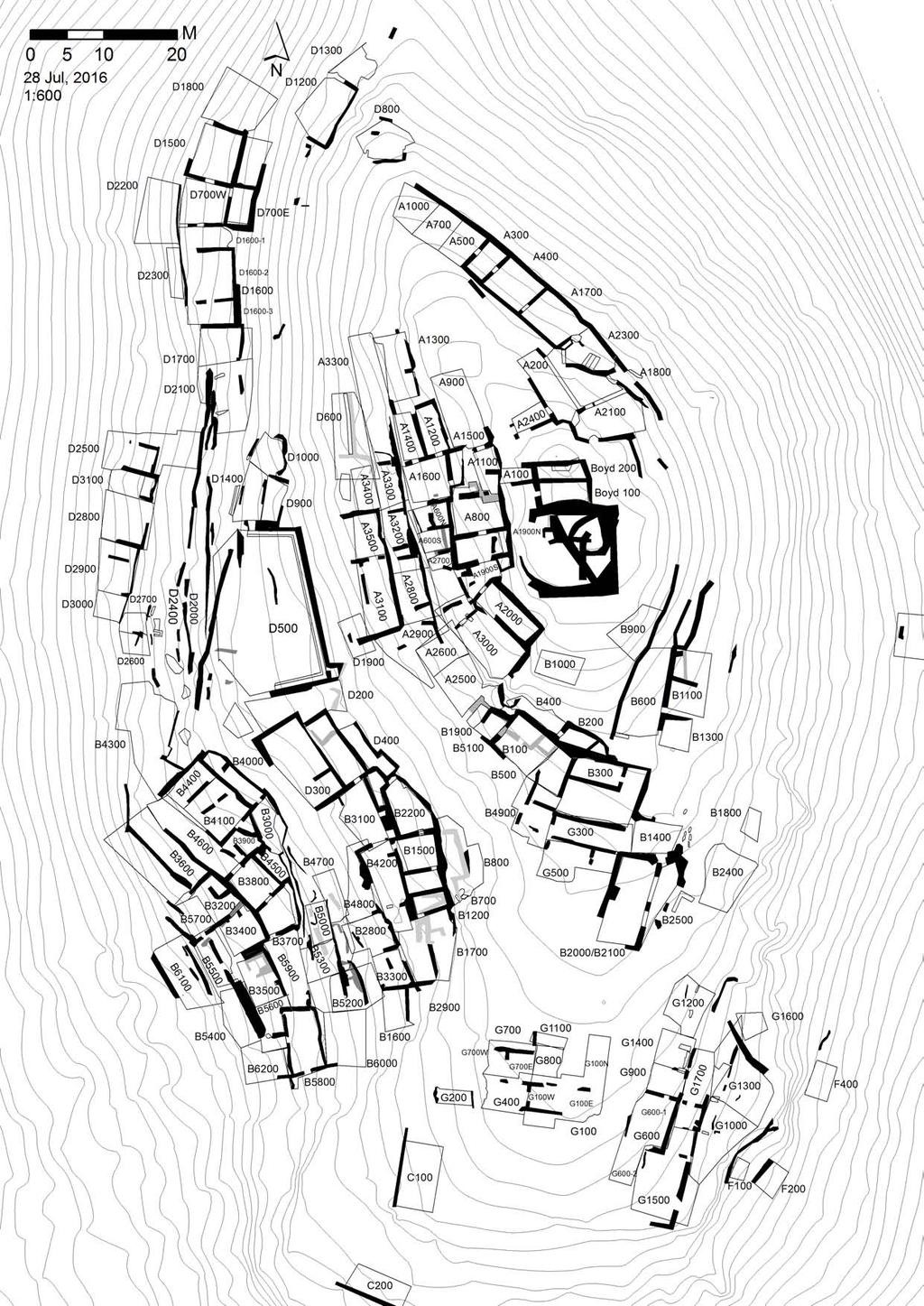
26
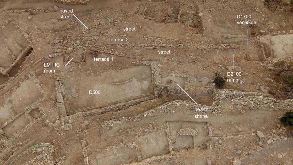
27
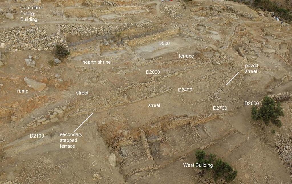
28
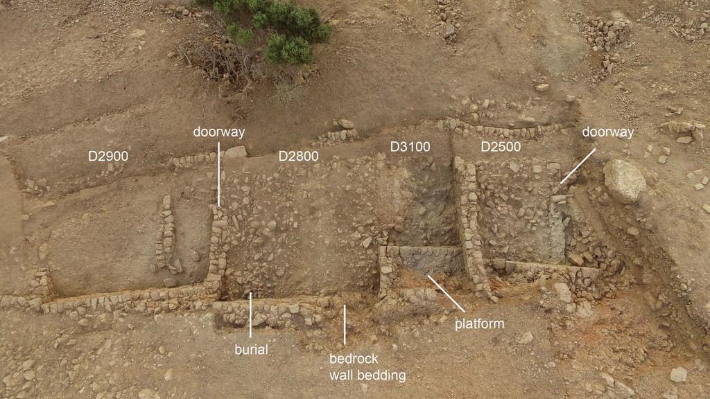
29

30
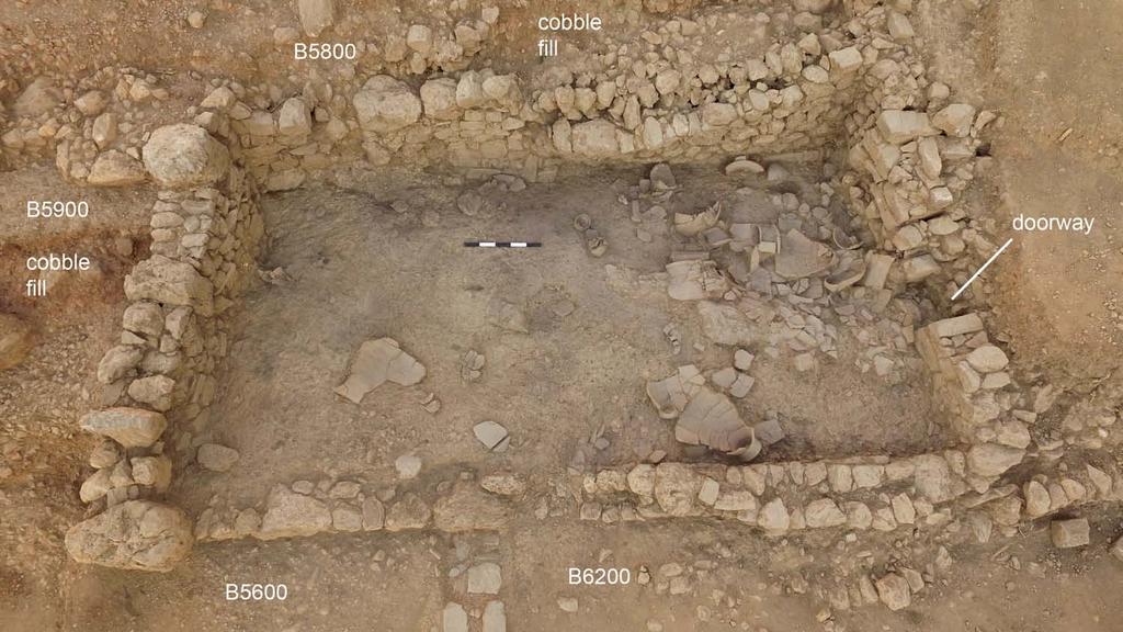
31
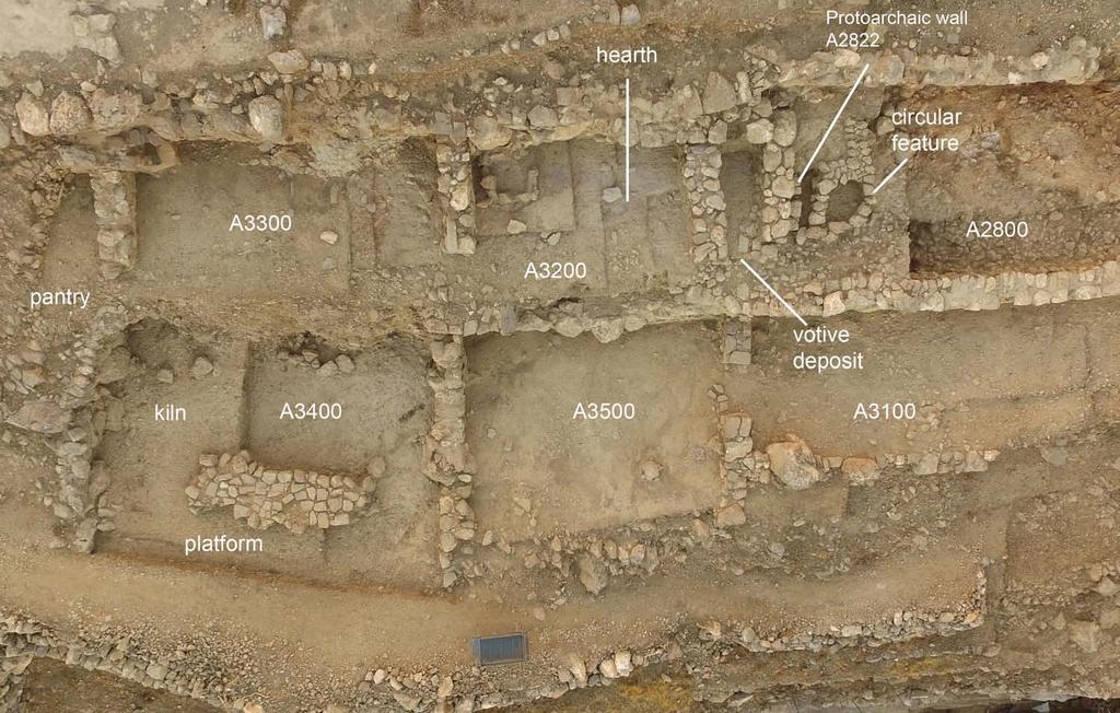
32
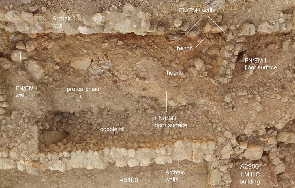
33
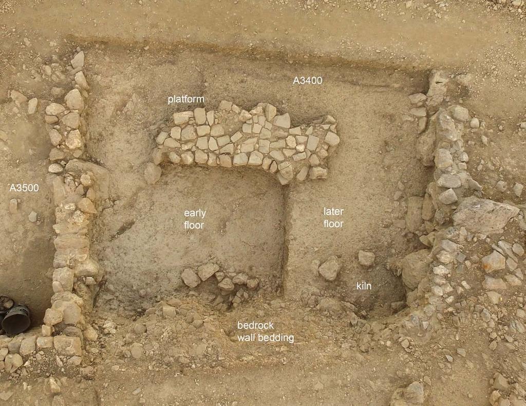
34
Azoria Project Final Report 2015 DRAFT (August 6, 2015) July 27-August 6, 2015 INSTAP-SCEC
 July 27-August 6, 2015 INSTAP-SCEC") Azoria Project Final Summary Report 2015 1 Azoria Project Final Report 2015 DRAFT (August 6, 2015) July 27-August 6, 2015 INSTAP-SCEC Donald C. Haggis, University of North Carolina at Chapel Hill Department
Azoria Project Final Summary Report 2015 1 Azoria Project Final Report 2015 DRAFT (August 6, 2015) July 27-August 6, 2015 INSTAP-SCEC Donald C. Haggis, University of North Carolina at Chapel Hill Department
Trench 91 revealed that the cobbled court extends further to the north.
 Report on the 2013 Gournia Excavations The 2013 excavations at Gournia were conducted June 17 July 26 under the aegis of the American School of Classical Studies at Athens and the supervision of the KD
IKLAINA ARCHAEOLOGICAL PROJECT 2016 FIELD REPORT Michael B. Cosmopoulos
 IKLAINA ARCHAEOLOGICAL PROJECT 2016 FIELD REPORT Michael B. Cosmopoulos Introduction The overarching objective of the Iklaina project is to test existing hierarchical models of state formation in Greece
Jneneh in the Upper Wadi az-zarqa, in North Central Jordan, First Season 2011.
 Jneneh in the Upper Wadi az-zarqa, in North Central Jordan, First Season 2011. Khaled Douglas Jneneh is located in the north-western periphery of the city of Zarqa (grid ref. 250.88E 165.25N), in North
E X C A V A T I O N O F T H E E A R L Y I R O N A G E S E T T L E M E N T A T A Z O R I A By Donald C. Haggis and Margaret S. Mook
 E X C A V A T I O N O F T H E E A R L Y I R O N A G E S E T T L E M E N T A T A Z O R I A By Donald C. Haggis and Margaret S. Mook Figure 1. B3500: Sondage from the east, showing Archaic cobble fill and
Azoria 2004 B700 Final Trench Report RQC
 Azoria 2004 B700 Final Trench Report RQC B700 is a room -2.5m by 4.5m, bounded by wall B711 to north, wall B703 to east, wall B706 to south, and wall B717 to west. B700 is an Archaic storeroom with an
IMTO Italian Mission to Oman University of Pisa 2011B PRELIMINARY REPORT (OCTOBER-DECEMBER 2011)
") IMTO Italian Mission to Oman University of Pisa 2011B PRELIMINARY REPORT (OCTOBER-DECEMBER 2011) The 2011B research campaign took place in the area around Salut from October, 19 th, to December, 16 th.
IMTO Italian Mission to Oman University of Pisa 2011B PRELIMINARY REPORT (OCTOBER-DECEMBER 2011) The 2011B research campaign took place in the area around Salut from October, 19 th, to December, 16 th.
In 2014 excavations at Gournia took place in the area of the palace, on the acropolis, and along the northern edge of the town (Fig. 1).
.") Gournia: 2014 Excavation In 2014 excavations at Gournia took place in the area of the palace, on the acropolis, and along the northern edge of the town (Fig. 1). In Room 18 of the palace, Room A, lined
Gournia: 2014 Excavation In 2014 excavations at Gournia took place in the area of the palace, on the acropolis, and along the northern edge of the town (Fig. 1). In Room 18 of the palace, Room A, lined
4. Bronze Age Ballybrowney, County Cork Eamonn Cotter
 4. Bronze Age Ballybrowney, County Cork Eamonn Cotter Illus. 1 Location map of the excavated features at Ballybrowney Lower (Archaeological Consultancy Services Ltd, based on the Ordnance Survey Ireland
The Greek-Swedish-Danish Excavations at Kastelli, Khania 2010 a short report
 The Greek-Swedish-Danish Excavations at Kastelli, Khania 2010 a short report During six weeks from 19 July to 27 August the Greek-Swedish-Danish Excavations continued work in the Ag. Aikaterini Square
New Studies in the City of David The Excavations
 The 2013-2014 Excavations Israel Antiquities Authority The intensive archaeological work on the city of David hill during the period covered in this article has continued in previously excavated areas
Excavation at Azoria in 2016 continued to recover evidence
 Ruscillo, D. 2005. Reconstructing Murex Royal Purple and Biblical Blue in the Aegean, in Archaeomalacology: Molluscs in Former Environments of Human Behaviour. Proceedings of the 9th ICAZ Conference, August
ANNUAL REPORT: ANCIENT METHONE ARCHAEOLOGICAL PROJECT 2014 FIELD SCHOOL
 ANNUAL REPORT: ANCIENT METHONE ARCHAEOLOGICAL PROJECT 2014 FIELD SCHOOL Director(s): Co- Director(s): Professor Sarah Morris, Cotsen Institute of Archaeology, UCLA John K. Papadopoulos, Cotsen Institute
IKLAINA ARCHAEOLOGICAL PROJECT 2015 FIELD REPORT Michael B. Cosmopoulos
 IKLAINA ARCHAEOLOGICAL PROJECT 2015 FIELD REPORT Michael B. Cosmopoulos The 2015 season of the Iklaina project took place from June 1 to July 7. The project is conducted under the auspices of the Athens
218 R. S. BORAAS AND S. H. HORN
 were able to show a sequence of ceramic corpora much more fully representative than those available from the occupation surfaces and structures higher on the mound. This ceramic series obtained from D.
IKLAINA ARCHAEOLOGICAL PROJECT 2012 FIELD REPORT
 IKLAINA ARCHAEOLOGICAL PROJECT 2012 FIELD REPORT Michael B. Cosmopoulos The sixth season of the Iklaina Archaeological Project was conducted for six weeks in June and July 2012. Τhe project is conducted
Architectural Analysis in Western Palenque
 Architectural Analysis in Western Palenque James Eckhardt and Heather Hurst During the 1999 season of the Palenque Mapping Project the team mapped the western portion of the site of Palenque. This paper
Excavations in a Medieval Market Town: Mountsorrel, Leicestershire,
 Excavations in a Medieval Market Town: Mountsorrel, Leicestershire, by John Lucas Mountsorrel is situated 12 kms north of Leicester and forms a linear settlement straddling the A6, Leicester to Derby road.
oi.uchicago.edu TALL-E BAKUN
 TALL-E BAKUN ABBAS ALIZADEH After I returned in September 1991 to Chicago from Cambridge, Massachusetts, I began preparing for publication the results of 1937 season of excavations at Tall-e Bakun, one
THE EL-QITAK PROJECT. oi.uchicago.edu
 oi.uchicago.edu THE EL-QITAK PROJECT T H O M A S - L - M C C L E L L A N T he 1987 season at el-qitar ran from May 2 t o July 29th and marked the last major season of excavation there because the site
Labraunda Preliminary report
 Labraunda 2012. Preliminary report The excavations at Labraunda this year were very successful and lasted for eight weeks. Our main new discovery is obviously the gold coin from Philip II discovered in
AN ARCHAEOLOGICAL ASSESSMENT OF BOERNE CITY PARK, KENDALL COUNTY, TEXAS. Thomas C. Kelly and Thomas R. Hester
 AN ARCHAEOLOGICAL ASSESSMENT OF BOERNE CITY PARK, KENDALL COUNTY, TEXAS Thomas C. Kelly and Thomas R. Hester Center for Archaeological Research The University of Texas at San Antonio Archaeological Survey
First announcement concerning the results of the 2005 exploratory season at Tel Kabri
 First announcement concerning the results of the 2005 exploratory season at Tel Kabri Assaf Yasur-Landau Tel Aviv University (assafy@post.tau.ac.il) Eric H. Cline The George Washington University (ehcline@gwu.edu)
Jane C. Waldbaum Archaeological Field School Scholarship - Report.
 Jane C. Waldbaum Archaeological Field School Scholarship - Report. Eastern Boeotia Archaeological Project, 2017 Novella Nicchitta Figure 1 EBAP's team for 2017 This year I had the pleasure of participating
Following the initial soil strip archaeology is sprayed up prior to planning and excavation
 Barton Quarry & Archaeology Over the past half century quarries have been increasingly highlighted as important sources of information for geologists, palaeontologists and archaeologists, both through
FOUNDATIONS OF ARCHAEOLOGY A WALK IN VERNDITCH CHASE
 FOUNDATIONS OF ARCHAEOLOGY A WALK IN VERNDITCH CHASE 1. A Tale of two Long Barrows Long barrows were constructed as earthen or drystone mounds with flanking ditches and acted as funerary monuments during
The Excavation of Archaic Houses at Azoria in
 World Languages and Cultures Publications World Languages and Cultures 2011 The Excavation of Archaic Houses at Azoria in 2005-2006 Donald C. Haggis University of North Carolina at Chapel Hill Margaret
ARDESTIE EARTH HOUSE HISTORIC ENVIRONMENT SCOTLAND STATEMENT OF SIGNIFICANCE. Property in Care no: 24
 Property in Care no: 24 Designations: Scheduled Monument (SM90021) Taken into State care: 1953 (Guardianship) Last reviewed: 2004 HISTORIC ENVIRONMENT SCOTLAND STATEMENT OF SIGNIFICANCE ARDESTIE EARTH
CARLUNGIE EARTH HOUSE
 Property in Care (PIC) ID: PIC015 Designations: Scheduled Monument (SM90059) Taken into State care: 1953 (Guardianship) Last reviewed: 2004 HISTORIC ENVIRONMENT SCOTLAND STATEMENT OF SIGNIFICANCE CARLUNGIE
TH E FIRST SEASON of investigations at the
 QUSEIR AL-QADIM Janet H. Johnson & Donald Whitcomb TH E FIRST SEASON of investigations at the ancient port of Quseir al-qadim on the Red Sea in Egypt took place in winter, 1978; the investigations were
Draft Report. 7. Excavations in the temenos gateway, Area (TG5) Author - D. A. Welsby Period 1-2. Period 1. Period 2. Derek A.
 Author - D. A. Welsby Period 1-2. Period 1. Period 2. Derek A.") 7. Excavations in the temenos gateway, Area (TG5) Derek A. Welsby When Griffith excavated the temples at Kawa in 1929-31, work followed by that of Macadam and Kirwan in the winter of 1935-6, the temenos
7. Excavations in the temenos gateway, Area (TG5) Derek A. Welsby When Griffith excavated the temples at Kawa in 1929-31, work followed by that of Macadam and Kirwan in the winter of 1935-6, the temenos
Excavation in Area G: squares m/14-15, new building BG1 (trench supervisor: Cleto Carbonara)
") Excavation in Area G: squares m/14-15, new building BG1 (trench supervisor: Cleto Carbonara) The excavation in the Area G started in the 1 st October has two main purposes: To understand the real extension
Excavation in Area G: squares m/14-15, new building BG1 (trench supervisor: Cleto Carbonara) The excavation in the Area G started in the 1 st October has two main purposes: To understand the real extension
The$Cisterns$of$No.on$ $ Angela$Commito$
 The$Cisterns$of$No.on$ $ Angela$Commito$ Aerial$view$of$No.on,$looking$northeast$ View$looking$up$cistern$sha
Gorse Stacks, Bus Interchange Excavations Interim Note-01
 Gorse Stacks, Bus Interchange Excavations 2015 Prepared for: Cheshire West & Chester Council Interim Note-01 1 Introduction & Summary Background Since c. 2000 investigations associated with redevelopment
Archaeologists for Hire: An In-Class Activity
 Archaeologists for Hire: An In-Class Activity Beyond Grades: Capturing Authentic Learning Conference Welcome to the Marveloso Valley, a fictional valley on the central coast of Peru. Over the decades,
Amarna Workers Village
 Amarna Workers Village The Egyptian city of Amarna was the pet building project of the pharaoh Akhenaten, who oversaw construction of his new capital between 1346 and 1341 BCE. The city was largely abandoned
THE HEUGH LINDISFARNE
 LINDISFARNE COMMUNITY ARCHAEOLOGY THE HEUGH LINDISFARNE Archaeological excavations in June 2017 Invitation to volunteers THE HEUGH, LINDISFARNE, NORTHUMBERLAND: ARCHAEOLOGICAL EXCAVATIONS 2017 INTRODUCTION
archeological site LOS MILLARES
 archeological site LOS MILLARES Aerial view of the plain of Los Millares between the Rambla de Huéchar and the River Andarax The archaeological site of Los Millares is located in the township of Santa
AREA A. BASTIAAN VAN ELDEREN Calvin Theological Seminary, Grand Rapids, Michigan
 AREA A BASTIAAN VAN ELDEREN Calvin Theological Seminary, Grand Rapids, Michigan During the 1968 and 1971 seasons six Squares were excavated in Area A, all but one (A.6) to bedrock.' Approximately threefourths
Çatalhöyük 2015 Archive Report by members of the Çatalhöyük Research Project
 Çatalhöyük 2015 Archive Report by members of the Çatalhöyük Research Project Chapter 4 Excavations in the TPC Area Arkadiusz Marciniak, Patrycja Filipowicz, Jędrzej Hordecki, Paul Eklöv Pettersson Introduction
Report on the excavations on the site Novopokrovskoe II in V. Kol'chenko, F. Rott
 Report on the excavations on the site Novopokrovskoe II in 2016 V. Kol'chenko, F. Rott In 2016 the Novopokrovskiy archeological group of the Institute of History and Heritage of the National Academy of
III. THE EARLY HELLADIC POTTERY FROM THE MASTOS IN THE BERBATI VALLEY, ARGOLID
 III. THE EARLY HELLADIC POTTERY FROM THE MASTOS IN THE BERBATI VALLEY, ARGOLID by JEANNETTE FORSÉN The Swedish investigations of the hillock Mastos in the western part of the Berbati valley, ca. 3 km south
220 NOTES AND NEWS REFERENCES
 220 NOTES AND NEWS pottery uncovered in each building, the inscription (found during the 2008 season), the seal and various metal objects. The site functioned as a rich urban centre. One would expect mention
Looking north from the SW shieling site with Lub na Luachrach in the foreground
 Looking north from the SW shieling site with Lub na Luachrach in the foreground Upper Gleann Goibhre - Shieling sites Two shieling sites in the upper reaches of the Allt Goibhre were visited and recorded
Ancient Greek Buildings/ Fortifications. Matthew Jackson
 Ancient Greek Buildings/ Fortifications Matthew Jackson What is a fortification? -The combination of terrain and available materials to form a means of defense against potential attackers -Represent the
TELL ES-SWEYHAT EXPEDITION TO SYRIA
 TELL ES-SWEYHAT EXPEDITION TO SYRIA THOMAS A. HOLLAND The fifth season of archaeological excavations was conducted during October and November 1991 at the Early Bronze Age site of Tell Es-Sweyhat, which
The Year in Review 2014, Beothuk Institute Inc. We have had several highlights this year. At the AGM in May there were two guest speakers, Dale
 The Year in Review 2014, Beothuk Institute Inc. We have had several highlights this year. At the AGM in May there were two guest speakers, Dale Jarvis set the stage for the story gathering that the Beothuk
The Journal of the American School of Classical Studies at Athens. Volume
 dining in the sanctuary of demeter and kore 1 Hesperia The Journal of the American School of Classical Studies at Athens Volume 80 2011 Copyright The American School of Classical Studies at Athens, originally
: southern pilaster of the entrance. The tomb owner, Redi, is depicted in painted raised relief ( a 8014) Plate 15
 Plate 15") 15. 2086: southern pilaster of the entrance. The tomb owner, Redi, is depicted in painted raised relief ( a 8014) Plate 15 16. 2086: south wall. Redi is seated with a woman, receiving a lotus, and entertained
15. 2086: southern pilaster of the entrance. The tomb owner, Redi, is depicted in painted raised relief ( a 8014) Plate 15 16. 2086: south wall. Redi is seated with a woman, receiving a lotus, and entertained
The Yingtianmen Gate-site of the Sui and Tang Eastern Capital in Luoyang City
 Nandajie The Yingtianmen Gate-site of the Sui and Tang Eastern Capital in Luoyang City Tang Luoyang City-site Archaeological Team, Institute of Archaeology, Chinese Academy of Social Sciences Key words:
GLACIER STUDIES OF THE McCALL GLACIER, ALASKA
 GLACIER STUDIES OF THE McCALL GLACIER, ALASKA T John E. Sater* HE McCall Glacier is a long thin body of ice shaped roughly like a crescent. Its overall length is approximately 8 km. and its average width
Excavations at Vagnari 2017
 Excavations at Vagnari 2017 Maureen Carroll Since 2012, our excavations at the Roman imperial estate at Vagnari in Puglia (Fig. 1) have concentrated on the northern edge of the village (vicus) of the estate
Trail Phasing Plan. Note: Trails in the Clear Creek Canyon area (Segments will be finalized in the future to minimize wildlife impacts
 Note: Trails in the Clear Creek Canyon area (Segments 2 5 and a future JCOS connection) will be finalized in the future to minimize wildlife impacts Trail Phasing Plan P Parking 3 Easy Trail Intermediate
The Tel Burna Archaeological Project Report on the First Season of Excavation, 2010
 The Tel Burna Archaeological Project Report on the First Season of Excavation, 2010 By Itzick Shai and Joe Uziel Albright Institute for Archaeological Research Jerusalem, Israel April 2011 The site of
[UNEDITED DRAFT-INTERNAL USE ONLY] Steven M. Ortiz and Samuel R. Wolff
![[UNEDITED DRAFT-INTERNAL USE ONLY] Steven M. Ortiz and Samuel R. Wolff](/thumbs/96/128776431.jpg "[UNEDITED DRAFT-INTERNAL USE ONLY] Steven M. Ortiz and Samuel R. Wolff") Tel Gezer G-56/2007 p. 1 Tel Gezer, 2007 Excavation Summary Report [UNEDITED DRAFT-INTERNAL USE ONLY] Steven M. Ortiz and Samuel R. Wolff Introduction The second season of the renewed excavations of Tel
Tel Gezer G-56/2007 p. 1 Tel Gezer, 2007 Excavation Summary Report [UNEDITED DRAFT-INTERNAL USE ONLY] Steven M. Ortiz and Samuel R. Wolff Introduction The second season of the renewed excavations of Tel
ANNA MORPURGO-DAVIES GERALD CADOGAN A SECOND LINEAR A TABLET FROM PYRGOS
 ANNA MORPURGO-DAVIES GERALD CADOGAN A SECOND LINEAR A TABLET FROM PYRGOS In May 1975 a second broken Linear A tablet was found during study of the pottery from the Minoan country house at Pyrgos near the
IMTO Italian Mission to Oman. University of Pisa SUMHURAM. Preliminary Report. February March 2016 (SUM16A)
") IMTO Italian Mission to Oman University of Pisa SUMHURAM Preliminary Report February March 2016 (SUM16A) PRELIMINARY REPORT (SUM16A) February March 2016 The first IMTO s campaign of 2016 (SUM16A), under
IMTO Italian Mission to Oman University of Pisa SUMHURAM Preliminary Report February March 2016 (SUM16A) PRELIMINARY REPORT (SUM16A) February March 2016 The first IMTO s campaign of 2016 (SUM16A), under
Lidar Imagery Reveals Maine's Land Surface in Unprecedented Detail
 Maine Geologic Facts and Localities December, 2011 Lidar Imagery Reveals Maine's Land Surface in Unprecedented Detail Text by Woodrow Thompson, Department of Agriculture, Conservation & Forestry 1 Introduction
New Archaeological Discoveries South of the Hanyuan Hall at the Daming Palace of Tang Dynasty
 New Archaeological Discoveries South of the Hanyuan Hall at the Daming Palace of Tang Dynasty The Xi an Tang City Archaeology Team, IA, CASS Key words: Imperial Palaces-China-Tang Dynasty Hanyuan Hall
The Sanctuary of Athena Alea at Tegea: Recent Excavations in the Northern Area. Results and Problems
 The Sanctuary of Athena Alea at Tegea: Recent Excavations in the Northern Area. Results and Problems Chiara Tarditi The excavations in the northern area of the sanctuary of Athena Alea at Tegea, organized
Excavations on the Kastro at Kavousi. An Architectural Overview
 World Languages and Cultures Publications World Languages and Cultures 1997 Excavations on the Kastro at Kavousi. An Architectural Overview William D. E. Coulson American School of Classical Studies at
47I THE LAS ANIMAS GLACIER.
 THE LAS ANIMAS GLACIER. ONE of the largest of the extinct glaciers of the Rocky Mountains was that which occupied the valley of the Las Animas river. This stream originates in the San Juan mountains in
Provincial Archaeology Office Annual Review
 2017 Provincial Archaeology Office Annual Review Provincial Archaeology Office Department of Tourism, Culture, Industry and Innovation Government of Newfoundland and Labrador March 2018 Volume 16 A brief
The Dams and Water Management Systems of Minoan Pseira
 The Dams and Water Management Systems of Minoan Pseira The Dams and Water Management Systems of Minoan Pseira Philip P. Betancourt Published by INSTAP Academic Press Philadelphia, Pennsylvania 2012 Design
aiton.new 1/4/04 3:48 AM Page 2
 aiton.new 1/4/04 3:48 AM Page 2 Below: An aerial view of area A of the excavations. A massive square building that appears to be a fortress was discovered in this area at the top of the tell. aiton.new
THE EAST WING OF THE PALACE OF MYCENAE
 THE EAST WING OF THE PALACE OF MYCENAE (PLATES 94-96) T is only fitting that the preliminary description of a newly recovered section of the " Palace of Agamemnon " should be dedicated to the revealer
Department of Tourism, Culture and Recreation Provincial Archaeology Office 2012 Archaeology Review February 2013 Volume 11
 Department of Tourism, Culture and Recreation Provincial Archaeology Office 2012 Archaeology Review February 2013 Volume 11 Area 14 of FjCa-14 in Sheshatshiu, portion of feature in southeast corner of
By : K. Blouin, Th. Faucher, N. Hudson, M. Kenawi, A. Kirby, R. Mairs, G. Marchiori, M. Van Peene
 THMUIS, A NEW LAND IN THE EASTERN NILE DELTA FIRST CANADIAN MISSION AT THMUIS By : K. Blouin, Th. Faucher, N. Hudson, M. Kenawi, A. Kirby, R. Mairs, G. Marchiori, M. Van Peene The first Canadian Mission
The Greek Swedish Excavations at Kastelli, Khania 2001: a preliminary report*
 The Greek Swedish Excavations at Kastelli, Khania 2001: a preliminary report* ERIK HALLAGER, YAIS TZEDAKIS & MARIA ADREADAKI-VLAZAKI During five weeks in June and July 2001 a small supplementary excavation
Archaeological Investigations Project South East Region SOUTHAMPTON 2/842 (C.80.C004) SU
 SU") SOUTHAMPTON City of Southampton 2/842 (C.80.C004) SU 4382 1336 125 BITTERNE ROAD WEST, SOUTHAMPTON Report on the Archaeological Evaluation Excavation at 125 Bitterne Road West, Southampton Russel, A. D
SOUTHAMPTON City of Southampton 2/842 (C.80.C004) SU 4382 1336 125 BITTERNE ROAD WEST, SOUTHAMPTON Report on the Archaeological Evaluation Excavation at 125 Bitterne Road West, Southampton Russel, A. D
The importance of Jerusalem for the study of Near Eastern history and. archaeology and for the study of the Biblical text (both old and new) cannot
 cannot") Setting the Clock in the City of David: Establishing a Radiocarbon Chronology for Jerusalem's Archaeology in Proto-historical and Historical Times Yuval Gadot, Johana Regev, Helena Roth and Elissabeta
Setting the Clock in the City of David: Establishing a Radiocarbon Chronology for Jerusalem's Archaeology in Proto-historical and Historical Times Yuval Gadot, Johana Regev, Helena Roth and Elissabeta
CARN BAN LONG CAIRN HISTORIC ENVIRONMENT SCOTLAND STATEMENT OF SIGNIFICANCE. Property in Care (PIC) ID: PIC059 Designations:
 ID: PIC059 Designations:") Property in Care (PIC) ID: PIC059 Designations: Scheduled Monument (SM90051) Taken into State care: 1962 (Guardianship) Last reviewed: 2004 HISTORIC ENVIRONMENT SCOTLAND STATEMENT OF SIGNIFICANCE CARN
Property in Care (PIC) ID: PIC059 Designations: Scheduled Monument (SM90051) Taken into State care: 1962 (Guardianship) Last reviewed: 2004 HISTORIC ENVIRONMENT SCOTLAND STATEMENT OF SIGNIFICANCE CARN
Notes from the Field: An Island off an Island - Understanding Bronze Age Society in Mochlos, Crete
 57 Notes from the Field: An Island off an Island - Understanding Bronze Age Society in Mochlos, Crete Luke Kaiser School of Anthropology, University of Arizona I pushed a wheelbarrow up over the berm of
Preliminary report on the 2013 season at Plakari
 Preliminary report on the 2013 season at Plakari Jan Paul Crielaard the 2013 excavations During the 2013 field season (8 July 5 August), excavations were continued on the southern slope of Terrace 2 (Trench
ROUKEN GLEN: BANDSTAND 2015 DATA STRUCTURE REPORT
 ROUKEN GLEN: BANDSTAND 2015 DATA STRUCTURE REPORT Author (s) Ian Hill Editors Report Date June 2015 Working Partners Funders Phil Richardson East Renfrewshire Council East Renfrewshire Council, Heritage
Wessex Archaeology. Little Stubbings, West Amesbury, Salisbury, Wiltshire. Archaeological Watching Brief. Ref:
 Wessex Archaeology Little Stubbings, West Amesbury, Salisbury, Wiltshire Ref: 63280.02 March 2007 LITTLE STUBBINGS, WEST AMESBURY, NR SALISBURY, WILTSHIRE ARCHAEOLOGICAL WATCHING BRIEF Prepared for: P
Glacial Geomorphology Exercise
 James Madison University Field Course in western Ireland Glacial Geomorphology Exercise 3-day road log (abbreviated) Striations Large kame terrace Cirque with moraines Kame delta Striations Eskers Raised
A New Fragment of Proto-Aeolic Capital from Jerusalem
 TEL AVIV Vol. 42, 2015, 67 71 A New Fragment of Proto-Aeolic Capital from Jerusalem Doron Ben-Ami and Yana Tchekhanovets Israel Antiquities Authority The article deals with a fragment of a proto-aeolic
ARCHAEOLOGICAL INVESTIGATIONS IN GUADALUPE, NORTHEAST HONDURAS
 ARCHAEOLOGICAL INVESTIGATIONS IN GUADALUPE, NORTHEAST HONDURAS Markus Reindel, Franziska Fecher and Peter Fux Archaeological investigations in Honduras have focused on the western, Mesoamerican part of
EXCAVATIONS AT AIXONIDAI HALAI VOULA FIELD SCHOOL
 EXCAVIONS HALAI J A N U A R Y 8-2 7, 2 0 1 8 I N S T R U C T O R : D R. J O H N K A R A V A S VOULA FIELD SCHOOL EXCAVIONS HALAI COURSE DETAILS Dates : January Students who have a serious interest in archaeology
HEATHROW COMMUNITY NOISE FORUM. Sunninghill flight path analysis report February 2016
 HEATHROW COMMUNITY NOISE FORUM Sunninghill flight path analysis report February 2016 1 Contents 1. Executive summary 2. Introduction 3. Evolution of traffic from 2005 to 2015 4. Easterly departures 5.
5 MAP SPECIFICATION FOR SKI-ORIENTEERING
 5 MAP SPECIFICATION FOR SKI-ORIENTEERING 5.1 General Maps for ski orienteering are based on the specifications for foot-orienteering maps. However in order to meet the specific requirements put on the
6 The excavation so far 6.1 Project history Monte Polizzo is 6 km. northwest of Salemi, in Trapani province, western Sicily (37 56 N, E.
 6 The excavation so far 6.1 Project history Monte Polizzo is 6 km. northwest of Salemi, in Trapani province, western Sicily (37 56 N, 12 46 E. The site consists of an interconnected group of ridges. The
Excavations at El Palenque, San Martín Tilcajete: A Late Formative Subregional Center in the Oaxaca Valley, México
 FAMSI 2000: Elsa M. Redmond Excavations at El Palenque, San Martín Tilcajete: A Late Formative Subregional Center in the Oaxaca Valley, México Research Year: 1999 Culture: Zapotec Chronology: Late Pre-Classic
Pella in Jordan Early Bronze Age Fortifications, a Late Bronze Age Palace and a Hellenistic Villa. by Stephen Bourke Introduction
 The Near Eastern Archæology Foundation BULLETIN NUMBER 55 February 2012 Pella in Jordan 2011 Early Bronze Age Fortifications, a Late Bronze Age Palace and a Hellenistic Villa by Stephen Bourke Introduction
NEWBORO AND PORTLAND HARBOUR REDVELOPMENT PLANS
 INTRODUCTION The Municipal docks in both Newboro and Portland were transferred to the Township of Rideau Lakes by Parks Canada in 2002. Little has been done to improve the docks physical condition or role
CSG Annual Conference - Cork - April Carrigadrohid Castle
 Carrigadrohid Castle & bridge. James N. Healy 1979 Carrigadrohid Castle Location: Townland of Carrigadrohid, lr. Carraig an Droichid (the rock of the bridge), Co. Cork. Description: Carrigadrohid Castle
Jane C. Waldbaum Archaeological Field School Scholarship
 Cole Furrh Emory University Jane C. Waldbaum Archaeological Field School Scholarship Field Report: Gournia Excavation Project 2016 This summer I had the privilege to work on the Gournia Excavation Project.
Archaeological Investigation of Coloane, Macau
 Archaeological Investigation of Coloane, Macau Received 13 March 1974" W. KELLY AND W. MEACHAM INTRODUCTION UP UNTIL July 1972, when a field survey of Coloane Island was undertaken by members of the Hong
Cetamura Results Prior to 2000
 Cetamura Results Prior to 2000 Excavations at the hilltop of Cetamura del Chianti (695m above sea level) near Siena by Florida State University have unearthed a habitation with a long and diverse history,
Cultural Resource Management Report Deer Valley 4wd Restoration and Blue Lakes Road Maintenance Project R
 Cultural Resource Management Report R2015-05-03-10005 Undertaking Description: The proposes to perform road maintenance and meadow restoration on the Deer Valley 4wd trail and road maintenance on the Blue
Erica Kinias Brown University, Department of the History of Art and Architecture
 Erica Kinias Brown University, Department of the History of Art and Architecture Archaeological Institute of America Jane C. Waldbaum Scholarship Fund Research Outcomes With the generous support from the
APPENDIX D: SUSTAINABLE TRAIL DESIGN. APPENDICES Town of Chili Parks and Recreation Master Plan Update
 APPENDIX D: SUSTAINABLE TRAIL DESIGN APPENDICES Town of Chili Parks and Recreation Master Plan Update Sustainable Trail Construction Sustainable trails are defined by the US Forest Service as trails having
An archaeological excavation at 193 High Street, Kelvedon, Essex September 2009
 An archaeological excavation at 193 High Street, Kelvedon, Essex September 2009 report prepared by Ben Holloway and Howard Brooks on behalf of Marden Homes CAT project ref.: 09/4g NGR: TL 8631 1913 (c)
ARCHAEOLOGY IN TUCSON
 ARCHAEOLOGY IN TUCSON Vol.1, No.4 Newsletter of the Institute for American Research Summer 1987 TRULY THE ORIGINAL TUCSON! In our last AIT newsletter, we presented some of the background about the San
HEATHROW COMMUNITY NOISE FORUM
 HEATHROW COMMUNITY NOISE FORUM 3Villages flight path analysis report January 216 1 Contents 1. Executive summary 2. Introduction 3. Evolution of traffic from 25 to 215 4. Easterly departures 5. Westerly
Plates. Kom Firin I 193. Plate 96 View of the southwestern part of Kom Firin, looking west-southwest.
 Plates Plate 96 View of the southwestern part of Kom Firin, looking west-southwest. Plate 97 Ramesside temple: wall 0157 and clean sand 0189 (TG), view to north. Plate 98 Ramesside temple: wall 0135 (TD),
BRONZE-AGE FOOD VESSEL (b) USED AS A BURIAL URN BROWN CANDOVER, [To face page 249]
![BRONZE-AGE FOOD VESSEL (b) USED AS A BURIAL URN BROWN CANDOVER, [To face page 249]](/thumbs/93/118018967.jpg "BRONZE-AGE FOOD VESSEL (b) USED AS A BURIAL URN BROWN CANDOVER, [To face page 249]") BRONZE-AGE FOOD VESSEL (b) USED AS A BURIAL URN BROWN CANDOVER, HANTS [To face page 249] 249 TWO BRONZE AGE DISCOVERIES IN HANTS. BY S. E. WlNBOLT, M.A. (i.) Brown Candover. East of the road at Brown Candover,
BRONZE-AGE FOOD VESSEL (b) USED AS A BURIAL URN BROWN CANDOVER, HANTS [To face page 249] 249 TWO BRONZE AGE DISCOVERIES IN HANTS. BY S. E. WlNBOLT, M.A. (i.) Brown Candover. East of the road at Brown Candover,
ΑΡΧΑΙΟΤΗΤΕΣ ΚΑΙ ΜΝΗΜΕΙΑ APT ΟΛΙΔΟΚΟΡΙΝΘΙ ΑΣ
 144 ΑΡΧΑΙΟΛΟΓΙΚΟΝ ΔΕΛΤΙΟΝ 20 (1965): ΧΡΟΝΙΚΑ ΑΡΧΑΙΟΤΗΤΕΣ ΚΑΙ ΜΝΗΜΕΙΑ APT ΟΛΙΔΟΚΟΡΙΝΘΙ ΑΣ EXCAVATIONS IN CORINTH, 1964 The principal excavations at Corinth in the spring of 1964 were conducted by Mrs. Saul
Settlement Patterns West of Ma ax Na, Belize
 SETTLEMENT PATTERNS WEST OF MA AX NA, BELIZE 1 Settlement Patterns West of Ma ax Na, Belize Minda J. Hernke Faculty Sponsor: Kathryn Reese-Taylor, Department of Sociology/Archaeology ABSTRACT The focus