EVOLUTION OF MADRAS AS AN URBAN CENTRE
|
|
|
- Marianna Porter
- 5 years ago
- Views:
Transcription
1 CHAPTER l EVOLUTION OF MADRAS AS AN URBAN CENTRE EVOLUTION OF URBANIZATION IN SOUTH INDIA Cities in South India have varying morphological structures and patterns evolved during their various historical periods. During the early and middle Hindu periods (upto AD 1300), temples were the nuclei of many centres. Seaborne trade also stimulated the growth of port towns. During the later Hindu period (AD ) in order to check the Muslim invasion, forts were constructed in most of the centres and subsequently they became the nuclei for urban growth. In some cases there were two nuclei (temple and fort).existing in tandem. During the Muslim period ( ) recurrent wars and battles retarded the growth of cities. However, the introduction of garrisons and contonments by the British stimulated urban growth by establishing political stability. Factors like administrative functions, introduction of Railways, Medical and Educational facilities were also responsible for the growth of cities during this time. MORPHOLOGICAL EVOLUTION OF MADRAS The growth of Madras demonstrates a pattern which is completely at variance with those of cities in the rest of South India. In Madras there is no
2 ancient tradition associated with a centrally positioned temple or pilgrimage centre, no long established kingdom for which the city functioned as a royal capital, no large contrasts between cantonment and civilian areas of the city. Madras might well be characterized as an Anglo-Indian city, a product of the close interaction of Indian and European efforts aimed primarily at trade and commerce. Madras came into existence, as a small trading factory only in the 17th Century after the advent of the British. The growth in status as well as the size of the city is inextricably linked with the expansion of British commercial enterprise through the performance of the port function. Now the capital of Tamil Nadu State and the largest city in South India, Madras is the fourth ranking urban centre in the country. The morphological evolution of Madras has been quite unlike those of the cities which expanded from a single centre (eg. Madurai) or from a double nuclei (eg. Coimbatore) or from different nuclei at different periods (eg. Hyderabad). In Madras no nuclear points can be identified, with the possible exception of Fort St. George whose nuclear influence, however, is limited. More accurately, Madras grew as a composite of a number of loosely linked self-contained villages in and around Fort. St. George which have subsequently coalesced into an urban entity, (Fig. 1.1). Even now one may see within the city a number of neighbourhoods such as Chetpet, Chindadripet, Komaleswaranpet, Elumbore (Egmore), Muthialpet, Nungambakkam, Perambur, Purasawalkam, Tondiarpet, Triplicane, Vepery and Vyasarpadi, which existed as separate neighbouring villages during the 17th century.
3 Some of the villages had an important temple as the nucleus; Mylapore, Triplicane. Purasawalkam and Komaleswaranpet are the best examples. Similarly, Santhome (from the Portuguese Sao Tome) came into existence and grew around a church containing the tomb of the christian apostle St. Thomas. Each village had in addition to temples churches or mosques, its own bazaars, service castes and separate functions. It is the self-contained nature of these villages that was the distinguishing fact in the development of settlement patterns in Madras. Such characteristics have persisted, making the structure of Madras unlike that of Calcutta, Bombay or other larger Indian cities where Industrialization played a more significant role. 'The population of Madras is really the ordinary population of an Indian village multiplied many times'.' Different versions exist regarding the nomenclature of the city, but it appears probable that Madras has its origin from the name 'Madharasakuppam' (Kuppam means village in the Tamil Language). Madras also has been known as 'Chennai' or 'Chennaipattanam'. This is a reference to another village 'Chennaikuppam', very near to where the Fort came to be sited. Both of these villages grew around the fort and hence the city has taken either name, Madras or Chennai. At present both places are merged in the George town area. The site conditions in the Madras area are not conducive to urban developments. None of the three natural waterways in the vicnity of Madras is navigable and none offers much in the way of natural harbour facilities. The site is level, almost featureless, and low lying, mostly between 15 feet and 20 feet above sea level. In both North and South of the City lagoons and marshes have restricted expansion, and the low gradient of the local streams have aggravated sewage disposal problems and hindered provision of water supply. Perhaps the
4 most logical urban site, the large island in the Cooum river was too accessible in the long dry season and low and marshy otherwise. Even the situation of Madras was not overly advantageous. The immediate hinterland had very limited agricultural and mineral resources, and yet Madras grew, almost fantastically so. Less than 50 years after its founding, its population exceeded 50,000,2 an almost unbelievable figure for a 17th century port city of secondary importance. Such growth, which continued into the 18th century was linked with the expansion of British commercial enterprises and thus to factors outside the Madras Metropolitan area, or even lndia itself. EVOLUTION OF THE URBAN LANDSCAPE Until 1639 there were, where Madras now stands, only a few scattered agricultural or fishir~g villages with a small Portuguese settlement in the South at Santhome. Two years earlier, in 1637, Francis Day, an agent of the British East lndia Company landed at the fishing village 'Madharasakuppam' and the local chieftain after negotiations offered settlement facilities by providing roughly one square mile of land. This was the inception of the present Madras city. Subsequently, there developed a trade between the English settlers and the villagers in attractive yet inexpensive calicos (calicloth). In order to house the English Calicloth facility, Fort. St. George was built in As a result of this concentration of commercial and protective functions, the fort area became the nucleus of the emerging town although the limitations in this regard have already been noted.
5 The nearby villages began to specialize in hand-weaving, spinning, dyeing and textile printing on a large and steadily growing scale. For example Washermanpet, initially settled by Dhobis (Washermen), shifted its functions to dyeing and bleaching, utilizing its abundant local water ~upply.~ Additionally, new villages were founded by the British to provide particular trade supply functions. Chindadripet was one such village which became a weaving colony. The rapid expansion of the Madras settlement during this period was mainly due to (a) the attraction of expanding trade with the Company and the employment of trade opportunities associated therewith (b) the thirty-year exemption from taxation which was extended to those who settled near the Fort and (c) the security offered to residents at the time of upheave1 and disorder caused by frequent local wars. It is quite obvious that the growth of Madras was based on political and commercial considerations, rather than any perceptible local geographical advantages. During the 18th Century expansion continued with the adding of additional villages such as Tiruvottiyur, Kathivakkam, Nungambakkam, Vyasarpadi, Purasawalkam and Egmore-all within a radius of 5 miles from the Fort. Similarly, in the early part of the 19th century more and more villages from the fringe area were annexed and incorporated within the expanding urban area. Proper drainage, construction of roadways and laying out of suburban areas (Perambur, Periamet) were emphasized during this period. However, in the surrounding rural areas beyond the contiguous urban land scattered suburban development was due mainly to the acquisition of land by Europeans for residences and gardens. During the same period important changes were occuring in the older portions of the city. The European quarters virtually under the wall of the fort were
6 replaced as the fort itself was expanded both by the British and by the French who occupied the Fort for a brief period in the middle of the 18th century. An open zone was created around the Fort to strengthen its defences; this reserve had the effect of decentralizing the concentration of public buildings. Legal and commercial buildings clustered between the harbour and the Fort, educational and government buildings were more than a mile further South. Throughout the 19th century as trade grew administrative activities also increased. The gradual assumption of government and judicial functions resulting in the creation of a large administrative machinery encouraged further migration of people seeking steady employment. All of South lndia became a'tributary of the Madras Presidency, which comprised almost all the present southern states. Its selection ensured that the City would come to dominate South India. During the later half of the 19th century the introduction of electricity, steam railways, electric trams and the provision of a filtered water supply and an underground sewage system each stimulated the growth of the city. However, public service and improvements were inordinately expensive due to the sprawling nature of the city's structure. Some attempts were also made during this period to improve access and circulation. The Buckingham canal was constructed in 1897 for the purpose of providing access by small country boats although it failed ultimately in its purpose due to waste water pollution from the river. The beginning of the fourth quarter of the 19th century saw two major alterations in the economic development of Madras. The establishment of artificial harbour facilities was a major filip to rapid city growth. In fact, Madras became the only major port in South lndia with any major ship- handling facilities. Today
7 Madras port handles a fifth of the country's entire imports and exports. The establishment of the large Buckingham and Carnatic textile mills and other smaller mills, signalled the commencement of significant industrial activity in Madras, although industrial employment never achieved the levels of Bombay and Calcutta. In the modern period, Madras has retained its agglomerated village aspect. Much open space has been preserved and the crowding and high densities typical of Indian cities is restricted to George Town and the other nuclear areas. By midtwentieth century the steadily advancing rural-urban fringe has succeeded in linking scattered villages additionally to form a vast metropolitan network. The aggregation of former suburban villages and subsequent urban expansion with the villages serving as nodes left large irregular open spaces within the City area. After 1950, with the establishment of factories, industrial estates, commercial facilities and educational and other public institutions, the City has grown mostly towards the south-west (Saidapet, Guindy, St. Thomas Mount) and the West (Sembiam, Villivakkam, Aminjikarai). At present, one can identify several types of residential development around Madras : (1) villages along major transportation corridors occupied largely by daily commuters (2) housing colonies and industrial areas located where they are, because of the industry's need to be close to the port, transportation and markets of Madras, but which manifest a quasi-independent existence, and (3) a series of small towns which are separate geographically but not economically, tied by a variety of activities to the large centre.
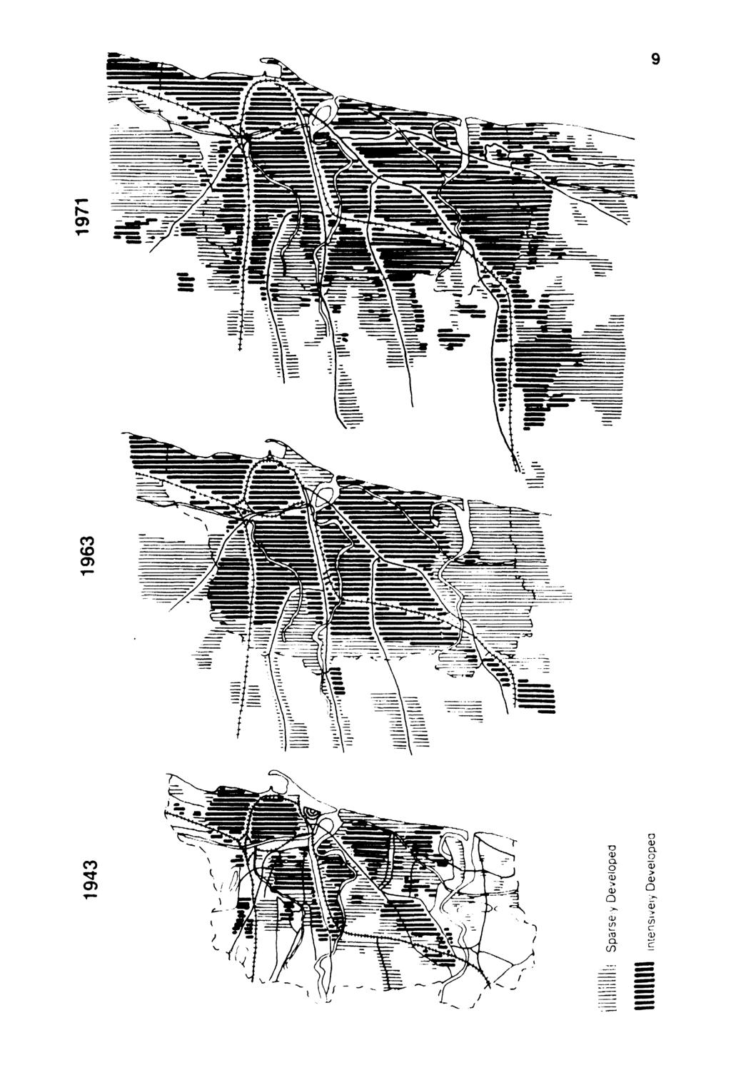
8 The growth of Madras since 1943 (1943, 1963 & 1971) are given in Fig.l.2., Fig. 1.3 shows the present land use in the City. Thus the City of Madras has grown during the past 350 years from a tiny village of fishermen to the most significant urban centre in South India, with a population of 3.3 million (census 1981) and an estimated 5.5 million in This as been brought about, as explained above, by the building up of vast open spaces that separated several villages which originally constituted the site of the city of Madras. Since this development has taken place without a plan, the City lacks the cohesion and orderliness that has to be expected in a city of its size. But it still certainly affords a lot of opportunities for orderly growth. As for the physical size, prior to 1946, the city of Madras was only 30 square miles in extent. ie. 77 square kilometers. in 1946, City limits were extended by the addition of certain outlying villages, increasing the City extent of 50 square miles i.e. 128 square kilometers. This position remained till June 1978, when the City was further extended by the addition of twelve outlying panchayats increasing the City extent to 66 square miles i.e. about 172 square kilometers. POPULATION AND IN-MIGRATION The population of the Madras Metropolitan city has been greatly increasing - 5,53,000 in 1901 ; 17,27,141 in 1961 ; 2.5 million in 1971 ; 3.3 million in 1981 and a projected 5.5 million in The population at the turn of the century will be, as estimated, more than 7 million including the projected in-migration. The growth of population in the Madras city and Madras Metropolitan area ( ) is given in Table 1.I.
9

10 - lc~dustrial opt,,^:, iparr: Htac redllollal - Irlbllfut~~rldl,~nd Water Bodk!s - t ~ty Houridary pre~197r New City Boundac)
11 iii 5 a 0 a "- W n z. F a E V) 0 O N P m l n C J J u 7 cd x S. g n n r s r s s i $ E J a m O I i i O " N " N N N $ m = c,? & g p 2 I i I O N ~ -, Y $ : : $ % N ' 0, 5 5 1?, &? C m z > ln C F z m o & g 2 L 3 K % 8 % : % z ~ -,To m P P m m m " " 2 t s % Eg,z Lrg $. m - L 2 C.Q a - 0.C- n r"'? :, j - X a :-zc?z.fi - z $ 7 N N N U J N P r n m m r - U ) m : I : : $ t i " "? % " ' $ < a,, ~ r P Z ~ N i i i ; ; g % z s p 5? 2! = C Y 8? % $ r r r " a m g ~ g ~ ~ g g & g??? - r r r r r r r
12 Of the major cities in India, Madras recorded the highest growth rate (63%) during 1971-'81. The estimation of the 1981 census shows that the natural population increase in the Madras urban centre is roughly around 28% which implies that inmigration accounts for a colossal figure of 35% of the total population. The population of the city of Madras is growing by 1,20,000 people each year and this is expected to reach the mark of 1,50,000 a year. It is predicted that during the decade the growth rate of Madras city will be 7.35% which is higher than in the decade (5.50%). The 1971 population 2,579,276 and the 1981 population 3,276,622 show a decade variation of +697,346 and a percentage decade variation of Density and distribution of population in the Madras Metropolitan area in 1380 and 1991 (projected) are given in Fig. 1.4 and Fig. 1.5 respectively. The average population density in the city of Madras is 19,050 per square kilometer (census 1981). Madras city is divided into 16 planning divisions. 'A planning division is a unit demarcated for the purpose of preparing detailed land use plans for smaller areas within the City'. The relevant maps of the Madras planning division with population growth rate and population density 1981 are given in Fig. 1.6 and Fig. 1.7 respectively. Madras city is divided into 150 Corporation divisions. 'A corporate division is a division demarcated by the Corporation of Madras for electoral purposes'. The relative map of the Madras City Corporation divisions with population density 1981 is given in the Fig Even at the level of strict urban population control, the population has doubled three times since 1901 till The doubling period
13
14 - Dsn,lly ~n Pr ulnr lrrl Silunre Kbmslls A 0"- uj mu E 5003 '0'm "cao,om, F (U C 2om M0(U G '7% bkb3 D IDW >~t~n L m lhd, 2x1 Fig. 1.5 : Density and Distribution of Population 1991

15 OUNDARY Y BOUNDARY 'ISION BOUNDAR Fig. 1.6 : Population Growth Rate (Planning Division)
16 Fig. 1.7 : Population Density 1981 (Planning Division)

17 CITY boundnw - COUPCIATION D(VIY0N bxhtcnqy LXNSITV PEH SQ.W n G ? bxxb 600Cl roe0000 m eoool ro~ooooo EZl loooa AND ABOVE AVIRALL DENSITY PlR SaYM Fig. 1.8 : Population Density 1981 (Corporation Division)
18 has come down since It took 43 years for doubling first time. The second doubling took Only 25 years in 1969 and as per the prediction, the third doubling would have been completed during the (ie. within 20 years).' A considerable proportion of the population explosion in Madras has been due to immigration. During over 950,000 migrants came into the City both from within the state and outside. A study of the origin of the migrants reveals that about 70% of migrants are from within Tamil Nadu. Andhra and Kerala, the two adjoining states accounted for approximately 9% of the immigration. Another important feature is that 58% of the migrants were from rural areas and of these 26.87% belonged to the adjoining district of Chinglep~t.~ Table 1.2 shows the general reasons for migration against the percentage of migrants: Reasons 1. Business and trade 2. Seeking job and training 3. Economic reasons 4. Casual non-economic reasons like relatives, famine, displacement etc. 5. Miscellaneous Total % of migrants Table 1.2 : General Reasons for Migration Source : 'Housing and Habitat in Development Countries', Baskar A study of the major settlements in the city of Madras reveals that as much as 25% of the households in these settlements belong to new comers who arrived only after Furthermore, this inflow of new residents is nowhere near matched by the out flow (or outmigration) of less than 2%: However, it would be incorrect to describe the major settlements in the City as migrant settlements.
19 Although a large proportion of the heads of households are first generation rural- urban migrants, most of them had already spent a long time in these settlements. 18% of the households now living in these settlements ar-rlved before Another 37% arrived between , when these settlements experienced rapid growth. Growth had slowed down considerably from , and the number of households increased by a mere 2.2% annually. The growth rate again increased from 1975, and it is from then until 1988 that the number of households living in the major settlements increased by 32.5%. With regard to the prevlous place of living of those who arr~ved prior to 1980, roughly 50% carne from outsrde Madras and can be described as migrants. The resi 50% are ~ntra-urban mlgrants who came from the other parts of the city.6 The relevant details pertaining to the various factors d~scussed In the preceeding pages have been set out in Tables 1.3 and 1.4. REFERENCES 1. J.C. Molony, A Book of South India. London: Methuen, 1966, p Susan, J. Lewandowski, "Urban Growth and Municipal Development in the colonial city of Madras OU, Journal of Asian Studies, February, 1975, p ibid., p M. Nageswara Rao, Studies in Urban Public Sector. New Delhi: Asish Publishing House, 1980, pp Report on the housing situation in Madras, Madras Metropolitan Development Authority, Madras, March 1982, p Housing and Land Development in MMA - A case study, Operations Research Group, Madras, May 1983, p. 18.
20 20 Density per sq.km. Localities (Corporation Division) Area in sq.km. Population in thousands 0-20,000 1, 32, 51, 74, 82, 106, 116, 136, 146, 2, 33, 63, 75, 84, 110, 120, 137, 147, 22, 34, 67, 76, 88, 112, 126, 138, 148, 25, 41, 71, 77, 89, IS, 127, 139, , 50, 73, 81, 101, 114, 135, 145, ,001-40,000 3, 21, 28, 37, 44, 62, 85, 107, 118, 128, 4, 23, 29, 38, 49, 64, 92, 108, 119, 131, 6, 24, 31, 40, 53, 68, 99, 109, 121, 133, 7, 26, 35, 42, 54, 72, 100, 111, 122, 134, 14, 27, 36 43, 60, 78, 104, 117, 124,' ,001-60,000 10, 69, 90, 130, , 79, 97, 132, 39, 80, 103, 140, 45, 83, 123, 141, 55, 86, 125, 142, ,001-80,000 9, 98, 20, , 87, 91, ,001-1,00,000 5, 19, 102, 8, 47, , 48, 13, 93, 17, 94, > 1,00,001 15, 56, 66, , 58, 70, 18, 59, 95, 46, 61, 96, 56, 65, 105, Table 1.3 : Broad Population Density Ranges (Corporation Divisions) Source : Madras Metropolitan Area Demography, 1981, MMDA.
Connectivity continues to remain one of the biggest concerns for north Chennai residents with thousands of commuters struggling every day
 Employment North Chennai is primarily an industrial area and is governed by business and trader community, locomotive workshops, government offices and port related activities. Chennai Port and Ennore
2. Introduction to Kurunegala Area : 2.1 Location and History : 2.2 Regional Aspects :
 2. Introduction to Kurunegala Area : 2.1 Location and History : Kurunegala town is the capital of Kurunegala district as well as the capital of North Western Province (Fig 2.1). It has been administered
CRITICAL FACTORS FOR THE DEVELOPMENT OF AIRPORT CITIES. Mauro Peneda, Prof. Rosário Macário AIRDEV Seminar IST, 20 October 2011
 CRITICAL FACTORS FOR THE DEVELOPMENT OF AIRPORT CITIES Mauro Peneda, Prof. Rosário Macário AIRDEV Seminar IST, 20 October 2011 Introduction Airports are becoming new dynamic centres of economic activity.
To Mumbai, Back and Forth. Circulatory Urbanism Photo Essay. Photos by Ishan Tankha Text by Rahul Srivastava and Matias Echanove
 To Mumbai, Back and Forth Circulatory Urbanism Photo Essay Photos by Ishan Tankha Text by Rahul Srivastava and Matias Echanove This photo essay is an extract from a study by the Institute of Urbanology.
UGANDA S URBAN DEVELOPMENT; A SCRUTINY OF TRANSPORT PLANNING AND MOBILITY IN TOWNS AND CITIES
 UGANDA S URBAN DEVELOPMENT; A SCRUTINY OF TRANSPORT PLANNING AND MOBILITY IN TOWNS AND CITIES BY Mutabazi Sam Stewart Executive Director Uganda Road Sector Support Initiative (URSSI) P.O Box 11110 Kampala,
TOURISM AS AN ECONOMIC ENGINE FOR GREATER PHILADELPHIA
 TOURISM AS AN ECONOMIC ENGINE FOR GREATER PHILADELPHIA 2015 Visitation and Economic Impact Report FINAL REPORT SUBMITTED TO: VISIT PHILADELPHIA 30 S. 17 th St, Suite 2010 Philadelphia, PA 19103 FINAL REPORT
Dr. Dimitris P. Drakoulis THE REGIONAL ORGANIZATION OF THE EASTERN ROMAN EMPIRE IN THE EARLY BYZANTINE PERIOD (4TH-6TH CENTURY A.D.
 Dr. Dimitris P. Drakoulis THE REGIONAL ORGANIZATION OF THE EASTERN ROMAN EMPIRE IN THE EARLY BYZANTINE PERIOD (4TH-6TH CENTURY A.D.) ENGLISH SUMMARY The purpose of this doctoral dissertation is to contribute
Business Growth (as of mid 2002)
") Page 1 of 6 Planning FHWA > HEP > Planning > Econ Dev < Previous Contents Next > Business Growth (as of mid 2002) Data from two business directories was used to analyze the change in the number of businesses
Page 1 of 6 Planning FHWA > HEP > Planning > Econ Dev < Previous Contents Next > Business Growth (as of mid 2002) Data from two business directories was used to analyze the change in the number of businesses
Hamilton s Business Economy
 Hamilton s Business Economy Growth Indicator Report August 2017 hamilton.govt.nz/growth Contents 3. Introduction 4. New Commercial and Industrial Building Consents 6. Retail 8. Employment 9. Unemployment
CHAPTER FIVE PROSPECTS FOR FUTURE ECONOMIC DEVELOPMENT
 CHAPTER FIVE PROSPECTS FOR FUTURE ECONOMIC DEVELOPMENT 5.1 GENERAL The recommended type and location of future land uses in Alpine should, in part, consider potential opportunities for future economic
population date of map cupar %
 population 7427 6766 date of map 1856 1896 cupar In 12th century Cupar was established as the county town of Fife. It prospered in its early days on the back of the wool industry and later grew as a market
Recent EconomicTrends
 Recent EconomicTrends in South Florida by REINHOLD P. WOLFF* OR THE LAST FIFTY YEARS the history of South Florida hlas been closely connected with the history of transportation in the United States. The
Household Travel Survey Overview
 2015 Edmonton and Household Travel Survey Overview The 2015 Household Travel Survey results describe the weekday travel patterns of residents of the Edmonton Capital for a 24 hour weekday period. Over
FILE NO. ANMICALGIC-1
 MUNICIPAL GOVERNMENT BOARD FILE NO. ANMICALGIC-1 IN TEE MATTER OF THE "Municipal Government Act" AND IN THE MATTER OF an application by the City of Calgary, in the Province of Alberta, to annex certain
Do Scenic Amenities Foster Economic Growth in Rural Areas?
 Do Scenic Amenities Foster Economic Growth in Rural Areas? By Jason Henderson and Kendall McDaniel Rural areas in the Tenth District are experiencing a period of renewed economic growth in the 199s. After
Chapter Five. Schedule 0.21: Particulars of Slum
 Schedule 0.21: Particulars of Slum 5.0 Introduction: The first nationwide survey on the economic condition of slum dwellers in urban cities was conducted by the NSSO in its 31 st round (July 1976 - June
COUNTRY CASE STUDIES: OVERVIEW
 APPENDIX C: COUNTRY CASE STUDIES: OVERVIEW The countries selected as cases for this evaluation include some of the Bank Group s oldest (Brazil and India) and largest clients in terms of both territory
MAPPING UNSHELTERED HOMELESSNESS IN INDIANAPOLIS ISSUE C17-20 NOVEMBER 2017
 MAPPING UNSHELTERED HOMELESSNESS IN INDIANAPOLIS ISSUE C17-20 NOVEMBER 2017 AUTHOR Chris Holcomb, Graduate Student, School of Public and Environmental Affairs, IUPUI 334 N. Senate Avenue, Suite 300 Indianapolis,
POPULATION INTRODUCTION
 POPULATION INTRODUCTION The socio-economic data available at the time of this writing is a conglomeration of data provided by the Kentucky State Data Center, OKI Regional Council of Governments, 2010 U.S.
The Economic Benefits of Agritourism in Missouri Farms
 The Economic Benefits of Agritourism in Missouri Farms Presented to: Missouri Department of Agriculture Prepared by: Carla Barbieri, Ph.D. Christine Tew, M.S. September 2010 University of Missouri Department
TOWN PLANNING SUBMISSION TO THE GREATER SYDNEY COMMISSION LANDS AT ARTARMON
 TOWN PLANNING SUBMISSION TO THE GREATER SYDNEY COMMISSION LANDS AT ARTARMON March 2017 TABLE OF CONTENTS 1.0 INTRODUCTION 3 2.0 THE SUBJECT SITE 4 3.0 STRATEGIC PLANNING CONTEXT 6 4.0 SUMMARY AND CONCLUSIONS
Part Three : COMMUNITY PLAN AREAS AND SPECIAL STUDY AREAS SACRAMENTO 2030 GENERAL PLAN. Introduction
 Special study Areas Part Three : COMMUNITY PLAN AREAS AND SPECIAL STUDY AREAS SACRAMENTO 2030 GENERAL PLAN Introduction Beyond the boundaries of the 2030 General Plan, the City has defined Special Study
PLANNING THE SUNBURY GROWTH CORRIDOR
 SUNBURY GROWTH CORRIDOR NOVEMBER 2016 PLANNING THE SUNBURY GROWTH CORRIDOR Sunbury Planning Background The Victorian Planning Authority, in consultation with Hume City Council, is undertaking a number
APPENDIX 8. Leeds Socio-Economic Baseline Report. Report. July Metro and Leeds City Council
 APPENDIX 8 Leeds Socio-Economic Baseline Report Report July 2009 Prepared for: Prepared by: Metro and Leeds City Council Steer Davies Gleave West Riding House 67 Albion Street Leeds LS1 5AA +44 (0)113
MEASURING ACCESSIBILITY TO PASSENGER FLIGHTS IN EUROPE: TOWARDS HARMONISED INDICATORS AT THE REGIONAL LEVEL. Regional Focus.
 Regional Focus A series of short papers on regional research and indicators produced by the Directorate-General for Regional and Urban Policy 01/2013 SEPTEMBER 2013 MEASURING ACCESSIBILITY TO PASSENGER
Average annual compensation received by full-time spa employees.
 1 Introduction This report presents the findings from the employee compensation and benefits section of the 2017 U.S. Spa Industry Study. The study was commissioned by the International SPA Association
Sustainable Rural Tourism
 Sustainable Rural Tourism Tourism: its nature and potential Tourism = multifaceted economic activity + strong social element Definition of tourism by the World Tourism Organisation (WTO): tourism comprises
The Sunshine Coast is part of the global community and generates wealth through export, high-value industries and new investment.
 3.2 Strategic intent 3.2.1 Shaping growth an overview In 2031, the Sunshine Coast is renowned for its vibrant economy, ecological values, unique character and strong sense of community. It is Australia
The Changing Form of Mountaineering in Slovenia
 The Changing Form of Mountaineering in Slovenia By Jurij Senegačnik - ZARIS (Institution for research, education, and consulting), Litostrojska 40, 1000 Ljubljana, Slovenia (senegacnik4@siol.net) Jurij
HEATHROW COMMUNITY NOISE FORUM
 HEATHROW COMMUNITY NOISE FORUM 3Villages flight path analysis report January 216 1 Contents 1. Executive summary 2. Introduction 3. Evolution of traffic from 25 to 215 4. Easterly departures 5. Westerly
BEFORE THE NATIONAL GREEN TRIBUNAL SOUTHERN ZONE, CHENNAI. Application No.180 of 2016 (SZ) Vs.
 Vs.") BEFORE THE NATIONAL GREEN TRIBUNAL SOUTHERN ZONE, CHENNAI In the matter of Application No.180 of 2016 (SZ) 1. Mr.P.Varatharajan 4/196, Pillayar Kovil Street, Moovarasampet, Chennai 600091 Vs... Applicant
BEFORE THE NATIONAL GREEN TRIBUNAL SOUTHERN ZONE, CHENNAI In the matter of Application No.180 of 2016 (SZ) 1. Mr.P.Varatharajan 4/196, Pillayar Kovil Street, Moovarasampet, Chennai 600091 Vs... Applicant
Provincial Review 2016: KwaZulu-Natal KwaZulu-Natal
 Provincial Review 2016: KwaZulu-Natal KwaZulu-Natal KwaZulu-Natal has a strong role in South Africa s manufacturing and agriculture, and has its largest port and main North-South freight corridor. Its
PROPOSED ALTERATION AND EXPANSION OF THE MOUNT PEARL MUNICIPAL BOUNDARY TO INCLUDE THE AREA OF THE FORMER PEARL ESTATE LANDS & ENVIRONS
 PROPOSED ALTERATION AND EXPANSION OF THE MOUNT PEARL MUNICIPAL BOUNDARY TO INCLUDE THE AREA OF THE FORMER PEARL ESTATE LANDS & ENVIRONS JANUARY 4, 2007 INTRODUCTION In accordance with Sections 3 to 6 inclusive
Chapter 1: The Population of NHS Greater Glasgow and Clyde
 Population Estimate (thousands) Chapter 1: The Population of NHS Greater Glasgow and Clyde Population Trends and Projections National Records of Scotland estimated (NRS SAPE) 1 the 2013 NHS Greater Glasgow
Figure 1.1 St. John s Location. 2.0 Overview/Structure
 St. John s Region 1.0 Introduction Newfoundland and Labrador s most dominant service centre, St. John s (population = 100,645) is also the province s capital and largest community (Government of Newfoundland
Chapter 25 Section One: Istanbul: A Primate City throughout History urban primate city
 Chapter 25 Section One: Istanbul: A Primate City throughout History Meryem lives in Istanbul, the largest city in Turkey. It is early morning. She is riding a ferryboat to get to work. The ferry carries
The Implications of Balkan Accession for the economy of Greece
 The Implications of Balkan Accession for the economy of Greece Professor George Petrakos South and East European Development Center University of Thessaly Conference The European Union s Balkan Enlargement:
CITY OF WINDHOEK DEPARTMENT OF PLANNING, URBANIZATION AND ENVIRONMENT
 CITY OF WINDHOEK DEPARTMENT OF PLANNING, URBANIZATION AND ENVIRONMENT Geographical Location Namibia is a developing country located on the south-western coast of Africa. It is an immensely semi-arid and
Hierarchy of Urban Areas based on Population
 Hierarchy of Urban Areas based on Population Unincorporated- once urban areas but small today- normally found in Western part of U.S., also exist in fringes of suburbs City Types Colonial Cities Fall Line
SUMMER VILLAGE OF SILVER SANDS. Municipal Development Plan
 SUMMER VILLAGE OF SILVER SANDS Municipal Development Plan Bylaw 253-2014 Adopted August 22, 2014 Summer Village of Silver Sands Municipal Development Plan Bylaw No. 253-2014 Page 2 1 INTRODUCTION 1.1 SETTING
Session with Hon ble Members of Parliament from Kerala. 4 August 2014, New Delhi. Confederation of Indian Industry
 Session with Hon ble Members of Parliament from Kerala 4 August 2014, New Delhi The growth vision 6,00,000 Crores by 2020 at a CAGR of 9.4 % This should come from growth rates of: Sector Growth rate in
STREET STATEMENT OF SIGNIFICANCE MARCH 2017
 1195 12 TH STREET STATEMENT OF SIGNIFICANCE MARCH 2017 HISTORIC CONTEXT The Rush House is located in the historic Ambleside neighbourhood of West Vancouver. Due to its position along the Burrard Inlet,
Australian Journal of Basic and Applied Sciences. Why to Introduce Flat Fare System in Janmarg, Ahmedabad, Gujarat A Case Study
 AENSI Journals Australian Journal of Basic and Applied Sciences ISSN:1991-8178 Journal home page: www.ajbasweb.com Why to Introduce Flat Fare System in Janmarg, Ahmedabad, Gujarat A Case Study 1 Jaynila
Population analysis of North West London for John Lyon s Charity
 Population analysis of North West London for John Lyon s Charity This note summarises the findings of our population analysis for the eight north west London boroughs in which John Lyon s Charity is active.
CONFERENCE ANNOUNCEMENT AND INFORMATION 2013 ATWS
 Indian Institute of Technology Madras (IITM) Department of Humanities and Social Sciences Room No. HSB 332D Chennai, 600 036, TamilNadu, India Tel: &91 (44) 2257 4518 Fax:&91 (44) 2257 4502 E-Mail: jyotirmaya@iitm.ac.
TRENDS IN DEMAND FOR TOURIST SPOTS
 TRENDS IN DEMAND FOR TOURIST SPOTS C. D. Johny Economics of tourism in Kerala a study of selected tourist spots Thesis. Department of Economics, Dr. John Mathai Centre Thrissur, University of Calicut,
CHAPTER 2 COUNTY PROFILE
 COUNTY PROFILE CHAPTER 2: COUNTY PROFILE This chapter provides a profile of Amador County, California, in the planning context of parks and recreation services. This profile includes a description of the
CHAPTER 1 INTRODUCTION MORENO VALLEY GENERAL PLAN 1. INTRODUCTION. 1.1 What is a General Plan?
 1. INTRODUCTION 1.1 What is a General Plan? A General Plan is a comprehensive long-term strategy for the physical development of a city. It determines how land may be used and the infrastructure and public
CHAPTER 3. CONTEXT. 3.1 The State of Morelos. 3.2 Waste issues in Morelos. 3.3 Criteria for selecting the municipality of Jiutepec as a case study
 CHAPTER 3. CONTEXT 3.1 The State of Morelos 3.2 Waste issues in Morelos The Tetlama Waste Dump case Waste production in Morelos Ecological consequences in the region 3.3 Criteria for selecting the municipality
AIRPORT MODERNISATION IN INDIA By K Roy Paul Secretary, Ministry of Civil Aviation, India and Chairman, Air-India Limited
 - 1 - AIRPORT MODERNISATION IN INDIA By K Roy Paul Secretary, Ministry of Civil Aviation, India and Chairman, Air-India Limited With phenomenal growth in air traffic, the importance of air transport in
Provincial Review 2016: Limpopo
 Provincial Review 2016: Limpopo Limpopo s growth since 2003 has been dominated by the mining sector, especially platinum, and by national construction projects. As a result, the provincial economy grew
North Africa. Chapter 25. Chapter 25, Section
 Chapter 25, Section World Geography Chapter 25 North Africa Copyright 2003 by Pearson Education, Inc., publishing as Prentice Hall, Upper Saddle River, NJ. All rights reserved. Chapter 25, Section World
SLUM UPGRADATION. Sangay Wangdi Tshewang Giacho Krishna Kafley
 SLUM UPGRADATION Sangay Wangdi Tshewang Giacho Krishna Kafley INTRODUCTION Only about 27.78 % of the total Indian population resides in urban areas. But according to the most recent Census, growth of the
Agritourism in Missouri: A Profile of Farms by Visitor Numbers
 Agritourism in Missouri: A Profile of Farms by Visitor Numbers Presented to: Sarah Gehring Missouri Department of Agriculture Prepared by: Carla Barbieri, Ph.D. Christine Tew, MS candidate April 2010 University
Like many transit service providers, the Port Authority of Allegheny County (Port Authority) uses a set of service level guidelines to determine
 uses a set of service level guidelines to determine") Transit service consists of two fundamental elements: frequency (how often service operates) and service span (how long service runs during the day). Combined, these two factors measure how much service
Transit service consists of two fundamental elements: frequency (how often service operates) and service span (how long service runs during the day). Combined, these two factors measure how much service
East Lothian. Skills Assessment January SDS-1154-Jan16
 East Lothian Skills Assessment January 2016 SDS-1154-Jan16 Acknowledgement The Regional Skills Assessment Steering Group (Skills Development Scotland, Scottish Enterprise, the Scottish Funding Council
Hazlet. 1. Overview of Hazlet and Its Waterfront. Hazlet Township. 1.1 Geographic Overview
 Hazlet 1. Overview of Hazlet and Its Waterfront 1.1 Geographic Overview Hazlet Township is located in Monmouth County. The Township has a land area of 5.6 square miles. Situated in the Bayshore region
Parkland County Municipal Development Plan Amendment Acheson Industrial Area Structure Plan
 Parkland County Municipal Development Plan Amendment Acheson Industrial Area Structure Plan New Plan Acheson Industrial Area Structure Plan Amendment Parkland County Municipal Development Plan Board Reference
KAMPALA: THE GARDEN CITY
 KAMPALA: THE GARDEN CITY Kampala is urbanizing rapidly. The city has a population of over three million people and accounts for over sixty percent of Uganda's GDP. According the to the Kampala City Council
Produced by: Destination Research Sergi Jarques, Director
 Produced by: Destination Research Sergi Jarques, Director Economic Impact of Tourism Norfolk - 2017 Contents Page Summary Results 2 Contextual analysis 4 Volume of Tourism 7 Staying Visitors - Accommodation
I507 Devonport Naval Base Precinct
 I507. Devonport Naval Base I507.1. Precinct Description The Devonport Naval Base precinct covers most of the land held by the Crown for the HMNZ Naval Base (south yard) in Devonport. It incorporates the
strong demand for urban office space in the city. In relation to this growth as a world-city, an urban redevelopment project was conducted around the
 Time series skyline and employment changes in Sydney, Australia Jun TSUTSUMI* and Bruno PAROLIN** * Department of Humanities, Faculty of Law and Letters, Ehime University 3, Bunkyo-cho, Matsuyama, Ehime,
RESIDENTS PERCEPTION OF TOURISM DEVELOPMENT: A CASE STUDY WITH REFERENCE TO COORG DISTRICT IN KARNATAKA
 RESIDENTS PERCEPTION OF TOURISM DEVELOPMENT: A CASE STUDY WITH REFERENCE TO COORG DISTRICT IN KARNATAKA Mr. Sukhesh P H.O.D., Department of Commerce Govt., First Grade College, Karnataka State, India.
The Economic Contributions of Agritourism in New Jersey
 The Economic Contributions of Agritourism in New Jersey Bulletin E333 Cooperative Extension Brian J. Schilling, Extension Specialist in Agricultural Policy Kevin P. Sullivan, Institutional Research Analyst
Flying Cloud Airport (FCM) Zoning Process: Informing a Mn/DOT Path Forward
 Zoning Process: Informing a Mn/DOT Path Forward") : Informing a Mn/DOT Path Forward A Review of the Flying Cloud Airport (FCM) Joint Airport Zoning Board (JAZB) Process and the Draft Airport Zoning Ordinance B A RPZ RPZ A B C Zone Chad E. Leqve Director
: Informing a Mn/DOT Path Forward A Review of the Flying Cloud Airport (FCM) Joint Airport Zoning Board (JAZB) Process and the Draft Airport Zoning Ordinance B A RPZ RPZ A B C Zone Chad E. Leqve Director
CAPE CORAL: AMERICA S BEST KEPT SECRET
 CAPE CORAL: AMERICA S BEST KEPT SECRET BASIC INFORMATION World Similar Rank to Urban Area Population (2000) 330,000 Not Rated Urban Land Area: Square Miles (2000) 192 Urban Land Area: Square Kilometers
This section of the Plan provides a general overview of the Smoky Mountain Region. It consists of the following four subsections:
 SECTION 3 COMMUNITY PROFILE This section of the Plan provides a general overview of the Smoky Mountain Region. It consists of the following four subsections: 3.1 Geography and the Environment 3.2 Population
Map 1.1 Wenatchee Watershed Land Ownership
 Map 1.1 Wenatchee Watershed Land Ownership Map 1.1 Wenatchee Watershed Land Ownership The Wenatchee watershed lies in the heart of Washington state in Chelan County. Just larger than the state of Rhode
Youth Retention: July Value of post secondary education in regional settings. Prepared for Luminosity Youth Summit.
 Youth Retention: Value of post secondary education in regional settings Prepared for Luminosity Youth Summit July 2013 Prepared by MID NORTH COAST NSW Table of contents Table of contents... 2 Introduction...
Good morning, ladies and gentlemen. Joaquín Ayuso. Chief Executive Officer
 Good morning, ladies and gentlemen. Joaquín Ayuso Chief Executive Officer Ferrovial Cash flow: 650 Construction 270 Infrastructure 136 Services 187 Real Estate 17 Corporation 41 Year-end cash position:
Produced by: Destination Research Sergi Jarques, Director
 Produced by: Destination Research Sergi Jarques, Director Economic Impact of Tourism North Norfolk District - 2016 Contents Page Summary Results 2 Contextual analysis 4 Volume of Tourism 7 Staying Visitors
Produced by: Destination Research Sergi Jarques, Director
 Produced by: Destination Research Sergi Jarques, Director Economic Impact of Tourism Norfolk - 2016 Contents Page Summary Results 2 Contextual analysis 4 Volume of Tourism 7 Staying Visitors - Accommodation
Produced by: Destination Research Sergi Jarques, Director
 Produced by: Destination Research Sergi Jarques, Director Economic Impact of Tourism Oxfordshire - 2016 Economic Impact of Tourism Headline Figures Oxfordshire - 2016 number of trips (day & staying) 27,592,106
TAYplan SDPA. Main Issues Report. Options for Scotland s s SusTAYnable Region (Strategic Development Planning Authority)
") TAYplan SDPA (Strategic Development Planning Authority) Main Issues Report Options for Scotland s s SusTAYnable Region 2012-2032 2032 Content 1. The Development Plan System in Scotland 2. TAYplan in Context
TAYplan SDPA (Strategic Development Planning Authority) Main Issues Report Options for Scotland s s SusTAYnable Region 2012-2032 2032 Content 1. The Development Plan System in Scotland 2. TAYplan in Context
TRADE: TOURISM. The Trade Related subjects is Building/Engineering Drawing.
 TRADE: 400 - TOURISM EXAMINATION STRUCTURE This Trade is made up of the following modules i. Travel Operation CTP12 ii. Geography of Nigeria CTP13 iii. Basic Tourism Entrepreneurship CTP10 iv. Basic Tourism
Comparison Between Old and New ALUC Plans
 A P P E N I X H Comparison Between Old and New ALUC Plans OVERVIEW This Placer County Airport Land Use Compatibility Plan (ALUCP) sets forth land use compatibility criteria for the environs of Auburn Municipal,
This page has been intentionally left blank.
 This page has been intentionally left blank. Chapter 2 2-2 2. Growing the Economy In many ways, the Niagara Region is a community of communities and this is becoming increasingly so. It is made up of towns
Scrappage for Equality
 Scrappage for Equality Calls continue to be made for the Government to sponsor a vehicle scrappage scheme to remove the most polluting vehicles from the parc. Previous RAC Foundation research has revealed
Thessaloniki Chamber of Commerce & Industry TCCI BAROMETER. Palmos Analysis Ltd.
 Thessaloniki Chamber of Commerce & Industry TCCI BAROMETER Palmos Analysis Ltd. March 2014 TCCI BAROMETER (Executive Summary) Thessaloniki Chamber of Commerce and Industry (TCCI), consistent to its efforts
HEALTH SECTOR ECONOMIC INDICATORS REPORT
 HEALTH SECTOR ECONOMIC INDICATORS REPORT For: Mid North Coast Local Health District Report prepared by: April 2013 Table of Contents Introduction 3 Executive Summary 4 Output 5 Value-Added 7 Workforce
UK household giving new results on regional trends
 CGAP Briefing Note 6 UK household giving new results on regional trends 01 08 July 10 Tom McKenzie and Cathy Pharoah In a climate of growing political emphasis on charitable activity at local levels, this
PRIMA Open Online Public Consultation
 PRIMA Open Online Public Consultation Short Summary Report Published on 1 June 2016 Research and Introduction Objective of the consultation: to collect views and opinions on the scope, objectives, and
POPULATION DISTRIBUTION AND DENSITY IN TANZANIA: EXPERIENCES FROM 2002 POPULATION AND HOUSING CENSUS
 POPULATION DISTRIBUTION AND DENSITY IN TANZANIA: EXPERIENCES FROM 2002 POPULATION AND HOUSING CENSUS 1.0. Introduction By Ndalahwa F. Madulu Institute of Resource Assessment University of Dar es Salaam
SUBMISSION BY THE BOARD OF AIRLINE REPRESENTATIVES OF NEW ZEALAND ON THE DRAFT QUEENSTOWN LAKES DISTRICT COUNCIL DRAFT PLAN
 SUBMISSION BY THE BOARD OF AIRLINE REPRESENTATIVES OF NEW ZEALAND ON THE DRAFT QUEENSTOWN LAKES DISTRICT COUNCIL DRAFT PLAN Background to BARNZ BARNZ is an incorporated society comprising 19 member airlines
HOUSEHOLD TRAVEL SURVEY
 HOUSEHOLD TRAVEL SURVEY Household Travel Survey i TABLE OF CONTENTS Page 1.0 INTRODUCTION... 1 2.0 SUMMARY OF TRAVEL... 2 2.1 All-Day Travel Patterns... 2 2.1.1 Automobile Availability... 2 2.1.2 Trip
Measuring the changing face of Global Sydney
 Measuring the changing face of Global Sydney Contents Global Migration Index P.1 Key findings P.2 Trends P.5 Future releases P.8 A Global Sydney Globalisation has brought society more closely together
PO Box 257 PO Box 257 PARRAMATTA NSW 2124 PARRAMATTA NSW 2124
 31 March 2017 Sean O Toole Sheridan Dudley District Commissioner - West District Commissioner - South West Greater Sydney Commission Greater Sydney Commission PO Box 257 PO Box 257 PARRAMATTA NSW 2124
5.4 SECONDARY (INDUCED) IMPACTS
 IMPACTS") 5.4 SECONDARY (INDUCED) IMPACTS Major development proposals often involve the potential for induced or secondary impacts on surrounding communities. Examples of these impacts include: shifts in patterns
5.4 SECONDARY (INDUCED) IMPACTS Major development proposals often involve the potential for induced or secondary impacts on surrounding communities. Examples of these impacts include: shifts in patterns
Westbrook Station. Transit Oriented Development Opportunity
 DEVELOPM Westbrook Station Transit Oriented Development Opportunity OPPOR Table of Contents Prime Real Estate Development Opportunity page 1 Calgary City of Opportunity page 3 What is Transit Oriented
TOURISM INDUSTRY A MULTIDIMENSIONAL VIEW
 TOURISM INDUSTRY A MULTIDIMENSIONAL VIEW T. Kannan Assistant Professor and Research Scholar, Department of Commerce (Center for Research), Government Arts College, Paramakudi, Ramanathapuram District Introduction
PERMANENT MISSION OF BELIZE TO THE UNITED NATIONS
 PERMANENT MISSION OF BELIZE TO THE UNITED NATIONS 675 Third Ave. Suite 1911 New York, New York 10017 Tel: (212) 986-1240/(212) 593-0999 Fax: (212) 593-0932 E-mail: blzun@belizemission.com STATEMENT DELIVERED
MINNESOTA S PARKS & TRAILS LEGACY PROGRAM: ACCOMPLISHMENTS & PROSPECTS
 MINNESOTA S PARKS & TRAILS LEGACY PROGRAM: ACCOMPLISHMENTS & PROSPECTS PAU L P U R M A N M I N N E S OTA D E PA R T M E N T O F N AT U R A L R E S O U R C E S, PA R K S & T R A I L S L EG 5/15/2016 1 A
The Economic Base of Colfax County, NM. PREPARED BY: The Office of Policy Analysis at Arrowhead Center, New Mexico State University.
 The Economic Base of Colfax County, NM PREPARED BY: The Office of Policy Analysis at Arrowhead Center, New Mexico State University DATE: July 2016 The Economic Base of Colfax County, New Mexico Introduction
Introducing. CODISSIA Trade Fair Complex, Coimbatore, India. 9 th 11 th April 2010, CODISSIA Trade Fair Complex, Coimbatore, India
 Introducing 9 th 11 th April 2010, CODISSIA Trade Fair Complex, Coimbatore, India Organisers Organised by: Orbitz Exhibitions Pvt Ltd: A leading Trade Fair Solution Company in India SIEMA: Founded with
EMPLOYMENT,
 Mississauga Long-Range Growth Forecasts Employment, 2011-2041 The City of Mississauga has released long-range growth forecasts of population, housing and employment to the year 2041. These forecasts were
ECONOMIC PROFILE PARK CITY & SUMMIT COUNTY, UTAH
 ECONOMIC PROFILE PARK CITY & SUMMIT COUNTY, UTAH Prepared by the Park City Chamber of Commerce & Visitors Bureau PO Box 1630, Park City, UT 84060 1.800.453.1360 Economic Profile Packet Sections 1. Introduction
The Economic Contribution of Cruise Tourism to the Southeast Asia Region in Prepared for: CLIA SE Asia. September 2015
 BREA Business Research & Economic Advisors The Economic Contribution of Cruise Tourism to the Southeast Asia Region in 2014 Prepared for: CLIA SE Asia September 2015 Business Research & Economic Advisors
Committee for Melbourne 2018 Election Priorities
 Committee for Melbourne 2018 Election Priorities Vote for the future The Committee for Melbourne calls on the next Victorian Government to commit to bold, visionary policies to help sustain Melbourne s
CORNWALL WATERFRONT PLAN 2007
 CANAL LANDS CANAL LANDS Page 58 Introduction This chapter details areas of possible development or redevelopment, and lands to be protected from any form of development in the Canal Lands area. As outlined
East Dunbartonshire Area Profile
 East Dunbartonshire Area Profile May 2015 Contents Executive Summary.. page 3 Introduction.. page 6 Population page 7 Age Structure. page 9 Population Estimates..page 11 Population Projections page 13