Mary s pilgrimage route. Pilgrimage guide
|
|
|
- Eleanor Kennedy
- 6 years ago
- Views:
Transcription
1 Mary s pilgrimage route Pilgrimage guide
2 Orlica
3 INDEX FOREWORD 4 INTRODUCTION 5 THE HISTORY OF PILGRIMAGES 6 GEOGRAPHICAL DESCRIPTION OF THE LANDSCAPE ALONG MARY'S PILGRIMAGE ROUTE 10 HOW TO USE THE GUIDE 14 MARKINGS ON MARY S PILGRIMAGE ROUTE IN SLOVENIA 15 MARY'S PILGRIMAGE ROUTE - A SHORT PRESENTATION 16 VERSION 1 20 VERSION 2 79 VERSION 3 92 VERSION 4 96 CHECKPOINTS ALONG THE ROUTE 114 TOURIST INFORMATION 116 A LIST OF CARETAKERS 129 IMPORTANT TELEPHONE NUMbERS in SLOVENIA 130 FURTHER REFERENCE 131
4 4 FOREWORD Mary's Pilgrimage Route is, besides Emma s Pilgrimage Route and Pilgrimage Europe SI-AT, the third largest project of Kozjanski Park, which now has the leading role in developing pilgrimage tourism in Slovenia. Pilgrimage tourism is one of the most sustainable forms of tourism that encompasses cultural and natural heritage, and encourages the local population to become actively involved. It fosters the development of tourism at unexplored sites, offering trekking, cycling and various other leisure activities in nature. An important part of Mary s Pilgrimage Route runs through Kozjanski Park, which is one of the oldest and largest protected areas in Slovenia. With 200 km2, it has regional park status, and comprises a mosaic of the Alpine foothills of the Sava Hills, vineyard hills, the plains along the Sotla River, pristine nature and rich cultural heritage. Due to its high level of biotic diversity, Kozjanski Park is among the most important environmentally protected areas in Slovenia and Europe, and most of it forms part of NATURA 2000, the European network of nature protection areas. Since 2010, the park and the Obsotelje region have been Biosphere Reserves protected by UNESCO. The most important points on Mary s Pilgrimage Route within the park are Svete gore above Bistrica ob Sotli, one of the oldest Slovenian pilgrimage sanctuaries, and Stare gore above Podsreda. Of special importance is Zagorje at Lesično, a pilgrimage site with the Baroque Church of Our Lady of Mercy, near which is a pearl of natural and cultural heritage, Lourdes Cave. CELJE Lesično Zagorje KRŠKO LJUBLJANA GRAD PODSREDA MARIBOR - GRADEC Podčetrtek Olimje Pilštanj Kozje Koprivnica Imeno Virštanj KOZJANSKI PARK državna meja STARE SVETE GORE Miljana UPRAVA KOZJANSKEGA PARKA Podsreda Bistrica ob Sotli SVETE GORE Pišece HR Bizeljsko Kumrovec BREŽICE ZAGREB Klanjec

5 5 INTRODUCTION Slovenia is a land where churches, chapels and shrines can be found on top of almost every hill including the regions included in this project: Pomurje, Podravje and Savinja Region in Slovenia as well as Krapina-Zagorje and Varaždin Regions in Croatia, all with a very rich religious cultural heritage. The pilgrimage centres and other sites that lie on each side of the border are not connected and are rather ignored by the tourism industry, although they have great potential. Mary s Pilgrimage Route is intended to connect Slovenian and Croatian places of worship devoted to St. Mary and the exceptionally rich cultural and natural heritage along the route, and to promote and market them. Places and buildings along the route will acquire well- deserved added value and the opportunity to become part of the tourist offer on Mary s Pilgrimage Route. Due to their longstanding pilgrimage tradition, Ptujska Gora and Svete gore above Bistrica ob Sotli stand out among other pilgrimage centres in the Slovenian project region. The same is true for the main Croatian pilgrimage centre at Marija Bistrica, which for Croatia is also national place of worship. Mary s Pilgrimage Route is part of the international cultural pilgrimage route of the same name that connects Częstochowa in Poland, Levoča in Slovakia and Mariazell in Austria. It then crosses over into Slovenia through Graz and continues into Croatia. The route in Slovenia is 409-km long, and in Croatia 393 km, and is intended for pilgrims, hikers, nature and cultural heritage enthusiasts, as well as anyone who wants to discover new and interesting places. For better recognition of Mary s Pilgrimage Route, a logo was created based on various monograms found in places of worship dedicated to St. Mary in Slovenia and Croatia.
6 6 THE HISTORY OF PILGRIMAGES Pilgrimages are religious practices of believers in God or a deity of some kind, and began as early as 2000 BC. A millennium later, they started to develop in the religions of Babylon, Canaan, Egypt, Greece and Rome. The Israelites went on pilgrimages to the Temple in Jerusalem, or the Holy Temple, where people gathered every year for festivals, and Christendom continued this tradition. Christians see a pilgrimage as an opportunity for religious meditation on nature and life on Earth, and on the Church as a pilgrimage to Trinitarian God. Pilgrimages are also known in Islam, Hinduism, Buddhism, Lamaism, Shintoism, and Confucianism. Pilgrimages are interesting in many ways: the piety which results from making one, discovering true fervour for historical roots of the Christian religion; asceticism stemming from the hardship and the length of the journey, with an emphasis on reconciliation; and also many secular elements, curiosity and joy of travel. The 4th century saw the development of pilgrimage as a typical form of piety first to Palestine, then to places of worship dedicated to martyrs. Apart from the usual pilgrimages for ascetics, there were also pilgrimages for other people and posthumous and substitute pilgrimages, which led to the employment of professional pilgrims, who were paid according to a fixed tariff. These were especially popular with the rich, who could avoid the stress, hardship and dangers of pilgrimage by employing their services. The Slovenian word for pilgrim ( romar ), which appeared in the 16th Century, is said to come from the word Rome, a more popular destination for people from this region than Palestine. Pilgrims have always given special thanks for grace, healing, aid in difficult times and answered prayers, and expressed their request or gratitude through an offering. And so votive offerings ex voto were made after a vow. Icons and sacred objects were also typical of every pilgrimage. Pilgrims were known for their attire, and received a pilgrimage sign or symbol which was blessed in their own parish church. If they undertook a journey taking several weeks or even months to distant sites, they needed appropriate clothing. Vital accessories included a hat, a walking stick, water bottle and bag. Those undertaking long journey were advised to carry as little food as possible, because in the Middle Ages they were entitled to free accommodation, fire, water and bread; they were also granted


7 7 special protection on the journey. Various pilgrimage songs accompanied them on their journey, on the pilgrimage itself, in and outside the church and on the return journey. A vast wealth of folk art is connected with pilgrimages: beliefs, stories, fairytales and legends about various saints and their miraculous icons, many pilgrimage songs and customs. The origin of most pilgrimages is shrouded in legend or completely unknown. Many sites were established simply because a special light was seen there, or someone saw an apparition of Saint Mary in their dreams. Europe s most famous route is the Way of Saint James to Santiago de Compostela. The area around Mary s Pilgrimage Route also offers Emma s, Martin s, Slomšek s and other pilgrimages. Mary s pilgrimages have a long-standing tradition in these parts, but they date back as early as the first centuries of Christianity in other areas. Mary was not a martyr, so there are no relics. Pilgrimages devoted to her were based on veneration of her image. This practice developed from the idea that a saint is present in an image, just as they are in a grave or relic. This started many pilgrimages whose object was the veneration of the merciful image. Mary had already been depicted as a mother in catacombs. Reports of real images of her can be found as early as the middle

8 8 of the first millennium. The origin of images supposed to be genuine is based on two traditions. According to one, Mary leaned on a pillar in Lida and impressed her image on it. The other tradition holds that St. Luke the Evangelist painted Mary when she was still alive. There are several paintings in Constantinople that are supposedly copies of Luke s. The famous icon in Czenstochowa, Poland is also supposed to be by St. Luke. Marija Bistrica Mary s pilgrimages proliferated during the Counter-Reformation, and later in the Baroque period, and apparitions led to the creation of new popular pilgrimages. Mary s Pilgrimage Route in Central Europe (Marien-Pilgerweg) runs from Czenstochowa through Levoča to Mariazell, and connected the three most important sites in Poland, Slovakia and Austria in The route is 1000 km long. In Poland, it passes through the Beskide forest and Gorce and Pieniny National Parks over a length of 300 km. The route is about 550 km in Slovakia and passes through historically important towns in the Spiš Region, Slovensky raj National Park, across the Low Tatra mountains and Greater and Lesser Fatra, and finally across the White and Little Carpathians to Bratislava. In Austria, the 200-km route passes through the Danube-Auen National Park as far as Vienna, then continues along the traditional Via Sacra through the Lower Voralpen Region to Mariazell. A network of Mary s pilgrimage routes were added to Mariazell, combining Upper and Lower Austria, Vienna, Graz, Gründerweg, Styria and the Carinthian Mariazell pilgrimage route.

9 9 The newly established Mary s Pilgrimage Route in Slovenia connects with the Styrian branch of Mary s route in Austria, and continues across Croatia to Marija Bistrica, a Croatian national place of worship. Mariazell
10 10 GEOGRAPHICAL DESCRIPTION OF THE LANDSCAPE ALONG MARY'S PILGRIMAGE ROUTE The bigger region through which Mary's Pilgrimage Route passes is classified geographically as Subpanonnian Slovenia, which is divided into several smaller areas. SLOVENSKE GORICE This is the largest hilly region in Slovenia, covering the hills between the plains along the Mura and Drava rivers. The highest ridges rise less than 400 m above sea level and run from northwest to southeast with long valleys in between. Two of the larger valleys are the Pesnica and Ščavnica valleys. The river valleys of the central part of Slovenske gorice are very wide, with long and gentle ridges which are perfect for vineyards. The underdeveloped transport network, damp valleys and unstable ground have been a great hindrance to the economy, as well as the development of larger settlements. Up until recently, the area was mainly dominated by smaller companies. A programme of modern road-building was begun in the 1960s, which significantly decreased the rate of rural depopulation. DRAVA-PTUJ PLAIN The gravel terraces of the Drava begin at Fala in the west and expand to an alluvial cone on the Drava Plain. Although meadows cover most of the alluvial deposits, approx. 39% of the surface of the entire region consists of fields, which is why there is a dense rural population


11 11 in this area. The most important urban centre in the region, Ptuj and Maribor, lie on the River Drava. The hydroelectric power plants at Zlatoličje and Formin are also found here. The largest reservoir in Slovenia was built for the latter, with Šturmovci Regional Park at the edge of the lake. The park includes the remains of the former Drava swamp meadows; all the areas along the old Drava riverbed have been included in the Natura 2000 network. HALOZE AND DRAVINJA LOW HILLS This a hilly region divided by the Dravinja River into the southern part, Haloze, and the northern part, called Dravinja Low Hills. Haloze can be divided into the Eastern or wine-growing area - with lower ridges and gentle slopes - and Western or wooded Haloze. The region is bounded by two rivers in the north, the Dravinja and the Drava; the mountain Boč lies in the west and Mount Donačka gora and Macelj in the south. The dispersed settlements on top of the ridges are typical of Haloze. The southern slopes are mostly covered by vineyards, whereas there are broadleaved and mixed woodlands on the northern slopes. This remote border hilly region, with very few opportunities to make a living, has until recently been considered one of the least developed regions in Slovenia. The Haloze region is a very popular destination for numerous hikers, also due to the fact that the Haloze hiking route leads through this hilly region. BOČ, DONAČKA GORA AND MACELJ


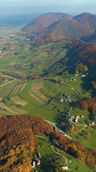
12 12 Boč and Macelj stand as the eastern extension to the Karavanke mountains and border the western part of the Pannonian low hills, with Mount Donačka gora rising above both of them. The hills separate the Dravinjske gorice and Haloze regions from Posotelj. The low hills stand out from the lower surrounding landscape due to its low elevation. The difference in height can reach up to 700 metres. The hills between Boč and Macelj are almost uninhabited because the surrounding low hills offer much better conditions for settlements. On the southern, less steep and warmer slopes, settlements can be found up to 500 metres above sea level. Two thirds of the area is completely covered by forest, the largest and densest woodland being in the central part of Boč and Mount Donačka gora, extending to the rim of the Žetal basin. There is still primary forest on the northern part of Mount Donačka gora which is protected as part of the Boč-Donačka gora Regional Park as the only old-growth forest in the Pannonian landscape of Slovenia. VOGLAJNA AND THE UPPER SOTLA LOW HILLS Voglajna and the Upper Sotla Low Hills comprise a transitional landscape between the Alpine and Pannonian landscape. The area extends from the Celje basin and the eastern branches of the Posavje Highlands to the low hills, where the only rising ground is the occasional solitary mountain amidst rolling low hills. A broad system of valleys has formed along the Voglajna, Šmarski potok, Mestinjščica and Sotla rivers. The prevailing landscape in the east, the Upper Sotla Low Hills or even Šmar-

13 13 je-rogaška Low Hills, are low hills with rounded peaks and flat ridges and gentle slopes with mostly narrow valleys in between. Forest covers more than a third of the landscape, consisting mostly of broadleaved trees. There are fewer vineyards than in other wine-growing regions, but they are more or less evenly distributed on the slopes exposed to the sun. As much as a third of the population lives in the central valleys, the valley of Zibiški potok and Kostrivnica valleys, in the four largest settlements of Šentjur, Šmarje pri Jelšah, Rogaška Slatina and Rogatec. POSAVJE HIGHLANDS The Posavje Highlands extend all the way to the Central Sotla Low Hills in the east. The Orlica ridge even touches the border with Croatia. Most of the highlands are between 300 and 600 m, with individual peaks exceeding 1000 m above sea level. Due to the prevailing layers of impermeable rock, the Posavje Highlands are riddled with a dense water network. The landscape has a moderate continental climate, which can be rather harsh in the higher areas. The diversity of rocks and soil has also enabled the growth of varied vegetation. CENTRAL SOTLA LOW HILLS This is a border Pannonian landscape. It is bounded in the north, west and south by the eastern foothills of the Alps in the form of the Posavje Highlands, and by the Sotla River in the east. The Central Sotla Low Hills are also known as Kozjansko, which mostly coincides with the Bistrica River basin. The heart of Kozjansko, the Kozje settlement that gave it its name, lies west of the Bistrica valley. The Central Sotla Low Hills can be divided into several regional sections. The valleys include the Bistrica valley and the central Sotla valley between Podčetrtek and Kunšperk. In the north, the distinct winegrowing area of Virštajn Low Hills, and Bistrica Low Hills in the south. All the waters of the Central Sotla Low Hills run into the Sotla, with the Bistrica and Buča being the main tributaries. Forest covers more than a third of the area, mostly of broadleaved trees, including beech. The region is quite evenly populated, with an increase of population density in the southwest wooded area. It does not have a powerful centre or even a town. Dispersed settlements are mostly on the ridges and gentle slopes exposed to the sun.


14 14 HOW TO USE THE GUIDE The guide contains a description of Mary s Pilgrimage Route in Slovenia, divided into western and eastern branches and four combinations. The Route is described in stages or legs. At the beginning of every stage, a smaller map provides a graphical presentation of the leg, followed by a description of the route and Saint Mary s churches or the main stops on this stage. A list of the cultural and natural sights along the route can be found at the end of each leg. The number of the page at the end of the guide where you can find tourist information on individual stages (accommodation, places to eat, information centres) is given at the bottom of the page. The guide also has information about churches of Saint Mary which are not included in the Route, but are located nearby. There is also a list of caretakers and checkpoints along the route where you collect Mary s Pilgrimage Route stamps for your pilgrimage booklet. For better orientation when walking, we recommend using the Mary s Pilgrimage Route map. There are thirty rest stops along the Route. Information panels with important information on the Route can be found at the main stops. There are information panels with relevant details next to all churches along the route which are dedicated to Mary, and other cultural heritage buildings and monuments.
15 15 MARKINGS ON MARY S PILGRIMAGE ROUTE IN SLOVENIA Mary s Pilgrimage Route in Slovenia is marked in accordance with the Mountain Paths Act (Official Gazette of RS 61/2007) and the Instructions for Marking Thematic Hiking Routes. Where it follows the same route as mountain paths, it is marked with white and red circle signs - known as a paint blaze - a direction arrow and a red direction signboard with a white inscription, in accordance with the Mountain Paths Act. Where it follows the same route as a European walking route, they are marked with a red and yellow circle. Other sections of Mary s Pilgrimage Route are marked with white and yellow signs, a yellow direction arrow and a yellow direction signboard with a white inscription, in accordance with the Instructions for Marking Thematic Hiking Routes in Slovenia. The direction signboards at main route crossroads have an additional board with the Mary s Pilgrimage Route logo.
16 16 MARY'S PILGRIMAGE ROUTE - A SHORT PRESENTATION In Slovenia, there are two branches of Mary s Pilgrimage Route leading from Mariazell, Austria, to Marija Bistrica, Croatia. THE WESTERN BRANCH starts on the Austrian-Slovenian border at Trate and includes all Saint Mary s churches in Zgornja Velka, Jareninski Dol, Gorca at Malečnik, Vurberk, Podlehnik, Ptujska Gora all the way to the foothills of Mount Donačka Gora, where it continues towards Croatia in three sub-branches. The first and longest sub-branch passes the churches at Ložno, Ljubično, Sladka Gora, Šmarje pri Jelšah, Završe pri Grobelnem, Botričnica, Kalobje, Dobje pri Planini, Zagorje, Kozje, Podsreda and Svete gore above Bistrica ob Sotli (VERSION 1). The second sub-branch follows the Croatian border, passing the churches at Tržišče at Rogaška Slatina, Slake at Podčetrtek and Olimje (VERSION 2). The above sub-branches meet at Bistrica ob Sotli, from where the route continues towards Croatia s Marija Bistrica. The third and shortest sections of the route are from Brezje above Žetale to the Slovenian-Croatian border at Gruškovje or further on to Zgornji Leskovec (VERSION 3). Here the route also continues to Croatia s Marija Bistrica. THE EASTERN BRANCH of the Saint Mary s pilgrimage route begins on the Slovenian-Austrian border at Gornja Radgona and continues to the Slovenian-Croatian border at Zavrč, or to the border crossing at Zgornji Leskovec (VERSION 4). The route leads past the churches at Negova, Polenšak and Zavrč and continues towards Croatia as far as Marija Bistrica. A pilgrim can therefore choose from the following 4 combinations of route versions. VERSION 1 (10 legs), 216 km (225 km): Trate Ptujska Gora Boč Sladka Gora Šentjur Dobje Zagorje Podsreda Svete gore above Bistrica ob Sotli IBC Bistrica ob Sotli/Razvor VERSION 2 (7 legs), 174 km: Trate Ptujska Gora Bukovje Rogaška Slatina Podčetrtek Olimje Buče IBC Bistrica ob Sotli/Razvor VERSION 3 (5 legs), 124 km (141 km): Trate Ptujska Gora Donačka gora Žetale IBC Gruškovje/Macelj (or BC Zgornji Leskovec/Cvetlin) VERSION 4 (3 or 4 legs), 74 km or 99 km: Gornja Radgona Negova Sv. Trojica in Slovenske gorice Juršinci Gorišnica IBC Zavrč/Dubrava Križovljanska or BC Zgornji Leskovec/Cvetlin
17 17 BC Interstate Border Crossing IBC International Border Crossing VERSION 1 10 legs / 216 km (225 km): LEG ITINERARY WALK DURATION DISTANCE 1 2 Trate Zgornja Velka Šentilj in Slovenske gorice Šentilj in Slovenske gorice Jareninski Dol Pernica (Maribor) Malečnik Spodnji Duplek 6 hours 15 min 21 km 6 hours 45 min 28 km 3 Spodnji Duplek Dvorjane Vurberk Ptuj 4 hours 45 min 19 km Ptuj Videm pri Ptuju Podlehnik Ptujska Gora Ptujska Gora Jelovice Bukovje Rudijev dom mountain hut under Donačka gora Rudijev dom mountain hut under Donačka gora Ložno Mountain hut at Boč (Kostrivnica) Pečica Ljubično Sladka Gora Šmarje pri Jelšah Šmarje pri Jelšah Završe pri Grobelnem Botričnica Šentjur 8 hours 45 min 32 km 4 hours 30 min 14 km 9 hours 29 km 4 hours 30 min 16 km 8 Šentjur Rifnik (Slivnica pri Celju) Kalobje Dobje Planina pri Sevnici 4 hours 45 min (7 hours 45 min) 18 km (27 km) 9 10 Planina pri Sevnici Zagorje Kozje Podsreda Podsreda (Koprivnica) Podsreda castle Svete gore above Bistrica ob Sotli IBC Bistrica ob Sotli/Razvori 7 hours 24 km 3 hours 45 min 15 km TOTAL VERSION km (225 km)
18 18 VERSION 2 7 legs / 174 km: The first four legs and part of leg 5 are described above as part of Version 1. LEG ITINERARY WALK DURATION DISTANCE 1 2 Trate Zgornja Velka Šentilj in Slovenske gorice Šentilj in Slovenske gorice Jareninski Dol Pernica (Maribor) Malečnik Spodnji Duplek 6 hours 15 min 21 km 6 hours 45 min 28 km 3 Spodnji Duplek Dvorjane Vurberk Ptuj 4 hours 45 min 19 km 4 5 Ptuj Videm pri Ptuju Podlehnik Ptujska Gora Ptujska Gora Jelovice Bukovje Rudijev dom mountain hut under Donačka gora Rogatec Rogaška Slatina 8 hours 45 min 32 km 7 hours 28 km 6 7 Rogaška Slatina Sv. Ema (Spodnje Tinsko) Podčetrtek (Slake) Olimje Olimje Virštanj Buče IBC Bistrica ob Sotli/Razvor 5 hours 30 min 24 km 5 hours 30 min 22 km Rudijev dom mountain hut (Donačka gora) IBC Bistrica ob Sotli/Razvor TOTAL VERSION 2 56 km 174 km
19 19 VERSION 3 5 legs / 124 km (141 km): The first four legs and part of leg 5 are described above as part of Version 1. LEG ITINERARY WALK DURATION DISTANCE Trate Zgornja Velka Šentilj in Slovenske gorice Šentilj in Slovenske gorice Jareninski Dol Pernica (Maribor) Malečnik Spodnji Duplek Spodnji Duplek Dvorjane Vurberk Ptuj Ptuj Videm pri Ptuju Podlehnik Ptujska Gora 6 hours 15 min 21 km 6 hours 45 min 28 km 4 hours 45 min 19 km 8 hours 45 min 32 km 5 Ptujska Gora Jelovice Bukovje Žetale IBC Gruškovje/Macelj Sveti Avguštin (BC Zgornji Leskovec/Cvetlin) 7 hours (11 hours) 24 km (41 km) Bukovje BC Zgornji Leskovec/Cvetlin TOTAL VERSION 3 29 km 124 km (141 km) VERSION 4 3 or 4 legs / 74 km or 99 km LEG ITINERARY WALK DURATION DISTANCE 1 2 Gornja Radgona Rodmošci Negova Sv. Trojica in Slovenske gorice Sv. Trojica in Slovenske gorice Vitomarci Juršinci Polenšak Gorišnica 6 hours 23 km 9 hours 34 km 3 Gorišnica Formin Borl IBC Zavrč 4 hours 17 km 4 Zavrč Drenovec Turški Vrh Korenjak Paradiž Skorišnjak BC Zgornji Leskovec/Cvetlin 8 hours 25 km TOTAL VERSION 4 99 km

20 20 version 1 leg 1 (21 km, 6 hours 15 min) Trate Zgornja Velka Šentilj in Slovenske gorice The western branch of Mary s Pilgrimage Route starts on the bridge spanning the River Mura at Trate, which connects the nearby Austrian town of Cmurek/ Mureck with Mariazell, Austria s principal pilgrimage site. From the banks of the Mura, climb the hilly Slovenske gorice, which you cross on the way to the town of Ptuj. From the Mura Bridge to the Eferl farmstead at Kaniža, follow the path marked by white and red circle blazes. Upon arriving at the former border crossing, turn right and follow the tow path along the Mura until you reach a large clearing, where you turn left and tackle a steep path uphill leading to the trees on top of Einsiedelberg Hermit s Hill. From the clearing, head into the woods as far as the main Trate Lenart road by the exit for Lokavec. At the main road crossroads, follow the local road to Lokavec and turn right at the first exit. A signpost soon directs you left and downhill, towards Zver farm. The path continues past the stable and into the valley, where you cross the stream and turn slightly right into the woods. Along the forest trail, climb to the ridge, where there is a paved road connecting Dražen Vrh with Lokavec. Turn right and follow this road until you reach the intersection, where blazes mark the path between the forest and the field. Soon you reach a forest, which you cross to reach a clearing with a chapel. The path leads left into the woods and soon reaches the Velka hunting lodge. see page
21 21 Crossing the hunting lodge yard, walk downhill to the pond, and follow the causeway between the two ponds. Follow the lower pond to the main Trate Lenart road. Turn left and continue until the exit for the local road to Dražen Vrh, where you take the right towards Holer farm. Walking along the deer enclosure, you reach a crossroads, where you should bear right; when reaching the top of Dražen Vrh, continue towards Zgornja Velka, following the ridge-top road to a crossroads with a crucifix and on to the left exit leading uphill to Oman farm. Crossing the hillock, continue along the road to the first intersection and bear left, past the bus stop and small chapel to the square on which stands Zgornja Velka s Mary of the Snows Church. From Zgornja Velka, continue left, past the inn, towards Spodnja Velka. Next to the chapel, turn left and follow a gravel road towards a solitary farm, walk past it and into the woods. Upon exiting the woods, you will see Rajšpova gomila, a tree-covered hillock, in front of you. Go downhill, cross the stream and climb the top of the tumulus. From here, descend to the meadow and walk uphill to Rajšp farm. From Rajšp farm, continue to the main Zgornja Velka Jurovski Dol road. Turn right and follow the ridge-top road, then turn left by a nearby house onto a gravel road. Continue past a holiday chalet to a farm, where you must turn right onto a path across the field, pass the forest until you reach a smaller cultivated plot; you then walk straight down to the bottom of the valley. Continue left along a small stream and then walk up towards a homestead consisting of several buildings. Leaving the house behind, you reach the stream and then walk uphill towards a paved (asphalt) road. Cross the yard and follow the path past the field until you reach a forest track, which you will soon leave and bear right through the orchard to a vineyard, where there is a gravel road. Past the vineyard, you reach the paved road of the Šomat hamlet. Once on the edge of the forest, turn left and downhill into the valley of Globovnica stream. By the Pleteršek homestead, there is a paved road which you follow to the right. This leads to the main road linking Zgornja Velka and Vranji Vrh. At the crossroads take the left road, leave it for a moment and return to it. Continue along this road past the local store straight to the hunting lodge at Vranji Vrh. From the hunting lodge, return to a residential building, bear right behind it and walk towards a stable. Continue through the forest and meadow to the paved road, from which you will soon turn left and reach Wolf Cave ( vučja jama ). Walk uphill on the road, exit the forest, and at the intersection behind an old house, turn right to Srebotje. In the midst of vineyards and farmsteads, continue towards the valley, where you take the paved road. At the next crossroads, walk straight along the valley until reaching the bridge spanning Jakobski potok stream. Once across the bridge, turn right and walk along the edge of the pasture to the forest. Walk uphill to the orchard, through which you will reach the top of a ridge dotted with several individual houses, part of the Zgornji Jakobski Dol hamlet. Turn right, and follow the road to the vineyard, where you head left into the woods. Crossing the woods, you descend to the valley of Vukovski potok stream, from which another uphill path leads to the next ridge. Underneath the overhead power line, continue along the forest trail, which leads to a lower-lying vineyard. Passing the vineyard, you reach a tourist farm. see page


22 22 Natural and cultural sights NATURAL SIGHTS: Lime tree, Trate Castle Aleksander and Peter s lime tree, Zgornja Velka Rajšp Mound, Spodnja Velka CULTURAL SIGHTS: Cmurek Castle, Trate Novi Kinek Castle, Trate Petek Mill, Trate Mura River ferry, Sladki Vrh Square Well, Zgornja Velka Šviligoj Homestead, Zgornja Velka St. Giles Church, Šentilj in Slovenske gorice Štrudl Villa, Šentilj in Slovenske gorice Chapel, Brloga Methans House Ethnological collection and art gallery, Zgornji Dražen Vrh Mura River ferry, Sladki Vrh Square Well, Zgornja Velka Chapel, Brloga

23 1 ZGORNJA VELKA Parish Church of Our Lady of the Snows m above sea level The church was built during a period of skin epidemics. At that time, a small church was built close to Trate Castle on the right side of the Mura River, and named the Church of Our Lady of the Snows. It was home to hermit monks, the eremites. The church was demolished during the Joseph II reforms in 1788 and a new church on Zgornja Velka was built from 1789 to 1791, which the people of Zgornja Velka constructed from material taken from the dilapidated church on Einsiedelberg. The entire construction was led by the vicar of the Church of Our Lady of the Snows, Matija Purgaj, who also held the first mass there on December The church has a single nave with a square bell tower. There is a crucifix on the east façade. The inside is arched; chapels are placed alongside the nave. The church is furnished in the Baroque style. The main altar and pulpit are by Jozef Holzinger; some of the statues are by the sculptor Johannes Klein from Radkersburg (Radgona). The church was once a popular well-known pilgrimage destination and is becoming increasingly recognised. It was declared a pilgrimage site in Beside the church, a renovated well with the following verse by Tone Kuntner can be seen: You, the pilgrim to Our Lady of the Snows, will not leave this place either hungry or thirsty. Delight in its beauty and peace, drink the wine of the plain truth. Church Parish Marija Snežna Zgornja Velka 43 / SI-2213 Zgornja Velka / Tel: +386 (0)
 Malečnik Spodnji Duplek see page 116")
24 24 version 1 leg 2 (28 km, 6 hours 45 min) Šentilj in Slovenske gorice Jareninski Dol Pernica (Maribor) Malečnik Spodnji Duplek see page
25 25 From the tourist farm, continue downhill along a service path to the main Šentilj Jareninski Dol road. At the junction, turn left and continue up to the exit for mrzli studenec ( cold stream ). Here, bear right, cross the stream and head into the woods uphill to the ridge, where there is a gravel road; to the left, this leads to the LD Jarenina hunting lodge, but our itinerary leads straight ahead towards Kaniža. At the next junction, turn right and walk slightly uphill. Continue along the meandering ridge between the Jareninska and Cirkniška dolina valleys. At a crossroads marked by a crucifix, continue straight ahead and turn right at the next junction. Walking past several individual houses, you once more join the road that leads past the Second World War Resistance monument to Eferl farm at Kaniža. From the Mura Bridge at Trate to Eferl farm, you follow the white and red blazes. From Eferl farm to Pernica, you walk on a trail marked by round white and yellow blazes designating recreational and theme routes. By Eferl farm, turn left and continue downhill on a road with vineyards on each side until as far as the road linking Jareninski Dol and Pesnica. Follow this road, and bear left and downhill. At the first crossroads, the route continues directly into the centre of Jareninski Dol with Saint Mary s Church. From the centre of Jareninski Dol, walk a few metres back in the direction of Šentilj, and then turn right on the local road on which you will climb to the top of the ridge. On the saddle, turn right. Mary s Pilgrimage Route follows the ridge on which stands the extended settlement of Jareninski Vrh, up to the end at the lake known as Perniško jezero. At junctions, pay attention to the blazes on the ridge-top road. Where the ridge ends, walk downhill past holiday chalets and through the woods until you reach a large meadow with a vineyard. Follow the downward sloping cart trail to the houses, where you reach the Pesnica Zgornje Vukovje road. Walk right to the nearby junction, and then continue to the pizzeria. At the junction, take the left local road towards Pernica. The road runs along the banks of Perniško jezero lake, at first through meadows and fields and then through a settlement of recently built houses. Upon reaching the main, Maribor Lenart road, take the left-hand pavement across the flyover over the Maribor Lendava motorway. Soon you arrive at a crossroads, where you turn left through a section of the village of Obrat, directly into the centre of Pernica. From Pernica to Zgornji Duplek, you once again follow the white and red blazes. From the centre of Pernica, the route leads past the village shop across the roundabout towards the new settlement by the cemetery. Follow the upward sloping local road, which is at first paved with asphalt and then gravel, until reaching the ridge that forms the border between the municipalities of Pesnica and Maribor. Once at the top of the ridge, you reach an asphalt road, where you bear right in the direction of the Hrenca hamlet. After a brief descent, you climb again to a crossroads, where the route turns left onto a ridge-top cart track, which you follow as far as a paved road, which you soon leave behind. Strolling through the Slovenske gorice landscape of vineyards, orchards and stands of mixed forest, the panoramic views take in the remote Dravsko polje basin, the Pohorje see page
26 26 mountain range and the last section of the Karavanke Alps, which consists of Konjiška gora, Boč and Donačka gora. On the ridge-top road running past rustic wineries and a tourist farm, you reach Saint Mary s pilgrimage church at Gorca at Malečnik. Crossing the churchyard, continue alongside the Way of the Cross towards the centre of Malečnik, and past Saint Peter s Church, where you turn left, where the route descends to the main road by the River Drava. You walk along the main road foe only a short time before turning right towards Trčova at the next crossroads. The path runs on the pavement up to the first junction of the local road, where you turn left. This road leads partly through a forest and past individual houses and on to the top of Trčova ridge. At the crossroads, take the ridge road to your right towards Metava. Passing detached houses, you soon reach the crossroads, where you turn right. A few metres on, take the local road to the left, which descends to a settlement of recently built houses. At the settlement, the blazes direct you to the left along a street at the end of which you start climbing back up to Trčova ridge. Once on top of the ridge, take the right-hand road at the crossroads and follow it to the end of the paved surface. You soon reach the forest, through which, via Kamenščak, you come to the first houses of the village of Zgornji Duplek. You walk downhill to the settlement of recently built houses, first on a gravel and then asphalt road. In the village, first turn left and then right on the main road. You soon reach the intersection with the European Cultural Trail of Saint Martin of Tours, which leads here from Miklavž na Dravskem polju. From this crossroads to Vurberk, the route is again marked with white and yellow blazes designating recreational theme routes. Continue left on the cart trail through meadows and fields in the direction of Spodnji Duplek. At the end of the trail ther is an intersection of asphalt roads. Walk straight on and turn right onto a gravel lane by the first house. Following the edge of a raised Drava riverbank, walk downhill to the houses of Spodnji Duplek. Walk to your left until an intersection with another hiking trail. Continuing straight on, you arrive in the centre of Spodnji Duplek, with its attractive municipal building. Before leaving the paved road at Hrenca and taking the ridge-top cart trail, a path veers off from this route: it leads to Saint Mary s Basilica in the centre of Maribor. Continue the path straight ahead on the paved road up to the junction, where you head to the farm on your left. At the nearby crossroads, bear left again and a few metres on downhill to the right in the direction of the motorway. Walk under the motorway on the local road that climbs past detachedl houses. Reaching the hill known as Meljski hrib, descend to the Meljski Dol hamlet and the overpass, where you cross the highway and railway linking Marobro with Graz. From the overpass, you continue on a road called Šentiljska cesta until you reach the town centre. Past the train and coach station, follow the street called Partizanska cesta until you reach Saint Mary s Basilica. see page
,")


27 Natural and cultural sights 27 NATURAL SIGHTS: Jareninski Dol Regional Park, Jareninski Dol Lake Pernica, Pernica Kamenšak-Hrastovec Regional Park Drava Regional Park Old Drava riverbed Karst spring, Zgornji Duplek Underground cave, Zgornji Duplek Dob (oak tree), Zgornji Duplek CULTURAL SIGHTS: St. Jacob s Church, Jakobski Dol Vogrin Museum windmill, Jakobski Dol Sacred year s monument, Jareninski Dol Shrine, Jareninski dol Old St. Michael s ossuary, Jareninski Dol Jarenina Castle, Polički Vrh St. Margaret s Church, Pernica St. Peter s Church, Malečnik Stations of the Cross chapels, Gorca Old Slavonic archaeological site, Zgornji Duplek Chapel dedicated to raftsmen, Spodnji Duplek St. Margaret s Church, Pernica St. Peter s Church, Malečnik Chapel dedicated to raftsmen, Spodnji Duplek


28 28 2 JARENINSKI DOL Parish Church of the Assumption The original Romanesque church was built before 1135 by the nobleman Rudolf Wittenswald, who participated in the hostile attack on Hildebod the Bishop of Gurk. As a gift of reconciliation, Rudolf donated the church and all his property to the Archbishop of Salzburg, who then gave it to the Admont Monastery. The first reference to the church as a parish church is from The present nave is still partly Romanesque, but most of the building is late Gothic, because the earlier building was burned down by Ottoman raiders in 1532, and renovated later. The chapel of Saint Blaise was added in the 17th century, and the chapel of the Holy Cross in the 18th century. The equipment inside is Baroque. The pulpit is by J. Holzinger, the side altars from 1755 are by J. Straub, and the altar crucifix from around 1740 is by F.J. Straub. The church is adorned by paintings by G. Broll. The late Gothic bell tower with the original stone roof is unique in Slovenia. Alongside the church which was once surrounded by a cemetery there is a round charnel house, St. Michael s, with an apse, with two Baroque vaults and wall openings, but with a basic design from the 12th century. The parish holiday (the Blessing) is on the day of Mary s Assumption, 15. August. Church Parish Jarenina Jareninski dol 12 / SI 2221 Jarenina / Tel:+386 (0)
29 3 346 m above sea level MALEČNIK Subsidiary Church of the Virgin Mary on Gorca The church is located on top of winegrowing low hills overlooking Malečnik, with a beautiful view of the area around the city of Maribor. Built in 1517, the late Gothic church was fortified by a strong wall until It consists of an entrance hall, church tower, nave and presbytery, with two Baroque chapels added on the southern and northern sides, and an added vestry on the northern side. In 1854, the church interior was painted by Giacomo Brollo and Tomasso Fantoni with four assistants, following a design by the Graz painter Tendler. The murals show scenes of Mary s life; the arches between the painted ridges show allegories from the Lauretian Litany and angels bearing Mary s emblems. The figural composition on the arched doorway is especially worth noticing, with Mary s worshipers gathered beneath her cloak, including Bishop Slomšek and Priest Marko Glazer, the latter having commissioned the renovation of the church. The main altar dates to the 19th century and was made in the workshop of master Kainz. It features an older, gracious statue of Mary Help of Christians holding the infant Jesus. A figural group scene of Mary s coronation from the beginning of the 17th century is placed in a niche in the presbytery. There are altars of St. Valentine and St. Florian in the northern chapel; the altar of St. Anthony of Padua is in the southern chapel, and there are two side altars dedicated to St. Urban and St. Anne in the nave. It said that the church once had as many as eight altars. Fourteen chapels of the Stations of the Cross from 1847 lead to Gorca. In front of the Second Station, there is a stone pyramid monument, erected in 1817 in memory of the priest M. Breznik, who died on this very spot on his way to Gorca. The final chapel stands in the cemetery around the Gothic church. The main pilgrimage event is on September Church Parish Sv. Peter pri Mariboru Malečnik 34 / SI 2229 Malečnik / Tel: +386 (0) / Web: www. zupnije.rkc.si/malecnik


30 30 4 MARIBOR Basilica of Our Mother of Mercy Today s church with the monastery was built between 1892 and 1900 on the site of the previous Capuchin church. It was built by a Franciscan, friar Kalist Heric from plans by Viennese architect Richard Jordan. The building is in Pseudo-Romanesque style and the façade is adorned by two imposing 58-metre towers. In 1906, Pope Pius X. elevated this pilgrimage church to a minor basilica, which is also explained on the crest on the front of the church. It was the first church elevated on Slovenian soil and even the first in the Austro-Hungarian Empire. The church has three naves; only the part on the arched doorway remains of the original murals. The walls of the presbytery were painted in 1965 by Stane Kregar, who also made the three new stained glass windows. The main altar is made of seventeen types of marble and is adorned by a gracious image. The Franciscans were given control of the church with the monastery in 1864 and still administer it. Counts and bishops of Maribor are buried in the tomb, including Martin Slomšek (until 1980). The pilgrimage is on 15 August. Church Parish Maribor Sv. Marija Ul. Vita Kraigherja 2 / SI 2000 Maribor / Tel:+386 (0) zupnija.sv.marija.maribor@rkc.si / Web:

31 version 1 leg 3 (19 km, 4 hours 45 min) 31 Spodnji Duplek Dvorjane Vurberk Ptuj From the centre of Spodnji Duplek, return to the junction of another pedestrian trail. Then turn right, cross a small bridge and walk uphill through the forest until you reach the chapel on top of Dupleški Vrh. Just before the stone escarpment, turn right and stay on the local road for a few metres until turning left. Follow this driveway downhill to the elementary school. Leaving the school behind, you reach the local road, staying on it for a few metres, and then turn right onto a pedestrian trail. Once past the house, walk to the small bridge crossing the stream and continue on the upward sloping path to the local road. Now bear left to the crossroads by a chapel, where you turn right in the direction of Dvorjane. At the crossroads with the main road, turn left and follow the pavement through the centre of Dvorjane to Saint Martin s Church. From the church at Dvorjane, continue on the local road to your right in the direction see page
32 32 of Krčevina and Ptuj. Reaching a settlement of recently built houses, leave the paved road behind and follow the driveway to the forest. Through the beech woods, climb the cart track to the top of the slope. Upon reaching the gravel road, turn left towards a shop where a signpost directs you to the right to the well-kept path to Saint Mary s Church at Vurberk, which stands near the ruins of the once mighty Vurberk Castle. From Vurberk through Ptuj and all the way to Sladka Gora, the path is marked by round white and red blazes. From Vurberk, the path leads from the church and continues along the trail of positive energy sources past the portal to the Castle. Following a downward sloping forest trail, you reach a crossroads of gravel roads. Continue straight ahead on the ridge-top gravel road to Plančeva kapela chapel at Krčevina pri Vurberku. The path runs predominantly through beech woods. Roughly a kilometre before the chapel you reach a recently paved road. By the chapel, walk straight along the paved road that runs first along Krčevina ridge before gradually descending. By the information table of the Primestna četrt Grajena turn right, following a local slightly downward sloping road to a crossroads surrounded by orchards. Turn left, and walk beside the fence of a medium-sized apple orchard to a bridge spanning a small stream. Behind the bridge there is a fork in the road which leads into the valley of the River Drava. You turn right on the next road a few metres on, and start walking uphill. The paved road ends above the Breg homestead at Krčevina pri Vurberku. Take the gravel driveway to the right, then turn almost immediately to the left along the rim of a vineyard and downhill to Breg farms s nonresidential building. From Breg farm, stay on the grave driveway as far the nearby woodland. The blazes direct you to your right into the wood through which you walk uphill to a paved road on which you turn left and walk slightly downhill. At the junction, turn left past the stables and towards a water tank, where you bear right to the end of the paved road and continue on gravel until the crossroads in front of a battery farm. Stay on the gravel road and keep right along the edge of the forest. In front of the Petek homestead, turn left into the forest where the forest trail leads uphill on Klinčev hrib. From the top, there is a wide panorama over the Drava basin Dravsko polje. Continue on the ridge past Horvat farm and on to Sovretova pot (Sovre s Path). Before reaching Sovretova pot, look to your lower right for Hince s sequoia at Orešja, the largest of its species in Slovenia. Following Sovre s path, walk to the junction with Klepova ulica (street), where you turn left and uphill. Past recently built houses, you come to ulica (street) Vide Alič, which takes you to the main road connecting Ptuj and Dvorjane. You cross this and walk straight on a narrow lane known as Vičavska pot to the bank of the Drava River. Vičavska pot runs parallel to the Drava and up to the buildings of the former army barracks of the town of Ptuj. You reach a park known as Sončni park, then stroll past the former Dominican abbey and Ivan Potrč library, continuing on Dravska ulica (street) up to a pedestrian bridge. see page


33 Natural and cultural sights 33 NATURAL SIGHTS: Castle Park, Vurberk Alder grove and Siberian iris habitat, Vumpah near Vurberk Bregova holly tree, Grajena Hince s sequoia, Orešje pri Ptuju Sunny Park at the Dominican Monastery, Ptuj Sycamore, Ptuj CULTURAL SIGHTS: St. Martin s Church, Dvorjane Vurberk Castle, Vurberk Hinc Homestead, Orešje pri Ptuju Planec Chapel, Krčevina pri Vurberku Ptuj Castle, Ptuj Ptuj Regional Park, Ptuj St. George s Church, Ptuj St. Peter and St. Paul s Church, Ptuj Minorite Monastery, Ptuj Dominican Monastery, Ptuj Orpheus Monument, Ptuj The Statue of St. Florian, Ptuj Mithras Shrine, Ptuj Town Hall, Ptuj Town s Tower, Ptuj Mali grad Manor, Ptuj The Statue of St. Florian, Ptuj Town Hall, Ptuj Ptuj Castle, Ptuj


34 34 5 VURBERK Parish Church of the Assumption The church is located immediately below the ruins of Wurenberg (Vurberk) Castle; it served the religious needs of the counts and anyone connected with the castle until it became a parish church in The first mention of the original church was in 1336 and the second church dedicated to St. Nicholas in 1510, but this was badly damaged during the period of Ottoman raids and the Reformation. Due to pilgrimages and other requirements, the present church was built between 1773 and 1776 following a design by Johann Fuchs of Maribor. The single nave church has a semi-circular presbytery, a bell tower with an onion dome, and an added vestry. The dome was painted with Mary s scenes by Franc Gornik in 1893, at the request of the parishioners. The oldest part of the main altar is the statue of Mary with the infant Jesus, dating back to the 15th century, but this was renovated in the 17th century after being badly damaged. The altar base with the main altar was made by the Ljubljana master craftsman Luka Mislej in In the 19th century, the church acquired new side altars dedicated to St. Joseph and the Holy Cross. All the major interior sculpture is from the Mersi and Holzinger workshops. The inner and outer walls of the church incorporate a Roman tombstone and tombstones with relief sculptures of the Wurenberg lords from the 16th and 17th centuries. The main pilgrimage event is on August 15. Church Parish Vurberk Vurberk 86 / SI 2241 Sp. Duplek / Tel:+386 (0) Web:

35 version 1 leg 4 (32 km, 8 hours 45 min) 35 Ptuj Videm pri Ptuju Podlehnik Ptujska Gora Cross the Drava on the pedestrian bridge and turn left to the railway bridge. On the right bank of the Drava, behind the railway bridge, the path veers towards a seed shop, where you turn left at the junction in front of it. Follow the gravel path to the right of the production facilities between two wire fences, all the way to Puhov most bridge. Walk through the subway under the bridge and straight on following a wire fence to the junction by Ptuj s municipal sewage water treatment plant. Cross the driveway leading to the plant and walk straight ahead on the gravel road to a small wood on your left. Upon reaching the other end of the forest, bear left to the embankment of Ptuj Lake. By the containers of the treatment plant, turn right on the gravel road running parallel to an artificial riverbed. Follow this road, above which rises the embankment of a resevoir; turn at the see page
36 36 next intersection, where a cart track takes you the fish farm at Šturmovcih. From the fish farm, the path continues on the paved road to Videm pri Ptuju. When you reach the end of the built-up area, leave the road and walk along the edge of the forest until you return to another paved road. To your left is the vast area of the Šturmovci Landscape Park (Krajinski park Šturmovci). Cross the road and continue on the cart track up to a small bridge spanning the old Drava riverbed. You now follow the River Dravinja embankment to the football field of the Videm pri Ptuju elementary school. On the paved road, turn left and walk past Saint Vitus (Guy s) Church and the municipal hall until you reach a bridge across the Dravinja. Once you have crossed the Dravinja, you are in the Haloze region. At the first junction, turn right towards Dravinjski Vrh. Saint John s Church stands above residential houses to the left. Turn right from the local road after a few metres and follow a driveway to the edge of the forest. Turn left and take the upward sloping path to a driveway, which you follow to the ridge-top paved road at Dravinjski Vrh, where this route meets the Haloze mountain route and the E7 from Borl to Podlehnik. As you follow this route, you pass the Kolednik homestead to your right and the winemaker/shop at Dravinjski Vrh. At the crossroads immediately after the wine shop, turn right and downhill, and continue along a deer enclosure to Majski Vrh. The ridge-top road meanders through vineyards all the way to a forest, at the end of which, just before the road descends into Rogoznica valley, you turn left onto a gravel road leading to the vineyards. Stay on this road until the top of the hill and the nearby vineyard. By the vineyard, turn right and descend to the forest, continuing until you reach the paved road by Podlehnik elementary school. Here, you turn left and continue to the first crossroads, where the road forks towards Leskovec. You continue on this road to the nearby fork, where the path on the right leads to Saint Mary s Church. Mary s Pilgrimage Route continues straight ahead on the road that leads across Rogatnica stream and a car showroom. Here, the road divides; one road leads to Gorca; but you continue straight on, crossing the Maribor Zagreb motorway, to a nearby pub. A signpost directs you straight ahead on a driveway to a hunting lodge at Podlehnik. Before the gate to the courtyard, bear left. Walk along the flank of the meadow into the woods, through which you reach a paved road. Turn right and then take a sharp left turn by a recently built house onto a cart track, which gently descends towards Podlehnik pond. Continue along the eastern side of the pond to its outflow and onwards to the forest. Through the forest, climb to the first houses at Gorca, where you reach a paved road. Follow this road past a manor house - once the property of Ornig, a former mayor of Ptuj - and continue to Dežno. Below you to the right, there are fine views of the Holy Trinity Church at Gorca. see page
37 37 The road across Gorca, on which this pilgrimage route runs, meanders through vineyards next to which stands a wooden structure housing the Podlehnik Tourism Board. Continue the path on the road to the right of the viticulture museum to the crossroads by a large spruce tree. Here, turn right and climb the slope to the rim of the forest. Continue on the road to the right that running along the edge of the forest and uphill. Soon you reach the crossroads with a paved road at Zgornja Pristava. Walk on the ridge-top road straight ahead and, at the holiday chalet, left and uphill. The Dežno winery is nearby, and you take the steep downward sloping road just after the winery. The road descending through vines and then forest trees takes into the valley and to a crossroads, where you take the gravel road to your right, crossing a bridge over Peklača stream, to the paved road at Dolena. Follow the road on the right to the bridge across Kačjak stream located by the first farm you see. In front of the non-residential buildings, turn left and past fruit trees into the forest, uphill to the forest trail through the Kačjak Valley and towards the peak of Janški Vrh. In the upper part of the valley, the path is secured with wooden palisades. Reaching the ridge, you leave behind the forest, and climb slightly past the old house to a paved road. Continue to the left on this ridge-top road left through small chalets to the forest, from which you reach the road from Dolena. Continue to the left and uphill to the Church of St. John the Baptist at Janški Vrh. At the crossroads below the church, take the right downward sloping road to Doklece. Going straight would take you on the Haloze mountain route that leads to Neraplje. Descending from the hill via the forest and arriving at a substantial farm, walk past it to the intersection in the Dravinja valley. Turn left and a few metres on, turn right towards the bridge across the Dravinja. On the left bank, you arrive at an intersection with the main road, where you turn left. After a few metres along this route, take the first right beside a large beehive and go uphill towards the forest. At the edge of the forest, climb up to the concrete steps to a paved road through the woods. Follow the slightly uphill road to your right towards Ptujska Gora. The path leads past detached houses, and through the forest to the crossroads, where you go straight ahead towards the chapel. Only a few metres on, by a walnut tree, turn right on the driveway serving the cemetery. Past the small Saint Leonard s Church, descend to the road, where Saint Martin s Pilgrimage Route, which comes from the direction of Hajdina, i.e., from the right hand side, joins our route. Turn left, and a few metes on, take the pilgrims steps, which give access to the square in front of the Basilica of the Mantled Virgin Mary the Protector at Ptujska Gora. see page


38 38 Natural and cultural sights NATURAL SIGHTS: Habjanič, Maher and Murko lime tree, Videm pri Ptuju Lake Ptuj, Ptuj Regional Park Šturmovci Pond, Tržec Haloze Well, Gorca Yew tree, Ptujska Gora Lake Dežno, Dežno pri Podlehniku CULTURAL SIGHTS: St. Vitus Church, Videm pri Ptuju Minorite Monastery, Videm pri Ptuju Church of St. John the Baptist, Dravinjski Vrh Gaiser Crucifix, Dravinjski Vrh Church of the Mother of Sorrows, Stanošina Church of the Holy Spirit, Rodni Vrh Church of the Holy Trinity, Gorca Ethnological museum, Gorca Vinedressers Museum, Gorca Plague column, Janški Vrh Church of St. John the Baptist, Janški Vrh Burial mounds, Podlože under Ptujska Gora Pillory, Ptujska Gora Plague column, Ptujska Gora St. Leonard s Church, cemetery in Ptujska Gora St. Vitus Church, Videm pri Ptuju Church of the Holy Trinity, Gorca Plague column, Janški Vrh


39 39 6 PODLEHNIK Subsidiary Church of the Virgin Mary The Church of the Virgin Mary was first built by Dominicans in the 15th century and was later taken over, together with the estates, by the Minorite order. The nave originally had a flat ceiling and was connected with the architectonically Gothic presbytery through a pointed arch. The presbytery is supported by four buttresses on the outer wall. The presbytery and bell tower are the oldest parts of the church, with the present nave being added later. A Gothic tower was added on the southern side of the presbytery. Underneath the passage from the presbytery to the nave there is a tomb where the knights of Liechteneck might have been buried. The main altar dates to A statue of Mary, Mother of God holding the infant Jesus, from the 17th century is placed in a niche in the presbytery. A Baroque chapel of St. Anthony of Padua, by the Maribor sculptor Straub, was added to the northern side of the nave. Both side altars are also his work, and date to During the period of Ottoman raids, a defensive wall was built around the church, but this has not survived. Originally, there was also a cemetery around the building. Until 1828, this was the parish church, but the parish seat was then moved to the Church of the Holy Trinity. Because of the side chapel, the local people also refer to the church as St. Anthony s. Church Parish Sv. Trojica Podlehnik Gorca 6 / SI 2286 Podlehnik / Tel: +386 (0)

, most likely after a vow taken at the end of the 14th century, and named Maria Neustift.")

40 m above sea level 7 PTUJSKA GORA Basilica of the Mantled Virgin Mary the Protector It still remains a mystery how this Mary s pilgrimage shrine, considered a beautiful example of Gothic architecture and one of the most beautiful Slovenian cultural monuments, was built. It was supposedly erected by the feudal lords of Pettau (Ptuj) (Bernard III.), most likely after a vow taken at the end of the 14th century, and named Maria Neustift. Various documents from 1473 officially call this place Mons gratiarum or the Mount of Grace. It kept this name until the Ottoman raids, when it reverted to Black Mountain after a legend. The pilgrimage was revived in 1615, when the Jesuits were given control of the church. They managed the church and the newly built pilgrimage house until the order was sup-
41 41 pressed in 1773, whereupon it was passed over to diocesan priests. In 1937, Franciscan Minorite brothers took control of the church and have kept it ever since. Soon after the arrival of the Minorites, first the parish and then the village itself were renamed Ptujska Gora. The Minorites also led the last renovation of the shrine, taking several decades, in order to prepare the church for the 600th anniversary of the consecration, which they celebrated in 2010, when the church was declared the Basilica of the Mantled Virgin Mary the Protector on 16 May. The church is distinguished by its elegant outer appearance, with buttresses having intricate decorations at the top surrounding the outer façade, and an octagonal bell tower. The relief of the Mantled Virgin Mary the Protector with a Cloak once dominated the main entrance, but the Jesuits had it moved to the Baroque main altar made in The relief statue is carved from a single block of stone, with angels spreading the cloak and eighty-two people seeking shelter beneath it; several attempts have been made to identify church dignitaries and members of the aristocratic Cilli family among them. Artists of the Parler circle also made the stone Gothic altars: the Rosary altar and St. Sigismund s altar. The Cilli altar in the southern apse was made along with the church and is richly decorated with statuettes, masks and crests of the Counts of Cilli (Celje). The frescoes in the former crucifixion chapel under the choir depict events from Jesus and Mary s life and the lives of saints. They are the originals, like the three reliefs in the winter chapel in the defence tower Adoration of the Magi, Mary s Death and Angel with Crest from the time the church was built. After their arrival in 1937, the Minorites gave the church a new appearance, with modern stained glass and a portrait of the conventual Franciscan, friar St. Maximilian Kolbe, as well as new Stations of the Cross by the sculptor Viktor Gojkovič. He also made the door with the relief of Mary, Pope John Paul II and Bishop Slomšek in memory of the beatification of Slomšek. An immense Baroque staircase leads to the church, watched over by statues of St. John of Nepomuk and St. Florian, both works of Joseph Straub from the mid-18th century. Pilgrimages take place throughout the year; major pilgrimage events are organised on the seventh Easter Sunday (anniversary of elevating the church to a basilica); on Mary s feast days: August 15, September 8 and December 8. July 2 is the holiday of Our Lady (the Šentvoršca). A newly completed pilgrimage path of peace with the mysteries of the rosary leads from the new car park to the church. The final stop on this path is a new pilgrimage house meant for visitors and pilgrims to prepare before entering the shrine. Church Parish Ptujska gora Ptujska Gora 40 / SI 2323 Ptujska Gora / Tel: +386 (0) minoriti.ptujska.gora@rkc.si / Web:

42 42 version 1 leg 5 (14 km, 4 hours 30 min) Ptujska Gora Jelovice Bukovje Rudijev dom mountain hut under Donačka gora From the square at Ptujska Gora, walk down the south pilgrims steps to the primary school and on to the crossroads. Continue straight ahead on the local road past the fire station to the crossroads along the road towards Slape. At the crossroads, head right on the Majšperk Tržec road. Walk along this route, first right towards Majšperk, and at the following intersection, take the road to the left that crosses the River Dravinja. Through the hamlet of Stogovci you reach the first buildings of Naraplje village, where you turn right near the bus stop and cross the small bridge towards Jelovice. Follow the local road up to see page
43 43 the curve surrounded by houses, where you leave this road. Go left along a row of firs to the footbridge spanning a small brook. Now the path starts to run uphill through a beech forest towards Jelovice. At the exit from the forest, you reach a paved road and taking the left uphill section, you reach a tourist farm in the immediate vicinity of St. Wolfgang s Church. From St. Wolfgang s Church, there is an extensive panoramic view of Haloze, the Drava and, part of the Ptuj Basins, Pohorje, Mount Donačka gora and Boč, as well as Ravna gora and Ivanjščica in Croatia. On a clear day, the view extends as far as Uršlja Gora, Peca and Kamnik-Savinja Alps. Continue on the downhill road to the Novina homestead and on to the crossroads with a monument to Second World War Resistance Forces. Take the right-hand road and walk a few metres to the intersection, where you must follow the uphill path to the woods. On the steep forest path, climb to a cart track and then along the edge of a young coniferous forest until you reach the ridge-top cart track, which to your left takes you to the summit of Jelovice (624 m), the highest point in Haloze, with a majestic lime tree at the top. Hiking on the south side of the summit takes you to the intersection of the Stoperška Mountain Path ( planinska pot ), which leads to the Winettu Valley. Take the left cart track, which meanders until reaching a gravel road. Walk on this road to the crossroads, where it meets a paved road. Here, there is a fine view of the northern slopes of the Mount Donačka gora. Once on the saddle, go straight ahead to the Benedik homestead at Kupčinji Vrh. From the Bedenik house, continue to the woods, where a cart track leads from our path to St. Hermagoras s Church. Walk straight on to a secluded farm, across the yard, along the edge of a meadow, and uphill to the forest. On a cart track running on the southern rim of Kukma Hill you reach the Završe hamlet, part of Kupčinji Vrh village. When you reach the paved road leading here from Stoperce, walk straight on to the Stojnšek farmstead, where you leave the asphalt. Take the uphill cart track to the forest, through which you reach the crossroads at Bukovje. Bukovje is also a fork, where the branch of Mary s Pilgrimage Route begins which leads past St. Mary s Church at Brezje above Žetale on to the Gruškovje/ Macelj international border crossing or further on to the Zgornji Leskovec/Cvetlin border crossing (VERSION 3 description follows). From Bukovje, Mary s Pilgrimage Route continues right on the forest road, replacing the old forest railroad once used to transport wood from the slopes of Donačka gora to the valley. Follow the red and white and yellow and red E7 blazes. After a half-hour hike, you reach Rudijev dom mountain hut under Mount Donačka gora. At Rudijev dom, the Frölich Path to Donačka gora begins, passing through a protected virgin forest area. The path dates from 1853 and is the oldest organised mountain route in Slovenia. Close to Rudijev dom, there is another fork where the second branch of Mary s Pilgrimage Route begins, running along the state border through Obsotelje (the Sotla Valley) past Saint Mary s churches at Tržišče at Rogaška Slatina, Slake at Podčetrtek and Olimje, all the way to the border crossing at Bistrica ob Sotli/ Razvor. (VERSION 2 description follows). see page


44 44 Natural and cultural sights NATURAL SIGHTS: Old-growth beech forest, Donačka gora Holly, Mount Donačka gora Boč-Donačka gora Regional Park Sempervivum juvanii habitat, Mount Donačka gora CULTURAL SIGHTS: St. Wolfgang s Church, Jelovice Church of St. Hermagoras and Fortunatus, Kupčinji Vrh Church of St. Anthony the Hermit, Stoperce Church of St. Donatus under Mount Donačka gora Crucifix on Mount Donačka gora St. Wolfgang s Church, Jelovice Church of St. Hermagoras and Fortunatus, Kupčinji Vrh

45 version 1 leg 6 (29 km, 9 hours) Rudijev dom mountain hut under Donačka gora Ložno Mountain hut at Boč (Kostrivnica) Pečica Ljubično Sladka Gora Šmarje pri Jelšah 45 From the Rudijev dom mountain hut, walk west on the cart track until you reach a recently built log cabin. Then turn right and walk along the edge of the meadow down to a forest road. Take the road left into the forest, through which you reach a junction with a path leading right. Take the track cut into the steep slope down to a cart track, on which you reach the Brzika road mountain pass. On the main road linking Majšperk and Rogatec, take the right downhill section to a wooden crucifix, where you must take a sharp left turn onto a local road. Walk uphill on the local road to a farm and across its courtyard, and then continue on the cart track along the rim of the forest to a gas pipeline with a gravel road. Cross this and tackle a steep uphill ridge track into the forest. The forest trail leads to the large car park of an inn. Above the inn, is a small hill, on top of which stands the Church of Saint Mary of Loretto at Ložno. Back in the car park, turn right onto a cart track that leads to a paved road. Continue on this road to your right, underneath the power lines to Vrhovski farm. Here, the Stoperška Mountain Trail forks to the right from your route. Continue on the road you are on, past non-residential buildings towards Ravno Cerje. Close to the log cabin, with a pond to your left, leave the paved road and take the gravel access path running uphill along a wired fence. Here begins a gradual uphill hike to the top of Mount Plešivec, which at 820 metres above sea level is the highest peak on Mary s Pilgrimage Route in Slovenia. The path climbs see page
46 46 through woodland and reaches the highest section with the peak of Plešivec, which is otherwise a plateau-like hill. As the path straightens, go left and along the south slope of Plešivec to the Gavez hunting lodge. There are occasionally panoramic views towards Rogaška Slatina and Obsotelje here. Before reaching the Gavez hunting lodge there is an intersection of trails. The left leads down to Rogaška Slatina, but you need to go right to the road barrier, where you turn left on the gravel road to Gavez. From Gavez hunting lodge, continue straight on to the crossroads with the road to Formilo. The path leads directly to the mountain hut under Mount Boč. The 16th century Church of St. Nicholas stands near the mountain hut. By the Boč mountain hut, a path forks from Mary s Pilgrimage Route that will allow you to visit the Church of Our Lady of Czestochova at Kostrivnica. From the Boč mountain hut take the paved road in the direction of Zgornja Kostrivnica to the intersection of a marked path, where you go right. First, the path is levelled, than it slopes downward and leads to a clearing in the woods. From here, walk towards the big curve of the paved road, but continue on the forest trail. Upon exiting the forest, you will see two old uninhabited homesteads and walk past them to a large water tank. Continue past the vineyards and several holiday homes uphill to the paved road leading from Kostrivnica to the Boč mountain hut. Walk on this road just a few metres to the right, and then go left downhill past the little chapel into the forest. Below St. Leonard s Church and past the primary school descend to Zgornja Kostrivnica with its Church of Our Lady of Czestochova. From Zgornja Kostrivnica continue towards Zgornji Gabrnik. On the second crossroads turn left towards Spodnji Gabrnik. From the village of Spodnji Gabrnik walk uphill towards the main road Poljčane Rogaška Slatina. Go right on this road, but soon leave it to your left and through the hamlets of Beli Potok at Lemberg and Jerovska walking to Sladka Gora, where you will re-join the main route of Mary s Pilgrimage Route. From the mountain hut, walk a few metres to the paved road and the signpost. Cross the road and head straight on the cart track, walking through meadows to a patch of Easter flowers. Due to the diversity of natural and cultural heritage, the wider area of Boč and Plešivec is protected as a landscape park. Walk past the flower site and forest, and continue on the southern slopes, on the path crossing Galke in the direction of Pečica. The path leads predominantly through woods and on limestone, so care is needed. Half-way to Pečica, the route forks towards Gabrnik, but you must bear right and downhill. Caution is also advised when reaching winemakers huts and holiday homes, where you follow a cart track along a deer enclosure uphill to the forest through which you descend towards houses. A driveway allows you to join the main Poljčane Rogaška Slatina road, which is crossed by the hiking trail to Dolga Gora. Turn see page
47 47 right and follow the forest track, first uphill, and then turn left and downhill to the main road. Carefully cross the main road and the car park of the nearby winemaking farm before taking the uphill cart trail to the forest. You then reach a local paved road. Turn left and stay on this road until you reach a tourist farm in Lovnik. A wide panorama will open up: the Zbelovska Gorca wine country and the valley with the Vienna Trieste railway line. Continue on the paved and slightly descending road through vineyards. At the crossroads, go right to the cart track on which you climb to the Church of Our Lady of the Scapular at Ljubično. From the church, first take the same path to the valley and the main Poljčane Rogaška Slatina road. By the winemaking farm, take the gravel road to the right and descend to the valley of a small brook. To the right, on the southern slopes, you will see nicely tended vineyards. At the first intersection, turn left the right road leads only to a nearby house. From the valley by the stream, take the gravel road to climb to the ridge-top road, which takes you near St. Michael s Church. Stay on this road for a few metres, then take the gravel road that leads right and downhill. Soon you reach a downhill forest track leading to a paved road. Past the last winemaking huts, you reach Sladka Gora with its famous baroque Church of Our Lady of the Miraculous. From Sladka Gora through Šmarje pri Jelšah to Šentjur, you will be guided by round white and yellow blazes designating thematic hiking paths. Leave Sladka Gora on the main road, first reaching the village of Nova vas. Reaching the first houses, bear right on the road crossing the Polžanski potok stream, and then through the hamlet continue on the uphill path to the right bend. Here you must head left into the forest to the nearby chapel. From the chapel, turn left and climb to a ridge-top road, which you cross and continue on the cart track. You are now in the village of Sotensko pri Šmarju. Follow this road to the crossroads on the edge of the forest, where you take a left turn to a downhill gravel road. Through the forest, descend to the Šmarje pri Jelšah primary school. Once past the school, take the left at the next crossroads. Follow this road up to the overpass spanning the Grobelno-Stranje railway. Once across the railway, go down the steps to the paved road that leads straight to the centre of Šmarje with the Church of the Assumption. Immediately across the Celje Mestinje main road, you may visit the famous Calvary up to the St. Roch s Church above Šmarje pri Jelšah. see page


48 48 Natural and cultural sights NATURAL SIGHTS: Easter Flower (Pulsatilla) habitat, Boč King and Ignatius Spring, Kostrivnica Boč Forest Reserve Plešivec Forest Reserve Cactus Pavilion, Cerovec pod Bočem St. Mary s Footprint, Ljubična Jagodič Oaks, Preloge Jelšingrad Castle Park, Šmarje pri Jelšah CULTURAL SIGHTS: St. Florian s Church, Sv. Florjan St. Margaret s Church, Boč Partisan Hospital, Boč St. Nicholas Church, Boč Gril Chapel, Cerovec pod Bočem Kozolec Toplar - Open hayrack at King s Spring, Kostrivnica St. Leonard s Church, Drevenik St. Rosalie s Church, Spodnji Gabernik St. Michael s Church, Pečica St. Nicholas Church, Lemberg Lemberg Square with a pillory and the Town Hall, Lemberg Lemberg Castle ruins, Lemberg St. Pancras Church, Lemberg Calvary and St. Roch Church, Šmarje pri Jelšah Jelšingrad Castle, Šmarje pri Jelšah St. Michael s Church, Pečica Calvary and St. Roch Church, Šmarje pri Jelšah St. Nicholas Church, Boč


49 8 LOŽNO (above Sv. Florjan) Subsidiary Church of St. Mary of Loretto m above sea level The Church of St. Mary of Loretto is situated on the steep Ložno Hill; it was first mentioned in It is very likely that it was built in the 18th century. It has always been a single building with a ribbed vault. The northern side of the rectangular nave and presbytery has a lengthwise chapel and vestry added, with the original arch still preserved. The interior of the church, presbytery and chapel were painted between 1868 and 1871 by Tomasso Fantoni, who also made all three Baroque altars. The main altar is dedicated to St. Mary of Loretto; the statues of the black Madonna and the two angels are older, from the 18th century. The side altars are dedicated to Birth of the Virgin and the wedding. The chapel holds the altar table and Fantoni s painting of the base with a painting of the Annunciation. The pulpit is a fine example of the Late Baroque; the organ is from Next to the church is a chapel with a small turret and a wooden statue of Mary, Mother of God, holding the infant Jesus, dating to the end of the 18th or beginning of the 19th century. The townspeople renovated the exterior of the church a few years ago, and mountaineers completely renovated the sexton s house. Church Parish Sv. Florjan ob Boču Sv. Florijan 61 / SI 3250 Rogaška Slatina / Tel: +386 (0) In the care of Kostrivnica Parish: Zgornja Kostrivnica 2 / SI 3241 Podplat / Tel: +386 (0)

50 m above sea level 9 KOSTRIVNICA Parish Church of Our Lady of Czestochowa In 1750, a pilgrim from Czestochowa brought an image of the Mary of Jasnogorska to the Church of St. Leonard in Drevenik, which was the parish church of Kostrivnica at that time. Because this ancient church was quite remote and the parish house and stables were threatened by landslides, the local inhabitants led by their priest, Franc Grmič, decided to build a new sanctuary closer to the centre of the parish at a safer location. They built the present Baroque church in record time between 1766 and 1769 in Zgornja Kostrivnica on top of a small hill donated by Count Leslie Rohitscher. The architecture is a true masterpiece of the period. Even before construction began, they had decided to dedicate it to Polish Mary. Even today, pilgrims are impressed by the diverse exterior, but are even more amazed when they enter the church. The main altar is a beautiful Baroque masterpiece. It was brought here from St. Aloysius Church in Maribor when the Jesuit monastery was closed. The other four altars are beautiful Baroque pieces made by master craftsman Franc Kotnik in The main pilgrimage event is on St. Jacob s Sunday (after St. Jacob s name day, which is 25 July), because the main altar was dedicated to Mary on this Sunday in Church Parish Kostrivnica Zgornja Kostrivnica 2 / SI 3241 Podplat / Tel: +386 (0)


51 m above sea level LJUBIČNO (above Poljčane) Subsidiary Church of Our Lady of the Scapular 51 The pilgrimage church on the ridge on top of the hill commonly known as God s Peak or Nun Mountain was commissioned at the end of the 15th century by Dominican nuns from the nearby town of Studenice. The inscription above the entrance states that the church was built in 1627, but the Gothic presbytery and bell tower with Romanesque window slits indicate an older origin. The main attraction is the statue of Mary near the bell tower, which is a masterpiece of the Gothic era, carved from stone around 1420 in a workshop in Ptujska Gora. The statue in the altar is surrounded by Baroque angels and images of gratitude placed there by pilgrims. An interesting legend is associated with this statue. It tells of how, one day, Mary became so disaffected with the sinful ways of the local people, who did not come to mass, cursed and indulged in alcohol, that she decided to go somewhere else. As she was leaving, she met the sexton. At first, he was frightened, but then he pleaded with her not to leave. Mary took pity on him and stayed, not in the main altar, but the altar under the bell tower, where she has a view of her sister on the Holy Mountain, as celebrated in a song. The main altar is dedicated to Mary, the side altars to St. Catherine and St. Barbara. Close to the church is a site with impressions of Mary s footprints. Church Parish Poljčane Prvomajski trg 8 / SI 2319 Poljčane / Tel: +386 (0)

52 m above sea level 11 SLADKA GORA Parish Church of Our Lady of the Miraculous This pilgrimage Church of Our Lady, with two bell towers, lies amidst the low wine-producing hills of Sladka Gora, and is a supreme Baroque masterpiece; its beautiful architecture and rich interior place it among the most important cultural monuments in the Štajerska region. Historical sources mention that pilgrims began visiting Sladka Gora because of a revelation on top of the hill overlooking the church. Because of increasing numbers of worshippers, the original church of St. Margaret built in the 14th century became too small. Construction of the present church began in 1774, headed by architect Johannes Fuchs, and was finished in ten years. It is in typical Baroque style with picturesque towers and a broken roof-line. The interior is covered by murals, which are among the most important Baroque works in Slovenia. The frescoes are by Franc Jelovšek, one of the most famous Slovenian Baroque painters, who also created his self-portrait here. The statues and ingenious woodwork decorating the five altars, two confessionals and organ box are from several workshops. The main altar attracts the most attention, with its statue of Our Lady of the Miraculous in the central niche bathing in magical light. The church also has an oil painting of St. Mary s assumption by another wellknown Baroque painter, Anton Cebej. The organ was made by master craftsman Janeček of Celje in The church is surrounded by an oval wall and parish garden, also known among local people as The Park. The annual pilgrimage to Sladka Gora is on August 13. On the eve of the pilgrimage, a procession once called the Pilgrimage Garden has been reintroduced. Church Parish Sladka gora Sladka gora 11 / SI 3240 Šmarje pri Jelšah / Tel: +386 (0) Web: In the care of Šmarje pri Jelšah Parish: Cesta na sv. Rok 2 / SI 3240 Šmarje pri Jelšah / Tel: +386 (0) Web:

53 227 m above sea level ŠMARJE PRI JELŠAH Parish Church of the Assumption The first references to the church as the Sancta Maria were in 1236, 1348 and 1495 as the subsidiary of Ponikva parish. According to legend, there was once a large lake with an island, where the Škapulir Chapel once stood, which is supposedly why it was named Mary of the Lake. In its original form, the church was a Romanesque building. A new appearance was given by the Baroque period in the first half of the 18th century, when it was raised and expanded through reconstruction. As shown by the fresco in the St. Roch presbytery, the church was enclosed by a circular wall with fourteen Stations of the Cross, which was demolished during the last major rebuilding in 1878/79. Two tall chapels were added at the side of the church, giving it a distinct cruciform appearance. The parish church is also interesting because of its interior. Although the large altar from the first half of the 18th century by the well-known Slovenian sculptor Janez Gregor Božič had to make way for the new, Pseudo-Romanesque altar, part still remains in the form of a kneeling Madonna in clouds in the niche above the present altar. The main altar is adorned by a sculpture of a group adoring St. Mary. The altar in the eastern chapel is dedicated to St. Mary of the Rosary. The Neo-Romanesque altar in the southern chapel is surrounded by a series of Baroque statuettes, supposedly from the chapel in the cemetery next to the former defensive wall. The altar in the northern chapel is decorated by a deistic group of figures with two Madonnas and a kneeling Magdalene. A special feature of this church is the stone statue of St. Michael, the winged soldier of God, with statues of Raphael and Gabriel. Two grave plates are built into the exterior wall in memory of two Šmarje priests, Matej Vrečar and Janez Jurešič, who deserve most of the credit for making the famous Šmarje Stations of the Cross and St. Roch s Church. Church Parish Šmarje pri Jelšah Cesta na sv. Rok 2 / SI 3240 Šmarje pri Jelšah / Tel: +386 (0) Web:

54 54 version 1 leg 7 (16 km, 4 hours 30 min) Šmarje pri Jelšah Završe pri Grobelnem Botričnica Šentjur From Šmarje pri Jelšah, go back to the railway overpass. Before the overpass, turn left on the street leading to the crossroads in front of the railway crossing. Continue right across the railway and then left on the road towards Jelše Castle. Follow this road past the castle to the end of the paved surface and continue on the gravel road to the crossroads at Spodnja Ponikvica. At the crossroads, turn right and walk to a wooden bus shelter at Podgaj. At the bus stop, leave the road and head left on a cart track past a farm and through fields. The cart track leads to the edge of a forest. Turn left and enter the forest through which you reach an old house and the paved road in the hamlet of Spodnje Selce. Walk on this downhill road to the crossroads, where you must turn left into the valley until you reach a rather large farmstead. Now take the uphill path to your right and walk to the crossroads with the road leading from Ponikva and Slom. Take this road to the left up to the Church of Our Lady of Good Council. You will also enjoy the views of the surrounding countryside. From Završe, walk downhill on the road to a wooden car-port where you turn right onto the cart track and down to the valley all the way to the Maribor Zidani Most railway line. Turn left on the bypass road to the level-crossing at Grobelno Stranje. Cross it carefully and continue to the nearby Celje Šmarje pri Jelšah road. Follow the pavement to the right to the centre of Grobelno, where you cross the local two-track railway near the station. Immediately after the see page
55 55 crossing, you turn right on the local road parallel to the railway to a rather large farmstead. By the farm, turn left onto an uphill gravel road. Once on the ridgetop paved road, turn right and uphill to the farm at the end of the paved surface. Walk ahead on the cart track through fields to the hamlet of Spodnji Vrh. At the junction, continue straight ahead on the cart track to the left on the grassy slope. Once on the ridge, enter the forest and descend to a paved road. Walk to the right on this road until our route forks to the left on a forest cart track. Through the mixed forest, continue down the slope to a paved road. Bear left on this road and cross a stream named Kamenski potok, then continue uphill to the small hamlet of Gorica. At the junction, turn right onto the road, which you will leave shortly. Go left on the cart track to the paved road, where you head right and soon reach the Church of Mary of Seven Sorrows at Botrničica. From the church, continue on the downward sloping road to Stari trg in the small town of Šentjur. Mary s Pilgrimage Route leads past the birthplace of the Ipavec brothers, famous Slovenian composers, and Saint George s Church. At the bottom of the slope is the main Dramlje Šentjur road. For motorised pilgrims we recommend a circular tour (95 km) with a visit to some other Mary s pilgrimage churches in the immediate vicinity of Šentjur. From Šentjur on, drive in the direction of Dramlje past the Žiče Charterhouse to Špitalič near Slovenske Konjice, a small town with the Church of the Visitation. Continue through Žiče to the crossroads, where you will turn towards Maribor. To get to the Church of the Assumption at Prihova, follow the signposts to Prihova. From Prihova, continue towards Zreče, where near Saint Eugene s Church you should turn right and cross a road bridge, then immediately turn right again and then take the uphill road to the left. Continue on this road up to an inn, where you turn right. At the next intersection turn right onto an asphalt road and continue to the next gravel road. At the end of the gravel road stands the Church of Our Lady on Brinjeva gora. You may continue in the direction of Celje and then on to Vitanje, where there stands the Church of the Assumption on Hriberca (where mass is celebrated only in the summer months). From here you will first cross the bridge at Vitanje and then stay on the course towards the small town of Dobrna, in the middle of which stands the Church of the Assumption. From Dobrna drive on towards Vojnik and Celje. At Arclin, turn left towards Ljubčna and return to Šentjur. see page


56 56 Natural and cultural sights NATURAL SIGHTS: Ipavec lime tree, Šentjur Pagoda tree, Šentjur Chestnut Avenue, Šentjur Modra kavčina, scion of the Old Vine in Lent, Šentjur CULTURAL SIGHTS: St. Laurence Church, Močle St. Nicholas Church, Sotensko pri Šmarju St. Guy s Church, Šentvid pri Grobelnem St. Oswald s Church, Uniše St. Acacius Church, Stopče St. Rosalie s Church, Šentjur St. Primus and St. Felician s Church, Primož pri Šentjurju Treasures of Rifnik Museum, Šentjur Permanent Exhibition of the New Swing Quartet, Šentjur Ipavec House, Šentjur Plečnik Well in the garden of the Ipavec House, Šentjur The Statues of Brothers Ipavec, Šentjur Southern Railroad Museum, Šentjur St. George s Church, Šentjur Zgornji trg Gallery, Šentjur Plague Column from Marija Dobje, Zgornji trg Gallery, Šentjur The Statue of Franjo Malgaj, Šentjur St. Primus and St. Felician s Church, Primož pri Šentjurju The Statues of Brothers Ipavec, Šentjur St. George s Church, Šentjur


57 13 ZAVRŠE PRI GROBELNEM Subsidiary Church of Our Lady of Good Council m above sea level The church dominates the wider surroundings and is characterised by two massive supporting pillars. The pillar in the bell tower on the south corner of the church forms a daring arch. The church was built at the beginning of the 16th century, which is confirmed by the inscription on the outside wall of the presbytery. Originally, it consisted of a nave with a flat roof and a star-ribbed vault. In the first half of the 18th century, the nave was vaulted, the choir gallery was renovated, a vestry was added and new interior equipment for the church purchased. In 1800, the bell tower acquired its distinctive flat pyramid roof. The interior is characterised by a ribbed vault in the presbytery. The large Baroque altar is from the first half of the 18th century, and the main feature is a Gothic statue of Mary from the beginning of the 16th century. The side altars were made in 1853 by Leopold Götzl of Celje, who also included the saints from previous altars damaged by lightning in The organ, dating from 1826, was made by the master craftsman of Graz, Matthias Kreinz. The church is enclosed by an oval cemetery wall. Two Slavonic scholars, Mihael Zagajšek ( ), the priest in Kalobje, and Jožef Ulaga ( ), the priest in Šentvid pri Grobelnem, are buried in the abandoned cemetery. The inscription on Zagajšek s headstone is in Slovenian in the Bohorič alphabet and was recently restored. Church Parish Šentvid pri Grobelnem Šentvid 5 / SI 3231 Grobelno / Tel: +386 (0)


58 m above sea level 14 BOTRIČNICA (at Šentjur) Subsidiary Church of Mary of Seven Sorrows According to tradition, this was originally the site of St. John s Church, but it was later rededicated to St. Mary; its first known reference was in The present-day Baroque building was erected in 1736 and consecrated in Symmetrically placed chapels, a presbytery, a vestry on the northern end and a bell tower on the southern end, with a bell cast in 1489, were added to the rectangular nave. A notable feature of the interior is the barrel vault. The Baroque equipment was installed during the construction of the church. The main altar is wood, marbled and gold plated. The central niche holds a pieta statue; above it is St. Veronica, with a veil. The side altars are formally identical and their bases are quality Baroque pieces from the same workshop as the main altar. There is an image of St. Joseph with the infant Jesus in the left altar and a deistic figural group on the right altar. All the altars were repaired and refurbished in 1858 by the military carpenter Martin Spiller, who also made a simple pulpit in the same year. The Stations of the Cross in the church are quite large examples of Josephinism period Stations of the Cross at the end of the 18th century. The wooden basket chandelier was made at a local glassworks in the first half or mid-19th century. Church Parish Šentjur Ulica skladateljev Ipavcev 14 / SI 3230 Šentjur / Tel: +386 (0) info@zupnija-sentjur.si / Web:
 Kalobje Dobje Planina pri Sevnici see page 116")
59 version 1 leg 8 (18 km (27 km), 4 hours 45 min (7 hours 45 min) 59 Šentjur Rifnik (Slivnica pri Celju) Kalobje Dobje Planina pri Sevnici see page
60 60 From Šentjur, set off in the direction of Rifnik. From the main Dramlje Šentjur road, turn left to the centre of Šentjur at the crossroads with traffic lights, then continue walking straight ahead on the pavement, through a subway under the railway to the Šentjur industrial zone. From the crossroads with traffic lights to the top of Rifnik (hill), the path is sign-posted with red and white blazes. At the crossroads, go straight ahead to reach the foot of Rifnik Hill. By the wooden bus shelter, turn left and take the steps to the house. Then climb a forest trail to another paved road. Bear right and walk uphill on this road, past detached houses and through a wood, where a road forks to the left, leading to the ruins of Rifnik Castle. But the pilgrimage route leads right on the cart track and uphill to the top of Rifnik Hill. On the ridge, the hiking trail to the top forks from our route. The top boasts an archaeological site with the Paleo-Christian church of St. Maximilian. Continue past the water reservoir and downhill to the log cabin of Šenčur Tourist Board. From the fork in front of the water intake and all the way to Podsreda Castle, you will be guided by round yellow and white blazes designating thematic hiking routes. Past the log cabin, continue on the left road downhill. On the south slope of Rifnik, a version of Mary s Pilgrimage Route forks from the original. This version leads through Gorica pri Slivnici and Slivnica pri Celju. It rejoins the main route at Kalobje. The route towards Gorica is initially a cart track that descends from the top through woodland and meadows, past detached houses into Voglajna valley where you will reach the main Šentjur Kalobje road. Turn right and follow the main road but turn left onto a local road at the first junction. On this meandering road pass amidst detached houses to St. Urban s Church and then past the primary school descend into the middle of Gorica pri Slivnici. From the centre of Gorica pri Slivnici, the roundabout, head on the main road towards Lesično. A few metres after the crossroads with the road leading to Voglajna, turn right and go towards the forest across a small meadow. The path ascends towards a holiday chalet with a small vineyard. Continue on a gravel road to the paved road leading to Slivnica. Taking it to the right will get you to the Church of St. Mary Magdalen at Slivnica pri Celju. Return from the church past a water sink and a few metres to the fork of the local road. Continue left do the end of the asphalt and onward on gravel surface. The scenic route runs quite levelled on the slope and offers a wide panorama embracing Pohorje, Boč and Mount Donačka gora. This route leads into the Sele hamlet from where a descending paved road leads into the valley served by the main road linking Šentjur and Planina pri Sevnici. By the nearby inn cross the main road and continue straight ahead on the local road leading into a smaller valley. At the end of the paved surface, go right on the upward sloping gravel road. Soon you will reach houses belonging to the hamlet of Trno. Past the tiny chapel you will arrive to the crossroads with the road followed by Mary s Pilgrimage Route from Rifnik to Kalobje. see page
61 61 Amidst residential buildings and several winemaking huts, descend to the bend by the chapel, where you leave the paved road and go left on the driveway towards the farm on the edge of the woods. Passing the farm, continue the uphill hike to the forest. Pass through the forest to a paved road leading to Kalobje. At the crossroads by the wooden cross, go straight uphill to the top of the hill to visit the Church of the Name of Mary at Kalobje. From the top of Kalobje, head away from the church and straight downhill to the edge of the forest. Here, turn left onto a cart track that leads downhill through the forest and along the edge of a meadow back to a paved road. On this road, pass through the hamlet of Kostrivnica to the right exit, where you leave the paved road and take the forest track past the Frece homestead to the Šentjur Planina main road. Cross the road carefully, and turn left and uphill at the first junction. Climb the slope of Laze Hill past the cemetery to the centre of Dobje pri Planini with the Church of Our Lady of Mount Carmel. From the church, return a few metres back to the crossroads, where you continue your path straight ahead on the upward sloping road. Stay on this scenic route until the exit for the village of Ravno, where you turn right. At first through woodlands and then past detached houses, you descend to the village of Ravno, where you turn left, walk until the end of the paved surface and then continue on gravel, first amidst fields and then through a wood known as Ravenski log. Back on the paved road at the hamlet of Brdo, you walk straight ahead on the downward sloping road to the valley of the Gračnica, where you carefully cross the main road. The old uphill road through the woods leads to the centre of Planina pri Sevnici. Towering above it are the ruins of the old castle. see page


62 62 Natural and cultural sights NATURAL SIGHTS: Mauer family garden, Rifnik Lake Slivnica, Gorica pri Slivnici Bird Reserve at Lake Slivnica, Gorica pri Slivnici Turkish lime tree, Dobje pri Planini Romih wild pear, Dobje pri Planini Gračnica valley Wolf s bane habitat, Bohor Turkish lime tree, Planina pri Sevnici Castle Park, Planina pri Sevnici Chestnut and lime tree avenue, Planina pri Sevnici Franz Joseph Garden, Slivnica pri Celju CULTURAL SIGHTS: Castle Rifnik ruins Rifnik Archaeological Park The Church of St. Mary Magdalene, Slivnica pri Celju The Church of St. John the Baptist, Slivnica pri Celju St. Urban s Church, Gorica pri Slivnici Protected village of Javorje St. Helen s Church, Javorje Shrine, Kalobje Kozjansko Homestead, Dobje pri Planini Drefat Chapel, Dobje pri Planini Chapel, Gorica pri Dobjem Planina Castle, Planina pri Sevnici St. Margaret s Church, Planina pri Sevnici Plague Column, Planina pri Sevnici Pillory, Planina pri Sevnici Šmid Ethnological Collection and the Kozjansko Glows permanent exhibition, Planina pri Sevnici Anne Wambrectsammer s birth place, Planina pri Sevnici Rifnik Archaeological Park The Church of St. Mary Magdalene, Slivnica pri Celju Planina Castle, Planina pri Sevnici


63 15 KALOBJE Parish Church of the Name of Mary m above sea level This large pilgrimage church was built in 1572, and has retained some Gothic elements. It was consecrated in The parish was founded in the A bell tower was added in the 17th century. Major reconstruction works with vaulted ceilings and modified windows were carried out at the beginning of the 18th century. Around 1900, a large vestry with an oratory was added to the northern end of the church. Most of the present-day interior dates to the mid-19th century. The central niche of the altar is adorned with a Baroque statue of Mary and has been worshipped for more than two centuries. Over the southern portal there is a statue of the Suffering Christ from the second half of the 18th century. Bishop Anton Martin Slomšek wrote about Kalobje in the Drobtinice Miscellany, especially about the dedication of the second priest there, Mihael Zagajšek. When he began serving in Kalobje, there were two churches, St. Mary s and St. Margaret s. They were both in poor condition and so it was decided to demolish St. Margaret s and renovate St. Mary s. Mihael Zagajšek also built a chapel dedicated to St. Michael in front of the church. On the façade of the church is a crucifix with the Crucified. The church is surrounded by the ruins of an oval defensive wall with Baroque pillars. The main pilgrimage to the Church is the celebration of the Name of Mary (12 September), which is celebrated on the first Sunday after the celebration of Mary s birth (8 September). Church Parish Kalobje Kalobje 12 / 3233 Kalobje / Tel: +386 (0)

64 m above sea level 16 DOBJE PRI PLANINI Parish Church of Our Lady of Mount Carmel The church was built by the local people at the beginning of the 17th century. The first documentary record dates to 1651, when a bell tower was added. A chapel and a presbytery were added in the first half of the 18th century. At first, it was a subsidiary of Peilenstein and St. Vitus parishes. It was elevated to a parish church dedicated to Our Lady of Mount Carmel in In 1827, the church was raised, the nave vaulted and the bell tower also heightened. The present vestry, with an oratory, was built on the north side of the church in The central niche of the main altar holds an image of Our Lady of Mount Carmel, with St. Joachim and St. Anne on the sides. The statues from 1906 are by Joseph Obletter of Gröden. The altar in the chapel is dedicated to St. Barbara, the Stations of the Cross is from The church is surrounded by an oval escarp. There was an ossuary in front of the bell tower until 1884, because since 1646, people had been buried next to the church because of the Plague. The church has been completely renovated in the last twenty years. Church Parish Dobje pri Planini Dobje pri Planini 4 / 3224 Dobje pri Planini / Tel: +386 (0) In the care of Kalobje Parish: ŽU Kalobje, Kalobje 12 / 3233 Kalobje / Tel: +386 (0)

65 version 1 leg 9 (24 km, 7 hours) 65 Planina pri Sevnici Zagorje Kozje Podsreda From the centre of Planina pri Sevnici, continue on the pavement to the Šentjur Sevnica main road. At the crossroads by the petrol station, turn left to the nearby fork of a local road to the right towards the cemetery. On this road, climb to a manufacturing facility. Immediately in front of the building, turn right to the cart track on which you reach the first Station of the Cross. A meandering path past the Stations of the Cross leads to the Church of the Holy Cross. A wide panorama opens up, taking in a large part of Eastern Slovenia and Croatian Zagorje. From the church, continue the path on the flat section to the first houses of the hamlet of Lipa, where you reach a road which you follow downhill to the hamlet of Jelše. In the hamlet, leave the paved road and take the cart track to the left, and descend along the edge of the pasture to Šentvid pri Planini. At the manufacturing facility, take the paved road, which, to your left, leads to the Church of Saint Vitus. From the centre of Šentvid, set off to your left on the local road to the village of Podpeč., following a relatively straight and flat road. Towering over you to the left are the slope of Pečine; to the right is the wooded ridge of Bohor Hill. Not far from Podpeč, a signpost directs you right and downhill on a gravel road to a forest through which you arrive at an isolated homestead. Walk to the right on the cart track below the buildings into the valley of the Laniška stream. After crossing the stream, start climbing the cart track, first through the forest, and then along the pasture to the ridge, where you meet a paved road. To the right, the road leads see page
66 66 to a big farm, but you should continue on the slightly downward sloping road to Zagorje at Lesično. Throughout this section of the route, you will be able to see Zagorje s Church of Our Lady of Mercy ahead. When you reach the crossroads near the power transformer station, turn right into the centre of Zagorje. From the Church of Our Lady of Mercy, take the downhill road to the exit to your left for Lourdes Cave. To reach the Cave, take the downhill cart track straight through the woods, where in the middle of the woods a wonderful rock shelter soon appears, with an altar dedicated to Our Lady of Lourdes. Follow the circular forest track running under the rock shelter to rejoin the paved road. Mary s Pilgrimage Route continues on the paved road downhill to the crossroads with the Lesično Planina road. Carefully cross the main road and continue straight ahead on the gravel road to the grassy slopes of Bohor. At first, the road is surrounded by grassy slopes on the edge of the forest. Through the forest, you start climbing to a crossroads of gravel forest tracks. Take the road to the left which runs along the northern slopes of Bohor. Occasionally, a view opens up of Zagorje and the valley below. When you reach the ridge, a gravel road appears on the right which follows the route of the Mountain Trail of the 14th Division from Bohor to Lesično. At the crossroads, turn left on the ridge to the isolated Tovornik homestead. By the homestead, the gravel road continues downhill into the valley of Bistri graben, where you arrive at a paved road. At the crossroads, turn left, and on the paved road, reach the centre of Kozje, with the parish Church of the Assumption. From the centre of Kozje, continue directly to the main road linking Bistrica ob Sotli and Planina. Be careful as you cross it at the first crossing (immediately behind the petrol station). Continue straight ahead on the local road to the nearby crossroads and turn left past the healthcare centre, walking uphill. Then turn right and continue uphill through a recently built hamlet. Through the houses, there is a gravel road which you climb to the ridge where, near a chapel, you reach a paved road. Walk slightly downhill on this road, and soon, by a cross, leave the paved road and turn right on a path crossing a meadow to the Duplo stream. Once across the stream, turn right into the Duplo valley. The road is paved at first, and then gravelled, and runs along the narrow valley of the Duplo stream to the hamlet of Socko. When you reach the asphalt road, go straight ahead to the main road linking Bistrica ob Sotli and Kozje. Walk along the road to the left, but soon turn right onto a gravel road that runs past detached houses. At the end of this road, rejoin the main road and at the first junction, turn right onto the local road leading to the middle of Podsreda. To the left of the main road, you may take the Way of the Cross past which you climb a hill with the Church of Mary of Seven Sorrows, known as Stare Svete gore above Podsreda. In the centre of Podsreda stands the Church of Saint John the Baptist and the building which houses the headquarters of Kozjansko Park. see page


67 Natural and cultural sights 67 NATURAL SIGHTS: Cliffs, Šentvid pri Planini Glija Cave, Planinska vas Bistrica River Source, Planinska vas Lordes Cave, Zagorje Bistri graben Valley The Bistrica River Vetrnik Learning Trail Blagaj Daphne shrub habitat, Bohor Sycamore, Kozje Duplo Valley Fossil Archaeological Site, Podsreda Vetrnik Learning Trail CULTURAL SIGHTS: Stations of the Cross chapels and the Church of the Holy Cross, Planina pri Sevnici St. Guy s Church, Šentvid pri Planini The Church of St. Mary Magdalene, Zagorje Chapel, Zagorje Kozje Square St. Emma s Church, Kozje Kozje Manor, Kozje Krofel Mill, Kozje My Mother s School Museum, Kozje Stations of the Cross chapels, Podsreda Slovenian-Bavarian House, Podsreda Pillory, Podsreda Podsreda Square Levstik Mill, Posreda Javeršek Homestead, Podsreda Stations of the Cross chapels and the Church of the Holy Cross, Planina pri Sevnici Pillory, Podsreda
.")
68 m above sea level 17 ZAGORJE (at Lesično) Parish Church of Our Lady of Mercy Already the sight of the impressive Church of Our Lady of Mercy in Zagorje tells us this is not an ordinary country subsidiary. According to legend, a chapel stood here during the time of St. Emma of Gurk (11th century). The year 1661 is inscribed above the main entrance, but the church is older, which is confirmed by the small chapel of the Holy Spirit or the Chapel of Celje on the south side of the church, with its Gothic arches and crest of the Counts of Celje with six-pointed stars carved into the keystone. At the beginning of the 18th century, Ignaz Maria Count of Attems ordered the addition of a presbytery and both chapels, had the nave vaulted and painted, and reconstructed the oratory. The main altar is from the 18th century, and is by Janez Gregor Božič of Laško. The altar is dominated by a much older statue of Mary, surrounded by angels and with God and the Holy Spirit above her. Two side altars are painted in the shallow niches: St. Leonard s and St. Ursula and St. Margaret s, but they are covered by a missionary cross and a statue of St. Ursula. The massive bell tower is also worth mentioning, as well as the side chapels: St. Joseph s, with scenes illustrating his life, and of the Holy Family. The one on the right side is dedicated to St. Dismas the thief on the right cross. The frescoes by Anton Lerchinger depicting scenes from Mary s coronation, Evangelists, a group of the poor and Count Attems as a prisoner are also extraordinary. The church has a beautiful Baroque organ by master craftsman Janeček in 1731, and an extremely lavishly gilded Baroque pulpit. There are two main pilgrimage events: the Zagorje or Štajerska Pilgrimage on the sixth Sunday after Easter, and the Leskovec Pilgrimage on the Sunday before St. Lawrence. Church Parish Zagorje Zagorje 48 / SI 3261 Lesično / zupnija.zagorje@rkc.si In the care of Pilštanj Parish: Pilštanj 13 / SI 3261 Lesično / Tel: +386 (0) zupnija.pilstanj@rkc.si

")

69 69 18 ZAGORJE (at Lesično) Lourdes Cave
70 70 Lourdes Cave is situated in a wood at the foothill of a natural rock overhang, approximately 250 m south of Mary s Church in Zagorje. It is a sandstone rock shelter from the Miocene Period (around 20 million years old), up to 38 metres wide, 17 m high and heavily overgrown with moss and ivy. Under the shelter, there is a sandstone and tufa altar and a niche in the wall, where a statue of Mary of Lourdes was placed during religious ceremonies and pilgrimages. Next to the altar is a spring, which was probably well-known and frequently visited in the past. Pilgrims on their way to the Church of Our Lady of Mercy in Zagorje also passed by Lourdes Cave, because there was a popular belief that the water from the stream running through the cave is very good for the eyes and could actually heal some diseases. A Last Will and Testament from 1920 has been preserved, wherein the owners of the plot of land with the cave, Jože and Marija Ivačič, bequeathed it to the parish church of St. Mary s in Zagorje. The land may be used for religious purposes, and the owners also allowed the building of a chapel or an altar where religious ceremonies in honour of Mary of Lourdes could be carried out. They also granted the right to use the path leading to the cave for processions or pilgrimages. Wishing to increase the number of pilgrims coming to Zagorje, priest Alojz Kramaršič arranged Lourdes Cave on the property of Jožef and Marija Ivačič. In 1919 and 1921, he ordered statues of St. Mary of Lourdes and Blessed Bernadette from Miloš Hohnjec, a sculptor in Celje. The gilder Janez Bevc from Celje and his wife Mary donated the statue of St. Francis in The priest also performed church ceremonies in the cave, especially evening masses. Because the water from the Cave was also a source of income causing conflict in the village, the bishop forbade ceremonies there in Before World War II and afterwards, the Cave with the altar and altar itself were neglected, because people attended St. Mary s more frequently. Only the female statues remain, and are kept in the chapel of St. Mary of Lourdes in Podlog pod Bohorjem. The fate or today s whereabouts of the saint remain unknown. The steep hillside at the edge of the shelter was used as a waste dump, although it was cleaned up a few years ago. The local cultural society has used the Cave on numerous occasions as a setting for nativity plays or concerts. In 2011, the Cave was fully renovated, also regarding water regulation and drainage, and the wall with the freshwater spring, with the addition of a circular path around the Cave, flowers and shrubs, a path in the Cave and benches. The altar with pillars has been completely refurbished and statues of St. Mary of Lourdes and St. Bernadette placed above the altar.


71 m above sea level KOZJE Parish Church of the Assumption 71 The first reference to the church was in 1249; the nave is from this period; the presbytery has a Gothic outer wall; the present appearance was achieved by later reconstruction work. The church is decorated by Fantoni s frescoes from 1883; otherwise, the interior is dominated by the late 19th century style from the local Pavlič workshop and the Stuffleser workshop in Tyrol. The main altar is a fine art masterpiece in the Baroque tradition in The semi-circular niche on it is dominated by a generously gilded statue St. Mary in the Neo- Gothic style, which was placed on the main altar in 1903, when the renovation of the church was completed. The side altars are fine art works from 1892, dedicated to St. Francis Xavier and St. Anthony of Padua. The oil painting of Mary s Coronation with the Holy Trinity dates to the mid-18th century; the baptismal stone is from The pulpit is a Neo- Romanesque work by Pavlič from 1907; the relief Stations of the Cross was made in Tyrol in The organ was brought from the subsidiary St. Emma s church, and was made by Anton Omerzel of Podsreda in A tall, heraldic head stone of Christoph von Drachenburg dating to 1516, with a carved image of a dragon, is preserved in the right side chapel. Church Parish Kozje Kozje 38 / SI 3260 Kozje / Tel: +386 (0) In the care of Buče Parish: Buče 1 / SI 3255 Buče / Tel: +386 (0)
72 m above sea level 20 GRADIŠČE (above Podsreda) Subsidiary Church of Mary of Seven Sorrows, Stare gore above Podsreda Stations of the Cross take us to the Church of Mary of Seven Sorrows, or Stare gore above Podsreda, as it is commonly known. Mary s church and St. Anna s chapel await us at the top. The central, former pilgrimage church of Mary of Seven Sorrows was first documented in 1347; the present-day building is from the beginning of the 15th century. Its original Gothic character is emphasised by the massive carved pillars placed around the presbytery and on the corners of the western wall. The last item of the original form of the interior which can be entered via the stairs is the triangular presbytery, where some frescoes were discovered recently. The main Late Baroque altar from the second half of the 18th century, with a pieta statue made in a workshop in Ptujska Gora around 1410, is the only outstanding item in the interior. The side altars are dedicated to St. Stephen, St. Roch and Mary Magdalene. The pulpit is Rococo, and the Stations of the Cross are special because of the inscriptions in the Bohorič alphabet. The centre of pilgrim worship is the Stuffleser statue of Mary from 1902, on a Baroque throne with beautiful carvings. St. Anna s chapel stands above the church. It is somewhat older than Mary s church and can be traced back to the 14th century. The thirteen chapels of the Stations of the Cross were built in 1834 and are all of similar type. The existing Chapel of Saint Hermagoras and Saint Fortunatus, built at the beginning of the 15th century, was used as the 14th Station. Mass is held in the church on Pentecost Sunday and on Thanksgiving Sunday, procession on Good Friday. Church Parish Podsreda Podsreda 35 / SI 3257 Podsreda / Tel: +386 (0)

73 version 1 leg 10 (15 km, 3 hours 45 min) 73 Podsreda (Koprivnica) Podsreda Castle Svete gore IBC Bistrica ob Sotli/Razvor From the square at Podsreda you may set off for the Church of the Assumption at Koprivnica. From Podsreda take the road leading to Senovo, up the hill. Soon after the first bend, turn left on the local road. Walk on it past detached houses to a compact hamlet where you will turn right <nd soon arrive to the main road, which you have left earlier. You only cross it and continue left on the road through Gorjane to Koprivnica where stands the Church of the Assumption. From the square at Podsreda, continue to the crossroads with the road leading to Senovo. Cross it and go straight ahead on the local road. Pass by the source of the Štok, and by the last houses, turn right onto the pedestrian track on which you walk uphill to the medieval Podsreda Castle. From Podsreda Castle to Bistrica ob Sotli, you first follow the red and yellow of the European Trail E7, then the white and red blazes designating the Zasavje Hiking Trail. From the Castle, continue left on the gravel road. At the first crossroads, the see page
74 74 signposts direct you to the left. On the forest track meandering on the northern slopes, walk all the way to the rest area known as Tabla. On certain sections of forest roads, note the signposts directing you to Svete gore above Bistrica ob Sotli, which you will be able to see from a distance on several occasions. From the Tabla rest area, continue on the forest road to the beginning of the paved road at the hamlet of Zagaj or, as the local people call it, Vrhunce. Continue past a stone monument Osojnik s Cross and soon you reach the car park of a former pilgrims inn. To the left, the pilgrimage route leads uphill to the Church of the Mother of God at Svete gore. From Mary s church at Svete gore, return downhill to the car park by the former inn and continue left and downhill on the paved road. A signpost soon directs you to take a sharp left turn to the chapel known as God s Foot. From here to Bistrica ob Sotli, follow the yellow and red blazes of the E7 European Hiking Trail. Continue downhill on the forest track past the stone monument called Tied Cross to a paved road near the Vapot chapel. Turn right and continue on the slightly downward sloping road. At the crossroads, where the paved road veers off to a sharp right turn, take the track on the left following the downhill fence. You soon reach the main road between Mestinje and Brežice. Cross this road and walk on the pavement to the centre of Bistrica ob Sotli with its St. Peter s Church. In the centre of Bistrica ob Sotli, turn right on the local road to Kunšperk and soon, close to a small park, turn left at the fork. You will also see the blazes of the hiking trail to Kumrovec. Continue walking past houses, a power transformer and former farms at Marof. This is a paved road that turns right to the hamlet of Polje pri Bistrici. On the right, there is a small basin known as Kunšpersko polje, with the ruins of Castle Kunšperk overlooking it, while to the left is the hill of Vina gora topped with the Church of the Holy Cross. Soon you turn left onto a cart track that leads, parallel to the border River Sotla, to the international border crossing at Bistrica ob Sotli/Razvor. The Route then continues in Croatia all the way to Marija Bistrica. see page


75 Natural and cultural sights 75 NATURAL SIGHTS: Štok River Source, Podsreda Podsreda Hiking Trail Castle Pond, Posreda Dry valleys with a sinkhole, Gorjane above Podsreda Vranske pečine Forest Reserve and Pavlek Cliffs, Orlica Prišjek Bistrica River Gorge, Bistrica ob Sotli Trebčica River Source, Trebče Pond, Trebče Village Laundry Place, Trebče Sotla River and Zelenjak Gorge Kunšperk Field, Kunšperk CULTURAL SIGHTS: Podsreda Castle Kunejev hram Vineyard Cottage, Gorjane above Podsreda Monument to tolar, Osredek pri Podsredi Preskar Mill, Osredek pri Podsredi Chapel of our Lady of Lourdes, Koprivnica Kolar Homestead, Trebče Osojnik Crucifix, Zagaj Svete gore over Bistrica ob Sotli (the Chapel of St. George, St. Martin and St. Fabian, Lourdes Chapel), Zagaj Chapel of the God s Foot, Zagaj Zvezani križ stone shrine, Zagaj Well, Bistrica ob Sotli St. Peter s Church, Bistrica ob Sotli Kravarič Homestead, Kunšperk Kunšperk Square The Church of the Holy Cross, Ples Prišjek Bistrica River Gorge, Bistrica ob Sotli Podsreda Castle The Church of the Holy Cross, Ples

, because of the picture found among nettles.")
76 m above sea level 21 KOPRIVNICA Parish Church of the Assumption There is an interesting story regarding the name of the town. It is said that one day a girl was tending a herd of cows on a small hill in the middle of the village. As she was playing, she found a picture of Mary among some nettles, and she recounted what happened at home and to other people. The story soon spread and many people said that they had also seen the picture. And so eventually, the place took on the name Koprivnica (nettles), because of the picture found among nettles. The Late Baroque church was built approximately on the same spot in the 17 th century; today it is a parish church dedicated to Mary of the Assumption. It is very likely that an older church, or at least a chapel, stood here, which is also confirmed by the frescoes on the left side of the name with illustrations of Christ s Birth. The church was consecrated in 1808 by Bishop Leopold von Firman. In 1824, the church was extended and a bell tower added. The main altar, made in Baroque style around 1800, holds a statue of Mary with Jesus and a statue of Mary as a representation of her Assumption. There are two side altars in the nave - the left is dedicated to St. Anna, the right to the Holy Cross. The Chapel of St. Mary of Lourdes was erected near the church in 1885 by a local villager, Blaž Sikošek, as a way of expressing his gratitude for his safe return from the Battle of Novara. Church Parish Koprivnica Koprivnica 4 / SI 8282 Koprivnica / Tel: +386 (0)


77 m above sea level SVETE GORE above Bistrica ob Sotli Subsidiary Church of the Mother of God 77 Svete gore is an ancient pilgrimage site. Mary s church was first mentioned in 1265 as Monte Criste Marie. The present building on the site of the previous church dates to the 17th century and was consecrated in 1611 by Bishop Tomaž Hren. More than a hundred years, later the church was extensively expanded. The local people say that the church was built by the Counts of Kunšperk. The Countess was riding one day to Podsreda Castle and lost her way in the woods. On the very same spot where the church is today, she got entangled in some bushes and thorns and could not get out. She took a vow to have a church built there if she could free herself from the thorny bushes. The old-
78 78 est preserved votive painting from 1680 also tells this story. During the time of Josephinism, Svete gore was almost forgotten, but interest in the place was renewed after 1860 when two priests, Jurij Stepišnik and Martin Sevnik, gave it a new look. Tomasso Fantoni painted the church between 1868 and He depicted Mary s Assumption on the vaulted ceiling of the presbytery and scenes from Mary s Litany on the side walls. An unknown artist painted the walls of the aisles with various prayers that were answered with the help of Mary of Svete gore. The present-day early-baroque building is in the form of a basilica. It is spacious, with three naves, and is 31 m long and 17 m wide. The main nave is separated from the aisles by four pairs of massive columns. The presbytery is the same width and height as the nave and closed off on three sides. The main altar shows the main events of Mary s life. St. Mary Queen of Creation holding a sceptre in her left hand and the infant Jesus in her right dominates the semi-circular niche. Next to her, angels are playing various instruments. This part of the altar is probably from the old church. The central part is dedicated to Mary s birth (September 9), then the Annunciation (March 25) and Assumption (August 15). Other members of Mary s family are also represented in the altar. Six side altars are placed against the columns in the nave, dating back to the third quarter of the 18th century. They are dedicated to St. Anna, St. Florian, St. Anthony the Hermit, St. Mary of the Rosary, St. Francis Xavier and St. Isidore. But the most impressive is Mary s Throne in the main nave. It is much closer than the main altar, so pilgrims resort to it with their problems and prayers. The interesting feature of this statue is that the garments are changed. Several votive images are kept in the church, the oldest dating as far back as The chapels of St. George and St. Martin are under Mary s church; higher up, there are chapels of St. Sebastian and St. Fabian and a chapel dedicated to Our Lady of Lourdes. The lower chapels are among the oldest religious buildings in Slovenia. St. George s chapel is also interesting because of Orans, an image of a man painted on stone, and an illegible inscription on the dividing partition that has not been deciphered. Wooden Stations of the Cross made by sculptor Stane Jarm in 2000 accompany us on our climb to the church. The main pilgrimage event is the celebration of Mary s Birth, September 8. Pilgrimages start on Easter Monday. Holy Mass is held every Sunday from May 1 until St. Martin s Sunday, but pilgrims flock to Sveta gora in larger numbers on August 15 (Assumption) and Thanksgiving Sunday in November. Church Parish Sv. Peter pod Sv. gorami Bistrica ob Sotli 7 / SI 3256 Bistrica ob Sotli / Tel: +386 (0) svete.gore@rkc.si / Web:

79 version 2 leg 5 (28 km, 7 hours) Ptujska Gora Jelovice Bukovje Rudijev dom mountain hut under Donačka gora Rogatec Rogaška Slatina 79 see page
80 80 From the Rudijev dom mountain hut, continue on the downhill paved road in the direction of Rogatec. From here, and all the way to Bistrica ob Sotli, follow the round red and yellow blazes. The road descends past the Polajžer homestead (locally known as Goršek) to a sharp left bend, where you leave the asphalt. Turn right and follow the track along the forest edge to descend to holiday chalets with vineyards, where you rejoin the paved road you left earlier. Continue on this road to the volunteer fire station at Donačka Gora, where the Route connects with the main road between Žetale and Rogatec. Walk to the right to the beginning of a pedestrian track running parallel to the road past the primary school and an open-air museum, all the way to Strmol Palace at Rogatec By the palace car park, turn right and continue on the paved road by the manor house in the direction of Sv. Florjan. At first, the road meanders in the valley and then crosses a relatively low pass from which a series of downhill hairpin bends take you to a large farmstead. Here, first turn left and then immediately right across a small bridge. This road starts to climb and then descend through this countryside dotted with forests, meadows, pastures and detached vineyards. At the junction at the hamlet of Sveti Florjan, take a sharp left turn. Continue in the direction of Rogaška Slatina. At the hamlet of Tuncovec, take care when crossing the main road linking Celje with Rogatec, then continue straight ahead on the local road. You will see a church ahead dedicated to Saint Mary known as The Three Wishes. At the foot of Janina Hill, you reach Rogaška Slatina. Before reaching Rogaška Slatina you may also visit the Church of the Assumption at Tržišče. After crossing the main road at Tuncovec turn away from Mary s Pilgrimage Route to the left on a local road leading to the hill crowned by the church. The path towards Rogaška Slatina where you will reconnect with the Route will take on local roads between the hills of Janina and Tržišče. Once you will have crossed the railway, you will again find yourself on the central part of the Route. see page


81 Natural and cultural sights 81 NATURAL SIGHTS: Forest Spring, Rogaška Slatina Ivan s Spring, Rogaška Slatina Spa Park and Promenade, Rogaška Slatina Thermal Springs, Rogaška Slatina CULTURAL SIGHTS: Strmol Manor, Rogatec Open-air Museum, Rogatec St. Bartholomew s Church, Rogatec St. George s Church, Sv. Jurij The Church of St. Hyacinth Mariscotti, Rogatec Mary s Shrine, Rogatec The Shrine of St. John of Nepomuk, Rogatec Einfalt Chapel, Rogatec Gornji Rogatec Castle ruins, Rogatec The Church of the Holy Cross, Rogaška Slatina Junež Homestead, Rogaška Slatina St. Anne s Chapel, Rogaška Slatina Rogaška Crystal Hall, Rogaška Slatina The Statue of St. John of Nepomuk, Rogaška Slatina Monument to Count Attems, Rogaška Slatina The Statue of Pegasus, Rogaška Slatina Tempel Pavilion, Rogaška Slatina Kidrič Monument, Rogaška Slatina Monument to the Fallen of the National Liberation War, Rogaška Slatina Calska gorca vineyard and building, Rogaška Slatina The Church of the Holy Trinity, Prnek The Church of St. Hermagoras and St. Fortunatus Strmol Manor, Rogatec Open-air Museum, Rogatec The Church of the Holy Cross, Rogaška Slatina


82 m above sea level 23 TRŽIŠČE (at Rogaška Slatina) Subsidiary Church of the Assumption The first reference to the Late Gothic church was in The interior is richly furnished in Baroque style. The people named the church Mary of the Wishes because old tourist guides describe St. Mary of Tržišče as the intercessor in matters of the heart. The chapel is an addition from The main altar from 1756 is a Baroque masterpiece from the Mersi workshop in Rogatec. It depicts Mary s Coronation. The Lent painting illustrates Mary s Assumption. Both side altars in the nave come from the same period. The right side altar holds statues of St. Barbara and St. Anna and a painting of St. Ursula in the middle. This altar was originally dedicated to St. Mary of Passau. A copy of the painting of St. Mary, Help of Christians is in the presbytery. The altar in the side chapel is dedicated to St. Joseph and is probably the predecessor of the present main altar. It has a dark brown base and richly gilded decoration, and stands as a beautiful example of altars from the third quarter of the 17th century. The church in Tržišče is also the final stop on the 200-year walking path of visitors to the Medical Centre in Rogaška Slatina. Church Parish Rogaška Slatina Brestovška 2 / SI 3250 Rogaška Slatina / Tel: +386 (0) urednik@zupnija-rogaska.net / Web:
 Podčetrtek (Slake) Olimje From the centre of Rogaška Slatina, walk across the square with the fountain to the crossing of the Stranje Rogatec railway.")
83 version 2 leg 6 (24 km, 5 hours 30 min) 83 Rogaška Slatina Sv. Ema (Spodnje Tinsko) Podčetrtek (Slake) Olimje From the centre of Rogaška Slatina, walk across the square with the fountain to the crossing of the Stranje Rogatec railway. The way to Podčetrtek is marked with the red and yellow blazes of the E7 European Hiking Trail. Carefully cross the railway and the main road linking Celje and Rogatec and walk straight ahead on the local road to the hill on which stands the Holy Trinity Church. The road soon starts climbing. Blazes then direct you to the left on a trail through the forest that leads to a hamlet. On the relatively straight and level local road, you reach the Holy Trinity Church, from which there is a wide panorama of the countryside near and far. In front of the church, turn right towards a local road. Here, turn right yet again and after a few metres, turn left into the hamlet of Brestovec. This is a local road that leads to the hamlet and Church of Saint Emma. The road meanders through the village of Kamence. At the crossroads, turn left to the hamlet of Vidovica and continue to the Church of St. Emma. From Sveta Ema you may also set off towards the Church of the Mother of God at Spodnje Tinsko. The way to Tinsko and Olimje is marked by the mountain hiking see page
84 84 blazes of the Štajersko-zagorska Mountain Trail, which sometimes bears the letter B (as in bratska or brotherly). From St. Emma s Church descend by the cemetery on the marked trail to the main road between Mestinje and Bizeljsko. Walk along the road for a while and then turn left to get to the nearby right fork. Take care as you cross the road first and then the railway linking Stranje and Imeno. You are currently on a local road that to the right leads to Cmerška Gorca. The Route soon climbs to the ridge offering great vistas and at its beginning stands the mighty St. Urban s Church. The route leads along the ridge and through the hamlets of Roginska Gorca and Bezgovica all the way to the churches of Saint Mary (Mother of God) and Saint Anne at Spodnje Tinsko. From the Mother of God Church return a few metres back to the crossroads where you will take the right downward sloping road. Here you will see also the blazes of the Slomšek Pilgrimage Route. As you descend to the valley road, turn left on the local road and continue for approximately 800 m to the fork in the road to the right and towards a farm. Right above you are the cables of the high voltage power line Krško Maribor. First walk around the farm on the road and then on a forest track along a stream uphill into the Ložno gorge. By the power line pylon you will reach the ridge of the Male Rudnice hill. Turn right on the ridge and join the E7 European Hiking Trail leading from Podčetrtek via Rudnica to Olimje. From St. Emmas s Church, take the swiftly descending path on the Eastern slope to the nearby holiday houses. Near a recently built house, leave the road and head on the track into the forest that leads downhill to a paved road running into the valley from St. Emma s Church. At the hayrack, turn left and walk between the houses past a sports ground to Sodna vas railway station, where you must carefully cross the Stranje Imeno railway. You soon reach the main road between Mestinje and Brežice. Follow the pavement all the way to the Terme Olimia Spa Resort at Podčetrtek. From the pavement, take the steps and climb past the hotel buildings to the edge of the forest. Above the fish ponds, turn right and continue the uphill walk, first on a forest track, then gravel and finally a paved road called Trška cesta, all the way to Podčetrtek Castle. At this junction, take the steep downhill road into the old village of Podčetrtek and continue walking to the right above St. Lawrence s Church to the Župnijski potok stream. Cross the stream and turn right on an uphill path along the stream until reaching the Svinjski graben gorge. Follow the forest track parallel to the stream. Once you exit the gorge and arrive at a junction of forest trails, the E7 European Hiking Trail forks off to the side valley, but you must continue on the gravel road running on the South-Eastern slope of Rudnica Hill. Just below Juternik Hill, the road leading downhill amidst detached homesteads will get you to the Olimščica Valley and finally to the Church of the Virgin Mary on Pesek at Slake at Podčetrtek. A mountain-hiking blaze will direct you to the church. From there, you will keep on walking to the local road between Podčetrtek and Olimje and further on to the right on a footpath to the centre of Olimje. Below Juternik Hill and past the Grobnin homestead, you descend into the centre of Olimje, with Olimje Abbey, which houses Slovenia s oldest pharmacy, and the Church of the Assumption. see page


85 Natural and cultural sights 85 NATURAL SIGHTS: Vonarje Pond, Vonarje Peterlin beech, Spodnje Tinsko Lime Tree and Hop Hornbeam Forest Reserve, Podčetrtek Garden of Medical Herbs, Olimje Thermal Springs, Podčetrtek Rudnica Geological Learning Path CULTURAL SIGHTS: St. Vitus s Church, Vidovica St. Henry s Church (Areh), Vonarje St. Catherine, Nezbiše St. Emma s Church, Sv. Ema St. Urban s Church, Cmereška Gorca St. Anne s Church, Spodnje Tinsko Podčetrtek Castle St. Lawrence s Church, Podčetrtek Farming Equipment Museum, Podčetrtek Minorite Monastery and the Old Pharmacy, Olimje Witch s Cottage, Olimje St. Emma s Church, Sv. Ema Minorite Monastery and the Old Pharmacy, Olimje Rudnica Geological Learning Path
86 m above sea level 24 SPODNJE TINSKO Subsidiary Church of the Mother of God The Churches of the Mother of God and St. Anna stand on a steep hill amidst vineyards. According to legend, Tinsko was once thickly overgrown with wild bushes and trees, with only hunter s chapel on top of Mount Tinsko. During the period of the Counts of Cilli (Celje), one of their ladies lost her way in these parts, so the Counts vowed to build a church next to the chapel if they found the lost girl. She was later found, and so they had the Church of St. Anna built in gratitude for their answered prayers. Mary s church was built in the second half of the 15th century. The exterior is Late Gothic, with richly carved stone details. The nave originally had a flat ceiling, but was vaulted in 1524, and the hall converted to a nave and aisle. The main altar, which was rebuilt in 1760 and 1770 in Baroque style, holds a stone statue of Mary from around Mersi s workshop in Rogatec made the six side altars, which are decorated by Anton Lerchinger, a painter from Rogatec. The same carvers also made the pulpit and Mary s throne in the middle of the church. Tinsko still has a very active pilgrimage tradition. On the eve of the Assumption, 14 August, pilgrims gather in procession with candles. Church Parish Zibika Zibika 6 / SI 3253 Pristava pri Mestinju / Tel: +386 (0)


87 25 SLAKE (at Podčetrtek) Subsidiary Church of the Virgin Mary on Pesek m above sea level The Church of the Virgin Mary on Pesek is one of the oldest pilgrimage sites in Slovenia and was mentioned for the first time in The style of the presbytery and nave suggest they were built around A bell tower was added in the first half of the 17th century. It has a square base, an octagonal top and is arrow-shaped. Both chapels were added at the end of the 17th century and the church was equipped in Baroque style around Although this is a subsidiary church, it has a very rich interior, which suggests that the Counts of Attems gave very generously to this church. The frescoes date to 1712, and according to art historians, is one of the most splendid trompe-l oeil paintings in the Štajerska region. The murals decorating the entire presbytery, nave, both chapels and the choir are by a master from the Attems painters circle. The interior equipment is also from the period when the frescoes were painted. The main altar is from the beginning of the 18th century and is entirely of marble. The central niche, with the crest of the Attems family, holds a sphere floating above the clouds; on top of it is a statue of St. Mary. Next to it are large wooden statues by master craftsman Božič of Laško. The altar in the left chapel dedicated to St. Florian was painted in 1704; the altar in the right chapel dedicated to St. Mark is from the first half of the 18th century. The organ was made in 1751 by master craftsman Janeček of Celje. The church is enclosed by an oval cemetery. Church Parish Podčetrtek Trška cesta 79 / SI 3254 Podčetrtek / Tel: +386 (0)


88 m above sea level 26 OLIMJE Parish Church of the Assumption Between 1665 and 1675, Pauline monks added a great monastery church to the western side of the ancient Olimje Castle and dedicated it to the Assumption of Mary. The first church had a uniform, rectangular nave and a narrower rectangular chancel; in 1710, a bell tower was added, and St. Francis chapel around The church has a very rich Baroque interior. The main three-storey gilded black altar was commissioned in 1680 by Paulines from Lepoglava in Croatia, and is one of the biggest gilded baroque altars in Slovenia. The walls around the altar were painted by Ivan Ranger using trompe-l oeil imagery. Two altars are placed at the entrance to the presbytery. The left gives praise for the Suffering of Christ and the right altar is dedicated to St. Paul the Hermit. The side chapels are dedicated to St. Katherine and Mary of Czestochowa on the left side and St. Barbara and St. Thomas on the right side. The chapel of St. Francis Xavier was painted by Anton Lerchinger, with images illustrating scenes from the saint s life. The organ is a beautiful masterpiece by Janeček of Celje. On the ground floor of the monastery, a round vaulted room of the former pharmacy can be found in the southern tower. Painted by Anton Lerchinger of Rogatec, it is decorated with scenes connected with healing. Minorite monks have managed the parish since Church Parish Olimje Olimje 82 / SI 3254 Podčetrtek / Tel: +386 (0) / Web:

89 version 2 leg 7 (22 km, 5 hours 30 min) 89 Olimje Virštanj Buče IBC Bistrica ob Sotli/Razvor From the middle of Olimje, Mary s Pilgrimage Route continues to the right on an uphill local road. This route is marked by the blazes of the E7 European Hiking Trail, and Saint Emma s and Slomšek s Pilgrimage routes. At the first crossroads, turn left and turn right in front of the exit to the homestead famous for its deer. Soon you reach St. Andrew s Church. A few paces further on, turn left and downhill on a cart track and, between two houses, enter the woods. Once out of the forest, at the junction of gravel roads, head left and downhill and soon, near the crucifix, reach a paved road. Turn right and descend to the crossroads, where you take the left road running along the bottom of the valley, which leads to a golf course. At the crossroads by the main entrance to the golf course, turn sharp right onto a paved uphill road, climbing to the pass, where you reach the extended hamlet of Virštajn. Now the road starts to descend on the Southern slopes amidst vineyards and numerous winegrowers cottages. At the first crossroads, turn right and continue, first on a paved local road and then on a cart track to the left down to the main road between Golobinjek and Lesično. Walk to the right on this road and continue on the main road past the renowned inn at Virštajn to the nearby crossroads, where a signpost directs you to the left in the direction of Verače and Buče. Continue along the local road meandering through the hilly Kozjansko countryside, at first see page
90 90 through the extended hamlet of Verače and then through Bučka gorca, before finally arriving in Buče. In the centre of Buče, turn left to St. Peter s Church, and before reaching the church, turn right along the path past the former school onto a paved local road leading to the hamlet of Vrenska Gorca. At the crossroads by the stone monument, turn left in the direction of Polja ob Sotli. The winding road runs on the right side of the valley. As soon as you arrive among the fields in the village, the Mountain Trail of the 14th Division connects with this route from the right, but soon veers off and continues to the Sedlar homestead. Mary s Pilgrimage Path leads 100 m onward to the Gradišek farm, and at the crossroads, you must continue to the right on a local road, uphill to the hamlet of Brezovec. Through Brezovec pri Polju, at first among houses and then through woodland, climb straight to the extended hamlet of Križan Vrh. Immediately after the large farm to the right, on the left, lies Trebeže, a hamlet of four compact homesteads, wonderful examples of rural building heritage. As the route straightens, there is a wonderful panorama ahead. Behind, from north to southwest, you can see Rudnica, Boč, Tabor Castle, Vina gora, Kuna gora, and in the background Mt. Donačka gora. Further on to the east, there is Croatian Zagorje, with Strahinjšćica and Ivanjščica. Straight ahead to the south is Orlica, with Svete gore above Sotla and Kunšperska gora. At the crossroads by the chapel, turn left. Continue walking on the main road past the cross to the left and the chapel to the right. Follow the blazes and descend past vineyards through the village of Črešnjevec into the valley and the hamlet of Trebče. At the crossroads with the main road between Bistrica ob Sotli and Podsreda, head left and continue on this road for approximately 1 km. Bistrica ob Sotli, with St. Peter s Church and, above it, the mighty Svete gore soon become visible. In front of a large orchard, leave the main road and turn right onto a cart track across a meadow to the edge of a forest towards the gorge of the River Bistrica. Upon reaching the paved local road, continue on the bridge across the Bistrica and turn left past the homestead. Continue on the paved road past the stone chapel at Obrež to the first houses of the hamlet of Zagaj. Soon, you arrive at the main road between Podčetrtek and Brežice. Cross this road carefully, and continue straight on and uphill to St. Peter s Church and the centre of Bistrica ob Sotli. Here this version joins the first branch of Mary s Pilgrimage Route arriving at Bistrica ob Sotli from Svete gore, and they continue together to the border crossing at Bistrica ob Sotli/Razvor. In the middle of Bistrica ob Sotli, turn left on the local road to Kunšperk and soon, at the fork near a small park, turn left. Note the blazes of the hiking trail to Kumrovec. Continue straight past houses and a power transformer and former farms on Marof. This is a paved road that turns right to the hamlet of Polje pri Bistrici. Crossing the disused railway, continue past the first houses and turn left onto a cart track that soon turns left by the River Sotla and leads to the international border crossing at Bistrica ob Sotli/Razvor. The Route then continues on Croatian territory all the way to Marija Bistrica. see page


91 Natural and cultural sights 91 NATURAL SIGHTS: The Old Vine in Banovina, Virštanj Gruska Cave, The Hermit s Cave, Buče Kodrin s Pit, Buče Pustišek Cave, Lastnič Davjek Karst spring, Dekmanca Žuraj Oak Tree, Križan Vrh Trebčica spring, Trebče Prišjek Bistrica River Gorge, Zagaj KULTURAL SIGHTS: St. Andrew s Church, Olimje Banovina Wine Cellar, Virštanj The Church of St. Phillip and St. Jacob, Sela The Church of the Holy Trinity, Dobležiče St. Peter s Church, Buče St. Nicholas Church, Polje ob Sotli Trebeže village, Križan Vrh Stone Shrine, Črešnjevec The Shrine in Obrež, Zagaj St. Peter s Church, Buče Stone Shrine, Črešnjevec Gruska Cave, Buče Pustišek Cave, Lastnič

92 92 version 3 leg 5 (24 km, 7 hours; (41 km, 11 hours)) Ptujska Gora Jelovice Bukovje Žetale IBC Gruškovje/Macelj Sveti Avguštin (IC Zgornji Leskovec/Cvetlin) From Bukovje, continue left on the gravel road downhill to the small hamlet of Medgore, which lies on the pass between Donačka gora in Resenik, where you turn right on the cart track crossing a meadow and all the way down to the valley. Crossing the meadow will take you to a wood. On the cart track, walk downhill through the wood to the left fork, where you leave the cart track and follow a trail to an old deserted house. Behind the house, go straight ahead along the edge of the meadow to the forest. From the meadow, there is a wide panorama of Žetale Basin, the mighty Macelj Ridge to the south and the southern slope of Resenik, on which the Route leads to Žetale. A forest trail and an access path allows you to descend to a paved road on which you walk to a crossroads, where you turn left and uphill to the Church of Our Lady of Mercy at Brezje above Žetale. In front of the entrance to the church, turn left, and go downhill on a forest track to a meadow, the crossing of which leads to the main road between Podlehnik and Rogatec. From the junction with the main road at Žetale to the international border crossing at Gruškovje/Cvetlin, there are yellow and white blazes marking thematic hiking trails. Continue left and along the edge of the street, past the primary school to the centre of Žetale. Located above the municipal building, which see page
93 93 used to be the village school, is the parish church of Saint Michael. Past the agricultural store and bar, walk downhill on the pavement to the crossroads, where you turn right onto a gravel road. On this road, climb to an isolated farm, and on a cart track to a panoramic forest track running along the northern slope of Macelj Hill, also known as Log. On the forest track, continue left until it ends at a crossroads with a paved road leading to Kozmince and Podlehnik. Head right on the paved road, across the bridge and then uphill all the way to the small hamlet of Janiče. The international border crossing at Gruškovje/Macelj is visible ahead; descend towards it on the paved road. You may continue the Route to Croatia s Marija Bistrica or stay on the Slovenian side up to the border crossing at Zgornji Leskovec/Cvetlin. By the Gruškovje border crossing, turn left across an overpass in the direction of Zgornje Gruškovje. At first, the road is paved and leads past the buildings of the international border crossing, up to the first fork to the left. Take this local road and walk uphill. Once you have climbed to the first houses, a wide panorama opens up with views of Haloze, Macelj, Brezova gora and Donačka gora. Stay on the road up to the hunters cross and farther on, up to the intersection with a paved road leading here from Podlehnik. On this road, continue to the right and past the Podgoršek homestead to the junction, where the Route continues to the right and uphill. Soon you reach a gravel road that becomes level. Stay on this road as far as an older house with a huge fig tree growing next to it. Here, turn right and descend past the Petrin homestead into the valley of the Psičina Stream. At the crossroads with a paved road, turn left to the Podovski homestead. Here, a path forks to the right leading to the top of the hill, to St. Augustine s Church, next to which stands another church, St. Magdalene. Mary s Pilgrimage Route continues on the paved road to Lah s Chapel, where you turn right on a gravel road into a small valley. Towards the end of the valley, the road starts to climb and, reaching the ridge, you arrive at the Forštnarič homestead. Across the courtyard, continue the hike along the vineyard to a small pass, from where you descend to the valley and the Zgornji Leskovec/Cvetlin border crossing. The Eastern branch of Mary s Pilgrimage Route from Gornja Radgona via Negova, Polenšak and Zavrč - joins this branch here. The Route then continues through Cvetlin and Lepoglava all the way to Marija Bistrica, Croatia. see page


94 94 Natural and cultural sights NATURAL SIGHTS: Macelj Sotla spring, Macelj Belinovec Forest Reserve, Macelj Sempervivum juvanii habitat, Resenik CULTURAL SIGHTS: St. Michael s Church, Žetale St. Sebastian s Church, Čermožiše Vukova domačija Ethnological Collection, Dobrina bei Žetale St. Augustine s Church and the Church of St. Mary Magdalene, Sveti Avguštin Ethnographical Collection, Velika Varnica St. Michael s Church, Žetale Vukova domačija Ethnological Collection, Dobrina bei Žetale Macelj


95 m above sea level BREZJE (above Žetale, Čermožiše) Subsidiary Church of Our Lady of Mercy 95 The main reason for building the pilgrimage church of Our Lady of Mercy was supposedly the infectious diseases ravaging Haloze. According to legend, St. Mary appeared to a shepherd boy on this spot and told him this was the place where she would share her grace with us. Pious people therefore built a chapel with Mary s image. Then a severe plague began to ravage the valley and also afflicted the boy s family, killing everyone but his mother. The sad mother took the dead body of her son to Mary s chapel, where a miracle occurred: the boy woke up, completely healed. When people heard of this, other sick people started flocking there and their prayers were also answered. This is probably what encouraged Seifred von Eggenberg to build this Baroque shrine between 1717 and The plans for construction were probably made by the Maribor architect Johann Fuchs. The building has a spacious nave and three chapels with galleries. The presbytery is positioned five steps higher than the nave. The lavish altar with Mary s statue is a beautiful gilded masterpiece with carvings probably made in the Mersi workshop. Other side altars and the pulpit have a similar appearance. The organ was made by Janeček of Celje in The main pilgrimage event is on jarmek, on the first Sunday after the celebration of Mary s Assumption. Church Parish Žetale Žetale 3 / SI 2287 Žetale / Tel: +386 (0)

96 96 version 4 leg 1 (23 km, 6 hours) Gornja Radgona Rodmošci Negova Sv. Trojica in Slovenske gorice The Eastern Branch of Mary s Pilgrimage Route starts on the bridge spanning the River Mura that links the towns of Radgona/Bad Radkersburg and Gornja Radgona. Once across the bridge, head right on Jurkovičeva ulica (street) past the Radgona Wine Cellar and St. Peter s Parish Church to the centre of Gornja Radgona. Mary s Pilgrimage Route crosses the main road between Lenart and Radenci, and near the building of the former inn, leads to a small hill known as Simoničev breg. At the last house within the town limits, the road becomes a well-compacted gravel surface. The route then leads on to the ridge, which also accommodates the extended hamlet of Hercegovščak. There is a deciduous wood to the right, and to the left, nicely tended vineyards. Past several detached houses, you climb to a panoramic see page
97 97 spot known locally as Piramida. At 310 m above sea level, there is a concrete sculpture of a square-based pyramid. Just behind the pyramid, descend into the wood and soon cross the yards of two Hercegovščak homesteads. Then turn right on the road, and soon left and up the slope, arriving at the house at Hercegovščak 42. At the Lomanoše Police crossroads, head in the direction of Polička vas and on to Zbigovci. For a while, the Route leaves behind paved surfaces, as it turns left up to the top of Police, also known as Hudrga and crowned with a typical winemakers hut. After the junction with a paved road, turn left towards Vrh, where the signposts at the crossroads show the direction of Rodomošci. In the centre of Rodomošci, head straight on to the birthplace of Anton Trstenjak. Continue straight ahead on a cart track to the forest. Through the forest, descend to a paved road in the valley of the River Ščavnica, where you turn left to the crossroads with the road leading in from Rodmošci. Take the main road straight to Spodnji Ivanci. In the centre of the village, turn right and head for Negova. Close to the bridge across the Ščavnica River is the well arranged Ivanjševska slatina, a source of mineral water adorned with a statue of the Virgin. Continue through the fields to a crossroads at the edge of the forest. Take the road straight through the forest. The road climbs slightly at first and, once on the ridge, descends to a crossroads, where you turn left in the direction of Negova and the Church of the Nativity of Mary. From the centre of Negova, continue on the pavement in the direction of Benedikt, past the cemetery, which is also where the charismatic inventor, benefactor and assassinated politician Ivan Kramberger, a native of Negova, is buried, to the crossroads where the Route forks to the left onto a gravel road. Follow this uphill to a house and to another asphalt road. Take this paved road to the crossroads in the centre of the hamlet. Here, turn right and follow the road down to the valley. At the crossroads, go straight ahead on the cart track and then through the forest to the road on which stands a memorial on the location of the birthplace of author Edvard Kocbek. Before reaching the house and memorial, signposts direct you downhill to the right and through the forest. Once you exit from the forest, take the driveway to the crossroads. Walk on the paved road to the right for only a few metres, then turn left onto the road leading uphill to the Church of the Magi. From the church, you can enjoy a fine view of Benedikt in Slovenske gorice with St. Benedict s Church. There is a vineyard nearby which has a scion originating from the world s oldest vine (an indigenous variety, Modra kavčina ) from Maribor. From the old vine, keep to the road up to the nearby crossroads, where you bear left. Soon you reach a sign marking the end of the hamlet of Sveti trije kralji v Slovenskih goricah. Stay on this road into the valley of Drvanja, where you cross the main road. A signpost directs you straight on and uphill. Through the hamlets of Obrat and Zgornji Porčič, you reach the crossroads on the ridge before Sv. Trojica. Walk left on the road to the inn, from where the centre of Sv. Trojica is already visible. After crossing the main road from Lenart to Cogetinci, continue straight into the centre of Sv. Trojica in Slovenske gorice. see page

, Gornja Radgona The Old Town the Upper and Lower Gris, Gornja Radgona The Friendship Bridge over the Mura")
98 98 Natural and cultural sights NATURAL SIGHTS: Lisjak Channel, Gornja Radgona Lake Negova, Negova Herbal Park, Negova Ivanjševci Spring, Ivanjševci Čolnik vine scion of the Old Vine in Lent, Sveti Trije Kralji in Slovenske Gorice Mighty lime tree, Benedikt in Slovenske gorice Mineral water springs in the area of Slovenske gorice Lake Sveta Trojica, Sveta Trojica in Slovenske gorice Kranjčeva ruda or Osek Quarry, Sveta Trojica in Slovenske gorice CULTURAL SIGHTS: St. Peter s Church, Gornja Radgona Radgona Castle, Gornja Radgona The old asylum ( špital ), Gornja Radgona The Old Town the Upper and Lower Gris, Gornja Radgona The Friendship Bridge over the Mura River, Gornja Radgona Šahenturm Manor, Gornja Radgona Admont Manor, Gornja Radgona Gunpowder Tower, Gornja Radgona Memorial Park and the Alley of the Greats, Gornja Radgona Stone Figural Shrine of St. Mathew, Črešnjevci Stone Pillar Shrine, Črešnjevci Hold Villa, Črešnjevci Dr. Anton Trstenjak s House of Birth, Rodmošci Negova Castle, Negova Pillory, Negova Dajnko Homestead, Črešnjevci The Tomb of Ivan Kramberger at the cemetery, Negova The Church of the holy Three Kings, Sveti Trije Kralji in Slovenske gorice Dominik Čolnik Memorial Plate, Sveti Trije Kralji in Slovenske gorice St. Benedict s Church, Benedikt in Slovenske gorice Burial mounds in Slovenske gorice The Church of the Holy Trinity, Sveta Trojica in Slovenske gorice Franciscan Monastery, Sveta Trojica in Slovenske gorice Plečnik s Monument to the Fallen of World War II, Sveta Trojica in Slovenske gorice St. Peter s Church, Gornja Radgona Radgona Castle, Gornja Radgona Lake Sveta Trojica, Sveta Trojica in Slovenske gorice


99 28 NEGOVA Parish Church of the Nativity of Mary m above sea level The church is located in the centre of town and was once under the patronage of the nearby Negova Castle. The first Gothic church was built in 1556 by Countess Katarina Trauttmannsdorf. The church soon became too small, and so the priest, Andrej Adam Nudl, had it expanded. The present church was built between 1699 and 1710, as confirmed by the inscription of the year 1710 on the entrance portal. The chapel of the Cross was added in 1850, using material from the former cemetery wall. The interior walls were painted in 1927 by Alojzij Mauk of Kapela and Franc Gornik of Malečnik. The main altar dedicated to the Holy Virgin dates to 1712; the side altars are Post-Baroque. All the altars were remade and equipped with statues from Tyrol in The altar in the chapel of the Cross is a very simple work from the mid-9 th century. The pulpit and Baroque type organ also have some elements of Rococo ornament, and were made in 1760, with some additional work in The parish house is from A stone statue of St. John of Nepomuk is placed on the side of the path between the church and the Castle, and a more modern stone statue of St. Carl Borromeo. Parish blessing is on September 8, the day of Mary s Birth; in 2010, a celebration was held to honour the tri-centennial of the church. Church Parish Negova Negova 14 / SI 9245 Sp. Ivanjci / Tel: +386 (0)

100 100 version 4 leg 2 (34 km, 9 hours) Sv. Trojica in Slovenske gorice Vitomarci Juršinci Polenšak Gorišnica see page
101 101 From the centre of Sv. Trojica continue right on the road along a stone wall to the churchyard. Turn left and walk down the pilgrims steps to the eastern side of Trojiško Lake. By the chapel, turn left on a gravel road following the shore of the lake all the way to a paved road, which you cross, and continue on a local road to the houses on Vaška ulica (street). Here, Saint Martin s Pilgrimage Route separates from Saint Mary s Route. From the crossroads by Vaška ulica to Drbetinci, you follow the white and yellow blazes marking thematic hiking trails. Turn left onto a cart track that starts to gradually slope upward through meadows. This leads to a paved road, on which you must turn left to a nearby intersection with a forest track to the right leading to a hunting lodge. At first, this is a paved road, which later becomes gravel, leading through Dobrava forest all the way to the hamlet of Spodnje Verjane in the valley of the Drvanja stream. At the first crossroads after the surface becomes asphalt again, turn left, then continue to the right on the new bridge across the Drvanja. Now you are on a flat section formed by the River Pesnica and its tributaries. On a local road, continue to the Žel homestead, where you turn right to Brengova. The road meanders along the edge of the forest and past a relatively big farm, eventually reaching the main road between Spodnja Senarska and Cerkvenjak. Cross this road and then head across the overpass over the A5 Maribor Lendava motorway. Immediately after the overpass, turn right onto a gravel road that initially runs parallel to the motorway. At the first intersection, turn left and walk past an airfield with a control tower as far as the paved road in the hamlet of Čagona. On the paved road, turn right, but soon leave it, as the Route leads to Spodnja Čagona. On a local road, initially follow a stream, and at the first intersection, head left onto a forest track and climb to the ridge. On the ridge, near a mighty lime tree, you reach asphalt. Follow this paved road to the right to the tourist farm at Drbetinci. From the crossroads by the tourist farm all the way to Veliki Vrh in the Haloze hills, you again follow the red and white Knafelc blazes. Continue straight ahead on the ridge-top road leading through the hamlet of Drbetinci. Soon you reach the Ruzovič tourist farm, from where you continue straight ahead to the intersection by the chapel. Here also, you continue straight on and soon arrive in Vitomarci with St. Andrew s Church. Mary s Pilgrimage Route continues from Vitomarci on the road past the primary school, then downhill to the crossroads with the road to Cerkvenjak. Turn right on the main road, and by the nearby apple orchard, turn left on the road leading to a hunting lodge. At the end of the orchard, there is an intersection where you head right. Walking among fields, you reach the village of Hvaletinci, and a paved road on which you turn left, to the centre of the village with a chapel. On the road to the right, walk to the last house in Hvaletinci. By the house, turn right onto a cart track. Cross the Mala Brnica stream, which forms the border between Sv. Andraž and Juršinci. Continue to the forest known as Muže and start see page
102 102 walking uphill. Through a nice sub-pannonian deciduous forest, you reach the edge of woodland, where there is a big meadow. The Route continues on a cart track leading to a gravel road. Take this road to your left as far as the extended hamlet of Grlinci. At the first farm, head right on a paved road to the nearby crossroads, where you turn left. The path climbs steadily to the well-known Hallelujah Chapel at Dragovič. From the mound on which the chapel stands, there is a wide panorama of Central Slovenske gorice and the Pesnica Valley. Turn left at the chapel and descend to the centre of Juršinci. At the roundabout, take the road leading directly to St. Leonard s Church. Across the square in front of the church, climb to the cemetery and on to a tourist farm. The local road climbs slightly towards Sakušak. At the bend next to a deserted vineyard, signposts direct you to the left and downhill through the woods, all the way to the valley of the Svujina stream. Cross a paved road and climb straight ahead to a curve of a local road which zig-zags uphill. On this road, you reach the ridge-top road. At the crossroads, head right and soon reach the Puh Museum at Sakušak. From the Museum, continue on the ridge-top road to the main Juršinci-Gomila road. You are now surrounded by vineyards and the occasional old house typical of Slovenske gorice. Follow the main road for a hundred metres to the left, then turn right on the downhill road to the Slodnjak homestead. At the homestead, take the cart track into the woods, through which you climb to a large meadow. Cross it to reach the ridge-top cart track. To the right, there is a beautiful pilgrimage monument, but the path leads to the left. Descending on the cart track past a house, you reach the Kokol farm. Cross its yard and continue on the cart track along the edge of the forest to a large meadow. Through the nearby forest, you reach the road leading to the side valley. Turn right and then left just below a lone house across a meadow to the edge of the forest. Through the forest, climb to the ridge-top paved road at Ilovšak, which is the local name for this part of Polenšak village. Head left on this road until the exit to an access road to the right. On this access road, which at first runs slightly uphill, descend into the valley to the main road linking Ptuj and Ljutomer. Carefully cross the road and go straight on the path parallel to a small ditch to the edge of the forest. Cross the water ditch and climb the forest track to the paved road at Polenšak. Head right and uphill on this road to the nearby crossroads, where you turn left to the Church of the Visitation. Continue past an agricultural building and turn left behind it on a driveway to a meadow. Along the edge of the meadow with an orchard, descend to the valley of the village of Polenci. Follow a forest track to a stream, which you cross, and continue on the cart track to a paved road, where you head right and after a few metres, beside a mighty lime tree, take the gravel road to the left. Climb this road past detached houses and through the forest to the ridge-top paved road leading from Polenšak to Prerad. Follow this road left to the crossroads next to a wooden bus shelter. At the crossroads in the middle of the forest, head right see page
103 103 on the slightly downhill road to the junction where a gravel road forks to the left. Take this road to a side valley down to the woods. Be careful to take the exit on the left as you walk straight among the fields to the edge of the forest. Through the forest, you arrive at a gravel road that you climb to Prerad Hill, which is mostly covered by vineyards. Once you reach the paved road, walk uphill to the crossroads, where you take the left-hand road to access the top of Prerad. A wide vista opens up, taking in the surrounding areas near and far. Continue for a few metres ahead to an old house, in front of which you must turn left on a steep downhill cart track. Descend to the valley of Bresnica village, at first on a cart track by a vineyard and afterwards on a paved road. At the next crossroads, take the first road to the right and left by the first house. Past this house, head into the woods and climb a forest track up to the ridge, then pass through a wonderful beech wood to the right towards the peak of Zamušanski vrh. Upon exiting the forest, you reach the ridge-top road, which you follow to the left and slightly uphill to an access road, where you turn right. Walk up to a rectangular oblong house, where you begin to descend. The path leads through vineyards to a paved road which you follow to the edge of the forest. A few metres behind a house, turn left into the forest through which you reach the road running parallel to the Pragersko Hodoš railway. Walk on this road to the right until you reach the overpass crossing the railway, under which is located Zamušani station. Cross the overpass to the left and continue on the pedestrian track across the River Pesnica into the village of Gorišnica. At the crossroads, among recently built houses, turn left and walk along a narrow access driveway to reach the main road between Ptuj and Ormož. Before continuing to St. Margaret s Church, head right on the pavement to the Dominko homestead. Take the same route back, passing by the hotel and continuing to the pedestrian crossing. Take care crossing the road, and continue on the pavement to the square in front of St. Margaret s Church in Gorišnica. Opposite the church stand the municipal building and primary school. see page


104 104 Natural and cultural sights NATURAL SIGHTS: Lüba vodica spring, Andrenci Pond, Moškajnci Snake s Head (Fritillaria meleagris) habitat, Tibolci Slodnjak lime tree, Gorišnica CULTURAL SIGHTS: The Chapel of Our Lady of the Miraculous Medal, Spodnja Senarska The Chapel of the Mother of Sorrows, Gornje Verjane Plague Column, Čagona St. Andrew s Church, Vitomarci Chapel, Vitomarci Hrg Vinedresser s Cottage, Vitomarci Toš Wooden Press, Vitomarci Čušev križ Plague Column, Hvaletinci Gomila Observation Tower, Senčak pri Juršincih Puh Museum, Sakušak Anton Slodnjak s birth place, Bodkovci Halleluyah Chapel, Dragovič St. Lawrence Church, Juršinci The Museum of the Society for Preserving and Developing Heritage, Juršinci Chapel and the Monument to the National Liberation War, Mostje Šegul Farm Building, Polenci Benko Chapel, Prerad Dornava Baroque Manor, Dornava Dominko Homestead, Gorišnica The Church of St. Margaret of Antioch, Gorišnica Sculpture made of cast-iron crosses and the cemetery chapel, Gorišnica St. Andrew s Church, Vitomarci Puh Museum, Sakuša Sculpture made of cast-iron crosses, Gorišnica


105 m above sea level POLENŠAK Parish Church of the Visitation The present pilgrimage church was built between 1621 and 1633, renovated in the heyday of pilgrimages and consecrated again in The outer appearance of the church hints at Baroque roots, but the interior of the presbytery still has Gothic elements. According to legend, the pilgrimage started when the brothers Cyril and Methodius were travelling from Poland to Rome through Polenšak, accompanied by two young boys. They had to stop at the Mura River, because one of the brothers had hurt his foot. While they were resting, he carved an icon of the Mother of God and said he would hang it up on the spot where they first caught first sight of the walls of Roman Poetovie (presentday Ptuj). This happened at the big lime tree in Polenšak, so the brothers put the image of Mary s Visitation on the tree. Afterwards, people gathered there to pray. During outbreaks of contagious diseases, especially of the Plague, several thousand pilgrims would flock here on Sundays and other holidays. The chronicle says that forty thousand pilgrims visited the church in Polenšak in The present church, with a high bell tower, has a Baroque appearance; the main and four side altars are by Josef Holzinger. A statue of Mary holding the infant Jesus surrounded by angels dominates the main altar. In 2009, the church acquired its latest addition, a new organ. Parish blessing is on the first Sunday in July. Church Parish Polenšak Polenšak 10 / SI 2257 Polenšak / Tel: +386 (0) zupnija@polensak.com / Web:

106 106 version 4 leg 3 (17 km, 4 hours) Gorišnica Formin Borl IBC Zavrč/Dubrava Križovljanska From Gorišnica, take the left exit from the roundabout in the direction of Formin. The Route runs on a local road, at first through fields and then along the base of the embankment of the inflow canal of the Formin hydroelectric power plant. At the left bend just before the hamlet of Formin, leave the road and cross the small bridge under the canal embankment to reach the access road at Formin. Walking among houses, you come to a street on which you head right to reach the bridge spanning the outflow canal of the power plant. At the crossroads in front of the bridge, European Hiking Trail E7, which runs from Hodoš to Kobarid, joins the Route; they follow the see page
107 107 same route all the way to Borl. Soon after crossing the bridge, by the power line pylon, leave the paved road and turn left on a cart track. Walk through fields to a small wood and to the right on a tractor track along the edge of the forest through fields to the entrance to the forest by the River Drava. A forest track takes you to a gravel road on which you keep left only for a few metres, then turn right by a mighty oak tree. You soon exit the forest and see fields, in the middle of which stands a concrete power line pylon base. In the distance, you can already see the Sv. Marjeta hunting lodge, where you reach a paved road. Past the lodge, continue on the road and past a chicken farm, nearing the village of Gajevci. A hundred metres before a nicely tended pond, turn left onto a gravel forest track that takes you to the farm s wired fence. Walk on a cart track along the edge of the forest directly into the forest by the River Drava. Stay on the forest cart track until you reach the old riverbed of the Drava. At junctions, pay attention to signposts, arrows and blazes. Walk a hundred metres upstream along the bank of the Drava, then once more head into the woods, through which you reach an intersection of forest tracks close to the hamlet of Muretinci. Go left on the forest cart track to a gravel road, and then turn right on this road to reach the crossroads in front of the bridge at Borl. First, turn left, and a few metres on the left again, cross the bridge and pass the inn at Dolane. Continue along the edge of the road linking Ptuj and Zavrč until the exit for Borl Castle. Follow this road to the right across a small bridge to a concrete power transformer, where a signpost directs you to the right, onto a gravel road. Follow this to the nearby crossroads, where you stay on the bottom road that leads you to a recently built house. Along the edge of the forest, to the left of the house, start climbing to the entrance to a beech wood. Through the wood, with a series of hairpin bends and along the Stations of the Cross, climb to Saint Anne s Church at Veliki Vrh. Pass the church, walk uphill on the ridge to a house with a garden, near which you meet a paved road. Take this road to the left, through vineyards and the extended hamlet of Veliki Vrh. When you reach the road between Borl and Hrastovec, turn right, but leave the asphalt after a few metres and head left on a cart track to the forest. The end of the paved road is also the end of the red and white Knafelc blazes. All the way to Gruškovje, follow the white and yellow blazes marking thematic hiking trails. On a forest cart track, approach a paved road in vineyards at Hrastovec, but stay in the forest and continue to the left in the direction of Zavrč. Walking on the ridge, you reach the Church of the Assumption perched on a hill near Zavrč. From the church, descend through vineyards to the primary school and parish church of St. Nicholas. From the church, you may visit Zavrč Castle and take the downhill road to the main road between Ptuj and Varaždin. At the roundabout, turn right and pass the service station to arrive at the international border crossing at Zavrč/Dubrava. You may continue the path in Croatia to Marija Bistrica, or remain a little longer on the Slovenian side as far as the border crossing at Zgornji Leskovec/Cvetlin. see page


108 108 Natural and cultural sights NATURAL SIGHTS: Borl Castle Park, Dolane CULTURAL SIGHTS: Šveič Chapel, Formin Leplin Chapel, Gajevci Castle, Muretinci Majcenovič Chapel, Dolane Borl Castle, Dolane The Church of the Holy Trinity, Dolane St. Anne s Church, Veliki Vrh Zavrč Manor, Zavrč St. Nicholas Church, Zavrč St. Hermagoras Church, Turški Vrh Column Shrine, Turški Vrh St. Anne s Church, Veliki Vrh Zavrč Manor, Zavrč Borl Castle Park, Dolane


109 m above sea level ZAVRČ Subsidiary Church of the Assumption The pilgrimage church is located near the parish church, on a solitary point with a beautiful view of the River Drava. The legend is still told of how the church was built. According to this legend, it was built by boatmen. They were drifting down the river Drava on St. Mary s holiday, when one of them drowned. The others saw it as God s punishment for transporting wood on Mary s feast day. They built the church in Mary s honour in repentance and to ask for protection in the future. The church was built in the second half of the 16th century at the latest. Even then, it was a known pilgrimage site. A Baroque chapel was added to the original church around This is a Late Gothic building with a single nave, a three-sided presbytery, rib-vaulted ceiling and beautiful Gothic side entrance called the Donkey s Back. The main altar with St. Mary holding the infant Jesus was made by Josef Holzinger. The side altars are dedicated to St. Urban and St. Anthony the Hermit. The vaulted dome-shaped chapel has a Baroque altar of St. Mary of the Rosary. The church was painted in 1914 by Franc Horvat of Maribor. In the presbytery, he depicted Mary s life and death, and on the dome of the chapel, Mary s coronation and glorification. The main pilgrimage event is the Feast of the Assumption on 15 August. Church Parish Zavrč Zavrč 12 / SI 2283 Zavrč / Tel: +386 (0)

110 110 version 4 leg 4 (25 km, 8 hours) Zavrč Drenovec Turški Vrh Korenjak Paradiž Skorišnjak BC Zgornji Leskovec/Cvetlin From Zavrč, turn right by the primary school and pass the cemetery, reaching the forest on a path surrounded by vineyards, climbing through it to the ridge. On a gravel road passing through the houses of the hamlet of Hrastovec, descend to a paved road. Turn left, and at the nearby junction, right to the centre of Zavrč. On the road that veers left past the municipal building, continue uphill to Goričak. Walk only on the right side of the road, as the left side is already in the neighbouring Republic of Croatia. When you reach the sign Pozor, državna meja see page
111 111 ( Attention State Border ), turn right onto a forest track. Walk uphill to a clearing with a vineyard. Pass the vineyard, and enter the forest once more, through which you reach a homestead. Past the homestead, you reach a ridge-top road. Most of the remaining Route is on this road. As you turn right on it, keep to the right side, as the left side of the road is already Croatian territory. The Route leads past a tourist farm and along the ridge to the birthplace of Slovenian actor Maks Furjan. Along the left edge of the house, climb to a vineyard, along which, to the right, you climb back to the ridge-top road to the next tourist farm. Continue on the ridge-top road to the first junction, where you go right and downhill. At the left bend, leave the paved road and descend past a vineyard and through the forest back to the road. A few metres on, there is a crossroads with the main road linking Zavrč and the border crossing at Drenovec. Head left on the road, which you leave after a few metres, turning right. Now start climbing the road to the hamlet of Turški Vrh. From the valley of the Turški potok stream, take the upward sloping road to the ridge of the hamlet of Turški vrh. At the crossroads, a road forks to the left towards Saint Mohor s Church. The church stands adjacent to the Slovenian- Croatian border. Continue to the right and slightly downhill to the house at Turški Vrh 104, where you turn left onto a cart track. Descend through vineyards and meadows into the valley, where you reach the Habjanec homestead. Take the paved road to the left past the homestead. Initially walk along the bottom of the valley, but then start climbing on the road up to the ridge, where you turn left and head on straight towards a crossroads past the detached houses of the hamlet of Korenjak. In the middle of the crossroads, there is a nicely tended traffic island with a wooden grape receptacle. Take the road to the right and descend to the main road between Turški Vrh and Cirkulane. Near the hunting lodge, turn left on a side road and climb to the chapel at Gruškovec. From the chapel, continue uphill to the left, among detached houses, to the foot of the Gruškovski Hum hill. On the right side of the hill, climb to the observation point, from which you descend to a paved road. Turn left on the road that meanders on the slope of the hill and climb to St. Florian s Church. The church stands on the Croatian side of the state border. Keep on the right side to the bend, where the Route forks right and downhill. Descend into the valley through the forest. At the crossroads, head left along the valley to the chapel, where you turn right and cross a small bridge. Take the cart track and walk past a house to the edge of the forest and into the side valley. On the right slope of the hill, the path gradually climbs to the ridge. You are now in a hamlet bearing an interesting name: Paradiž ( Paradise ). Keep right on the road to arrive at the house in this hamlet. Continue past this house on the downward sloping road, through a forest to a crossroads, where you turn left and downhill. The road descends through vineyards to a small wood, where you leave the paved road and descend through the wood to the road at the bottom of the valley. You only cross this road and climb the cart track to the see page
112 112 ridge and the extended hamlet of Pohorje. Near the Route stands St. Elizabeth s Church, known locally as Špeta. On the road and through the forest, you arrive at a crossroads, where the so-called Bračičeva Route forks from Mary s Pilgrimage Route. The former keeps straight to the paved road, while you must take the gravel road to the left, enjoying the fine panoramas of the Haloze hills, the Ptuj basin and Slovenske gorice in the background. This road meanders on a wooded slope, leading you to the Žutec homestead, perched on the ridge constituting the border between Cirkulane and Videm. You are on the crossroads where the left road leads to the State border, but you continue right on the ridge. Soon you arrive at a crossroads, where you turn left on a downward sloping gravel road. Now you are descending to the valley to the village of Skorišnjak. The road meanders at first on a grassy slope, then through woodland, eventually reaching asphalt, on which you reach an agricultural building, already part of Skorišnjak. Standing on the right of the agricultural building, turn across the stream and stroll towards the wooded slope. Take the cart track that first runs on the slope, then turns right into the forest, and climb to the ridge. You are now in the extended hamlet of Gradišče. On the ridge-top road, turn left, but leave the road at the very next crossroads, and turn right and downhill. The road descending to the valley leads to a paved road. You are about to reach the border crossing at Zgornji Leskovec/ Cvetlin. The Route now leads to the left across the border, crossing on an uphill road. The paved road climbs to the ridge in a series of sharp bends; at this border ridge Mary s Pilgrimage Route leaves Slovenia. From the right, the sub-branch of the Western branch of Mary s Pilgrimage Route from Graz, Austria, through Trate, Ptuj, Ptujska Gora, Žetale and Gruškovje, joins this branch. The Route then continues through Cvetlin and Lepoglava to Marija Bistrica in Croatia. see page

, Pohorje St. Andrew s Church, Zgornji Leskovac St.")

113 Natural and cultural sights 113 CULTURAL SIGHTS: Maks Furjan s House of Birth, Goričak St. Urban s Church ruins, Belski Vrh The Church of St. John the Baptist, Gorenjski Vrh Škeč Chapel, Gruškovec The Church of St. Elisabeth of Hungary (Špeta), Pohorje St. Andrew s Church, Zgornji Leskovac St. Catherine s Church, Cirkulane, Meje St. Florian s Church, Meje Maks Furjan s House, Goričak The Church of St. Elisabeth of Hungary (Špeta), Pohorje St. Florian s Church, Meje
MARIBOR CITY AND MARIBOR POHORJE DESTINATION. Maribor, February 2016
 MARIBOR CITY AND MARIBOR POHORJE DESTINATION Maribor, February 2016 Cooperation is a key We have signed the Agreement on Cooperation with the Podravje-Ptuj- Ormož Regional Destination Organisation and
ANALYSIS OF INADEAUTE WATER QUALITY OD THE RESERVOIR VONARJE/SUTLA LAKE AND POSSIBILITY OF RESTORATION AND UTILIZATION
 EC project on Integration of Natural Water Retention Measures in river basin management The 1 st Danube Region Workshop ANALYSIS OF INADEAUTE WATER QUALITY OD THE RESERVOIR VONARJE/SUTLA LAKE AND POSSIBILITY
WINE AND WELLNESS SLOVENIA. Slovenia
 WINE AND WELLNESS SLOVENIA Slovenia MARIBOR - PTUJ - ORMOŽ - JERUZALEM - FILOVCI - BOGOJIMA - MORAVSKE TOPLICE - LENDAVA - CERKVENJAK - LENART 8 days / 7 nights Highlights: Enyoj lush landscape of vineyards,
LANDSCAPE DIVERSITY IN EUROPE AND IN SLOVENIA. Rok Ciglič, Drago Perko
 LANDSCAPE DIVERSITY IN EUROPE AND IN SLOVENIA Rok Ciglič, Drago Perko COMLAND Ljubljana, 23. 6. 2016 ALPS PANNONIAN BASIN Marjan Garbajs Petra Gostinčar Marjan Garbajs Jurij Senegačnik Source: USGS 2016
RIVER ZADORRA, between Ibaiondo and Gobeo RIVER ZADORRA, FROM GAMARRA MAYOR TO ABETXUKO FROM THE CITY TO THE COUNTRYSIDE ALONG THE RIVER
 RIVER ZADORRA, FROM GAMARRA MAYOR TO ABETXUKO PRACTICAL INFORMATION TIMETABLE OF THE URARTE VEGETABLE GARDENS Winter timetable (from 1st October to 31st March): from 08:30 to 18:15 Summer timetable (from
Assisi Religious Buildings Walking Tour
 Copyright by GPSmyCity.com - Page 1 - Assisi Religious Buildings Walking Tour Assisi is a great sacred destination, being the birthplace of St. Francis, St. Clare (Chiara d'offreducci) and Saint Gabriel
Hay Wood, Rowington and Baddesley Clinton - Warwickshire
 Hay Wood, Rowington and Baddesley Clinton - Warwickshire Starts at Lay-by alongside Hay Wood 2 hours 30 minutes 5.5miles 8.8km Leisurely ID: 0.683 Developed by: John Clift Checked by: Andy Page www.ramblersroutes.org
UNTOUCHED DIVERSITY AT THE CROSSROADS DRAVOGRAD. KORO[KA. SLOVENIA.
 UNTOUCHED DIVERSITY AT THE CROSSROADS DRAVOGRAD. KORO[KA. SLOVENIA. 2 UNTOUCHED DIVERSITY I n Dravograd the colourful geographical centre of Koro{ka, in the diverse landscape, we find a junction of three
TAB 1. Impacts of Religious Tourism Lourdes
 Impacts of Religious Tourism Lourdes Sections: 1. Why is Lourdes so appealing to its visitors? 2. How are visitor trends changing? 3. What are the impacts of tourism on Lourdes? 4. Activities 5. Evidence
Religious Walking Tour in Rennes
 Copyright by GPSmyCity.com - Page 1 - Religious Walking Tour in Rennes Rennes is a city rich with religious heritage and has plenty to offer for the religious oriented traveler. Among the most important
THE LEGENDARY LAKES OF ITALY 2018 LAKES GARDA, COMO & MAGGIORE SELF-GUIDED CYCLE TOUR 280 kms: 8 DAYS / 7 NIGHTS
 THE LEGENDARY LAKES OF ITALY 2018 LAKES GARDA, COMO & MAGGIORE SELF-GUIDED CYCLE TOUR 280 kms: 8 DAYS / 7 NIGHTS One of Italy s largest regions, Lombardy lies in the north of the country sharing a border
The Mendip Way. Route Directions and Maps Uphill to Wells
 The Mendip Way Route Directions and Maps Uphill to Wells Website: www.mendiphillsaonb.org.uk Email: mendip@mendiphillsaonb.org.uk Facebook & Twitter: @MendipHillsAONB Phone: 01761462338 1 Uphill to Loxton
Leaden Boot Challenge ROUTE INSTRUCTIONS
 Leaden Boot Challenge ROUTE INSTRUCTIONS Section 1 Alstonefield to Ilam From the village hall car park turn R then L and pass through the village keeping to the R to enter Church Street. Pass the Church
Eight trails, eight stories.
 Eight trails, eight stories. Each cheese trail offers a unique experience. Choose the one that attracts you the most. On the paths to the mountains, you will be guided by experienced guides, you will learn
BISHOPSTONE CIRCULAR WALK
 BISHOPSTONE CIRCULAR WALK 4½ miles (7¼ km) - allow 2 hours (see maps on final pages) Introduction This walk is within the North Wessex Downs Area of Outstanding Natural Beauty and starts from the small,
Divine Mercy Pilgrimage
 Address: Grodzka 54 31-044 Kraków, Polska tel./fax: +48 12 633 65 56 e-mail: ernesto@ernesto-travel.pl www: www.ernesto-travel.pl skype: ernesto-travel Divine Mercy Pilgrimage Day 1 Day 2 Arrival to Vilnius
Pontfadog. Walk A. Walk A
 Walk A A Bird s eye view of the village 2km. (1 1 /2 miles); height gain 45m. (150ft) about 45 minutes. Six minutes walk along the main road towards Glyn Ceiriog reach a signpost to Llwynmawr. Take the
CARCASSONNE TO BARCELONA CYCLE
 FRANCE, SPAIN CYCLE TOUGH ABOUT THE CHALLENGE This challenging, spectacular ride takes us from the beautiful fortified city of Carcassonne, through the rolling hills of Cathar country before reaching the
Austria Slovakia Vienna, Wine, Wind and Water Cycle Tour 2019 Individual Self-Guided 7 days/6 nights
 Austria Slovakia Vienna, Wine, Wind and Water Cycle Tour 2019 Individual Self-Guided 7 days/6 nights East of Vienna begins the fascinating landscape of the Pannonian Lowlands. The wonderful Donauauen Nature
CELEBRATE WEST GREENWICH GEOCACHING THROUGHOUT WEST GREENWICH
 CELEBRATE WEST GREENWICH GEOCACHING THROUGHOUT WEST GREENWICH The West Greenwich Land Trust (WGLT) is sponsoring Celebrate West Greenwich, an event designed to celebrate the beauty and history of scenic
The Best of Tuscany and Umbria
 The Best of Tuscany and Umbria Cycling through enchanting landscapes along medieval pilgrim ways and into the home country of Saint Francis of Assisi TRIP NOTES 2017 Genius Loci Travel, 2017. All rights
STAR OF DAVID TOURS & TRAVELS GOA - INDIA
 STAR OF DAVID TOURS & TRAVELS GOA - INDIA THE MOST AMAZING EUROPE TOUR TO 3 COUNTRIES ITALY, PORTUGAL & FRANCE TOUR HIGHLIGHTS ITALY Rome St Paul s within the Walls Church, Coliseum (outside view), Roman
2. 1 Glendalough. Monastic City
 2. 1 Glendalough 20 Glendalough s Monastic City was founded in the seventh century in honour of St Kevin. It became a magnet for pilgrims for over a thousand years. The artist's impression below shows
Beautiful Walks from the Blue Ball Inn
 Walk No. 5 RIVER VALLEYS AND MOOR Countisbury, Watersmeet, Hillsford Bridge, Cheriton, Shilstone Hill, Rockford and Chiselcombe. 8.5 MILES APPROX. Walking time four and a half hours approx. OS 1;25,000
Leaden Boot Challenge 2016 ROUTE INSTRUCTIONS
 Leaden Boot Challenge 2016 ROUTE INSTRUCTIONS Section 1 Alstonefield to Ilam (CP2) From the village hall car park turn R then L and pass through the village keeping to the R to enter Church Street. Pass
1 st DAY:ARRIVAL TO ZAGREB APT SARAJEVO 2 ND DAY: SARAJEVO 3 RD DAY: SARAJEVO MOSTAR - DUBROVNIK
 1 st DAY:ARRIVAL TO ZAGREB APT SARAJEVO Arrival to Zagreb airport. Meeting with LDC coach and transfer to Sarajevo. Arrival to hotel, check in and overnight in Sarajevo. 2 ND DAY: SARAJEVO Meeting with
BEST OF SLOVAKIA TOUR 2018 (6 DAYS)
") BEST OF SLOVAKIA TOUR 2018 (6 DAYS) ITINERARY We invite you to come to Slovakia - the hidden gem of Europe. Immerse with us into the green and untouched countryside. Stroll with us through beautiful middle-aged
BEST OF SLOVAKIA TOUR 2018 (6 DAYS) ITINERARY We invite you to come to Slovakia - the hidden gem of Europe. Immerse with us into the green and untouched countryside. Stroll with us through beautiful middle-aged
Stephens State Park Trails
 TRAILS OF ALLAMUCHY MOUNTAIN & STEPHENS STATE PARKS Allamuchy Mountain and Stephens State Parks contain 28 marked trails providing access to diverse landscapes for walking, hiking, biking, bird-watching,
A Tour of the Valle del Gizio
 Walk 25 A Tour of the Valle del Gizio Walking time 5hrs 30mins (4hrs if Colle Mitra is omitted) Difficulty 2 (likely to be snowbound in winter months); 1 (if Colle Mitra is omitted) Ascent/descent 570m/570m
3.1 Bowness-on-Solway to Carlisle
 3.1 Bowness-on-Solway to Carlisle Map panel 1 Distance 15 miles (24 km) Terrain minor roads, tracks, field paths and riverside footpath, muddy in places Grade easy, with gentle gradients on undulating
Black Hill Regional Park, Little Seneca Lake
 Black Hill Regional Park, ittle Seneca ake ittle Seneca ake, in Black Hill Regional Park, is a reservoir created after a previous drought struck the Washington area. The park is under Maryland-National
PILGRIMAGE TO MEDJUGORJE 29 August 14 September 2015
 PILGRIMAGE TO MEDJUGORJE 29 August 14 September 2015 Photo: Mir Pilgrimages Medjugorje has turned into Europe s third most important Catholic apparition site, which is visited by more than 1 million pilgrims
San Luis Obispo. Bishop Peak Felsman Loop Eagle Rock Maino Open Space Poly Canyon Poly P Other Areas
 San Luis Obispo Bishop Peak Felsman Loop Eagle Rock Maino Open Space Poly Canyon Poly P Other Areas 1 JCT. ELEV. 72 400 00 0 FELSMAN LOOP GATE LOOP RIDGE 600 FENCE JCT. ELEV. 860 1000 1200 BISHOP PEAK
Historical sites. Przemęt Commune.» St. John the Baptist church in Przemęt
 Historical sites Przemęt Commune» St. John the Baptist church in Przemęt Barchlin In the northern part of Barchlin, there is a neo-renaissance mansion built in 1893 by the owner of this land at the time,
In Partnership with PILGRIMAGE TO CENTRAL EUROPE
 Address: Grodzka 54 31-044 Kraków, Polska tel./fax: +48 12 633 65 56 tel.mob: +48 502 53 54 58 e-mail: ernesto@ernesto-travel.pl www: www.ernesto-travel.pl skype: ernesto-travel In Partnership with PILGRIMAGE
Langtang Trek (Central Himalayan s)
") (Central Himalayan s) This trek gives you the opportunity to get right in among the Himalayan peaks. It offers an exceptional diversity of scenery and culture. The combination of two treks gives great
(Central Himalayan s) This trek gives you the opportunity to get right in among the Himalayan peaks. It offers an exceptional diversity of scenery and culture. The combination of two treks gives great
43. DEVELOPMENT AND DISTRIBUTION OF TOURISM
 Tourism Tourism is one of the world s largest industries. In many regions it is also the greatest source of revenue and employment. Tourism demand is based on the values and needs of modern tourists, while
Papal Basilica of St. John Lateran Basilica of St Mary Major
 The Main Basilicas of Rome Papal Basilica of St. John Lateran Basilica of St Mary Major a Why use Vapour Trails Direct for your Pilgrimage? We are a tour company that is new and innovative, we supply traditional
The F a r - O u t East Bhutan Trek
 The F a r - O u t East Bhutan Trek An all year round trek with pristine nature, authentic culture and unique history of Trashi Yangtse 1 Omba Gonpa Highlights and Key Info Gongza Ney & Gonpa Omba Gonpa
Leg 2 Cortemilia Bergolo
 Leg 2 Cortemilia Bergolo 27 GTL - Grande Traversata delle Langhe Leg 2 Cortemilia Bergolo 28 Leg 2 Cortemilia Bergolo An uphill section starting in Cortemilia and the surrounding hazelnut groves and finishing
WALKING IN THE UMBRA VALLEY FROM ASSISI TO SPOLETO (easy/middle hiking tour, 08 days / 07 nights; individual, self-guided tour)
") WALKING IN THE UMBRA VALLEY FROM ASSISI TO SPOLETO (easy/middle hiking tour, 08 days / 07 nights; individual, self-guided tour) Description This tour offers the right combination of visiting typical Umbrian
WALKING IN THE UMBRA VALLEY FROM ASSISI TO SPOLETO (easy/middle hiking tour, 08 days / 07 nights; individual, self-guided tour) Description This tour offers the right combination of visiting typical Umbrian
Group Travel Specialists for Spain, Portugal & Beyond since 1979 Toll free ,
 Group Travel Specialists for Spain, Portugal & Beyond since 1979 102 NE 2 nd Street, Suite 303 Boca Raton, FL 33432 Toll free 1-800-422-8000, Fax 561-214-4293 ARC#10-52317-0, ASTA, IATA www.suntoursinternational.com
St Winefride s Well Holywell North Wales
 St Winefride s Well Holywell North Wales Sir Derek Jacobi as Brother Cadfael in the ITV series 'Cadfael' If you enjoyed Sir Derek Jacobi s performances in the ITV series Cadfael, you may recall the episode
Inchcailloch Island. Cultural Heritage. Welcome to the island of Inchcailloch.
 Inchcailloch Island. Welcome to the island of Inchcailloch. There are two walking routes on the island the Low Path and the Summit Path. They can be enjoyed separately or together. Each path takes 30-45
Asheville & WNC Hikes
 Asheville & WNC Hikes Amazingly, we have 3,000+ miles of free public hiking trails near Asheville, including 1,600 miles in the Pisgah and Nantahala National Forests, 850 miles in Great Smokey Mountains
Bewl Water & the High Weald
 1 Bewl Water & the High Weald Stonegate station - Stonegate - Wallcrouch - Newbarn - Cousley Wood - Wood's Green - Wadhurst station Length: 9 ½ miles (15.3km) Underfoot: Large portions of this path are
PEARLS OF CENTRAL EUROPE CULTURAL TRIP
 Address: Grodzka 54 31-044 Kraków, Polska tel./fax: +48 12 633 65 56 tel.mob: +48 502 53 54 58 e-mail: ernesto@ernesto-travel.pl www: www.ernesto-travel.pl skype: ernesto-travel In Partnership with PEARLS
Skiing and Snowshoes on Un-groomed Fernan Saddle Terrain
 Skiing and Snowshoes on Un-groomed Fernan Saddle Terrain Three ski or snowshoe routes are available from the Fernan Saddle Parking Lot which either do not cover routes ordinarily groomed for snow machine
C E N T R A L C A T S K I L L S
 120 C E N T R A L C A T S K I L L S Central Catskills Once out of the southern parts of the Catskills, the Long Path enters the more well traveled and civilized regions. The trail joins the Devil s Path,
A leisurely one mile stroll through the history of Aldershot s Manor park, considered by many as the most attractive and pleasant parts of our town.
 Figure 1 Entrance to Park from the Aldershot Green/Churchill road end A leisurely one mile stroll through the history of Aldershot s Manor park, considered by many as the most attractive and pleasant parts
 Routes around Solsona The surroundings of Solsona, called el Vinyet, preserve an old mosaic of forests, fields, farmhouses and stone walls. The group of suggested routes has a low level of difficulty and
St. Martin Apostolate - Pilgrimage to Peru Monday 31 October Tuesday 8 November 2016
 St. Martin Apostolate - Pilgrimage to Peru Monday 31 October Tuesday 8 November 2016 This Pilgrimage starts in Lima, the birthplace of St. Martin de Porres and St. Rose of Lima, both of the Dominican Order.
City Orientation Walk
 Copyright by GPSmyCity.com - Page 1 - City Orientation Walk Founded by the Phoenicians on the south coast of Cyprus, today Larnaca is known primarily as a major leisure spot with a cute palm-lined seaside
CUSERCOLI TAPPA 26 - CUSERCOLI - SANTA SOFIA CIVITELLA DI ROMAGNA KM 20,5/23, E. Emila Romagna Comune: di Civitella di Romagna Forlì-Cesena
 CUSERCOLI Emila Romagna Comune: di Civitella di Romagna Forlì-Cesena TAPPA 26 - CUSERCOLI - SANTA SOFIA KM 20,5/23,5 +680-550 E CIVITELLA DI ROMAGNA Originally the settlement of Cusercoli was enclosed
Woodland Walk If you enjoyed this walk there are two others available in the same area.
 The Woodland Walk 11-12 kilometres (7-8 miles) 4-5 hours Terrain: some easy hills Can be slippery when wet 5 stiles Unsuitable for a pushchair/wheelchair Uses OS map 197 Parking: Pulborough Station and
UNESCO HERITAGE. castles caves towns
 UNESCO HERITAGE castles caves towns OK TOURS OK TOURS is an incoming & outgoing travel agency recognized for its quality services and personal approach to each individual travel requests. Incoming and
Project RUINS CE902:
 Project RUINS CE902: Sustainable re-use, preservation and modern management of historical ruins in Central Europe - elaboration of integrated model and guidelines based on the synthesis of the best European
7 OR 9 NIGHTS TOUR IN CROATIA
 7 OR 9 NIGHTS TOUR IN CROATIA Day 1: Zagreb Check in to your Zagreb hotel, and then enjoy some free time to get acquainted with the country s charismatic capital. Perhaps take a stroll around the city
Positano the best walks
 Positano the best walks Walking behind the scenes of the world s most beautiful resort town including the complete Sentiero degli Dei TRIP NOTES 2018 Genius Loci Travel, 2018. All rights reserved. INTRODUCTION
Marian Shrines of Europe-TM
 Marian Shrines of Europe-TM Included Features LISBON: Welcome dinner; guided sightseeing, visit Jeronimos Monastery and the Church of St. Anthony SANTARÉM: Visit the Church of the Holy Miracle FATIMA:
Trail Beginning Elevation: 7553 ft The Poison Creek Trailhead is located at the end of National Forest Road 646E (NF-646E).
.") West Mountain Trails Poison Creek Trail #134 Length: 2.9 miles (4.7 km) Difficulty Horseback: A good trail for the first time west mountain rider, some steep sections Hiking: Most Difficult USGS Maps:
West Mountain Trails Poison Creek Trail #134 Length: 2.9 miles (4.7 km) Difficulty Horseback: A good trail for the first time west mountain rider, some steep sections Hiking: Most Difficult USGS Maps:
NOTICE OF INTENT MAPS WITH DESCRIPTIONS
 NOTICE OF INTENT MAPS WITH DESCRIPTIONS Location Map(s) to Accompany Notice of Intent The small corner map embedded in the lower left corner of the large map above shows the location of the three national
Brda Soča Valley Vipava Valley Karst and Coastal region Friuli - Venezia Giulia
 Brda Soča Valley Vipava Valley Karst and Coastal region Friuli - Venezia Giulia Welcome to the Brda, the land of fine wines, delicious fruits, olive oil and beautiful views Day trips around Brda 01. Wine
Stage 2: Following the royal cattle route towards the medieval castle of the Mendozas. Tres Cantos to Manzanares el Real
 Stage 2: Following the royal cattle route towards the medieval castle of the Mendozas. Tres Cantos to Manzanares el Real 25,1 km, 6,5 hrs, é513m, ê344m, ñ661-1008m 0,0 km ñ745m Tres Cantos tvsäã 0,9 km
Vipiteno/Sterzing STAGE 2 VIPITENO BRESSANONE. Km 32,7 +400m -780m E. Italia. Trentino-Alto Adige. Bolzano
 Vipiteno/Sterzing Italia Trentino-Alto Adige STAGE 2 VIPITENO BRESSANONE Km 32,7 +400m -780m E Bolzano Vipitenum was a Roman mansio on the Brenner Road at 948 m of altitude, which between the 9th and 11th
SLOW ADVENTURE - CROATIA Self-Guided Hiking along the Dalmatian Coast Split to Dubrovnik
 SLOW ADVENTURE - CROATIA Self-Guided Hiking along the Dalmatian Coast Split to Dubrovnik Enjoy walking along ancient Greek, Roman, and Venetian trails while discovering the local culture and gastronomy
SERBIA'S REMOTER TRAILS. By David McGuinness. 8 days
 By David McGuinness 8 days Countries visited Serbia Tour Highlights Cosmopolitan café culture of modern Belgrade Cycle through stunning landscapes Sample local wines, brandies, breads, meats and cheeses
Natural wonders, a clean environment, water and forest wealth represent important advantages of our area in the modern world.
 Lake Žovnek Branimir Strojanšek Mayor of Municipality of Braslovče People always like to travel, to experience something new and admire the natural, cultural, historical and other attractions. When we
The Carpathian Mountains, villages and castles
 8 Days / 7 Nights The Carpathian Mountains, villages and castles This 8-day guided walking adventure through the most appreciated Carpathian Mountains is a must do! Romania is a wonderful, bucolic country
BEAUTIES OF SLOVENIA IN THREE DAYS
 BEAUTIES OF SLOVENIA IN THREE DAYS 18.9. FLYING OVER THE EMERALD LAND We will start our journey with a short drive from Brdo to Bled. With immense natural beauty, Bled, together with its surroundings,
FOLLOWING THE FOOTSTEPS OF SAINT JOHN PAUL II
 Address: Grodzka 54 31-044 Kraków, Polska tel./fax: +48 12 633 65 56 tel.mob: +48 502 53 54 58 e-mail: ernesto@ernesto-travel.pl www: www.ernesto-travel.pl skype: ernesto-travel 1 st INTERNATIONAL CONGRESS
H U D S O N P A L I S A D E S
 14 H U D S O N P A L I S A D E S Hudson Palisades The southernmost sections of the Long Path follow the Hudson River and the Hudson Palisades north, staying close to the river and to civilization. Although
Guadalajara Sacred Places Tour
 Copyright by GPSmyCity.com - Page 1 - Guadalajara Sacred Places Tour Guadalajara is home to a great number of wonderful religious buildings, dating back to colonial era. Many of them are unique architectural
Our Lady and St Edward. Gordon Road, St Ann s, Nottingham NG3. National Grid Reference SK Statement of Importance
 Our Lady and St Edward Gordon Road, St Ann s, Nottingham NG3 National Grid Reference SK 586 409 Statement of Importance The rather unprepossessing exterior of the church contrasts with the reposeful and
AUSTRIA 2018 DANUBE: SCHARDING OR PASSAU TO VIENNA SELF GUIDED CYCLE TOUR 9 DAYS/8 NIGHTS 350 KM
 AUSTRIA 2018 DANUBE: SCHARDING OR PASSAU TO VIENNA SELF GUIDED CYCLE TOUR 9 DAYS/8 NIGHTS 350 KM The classic cycle path along the Danube from Passau to Vienna is one of the most beautiful routes in Europe,
beach. Make the ford and follow the trail out to the junction with Red Creek Tr in an open grassy area.
 Description: This is a moderate to slightly strenuous 22.8 mile backpack (add 2.6 miles if you do the packless out and back to the Lion s Head) that will have you exploring nearly every thing that is The
The sunny peninsula in the Mediterranean Sea Self-guided tour 8 days /7 nights
 hikeholiday The sunny peninsula in the Mediterranean Sea Self-guided tour 8 days /7 nights Description Starting point for this hiking tour is Trieste, the former Habsburg seaport seated at the foothills
THE THREE PEAKS OF TANZANIA
 THE THREE PEAKS OF TANZANIA Longido, Mt Meru, and Kilimanjaro in 13 days Day 1 Arrival Longido approx 10kms trekking FBA can arrange your flights to Nairobi or Kilimanjaro. If booking your own flights,
Private tour Slovenia- Montenegro- Croatia SUGGESTED ITINERARY:.Tierra Travels
 Registered Office & preferred: 38, New Rajdhani Enclave Mailing address Vikas Marg, Delhi 110092 Head Operations: 123,1 Floor, Crystal Shoppers Paradise st th rd Junction 24 &33 Road, Opp. KFC Bandra West,
TREK KILIMANJARO ABOUT THE CHALLENGE KILIMANJARO TREK - 11 DAY TANZANIA TREK RED 3
 TREK KILIMANJARO TANZANIA TREK RED 3 ABOUT THE CHALLENGE Climb the highest freestanding mountain in the world! Kilimanjaro is the highest mountain on the African continent at 5896m. Its snow-capped summit
Arrive in Jordan (Amman is the Capital of Jordan, known in Biblical times as Rabbath Amman).
.") Page 1 of 6 Itinerary DAY 01 Group report at the Bandaranaike International Airport. Group met by the Superlink Representative at the Departure Lounge. Depart to Jordan. Arrive in Jordan (Amman is the
Page 1 of 6 Itinerary DAY 01 Group report at the Bandaranaike International Airport. Group met by the Superlink Representative at the Departure Lounge. Depart to Jordan. Arrive in Jordan (Amman is the
GUIDED CYCLE TOUR - 8 DAYS / 7 NIGHTS
 GUIDED CYCLE TOUR - 8 DAYS / 7 NIGHTS Experience the atmosphere of Bulgarian monasteries and history on a bike. This tour is not just a circuit of some of the most interesting Bulgarian monasteries. It
INTRODUCTION ITINERARY PERU - EQUESTRIAN ADVENTURE TRIP CODE PETSMLP DEPARTURE DURATION. 7 Days LOCATIONS. Peru
 INTRODUCTION The Chimu Collections range consists of boutique properties, cruises & itineraries, throughout Latin America, designed for travellers seeking unique experiences. This exclusive trip allows
AOTA ArtTrek Locations
 AOTA ArtTrek Locations ArtTrek is a summer-long Grand County, CO art adventure. Highlighted by snow-covered mountain vistas and rolling meadows threaded with sparkling streams and rivers, numerous sites
Hadleigh Castle and Chalkwell Oaze
 1 Hadleigh Castle and Chalkwell Oaze Benfleet station Hadleigh Park Hadleigh Castle Leigh-on-Sea Chalkwell station A short stroll through the lush woods of Hadleigh Park high above the Thames-side marshes,
HIKING IN THE CANADIAN ROCKIES
 HIKING IN THE CANADIAN ROCKIES Distance Time Elevation y MORAINE LAKE TRAILS THE ROCKPILE 0.8 km (0.5 mi) 20 min 30 m (98 ft) Located adjacent to the Lodge, the short interpretive trail up the Rock Pile
playwinterpark.com Off The Beaten Path Hikes Hiking Recommendations for the Adventurous Hiker
 playwinterpark.com Off The Beaten Path Hikes Hiking Recommendations for the Adventurous Hiker Hike: Devil s Thumb (difficult) Length: 3.93 miles one-way Elevation: Trailhead 9609 Destination 12,236 Trailhead
Assessment of military brownfields POSAVJE REGION
 Assessment of military brownfields POSAVJE REGION by Regional Development Agency Mura and Municipality Murska Sobota F.A.T.E. From Army To Entrepreneurship 1. SITUATIONAL ANALYSIS...3 2: BROWNFIELD ANALYSIS...7
MONTENEGRO EXPLORER 7 days
 7 days Countries visited Montenegro Tour Highlights Ottoman architecture of Podgorica Spectacular Tara gorge See the Monastery Ostrog perched on the cliffs The pretty Riviera town of udva Sample Njegusi's
Much of the information which follows is included by kind permission of the Tynedale Council (now defunct) and is based on its brochure.
 and is based on its brochure.") The Tyne Green Trail This easy going circular walk is on level ground throughout. It follows the course of the River Tyne between Hexham Bridge and the turning point just past Watersmeet. The return is
The Tyne Green Trail This easy going circular walk is on level ground throughout. It follows the course of the River Tyne between Hexham Bridge and the turning point just past Watersmeet. The return is
CWMGIEDD FROM ABERCRAVE
 Abercrave to Cwmgiedd Walk Page 1 Starting from The Abercrave Inn. Grid Ref: SN 824128 From the Abercrave Inn, an 11.3km (7 miles) walk to the foothills of the Cribarth Mountain, then through forest to
Slad over to Pitchcombe and back
 The walk climbs up from Slad over Wickridge Hill, descends to near Pitchcombe, then climbs back over Wickridge hill and round the back of Slad. Page 1 Start Point: SO 8718 0732 The Woolpack, Slad Length:
FOUNDATIONS OF ARCHAEOLOGY A WALK IN VERNDITCH CHASE
 FOUNDATIONS OF ARCHAEOLOGY A WALK IN VERNDITCH CHASE 1. A Tale of two Long Barrows Long barrows were constructed as earthen or drystone mounds with flanking ditches and acted as funerary monuments during
A Publication of Friends of Sleeping Bear Dunes
 A Publication of Friends of Sleeping Bear Dunes 2014, Friends of Sleeping Bear Dunes, P.O. Box 545, Empire, MI 49630 www.friendsofsleepingbear.org info@friendsofsleepingbear.org Learn more about the Friends
FUNActive Tours GmbH. Description. Characteristics of the route
 FRIULI based in Prepotto and Gradisca On the route of the Langobards, Franks, Patriarches of Aquileia and the counts of Goricia Self-guided tour approx. 208-320 km 8 days / 7 nights Description Starting
Section 7: Pick Up Where You Left Off! S-Tree Road over the Todd Road
 2018 TRACE NOTES Helpful information for your adventure on Section 7 of the Hiker Challenge. Start Point S-Tree Rd. End Point Intersection Todd Rd. / Hale Ridge Rd. WEATHER DECISION Weather Alert!!!! Potential
Spend 4 days on a spiritual journey to La Sainte Baume, Saintes Marie de la Mer, Marseilles, Aix-en-Provence, and the Cote d Azur region of France.
 Marseilles/Provence/La Sainte Baume Spend 4 days on a spiritual journey to La Sainte Baume, Saintes Marie de la Mer, Marseilles, Aix-en-Provence, and the Cote d Azur region of France. This transformational
FORLI TAPPA 25 - FORLI - CUSERCOLI. Emilia - Romagna Forlì - Cesena KM 28, E
 FORLI Emilia - Romagna Forlì - Cesena TAPPA 25 - FORLI - CUSERCOLI KM 28,3 +360-270 E Forlì, in Latin Forum Livii, (also called Forlivio, Furlè (in old Italian) was one of the Roman market towns that dotted
2690 WESTON ROAD, STE 200, WESTON FL TEL: FAX:
 Croatian Dream Tour Day 1 - Arrive in Dubrovnik Welcome to Dubrovnik, centuries old fortified jewel on the clear blue Adriatic coast, included on the list of UNESCO World Cultural Heritage. Get to know
THETRIS PROJECT COLLECTION OF GOOD PRACTICES WP 3.3.2
 THETRIS PROJECT COLLECTION OF GOOD PRACTICES WP 3.3.2 PP9: Znanstenoraziskovalni center Slovenske akademije znanosti in umetnosti, Raziskovalna postaja v Novi Gorici Research Centre of the Slovenian Academy