APPENDIX C STAGE 1 ARCHAEOLOGICAL INVESTIGATION
|
|
|
- Barry Black
- 6 years ago
- Views:
Transcription
1 APPENDIX C STAGE 1 ARCHAEOLOGICAL INVESTIGATION
2 REPORT ON Stage 1 Archaeological Assessment West Transitway Extension Part Lots 8-11, Concession 1 Part Lots 8-16, Concession 2 Geographic Township of Nepean Carleton County, Ontario PIF Number: P Submitted to: McCormick Rankin Corporation 1145 Hunt Club Road, Suite 300 Ottawa, Ontario K1V 0Y3 REPORT Attention: Mr. Robert Hunton Report Number: (5000) Distribution: 3 copies McCormick Rankin Corporation 3 copies Ministry of Culture 2 copies Golder Associates Ltd.
3 Executive Summary Golder Associates Ltd. (Golder), on behalf of McCormick Rankin Corporation, undertook a Stage 1 archaeological investigation of an area that may be impacted by the proposed westerly expansion of the Ottawa- Carleton Transitway from Bayshore shopping centre to west of Moodie Drive (the Project). The transit right of way (ROW) will occur on part of Lots 8 11, Concession 1, Ottawa Front and part of Lots 8 16, Concession 2, Ottawa Front, Geographic Township of Nepean, Carleton County (the Project). The ROW will parallel the west bound lanes of highway 417 and will impact portions of Stillwater Creek, a tributary of the Ottawa River. An alternate alignment route for the Transitway is being considered for the south of Highway 417. An overview Stage 1 archaeological assessment was also conducted for this area as requested by the client. The objective of the Stage 1 investigation was to identify known archaeological/heritage sites on or in the vicinity of the study area and to asses the potential of the area. The Executive Summary highlights key points from the report only; for complete information and findings, as well as the limitations, the reader should examine the complete report. Historically, the study area has been extensively utilized and farmed since the early part of the nineteenth century. The area of highest historic archaeological potential is the western one third of the development. The area on the west side of Moodie Drive will impact lands which historically have been farmed by the Craig, Beatty, Johnston, O Grady, and Graham families. Based on the 1879 Belden map there are four buildings located directly within or very close to boundary of the study area. Air photos indicate that these structures have long disappeared but the cultural material associated with these structures and the early farming activities potentially remain intact. There are no registered archaeological sites or registered standing built heritage resources within the study area. The results of the pre-field Stage 1 investigation, however, identified areas that contain low to moderate archaeological potential for both pre-contact and historic sites. The first approximately 800 m of the study area west of Holly Acres Road has been disturbed by a large man-made earthworks. In addition, the lands to the east of Holly Acres Road have been previously developed and therefore both areas have little to no archaeological potential. The forested area bordering Stillwater Creek at the centre of the study area has moderate potential for pre-contact and historic sites as does the area west of Moodie Drive. This investigation has provided the basis for the following recommendations: 1) That a Stage 2 archaeological assessment be undertaken by a licensed archaeologist for those areas identified as having archaeological potential and that have not been impacted by previous and significant construction activities (see Figure 6). 2) Any deviation from the proposed archaeological potential study area (Figure 6) must be preceded by further Stage 1 archaeological assessment by a licensed archaeologist. This includes the area south of Highway 417. If the decision is reached to proceed with the southern development, a preliminary alternative alignment must be provided. 3) Should deeply buried archaeological remains be found during the construction activities, the Ministry of Culture, (416) , should be notified immediately. Report No (5000) i
4 4) In the event that human remains are encountered during the construction activities, both the Ministry of Culture, (416) , and the Registrar or Deputy Registrar of the Cemeteries Regulation Unit of the Ministry of Small Business and Consumer Relations, (416) , should be notified immediately. Report No (5000) ii
5 Acknowledgments Client Contact: Project Manager: Licenced Director GIS Support: Report Preparation: Administrative Support: Mr. Robert Hunton Troy Skinner Bradley Drouin (P311) Amy Brunsveld Bradley Drouin Hilary Blake Report No (5000) iii
6 Table of Contents 1.0 INTRODUCTION OBJECTIVES PROJECT DESCRIPTION STUDY AREA Environment Previous Research Cultural Overview Pre-Contact Occupation Post-Contact Occupation Nepean Township Property History Concession 1, Nepean Township, Carleton County Concession 2, Nepean Township, Carleton County HERITAGE & ARCHAEOLOGICAL RESOURCES AND ARCHAEOLOGICAL POTENTIAL Heritage Buildings Known Archaeological Resources Archaeological Potential SUMMARY AND RECOMMENDATIONS IMPORTANT INFORMATION AND LIMITATIONS OF THIS REPORT CLOSURE REFERENCES PLATES Plate 1: Looking east onto large man made earthwork at eastern end of study area Plate 2: Looking north onto typical forested area along the banks of Stillwater Creek Plate 3: Looking east onto large section of Stillwater Creek at western end of central study area that has been diverted and altered Plate 4: Looking southwest onto intact and undisturbed upper terrace of Stillwater Creek Plate 5: Looking north onto open soccer field and park area to the north of Corkstown Road (foreground) and east of Moodie Drive Report No (5000) iv
7 Plate 6: Looking southwest onto cultivated field to the west of Moodie Drive and north of Corkstown Road FIGURES Figure 1: Key Plan... 2 Figure 2: Site Plan... 5 Figure 3: 1863 Walling Map Figure 4: 1879 Belden Map Figure 5: Location of Heritage Buildings within 1.5 km of Study Area Figure 6: Archaeological Potential APPENDICES APPENDIX A Property History APPENDIX B Photographic Catalogue Report No (5000) v
8 1.0 INTRODUCTION Golder Associates Ltd. (Golder), on behalf of McCormick Rankin Corporation, undertook a Stage 1 archaeological assessment of the area to be impacted by the development of the proposed West Transitway ROW. The study area consisting of a 3 km corridor, roughly 6.44 ha in size, extends from Bayshore Station to west of Moodie Drive through part Lots 8 11, Concession 1, Ottawa Front and part Lots 8 16, Concession 2, Ottawa Front, Geographic Township of Nepean, Carleton County (Figure 1). A brief review of the south side of highway 417 was also conducted at the request of McCormick Rankin as this area is also being considered for the West Transitway ROW project. The objective of the Stage 1 investigation was to identify any known heritage or archaeological resources that might be affected by the construction of Transitway and to assess the archaeological potential of the study area. This investigation included a review of an updated site data listing from the Ministry of Culture, relevant archaeological, historical and environmental data pertaining to the study area and some primary historical data including land registry records, historical maps and aerial photographs. A non-intrusive site visit was conducted on March 26, 2009, under sunny skies and a temperature of about 2 C, in order to determine the nature and extent of any pre-existing disturbance. Report No (5000) 1


9
10 2.0 OBJECTIVES The Stage 1 archaeological assessment was completed to identify known archaeological and heritage resources on and in the vicinity of the study area that may be affected by the proposed construction of the Project. The objectives of a Stage 1 investigation generally flow from principles outlined in the Ontario Heritage Act (Consolidated 2007), the Draft Standards and guidelines for Consulting Archaeologists (2006) and the Archaeological Assessment Technical Guidelines (1993). More specifically, studies were completed with the following objectives: Completion of the appropriate level of archaeological and heritage resource assessment for the areas to be developed; Evaluation of the potential impacts to the heritage/archaeological resources that could result from the proposed developments; and, Recommendations for further work within the study area based on findings of the current investigation. The results of the investigation are outlined in this report, beginning with an overview of the study area including environmental conditions, previous research in the area, cultural overview and a corridor specific history. A review of known and/or registered heritage and archaeological sites along the corridor is also provided followed by an assessment of the area s archaeological potential. A summary and discussions section is included which details further recommendations for the proposed project. All cited references are listed and a photographic catalogue is included as Appendix B. Report No (5000) 3
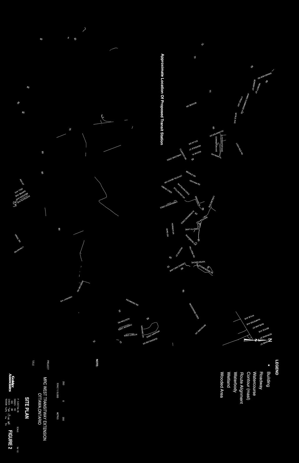
11 3.0 PROJECT DESCRIPTION The proposed Transitway is located in part Lots 8-11, Concession 1, Ottawa Front and part Lots 8 16, Concession 2, Ottawa Front, Nepean Township, Carleton County. The route is approximately 3 km in length and extends from Bayshore Station on the east side of Holly Acres road to west of Moodie Drive (Figure 2). The proposed route width will consist of a single lane added onto the north side of Highway 417. At the eastern end of the proposed development, the transitway will link to Bayshore Station and take a number of possible routes to link to the west side of Holly Acres Road. The route location will parallel Highway 417 until which point it veers slightly north at the Holy Acres Road/417 on ramp. The route will then head southwest and again parallel Highway 417 and cross over Moodie Drive close to the interchange with the highway and just south of Corkstown Road (Figure 2). The route alignment will then cross Corkstown Road and parallel the west bound lanes of Highway 417. The route then heads south, crossing both lanes to the south side of the highway and then veers back north (Figure 1). Report No (5000) 4

12
13 4.0 STUDY AREA 4.1 Environment The study area is located within the Ottawa Valley Clay Plains physiographic region (Chapman and Putnam 1966). These clay plains are underlain by various depths of bedrock, ranging from 2 3 m in the western end to m deep at the eastern end of the study area. The bedrock at the eastern most extent of the study area is associated with the Rockcliffe formation and is mainly composed of greenish grey quartz sandstone, shaley limestone and shale. The remaining bedrock is composed of quartz sandstone, sandy dolostone and dolostone and is associated with the March formation (Belanger 2001). The study area falls within the Upper St. Lawrence sub-region of the Great Lakes St. Lawrence Forest Region (Rowe 1977). The larger Great Lakes St. Lawrence Forest region is a transitional zone between conifers extending south from the Boreal Forest and the broad-leafed deciduous trees extending north from southern Ontario. As a result, the area is characterized as a mixture of habitats controlled primarily by local microclimates and soil types (Kershaw 2001). Tree types most associated with the Upper St. Lawrence forest subregion include sugar maple, beech, red maple, yellow birch, basswood, white ash, largetooth aspen and red and bur oaks. Within poorly drained and wet environments, such as river and creek banks, butternut and eastern cottonwood, slippery elm, and black and silver maples can often be encountered as well as various types of willow and ash (Kirshaw 2001; Rowe 1977). Approximately half of the study area remains forested, primarily along the banks of Stillwater Creek with the remaining portions of the study area cleared. Stillwater Creek and one of its unnamed tributaries cuts through approximately the centre of the study area. Stillwater Creek is a tributary of the Ottawa River bisecting suburban housing developments. The outflow location of the creek is situated directly to the east of the Nepean Sailing Club and to the west of Andrew Hayden Park. The study area has very slight limitations for the production of ungulates (Thomasson 1971), severe limitations for the production of waterfowl (Arsenault 1970) and moderate limitations that restrict the range of crops as the soils are classified as very fine textured, neutral in ph originating from marine deposits and located in abandoned river channel floors and terraces (Schut and Wilson, 1987 and Agriculture Canada 1979). Fauna and flora capabilities of specific geographical regions can play an important role in the assessment of archaeological and historical potential of an area. It is therefore important to review the capabilities of the study area in order to better understand their potential. However, it should be noted that the information presented on the soils capability, forest cover and waterfowl and ungulate capabilities needs to be reviewed in the proper context. These classifications have implications with respect to historic site location however, to lesser degree with pre-contact sites. The landscape has been drastically altered through agricultural practices since Euro- Canadian occupation and as a result waterfowl and more specifically ungulate capabilities could have been significantly different prior to Euro-Canadian contact. Similarly, the range of forest cover has been drastically altered since European arrival and as a result may not represent what was present during the pre-contact period. Specifically, the study area contains a number of different environmental settings ranging from cultivated fields to woodlots to completely disturbed deposits. Report No (5000) 6
.")
14 The east side of Holly Acres Road has been completely disturbed by urban development. On the west side Holly Acres Road and directly north of the 417, there is a large man made earthwork extending the first 800 m (Plate 1). The centre of ROW between the earthwork and Moodie Drive is more typical of Upper St. Lawrence forests (Plate 2). Stillwater creek and a number of its tributaries also cross through the study area. Based on the site visit it appears that the portion of Stillwater Creek at the western end of this portion of the study area has been modified and its route altered from its original course. As such, the margins of the creek which one could presume would hold archaeological potential no longer do as they are artificial (Plates 3 and 4). There is a section of land between the diverted portion of Stillwater Creek and the earthwork that appears to be relatively undisturbed. This area holds the greatest potential, albeit still moderate, for containing archaeological resources. There are a number of well developed and intact terraces overlooking Stillwater Creek (Plate 4). In addition to Stillwater Creek there are a number of culverts which drain into the Creek. These culverts run perpendicular to the highway. The portion of the study area located to the north of Corkstown Road and east of Moodie Drive contain a large open field which has been utilized in the past as a park and soccer field (Plate 5). Similarly, the study area to the west of Moodie Drive is devoid of trees and has been extensively cultivated (Plate 6). Plate 1: Looking east onto large man made earthwork at eastern end of study area. Report No (5000) 7


15 Plate 2: Looking north onto typical forested area along the banks of Stillwater Creek. Plate 3: Looking east onto large section of Stillwater Creek at western end of central study area that has been diverted and altered. Report No (5000) 8

 and east of Moodie")
16 Plate 4: Looking southwest onto intact and undisturbed upper terrace of Stillwater Creek. Plate 5: Looking north onto open soccer field and park area to the north of Corkstown Road (foreground) and east of Moodie Drive. Report No (5000) 9

17 Plate 6: Looking southwest onto cultivated field to the west of Moodie Drive and north of Corkstown Road. 4.2 Previous Research A considerable amount of research has been done for the historic Township of Nepean. One of the earliest accounts can be found in Walling s Map of Carleton County (1863) and Belden s Illustrated Historical Atlas of Carleton County (1879). Bruce Elliott gives a very detailed description of Nepean s history in The City Beyond: A History of Nepean, Birthplace of Canada s Capital (1991). Other research has been done by Sarah B. Craig in Hello Nepean (1974). Two histories of the greater Ottawa area, which contains sections of Nepean, were published in 1968: The Carleton Saga by Harry and Olive Walker and The Ottawa Country by Courtney Bond. More recently, Larry D. Cotton (2008) has produced a number of books: Whiskey and Wickedness, volumes 1 5, detailing the history of various counties throughout the Ottawa valley through anecdotal evidence and the role of alcohol in the formation and transformation of many small communities. Literature concerning the pre-contact history of Nepean Township is almost non-existent. Apart from passing references in works such as those noted above, there are a few general articles by Sowter (1900, 1901, 1909 and 1917) which describe pre-contact sites. Other sources included Champlain Sea and Early Ottawa River Shoreline Studies by Kennedy (1976) and An Inventory of the Prehistoric Archaeological Sites of Ottawa- Carleton by Jamieson (1989). There are no recorded pre-contact archaeological sites within a 3 km radius of the study area. There are however, a number of recorded pre-contact sites located further afield from the study area. Middle Woodland (BiGa 2 7) sites located around Constance Bay (Watson 1972); the Lake Leamy sites (BiFw 6, and 25 28) which represent both historic and pre-contact sites (Laliberte 1995); the Sawdust Bay sites on Lac Des Chats (Daechsel 1981) and a number of poorly excavated and recorded pre-contact find spots in the Rideau River Valley (BiFw 1, 3 5 and 10 11). Report No (5000) 10
18 The majority of the archaeological investigations which have been carried out within close proximity of the study area have all consisted of either a Stage 1 and/or 2 archaeological assessment. Nick Adams undertook both Stage 1 and Stage 2 assessments for the Chapman Mills subdivision at the north end of Lots 1 and 2 as well as a Stage 3 investigation of the Spain site (BhFw-7) in Lot 14, Concession 2, Geographic Township of Nepean (Adams 2000a, 2000b and 2000c). A little further south, Adams (2000d) also conducted a combined Stage 1 and 2 on a proposed subdivision development on the south half of Lot 16, Concession 2, Rideau Front. The following year Heritage Quest undertook a Stage 1 and a Stage 2 assessment for the North Kanata Trunk Line Route in part Lots 5 and 6, Concession 1, Ottawa Front, Geographic Township of Nepean. Lastly, a Stage 1/2 archaeological assessment of the Nortel Carling Campus expansion was conducted in 1997 (Daechsel 1997). The archaeological assessment conducted with relevance to the current study area is that produced by Kenneth Swayze (2001a). Swayze conducted a combined Stage 1 and 2 archaeological assessment for the Stillwater Creek Slope Stabilization Project located close to Bells Corners on part Lots 12 and 13, Concession 2 Ottawa Front (2001). During the Stage 2 investigation Swayze test pitted the east and west sides of a tributary of Stillwater Creek, located just south of the current Project location. During the course of the investigation no cultural material was identified. The current study area falls within Borden block BhFx with only one registered archaeological site: BhFx-1. The site is known as the Scharf site and is a nineteenth century homestead investigated by the Earl of March Secondary School in Kanata (Swayze 2001). 4.3 Cultural Overview Pre-Contact Occupation Human occupation of southern Ontario dates back to approximately 11,000 years B.P. (Before Present) (Ellis and Deller 1990: 39). The first period of occupation is referred to by archaeologists as the Paleo-Indian (11,000 9,000 B.P.). Paleo-Indian populations occupied the shorelines of vast glacial lakes such as Lake Algonquin in the area that is now southern Georgian Bay, and along the north shore of present day Lake Ontario (Ellis and Deller 1990: 50). Available evidence suggests that they were highly mobile hunter gatherers relying on caribou, small game, fish and wild plants found in the sub-arctic environment (Ellis & Deller 1990: 53). The Ottawa Valley remained very much on the fringe of the early human occupation of Ontario at this time. The ridges and old shorelines of the Champlain Sea and the Ottawa River, including parts of the Prescott Russell Sand Plain, would be the most likely areas to find Paleo-Indian sites. Isolated finds of fluted points (laurel leaf shaped points with a channel flake scar extending from the base of the point) have been recorded in the Rideau Lakes area (Watson 1982) and Kingston (Kennett & Earl 2000). Most recently, Ken Swayze has found what he believes to be Paleo-Indian material immediately north of the corridor near Greenbank Road (Swayze 2003) and possibly at Albion Road and Rideau Road (Swayze 2004). During the succeeding Archaic Period (ca. 9,000 to 2,800 B.P.), the environment of southern Ontario approached modern conditions (Ellis, Kenyon & Spence 1990: 69), opening areas for occupation as the glacial lakes drained and water courses such as the Ottawa River recessed. While Archaic populations continued as hunter gatherers, they focused on localized faunal and floral resources including deer, fish, berries and nuts. Archaic assemblages consisted of less well made flaked points, greater variety of lithic sources for the Report No (5000) 11
19 production of tools, the production of larger ground stone tools presumed to have been used in wood working, manufacture of bone tools and the use of copper (Ellis et. al. 1990: 65-66). The appearance of copper by the Middle Archaic indicated that Archaic populations participated in an extensive trade network with less extensive territories utilized for subsistence (Ellis et. al. 1990: 93). The first significant evidence for occupation of the Ottawa Valley appears during this period. Archaic sites have been identified on Allumette and Morrison Island on the Ottawa River near Pembroke. Closer to the study area, Late Archaic Sites have been noted at Leamy Lake near the junction of the Gatineau and Ottawa Rivers, in the Rideau Lakes (Watson 1982), at Jessups Falls and in Pendleton along the South Nation River (Daechsel 1980; Jean Luc Pilon 2003 personal communication). The Woodland Period (ca. 2,800 to 450 B.P.) is distinguished from the earlier Archaic Period by the introduction of ceramics (Wright 1972). Early Woodland populations continued to live as hunter gatherers and fishers in much the same way as their ancestors. They also participated in elaborate burial ceremonialism evidenced by the inclusion of exotic artifacts with burials (Spence et. al. 1990: 129). Extensive trade networks continued through the early and middle portions of this period with influences from populations south of the Great Lakes including the Adena and Hopewell. Early Woodland sites have been reported near Arnprior and to the south in the Lake Ontario - St. Lawrence River drainage area including Wolfe Island. By the Middle Woodland Period (2,400 to 1,150 B.P.) regional cultural expressions or traditions have been distinguished by archaeologists. These traditions have been identified based on patterns of ceramic decorations, use of lithic materials and in the case of eastern Ontario, the emergence of a fine bone technology. Based upon the proliferation of sites there appears to have been an appreciable increase in the population of Eastern Ontario although the Ottawa area has yet to yield the site numbers found in other parts of southeastern Ontario including the Upper Ottawa Valley and in the Upper St. Lawrence River Basin. While Middle Woodland populations continued as hunter gatherers, the appearance of larger sites in areas where there was intensive exploitation of spawning fish suggests a major change in the settlement subsistence system for this period (Spence et. al. 1990: 167). It has been suggested that the repeated use and reliance upon these sites assisted with the stabilization of the settlement cycle (Spence et. al. 1990: 168). This would have provided the means for the adoption of agriculture in the southern areas of eastern Ontario. Middle Woodland sites have been noted in the South Nation Drainage Basin (Daechsel 1980) and along the Ottawa River including the northwest end of Ottawa at Marshall s and Sawdust Bays (Daechsel 1981). A significant development of the Woodland period was the appearance of domesticated plants as early as 1,450 B.P. Initially only a minor addition to the diet, the cultivation of corn, beans, squash, sunflowers and tobacco grew in importance for Late Woodland populations. Along with this shift in subsistence, settlements located adjacent to corn fields began to take on greater permanency. Semi permanent and permanent villages were established in the southern portion of southeastern Ontario. Many of these were palisaded, evidence of growing hostilities between regional populations. By the end of the Late Woodland period, distinct regional populations occupied specific areas of southern Ontario including the Huron along the north shore of Lake Ontario (Ramsden 1990: 363) and St. Lawrence Iroquois along the St. Lawrence River (Jamieson 1990: 387). Report No (5000) 12
20 While there is clear evidence of these developments in much of southern Ontario, the Ottawa Valley remained a sparsely occupied region utilized by hunter gatherer populations. This was, in part, due to the less suitable terrain for agriculture. It may also have been a reflection of the increased pressure on hunting territories and conflict over trade routes at the end of the Woodland Period. By the end of the Woodland Period, there had been a significant change in the settlement of southeastern Ontario. The St. Lawrence Iroquois who had, among other regions, occupied areas at the head waters of the South Nation River Drainage Basin (Daechsel 1980), were dispersed or perhaps absorbed by neighbouring Iroquoian and Algonquin populations (Pendergast 1999). The Huron along the north shore of Lake Ontario had moved to the Lake Simcoe - Georgian Bay region leaving the area of eastern Ontario, save for some small Algonquin groups, unoccupied by the time the first French explorers, traders and missionaries arrived in the beginning of the seventeenth century. Late Woodland sites have been recorded in the Ottawa Valley. Of particular note is an ossuary burial identified along the north shore of the Ottawa River in the 1840s (Van Courtland 1853) Post-Contact Occupation Samuel de Champlain was the first European to document his explorations of the Ottawa Valley, initially in 1613 and again in He was preceded, however, by two of his emissaries, Étienne Brûlé around 1610 and Nicholas de Vignau in It is likely that all three traveled at least the lower reaches of the Rideau River. In the wake of Champlain s voyages, the Ottawa River became the principal route for explorers, missionaries and fur traders traveling from the St. Lawrence to the interior, and throughout the seventeenth and eighteenth centuries this route remained an important link in the French fur trade. At the time of initial contact, the French documented three Algonquin groups residing in the vicinity of the study area (Heidenreich & Wright 1987: Plate 18). These included the Matouweskarini along the Madawaska River to the west, the Onontchataronon in the Gananoque River basin to the south, and the Weskarini, the largest of the three, situated in the Petite Nation River basin north of the study area. While prolonged occupation of the region may have been avoided as a result of hostilities with Iroquoian speaking populations to the south, at least the northern reaches of the South Nation River basin were undoubtedly used as hunting territories by the Algonquin at this time. The recovery of European trade goods (i.e., iron axes, copper kettle pieces and glass beads) from Native sites throughout the Ottawa River drainage basin has provided evidence of the extent of contact between Natives and the fur traders during this period. The English, upon assuming possession of New France, continued to use the Ottawa River as an important transportation corridor. Settlement in the Ottawa area was not actively encouraged by the colonial government until the late eighteenth century. Two years after the 1791 division of the Province of Québec into Upper and Lower Canada, John Stegmann, the Deputy Surveyor for the Province of Upper Canada, undertook an initial survey of Gloucester Township. At this same time, John Graves Simcoe, Lieutenant Governor of the Province of Upper Canada, issued a proclamation aimed at attracting new settlers to the region. United Empire Loyalists and other immigrants began to move to lands along the Ottawa and Rideau Rivers in the early nineteenth century. Report No (5000) 13
21 4.3.3 Nepean Township The Township of Nepean was first surveyed in 1794, designated in a statute passed in 1798 by the second Parliament of Upper Canada and named in honour of the British Administrator Sir Evan Nepean (Elliott 1991). The township grew slowly over the next decades with few people settling into the area. It was not until the mid nineteenth century that an influx of immigrants and settlers into the area began to occur. Due to the growing population the County, the Township of Nepean necessitated a re-arrangement of the old districts into new ones. By 1849 the present day Carleton County was established with ten geographic townships designated. Nepean Township, one of the larger townships, is bordered to the north and west by March and Goulbourn Townships, respectively, North Gower to the south and the Rideau and Ottawa Rivers to the east and north (Walker & Walker 1968). 4.4 Property History As stated previously, the proposed Project route will impact various portions of 13 Lots in two Ottawa River fronting Concessions in Nepean Township. Based on archival information and historic maps, the majority of the lands within the study area were primarily used for farming and live stock from the early part of the nineteenth century. Due to the limited footprint of the proposed development, going into great detail on the property history within the body of the text for each of the 13 Lots would not provide an accurate representation of the heritage potential for study area. Rather, what is presented below is a more focused discussion on the lands and the families who utilized it and the heritage resources that may be impacted by the construction of the Project. A property history for each lot has been included (Appendix A) Concession 1, Nepean Township, Carleton County The primary area of interest along Concession 1 is located on the west side of Moodie Drive and north of Corkstown Road. Based on the 1863 Walling Map and the 1879 Belden Map there are a number of structures which are present in and around Stillwater Creek. More specifically, on the 1879 Belden map there are two dwellings possibly located within the study and one just outside (Figure 3). Two of the three buildings are located in the south half of Lot 10. The two dwellings belonged to brother s William and Samuel Craig (Appendix 2). The Craig family name is closely associated with the early migrations to Nepean Township. The Craig s came to this area in two separate migrations, the first in 1834 and later in The Craig family primarily settled in and around the Goulbourn and North Gower areas (Walker 1968). According to 1891 census and the 1879 Belden maps, the brothers lived on adjoining 50 acres lots at the south end of Lot 10. William Craig owned the west half and was a 50 year old Presbyterian farmer of Ontario decent in William and his family, which consisted of wife Mary, 43; son John, 14, daughters Margaret,12; Agnus, 10; Ethal, 8; and youngest son Wellington, 3, all lived in a wooden two story five room home at the south east corner of their property. Samuel Craig occupied and lived on 50 acres at the south east corner of the lot. At the time of the 1891 census Samuel was a Presbyterian farmer of Ontario decent who lived with Cathrine, his 50 year old wife, in a one and half story wood house close to the southwest corner of their property (Figure 3). The third structure is situated at the far western edge of the project s study area (Belden 1879). According to the 1851 census was utilized as the primary residence for the Beatty family and was potentially used as a school Report No (5000) 14
22 house. The structure consisted of a one and a half story log house situated on the west side of Stillwater Creek in the southwest corner of the property (Figure 3). In 1851, Thomas Beatty was a 36 year old farmer who lived in their house with his 30 year old wife, Elizabeth, and their six children. It is important to note that only primary buildings tend to be identified on historic maps. Early pioneers of these lands could potentially have had outbuildings associated with farming and their livelihood which are not indicated on either the 1863 Walling or 1879 Belden maps that may fall within the study Concession 2, Nepean Township, Carleton County According to both the 1863 Walling and 1879 Belden maps there were no buildings located within the study area in the mid nineteenth century. There is one dwelling located just outside and is located on the north side of Stillwater Creek at the very northeast corner of Lot 13 (Figure 3). The lands within the Concession 2 study area were primarily utilized by a small number of families. These families included the Moodies, the Grahams, the Bearmans, the Stinsons, the Johnstons and the Spittals, among others (Appendix A). Of particular interest is the Bearman family who owned a large number of lots in Nepean Township and specifically Lots 13 15, Concession 2. Frederick Bearman was one of the original owners of the lots and father to James and John (Figure 3). The Bearman family occupied the lots, in various capacities, from 1833 until the early part of the twentieth century (Appendix A). At the time of the 1851 census, Fredrick was a 48 year old Methodist farmer who lived in a wood frame one and half story house with his 42 year old wife, Margaret and their eight children. The Children ranged in age from 20 to three, with his two eldest sons, James, 20, and John, 18, who worked on the farm as labourers. There is no indication of a structure present on the 1863 Walling map, however present on the 1879 Belden map is a structure located on the very north end of the lot north of Stillwater creek and in very close proximity to the study area. The 1891 census sheds light onto James Bearman and his family who at one point owned parts or all of Lots 13 and 14. In 1891 James Bearman was a 58 year old Methodist farmer living in a two story, ten room stone house presumable close to the south end of Lot 14 (Belden 1879). He lived in the house with his 44 year old wife, Margaret and their three children, Fredrick, 19, George, 16 and Cathrine, 4. Also living in the house was James mother Margaret who was widowed and 86 years old at the time of the census. The remaining lands within the study area appear to have been primarily used for farming with no evidence of permanent structures. Report No (5000) 15


23


24
25 5.0 HERITAGE & ARCHAEOLOGICAL RESOURCES AND ARCHAEOLOGICAL POTENTIAL 5.1 Heritage Buildings Built heritage resources means one or more significant buildings, structures, monuments, installations or remains associated with architectural, cultural, social, political, economic or military history and identified as being important to a community. These resources may be identified through designation or heritage conservation easement under the Ontario Heritage Act, or listed by local, provincial or federal jurisdictions (Ontario Ministry of Culture 2006: 44). Heritage Buildings within the City of Ottawa have been recognized in a number of ways. At the federal level, the National Capital Commission (NCC) has designated a number of properties under their ownership as heritage buildings. The historical and architectural significance of these properties is reviewed by the Federal Heritage Building Review Office (FHBRO). The NCC maintains a listing of these designated properties (NCC 2002a, 2002b, 2003a, 2003b). At the provincial level, individual properties of heritage significance may be designated under Part IV of the Ontario Heritage Act. These properties are generally identified by the municipality and a designation report prepared and reviewed prior to provincial designation. Any planned alteration to or demolition of a designated property must be reviewed by City Council. The City of Ottawa maintains a database of built heritage properties and this listing was consulted for the present study. Within the City of Ottawa, there are also a large number of properties that have been identified as having potential heritage significance but have not gone through the formal designation process. These properties are identified as Listed in the built heritage inventory for the City. While these properties do not have the same level of protection as those designated under the Ontario Heritage Act, their potential heritage significance is such that further evaluation would be required in the event that any construction were to have an impact on them. Within the City s built heritage database, individual properties are graded, with Grade 1 buildings considered prime heritage buildings; Grade 2 buildings integral components of a heritage district; Grade 3 buildings heritage components of an area while Grade 4 buildings are generally modern but still considered significant elements in a heritage area (Smith et al 1990). The study area comes within close proximity to Richmond Road which is the oldest thoroughfare in the city. The road was initially constructed by disbanded soldiers in the autumn of 1818 that arrived in the area to settle and take up lands along the Jock River. The settlement would eventually be named Richmond after the Duke, governor-in-chief of Canada (Duhamel 1967). As a result of the history and importance of the corridor in the early settlement of Nepean Township there area a large number of heritage buildings. Within a three kilometre radius of the study area there are 222 registered heritage buildings. Of the 222 buildings, seven have a Grade of 1 ; five have a Grade of 2 ; 78 have a Grade of 3 ; two have been assigned no category but are designated and the remaining 130 are Listed. Based on the results listed in Table 1, Figure 4 illustrates the locations of the registered heritage buildings in yellow. The table indicates that there are no registered buildings within the study area. The majority of the buildings are located to the northeast of the project area in Ward 7. Report No (5000) 18
26 Table 1: Heritage Buildings Located within 1.5 km of Study Area (Figure 5) Building # Address Address Type Category Designation 1 62 Boyce Avenue Main Listed n/a 2 70 Boyce Avenue Main Listed n/a 3 71 Boyce Avenue Main Listed n/a 4 98 Boyce Avenue Main Listed n/a 5 35 Burland Street Main Listed n/a Carling Avenue Historical Listed n/a Carling Avenue Main Listed n/a 8 44 Kempster Avenue Main Listed n/a Richmond Road Main Grade 1 IV Richmond Road Main Listed n/a Rocky Point Road Main Listed n/a Scrivens Street Main Listed n/a Scrivens Street Main Listed n/a Report No (5000) 19


27
28 5.2 Known Archaeological Resources There are two historic archaeological sites situated within 3 km of the study area. These are the Scharf Site located in Kanata west of March Road and the Beatty Archer site situated along Carling Avenue on the Nortel Carling Campus property. 5.3 Archaeological Potential There are a number of variables that are used to determine archaeological site potential. In the case of precontact sites, criteria are focused on topographical features such as the distance from the nearest source of water, height above the nearest source of water, and the nature of the nearest source of water (creek, lake, river). Distinguishing elements in the landscape including ridges, knolls, eskers, and wetlands, as well as soil type also influence site locations. Other factors that influence pre-contact site location include access to raw materials such as chert, mica or copper; and the proximity to other known pre-contact sites. Archaeological site assessment of post-contact sites is reliant on historical research, land registry records, census returns and assessment rolls, aerial photographic evidence, and the inspection of the study area for possible above ground remains or other evidence of a demolished structure(s). The project area contains various levels of potential due to past developments and proximity to water (Figure 5). The area at the eastern end of the development zone east of Holly Acres Road and from Holly Acres Road west approximately 800 m has been previously impacted. This area, therefore, has low potential for intact pre-contact or historic resources. The ROW section from the fill deposits west to Corkstown Road which parallels the westbound lanes of the 417 and that comes within close proximity to Stillwater Creek contains the highest potential for pre-contact sites. The majority of this area is forested and contains intact and relatively level upper terraces. Based on the in-field site reconnaissance, portions (the eastern end) of the area appear to have been subjected to little to no previous disturbances and as a result the potential for this section of the ROW to impact intact buried deposits is moderate. The western end of the central portion of the study area appears to have been modified in order to divert Stillwater Creek. There are numerous storm water drains which feed the creek that have provided other disturbances in this area. The area on the west side of Moodie Drive contains low potential for intact pre-contact sites as the area has been extensively cultivated in the past and is approximately 400 m to the west of Stillwater Creek. In addition to the potential presence of pre-contact sites, the study area also contains relatively high potential for historic sites. Portions of the study are located close to historic roadways (Belden 1879) and there is evidence that large portions of the study area have been extensively utilized by Euro-Canadian farmers since the midnineteenth century. There are four structures that were present in the middle to late nineteenth century (Belden 1879) that are located either directly within or just outside the western end of the study area (Figure 3). The first was a one and a half story, four room wood frame house located in the southeast half of Lot 10, Concession 1 that belonged to Samuel Craig. The second house, which belonged to Samuel s brother William, was located in the adjoining 50 acre lot on the southwest side of Lot 10. William s house was a two story, five room wood framed house and is located within the study area, close to the intersection of Corkstown Road and Moodie Drive. The third building, similarly located within the study area, belonged to John Beatty. No information could be located for this particular property. The final building was located at the far northwest corner of Lot 13, Concession 2, just on Report No (5000) 21
29 the north side of Stillwater Creek. This house belonged to the Bearman family and was most likely occupied during the early to late part of the nineteenth century (Figure 3). It has also been suggested that a route for the West Transitway ROW extension be considered for within 50 metres from the edge of the south side of the Highway 417 right of way. Figure 6 highlights the areas of archaeological potential located on both the north and south sides of the Highway 417 corridor. The results of the archaeological potential of the south side is based on the criteria mentioned above. The proximity of the study area to Still Water Creek, Corkstown Road (a historical corridor) and historically owned Euro-Canadian land (1876 Belden map) provide the south side corridor with a moderate potential for both pre-contact and historical archaeological resources. There are a number of areas to the south that have been impacted by the development of the present roadway systems which would negate the need for Stage 2 testing in these areas. It is important to note that any deviations from the northern limits outlined in Figures 2 and 6, must be preceded by further Stage 1 archaeological assessment that would include a field reconnaissance, review of the environmental background of the study area as well as consultation with relative historical documents. Report No (5000) 22


30
31 6.0 SUMMARY AND RECOMMENDATIONS Golder, on behalf of McCormick Rankin Corporation, undertook a Stage 1 archaeological investigation of an area to be impacted by the proposed westerly expansion of the Ottawa-Carleton Transitway from Bayshore shopping centre to west of Moodie Drive. The transit right of way (ROW) will impact part of Lots 8 11, Concession 1, Ottawa Front and part of Lots 8 16, Concession 2, Ottawa Front, Geographic Township of Nepean, Carleton County (the Project). The ROW will parallel the westbound lanes of Highway 417 and will impact portions of Stillwater Creek, a tributary of the Ottawa River. A brief review of the south side of highway 417 was also conducted at the request of McCormick Rankin since this area is also being considered for the West Transitway ROW project. The objective of the investigation was to identify any known heritage and archaeological resources that might be impacted by the construction and to assess the archaeological potential of the study area to contain unrecorded sites. There is evidence of human occupation in Eastern Ontario dating to at least 9,000 B.P. following the retreat of the Champlain Sea. Based upon existing data, it would appear that the lower Rideau River, however, was not utilized until 6,000 B.P., with Archaic and later Woodland sites noted near the mouth of the Rideau River and Lac Leamy, Gatineau. The earliest Euro-Canadian occupations near the study area occurred during the first half of the nineteenth century with Richmond Road being one of the oldest overland historic transportation corridors in Ottawa, first constructed in There are no registered heritage buildings or archaeological sites within the study area, although it does have low to moderate potential for both pre-contact and historic resources. The central portion of the study area around Stillwater Creek has moderate potential for pre-contact resources, while the area to the west of Moodie Drive has a high potential for historic sites. Test pitting procedures and recommendations (outlined below) may need to be modified depending on the width of corridor. Parallel to the 417 is a large 10 to 15 m wide ditch which runs the entire length of the study area. If the Transitway corridor will impact only this previously disturbed section of then a limited amount of test pitting will be required. However, if the ROW will extend into undisturbed sections then a more systematic assessment will be required. This investigation has provided the basis for the following recommendations: 1) That a Stage 2 archaeological assessment be undertaken of defined areas to be impacted by construction of the west Transitway extension. Specifically, a) Systematic test pitting along the ROW corridor in portions of the central study area between Holly Acres Road and Moodie drive where Stillwater Creek has not been disturbed. b) Judgemental test pitting along the corridor where Stillwater Creek has been diverted in order to determine the nature and extent of the disturbances. c) Pedestrian survey in the cultivated fields on the west side of Moodie. In order to comply with MOC guidelines, prior to conducting this portion the field would require tilling and time to weather. d) Systematic test pitting along the corridor on the west side of Moodie between Corkstown Road and the ) Any deviation from the proposed archaeological potential study area (Figure 6) must be preceded by further Stage 1 archaeological assessment by a licensed archaeologist. This includes the area south of Report No (5000) 24
32 Highway 417. If the decision is reached to proceed with the southern development, a preliminary alternative alignment must be provided. 3) Should deeply buried archaeological remains be encountered during the construction activities, the Ministry of Culture, (416) , should be notified immediately. 4) In the event that human remains are encountered during the constructed activities, both the Ministry of Culture, (416) , and the Registrar of the Cemeteries Regulation Unit of the Ministry of Small Business and Consumer Relations, (416) , should be notified immediately. Report No (5000) 25
33 7.0 IMPORTANT INFORMATION AND LIMITATIONS OF THIS REPORT Golder Associates Ltd. (Golder) has prepared this report in a manner consistent with that level of care and skill ordinarily exercised by members of the archaeological profession currently practicing under similar conditions in the jurisdiction in which the services are provided, subject to the time limits and physical constraints applicable to this report. No other warranty, expressed or implied is made. This report has been prepared for the specific site, design objective, developments and purpose described to Golder by McCormick Rankin Corporation (the Client). The factual data, interpretations and recommendations pertain to a specific project as described in this report and are not applicable to any other project or site location. The information, recommendations and opinions expressed in this report are for the sole benefit of the Client. No other party may use or rely on this report or any portion thereof without Golder s express written consent. If the report was prepared to be included for a specific permit application process, then upon the reasonable request of the client, Golder may authorize in writing the use of this report by the regulatory agency as an Approved User for the specific and identified purpose of the applicable permit review process. Any other use of this report by others is prohibited and is without responsibility to Golder. The report, all plans, data, drawings and other documents as well as all electronic media prepared by Golder are considered its professional work product and shall remain the copyright property of Golder, who authorizes only the Client and Approved Users to make copies of the report, but only in such quantities as are reasonably necessary for the use of the report by those parties. The Client and Approved Users may not give, lend, sell, or otherwise make available the report or any portion thereof to any other party without the express written permission of Golder. The Client acknowledges the electronic media is susceptible to unauthorized modification, deterioration and incompatibility and therefore the Client cannot rely upon the electronic media versions of Golder s report or other work products. Unless otherwise stated, the suggestions, recommendations and opinions given in this report are intended only for the guidance of the Client in the design of the specific project. Special risks occur whenever archaeological investigations are applied to identify subsurface conditions and even a comprehensive investigation, sampling and testing program may fail to detect all or certain archaeological resources. The sampling strategies incorporated in this study comply with those identified in the Ministry of Culture s Archaeological Assessment Technical Guidelines (1993) (Stages 1-3 and Reporting Format). Report No (5000) 26


34
35 REFERENCES Adams, Nick 2000a An A. A. (Stage 1 & 2) of the Proposed Subd. Devel. Chapman Mills (Winding Way at Hwy. 16 Parcel) (In the Former Tws. of Nepean), Parts of Lots 14, 15, 16, Conc. 1, Township of Nepean, City of Nepean, (Former) County of Carleton, R. M. of Ottawa-Carleton. Report on file with the Ministry of Culture, Toronto, Ontario. 2000b An A. A. (Stage 1-2) of the Proposed Subdiv. Dev. "Chapman Mills", Parts of Lots 10,11,12,13,Con.1 & Part of Lots 13,14 & 15, Con. 2, Twp.of Nepean, City of Nepean,R.M.of Ottawa-Carleton & Stage 3 Testing "Spain Site"(BhFw-7), Lot 14, Con. 2 Twp.of Nepean. Report on file with the Ministry of Culture, Toronto, Ontario. 2000c An A. A. (Stage 1 & 2) of the Bidgwood Property (Morgan's Grant Phase 12), (Former Township of March), Part of Lot 11, Conc. 3, Township of West Carleton, City of Kanata, (former) County of Carleton, R. M. of Ottawa-Carleton. Report on file with the Ministry of Culture, Toronto, Ontario. 2000d An Archaeological Assessment (Stage 1 & 2) of the Proposed Subdivision Development Part of the South 1/2, Lot 16, Conc. 2, (Rideau Front, Township of Nepean, City of Nepean (Former) County of Carleton, R. M. of Ottawa-Carleton. Report on file with the Ministry of Culture, Toronto, Ontario. Agriculture Canada, 1979 Soils, Capability and Land Use in the Ottawa Urban Fringe, Report No. 47. Ontario Soils Survey. Ministry of Agriculture and Food. Ontario. Arsenault, G. & B. Johnson 1970 Land Capability for Wildlife Waterfowl. Ministry of Supply and Services Canada, Ottawa. Belanger, J.R Urban Geology of the National Capital Area. Geological Survey of Canada, Ottawa, ON. Belden, H. and Co Illustrated Historical Atlas of the County of Carleton. Reprinted Port Elgin: Ross Cumming. Chapman, L.J. & D.F. Puttnam 1966 The Physiography of Southern Ontario. University of Toronto Press, Toronto Daechsel, Hugh J. 2001a Stage 2 Archaeological Assessment of Proposed North Kanata Trunk Line Route, Lot 5, Conc. 1, Ottawa Front Former Township of Nepean, City of Ottawa. Report on file with the Ministry of Culture, Toronto, Ontario. Report No (5000) 28
36 Daechsel, Hugh J. (continued) 2001b Stage 1 Archaeological Assessment of Proposed North Kanata Trunk Line Route, Lots 5 & 6, Conc. 1, Ottawa Front Former Township of Nepean, City of Ottawa. Report on file with the Ministry of Culture, Toronto, Ontario Sawdust Bay 2: The Identification of a Middle Woodland Site in the Ottawa Valley. Unpublished M.A. Thesis, McMaster University, Ontario Sawdust Bay-2 The Identification of a Middle Woodland Site in the Ottawa Valley. M.A. Thesis, Department of Anthropology, McMaster University An Archaeological Overview of the South Nation River Drainage Basin: Background Paper No. 3. Report prepared for the South Nation River Conservation Authority. Duhamel, Roger 1967 City of the Ottawa. Queen s Printer and Controller of Stationery, Ottawa. Ellis, Chris J. and Brian D. Deller 1990 Paleo-Indians in The Archaeology of Southern Ontario to A.D. 1650, eds. Chris Ellis and Neal Ferris, Occasional Publication of the London Chapter, OAS Number 5, pp Ellis, Chris J., Kenyon, Ian T. and Michael W. Spence 1990 The Archaic in The Archaeology of Southern Ontario to A.D. 1650, eds. Chris Ellis and Neal Ferris, Occasional Publication of the London Chapter, OAS Number 5, pp Heidenreich, Conrad & J.V. Wright 1987 "Population and Subsistence." Plate 18 in Historical Atlas of Canada, Volume 1: From the Beginning to ed. R. Cole Harris. University of Toronto Press: Toronto. Jamieson, James B 1989 An Inventory of the Prehistoric Archaeological Sites of Ottawa-Carleton. Paper submitted to the Ontario Archaeological Society, Ottawa Chapter The Archaeology of the St. Lawrence Iroquoians in The Archaeology of Southern Ontario to A.D. 1650, eds. Chris Ellis and Neal Ferris, Occasional Publication of the London Chapter, OAS Number 5, pp Kershaw, Linda Trees of Ontario: Including Tall Shrubs. Lone Pine Publishing, Edmonton, AB. Laliberte, M 1995 Les Recherches Archaeologiques de 1994 dans le Parc du Lac leamy, Hull. La Societe d Histoire de l Outaouais, Hull. Report No (5000) 29
37 Schut, L.W. and E.A. Wilson 1987 The Soils of the Regional Municipality of Ottawa-Carleton, vol. 1. Report No. 58 of the Ontario Institute of Pedology. Ministry of Agriculture and Food, Agriculture Canada. Queen s Printer for Ontario. Spence, Michael W.; Phil Robert H. and Carl R. Murphy 1990 Cultural Complexes of the Early and Middle Woodland Periods in The Archaeology of Southern Ontario to A.D. 1650, eds. Chris Ellis and Neal Ferris, Occasional Publication of the London Chapter, OAS Number 5, pp Swayze, Ken 2004 Stage 1 & 2 Archaeological Assessment of Proposed Central Canada Exhibition, Albion Road Site, Part Lots 24 and 25, Concession 3, Gloucester Township (Geo.), City of Ottawa. Summary report, on file, Ministry of Culture, Toronto A Stage 1 & 2 Archaeological Assessment of Woodroffe Estates, Part North Half Lot 16, Concession 2, Nepean (Geo.) Twp., City of Ottawa. Summary report, on file, Ministry of Culture, Toronto Stage 1 & 2 A.A. of the Still Water Creek Slope Stabilization Project on Part of Lots 12 & 13, Con. 2, Nepean Twp. (Geo) at Bells Corners, City of Ottawa. Report prepared for National Capital Commission and on file with Ministry of Culture, Toronto, Ontario. Thomasson, R Land Capabilities for Wildlife Ungulates. Ministry of Supply and Services, Ottawa. Van Courtland Edward 1853 Notice of an Indian Burying Ground in Canadian Journal, vol. 1, pp Walling, H. F Map of Carleton County. Canada West. National Archives of Canada, NMC Watson, Gordon D Prehistoric Peoples of the Rideau Waterway in Archaeological Historical Symposium, Rideau Ferry, Ontario, F.C.I. Wyght, Lombardy, Ontario. pp A Woodland Indian Site at Constance Bay, Ontario Ontario Archaeology 50:5-26. Wright, James V Ontario Prehistory, An Eleven-Thousand-Year Archaeological Outline. National Museums of Canada, Ottawa. Report No (5000) 30
38 Documents from the National Archives C Census Returns, Nepean Township C Census Returns, Nepean Township C Census Returns, Nepean Township C Census Returns, Nepean Township T Census Returns, Nepean Township Report No (5000) 31
39 APPENDIX A Property History Report No (5000)
40 APPENDIX A Property History Lot 8, Concession 1, Nepean Township, Carleton County Lot 8 appears to have had a little to no significant change of hands during the early portion of its use. The first Crown Patent as recorded in the land registry listing was issued to Margaret O Grady in April of Margaret O Grady deeded all the land to Peter McFarland on October 16, 1888, who in turn deeded the land back to Margaret two weeks later on October 31, 1888 (Inst. NP 7788, and 13665, respectively). Several years later, Margaret sold all her remaining property to William Richardson in January of 1889 while Timothy O Grady and Family sold a small portion to the Ottawa A. & P. Ry. Co. in August of 1892 for $200 (Inst. NP and 15795, respectively). After the sale of part of the lot by Richardson in 1913, the remainder of the land registry form becomes illegible. There was little specific and reliable information which could be gathered on either Margaret or John O Grady. The census records list a large number of O Grady and Grady Families living in Nepean Township. Similarly no record of William Richardson was located in the 1891 census. Lot 9, Concession 1, Nepean Township, Carleton County Crown Patent was first issued to John LeBreton for 200 acres of Lot 9 in May Approximately 27 years later, LeBreton sold all his 200 acres to brothers John and Thomas Beatty in March 1838 (Inst. RO 1269). Following this purchase, Thomas sold 60 acres of the east part of the lot to Michael Beatty in October 1840 (Inst. RO 1615). Michael Beatty then willed 60 acres to his John in 1848, who then sold 60 acres to Thomas Beatty, who in turn sold 90 acres back to John on the same day on April 26, 1867 (Inst. RO 3693 and 27142, respectively). Following this string of transactions the Beattys remain on the land until Thomas sold 100 acres of the north half of Lot 9 to John Archer in November 1872 (Inst. NP 1671). The subsequent year John Archer transferred the part of the north half of Lot 9 to, presumably his son, Thomas Archer on April 24, 1879 (Inst. NP 6366). Five days after this transaction, John Archer sold 100 acres in the northern half of the lot to William Richardson (Inst. NP 6376). Three days after the last land transaction, John Beatty deeded his share to Thomas Beatty who then, twelve years later, sold 60 acres of the east half to his son Daniel Beatty (Inst. NP 6381 and 15244, respectively). Margaret Beatty and family, in February of 1893, sold part of lot 9 to the Ottawa A. & P. Ry. Co. for $ (Inst. NP 16050). After the death of the eldest Beatty, Sarah and Frederick Beatty transferred parts of Lot 9, the deceased premises and $2500 to harry Beatty on February 25, 1911 (Inst. NP 24838). At the time of the 1851 census Thomas Beatty and his family were occupying the south half of Lot 9. Thomas was a 36 year old farmer who lived in a one and a half story log house at the southeast corner of their property. He lived there with his 30 year old wife Elizabeth and six children. Also within the 1851 census records was a note indicating that there was either a school house on his property or their house doubled as a school house; the notes were not clear. No structure is indicated on the 1863 Walling map, however, on the 1878 Belden map there is a structure that is located on the west side of Stillwater Creek and within or on the border of the current study area boundaries (Figure 3). Project No (5000) 1/8
41 APPENDIX A Property History Lot 10, Concession 1, Nepean Township, Carleton County The first Crown Patent for 100 acres was issued to Frederick William Harmer in However the first transactions for Lot 19 occurred between John McKenzie who sold 100 acres to Arthur Campbell in August of 1831 (Inst. RO 442). On behalf of McKenzie, his attorney sold his 100 acres to Samuel Tompson less than a year later in May of 1832 (Inst. RO 534). Jos. Malcolmson in 1862 sold all 100 acres to Frederick Harmer (Inst. RO 13496). Three years later a similar transaction occurs between Malcolmson and Harmer where 100 acres are transferred (Inst. RO 19355). In October 18, 1873, William Harmer splits the south half of Lot 19 and sold the west half to William Craig and the east half to his brother Samuel Craig (Inst. NP 2313 and 2314, respectively). However, prior to the south half being divided into two separate areas for the Craig brothers, Fredrick Harmer farmed the land as a tenant. Based on the 1871 census there are no records of any structures being present within the south half of the lot. The brothers Craig occupied the land until the summer of 1892 when each sold off portions of their property to the Ottawa A. & P. Ry. Co. for $1300. Following this, Samuel Craig and his wife deeded the east half of the south half for $3,270 and part of the east half of the south half for $30 to Robert Nesbitt in October of 1894 and July of 1895, respectively (Inst. NP and 17718). Between 1898 and 1904 there are a number of family agreements and ratifications to agreements where 50 acres change hands within the Nesbitt family (Inst NP 17718, 17739, , and 20053). According to the 1891 census and the 1879 Belden maps, the brothers lived on adjoining 50 acre lots at the south end. William Craig, who owned the west half, was a 50 year old Presbyterian farmer of Ontario decent. William and his family, which consisted of wife Mary, 43; son John, 14, daughters Margaret,12; Agnus, ten; Ethal, eight; and youngest son Wellington, three, all lived in a wooden two-story five room home at the southeast corner of their property. Samuel Craig occupied and lived on 50 acres at the southeast corner of the lot. At the time of the 1891 census Samuel was a Presbyterian farmer of Ontario decent who lived with Cathrine, his 50 year old wife, in a one and half story wood house close to the southwest corner of their property (Figure 3). Lot 11 Concession 1, Nepean Township, Carleton County The first Crown Patent for Lot 11 was issued to Sarah Allen for all 200 acres. Sarah and her husband, Geoff, then sold the entire lot to Rice Honeywell on July 1, One day after that sale, Rice sold the property to Ira who a year and half sold it to John Nesbitt (Inst. RO 142, 143 and 257, respectively). John Nesbitt utilised the land for the next 17 years until he sold it to Thomas Wiggins who then sold it back to John Nesbitt in February of 1853 (Inst. 941 and 6211, respectively). In November of 1868, John sold all 200 acres to his son Robert Nesbitt (Inst. NP 60). The land then gets deeded to Hannah Heath in 1884 who then marries into the Nesbitt family and releases the land to Robert Nesbitt in 1896 (Inst. NP and 17123, respectively). Through various family agreements and transactions the land changes hands numerous times, all the while staying within the Nesbitt family. Typical for the nineteenth century, John and Robert Nesbitt had large families (1851, 1871 and 1891, censuses). The patriarch of the family, John, was just under 20 years old when he first acquired Lot 11. By 1851 he married his wife Elizabeth and fathered nine children. All the family, which consisted of Cathrin (age 15), Mary (14), James (13), John (ten), Jane (eight), Thomas (six), Robert (four), Joseph (two) and Agnus (one) all lived in a one story log house (1851 Census). Project No (5000) 2/8
42 APPENDIX A Property History Similar to his father, Robert Nesbitt had a large family that was composed of six children, two males and four females ranging in age from 15 to two. Robert was employed as a farmer working a total of 170 acres, 120 improved acres, 40 acres of pasture land. Of the improved acres, 13 produced wheat, five produced potatoes and 15 acres were hay. The Nesbitt family owned two barns, two carriages, five carts/wagons/sleds, a communal boat, five ploughs/cultivators, a reaper, a horse rake and a fanning mill. In 1871, the farm produced 156 bushels of wheat, 50 bushels of barley, 260 bushels of oats, 100 bushels of peas, 200 bushels of potatoes and 15 tons of hay. Living on the farm were five horses, 10 milk cows, eight cattle, 38 sheep, 20 swine, of which eight cattle and 28 sheep were butchered (1871 census). According to the 1891 census, the Nesbitt Family occupied a two story, eight room stone house close to the banks of the Ottawa River. Lot 8, Concession 2, Nepean Township, Carleton County The first Crown Patent for all 200 acres of Lot 8 was issued to John Robertson on September Robertson owned the land for approximately five years until he sold 70 acres of the northeast part of Lot 8 to Henry Warren on November 13, Robertson then sold the north half of the west half of the lot to Timothy McCarthy on May 14, 1853 (Inst. RO 2376 and RO 6406, respectively). After his death Timothy McCarthy willed 50 acres of the northwest of Lot 8 to his son John on December 3, 1862 (Inst. NP 19994). John Robertson sold part of the lot to the Canada C.R. Co. on the 25th of January 1870 (Inst. NP 397). Also in 1870, Henry Warren sold 70 acres in the northeast part of Lot 8 to his son Jessie with an additional 140 acres released to his son in 1872 and 1873, respectively (Inst. NP 515, 1410, and 2090). On June 24, 1873, the same day Jessie received 70 acres from his father, he sold it to Andrew Johnston (Inst. NP 2091). The following year Jesse Warren sold 70 acres from the northeast corner of Lot 8 to William Lowe for $1,160 (Inst. NP 3252). John McCarthy deeded the north half and the west half of the lot to his son, Timothy, on June 30, 1882 (Inst. NP 7847). Following the death of his father, Thomas Robert was willed 50 acres of land in the south and west half and 25 acres in the south end of the east half on April 4, 1883 (Inst. NP 9728). The following year Thomas Robertson sold the same parcels of land to John Robertson (Inst. NP 9832). The occupants of the land remain constant for the following three years until A Johnston and family deed the northeast half of Lot 8 to Patrick Byrne on March 16, 1887 (Inst. NP 11610). Patrick Byrne then acquired, through a deed, the 50 acres of the north half of the west half of Lot 8 on March 1, 1889 (Inst. NP 13850). The following year Patrick Byrne and wife sold 70 acres of the northeast half or the north half of the west half to John Boucher until May of 1903 when he sold 50 acres of the north half of the west half to his son, Samuel, for $1 (Inst. NP 19643). In the interim John Robertson deeded 50 acres in the south half of the west half and 25 acres of the east half of the south end to Thomas Robertson for $2,500 on June 13, Andrew Johnston was a farmer who was a large property owner in and around 1871 (Belden 1879). According to the 1871 census, Andrew Johnston and family owned and utilised approximately 300 acres of land. Andrew was 49 years old in 1871, his wife Matilda was 39 and they had six children ranging in age from 13 to less than a year old. They were of Scottish decent and Presbyterian. Of the 300 acres, 65 were improved, ten were pasture, one half was a garden with eight acres for wheat, two and a half for potatoes and 22 for hay. The family owned one house, two barns/stables, one carriage/sleigh, three carts/wagons/sleds, two ploughs, one horse rake and one fanning mill. All this equipment helped produce 100 spring and 30 fall bushels of wheat, 50 bushels of barley, 200 bushels of oats, 30 bushels of peas, 20 bushels of corn, 200 bushels of potatoes, 200 bushels of turnips, 200 bushels of carrots and 22 tons of hay. Four hundred and fifty pounds of butter, 20 pounds of wool, 20 cords of wood and 1,000 cubic feet of square aided timber were also produced in Living on the farm were three horses, six milk cows, eight other cattle, 13 sheep and 12 swine (1871 census). Project No (5000) 3/8
43 APPENDIX A Property History According to the 1879 Belden map there are three structures located on various properties owned by Andrew Johnston, however, none of the structures are within or in close proximity to the study area. Lot 9, Concession 2, Nepean Township, Carleton County Eliza Brown was first granted patent for the entire 200 acres of Lot 9 on April 18, John D. McKay sold the west half of the lot to Henry Warren on October 15th, 1835 and 100 acres to John Robertson on December 17th, 1838 in two different transactions, one for the east half and one for the west half of Lot 9 (Inst. RO 903, 1347 and 1348, respectively). On the same day, John McKay sold an additional 50 acres of the north end in the east half to Henry Warren (Inst. RO 1349). The land remained relatively unchanged until Jan 2nd, 1846 when Henry Warren and wife sold 50 acres of the north half in the east half to John Stinson (Inst. RO 3197). June 18th, 1857, William McKay sold all of Lot 9 to William A. McKay (Inst. RO 11162). Two months later on August 6, 1857, Eliza Brown deeded all of Lot 9 to William A. McKay (Inst. RO 11316). Approximately 13 years after purchasing the land from Henry Warren, John Stinson and family sold their 50 acres to Jesse Warren (Inst. NP 91). The following year John Robertson sold an undisclosed part of his land to the Canada C.R. Co. on January 25, Over several years the Warren family would buy and sell various portions of land from one another starting on June 24, 1873 when Jesse Warren sold 50 acres of land in the north half of the east half to Henry Warren (Inst. RO 2093). The subsequent year, on September 26, 1874, Henry Warren Senior sold part of the west half of Lot 9, totalling 70 acres to his son Henry Warren Junior (Inst. RO 3046). Three years following this transaction Warren Senior deeded parts of the west half of Lot 9 again to his son on November 8, 1877 (inst. RO 5501). On the same day, Warren Junior sold roughly 120 acres of the north half of the east and west half to Thomas Stinson. John Robertson willed 120 acres of Lot 9, 30 acres from the south half of the east half and 80 acres from the west half of the south end to his son Ebenezer (Inst. NP 9728). The following year Ebenezer Robertson sold the same land to Thomas Robertson on May 21, 1884 (Inst. NP 9832). Thomas Robertson, on the same day, then sold the same piece of land to John Robertson (Inst. NP 10554). Thomas Stinson sold the half, less parts, to Samuel Stinson on September 21, 1885, who a few months later deeded the same parcel of land to Patrick Byrne on June 12 th (Inst. NP and 10748, respectively). Patrick Byrne then deeded the same land to Edward Byrne three years later on June 12, 1888 (Inst. NP 15411). John Robertson sold 50 acres of the southeast corner of the south end and 30 acres of the west half to Thomas Robertson for $2,500 (Inst. NP 16915). Approximately ten years later Edward Byrne and his wife sold the north half of the east half less part to David Barr for $10,300 on March 9, 1905 (Inst. NP 20326). According to the 1871 census Jesse Warren lived on a 120 acre piece of land on the east side of Lot 8 (even though the Belden 1879 map indicates otherwise). At the time of the census he was a 31 year old farmer living with his 24 year old wife, Elizabeth. The farm produced 400 bushels of wheat, 300 bushels of oats, 60 bushels of peas, 200 bushels of potatoes and 20 tons of hay from 100 improved acres and 20 acres of pasture land. Of the 100 improved acres, 29 were designated for wheat, three for potatoes and 30 for hay. The land also contained one house, five barns, one carriage, six ploughs, one reaper, one horse rake and one fanning mill. The livestock consisted of four colts/horses, 14 head of cattle, four of which were milk cows, six sheep and eight swine. That year the milk cows and sheep produced 450 pounds of butter and 50 pounds of wool, respectively (1871 census). In addition, 20 cords of wood and 700 cubic feet of square or aided lumber was produced. One structure is visible on the 1879 Belden map but it is located to the west of Stillwater Creek and is not within the current boundaries of the study area. Project No (5000) 4/8
44 APPENDIX A Property History Lot 10, Concession 2, Nepean Township, Carleton County Reverend John L. Gourlay was first granted patent for the land in the early part of the 1800s with the second recorded transaction for Lot 10 having been acquired on August 25, 1831 when John McKenzie sold all of the land to Arthur Campbell (Inst. RO 442). Less then a year later Attorney J. McKenzie, on behalf of Alex Millar sold his land to Samuel Thompson on May 22, 1832 (Inst. RO 534). Sheriff Powell sold 80 acres to Roderick Matheson on January 11, 1839, who then sold the same piece of land to Thomas Graham three years later on January 17, 1842 (Inst. RO 1370 and 1820, respectively). Less then six months following the previous transaction, Thomas Graham sold all of his land to Archibald Graham on April 8, 1843 (Inst. RO 2032). Frances Thompson deeded all of his land to Archibald Graham on June 22, 1857 (Inst. RO 11170). On January 18, 1862, Reverend Gourlay sold six acres in the west part of the lot to the Municipality of Nepean. On the same day, the Municipality then sold the original road allowance between Lots 10 and 11, totalling 11 acres, to Reverend Gourlay (Inst. RO and 18653, respectively). Seven years following the previous transaction the Reverend sold all his land Robert Moodie on March 24, 1869 (Inst. NP 149). Moodie then sold part of an acre to Canada C.R. Co. on June 14, 1870 and the remaining lands to his son Robert, less parts of the original road allowance between Lots 10 and 11 on July 10, 1905 (Inst. NP 20514). The two primary owners of the Lot 10 were Archibald Graham and Robert Moodie. They each owned half the lot which can be seen in the 1879 Belden maps and confirmed by the land registry and census data. The Moodies occupied the east half of Lot 10 from as early as 1860 and well into the middle part of the twentieth century. In 1871 Robert Moodie was 53 years old and a hotel keeper. His wife, Elizabeth was 55 and they had seven children that ranged in age from 28 to 14. The eldest son was a blacksmith while the second eldest farmed their land. They had one servant, 13 year old Elizabeth (1871 census). In 1871 the farm consisted of around 100 acres of improved land. Twenty acres were dedicated to pasture, half an acre for gardening/orchard, eight for wheat, two acres for potatoes and around 60 acres for hay. The land also had one house, two barns, three carriages, four carts, six ploughs one reaper, one horse rack and one fanning mill. That year the crop yields consisted of 75 bushels of wheat, 150 bushels of barley, 300 bushels of oats, five bushels of beans, 200 bushels of potatoes, 40 bushels of turnips, 10 bushels of beets, 35 bushels of carrots, six bushels of pears/plums and 80 tons of hay. The livestock on the land was comprised of nine horses/colts, eight milk cows, 13 cattle, 18 sheep, 13 swine and three beehives. These animals produced a total of 700 pounds of butter, 75 pounds of honey, 100 pounds of wool and four muskrat and eight mink furs. A single structure is observed at the south end of the property well away from the current study area (Belden 1879). Similar to the east half of the lot, the west half was extremely plentiful. William Graham, in 1871 (census) was 50 years with a 30 year old wife and three children ranging in age from 15 to 12. William and his eldest son, Thomas, farmed the 96.5 acres of land, of which 86.5 were improved with ten acres of pasture. Fourteen acres were designated for hay, three acres for potatoes, seven acres for wheat and half an acre for garden. The Graham family owned one house, located at the very southern end of the lot, two barns, one carriage, three carts, two ploughs and fanning mill. The farm in 1871 produced 140 bushels of wheat, 200 bushels of oats, 70 bushels of peas, 13 bushels of beans, one bushel of corn, 100 bushels of potatoes, 200 bushels of beets, 200 bushels of carrots one bushel of grass and 200 tons of hay. The livestock on the farm consisted of five horses/colts, five milk cows, four cattle, 14 sheep and nine swine which produced 400 pounds of butter and 20 pounds of wool. The cleared land also produced 20 cords of wood and 350 cubic feet of square or aided timber (1871 census). Project No (5000) 5/8
45 APPENDIX A Property History Lot 11, Concession 2, Nepean Township, Carleton County Alex McIntyre was granted the first Crown Patent in April of 1809 for 200 acres. McIntyre, approximately 15 years later, sold all 200 acres to William Johnston in November 1826, who in turn divided and sold the south half of Lot 9 to Robert Malcolmson in April 1830 (Inst. RO 69 and 304, respectively). William Johnston further divided the north half and sold the land to, presumably, his sons John and Andrew in July The north half remained unchanged until 1878 when John Johnston sold the east half of the north half to David Hartice and Andrew Johnston (refer to earlier descriptions of the Johnstons) sold the west half of the north half and road allowance to David Hartin (Inst. NP 6021 and 6049). They remained on the land well into the twentieth century. According to the 1881 census David Hartin was a 56 year old Presbyterian farmer of Irish descent born in Ontario. His wife Sarah, 56, and he had a large family consisting of seven children, five males and two females, ranging in age from 26 to 11. The three youngest were all attending school in David and his eldest son, Charles, farmed their 50 acres of land (1881 census). One structure is visible in the 1879 Belden maps but it lies well away from the proposed west Transitway extension root. Lot 12, Concession 2, Nepean Township, Carleton County Lot 12 from patent has been divided into the east and west halves. The east half was first granted patent to James Shouldice in 1821 with the next land transaction taking place in October 1829 when Shouldice sold all 100 acres to Jos. N. Hagarman (Inst. RO 241). Sheriff Berford then acquires the land and sold all 100 acres to Tiberius Wright in 1835 who then sold the land a few months later John Stinson (Inst. RO 867 and 910, respectively). John Stinson occupies the land until 1870 when he sold part to Henry Patton and just over three acres to Canada C.R. Co. (Inst. NP 389 and 405, respectively). John then sold the remainder of his land to either his son or Grandson Hugh Stinson, in 1877, who then sold 12 acres to the Ottawa A. & P. Ry. Co. in October 1892 and four acres to the Canadian Northern Ontario Railway Co. for $1,215 in 1915 (Inst. NP 5593, and 25386, respectively). The west half has a slightly different history with the first Crown Patent being issued to William Boyd in June William sold all 100 acres of his land to presumably his son Robert Boyd in July 1836 (Inst. RO 1024). Five years later William and Robert Boyd sold the south half of Lot 12, less a 12 foot road allowance to John Stinson (Inst. RO 1811). Robert Boyd then sold the north half of the west half to John Graham in December 1846 (Inst. RO 3170). William Graham utilised the west half of the north of Lot 12 until he willed the area to his sons Harvey and Fred, in equal parts, in April 1902 (Inst NO 19255). Refer to Lot 10 description for further information on William Graham. The only records which potentially match both John and Hugh Stinson come from the 1881 census, which records John as being an 81 year old Presbyterian farmer of Irish descent living in the same house as 24 year old Hugh Stinson. It appears that there were numerous Stinsons living in Nepean Township between 1851 and 1891 and as a result listing all is beyond the scope of a Stage 1 assessment. Based on the 1879 Belden map and the land registry information the lot was subdivided into smaller lots, all of which located at the southwest corner and far away from the current study area. Similarly there is one structure visible on the 1879 Belden map but south of the study area. Project No (5000) 6/8
46 APPENDIX A Property History Lot 13, Concession 2, Nepean Township, Carleton County Mary Rose was granted the first Crown Patent for 200 acres of Lot 13 in May Approximately 25 years later Mary s son Alex and family sold all 200 acres to Fred Bearman in December Fred Bearman then willed all 200 acres to his sons John and Jason in May 1852 (Inst. RO 5751). A small two acre lot in the southwest corner of Lot 12, outside the current study area, was sold to Alex Spittal in March 1855 (Inst. RO 8403). The remaining 198 acres of Lot 12 changed hands several times, by 1883 the land is solely in James Bearman s name. On April 15, 1890 and 1891, all of Lot 13, less parts are deeded and then released by James and wife Margaret Bearman to John Lowrey (Inst. NP and 14333). John Lowrey held onto the land until 1892 when he sold close to four acres to the Ottawa A. & P. Ry. Co. for $800 and finally the remainder of the Lot to Allan McLellan for $40,000 in June 1911 (Inst. NP and 24414, respectively). Fredrick Bearman, one of the original owners of the lot and father to James and John occupied the lot from 1833 until the early part of the twentieth century. At the time of the 1851 census, Fredrick was a 48 year old Methodist farmer who lived in a wood frame one and half story house with his 42 year old wife, Margaret and their eight children. The Children ranged in age from 20 to three, with his two eldest sons, James, 20, and John, 18, working on the farm as labourers. There is no indication of a structure present on the 1863 Walling map, however present on the 1879 Belden map there is a structure located on the very north end of the lot north of Stillwater creek and in very close proximity to the study area. There was little reliable information which could be identified on John Bearman from the archives or the nature of the structure at the north end of the lot. On the other hand, the 1891 census sheds light onto James Bearman and his family who at one point owned parts or all of Lots 13 and 14. In 1891 James Bearman was a 58 year old Methodist farmer living in a two story, ten room stone house presumable close to the south end of Lot 14 (Belden 1878). He lived in the house with his 44 year old wife, Margaret and their three children, Fredrick, 19, George, 16 and Cathrine, four. Also living in the house was James mother Margaret who was widowed and 86 years old at the time of the census. Lot 14, Concession 2, Nepean Township, Carleton County The first Crown Patent for Lot 14 was issued to James Bearman in November of 1845 and consisted of the entire 200 acres. Seven years following the initial patent, Fred Bearman willed the entire lot to his two sons, James and John in February of 1852 (Inst. RO 5751). James and John then transferred the land to William Fenton on March 14, 1870 who then sold James the east half and John the west half on the same day (Inst. NP 439 and 440, respectively). John Bearman willed 1.5 acres within the west half of the lot to his brother James in March of 1882 (Inst. NP 8027). Following this, John s wife, Mary, released the remaining west half to James on February 15, 1883 (Inst. NP 9066). James Bearman and his family utilized the entire lot for the next eight years until they deeded and released the west half, less parts, to John Lowry on April 15, 1890 (refer to Lot 13 description on James Bearman) (Inst. NO and 14333, respectively). Two years following the acquisition of the western half of Lot 14, James Lowry deeded part to Ottawa A. & P. Ry. Co. on October 28, 1892 for $800 (Inst. NP 15922). In a similar move, James Bearman deeded part of the east half of Lot 14 to Ottawa A. & P. Ry. Co. for $1,000 (Inst. NP 16056) with the remainder of the east half and part of the west half sold to James MaGee for $25,000 on November 25, 1901 (Inst. NP 19107). Project No (5000) 7/8
47 APPENDIX A Property History Lot 15, Concession 2, Nepean Township, Carleton County Based on the land registry information the first Crown Patent for Lot 15 was issued to Mary McDonell in May of John and Mary McDonell then sold nearly the entire lot to David Wright in March of 1817, who in turn sold that portion to John LeBreton two years later in March of 1819 (Inst. RO 510 and B, respectively). Approximately 12 years later, after first acquiring Lot 15, LeBreton sold the entire lot to James Bearman on August 1, 1831 (Inst. RO 422). Similar to Lot 14, Fred Bearman willed his land to his two sons, James and John in May of The original owner, John McDonell sold portions to Archibald Fraser in September of 1855 (Inst. RO 8900). Eighteen years after they acquired the land from their father James and John transferred their land to William Fenton on March 14, 1870 who then sold the land on the same day back to James Bearman (refer to Lot 13 description on James Bearman) (Inst. NP 438 and 439, respectively). James Bearman and his family then deeded parts (amount not indicated) to the Ottawa A. & P. Ry. Co. for $1,000 in February of 1893 (Inst. NP 16056). The remaining Bearman land was subsequently sold to James McGee in November of 1901 for $25,000 (Inst. NP 19107). Lot 16, Concession 2, Nepean Township, Carleton County A. Ross was issued the first Crown Patent for 200 acres of Lot 16 in March of Some time between 1808 and 1820 David Puttee acquired part of Lot 16 then deeded an undivided half to Thomas Mears on October 20, 1820 (Inst. RO 120). A few months after Puttee sold his portion of land, Aird Hose sold all of their land to Richard Mears, presumably the brother of Thomas (Inst. RO 140). Richard then sold the land he just bought to Thomas Mears and David Puttee on November 8, 1820 (Inst. RO 149). Approximately 20 years later, Sherriff Powell transferred the land to Roderick Matheson. The first transfer occurred in January of 1839 and consisted of part of 180 acres with the second transaction occurring in May of 1840 (Inst. RO 1371 and 1551, respectively). A little over five years later Roderick Matheson deeded all his land to James Brown (Inst. RO 3268). The land in Lot 16 then changed hands a number of times over the course of the 40 years, first between Richard Ross and Joseph Hinton in November of 1850 (Inst. RO 4770), then between James Brown and John Egan in February of 1853 (Inst. 5533), followed by Egan selling part of his land to the Bytown and Nepean R. Co. in August of 1853 (Inst. 6588). Egan then sold all of the remainder of his land, less parts sold to the Road Co. to Thomas and William Graham in November of William then deeded all of the land, less parts, to his son, Thomas, 23 years later, in June of 1878 (Inst. NP 5906). Thomas and family occupied the land for an additional 30 years until portions were sold to John Moffat Ross in June of 1909 for $2,000 (Inst. NP 22777). From approximately 1885 to the early part of the twentieth century Thomas Graham owned the majority of Lot 16. At the time of the 1861 census, when he had just recently acquired the lot, he was a 40 year old farmer worshipping at the Church of England. He was married to his 35 year old wife, Mary, and had five children ranging in age from 15 down to one and lived in a log one and a half story house. Both the 1863 (Walling) and 1879 (Belden) maps show only one structure on the lot and it was located on the south side what is now Robertson Road and well away from the current boundaries of the study area. n:\active\2009\1121 geotechnical\ mrc wtw ottawa\phase 5000 archaeology\stage 1\draft report\appendix a_ property history.docx Project No (5000) 8/8
48 APPENDIX B Photographic Catalogue Report No (5000)
49 APPENDIX B Photograph Log Catalogue No. Description Direction Photographer Date D001 View of creek between Corkstown Road and 417 at west end of ROW S BD 13-Apr D002 View of creek north of Corkstown Road at west end of ROW N BD 13-Apr D003 Area to the east of Moodie and north of 417 E BD 13-Apr D004 Area to the east of Moodie and north of 417 E BD 13-Apr D005 ROW crossing location at Moodie Drive and Corkstown Road SW BD 13-Apr D006 Location of proposed route on west side of Moodie Drive W BD 13-Apr D007 Location of proposed route on west side of Moodie Drive SW BD 13-Apr D008 Location of proposed route on west side of Moodie Drive W BD 13-Apr D009 Location of proposed route crossing at Moodie and Corkstown Road D010 Location of proposed route crossing at Moodie and Corkstown Road D011 Location of proposed route on west side of Moodie Drive and western end of development D012 Location of proposed route on west side of Moodie Drive and western end of development SE BD 13-Apr-09 E BD 13-Apr-09 NE BD 13-Apr-09 N BD 13-Apr D013 ROW between Corkstown Road and 417 W BD 13-Apr D014 Open field north of Corkstown and east of Moodie Drive NW BD 13-Apr D015 Approximate proposed route location at western end E BD 13-Apr D016 Creek/water diversion channel at western end SE BD 13-Apr D017 Creek/water diversion channel, man made, at western end N BD 13-Apr D018 Creek/water diversion channel at western end E BD 13-Apr D019 Creek/water diversion channel at western end E BD 13-Apr D020 Creek/water diversion channel at western end W BD 13-Apr D021 Remnants of original Stillwater Creek or tributary of N BD 13-Apr D022 Location of raised terrace around Stillwater Creek SE BD 13-Apr D023 Location of raised terrace around Stillwater Creek SW BD 13-Apr D024 Low wet area south of Creek and north of 417 S BD 13-Apr D025 Location of proposed route north of 417 in centre of study area E BD 13-Apr D026 Location of proposed route north of 417 in centre of study area W BD 13-Apr D027 Storm water channel in centre of study area N BD 13-Apr D028 Remnants of original Stillwater Creek or tributary of in centre of study area N BD 13-Apr-09 Project No (5000) 1/2
50 APPENDIX B Photograph Log Catalogue No. Description Direction Photographer Date D029 Remnants of original Stillwater Creek or tributary of in centre of study area N BD 13-Apr D030 Storm water channel in centre of study area S BD 13-Apr D031 Remnant channel in centre of study area E BD 13-Apr D032 Man made earth work in centre of study area E BD 13-Apr D033 Man made earth work in centre of study area E BD 13-Apr D034 Raised terrace overlooking Stillwater Creek approximately m north of 417 N BD 13-Apr D035 Typical vegetation in center of development S BD 13-Apr-09 n:\active\2009\ geotechnical\ mrc wtw ottawa\phase archaeology\stage 1\draft report\appendix b.docx Project No (5000) 2/2


51 Golder Associates Ltd. 32 Steacie Drive Kanata, Ontario, K2K 2A9 Canada T: +1 (613)
Original Report F WIN , F WIN Prepared for Northland Power and Ministry of Tourism and Culture
 STAGE 2 ARCHAEOLOGICAL ASSESSMENT McLEAN S MOUNTAIN WIND FARM Part Lots 12-15, Concession 3 Geographic Township of Howland Part Lot 24, Concession 12 Geographic Township of Bidwell and Goat Island (formerly
2.0 Physical Characteristics
 _ 2.0 Physical Characteristics 2.1 Existing Land Use for the Project The site is comprised of approximately 114 acres bounded by Highway 101 to the north, the existing town of Los Alamos to the east, State
Bayview Escarpment. Interim Management Statement
 Bayview Escarpment Interim Management Statement Bayview Escarpment Provincial Nature Reserve Interim Management Statement January 15, 1995 REGIONAL DIRECTOR'S APPROVAL STATEMENT This Interim Management
APPENDIX J: STAGE 1 ARCHAEOLOGICAL ASSESSMENT
 APPENDIX J: STAGE 1 ARCHAEOLOGICAL ASSESSMENT A.1 Registered Archaeological Sites Within Three Kilometres of the Study Area A total of 112 sites have been registered within three kilometres of the study
Cultural Resource Management Report Deer Valley 4wd Restoration and Blue Lakes Road Maintenance Project R
 Cultural Resource Management Report R2015-05-03-10005 Undertaking Description: The proposes to perform road maintenance and meadow restoration on the Deer Valley 4wd trail and road maintenance on the Blue
SUMMER VILLAGE OF SILVER SANDS. Municipal Development Plan
 SUMMER VILLAGE OF SILVER SANDS Municipal Development Plan Bylaw 253-2014 Adopted August 22, 2014 Summer Village of Silver Sands Municipal Development Plan Bylaw No. 253-2014 Page 2 1 INTRODUCTION 1.1 SETTING
MANAGEMENT DIRECTION STATEMENT June, 1999
 Thompson River District MANAGEMENT DIRECTION STATEMENT June, 1999 for Roche Lake Provincial Park Ministry of Environment Lands and Parks BC Parks Division Table of Contents I. Introduction A. Setting
Whitemouth Falls Provincial Park. Draft Management Plan
 Whitemouth Falls Provincial Park Draft Management Plan Whitemouth Falls Provincial Park Draft Management Plan Table of Contents 1. Introduction... 3 2. Park History... 3 3. Park Attributes... 4 3.1 Natural...
Pembina Valley Provincial Park. Draft Management Plan
 Pembina Valley Provincial Park Draft Management Plan 2 Pembina Valley Provincial Park Table of Contents 1. Introduction... 3 2. Park History... 3 3. Park Attributes... 3 3.1 Natural... 3 3.2 Recreational...
Watchorn Provincial Park. Management Plan
 Watchorn Provincial Park Management Plan 2 Watchorn Provincial Park Table of Contents 1. Introduction... 3 2. Park History... 3 3. Park Attributes... 3 3.1 Natural... 4 3.2 Recreational... 4 3.3 Additional
Sand Lakes Provincial Park. Draft Management Plan
 Sand Lakes Provincial Park Draft Management Plan 2 Sand Lakes Provincial Park Table of Contents 1. Introduction... 3 2. Background... 3 3. Park Purpose... 5 4. Park Management Guidelines... 6 Appendix...
Sasagiu Rapids Provincial Park. Draft Management Plan
 Sasagiu Rapids Provincial Park Draft Management Plan 2 Sasagiu Rapids Provincial Park Table of Contents 1. Introduction... 3 2. Background and Park Attributes... 3 2.1 Park History.... 3 2.2 Natural Features...
Ouimet Canyon Provincial Nature Reserve. Management Plan
 Ouimet Canyon Provincial Nature Reserve Management Plan NOTE: This document has been scanned and formatted, and therefore is slightly different from the original version. -March 2002 Additional copies
Trappist Monastery Provincial Park. Management Plan
 Trappist Monastery Provincial Park Management Plan 2 Trappist Monastery Provincial Park Table of Contents 1. Introduction... 3 2. Park History... 3 3. Park Attributes... 4 3.1 Natural... 4 3.2 Recreational...
Nakina Moraine Provincial Park. Interim Management Statement. Ontario. Ministry of Natural Resources
 Nakina Moraine Provincial Park Interim Management Statement Ontario Ministry of Natural Resources 1999, Queen's Printer for Ontario Printed in Ontario, Canada Additional copies of this publication can
Bloor Street West Rezoning Application for a Temporary Use By-law Final Report
 STAFF REPORT ACTION REQUIRED 3741 3751 Bloor Street West Rezoning Application for a Temporary Use By-law Final Report Date: June 12, 2007 To: From: Wards: Reference Number: Etobicoke York Community Council
Port Bruce. Interim Management Statement
 Port Bruce Interim Management Statement Port Bruce Interim Management Statement August 3, 1999 This Port Bruce Provincial Park Interim Management Statement provides direction for the custodial management
MANAGEMENT DIRECTION STATEMENT June, 1999
 Thompson River District MANAGEMENT DIRECTION STATEMENT June, 1999 for Clearwater River Corridor (Addition to Wells Gray Park) Ministry of Environment Lands and Parks BC Parks Division ii Table of Contents
Birch Point Provincial Park. Management Plan
 Birch Point Provincial Park Management Plan 2 Birch Point Provincial Park Table of Contents 1. Introduction... 3 2. Park History... 3 3. Park Attributes... 4 3.1 Natural... 4 3.2 Recreational... 4 4. Park
Chair and Members, The Etobicoke York Community Council. Mark Sraga, Director and Deputy Chief Building Official
 STAFF REPORT ACTION REQUIRED Sign Variance Report - Revised 29 Algie Avenue Date: January 11, 2010 To: From: Chair and Members, The Etobicoke York Community Council Mark Sraga, Director and Deputy Chief
Cascade River State Park Management Plan Amendment
 This document is made available electronically by the Minnesota Legislative Reference Library as part of an ongoing digital archiving project. http://www.leg.state.mn.us/lrl/lrl.asp Cascade River State
Marchand Provincial Park. Management Plan
 Marchand Provincial Park Management Plan 2 Marchand Provincial Park Table of Contents 1. Introduction... 3 2. Park History... 3 3. Park Attributes... 4 3.1 Natural... 4 3.2 Recreational... 4 3.3 Additional
RESEARCH BULLETIN. Parks Canada. Parcs Canada. Cette publication est disponible en français.
 RESEARCH BULLETIN No. 201 August 1983 Scratching the Surface-Three Years of Archaeological Investigation in Wood Buffalo National Park, Alberta/N.W.T.-Preliminary Summary Report Marc G. Stevenson Archaeology,
An Unclaimed Intangible Property Program for Ontario
 for Ontario Introduction A wide variety of intangible property currently lies unclaimed in various institutions in Ontario. The 2012 Ontario Budget announced the government s intention to establish a program
Spadina Avenue Built Form Study Preliminary Report
 STAFF REPORT ACTION REQUIRED Spadina Avenue Built Form Study Preliminary Report Date: July 9, 2014 To: From: Wards: Reference Number: Toronto and East York Community Council Director, Community Planning,
Rule Governing the Designation and Establishment of All-Terrain Vehicle Use Trails on State Land
 Rule Governing the Designation and Establishment of All-Terrain Vehicle Use Trails on State Land 1.0 Authority 1.1 This rule is promulgated pursuant to 23 V.S.A. 3506. Section 3506 (b)(4) states that an
Dividing Lake Provincial Nature Reserve
 - Do Not Remove i, '" i ' Dividing Lake Provincial Nature Reserve I!.' Interim Management Statement Amendment 2001-001 Park Boundary Amendment Approved: r.in'r entral Zone, Ontario Parks PJ Date 2. ()/
FILE: /PERM EFFECTIVE DATE: May 16, 2014 AMENDMENT:
 APPROVED AMENDMENTS: Effective Date Briefing Note /Approval Summary of Changes: FILE: 11000-00/PERM EFFECTIVE DATE: May 16, 2014 AMENDMENT: Table of Contents 1. POLICY APPLICATION... 1 2. PRINCIPLES AND
AN ARCHAEOLOGICAL ASSESSMENT OF BOERNE CITY PARK, KENDALL COUNTY, TEXAS. Thomas C. Kelly and Thomas R. Hester
 AN ARCHAEOLOGICAL ASSESSMENT OF BOERNE CITY PARK, KENDALL COUNTY, TEXAS Thomas C. Kelly and Thomas R. Hester Center for Archaeological Research The University of Texas at San Antonio Archaeological Survey
Parkland County Municipal Development Plan Amendment Acheson Industrial Area Structure Plan
 Parkland County Municipal Development Plan Amendment Acheson Industrial Area Structure Plan New Plan Acheson Industrial Area Structure Plan Amendment Parkland County Municipal Development Plan Board Reference
Segment 2: La Crescent to Miller s Corner
 goal of the USFWS refuges is to conserve, protect and enhance fish, wildlife and plants and their habitats for the continuing benefit of the American people. Refuge lands are used largely for fishing,
Wallace Lake Provincial Park. Management Plan
 Wallace Lake Provincial Park Management Plan 2 Wallace Lake Provincial Park Table of Contents 1. Introduction... 3 2. Park History... 3 3. Park Attributes... 4 3.1 Natural... 4 3.2 Recreational... 4 4.
CHAPTER 6 NOISE EXPOSURE
 CHAPTER 6 NOISE EXPOSURE FAA requires that the NEM submitted for review represent the aircraft noise exposure for the year of submittal (in this case 2008) and for a future year (2013 for OSUA). However,
Recent Research on Four Sites Spanning 13,000 years from Southwestern New Brunswick, Canada.
 Recent Research on Four Sites Spanning 13,000 years from Southwestern New Brunswick, Canada. Brent D. Suttie¹, Michael A. Nicholas¹, Jason S. Jeandron², Grant R. Aylesworth³, Ashley B. Brzezicki¹, and
Rappahannock River Crossing Project; Ms. J. V. Langan; May 28, 2015 Page 2 of 6
 Page 2 of 6 VDOT engaged the consultant firm McCormick Taylor to conduct the historical research and Phase I and Phase II field investigations necessary to identify and assess the significance of archaeological
communication tower means a tower or structure built to support equipment used to transmit communication signals;
 Ontario Ministry of Natural Resources Subject Communication Tower Sites on Crown Land Compiled by - Branch Lands & Waters Section Land Management Policy PL 4.10.02 Replaces Directive Title Communication
Town of Oakfield Agricultural and Farmland Protection Plan
 SECTION III COMMUNITY OVERVIEW A. Regional Setting / Location The Town of Oakfield is located in the northwestern portion of Genesee County. Located west of New York's Finger Lakes, the Town is uniquely
Geoscape Toronto The Oak Ridges Moraine Activity 2 - Page 1 of 10 Information Bulletin
 About 13,000 years ago as the Laurentide Ice Sheet melted, glacial meltwater accumulated between the ice sheet and the Niagara Escarpment. This formed a lake basin into which gravel and sand were deposited.
2.1 Physical and Biological Description Matabitchuan River Watershed
 2.1 Physical and Biological Description Watershed 2.1.1 Physical Description The system watershed has a total area of about 933 km 2 and is a tributary system to Lake Temiskaming and the Ottawa River Drainage
Human Geography of Canada
 Human Geography of Canada History and Government of Canada Like the United States, people migrated across Beringia into Canada, these people were the ancestors of the Inuit (Eskimos) 16 th and 17 th centuries,
Stage 3 Archaeological Assessment (Cemetery Investigation) Shiloh Primitive Methodist Cemetery
 Shiloh Primitive Methodist Cemetery") !4 5( $!+# ORIGINAL Stage 3 Archaeological Assessment (Cemetery Investigation) Lot 17, Concession 12 ND (Regional Road 50) Former Township of Toronto Gore, Peel County City of Brampton, Regional Municipality
!4 5( $!+# ORIGINAL Stage 3 Archaeological Assessment (Cemetery Investigation) Lot 17, Concession 12 ND (Regional Road 50) Former Township of Toronto Gore, Peel County City of Brampton, Regional Municipality
Ministry of Tourism and Culture Stages 1 and 2 Archaeological Assessments:
 Ministry of Tourism and Culture Stages 1 and 2 Archaeological Assessments: Part Lot 1 Concession 16 a Prepared for: H. Bye Construction 395 Church Street North Mount Forest, Ontario N0G 2L2 Prepared by:
Following the initial soil strip archaeology is sprayed up prior to planning and excavation
 Barton Quarry & Archaeology Over the past half century quarries have been increasingly highlighted as important sources of information for geologists, palaeontologists and archaeologists, both through
Airport Planning Area
 PLANNING AREA POLICIES l AIRPORT Airport Planning Area LOCATION AND CONTEXT The Airport Planning Area ( Airport area ) is a key part of Boise s economy and transportation network; it features a multi-purpose
Bradley Brook Relocation Project. Scoping Notice. Saco Ranger District. United States Department of Agriculture Forest Service
 Bradley Brook Relocation Project United States Department of Agriculture Forest Service Scoping Notice White Mountain National Forest February 2011 For Information Contact: Jenny Burnett White Mountain
Clearwater Lake Provincial Park. Draft Management Plan
 Clearwater Lake Provincial Park Draft Management Plan Clearwater Lake Provincial Park Draft Management Plan Table of Contents 1. Introduction... 3 2. Park History... 4 3. Park Attributes... 4 3.1 Location/Access...4
THE ALBERTA GAZETTE, SEPTEMBER
 VILLAGE OF CEREAL Order No. 16915 IN THE MATTER OF THE "Municipal Government Act": File No. 241(A)3 AND IN THE MATTER OF an application by the Council of the Village of Cereal, in the Province of Alberta,
2.0 PARK VISION AND ROLES
 2.0 PARK VISION AND ROLES 2.1 Significance in the Protected Area System Marble Range and Edge Hills provincial parks protect 6.8% of the Pavillion Ranges Ecosection, which is located in the Southern Interior
Approval Statement. Brian Pfrimmer, Central Zone Manager Ontario Parks
 Approval Statement I am pleased to approve this Interim Management Statement for Dividing Lake Provincial Nature Reserve. This Nature Reserve contains biological features of provincial significance and
Yard Creek Provincial Park. Management Plan
 Yard Creek Provincial Park Management Plan Draft January 2010 Yard Creek Provincial Park Management Plan Approved by: telàlsemkin/siyam/chief Scott Benton Bill Williams Squamish Executive Director ation
PROPOSED ALTERATION AND EXPANSION OF THE MOUNT PEARL MUNICIPAL BOUNDARY TO INCLUDE THE AREA OF THE FORMER PEARL ESTATE LANDS & ENVIRONS
 PROPOSED ALTERATION AND EXPANSION OF THE MOUNT PEARL MUNICIPAL BOUNDARY TO INCLUDE THE AREA OF THE FORMER PEARL ESTATE LANDS & ENVIRONS JANUARY 4, 2007 INTRODUCTION In accordance with Sections 3 to 6 inclusive
Proposed Official Plan Amendment 41 to the Region of York Official Plan
 COMMITTEE OF THE WHOLE NOVEMBER 18, 2002 REGION OF YORK OFFICIAL PLAN AMENDMENT 41 THE OAK RIDGES MORAINE CONSERVATION PLAN Recommendation The Commissioner of Planning recommends: 1. That the City of Vaughan
CRAZY HORSE TRAIL GUIDE
 CRAZY HORSE TRAIL GUIDE Abridged Version: July 2016 This is a short form of our interpretive trail guide for the Crazy Horse Trail. The full version of the guide has a more detailed description of the
Pinawa Provincial Park. Draft Management Plan
 Pinawa Provincial Park Draft Management Plan Pinawa Provincial Park Draft Management Plan Table of Contents 1. Introduction... 3 2. Park History... 3 3. Park Attributes... 4 3.1 Natural... 4 3.2 Recreational...
Perth and Kinross Council Development Control Committee 12 December 2012 Report of Handling by Development Quality Manager
 Perth and Kinross Council Development Control Committee 12 December 2012 Report of Handling by Development Quality Manager 4(3)(i) 12/570 Alterations and replacement windows at Milnathort Town Hall, 1
Numaykoos Lake Provincial Park. Management Plan
 Numaykoos Lake Provincial Park Management Plan 2 Numaykoos Lake Provincial Park Table of Contents 1. Introduction... 3 2. Background... 3 3. Park Purpose... 5 4. Park Management Guidelines... 6 Appendix...
FILE NO. ANMICALGIC-1
 MUNICIPAL GOVERNMENT BOARD FILE NO. ANMICALGIC-1 IN TEE MATTER OF THE "Municipal Government Act" AND IN THE MATTER OF an application by the City of Calgary, in the Province of Alberta, to annex certain
HUT POINT, ROSS ISLAND
 Measure 2 (2005) Annex K Management Plan for Antarctic Specially Protected Area No. 158 HUT POINT, ROSS ISLAND (including Historic Site and Monument No. 18, the historic Discovery hut of Captain R F Scott)
3.0 EXISTING PARK & RECREATION SPACE
 3.0 EXISTING PARK & RECREATION SPACE TOWN PARK & RECREATION SPACE An inventory of current parks and recreation area in the Town of Cedarburg is shown in Table 3. These areas total roughly 381.89 acres.
Establishing a National Urban Park in the Rouge Valley
 STAFF REPORT ACTION REQUIRED Establishing a National Urban Park in the Rouge Valley Date: March 29, 2012 To: From: Wards: Reference Number: Executive Committee Deputy City Manager, Cluster B All p:\2012\cluster
Settlement Patterns West of Ma ax Na, Belize
 SETTLEMENT PATTERNS WEST OF MA AX NA, BELIZE 1 Settlement Patterns West of Ma ax Na, Belize Minda J. Hernke Faculty Sponsor: Kathryn Reese-Taylor, Department of Sociology/Archaeology ABSTRACT The focus
MANAGEMENT DIRECTION STATEMENT
 Skeena District MAAGEMET DIRECTIO STATEMET July, 2000 for Driftwood Canyon Provincial Park Ministry of Environment Lands and Parks BC Parks Division i Table of Contents Driftwood Canyon Park Approvals
Wallace Lake Provincial Park. Draft Management Plan
 Wallace Lake Provincial Park Draft Management Plan Wallace Lake Provincial Park Draft Management Plan Table of Contents 1. Introduction... 3 2. Park History... 3 3. Park Attributes... 4 3.1 Natural...
Executive Summary. MASTER PLAN UPDATE Fort Collins-Loveland Municipal Airport
 Executive Summary MASTER PLAN UPDATE Fort Collins-Loveland Municipal Airport As a general aviation and commercial service airport, Fort Collins- Loveland Municipal Airport serves as an important niche
2.2 For these reasons the provision of tourist signing will only be considered:
 TOURIST SIGNING POLICY 2015 1. DEFINITION 1.1 A tourist destination is defined as a permanently established attraction which attracts or is used by visitors to an area and is open to the public without
at: Accessed May 4, 2011.
 3.11 SAFETY 3.11.1 Background and Methodology As with other forms of transportation, there is risk associated with aviation activities. This section focuses on risk to those on the ground near airports.
Sawtooth National Forest Fairfield Ranger District
 United States Department of Agriculture Forest Service Sawtooth National Forest Fairfield Ranger District P.O. Box 189 Fairfield, ID. 83327 208-764-3202 Fax: 208-764-3211 File Code: 1950/7700 Date: December
Seager Wheeler Lake. Representative Area. -- Concept Management Plan --
 Seager Wheeler Lake Representative Area -- Concept Management Plan -- Saskatchewan Environment and Resource Management January, 1999 Saskatchewan s Representative Areas Network Program The Government of
Little Limestone Lake Provincial Park. Draft Management Plan
 Little Limestone Lake Provincial Park Draft Management Plan Little Limestone Lake Provincial Park Draft Management Plan Table of Contents 1. Introduction... 3 2. Background... 3 3. Planning context...
Trappist Monastery Provincial Park. Draft Management Plan
 Trappist Monastery Provincial Park Draft Management Plan 2 Trappist Monastery Provincial Park Table of Contents 1. Introduction... 3 2. Park History... 3 3. Park Attributes... 3 3.1 Natural... 3 3.2 Recreational...
Other Principle Arterials Minor Arterial Major Collector Minor Collector Local
 CHAPTER 10 TRANSPORTATION Introduction The system of public roads in East Pikeland Township is decidedly rural in character. Since the 1984, the road network has remained much the same, with the addition
Labrador - Island Transmission Link Target Rare Plant Survey Locations
 27-28- Figure: 36 of 55 29-28- Figure: 37 of 55 29- Figure: 38 of 55 #* Figure: 39 of 55 30- - east side Figure: 40 of 55 31- Figure: 41 of 55 31- Figure: 42 of 55 32- - secondary Figure: 43 of 55 32-
Beaver Creek Provincial Park. Management Plan
 Beaver Creek Provincial Park Management Plan 2 Beaver Creek Provincial Park Table of Contents 1. Introduction... 3 2. Park History... 3 3. Park Attributes... 4 3.1 Natural... 4 3.2 Recreational... 4 4.
Comparison Between Old and New ALUC Plans
 A P P E N I X H Comparison Between Old and New ALUC Plans OVERVIEW This Placer County Airport Land Use Compatibility Plan (ALUCP) sets forth land use compatibility criteria for the environs of Auburn Municipal,
United States Department of the Interior National Park Service. Boundary Expansion Listed in National Register January 11, 2017
 NPS Form 10900-a (Rev. 8/2002) OMB No. 10240018 United States Department of the Interior National Park Service Boundary Expansion Listed in National Register January 11, 2017 National Register of Historic
Te Manahuna Consulting
 Assessment of the natural values at the proposed centre pivot irrigation site and surrounds on Ben Ohau Station, Mackenzie Basin, New Zealand August 2016 Abstract The natural values of the area proposed
NATIONAL PARK SERVICE CERTIFICATION OF COMPLETED SEGMENTS OF THE NORTH COUNTRY NATIONAL SCENIC TRAIL
 NATIONAL PARK SERVICE CERTIFICATION OF COMPLETED SEGMENTS OF THE NORTH COUNTRY NATIONAL SCENIC TRAIL Completed trail segments that (1) follow the route identified in the 1982 National Park Service (NPS)
David Magney Environmental Consulting
 David Magney Environmental Consulting DELINEATION OF JURISDICTIONAL WATERS AND RIPARIAN HABITATS FOR LYONS CANYON RANCH, NEWHALL, CALIFORNIA Prepared for: UNITED STATES ARMY CORPS OF ENGINEERS and CALIFORNIA
Boyne Valley Provincial Park. Interim Management Statement
 Boyne Valley Provincial Park Interim Management Statement January 20, 1995 REGIONAL DIRECTOR'S APPROVAL STATEMENT This Interim Management Statement will provide interim direction for the management of
FINGER-TATUK PROVINCIAL PARK
 FINGER-TATUK PROVINCIAL PARK PURPOSE STATEMENT AND ZONING PLAN March 2003 FINGER-TATUK PROVINCIAL PARK Purpose Statement and Zoning Plan Finger-Tatuk Provincial Park is 17,151 ha in size. It includes the
Northeast Quadrant Distinctive Features
 NORTHEAST QUADRANT Northeast Quadrant Distinctive Features LAND USE The Northeast Quadrant includes all the area within the planning area that is east of Interstate 5 and to the north of State Route 44.
Gorse Stacks, Bus Interchange Excavations Interim Note-01
 Gorse Stacks, Bus Interchange Excavations 2015 Prepared for: Cheshire West & Chester Council Interim Note-01 1 Introduction & Summary Background Since c. 2000 investigations associated with redevelopment
Toronto 2015 Pan Am/Parapan Am Games Temporary Traffic By-law Amendments for High Occupancy Vehicle Lanes (Supplementary Report)
") STAFF REPORT ACTION REQUIRED Toronto 2015 Pan Am/Parapan Am Games Temporary Traffic By-law Amendments for High Occupancy Vehicle Lanes (Supplementary Report) Date: March 25, 2015 To: From: Wards: Reference
STAFF REPORT ACTION REQUIRED Toronto 2015 Pan Am/Parapan Am Games Temporary Traffic By-law Amendments for High Occupancy Vehicle Lanes (Supplementary Report) Date: March 25, 2015 To: From: Wards: Reference
Provincial Archaeology Office Annual Review
 2017 Provincial Archaeology Office Annual Review Provincial Archaeology Office Department of Tourism, Culture, Industry and Innovation Government of Newfoundland and Labrador March 2018 Volume 16 A brief
ALBERTA S GRASSLANDS IN CONTEXT
 ALBERTA S GRASSLANDS IN CONTEXT GLOBAL GRASSLANDS 1 Temperate grasslands, located north of the Tropic of Cancer and south of the Tropic of Capricorn, are one of the world s great terrestrial biomes 2.
HOUSEHOLD TRAVEL SURVEY
 HOUSEHOLD TRAVEL SURVEY Household Travel Survey i TABLE OF CONTENTS Page 1.0 INTRODUCTION... 1 2.0 SUMMARY OF TRAVEL... 2 2.1 All-Day Travel Patterns... 2 2.1.1 Automobile Availability... 2 2.1.2 Trip
THE REGION LAKE SUPERIOR THE GITCHI-GAMI TRAIL & THE NORTH SHORE
 LAKE SUPERIOR THE GITCHI-GAMI TRAIL & THE NORTH SHORE 7 LAKE SUPERIOR: Water covers 70% of the earth s surface area, but only 3% of it is freshwater. Saltwater makes up 97% of the earth s water supply.
NECHAKO CANYON PROTECTED AREA
 NECHAKO CANYON PROTECTED AREA PURPOSE STATEMENT AND ZONING PLAN March 2003 1 Nechako Canyon Protected Area Purpose Statement and Zoning Plan The Nechako Canyon Protected Area (1,246 hectares) is located
I I I I LINDEN TO WOOD FORD SURVEY ITEMS OF HISTORICAL SIGNIFICANCE I I I I I I I I I I I I I
 LNDEN TO WOOD FORD SURVEY TEMS OF HSTORCAL SGNFCANCE ------------------------------------------------------------------------------ --- - CONTENTS OF THE REPORT 1.0 ntroduction to the Report 1.1 Parameters
AURORA WILDLIFE RESEARCH
 AURORA WILDLIFE RESEARCH Kim Poole 2305 Annable Rd. Nelson, BC, V1L 6K4 Canada Tel: (250) 825-4063; Fax: (250) 825-4073 e-mail: klpoole@shaw.ca 27 April 2005 Mike Gall Conservation Specialist and Glenn
The Kitigan Zibi Reserve is located 130 kilometres north the new amalgamated city of Gatineau.
 DESCRIPTION The Kitigan Zibi Indian Reserve consists of the township of Maniwaki, less the portion occupied by the city of Maniwaki, the Provincial Highway 105 crossing the reserve, and the land occupied
URBAN DESIGN REPORT. Proposed Residential Development, Old Church Road, Caledon East
 Proposed Residential Development, Old Church Road, Caledon East TABLE CONTENTS: 1.0 DEVELOPMENT 1.1 Introduction-Analysis of Guiding Principles and Documents 1.2 Community Design and Architectural Design
RAY YENKANA Willowbrook Cr, Dawson Creek BC Canada $2,847,000
 1716 Willowbrook Cr, Dawson Creek BC Canada For SALE $2,847,000 This is a rare find, 32 townhomes in Dawson Creek, BC. Excellent investment in a single title multi family complex. Vendor has upgraded this
The following criteria shall be applied within the boundaries of the AO District:
 Sec. 419 (a) Purpose AIRPORT OVERLAY DISTRICT (AO) The purpose of the Airport Overlay District is to regulate and restrict the height of structures, objects, or natural growth, regulate the locations of
Criddle/Vane Homestead Provincial Park. Draft Management Plan
 Criddle/Vane Homestead Provincial Park Draft Management Plan 2 Criddle/Vane Homestead Provincial Park Table of Contents 1. Introduction... 3 2. Park History.... 3 3. Park Attributes.... 3 3.1 Natural....
MARSHALL Subdivision. Township of Springwater, County of Simcoe. Traffic Brief for: Ontario Inc. Type of Document: Final Report
 MARSHALL Subdivision Township of Springwater, County of Simcoe Traffic Brief for: 489469 Ontario Inc. Type of Document: Final Report Project Number: JDE 1521 Date Submitted: October 19 th, 2016 10 / 19
Lake Erie Commerce Center Traffic Analysis
 LOCATION: East of NYS Route 5 at Bayview Road Town of Hamburg Erie County, New York PREPARED BY: Wendel Companies 140 John James Audubon Parkway Suite 200 Amherst, New York 14228 January 2012 i ii Table
Public Notice ISSUED: December 10, 2018 EXPIRES: January 9, 2019
 APPLICANT: REFER TO: St. Louis and Lake Counties Regional Rail Authority 2018-01942-ARC Public Notice ISSUED: December 10, 2018 EXPIRES: January 9, 2019 SECTION:404 - Clean Water Act 1. APPLICATION FOR
STAFF REPORT. Airport Land Use Plan Consistency Review: Santa Barbara Airport Master Plan. MEETING DATE: November 19, 2015 AGENDA ITEM: 7D
 STAFF REPORT SUBJECT: Airport Land Use Plan Consistency Review: Santa Barbara Airport Master Plan MEETING DATE: AGENDA ITEM: 7D STAFF CONTACT: Peter Imhof, Andrew Orfila RECOMMENDATION: Adopt findings
Bon Portage Island Conservation Campaign
 Bon Portage Island Conservation Campaign Protecting a Coastal Treasure Final Report to Nova Scotia Habitat Conservation Fund September 2012 Protection of Bon Portage Island Over the course of this two-year