COASTAL CONSERVANCY. Staff Recommendation October 18, 2012 USAL-SHADY DELL CREEK CALIFORNIA COASTAL TRAIL PLANNING
|
|
|
- Emerald Carpenter
- 5 years ago
- Views:
Transcription
1 COASTAL CONSERVANCY Staff Recommendation October 18, 2012 USAL-SHADY DELL CREEK CALIFORNIA COASTAL TRAIL PLANNING Project No Project Manager: Karyn Gear RECOMMENDED ACTION: Consideration and possible Conservancy authorization to disburse up to $78,750 to Save the Redwoods League to complete planning, design and permit applicationsfor a new 2 mile section of the California Coastal Trail on the Usal-Shady Dell Creek Property, northern Mendocino County. LOCATION: Adjacent to and south of Usal Beach, Northern Mendocino County PROGRAM CATEGORY: Public Access EXHIBITS Exhibit 1: Project Location and Site Map Exhibit 2: Photographs Exhibit 3: Project Letters RESOLUTION AND FINDINGS: Staff recommends that the State Coastal Conservancy adopt the following resolution pursuant to Sections et. seq. of the Public Resources Code: The State Coastal Conservancy hereby authorizes the disbursement of up to seventy-eight thousand seven hundred fifty dollars ($78,750.00) to Save the Redwoods League (SRL) for the planning and design of, including permit applications for, an approximately 2 mile segment of the California Coastal Trail on the Usal-Shady Dell Creek property in northern Mendocino County. Prior to the disbursement of any funds for the project, SRL shall submit for the review and approval of the Executive Officer a work program, schedule, budget and the names and qualifications of any subcontractors. Staff further recommends that the Conservancy adopt the following findings: Based on the accompanying staff report and attached exhibits, the State Coastal Conservancy hereby finds that: 1. The proposed project is consistent with the current Project Selection Criteria and Guidelines, updated by the Conservancy on November 10, Page 1 of 6
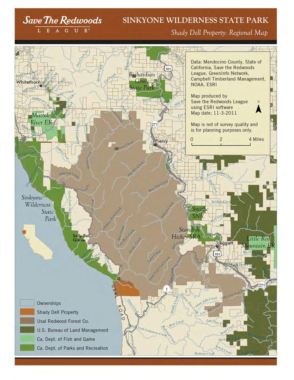
2 USAL-SHADY- DELL CREEK CALIFORNIA COASTAL TRAIL PLANNING 2. The proposed authorization is consistent with the purposes and objectives of Chapter 9 of Division 21 of the Public Resources Code, regarding public access. 3. SRL is a private nonprofit organization existing under the provisions of Section 501(c)(3) of the U.S. Internal Revenue Code and its purposes are consistent with Division 21 of the Public Resources Code. PROJECT SUMMARY: Staff is recommending the Conservancy authorize the disbursement of up to $78,750 dollars to Save the Redwoods League (SRL) to complete planning, design and permitting work for a new 2-mile segment of the California Coastal Trail on the 957-acre Usal-Shady Dell Creek property in northern Mendocino County (See Exhibit 1: Project Location). When constructed, the Shady Dell segment of the California Coastal Trail (CCT) will extend the Lost Coast section of the CCT 2 miles southward into varied habitats, including the Trees of Mystery (a spectacular grove of stunted, old growth candelabra redwood trees), along Shady Dell Creek, and then west of the existing county road, providing inspiring views of the rugged northern Mendocino Coast (Exhibit 2: Photographs). When constructed, this trail will be named the Peter Douglas Coastal Trail in honor of the former director of the Coastal Commission. SRL acquired the property in October 2011 with funding assistance from the Conservancy and private donors. A primary goal of the acquisition was developing new coastal trail that would connect on the northern edge of the property to existing CCT in the Sinkyone Wilderness State Park. The proposed project is an important, necessary step in accomplishing that goal. Pursuant to the Conservancy s proposed authorization, SRL will work in partnership with the Mendocino Land Trust to plan and design the trail alignment, and obtain the permits to construct the trail. SRL will undertake the necessary archaeology, botanical, wetland and wildlife surveys to inform the design of the project and provide the basis to analyze project impacts pursuant to the California Environmental Quality Act. SRL will also develop engineered designs for a bridge over Shady Dell creek, and for viewing platforms and stairs along the trail. It is anticipated that when the design and permitting is complete, SRL will approach the Conservancy for implementation funding. SRL s history of conservation work in the area dates back to 1922 with acquisitions on the eastern edge of the Usal Forest Conservation Project. The Conservancy has worked with SRL on a number of north coast acquisition projects over the last decade, including the 25,000 acre Mill Creek acquisition in Del Norte County, and smaller acquisitions at Humboldt Lagoons State Park and Montgomery Woods State Park in the upper Big River watershed. More recently, SRL stepped in to provide interim funding for the Jenner Headlands acquisition in Sonoma County when the State funding was frozen. SRL has proven its capabilities as a strong participant in conserving the coast. Site Description: The Shady Dell Creek property is adjacent to the 7,800-acre Sinkyone Wilderness State Park to the north and the 49,500 acre Redwood Forest Foundation property to the east, which is conserved by a working forest easement. Also to the north is the Sinkyone Intertribal Wilderness Page 2 of 6
3 USAL-SHADY- DELL CREEK CALIFORNIA COASTAL TRAIL PLANNING Council land, which connects to the 60,000-acre King Range National Conservation Area, managed by the Bureau of Land management. To the south are lands managed by Soper- Wheeler, a private timber company. The 957-acre property contains a variety of highly valuable habitats, including one mile of coastline with sandy beach and steep coastal bluffs, as well as riparian and forested habitat types. The coastal bluff scrub provides habitat for as many as five sensitive plant species, including Mendocino Coast Indian Paintbrush. Records from the California Natural Diversity Database indicate several occurrences of an old forest lichen named Methuselah s beard lichen (Usnea Longissima) on the parcel, suggesting complex forest structure. The property also offers habitat for the Northern Spotted Owl. Early to mid-successional redwood and Douglas fir forest surrounds Shady Dell Creek, a tributary of Usal Creek, which supports habitat for Chinook salmon, coho salmon and steelhead trout. Project History: SRL was awarded $3,000,000 by the Conservancy in January 2011 to assist with the purchase of the Shady Dell Creek property, and provided $2,500,000 in private matching funds. The acquisition, completed in October 2011, was part of the 50,000-acre Usal Forest Conservation Project, a cooperative project of the Redwood Forest Foundation Inc (RFFI), The Conservation Fund, SRL, the Coastal Conservancy, and the Wildlife Conservation Board. The majority of RFFI s property was conserved through a working forest conservation easement. The portion of the property deemed most suitable for public acquisition and access was the Shady Dell Creek property, and thus it was acquired in fee. It was originally hoped that the California Department of Parks and Recreation (DPR) would be able to take on ownership, and manage the property in conjunction with the Sinkyone Wilderness State Park, but due to budgetary limitations, DPR was unable to take on ownership at the time the property was acquired, and SRL agreed to own and manage the property for natural resource protection and public access until a public entity is able to take over management responsibilities. One of the primary purposes of the acquisition was the development of additional coastal trail. SRL is now seeking to move that goal forward with the development of the trail plan. The Conservancy has a long history of developing and implementing projects in the vicinity. In addition to the Usal-Shady Dell Creek acquisition, the Conservancy provided funding for the Sinkyone State Park acquisitions in the late 1980s, and sold land to the Intertribal Sinkyone Wilderness Council (ITSWC) for creation of their wilderness park in the 1990s. Subsequently, the Conservancy awarded a grant to ITWSC to plan for the development of trails on that property, and has also worked with the ITSWC on implementation of anadromous fish habitat improvement projects. At the October 18, 2012 Conservancy Board meeting, the board will also consider funding for construction of two trails crossing the ITSWC property connecting to the Sinkyone State Park. Page 3 of 6
4 USAL-SHADY- DELL CREEK CALIFORNIA COASTAL TRAIL PLANNING PROJECT FINANCING Coastal Conservancy 78,750 Save the Redwoods League 19,670 Total Project Costs 98,420 The expected source for the Conservancy funds for this authorization is an appropriation to the Conservancy from the Safe Drinking Water, Water Quality and Supply, Flood Control, River and Coastal Protection Bond Act of 2006, Proposition 84, Public Resources Code section et seq. Subsection 75060(b) of the Public Resources Code authorizes the use of these funds for projects that promote access to and enjoyment of the coastal resources of the state and that are consistent with the Conservancy s enabling legislation, Division 21 of the Public Resources Code. The proposed project serves to promote access to coastal resources by completing planning, design and permitting for a new segment of CCT, and is consistent with Chapter 9 of Division 21 as explained below. Therefore, it is appropriate to use Proposition 84 funds for the proposed project. CONSISTENCY WITH CONSERVANCY S ENABLING LEGISLATION: The proposed project is undertaken pursuant to Chapter 9 of Division 21 of the Public Resources Code (Sections et seq.). Section states that it is the intent of the Legislature that the Conservancy have a principal role in the implementation of a system of public accessways to and along the state s coastline. Pursuant to section the Conservancy may award grants to nonprofit organizations to develop lands for public access to and along the coast. SRL is a 501 (c)(3) nonprofit organization. The proposed project will lead to the development of new coastal trail and access facilities. Pursuant to section , the Conservancy may provide up to the total cost of the initial development of public accessways by a nonprofit organization. Consistent with this section, the amount of funding provided by the Conservancy has been determined by the total amount of funding available for coastal public accessway projects, the fiscal resources of the applicant, the urgency of the project relative to other eligible projects, and the application of the Conservancy s Project Selection Criteria and Guidelines, as described below. Pursuant to section , the Conservancy may provide such assistance as is required to aid nonprofit organizations in establishing a system of public coastal accessways. The Conservancy s funding will enable SRL to proceed with the design and permitting of public access on the Shady Dell property. Pursuant to section , the Conservancy shall coordinate the development of the California Coastal Trail. The proposed project will lead to the development of 2 miles of new coastal trail. In addition, Public Resources Code section allows the Conservancy to undertake plans and feasibility studies to carry out the purposes of Division 21 of the Public Resources Code. Page 4 of 6
5 USAL-SHADY- DELL CREEK CALIFORNIA COASTAL TRAIL PLANNING CONSISTENCY WITH CONSERVANCY S 2007 STRATEGIC PLAN GOAL(S) & OBJECTIVE(S): Consistent with Goal 1, Objective C of the Conservancy s 2007 Strategic Plan, the proposed project will design an approximately 2 mile segment of new coastal trail within land held by SRL. CONSISTENCY WITH CONSERVANCY S PROJECT SELECTION CRITERIA & GUIDELINES: The proposed project is consistent with the Conservancy s Project Selection Criteria and Guidelines, last updated on November 10, 2011, in the following respects: Required Criteria 1. Promotion of the Conservancy s statutory programs and purposes: See the Consistency with Conservancy s Enabling Legislation section above. 2. Consistency with purposes of the funding source: See the Project Financing section above. 3. Support of the public: The proposed project is supported by Assemblyman Wes Chesbro, Senator Noreen Evans, the Counties of Mendocino and Humboldt, the City of Fort Bragg, Coastwalk, and others. Letters of support are included in Exhibit Location: The proposed project would be located within the coastal zone of Mendocino County. 5. Need: Few funding sources are available for trail design. SLT has committed some of its private funds to this effort, but the project will not move forward absent Conservancy participation. The trail will provide a new amenity for visitors to the Usal Beach campground, and hikers on the Lost Coast. Without the development of a formal trail, it is likely that visitors will develop volunteer trails across the property, which might impact sensitive natural resources. 6. Greater-than-local interest: Completion of a contiguous CCT has been a goal of Californians for decades. In 1972, California voters passed Proposition 20 which, among other things, provides that a hiking, bicycle, and equestrian trails system shall be established along or near the Coast, and the CCT was subsequently designated California s Millennium Legacy Trail in California s Lost Coast has become a destination for local, regional, and international visitors seeking inspiring, undeveloped coastal views, rigorous hiking, and solitude. The proposed project will lead to the addition of 2 miles to the Lost Coast trail system. 7. Sea level rise vulnerability: Vulnerability to sea level rise is minimal on the Shady Dell property. The southern portion of the property contains steep coastal bluffs that provide stunning views, but no access to the shoreline The northern portion, where the shoreline is accessible from the Sinkyone Wilderness State Park, could become less accessible with anticipated sea level rise over the next years. However, it is anticipated that the proposed coastal trail will occur on the blufftop, and thus access to the property would be maintained. The remainder of the Shady Dell property would not be impacted by anticipated Page 5 of 6
6 USAL-SHADY- DELL CREEK CALIFORNIA COASTAL TRAIL PLANNING sea level rise, and in fact, could provide alternative locations for public access improvements currently located in potentially vulnerable areas on the existing state park. Additional Criteria 8. Resolution of more than one issue: Trail design will balance the need for improved public access facilities with protection of sensitive habitats and rare species. 9. Leverage: See the Project Financing section above. 10. Readiness: SRL has developed a scope of work, budget and timeline, and is prepared to proceed upon Conservancy approval. The project is expected to be planned, designed and permitted within two years. 11. Realization of prior Conservancy goals: See Project History above. 12. Cooperation: SRL will coordinate with State Parks, the Conservancy and coastal trail advocates in the development of the trail plan. 13. Minimization of greenhouse gas emissions: Aside from minimal car trips to the site to complete the trail design process, this planning design and permitting project should not contribute to greenhouse gas emissions and climate change. CONSISTENCY WITH LOCAL COASTAL PROGRAM POLICIES: The proposed project is consistent with the Mendocino County Local Coastal Plan. Specifically, Policy states a hiking trail should be developed. It should extend form the Humboldt County line southward beyond the southern limits of the (Sinkyone Wilderness) State Park and along the Usal Road to State Highway 1. Policy states The Board of Supervisors or appropriate entity should continue to negotiate for a trail from Humboldt County line southward to connect with other trails within the Coastal Zone. Policy states coastal trails shall be established for hiking and equestrian use along the Briceland Road and Usal Creek, and aligned with other trail segments to the south. COMPLIANCE WITH CEQA: The proposed project involves only feasibility or planning studies and it may include basic data collection and research (neither of which will impact any environmental resource(s)), undertaken as part of a study leading to an action which has not yet been approved, authorized, adopted, or funded by the Conservancy or another agency and is thus statutorily exempt from the California Environmental Quality Act (CEQA) pursuant to 14 Cal. Code of Regulations sections and Planning carried out as part of this project will, however, consider environmental factors as required by section Staff will file a Notice of Exemption upon approval of this project. Page 6 of 6

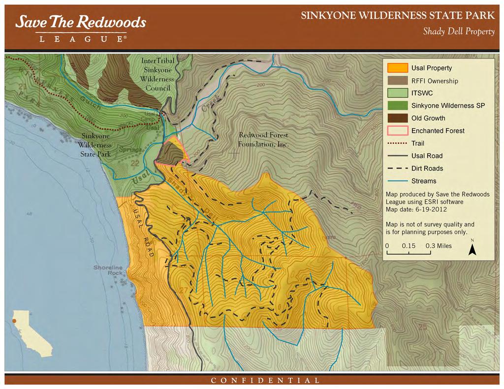
7 Project Location Exhibit 1: Project Location Map
8
9
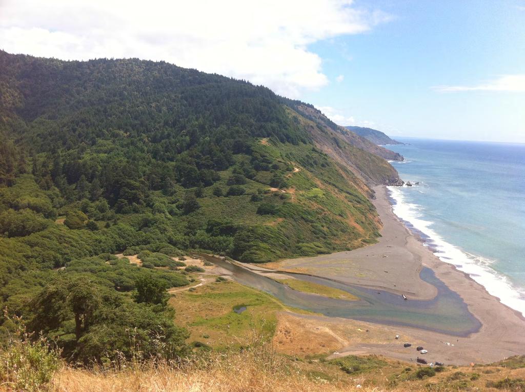
10 Exhibit 2: Photographs
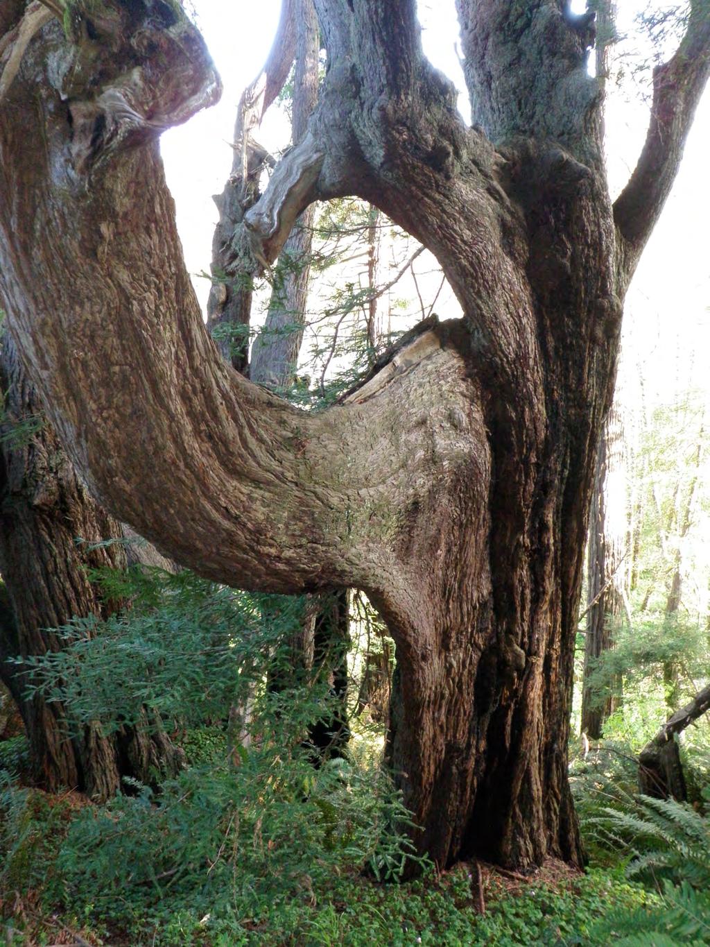
11 Exhibit 2: Photographs
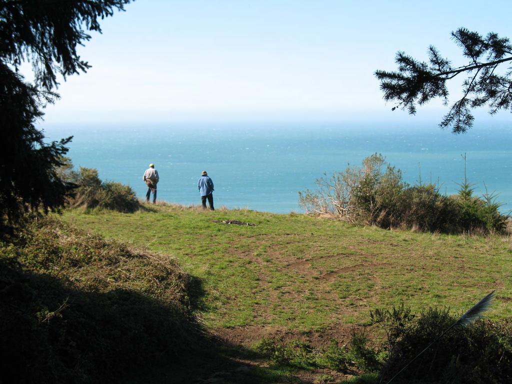
12 Exhibit 2: Photographs
13 Exhibit 3: Project Letters
14 Exhibit 3: Project Letters
15 Exhibit 3: Project Letters
 468-9500 InterTribal Cultural Conservation for Sinkyone Indian Lands _ September 12, 2012 BOARD OF DIRECTORS Priscilla Hunter Chairwoman Coyote Valley Band of")

16 Exhibit 3: Project Letters InterTribal Sinkyone Wilderness Council P.O. Box 1523 Ukiah, CA Phone (707) InterTribal Cultural Conservation for Sinkyone Indian Lands _ September 12, 2012 BOARD OF DIRECTORS Priscilla Hunter Chairwoman Coyote Valley Band of Pomo Indians Daniel Rockey, Sr. Vice Chairperson Sherwood Valley Band of Pomo Indians Martha Knight Secretary Pomo Elizabeth Hansen Treasurer Redwood Valley Band of Pomo Indians Richard J. Smith Member Cahto Tribe of Laytonville Rancheria Shawn Padi Member Hopland Band of Pomo Indians David Edmunds Member Pinoleville Pomo Nation Salvador Rosales Member Potter Valley Tribe Stoney Timmons Member Robinson Rancheria of Pomo Indians Mona Oandasan Member Round Valley Indian Tribes Crista Ray Member Scotts Valley Band of Pomo Indians STAFF Hawk Rosales Executive Director Janene Ilar Administrative Assistant Doug Bosco, Chairman State Coastal Conservancy 1330 Broadway, 13 th Floor Oakland, CA Re: Shady Dell Coastal Trail Project Dear Chairman Bosco: The InterTribal Sinkyone Wilderness Council, a nonprofit land and ocean conservation consortium comprised of ten federally recognized Northern California Indian Tribes, fully supports Save the Redwoods League s Shady Dell California Coastal Trail (CCT) grant application. The goal of this project is to complete the planning, design and permitting phase for approximately two miles of new CCT, situated at the southern end of the Lost Coast in northern Mendocino County. This trail-planning project will enable the League, in partnership with the Mendocino Land Trust, to provide the public with new coastal hiking opportunities. California residents and visitors alike will benefit from the completion of this new segment of the CCT. The Conservancy invested $3,000,000 in acquisition and protection of the Shady Dell property in Funding support from the Conservancy for coastal trail planning (Phase I) for this property during 2012 is a critically important step for moving this important project toward completion. The 957-acre Shady Dell property contains a variety of highvalue habitats and ecosystems, including one mile of coastline, as well as riparian and forested habitat types and many communities of native wildlife and vegetation. The Shady Dell CCT will provide outstanding recreational and educational opportunities, and will enhance the public s access and enjoyment of our State s unrivaled Lost Coast region. The Save the Redwoods League ownership at Shady Dell is adjacent to the 7,250-acre Sinkyone Wilderness State Park to the northwest and the 49,500-acre Redwood Forest Foundation property to the northeast, which was recently conserved through a working forest easement. To the north are the 4,000-acre InterTribal Sinkyone Wilderness properties, permanently protected through conservation easements, which lie between the Sinkyone Wilderness State Park and the Redwood Forest Foundation property and connect in the north to the protected 4,000-acre Upper Mattole River & Forest Cooperative lands and the 68,000-acre BLM King Range National Conservation Area (42,600 acres of which are designated federal wilderness). To the south of Shady Dell are lands owned by Soper- Wheeler Company, a private timberland manager. The Lost Coast represents the longest stretch of permanently protected coastal wilderness in the lower 48 states, beginning in the south with the Shady Dell property, and ending in north at the mouth of the Mattole River in the King Range National Conservation Area. InterTribal Sinkyone Wilderness Council is a Nonprofit Consortium of California Indian Tribes Cultural Conservation Native Stewardship Watershed Rehabilitation Cultural Ecology Education
17 Exhibit 3: Project Letters InterTribal Sinkyone support letter for Shady Dell CCT grant September 12, 2012 The Shady Dell trail will parallel the west side of the Mendocino County Road #431 (Usal Road), cross Shady Dell Creek, wind through the Trees of Mystery, and connect with the southern end of the existing Lost Coast Trail in the Sinkyone Wilderness State Park. The League is contributing 20% of the total project budget ($19,670), and requests $78,743 from the Coastal Conservancy. The total project budget is $98,413. The Sinkyone Council supports this project and appreciates the Conservancy s many conservation and trail efforts along the California Coast, particularly in the rugged coastal lands of Mendocino County. We also appreciate the exceptional work of both Save the Redwoods League and Mendocino Land Trust to protect and restore North Coast lands while providing increased opportunities for stewardship, recreation and education. Thank you for your consideration of this important and worthy project. Sincerely, Priscilla Hunter Chairwoman cc: Karyn Gear, State Coastal Conservancy Ruskin Hartley, Save the Redwoods League Louisa Morris, Mendocino Land Trust Page 2 of 2

18 Exhibit 3: Project Letters Board of Directors Richard Nichols President Sonoma County Sarah Gurney Vice-President Sonoma County Linda Hanes Secretary Sonoma County Mike Reilly Treasurer Sonoma County Gregory Fearon Sonoma County Nancy Graves San Luis Obispo County Maggie Hardy Monterey County Mark Massara San Francisco County Sandi McCubbin San Francisco County Richard Retecki Sonoma County Chris Thollaug San Mateo County John Woolley Humboldt County Una J. M. Glass, Executive Director Mailing Address: 555 South Main St., Suite. 1 Sebastopol, CA (707) californiacoastaltrail.info September 10, 2012 Mr. Douglas Bosco, Chairman State Coastal Conservancy 1330 Broadway, 13 th Floor Oakland, CA Dear Mr. Bosco: We are writing to you in support of Save-the-Redwoods League s Shady Dell California Coastal Trail (CCT) grant application. The goal of this project is to complete the planning, design, and permitting for approximately 2 miles of new CCT, at the southern end of the Lost Coast in Mendocino County. This trail planning project will enable the League, in partnership with the Mendocino Land Trust, to provide the public with new coastal trail hiking opportunities. California residents and visitors alike will benefit from completion of this new CCT segment. The Conservancy invested $3,000,000 in acquisition of the Shady Dell property in 2011, and the Conservancy s support of coastal trail planning (Phase I) for this property is a natural next step for The 957-acre Shady Dell property contains a variety of highly valuable habitats, including one mile of coastline, as well as riparian and forested habitat types. The Save the Redwoods League ownership at Shady Dell is adjacent to the 7,800-acre Sinkyone Wilderness State Park to the north and the 49,500-acre Redwood Forest Foundation property to the east, which is conserved by a working forest easement. Also to the north is the Sinkyone Intertribal Wilderness Council land, which connects to the 60,000-acre King Range National Conservation Area, managed by the Bureau of Land Management. To the south are lands managed by Soper-Wheeler, a private timber company. The new trail will travel west of the existing County Road (Usal Road), cross Shady Dell Creek, wind through the Trees of Mystery, and connect with the southern end of the existing Lost Coast trail. The League is contributing 20% of the total project budget ($19,670), and requests $78,743 from the Coastal Conservancy. The total project budget is $98,413. Coastwalk California is a 29 year old statewide nonprofit dedicated to coastal access, coastal preservation and the completion of the 1200 mile California Coastal Trail that will run unbroken from Oregon to Mexico. Many of our members have hiked the entire CCT to bring attention to gaps and barriers in completing this great long-distance trail. We support this project and appreciate the Conservancy s conservation and trail efforts, particularly in rugged Mendocino County. Sincerely, Una J. M. Glass Executive Director
19 Exhibit 3: Project Letters
COASTAL CONSERVANCY. Staff Recommendation June 5, 2008 GUALALA BLUFF TRAIL OPERATIONS AND MAINTENANCE
 COASTAL CONSERVANCY Staff Recommendation June 5, 2008 GUALALA BLUFF TRAIL OPERATIONS AND MAINTENANCE File No. 08-047-01 Project Manager: Deborah Hirst RECOMMENDED ACTION: Consideration and possible Conservancy
COASTAL CONSERVANCY. Staff Recommendation March 25, 2004 SONOMA COUNTY COASTAL TRAIL, PHASE I. File No Project Manager: Richard Retecki
 COASTAL CONSERVANCY Staff Recommendation March 25, 2004 SONOMA COUNTY COASTAL TRAIL, PHASE I File No. 03-142 Project Manager: Richard Retecki RECOMMENDED ACTION: Authorization to disburse up to $455,000
COASTAL CONSERVANCY. Staff Recommendation September 22, 2011 BAY AREA RIDGE TRAIL: HOOD MOUNTAIN TO HIGHWAY 12
 COASTAL CONSERVANCY Staff Recommendation September 22, 2011 BAY AREA RIDGE TRAIL: HOOD MOUNTAIN TO HIGHWAY 12 File No. 11-039-001 Project Manager: Betsy Wilson RECOMMENDED ACTION: Authorization to disburse
COASTAL CONSERVANCY. Staff Recommendation December 2, 2004 COYOTE HELLYER COUNTY PARK BAY AREA RIDGE TRAIL
 COASTAL CONSERVANCY Staff Recommendation December 2, 2004 COYOTE HELLYER COUNTY PARK BAY AREA RIDGE TRAIL File No. 04-057 Project Manager: Amy Hutzel RECOMMENDED ACTION: Authorization to disburse up to
COASTAL CONSERVANCY. Staff Recommendation March 17, 2011 EAST-SLOPE SONOMA MOUNTAIN RIDGE TRAIL PLANNING
 COASTAL CONSERVANCY Staff Recommendation March 17, 2011 EAST-SLOPE SONOMA MOUNTAIN RIDGE TRAIL PLANNING File No. 11-008-01 Project Manager: Sam Jenniches RECOMMENDED ACTION: Authorization to disburse up
COASTAL CONSERVANCY. Staff Recommendation December 4, 2008 TIMBER COVE COASTAL TRAIL FEASIBILITY STUDY
 COASTAL CONSERVANCY Staff Recommendation December 4, 2008 TIMBER COVE COASTAL TRAIL FEASIBILITY STUDY File No. 08-138-01 Project Manager: Matthew Gerhart RECOMMENDED ACTION: Authorization to disburse up
COASTAL CONSERVANCY. Staff Recommendation May 27, 2010 SANTA CRUZ COUNTY MASTER COASTAL TRAIL PLAN. File No Project Manager: Laura Engeman
 COASTAL CONSERVANCY Staff Recommendation May 27, 2010 SANTA CRUZ COUNTY MASTER COASTAL TRAIL PLAN File No. 09-004 Project Manager: Laura Engeman RECOMMENDED ACTION: Authorization to disburse up to $250,000
COASTAL CONSERVANCY. Staff Recommendation October 21, 2010 PETALUMA TRESTLE REHABILITATION DESIGN
 COASTAL CONSERVANCY Staff Recommendation October 21, 2010 PETALUMA TRESTLE REHABILITATION DESIGN Project No.: 10-017-01 Project Manager: Deborah Hirst RECOMMENDED ACTION: Authorization to disburse up to
COASTAL CONSERVANCY. Staff Recommendation May 27, 2010 SAN DIEGUITO RIVER PARK TRAILS PHASE II TRAIL DESIGN AND CONSTRUCTION
 COASTAL CONSERVANCY Staff Recommendation May 27, 2010 SAN DIEGUITO RIVER PARK TRAILS PHASE II TRAIL DESIGN AND CONSTRUCTION File No. 05-031-02 Project Manager: Christopher Kroll RECOMMENDED ACTION: Authorization
STORNETTA BROTHERS COASTAL RANCH
 STORNETTA BROTHERS COASTAL RANCH Location: Surrounding Point Arena Lighthouse and immediately south of Manchester State Park Mendocino Co., CA Acres: 1,860 Resources: Over two miles of Pacific Ocean coastline
COASTAL CONSERVANCY. Staff Recommendation November 6, 2008 SAN FRANCISCO BAY TRAIL: CANAL BOULEVARD CONSTRUCTION
 COASTAL CONSERVANCY Staff Recommendation November 6, 2008 SAN FRANCISCO BAY TRAIL: CANAL BOULEVARD CONSTRUCTION File No. 07-037-02 Project Manager: Michelle Jesperson RECOMMENDED ACTION: Authorization
DATE: January 19, WCA Governing Board. Johnathan Perisho, Project Manager. Mark Stanley, Executive Officer
 Item 14 DATE: January 19, 2017 TO: FROM: THROUGH: SUBJECT: WCA Governing Board Johnathan Perisho, Project Manager Mark Stanley, Executive Officer Item 14: Consideration of a resolution to accept an acquisition
COASTAL CONSERVANCY. Staff Recommendation December 13, 2007 SANTA ANA RIVER PARKWAY. File No Project Manager: Mary Small
 COASTAL CONSERVANCY Staff Recommendation December 13, 2007 SANTA ANA RIVER PARKWAY File No. 07-097 Project Manager: Mary Small RECOMMENDED ACTION: Authorize disbursement of up to two million seven hundred
ROAD AND TRAIL PROJECT APPROVAL
 ROAD AND TRAIL PROJECT APPROVAL www.marincountyparks.org Marin County Parks, 3501 Civic Center Dr, Suite 260, San Rafael, CA 94903 DATE: July 12, 2017 PRESERVE: Gary Giacomini Open Space Preserve PROJECT:
Decision Memo Broken Wheel Ranch Equestrian Outfitter Special-Use Permit Proposed Action
 Decision Memo Broken Wheel Ranch Equestrian Outfitter Special-Use Permit USDA Forest Service Mississippi Bluffs Ranger District, Shawnee National Forest Jackson and Union Counties, Illinois Proposed Action
CHAPTER 4 -- THE LAND USE PLAN: DESCRIPTIONS AND POLICIES FOR THIRTEEN PLANNING AREAS
 CHAPTER 4 -- THE LAND USE PLAN: DESCRIPTIONS AND POLICIES FOR THIRTEEN PLANNING AREAS NORTH CENTRAL CAC AREA LITTLE VALLEY ROAD TO JUG HANDLE CREEK PLANNING AREA This planning area includes Cleone, Noyo,
CHAPTER 4 -- THE LAND USE PLAN: DESCRIPTIONS AND POLICIES FOR THIRTEEN PLANNING AREAS
 CHAPTER 4 -- THE LAND USE PLAN: DESCRIPTIONS AND POLICIES FOR THIRTEEN PLANNING AREAS SOUTH COAST CAC PLANNING AREA 4.10 NAVARRO RIVER TO MALLO PASS CREEK PLANNING AREA (Includes Greenwood/Elk) This planning
1803 West Hwy 160 Monte Vista, CO (719) TTY (719)
 TTY (719)") USDA Forest Service Rio Grande National Forest http://www.fs.fed.us/r2/riogrande 1803 West Hwy 160 Monte Vista, CO 81144 (719)852-5941 TTY (719)852-6271 USDI Bureau of Land Management San Luis Valley Center
USDA Forest Service Rio Grande National Forest http://www.fs.fed.us/r2/riogrande 1803 West Hwy 160 Monte Vista, CO 81144 (719)852-5941 TTY (719)852-6271 USDI Bureau of Land Management San Luis Valley Center
$850,000 Awarded to 20 Organizations
 $850,000 Awarded to 20 Organizations The Conservation Alliance is pleased to fund the following organizations to support their efforts to protect wild lands and waterways for their habitat and recreation
Land Protection Accomplishments
 2017 Land Protection Accomplishments Conserving Open Space and Recreational Access On the Pacific Crest National Scenic Trail View from the Pacific Crest Trail of Donomore Meadows near the California/Oregon
S Central Coast Heritage Protection Act APRIL 21, 2016
 STATEMENT OF GLENN CASAMASSA ASSOCIATE DEPUTY CHIEF, NATIONAL FOREST SYSTEM U.S. FOREST SERVICE U.S. DEPARTMENT OF AGRICULTURE BEFORE THE UNITED STATES SENATE COMMITTEE ON ENERGY AND NATURAL RESOURCES
SONOMA LOCAL AGENCY FORMATION COMMISSION 111 SANTA ROSA AVENUE, SUITE 240, SANTA ROSA, CA (707)
") SONOMA LOCAL AGENCY FORMATION COMMISSION 111 SANTA ROSA AVENUE, SUITE 240, SANTA ROSA, CA 95404 (707) 565-2577 www.sonomalafco.org Item 4.2 Staff Report Meeting Date: February 6, 2019 Agenda No. Item 4.2
SONOMA LOCAL AGENCY FORMATION COMMISSION 111 SANTA ROSA AVENUE, SUITE 240, SANTA ROSA, CA 95404 (707) 565-2577 www.sonomalafco.org Item 4.2 Staff Report Meeting Date: February 6, 2019 Agenda No. Item 4.2
CHAPTER 4 -- THE LAND USE PLAN: DESCRIPTIONS AND POLICIES FOR THIRTEEN PLANNING AREAS
 CHAPTER 4 -- THE LAND USE PLAN: DESCRIPTIONS AND POLICIES FOR THIRTEEN PLANNING AREAS NORTH CENTRAL CAC PLANNING AREA 4.4 FORT BRAGG CITY LIMIT TO HARE CREEK PLANNING AREA (Includes Noyo) The Noyo community
COASTAL CONSERVANCY. Staff Recommendation December 2, 2010 CITY OF SAN DIEGO NCCP PROGRAM VERNAL POOL HABITAT CONSERVATION PLAN
 COASTAL CONSERVANCY Staff Recommendation December 2, 2010 CITY OF SAN DIEGO NCCP PROGRAM VERNAL POOL HABITAT CONSERVATION PLAN Project No. 98-011-02 Project Manager: Mary Small RECOMMENDED ACTION: Authorization
Sibley LUPA. Board Executive Committee Meeting December 7, 2017
 Sibley LUPA Board Executive Committee Meeting December 7, 2017 Project Location & Project Area 1,318-acre Robert Sibley Volcanic Regional Preserve Project Area Purpose Project Purpose & Goals Append the
PROPOSED PROCESS FOR WRITING THE MASTER PLAN FOR THE BIG SUR PORTION OF THE CALIFORNIA COASTAL TRAIL
 PROPOSED PROCESS FOR WRITING THE MASTER PLAN FOR THE BIG SUR PORTION OF THE CALIFORNIA COASTAL TRAIL PURPOSE The purpose of this process is to agree on the Master Plan for the portion of the California
Partners: Michigan California Timber Company Shasta-Trinity National Forest Pacific Crest Trail Association The Trust for Public Land
 Partners: Michigan California Timber Company Shasta-Trinity National Forest Pacific Crest Trail Association The Trust for Public Land Describe the project location, size, opportunities, and timing. Provide
Little River Trail Feasibility Study
 Final April, 2014 Prepared for the State Coastal Conservancy By the Natural Resources Services Division of Redwood Community Action Agency Table of Contents Executive Summary... 1 1. Project Purpose and
David Johnson. Tom, Attached please find the final scoping letter and figures for your review. David
 David Johnson From: Sent: To: Cc: Subject: Attachments: David Johnson Tuesday, April 12, 2011 4:33 PM Thomas Malecek Dave Dyer; Jason Marks (jmarks@segroup.com) VWC Scoping Letter
CHAPTER 4 -- THE LAND USE PLAN: DESCRIPTIONS AND POLICIES FOR THIRTEEN PLANNING AREAS
 CHAPTER 4 -- THE LAND USE PLAN: DESCRIPTIONS AND POLICIES FOR THIRTEEN PLANNING AREAS SOUTH COAST CAC PLANNING AREA 4.11 MALLO PASS CREEK TO IVERSEN ROAD PLANNING AREA (Irish Beach/Manchester/Point Arena)
White Mountain National Forest Saco Ranger District
 United States Department of Agriculture Forest Service White Mountain National Forest Saco Ranger District 33 Kancamagus Highway Conway, NH 03818 Comm: (603) 447-5448 TTY: (603) 447-3121 File Code: 1950
FINAL TESTIMONY 1 COMMITTEE ON RESOURCES UNITED STATES HOUSE OF REPRESENTATIVES. July 13, 2005 CONCERNING. Motorized Recreational Use of Federal Lands
 FINAL TESTIMONY 1 STATEMENT OF DALE BOSWORTH CHIEF Of the FOREST SERVICE UNITED STATES DEPARTMENT OF AGRICULTURE Before the SUBCOMMITTEE ON FORESTS AND FOREST HEALTH And the SUBCOMMITTEE ON NATIONAL PARKS,
Pinellas County Environmental Lands
 Pinellas County Environmental Lands In addition to traditional parks and recreation facilities, Pinellas County owns and manages a system of environmental lands that provides specialized resource-based
UNITED STATES DEPARTMENT OF THE INTERIOR BUREAU OF LAND MANAGEMENT MANUAL TRANSMITTAL SHEET
 Form 1221-2 (June 1969) UNITED STATES DEPARTMENT OF THE INTERIOR BUREAU OF LAND MANAGEMENT MANUAL TRANSMITTAL SHEET Release 8-83 Date Subject 8353 Trail Management Areas Secretarially Designated (Public)
This area encompasses the coastal shores and
 COASTAL REDWOOD NATIONAL AND STATE PARKS This area encompasses the coastal shores and forests of Redwood National and State Parks (RNSP) from Crescent Beach south to Mussel Point, near the town of Orick
Environment and Natural Resources Trust Fund 2019 Request for Proposals (RFP)
") Environment and Natural Resources Trust Fund 2019 Request for Proposals (RFP) Project Title: Glacial Edge Trail and Downtown Pedestrian Bridge Category: G. Land Acquisition for Habitat and Recreation ENRTF
Environment and Natural Resources Trust Fund 2019 Request for Proposals (RFP) Project Title: Glacial Edge Trail and Downtown Pedestrian Bridge Category: G. Land Acquisition for Habitat and Recreation ENRTF
Wilderness Areas Designated by the White Pine County bill
 Wilderness Areas Designated by the White Pine County bill SEC. 321. SHORT TITLE. This subtitle may be cited as the `Pam White Wilderness Act of 2006'. SEC. 322. FINDINGS. Congress finds that-- The White
Environment and Natural Resources Trust Fund 2014 Request for Proposals (RFP)
") Environment and atural Resources Trust Fund 2014 Request for Proposals (RFP) Project Title: State Parks and Trails Land ERTF ID: 181-G Category: G. Land for Habitat and Recreation Total Project Budget:
Environment and atural Resources Trust Fund 2014 Request for Proposals (RFP) Project Title: State Parks and Trails Land ERTF ID: 181-G Category: G. Land for Habitat and Recreation Total Project Budget:
Cascade River State Park Management Plan Amendment
 This document is made available electronically by the Minnesota Legislative Reference Library as part of an ongoing digital archiving project. http://www.leg.state.mn.us/lrl/lrl.asp Cascade River State
SUMMER VILLAGE OF SILVER SANDS. Municipal Development Plan
 SUMMER VILLAGE OF SILVER SANDS Municipal Development Plan Bylaw 253-2014 Adopted August 22, 2014 Summer Village of Silver Sands Municipal Development Plan Bylaw No. 253-2014 Page 2 1 INTRODUCTION 1.1 SETTING
OPEN SPACE. The Open Space Element describes the County s goals and policies with respect to open space areas and addresses the following topics:
 PURPOSE This element addresses open spaces for: the managed production of resources, outdoor recreation, public health and safety, and the preservation of natural resources. Amador County s open space
January 14, Orange County Transportation Authority Attn: M2 NCCP/HCP 550 South Main Street P.O. Box Orange, CA
 Equestrian Trails, Inc. Corral 357 P.O. Box 1026 Trabuco Canyon, CA 92678 http://saddlebackcanyonriders.com/ President: James Iacono... 714-612-1789 January 14, 2016 Orange County Transportation Authority
Continental Divide National Scenic Trail Legislative History and Planning Guidance
 Continental Divide National Scenic Trail Legislative History and Planning Guidance Legislation, Policy, and Direction Regarding National Scenic Trails The National Trails System Act, P.L. 90-543, was passed
LAS VARAS RANCH CA COASTAL TRAIL PROPOSED ALIGNMENT
 LAS VARAS RANCH CA COASTAL TRAIL PROPOSED ALIGNMENT Santa Barbara Trails Council * Prepared by Ray Ford February 1,2012 The following notes accompany the Santa Barbara Trails Council map for the Las Varas
Bon Portage Island Conservation Campaign
 Bon Portage Island Conservation Campaign Protecting a Coastal Treasure Final Report to Nova Scotia Habitat Conservation Fund September 2012 Protection of Bon Portage Island Over the course of this two-year
Blueways: Rivers, lakes, or streams with public access for recreation that includes fishing, nature observation, and opportunities for boating.
 Parks, Open Space and Trails PRINCE WILLIAM COUNTY 2008 COMPREHENSIVE PLAN TRAILS PLAN CONTENTS The components of the trails plan are: Intent Definitions Goals, Policies, and Action Strategies Trails Map
METROPOLITAN COUNCIL 390 North Robert Street, St. Paul, MN Phone (651) TDD (651)
 TDD (651)") DATE: March 27, 2012 METROPOLITAN COUNCIL 390 North Robert Street, St. Paul, MN 55101 Phone (651) 602-1000 TDD (651) 291-0904 TO: Metropolitan Parks and Open Space Commission FROM: Arne Stefferud, Planning
DATE: March 27, 2012 METROPOLITAN COUNCIL 390 North Robert Street, St. Paul, MN 55101 Phone (651) 602-1000 TDD (651) 291-0904 TO: Metropolitan Parks and Open Space Commission FROM: Arne Stefferud, Planning
BACKCOUNTRY TRAIL FLOOD REHABILITATION PROGRAM
 BACKCOUNTRY TRAIL FLOOD REHABILITATION PROGRAM Backcountry Trail Flood Rehabilitation A June 2013 Flood Recovery Program Summary In June 2013, parts of Southern Alberta were devastated from significant
National Wilderness Steering Committee
 National Wilderness Steering Committee Guidance White Paper Number 1 Issue: Cultural Resources and Wilderness Date: November 30, 2002 Introduction to the Issue Two of the purposes of the National Wilderness
Flow Stand Up Paddle Board Parkway Plan Analysis
 Regional Parks Department Jeffrey R. Leatherman, Director County of Sacramento Divisions Administration Golf Leisure Services Maintenance Rangers Therapeutic Recreation Services Flow Stand Up Paddle Board
MARBLE RIVER PROVINCIAL PARK
 MARBLE RIVER PROVINCIAL PARK PURPOSE STATEMENT AND ZONING PLAN March 2003 MARBLE RIVER PROVINCIAL PARK Purpose Statement and Zoning Plan Primary Role The primary role of Marble River Park is to protect
Chapter 2: Summary of Existing Open Space System
 Chapter 2: Summary of Existing Open Space System In 1976, the Wake County Board of Commissioners established the Wake County Parks and Recreation Department in order to provide park facilities and programs
BA Collaborators. Driftless Area Initiative The Prairie Enthusiasts Trout Unlimited TNC TCF Natural Resources Foundation of Wisconsin
 BA Collaborators Driftless Area Initiative The Prairie Enthusiasts Trout Unlimited TNC TCF Natural Resources Foundation of Wisconsin The mission of the of the Blufflands Alliance is to actively conserve
The Partnership Wild & Scenic Rivers Program
 BUDGET REQUEST FISCAL YEAR 2017 Proven, cost-effective protection for 770 miles of rivers and thousands of acres of riparian land Westfield River, MA (L) and Farmington River, CT (R) Partnership Wild &
Virginia Department of Transportation s Rural Rustic Road Program
 Virginia Department of Transportation s Rural Rustic Road Program Prepared by the Local Assistance Division Virginia Department of Transportation 1401 East Broad Street Richmond, Virginia 23219 Michael
National Forests and Grasslands in Texas
 United States Department of Agriculture Forest Service National Forests and Grasslands in Texas Sam Houston NF 394 FM 1375 West New Waverly, Texas 77358 Phone 936-344-6205 Dear Friends, File Code: 1950
2. Goals and Policies. The following are the adopted Parks and Trails Goals for Stillwater Township:
 D. PARKS AND TRAILS 1. Introduction Stillwater Township s population is relatively low, with most residents living on rural residences on large lots. The need for active park space has been minimal in
National Park Service Wilderness Action Plan
 National Park Service U.S. Department of the Interior National Park Service Wilderness Action Plan National Wilderness Steering Committee National Park Service "The mountains can be reached in all seasons.
A CASE FOR COMPLETING THE JORDAN RIVER PARKWAY: A
 A CASE FOR COMPLETING THE JORDAN RIVER PARKWAY: A safe crossing at 9000 South and 850 West Proposed 9000 South Underpass Parkway Timeline Parkway, Trail, and Tourism Facts Blueprint Jordan River 1971 1973
VARGAS ISLAND PROVINCIAL PARK
 VARGAS ISLAND PROVINCIAL PARK PURPOSE STATEMENT AND ZONING PLAN February 2003 VARGAS ISLAND PROVINCIAL PARK Purpose Statement and Zoning Plan Primary Role The primary role of Vargas Island Park is to protect
PROPOSED ACTION South 3000 East Salt Lake City, UT United States Department of Agriculture
 United States Department of Agriculture Forest Service Uinta-Wasatch-Cache National Forest Salt Lake Ranger District 6944 South 3000 East Salt Lake City, UT 84121 801-733-2660 File Code: 1950/2300 Date:
The Chu property is a 6.57 acre parcel located in the Town of Superior on the west side of McCaslin Boulevard. In 2014, the Town of Superior acquired
 1 The Chu property is a 6.57 acre parcel located in the Town of Superior on the west side of McCaslin Boulevard. In 2014, the Town of Superior acquired the Chu property for open space with a contribution
OMINEACA PROVINCIAL PARK
 OMINEACA PROVINCIAL PARK AND PROTECTED AREA PURPOSE STATEMENT AND ZONING PLAN March 2003 OMINECA PROVINCIAL PARK AND PROTECTED AREA Purpose Statement and Zoning Plan Omineca Park and Omineca Protected
June 22, Superintendent Jock Whitworth Zion National Park Springdale, UT Re: Wild and Scenic River Management Plans
 Nathan Fey Colorado Stewardship Director 1601 Longs Peak Avenue Longmont, Colorado 80501 nathan@americanwhitewater.org June 22, 2010 Superintendent Jock Whitworth Zion National Park Springdale, UT 84767-1099
Segment 2: La Crescent to Miller s Corner
 goal of the USFWS refuges is to conserve, protect and enhance fish, wildlife and plants and their habitats for the continuing benefit of the American people. Refuge lands are used largely for fishing,
2016 Regional Transportation Alternatives Program (TAP) Grant Application
 Grant Application") 2016 Regional Transportation Alternatives Program (TAP) Grant Application PROJECT TITLE: Yelm-Tenino Trail Extension Feasibility Study TRPC use only GENERAL PROJECT INFORMATION Agency or Organization City
2016 Regional Transportation Alternatives Program (TAP) Grant Application PROJECT TITLE: Yelm-Tenino Trail Extension Feasibility Study TRPC use only GENERAL PROJECT INFORMATION Agency or Organization City
13.1 REGIONAL TOURISM ISSUES AND SUMMARY OF FINDINGS
 13 REGIONAL TOURISM T he County of Mariposa s recreation needs and facilities fall within two categories: regional tourism and local recreation. This Element focuses on regional tourism issues related
Conservation Partners for the National Reserve System Program: a Western NSW focus
 Conservation Partners for the National Reserve System Program: a Western NSW focus Cooper, N. 1, Webber, L. 2, Nicolson, K. 3 1 Department of Environment, Climate Change and Water NSW, PO Box 788 Broken
(No. 76) (Approved June 6, 2002) AN ACT
 (Approved June 6, 2002) AN ACT") (S. B. 1196) (No. 76) (Approved June 6, 2002) AN ACT To amend the first paragraph of subsection (b) and the first paragraph of subsection (c) of Section 4, of Act No. 66 of June 22, 1975, as amended, known
(S. B. 1196) (No. 76) (Approved June 6, 2002) AN ACT To amend the first paragraph of subsection (b) and the first paragraph of subsection (c) of Section 4, of Act No. 66 of June 22, 1975, as amended, known
Decision Memo for Desolation Trail: Mill D to Desolation Lake Trail Relocation
 for Salt Lake County, Utah Uinta-Wasatch-Cache National Forest Salt Lake Ranger District 1. Background The present location of the Desolation Trail (#1159) between Mill D and Desolation Lake follows old
Executive Summary Downtown Park Fund Allocation HEARING DATE: MAY 5, 2016
 Executive Summary Downtown Park Fund Allocation HEARING DATE: MAY 5, 2016 Date: April 28, 2016 Case No.: 2016 004634CWP Project Name: Allocation of $4,000,000 from the Downtown Park Fund for the Renovation
Securing Permanent Protection for Public Land
 Securing Permanent Protection for Public Land Tools for Wyoming Advocates Paul Spitler* The Wilderness Society * I am a wilderness policy expert, not a powerpoint expert! Platform and Resolutions of the
Preferred Recreation Recommendations Stemilt-Squilchuck Recreation Plan March 2018
 Preferred Recreation Recommendations Stemilt-Squilchuck Recreation Plan March 2018 Below are the recommended recreation ideas and strategies that package together the various recreation concepts compiled
112th CONGRESS. 1st Session H. R. 113 IN THE HOUSE OF REPRESENTATIVES
 HR 113 IH 112th CONGRESS 1st Session H. R. 113 To provide for additions to the Cucamonga and Sheep Mountain Wilderness Areas in the Angeles and San Bernardino National Forests and the protection of existing
WEKIVA WILD AND SCENIC RIVER ACT OF 2000
 PUBLIC LAW 106 299 OCT. 13, 2000 WEKIVA WILD AND SCENIC RIVER ACT OF 2000 VerDate 11-MAY-2000 01:59 Oct 20, 2000 Jkt 069139 PO 00000 Frm 00001 Fmt 6579 Sfmt 6579 E:\PUBLAW\PUBL299.106 APPS27 PsN: PUBL299
Financing Pier 70 Waterfront District Development Plan upon Board of Supervisors Approval
 Financing Pier 70 Waterfront District Development Plan upon Board of Supervisors Approval D Proposition D Shall the City provide funds to develop Pier 70, based on new City hotel and payroll expense tax
Rule Governing the Designation and Establishment of All-Terrain Vehicle Use Trails on State Land
 Rule Governing the Designation and Establishment of All-Terrain Vehicle Use Trails on State Land 1.0 Authority 1.1 This rule is promulgated pursuant to 23 V.S.A. 3506. Section 3506 (b)(4) states that an
The Corporation of the City of Kawartha Lakes Council Report
 The Corporation of the City of Kawartha Lakes Council Report Report Number ENG2017-008 Date: September 12, 2017 Time: 2:00 p.m. Place: Council Chambers Ward Community Identifier: All Subject: Author Name
City of Durango 5.8 FUNDING TRAILS DEVELOPMENT
 5.8 FUNDING TRAILS DEVELOPMENT The City has been successful in establishing dedicated local funding sources as well as applying for grants to develop the City s trail system, having received nearly $2.4
Evaluation of Outstanding Remarkable Values for Collawash River March 2011
 Evaluation of Outstanding Remarkable Values for Collawash River March 0 Segment From headwaters of East Fork Collawash River to Buckeye Creek Mileage: miles Free flowing: Yes Scenic:, Substantial River
H. R IN THE HOUSE OF REPRESENTATIVES
 I 113TH CONGRESS 1ST SESSION H. R. 1776 To establish the Clear Creek National Recreation Area in San Benito and Fresno Counties, to designate the Joaquin Rocks Wilderness in such counties, to designate
Kit Carson-Challenger Ridge Trail Project Annual Performance Report-2014 October 22, 2014
 1 Kit Carson-Challenger Ridge Trail Project Annual Performance Report-2014 October 22, 2014 Willow Lake and Kit Carson Peak 2 SUMMARY The Rocky Mountain Field Institute began Phase 1 of a multi-phase,
CITY OF PALMDALE. REPORT to the Mayor and Members of the City Council from the City Manager
 CITY OF PALMDALE REPORT to the Mayor and Members of the City Council from the City Manager DATE: June 4, 2014 SUBJECT: Specific Plan Amendment 14-01; Amending the Use Designation of 23.97 Acres within
FEASIBILITY CRITERIA
 This chapter describes the methodology and criteria used to evaluate the feasibility of developing trails throughout the study areas. Land availability, habitat sensitivity, roadway crossings and on-street
April 10, Mark Stiles San Juan Public Lands Center Manager 15 Burnett Court Durango, CO Dear Mark,
 Mark Stiles San Juan Public Lands Center Manager 15 Burnett Court Durango, CO 81301 Dear Mark, We are pleased to offer the following comments on the draft San Juan Public Lands Center management plans
APPENDIX. Alberta Land Stewardship Act AMENDMENTS TO THE SOUTH SASKATCHEWAN REGIONAL PLAN
 APPENDIX Alberta Land Stewardship Act AMENDMENTS TO THE SOUTH SASKATCHEWAN REGIONAL PLAN 1 All references to Alberta Environment and Sustainable Resource Development, Environment and Sustainable Resource
STOWER SEVEN LAKES STATE RECREATION TRAIL POLK COUNTY, WISCONSIN. MASTER PLAN June, 2018
 STOWER SEVEN LAKES STATE RECREATION TRAIL POLK COUNTY, WISCONSIN MASTER PLAN June, 2018 Polk County Environmental Services Committee Kim O Connell-Chairman Brad Olson -Vice Chairman Jim Edgell Doug Route
The following criteria were used to identify Benchmark Areas:
 7.0 BENCHMARK AREAS The Churn Creek Protected Area offers a significant opportunity to learn more about how grassland ecosystems function. One of the key tools that will be used to monitor larger grassland
Bridge District Board of Directors Meeting
 Partnership with the Golden Gate Bridge District National Park Service, and Golden Gate National Parks Conservancy presented at the Bridge District Board of Directors Meeting March 11, 2011 THE GOLDEN
USDA Forest Service Deschutes National Forest DECISION MEMO. Round Lake Christian Camp Master Plan for Reconstruction and New Facilities
 USDA Forest Service Deschutes National Forest DECISION MEMO Round Lake Christian Camp Master Plan for Reconstruction and New Facilities Jefferson County, Oregon T. 13 S., R. 8 E., Section 16, W.M. Background:
Colorado Parks and Wildlife Commission July 10, Raquel Wertsbaugh, CNAP Coordinator
 Colorado Natural Areas Program Logan Wash Mine Designation Colorado Parks and Wildlife Commission July 10, 2014 Raquel Wertsbaugh, CNAP Coordinator raquel.wertsbaugh@state.co.us Colorado Natural Areas
SENATE, No STATE OF NEW JERSEY. 217th LEGISLATURE INTRODUCED FEBRUARY 8, 2016
 SENATE, No. STATE OF NEW JERSEY th LEGISLATURE INTRODUCED FEBRUARY, 0 Sponsored by: Senator ROBERT W. SINGER District 0 (Monmouth and Ocean) Senator JOSEPH F. VITALE District (Middlesex) SYNOPSIS Establishes
RESOLUTION NO
 RESOLUTION NO. 2015-15 A RESOLUTION OF THE CITY COUNCIL OF THE CITY OF MARINA AUTHORIZING SUBMISSION OF A GRANT APPLICATION TO THE FEDERAL AVIATION ADMINISTRATION (FAA) FOR PARTICIPATION IN THE 2015 MILITARY
FAQ: HR 799 & S. 403: North Country National Scenic Trail Route Adjustment Act
 FAQ: HR 799 & S. 403: North Country National Scenic Trail Route Adjustment Act Exactly what does HR 799/S. 403 call for? These bills simply amend the National Trails System Act (16 U.S.C. 1244(a)(8)) by:
Rural Rustic Road Program
 Virginia Department of Transportation s Rural Rustic Road Program Prepared by the Local Assistance Division Virginia Department of Transportation 1401 East Broad Street Richmond, Virginia 23219 Michael
County of Sonoma Agenda Item Summary Report
 Revision No. 20170501-1 of Sonoma Agenda Item Summary Report Agenda Item Number: 37 (This Section for use by Clerk of the Board Only.) Clerk of the Board 575 Administration Drive Santa Rosa, CA 95403 To:
RUSHMORE CONNECTOR TRAIL PROPOSAL
 PURPOSE AND NEED Background The U.S. Forest Service, Black Hills National Forest (Forest Service) has received a special use permit application from the State of South Dakota Department of Game, Fish and
Whitefish Range Partnership Tentatively Approved by WRP 11/18/2013!Rec. Wilderness Page 1
 Whitefish Range Partnership Tentatively Approved by WRP 11/18/2013!Rec. Wilderness Page 1 Recommended Wilderness Background The Whitefish Range has a long management and legislative history associated
INFORMATION NOTICE 15-2 Limited & Excluded Lands
 INFORMATION NOTICE 15-2 Limited & Excluded Lands Schedule 1 (Land Description) of onshore petroleum Agreements issued by the Department of Energy details the total hectares calculated. Total hectares are
White Mountain National Forest Saco Ranger District
 United States Department of Agriculture Forest Service White Mountain National Forest 33 Kancamagus Highway Conway, NH 03818 Comm: (603) 447-5448 TTY: (603) 447-3121 File Code: 1950 Date: February 26,