Environmental Assessment
|
|
|
- Lorena Lester
- 5 years ago
- Views:
Transcription
1 United States Department of Agriculture Forest Service August 2013 Environmental Assessment Fallen Leaf Lake Trail Access and Travel Management Project Lake Tahoe Basin Management Unit, Region 5 USDA Forest Service 1
2 For More Information Contact: USDA Forest Service Lake Tahoe Basin Management Unit 35 College Drive South Lake Tahoe, CA (530) The U.S. Department of Agriculture (USDA) prohibits discrimination in all its programs and activities on the basis of race, color, national origin, age, disability, and where applicable, sex, marital status, familial status, parental status, religion, sexual orientation, genetic information, political beliefs, reprisal, or because all or part of an individual s income is derived from any public assistance program. (Not all prohibited bases apply to all programs.) Persons with disabilities who require alternative means for communication of program information (Braille, large print, audiotape, etc.) should contact USDAs TARGET Center at (202) (voice and TDD). To file a complaint of discrimination, write to USDA, Director, Office of Civil Rights, 1400 Independence Avenue, S.W., Washington, D.C , or call (800) (voice) or (202) (TDD). USDA is an equal opportunity provider and employer. 2
3 Table of Contents Chapter 1- Introduction Document Structure Background Historic Use Current Use Ownership Overview of the Existing Condition Access and Travel Management (ATM) Desired Condition Purpose and Need for Action Summary of the Proposed Action Management Direction Decision Framework Public Involvement Issues Applicable Laws, Regulations, and Policies National Forest Management Act Endangered Species Act National Historic Preservation Act Clean Water Act (Public Law ) Environmental Justice (Executive Order 12898) Invasive Species, Executive Order of February 3, Recreational Fisheries, Executive Order of June 6, Floodplain Management, Executive Order of May 24, 1977, and Protection of Wetlands, Executive Order of May 24, Special Area Designations Local Agency Permitting Requirements and Coordination Chapter 2 - Alternatives, including the Proposed Action Alternatives Alternatives Considered But Not In Detail Alternatives Considered In Detail Alternative 1- No Action Alternative 2 Proposed Action Alternatives 3 through The following section details differences between Alternatives 3 through 6 (see figure 2.2): Alternative Alternative Alternative Alternative Resource Protection Measures Soils and Hydrology Recreation Scenic Resources Cultural and Heritage Resources Botany Wildlife Aquatic Biology
4 Chapter 3 - Environmental Consequences Introduction Organization of Chapter Projects Considered for Cumulative Effects Past Projects Present Projects Foreseeable Future projects Resources Considered for Analysis Soil and Hydrology Resources Affected Environment and Existing Conditions Analysis Indicators and Project Elements with Potential to Affect Hydrology and Soil Resources Direct, Indirect and Cumulative Effects Recreation Resources Affected Environment and Existing Conditions Analysis Indicators Direct, Indirect and Cumulative Effects Scenic Resources Affected Environment and Existing Condition Analysis indicators Direct, Indirect and Cumulative Effects Heritage Resources Affected Environment and Existing Conditions Analysis Indicators and Project Elements with Potential to Affect Heritage Resources Direct, Indirect and Cumulative Effects Botanical Resources Affected Environment and Existing Conditions Analysis Indicators Direct, Indirect and Cumulative Effects Wildlife Affected Environment and Existing Conditions Analysis Indicators Direct, Indirect and Cumulative Effects Aquatic Species Affected Environment and Existing Conditions Analysis Indicators and Project Elements with Potential to Affect Aquatic Biology Direct, Indirect and Cumulative Effects Chapter 4-Consultation and Coordination Chapter 5-Reference List Appendix A Proposed Trail System Designed Use Appendix B USFS Trail Design Parameters Appendix C Map of Alternative 4 Implemented Trail System Designed Use Appendix D Response to Comments 4
5 List of Tables Table 1-1: Summary of Existing Trail miles Table 1-2: Proposed Action Sum of Miles Table 2-1: Summary of Alternative 2 Proposal for Trail Adopt/Upgrade Table 2-2: Summary of Alternative 2 Proposal for Decommissioning Table 2-3: Summary of Alternative 2 Proposal for Trail Reconstruction Table 2-4: Summary of Alternative 2 Proposal for Trail New Construction Table 2-5: Wildlife Limited Operating Period Definitions Table 2-6: Summary of Effects of Alternatives Table 3-1: Summary of Proposed Action Table 3-2: Parking area changes associated with Alternative Table 3-3: Summary of Alternative Table 3-4: Summary of Alternative Table 3-5: Camp Richardson Corral Operating Figures Table 3-6: TES plant and fungi species that are known to or have potential to occur on the LTBMU as of July No other Federally Threatened, Endangered, Proposed, Candidate, or R5 Sensitive plant and fungi species have known occurrences or suitable habitat on the LTBMU Table 3-7: Special interest plant species that are known to or have potential to occur on the LTBMU as of July Table 3-8: Confirmed fens located within the boundary of the Fallen Leaf Lake Access & Travel Management Plan, as of July Table 3-9: Noxious weed species that are known from or were observed within the project area adjacent to proposed activities Table 3-10: Special status wildlife distribution, habitat, and occurrence Table 3-11: Effect determinations summary for project level analysis Table 3-12: Special-status aquatic species potentially occurring in the Lake Tahoe basin, habitat characteristics, occurrence of habitat in or near the Proposed Project area, and biological conditions suitable for Federally listed or candidate species. Sources: CDFG 2008; USDI 2008; USDA Table 3-13: Threatened, Endangered, and Sensitive Species for the LTBMU, and Effects Determinations for Project Level Analysis for the South Shore Project List of Figures Figure 1.1 Project Area Map... 7 Figure 1.2 Project Area Land Ownership Figure 1.3 Project Area Existing Conditions Figure 2.1 Proposed Action Map, Tiles 1 through Figure 2.2 Map of Alternatives 3 Through
6 Chapter 1- Introduction 1.1 Document Structure The U.S. Forest Service (USFS) has prepared this Environmental Assessment (EA) in compliance with the National Environmental Policy Act (NEPA) and other relevant federal and state laws and regulations. This report discloses the direct, indirect, and cumulative environmental effects that would result from the proposed action, the noaction alternative and action alternatives developed to respond to issues raised during public scoping. The document is organized as follows: Chapter 1, Introduction, includes information on the structure of the EA, background of the project, overview of the existing condition, the desired conditions, the purpose of and need for action, summary of the proposed action, applicable management direction, and the decision framework. This chapter also details how the Forest Service informed the public of the proposal through public involvement, describes the issues identified by the public, and summarizes laws, regulations, and policies that are applicable to the proposed project. Chapter 2, Alternatives, Including the Proposed Action, provides descriptions of alternatives considered but dismissed from detailed analysis, the no-action alternative, and the Forest Service s proposed action and alternatives. It also summarizes the effects of the no-action alternative, the proposed action and alternatives. Chapter 3, Affected Environment and Environmental Consequences, presents an overview of the analysis, the indicators used to document the effects, the existing conditions, and the environmental effects of implementing the proposed action and alternatives. The effects of the no-action alternative are described first to provide a baseline for evaluation and comparison of the proposed action. Chapter 4, Consultation and Coordination, provides a list of preparers and agencies consulted during the development of this document. Appendix, provides supplemental information used to support the findings of this analysis. Additional documentation may be found in the project record located at the Lake Tahoe Basin Management Unit (LTBMU) Forest Supervisor s Office in South Lake Tahoe, CA. 1.2 Background The project area is currently one of the largest recreational usage areas in the Lake Tahoe Basin. It contains one Class I multiuse paved trail (Pope Baldwin Bike Path National Recreation Trail) and numerous authorized and unauthorized native surface trails of varying levels of challenge, maintenance, and environmental sustainability. The existing trail system is a collection of planned trails, previously existing roads, and unauthorized trails. There are numerous resource issues resulting from the existing network of trails. Additionally unmanaged roadside parking by recreational uses contributes to the impact to resources, especially during peak times of use. 6

7 Figure 1.1 Project Area Map 7
8 1.2.1 Historic Use In the late 1800 s the first development in the area was the Glen Alpine resort, established by Nathan Gilmore and the Tallac Hotel, established by Lucky Baldwin. The Fallen Leaf Lake Lodge was built by William Price later and evolved into Stanford Camp. Price also constructed the Chapel at the south end of the lake. Additionally, the Angora Resort and Camp Richardson Resort were established in the 1920 s and the Angora Lookout followed. Lucky Baldwin s daughter Anita established a saw mill and residence on properties along the northwest side of Fallen Leaf Lake during this period. As a result of this early development the Fallen Leaf Lake Road, Angora Road, Cathedral Road, Tahoe Mountain Road, portions of Highway 89 and numerous trails were established in this area. In addition, the Fallen Leaf Lake Dam was constructed by Anita Baldwin. The lands in this area were federally claimed but not owned during the earliest development and homesteads were established and grown as development occurred. Roads and trails were constructed by those who needed access and because route construction was very difficult, often boats were used to ferry supplies and people on both Lake Tahoe and Fallen Leaf Lake. The resorts were successful and the area developed as a seasonal retreat for residents of San Francisco. The early resorts offered rustic wilderness experiences at the Glen Alpine Resort, Angora Resort and Fallen Leaf Lake Lodge and more plush accommodations at the Tallac Hotel. The early developers all seemed to share a strong connection with the land and a desire to protect these areas. Trails were built on Mount Tallac, Angora Ridge and to the lakes surrounding Glen Alpine Springs to provide access for visitors. Lakes were stocked with fish and row boats were hauled to remote lakes for visitors of their resorts (Glen Alpine and Angora Resort). In 1899, President McKinley created the Lake Tahoe Forest Reserve, much to the credit of Nathan Gilmore who petitioned for the protection of the area and gave up his legal claim to the Tallac-Gilmore range. In 1907, those lands were re-named and were now known as National Forest lands. In 1969, the Desolation Wilderness was created which further protected the area west of Fallen Leaf Lake and Glen Alpine Springs Resort. Public lands in this area are primarily managed by the Forest Service with small parcels of state land. Use of the area over the years has steadily grown as a result of improved highway systems which shortened travel times, increased population, improvements in technology, and economic upswings Current Use Within the project area are special use permit operations, two organizational camp facilities, a very popular concessionaire-operated campground, numerous private and Forest Service permitted cabins, several homeowner associations, and two Wilderness access trailheads. The summertime population at Fallen Leaf Lake is approximately 8
9 2000 residents and approximately 50 residents in the winter. Private properties have been developed and subdivided primarily on the south and east sides of Fallen Leaf Lake and directly adjacent to the lake. The west side of the lake has private inholdings and recreation residence cabins on National Forest System lands authorized under permit to individuals. The north end of the lake is primarily public land with an exception of private parcels on the southwest side of the lake. Current use in the area is primarily day use in the form of pedestrian and bicycle traffic accessing a range of destinations including Lake Tahoe beaches, Fallen Leaf Lake beaches, day trips from the Fallen Leaf Lake Campground, out and back trips along the Pope Baldwin Bike Path, day use from the Tallac Historic Site and Taylor Creek Visitors Center, and both single and multiple day trips into the Desolation Wilderness from either of the two trailheads within the project boundary. Equestrian use occurs in this area, primarily coming from the Camp Richardson Corral, a special use operation with an 80 year history of operation in this area Ownership The majority of lands within the project boundary are property of the United States, managed by the Lake Tahoe Basin Management Unit (LTBMU). Trails in the project area affect National Forest, private ownership and California Tahoe Conservancy parcels (see figure 1.2). In some cases, existing routes cross onto private lands where no easement exists. 9

10 Figure 1.2 Project Area Land Ownership 10
11 1.3 Overview of the Existing Condition This section describes the existing condition of the project area in general. Chapter 3 includes a more detailed description of the existing condition for that resource. The project area encompasses approximately 14,960 acres and includes roughly 45 miles of existing authorized and unauthorized trails (Table 1-1, figure 1.3). An authorized trail is included within the system of trails authorized, managed and maintained by the Forest Service (National Forest System Trail). An unauthorized trail is any trail on National Forest System lands that is not authorized, managed and maintained by the Forest Service. Currently there are 23.7 miles of authorized trails and 21.5 miles of unauthorized trails in the project area Access and Travel Management (ATM) The current trail system is a web of both authorized and unauthorized trails that has evolved since the late 1800 s with changing land ownership. The area has never been analyzed for recreation and access management as a whole. Portions of the existing trail system do not meet current access needs, current design and construction standards, or recreation needs. The 23.7 miles of authorized trails are managed using the Forest Service Trail Management Handbook (Project Record G-2). There are five trail classes, ranging from the least developed (Trail Class 1) to the most developed (Trail Class 5) (Appendix B). Each authorized non-motorized trail has one designed use (Bicycle, Hiker/Pedestrian or Pack and Saddle for non-motorized trails), which establishes construction and maintenance parameters for each trail. All authorized trails in the project area are managed as shared use, meaning they are open to all nonmotorized users. The remaining 21.5 miles of trail in the project area are unauthorized, though they may have features that appear to be that of an authorized trail, such as signs. These are generally characterized as unmanaged and user created. Unauthorized trails in the project area are currently used by the public for non-motorized access to the forest and various destinations. These routes have a greater erosion risk due to the lack of designed best management practices (BMPs), lack of maintenance, locations in low capability soils, location in sensitive ecosystems and steep sections. Trail location signage to guide recreation use is lacking, which has been observed to contribute to the proliferation of unauthorized trails over many decades. Unauthorized trails are by their nature unmanaged, and are therefore open to all non-motorized use types Additionally, lack of signage has been shown to contribute to use conflict as individuals and groups have no reference available to show that all non-motorized use types are allowed on all authorized trails, thereby failing to set an expectation for users regarding other use types they may encounter while recreating. Portions of both authorized and unauthorized trails are located in stream environment zones (SEZs), in low capability soils, and on steep slopes, impacting water quality, scenic quality, forest productivity, and recreation experience. The predominate equestrian use in the project area is generated by a commercial operation under a Forest Service special use permit (SUP) (see table 3-5). Trails that are available for use by the permittee are specifically authorized in the SUP. Private equestrian use in the area has been observed to be low. Most of the private use originates 11
12 from horses that are boarded at the Camp Richardson Corral, which typically can be up to six to eight horses at any one time. Private equestrian users are allowed on all authorized trails in the project area. Currently use conflicts upon the trail system in this area are primarily occurring between equestrians and hikers. Hikers have complained of dust, flies, manure, and environmental impacts from equestrian use. Use conflicts on unmanaged trails tend to be aggravated due to lack of trail design, signing, and management. Lack of design in this area is causing resource impacts in sensitive areas and preventing users from achieving their desired recreation experiences due to the abundance of trail options, many of which are repetitive, and the lack of information regarding how to access desirable features and how to complete trail loops.. Additional access and travel management concerns stem from the overall lack of public information available to inform users of the resources available in the area. Several desirable recreation destinations can be accessed from each available parking area, however the unplanned nature of the trail system combined with a lack of signage makes travel and navigation difficult for those unfamiliar with the area. Current use patterns show that users access different recreation areas via multiple vehicle trips from one to the next, not realizing that there are available trail connections and relatively short distances between each that would not require additional vehicle trips. Managed parking options exist throughout the project area, but are often full resulting in visitors parking in unmanaged areas adjacent to parking lots and roads. Unmanaged parking in many areas has resulted in compacted dirt shoulders and damage to vegetation. The mileage of authorized and unauthorized trails within the project area is summarized in Table 1-1. Table 1-1: Summary of Existing Trail miles Authorized Unauthorized Trail Miles Total Miles:

13 Figure 1.3 Project Area Existing Conditions 13
14 1.4 Desired Condition The desired condition of the trail system is a planned system of shared-use, interconnected, environmentally sustainable trails to serve the entire spectrum of nonmotorized recreational and commuting users. Measures to achieve this desired condition include reducing sediment loads, reduced and controlled stormwater runoff, and construction and/or adopting trail segments to provide trail connections to features and destinations. Implementing these retrofits will increase the quality, safety, and accessibility of the recreation experience for all visitors to the Fallen Leaf area trail system and help protect the natural, cultural, and historic resources of the area. 1.5 Purpose and Need for Action The purpose of this project is to create a planned system of shared-use, interconnected, environmentally sustainable trails that meets the intent and direction of the LTBMU Land and Resource Management Plan (LRMP), This action is needed, because the existing network of trails in the project area does not meet current recreation needs or resource management objectives, and contributes to environmental degradation. This project is also needed to address use conflict in the project area, by implementing management strategies designed to reduce use conflict, and which have proven successful in similar trail ATM projects. There is also a need to address an overall lack of planned and managed parking in the project area, and to upgrade existing managed parking with BMPs. 1.6 Summary of the Proposed Action Improvements to the existing trail system as well as adjacent unmanaged trails are proposed to include BMP upgrades, reconstruction, and relocation. Some authorized and unauthorized trails in the project area are proposed for decommissioning and restoration in order to eliminate duplicate routes and protect resources in those areas. Some currently unauthorized trails are proposed for adoption as USFS authorized trails, and would receive reconstructive or BMP upgrades in order to bring to current standard. Newly constructed trails and trail segments are proposed to provide sustainable connections and improved non-motorized recreation opportunities within the project area (see tables 2-1 through 2-4 and figure 2.1). Table 1-2: Proposed Action Sum of Miles Proposed Action Total Miles Adopt/Upgrade 9.3 Decommission 13.7 Reconstruction 5.7 New Construction 12.1 Additional actions are proposed that would adopt and formalize specific unmanaged parking areas, as well as propose to newly develop additional parking areas. For a detailed description of specific actions proposed, please see Chapter 2 of this EA. 14
15 1.7 Management Direction The LRMP as amended guides overall LTBMU land management and resource protection through prescriptions, standards, and guidelines. The 2004 Sierra Nevada Forest Plan Amendment (SNFPA) specifically advocates restoration of natural geomorphic processes as a means to restore ecosystem function and self-sustaining wildlife populations and native plants in aquatic, riparian, and meadow systems where significant declines in habitat quality have occurred (USDA 2004a). This project responds to the goals and objectives outlined in the 1988 Lake Tahoe Basin Management Unit Forest Plan, and helps move the project area towards desired conditions described in that plan (LTBMU Forest Plan, 1988). Public demand is increasing for all types of trail use. At least 154 miles of new trails are needed. (III-6) The LTBMU has miles of system trails. An estimated 70 miles of additional existing trails meet the criteria for inclusion in the system Most trails are in need of repair. (III-5) Though the mileage numbers from 1988 have changed in subsequent years, the need to adopt or construct trails remains relevant, as does the need for BMP upgrades to existing trails. The 1988 LTBMU Forest Plan states the following: Fallen Leaf Management Area Direction Section VI; Proposed Resolution of Issues and Concerns: 3. Trailhead and other parking areas will be designed and constructed based upon project level plans. In some situations, they may be relocated to more suitable sites. Studies will be made to best determine how to effectively utilize public transportation and other alternatives to the automobile to serve the area. (page IV-91) Forestwide Standards and Guidelines, 7. Dispersed Recreation Management- Summer. Practice Standards and Guidelines: Give priority to the following actions to facilitate dispersed recreation activities: a) Maintain a variety of environmental conditions (ROS classes) to satisfy different visitor interests (see ROS map). b) Minimize adverse resource impacts from concentrated dispersed use by developing resource or social carrying capacity limits as needed. 15
16 c) Assure access to locations offering dispersed recreation attractions where environmental and social conditions permit. d) Provide information to visitors about the variety of recreation opportunities and regulations regarding the management of national forest lands. e) Enhance the opportunities by building and maintaining where appropriate, trails, trailheads, and other support facilities to provide for multiple kinds of dispersed recreational opportunities. f) Minimize conflict between dispersed recreation user groups, including those operating under special use permits. Deny a special use when such use would not be compatible with desired ROS class of the area or where public recreation use is already at a high level. (pages IV-22-23) Additional direction is found in the Sierra Nevada Forest Plan Amendment Final Supplemental Environmental Impact Statement Record of Decision (SNFPA-FSIES ROD) This decision reaffirms that providing recreation opportunities is one of the Forest Service s major missions in California, along with providing sustainable, healthy ecosystems. Many recreation experiences in the Sierra Nevada are provided under special use authorizations Authorized recreation businesses contribute significantly to the economic base of communities and counties that rely on national forest recreation for employment, wages and taxes. Projected population growth in the United States and increasing tourism in the region, along with other factors, clearly contribute to increasing demand for recreation facilities and services throughout the Sierra Nevada. (ROD, page 11) 1.8 Decision Framework The decision to be made by the Forest Supervisor (responsible official) on National Forest System lands is two-fold: 1. Whether to implement the Fallen Leaf Lake Trail ATM (Fallen Leaf ATM) project as proposed, whether to implement an alternate proposal, or whether to take no action at this time. 2. Provide sufficient evidence and analysis for determining whether to prepare an environmental impact statement or a finding of no significant impact (FSH , Chapter 41.1). 1.9 Public Involvement The project proposal was listed in the Schedule of Proposed Actions on October 1 st, 2010, and has been available via the Forest Service website ( 16
17 The proposal was provided to the public and other agencies for comment during scoping, which began November 2 nd, 2011, and ended on January 13 th, In addition, as part of the public involvement process, the agency has issued several press releases and provided input and comment to all local news sources. Numerous articles were published in local and regional news sources regarding this project. Additional contacts have been made with regional and national resource management and regulatory agencies in order to ensure full involvement and, where appropriate, consultation early in the project. A total of 159 written or electronic comment letters were submitted (Project Record Documents D-FLL01 through D-FLL159) and a total of 2,051 comments were identified and evaluated for significance. These comments and their disposition are summarized in Project Record Document D-1. A 30 day public comment period was held between September 12 th, 2012 and October 12 th, A public information meeting was held on September 19 th, 2012 to discuss the project and inform participants on how to provide comments. Additionally, the LTBMU published press releases and informational notices were posted throughout the project area. A total of 69 comment letters were received during the comment period, and 1 was received after the closing date. The LTBMU responded to each comment in Appendix C of the Decision Notice/Finding of No Significant Impact (Project Record A- 2) Issues The Forest Service separated the issues into two groups: issues of concern and nonsignificant issues. Issues of concern were defined as those directly or indirectly caused by implementing the proposed action. Non-significant issues were identified as those: 1) outside the scope of the proposed action; 2) already decided by law, regulation, Forest Plan, or other higher level decision; 3) irrelevant to the decision to be made; or 4) conjectural and not supported by scientific or factual evidence. The Council on Environmental Quality (CEQ) NEPA regulations require this delineation in Sec , identify and eliminate from detailed study the issues which are not significant or which have been covered by prior environmental review (Sec ) A list of nonsignificant issues and reasons regarding their categorization as non-significant may be found at D-1 in the project record. As for issues of concern, the Forest Service identified the following during scoping. These issues were used to develop alternatives to the proposed action that address the concern. Issue 1: Proposal to upgrade the existing walkway over Fallen Leaf Lake Dam 1. The proposed wide shared use bridge would present public safety concerns for equestrian and other use groups 2. The proposed wide shared use bridge would negatively affect the character and recreation experience currently available Alternatives 3 through 6 each respond to this issue by proposing a 4-6 wide bridge designed to fit the character of the location. 17
18 Issue 2: Stream ford crossing on Taylor Creek 1. The proposal to adopt FL11 and decommission FL12 and FL19 could result in negative impacts to hydrologic function and fish habitat, migration and spawning grounds. Three alternatives were analyzed that would locate the stream ford crossing at alternative locations, or eliminate the stream ford altogether in order to address this concern. Alternatives 3 and 5 propose a stream ford located at FL12 and FL19 respectively, and Alternative 6 proposes eliminating all stream ford crossings. Issue 3: Parking facilities 1. The proposal for a developed parking area on the Polo Field site would negatively affect a historic resource 2. Discouraging unmanaged roadside parking along Glen Alpine road would result in fewer parking spaces overall and a reduction of access in the Glen Alpine area. The proposal for developed parking on the Polo Field site has been removed from this project. Discouraging unmanaged parking along Glen Alpine road through placement of natural barriers is needed to prevent erosion and protect resources from the effect of unmanaged parking. New and adopted parking areas are proposed in each action alternative that would provide for displaced parking in the project area. Issue 4: Trails proposed for decommissioning 1. FL5 is required for a trail loop in the area near the historic Mill site, decommissioning would negatively affect the recreational opportunity and would require doubling back, resulting in increased trail traffic 2. Trails FL53 and FL54 provide important creek access routes and points, decommissioning would eliminate this recreation opportunity and likely result in a proliferation of unauthorized trails along Taylor Creek 3. FL9 is an important and popular trail along Taylor Creek, decommissioning would eliminate an important recreational opportunity 4. CR14 allows for separate use access from Taylor Creek Visitors Center to Lake Tahoe beaches. Additionally, this route is approved for use under the Camp Richardson Corral special use permit, and provides a necessary route for their sleigh and wagon rides. Elimination of this route would require all use groups to share the paved road with vehicle traffic, which is a public safety concern. 5. FL69 provides an alternative loop option for users wanting to vary the length of their trip, and avoid meadow areas when surface water exists 6. Decommissioning trails AN4 and AN8 would eliminate an important and popular hiking loop from Fallen Leaf Lake to Angora Ridge. Additional concerns were raised regarding the potential for historic eligibility of these trails. Alternatives 3 through 6 each address this issue by directly responding to items 1-6 above, and maintaining access to those trails and access points of concern. 18
19 1.11 Applicable Laws, Regulations, and Policies All resource management activities described and proposed in this document would be implemented to the extent that they are consistent with applicable federal law, USDA regulations, Forest Service policies, and applicable provisions of state law. The major applicable laws are as follows: National Forest Management Act The National Forest Management Act (NFMA) requires the development of long-range land and resource management plans. The Forest Plan was approved in 1988 as required by this act. It has been amended several times, including in the SNFPA (USDA Forest Service 2004). The Forest Plan provides guidance for all natural resource management activities. The NFMA requires that all projects and activities be consistent with the Forest Plan. The Forest Plan has been reviewed in consideration of this project, and the design of the Fallen Leaf Trail ATM Project is consistent with the Forest Plan. A Forest Plan consistency matrix and review for this project was completed (Project Record Document B-1) Endangered Species Act In accordance with Section 7(c) of the Endangered Species Act, the U.S. Fish and Wildlife Service (FWS) list of endangered and threatened species that may be affected by Projects in the Lake Tahoe Basin Management Area (updated on September 18, 2011) was reviewed ( National Historic Preservation Act Section 106 of the National Historic Preservation Act (NHPA) requires federal agencies to take into account the effect of a project on any district, site, building, structure, or object that is included in, or eligible for inclusion in, the National Register of Historic Places. Surveys were conducted for Native American religious or cultural sites, archaeological sites, and historic properties or areas that may be affected by this project. A determination of No adverse effect is awaiting concurrence from the California Historic Preservation Officer Clean Water Act (Public Law ) All federal agencies must comply with the provisions of the Clean Water Act (CWA), which regulates forest management activities near federal waters and riparian areas. The resource protection measures associated with the proposed action ensure that the terms of the CWA are met, primarily prevention of pollution caused by erosion and sedimentation Environmental Justice (Executive Order 12898) Executive Order requires that all federal actions consider potentially disproportionate effects on minority and low-income communities, especially if adverse effects to environmental or human health conditions are identified. Adverse environmental or human health conditions created by any of the alternatives considered would not affect any minority or low-income neighborhood disproportionately. 19
20 Invasive Species, Executive Order of February 3, 1999 This EA covers botanical resources and noxious weeds. The project s resource protection measures are designed to minimize risk of new weed introductions Recreational Fisheries, Executive Order of June 6, 1995 The effects to fish habitat from the project are expected to be positive, as stream bank restoration and trail BMPs and upgrades will improve habitat, and impacts to the aquatic environment from unauthorized trails will be reduced. This project is consistent with this Executive Order Floodplain Management, Executive Order of May 24, 1977, and Protection of Wetlands, Executive Order of May 24, 1977 These executive orders provide for protection and management of floodplains and wetlands. Compliance with these orders will be ensured by incorporating and adhering to the project resource protection measures, including the implementation of BMPs Special Area Designations The project area for the Fallen Leaf ATM incorporates portions of the Desolation Wilderness. The proposal and various alternatives are in compliance with applicable laws, policy and LRMP direction for activities affecting designated Wilderness Areas, as well as the Desolation Wilderness Management Plan (Project Record G-6) Local Agency Permitting Requirements and Coordination Portions of this project are expected to require permits from the California Water Control Board, Lahontan Region (LWB). The LWB is delegated authority to implement the federal Clean Water Act by the U.S. Environmental Protection Agency. Permits issued by the LWB are subject to compliance with the California Environmental Quality Act (CEQA). The State CEQA Guidelines, Article 14 provides guidance on use of NEPA compliant analysis to satisfy CEQA, where a project is subject to both (Sec ). This EA is the equivalent to a CEQA Initial Study and is being circulated compliant with the provisions of CEQA (Article 14, Sec directing meeting standards at Sec (a) or 15087(a)). In addition, the analysis presented in this EA concludes there are no significant impacts that are not mitigated, and therefore this EA serves as the Notice of Intent that the Forest Service proposes to make a Finding of No Significant Effect (FONSI) equivalent to a CEQA Negative Declaration. Circulation of the Negative Declaration (FONSI) will also be CEQA compliant (Article 14, 15225). NEPA does not require separate discussion of mitigation measures, growth-inducing impacts, or a greenhouse emission analysis (SB97) (Article 14, Sec (b)). In compliance with CEQA, this EA includes these three required analysis. Mitigation measure necessary to reduce impact to a level less than significant are presented in EA Section 2.2, Resource Protection Measures. This project will not have any growth inducing impacts, EA Section
21 A greenhouse emission analysis is presented in EA Section 3.0.3, Climate Change. In summary, this EA fulfills all the requirements to satisfy CEQA as provided in the State CEQA Guidelines. Permits will be obtained to comply with Sections 401 and 404 of the Clean Water Act through the Lahontan Regional Water Quality Control Board and the U.S. Army Corps of Engineers for stream, bridge and trail activities. The degree of permitting would depend on which alternative is selected by the Forest Supervisor. 21
22 Chapter 2 - Alternatives, including the Proposed Action This chapter describes and compares the alternatives considered for the Fallen Leaf ATM project. This chapter also presents the alternatives in comparative form, sharply defining the differences between each alternative. Each action alternative describes in detail the proposal for each trail in the project area, which includes the following management actions: New Construction, Adopt/Upgrade, Reconstruction and Decommission/Restore. Details of these separate management actions are included here: New Construction trail would be newly constructed when none currently exists. This action in some cases reflects constructing new trail segments in previously undisturbed areas that would replace existing segments that are poorly located. Details such as tread width and designed use for each trail are included in Appendix A. Adopt/Upgrade trail is not currently authorized within the National Forest Trail System, but would be adopted as an authorized trail through this proposal and upgraded to meet current trail standards. Details such as tread width and designed use for each trail are included in Appendix A. Reconstruction trail is currently authorized, and would be reconstructed in the current location to meet current standard. Details such as tread width and designed use for each trail are included in Appendix A. Decommission/Restore trail would be decommissioned and the area restored to native condition. This action would include decompacting the soil 8-10 deep, mulching with native material and scattering limbs, logs and rocks over the affected area to match the surrounding forest. In some cases, decommissioning and restoration activities may include stabilizing hill slopes adjacent to trails, as well as addressing associated erosion and drainage resultant from the trail proposed for decommissioning. 2.1 Alternatives Alternatives Considered But Not In Detail Two Stream Ford Crossings An alternative was considered that would have included two stream ford crossings on Taylor creek, shown as FL19 and either FL12 or FL11 on the Proposed Action map (figure 2.1). The rationale for this alternative was the idea that multiple stream fords would spread any impact associated with those stream crossings and minimize the disturbance at a single location. This alternative was not considered in detail for the following reasons: 1. This alternative would result in additional stream environment zone (SEZ) coverage and potential impact to Taylor Creek. Further analysis determined that 22
23 Alternatives 3 through 6 would meet user needs and result in less SEZ coverage and affect to Taylor Creek. 2. The construction, maintenance and monitoring costs of two improved stream ford crossings would have been greater than the Proposed Action or Alternatives 3 through 6. Two Bridge Crossings An alternative was considered that would have proposed two bridge crossings of Taylor Creek in order to minimize in-stream disturbance and minimize use conflict by providing additional opportunities to cross the stream and create loops. Both bridges would have been designed to accommodate all use types (hiker, bicycle, equestrian), and would have been wide. This alternative was considered in order to eliminate stream ford crossings, while maintaining access across Taylor Creek for all use types. This alternative was not considered in detail for the following reasons: 1. The bridge design needed to accommodate all use types would have been wide each, and would have been approximately long. Public comments received from scoping were not in support of structures of this scale, as they are out of character for the environment and would negatively affect the scenic character of the area. 2. Both bridges would require permanent abutments and support pillars, resulting in significant in-stream infrastructure and fill. 3. While these structures would be designed to accommodate all use types, they would not reduce use conflict, and may increase it due to the need for equestrians to halt all other users while crossing the bridges for public safety reasons. No New Bridge An alternative was considered that would have adopted the existing walkway over Fallen Leaf Lake dam, with no proposal for an upgraded or new bridge. This alternative would have resulted in significant cost savings, and would have addressed concerns identified in public scoping related to the negative visual and recreation effects of constructing a new bridge. This alternative was not considered in detail for the following reasons: 1. The existing walkway over Fallen Leaf Lake dam does not meet current trail and public accessibility standards. 2. This alternative is not responsive to the Purpose and Need for this proposal, as it does not address use conflict concerns. The proposed action and Alternatives 3-6 are all likely to result in increased use at this location, and without upgrades to the walkway each alternative would likely increase use conflict. 3. The existing walkway cannot be brought to current AASHTO standards through upgrades or retrofits. 4. This alternative would not meet the desired condition of providing safe and accessible recreation experiences to the public, as the existing walkway does not meet Forest Service standards for trail design. 23
24 Specific Use Trail Designations Certain trails in the project area would restrict specific uses to protect resources and user experiences. Restriction would be accomplished with informational signage and monitored over time for effectiveness and user compliance. If monitoring indicated ineffectiveness or non-compliance, then additional measures such as establishment of a Forest Order could be used to create trail closures for specific uses, and thereby make the closures enforceable. The configuration of trails identified by designed use for Alternative 4 is shown in Appendix C. To allow all non-motorized users to access the destinations in this area, trails would be shared but many are designed and identified to accommodate specific use types, to the extent possible in a heavily used, small area. Signs and other informational media (such as maps or kiosks) would inform visitors about the trail system options. The majority of equestrian use in the project area is authorized under a special use permit (SUP). The terms of the SUP allow equestrian use by the permit holder only on specified trails, which are detailed in their operating plan. Only trails that have a designed use of Pack and Saddle are eligible for equestrian use under a SUP. Private equestrian use is infrequent and generally originates from the Camp Richardson Corral area where parking and boarding services are provided to the public. Private equestrian use may occur on any trails in the project area, and is recommended but not limited to those trails with a designed use of Pack and Saddle. Since almost all of the equestrian use starts at the same location horse users can be well informed. Out of the total approximately 46 miles of authorized trails described in Alternatives 3-6, 17 miles are identified as designed use equestrian. The bulk of the trail mileage designed for equestrian is immediately south of the Camp Richardson Corral, creating several loop options and connections to other trail networks. Under all action alternatives, there is only one trail with a designed use Pack and Saddle that connects Camp Richardson Corral with the Tallac Trailhead area and the west side of Taylor Creek and Fallen Leaf Lake. An additional trail (FL6) connects similar access points, parallels Fallen Leaf Lake and has a designed use of Bicycle. This configuration of trails has the effect of concentrating equestrians on a trail designed for that use and away from the lakeshore, while providing another route for the majority of hikers and bicyclists, thereby separating uses in the most constricted travel area (Appendix C). When considering alternatives that would designate single allowed use in the project area, there would be two potential outcomes: 1) a reduction in overall trail miles and access for each use type, and access for all users to the major destinations in the project area would be constrained or 2) to maintain access, parallel routes would be created with individual allowed uses on each. There are specific locations in the project area that form geographic bottlenecks, and would not support completely parallel trails due to a lack available space, such as the area between Fallen Leaf Lake and Fallen Leaf Campground. Alternative 6 describes the effects to equestrian use if there is no access from the Camp Richardson Corral area to the Tallac Trailhead. However, Alternatives 2-5 do separate uses through this area, providing only one through trail designed for equestrians but several options for hikers and bikers. A parallel system of trails would result in overall greater resource impact in the area, as it would require significantly greater infrastructure and disturbance than a shared route. In addition, McCoy and Stoner (1992) feel that 24
25 providing separate trails for different user groups has many drawbacks. They point out that it can be expensive, cause resentment, be difficult to enforce, and limit opportunities for communication and cooperation among users. A trail system that does not provide access to non-motorized users to the destinations in this area is not consistent with the LRMP (see EA Section 1.7). While there is a Standard and Guideline (S&G) to minimize conflict between dispersed recreation use groups there is also a S&G that states assure access to locations offering dispersed recreation attractions where environmental and social conditions permit. The social conditions are defined in the LRMP by the Recreation Opportunity Spectrum (ROS) designations. The project area is almost entirely in the Rural and Roaded Natural ROS areas. Within the Rural ROS designation, north of Fallen Leaf Lake, there is an acceptance that the frequency of contact on trails may be moderate to high. The expectation of solitude and little contact with other users is not characteristic of the Rural ROS class. The LRMP also directs dispersed area management to maintain a variety of environmental conditions (ROS Classes) to satisfy different visitor interest. This is applied over large landscapes not individual projects. Each of the five action alternatives identify a system of trails designed for different users. Since most equestrian use is under permit and confined to identified trails designed for that use, analysis of an additional alternative that applies direct regulation is not warranted. Use Conflict Discussion One of the reasons restricting uses on the trail system has been suggested as an alternative is the perception that it is the only effective way to reduce use conflict, however there is a body of research that would suggest that this may not always be the case. Several studies and specifically Hendee, Stankey, and Lucas (1990) advocated using the least intrusive measures to manage multiple use trails and that this concept is important to maintaining high quality recreation experiences by allowing for freedom and naturalness. Information and education efforts are almost universally supported as an essential strategy for providing opportunities for high quality recreation experiences. Influencing human behavior through information and education is an attractive alternative to controlling or coercing compliance through more heavy-handed techniques that can impact recreation experiences (Manfredo1992; Lucas 1981). Recreation experiences are affected by many subjective as well as situational factors: the conditions encountered at an area, users expectations, any discrepancies between what users expect and what they actually find or experience (Lawler 1973; Peterson 1974; Schreyer and Roggenbuck 1978; Todd and Graefe 1989). Use conflict can be generally characterized as either direct or indirect. Direct use conflict is described as an experience where users of either the same or different use groups (hiker/pedestrians, bicyclists, equestrians) come into direct contact with each other while recreating and one or both parties experience conflict as a result of this encounter. 25
26 Direct conflict does not necessarily mean physical contact, but may result from a user bias against another use group, needing to yield or otherwise allow others to pass by, becoming startled or surprised by users coming from an opposite direction or from behind, and in rare cases from actual contact between users. Indirect use conflict tends to result from user perception and beliefs about other use groups, and from user expectation of the experience they desire while recreating. For example, an individual hiker may have a negative bias or impression towards equestrian users, and as a result may have a degraded or negative experience when seeing horse manure on a trail. Use conflict in the area is likely to occur and increase over time as a result of the existing conditions in the project area. Most commonly, indirect conflict is likely to occur in this area as a result of user expectations and preferences. Signage has not been sufficient to provide users with information about designed or recommended uses for area trails. Historically this has led to assumptions regarding allowed use and in some cases direct conflict between individual users of different types. Further contributing to this issue has been incorrectly applied signage indicating allowed and prohibited use on individual trails such as FL6, which was inconsistent with trail management objectives Alternatives Considered In Detail Alternative 1- No Action Under the No Action alternative, current management plans would continue to guide management of the project area. No new trail construction, new or adopted parking facilities to accommodate displaced parking, no adoption of existing trails or bridge upgrades would be implemented to accomplish project goals. Unauthorized trails may be subject to closure and restoration to prevent and mitigate resource damage. Alternative 2 Proposed Action The following descriptions and tables represent the actions that would be implemented under the proposed action. These descriptions vary somewhat from the proposed action that was presented during the public scoping period in order to reflect new information that was received during scoping, as well as to clarify certain actions. In addition, some elements were removed from the initial proposed action and incorporated into separate projects being analyzed for action. The designed use for each trail not proposed for decommissioning is shown in Appendix A. Changes from the initial Proposed Action as presented during Public Scoping: The proposal for a parking area in the location of the Polo Field has been removed from this analysis and is no longer proposed. The proposal to relocate the Pope Baldwin Bike Path from adjacent to Highway 89 to behind the Pope Beach entrance station and the Camp Richardson General Store (CR29, CR30, and CR31) has been removed from this proposal. These actions are analyzed in the Camp Richardson Resort Campground and Vehicle Circulation BMP Project 26
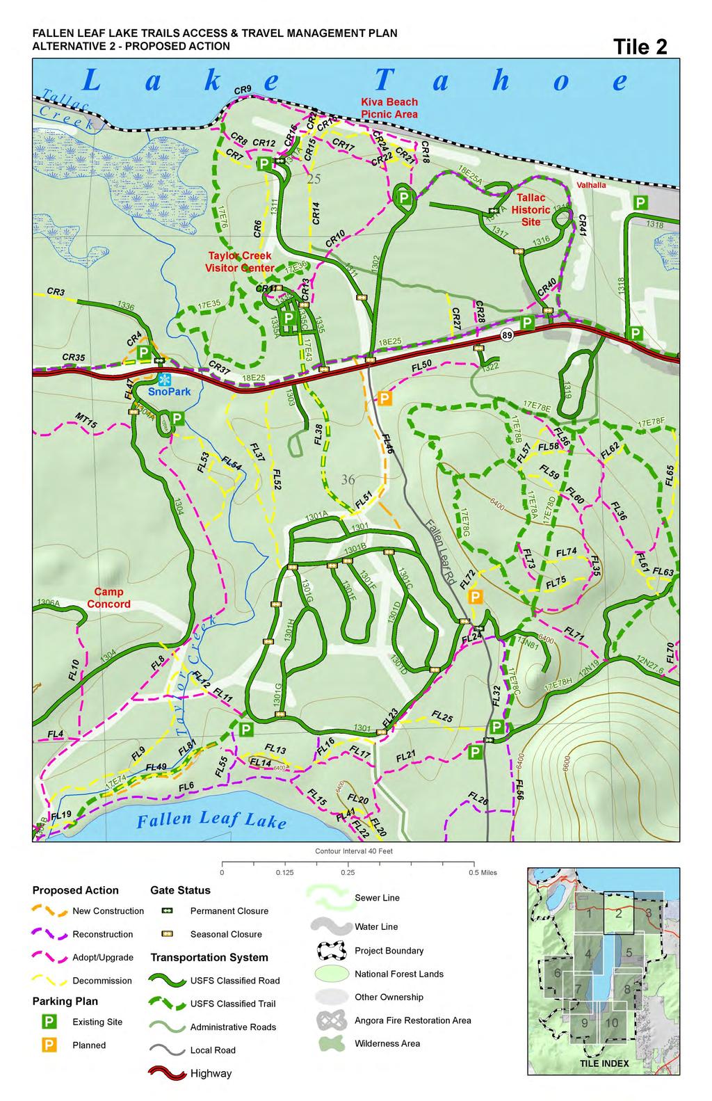
27 There was a typographical error in the proposed action, which made the proposal for the Glen Alpine parking lot unclear. The proposed action would not change the parking capacity of the Glen Alpine parking lot. The following trails are proposed for adopting as National Forest System Trails in their existing location (see figure 2.1): AN6 Existing unauthorized trail providing access to Angora Lakes. CR8-12, CR18, CR24, CR28 These existing unauthorized routes provide important connections and loop options between Taylor Creek Visitor Center, Lake Tahoe Beaches, and the Tallac Historic Site. The management level and capacity of individual routes may be upgraded or reduced to reflect projected use and capacity. CR24 would receive a minor reroute near the Tallac parking area to maintain the full width standard for this route. CR17 The promenade would be adopted as a trail, but would not be upgraded in order to maintain the character of this historic feature. FL48 Existing unauthorized route providing access to Fallen Leaf Lake and adjacent historic features. FL4, FL7-8, and FL10 These existing unauthorized trails provide access from parking areas at the Snow Park and Mt Tallac trailhead to Fallen Leaf dam and Taylor Creek. FL8 coexists on a utility access line, which is maintained by the South Tahoe Public Utility District through a utility easement. FL11 This trail would be upgraded with an improved stream ford, and used primarily as a loop option by the Camp Richardson Corral. Additional stream ford crossings FL12 and FL19 are proposed for decommissioning in order to reduce impacts to water quality. FL11 would be adopted and reconstructed to meet current standards for a typical stream ford in order to maintain equestrian public and permittee access across Taylor Creek. FL14-15, FL17, FL21-24, FL These trails provide access to popular destinations and loops along the north shore of Fallen Leaf Lake, and connect to managed parking and campground facilities. Additional duplicate routes in this area are proposed for decommission in order to minimize the overall disturbance while providing sustainable trail access. FL23 would be widened and surfaced with gravel to provide a continuation of the smooth surface bicycle loop. Equestrian use would be allowed along the shoulder of FL23, and may be separated using natural barriers, such as split rail posts. FL35-36 These existing unauthorized trails provide sustainable loop options for the Camp Richardson Corral, and are used seasonally to reduce impacts to adjacent trails located in areas that tend to hold meltwater later into the spring season. FL41-45 Existing unauthorized routes providing trail connections across the moraine directly east of Fallen Leaf Lake. FL50 This existing unauthorized trail provides a connection from the proposed new parking area at the highway 89/Fallen Leaf Lake road intersection to popular equestrian trails near Camp Richardson Corral and the Angora trail system. 27
28 28 FL60, FL64, FL70-71, FL73 Existing unauthorized routes near Camp Richardson Corral that are used under special use permit. These routes provide important loop options for equestrian use public and permittee. MT15 Existing unauthorized route provides access from the snow park to Cathedral road and Spring Creek road. The majority of this route would remain minimally developed, native surface. The segment from MT12 to Spring Creek rd. would be a more developed, smooth native surface similar to MT12.
29 Table 2-1: Summary of Alternative 2 Proposal for Trail Adopt/Upgrade Trail Number Proposal Width (in) Length (feet) Miles AN6 Adopt/Upgrade CR10 Adopt/Upgrade CR11 Adopt/Upgrade CR12 Adopt/Upgrade CR17 Adopt/Upgrade CR18 Adopt/Upgrade CR24 Adopt/Upgrade CR28 Adopt/Upgrade CR8 Adopt/Upgrade CR9 Adopt/Upgrade FL10 Adopt/Upgrade FL11 Adopt/Upgrade FL14 Adopt/Upgrade FL15 Adopt/Upgrade FL17 Adopt/Upgrade FL21 Adopt/Upgrade FL22 Adopt/Upgrade FL23 Adopt/Upgrade FL24 Adopt/Upgrade FL27 Adopt/Upgrade FL28 Adopt/Upgrade FL35 Adopt/Upgrade FL36 Adopt/Upgrade FL4 Adopt/Upgrade FL41 Adopt/Upgrade FL42 Adopt/Upgrade FL43 Adopt/Upgrade FL44 Adopt/Upgrade FL45 Adopt/Upgrade FL48 Adopt/Upgrade FL50 Adopt/Upgrade FL60 Adopt/Upgrade FL64 Adopt/Upgrade FL7 Adopt/Upgrade FL70 Adopt/Upgrade FL71 Adopt/Upgrade FL73 Adopt/Upgrade FL8 Adopt/Upgrade MT15 Adopt/Upgrade MT15 Adopt/Upgrade Total
30 The following trails are proposed to be decommissioned and the area restored to natural condition (see figure 2.1): Spring Creek Trail (MT7) This existing authorized trail would be decommissioned in order to eliminate a threat to water quality and protect sensitive wildlife species in the immediate area. The current trail alignment runs the majority of its length within an SEZ, in some cases within the live stream channel. Further, this trail exists within both Northern Goshawk and Spotted Owl Protected Activity Centers (PACs). In addition, there is no public parking access for this trail. CR1 This trail represents the last.29 miles of the Pope Baldwin Bike Path where it terminates at the junction of highway 89 and Spring Creek Road. This location presents sightline and vehicle hazards to pedestrian and bicycle traffic crossing the highway, and is located in an SEZ. This segment is proposed for relocation.24 miles east to a more appropriate crossing site where it will connect with the proposed route MT12. Options for extending the Pope Baldwin Bike Path beyond Spring Creek Rd were discussed but not included in the proposed action as the requirements for analysis and construction are beyond the scope of this project. MT13 This route uses a combination of unauthorized trail and existing road prism to connect Spring Creek Tract to Cathedral Road. It is proposed for decommissioning in order to avoid duplication with the proposed newly constructed MT12, which will provide higher capacity access for a broader range of users. FL9 Existing unauthorized trail running adjacent to Taylor Creek along the western streambank. This route poses water quality concerns due to the close proximity to unstable streambanks and unmanaged access routes leading to the stream. FL37, FL52-54 Existing unauthorized trails located adjacent to Taylor Creek. These routes are identified as posing threats to water quality due to their poor alignments lack of drainage features and location on low capability land. CR6-7, CR14-16, CR21-22, CR25, CR27 Existing unauthorized routes that run parallel to or otherwise duplicate another existing route in a more appropriate location. FL13, FL16, FL20, FL25, FL40 These exiting unauthorized routes are parallel to or otherwise duplicate an existing trail in a more appropriate location. FL30, FL31 These existing unauthorized trails run east-west across a perennially wet meadow on the east side of Fallen Leaf Lake. They will become obsolete with implementation of the proposed parking plan, and the termini of both trails will be accessible via other routes. FL57-59, FL61-63, FL65-69, FL72, FL74-75 These trails represent 1.72 miles of existing unauthorized trail near the Camp Richardson Corral that have been recommended by the permittee for decommissioning due to their duplicative and/or unsustainable nature. Other existing routes in the area provide access and loop options meeting the demand of this system. FL12, FL19 These existing unauthorized trails provide stream ford crossing access for public equestrian and Camp Richardson Corral access. They are 30
31 31 proposed for decommissioning and restoration in order to improve water quality and stabilize erodible stream banks. Trail FL11 is proposed for adoption/upgrade to meet the need for access across Taylor Creek. AN4, AN8 These existing authorized trails run from Angora Ridge toward Fallen Leaf Lake, where they enter and terminate on private land. Furthermore, there are no public parking options to provide public access on the lower end of either trail. There are no viable reroute options that would bypass the privately owned parcels. Proposed trail AN5 would provide an alternative to these trails. AN9 This existing classified trail runs fall line for.33 miles, and does not meet current design or construction standards. Proposed trail AN5 would replace it and connect to a more logical parking and trailhead facility. CR3 Existing unauthorized trail connecting an unauthorized parking area to the Baldwin Beach Road. This route would be replaced by the proposed CR2 route. CR36 This short segment of the Pope Baldwin Bike Path would be rerouted away from Highway 89 to the backside of a proposed parking development. CR4 is proposed to replace CR36. FL5 Existing unauthorized trail located in a low capability land area. This route is proposed for decommissioning as there is an existing utility disturbance that provides adequate access in this area. FL51 Existing unauthorized trail connecting Fallen Leaf Campground to Fallen Leaf Road. Trail FL46 would replace this connection in a better location. FL79 Existing authorized trail would be decommissioned as it is redundant with FL56, and located immediately adjacent to RV campsites at the Camp Richardson Resort. FL81 Existing authorized trail would be decommissioned and replace by FL49. New route would be nearly identical to the existing trail, but would be located farther away from unstable stream banks to provide resource protection. MT14 Existing road leading southwest from Camp Concord that has been closed to vehicle traffic for many years, and which has no destination. This route does not serve any public or administrative function. Mt Tallac and Cathedral Trails: These popular routes would receive significant reroutes in order to move those trail segments onto higher capability land and reduce water quality concerns. Newly constructed segments (MT1, MT4, MT6, and MT8) would replace existing segments (MT2, MT3, MT5, MT9) with trail meeting current design and construction standards.
32 Table 2-2: Summary of Alternative 2 Proposal for Decommissioning Trail Number Proposal Width (in) Length (feet) Miles AN4 Decommission AN8 Decommission AN9 Decommission CR1 Decommission CR14 Decommission CR15 Decommission CR16 Decommission CR21 Decommission CR22 Decommission CR25 Decommission CR27 Decommission CR3 Decommission CR36 Decommission CR6 Decommission CR7 Decommission FL12 Decommission FL13 Decommission FL16 Decommission FL19 Decommission FL20 Decommission FL20 Decommission FL25 Decommission FL30 Decommission FL31 Decommission FL37 Decommission FL40 Decommission FL5 Decommission FL51 Decommission FL52 Decommission FL53 Decommission FL54 Decommission FL57 Decommission FL58 Decommission FL59 Decommission FL61 Decommission FL62 Decommission FL63 Decommission FL65 Decommission
33 FL66 Decommission FL67 Decommission FL68 Decommission FL68 Decommission FL69 Decommission FL72 Decommission FL74 Decommission FL75 Decommission FL79 Decommission FL81 Decommission FL9 Decommission MT13 Decommission MT13 Decommission MT13 Decommission MT13 Decommission MT14 Decommission MT2 Decommission MT3 Decommission MT5 Decommission MT7 Decommission MT9 Decommission Total The following trails are proposed to be reconstructed and/or rerouted to meet current Forest Service standard (see figure 2.1): FL6 Proposed for reconstruction and BMP upgrades in the current alignment. This trail would be upgraded similar to MT12 and FL46, in order to provide a continuous smooth surface and high capacity route. This proposal would include removal of the existing walkway over Fallen Leaf Lake dam, to be replaced with an accessible bridge designed to accommodate hiker, bicycle and equestrian use, and would have an overall width of feet. FL26, FL32, FL55-56 These trail segments would be reconstructed in their existing locations to meet current trail design and construction standards. Some trails may be improved to a higher capacity and management level to meet the demand of increased use. Pope Baldwin Bike Path CR35, CR The overall proposal for this trail is to reconstruct and upgrade it to meet AASHTO direction and Universal Design principles. In addition, the rerouted segment CR4 is proposed in order to relocate the path away from the congested highway corridor. CR41 The Tallac Bicycle Loop would be reconstructed as needed to meet a full 10 foot width with no shoulder, and provide a smooth paved surface. 33
34 17E78E Existing authorized trail bordering the Camp Richardson Campground. A short segment would be replaced by the proposed trail FL561 in order to provide better separation between the trail and existing campsites. Total length of reroute would be approximately.25 mile. Table 2-3: Summary of Alternative 2 Proposal for Trail Reconstruction Trail Number Proposal Width (in) Length (feet) Miles CR35 Reconstruction CR37 Reconstruction CR38 Reconstruction CR41 Reconstruction FL26 Reconstruction FL32 Reconstruction FL55 Reconstruction FL56 Reconstruction FL6 Reconstruction Total The following trails are proposed to be newly constructed in the project area (see figure 2.1): CR2 - Proposed new trail connection from the Pope Baldwin bike path to the Baldwin Beach entry kiosk parking area to eliminate pedestrian and bicycle traffic on the paved road. FL47 Proposed new connection from the snow park to highway 89 providing access to the bike path. FL46 Proposed new trail on existing utility disturbance providing access connecting the Fallen Leaf Campground, a proposed parking area, Lake Tahoe Beaches, Fallen Leaf Lake, and providing a loop option for area trail users. MT12 Proposed new trail connecting the Pope Baldwin Bike Path to Fallen Leaf Lake dam. This route provides an important option to improve smooth surface access in the area, create loop options from the existing bike path, and link several popular area destinations via non-motorized options. Smooth surface trails would generally be native or aggregate surface, with protrusions no greater than 2 in height in the tread surface. AN2 Proposed new trail providing shared use trail access from the Angora Ridge/Lookout to the Angora/North Upper Truckee Rd. neighborhoods. Provides new high quality destination and loop options to the broader area. AN1, AN3 Proposed new route running north/south along Angora Ridge. This trail would connect the Angora Lakes area with proposed new parking at Tahoe Mountain Road, and provide trail access connecting the Angora trail system to 34
35 35 Angora ridge, North Upper Truckee Rd. neighborhoods and via AN5 to the Glen Alpine area. AN5 Proposed new trail would connect Angora Lakes parking to the Glen Alpine trailhead and parking area. This route would serve to replace or provide alternatives to AN8 and AN9, which are proposed for decommission due to private property concerns. AN10 New trail would connect the proposed parking area at Tahoe Mountain and Angora Ridge Rd. and proposed trail AN1 with FL56. This route provides an opportunity for users to access Angora Ridge, Angora Lakes and Fallen Leaf Lake from any of several access points, and eliminates trail users need to utilize Tahoe Mountain Rd. as a connecting route. This route also provides trail loop options in the Tahoe Mountain and Angora Ridge area. Construction of this trail requires crossing California Tahoe Conservancy (CTC) property for a distance of approximately 1900 feet. CR4 New trail segment representing a reroute of the Pope Baldwin Bike Path in order to provide better separation from the highway. MT1, MT4, MT6, and MT8 These proposed new trail segments represent reroutes of the Mt Tallac trail. They would replace the decommission segments MT2, MT3, MT5, and MT9 in more sustainable locations and with upgraded BMP and resource protection measures.

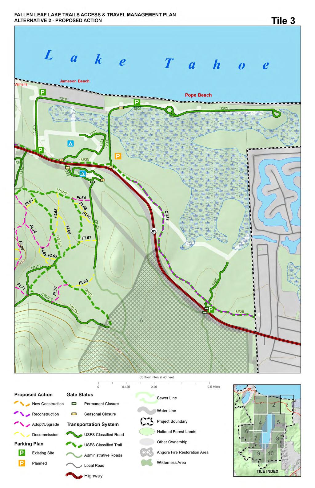
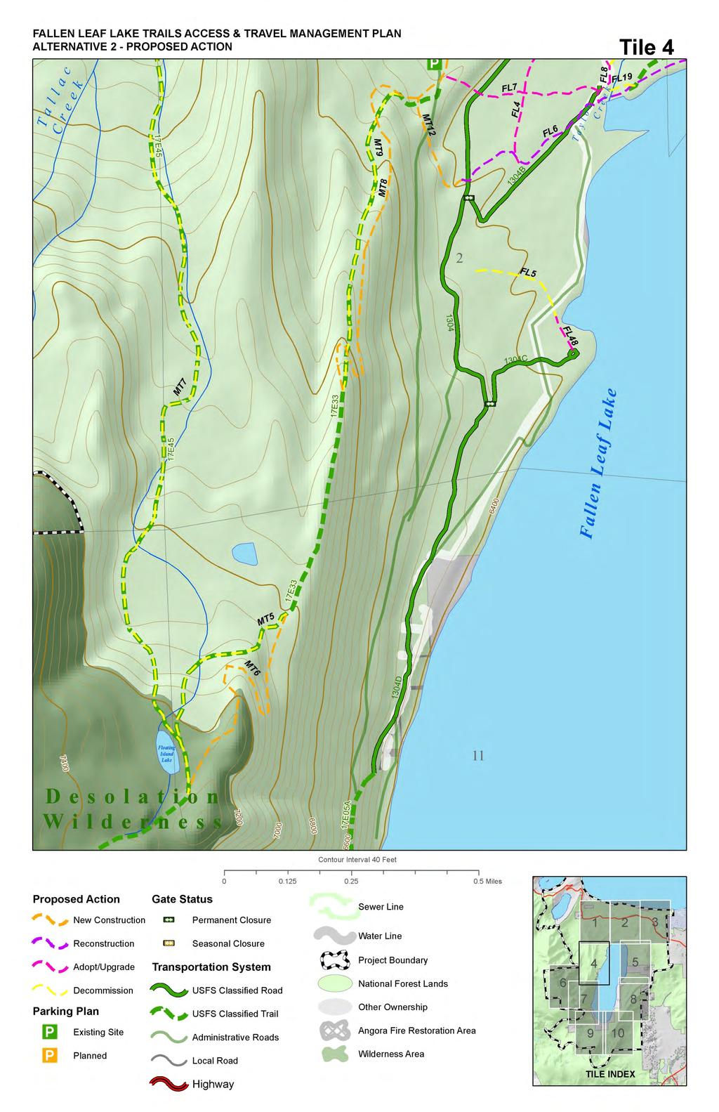
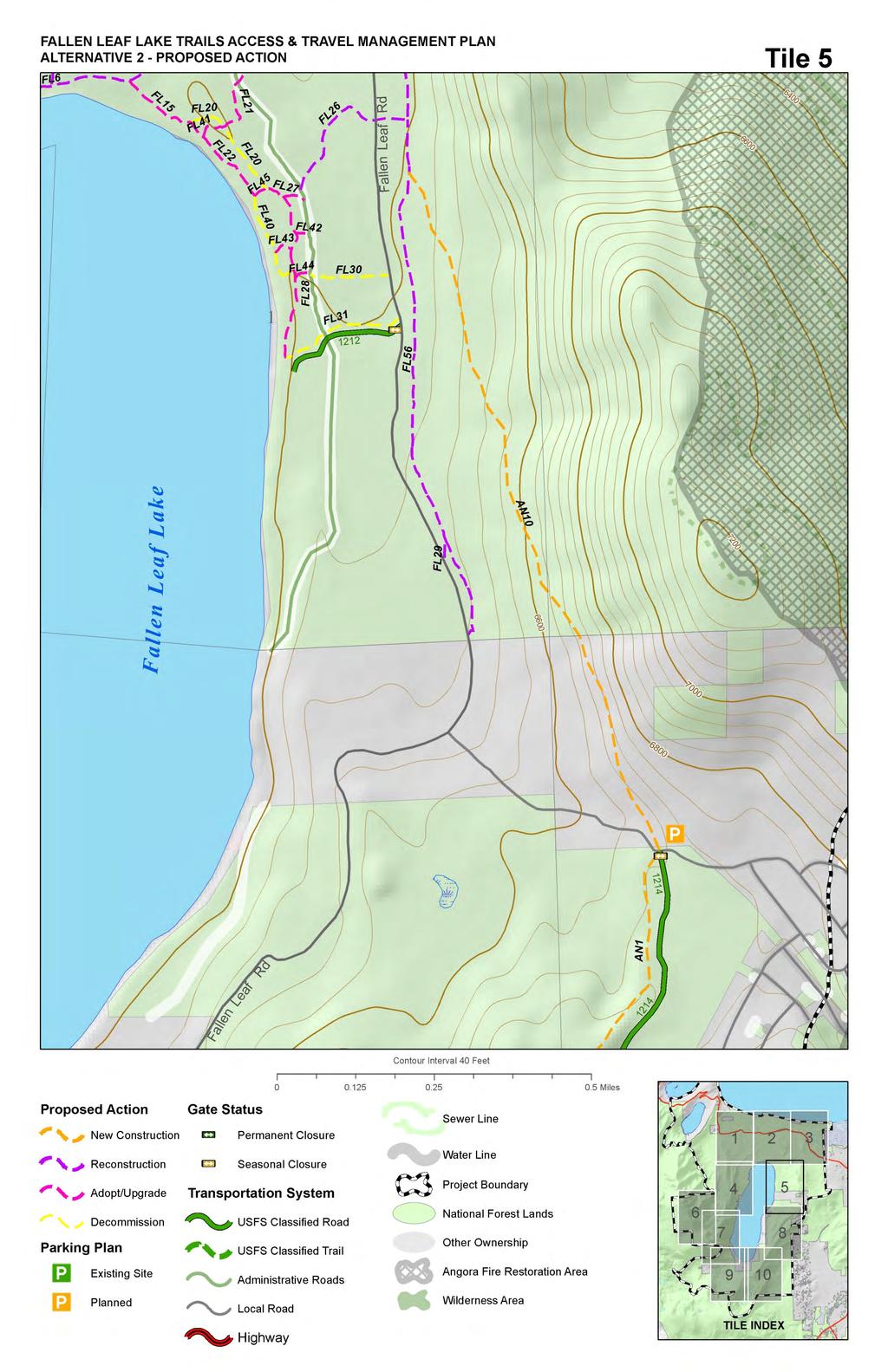
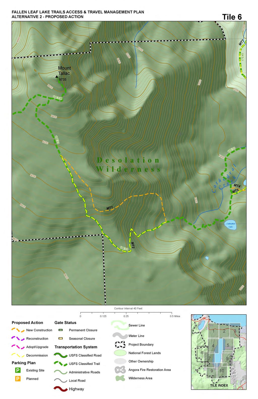
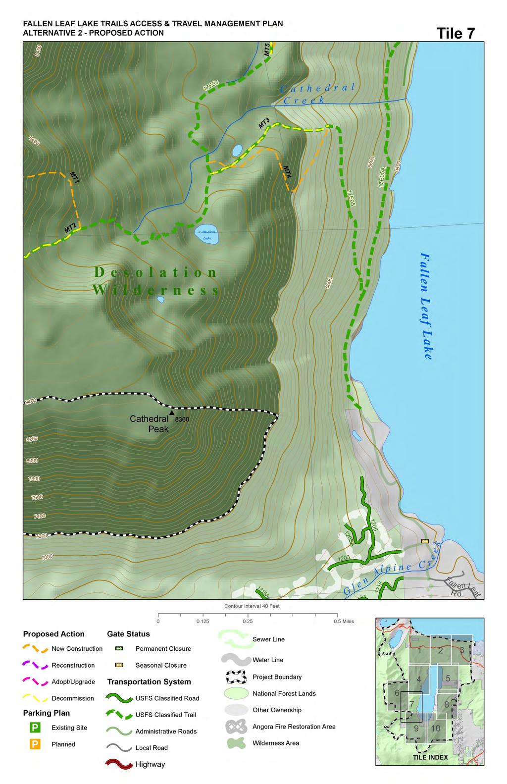
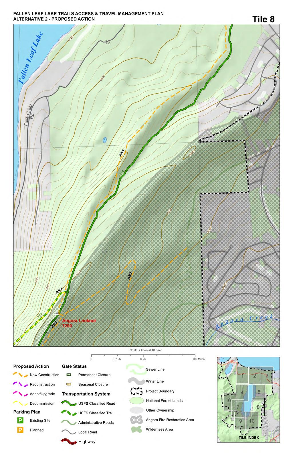
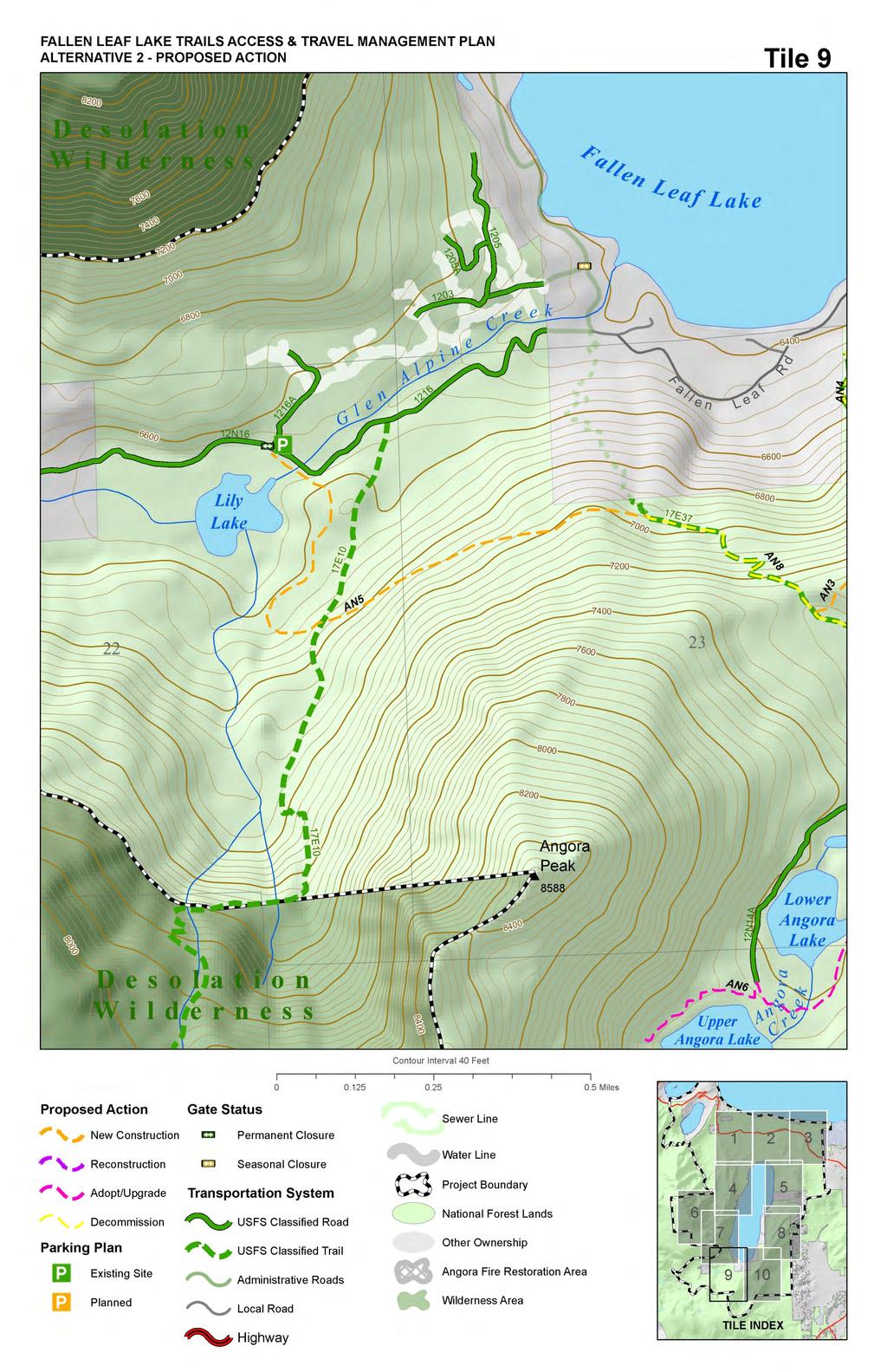
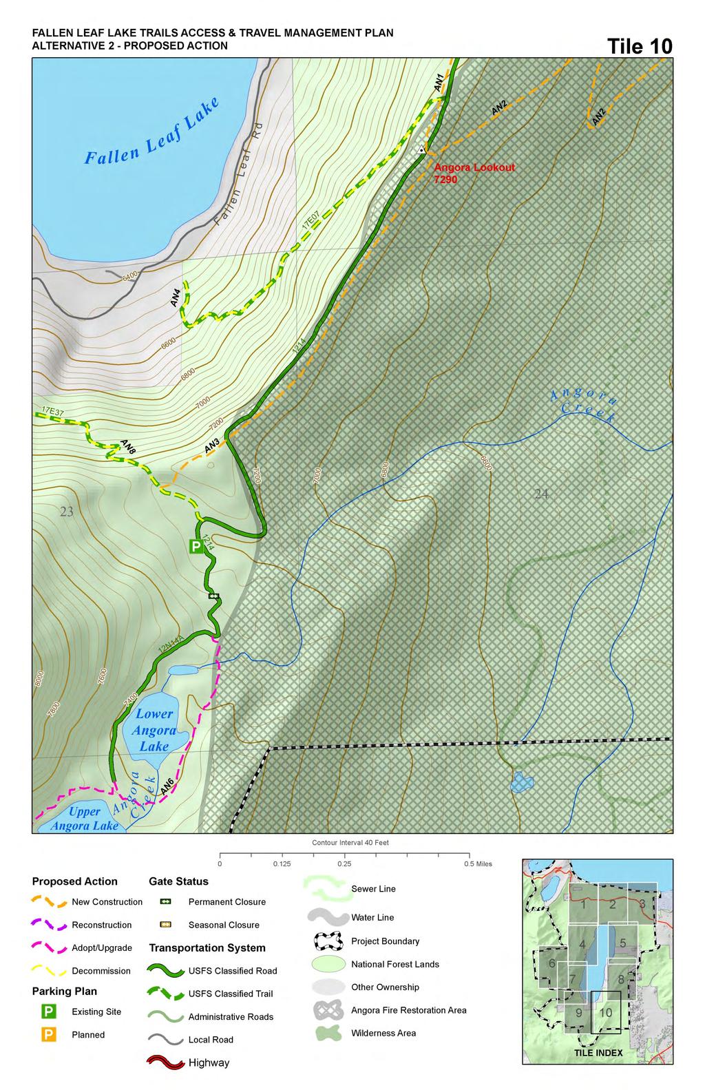
36 Figure 2.1 Proposed Action Map, Tiles 1 through 10 36
37 37
38 38
39 39
40 40
41 41
42 42
43 43
44 44
45 45
46 Table 2-4: Summary of Alternative 2 Proposal for Trail New Construction Trail Number Proposal Width (in) Length (feet) Miles AN1 New Construction AN2 New Construction AN3 New Construction AN5 New Construction AN10 New Construction CR2 New Construction CR4 New Construction FL46 New Construction FL47 New Construction FL49 New Construction MT1 New Construction MT12 New Construction MT12 New Construction MT12 New Construction MT4 New Construction MT6 New Construction MT8 New Construction Total Trailheads and trailhead parking have been identified for upgrade and BMP design, certain existing unmanaged parking areas would be adopted and formalized, and new parking facilities are proposed for construction. The following upgrades, new construction, and other changes to trailhead and parking facilities are proposed (see figure 2.1): A new parking facility is proposed approximately.22 miles east of Spring Creek Road near Highway 89, on the south side of the highway. This parking area would be of typical design, either paved or aggregate surfaced with a capacity of between 20 and 30 spaces. This parking area is proposed at the location of a log landing to be constructed under the South Shore Fuel Reduction and Healthy Forest Restoration Project in order to minimize new disturbance in that area. The informal parking near the fee stations on both Baldwin Beach Rd. and Pope Beach Rd. would be adopted and upgraded to meet current Forest Service standards. These areas are currently paved, and would be reconfigured to allow for 3-5 parking spots each. This parking would be available as overflow parking during the summer months, and would provide free public parking during the shoulder seasons between winter closure and fee station operating periods. A new parking facility would be constructed at the beginning of Fallen Leaf Road along the east side of the road, near Highway 89. This parking area would have a paved surface, contain spaces and could be plowed for winter use. 46
47 The informal parking area across from Fallen Leaf Campground would be adopted and upgraded to current standard. This area would be either paved or aggregate surface, and would contain parking spaces. The existing parking areas on Fallen Leaf Rd. where trail FL21 begins would receive BMP upgrades and barriers to discourage expansion of the parking areas into adjacent forest. The informal parking located on CTC lands near the junction of Tahoe Mountain Rd. and Angora Ridge Road would be adopted and upgraded to meet current standard. This parking area would be paved or aggregate surfaced and contain 5-10 spaces. The existing parking lot and trailhead at Glen Alpine would receive BMP upgrades in order to meet current standard. In addition, the road leading into the parking area would receive BMP upgrades, and unmanaged roadside parking would be discouraged by placing natural barriers (boulders) and/or through signage in those areas. Turnouts along the road would be maintained to allow vehicle passing. The capacity of the parking and trailhead facility would not be changed from the current design. The Tallac trailhead and parking area would receive BMP upgrades, and would be expanded by paved spaces. Unmanaged roadside parking would be discouraged by placing natural barriers and installing signage. The trailhead kiosk would be reconstructed and updated, and additional natural trailside barriers would be placed to keep users on existing authorized routes. An aggregate or paved emergency access road is proposed for construction at the northeast corner of the Fallen Leaf Campground. This road would be approximately 250 linear feet, gated at both ends, and would be for administrative and emergency use only. Prohibited Uses The following trails would be managed to prohibit specific uses (shown in Appendix C): FL21 Bicycle use prohibited FL15, FL22, FL27, FL42, FL28 Bicycle use prohibited FL6 Equestrian use prohibited FL78, FL53 Equestrian use prohibited Alternatives 3 through 6 These alternatives incorporate all actions described in the proposed action (Alternative 2) and are identical in all aspects, with the only significant difference relating to the location of a developed stream ford crossing on Taylor Creek (see figure 2.2). They will be described in this section by the commonalities shared by all, followed by an individual description for each discussing only the significant difference in location of the stream ford crossing on Taylor Creek. The designed use of each trail not proposed for decommissioning is included in Appendix A. These alternatives would incorporate all actions described in the proposed action, but with the following changes common to Alternatives 3 through 6: 47
48 The proposed bridge across Taylor Creek would be constructed to the minimum design standard acceptable for that location, and would incorporate architectural design measures that would minimize the visual impact of the new structure. This bridge would be approximately four feet wide and would widen to six feet for a short section in the middle to facilitate operation of the dam gates and allow users space to pass. This bridge would be located where the current walkway exists, and there would be no effect to the existing dam. The following trails would be adopted and managed to current Forest Service Standards: o FL5 existing unauthorized trail providing access to and loop options near the historic Mill site o FL9 informally known as the Taylor Creek Trail, this route would be adopted as an authorized trail and rerouted in three short sections where erosion and water quality concerns exist. The reroutes would move the trail sections to higher capability land and provide a buffer to erodible stream banks. As a related action, stream bank stabilization and restoration activities would occur in those specific areas to correct legacy use issues and improve fish habitat and overall stream health. o FL53 and FL54 existing unauthorized trails adjacent to Taylor Creek would be adopted and reconstructed to current standard. These trails would provide sustainable trail access points to Taylor Creek from the Taylor Creek Snow Park, and when combined, would provide a short hiking loop. o CR14 existing unauthorized trail that provides a separated route for pedestrians and bicycles from the Taylor Creek Visitors Center to the Lake Tahoe beaches. o FL69 existing unauthorized trail near the northern end of Tahoe Mountain providing a loop option for early season access. The following trails would be newly constructed in the project area: o CR33 proposed new trail would provide a separated route along the visitors center road for pedestrian and bicycle access. o CR42 proposed new trail would provide a separated route along the 1302 road allowing for pedestrian and bicycle access to the Kiva Beach picnic area. Other elements included in these alternatives: o There would be no action on trails AN4 and AN8. These are existing authorized trails that cross private land where no public easement exists. In lieu of decommissioning, this alternative would leave these trails unchanged and the LTBMU would seek to pursue easements for public access. 48
49 o There would be no action on AN6. AN6 receives very minimal use, primarily by cabin owners, and a separate existing route in a more suitable location provides adequate public access to the Angora Lakes. This route would continue to be managed and maintained under conditions of the Special Use Permit for cabin owners. The following section details differences between Alternatives 3 through 6 (see figure 2.2): Alternative 3 This alternative would include all actions described as common to Alternatives 3 through 6, and would further include the following: Adopt stream ford crossing FL12 and construct to current standard. Decommission FL19 and restore stream banks to a stabilized condition. Stream bank stabilization may include designs to improve fish habitat and stream function. No action on FL11. Alternative 4 This alternative would include all actions described as common to Alternatives 3 through 6, and would further include the following: Adopt stream ford crossing FL11 and construct to current standard. Decommission FL19 and restore stream banks to a stabilized condition. Decommission FL12 and restore the eastern stream bank to stabilized condition. The western stream bank has been impacted by dispersed recreational use, and would be stabilized with native materials to prevent further erosion. Stream bank stabilization may include designs to improve fish habitat and stream function. Alternative 5 This alternative would include all actions described as common to Alternatives 3 through 6, and would further include the following: Adopt stream ford crossing FL19 and construct to current standards. Decommission FL12 and restore the eastern stream bank to a stabilized condition. The western stream bank has been impacted by dispersed recreational use, and would be stabilized with native materials to prevent further erosion. Stream bank stabilization may include designs to improve fish habitat and stream function. No action on FL11. Alternative 6 This alternative would include all actions described as common to Alternatives 3 through 6, and would result in no stream ford crossing through Taylor Creek. 49
50 Decommission FL12 and restore the eastern stream bank to a stabilized condition. The western stream bank has been impacted by dispersed recreational use, and would be stabilized with native materials to prevent further erosion. Stream bank stabilization may include designs to improve fish habitat and stream function. No action on FL11. Decommission FL19 and restore stream banks to a natural condition. 50

51 Figure 2.2 Map of Alternatives 3 Through 6 51
52 2.2 Resource Protection Measures Resource protection measures were developed to ease some of the potential impacts the various alternatives may cause. These measures would be applied to all of the action alternatives. Common to All Resource Areas 1. Stream bank stabilization and restoration activities would occur at specific sites on Taylor Creek in order to address legacy water quality and erosion concerns. Fish habitat improvements would be incorporated in order to maximize the benefits of restoration actions. 2. Actions affecting the bridge over Taylor Creek would require construction of a temporary access road and staging areas between the existing utility service road and the Fallen Leaf Lake dam location. This temporary road would be 140 feet long, and would be fully decommissioned and restored to native condition once construction of the bridge has been completed. There is also a need for equipment access to the east side of Taylor Creek at the location of the proposed bridge site. The existing trail FL6 would be utilized with minimal improvements to allow temporary equipment access, and would be restored to pre-construction condition once the bridge was completed. For both access routes, timing of implementation and the duration of use would be minimized to the degree feasible for this project. 3. Bank stabilization would occur at the location of FL12 in order to address legacy erosion resulting from dispersed recreation at this location. Stream bank stabilization may include designs to improve fish habitat and stream function. Soils and Hydrology Erosion control and prevention of sediment transport for this project would be implemented in accordance with the USDA Forest Service Region 5 Water Quality Management Handbook. 1. Staging of materials and equipment would first use existing disturbed areas outside of SEZs, where soil is already compacted and vegetation has been cleared. These staging areas are all in locations where parking already exists or new parking is proposed. 2. New trails will be developed with appropriate design and construction BMP s to provide for proper drainage. 3. Trail decommissioning will include decompacting the soil to approximately an 8-10 inch depth and applying native material mulch to a maximum depth of 4 inches as ground cover to prevent erosion and soil loss. a. Trail decommissioning in SEZ areas will include spreading meadow mowings (collected nearby with a weedwacker or similar method) or riparian vegetation mulch rather than pine needles and tree branches to promote SEZ seed recruitment and avoid introducing conifer seeds to the area. Consult with the project botanist to determine an appropriate site to 52
53 collect meadow mowings (in order to avoid threatened or endangered plants disturbance and noxious weed introduction). 4. Rock, soil and other earthen materials removed during grading operations may be stockpiled and used for construction activities. Measures would be employed to prevent stockpiled material from entering surface waters or otherwise adversely affecting surface or groundwater quality, in accordance with BMP requirements. 5. A 140 ft. segment of temporary road will be constructed to access the bridge construction site near the Fallen Leaf Lake dam from FL8. This temporary road will be decommissioned by decompacting the surface, mulching the area and narrowing the road down to a trail. 6. Downed logs present within stream channels will be left in place to avoid disturbing the channel banks. 7. Whenever working within a flowing channel, detailed dewatering and diversion plans will be prepared as part of the permit package for those specific project activities. 8. Hazardous spill prevention measures, detailed in the spill prevention, containment and cleanup plan for the LTBMU will be followed, including having spill prevention kits available onsite during any activities involving hazardous materials (including fuel and lubricants for heavy equipment). Recreation 1. As appropriate, place interpretative panels to aid in public education of recreation opportunities, management activities and forest health around recreation sites nearby during project activities. 2. Repair and rehabilitate any incidental damage caused by this project to recreation improvements/facilities after project activities are completed. Repair incidental damage as soon as the trails can be reopened. 3. Any disruption or closure of recreation facilities shall be minimized in duration and timed to occur during off-peak periods as much as feasible during implementation. Public notice shall be given if any closures will be required. 4. Establish signing identifying trail names or numbers, allowed uses, and mileage to important destinations on the managed system. Scenic Resources 1. Locate new parking areas at least 75 linear feet from the Highway 89 travel route road shoulder. 2. Place large boulders and plant native vegetation between new parking areas and the Highway 89 travel route road shoulder to minimize visual effects of viewing parked vehicles. 53
54 3. Place boulders and/or wooden bollards at the edges of parking areas to restrict vehicles to paved surfaces. 4. Utilize Low Impact Development (LID) design principles within new parking areas. Grade paving to direct storm water run off to shallow infiltration basins as close as possible to the parking areas. 5. Follow architectural design direction provided in the USFS Built Environment Image Guide (BEIG) for constructed features such as the proposed non-motorized bridge, walkway and guard rails across Fallen Leaf Lake dam, and any informational sign kiosks. Design of bridge would be consistent with existing features and historic character. 6. Where cutting of trees within 10 feet of a system or adopted trail is required, cut stumps flush at 2 inches maximum height above finished grade (measured from the uphill side). Heritage Resources 1. If any previously unrecorded heritage resources are discovered during this project, all project-related activities must cease immediately and the procedures as set forth in Section of the Council on Environmental Quality s regulation 36 CFR Part 800 must be initiated. Botany 1. The project area was surveyed in 2010 and One candidate species, Pinus albicaulis (whitebark pine) was observed. Several sub-occurrences of another candidate species, Rorippa subumbellata (Tahoe yellow cress), are known to occur within the project area but no individuals were observed during project surveys. One sensitive species, Meesia triquetra (three-ranked hump-moss) is known to occur within the project area but is not located adjacent to grounddisturbing activities. If these or any additional sensitive plant species are detected prior to or during project implementation, the individuals will be flagged with an appropriate buffer as determined by a staff botanist and avoided during project implementation. 2. Flagged areas around sensitive species and associated habitats (i.e. control areas) are to be avoided completely during project activities. This includes, but is not limited to: removal of trees; access and travel through control areas; construction activities; material removal (e.g. soil, rocks, gravel, wood); and equipment or material storage. Trees may be removed at the control area boundary but they will be felled away from control areas. 3. Pinus albicaulis trees adjacent to trail segments MT1 and MT2 in the Tallac Bowl will be flagged if necessary and retained to the greatest extent possible. Individual trees may be removed if disease or insect infestations are present. Disturbance associated with access and travel, construction, material removal (e.g. soil, rocks, 54
55 gravel, wood), and equipment or material storage will be minimized in P. albicaulis stands. 4. Six sub-occurrences of Rorippa subumbellata are located within the project boundary. These sub-occurrences are in the vicinity of trail segments CR9 and CR18, but no individuals were observed during project surveys. If any plants are detected prior to or during project implementation, the individuals will be flagged with an appropriate buffer as determined by a staff botanist and avoided during project implementation. Adoption of trail segments CR9 and CR18 along the shoreline of Lake Tahoe at Kiva beach could potentially result in increased recreation use in R. subumbellata habitat. Resource protection measures including, but not limited to, informational signs at access points to Kiva Beach (at the parking lot and along the trail from the Tallac Historic Site) will be installed in order to minimize effects to occurrences or habitat. Noxious Weeds Seven noxious weed species, Bromus tectorum (cheatgrass), Cirsium vulgare (bull thistle), Hypericum perforatum (common St Johnswort), and Leucanthemum vulgare (oxeye daisy) were observed during project surveys, and known infestations of Cytisus scoparius (Scotch broom), Linaria vulgaris (yellow toadflax), and Onopordum acanthium (Scotch thistle), are known to occur within the project area within 75 feet of proposed ground-disturbing activities. These infestations will be treated prior to project implementation in accordance with the Terrestrial Invasive Plant Species Treatment Project, Environmental Assessment (TIPS EA). If an infestation is not treatable, it will be flagged and avoided according to the species present, project constraints, and feasibility. 2. All vehicles and equipment must be cleaned before moving into the project area, in order to ensure that they are free of non-native invasive species. Equipment will be considered clean when visual inspection does not reveal soil, seeds, plant material, or other debris that could contain or hold seeds of non-native invasive species. 3. When working in areas known to harbor non-native invasive species, equipment shall then be cleaned at a washing station before moving to other USFS lands. If this mitigation isn t possible, then coordination with the botanist on the project should take place. 4. Staging areas for equipment, materials, or crews will not be situated in areas infested by non-native invasive species. Areas containing non-native invasive species should be avoided during project activities. 5. All gravel, fill, or other materials are required to be weed-free. Use on-site sand, gravel, rock, or organic matter when possible. Otherwise, obtain weedfree materials from gravel pits and fill sources that have been surveyed and approved by the Nevada Department of Agriculture or by LTBMU the noxious
56 weed coordinator. See the LTBMU annual report of Material Pit Surveys for Noxious Weeds for suitable sources of gravel & fill (Project Record G-1). 6. Use weed-free mulches, hay, and seed sources. Salvage topsoil from project area for use in onsite revegetation, unless contaminated with non-native invasive species. Do not use soil or materials from area contaminated by cheatgrass. 7. Minimize the amount of ground and vegetation disturbance in construction areas. Reestablish vegetation where feasible on disturbed bare ground to minimize nonnative invasive species establishment and infestation. Revegetation is especially important in staging areas. Utilize locally collected native seed sources when possible. Plant and seed material should be collected from or near the project area, from within the same watershed and at a similar elevation when possible. Persistent non-natives such as Phleum pratense (cultivated timothy), Dactylis glomerata (orchard grass), or Lolium spp. (ryegrass) will not be used. Seed mixes must be approved by a staff botanist. 8. The LTBMU noxious weed coordinator should be notified after project completion so that the project area can be monitored for three years (as funding allows) to ensure additional non-native invasive species do not spread or become established in the areas affected by the project. Wildlife 1. Limited operating periods (LOPs) restrict the type, spatial extent, and timing of project activities to minimize disturbance to breeding pairs of management species. A LOP currently applies at the Spring Creek northern goshawk nest 2010d. If other special status wildlife species are detected in the project vicinity, LOPs would be implemented as determined by the project biologist. LOPs are based on habitat suitability or the most current wildlife data from pre-project field surveys. 2. Any sightings of threatened, endangered, candidate, sensitive, management indicator, or special interest species would be reported to the project biologist. Nests and dens would be protected with flagging, fencing, or LOPs in accordance with management direction. Species identification, known locations, and protection procedures would be addressed with implementation crews during a pre-construction tailgate meeting. 3. Large tree removal would be minimized. Species preference would be given to large cedars, then pines, and finally to firs. Except in developed recreation areas, structural preference would be given to live trees with spreading branch structure, large diameter broken tops, or cavities in the bole for wildlife habitat. 4. Snags would be retained for wildlife unless deemed a hazard tree. 5. Existing logs greater than 20 inches dbh would be retained. Logs moved during construction would be repositioned. Preference would be given to snags that have 56
57 to be felled for public safety, then to the largest logs available in a variety of decay stages for wildlife habitat. 6. Bear proof garbage containers would be temporarily installed during implementation of contracted work, or food related trash would be removed daily to avoid attracting wildlife to the project area. Table 2-5: Wildlife Limited Operating Period Definitions Reason for Limited Operating Period and Impacted Activities Restriction Bald eagle wintering area: Baldwin/Taylor & Pope Marshes Bald eagle nest site Golden eagle nest site Osprey nest site Peregrine falcon nest site Northern goshawk PAC 4 California spotted owl PAC Great gray owl PAC Willow flycatcher nest site Waterfowl, ex. mallard American marten den site Pacific fisher den site Townsend s big-eared bat October 15 through March 15 (LTBMU LRMP 1 ) restricted recreational access and management activities; no habitat manipulation within mapped wintering habitat (TRPA Code 2, Ch. 78). March 1 through August 31 - no habitat manipulation within ½ mile of the nest site (TRPA Code, Ch. 78), unless surveys confirm that bald eagles are not nesting. March 1 through July 31 - no habitat manipulation within ¼ mile of nests (TRPA Code, Ch. 78), unless surveys confirm that golden eagles are not nesting. March 1 through August 15 - no habitat manipulation within ¼ mile of the nest site (TRPA Code, Ch. 78), unless surveys confirm that osprey are not nesting. April 1 through July 31 (LTBMU LRMP) - restricted recreational activity (rock climbing) on nesting cliffs; no habitat manipulation within ¼ mile of nests (TRPA Code, Ch. 78), unless surveys confirm that peregrine falcons are not nesting. February 15 through September 15 (SNFPA ROD ) - no vegetation treatments (timber thinning, prescribed fire, restoration, road or trail building) within ¼ mile of the nest site; no habitat manipulation within ½ mile of each nest site, unless surveys confirm that northern goshawks are not nesting (TRPA Code, Ch. 78). March 1 through August 15 (SNFPA ROD 2004) - no vegetation treatments (timber thinning, prescribed fire, restoration, road or trail building) within ¼ mile of the activity center, unless surveys confirm that California spotted owls are not nesting. March 1 through August 15 (SNFPA ROD 2004) no vegetation treatment or road construction within ¼ mile of an active great gray owl nest stand. June 1 through August 31 - no timber thinning, prescribed fire, restoration, grazing, utilities work, road or trail building in suitable habitat around active nest. March 1 through June 30 (LTBMU LRMP) manage suitable wetlands for low levels of human disturbance except Pope Beach; harassment by dogs must be controlled. May 1 through July 31 (SNFPA ROD 2004) - no vegetation treatments (timber thinning, prescribed fire, restoration, road or trail building) within ¼ mile of den. March 1 through June 30 (SNFPA ROD 2004) - no vegetation treatments (timber thinning, prescribed fire, restoration, road or trail building) within ½ mile of den. May 1 through August 31 (R5 bat coordinator 6 ) no habitat manipulation or other activity that could create noise disturbance within of 300 feet of roost; no burning unless it can be guaranteed that smoke will not enter roost. Adjustments Allowed None except for emergency situations Surveys confirm no nesting or occupancy TRPA Code, Ch. 78 Surveys confirm no nesting or occupancy TRPA Code, Ch. 78 SNFPA ROD S&G 5 #76, #77, #79 & TRPA approval SNFPA ROD S&G #75, #77, & #78 SNFPA ROD S&G #83 SNFPA ROD S&G #62 Pope Beach opens on Memorial Day SNFPA ROD S&G #88 SNFPA ROD S&G #85 Surveys confirm no bats are present 1 LTBMU LRMP = Lake Tahoe Basin Management Unit Land and resource management plan, U.S. Department of Agriculture, Forest Service, Lake Tahoe Basin Management 57
58 Unit. 269 pages. The normal operating period for ground disturbing in the Lake Tahoe Basin is from May 1 to October 15. The normal operating period for ground disturbing activities in the stream environment zone is from July 15 to October 15. Pile burning and over the snow mechanical treatments may occur during the winter. 2 TRPA Code = Tahoe Regional Planning Agency. 3 SNFPA ROD = Sierra Nevada Forest Plan Amendment Record of Decision, January Final supplemental environmental impact statement, record of decision. U.S. department of agriculture, forest service, Pacific southwest region, Vallejo, CA. 71 pages. 4 PAC = protected activity center. 5 S&G = standards and guidelines. 6 R5 bat coordinator = Linda Angerer, Region 5 bat coordinator. Recommended conservation measures provided to LTBMU following identification of Townsend s big-eared bat in the Basin. Aquatic Species 1. If water from the stream will be siphoned to use as water supply for construction activities such as dust abatement and irrigation, a screen will be placed over the siphon to avoid impacts to fish and amphibians. Siphoning will be ceased if stream flow level falls below a level that will affect fisheries resources, as determined by a LTBMU fisheries biologist. 2. Salvage/recovery of fish will be conducted within anticipated construction dewatering or diversion zones operations by electro-shocking or other suitable means as developed through consultation with the California Department of Fish and Game and LTBMU fisheries staff. Fish will be moved approximately feet upstream or downstream of in-stream project activities. Block nets will be installed to ensure fish do not move back into the project area. Nets will be cleaned one to two times daily to ensure the nets are functioning. 58
59 Comparison of Alternatives This section provides a summary of the effects of implementing each alternative. Information in the table is focused on activities and effects where different levels of effects or outputs can be distinguished quantitatively or qualitatively among alternatives. Table 2-6: Summary of Effects of Alternatives Alternative 1 (No Action) Alternative 2 (Proposed action) Alternative 3 Soils and Hydrology Unauthorized trails and unmanaged parking will continue to contribute to erosion and sediment delivery. Existing authorized trails that do not meet current BMP and design standards will also continue to contribute to erosion and sediment delivery. All 3 existing ford crossings on Taylor Creek will continue to receive equestrian use, and lack of BMPs will continue to result in declining conditions. Eroding banks along Taylor Creek will continue to decline in response to unmanaged recreation. Both unauthorized and authorized trails that are causing erosion and sediment delivery will be addressed through trail upgrades, decommissioning or reconstruction, reducing the water quality impacts from trail erosion. The single ford crossing at FL11 will be adopted, and the other 2 crossings decommissioned and no longer allowed for horse use. The FL11 ford crossing is at the best available location along the channel for a ford so will result in the least potential for water quality effects of all ford crossing alternatives. A ft. bridge would be installed near the FLL dam, resulting in some bank disturbance for installation and location of bridge abutments. Long term, the bridge would accommodate more users and a reduction in unmanaged recreation use may result. In addition, 3 sections of Taylor Creek banks that are actively eroding will be stabilized, reducing the sediment delivery from this source. Same as alternative 2, except that a smaller 4 ft. bridge would be installed over Taylor Creek at the dam location (instead of a ft. bridge), which requires smaller abutments and less bank disturbance. The ford at FL12 will be adopted instead of that at FL11, which would result in greater potential for sediment delivery and water contamination during horse crossings due to the wider channel and finer grained bed substrate present here. FL19 would be decommissioned and restored to stabilized conditions, and there would be no action of FL11. This alternative could result in slightly higher disturbances at Taylor Creek from unmanaged use due to the smaller bridge. 59
60 Alternative 4 Alternative 5 Alternative 6 Same as alternative 3 except that the FL11 ford would be adopted and the other 2 decommissioned. FL11 is the ford location with the least chances for water quality impacts, due to a narrower channel, larger bed substrate, and shallower, straighter section of the channel. This alternative could result in slightly higher disturbances at Taylor Creek from unmanaged use due to the smaller bridge. Same as alternatives 3 and 4 except that the ford at FL19 would be adopted and FL12 decommissioned and stabilized. This ford crossing location is less suitable than FL11, because the channel is wider and the bed substrate is smaller. However, this is a better location than FL12 with regards to potential water quality effects. Short term construction disturbance would be less because the ford at FL19 requires primarily bank construction and little if any in channel construction. This alternative could result in slightly higher long term disturbances at Taylor Creek from unmanaged use due to the smaller bridge. This alternative includes all of the positive components of alternatives 3, 4, and 5, but includes no adopted ford crossings. All 3 existing fords would be decommissioned and restored to stabilized conditions. This alternative results in the least impacts with regards to soil and water quality. Long term disturbance from unmanaged recreation would be the greatest from this alternative. Alternative 1 (No Action) Alternative 2 (Proposed Recreation Current trail networks reflect decades of unmanaged public access and limited or non-existing trail management, with trails becoming established across sensitive meadows or stream zones. The existing condition has an impact on both the resources and the user public s experience (trail difficulty, safety, and social experiences). The expected increase in population will over time be reflected in more demand for use of the existing Fallen Leaf trail system, which would lead to more resource impacts, trail congestion and social conflicts, and as a probable likelihood, the development of more unauthorized trails. Concurrently, a lack of trail maintenance/management actions will also have a long term negative impact of the resources and user experiences. Existing walkway across the Fallen Leaf/Taylor Creek dam was not designed to meet current trail management or shared use (pedestrians, bicyclists, equestrian) standards, and would not change under this alternative. Maintaining FL11 would support public demand for access. This alternative is an improvement over the No Action Alternative as it does indicate a more active trail maintenance and management program within the Fallen Leaf area. This alternative would overall benefit recreational use in the project area. Providing additional parking, trailheads 60
61 action) Alternative 3 Alternative 4 Alternative 5 Alternative 6 and comprehensive signage would improve recreational opportunity and quality, as well as reduce use conflict in the project area. The proposed pedestrian/bicycle routes that would separate users from vehicle traffic and the park once concept will serve to improve public safety and circulation in the project area. Proposed closure of the existing routes AN4 and AN8 would impact public access and eliminate a popular recreation experience. Public access across dam would be improved from the existing condition, along with improved overall trail maintenance and management. Proposed trail expansions would also expand public use of popular destinations and user concentrations. Maintaining such routes as FL9 and FL69, FL5, FL38 would support existing established public access with improved management. Providing additional parking, trailheads and comprehensive signage would overall improve recreational opportunity and quality, as well as reduce use conflict in the project area. The proposed pedestrian/bicycle routes that would separate users from vehicle traffic and the park once concept will serve to improve public safety and circulation in the project area. Public access across Fallen Leaf dam would be improved from the existing condition. Adoption of FL11 would allow continued public access along an established route, and with the advantage of improved maintenance and management. Proposed decommissioning would require additional management effort for public notification and enforcement. Overall, this Alternative would accommodate current public demand for access around the Fallen Leaf area, with improved management and maintenance. It would address selected current resource problems as identified in previous Alternatives. Providing managed parking, trailheads and comprehensive signage would improve recreational opportunity and quality, as well as reduce use conflict in the project area. The proposed pedestrian/bicycle routes that would separate users from vehicle traffic and the park once concept will serve to improve public safety and circulation in the project area. Similar to Alternative 4. With expanded maintenance and management, overall Fallen Leaf trail system would be improved from the existing condition for public recreation experience and resource protection. Similar to Alternative 5 with exception of proposed alternation in stream ford crossings. The proposed restoration work across stream crossing points would require monitoring and possible maintenance, as future public use of the area is not expected to diminish, nor is the attractiveness of walking around the Taylor Creek drainage. 61
62 Alternative 1 (No Action) Alternative 2 (Proposed action) Alternative 3 Scenic Resources Unauthorized trails result in continued erosion including stream bank destabilization. Highway shoulder parking is unmanaged. Conditions are consistent with VQO. Trail construction and realignment have some scenic effects but are less than significant. Trail bridge at Taylor Creek is consistent with BEIG. Stream bank at ford crossings stabilized. Managed parking areas are visible but mitigate unmanaged shoulder parking impacts. Short term visual impacts related to construction activity. Trail construction and realignment have some scenic effects but are less than significant. Trail bridge at Taylor Creek is consistent with BEIG. Stream bank at ford crossings stabilized. Managed parking areas are visible but mitigate unmanaged shoulder parking impacts. Short term visual impacts related to construction activity. Alternative 4 Same as Alternative 3 Alternative 5 Same as Alternative 3 Alternative 6 Same as Alternative 3 Alternative 1 (No Action) Alternative 2 (Proposed Action) Cultural and Heritage Resources If no action is taken then there will be no direct effects to historic properties eligible to the NRHP. Indirect impacts that are currently occurring to the prehistoric petroglyph site from unconstrained trail use will continue. Continued development and use of unauthorized trails in the area pose a future threat to heritage resources. Would reduce impacts to prehistoric petroglyph site. Resource protection measures will be applied to minimize any potential impact to the dam. AN4 (Waterhouse Trail) and AN8 (Church Trail) are historic trails that have been brought to our attention by a local historian. These trails will be determined eligible to the National Register of Historic Places by the LTBMU. Decommissioning of these trails would result in a determination of Adverse Effect to the trails historic 62
63 significance. Alternative 3 Would reduce impacts to prehistoric petroglyph site. Resource protection measures will be applied to minimize any potential impact to the dam. Alternative 4 Same as Alternative 3. Alternative 5 Same as Alternative 3. Alternative 6 Same as Alternative 3. Alternative 1 (No Action) Alternative 2 (Proposed action) Botany Existing and future increases in unauthorized trails and unmanaged recreation use would lead to a trend of declining abundance and condition of sensitive plant species and their suitable habitat via habitat loss and fragmentation. Unauthorized trails located in meadows and riparian corridors would lead to declining condition of these resources via soil erosion, decreasing water quality, and vegetation and stream bank degradation. Increases in unauthorized trails and unmanaged recreation use would increase the risk of introduction and spread of terrestrial invasive species via additional use of a more extensive, unconnected and unmanaged trail system. The trend in abundance and condition of sensitive plant species and their suitable habitat would generally be neutral or increased by construction of trail upgrades to meet design and BMP standards and decommission of selected trail segments. Whitebark pine adjacent to the trail re-route below Mt. Tallac will be retained and protected by resource protection measures. Trail adoption along the shoreline of Lake Tahoe could potentially result in increased recreation use in Tahoe Yellow Cress (TYC) habitat. However resource protection measures (informational signs, barriers, etc.) will be incorporated as appropriate to minimize effects to TYC populations or habitat. Negative effects on meadows and riparian resources would be decreased by decommissioning of trails in these habitats or by construction of trail upgrades to meet design and BMP standards. The risk of introduction and spread of terrestrial invasive species from recreation use would be neutral or decreased compared to Alternative 1 because a planned, interconnected trail system would discourage creation and use of additional unauthorized trails. The risk of introduction and spread of terrestrial invasive species from project construction would be minimized by the 63
64 implementation of resource protection measures. Alternative 3 Same as Alternative 2 Alternative 4 Same as Alternative 2 Alternative 5 Same as Alternative 2 Alternative 6 Same as Alternative 2, except no stream ford would improve stream bank erosion, sedimentation, and vegetation. Alternative 1 (No Action) Alternative 2 (Proposed Action) Wildlife Existing disturbance in the Spring Creek and Floating Island northern goshawk and spotted owl PACs would not change, because trail use through the PACs would continue. No direct or indirect effects would result from the No Action alternative, because current conditions in the project area would continue. Where parking areas would be adopted, asphalt or gravel would be laid over decomposed granitic sands that have been already been compacted by cars. Other unmanaged parking areas would be blocked, decompacted and restored to native conditions. In general, tree removal would be minimized. Hazard snags are routinely removed at developed recreation areas as necessary to improve public safety. Hazard snags would be removed along trails only if they are an immediate hazard to construction crews or public trail users. Erosion and sedimentation would decrease due to implementing BMPs on existing trails, and redundant trails would be decommissioned and restored to a natural condition. Disturbance would decrease in the Spring Creek and Floating Island northern goshawk and spotted owl PACs, because 1.9 miles of trail would be decommissioned and restored to a natural condition. Proposed new trails would not affect wildlife, and overall disturbance would decrease because of a 3% reduction of trail miles in the project area. Special status wildlife may be temporarily disturbed by construction during the breeding season. LOPs for special status wildlife species would be implemented as necessary unless surveys confirm that special status wildlife species are not nesting. Project activities could alter the timing of nesting, denning, and foraging. However, the scale of this reduction is small, and resource protection measures would reduce both direct and indirect impacts. Phased construction over several years would reduce the disturbed area at any one time, and allow individuals to find refuge in adjacent suitable habitat. Disturbance from the project activity 64
65 would not be greater than disturbance from existing road traffic, commercial, residential, and recreational activity. Alternative 3 Generally similar to Alternative 2. Proposal to adopt and newly construct additional trails beyond what is shown in the Proposed Action would result in a minimal overall reduction of wildlife habitat. Eliminating the proposal to construct parking at the Polo Field site would offset some of this overall disturbance and reduction. Alternative 4 Same as Alternative 3 Alternative 5 Same as Alternative 3 Alternative 6 Same as Alternative 3 Alternative 1 (No Action) Alternative 2 (Proposed action) Alternative 3 Aquatic Biology Aquatic habitat would continue to decline where unauthorized trails occur in high use areas due to increase in stream bank erosion, reduction in stream shading, reduced water quality, and increased habitat fragmentation. The existing horse crossing will continue to impact water quality (specifically resulting from fecal coliform) as well as fish spawning and rearing habitat. TES species within the project area would stay in baseline condition or decline as habitat conditions are impacted. Aquatic habitat will improve as trails and parking areas near aquatic habitat are either brought to standard through BMP upgrades, decommissioned, or re-routed. These actions will decrease streambank erosion, increase streambank vegetation and shading, and improve water quality parameters, such as stream temperature. Trail decommissioning, specifically for unauthorized trails will reduce habitat fragmentation. The proposed stream crossing will continue to impact water quality measures (specifically fecal coliform) and potentially impact spawning habitat by increased sedimentation and increased disturbance. Stream ford entrance and exit location could be a conduit for sediment transport into Taylor Creek. Potential effects to aquatic habitat and species are the same as Alternative 2 except for those potential effects caused by the ford crossing. Unlike Alternative 2, which proposes a ford in a narrow section of the stream with gravel/cobble substrate, Alternative 3 proposes to keep the existing crossing (FL12). This area is directly upstream of an old beaver pond, is wide, deep, composed of silty substrate, and is located near a river bend. Continued use in this area will reduce water quality by increasing downstream sedimentation, increase channel widening as well as 65
66 continue to contribute to fecal coliform concentration within the channel, which would be minimized and/or mitigated through streambank stabilization as proposed. Additionally, some recreation impacts caused by trail use (trail FL9) near Taylor Creek could result in increased sedimentation and potentially loss of streambank vegetation, but adopting this trail (including installing BMPs) and rerouting sections would minimize these impacts. Alternative 4 Alternative 5 Alternative 6 Potential effects to aquatic species and habitat are the same as Alternative 2. However some recreation impacts caused by trail use (trail FL9) near Taylor Creek could result in increased sedimentation and potentially loss of streambank vegetation, but adopting this trail (including installing BMPs) and rerouting sections would minimize these impacts. Potential effects to aquatic habitat and species are the same as Alternative 2 except regarding the proposed ford. The ford would be located directly downstream of the existing dam and in close proximity to Fallen Leaf Lake, which has an existing population of Lahontan cutthroat trout (LCT). Escaped LCT could attempt to migrate back into Fallen Leaf Lake, and hold up in the section of stream below the dam. This location would decrease potential spawning habitat, increase sedimentation, increase disturbance and stress to LCT present, reduce water quality parameters such as temperature, and impact downstream habitat. The substrate in this area is a mix of gravel/cobble and silt so could increase downstream sedimentation (more than Alternative 2 and 4). Additionally, some recreation impacts caused by trail use (trail FL9) near Taylor Creek could result in increased sedimentation and potentially loss of streambank vegetation, but adopting this trail (including installing BMPs) and rerouting sections would minimize these impacts. Aquatic habitat will improve as trails and parking areas near aquatic habitat are brought to standard through BMP upgrades, decommissioned, or re-routed. These actions will decrease streambank erosion, increase streambank vegetation and shading, and improve water quality parameters, such as stream temperature. Trail decommissioning, specifically unauthorized trails, will reduce habitat fragmentation. Additionally, the removal of a ford crossing will further improve habitat conditions by improving spawning and rearing habitat, reduce fecal coliform, reduce sedimentation/erosion, and decrease activities that influence channel form and function. However, some recreation impacts caused by trail use (trail FL9) near Taylor Creek could result in increased sedimentation and potentially loss of streambank vegetation, but adopting this trail (including installing BMPs) and rerouting sections would minimize these impacts. 66
67 Chapter 3 - Environmental Consequences 3.0 Introduction The Council on Environmental Quality (CEQ) regulations direct that agencies succinctly describe the environment that may be affected by the alternatives under consideration (40 CFR ). This chapter describes the existing physical, biological, social, and economic aspects of the project area that have the potential to be affected by implementing any of the alternatives (i.e., the existing conditions). Each description of the existing conditions is followed by a description of the environmental effects (direct, indirect, and cumulative) that would be expected to result from undertaking the proposed action or other alternatives. Together, these descriptions form the scientific and analytical basis for the comparison of effects table found at the end of Chapter 2, Alternatives, Including the Proposed Action Organization of Chapter 3 Chapter 3 combines information on the existing conditions and environmental effects of the alternatives for the various resources. The information is separated into these resource areas for ease in reading. The discussion of alternatives is organized by resource area, and each resource area is presented as follow: Introduction. The scope of the analysis briefly describes the geographic area(s) for the individual resource and its indicators potentially affected by implementation of the proposed action or alternative. The scope of the analysis varies according to individual resource area and may also vary for direct, indirect, and cumulative effects. Existing Conditions. The existing conditions section provides a description of the resource environment that is potentially affected based on current resource conditions, uses, and management decisions. Direct, Indirect, and Cumulative Effects. This section provides an analysis of direct, indirect, and cumulative environmental effects on the resource area by implementing each of the alternatives, according to the indicators and issues identified for that resource. Direct effects are caused by the actions to implement an alternative, and occur at the same time and place. Indirect effects are caused by the implementation action and are later in time or removed in distance, but are still reasonably foreseeable (i.e., likely to occur within the duration of the project). A cumulative effect is the effect on the environment that results from the incremental effect of the action when added to the effects of other past, present, and reasonably foreseeable future actions, regardless of what agency or person undertakes the other actions and regardless of land ownership on which the other actions occur. An individual action when considered alone may not have a significant effect, but when its effects are considered in sum with the effects of other past, present, and reasonably foreseeable future actions, the effects may be significant (40 CFR , ). Cumulative effects can result from individually minor, but collectively significant actions, taking place over a period of time. 67
68 Cumulative effects are commonly confused with indirect effects. The cumulative effects analysis for each resource takes a look at the other past, present and foreseeable future actions: by the Forest Service as well as other agencies. Cumulative effects, generally speaking, are those additive effects to resources on the landscape from: 1. the actions proposed in the Fallen Leaf ATM project (as an additive effect) when combined with 2. the lingering effects of: a. past projects, b. currently active projects, and c. projects that are planned in the foreseeable future. To accomplish this, it is necessary to establish analysis boundaries in time and geographic area. This analysis relies on current environmental conditions as a proxy for the impacts of past actions. o This is because existing conditions reflect the aggregate impact of all prior human actions and natural events that have affected the environment (and might contribute to cumulative effects). The reasonably foreseeable future actions used in the cumulative analysis are limited to projects that are funded and have progressed in the planning stages sufficiently to clearly identify the anticipated direct and indirect environmental effects. Projects where the implementation may take place at some undefined point in the future and/or have unformed proposed actions which do not yet have specific environmental consequences cannot be reasonably included in the analysis. Stated simply, if the specific location, action, direct and indirect effects, and timing cannot be predicted with some degree of certainty, then including that project in the analysis is only speculative which may lead to inaccurate cumulative effects analyses. Future actions are only included if their impacts are forecasted to occur before the impacts of the proposed action have ended. The Analytical Conclusions section is provided at the end of each resource section within Chapter 3 to provide a brief summary of the analysis and to clarify the conclusions of the environmental effects analysis for each resource. Based on the analysis, this section presents the determination of whether or not there are significant environmental impacts Projects Considered for Cumulative Effects Past Projects In order to understand the contribution of past actions to the cumulative effects of the proposed action and alternatives, this analysis relies on current environmental conditions as a proxy for the impacts of past actions. This is because existing conditions reflect the aggregate impact of all prior actions that have affected this project area and might contribute to cumulative effects. 68
69 The cumulative effects analysis does not attempt to quantify the effects of past human actions by adding up all prior actions on an action-by-action basis. There are several reasons for not taking this approach. 1) A catalog and analysis of all past actions would be impractical to compile and unduly costly to obtain. Current conditions within the project area have been impacted by innumerable actions over the last century (and longer); attempting to isolate the individual actions that continue to have residual impacts would be nearly impossible. 2) Providing the details of past actions, on an individual basis, would not be useful to predict the cumulative effects of the proposed action or alternatives. In fact, focusing on individual actions would be less accurate than looking at existing conditions because there is limited information on the environmental impacts of individual past actions, and one cannot reasonably identify each and every action over the last century that has contributed to current conditions. Additionally, focusing on the impacts of past human actions can risk ignoring the important residual effects of past natural events, which also contribute to cumulative effects by looking at current conditions. We are sure to capture all the residual effects of past human actions and natural events, regardless of which particular action or event contributed those effects. 3) Public scoping for this project did not identify any public interest or need for detailed information on individual past actions. 4) The Council on Environmental Quality issued an interpretive memorandum on June 24, 2005 regarding analysis of past actions, which states, agencies can conduct an adequate cumulative effects analysis by focusing on the current aggregate effects of past actions without delving into the historical details of individual past actions. (Connaughton 2005) The cumulative effects analysis in this EA is also consistent with Forest Service NEPA Regulations (36 CFR 220.4(f)) (July 24, 2008), which state, in part: CEQ regulations do not require the consideration of the individual effects of all past actions to determine the present effects of past actions. Once the agency has identified those present effects of past actions that warrant consideration, the agency assesses the extent that the effects of the proposal for agency action or its alternatives will add to, modify, or mitigate those effects. The final analysis documents an agency assessment of the cumulative effects of the actions considered (including past, present, and reasonable foreseeable future actions) on the affected environment. With respect to past actions, during the scoping process and subsequent preparation of the analysis, the agency must determine what information regarding past actions is useful and relevant to the required analysis of cumulative effects. Cataloging past actions and specific information about the direct and indirect effects of their design and implementation could in some 69
70 contexts be useful to predict the cumulative effects of the proposal. The CEQ regulations, however, do not require agencies to catalogue or exhaustively list and analyze all individual past actions. Simply because information about past actions may be available or obtained with reasonable effort does not mean that it is relevant and necessary to inform decision making. (40 CFR ) For these reasons, the analysis of past actions in this section is based on current environmental conditions Present Projects Additional information on present projects and those in the planning stage listed below can be found at under "Land and Resources Management" and search "Projects." There are four projects to be considered: Angora Fire Restoration: This project was approved in 2010, and implementation is ongoing. The Fallen Leaf ATM project boundary overlaps with the Angora Fire Restoration boundary along the Angora Ridge and Tahoe Mountain areas. There are several treatment stands and reforestation sites within the Fallen Leaf ATM project area. The Fallen Leaf ATM proposal would provide access and connectivity to the Angora road and trail system. Implementation of the Angora Fire Restoration project is expected to be complete in South Shore Fuel Reduction and Healthy Forest Restoration Project (South Shore Fuels): This project was approved in 2012, and is in the second year of a multiple year implementation. It involves thinning and associated fuel reduction in conifer stands around South Lake Tahoe. The proposed project area is entirely within the boundary of the South Shore Fuels project. Aspen Community Restoration Project: This project was approved in 2009 and implementation is ongoing. This project involves restoration of Aspen stands at risk of loss from the landscape due to conifer encroachment or lack of Aspen regeneration. This project area includes restoration activities within the proposed project boundary Foreseeable Future projects There is one project to be considered: The California Department of Transportation (CalTrans Project) is planning to address water quality concerns along the Highway 89 right-of-way to the east and west of the Camp Richardson Resort area. The improvements will result in a reduction in parking of about 450 cars along the highway corridor and improvements of existing intersections to reduce both traffic and pedestrian traffic and reduce vehicle congestion. Taylor Creek Environmental Education and Visitors Center: This project was approved by the LTBMU in 2010 but has not yet been implemented. The project involves replacement of the educational/visitor building at the 4.9-acre project 70
71 site, which is entirely within the Fallen Leaf ATM project area. Additionally, several trail proposals would occur adjacent to or connecting with the Visitors Center Resources Considered for Analysis Air Quality Air quality impacts are typically associated with increased vehicular traffic. As described in Chapter 2, all of the action alternatives seek to achieve the desired condition of reducing overall vehicle use by improving informational signage regarding location in respect to multiple destinations, and by encouraging non-motorized recreation and travel. Resource protection measures have been incorporated into Chapter 2 to reduce shortterm, construction-related air quality impacts associated with implementation of any approved alternative. This project will have no effect on air quality. Climate Change Greenhouse gas (GHG) emissions were considered in proportion to the nature and scope of the Proposed Action including the potential to either affect emissions or be affected by climate change impacts. The components of the Proposed Action are of such a minor scale in the context of global climate change that the quantification or qualification of direct, indirect, or cumulative effects would be meaningless to a reasoned choice among alternatives. A detailed analysis of GHG emissions and climate change was not deemed necessary. There is uncertainty and unknown risk associated with the effects of climate change on the Proposed Action. Also, it is not possible to discern significant effects on climate change as a result of implementing the Proposed Action. This is due to the fact: (1) The Proposed Action affects only a small area of National Forest System lands; and (2) as a result of the limited size and scope of the project, the effects of the Proposed Action cannot be meaningfully evaluated under current science, modeling, and policies. Vegetation Management, Fire and Fuels Impacts to vegetation management, fire and fuels were considered. The Fallen Leaf ATM would have relative minimal impact in respect to those resources. As discussed in the Projects Considered for Cumulative Effects section, coincidental projects with common geography are ongoing (South Shore Fuel Reduction and Healthy Forest Restoration Project), which focus on vegetation management, fire and fuels. It was determined that by considering the Fallen Leaf ATM alternatives for cumulative effects when combined with these other projects, any significant effect to these resources would be identified. Resource protection measures were identified and included in Chapter 2 to reduce shortterm, construction-related impacts associated with implementation of any approved alternative. This project would have no effect on these resources. Growth Inducing Impact (CEQA) None of the alternatives presented would have growth inducing impacts. While the action alternatives promote an improved visitor experience and sustainable resource 71
72 protection the improvements would not attract the volume of visitors that would cause measurable growth in the community of South Lake Tahoe. 3.1 Soil and Hydrology Resources Affected Environment and Existing Conditions The project area includes many Stream Environment Zones (SEZs), Taylor, Tallac and Spring Creek channels, Fallen Leaf Lake, Cascade Lake, Angora Lakes, the South Shore of Lake Tahoe, and other small high alpine lakes and ponds and intermittent and ephemeral channels. Taylor Creek, at its outfall to Lake Tahoe, drains approximately 18.4 square miles, including the area draining to Fallen Leaf Lake. Taylor Creek has a length of approximately 0.6 miles between Fallen Leaf Lake and SR 89, and 1.4 miles from SR 89 to Lake Tahoe. The upper watershed is dominated by the 1,400-acre Fallen Leaf Lake, which occupies the majority of the watershed and acts as a sediment trap disconnecting the eroding upper watershed from the lower reaches. Fallen Leaf Lake is a natural lake that has been dammed and slightly raised, and is now regulated. The Fallen Leaf Lake basin is primarily drained by Glen Alpine Creek to the south end of the lake. The alpine glaciated basin is steep and relatively narrow. About 30% of the basin is forested with soils of glacial or residual origin with the remainder supporting thin residual soils or being composed of granodiorite bedrock and talus slopes. In general, Taylor Creek is somewhat naturally incised, and does not have a floodplain. There are several locations where trails run close to the top of the banks of the creek, and where there appears to be some erosion of fine sediment into the creek because of foot, horse or mountain bike traffic. This fine sediment source is most noticeable where trails run near eroding outside bends, which are typically 5 feet high with some reaches feet high. There is one very large eroding bend 300 feet upstream of the SR 89 Bridge where the creek impinges onto a lateral moraine. These sites are a significant source of both fine and coarse sediment that is transported all the way through the lower wetland. Taylor Creek appears to be transporting significant amounts of bedload (ranging from small cobbles and coarse gravel to sand) and wash load (fine sand and silt) from the reach downstream of Fallen Leaf Lake to the wetland, with sand and finer sediment reaching Lake Tahoe, however the size and specific gravity of the particulates reaching Lake Tahoe from Taylor Creek is not known.. The main source of sediment appears to be bank erosion in the reach between Fallen Leaf Lake and the SR 89 Bridge. While some of this erosion is natural and expected in an alpine setting, there is some accelerated erosion because of trail impacts and potentially the presence of a flow deflection structure upstream of SR 89 (EDAW and PWA, 2005). Tallac Creek, at its outfall to Lake Tahoe, drains approximately 4.6 square miles, with its tributary Spring Creek draining approximately 0.8 square miles. Above SR 89, the Tallac Creek basin is of similar origin and composition as the Taylor Creek basin. The upper Tallac Creek watershed is steeper than the Taylor Creek watershed, and dominated by debris flow erosion and deposition. The main channel of Tallac Creek has a steep gradient step-pool morphology. The bed material tends to be coarse, dominated by cobbles. The channel is more variable than Taylor Creek, with a range of conditions from a very high quality relatively undisturbed step-pool channel to highly eroding and incised sections and areas where debris flow deposits have obliterated the channel. The headwater 72
73 tributaries of Tallac Creek are steep boulder and cobble step-pool channels with heavy loading of large woody debris (EDAW and PWA, 2005). Taylor and Tallac Creeks are both steep, confined creeks upstream of their respective SR 89 crossings. Just downstream of SR 89 both creeks show a pronounced break in slope separating the upper erosion and transport zones from the lower depositional fans or deltas. Both creeks have a relatively high natural erosion rate in the headwaters but a very low sediment transport capacity in the lower reaches, resulting in large natural sediment accumulation rates. The headwaters of both Taylor and Tallac Creeks have relatively high erosion rates compared to other parts of the Tahoe Basin, and are expected to generate large volumes of sediment during episodic disturbances (e.g. landslides and debris flows during especially wet years). Fallen Leaf Lake traps almost all the sediment from the upper portion of the Taylor Creek watershed. By contrast the headwaters of Tallac and Spring Creeks are connected, and able to transport sediment all the way to the wetland area. Taylor Creek appears to transport more sediment than Tallac Creek, likely due to a higher sediment transport capacity in Taylor Creek and sediment starved water flowing out of Fallen Leaf Lake which is more erosive than comparable flows in Tallac Creek. In Tallac and Spring Creeks most of the coarse sediment appears to come from debris flows and channel erosion in the headwaters and immediately upstream of Spring Creek Road (EDAW and PWA, 2005). Infrastructure development in Taylor-Tallac Marsh has modified plant communities and wetland function. Constructed features such as roads and parking lots, bridges, the sewer line, and drainage ditches have both directly modified habitat and indirectly altered processes supporting these wetland areas. Infrastructure development has also indirectly affected vegetation and wetland function by introducing and supporting a high volume of recreational use. In general, visitor use of the marsh system is concentrated on the beaches and paved interpretive trails through Taylor Creek marsh. The existing trail network within the project area includes many miles of unauthorized trails and trails that lack adequate BMPs to prevent erosion and potential sediment delivery. There are several trail segments that actively erode during rain or snowmelt events, and also trail segments that hold water for long periods of time during the spring or other wet conditions (EDAW and PWA, 2005). Many of the unauthorized trails, which are not currently managed by the LTBMU, are causing erosion and potential water quality impacts in the project area, primarily meadows and channel corridors. These unmanaged trails capture water during wet conditions, and can route the water out of the meadows and SEZs, sometimes draining the SEZ early in the season. Also, several areas of unauthorized trails along stream channels in the project area have contributed to bank erosion and exposed, bare soil areas along the banks. These unauthorized trails and other disturbed areas are characterized by compacted soil, with little to no organic matter content, and often don t support vegetation. In addition to these impacts to SEZs resulting from unauthorized trails in the project area, several authorized trails are in undesirable locations or lack adequate drainage features, which also contributes to erosion and potential water quality concerns from erosion and sediment delivery. For example, some trail segments are wet or covered in snow each year during high recreation use periods, such as portions of the Mt. Tallac Trail (MT1 and 2). As a result, trail users bypass wet areas, often creating another disturbance footprint 73
74 adjacent to the main trail. This has occurred repeatedly in some areas, resulting in a spaghetti network of trails on the landscape usually in or near wet areas. Other trails are located on very steep terrain that does not meet current slope standards for trails (e.g. MT 5, 6, 8, and 9, and AN9). Another example of a trail causing resource concerns is the Spring Creek Trail (MT7), which is located in part within the banks of the channel. Because the channel changes form periodically after large flow events, the trail is not always well defined, leading users to find their own way up or down the drainage to their destination. This results in greater disturbance to the channel bed and banks, SEZ and riparian vegetation and can increase loose sediment available to higher flows in the channel the following winter and spring. Parking in the project area is somewhat limited and can be largely characterized as unmanaged roadside parking. The majority of the parking for trail use in this area occurs along roadsides, with little control over the disturbance that results. After many years of parking in this way, roadside areas are bare and compacted, and the un-vegetated area grows year by year as there is increased demand on these limited roadside areas. The only crossing structure over Taylor Creek currently is a small bridge over the Fallen Leaf Lake Dam, intended for use to maintain the lake level and flows in Taylor Creek. The bridge spans the entire Taylor Creek channel, and is not causing bank erosion. Although this bridge was not intended for recreation use, it is not blocked from access and is the only crossing over the channel other than the ford crossings described below, so it is used by many different recreation trail users. The Camp Richardson Corral is an LTBMU Special Use Permit holder that operates a commercial business offering horseback trail rides throughout the project area. Under the Camp Richardson Corral s current Special Use Permit, they are permitted to cross Taylor Creek at any of three locations. Each of these 3 crossing locations lack BMPs and drainage structures to avoid contributing sediment into the Taylor Creek channel by way of trail erosion and runoff, and some also exhibit unstable and eroding banks, and unvegetated and unprotected surface conditions. The FL12 crossing is currently being used for the Camp Richardson Corral horse tours. The FL12 crossing location is one of the widest spots in the channel through this area, nearing 100 ft. wide. Therefore, horses are in the channel for longer at this crossing than at either of the other crossing locations. This is also near the apex of a bend in the creek at a pool, typically one of the areas that experience the most channel adjustments over time. Because of its location at a bend in the channel, the channel is deeper here and the bed substrate at this location is very finegrained, mostly silt, sand and small gravel. This finer grained material can be easily mobilized each time horses cross the creek, possibly leading to greater sediment delivery downstream. Finally, the pool just downstream of this crossing is near the Fallen Leaf Lake Campground, and is a popular swimming hole for campers. There is a potential risk to recreational users and water quality effects from the horses crossing the creek (e.g. fecal coliform) at each stream ford location, with FL12 having the greatest potential risk as it is located closest to the swimming area. The existing ford crossing at FL11 has not been used for many years, and exhibits stable banks and bed conditions and little signs of surface disturbance from the trail. The alignment of the FL11 trail segment follows an existing utility access easement, so access across the channel is required in this location for emergency utility line maintenance, etc. The FL11 crossing is located at a riffle along a straight section of the creek, so this area is 74
75 not likely to adjust over time. The bed substrate is composed of larger material than the other 2 crossings, mainly gravels and small cobbles, which reduces the likelihood of fine sediment production while crossing the creek. In addition, this is a narrower (approximately 40 ft.) and shallower section of the channel than at either the FL12 or FL19 crossings, which reduces the length of time that horses are in the water with each crossing. The FL19 crossing is also not actively being used, primarily due to obstructions along the trail making equestrian passage difficult. However, the trail approaches to the channel are compacted and unvegetated, and the crossing location itself exhibits signs of active bank erosion and widening, particularly on the left bank. The channel at crossing FL19 is approximately 75 ft. wide, narrower than the channel at FL12, but wider than at FL11. This location along the channel is a riffle/run location rather than a pool (such as at FL12) so the channel depth is shallower than FL12, but deeper than FL11. The bed substrate is larger than at FL12, but smaller than at FL11, so there is less potential for sediment delivery associated with horses crossing the channel here than at FL12, but likely more than at FL11. The Corral typically operates equestrian trail rides between mid-may through October of each year. During this period of time, the average number of permittee crossings per day ranges from 4-11 (including both outgoing and return trips) based on the use numbers from The overall average for this time period was 7 permittee crossings per day, with an overall peak during the 4 th of July holiday in 2004 of 50 horses crossing the creek in one day. With the exception of this one-time peak, this is not a large number of crossings, and is typically spread out over the May through October season each year. Horse use of trails can cause water quality impacts, primarily in the form of fecal coliform and other bacteria that originate from horse manure. Manure can be deposited directly into surface waters, for example when horses cross flowing water, or can be deposited onto trails near surface water and then run into surface waters during precipitation events (Derlet et al. 2008). Either or both of these water quality impacts could be occurring in the project area under existing conditions, since the Camp Richardson Corral takes their horses along trails near surface waters, and across Taylor Creek regularly each summer season. In addition to the potential water quality impacts from horse manure reaching surface waters, horse traffic applies the greatest force (weight per unit area) among hikers, horseback riders, off-road bicyclists and motorcyclists, and has been shown to produce greater sediment yields than these other trail users (Wilson and Seney, 1994) Analysis Indicators and Project Elements with Potential to Affect Hydrology and Soil Resources The following analysis indicators will be used to compare the alternatives and analyze the effects of the project on hydrology and soil resources. 75 Soils Specific trail examples Taylor Creek bridge crossing Taylor Creek ford crossing
76 Taylor Creek Bank Stabilization Project elements with potential to effect hydrology and soil include decommissioning, adopting/upgrading, reconstructing and newly constructing trails within the project area. Actions proposed for unmanaged parking areas may also result in effects to these resources Direct, Indirect and Cumulative Effects Alternative 1 No Action If no action is taken at this time to improve the trail conditions and parking opportunities in the project area, decommission redundant or undesirable trail segments, and restore degraded banks along Taylor Creek, then trails would continue to erode and deliver sediment into creeks and lakes nearby. Parking would continue to cause disturbance along roadsides, and SEZs would remain in their disturbed condition where trails bisect them without adequate BMPs or drainage features. Equestrian users would continue to cross Taylor Creek at an uncontrolled and unmanaged location, which may contribute to increased bank erosion, depending on the crossing location(s) used. Disturbed soil areas resulting from unauthorized trails will continue to be bare and compacted, preventing vegetation establishment and leading to increased erosion rates. The existing Mt. Tallac Trail and Spring Creek Trail would remain in their existing locations. The Spring Creek channel and adjacent SEZ will continue to contribute to potential water quality impacts associated with hikers walking directly on the bed and banks of the channel. The Mt. Tallac Trail will continue to have wet/snowy areas that are bypassed by hikers during spring conditions, increasing the disturbance footprint caused by the trails. And portions of the Mt. Tallac Trail, AN9 and other trail segments will still be too steep to comply with current trail standards for BMPs and drainage features, likely contributing to erosion and sediment delivery. The eroding banks along Taylor Creek will remain in their existing condition, with trails still present adjacent to them in several locations, exacerbating the bank erosion rates. The eroded bank segments may expand and lead to additional water quality concerns in the future. Alternative 2 Proposed Action This project alternative would involve re-routing and/or reconstructing trail segments that are causing resource impacts, including installing BMPs on trails that do not meet the current standards; constructing new trail segments to better connect nearby neighborhoods and parking areas to recreation sites; increasing loop route opportunities and decreasing trail use conflicts; and decommissioning unauthorized trails and redundant trails. These trail activities will include providing proper drainage from trails, which will reduce trail erosion in the project area and reduce the potential for sediment delivery to nearby surface waters. New trails would be designed and constructed to provide for proper drainage, and would be installed with other drainage structures, as needed. In addition, trail widths are determined based on designed use. Refer to Chapter 2 of the EA for details about each trail segment, and the proposed width. 76
77 Table 3-1: Summary of Proposed Action Alternative 2 - Proposed Sum of Miles in Action SEZ/Riparian Sum of Miles in Upland Total Miles Adopt/upgrade Decommission New construction Reconstruction Total Miles Parking This alternative would also involve constructing additional parking areas for improved access to the trail network. Constructing additional parking facilities will reduce the impacts from off-road parking and provide improved access to this highly used recreation area. In addition, several of the off-road parking locations that are causing resource damage will be physically blocked, and these blocked areas will also be ripped or otherwise de-compacted and mulched to reduce soil compaction along roads. Removing parking from roadside areas will allow for infiltration rates of the soil to improve, reducing erosion and sediment delivery from these areas and allowing vegetation to once again become established. Roadside areas in Tahoe are important for infiltration of road runoff. Once these disturbed roadside areas are revegetated and better able to infiltrate water, some urban water quality benefit is likely to result as road runoff enters these areas and infiltrates rather than continuing down the road to the nearest drainage feature. A summary of the parking area activities proposed is provided in Table 3-2. No riparian or SEZ areas are proposed for established and managed parking. Table 3-2: Parking area changes associated with Alternative 2 Parking action proposed SEZ/Riparian Acres Upland Acres New paved Existing native surface To pave or gravel Soils There are trails that are located in the project area exist in Natural Resource Conservation Service (NRCS) soil types that are listed as having a severe hazard of erosion (USDA NRCS, 2007). New trail construction on these soil types includes a total of 5.3 miles, with an additional 0.2 miles of trails slated for adopt/upgrade on these soils as part of the Proposed Action Alternative. These trails in particular will require more rigorous BMPs 77
78 and may require more frequent maintenance than trails on other soils in the project area. Current trail construction practices account for steep slopes and rocky soils, where present. It is anticipated that the new trail segments on these soils will not result in erosion, even with their severe erosion hazard rating, because these trail standards and practices will be used. Trail design standards for the Forest Service and Lake Tahoe have been modeled using Watershed Erosion Prediction Project (WEPP) and published in Stream Notes, July In addition, the proposed decommissioning activities will restore 2.9 miles of trails on soils that exhibit severe erosion hazard and have been identified as poorly suited for native surface roads. These decommissioned trails, and the other proposed decommissioning activities will result in reduced compacted soil acreage, and further reduce erosion and sediment delivery originating from trails in the project area. Specific Trail Examples Although there are many trails that will receive treatments, as described in detail in Chapter 2 of the EA, several trail segments in particular are being treated in part due to their effects on water or soil quality. These trail segments will be highlighted in this effects analysis, and include FL9, CR1, MT7, AN9 and segments of the Mt. Tallac Trail (MT1, 2, 5, 6, 8, and 9). The Taylor Creek Trail (FL9) is unauthorized and parallels the Taylor Creek channel. In several locations (described above under the Affected Environment/Existing Conditions section), this trail is contributing to the bank erosion along the creek. The proposed action would decommission this trail, since it is redundant with trail FL8 and is a source of water quality impacts. In addition, several of the eroding bank sections along Taylor Creek will be restored and stabilized, as described below under the heading Taylor Creek Bank Stabilization. The existing paved Pope Baldwin Bike Path terminates at SR 89 in an SEZ. Since this trail does not connect to other trails or recreation opportunities at this location, and the last 0.29 miles of the trail are through an SEZ, the last segment of the trail will be fully decommissioned. This action will return a portion of SEZ to a natural condition, with surface and subsurface drainage patterns restored. After decommissioning this segment of the trail, the trail will terminate at a straight section of the highway (rather than at a bend), and cross the highway to connect to new trails (e.g. MT12 and MT15). One of the trails that would be decommissioned as part of the Proposed Action is the Spring Creek Trail (MT7) which runs along the Spring Creek channel, with multiple sections of the trail within the channel banks. Decommissioning this trail will eliminate a source of disturbance in the channel and the adjacent SEZ, and encourage vegetation establishment and recovery within the channel alignment. The existing AN9 trail segment runs along the fall line for 0.33 miles. Because of the steepness of this trail segment, it is a source of erosion and sediment delivery during storm events, and does not meet current trail standards. The proposed new trail AN5 will replace this trail, and is located in a more suitable location. Re-routing this trail segment and fully decommissioning the existing AN9 trail will eliminate a source of erosion and improve drainage conditions in this area. 78
79 The proposed re-route of certain segments of the Mt. Tallac trail are in locations where the trail remains wet or snow covered for longer in the season than the rest of the trail (MT2) and where the existing trail is very steep and contributes to erosion and sediment delivery (MT5 and MT9). Strategic re-routes in these areas (i.e. MT1, MT6, and MT8) will reduce the risk for trail users to bypass wet areas and create additional soil disturbance, and will reduce the erosion from this trail. The result will be less disturbed acres, a single trail alignment that is passable during most summer and fall conditions, and less trail erosion on steep sections. In addition, the network of unauthorized disturbance adjacent to the existing trail alignment will also be ripped/decompacted and mulched as part of decommissioning the existing trail segments. Taylor Creek Bridge Because of the condition of the existing bridge over Taylor Creek at the dam, and since it was never intended to withstand the existing use, a new bridge will be constructed under this alternative. The new bridge will be built for shared recreation use. It would be ft. wide to accommodate the equestrian, biking, and hiking users of the area. The existing bridge will removed, and dam management will occur from the new bridge. The bridge design and location will be done according to current standards to ensure that dam and flow management will not be impacted by replacing the bridge. Installation of the new ft. wide bridge over Taylor Creek will result in some short-term bank disturbance for construction of the bridge abutments and removal of the existing bridge and abutments. Construction will primarily occur from the west side of the creek, so no inchannel activities are proposed here. A 140 ft. temporary road will be constructed to access this bridge site from the FL8 trail. This road will be decommissioned after bridge construction is completed and returned to a trail. Taylor Creek Ford Crossing This alternative would adopt the FL11 ford crossing over Taylor Creek as an equestrian crossing. The other two ford crossings (FL12 and FL19) that have been used at varying levels in the past for equestrian crossings would be decommissioned so that FL11 would be the only ford crossing over the creek. Because of the campground use of the pool at FL12, trail approaches to the FL12 crossing would remain in place, however the trail would be narrowed so that equestrian use would no longer be appropriate. The trail approaches to FL19 would be fully decommissioned and the channel banks in this location would be stabilized to reduce future bank erosion. The ford crossing at FL11 along Taylor Creek would minimize channel bed and bank disturbance. As described above, the FL11 crossing is located along the channel where the depth is least, bed substrate is largest, and channel adjustments are least likely. Therefore, there is less likelihood of fine sediment production while crossing the creek, horses will be in the water for less time with each crossing (i.e. less likely fecal contamination), and trail maintenance requirements will be less at this location than at the other existing ford crossings. Although this crossing is located along a utility easement, it is not a well-travelled route. The canopy has been cleared, but the surface vegetation and bank vegetation does not exhibit signs of recent disturbance. Therefore, some meadow vegetation and riparian shrubs along the banks near this trail alignment would need to be removed to upgrade/adopt the trail. However, all of the disturbance associated with this trail segment 79
80 would be situated over the buried utilities and existing access easement, so this would not constitute new disturbance in an SEZ. Because horses will be crossing the flowing stream channel, there is a potential for the horse waste products to be released into Taylor Creek. The release of livestock waste products into aquatic systems decreases water quality by increasing the concentrations of nutrients, such as nitrogen and phosphorus, and increasing fecal coliform bacteria levels. The buildup of these nutrients in aquatic/wetland systems can lead to algal blooms and the proliferation of aquatic weeds. High fecal coliform counts in aquatic environments can be detrimental to human health. However, high levels have not been found currently and are not anticipated from future use. Pathogens or disease-producing bacteria or viruses can also exist in fecal material, and the presence of fecal coliform bacteria indicates the potential presence of other pathogens or disease-producing bacteria (EDAW and PWA, 2005). This alternative would decommission 2 of the existing ford crossings and equestrians will be limited to 1 ford crossing in the future, instead of the 3 they are allowed to use currently. The risk for water quality effects from horses crossing the stream are expected to be minimal, particularly with selection of the FL11 ford crossing location, with its lesser potential effects as described above. In addition, the equestrian permitee trips are limited in quantity and duration, again reducing the likelihood for water quality impacts from horses crossing the creek. Taylor Creek Bank Stabilization As described in detail above, the banks of Taylor Creek are unstable and actively eroding in certain locations. Although this was not caused by unmanaged recreation, the most problematic areas are those where unauthorized trails are very close to the creek, and people are breaking off the trail to scale steep banks down to the water. In specific, three areas exist along trail FL9 where this type of off-trail recreation use has led to a chronic and worsening trend of bank erosion. In addition, the banks along FL19 are vulnerable and also show signs of active erosion and channel widening. As part of the Proposed Action, these three areas of eroding, bare banks will be restored and stabilized. In 2 of these 3 areas, the eroding banks are on the outside of channel bends. As part of the restoration of these areas, fish habitat may be improved, and bank stability will be provided through a combination of vegetative measures and rock or log stabilization. The design of proposed bank stabilization features will reduce the likelihood of future unmanaged recreation impacts by making it more difficult to access the creek in these areas and stabilizing the surface with bioengineering techniques. Alternative 3 Alternative 3 would be similar to the Proposed Action, in that problematic trail segments would be re-routed or reconstructed with BMPs to meet current standards, redundant trails would be decommissioned, new trails would be constructed to provide better access and improved trail conditions, and additional parking areas will be provided. In addition, the three areas of bank stabilization along Taylor Creek will be restored under this alternative as described above. The summary of project activities associated with Alternative 3 is provided below in Table
81 Table 3-3: Summary of Alternative 3 Alternative 3 Sum of Miles in SEZ/Riparian Sum of Miles in Upland Sum of Miles Adopt/upgrade Decommission New construction Reconstruction Total Miles Taylor Creek Bridge The first main difference between Alternatives 2 and 3 is that under Alternative 3 the bridge over Taylor Creek near the dam would be only 4 ft. wide and would not accommodate equestrian use. The narrower bridge over Taylor Creek would result in fewer disturbances to the channel banks than the wider bridge proposed under Alternative 2. The disturbance footprint for the bridge abutments will be smaller, decreasing the extent of disturbance during construction and in the long-term. The new bridge would still be designed to allow continued management of the dam including maintaining Fallen Leaf Lake levels and flows in Taylor Creek. The existing bridge over the dam would still be removed under this alternative. Taylor Creek Ford Crossing Also, rather than adopting the ford at FL11, the ford at FL12 would be adopted instead. FL12 is the existing primary ford crossing being used by the Camp Richardson Corral, so the trail approaches on either side of the creek are already in place. No new disturbance would be required to formally adopt this as the main ford crossing, only trail upgrades and BMP installation is proposed. Since FL11 is located at a utility line crossing and easement, it cannot be fully decommissioned. The FL11 trail would remain in its existing condition. The existing trail and crossing at FL19 would be fully decommissioned, including restoring the disturbed banks to a natural condition and decompacting the disturbance footprint and providing groundcover. The FL12 crossing would be the only managed ford crossing, and would be the only crossing accessible for equestrian use. As described above, the FL12 crossing location is at a very wide spot in the river (i.e. horses will be in the channel longer with each crossing) and the channel is deeper here with finer grained bed substrate than the other crossing locations consisting of silt and sand (i.e. greater potential for sediment release when crossing). The location of FL12 is also a very popular swimming area because of the depth of the channel here, and the close proximity to the Fallen Leaf Campground. 81
82 Specific Trail Examples All trail segments described in detail above under Alternative 2 will be included in this alternative with a few exceptions described below. Trail FL9 would be adopted and the portions of the trail that are close to Taylor Creek will be re-routed further away from the channel to discourage off trail access to the creek and continued disturbance to vulnerable eroding banks. Barriers will be placed along the trail in strategic locations to prevent unauthorized off-trail use. Although the trail will still be located along the creek, the potential for off-trail use to continue to cause erosion will be decreased substantially. The re-routed segments of this trail are those that are causing the greatest issues with regard to bank erosion, so the biggest problem areas will be addressed with this alternative. Because some access points to Taylor Creek will be decommissioned or blocked off to protect resources, additional access points will be provided at specific locations along the adopted trails. These areas will be well signed, easily accessible from the parking areas and adopted trail network, and provide better viewing and swimming opportunities along the river. These creek access point locations have been selected due to their proximity to parking areas and trails, and because they provide an area adjacent to the creek for people to recreate along the channel. Alternative 4 Alternative 4 would be very similar to Alternative 3, including the same trail re-routes and reconstruction activities, decommissioning actions and new trail construction, and additional parking areas. Also, the three areas of bank stabilization along Taylor Creek will be included under this alternative as described above under Alternative 2. The only difference between Alternatives 3 and 4 is the location of the adopted ford crossing over Taylor Creek. The minor changes to trail miles resulting from the different ford crossing location is depicted below in Table 3-4. Table 3-4: Summary of Alternative 4 Alternative 4 Sum of Miles in SEZ/Riparian Sum of Miles in Upland Sum of Miles Adopt/upgrade Decommission New construction Reconstruction Total Miles Taylor Creek Ford Crossing Alternative 4 would adopt the FL11 ford crossing instead of FL12. As described above, this crossing location is better than the other options with regard to the hydrology and soil resources. The channel is narrower (less time for the animals in the channel), the bed substrate is larger (less likely to have sediment delivery impacts), and it is located at a 82
83 riffle where the water is shallower and would result in less concern for long term maintenance because the channel is more stable here. Being that this alternative also includes the narrower bridge over Taylor Creek at the dam, this alternative results in the least amount of disturbance to channel banks and the least potential for water quality effects of all the crossing alternatives (i.e. Alt 2, 3, 4, and 5). Alternative 5 Alternative 5 is again the same as Alternatives 3 and 4, with the exception of the ford crossing location that would be adopted for equestrian use. The summary of trail actions associated with Alternative 5 is the same as that for Alternative 3, shown in Table 3-3. Taylor Creek Ford Crossing Alternative 5 would adopt FL19 as a managed ford crossing for equestrian use, and would decommission FL12. Again, FL11 cannot be decommissioned because of the easement for the buried utilities. The channel at crossing FL19 is approximately 75 ft. wide, narrower than the channel at FL12, but wider than at FL11. The channel depth at FL19 is shallower than FL12, but deeper than FL11. The bed substrate is larger than at FL12, but smaller than at FL11, so there would be less potential for sediment delivery associated with horses crossing the channel here than at FL12, but more than at FL11. The crossing at FL19 has been used in the past as an equestrian crossing; however, it hasn t been used in many years due to fallen trees along both left bank and right bank trail approaches, which has limited access. No new disturbance would be required to upgrade the trail at this location. Bank stabilization measures would be required upstream and downstream of the crossing location, particularly along the left bank due to impacts from past recreation use, and to stabilize the area prior to opening the trail to equestrian use again. This crossing would cause the least disturbance during construction. Alternative 6 Alternative 6 is the same as Alternatives 3, 4, and 5 except that no ford crossings would be adopted. The summary of Alternative 6 project actions, with regards to trail miles inside and outside of SEZs and riparian areas is the same as for Alternative 3, shown in Table 3-3. The existing ford crossings at FL12 and FL19 would be decommissioned, and the trail approaches on either side of the channel would also be decommissioned at FL19. Taylor Creek would not be accessible for equestrian crossings, and horses would instead be restricted to trail rides on the west side of the creek and around the west and south sides of Fallen Leaf Lake. This alternative would result in the least impacts to the bed and banks of Taylor Creek, and the least potential for water quality impacts from sediment delivery and animals present in the live channel. Overall, this alternative will result in the least impacts to soil and water quality from construction activities, however unauthorized crossings of Taylor Creek may continue to persist and cause impacts to water quality and soils. 83
84 Cumulative Effects Alternative 1 No Action The degraded trail conditions in the project area, and the resulting erosion and sediment delivery will continue under the No Action Alternative since no actions would be taken to improve trail conditions and install BMPs in the project area. The other projects considered for cumulative effects will still occur under the no action alternative, which will result in improved drainage and BMPs in these watersheds, and improved conditions in treated SEZs. Alternatives 2, 3, 4, 5, and 6 As detailed above, all of the action alternatives analyzed for the Fallen Leaf ATM are similar and include improved trail conditions and installation of BMPs. They all involve improving drainage conditions on existing trails, decommissioning trails that are causing resource damage, reducing the number of ford crossings allowed for use by equestrians, and reducing stream bank erosion along Taylor Creek by constructing bank stabilization measures. Because the total acreage of trail activities as compared to the overall watershed acres is very small, and since many of the proposed trail activities associated with each action alternative will result in positive effects to watershed conditions, a traditional Cumulative Watershed Effects analysis using an Equivalent Roaded Acres model was not conducted for this project. These types of models are not sensitive enough to detect and analyze changes of this scope and scale. The primary differences between the alternatives are detailed above, and do not amount to a significant change in the direct and indirect effects of each alternative on overall watershed conditions. For this reason, a combined cumulative effects analysis will be conducted for all of the action alternatives. Because this project involves adopting and upgrading trails and trail reconstruction activities, which will reduce the potential for erosion and sediment delivery from existing trails, and decommissioning existing trails where they are causing resource impacts or are redundant or unnecessary, the direct and indirect effects of this project will be to reduce water quality impacts from poorly designed or located trails. The other projects considered for cumulative effects will also result in improved drainage conditions, installation of current and approved BMPs, and fuel reduction to reduce the likelihood of catastrophic wildfire. The cumulative effect of all projects planned for this area will be positive for water and soil resources, resulting in improved SEZ conditions, lesser water quality impacts from existing land uses, and improved soil conditions in the project area watersheds. Watershed, hydrology and soil resources will benefit in the long-term from all proposed project activities within these watersheds. Impervious coverage will not increase significantly as a result of these project actions, and drainage and infiltration patterns will improve. In addition, the potential for a large scale catastrophic wildfire will be reduced, and soil conditions will be improved through application of BMPs and decommissioning activities. With application of temporary construction and long-term BMPs, the cumulative effects of this project and other foreseeable future projects planned within the project area watersheds will be less than significant and are expected to be positive. 84
85 Analytical Conclusions Alternative 1 Unauthorized trails in the project area would continue to contribute to erosion and sediment delivery under the No Action alternative. Existing trails that do not comply with current BMP and design standards would also continue to contribute to erosion and sediment delivery. All three existing ford crossings on Taylor Creek would continue to be accessible for horse crossings. Eroding banks along Taylor Creek would not be repaired or stabilized. Alternative 2 Unauthorized and existing trails that are causing erosion and sediment delivery would be addressed through trail upgrades, decommissioning or reconstruction under Alternative 2, reducing the water quality impacts from trail erosion. In addition, existing parking facilities would be upgraded with BMPs and new parking areas will be provided to reduce the overall extent of disturbed soil resulting from unmanaged parking in the project area. The single ford crossing at FL11 would be adopted, and the other two crossings decommissioned and no longer accessible for horse use. The FL11 trail segment is at the best available location along the channel for a ford crossing, so will result in the least potential for water quality effects of all ford crossing alternatives (i.e. Alternatives 2, 3, 4, and 5). A ft. bridge would be installed near the Fallen Leaf Lake dam, resulting in some bank disturbance for installation and location of bridge abutments. In addition, three sections of Taylor Creek banks that are actively eroding will be stabilized, reducing sediment delivery from bank erosion in the project area. This alternative would not result in significant direct, indirect or cumulative effects to soil and hydrology resources. Alternative 3 Alternative 3 is the same as Alternative 2, except that a smaller 4 ft. bridge would be installed over Taylor Creek near the dam (instead of a ft. bridge), which requires smaller abutments and less bank disturbance. The ford at FL12 would be adopted instead of that at FL11, which would result in greater potential for sediment delivery and water contamination during horse crossings due to the wider channel and finer grained bed substrate present at this location. The other two ford crossings would be decommissioned and no longer accessible for horse use. The bank stabilization measures and parking area improvements proposed under Alternative 2 would also be included under this alternative. This alternative would not result in significant direct, indirect or cumulative effects to soil and hydrology resources. Alternative 4 Alternative 4 is the same as Alternative 3 except that the FL11 ford would be adopted and the other two existing ford crossings would be decommissioned. FL11 is the ford location with the least chances for water quality impacts, due to a narrower channel, larger bed substrate, and shallower, straighter section of the channel. 85
86 This alternative would not result in significant direct, indirect or cumulative effects to soil and hydrology resources. Alternative 5 Alternative 5 is the same as Alternatives 3 and 4 except that the ford at FL19 would be adopted and the other two ford crossings decommissioned and no longer accessible for horse use. This ford crossing location is wider and the bed substrate is smaller than FL11. However, this is a better location than FL12 with regards to potential water quality effects. This alternative would not result in significant direct, indirect or cumulative effects to soil and hydrology resources. Alternative 6 Alternative 6 includes all of the positive components of Alternatives 3, 4, and 5, but includes no adopted ford crossings; all three existing fords would be decommissioned and no longer accessible for horse use. This alternative results in the least impacts with regards to soil and water quality from construction activities, however it poses the greatest risk of the action alternatives for unauthorized fords to persist across Taylor Creek. This alternative would not result in significant direct, indirect or cumulative effects to soil and hydrology resources. 3.2 Recreation Resources Affected Environment and Existing Conditions The recreation environment potentially affected by the Fallen Leaf ATM project consists of dispersed recreation as well as trail-based and developed recreation opportunities. The dispersed recreation is focused on the backcountry areas like Desolation Wilderness, while the front country supports most of the developed recreation opportunities including camping, beach access, picnicking and interpretive programs. Existing Recreation Overview The project area receives some of the highest recreational use per acre of any in the Lake Tahoe basin. Common recreation activities within the project area during the summer months include mountain bike riding, swimming, hiking, camping, fishing, horseback riding, picnicking, wildlife viewing, sightseeing, and driving for pleasure. Winter recreational activities include snowshoeing, over-the-snow motor vehicle travel, crosscountry skiing and snow play. The 2011 statistics from the Forest s National Visitor Use Monitoring (NVUM) survey indicate that approximately 5 million people visit the Lake Tahoe Basin Management Unit annually. NVUM data further indicates that, while more than twenty percent of those visitors live within 25 miles of the LTBMU, nearly a third of visitors have traveled 86
87 more than 500 miles to get there, supporting the concept that the Lake Tahoe basin is a national and internationally recognized year-round recreation destination. NVUM data indicates that LTBMU users participated in the following activities at the following rates (categories are not mutually exclusive): 54% - Viewing natural features and scenery 45% - Relaxing, or hanging out 45% - Hiking or walking 45% - Viewing wildlife 29% - Driving for pleasure The Tahoe Regional Planning Agency (TRPA) Recreational Activity Survey (2004) demonstrated that a high percentage of both residents and visitors participate in trail using recreation activities (as many as 316,000 PAOTs/day). These users are engaged in walking, jogging, trail hiking, mountain biking, and smooth surface biking. The Lake Tahoe Basin Bike Trail Survey (LTBMU, 2007) reported that the Camp Richardson Pope-Baldwin National Recreation Trail (shared use path) has the highest use of any trail in the Basin, increasing over the last decade. Bike rentals are also experiencing a yearly increase Bike rental shops serving the Camp Richardson area report an average annual rental increase of around 10% (Anderson s increased 8.4% in 2007 despite the Angora fire and 10.7% in 2008). Existing Recreation Types and Patterns The project area encompasses a high recreational use section of the Lake Tahoe basin, with many different types of uses and some special considerations affecting this project, including special use permit operations, organizational camps, private cabins adjacent to public lands, and special use cabin permitees.. Current use of public land in the area is generally described as day use or overnight use. Day use in the area consists of pedestrian and bicycle traffic accessing a range of destinations including Lake Tahoe beaches, Fallen Leaf Lake beaches, day trips from the Fallen Leaf Lake Campground, out and back trips along the Pope Baldwin NRT Bike Path, day use from the Tallac Historic Site and Taylor Creek Visitors Center, and day trips into the Desolation Wilderness from either of the two trailheads within the project boundary. Public use in the area is focused on access to the developed recreation facilities and destinations described above, with dispersed use occurring mainly at beaches on Lake Tahoe and Fallen Leaf Lake. Users can be generally characterized in three group types: overnight visitor, day-use visitor, day-use local. Overnight visitor: typically families coming to the area to stay in a developed campground or other developed site within the project area. These visitors stay for a week or weekend, and seek several types of recreation experience, such as Lake Tahoe beach access, visiting the Historic Site and Taylor Creek 87
88 Visitors Center, utilizing the Pope Baldwin Bike Path, and day use hiking locally or beyond into Desolation Wilderness. Day-use visitor: individuals or families staying locally, but outside of the project area. These users seek several different types of recreation experience, including access to the Pope Baldwin Bike Path, Lake Tahoe beaches, Fallen Leaf Lake beaches, visiting the Historic Site and Taylor Creek Visitors Center, and day hikes into Desolation Wilderness. A small proportion of these visitors engage in winter recreation in the area, primarily by accessing developed cross-country skiing and sleigh rides provided by special use permitees in the project area. Day-use local: individuals or families living locally who spend time in the project area several times per year, and may access the project area at different times of year. These users tend to be more familiar with the project area, and utilize many trails and facilities for regular activities such as hiking, biking, running, dog walking and water sports. A proportion of these users access the area year round in the form of summer trail use and dispersed winter recreation. Other use in the area includes homeowners, permitted cabin owners, organizational camp guests, day-use fishing, and other day-use watersports. Use conflict is compounded in the project area by different use types and expectations. Users are likely to encounter other uses such as overnight campground, day-use beach access, private and permit equestrian, pedestrian and bicycle while recreating in the project area. These shared uses are likely to have different expectations for the recreation experience than they might encounter, and there is currently little to no directional signage and recommended use to help set appropriate expectations and trail use ethics for the area. Pope Baldwin Bike Path National Recreation Trail (NRT) used exclusively by pedestrian and bicycle traffic, is variable from 5 to 8 feet in width, and is often heavily congested. The path also varies closely to Hwy 89 creating use conflict between vehicles, pedestrians and bicyclists. During periods of heavy recreational activity in the project area, vehicles often park adjacent to or in some cases directly on the path where it exists closest to the highway Bicycle use along the Highway 89 corridor can be generally characterized as either local or distance travel, and each group has different requirements. Local bicycle traffic uses the bike path exclusively for recreation, destination access, or exercise. Distance bicycle traffic tends to travel at a higher rate of speed with the intent of achieving a specific destination or distance. The latter group experiences congestion along the bike path, and tends to use the highway shoulder for travel, which due to the narrow roadway can contribute to conflict and congestion with motorists. Occasional public equestrian use occurs within the project area, without restriction. The predominate equestrian use is from the Camp Richardson Corral, a special use permittee with an 80 year history of operation in this area.. The total equestrian use contributed by the Camp Richardson Corral within the project area is an average 37 individual horses 88
89 per day over a network of 25 miles of trail during the May through October operating season. Table 3-5: Camp Richardson Corral Operating Figures Year Operating days (May through October) Total individual use Average Individual Trips/day Avg. Trips/day minus wagon Average 37 Both private and permitted equestrian rides tend to focus on areas with highest recreational value, such as t adjacent to water, in or adjacent to Aspen stands, unobstructed views of Mt. Tallac and Desolation Wilderness, and with views of Lake Tahoe. The Camp Richardson Corral reports the highest visitor demand for rides along the north end of Fallen Leaf Lake, either side of Taylor Creek and crossing Taylor Creek. Typical equestrian rides provided by the permittee include 6-10 horses, are designed as loops and consist of either 1 hour or 2 hour ride time. Longer rides (half day or all day) occur infrequently, and pack trips are available but typically occur only once or twice per season. These longer rides and pack trips are permitted within Desolation Wilderness and utilize both the Mt. Tallac and Glen Alpine trailheads. There are several loop options currently used for both the 1 and 2 hour long trips, and the trails used for each trip type are detailed below: 1 hour loops use the following trails: FL57, FL79, FL64, FL65, FL62, FL59, FL72, FL71, FL70, FL69, FL61, FL36, FL32 2 hour loops use the following trails: FL57, FL79, FL64, FL65, FL62, FL59, FL72, FL71, FL70, FL69, FL61, FL36, FL32, FL23, FL21, FL16, FL15, FL40, FL30, FL14, FL56, FL6, FL12, FL11, FL9, FL8, FL7, FL4, FL13, FL5, FL48, and some trails within the Angora and Tahoe Mountain areas. 1 Wagon rides run once daily and carry 13 people per trip. The final calculation takes the average trips per day subtracted by 12 in order to represent the actual individual number of equestrian trips, as opposed to the number of individual people. 89
90 Wagon rides use the same trail network as the 1 hour rides, but also may include the following trails: CR27, CR28, CR40, CR41, CR24, CR14, CR17, CR18. Overnight use occurs mainly within the developed Fallen Leaf Campground and Camp Richardson Resort Campground. The Camp Richardson Resort is a special use permittee who operates a historic hotel and cabin complex near Lake Tahoe. Lastly, overnight backpacker use stems from two trailheads (Mt. Tallac and Glen Alpine) in the project area accessing Desolation Wilderness. Winter use in the project area is much less frequent than summer use, but remains an important consideration for public access and recreation. This use generally includes backcountry skiing in the Mt Tallac and Angora Ridge areas, cross-country skiing (both developed and dispersed), beach access, sleigh rides offered by the Camp Richardson Corral, and dispersed snow shoe access. Fallen Leaf Lake Road provides the only road access to the south end of Fallen Leaf Lake. This road is winding and, in some areas, one lane. Traffic congestion effectively discourages non-automotive use for the visitors/residents accessing residential areas. In addition, Fallen Leaf Road provides the only access to the boat ramp on Fallen Leaf Lake, to Stanford Camp and National Forest System lands at the South end of the project area. There are several designated trailheads and parking facilities in the area from which to base recreational activities. There is lack of information available to trail users indicating the destination of trails, the trail length, junctions and services available in the area at these trailheads and parking facilities. These factors contribute to trail users having no sense of expectation for how to prepare for their experience and what to expect while recreating, such as distance to restrooms or parking facilities, and what other use types to expect on the trail. Users unfamiliar with the area are unlikely to be successful in planning to visit multiple recreation destinations without being required to travel by vehicle to multiple trailheads or parking facilities, despite the relative close proximity of many desirable destinations. The current parking conditions in the project area do not meet recreational needs or BMPs. This is evident in the proliferation of unmanaged parking along roads in the project area, which is increasing over time. Parking can be generally characterized by the following types and conditions: Developed parking o Mt Tallac trailhead developed and managed parking with no services available. Public information is available at the trailhead kiosk with information about local trails. This parking lot is often over capacity on weekends in the summer, and dispersed parking has been expanding along both sides of the road causing vegetation damage and soil compaction. o Taylor Creek Visitors Center high capacity with numerous visitor services. This resource is highly underutilized due to a general lack of signed connections to other recreational opportunities such as public beaches, bike path, and hiking trails. 90
91 o Taylor Creek Snow Park developed, high capacity parking area with no visitor services available. This parking are is highly underutilized yearround, likely due to the lack of nearby recreation opportunities and connections to trail systems. This site is identified as the future location of the Washoe Cultural Center. o Baldwin Beach developed fee parking area with numerous services available accessing public beach areas, such as barbeques, restrooms, tables and kayak rentals. o Kiva day use area developed parking areas accessing public beaches. These parking areas are often at capacity on weekends. While other destinations can be accessed from this location, because current signing is site specific only, there is a limited awareness of overall area and recreation available nearby. o Pope Beach developed fee parking area with numerous services available accessing public beach areas, such as barbeques, restrooms, tables and kayak rentals. Unmanaged parking areas o Several informal parking areas exist in the project area, which do not have signs or any public services available. These areas have become compacted with additional impacts to vegetation as a result of use, and continue to expand into previously undisturbed areas as overall use in the area increases. The concentration of these parking areas exist along Fallen Leaf and Cathedral roads, and are associated with access to unauthorized trails in both areas. o Unmanaged parking areas are also affected by winter use, as managed winter parking is limited to the Sno-Park. Winter visitors tend to park in the plowed shoulder areas along the highway and in approaches to Baldwin Beach Rd., Visitors Center Rd. and Heritage Way. Unmanaged roadside parking o Unmanaged parking exists along many roadways in the project area, with the highest concentration located along Highway 89 from Pope Beach road to the Visitors Center. As a result, soil compaction and loss of vegetation have occurred and the impact is increasing as overall use increases in the area. o Similar conditions exist along Fallen Leaf and Cathedral roads, where visitors utilize road shoulders to park and access various forest and recreation resources. In general, unmanaged roadside parking is increasing in the project area, and is expected to continue to increase as overall use increases. Traffic and congestion in the project area vary greatly with the change of season. Winter use is greatly decreased, as are the available visitor services and developed recreation opportunities, which result in overall reduction in traffic and congestion. The summer season is the busiest time by far, and as such, traffic increases dramatically along with congestion in the area. 91
92 Factors affecting traffic and congestion in the project area include the following: Slow, sluggish traffic during heavy use seasons due mainly to the volume of cars, and visitors vying for all the same services and limited parking. The fee kiosks at the entryways to the beach sites tend to back up the traffic from Highway 89 and force vehicles to partially block the Pope Baldwin Bike Path at road crossings. Camp Richardson Resort is a popular year-round developed recreation destination. The highway running through the middle of this very popular area is often congested as it passes through the Resort s commercial core. Numerous pedestrians are observed trying to cross the highway at the crosswalk and intersection of Jameson Beach Road and Highway 89. During the peak summer periods, the number of pedestrians can negatively affect the smooth flow of traffic. Especially during peak times, left turns onto the highway from the feeder roads such as Fallen Leaf Rd., are challenging for motorists. Traffic becomes sluggish from the point the four-lane highway narrows down to two lanes, west to the turnoff to Taylor Creek Visitor Center (about 2.9 miles). Once the vehicles get past the road to Baldwin Beach, traffic tends to move more steadily. The Tallac Historic site experiences heavy visitation in the form of events, tours, specially sponsored programs and general public visitation. The small parking lots fill up and visitors begin to park along the access road. The result is that the road backs up to the main highway, and then the visitors park along the shoulders of Highway 89. The available developed parking space is adequate for non-peak times and is adequate depending on the time of day and the activities being engaged in. As a result of highway roadside parking, visitors will walk along the narrow highway shoulder or cut across open forest to access their desired destinations, both of which result in congestion and/or resource impacts. Circulation in the project area is affected by several factors, including a lack of signage orienting visitors to their current location and proximity to destinations and amenities nearby, road and path intersections that do not meet current American Association of State Highway and Transportation Officials (AASHTO) standard, and shared use roads where vehicle and pedestrian or bicycle traffic occur on the same route Analysis Indicators The following analysis indicators will be used to compare the alternatives and analyze the effects of the project on recreation resources. 92
93 Trail use measures include availability of trail loop options, quality of available trail recreation experience and quantity of trail available for use. Recreation opportunity and access measures include ability of visitors to access trailheads, trails and desirable recreation features. Use conflict measures include elements of each alternative that would reduce or mitigate the potential for use conflict. Traffic and parking measures include elements that would increase or decrease traffic in the project area, and elements that would improve parking congestion and address unmanaged parking concerns Direct, Indirect and Cumulative Effects Alternative 1 No Action If no action is taken to improve the trail system, public access via parking and information, and use conflict in the project area, existing recreation experience conditions will continue to persist and are anticipated to decline over time. The effect of the no action alternative is a continued decline in recreation experience, increased use of popular trails with greater potential for use conflict, development of additional unauthorized trails, and an increase in area traffic and parking congestion. While overall increased use is anticipated to have effects for each alternative, this alternative would be least responsive to this change and therefore have the greatest effect to recreation. Current signage is inadequate, and does not provide accurate public information that reflects the recreation options and conditions in the project area. Unauthorized trails are not signed or mapped, and public information regarding authorized trails is incomplete. The lack of signage creates an overall lack of information about the recreation opportunities available, location of visitor services, and what conditions and experiences to expect while recreating in the area. Use conflicts would continue without change from the existing condition. Few trails are managed in the area and as such few signs exist or would be installed to indicate trail name, destinations, and allowed uses. While equestrian use is authorized by a special use permit for many trails in the area, most of the trails are not part of the managed trail system. Lack of management within this area has led to an increase in use conflict. Conflicting direction has evolved over time because trail management objectives are not established and would not be established under the no-action alternative. Alternative 2 Proposed Action The proposed action may have short-term direct effects on the trail resources within the project area during construction activities. There are trailheads, public access parking areas and non-motorized trails that are within the proposed action area. These features could be impacted by decommissioning or construction activities, causing temporary, short-term disruption to recreation users in the area. During project operations, impacted sections of trails, trailheads and parking areas may be temporarily closed. In addition, while primary roads will be kept open, temporary impacts and/or delays to public access 93
94 may be necessary where implementation activities pose a safety hazard to the public. Access to recreation destinations such as trailheads could therefore be temporarily impacted during implementation. Trail Use The proposed action would implement a sustainable network of trails designed to serve the full spectrum of current and foreseeable recreational use in the area. The proposed design would serve to provide multiple access points, trail loops and experience types in order to encourage recreationists to spread out among various trails and access points, effectively accommodating the increased use without concentrating users in specific areas. Recreation Opportunity and Access This alternative would implement newly constructed trails and access points in order to improve recreation opportunity and access overall. New trails would either replace unsustainable or duplicate routes in more sustainable locations, or would be constructed to provide loop opportunities where none currently exist. Access to trails and recreation would generally improve under this alternative as a result of improved public information and parking. Public information is discussed under signage in the following section. Currently unmanaged parking areas would generally be adopted, improved and managed for public use. Additional parking improvements include expanding managed parking at popular trailheads in order to address the reduction in roadside parking while balancing the recreation capacity of the area. A reduction in roadside parking would have the direct effect of eliminating opportunity for longer wheelbase vehicles and vehicles towing trailers to park in the area. As there is currently no alternative parking available to accommodate these vehicles, larger parking spaces or pull-through parking will reduce the impact of removal of the roadside parking to this particular use group. Proposed parking areas would create new access points that would serve the implemented trail system. This alternative would decommission some trails, which would have a direct effect on trail use and recreation in the project area. However, this effect is mitigated by maintaining access to all currently accessible destinations via newly constructed trails or use of alternative existing routes. This change would result in modified or otherwise changed use patterns in the area, as users may be required to access specific trails from new locations and may find a somewhat altered experience while using trails in the area. For example, trails AN4 and AN8 are currently used by some hikers as a loop beginning at Fallen Leaf Lake, climbing to Angora ridge then returning back to the lake on a different route. This alternative proposes to decommission AN4 and AN8, to be replaced by AN5 and AN3. While this change would maintain access to Angora Ridge, it would not provide an opportunity for a trail loop as is currently available. Public equestrian use is expected to remain infrequent, though improvements in parking availability for longer wheelbase vehicle and vehicles pulling trailers would improve possibly removing a deterrent to some equestrian use. Equestrian use under permit is anticipated to remain consistent with current use, though the trail network available for this use would be altered and would therefore change the use pattern somewhat. The currently available 25 miles of trail would be reduced to 21 miles. 94
95 The existing walkway at the Fallen Leaf Lake dam would be replaced with a wide bridge designed to meet current standard and accommodate all use groups. This feature would result in a changed experience from the existing condition, as currently the walkway does not accommodate equestrian use, and requires bicyclists to dismount and walk across. Use Conflict The proposed action alternative would have the direct effect of reducing the potential for use conflict through trail design, location and signage. Consistent with current trail management guidance, trails in the project area would be managed as shared-use, nonmotorized. Some trails would prohibit specific uses in order to protect resources and preserve user experience in congested areas. Each trail would have one designed and recommended use (either pedestrian, bicycle, or pack and saddle) that informs the actual construction and maintenance of that trail with regards to tread width, obstructions and clearing limits (Appendix A). While most trails would be managed as shared-use, the designed use would relate directly to the experience of each use group on a trail, and may serve to effectively encourage or discourage certain use types on that trail. Key to mitigating use conflict is appropriate signage for each trail, and this alternative includes signage throughout the project area. Trail signs would inform all users of the designed and recommended uses for each trail at a minimum, and may include other information such as trail name, length, available destinations, and available services. Trails with specific prohibited uses would be signed appropriately. Trailheads and managed parking areas would have kiosks containing information for the larger area showing detail such as area maps, location within the overall area, features and opportunities accessible from each kiosk, and visitor services available in the area. Proper trail design, layout and maintenance (or redesign and reconstruction when necessary) are essential for user safety and resource protection and are important contributors to user satisfaction as well. Proper design includes more than aesthetics and minimizing resource impacts. It can be used to encourage trail users to behave in more appropriate ways. Influencing proper behavior through the subtleties of design is preferable and often more effective than attempting to do so after the fact through education programs or regulation (Moore, 1994). Traffic and Parking Alternative 2 would have the direct effect of creating new parking areas and formalizing existing unmanaged parking in order to provide better access points By providing managed parking throughout the project area, users will be able to better plan their activities and will have several locations to choose from. This is an improvement over the existing condition, which is few managed parking areas mainly located north of highway 89, with additional unmanaged parking informally dispersed and without signage indicating that parking is allowed. Traffic congestion is expected to improve under this alternative as an indirect effect resulting from implementation. A combination of formalized parking areas and better signage will provide better public information and alleviate the congestion created by vehicles moving slowly or stopping on roadways to consider their location and the availability of parking. Additional congestion improvement will indirectly result from 95
96 relocating segments of the Pope Baldwin Bike Path away from highway 89, and away from intersection points of roads leading to the highway. Parking at the Glen Alpine trailhead is limited by both terrain and management objectives, and will not be changed by this alternative. Congestion at the Jameson Beach road and highway 89 intersection is likely to improve somewhat under this alternative, but would not likely be eliminated due to the extreme popularity and use in that area. Alternatives 3 through 6 Alternatives 3 through 6 will be discussed together in this section, as they are each identical to the next in all aspects with the only difference being the location of a stream ford Crossing on Taylor Creek. The stream ford location and differences for each alternative will be considered at the end of each analysis indicator section. Common to these alternatives are changes from the proposed action that were developed in response to public scoping, and which provide for improved opportunity and access beyond what is included in the proposed action. Specific examples are included here: Trails AN4 and AN8 would remain as existing authorized trails these trails provide a popular loop opportunity from Fallen Leaf Lake to Angora Ridge Adopt trail FL9 in order to maintain access along the west side of Taylor Creek Adopt trails FL53 and FL54 in order to provide sustainable access points along Taylor Creek, as well as a loop option New proposed trails providing separated routes along the visitors center and heritage way roads for pedestrian and bicycle traffic Trail Use Alternatives 3 through 5 would increase the availability of trail loop options, quality of available trail recreation experience and quantity of trail available for use. Alternative 6 would reduce trail loop options, quality and quantity of high quality trail options for equestrian users by eliminating the ability for equestrians to access both sides of Taylor Creek on a continuous ride. Recreation Opportunity and Access Alternatives 3-5 would maintain equestrian opportunity and access across Taylor Creek, while alternative 6 would eliminate all stream fords. Private equestrian use of stream fords is infrequent, yet important as the stream ford provides the only access to the west side of Taylor Creek for equestrian use public, as there is limited available equestrian parking on the west side of Taylor Creek. The lack of equestrian use parking in the area requires users to stage from the Camp Richardson Corral or ride from a private residence in the Tahoe Mountain or adjacent neighborhoods. Each alternative 3-5 proposes a developed stream ford in a different location, any of which would directly affect equestrian use patterns, but would maintain recreation 96
97 opportunity and access overall. Alternative 6 would directly affect access for equestrian users by eliminating the opportunity to cross Taylor Creek. In addition to private equestrian use, permitted commercial use provides equestrian recreation opportunities under a SUP to the public within the project area. Alternatives 3-5 would each directly affect the operation of this permittee by changing the overall trail network in the permit area. The currently available 25 miles of trail would be reduced to 21 miles. Eliminating the stream ford altogether, as proposed in alternative 6, would eliminate a unique experience provided by the permittee, as well as reduce the overall trail network, length of ride, and ability to provide loop options that are currently available. This alternative would reduce the number of available trail miles from the current 25 to 21.5 miles. Use Conflict Proper trail design, layout and maintenance (or redesign and reconstruction when necessary) are essential for user safety and resource protection and are important contributors to user satisfaction as well. Proper design includes more than aesthetics and minimizing resource impacts. It can be used to encourage trail users to behave in more appropriate ways. Influencing proper behavior through the subtleties of design is preferable and often more effective than attempting to do so after the fact through education programs or regulation (Moore, 1994). In general, alternatives 3 through 6 would each have nearly identical features, effects and impacts as would the proposed action. A comprehensive sign plan will be included for any action alternative, which will have the direct effect of improving public information and reducing use conflict in the project area. Consistent with current trail management guidance, trails in the project area would be managed as shared-use, non-motorized. Each trail would have one designed use (either pedestrian, bicycle, or pack and saddle) that informs the actual construction and maintenance of that trail with regards to tread width, obstructions and clearing limits (Appendix A, Appendix B). While all trails would be managed as shared-use, the designed use would relate directly to the experience of each use group on a trail, and may serve to effectively encourage or discourage certain use types on that trail. The designed use of specific trails would limit permit holders to those trails designed for the type of use authorized under SUP (Appendix C). For example, a future permit for bicycle tours would be limited to trails with a designed use of bicycle. Trail signs would inform all users of the allowed uses for each trail at a minimum, and may include other information such as trail name, length, available destinations, and available services. Trailhead information promoting trail etiquette and encouraging positive interaction will be included, and has been documented to help set appropriate expectations for all use types and reduce use conflict (Moore, 1994). Trailheads and managed parking areas would have kiosks containing information for the larger area showing detail such as area maps, location within the overall area, features and opportunities accessible from each kiosk, and visitor services available in the area. 97
98 Each alternative 3-6 would provide increased separation between vehicle and nonmotorized use, resulting in overall less conflict and improved public safety. Appropriate signage, adequate trail opportunities and trails constructed to appropriate design standards are examples of least intrusive management measures that have been shown to maintain high quality recreation experiences and reduce or mitigate most use conflict (Hendee, Stankey, and Lucas 1990). Alternative 6 would eliminate all stream ford crossing on Taylor Creek, and may have the direct effect of concentrating equestrian use on the east side of the creek. This is likely to result in trail congestion and greater use conflict in the area between Taylor Creek, Fallen Leaf road, Fallen Leaf Campground and Fallen Leaf Lake. Traffic and Parking Traffic and parking indicators under any of the alternatives 3-5 would be identical to the proposed action. Traffic and parking under Alternative 6 would differ slightly as a result of having no stream ford crossing available for private and special use permit equestrian users. Because there would be no trail access to the West side of Taylor Creek, these users would be required to trailer their horses for the roughly 1 mile trip from the Corral and park in one of the managed parking areas on the West side of Taylor Creek. Additionally, clients of the Camp Richardson Corral would be required to drive from the Corral and park in one of these areas to being their ride. Cumulative Effects Alternative 1 No Action The existing condition would continue in the project area, and would be minimally affected by other current and reasonably foreseeable project activities. It is anticipated that unauthorized trail use would continue and that use over time will increase on both authorized and unauthorized trails. Parking and traffic congestion when considered with Alternative 1 are likely to change as a result of effects from other projects considered in this analysis. The Caltrans proposal to limit roadside parking along Hwy 89 in the project corridor is planned for implementation, which would effectively limit available parking in the project area. The no action alternative would not accommodate those displaced parking areas and would not change current or anticipated demand. As such, additional unmanaged parking and encroachment into undeveloped forest areas adjacent to roads will likely occur. A reduction in roadside parking would have the direct effect of eliminating opportunity for longer wheelbase vehicles and vehicles towing trailers to park in the area. As there is currently no alternative parking available to accommodate these vehicles, larger parking spaces or pull-through parking will reduce the impact of removal of the roadside parking to this particular use group. Alternatives 2, 3, 4, 5, and 6 98
99 The other projects considered for cumulative effects would likely result in some short term, temporary impact to recreation, but would generally result in favorable direct effects by improving recreational access and experience. Specifically, the Fallen Leaf ATM project will implement trail upgrades and improvements directly adjacent to the Angora Restoration project area, and will provide a complementary trail system with a similar desired condition. No cumulative effects are expected to the recreation resource from the implementation of Alternatives 2, 3, 4, 5 or 6. Several new parking areas would be constructed and are spread around the project area to provide an offset to the roadside parking identified for removal in this analysis and under the Caltrans project. Improvements to the roadway shoulder specifically for bicyclists are proposed in the Caltrans project from the end of the four lane highway to the Visitors Center, which should improve this conflict and congestion. This area reaches capacity during heavy use portions of the summer season, and a closure of roadside parking will result in the displacement of an estimated 450 informal roadside parking spots. Additional traffic congestion often results from visitors entering and exiting the highway along this area as they search for available parking. Analytical Conclusions Alternative 1 No Action Unauthorized trail use and unmanaged parking would continue and are expected to continue expanding as overall use and recreation demand increase in the project area. Recreation experience may decline over time as the impacts of increased use continue to degrade natural features and sensitive areas, and as vegetation loss and soil compaction increase at popular recreation locations. Recreation opportunity and access is not likely to change significantly, though as mentioned, the overall experience may become degraded over time as the area is further impacted by increasing use in concentrated locations. This alternative would decommission specific trails that receive moderate use and are important to public using the area (FL9, AN4, AN8). It is likely that unauthorized trail development would occur in these areas as the demand would not decrease, though the access would change. Use conflict would remain a concern and is likely to increase as overall use in the project areas increases over time. Similarly, traffic congestion will likely continue to impact the experience of the area. Parking would likely be reduced under this alternative as roadside parking will become limited through implementation of the Caltrans highway project, but no additional parking would be provided to serve the demand. Alternative 2 Proposed Action The proposed action would significantly improve recreation in the project area as signage, parking, trail access and opportunity would all be upgraded to meet current and foreseeable future need. Use conflict would be reduced through combination of signage, trail design and expanded opportunity. Trail conditions would generally improve through 99
100 the installation of BMP s and rerouted sections of trail, as well as wayfinding signage and improved access and parking. This alternative would change use patterns, access and user experience from the existing condition. Specific trails would be decommissioned, such as FL9, AN4 and AN8, which were identified in scoping as providing important functions for the public. Alternative routes are proposed for construction or adoption, but would be a change from the current experience. Similarly, the walkway at the Fallen Leaf Lake dam would be upgraded to a wide bridge meeting current design standard and accommodating all use groups. This structure would provide a different experience from the existing structure, and would introduce shared use to a feature that currently does not accommodate all use types. There would be short term impacts related to implementation activities, which may cause temporary closures or delays to facilitate construction and maintain public safety. Use patterns would change in some areas as specific trails would be decommissioned and some newly constructed trails would provide changed access to destinations. The direct and indirect effects of the proposed action are not considered to be significant environmental effects. Alternatives 3, 4 and 5 These alternatives include all of the beneficial impacts of Alternative 2, and further include features to address the less desirable components that would likely affect user experience. While use patterns would still change under these alternatives, those popular routes identified during scoping would remain accessible, in some cases with BMP and/or reroutes in order to address sustainability concerns. In addition, these alternatives would replace the existing walkway at Fallen Leaf Lake dam with a structure meeting current design standard, but significantly reduced in size so as to maintain an element of the existing experience. As a result, this structure would not accommodate equestrian use, but equestrian use would be addressed by constructing an improved stream ford crossing. The direct and indirect effects of implementing these alternatives are not considered to be significant environmental effects. Implementation of any of the action alternatives considered under this project will not result in significant cumulative impacts. Alternative 6 This alternative is identical to Alternatives 3, 4 and 5, but does not include a stream ford crossing on Taylor Creek. Generally, this alternative would meet the management objectives and desired condition for the project, but would not address the need for managed equestrian access to the west side of Taylor Creek. As a result, equestrian access would be limited in the project area, and would likely increase on the east side of Taylor Creek, potentially resulting in increased use conflict in that area. While this would not result in an impact considered significant, it would result in a changed condition that would not benefit equestrian recreation, and may negatively impact the equestrian Special Use Permittee. The direct and indirect effects of implementing this alternative are not considered to be significant environmental effects. Implementation of any of the action alternatives considered under this project will not result in significant cumulative impacts. 100
101 3.3 Scenic Resources Affected Environment and Existing Condition The landscape of Lake Tahoe s South Shore, including the Project Area surrounding Fallen Leaf Lake, receives millions of visitors per year. The Forest Service National Visitor Use Monitoring survey (2010) identifies viewing of scenery as the third most frequently identified primary activity on LTBMU lands. The visual quality of National Forest System lands in the project area is an important social value and is a managed resource under the LTBMU Forest Plan. The visual character of the project area is dominated by views of the mountain peaks of the Sierra Nevada - specifically Mount Tallac; views of Lake Tahoe and Fallen Leaf Lake; and views of the conifer forest with occasional riparian vegetation including aspen groves. The built environment of the area includes private residences surrounding Fallen Leaf Lake, recreation residence tracts, organization camps, campgrounds, Camp Richardson Resort, the Tallac Historic estates, visitor center, and day use beach facilities. Roads and trails provide multi-modal access throughout the project area and offer a spectrum of recreation opportunities from remote wilderness to special event festivals. Views of the natural setting of the project area are especially sensitive due to the number of visitors, their expectation of naturally-appearing landscape views, and the relatively slow speeds at which the views are experienced ranging from highway travel, to hiking, to stationary camping. Forest Plan adopted Visual Quality Objectives (VQOs) for the project area includes both Retention and Partial Retention. Both VQOs manage for a naturally-appearing landscape and allow for management activities that are visual subordinate to the surrounding landscape character. The adopted VQO in the Desolation Wilderness is Preservation which is the most restrictive with respect to the visibility of management activity. This analysis considers the potential impacts to scenic resources resulting from implementation of the project alternatives Analysis indicators Potential impacts to scenic resources resulting from implementation of the project alternatives are evaluated and discussed using several analysis indicators. Compliance with the Forest Plan VQOs considers the degree to which the project could alter the overall scenic character of the surrounding landscape including foreground, middleground, and background views. Built features are evaluated for consistency with the USFS Built Environment Image Guide (BEIG) to ensure that they reflect the alpine setting and contribute to rather than detract from the experience of being at Lake Tahoe. Valued scenic attributes those that define the scenic character of the area are considered to determine if the project alternatives detract from this character. Consideration of valued scenic attributes helps determine compliance with VQOs. Scenic Stability is a measure of the likelihood that valued scenic attributes will be perpetuated into the future without additional management activity. Project Elements with potential to affect scenic resources Management activity common to all action alternatives that has the potential to affect scenic resources include the following: 101
102 Adoption of non-system trails (existing unauthorized trails) Decommissioning of trails & restoration to naturally appearing conditions Reconstruction / reroute of existing trails Construction of new trails Construction or upgrading of parking areas. The range of activity anticipated under each action alternative includes placement of temporary erosion control measures and informational signage, earthwork & grading, tree & vegetation removal, relocation & placement of native boulders, placement of vehicle barriers, and paving Direct, Indirect and Cumulative Effects Alternative 1 - No Action Selection of Alternative 1, the No-Action Alternative, would have no direct effects to scenic resources. Indirect effects resulting from the perpetuation of existing conditions are anticipated to include erosion and degradation of trail surfaces and surrounding areas where trails are currently located in sensitive areas such as steep slopes, meadows, and adjacent to stream banks. Existing stream bank degradation along Taylor Creek, particularly at the two unmanaged stream fords at trail FL12 and FL19 is anticipated to worsen compared to existing conditions. Scenic stability would be negatively affected in this scenario as changes in the visual landscape are anticipated to detract from valued scenic attributes over time. Current roadside parking would continue and negatively affect the quality of the scenery viewed in the foreground of Highway 89 and roadways such as Fallen Leaf Road. This visual impact is of a short duration, but is re-occurring, especially during peak use periods. Alternative 2 - Proposed Action Adoption of existing non-system trails (existing unauthorized trails) into the Forest Service trails system will not result in any direct environmental effects as the trails already exist in the landscape. An indirect effect of adopting existing non-system trails is that management activity would occur where it currently does not. Management activity is anticipated to include trail improvements such as re-grading of trail tread surfaces and construction of features such as drainage dips or rock slope stabilization to improve surface drainage. In some instances vegetation clearing may occur in these trail segments to meet agency safety standards. These types of management activities are not anticipated to negatively affect scenic resource indicators. These types of management activities are anticipated to benefit the indicator of scenic stability as they would decrease the likelihood that landscape conditions surrounding the trail would become degraded resulting from use without management. Conditions along adopted trail FL11 where it crosses Taylor Creek would be improved through slope stabilization and use of placed native boulders. This management activity would result in short term visual disturbance associated with construction activity and placement of stream water protection BMP measures. Placed rock slope stabilization would likely initially appear man-made and a departure from the naturally appearing 102
103 character of the area, but would weather within one or two years to a point that it did not detract from the scenic resource and would be consistent with both the adopted Forest Plan VQO and the BEIG. Adoption of non-system trails might result in management activity that would re-route certain trail segments away from environmentally sensitive locations. This re-routing, specifically of trail CR24 but also of other identified existing authorized trails would result in new visual disturbance associated with trail construction. This impact would be offset, however, through the restoration of the abandoned trail segments. In many instances re-routing of a trail from sensitive areas benefits the indicator of scenic integrity, as the sensitive areas such as meadows, wetlands, stream banks, or aspen stands represent valued scenic attributes and their integrity and stability would be increased and perpetuated into the future as a result of the management activity. The alternative includes the re-routing of the existing trail that utilizes the walkway on top of the dam at Fallen Leaf Lake and the construction of a new non-motorized bridge over Taylor Creek. The proposed bridge would accommodate bicycles, pedestrians, and equestrian users and would be between ten and fourteen feet wide. The bridge would be a newly constructed feature in the landscape and would increase the developed visual appearance of the area. The bridge would be constructed to be consistent with the BEIG and might include features such as heavy timber construction and use of rock-faced or colored and textured concrete. These architectural features would reduce the visual impact of the bridge and would be consistent with the area s Recreation Opportunity Spectrum classification of Roaded Natural. Construction of the non-motorized bridge would be consistent with the areas adopted Visual Quality Objective. The bridge could also have a beneficial effect on scenic stability as visitors, particularly those on horseback crossing the river might use it rather than crossing the river directly and negatively affecting the riverbanks. Another aspect of trail re-routing under this alternative is the widening and re-route of the Pope-Baldwin bike path to meet current AASHTO standards for the Class One bike trail and reduce potential conflicts with highway vehicles in the Camp Richardson area. The widening will result in a ten foot paved surface compared to the existing eight foot paved surface. The trail will additionally have un-paved aggregate surface shoulders. The reroute through Camp Richardson is approximately one-quarter mile in length. This activity is not anticipated to result in lasting negative effects to scenic resources. Temporary impacts associated with construction will decrease the visual condition in the area but will be of a short duration. Adoption of existing non-system trails is anticipated to be consistent with the adopted Forest Plan VQOs. Trail decommissioning and restoration of those areas to native surface would have direct effects associated with the implementation of this element of the alternative. Activities of concern might include placement of temporary project fencing, grading work associate with re-contouring an area, and the presence of work crews. Decommissioning of trails FL12 and FL19 including the restoration of stream banks at their unmanaged ford crossings would reduce the visual evidence of human use in the stream corridor. Actions associated with the decommissioning of these two ford crossings would include placement of rock slope protection and placement of other native materials. Impacts to scenic resources associated with various trail decommissioning activities would be of a 103
104 short duration and would be consistent with adopted Forest Plan VQOs. Placement of barriers to discourage use of a trail would include the use of logs and boulders and would be naturally appearing. Decommissioning of trails would reduce the opportunity of forest visitors to experience views of the national forest, however there are ample trail opportunities within the project area and this is not considered a significant visual effect. The construction of new trails has the potential to result in management activity that is visually evident in the landscape, especially when viewed from foreground and middle ground viewing distances. The scale of newly constructed trails is anticipated to be relatively small however, and would not be visually evident in background views and would not significantly alter the visual character of the surrounding landscape. A new trail segment from the existing Pope-Baldwin bike trail to the existing Baldwin Beach parking kiosk would be four feet wide aggregate or paved surface approximately 800 feet long resulting in removal of approximately 3,200 square feet of sage brush vegetation. This terrain is relatively flat and would not require extensive trail grading. A similar new trail segment is proposed to connect the Pope-Baldwin bike trail to the Taylor Creek Sno-Park. This trail segment would result in the removal of approximately 1,460 square feet of native vegetation. Minor grading may be required for this trail segment. Exposed grading slopes would be expected to revegetate within five years and would be stabilized through the use of rock protection or placement of log structures and mulching with native material. Approximately two miles of new trail segment are proposed to connect the Fallen Leaf dam crossing with the Pope-Baldwin bike trail. This aggregate surface trail segment would be approximately four feet wide and would traverse land with native sage brush, shrub, and woodland understory vegetation. This trail segment would result in the removal of approximately 20,000 square feet of vegetation. Removal of conifer trees is not anticipated as a result of this activity. Trail surfaces for these trail segments would be a compacted aggregate material and would be consistent with the visual character of the surrounding landscape. An area of existing disturbance along a utility corridor between the Fallen Leaf Lake Campground and Highway 89 is proposed for construction of a trail segment. This trail segment would cross the highway and connect to the existing bike path to the north. Two new trail segments are proposed in the Angora Ridge area which would connect the ridge to the neighborhoods along North Upper Truckee Road, and the Angora Lakes area to Tahoe Mountain Road. The first segment would be approximately 1.09 miles in length and the second would be approximately 2.6 miles in length. Both new trail segments would contour the slope to maintain acceptable trail slope gradients. Minor grading may be required for these trail segments. Exposed grading slopes would be expected to revegetate within five years and would be stabilized through the use of rock protection or placement of log structures and mulching with native material. The grading associated with these trail segments could be visible from the downslope neighborhoods resulting in the visibility of a diagonal linear feature crossing the slope. This effect will be visually mitigated through the naturally occurring growth of shrubs and trees and is not considered to be a significant visual impact. A new trail segment is proposed connecting the Angora Lakes area with the Glen Alpine Trailhead, south of Fallen Leaf Lake. The visual effect of this trail segment is similar to that discussed above, but is considered less sensitive due the absence of major down slope neighborhoods. 104
105 While removal of native vegetation associated with construction of new trail segments has an incremental negative impact on scenic resource quality, this is not considered to be a significant visual effect. Trail widths are relatively small when viewed from a short distance away, and native vegetation is anticipated to largely mask their visual presence in the landscape. Visual impact will be greatest during and immediately after construction. With removal of construction activity and temporary resource protection measures newly constructed trail segments are not anticipated to be visually dominant within views of the characteristic landscape. Within five years vegetation along trail edges is anticipated to recover from any impacts and would further reduce the visual presence of these trail segments within the landscape. New trail segments are proposed to provide managed trail linkages and reduce the occurrence of unauthorized trail connections which can have negative scenic impacts such as continued erosion and spider-webbing associated with the presence of multiple trail connections. The new trail segments are considered a benefit to scenic stability for this reason. The new trail segments are not anticipated to be visually dominant within the landscape are would be consistent with the Forest Plan adopted VQOs. Construction of parking areas has the potential to negatively affect the quality of the scenic resource. Two new parking areas are proposed, one approximately 0.2 miles east of Spring Creek Road and another on the east side of Fallen Leaf Road south of Highway 89. The first parking area is proposed on the location of a forest thinning landing site. This parking area would accommodate up to thirty vehicles and would be up to 12,000 square feet in area. This parking area would be located a minimum of seventy-five feet from the Highway 89 travel route which would reduce its visual impact to foreground views from highway travelers without visually obscuring it from potential users. The second parking area is proposed in an area of existing disturbance which is frequently used for un-managed parking. This parking area is proposed to accommodate up to fifty vehicles and would be approximately 12,000 to 18,000 square feet in area. Placement of large boulders or planting of conifer trees would help reduce the visual impact of this parking area to foreground views from highway travelers. Visual impacts associated with the construction of these parking areas would be removal of native vegetation and the visibility of vehicles using these areas. Vehicle use near Spring Creek Road is considered a new use, while proposed parking near Fallen Leaf Road is considered an existing use. The amount of native vegetation removed for these parking areas is not anticipated to be significant as both proposed areas are already denuded from either logging operations or from un-managed parking. Several existing project area parking locations are proposed for management activity to formalize them and bring them into compliance with water quality protection standards. An area along Fallen Leaf Road, across from the Fallen Leaf Lake Campground accommodates ten to fifteen vehicles. Formalization could include paving of these areas to reduce the generation of fine sediment as well as the placement of vehicle barriers to restrict vehicles to managed areas. Similar activity is planned near Tahoe Mountain Road and Angora Ridge Road where five to ten vehicle spaces would be formalized. This action would be integrated with the placement of vehicle barriers along the road leading to this parking area to prevent vehicles from parking on roadside shoulders and impacting native soils and vegetation. Visual effects associated with the formalization of existing un-managed parking are anticipated to improve scenic resource conditions. Scenic 105
106 stability would benefit from the restriction of vehicles from roadside shoulders and their ability to damage native vegetation. Existing un-managed roadside parking along the road leading to Glen Alpine Trailhead would be discouraged through the placement of boulder or wooden bollard barriers. Barriers would also be placed within the trailhead parking area to restrict vehicles to managed area. This action is consistent with scenic resource goals and the Forest Plan VQO. A new native surface road is proposed to connect the Fallen Leaf Campground with Fallen Leaf Road. This road would be gated on each end and would be approximately 250 feet in length. Some grading and removal of native sage scrub vegetation is anticipated during construction. This road is anticipated to be used only in the event of an evacuation emergency or for emergency access to the campground in the event that the main entry is blocked use is anticipated to be infrequent. The road surface is anticipated to be covered with pine needle mulch and visually blend with its surrounding landscape within one to two years following implementation. Placement of gates will increase the developed appearance of the area, but is not inconsistent with the visual character of this roaded area. Alternative 3 Management activities under Alternative 3 are similar to those under Alternative 2 with a few exceptions. Under Alternative 3 a non-motorized access bridge across Taylor Creek would be constructed at a width of four feet rather than the ten to fourteen foot width included in Alternative 2. The new bridge would be constructed in a similar location to the existing pedestrian walkway across the top of the Fallen Leaf Lake dam. The new bridge would widen to six feet at the dam s spillway control area. Design of the bridge and associated guard rails would follow design parameters identified in the BEIG. This management activity would be consistent with the adopted Forest Plan VQO. Under Alternative 3 some trails identified for decommissioning under Alternative 2 would be adopted into the trail system and managed to meet use and environmental protection standards. Some minor trail segment re-routing of these adopted trails would also occur. Scenic resource effects of these management actions would be similar to the discussion under Alternative 2 related to adoption of non- system trails and re-routing of trails away from sensitive areas. This management activity would be consistent with the adopted Forest Plan VQO. This alternative proposes to decommission and restore trail FL19 which currently provide access for equestrian crossing of Taylor Creek at an unmanaged stream ford. Trail FL11 and the associated stream ford would remain in its current condition under this alternative. Trail FL12 and its associated stream ford would be adopted and upgraded to meet safety and resource protection standards which would include rock slope armoring and bank stabilization with native material. Scenic resource effects associated with this management activity would be consistent with the adopted Forest Plan VQO. 106
107 Alternative 4 Alternative 4 is identical to Alternative 3 with the exception that trails FL12 and FL19 and their associated stream ford crossings would be decommissioned and restored. Trail FL11 and its ford crossing would be adopted and upgraded to meet safety and resource protection standards which would include rock slope armoring and bank stabilization with native material. The project would be consistent with the adopted Forest Plan VQO. Scenic stability under this alternative would not benefit to the extent that it would under Alternatives 2 and 3. Alternative 5 Alternative 5 is identical to Alternative 3 with the exception that trail FL19 would be adopted into the trail system and the stream ford across Taylor Creek would be upgraded to meet safety and resource protection standards. Trail FL12 would be decommissioned and its western river bank restored. The eastern river bank would be stabilized to reduce erosion. No management activity would occur along trail FL11 and the existing stream ford crossing at Taylor Creek and river bank conditions would remain. The project would be consistent with the adopted Forest Plan VQO. Scenic stability under this alternative would not benefit to the extent that it would under Alternatives 2 and 3. Alternative 6 Alternative 6 is identical to Alternative 3 with the exception that trail FL11 and its associated stream ford crossing of Taylor Creek would remain in its current condition rather than being adopted and upgraded. Trails FL12 and FL19 would be decommissioned and restored. The project would be consistent with the adopted Forest Plan VQO. Scenic stability under this alternative would not benefit to the extent that it would under Alternatives 2 and 3. Cumulative Effects Direct and indirect effects to scenic resources resulting from implementation of any of the action alternatives are not considered to be significant environmental effects. The effects do have the potential to become significant when combined with the effects of past, present, and reasonably foreseeable management activities. Implementation of any of the alternatives considered under this project will not result in significant cumulative impacts. The action alternatives reduce the amount of naturally appearing native vegetation within the project area, specifically through the removal of sage shrub and forest understory vegetation associated with new trail construction, realignment, or widening. Other projects within the area also result in removal of native vegetation. The South Shore Fuels Reduction and Healthy Forest Restoration project as well as the Angora Fire Restoration Project will primarily remove conifer trees within the analysis area, but will also result in the reduction of shrubs and other plants. The shrub and understory vegetation reduction through these projects is considered a short-term effect as the nontree vegetation is anticipated to become reestablished within a few years. Management activity with Camp Richardson Resort and the Historic facilities surrounding the Tallac Historic Site is anticipated to include both removal of conifer trees and understory vegetation in order to facilitate improvements to campground, road, trail, and parking 107
108 facilities. Removal of understory vegetation to enhance and better manage these developed sites is a direct effect from these projects that is not considered significant. When added to the direct effects from the ATM project the effect remains non-significant. The developed footprint within the project area will remain small compared to the surrounding landscape, and the overall scenic character of the area will not be negatively affected; within middle-ground and back-ground views of the landscape, the removal of shrub and understory vegetation will not alter the characteristic views of the surrounding landscape. Other projects considered in this analysis will not result in effects to naturally appearing vegetation. The action alternatives include construction of managed parking areas, including two along the highway 89 corridor. Parking along the highway shoulder and in some unmanaged concentrated areas currently occurs within the highway corridor. Proposed CalTrans management within the highway Right-Of-Way is anticipated to restore soil conditions along much of the highway shoulder resulting in a reduction of unmanaged parking opportunities. Other USFS projects considered in this analysis propose establishment of managed parking facilities that would accommodate the use displaced by highway shoulder restrictions. Within the Camp Richardson Resort area, two day use parking areas are proposed south of the highway adjacent to commercial uses. Within the Historic Facilities project, existing parking areas are being considered for expansion. These expanded parking areas are not immediately adjacent to the highway corridor and would not be visible from the travel route; they would not result in a cumulative effect. The cumulative effect of developing numerous parking areas within the corridor will improve the visual character of the area by concentrating small numbers of vehicles in conspicuously designed and BMP compliant parking areas. Views from the highway will be improved through the reduction in likelihood that vehicles will be parked along the shoulder and will block views to the naturally appearing landscape. Construction of the proposed non-motorized bridge across Taylor Creek nearby the Fallen Leaf Lake dam would not result in cumulative effects as no other projects propose new construction development in proximity to this facility. Analytical Conclusions The proposed project action alternatives will result in some direct and indirect effects to scenic resources. These effects are not considered to be a significant environmental impact. In many cases these effects are short in duration. Other effects, such as the stabilization of degraded stream banks are considered to be an improvement to scenic resource conditions and scenic stability. The action alternatives are consistent with the adopted Forest Plan VQOs and constructed features are consistent with the USFS Built Environment Image Guide. The proposed project does not result in cumulative impacts to scenic resources. 3.4 Heritage Resources Affected Environment and Existing Conditions The Heritage Resources of the environment potentially affected by the Fallen Leaf ATM project consists of minor historic and prehistoric archaeological sites, historic trails, an historic dam, an historic lookout, a complex prehistoric rock art site, the historic district 108
109 of Camp Richardson Resort and the Tallac Estates, a major National Register Listed District. Existing Heritage Resource Conditions The Washoe tribe and their ancestors used the project area for many millennia for seasonal camping and an area of intensive resource collecting. Taylor Creek was known to be the location of a major fisheries resource and the marsh had an abundance of terrestrial resources. Many aboriginal campsites are located within the project area. Historic recreation activities have been common within the area. Major historic resorts, estates, commercial facilities, and structures to support them are present. Some of the trails are historic and have served the historic resources for many years Analysis Indicators and Project Elements with Potential to Affect Heritage Resources The following analysis indicators will be used to compare the alternatives and analyze the effects of the project on heritage resources. Effects to historic properties that are potentially eligible to the National Register of Historic Places (NRHP) Decommissioning of historic trails Reconstruction of walkway over Fallen Leaf Dam Unconstrained trail use through archeological or historic sites Re-alignment of historic trails Project elements with the potential to effect these indicators include decommissioning, adopting/upgrading, reconstructing or newly constructing trails and parking areas in the project area Direct, Indirect and Cumulative Effects Alternative 1 No Action If no action is taken then there will be no direct effects to historic properties eligible to the NRHP. Indirect impacts that are currently occurring to the prehistoric petroglyph site from unconstrained trail use will continue. In general, no action will continue to result in public access to historic trails and sites currently accessible, but will continue to degrade the condition of many historic features in the project area. No direct effects would occur under the No Action alternative. Alternative 2 Proposed Action Adoption of certain trails (specific segment numbers and locations are withheld for resource protection) would continue impacts to a prehistoric petroglyph site, however restricting the trails width, barriers, and signage could reduce the impacts significantly from their current uncontrolled condition. Decommissioning of certain trails would 109
110 reduce the existing impacts that are occurring to this site. It is doubtful that decommissioning all trails at this location would be successful due to its popular location and its scenic overlook. Management of a defined corridor using barriers and signage is thought to be the best management solution and will require consultation with Washoe Tribal representatives. AN4 (Waterhouse Trail) and AN8 (Church Trail) are historic trails that have been brought to the LTBMUs attention by a local historian. If these trails are evaluated and determined to be eligible to the NRHP, then their decommissioning would adversely affect their significance. If they were determined not eligible, there would be no effect to historic properties. Removal and reconstruction of the catwalk over Fallen Leaf Dam could have an effect on the historic integrity of the Fallen Leaf Lake Dam if it is determined to be eligible to the NRHP. A catwalk was included in the original design and build of the dam, though it is believed that the existing catwalk has been replaced several times in the past. Sympathetic design could result in a determination of no adverse effect. If the dam is determined to be not eligible to the NRHP then there would be no effect to historic properties. New construction of FL47 and CR4 appear to impact archaeological sites. CR4 will be routed to avoid the site and will have no effect. FL47 will be constructed immediately adjacent to Cathedral road in the previously disturbed shoulder and will have no effect. Alternatives 3 through 6 In these alternatives, AN4 and AN8 will not be decommissioned and the effects described in the proposed action will be avoided. Other effects described in in proposed action would remain the same. Indirect effects would occur from not managing unconstrained trail use. Under all but the No Action alternatives, effects could occur to the Fallen Leaf Lake Dam if it is determined eligible to the NRHP. This effect would likely be reduced to no adverse effect through sympathetic design and restoration. Existing indirect effects could be reduced to the prehistoric petroglyph site by managing trail use and signage. Cumulative Effects No cumulative effects to Heritage Resources are anticipated. Analytical Conclusions Alternatives 3 through 6 would all result in improvements or no effect to Heritage Resources in the project area. The proposed action would result in the greatest impact to Heritage Resources by decommissioning historic trails and replacing the walkway over Fallen Leaf dam with a structure inconsistent with the historic design. Adverse effects could occur to the potentially eligible AN4 and AN8 trails under the proposed action. No cumulative effects are anticipated to Heritage Resources under any of the alternatives for this project. 110
111 3.5 Botanical Resources Affected Environment and Existing Conditions A pre-field review of existing information from the LTBMU flora atlases and available GIS coverages (e.g. Threatened, Endangered and Sensitive species [TES] occurrences, habitat models, aerial photography, vegetation types, soils, slope, and elevation) was performed to evaluate the extent of suitable habitat and known occurrences of TES species within the proposed project areas. An element occurrence is a population or group of populations found within 0.25 miles and not separated by significant habitat discontinuities. There may be multiple sub-occurrences groups or individuals separated by more than 100 feet within each element occurrence. Botanical surveys were conducted to verify known TES species occurrences and search potential habitat for new occurrences. Many TES species have specific habitat preferences (e.g. wet meadows, fens, granite scree) and surveyors search for these habitats as well as their constituent species. While surveys focus on TES species, they are floristic in nature and surveyors attempt to identify the majority of plants encountered in the field. LTBMU botanical technicians conducted intuitive-controlled surveys during June, July, and September 2010, and July, August, and September In this survey method, the entire area is reviewed but the survey effort is focused in areas of suitable habitat. Because potential effects to TES species and their habitat are expected to be concentrated where ground-disturbing activities are proposed rather than spread across the entire 14,960-acre project area, surveys were not conducted for the entire project area. Instead, surveys were focused on areas where ground-disturbing activities are proposed trails, trailheads, and parking facilities. A 75-foot buffer was surveyed on both sides of trails in order to ensure that the final trail alignment was located within the surveyed areas. Elevations within the project area range from 6,223 at lake level to 9,735 feet at the summit of Mt. Tallac. Forest stands consist of mixed conifer forests dominated by Pinus jeffreyi (Jeffrey pine), Pinus contorta (lodgepole pine), and Abies concolor (white fir) at lower elevations, with occasional Abies magnifica (red fir) and Calocedrus decurrens (incense cedar). Higher elevation forests are primarily composed of A. magnifica, Tsuga mertensiana (mountain hemlock), P. monticola (western white pine), P. contorta, and Juniperus occidentalis (Sierra juniper). Pinus albicaulis (whitebark pine) occurs on high elevation slopes and summits. Although dominated by coniferous forest stands, the project area contains a variety of other habitat types and plant communities, including chaparral shrublands, aspen forests, willow-dominated riparian corridors, and wet meadows. The project area also includes portions of the riparian and lacustrine ecosystems of Fallen Leaf Lake/Taylor Creek, Tallac Creek, Cascade Lake, and the south shore of Emerald Bay. A total of 270 species of vascular plants and 10 species of non-vascular plants and lichens were identified during surveys conducted in the project area. It is suspected that the nonvascular diversity is much higher than 10, however there were not sufficient resources to do a complete non-vascular floral inventory so project surveyors primarily focused on Sensitive genera. TES Plant Species 111
112 Eight sub-occurrences of Meesia triquetra (Three-ranked hump moss), Pinus albicaulis (Whitebark pine), and Rorippa subumbellata (Tahoe yellow cress) occur within the project boundary. All of these occurrences with the exception of P. albicaulis were known prior to project surveys. There is suitable habitat for an additional 22 TES plant species. The following table summarizes the legal status and presence of occurrences and potential habitat for all Candidate and R5 TES plant and fungi species within the project area. Table 3-6: TES plant and fungi species that are known to or have potential to occur on the LTBMU as of July No other Federally Threatened, Endangered, Proposed, Candidate, or R5 Sensitive plant and fungi species have known occurrences or suitable habitat on the LTBMU. Species Arabis rigidissima var. demota Galena Creek rock cress Arabis tiehmii Tiehm s rock cress Botrychium ascendens upswept moonwort Botrychium crenulatum scalloped moonwort Botrychium lineare slender moonwort Botrychium lunaria common moonwort Botrychium minganense Mingan moonwort Botrychium montanum Western goblin Bruchia bolanderi Bolander s candle moss Legal Status a Known to occur in project area Potential habitat in project area S No Yes S No Yes S No Yes Suitable habitat characteristics Species is found in open, rocky areas along forest edges of conifer and/or aspen stands. Usually found on northerly aspects above 7,500 ft. Species is known from open rocky soils in the Mt. Rose Wilderness, typically at elevations above 10,000 ft. Botrychium species share similar preferences in habitat, i.e. wet or moist soils such as marshes, meadows, and along the edges of lakes and streams at elevations between 4,700 and 9,000 ft. They generally occur with mosses, grasses, sedges, rushes, and other riparian vegetation. S No Yes See Botrychium ascendens S No Yes See Botrychium ascendens S No Yes See Botrychium ascendens S No Yes See Botrychium ascendens S No Yes See Botrychium ascendens S No Yes Dendrocollybia racemosa branched collybia b S No Yes Draba asterophora var. asterophora 112 S, SI No Yes Montane meadows and stream banks are favored habitat. This moss grows on bare, slightly eroding soil where competition with is minimal. This species is a mycoparasite growing on old decayed or blackened mushrooms or occasionally in coniferous duff, usually within old growth stands. Species is found in rock crevices and open granite talus slopes at high
113 Species Tahoe draba Draba asterophora var. macrocarpa Cup Lake draba Epilobium howellii subalpine fireweed Erigeron miser starved daisy Eriogonum umbellatum var. torreyanum Torrey s or Donner Pass buckwheat Helodium blandowii Blandow s bog-moss Hulsea brevifolia short-leaved hulsea Lewisia kelloggii ssp. hutchisonii Kellogg s lewisia Lewisia kelloggii ssp. kelloggii Kellogg s lewisia Lewisia longipetala long-petaled lewisia Meesia triquetra three-ranked hump-moss Meesia uliginosa broad-nerved hump-moss Peltigera hydrothyria veined water lichen Pinus albicaulis whitebark pine Rorippa subumbellata Tahoe yellow cress Legal Status a Known to occur in project area Potential habitat in project area S, SI No Yes S No Yes S No Yes S No Yes S No Yes S No Yes S No Yes S No Yes S, SI No Yes S Yes Yes S No Yes S No Yes C, S, SI Yes Yes C, S, SI Yes Yes Suitable habitat characteristics elevations (8,000 to 10,200 ft.) on northeast slopes. This species is found on steep, gravelly or rocky slopes at elevations of 8,400 to 9,235 ft. Plants are known from wet meadows and mossy seeps at 6,500 to 9,000 ft in subalpine coniferous forest. Plants are known from high elevation granitic rock outcrops above 6,000 ft. This species grows in dry gravelly or stony sites, often on harsh exposures such as ridge tops or steep slopes. Habitat for this moss is in bogs and fens, wet meadows, and along streams under willows. This species is known from red fir forest, but has also been found in mixed conifer forests. It occurs on gravelly soils between 4,920 and 8,860 ft. Habitat for this plant occurs on ridge tops or flat open spaces with widely spaced trees and sandy granitic to erosive volcanic soil from about 5,000 to 7,000 ft. See Lewisia kelloggii ssp. hutchisonii This species occurs on the northerly exposures on slopes and ridge tops at elevations between 8,000 and 12,500 ft where snow banks persist throughout the summer. The plants are often found near the margins of the snow banks in wet soils. This moss prefers bogs and fen habitats, but is also found in very wet meadows. This moss prefers bogs and fen habitats, but is also found in very wet meadows. This species is found in cold unpolluted streams in mixed conifer forests. This species occurs in the subalpine zone and at timberline. Soils are rocky, well drained, and derived from granitic or volcanic parent materials. This species is endemic to the shore zone of Lake Tahoe, typically in back beach areas between 6,223 and 6,230 ft. 113
114 Species Legal Status a Known to occur in project area Potential habitat in project area Suitable habitat characteristics a Status explanations: No species in the LTBMU are currently listed as Threatened, Endangered, or Proposed by USFWS under ESA C = USFWS Candidate species for listing under ESA S = USFS LTBMU Sensitive Species, Regional Forester s Sensitive Species List (2006) SI = TRPA Special Interest Species, Regional Plan for the LTBMU: Goals and Policies (1986) and Code of Ordinances (1987) b Although project surveys were conducted and no detections of this fungus was found, surveys are effective only when the fruiting bodies are visible. This species typically fruits in late fall through early winter. The extent to which aboveground fruiting bodies are correlated with the abundance of underground strucutres is unknown. When a survey does not find the fruiting body, the species could still be present at the site. Because of this detection difficulty, it is important to manage habitat in a state that is suitable for fungi. Meesia triquetra (three-ranked hump-moss) is ranked globally as G5, ranked in California as S4, and ranked by CNPS as 4.2. A conservation assessment was completed for M. triquetra as well as M. uliginosa by Dillingham (2005). The species is well distributed in the Northern Hemisphere, although a large number of central and western European populations are now extinct due to human activities. There are twelve element occurrences with 27 sub-occurrences of M. triquetra on the LTBMU. One suboccurrence of M. triquetra occurs within the project area. Meesia triquetra is found in fens and bogs as well as very wet meadows. Fens are considered Special Aquatic Features and receive a default riparian conservation area buffer up to 300 feet (USDA 2004). The two most critical factors affecting the abundance and distribution of fen species are hydrology and the nutrient concentration of incoming water. Changes in hydrology can occur through ditching, road and trail construction, or cattle trails. Pinus albicaulis (whitebark pine) is designated as a candidate species eligible for ESA protection as of July By virtue of its candidate classification the species will also be moved to the Forest Service Sensitive species list in the regions where it occurs. Due to its recent listing it has not yet been ranked by the California or Nevada natural heritage programs or the CNPS. The LTBMU does not currently have any management guidelines for this taxon; however given its recent listing as a candidate species, it is treated as a Sensitive species for the purposes of NEPA analysis. Project and management activities will thus be designed to maintain and/or promote whitebark pine occurrences. Pinus albicaulis occurs in subalpine and timberline ecosystems in the mountains of western North America, including California, Nevada, Oregon, Washington, Idaho, Wyoming, and Montana in the United States, and British Columbia and Alberta in Canada. In the US, the majority of the whitebark pine occurs on land managed by the US Forest Service (USFWS 2011). According to the existing vegetation map (USFS 2005), which predicts vegetation distribution from satellite imagery, P. albicaulis extent on the LTBMU comprises 1,518 acres. An additional 11,982 acres of subalpine conifer community potentially contain P. albicaulis as a component species. Pinus albicaulis occurs in the vicinity of the trail reroute in the Mt. Tallac Bowl. Historically, P. albicaulis dominated many subalpine plant communities of the western United States. Major threats include 114
115 mortality and habitat loss from white pine blister rust, mountain pine beetle, fire suppression and catastrophic fire, and climate change (Fryer 2002). Rorippa subumbellata (Tahoe yellow cress) is designated as a candidate species for listing as threatened or endangered under the ESA, Sensitive by the Regional Forester, and a special interest species by TRPA. It is ranked globally as G1, ranked in California as S1.1, and ranked in Nevada as S1S2. It is ranked by California Native Plant Society as 1B.1. A conservation assessment was prepared by Pavlik et al. (2002). Rorippa subumbellata is endemic to the Lake Tahoe shoreline and beaches in California and Nevada, and is sometimes associated with stream mouths and backshore areas. The species is well adapted to the fluctuating water levels of the lake and stream inlets, thus the number and density of R. subumbellata populations fluctuates over time and the number of occupied sites around the lake changes as well. The species is threatened by human activities in the shorezone, including recreation, development, and facilities maintenance, which result in trampling or displacement of individuals or populations. As of 2011 there were 20 sub-occurrences of R. subumbellata on LTBMU land, and a total of 61 sites along the shores of Lake Tahoe, regardless of land ownership (Stanton & Pavlik 2011). Six sub-occurrences are located within the project boundary, but only two suboccurrences are within the vicinity of project activities (trail adoption). Special Interest Plant Species The following special interest plant species, from Table 3-6, have known locations in the footprint of the project boundary: 1. Arabis rectissima var. simulans (Washoe tall rock cress) 2. Sphagnum spp. (Sphagnum moss) Table 3-7: Special interest plant species that are known to or have potential to occur on the LTBMU as of July Scientific Name Common Name Known locations in project area? Potential habitat in project area? Arabis rectissima var. simulans Washoe tall rock cress Yes Yes Meesia longiseta Meesia moss No Yes Myurella julacea Myurella moss No Yes Orthotrichum praemorsum Orthotrichum moss No Yes Orthotrichum shevockii Shevock s bristle-moss No Yes Orthotrichum spjutii Spjut s bristle-moss No Yes Pohlia tundrae Tundrae pohlia moss No Yes Sphagnum spp. Sphagnum moss Yes Yes Arabis rectissima var. simulans (Washoe tall rock cress) was observed in the project area adjacent to project activities. This species is known only from the NW corner of the Carson Range. It meets criteria for listing as a Forest Service Sensitive Species, but is not yet listed in Region 5 because it was not known to occur in California until It is ranked as critically imperiled at the global and state level by the Nevada Natural Heritage 115
116 Program and is therefore rare enough to merit conservation and protection (Morefield 2003). One occurrence of this species (ARRES 1) is located within the project area adjacent to trail segments CR40 and CR41. This occurrence shall be flagged with a 20 ft. buffer and the flagged area shall be avoided during project activities. Sphagnum spp. (Sphagnum moss) occur in the project area but the occurrence is over half a mile away from proposed trail activities. Sphagnum is a moss genus that mainly occurs in the northern hemisphere in fens and wet meadows, coniferous forests, and along streams. Sphagnum is restricted to wet sites and plays an important role in regulation of the water table and water chemistry in wetlands. There is habitat present for this genus on most national forests in California. It is known from several locations within the basin including Grass Lake RNA, Hell Hole, Angora Burn, and Velma Lakes. There are ten element occurrences with a total of 29 sub-occurrences of Sphagnum spp. on the LTBMU. The sub-occurrence of Sphagnum that occurs within the project boundary is located approximately half a mile away from the nearest proposed trail activity, therefore no resource protection measures are required. Uncommon Plant Communities Fens are ground-water dependent wetlands that are hotspots of biological diversity and provide habitat for rare plants such as Meesia, Sphagnum, and other bryophytes. Fens are among the most Sensitive plant communities identified during ecological assessments of the Sierra Nevada (Sierra Nevada Ecosystem Project 1996; Sierra Nevada Forest Plan Amendment (SNFPA) 2004)). The SNFPA requires that Region 5 National Forests address fens and bogs as a botanical resource during project analyses and that fens on USFS lands be maintained, restored, and/or enhanced. The TRPA and the LTBMU designate fens as uncommon plant communities and require non-degradation of their natural qualities. Three fens occur within the boundary of the project area (Table 3-7), but none are adjacent to project activities. These fens do not require any mitigation because one is 300 feet away from a trail to be decommissioned and the other two are approximately half a mile away from project activities. Table 3-8: Confirmed fens located within the boundary of the Fallen Leaf Lake Access & Travel Management Plan, as of July Fen Name Location TES Species 705_203_1 Tallac Creek None 705_203_3 Tallac Creek None Burn_METR1 Angora/N. Upper Truckee Rd Meesia triquetra Noxious Weed Species The following noxious weed species were identified during field surveys or are known from the project area within 75 feet of ground-disturbung activities (Table 3-8). All noxious and non-native invasive plant species are further discussed in the project s Noxious Weed Risk Assessment (Project Record G-1). 116
117 Table 3-9: Noxious weed species that are known from or were observed within the project area adjacent to proposed activities. Scientific Name Cirsium vulagare Cytisus scoparius Leucanthemum vulgare Linaria vulgaris Hypericum perforatum Onopordum acanthium Common Name Bull thistle Scotch broom Oxeye daisy Yellow toadflax Klamath weed Scotch thistle Analysis Indicators The following indicators will be used to evaluate and determine any effect on Botanical Resources resultant from implementing the proposed project: Effects to TES plant species populations or individuals Effects on suitable habitat Introduction and Spread of Noxious Weed Species Project Elements with Potential to Affect Botanical Resources Management activity common to all action alternatives that has the potential to affect botanical resources include the following: Adoption of existing unauthorized trails Decommission and restoration of existing trails Reconstruction of existing trails Construction of new trails Construction and/or upgrading of parking areas. The range of activity anticipated under each action alternative includes placement of temporary erosion control measures and informational signage, earthwork & grading, tree & vegetation removal, relocation & placement of native boulders, placement of vehicle barriers, and paving Direct, Indirect and Cumulative Effects Analysis of effects requires consideration of the direct, indirect, and cumulative effects associated with the proposed project activities. Direct effects occur when plants are physically impacted. Examples of proposed activities that have the potential to directly affect plants include trail, trailhead, and parking area construction as well as certain trail decommissioning activities (e.g. recontouring and brush placement). These actions can result in death, altered growth, or reduced seed set through physically breaking, crushing, burning, scorching, or uprooting plants. Indirect effects are separated from an action in either time or space. They can be beneficial or detrimental; adverse indirect effects are 117
118 more likely to occur to those species that are intolerant of disturbance. Indirect effects may include changes in vegetation composition, successional patterns, fire regimes, or the distribution and abundance of noxious weeds. Effects analysis is required for all Federally Threatened, Endangered, Proposed, Candidate, and USFS Region 5 (R5) Sensitive species that are found within or have suitable habitat near proposed activities. No Federally Threatened, Endangered, or Proposed species occur within or have suitable habitat near the proposed activities, so there will be no effects to these species. Federal Candidate species are managed in the same manner as R5 Sensitive species and are discussed alongside R5 Sensitive species. There will be no effects to the other 22 Sensitive species with potential habitat within the project area because plants and fungi do not occur in the project area. The following provides a discussion of the direct, indirect, and cumulative effects of the project on the Sensitive species with known occurrences in the project area: Meesia triquetra (Threeranked hump-moss), Pinus albicaulis (Whitebark pine), and Rorippa subumbellata (Tahoe yellow cress). Alternative 1 - No Action There will be no direct effects of project implementation because no action will be taken. Unmanaged recreation is likely to result in proliferation of unauthorized trails which, because they are not surveyed or reviewed for presence of Sensitive species, may impact plants or fungi through trampling, breakage, crushing, uprooting, and/or displacement. An unauthorized network trails may also result in habitat fragmentation, which would reduce the quality of potential habitat. Unauthorized trails located in meadows and riparian corridors would lead to declining condition of these resources via soil erosion, decreasing water quality, and vegetation and stream bank degradation. An increase in unauthorized trails would likely increase the risk of introduction and spread of invasive plants. Trails can act as vectors for invasive plant introduction and spread when users transport weed seed from infested areas often many miles away on their clothing, shoes, hooves, tires, etc. Invasive plants can compete directly with Sensitive species and can reduce their abundance and fitness. Invasive plants can also indirectly affect Sensitive species by degrading their habitat through the alteration of fire or nutrient regimes or competition with native plants species resulting in decreased native abundance or diversity that are associated with Sensitive species habitat. Alternative 2 - Proposed Action Direct effects of the project may include physically trampling, breaking, crushing, uprooting, removing, and/or displacing individuals or occurrences. These negative effects are anticipated to result from staging area creation, increased vehicle and equipment traffic, human trampling, and felling of live trees associated with trail and facility construction as well as trail decommissioning; as such, they are likely to be short-term. If new trail construction is located near Sensitive species occurrences, it could result in permanent direct effects; however, no new trail construction is proposed near known 118
119 Sensitive species occurrences, expect near two Tahoe yellow cress sub-occurrences; these are discussed below. Resource protection measures designed to protect Sensitive species from direct effects during project implementation include, but are not limited to, flagging and avoiding areas around Sensitive species and habitats (i.e. control areas). These control areas will be completely avoided during project activities including, but not limited to: location of trail alignments; construction and its associated disturbance; access and travel through control areas; staging areas; and equipment or materials storage. Trees will be felled away from any control areas. No direct effects are anticipated for the one occurrence of Meesia triquetra because it is well beyond the vicinity of proposed activities more 0.5 miles away from the nearest trail modification). Minimal direct effects are anticipated for Pinus albicaulis individuals because all proposed activities including trail alignments will retain Pinus albicaulis individuals and avoid disturbance to each tree s root system and trunk. Pinus albicaulis individuals will be flagged if necessary in order to protect individuals and prevent their removal during trail rerouting and construction in the Mt. Tallac Bowl. Direct effects of breaking, crushing, or uprooting individuals will be minimal due to the large stature of P. albicaulis trees, although it is possible that some P. albicaulis seedlings could be trampled during construction activities. Direct effects of construction disturbance to root systems will be minimal because P. albicaulis that occur near proposed activities are located in Desolation Wilderness Area, where only non-mechanized hand tools will be used for construction activities. In addition, access routes, staging areas, and other ground disturbances will be minimized or avoided in P. albicaulis stands. Minimal direct effects are anticipated to Rorippa subumbellata. Six sub-occurrences are known to occur within the project area but no individuals were observed during project surveys. Only two sub-occurrences occur within the vicinity of trail modifications. If any individuals are detected prior to or during project implementation, the individuals will be flagged with an appropriate buffer as determined by a staff botanist and avoided during project implementation. Trail adoption/upgrade along the shoreline of Lake Tahoe could potentially result in increased foot traffic in known R. subumbellata occurrences, resulting in breaking, crushing, or uprooting of individual plants. If plants are discovered, resource protection measures namely, barriers and informational signs will be posted around plants to restrict access and eliminate direct effects. The other four sub-elements of R. subumbellata are well beyond the vicinity of proposed trail modifications more than 0.25 miles away; no direct effects are anticipated for these sub-occurrences. In areas where trail rerouting and decommissioning will remove trails from Sensitive species habitat (for this project that is primarily meadows and riparian corridors), habitat for Sensitive species would likely be enhanced in the short- to long-term. Unauthorized trails located in meadows and riparian corridors lead to declining habitat condition via soil erosion, decreased water quality, and vegetation and stream bank degradation. Habitat may also be enhanced by upgrading trails to meet design/bmp standards which provide for proper drainage and prevent erosion. These improvements could have shortand long-term positive indirect effects on Sensitive species by preventing degradation of suitable habitat adjacent to trails. The amount of suitable habitat available for Sensitive 119
120 species would likely be increased by reducing the number of unauthorized trails and decommissioning redundant trail segments. Finally, improvements in signage of the new trail system are likely to discourage future proliferation of unauthorized trails in the project area, which would prevent loss of suitable habitat in the long-term. New trail construction can remove areas from being considered as potential habitat for Sensitive plant species for a long to permanent timeframe. While miles of new trail construction are proposed, miles of decommissioning are proposed, resulting in a net loss of 1.47 miles of trail. Where new trail alignments intersect suitable habitat, there may be a long-term loss of habitat. However, the majority of new trail construction is proposed for high capability lands (i.e. areas where habitat deterioration is not a concern due to slope, soil type, hydrology, Sensitive species, etc.) and is not likely to significantly reduce potential habitat. Several new parking areas will be constructed and other parking areas will be upgraded. Paving can remove areas from being considered as potential habitat for Sensitive plant species for a long to permanent timeframe. Most of the new parking areas will be located in previously disturbed sites, which are not likely to be high quality habitat for most Sensitive species. Some loss of suitable habitat may occur, but the quantity is not likely to be significant. The utilization of appropriate BMPs will prevent drainage and soil erosion problems from affecting habitat adjacent to parking areas over the short- to longterm. Recreation use is likely to increase in the areas where new trails are constructed or unauthorized trails are adopted or upgraded, especially when these trail segments are signed and added to maps. The increased number of users along these trails could negatively impact Sensitive species and their habitat over the long-term through direct physical effects as well as habitat degradation as soil structure and vegetation abundance and composition are altered. Alteration of soil and hydrology characteristics associated with trail installation is expected to be minimal because new trail construction will follow all design standards and utilize BMPs to prevent problems with drainage or soil erosion over the short- and long-term. However, if these measures alter flow pathways and water availability away from Sensitive species occurrences or habitat, they could have a negative long-term effect. Trails can act as vectors for invasive plant establishment and spread when users transport weed seed from infested areas often many miles away on their clothing, shoes, tires, hooves, tires, etc. Many invasive plant species, including Bromus tectorum, Cirsium vulgare, Hypericum perforatum, and Leucanthemum vulgare, compete with Sensitive species and can reduce their abundance and diversity. Invasive plants can also indirectly affect Sensitive species by degrading their habitat through the alteration of fire or nutrient regimes or competition with native plants species resulting in decreased native abundance or diversity that are associated with Sensitive species habitat. In comparison to the no-action alternative, the indirect effects associated with invasive plants from the action alternative are anticipated to be neutral or even decreased in the long-term; a planned interconnected trail system would discourage the creation of additional unauthorized trails, decreasing the number of vectors for weed introduction and spread. The project includes resource protection measures to reduce the introduction and spread of invasive plants. These measures include the use of weed-free materials, cleaning of potentially-infested equipment, treatment of priority invasive plant infestations, and 120
121 revegetation of disturbed areas with an USFS-approved native seed mix. These measures are detailed in full in the project s Noxious Weed Risk Assessment (Project Record G-1). Alternatives 3-6 The only differences between Alternatives 3 through 6 are the location of the equestrian ford crossing and the dimensions of the bridge over Taylor Creek at the Fallen Leaf Lake outlet. The specific location of the stream ford crossing is not expected to cause direct, or indirect effects that differ from those described for Alternative 2 because the closest Sensitive plant occurrence to the proposed activities at the Fallen Leaf Lake outlet is nearly one mile away. Alternatives 3 through 6 also differ from Alternative 2 in regards to the management of several trail segments in the Fallen Leaf Lake, Camp Richardson, and Angora Ridge areas. The proposed activities associated with these trails are not expected to cause direct or indirect effects differing from those described for Alternative 2 because there are no Sensitive plant occurrences within a quarter of a mile of these trails. Within the context of other past, present, and foreseeable future activities that overlap in time or space, Alternative 2 is not likely to contribute significantly towards a loss of species viability for any of the Sensitive species analyzed, for the following reasons: There are minimal direct and indirect effects from the proposed action to the three Sensitive plant species that are found within the project area Meesia triquetra (threeranked hump-moss), Pinus albicaulis (whitebark pine), and Rorripa subumbellata (Tahoe yellow cress) as well as the 22 additional Sensitive species with suitable habitat within the project area. In addition, for the three species found within the project area, the occurrences within the project area do not constitute the entirety of the species distribution; there are additional known occurrences on the LTBMU outside the project boundary and, for Meesia triquetra and Pinus albicaulis, there are also occurrences known from outside the Lake Tahoe basin. One M. triquetra sub-occurrence occurs within the project boundary but it is greater than 0.5 miles away from any proposed activities; it will not be affected by project implementation. On the LTBMU, there are a total of 12 element occurrences of M. triquetra comprised of 27 sub-occurrences. Pinus albicaulis individuals in the vicinity of trail construction activities will be flagged if necessary and retained to the greatest extent possible. Individual trees will not be removed unless disease or insect infestations are present. Disturbance associated with access and travel, construction, material removal (e.g. soil, rocks, gravel, wood), and equipment or material storage will be minimized in P. albicaulis stands. Approximately 38 acres of sparse P. albicaulis stands occur within the vicinity of proposed trail activities. If any R. subumbellata individuals are detected prior to or during project implementation, the individuals will be flagged with an appropriate buffer as determined by a staff botanist and avoided during construction. Trail adoption along the shoreline of Lake Tahoe could potentially result in increased recreation use at two unoccupied suboccurrences and in adjacent R. subumbellata habitat. However, resource protection measures (e.g. informational signs, barriers) will be incorporated as appropriate to 121
122 minimize direct or indirect effects to R. subumbellata plants. Four sub-occurrences of R. subumbellata are well beyond the vicinity of proposed trail modifications greater than 0.5 miles and will not be directly affected by the proposed action. Cumulative Effects Alternative 1 No Action If the project is not implemented, it would have no direct or indirect effects and would therefore not contribute to cumulative effects on Sensitive species. Alternatives 2 through 6 The majority of the forests in the Lake Tahoe Basin were clear cut in the mid to late 1800s. Logging removed most old growth timber stands and simplified forest structure. In combination with fire suppression since the early 1900s, dense even-aged forest stands of Abies concolor, Abies magnifica, and Pinus contorta have developed. These forests have very heavy fuel loads, which have the potential to result in high-intensity and standreplacing wildfires. Native species, including several Sensitive species with suitable habitat in the project area, evolved in a forest ecosystem that was more open and multiaged. These forests experienced more frequent, low intensity fires. Logging and fire suppression may have contributed to habitat deterioration for some Sensitive species. The ongoing South Shore Fuels Reduction Project will thin and prescribe burn forested areas around South Lake Tahoe. These treatments are anticipated to have neutral to beneficial long-term effects on Sensitive species through the development of more open, multi-aged stands, though it may take many decades to achieve habitat suitability. The ongoing Aspen Community Restoration Project is anticipated to have neutral to positive long-term effects on Sensitive species that occur in aspen stands. This project involves removing encroaching conifers from aspen stands to promote aspen growth and regeneration. In June 2007, the Angora Fire burned approximately 3,100 acres of forest within and adjacent to the project area. The fire reduced or degraded Sensitive plant habitat through direct losses of forested areas to high-intensity fire, increased risk of soil erosion from bare slopes and stream banks, increased fuel loading as large woody debris accumulates post-fire, and spread of invasive plants during fire suppression activities. Past and ongoing restoration projects - including the Angora Hazard Tree Removal, Reforestation, Restoration - consist of hazard tree removal, planting of desirable conifer seedlings and aspen, conifer removal from aspen stands, Angora Creek channel restoration, Seneca pond restoration, slope stabilization and mulching, road and trail maintenance and improvements, Gardner Mountain meadow restoration, invasive plant treatment, and forest thinning. Overall, these project activities are anticipated to improve habitat for native plants and Sensitive species in the vicinity of the Fallen Leaf ATM project area, by preventing excessive erosion, promoting desirable habitat features and native plants, and treating invasive plants. The environmental effects from these projects have been analyzed and disclosed separate from the Fallen Leaf ATM. In addition, in the vicinity of Camp Richardson, the California Department of Transportation has proposed to reduce roadside parking and improve intersections to reduce traffic congestion. These projects are expected to have positive indirect effects on native plants and Sensitive species by minimizing erosion, improving water quality, and generally improving recreation management. Improvements to the Taylor Creek 122
123 Environmental Education and Visitors Center may have positive effects on Sensitive species by providing additional opportunity to educate the public regarding conservation of native and Sensitive species and their habitats. The new facility will occur within the current footprint of the existing building site; resource protection measures have been incorporated to minimize negative effects on Sensitive species and their habitat. Past management activities have likely negatively impacted Sensitive species often on a scale that can be difficult to quantify with a lack of pre-disturbance data through direct harm to individuals or entire occurrences, elimination of individuals or entire occurrences, and habitat degradation. Recent past and ongoing LTBMU projects occurring within the project area are designed to improve habitat for native species and incorporate protections for Sensitive species from direct and indirect effects. The additive effects of these resource protection and enhancement measures are expected to have neutral or positive effects on Sensitive species and their habitat. Analytical Conclusions Effects determination is based on evaluation of all past and potential direct, indirect, and cumulative effects, using professional judgment, existing information (i.e. existing condition of Sensitive species and habitat in the project area), and the potential impacts of all alternatives. Even if potential direct effects are deemed negligible, it is possible that indirect or cumulative effects may affect the viability of the species. Alternatives 2 through 6 of the proposed Fallen Leaf Lake Access and Travel Management Plan: May affect individuals, but are not likely to result in a trend toward Federal listing or loss of viability for: Meesia triquetra (Three-ranked hump moss), Pinus albicaulis (Whitebark pine), and Rorippa subumbellata (Tahoe yellow cress). The known occurrences will be protected by resource protection measures, which require that occurrences be flagged and avoided during project activities if they are adjacent to construction activities. Trail design and alignment plans will provide for retaining Pinus albicaulis individuals to the greatest extent possible. Resource protection measures including, but not limited to, informational signs will be incorporated to minimize effects to Rorippa subumbellata individuals or occurrences where appropriate. 1. May affect individuals, but are not likely to result in a trend toward Federal listing or loss of viability for: Arabis tiehmii (Tiehm s rock cress), Botrychium ascendens (upswept moonwort), Botrychium crenulatum (scalloped moonwort), Botrychium lineare (slender moonwort), Botrychium lunaria (common moonwort), Botrychium minganense (Mingan moonwort), Botrychium montanum (Western goblin), Dendrocollybia racemosa (branched collybia), Draba asterophora var. macrocarpa (Cup Lake draba), Epilobium howellii (Subalpine fireweed), Erigeron miser (Starved daisy), Eriogonum umbellatum var. torreyanum (Torrey s or Donner Pass buckwheat), Helodium blandowii (Blandow s bog-moss), Hulsea brevifolia (short-leaved hulsea), Lewisia kelloggii ssp. hutchisonii (Kellogg s lewisia), Lewisia kelloggii ssp. kelloggii (Kellogg s lewisia), Lewisia longipetala (long-petaled lewisia), Meesia uliginosa (broad-nerved hump moss), and Peltigera hydrothyria (veined water lichen). These species may be affected if undetected individuals or occurrences are present within the project area where
124 suitable habitat occurs. However, if any plants are detected prior to or during project implementation, individuals or occurrences will be flagged and avoided for their protection. This project does not result in direct, indirect or cumulative effects to botanical resources. 3.6 Wildlife Affected Environment and Existing Conditions There is suitable habitat in the analysis area for special status wildlife species, including bald eagle, northern goshawk, California spotted owl, willow flycatcher, Townsend s bigeared bat, and American marten. Special status wildlife species zones include bald eagle wintering habitat, northern goshawk Protected Activity Centers (PACs), California spotted owl PACs, and California spotted owl Home Range Core Areas (HRCAs). Nesting areas include bald eagle, northern goshawk, California spotted owl, and willow flycatcher. Detections include bald eagle, northern goshawk, California spotted owl, willow flycatcher, and American marten; note that these include historic detections. Species Accounts This section summarizes life history information, necessary habitat elements for life history stages, and occurrence records for each potentially affected species. Extensive detail on life history can be found in the Sierra Nevada Forest Plan Amendment Final Environmental Impact Statement (January 12, 2001) and Sierra Nevada Forest Plan Amendment Record of Decision and Final Supplemental Environmental Impact Statement (January 2004). Bald Eagle (Haliaeetus leucocephalus) The LTBMU manages approximately 370 acres of the Taylor Creek and Tallac Creek wetlands and meadows as bald eagle wintering habitat from October 15 through March 15 according to TRPA code of ordinances, chapter 78. These wetlands overlap with the project area. These wetlands and adjacent uplands are also managed for developed recreation at Taylor Creek Visitor s Center, Baldwin beach, Pope Beach and Kiva beach. Suitable habitats exist in close proximity to these intensive recreation sites, and are identified by signs and fences. There is suitable habitat, and 3.9 square miles of winter habitat in the action area. No bald eagle surveys were conducted specifically for this project. Bald eagle and osprey surveys are conducted annually on Lake Tahoe, Fallen Leaf Lake, and Cascade Lake. Five bald eagles were detected during 2010 and 2011 midwinter surveys. There is a bald eagle nest in the action area, which fledged 2 eaglets in 2010, but the nest is not located on FS lands. The nest was inactive during This nest has been occupied and successfully produced fledglings off and on since There were 24 detections during the last 10 years, and 661 historical detections in the action area. 124
125 Northern Goshawk (Accipiter gentiles) The northern goshawk is a Forest Service Sensitive (S) and Management Indicator Species (MIS) and a Tahoe Regional Planning Agency Special Interest Species (SI) on the Lake Tahoe Basin Management Unit. Please refer to the Management Indicator Species Report and Tahoe Regional Planning Agency Impact Analysis for this project for further discussion of this species in regards to its MIS and SIS status. Current management direction for this species is set forth in the Land and Resource Management Plan (USDA 1988), as amended by the Sierra Nevada Forest Plan Amendment (USDA 2004b). Northern goshawks occupy boreal and temperate forests throughout the Holarctic zone. This broad range of forested communities includes mixed conifer, true fir, montane riparian, Jeffrey pine, ponderosa pine, and lodgepole pine forests. Within California, this species occurs in the Sierra Nevada, Klamath, Cascade, Inyo-White, Siskiyou, Warner, and North Coast Ranges. There are 9.8 square miles of moderate and highly suitable habitat in the action area. The Angora wildlfire burned over 2.3 square miles and 7 nests in the project area. Protocollevel northern goshawk surveys were conducted where project activities would occur in suitable habitat. There are 17 detections, 1 active nest, and 2 fledged during 2010 and 2011 protocol level surveys. There are 4 PACs, 122 historical detections, 16 historical nests, and 7 historical fledged in the action area California Spotted Owl (Strix occidentalis occidentalis) The California spotted owl is a Forest Service Sensitive (S) and Management Indicator Species (MIS) on the Lake Tahoe Basin Management Unit. Please refer to the Management Indicator Species Report and Tahoe Regional Planning Agency Impact Analysis for this project for further discussion of this species in regards to its MIS and SI status. Current management direction for this species is set forth in the Land and Resource Management Plan (USDA 1988), as amended by the Sierra Nevada Forest Plan Amendment (USDA 2004b). The range of the California spotted owl is divided into two major physiographic provinces, the Sierra Nevada province and the southern California province. The Sierra Nevada province is comprised of the southern Cascade and Sierra Nevada ranges. The distribution of California spotted owls in the Sierra Nevada province is characterized as continuous and of relatively uniform density. The Lake Tahoe Basin Management Unit is located on the edge of the range for this species. The first known California spotted owl nest in the State of Nevada was confirmed during the 2010 field season on the adjacent Humboldt-Toiyabe National Forest. There are 8.6 square miles of moderate and highly suitable habitat in the action area. The Angora wildlfire burned over 2.3 square miles and 0 nests in the project area. Protocollevel California spotted owl surveys were conducted where project activities would occur in suitable habitat. There are 2 detections, 0 active nest, and 0 fledged during 2010 and 2011 protocol level surveys. There are 2 PACs, 34 historical detections, 1 historical nest, and 1 historical fledged in the action area. 125
126 Willow Flycatcher (Empidonax traillii) The willow flycatcher (Empidonax trailii) is a Forest Service Sensitive (S) species on the Lake Tahoe Basin Management Unit. Current management direction for this species is set forth in the Land and Resource Management Plan (USDA 1988), as amended by the Sierra Nevada Forest Plan Amendment (USDA 2004). This neotropical migrant species breeds within the contiguous United States, except the Southeast, and the southern margins of Canada and winters from Mexico to northern South America. Three subspecies occur in California: E. t. extimus (southern California), E. t. brewsteri (north of Fresno County from the Pacific coast to the western slopes of the Sierra Nevada crest), and E. t. adastus (on the eastern slopes of the Sierra Nevada and Cascade ranges, including the Lake Tahoe Basin a watershed that drains to the east of the Sierra crest). The latter subspecies, E. t. adastus, occurs and breeds on the LTBMU from May through September and winters from the Mexican state of Colima to northwestern Venezuela. Historically, this species likely occurred in suitable habitats throughout California and portions of Nevada including the central coast, Central Valley, Sierra Nevada, and Great Basin. Willow flycatchers were common in the Sierra Nevada until as recently as 1910 and locally abundant through However, this species has declined precipitously in the Sierra Nevada since Urbanization and the draining, channelization, and filling of wetlands, grazing, mining, and pesticide use are likely responsible for the decline in range and abundance of this species. Much of the suitable habitat within the Lake Tahoe Basin has been developed since 1900; as much as 35 percent of streamside zones, 50 percent of meadows, and 75 percent of marshes were estimated to have been lost to development by 2001 (USDA 2001). However, since 2001 several large scale meadow and riparian restoration projects (e.g. Cookhouse Meadow, Big Meadow, Washoe State Park, Upper Truckee River, Taylor-Tallac, High Meadows, Meeks Bay, Blackwood, and Antone Meadows) have or will soon be restoring willow flycatcher habitats. Livestock grazing has been essentially eliminated in the Lake Tahoe Basin, assisting in the restoration of primary habitat for the species. There are 40.8 acres of suitable emphasis habitat in the action area. The Angora wildlfire did not burn any emphasis habitat or nests in the action area. Protocol-level willow flycatcher surveys were conducted for monitoring in suitable habitat. There are 13 detections, 3 active nests, and 0 fledged during 2010 and 2011 protocol level surveys. There are 53 historical detections, 7 historical nests, and 4 historical fledged in the action area. Townsend s Big-eared Bat (Corynorhinus townsendii) Townsend s big-eared bat (Corynorhinus townsendii) is a Forest Service Sensitive (S) species on the Lake Tahoe Basin Management Unit. Current management direction for this species is set forth in the Land and Resource Management Plan (USDA 1988), as amended by the Sierra Nevada Forest Plan Amendment (USDA 2004). Townsend s big-eared bat ranges throughout western North America from British Columbia to the central Mexican highlands, with isolated populations reaching east in the United States to the Ozarks and Appalachia, and occurs in a variety of habitats, including desert scrub, sagebrush, chaparral, and deciduous and coniferous forests 126
127 (USDA 2004). The historic and current range in California is not understood with great accuracy or precision. There is suitable roosting habitat in the action area. No Townsend s big-eared bats were detected during 2010 acoustic surveys. The nearest detection is 13 miles northeast of the action area. American Marten (Martes americana) The American marten (Martes americana) is a Forest Service Sensitive (S) species and Management Indicator Species (MIS) for the late seral, closed canopy coniferous forest habitat component on the Lake Tahoe Basin Management Unit. Please refer to the Management Indicator Species Report for this project for further discussion of this species and its habitat in regards to its MIS status. Current management direction for this species is set forth in the Land and Resource Management Plan (USDA 1988), as amended by the Sierra Nevada Forest Plan Amendment (USDA 2004). The American marten (M. americana) is one of four closely related species in the genus Martes, along with the Eurasian pine marten (M. martes), sable (M. zibellina), and Japanese marten (M. melampus), called the boreal forest martens. These congenic species replace each other geographically in a circumboreal overall distribution. American martens are the only Martes in North America, aside from the fisher (M. pennanti), and are broadly distributed from northern New Mexico to the northern limit of trees in arctic Alaska and Canada, and from the southern Sierra Nevada range in California to Newfoundland Island. This species is continuously distributed in Alaska and Canada, but discontinuously distributed in the western contiguous United States, where it occurs only in mountain ranges with preferred habitats. Marten occurrence appears to be associated with protected areas (e.g. National Parks and Wildernesses) and late seral forests. Timber harvest, development, and fur trapping (which occurred until the mid-1950s) have adversely impacted the distribution of this species. In California, marten occur in the southern Cascades and northern Sierra Nevada south to Tulare County. A gap in distribution has recently developed between the Cascade and Sierra Nevada mountain ranges. Distribution within the Sierra Nevada range is continuous at high elevations; at lower elevations there is a large gap (historic and current) in distribution in Tuolumne County and new large gaps where none were recorded previously. Marten occur in suitable habitats throughout the Lake Tahoe Basin. There is suitable habitat in the action area. The Angora wildlfire burned over 2.3 square miles in the project area, which removed down woody debris that is used for protection from predation, thermal cover, and prey availability. There are 5 historical detections from 1993 to 1995, and 0 historical dens in the action area. 127
128 Table 3-10: Special status wildlife distribution, habitat, and occurrence Wildlife Legal Suitable Known Distribution Occurrence Description (genus and species) status 1 habitat to occur 2 Birds Bald eagle (Haliaeetus leucocephalus) D, S Occurs throughout California. Nests in dense forest with supercanopy trees within one mile of large lakes with abundant fish prey. yes yes Suitable habitat in or adjacent to the project area. Bald eagle winter habitat. 5 bald eagles detected during 2010 and 2011 midwinter surveys. 24 detections last 10 years. 661 historical bald eagle detections. Bald eagle nest 0.4 miles north of the project area fledged 2 eaglets in Northern goshawk (Accipiter gentiles) S Occurs in the north Coast Ranges, Sierra Nevada, Klamath, Cascade, Warner, San Jacinto, and San Bernardino Mountains. Found in older-age coniferous, mixed conifer, and deciduous forest habitats at mid to high elevations during breeding season. yes yes Suitable habitat in or adjacent to the project area. 17 detections, 1 active nest, 2 fledged during 2010 and 2011 surveys. 4 PACs, 122 historical detections, 16 historical nests, 7 fledged. Spring Creek PAC nest active California spotted owl (Strix occidentalis occidentalis) S Occurs from the southern Cascades, through the Sierra Nevada, and into the mountains of southern California. Usually found in old, dense, and layered mixed conifer forest. Also found in riparian/hardwood, ponderosa pine/hardwood, red fir, and east side pine forest. yes yes Suitable habitat in or adjacent to the project area. 2 detections, 0 active nests, 0 fledged during 2010 and 2011 surveys. 2 PACs, 34 historical detections, 1 historical nests, 1 fledged. Willow flycatcher (Empidonax traillii) S Occurs in the Sierra Nevada in wet meadow and montane riparian habitats larger than 15 acres. Nest yes in dense willow thickets, with standing or running water on June 1. yes Suitable habitat in or adjacent to the project area. 13 detections, 3 active nests, 0 fledged during 2010 and 2011 surveys. 53 historical detections, 7 historical nests, 4 fledged. Mammals Townsend s big-eared bat (Corynorhinus townsendii) S Occurs throughout California in desert scrub and pine forest. Strongly associated with caves, mines, tunnels, or rocky outcrops near wetlands or forest edges with moths. Occasionally found in old abandoned buildings and tree yes no Suitable roosting habitat in or adjacent to the project area. No known occurrences in project area; nearest detection is 13 miles northeast of the project area. 128
129 Wildlife (genus and species) Legal status 1 Distribution Suitable Known Occurrence Description habitat to occur 2 hollows. American marten (Martes americana) S Occurs in the North Coast, Sierra Nevada, Klamath, and Cascades. Found in dense late successional coniferous forest with snags, down logs, debris piles, and abundant squirrel prey. Usually found in mature red/white fir mix, lodgepole pine, and Sierran mixed conifer. Also found in montane hardwoodconifer, aspen, and red fir. yes yes Suitable habitat in or adjacent to the project area. 5 historical detections, 0 dens. 1 Legal status: D = Delisted species by the USFWS under the Endangered Species Act. Bald eagle was delisted on June , and will be monitored for 5 years. S = Sensitive species listed by Region 5, US Forest Service. Regional Forester sensitive species list was revised on October 15, Known to occur in or within 0.5 mile of the project area to account for potential direct and indirect effects according to TRPA guidelines Analysis Indicators The following analysis indicators will be used to determine any effects to wildlife as a result of implementing the alternatives: Effects to special status individuals Effects to special status species Effects to terrestrial wildlife habitat Project Elements with Potential to Affect Wildlife Resources Proposed activities within the project area have the potential to negatively affect wildlife resources through direct impact to individuals and habitat, as well as indirect impacts to individuals, habitat and special status species. These elements include proposals for adopting, reconstructing, newly constructing and decommissioning trails and parking areas. Resource protection measures were developed to minimize impacts to each resource area (Chapter 2.2), and any further impacts are discussed in the following sections. 129
130 3.6.3 Direct, Indirect and Cumulative Effects Alternative 1 (No Action) Existing disturbance in the Spring Creek and Floating Island northern goshawk and spotted owl PACs would not change. Current management including past, present, and reasonably foreseeable actions on all ownerships would cause very little change to special status species habitat. No direct, indirect, or cumulative effects would result from the No Action alternative, because current conditions in the project area would continue. Moreover, fuel reduction and restoration projects in the project area would improve conditions for wildlife and the reduction in overall parking capacity, in terms of off highway parking, would also improve vegetation. Alternative 2 (Proposed Action) Special status terrestrial wildlife species may be temporarily disturbed by construction during the breeding season. LOPs for special status wildlife species would be implemented as necessary unless surveys confirm that special status wildlife species are not nesting. Project activities could alter the timing of nesting, denning, and foraging. However, the effect is expected to be negligible because resource protection measures would minimize such impacts. In addition, disturbance from the project activity would not be greater than disturbance from existing road traffic, commercial, residential, and recreational activity. Disturbance would decrease in the Spring Creek and Floating Island northern goshawk and spotted owl PACs because the existing 1.9 mile trail segment would be decommissioned and restored to a natural condition. Use of the new trail that would be constructed in the northern portion of the Tahoe Mountain spotted owl PAC could presumably deter spotted owls from nesting in this portion of the PAC in the future and is considered an indirect impact. Phased construction over several years would reduce the disturbed area at any one time, and allow individuals to find refuge in adjacent suitable habitat. There would be no change in California Wildlife Habitat Relationship system habitat acres, size, or canopy closure; because few if any trees would be felled. Riparian habitat would be enhanced under this alternative, because stream crossings would be reduced from 2 to 1. Stream fords would be decommissioned and restored to a natural condition at FL12 and FL19. A stream ford would be adopted at FL11, which is an already disturbed utility line crossing. Special status species may be affected by the initial reduction of understory herbaceous and shrub cover, but habitat would recover beyond existing conditions as native plants are reestablished after two growing seasons. Trails would be constructed in upland habitat, to replace those that are decommissioned in sensitive riparian habitat. Disturbance to vegetation would be reduced, because off highway parking would be effectively blocked. None of the proposed parking facilities occur in areas of concern for sensitive terrestrial wildlife species. This project has beneficial effects for terrestrial wildlife species beyond those described in Alternative 1. Therefore, this project, in conjunction with past, present and future 130
131 projects (as described under Alternative 1) would have a net positive effect and improve habitat for terrestrial wildlife species. This project would not result in direct, indirect or cumulative effects to wildlife. Alternative 3 In general, effects to special status terrestrial wildlife would be similar to the proposed action (Alternative 2). Riparian habitat would be affected to a greater degree under this alternative by developing the stream ford FL12. In addition, upland habitat would be affected to a greater degree compared to the proposed action because 8 additional trails would be adopted, 2 new trails would be constructed, and easements would be pursued for 2 existing trails on private land. These changes from Alternative 2 are not considered significant, and do not result in overall negative effects to wildlife. Cumulative effects would be similar to those described under Alternative 2. Alternative 4 Effects to special status terrestrial wildlife would be similar to the proposed action. Riparian habitat would be affected to the same degree as described under the proposed action. Upland habitat would be affected to the same degree as described under Alternative 3. Cumulative effects would be similar to those described under Alternative 2. Alternative 5 Effects to special status terrestrial wildlife would be similar to the proposed action. Riparian habitat would be affected to a greater degree compared to the proposed action, because the stream ford at FL19 would be adopted which is considered an unsuitable location for riparian habitat. Upland habitat would be affected to the same degree as described under Alternative 3. Cumulative effects would be similar to those described under Alternative 2. Alternative 6 Effects to special status terrestrial wildlife would be similar to the proposed action. Riparian habitat would be affected to the least degree compared to all action alternatives, because there would be no stream ford. Upland habitat would be affected to the same degree as described under Alternative 3. Cumulative effects would be similar to those described under Alternative 2. Analytical Conclusions The following determinations were found based on the description of the proposed alternatives and the analysis considered. Alternative 1 of the Fallen Leaf ATM project will not affect all special status wildlife species, because current conditions in the project area would continue. Alternatives 2, 3, 4, 5, and 6 of the Fallen Leaf ATM project will 131
132 not affect the great gray owl, Sierra Nevada red fox, and California wolverine, because the proposed action is outside the current range of these species or because there is no suitable habitat in or within 0.5 miles of the project area. Alternatives 2, 3, 4, 5, and 6 of the Fallen Leaf ATM project may affect individuals, but is not likely to result in a trend toward Federal listing or loss of viability for the bald eagle, northern goshawk, California spotted owl, willow flycatcher, Townsend's big-eared bat, and American marten. In summary, this project does not result in cumulative effects to wildlife. Wildlife Table 3-11: Effect determinations summary for project level analysis (genus and species) Birds Legal Alternative Alternative 2 = status 1 1= No action Proposed Alternative 3 Alternative 4 = Alternative 5 Alternative 6 Bald eagle (Haliaeetus leucocephalus) Northern goshawk (Accipiter gentiles) California spotted owl (Strix occidentalis occidentalis) Great gray owl (Strix nebulosa) Willow flycatcher (Empidonax traillii) D,S NE MANL MANL MANL MANL MANL S NE MANL MANL MANL MANL MANL S NE MANL MANL MANL MANL MANL S NE NE NE NE NE NE S NE MANL MANL MANL MANL MANL Mammals Pacific fisher (Martes pennanti) Townsend s big-eared bat (Corynorhinus townsendii) American marten (Martes americana) Sierra Nevada red fox (Vulpes vulpes necator) C NA NA NA NA` NA NA S NE MANL MANL MANL MANL MANL S NE MANL MANL MANL MANL MANL S NE NE NE NE NE NE 132
133 Wildlife (genus and species) Legal Alternative Alternative 2 = status 1 1= No action Proposed Alternative 3 Alternative 4 = Alternative 5 Alternative 6 California wolverine (Gulo gulo luteus) S NE NE NE NE NE NE 1 Legal status: C = Candidate species for federal listing by the USFWS under the Endangered Species Act. The Pacific fisher (Martes pennanti) is a candidate species for the LTBMU. The LTBMU is outside the current and historical range of these species, and would not be affected by this project. No federally listed wildlife species would require technical assistance from the USFWS. D = Delisted species by the USFWS under the Endangered Species Act. Species will be monitored for 5 years. S = Sensitive species listed by Region 5, US Forest Service. Regional Forester sensitive species list was revised on October 15, Determination U.S. Fish and Wildlife Service listed species: NA = The project would not affect the species or its designated critical habitat. Forest Service sensitive species: NE = The project would not affect the species. MANL = The project may affect individuals, but is not likely to result in a trend toward Federal listing or a loss of viability. Project activities may result in some loss of habitat, reduction of habitat quality, or timing of nesting, denning, and foraging for the species. However, the scale of this reduction is small, and design features and mitigation measures would reduce both direct and indirect impacts. 3.7 Aquatic Species Affected Environment and Existing Conditions There is suitable habitat in or downstream of the analysis area for the following Forest Service aquatic sensitive species: Lahontan lake tui chub, Sierra Nevada yellow-legged frog, and Great Basin rams-horn. In addition, there is suitable habitat in and downstream of the analysis area for threatened Lahontan cutthroat trout. Physical habitat conditions are summarized in the Soil and Watershed Resources section of this EA (section 3.1). Species Accounts This section summarizes life history information, necessary habitat elements for life history stages, and occurrence records for each potentially affected species. Biological information from the Project Area has been derived from the LTBMU Basin-wide Native Non-game Fish Assessment ( ), Amphibian Visual Encounter Surveys in 2012, the Draft Recovery Implementation Action Plan for LCT in The Tahoe Basin, Sierra Nevada Mountain Yellow-Legged Frog Conservation Assessment (Brown 2009), research projects, and personal communications with outside agency fisheries biologists and university researchers. 133
134 Lahontan cutthroat trout (Oncorhynchus clarki henshawi) Lahontan cutthroat trout (LCT) was listed as an endangered species in 1970 (Federal Register Vol. 35, p.13520). In 1975, under the Endangered Species Act of 1973 as amended (ESA), LCT was reclassified as threatened to facilitate management and to allow for regulated angling (Federal Register Vol. 40, p.29864). In 1995, FWS released its recovery plan for LCT, encompassing six river basins within LCT historic range, including the Truckee River basin. Endangered Species Act specific recovery targets related to down listing (i.e. number of self-sustainable sub-populations) have yet to be determined for the basin (USDI 1995). No Critical Habitat has been designated for LCT. Lake Tahoe and its tributaries provide spawning and rearing habitat for both fluvial and lacustrine life history forms of LCT. Optimal LCT stream habitat is characterized by clear, cold water with silt-free substrate. LCT streams tend to have a variety of habitats including areas with slow deep water, well vegetated streambanks to provide cover and bank stabilization, and relatively stable flow and temperature regimes. Nursery habitat during the summer may be impacted by rapidly increasing water temperatures, and drying of stream segments important for fry survival (Gerstung 1988, Harvey and Stewart 1991, Bozek and Hubert 1992). Non-native salmonids have displaced many LCT populations. Habitat suitability in the Lake Tahoe basin is impaired by the presence of nonnative salmonids, such as rainbow trout, brook trout, brown trout, and lake trout which are all known competitors and/or predators (USDI 1995). Introduced fall spawning salmonids (brook trout, brown trout, and kokanee) may have an advantage over spring spawning LCT because altered watersheds provide poor habitat with such conditions as excessive turbidity, limited spawning gravel, and high flows. Habitat improvement without the removal of non-native salmonids could impact LCT populations through hybridization and displacement (USDI 1995). Also, aquatic invasive species such as bluegill, largemouth bass smallmouth bass, black crappie, brown bullhead catfish, Eurasian watermilfoil, and curly leaf pondweed are contributing to habitat alterations which may not be favorable for LCT. LCT were introduced to the headwaters of the Upper Truckee River in Meiss Meadows in the late 1980 s and early 1990 s through a cooperative effort between the CDFG, USFS and FWS. This is the only self-sustaining population in the Lake Tahoe basin. Expansion efforts were initiated to increase the range of this population in 2009 and will continue through The Meiss Meadows area is well outside of the geographic scope of this project and will not be affected. Additional recovery actions for LCT are ongoing in Fallen Leaf Lake and Glen Alpine Creek. LCT are stocked each year into Fallen Leaf Lake as part of a FWS pilot research project to track growth, movement and habitat requirements of LCT reintroduced into the lake, and to examine their interactions with nonnative trout. The goals of these reintroductions, which began in 2002 with a variety of different stocking scenarios, were to establish a naturally reproducing population of LCT and to identify the magnitude of factors limiting successful reintroductions in a lake environment. The Tahoe Basin Recovery Implementation Team (TBRIT), which is comprised of Tribal, Federal, and State agency representatives, will continue to plan and implement recovery activities in 134
135 Fallen Leaf Lake, but it is not yet determined what the recovery goals are. Recovery actions in Fallen Leaf Lake may range from stocking larger size LCT to adjusting harvest regulations to manually removing nonnative fish. LCT are known to occur in the lowest 0.31 miles of Glen Alpine Creek both Angora Lakes, Taylor Creek, and Lake Tahoe. However, the number of LCT per square meter is expected to be very low because predatory pressures and competition for habitat will occur with introduced salmonids, or because there is minimal spawning habitat available for stocked populations (ie. Angora Lakes). Individual LCT also have the potential to occupy habitat in Tallac Creek through its connectivity to Lake Tahoe, though this has not been documented to date. Sierra Nevada yellow-legged frog (Rana sierrae) Sierra Nevada yellow-legged frog (SNYLF) is a candidate species for listing under the Endangered Species Act (ESA), a Region 5 Forest Service Sensitive Species (USDA 2007), and a threatened species under the California Endangered Species Act (CESA). Decisions regarding the listing status of SNYLF are expected in SNYLF are highly aquatic, rarely venturing far from water. They are well-known inhabitants of alpine lakes above timberline in the central Sierra Nevada, but they are actually considered a stream-dwelling species that has recently colonized those lakes (Jennings and Hayes 1994, Vredenberg 2004). SNYLF are well-adapted for existence at high altitudes, where the early onset of winter and the late disappearance of snow and ice from waterways strongly limit their seasonal and reproductive activity. These frogs presumably winter in lake and stream substrata, and they emerge as soon as 24-hour air temperatures continuously remain above freezing, sometimes as late as June. These frogs breed very soon after iceout, and females deposit egg masses in vegetation along undercuts and other subsurface concealed sites (Zweifel 1955). Tadpoles overwinter and metamorphose in their second or third year after hatching. Thus, this species requires permanent water for successful recruitment, and strongly favors aquatic habitat with concealed underwater refugia. SNYLF have been extirpated from over 90 percent of its historic range. SNYLF occupied the majority of lake, pond, marsh, and stream habitats within its historic range. The decline of the SNYLF is being driven primarily by the introduction of non-native fish and the emerging infectious disease, Batrachochytrium dendrobatidis ( chytrid fungus ). Within the historical range of SNYLF, most aquatic habitats were naturally fishless due to the presence of natural barriers that prevented the upstream movement of fish from occupied downstream habitats. Starting in the mid-1800s, several species of trout were widely introduced into fishless lakes and streams throughout their range. Predation by trout on all SNYLF life stages resulted in marked declines of SNYLF across their range. These declines caused by introduced trout are now being partially reversed via removal of trout populations from some sites by the National Park Service, CDFG, and USFS. Historically, SNYLF specimens have been documented in the project area. In 1913, the largest collection of mountain yellow-legged frogs ever made at a single locality (262 frogs) was recorded at Fallen Leaf Lake (Brown et al. 2009). It is believed that all populations in the project area are now extinct. A decrease in wet meadow habitat, increase in urban development, and the presence of non-native salmonids in many lakes 135
136 and rivers have eliminated SNYLF in the project area. This species is not expected to exist within or immediately adjacent to the project area. SNYLF has been nearly extirpated from the Lake Tahoe basin. Currently, there are only two known remnant populations of SNYLF in the Tahoe basin: in the headwaters of Trout Creek (Hellhole), and in Desolation Wilderness, which are both outside any influence from this project. Lahontan lake tui chub (Gila bicolor pectinifer) Two subspecies of Lahontan tui chub exist in the Lake Tahoe basin, Lahontan Creek tui chub (Gila bicolor obesa) and the Lahontan Lake tui chub (Gila bicolor pectinifer), and much controversy exists over distinguishing between these two subspecies taxonomy. Only the Lahontan lake tui chub is a Region 5 Forest Service Sensitive Species (USDA 2007). Most studies and surveys rarely distinguish between the two subspecies, making it difficult to tease out information related to only the Lahontan lake tui chub. Some studies indicate that the two forms segregate ecologically in Lake Tahoe and do not interbreed (Miller 1951, Moyle 1976, Galat and Vucinich 1983). The Lahontan Creek tui chub may be present in streams and lakes as shallow water bottom feeder, while the Lahontan Lake tui chub inhabits mid-water areas of lakes, rarely occupying streams. Lahontan tui chub (G. bicolor sp.) occur in open water habitats, such as lakes, lagoons or river mouths and feed primarily on zooplankton. In deep lakes tui chub can be found down to depths of 100 feet, but smaller individuals may occupy shallower water. In large, open habitats, like Lake Tahoe, they move in schools, but do so less in shallow habitats with more cover. In Lake Tahoe, the larger fish (>16 cm TL) exhibit a diel horizontal migration by moving into deeper water (>50 m) during the day and back into shallower habitat at night (Miller 1951). However, G. bicolor pectinifer always schools well off the bottom (whereas the benthic form, G. bicolor obesa, shoals close to the bottom). Additionally, there is also a seasonal vertical migration, with fishes located deeper in the water column during winter and moving back into the upper water column during summer (Snyder 1917, Miller 1951). In Lake Tahoe, tui chub spawning apparently occurs at night during May and June, and possibly later (Miller 1951). They are probably serial spawners, capable of reproducing several times during a season (Moyle 1976). Lahontan tui chubs spawn in near-shore shallow areas over beds of aquatic vegetation and found eggs adhering to the aquatic vegetation. The embryos hatch within 3-6 days and congregate in shallow and vegetative nursery areas. As they grow they will spread out over rocky and sandy areas (Miller 1951). Juveniles remain in the near-shore environment until winter when they are 1-2 cm in length, and then migrate into deeper water offshore. The tui chub population has not been studied in Lake Tahoe since 1951 (Miller). Since then, the zooplankton assemblage in the lake has changed. Daphnia species, an important prey of adult tui chubs, have been nearly eliminated (Richards et al. 1975) by the introduced kokanee salmon and opossum shrimp (Mysis relicta), both of which also compete with tui chub by feeding on zooplankton. The population may also have been stressed by the elimination of marshlands along the lake that may have been used for spawning and nursery areas. Compounding these impacts are the illegal introductions of invasive water-warm fishes, specifically largemouth bass but potentially bluegill, crappie, 136
137 and brown bullhead catfish, which prey on juvenile chubs in their inshore rearing habitats (Kamerath et al. 2008). The current abundance and distribution of this sub-species of tui chub in the Lake Tahoe basin is not known. Tui chub are present in Fallen Leaf Lake, the shore zone of Lake Tahoe, and the lower gradient reaches of Taylor Creek near its mouth. Great Basin rams-horn (Helisoma (Carninifex) newberryi) Great Basin rams-horn is known to occur in large lakes, slow flowing rivers, and larger spring sources and spring-fed creeks (Frest and Johannes 1998). Areas with this species generally have a well-oxygenated but in soft substrate and clear, very cold, slowly flowing water. Presence of this species may be associated with very large spring pools or strongly spring-influenced areas in larger streams or lakes. The snails characteristically burrow in soft mud and may be almost invisible to detect even when abundant (Taylor 1981). Deep water populations differ somewhat in morphology from shallow-water lake and spring populations (Frest and Johannes 1998). The deep water form prefers muddy environments where macrophytes are present, and is generally found just below the sediment surface feeding on detritus (Frest and Johannes 1996). Water quality, nutrient concentration, sedimentation, eutrophication, grazing, and habitat loss by conversion of springs for livestock usage and water diversions are all threats to this species (Frest and Johannes 1998). Continuing development threatens existing sites, and some sites may no longer be occupied due to water impoundment and pollution. This invertebrate can be almost invisible, even when abundant due to its burrowing nature. Historically the species occurred in Lake Tahoe and the slow moving segment of the Truckee River where it meets Lake Tahoe. The current abundance and distribution of Great Basin rams-horn in the Lake Tahoe basin is not known. Rams-horn may also be present in the lower gradient reaches of Taylor and Tallac Creeks near their mouths. 137
138 Table 3-12: Special-status aquatic species potentially occurring in the Lake Tahoe basin, habitat characteristics, occurrence of habitat in or near the Proposed Project area, and biological conditions suitable for Federally listed or candidate species. Sources: CDFG 2008; USDI 2008; USDA 2007 SPECIES STATUS HABITAT CHARACTERISTICS POTENTIAL HABITAT PRESENT? RATIONALE Fish Gila bicolor pectinifer Lahontan lake tui chub FSS Large, deep lakes of the Lahontan basin. Algal beds in shallow, inshore areas for spawning, egg incubation, larval rearing. Yes Tui chub may spawn in the near shore areas of Lake Tahoe and Fallen Leaf Lake, and have been documented as occurring in the Taylor Creek lagoon area and in Fallen Leaf Lake. Oncorhynchus clarki henshawi Lahontan cutthroat trout FT Lakes and streams of the Lahontan basin. Yes LCT are present in Fallen Leaf Lake, lower Glen Alpine Creek, Taylor Creek, Angora Lakes, and Lake Tahoe. However, the biological conditions (specifically non-native trout presence) inhibit LCT from becoming established in Taylor Creek. Amphibians Rana sierrae Sierra Nevada yellow-legged frog FSS, FC Inhabits ponds, tarns, lakes, and streams at moderate to high elevations. Yes Though there is habitat present, there are no populations in the project area due to the biological conditions (specifically non-native trout and amphibians). Invertebrates 138
139 Helisoma (Carninifex) newberryi Great Basin rams-horn FSS Larger lakes and slow rivers, including larger spring sources and spring-fed creeks. Snails burrow in soft mud. Yes Rams-horn has been documented occurring in Lake Tahoe off of Camp Richardson Resort area. Rams-horn may be present in Taylor Creek lagoon or in springs inside the project area, but surveys have not been conducted. Status explanations: Regional Forester s Sensitive Species List, Region 5 FSS = LTBMU Sensitive Species California State List: CSC = CA Special Concern; CE = CA Endangered; CT = CA Threatened; CFP = CA Fully Protected Federal List (FWS): FC = Candidate for listing; FE = Endangered; FT = Threatened Analysis Indicators and Project Elements with Potential to Affect Aquatic Biology The following analysis indicators will be used to compare the alternatives and analyze the effects of the project on aquatic biology: Effects to aquatic habitat (lakes, rivers, meadows), including the stream ford crossing Effects to LCT Effects to sensitive species (Lahontan lake tui chub, Sierra Nevada yellow-legged frog, and Great Basin rams-horn) Project elements that have the potential to affect Aquatic Biology include trail construction, decommissioning and upgrades, parking area construction, and activities affecting the Taylor Creek stream side corridor Direct, Indirect and Cumulative Effects Alternative 1 No Action Aquatic Habitat If no action is taken to improve current trail conditions, decommission redundant or undesirable trail segments, restore degraded banks along creeks and lakeshores, and upgrade unauthorized trails to current trail management standards, then trails would continue to cause incremental deterioration to aquatic habitat through increased bank 139
140 instability, increased sediment deliver from bank erosion and overland runoff, increased suspended and bedload sediment from trampling of streambanks and lack of BMPs, decreased meadow quality from fragmentation and trampling, decreased riparian vegetation from trampling, presence of fecal coliform from animal and human wastes, addition of chemicals from human soap/lotion products (Clark and Gibbons 1991). Increased sedimentation could affect stream water temperature, channel form, macroinvertebrate habitat, and dissolved oxygen levels. Streambank vegetation is instrumental in maintaining the proper functioning of riparian areas and suitable habitat for fisheries and other aquatic life. Disturbed soil areas resulting from those trails that are not managed, do not have erosion control BMPs installed, or are adjacent to and upstream of aquatic habitat would continue to be bare and compacted, preventing vegetation establishment and leading to increased erosion rates. These habitat effects could cause changes in behavior, survival, distribution, and status of sensitive and threatened species that occur in or downstream of the project area. The effects on aquatic species and the amount of change is dependent on where the recreational activities take place, when they occur (e.g. season), the duration of the activity, the intensity of use (e.g. number of people or animals), and how widespread the use is over the species habitat (Clark and Gibbons 1991). Existing trails, such Spring Creek Trail, would remain in its existing conditions and locations. The Spring Creek channel and adjacent SEZ would continue to contribute to increased sedimentation and bank instability from hikers walking directly on the bed and banks of the channel. These effects to habitat could potentially be impacting downstream habitat where sensitive and threatened species occur. The eroding banks along Taylor Creek would remain in their existing condition, with trails still adjacent to them in several locations, exacerbating the bank erosion rates, reducing streambank vegetation, streambank shading, and leading to increased water temperatures (FL8, FL9, FL49, FL53, FL54, and FL81). Additionally, unmanaged stream ford crossings (FL11 and FL19) would continue to be used in Taylor Creek, with the current estimated crossings per season summarized in the Soil and Watershed Resources section of this EA (section 3.1.1). Impacts to habitat from stream ford crossings include increased fine sediment at and downstream of the crossings (reducing the quantity and quality of spawning habitat), and reduced streambank vegetation and stability at the crossing approaches. The user created or redundant trails on the shorelines of Fallen Leaf Lake (FL6, FL15, FL20, FL28, and FL40), Angora Lakes (AN6), a section of Lake Tahoe (CR9, CR15, and CR41), and some smaller alpine lakes (MT3 and MT6) would remain in their existing condition of not meeting current erosion control standards. Sections of these trails would continue to erode and deliver sediment into nearby lakes where sensitive and threatened species occur. Disturbed soil areas resulting from user-created and redundant trails near lakes would continue to be bare and compacted, preventing vegetation establishment and leading to sediment delivery. Lahontan cutthroat trout (Oncorhynchus clarki henshawi) The greatest impact to LCT habitat is the degradation of potential spawning and rearing habitat in Taylor Creek, from sediment delivery and reduced riparian understory as a result of unauthorized (FL8, FL9, FL53, FL 52, FL54, and FL81) and authorized (FL49) trail sections along degrading banks. Unmanaged stream ford crossings in undesirable locations on Taylor Creek (FL11 and FL19) are also contributing to increased sediment delivery, reduced bank stability, increased water quality concerns from equestrian 140
141 urination and defecation, and increased stress in fish from human activity resulting in avoidance of the area. Although LCT spawning has not been documented in Taylor Creek to date, and these effects may be only affecting stray individuals, potential spawning and rearing habitat would continue to degrade with these continued activities. LCT would continue to experience increased stress and disturbances resulting from the proximity of high-use and unauthorized recreational trails in riparian corridors and in/adjacent to meadows and lakes. There would be a continuance of current effects to individuals due to human presence and the tendency for most individuals to alter behavior when humans are nearby. However, LCT numbers are expected to be low due to predatory pressures and competition for habitat with introduced salmonids. Sierra Nevada yellow-legged frog (Rana sierrae) Historically, the project area was occupied by SNYLF and suitable habitat exists but is now considered unsuitable for SNYLF because of increased urban development, increased trails and visitor use, and specifically the presences of nonnative species that are successful predators of SNYLF. The historical habitat of SNYLF would remain impacted where trails bisect them without adequate BMPs or drainage features, decreasing quality meadow habitat. However, Alternative 1 is not expected to cause any direct or indirect effects to the current status of SNYLF, as there are no known populations in or near the project area. Lahontan lake tui chub (Gila bicolor pectinifer) The habitat effects described above also pertain to potential effects to tui chub and their associated habitat in Fallen Leaf Lake, Lake Tahoe, and the Taylor Creek lagoon. Current impacts to tui chub from the authorized and unauthorized trail sections around Fallen Leaf Lake, Lake Tahoe, and Taylor Creek may affect individuals and, potentially reduce habitat quality; however, increased urban development, increased trail and visitor use, and presences of nonnative fish species are likely causing greater impacts on tui chub success than any effects from current trail conditions. Alternative 1 is not expected to cause any measurable changes to the current status of Lahontan lake tui chub. Therefore, The Fallen Leaf lake ATM Project may affect individuals, but is not likely to result in a trend toward Federal listing, or loss of viability, of Lahontan Lake tui chub for Alternatives 1. Great Basin rams-horn (Helisoma (Carninifex) newberryi) The habitat effects described above also pertain to potential effects to Great Basin ramshorn and their associated habitat in springs (which are contained within SEZs), lakes, and stream mouths. If no action is taken to improve management of the trail system in the project area, SEZs would remain disturbed where trails bisect them without adequate BMPs or drainage features. Potential Great Basin rams-horn habitat (springs and wetlands) is contained within these SEZs indirectly reducing water availability to these habitats and reducing the quantity of potential habitat available for Great Basin rams horn. However, increased urban development, regulated flows, increased trails and visitor use, and presences of nonnative aquatic species (including aquatic weeds) may be causing much bigger impacts on rams-horn success than any effects from current trail conditions. Alternative 1 is not 141
142 expected to cause any measurable changes to the current status of Great Basin rams-horn. Therefore, Alternative 1 may affect individuals, but is not likely to result in a trend toward Federal listing, or loss of viability, of Great Basin rams-horn. Alternative 2 Proposed Action Aquatic Habitat Alternative 2 would provide mostly long-term beneficial effects to aquatic habitat and their associated species. Meadow, stream, and lake habitat would be improved by rerouting and reconstructing (CR27, CR35, CR37, CR38, CR41, FL6, FL26, FL32, FL46, FL49, MT4, MT6, and MT12), decommissioning (CR3, CR7, CR16, CR25, FL5, FL9, FL12, FL19, FL25, FL30, FL31, FL37, FL38, FL40, FL52, FL53, FL54, FL68, FL81, MT3, MT5, MT7, MT13, and AN4), and/or adopting and upgrading (CR8, CR9, CR15, CR18, FL8, FL10, FL11, FL 15, FL22, FL23, FL28, FL 40, FL43, FL48, FL64, MT15, and AN6) trail segments that are causing resource impacts. Hydrology and soil BMPs would be installed on trails that do not meet the current standards for erosion control, which would improve water quality (less nutrients and reduced algae growth), spawning habitat (less fine sediment), streambank stability and shading, and meadow habitat. Trail activities would include providing proper drainage from trails, which would reduce trail erosion in the project area and reduce the potential for sediment delivery to nearby surface waters, which would increase both the quality and quantity of habitat for aquatic species. Although there are many trails that would receive treatments, as described in detail in Chapter 2 of the EA, several trail segments in particular would be treated in part due to their existing effects on stream, lake, or meadow habitat. Implementation of the Proposed Action (adopting, upgrading, reconstructing, decommissioning, or stabilizing stream bank) may cause localized short-term disturbance while ground work occurs, but would provide the long-term beneficial effects to habitat described above. Resource protection measures have been developed and included in the EA to minimize these localized and short-term effects. Unlike other alternatives, Taylor Creek Trail (FL9) is proposed for decommissioning under Alternative 2. This currently unauthorized trail parallels the western side of Taylor Creek and, in several locations, is contributing to bank erosion along the creek. The proposed decommission and bank restoration/stabilization would decrease the sedimentation and bank instability caused by the current trail alignment. The result of decommissioning, restoring, and placing materials to discourage unmanaged use would decrease the overall sedimentation into the watershed, reduce the amount of visitors creating unmanaged spurs through unstable banks to access the creeks, and improve both the quality and quantity of habitat for sensitive and threatened species in and downstream of Taylor Creek. However, some of these beneficial effects would be lessened or negated by continued high recreational use in and along the creek, and by visitors potentially creating unauthorized trails to access the creek, which will contribute to sediment delivery and poor bank stability. The Proposed Action also includes the installation of a foot wide bridge over Taylor Creek at the Fallen Leaf Lake dam bridge to ensure the structure meets trail design standards and to allow for horse and bicycle crossings. Bridge installation and the associated temporary road construction would result in some short-term bank disturbance 142
143 during construction activities. However, no in-channel activities are proposed and required BMPs would be installed and maintained to minimize these short-term disturbances. As riparian vegetation becomes established in the disturbance zone, the stream banks would recover to existing conditions. The Proposed Action would adopt and reconstruct FL11 to meet current standards for a typical stream ford to decrease overall impacts to water quality. Two other unmanaged ford crossings (FL12 and FL19) would be decommissioned. The trail that approaches FL19 would be fully decommissioned and the channel banks in this location would be stabilized to reduce future bank erosion. Construction of the Taylor Creek ford crossing (FL11) would result in some short-term localized effects. This crossing is located along a utility easement, but is not currently being used as a ford crossing. The canopy has been cleared, but currently, bank vegetation is established and stable. Therefore, some riparian vegetation along the banks of the proposed ford alignment would need to be removed to adopt and upgrade the trail, which may lead to some erosion until the banks are hardened to avoid incision and the erosion control standards are implemented. In stream work would occur to install permanent armored banks and perform bank stabilization activities. Required BMPs would be installed and maintained to minimize these short-term disturbances. As riparian vegetation becomes established in the disturbance zone, the stream banks would recover. All of the disturbance associated with this trail segment would be situated over the buried utilities and existing access easement, so this would not constitute new disturbance. Although the proposed FL11 ford crossing would reduce the number of existing ford crossings, there would still be localized impacts to stream habitat as a result of a crossing. Impacts to habitat include increased fine sediment at and downstream of the crossing (reducing the quantity and quality of spawning habitat), and reduced streambank vegetation and stability at the FL11 crossing approaches. Because equestrians would be crossing the flowing stream channel, there would be a potential for the horse waste products to be released into Taylor Creek. Lahontan cutthroat trout (Oncorhynchus clarki henshawi) The habitat effects described for the Proposed Action, Alternative 2, above also pertain to potential effects to LCT and their associated habitat. Additional effects are described below. During implementation of the proposed activities (adopting, upgrading, reconstructing, decommissioning, or stream bank restoration/stabilization) adjacent to creeks or lakeshores, there may be some localized short-term effects on the behavior of individual LCT that are occupying the vicinity. While crews are working adjacent to creeks or lakeshores, there may be increased stress levels in individual LCT that may be nearby. These effects are only expected to affect individual LCT, because these activities are not proposed in currently known LCT spawning or rearing locations (i.e. where LCT congregate for reproduction, where eggs are incubating, and where juveniles school). The likelihood of individual LCT occurring in the vicinity during implementation activities is low to moderate, because concentrated recreation use in the project area may already be causing LCT avoidance behavior, and because LCT numbers are expected to be low due to predatory pressures and competition for habitat with introduced salmonids. 143
144 Sierra Nevada yellow-legged frog (Rana sierrae) The Proposed Action, Alternative 2, is not expected to cause any direct or indirect effects to the current status of SNYLF, as there are no known populations in or near the project area Lahontan lake tui chub (Gila bicolor pectinifer) The habitat effects described above also pertain to potential effects to tui chub and their associated habitat in Fallen Leaf Lake, Lake Tahoe, and the Taylor Creek lagoon. A longterm decrease in sediment delivery into tui chub habitat would occur as a direct result of adopting and upgrading sections of trails that do not currently have hydrology and soil BMPs installed to meet the current standards for erosion control. Additionally, decommissioning and re-routing trails away from stream banks and lakeshores would decrease the amount of sediment transported to tui chub occupied environments and potential spawning habitat. Tui chub habitat in Taylor Creek mouth/lagoon would improve with decommissioning of FL9, decommissioning of two stream ford crossings (FL12 and FL19), and adopting the FL11 ford crossing (the best location for a ford along this section of Taylor Creek, as explained in the general effects section for the Proposed Action). Great Basin rams-horn (Helisoma (Carninifex) newberryi) The aquatic habitat effects described for the No Action Alternative above also pertain to potential effects to Great Basin rams-horn and their associated habitat in springs (which are contained within SEZs), lakes, and stream mouths. SEZs and spring habitats would be improved by installing adequate BMPs or drainage features which would increase water availability, and protect potential habitat available for Great Basin rams horn. A long-term decrease in sediment delivery into rams-horn habitat would occur as a direct result of adopting and upgrading sections of trails and fords that do not have hydrology and soil BMPs installed to meet the current standards for erosion control. Additionally, decommissioning and re-routing trails and fords away from stream banks and lakeshores, and implementing bank restoration and stability activities would decrease the long-term sediment contribution downstream into potential rams-horn habitat in the low-gradient stream reaches and lakes in the project area.. Alternative 3 Aquatic Habitat Alternative 3 would provide beneficial effects to aquatic habitat and their associated species. Meadow, stream, and lake habitat would be improved by re-routing and reconstructing (CR35, CR37, CR38, CR41, FL6, FL9, FL26, FL32, FL46, FL49, FL76, FL78, MT4, MT6, MT8, MT12, AN3, and AN1), decommissioning (CR1, CR3, CR7, CR15, CR16, CR25, FL19, FL25, FL30, FL31, FL37, FL38, FL40, FL52, FL54, FL68, FL77, FL81, MT3, MT5, MT7, and MT13), and/or adopting and upgrading (CR8, CR9, CR18, CR24, FL5, FL7, FL8, FL9, FL10, FL12, FL 15, FL21, FL22, FL23, FL28, FL43, FL48, FL53, FL64, and MT15) trail segments that are causing resource impacts. Hydrology and soil BMPs would be installed on trails that do not meet the current 144
145 standards for erosion control, which would improve water quality (less nutrients and reduced algae growth), spawning habitat (less fine sediment), streambank stability and shading, and meadow habitat. Trail activities would include providing proper drainage from trails, which would reduce trail erosion in the project area and reduce the potential for sediment delivery to nearby surface waters, which would increase both the quality and quantity of habitat for aquatic species. Implementation of the Alternative 3 (adopting, upgrading, reconstructing, decommissioning, or stabilizing stream bank) may cause localized short-term disturbance while ground work occurs, but would provide the long-term beneficial effects to habitat described in the previous paragraph. Because the Taylor Creek Trail (FL9) would not be fully decommissioned, and because the Angora Lakes trail (AN6) would not be adopted and upgraded, there would be a slightly reduced overall improvement in beneficial effects as those described in the Proposed Action. Effects of not performing these activities would be somewhat offset by re-routing (and restoring streambanks) along sections of FL9 away from Taylor Creek which are currently impacting streambank stability and causing increased sediment delivery. The result of decommissioning, restoring, and placing materials to discourage unmanaged use would decrease the overall sedimentation into the watershed. However, some sedimentation and bank instability caused by visitors creating unmanaged spurs through unstable banks to access the creeks would likely continue to occur. AN6 would not be adopted under Alternative 3, but would continue to be managed under the conditions of the Special Use Permits for the Angora cabin permitees. These variations from the Proposed Action would help improve water quality (less nutrients and reduced algae growth), spawning habitat (less fine sediment), streambank stability and shading, and meadow habitat from existing conditions, though some benefits are slightly reduced from those in the Proposed Action. Alternative 3 also includes the installation of new bridge over Taylor Creek at the Fallen Leaf Lake dam to insure the structure meets USFS trail system standards. This bridge would be 4 feet wide and would not accommodate equestrian use. Bridge installation and the associated temporary road construction would result in some short-term bank disturbance during construction activities. However, no in-channel activities are proposed and required BMPs would be installed and maintained to minimize disturbance. The narrower bridge would result in fewer disturbances to the channel banks than the wider bridge in the Proposed Action. The disturbance footprint for the bridge abutments will be smaller, decreasing the extent of disturbance during construction. As riparian vegetation becomes established in the disturbance zone, the aquatic habitat would recover to existing conditions. Finally, Alternative 3 would adopt and upgrade the existing FL12 stream ford crossing over Taylor Creek and decommission the FL19 (and restore its stream banks) and FL11 crossings. There would be short-term localized increased sedimentation when implementation of these activities occurs. Although the proposed FL12 ford crossing would reduce the amount of existing crossings, there would be localized impacts to stream habitat as a result of this crossing. Impacts to habitat include increased fine sediment at and downstream of the crossing (reducing the quantity and quality of spawning habitat), and reduced streambank vegetation and stability at the FL12 crossing approaches. Because horses would be crossing the flowing stream channel, there is a 145
146 potential for the horse waste products to be released into Taylor Creek. These could impact downstream characteristics to water quality (increased nutrients and sedimentation) as well as habitat characteristic, specifically to spawning gravels. Lahontan cutthroat trout (Oncorhynchus clarki henshawi) Beyond the habitat effects described above, the effects to LCT are the same as those described in Alternative 2. Effects to Sensitive Species Beyond the habitat effects described above, the effects to sensitive aquatic are the same as those described in Alternative 2. Alternative 4 Aquatic Habitat The direct and indirect effects to aquatic habitat for the Alternative 4 are the same as those in Alternative 3, except as it relates to the stream ford crossing on Taylor Creek. The proposed stream ford crossing location in Alternative 4 is the same as in the Proposed Action, Alternative 2, but the proposed bridge over Taylor Creek would not accommodate equestrian use. Because there would be no alternate stream crossing than the one ford location, there would be a slight increase in downstream sedimentation, reduced water quality, and reduced quality and quantity of habitat available for aquatic species than those described in the Proposed Action, Alternative 2. Therefore, the proposed stream ford crossing activities in Alternative 4 would produce a slight increase in the direct and indirect effects compared with Alternative 2. Lahontan cutthroat trout (Oncorhynchus clarki henshawi) Beyond the habitat effects described above, the effects to LCT are the same as those described in Alternative 2. Effects to Sensitive Species Beyond the habitat effects described above, the effects to sensitive aquatic are the same as those described in Alternative 2. Alternative 5 Aquatic Habitat The direct and indirect effects to aquatic habitat for the Alternative 5 are the same as those in Alternative 3, except as it relates to the equestrian stream ford crossing on Taylor Creek. Alternative 5 would adopt and upgrade the existing FL19 equestrian ford crossing over Taylor Creek and decommission the FL12 (and restore or stabilize its stream banks) and FL11 crossings. There would be short-term localized increased sedimentation when implementation of these activities occurs. Although the proposed FL19 ford crossing would reduce the amount of existing unmanaged crossings, there would be localized impacts to stream habitat as a result of this crossing. Impacts to habitat include increased 146
147 fine sediment at and downstream of the crossing (reducing the quantity and quality of spawning habitat), and reduced streambank vegetation and stability at the FL19 crossing approaches. Because horses would be crossing the flowing stream channel, there is a potential for the horse waste products to be released into Taylor Creek. The release of livestock waste products into aquatic systems decreases water quality by increasing the concentrations of nutrients, such as nitrogen and phosphorus, and increasing fecal coliform bacteria levels. The buildup of these nutrients in aquatic/wetland systems can lead to algal blooms or disease-producing bacteria. These could impact downstream characteristics to water quality (increased nutrients and sedimentation) as well as habitat characteristic, specifically to spawning gravels. The ford at FL19 would result in less sediment delivery and water contamination, and increased bank stability compared to the ford crossing proposed in Alternative 3 (FL12) because it is located on a straighter and more stable river reach (as opposed to FL12), it is shallower than FL12, and the streambed is composed of a mixture of cobble, gravel, and sands. The ford location for Alternative 5 (FL19) would result in slightly more sediment delivery and water contamination than compared to the ford crossing (FL11) in the Proposed Action (Alternative 2) and the Preferred Alternative (Alternative 4) because it is located on slightly wider channel than at FL11, and its bed is composed of a mixture of cobble, gravel, and sand versus the FL11 location, which is dominated more by cobbles. However, the detrimental effects from the FL12 crossing would be less than the No Action Alternative, which includes three unmanaged crossings utilized by equestrian traffic. In addition, the ford at FL19 would be located directly downstream of the existing Fallen Leaf Lake dam. Salmonids (i.e. kokanee and trout) will hold up in this location in search of a way to continue upstream during spawning season. A ford crossing in this vicinity would cause increased stress levels in any fish that are nearby, and would cause avoidance behavior in fish every time the ford is crossed. Lahontan cutthroat trout (Oncorhynchus clarki henshawi) Potential effects to LCT are the same as Alternative 4 except regarding the proposed ford. The ford would be located directly downstream of the existing dam and in close proximity to Fallen Leaf Lake, which has an existing population of LCT. Because LCT display upstream migratory behavior when spawning, it is expected that individuals (stocked in Lake Tahoe or escaped from Fallen Leaf Lake) will hold up in this location in search of a way to continue upstream. Similarly, this behavior has been observed in other salmonid species (kokanee and rainbow trout) that occur in Taylor Creek. A ford crossing in this vicinity would cause increased stress levels in LCT that are nearby, and would cause avoidance behavior in LCT every time the ford is crossed. Effects to Sensitive Species Beyond the habitat effects described above, the effects to sensitive aquatic are the same as those described in Alternative 2. Alternative 6 Aquatic Habitat 147
148 The direct and indirect effects to aquatic habitat for the Alternative 6 are the same as those in Alternative 3, except as it relates to the equestrian stream ford crossing on Taylor Creek. Alternative 6 would decommission and restore/stabilize stream banks along the currently unmanaged ford crossings FL12 and FL19, and would perform no actions on the existing utility access trail FL11 because it is currently in stable condition with established riparian vegetation. In the long-term, the decommissioning and upgrading of trails in addition to the elimination of a stream ford crossing will further improve habitat conditions in Taylor Creek and downstream Lake Tahoe by improving spawning and rearing habitat, reducing fecal coliform, reducing sedimentation/erosion, and decrease activities that alter channel form and function. Lahontan cutthroat trout (Oncorhynchus clarki henshawi) The aquatic habitat effects described for Alternative 6 above also pertain to potential effects to LCT and their associated habitat. Additional effects are described below. During implementation of the proposed activities (adopting, upgrading, reconstructing, decommissioning, or stream bank restoration/stabilization) adjacent to creeks or lakeshores, there may be some localized short-term effects on the behavior of individual LCT that are occupying the vicinity. Effects to Sensitive Species Beyond the habitat effects described above, the effects to sensitive aquatic are the same as those described in Alternative 2. Cumulative Effects Alternative 1 (No Action) Aquatic Habitat The multiple BMP Retrofits and the Restoration projects (Angora Fire and Aspen) in the area would eventually result in improved drainage and BMPs in adjacent watersheds, and improved conditions in treated SEZs. Meadow, lake, and stream habitat would be improved through these projects, but would do little to offset the detrimental direct and indirect effects that unmanaged trails and equestrian stream crossings are currently having (and would continue to have if Alternative 1is implemented) on stream banks and lakeshores in the Fallen Leaf ATM project area. Currently, there is a large quantity of downed wood (especially along Taylor Creek), which would be removed during the South Shore Fuels Project implementation. This downed wood is currently acting as a sediment filter and as protection against visitors from creating more unauthorized trails to access creeks and lakes. Removal of downed wood would likely add to the increased sedimentation runoff, and decreased bank and riparian vegetation as a result of easier access for dispersed recreation along Taylor Creek when combined with a continuance of existing conditions of currently unmanaged trails and stream ford crossings. Lahontan cutthroat trout (Oncorhynchus clarki henshawi) 148
149 As described in the cumulative aquatic habitat effects above for Alternative 1, the multiple BMP Retrofits and the Restoration projects (Angora Fire and Aspen) would improve LCT habitat in the Lake Tahoe, Fallen Leaf Lake, and the Angora watersheds, but would do little to offset the direct and indirect effects that unauthorized trails and stream crossings are currently having on stream banks and lakeshores in the Fallen Leaf ATM project area. There is not expected to be any additional measurable effects on LCT behavior, stress, or status than currently exists if the No Action Alternative is combined with all other current and foreseeable future activities. Cumulative Effects to Sensitive Species This alternative does not result in direct, indirect or cumulative effects to sensitive aquatic species. Alternative 2 - Proposed Action Aquatic Habitat The combination of projects affecting the Fallen Leaf ATM area would cumulatively benefit aquatic habitat and species by reducing sedimentation, improving drainage conditions in SEZs, reducing unauthorized trail use and stream crossings, re-routing trails that are currently impacting resources, restoring and stabilizing sections of Taylor Creek banks, improve overall forest and riparian habitat conditions, and reducing the likelihood of catastrophic fire. Lahontan cutthroat trout (Oncorhynchus clarki henshawi) This alternative does not result in direct, indirect or cumulative effects to LCT. Cumulative Effects to Sensitive Species This alternative does not result in direct, indirect or cumulative effects to sensitive aquatic species. Alternatives 3 through 6 The cumulative effects to aquatic habitat, LCT, Lahontan Lake tui chub, SNYLF, and Great Basin rams-horn for Alternatives 3 through 6 are the same as in the Proposed Action (Alternative 2). Determinations Determinations of no effect are usually appropriate only if the project is not located in (or does not affect) suitable or critical habitat, and if disturbance or other direct or indirect impacts to the species are not an issue. Projects within suitable, or critical, habitat must demonstrate that there are no direct or indirect impacts to the species or its habitat to support a no effect determination. No effect determinations are unusual if suitable habitat for a species is in any way entered or otherwise affected. Determinations of not likely to adversely affect are usually appropriate when the project occurs in (or affects) suitable or critical habitat or results in disturbance to the 149
150 species, but take criteria (e.g., quantity or quality of habitat, disturbance, etc.), recovery plan objectives, or regional aquatic conservation strategies are clearly met. Determinations of not likely to lead to a trend toward federal listing are usually appropriate when the project occurs in (or affects) suitable habitat or results in disturbance to the species, but compliance with any existing terrestrial or aquatic conservation strategies can be shown. Determinations of likely to lead to a trend toward federal listing are usually appropriate when the project occurs in (or affects) suitable habitat or results in disturbance to the species, and compliance with existing conservation strategies cannot be demonstrated. A summary of determinations based on the description of the proposed alternatives and the analysis considered is included in table Table 3-13: Threatened, Endangered, and Sensitive Species for the LTBMU, and Effects Determinations for Project Level Analysis for the South Shore Project Species Fish Special Status Known to occur in project area Suitable Habitat in project area *Determination for Alternatives Lahontan cutthroat trout (Oncorhynchus clarkii henshawi) Threatened Yes Yes may affect, but is not likely to adversely affect Lahontan Lake tui chub (Gila bicolor pectinifer) Forest Sensitive Species Yes Yes may affect individuals, but is not likely to lead to federal listing or loss of viability Amphibians Sierra Nevada yellowlegged frog (Rana muscosa) Invertebrates Candidate; Forest Sensitive Species No Yes no effect Great Basin rams-horn (Helisoma newberryi newberryi) Forest Sensitive Species Yes^ Yes may affect individuals, but is not likely to lead to federal listing or loss of viability 150
151 ^ suspected to occur Analytical Conclusions Based on the direct, indirect, and cumulative effects to aquatic habitat, LCT, Lahontan Lake tui chub, Great Basin rams-horn, and SNYLF, any action alternative may affect individuals, but is not likely to lead to federal listing or loss of viability for FS sensitive species. If LCT occurrence is documented in a new location in or near the project area, or if LCT reproduction (spawning or juvenile recruitment) is documented in any location besides Glen Alpine Creek, a change in baseline condition would occur, triggering a reassessment of the effects determination for LCT for the Fallen Leaf ATM project and a possible re-initiation of consultation with the FWS. 151
152 Chapter 4-Consultation and Coordination The Forest Service consulted the following individuals, Federal, State, tribal, and local agencies during the development of this environmental assessment: Interdisciplinary Team Members: IDT Leader: Jacob Quinn, Trail Engineer Stan Kot, Wildlife Biologist Maura Santora, Aquatic Biologist Theresa Cody, Hydrologist Cheryl Beyer; Blake Engelhardt, Botanists Don Lane, Recreation Specialist John Maher, Heritage Resources Mike Gabor, Forest Engineer/Angora Restoration Liaison Daniel Cressy, Landscape Architect Gerrit Buma, NEPA Coordinator Garrett Villanueva, Assistant Forest Engineer Jonathan Cook-Fisher; Megan Mullowney, Recreation Special Uses Duncan Leao, Forester Bob Rodman, Lands Specialist Chuck Brickey; Kurt Teuber, Geographic Information System Support Federal, State, and Local Agencies: California Tahoe Conservancy Lahontan Regional Water Quality Control Board California Department of Fish and Game Tahoe Regional Planning Agency US Fish and Wildlife Service 152
153 Tribes: Washoe Tribe of Nevada and California Chapter 5-Reference List Bozek, M.A., and W.A. Hubert Segregation of resident trout in streams as predicted by three habitat dimensions. Canadian Journal of Zoology, Vol 70: Brown, C., M. Hayes, G.A. Green, and D. Macfarlane Sierra Nevada Mountain Yellow-Legged Frog Conservation Assessment. Clark, R.N., and D.R. Gibbons Recreation. In W. R. Meehan, editor. Influences of forest and rangeland management on salmonid fishes and their habitats. Special publication 19. American Fisheries Society, Bethesda, Maryland. Derlet, R.W., K.A. Ger, J.R. Richards, J.R. Carlson Risk Factors for Coliform Bacteria in Backcountry Lakes and Streams in the Sierra Nevada Mountains: A 5-Year Study. Wilderness and Environmental Medicine. 19: EDAW and PWA, Taylor, Tallac and Spring Creek Watershed, Ecosystem Assessment Report. Prepared for USFS LTBMU, June Frest, T. J. & E. J. Johannes Fresh water mollusks of the Upper Klamath Lake Drainage, Oregon yearly report to Oregon Natural Heritage Program. Deixis Consultants, Seattle, Washington. Frest, T. J. & E. J. Johannes Fresh water mollusks of the Upper Klamath Lake Drainage, Oregon yearly report to Oregon Natural Heritage Program. Deixis Consultants, Seattle, Washington. Galat, D.L. and N. Vucinich Food partitioning between young of the year of two sympatric Tui Chub morphs. Trans. Amer. Fish. Soc. 112: Gerstung, E.R Status, life history, and management of Lahontan cutthroat trout. American Fisheries Society Symposium 4: Harvey, B.C., and A. J. Stewart Fish size and habitat depth relationships in headwater streams. Oecologia (1991) 87: Hendee, J. C., G. H. Stankey & R. C. Lucas (1990). Wilderness Management. Golden, CO: North American Press, pps. 546.Jennings, M. R., and M. P. Hayes Amphibian and reptile species of special concern in California. California Department of Fish and Game, Inland Fisheries Division, Rancho Cordova. Kamerath, M., S. Chandra, and B.C. Allen Distribution and impacts of warm water invasive fish in Lake Tahoe, USA. Aquatic Invasions 3(1):
154 Lawler, E. E. (1973). Motivation in Work Organizations. Monterey, CA: Brooks/Cole. Lucas, R. C. (1981). Redistributing wilderness use through information supplied to visitors (Research Paper, INT-277). Ogden, UT: USDA Forest Service, Intermountain Forest and Range Experiment Station, 15 pps. Manfredo, M. J. (Ed.)(1992). Influencing Human Behavior. Champaign, Illinois: Sagamore Publishing, Inc., 371 pps. McQuaid-Cook, J Effects of hikers and horses on mountain lakes. Journal of Environmental Management 6: Moore, Roger L Conflicts on Multiple-Use Trails: Synthesis of the Literature and State of the Practice. Federal Highway Administration. Moyle, P.B Inland Fishes of California. University of California Press, Berkeley, CA. Peterson, G. L. (1974). Evaluating the quality of the wilderness environment: Congruence between perception and aspiration. Environment and Behavior, 6(2): Schreyer, R. & J. W. Roggenbuck (1978). The influences of experience expectations on crowding perceptions and social-psychological carrying capacities. Leisure Sciences 1(4): Snyder, J. O The fishes of the Lahontan system of Nevada and northeastern California. U.S. Bur.Fish. Bull (.35): Summer, R.M Impact of horse traffic on trails in Rocky Mountain National Park. Journal of Soil and Water Conservation Summer, R.M Geomorphic impacts of horse traffic on montane landforms. Journal of Soil and Water Conservation Todd, S. L. & A. R. Graefe (1989). Level of experience and perception of conflict among canoeists on the Delaware River. In T. More, M. Donelly, A. Graefe & J. Vaske (Eds.) Proceedings of the 1989 Northeastern Recreation Research Symposium (Gen. Tech. Report NE-132), (pp ). Broomall, PA: USDA Forest Service, Northeastern Forest Experiment Station. Wilson, J.P., and J.P. Seney Erosional Impact of Hikers, Horses, Motorcycles, and Off-Road Bicycles on Mountain Trails in Montana. Mountain Research and Development. 14(1):
155 USDA NRCS United States Department of Agriculture, Natural Resources Conservation Service. Soil survey of the Tahoe Basin Area, California and Nevada. Accessible online at: USDA Forest Service. Region 5 Water Quality Management Handbook. R5 FSH Soil and Water Conservation Handbook, Chapter 10 Water Quality Management Handbook. December 5, 2011 USDI Lahontan cutthroat trout (Oncorhuynchus clarki henshawi) recovery plan. Portland, OR. US Department of Interior, Fish and Wildlife Service. Vredenburg, V. T Reversing introduced species effects: Experimental removal of introduced fish leads to rapid recovery of a declining frog. Proceedings of the National Academy of Sciences, USA 101: Zweifel, R. G Ecology, distribution, and systematics of frogs of the Rana boylii group. Univ. of California Publ. Zool. 54:
156 Appendix A Alternative 2 Proposed Trail System Designed Use Trail Number Proposal Width (in) Length (feet) Miles Designed Use Trail Class AN6 Adopt/Upgrade Hiker/Pedestrian 1 CR10 Adopt/Upgrade Bicycle 3 CR11 Adopt/Upgrade Bicycle 3 CR12 Adopt/Upgrade Bicycle 3 CR17 Adopt/Upgrade Hiker/Pedestrian 4 CR18 Adopt/Upgrade Bicycle 3 CR24 Adopt/Upgrade Bicycle 3 CR28 Adopt/Upgrade Pack and Saddle 4 CR8 Adopt/Upgrade Hiker/Pedestrian 3 CR9 Adopt/Upgrade Hiker/Pedestrian 3 FL10 Adopt/Upgrade Hiker/Pedestrian 3 FL11 Adopt/Upgrade Pack and Saddle 3 FL14 Adopt/Upgrade Pack and Saddle 4 FL15 Adopt/Upgrade Hiker/Pedestrian 3 FL17 Adopt/Upgrade Bicycle 4 FL21 Adopt/Upgrade Hiker/Pedestrian 3 FL22 Adopt/Upgrade Hiker/Pedestrian 3 FL23 Adopt/Upgrade Pack and Saddle 3 FL24 Adopt/Upgrade Pack and Saddle 3 FL27 Adopt/Upgrade Hiker/Pedestrian 2 FL28 Adopt/Upgrade Hiker/Pedestrian 2 FL35 Adopt/Upgrade Pack and Saddle 3 FL36 Adopt/Upgrade Pack and Saddle 3 FL4 Adopt/Upgrade Pack and Saddle 3 156
157 FL41 Adopt/Upgrade Hiker/Pedestrian 3 FL42 Adopt/Upgrade Hiker/Pedestrian 3 FL43 Adopt/Upgrade Hiker/Pedestrian 2 FL44 Adopt/Upgrade Hiker/Pedestrian 3 FL45 Adopt/Upgrade Hiker/Pedestrian 3 FL48 Adopt/Upgrade Pack and Saddle 3 FL50 Adopt/Upgrade Pack and Saddle 3 FL60 Adopt/Upgrade Pack and Saddle 3 FL64 Adopt/Upgrade Pack and Saddle 3 FL7 Adopt/Upgrade Pack and Saddle 3 FL70 Adopt/Upgrade Pack and Saddle 3 FL71 Adopt/Upgrade Pack and Saddle 3 FL73 Adopt/Upgrade Pack and Saddle 3 FL8 Adopt/Upgrade Pack and Saddle 3 MT15 Adopt/Upgrade Hiker/Pedestrian 3 MT15 Adopt/Upgrade Hiker/Pedestrian 3 Total CR35 Reconstruction Bicycle 5 CR37 Reconstruction Bicycle 5 CR38 Reconstruction Bicycle 5 CR41 Reconstruction Bicycle 5 FL26 Reconstruction Hiker/Pedestrian 3 FL32 Reconstruction Bicycle 3 FL55 Reconstruction Hiker/Pedestrian 3 FL56 Reconstruction Bicycle 3 FL6 Reconstruction Hiker/Pedestrian 4 157
158 Total AN1 New Construction Bicycle 3 AN2 New Construction Bicycle 3 AN3 New Construction Bicycle 3 AN5 New Construction Hiker/Pedestrian 2 AN10 New Construction Bicycle 3 CR2 New Construction Bicycle 4 CR4 New Construction Bicycle 5 FL46 New Construction Bicycle 4 FL47 New Construction Bicycle 3 MT1 New Construction Pack and Saddle 2 MT12 New Construction Bicycle 4 MT12 New Construction Bicycle 4 MT12 New Construction Bicycle 4 MT4 New Construction Hiker/Pedestrian 2 MT6 New Construction Pack and Saddle 2 MT8 New Construction Pack and Saddle 2 Total Alternatives 3 through 6 Trail Numbe r Proposal Width (in) Lengt h (feet) Miles Designed Use Trail Class FL5 Adopt/Upgrade Hiker/Pedestria n 1 FL9 Adopt/Upgrade Hiker/Pedestria n 2 FL53 Adopt/Upgrade Hiker/Pedestria n 3 FL54 Adopt/Upgrade Hiker/Pedestria n 3 CR14 Adopt/Upgrade Bicycle 4 158
159 FL69 Adopt/Upgrade CR33 CR42 New Construction New Construction Pack and Saddle Bicycle Bicycle 4 Total
160 Appendix B US Forest Service Trail Design Parameters Design Parameters Design Parameters are technical guidelines for the survey, design, construction, maintenance, and assessment of National Forest System trails, based on their Designed Use and Trail Class and consistent with their management intent 1. Local deviations from any Design Parameter may be established based on trail-specific conditions, topography, or other factors, provided that the deviations are consistent with the general intent of the applicable Trail Class. Designed Use HIKER/PEDESTRIAN Trail Class 1 Trail Class 2 Trail Class 3 2 Trail Class 4 2 Trail Class 5 2 Design Tread Width Wilderness (Single Lane) Non-Wilderness (Single Lane) Non-Wilderness (Double Lane) Structures (Minimum Width) Design Type Native, ungraded Surface 3 May be continuously rough Protrusions 24 Likely common and continuous Exception: may be at steep side slopes Exception: may be at steep side slopes Not applicable Native, limited grading May be continuously rough 6 May be common and continuous Native with some onsite borrow or imported material where needed for stabilization, occasional grading Intermittently rough 3 May be common, not continuous Native with improved sections of borrow or imported material, routine grading Minor roughness 3 Uncommon, not continuous Likely imported material, routine grading Uniform, firm, and stable No protrusions 160
161 Designed Use HIKER/PEDESTRIAN Trail Class 1 Trail Class 2 Trail Class 3 2 Trail Class 4 2 Trail Class 5 2 Obstacles (Maximum Height) No obstacles Design Target Grade 5% 25% 5% 18% 3% 12% 2% 10% 2% 5% Grade 3 Short Pitch Maximum 40% 35% 25% 15% 5% FSTAG: 5% 12% 2 Maximum Pitch Density 20% 40% of trail 20% 30% of trail 10% 20% of trail 5% 20% of trail 0% 5% of trail Designed Use HIKER/PEDESTRIAN Trail Class 1 Trail Class 2 Trail Class 3 2 Trail Class 4 2 Trail Class 5 2 Design Cross Slope Design Clearing Design Turn Target Cross Slope Natural side slope 5% 20% 5% 10% 3% 7% 2% 3% (or crowned) Maximum Cross Slope Natural side slope 25% 15% 10% 3% Height Width 24 Some vegetation may Some light vegetation encroach into clearing may encroach into area clearing area Shoulder Clearance Radius No minimum For definitions of Design Parameter attributes (e.g., Design Tread Width and Short Pitch Maximum) see FSH , section Trail Classes 3, 4, and 5, in particular, have the potential to provide accessible passage. If assessing or designing trails for accessibility, refer to the Forest Service Trail Accessibility Guidelines (FSTAG) for more specific technical provisions and tolerances (FSM 2350). 3 The determination of trail-specific design grades, design surface, and other Design Parameters should be based upon soils, hydrological conditions, use levels, erosion potential, and other factors contributing to surface stability and overall sustainability of the trail. 161
162 Design Parameters Design Parameters are technical guidelines for the survey, design, construction, maintenance, and assessment of National Forest System trails, based on their Designed Use and Trail Class and consistent with their management intent 1. Local deviations from any Design Parameter may be established based on trail-specific conditions, topography, or other factors, provided that the deviations are consistent with the general intent of the applicable Trail Class. Designed Use PACK AND SADDLE Trail Class 1 Trail Class 2 Trail Class 3 Trail Class 4 Trail Class 5 Design Tread Width Wilderness (Single Lane) Non-Wilderness (Single Lane) Non-Wilderness (Double Lane) Structures (Minimum Width) Typically not designed or actively managed for equestrians, although use may be accepted May be up to 48 along steep side slopes or greater along precipices May be up to 48 along steep side slopes or greater along precipices 24 May be up to 48 along steep side slopes or greater along precipices May be up to 48 along or greater along or greater along steep side slopes precipices precipices or greater along precipices Other than -bridges: 36 Bridges without handrails: 60 Bridges with handrails: 84 clear width Design Type Native, limited grading Surface 2 May be frequently rough Protrusions 6 May be common and continuous Other than bridges: 36 Bridges without handrails: 60 Bridges with handrails: 84 clear width Native with some onsite borrow or imported material where needed for stabilization, occasional grading Intermittently rough 3 May be common, not continuous Other than bridges: 36 Bridges without handrails: 60 Bridges with handrails: 84 clear width Native, with improved sections of borrow or imported material, routine grading Minor roughness 3 Uncommon, not continuous Typically not designed or actively managed for equestrians, although use may be accepted 162
163 Designed Use PACK AND SADDLE Trail Class 1 Trail Class 2 Trail Class 3 Trail Class 4 Trail Class 5 Obstacles (Maximum Height) Designed Use PACK AND SADDLE Trail Class 1 Trail Class 2 Trail Class 3 Trail Class 4 Trail Class 5 Design Target Grade 5% 20% 3% 12% 2% 10% Grade 2 Short Pitch Maximum 30% 20% 15% Maximum Pitch Density 15% 20% of trail 5% 15% of trail 5% 10% of trail Design Cross Slope Design Clearing Design Turn Target Cross Slope 5% 10% 3% 5% 0% 5% Maximum Cross Slope 10% 8% 5% Height Width 72 Some light vegetation may encroach into clearing area Shoulder Clearance 6 12 Pack clearance: 36 x Pack clearance: 36 x Pack clearance: 36 x 36 Radius For definitions of Design Parameter attributes (e.g., Design Tread Width and Short Pitch Maximum) see FSH , section The determination of trail-specific design grades, design surface, and other Design Parameters should be based upon soils, hydrological conditions, use levels, erosion potential, and other factors contributing to surface stability and overall sustainability of the trail. 163
164 Design Parameters Design Parameters are technical guidelines for the survey, design, construction, maintenance, and assessment of National Forest System trails, based on their Designed Use and Trail Class and consistent with their management intent 1. Local deviations from any Design Parameter may be established based on trail-specific conditions, topography, or other factors, provided that the deviations are consistent with the general intent of the applicable Trail Class. Designed Use BICYCLE Trail Class 1 Trail Class 2 Trail Class 3 Trail Class 4 Trail Class 5 Design Single Lane Tread Width Double Lane Structures (Minimum Width) Design Type Native, un-graded Surface 2 May be continuously rough Sections of soft or unstable tread on grades < 5% may be common and continuous Protrusions 24 Likely common and continuous Obstacles (Maximum Height) Native, limited grading May be continuously rough Sections of soft or unstable tread on grades < 5% may be common 6 May be common and continuous Native with some onsite borrow or imported material where needed for stabilization, occasional grading Intermittently rough Sections of soft or unstable tread on grades < 5% may be present, but not common 3 May be common, not continuous Native, routine grading with improved sections of borrow or imported materials Stable with minor roughness 3 Uncommon, not continuous Likely imported material, routine grading Uniform, firm, and stable No protrusions No obstacles Design Target Grade 5% 20% 5% 12% 3% 10% 2% 8% 2% 5% 164
165 Designed Use BICYCLE Trail Class 1 Trail Class 2 Trail Class 3 Trail Class 4 Trail Class 5 Grade 2 Short Pitch Maximum 30% 50% on downhill-only segments 25% 35% on downhill-only segments 15% 10% 8% Maximum Pitch Density 20% 30% of trail 10% 30% of trail 10% 20% of trail 5% 10% of trail 0% 5% of trail Designed Use BICYCLE Trail Class 1 Trail Class 2 Trail Class 3 Trail Class 4 Trail Class 5 Design Cross Slope Target Cross Slope 5% 10% 5% 8% 3% 8% 3% 5% 2% 3% Maximum Cross Slope 10% 10% 8% 5% 5% Design Clearing Design Turn Height Width Some vegetation may encroach into clearing area Some light vegetation may encroach into clearing area Shoulder Clearance Radius For definitions of Design Parameter attributes (e.g., Design Tread Width and Short Pitch Maximum) see FSH , section The determination of trail-specific design grades, design surface, and other Design Parameters should be based upon soils, hydrological conditions, use levels, erosion potential, and other factors contributing to surface stability and overall sustainability of the trail. 165
166 APPENDIX C FALLEN LEAF LAKE TRAILS ACCESS AND TRAVEL MANAGEMENT PLAN ALTERNATIVE 4 TRAIL SYSTEM-DESIGNED USE 166
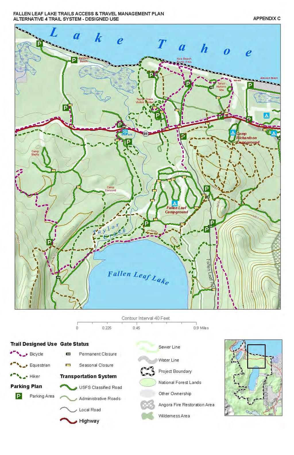
167 167
Decision Memo for Desolation Trail: Mill D to Desolation Lake Trail Relocation
 for Salt Lake County, Utah Uinta-Wasatch-Cache National Forest Salt Lake Ranger District 1. Background The present location of the Desolation Trail (#1159) between Mill D and Desolation Lake follows old
Proposed Action. Payette National Forest Over-Snow Grooming in Valley, Adams and Idaho Counties. United States Department of Agriculture
 United States Department of Agriculture Forest Service January 2012 Proposed Action Payette National Forest Over-Snow Grooming in Valley, Adams and Idaho Counties Payette National Forest Valley, Adams
Decision Memo Ice Age Trail Improvement (CRAC 37)
") Decision Memo Ice Age Trail Improvement (CRAC 37) U.S. Forest Service Chequamegon-Nicolet National Forest, Medford-Park Falls Ranger District Taylor County, Wisconsin T32N, R2W, Town of Grover, Section
Decision Memo Ice Age Trail Improvement (CRAC 37) U.S. Forest Service Chequamegon-Nicolet National Forest, Medford-Park Falls Ranger District Taylor County, Wisconsin T32N, R2W, Town of Grover, Section
White Mountain National Forest
 White Mountain National Forest United States Department of Agriculture Forest Service Eastern Region Boles Brook Snowmobile Bridge Decision Memo Boles Brook Snowmobile Bridge Project Town of Woodstock
DECISION MEMO. Rawhide Trail #7073 Maintenance and Reconstruction
 Page 1 of 6 Background DECISION MEMO USDA Forest Service Jefferson Ranger District Jefferson County, Montana Rawhide Trail #7073 is located in the Elkhorn Mountain Range approximately 10 miles east of
Tracy Ridge Shared Use Trails and Plan Amendment Project
 Tracy Ridge Shared Use Trails and Plan Amendment Project Scoping Document Forest Service Allegheny National Forest Bradford Ranger District McKean, County, Pennsylvania In accordance with Federal civil
BACKGROUND DECISION. Decision Memo Page 1 of 6
 DECISION MEMO DEVIL S ELBOW BY-PASS, BOUNDARY TRAIL NO.1 U.S. FOREST SERVICE T9N, R7E, SECTION 9 RANGE 5E COWLITZ COUNTY WA MOUNT ST. HELENS NATIONAL VOLCANIC MONUMENT, GIFFORD PINCHOT NATIONAL FOREST
CHAPTER III: TRAIL DESIGN STANDARDS, SPECIFICATIONS & PERMITS
 CHAPTER III Trail Design Standards, Specifications & Permits This chapter discusses trail standards, preferred surface types for different activities, permits, and other requirements one must consider
Crystal Lake Area Trails
 Lake Area Trails Welcome to the Lake area of the Big Snowy Mountains! This island mountain range in central Montana features peaks reaching to 8,600 feet and long, high ridges from which vistas of the
Description of the Proposed Action for the Big Creek / Yellow Pine Travel Plan (Snow-free Season) and Big Creek Ford Project
 and Big Creek Ford Project") Description of the Proposed Action for the Big Creek / Yellow Pine Travel Plan (Snow-free Season) and Big Creek Ford Project Payette National Forest Krassel Ranger District Valley and Idaho Counties, Idaho
Description of the Proposed Action for the Big Creek / Yellow Pine Travel Plan (Snow-free Season) and Big Creek Ford Project Payette National Forest Krassel Ranger District Valley and Idaho Counties, Idaho
Daisy Dean Trail 628/619 ATV Trail Construction
 Background and Purpose and Need The Daisy Dean ATV Trail Construction Project is located in the Little Belt Mountains, Musselshell Ranger District, Lewis and Clark National Forest approximately 32 miles
White Mountain National Forest Saco Ranger District
 United States Department of Agriculture Forest Service White Mountain National Forest Saco Ranger District 33 Kancamagus Highway Conway, NH 03818 Comm: (603) 447-5448 TTY: (603) 447-3121 File Code: 1950
GREENWOOD VEGETATION MANAGEMENT
 APPENDIX G GREENWOOD VEGETATION MANAGEMENT PROJECT RECREATION RESOURCE REPORT Prepared by: Laurie A. Smith Supervisory Forester Stearns Ranger District Daniel Boone National Forest August 4, 2016 The
Decision Memo Sun Valley Super Enduro & Cross-Country Mountain Bike Race. Recreation Event
 Decision Memo 2015 Sun Valley Super Enduro & Cross-Country Mountain Bike Race Recreation Event USDA Forest Service Ketchum Ranger District, Sawtooth National Forest Blaine County, Idaho Background The
Buffalo Pass Trails Project
 Buffalo Pass Trails Project Hahns Peak/Bears Ears Ranger District, Medicine Bow-Routt National Forests and Thunder Basin National Grassland Routt County, Colorado T6N 83W Sections 3-5, 8; T6N 84W Sections
Bradley Brook Relocation Project. Scoping Notice. Saco Ranger District. United States Department of Agriculture Forest Service
 Bradley Brook Relocation Project United States Department of Agriculture Forest Service Scoping Notice White Mountain National Forest February 2011 For Information Contact: Jenny Burnett White Mountain
Decision Memo Broken Wheel Ranch Equestrian Outfitter Special-Use Permit Proposed Action
 Decision Memo Broken Wheel Ranch Equestrian Outfitter Special-Use Permit USDA Forest Service Mississippi Bluffs Ranger District, Shawnee National Forest Jackson and Union Counties, Illinois Proposed Action
Rule Governing the Designation and Establishment of All-Terrain Vehicle Use Trails on State Land
 Rule Governing the Designation and Establishment of All-Terrain Vehicle Use Trails on State Land 1.0 Authority 1.1 This rule is promulgated pursuant to 23 V.S.A. 3506. Section 3506 (b)(4) states that an
DECISION MEMO North Zone (Legacy Trails) Trail Stabilization Project
 Trail Stabilization Project") DECISION MEMO North Zone (Legacy Trails) Trail Stabilization Project USDA FOREST SERVICE Rocky Mountain Region (R2) Shoshone National Forest Wapiti and Greybull Ranger District Park County, Wyoming Background
DECISION MEMO North Zone (Legacy Trails) Trail Stabilization Project USDA FOREST SERVICE Rocky Mountain Region (R2) Shoshone National Forest Wapiti and Greybull Ranger District Park County, Wyoming Background
St. Joe Travel Management EA CULTURAL RESOURCES
 St. Joe Travel Management EA CULTURAL RESOURCES Bruce Gibson May 2015 Regulatory Framework Forest Plan The Idaho Panhandle National Forests (IPNF) Forest Plan requires systematic cultural resource inventory
Continental Divide National Scenic Trail Legislative History and Planning Guidance
 Continental Divide National Scenic Trail Legislative History and Planning Guidance Legislation, Policy, and Direction Regarding National Scenic Trails The National Trails System Act, P.L. 90-543, was passed
Theme: Predominately natural/natural appearing; rustic improvements to protect resources. Size*: 2,500 + acres Infrastructure**:
 Recreation Opportunity Spectrum (ROS) Classes The Recreation Opportunity Spectrum (ROS) provides a way to describe the variations in the degree of isolation from the sounds and influences of people, and
RUSHMORE CONNECTOR TRAIL PROPOSAL
 PURPOSE AND NEED Background The U.S. Forest Service, Black Hills National Forest (Forest Service) has received a special use permit application from the State of South Dakota Department of Game, Fish and
Coronado National Forest Santa Catalina Ranger District
 United States Department of Agriculture Forest Service Coronado National Forest Santa Catalina Ranger District File Code: 1950 Date: October 14, 2015 Dear Interested Party: The Santa Catalina Ranger District
White Mountain National Forest Saco Ranger District
 United States Department of Agriculture Forest Service White Mountain National Forest 33 Kancamagus Highway Conway, NH 03818 Comm: (603) 447-5448 TTY: (603) 447-3121 File Code: 1950 Date: February 26,
Hiawatha National Forest St. Ignace Ranger District. File Code: 1950 Date: August 5, 2011
 United States Department of Agriculture Forest Service Hiawatha National Forest St. Ignace Ranger District W1900 West US-2 St. Ignace, MI 49781 906-643-7900 File Code: 1950 Date: August 5, 2011 Dear National
PROPOSED ACTION South 3000 East Salt Lake City, UT United States Department of Agriculture
 United States Department of Agriculture Forest Service Uinta-Wasatch-Cache National Forest Salt Lake Ranger District 6944 South 3000 East Salt Lake City, UT 84121 801-733-2660 File Code: 1950/2300 Date:
PURPOSE AND NEED. Introduction
 Public Scoping: Allocation of Recreation Capacity for Commercial Outfitter Guide Services on North Kruzof Island Trails (Kruzof Island Outfitter Guide) PURPOSE AND NEED Introduction The U.S. Department
DECISION MEMO For Bullis Hollow Trail
 I. DECISION TO BE IMPLEMENTED A. Description of Decision DECISION MEMO For Bullis Hollow Trail USDA Forest Service, Eastern Region 9 Allegheny National Forest Bradford Ranger District Corydon Township
RECREATION. Seven issues were identified that pertain to the effects of travel management on outdoor recreation within portions of the project area.
 RECREATION Seven issues were identified that pertain to the effects of travel management on outdoor recreation within portions of the project area. OPPORTUNITIES FOR SOLITUDE / QUIET TRAILS. One attraction
DECISION MEMO Whetstone Ridge Trail #8020 Relocation
 Page 1 of 7 Background DECISION MEMO Whetstone Ridge Trail #8020 Relocation USDA Forest Service Pintler Ranger District Granite County T4N, R16W, Sections 4,9,29 and T4N, R17W, Section 36 Whetstone Ridge
Recreation Specialist
 United States Department of Agriculture Forest Service October 2016 Recreation Specialist Report Red Rock Ranger District Coconino National Forest Coconino County, Arizona 1 Distribution/Availability Statement:
Appendix A Appendix A (Project Specifications) Auk Auk / Black Diamond (Trail 44) Reroute
 Auk Auk / Black Diamond (Trail 44) Reroute") Appendix A (Project Specifications) Auk Auk / Black Diamond (Trail 44) Reroute I. Proposed Action: This project proposes to reroute approximately 1,800 feet of a 50 inch wide trail, off of private property
Appendix A (Project Specifications) Auk Auk / Black Diamond (Trail 44) Reroute I. Proposed Action: This project proposes to reroute approximately 1,800 feet of a 50 inch wide trail, off of private property
Final Environmental Impact Statement for the Merced Wild and Scenic River. Comprehensive Management Plan, Yosemite National Park, Madera and Mariposa
 This document is scheduled to be published in the Federal Register on 02/26/2014 and available online at http://federalregister.gov/a/2014-04061, and on FDsys.gov DEPARTMENT OF THE INTERIOR 4312-FF NATIONAL
Kelly Motorized Trails Project Proposed Action
 Kelly Motorized Trails Project Proposed Action November 28, 2011 The Flagstaff Ranger District of the Coconino National Forest is seeking public input on the proposed Kelly Motorized Trails Project (formerly
Decision Memo for Philmont Scout Ranch Bike Trail and Access Reroute Project
 Decision Memo Philmont Scout Ranch Bike Trail and Access Reroute Project USDA Forest Service, Southwestern Region Questa Ranger District, Carson National Forest Colfax County, New Mexico (T. 30N, R. 17E,
Thank you for the opportunity to comment on the proposed action to add trails and trailheads to the Red Rock District trail system.
 July 14, 2010 Jennifer Burns Red Rock Ranger District PO Box 20429 Sedona, AZ 86341 Flagstaff Biking Organization PO Box 23851 Flagstaff, AZ 86002 Dear Jennifer- Thank you for the opportunity to comment
White Mountain National Forest. Pond of Safety Accessible Trail & Shoreline Access Project. Scoping Report. Township of Randolph Coos County, NH
 White Mountain National Forest United States Department of Agriculture Forest Service Eastern Region Pond of Safety Accessible Trail & Shoreline Access Project Township of Randolph Coos County, NH Scoping
Fossil Creek Wild & Scenic River Comprehensive River Management Plan Forest Service Proposed Action - details March 28, 2011
 Fossil Creek Wild & Scenic River Comprehensive River Management Plan Forest Service Proposed Action - details March 28, 2011 Primary Goals of the Proposed Action 1. Maintain or enhance ORVs primarily by
Cultural Resource Management Report Deer Valley 4wd Restoration and Blue Lakes Road Maintenance Project R
 Cultural Resource Management Report R2015-05-03-10005 Undertaking Description: The proposes to perform road maintenance and meadow restoration on the Deer Valley 4wd trail and road maintenance on the Blue
Tahoe National Forest Over-Snow Vehicle Use Designation
 Tahoe National Forest Over-Snow Vehicle Use Designation USDA Forest Service Tahoe National Forest February 20, 2015 Introduction The Forest Service, U.S. Department of Agriculture will prepare an Environmental
ROAD AND TRAIL PROJECT APPROVAL
 ROAD AND TRAIL PROJECT APPROVAL www.marincountyparks.org Marin County Parks, 3501 Civic Center Dr, Suite 260, San Rafael, CA 94903 DATE: July 12, 2017 PRESERVE: Gary Giacomini Open Space Preserve PROJECT:
Blueways: Rivers, lakes, or streams with public access for recreation that includes fishing, nature observation, and opportunities for boating.
 Parks, Open Space and Trails PRINCE WILLIAM COUNTY 2008 COMPREHENSIVE PLAN TRAILS PLAN CONTENTS The components of the trails plan are: Intent Definitions Goals, Policies, and Action Strategies Trails Map
S Central Coast Heritage Protection Act APRIL 21, 2016
 STATEMENT OF GLENN CASAMASSA ASSOCIATE DEPUTY CHIEF, NATIONAL FOREST SYSTEM U.S. FOREST SERVICE U.S. DEPARTMENT OF AGRICULTURE BEFORE THE UNITED STATES SENATE COMMITTEE ON ENERGY AND NATURAL RESOURCES
National Forests and Grasslands in Texas
 United States Department of Agriculture Forest Service National Forests and Grasslands in Texas Sam Houston NF 394 FM 1375 West New Waverly, Texas 77358 Phone 936-344-6205 Dear Friends, File Code: 1950
Alternative 3 Prohibit Road Construction, Reconstruction, and Timber Harvest Except for Stewardship Purposes B Within Inventoried Roadless Areas
 Roadless Area Conservation FEIS Summary Table S-1. Comparison of Key Characteristics and Effects by Prohibition Alternative. The effects summarized in this table A would occur in inventoried roadless areas
Recreation Opportunity Spectrum for River Management v
 Recreation Opportunity Spectrum for Management v. 120803 Introduction The following Recreation Opportunity Spectrum (ROS) characterizations and matrices mirror the presentation in the ROS Primer and Field
Appendix 3. Greenway Design Standards. The Whitemarsh Township Greenway Plan
 Appendix 3 Greenway Design Standards This chapter discusses two design standards for the greenway types discussed above. First, trail design standards are presented together with trailhead facilities and
Draft Environmental Impact Statement
 United States Department of Agriculture Forest Service Pacific Southwest Region Draft Environmental Impact Statement Inyo National Forest Motorized Travel Management R5-MB-182 January 2009 Inyo Mountains
United States Department of Agriculture. Forest Service
 United States Department of Agriculture Forest Service DECISION NOTICE AND FINDING OF NO SIGNIFICANT IMPACT MT. HOUGH SOUTH PARK PROPOSED TRAILS SYSTEM PROJECT U.S. FOREST SERVICE, PLUMAS NATIONAL FOREST,
Eagle Rock Loop Ouachita National Forest Page 1 of 8
 EAGLE ROCK LOOP Eagle Rock Loop Ouachita National Forest Page 1 of 8 Hiking: Biking: Equestrian: Trail Highlights: This trail offers the longest loop trail in Arkansas. A combination of the Little Missouri,
FINAL TESTIMONY 1 COMMITTEE ON RESOURCES UNITED STATES HOUSE OF REPRESENTATIVES. July 13, 2005 CONCERNING. Motorized Recreational Use of Federal Lands
 FINAL TESTIMONY 1 STATEMENT OF DALE BOSWORTH CHIEF Of the FOREST SERVICE UNITED STATES DEPARTMENT OF AGRICULTURE Before the SUBCOMMITTEE ON FORESTS AND FOREST HEALTH And the SUBCOMMITTEE ON NATIONAL PARKS,
SOCIAL CONFLICT BETWEEN MOTORIZED AND NON-MOTORIZED RECREATIONAL ACTIVITIES.
 SOCIAL CONFLICT BETWEEN MOTORIZED AND NON-MOTORIZED RECREATIONAL ACTIVITIES. There is a great disparity in opinions about the effects on a person s recreational experience when they encounter others on
Cave Run Nonmotorized Trails Project
 United States Department of Agriculture Forest Service August 2012 Cave Run Nonmotorized Trails Project Comment Period Report Cumberland Ranger District, Daniel Boone National Forest Bath, Rowan, and Menifee
DECISION MEMO Grand Targhee Resort Summer Trails. USDA Forest Service Caribou-Targhee National Forest Idaho Falls, Idaho 83401
 DECISION MEMO Grand Targhee Resort Summer Trails USDA Forest Service Caribou-Targhee National Forest Idaho Falls, Idaho 83401 Background Situated on the east side of the Teton Mountain Range, Grand Targhee
Logo Department Name Agency Organization Organization Address Information 5700 North Sabino Canyon Road
 Logo Department Name Agency Organization Organization Address Information United States Forest Coronado National Forest 5700 North Sabino Canyon Road Department of Service Santa Catalina Ranger District
Preferred Recreation Recommendations Stemilt-Squilchuck Recreation Plan March 2018
 Preferred Recreation Recommendations Stemilt-Squilchuck Recreation Plan March 2018 Below are the recommended recreation ideas and strategies that package together the various recreation concepts compiled
Sawtooth National Forest Fairfield Ranger District
 United States Department of Agriculture Forest Service Sawtooth National Forest Fairfield Ranger District P.O. Box 189 Fairfield, ID. 83327 208-764-3202 Fax: 208-764-3211 File Code: 1950/7700 Date: December
Bear Creek Habitat Improvement Project
 06/10/10 Bear Creek Habitat Improvement Project El Paso County, Colorado Pike National Forest and Colorado Springs Utilities Owned Land Report prepared by: Eric Billmeyer Executive Director Rocky Mountain
USDA Forest Service Deschutes National Forest DECISION MEMO. Round Lake Christian Camp Master Plan for Reconstruction and New Facilities
 USDA Forest Service Deschutes National Forest DECISION MEMO Round Lake Christian Camp Master Plan for Reconstruction and New Facilities Jefferson County, Oregon T. 13 S., R. 8 E., Section 16, W.M. Background:
Chattahoochee- Oconee National Forests. Decision Memo
 Page 1 of 6 USDA Forest Service Chattahoochee- Oconee National Forests Decision Memo Chattahoochee-Oconee National Forests Home Page Recreation Information Forest History Forest Facts Forest Management
Buford / New Castle Motorized Trail
 Buford / New Castle Motorized Trail Rifle Ranger District, White River National Forest Garfield County, Colorado Comments Welcome The Rifle Ranger District of the White River National Forest welcomes your
USDA FOREST SERVICE, HIAWATHA NATIONAL FOREST Alger County, Michigan. Grand Island Primitive Cabins Project
 USDA FOREST SERVICE, HIAWATHA NATIONAL FOREST Alger County, Michigan I. INTRODUCTION Grand Island Primitive Cabins Project DECISION NOTICE and FINDING OF NO SIGNIFICANT IMPACT This document describes my
Lassen National Forest Over-snow Vehicle Use Designation
 United States Department of Agriculture Over-snow Vehicle Use Designation Revised Draft Environmental Impact Statement Volume II. Appendices Forest Service September 2017 Cover photo: Jonohey In accordance
Ottawa National Forest Supervisor s Office
 United States Department of Agriculture Forest Service Supervisor s Office E6248 US2 Ironwood, MI 49938 (906) 932-1330 (906) 932-0122 (FAX) File Code: 1950/2350 Date: April 11, 2012 Dear Friends of the,
COASTAL CONSERVANCY. Staff Recommendation December 2, 2004 COYOTE HELLYER COUNTY PARK BAY AREA RIDGE TRAIL
 COASTAL CONSERVANCY Staff Recommendation December 2, 2004 COYOTE HELLYER COUNTY PARK BAY AREA RIDGE TRAIL File No. 04-057 Project Manager: Amy Hutzel RECOMMENDED ACTION: Authorization to disburse up to
White Mountain National Forest
 White Mountain National Forest United States Department of Agriculture Forest Service Eastern Region Batchelder Brook and Guinea Pond Snowmobile Bridges Decision Memo Batchelder Brook/Guinea Pond Snowmobile
Decision Notice & Finding of No Significant Impact Middle Citico Equestrian Trail Network
 Decision Notice & Finding of No Significant Impact Middle Citico Equestrian Trail Network USDA Forest Service Tellico Ranger District, Cherokee National Forest Monroe County, Tennessee Decision and Reasons
COASTAL CONSERVANCY. Staff Recommendation September 22, 2011 BAY AREA RIDGE TRAIL: HOOD MOUNTAIN TO HIGHWAY 12
 COASTAL CONSERVANCY Staff Recommendation September 22, 2011 BAY AREA RIDGE TRAIL: HOOD MOUNTAIN TO HIGHWAY 12 File No. 11-039-001 Project Manager: Betsy Wilson RECOMMENDED ACTION: Authorization to disburse
Chetco River Kayaking Permit
 Decision Memo USDA Forest Service Rogue River-Siskiyou National Forest Gold Beach Ranger District - Curry County, Oregon Wild Rivers Ranger District Josephine County, Oregon BACKGROUND A special use permit
5.0 OUTDOOR RECREATION OPPORTUNITIES AND MANAGEMENT
 5.0 OUTDOOR RECREATION OPPORTUNITIES AND MANAGEMENT 5.1 Introduction This section describes the range of recreational activities that currently take place in Marble Range and Edge Hills Parks, as well
Draft Decision Notice and Finding of No Significant Impact
 United States Department of Agriculture Draft Decision Notice and Finding of No Significant Impact Zuni Mountain Trail Project Cibola National Forest, Mt Taylor Ranger District McKinley County & Cibola
MANAGEMENT DIRECTION STATEMENT June, 1999
 Thompson River District MANAGEMENT DIRECTION STATEMENT June, 1999 for Roche Lake Provincial Park Ministry of Environment Lands and Parks BC Parks Division Table of Contents I. Introduction A. Setting
RIM TRAIL EXTENSION PROJECT
 DECISION MEMO For RAINBOW RIM TRAIL EXTENSION PROJECT Located on National Forest System Lands USDA Forest Service, Southwest Region Kaibab National Forest - North Kaibab Ranger District T.35 N, R.1 E,
Uinta-Wasatch-Cache National Forest Salt Lake Ranger District
 United States Department of Agriculture Forest Service Uinta-Wasatch-Cache National Forest Salt Lake Ranger District 6944 South 3000 East Salt Lake City, UT 84121 801-733-2660 File Code: 1950/2300 Date:
The Roots of Carrying Capacity
 1 Applying Carrying Capacity Concepts in Wilderness 1872 1964...shall be preserved for the use & enjoyment of the American people...in such manner as will leave them unimpaired for future generations...
DRAFT - APRIL 13, 2007 ROUTING STUDY FOR TRAIL CONNECTIONS BETWEEN CALAIS AND AYERS JUNCTION
 DRAFT - APRIL 13, 2007 ROUTING STUDY FOR TRAIL CONNECTIONS BETWEEN CALAIS AND AYERS JUNCTION Abstract The vision for the East Coast Greenway is an off-road urban trail system running from Calais, Maine
Decision Notice and Finding of No Significant Impact
 Decision Notice and Finding of No Significant Impact Steamboat Ski Area Summer Trails Project USDA Forest Service Medicine Bow-Routt National Forests Hahns Peak/Bears Ears Ranger District Routt County,
Appendix C. Tenderfoot Mountain Trail System. Road and Trail Rehabilitation Plan
 Appendix C Tenderfoot Mountain Trail System Road and Trail Rehabilitation Plan All rehabilitation work would be under the direction of the District Fisheries Biologist, the Forest Hydrologist, and/or the
Understanding user expectations And planning for long term sustainability 1
 Understanding user expectations And planning for long term sustainability 1 What is a natural surface trail? It can be as simple has a mineral soil, mulched or graveled pathway, or as developed as elevated
Wilderness Specialist s Report
 United States Department of Agriculture Forest Service July 2009 Wilderness Specialist s Report Travel Management Rule EIS USDA Forest Service Southwestern Region Apache-Sitgreaves National Forests Prepared
Connie Rudd Superintendent, Black Canyon of the Gunnison National Park
 National Park Service U.S. Department of the Interior Black Canyon of the Gunnison National Park and Curecanti National Recreation Area Information Brochure #1 Wilderness and Backcountry Management Plan
MONTEREY REGIONAL AIRPORT MASTER PLAN TOPICAL QUESTIONS FROM THE PLANNING ADVISORY COMMITTEE AND TOPICAL RESPONSES
 MONTEREY REGIONAL AIRPORT MASTER PLAN TOPICAL QUESTIONS FROM THE PLANNING ADVISORY COMMITTEE AND TOPICAL RESPONSES Recurring topics emerged in some of the comments and questions raised by members of the
PLANNING COMMISSION AGENDA REPORT May 10, Members of the Planning Commission. Joyce Parker-Bozylinski, Contract Planner
 PLANNING COMMISSION AGENDA REPORT May 10, 2007 TO: FROM: PROPOSAL: APPLICANT: RECOMMENDATION: Members of the Planning Commission Joyce Parker-Bozylinski, Contract Planner Approval of the Calabasas Trails
City of Durango 5.8 FUNDING TRAILS DEVELOPMENT
 5.8 FUNDING TRAILS DEVELOPMENT The City has been successful in establishing dedicated local funding sources as well as applying for grants to develop the City s trail system, having received nearly $2.4
Hermosa Area Preservation The Colorado Trail Foundation 4/11/2008
 Hermosa Area Preservation The Colorado Trail Foundation 4/11/2008 Legend d o Tr ail NPA - National Protection Area ra NCA - National Conservation Area o e C Th The Colorado Trail lo FS inventoried Roadless
RECREATION. 1. Conflict between motorized and non-motorized recreation uses,
 Island Unit Trail System Additions Project Chapter 3. Recreation RECREATION INTRODUCTION This section discusses the effects to public recreation opportunities and experiences. The type of recreational
Thank you for this third opportunity to comment on the proposed revisions to the Coconino National Forest Management plan.
 March 19, 2014 Flagstaff Biking Organization PO Box 23851 Flagstaff, AZ 86002 Vern Keller Coconino National Forest Attn: Plan Revision 1824 South Thompson Street Flagstaff, Arizona 86001 coconino_national_forest_plan_revision_team@fs.fed.us
Williamson Rock/Pacific Crest National Scenic Trail (PCT) Project EIS. Notice of intent to prepare an Environmental Impact Statement.
 Project EIS. Notice of intent to prepare an Environmental Impact Statement.") [3411-15-P] DEPARTMENT OF AGRICULTURE Forest Service Angeles National Forest; Los Angeles County, CA Williamson Rock/Pacific Crest National Scenic Trail (PCT) Project EIS AGENCY: ACTION: Forest Service,
[3411-15-P] DEPARTMENT OF AGRICULTURE Forest Service Angeles National Forest; Los Angeles County, CA Williamson Rock/Pacific Crest National Scenic Trail (PCT) Project EIS AGENCY: ACTION: Forest Service,
Georgetown-Lewes Rail/Trail Study. Rail/Trail Study: Cool Spring to Cape Henlopen State Park New Road Extension (House Resolution No.
 Georgetown-Lewes Rail/Trail Study Rail/Trail Study: Cool Spring to Cape Henlopen State Park New Road Extension (House Resolution No. 47) August 22, 2011 Presentation Outline Background Benefits Statewide
RE: Access Fund Comments on Yosemite National Park Wilderness Stewardship Plan, Preliminary Ideas and Concepts
 September 30, 2016 Superintendent Yosemite National Park Attn: Wilderness Stewardship Plan P.O. Box 577 Yosemite, CA 95389 RE: Access Fund Comments on Yosemite National Park Wilderness Stewardship Plan,
Procedure for the Use of Power-Driven Mobility Devices on Mass Audubon Sanctuaries 1 September 17, 2012
 Procedure for the Use of Power-Driven Mobility Devices on Mass Audubon Sanctuaries 1 September 17, 2012 Background As part of Mass Audubon s mission to preserve the nature of Massachusetts for people and
FEASIBILITY CRITERIA
 This chapter describes the methodology and criteria used to evaluate the feasibility of developing trails throughout the study areas. Land availability, habitat sensitivity, roadway crossings and on-street
Mt. Hood National Forest
 United States Department of Agriculture Forest Service Mt. Hood National Forest Zigzag Ranger District 70220 E. Highway 26 Zigzag, OR 97049 503-622-3191 Fax: 503-622-5622 File Code: 1950-1 Date: June 29,
Teton Basin Ranger District
 Teton Basin Ranger District P.O. Box 777 Driggs, ID 83422 File Code: 1950/2350 Date: August 5, 2002 Greetings: You received the preliminary Environmental Assessment (EA) for the Teton Pass Trail last summer.
NATIONAL PARK SERVICE CERTIFICATION OF COMPLETED SEGMENTS OF THE NORTH COUNTRY NATIONAL SCENIC TRAIL
 NATIONAL PARK SERVICE CERTIFICATION OF COMPLETED SEGMENTS OF THE NORTH COUNTRY NATIONAL SCENIC TRAIL Completed trail segments that (1) follow the route identified in the 1982 National Park Service (NPS)
White Mountain National Forest. Rumney Rocks Project Supplemental Environmental Assessment. 30-day Comment Report
 White Mountain National Forest United States Department of Agriculture Forest Service Rumney Rocks Project Supplemental Environmental Assessment Eastern Region Town of Rumney, Grafton County, NH 30-day
USDA Trails Strategy WRI: ENGLISH PEAK SURVEY. Theodore Mendoza San Diego State University June 6 th 2016 August 18 th Advisor: Sam Commarto
 WRI: ENGLISH PEAK SURVEY Theodore Mendoza San Diego State University June 6 th 2016 August 18 th 2016 Advisor: Sam Commarto Klamath National Forest Submitted: March 21, 2017 Table of Contents Acknowledgements
Worksheet: Resolving Trail Use(r) Conflict March 27, 2010
 Conflict March 27, 2010") RI Land & Water Summit Worksheet: Resolving Trail Use(r) Conflict March 27, 2010 John Monroe National Park Service, Rivers & Trails Program 617 223 5049 John_Monroe@nps.gov www.nps.gov/rtca In one sentence,
RI Land & Water Summit Worksheet: Resolving Trail Use(r) Conflict March 27, 2010 John Monroe National Park Service, Rivers & Trails Program 617 223 5049 John_Monroe@nps.gov www.nps.gov/rtca In one sentence,
Project Planning, Compliance, and Funding
 Project Planning, Compliance, and Funding The plans above offer high level guidance to ensure that the A.T. is managed effectively as a whole unit in a decentralized management structure. Cooperative management