GJditarod National GfIistoric Trail
|
|
|
- Benedict Booker
- 6 years ago
- Views:
Transcription
1
2
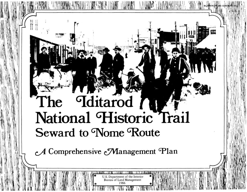
3 The GJditarod National GfIistoric Trail Seward to GNome GRoute c..a Comprehensive UVIanagement GPlan March 1986 Prepared By: Bureau of Land Management Anchorage District Office Anchorage, Alaska
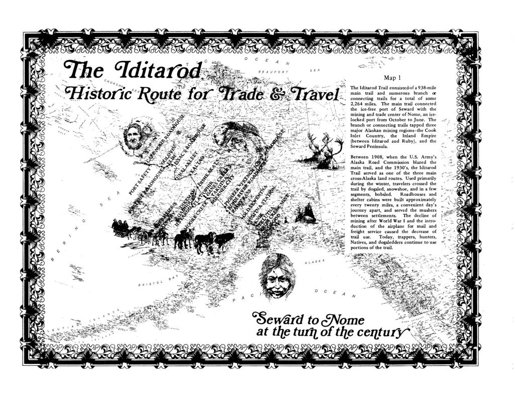
4 ~TABLE OF CONTENTS~ Iditarod National Historic Trail Comprehensive Management Plan INTRODUCTION I. PROJECT BACKGROUND J A. National Trails System Act B. Alaska Gold Rush Trails Study C. Iditarod Trail Sled Dog Race D. National Historic Trails It E. Comprehensive Management Plan 5 F. Advisory Council G. Management Goals H. Management Objectives II. HISTORIC OVERVIEW III. REGIONAL PROFILE 5 A. Seward to Rainy Pass B. Rainy Pass to Kaltag C. Kaltag to Nome Itlt iii
5 IV. SIGNIFICANT SITES AND SEGMENTS A. Primary Route and Connecting Trails B. Resource Inventories Historic (Gold Rush Era) Resources Pre-Gold Rush Era Resources 52. Natural (Scenic) Resources if. Outdoor Recreation Resources C. Management Categories Active and Minimum Management of Segments Recommended Man8rgement Levels for Historic Sites National Register of Historic Places D. Secretary's Interim Criteria for Inclusion of Non-Federal Sites and Segments into the INHT System 60 V. MANAGEMENT OPPORTUNITIES A. Cooperative Management System Management Philosophy Secretary's }\dministrative Responsibilities Management Roles and Responsibilities..... ; if. Cooperative Agreements :76 B. Trail Management Guidelines ' Protection Options for Trail Segments iv
6 2. Trail Corridor Guidelines Uniform Trail Markers If. Trail Marking Standards Maintenance Construction Off-Road Vehicle Use Commercial/Competitive Activities Mining Wildfire/Prescription Burning 81f C. Information/Interpretation lf D. Research Opportunities lf 1. Comprehensive History lf 2. Oral History Documentation Archeological Research If. Preservation of Historical Photographs, Maps, and Documents Historical!Archit~ctural Research E. Segment Management Opportunities The Primary Route (Goodwin's Route) Connecting Trails 92 VI. APPENDICES Iditarod National Historic Trail Advisory Council. 99 v
7 2. Public Involvement Record Historic/Pre-Gold Rush Sites if. Sites on the National Register of Historic Places in the Proximity of the Iditarod National Historic Trail ~ a. Site Management Opportunities - Primary Route b. Site Management Opportunities - Connecting Trails Information/Interpretation Opportunities f 7. Determination of "No Effect" Correspondence vi
8 ~G)LIST OF MAPS(C?~ ~G)LIST OF TABLES~ Map 1 Iditarod Trail System Inside Cover Table 1 Community Profiles - Seward to Rainy Pass Map 2 Map of Alaska - Alaska Railroad Commission (1916) Map Primary Route and Connecting Trails - Seward to Rainy Pass Map If Primary Route and Connecting Trails Rainy Pass to Kaltag (Southern portion) If1 Map 5 Primary Route and Connecting Trails Rainy Pass to Kaltag (Northern portion) f2 Map 6 Primary Route and Connecting Trails - Kaltag to Nome '+6 Map 7 Generalized Land Status- Seward to Rainy Pass Map 8 Generalized Land Status Rainy Pass to Kaltag (Southern portion) Map 9 Generalized Land Status Rainy Pass to Kaltag (Northern portion) Map 10 Generalized Land Status - Kaltag to Nome Table 2 Community Profiles - Rainy Pass to Kaltag Table Community Profiles - Kaltag to Nome Table If Primary and Connecting Routes f Table 5 Level 1 Historic Sites Table 6 Level 2 Historic Sites Table 7 Management Opportunities - Primary Route Table 8 Management Opportunities - Connecting Trails If '+7 vii
9 University of Oregon Library..... Cover University of Oregon Library BLM Photo Glenbow Archive:;, Calgary, Alberta Glenbow Archives, Calgary, Alberta Alaska and Its Resources by William Dall, Boston Lee and Shepard Alaska and Its Resources by William Dall, Boston Lee and Shepard Alaska and Its Resources by William Dall, Boston Lee and Shepard Anchorage Historical and Fine Arts Museum B newspaper advertisement University of Arizona Anchorage Historical and Fine Arts Museum One Man's Gold Rush by Murray Morgan, University of Washington Press Rich Pay Struck in the Iditarod Fairbanks Weekly Times, February 24-, Over Three Hundred Stampeders Leave Fairbanks Weekly Times, June 1, More Iditarod News Worth Considering Nome Daily Nugget, June 24-, Another Shooting Affair in Iditarod Fairbanks Weekly Times, April 1, University of Oregon Library Glenbow Archives, Calgary, Alberta B viii University of Oregon Library
10 Glenbow Archives, Calgary, Alberta Glenbow Archives, Calgary, Alberta University of Oregon Library BLM Photo lf9 Anchorage Historical and Fine Arts Museum B7lf lf Glenbow Archives, Calgary, Alberta Glenbow Archives, Calgary, Alberta Glenbow i\rchives, Calgary, Alberta 25 Glenbow Archives, Calgary, Alberta Glenbow Archives, Calgary, Alberta Anchorage Historical and Fine Arts Museum B ,.. 28 Anchorage Historical and Fine Arts Museum B One Man's Gold Rush by Murray Morgan, University of Washington Press 0 Anchorage Historical and Fine Arts Museum B ix

11 INTRODUCTION (j)/b, IDITAROD is a magical word not only in Alaska, but also in the Nation and in many other parts of the world. It is a word that raises different images and emotions in different people. To the oldest i-\laskan Natives, it recalls the approximate name of a 19th century Athabaskan Indian village on a small river now also called Iditarod. To "Sourdoughs" and others familiar with the State's history, IDITAROD refers to the now-abandoned Gold Rush town of the 1910's and its associated mining district in Southcentral Alaska. More technically, to the historian, IDITAROD refers to the 1910 Seward-to-Nom trail surveyed by the U.S. Army's Alaska Road Commission. Yet today the name IDITAROD, above all in National and International recognition, symbolizes the dramatic, long distance sled dog race between Anchorage and Nome held each Nlarch since 197. In November of 1978, IDITAROD took on still another meaning when the National Trails System Act was amended. At the urging of the public, Congress created a new category of National Trails when the Lewis and Clark, the Oregon, the Mormon-Pioneer, and the Iditarod were designated as National Historic Trails. The IDITAROD NATIONAL HISTORIC TRAIL (Iditarod NHT) is composed of the federally administered areas of the Gold Rush Trail network which connect Seward in southern Alaska with Nome in northwestern Alaska via the Iditarod Mining District. The 98-mile Trail, commonly known as the "Iditarod Trail" during the Iditarod Gold Rush of the 1910's, was formally constructed by the Alaska Road Commission under the direction of Walter L. Goodwin during This constitutes the Iditarod NHT's "Primary Route." Yet branching from this primary route are hundreds of miles of land and water based routes and trails. They were important not only during the 1910's, but also during the entire Gold Rush Period in Interior Alaska from the 1880's into the 1920's, with some based on even earlier Indian trails. In addition to the trails used during this period, other routes used yearly in the IDITAROD TRAIL SLED DOG RACE are also part of this Trail system. Collectively, these trail segnlents and associated historic sites make up what is referred to as the IDITAROD NATIONAL HISTORIC TRAIL SYSTEM. Though the IDITAROD NATIONAL HISTORIC TRAIL SYSTEM currently includes only the federally administered portions of the Gold Rush trail system, the remainder of the network will be recognized officially as components of the National Trails System once cooperative agreements between the Secretary of the Interior and the non-federal land managers are executed. This Comprehensive Management Plan, as mandated by Congress, represents the cooperative efforts of the Bureau of Land Management, the Forest Service, the Fish and Wildlife Service, the National Park Service, the State of Alaska, the Iditarod National Historic Trail Advisory Council, various local governments, Native corporations, and interest groups, as well as hundreds of individuals. Together, these agencies, groups, and individuals have proposed a cooperative management philosophy. This management philosophy, which is based on the spirit of cooperation and on folmal agreements, seems particularly appropriate for Alaska. The entire Trail system would be managed as a unit by a coalition of volunteer Trail organizations in partnership with the local land managers who are ultimately responsible for the various segments of the Trail. The intent of this plan is for the Federal Government to initiate cooperative management of the Iditarod NHT, so that eventually the State of Alaska and a coalition of
12 volunteer organizations may assume the major portion of the management responsibility for the Trail system. The IDITAROD NATIONAL HISTORIC TRAIL is unique in Alaskan and American history. It represents the last vestiges of a truly remote and wild trail system which today remains much the same as it was 75 years ago. We trust that as stewards of this remarkable nonrenewable resource, we will work cooperatively to preserve a prominent part of America's past for future generations who will treasure this resource as much as or more than we do today.
13 Archeologists for the Bureau of Land Management, examine the remains of an old dog barn near Pioneer Roadhouse, Mile 0 on the Iditarod Trail.

14 I. P R o JE C T B A C KG R o U N D

15 ~Project Background~ A. National Trails System Act The National Trails System Act, Public Law 90-5lf, was approved on October 2, This Act states: In order to provide for the ever increasing outdoor recreation needs of an expanding population and in order to promote public access to, travel within, and enjoyment and appreciation of the open-air, outdoor areas of the Nation, trails should be established (i) primarily, near the urban areas of the Nation, and (ii) secondarily, within established scenic areas more remotely located. The original Act instituted a national system of recreation and scenic trails, designated the Appalachian and Pacific Crest Trails as the initial components of the National Scenic Trail System, and prescribed methods by which, and standards according to which, additional components may be added to the system. The Act directed that llf specified routes would be studied for the purpose of determining the possibility and desirability of designating each as a national scenic trail. One route named for study was the "Gold Rush Trails in Alaska." No further identification of the route was included in the original Act. B. Alaska Gold Rush Trails Study The primary task of the Alaska Gold Rush Study Team, formed in September 197, was to determine specific trails that should be studied as a basis of appropriate proposals for additional national scenic trails. The study team, chaired by the Bureau of Outdoor Recreation, was made up of various Federal, State, and local government representatives. In September 1977, the study team made its recommendations to the President and to Congress in The Iditarod Trail (Seward-to-Nome Route) and Other Gold Rush Trails. The team recommended that the 2,07-mile Iditarod Trail system be included in the National Trails System and designated as a National Historic Trail. C. Iditarod Trail Sled Dog Race In March of 197, the Iditarod Trail Committee staged the first IDITAROD TRAIL SLED DOG RACE between Anchorage and Nome. Twenty-two mushers successfully retraced the steps of men and dogs from over 50 years earlier by traveling overland to Nome. The event that year captured the imagination of many Alaskans. In the years to follow, interest in the event would spread to many parts of the world as mushers from many different countries began to enter the competition. Billed as a 1,Olf9-mile race each year, it actually exceeds that distance, as well as alternates between a southern and a northern race route. Some variation of the northern race route has been used by the Iditarod Race Committee in 197, 1971f, 1975, 1976, 1978, 1980, 1982, 1981f, and This race route generally follows Trail segments identified on the Iditarod NHT system. Some variation of the southern race route has been used in the Iditarod Sled Dog Race in each odd-numbered year between 1977 and This race route generally follows Trail segments identified on the Iditarod NHT system, with two exceptions. Normally the southern race route leads from the town of Iditarod to the villages of Shageluk, Anvik, and Grayling, and then follows the Yukon River to the village of Kaltag. (This portion of the southern race route, though not originally listed in the Alaska Gold Rush Trails Study Report as a potential addition to the Trail system, is certainly eligible for inclusion into the National Trail System and should be added at some later date.) In 1981, the Iditarod
16 , Trail Committee ran the event through the Anvik River and Chirosky River drainages, thereby bypassing the Yukon River and the village of Kaltag. Without a doubt, the excitement and success of the annual Iditarod Sled Dog Race and the organization of people behind that race helped the once-abandoned Iditarod Trail attain national recognition and National Trail status. D. National Historic Trails The Seward-Nome Route became one of the first National Historic Trails selected when Public Law (The National Parks and Recreation Act) was signed by the President on November 10, This Act, amending the National Trails System Act, provided for and specifically named the Iditarod as a National Historic Trail. It mandated the following actions: 1) The Iditarod NHT shall be administered by the Secretary of the Interior. 2) The Secretary of the Interior shall submit to the Committee on Interior and Insular Affairs of the House of Representatives and the Committee on Energy and Natural Resources of the Senate, a "comprehensive plan" for the management and use of the Trail. The comprehensive plan shall include, but not be limited to: The identification of the historic Trail system and side and connecting trails. The identification of all significant natural, historic, and cultural resources to be preserved. Specific objectives and practices to be observed in the management of the Trail. Details of any anticipated cooperative agreements to be consummated. Procedures for establishing a uniform marker, marking the Trail, and providing markers to cooperating agencies. Identifying access needs to the Trail where appropriate and identifying acquisition needs for significant sites or segments. ) An Advisory Council be formed with the following members to be included: A member of each Federal or independent agency administering land through which the Trail route passes. A member to represent the State, appointed by the Governor. One or more members appointed to represent private organizations and individual landowners or land users who have an established and recognized interest in the Trail. If) The Secretary shall select necessary rights-of-way for the Trail after obtaining advice and assistance of the State of Alaska, local governments, private organizations, and landowners and land users concerned. 5) Maps of the Iditarod NHT shall be kept on file and available for public inspection in the office of the Director, National Park Service, Washington, D.C. The National Trails System Act specifically authorized and designated "The Iditarod National Historic Trail" as the "route of approximately two thousand miles extending from Seward, Alaska to Nome, Alaska..., following the routes as depicted on maps identified as 'Seward-Nome Trail'" in the Bureau of Outdoor Recreation's September 1977 study report. The route is actually a trail system made up of a primary trail route connecting Seward and Nome, and over

17 thirteen hundred miles of other trails which connect the Alaska Road Commission's Seward-to-Nome Route with gold strikes, communities, and access points. E. Comprehensive Management Plan The Secretary of the Interior delegated the responsibility of preparing a comprehensive management plan for the Iditarod NHT to the Bureau of Land Management. This responsibility was eventually assigned to the Anchorage District Office of the Bureau. The project team, which was assembled between June 1979 and September 1981, consisted of a project leader, outdoor recreation planner, historians, historic architect, project assistants, archeologists, and landscape architects. A writer/editor, graphic artists, realty specialists, public affairs specialists and others also gave invaluable assistance. The project team was also assisted by other Federal, State, and local government representatives and private individuals in historical research and in preparation of a September 1981 Draft Comprehensive Management Plan. The project team, disbanded after completion of the Draft Comprehensive Management Plan, accomplished various tasks during their assignment. Field inventories were conducted during 1980 and 1981 to locate and evaluate historical sites and segments. State and Federal records and private collections throughout the United States and Canada were researched for Iditarod-related documents, photographs and maps. Maps and photographs collected were cataloged. Site information files were established to compile known information on each historic site and segment which were indexed to the Alaska Historical Resources Survey (AHRS) system as maintained by the State of Alaska. Maps at the 1:6,60 scale depicting historic site and Iditarod Trail segment locations were produced by the project staff. Informal conversations as well as formal oral history interviews with people who recollect the days of the Iditarod Trail were recorded, annotated, and contributed to the Alaska State Historical Library in Juneau. An extensive public involvement program designed to inform and involve citizens in the planning process was carried out. A Draft Comprehensive Management Plan was prepared for transmittal to the Secretary of the Interior. A document entitled Resource Inventories was completed. This document summarized the recommendations of the individual resource specialists as of September (Copies of Resource Inventories are available from the Anchorage District Office, Bureau of Land Management.) In August 198tt the Anchorage District was directed to revise the Comprehensive Management Plan for the Iditarod NHT. This revision was necessary primarily because of budget and organizational implications found in the 1981 draft plan. F. Advisory Council On January Itt, 1981, the Secretary of the Interior officially appointed a twenty-member Advisory Council to assist the Bureau of Land Management in the formulation of the Comprehensive Management Plan. The original Advisory Council, appointed for a two-year term. inet on March 6, 5

18 1981, and May 7-8, It reviewed the BLM's management proposal and approved the recommendations and management approach contained within the draft document. The membership of the original i\.dvisory Council is shown in Appendix 1. Minutes of Advisory Council meetings are on file at the Anchorage District Office, Bureau of Land Management. The Advisory Council will be reinstated once the expired charter is replaced with a new charter signed by the Secretary. The main objective of the new Advisory Council will be to advise the Secretary and all Iditarod NHT managers and cooperators in the implementation of this comprehensive management plan. G. Management Goals "National historic trails shall have as their purpose the identification and protection of the historic route and its historic remnants and artifacts for public use and enjoyment" (Section (c), National Trails System Act, as amended). The primary goal of this comprehensive plan is to establish a common guide which will be used to promote the preservation, enjoyment, use, and appreciation of the historic route of the Iditarod Trail. This plan identifies the trails and sites making up the historic Trail system and recommends non-binding possible management actions for protecting significant segments, historic remnants, and artifacts for public use and enjoyment. In addition, the plan identifies the opportunities for outdoor recreation and public enjoyment which are compatible with the integrity of the historic route and are not destructive to the cultural and natural resources associated with the Iditarod Trail. This comprehensive management plan proposes a cooperative management system for the Iditarod NHT which is based on a PARTNERSHIP of: 1) the Federal land managers already responsible for sections of the NHT; 2) State, local, and private landowners/managers who have entered into cooperative agreements supporting the historic Trail management concept; and, ) the Trail management organization(s), who will accept major responsibilities for carrying out on-the-ground work on the Trail. The Bureau of Land Management will be responsible for the COORDINATION of efforts of all Trail partners. H. Management Objectives Components of the Iditarod NHT should be managed by the respective land managers or owners in a manner consistent with the intent of the enabling legislation so as to achieve the following broad, long term objectives: 1) The Iditarod NHT should be managed under a cooperative agreement system, involving Federal agencies, the State of Alaska, local governments, private Trail organizations, and an Advisory Council, using the Comprehensive Management Plan as a common guide. 2) Encourage and assist the "Iditarod Trail Blazers" a coalition of Trail organizations and interest groups, to participate as a working partner in the management of the Iditarod NHT. ) On behalf of the Secretary of the Interior, use the Bureau of Land Management's Anchorage District Office as liaison for Iditarod NHT matters. if) ytilize the Iditarod NHT Advisory Council for consultation with respect to matters related to the Trail. 5) In order to increase public use and enjoyment, all Trail segments identified for active management should be managed to protect and interpret their historic values, and should be identified by the placement of uniform markers. 6) Public use of Trail segments should be encouraged, protected, and managed to the extent that such use does not 6
19 impact the historic values of the Iditarod NHT. Rights-of-way, easements, management corridors, cooperative agreements, and access improvements will all be used to meet this objective. 7) Non-federal sites and segments should be included in the Iditarod NHT through cooperative agreements as soon as possible. 8) A full range of publications, maps, and other materials interpreting the Trail and the component sites and segments should be made available to the public in order to increase public appreciation and understanding of the Iditarod NHT system. This information and education program should be a cooperative effort of Trail managers and volunteer groups. 9) Certain segments and all historic sites identified in Appendix 5 should be further evaluated for possible nomination to the National Register of Historic Places. This should be done prior to making any binding management decisions which eventually may include various degrees of protection, interpretation, and recordation of their historic values. It is recommended that Levelland 2 sites be given the highest priority. Detailed management and use plans for accomplishing this objective should be prepared by the appropriate land management agency. 10) Nominations to the National Register of Historic Places should be by a thematic group format submission. If not possible, then each managing agency should consider undertaking site-specific nominations of the site recommended. 7
20 "Musfi! :Husky ana malamute! 9(eep to tfie trai{! Tfiey're iepencfing on us, for tfie government maul" THE MAIL Council City News December 17,1904
21 II. H IS T o RI C o VE R VI E W u.s. mail team near Nome

22 ~ OF..J l./.~. '1,- ~:.\.\ 10
23 ~Historic Overview~ Innuit sled of Norton Sound "Ifyou love the grandeur ofnature--its canyons, its mountains and its mightiness, and love to feel the thrill of their presence--then take the trip by all means; you will not be disappointed. But ifyou wish to travel on 'flowery beds ofease' and wish to snooze and dream thatyou are a special product of higher civilization too finely adjusted for this more strenuous life, then don't. But may God pity you, for you will lose one thing worth living for ifyou have the opportunity to make this trip and fail to do so. " C. K. Snow A t the End ofthe Trail Seward, February 15, 1919 The Iditarod Trail, a symbol of frontier travel and once main artery of Alaska's winter commerce, served a string of mining camps, trading posts, and other settlements founded between 1880 and 1920, during Alaska's Gold Rush Era. The Alaska Gold Rush was an extension of the Western mining frontier that dates from the California gold discovery in 18/f8. In each new territory, gold strikes had caused a surge in population, the establishment of a territorial government, and the development of a transportation system linking the goldfields with the rest of the nation. Alaska, too, followed through these stages. With the increase in gold production, the non-native population boomed from a recorded /f0 in 1880 to some 6,/f00 in In 1912 President Taft signed the act creating the Territory of Alaska. At that time, transportation systems included steamship and steamboat lines, railroads, and four major cross-country dogsled winter trails. Of the latter, the longest ran from Seward to Nome, and was called the Iditarod. The Iditarod Trail was developed as a response to gold rush era needs. Its antecedents were the Native trails of the Tanaina and Ingalik Indians and the Inupiaq and Yupik Eskimos. They knew the route and had developed winter modes of travel--the dogsled and snowshoe. The peaceful collaboration of Native groups with the newcomers made settlement easier. Our stereotyped image of the parka-clad musher behind a sled and string of dogs reflects a mixture of Native technology and European adaptations. The Native sled was built to carryall the owner's possessions from camp to camp or from camp to village. The owner ran in front, guiding his dog team along unimproved trail. The Russian, Lt. Zagoskin, wrote in the 18/f0's that the Russians introduced the method of harnessing the dogs single file or in pairs in front of the 11

24 Dogsledding the Kaltag Portage,

25 sled. The Russians also introduced the lead dog or "leader" --the best trained dog that kept the others in line and recognized voice commands for direction. During the Russian era, guide-poles and later handlebars were attached to the rear of the sled to direct, push, and balance the weight. The Russians also developed parts of the later Iditarod Trail as a route of supply and provision for fur trading posts. The Russian American Company sent fur trading expeditions across the Kaltag Portage to Nulato on the Yukon River, along a section built later as part of the Iditarod Trail. When the }\merican fur trading companies took over the Russian posts (after 1867), they continued using the Kaltag Portage and extended it as part of the Yukon River Trail, linking fur trading posts into Canada. From there came French-Canadian traders and trappers, along with their voice commands for dogsledding: Americanized as gee for ~ (go right), haw for cha (go left), and mush for marche (go ahead). Thus, the mode of travel and an emerging pattern of transportation were developed, aiding the movement north by the time of the first gold strikes. Alaska's gold rushes occurred after the other Western states had passed beyond their frontier mining eras. As those frontiers closed, parties ventured north to prospect, to trap, to trade. These freebooters came north from the industrializing mines of Montana, the Black Hills, from the deserts of Arizona and the mountains of Colorado--each in search of an Eldorado or enough of a grubstake to continue his itinerant lifestyle. These were miners after the California fashion, who had moved up the Pacific coast with the series of strikes: into the Cassiar, then into Juneau, and, during the 1880's, some crossed into the Yukon. There the particular conditions of geography and the Arctic climate changed the familiar patterns of the mining west. Dogs and sleds replaced the burro, sourdough replaced johnny cakes, and cigars (with their mosquito deterrent) replaced the plug and chew. The first mining area to develop along the future route of the Iditarod Trail was the Cook Inlet country. The glacial Kenai Nulato and Chugach ranges cut along the Inlet's eastern shores creating numerous bays and arms. In a few of the streams pouring into the ocean, gold had been deposited into rich pockets. Russians and early trader/prospectors found traces of gold, but the first major find did not occur until the 1890's. In 1891, Al King, a veteran prospector from the interior, working with gold pan and rocker, located gold on Resurrection Creek, a steep-graded stream flowing north into Turnagain Arm. A secretive sort, King kept his find quiet until 189. That year the prospectors and traders followed the usual practice of establishing a mining district, creating rules for claim ownership, and electing a recorder. The Turnagain Arm Mining District boomed in News of rich finds on the tributaries of the Six-Mile, Resurrection, and Glacier Creeks drew a reported,000 people into Turnagain Arm. Most arrived by steamship or sailing vessel, precariously navigating the treacherous tides of the Arm in order to dock at the log cabin communities of Hope and Sunrise. Several hundred other miners took the Portage Glacier route. Steamers from Juneau and Sitka 1

26 Knik, Alaska - Sign for Cottonwood Roadhouse Ill-

27 Q1l1oaded their passengers in winter at Portage Bay, where the miners had a IS-mile trek across a glacier, the frozen Placer River, and the frozen Arm to Sunrise. Here miners \vere introduced to the hardships of Alaska winter travel; some froze on the glacier, others starved while lost in '\vhite-outs," and a few drowned in the Arm. During the 1890's, Sunrise, Hope, and scattered trading posts at Resurrection Bay, Knik Arm, and the Susitna River were con:flected by roughly blazed trails. Miners and merchants cornbined to build a \vagon road from Sunrise up Six-Mile Creek along the mining claims. Like their counterparts on the Yukon, miners in Southcentral Alaska were adapting to the northern climate. Prospecting followed the cycle of seasons. In the fall, after freeze-up, they hooked up their dogs and pulled their Yukon sleds loaded ulith a year or two of supplies up the Kenai, Susitna, KIlik, or other rivers, then established camp at a promising location and spent the winter thawing ground and digging gravel. At spring break-up, with plenty of water, they sluiced the hoped-for gold from pay dirt. At season's end they built rafts or poling boats and floated back downstream to the trading posts or towns. In this way, the land \vas prospected. As goldfields were found to the north in the Talkeetna l\1ountains and the Yentna River drainage, the network of trails was extended. T:le "bm:e iii~stration is a correct reproduction of the only A L,\SK.\ freight SLED on the market. This is made from a pattern furnishej by ::e "entler:.h!!l who took the United States census in Alaska. and is a repro,ill<': "rm"'0 the one that he"u<ied in travelink thousandsoi miles when taking the 'ensus, and in which he carried his ontfit and provisions. The sled is much larger and stronger than the" Yukon.Miner's" sled. f: is made entirely of oak, and at the joints, instead of being ri\-eted, it is ::lortise,l an,l :ashed with ra.whide so that there is not the same liabilit\- of 'reakage a5 there would he if bolted together. The top hamper is made of (,ak interlaced with ra'ahide and tarred marline. ';ohis sie'! i;:; not an experiment. It is the kind the nati'l,es use, and will he fr>un<! invaluable for transportin~ all kinds (If merchandise. It is intende<l to '.e :Jsed for a flo.~ team or to he hauled by hand. The weil{bt is approximately ~5?Ollllfk.Its carryid~ capacity varies from 1,000 to pounds. acconlid~ :0 the :l1au~nal transportel!. \Ve are the only manufacturers of this kind of..!~l Price is 50 each. ~ BAKER. & HAMILTON, San Francisco. The greatest impehls to }\laska rtilnlng occurred, not In Alaska, but in the C&ladian Klondike goldfields. i\fter gold was discovered there in 1896, the starnpede in an estimated souls north. l\t~ai1y never ~~eacheci tne c;ver into the Cook Inlet the ~~~rr~~erican '<t"~"-ulz~or1 2:f1G else\\;here~ summer 898, on the shores of the Bering Sea, a handful of inexperienced prospectors happened upon the gold of l\nvil Creek. On September 20, 1898, Jafet Lindeberg, Eric Lindblom, and John Bymeson, the three "Lucky Swedes," staked the richest creekbeds of the Cape Nome goldfields. 15
28 Post Office, Norne 16

29 Nome became an instant city. Word of gold discoveries in the beach sands caused one of the West's and Alaska's largest stampedes. By the summer of 1900, an estimated 20,000 to 0,000 people arrived by steamer to dig the golden sands of Nome. Miners' tents spread for miles along the Bering Sea coast, and inland hydraulic plants were introduced to wash away gravel. Nome also gained national notoriety for its violence and its corrupt Federal officials, who were later exposed and imprisoned. These events were immortalized by the novels of Rex Beach. From October to June, the Bering Sea froze, isolating the people of Nome who had missed the last boat "Outside." In order to break down this isolation, the people focused their concern on wintertime ties to the rest of the nation. A telegraph system was constructed from Valdez across Alaska to Nome. Trails were cleared to bring in needed supplies and the mail. Knik Pier, Cook Inlet, 1898 Between 1898 and 1908, four routes were used connecting ice-free ports with Nome. The first ran from Skagway to Dawson, Yukon Territory, then down the Yukon River to the Bering Sea coast and Nome. This 2,000-mile route, though used by express companies and the mail, was considered unsatisfactory because of its great distance and because it crossed Canadian territory. The search for an "All-American route" and the demand for a shorter hhul to Nome brought into existence two aborted routes--the Valdez to Eagle Trail and the Iliamna Route. Each proved uneconomical. After the gold rush to Fairbanks in 190, the Valdez route became feasible via Fairbanks and the Yukon River Trail. By 190Lf.-1905, all winter mail bound for Nome went by way of Valdez and Fairbanks. Wintertime travelers to Nome, however,still believed the shortest route to Nome would be via the Cook Inlet country. Railroad promoters had already begun construction of the ill-fated Alaska Central Railway north from Seward. In 1907, because of the development of Seward on the Resurrection Bay and recent gold discoveries in the Innoko District, the Army's Alaska Road Commission took action. 17

30 Sinking of a shaft near Iditarod A winter camp

31 Major Wilds Richardson ordered Walter Goodwin and a crew of three to blaze a route from Seward through the Cook Inlet country and beyond to Nome. From January to April 1908, Goodwin blazed the Iditarod Trail. In a report to Richardson, he concluded that the 800-mile proposed trunkline would be feasible only if mines of value were developed, attracting additional traffic. Unknown to Goodwin, two prospectors, John Beaton and William Dikeman, had penetrated the virgin territory and uncovered paydirt in the area that soon would become the Iditarod Mining District. The Iditarod was Alaska's last major gold rush. It was the most productive strike in a vast area, loosely termed the Inland Empire, spreading from Ruby on the Yukon River, south along the Kuskokwim Mountains into the drainages of the Innoko and Upper Kuskokwim Rivers. Prospectors had visited the area since the 1880's, and minor stampedes had occurred up to 1907 with strikes on Ganes Creek and near Ophir. The rush to Iditarod and Ruby, between 1910 and 1912, set 10,000 stampeders in motion, while each community reached peak populations of,000. Within two decades, $0 million worth of gold was dug from these goldfields. Whereas Nome and the Cook Inlet country were easily accessible by ocean steamers, interior camps in the Inland Empire (the Iditarod, Innoko, and Ruby districts) were isolated. Stampeders bound for the mines took steamships to tidewater, then steamboats for as far as 1,000 miles up the meandering rivers--the Yukon, Innoko, or Kuskokwim. The majority of passenger and freight traffic used the river system from May to October. Freeze-up shifted traffic to the trails. Trails developed ill the Inland Empire in' direct response to gold discoveries. Prospectors took the natural land routes or Native routes to the Innoko mines in 1906 and 1907 and were followed the next year by Goodwin. Goodwin's blazed and cleared Seward-to-Nome winter trail became the main winter access route to the Iditarod district. A loop trail left the main trail at Takotna and followed the creeks to the town of Iditarod, and from there north through to Dikeman to Sluicing paydirt near Norne 19

32 20
\"a a W'Www.' H_oIJ.~, Liquors.' & \"Cigar's:,'..~~.,:,:S\.JP.")
33 Little Delta and stampeders at Iditarod, June 1910 Dragline scraper mining at Flat Creek Flat City, 1912 ttilt~ W'W'.-ww NORTHERN} wilon7og.'wsnalwft)"a a W' H_oIJ.~, Liquors.' & "Cigar's:,'..~~.,:,:S\.JP.,~ 21

34 First Avenue, Iditarod,

35 rejoin the tnmkline trail at Dishkakat. A trail from Ruby to the Yukon River ran south in response to strikes made on the tributaries of the Nowitna and Upper Innoko Rivers. By 191, an alternate trail to Nome left the tnmkline at Ophir and headed north to Ruby via the gold camps of Cripple, Poorman, and Long. From Ruby the musher followed the Yukon River Trail east to Fairbanks or west to Nome. Nome, 1900 These crude trails buht by the mining camp residents were upgraded by the Alaska Road Commission. Congress established the Alaska Road Commission in 1905 as part of the Army's road and trail building efforts connecting the military posts and the new mining camps with tidewater ports and navigable streams. Major Wilds P. Richardson headed the Commission and with his engineers set the standards for construction. The lowest level of transportation was the trail, a cleared and smoothed surface approximately eight feet wide and with no grades steeper than four percent. Along barren stretches or areas above timberline the trails were flagged. The Commission's bobsled roads were similar to trails, except they were wider and more attention was given to grade. The few early wagon roads built by the Alaska Road Commission along the Iditarod Trail ran from communities to mining areas: from Nome to Solomon and Council, from Ruby to Long, Iditarod to Flat, Knik to Willow mines, and from Sunrise to Canyon and Six-Mile Creeks. These roads were graded and drained; corduroyed or macadamed; and further improved, enabling them to be used in the summer. Most travelers on the Iditarod Trail did not go from trailhead to trailhead--seward to Nome--as they did on the other trails of settlement in the American West. Instead, they mushed from the ice-free harbor of Seward to the various mining districts or used the Trail segments while traveling between mining camps and trade centers. An assortment of travelers used the Trail. The majority were prospectors, trappers, or Natives who traveled--often without dogs or with one or two to help pull a sledload of 2

36 Bobsled freight along Turnagain Ann, 1916 PAYSTREAK EXPRESS-.\:" lj -. PASSENGER SERVICE nne'rip;:arh W_1t from.\ncho~e. to S4a".-&rJ and _H...turn- ~OC-k. Fifth luid D Scnet.,~. W.. PaaJa.~.eo:. ;PnJprie... 2/f

37 supplies--to isolated cabins. A surprising number walked along the Trail. The hero of the Trail, however, was the dogsled team and driver. These noteworthies earned nicknames befitting the men who raced along the Trail carrying fresh eggs or oranges, mail or express, or shipments of gold--frank Tondreau, known from Belfast to Point Barrow as the Malemute Kid; the famous racer John "Iron Man" Johnson and his indefatigable Siberians; Captain Ulysses Grant Norton, the tireless trojan of the trails; the Eskimo, Split-the-Wind; and the wandering Japanese, Jujira Wada. All were welcomed in the camps and became often interviewed celebrities. One such person and event glorified in the press was Bob Griffis and his annual Iditarod gold train. Griffis, who had once driven stages during the Black Hills rush in the Dakotas, ran the mail from Unalakleet to Nome for a decade before the Miners and Merchants Bank of Iditarod acquired his services. In November 1910, he started from Iditarod for Seward with a quarter million dollars worth of gold lashed to his dogsled. The scene was set for a spectacular robbery, but the 6-year-old Griffis knew that the Alaskan winter was deterrent enough to robbers. Thirty-seven days later, his three teams and their guards arrived unscathed in Seward. Until World War I, Griffis protected the Iditarod gold trains carrying up to one million dollars worth of gold on their annual trek to Seward. It is to his credit that the gold was never stolen. (Not until 1922 was a gold shipment stolen--$0,000 worth by a roadhouse operator and his confederate, an Iditarod prostitute.) The relative ease of travel along the trails during this period was made possible by the maintenance provided by the Alaska Road Commission and by the many roadhouses which once lined the Trail and its branches. During stampedes to a new gold strike, numerous impromptu roadhouses vied for traveler patronage, but after business settled to a routine, roadhouses were naturally thinned to locations roughly a day's journey apart--approximately 20 miles. Roadhouse operators might begin business in a tent, then during the first winter build a Steamboat Reliance on Iditarod River,

38 "The Musher" Arrival of mail team at Nome Post Office,

39 log cabin, adding another story or an addition as business increased. Accommodations varied. Hudson Stuck stopped at a filthy, low roadhouse at Shaktoolik, where the proprietor continued his card games rather than serve patrons. Near Iditarod, he and other travelers praised the Bonanza Creek Roadhouse as the best on the Trail. The fresh meat and roomy bunks were termed luxuries. An advertisement in the Ruby Record Citizen gives an image of Cox's Roadhouse at Poorman, a better than average stop. Besides the 22-by-0-foot main roadhouse, Henry Cox had a lean-to kitchen with running water and a dining room plus an "outside white porcelain bathtub." A cache and ice house were nearby. To entertain patrons, the roadhouse had a pool table, card tables, and phonograph "with '+0 records." The nine single beds had springs and mattresses. Henry Cox's Poorman Roadhouse was a place of comfort and leisure. Roadhouse proprietors faced economic problems once the stampede days passed and travel on the trails declined. Thus, a major mainstay was becoming a stop on the mail contractor's run. The first mail contract to Iditarod ran from Nulato, on a branch run of the Valdez-Fairbanks-Nome route. In 191'+, "Colonel" Harry Revell received the first contract to carry the winter mail from Seward to Iditarod. Revell had been one of the stampeders to the Cook Inlet country in With his father-in-law, Alfred Lowell, he operated a winter mail service connecting Seward, Sunrise, Girdwood, Eklutna, Knik, and Susitna Station. With the development of the Seward-to-Nome route, he joined other Seward businessmen to boost the establishment of a mail route between the two places. Although travel between the two points was common, the mail route extended only to Iditarod. Connections with Nome were made via a short spur route from Takotna to Ruby, where the main mail run was joined. After 1918, Revell gave up the mail contract. With the end of mail runs, roadhouses began to close. The lack of roadhouses caused residents to demand protection for winter travel. A strong voice in the Territorial legislature 27

40 Express dog teams from Iditarod to Seward,

41 during the early 1910's, the representatives of the voters along the Iditarod Trail enacted legislation to aid travelers. All roadhouses were required to keep a list of travelers in order to help find the last known location of lost mushers. A territorial road commission was established to assist the Alaska Road Commission. Funds were set aside by the territory for staking trails and building shelter cabins in order to save the lives of travelers stranded by blizzards. The legislators also dealt with restrictive mining laws, moralistic change, prohibition, and other issues of the mining camps and trade centers. By World War I, the days of isolation were coming to an end. The activities "Outside" began to bear more and more on local events, especially the Great War. Young miners and workers enlisted and left the country, never to return. Money expected to be funneled into trails or mines went east. The slow construction of the Federal government's Alaska Railroad and its anticipated aid to growth did little to St. nicholas ~estau,ant J. H. BABCOCK HOTEL <':0. Pr0l'ra....t"dap's mtnu... RELlSH' Slic"d Cucumber- soup RI* IIud 'i'omalo, ~'ISH BoliN SlIlmon: Sauce Holl:Ollualse BOILED Corneu I:eer and Cabb..,e ROAST Young Turk<,}': Crnuht. rry SRU(,8 Ollvn. Potak>es N..tur,,1 F. NTnl;ES Chicken Lln-", n j:l Iirocl';'u", 1-11,...",1 H:l1O on Toaa, a""r.. II> litode Spaghl'LU I tull,," Masbed Potutoe~ \"EGETAllLES Stew~ CorD I~ I~ DESSERT R1ce Custa.rd Puddlnlil; l:realtl Sauce, }"II)" Roll Che"sc..nd Crackers f I'Vli:E Front Street, Nome ~'o. "'LZL2."'ZiritN.~~~~~~~~i!!j~ IDO YOUMOCHA' AND ~ JAVA COFFEE ~ ---- ~ Get. ~~ GOLDEN AGE.. 5 and 101b tins ground and roasted DELIGHTFUL FLAVOR--SUPH:RIOR STRENGTH - Ames Mercantile Co. 29

42 Mainstreet, Girdwood, 1915 stabilize the Inland Empire's economy. Instead, many of its settlers moved to the railroad town of Anchorage. During the 1920's, dogsled transportation was challenged by the airplane. On February 21, 1924-, the first Alaskan airmail flew into McGrath; by the end of the decade airmail replaced Canton's Pioneer Roadhouse, Knik the run to Nome. However, in 1925, the dog team and driver captured the attention of the nation for a final episode. A feared epidemic of diptheria caught the town of Nome without enough serum to inoculate the community. A wire for help went out, but plans to send an airplane from Fairbanks were thwarted by weather. It was decided to use a relay of dog teams from Nenana on the Alaska Railroad, down the Yukon River Trail to the Iditarod Trail, and into Nome. Twenty mushers carried the serum the 674- miles in 127-1/2 hours. The mushers became heros. President Coolidge sent medals, and Balto, the dog leading the last team into Nome, was used as a model for statues of dogs in places as distant as New York City's Central park. The Iditarod Trail and dogsledding, along with Alaska's gold rush frontier era had gone out with a flash. 0

43 PiONEER,,:.- 0, F. B. CANNON. PROPRIETOR _ ~""""",..., ,-..._., :'.. :... ~...~...: :r(. ~ : FIRST. CLASS ACCOMMODATIONS,FOR TRAVEl RS ~.r :.; K N I BEST BEDS AND ROOMS IN TOWN.,.~.~.~ NO BAR... \- K,',".' I,...: '1' ~.,. AL~SKA..-:-.J.. L 1
44 "when in :F{at City there's a good p{ace tv dwef{. '1t is nown by aft as the (jrand Rote{j :From itcfien tv garreti it is dean and neat).9lnd the ta~{es are {oadd with good things tv eat." THE GRAND HOTEL Iditarod Nugget June 2'8, /9/

45 III. R E G I o NA L P R o FI L E

46 A. Seward to Rainy Pass ~>Regional More change has occurred on the historic routes between Seward and the Alaska Range over the last 70 years than on any other portion of the historic Trail system. Now approximately 00 of the 700 miles of primary and connecting trails are paved or covered with railroad and State highway rights-of-way. There are nearly 50 miles of developed recreation trails, while the remainder of the trails are suitable for winter-use only or are abandoned trails which are difficult to follow. (See Map.) From sea level at Seward, the trails follow various narrow valleys through the Kenai and Chugach Mountains to Knik Arm. Topographic relief is varied, with Crow Pass and Indian Pass reaching,500 and 2,00 feet, respectively. From sea level at Knik, the Trail again begins a slow climb across the Susitna River valley, the Skwentna and Happy Rivers to Rainy Pass (at approximately,50 feet) in the Alaska Range, where surrounding peaks are over 5,000 feet. In these mountainous areas, avalanche danger threatens contemporary travelers as it did historic travelers. Vegetation types vary from the coastal western hemlock-sitka spruce forest communities of the Kenai Peninsula to the alpine-tundra and barren-ground communities of the Chugach Mountains and Alaska Range. From Knik Arm north, the transition from lowland spruce-hardwood forests to bottomland spruce-popular forests is as subtle as the elevation gain. Sitka spruce is commercially harvested adjacent to the Trail in the Seward area. Soils in the Cook Inlet and Susitna River Valley are generally well drained, strongly acid silt-loams, while extremely shallow and rocky soils are found in the Chugach Mountains and Alaska Range. Patches of poorly drained soils occur in Profile~~. the Susitna River Valley. Wildlife is plentiful in the area south of the Alaska Range. Moose, caribou, black bear, brown-grizzly bear, lynx, beaver, land otter, marten, muskrat, northel n bald eagles, and all types of waterfowl are common. Fish species include salmon, steelhead, Dolly Varden trout, arctic grayling, and lake trout. Major climatic zones--the Maritime, Transition, and Continental--provide varied weather conditions along the Iditarod Trail system between Seward and Nome. Whittier, falling into the Maritime Climatic Zone, has weather typical of a thin band along the Gulf of Alaska: heavy precipitation (175 inches, including I '+0 inches of snow), cool summers (Lf5 F to 6 F), and mild winters (26 F to 0 F). A small cell of the Continental Climatic Zone is situated in the central portion of the Kenai Peninsula. For example, Cooper Landing is characterized by light precipitation (0 inches, including 76 inches of snow), cool summers (lf2 F to 65 F), and mild winters (11 F to Lf2 F). Extremes of -25 F to 8LfOF have been recorded. The major portion of the Trail system falls in the Transitional Climatic Zone" Near Rainy Pass at the Puntilla Lake station, precipitation is light (1 Lf inches, including 86 inches of snow); summer temperatures are cool (7 F to 6 F), and winter temperatures normally range from -7 F to lfof. Extreme temperatures of -lf7 F and 86 F have been recorded. Transition Zone stations at Skwentna, Wasilla, Anchorage, and Seward record similar weather statistics. As in the gold rush days, climatic conditions are always a vital consideration in planning travel along many portions of 5
47 the Iditarod Trail. Extreme temperatures and winds, and heavy snowfall with extreme avalanche danger will threaten the lives of unwary travelers. The communities of the Iditarod Trail system south of the Alaska Range have changed more than those north of Rainy Pass. Anchorage, nonexistent in 1910, today boasts a population of more than 200,000. As the largest city in Alaska, it is the regional trade/transportation and service center. Substantial amounts of land have been developed for transportation, commercial and residential, and to a lesser extent, agricultural purposes. (The importance of Anchorage today tends to alter the contemporary perception of the historic Iditarod. Anchorage was not a major destination or supply point during the period.) The large tracts of land on the Trail system south of Rainy Pass presently have several land managers. Most of the Trail between Rainy Pass and Seward is presently managed as public lands by the State of Alaska, the Matanuska-Susitna Borough, the Municipality of Anchorage, the D.S. Army, and the D.S.D.A. Forest Service. Several miles of it are in private ownership. Only those portions of Trail situated on federally managed land are presently in the National Trail System. Section IV - Significant Sites and Segments will discuss which non-federal portions of the Trail system are recommended for active management and for inclusion into the Iditarod National Trail System. All communities within this region of the Iditarod system are linked by major transportation systems. The Alaska Railroad, the Alaska Highway System, the Alaska Maritime Highway, and an international airport connect this portion of the Iditarod Trail with interstate points. Table 1 summarizes community population, government, services, and access information for this region. Recreation is the most diverse on the Trail segments south of Rainy Pass; the Trail receives the heaviest recreation use of any part of the Trail system. Several segments receive year-round use for hiking, skiing, and snowshoeing. Other Trail segments are popular routes for sled dog teams and snowmobiles, and at times unregulated use has created conflicts on various portions of the Trail system. Within the Chugach National Forest, no summer motorized use is allowed on the historic trails, which are currently used as hiking trails. The Crow Pass-to-Eagle River traverse is closed to motorized use during the entire year within both the National Forest and Chugach State Park. Similarly, Indian Pass, within the State Park, is also closed to motorized use year-round. 6

48 \"""r'o! ~ohn River J Roadhouse._./~~r.s--- c.\ O\~.JOreeK \\ -,,
49 TABLE 1 COMMUNITY PROFILES SEWARD TO RAINY PASS SERVICES Q) c. Q) 0 u til ~ ;;::: 0\ r:! (; t: ~... '" c. VI t: "0 Regional Village D Q) 0 0 ::l '" 0 Corporation Corporati on Cl. (!) -' Cl. :t COMMUNITY POPULATION GOVERNMENT NATIVE ORGANIZATIONS Q; "0,.~ Seward 1,84 Home Rule City Chugach Natives X X X X X Incorporated Moose Pass *1 Kenai Peninsula Cook Inlet X X Borough Region, Inc. Hope *1 Kenai Peninsula Cook Inlet X Region, Inc. Whittier 224 2nd class city Cook Inlet X X X X Region, Inc. Portage *1 Municipality of Cook Inlet X X Anchorage Region, Inc. Girdwood 114 Municipality of Cook Inlet X X X X Anchorage Region, Inc. Anchorage 204,216 Unified Home Cook Inlet X X X X X Rule Municipality Region, Inc. Eagle River *1 Municipality of Cook Inlet X X X Anchorage Region, Inc. Eklutna *1 Traditional Cook Inlet Eklutna, Inc. X Region, Inc. Wasilla 1,559 2nd class city Cook Inlet X X X X Region, Inc. Knik *1 Matanuska Cook Inlet Knikatnu, Inc. Susitna Borough Region, Inc. Susitna *1 Matanuska Cook Inlet Susitna Borough Region, Inc. Skwentna *1 Matanuska Cook Inlet Susitna Borough Region, Inc. 11 nformation not available 2Non-paSsenger NOTE: Population data sources vary; 1980 census figures or more recent data if available 8

50 B. Rainy Pass to Kaltag Branching off the Alaska Road Commission's original Seward-to-Nome Trail, a trail system developed connecting the villages and mining camps of the Kuskokwim, Innoko, and Yukon rivers. Remaining today are trails still used each winter, summer roads, and abandoned sections of trail which have probably not been used in If0 years. Along the almost 1,200 miles of Trail system between Rainy Pass and Kaltag, no railroads, paved highways, or maintained recreation trails have been constructed. (See Map If.) The Iditarod Trail system between Rainy Pass and Kaltag leaves the,500-foot level of the Alaska Range and descends for more than,000 feet into the Kuskokwim River Valley to McGrath, then crosses the Kuskokwim Mountains (over several routes) into the Yukon River drainage. All routes meet at the village of Kaltag <elevation 200 feet} on the Yukon River. The predominant vegetation type through which this section of the Iditarod Trail passes is the spruce-hardwood forest of the Kuskokwim and Innoko Flats and surrounding mountainous areas. Bottomland spruce-poplar forest communities dominate the major river valleys of the Yukon, Kuskokwim, Iditarod, and Innoko rivers. Alpine tundra and barren ground communities are scattered throughout this large area, with large communities located near the Iditarod Loop of the Trail and the Alaska Range. The major low brush bog community is located in the lowlands between Kaiyuh Mountains and the Yukon River. Other small low brush bog communities are located near the Yukon River, Iditarod River, and Takotna River. Wildlife species are diverse in the interior portion of the Iditarod Trail System: caribou, hare, lynx, moose, black bear, wolverine, fox, wolf, brown-grizzly bear, beaver, Dall sheep, marten, land otter, bald eagle, golden eagle, osprey, peregrine falcon, muskrat, weasel, and mink. Important waterfowl areas are located in the Innoko and Kuskokwim valleys. Sport fish species in various areas include grayling, northern pike, and several species of salmon. The entire Trail system between Rainy Pass and Kaltag falls into the Continental Climatic Zone. Generally, weather conditions are characterized by extreme temperatures both winter and summer, light precipitation, and often light surface winds. At McGrath, average daily temperatures range from about lf5 F to 68 F during the summer months and from -1 F to -18 F in the winter months. Precipitation averages 18 inches, including 56 inches of snow. The towns of Flat, Ruby, Galena, and Nulato experience similar weather conditions. The Iditarod Trail in Alaska's interior has fewer communities along the route now than it did at the height of the Iditarod and Ruby gold strikes. The population is concentrated in the villages along the Yukon River between Ruby and Kaltag, with Galena being the transportation and trade center in the area. McGrath serves as the population/trade center between the Yukon and Rainy Pass on the Kuskokwim River. Athabascan Indians make up the majority population of communities in this portion of the Trail system. Besides employment relating to trade, transportation, and service in McGrath and Galena and the U.S. Air Force Base in Galena, the people living in villages and camps along the route are engaged in seasonal and/or subsistence activities. Mining is a significant economic base for the area, with active mines around Ganes Creek, Moore Creek, Flat, Poorman, and Ophir. Transportation between villages is chiefly by light plane. Galena and McGrath are connected to Anchorage by commercial airlines. The State maintains roads between Poorman and Ruby, and between Takotna and Ophir. Riverboats, snowmachines, dog teams, and all-terrain 9
51 vehicles transport equipment and people between villages, subsistence areas, and mining camps. Table 2 summarizes community population, government, services, and access information for this region. Due to the extreme weather conditions and lack of support facilities away from communities, the Trail system does not attract many visiting recreationists. During the fall, some big game hunting is based out of the Yukon River villages and the McGrath area. Each March, the Iditarod Sled Dog Race attracts mushers, tourists, and support personnel, who utilize portions of the historic route. Recreational use of the Trail system is concentrated around villages by local residents during the winter months. The State of Alaska is the major landowner of the Trail system between Rainy Pass and the Yukon River. The State will manage major blocks of land around the Alaska Range, Iditarod Loop, and behveen McGrath and the Yukon River. Various Trail segments are within the Innoko National Wildlife Refuge managed by the U.S. Fish and Wildlife Service. One frequently used Trail segment between Ophir and Iditarod (commonly called the "Hunter Trail") crosses a "Designated Wilderness Area." The Bureau of Land Management is responsible for various blocks of Federal land near the South Fork of the Kuskokwim River and Flat. Various portions of the historic route cross Doyon, Ltd. regional corporation lands, Native village lands of McGrath, Takotna, and Kaltag, and individual Native allotment lands. Federal easements generally follo\\t all sections of the historic Trail system across Native lands except for small portions through Kaltag Village, L\'cGrath Village, and Doyon Regional Corporation lands. /f0
52 Bul,;0 huk Q /7 Gr (tal t I 678',.~ "ii.," -~~"'-.,.,.,,'U,...<-- ':,-/.. 7-d--'6-Z:; fa ea,,r;--~,.,' ~ o'\--j,~(, 4 VJ.' " ", / 'C;~ ",~'.,"" ~2;"'HU~CH MT~ p r--~ :::~-...l~------t ~_" C~pple Landing. " ~~ ~ MAP 4 ~ ~~nnies I I"'$-il, \ Iditarod National Historic Trail )"., Landing iolger)'.' ~. ' TRAIL SYSTEM {", '.'.,. ~i;, \~"'",I i 0 Rainy Pass to Kaltag.~'\<\ «:"{,~~' (Southern Portion) Q:) *,:~~lstol,' : ;:(f'i'\ge MTN + <=~;:.:ri9~~_~t~ Route) /?ff a, / 5'" N ) (j"-.',/ \ * ',' CARIEfOU MTri :::,./{}.Connecting Trails ),2~8~OI '/9/r:J.:s;; /.1T HURST!,,',!,~.i.~o(l -====:i E::=~! "fl.. OPhi,~~" TWiN: MTN (l~ '1: ;.!!2..-..' Ganes Creek ~r r:;/ LO,-,'" 'LFWAY --:::: \ r-..." c!:i.., '~. c /, ",: ~~~T.a.ko..t.n.a...~,...~~...~,! nt;t~ <:;/', \., 'W'j'ndy "'~~;(\e', " I Go',,,, Gr,",,-' G! /i\', ",',,:~ -~ ~o\. / ~~ I, '1.',\\"; 2j ",(0'),:+,,"""'. ia..,'cl, /,oorecreek, "
53 ;. Creek MAPS Iditarod National Historic Trail TRAIL SYSTEM 5- ;AUCH MTN, / e t
54 I,nformation not available NOTE: Population data sources vary; 1980 census figures or more recent data if available 1f

55 C. Kaltag to Nome The travel routes between the Yukon River and the villages bordering Norton Sound have changed little since the gold rush era. Of the almost lfoo miles of Trail included or eligible for inclusion in the National Trail System, miles are a State-maintained road between Nome and Solomon, and the remainder are winter trails which follow the beaches and cross Norton Bay. No developed recreation trails have been established between Kaltag and Nome. The winter trail tread is quite evident in all seasons along most of the Kaltag portage, but portions of the Trail that cross tundra areas are undetectable during the summer months. Various segments of the Trail are visible at scattered intervals along the Kaltag-to-Nome segment. (See Map 6.) The route leaves the 200-foot elevation in the Yukon River basin at Kaltag and follows the low, broad Unalakleet River Valley, reaching an elevation of 600 feet in the vicinity of Twenty-two Mile Cabin as it passes through the Kaltag Mountains with peaks averaging 2,000 to,000 feet. From Unalakleet, the Trail generally stays at or near sea level as it skirts Norton Sound along the tidewater lagoons, spits, and barrier beaches. The normal winter trail actually crosses Norton Bay when sea ice will support such travel. The portion of the Trail system that leaves barren beaches reaches a maximum elevation of 00 feet near the village of ~llite Mountain. Vegetation types range from the upland spruce-hardwood communities,of the Yukon and Unalakleet River valleys to the various tundra and beach communities bordering Norton Sound. Wildlife species common to the area include: brown-grizzly bear, red fox, moose, arctic fox, land otter, marten, hare, musk-ox, caribou, beaver, lynx and walrus. Important waterfowl nesting areas are located along the shores of Norton Sound. Grayling, arctic char, northern pike, and several species of salmon are found in the Unalakleet River and other creeks and streams along Norton Sound. Passing from Kaltag to Nome, a traveler will leave the Continental Climatic Zone and ~nter the Transitional Climatic Zone. In general, coastal summer weather temperatures will be less extreme, but precipitation will be about the same as for the interior region. At Nome, precipitation averages 19 inches, including 82 inches of snow. Average daily temperatures range from 8 F to 56 F in the summer months, and from -lfof to -1 F in the winter months. Other coastal communities experience similar weather patterns. This portion of the Iditarod Trail crosses the boundary between Indian and Eskimo cultures. Athabascan Indians inhabit the Yukon River village of Kaltag, while people of Eskimo descent make up a majority of the population of the villages along the route between Unalakleet and Nome. Nome has remained the largest community in this area since the gold rush boom. It serves as the trade, transportation, and service center for the villages of the Norton Sound area. Besides employment relating to trade, transportation, and service in Nome, people living in Nome and other villages on the route to Kaltag are engaged in seasonal employment such as reindeer herding, commercial fishing and fish processing, and fire fighting. Mining for precious metals is still the most important economic activity of the Seward Peninsula. Subsistence activities within the area include hunting, trapping, fishing, firewood gathering, and berry picking. Transportation between villages during winter is by light plane, snowmachine, and dog team. Boats or small planes are used during the summer. Only Nome and Unalakleet are connected to Anchorage by commercial airliner. Other villages are connected by regularly scheduled mail planes.
56 The villages of Council, Solomon, and Nome are connected by a State-maintained road system. Table summarizes community population, government, services, and access information for this region. Recreation use in the region is concentrated around Nome, where a large number of tourists are attracted by the historic Nome townsite, active and historic mining, the annual Iditarod Sled Dog Race, and side trips from Nome. Access to the Trail system is by aircraft to the villages along the route. Outside of Nome, recreational use of the Trail is limited primarily to local villagers with snowmachines and dog teams. Native regional and village corporations have selected most of the land along the route between the Yukon River and Nome. Federal easements protect public access along the historic route, however, the primary route between Kaltag and Unalakleet crosses the Unalakleet National Wild River, managed by the Bureau of Land Management. The Trail also crosses U.S. Fish and Wildlife Service withdrawals for the Alaska Maritime National Wildlife Refuge. The State of Alaska manages the historic route between Solomon and Nome along the State-maintained road. 11-5
57 Ha t N MAP6 Iditarod National Historic Trail TRAIL SYSTEM Kaltag to Nome _ Primary Route (Goodwin's Route) - _. Connecting Trails o ~-~====---==:::Jimiles 2// /. PK. '288 ~,,* G --*~ River N MTN CaPe Darby ON s 0 U N D V,MT Me
58 TABLE COMMUNITY PROFILES KALTAG TO NOME COMMUNITY POPULATION GOVERNMENT NATIVE ORGANIZATIONS..., Q) SERVICES ACCESS > ~ Q) ~ 2 0 u '- (;..., I "0 Q) >. a: Q) III Q) ~ f,/) Q) u U; c e"" u "0 U ;;: 01 ~ >-.~ ~ "0 ~ a " c ~ "0..~ '0. ~ a: "" I e ~ :::l Q) "0 Q) til Q) II> C "0 :0 (g ~ ~ ~ ~..., ~ ~ a....j a. I c:( c:( c:( -, "" :0 til CD Regional Village Q) 0 0 :::l Q) U Corporation Corporation Kaltag 247 2nd class city Doyon, Ltd. Gana-a'Yoo Ltd. X X X X X X " E..., c '0 Unalakleet 62 2nd class city Bering Straits Unalakleet Native X X X X X X X Native Corp. Corporation Shaktoolik 16 2nd class city Bering Straits Shaktoolik Native X X X X X X Native Corp. Corporation Koyuk 178 2nd class city Bering Straits Koyuk Native X X X X X X Native Corp. Corporation Elim 218 2nd class city Elim Native X X X X X X Corporation Golovin 118 2nd class city Bering Straits Golovin Native X X X X X X Native Corp. Corporation White Mountain 115 2nd class city Bering Straits White Mountain X X X X X X Native Corp, Native Corp. Council 11 None Bering Straits Council Native X X X X Native Corp. Corporati on Solomon 4 None Bering Straits Solomon Native X X Native Corp. Corporation Nome,40 1st class city Bering Straits Sitnasuak Native X X X X X X X X X X Native Corp, Corporation NOTE: 1980 population data sources: 1980 census, various sources, 198 Alaska Blue Book 1f7
59 The original Whaleback cabin on the Unalakleet River photographed in 1976 was lost to history in 1977 when severe erosion of the river bank undermined the structure and it was washed down river.

60 S I T _...- IV. S I G N IF I C A N T E S A N D S E G M EN T S
61 ~Significant Sites and Segments~ The National Trails System Act (Public Law 90-5'+), as amended by the National Parks and Recreation Act (Public Law ), required that a comprehensive plan be completed for the management and use of the Iditarod Trail. The plan must include, but not be limited to, the following "specific objectives and practices to be observed in management of the trail, including the identification of all significant natural, historical, and cultural resources to be preserved." --The National Trails System Act as amended (through P.L , November 10, 1978), Section 5(e)(l). (Emphasis added.) To qualify as a National Historic Trail, the trail had to: "have significant potential for public recreational use or historical interest based on historic interpretation and appreciation." --Section 5(b)(l1)(c). (Emphasis added.) To meet these congressional requirements, the project team and specialists from other State and Federal agencies identified the "significant" natural, historic, cultural, and outdoor recreation resources associated with the Iditarod Trail system. Because of the vast mileage of the trail system and the hundreds of historic, cultural, and natural sites associated with the gold rush trail system, the specialists agreed upon the following three-step procedure to inventory and evaluate information and to determine the most "significant" components of the Trail system for this comprehensive management plan. 1) Identification and selection of the primary route and connection trails. 2) Inventory of historic (gold rush era), pre-gold rush era, natural, and recreational resources along the primary route and connecting trails by specialists. ) Recommendation of priority levels of management for segments and sites. The resource evaluations summarized in this document and discussed in detail in Resources Inventories are by no means final. The evaluations, instead, are the project team's identification of all significant natural, historical, and cultural resources of the Iditarod Trail system as required by Congress. The evaluations, however, will be most valuable to individual land managers/owners. Using this comprehensive management plan, each land manager/owner can begin to view how a particular property fits in with the entire Iditarod NHT management scheme. The project team has evaluated all known sites and segments associated with the Iditarod Trail system and has made recommendations as to which sites and segments have the highest priority for management action. It will be each individual land manager/owner who will review these evaluations, consider each as an opportunity to preserve and/or protect part of the Trail system, and then take the appropriate management action. 51

62 A. Primary Route and Connecting Trails As discussed in the Introduction, the Iditarod NHT is made up of a primary route and connecting trails. The primary route was selected after considerable discussion by the project teams. The Trail surveyed by W. L. Goodwin of the Alaska Road Commission in 1910 to connect Seward, Nome, and the town of Iditarod was selected by the project team as the "primary route" of the Iditarod NHT. This route was the most important travelway of the Trail system during the Iditarod Gold Rush. Branching from the Iditarod NHT primary route are over a thousand miles of Connecting trails which were important components of this gold rush trail system. Though the terms "primary and connecting trails" lead readers to assign a relative level of importance to individual segments inventoried in each type of trail, that was not the intent of the project team. The primary route of the 1910's is not the exact route accepted as the "modern day" Iditarod Trail. The northern and southern Iditarod Trail race routes actually use portions of Goodwin's route (primary route), some connecting trails, and some trails not presently included in the National Trails System. The primary route and the connecting trail system as identified by the project team is displayed in Table if. B. Resource Inventories 1. HISTORIC (GOLD RUSH ERA) RESOURCES The inventory of historic resources of the Iditarod NHT system certainly was the most exhaustive of the four inventories listed herein. The inventory consisted of literature searches, record searches, oral interviews, and field examinations. Site and Segment Files, now stored at Anchorage District Office of BLM. This information came mostly from local sources, but information was also located in places as unlikely as Reno, Nevada; Calgary, Alberta; and Eugene, Oregon. This research served as the information base for field examinations conducted in 1980 and In addition to the research of literature and records, an oral history of the Iditarod Trail was initiated to further gather and record many previously unrecorded accounts of uses of the Trail. The purpose of the field examinations of the Trail system was to verify locations of both sites and segments which had been identified on "paper." Once historic sites were located, general condition was noted. They were then rated on a weighted point system to determine the relative manageability compared to other Iditarod NHT sites. The management rating criteria was based on access, condition, and potential visitor use. During the course of the evaluation, 6if historic sites were inventoried and rated, with many of the sites north of Rainy Pass actually located and evaluated during field examinations. 2. PRE-GOLD RUSH ERA RESOURCES Al though the Iditarod Trail was designated as a National Historic Trail to commemorate Alaska's gold rush era, it is also a Trail system which incorporates many portions of an earlier system of Indian and Eskimo travel routes. In addition, it also is a Trail system which passes prehistoric and contact period villages, temporary campsites, cemeteries, and traditional gathering places. Many of the historic sites which were "discovered" in the historical research actually overlie pre-gold rush era sites which are important to Native Alaskans. As a result of the initial cultural resource inventory effort, known pre-gold rush sites along the primary and connecting routes have been identified, including prehistoric and contact-period villages, temporary campsites, cemeteries, and traditional gathering places. The project team gathered all the information that could be located on historic trail segments and sites related to the The first step of the inventory of these?i"e-gold rush sites Iditarod Trail system. The information was organized into was exclusively a literature search of known information. 52

63 The specialists identified 100 known sites along the primary and connecting routes. It is recommended that all such sites receive further evaluation for potential nomination to the National Register of Historic Places. Accordingly, final decisions concerning the management of any of the pre-gold rush sites should be made only after proper consideration of their importance based on National Register criteria. The second step of the inventory was to evaluate the significance of these cultural sites in terms of their association with the National Historic Trail. Because of the disparity in the amount of information available for individual sites, specialists proposed a "significance level" for each of the cultural sites. Significance Levell - Sites like1y eligible or on the National Register. Significance Level 2 - Sites potentially eligible for the National Register. Significance Level - Sites likely not eligible for the National Register. Significance Level If - Sites for which potential eligibility could not be determined. The Native settlements along the Iditarod Trail, which continued to be occupied during the gold rush era, demonstrated the relationship between the historic and prehistoric system of trails and exemplify Native involvement in the activities of the system. Roadhouses were often located in villages and run by Native families. Natives served as guides for the early explorers and played a major role in later years in the delivery of mail and freight, a role that is little understood and not well documented. Determining the particular significance of these sites should be a priority for the land manager/owner. Native sites with an historic lditarod component: SITE Eklutna Knik Susitna Station Salmon River Nikolai Big River Village Nixon Forks Slow Fork Village Khadilotden Dikeman Dishkakat Kaltag Unalakleet Issac's Village Chiukak Steuk Mupterukshuk Alaska Historical Resource Inventory ANC-008 ANC-06 TYO-018 MCG-01 MED-995 MED-xxx MED-xxx MED-xxx IDT-002 IDT-G0 OPH-OOIf NUL-00 UKT-OOIf NOB-OIO SOL-OI2 SOL-070 SOL-xxx. NATURAL (SCENIC) RESOURCES Legislative intent called for the identification and protection of significant natural qualities along the Trail. Scenic quality is perhaps best described as the overall impression a person retains after passing from one landscape type to the next along the Iditarod Trail. The first step of the process was to identify broad physiographic provinces using Physiographic Divisions of Alaska (Wahrhaftig 197). The physical appearances of the topography provided the basis for differentiating one division from another. Divisions were further delineated by the geologic structure, which mayor may not be visually distinctive. For example, the Innoko lowlands and the Kuskokwim lowlands were evaluated as separate landscapes, even though they look similar. Topographic maps, aerial photographs, and regional resource maps were used to define 5
64 TABLE 4 PRIMARY AND CONNECTING ROUTES THE PRIMARY ROUTE (Goodwin's 1910 Route) CONNECTING TRAILS TO THE PRIMARY ROUTE Miles Miles SEWARD TO RAINY PASS SEWARD TO RAINY PASS Seward to Moose Pass 0 Moose Pass Military Road (Canyon Creek Trail) 27 Moose Pass to Portage 6 Johnson Pass/Sunrise/Hope Military Road 41 Portage to Girdwood 10 Granite/Ingram Creek Trail 1 Girdwood to Eagle River (Crow Pass) 42 Portage Pass Route 1 Eagle River to Knik 29 Potter Trail 28 Knik to Susitna River 28 Billings Creek/Glacier River Trail 18 Susitna River to Old Skwentna 8 Girdwood to Ship Creek (Indian Pass) 7 Old Skwentna to Rainy Pass 70 Anchorage to Eagle River 12 Susitna Station to Old Skwentna (Yentna River) 45 RAINY PASS TO KALTAG Ptarmigan Pass 75 Rainy Pass to Farewell Lake 5 Farewell Lake to Big River Roadhouse 56 RAINY PASS TO KALTAG Big River Roadhouse to Takotna (ARC Trail) 7 Pitka Fork Loop to McGrath 45 Takotna to Flat 80 Salmon River to McGrath Flat to Iditarod 8 Farewell Lake to Nikolai (via S.F. Kuskokwim) 45 Iditarod to Dikeman 0 Nikolai to McGrath 42 Dikeman to Dishkakat 50 McGrath to Takotna 17 Dishkakat to Kaltag 66 Takotna to Ophir 18 Iditarod to Ophir (Ganes Creek) Summer Trail 72 KALTAG TO NOME Iditarod to Takotna Summer Trail 2 Kaltag to Unalakleet 81 Otter to Flat 8 Unalakleet to Ungalik 52 Willow Creek Loop 24 Ungalik to Baldhead 24 Ophir to Dikeman Cut Off(Hunter Trail) 56 Baldhead to Moses Point 18 Ophir to Dishkakat 55 Moses Point to Walla Walla 18 Ophir to Poorman Win ter Trail 82 Walla Walla to Golovin 20 Ophir to Poorman Summer Trail 87 Golovin to Chiukak 12 Poorman to Ruby 58 Chiukak to Solomon 5 Ruby to Kaltag (Yukon River) 14 Solomon to Nome Dishkakat to Lewis Landing 108 TOTAL - PRIMARY ROUTE 98 Miles KALTAG TO NOME Ungalik to Baldhead (via Koyuk) 48 Portage Roadhouse Trail 17 Golovin to Bluff 27 TOTAL - CONNECTING TRAILS 126 Miles

65 these physiographic boundaries. Then, the scenic values within each physiographic unit were inventoried using seven key factors: landfonn, vegetation, water, color, influence of adjacent scenery, scarcity, and cultural modifications. A standardized point system assigned great, same, or little importance to each factor. The values for each category were calculated, and according to total points, three scenic quality classes were detennined and mapped: Class A - Areas that combine the most outstanding characteristics of each rating factor. Class B - Areas in which there is a combination of some outstanding features and some that are fairly common to the physiographic region. Class C - Areas in which the features are fairly common to the physiographic region. These ratings were verified by flying over the primary route in a fixed-wing aircraft. if. OUTDOOR RECREATION RESOURCES Outdoor recreation opportunities on the Iditarod NHT were analyzed according to the following factors: --" existing recreation use -- potential recreation use -- season of use -- accessibility -- proximity to population centers -- distribution of historic sites -- existing land uses -- ownership -- manageability Each segment identified in Table if was evaluated according to the interrelated, but varied aspects of the Trail which determine the potential for outdoor recreation use. Based on this evaluation, those segments which were recognized to enhance and support the historic nature of the Trail system \vere detennined as having a HIGH POTENTIAL for outdoor recreation and historic interpretation. C. Management Categories 1. ACTIVE AND MINIMUM MANAGEMENT OF SEGMENTS Once trail locations were identified and evaluated for historic, pre-gold rush, and natural significance and outdoor recreation potential, management recommendations for specific segments \vere made using the broad categories of ACTIVE and MINIMUM management. The ACTIVE MANAGEMENT category applies to segments that are recommended for physical trail management. The primary route was recommended for active management in order to connect Nome, Seward, and Iditarod on a continuous trail. Certain connecting trails were recommended for active management due to the relative significance of the individual segments to current or potential use. Active management is a broad category. A recommendation for only a roadside sign is considered "active" management. Other management actions may include trail marking, trail clearing, trail reconstruction, parallel trail construction, shelter and visitor facility construction. The MINIMUM MANAGEMENT category was applied to Trail segments where existing laws and regulations are adequate for trail management purposes. Periodic reevaluation of these segments is recommended. 2. RECOMMENDED MANAGEMENT LEVELS FOR HISTORIC SITES There are inherent difficulties in assigning a level of significance and appropriate management to each site, especially when dealing with as many sites as there are on 55

66 the Iditarod Trail. Also, the detailed process of evaluating sites and segments of the trail as to potential eligibility for the National Register of Historic Places remains to be done and will precede any decisions which could affect them. Thus, this additional evaluation step may result in certain change"s "as "to "recommended management. Further, if oversights become apparent or new information becomes available, this information also should be evaluated by the appropriate land manager and new recommendations should be proposed and reviewed by the Iditarod National Historic Trail Advisory Council. Following the resource inventory step, all historic sites were rated and tentatively assigned a management level to establish al1d prioritize management recommendations. a. Levell--Recommended Priority Management Every effort should be made to actively preserve and protect those sites recommended for Levell management category, which may include: Future evaluation for possible site-specific or thematic nomination to the National Register of Historic Places. Complete documentation of the historic and cultural resources through established architectural and archeological procedures. Protection of sites from disturbance due to natural and manmade causes in accordance with established Federal and State procedures. Stabilization, restoration, or adaptive use (sometimes in support of recreation activities) of existing sites or structures after National Register eligibility evaluation. Identification and location of adequate easements for protection of access and visual integrity. 56 Table 5 lists all Level 1 sites. Appendices 5a and 5b describe site management opportunities for sites listed in Table 5. b. Level 2--Recommended Secondary Management Passive preservation of historic resources assigned Level 2 may include: Future evaluation for possible site-specific or thematic nomination to the National Register of Historic Places for certain sites. Preservation of certain significant sites to the extent that funds and resources are available, as determined by the managing agency. Identification and location of adequate easements for protection of access and visual integrity. Mitigation of disturbance to or destruction of these sites. Stabilization, restoration, or reconstruction at specific sites to support recreational activities, or other needs after National Register eligibility evaluation. Further site documentation and recording to support continuing trail documentation or interpretation. Table 6 lists all Level 2 sites. Appendices 5a and 5b describe site management opportunities for federally administered sites listed in Table 6. c. Level --Recommended Minimum Management Further evaluation for possible thematic nomination to the National Register of Historic Places for specific area.

67 Adequate site protection in accordance with established Federal or State regulations. Level sites are listed in Appendix. Recommendations have been made for If7 Level 1 sites, without regard to land ownership, in hopes that the landowners will realize the historic significance of their properties and take the necessary actions to protect and preserve them. Recommendations for Level 2 sites were made only for known Federal properties.. NATIONAL REGISTER OF HISTORIC PLACES The National Register of Historic Places is the official list, involving an inventory process, for the Nation's significant cultural resources. It was established by the Historic Sites Act of 195 and further expanded by the National Historic Preservation Act of It includes districts, sites, buildings, structures, and objects significant as physical reminders of the prehistoric and historic past. One major,use of the National Register is in facilitating consideration of these values by Federal and State agencies for planning and other purposes. In all, the register is designed to insure future generations an opportunity to appreciate and enjoy the rich heritage of the Nation, including Alaska's historically significant trails and associated sites. The Iditarod NHT is one of a new type of nationally commemorated routes and events that have been designated by Congress. Because of this designation, the entire Trail has been considered as "potentially eligible for inclusion into the National Register of Historic Places." More appropriately, only certain segments probably deserve National Register status. Nominations to the National Register should be made for those specific Trail sites and segments which best represent the historic values of the Trail. These would include sites and segments where physical remains exist which are associated with the Iditarod Trail. Nominations would be accomplished within the Federal planning process for Federal lands and through the Alaska State Historic Preservation Plan for State and private properties. a. Nomination of Specific Sites Associated with the Trail As of 1981f, there were 1f sites or districts on the National Register associated with the historic Iditarod Trail for the period 1880 to the 1920's. There is also a 5th, a prehistorical site on Cape Denbigh Peninsula in the vicinity of the Trail but unrelated to it historically. (See Appendix If.) Other potential National Register listings include the Level 1, 2, and sites and connecting trails discussed earlier in this plan. All would be evaluated for individual significance related to the Trail and nominated to the National Register as individual sites or as components within a more comprehensive thematic Iditarod Trail nomination (discussed below). However, no attempt would be made to list privately owned sites along the Trail on the National Register without the concurrences of the owners. If privately owned properties are listed individually on the National Register, owners may choose to apply for matching Federal Historic Preservation funds and Tax Act certification. b. Thematic Iditarod Trail Nomination A thematic group format submission for nominating properties to the National Register is one which includes a finite group of resources related to one another in a clearly distinguishable way. A thematic Iditarod Trail nomination would include those sites or Trail segments (including physical remains of the Trail, such as trail tread) which relate to the Trail's significance for the period 1880 to the 1920's. It has been recommended by both the BLM and the State Historic Preservation Officer that a thematic nomination to the National Register be undertaken. The thematic nomination procedure offers the most flexible and open-ended process for applying National Register designations. It will also serve as a criteria basis for inclusion of non-federal sites into the Trail system by the Secretary of the Interior (as required under the National Trails System Act of 1978). 57
68 TABLE 5 LEVEL I SITES (Federal and Non-Federal Properties) SEWARD QUAD Seward Railroad Depot Tunnell (Railroad Tunnel) Alaska Nellie's Homestead Crow Creek Consolidated Mine Lauritsen Cabin Gilpatrick's Cabin Canyon Creek Whites Roadhouse Bruhn Ray Mine Sunrise (Townsite) Hope Historic District SITE NUMBER SEW-OOI SEW-I 9 SEW-025 SEW-l 91 SEW-152 SEW-OI5 SEW-06 SEW-I05 SEW-197 SEW-195 SEW-OI8 OPHIR QUAD Dishkakat (Native/Mining Community) Ganes Creek Mine (Camp) Ganes Creek Drecge Ophir City (Roadhouse) RUBY QUAD Poorman (Mining Camp) Sulatna Crossing (River Crossing) Long (Mining Community) Ruby Roadhouse Fisher Roadhouse SITE NUMBER OPH-004 OPH-OOI OPH-OOI OPH-005 RUB-OI2 RUB-009 RUB-OOI RUB-008 RUB-OI6 ANCHORAGE QUAD Girdwood Mine St. Nicholas Russian Orthodox Church, Eklutna Whites Cabin Knik Townsite Whitney's Ranch (Homestead) Potter Section House TYONEK QUAD Susitna Station (Roadhouse) Skwentna Roadhouse McGRATH QUAD Rohn River Roadhouse Pioneer Roadhouse Old McGrath IDITAROD QUAD Otter (River Landing) Flat (Mining Camp/Town) Iditarod (River Community) Shermeier's Halfway Roadhouse Dikeman (River Community) ANC-xxx ANC-022 ANC-xxx ANC-00 ANC-xxx ANC-075 TYO-OI8 TYO-02I McG-007 McG-009 McG-OOl IDT-09 IDT-005 IDT-OOI IDT-OIO IDT-00 NORTON BAY QUAD Old Woman (Mountain) Cabin Isaac's (Village) SOLOMON QUAD Walla Walla Roadhouse Dexter Trading Post Dickson (River Landing) Solomon River & Council City R.R. Solomon Roadhouse Safety Roadhouse Cape Nome Roadhouse Portage Roadhouse McKinley Creek Relief Cabin NOME QUAD Fort Davis (Military Fort) St. Joseph Church, Nome NOB-04 NOB-OIO SOL-026 SOL-1l0 SOL-00 SOL-02 SOL-01 SOL-02 SOL-069 SOL-027 SOL-079 NOM-002 NOM-040 -xxx =No AHRS Record 58
69 TABLE 6 LEVEL 2 SITES (Federal and Non-Federal Properties) SEWARD QUAD Falls Creek Mine Johnson (Roadhouse Site) Twentymlle River Sawmill Girdwood Roadhouse Michaelson Cemetery Michaelson Mining Camp (Cabin) Wibel (Mining Camp) Canyon Creek Dam ANCHORAGE QUAD Raven Creek (Duke's) Roadhouse Monarch Mine W. D. Elliot's Roadhouse TYONEK QUAD Rabbit Lake Relief Cabin Mountain Climber's Roadhouse Happy River Roadhouse SITE NUMBER SEW-I62 SEW-1I8 SEW-xxx SEW-I 02 SEW-05 SEW-I5 SEW-xxx SEW-06 ANC-xxx ANC-xxx ANC-xxx TYO-044 TYO-022 TYO-02 IDITAROD QUAD Moore Creek (Mining Camp) Moore Creek Halfway Cabin Bonanza Creek ARC Relief Cabin Moore City First Chance Relief Cabin Reindeer Cabin (Don's) Fritz's Roadhouse OPHIR QUAD Brown Creek Shelter Cabin Yankee Creek ARC Cabin Yankee Creek Roadhouse Boxcar Roadhouse Del Thompson's Boob Creek Tolstoi (Olson's Roadhouse) Cripple Landing Dishna (Native Village) Simels (Trading Post) SITE NUMBER IDT-OI2 IDT-01 IDT-00 IDT-006 IDT-OI9 IDT-OI5 IDT-009 OPH-OI4 OPH-OI7 OPH-OI5 OPH-006 OPH-OI6 OPH-008 OPH-00 OPH-020 OPH-021 TALKEETNA QUAD Puntilla Cabin McGRATH QUAD Rainy Pass Shelter Cabin Dalzell Roadhouse Salmon River Roadhouse Big River Roadhouse TAL-044 MeG-xxx McG-00 McG-OI McG-OI5 RUBY QUAD Hub Roadhouse Tenmlle Roadhouse NULATO QUAD Captain Dalquist's Lodge Lewis Landing (Noo Sa Gunh) Louden (River Landing) RUB-OI9 RUB-OI8 NUL-OI9 NUL-01 NUL-008 MEDFRA QUAD Big River Village Nixon Forks (Trading Post) Boerner City (Trading Post) Nikolai (Native Village) MED-xxx MED-OI2 MED-OII MED-025 UNALAKLEET QUAD Whale Back Cabin NORTON BAY QUAD Twenty-Two Mile Roadhouse (Ivan) Tenmlle Roadhouse Egavik (Reindeer Progress Point) Koyuk (Big Sam's Roadhouse) UKT-026 NOB-00 NOB-0 NOB-006 NOB-004 SOLOMON QUAD Chiukak (Relief Cabin) Topkok Roadhouse SOL-OI2 SOL-028 -xxx = No AHRS Record 59
 of the National Trails System Act (as amended through P.L.")
70 If a thematic nomination is not possible in the near future, then each managing agency should consider undertaking site-specific nominations of the site recommended. c. Highways and Other Transportation Corridors Section 7(g) of the National Trails System Act (as amended through P.L ) states: No land or site located along a designated historic trail... shall be subject to the provisions of section /f(f) of the Department of Transportation Act (/f9 U.S.C. 165(f» unless such land or site is deemed to be of historical significance under appropriate historical criteria such as those for the National Register of Historic Places. Section /f(f) of the Department of Transportation Act of 1966 (P.L ), as amended, states as national policy: special effort should be made to preserve the natural beauty of the countryside and public park and recreation lands, wildlife and waterfowl refuges, and historic sites. Section /f(f) specifically requires that the Secretary of Transportation cooperate and consult with the Secretaries of the Interior, Housing and Urban Development, and Agriculture and with the States in developing transportation plans and programs that include measures to maintain or enhance the natural beauty of lands traversed. After the effective date of the Federal Highway Act of 1968, the Secretary (of Transportation) shall not approve any program or project which requires the uses of any publicly owned land from a public park, recreation area, or wildlife and waterfowl refuge of national, State, or local significance as determined by the Federal, State, or local officials having jurisdiction thereof, or any land from an historic site of national, State, or local significance as so determined by such officials unless (1) there is no feasible and prudent alternative to the use of the land, and (2) such program includes all possible planning to minimize harm to such park, recreational area, wildlife and waterfowl refuge, or historic site resulting from such use. Section /f(f) of the Department of Transportation Act does not apply to the Alaska Railroad right-of-way. On non-federal land, Section /f(f) will apply to National Trail segments and sites determined eligible for nomination to the National Register of Historic Places, and to non-federal land where the landowner/manager has applied to the State Historic Preservation Officer to include their properties into the National Register. If a transportation project or program would affect sites designated for active management, section /f(f) consideration may require rerouting or special design if there is no reasonable and prudent alternative to mitigate the potential impact. Further, any surface-disturbing activities occurring on federally managed lands along the Trail must follow the guidance mandated by legislation and regulation regarding the management of cultural resources. Specific legislative requirements are described by the National Historic Preservation Act of 1966, the Antiquities Act of 1906, and other applicable legislation. D. Secretary's Interim Criteria for Inclusion of Non-Federal Sites and Segments into the Iditarod NHT System Based on the resources evaluation conducted by the project team, the following sites and non-federal segments should be included in the Iditarod NHT. The following sites and 60
71 segments have been determined to be eligible for inclusion into the Iditarod NHT system. They include: The primary and connecting routes identified in Table If. Historic sites identified in Appendix. Pre-gold rush sites with an Iditarod component, In Appendix. Natural landmarks identified on the maps in Resources Inventories. Further study and research may reveal additional sites, segments, and connecting trail which may be eligible for certification as components of the Iditarod NHT system. ONLY THOSE SITES AND SEGMENTS (OR PORTIONS THEREOF) LOCATED ON FEDERAL LANDS ARE ESTABLISHED AS INITIAL COMPONENTS OF THE IDITA.ROD TRAIL SYSTEM. Other identified and unidentified non-federal sites and segments may later become components of the Iditarod Trail system through application from the owner (private, local, or State) to the Secretary of the Interior, through the BLM. Application for inclusion of sites or segments by the owner shall include: -- Statement of Significance -- Relationship to Iditarod NHT Focus -- Location -- Legal Description -- Condition -- Photo Documentation -- Proof of Ownership All applications will be reviewed and forwarded with comment to the Secretary by the Iditarod NHT }\dvisory Council. 61
72 "We've struck tfie pay in!lql6y, Let tfie cry go far and wide,.9lnd ofd sourcfougfts Outside 'Wiff come 6ack and 6e surprised Wfien tfiey fiear we've got tfie pay in!lql6y." WE'VE GOT THE PAY IN RUBY Ruby Reed Citizen February /0, /9/2

73 v. M A N AG E M EN T o P P o R T U N IT I E S Ruby, Yukon River, 1912

74 ""\~MOt.. Q... ~ ~~ anagedlent ppor unities ~.{?-- A. Cooperative Management System 1. MANAGEMENT PHILOSOPHY The Iditarod Trail was improved and maintained by the U.S. Alaska Road Commission (ARC) to provide a safe and sure way for early travelers to cross the wilds of Alaska, but it was those people who lived in the communities and traveled along the length of the trail who "managed" the route--who often reset tripods, repaired and cleared roadways for wagon, sled, and foot travel, constructed roadhouses, and occasionally constructed better routes. Even National Trail status for the Iditarod was prompted and made possible by citizen support. In considering possible management approaches for a 2,00-mile Trail system which crosses various Federal, State, local, and private landholdings, a cooperative management system similar to the one used during those early days seems most appropriate. Though the Federal and State governments may take the lead in future possible reestablishment and reconstruction of certain important segments of the historic route, it is the trail users,v'ho can best maintain the historic Iditarod as a viable transportation link as well as a recreation and cultural resource in Alaska. Private management of federally designated trails is by no means a new concept. The Appalachian Trail Conference, a nonprofit organization, initially determined the route and coordinated the work of the clubs and individuals who made the 2,100-mile Appalachian National Scenic Trail a reality, and now this private management organization works with the Federal government to protect and care for the Trail. Through cooperative agreements, Federal, State, local, and private landowners, as well as interested groups and individuals, using this plan as guidance will work toward a common goal in the management and protection of this historically significant Trail. 2. SECRETARY'S ADMINISTRATIVE RESPONSIBILITIES The Secretary of the Interior is by law charged with the responsibility for the administration of the Iditarod NHT. This responsibility is delegated to the Bureau of Land Management. Administration of the National Trail by the Department of Interior involves coordinating trail management and historic preservation efforts on the Iditarod Trail system, but does not include management of non-federal trail segments or sites. National Trail designation on any non-federal site or trail segment will not transfer management responsibility to any Federal agency. Instead designation is formal recognition of the significance of the historic site or segment, and enters the non-federal component into a partnership of landowners, land managers, and private trail groups concerned by the cooperative management of the Iditarod Trail. The Secretary of the Interior, represented by the Anchorage District Manager of the Bureau of Land Management, will coordinate the cooperative management of the Iditarod NHT by carrying out the following actions: Functioning as liaison between the land managers, private trail organization(s) and trail managers by maintaining an information network, including, when appropriate, acting as media contact on National Trail matters. 65

75 Providing administrative support for the Iditarod NHT Advisory Council until Preparing and assisting in preparation of cooperative agreements as needed. Reviewing and processing of applications for certification of non-federal Trail sites or segments subsequent to the recommendations of the Advisory Council. Reviewing for appropriateness and consistency any draft regulations proposed for use on the National Trail segments. Selecting and publishing in the Federal Register rights-of-way for the Trail after obtaining advice and assistance from the State of Alaska, local governments, private organizations, trail users, and the Advisory Council. Providing uniform trail markers to cooperating non-federal agencies, in accordance with written agreements. Cooperators then erect and maintain them in accordance with standards established. Coordinating efforts to prepare thematic nomination for inclusion of sites and segments into National Register of Historic Places. Coordinating efforts to initiate an information/interpretation program for the Trail.. MANAGEMENT ROLES AND RESPONSIBILITIES The cooperative management system for the Iditarod NHT will be a PARTNERSHIP made up of: 1) the Federal land managers already responsible for sections of the National Historic Trail; 2) State, local, and private landowners/managers who have entered into cooperative agreements supporting the historic trail management concept; and, ) trail management orgal1ization(s), who will accept major responsibilities for carrying out on-the-ground work on the Trail. The Bureau of Land Management will be responsible for the COORDINATION of efforts of all trail partners. a. Federal Land Management Agencies When the National Trails System Act was amended by Public Law in 1978 the Iditarod became a National Historic Trail, the Departments of Interior, Agriculture, Defense and Transportation became management partners. The management of the Trail ultimately remains the responsibility of each Federal land manager across whose land the Trail passes. These Departments will work together to ensure that the management objectives and specific practices outlined in this comprehensive plan are observed in the protection and use of the Iditarod NHT to prevent or mitigate actions which may compromise the historic integrity of the Trail. Consultations with the Iditarod NHT Advisory Council will be conducted about proposed management actions on or near the Trail which are contrary to the management objectives of the Trail. Maps 7, 8, 9, and 10 generally display Federally-administered lands which are the current components of the National Trails System. The following Federal agencies are managers of lands crossed by the Iditarod NHT: Department of Agriculture - Forest Service, Chugach National Forest Department of Interior - Bureau of Land Management - Anchorage District Office - Fairbanks District Office 66

76 inilchik

77

78 !,,0.~)~ rvftn MAP 9 Iditarod National Historic Trail Rainy Pass to Kaltag (Northern Portion) GENERALIZED LAND STATDS D Federally Administered Lands State and Native! Selected Lands T N Patented Lands C> ( MAJOR FEDERAL LAND MANAGERS USFS - USDA Forest Service BLM - USDI Bureau of Land Management FWS - USDI Fish and Wildlife Service o liiiiil::::::==::::jii ====:140miles NOTE: The land status maps herein depict general land status patterns only. Current land status for any particu lar area can be obta ined at State and Federal land offices.

79 D MAP 10 Iditarod National Historic Trail Kaltag to Nome GENERALIZED LAND STATUS Federally Administered Lands State and Native! Selected Lands T Patented Lands N 66.~ Y' MAJOR FEDERAL LAND MANAGERS USFS - USDA Forest Service BLM - USDI Bureau of Land Management FWS - USDI Fish and Wildlife Service o ==:='--_IIiI::===::::::il miles NOTE: The land status maps herein depict general land status patterns only. Current land status for any particu lar area can be obtained at State and Federal land offices. I pebauch,fij'tn! ".Yz,.I/ ' NOT ) l o! BI4Ckhurn DOrLAI f1

80 - Fish and Wildlife Service - Alaska Maritime National Wildlife Refuge - Innoko National Wildlife Refuge Department of Defense - U.S. Army, Fort Richardson - U.S. Air Force, Elmendorf Air Force Base In 1985, the primary route trail segment between Seward and Girdwood was transferred from the Federal Department of Transportation to the State of Alaska with the transfer of the Alaska Railroad. No reservation was made for this National Trail segment by mutual agreement of the parties, but the national significance of this trail segment is recognized by the State of Alaska. b. The Volunteer Trail Organization The Iditarod Trail Blazers is a private, non-profit organization formed in 1972 to locate, clear, place signs, and protect the historic integrity of the Iditarod Trail. This organization, made up of people with varied interests, has volunteered to enter into partnership with land managers in the implementation of this management plan. The Iditarod Trail Blazers has agreed, in concept, to form a coalition of trail organizations interested in protecting the Iditarod Trail. The group intends to assist public land management agencies and private land owners in trail location, trail maintenance, historic site protection, and public information programs related to the Iditarod Trail. The Trail Blazers organization will coordinate the activities of individual trail organizations and interest groups who volunteer to take on a portion of the management responsibilities from one or more land management entities. The Trail Blazers organization could be made up of existing trail organizations, such as the Iditarod Trail Committee, the Nome Kennel Club, and the Iron Dog Association. Where organized Trail groups do not exist, independent chapters of the Trail Blazers have been and can be formed, as has already occurred in Seward and Knik. Through cooperative agreements between land management agencies/owners and other organized trail user groups, this volunteer management organization could assume the responsibilities of: Coordinating the volunteer services of individuals and member clubs to assist in fulfilling the goals and objectives of this plan. Assisting land managers in clearing, placing signs, and marking Trail segments designated for active management. Assisting the Federal and cooperating land managers in constructing and maintaining approved shelters. Assisting the land managers in problems related to visitor use or resource damage, including scheduling and monitoring of competitive events on the Trail. Assisting in maintaining, patrolling, and placing signs for historic structures along the Trail. c. Non-Federal Land Managers State, city, municipal, or borough land managers responsible for Trail segments or for historic sites identified in this management plan are encouraged to enter into cooperative agreements with the Federal government. Cooperative agreements would formally recognize Trail sites and segments as components of the National Trail System. Cooperative agreements will define actions which are consistent with the management on a segment-by-segment or site-by-site basis and may cover one or more of the following areas: public access, National Register nominations, certification for inclusion into the National Trail System, interpretive programs, and Federal revenues or incentives for actions taken on historic and non-federally owned properties. 75

81 d. Private Landowners Private landowners, including Native villages and regional corporations, owning portions of Trail segments identified for active management or o\vning historic sites are encouraged to enter into cooperative agreements with the Federal government. Cooperative agreements would formally recognize Trail sites and segments as components of the National Trails System. Agreements concerning segments which currently have public rights-of-way or easements would detail standards for marking and maintaining specific Trail segments, and would discuss use of those segments. Trail segments on private land without public rights-of-way or easements can also be recognized as having historic, cultural, or natural significance and/or potential for future inclusion into the National Historic Trail system when the landowner desires. e. Iditarod National Historic Trail Advisory Council The Secretary of the Interior has appointed an Advisory Council to consult about matters relating to the Trail, including selecting rights-of-way, setting standards for erecting and maintaining markers, and administering the Trail. The original Advisory Council reviewed and approved the management concepts of this comprehensive plan. A newly appointed Advisory Council's critique and advice will be given to all National Trail land managers during the implementation of the plan. The original Advisory Council membership is shown in Appendix 1. If. COOPERATIVE AGREEMENTS Once the Iditarod NHT Comprehensive Management Plan is submitted to Congress, Federal land management agencies may sign a Memorandum of Understanding which would formally bind the Federal agencies as Trail management partners. A Memorandum of Understanding will commit agency heads to the cooperative management philosophy and the specific objectives of the Iditarod NHT Comprehensive Management Plan. Non-federal land managers and land owners, and the volunteer trail organization may become Trail management partners by entering into Cooperative Agreements with the Secretary of Interior, or his designee. The cooperative agreements will commit non-federal partners to the cooperative management philosophy. The Memorandum of Understanding and each Cooperative Agreement will contain general language which will address the cooperative management philosophy, the management objectives, and the Comprehensive Management Plan for the Trail. In addition, specific details unique to each particular situation may be addressed as an addendum to each agreement if necessary. These specific details may include, but are not limited to: Protective Status of each Specific Trail Segment Trail Markers Purchase, Installation, and Maintenance Maintenance Standards and Cooperation Reconstruction of Trail Segments or Side Trails Information/Interpretation Cooperation National Register of Historic Places Nomination Research Cooperation Preservation/Stabilization Cooperation Type of Use allowed on specific Trail Segments B. Trail Management Guidelines Guidelines regarding traditional, existing, and future uses of the historic Trail system need to be clearly defined and understood by all partners of the cooperative management system, by users, and by the public-at-iarge. 76

82 1. PROTECTION OPTIONS FOR TRAIL SEGMENTS When the Bureau of Outdoor Recreation recommended amending the National Trails System Act by including a category of national historic trails, the primary purpose was to protect historic values and trail segments for potential future recreational trail development and to insure continued public travel along the various segments. national historic trail parallels an existing public road, such road may be marked to commemorate the historic route. Because of the complex land patterns and conveyance actions occurring in Alaska at the present time, protection of the various segments of the Iditarod NHT Segments can be accomplished by various legal and cooperative methods: Section 7(a) of the National Trails System Act states that: a. National Trail Withdrawal the appropriate Secretary shall select the rights-of-way for national scenic and historic trails and shall publish notice thereof in the Federal Register, together with appropriate maps and descriptions; Provided, that in selecting the rights-of-way, full considerations shall be given to minimizing the adverse effects upon the adjacent landowner or user and his operation. Development and management of each segment of the National Trails System shall be designed to harmonize with and complement any established multiple use plans for that specific area in order to ensure continued maximum benefits from the land. The location and width of such rights-of-way across Federal lands under the jurisdiction of another Federal agency shall be by agreement between the head of that agency and the appropriate Secretary. In selecting rights-of-way for trail purposes, the Secretary shall obtain the advice and assistance of the States, local government, private organizations, and landowners and lands users concerned. Section 7(c) of the National Trails System Act also states: When a national historic trail follows existing public roads, developed rights-of-way or waterways, and similar features of man's non-historically related development, approximating the original location of a historic route, such segments may be marked to facilitate retracement of the historic route, and where 77 The strongest protection of the Iditarod Trail system on Federal lands is through a formal withdrawal of a specific trail corridor for the specific purpose of preserving the historic values and ensuring continued public travel. Each Department of the Federal Government can withdraw from other forms of land use, such as settlement or mining, a reasonable trail corridor along their respective Trail Segments. b. Administrative Trail Corridor Agencies may also protect the historic resources and ensure public travel along the trail by administratively designating the particular trail route. Protection and management of the historic trail corridor can be assured by recognizing the specific trail corridor in land use plans, recreation and cuitural resource plans, and other management standards and guidelines. If further protection of the historic resources is needed within the specific corridor, each agency can withdraw the corridor from mineral entry to protect against new mining operations. c. Federal Trail Reservation A trail reservation or right-of-way of specific location and width can be established on Federal land, and will be done in any area where the surrounding land will pass from Federal to State or private ownership.
 mandating consideration of")
83 A trail reservation ensures the public travel along the segment, but may not protect the historic resources along the trail segment. However, prior to taking historic and other cultural resources from Federal ownership, procedures would be followed as required by laws and regulations (mentioned earlier) mandating consideration of such resources, including potential nomination to the National Register of Historic Places. d. State Trail Right-of-Way Similarly to the Federal Government, the State has provisions to establish a "dedicated" right-of-way along portions of the Iditarod Trail. This has been done already on most of the Knik-to-Susitna River Trail Segment where a trail corridor of specific width has been surveyed and noted on status plats as the Iditarod Trail. Within State lands, this is the strongest protection of the Iditarod Trail which can be applied currently. The State may claim portions of the Iditarod Trail system as a public right-of-way under Revised Statute 2/f77. On any segment where the State perfects an RS 2/f77 assertion, only public travel, not protection of the historic resources, is assured. Additional protective measures would then have to be taken by the State if the trail is to be managed as an historic resource. A proposed State trails bill would would enable State officials to recognize and protect the Iditarod Trail as a "State Historic Trail." However, until an RS 2/f77 is asserted, the Federal government will continue to manage the historic resources and ensure public travel on segments currently under Federal adn1inistration. e. Easements Across Native Conveyed Land The identification of public access easements as required under the Alaska Native Claims Settlement Act began in In the process and prior to the designation of the Iditarod Trail as a National Historic Trail, roads and trails corresponding to most of the trail segments considered to be the "Iditarod TraiP' were identified. Proposed easements identified under Sec. 17(b) of ANCSA were considered to be "following existing public rights-of-way approximating the original location of an historic route," as discussed in Section 7(c) of the National Trails System Act. No additional protective status will be sought. f. Existing Public Roads and Rights-of-Way On Trail segments corresponding to existing highways and secondary roads, such as the Seward Highway, the Nome-to-Solomon Highway, and a portion of Alaska Railroad between Seward and Girdwood, no additional rights-of-way will be sought since use is established and public access is assured. Within the Alaska Railroad right-of-way currently under State of Alaska Management, no additional right-of-way will be sought since use is established. However, the State recognizes the historic values of this particular segment, and recognizes the potential for future recreational trail development. g. Waterways On trail segments which follow public waterways, no trail corridor will be established. Land managers should investigate the possible existence of land-based trail paralleling water routes which may need a protective corridor. h. Cooperative Agreements On Private Lands Section 10(c) of the National Trails System Act states that no funds may be expended by the Federal government for acquisition of lands or interest in land. On lands held in private ownership where no public right-of-way exists, the Secretary may enter into cooperative agreements in regard to the protection of historic trail and public access on any 78

84 trail segments or properties eligible for inclusion into the National Trails System. Other public land managers are also encouraged to acquire interest or enter into cooperative agreements with private land owners in regard to the protection of historic resources and the assurance of continued public travel on Iditarod NHT segments. Upon submission of this comprehensive management plan to Congress, Federal. agencies should determine on a segment-by-segment basis by what method the Trail segments will be protected or recognized on lands under their respective administration. Non-Federal land managers, in their application for inclusion of their respective segments into the National Trails System, should describe what protective status will apply to each segment under their respective administration. The following trail corridor guidelines are recommended and are summarized on a segment-by-segment basis in Table TRAIL CORRIDOR GUIDELINES a. Federally Managed Lands National Register Nominations - A 1000-foot corridor will be established on federally managed Trail segments which are recommended for both Active Management and National Register nomination in this plan. Active Management Lands - A corridor of 100 to 1000 feet will be established on all other Federal lands recommended for active management. On existing Federal highway and road rights-of-way, no additional trail corridor width is recommended. Minimum Management Lands - A trail corridor of no more than 100 feet, to preserve public access for possible future active management, will be established for approximately 800 miles of the Trail system recommended for minimum management because of remoteness, terrain, and/or relatively low historic, cultural, natural, and recreational significance. b. State and Local Government Lands For Trail segments on: 1) State patented lands, 2) lands tentatively approved for patent under the Alaska Statehood Act, or ) patented local government lands, rights-of-way consistent with those on federally managed lands are recommended. On lands that have been selected by the State, but not yet conveyed or tentatively approved for conveyance as of the date of passage of the Act (November 10, 1978), it is recommended a Federal right-of-way be retained as provided for in the Act: whenever the Secretary of the Interior makes any conveyance of land under any of the public land laws, he may reserve a right-of-way for trails to the extent he deems necessary to carry out the purposes of this Act. --(Section 7(h), National Trails System Act, as amended.) c. Private Lands Existing and proposed Federal easements through Native lands which overlie or closely parallel the actively managed historic route will be recognized and uniformly marked as the historic Trail after cooperative agreements are consummated. In addition, where no easement overlies or closely parallels the route, cooperative agreements may be executed t<? recognize Trail segments eligible for inclusion into the National Trail System. Otherwise, no additional easements or restrictions will be sought by the Federal government for national historic trail management purposes unless special circumstances warrant an additional agreement between the Federal government and the private landowner. 79

85 On other (non-native) privately-owned lands where no public rights-of-way or easement exists, cooperative agreements can be made with the Federal government or adjacent non-federal land manager allowing for public use of the historic route. If private landowners reject public use of.the historic route, alternate routes should be explored to provide the public with access between Trail segments. Federal acquisition of any trail segment is currently prohibited in the National Trails System Act. But if the State of Alaska does not assert an RS 2if77 claim on private lands between Knik and Susitna River, then State or Borough acquisition of private lands is recommended for approximately if miles of private land near Knik which connects the road system with the historic Trail system. In their 1977 report to Congress the Bureau of Outdoor Recreation also recommended a portion of this segment be acquired.. UNIFORM TRAIL MARKERS /~ Ie! /;::.:!~ \ ~STO~\ l \\ \\ \ The Secretary of the Interior and the Secretary of Agriculture, in consultation with appropriate governmental agencies and public and private organizations, shall establish a uniform marker, including thereon an appropriate and distinctive symbol for each national recreation, national scenic, and national historic trail. Where the trails cross lands administered by Federal agencies such markers shall be erected at appropriate points along the trails and maintained by the Federal agency administering the trail in accordance with standards established by the appropriate Secretary. Where the trails cross non-federal lands, in accordance with written cooperative agreements, the appropriate Secretary shall provide uniform markers to cooperating agencies and shall such agencies to erect and maintain them in accordance with the standards established. (National Trails System Act, as amended. P.L. 90-5lf; ) Standard Symbol Iditarod National Historic Trail Figure 1 The standard National Trails System symbol with the Iditarod Historic Trail logo, as shown in Figure 1, will be used on sites and segments certified for inclusion into the National Trails System, as recommended for adoption by the Iditarod NHT Advisory Council in May The official marker conforms to the shape established for trails within the National Trails System and will be gold-leaf-on-bright-royal-blue-background marker. It will be made available in three sizes: -1/2-inch, 9-inch, and 18-inch. The symbol is a representation of the historic use of 80

86 the trail--winter travel using sled and dogs by miners, merchants, mailrunners, and residents. The -1/2-inch markers will be used to mark recreation side trails; the 9-inch markers will designate trailheads and/or highway retracement routes off the designated highway route; the I8-inch markers will mark the designated highway route and/or place where the trail crosses a major or secondary highway. Deviations from these standards may be allowed for special conditions. Exceptions to these standards may be made after consultation with the Advisory Council. if. TRAIL MARKING STANDARDS Because of the diversity of the country through which the Trail passes (e. g. swamps, riverbeds, sea ice, treeless mountain passes, and areas of cultural modification), trail marking techniques may include Iditarod NHT markers, rock cairns, tripods, blazes, and brands. These signs and markers would identify the historic Trail at public access points, safely guide travelers along the Trail route, and provide information to visitors (such as distances to features and facilities, and historic significance). The following general standards will apply to trail segments certified for inclusion into the National Trails System: a. Highway Segments The Iditarod NHT marker will be used on segments overlain or crossed by State highways. The symbol may be used as a highway marker or incorporated into interpretive signs at pull-offs or historic sites. Actual locations of highway markers would be specified in cooperative agreements. b. Railroad Segments Trail segments overlain by the Alaska Railroad should be uniformly marked with the Iditarod NHT symbol at intersections with other public travel routes or along the State highway system where the highway closely parallels the actual historic route. c. Forested Areas Trail segments through forested areas will be marked with the Iditarod NHT symbol at trailheads, intersections, and at intermediate points. In addition, blazes on trees may be used, as well as brands with the Iditarod NHT symbol. Single blazes will assure the traveler of being on the correct course, double blazes--one below the other--will be used when an abrupt change in direction occurs or special attention is required. In areas primarily used by winter travelers, painted orange blazes or reflectors may be used where high visibility is especially needed. It will be the responsibility of the individual land Inanager to select the marking techniques most appropriate for Trail segments. d. Tundra-Alpine Areas Trail segments through areas without trees or cultural modifications will be marked with cairns or tripods. The Iditarod NHT symbol may be used in conjunction with cairns and tripods. e. Historic Sites The Iditarod NHT symbol should be used on all Levels 1 and 2 historic sites. f. Trailheads Signs and bulletin boards should be installed at all major trailheads (entrance, parking areas, etc.) to inform the user of the nature and conditions of the Trail, the history of the Trail, the meaning of different types of trail markings, rules and regulations, emergency procedures, points of interest, and other information. 81

87 5. MAINTENANCE Maintenance of the Iditarod NHT should be concentrated along the primary route and along.cor:mecting. tr~ils in ~he active management category and WIll Include trail marking and clearing, sign maintenance, and shelter maintenance. The success or failure of the future management of the Iditarod NHT will greatly depend on the use of volunteers to mark, establish, maintain, and patrol the Trail. Volunteers authorized by the appropriate agency may be allowed, under specific stipulations, to use government-owned equipment, fly in government-owned or chartered aircraft, and lodge and subsist in government quarters when performing official authorized trail activities. After reconstruction/stabilization of certain sites, land managers should consider a caretaker to reside at the site to maintain the structure and inhibit vandalism or misuse of the buildings and related. artifacts. At such sites, an adjacent building of compatible architecture may be provided for travelers. Guidelines for such a program should be initiated by the Advisory Council with full assistance from the land manager and other interested parties. Cooperative agreements should be consummated between volunteer trail groups and.appropriate land. managers to formalize specific maintenance standards and responsibilities. 6. CONSTRUCTION Reconstruction, or the reestablishment, of Trail segments and reconstruction of historic structures is recommended for certain sites due to the high potential for historical interpretation and outdoor recreation. This would be preceeded by further evaluation. for potential nominati<:>n to the National Register of Historic Places, as mentioned previously. Trail shelters may be built on federally managed lands to support recreation activities if the shelters are otherwise allowable under land use management plans, are compatible with the surrounding environment, and the design consistent with the historic structures of the Trail. Where possible, existing cabins could be used for temporary shelters for travelers and visitors, after evaluation of possible inclusion into the National Register of Historic Places. It is stressed that constructing trail shelters is considerably easier than maintaining them year after year because of severe snow-loading, freeze-thaw effects, and other ravages of the extreme Alaskan environment. It must be satisfactorily proven to all management parties that such shelters are feasible, needed in the best interest of the public, and that they will be maintained. Shelters constructed by other landowners or land managers along the Trail should (when possible) also be consistent with the historic theme of the Trail. Shelter construction is not recommended at Level 1 historic sites, but is recommended along the Trail and at Level 2 and sites pending appropriate National Register evaluation. 7. OFF-ROAD VEHICLE USE As well as being an important historic resource, some Trail segments making up the Iditarod NHT system are also vital transportation arteries. In designating the Trail system as a national historic trail, Congress also intended to honor the existing uses of the trail segments. Section 7(c) of the National Trails Act (as amended through P.L ) states: Other use along the historic trails... which will not substantially interfere with the nature and purposes of the trail... including the use of motorized vehicles, shall be permitted. 82

88 In 198, the National Trails Act was amended In Public Law to include the following passage: Potential trail uses allowed on designated components of the national trails system may include, but are not limited to, the following: bicycling, cross-coootry skiing, day hiking, equestrian activities, jogging or similar fitness activities, trail biking, overnight and long-distance backpacking, snowmobiling, and surface water and ooderwater activities. Vehicles which may be permitted on certain trails may include, but need not be limited to, motorcycles, bicycles, four-wheei-drive or all-terrain off-road vehicles. Local people use substantial segments of the historic route near remote towns and villages in traveling between villages; camps; and mining, hooting, trapping, and fishing areas. In the summer, motorboats use the Yukon River segment of the Trail; most of the local use during winter is by snowmachine and, to a lesser extent, dogsled and snowshoe. Such traditional uses will continue where they already exist. While the National Trails System Act (as amended) recognizes motorized vehicles as a possible allowable use on the Iditarod NHT system, other legislation may prohibit certain types of motorized vehicles in specific areas. In areas designated as components of the National Wildlife Refuge System, National Wilderness System or the National Wild and Scenic Rivers System, "land managers may prohibit certain types of vehicles which might be otherwise allowable elsewhere on the Iditarod NHT system. Other specific closures to motorized use along portions of the historic trail segments may be made by individual land managers. The Bureau of Land Management will assist in publicizing and coordinating Trail closures and will assist in processing public requests for authorized use along the historic Trail. Emergency closure to motorized use of any federally manage"d land along the Trail may occur at any time if conditions so dictate. Notification of such closure shall be annoooced in the Federal Register, as well as in newspapers within commooities along or adjacent to the Trail. Nothing in this management plan should be construed as denying motorized access to private landowners. Those who feel that their access is being denied or compromised are encouraged to work with the appropriate land manager to resolve conflicts. Dealing with potential conflicts between motorized use and the historic significance of the Trail is the land manager's responsibility. 8. COMMERCIAL/COMPETITIVE ACTIVITIES On Federal land, when two or more commercial!competitive activities requiring Federal permitting will potentially interfere with one another, preference will be given to the activities whose purposes align most closely with the historic nature of this Trail. Permits for all commercial or competitive events requiring the permission of two or more landowners should be coordinated whenever possible so that the public or the user group will not be duplicating efforts to utilize the Trail. The Bureau of Land Management shall also assist the public by providing information regarding land ownership and the appropriate landowners to contact when competitive/commercial events are proposed on the Iditarod Trail. 9. MINING It was primarily mining activities and the transportation system which evolved from mining routes that made the Iditarod historically significant in Alaska and America. The mining activities near Hope, Girdwood, Ophir, Flat, Iditarod, Poorman, Ruby, and along the Nome coast are a continuation of similar activities that have been going on, depending on market conditions, for over 75 years. Most of this land, primarily because of its mineral value, is privately owned. Nothing in this plan or in the enabling legislation that 8

89 included the Iditarod within the National Historic Trails System was meant to prohibitor prevent existing mining activities or to prevent a logical progression of current mining operations. 10. WILDFIRE/PRESCRIPTION BURNING Recognizing that wildfire is a natural phenomenon in Alaska and that land management agencies and private landowners use prescription burning for various management reasons (moose habitat improvement, seedbed preparation, etc.), agencies will. retain options for using fire as a management tool in the vicinity of the Iditarod Historic Trail segments. Fire management plans have been adopted for all wildlands along the Trail system. Land managers should assess impacts of proposed prescription burning on or adjacent to the Iditarod NHT. C. Information/Interpretation Because a majority of the public will never experience a dogsled ride through Rainy Pass, or visit the abandoned town of Iditarod, or spend a winter's night in a restored roadhouse along the Iditarod, an information/interpretation program has been proposed (see Appendix 6) to interpret the history of the Trail away from the Trail, as well as at key historic and visitor contact points along the Trail. If implemented, this program will represent the most contact most people will ever have with the Iditarod Trail. Implementation of this information/interpretation program should be a multi-agency endeavor. The Federal land management agencies and the State of Alaska would be the primary partners in the public contact program, but local governments, individual landowners, and volunteers could play key roles. Visitor centers, waysides, and key historic sites along the Trail as well as airports, museums, and ferry terminals are identified and recommended for informative/interpretive exhibits. Audio-visual materials, such as films, videotapes, and sound/slide programs, are proposed in order to leave the viewer with an appreciation of the evolution of the Trail and the people and events that made it significant. A multi-agency trail guide is proposed to provide specific information toboth potential travelers and persons interested in the history. A brochure is proposed to be distributed along the Trail at visitor contact points. Interpreters from cooperating agencies and volunteer groups would provide personal services to visitors stopping at key contact points. The information/interpretation program should be given much emphasis in this comprehensive plan. The effort eventually spent by all agencies, groups, and individuals in the information/interpretation program may well prove to be the greatest investment in the preservation and appreciation of the Iditarod National Historic Trail. D. Research Opportunities 1. COMPREHENSIVE HISTORY The significance of the Iditarod Trail extends back beyond the gold rush era to its use as a prehistoric Native trail and early historic route. Though relatively recent history, a comprehensive, scholarly history of the Iditarod NHT has not been completed. Much of the written information is scattered and unpublished. In order to understand and to educate others as to the significance of the Trail, an historic overview should be undertaken by some agency and/or volunteer group. The historic overview compiled should include a discussion of major figures, themes, and events using the following framework: Phase I Data Gathering: - General overview of available information. - Review and additional compilation of historic maps, photos, diaries, and records. 8Lf

90 - Incorporation of existing oral history interviews. - Preparation of comprehensive bibliography. Phase II - Research to Define the Historic Framework, to include: Phase III Description/Geography - Prehistory/Contact - Russian Period - American Period - Gold Rush Era - Present Development Theme Development, to include: Exploration, Mining, Hunting, Fishing, Trapping Communities, Cultural Values, Dogsledding, Transportation Roads and Trails, River Transportation, Aviation ORAL HISTORY DOCUMENTATION In the course of preparing this management plan, the project team initiated an oral history program on the Iditarod Trail which revealed the extensive knowledge people have of the Trail, of its location, its folklore, and the lifestyle along the Trail--information that is seldom published and that is fast disappearing. Contracting for the gathering of information is recommended to be with local historical societies, etc., under the supervision of a professional historian. This would serve to establish oral history programs in many areas along the Trail.. ARCHEOLOGICAL RESEARCH Archeological research should be focused on those sites where the relationship between prehistoric and historic settlements and activities can be documented, and should be conducted in conjunction with other work at selected Level 1 sites. Archeological research which is required as part of any restoration or reconstruction activities could reveal, for example, information on the prehistoric and early historic context of an Iditarod Trail roadhouse; the nature of the prehistoric settlement at the site, the date and nature of European contact, Native lifeways during the gold rush era, and even the history of the construction of the structure itself. Such information is a fundamental part of the historic significance of a site and would contribute immensely to our knowledge of the trail and to a visitor's appreciation of its significance. Agencies should cooperatively initiate a three-phase ethnohistorical/archeological research program for the Iditarod NHT to include: Phase I Completing an ethnohistorical study of the prehistoric trail system which the Iditarod NHT system overlays. Completing an ethnohistorical review of Native involvement in the Iditarod NHT. Incorporating information gathered in Phase I into the historic overview. Phase II - Researching and investigating the 17 sites initially identified as culturally significant and having an Iditarod component. This would be done in order to better understand and interpret the Native role in the development and establishment of the Iditarod Trail system. Phase III - Phase I, Phase II, and a refined research focus could result in additional investigation of specific sites. 85
91 if. PRESERVATION OF HISTORICAL PHOTOGRAPHS, MAPS, AND DOCUMENTS Land agencies, landowners, and volunteer groups should strive to secure historical photographs, maps, and other significant documents for archival protection within the State of Alaska. In the course of this project, invaluable records have been discovered and will continue to be found as future research takes place. A single repository for the Iditarod NHT archival documents and artifacts should be established with the recommendation of the Iditarod NHT Advisory Council. Consideration should be given to: Anchorage Historical and Fine Arts Museum University of Alaska, Anchorage Iditarod Trail Committee Headquarters (NOTE: Active collection or removal of artifacts from the Trail should not begin without proper documentation and/or completion of National Register evaluation.) 5. HISTORICAL/ARCHITECTURAL RESEARCH Agencies should cooperatively initiate a four-phase historical/architectural research program for the Iditarod NHT to include: Phase 1- Iditarod Trail thematic nomination to the National Register of Historic Places: - Evaluate and potentially recommend the 5if sites identified in Appendix 5 for inclusion in the National Register. - Acquire owner concurrence for nomination. - Nominate, with owner concurrence, the Flat/lditarod area as a National Historic District. Phase II - Photo documentation of historic Levelland 2 sites to National Architectural and Engineering (NAER) standards: - Photograph, with owner concurrence, the ifl historic sites (identified in preceding recommendations) to NAER standards. - Photograph the Flatllditarod townsite to NAER standards (about 60 structures). Phase III - Recording of significant or unusual architectural features or details: - Architecturally record the Levelland 2 sites, identified in the previous section, to include: schematic site plans, schematic floor plans, schematic elevations and specific architectural documentation of unusual features or details. Phase IV - The assembly, for educative/interpretive purposes, of an historic structures/resources report to include the thematic nominations, NAER-photo project, and the architectural record program. E. Segment Management Opportunities Specific historic site recommendations are found in Appendix 5a (Historic Sites Along the Primary Route) and Appendix 5b (Historic Sites Along Connecting Trails). 1. THE PRIMARY ROUTE (GOODWIN S ROUTE) SEGMENT: Seward to Girdwood Predominate Ownership: STATE R/W THROUGH FOREST SERVICE 86
92 The Alaska Railroad is the primary historic route, closely paralleled by the Seward Highway for 'f0 of the 76 miles. Investigate the original route through Girdwood and place appropriate signs. Recommendations: No additional right-of-way protective status along the highway or railroad. or Establish a 1000-foot corridor between the USFS Crow Pass Trailhead and Chugach State Park Eagle River Visitor Center. Interpretative signs along portions of the Seward Highway. Construct parallel recreational trail (60 miles) between Seward and Portage adjacent to, but outside of, existing railroad and highway rights-of-way. Initially, the Trail should be brushed and marked by volunteers along a route to be determined by the USFS. An adequate right-of-way should be reserved on this proposed route to provide both summer and winter access. Priority sites within segment: Seward Railroad Depot Tunnel 1 Loop District Tunnel (Railroad Siding) Tunnel 0 Tunnels 2-7 Tunnel 8 Nellie Neal's Homestead SEGMENT: Girdwood to Eagle River Predominate Ownership: FOREST SERVICE, STATE OF ALASKA The historic route closely follows Girdwood Road, Crow Creek Road, the existing hiking trail over Crow Pass into Eagle River Valley, and Eagle River Valley Road. Recommendations: Place signs along roadway and trail heads to identify the historic route. Use appropriate trail markers to guide foot travelers through the summer-use portion of the historic route. Continue to maintain the summer hiking trail. 87 Consider segment as part of the thematic Iditarod Trail nomination to the National Register. Conduct a centerline survey on the back-country portion of the Trail. Priority sites within segment: Crow Creek Consolidated Mine Girdwood Mine SEGMENT: Eagle River to Knik Predominate Ownership: STATE OF ALASKA, PRIVATE This portion of the historic route is overlain with highways, roads, and bike paths. Status plats exist which define Trail locations in great detail for the Greater Anchorage Area, i.e., Anchorage, Birchwood, and Eklutna. As a result of Trail inventories by the Iditarod NHT staff, the Municipality of Anchorage is presently investigating land ownership and easements within the area to determine the feasibility of relocating and marking the Trail system. Priority sites within segment: W.D. Elliot Roadhouse Knik Townsite St. Nicholas Russian Orthodox Church, Eklutna SEGMENT: Knik to Old Skwentna Predominate Ownership: STATE OF ALASKA, MATANUSKA-STJSITNA BOROUGH
93 The historic Trail from Knik to Susitna River was located and marked by the State of Alaska in All public lands between Knik and Finger Lake have been surveyed to date. Right-of-way width, where established, ranges from 00 to if00 feet. Recommendations: Acquire the approximately if miles of private land beyond Knik. Purchase, if necessary, a public right-of-way to the trail from the Knik Road. On public lands, establish an adequate right-of-way. Continue trail marking and maintenance. Priority sites within segment: White's Cabin Susitna Station Skwentna Roadhouse SEGMENT: Skwentna to Farewell Lake Predominate Ownership: STATE OF ALASKA The historic route is well defined and is marked and cleared between Skwentna and Finger Lake. Recommendations: right-of-way. Establish a minimum 1000-foot Consider segment as part of the thematic Iditarod Trail nomination to the National Register. Mark and clear the Trail. Construct trail shelters near the Rainy Pass Summit and Dalzell Creek. Improve the airstrips near Puntilla Lake, Rohn River, and Farewell Lake to enhance public access. Priority sites within segment: Rohn River Roadhouse Pioneer Roadhouse SEGMENT: Farewell Lake to Big River Roadhouse Predominate Ownership: PRIVATE WITH FEDERAL EASEMENT The primary route between Pioneer Roadhouse and Big River Roadhouse has been located and maintained. A major portion of the segment on the north had been abandoned. A 1977 forest fire burned the southern portion of the Trail segment so that this segment was in poor and dangerous condition for winter travel, but was improved in a 1982 joint State/Federal trail maintenance project between Submarine Lake and Salmonberry Lake. Recommendations: Continue major trail clearing and marking as soon as possible. Establish a 100- to 1000-foot right-of-way across public lands. SEGMENT: Big River Roadhouse to Takotna Predominate Ownership: BUREAU MENT OF LAND MANAGE- (STATE-SELECTED), PRIVATE Recommendations: Enter into a cooperative agreement with the Native regional corporation to grant public access to the historic Trail. Establish and survey a public land. Clear and mark agreements are established to 1000-foot right-of-way on the Trail system consummated or once cooperative alternative routes 88
94 The route may have to be reestablished between Forks and Takotna. SEGMENT: Takotna to Iditarod (via Moore Creek) Predominate Ownership: STATE OF ALASKA The winter trail between Takotna and Iditarod is generally well defined. Recommendations: Establish a 100- to right-of-way on public lands. Survey and mark the route. looo-foot Consider the Trail between Flat and Iditarod as part of a thematic Iditarod Trail nomination to the National Register. Improve the airstrip at Ophir for Trail access. Priority sites within segment: Flat Iditarod SEGMENT: Iditarod to Kaltag Predominate Ownership: FISH AND WILDLIFE SERVICE The Trail between Iditarod and Kaltag across the Innoko Flats is difficult to locate because the tripods originally used to mark the route have deteriorated. Little if any use occurs in present day. Recommendations: public land. Survey the Trail. Establish. an adequate right-of-way on Priority sites within segment: Shermeier's Roadhouse Dikeman Dishkakat SEGMENT: Kaltag to Unalakleet Predominate Ownership: BUREAU OF LAND MANAGE MENT, PRIVATE WITH FEDERAL EASEMENTS This portion of the trail, known as the Kaltag Portage, is significant for its role in historic and prehistoric development of the Arctic. This valley is further distinguished by the Unalakleet River, a portion of which is a component of the National Wild and Scenic Rivers System. Recommendations: Establish a right-of-way adequate to protect the entire valley from intrusions which would interfere with these values. Consider the Kaltag Portage as part of the thematic Iditarod Trail nomination to the National Register of Historic Places. Clear, mark, and survey the route tread, which still remains. Construct a trail shelter in the vicinity of the Old Woman Cabin. Begin placing signs and regular maintenance. Priority sites within segment: Twenty-two Mile Roadhouse Tenmile Roadhouse Old Woman Cabin Whaleback Shelter Cabin Remark the historic route with tripods. Consider constructing trail shelters. SEGMENT: Unalakleet to Moses Point Predominate Ownership: PRIVATE WITH EASEMENTS FEDERAL 89
95 TABLE 7 MANAGEMENT OPPORTUNITIES PRIMARY ROUTE (For Active Management) MANAGEMENT RESPONSIBILITY MANAGEMENT RECOMMENPATIONS a:: FOR w I- a:: PRIMARY ROUTE RECOMMENDED ACTIVE MANAGEMENT SEGMENT Z 0 III III W C!l I- III W I- a :> a:: C!l ex: ex: ex: z...j W > 0 ~ 0 ex: a:: a:: I- w a:: a:: I- w I- Z Z...J...J UJ III Z U U UJ 0 ex: UJ I- ex: UJ C!l Z ~ :;E z a:: a ex: :;E ex: a:: I- a:: a 0 ~ z UJ... ex: I- ex: UJ UJ z a C!l Z a:: I- > I- ac! Z Z W III 0 Z l- :> z I- a:: UJ UJ ~ Z C!l Z III ex: UJ u III w a i: l- I- :;E III Z 0 a:: UJ z III :;E UJ UJ ex: :> > Z a:: a:: III Z...J 0 a....j... a::...j I- UJ U III III ex: ~ UJ...J W ex: ~ 0 UJ 0 ex: :> ex: I w :;E!: :;E UJ I lj.. :;E lj.. III ex: III a. I C!l UJ :;E a :;E ex: :;E a::...j III...J III III ex: I- III III III... I- ~ CD ~ ~ UJ UJ UJ UJ UJ...J ex: :;E -...J ~...J...J...J III...J C!l :;E l- I- l- I- ex: > o a:: ~ I w ex: Z a a a a a ex: ex: ex: ex: u ua:: ex: C!l ~ ex: ~ 0 I- a UJ w w w UJ W l- I- l- I- 0 a:: w 0 a:: a:: a:: a:: u u 0 UJ...J lj.. lj.. lj.. lj.. lj.. III III III III...J a. a::u l- I l- I- I- ex: ex: I- lj.. SEWARD TO RAINY PASS Seward to Moose Pass EXisting X X Moose Pass to Portage 6 6 EXisting X X Portage to Girdwood EXisting X Girdwood to Eagl e River (Crow Pass) X X 2 9 Eagle River to Knik Existing X Knik to Susitna River ' X X X X X Susitna River to Old Skwentna ' X X X 48 Old Skwentna to Rainy Pass X X X X X 70 RAINY PASS TO KALTAG Rainy Pass to Farewell Lake X X X X X 5 5 Farewell Lake to Big River RH ' X X X Big River RH to Takotna (ARC Trail) ' X X Takotna to Flat ' X X X Flat to Iditarod '+ X X 8 Iditarod to Dikeman ' X X X 0 16 Dikeman to Dishkakat ' X X X Dishkakat to Kaltag ' X X KALTAG TO NOME Kaltag to Unalakleet X X Unalakleet to Ungalik ' X X X Ungalik to Baldhead ' X X Baldhead to Moses Point ' X X Moses Point to Walla Walla ' X X 18 Walla Walla to Golovin ' X X 20 Golovin to Chiukak ' X X 12 Chiukak to Solomon ' X X 46 1 Solomon to r~ome Existing X TOTALS
96 TABLE 8 MANAGEMENT OPPORTUNITIES CONNECTING TRAILS (For Active Management) 91
97 Recommendations: Mark and survey this generally well defined route. Construct a trail shelter on Federal land In the vicinity of Ungalik. Priority sites within segment: Issac's Roadhouse SEGMENT: Moses Point to Solomon Predominate Ownership: PRIVATE WITH EASEMENTS Recommendations: Survey and mark the route, which is generally well defined. Establish a IOOO-foot right-of-way. FEDERAL Consider nomination, with landowners'/managers' concurrence, to the National Register of Historic Places. Establish a trail shelter in the Chuikak vicinity. Priority sites within segment: Walla Walla Roadhouse Portage Roadhouse McKinley Creek ARC Relief Cabin Dexter Trading Post Bluff Dickson SEGMENT: Solomon to Nome Predominate Ownership: STATE OF ALASKA The State highway which connects Solomon and Nome closely follows the historic route. The road is maintained during the summer. The existing right-of-way is adequate. Recommendations: Consider nomination of the entire segment to the National Register of Historic Places. Place highway signs to identify the highway as an historic route. The Nuk site/district, through which a portion of the road passes is eligible for inclusion into the National Register because of its archeological value. It should be so nominated and appropriately protected and managed. Other priority sites within segment: Solomon River and Council City RR Solomon Roadhouse Safety Roadhouse Cape Nome Roadhouse Ft. Davis St. Joseph Church, Nome 2. CONNECTING TRAILS SEGMENT: Moose Pass Military Road (Canyon Creek Trail) and Granite Creek/Ingram Creek Trail Predominate Ownership: STATE OF ALASKA, FOREST SERVICE The year-round Seward Highway overlies these historic Trail segments, except for the north end of the Canyon Creek Trail, which is either intact or unmaintained dirt road. Recommendations: Mark the highway segments with the appropriate symbol. Priority sites within segment: Lauritsen Cabin Gilpatrick's Camp Canyon Creek Dam Bruhn Ray Mine 92
98 SEGMENT: Johnson Pass/Sunrise/Hope Military Road Predominate Ownership: FOREST SERVICE, STATE OF ALASKA The Seward Highway, Hope Highway, and Johnson Pass Trail make up this historic connecting route. The Johnson Pass Trail is entirely administered by the USDA Forest Service. The Sunrise/Hope section is mostly overlain with State highway rights-of-way. The highways receive year-round use, as does Johnson Pass Trail, although the Johnson Pass Trail is used most during the summer months. Recommendations: Ensure adequate recreation trail corridor along the Johnson Pass Trail. Consider including 19 miles of the Johnson Pass Trail which overlies the historic route in the thematic Iditarod Trail nomination to the National Register. Continue trail maintenance on Forest Service Trail No. 10 (Johnson Pass Trail) for 22 miles. This provides access to the historic portions of the Trail. Place appropriate trail markers along the historic trail between Johnson and Canyon Creek. Place highway markers from Canyon Creek to Hope. Priority sites within segment: White's Roadhouse Hope Historic District Sunrise Townsite SEGMENT: Portage Pass Segment Predominate Ownership: FOREST SERVICE This route over Portage Glacier contains significant historic, cultural, and scenic resources. Recommendations: Analyze route for development as a summer recreation trail. 9 Protect with a minimum looo-foot right-of-way. Consider including in the thematic nomination to the National Register. NOTE: Excellent interpretive opportunities are available in the Forest Service interpretive center at Portage Glacier. SEGMENT: Pottel' (Johnson) Trail Predominate Ownership: STATE OF ALASKA Portions of the Potter Trail, now referred to as the Johnson Trail, are currently popular recreation routes within the Chugach State Park during the summer. Recommendations: Place appropriate signs. Consider re-naming to the more historically accurate and descriptive name: ''Turnagain Trail." Continue maintenance. Priority sites within segment: Potter Section House SEGMENT: Girdwood to Ship Creek (Indian Pass) Predominate Ownership: STATE OF ALASKA, MILITARY RESERVATION The historic route between Girdwood and the Anchorage vicinity is currently overlain by railroad, secondary roads, and a Chugach State Park hiking route. The segment is used year-round. Recommendations: Consider including the 2Lf.-mile route maintained by Chugach State Park from the vicinity of Indian Pass to Arctic Valley road in the thematic nomination to the National Register. Protect the 2Lf.-mile route with a mjnilnum logo-foot right-of-way.
99 1 Place appropriate trail markers along the 24--mile route. Continue maintaining the 24--mile route. SEGMENT: Anchorage to Eagle River Predominate Ownership: LOCAL GOVERNMENT/PRIVATE, MILITARY RESERVATION Recommendations: Undertake additional research and planning by the Municipality of Anchorage in order to provide a trail link between Anchorage, the Indian Pass Route, and the primary route. Place appropriate trail markers once the historic route is identified and established. Priority sites within segment: Whitney's Ranch SEGMENT: Susitna Station to Old Skwentna/Yentna River Predominate Ownership: STATE OF ALASKA Recommendations: Periodically mark and maintain the winter route paralleling the Yentna River to provide an alternative route. Remove deadfall and snags from portions of the Trail that have been burned. Establish a 100- to 1000-foot right-of-way on Federal land. SEGMENT: Takotna to Dikeman Cut Off (via Ophir) Predominate Ownership: FISH AND WILDLIFE SERVICE, STATE OF ALASKA Recommendations: Mark with trail signs the 18-mile road connecting Takotna and Ophir and the 56-mile winter trail known as Hunter Trail. Consider including as part of the thematic nomination to the National Register. Establish a minimum 1000-foot right-of-way on Hunter Trail. Priority sites within segment: Old McGrath Ganes Creek Mine Ganes Creek Dredge Ophir City SEGMENT: Otter to Flat Predominate Ownership: BUREAU OF LAND MANAGEMENT Establish a 100- to 1000-foot right-of-way to protect public access. Recommendations: and Flat. Identify Discovery Trail between Otter SEGMENT: Salmon River to Takotna (via McGrath) Predominate Ownership: BUREAU OF LAND MANAGE MENT, PRIVATE WITH FEDERAL EASEMENTS Recommendations: Mark and maintain, through Federal portions and Federal easements, the well-established winter Trail connecting Salmon River, McGrath, and Takotna. Mark and periodically maintain the route. Protect the route with a 1000-foot right-of-way. Consider including in the thematic nomination to the National Register.
100 Priority sites within segment: Otter SEGMENT: Ophir to Ruby (Winter Trail) Predominate Ownership: STATE OF ALASKA Recommendations: Mark the Trail between Ophir and Poorman and the highway between Poorman and Ruby. Maintain the 82 miles of winter Trail periodically. Establish a looo-foot right-of-way along the winter Trail. Priority sites within segment: Poorman Sulatna Crossing Long Ruby Roadhouse Fisher Roadhouse, Ruby SEGMENT: Ungalik to Issac's Point (Baldhead) Predominate Ownership: PRIVATE WITH FEDERAL EASEMENTS Recommendations: The land route connecting Ungalik and Baldhead should be periodically marked and maintained. Cooperative agreements between private landowners and the Federal government should recognize public use of the historic route. 95
101 Much of the network of trails on the Seward Peninsula was traditionally used by Eskimos of that region for hunting and travel.

102 VI. A PP E N D I C E S
103 APPENDIX 1 IDITAROD NATIONAL HISTORIC TRAIL ADVISORY COUNCIL On January 14, 1981, an Advisory Council was appointed by the Secretary of the Interior. The original council members were: Joseph E. Redington, Sr. Clay G. Beat. William F. Coghill Floyd W. Sharrock Chip Dennerlein Ken Chase Raymond L. Collins LeRoy J. Davie Wilda Hudson Andy Edge Jack Garrison Shirley J. Heatwole Edgar Kalland* Fritz A. Livesay Michael J. Meehan Roderic M. Perry Clyde Peters Rosemary Phillips Daniel Seavey Mary Shields Chairman u.s. Department of Agriculture u.s. Department of Transportation U.S. Department of Interior State of Alaska Public-at-Large Public-at-Large Mat-Su Borough Municipality of Anchorage Public-at-Large Public-at-Large Public-at-Large Public-at-Large Public-at-Large Public-at-Large Public-at-Large Public-at-Large Public-at-Large Public-at-Large Public-at-Large Knik Anchorage Anchorage Anchorage Anchorage Anvik McGrath Willow Anchorage Nome Big Lake Anchorage Kaltag Anchorage Seward Chugiak Galena Nome Seward Fairbanks *Mr. Edgar Kalland, veteran dog musher and one of the original serum runners from the 1925 Nome Diphtheria Epidemic, died after a period of serious illness in April
104 APPENDIX 2 PUBLIC INVOLVEMENT RECORD ( ) Pub1 ic Meetings Anchorage, Coordination Meeting Anchorage, Coordination Meeting Nikolai, Village Meeting Ruby, Village Meeting Galena, Village Meeting Nulato, Village Meeting Anvik, Village Meeting Grayling, Village Meeting McGrath, Village Meeting Unalakleet, Village Meeting Anchorage, Fur Rondy Booth Nome, City Hall (Iditarod Month) Anchorage, Coordination Meeting Seward, City Meeting Iditarod National Historic Trail Advisory Council, Anchorage Seward City Council Meeting Hope, Public Meeting Cooper Landing, Public Meeting Moose Pass, Public Meeting Iditarod National Historic Trail Advisory Council, Anchorage June 8, 1979 August 7, 1979 January 15, 1980 January 2, 1980 January 24, 1980 January 25, 1980 January 0, 1980 January 1, 1980 February 1, 1980 February 5, 1980 February 8-17, 1980 March 1-22, 1980 April 28, 1980 October, 1980 April 6, 1981 April 26, 1981 May 2, 1981 May, 1981 May, 1981 May 7 & 8, 1981 Interest Group Meetings Ruby, Elementary School Galena, High School Anvik, Village Grayling, Elementary School McGrath, High School Unalakleet, Grade/High School Anchorage, University of Alaska Anchorage, Rodgers Park School Fairbanks, BLM-Fairbanks District Office Fairbanks, Interior Village Association Workshop January 24, 1980 January 25, 1980 January 1, 1980 February 1, 1980 February 1, 1980 February 6, 1980 February 26, 1980 February 29, 1980 March, 1980 March,
105 Brochures March 1980, Iditarod National Historic Trail. August 1980, Iditarod National Historic Trail. (,000 copies) (Reprint, 5,000) Visuals December 1979, "The Iditarod National Historic Trail" (slide presentation), produced by the Bureau of Land Management. Interest Group Meetings Palmer, High School Anchorage, HCRS/USFWS Fairbanks, College Rotary Denver, National Trails Workshop Anchorage, Prospectors Society Anchorage, Mining in Alaska's History, Mining Conference Victoria, B.C., Alaska Yukon Pioneers International Convention Fairbanks, Iditarod Trail Committee Anchorage, Exchange Club Anchorage, Iditarod Trail Blazers Davis, California, Sixth National Trails Symposium March 12, 1980 March 26, 1980 April 8, 1980 April 1980 and December 1980 April 29, 1980 September 18, 1980 October 2-5, 1980 September 14, 1980 November 4, 1980 January 19, 1981 June 28-July 1, 1981 Articles June 1979, "Iditarod Advisory Council to be Formed," Anchorage Times, Anchorage Daily News, Times, Alaska Magazine. Tundra September 1979, "The Iditarod Trail. Protecting Alaska's Gold Rush History." The Land, Bureau of Land Management. January 1980, "Planning Begins for Management of Famed Trail," BLM-Anchorage District Office, 1979 Annual Report. January 1980, "Mining Trail Finds Its Place In Mining." Alaska Miner's Association Journal. 101
106 Articles (Continued) Spring, 1980, "The Iditarod-Alaska's National Historic Trail." Alaska Recreation and Parks Association Quarterly. June 17, 1980, "Plan to Protect Historic Trail Begins." New York Times. September 8, 1980, "The Iditarod National Historic Trail." Alaska Yukon-Pioneer News. Fall 1980, "The Historic Iditarod," Our Public Lands, Bureau of Land Management. May 9, 1981, "Idea from Appalachia May Revitalize Trail," Anchorage Daily News. 102
107 APPENDIX HISTORIC/PRE-GOLD RUSH SITES IDITAROD NATIONAL HISTORIC TRAIL SEWARD QUADRANGLE HISTORIC SITE NAME ALASKA HISTORIC RESOURCE SURVEY (AHRS) 1:6,60 Quad Map OWNERSHIP MANAGEMENT LEVEL PRIMARY ROUTE Seward * SEWARD ALASKA RAILROAD DEPOT Woodrow R.R. Station Lakeside Roadhouse Tunnel 0 Divide Minnie Andacher Homestead Primrose Primrose Mine Victor Creek Prospect Lakeview Sawmill-Rocky Creek * ALASKA NELLIE'S HOM STEAD Roosevelt R.R. Station Falls Creek R.R. Station Falls Creek Mine Crown Point Crown Point Mine Moose Pass Moose Pass R.R. Stop Johnson (Possible Roadhouse Site) Johnson R.R. Site (Sunrise Site) Johnson Springs Hunter RH/R.R. Stop SEW-xxx SEW-OOI SEW-114 SEW-027 SEW-115 SEW-020 SEW-094 SEW-116 SEW-I 42 SEW-16 SEW-117 SEW-xxx SEW-025 SEW-095 SEW-01 SEW-162 SEW-021 SEW-192 SEW-024 SEW-xxx SEW-xxx SEW-lIB SEW-07 SEw-09 A7 A7 A7 A7 B7 B7 B7 B7 B7 B7 B7 B7 B7 B7 B7 B7 B7 B7 B7 B7 C7 C7 C7 C6 Local Gov., Private Local Gov. State RR R/W State RR R/W State RR R/W State RR R/W Fed (USFS) State RR R/W Fed (USFS) Fed (USFS) State RR R/W State RR R/W Private State RR R/W State RR R/W Fed (USFS), Mining Claim State RR R/W Fed (USFS), Mining Claim Private State RR R/W Fed (USFS) State RR R/W Fed (USFS) State RR R/W I 2 I 2 2 * Level I Sites Level 2 Sites xxx No AHRS Record 10
108 Seward Quadrangle Historic Sites (continued) Snoring Inn Grandview R.R. Stop Grandview Roadhouse Snowshed * TUNNEL 1 - The Loop District Second Placer Creek Crossing - Tunnel Siding - Tunnels 2-7 Snowshed 2 Snowshed - Tunnel 8 Spencer Bridge Spencer Siding Trapper's Cabin - Twenty Mile River Sawmill Portage Portage Roadhouse Kern Virgin Creek Sawmill Girdwood Townsite Glacier Creek Bridge - Girdwood Roadhouse Glacier Creek R.R. Station Linblad Cabin (Calif Creek) Linblad Cabin (Winter Creek) Porter Knox Cabin * CROW CREEK CONSOLIDATED MINE SEW-xxx SEW-099 SEW-017 SEW-128 SEW-19 SEW-xxx SEW-16 SEW-094 SEW-107-l2 SEW-129 SEW-10 SEW-18 SEW-120 SEW-12l SEW-xxx SEW-xxx SEW-12 SEW-100 SEW-092 SEW-xxx SEW-016 SEW-124 SEW-102 SEW-17 SEW-xxx SEW-xxx St.."'W-xxx SEW-19l C6 C6 C6 C6 G6 C6 C6 C6 C6 C6 C6 C6 C6 C6 C6 D6 D6 D6 D6 D6 D6 D6 D6 D6 D6 D6 D7 D6 Fed (USFS) State RR R/W State RR R/W State RR R/W Fed (USFS) Fed (USFS) State RR R/W State RR R/W State RR R/W State RR R/W Fed (USFS) Fed (USF) State RR R/W State RR R/W Fed (USFS) Fed (BLM) Fed (BLM), Private State RR R/W State RR R/W Private Private State RR R/W State RR R/W State RR R/W Private Fed (USFS) State, Private Private JOHNSON PASS TRAIL Gleason's Camp * WHITE'S VICINITY ROADHOUSE * ANDERSON'S CAMP The Fork's * BRUHN RAY MINE * SUNRISE Sunrise Cemetery * HOPE HISTORIC DISTRICT Ogle Camp SEW-xxx SEW-105 SEW-xxx SEW-xxx SEW-197 SEW-194 Sl'.."'W-195 SEW-018 SEW-xxx C6 C7 C7 D7 D7 D7 D7 D8 D6 Fed (USFS) Fed (USFS), Mining Claim Fed (USFS) Fed (USFS), Private Private Private Fed (USFS) Mining Claim
109 Seward Quadrangle Historic Sites (continued) PORTAGE PASS TRAIL Griset's Roadhouse Moraine Whittier Tunnel * GILPATRICK'S Gilpatrick's Cabin Slate Creek Mine Oracle Mine Dahl Michaelson Cemetery Michaelson Cabin Saxton Camp Wibel * CANYON CREEK DAM Swetmann Camp SEW-l 04 SEW-122 s:r.."'w-xxx SEW-015 SEW-l 59 SEW-190 SEW-l 90 SEW-022 SEW-05 SEW-15 SEW-l 49 SEW-xxx SEW-06 SEW-196 D5 D5 D5 C7 C7 C7 C7 C7 C7 C7 C7 C7 D7 D7 Fed (USFS) State RR R/W State RR R/W Fed (USFS) fed (USFS) Permit Fed (USFS), Mining Claim Undetermined Fed (USFS) Fed (USFS) Fed (USFS), Mining Claim Fed (USFS) Fed (USFS) Fed (USFS) Fed (USFS) SEWARD MISCELLANEOUS SITES Condit Cabin Snowshed 5 Snowshed 6 Snowshed 7 Side Hill Stream Bridge Bird R.R. Station Mi 81 Cabin on Bird Point Cabin (4) between Girdwood/Bird The Bird House Bird Creek Roadhouse Bird Creek Lumber Co. Sawmill Indian Sawmill Site Sibley's Tent Roadhouse Indian R.R. Station Site Falls Creek Cabin Falls Creek Construction Camp Old Mail Camp John's Creek Cabin * LAURITSEN CABIN SEW-xxx SEW-1 SEW-l 4 SEW-15 SEW-ll9 SEW-xxx SEW-xxx Creek SEW-xxx St;W-xxx SEW-l0 SEW-xxx SEW-12 SEW-xxx SEW-126 SEW-l 1 SEW-xxx SEW-xxx SEW-158 SEW-l 52 D6 D6 D6 C6 D7 D7 D7 D7 D7 D7 D7 D7 D7 D7 D7 D7 C7 C7 Fed (USFS), Permit State RR R/W State RR R/W State R/W State RR R/W State RR R/W State State Private Fed (USFS) State State State State RR R/W State State Fed (USFS) Undetermined Fed (USFS), Mining 1 105
110 Seward Quadrangle Pre-Gold Rush Era Sites PRE-GOLD RUSH ERA SITE NAME AHRS SIGNIFICANCE LEVEL 14(h)(1) NO. Trail River Ruins Passage Canal Hope Cu toff Site SEW-1l SEW-xxx SEW-l06 SEW-l 06 SEW-1l 4 106
111 ANCHORAGE QUADRANGLE HISTORIC SITE NAME ALASKA HISTORIC RESOURCE SURVEY (AHRS) 1:6,60 Quad Map OWNERSHIP MANAGEMENT LEVEL PRIMARY ROUTE Crow Creek Roadhouse * GIRDWOOD MINE Raven Creek (Duke's) Roadhouse Brenner's Prospect Monarch Mine Bahrenberg Cabin Eagle River Roadhouse (deserted) Kuney Siding (R.R.) Cabin (Ship Creek) Birchwood R.R. Siding Ek1utna * ST. NICHOLAS RUSSIAN ORTHODOX CHURCH Ek1utna R.R. Station A.C. Warehouse (Ek1utna) Weise Farm F. Hunt's Cabin W.D. Elliot Roadhouse Brown's Roadhouse Watson's Roadhouse Matanuska 12 Mile House Cottonwood Roadhouse Hughe's House Gate's House 0'Brien's Cabin Cabin * WHITE'S CABIN * KNIK TOWNSITE ANC-xxx ANC-xxx ANC-xxx ANC-xxx ANC-xxx ANC-xxx ANC-076 ANC-xxx ANC-xxx ANC-xxx ANC-008 ANC-022 ANC-091 ANC-xxx ANC-xxx ANC-xxx ANC-xxx ANC-xxx ANC-xxx ANC-082 ANC-xxx ANC-OlO ANC-xxx ANC-xxx ANC-xxx ANC-xxx ANC-xxx ANC-00 A6 A6 A6 A6 A6 A6 B7 B7 B7 A8 B7 B7 B7 B7 C7 A8 A8 A8 A8 C7 C7 C7 C7 B8 B8 B8 BB B8 State State Fed (USFS) Fed (USFS) Fed (USFS) Fed (USFS) Private State RR R/W Local Gov., Private State Private Private State RR R/W Private Private Mat-Su Borough INDIAN PASS TRAIL 18 Mile Roadhouse 25 Mile Roadhouse ANC-xxx ANC-xxx A7 A7 State State 107
112 Anchorage Quadrangle Historic Sites (continued) SHIP CREEK TRAIL Anchorage Historic District Saloon (Ship Creek) T. H. Jeter's Cabin Whitney's Cache G. W. Palmer Warehouse J. Nelsen's Cabin Kincaid * WHITNEY'S RANCH Whitney IS R.R. Section House J. Albert's (Cabin) JOHNSON'S TRAIL (Rainbow to Ship Creek) Rainbow Construction Camp Cabin Ruins (Foundations) Beluga Pt. Cabin Site Mp 110 Cabin McHugh Creek Construction Camp Telegraph Station Site Sheep Creek Cabin Sheep Creek Construction Camp Mrs. Johnson's Roadhouse * POTTER SECTION HOUSE Last Chance Quartz Claim OTHER SITES Nancy PRE-GOLD RUSH ERA SITE NAME ANC-055 * BELUGA POINT ANC-078 Ek1utna - Cottonwood Creek - Knik Lake Fisher-Hong Fish Creek ANC-08l A8 Local Gov., Private ANC-xxx A8 Local Gov., Private ANC-xxx A8 Local Gov., Private ANC-xxx A8 Local Gov., Private ANC-xxx A8 Lo~al Gov., Private ANC-xxx A8 Local Gov., Private ANC-xxx A8 Local Gov., Private ANC-xxx A8 Local Gov. 1 ANC-xxx A8 State RR R/W 2 ANC-xxx B8 Unknown ANC-xxx A8 State ANC-xxx A8 State ANC-xxx A8 State ANC-xxx A8 State ANC-xxx A8 State ANC-xxx A8 State ANC-xxx A8 State ANC-xxx A8 State ANC-050 A8 State ANC-075 A8 State 1 ANC-xxx A8 Unknown ANC-087 C8 State RR R/W SIGNIFICANCE AHRS LEVEL 14(h)(1) NO. ANC-055 ANC ANC-078 ANC ANC-05 2 ANC-06 2 ANC-08 4 ANC
113 TYONEK QUADRANGLE HISTORIC SITE NAME ALASKA HISTORIC RESOURCE SURVE Y (AHRS) 1:6,60 Quad Map OWNERSHIP MANAGEMENT LEVEL PRIMARY ROUTE Little Susitna Roadhouse TYO-017 Bl State Re lief Cabin TYO-04 Bl State * SUSITNA STATION TYO-018 Cl State, Private Alexander's Roadhouse TYO-019 C2 State Keller's Roadhouse TYO-xxx C2 State Lakeview Roadhouse TYO-020 D State - Rabbit Lake Relief Cabin TYO-044 C State Bear Creek Cabin TYO-045 C State OLD SKWENTNA ROADHOUSE TYO-02l D4 State * - Mountain Climber Roadhouse TYO-022 D5 State - Happy River Roadhouse TYO-02 D7 State selected McPHERSON'S R.R. Survey Route Old Camp TYO-046 D State - McDougal Roadhouse TYO-047 D State Roadhouse (Kaniltna & Yentna) TYO-048 D State - Kroto (or Croto) TYO-OOI D State SIGNIFICANCE PRE-GOLD RUSH ERA SITE NAME AHRS LEVEL l4(h)(1) NO. Susitna TYO-Ol8 4 TYO-Oll TYO-Oll 4 Eight Mile Creek TYO
114 TALKEETNA QUADRANGLE HISTORIC SITE NAME ALASKA HISTORIC RESOURCE SURVE Y (AHRS) 1:6,60 Quad Map OWNERSHIP MANAGEMENT LEVEL PRIMARY ROUTE Unnamed Roadhouse - Puntilla Cabin Pass Creek Roadhouse TAL-xxx TAL-044 TAL-010 AS A6 A6 State selected State State 2 110
115 MEDFRA QUADRANGLE HISTORIC SITE NAME PRIMARY ROUTE - Big River Village Cabin (Crooked Creek) - The Forks Grayling Creek Cabin - Boerner City BIG RIVER - TEL IDA TRAIL (NENANA) Nikolai East Fork Roadhouse (Hosley) East Fork Village Ekilina Village Slow Fork Village Roadhouse Slow Fork Roadhouse 2 Ruins Medfra OPHIR-POORMAN - WINTER TRAIL Hogan's Relief Cabin OPHIR-POORMAN - SUMMER TRAIL Army Shelter Cabins PRE-GOLD RUSH ERA SITE NAME Nixon Fork Village East Fork Village Slow Fork Village ALASKA HISTORIC RESOURCE SURVEY 1:6,60 MANAGEMENT (AHRS) Quad Map OWNERSHIP LEVEL MED-xxx A5 State, Private 2 MED-xxx State selected MED-012 A6 State selected 2 MED-xxx A5 State selected MED-Oll A6 State selected 2 MED-022 A Private MED-02 A Private 2 MED-xxx Private MED-xxx Private 1 MED-020 A2 Unknown, State selected MED-02l A2 State selected MED-xxx A4 Private MED-OOl A4 Private MED-01 D6 State MED-xxx C6 State SIGNIFICANCE AHRS LEVEL l4(h)(1) NO. MED-xxx 4 MED-xxx 4 MED-xxx 4 III
116 McGRATH QUADRANGLE HISTORIC SITE NAME ALASKA HISTORIC RESOURCE SURVE Y (AHRS) 1:6,60 Quad Map OWNERSHIP MANAGEMENT LEVEL PRIMARY ROUTE - Rainy Pass Shelter Cabin Dalzell Roadhouse * ROHN RIVER ROADHOUSE * ROHN RIVER CHECKPOINT CABIN * PIONEER ROADHOUSE Morgan's Roadhouse Peluk Roadhouse Sullivan Roadhouse Seattle Cabin Sheep Creek Cabin Pitka Fork Bear Creek Roadhouse Salmon River Roadhouse Fish Camp Big River Roadhouse MCG-xxx MCG-00 MCG-007 MCG-019 MCG-009 MCG-010 MeG-OIl MCG-014 MCG-021 MCG-02D MCG-OIB MCG-012 MCG-01 MCG-xxx MCG-015 Al Al BI Bl C2 C D D4 D D D D4 D4 D4 State selected State selected Fed (BLM) Fed (BLM) State Nat. Selection Federal Fed (BLM) Fed (BL'1) Fed (BLM) Fed (BLJ.'1) Fed (BLM) Fed (BLM) Private Private Private BIG RIVER TO McGRATH - Hosner's Cabin Cabin Atwater's Cabin * OLD McGRATH McGrath PER McPHERSON SURVEY 1914 MCG-00 MCG-024 MCG-02 MCG-OOl MCG-022 D5 D5 D6 D6 D6 Private Private Private Private Local Gov., Private 1 PRE-GOLD RUSH ERA SITE NAME AHRS SIGNIFICANCE LEVEL l4(h)(1) NO. Egypt Mountain Farewell Lake Nikolai Village Salmon River Gathering Place Farewell Landing Big River Roadhouse MCG-xxx MCG-xxx MCG-xxx MCG-01 MCG-xxx MCG-xxx MGC-xxx 4 4 MCG-l 4 4 MGR-0 4 MGR-29 4 MGR
117 IDITAROD QUADRANGLE HISTORIC SITE NAME ALASKA HISTORIC RESOURCE SURVEY (AHRS) 1:6,60 Quad Map OWNERSHIP MANAGEMENT LEVEL PRIMARY ROUTE Takotna Townsite Cabin Big Creek Roadhouse Indian Village Site Smith's Halfway Roadhouse Lincoln Creek Roadhouse - Moore Creek Mrs. Perry's Roadhouse Summit Roadhouse Summit ARC Cabin Moore Creek Halfway Cabin Ruby Creek Roadhouse 2 Ruby Creek Relief Cabin Ruby Creek Roadhouse 1 Bonanza Creek A.P.C. Relief Cabin Moose Creek Cabin * OTTER * FLAT Iditarod to Flat Tramway Summit Roadhouse * IDITAROD Discovery Cabin Richmond's Roadhouse Murray's Roadhouse Langley City Shermeier's Halfway Roadhouse * DIKEMAN IDT-008 IDT-xxx IDT-007 IUT-0 IDT-017 IDT-Oll IDT-012 IDT-xxx IDT-xxx IDT-02l IDT-0l IDT-022 IDT-028 IDT-029 IDT-00 IDT-018 IDT-004 IUT-OOS IDT-024 IDT-xxx IDT-OOI IDT-004 IDT-016 IDT-04 IDT-xxx IDT-OlO IDT-00 Dl Dl Dl Dl D2 D2 C C C C B4 B4 B4 B4 B4 B4 B4 B5 B5, C5 B5 C5 C5 C5 C4 C4 C4 D4 Private Private Private Private State selected State selected State, Mining Claim State State State State Fed (BLM) Fed (BLM) Fed (BLM) Fed (BLM) Fed (BLM) Fed, Mining Claim Fed, Private Fed, State, Private State State, Private State State State State Fed (USFWS) Fed (USFWS) PRIMARY ROUTE - IDITAROD TO OPHIR - Lincoln Creek ARC Cabin - Moore Creek City Brush Creek ARC Cabin 4th of July ARC Cabin Willow Creek Reindeer Cabin SUMMER TRAIL IDT-02 IDT-006 IDT-025 IDT-027 IDT-04l D2 D2 C C C State State State State State selected 2 11
118 Iditarod Quadrangle Historic Sites (continued) Duffey-Riley Cabin IDT-042 C State McGee ARC Cabin IDT-xxx HUNTER TRAIL - First Chance Cabin IDT-OI9 D4 State 2 - Reindeer Cabin (Don' s) IDT-OI5 D State 2 - Fritz' Roadhouse IDT-009 D State 2 CROOKED CREEK TRAIL ARC Relief Cabin IDT-xxx HOLY CROSS WINTER TRAIL Pound's Place Roadhouse IDT-xxx Wannigan Swinging Dome IDT-07 B5 WILLOW CREEK TRAIL LOOP Prince Creek Mine IDT-02 Fed ( Bl1vI) Willow Creek Mine IDT-xxx B4 Bonanza Flats Cabin IDT-xxx B5 Fed (BLM) Willow Creek Roadhouse IDT-xxx B5 Cullenville Roadhouse IDT-xxx B5 SIGNIFICANCE PRE-GOLD RUSH ERA SITE NAME AHRS LEVEL 14(h)(I) NO. Old Fish Camp IDT-xxx 4 MGR-40 4th of July Creek IDT-xxx 4 MGR-9 Mouth of Big Creek IDT-xxx 4 MGR-41 Kadilotden IDT SHG-14 Dikeman IDT-xxx 4 GRY-17 lllf
119 OPHIR QUADRANGLE ALASKA HISTORIC RESOURCE SURVE Y 1:6,60 MANAGEMENT HISTORIC SITE NAME (AHRS) Quad Map OWNERSHIP LEVEL PRIMARY ROUTE Cut-off Roadhouse OPH-xxx A4 Fed (USFWS) Lovell's Tent OPH-xxx A4 Fed (USFWS) Frenchman's Roadhouse OPH-xxx Fed (USFWS) * DISHKAKAT OPH-004 C Fed (USFWS), Private 1 Daniel's Cabin OPH-02 C4 Unknown All-Right Roadhouse OPH-xxx D4 Fed (USFWS) HUNTER TRAIL Ruins OPH-018 A2 State - Brown Creek Shelter Cabin OPH-014 A2 State 2 HcCarthy's Cabin OPH-009 A2 Unknown TAKOTNA TO OPHIR TRAIL - Yankee Creek ARC Cabin OPH-017 Al State, Mining Claim 2 - Yankee Creek Roadhouse OPH-015 Al State, Mining Claim 2 ~" GANES CREEK MINE OPH-OOl Ai State, Mining Claim 1 * GANES CREEK DREDGE OPH-OOl Al Private 1 Spruce Creek Mine OPH-019 Ai State, Mining Claim OPHIR CITY OPH-005 A2 State, Mining Claim 1 * OPHIR TO DISHKAKAT - TRAIL - Boxcar Roadhouse OPH-006 A2 State 2 Big Aggie's Roadhouse OPH-xxx A2 State Del Thompson's Mt. Hurst Cabin OPH-01 A2 State Mt. Hurst Summit Roadhouse OPH-007 A2 State - Del Thompson's Boob Creek OPH-016 B State 2 Evan's (Roadhouse) OPH-xx B State - Tolstoi OPH-008 B State 2 Madison Creek Roadhouse OPH-Oll B State Regans OPH-xxx B Fed (USFWS) 115
120 Ophir Quadrangle Historic Sites (continued) OPHIR TO CRIPPLE LANDING Johnson's Roadhouse 18 Mile Roadhouse Lewis Roadhouse Cripple Landing OPH-xxx OPH-xxx OPH-xxx OPH-00 Cl State, Private DISHKAKAT TO LEWIS TRAIL - Dishna - Simels Rennie's Landing Dave Lewis Tent Lone Jim Roadhouse Antonio's Roadhouse OPH-020 OPR-02l OPH-022 OPR-xxx OPH-xxx OPR-xxx C C C C2 Dl D2 Fed (USFWS), Fed (USFWS), Fed (USFWS) Private Private 2 2 CRIPPLE LANDING TO LEWIS TRAIL Florence City Davenport Cabin CRIPPLE LANDING TO RUBY ARC Relief Cabin 1 ARC Relief Cabin 2 California Roadhouse OPHIR - POORMAN - SUMMER TRAIL U.S. Army Relief Tent OPHIR MISCELLANEOUS SITES Jessie Baugh Cabin OPH-xxx OPH-xxx OPR-xxx OPH-xxx OPR-xxx OPH-xxx OPH-xxx Dl Cl D2 Dl Bl B2 PRE-GOLD RUSH ERA SITE NAME AHRS SIGNIFICANCE LEVEL l4(h)(1) NO. Dishkakat OPH GRY
121 RUBY QUADRANGLE HISTORIC SITE NAHE ALASKA HISTORIC RESOURCE SURVEY (AHRS) 1:6,60 Quad Map OWNERSHIP MAJ.~AG&'1ENT LEVEL PRIMARY ROUTE Timber Creek Mining * POORMAN Placerville Tamarack Landing and Ferry Spruce Creek Mining Jessie's Roadhouse * SULATNA CROSSING Greenstone Creek Roadhouse Midnight Creek Roadhouse * LONG Cabin Ruins (Long Creek) ARC Warehouse - HUB Roadhouse 1912 Mining Camp Big Dome Roadhouse Dome Roadhouse 14 Mile Roadhouse New York Creek Roadhouse 10 Mile Roadhouse Boston Roadhouse Ruby * RUBY ROADHOUSE * FISHER ROADHOUSE Melozi PRE-GOLD RUSH ERA SITE NAME Melozikaket RUB-01 A6 State, Mining Claim RUB-012 A6 State, Mining Claim RUB-014 A6 State RUB-OIl A5 State RUB-OlO A5 State, Mining Claim RUB-xxx A5 RUB-009 A5 State RUB-xxx B5 State selected RUB-xxx B5 State selected RUB-OOI B5 State, Mining Claim RUB-xxx C6 Fed, Village Selection RUB-xxx RUB-019 C6 State RUB-015 B6 State selected RUB-xxx Private RUB-xxx RUB-017 C5 State RUB-017 C5 Unknown RUB-OlB C5 State RUB-005 C5 State RUB-004 C5 Private RUB-OOB C5 Private RUB-016 C5 Private RUB-00 D6 Private SIGNIFICANCE AHRS LEVEL 14(h)(I) NO. RUB
122 NULATO QUADRANGLE HISTORIC SITE NAME ALASKA HISTORIC RESOURCE SURVEY (AHRS) 1:6,60 Quad Map OWNERSHIP MANAGEMENT LEVEL PRIMARY ROUTE Lakeshore Roadhouse Slough Roadhouse - Capt. Dalquist's Lodge Adolph Muller's Roadhouse/Store Kaltag NUL-017 NUL-OIB NUL-019 NUL-xxx NUL-00 AS A6 B6 B6 B6 Fed, State selected Fed Unknown Private Private 2 RUBY TO KALTAG - ROUTE - Lewis Landing Whiskey Creek - Louden Galena Pilot Mountain Bishop Rock Koyukuk Nulato ARC Shelter Cabin NUL-0l NUL-020 NUL-OOB NUL-006 NUL-xxx NUL-00 NUL-ODS NUL-009 NUL-xxx Cl Cl C2 C2 C, D D D4 C5 Fed, State selected Fed, State selected Private Private Private Private Private Private Private 2 2 LEWIS TRAIL (LEWIS LANDING TO 50 Mile Roadhouse J. Carrol Roadhouse Mrs. Parson's Roadhouse DISHKAKAT) NUL-xxx NUL-xxx NUL-xxx Al Bl Bl State State State PRE-GOLD RUSH ERA SITE NAME AHRS SIGNIFICANCE LEVEL l4(h)(1) NO. - Old Fish Camp Kaltag Ga lena Koyukuk Nulato Kaiakak Chogolthlinde Tatsenibanten Knogot1inde NUL-DID NUL-xxx NUL-006 NUL-ODS NUL-009 NUL-DOl NUL-xxx NUL-xxx NUL-xxx KAL
123 Nulato Quadrangle Pre-Gold Rush Era Sites (continued) Village NUL-xxx 4 Nuloyit NUL-xxx 4 Tom's Village NUL-xxx 4 Nodoyitekentlit NUL-xxx 4 Sanlaytor NUL-xxx 4 Old Vi llage NUL-00 4 KAL- 119
124 UNALAKLEET QUADRANGLE HISTORIC SITE NAME ALASKA HISTORIC RESOURCE SURVEY (AHRS) 1:6,60 Quad Map OWNERSHIP MANAGEMENT LEVEL PRIHARY ROUTE - Wha1eback Eaton's Unalakleet UKT-026 UKT-xxx UKT-004 D D4 D4 Fed (BLM) Private Private 2 PRE-GOLD RUSH ERA SITE NAME AHRS SIGNIFICANCE LEVEL 14(h)(1) NO. Lutz's Site 4 U1ukuk Lutz's Site Lutz's Site 1 Iktiga1ik Unalakleet - Airport Site Crosswind Site Bridge Site Tacan Site - Epidemic Site Cranberry Slough Powers Creek Hill Blueberry Creek UKT-024 UKT-xxx UKT-02 UKT-021 UKT-022 UKT-004 UKT-007 UKT-008 UKT-009 UKT~OIO UKT-011 UKT-012 UKT-01 UKT
125 NORTON BAY QUADRANGLE HISTORIC SITE NAME ALASKA HISTORIC RESOURCE SURVE Y (AHRS) 1:6,60 Quad Map OWNERSHIP MANAGEMENT LEVEL PRIMARY ROUTE - 22 Mile Roadhouse - 10 Mile Roadhouse * OLD WOMAN CABIN - Egavik Foothill's Roadhouse 2 Foothill's Roadhouse 1 Shaktoolik Roadhouse - Bonanza (Ungalik) Roadhouse - Koyuk (Big Sam's Roadhouse) * ISSAC'S ROADHOUSE Kwik Site Ungalik NOB-xxx Al Feel (BLM) NOB-0 A2 Fed (BLM) NOB-04 A2 Fed (BLM) NOB-006 A4 Private NOB-009 A4 Private NOB-046 B5 Private NOB-028 B5 Private NOB-029 C4 Private NOB-004 D5 Private NOB-00 D6 Private NOB-007 D6 Private NOB-047 C PRE-GOLD RUSH E~~ SITE NAME AHRS SIGNIFICANCE LEVEL l4(h)(1) NO. Egavik Egavik - Difchahak - Nukleet - Madjujuinuk * IYATAYET NOB-02 Akulik River Koyuk NOB-015 NOB-016 NOB-014 Kwighuk NOB-012 NOB-OIl - Issac's Village NOB Kwik Tubuktulik NOB-006 NOB-009 NOB-005 NOB-OOI NOB-008 NOB-002 NOB-02 NOB-xxx NOB-004 NOB-015 NOB-016 NOB-014 NOB-01 NOB-012 NOB-OIl NOB-OIO NOB-024 NOB-007 NOB
126 SOLOMON QUADRANGLE HISTORIC SITE NAME ALASKA HISTORIC RESOURCE SURVE Y (AHRS) 1:6,60 Quad Map OWNERSHIP MANAGEMENT LEVEL PRIMARY ROUTE Moses Point Iron Creek Elim Keiktalik * WALLA WALLA ROADHOUSE * RELIEF CABIN (McKINLEY CREEK) * GOLOVIN HISTORIC DISTRICT * DEXTER TRADING POST (GOLOVIN) Chiukak Topkok Roadhouse * BLUFF Chekuk * DICKSON * SOLOMON-COUNCIL CITY R.R. Taylor Lagoon Roadhouse Solomon * SOLOMON ROADHOUSE Lee's Creek Cabin Golden Gate Cabin * SAFETY ROADHOUSE * CAPE NOME ROADHOUSE SOL-007 SOL-016 SOL-09 SOL-017 SOL-026 SOL-080 SOL-009 SOL-IIO SOL-OI2 SOL-028 SOL-021 SOL-098 SOL-00 SOL-02 SOL-xxx SOL-020 SOL-01 SOL-xxx SOL-xxx SOL-02 SOL-069 C1 D6 CI C1 CI C2 C C C C4 C4 C5 C5 C5 C5 C5 C5 B6 B6 Private Private Private Private Private Private Private Private Fed (USFWS) Fed (USFWS), Private Fed (USFWS), Private Private Private State, Private Fed (USFWS) Private Private Private Private Private Private I 1 I 1 PORTAGE LOOP - ROUTE * PORTAGE ROADHOUSE Summit ARC Cabin Relief Cabin (McKinley Creek) SOL-027 SOL-080 SOL-079 B2 C2 C2 Private Private 1 PRE-GOLD RUSH ERA SITE NAME SIGNIFICANCE AHRS LEVEL 14(h)(I) NO. Moses Point Mi1ianotulik Kuiukta1ik Nuviakchak SOL-007 SOL-07 SOL-017 SOL
127 'Solomon Quadrangle Pre-Gold Rush Era Sites (continued) Elim Nutikut - Atnuk - Gungnuk Golovin Malimium Chiukak Eghukachak Tapkak Okpiktulik - Nuk - Old Beach Site Mupterukshuk Setuk SOL-09 SOL-040 SOL-xxx SOL-OIl SOL-009 SOL-059 SOL-OI2 SOL-066 SOL-067 SOL-068 SOL-002 SOL-xxx SOL-OOl SOL-OlO
128 NOME QUADRANGLE HISTORIC SITE NAME ALASKA HISTORIC RESOURCE SURVEY (AHRS) 1:6,60 Quad Map OWNERSHIP MANAGEMENT LEVEL PRIMARY ROUTE * FORT DAVIS Hastings Creek Nome Historic District * ST. JOSEPH'S CHURCH NOM-002 NOM-OIl NOM-xxx NOM-040 Bl Bl Bl, Cl Cl Private Private Local Gov., Private Private 1 1 PRE-GOLD RUSH ERA SITE NAME AHRS SIGNIFICANCE LEVEL l4(h)(l) NO. - Ayasayuk Uinakhtaguin NOM-009 NOM-OlO f
129 APPENDIX ~ SITES ON THE NATIONAL REGISTER OF HISTORIC PLACES IN THE PROXIMITY OF THE IDITAROD NATIONAL HISTORIC TRAIL QUAD/ AHRSNUMBER SITE/LOCATION DATE ENTERED Seward Diversion Tunnel, 11/2/ near Seward Seward Hope Historic 1f/25/ District, Hope Seward Ballaine House, 7/12/78 02 Seward Seward Alaska Nellie's 1f// Homestead, north of Seward SIGNIFICANCE This Corps of Engineers project eliminated the danger of spring floods of Lowell Creek to Seward. Surveyed 196, started 2/8/9, completed 11!20/1f0. Center of gold mining activity on the Kenai Peninsula dating back to Commemorates the site of the first (and only) significant gold rush on the Kenai Peninsula. Seward residence of Frank L. Ballaine, major figure in creation of the Alaska Central Railway and founder of the townsite and community of Seward. Dates Marks the townsites of Roosevelt and Lawing and commemorates a widely known Alaskan personality, Alaska Nellie Lawing, Ca Seward St. Peters Church, 12/21/ Seward Seward Alaska Central 11/28i77 19 Railroad Tunnel No.1, north of Grandview on the Kenai Peninsula Built 190/f-05. First church building in Seward. First Protestant Church on the Kenai Peninsula. First Episcopal Church in Southcentral Alaska. An important adjunct and engineering feature of the first major railroad into Alaska's interior. Surveyed in 1905, built in 1906, and used until 1951 when the railroad was re-routed. Seward Cooper Landing Post 5/2/78 Ilf6 Office, Cooper Landing Oldest known usable building in Cooper Landing, operated as store, post office. Also headquarters for dog team mail run. Built
130 Seward 150 Swetman House, Seward 2/17/78 Noted for its architectural design. Built in 1916 by Gerhard Jolmson and later sold to Elwyn Swetman, a prominent Seward resident. Seward 152 Lauritsen Cabin, northern Kenai Peninsula 10/16/79 Important for its construction and use in the early period of mining on Canyon Creek, on the most lucrative gold claim on the Kenai Peninsula. Dates Ca Seward 160 Van Gilder Hotel, Seward 12/2/80 Oldest surviving hotel in Seward. Completed October Received world-wide attention when round-the-world pilots stayed night of If/1/2Lf to rest for remainder of their history-making flight. Seward 191 Crow Creek Consolidated Gold Mine Co., northern Kenai Peninsula 9/1/78 A well preserved picturesque mining camp with 8 surviving frame buildings, built between 1898 and Was one of the best gold properties over a longer span of years than almost any other in the vicinity of Anchorage. Anchorage 00 Knik Town Site, Knik 7/2Lf/7 Knik, once the largest community on Cook inlet, served as regional trading and transportation center from about 1898 to Includes Knik Museum containing materials dating back to Knik's heyday and "Dog Mushers Hall of Fame" commemorating the long history of dog mushing in Alaska. Anchorage OOLf Old St. Nicholas Russian Orthodox Chapel, Eklutna /2Lf/72 Symbol of Russian missionary activity associated with fur trading in Cook Inlet dating back to about Is an example of vernacular church architecture. Anchorage 05Lf Beluga Point Site, south of Anchorage /0/78 Prehistoric archeological site south of Anchorage important for data clarifying areal and temporal boundaries between the Eskimo and Tanaina Athabaskans. 126
131 Anchorage 088 Wasilla Depot, Wasilla 12/16/77 Wasilla townsite was established around the depot which was built in Has served as a transportation and supply point for mining and ~arming activities in the area including the famous Matanuska Valley. Anchorage 098 Oscar Anderson House, Anchorage 6/1/78 This house, built in 1915, was among the first permanent residences in Anchorage. It was the home of prominent businessman and civic figure, Oscar Anderson and his family. Anchorage 111f Teeland's Country Store, Wasilla 11/11f/78 This store was built by O.G. Heming in 1917, a former store operator at Knik. It has operated at its Wasilla location since the Alaska Railroad established the town. Anchorage 128 Federal Building, Anchorage 6/2/78 Built in 199, it served as the U.S. Post Office and Courthouse from that time. It was the most advanced, modern concrete structure then builtin Anchorage and has remained a city landmark since its completion. Anchorage 16 Lathrop Building, Anchorage 2/22/81f Built in by noted Alaskan businessman Austin F. "Cap" Lathrop, it remains as one of the earliest commercial structures in Anchorage. Anchorage 2If0 Anchorage City Hall, Anchorage 12/2/80 Built in 196, this building was the hub of municipal operations , and was the predecessor of much architecture in Anchorage buildings which followed. Anchorage 2 IfIf Pioneer School, Anchorage 12//80 First school in Anchorage, built in Alaska, Igloo 15, from 1920's to 1961f. Housed Pioneers of Anchorage 251 Alaska Methodist University Campus Center, Anchorage 6/22/79 Built in 1966, it was the site of the 1971 ratification by Alaska Natives of the Alaska Native Claims Settlement Act of During December 16-18, 1971, the Alaska Native delegation met and agreed to the settlement of Alaska Native claims. They also learned by phone at this location from President Nixon that he had signed the historic and highly significant act which continues to shape Alaska into the 1980's and beyond
132 Anchorage 28lf Anchorage 29 Anchorage 29lf Medfra 022 Ruby 008 Solomon 01 Solomon 069 Fourth Avenue 10/5/82 Theatre, Anchorage First Wasilla 2/5/80 School, Wasilla Mike Alex Cabin, 9/8/82 Eklutna Presentation of 6/6/80 Our Lord Chapel, Nikolai Ruby Roadhouse, 5/20/82 Ruby Solomon Roadhouse, 9/17/80 Solomon Cape Nome Roadhouse, 12/12/76 east of Nome This elegant theatre was begun in 19lf1 and completed in using ART DECO style architectural design. Besides being significant for large murals and fine interior workmanship, it is also noted for its association with its builder, Austin F. "Cap" Lathrop, early Anchorage entrepreneur. First school in Wasilla, builtin From the beginning of the town, it served as a center of community, educational, and cultural affairs. The original cabin was builtin 1926 by Mike Alex, the last traditional chief of the village of Eklutna. Nominated as part of the Russian Orthodox Church thematic nomination to the National Register. Located at Nikolai (rd Old Nikolai); described variously as dating to 1929 or earlier. Ruby Roadhouse is the last remaining evidence of Ruby Camp from its founding to the present. It incorporates a log cabin built around 1911 by "Doc Frost," the Tackstrom residence built in 191, and numerous additions made since 195. Built in 1901f this roadhouse is one of the few surviving structures from the railroad town of Dickson, Alaska. Built Ca. 1900, it is considered the best surviving example of a roadhouse on the Seward Peninsula. Also is the only roadhouse still standing that was used in the famous "race to Nome" in 1925 during the diptheria epidemic in Nome. Was a major stopover for dog teams traveling the Iditarod Trail. Currently used as a private residence and store. 128
133 Norton Bay 002 Iyatayet Site, Cape Denbigh Peninsula, Norton Sound (This is a National Historic Landmark) 1/20/61 One of the earliest such sites found, dating back to 6000 B.C., it has given definite sequential evidence of coastal occupation beginning with the Denbigh flint industry. Site has given substance to the assumption that the first people in the Americas came south from Alaska. This is the type site for both the Norton Culture and the Denbigh Flint Complex. Nome 018 SaIly Carrighar House, Nome 8//77 Perhaps the first two-story residence in Nome. It was built in 1901f by Jacob Berger, a local miner, and later was the home of Sally Carrighar, a local naturalist and author. Nome 021 Anvil Creek District, Nome (This is a National Historic Landmark) 12/21/65 Alaska's great gold rush to Nome began when the first large gold placer strike was made here on September 20, By June 1899 Nome ("Anvil City") had a population of 1700 and a year later had swollen to 12,1f88 souls. Nome 02 Carrie McLain Home, Nome 12/19/78 This Nome home typifies the lifestyle, architecture, and culture of one of the Nation's most famous gold camps. It is noted also for its association with Carrie McLain, prominent Nome citizen. Built Nome 06 Lt. C.V. Donaldson (wooden launch craft), Nome 8/9/76 Built as an Army launch to serve Ft. Liscum, Valdez in Sold to Capt. Allan in 192 and used to relieve Stefannson's Wrangell Expedition that year. Later used by the Arctic Transport Co. in 1927 and by about 1955 was employed in the St. Michael-to-Nome trade. Currently beached at Nome. Nome 01f2 Discovery Saloon, Nome 1f//80 Nome's oldest surviving business structure. Built in 1901 and converted into a private residence about 191f0. 129
134 APPENDIX 5a SITE MANAGEMENT OPPORTUNITIES - PRIMARY ROUTE {Goodwin's 1910 Route} Site Name Site Number Owner Level 1 Site SEWARD RAILROAD DEPOT AHRS SEW-OOl CITY OF SEWARD Recommendations: Consider, with owner's consent, as part of a thematic Iditarod Trail nomination to the National Register of Historic Places. Develop a multi-unit visitor center interpretation complex at the depot area by reinstalling a railbed for a short distance at the depot, bringing railroad passenger cars for adapted use and lease by the Chamber of Commerce, Kenai Fjords National Park, the Chugach National Forest, and Alaska State Parks. The complex will give the city a focus as a port and railhead. Upgrade the existing depot for continued use as the Alaska Marine Highway ferry terminal and visitor restrooms. Develop a port plan in the area of the depot that addresses mixed uses: industrial, commercial, visitor, parking, reestablishment of historic texture and context, and zoning for the area. Assist city in upgrading landscaping and facilities of adjacent city park. Establish a trailhead monument at the Seward Railroad Depot. Identify and mark streets or trails through the City of Seward that indicate the historic trail route. Proposed trail (as proposed in this plan) from Seward to Portage should begin at the railroad depot. Level 1 Site TUNNELl AHRS SEW-l9 ALASKA RAILROAD (STATE) Recommendations: In the thematic nomination of the Iditarod Trail, recognize site as currently on the National Register of Historic Places. Document existing wood structures within the tunnel through National Architectural and Engineering Record (NAER)-quality photos. Record significant architectural features or details. Maintain as part of the railroad maintenance activities. Level 1 Site NELLIE NEAL'S HOMESTEAD PRIVATE AHRS SEW-025 Recommendations: In the thematic nomination of the Iditarod Trail, recognize site as currently on the National Register of Historic Places. Rehabilitate Nellie Neal's Roadhouse at Lawing to near-original condition. Record the structure through NAER-quality photographs. Record significant architectural features and details of these structures. 10
135 Levell Site CROW CREEK CONSOLIDATED MINE PRIVATE, FOREST SERVICE AHRS SEW-191 Levell Site ST. NICHOLAS RUSSIAN ORTHODOX CHAPEL, EKLUTNA AHRS ANC-022 PRIVATE Recommendations: In the thematic nomination of the Iditarod Trail, recognize site as currently on the National Register of Historic Places. Document structures and equipment though NAER-quality photographs. Map the existing mine site and delineate major structures. Continue to use gold placer mine as visitor facility. Record significant or unusual architectural features or details. Develop a stabilization plan for the structures at Crow Creek. The plan would be used to preserve the structures in their present ttrustic" conditions. Levell Site GIRDWOOD MINE AHRS UNASSIGNED PRIVATE, FOREST SERVICE Recommendations: Consider as part of the thematic Iditarod Trail nomination to the National Register of Historic Places. Recommendations: In the thematic nomination of the Iditarod Trail, recognize site as currently on the National Register of Historic Places. Document through NAER-quality photographs. Record any significant or unusual architectural features. Continue to maintain the structure and site. The structure and cemetery spirit houses were restored in Prepare an interpretative history of the church and its significance--the settlement of the Cook Inlet area; include data from the early historic period through the Iditarod gold rush period. Levell Site KNIK TOWNSITE MAT-SU BOROUGH AHRS ANC-00 Recommendations: In the thematic nomination of the Iditarod Trail, recognize site as currently on the National Register of Historic Places. Prepare a management!development plan for the Knik historic site. Levell Site W.D. ELLIOT ROADHOUSE UNASSIGNED UNKNOWN }\HRS Complete the restoration phase of Knik Pool Hall. Begin restoration of the Knik Bar and provide for a site development and redefinition of structures and the townsite. Recommendations: Consider, with owner concurrence, as part of the thematic Iditarod Trail nomination to the National Register of Historic Places. Locate and document through NAER-quality photos any structural remains. Take necessary action for its protection/preservation. 11 Consider possible construction of a Mushers' Hall of Fame by the Iditarod Race Committee through private funding and construction of a new visitor restroom facility as part of a tour bus program for the site. Care should be taken to ensure reconstruction of historical buildings instead of noncompatible new construction.
136 Direct future site planning in order to define and reestablish the historic main street of Knik, which ran by the Knik Bar and the Pool Hall. Reconstruct structures that fronted that street and boardwalks, fences, historic signs. Place historic transportation equipment, such as sleds and wagons, along the street. Through interpretation and site development, reestablish Knik's connection with Knik Arm and the ocean. Work with highway department in order to provide a safe pedestrian way (either under or over the highway) from Knik Mushers' Hall of Fame to the beach. Organize and maintain the existing museum at Knik Pool Hall and operate on a regular schedule. Study and identify ways to lessen the existing highway's visual impact upon the site. Protect the site from fire through an active program of vegetation control and by installing a fire shed with pump at Knik Lake. NOTE: The opportunity exists for tours beginning at Knik that last from several hours to several days. Levell Site WHITE'S CABIN AHRS UNASSIGNED UNKNOWN Recommendations: Consider, with owner concurrence, as part of the thematic Iditarod Trail nomination to the National Register of Historic Places. Locate and record existing structure or ruins through NAER-quality photographs. Record significant or unusual architectural features. Levell Site SUSITNA STATION AHRSTYO-0185TATE, PRIVATE Recommendations: In the thematic nomination of the Iditarod Trail, recognize site as currently on the National Register of Historic Places. Inventory and document through NAER-quality photos existing structures at Susitna Station. Record all significant or unusual architectural features or details. Construct, in a historically sympathetic manner, an overnight facility in support of existing trail uses. The location of the structures may correspond with the Iditarod Race Committee's proposed dog lot in the Susitna Station area. Preserve and protect the existing historic Northern Commercial Company Store at Susitna. Levell Site SKWENTNA ROADHOUSE STATE or PRIVATE AHRS TYO-021 Recommendations: In the thematic nomination of the Iditarod Trail, recognize site as currently on the National Register of Historic Places. Develop a management plan for the structure using plans recorded to Historic American Building Survey (HABS) standards in Rehabilitate or restore and maintain the old Skwentna Roadhouse for use as a shelter cabin. The cabin has recreational potential to support trail use from Knik to Old Skwentna during winter months and river transportation during the summer. Stabilize existing structure or structural ruins to halt further deterioration. 12
137 Levell Site ROHN RIVER AHRS McG-007FEDERAL (STATE-SELECTED) The Rohn River Roadhouse site was recorded to HABS standards in Primary historic structures destroyed by spring flooding of the Tatitna River in 198Lf. Recommendations: In the thematic nomination of the Iditarod Trail, recognize site as currently on the Register of Historic Places. Prepare a management plan for the Rohn River site to include restoring the existing Civilian Conservation Corps cabin to be used as a Trail visitor cabin. Transfer to State of Alaska. Levell Site PIONEER ROADHOUSE FEDERAL (Native-selected 1Lf(h)(l» Consummate a cooperative agreement with 1Lf(h)(l) owner to preserve and manage the site. Perform emergency stabilization on the only remaining intact cabin at the site. The roof collapsed in Reconstruct one of the barns to use in support of trail maintenance activities. Reconstruct a log cache at the site. AHRS McG-009 Recommendations: Consider, with owner concurrence, as part of a thematic Iditarod Trail nomination to the National Register of Historic Places. Prepare a management plan for the Pioneer site to include research and restoration of the primary cabin at Pioneer for use as a trail relief cabin. Institute a trail/site caretaker program similar to that at Rohn River. Perform historic and archeological research on the site to include testing, mapping, photo documentation, and historic archival research as a prerequisite for site work. Levell Site FLAT (See discussion below.) Levell Site IDITAROD AHRS IDT-005 BUREAU OF LAND MANAGEMENT, MINING CLAIMS PRIVATE STRUCTURES AHRS IDT-001 STATE, PRIVATE STRUCTURES Iditarod and Flat offer the largest concentration of intact historic structures on the Iditarod Trail and perhaps in Alaska. The architectural styles, building technology, and the many people who survive today in Alaska who were from the area during its heyday, offer a sizeable preservation and documentation problem. This problem is compounded further by the remoteness and lack of access to the area. As a result, this plan recommends a program to document the existing site arid structures within the area by photographic documentation, mapping, and architectural recording of significant or unusual features and details. Complete documentation are recommended made of the most significant structures and both written and oral history of the Flat/Iditarod area are recommended undertaken. With owner concurrence the planners also propose to systematically record and remove representative objects and artifacts from the site for preservation and interpretative purposes at exhibits and museums along the Trail, if appropriate, following National Register evaluation. Recommendations: Consider, with the owners' consent, as part of the thematic Iditarod Trail nomination to the National Register of Historic Places. 1
138 Record all structures through NAER-quality photographs, interior and exterior. Record through HABS drawings those structures best typifying the building of the Flat/Iditarod area, Le., typical store, warehouse, cabin, roadhouse, saloon, mining structures such as shops, bunkhouses, and the Flat dredge. Map the Flat/Iditarod area, recording significant man-developed features within the area. Evaluate and prepare an historic furnishings inventory report for those items remaining within the townsite of Flat and Iditarod.. Initiate, with the owners' compliance and through the volunteer assistance of the Iditarod Trail Blazers, a caretaker program for the Flat and Iditarod site. The caretaker would maintain the site, provide some fire, vandalism, and theft protection and remove intrusive vegetation which otherwise allow for the spread of fires. Develop a maintenance program through minimum repair to roofs and sash for significant sites and structures within the Flat/Iditarod area to prolong the life of those structures. NOTE: The Flat/Iditarod area should be considered for possible nomination as an historic district along the Iditarod Trail. Levell Site DIKEMAN AHRS IDT-00 FISH AND WILDLIFE SERVICE Recommendations: In the thematic nomination of the Iditarod Trail, recognize site as currently on the National Register of Historic Places. Document through NAER-quality photos. Record significant or unusual architectural features or details. Prepare a site map to include location of ruins, the existing structure at the site, and the cemetery. Protect site from future disturbance. Allow structure to deteriorate. Levell Site DISHKAKAT AHRS OPH-OOlfFISH AND WILDLIFE SERVICE Recomn1endations: In the thematic nomination of the Iditarod Trail, recognize site as currently on the National Register of Historic Places. Levell Site SHERMEIER'S ROADHOUSE FISH AND WILDLIFE SERVICE AHRS IDT-OIO Continue research into the significance of the Native culture of the site and its relationship to the contact period of the Iditarod Trail. Recommendations: In the thematic nomination of the Iditarod Trail, recognize site as currently on the National Register of Historic Places. Protect from potential site disturbance. Undertake archeological testing to determine its significance. Prepare site map of existing ruins. Document cabin remains on site though NAER-quality photos. 11f
139 Record significant or unusual architectural features or details. Protect sites from future impact. Levell Site OLD WOMAN CABIN AHRS NOB-0lfBUREAU OF LAND MANAGEMENT Level 2 Site. 22-MILE ROADHOUSE BUREAU OF LAND MANAGEMENT AHRS NOB-00 Recommendations: In the thematic nomination of the Iditarod Trail, recognize site as currently on the National Register of Historic Places. Recommendations: In the thematic nomination of the Iditarod Trail, recognize site as currently on the National Register of Historic Places. Record through NAER-quality photos. Record significant or unusual architectural features and details. Identify in any Unalakleet National Wild River management planning. Protect the site from future disturbance. Consider historical reconstruction. Level 2 Site TENMILE ROADHOUSE BUREAU OF LAND MANAGEMENT Recommendations: In the thematic nomination of the Iditarod Trail, recognize site as currently on the National Register of Historic Places. Document existing ruins through NAER-quality photos. Consider in any Unalakleet Wild River management planning. Protect site from future disturbance. AHRS NOB-0 Document through NAER-quality photos remaining structure at the site. Record significant or unusual architectural features at the site. In a historically sympathetic manner, construct a relief cabin in the vicinity of Old Woman for present and future trail use. Identify the Old Woman site in any Unalakleet Wild and Scenic River management planning. Protect historic site through existing Federal mandates. Level 2 Site WHALEBACK SHELTER CABIN BUREAU OF LAND MANAGEMENT AHRS UKT-026 Recommendations: In the thematic nomination of the Iditarod Trail, recognize site as currently on the National Register of Historic Places. Record existing structure and ruins through NAER-quality photos. Record significant or unusual architectural features and details. Consider as part of any Unalakleet Wild and Scenic River management planning. 15
140 Protect from future site disturbance. Levell Site ISAAC'S ROADHOUSE PRIVATE AHRS NOB-OIO Recommendations: Consider, with owner concurrence, as part of the thematic Iditarod Trail nomination to the National Register of Historic Places. Document through NAER-quality photos remaining structures at the site. Record significant or unusual architectural features or details. Levell Site WALLA WALLA ROADHOUSE PRIVATE AHRS SOL-026 Recommendations: In the thematic nomination of the Iditarod Trail, recognize site as currently on the National Register of Historic Places. Record through NAER-quality photos existing structures at the site. Record significant or unusual architectural features or details at the site. Rehabilitate and maintain existing structures at the site for continued use as a shelter. Levell Site PORTAGE ROADHOUSE AHRS SOL-027 PRIVATE The structure was recorded to HABS standards in Recommendations: In the thematic nomination of the Iditarod Trail, recognize site as currently on the National Register of Historic Places. Protect the site. Levell Site MCKINLEY CREEK ARC RELIEF CABIN PRIVATE AHRS SOL-079 Recommendations: In the thematic nomination of the Iditarod Trail, recognize site as currently on the National Register of Historic Places. Document through NAER-quality photos. Record significant or unusual architectural features and details. Rehabilitate for continued use as a shelter. Levell Site DEXTER TRADING POST AHRS SOL-IIO PRIVATE Recommendations: Consider, with owner concurrence, as part of a thematic Iditarod Trail nomination to the National Register of Historic Places. Document the existing structure through NAER-quality photos. Record significant architectural features and draw details of the structure. Continue to preserve/maintain the structure. Preservation guidance and expertise would be available, at owner's request, through the Iditarod NHT Staff. Undertake a historic research project that focuses upon its significance in relation to whaling, herring fishing, and grubstaking of miners in the Golovin area. 16
141 Levell Site BLUFF AHRS'SOL-021 (INACTIVE) MINING CLAIM (FEDERAL) Prot~ct and preserve the site through withdrawal or cooperative agreement with the owners (Solomon Village) that identifies continued preservation and an interpretative program. Recommendations: Consider, with owner concurrence, as part of a thematic Iditarod Trail nomination to the National Register of Historic Places. Document existing structures through NAER-quality photographs. Prepare a site map of the existing structures and mining features within the area. Record all significant or unusual architectural features or details. With owner concurrence, record and remove representative artifacts or objects for preservation and interpretation at exhibits and museums along the Trail. Due to Bluff's location in relationship to Nome, documentation of structures remaining at the site not only may provide additional information for the Bluff site but could serve to better identify and interpret those structures built during the same period at Nome. Prepare a detailed history of Bluff and its place in the gold history of the Seward Peninsula and along the Trail. Levell Site DICKSON AHRS SOL-00 FEDERAL SOLOMON RIVER AND COUNCIL CITY RR AHRS SOL-02 PRIVATE Recommendations: Consider as part of the thematic Iditarod Trail nomination to the National Register of Historic Places. Prepare a management plan for the Dickson and Solomon-Council Railroad site to include: a) construction of a 200-foot railroad bed for the trail; b) stabilization of two of three locomotives and their cars; c) maintenance of the site to preserve and protect the ghosttown-like quality; and d) relocation of the railroad stock to the new railroad bed. Preserve and restore one of the three locomotives. Stabilize and maintain existing warehouse structure at the site. Retain contents in abandoned warehouse atmosphere. Document the entire site through NAER-quality photos with emphasis on documenting industrial marking on the locomotives and equipment within the area. Record any significant or unusual architectural features or details. The area should serve as a prime interpretative point on the Iditarod Trail. Levell Site SOLOMON ROADHOUSE PRIVATE AHRS SOL-01 Recommendations: In the thematic nomination of the Iditarod Trail, recognize site as currently on the National Register of Historic Places. At the owner's request, provide initial planning and preservation expertise for the protection and preservation of the structure. 17
142 Record through NAER-quality photographs. Record through HABS architectural documentation. Level 1 Site SAFETY ROADHOUSE PRIVATE NOTE: This structure burnt in 198. AHRS SOL-02 Recommendations: Consider site, with owner concurrence, as a part of the thematic Iditarod Trail nomination to the National Register of Historic Places. Level 1 Site CAPE N01V1E ROADHOUSE PRIVATE AHRS SOL-069 Recommendations: Consider, with owner concurrence, as part of the thematic Iditarod Trail nomination to the National Register of Historic Places. Work with the State Highway Department to ensure maintenance of the existing roadbed to the south of the roadhouse. The road presently protects the site from wind and sea erosion. Explore the possibility of re-adapting this structure to a "bed and board" roadhouse operation typical of early travel along the trail. Restored use as a roadhouse would offer an alternative opportunity to visitors in the Nome area. Determine if any structures in the Nome area are from Ft. Davis. Photograph to NAER-quality standards. Record any significant or unusual architectural features or details. Level 1 Site ST. JOSEPH CHURCH, NOME PRIVATE Recommendations: Consider, with owner concurrence, as part of the thematic Iditarod Trail nomination to the National Register of Historic Places. Record to HABS-quality architectural standards. AHRS NOM-OLtO Relocate to original location within the City of Nome. Protect the structure for potential restoration. Restore or adaptively reuse the structure so that it could once again serve as a church, or possibly as a visitor center, expanded city museum, or city theater. Reconstruct the landmark steeple that once stood with the church. Reconstruction of the steeple would once again provide a visual landmark of the city--the landmark that has served in the past to designate the end of the Iditarod Trail. Record, through HABS drawings, the original roadhouse and any modifications to that structure. Level 1 Site FT. DAVIS PRIVATE AHRS NOM-002 Recommendations: Consider, with owner concurrence, as part of the thematic Iditarod Trail nomination to the National Register of Historic Places. 18
143 APPENDIX 5b SITE MANAGEMENT OPPORTUNITIES - CONNECTING TRAILS Site Name Levell Site LAURITSEN CABIN Site Number Owner Recommendations: Consider as part of the thematic Iditarod Trail nomination to the National Register of Historic Places. AHRS SEW-l52 ACTIVE MINING CLAIM PRIVATE Document existing structure through NAER-quality photos. Recommendations: In the thematic nomination of the Iditarod Trail, recognize site as currently on the National Register of Historic Places. Document through NAER-quality photographs existing structures. Record significant or unusual architectural features and details. Continue to use as a cabin. Make available, at owner request, preliminary preservation and planning assistance by Iditarod NHT staff. Levell Site GILPATRICK'S CAMP FOREST SERVICE Recommendations: Consider as a part of the thematic Iditarod Trail nomination to the National Register of Historic Places. Document any existing ruins through NAER-quality photos. Survey and prepare site map. Level 2 Site CANYON CREEK DAM FOREST SERVICE AHRS SEW-015 }\HRS SEW-06 Protect from future site disturbance. Levell Site BRUHN RAY MINE AHRS SEW-197ACTIVE MINING CLAIM PRIVATE Recommendations: In the thematic nomination of the Iditarod Trail, recognize site as currently on the National Register of Historic Places. Document through NAER-quality photographs existing structures. Record significant or unusual architectural features or details in the Bruhn Ray Mine. Map the existing site and structures within the site. Stabilize existing structures to preserve the rustic qualities now present at the site. NOTE: The existing structures at the Bruhn Ray mining camp and the location at the junction at Moose Pass Highway and the highway to Cooper's Landing offer an opportunity to preserve and exhibit an early Kenai Peninsula mining camp. The site has potential because of its historic significance and easy accessibility. It could serve as a Kenai Peninsula mining museum, where historic mining objects from the Kenai Peninsula mining district could be relocated and preserved. 19
144 Levell Site WHITE'S ROADHOUSE FOREST SERVICE MINING CLAIM AHRS SEW-I05 Levell Site HOPE HISTORIC DISTRICT PRIVATE AHRS SEW-OI8 Recommendations: Consider as part of the thematic Iditarod Trail nomination to the National Register of Historic Places. Resolve ownership of property. Document the two remaining historic structures and other contemporary structures remaining at the site through NAER-quality photographs. Records any significant or unusual architectural details or features. Stabilize existing structures for continued preservation. Explore possibility of adaptive reuse of one or several of the structures as shelter cabins on the Johnson Trail portion of the Iditarod. Levell Site SUNRISE TOWNSITE Recommendations: In the thematic nomination of the Iditarod Trail, recognize site as currently on the National Register of Historic Places. Locate and map the old original townsite. Evaluate potential for historic archeology. AHRS SEW-l94-PRIVATE, FOREST SERVICE Protect the site under existing State and Federal regulations from unwanted impact. Recommendations: In the thematic nomination of the Iditarod Trail, recognize site as currently on the National Register of Historic Places. Document throqgh NAER-quality photographs the structures within the historic district. Map the existing townsite through the use of city maps, aerial photos, and historic data. Record unusual or significant architectural features or details. Develop a city plan for the preservation, protection, and restoration for adaptive reuse of existing resources within the area. Levell Site POTTER SECTION HOUSE AHRS ANC-075 MUNICIPALITY OF ANCHORA.GE Recommendations: In the thematic nomination of the Iditarod Trail, recognize site as currently on the National Register of Historic Places. Inventory and document through NAER-quality photos existing structures or details. Record all significant or unusual architectural features or details. Rehabilitate and adaptively use as a visitor center the existing railroad section house on/the present site. Preserve the existing railroad context of the site. lifo
145 Levell Site WHITNEY'S RANCH AHRS UNASSIGNED PRIVATE Recommendations: Consider, with owner concurrence, as part of the thematic Iditarod Trail nomination to the the National Register of Historic Places. Consider, locate, and document any remaining structures through NAER-quality photos. Protect and stabilize or preserve any significant features at the site--the first recorded homestead in the Anchorage area. Levell Site OLD MCGRATH AHRS McG-OOIPRIVATE Recommendations: In the thematic nomination of the Iditarod Trail, recognize site as currently on the National Register of Historic Places. Document through NAER-quality photos the only remaining structure of the historic period at McGrath. Record all significant or unusual architectural features or details \vithin that existing structure. Encourage city/owners to protect and preserve the remaining buildings. Record significant architectural features or details. Preserve and protect existing structures by owner. Levell Site GANES CREEK DREDGE PRIVATE or STATE AHRS UNASSIGNED RecOlnn1cndations: Consider, with owner concurrence, as part of thl~ thematic Iditarod Trail nomination to the National Register of Historic Places. Document through NAER-quality photographs. Record significant or unusual architectural features and details. Levell Site OPHIR CITY AI-IRS OPH-005ACTIVE MINING, STATE Recommendations: In the thematic nomination of the Iditarod Trail, recognize site as currently on the National Register of IIistoric Places. Map existing site indicating ruins. Remove existing vegetation for fire protection. Levell Site GANES CREEK rvune MINING CLAI1\A PRIVATE Recommendations: In the thematic nomination of the Iditarod Trail, recognize site as currently on the National Register of Historic Places. Document through Ni\ER-ql.lality photos. Levell Site OTTER AHRS ldt-oolf STATE AHRS OPH-OOI Recomn1endations: Consider as part of the thematic lditarod Trail nomination to the National Register of Historic Places. Record through NAER-quality photos. There are reported remains of the Gugenheim hydro-plant at the site. No other structures or features are anticipated at the site. 14-1
146 Levell Site POORMAN AHRS UNASSIGNED ACTIVE MINING CLAIM, PRIVATE Recommendations: Consider, with owner concurrence, as part of the thematic Iditarod Trail nomination 0 the National Register of Historic Places. Document through NAER-quality photos the only remaining structure of the historic period at Poorman today. Record all significant or unusual architectural features or details within that existing structure. Levell Site RUBY ROADHOUSE AHRS RUB-008PRIVATE Recommendations: In the thematic nomination of the Iditarod Trail, recognize site as currently on the National Register of Historic Places. (Note: On August 29, 1981f, the Ruby City Council passed a resolution establishing the Ruby Historical District Commission.) Document through NAER-quality photos. Record any significant or unusual architectural features or details. Levell Site SULATNA CROSSING UNKNOWN AHRS UNASSIGNED Preserve and protect the roadhouse for continued use--the only continuously operated roadhouse on the Iditarod Trail. (Note: In 1981f, stabilization work took place on portions of the roof and foundation of the Rupy Roadhouse.) Recommendations: Consider, with owner concurrence, as part of the thematic Iditarod Trail nomination to the National Register of Historic Places. Make available, at the owner's request, preservation skills and guidance. Record existing structures and bridge through NAER-quality photos. Record any significant or unusual architectural features or details. Levell Site FISHER ROADHOUSE, RUBY PRIVATE AHRS UNASSIGNED Protect existing site through Federal and State mandates. Levell Site LONG AHRS RUB-OOIACTIVE MINING CLAIM PRIVATE Recommendations: In the thematic nomination of the Iditarod Trail, recognize site as currently on the National Register of Historic Places. Document and map original townsite at Long. Recommendations: Consider, with the owner's consent, as part of the thematic Iditarod Trail nomination to the National Register of Historic Places. Locate and document existing structure through NAER-quality photographs. Record significant or unusual architectural features or details. Stabilize and preserve, if feasible. Provide, at owner's request, preservation guidance and expertise. Protect site through existing State and Federal regulations. Ilf2

147 APPENDIX 6 INFORMATION/INTERPRETATION OPPORTUNITIES The overall theme of the Iditarod NHT is that ofa major transportation route interconnecting Seward with Nome and a place called Iditarod. Established by Eskimos and Indians, used by Russian explorers, and traveled by thousands of gold rushers, the Trail connects many of the people, events, and history that made Alaska unique. The Trail is the thread on which many of the pearls of Alaskan prehistory and history are strung. In 1978, the National Trails System Act established the Iditarod NHT, a trail system stretching across Alaska, tying together two points, two ports, and many parts of an expansive land. Most visitors cannot travel the Trail. They have to read about it, see pictures of it, listen to stories about it, and look at maps of it. There is no place where visitors can do all of these things at the same time. There is no place where the history of the Iditarod Trail can be presented as a single story. There is no single way to present the history either. The following recommendations address these problems--the length of the trail, the scattered and uneven visitor-use patterns, the long and complicated history of the first people in what is now Alaska--those who came and left, and those who came and remained. To develop these recommendations, planners weighed the physical, geographic, and climatic conditions of Alaska, transportation routes, and visitor use patterns. They considered the advantages and disadvantages of interpretative media in order to use exhibits, films, publications, and personnel to the best advantage. A. COOPERATIVE PLANNING AND IMPLEMENTATION Implementation of any information/interpretation program must be a multi-agency endeavor, with the State and Federal land management agencies coordinating the various landowners and agencies concerned. Interpretative recommendations are made without reference to specific landowners. State and local historical societies, and each agency, such CiS the Chugach National Forest and the Chugach State Park, have their own objectives, exhibits, and interpretative programs. The objectives of each would be detailed when specific planning begins. Planners would study all the options available for visitors to learn the history that led to formation of the Trail. The Anchorage District Office of BLM retains the information/interpretation program funding recommendations in district files. B. COOPERATIVE VENTURES 1. Anchorage Historical and Fine Arts Museum Cooperative programs with the museum should include complementary exhibits on the history of that part of the Iditarod Trail which passed through what is now the Anchorage area. The BLM staff would work closely with the museum to develop an agreement to continue using this facility as an archival and collection center. 2. Alaska Marine Highway An introduction/orientation wayside exhibit could be placed on the ferry that travels between Whittier and Cordova/Valdez. Free brochures would be included. A program done by an interpreter during the trip back to Whittier would give visitors an opportunity to understand what it was like to land at the port as the gold rushers did 80 years ago. Some role playing or living history (first person) interpretation could be included in the program. Ilf

148 The interpretative panel should complement the USFS exhibits: descriptions of the rushers arriving on various kinds of ocean-going vessels, the supplies they carried, origins of the travelers, and their dreams and misconceptions of what lay ahead. Journals and letters with old photos of Whittier, Cordova, and Valdez, and the steamships at the docks could be used. The docks at the ferry landings would be another excellent place for introduction/orientation waysides to give visitors some of the Iditarod NHT and Alaskan history, which often began at the docks.. Alaska Railroad At Anchorage, Portage Depot, and Whittier, wayside exhibits would be placed outside the depots. They should be near the inside ticket gate so people waiting for the Whittier/Seward Train can be enlightened before they leave. A brochure dispenser would be added, and/or a listening device, where up-to-date messages would tell visitors about opportunities for recreation and interpretation along the Iditarod NHT. Panels could be put in individual cars, including trains going to Fairbanks, to call attention to the stretch from Seward and Whittier to Nancy Lake. A taped message could also be provided on passenger cars to be used on demand or by an interpreter/volunteer. Arrangements could be made to provide programs about the Trail, much like the ferry service programs provided by the USFS. If. Airport Terminals Taped programs, or a script, could be arranged with the airlines to provide short orientation programs for passengers coming into Nome, Anchorage, McGrath, or anywhere commercial flights contact sites along the Trail. Brochures would also be available for passengers to follow along with the narration. C. SIGNS The Iditarod NHT logo should be on all signs. All signs and labels would be on at least two sides of the post, easily visible and highly legible from a distance and from a moving car or train. The materials would be the same as the wayside supports--sturdy and suitable for the area and requiring little maintenance. The site signs could be incorporated into the support of the wayside exhibits where suitable. Any sign labeling the location of a site (e.g. Alaska Nellie's Roadhouse) would have a pullout or parking area. Each point where the Iditarod NHT crosses a public transportation route should be marked (State Highways 1 and, the Alaska Railroad right-of-way, an existing hiking trail, a street, and ocean or river landings). The Primary Route and major connecting trails also would be marked (e.g. CONNECTING TRAIL TO HOPE, INDIAN PASS TRAILHEAD). Major "monument" type trail markers of the same design should mark the two trailheads at Nome and Seward. Whittier is an additional site for a major monument, although it is not on the Primary Route. Signs should be installed at, but not limited to, the following places: Introduction/orientation panels by the baggage claim areas or public transportation pickup areas would inform visitors of the Trail and their chances of crossing and learning about it. If located inside a building, the panel could have a brochure dispenser and a telephone or other listening device to transmit taped messages about the Trail. Moose Pass Forks (Bruhn Ray Mine and Canyon Creek Mine) Johnson Hope Sunrise Captain Dalquist's Site Kaltag Ophir Ruby Galena Nulato
149 Portage Girdwood Crow Pass Eagle River, Town of Indian Pass Indian River Wasilla Takotna Iditarod Shermeier Flat Discovery In communities established over the historic Trail, the logo should mark where the streets cross the Trail, wherever it can be documented, in: Seward Anchorage McGrath Nome Koyuk Moses Point Elim Walla Walla McKinley Creek Dexter Trading Post Bluff Solomon Dickson Port Safety Cape Nome Fort Davis Girdwood Birchwood Eagle River and... on hiking, skiing, and mushing trails, a symbol should indicate that use, if it does not already exist. Level 1 sites should be interpreted, on-site, by a wayside exhibit or group of exhibits indicating the significance of each point along the Trail. As research is done on each, some may duplicate others along the same route and may be deleted. Some Level 2 sites may be substituted at a later date to fill gaps in interpretation of the total Trail. Just before reaching the wayside exhibits along the highways, drivers should be warned by small signs bearing the Iditarod NHT logo that a "point of interest" lies 50 yards ahead. These small indicators should be placed for both directions and enable visitors to stop safely by giving them enough time to make a decision and signal for a tum. D. VISITOR CENTERS 1. Anchorage Visitor Orientation Services Information and Exhibits, maps, and interpretative specialists to interpret the trail and its plan in Alaskan and American history should be part of the Alaska Public Lands Information Center. A common theme, consistent with the intent of Congress and this management plan, would be the central focus of these exhibits. Among questions and answers to be included in the exhibits at the Center: Why is the gold here? Present the area's geologic formations in a simple way. What conditions do residents face? Present the weather and climate of Alaska, graphically. How did people get to Alaska? Describe steamships, foot and dog sled travel, etc. How did they get around once there? Show hikers, bicycles, sleds, back packs, steamboats, railroad, etc. Why did the use of the the trail decline? Present the reasons. Maps Construct overlays or plexiglass panels to be pulled over a base map showing, one-by-one, the advances, connections, and developments of the trail, and bringing the visitor up to today. lif5

150 Early transportation routes Depict graphically Eskimo and Indian groups and their travel, hunting and trade routes. Historic transportation routes Trace exploration, the Russian fur trade, and the gold rush, with dates of development, Goodwin's survey, the peak development of the Iditarod Trail, ending with the Iditarod NHT and its connecting routes. The exhibits would present a "broad brush" story of the Trail, to be supplemented by staff-presented programs, publications, and audio-visual presentations. Off-site programs could be given at schools, for community groups, and at special workshops for local historical societies and volunteers to develop cooperative programs, exhibits, and publications. The Alaska Public Lands Information Center will provide visitors with the tools they need to make best use of the recreational and educational choices offered to them. Exhibits here would complement the Anchorage Historical and Fine Arts Museum exhibits on the history of the gold rush. Visitors should be encouraged to visit that museum to enlarge their knowledge of Alaska. 2. Seward Visitor Center and Trailhead Monument Visitors to Seward would be invited by attractive and succinct signs to the dock!depot area. There they would see the railroad depot and a proposed visitor center consisting of the existing building and four or five historic railroad cars parked on a siding. The depot would continue its present use as the Alaska Marine Highway terminal, ticket office, and waiting room. The space would be shared with the Alaska State Parks as a greeting place and rest area for visitors. The cars would contain information and interpretative centers for the local Chamber of Commerce and such agencies as the Chugach National Forest, Kenai Fjords National Park, and the Iditarod NHT. A car in the middle of the line of historic cars would be shared for communal audio-visual programs. The pleasant complex would be a center for both information and orientation about the area, as well as interpretative programs and exhibits about the trailhead to the Iditarod, the Alaska gold rush days, everything one might want to know about Seward, and how to learn about the natural history of the Kenai Peninsula in a few easy lessons, using the nearby forests and parks. The design of the complex would match the period of history around which the city plans to focus its restoration and development. The Seward Chamber of Commerce would staff the first railroad car to assist visitors to go where they want in the time they have available and to do what is best suited to their interests. Each car would be decorated in the style of a cooperating agency, so that visitors would see a variety of environments. A "monument" like the one at Nome would mark the beginning of the famous Iditarod Trail - the gateway marker to the Alaskan Interior and Nome. The complex would be open whenever a cruise ship or ferry is coming in, as well as 12 hours a day during peak seasons (depending on demand). Interpretive staff should be on duty when the complex is open. The Trail Guide and other publications about the Trail could be sold if they were not readily available in town. Exhibits would complement the local historical society's objectives in providing a complete picture of the historic and prehistoric Iditarod Trail. Exhibits would provide an introduction to the Iditarod NHT, geology (why gold was here), transportation routes and modes (the main theme of the Trail) of the original inhabitants, Russians, the gold rushers, and mushers, and the Iditarod/FlatlOphir area, and Ilf6

151 would indicate the tremendous distance from Seward to Nome and the rigors of getting there. The communal audio-visual car would be used by all of the agencies for Iditarod NHT films, slide shows, orientation programs, and other interpretative presentations. Outreach programs would be available in cooperation with the USFS and the NPS for the local communities. Volunteer groups would be encouraged to staff the facility and help provide school programs to support and extend services available to the public and to the community.. Nome Visitor Center and Trailhead Monument A proposed center would be open and completely staffed during the peak season (depending on use patterns). Seasonal employees or volunteers would provide information and interpretative services during the peak season and whenever special occasions warrant (e.g., Month of the Iditarod or a historical celebration). A "monument" here and at Seward would mark the beginning of the Iditarod Trail--the gateway marker to the Alaskan Interior and sister port at the other end. Exhibits would provide an introduction to the geology, weather/climate, transportation routes and modes of transportation used by original inhabitants--eskimos, Russians, gold rushers, mushers--over the years. The center exhibits would describe activities available in the area and recommend a trip to the Dickson/Solomon complex as an introduction to the Trail beyond. A cooperative project with the Carrie McLain Memorial Museum is recommended to study the possibility of combining the center and the museum into one complex in a central location in Nome. This could work to the advantage of both of these visitor services, which would complement each other to present a well-rounded story of what this part of Alaska offers travelers. E. WAYSIDE EXHIBITS 1. Objectives Wayside, or outdoor, exhibits are to be used to present on-site, unmanned, 2Lf-hour, year-round interpretation of the Iditarod NHT to the best advantage. They should be placed at points of highest visitor contact so the investment in time and money is the most cost effective. On-site exhibits are most effective in showing the relationship of individual sites to the overall Iditarod NHT. Specific descriptions of the sites and their histories would create an atmosphere in \vhich visitors can most fully appreciate past events. At a wayside exhibit, a single subject would be presented independently. Visitor-use patterns indicate that few people visit such sites in any predictable order. 2. Future Planning When future development along the Trail results in increased visitor use, wayside exhibits can be developed for such sites as Ruby and points south, highlighting the large mines and communities in the Interior. When private owners begin to develop their roadhouses, individual exhibits can be done on such places as Port Safety and Cape Nome in cooperation with the owners.. Cooperative Planning Any exhibits produced in cooperation with another agency would be planned and developed with a designated representative from that agency (local, State, or Federal). Quality should be assured through close adherence to the approved design criteria. If. Design Wayside exhibit units, supports, or structur' S should be low Ilf7

152 profile and require little maintenance. Materials would be selected to blend with the area and with Alaska's natural beauty. The units must be attractive, noticeable from the road but not obtrusive, and fit nicely into pullouts and parking areas. The wayside support would be designed to be used in multiple units. It is suggested that the panels, whether they are fiberglass embedments or etched aluminum, be removable for storage in winter so they would last longer and not be vulnerable to vandalism when not being used. A Coreten (steel that rusts to an old finish) support could be used, but with extruded aluminum framing for easy and safe removal of the panels. 5. Location Introduction/orientation exhibits should be in highly accessible and visible places, available 2Lf hours a day, where there is parking space. Existing pullouts or parking areas are to be used whenever possible to cut costs and physical impacts. The capability for parking, or establishing a parking area, would be a criterion for locating additional wayside sites. Existing picnic areas in towns and along highways should be considered, as well as places where people congregate. These panels are to complement any existing interpretation or information, so they can be located near public places or museums or parks, such as Mirror Lake, Knik Hall, or Anchorage city parks. 6. Introduction/Orientation Wayside Exhibits These "generic" waysides should be placed along the Iditarod NHT at high exposure sites--places along the Trail where visitors or communities' congregate or pass as they tour Alaska. Each panel should be identical except for the "you are here" marker on the map, and a space where a brief label and picture would address the specific point/site. The wayside exhibit panels should include, but not be limited to, the following components: A map of the entire Trail with the main points of interest indicated graphically (historic sites and towns, dates of establishment, etc.) A summary of why the Iditarod NHT is significant. ' Points of contact where visitors who are driving can visit, hike, ski, mush, or learn more about the Trail in general. 7. Site-Specific Exhibits The exact number of units or panels needed has not been addressed here. The location and general subjects have been discussed in connection with the site. When planning begins, a site-specific subject, or grouping, may require more than one unit because of its subject matter and interest. Each of these exhibits should be as simple, attractive, and graphic as possible. Each exhibit should be complete in itself and not depend on another exhibit or other knowledge to support it. Each should contribute, however, to the overall feeling of the great distances in Alaska, the difficulty of transportation, the activity levels of each era compared with those of today's population, and the variety of transportation routes and modes exemplifying the development of Alaska. 8. Recommendations for Individual Wayside Exhibits The following exhibits are listed in order from Seward to Nome: These waysides could stand alongside or be combined with site-specific waysides to make a two- or three-unit device. The waysides would be planned and placed in cooperation with the specific landowners or agencies concerned. Ill-8 LAWING - PRIVATE Themes: People and roadhouses

153 This exhibit would combine all of Alaska Nellie Neal Lawing's various roadhouses, her background, and main activities in the area. Many photographs of the roadhouses and this woman exist in collections. These would provide interesting material. JOHNSON TRAILHEAD SOUTH - FOREST SERVICE Themes: Mining and people Located at an existing parking area at the south end of the busy Johnson Trail, this wayside would combine the interpretation of two Level 1 sites: Lauritsen's Cabin and Gilpatrick's Camp. The wayside would address the establishment of these places and the people who worked in the area. The activities on the Johnson Trail would also be tied in here--recreational activities on historic trails using historic means of transportation. JOHNSON TRAILHEAD NORTH - FOREST SERVICE Themes: Mining, transportation, and roadhouses Located at the existing trailhead parking at the north end, this wayside would combine the interpretation of several Level 1 sites: White's Roadhouse, the Bruhn Ray Mine, Forks, and Canyon Creek Dam. The Bruhn Ray Mine has the potential to be developed into a mining museum, in situ. The wayside would address mining equipment and procedures used in this area of the Kenai Peninsula. White's Roadhouse would tie to the mining supply route. A short hike could be developed to an overlook where one can see the amazing dam built to provide water for mining. If that occurs, a separate, but smaller wayside would be installed at the overlook explaining how and why the dam was built. PORTAGE DEPOT - STATE OF ALASKA Theme: The railroad This point is the rail junction (Whittier and Seward branches), highway junction (Portage Visitor Center and Seward/Homer), and Trail junction (Seward to Portage) section of the Iditarod NHT. As part of the new depot an exhibit would address the railroad story. All of the tunnels would be mentioned in connection with the difficulties of building and maintaining the railroad in this country. Freight that was historically carried on the railroad would be compared with freight that is carried now. The significance of the end of the railroad and the beginning of the old trail would be mentioned, as well as the extension of the railroad to Nancy and beyond, causing the decline in trail use. This exhibit (or exhibits) would be planned and executed in cooperation with the Alaska Railroad. PORTAGE VISITOR CENTER - FOREST SERVICE Information on the Iditarod NHT would be available 2/f hours a day, year-round to the more than 00,000 visitors to this popular USFS attraction. This introductory panel would be done in cooperation with the USFS, Chugach National Forest, Anchorage District. The small site-specific display would discuss this section of the Trail and problems of the climate impeding transportation along the route (e.g., travelers falling into crevasses). WHInIER TERMINALS - STATE OF ALASKA Theme: Railroad routes Another high-visibility wayside exhibit would be provided for visitors using the Alaska Railroad and the Alaska Marine Highway. It would be a major contact point for the general orientation to the Iditarod NHT. Ilf9

154 The small site-specific section would be on the port itself, showing how the port operated asa port-of-entry for the gold rush, \vhat came into it, and what went out of it. The Portage Pass route used by the Indians and Eskimos would be marked on the map. HOPE HISTORIC DISTRICT AND SUNRISE - PRIVATE Theme: Mining Combining two Levell sites, this wayside would stress Hope and Sunrise and the parts they played in gold rush era mining on the Kenai Peninsula. This wayside is on a connecting trail of the Iditarod NHT, not the Primary trail, in order to incorporate the Historic District of Hope. POTTER STATION - MUNICIPALITY OF ANCHORAGE Theme: Railroading In conjunction with the recreational use of this site, the Potter Station Railroad Section House would be interpreted by descriptions of the construction problems of the transportation system to Nancy and beyond. The alternative Indian Pass route can be addressed here as well. The extension of the railroad ended the need for trails over the passes and their use diminished. Now the same trails are recreational and are being used once more. When the Municipality of Anchorage develops this building into a visitor center, the trail coordinator and interpreter would work cooperatively to develop an exhibit that would complement the city's interpretation. CROW PASS TRAILHEAD - FOREST SERVICE This trailhead would stress the role that avalanches and severe winter conditions played in Trail location and relocation. This trail, between Crow Pass Trailhead, across Eagle River to the Chugach State Park Visitor Center, re-creates the route used during the gold rush days and traverses a spectacular pass through the Chugach Mountains. Theme: Ore processing and transportation Combining two Level 1 sites, the Crow Creek Mining Company and the Girdwood Mine (as well as the Monarch Mine and Falls Creek Mine), the types of processing, the transportation problems, and the Crow Pass Trail (and Indian Pass alternate) would be shown here. WHITNEY RANCH - MUNICIPALITY OF ANCHORAGE Theme: Homesteading The first recorded homestead in the Anchorage area, the Whitney Ranch, would be used to expand on the transportation routes, the evolution of developluent from Native to modern use, and the settlements along the trails. It would ask, and answer, such questions as: Who were the people who homesteaded? When did they come? Where did they come from? What did they do here? How did they get here? What was the Alaska Homestead Act? Parking is already available at this well-used site, so no additional construction or impacts would result from waysides being installed here. 150
155 EAGLE RIVER VISITOR CENTER - CHUGACH STATE PARK A wayside exhibit would be a short distance away from the visitor center, on the Trail itself, both as part of a short loop trail around the center and as the beginning or end of this section of the Iditarod NHT. Interpreters at the visitor center are developing an interior exhibit that would present information specifically pertinent to the portion of the Trail within the Chugach State Park. EKLUTNA - PRIVATE This wayside could be located, in cooperation with the church parking, at the St. Nicholas Orthodox Church. Theme: Indigenous people of Alaska and Russian exploration In cooperation with the church and the local corporation, the Eklutna village site and Russian era would be interpreted as a highly significant and visible site along the Iditarod NHT. The history of Native use, then Russian contact, both evolving into the gold rush patterns of use, would introduce visitors to the multi-cultural aspects of the entire Trail. KNIK - PRIVATE An introductory exhibit \vould be provided here in conjunction with the picnic area, to provide 2Lf-hour.information to the. traveling public at this very important trailhead. The exhibit would indicate the existence of a if-mile-long hiking trail (summer) and the longer skiing/mushing trail (winter). As the old roadhouses and relief cabins become available with caretakers, guided tours and reserved rental of the chain of cabins could be started from here and advertised as one of the recreational ways to use the Iditarod NHT. Theme: The wilderness beyond and homesteading, plus recreation. This is the beginning of the wild part of the Iditarod NHT, the section that only o1ushers see. Exhibits should give the flavor of the Trail and depict the conditions, distances, the roadhouses (Susitna Station, Skwentna relief cabins, ROM River and Pioneer roadhouses) and on to Iditarod/Flat/Ophir area. White's Cabin, an early homestead, would be interpreted in Knik, with an invitation to walk a bit on the Trail and enjoy imagining what it would like to start out on the entire trip from there. THE KNIK AREA - MATANUSKA-SUSITNA BOROUGH Specific objectives would be established with the Knik-Wasilla-Willow Historical Society, the Mushers Hall of Fame, the Iditarod Trail Committee, and the Iditarod Trail Blazers to identify interpretative themes for each group so that none duplicates and all complement one another in that rather small area. The groups would be encouraged and helped to provide the major interpretation of such topics as their specific sites, the closest portions of the Trail, the historic trailhead, the history of dogsledding, its uses and equipment, and finally the present Iditarod Trail Race. Planning and design support for the Knik Hall and Bar and the Mushers Hall of Fame may be provided, with a cooperative agreement between the management agencies and owners. A recommendation to the Historical Society and the Iditarod Trail Committee would be that cooperative storage and archival facilities be established in the new building, so that artifacts and other materials are safely stored in one place. 151

156 McGRATH - LOCAL GOVERNMENT The transportation routes through McGrath, centered on the Trail in the winter and the river in the summer, would be emphasized in the individual section. The roadhouse in McGrath was a part of the whole system and still is--an excellent bit of continuity to bring the past up to the present. KALTAG - LOCAL GOVERNMENT The transportation routes through this point ranged from dogsled trails to riverboat systems. These modes of transportation could be presented in the context of their seasonal use on an exhibit. UNALAKLEET - LOCAL GOVERNMENT The summer ocean access and the hazards of winter travel across Norton Sound to the coast of the Bering Sea would be emphasized here. Locations of the many roadhouses between here and Nome would be indicated, as well as the way on to Kaltag and Iditarod/Flat/Ophir--all to give an impression of the remoteness of this site. DICKSON;-SOLOMON Themes: - STATE OF ALASKA The Trail, mining, the railroad, roadhouses, Native villages This would be a major wayside exhibit complex to include interpretation and a brief summary of the other Level 1 sites along the Bering Sea (Cape Nome and Port Safety roadhouses and those at Bluff and Golovin, McKinley Creek Relief Cabin, Portage Roadhouse, Walla Walla, Elim, Koyuk, and the dangerous Norton Sound crossing to Unalakleet). Roadhouses and relief cabins could connect all of the significant sites, to indicate the distances and the numerous support facilities and people needed to maintain and facilitate the use of the Trail. A section of the railbed and narrow gauge tracks would be rebuilt for the locomotives and miscellaneous rolling stock. They would be stabilized and used to symbolically point the way to Solomon, just as they do today, drawing attention to the ghost town and the ghost railroad that supplied all the communities in the hills above. The dredges seen all around Nome and on up the road past Solomon would be at this site, with particular attention paid to the Ganes Creek Dredge, a Level 1 site along the Trail. F. AUDIO-VISUAL MATERIALS Motion pictures are usually well received by visitors. The films are portable and can be sent easily to provide outreach interpretations of isolated areas. Visitors find it easier to concentrate on a complicated story when they do not have distractions, can focus on a single screen in comfortable surroundings, and have the feeling of realism that motion picture convey. Music and graphics, sound and motion can intensify an experience and enhance the message. It would be possible to have sound tracks in multiple languages for a number of foreign visitors coming every year. Films are also well suited to presenting sequential or developmental stories--and that is what the main theme of the Iditarod NHT is all about. The motion picture and slide shows produced for the Iditarod NHT would be used in visitor centers on site and would be provided throughout the country. Videotapes are becoming more and more useful in school programs and even in visitor centers, eliminating the nuisance of threading and rethreading projectors for short programs. Where projectors and monitors are not available, the sound/slide programs make fine packages to send to audiences away from the site. ~'here none of these is appropriate, personal services with audio-visual aids may be tailored to fit the area, with the audience and the situation. Local schools, community groups, statewide programs, and 152

157 programs given in the Lower 4-8 could all use the single motion picture or slide show in many ways. The costs are mitigated by the great number of visitors and potential visitors reached, as well as those who can never come but still want to know about the Iditarod NHT. Theme: 1. The Film--The Iditarod National Historic Trail The transportation routes that crossed a country. THE SCENARIO: NATIVE/ESKIMO TRAIL AREA, long shots of the country, quiet, solitary, scenics of the typical countryside with no population... slowly a man enters and begins the progression. In an overlay, a map begins to grow from two points, what is now Nome and Seward, growing slowly as the numbers of people increase their range, but just a few people, moving about... dates slowly passing in large numbers to show centuries. The whole mood is quiet and solitary, in sound and scene. RUSSIAN EXPLORATION begins, and the use of the Native trails increases. Graphics, music, and visuals tell, more than narration, what is happening. The trails on the map increase at a little more rapid pace, the dates begin getting closer together, the music gets a little faster, the pace of the filming moves a little faster, the population is obviously increasing. Furs and mining begin to bring in outsiders, foreigners. GOLD! Dates bring the viewer to a more recent time, to the events of the period through headlines, voices, old photographs of more contemporary activities. Oldtimers begin to get excited about the events leading up to the period of the gold rush. Appropriate music is much faster, building up the pace, the map is branching out, growing from the two points, closer and closer. The dates are moving faster in small numbers to show years. The whole mood is growing rapidly to a fever pitch... tremendous activity, background noise and old photographs, film, and re-creation of men working, building, honkytonks, women, dogs, horses, and finally trains... Goodwin connects the trails in 1908 and the activity peaks... gold, gold, and more gold! The population has increased to its peak. So has the gold rush and everything is frantic, hectic, and map is spreading... then. WORLD WAR I and AIRPLANES enter the scene. Fairly rapidly, all of that activity slows, in the trail use, in population, as gold strikes peter out. Trails begin vanishing from the screen as they are abandoned (but leave a trace that will be the connecting trails of the Iditarod NHT). The music slows and becomes the music of the 1920's and 190's, quiets and the scene becomes more solitary once again. Alaska sounds of a plane, dogs, people in small towns and villages... the rush is over... things have changed... and IDITAROD NATIONAL HISTORIC TRAIL remains, simple and almost back to the original single line from Nome to Seward. The dates have slowed, the music is American (Aaron Copeland could do a stunning job on a piece of Alaskan music). The use of the trail is obviously by villagers and recreational users, the race, snow machines, hikers, hunters and fishermen, both subsistence and recreational. The date now stops at the establishment, with an invitation to come up TODAY and use your trail in as many ways as you can. * * * * * * * * * * The visual progression of the film includes actual footage of the countryside, working from both ends or beginnings of the trail. Old photographs, objects, graphics, overlain with the map showing ever-increasing established trails and their uses, the heyday and the decline of the Trail graphically show the Trail's evolution. Pictures of the activities, headlines, scenics, and so forth, instead of complicated narration, with voice-over interviews with oldtimers, readings from journals of the period, would give the flavor of the area in the words of the people who made the history. 2. Videotapes or Short Films While shooting footage for the major film, the crew would purposefully overshoot in order to produc~ additional films on 15

158 specific subjects (ie., dogsledding on the Trail, the people on the Trail, winter use versus summer use, the race, the different life zones of the Trail, the railroads, the sea ports, and so forth). This would increase the value of the footage and provide more versatile audio-visual capability to trail interpreters. These would also be used on-site, at schools, communities, and at far-off places with strange-sounding names.. Sound/Slide Program Also to be used on-site or for outreach programs, the sound/slide program would provide information and orientation for visitors, potential visitors, and those who may never come but want to learn about the trail. The program could be made automatic, to be used by the visitor when he wants it without having to wait for an interpreter to present it. G. PUBLICATIONS 1. Trail Guide One of the objectives of this publication is to present the evolution of the Iditarod Trail while taking visitors over it segment-by-segment. It does not matter whether they are in a car, on the Trail, or in a motel along the way, or even if they never see any of the Trail. Other objectives are to give readers a feeling of the incredible length of the Trail, the great amount of activity that went on along the trail, and the many people who made up the history along this complicated transportation route across Alaska.. The Trail Guide would introduce the Iditarod Trail as part of the National Trails System. It \vould show the Trail segment-by-segment on the actual maps, with points of interest indicated right on the trail map. The map would be used by hikers, cross-country skiers, boaters, or just visitors to Nome or Seward. Many of the Level 1 sites would be interpreted with the old pictures of the sites in their heyday. Landmarks and roadhouses, relief cabins and mines, river crossings and ice crossings, segments of the actual Trail and fascinating characters would be noted and described. The research and outline for this guide were done during the study to produce the management plan. The layout and art work are the only part remaining to be done. For a publication of this importance, it would be a fairly simple and inexpensive production, and one with an immediate high return of reaching many visitors quickly. 2. Brochure A - to 6-fold, four-color brochure would be available free to visitors at all possible contact points. All staffed visitor centers would have them. Airports, railroad stations, and ferries would be encouraged to keep them available for all visitors.. Packaged Monographs or Mini-Publications As research progresses, individual district, roadhouses, mines, people, and events would be recorded and authenticated. Each of these projects may be reported as an individual publication or a photo-essay booklet. These individual publications would be collected by visitors and residents, depending on their interests (such as history, natural science, or architecture) or the sites they had visited. Covers such as a scrapbook or binder with pockets might be purchased in which to keep the booklets in a library, in a car, or to add to as new publications become available. This is a flexible, easily corrected, and updated way to develop a future handbook of the Trail. A publication program like this produces inexpensive publications, as well as high visibility, in-depth interpretation that gets out to the public in a timely fashion. When the research is completed for an Iditarod NHT Historic Handbook, it would be combined and published as a single volume. The public would not have to wait for completion of the research if single subject publications were made available as research progresses. 15'1-

159 H. PERSONAL SERVICES 1. Programs and Presentations Programs and presentations that are given by permanent or seasonal personnel, as well as by volunteers, at areas of high visitor use would provide the basis for the personal services of the Iditarod NHT. The advantage of personal services is the opportunity for direct exchange with the visitor. Questions could be asked and answered and a travel plan could be tailoredto individuals' interests and the amount of time available. Training for members of the volunteer organizations, any of the historical society docents, and all agency staff interpreting to visitors in any locations along the Trail would be provided in cooperation with all the agencies involved, such as the BLM, the USDA Forest Service, Alaska State Parks, and perhaps the National Park Service. Cooperative programs with local community colleges might be arranged for training local people in speaking skills, history, and dealing with large groups of visitors. Slide programs for visitors, demonstrations, on-site guided walks and talks, campfire programs in nearby campgrounds, programs in the local auditoriums, and even theater presentations about the trail history would be presented on regular schedule during the peak season. The demand and cost-effectiveness would be decided on a site-by-site basis to ensure the best use of personnel. Off-season programs would be given in schools and locals communities. Portable programs would be developed to be sent to communities where personnel cannot visit. Many kinds of teaching.tools and packages could be developed, depending on the demand and local needs. Workshops could be arranged among the agencies to take programs and training to isolated areas in an efficient manner. Theater productions or pla}writing contests might possibly be encouraged based on the fascinating history of the Iditarod Trail. They could provide enjoyable learning projects with school~. Readings of old journals and reminiscences are very effective. Demonstrations of old mining techniques, panning, rockers, dogsled equipment and handling, and other pioneer skills would be encouraged. The advantages and possibilities interpretation are limited only imaginations. 2. Outreach Programs Alaska is not an easy place even for residents to move around in. A series of outreach programs through existing media should be encouraged throughout the year. A 15- or 0-minute radio program should be considered, probably live at a.local radio station (with a script prepared and sent to the station), as well as weekly or monthly column in local newspapers, suited to the specific area. Notices of activities could be placed on local bulletin boards and local schools become involved. When the State or community is celebrating a local or national holiday, such as the Fourth of July, the Anchorage Fur Rendezvous, the salmon festivals, and the Nome Month of Iditarod, it would be tied to similar celebrations in Native, Russian, or gold rush history. Traveling workshops to outlying areas would include instruction in history, artifact care and identification, and interpretative skills. Demonstrations would be part of the show. Instead of people coming to the office, the offices could go to the people. I. COMMERCIAL TOURS of having first-hand by the interpreters' Tours coul.d be encouraged by the commercial enterprises in Nome, guided by the tour company or volunteers. Guided tours to Dickson and Solomon in vehicles or hiking tours and guided walks around any of the roadhouses or beach areas could be included. 155
Willow.
 Willow Population: 1,100 The trail begins on Willow Lake and winds through typical northern forests, consisting of alternating birch woods and spruce swamps. Most of the trail is flat to gently rolling
Economics 300: The Economy of Alaska NOTES: INTRODUCTION TO ALASKA GEOGRAPHY by Gunnar Knapp Updated January 16, 2005
 Economics 300: The Economy of Alaska NOTES: INTRODUCTION TO ALASKA GEOGRAPHY by Gunnar Knapp Updated January 16, 2005 These notes provide a brief introduction to features of Alaska geography which are
SAR JOURNEY TO ALASKA
 SAR JOURNEY TO ALASKA POST TRIP TO DENALI NATIONAL PARK Sunday, May 22, 2016 - Arrive Seward, Alaska Holland America s Noordam will clear customs in Seward early morning. After a wonderful breakfast on
UNITED STATES DEPARTMENT OF THE INTERIOR BUREAU OF LAND MANAGEMENT MANUAL TRANSMITTAL SHEET
 Form 1221-2 (June 1969) UNITED STATES DEPARTMENT OF THE INTERIOR BUREAU OF LAND MANAGEMENT MANUAL TRANSMITTAL SHEET Release 8-83 Date Subject 8353 Trail Management Areas Secretarially Designated (Public)
IDITAROD NATIONAL HISTORIC TRAIL VISITOR GUIDE. HIT THE TRAIL page 3. HISTORIC OVERVIEW page 6. BIRTH OF SLED DOG RACING page 20
 IDITAROD NATIONAL HISTORIC TRAIL VISITOR GUIDE HIT THE TRAIL page 3 HISTORIC OVERVIEW page 6 BIRTH OF SLED DOG RACING page 20 Table of Contents Iditarod Trail System Map... 4 Alaska s Enduring Trail...
Uncle James Howver The Gold Rush and a Lost Claim
 Uncle James Howver The Gold Rush and a Lost Claim There s Gold in Them Thar Hills! Susan McNelley Some men seek riches. Some men seek adventure. Some men yearn for both. Their stories often stir the imagination.
TRAILS. RM10_Cultural Resources Survey Report_ Stephen R. Braund & Associates
 TRAILS SRB&A s literature review identified five trails within or in close proximity to the direct APE (Map 15). These trails include the Wet Gulch/Willow Creek, Iditarod Trail Sled Dog Race Route, Iditarod
Alaska Ferry Vacations
 Alaska Ferry Vacations Tour Name : 10 Day Combo, Inside Passage and Denali Expedition Tour Number : 2059 TRAVEL ARRANGEMENTS Itinerary runs from Saturday thru Monday, 10 Days, and is based on 2 people
Alaska Cruisetours: 11-Day Denali Express
 Alaska CruiseTours Alaska Cruisetours: 11-Day Denali Express Alaska Cruisetours Choose from FOUR Cruisetours featuring escorted Motorcoach and Railroad Tours to see the heart of this great land: 11-Day
Alaska Ferry Vacations 10 Day Combo Inside Passage and Denali
 Alaska Ferry Vacations 10 Day Combo Inside Passage and Denali Reference: 4459 TRAVEL ARRANGEMENTS Travel Arrangements starting at US$3,575.00 per person for Double Occupancy Single, Triple and Quad Occupancy
Continental Divide National Scenic Trail Legislative History and Planning Guidance
 Continental Divide National Scenic Trail Legislative History and Planning Guidance Legislation, Policy, and Direction Regarding National Scenic Trails The National Trails System Act, P.L. 90-543, was passed
KALEO Tours / Oklahoma Christian Travelers
 KALEO Tours / Oklahoma Christian Travelers July 26- August 11, 2018 16 days of unequaled beauty!!! Once you ve been to Alaska you never come all the way back. Tour # 18-0726 Price: $3988.00 pp dbl. Includes:
Alaska Trails/Confluence/Adventure Alaska Fund Building a Powerful Alaskan Outdoor Recreation Economy Why, What, and One Path to Get There
 Alaska Trails/Confluence/Adventure Alaska Fund Building a Powerful Alaskan Outdoor Recreation Economy Why, What, and One Path to Get There Steve Cleary, Alaska Trails Lee Hart Levitation 49/ Valdez Adventure
PROJECT REPORT Alaska Volunteer Trip Juneau Ranger District, Tongass National Forest and Klondike Gold Rush National Historical Park June 12-22, 2017
 PROJECT REPORT Alaska Volunteer Trip Juneau Ranger District, Tongass National Forest and Klondike Gold Rush National Historical Park June 12-22, 2017 SUMMARY Sixteen Conservation Volunteers International
Dumont Dunes Special Recreation Management Area (SRMA)
") Dumont Dunes Special Recreation Management Area (SRMA) RMA/RECREATION MANAGEMENT ZONE (RMZ) OBJECTIVE(S) DECISIONS Objective Statement: Designate this area as a Special Recreation Management Area. To manage
Dumont Dunes Special Recreation Management Area (SRMA) RMA/RECREATION MANAGEMENT ZONE (RMZ) OBJECTIVE(S) DECISIONS Objective Statement: Designate this area as a Special Recreation Management Area. To manage
Alaska Day 5 - Skagway
 Alaska Day 5 - Skagway The Star Princess arrives at the Port of Skagway. View from the bow. A river otter enjoying its breakfast meal. Leaving the cruise ship to go on an excursion. Solar logo on the
Discipline / Subject: Geography, STEM. Topic: Topographic Maps, Augmented Reality. Grade Level: 3-6; others with modifications
 Building the Trail: Augmented Reality Topographic Trail Map Developed by: Jen Reiter, 2014 Iditarod Teacher on the Trail Created February, 2018 Barry James, Science Teacher Discipline / Subject: Geography,
Appendix J Major Events in the History of the Refuge
 Appendix J Major in the History of the Refuge Appendix J: Major in the History of the Refuge J. Major in the History of the Refuge 1837 First European contact with the Koyukon people in their own area
This Is the. W e s t
 This Is the W e s t This Is the W e s t Copyright by Harcourt, Inc. All rights reserved. No part of this publication may be reproduced or transmitted in any form or by any means, electronic or mechanical,
PROUDLY BRINGING YOU CANADA AT ITS BEST. Management Planning Program NEWSLETTER #1 OCTOBER, 2000
 PROUDLY BRINGING YOU CANADA AT ITS BEST VUNTUT NATIONAL PARK Management Planning Program NEWSLETTER #1 OCTOBER, 2000 INTRODUCTION This newsletter launches the development of the first management plan for
MULTI SPORT ADVENTURE
 MULTI SPORT ADVENTURE This trip is designed for the active explorer. Discover Alaska through outdoor activities, ranging from serene to heart-pounding! Kayak between glaciers, fish for wild salmon, and
WEKIVA WILD AND SCENIC RIVER ACT OF 2000
 PUBLIC LAW 106 299 OCT. 13, 2000 WEKIVA WILD AND SCENIC RIVER ACT OF 2000 VerDate 11-MAY-2000 01:59 Oct 20, 2000 Jkt 069139 PO 00000 Frm 00001 Fmt 6579 Sfmt 6579 E:\PUBLAW\PUBL299.106 APPS27 PsN: PUBL299
EXPLORE ALASKA. What is Alaska like? Page 1
 EXPLORE ALASKA Page 1 What is Alaska like? Geography: Alaska is impressive for its sheer size. It accounts for one fifth of the United States' total land area with more than 580,000 square miles. From
Wildlife Tour (10 Days)
") Multi-Sport Camping Adventures Small Groups (10 max) Great Guides Top of the line Equipment Excellent Meals Active Experiences Wildlife Tour (10 Days) For those with wildlife viewing as a primary objective
Multi-Sport Camping Adventures Small Groups (10 max) Great Guides Top of the line Equipment Excellent Meals Active Experiences Wildlife Tour (10 Days) For those with wildlife viewing as a primary objective
AlaskaFerryVacations.com
 AlaskaFerryVacations.com 15 Day Gems of Alaska Tour Tour Name Tour Number : 2096 : 15 Day Gems of Alaska Tour TRAVEL ARRANGEMENTS Itinerary runs from Friday to Saturday, and is based on 2 people traveling
HEART OF ALASKA WILDERNESS LODGE RETREAT
 HEART OF ALASKA WILDERNESS LODGE RETREAT This is the ultimate Alaskan lodge experience, with visits to three unique lodges. With activities running the gamut from heli-hiking and sport fishing to wildlife
SENSITIVE AREAS: PART FIVE - AREAS OF LOCAL CONCERN
 S: PART FIVE - AREAS OF LOCAL CONCERN Some areas within the Cook Inlet Subarea warrant special attention due to the presence of highly productive wildlife habitat, the ability to sustain a large part of
Arrive in Fairbanks Afternoon at leisure Accommodations are at the Fairbanks Springhill Suites by Mariott
 LAND & SEA This trip will introduce you to both interior and coastal Alaska. Highlights include the train journey to Denali National Park aboard the luxurious Alaska Railroad GoldStar dome train, a flightseeing
The Panama Canal An Engineering Wonder
 The Panama Canal An Engineering Wonder By Priyanka Ann Saini, Sea News - November 28, 2017 The Panama Canal is a modern day engineering wonder. It is approximately 80 kilometers long between the Atlantic
Alaska s 12-Day Denali by Rail Cruisetour. June 28th - July 9th, Fully escorted by Warther Tours
 Alaska s 12-Day Denali by Rail Cruisetour June 28th - July 9th, 2018 Fully escorted by Warther Tours Trip Highlights: 1. Unique to this tour: Three Deluxe Dome Railcar segments on the rails of Alaska Railroad
CHAPTER 1. INTRODUCTION AND BACKGROUND
 SETTING CHAPTER 1. INTRODUCTION AND BACKGROUND The City and Borough of Juneau (CBJ) is located in the central portion of the Alaskan panhandle, approximately 700 miles from Anchorage and 950 miles from
APPENDIX A1. NATIONAL TRAILS SYSTEM
 APPENDIX A1. NATIONAL TRAILS SYSTEM Acts of October 2, 1968 (PL 90-543), Nov. 10, 1978, March 28, 1983 (PL 98-11), Dec. 11, 1987 (PL 100-187), Oct. 4, 1988 (PL 100-470), 2006 (PL 109-418). 16 USC 1241-1251.
Carved by glaciers and blanketed with majestic hemlock and spruce, Alaska s Inside Passage is a region of pristine water, snow capped mountains, deep
 Carved by glaciers and blanketed with majestic hemlock and spruce, Alaska s Inside Passage is a region of pristine water, snow capped mountains, deep fjords, and forested islands. With its wet, mild, maritime
MOUNTAINS WILDLIFE & GLACIERS
 MOUNTAINS WILDLIFE & GLACIERS This triple-threat Alaskan getaway will have you soaring high above Denali National Park, paddling along frigid icebergs by kayak, and lumbering through the mountains in a
National Park Service Wilderness Action Plan
 National Park Service U.S. Department of the Interior National Park Service Wilderness Action Plan National Wilderness Steering Committee National Park Service "The mountains can be reached in all seasons.
FINAL TESTIMONY 1 COMMITTEE ON RESOURCES UNITED STATES HOUSE OF REPRESENTATIVES. July 13, 2005 CONCERNING. Motorized Recreational Use of Federal Lands
 FINAL TESTIMONY 1 STATEMENT OF DALE BOSWORTH CHIEF Of the FOREST SERVICE UNITED STATES DEPARTMENT OF AGRICULTURE Before the SUBCOMMITTEE ON FORESTS AND FOREST HEALTH And the SUBCOMMITTEE ON NATIONAL PARKS,
ALASKA WINTER WILDERNESS ADVENTURE
 ALASKA WINTER WILDERNESS ADVENTURE Experience the ultimate winter wonderland with a visit to Winterlake Lodge, the fourth checkpoint on the famous Iditarod Trail Race. Spend your days whizzing through
ALASKA LAND EXCURSIONS
 ALASKA LAND EXCURSIONS ANCHORAGE BEAR VIEWING LAKE CLARK You re a bear country bound adventurer. Coast through the mountains of Lake Clark National Park by plane. After a beach landing, venture out to
Whitefish Range Partnership Tentatively Approved by WRP 11/18/2013!Rec. Wilderness Page 1
 Whitefish Range Partnership Tentatively Approved by WRP 11/18/2013!Rec. Wilderness Page 1 Recommended Wilderness Background The Whitefish Range has a long management and legislative history associated
Courtesy of Wayde Carroll/Alaska Wildland Adventures. Alaska
 Courtesy of Wayde Carroll/Alaska Wildland Adventures Alaska A SPECIAL CONSERVANCY DEPARTURE AUGUST 28 - SEPTEMBER 4, 2016 Join us and fellow supporters on this excursion to Alaska. Spend time with us during
GUIDE TO THE WEAVERVILLE JOSS HOUSE STATE HISTORIC PARK PHOTOGRAPHIC COLLECTION California State Parks
 GUIDE TO THE WEAVERVILLE JOSS HOUSE STATE HISTORIC PARK PHOTOGRAPHIC COLLECTION 2016 California State Parks Collection processed and cataloged by California State Parks Photographic Archives interns Finding
Alaska Cruise. Day 1 - Seward, Alaska. Day 2 - Hubbard Glacier
 Alaska Cruise June 21 - June 28, 2019 Aboard the Radiance of the Seas Departing Seward, Alaska, to Hubbard Glassier, Juneau, Skagway, Icy Strait Point, Ketchikan, Inside Passage and ends in Vancouver,
Segment 2: La Crescent to Miller s Corner
 goal of the USFWS refuges is to conserve, protect and enhance fish, wildlife and plants and their habitats for the continuing benefit of the American people. Refuge lands are used largely for fishing,
WELCOME to the Iditarod Dog Sledding Historic District (IDSHD) Workshop. January 11, Houston Middle School Houston, Alaska
 Workshop. January 11, Houston Middle School Houston, Alaska") WELCOME to the Iditarod Dog Sledding Historic District (IDSHD) Workshop January 11, 2012 Houston Middle School Houston, Alaska Workshop Purpose: Present/discuss proposed resolutions to comments received
WELCOME to the Iditarod Dog Sledding Historic District (IDSHD) Workshop January 11, 2012 Houston Middle School Houston, Alaska Workshop Purpose: Present/discuss proposed resolutions to comments received
The VERY BEST of ALASKA
 The VERY BEST of ALASKA Cruise/Land Combination: August 1-11, 2018 Beautiful Auke Bay and Mendenhall Glacier in Juneau! This brochure contains information about our Alaska Cruise or Cruise/Tour. There
Hudson Bay Lowlands Proposed Protected Areas
 Hudson Bay Lowlands Proposed Protected Areas Hudson Bay Lowlands Proposed Protected Areas The Protected Areas Initiative has identified portions of the Hudson Bay Lowlands region that have significant
As outlined in the Tatshenshini-Alsek Park Management Agreement, park management will:
 Management Strategy General Strategy The priority management focus for the park is to ensure that its internationally significant natural, cultural heritage and recreational values are protected and that
The VERY BEST of ALASKA
 The VERY BEST of ALASKA Cruise/Land Combination: July 27-August 6, 2013 Beautiful Auke Bay and Mendenhall Glacier in Juneau! We are enclosing the information you requested on our Alaska Cruise or Cruise/Tour.
TAYLOR CANYON RANCH COLORADO - ROUTT COUNTY - STEAMBOAT SPRINGS
 TAYLOR CANYON RANCH COLORADO - ROUTT COUNTY - STEAMBOAT SPRINGS Tucked up against the steep valley shaped by Mt. Pau and rising to the Routt National Forest, Taylor Canyon Ranch is an easily accessible,
Bell s Travel Guides
 Bell s Travel Guides Top of the World Highway Road Log Mile by Mile Description of the Top of the World Highway so you always know what lies ahead. Dawson City, Yukon to Tetlin Junction on the Alaska Highway
Colorado Life Zone Scavenger Hunt
 Colorado Life Zone Scavenger Hunt Below are worksheets created for all the habitats or life zones. They were designed with the intention of breaking the class up into small groups, and having students
INTRODUCTION 250,000
 INTRODUCTION The United States of America has over 250,000 rivers, with a total of about 3,500,000 miles of rivers. The main stems of 38 rivers in the United States are at least 500 miles (800 km) long.
Curriculum Pacing Guide Grade/Course 5 Th Grade Geography Grading Period 1 st Nine Weeks
 2013-2014 Curriculum Pacing Guide Grade/Course 5 Th Grade Grading Period 1 st Nine Weeks Time Frame Unit/ photographs, pictures, and tables to Locate and identify: Continents and Oceans -North America
LOCATION. A. Setting West Anchorage District Plan
 A. Setting West Anchorage District Plan LOCATION The West Anchorage Planning Area is within the Anchorage Bowl; roughly bounded by Westchester Lagoon to the north, Minnesota Drive to the east, and Cook
April 10, Mark Stiles San Juan Public Lands Center Manager 15 Burnett Court Durango, CO Dear Mark,
 Mark Stiles San Juan Public Lands Center Manager 15 Burnett Court Durango, CO 81301 Dear Mark, We are pleased to offer the following comments on the draft San Juan Public Lands Center management plans
A number of goals were identified during the initial work on this Big Lake Transportation Plan.
 C. Transportation General Background Information Big Lake s transportation system includes all the roads, paths and facilities that allow the movement of private vehicles, trains and planes, as well as
RETURN TO THE LOST ADAMS DIGGINGS
 RETURN TO THE LOST ADAMS DIGGINGS My name is Richard U. French, friends call me Dick. I want to tell you a story; it is a story about gold. In the closing months of the American Civil War, in 1864, an
Chef Alli's Friends, Family & Farmers Alaskan Cruise
 Chef Alli's Friends, Family & Farmers Alaskan Cruise by Cyndi & Lonnie Morris 785-484-2050 at Kansas Farm Bureau Summary Join Chef Alli in partnership with Kansas Farm Bureau aboard the beautiful Carnival
City of Durango 5.8 FUNDING TRAILS DEVELOPMENT
 5.8 FUNDING TRAILS DEVELOPMENT The City has been successful in establishing dedicated local funding sources as well as applying for grants to develop the City s trail system, having received nearly $2.4
2/7/2012. Mission Mountains Wilderness Contracting as a management alternative Climb the mountains and get their good tidings John Muir
 Wilderness Contracting as a management alternative Climb the mountains and get their good tidings John Muir Kari Gunderson Wilderness Education and Management Specialist Swan Valley, Montana In memory
The National Historic Trail System
 The National Historic Trail System Frank Norris, Historian, National Park Service, National Trails Office, P.O. Box 728, Santa Fe, NM 87504; frank_norris@nps.gov Mike Taylor, Cultural Resource Specialist,
Why choose this small ship? You ll really see Alaska!
 Hello from SE Alaska! Thanks for taking a moment to read about our Small Ship Cruise program in Alaska. We are a family owned business with the owner and Captain on board. I will always strive to bring
COASTAL CONSERVANCY. Staff Recommendation December 2, 2004 COYOTE HELLYER COUNTY PARK BAY AREA RIDGE TRAIL
 COASTAL CONSERVANCY Staff Recommendation December 2, 2004 COYOTE HELLYER COUNTY PARK BAY AREA RIDGE TRAIL File No. 04-057 Project Manager: Amy Hutzel RECOMMENDED ACTION: Authorization to disburse up to
Human Geography of Canada
 Human Geography of Canada History and Government of Canada Like the United States, people migrated across Beringia into Canada, these people were the ancestors of the Inuit (Eskimos) 16 th and 17 th centuries,
AN EXTRAORDINARY COLLECTION OF HOTELS ACROSS ALASKA & THE YUKON
 AN EXTRAORDINARY COLLECTION OF HOTELS ACROSS ALASKA & THE YUKON W elcome Experience Alaska and the Yukon with Westmark Hotels. Our eight full-service hotels and inns throughout the region represent a wide
16 Day Rocky Mountaineer & Alaska Cruise
 Train 16 Day Rocky Mountaineer & Alaska Cruise International airfares All transfers 8 Day Deluxe Alaska cruise 7 Day Rockies highlights including the Rocky Mountaineer with Deluxe SilverLeaf accommodation
VOYAGE GLACIERS OF THE
 Signature VOYAGE GLACIERS OF THE Fairbanks, Denali National Park, Gold Star glass domed train travel and Anchorage followed by a 7 night cruise on the Radiance of the Seas July 16-July 28th, 2017 AD Alaska
YEARS FERRY FIELD GUIDE. The Alaska Marine Highway System. An All-American Road
 50 YEARS FERRY FIELD GUIDE T H E 5 0 th A N N I V E R S A RY O F The Alaska Marine Highway System An All-American Road AK FERRY FIELD GUIDE What is the Alaska Marine Highway? There are many communities
Ted Stevens Anchorage International Airport
 Ted Stevens Anchorage International Airport 2014 MASTER PLAN UPDATE APPENDIX B - COMMUNICATIONS PLAN JUNE 2014 IN ASSOCIATION WITH: HDR DOWL HKM RIM Architects ATAC CT Argue Aviation Photo credit: Sokol
Chapter Four: Current and Projected Use of the Proposed License Area
 Chapter Four: Current and Projected Use of the Proposed License Area This section describes current uses in and near the proposed license area. Unless otherwise stated below, projected use of the proposed
2012 Mat Su Valley Collision Avoidance Survey
 Table of Contents Table of Contents 1 INTRODUCTION Measurement Objectives 3 Methodology and Notes 4 Key Findings 5 PILOT LOCATION Activity in the Area 7 Pilot Location 8 Altitudes Flown 9 SAFETY IN THE
Proposal to Redevelop Lower Kananaskis River-Barrier Lake. Bow Valley Provincial Park. Frequently Asked Questions
 Proposal to Redevelop Lower Kananaskis River-Barrier Lake Bow Valley Provincial Park Frequently Asked Questions What is being proposed? What are the details of the proposal? Where is the project area located?
APPENDIX D: SUSTAINABLE TRAIL DESIGN. APPENDICES Town of Chili Parks and Recreation Master Plan Update
 APPENDIX D: SUSTAINABLE TRAIL DESIGN APPENDICES Town of Chili Parks and Recreation Master Plan Update Sustainable Trail Construction Sustainable trails are defined by the US Forest Service as trails having
LPL Alaska Cruise 2018 Itinerary
 LPL Alaska Cruise 2018 Itinerary FRIDAY, JULY 27 / Embark from SEATTLE, WA / 4:00 PM A trip to Seattle isn't complete without visiting Pike Place Market. Take in the view from the Space Needle and glimpse
112th CONGRESS. 1st Session H. R. 113 IN THE HOUSE OF REPRESENTATIVES
 HR 113 IH 112th CONGRESS 1st Session H. R. 113 To provide for additions to the Cucamonga and Sheep Mountain Wilderness Areas in the Angeles and San Bernardino National Forests and the protection of existing
Overland Stagecoach Service through Tucson If it weren t for stagecoaches, Tucson wouldn t have developed to be the town we see today!
 Ring s Reflections by Bob Ring Overland Stagecoach Service through Tucson 1857-1880 If it weren t for stagecoaches, Tucson wouldn t have developed to be the town we see today! Let s set the stage (sorry).
Chitina-Kennecott Area Additions
 Chitina-Kennecott Area Additions This scenery packages is designed to give the user many add on locations to fly to and explore in the Chitina-Kennecot Glacier areas near McCarthy (15Z). You should add
COASTAL CONSERVANCY. Staff Recommendation June 5, 2008 GUALALA BLUFF TRAIL OPERATIONS AND MAINTENANCE
 COASTAL CONSERVANCY Staff Recommendation June 5, 2008 GUALALA BLUFF TRAIL OPERATIONS AND MAINTENANCE File No. 08-047-01 Project Manager: Deborah Hirst RECOMMENDED ACTION: Consideration and possible Conservancy
Maggie s Weekly Activity Pack!
 Maggie s Weekly Activity Pack! Name Date Remembering A Great Adventure The Journey of Lewis and Clark It has been two hundred years since Lewis and Clark started their journey across America. In February
AlaskaFerryVacations.com 16 Day Alaska Ferry Expedition
 AlaskaFerryVacations.com 16 Day Alaska Ferry Expedition Tour Name Tour Number : 2090 : Alaska Ferry Expedition 16 Days Our Alaska Ferry Expedition is a great alternative to a typical Alaskan Cruise on
2014 Alaska Cruisetours Optional Land Excursions Guide. That s Modern luxury. SM
 2014 Alaska Cruisetours Optional Land Excursions Guide That s Modern luxury. SM Anchorage Land Excursions Glacier and Wildlife Flightseeing Tour Take off over the expansive Knik Glacier rimmed with spectacular
REVIEW OF THE STATE EXECUTIVE AIRCRAFT POOL
 STATE OF FLORIDA Report No. 95-05 James L. Carpenter Interim Director Office of Program Policy Analysis And Government Accountability September 14, 1995 REVIEW OF THE STATE EXECUTIVE AIRCRAFT POOL PURPOSE
ALASKA AND THE YUKON CRUISE TOUR
 ALASKA AND THE YUKON CRUISE TOUR HIGHLIGHTS Seven nights aboard the Norwegian Jewel Glacier Discovery & Inside Passage Cruise White Pass & Yukon Route Railroad Golden Heart Revue Riverboat Discovery including
15 Day Husky Adventure Tour 14 days with the Huskies
 15 Day Husky Adventure Tour 14 days with the Huskies Every Saturday from 1 st December 2018 to 16 th March 2019 Cost: 2435 per person including GST Group size: Max 6 Room in Whitehorse please add 95 This
Winter Alaska: Northern Lights & Iditarod For Jewish Singles in their 40 s, 50 s & 60 s March 1-9, 2018 Led by Bill Cartiff
 Winter Alaska: Northern Lights & Iditarod For Jewish Singles in their 40 s, 50 s & 60 s March 1-9, 2018 Led by Bill Cartiff Thursday, March 1: ARRIVE ANCHORAGE Located in Southcentral Alaska on the shores
PURPOSE AND NEED. Introduction
 Public Scoping: Allocation of Recreation Capacity for Commercial Outfitter Guide Services on North Kruzof Island Trails (Kruzof Island Outfitter Guide) PURPOSE AND NEED Introduction The U.S. Department
, U.S.
 Ohio Valley District Klondike Derby 2013 Friday, February 15 and Saturday, February 16, 2013 Pickaway County Sportsmen s Club 8100 U.S. 22 Circleville, OH 43113 (740) 477-3670 Friday, February 15 1630
DOWNLOAD OR READ : WILLIAM PARKS PDF EBOOK EPUB MOBI
 DOWNLOAD OR READ : WILLIAM PARKS PDF EBOOK EPUB MOBI Page 1 Page 2 william parks william parks pdf william parks March 14, 2019 OC Parks Volunteer Information NightJoin OC Parks staff and volunteers Monday,
FILE NO. ANMICALGIC-1
 MUNICIPAL GOVERNMENT BOARD FILE NO. ANMICALGIC-1 IN TEE MATTER OF THE "Municipal Government Act" AND IN THE MATTER OF an application by the City of Calgary, in the Province of Alberta, to annex certain
Creating a User-Driven Long-Distance OHV Trail Through Partnering
 Joseph Raffaele Outdoor Recreation Planner U.S. Bureau of Land Management Yuma, Arizona Creating a User-Driven Long-Distance OHV Trail Through Partnering BLM is a multiple-use land management agency within
Friday, Day 1 3. Tour Name : Fourteen Day Heart of Gold Expedition Tour Number : 2106 TRAVEL ARRANGEMENTS
 Tour Name : Fourteen Day Heart of Gold Expedition Tour Number : 2106 TRAVEL ARRANGEMENTS Your Itinerary runs from Friday to Thursday and is based on 2 people traveling together. Travel Arrangements: US
BACKGROUND DECISION. Decision Memo Page 1 of 6
 DECISION MEMO DEVIL S ELBOW BY-PASS, BOUNDARY TRAIL NO.1 U.S. FOREST SERVICE T9N, R7E, SECTION 9 RANGE 5E COWLITZ COUNTY WA MOUNT ST. HELENS NATIONAL VOLCANIC MONUMENT, GIFFORD PINCHOT NATIONAL FOREST
American Conservation Experience
 ACE Project Report For Tonto National Forest, Arizona Trail Association and Arizona State Parks Title of Project: 4 Peaks Trail Maintenance Award Contract Number: ASP NM11021 Project Partner: Paul Burghard
Redesigning The Waterfront
 San Francisco Maritime National Park Service U.S. Department of the Interior National Historical Park California Redesigning The Waterfront A Self-Guided Walking Tour Then & Black Point Cove, ca. 1910.
Executive Summary. MASTER PLAN UPDATE Fort Collins-Loveland Municipal Airport
 Executive Summary MASTER PLAN UPDATE Fort Collins-Loveland Municipal Airport As a general aviation and commercial service airport, Fort Collins- Loveland Municipal Airport serves as an important niche
At the time, the portion of the line through Eagle County remains wholly under the ownership of Union Pacific Railroad (UP).
.") Chapter 5 The Railroad Corridor as a Trail Corridor The intent of this chapter is to identify how the rail corridor, if available for lease or purchase in all or part, could be incorporated into the core
Chapter 5 The Railroad Corridor as a Trail Corridor The intent of this chapter is to identify how the rail corridor, if available for lease or purchase in all or part, could be incorporated into the core
Kit Carson-Challenger Ridge Trail Project Annual Performance Report-2014 October 22, 2014
 1 Kit Carson-Challenger Ridge Trail Project Annual Performance Report-2014 October 22, 2014 Willow Lake and Kit Carson Peak 2 SUMMARY The Rocky Mountain Field Institute began Phase 1 of a multi-phase,
LOCAL PLAN FOR THE MANAGEMENT OF THE APPALACHIAN TRAIL IN MAINE. (GRAFTON NOTCH TO KATAHDIN) 1 January 2013 (Revised 5 February 2014)
 1 January 2013 (Revised 5 February 2014)") LOCAL PLAN FOR THE MANAGEMENT OF THE APPALACHIAN TRAIL IN MAINE (GRAFTON NOTCH TO KATAHDIN) 1 January 2013 (Revised 5 February 2014) The Appalachian Trail is a way, continuous from Katahdin in Maine to
LOCAL PLAN FOR THE MANAGEMENT OF THE APPALACHIAN TRAIL IN MAINE (GRAFTON NOTCH TO KATAHDIN) 1 January 2013 (Revised 5 February 2014) The Appalachian Trail is a way, continuous from Katahdin in Maine to
Nakina Moraine Provincial Park. Interim Management Statement. Ontario. Ministry of Natural Resources
 Nakina Moraine Provincial Park Interim Management Statement Ontario Ministry of Natural Resources 1999, Queen's Printer for Ontario Printed in Ontario, Canada Additional copies of this publication can
Progress Report March 2002 Project FIS Summary of Whitefish movement, Whitefish Lake Weir, Yukon Delta National Wildlife Refuge, Alaska, 2001
 Progress Report March Project FIS 1-5 Summary of Whitefish movement, Whitefish Lake Weir, Yukon Delta National Wildlife Refuge, Alaska, 1 Frank G. Harris and Ken C. Harper U.S. Fish and Wildlife Service