ROANOKE APPALACHIAN TRAIL CLUB LOCAL MANAGEMENT PLAN FOR THE APPALACHIAN TRAIL SIXTH EDITION JANUARY 2015
|
|
|
- Cory Jennings
- 6 years ago
- Views:
Transcription
1 ROANOKE APPALACHIAN TRAIL CLUB LOCAL MANAGEMENT PLAN FOR THE APPALACHIAN TRAIL SIXTH EDITION JANUARY 2015 ROANOKE APPALACHIAN TRAIL CLUB PO BOX ROANOKE, VA i
2 EMERGENCY CONTACTS US FOREST SERVICE Eastern Divide Ranger District (540) Glenwood Pedlar Ranger District ( ) NATIONAL PARK SERVICE Appalachian Trail Conservancy Harpers Ferry Appalachian Trail Conservancy Blacksburg Blue Ridge Parkway VIRGINIA STATE POLICE DEPARTMENT OF EMERGENCY SERVICES BOTETOURT COUNTY CRAIG COUNTY GILES COUNTY MONTGOMERY COUNTY ROANOKE COUNTY ROANOKE CITY WATERSHED ii
3 TABLE OF CONTENTS 1. INTRODUCTION A. Statement of Purpose 1 B. Introduction BACKGROUND A. Description of the Trail Route..5 B. Definition of Appalachian Trail Lands 6 3. THE COOPERATIVE MANAGEMENT SYSTEM A. Historical Background..9 B. The National Park Service Corridor Lands 11 C. Roles of Management Partners 14 D. Jurisdictions 18 E. Overview of Delegated Responsibilities MANAGING THE PHYSICAL TRAIL A. Trail Maintenance 22 B. Accessibility.23 C Relocations...24 D. Trail Signs.25 E. Stream Crossings and Bridges..26 F. Trailheads and Parking...28 G. Connecting and Side Trails 31 H. Overnight Use Shelters, Campsites, Privies..34 I. Water Sources..38 J. Sanitation..39 K. Safety PUBLIC USE, PUBLIC INFORMATION, AND EMERGENCY RESPONSE A. Public Information 42 B. Emergency Planning and Coordination 43 C. Special Events and Large Group Use...44 D. Ridge Runner Program 45 E. Minimum Impact Backcountry Use CORRIDOR MONITORING AND MANAGEMENT A. Motorized and Mechanized Users.49 B. Litter and Graffiti...50 iii
4 C. Hunting..51 D. Horses and Pack Animals..52 E. Roads 53 F. Special Use of Trail Lands 54 G. Utilities and Communications Facilities..56 H. Special Structures..58 I. Corridor Monitoring Program 60 J. Geocaching.62 K. Bicycles MANAGING NATURAL, CULTURAL, AND SCENIC RESOURCES A. Open Areas and Vistas 65 B. Timber Management.68 C. Pest Management..70 D. Threatened and Endangered Species 72 E. Wildlife Management.74 F. Vegetation Management 75 G. Historical and Cultural Resources 76 H. Wilderness 79 I. Special and Unique Areas 82 J. NEPA Compliance RATC ACTION PLAN APPENDICES A. MOU for the Appalachian Trail between the RATC and ATC B. MOU for the Appalachian Trail in the State of Virginia C. Map of the RATC Section of the AT D. Guidelines for the RATC Overseer System E. RATC Trail Evaluation Checklist F. Tables of management responsibilities for the RATC section of the AT and corridor lands iv
5 1(A) PURPOSE The purpose of this plan is to provide the basis for cooperative management between the Roanoke Appalachian Trail Club (RATC) and its trail management partners. Specifically, the plan: A. Describes the manner in which the Roanoke Appalachian Trail Club (RATC) will work to maintain and preserve its assigned portion of the Appalachian Trail (AT) and associated lands. B. Defines the relationship of the RATC to other management partners, namely, the National Park Service (NPS), the Appalachian Trail Conservancy (ATC), the United States Forest Service (USFS) as well as state and local governments. C. Assists in preserving the primary role of local volunteer trail workers in the management of Trail affairs. D. Provides a continuous framework for future management as circumstances and personnel change. E. Complements the Comprehensive Plan for the Appalachian National Scenic Trail and fulfills the requirements for preparation of a management plan outlined in that document and in the Local Management Planning Guide. 1
6 1 (B) INTRODUCTION Management of the Appalachian Trail is a unique undertaking because, although these facilities are government owned, a great deal of the responsibility for management rests with private individuals. Management is also complex because, on its 2,100 mile course from Maine to Georgia, the Trail has to pass through and reconcile itself with 225 jurisdictions and also incorporate the management efforts of 31 local hiking clubs. Thus, the RATC management plan is but one small part of a larger picture. This plan will define the RATC approach to general matters which are common to all sections of the Trail as well as special matters which are of local significance. All of the policies and actions contained in this plan are subject to state and federal agency laws and regulations. This local planning document is organized in essentially the same format as the ATC s Local Management Planning Guide. This enables the reader to readily relate local policies to the wider state and federal aspects of Trail management. A description of the RATC section of the Trail and the lands that it crosses is presented in the first section. A clear understanding of the different agency jurisdictions is important because frequently RATC policy varies depending on the area involved. In the second section of the plan a brief overview of the cooperative management system is described, and the management partners and their roles are defined. The NPS-acquired corridor lands in the Roanoke section are described in some detail. Agency jurisdictions are outlined. The third part of the plan describes policies which will guide the manner in which the RATC will work to maintain its assigned portion of Appalachian Trail. The fourth portion of the plan defines policies which relate directly to the general public. This involves contingencies for emergencies, corridor monitoring, public information and educational activities. The fifth section of the plan describes conflicting and competing uses of the Trail and corridor lands and defines the club s policies regarding these items. The sixth section of the plan details policies regarding club responsibilities in the area of the management of natural and cultural resources. 2
7 The final section of the plan is the appendices in which is detailed a miscellaneous grouping of information including the documents of delegation and formal agreements. 3
8 PART 2 BACKGROUND 4
9 2 (A) DESCRIPTION OF THE TRAIL The RATC s section of Appalachian Trail is approximately 121 miles in length. It is situated in southwest Virginia and passes over six counties: Botetourt, Roanoke, Craig, Montgomery, Giles, and Bland. The Roanoke Section extends between Black Horse Gap on the Blue Ridge to the north to south to Pine Swamp Branch Shelter and from Pearisburg at the New River south to Virginia 611 in Bland County. It has a general northeast to southwest trend following the general hill and valley topography which is prominent in this section of the state. The New River, which is crossed near Pearisburg, is the only major river in the area. The Trail passes briefly through the Brush Mountain Wilderness, the Mountain Lake Wilderness, the Peter s Mountain Wilderness and the Mill Creek Special Management Area. The Trail follows long mountain ridges and crosses rich hardwood coves and fertile farmland valleys of the Allegheny Mountain range. It crosses the Shenandoah Valley just north of Roanoke near the town of Daleville to run north through the Blue Ridge Mountains. Outstanding scenic attractions of the section maintained by the RATC include Hay Rock, Tinker Cliffs, McAfee s Knob, Dragon s Tooth, Kelly s Knob, Wind Rock, and Angel s Rest. A section of trail approximately 19 miles in length on Peters Mountain is excluded from this plan because it is maintained by the Outdoor Club Virginia Tech (OCVT). This sections starts at the New River and ends a 1/4 mile south of Pine Swamp Shelter (near the Road Bridge on VA 635). 5
10 2 (B) DEFINITION OF APPALACHIAN TRAIL LANDS For the purposes of this plan, Appalachian Trail Lands are used as a generic term to identify land areas through which the Appalachian Trail passes and on which special management themes are considered. On the Roanoke section there are four specific areas to be distinguished. Within the Jefferson National Forest this area is defined in the Jefferson National Forest Land and Resource Management Plan as Management Area Number 1, being managed in accordance with the direction, standards and guides of this Plan. The Forest Service Administered National Park Service Lands refer to areas in the Pearisburg and Sinking Creek regions contiguous to the Jefferson National Forest which were purchased for Trail protection by the NPS and transferred to the FS for special management. These lands are defined in the Jefferson National Forest Land and Resource Management Plan as Management Area l-a, and they are managed to the same standards as Management Area 1. The Catawba Mountain-Daleville Corridor refers to the Catawba Mountain Daleville section of land acquired and retained by the NPS, protecting the Trail where it lies outside the Jefferson National Forest between the Glenwood Ranger District to the north, and the Eastern Divide Ranger District to the south. Roanoke City Watershed. Four miles of Appalachian Trail runs through this area. Please see Roles of Associated Agencies for further details. 6
11 APPALACHIAN TRAIL LANDS NPS AQUIRED LANDS CARVINS COVE NATURAL PRESERVE FS LANDS MAMAGMENT AREA 1 FS ADMINISTERED NPS LANDS MAMAGMENT AREA 1 CA DA CO 14 MILES OF AT 10,000 ACRES PROTECTING 77 MILES OF AT 1,500 ACRES PROTECTING 10 MILES OF AT 4,50 PRO 30 M 7
12 PART 3 THE COOPERATIVE MANAGEMENT SYSTEM 8
13 3 (A) HISTORICAL BACKGROUND From the earliest days of its development, the Appalachian Trail has been the product of a cooperative management philosophy. Built and constructed for the most part by enthusiastic amateurs, this system of cooperative management lends itself well to the special needs of The Trail. It allows for effective cooperation between the private and public sectors. It allows the volunteerism, which is the grass roots of The Trail, to thrive undiminished within the framework of formal land management practices of the different agencies through whose jurisdictions the Trail passes. The Trail was begun in Rapid growth and increasingly complicated public relations resulted in the formation of the Appalachian Trail Conference in This body was formed to unify and coordinate the efforts of the volunteers. It included officials from the public sector to facilitate cooperation with official land management agencies. Although The Trail was completed in 1937, it has had a checkered career since then, suffering many dislocations and re-routings. An important landmark was the 1938 official recognition by all Trail states and official recognition and commitment for support by the United States Forest Service and National Park Service in the form of the Appalachian Trailway Agreement. With the passage of the National Trail System Act of 1968, the Appalachian Trail achieved the status of a National Scenic Trail. It was placed under the Department of the Interior, and is administered by the National Park Service, in consultation with the United States Forest Service for the section of the Trail that traverses national forests. In 1981, the NPS, FS and ATC completed the Comprehensive Plan for The Appalachian Trail. The joint agreement, signed by all three parties, established the cooperative management system. This plan formally endorsed the idea of public agencies and private groups working together as partners, with the leadership responsibility of trail management assigned to the Appalachian Trail Conference, and through the Conference to the local clubs. Throughout these documents there is expressed support for continuation of the traditional volunteer based system for Trail stewardship. National designation and subsequent agreements between partners had a major impact on the RATC section of AT, where about one-third of the Trail lay fragmented and vulnerable outside the boundary of the Jefferson National Forest. Ultimately, the NPS acquired about 5,000 acres of land to provide a protective corridor for approximately 37 miles of Trail in the Daleville, Sinking Creek, and Pearisburg areas. Under the cooperative management system, the RATC s major partners are the Appalachian Trail Conservancy, the National Park 9
14 Service, and the Jefferson National Forest. In addition, secondary partners in local and state agencies are involved in certain special management directions. The roles of these organizations are set out on the following pages. 10
15 3 (B) NATIONAL PARK SERVICE ACQUIRED LANDS NPS acquired lands refer to those areas which have been acquired by the Department of Interior through its agency, the National Park Service, to secure safe and permanent passage for the Trail where it was situated on private land. Approximately 1/3 of the Trail for which RATC is responsible is in this category. Geographically, the NPS corridor falls into three distinct sections: The Pearisburg area Sinking Creek Valley The Catawba-Daleville section The Pearisburg and Sinking Creek lands have been transferred by NPS to the FS for management. The Catawba-Daleville lands have been retained by the NPS. PEARISBURG AND SINKING CREEK Background and History: The Appalachian Trail was first located in the Pearisburg and Sinking Creek areas in the 1950 s when a major relocation moved the Trail away from the Blue Ridge Parkway. The Trail followed roads through the outskirts of Pearisburg and then crossed private land before reaching the National Forest boundary about halfway up Pearis Mountain. The Trail was very close to the Forest boundary for several miles along the crest of Pearis Mountain. By the spring of 1982, enough land had been acquired to permit relocation of the Trail to an off-road route on public lands. The Trail has moved several times in the Sinking Creek area. By 1980, a route for the Trail began to crystallize. Land was purchased along the crest of Sinking Creek Valley and mountain, adjacent to the National Forest boundary. By the spring of 1983, it was possible to open the Sinking Creek Valley crossing to hikers. Description of Land: 11
16 Near Pearisburg, from north to south, the Trail goes past an old cemetery near the east end of the US 460 Bridge over the New River and passes through Bluff City. The Trail runs along the top of the Bluffs and extends up Pearis Mountain to the National Forest boundary. The trail continues along the ridge of Pearis Mountain past Docs Knob shelter and along the edge of Docs Knob, and down the crest of Sugar Run Mountain. In the Sinking Creek area, from the north the Trail runs approximately 5 miles along the crest of Sinking Creek Mountain with the National Forest Boundary on the east and the protective NPS acquired lands on the west. The Trail and corridor then drop down into the valley, reaching VA 42 after crossing Sinking Creek on the VA 630 Bridge. From here, two access routes (Huffman and Baber properties) join shortly to lead one mile south of VA 42 to Forest Service boundary near Laurel Creek. Management System: The Eastern Divide Ranger District of the Jefferson National Forest is responsible for the management of these lands which are categorized as Management Area I A in the Forest Land Management Plan, and management is in accordance with the standards and guides set forth therein. A close working relationship between the Club and the local Forest Service officials forms the basis for the management system for these lands. The local club plan amplifies the philosophy set forth in the Comprehensive Plan. The Memorandum of Agreement for the Management of the Appalachian National Scenic Trail and the Cooperative Agreement between the Forest Service and the Appalachian Trail Conference Concerning Certain Lands Along the Appalachian National Scenic Trail provide the necessary legal basis for this management system. (See Appendix A.) CATAWBA MOUNTAIN - DALEVILLE AREA Historical Background: The Appalachian Trail across Catawba Mountain was closed to the public by land owners in the late 1970 s. This necessitated a relocation along North Mountain, the adjacent parallel mountain ridge to the north, this being within the Jefferson National Forest. The North Mountain trail is a pleasant but rather monotonous footway, lacking in views and limited in water supply. It descends sharply from North Mountain, crosses the Catawba Valley, and ascends Tinker Mountain to rejoin the original trail in Scorched Earth Gap. The original AT along Tinker s Cliffs was maintained as a blue-blazed side trail out of the Gap. 12
17 The NPS acquisition plan made it possible to relocate trail over Catawba Mountain. The Catawba Mountain area is especially suited for the Trail because it provides a highly varied trail environment: picturesque pasturelands, a sawtooth ridge, and an outstanding area feature, McAfee s Knob, with grand vistas and remote woodland. Description of the Land Area: The corridor begins to the north at Mountain Pass Road (VA 652), which is the National Forest boundary. It crosses an attractive open pasture and then passes through the congested Shenandoah Valley (including crossings of US 11, I 81, Buffalo Creek, US 220 and Tinker Creek) before ascending the northern slope of Tinker Mountain to Tinker Ridge. The long ten mile hook of ridge is essentially the boundary of the Carvin s Cove water supply to Roanoke City which thus protects the Trail on one side with the NPS acquired lands to the north and west. This route passes for 4 miles through the watershed, emerging again at Scorched Earth Gap. The NPS corridor resumes, encompassing the spectacular Tinker Cliffs and McAfee s Knob, the 3,200 foot geological highlight of this section. The corridor follows the Catawba Ridge, crossing US 311 where there is a 30 car parking lot. 2 1/2 miles further along at Beckner s Gap the trail drops down into the valley of Catawba Creek with its picturesque pasture lands, crosses VA 785 and terminates at VA 624 at the National Forest boundary. Management System Direction: The NPS has retained authority for the lands it acquired in the Catawba Mountain-Daleville section. A close working relationship between NPS, the Club, and the ATC forms the basis for the management system for this section of corridor land. The local plan embraces the general philosophy of the Comprehensive Plan. The formal delegation of responsibility by the NPS to the ATC, and through the ATC to the RATC as local land manager, forms the necessary legal basis for this management system. The Forest Service will be available on an informal basis to offer technical advice and physical support, this authorized by amendments to the National Trails System Act. 13
18 3 (C) THE ROLES OF MANAGEMENT PARTNERS A table summarizing the roles of the various agencies which have influence over the Roanoke section of the Appalachian Trail is found at the end of this section and full definition of responsibilities are defined in Appendix H. The National Park Service Role: The National Park Service retains the primary federal authority and responsibility for acquisition, development, and administration of the Appalachian Trail. These functions are carried out through the Appalachian Trail Park Office (ATPO) situated at Harpers Ferry, WV. The ATPO operates under the same regulations that are in effect for all National Park System lands, as enunciated in the Code of Federal Regulations, Title 36, Parks, Forests, and Public Property. On RATC s section of Trail, NPS has transferred certain management responsibilities to the FS for lands acquired in the Pearisburg and Sinking Creek areas. The NPS has also delegated certain management responsibilities to ATC and RATC for lands in the Catawba-Daleville Corridor. On all corridor land outside National Forest boundaries, the NPS is responsible for land acquisition. In the Catawba-Daleville corridor, the NPS retains the responsibility for law enforcement, compliance with regulations of the National Environmental Policy Act, survey and boundary marking, and enforcement of federal regulations. The National Park Service reviews and monitors RATC s local management plan to ensure compliance with federal regulations. On National Park Service acquired lands which have been transferred to the National Forest, the NPS has no current management role except for the initial boundary survey. The United States Forest Service Role: The Jefferson National Forest provides for protection and management of the Appalachian Trail on Jefferson National Forest lands within a special AT management zone, with the primary objectives being protection and enhancement of the hiking experience, other compatible recreational activities being permitted. In the Forest Land and Resource Management Plan this zone is called Management Area 1. District Rangers and members of the recreation staff at the Supervisor s Office work closely with ATC and RATC representatives in the development of 14
19 Environmental Assessments and Opportunity Area Analyses on matters which impact upon the Trail and its management zone. Additional protection of Trail values are observed outside the AT Management Area through the use of the Visual Management System which is also prescribed in the Forest Plan. Certain National Park Service lands have been transferred to the Forest Service. The Forest Service, in turn, has delegated responsibility for operations, development and maintenance of the AT and these corridor lands to ATC and RATC. These areas are the 650 acre Pearisburg corridor and the 850 acre Sinking Creek corridor. District Rangers are responsible for enforcing federal Regulations on these corridor lands and for the management of these lands. These lands are defined in the Forest Land and Resource Management Plan as Management Area l-a. Roanoke Appalachian Trail Club Role: RATC is responsible for maintaining its section of the Appalachian Trail to commonly accepted standards, and for carrying out its delegated land management obligations. It is also responsible for developing a management plan to describe how it will manage both the Trail and Trail lands in cooperation with other management partners. The plan shall be approved by the Forest Service and ATC and then submitted to the National Park Service for endorsement. The club s maintenance and management activities on National Park Service and Forest Service lands are authorized through the delegation agreement memoranda in Appendix A. The Appalachian Trail Conservancy Role: The ultimate role of ATC is to protect and promote the Appalachian Trail. ATC carries out its mission through oversight and support of the 32 local maintaining clubs, of which RATC is a member, and through a variety of coordination and oversight functions, including providing technical and financial assistance to Trail clubs, publication and dissemination of information about the Trail to the general public, and coordinating management of the Trail among different agency and Trail club jurisdictions. ATC also serves as guarantor to the government that the Trail will be adequately managed. On the NPS acquired Catawba Mountain-Daleville corridor, this responsibility is a result of the delegation agreement between NPS and ATC. Although ATC has delegated the management responsibilities for this section to RATC, it still remains a guarantor to the NPS that the lands will be adequately managed. On the NPS acquired corridor of Sinking Creek and Pearisburg which has been 15
20 transferred to the FS for administration, ATC s responsibilities result from the delegation agreement between the USFS and ATC. The Conference supports the RATC in its operational responsibilities, provides financial assistance through special grants, and technical assistance through its southern region volunteer trail crew (Konnarock). The ATC also publishes and disseminates much trail information to the general public and acts as advocate for the private voluntary Trail community at federal and state levels. In 2005, several years of structured reflections and strategic planning came to fruition. The Appalachian Trail Conference became the Appalachian Trail Conservancy, a change that reflects the gradual broadening and deepening of the organization s vision. ATC s leadership realized that preserving the Trail experience for future generations would require action beyond the boundaries of the Trail corridor and beyond the scope of traditional volunteer Trail building and maintenance. Clean air, the presence of native flora and fauna, natural and clean streams and ponds, views unmarred by developments are all examples of features that are intrinsically part of the Trail experience, yet they cannot be protected without reaching beyond corridor lands. For this reason, ATC has chosen to broaden its scope of action, while reaffirming its commitment to its first and prime responsibility that of caring for the Appalachian Trail and its corridor lands. As a result of the 2005 reorganization, ATC s former Board of Managers has been replaced by a smaller Board of Directors (Board) focused on long-term growth and planning issues and financial oversight for the Conservancy. A Stewardship Council, appointed by the Board chair, oversees policy development and programs related to stewardship of the Trail and surrounding public lands, including land protection and land-use planning. The three former regional management committees (Southern, Mid-Atlantic, and New England) that began overseeing A.T. management in 1980 have been replaced by four regional partnership committees (RPCs) corresponding to ATC s four regional offices (known as New England, Mid-Atlantic, Central and Southwest Virginia, and Deep South). The RPCs work closely with and advise ATC s four regional directors and the Stewardship Council. Each RPC provides a forum for coordination and decision-making among Trail-maintaining clubs, ATC staff, agencies, and other partners. Each Trail club has at least one representative on its RPC, and the Stewardship Council includes at least one member from each RPC. State Agency Partners: Except where it crosses public roads, none of the Trail in the Roanoke section of AT lies on state owned land. The Department of Transportation cooperates with Trail agencies in matters pertaining to trailheads, highway signs and parking lots. Due to prior agreements, state and local law enforcement and fire suppression agencies and the Virginia Department of Forestry exercise jurisdiction over National Forest and UPS corridor lands transferred to the Forest Service for management. 16
21 Management Responsibilities for Lands in RATC s Section of the Appalachian Trail Lad Base Trail Club Roles Agency Partner Roles Other Roles Agreements and Qther Docu ments Affecting Management NPS-acquired A.T. corridor lands all management functions, including maintenance of the Trail treadway and facilities, monitoring and management of corridor lands, preparation of a local management plan. NPS-ATPO enforcement of federal laws and regulations, NEPA compliance, surveying, land acquisition, oversight for compliance with agency polity, endorsement of RATC local mgt. plan. state and local Police law enforcement; U.& Forest Service: fire suppression 1981 A.T. Comprehensive Plan; 1984 Delegation Agreement (renewed 1989); 2012 RATC Local Mgt. Plan NPS-acquired A.T. lands transferred to the Forest Service (Management Area No. IA) development, operations and maintenance of the A.T. and acquired lands, and preparation of a local management plan. USFS-Jefferson NF: enforcement of federal laws and rage, NEPA compliance, oversight for compliance with agency policy, endorsement of RATC local mgt. plan. NPS-ATPO acquisition of remaining lands, boundary survey and boundary marking. State and local police enforcement of laws affecting private individuals and personal property A.T. Comprehensive Plan-, 1984 Agreement between the Mpg and the US, Forest Service (renewed 1989); 1984 Agreement between the U.S. Forest Service and ATC; 2004 Jefferson National Forest Land and Resource Management Plan ; RATC Local Mgt. Ran National Forest lands (Management Area No. 1) maintenance of the Appalachian Trail and its facilities; consultation w/u9fs on timber harvests and other projects that may affect the A.T. USFS-Jefferson NF: administration and management of A.T. and Forest lands, law enforcement (including enforcement of F.S. regulations). State and local police: enforcement of laws affecting private individuals and personal property &T. Comprehensive Plan; 2004 Jefferson National Forest land and Res. Mgt. Plan-, 2012 RATC Local Mgt. Plan City of Roanoke maintenance of the Right of-way for pedestrian use. City of Roanoke: management of lands for watershed purposes. State and local police enforcement; Va. Dept of Forestry: fire suppression A.T. Comprehensive Plan 1983 Cooperative Agreement between City of Roanoke and ATC RAT C Local Mgt Plan 17
22 PART 3 (D) JURISDICTIONS 18
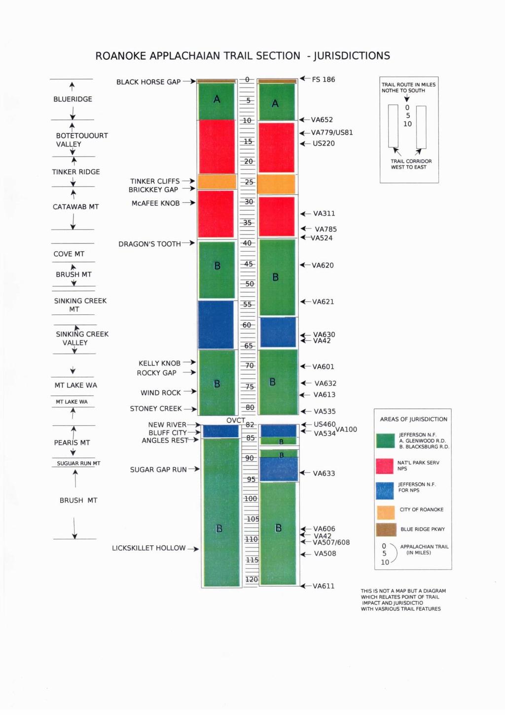
23 19
24 3 (E) OVERVIEW OF DELEGATED RESPONSIBILITIES The preceding portion of this Management Plan has identified the RATC section of the AT and its various associated management areas, and has described the roles of the different management partners. The succeeding portion of the Plan will describe the policies formulated by the RATC for management of the Trail. The responsibilities of RATC and the FS and ATC for specific tasks relating to the Trail on the Jefferson National Forest (AT Special Management Area 1) are summarized in the Appendix F, Table 1. The responsibilities of RATC and the FS and ATC for special tasks relating to the Trail on the FS acquired NPS lands of Sinking Creek and Pearisburg (AT Special Management Area 1A) are summarized in the Appendix F, Table 2. The responsibilities of RATC, ATC, and NPS for specific tasks relating to the Trail and the Catawba Mountain-Daleville Corridor lands are summarized in the Appendix F, Table 3. 20
25 PART 4 MANAGING THE PHYSICAL TRAIL 21
26 4 (A) TRAIL MAINTENANCE The club continues in its traditional role of maintaining its section of the AT with back up assistance from partners on major projects. ATC Trail standards are endorsed by the National Park Service and the Forest Service. The RATC fully subscribes to the following guiding principle as set forth by ATC in 1979: The Appalachian Trail in its entirety shall be kept forever open, obvious and narrowly passable for hiking. The tread way shall pass lightly over the land to provide for the least disturbance to the natural setting. The Trail shall be marked and cleared to offer passage that may be both enjoyable for the reasonably prepared and in harmony with the natural environment so that a hiker unfamiliar with the area can discern the direction of the route and the location of water sources and facilities. Trail maintenance is achieved through a system of overseers. The Trail is divided into approximately 27 sections, ranging from 3-6 miles in length. One or more club members are assigned to each section. The overseers clear, blaze and maintain the tread way of their sections of the Trail in conformity with the standards set forth by the Conference in 1979 and stated in the ATC s stewardship manual, Trail Design, Construction, and Maintenance (1981). In order to ensure adequate maintenance, the entire length of the trail is inspected at least twice per year and club work trips are scheduled where and when needed. RATC continues to strive to improve the effectiveness of its trail overseer system. Overseers are encouraged to assume as much responsibility for their section of trail as they are able to handle. The Club Trail Supervisor, who serves as chairman of the overseer committee, makes assignments and re-assignments of overseers as necessary. The Supervisor is responsible for coordinating trail work with the Forest Service district rangers and with the ATC. The Trail Supervisor also coordinates club trail work activities and supplies overseers with tools and paint for use on their trail sections. 22
27 4 (B) Accessibility After passage of the Architectural Barriers Act (1968), implementation guidelines were initially developed to address issues only in highly developed environments. Since the mid-1990 s, the Access Board has been developing guidelines for the recreational environment, including the backcountry trails. The Access Board has involved the trails community and land management agencies in the process. ATC has been heavily involved in the proceedings and has kept RATC and other clubs informed throughout. The USFS has developed a set of guidelines (Forest Service Trails Accessibility Guidelines, FSTAG), and Forest Service Outdoor Recreation Accessibility Guidelines (FSORAG), finalized in May 2006, which will be incorporated as an amendment to FS Manual RATC has pro-actively sought to identify segments of the A.T. in Georgia that might be appropriate for universal design, which enables access by some persons with disability. As needed, RATC will make Trail shelters and privies accessible and will consider accessibility issues in all new facility construction. RATC recognizes that persons with disabilities should be able to use and enjoy the A.T. where appropriate, and that technological advances in design of equipment that would allow disabled persons to access the backcountry have occurred and will likely continue. RATC is also strongly committed to managing the A.T. as a primitive footpath that lies lightly on the land. RATC has supported the guidelines in the FSTAG/FSORAG documents that indicate that the fundamental character of a trail or the trail environment should not be altered to provide disabled access. 23
28 4 (C) RELOCATIONS The Optimal Location Review, as defined in the Jefferson National Forest Resource and Management Plan, will serve as the primary guide for decisions involving relocations. The RATC Trail Supervisor, the board, and interested club members will work with agency partners and ATC in determining the best route for the trail. Major criteria to be observed are quality of hiking experience, safety, environmental impact, and trail protection. Variables, such as economic and social values, will be considered in addition to the optimal location and will be considered in evaluating all alternatives. NEPA review and approval is required in advance of all proposed relocations. See inventory of prospective trail relocations in Action Plan (Part 7.) The primary responsibility for Trail construction work on all relocations rests with RATC and ATC through its Konnarock Crew Program. 24
29 4 (D) SIGNS For National Forest Management Areas 1 and l-a, signing needs are coordinated with the district rangers. The Forest Service purchases most signs and the club erects them. On the Catawba-Daleville corridor, RATC is responsible for manufacturing, erecting and maintaining signs. Signage needs are determined by the Trail Supervisor, Section Overseers, appropriate partners, and interested Board members. Signage concerns are discussed at the annual spring overseers meeting. The RATC President will appoint a club member to be responsible for the sign program. Directional signs with distances are made of wood. These will be placed near trailheads, road crossings, trail intersections, and shelters. These will be located out of sight of roads. To discourage theft, identification signs will not be placed at significant trail features but only used as destination points on directional signs. The trails to McAfee s Knob and Dragons Tooth will have prominent signage in their parking lots and along the trail to inform hikers of mileages, etc. This is due to the large number of inexperienced hikers using these trails. Regulatory signs, to the extent available, will be standardized, professionally made signs supplied by ATC, the National Park Service, or the Forest Service. Where applicable, such signs will be placed at road crossings and trailheads. Such signs, when made individually, will be posted in clusters to reduce sign pollution. On interior locations along the Trail, regulatory signs will be placed at shelters, bulletin boards, and specific locations where problems or concerns have been identified. All developed water sources will have the standard Forest Service sign Water should be boiled or treated chemically before use. 25
30 4 (E) STREAM CROSSINGS AND BRIDGES Most of the streams crossed by the AT on the RATC section are small and nonhazardous even during periods of high run-off. Bridges over streams less than 10 feet in width are considered necessary only when the crossing presents a personal danger, or where unavoidable trampling and bank breakdown of fragile terrain occurs from use. Bridges should have a rustic appearance and be constructed in consultation with agency partners, with hiker safety the primary consideration. RATC policy is to construct a foot bridge over streams greater than 10 feet with a single span stringer using crib supports on each stream bank. Stringer logs are usually covered by a board deck. Adult and child railings should be provided where the bridge deck is over 3 feet from the ground. With larger bridges engineering expertise and construction assistance and environmental assessment will be sought from the appropriate agency partner. In National Forest Management Areas I and la, bridges over 20 feet or more than 3 feet off the ground must he approved by the JNF engineering section, must receive an environmental assessment by the FS, and must be inspected for maintenance and safety needs on a five year schedule. On NPS lands, these standards apply to bridges greater than 35 feet. RATC bridge maintenance policy is to perform minor repairs on USFS bridges in consultation with the FS, if requested. RATC will do all maintenance on club constructed bridges on the NPS corridor. These bridges will be inspected periodically for signs of wood deterioration and stability of hand and bridge supports. Bridges will be inspected annually by the appropriate overseer for safety, and repairs will be given high priority. The numerous bridged stream crossings in the Roanoke section, together with the primary responsible party, are listed on the following page from north to south. STREAM CROSSINGS AND BRIDGES (North to South) PARTY RESPONSIBLE FOR AREA STREAM TYPE BRIDGE MAINTENANCE Botetourt Co. Wilson Creek None necessary Botetourt Co. Curry Creek None necessary 26
31 Troutville Buffalo Creek Wooden foot bridge RATC Daleville Tinker Creek Concrete bridge NPS Botetourt Co. Sawmill Branch 2 crossings/no bridges needed Roanoke Co. Catawba Shelter Br. Wooden foot bridge RATC Roanoke Co. Unnamed tributary Catawba Creek Wooden foot bridge RATC Roanoke Co. Catawba Creek Wooden foot bridge RATC Roanoke Co. Morehead Run Wooden foot bridge RATC Roanoke Co. Small unnamed stream Culvert galvanized iron (VA 624) VDOT Craig Co. Trout Creek wooden foot bridge RATC Craig Co. Craig Creek Tributary Wooden foot bridge RATC Craig Co. Craig Creek Tributary Wooden foot bridge RATC Craig Co. Craig Creek Tributary Wooden foot bridge RATC Craig Co. Craig Creek wooden foot bridge USFS Craig Co. Lee Hollow Branch wooden foot bridge RATC Craig Co. Keffer Branch Wooden foot bridge RATC Craig Co. Sinking Creek Highway bridge (VA 630) VDOT Craig Co. Branch of Sinking Cr. Foot bridge RATC Craig Co. Laurel Creek Foot bridge RATC Giles Co. John s Creek wooden foot bridge RATC Giles Co. War Branch None (foot log needed) USFS Interior Stony Creek Wooden foot bridge USFS Pearisburg New River Highway bridge (US 460)VDOT Bland Co. Dismal Creek wooden bridge RATC Bland Co. Kimberling Creek Suspension bridge USFS 27
32 4 (F) TRAILHEADS AND PARKING Parking facilities will be kept to the minimum necessary for safe and adequate accommodation of hikers. The club periodically monitors current parking facilities for adequacy, safety, vandalism, and littering and works with the appropriate agencies (which includes the State Department of Transportation) to develop simple, safe and functional parking areas. Trailheads are marked clearly with the appropriate standard signs. Extensive, informative signing materials are not, in general, placed at parking lots but are placed discreetly back along the trail to minimize vandalism. (See sign policy in Section 4(D) for further information.) Trash cans are discouraged because regular pick-up is not available. A listing of the Trail highway crossings and related parking facilities is given on the following pages from north to south. Also indicated on the table is the agency primarily responsible for maintenance of the indicated parking area. Regardless of the primary partner, club policy is to do its best to keep clean ALL parking facilities which are servicing the Trail. The design and construction of any new parking facilities will be coordinated with and approved by the appropriate agency partners. If necessary, RATC will obtain a highway access permit from the Virginia Department of Transportation for any new parking area that is accessed from a state road. ROAD CROSSING PARKING FACILITY AGENCY FS 186 (Blue Ridge) Gravel lot each side of Blue Ridge Parkway BRP (4 6 cars) FS 191 (Blue Ridge) Wide shoulder, gravel road FS VA 652 (Botetourt Valley) None US 11 (Botetourt Valley) Gravel lot (8 cars) RATC VA 779 (Botetourt Valley) VA 653 (Botetourt Valley) None None US 220 (Botetourt Valley) Daleville Park and Ride - 40 cars VDOT VA 311 (Catawba Mountain) Paved gravel lot 24 cars RATC VA 785 (Catawba Valley) None 28
33 VA 624 (Catawba Valley) Narrow dirt spaces 2 to 3 cars VDOT VA 311 No road crossing Dragons Tooth, dirt parking lot FS At 2 1/2 mi cars VA 620 (Trout Creek) Road shoulder and dirt lot 5 6 cars VDOT VA 621 (Craig Creek Valley) Dirt lot, 4 5 cars FS VA 630 (Sinking Creek) Gravel and grass lot 4-5 cars FS VA 42 (Sinking Creek Valley) Several wide gravel areas VDOT VA 601 (Rocky Gap) Several wide gravel areas FS VA 632/FS 156 (Johns Creek Valley) Gravel lot, 4 5 cars FS VA 613 No road crossing War Spur side trail parking lot FS 2 1/2 mi. 6 cars VA 613 (Salt Sulphur Turnpike) Large grass and gravel parking area FS FS 734 (Bailey Gap) None VA 635 (Interior) Numerous pull offs for fishermen VDOT on Stony Creek VA 635 (Pine Swamp Bridge) Lot, 3-4 cars USFS US 460 (New River) Large shopping center lot opposite Private VA 100 Parking Room for about 10 cars RATC VA 634 (Pearisburg) None VA 663 (Sugar Run Gap) Wide gravel shoulder, 5 6 cars VDOT FS 201 (Dismal Creek) None VA 606 (Kimberling Creek) Wide gravel road shoulder, 5 6 cars VDOT VA 608 (Lickskillet Hollow) Gravel lot, 8 cars VDOT VA 611 Gravel shoulder, 3-4 cars VDOT 29
34 30
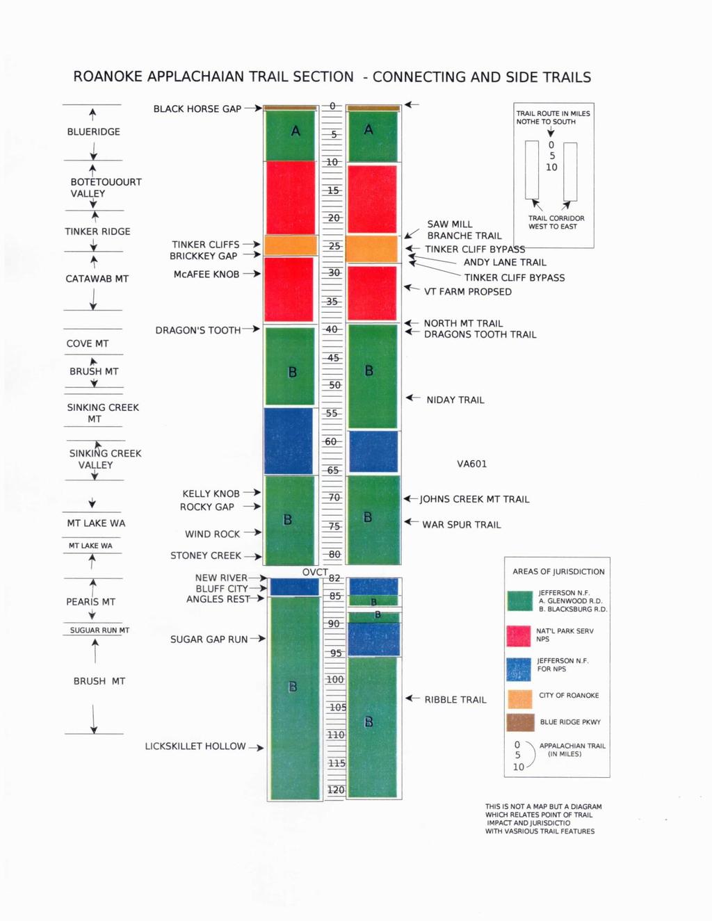
35 4 (G) CONNECTING AND SIDE TRAILS Trails leading to water sources, shelters, and viewpoints are considered an integral part of the Appalachian Trail. They are blue-blazed and maintained to accepted Trail standards. The RATC endorses the connecting and side trails policy adopted by the ATC Board of Managers in November This policy, which is included in Section 2(F) of the ATC Local Management Planning Guide, outlines a process and specific criteria for official designation of any trail connecting or co-aligned with the Appalachian Trail. In general, the RATC is in favor of the development and maintenance of selected designated connecting trails. Alternate hiking routes and variable access points add variety to the hiking experience and lessen the impact on the main Trail. Each trail should be strictly limited to foot traffic and should be so protected by appropriate barricades and signs. Connecting and side trails which are maintained by the Roanoke club are listed from north to south as follows. TRAIL NAME TERMINUS LANDHOLDER Curry Creek Trail (AT FS 634) USFS Sawmill Branch Trail (Tinker Ridge-Carvins Cove) NPS/City of Roanoke Andy Layne Trail (VA 799 Scorched Earth Gap) ATC/Private Tinker Cliff Bypass (AT at Brickey s Gap - AT City of Roanoke / NPS at City of Lamberts Meadow) ; North Mountain Trail (VA 311 VA 799) USFS Two Access Trails: Dragons Tooth Trail (VA 311-AT at Lost Spectacles Gap) USFS Scout Trail (Dragons Tooth Trail AT) USFS Niday (AT to PS Hall Road) USFS Johns Creek Mt. Tr. (Rocky Gap - VA 658) USFS War Spur Trail (VA 613-Mt. Lake Wilderness) USFS Church Hospice (AT Pearisburg) Town of Pearisburg/ USFS 31
36 Ribble Trail (Dismal Creek-Flat Top Mt.) USFS 32
37 33
38 4 (H) OVERNIGHT USE - SHELTERS, CAMPSITES, PRIVIES RATC is responsible for general maintenance and clean up of shelters and camping sites in its area. These areas shall be monitored for overuse, abuse, and environmental impact by the appropriate overseer and the shelter supervisor. On the Trail within the Jefferson National Forest or on National Park Service lands administered by the Jefferson National Forest camping is allowed in accordance with Forest Service policy. In these sections, the club policy is to work with the Forest Service staff in monitoring areas for excessive impact in order to mitigate adverse effects on the Trail and its environment. This will be done through the Trail Assessment Process, the planning of trailhead and overnight facilities, and controlling vehicular access into the management area. On the Catawba-Daleville corridor, camping and fires are allowed at designated campsites only. The Daleville corridor extends north from Route 624 in Roanoke County to Route 652 in Botetourt County.Overnight stays longer than two consecutive nights at any one particular facility is prohibited unless specifically allowed with written permission by an elected club officer. These designated sites are identified on appropriate maps at trailheads, in the club s descriptive trail literature, and by signs in the field. Signs indicating no camping and no fires are placed at other sites as needed and are made as unobtrusive as feasible. The maximum overnight camping group size limit in the Catawba-Daleville corridor is ten. The maximum group size limit for day hikers in the Catawba- Daleville corridor is 25. Groups larger than the maximum sizes are prohibited. Alcohol usage is also prohibited in the Catawba-Daleville corridor. The club does not plan to propose any more shelters on its section of AT at this time; however, it will respond to increased needs as necessary. In the National Forest, the district ranger or ATC would be in charge of funding for a new shelter, and the club would provide the labor. On the NPS corridor, the ATPO must approve the shelter. Each shelter proposal will be evaluated individually using criteria outlined in the ATC Checklist for the Location, Design and Construction of Shelters and Campsites in the U.S. Forest Service Manual Supplement for Region S. Proposed new or relocated shelters will be submitted to the ATC Southern Vice- Chair with appropriate approvals from the land managing agency. Shelter construction would conform to the principles which were observed with RATC s other shelters. This will involve an initial evaluation and planning with the 34
39 appropriate agency partners. Shelters are accessed by blue-blazed trails located away from the AT, close to reliable water sources, in such a manner to protect the water sources. They are supplied by a discreetly placed privy. Shelters should be as far away as possible from vehicular access and commodious enough to accommodate at least six hikers. A campsite is defined as an area specifically set aside and developed to accommodate campers. It does not refer to shelter clearings, even though tenters will naturally gravitate to these areas. Camping and campfires at undesignated spots along the trail should be discouraged. This increases the impact on the vegetation and land along the trail. Fire rings at undesignated camp sites should be broken up and any trash located in them removed. RATC does not oppose the use of shelter clearings for tenting per se, but recognizes the risk of environmental deterioration from excessive use of this practice. Thus, it is RATC policy to monitor its shelter environs and respond to excessive camping impact by developing dispersed facilities for campers in the form of campsites with cooking grills and picnic tables, at least several hundred yards away from the affected shelter site. Use of these facilities is encouraged by appropriate signing. Criteria for development of camping sites are: demonstrable need, accessibility to the AT, minimal environmental impact, location at least one mile from public vehicular access, and reliable water source. On NPS corridor lands, dead and dying trees (hazard trees) within 125 feet of designated shelters and campgrounds will be identified and removed each year by RATC. The FS is responsible for this process on FS administered lands. RATC will construct and maintain privies at each shelter site in accordance with accepted back country sanitation standards, as outlined in Back Country Facilities: Design and Maintenance by Leonard, Spencer and Bromley. (This is an AMC publication.) and Back Country Sanitation Manual (ATC Reference Material). The appropriate trail overseer and shelter supervisor share the responsibility of monitoring the privies. When a privy requires relocation, this is done as a club project under the supervision of the Shelter Supervisor in consultation with the ATC to determine environmental impacts. Shelter associated campsites have been specifically developed at the Campbell and Catawba shelters. The shelter privies serve as sanitation facilities for these sites. While the RATC does not encourage large group usage of the Trail and facilities, such use eventually occurs, and when a large group plans to overnight at Campbell Shelter, it will be encouraged to use the large open field under the power line close to the shelter in order to protect the shelter setting. For a complete north to south inventory of overnight facilities on the RATC section of the AT, see below. INVENTORY OF OVERNIGHT FACILITIES 35
40 LOCATION SHELTER PRIVY CAMPSITE* 1. Wilson Creek Wilson Creek Yes No 2. Fulhardt Knob Fulhardt Knob Yes No 3. Carvins Cove Lamberts Meadow Yes Yes 4. McAfee Knob Campbell Yes Yes 5. McAfee Knob. Catawba Yes Yes 6. Catawba Mt. Johns Spring Yes No 7. Millers Cove Pickle Branch Yes No 8. Sinking Creek Mt. Niday Yes No 9. Sinking Creek Mt. Sarver Cabin Yes No 10. Laurel Creek Laurel Creek Yes No 11. Mountain Lake War Spur Yes Yes Wilderness 12. Bailey Gap Bailey Gap Yes No 13. Doc s Knob Doc s Knob Yes No 14. Dismal Creek Valley Wapiti Yes Yes 15. Brushy Mountain Jenny Knob Yes No * See text for definition of Campsite. 36
41 37
42 4 (I) WATER SOURCES It is the club s policy to maximize use of the few reliable water sources in its section. Water sources are identified for hikers in the club s descriptive written material and on the ground by appropriate signing and blue blazing of access trails. The information is accompanied by warnings to treat all water before consumption. The club does not and cannot guarantee the quality or potability of surface water sources. However, the club attempts to protect its identified water sources from contamination by careful planning of trail facilities and by regular monitoring of the sites. These sources typically are maintained in an undeveloped condition, or improved minimally by the construction of a catch basin or spring box to improve collection of the water. Any surface water source that appears susceptible to contamination will be tested for bacteriological contamination on a regular basis. The club will request funds from ATC for full spectrum tests of any water sources that could be contaminated by heavy metals or other chemical contaminants. All identified and improved water sources on all NPS lands are supplied with signs warning hikers to treat water before use. 38
43 4 (J) SANITATION To ensure proper sanitation along the trail it is very important to establish a barrier between feces-borne pathogens and backcountry water supplies. Human waste must be contained in a well-sited sanitation facility. Along the A.T. the most common type of sanitation facility is the pit toilet or pit privy. It is RATC policy to install and maintain pit prives at all shelter sites. The pit privies will be inspected at least annually to ensure they are in good repair. Pit privies located along section of Trail that have heavy day-use will be inspected more frequently. When a pit privy needs to be moved the club will follow ATC published guidance on determining the new location for the privy. A list of pit privies maintained by the RATC is contained in section 4 (H). 39
44 4 (K) SAFETY Trail maintenance and construction activities often require use of sharp tools, heavy lifting, and technical knowledge and skill. These activities also often take place in fairly remote locations, and occasionally take place in inclement weather. Workers must practice safe work habits to insure personal safety and the safety of others. The RATC considers safety to be of prime importance in carrying out its trail management and maintenance duties. All RATC members are expected to follow safe work practices while participating in RATC sponsored activities. RATC members are strongly encouraged to practice safe work habits, wear appropriate protective clothing and utilize protective equipment as they pursue their maintenance activities. Where appropriate, all trail maintainers should be encouraged to wear hardhats, eye protection, gloves, shin guards, and boots with skid-resistant soles, and such other equipment as will enhance safety. A first aid kit will be carried on all club-sponsored work hikes. RATC members will receive first aid/cpr, chain saw, and or crosscut saw training before using these saws in any RATC maintenance activity. The club will maintain a list of trail maintainers who have received chainsaw and cross cut saw training and certification and when those certifications expire. Before beginning work on Club sponsored work trips, a discussion on safety will be conducted for the benefit of all participants. A list of members has been submitted to our agency partners. This registers all members as Volunteers in the Forest, eligible for Federal Workers Compensation in the event of an injury. All accidents should be promptly reported. 40
45 PART 5 PUBLIC USE, PUBLIC INFORMATION AND EMERGENCY RESPONSE 41
46 5 (A) PUBLIC INFORMATION The A.T. is a public resource and dissemination of information pertaining to its physical location and education concerning the use of this resource are the responsibility of the organizations that manage it, including the RATC. The club has a display booth and participates in outdoors-related functions as well as putting on workshops. Requests from other groups for educational programs or trail-related exhibits are also honored. The club maintains a permanent post office box mailing address in order that accurate and timely information may be supplied on request. This duty is performed by the club treasurer who inspects the box on a weekly basis. An information packet, which includes an attractive club brochure and current hike schedule, is supplied to those requesting information about the club. The Club has developed a New Member Package which is supplied to persons inquiring about the Trail. The club has several bulletin boards at trailheads exhibiting area maps and regulations. These are also used to inform people of trail location details and also to educate them concerning appropriate use of the trail both from the perspective of hiker safety and from the aspect of resource protection. The club has a website, to provide the public with information about both the club and the AT in Virginia. Information includes a list of club activities, description of the RATC portion of the AT, a list of hikes, trail maps, hiking tips, and links to other club sites as well as to the ATC web, and contact information for club officers. 42
47 5 (B) EMERGENCY PLANNING AND COORDINATION Responses to law enforcement, fire control and search and rescue emergencies are dependent upon the established jurisdictions for the lands on which the A.T. is located. These responses are outside the capability of the RATC. The Catawba Mountain Daleville corridor is federal land and is under the protection of state and county agencies. Federal agents have proprietary jurisdiction on these lands. State and local laws and regulations apply. Thus, the primary responsibility for search and rescue operations, law enforcement, and fire control rests with the county sheriffs with assistance of local rescue squads, and if appropriate, is coordinated by the State Police and State Forester. ATC and RATC are authorized to represent the interests of the National Park Service on corridor lands in the RATC section, but may not take any law enforcement action. The Forest Service enforces federal regulations pertaining to land use on its Management Area 1 and 1A lands. The enforcement of civil and criminal laws remains in the domain of state and county units. Search and rescue rests with county sheriffs, assisted by rescue teams and the Forest Service. The Forest Service can enforce state laws in the area of hunting because of a long standing agreement with the VA Department of Game and Inland Fisheries. With one exception, the Forest Service has no formal agreement or jurisdiction for management of the National Park Service Catawba Mountain-Daleville corridor, but will be available for consultation if requested. A formal agreement between the Jefferson National Forest and NPS for fire suppression in this area has been developed. Through its programs of dissemination of information to the public about the trail system and facilities, the club aims to minimize emergency situations. A listing of emergency contacts can be found at the front of this Plan. The RATC will report any significant incidents, as soon as practically possible, to the Appalachian Trail Conference and the National Park Service. RATC continues the policy of maintaining the Catawba Mountain fire road in a primitive condition, passable with high clearance vehicles, as long as it is feasible within the limited constraints of the club s resources. The fire road serves as a valuable route to the high-use McAfee Knob area to deal with emergency situations. 43
48 5 (C) SPECIAL EVENTS AND LARGE GROUP USE In general, large group activities and fund raising exercises are inconsistent with the purposes of the Trail as a wilderness footpath and are opposed by RATC. Hiking groups staying over night on the Trail are encouraged to limit their party to ten persons and day groups should be encouraged to limit themselves to twentyfive. User conflicts can occur when large groups fill trail shelters, leaving no room for individual hikers. In wilderness areas federal regulations limit group size to 10 people The maximum overnight camping group size limit in the Catawba-Daleville corridor is ten. The maximum group size limit for day hikers in the Catawba- Daleville corridor is 25. Groups larger than the maximum sizes are prohibited. Alcohol usage is also prohibited in the Catawba-Daleville corridor. The Daleville corridor extends north from Route 624 in Roanoke County to Route 652 in Botetourt County. On National Forest lands Special Use Permits are required for recreational events and commercial use of the Trail. 44
49 5 (D) ATC RIDGE RUNNER PROGRAM The Appalachian Trail Conservancy will provide a Ridge Runner on Catawba Mountain and Dragon s Tooth from April through November, funding permitting. RATC will work closely with the Ridgerunner and receive weekly reports from ATC. The main objective of the Ridge Runner Program is to prevent misuse of The Trail and its environs. This is achieved by educating the hiking public in good Leave No Trace hiking and camping practices and by monitoring the AT and fire road between Highway 311 and McAfee Knob and the trail up to Dragon s Tooth for progressive signs of misuse or overuse in order that appropriate corrective measures may be taken. The Ridgerunner patrols the Trail on Saturdays and Sundays during the high use months. Optimum time for patrol will be from mid-late morning, for eight hours, timed so that some of the activity can involve the late afternoon and early evening times. In order to establish a somewhat official appearance and to reassure people approached on the trail, ATC will outfit the Ridge Runner with a uniform shirt with a name badge, and shoulder patches designating AT Ridge Runner, and RATC or AT insignia should be obvious either on clothing or pack. RATC will provide the Ridge Runner with a club patch. The Ridge Runner should carry a map of the area, informative brochures, trail guide book, maps of available bike routes, a small first aid kit (however, should avoid giving medicines), extra water, several snacks, and a flashlight. The Ridge Runner should be familiar with the club maintainers in the area. They should also have the club emergency call list and should be familiar with how to contact the Sheriff and Fire Warden for emergencies. The Ridge Runner should hike the section between Dragon s Tooth and Daleville, spending the majority of the time on the Trail and fire road from Highway 311 to the McAfee Knob area and the McAfee Knob 311 parking lot and Dragon s Tooth area. He/she should be able to offer general information of the trail system, parking areas, shelter sites, water sources and points of interest. He should take every opportunity to advise people in a friendly, informal way regarding trail stewardship and the importance of observing the area regulations and the reasons for the regulations. Keep a rough tally of number of hikers encountered each weekend. 45
50 The Ridge Runner should inspect the shelters and campsites on a regular basis to observe for overuse and environmental deterioration and be prepared to advise campers on low-impact camping techniques. The water sources should be inspected regularly to be sure that they are in clean and working order. The Ridge Runner should keep a rough tally of the use of the Highway 311 parking lot in order to determine ongoing needs. The Ridge Runner should monitor all the directional signs and report any damaged, vandalized or missing signs. The Ridge Runner should be prepared to carry out minor chores such as picking up trash around the parking lot or along the trail, and perform minor clipping or brushing of the trail. The club will provide the Ridge Runner with a small hand saw. The Ridge Runner should take the opportunity at all times to act as a good PR person for the local club, the ATC and the National Park Service. The Ridge Runner should file a report weekly and at the end of the season documenting specific incidents, general activities, problems and recommendations for improvement. 46
51 5 (E) Minimum Impact Backcountry Use The RATC endorses the philosophy of Leave-No-Trace (LNT) trail usage. We have posted LNT information on all trail side bulletin boards maintained by the club. We also have LNT information on our web site. The club distributes a LNT to all new members and has conducted training sessions on LNT principles for its members. 47
52 PART 6 CORRIDOR MANAGEMENT AND MONITORING 48
53 6 (A) MOTORIZED AND MECHANIZED USERS The RATC vigorously supports the view that the presence of motorized and mechanized vehicles, including ORV s, ATV s, four wheel drive vehicles, bicycles and snowmobiles on the Trail is incompatible with the purposes of the Trail. Forest Service policy dictates that motorized vehicles are permitted in the forest only on roads and trails which have been designated for their use. All motorized vehicles as wells as bicycles are barred from the Trail on the Jefferson National Forest through adoption of the Forest Land and Resource Management Plan. The National Park Service regulations in the Code of Federal Regulations specifically prohibit mechanized vehicles on the NPS acquired corridor. In the RATC section, vehicular activity on the Trail and corridor lands is limited to administrative needs, emergencies, and to those few land owners who hold Special Use Permits for regulated motorized activities as defined by Special Use Permits issued by the National Park Service. Certain landowners possess highly structured access rights which are defined in the deeds by which the land was acquired. The RATC maintains 22 locked gates on both the Catawba Mountain-Daleville and Forest Service administered NPS lands. These gates curtail access routes to the Trail corridor where a potential hazard for unauthorized vehicular intrusion exists. Signs have been placed where appropriate. See master lock inventory in Appendix E for a detailed listing of locks. Further, tank traps and other means of obstruction are utilized as appropriate. It is the club s policy to continue monitoring all of the National Park Service corridor closely for unauthorized vehicular activity through the regular club monitors and trail neighbors. Enforcement of these regulations is recognized as a problem for the RATC and the club policy is to proceed with efforts of information, education, and signing. The club will also continue its policy of maintaining communications with the appropriate local law enforcement agencies and will be prepared to enlist the active intervention of these parties if, after consultation with the club s agency partners, such strong measures are necessary. 49
54 6 (B) LITTER AND GRAFFITI Littering and graffiti are illegal on all federal lands. Littering is not a major problem on the Roanoke section of trail except at highway crossings, parking lots and, to a lesser extent, shelters. The club policy is to monitor these areas frequently and keep them as clean as possible. Regular inspections of trouble spots are built into the job descriptions of NPS assigned volunteers in the Park, and also into the Ridge Runner Program. It is the club policy to avoid supplying receptacle bins and trash cans anywhere in this section because of the non-availability of regular trash removal services. One rocky outcrop (Hay Rock) is the site of extensive graffiti which has been covered up. 50
55 6 (C) HUNTING Hunting regulations relating to the Trail are determined by the policies of the appropriate land management agency. Hunting is a traditional form of recreation in the National Forest and is permitted on National Forest Management Area 1 and 1-A lands. Hunting laws are mandated by the state, but regulations are also enforced by federal personnel through a cooperative agreement with the Department of Game and Inland Fisheries. Hunting is prohibited on ALL lands administered by the National Park Service, including the Catawba-Daleville corridor. In those parts of the corridor in the Sinking Creek and Pearisburg areas which are administered by the Forest Service, hunting is permitted in conformity with Forest Service policy. Hunting is prohibited in the Roanoke watershed by a City ordinance. The club recognizes the policies in the various jurisdictions. Hikers shall be encouraged to wear blaze orange and to use extreme caution during hunting season. No Hunting signs shall be posted on National Park Service boundaries. The importance of educating club members as to the potential dangers during gun season for deer is recognized. Because of the proximity of private land to the NPS corridor, signs warning hikers to wear blaze orange will be posted during hunting season at developed trailheads to the NPS corridor, together with the dates of each hunting season. The difficulty in enforcing No Hunting regulations on the National Park Service Catawba-Daleville corridor is acknowledged. The club will follow a policy of informing the public of National Park Service regulations by signs, club publications and direct discussions. It will also maintain a working relationship with local law enforcement agents and State Game Wardens and be prepared, if necessary, to enlist these organizations in the prosecution of violators, after consultation with Appalachian Trail Conference and National Park Service. 51
56 6 (D) HORSES AND PACK ANIMALS The use of horses and pack animals, including llamas, on the Appalachian Trail is prohibited in the Code of Federal Regulations and State Law. National Park Service regulations also prohibit these animals on Trail corridor lands. RATC recognizes that the use of these animals is very detrimental to the Trail and to the experience of trail hikers, and will vigorously oppose their use both on the Trail and in the corridor. Through the concerted efforts of gating access routes, signing, and discussion with horseback riders, horses are not perceived as a serious problem on the Roanoke section of AT at the present time. The club will work with the Forest Service in trail planning and design so that future horse trails in the forest will not impact on the Trail environment. In two sections of trail in the Roanoke area (Wind Rock and Dismal Creek) where foot trail and horse trail exist close together, impact has been minimized by appropriate trail design. Local club monitors will observe these situations to determine if further precautions (such as the fence installed at Dismal Creek) are necessary. 52
57 6 (E) ROADS Roads have great potential to destroy the remote and primitive nature of the Appalachian Trail. The RATC will oppose the construction of any new road which impacts on the Trail unless the road is found, (after thorough study by the involved agencies,) to be the only feasible and prudent alternative. The club will consult with ATC and will provide input on how the proposed road could affect the Trail environment. The club will also help search for ways to mitigate the effects of the new road on the Trail environment. New road construction is not to be expected on National Park Service lands. New road construction on Forest Service lands within the Appalachian Trail management area is expected to be minimal and consistent with the semiprimitive, non-motorized category as defined in the US Forest Service Recreation Opportunity Spectrum guidelines. Any new road construction within the Jefferson National Forest within 1/2 mile of the Trail will require a formal environmental assessment. RATC policy will be to involve both itself and ATC in the assessment, again, looking to the standard only feasible and prudent alternative in these deliberations. The RATC will encourage permanent closure and rehabilitation of all unused woods roads within the National Forest AT Management Area and on all NPS corridor lands. Those forest roads which are required to remain functional, either because of Trail administrative purposes or because of Special Use Permits, shall be closed and controlled by locked gates. Trail crossings of public roads are listed in the Trailheads and Parking section. 53
58 6 (F) SPECIAL USE OF TRAIL LANDS Special Use Permits can be issued by the National Park Service and the US Forest Service to allow activities by private individuals on federal lands. It is important for the club to recognize that the primary purpose of a Special Use Permit is to further the protection of the Trail environment and enhance the Trail experience. These permits are highly structured, revocable, and of short term. On the RATC section of AT, most of the permits are issued for grazing and agricultural use in order to maintain open pastoral settings. RATC recognizes its responsibility in monitoring the activities of permitees to insure that the provisions of the permits are being observed. An inventory of Special Use Permitees, both on the NPS corridor and in the National Forest AT Management area, is presented on the following page. 54
59 55
60 6 (G) UTILITIES AND COMMUNICATIONS FACILITIES Electrical transmission lines, telephone lines, and gas pipelines cross the RATC section of the Appalachian Trail. In general. these structures are detrimental to the remote and natural setting which characterizes the Trail experience, but are largely unavoidable, having been in place for a considerable time before the AT came into being. Any future major utility crossing of the Trail will require environmental impact studies. The Roanoke Club will cooperate with its management partners in assessing the impact of such a corridor on the Trail environment and will examine and suggest ways to mitigate this impact. Local club monitors and Trail neighbors will maintain a vigilant watch for proposed communications structures on adjoining private lands which may disrupt the natural scene and will work with ATC in attempting to convince local zoning boards and utility and agency officials on not taking actions which compromise the scenic value of the Trail. The club also recognizes the disruptive effect of utility right of way maintenance on the Trail. This may take the form of spraying, tree cutting, and indiscriminate destruction of vegetation around the Trail. The club shall attempt to develop an understanding with the local utility companies so that the maintenance of the right of way in the area of the Trail may be assumed by club members. 56

61 57
62 6 (H) STRUCTURES During the land acquisition process, the National Park Service acquired incidentally a number of diverse man-made structures. Some structures are of significant monetary value. Some structures have long been abandoned and are in varying degrees of deterioration, and represent significant safety hazards and potential sites for vandalism. Although management decisions regarding some of these structures may be complex, the overriding consideration is whether the structure is compatible with the purpose and values of the Appalachian Trail. In these cases, the club will observe to insure that management of the property is compatible with the objectives of management of the remainder of the Trail corridor. The corridor contains one house in which lifetime occupancy by the previous owner has been retained, the J.C. Arney, Daleville tract. That house has recently been vacated and will be removed at some point. One home has been preserved and is occupied by a tenant under a Special Use Permit issued by the National Park Service. This is the Hunley Home- Daleville, tract # In this case the club, together with its agency partners, has determined that, on a temporary basis, it serves the best interests of the Trail and its corridor to retain individuals in these homes in the capacity of observers and custodians of the Trail and corridor. Although these people are expected to maintain the structures in good condition, this is viewed as a secondary purpose of the occupancy. Several other structures on the corridor, such as deteriorating abandoned farmhouses and barns, are judged by the club to be of no redeeming value to the Trail.. By law, if a structure is over 50 years of age, it requires formal evaluation for its value as a national historic site. The club, working with the ATC field representative and the appropriate agency partner (NPS or USFS) shall evaluate each structure individually with the aim of preservation or removal either by controlled burning or demolition, returning the site to a natural condition. 58
63 59
64 6 (I) CORRIDOR MONITOR PROGRAM Outside of existing national and state parks and forests, much of the A.T. footpath is laid upon a narrow corridor of public land that threads its way between privately owned lands. In some cases, the federal or state agency may have acquired only an easement. In other cases, the landowner was allowed to retain certain rights to lands that were conveyed to the government. Even within existing national and state parks and forests, the Trail is usually protected only by a narrow management area or protection zone. The Appalachian Trail corridor is extremely vulnerable to encroachments and abuse, such as dumping of trash, off-road vehicle use and damage, timber theft, or illegal building of structures on A.T. lands. An active corridor-monitoring program is essential for detecting encroachments and easement violations and helps discourage many of these problems. The RATC has a major delegated responsibility of ensuring that the properties acquired by the NPS for the Appalachian Trail corridor are protected from unauthorized and illegal uses. Corridor monitoring refers to the act of visiting a selected section of A.T. corridor in the field and reporting on its condition. It includes walking the boundaries using survey maps and compass, inspecting survey monuments, noting the condition of the boundary blazes and signs, keeping a lookout for encroachments, and reporting all of this information. It is the primary line of defense in protecting the both the land base and the surveyed boundary line. Volunteer corridor monitors provide an essential role not only as watchful eyes and ears, but also as a valuable source of education to inform neighboring landowners and local communities of the purpose of the A.T. corridor and the values that these lands protect. Monitors have no law enforcement authority. The RATC Land Management Supervisor is responsible for designing and overseeing a corridor monitoring program which has the following objectives: 1. To develop and maintain an efficient system of records pertaining to all corridor lands. 2. To gather information regularly about the corridor by club members. 3. To establish a system of communications to encourage reporting by club members, hikers, neighbors, agency partners, and officials. 60
65 4. To develop the capability to respond to problems, assist when feasible in the correction of these problems, and to follow-up later to determine if the problems have been resolved. 5. To submit an annual report to the ATC on monitoring activities. Further information on the monitoring program can be found in the ATC publication A.T. Corridor Stewardship Field Book. 61
66 6 (J) Geocaching Geocaching is a high-tech treasure hunting game played throughout the world. It involves participants hiding a cache (a stash of goods) in a remote location and recording its exact position using a hand-held global positioning system (GPS) unit. The coordinates, along with a few helpful hints, are posted online for other geocachers to look up. Then, armed with a GPS unit, enthusiasts seek a route to the site to search for the hidden cache. Because finding the route and the treasure at the end of it is a large part of the attraction of the activity, with the participants multiplying through the power of the Internet, impacts from geocaching are growing. Over the last few years, thousands of new caches have been placed and posted world-wide, and both the number of Web sites dedicated to the activity and the number of participants have grown rapidly. Impacts on sensitive environments or rare plant populations by behaviors such as criss-crossing and trampling an area in order to place or find a cache are of great concern. Damage to specific natural and cultural resources resulting from geocaching can be significant, as well as broader impacts such as visitor created trails and trampling. Geocaching is allowed on NPS lands. However a permit is required. Geocaching requests received by the club will be referred to the ATPO. Geocaches discovered on the trail corridor maintained by the club will be reported to the ATC and ATPO. 62
67 6 (K) BICYCLES Bicycles can cause extensive damage to Trail treadway by creating ruts, displacing soils, and destroying water bars and other erosion-control structures. In areas with wet or poor soils, extensive reconstruction or relocation of the Trail treadway may be necessary to repair the damage caused by wheeled vehicles. In addition, hikers complain of safety hazards associated with meeting individuals riding mountain bikes on the Trail. The Appalachian Trail was conceived, designed, constructed, and intended for use as a footpath. Bicycles are prohibited on National Park Service Appalachian Trail corridor lands by regulation: Appalachian National Scenic Trail The use of bicycles, motorcycles, or other motor vehicles is prohibited. (Code of Federal Regulations, Title 36, Section 7.100). Bicycles are not permitted on any part of the Trail maintained by the RATC. Members or trail maintainers encountering bikers on the trail or damage caused by biker should promptly report the incident to the ATC and the ATPO using an Incident Report Form, found on the ATC web site. The RATC President should be notified also. The club will follow up with our agency partners to determine actions that can be taken to discourage bicycle use on the Trail. Bicycles on the Trail have been an ongoing problem on the northern section of the Trail maintained by the club (from Route 11 to Black Horse Gap). The club has notified our agency partners about this and has posted additional signage. 63
68 PART 7 MANAGING NATURAL, CULTURAL, AND SCENIC RESOURCES 64
69 7 (A) OPEN AREAS AND VISTAS From the Appalachian Trail s beginning, the scenic vistas provided by open areas have been considered one of the most important features of the Trail experience. Over the years, many of those views have been lost through reforestation and abandonment to natural succession from former agricultural uses. Presently, trees and shrubs are rapidly growing in many areas along the Trail that were once open fields and meadows. The concern is that, unless active measures are taken to maintain these open areas, the landscape s diversity will be diminished and, with it, the Trail experience. Today there is basic agreement among all Trail agency partners that significant open areas and vistas should be actively rehabilitated and preserved. The RATC has many outstanding views along its section of Trail and also has sections where the Trail passes through beautiful open meadow lands. A key feature of the NPS land acquisition program was to provide an open pastoral setting for the Trail across Sinking Creek Valley and Catawba Valley, and to reroute the Trail back over the dramatic McAfee s Knob. The club recognizes the importance of maintaining these picturesque features. Special Use Permits have been issued by the NPS and FS for farming and grazing where the corridor passes through inter-mountain valleys. The club recognizes its important role of monitoring these areas to insure that the conditions of the permits are observed and that the open pastoral setting is preserved in its pristine beauty. Routine club procedures for Trail maintenance will ensure that the present views are maintained from rocky outcrops along its section of Trail. The club will strive to maintain these areas in the most natural appearing manner. The club will also continue its search for new view opportunities and, should such opportunities involve the cutting of more than several small trees, will consult with its agency partners to be sure that management standards are observed. An inventory of open areas and vistas is set out below. Further information may also be obtained from the section on Special Use Permits. OPEN AREAS 1. Grassy Knoll, Humbert Farm, Daleville 2. Brickey Fields, Catawba Mountain 3. Catawba Valley 4. Sinking Creek Valley VISTAS 65
70 5. Unnamed rocky outcrop near Blue Ridge Parkway 6. Outcrop on Fullhardt s Knob 7. Grassy Knoll, Botetourt Valley 8. Several rocky outcrops on Tinker Ridge, including Hay Rock 9. Tinker Cliffs 10. McAfee s Knob l1. Outcrop on the Sawtooth Trail of Catawba Mountain 12.Rawie s Rest 13. Dragon s Tooth 14 Several cleared areas crest of Brush Mountain 15. Several rocky outcrops on Sinking Creek Mountain 16. Kelly Knob 17. Wind Rock 18. Angels Rest 19. Wilburn Valley Overlook 20. Doc s Knob Overlook 21. Crest of Sugar Run Mountain, unnamed knob 22. Rock outcrop on top of Brushy Mountain 66
71 67
72 7 (B) TIMBER MANAGEMENT Over 3/4 of the Appalachian Trail in the RATC section lays in forested land. Thus timber management is a major issue for the environment of the Trail. These forests are under the jurisdiction of either the National Park Service or the Forest Service, with a short section passing through the Roanoke City watershed. Commercial timber harvest will not occur on the Catawba Mountain-Daleville corridor. The club uses its trail maintenance prerogative to clear trees along the Trail to insure a safe, pleasant, and natural trailway for hikers. The club also, in consultation with the local ATC field representative, pursues practices of revegetation of devitalized areas and planting of trees appropriately to encourage natural screening where the Trail needs protection. The club will also work through the ATC field representative to insure that its management practices continue to be consistent with overall planning and management standards. The Roanoke section of Trail through the Jefferson National Forest lies within an AT Special Management Area, which is classified as unsuitable for timber production. Timber cutting is limited to those specific needs for safety and pest control and the enhancement of the recreational experience (e.g. viewpoints, wildlife improvements) Club maintainers and monitors must he knowledgeable about the special limitations which apply to timber management in this zone. Land visible from the AT, but outside the Appalachian Trail Management Areas on the Jefferson National Forest, may be suitable for timber management or other activities that would effect the Trail. Any timber harvest, road construction, or other management activities that have the potential for affecting the Trail will be coordinated with the AT community and the FS VOQ system will be used to minimize the visual impact to the Trail. The RATC policy is to be familiar with the special forest management principles of each agency partner. The club will work with its agency partners to enhance the visual and recreational values of the forest. 68
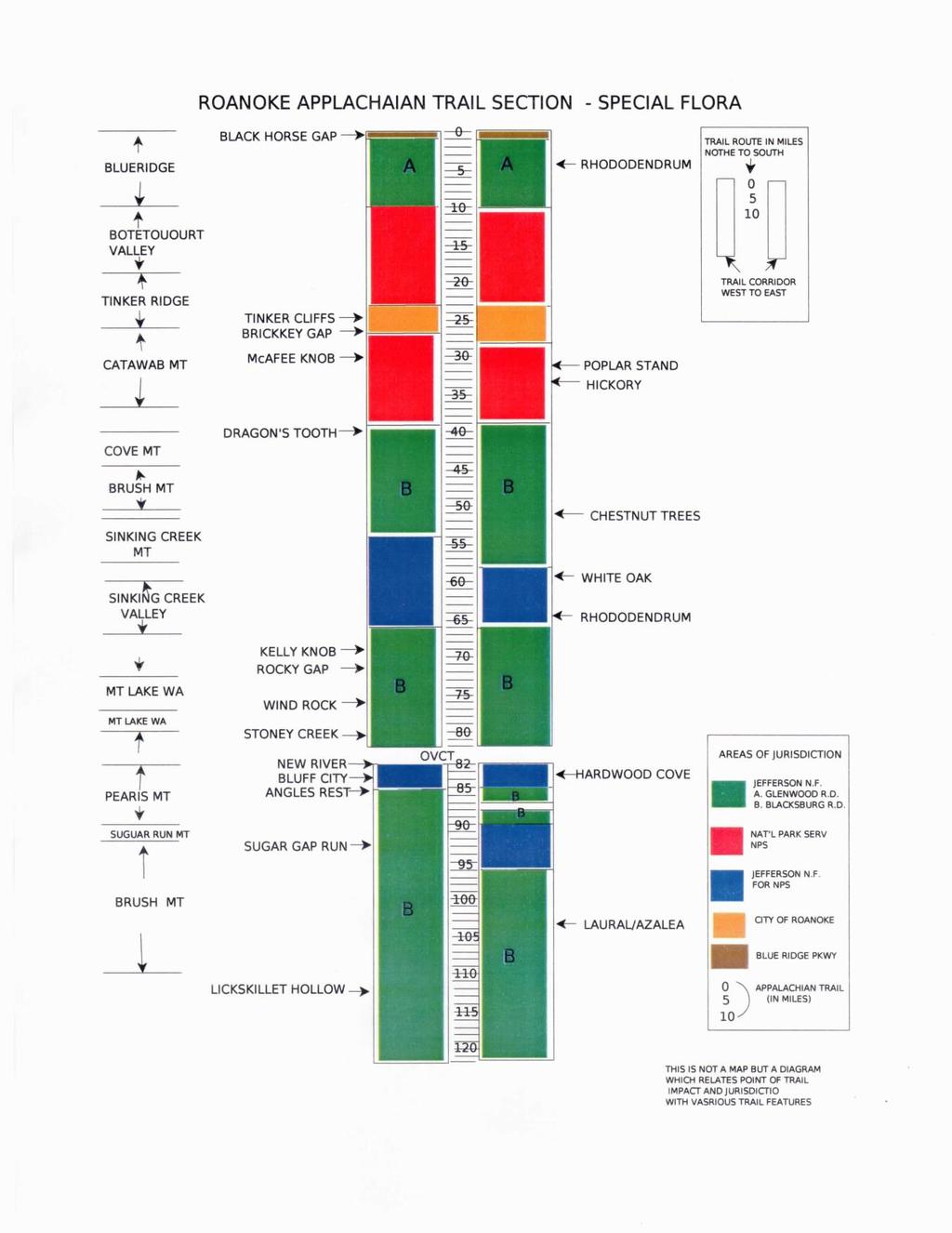
73 69
74 7 (C) PEST MANAGEMENT Attempts to control pest outbreaks present one of the most controversial aspects of management of Trail lands. Many types of native and introduced pest species are present on Appalachian Trail lands and lands adjoining the Trail. Forest pests are the cause of some of the most dramatic naturally caused impacts to the Trail environment. Defoliators such as the spruce budworm, hemlock woolly adelgid, and gypsy moth go through cyclic outbreaks or spread to new geographic regions. Diseases such as Dutch elm disease progress in much the same fashion as did chestnut blight 60 years ago, resulting in the disappearance of tree species from their natural range. Other than the obvious negative visual effects that insect and disease outbreaks can have on the Trail environment, significant economic impacts to surrounding areas occur as timber inventories drop. Pest management in public recreational areas is a difficult and controversial issue. Pests, both natural and introduced, are capable of profoundly devastating the forest. Unfortunately, most of the chemical agents presently available cannot be unequivocally guaranteed harmless to people. The agents may also have profound repercussions through the rest of the eco-system. In many cases of large regional problems, such as the gypsy moth, widespread spraying is thought by many to be ineffective in the long run. The National Park Service policy for insect and disease control is well established. Pests are living organisms that interfere with the purposes or management objectives of a specific site within a park or that jeopardize human health or safety. Decisions concerning whether or not to manage a pest or pest population will be influenced by whether the pest is an exotic or a native species. Native pests will be allowed to function unimpeded, except as noted below. The NPS may control native pests to: (1) conserve threatened or endangered species, or unique specimens or communities; (2) preserve, maintain, or restore the historical integrity of cultural resources; (3) conserve and protect plants, animals, and facilities in developed areas; (4) prevent outbreaks of a pest from invading uninfested areas outside the park; (5) manage a human health hazard when advised to do so by the U.S. Public Health Service (which includes the Centers for Disease Control and the NPS public health program); and (6) to otherwise protect against a significant threat to human safety (2006 NPS Management Policies, ). The National Forest Service policy is less structured, and may be found in the Jefferson Plan s Standards and Guides. It may be stated broadly that pest management strategies are practiced when it appears that there will be unacceptable levels of resource damage and loss or when necessary to protect the health and safety of the public. 70
75 The RATC policy follows the lead of the ATC in the area of pest management. The club clearly recognizes its responsibility in promoting all reasonable efforts to protect hikers from inadvertent exposure to sprayed chemicals. This should be done by adequate publication along the Trail with dates of anticipated activities and appropriate warnings to hikers of the possible hazards of exposure. On the Catawba Mountain-Daleville NPS corridor, the guidelines are clear-cut. Should the issue of spraying on the corridor come up, it will be evaluated carefully by club and ATC Representatives along with National Park Service. Such use must be approved by the director of the NPS and shall conform to EPA and OSHA regulations. Should pesticides he determined necessary, the club will encourage the use of the most biodegradable and least toxic agents available. 71
76 7 (D) THREATENED AND ENDANGERED SPECIES The terms threatened and endangered pertain to the specific legal status of a plant or animal species as designated by the secretary of the interior, under the authority of the Endangered Species Act of 1973, following a recommendation by the U.S. Fish and Wildlife Service. An endangered species is one that is close to extinction throughout all or a significant part of its range. A threatened species is one likely to become endangered in the near future. The Endangered Species Act prescribes specific procedures for determining the eligibility of a species for threatened or endangered status. The process is a long one, requiring publication of a notice in the Federal Register, consultation with governors of affected states, and other safeguards. Other terms are used to describe the relative population of a species, including rare, relict, and sensitive species. These latter terms do not give a species any legal protection under the Endangered Species Act. They do, however, provide a general indication of the size of a local population. Threatened and endangered species are provided expansive protection from federal action under Section 7 of the Endangered Species Act, which states in part: All federal departments and agencies shall, in consultation with and with the assistance of the Secretary [of Interior], utilize their authorities in furtherance of the purposes of this act by carrying out programs for the conservation of endangered species and threatened species and by taking such action as is necessary to insure that actions authorized, funded, or carried out by them do not jeopardize the continued existence of such endangered species and threatened species or result in the destruction or modification of habitat of such species which is determined by the Secretary, after consultation as appropriate with the affected states, to be critical. This provision imposes significant constraints on federal activities, including actions that take place on federal lands and actions that might require federal permits, licenses, or funds. Between 1989 and 2001, ATC, ATPO, and the U.S. Forest Service administered comprehensive natural-heritage inventories (often prepared by state naturalheritage offices under ATC contract) along the Trail. More than 2,100 populations of rare, threatened, and endangered species (plants and animals) and rare or exemplary natural communities have been identified at approximately 520 sites along the Trail. Monitoring programs, primarily for rare, threatened, and endangered plants, have been established in each of the 14 A.T. states, and more than 200 A.T. volunteers have been trained to monitor and report on those populations. 72
77 If protected species are identified along the section of Trail maintained by RATC, the club will work with its agency partners to devise ways to protect the species. Minor relocations of the Trail will be developed as necessary. With regard to major trail actions, such as relocations, new shelter construction, and open areas projects, the club will work with its agency partner in the planning process to determine that the actions will not affect threatened and endangered species that are known in the area. 73
78 7 (E) WILDLIFE MANAGEMENT The natural habitats along the Appalachian Trail support a great variety of wildlife. In most cases, the narrowness of the Trail corridor precludes management practices that will significantly enhance habitat to a point of improving a species over-all health, distribution, or range. However, in areas where there is increasing pressure from development, the corridor may provide an important source of forage and cover that sustains populations of small mammals and birds. The corridor can provide critical nest and den sites for species such as eagles, hawks, falcons, and waterfowl. The Appalachian Mountain ridgeline is also an important flyway for the migration of raptors. Several special items in the Roanoke sector may be noted the abundant bluebird populations through the inter-mountain valleys, the frequent sightings of bear in the McAfee Knob area, the abundant deer population around Carvins Cove and turkey population in the Glenwood Ranger District. The woodland environment of the Trail across Tinker Creek has long been a famous locality for observing songbirds. National Park Service policy for wildlife management on corridor lands is consistent with policy on other National Parks. No hunting, trapping, or fishing is permitted unless specifically authorized. Removal or control of animals is conducted only on a case by case analysis where necessary either for safeguarding human health, safety, or for the preservation of a healthy ecosystem. Wildlife management is a major component of the Jefferson National Forest management plan and it is designed to accommodate the many diverse recreational interests of the general public. The general policy of the Forest Service, in the special management zone of the Appalachian Trail, is to permit only habitat improvements which are compatible with the primary purposes of the Trail. The City of Roanoke controls that small section of the Trail which passes through its watershed. The city policy is to allow no hunting or trapping within the watershed. Fishing is permitted under license. The club recognizes the varying jurisdictions of the three land agencies through which its section of the Trail passes. The club policy is to remain alert for any measures which may be contemplated by agency partners in manipulation of the Trail environment for the purpose of wildlife management and to consult with the ATC field representative in such situations in order to determine the best interests of the Trail and its users. Refer to section on hunting for further information. 74
79 75
80 7 (F) VEGETATION MANAGEMENT Vegetation management involves the manipulation of plant species or habitat to meet a desired goal. Mechanical methods of management should be used to keep the treadway of the AT open. Chemical, prescribed fire and biological methods (for example, herbicide use or livestock grazing) should be used only in exceptional circumstances. Reclamation efforts may be required because of man-caused damage and misuse. These should be considered jointly by the RATC and the NPS or USFS on a case-by-case basis. Required projects should then be included in the annual plan for trail maintenance. 76
81 7 (G) HISTORICAL AND CULTURAL RESOURCES The lands crossed by the Appalachian Trail have a rich history. Parts of the Trail were major travel routes for Native Americans and for settlers pushing west to explore the new frontiers of our country in the 18th and 19th centuries. Many of the springs, campsites, gaps, and lookouts along the Trail were used by earlier travelers and settlers. Those sites, and the objects and other physical evidence left behind by these travelers and settlers, are an important part of our cultural heritage. Cultural resources can range from individual artifacts arrowheads, tools, bullets, housewares and other items for human use to structures and large areas of land. Historic campsites, farms, battlefields, and other broad areas of human occupation or use also are important to the historian or archaeologist. The Appalachian Trail itself is an important part of our nation s heritage. Although cultural-resource sites are vulnerable to gradual destruction from exposure to the elements, the most significant impacts usually result from man s activity. Cultural sites can be affected by surface-disturbing activities, such as constructing treadway for a relocation or building a new shelter. They can also be affected simply by opening a new area to public use. The RATC recognizes the importance of working with its agency partners in identifying and preserving historical and cultural resources. An inventory of these items known to occur on the RATC section of Trail is listed below. Any development which is planned on the Trail or corridor which involves a significant disturbance of soil surface, such as a major relocation or shelter development, will require a formal environmental assessment which includes evaluation of the site by an archeologist. Similarly, all structures which exist on the NPS corridor will be managed in conformity with the National Historic Preservation Act, further refined by the National Park Service affirmative action policies. The technical and legal details associated with historical structures require close cooperation with National Park Service specialists in this area. Inventory: The Trail passes the Audie Murphy Memorial on the high slopes of Brush Mountain in Craig County in the Blacksburg Ranger District of the National Forest. 77
82 The Trail passes within a few yards of a cemetery which is at least partially on NPS Tract , This cemetery contains about 40 graves, including that of Revolutionary War hero and founding father of Giles County, Captain George Pearis. Pearisburg itself, situated on the New River, is a town of historical interest. Local tradition holds that the general area of the Trail corridor on the northern aspect of Tinker Mountain near Daleville is an ancient Indian Hunting Campsite. (474-11/12/13). Three old gravesites of unknown significance are on Catawba Mountain (476-2, ) The Ditch Trail. The definite sites of historical and cultural significance on the Roanoke section of the Trail are depicted on the following page. 78
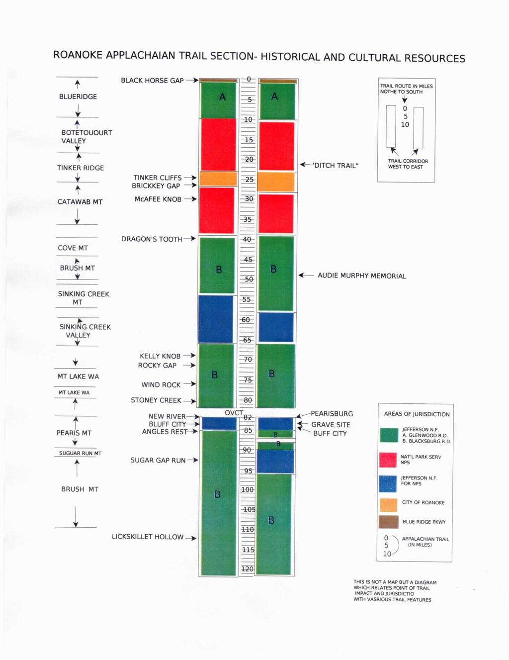
83 79
Project Planning, Compliance, and Funding
 Project Planning, Compliance, and Funding The plans above offer high level guidance to ensure that the A.T. is managed effectively as a whole unit in a decentralized management structure. Cooperative management
LOCAL PLAN FOR THE MANAGEMENT OF THE APPALACHIAN TRAIL IN MAINE. (GRAFTON NOTCH TO KATAHDIN) 1 January 2013 (Revised 5 February 2014)
 1 January 2013 (Revised 5 February 2014)") LOCAL PLAN FOR THE MANAGEMENT OF THE APPALACHIAN TRAIL IN MAINE (GRAFTON NOTCH TO KATAHDIN) 1 January 2013 (Revised 5 February 2014) The Appalachian Trail is a way, continuous from Katahdin in Maine to
LOCAL PLAN FOR THE MANAGEMENT OF THE APPALACHIAN TRAIL IN MAINE (GRAFTON NOTCH TO KATAHDIN) 1 January 2013 (Revised 5 February 2014) The Appalachian Trail is a way, continuous from Katahdin in Maine to
I. PREFACE II. THE PARTNERSHIP
 I. PREFACE This document is the "local" plan for the management of the Appalachian Trail in Maine from Maine Highway 26 in Grafton Notch to the summit of Katahdin. It is a part (the other being the Appalachian
Continental Divide National Scenic Trail Legislative History and Planning Guidance
 Continental Divide National Scenic Trail Legislative History and Planning Guidance Legislation, Policy, and Direction Regarding National Scenic Trails The National Trails System Act, P.L. 90-543, was passed
Allegheny Trail to Pine Swamp
 16.5 miles, Strenuous, $5.00 carpool fee 62 miles from Roanoke Allegheny Trail to Pine Swamp The hike will start in Monroe County, West Virginia. It begins on WV CR15 at the parking lot for the Hanging
RUSHMORE CONNECTOR TRAIL PROPOSAL
 PURPOSE AND NEED Background The U.S. Forest Service, Black Hills National Forest (Forest Service) has received a special use permit application from the State of South Dakota Department of Game, Fish and
RE: Access Fund Comments on Yosemite National Park Wilderness Stewardship Plan, Preliminary Ideas and Concepts
 September 30, 2016 Superintendent Yosemite National Park Attn: Wilderness Stewardship Plan P.O. Box 577 Yosemite, CA 95389 RE: Access Fund Comments on Yosemite National Park Wilderness Stewardship Plan,
Rule Governing the Designation and Establishment of All-Terrain Vehicle Use Trails on State Land
 Rule Governing the Designation and Establishment of All-Terrain Vehicle Use Trails on State Land 1.0 Authority 1.1 This rule is promulgated pursuant to 23 V.S.A. 3506. Section 3506 (b)(4) states that an
Local Management Planning Guide
 Local Management Planning Guide r e v i s e d A p r i l 2 0 0 9 Table of Contents Appalachian Trail Conservancy LOCAL MANAGEMENT PLANNING GUIDE TABLE OF CONTENTS Preface: An Introduction to the Local Management
Logo Department Name Agency Organization Organization Address Information 5700 North Sabino Canyon Road
 Logo Department Name Agency Organization Organization Address Information United States Forest Coronado National Forest 5700 North Sabino Canyon Road Department of Service Santa Catalina Ranger District
City of Durango 5.8 FUNDING TRAILS DEVELOPMENT
 5.8 FUNDING TRAILS DEVELOPMENT The City has been successful in establishing dedicated local funding sources as well as applying for grants to develop the City s trail system, having received nearly $2.4
Chapter 6: POLICY AND PROCEDURE RECOMMENDATIONS
 Chapter 6 POLICY AND PROCEDURE RECOMMENDATIONS FOR SRRA Below are seven policy elements that should be considered for adoption by the Southwest Regional Recreation Authority of Virginia: 1. Develop strategies
BUTTE COUNTY FOREST ADVISORY COMMITTEE
 BUTTE COUNTY FOREST ADVISORY COMMITTEE November 24, 2014-4:00 P.M. ITEM NO. 1.00 2.00 Call to order Golden Valley Bank, 190 Cohasset Rd. Chico, CA 95926 (park in center of lot) Pledge of allegiance to
MANAGEMENT DIRECTION STATEMENT June, 1999
 Thompson River District MANAGEMENT DIRECTION STATEMENT June, 1999 for Roche Lake Provincial Park Ministry of Environment Lands and Parks BC Parks Division Table of Contents I. Introduction A. Setting
Non-motorized Trail Plan & Proposal. August 8, 2014
 Town of Star Valley Ranch, Wyoming and the Star Valley Ranch Association in partnership with the USDA Forest Service, Bridger-Teton National Forest, Greys River Ranger District Non-motorized Trail Plan
Decision Memo Broken Wheel Ranch Equestrian Outfitter Special-Use Permit Proposed Action
 Decision Memo Broken Wheel Ranch Equestrian Outfitter Special-Use Permit USDA Forest Service Mississippi Bluffs Ranger District, Shawnee National Forest Jackson and Union Counties, Illinois Proposed Action
CHAPTER III: TRAIL DESIGN STANDARDS, SPECIFICATIONS & PERMITS
 CHAPTER III Trail Design Standards, Specifications & Permits This chapter discusses trail standards, preferred surface types for different activities, permits, and other requirements one must consider
2.2 For these reasons the provision of tourist signing will only be considered:
 TOURIST SIGNING POLICY 2015 1. DEFINITION 1.1 A tourist destination is defined as a permanently established attraction which attracts or is used by visitors to an area and is open to the public without
Silver Lake Park An Environmental Jewel for the Citizens of Prince William County
 Silver Lake Park An Environmental Jewel for the Citizens of Prince William County The Prince William Park Authority Mission Statement states: The Prince William County Park Authority will create quality
Tahoe National Forest Over-Snow Vehicle Use Designation
 Tahoe National Forest Over-Snow Vehicle Use Designation USDA Forest Service Tahoe National Forest February 20, 2015 Introduction The Forest Service, U.S. Department of Agriculture will prepare an Environmental
White Mountain National Forest Saco Ranger District
 United States Department of Agriculture Forest Service White Mountain National Forest Saco Ranger District 33 Kancamagus Highway Conway, NH 03818 Comm: (603) 447-5448 TTY: (603) 447-3121 File Code: 1950
Chattahoochee- Oconee National Forests. Decision Memo
 Page 1 of 6 USDA Forest Service Chattahoochee- Oconee National Forests Decision Memo Chattahoochee-Oconee National Forests Home Page Recreation Information Forest History Forest Facts Forest Management
NATIONAL PARK SERVICE CERTIFICATION OF COMPLETED SEGMENTS OF THE NORTH COUNTRY NATIONAL SCENIC TRAIL
 NATIONAL PARK SERVICE CERTIFICATION OF COMPLETED SEGMENTS OF THE NORTH COUNTRY NATIONAL SCENIC TRAIL Completed trail segments that (1) follow the route identified in the 1982 National Park Service (NPS)
MEMORANDUM OF UNDERSTANDING for the APPALACHIAN NATIONAL SCENIC TRAIL in the STATE OF NEW JERSEY
 MEMORANDUM OF UNDERSTANDING for the APPALACHIAN NATIONAL SCENIC TRAIL in the STATE OF NEW JERSEY I. BACKGROUND and OBJECTIVES The Appalachian Trail is a way, continuous from Katahdin in Maine to Springer
Proposed Action. Payette National Forest Over-Snow Grooming in Valley, Adams and Idaho Counties. United States Department of Agriculture
 United States Department of Agriculture Forest Service January 2012 Proposed Action Payette National Forest Over-Snow Grooming in Valley, Adams and Idaho Counties Payette National Forest Valley, Adams
Establishing a National Urban Park in the Rouge Valley
 STAFF REPORT ACTION REQUIRED Establishing a National Urban Park in the Rouge Valley Date: March 29, 2012 To: From: Wards: Reference Number: Executive Committee Deputy City Manager, Cluster B All p:\2012\cluster
Port Gamble Shoreline Area Conceptual Trail Proposal
 The North Kitsap Trails Association is pleased to be a partner to the Kitsap Forest and Bay Project and assist Kitsap County, Forterra, Olympic Property Group, Great Peninsula Conservancy and the Port
Final Environmental Impact Statement for the Merced Wild and Scenic River. Comprehensive Management Plan, Yosemite National Park, Madera and Mariposa
 This document is scheduled to be published in the Federal Register on 02/26/2014 and available online at http://federalregister.gov/a/2014-04061, and on FDsys.gov DEPARTMENT OF THE INTERIOR 4312-FF NATIONAL
Hermosa Area Preservation The Colorado Trail Foundation 4/11/2008
 Hermosa Area Preservation The Colorado Trail Foundation 4/11/2008 Legend d o Tr ail NPA - National Protection Area ra NCA - National Conservation Area o e C Th The Colorado Trail lo FS inventoried Roadless
UNITED STATES DEPARTMENT OF THE INTERIOR BUREAU OF LAND MANAGEMENT MANUAL TRANSMITTAL SHEET
 Form 1221-2 (June 1969) UNITED STATES DEPARTMENT OF THE INTERIOR BUREAU OF LAND MANAGEMENT MANUAL TRANSMITTAL SHEET Release 8-83 Date Subject 8353 Trail Management Areas Secretarially Designated (Public)
Preferred Recreation Recommendations Stemilt-Squilchuck Recreation Plan March 2018
 Preferred Recreation Recommendations Stemilt-Squilchuck Recreation Plan March 2018 Below are the recommended recreation ideas and strategies that package together the various recreation concepts compiled
5.0 OUTDOOR RECREATION OPPORTUNITIES AND MANAGEMENT
 5.0 OUTDOOR RECREATION OPPORTUNITIES AND MANAGEMENT 5.1 Introduction This section describes the range of recreational activities that currently take place in Marble Range and Edge Hills Parks, as well
White Mountain National Forest Saco Ranger District
 United States Department of Agriculture Forest Service White Mountain National Forest 33 Kancamagus Highway Conway, NH 03818 Comm: (603) 447-5448 TTY: (603) 447-3121 File Code: 1950 Date: February 26,
Minimum Requirements References in National Park Service Policy
 Minimum Requirements References in National Park Service Policy 2006 NPS Management Policies Chapter 6: Wilderness Preservation and Management 6.3 Wilderness Resource Management 6.3.1 General Policy (in
MORGAN CREEK GREENWAY Final Report APPENDICES
 APPENDICES MORGAN CREEK GREENWAY Appendix A Photos of Existing Conditions in Trail Corridor Photos of existing conditions Main trail corridor - February 2009 Photos of existing conditions south bank Morgan
Blueways: Rivers, lakes, or streams with public access for recreation that includes fishing, nature observation, and opportunities for boating.
 Parks, Open Space and Trails PRINCE WILLIAM COUNTY 2008 COMPREHENSIVE PLAN TRAILS PLAN CONTENTS The components of the trails plan are: Intent Definitions Goals, Policies, and Action Strategies Trails Map
Rogue River Access and Management Plan Draft Alternatives
 Rogue River Access and Management Plan Draft Alternatives The Rogue River Access and Management Plan was initiated in December, 2011 and is being led by Jackson County Parks (JCP) and Oregon Department
2. Goals and Policies. The following are the adopted Parks and Trails Goals for Stillwater Township:
 D. PARKS AND TRAILS 1. Introduction Stillwater Township s population is relatively low, with most residents living on rural residences on large lots. The need for active park space has been minimal in
Segment 2: La Crescent to Miller s Corner
 goal of the USFWS refuges is to conserve, protect and enhance fish, wildlife and plants and their habitats for the continuing benefit of the American people. Refuge lands are used largely for fishing,
Procedure for the Use of Power-Driven Mobility Devices on Mass Audubon Sanctuaries 1 September 17, 2012
 Procedure for the Use of Power-Driven Mobility Devices on Mass Audubon Sanctuaries 1 September 17, 2012 Background As part of Mass Audubon s mission to preserve the nature of Massachusetts for people and
As outlined in the Tatshenshini-Alsek Park Management Agreement, park management will:
 Management Strategy General Strategy The priority management focus for the park is to ensure that its internationally significant natural, cultural heritage and recreational values are protected and that
Theme: Predominately natural/natural appearing; rustic improvements to protect resources. Size*: 2,500 + acres Infrastructure**:
 Recreation Opportunity Spectrum (ROS) Classes The Recreation Opportunity Spectrum (ROS) provides a way to describe the variations in the degree of isolation from the sounds and influences of people, and
Overview. Wilderness Act of Statement of Need. What is Wilderness Character. Monitoring Wilderness Character
 Overview Monitoring Wilderness Character What What & Why? How? How? Conceptual Development How? How? Implementation Future? Future? Troy Hall Steve Boutcher USFS Wilderness & Wild and Scenic River Program
MASTER PLAN EXECUTIVE SUMMARY
 Biscuit Run State Park Scottsville Road (State Route 20) Charlottesville, VA 22902 Biscuit Run State Park MASTER PLAN EXECUTIVE SUMMARY Department of Conservation and Recreation Division of Planning and
BACKCOUNTRY TRAIL FLOOD REHABILITATION PROGRAM
 BACKCOUNTRY TRAIL FLOOD REHABILITATION PROGRAM Backcountry Trail Flood Rehabilitation A June 2013 Flood Recovery Program Summary In June 2013, parts of Southern Alberta were devastated from significant
Fossil Creek Wild & Scenic River Comprehensive River Management Plan Forest Service Proposed Action - details March 28, 2011
 Fossil Creek Wild & Scenic River Comprehensive River Management Plan Forest Service Proposed Action - details March 28, 2011 Primary Goals of the Proposed Action 1. Maintain or enhance ORVs primarily by
Dungeness Recreation Area County Park Master Plan
 Dungeness Recreation Area County Park Public Outreach Meeting October 10, 2007 Project Overview USFWS Site Dungeness Recreation Area County Park Meeting Objectives: Re-Introduce project; provide status
Description of the Proposed Action for the Big Creek / Yellow Pine Travel Plan (Snow-free Season) and Big Creek Ford Project
 and Big Creek Ford Project") Description of the Proposed Action for the Big Creek / Yellow Pine Travel Plan (Snow-free Season) and Big Creek Ford Project Payette National Forest Krassel Ranger District Valley and Idaho Counties, Idaho
Description of the Proposed Action for the Big Creek / Yellow Pine Travel Plan (Snow-free Season) and Big Creek Ford Project Payette National Forest Krassel Ranger District Valley and Idaho Counties, Idaho
Appendix A BC Provincial Parks System Goals
 Appendix A BC Provincial Parks System Goals The British Columbia Provincial Parks System has two mandates: To conserve significant and representative natural and cultural resources To provide a wide variety
DECISION MEMO. Rawhide Trail #7073 Maintenance and Reconstruction
 Page 1 of 6 Background DECISION MEMO USDA Forest Service Jefferson Ranger District Jefferson County, Montana Rawhide Trail #7073 is located in the Elkhorn Mountain Range approximately 10 miles east of
Natural and Cultural Resources Management, Part 610: Wilderness Stewardship
 Natural and Cultural Resources Management, Part 610: Wilderness Stewardship 2.5 May the Service allow structures and installations in wilderness? Section 4(c) of the Wilderness Act generally prohibits
Whitefish Range Partnership Tentatively Approved by WRP 11/18/2013!Rec. Wilderness Page 1
 Whitefish Range Partnership Tentatively Approved by WRP 11/18/2013!Rec. Wilderness Page 1 Recommended Wilderness Background The Whitefish Range has a long management and legislative history associated
SUMMARY REPORT ON THE SAFETY OVERSIGHT AUDIT FOLLOW-UP OF THE DIRECTORATE GENERAL OF CIVIL AVIATION OF KUWAIT
 ICAO Universal Safety Oversight Audit Programme SUMMARY REPORT ON THE SAFETY OVERSIGHT AUDIT FOLLOW-UP OF THE DIRECTORATE GENERAL OF CIVIL AVIATION OF KUWAIT (Kuwait, 17 to 20 September 2003) International
LEAVE NO TRACE CENTER FOR OUTDOOR ETHICS CONSULTING SERVICES
 LEAVE NO TRACE CENTER FOR OUTDOOR ETHICS CONSULTING SERVICES LEAVE NO TRACE PURPOSE Americans love the outdoors. Today, more than 300 million people visit America s national parks and another 150 million
Tracy Ridge Shared Use Trails and Plan Amendment Project
 Tracy Ridge Shared Use Trails and Plan Amendment Project Scoping Document Forest Service Allegheny National Forest Bradford Ranger District McKean, County, Pennsylvania In accordance with Federal civil
Business Item No XXX. Proposed Action That the Metropolitan Council approve the Coon Creek Regional Trail Master Plan.
 Business Item No. 2015-XXX Metropolitan Parks and Open Space Commission Meeting date: July 7, 2015 For the Community Development Committee meeting of July 20, 2015 For the Metropolitan Council meeting
FINAL TESTIMONY 1 COMMITTEE ON RESOURCES UNITED STATES HOUSE OF REPRESENTATIVES. July 13, 2005 CONCERNING. Motorized Recreational Use of Federal Lands
 FINAL TESTIMONY 1 STATEMENT OF DALE BOSWORTH CHIEF Of the FOREST SERVICE UNITED STATES DEPARTMENT OF AGRICULTURE Before the SUBCOMMITTEE ON FORESTS AND FOREST HEALTH And the SUBCOMMITTEE ON NATIONAL PARKS,
April 10, Mark Stiles San Juan Public Lands Center Manager 15 Burnett Court Durango, CO Dear Mark,
 Mark Stiles San Juan Public Lands Center Manager 15 Burnett Court Durango, CO 81301 Dear Mark, We are pleased to offer the following comments on the draft San Juan Public Lands Center management plans
PLANNING COMMISSION AGENDA REPORT May 10, Members of the Planning Commission. Joyce Parker-Bozylinski, Contract Planner
 PLANNING COMMISSION AGENDA REPORT May 10, 2007 TO: FROM: PROPOSAL: APPLICANT: RECOMMENDATION: Members of the Planning Commission Joyce Parker-Bozylinski, Contract Planner Approval of the Calabasas Trails
Accessibility Guidelines for Outdoor Recreation and Trails
 Accessibility Guidelines for Outdoor Recreation and Trails Association of Conservation Engineers September 17, 2007 Accessibility Guidelines for Outdoor Recreation and Trails Access Board is the independent
CHAPTER 4 -- THE LAND USE PLAN: DESCRIPTIONS AND POLICIES FOR THIRTEEN PLANNING AREAS
 CHAPTER 4 -- THE LAND USE PLAN: DESCRIPTIONS AND POLICIES FOR THIRTEEN PLANNING AREAS NORTH CENTRAL CAC AREA LITTLE VALLEY ROAD TO JUG HANDLE CREEK PLANNING AREA This planning area includes Cleone, Noyo,
Marilla Reservoir to Chestnut Ridge via Marilla Trails and Bullis Hollow Trail east to west
 USGS topographic maps useful to this hike are the Bradford and Stickney 7.5 minute sectionals. These notes are designed to assist in identifying distance and location using geophysical and man-made characteristics
Bear Creek Habitat Improvement Project
 06/10/10 Bear Creek Habitat Improvement Project El Paso County, Colorado Pike National Forest and Colorado Springs Utilities Owned Land Report prepared by: Eric Billmeyer Executive Director Rocky Mountain
CHG 0 9/13/2007 VOLUME 2 AIR OPERATOR AND AIR AGENCY CERTIFICATION AND APPLICATION PROCESS
 VOLUME 2 AIR OPERATOR AND AIR AGENCY CERTIFICATION AND APPLICATION PROCESS CHAPTER 5 THE APPLICATION PROCESS TITLE 14 CFR PART 91, SUBPART K 2-536. DIRECTION AND GUIDANCE. Section 1 General A. General.
Creating a User-Driven Long-Distance OHV Trail Through Partnering
 Joseph Raffaele Outdoor Recreation Planner U.S. Bureau of Land Management Yuma, Arizona Creating a User-Driven Long-Distance OHV Trail Through Partnering BLM is a multiple-use land management agency within
National Forests and Grasslands in Texas
 United States Department of Agriculture Forest Service National Forests and Grasslands in Texas Sam Houston NF 394 FM 1375 West New Waverly, Texas 77358 Phone 936-344-6205 Dear Friends, File Code: 1950
Understanding user expectations And planning for long term sustainability 1
 Understanding user expectations And planning for long term sustainability 1 What is a natural surface trail? It can be as simple has a mineral soil, mulched or graveled pathway, or as developed as elevated
Ouimet Canyon Provincial Nature Reserve. Management Plan
 Ouimet Canyon Provincial Nature Reserve Management Plan NOTE: This document has been scanned and formatted, and therefore is slightly different from the original version. -March 2002 Additional copies
FOREST SERVICE MANUAL NATIONAL HEADQUARTERS (WO) WASHINGTON, DC
 WASHINGTON, DC") Page 1 of 77 FOREST SERVICE MANUAL NATIONAL HEADQUARTERS (WO) WASHINGTON, DC FSM 2300 RECREATION, WILDERNESS, AND RELATED RESOURCE MANAGEMENT CHAPTER TRAIL, RIVER, AND SIMILAR RECREATION OPPORTUNITIES
Page 1 of 77 FOREST SERVICE MANUAL NATIONAL HEADQUARTERS (WO) WASHINGTON, DC FSM 2300 RECREATION, WILDERNESS, AND RELATED RESOURCE MANAGEMENT CHAPTER TRAIL, RIVER, AND SIMILAR RECREATION OPPORTUNITIES
General Rules for Use of Lands Managed by the. Middle Peninsula Chesapeake Bay Public Access Authority
 General Rules for Use of Lands Managed by the Middle Peninsula Chesapeake Bay Public Access Authority As a visitor to lands managed by the Middle Peninsula Chesapeake Bay Public Access Authority (PAA),
Yard Creek Provincial Park. Management Plan
 Yard Creek Provincial Park Management Plan Draft January 2010 Yard Creek Provincial Park Management Plan Approved by: telàlsemkin/siyam/chief Scott Benton Bill Williams Squamish Executive Director ation
National Park Service Wilderness Action Plan
 National Park Service U.S. Department of the Interior National Park Service Wilderness Action Plan National Wilderness Steering Committee National Park Service "The mountains can be reached in all seasons.
FEASIBILITY CRITERIA
 This chapter describes the methodology and criteria used to evaluate the feasibility of developing trails throughout the study areas. Land availability, habitat sensitivity, roadway crossings and on-street
APPENDIX. Alberta Land Stewardship Act AMENDMENTS TO THE SOUTH SASKATCHEWAN REGIONAL PLAN
 APPENDIX Alberta Land Stewardship Act AMENDMENTS TO THE SOUTH SASKATCHEWAN REGIONAL PLAN 1 All references to Alberta Environment and Sustainable Resource Development, Environment and Sustainable Resource
Wilderness Process #NP-1810: Your letter ID is NP September 5, 2018
 Wilderness Process #NP-1810: Your letter ID is NP-1810-2602-96 September 5, 2018 RE: GMUG Wilderness Evaluation Revised Evaluation Criteria and Draft Report Forest Revision Planning Team: The Continental
St. Joe Travel Management EA CULTURAL RESOURCES
 St. Joe Travel Management EA CULTURAL RESOURCES Bruce Gibson May 2015 Regulatory Framework Forest Plan The Idaho Panhandle National Forests (IPNF) Forest Plan requires systematic cultural resource inventory
ROAD AND TRAIL PROJECT APPROVAL
 ROAD AND TRAIL PROJECT APPROVAL www.marincountyparks.org Marin County Parks, 3501 Civic Center Dr, Suite 260, San Rafael, CA 94903 DATE: July 12, 2017 PRESERVE: Gary Giacomini Open Space Preserve PROJECT:
PROPOSED ACTION South 3000 East Salt Lake City, UT United States Department of Agriculture
 United States Department of Agriculture Forest Service Uinta-Wasatch-Cache National Forest Salt Lake Ranger District 6944 South 3000 East Salt Lake City, UT 84121 801-733-2660 File Code: 1950/2300 Date:
Appalachian Trail Community
 Harpers Ferry, West Virginia Appalachian Trail Community A Designation Program of the Appalachian Trail Conservancy The Appalachian Trail Conservancy (ATC) mission is to preserve and manage the Appalachian
ICAO SUMMARY REPORT AUDIT OF THE DEPARTMENT OF CIVIL AVIATION OF THE LAO PEOPLE S DEMOCRATIC REPUBLIC
 ICAO Universal Safety Oversight Audit Programme ICAO SUMMARY REPORT AUDIT OF THE DEPARTMENT OF CIVIL AVIATION OF THE LAO PEOPLE S DEMOCRATIC REPUBLIC (Vientiane, 22 to 30 April 1999) INTERNATIONAL CIVIL
Kit Carson-Challenger Ridge Trail Project Annual Performance Report-2014 October 22, 2014
 1 Kit Carson-Challenger Ridge Trail Project Annual Performance Report-2014 October 22, 2014 Willow Lake and Kit Carson Peak 2 SUMMARY The Rocky Mountain Field Institute began Phase 1 of a multi-phase,
Welcome to the future of Terwillegar Park a Unique Natural Park
 Welcome to the future of Terwillegar Park a Unique Natural Park 1 Introduction The Terwillegar Park Concept Plan study will develop an overall concept plan, management objectives and development guidelines
Appendix I Case-Studies in Wilderness Management
 Appendix I Case-Studies in Wilderness Management Management Issue Scenarios Note: These scenarios are meant to be used as guidelines for the program leader rather than to be read verbatim. Introduce a
Appendix 3. Greenway Design Standards. The Whitemarsh Township Greenway Plan
 Appendix 3 Greenway Design Standards This chapter discusses two design standards for the greenway types discussed above. First, trail design standards are presented together with trailhead facilities and
WHEREAS, the City operates and manages Rapid City Regional Airport (RAP); and
; and") MEMORANDUM OF UNDERSTANDING BETWEEN THE RAPID CITY DEPARTMENT OF FIRE & EMERGENCY SERVICES AND RAPID CITY REGIONAL AIRPORT BOARD RELATING TO THE PROVISION OF AIRPORT RESCUE AND FIREFIGHTING SERVICES This
MEMORANDUM OF UNDERSTANDING BETWEEN THE RAPID CITY DEPARTMENT OF FIRE & EMERGENCY SERVICES AND RAPID CITY REGIONAL AIRPORT BOARD RELATING TO THE PROVISION OF AIRPORT RESCUE AND FIREFIGHTING SERVICES This
National Wilderness Steering Committee
 National Wilderness Steering Committee Guidance White Paper Number 1 Issue: Cultural Resources and Wilderness Date: November 30, 2002 Introduction to the Issue Two of the purposes of the National Wilderness
Minutes from the RATC Board Meeting October 15, 2012
 Minutes from the RATC Board Meeting October 15, 2012 Meeting called to order at 7:00 pm Host: Fred Walters Location: Roanoke County Parks & Recreation Building, Kessler Mill Road, Salem Attending: Liz
Isle of Wight Council TOURISM SIGNING POLICY
 Isle of Wight Council TOURISM SIGNING POLICY 2005 1 st April 2005 1 CONTENTS Introduction Page 3 Section I - Eligibility Criteria for Tourism Signing Page 5 1. General Requirements Applicable to all Attractions
Southern Shenandoah Valley Chapter
 Southern Shenandoah Valley Chapter June 7, 2018 Members of the State Water Control Board c/o Office of Regulatory Affairs, Department of Environmental Quality P.O. Box 1105 Richmond, Virginia 23218 citizenboards@deq.virginia.gov
Outdoor Developed Areas
 The United States Access Board is an independent federal agency that promotes equality for people with disabilities through leadership in accessible design and the development of accessibility guidelines
What s covered. What s not covered. Options for those not covered. ABA Coverage
 The United States Access Board is an independent federal agency that promotes equality for people with disabilities through leadership in accessible design and the development of accessibility guidelines
Section II. Planning & Public Process Planning for the Baker/Carver Regional Trail began in 2010 as a City of Minnetrista initiative.
 Section II Planning & Public Process Planning for the began in 2010 as a City of initiative. city staff began discussions with the Park District on the possibility of a north/south regional trail connection
LESSON 5 Wilderness Management Case Studies
 LESSON 5 Wilderness Management Case Studies Objectives: Students will: review the key points of the Wilderness Act of 1964. brainstorm solutions for Wilderness management issues. Materials: Í Leave no
Daisy Dean Trail 628/619 ATV Trail Construction
 Background and Purpose and Need The Daisy Dean ATV Trail Construction Project is located in the Little Belt Mountains, Musselshell Ranger District, Lewis and Clark National Forest approximately 32 miles
Clearwater Lake Provincial Park. Draft Management Plan
 Clearwater Lake Provincial Park Draft Management Plan Clearwater Lake Provincial Park Draft Management Plan Table of Contents 1. Introduction... 3 2. Park History... 4 3. Park Attributes... 4 3.1 Location/Access...4
Rural Rustic Road Program
 Virginia Department of Transportation s Rural Rustic Road Program Prepared by the Local Assistance Division Virginia Department of Transportation 1401 East Broad Street Richmond, Virginia 23219 Michael
Massanutten Mountain Cluster
 Massanutten Mountain Cluster Signal Knob Catback Mountain Southern Massanutten Mountain Five areas of almost 49,000 acres on the Lee Ranger District compose the Massanutten Mountain Cluster of Mountain
DECISION MEMO North Zone (Legacy Trails) Trail Stabilization Project
 Trail Stabilization Project") DECISION MEMO North Zone (Legacy Trails) Trail Stabilization Project USDA FOREST SERVICE Rocky Mountain Region (R2) Shoshone National Forest Wapiti and Greybull Ranger District Park County, Wyoming Background
DECISION MEMO North Zone (Legacy Trails) Trail Stabilization Project USDA FOREST SERVICE Rocky Mountain Region (R2) Shoshone National Forest Wapiti and Greybull Ranger District Park County, Wyoming Background
SUMMER VILLAGE OF SILVER SANDS. Municipal Development Plan
 SUMMER VILLAGE OF SILVER SANDS Municipal Development Plan Bylaw 253-2014 Adopted August 22, 2014 Summer Village of Silver Sands Municipal Development Plan Bylaw No. 253-2014 Page 2 1 INTRODUCTION 1.1 SETTING
Cultural Resource Management Report Deer Valley 4wd Restoration and Blue Lakes Road Maintenance Project R
 Cultural Resource Management Report R2015-05-03-10005 Undertaking Description: The proposes to perform road maintenance and meadow restoration on the Deer Valley 4wd trail and road maintenance on the Blue