Historic England (Designation) Consultation Report 14 December 2017
|
|
|
- Benedict Casey
- 6 years ago
- Views:
Transcription
1 Case Name: North Trans-Pennine Phase 2: Footbridge MVL3/8 Case Number: Background Historic England has been asked to assess this structure for listing in connection with the proposed upgrade of the Trans-Pennine railway route from Manchester to York and Selby. Asset(s) under Assessment Facts about the asset(s) can be found in the Annex(es) to this report. Annex Name Heritage Category 1 Railway overbridge MVL3/8, Listing Footbridge Visits Date Visit Type 13 October 2017 Full inspection Page 1 of 4
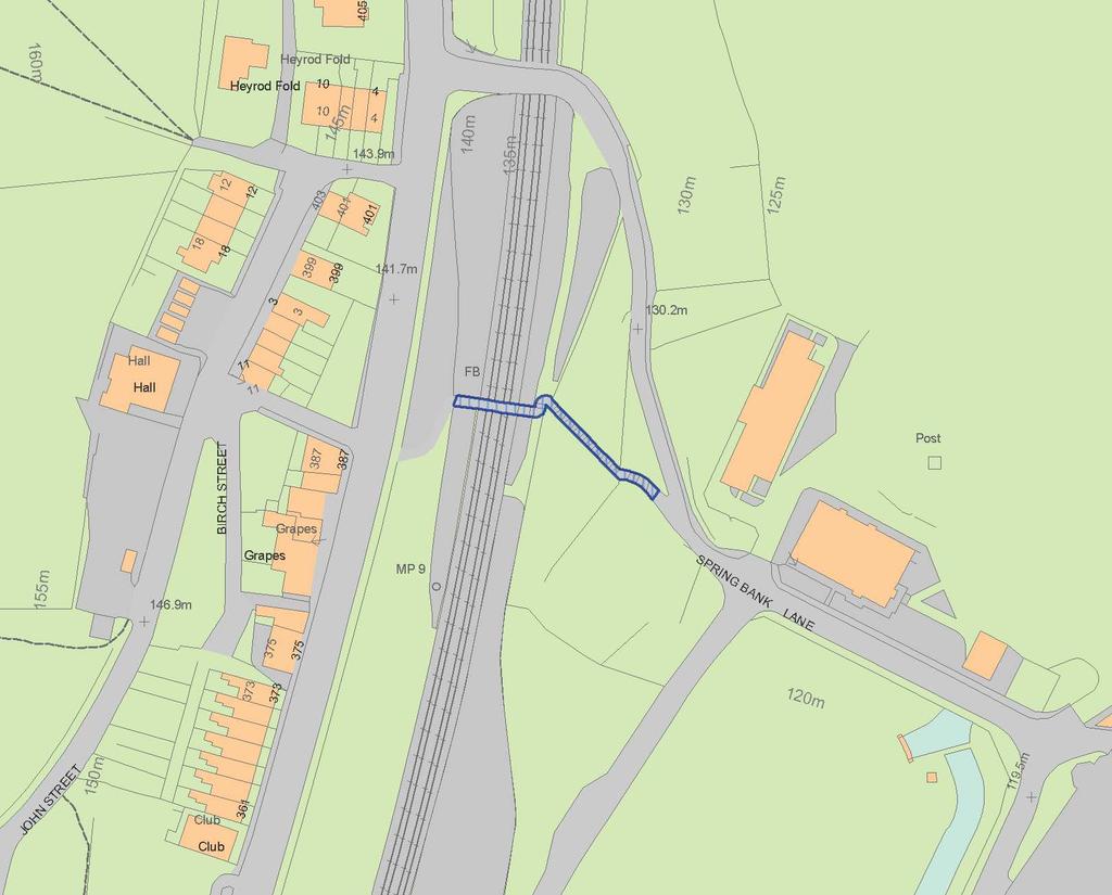
2 Annex 1 The factual details are being assessed as the basis for a proposed addition to The National Heritage List for England. Factual Details Name: Railway overbridge MVL3/8, Footbridge Location Footpath between A635 Wakefield Road and Spring Bank Lane, Heyrod. County District District Type Parish Tameside Metropolitan Authority Non Civil Parish History In contrast to the main trunk lines of the late 1830s that were constructed by single railway companies the route from Stalybridge to Leeds had fragmented origins and was the work of three different railway companies: the Huddersfield & Manchester Railway, Leeds, Dewsbury & Manchester Railway, and the Manchester & Leeds Railway. The Huddersfield & Manchester Railway was authorised in 1845 and followed the route of the Huddersfield Narrow Canal for much of its length, including a railway tunnel through the Pennine hills set alongside the earlier Standedge Canal Company tunnel of 1811; in 1846 the railway company also acquired the canal. Joseph Locke and Alfred Stanistreet Jee were appointed to survey and design the new line, the two engineers having already worked together on a major project linking Manchester and Sheffield. Jee became the lead engineer for the Huddersfield line, which passed through challenging terrain, assisted by resident engineers that included his brother Moreland Jee (until 1848) and Herbert F Mackworth. Construction of the line was divided into various contracts, with many contractors being only responsible for a single cutting, viaduct or tunnel portal. The largest contract for the Standedge Tunnel between Diggle and Marsden was let to a single contractor, Thomas Nicholson in The tunnel's completion in 1849 marked the opening of the line. The Leeds end of the route, which was also authorised in 1845, was constructed by the Leeds, Dewsbury & Manchester Railway. The engineer was Thomas Grainger who had previously largely worked in Scotland, and the line was completed in A short three-mile section of the route between Heaton Lodge Junction and Thornhill Junction near Mirfield was developed by the Manchester & Leeds Railway and was constructed between 1837 and 1840, with George Stephenson as the chief engineer. The structures on this line were designed by Thomas Gooch under the oversight of Stephenson. In 1847 the railway company changed its name to the Lancashire & Yorkshire Railway. In 1847 the Huddersfield & Manchester Railway and the Leeds, Dewsbury & Manchester Railway were acquired by the London & North Western Railway (LNWR) so that the company could access the city of Leeds and the textile towns of West Yorkshire. This pitted them as rivals to the Lancashire & Yorkshire Railway, although at points on the route the two companies had to work together. By 1851 the London & North Western Railway had an overall mileage of railway track of 800 miles and it became the most prominent railway company in the country and the largest joint-stock concern in the world in the late C19. Although the LNWR had a general manager, Captain Mark Huish, the lines of the Stalybridge to Leeds route still managed their own affairs. LNWR later carried out expansion works, including the widening of tracks and bridges, the construction of additional tunnels, and station alterations. In 1923 the line became part of the London Midland & Scottish Railway, and subsequently part of the nationalised British Railways in The line, its structures and track are currently owned by Network Rail, and the passenger services operated by TransPennine Express and Northern Rail. Page 2 of 4
3 This overbridge was built to carry the footpath between Spring Bank Lane and Wakefield Road over the railway. It was designed by AS Jee and dates from the line s construction between 1845 and The upper courses of the parapets appear to be of a different brick from the lower six courses and the upper courses and the stone parapet copings are probably a later addition, perhaps replacing earlier brick or an iron balustrade. The deck has been overlaid with tarmac. Otherwise the bridge appears little-altered. Details Railway overbridge and flight of steps, , by AS Jee for the Huddersfield and Manchester Railway. MATERIALS: sandstone, cast iron, red brick, blue engineering brick. DESCRIPTION: the bridge carries a footpath running east-west over the railway, with steps on the eastern side down to a path running south-east towards Spring Bank Lane. The single span has a deck formed by cast-iron edge beams with a brick jack arch spanning between the bottom flanges. The abutments are battered, of squared and coursed quarry-faced stone with a weathered plinth and surmounted by an ashlar band. Projecting piers at all four inner corners are quoined, with a flush return linking them beneath the span. The piers have parapet imposts of three weathered ashlar steps, and pyramidal caps. The approach walls are of random-coursed squared stone with punched hog s-back copings and a weathered projecting band at the base. The parapets are of blue engineering brick laid in alternate header and stretcher courses, the bottom six courses with more apparent weathering. The stone parapet copings are twice-weathered. The deck is surfaced with tarmac. On the eastern side steep steps run down to the north between the approach walls to a landing enclosed by a curving northern wall, with monumental posts at the eastern corners. The posts are circular with a weathered plinth, punch-dressed, and with a dome-topped deep circular cap to the southern post, that to the north being missing. The northern approach wall continues for two metres beyond the post alongside the footpath, stepping down to meet the ground. Mild steel handrails are fixed to the southern post and the inner faces of the approach walls. SUBSIDIARY FEATURES: from the landing, four sandstone steps run down to the footpath, which is comprised of short landings of sandstone setts divided by flights of three shallow steps with setted treads and flagstone risers, all well-worn. Selected Sources Other TransPennine Route Statement of History and Significance: West of Leeds V3.1. Prepared for Network Rail, March Alan Baxter Ltd. Page 3 of 4

4 Map National Grid Reference: SD Crown Copyright and database right All rights reserved. Ordnance Survey Licence number The above map is for quick reference purposes only and may not be to scale. For a copy of the full scale map, please see the attached PDF _1.pdf. Page 4 of 4
5
6 Case Name: North Trans-Pennine Phase 2: Manchester Road MVL3/10 Case Number: Background Historic England has been asked to assess this structure for listing in connection with the proposed upgrade of the Trans-Pennine railway route from Manchester to York and Selby. Asset(s) under Assessment Facts about the asset(s) can be found in the Annex(es) to this report. Annex Name Heritage Category 1 Railway underbridge Listing MVL3/10, Manchester Road Visits Date Visit Type 13 October 2017 Full inspection Page 1 of 4
7 Annex 1 The factual details are being assessed as the basis for a proposed addition to The National Heritage List for England. Factual Details Name: Railway underbridge MVL3/10, Manchester Road Location A635 Manchester Road, Mossley. County District District Type Parish Tameside Metropolitan Authority Mossley Tameside Metropolitan Authority Non Civil Parish History In contrast to the main trunk lines of the late 1830s that were constructed by single railway companies the route from Stalybridge to Leeds had fragmented origins and was the work of three different railway companies: the Huddersfield & Manchester Railway, Leeds, Dewsbury & Manchester Railway, and the Manchester & Leeds Railway. The Huddersfield & Manchester Railway was authorised in 1845 and followed the route of the Huddersfield Narrow Canal for much of its length, including a railway tunnel through the Pennine hills set alongside the earlier Standedge Canal Company tunnel of 1811; in 1846 the railway company also acquired the canal. Joseph Locke and Alfred Stanistreet Jee were appointed to survey and design the new line, the two engineers having already worked together on a major project linking Manchester and Sheffield. Jee became the lead engineer for the Huddersfield line, which passed through challenging terrain, assisted by resident engineers that included his brother Moreland Jee (until 1848) and Herbert F Mackworth. Construction of the line was divided into various contracts, with many contractors being only responsible for a single cutting, viaduct or tunnel portal. The largest contract for the Standedge Tunnel between Diggle and Marsden was let to a single contractor, Thomas Nicholson in The tunnel's completion in 1849 marked the opening of the line. The Leeds end of the route, which was also authorised in 1845, was constructed by the Leeds, Dewsbury & Manchester Railway. The engineer was Thomas Grainger who had previously largely worked in Scotland, and the line was completed in A short three-mile section of the route between Heaton Lodge Junction and Thornhill Junction near Mirfield was developed by the Manchester & Leeds Railway and was constructed between 1837 and 1840, with George Stephenson as the chief engineer. The structures on this line were designed by Thomas Gooch under the oversight of Stephenson. In 1847 the railway company changed its name to the Lancashire & Yorkshire Railway. In 1847 the Huddersfield & Manchester Railway and the Leeds, Dewsbury & Manchester Railway were acquired by the London & North Western Railway (LNWR) so that the company could access the city of Leeds and the textile towns of West Yorkshire. This pitted them as rivals to the Lancashire & Yorkshire Railway, although at points on the route the two companies had to work together. By 1851 the London & North Western Railway had an overall mileage of railway track of 800 miles and it became the most prominent railway company in the country and the largest joint-stock concern in the world in the late C19. Although the LNWR had a general manager, Captain Mark Huish, the lines of the Stalybridge to Leeds route still managed their own affairs. LNWR later carried out expansion works, including the widening of tracks and bridges, the construction of additional tunnels, and station alterations. In 1923 the line became part of the London Midland & Scottish Railway, and subsequently part of the nationalised British Railways in The line, its structures and track are currently owned by Network Rail, and the passenger services operated by TransPennine Express and Northern Rail. Page 2 of 4
8 This underbridge was built to carry the railway over Manchester Road. It was designed by AS Jee and dates from the line s construction between 1845 and The bridge is little-altered having not been widened and retains its original features. Details Railway underbridge, , by AS Jee for the Huddersfield & Manchester railway. MATERIALS: buff sandstone. DESCRIPTION: the bridge carries the railway over Manchester Road at a slight angle, running north-south. It comprises a central span flanked by projecting piers, linked by in-line wing walls which subtly curve outwards at the ends and terminate in further piers. The segmental-arch span springs from v-jointed rusticated abutments with canted corners and a projecting weathered impost band. The soffit, the walls beneath the span and the upper stonework are of regular-coursed quarry-faced stone. The voussoirs are ashlar, unfortunately partly concealed by modern warning signs. The whole length of wing walls and span is topped by a deep ashlar coping with projecting band. Selected Sources Other TransPennine Route Statement of History and Significance: West of Leeds V3.1. Prepared for Network Rail, March Alan Baxter Ltd. Page 3 of 4

9 Map National Grid Reference: SD Crown Copyright and database right All rights reserved. Ordnance Survey Licence number The above map is for quick reference purposes only and may not be to scale. For a copy of the full scale map, please see the attached PDF _1.pdf. Page 4 of 4
10
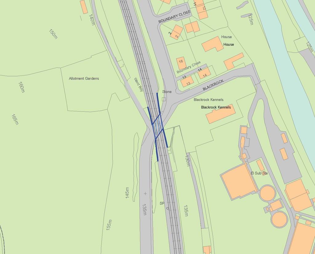
11 Case Name: North Trans-Pennine Phase 2: Scout tunnel MVL3/11 Case Number: Background Historic England has been asked to assess this structure for listing in connection with the proposed upgrade of the Trans-Pennine railway route from Manchester to York and Selby. Asset(s) under Assessment Facts about the asset(s) can be found in the Annex(es) to this report. Annex Name Heritage Category 1 Railway tunnel portal, MVL3/11 Scout Tunnel (south end) Listing Visits Date Visit Type 13 October 2017 Full inspection Page 1 of 4
12 Annex 1 The factual details are being assessed as the basis for a proposed addition to The National Heritage List for England. Factual Details Name: Railway tunnel portal, MVL3/11 Scout Tunnel (south end) Location South end of Scout tunnel, 100m west of Manchester Road, Mossley. County District District Type Parish Tameside Metropolitan Authority Mossley History In contrast to the main trunk lines of the late 1830s that were constructed by single railway companies the route from Stalybridge to Leeds had fragmented origins and was the work of three different railway companies: the Huddersfield & Manchester Railway, Leeds, Dewsbury & Manchester Railway, and the Manchester & Leeds Railway. The Huddersfield & Manchester Railway was authorised in 1845 and followed the route of the Huddersfield Narrow Canal for much of its length, including a railway tunnel through the Pennine hills set alongside the earlier Standedge Canal Company tunnel of 1811; in 1846 the railway company also acquired the canal. Joseph Locke and Alfred Stanistreet Jee were appointed to survey and design the new line, the two engineers having already worked together on a major project linking Manchester and Sheffield. Jee became the lead engineer for the Huddersfield line, which passed through challenging terrain, assisted by resident engineers that included his brother Moreland Jee (until 1848) and Herbert F Mackworth. Construction of the line was divided into various contracts, with many contractors being only responsible for a single cutting, viaduct or tunnel portal. The largest contract for the Standedge Tunnel between Diggle and Marsden was let to a single contractor, Thomas Nicholson in The tunnel's completion in 1849 marked the opening of the line. The Leeds end of the route, which was also authorised in 1845, was constructed by the Leeds, Dewsbury & Manchester Railway. The engineer was Thomas Grainger who had previously largely worked in Scotland, and the line was completed in A short three-mile section of the route between Heaton Lodge Junction and Thornhill Junction near Mirfield was developed by the Manchester & Leeds Railway and was constructed between 1837 and 1840, with George Stephenson as the chief engineer. The structures on this line were designed by Thomas Gooch under the oversight of Stephenson. In 1847 the railway company changed its name to the Lancashire & Yorkshire Railway. In 1847 the Huddersfield & Manchester Railway and the Leeds, Dewsbury & Manchester Railway were acquired by the London & North Western Railway (LNWR) so that the company could access the city of Leeds and the textile towns of West Yorkshire. This pitted them as rivals to the Lancashire & Yorkshire Railway, although at points on the route the two companies had to work together. By 1851 the London & North Western Railway had an overall mileage of railway track of 800 miles and it became the most prominent railway company in the country and the largest joint-stock concern in the world in the late C19. Although the LNWR had a general manager, Captain Mark Huish, the lines of the Stalybridge to Leeds route still managed their own affairs. LNWR later carried out expansion works, including the widening of tracks and bridges, the construction of additional tunnels, and station alterations. In 1923 the line became part of the London Midland & Scottish Railway, and subsequently part of the nationalised British Railways in The line, its structures and track are currently owned by Network Rail, and the passenger services operated by TransPennine Express and Northern Rail. Page 2 of 4
13 Scout tunnel was built to carry the railway through a small hill between Stalybridge and Mossley. The south portal was designed by AS Jee and dates from the line s construction between 1845 and The portal remains as built. Details Railway tunnel portal, , by AS Jee for the Huddersfield & Manchester railway. MATERIALS: buff sandstone. DESCRIPTION: the portal faces south, standing against the south face of the hill, elevated above the road. It comprises a single horseshoe arch flanked by octagonal piers with abutments to either side running into the steep sides of the cutting. The arch has alternate giant voussoirs and random-coursed blocks; all other walling is regular-coursed quarry-faced stone. A giant upper course runs across the whole, with an ashlar parapet above with prominent roll moulding at its base. Selected Sources Other TransPennine Route Statement of History and Significance: West of Leeds V3.1. Prepared for Network Rail, March Alan Baxter Ltd. Page 3 of 4

14 Map National Grid Reference: SD Crown Copyright and database right All rights reserved. Ordnance Survey Licence number The above map is for quick reference purposes only and may not be to scale. For a copy of the full scale map, please see the attached PDF _1.pdf. Page 4 of 4

15
16 Case Name: North Trans-Pennine Phase 2: Roughtown Road MVL3/17 Case Number: Background Historic England has been asked to assess this structure for listing in connection with the proposed upgrade of the Trans-Pennine railway route from Manchester to York and Selby. Asset(s) under Assessment Facts about the asset(s) can be found in the Annex(es) to this report. Annex Name Heritage Category 1 Railway overbridge MVL3/17, Listing Roughtown Road Visits Date Visit Type 13 October 2017 Full inspection Page 1 of 4
17 Annex 1 The factual details are being assessed as the basis for a proposed addition to The National Heritage List for England. Factual Details Name: Railway overbridge MVL3/17, Roughtown Road Location Higher Newtons, Mossley. County District District Type Parish Tameside Metropolitan Authority Mossley History In contrast to the main trunk lines of the late 1830s that were constructed by single railway companies the route from Stalybridge to Leeds had fragmented origins and was the work of three different railway companies: the Huddersfield & Manchester Railway, Leeds, Dewsbury & Manchester Railway, and the Manchester & Leeds Railway. The Huddersfield & Manchester Railway was authorised in 1845 and followed the route of the Huddersfield Narrow Canal for much of its length, including a railway tunnel through the Pennine hills set alongside the earlier Standedge Canal Company tunnel of 1811; in 1846 the railway company also acquired the canal. Joseph Locke and Alfred Stanistreet Jee were appointed to survey and design the new line, the two engineers having already worked together on a major project linking Manchester and Sheffield. Jee became the lead engineer for the Huddersfield line, which passed through challenging terrain, assisted by resident engineers that included his brother Moreland Jee (until 1848) and Herbert F Mackworth. Construction of the line was divided into various contracts, with many contractors being only responsible for a single cutting, viaduct or tunnel portal. The largest contract for the Standedge Tunnel between Diggle and Marsden was let to a single contractor, Thomas Nicholson in The tunnel's completion in 1849 marked the opening of the line. The Leeds end of the route, which was also authorised in 1845, was constructed by the Leeds, Dewsbury & Manchester Railway. The engineer was Thomas Grainger who had previously largely worked in Scotland, and the line was completed in A short three-mile section of the route between Heaton Lodge Junction and Thornhill Junction near Mirfield was developed by the Manchester & Leeds Railway and was constructed between 1837 and 1840, with George Stephenson as the chief engineer. The structures on this line were designed by Thomas Gooch under the oversight of Stephenson. In 1847 the railway company changed its name to the Lancashire & Yorkshire Railway. In 1847 the Huddersfield & Manchester Railway and the Leeds, Dewsbury & Manchester Railway were acquired by the London & North Western Railway (LNWR) so that the company could access the city of Leeds and the textile towns of West Yorkshire. This pitted them as rivals to the Lancashire & Yorkshire Railway, although at points on the route the two companies had to work together. By 1851 the London & North Western Railway had an overall mileage of railway track of 800 miles and it became the most prominent railway company in the country and the largest joint-stock concern in the world in the late C19. Although the LNWR had a general manager, Captain Mark Huish, the lines of the Stalybridge to Leeds route still managed their own affairs. LNWR later carried out expansion works, including the widening of tracks and bridges, the construction of additional tunnels, and station alterations. In 1923 the line became part of the London Midland & Scottish Railway, and subsequently part of the nationalised British Railways in The line, its structures and track are currently owned by Network Rail, and the passenger services operated by TransPennine Express and Northern Rail. Page 2 of 4
18 This overbridge was built to carry Roughtown Road over the railway. It was designed by AS Jee and dates from the line s construction between 1845 and It remains as built, apart from minor parapet repairs and deck resurfacing. Details Railway overbridge, , by AS Jee for the Huddersfield and Manchester railway. MATERIALS: buff sandstone. DESCRIPTION: the bridge carries Roughtown Road north-south across the railway, to the east of Mossley station. Due to gradients the deck slopes down towards the south. The bridge comprises a single segmental-arched span recessed between abutments to either side of the steep cutting, with a parapet. The stonework is regular-coursed and quarry-faced. The stone of the arch piers and the voussoirs have tooled margins, the keystone breaking the arch above and below. The impost band, sloping string course above the arch and the twice-weathered parapet copings are dressed. The abutments curve outwards slightly at all four corners and terminate in slender piers with shallow, pyramidal caps. The arch soffit is narrow-coursed masonry with tooled detailing. The road surface is tarmac. A short section of parapet copings in the south-west corner has been rendered, and a short cement kerb with modern bollards has been installed next to the inner face of the south-west corner. Selected Sources Other TransPennine Route Statement of History and Significance: West of Leeds V3.1. Prepared for Network Rail, March Alan Baxter Ltd. Page 3 of 4

19 Map National Grid Reference: SD Crown Copyright and database right All rights reserved. Ordnance Survey Licence number The above map is for quick reference purposes only and may not be to scale. For a copy of the full scale map, please see the attached PDF _1.pdf. Page 4 of 4
20
21 If you require an alternative accessible version of this document (for instance in audio, Braille or large print) please contact our Customer Services Department: Telephone: Fax: Textphone:
Historic England (Designation) Reject at Initial Assessment Report 13 March 2018
 Reject at Initial Assessment Report 13 March 2018") Historic England (Designation) Reject at Initial Assessment Report 13 March 2018 Application Name: North Trans-Pennine Phase 2: Ladywood Road Culvert, MVN 2/200 Number: 1448558 Type: New Heritage Category:
Historic England (Designation) Reject at Initial Assessment Report 13 March 2018 Application Name: North Trans-Pennine Phase 2: Ladywood Road Culvert, MVN 2/200 Number: 1448558 Type: New Heritage Category:
TransPennine Route Listing Review: Existing Listings Prepared for Network Rail and Historic England March Alan Baxter
 TransPennine Route Listing Review: Existing Listings Prepared for Network Rail and Historic England March 2017 TransPennine Route Listing Review: Existing Listings Prepared for Network Rail and Historic
A487 PONT SEIONT ARCHAEOLOGICAL RECORDING REPORT NO Y mddiriedolaeth Archaeolegol Gwynedd Gwynedd Archaeological Trust
 A487 PONT SEIONT ARCHAEOLOGICAL RECORDING REPORT NO. 148 Y mddiriedolaeth Archaeolegol Gwynedd Gwynedd Archaeological Trust A487 PONT SEIONT ARCHAEOLOGICAL RECORDING prepared for Welsh Office Highways
11 Majors Barn. 19 Mill Street Exploring Abergavenny
 11 Majors Barn 19 Mill Street Exploring Abergavenny Cover: Mill Street from Monmouth Road 2 mill street EXPLORING ABERGAVENNY For several years the Abergavenny and District Civic Society has been studying
Register of Parks and Gardens of Special Historic Interest in England. The first publicly owned park in Bradford, open in early 1850s.
 Register of Parks and Gardens of Special Historic Interest in England West Yorkshire Bradford Bradford Peel Park GD3330 II The first publicly owned park in Bradford, open in early 1850s. Historic Development
FORGE LANE DEWSBURY WF12 9EN
 ENTER LOCATION The subject site is situated in Thornhill Lees to the South of Dewsbury, West Yorkshire. Dewsbury is a town with a population in the region of 63,000. The site is located approximately 8
Looking north from the SW shieling site with Lub na Luachrach in the foreground
 Looking north from the SW shieling site with Lub na Luachrach in the foreground Upper Gleann Goibhre - Shieling sites Two shieling sites in the upper reaches of the Allt Goibhre were visited and recorded
Chester's City Walls. Guide Location: England» Chester # of Attractions: 8 Tour Duration: 1 hour(s) Travel Distance: 2.3 km.
 Travel Distance: 2.3 km.") Copyright by GPSmyCity.com - Page 1 - Chester's City Walls Chester is the only city in Great Britain that maintained the full circuit of its ancient defensive walls. The main access through the walls is
Copyright by GPSmyCity.com - Page 1 - Chester's City Walls Chester is the only city in Great Britain that maintained the full circuit of its ancient defensive walls. The main access through the walls is
Changes to train times Easter Weekend Manchester to Stalybridge and Huddersfield
 25 Changes to train times Easter Weekend Manchester to Stalybridge and Huddersfield 30 March 2 April 2018 Parking available Staff in attendance Bicycle store facility Metrolink Interchange stations Disabled
Our Lady and St Edward. Gordon Road, St Ann s, Nottingham NG3. National Grid Reference SK Statement of Importance
 Our Lady and St Edward Gordon Road, St Ann s, Nottingham NG3 National Grid Reference SK 586 409 Statement of Importance The rather unprepossessing exterior of the church contrasts with the reposeful and
Whitney Bridge. A rare tax free business. FOR SALE Freehold. Whitney-on-Wye, Herefordshire HR3 6EW
 FOR SALE Freehold A rare tax free business Whitney Bridge Whitney-on-Wye, Herefordshire HR3 6EW GVA Whitney Bridge, Whitney-on-Wye, Herefordshire HR3 6EW 1 The Opportunity Whitney Bridge is one of the
HB/10/06/003 Camus House, 46 Lisky Rd, Strabane. Foyle Valley
 Asset Ref No. Heritage Type House, Gates, Outbuildings, Walling Including Around Flax Drying Green. Built Post-Medieval house Location OS 6-inch map sheet Townland Parish LCA Foyle Valley ITM Coordinates
A travel description of the Brisbane Airport Domestic Terminal Precinct. Author: Mr Terry Boyle of the Tactual Mapping Committee (September 2013)
") A travel description of the Brisbane Airport Domestic Terminal Precinct Author: Mr Terry Boyle of the Tactual Mapping Committee (September 2013) Brisbane Airport is located approximately 18 kilometres
A travel description of the Brisbane Airport Domestic Terminal Precinct Author: Mr Terry Boyle of the Tactual Mapping Committee (September 2013) Brisbane Airport is located approximately 18 kilometres
TRANSFORMING TRANSPENNINE
 TRANSFORMING TRANSPENNINE MAY 2018 TIMETABLE We are now at a key milestone for our franchise, with the timetable change that comes into effect on Sunday 20 May 2018 the biggest and most important since
City of Sydney (COS) Bridges - an Overview & Current Asset Management Practices
 Bridges - an Overview & Current Asset Management Practices") City of Sydney (COS) Bridges - an Overview & Current Asset Management Practices Nasser Hossain Senior Engineer, Roads & Structural Assets, City of Sydney City of Sydney (COS) LGA The City of Sydney LGA
City of Sydney (COS) Bridges - an Overview & Current Asset Management Practices Nasser Hossain Senior Engineer, Roads & Structural Assets, City of Sydney City of Sydney (COS) LGA The City of Sydney LGA
Barnsley, Dearne & Dove Canals Trust HS2 Mitigation Options
 Page 1 of 13 Barnsley, Dearne & Dove Canals HS2 Mitigation Options December 2013 Elsecar Branch, Top Pound Prepared by Ulrich Signer, Director, BDDCT Mike Silk, Engineer, BDDCT The Barnsley, Dearne and
808 Cherry Avenue
 808 Cherry Avenue 104-0213-0059 Primary Resource Information: Single Dwelling, Stories 2.00, Style: Other, ca 1900 July 2006: This 2-story, 3-bay frame I-house features a central-front gable, a brick pier
In your area. Stourton to Hunslet LA17. June Introduction. High Speed Two (HS2) is
 is") June 2018 www.hs2.org.uk In your area Stourton to Hunslet LA17 High Speed Two (HS2) is to Leeds M621 HUNSLET A639 STOURTON M621 A61 M1 A63 A639 M1 HS2 Phase 2b to Birmingham the Government s planned new
June 2018 www.hs2.org.uk In your area Stourton to Hunslet LA17 High Speed Two (HS2) is to Leeds M621 HUNSLET A639 STOURTON M621 A61 M1 A63 A639 M1 HS2 Phase 2b to Birmingham the Government s planned new
CAPEL SAESNEG STRYD FAWR Y BALA LL23 7AG PRICE: 50,000. VIEWING: Strictly by appointment with the Selling Agents
 Ref: B.612 SURVEYORS ESTATE AGENTS AUCTIONEERS VALUERS A REDUNDANT CHAPEL BULDING CAPEL SAESNEG STRYD FAWR Y BALA LL23 7AG A freehold single cell detached Chapel building of solid stone construction under
29 Plas Derwen. Exploring Abergavenny
 29 Plas Derwen Exploring Abergavenny Cover: rhythm 2 plas derwen EXPLORING ABERGAVENNY For several years the Abergavenny and District Civic Society has been studying the streets, spaces and buildings of
In your area. South Kirkby to Sharlston Common LA14. June Introduction
 June 2018 www.hs2.org.uk In your area South Kirkby to Sharlston Common LA14 A645 to Leeds A628 A638 Sharlston A639 Crofton Wragby HS2 Phase 2b Wintersett A638 Kinsley Ryhill A628 Hemsworth A6201 South
5.7 Local road upgrades
 5.7 Local road upgrades Local roads around the St Peters interchange and the intersection of Campbell Road and Euston Road would be upgraded to ensure safe and efficient connections with the New M5, and
Friends Meeting House, Leicester. 16 Queens Road, Leicester, LE2 1WP. National Grid Reference: SK Statement of Significance
 Friends Meeting House, Leicester 16 Queens Road, Leicester, LE2 1WP National Grid Reference: SK 59852 02815 Statement of Significance A meeting house purpose-built on a new site in 1955 and slightly enlarged
The Bridestone Rocks from Lydgate
 Print this page Back to results The Bridestone Rocks from Lydgate Ancient tracks and gritstone outcrops, with terrific views of the steepsided Cliviger Valley. Distance 5 miles (8km) Minimum time 2hrs
Higher Viaduct. Route - January 2012
 480000 490000 500000!!! Aylesbury!! HS2 in the Chilterns Route Revisions 210000 January 2012 210000 At Grade Shallow cutting Longer Green Tunnel Wendover!! Higher Viaduct Cutting Embankment Green Tunnel
Friends Meeting House, Hitchin. 1 Paynes Park, Hitchin, Hertfordshire, SG5 1EH. National Grid Reference: TL Statement of Significance
 Friends Meeting House, Hitchin 1 Paynes Park, Hitchin, Hertfordshire, SG5 1EH National Grid Reference: TL 18282 29279 Statement of Significance A meeting house of 1957 designed by Paul V. Mauger and erected
A meeting house built on a new site in 1961 to the design of Joseph Konrad. The building is of low heritage significance.
 Friends Meeting House, Beverley Quaker Lane, (off Woodlands), Beverley, HU17 8BY National Grid Reference: TA 02930 39656 Statement of Significance A meeting house built on a new site in 1961 to the design
Historical value The building was erected on a new site to serve a new meeting and in itself is of low historical value.
 Quaker Meeting House, Welwyn Garden City 109 Handside Lane, Welwyn Garden City, Hertfordshire, AL8 6SP National Grid Reference: TL 23149 12617 Statement of Significance As first built in 1926 to the designs
Claro Community Archaeology Group
 Site Record Form Item Number Claro Community Archaeology Group 60940162 Date Initials Inspected Access Visibility NGR Centre 434513 458452 NGR Linear Item Description HALL HOUSE Site Data Old Hall Coach
FOUNDATIONS OF ARCHAEOLOGY A WALK IN VERNDITCH CHASE
 FOUNDATIONS OF ARCHAEOLOGY A WALK IN VERNDITCH CHASE 1. A Tale of two Long Barrows Long barrows were constructed as earthen or drystone mounds with flanking ditches and acted as funerary monuments during
PHOTOGRAPHY LOCATIONS
 PHOTOGRAPHY LOCATIONS The East Lancashire Railway welcomes people to come and take advantage of some of the fantastic and unique photo opportunities our railway provides. The railway offers great photo
THE PROPOSED NETWORK RAIL (ESSEX AND OTHERS LEVEL CROSSING REDUCTION) ORDER DEPARTMENT FOR TRANSPORT REFERENCE: TWA/17/APP/05
 ORDER DEPARTMENT FOR TRANSPORT REFERENCE: TWA/17/APP/05") OBJ/148/ W 031 E20 SNIVELLERS THE PROPOSED NETWORK RAIL (ESSEX AND OTHERS LEVEL CROSSING REDUCTION) ORDER PUBLIC INQUIRY, 18 OCTOBER 2017 DEPARTMENT FOR TRANSPORT REFERENCE: TWA/17/APP/05 OBJECTION BY
OBJ/148/ W 031 E20 SNIVELLERS THE PROPOSED NETWORK RAIL (ESSEX AND OTHERS LEVEL CROSSING REDUCTION) ORDER PUBLIC INQUIRY, 18 OCTOBER 2017 DEPARTMENT FOR TRANSPORT REFERENCE: TWA/17/APP/05 OBJECTION BY
Jim O Sullivan Chief Executive
 Jim O Sullivan Chief Executive Imperatives Customer Service Safety Delivery The Strategic Road Network (SRN) Connects the nation Supports the wider transport network Drives the economy 4,300 miles of SRN
YHA Malham Access Statement
 YHA (England & Wales) Trevelyan House, Dimple Road, Matlock, Derbyshire, DE4 3YH Tel. +44(0)1629 592 700 www.yha.org.uk YHA Malham Access Statement Introduction walking the Pennine Way, or just looking
marsden jazz festival 25 years of jazz in the yorkshire pennines village trail
 marsden jazz festival 25 years of jazz in the yorkshire pennines village trail Launched in 1992, with the objective of utilising the refurbished Mechanics Hall and to contribute to the regeneration of
Sand and Aggregates
 www.marshalls.co.uk Sand and Aggregates HOWLEY PARK QUARRY WF12 7JJ STAINTON QUARRY S66 7RH SCOUT MOOR QUARRY BL0 0RQ CLEAN MATERIALS Gabion stone For baskets 150-75mm Clean stone for general purpose 75-40mm
The Clyde Walkway. Cambuslang Bridge to Strathclyde Country Park. Thanks to
 Thanks to The Clyde Walkway is a partnership venture based on co-operation and agreement. North Lanarkshire, South Lanarkshire and Glasgow City Councils would like to acknowledge the help and support of
An Introduction to HS2
 July 16 1 Overview HS2 is a vital part of the Government s long term economic plan, strongly supported by midland, northern English and Scottish cities. HS2 will not be a separate, standalone railway.
In your area. Warmfield to Swillington and Woodlesford LA15. June Introduction
 June 2018 www.hs2.org.uk In your area Warmfield to Swillington and Woodlesford LA15 LA15 Rothwell to Leeds A642 M62 M1 Woodlesford Oulton Bottom Boat to York HS2 Phase 2b Altofts A642 Swillington Methley
BACKGROUND TO THE EAST COAST MAIN LINE AND INTERCITY EAST COAST FRANCHISE
 BACKGROUND TO THE EAST COAST MAIN LINE AND INTERCITY EAST COAST FRANCHISE 1 The East Coast Main Line 1.1 The East Coast Main Line (ECML) is one of two high-capacity north-south trunk routes that run between
TAKING THE NORTH FURTHER
 TAKING THE NORTH FURTHER STAKEHOLDER NEWSLETTER JULY / AUGUST 2018 Dear Stakeholder Summer is here and things are definitely hotting up in terms of our transformation. The Class 185 upgrade is very close
YHA Bath - Access Statement
 YHA (England & Wales) Trevelyan House, Dimple Road, Matlock, Derbyshire, DE4 3YH Tel. +44(0)1629 592 700 www.yha.org.uk YHA Bath - Access Statement Introduction Located close to the historic heart of Bath,
TIMBER BOLLARDS TYPE I. TYPE ll TS mm Radius 150 x 100 white painted Timber post dia Timber Post. Ground Level NOTES:
 30 95 15 20mm Radius x 100 white painted Timber post 900 700 125 dia Timber Post Ground Level 500 500 TYPE I TYPE ll NOTES: 1. Type I Bollards are generally to be installed in grass verge areas. 2. Type
Hay Wood, Rowington and Baddesley Clinton - Warwickshire
 Hay Wood, Rowington and Baddesley Clinton - Warwickshire Starts at Lay-by alongside Hay Wood 2 hours 30 minutes 5.5miles 8.8km Leisurely ID: 0.683 Developed by: John Clift Checked by: Andy Page www.ramblersroutes.org
301 7½ Street SW
 301 7½ Street SW 104-0213-0072 Primary Resource Information: Single Dwelling, Stories 2.00, Style: Other, ca 1890 July 2006: This late-19th-century, 3-bay, 2-story, hip-roofed frame I-house features projecting
DEVON HOUSE Crook of Devon Kinross KY13 0UL
 DEVON HOUSE Crook of Devon Kinross KY13 0UL DEVON HOUSE Crook of Devon Kinross KY13 0UL Extended period family home with excellently presented interior Dollar 6 miles, Kinross 6 miles, Edinburgh 30 miles
Woodland House, Park House, Maple House & Beech House
 +10 YEAR INCOME OFFICE INVESTMENT Woodland House, Park House, Maple House & Beech House INVESTMENT SALE WOODLAND PARK, BRADFORD ROAD, CLECKHEATON, WEST YORKSHIRE, BD19 6BW ENTER INVESTMENT SUMMARY WOODLAND
Friends Meeting House, Pickering. 19 Castlegate, Pickering, YO18 7AX. National Grid Reference: SE Statement of Significance
 Friends Meeting House, Pickering 19 Castlegate, Pickering, YO18 7AX National Grid Reference: SE 79795 84336 Statement of Significance The meeting house was built in 1793; the attached burial ground was
Lancaster Castle THE CASTLE STUDIES GROUP JOURNAL NO 26:
 Lancaster Castle. The Henry IV gatehouse from the south-east. The C15 gatehouse subsumes a C12/13 stone gateway, observable inside the gate passage beyond the portcullis. The lower level loops originally
Skipton Castle Woods Accessibility Statement November 2016
 Skipton Castle Woods Accessibility Statement November 2016 Purpose: This accessibility statement outlines the available facilities and access information for Skipton Castle Woods. Welcome We, the Woodland
Ormiston House HAWICK ROXBURGHSHIRE
 Ormiston House HAWICK ROXBURGHSHIRE Ormiston House HAWICK ROXBURGHSHIRE Secluded country house in beautiful countryside Hall 4 reception rooms 8 bedrooms 5 bathrooms (2 ensuite) Kitchen/breakfast room
OUTSTANDING AND UNIQUE DEVELOPMENT OPPORTUNITY GELT HALL, CASTLE CARROCK, CUMBRIA
 OUTSTANDING AND UNIQUE DEVELOPMENT OPPORTUNITY GELT HALL, CASTLE CARROCK, CUMBRIA OUTSTANDING AND UNIQUE DEVELOPMENT OPPORTUNITY, GELT HALL, CASTLE CARROCK, CUMBRIA Background Savills are delighted to
ALL CHANGE NEW TRAIN TIMES FROM SUNDAY 20 MAY
 ALL CHANGE NEW TRAIN TIMES FROM SUNDAY 20 MAY From Sunday 20 May 2018 customers across the North of England and into Scotland are set to benefit from improved connectivity, new journey opportunities and
In your area. Manchester Piccadilly Station MA08. June Introduction. High Speed Two (HS2) is
 is") June 2018 www.hs2.org.uk In your area Manchester Piccadilly Station MA08 High Speed Two (HS2) is A57(M) A5067 Manchester A5103 A5067 Newton Street Piccadilly A34 A665 Store Street A6 Manchester Sheffield
June 2018 www.hs2.org.uk In your area Manchester Piccadilly Station MA08 High Speed Two (HS2) is A57(M) A5067 Manchester A5103 A5067 Newton Street Piccadilly A34 A665 Store Street A6 Manchester Sheffield
Approximate distance: 7.5 miles For this walk we ve included OS grid references should you wish to use them.
 Approximate distance: 7.5 miles For this walk we ve included OS grid references should you wish to use them. 6 5 7 8 4 1 2 Start End N 3 W E S Reproduced by permission of Ordnance Survey on behalf of HMSO.
Speed control humps - Scotland, England and Wales
 Traffic Advisory Leaflet 3/91 September 1991 Speed control humps - Scotland, England and Wales Introduction Road humps are an extremely effective means of keeping vehicle speeds low. The standard round
Lovely Hall. Lovely Hall Lane Salesbury BB1 9EQ
 Lovely Hall Lovely Hall Lane Salesbury BB1 9EQ Lovely Hall Guide Price of 1,495,000 LovelyHallLane Salesbury BB19EQ AmagnificentGradeIIlistedhistorichall,thepropertyhasbeen meticulouslyandextensivelyrenovatedandextendedoverthelast
Centurion Way Chichester
 Centurion Way Chichester Work book of plans to show details of the Centurion Way, its links, and potential developments and enhancements from linking to the South Downs National Park all the way to the
A63 Preferred Route Announcement
 Safe roads, Reliable journeys, Informed travellers Castle Street Improvements A63 Preferred Route Announcement Preferred Route Announcement i An Executive Agency of the Introduction During Spring 2009,
Newton of Drumduan, Dess, Aboyne, Royal Deeside
 Newton of Drumduan, Dess, Aboyne, Royal Deeside Newton of Drumduan Dess, Aboyne, Royal Deeside AB34 5BD A rare opportunity to purchase a large, secluded, country house with land and outbuildings in a convenient
ELMET(E) HALL By Anthony Silson
 HALL By Anthony Silson") From Oak Leaves, Part 9, Autumn 2009 - published by Oakwood and District Historical Society [ODHS] ELMET(E) HALL By Anthony Silson Elmet(e) Hall is an impressive building that stands on elevated ground
From Oak Leaves, Part 9, Autumn 2009 - published by Oakwood and District Historical Society [ODHS] ELMET(E) HALL By Anthony Silson Elmet(e) Hall is an impressive building that stands on elevated ground
Dufferin Jog Elimination Project
 Project Project Status Update November 14 2007 Project History Planning Alternatives Criteria Measured Project Benefits Structural Configurations Considered Structural Design Considerations The Preferred
FOR SALE PRIME DEVELOPMENT OPPORTUNITY NOR THE RN QUARTER
 FOR SALE PRIME DEVELOPMENT OPPORTUNITY NOR THE RN QUARTER LOCATION Manchester is the acknowledged capital of the North of England and is the largest English financial and business centre outside London.
Hwy Retaining Wall/ Sea Wall. Not Eligible, see Statement of Significance Also member of listed NR district: Mantorville Historic District
 Historic Name CS # 2007 Other Name SHPO Inv # Location E and W sides of TH 57 between 6th St and 7th St Hwy District Reference City/Township County Mantorville, City of Dodge Acres Twp Rng Sec 107N 16W
London to Oxford Trek map
 London to Oxford Trek map Route stats: 103.6 km (64.4 miles) with 800 metres of climbing Start time: 08:00-09:00am Checkpoints: Start - Spelthorne Leisure Centre TW18 1AJ Distance: 0km (0m) Leave here
HS2 Update 19 FEBRUARY 2017
 HS2 Update 19 FEBRUARY 2017 Agenda HS2 Proposal Alternatives Issues HS2 Meeting Feedback Call to Action Help and Resources HS Proposal Overview of proposed route and operations Route Overview Branch line
SLATEFORD HOUSE Lanark Road, Edinburgh, EH14 1TL. Development Opportunity with Residential / Commercial / Leisure Potential
 SLATEFORD HOUSE 51-53 Lanark Road, Edinburgh, EH14 1TL Development Opportunity with Residential / Commercial / Leisure Potential Slateford House 51-53 Lanark Road, Edinburgh Historic property extending
FRYUP GILL FARM, Whitby, North Yorkshire, YO21 2AP
 Fryup Gill, Whitby FOR SALE AS A WHOLE OR IN 3 LOTS FRYUP GILL FARM, Whitby, North Yorkshire, YO21 2AP Foreword: This delightful 3 bedroom dormer bungalow is built in natural dressed stone and set in idyllic
Friends Meeting House, Lancaster. Meeting House Lane, Lancaster, LA1 1TX. National Grid Reference: SD Statement of Significance
 Friends Meeting House, Lancaster Meeting House Lane, Lancaster, LA1 1TX National Grid Reference: SD 47298 61681 Statement of Significance The meeting house has high significance as a good example of a
Chiselbury Camp hillfort
 Chiselbury Camp hillfort Reasons for Designation Large univallate hillforts are defined as fortified enclosures of varying shape, ranging in size between 1ha and 10ha, located on hilltops and surrounded
CSG Annual Conference - Cork - April Carrigadrohid Castle
 Carrigadrohid Castle & bridge. James N. Healy 1979 Carrigadrohid Castle Location: Townland of Carrigadrohid, lr. Carraig an Droichid (the rock of the bridge), Co. Cork. Description: Carrigadrohid Castle
The Swansea Canal & St Catherine s Church at Pontardawe
 INSPIRING LANDSCAPES FASCINATING HISTORY & LEGEND GREAT WALKS IN THE SWANSEA VALLEY Clydach to Pontardawe along the Swansea Canal, at Pontardawe the railway that never was! Historic & Geographic Background
Why build a third runway, when you can build a longer runway?
 Why build a third runway, when you can build a longer runway? Cheaper. Simpler. Politically Realistic. Cheaper. Simpler. Politically Realistic. We recommend that the Government selects our extended runway
the ultimate trans pennine trail guide coast to coast across northern england by bike or on foot ultimate guide series
 DOWNLOAD OR READ : THE ULTIMATE TRANS PENNINE TRAIL GUIDE COAST TO COAST ACROSS NORTHERN ENGLAND BY BIKE OR ON FOOT ULTIMATE GUIDE SERIES PDF EBOOK EPUB MOBI Page 1 Page 2 on foot ultimate guide series
Evidential value The former schoolroom, the oldest part of the building, has been considerably altered, but still has medium evidential value.
 Friends Meeting House, St Albans 7 Upper Lattimore Road, St Albans, Hertfordshire, AL1 3UD National Grid Reference: TL 15199 07181 Statement of Significance The meeting house is a small former schoolroom
OFFICE ACCOMMODATION TO LET OR FOR SALE
 Carbrook Hall Road, Meadowhall, Sheffield, S9 2DB Jct 34, M1 OFFICE ACCOMMODATION TO LET OR FOR SALE meadowhallbusinesspark.co.uk The potential to Positioned in a prime location close to the M1 motorway
CWMGIEDD FROM ABERCRAVE
 Abercrave to Cwmgiedd Walk Page 1 Starting from The Abercrave Inn. Grid Ref: SN 824128 From the Abercrave Inn, an 11.3km (7 miles) walk to the foothills of the Cribarth Mountain, then through forest to
Packthorne Farm WHITMINSTER, GLOUCESTER
 Packthorne Farm WHITMINSTER, GLOUCESTER Packthorne Farm WHITMINSTER, GLOUCESTER Gloucester 8.5 miles Cheltenham 18 miles Bristol 30 miles M5 Junction 13 2 miles (distances are approximate) Impressive
Up to 50 acres for employment development J5 / M18 / Doncaster / South Yorkshire. Hatfield Power Park
 Up to 50 acres for employment development J5 / M18 / Doncaster / South Yorkshire THE SITE PLOT AND BUILDING SIZES ARE FLEXIBLE With an award winning track record in revitalising reclaimed Brownfield sites
BUSINESS UNIT FOR SALE/MIGHT LEASE St Ives, Cambridgeshire
 BUSINESS UNIT FOR SALE/MIGHT LEASE St Ives, Cambridgeshire 01480 451578 ww.b Unit A Lakes Business Park, St Ives, Cambridgeshire, PE28 9QR Price: 700,000 plus VAT Size: 648 sq m (6,975 sq ft) New light
THE EXO BUILDING POINT VILLAGE NORTH WALL DUBLIN 1 CONSERVATION ASSESSMENT
 THE EXO BUILDING POINT VILLAGE NORTH WALL DUBLIN 1 CONSERVATION ASSESSMENT 9 th September 2015 Historic Building Consultants Old Bawn Old Connaught Bray 748/01 Contents Contents Contents... 2 Summary...
RETAIL OPPORTUNITY. A new retail destination. Riverside Building Riverside Way, Nottingham NG2 1DP
 Riverside Building Riverside Way, Nottingham NG2 1DP 4-19,000 sqft. GIA, Parking for 48 cars Nottingham City Centre RETAIL OPPORTUNITY A new retail destination. CITY CENTRE RIVERSIDE WAY NOTTINGHAM CASTLE
Texas Department of Transportation Corpus Christi District. Corpus Christi Harbor Bridge
 Texas Department of Transportation Corpus Christi District Corpus Christi Harbor Bridge Presented by Russel W. Lenz, P.E. Corpus Christi District Engineer For 2009 Texas Ports and Waterways Conference
BUILD. In this issue: NEW AERIALS OF CONSTRUCTION NEW PROJECT IN CONSTRUCTION PAC K AG E 4. August 2018
 BUILD C O N ST R U C T I O N Update August 2018 In this issue: NEW AERIALS OF CONSTRUCTION NEW PROJECT IN CONSTRUCTION PAC K AG E 4 AVENUE 12 CEDAR VIADUCT A VIEW FROM ROAD 27 ABOVE HSR CONSTRUCTION FRESNO
In your area. Stonebroom to Clay Cross LA09. June Introduction
 June 2018 www.hs2.org.uk In your area to Clay Cross LA09 Midland Main Line Shirland Tupton Clay Cross A61 Stretton Midland Main Line to Chesterfield and Sheffield Pilsley A6175 HS2 Phase 2b spur Morton
Survey of Deadwater Fell and Peel Fell
 4 December 2014 Survey of Deadwater Fell and Peel Fell Team: John Barnard, Chris Crocker, Richard Cooper and Graham Jackson 1) Introduction Deadwater Fell (Hill 3542, Section 33, OS 1:50000 Map 80, OS
Description for the Round Rotherham 8 December 2007
 Directions: L left R right ½L, ½R half left, half right X cross X Rds cross roads SA straight Codes: BR bridge FP footpath FB footbridge RWY railway CP car park RD road Description for the Leave Event
Hotel, Conference and Training Venue Tollerton Road, Huby, Near York, YO61 1JB. BBurn Hall
 Hotel, Conference and Training Venue Tollerton Road, Huby, Near York, YO61 1JB BBurn Hall Burn Hall BBurn Hall Strong profitable business 9 en-suite bedrooms Extensive technical training complex majority
Watten Mains Farmhouse, Wick, Caithness
 Watten Mains Farmhouse, Wick, Caithness Watten Mains Farmhouse, Wick, Caithness, KW1 5UH An attractive B listed period home set in approximately 6 acres Wick 8 miles, Thurso 14 miles, Inverness 106 miles,
City of Kingston Report to Municipal Heritage Committee Report Number MHC
 To: From: Resource Staff: Date of Meeting: August 25, 2014 Subject: City of Kingston Report to Municipal Heritage Committee Report Number MHC-14-055 Chair and Members of Municipal Heritage Committee Lanie
Local Studies Collection. Trade Directories
 Local Studies Collection Trade Directories Trade Directories From the late 18th century until the present day, directories form a valuable source of local information. The amount of information contained
ATTRACTIVE VICTORIAN HOUSE IN IRONBRIDGE GORGE WITH VIEWS OVER RIVER
 ATTRACTIVE VICTORIAN HOUSE IN IRONBRIDGE GORGE WITH VIEWS OVER RIVER Broomycroft, High Street, Coalport, Shropshire TF8 7HP Freehold Attractive Victorian house in Ironbridge Gorge with elevated views over
SURVEY OF RAILWAYS IN COUNTIES LOUTH AND MONAGHAN Summary. Fred Hamond
 SURVEY OF RAILWAYS IN COUNTIES LOUTH AND MONAGHAN Summary Fred Hamond 1. INTRODUCTION Project brief The objective of this project was to identify all railways which were built or worked by the Great Northern
INVESTMENT CITY CENTRE INVESTMENT GROUND FLOOR AND BASEMENT WESTLEGATE, NORWICH NR1 3LR LET TO EVANS CYCLES
 INVESTMENT GROUND FLOOR AND BASEMENT 14-18 WESTLEGATE, NORWICH NR1 3LR CITY CENTRE INVESTMENT LET TO EVANS CYCLES INVESTMENT SUMMARY Norwich is a major UK city with a large and affluent catchment. Prominent
Hunter Water S170 Register
 SHI No.: 3630112 Location Name: 800 Salisbury Rd, Munni NSW 2420 Other ID nos HW ID: 130. Description: The house is set on a buff over looking the creek The house is built in the colonial style, single
NEW AUGUSTUS STREET, BRADFORD BD1 5LL. Trust House ST. JAMES BUSINESS PARK. GRADE A OFFICE ACCOMMODATION Up to 1, sq m (14,893 sq ft)
") NEW AUGUSTUS STREET, BD1 5LL Trust House ST. JAMES BUSINESS PARK GRADE A OFFICE ACCOMMODATION Up to 1,383.63 sq m (14,893 sq ft) GRADE A OFFICE ACCOMMODATION Trust House, St James Business Park,, BD1 5LL
NEW AUGUSTUS STREET, BD1 5LL Trust House ST. JAMES BUSINESS PARK GRADE A OFFICE ACCOMMODATION Up to 1,383.63 sq m (14,893 sq ft) GRADE A OFFICE ACCOMMODATION Trust House, St James Business Park,, BD1 5LL
Report Author: Jo Turton, Executive Director for the Environment, Lancashire County Council
 Transport for Lancashire Committee 1 st July 2013 Local Major Transport Scheme Investment Programme Report Author: Jo Turton, Executive Director for the Environment, Lancashire County Council Executive
The Old Bridges of Derbyshire & Nottinghamshire
 The Old Bridges of Derbyshire & Nottinghamshire No. BRIDGE OS Location BUILD DATE DE1 Ashford Mill and Lees Bridges SK 199 695 17 th C DE2 Ashford Sheepwash Bridge SK 194 696 17 th C DE3 Ashover Clapper
Exciting Residential Development Opportunity
 Exciting Residential Development Opportunity Former Calderwood Lodge Primary School, 28 Calderwood Road, Glasgow G43 2RU The Opportunity Savills is pleased to bring to the market an opportunity to purchase
Residential and Retail Development Site at Jim Bush Drive, Prestonpans, East Lothian, EH32 9GP
 Residential and Retail Development Site at Jim Bush Drive, Prestonpans, East Lothian, EH32 9GP Development site with planning permission for 14 apartments and 5 retail units (15/00487/P) Approx. 0.59 acres