Þ = Gate. Bail Out. Hand Spray Herbicide Map of. S.G.L. No. 024 Forest Co. Green Twp. 1" = 1320' Guitonville Rd. S.R ac Blk7 6ac Blk6
|
|
|
- Hilary Davis
- 5 years ago
- Views:
Transcription
1 Þ Guitonville Rd. S.R.3004 Ü 17ac Blk5 13ac Blk7 6ac Blk6 Herbicide Map of Bail Out S.G.L. No. 024 Forest Co. Green Twp. 1" = 1320' 12ac Blk8 Þ = Gate = PGC Haul Road Block 5= 17 Acres Block 6= 6 Acres Block 7= 13 Acres Block 8= 12 Acres Total= 48 Acres SGL Boundary Map 1 of 2 µ 0 Bureau of Forestry Projection Feet 660 1,320 2,640 3,960 5,280 Pennsylvania Game Commission
2 Guitonville Rd. S.R.3004 Þ Ü Herbicide Map of Bail Out S.G.L. No. 024 Green Twp. Forest Co. 1" = 1320' Þ = Gate = PGC Haul Road Block 9= 28 acres 28ac Blk9 Buried Pipeline Map 2 of 2 µ 0 Bureau of Forestry Projection Feet 660 1,320 2,640 3,960 5,280 Pennsylvania Game Commission
3 $ Jones Farm Rd. ñ Y "Muzette Rd." S.G.L. 024 Boundary S.R to Marienville S.R. 36 To Tionesta T-334 To Newmansville Ç Ç B SR 2007 "Ward's Ranch Rd." S.G.L. 024 Boundary "Slater Dr." T-640 to Marienville VOWINCKLE S.R. 66 S.R. 36 TYLERSBURG S.R. 66 LEEPER Location Map for Hebicide Blocks Bail Out SGL 024 Green Twp. Forest Co = SGL Parking Lots Miles SLW 10/12
4 4 Blk4 20ac Blk3 17ac Herbicide Map of ATM Sale S.G.L. No. 029 Warren Co. Cherry Grove Twp. 1" = 1320' Þ = Gate = PGC Haul Road Block 3= 17 Acres Block 4= 20 Acres Total= 37 Acres Þ SR2002 Hearts Content Road Map 1 of 2 Feet ,320 2,640 3,960 5,280
5 4 Þ Blk8 26ac Blk7 52ac Blk6 11ac Herbicide Map of ATM Sale S.G.L. No. 029 Warren Co. Cherry Grove and Pleasant Twps. 1" = 1320' Þ = Gate = PGC Haul Road Block 6= 11 Acres Block 7= 52 Acres Block 8= 26 Acres Total= 89 Acres Feet ,320 2,640 3,960 5,280 Map 2 of 2
6 Warren Lenhart Rd SR 3005 ¹ Route 62 SR 3005 Pleasant Twp Watson Twp Forest HWY 437 SR 2005 SGL Boundary B Chapman State Park Pleasant Twp SR 3005 Cherry Grove Twp Tidioute SR 2002 Hearts Content Watson Twp Cherry Grove Twp Dunham Siding SR 2002 SGL Boundary SR 2001 Location Map Herbicide Blocks ATM SGL 029 Warren Co. = PGC Parking Lot = PGC Haul Roads Forest HWY 119 Forest HWY 116 SLW10/16 Vandergrift Corners SR 2001 Minister Rd Miles
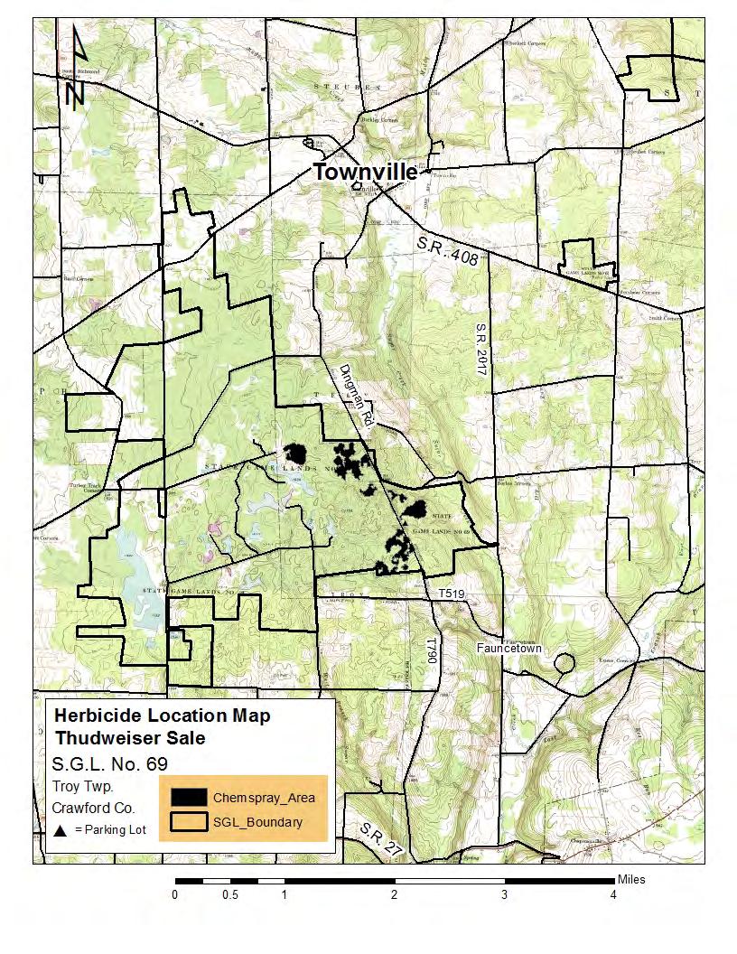
7 ¹ Block 1 Block 2 Block 4 Block 3 S.G.L. 069 Crawford Co., Troy Twp. Thudweiser Herbicide Only Parking_Area NW_State_Roads Local_Roads_2014 Block 6 Block 5 Chemspray_Area Block Boundary SGL_Boundary Block 1-19 Acres Block 2-36 Acres Block 3-5 Acres Block 4-4 Acres Block 5-16 Acres Block 6-33 Acres Total = 113 Acres 1 inch = 1,320 feet Feet ,320 2,640 3,960 5,280
8
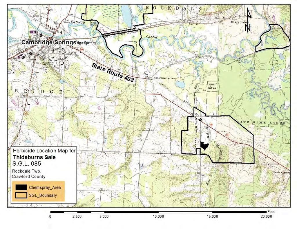
9 ¹ 1200 HWY 408 ST RT 1031 Block 1 Western Game Farm 1200 HENRY ST RT 1031 SGL 085 Crawford Co., Rockdale Twp. Thideburns Herbicide Only SGL_Boundary Chemspray_Area Block Boundary - State/Twp. Road Block 1 = 9 Acres 1 inch = 1,320 feet GRAYTOWN HILL JOUVER ,320 2,640 3,960 5,280 Feet
10
11 BROWN Block 1 WILLIAMS ¹ Block 2 STORMFELL Block 4 T 625 Block 5 REIS SGL 96 Venango Co., Plum Twp. Chapter 2 Herbicide Only = PGC Road Parking_Area Block 6 LINE KNEPP Block 7 BRADLEYTOWN ST RT 4002 WHITE Block 1= 7 Acres Block 2= 30 Acres Block 4= 6 Acres Block 5= 3 Acres Block 6= 11 Acres Block 7= 8 Acres Block 8= 26 Acres SUGAR LAKE SGL_Boundary Chemspray_Area road_tanw_l_pa121 PROPER Block Total Acres= 91 Acres Scale 1" =1320' Map 1 of 2 WHITE Feet ,320 2,640 3,960 5,280
12 VOORHEES LAMY RIDGE ¹ HAMILTON CORNERS Block 9 DEETS SCHOOL GRESHEM Block 10 SGL 96 Venango Co., Cherrytree Twp. Chapter 2 Herbicide Only GIFFO Block 13 = Gate Parking_Area PUMP STATION SGL_Boundary TARR Block Chemspray_Area Boundary PGC_Roads Block 9= 9 Acres Block 10= 5 Acres Block 13= 61 Acres Total Acres= 75 Acres Map 2 of 2 Feet ,320 2,640 3,960 5,280
13
14 CONCO WADE µ Block 1 MOUNT PLEASANT CHELTON HILL CHELTON HILL LR LR HWY 89 ROUTE 89 Block 2 HWY 89 Block 3 Block 5 Block 6 SGL 144 & 272 Erie, Crawford and Warren Counties Concord, Sparta and Eldred Twp. Big Portions Herbicide Map 1 of 2 BYLER - SGL Boundary - Herbicide Boundary - State/Twp. Road - SGL Road Block 7 Block 8 EARNEST Block 9 - SGL Gate Block 1-40 ac Block 2-7 ac Block 3-14 ac Block 5-15 ac Block 6-21 ac Block 7-12 ac Block 8-6 ac Block 9-32 ac Block ac Total = 157 acres BYLER CANADOHTA LAKE ST RT 1024 ST RT inch = 1,320 feet
15 µ Block 10 HARRISON T 365 SGL 144 & 272 Erie, Crawford and Warren Counties Concord, Sparta and Eldred Twp. Big Portions Herbicide Map 2 of 2 BIMBER - SGL Boundary - Herbicide Boundary - State/Twp. Road - SGL Road - SGL Gate Block 1-40 ac Block 2-7 ac Block 3-14 ac Block 5-15 ac Block 6-21 ac Block 7-12 ac Block 8-6 ac Block 9-32 ac Block ac Total = 157 acres ST RT 1032 LR inch = 1,320 feet
16 BOYTHE Block 2 Block 3 BYLER ST RT 1024 BYLER Block 1 CHELTON HILL Block 7 EARNEST HWY 77 WADE Block 5 Block 6 Block 8 ST RT 1024 SPORTSMAN LR Block 9 SPARTA ST RT 1024 FISH FLATS ERIE COUNTY LINE GRADE WOOD HAMMOND S SPRING ST BLAKESLEE COUNTY LINE E MAIN ST SPRING ST WELCH HILL WELCH HILL Spartansburg ST RT 1034 PATCHEON ERIE COUNTY LINE MCCRAY DR OBERT ROSS OLD ROUTE 77 SMITH EASTMAN ST RT 1034 SUNBECK COUNTY LINE SUNDBECK LINDSAY LINDSEY HOLLOW STATE LOT SUNDBECK ERIE COUNTY LINE COUNTY LINE COUNTY LINE LINDSEY HOLLOW COUNTY LINE ST RT 3010 WHITNEY STATE LOT COUNTY LINE ST RT 3010 µ HYDE JINKS WOLOSZYN HYDE COBBS BRITTON RUN FIRTH BUELLS CORNERS WHITE RECKS MAGEETOWN WRIGHT GLYNDEN BANGS LN ST RT 1032 WHITNEY REED FINK FISH FLATS ST RT 1022 CHASE ST RT 1032 HWY 89 SGL 144 & 272 Erie, Crawford and Warren Counties Concord, Sparta and Eldred Twp. Big Portions Herbicide Location Map - SGL Boundary Block 1-40 ac Block 2-7 ac Block 3-14 ac Block 5-15 ac Block 6-21 ac Block 7-12 ac Block 8-6 ac Block 9-32 ac Block ac Total = 157 acres PENNOYER FAIRVIEW COON - Herbicide Boundary - State/Twp. Road - SGL Road - SGL Gate ST RT 1022 STEWART 1 inch = 5,417 feet ROGERS CENTERVILLE-BUELLS CORNERS ST RT 1032 HATCHTOWN ST RT 1022 VROOMAN EAST FARRINGTON HARRISON BETHEL CHURCH SECREST ST RT 1022 ST RT 1013 BERRY RIGBY MAGEETOWN SUNDBECK BIMBER Block 10 LR SPRING CREEK BUELL CORNERS T 365 SUNBACK SPRING CREEK LAMB GOSSVILLE ONGLEY HL SUNBACK EUREKA CALALLEN
17 µ WINTON Block 1 PICCADILLY HILL SGL 291 Warren County, Spring Creek Twp. Ash Man Herbicide - SGL Boundary - Herbicide Boundary - SGL Road - State/Twp. Road - SGL Gate Block 1-18 acres WHITNEY RUN 1 inch = 1,171 feet
18 RUSSEL T 328 ROOSEVELT HWY LOWELL CHERRY HILL HILLCREST DR WARREN ST HARE CREEK UNION ST OHIO ST ELK ST MOUND ST PLAZA ST CHO STEWART VILLAGE GREEN DR ST Corry MEADOW LN FULTON E SOUTH ST SEVENTH ST S CENTER ST RANDOM APACHE AVE E MAIN ST SIXTH ST S SHADY AVE SHADY AVE STEWART E COLUMBUS AVE WINTON SPENCER SCOTTS CROSSING MUZZY DRABNECK MARKET ST LOCEY EAST ST WHITES CORN S SAMPLE FLATS WEBER ST CAROL HILL GRAND ARMY OF THE REPUBLIC HWY DAVIS SPRING CREEK CORRY HWY 957 YANNA BAKER HILL µ KIRIN LR BAKER HILL WAY RIDGE ORMSBEE WELCH HILL SPARTANSBURG HWY AKAM ROSS SHORT SUMMIT LINDSEY HOLLOW WHITNEY RUN WINTON Block 1 LINDSEY HOLLOW PICCADILLY HILL TURNER HILL BECK CEMETERY COUNTY LINE SPRING ST LINDSAY LINDSEY HOLLOW ERIE COUNTY LINE SGL 291 Warren County, Spring Creek Twp. Ash Man Herbicide - SGL Boundary - Herbicide Boundary LINDSEY HOLLOW WHITNEY COUNTY LINE JINKS WOLOSZYN HYDE ST RT 3010 OIL CREEK JACKSON HILL PATCHEN COLLINS - SGL Road - State/Twp. Road - SGL Gate Block 1-18 acres COUNTY LINE 1 inch = 5,417 feet STATE LOT HYDE KNAPP COBBS SPRING CREEK TUBBS
Tahlequah Public Schools Department of Transportation 820 Pendleton Tahlequah, OK
 Tahlequah Public Schools Department of Transportation 820 Pendleton Tahlequah, OK 74464 1.918.458.4168 Route 1 6:45am 6:46am 6:48am 6:50am 6:52am 6:55am 6:56am 6:57am 6:58am 6:59am 7:00am 7:05am 7:11am
2016 Penelec Smart Meter Installation Schedule*
 Meadville Area Communities with an installation date of Jan 2016 Mar 2016: Cambridge Springs Meadville Centerville Nanty Glo Cochranton Saegertown Conneaut Lake Shippenville Conneautville Springboro Edinboro
Townships Eligible to Apply for Township Sign Grant 2018
 Townships Eligible to Apply for Township Sign Grant 2018 For more information on the Ohio Dept. of Transportation s Township Sign Grant Program, please visit the program s website at: http://www.dot.state.oh.us/divisions/planning/localprograms/pages/township_safety_s
Tell City-Troy Township School Corporation Home of the Marksmen Bus Route Information
 Tell City-Troy Township School Corporation Home of the Marksmen 2015-2016 Bus Route Information We continue working with the City of Tell City with their get healthy initiative. In doing so, there will
Tell City-Troy Township School Corporation Bus Route Information
 Tell City-Troy Township School Corporation 2018-2019 Bus Route Information We continue working with the City of Tell City with their get healthy initiative. In doing so, there will once again be walking
LIHTC Properties in Iowa's 2nd District LIHTC (1997 to. (Dave Loebsack - D) 2016) Source: HUD LIHTC Through 2016
 2016) Source: HUD LIHTC Through 2016") LIHTC Properties in Iowa's 2nd District LIHTC (1997 to (Dave Loebsack - D) 2016) Source: HUD LIHTC Through 2016 nprofit Placed BLACK HAWK VILLAGE 3420 MASON RD BURLINGTON IA 52601 t 47 t EAGLE BLUFF PHASE
LIHTC Properties in Iowa's 2nd District LIHTC (1997 to (Dave Loebsack - D) 2016) Source: HUD LIHTC Through 2016 nprofit Placed BLACK HAWK VILLAGE 3420 MASON RD BURLINGTON IA 52601 t 47 t EAGLE BLUFF PHASE
MULTIPLE POLLING PLACES
 MULTIPLE POLLING PLACES CITY OF BINGHAMTON 30 polling places Ely Park Housing, Recreation Center, Glenwood Rd 1 Holy Spirit Recreation Center, 358 Clinton St 2, 5 & 7 Catholic Charities, 290 Front St 3
Page 1 10/13/2011
 Page 1 10/13/2011 Page 2 10/13/2011 Page 3 10/13/2011 Page 4 10/13/2011 Page 5 10/13/2011 Page 6 10/13/2011 Page 7 10/13/2011 Page 8 10/13/2011 Page 9 10/13/2011 Page 10 10/13/2011 S Spruce Dr 8th Ave
List of Lands Available for Taxes
 List of ****Florida Statute 197.502 Application for obtaining tax deed by holder of tax sale certificate; fees. (7) On county-held or individually held certificates for which there are no bidders at the
#206 - EAST HIGH SCHOOL LF ON 11E ON RAMP THEN LF ON ENTRANCE ON HAMPTON HILL RD, START AT 6:00 A.M., LF ON HAMPTON HILL ROAD, PICKUP AT 6:05 RT ON 39
 BUS #201 - EAST HIGH SCHOOL RT ON FLATWOOD RD (PICKUP AT END OF TRIVETTE LANE (6:25) TURN AT FLATWOOD AND MORRELL TOWN INTERSECTION - RETRACE TO FLATWOODS, LF ON HICKORY TREE ROAD, LF ON RYDER CHURCH RD,
1336 GRANT IS THE LAST # in Burgettstown Area
 #1 2016-2017 AM HIGH SCHOOL 6:50 98791 Garage 6:58 6.7 Shady Lane Bar, Box 1110 Grant street 6:59 0.2 Verner Mine Rd. 7:00 0.6 SNPJ 7:01 0.2 French Hill 7:02 0.1 Dilly St. Midway,Make Right onto North
Northwest Triangle. Redevelopment Proposal. Property Acquisition, Engineering, and Demolition. December, 2005 REDEVELOPMENT AUTHORITY OF THE
 Northwest Triangle Redevelopment Proposal Property Acquisition, Engineering, and Demolition December, 2005 REDEVELOPMENT AUTHORITY OF THE CITY OF YORK York City Redevelopment Authority 14 West Market Street,
3: Elementary 37 Bavington Rd 3: Harmon Creek,Second Ave.
 #1 2016-2017 PM HIGH SCHOOL 2:30 98826.6 High School 2:34 2.1 Loucust St. 2:36 0.5 Pierce 2:37 0.1 Box 148 Evergreen Rd. 2:38 0.3 Raccoon Car Wash 2:39 0.2 Shin Hill 2:40 0.1 Honor Roll (Joffre) 2:41 0.1
Ohio Maple Producers Association Members Updated April 2018 [1]
![Ohio Maple Producers Association Members Updated April 2018 [1]](/thumbs/85/91511528.jpg "Ohio Maple Producers Association Members Updated April 2018 [1]") Ohio Maple Producers Association Members Updated April 2018 [1] 4-H Camp Whitewood 7983 S. Wiswell Road Windsor, OH44099 440-272-5275 campwhitewood@gmail.com https://4hcampwhitewood.osu.edu/, candy, Eating
Ohio Maple Producers Association Members Updated April 2018 [1] 4-H Camp Whitewood 7983 S. Wiswell Road Windsor, OH44099 440-272-5275 campwhitewood@gmail.com https://4hcampwhitewood.osu.edu/, candy, Eating
MEMORANDUM. DATE: February 1, 2007
 DATE: February 1, 2007 TO: FROM: SUBJECT: NW PA Regional Operations Forum (ROF) Edwards and Kelcey Inventory of Existing and Planned Regional Operations Projects (DRAFT) The Regional Operations Forum (ROF)
CITY OF CONCORD CURRENT PROJECTS REPORT SEPTEMBER DECEMBER 2017
 CURRENT PROJECTS REPORT SEPTEMBER DECEMBER 2017 RETAIL/SERVICE COMMERCIAL DEVELOPMENT Application PL15466 - UP, RT, DR Project Name UNDER CONSTRUCTION: Veranda Shopping Center APPROVED: Applicant Building
AFTERNOON RUN IS REVERSE OF MORNING RUN (add Poplar Grove Church Daycare from Bus 266)
") BUS #212 (6:25 A.M.) BEGINNING AT CROSS ROADS IN PINEY FLATS, LEFT ON PINEY FLATS ROAD, RIGHT ON CHESHIRE LANE, RETRACE, RIGHT ON PINEY FLATS ROAD, TURN AT CRIPPLE CREEK ROAD, RIGHT ON PINEY FLATS ROAD,
BUS #212 (6:25 A.M.) BEGINNING AT CROSS ROADS IN PINEY FLATS, LEFT ON PINEY FLATS ROAD, RIGHT ON CHESHIRE LANE, RETRACE, RIGHT ON PINEY FLATS ROAD, TURN AT CRIPPLE CREEK ROAD, RIGHT ON PINEY FLATS ROAD,
LIHTC Properties in 2016) (Donald Norcross Through 2016
 (Donald Norcross Through 2016") LIHTC Properties in New Jersey's 1st District LIHTC (1997 to 2016) Source: HUD LIHTC (Donald rcross - D) Through 2016 nprofit EVANS-FRANCIS ESTATES 100 EVANS LN CHERRY HILL NJ 8003 2005 t 54 t EDGEWOOD
LIHTC Properties in New Jersey's 1st District LIHTC (1997 to 2016) Source: HUD LIHTC (Donald rcross - D) Through 2016 nprofit EVANS-FRANCIS ESTATES 100 EVANS LN CHERRY HILL NJ 8003 2005 t 54 t EDGEWOOD
JUNIOR SIMM x ANG Lot Sale Price Seller Buyer
 2017-2018 Performance Tested Bull Sale Report JUNIOR SIMM x ANG Saxe Farm Steve Weber 20457 Neal Davis RD 3317 Hoffmann LN 6 $3,700.00 Thompsonville, IL 62890 Fults, IL 62244 Glenn Brammeier Mark Smith
Sevier County Natural Stakeholders
 County Mr. Larry Waters Sevier County Cthse Ste 21E 125 Court Ave 865 453-6136 FAX 453-683 Supt. Highways Mr. Jonas A. Smelcer Sevier County Cthse Ste 34E 865 453-3452 Gatlinburg Mr. Mike Helton 123 Parkway
Mercer County, PA Cemetery Index Page Key
 This table can be used to determine in which cemetery a particular grave listing can be found. For example, if your page is Vol. 3, Page 79, it would most likely be in Pearson Cemetery, Jefferson Twp.
Call Briefing Report
 WINCHESTER POLICE DEPARTMENT Call Briefing Report 3/8/2019 thru Selected Agency Type: Police Selected Agency ID: All 19-009568 03/08/2019 00:04 TRAFFIC STOP DUI AMHERST ST/ W BOSCAWEN ST 19-009569 03/08/2019
Bulletin June 25, 2010 COUNTY VOTED 2009 PROPERTY TAX LEVIES BY PROGRAM CATEGORY, COUNTY AND RATE
 Bulletin 2010-03 June 25, 2010 COUNTY VOTED 2009 PROPERTY TAX LEVIES BY PROGRAM CATEGORY, COUNTY AND RATE AGING AND SENIOR SERVICES Adams.5 Allen.8 Ashland.6 Ashtabula 1.0 Athens.75 Auglaize 1.0 Belmont.8
Santa Cruz North Interior
 Santa Cruz North Interior The Santa Cruz North Interior planning area includes the area commonly referred to as the San Lorenzo Valley. The greatest amount of development occurs in the communities of Boulder
FOR LEASE 1710 Whitney Mesa Dr. Henderson, NV 89014
 Whitney Mesa is a high-end concrete-tilt up office/warehouse building, approximately 33,625 SF. The facility has a FDA approval for drug assembly and R&D or is well-suited for MD use. PROPERTY HIGHLIGHTS
WEST CLARK COMMUNITY SCHOOLS 2018/2019 Henryville Roads & Subdivisions Bus Routes AM and PM STREET NAME SUBDIVISION ROUTE DRIVER Phone Apple Tree
 WEST CLARK COMMUNITY SCHOOLS 2018/2019 Henryville Roads & Subdivisions Bus Routes AM and PM STREET NAME SUBDIVISION ROUTE DRIVER Phone Apple Tree Lane 400 Amy Guthrie 812-620-0298 Ash Street 205 Susan
1C-PM-1 PVE PLEASANT VALLEY ELEMENTARY PM
 Bus Stop Locations For 1C-PM-1 PVE PLEASANT VALLEY ELEMENTARY PM Bus:1C Driver:Shaffer, Melinda 2:05 pm ARRIVE PLEASANT VALLEY ELEMENTARY SCHOOL 2:20 pm ORIGIN PLEASANT VALLEY ELEMENTARY SCHOOL 2:20 pm
DAILY & WOODS A PROFESSIONAL LIMITED LIABILITY COMPANY ATTORNEYS AT LAW
 JERRY L. CANFIELD, P.A. THOMAS A. DAILY, P.A. WYMAN R. WADE, JR., P.A. DOUGLAS M. CARSON, P.A. ROBERT R. BRIGGS, P.A. C. MICHAEL DAILY L. MATTHEW DAVIS COLBY T. ROE Also Licensed in Oklahoma DAILY & WOODS
7:52 26 & E 7:52 26 & 7:54 26 & 7:56 & 7:56 & 7:56 & 7:56 7: : : :00 8: : :06 26 & E
 Welches Route 1 AM 7:50 Greenwood Dr. (El Burro Loco parking lot) 7:52 Hwy. 26 & E Wildwood Ave. 7:52 Hwy. 26 & Lataurelle Ave. 7:54 Hwy. 26 & Mtn. Air Dr. 7:56 Wild Fern Ln. & Mt. Vista Ct. 7:56 Wild
Prescribed burn contractors in Arkansas updated
 Prescribed burn contractors in Arkansas updated 11-17-17 (NW AR list with potential coverage throughout AR depending on size of burn units and contractor desire) This is not a complete list of all prescribed
Santa Cruz North Interior
 Santa Cruz North Interior The Santa Cruz North Interior planning area includes the area commonly referred to as the San Lorenzo Valley. The greatest amount of development occurs in the communities of Boulder
City of Pittsburg. WEST QUINCY AND COUNTRYSIDE ADDITION STREET IMPROVEMENTS 2018 Street Improvements Program
 CRESTWOOD LN SYCAMORE ND V I POTLITZER LINDBURG 26TH ST TERR MILLER JAMES UTAH OHIO HOBSON HOBSON FIELDCREST SUNCREST THOMAS MT CARMEL PL NORRIS PEARL TWIN LAKES 31ST ST HOMER UTAH 32ND ST 30TH ST LIZA
Start Time:3:15 pm End Time:3:54 pm
 Bus Stop Locations For 14 PM MURPHY PM MURPHY PM Route:14 PM MURPHY PM Bus:32 End Time:3:54 pm 3:21 pm STOP 751 OLD COLCHESTER RD 3:21 pm STOP 715 OLD COLCHESTER RD 3:21 pm STOP 709 OLD COLCHESTER RD 3:22
ISSUE SUMMARY: FUNCTIONAL CLASSIFICATION NETWORK UPDATE FOR PRINCIPAL ARTERIALS
 Draft for approval by TCC on 8/8; TAQC on 8/14 and ARC on 8/27/14 DATE: August 27, 2014 ISSUE SUMMARY: FUNCTIONAL CLASSIFICATION NETWORK UPDATE FOR PRINCIPAL ARTERIALS FROM: Tom Worthan, TAQC Chairman
LIHTC Properties in Texas' 29th District. 2016) Source: HUD LIHTC. Through 2016
 Source: HUD LIHTC. Through 2016") LIHTC Properties in Texas' 29th District (Gene LIHTC Green (1997 to - D) 2016) Source: HUD LIHTC Through 2016 nprofit Placed AVENUE TERRACES PHASE II 4300 IRVINGTON HOUSTON TX 77009 2014 New Construction
LIHTC Properties in Texas' 29th District (Gene LIHTC Green (1997 to - D) 2016) Source: HUD LIHTC Through 2016 nprofit Placed AVENUE TERRACES PHASE II 4300 IRVINGTON HOUSTON TX 77009 2014 New Construction
North Warren Elementary Transportation Information for
 A B C D E F Aubrey Mills Road 1002 6:53 Floyd, Vicky 846-2175 Ayers Road & Three Forks-Flat 2615 6:38 Cassie Jones 202-2591 Beckham Road 2615 6:47 Cassie Jones 202-2591 Beeler Ave. 1002 7:11 Floyd, Vicky
Thomas Dickerson Mercer Pioneer of 1852 compiled by Stephenie Flora oregonpioneers.com
 Thomas Dickerson Mercer Pioneer of 1852 compiled by Stephenie Flora oregonpioneers.com Thomas Dickerson Mercer b. 11 Mar 1813 Harrison County, Ohio d. 25 May 1898 Seattle, King County, Washington buried
21 TABLES OF SPECIAL ORDINANCES TABLE C - VACATING OF STREETS AND ALLEYS
 21 TABLES OF SPECIAL ORDINANCES TABLE C - VACATING OF STREETS AND ALLEYS Alley - N. Albemarle St. to Eberts Lane 7-16-85 X-321 Alley - N. Albemarle St. to Cambridge St. 6-19-90 Y-411 Alley - Bare to Park
Hamilton, Clermont, Butler, Warren, Brown & Clinton Counties
 Hamilton, Clermont, Butler, Warren, Brown & Clinton Counties Clinton Adams Twp E32 11 $169,159 10 $156,790 Hamilton Addyston W07 6 $31,958 4 $8,975 Hamilton Amberley E02 39 $286,442 37 $276,323 Clermont
Boil Water Advisory Issued For Portions of Cabell and Lincoln Counties
 \ Kelley Gillenwater Kelley.Gillenwater@amwater.com Office: 304-340-2090 Mobile: 304-389-8175 www.amwater.com Boil Water Advisory Issued For Portions of Cabell and Lincoln Counties CHARLESTON, W.Va. (April
Chapter VIII: Agencies and Organizations
 Chapter VIII: Agencies and Organizations The following agencies and organizations play a major role in water resource decision-making in the Oneida Lake watershed. Please contact the CNY Regional Planning
EAST VALLEY HIGH SCHOOL CCS
 EAST VALLEY HIGH SCHOOL CCS Students should arrive to the stop 5 minutes before the designated pick up time. Collaboration day pick up time is 1.5 hours later except for Preschool children. ROUTE 101 6:27
WARM SPRINGS CROSSING 7440, 7370, 7350 & 7470 DEAN MARTIN DRIVE :: LAS VEGAS, NV 89139
 FOR LEASE Divisible Warehouse/Showroom/Office Space WARM SPRINGS CROSSING 7440, 7370, 7350 & 7470 DEAN MARTIN DRIVE :: LAS VEGAS, NV 89139 OWNED AND MANAGED BY: FOR MORE INFORMATION PLEASE CONTACT: Jeremy
FOR LEASE SPENCER AIRPORT PLAZA II 2057 EAST MAULE AVENUE, LAS VEGAS, NEVADA 89119
 2057 EAST MAULE AVENUE,, NEVADA 89119 KYLE CANYON GATEWAY HUALAPAI WAY FORT APACHE ROAD SPRING MOUNTAIN SILVERSTONE S RAINBOW BLVD IRON MOUNTAIN N JONES BLVD N DECATUR BLVD S DECATUR BLVD MARTIN LUTHER
LIHTC Properties in Georgia's 13th District Satellit. LIHTC Source: e LIHTC. (David Scott - D) Through 2015
 Through 2015") LIHTC Properties in Georgia's 13th District Satellit LIHTC Source: e LIHTC (David Scott - D) Through 2015 Placed ABBINGTON TRAIL 3470 FLORENCE POWDER SPRINGS GA 30127 2013 60 ALEXANDER FALLS 950 LAKE RIDGE
LIHTC Properties in Georgia's 13th District Satellit LIHTC Source: e LIHTC (David Scott - D) Through 2015 Placed ABBINGTON TRAIL 3470 FLORENCE POWDER SPRINGS GA 30127 2013 60 ALEXANDER FALLS 950 LAKE RIDGE
BURLINGTON POLICE DEPARTMENT Daily Activity Log
 BURLINGTON POLICE DEPARTMENT Daily Activity Log 03/31/2019 thru 04/02/2019 Selected Agency Type: Police Selected Agency ID: All 19-010258 03/31/2019 00:29:22 ASSAULT ASSAULT 613 JEFFERSON ST PADDLEWHEEL
List of Interpretive Signs of the John Hunt Morgan Heritage Trail of Ohio
 List of Interpretive Signs of the John Hunt Morgan Heritage Trail of Ohio 23 County Location, Interpretive Sign Number GPS Coordinates (Decimal Format) Longitudinal (W) Latitudinal (N) Nearest Road Intersection
2002 and 2001 Iowa Land Values
 2453 2024 2859 2368 2278 2213 1878 1731 1744 1627 OSCEOLA O BRIEN HARRISON SHELBY AUDUBON GUTHRIE DALLAS POLK JASPER 1897 1789 FREMONT 2002 and 2001 Iowa Land Values 2407 2137 2670 2498 CHEROKEE 2114 2086
Bulletin August 2013 COUNTY, MUNICIPAL & TOWNSHIP PERMISSIVE MOTOR VEHICLE LICENSE TAX REVENUE RECEIVED BY TYPE OF JURISDICTION IN 2012
 (3) (4) (5) ADAMS - - - - 43,874 53,413 97,287 ALLEN 544,173 - - 544,251 301,869-846,120 ASHLAND 301,358 - - 301,401 95,991 38,463 435,855 ASHTABULA 319,512 326,226 430,584 1,076,490 453,686 357,595 1,887,771
2016 Bee Swarm List 2016 Adams County Swarm List
 2016 Bee Swarm List 2016 Adams County Swarm List Name Dennis Eilers Phone 513-502-8190 Address 2086 Fullmoon Ct. County Adams Name Sandra Hartman Phone 513-313-2322 Address 3859 Buck Run Rd. County Adams
SOUTHWESTERN PENNSYLVANIA COMMISSION
 About These Data This file contains the 100% count of total population for the municipalities in Allegheny County for the decennial years 1930 to 2010. The 100% count of population comes from the questions
NATURAL LAKES IN OHIO
 OPEN FILE REPORT # 5 NATURAL LAKES IN OHIO (LARGER THAN FIVE ACRES) By Leonard P. Black Water Planning Unit Ohio Department of Natural Resources, Division of Water August 1991 INTRODUCTION Due to the numerous
LIHTC Properties in Georgia's 13th District. LIHTC (1997 to. Through 2016
 LIHTC Properties in Georgia's 13th District LIHTC (1997 to (David 2016) Source: Scott HUD LIHTC - D) Through 2016 Placed ABBINGTON TRAIL 3470 FLORENCE POWDER SPRINGS GA 30127 2013 60 MANOR AT BROAD ST
Newburyport P.M. Routes updated: 8/14/17 ROUTE 1 Nock Middle School ROUTE 2 Nock Middle School
 ROUTE 1 Nock Middle School ROUTE 2 Nock Middle School 1. Dennett Dr. @ Everette Dr. 1. 136 Hale St. 2. Dennett Dr. @ Jones Dr. 2. LaValley Ln. @ Francis Dr. 3. Turkey Hill Rd. @ Henderson Circle 3. 47
APPLEWOLD BOROUGH: Applewold Borough Building, 8 Hickory Street, Kittanning, PA 16201
 APOLLO BOROUGH: Apollo Hose Company #2, 327 N. 4 th Street, Apollo, PA 15613 APPLEWOLD BOROUGH: Applewold Borough Building, 8 Hickory Street, Kittanning, PA 16201 ATWOOD BOROUGH: Keystone Sportsmen s Club,
Road and Bridge Closure Report
 Page 1 of 7 Openings Date Anticipated DIST COUNTY ROUTE NUM LOCALNAME Closed OpeningDate CO 001/01 VALLEY VIEW comments CO 015/04 MAIN STREET (IN WIDEN AREA) CULVERT WASHOUT CO 015/03 UGLY RUN CO 013/02
Figure 3-1 Sediment Sampling Locations Overview. Downtown Portland Sediment Characterization Field and Data Report. River Mile 12 to 16
 2054 2180 2179 2178 2631 162 1972 4589 4481 1052 3009 1400 4009 45 4803 1533 Figure 3-1 Sediment Sampling Locations River Mile 12 to 16 4463 2623 2275 1739 309 RM-12 3793 1068 278 334 STEEL BRG OF40 1394
ARKANSAS STATE HIGHWAY AND TRANSPORTATION DEPARTMENT TABULATION FOR BID NO
 DISTRICT ONE Page 1 of 10 Pages District 1 Headquarters P.O. Box 278 Wynne, Arkansas 72396 Phone - (870) 238-8144 COUNTY ITEM QUANTITY PRICE EXTENSION PRICE EXTENSION PRICE EXTENSION ITEM 1: Bag# 1-1 2330
NEC OF DEER SPRINGS WAY & HUALAPAI WAY
 NEC OF & Las Vegas, NV 89166 FOR LEASE - 2 SPACES REMAINING JOSEPH BONIFATTO T: 702 242 56 C: 702 491 0472 FORT APACHE ROAD N DURANGO DRIVE CHARLESTON CAMPUS S RAINBOW BLVD N JONES BLVD N DECATUR BLVD
City / Village Name. Picked Up So Far = 1245 lbs of Holiday Lights. Arlington Heights / SWANCC. Barrington /
 City / Village Name Arlington Heights / Barrington / Buffalo Grove / Elk Grove Village / LBS Recycled 2011-2012 Drop Off Locations Arlington Heights Public Works 222 N Ridge Avenue Monday - Friday: 7:30
TRIP SUMMARY by TRIP 09/23/2015 Ordered by Trip Name
 TRIP SUMMARY by TRIP 0//0 Ordered by Trip Name Bus AM - Goat * Bus PM - Goat * : am 0 : am 0 0 S FM 0 : pm ROCKDALE INTERMEDIATE (0) :0 am CR : pm ROCKDALE ELEMENTARY (0) : am 0 COUNTY ROAD : pm ROCKDALE
Monomoy Regional School District Bus Routes Monomoy Regional Middle School Revised 8/30/18
 MR7 7:48 AM Depot St at Big Rock Oyster, Harwich 4:04 PM 7:49 AM 397 Depot St, Harwich 4:03 PM 7:51 AM 124 Depot Rd, Harwich 4:02 PM 7:52 AM Spot Rd at Arbutus, Harwich 4:01 PM 7:53 AM Depot Rd at Smith
STOP LIST FOR BUS # 904
 STOP LIST FOR BUS # 904 TO MT ZION PS -HAMMER/GA.POWER/STEM (6/4-7) DRIVER NAME: LYNETTE VIRGINIA RunID:139.001 W LEES MILL RD & VERDE DR 07:40 AM BENTLEY CRSG @ MEADOW SPRINGS APTS (BY CLUBHOUSE) 07:42
SUBJECT TO CHANGE!! BERLIN TOWNSHIP
 Page 1 of 5 SUBJECT TO CHANGE!! BERLIN TOWNSHIP 011-027-000-040-00 JORDAN LAKE RD, SARANAC, MI $2,300.00 BEG AT PNT ON E EDGE JORDAN LAKE HWY & S LI OF I-96 R/W, 228.83 FT S & 78.36 FT N 73 DEG 18 MIN
REPOSITORY LIST 2018 ASTON TWP PROPERTIES SOLD "AS IS"
 REPOSITORY LIST 2018 ASTON TWP PROPERTIES SOLD "AS IS" 02-00-00822-02 DIAMOND STREET (GRD) (GRD--GROUND) 02-00-01569-00 2231 MOUNT ROAD CHESTER TWP 07-00-00764-00 TOWNSEND STREET (GRD LOT 6) 07-00-00796-00
Outlot at Foxboro Square Canton, Ohio
 Outlot at Foxboro Square Canton, Ohio Canal Fulton STATE STATE STATE STATE STATE STATE STATE STATE STATE HWY HWY HWY HWY HWY HWY HWY HWY HWY 21 21 21 21 21 21 21 21 21 ORRVILLE ST NW WOOSTER ST NW STATE
7. Thrifty Outlet, MI 4677 Alpine Ave NW, Comstock Park, MI Norton Shores, MI 700 W Norton Ave, Muskegon, MI 49441
 Meijer Stores Michigan 7. Thrifty Outlet, MI 4677 Alpine Ave NW, Comstock Park, MI 49321 19. Norton Shores, MI 700 W Norton Ave, Muskegon, MI 49441 20. Walker, MI 2929 Walker Ave NW, Grand Rapids, MI 49544
SANDY HIGH SCHOOL - AM
 - AM Please be advised that there are many changes to several of the routes this year. Some students will ride one route in the morning and then ride a different route in the afternoon. Please pay careful
PRESIDENTIAL PONDERINGS
 PKWS June 2014 Issue Editor: Carol Mathis PRESIDENTIAL PONDERINGS We are just a few weeks away from the 2014 Charlotte Pond Tour. I still need one family to volunteer to help out at one pond where we do
Crestwood Dr Thornhill Terrace Sub., S from Spielman Rd Alexander - Bus AMS 5/6 - Bus AMS 7/8 - Bus High School - Bus
 Country Club Rd 3502-4705 W from N Scott-Ends at Wolf Creek Hwy (1st House N side past Alexander - Bus AMS 5/6 - Bus AMS 7/8 - Bus 4000 to 4700 High School - 4500 to 4700 Crestwood Dr 2445-2532 Thornhill
Tulare County Irrigation Districts
 Irrigation s Consolidated Fresno County Alta Dinuba Hills Valley Orange Cove Stone Corral ÿ 63 Ivanhoe Woodlake Kings County Tulare Visalia ÿ198 ÿ 99 ÿ 137 Exeter Lindsay- Strathmore Tulare County Tulare
Nevada Transportation Conference
 Nevada Transportation Conference Transportation Funding Jacob Snow, General Manager Regional Transportation Commission of Southern Nevada Steven Horsford, Senator Kelvin Atkinson, Assembly Transportation
Stephen Rusher
 39 3 0 13-0393 10/14 CONTACT T AGENTS: Stephen Rusher 925.974.0115. srusher@newmarkccarey.com r@ne care rey. co m CA RE License e# #01439740 40 Lone Tree Plaza is is a a ±477,000 ±477,000 square square
 Driving Directions from Milledgeville, Georgia to in Pine Mountain, G... http://www.mapquest.com/print?a=app.core.eb74f8500f9d24550f56f4e6 Page 1 of 3 7/31/2012 Notes MOUNTAIN CREEK INN Trip to: 17800
HIGH SCHOOL BUS #1 ROUTE - MORNING BUS #1 ROUTE - AFTERNOON * EFFECTIVE JANUARY 3RD, 2018 *
 BUS #1 ROUTE - MORNING * EFFECTIVE JANUARY 3RD, 2018 * 1 6:30AM Wawa @1400 Beaver Brook Plaza New Castle, DE 2 6:40AM Farmer s Market- RT 13 & 273 3 6:47AM Walmart- RT 13 & 40 Split (Applebees) 2 2:43PM
SUBDIVISION TWP SUB # SECTION GENEVA TOWNSHIP Vilage of Buttonville
 EDENVILLE TOWNSHIP Colling Estates 010 150 35 The Flats Campground 010 350 26 Francis Shores Estates #1 010 381 35 Francis Shores Estates #2 010 382 35 Francis Shores Estates #3 010 383 35 Francis Shores
BURLINGTON POLICE DEPARTMENT Daily Activity Log
 BURLINGTON POLICE DEPARTMENT Daily Activity Log 07/20/2017 thru 07/21/2017 Selected Agency Type: Police Selected Agency ID: P 17-026091 07/20/2017 01:21:45 LOG CCH & III ONLY LOG CCH & III ONLY 17-026092
BURLINGTON POLICE DEPARTMENT Daily Activity Log
 BURLINGTON POLICE DEPARTMENT Daily Activity Log 01/12/2019 thru 01/14/2019 Selected Agency Type: Police Selected Agency ID: All Incident # Time Reported Activity Location/ Business Name 19-001221 01/12/2019
s. Rural Schools of Price County page 1
 Brannon / Spirit 1879 (blank) Anderson (blank) (blank) (blank) Spirit Center (blank) ca 1886 (blank) 8 34N 3E Fred Johnson (blank) ca 1886 (blank) 30 (19) 34N 3E Stone Lake burned down 1979 late 1890s
SERVICE AREA BOUNDARIES Beginning SFY2018
 SERVICE AREA BOUNDARIES Beginning SFY2018 Service Area A (1) Boundaries -- all of Ray County Ray County Fellowship Senior Center 1015 West Royle Richmond, Missouri 64085 Service Area B Beginning at I-435
Astorhurst History
 Astorhurst History 12-1-2018 Purchase Announcement May 26, 2017 CMP approval by three commissioners - Minutes $3.1 M cost, $25k per acre budget plus grants Clean Ohio Conservation matched funds with $45k
ELDORADO BUSINESS PARK
 7445-7485 DEAN MARTIN DRIVE,, NEVADA 89139 WEST ELDORADO LANE DEAN MARTIN DRIVE Eldorado Business Park is located less than 5 minutes from the I-15 Freeway, McCarran International Airport, the Las Vegas
- AGENDA - June 27, 2018
 CLARKSVILLE-MONTGOMERY COUNTY REGIONAL PLANNING COMMISSION - AGENDA - June 27, 2018 2:00 P.M. 329 Main Street (Meeting Room - Basement) I. CALL TO ORDER/QUORUM CHECK/PLEDGE TO FLAG II. APPROVAL OF MINUTES
Gateway Lab School Bus #
 Bus #1 1 7:55 Limestone Rd & Sandy Rd 2 8:01 Meadowwood Dr & Kirkwood Hwy (Walgreens parking lot) 3 8:07 New Linden Hill Road & Polly Drummond Hill Road (Zingo's) 4 8:13 North Star Road & Beech Hill Drive
River to Co. East Boundary Original All Twp 27 between Puget Sound & Snohomish-Snoqualmie Rivers
 DISTRICT NUMBER NAME AND DATE ORIGINATED COMPONENTS HISTORY 1 Snohomish (1868) Original All of Snohomish Co. 300 (1912) - 326 (1929) 327 (1930) 329 (1931) 1 new ((1938) 1 New Snohomish (1938) Consol. #12
Wacouta Twp. Florence Twp. Lake City. Mount Pleasant Twp. Lake Twp. Chester Twp West Albany Twp Gillford Twp. Zumbro Falls. Hyde Park Twp.
 M I S S I S S I Vermillion Empire Twp Castle Rock Twp Sciota Twp 0 Randolph Vermillion Twp Sheet Map 1 Hampton Hampton Twp CO New Trier Sheet Map 2 Stanton Twp Sheet Map Randolph Twp Cannon Falls 20 Marshan
BURLINGTON POLICE DEPARTMENT Daily Activity Log
 BURLINGTON POLICE DEPARTMENT Daily Activity Log 04/28/2018 thru 04/29/2018 Selected Agency Type: Police Selected Agency ID: P 18-014225 04/28/2018 00:40:29 1204 N 8 ST GAS LAND N 8 ST 18-014226 04/28/2018
City of North Liberty
 City of North Liberty City Council Agenda Special Session August 3, 11 AGENDA North Liberty City Council August 3, 11 Special Session :3 p.m. Council Chambers 1. Call to order.. Roll call. 3. Approval
BURLINGTON POLICE DEPARTMENT Daily Activity Log
 BURLINGTON POLICE DEPARTMENT Daily Activity Log 12/15/2018 thru 12/17/2018 Selected Agency Type: Police Selected Agency ID: All 18-042792 12/15/2018 00:10:04 FOOT PATROL/WALKING BEAT FOOT PATROL/WALKING
O.C.G.A GEORGIA CODE Copyright 2014 by The State of Georgia All rights reserved. *** Current Through the 2014 Regular Session ***
 O.C.G.A. 15-6-3 GEORGIA CODE Copyright 2014 by The State of Georgia All rights reserved. *** Current Through the 2014 Regular Session *** TITLE 15. COURTS CHAPTER 6. SUPERIOR COURTS ARTICLE 1. GENERAL
2015 Adams County Swarm List (Please sign up if interested in being called to pick up Honey Bee swarms)
") 2015 Adams County Swarm List Name Tom House Phone 513-519-4840 Address County Anywhere 2015 Brown County Swarm List Name Walt Weldon Phone 513-681-5274 Address County Hamilton Locations you would be willing
2015 Adams County Swarm List Name Tom House Phone 513-519-4840 Address County Anywhere 2015 Brown County Swarm List Name Walt Weldon Phone 513-681-5274 Address County Hamilton Locations you would be willing
BCCU#2 AM Bus Stops and Estimated Times
 BCCU#2 AM Bus Stops and Estimated Times Greenville Student Buses Bus #34 - Ayers Rd, Mt Tabor Ave, Hastings Cemetery Ave, Red Ball Trl, Lakepoint Sub, Glenwood Sub, Ivy Ln, Ward St, Stephen St, Vine St,
Driving Directions to NTIS Symposium-Embassy Suites Cary 201 Harrison Oaks Blvd Cary, NC 27513
 From Cambria Suites RDU to Embassy Suites Cary 1. Exit hotel parking lot, turning left onto Airgate Drive 2. Turn right onto Pleasant Grove Church Road 3. Take the 1 st right onto Airport Blvd 4. Take
 RAMPART BLVD DURANGO DR RAINBOW BLVD NELLIS BLVD DECATUR BLVD DECATUR BLVD MARYLAND PKWY EASTERN AVE PECOS RD PECOS RD LAMB BLVD LAMB BLVD N RANCHO DR S RANCHO DR INDUSTRIAL RD W SAHARA AVE 1 W CHARLESTON
VANCOUVER POLICE BLOCK WATCH WEEKLY CRIME STATS JUNE 25 TH TO JULY 1 ST, 2014
 VANCOUVER POLICE BLOCK WATCH WEEKLY CRIME STATS JUNE 25 TH TO JULY 1 ST, 2014 GET INVOLVED WITH BLOCK W ATCH VISIT VPD.CA OR CALL 604.717.2857 P O L I C E R E S O U R C E S C AN N O T B E A L L O C A T
±2.47 ACRES AT THE VILLAGE AT MERIDIAN EXCLUSIVE LISTING MERIDIAN, ADA COUNTY, IDAHO
 ±2.47 ACRES AT THE VILLAGE AT MERIDIAN EXCLUSIVE LISTING MERIDIAN, ADA COUNTY, IDAHO CALL FOR OFFERS! Offers due Friday, September 8th at 2 PM. OFFERING Land Advisors Organization is pleased to present
WR-322 RM-14 WR-503 WR-504 RIVER PKWY 1923 ROSS ISLAND BRG OF04A 1925 WR OF04 NAITO PKWY 1011 I405 FWY RM 15
 2054 2180 2179 2178 2631 162 1972 4589 4481 1052 3009 1400 4009 45 4803 1533 Figure 6-3a River Mile 12 to 16 4463 2623 2275 1739 4167 1297 986 2398 1434 1294 2049 2247 1973 4282 309 RM-12 3793 1068 278
Polling Locations. 10/31/2016 Page 1 Of 5. County: 02 - AIKEN
 County: 02 - AIKEN PCT Precinct Name Polling Location Name Polling Location Address 001 Aiken No. 1 City Auditorium 214 Park Ave SW 002 Aiken No. 2 American Legion Post 602 Hampton Ave NW 003 Aiken No.
Lehighton Area School District /15 Bus Schedules
 Lehighton Area School District - 2014/15 Bus Schedules Lehighton Area School District will begin classes on Monday - August 25, 2014. The following bus schedules are listed for the Middle School/ Senior
BURLINGTON POLICE DEPARTMENT Daily Activity Log
 BURLINGTON POLICE DEPARTMENT Daily Activity Log 05/01/2017 thru 05/02/2017 Selected Agency Type: Police Selected Agency ID: P 17-014948 05/01/2017 00:08:01 BURGLAR/HOLDUP ALARM BURGLAR/HOLDUP ALARM 2001