Dehcho Land Use Plan
|
|
|
- Randall Patrick
- 5 years ago
- Views:
Transcription

1 Grizzly Bear, Woodland Caribou, and Dall s Sheep Background Information for the Dehcho Land Use Plan John L. Weaver, Ph.D. WILDLIFE CONSERVATION SOCIETY CANADA January, 2006
2 1 Grizzly Bear, Woodland Caribou, and Dall s Sheep Background Information for the Dehcho Land Use Plan INTRODUCTION The Dehcho territory covers about 215,000 km 2 in the southwest corner of the Northwest Territories. The Mackenzie River or Dehcho (meaning big river) and its tributaries are a major feature of the landscape. The Dehcho Land Use Planning Committee seeks to finalize its Land Use Plan (LUP) by March One of the 30 land use zones identified in the Plan is Zone 6: Greater Nahanni Ecosystem (NahÆâ Dehé), which surrounds Nahanni National Park Reserve. The boundaries of the park reserve were established quickly in 1972 to protect the spectacular falls and canyons of the famed South Nahanni River from imminent hydroelectric development. Consequently, the Park Reserve is less than 10 km wide in some sections and encompasses only a small portion (14% or 4766 km 2 ) of the South Nahanni River watershed. Both the Dehcho First Nation and Parks Canada have a strong interest in providing for ecological integrity of the Greater Nahanni area. Together, they have articulated the following vision which embraces traditional ecological knowledge and principles of conservation biology: NahÆâ Dehé will protect a wilderness watershed in the Mackenzie Mountains where natural processes such as fires and floods will remain the dominant forces shaping the park s ecosystems. Special features of the park, including waterfalls, hotsprings, glaciers, plateaux, canyons, karst landscapes and cultural/spiritual sites will be preserved. Naturally-occurring plant communities will thrive and native animal species, including woodland caribou and grizzly bears, will be sustained at viable population levels.
3 2 Through a Memorandum of Understanding, Dehcho First Nations and Parks Canada have agreed to work together to expand Nahanni National Park Reserve within the Greater Nahanni Ecosystem. Under the Interim Measures Agreement (IMA) signed in 2003, approximately 85% of the South Nahanni River watershed within the Dehcho territory (excluding the present Nahanni National Park Reserve) was withdrawn from issuance of new dispositions for 5 years. The remaining 15% not withdrawn is comprised of 5 distinct blocks: (1) upper Prairie Creek, (2) upper Caribou River, (3) northwest of Tungsten, (4) Black Wolf Creek, and (5) upper Clearwater-Flood Creeks. The draft Dehcho LUP (November 2005) proposes that all of the Greater Nahanni Ecosystem (South Nahanni River watershed and the adjacent Nahanni Karstlands: 40,000 km 2 ) be managed as a Conservation Zone (Zone 6) until new boundaries are approved for Nahanni National Park Reserve. Wildlife species that use large, ecologically diverse areas can serve as useful umbrellas or surrogates for conservation of other species. Specific information about the occurrence and seasonal ranges of such landscape species can provide important information for land use planning. The NahÆâ Dehé Consensus Team for Nahanni identified sahcho or grizzly bear (Ursus arctos horribilis), medzih or woodland caribou (Rangifer tarandus caribou), and doo or Dall s sheep (Ovis dalli dalli) as pertinent species. Selection of this suite was appropriate because the problem of inadequate boundaries is especially acute for wide-ranging animals such as carnivores and northern ungulates that occur at low densities, possess lower resiliency to human impacts, and require large, secure areas to sustain viable populations. Empirical data on selected species provides a more credible basis for conservation planning than arbitrary political targets (Svancara et al. 2005). I began surveys of grizzly bears in the Greater Nahanni area in 2002 and initiated studies on woodland caribou and Dall s sheep in The purpose of this short report is to provide key findings of these on-going studies to the Dehcho LUP Committee. A final report will be available in the summer of 2006.
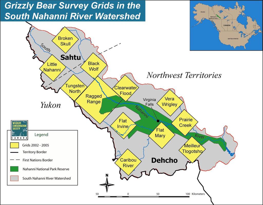
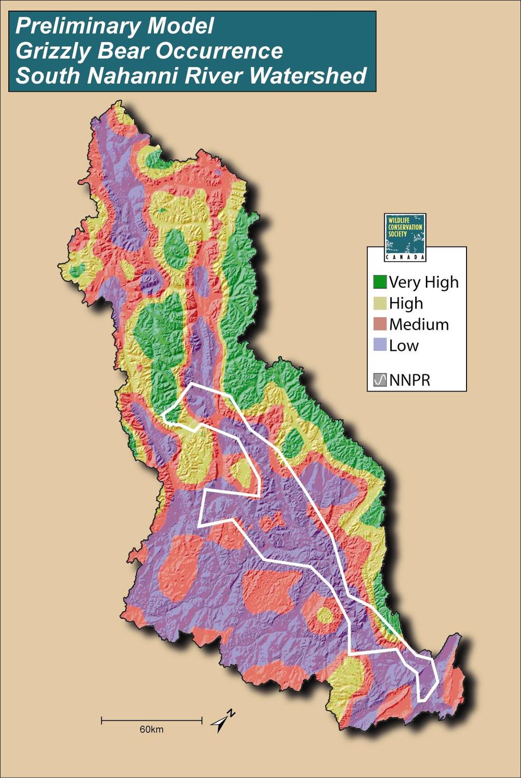
4 3 GRIZZLY BEAR Grizzly bears have low resiliency compared to other carnivores (Weaver et al. 1996). Their need for high-quality foods in spring and fall, their low reproductive rate, and their conservative dispersal (especially females) does not provide much resiliency in the face of human activities. Indeed, the drastic decline of grizzly bears throughout much of North America attests to their vulnerability and need for large, secure areas. The Committee on the Status of Endangered Wildlife in Canada (COSEWIC) has designated the northwestern population of grizzly bears as one of special concern (COSEWIC 2002a). Methods In the late 1990 s, Canadian bear researchers and geneticists pioneered a new technique for surveying bears using non-invasive, scented stations to collect hair for DNA analysis (Woods et al. 1999). Such data can provide a rich set of information on the species, gender, individual identity, and genetic diversity of bears. I followed their basic protocols in the field (Weaver 2004); Wildlife Genetics International in Nelson, BC, conducted all DNA analyses (Paetkau 2003). During 3 seasons ( ), my assistants and I established stations at 177 sites across the South Nahanni River (SNR) watershed (Map 1). We used data on grizzly visits to these stations along with digital data on terrain features and coarse classification of land cover types to construct a preliminary model and map of grizzly bear occurrence across the watershed (following Apps et al. 2004). We surveyed another 48 sites in 2005 to verify and refine the model. Results During the June survey period ( ), grizzly bears occurred at high and very high levels of relative abundance in the mountains and tributary valleys of the northern portion of the SNR watershed (Map 2). Grizzlies were less common in the boreal forests of the southwest sector of the watershed. Additional collection of hair at natural rub trees along the South Nahanni River revealed that grizzlies used the main river corridor,
5 4 primarily above Náîlîcho or Virginia Falls. We collected hair of various individuals (particularly males) at numerous sites that were km apart. These distances suggest that these bears had home ranges perhaps as large as 2000 km 2. In addition, several of the male grizzly bears detected in the Clearwater-Flood, Tungsten North, and Black Wolf grids also used the trails around Gahnîhthah or Rabbitkettle Lake inside Nahanni National Park Reserve. Genetic analyses revealed that Nahanni grizzlies exhibit the highest level of genetic diversity (along with grizzlies in Kluane) found in grizzly bears across their North American range (Paetkau et al. 1998, David Paetkau, pers.comm.) Discussion At present, Nahanni National Park Reserve is too narrow and too small to sustain a viable population of grizzly bears. The extensive block of boreal forest in the broadest portion of the South Nahanni River watershed does not support a high density of grizzly bears. The mountains and tributary valleys of the upper SNR watershed support high to very high occurrence of grizzlies and contribute importantly toward a viable population of grizzly bears. Interim land withdrawals under the IMA did not protect several areas important to grizzly bear conservation, including upper Prairie Creek and upper Clearwater-Flood Creeks. Designation of Zone 6: Greater Nahanni Ecosystem as a Conservation Zone in the Dehcho LUP would protect important habitats for grizzly bears throughout the South Nahanni River watershed. WOODLAND CARIBOU Woodland caribou in the boreal cordillera of western Canada use boreal forests in winter where they paw through shallow snow to feed on ground lichens. In spring, they migrate to alpine areas where they calve, spend the summer, rut in the fall, and stay some time during milder winters. Compared to other species of ungulates, woodland caribou have low resiliency to impacts on habitats and populations resulting from human activities (McLoughlin et al. 2003). The northern mountain population of woodland caribou has been designated as one of special concern by the COSEWIC (2002b).
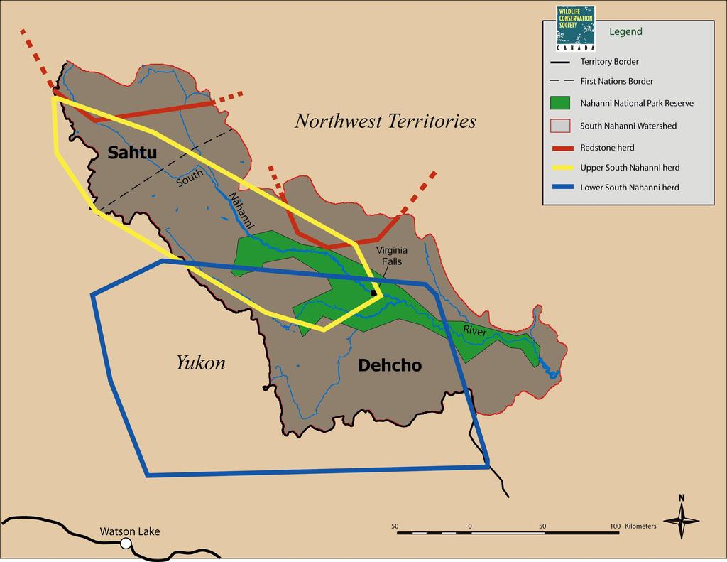
6 Methods 5 I compiled locations of radio-collared woodland caribou in the SNR watershed from several sources. In March 1995, 25 adult female caribou were fitted with conventional (VHF) radio-collars near Virginia Falls; park wardens obtained locations a few times each year during (Gullickson and Manseau 2000). From 1998 to 2002, 11 additional female caribou were fitted with satellite (PTT) radio-collars; locations were obtained every 5 days (A. Gunn and J. Adamczewski, personal communication). In October 2004, biologists with the Yukon Department of Environment captured 18 adult female caribou along the Yukon-Northwest Territory border and fitted them with satellite (PTT) radio-collars that provided locations every 5 days. Finally, the Sahtu Renewable Resources Board provided locations of caribou fitted with satellite radio-collars that use the SNR watershed. I thank all the caribou researchers for generous sharing of their data. Results I have identified 3 distinct caribou herds that use portions of the South Nahanni River watershed: (1) Lower SNR herd, (2) Upper SNR herd, and (3) Redstone herd (Map 3). The Lower SNR herd finds critical winter range inside Nahanni National Park Reserve below Náîlîcho (Virginia Falls). In May, these caribou migrate quickly km westward to the mountains of southeast Yukon where they calve and spend the summer. In early October, males and females group together for the rut along the Yukon- NT border. During milder winters, some caribou winter along the border whereas in harsh winters, they migrate eastward to lower areas in Nahanni with less snow cover. The annual home range of this herd is approximately 32,000 km 2. Within the range of this herd, Yukon biologists counted 348 caribou in the LaBiche area in 1993 and 383 caribou in the upper Coal River area in 1997 (R. Florkiewicz, personal communication). Due to inclement weather during surveys, these were incomplete counts. The Upper SNR herd winters along the South Nahanni River above Virginia Falls and in the Clearwater basin. In May, most of these animals migrate north km to the northwest corner of the SNR watershed. Here, in the alpine areas northwest of Tungsten
7 6 to beyond Howards Pass, they calve, spend the summer, and rut during October. Afterwards, they migrate southward following the South Nahanni River or the Flat River. The annual range of this herd is approximately 16,000 km 2. In 2001, biologists counted 781 animals and estimated the population size to be (Gunn et al. 2002). The Redstone herd occurs mainly north of the South Nahanni River watershed in the Sahtu region. During May and June, some caribou from this herd have their calves in the headwaters region of the South Nahanni (Sahtu). During fall and winter, some Redstone caribou winter within Dehcho territory in the upper basin of the Clearwater and Cathedral Creeks in the SNR watershed and the upper basins of Thundercloud Creek and the North Nahanni River. Discussion At present, Nahanni National Park Reserve is too narrow and too small to protect critical seasonal ranges (winter range, calving sites, rutting areas, and migratory routes) of several herds of woodland caribou. Interim land withdrawals under the IMA did not protect several areas important to woodland caribou, including alpine areas northwest of Tungsten, the upper Caribou River basin, and the upper Clearwater-Flood Creek basin. Within the Dehcho territory, designation of Zone 6: Greater Nahanni Ecosystem as a Conservation Zone would protect important caribou areas in the SNR watershed. One of the winter ranges for the Redstone caribou, however, includes not only the upper Clearwater-Flood Creek basin but also the adjacent basins of Thundercloud Creek above Coates Lake and the North Nahanni River. Under the draft Dehcho LUP, a 3-km buffer zone along the North Nahanni River (Zone 18) is designated as a Conservation Zone. The section of the Thundercloud Basin nearest Coates Lake is designated as a Special Management Zone (Zone 25) where mining and oil and gas development would be permitted. The remainder of this wintering area for caribou is designated as a General Use zone in the draft Dehcho LUP. Recently, the Sahtu have proposed the area immediately adjacent to the north as a conservation area under the Sahtu LUP.
8 DALL S SHEEP 7 Dall s sheep are habitat specialists that use alpine tundra habitat near cliffs which provide adequate escape from predators. Moreover, in winter, sheep select sites where snow accumulation is shallow due to light snowfall or wind. Consequently, Dall s sheep occur in discrete islands or patches of suitable habitat of varying size. Because suitable sites represent stable plant communities and enduring terrain features, sheep (particularly females) tend to stay at home and not disperse very far (Geist 1971). Thus, sheep populations may be structured genetically by groups of related females or matrilines occupying distinct, traditional ranges (Ramey 1993). During the Wisconsin glaciation (70,000 to 10,000 years BP), the Mackenzie Mountains represented the eastern arm of Berengia and served as major refugia between the Laurentide and Cordilleran glaciers (Loehr et al. 2005). Methods Based upon extensive field surveys, Simmons (1982) delineated the distribution of Dall s sheep throughout the Mackenzie Mountains. From the 1980s to present, NWT biologists and Parks Canada wardens periodically have conducted sheep surveys in the southern portion of the Mackenzie Mountains (Case 1985, Parks Canada 199?). We observed sheep from air and ground on the Nahanni Plateau, Ram Plateau, and Tlogotsho Plateau. We collected shed hair and faeces of sheep for possible DNA analysis, too. Results Groups of Dall s sheep occur in suitable patches of alpine habitat scattered throughout the South Nahanni River watershed (Simmons 1982). Some of the larger patches of occurrence include the Tlogotsho Plateau, Nahanni Plateau, and Sunblood Range where winter snow pack is shallow and/or windblown. Recent genetic studies indicate that sheep throughout much of the Mackenzie Mountains share similar genetic structure (Worley et al. 2004). The distribution map (Simmons 1982) suggests that the mountainous divide at the head of Clearwater and Flood Creeks may serve as a landscape-level linkage for sheep in Nahanni to other sheep bands further north in the
9 8 Mackenzie Mountains. Dall s sheep on the Tlogotsho Plateau, however, exhibit a different genetic structure than sheep elsewhere in the Mackenzies (Worley et al. 2004). During the course of sheep surveys, we discovered a concentration of caves used by sheep on the Nahanni Plateau (north of the Ram River) and others on the Ram Plateau. These karst caves on the Nahanni Plateau occur approximately 15 km to the west of the known extent of karst features (Derek Ford, personal communication). We documented 22 caves in one small basin (3 km 2 ) and another 13 caves in the adjacent basin. We observed ewe-lamb pairs inside several of the caves. Sheep in the Nahanni Range further east also use caves (Case 1989, this study). Results from DNA analyses of the hair and faeces are pending. Discussion Most of the important sheep ranges (i.e., Tlogotsho Plateau, Nahanni Plateau, and Sunblood Range) lay outside the present boundary of Nahanni National Park Reserve. Discovery of sheep using the numerous caves on the Nahanni Plateau is notable in two respects. It extends the known occurrence of the Nahanni karst features which are considered the finest in the temperate latitudes of the world. Moreover, it represents the greatest concentration of wild sheep using caves documented anywhere in North America (personal communications with sheep biologists). The caves offer a moderate environment and shelter during both summer and winter. Typically, they are located in places where predators would find access very difficult. At the entrance to the caves, deep deposition of sheep faeces provides fertilization whereas water dripping from the front edge of the cave roof provides irrigation. Most of these cave entrances exhibited a lush growth of grass and forbs that appear as an oasis in a desert of stone. I hypothesize that this unique combination of cave and lush grass allows ewes with lambs to minimize risk of predation while having good forage, thereby increasing survivorship of lambs. Designation of Zone 6: Greater Nahanni Ecosystem as a Conservation Zone in the Dehcho LUP would protect annual ranges of Dall s sheep in the South Nahanni River watershed as well as the continentally-unique occurrence of sheep using caves on the Nahanni and Ram Plateaus.
10 9 CONCLUSIONS The present boundaries of Nahanni National Park Reserve are too narrow and too small to provide for the seasonal needs and viable populations of grizzly bears, woodland caribou, and Dall s sheep. Interim land withdrawals under the IMA did not protect several areas important to these species, including upper Prairie Creek (grizzly bear and Dall s sheep), upper Caribou River (woodland caribou), northwest of Tungsten (woodland caribou), and upper Clearwater-Flood Creek (grizzly bear, woodland caribou, and Dall s sheep). Designation of Zone 6: Greater Nahanni Ecosystem as a Conservation Zone in the Dehcho LUP would protect critical seasonal ranges, contribute substantially to sustaining viable populations, and safeguard unique phenomena for these important wildlife species. LITERATURE CITED Apps, C.D., B.N. McLellan, J.G. Woods, and M.F. Proctor Estimating grizzly bear distribution and abundance relative to habitat and human influence. Journal of Wildlife Management 68: Case, R Distribution and abundance of Dall s sheep in the southern Mackenzie Mountains, Northwest Territories. File Report No. 81. Department of Renewable Resources, Government of the Northwest Territories. Yellowknife. COSEWIC. 2002a. COSEWIC assessment and update status report on the grizzly bear Ursus arctos in Canada. Committee on the Status of Endangered Wildlife in Canada. Ottawa. COSEWIC. 2002b. COSEWIC assessment and update status report on the woodland caribou Rangifer tarandus caribou in Canada. Committee on the Status of Endangered Wildlife in Canada. Ottawa. Geist, V Mountain sheep: a study in behavior and evolution. The University of Chicago Press, Chicago. Gullickson, D., and M. Manseau South Nahanni Woodland Caribou Herd seasonal range use and demography. Parks Canada Agency.
11 Gunn, A., R. Farnell, J. Adamczewski, J. Dragon, and L. Laberge Census for the South Nahanni Mountain Caribou Herd. Report No Department of Resources, Wildlife, and Economic Development, Government of Northwest Territories, Yellowknife. Loehr, J., K. Worley, A. Grapputo, J. Carey, A. Veitch, and D.W. Coltman Evidence for cryptic glacial refugia from North American mountain sheep mitochondrial DNA. Journal of Evolutionary Biology. McLoughlin, P.D., E. Dzus, B. Wynes, and S. Boutin Declines in populations of woodland caribou. Journal of Wildlife Management 67: Paetkau, D An empirical exploration of data quality in DNA-based population inventories. Molecular Ecology 12: Paetkau, D., L. Waits, P. Clarkson, L. Craighead, E. Vyse, R. Ward, and C. Strobeck Variation in genetic diversity across the range of North American brown bears. Conservation Biology 12: Ramey, R.R. II Evolutionary genetics and systematics of North American mountain sheep: implications for conservation. Dissertation, Cornell University, Ithaca. Simmons, N Seasonal distribution of Dall s sheep in the Mackenzie Mountains, Northwest Territories. File Report No. 21. Northwest Territories Wildlife Service. Yellowknife. Svancara, L.K., R. Brannon, J.M. Scott, C.R. Groves, R.F. Noss, and R.L. Pressey Policy-driven versus evidence-based conservation: a review of political targets and biological needs. BioScience 55. Weaver, J.L Trans-boundary survey of grizzly bears in Nahanni National Park Reserve Progress Report. Wildlife Conservation Society. Weaver, J.L., P.C. Paquet, and L. F. Ruggiero Resilience and conservation of large carnivores in the Rocky Mountains. Conservation Biology 10: Woods, J.G., D. Paetkau, D. Lewis, B.N. McLellan, M. Proctor, and C. Strobeck Genetic tagging free ranging black and brown bears. Wildlife Society Bulletin 27: Worley, K., C. Strobeck, S. Arthur, J. Carey, H. Schwantje, A. Veitch, and D.W. Coltman Population genetic structure of North American thinhorn sheep (Ovis dalli). Molecular Ecology 13:
12
13
14
BIG ANIMALS and SMALL PARKS: Implications of Wildlife Distribution and Movements for Expansion of Nahanni National Park Reserve. John L.
 BIG ANIMALS and SMALL PARKS: Implications of Wildlife Distribution and Movements for Expansion of Nahanni National Park Reserve John L. Weaver Conservation Report No.1 July 2006 4 SUMMARY The boundaries
Nahanni National Park
 Nahanni National Park 2017 Conservation Outlook Assessment SITE INFORMATION Country: Canada Inscribed in: 1978 Criteria: (vii) (viii) Site description: Located along the South Nahanni River, one of the
PROPOSED EXPANSION OF NAHANNI NATIONAL PARK RESERVE
 PROPOSED EXPANSION OF NAHANNI NATIONAL PARK RESERVE Boundary Options October 2007 Since 2004, the Nahanni Expansion Working Group (NEWG) has been overseeing feasibility studies for the proposed expansion
Nahanni National Park Reserve PO Box 348, Fort Simpson, NT X0E 0N0. 29 September, 2000
 Nahanni National Park Reserve PO Box 348, Fort Simpson, NT X0E 0N0 29 September, 2000 Mackenzie Valley Environmental Impact Review Board PO Box 938, 5102-50 th Ave. Yellowknife, NT X1A 2P6 Attn: Gordon
Bill S-5: An Act to amend the Canada National Parks Act (Nááts ihch oh National Park Reserve of Canada)
") Bill S-5: An Act to amend the Canada National Parks Act (Nááts ihch oh National Park Reserve of Canada) Publication No. 41-2-S5-E 16 May 2014 Revised 22 October 2014 Penny Becklumb Tim Williams Economics,
Bill S-5: An Act to amend the Canada National Parks Act (Nááts ihch oh National Park Reserve of Canada) Publication No. 41-2-S5-E 16 May 2014 Revised 22 October 2014 Penny Becklumb Tim Williams Economics,
IMPORTANT WILDLIFE AREAS IN THE WESTERN NORTHWEST TERRITORIES
 IMPORTANT WILDLIFE AREAS IN THE WESTERN NORTHWEST TERRITORIES Joanna M. Wilson and Claudia A. Haas Environment and Natural Resources Government of the Northwest Territories 2012 Manuscript Report No. 221
Intact Habitat Landscapes and Woodland Caribou on the Island of Newfoundland
 Intact Habitat Landscapes and Woodland Caribou on the Island of Newfoundland A bulletin produced by the Canadian Boreal Initiative Authors ÂÂ Dr. Jeffrey Wells, Science Advisor to the International Boreal
Sensitive Start Year Project Name N 2008 Central Barrens - BHP Preliminary Caribou Observation Survey (2008) N 2000 Central Barrens - Grizzly Bear
 N 2000 Central Barrens - Grizzly Bear") N 2008 Central Barrens - BHP Preliminary Caribou Observation Survey (2008) N 2000 Central Barrens - Grizzly Bear #592 GPS tracking records Lac de Gras 2000-2003 N 1988 Central Barrens - Grizzly Bear Captures
N 2008 Central Barrens - BHP Preliminary Caribou Observation Survey (2008) N 2000 Central Barrens - Grizzly Bear #592 GPS tracking records Lac de Gras 2000-2003 N 1988 Central Barrens - Grizzly Bear Captures
Planning Wildlife Crossings in Canada's Mountain Parks SESSION: Highway Mitigation: new insights for practitioners
 Planning Wildlife Crossings in Canada's Mountain Parks ID95 SESSION: Highway Mitigation: new insights for practitioners Trevor Kinley, Project Manager Lake Louise Yoho Kootenay Field Unit, Parks Canada
SUGARBOWL-GRIZZLY DEN PROVINCIAL PARK AND SUGARBOWL-GRIZZLY DEN PROTECTED AREA Purpose Statement and Zoning Plan
 SUGARBOWL-GRIZZLY DEN PROVINCIAL PARK AND SUGARBOWL-GRIZZLY DEN PROTECTED AREA Purpose Statement and Zoning Plan Located one hour east of Prince George on Highway 16, Sugarbowl-Grizzly Den Provincial Park
News Release Communiqué
 News Release Communiqué CP2009-00469 GOVERNMENT OF CANADA ANNOUNCES THE EXPANDED BOUNDARY FOR NAHANNI NATIONAL PARK RESERVE OF CANADA The greatest conservation achievement in a generation OTTAWA, JUNE
Labrador - Island Transmission Link Target Rare Plant Survey Locations
 27-28- Figure: 36 of 55 29-28- Figure: 37 of 55 29- Figure: 38 of 55 #* Figure: 39 of 55 30- - east side Figure: 40 of 55 31- Figure: 41 of 55 31- Figure: 42 of 55 32- - secondary Figure: 43 of 55 32-
Large Carnivore of the Ukrainian Carpathians
 Large Carnivore of the Ukrainian Carpathians Dr. Andriy-Taras Bashta, Institute of Ecology of the Carpathians Dr. Volodymyr Domashlinets Ministry of Ecology and Natural Resources of Ukraine Ukrainian (Eastern)
OMINEACA PROVINCIAL PARK
 OMINEACA PROVINCIAL PARK AND PROTECTED AREA PURPOSE STATEMENT AND ZONING PLAN March 2003 OMINECA PROVINCIAL PARK AND PROTECTED AREA Purpose Statement and Zoning Plan Omineca Park and Omineca Protected
Role of the Protected Area
 Role of the Protected Area Provincial and Regional Context Height of the Rockies and Elk Lakes provincial parks lie in southeastern British Columbia in the Rocky Mountains, about 85 km southwest of Calgary,
April 10, Mark Stiles San Juan Public Lands Center Manager 15 Burnett Court Durango, CO Dear Mark,
 Mark Stiles San Juan Public Lands Center Manager 15 Burnett Court Durango, CO 81301 Dear Mark, We are pleased to offer the following comments on the draft San Juan Public Lands Center management plans
Figure 1. The transboundary Flathead, Crowsnest coalfields with proposed coal and coalbed methane projects, and Waterton-Glacier International Peace
 Figure 1. The transboundary Flathead, Crowsnest coalfields with proposed coal and coalbed methane projects, and Waterton-Glacier International Peace Park. Base map courtesy of Miistakis Institute for the
Population Assessment of Southern Mountain Caribou (Rangifer tarandus) in the Prince George Forest District
 in the Prince George Forest District") Population Assessment of Southern Mountain Caribou (Rangifer tarandus) in the Prince George Forest District Michael Klaczek 1 and Doug Heard May 2016 1 Wildlife Biologist, Omineca Region, Ministry of Forests,
Population Assessment of Southern Mountain Caribou (Rangifer tarandus) in the Prince George Forest District Michael Klaczek 1 and Doug Heard May 2016 1 Wildlife Biologist, Omineca Region, Ministry of Forests,
Mountain Goats and Winter Recreation November 17, 2011
 Mountain Goats and Winter Recreation November 17, 2011 Summary Mountain goats need protection from disruption and displacement in their winter feeding areas by motorized and non-motorized recreationists
Kronotskii Biosphere Reserve, Ryabikov Street, Elizovo, Kamchatka, , Russia
 The Eight North American Caribou Workshop, Whitehorse, Yukon, Canada, 20-24 April, 1998. Conservation of wild reindeer in Kamchatka Vladimir I. Mosolov Kronotskii Biosphere Reserve, Ryabikov Street, Elizovo,
Questions and Answers related to Caribou and the Winter Road
 Updated December 18, 2009 Questions and Answers related to Caribou and the Winter Road Question: Does the operation of the winter road have an effect on the Bathurst Caribou Herd? Answer: Commercial use
FINGER-TATUK PROVINCIAL PARK
 FINGER-TATUK PROVINCIAL PARK PURPOSE STATEMENT AND ZONING PLAN March 2003 FINGER-TATUK PROVINCIAL PARK Purpose Statement and Zoning Plan Finger-Tatuk Provincial Park is 17,151 ha in size. It includes the
AURORA WILDLIFE RESEARCH
 AURORA WILDLIFE RESEARCH Kim Poole 2305 Annable Rd. Nelson, BC, V1L 6K4 Canada Tel: (250) 825-4063; Fax: (250) 825-4073 e-mail: klpoole@shaw.ca 27 April 2005 Mike Gall Conservation Specialist and Glenn
Aerial Classified Mountain Goat and Bighorn Sheep Count, Penticton Creek to Vaseux Creek, South Okanagan, March 2009.
 Aerial Classified Mountain Goat and Bighorn Sheep Count, Penticton Creek to Vaseux Creek, South Okanagan, March 2009. Prepared by: Les W. Gyug, R.P. Bio., Okanagan Wildlife Consulting, 3130 Ensign Way,
Brown bear (Ursus arctos) fact sheet
 fact sheet") Brown bear (Ursus arctos) fact sheet Biology Status Distribution Management Conservation Biology Size: Reproduction: Diet: Social organisation: Home ranges: Males 140 320 kg/females 100 200 kg Mating:
Brown bear (Ursus arctos) fact sheet Biology Status Distribution Management Conservation Biology Size: Reproduction: Diet: Social organisation: Home ranges: Males 140 320 kg/females 100 200 kg Mating:
Sabourin lake biodiversity reserve
 PLAN OF THE PROPOSED SABOURIN LAKE BIODIVERSITY RESERVE AND CONSERVATION PLAN FOR THE RESERVE (provisional name) Sabourin lake biodiversity reserve February 2003 March 2003 1 1. Plan and description 1.1.
Kwadacha Wilderness Provincial Park and Kwadacha Addition (Kwadacha Recreation Area) Purpose Statement and Zoning Plan
 Purpose Statement and Zoning Plan") Kwadacha Wilderness Provincial Park and Kwadacha Addition (Kwadacha Recreation Area) Purpose Statement and Zoning Plan Located in a remote area of the northern interior of BC, this large park straddles
Kwadacha Wilderness Provincial Park and Kwadacha Addition (Kwadacha Recreation Area) Purpose Statement and Zoning Plan Located in a remote area of the northern interior of BC, this large park straddles
2.0 PARK VISION AND ROLES
 2.0 PARK VISION AND ROLES 2.1 Significance in the Protected Area System Marble Range and Edge Hills provincial parks protect 6.8% of the Pavillion Ranges Ecosection, which is located in the Southern Interior
SOUTH NAHANNI AND COAL RIVER NORTHERN MOUNTAIN CARIBOU HERDS: POPULATION STATUS AND DEMOGRAPHIC CHARACTERISTICS
 SOUTH NAHANNI AND COAL RIVER NORTHERN MOUNTAIN CARIBOU HERDS: POPULATION STATUS AND DEMOGRAPHIC CHARACTERISTICS Prepared By: Troy Hegel, Kyle Russell, W. James Rettie, and Douglas P. Tate ( Paragon Wildlife
STONE MOUNTAIN PROVINCIAL PARK Purpose Statement and Zoning Plan
 1 STONE MOUNTAIN PROVINCIAL PARK Purpose Statement and Zoning Plan Stone Mountain Provincial Park is situated 140 km west of Fort Nelson at Kilometre 595 of the Alaska Highway. The 25 690 ha park is located
Michipicoten Island Regional Plan
 Michipicoten Island Regional Plan This is one of twenty Regional Plans that support implementation of the Lake Superior Biodiversity Conservation Strategy (Strategy). The Strategy, prepared and overseen
Backgrounder Plains Bison Reintroduction to Banff National Park
 Backgrounder Plains Bison Reintroduction to Banff National Park Introduction The five-year reintroduction project is a small- scale initiative that would inform future decisions regarding the feasibility
DATE: January 19, WCA Governing Board. Johnathan Perisho, Project Manager. Mark Stanley, Executive Officer
 Item 14 DATE: January 19, 2017 TO: FROM: THROUGH: SUBJECT: WCA Governing Board Johnathan Perisho, Project Manager Mark Stanley, Executive Officer Item 14: Consideration of a resolution to accept an acquisition
TO THE WORLD HERITAGE LIST. Convention concerning the Protection of the World Cultural and Natural Heritage
 NOMINATION TO THE WORLD HERITAGE LIST Convention concerning the Protection of the World Cultural and Natural Heritage Name I CANADIAN ROCKIES Identification No, 304 Date received by WH Secretariat, 23.12.83
Sawtooth National Forest Fairfield Ranger District
 United States Department of Agriculture Forest Service Sawtooth National Forest Fairfield Ranger District P.O. Box 189 Fairfield, ID. 83327 208-764-3202 Fax: 208-764-3211 File Code: 1950/7700 Date: December
The Canadian field-naturalist. Ottawa,Ottawa Field-Naturalists' Club.
 http://www.biodiversitylibrary.org/ The Canadian field-naturalist. Ottawa,Ottawa Field-Naturalists' Club. http://www.biodiversitylibrary.org/bibliography/39970 v.114 (2000): http://www.biodiversitylibrary.org/item/106750
NOTICE OF INTENT MAPS WITH DESCRIPTIONS
 NOTICE OF INTENT MAPS WITH DESCRIPTIONS Location Map(s) to Accompany Notice of Intent The small corner map embedded in the lower left corner of the large map above shows the location of the three national
Keeping Wilderness Wild: Increasing Effectiveness With Limited Resources
 Keeping Wilderness Wild: Increasing Effectiveness With Limited Resources Linda Merigliano Bryan Smith Abstract Wilderness managers are forced to make increasingly difficult decisions about where to focus
The following criteria were used to identify Benchmark Areas:
 7.0 BENCHMARK AREAS The Churn Creek Protected Area offers a significant opportunity to learn more about how grassland ecosystems function. One of the key tools that will be used to monitor larger grassland
discover Genuine Montana The Last Best Place Great Falls Montana
 discover Genuine Montana The Last Best Place Great Falls Montana the grandest sight I ever beheld... 1805 Meriwether Lewis journal entry Resting on the high plains along Montana s Rocky Mountain Front
POPULATION ESTIMATES FOR PEARY CARIBOU (MINTO INLET HERD), DOLPHIN AND UNION CARIBOU, AND MUSKOX ON NORTHWEST VICTORIA ISLAND, NT, JULY 1998
, DOLPHIN AND UNION CARIBOU, AND MUSKOX ON NORTHWEST VICTORIA ISLAND, NT, JULY 1998") POPULATION ESTIMATES FOR PEARY CARIBOU (MINTO INLET HERD), DOLPHIN AND UNION CARIBOU, AND MUSKOX ON NORTHWEST VICTORIA ISLAND, NT, JULY 1998 John A. Nagy 1, Nic Larter 2, and Wendy H. Wright 1 1 Department
POPULATION ESTIMATES FOR PEARY CARIBOU (MINTO INLET HERD), DOLPHIN AND UNION CARIBOU, AND MUSKOX ON NORTHWEST VICTORIA ISLAND, NT, JULY 1998 John A. Nagy 1, Nic Larter 2, and Wendy H. Wright 1 1 Department
Mackinnon Esker Ecological Reserve Draft - Management Plan
 Mackinnon Esker Ecological Reserve Draft - Management Plan May 2011 Photo Credit: This document replaces the direction provided in the Carp Lake Provincial Park and Protected Area and Mackinnon Esker Ecological
Crown of the Continent Ecosystem The Glacier-Great Bear Connectivity Conservation Area Briefing
 Crown of the Continent Ecosystem The Glacier-Great Bear Connectivity Conservation Area Briefing By: Rob Ament & Tyler Creech October 2016 The Glacier-Great Bear Connectivity Conservation Area The Crown
Wilderness Areas Designated by the White Pine County bill
 Wilderness Areas Designated by the White Pine County bill SEC. 321. SHORT TITLE. This subtitle may be cited as the `Pam White Wilderness Act of 2006'. SEC. 322. FINDINGS. Congress finds that-- The White
The Design of Nature Reserves
 The Design of Nature Reserves Goals Maintenance of MVP s for targeted species Maintenance of intact communities Minimization of disease Considerations of reserve design 1. Disturbance regime Fire Insect
Overwiew on the status of bear, wolf and lynx on the Alps
 Overwiew on the status of bear, wolf and lynx on the Alps The role of the Alpine Convention Claudio Groff Alpine Convention Conference on LC protection in the Carpathians Roznov pod Radhostem 18-21 October
Preferred Recreation Recommendations Stemilt-Squilchuck Recreation Plan March 2018
 Preferred Recreation Recommendations Stemilt-Squilchuck Recreation Plan March 2018 Below are the recommended recreation ideas and strategies that package together the various recreation concepts compiled
Yukon Territory, June 23-July 5, 2016
 Yukon Territory, June 23-July 5, 2016 Introduction Al Harris and I had some botany-related fieldwork in the Yukon in late June, so we extended our stay to hike and hopefully see some new mammals. There
Evaluation of Woodland Caribou Winter Range in Mount Robson Provincial Park (Keystone Wildlife Research 1998)
") MOUNT ROBSON PROVINCIAL PARK Appendix 8. Evaluation of Woodland Caribou Winter Range in Mount Robson Provincial Park (Keystone Wildlife Research 1998) Introduction Background and Objectives The Mount Robson
MOUNT ROBSON PROVINCIAL PARK Appendix 8. Evaluation of Woodland Caribou Winter Range in Mount Robson Provincial Park (Keystone Wildlife Research 1998) Introduction Background and Objectives The Mount Robson
Clearwater Lake Provincial Park. Draft Management Plan
 Clearwater Lake Provincial Park Draft Management Plan Clearwater Lake Provincial Park Draft Management Plan Table of Contents 1. Introduction... 3 2. Park History... 4 3. Park Attributes... 4 3.1 Location/Access...4
Shaping of North America. Physical Geography II of the United States and Canada. The Last Ice Age. The Ice Age. Pleistocene Polar Ice Cap 2/14/2013
 Physical Geography II of the United States and Canada Prof. Anthony Grande AFG 2012 Shaping of North America The chief shaper of the landscape of North America is and has been running water. Glaciation
ALBERTA S GRASSLANDS IN CONTEXT
 ALBERTA S GRASSLANDS IN CONTEXT GLOBAL GRASSLANDS 1 Temperate grasslands, located north of the Tropic of Cancer and south of the Tropic of Capricorn, are one of the world s great terrestrial biomes 2.
Numaykoos Lake Provincial Park. Management Plan
 Numaykoos Lake Provincial Park Management Plan 2 Numaykoos Lake Provincial Park Table of Contents 1. Introduction... 3 2. Background... 3 3. Park Purpose... 5 4. Park Management Guidelines... 6 Appendix...
PRESS RELEASE CANADIAN ZINC SUPPORTS EXPANSION OF NAHANNI NATIONAL PARK
 PRESS RELEASE CZN-TSX CZICF-OTCBB FOR IMMEDIATE RELEASE CANADIAN ZINC SUPPORTS EXPANSION OF NAHANNI NATIONAL PARK PRAIRIE CREEK MINE EXCLUDED FROM ENLARGED PARK ACCESS RIGHTS TO BE PROVIDED BY NEW LEGISLATION
PROUDLY BRINGING YOU CANADA AT ITS BEST. Management Planning Program NEWSLETTER #1 OCTOBER, 2000
 PROUDLY BRINGING YOU CANADA AT ITS BEST VUNTUT NATIONAL PARK Management Planning Program NEWSLETTER #1 OCTOBER, 2000 INTRODUCTION This newsletter launches the development of the first management plan for
Project Concept Note
 North-East Asian Subregional Programme for Environmental Cooperation (NEASPEC) 1. Overview 1. Project Title 2. Goals Project Concept Note Study on Transborder Movement of Amur Tigers and Leopards using
2009 Clearwater Area Sheep
 2009 Clearwater Area Sheep Section Authors: Chiarastella Feder and Shevenell Webb Suggested Citation: Feder, C. and S. Webb. 2009. Clearwater Area Sheep. Pages 22 25. In: N. Webb and R. Anderson. Delegated
Hudson Bay Lowlands Proposed Protected Areas
 Hudson Bay Lowlands Proposed Protected Areas Hudson Bay Lowlands Proposed Protected Areas The Protected Areas Initiative has identified portions of the Hudson Bay Lowlands region that have significant
POPULATION ESTIMATES FOR PEARY CARIBOU (MINTO INLET HERD), DOLPHIN AND UNION CARIBOU, AND MUSKOX ON NORTHWEST VICTORIA ISLAND, NT, JULY 2005
, DOLPHIN AND UNION CARIBOU, AND MUSKOX ON NORTHWEST VICTORIA ISLAND, NT, JULY 2005") POPULATION ESTIMATES FOR PEARY CARIBOU (MINTO INLET HERD), DOLPHIN AND UNION CARIBOU, AND MUSKOX ON NORTHWEST VICTORIA ISLAND, NT, JULY 2005 John A. Nagy 1, Anne Gunn 2, and Wendy H. Wright 1 1 Department
POPULATION ESTIMATES FOR PEARY CARIBOU (MINTO INLET HERD), DOLPHIN AND UNION CARIBOU, AND MUSKOX ON NORTHWEST VICTORIA ISLAND, NT, JULY 2005 John A. Nagy 1, Anne Gunn 2, and Wendy H. Wright 1 1 Department
Physical Regions of the U.S.
 Physical Regions of the U.S. Quickly use this map to label the map on your paper Pacific Coast The coast from southern California to Alaska The region of the Pacific Northwest has a long history that was
The CANADIAN FIELD-NATURALIST. Published by THE OTTAWA FIELD NATURALIST CLUB, Ottawa, Canada
 The CANADIAN FIELD-NATURALIST Published by THE OTTAWA FIELD NATURALIST CLUB, Ottawa, Canada Volume 122, Number 4 October-December 2008 Grizzly Bears, Ursus arctos, in Wapusk National Park, Northeastern
(Short Listing) DUPUYER ACREAGE, ROCKY MOUNTAN FRONT
 DUPUYER ACREAGE, ROCKY MOUNTAN FRONT") (Short Listing) DUPUYER ACREAGE, ROCKY MOUNTAN FRONT This unique property is located 8½ miles northwest of Dupuyer, Montana and approximately thirty 30 miles northwest of Choteau, Montana. Great Falls
(Short Listing) DUPUYER ACREAGE, ROCKY MOUNTAN FRONT This unique property is located 8½ miles northwest of Dupuyer, Montana and approximately thirty 30 miles northwest of Choteau, Montana. Great Falls
Section 2 North Slope Ecoregions and Climate Scenarios
 Section 2 North Slope Ecoregions and Climate Scenarios North Slope Ecoregions The geographic/ecological scope of the workshop will be freshwater and terrestrial systems of the North Slope of Alaska, with
Robson Valley Avalanche Tract Mapping Project
 Robson Valley Avalanche Tract Mapping Project Prepared for: Chris Ritchie Ministry of Water Land and Air Protection 325 1011 4th Avenue Prince George, BC. V2L3H9 and Dale Seip Ministry of Forests 1011
Spatial Distribution and Characteristics of At-Risk Species in the Southeast U.S.
 Nicholas Institute for Environmental Policy Solutions Scoping Document Part 2 Exploratory Analysis of Characteristics and Trends of At-Risk Species in the Southeast U.S. Spatial Distribution and Characteristics
Sand Lakes Provincial Park. Draft Management Plan
 Sand Lakes Provincial Park Draft Management Plan 2 Sand Lakes Provincial Park Table of Contents 1. Introduction... 3 2. Background... 3 3. Park Purpose... 5 4. Park Management Guidelines... 6 Appendix...
Fraser River Provincial Park Purpose Statement and Zoning Plan
 Fraser River Provincial Park Purpose Statement and Zoning Plan Fraser River Provincial Park is located on the west bank of the Fraser River, approximately 35 km south of Prince George. This 4,899 ha Protected
Case Study: Conserving Ecological Processes in the Eastern Himalayas
 Standard 7: Select terrestrial, freshwater and marine conservation biodiversity elements (a.k.a conservation targets) across multiple biological scales to comprehensively represent the biodiversity of
Displacement of Mountain Caribou from Winter Habitat by. Snowmobiles
 Draft Manuscript 07/02/2006 1 Displacement of Mountain Caribou from Winter Habitat by Snowmobiles Dale Seip, Chris Johnson and Glen Watts Abstract Mountain caribou are an ecotype of woodland caribou (Rangifer
Region 1 Piney Woods
 Region 1 Piney Woods Piney Woods 1. This ecoregion is found in East Texas. 2. Climate: average annual rainfall of 36 to 50 inches is fairly uniformly distributed throughout the year, and humidity and temperatures
You can learn more about the trail camera project and help identify animals at WildCam Gorongosa (
 INTRODUCTION Gorongosa National Park is a 1,570-square-mile protected area in Mozambique. After several decades of war devastated Gorongosa s wildlife populations, park scientists and conservation managers
Wolverine-Forest Carnivore Research in the Northern Cascades of Oregon
 Wolverine-Forest Carnivore Research in the Northern Cascades of Oregon Final Progress Report for Field Season 1 (Oct 2012 May 2013) 11 July 2013 Tim L. Hiller 1, Oregon Department of Fish and Wildlife,
KOOTENAY LAKE PROVINCIAL PARK (MIDGE CREEK SITE)
") KOOTENAY LAKE PROVINCIAL PARK (MIDGE CREEK SITE) PURPOSE STATEMENT AND ZONING PLAN February 2003 Approved by: KOOTENAY LAKE PROVINCIAL PARK (Midge Creek Site) Purpose Statement and Zoning Plan Primary
KOOTENAY LAKE PROVINCIAL PARK (MIDGE CREEK SITE) PURPOSE STATEMENT AND ZONING PLAN February 2003 Approved by: KOOTENAY LAKE PROVINCIAL PARK (Midge Creek Site) Purpose Statement and Zoning Plan Primary
Town of Oakfield Agricultural and Farmland Protection Plan
 SECTION III COMMUNITY OVERVIEW A. Regional Setting / Location The Town of Oakfield is located in the northwestern portion of Genesee County. Located west of New York's Finger Lakes, the Town is uniquely
BUTCHER CREEK RANCH. Butcher Creek Ranch. Roscoe, Montana. Reduced to $1,650,000.
 BUTCHER CREEK RANCH Butcher Creek Ranch Roscoe, Montana Reduced to $1,650,000. Offered Exclusively By: Sonny Todd Real Estate 301 West First Avenue, PO Box 788 Big Timber, Montana 59011 Office: (406) 932-1031
INTRODUCTION 250,000
 INTRODUCTION The United States of America has over 250,000 rivers, with a total of about 3,500,000 miles of rivers. The main stems of 38 rivers in the United States are at least 500 miles (800 km) long.
UPDATE ON CENTRAL KALAHARI GAME RESERVE BLUE WILDEBEEST STUDY
 UPDATE ON CENTRAL KALAHARI GAME RESERVE BLUE WILDEBEEST STUDY Moses Selebatso 2 Brief Introduction The CKGR wildebeest study is part of the CKGR Predator Prey Project which aims at developing an understanding
What Is An Ecoregion?
 Ecoregions of Texas What Is An Ecoregion? Ecoregion a major ecosystem with distinctive geography, characteristic plants and animals, and ecosystems that receives uniform solar radiation and moisture Sometimes
Maligne Valley Action Plan. September 2016
 Maligne Valley Action Plan September 2016 Introduction In 2013, Parks Canada announced its intention at the Jasper National Park Annual Public Forum to develop an implementation strategy or action plan
By any measure, Canada s progress
 2008 REVIEW TAKING STOCK OF CANADA S PROGRESS ON PARKS AND PROTECTED AREAS By any measure, Canada s progress in creating new parks and protected areas since last Parks Day has been extraordinary. If the
26 Utah s Patchwork Parkway SCENIC BYWAY CORRIDOR MANAGEMENT PLAN (SR 143)
") Natural Natural Quality applies to those features in the visual environment that are in a relatively undisturbed state. These features predate the arrival of human populations and may include geological
Natural Natural Quality applies to those features in the visual environment that are in a relatively undisturbed state. These features predate the arrival of human populations and may include geological
As outlined in the Tatshenshini-Alsek Park Management Agreement, park management will:
 Management Strategy General Strategy The priority management focus for the park is to ensure that its internationally significant natural, cultural heritage and recreational values are protected and that
Draft Resolution on wetlands in polar and subpolar regions
 RAMSAR CONVENTION ON WETLANDS 54th Meeting of the Standing Committee Gland, Switzerland, 23 27 April 2018 Submitted by Sweden Draft Resolution on wetlands in polar and subpolar regions Doc. SC54-21.14
NAHANNI NATIONAL PARK CANADA
 NAHANNI NATIONAL PARK CANADA The Park is in the mountain wilderness of Canada s Northwest Territories along the South Nahanni River near the Yukon border. It shows a unique combination of ongoing geological
2000 SOUTHERN EAST KOOTENAY GOAT AERIAL SURVEY
 COLUMBIA BASIN FISH & WILDLIFE COMPENSATION PROGRAM 2000 SOUTHERN EAST KOOTENAY GOAT AERIAL SURVEY PREPARED BY Robert Halko, P.Ag., Keith Hebert FOR Columbia Basin Fish & Wildlife Compensation Program
Dr. Ingrid Wiesel. Elizabeth Bay Optimisation Project
 Dr. Ingrid Wiesel P. O. Box 739, 204 Ring Street, Lüderitz, Namibia Tel.: ++264 (0)63 202114 Fax: ++264 (0)63 202114 strandwolf@iway.na www.strandwolf.org.za Elizabeth Bay Optimisation Project Specialist
Daisy Dean Trail 628/619 ATV Trail Construction
 Background and Purpose and Need The Daisy Dean ATV Trail Construction Project is located in the Little Belt Mountains, Musselshell Ranger District, Lewis and Clark National Forest approximately 32 miles
Steps in the Management Planning Process
 Steps in the Management Planning Process Developing a management plan for Kalamalka Lake Park will follow a multi-stage process. The planning process for this park is currently in the Draft Management
A Gift to the Earth. Parks Canada, Proud Recipient of the WWF International Award
 A Gift to the Earth Parks Canada, Proud Recipient of the WWF International Award Parks Canada Receives the Gift to the Earth Award A Gift to the Earth award is WWF-International s highest accolade for
Draft Resolution on wetlands in polar and subpolar regions
 RAMSAR CONVENTION ON WETLANDS 54th Meeting of the Standing Committee Gland, Switzerland, 23 27 April 2018 Submitted by Sweden Draft Resolution on wetlands in polar and subpolar regions SC54-Com.15 (21.14)
Subject to sale, withdrawal, or error.
 The Crawford L Bar Ranch is located approximately 40 air miles west of Albuquerque, New Mexico. This ranch truly epitomizes the description of New Mexico being the Land of Enchantment. The topography and
Decision Memo Broken Wheel Ranch Equestrian Outfitter Special-Use Permit Proposed Action
 Decision Memo Broken Wheel Ranch Equestrian Outfitter Special-Use Permit USDA Forest Service Mississippi Bluffs Ranger District, Shawnee National Forest Jackson and Union Counties, Illinois Proposed Action
^-.^.^TK'^^.?' ".. Information and Exercises. about. The Territories. Yukon Territory Northwest Territories. Nunavut Territory.
 ^-.^.^TK'^^.?' ".. Information and Exercises about The Territories Yukon Territory Northwest Territories Nunavut Territory Whitehorse, Yukon fyukon TERRITORY ] Key Words: taiga- northern forest area boreal-
$850,000 Awarded to 20 Organizations
 $850,000 Awarded to 20 Organizations The Conservation Alliance is pleased to fund the following organizations to support their efforts to protect wild lands and waterways for their habitat and recreation
Draft. Management Plan. Prepared by the Fishing Branch Local Planning Team
 Draft Shienjik (Fishing Branch) Wilderness Preserve and Habitat Protection Area Management Plan Prepared by the Fishing Branch Local Planning Team Graham Baird, Co-chair - Vuntut Gwitchin First Nation
2.0 Physical Characteristics
 _ 2.0 Physical Characteristics 2.1 Existing Land Use for the Project The site is comprised of approximately 114 acres bounded by Highway 101 to the north, the existing town of Los Alamos to the east, State
Conservation is often about long journeys. Progress is
 Yellowstone to Yukon Conservation Initiative Spring/Summer 2018 Connections Newsletter Spring flowers explode across a mountainside. Photo: Stephen Legault In this issue P2 Making history in the Flathead
Sizing up Australia s eastern Grey Nurse Shark population
 Image: David Harasti A new estimate of adult population size for Australia s eastern Grey Nurse Shark drew on widespread genetic sampling and forensic exploration of family trees. Grey Nurse Sharks are
Marchand Provincial Park. Management Plan
 Marchand Provincial Park Management Plan 2 Marchand Provincial Park Table of Contents 1. Introduction... 3 2. Park History... 3 3. Park Attributes... 4 3.1 Natural... 4 3.2 Recreational... 4 3.3 Additional
Arrowhead Ranch. Located in the Big Range Country of Central Wyoming.
 Arrowhead Ranch Located in the Big Range Country of Central Wyoming. 58 E. Benteen Street Buffalo, WY 82834 Ph 307-684-9556 Toll Free 888-684-9557 Fax 307-684-8565 Location The ranch is approximately: