River aux Sables. Interim Management Statement
|
|
|
- Dinah Hodges
- 5 years ago
- Views:
Transcription
1 River aux Sables Interim Management Statement 2006
2 APPROVAL STATEMENT I am pleased to approve this Interim Management Statement for River aux Sables Provincial Park. Ontario s Living Legacy Land Use Strategy (OMNR 1999) designated this area as a waterway class provincial park. This Interim Management Statement provides direction for the protection and custodial management of River aux Sables Provincial Park. This park is not yet regulated. Paul Bewick Zone Manager Northeast Zone Ontario Parks June 12, 2006 Date
3 TABLE OF CONTENTS 1.0 Introduction Objectives Management Context Environmental Assessment Park Features and Values Geological Features Biological Features Cultural Setting Recreation Aboriginal Uses Stewardship Policies Terrestrial Ecosystems Vegetation... 6 Harvesting... 6 Non-Native Plants... 7 Insects and Disease... 7 Fire Wildlife Management... 7 Hunting... 7 Bear Management Areas... 7 Trapping Industrial Resources Access and Crossings... 9 Access... 9 Roads... 9 Utility Corridors Recreational Trails Adjacent Land Management Forestry Provincial Parks Forest Reserves General Use Areas Land Disposition Land Use Permits, Licenses of Occupation, Unauthorized Occupations Patent Land Boat Caches Aquatic Ecosystems Water Management Fisheries Management Sport Fishing Commercial Fishing Commercial Baitfish Harvesting Fish Stocking Operations Policies Recreation Management Motorized Recreation Motorboats... 14
4 Snowmobiles All-Terrain Vehicles Aircraft Non-Motorized Recreation Camping Hiking Canoeing/Kayaking Emerging Recreation Uses Development Commercial Tourism Cultural Resources Heritage Education Research References Appendix A: Background Information LIST OF FIGURES Figure 1: Regional Context... 2 Figure 2a: Park Boundary... 3 Figure 2b: Park Boundary... 4 Figure 3: Bear Management Areas... 8 Figure 4: Trap Line Areas Figure 5: Commercial Baitfish Harvesting... 15
5 1 1.0 INTRODUCTION River aux Sables Provincial Park is located in Tennyson, Mandamin, Boon, Salter, Teasdale, Prescott, Strain, and Monestine townships (Figure 1). This waterway class park protects approximately 3,658 hectares including 75 kilometres of the river. The purpose of the waterway designation within the context of the provincial park system is to protect outstanding recreational water routes and is meant to provide high quality recreational and educational opportunities. The park s northern boundary abuts the Mississagi River Addition (P238) at Ritchie Falls. The southern boundary of this park is fragmented and the most southern block of the park is located just north of Chutes Provincial Park (Figures 2a and 2b). 1.1 Objectives The park will be managed consistent with the four objectives for provincial parks: Protection: To protect provincially significant elements of the natural and cultural landscapes of Ontario. Recreation: To provide provincial park outdoor recreation opportunities ranging from highintensity day-use to low-intensity wilderness experiences. Heritage Appreciation: To provide opportunities for exploration and appreciation of the outdoor natural and cultural heritage of Ontario. Tourism: To provide Ontario s residents and out-of-province visitors with opportunities to discover and experience the distinctive regions of the Province. 2.0 MANAGEMENT CONTEXT The purpose of this Interim Management Statement (IMS) is to provide direction to ensure the custodial management of park resources. Future park planning may be undertaken as required to provide direction on significant decisions regarding resource stewardship, development, operations and permitted uses. Park management will follow direction from: Provincial Parks Act (1990) and regulations Ontario Provincial Parks Planning and Management Policies (OMNR 1992) Crown Land Use Policy Atlas (OMNR 2004a) Ontario s Living Legacy Land Use Strategy (OMNR 1999) and policy clarification amendments (OMNR 2000) and related direction. In addressing custodial management obligations to protect park values and ensure public health and safety, Ontario Parks will ensure that policy and Environmental Assessment Act (1990) requirements are implemented.

6

7

8
9 5 2.1 Environmental Assessment As a part of the Ontario Ministry of Natural Resources (MNR), Ontario Parks is a public sector agency that is subject to the Environmental Assessment Act. Park management will be carried out in accordance with legislation, policies and guidelines that are required under MNR s A Class Environmental Assessment for Provincial Parks and Conservation Reserves (OMNR 2005a). 3.0 PARK FEATURES AND VALUES The River aux Sables originates at Lac aux Sables and flows for 85 kilometres through Ecodistricts 4E-3 and 5E-4 south to Chutes Provincial Park. This river has free-flowing drainage and impressive white water sections. The natural corridor provides accessible paddling opportunities that are directly linked to an existing park (Chutes Provincial Park). The southern portion of the river is renowned for white-water kayaking. 3.1 Geological Features The park s dominant bedrock types are felsic to intermediate metaplutonic rocks of the Ramsey Algoma granitoid complex and subordinate Paleoproterozoic mafic metaplutonic rocks, components of the south-central Abitibi Subprovince in the Archean Superior Province (Frey and Duba 2002). The Quaternary glacial deposits of the park are late Wisconsinan in age. The northern and central portions of the park are covered by outwash fine sand, sand, and gravel, as well as glaciolacustrine deposits of deltaic sand. The southern segment of the river is overlain by silty to sandy till and glaciolacustrine deposits or varved or massive clay to silt and fine sand (Frey and Duba 2002). Within the Ontario Parks system, the bedrock geological features of this park have regional significance in representing the Ramsey-Algoma granitoid complex and components of the southcentral Abitibi Subprovince in the Archean Superior Province (Frey and Duba 2002). 3.2 Biological Features River aux Sables Provincial Park starts in Ecodistrict 4E-3 at Ritchie Falls and extends southward into Ecodistrict 5E-4. The river continues south through Chutes Provincial Park and the town of Massey, before joining the lower Spanish River. The river supports both cold water and warm water fish species, but is better known for its cold water species (brook trout) (Morris 2003). The most significant natural heritage area within the park is the riparian wetland in Tennyson Township. This area was found to have a wide range of aquatic and marsh vegetation, as well as a complex arrangement of oxbow swale ponds and abandoned river channels which attract migratory and breeding marsh birds and waterfowl. Although it provides good representation of this community type, the surrounding areas have been logged and replanted with pine species (Morris 2003). The 200 metre terrestrial corridor provides local protection to the River Aux Sables watershed. Parts of the park include floodplains, such as the Tennyson Township riparian wetlands (Morris 2003). This park is regionally significant for its representation of a medium-sized river and corridor of Ecodistricts 4E-3 and 5E-4 (Morris 2003).
10 6 3.3 Cultural Setting An investigation into the cultural features specific to River aux Sables Provincial Park has not been completed at this time. Any future planning will be within the context of a provincial framework, A Topical Organization of Ontario History (OMNR 1974). In addition, updates and discussions with First Nations, other agencies and stakeholders may be carried out to identify cultural heritage values and features within the park and their significance. This information may be used to develop management guidelines to conserve and protect representative archaeological and historical values and features, or to provide direction for further research. 3.4 Recreation River aux Sables is a documented canoe route and experiences use by canoeists and kayakers. The river offers flatwater portions and challenging white water sections. The lower section of the river, a portion of which is included in the park, is recognized as one of the best white water kayaking destinations on the North Shore. This Class III to Class IV river is recommended for experienced paddlers only, as it contains several sections of challenging white water (Harper 2003). The park area is also a popular fishing, hunting, and camping destination (Harper 2003). 4.0 ABORIGINAL USES River aux Sables Provincial Park is located within the Robinson Huron Treaty (1850) approximately 20 kilometres north of the Sagamok Indian Reserve. First Nations have expressed interest in and have shared knowledge of the park and surrounding area. Aboriginal communities have used the area for hunting, trapping, fishing, gathering and travel. These uses may continue, subject to public safety, conservation and other considerations. Any communications and cooperation between Aboriginal communities and the MNR for planning and operations purposes will be done without prejudice to any future discussions or negotiations between the government of Ontario and Aboriginal communities. 5.0 STEWARDSHIP POLICIES Removal, damaging or defacing of Crown property, natural objects, relics and artifacts is not permitted in provincial parks (Provincial Parks Act). Alternative non-commercial energy proposals (e.g. small scale hydro, wind and solar) for in-park use may be evaluated through future park planning, including full public and Aboriginal consultation. 5.1 Terrestrial Ecosystems Vegetation Harvesting Commercial forest harvesting and renewal activities are not permitted within the park (OMNR 2004a). The harvest of non-timber forest products such as club moss, Canada yew etc., will not be permitted within the park.
11 7 Existing authorized wild rice harvesting may continue. New operations will not be permitted. There are no fuelwood cutting permits currently issued for the park. No new permits will be issued (OMNR 2000). Non-Native Plants Non-native plant species will not be deliberately introduced into the park. Where non-native plant species are already established, and threaten park values, a strategy may be developed to control the species (OMNR 1992). Insects and Disease Insects and diseases may be managed where the park s aesthetic, cultural or natural values are threatened (OMNR 1992). Control measures will follow guidelines established by the Ontario Ministry of the Environment (MOE) and the MNR. Biological controls, in preference to chemicals, will be used whenever possible (OMNR 1992). Fire The park is located within MNR s Great Lakes - St. Lawrence Fire Management Zone. In accordance with existing provincial park policy and the Forest Fire Management Strategy for Ontario (OMNR 2004b), forest fire protection will be carried out in River aux Sables Provincial Park as on surrounding lands. Whenever feasible, MNR s Forest Fire Management program will use techniques which minimize damage to the landscape, such as limiting the use of heavy equipment or limiting the number of trees felled during response efforts (OMNR 2004b) Wildlife Management River aux Sables Provincial Park is located within Wildlife Management Units 37 and 38. Removal or harassment of non-game animals is not permitted in provincial parks (Provincial Parks Act). Hunting Sport hunting is permitted to continue. Considerations of safety and conservation with respect to hunting may be made through future management planning, which includes public consultation (OMNR 2000). The Fish and Wildlife Conservation Act (1999) and the Migratory Birds Convention Act (1994) govern hunting within the park. The Ontario Hunting Regulations Summary contains regulations specific to this area. The harvest of bullfrogs or snapping turtles is illegal in provincial parks. Bear Management Areas The park includes portions of seven licensed bear management areas (BMA): EP37-039, EP37-040, EP37-045, EP37-048, EP38-065, EP38-074, and EP (Figure 3). Existing commercial bear hunting operations are permitted to continue. This activity may be subject to conditions identified during future management planning (e.g. the designation of nature reserve zones). New BMA licences will not be permitted (OMNR 2000; 2003).


12 8 Figure 3: Bear Management Areas
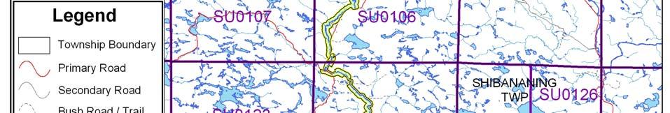
13 9 Trapping There are portions of six licensed trap lines within River aux Sables Provincial Park: EP-03, EP- 05, EP-12, EP-15, EP-16, and EP-17 (Figure 4). There are also two trap cabins (EP-15 and EP- 16) located within the park boundary. Existing commercial fur harvesting operations may continue where the activity has been licensed or permitted since January 1, New operations, including trap cabins and trails, will not be permitted (OMNR 2000; 2003). Transfers of active trap line licenses are permitted, subject to a review of potential impacts and the normal transfer or renewal conditions that apply Industrial Resources Aggregate extraction is not a permitted use within provincial parks (OMNR 1992; 2004a). However, the current unregulated park boundary includes portions of active aggregate permits as well as several inactive aggregate pits. The existing active aggregate permits may continue as a non-conforming use within the park. There are no existing mining claims within the park boundary and lands have been withdrawn from mining activity under the Mining Act (1990). Mineral exploration and mining are not permitted within the park (OMNR 1992). In accordance with Ontario s Living Legacy Land Use Strategy, access through the park to mining lands beyond the boundary (i.e. forest reserves and mining patents) will be permitted for purposes of mineral exploration, development or operations. Access will be planned in accordance with the requirements of the Environmental Assessment Act Access and Crossings Access This waterway park is accessible through a number of primary, secondary, and forestry roads as well as by water and air. Roads Highway 553/810 (Massey Tote Road) travels north from Massey to Ritchie Falls. The road parallels the river in many places and crosses the river in three locations in Prescott, Strain and Mandamin townships. Highway 553 ends at East Bull Lake and continues north as Highway 810. The highway corridor is excluded from the park boundary. Existing roads that have been identified for long term use by the forest industry will continue to be available. These include: Highway553/810 Eight Mile Road Boon Road 12 Mile Road Crossover Road Whiskey Lake Road Madawason Lake Access Road Plaunts Road Ritchie Falls Road. Existing and future tertiary roads associated with the above roads that are required to access forest allocations adjacent to the park are permitted. Tertiary roads will be constructed to a


14 10 Figure 4: Trap Line Areas
15 11 minimum standard and physical abandonment will occur once the road is no longer required. Future tertiary roads that travel through the park boundary will be addressed during forest management planning, and park values will be a priority. Where existing access roads are essential for continued access within or beyond the park for forest management, recreation or in-holdings (i.e. land use permits, patent land, etc.) and alternative road access does not exist, or road relocation is not feasible, existing roads will continue to be available for access. Continued use will include maintenance and may include upgrading (OMNR 2004a). Ontario Parks is not responsible for maintenance or upgrading of any existing roads within the park boundary. Crossing of waterway parks by new roads may be necessary. The number of crossings will be minimized where possible and managed to reduce their impact on recreational and aesthetic values. Any future road crossings proposed through the park, where park lands are unavoidable, will be reviewed on a case-by-case basis. Protection of park values will be a priority and all requirements of the Environmental Assessment Act will be met. Aggregate extraction is not permitted within parks. An external source of aggregate is required for road improvements and maintenance. Utility Corridors There are two hydro line corridor crossings in the park; the Hydro One corridor crosses the park in Boon Township and a private power line in Salter Township. Maintenance of existing utility lines will be permitted. Maintenance activities shall not impact negatively on park values and must adhere to the regulations set out under the relevant acts, such as the Environmental Assessment Act, the Canadian Environmental Protection Act (1999), and the Pesticides Act (1990). All public utilities (e.g. gas pipelines, transmission lines, communications towers, etc.) must avoid park lands wherever possible, however new utility corridor crossings may be necessary to maintain essential public services (OMNR 2004a). Any future utility corridors proposed through the park, where park lands are unavoidable, will be reviewed on a case-by-case basis. Protection of park values will be priority and MNR s environmental assessment requirements must be met. Recreational Trails Canoe Routes: The River aux Sables is a documented canoe route. This Class III to Class IV river is recommended for experienced paddlers only, as it contains several sections of challenging white water (Harper 2003). Snowmobile Trails: The Ontario Federation of Snowmobile Clubs (OFSC) Trans Ontario Provincial Series (TOPS) trail "D crosses through the park boundary in Salter Township just south of Cameron Falls. The Algoma Snow Plan Affiliation (ASPA) maintains this OFSC TOPS trail as part of their local trail system. Hiking Trails: There are no designated hiking trails in River aux Sables Provincial Park at this time. There are however some trails which run adjacent to the park. All-Terrain Vehicle Trails: There are no designated all-terrain vehicle (ATV) trails in River aux Sables Provincial Park at this time. New trails (e.g. hiking) may be developed if the need arises. Any proposed development within the park is subject to Environmental Assessment Act requirements.
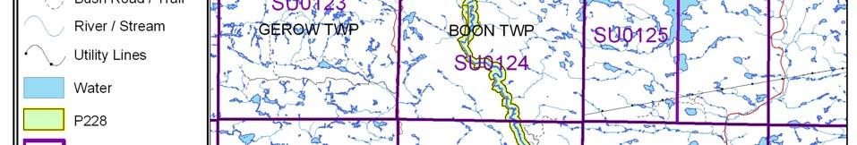
16 Adjacent Land Management Forestry The land adjacent to this park is included in the Spanish Forest (#210) and the North Shore Forest (#680) management areas. The Spanish Forest is currently managed by Domtar Incorporated and the North Shore Forest by Northshore Forest Incorporated. Forest Management Plans for both of these areas are scheduled for renewal in Provincial Parks Chutes Provincial Park (108 hectares) is located south of this park and was designated under the Provincial Parks Act in Mississagi River Park Additions (P238) is located north of this park. The additions add 67,253 hectares to the existing Mississagi River Provincial Park. Forest Reserves Forest reserves (FR) are areas where the protection of natural heritage and special landscapes is a priority, but some resource use can take place under the appropriate conditions. Policies for FRs are similar to the policies for new conservation reserves, except that mining and related activities will be allowed in a forest reserve. Commercial forest harvest, new hydroelectric power development, and peat extraction will not be allowed, but most other resource and recreation uses will be permitted, provided that they are consistent with the features and values being protected (OMNR 1999). There is one forest reserve (F228) located adjacent to the boundary of this park. This forest reserve, which is 309 hectares in size, includes two linear mining parcels with river sections that connect with this park (OMNR 2004a). As described in the proposed strategy for FRs (OMNR 2005b), the FR designation will be retained and the FR may eventually be added to the park. General Use Areas There are three General Use Areas adjacent to River aux Sables Provincial Park: The West Branch (G2035), Lower Massey Tote Road (G2034) and The Rural Settlements (G2025). The West Branch General Use Area (G2035) is a 205,954 hectare area located adjacent to the northern half of the park. This large area includes a majority of the Crown land base of the Espanola District. The primary purpose for this area is economic resource development, in particular logging and commercial tourism. Lower Massy Tote Road General Use Area (G2034) is a 52,226 hectare area located adjacent to the central length of River aux Sables Provincial Park. Commercial and industrial activities such as tourism, mining and forestry are supported. The Rural Settlements General Use Area (G2025) is a 282,230 hectare area located along the southern section of River aux Sables Provincial Park. The purpose of this area is to recognize and support the existing activities in the settled, rural areas of the district Land Disposition River aux Sables Provincial Park is located in the Sudbury District of the MNR. The park travels through eight townships as it flows from just south of the Mississagi River Park Additions (P238) to just north of Chutes Provincial Park. No new land disposition for private use or corporations will be permitted within the park boundaries (OMNR 2004a).
17 13 Land Use Permits, Licenses of Occupation, Unauthorized Occupations There are two private recreation camp land use permits (LUPs) located within the boundary of the park. These permits are located in Tennyson and Prescott Townships. These LUPs are permitted to continue. There will be no new dispositions for private recreation camps (OMNR 1999). Existing authorized LUPs for recreation camps may be eligible for enhanced tenure but not the purchase of land. Recreational camp LUPs cannot be changed to commercial LUPs unless this is supported during a review as part of park management planning. Enhanced tenure, is defined as a possible extension of the term of the LUP for recreation camps up to 10 years or upgrade in tenure (i.e. LUP to lease) (OMNR 2000a). Enhanced tenure for an LUP for a recreation camp is not guaranteed. Requests for enhanced tenure, or to transfer recreation camps, will be reviewed based upon the following criteria: Continued compliance with the conditions of the LUP for recreation camps Current land disposition policies for LUPs Consistency with park objectives to sustain values no effects on heritage values and/or conflict with other uses Consistency with Aboriginal land claim negotiations or protocol agreements All rents, taxes, fees, rates or charges are paid and in good standing. An extension in the term of tenure for an existing private recreation camp LUP does not convey a commitment to provide for a change in the type or the standard of existing access to the private recreation camp. An existing private recreation camp LUP holder can relinquish their LUP and are responsible for having existing improvements removed including, but not limited to, the sale of any existing improvements. The MNR may consider purchase of improvements. Patent Land There are no parcels of patent land surrounded by the park. The policies that are applied to this park do not affect the uses of adjacent patent land. Private land is not included within the park boundary and as such park policy does not apply to these areas. Boat Caches There are no authorized boat caches within the boundary of River aux Sables Provincial Park. Boats are not permitted to be left unattended in the park without written permission from the park superintendent under the authority of the Provincial Parks Act. 5.2 Aquatic Ecosystems Sustaining quality water resources is integral to the protection of park and adjacent lands values. The MOE enforces applicable legislation and regulations for water quality Water Management The Aux Sables Watershed Water Management Plan, a simplified water management plan, provides overall direction for watershed water management (OMNR 2004a). The emphasis on
18 14 management of the watershed is optimizing the benefits for protection of aquatic resources and recreational and industrial users. There are no water control, hydro electric, or diversion structures located within the boundary of the park. No new commercial hydroelectric developments will be permitted in River aux Sables Provincial Park (OMNR 2000). The Cameron Falls Generating Station (Tennyson Township) is located on private land not within the park boundary. There is a Memorandum of Understanding between the MNR and the owner of Ritchie Falls Resort for the operation of the Ritchie Falls Dam and Micro-Hydro Facility. This dam is located just north of the northern park boundary Fisheries Management Fisheries management will complement the maintenance and enhancement of native, selfsustaining fish populations (OMNR 1992). Sport Fishing Sport fishing is permitted within the park. This activity is governed by legislation and regulations in the Fish and Wildlife Conservation Act and the Fisheries Act (1985). The Recreational Fishing Regulations Summary contains details on the regulations that are applicable to this area. Commercial Fishing There are no commercial fishing operations within the boundary of River aux Sables Provincial Park. New operations will not be permitted (OMNR 2004a). Commercial Baitfish Harvesting Mandamin, Boon, Salter, Tennyson, Teasdale, Prescott, Strain and Monestine townships are currently allocated for baitfish harvesting. Existing commercial baitfish harvesting may continue where the activity has been licensed or permitted since January 1, This activity may be subject to conditions identified through future park management planning or fisheries management plans. New baitfish licenses will not be permitted (OMNR 2000; 2003). Fish Stocking The stocking of native fish species may be considered through park management planning, with full public consultation. Non-native fish species will not be deliberately introduced into park waters (OMNR 1992). 6.0 OPERATIONS POLICIES 6.1 Recreation Management Future planning, with full public consultation, will review direction on motorized and non-motorized recreation uses Motorized Recreation Motorboats The use of motorboats is permitted to continue, unless park values are being threatened (OMNR 2004a).


19 15 Figure 5: Commercial Baitfish Harvesting
20 16 Snowmobiles There is one existing OFSC snowmobile trail located in this park. The use of existing snowmobile trails is permitted to continue unless park features are threatened. Proposals for new trails may only be considered through future planning with public consultation (OMNR 2000). Off-trail snowmobile use is not permitted within the park. All-Terrain Vehicles There are no authorized ATV trails located within the boundary of the park. These vehicles may be using the existing road network as unauthorized trails. Proposals for new trails may only be considered through future planning with public consultation (OMNR 2000). Off -road use of ATVs will not be permitted within park boundaries unless authorized by the park superintendent under the authority of the Provincial Parks Act. Aircraft Aircraft landings are permitted in this waterway park (OMNR 2004a). All aircraft landings are subject to regulation and valid aircraft landing permits issued by the park superintendent under the authority of the Provincial Parks Act Non-Motorized Recreation Camping There are currently no developed camping facilities within River aux Sables Provincial Park. There are, however, several unmanaged campsites within the park boundary associated with the canoe route and road access within the park. Ontario Parks may assess the condition of existing campsites and will maintain, rehabilitate or close sites as required. If there is an identified need, new backcountry campsites may be considered (OMNR 2004a). Infrastructure will be permitted in order to protect park features and values in response to use, environmental deterioration and environmental protection requirements. Any proposed development in the park must fulfill the requirements of the Environmental Assessment Act. Hiking There are no authorized hiking trails within the boundaries of this provincial park. Existing hiking trails may be permitted to continue unless such trails threaten park features and values, create user conflicts or raise safety/liability issues. If there is an identified need, the development of new hiking trails may be considered. Trail infrastructure to protect park values and features will be permitted. Any proposed development within the park is subject to Environmental Assessment Act requirements. Canoeing/Kayaking Existing uses may continue, unless park values are threatened (OMNR 2004). Infrastructure to protect park features and values may be permitted and developed in response to use, environmental deterioration and environmental protection requirements Emerging Recreation Uses There are emerging recreation uses for which there is limited or no policy to deal with their management (e.g. adventure racing, geocaching). The park superintendent will use legislation, policy and guidelines that are in place in the interim to manage emerging uses.
21 Development There is no existing park infrastructure located within the park boundary. Infrastructure to protect park features and values may be permitted and developed in response to use, environmental deterioration and environmental protection requirements. Any proposed development within the park is subject to MNR s requirements under the Environmental Assessment Act. 6.3 Commercial Tourism There are currently no commercial tourism facilities located within the park boundary. New commercial tourism facilities may be considered where consistent with park policy (OMNR 2004a). Any development must meet the requirements of the Environmental Assessment Act. 7.0 CULTURAL RESOURCES No assessment of the cultural resources specific to River aux Sables Provincial Park has been completed at this time; however, management of any cultural values within this park will be directed toward protection and heritage appreciation (OMNR 1992). 8.0 HERITAGE EDUCATION Literature and other supporting information may be developed to describe the park in the context of Ontario s provincial park system. Boundary limits, significant heritage features and permitted uses of the waterway park may be included in park literature. Prospective park visitors may be informed about the sensitivity and significance of park values through park literature. 9.0 RESEARCH Scientific research by qualified individuals which contributes to the knowledge of natural or cultural history, or to environmental or recreational management, may be encouraged in the park. Ontario Parks will encourage institutions, such as universities, to undertake research projects. All research programs will require the approval of Ontario Parks and are subject to park policy and other applicable legislation. Any materials removed from the park will remain the property of Ontario Parks. Approved research activities and facilities will be compatible with the park s protection objective. Any site which is affected by research will be rehabilitated as closely as possible to its original state. Environmental Assessment Act requirements will apply.
22 REFERENCES Canadian Environmental Protection Act, Environmental Assessment Act, Fisheries Act, Fish and Wildlife Conservation Act, Frey E. and D. Duba, Earth Science Checksheet P228 River aux Sables Provincial Park. (Draft). Harper, T., River Aux Sables Provincial Park (P228) Recreation Inventory Report-Version 1.2. Migratory Birds Convention Act, Mining Act, Morris, E.R., Natural Heritage Area Life Science Checksheet River aux Sables Provincial Park (P228). Ontario Ministry of Natural Resources, A Topical Organization of Ontario History. Historic Sites Branch Division of Parks. Ontario Ministry of Natural Resources, Ontario Provincial Parks Planning and Management Policies. Ontario Ministry of Natural Resources, Ontario s Living Legacy Land Use Strategy. Ontario Ministry of Natural Resources, Ontario s Living Legacy Land Use Strategy (Policy Clarification). Ontario Ministry of Natural Resources, Directions for Commercial Resource Use Activities in Provincial Parks and Conservation Reserves. 5 pp. Ontario Ministry of Natural Resources, 2004a. Crown Land Use Policy Atlas. Ontario Ministry of Natural Resources, 2004b. Forest Fire Management Strategy for Ontario. Aviation and Fire Management Branch. Ontario Ministry of Natural Resources, 2005a. A Class Environmental Assessment for Provincial Parks and Conservation Reserves. Ontario Ministry of Natural Resources, 2005b. Summary of Proposed Disentanglement Strategies for Recommended Protected Areas and Pre-Existing Mining Lands. Pesticides Act, Provincial Parks Act, 1990.
23 APPENDIX A: BACKGROUND INFORMATION Name River aux Sables Provincial Park (P228) Classification Waterway Ecoregion/Ecodistrict 4E-3 (Mississagi), 5E-4 (Sudbury) OMNR Administrative Region/District Northeast Sudbury Total Area (ha) 3,658 Regulation date & Number Unregulated REPRESENTATION Earth Science: The bedrock of the River aux Sables Provincial Park is within the south-central Abitibi Subprovince of the Archean Superior Province with small enclaves of younger Paleoproterozoic Penokian Belt. The Abitibi Subprovince is a late-archean granite-greenstone-gneiss terrane (2.8 to 2.6 billion years old). The northern and central segments of the waterway park are dominantly underlain by the intermediate to felsic metaplutonic rocks and Parisien Lake Syenite of the Archean Ramsey- Algoma granitoid complex. The Quaternary glacial deposits in the region are late Wisconsinan in age. The most northern and central River aux Sables is covered by outwash fine sand, sand, and gravel and glaciolacustrine deposits of deltaic sand. The ground moraine over the bedrock is minor. It consists of sandy to silty till with large amounts of pebbles and boulders. The southern area of the river is overlain by silty to sandy till and glaciolacustrine deposits, varved or massive clay to silt and fine sand. Life Science: The ecosite representation within the park is relatively high given the narrow corridor in which it exists. The park contains eight major ecosite representations and six moderate ecosite representations. Special features within the park include the Tennyson Township Wetland which contains several vegetation types important to waterfowl, such as wild rice (Zizania palustris), pondweeds (Potamogeton spp.) and manna grasses (Glyceria spp.). This area also provides aquatic and bottomland feeding habitat for moose. Several examples of high sand banks occur along the southern portions of the river as it flows through glaciofluvial outwash plains. These areas provide nesting habitat for bank swallows, rough-winged swallows and belted kingfishers. Cultural Resources: No investigation or analysis of cultural resources specific to River aux Sables Provincial Park has been completed at this time. Recreation and Tourism: Being a waterway park, the majority of the recreation activity that occurs within this park is wateroriented. River aux Sables is a documented canoe route and experiences use by canoeists and
24 20 kayakers. The river offers flat water portions and challenging white water sections. The lower section of the river, a portion of which is included in the park, is recognized as being one of the best white water kayaking destinations on the North Shore of Lake Huron. This route is recommended for experienced paddlers only, as it contains several sections of white water and is classified as being a Class III to Class IV River. Fishing is also a popular recreational activity of the river. The River aux Sables supports some species of sport fish including brook trout populations. The park area is also a popular hunting destination. Other activities include camping, and general nature appreciation. INVENTORIES Survey Level Earth Science Life Science Cultural Recreational Reconnaissance Frey and Duba, 2002 Morris, 2003 Harper, 2003
MacMurchy Township End Moraine. Interim Management Statement
 MacMurchy Township End Moraine Interim Management Statement 2006 Approval Statement I am pleased to approve this Interim Management Statement for MacMurchy Township End Moraine Provincial Park (P1591).
White Lake Peatlands. Interim Management Statement
 White Lake Peatlands Interim Management Statement 2007 APPROVAL STATEMENT I am pleased to approve this Interim Management Statement for White Lake Peatlands Provincial Park. This park was regulated under
Jocko Rivers. Interim Management Statement
 Jocko Rivers Interim Management Statement 2006 APPROVAL STATEMENT I am pleased to approve this Interim Management Statement for Jocko Rivers Provincial Park. Ontario s Living Legacy Land Use Strategy (OMNR
Nakina Moraine Provincial Park. Interim Management Statement. Ontario. Ministry of Natural Resources
 Nakina Moraine Provincial Park Interim Management Statement Ontario Ministry of Natural Resources 1999, Queen's Printer for Ontario Printed in Ontario, Canada Additional copies of this publication can
Approval Statement. Brian Pfrimmer, Central Zone Manager Ontario Parks
 Approval Statement I am pleased to approve this Interim Management Statement for Dividing Lake Provincial Nature Reserve. This Nature Reserve contains biological features of provincial significance and
MANAGEMENT DIRECTION STATEMENT June, 1999
 Thompson River District MANAGEMENT DIRECTION STATEMENT June, 1999 for Roche Lake Provincial Park Ministry of Environment Lands and Parks BC Parks Division Table of Contents I. Introduction A. Setting
Noganosh Lake. Interim Management Statement
 Noganosh Interim Management Statement March 1, 2004 The Noganosh Provincial Park Interim Management Statement provides direction for the custodial management of Noganosh Provincial Park until such time
 ONTARIO Pul
 NOV UPPER MADAWASKA RIVER PROVINCIAL PARK INTERIM MANAGEMENT STATEMENT. Ontario
 NOV 1 3 2001 UPPER MADAWASKA RIVER PROVINCIAL PARK INTERIM MANAGEMENT STATEMENT Ontario . BACKGROUND INFORMATION NAME: Upper Madawaska River REGIONAL SETTING MAP PROPOSED CLASS: U.N.R. DISTRICT: U.N.R.
Steel River Provincial Park. Interim Management Statement. Ministry of Natural Resources. Ontario. Ministry of Natural Resources.
 Steel River Provincial Park Interim Management Statement Ontario Ministry of Natural Resources (j) Ontario Ministry of Natural Resources Additional copies of this publication are obtainable only from:
Sand Lakes Provincial Park. Draft Management Plan
 Sand Lakes Provincial Park Draft Management Plan 2 Sand Lakes Provincial Park Table of Contents 1. Introduction... 3 2. Background... 3 3. Park Purpose... 5 4. Park Management Guidelines... 6 Appendix...
MANAGEMENT DIRECTION STATEMENT June, 1999
 Thompson River District MANAGEMENT DIRECTION STATEMENT June, 1999 for Clearwater River Corridor (Addition to Wells Gray Park) Ministry of Environment Lands and Parks BC Parks Division ii Table of Contents
Ontario. Tide Lake Provincial Nature Reserve. Interim Management Statement. Ministry of Natural Resources
 Ontario Tide Lake Provincial Nature Reserve nterim Management Statement Ministry of Natural Resources Tide Lake Provincial Nature Reserve nterim Management Statement Ontario Ministry of Natural Resources
Longlac North Conservation Reserve (C2207) Statement of Conservation Interest
 Statement of Conservation Interest") Longlac North Conservation Reserve (C2207) Statement of Conservation Interest April 2003 Prepared for the Ontario Ministry of Natural Resources, Northwest Region by Rebecca Zeran and Natalie Kolody OLL
Longlac North Conservation Reserve (C2207) Statement of Conservation Interest April 2003 Prepared for the Ontario Ministry of Natural Resources, Northwest Region by Rebecca Zeran and Natalie Kolody OLL
Numaykoos Lake Provincial Park. Management Plan
 Numaykoos Lake Provincial Park Management Plan 2 Numaykoos Lake Provincial Park Table of Contents 1. Introduction... 3 2. Background... 3 3. Park Purpose... 5 4. Park Management Guidelines... 6 Appendix...
Ottertooth CONSERVATION RESERVE C2262 STATEMENT OF CONSERVATION INTEREST. Ministry of Natural Resources. Thunder Bay District.
 Ottertooth CONSERVATION RESERVE C2262 STATEMENT OF CONSERVATION INTEREST Ministry of Natural Resources Thunder Bay District January 2003 Information Management By Jason Biggar Thunder Bay District Ottertooth
Policy PL Date Issued February 10, 2014
 Subject RENEWABLE ENERGY ON CROWN LAND Compiled by Renewable Energy Program, Biodiversity Branch Replaces Policy Directives Waterpower Site Release Crown Land Onshore Windpower Development - Crown Land
Marchand Provincial Park. Management Plan
 Marchand Provincial Park Management Plan 2 Marchand Provincial Park Table of Contents 1. Introduction... 3 2. Park History... 3 3. Park Attributes... 4 3.1 Natural... 4 3.2 Recreational... 4 3.3 Additional
Dividing Lake Provincial Nature Reserve
 - Do Not Remove i, '" i ' Dividing Lake Provincial Nature Reserve I!.' Interim Management Statement Amendment 2001-001 Park Boundary Amendment Approved: r.in'r entral Zone, Ontario Parks PJ Date 2. ()/
As outlined in the Tatshenshini-Alsek Park Management Agreement, park management will:
 Management Strategy General Strategy The priority management focus for the park is to ensure that its internationally significant natural, cultural heritage and recreational values are protected and that
OMINEACA PROVINCIAL PARK
 OMINEACA PROVINCIAL PARK AND PROTECTED AREA PURPOSE STATEMENT AND ZONING PLAN March 2003 OMINECA PROVINCIAL PARK AND PROTECTED AREA Purpose Statement and Zoning Plan Omineca Park and Omineca Protected
Little Limestone Lake Provincial Park. Draft Management Plan
 Little Limestone Lake Provincial Park Draft Management Plan Little Limestone Lake Provincial Park Draft Management Plan Table of Contents 1. Introduction... 3 2. Background... 3 3. Planning context...
Whitemouth Falls Provincial Park. Draft Management Plan
 Whitemouth Falls Provincial Park Draft Management Plan Whitemouth Falls Provincial Park Draft Management Plan Table of Contents 1. Introduction... 3 2. Park History... 3 3. Park Attributes... 4 3.1 Natural...
TRAILS WHERE TO FIND TRAILS IN NOVA SCOTIA
 TRAILs SIGNAGE Know the Signs............................ 44 WHERE YOU CAN RIDE Roads and Highways........................ 46 Designated Trails........................... 47 Established Trails...........................
A GUIDE TO MANITOBA PROTECTED AREAS & LANDS PROTECTION
 A GUIDE TO MANITOBA PROTECTED AREAS & LANDS PROTECTION Manitoba Wildands December 2008 Discussions about the establishment of protected lands need to be clear about the definition of protection. We will
 ONTARIO White Lal
 Bayview Escarpment. Interim Management Statement
 Bayview Escarpment Interim Management Statement Bayview Escarpment Provincial Nature Reserve Interim Management Statement January 15, 1995 REGIONAL DIRECTOR'S APPROVAL STATEMENT This Interim Management
Clearwater Lake Provincial Park. Draft Management Plan
 Clearwater Lake Provincial Park Draft Management Plan Clearwater Lake Provincial Park Draft Management Plan Table of Contents 1. Introduction... 3 2. Park History... 4 3. Park Attributes... 4 3.1 Location/Access...4
Wallace Lake Provincial Park. Management Plan
 Wallace Lake Provincial Park Management Plan 2 Wallace Lake Provincial Park Table of Contents 1. Introduction... 3 2. Park History... 3 3. Park Attributes... 4 3.1 Natural... 4 3.2 Recreational... 4 4.
Sasagiu Rapids Provincial Park. Draft Management Plan
 Sasagiu Rapids Provincial Park Draft Management Plan 2 Sasagiu Rapids Provincial Park Table of Contents 1. Introduction... 3 2. Background and Park Attributes... 3 2.1 Park History.... 3 2.2 Natural Features...
ISBN c 1988 Government of Ontario Printed in Ontario, Canada
 Single copies of this publication are available for $2.00 from the Ontario Ministry of Natural Resources, Espanola District Office, P.O. Box 1340, 148 Fleming Street, Espanola, Ontario, POP 1CO, telephone:
Ontario s Approach to Wilderness: A Policy May 1997 (Version 1.0)
") Ontario s Approach to Wilderness: A Policy May 1997 (Version 1.0) 1.0. Introduction Wilderness is important to Ontarians, important to the sustained, healthy functioning of Ontario s ecosystems. The Ministry
Ontario s Approach to Wilderness: A Policy May 1997 (Version 1.0) 1.0. Introduction Wilderness is important to Ontarians, important to the sustained, healthy functioning of Ontario s ecosystems. The Ministry
APPENDIX. Alberta Land Stewardship Act AMENDMENTS TO THE SOUTH SASKATCHEWAN REGIONAL PLAN
 APPENDIX Alberta Land Stewardship Act AMENDMENTS TO THE SOUTH SASKATCHEWAN REGIONAL PLAN 1 All references to Alberta Environment and Sustainable Resource Development, Environment and Sustainable Resource
Wallace Lake Provincial Park. Draft Management Plan
 Wallace Lake Provincial Park Draft Management Plan Wallace Lake Provincial Park Draft Management Plan Table of Contents 1. Introduction... 3 2. Park History... 3 3. Park Attributes... 4 3.1 Natural...
South Atikaki Provincial Park. Draft Management Plan
 South Atikaki Provincial Park Draft Management Plan South Atikaki Provincial Park Draft Management Plan Table of Contents 1. Introduction... 3 2. Park History... 3 3. Park Attributes... 3 3.1 Natural...
Yard Creek Provincial Park. Management Plan
 Yard Creek Provincial Park Management Plan Draft January 2010 Yard Creek Provincial Park Management Plan Approved by: telàlsemkin/siyam/chief Scott Benton Bill Williams Squamish Executive Director ation
PROUDLY BRINGING YOU CANADA AT ITS BEST. Management Planning Program NEWSLETTER #1 OCTOBER, 2000
 PROUDLY BRINGING YOU CANADA AT ITS BEST VUNTUT NATIONAL PARK Management Planning Program NEWSLETTER #1 OCTOBER, 2000 INTRODUCTION This newsletter launches the development of the first management plan for
2.1 Physical and Biological Description Matabitchuan River Watershed
 2.1 Physical and Biological Description Watershed 2.1.1 Physical Description The system watershed has a total area of about 933 km 2 and is a tributary system to Lake Temiskaming and the Ottawa River Drainage
FILE: /PERM EFFECTIVE DATE: May 16, 2014 AMENDMENT:
 APPROVED AMENDMENTS: Effective Date Briefing Note /Approval Summary of Changes: FILE: 11000-00/PERM EFFECTIVE DATE: May 16, 2014 AMENDMENT: Table of Contents 1. POLICY APPLICATION... 1 2. PRINCIPLES AND
5.0 OUTDOOR RECREATION OPPORTUNITIES AND MANAGEMENT
 5.0 OUTDOOR RECREATION OPPORTUNITIES AND MANAGEMENT 5.1 Introduction This section describes the range of recreational activities that currently take place in Marble Range and Edge Hills Parks, as well
camping means the temporary occupation of Crown land using a camping unit, but does not include commercial tourism occupations;
 Ontario Ministry of Natural Resources Subject FREE USE POLICY Compiled by - Branch Lands & Waters Section Land Management Policy PL 3.03.01 Replaces Directive Title Same title Number Same number Dated
FINGER-TATUK PROVINCIAL PARK
 FINGER-TATUK PROVINCIAL PARK PURPOSE STATEMENT AND ZONING PLAN March 2003 FINGER-TATUK PROVINCIAL PARK Purpose Statement and Zoning Plan Finger-Tatuk Provincial Park is 17,151 ha in size. It includes the
MANAGEMENT DIRECTION STATEMENT March 2003
 Skeena Region MAAGEMET DIRECTIO STATEMET March 2003 for Meziadin Lake Provincial Park Ministry of Water, Land and Air Protection Environmental Stewardsh Division This page left blank on purpose ii Table
Birch Point Provincial Park. Management Plan
 Birch Point Provincial Park Management Plan 2 Birch Point Provincial Park Table of Contents 1. Introduction... 3 2. Park History... 3 3. Park Attributes... 4 3.1 Natural... 4 3.2 Recreational... 4 4. Park
Port Bruce. Interim Management Statement
 Port Bruce Interim Management Statement Port Bruce Interim Management Statement August 3, 1999 This Port Bruce Provincial Park Interim Management Statement provides direction for the custodial management
WESTERN LAKE SUPERIOR CONSERVATION RESERVE (C2260) STATEMENT OF CONSERVATION INTEREST
 STATEMENT OF CONSERVATION INTEREST") WESTERN LAKE SUPERIOR CONSERVATION RESERVE (C2260) STATEMENT OF CONSERVATION INTEREST May 2004 Thunder Bay District Ministry of Natural Resources Western Lake Superior Conservation Reserve (C2260) Statement
WESTERN LAKE SUPERIOR CONSERVATION RESERVE (C2260) STATEMENT OF CONSERVATION INTEREST May 2004 Thunder Bay District Ministry of Natural Resources Western Lake Superior Conservation Reserve (C2260) Statement
Stuart River Provincial Park Purpose Statement and Zoning Plan
 Stuart River Provincial Park Purpose Statement and Zoning Plan Stuart River Provincial Park protects three-quarters of the 110 kilometer long Stuart River corridor between Stuart Lake and the Nechako River.
Watchorn Provincial Park. Management Plan
 Watchorn Provincial Park Management Plan 2 Watchorn Provincial Park Table of Contents 1. Introduction... 3 2. Park History... 3 3. Park Attributes... 3 3.1 Natural... 4 3.2 Recreational... 4 3.3 Additional
Lion s Head. Interim Management Statement
 Lion s Head Interim Management Statement Lion's Head Provincial Nature Reserve Interim Management Statement July 14, 1997 APPROVAL STATEMENT This Interim Management Statement will provide interim direction
Boyne Valley Provincial Park. Interim Management Statement
 Boyne Valley Provincial Park Interim Management Statement January 20, 1995 REGIONAL DIRECTOR'S APPROVAL STATEMENT This Interim Management Statement will provide interim direction for the management of
MANAGEMENT DIRECTION STATEMENT October, 1999
 Thompson River District MAAGEMET DIRECTIO STATEMET October, 1999 for Chu Chua Cottonwood Provincial Park Ministry of Environment Lands and Parks BC Parks Division Ministry of Environment, Lands and Parks
Lac Seul Islands Conservation Reserve (C2317)
") Lac Seul Islands Conservation Reserve (C2317) Statement of Conservation Interest Sioux Lookout District Ministry of Natural Resources January 2005 Prepared by: Magdalena Kowalczyk TABLE OF CONTENTS 1.0
Lac Seul Islands Conservation Reserve (C2317) Statement of Conservation Interest Sioux Lookout District Ministry of Natural Resources January 2005 Prepared by: Magdalena Kowalczyk TABLE OF CONTENTS 1.0
Coastal Dune Locations of Ontario
 Coastal Dune Protection along Ontario s Great Lakes Coast Great Lakes Dune Conference, Traverse City, Michigan Oct 3 4, 2006 J. Childs, WLU Dunes in Ontario Coastal very small % of coastline Located: At
Fred Antoine Park. Management Plan. Final Public Review Draft
 Fred Antoine Park Management Plan Final Public Review Draft March 2016 Fred Antoine Park Management Plan Approved by: Jeff Leahy Regional Director Thompson Cariboo Region BC Parks Date Brian Bawtinheimer
Oxtongue River- Ragged Falls Provincial Park. Management Plan
 Oxtongue River- Ragged Falls Provincial Park Management Plan 4279 0-7729-4782-1 1990, Queens Printer for Ontario Printed in Ontario, Canada Limited copies of this publication are obtainable from: Ministry
Ouimet Canyon Provincial Nature Reserve. Management Plan
 Ouimet Canyon Provincial Nature Reserve Management Plan NOTE: This document has been scanned and formatted, and therefore is slightly different from the original version. -March 2002 Additional copies
Chapter 9: National Parks and Protected Areas
 Part 9.1 Torngat Mountains National Park Reserve 9.1.1 The area set out in the Map Atlas (shown for illustrative purposes only in schedule 9-A) and described in appendix D-2 shall become a National Park
Craig's Pit Provincial Nature Reserve. Interim Management Statement. Ministry. Natural Resources. Ontario
 Craig's Pit Provincial Nature Reserve nterim Management Statement ( Ministry Ontario of Natural Resources REGONAL DRECTOR'S APPROVAL STATEMENT CRAG'S PT PROVNCAL NATURE RESERVE This revised nterim Management
 March 25, 1994 To: Re: MEMO TO FILE MINOR AMENDMENT - PINERY PROVINCIAL PARK MANAGEMENT PLAN The following paragraph from page 5 of the Pinery Provincial Park Management Plan (ISBN 0-7729-0290-9) lnsects
MARBLE RIVER PROVINCIAL PARK
 MARBLE RIVER PROVINCIAL PARK PURPOSE STATEMENT AND ZONING PLAN March 2003 MARBLE RIVER PROVINCIAL PARK Purpose Statement and Zoning Plan Primary Role The primary role of Marble River Park is to protect
ONE ISLAND LAKE PROVINCIAL PARK Purpose Statement and Zoning Plan
 ONE ISLAND LAKE PROVINCIAL PARK Purpose Statement and Zoning Plan Primary Role The primary role of One Island Lake Provincial Park is to provide recreational opportunities to regional and residential area
2.0 PARK VISION AND ROLES
 2.0 PARK VISION AND ROLES 2.1 Significance in the Protected Area System Marble Range and Edge Hills provincial parks protect 6.8% of the Pavillion Ranges Ecosection, which is located in the Southern Interior
Ojibway Provincial Park. Management Plan
 Ojibway Provincial Park Management Plan ISBN O-7729-9448-X 1992, Queen s Printer for Ontario Printed in Ontario, Canada Single copies of this publication are available at no charge from the address noted
MANAGEMENT DIRECTION STATEMENT October, 1999
 Thompson River District MAAGEMET DIRECTIO STATEMET October, 1999 for Harry Lake Aspen Provincial Park Ministry of Environment Lands and Parks BC Parks Division Ministry of Environment, Lands and Parks
INFORMATION NOTICE 15-2 Limited & Excluded Lands
 INFORMATION NOTICE 15-2 Limited & Excluded Lands Schedule 1 (Land Description) of onshore petroleum Agreements issued by the Department of Energy details the total hectares calculated. Total hectares are
Otoskwin Attawapiskat River
 Otoskwin Attawapiskat River Park Management Plan Ontario 51623-1 (0.65 k P.R., 02 09 30) ISBN 0-7794-3270-3 Otoskwin-Atlawapiskat River Provincial Park Box 280 Tel: 807 825-3413 ONTARIO Terrace Bay, ON
Bridge River Delta Park. Management Plan. Final Public Review Draft
 Bridge River Delta Park Management Plan Final Public Review Draft March 2016 Bridge River Delta Park Management Plan Approved by: Jeff Leahy Regional Director Thompson Cariboo Region BC Parks Date Brian
MANAGEMENT DIRECTION STATEMENT
 Lower Mainland District MAAGEMET DIRECTIO STATEMET January 2001 for Liumchen Ecological Reserve Ministry of Environment Lands and Parks BC Parks Division Table of Contents Page Introduction... 1 Purpose
APPENDIX 3-I-B. Alternative Route Assessment Around Provincial Parks and Conservation Reserves
 EAST-WEST TIE TRANSMISSION PROJECT ENVIRONMENTAL ASSESSMENT REPORT APPENDIX 3-I-B Alternative Route Assessment Around Provincial Parks and Conservation Reserves Report No. 1536607/2000/2018 TABLE OF CONTENTS
D IRECTION S TATEMENT
 Vancouver Island Region M ANAGEMENT D IRECTION S TATEMENT September 2003 for Lower Nimpkish Provincial Park Ministry of Water, Land and Air Protection Environmental Stewardship Lower Nimpkish Provincial
ANAGEMENT P LAN. February, for Elk Lakes and Height of the Rockies Provincial Parks. Ministry of Environment, Lands and Parks BC Parks Division
 M ANAGEMENT P LAN February, 1999 for Elk Lakes and Height of the Rockies Provincial Parks Ministry of Environment, Lands and Parks BC Parks Division Elk Lakes & Height of the Rockies Provincial Parks M
MANAGEMENT DIRECTION STATEMENT October, 1999
 Thompson River District MAAGEMET DIRECTIO STATEMET October, 1999 for Wire Cache Provincial Park Ministry of Environment Lands and Parks BC Parks Division Ministry of Environment, Lands and Parks BC Parks
NECHAKO CANYON PROTECTED AREA
 NECHAKO CANYON PROTECTED AREA PURPOSE STATEMENT AND ZONING PLAN March 2003 1 Nechako Canyon Protected Area Purpose Statement and Zoning Plan The Nechako Canyon Protected Area (1,246 hectares) is located
MANAGEMENT DIRECTION STATEMENT March 2003
 Skeena Region MAAGEMET DIRECTIO STATEMET March 2003 for Great Glacier Provincial Park Ministry of Water, Land an Air Protection Environmental Stewardship Division ii This management direction statement
SANTA-BOCA PROVINCIAL PARK
 SANTA-BOCA PROVINCIAL PARK PURPOSE STATEMENT AND ZONING PLAN March 2003 SANTA-BOCA PROVINCIAL PARK Purpose Statement and Zoning Plan Primary Role The primary role of Santa-Boca Park is to provide marine-based
Pinard Moraine Conservation Reserve (C1582)
") Pinard Moraine Conservation Reserve (C1582) Statement of Conservation Interest November 2004 Cochrane District Ministry of Natural Resources Cochrane District Ministry of Natural Resources APPROVAL STATEMENT
Pinard Moraine Conservation Reserve (C1582) Statement of Conservation Interest November 2004 Cochrane District Ministry of Natural Resources Cochrane District Ministry of Natural Resources APPROVAL STATEMENT
Temagami Area Provincial Parks
 Temagami Area Provincial Parks Lady Evelyn-Smoothwater Makobe-Grays River Obabika River Solace Sturgeon River Preliminary Park Management Plan Temagami Area Backcountry Parks DRAFT Preliminary Park Management
Proposed National Marine Conservation Area Reserve Southern Strait of Georgia PROJECT UPDATE Spring 2012
 Proposed National Marine Conservation Area Reserve Southern Strait of Georgia PROJECT UPDATE Spring 2012 National marine conservation areas (NMCAs) are established to protect, conserve and present examples
White Mountain National Forest Saco Ranger District
 United States Department of Agriculture Forest Service White Mountain National Forest 33 Kancamagus Highway Conway, NH 03818 Comm: (603) 447-5448 TTY: (603) 447-3121 File Code: 1950 Date: February 26,
Pinawa Provincial Park. Draft Management Plan
 Pinawa Provincial Park Draft Management Plan Pinawa Provincial Park Draft Management Plan Table of Contents 1. Introduction... 3 2. Park History... 3 3. Park Attributes... 4 3.1 Natural... 4 3.2 Recreational...
Boatswain bay biodiversity reserve
 Boatswain bay biodiversity reserve March 2003 1 1. Plan and description 1.1. Geographic location, boundaries and dimensions The plan of the proposed Boatswain bay biodiversity reserve and its location
MANAGEMENT DIRECTION STATEMENT October, 1999
 Thompson River District MAAGEMET DIRECTIO STATEMET October, 1999 for orth Thompson Islands Provincial Park Ministry of Environment Lands and Parks BC Parks Division Ministry of Environment, Lands and Parks
Rule Governing the Designation and Establishment of All-Terrain Vehicle Use Trails on State Land
 Rule Governing the Designation and Establishment of All-Terrain Vehicle Use Trails on State Land 1.0 Authority 1.1 This rule is promulgated pursuant to 23 V.S.A. 3506. Section 3506 (b)(4) states that an
VARGAS ISLAND PROVINCIAL PARK
 VARGAS ISLAND PROVINCIAL PARK PURPOSE STATEMENT AND ZONING PLAN February 2003 VARGAS ISLAND PROVINCIAL PARK Purpose Statement and Zoning Plan Primary Role The primary role of Vargas Island Park is to protect
Criddle/Vane Homestead Provincial Park. Draft Management Plan
 Criddle/Vane Homestead Provincial Park Draft Management Plan 2 Criddle/Vane Homestead Provincial Park Table of Contents 1. Introduction... 3 2. Park History.... 3 3. Park Attributes.... 3 3.1 Natural....
Seager Wheeler Lake. Representative Area. -- Concept Management Plan --
 Seager Wheeler Lake Representative Area -- Concept Management Plan -- Saskatchewan Environment and Resource Management January, 1999 Saskatchewan s Representative Areas Network Program The Government of
We are pleased to approve the Craigleith Provincial Park Management Plan, as official policy for the management and development of this park.
 We are pleased to approve the Craigleith Provincial Park Management Plan, as official policy for the management and development of this park. The plan reflects this Ministry s intent to protect natural
Bradley Brook Relocation Project. Scoping Notice. Saco Ranger District. United States Department of Agriculture Forest Service
 Bradley Brook Relocation Project United States Department of Agriculture Forest Service Scoping Notice White Mountain National Forest February 2011 For Information Contact: Jenny Burnett White Mountain
Proposed National Marine Conservation Area Reserve Southern Strait of Georgia PROJECT UPDATE Spring 2012
 Proposed National Marine Conservation Area Reserve Southern Strait of Georgia PROJECT UPDATE Spring 2012 National marine conservation areas (NMCAs) are established to protect, conserve and present examples
Strengthening the Ontario Trails Strategy. Report on Consultations and the Environmental Bill of Rights Registry
 Strengthening the Ontario Trails Strategy Report on Consultations and the Environmental Bill of Rights Registry Purpose To report on the feedback and information received through the regional consultations,
EAST-WEST TIE TRANSMISSION PROJECT ENVIRONMENTAL ASSESSMENT REPORT APPENDIX 19-IV
 EAST-WEST TIE TRANSMISSION PROJECT ENVIRONMENTAL ASSESSMENT REPORT APPENDIX 19-IV Project Activities in Provincial Parks and Conservation Reserves Report No. 1536607/2000/2018 TABLE OF CONTENTS 1. INTRODUCTION
MANAGEMENT DIRECTION STATEMENT February 2001
 Thompson River District MAAGEMET DIRECTIO STATEMET February 2001 for Greenstone Mountain Provincial Park Ministry of Environmen Lands and Parks BC Parks Division Table of Contents Introduction... 1 Purpose
Continental Divide National Scenic Trail Legislative History and Planning Guidance
 Continental Divide National Scenic Trail Legislative History and Planning Guidance Legislation, Policy, and Direction Regarding National Scenic Trails The National Trails System Act, P.L. 90-543, was passed
ANAGEMENT. LAN November, 1996
 M ANAGEMENT P LAN November, 1996 for Coldwater River Provincial Park Ministry of Environment, Lands and Parks BC Parks Department Coldwater River Provincial Park M ANAGEMENT P LAN Prepared by BC Parks
Outdoor Recreation Opportunities Management
 Outdoor Recreation Opportunities Management Introduction The natural features of Height of the Rockies and Elk Lakes provincial parks provide a wide variety of outdoor recreational activities. However,
ONTARIO. Batchawana River PARKS. Interim Management Statement
 ONTARIO Batchawana River PARKS Interim Management Statement Ontario 2006 -' -- -- - i ' l APPROVAL STATEMENT,1- t ', -!, ',: ',' ' ;,j,,'j I am pleased to approve this Interim Management < Statep1 ntj
Limestone Islands. Park Management Plan
 Limestone Islands Park Management Plan MNR 51643-1 ISBN 0-7794-3580-X 2002 Queen s Printer of Ontario Printed in Ontario, Canada Cover Photo: Henry Kujala Additional copies of this publication can be obtained
Norris Lake Provincial Park. Draft Management Plan
 Norris Lake Provincial Park Draft Management Plan 2 Norris Lake Provincial Park Table of Contents 1. Introduction... 3 2. Park History... 3 3. Park Attributes... 4 3.1 Natural... 4 3.2 Recreational...
Pillar Park. Management Plan
 Pillar Park Management Plan January 2014 Pillar Park Management Plan Approved by: Jeff Leahy Regional Director Thompson Cariboo Region BC Parks January 9, 2014 Date Brian Bawtinheimer Executive Director
APPENDIX 19-IV. Project Activities in Provincial Parks And Conservation Reserves
 EAST-WEST TIE TRANSMISSION PROJECT AMENDED ENVIRONMENTAL ASSESSMENT REPORT APPENDIX 19-IV Project Activities in Provincial Parks And Conservation Reserves Report No. 153667/2/2219 TABLE OF CONTENTS 1.