APPENDIX PRELIMINARY DESIGN GIS THEMATIC MAPS
|
|
|
- Bernadette Ginger Hopkins
- 6 years ago
- Views:
Transcription
1 PRELIMINARY DESIGN GIS THEMATIC MAPS 49
2 PRELIMINARY DESIGN: DESIGN PROCESS: The Center for Changing Landscapes utilizes an interactive design process that includes: Community focus groups, Multiple public meetings to gather feedback, Stakeholder, government agency, and private landowner outreach, and Design revisions based on the opinions expressed, as a means of using design to create REAL DESIGN SOLUTIONS THAT HAVE THE BACKING OF THE GOVERNMENT, THE COMMUNITY, & PRIVATE LAND OWNERS. STREETSCAPE MASTERPLAN & DESIGN FEATURES: The new streetscape along Hwy. 61 in downtown Beaver Bay reworks the existing road profile into a new configuration slowing traffic and producing a park-like experience for pedestrians. The entrances into town become the transitional areas which mark town boundaries and create an awareness of the recreational opportunities found in the region. This corridor highlights the change in landscape character as one first encounters the Beaver Bay geologic intrusion, which is seen faintly as distant hills and forested valleys. New crosswalks are placed to increase access to area shops and services on both sides of Hwy. 61. Features include: Colorful paving marking crosswalks, and Safety islands which become green pockets along Hwy

3 51
4 PRELIMINARY DESIGN: The Beaver River Park masterplan highlights site features and location to produce a varied set of experiences designed to enhance the Gitchi-Gami Trail system and the town of Beaver Bay by creating a gathering space for locals and visitors. Beaver River Park also mitigates on-site issues such as traffic and pedestrian safety, Gitchi-Gami Trail routing and trailhead design, and on-site stormwater concerns producing an ecologically sustainable design. BEAVER RIVER PARK MASTERPLAN & DESIGN FEATURES: These elements combined with the hilltop green, historic mill ruins, and river gorge viewing platforms create a truly memorable destination along the Gitchi-Gami Trail: Sinuous paths meander and cross the site s landform leading the visitor to the river and the lake, Earthen berms symbolic of the North Shore landscape frame views through the site and river gorge, Innovative restroom structure with Norwegian commercial boat house influenced design that ori entate the visitor, Informational kiosks with artist rendered drawings which depict the hidden and unique landform subtleties of the Beaver Bay landscape, and Bike racks for use by Gitchi-Gami Trail patrons are located at the trailhead. 52

5 53
6 PRELIMINARY DESIGN: The Millstone Park masterplan highlights Beaver River and settlement history to produce an interpretive experience designed to compliment the Gitchi-Gami Trail system and the town of Beaver Bay by revealing local history to users. Millstone park also mitigates on-site issues such as traffic and pedestrian safety, Gitchi-Gami trail routing and trailhead design, and on-site stormwater concerns. These elements combined with the historic mill ruins, and river gorge viewing platforms create a truly unique destination along the Gitchi-Gami Trail: MILLSTONE PARK MASTERPLAN & DESIGN FEATURES: Paths that direct views to the Beaver Bay hills and Lake Superior while leading the visitor to the river and the lake, Gently sloping topography and aspen plantings create rooms and frame views through the site and river gorge, Restroom facility design is influenced by Scandinavian architecture, Information kiosks include artist rendered drawings depicting the hidden and unique landform subtleties of the Beaver Bay landscape, and Bike racks for trail users creating a human presence at the trailhead intersection. 54

7 55
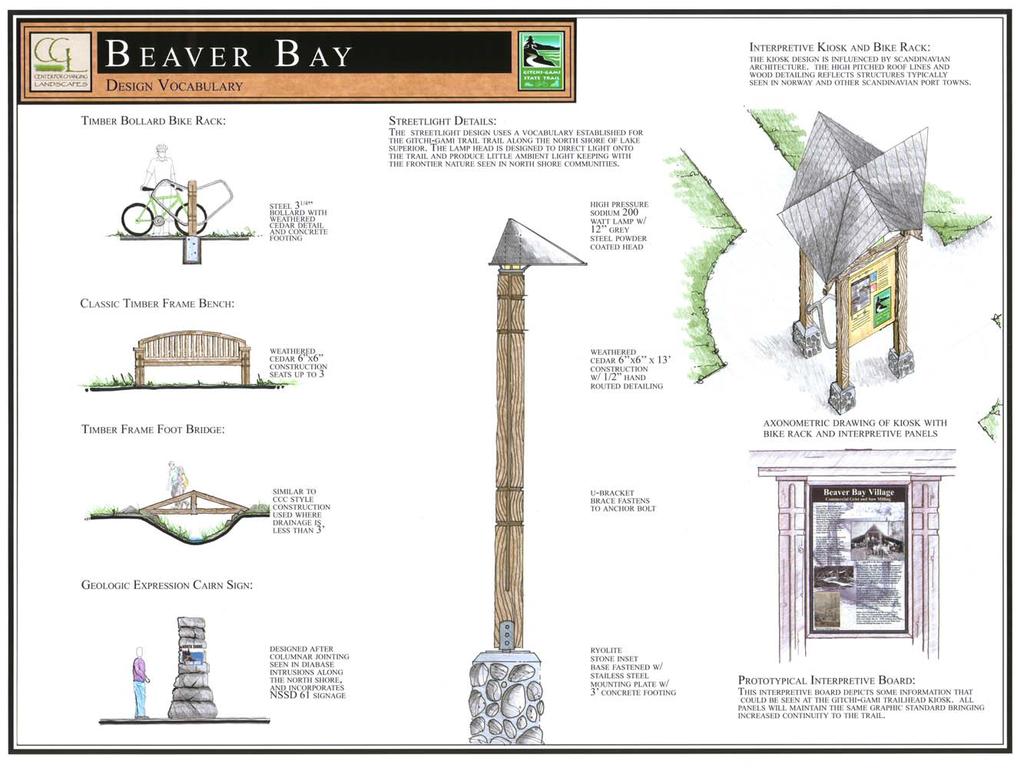
8 PRELIMINARY DESIGN: STREETLIGHT DETAILS: The streetlight design uses a vocabulary established for the Gitchi-Gami Trail along the North Shore of Lake Superior. The lamp head is designed to direct light onto the trail and produce little ambient light keeping with the nature of North Shore communities. INTERPRETIVE KIOSK AND BIKE RACK: The kiosk design is influenced by Scandinavian architecture. The high pitched roofs and wood detailing reflect structures typically seen in Norway and other Scandinavian port towns. PROTOTYPICAL INTERPRETIVE BOARD: This interpretive board depicts some information that could be seen at the Gitchi-Gami trailhead kiosk. All panels will maintain the same graphic standard bringing increased continuity to the trail. 56
9 57
10 GEOGRAPHIC INFORMATION SYSTEMS (GIS) THEMATIC MAPS: The first step in the design process is analyzing the landscape to understand its complex layers of geology, landform, vegetation, history, and culture. In order to perform the analysis, GIS data was collected and then processed into different layers according to themes. Each theme become an individual map. Like laying transparencies over each other, these thematic maps are layered to reveal relationships within the complexity of the landscape. Hundreds of individual data layers were chosen and combined into the thematic maps representing bedrock geology, surficial geology, infrastructure, elevation, hydrology, original vegetation, native plant communities, biodiversity sites, national wetlands inventory, land use, land cover, population change, and land ownership. Thematic maps from Two Harbors to Grand Marais were then produced. Analyzing the landscape in this layered manner serves as the basis for developing a regional identity through design. Mapping the attributes of a region allows the design to celebrate the uniqueness of the area through use of regional materials, native vegetation, and local land form vocabulary. 58
11 GRAND MARAIS GITCHI-GAMI TRAIL BEAVER BAY TWO HARBORS GIS STUDY AREA EXTENT 59
12 GEOLOGY The Laurentian Mountains formed 2.7 billion years ago as the Earth s crust cooled and solidified. Over hundreds of millions of years, several miles thickness of this rock eroded away to reveal Ely Greenstone that had formed deep in the Earth s crust. These deformed and metamorphosed granites make up the Canadian Shield, which forms the ancient core and foundation of the North American continent. From 2.2 to 1.9 billion years ago a vast inland sea flooded the interior of the continent. Sediments accumulated at the bottom of this sea to depths of several thousands of feet. These are some of the oldest sedimentary rocks in the world. These sandstones and graywacke (muddy or dirty sandstones) are visible in the Rove Formations around the Grand Portage area and include the iron bearing formations of the Mesabi Iron Range. Approximately 1 billion years ago the Earth s crust began to pull apart in a great zone of crustal thinning known as the Midcontinent Rift System. Basaltic lava poured through cracks in the Earth s surface and spread out on the flat landscape. Hundreds of these lava flows accumulated on top of each other to form the North Shore Volcanic Group. Their combined weight caused the already thin crust to subside, forming the Lake Superior basin and tilting up layers of rock on the edges of the rift system. Magma that cooled underground formed the more resistant, diabase rocks of the Duluth Complex that form most of the rugged hills and ridges of the North Shore, including at Split Rock, Manitou, Tettagouche, and Carlton Peak. The falls on the Gooseberry, Baptism, Cross, and Temperance Rivers flow over different layers of basaltic lava flows. The jagged form of the Sawtooth Mountains illustrates the tilting layers of lava at the edge of the rift system with their gradual slope extending under Lake Superior to the south and their steep slope facing north. Columnar joints and vertical fractures that develop as lava flows cool and shrink are visible at Gooseberry and Temperance Rivers. Gas bubbles trapped in the solidifying lava gradually fill up with dissolved minerals to form amygdules like the Agates are commonly found along the North Shore. Lava dikes cooled vertically in cracks around Grand Portage, instead of horizontally on the surface of the earth as occured elsewhere on the North Shore, resulting in a pattern of steep, narrow ridges that criss-cross the landscape. RESOURCES FOUND ALONG THE GITCHI-GAMI TRAIL: Two Harbors to Beaver Bay is generally flat, except for the more resistant diabase intrusion that forms Silver Cliff and Lafayette Bluff. Outcroppings of the soft, flat, basaltic lava flows can be seen at Gooseberry Falls. Another diabase intrusion occurs at Split Rock Lighthouse. Beaver Bay to Tofte is characterized by the rocky, humpback forms of the more resistant diabase intrusion known locally as the Beaver Bay Complex. These outcroppings occur along the lake creating a rugged shoreline that forces the road further inland and includes such familiar sights as Palisade Head, Shovel Point, Carlton Peak and the gorges of the Baptism, Manitou, Caribou, Cross and Temperance Rivers. Tofte to Grand Marais is characterized by the jagged profile of the Sawtooth Mountains rising gradually out of Lake Superior in a series of ridges with steep back slopes. Their cuesta form is the result of the North Shore Volcanic Group s flat, basaltic lava flows tilting up under their own weight. 60
13 GRAND MARAIS BEAVER BAY LEGEND TWO HARBORS 61
14 TOPOGRAPHY Two million years ago, mile thick glaciers began advancing out of Canada. Four great periods of glacial advance have been identified; the Kansan, Nebraskan, Illinoian, and Wisconsin, each followed by subsequent periods of retreat. The glaciers scoured away softer sedimentary rocks and basaltic lavas in the Lake Superior basin and left two types of deposits, till and outwash. Till is unsorted material that is directly deposited by the ice in the form of moraines. Outwash is transported by meltwaters and deposited in layers sorted by the size of its particles. While the last ice sheet was blocking existing lower outlets to the east, Lake Superior occupied higher levels than it does today. Striations etched into the bedrock by slow moving glaciers are visible in many locations along the North Shore. Abandoned beach terraces are visible at Caribou River where sand and gravel from higher lake levels covers the volcanic bedrock. RESOURCES FOUND ALONG THE GITCHI-GAMI TRAIL: Two Harbors to Beaver Bay is generally flat, except for a single rugged intrusion that extends in a perpendicular direction toward the shoreline.the intrusion creates a rugged shoreline where it meets Lake Superior, necessitating the tunnels at Silver Cliff and Lafayette Bluff, and generating spectacular views out over the lake. Another smaller intrusion meets the shoreline up the road to create the promontory at Split Rock Lighthouse. The humpback form of the Beaver Bay Complex intrusion parallels Lake Superior from Beaver Bay to Tofte creating a rugged shoreline of alternating rocky headlands, sheer cliffs, and secluded coves. The road moves further inland and to higher elevations where it can be wider and straighter through the inland forests to avoid such familiar landmarks as Palisade Head, Shovel Point, Carlton Peak and the gorges of the Baptism, Manitou, Caribou, Cross and Temperance Rivers. Tofte to Grand Marais is characterized by the jagged profile of the Sawtooth Mountains rising gradually out of Lake Superior in a series of ridges with steep back slopes. Their cuesta form is the result of the North Shore Volcanic Group s flat, basaltic lava flows tilting up under their own weight and provides the opportunity to connect the numerous peaks and ridges with recreational trails and and skihills. 62
15 GRAND MARAIS BEAVER BAY TWO HARBORS LEGEND 63
16 HYDROLOGY The streams of the North Shore are generally short and steep, draining small watersheds. They flow southeast to Lake Superior through surface deposits of glacial till, uplifted glacial lake sediments, and bedrock in which they have eroded deep gorges. Near Duluth the streams have virtually no lakes in the headwaters so that during times of snowmelt or heavy rain, floodwaters develop rapidly and run off quickly. During drought, flows are extremely low. To the northeast the streams have a more stable flow, lakes and marshes in the headwaters act as natural regulators retarding high flows during storms and slowly releasing stored water during drought to maintain higher minimum flows. With relatively deep water so close to shore, Lake Superior s biological communities are concentrated in the narrow and shallow nearshore areas. The lake s clear water is extremely cold and infertile resulting in food production rates that are much lower than in other lakes. Non-point source pollution is one of the major threats affecting water quality in Lake Superior. These threats are due to erosion, sedimentation, and run-off from failing septic systems. Approximately 36 miles of Minnesota s shoreline has been identified as high erosion hazard by the Minnesota Pollution Control Agency. Approximately 55% of North Shore septic systems are deemed failures as described by Chapter 7080 of the Indivdual Sewage Treatment Sytems Standards. Lake Superior and its tributaries are extremely fragile ecosystems that retain their pristine conditions because they have not experienced the same amount of development and pollution as the other Great Lakes. RESOURCES FOUND ALONG THE GITCHI-GAMI TRAIL: The Gooseberry and Baptism Rivers lack water storage in their headwaters and consequently discharge fluctuates seasonally. They may be virtually dry in late summer. High waterfalls in their lower reaches dropping feet in the last several miles provide scenic opportunities in State Parks. From the Manitou to Two Island Rivers, large watersheds and high waterfalls with some head water storage in lakes and swamps stabilize water flow, thereby creating some of the best trout streams along the North Shore. From the Cross to Devil Track Rivers, large watersheds with many lakes and marshes in their headwaters result in more stable flows and relatively high water temperatures more suited to warm water fish species such as northern pike and smallmouth bass in the upper reaches. These streams cascade through State Park gorges so narrow and deep they seem more like caves than river channels. 64
17 GRAND MARAIS BEAVER BAY TWO HARBORS LEGEND 65
18 ORIGINAL VEGETATION The original vegetation of the North Shore was coniferous forest in most places. The Great Lakes Pine Forest, comprised of white and red pine, paper birch and aspen, occurred on thin glacial till over the underlying bedrock in northern Minnesota. White and red pines dominated the shoreline to Little Marais. Beyond Little Marais, paper birch and aspen outnumbered the pines in the forest. Near Hovland several tracts of white and red pine dominated forest appeared once again. The dry open conditions under the jack pine canopy allow for a variety of understory plants. Ericaceous (heath family) shrubs such as wintergreen and blueberry are especially common. On deeper soils hazel may form impenetrable thickets. Balsam fir, owing to its great shade tolerance, tends to form extensive stands in the absence of frequent fires. Natural disturbances including fire, wind and spruce budworm epidemics often result in extensive areas of even aged aspen-birch forest. All along the North Shore mixed hardwood maple and pine forests occurred on the cooler, shadier backslopes of hills and ridges inland from the lake. Conifer bogs and swamps also occured inland, where hills and ridges blocked the drainage to Lake Superior. Forest fires created a dynamic ecosystem composed of early post-fire stands of jack pine and red pine and mature old growth stands of white pine. In general, red pine was more abundant than white pine and occurred on coarsely textured dry sites prone to fire. White pine stands occurred on the mesic (moist) sites of stream margins and lower slopes less subject to fires. Fire opens the ground plane to direct sunlight and exposes the mineral soil seedbed, both of which are necessary requirements for jack pine reproduction. Disturbance is a natural part of the ecological cycle. Fire was responsible for the origin and presence of the vast pine stands. Red and white pines with their thick, insulated layers of bark, and branches that don t start until half way up the trunk, were usually able to survive fires raging on the forest floor, aspen and birch with their thin bark and numerous branches were not. Without periodic fires to remove the quick growing aspen and birch, pine saplings are quickly crowded out and denied access to the sunlight they needed to survive. If their are no young pines when the mature trees die of old age, the forest will slowly evolve from pine to aspen and birch. Today the entire forest has been disturbed by logging. RESOURCES FOUND ALONG THE GITCHI-GAMI TRAIL: Two Harbors to Beaver Bay was dominated by white and red pine forest. Beaver Bay to Tofte saw the transition from white and red pine to forest dominated by aspen and birch. Tofte to Grand Marais was aspen and birch dominated pine forest. 66

19 GRAND MARAIS BEAVER BAY TWO HARBORS LEGEND 67
20 ECOLOGY Rare plant communities and animal nesting sites occur with great frequency along the North Shore. Remnant patches of original vegetation support populations of plants and animals that have otherwise disappeared from the North Shore as humans alter the landcover. Habitat is especially critical to migratory birds that must go around rather than across the expanse of Lake Superior on their migratory flights. The abundance of rocky cliffs minimizes the nesting habitat available for waterfowl and shorebirds. Arctic plant communities occur under favorable microclimates in disjunct locations. Local stream trout and anadromous trout from Lake Superior use the streams and rivers of the North Shore to spawn and reproduce. Diverse old-growth pine forests no longer exist on the North Shore. The current forest is mostly highly disturbed, young, even-aged, second-growth aspen and birch forest. Even the few places where remnant patches of old-growth pine forest remain are not what they used to be. The suppression of forest fires over the last 100 years has halted the natural cycle of regeneration. As mature pine trees age and die there are no young pines in the forest to take their place. Without fire, the aspen, birch and fir out-compete young pines. In 1854 woodland caribou were common, moose uncommon, and deer nonexistent along the North Shore. The young aspen and birch forests of today, with frequent openings created by logging, are not able to support wolf and caribou populations. In the absence of predators, deer have moved into the forest in great numbers and are devouring their favorite food source, tender, young pine saplings. The presence of deer in old-growth forests, further disrupts the natural cycle of regeneration by removing young pines and further shifting the forest composition to aspen and birch. Optimum deer habitat is 45-60% deciduous of which 25-35% is aspen and 25% is ten years old or less. Another 5-10% should be grassy openings and 15-20% should have conifers for protective cover. Logging the pine forests replaced moose and caribou habitat with deer habitat. Large deer populations were reported on the North Sore by the 1930s. Second growth aspen is short-lived, maturing in years. When second growth aspen forest began maturing in the 1960s, deer numbers decreased and moose recovered. Wolves were blamed for the decline in deer. Today, as loggers harvest the mature second growth aspen forest for pulpwood, deer numbers are rebounding and moose are once again in decline. State Parks are important habitat centers on the North Shore that are managed to increase their habitat value. Controlled fires can be set to keep the aspen and birch at bay. Fenced exclosures keep deer out until the pines are tall enough that deer can t reach their tender branches. State parks also provide habitat corridors for the movement of birds and animals between the shore of Lake Superior and the state and national forests inland. RESOURCES FOUND ALONG THE GITCHI-GAMI TRAIL: The Two Harbors to Beaver Bay segment contains colonial waterbird nesting habitat, and rare plant and animal habitat, and shorebird migratory habitat. The Beaver Bay to Tofte contains arctic disjunct plant communities, northern hardwood and upland cedar forests, fish spawning areas, and deer yards. The Tofte to Grand Marais segment contains arctic and alpine disjunct plant communities, fish spawning areas, and poor fen wetland habitat. 68
21 GRAND MARAIS BEAVER BAY TWO HARBORS LEGEND 69
22 LANDCOVER During the economic boom years following World War II, the supply of high-grade iron ore slowly declined. Researchers at the University of Minnesota perfected a method for taconite beneficiation and the Reserve Mining plant was built in 1955 to process low-grade taconite ores and the new town of Silver Bay sprang up around it. The opening of the St. Lawrence Seaway in 1959 connected the Great Lakes to international markets. The first artificial connection between the Atlantic Ocean and the Great Lakes - the Erie Canal completed in introduced the sea lamprey to the lower Great Lakes. The Welland Ship Canal allowed sea lampreys access to the Great Lakes above Niagara Falls in The first sea lamprey was observed in Lake Ontario in 1835, in Lake Erie in 1921, in Lake Huron in 1937 and in Lake Superior in By the late 1940s, lake trout in Lakes Huron and Michigan were essentially extirpated. Sea lampreys devastated Lake Superior s native trout populations during the 1950s, until effective sea lamprey control programs were initiated in the 1960s. Today tourism is the leading economic activity on the North Shore. Naniboujou Lodge was built in 1928 as a private club. The Nelson family built Lutsen Ski Resort in Inevitably we have exhausted the seemingly inexhaustible resources that attract us to the North Shore. A variety of experiences is available on the North Shore moving through alternating stands of pine and then aspen or birch. Today the forests are primarily mixedwood forest along the shore with aspen and paper birch dominating pines on the front slopes and deciduous sugar maples on the back slopes. There are many stands of shrubs and young regenerating forest where logging has recently occurred. Coniferous forests survive only in wetland areas. The gravel bars at some of the North Shore streams formed after clear-cutting exposed the bare slopes and hillsides of the river valleys to erosion. Spawning beds in the rivers silted over and water temperatures increased due to the lack of shade. Logs gouged streambeds to the point they are only now healing. A logjam once blocked the Stewart River for 3 years. RESOURCES FOUND ALONG THE GITCHI-GAMI TRAIL: This segment contains the historic communities of Two Harbors and Beaver Bay and many small, rustic, Ma & Pa resorts and cabins. This segment contains the large industrial operations and iron ore loading facilities at Silver Bay and Taconite Harbor. This segment contains the resort commnities of Tofte, Lutsen, and Grand Marais. 70

23 GRAND MARAIS BEAVER BAY LEGEND TWO HARBORS 71
24 DEVELOPMENT Historically, communities nestled into the rugged North Shore had more of a connection to the land or the lake than they did to each other. Finnish, Swedish, Norwegian and German communities were isolated from each other as much by the rugged landscape as they were by language. Frequent river gorges and impenetrable forests made travel along the shore nearly impossible, except for the most hardy, like postman John Beargrease. Most of the communities on the North Shore were only accessible to the outside world by boat until the mid 1920s. In fact, most community locations were selected for the shelter provided by a harbor or river mouth for loading and unloading boats. Traveling inland was typically much easier, especially along the path of least resistance cut by rivers through the hills and trees. Communities prospered or perished based on the availability of inland natural resources, including iron ore deposits, harvestable lumber, the presence of game birds and animals, and the supply of fish in the streams and waters of Lake Superior. Today s communities depend on the steady flow of tourists into the region, seeking outdoor recreation on the same forested hills that tower scenically above the river gorges and Lake Superior itself. RESOURCES FOUND ALONG THE GITCHI-GAMI TRAIL: There are many small, rustic homes and Ma & Pa resorts visible along the Gitch-Gami Trail from Two Harbors to Beaver Bay. You pass directly through the historic towns of Beaver Bay and Two Harbors. Popular, historic state parks occur at Gooseberry Falls and Split Rock Lighthouse with numerous scenic views from bridges over river gorges. The Trail from Beaver Bay to Tofte is planned further inland through the forest to avoid rugged landforms along the lakeshore. There are fewer buildings and services visible in this isolated stretch of the trail. The modern town of Silver Bay is entirely inland and not visible from the pro posed trail. Tettegouche and Crosby-Manitou contain the most inland backcountry areas of all the state parks and require getting out of your car to enjoy the scenic views. Iron ore loading docks at Silver Bay and Taconite Harbor are visible along the lakeshore. Highway 1 is major inland artery to Finland, Wolf Ridge ELC, Ely, and the Boundary Waters Canoe Area beyond. Larger, newer homes and resorts occur along the trail from Tofte to Grand Marais. You pass through the resort communities of Schroeder, Tofte, Lutsen and Grand Marais. Numerous scenic views of the Sawtooth Mountains and state park river gorges are visible from the planned trail including Carlton Peak, Leveaux Mountain, Cross River, Temperance River, and Cascade River. 72
25 GRAND MARAIS BEAVER BAY TWO HARBORS LEGEND 73
26 INFRASTRUCTURE The Gitchi-Gami Trail is planned to run the length of the North Shore and connect all its communities. Except for iron ore shipments from the range to Silver Bay and Taconite Harbor, railroads extend up the North Shore only to Two Harbors. Loading dock facilities for ore boats occur in Two Harbors, Silver Bay, and Taconite Harbor. Public Access Boat Launches on Lake Superior are maintained in Two Harbors, Twin Points, Silver Bay Marina, Taconite Harbor, Schroeder, Tofte, Grand Marais, Hovland, Horseshoe Bay, and Grand Portage. Additional public access boat ramps occur on numerous inland lakes and streams. Municipal sewage treatment lagoons exist in Two Harbors, Beaver Bay, Lutsen, and Grand Marais. Airports serve the communities of Two Harbors, Beaver Bay, Tofte, and Grand Marais. Interior roads to inland areas occur at Two Harbors (County Road 2 to Ely), Beaver Bay (SNF Scenic Byway to the Iron Range), Illgen City (Highway 1 to Ely), Tofte (Sawbill Trail to BWCAW), Lutsen (Caribou Trail to BWCAW), Grand Marais (Gunflint Trail to BWCAW), and Hovland (Arrowhead Trail to BWCAW). RESOURCES FOUND ALONG THE GITCHI-GAMI TRAIL: The area from Two Harbors to Beaver Bay contains the most people and the most infrastructure, including; 4 public access boat launches, 2 airports, 2 municipal sewage treatment lagoons, 2 roads inland, and the terminus of passenger railroad service. The area from Silver Bay to Taconite Harbor contains very little infrastructure, including; rail road lines to carry iron ore to the loading facilities at Silver Bay and Taconite Harbor, 1 public access boat launch, and 1 road inland. The area from Tofte to Grand Marais conatins 3 public access boat launches, 2 airports, 2 mu nicipal sewage treatment lagoons, and 3 roads inland. 74
27 GRAND MARAIS BEAVER BAY LEGEND TWO HARBORS 75
28 LAND OWNERSHIP Federal ownership dominates the North Shore within the Superior National Forest from Schroeder to beyond Grand Marais. The Grand Portage Indian Reservation dominates the tip of the Arrowhead region. State Parks and State Forests dominate locally at Gooseberry Falls, Split Rock Lighthouse, Tettegouche, Crosby-Manitou, Temperance River, Cascade River, Judge Magney, Finland, Pat Bayle and Grand Portage. Large parcels of privately owned industrial land occur in Two Harbors, Silver Creek, Silver Bay, and Taconite Harbor. RESOURCES FOUND ALONG THE GITCHI-GAMI TRAIL: The shoreline from Two Harbors to Beaver Bay is mostly in private ownership except for state land at Gooseberry Falls and Split Rock Lighthouse State Parks and along the shore s backslopes. Much of the shoreline and inland areas from Beaver Bay to Tofte are privately owned except in Tettegouche and Crosby-Manitou State Parks and in Finland State Forest. Only a narrow corridor of private ownership exists along the shore from Tofte to Grand Marais, interrupted by public land at Cascade River State Park. All inland areas are federally owned in the Superior National Forest. 76
29 GRAND MARAIS BEAVER BAY TWO HARBORS LEGEND 77
30 HISTORIC STRUCTURES Historic structures reinforce the settlement pattern, occurring mainly in the communities of Two Harbors, Beaver Bay, Finland, Schroeder, Lutsen, Grand Marais, Hovland, and Grand Portage as well as at Gooseberry Falls, the oldest state park on the North Shore. Silver Bay, the newest town on the North Shore in 1955, has no historic structures. A wide variety of historic structures has been designated along the North Shore including churches, cemeteries, abandoned CCC camps and logging camps, lighthouses, iron ore loading docks, locomotives, train depots, tugboats, shipwrecks, fishing piers, farm buildings, fur trade stockades, log lodges and resorts, missionary camps, and Native American sites. This wide variety reflects the broad scope of human industries and occupations that existed in North Shore communities through multiple cultures throughout the ages. Cultural festivals and public gatherings are also centered in the communities of the North Shore. Two Harbors hosts the County Fair, Folk Festival, Harbor Fest, and Heritage Days. Beaver Bay sponsors the Smelt Fry. Illgen City hosts St. Urho s Days and Tofte shoots off fireworks on the Fourth of July. Grand Marais sponsors the Fisherman s Picnic, Playhouse, Dog Days Winter Carnival, and Northern Lights. Hovland proclaims itself the Lake Trout Capital of the World and Grand Portage re-enacts Rendezvous Days. RESOURCES FOUND ALONG THE GITCHI-GAMI TRAIL: Historic structures are concentrated in the historic communities of Two Harbors, Castle Danger, and Beaver Bay as well as Gooseberry Falls and Split Rock Lighthouse State Parks. There are fewer historic structures along the North Shore from Silver Bay to Taconite Harbor. There are a couple of historic structures in the communities of Little Marais and Schroeder. There is also a collection of Finnish log homes in Finland, but there are no historic structures in Silver Bay, since it was only built in Historic structures from old logging camps survive at Tettegouche State Park and Sugarloaf Interpretive Center. There are more historic structures again in the communities of Tofte, Lutsen, and Grand Marais. Historic log lodges occur at Lutsen and at the Cascade River. An historic lighthouse and harbor facilities occur in Grand Marais and the ruins of an old pier remain in Tofte. 78
31 GRAND MARAIS BEAVER BAY T W O H A R B O R S LEGEND 79

32 RECREATIONAL SITES There are several regional trails that parallel the shoreline including the North Shore State Trail, Lake Superior Hiking Trail, Lake Superior Water Trail, and Gitchi Gami State Bike Trail. Otherwise, recreation opportunities tend to be concentrated in population centers, especially in and around Silver Bay and in the stretch from Lutsen to Grand Marais. Silver Bay trails are more popular with local residents, while the trails at Lutsen are more frequented by visitors and tourists. Lutsen Mountain is one of the largest downhill ski hills in the Midwest. There are 4 golf courses on the North Shore; Lakeview National in Two Harbors, Silver Bay Country Club in Silver Bay, Superior National in Lutsen, and Gunflint Hills in Grand Marais. Rock climbing is a popular activity, especially on the cliffs at Palisade Head, Shovel Point, and along the Baptism River. Fishermen flock to the North Shore streams all summer, but especially during the spring and fall spawning runs. Charter fishing boats and excursion boats are available in most communities. Rock hounds collect numerous Agates and Thomsonite. Hunting occurs for deer, moose, black bear, and upland game birds. Scuba diving to shipwrecks is possible. Inland roads provide access to additional recreational opportunities amidst the lakes and trees of Superior National Forest, Finland, Pat Bayle, and Grand Portage State Forests, and the Boundary Waters Canoe Area Wilderness. County Road 2 heads inland from Two Harbors, Superior National Forest Scenic Byway Highway 15 leaves Silver Bay, and Highway 1 turns north from Illgen City. The Sawbill Trail out of Tofte, Caribou Trail out of Lutsen, Gunflint Trail out of Grand Marais, and Arrowhead Trail out of Hovland all reach the southern edges of the Boundary Waters. Public Water Access boat launches for Lake Superior occur at Two Harbors, Twin Points, Silver Bay Marina, Taconite Harbor, Schroeder, Tofte, Grand Marais, Hovland, Horseshoe Bay and Grand Portage. Numerous inland access points also exist for backcountry lakes of all shapes and sizes. Those portions of the North Shore s streams and rivers held in public ownership also provide recreation opportunities, including the magnificent string of State Parks from Flood Bay, Gooseberry Falls and Split Rock Lighthouse to Palisade Head, Tettegouche (Baptism River), Crosby-Manitou, Caribou Falls, Cross River, Temperance River, Ray Bergland (Onion River), Cascade River, Devil s Track River, Kadunce River, Judge C. R. Magney (Brule River), and Grand Portage (Pigeon River). RESOURCES FOUND ALONG THE GITCHI-GAMI TRAIL: The district from Two Harbors to Beaver Bay contains 4 Public Water Access boat launches, 2 very popular state parks in Gooseberry Falls and Split Rock Lighthouse, 1 golf course, and 1 road in land. Numerous hiking, cross-county skiing, snowmobiling, and kayaking trails parallel the shore. The district from Silver Bay to Taconite Harbor contains 1 Public Water Access boat launch, 1 golf course, 2 state parks, and 2 inland roads. In addition there are many local recreational trails in the woods around Silver Bay. The district from Tofte to Grand Marais contains 3 Public Water Access boat launches, 2 state parks, 2 golf courses, 3 inland roads, Lutsen Mountain, and an abundance of local trails in the Sawtooth Mountains. 80
33 GRAND MARAIS BEAVER BAY TWO HARBORS LEGEND 81
THE REGION LAKE SUPERIOR THE GITCHI-GAMI TRAIL & THE NORTH SHORE
 LAKE SUPERIOR THE GITCHI-GAMI TRAIL & THE NORTH SHORE 7 LAKE SUPERIOR: Water covers 70% of the earth s surface area, but only 3% of it is freshwater. Saltwater makes up 97% of the earth s water supply.
Analysis of Existing Resources
 Analysis of Existing Resources Photo: View of the Shore - by Doug VanValkenburg The region s intrinsic qualities combine with the road s alignment to create the North Shore s unique sense of character.
2.1 Physical and Biological Description Matabitchuan River Watershed
 2.1 Physical and Biological Description Watershed 2.1.1 Physical Description The system watershed has a total area of about 933 km 2 and is a tributary system to Lake Temiskaming and the Ottawa River Drainage
SIGNATURE ELEMENTS BICYCLE RACKS & FENCING NSSD HWY. 61 CAIRN & TRAIL SIGNS INTERPRETIVE KIOSK
 SIGNATURE ELEMENTS BICYCLE RACKS & FENCING NSSD HWY. 61 CAIRN & TRAIL SIGNS INTERPRETIVE KIOSK 77 SIGNATURE ELEMENTS BICYCLE RACKS & FENCING: A kiosk, signs, fencing, and bike racks were designed as a
Segment 2: La Crescent to Miller s Corner
 goal of the USFWS refuges is to conserve, protect and enhance fish, wildlife and plants and their habitats for the continuing benefit of the American people. Refuge lands are used largely for fishing,
Region 1 Piney Woods
 Region 1 Piney Woods Piney Woods 1. This ecoregion is found in East Texas. 2. Climate: average annual rainfall of 36 to 50 inches is fairly uniformly distributed throughout the year, and humidity and temperatures
Jan Lake Representative Area -- Concept Management Plan --
 Jan Lake Representative Area -- Concept Management Plan -- Saskatchewan Environment and Resource Management December, 1999 Saskatchewan s Representative Areas Network Program The government of Saskatchewan,
Seager Wheeler Lake. Representative Area. -- Concept Management Plan --
 Seager Wheeler Lake Representative Area -- Concept Management Plan -- Saskatchewan Environment and Resource Management January, 1999 Saskatchewan s Representative Areas Network Program The Government of
PHYSICAL GEOGRAPHY GEOGRAPHY EARTH SYSTEMS COASTAL SYSTEMS FLUVIAL SYSTEMS
 PHYSICAL GEOGRAPHY EARTH SYSTEMS FLUVIAL SYSTEMS COASTAL SYSTEMS PHYSICAL GEOGRAPHY CORRIES / CIRQUES A Corrie or Cirque is the armchair shaped hollow that was the birthplace of a glacier. It has steep,
Whitemouth Falls Provincial Park. Draft Management Plan
 Whitemouth Falls Provincial Park Draft Management Plan Whitemouth Falls Provincial Park Draft Management Plan Table of Contents 1. Introduction... 3 2. Park History... 3 3. Park Attributes... 4 3.1 Natural...
26 Utah s Patchwork Parkway SCENIC BYWAY CORRIDOR MANAGEMENT PLAN (SR 143)
") Natural Natural Quality applies to those features in the visual environment that are in a relatively undisturbed state. These features predate the arrival of human populations and may include geological
Natural Natural Quality applies to those features in the visual environment that are in a relatively undisturbed state. These features predate the arrival of human populations and may include geological
APPENDIX 19-II. Ontario Trail Network Trailheads EAST-WEST TIE TRANSMISSION PROJECT AMENDED ENVIRONMENTAL ASSESSMENT REPORT
 EAST-WEST TIE TRANSMISSION PROJECT AMENDED ENVIRONMENTAL ASSESSMENT REPORT APPENDIX 19-II Ontario Network heads Report. 1536607/2000/2219 Ontario Network heads in the n-commercial Land and Resource Use
1 Glacial Erosion and
 www.ck12.org Chapter 1. Glacial Erosion and Deposition CHAPTER 1 Glacial Erosion and Deposition Lesson Objectives Discuss the different erosional features formed by alpine glaciers. Describe the processes
Understanding user expectations And planning for long term sustainability 1
 Understanding user expectations And planning for long term sustainability 1 What is a natural surface trail? It can be as simple has a mineral soil, mulched or graveled pathway, or as developed as elevated
CRAZY HORSE TRAIL GUIDE
 CRAZY HORSE TRAIL GUIDE Abridged Version: July 2016 This is a short form of our interpretive trail guide for the Crazy Horse Trail. The full version of the guide has a more detailed description of the
Trail Assessment Report
 Trail Assessment Report Trail Options for the Bear Creek Canyon located in Pikes Peak Ranger District, Pike National Forest and on Colorado Springs Utility Lands Due to the presence of a unique species
Clearwater Lake Provincial Park. Draft Management Plan
 Clearwater Lake Provincial Park Draft Management Plan Clearwater Lake Provincial Park Draft Management Plan Table of Contents 1. Introduction... 3 2. Park History... 4 3. Park Attributes... 4 3.1 Location/Access...4
THE SETTING REGION COMMUNITY ANALYSIS
 THE SETTING REGION COMMUNITY ANALYSIS REGION Historical Setting The Crane Lake waterway pre-dates the American Indians who traveled its waters for generations before it became a fur-trading route for the
Public Notice ISSUED: December 10, 2018 EXPIRES: January 9, 2019
 APPLICANT: REFER TO: St. Louis and Lake Counties Regional Rail Authority 2018-01942-ARC Public Notice ISSUED: December 10, 2018 EXPIRES: January 9, 2019 SECTION:404 - Clean Water Act 1. APPLICATION FOR
Rogue Gorge (Mt. Stella) Roadless Area-- T30S R3E (primarily in portions of Sections 23, 26, 33, 34 & 35)
 Roadless Area-- T30S R3E (primarily in portions of Sections 23, 26, 33, 34 & 35)") Rogue Gorge (Mt. Stella) Roadless Area-- T30S R3E (primarily in portions of Sections 23, 26, 33, 34 & 35) Rogue River-Siskiyou National Forest--High Cascades Ranger District Upper, higher elevation trail
Rogue Gorge (Mt. Stella) Roadless Area-- T30S R3E (primarily in portions of Sections 23, 26, 33, 34 & 35) Rogue River-Siskiyou National Forest--High Cascades Ranger District Upper, higher elevation trail
The gorges of Mohican Park in Ohio create a hiker's paradise Sunday, May 22, 2011 By Bob Downing, Akron Beacon Journal
 Pittsburgh Post-Gazette The gorges of Mohican Park in Ohio create a hiker's paradise Sunday, May 22, 2011 By Bob Downing, Akron Beacon Journal Bob Downing Big Lyons Falls drops 80 feet into a shady U-shaped
Photographing Upper Peninsula Waterfalls
 Photographing Upper Peninsula Waterfalls Tod Poirier Freelance Photographer Photography is one of my passions. The following spread showcases several Upper Peninsula waterfalls. At times a single drop
What Is An Ecoregion?
 Ecoregions of Texas What Is An Ecoregion? Ecoregion a major ecosystem with distinctive geography, characteristic plants and animals, and ecosystems that receives uniform solar radiation and moisture Sometimes
Colorado Life Zone Scavenger Hunt
 Colorado Life Zone Scavenger Hunt Below are worksheets created for all the habitats or life zones. They were designed with the intention of breaking the class up into small groups, and having students
NORTH SHORE CONSERVATION REGION 50 Year Vision
 NORTH SHORE CONSERVATION REGION 50 Year Vision The North Shore of Minnesota has what no other place in the Midwest can offer an inland sea, a mountain backdrop, an unspoiled wilderness, and a unique feeling
Glaciers Earth 9th Edition Chapter 18 Mass wasting: summary in haiku form Glaciers Glaciers Glaciers Glaciers Formation of glacial ice
 1 2 3 4 5 6 7 8 9 10 11 12 13 14 15 Earth 9 th Edition Chapter 18 Mass wasting: summary in haiku form Ten thousand years thence big glaciers began to melt - called "global warming." are parts of two basic
FINGER-TATUK PROVINCIAL PARK
 FINGER-TATUK PROVINCIAL PARK PURPOSE STATEMENT AND ZONING PLAN March 2003 FINGER-TATUK PROVINCIAL PARK Purpose Statement and Zoning Plan Finger-Tatuk Provincial Park is 17,151 ha in size. It includes the
Glaciers. Clicker Question. Glaciers and Glaciation. How familiar are you with glaciers? West Greenland. Types of Glaciers.
 Chapter 21 Glaciers A glacier is a large, permanent (nonseasonal) mass of ice that is formed on land and moves under the force of gravity. Glaciers may form anywhere that snow accumulation exceeds seasonal
Gifts of the Glaciers
 Gifts of the Glaciers Gifts of the Glaciers Moving ice of glacier was responsible for water, landforms, and soil characteristics and patterns of today Sculpturing of bedrock materials Glacial Landforms
TRAILS WHERE TO FIND TRAILS IN NOVA SCOTIA
 TRAILs SIGNAGE Know the Signs............................ 44 WHERE YOU CAN RIDE Roads and Highways........................ 46 Designated Trails........................... 47 Established Trails...........................
The Physical Geography of Long Island
 The Physical Geography of Long Island A Bit About Long Island Length 118 miles Brooklyn to Montauk Geo202 Spring 2012 Width 23 miles at it s widest Area 1,400 square miles Formation of Long Island River
Michipicoten Island Regional Plan
 Michipicoten Island Regional Plan This is one of twenty Regional Plans that support implementation of the Lake Superior Biodiversity Conservation Strategy (Strategy). The Strategy, prepared and overseen
April 10, Mark Stiles San Juan Public Lands Center Manager 15 Burnett Court Durango, CO Dear Mark,
 Mark Stiles San Juan Public Lands Center Manager 15 Burnett Court Durango, CO 81301 Dear Mark, We are pleased to offer the following comments on the draft San Juan Public Lands Center management plans
Recrystallization of snow to form LARGE. called FIRN: like packed snowballs. the weight of overlying firn and snow.
 Chapter 11 Glaciers BFRB P. 103-104, 104, 108, 117-120120 Process of Glacier Formation Snow does NOT melt in summer Recrystallization of snow to form LARGE crystals of ice (rough and granular) called
MEETING MINUTES District 1 Trail Planning Meeting 1
 MEETING MINUTES District 1 Trail Planning Meeting 1 June 1, 2017 2:00 PM 3:30 PM City of Two Harbors 2:00 Introductions Attendees: Lisa Austin, MnDOT Bryan Anderson, MnDOT Jasna Hadzic-Stanek, MnDOT Justin
Approval Statement. Brian Pfrimmer, Central Zone Manager Ontario Parks
 Approval Statement I am pleased to approve this Interim Management Statement for Dividing Lake Provincial Nature Reserve. This Nature Reserve contains biological features of provincial significance and
Photography Guide U.P. of Michigan
 Photography Guide U.P. of Michigan Porcupine Mountains Pictured Rocks National Seashore & Tahquamenon Falls By Bill Welch The U.P. of Michigan Michigan s Upper Peninsula (the U.P.) is a forest covered
Mark West Creek Flow Study Report
 Mark West Creek Flow Study Report Biology and Geology of Mark West Creek The headwaters of Mark West Creek are located in the Mayacamas Mountain range, which border Napa and Sonoma County, where it then
Geoscape Toronto The Oak Ridges Moraine Activity 2 - Page 1 of 10 Information Bulletin
 About 13,000 years ago as the Laurentide Ice Sheet melted, glacial meltwater accumulated between the ice sheet and the Niagara Escarpment. This formed a lake basin into which gravel and sand were deposited.
Glacial Geomorphology Exercise
 James Madison University Field Course in western Ireland Glacial Geomorphology Exercise 3-day road log (abbreviated) Striations Large kame terrace Cirque with moraines Kame delta Striations Eskers Raised
Driving Time: 3 hours (allow extra time for stops)
") Scenic Byways loop This journey takes visitors through the eastern edge of Mt. Rainier National Park and along two of Washington s most beloved scenic byways, the Chinook Byway and the White Pass Scenic
Scenic Byways loop This journey takes visitors through the eastern edge of Mt. Rainier National Park and along two of Washington s most beloved scenic byways, the Chinook Byway and the White Pass Scenic
A Publication of Friends of Sleeping Bear Dunes
 A Publication of Friends of Sleeping Bear Dunes 2014, Friends of Sleeping Bear Dunes, P.O. Box 545, Empire, MI 49630 www.friendsofsleepingbear.org info@friendsofsleepingbear.org Learn more about the Friends
Bayview Escarpment. Interim Management Statement
 Bayview Escarpment Interim Management Statement Bayview Escarpment Provincial Nature Reserve Interim Management Statement January 15, 1995 REGIONAL DIRECTOR'S APPROVAL STATEMENT This Interim Management
(/ 63 (/ 8 Æ% 48 Æ% 87 Æ% 35 Æ% 35 Æ% 65 Æ% 46. Æÿ J. Æÿ W. Æÿ I. Æÿ E. Æÿ O. Ice Age Trail Polk and Burnett Counties MINNESOTA
 ce Age Trail olk and Burnett Counties olk and Burnett Counties ce Age Trail Alliance www.iceagetrail.org Frederic Trade Æÿ McKenzie Creek ildlife Area Æÿ O Æÿ E Æÿ Æÿ O ndian Creek McKenzie Creek BURNETT
MANAGEMENT DIRECTION STATEMENT June, 1999
 Thompson River District MANAGEMENT DIRECTION STATEMENT June, 1999 for Clearwater River Corridor (Addition to Wells Gray Park) Ministry of Environment Lands and Parks BC Parks Division ii Table of Contents
Glaciers and Glaciation Earth - Chapter 18 Stan Hatfield Southwestern Illinois College
 Glaciers and Glaciation Earth - Chapter 18 Stan Hatfield Southwestern Illinois College Glaciers Glaciers are parts of two basic cycles: 1. Hydrologic cycle 2. Rock cycle A glacier is a thick mass of ice
Geologic Trips, Sierra Nevada
 ISBN 0-9661316-5-7 GeoPress Excerpt from Geologic Trips, Sierra Nevada by Ted Konigsmark All rights reserved. No part of this book may be reproduced without written permission, except for critical articles
Wallace Lake Provincial Park. Management Plan
 Wallace Lake Provincial Park Management Plan 2 Wallace Lake Provincial Park Table of Contents 1. Introduction... 3 2. Park History... 3 3. Park Attributes... 4 3.1 Natural... 4 3.2 Recreational... 4 4.
Hudson Bay Lowlands Proposed Protected Areas
 Hudson Bay Lowlands Proposed Protected Areas Hudson Bay Lowlands Proposed Protected Areas The Protected Areas Initiative has identified portions of the Hudson Bay Lowlands region that have significant
glacier Little Ice Age continental glacier valley glacier ice cap glaciation firn glacial ice plastic flow basal slip Chapter 14
 Little Ice Age glacier valley glacier continental glacier ice cap glaciation firn glacial ice plastic flow basal slip glacial budget zone of accumulation zone of wastage glacial surge abrasion glacial
discover Genuine Montana The Last Best Place Great Falls Montana
 discover Genuine Montana The Last Best Place Great Falls Montana the grandest sight I ever beheld... 1805 Meriwether Lewis journal entry Resting on the high plains along Montana s Rocky Mountain Front
Chapter 16 Glaciers and Glaciations
 Chapter 16 Glaciers and Glaciations Name: Page 419-454 (2nd Ed.) ; Page 406-439 (1st Ed.) Part A: Anticipation Guide: Please read through these statements before reading and mark them as true or false.
To Wellness. To Wellness PASSPORT PASSPORT. Partners. Partners. Ashland County Health & Human Services 630 Sanborn Avenue, Ashland, WI
 Partners Ashland County Health & Human Services 630 Sanborn Avenue, Ashland, WI Ashland Bretting Center 320 4th Avenue W., Ashland, WI PASSPORT Bayfield County Health Department 117 E. 6th Street, Washburn,
South Atikaki Provincial Park. Draft Management Plan
 South Atikaki Provincial Park Draft Management Plan South Atikaki Provincial Park Draft Management Plan Table of Contents 1. Introduction... 3 2. Park History... 3 3. Park Attributes... 3 3.1 Natural...
2.0 PARK VISION AND ROLES
 2.0 PARK VISION AND ROLES 2.1 Significance in the Protected Area System Marble Range and Edge Hills provincial parks protect 6.8% of the Pavillion Ranges Ecosection, which is located in the Southern Interior
Little Grand Canyon near Pomona, Illinois
 Little Grand Canyon near Pomona, Illinois Below: View of the trail and the terrain created using the Map My Hike app Below: Summary of the hike created using the Map My Hike app Presented by: Jennifer
Marchand Provincial Park. Management Plan
 Marchand Provincial Park Management Plan 2 Marchand Provincial Park Table of Contents 1. Introduction... 3 2. Park History... 3 3. Park Attributes... 4 3.1 Natural... 4 3.2 Recreational... 4 3.3 Additional
Pinellas County Environmental Lands
 Pinellas County Environmental Lands In addition to traditional parks and recreation facilities, Pinellas County owns and manages a system of environmental lands that provides specialized resource-based
Evaluation of Outstanding Remarkable Values for Collawash River March 2011
 Evaluation of Outstanding Remarkable Values for Collawash River March 0 Segment From headwaters of East Fork Collawash River to Buckeye Creek Mileage: miles Free flowing: Yes Scenic:, Substantial River
155 acres on Tyaughton Lake 900 feet of Pristine Waterfront Private & Secluded Property
 155 acres on Tyaughton Lake 900 feet of Pristine Waterfront Private & Secluded Property 946 Tyaughton Lake Road Gold Bridge BC V0K1P0 900 ft of waterfront with 155 acres of south facing easy access. This
Just how big is Africa?
 The United States China India The United Kingdom Portugal Spain France Belgium Germany The Netherlands Switzerland Italy Eastern Europe Japan 11.7 million sq. miles Just how big is Africa? Chapter 18 Section
Lidar Imagery Reveals Maine's Land Surface in Unprecedented Detail
 Maine Geologic Facts and Localities December, 2011 Lidar Imagery Reveals Maine's Land Surface in Unprecedented Detail Text by Woodrow Thompson, Department of Agriculture, Conservation & Forestry 1 Introduction
Shaping of North America. Physical Geography II of the United States and Canada. The Last Ice Age. The Ice Age. Pleistocene Polar Ice Cap 2/14/2013
 Physical Geography II of the United States and Canada Prof. Anthony Grande AFG 2012 Shaping of North America The chief shaper of the landscape of North America is and has been running water. Glaciation
1.1.1 Landscape character This is the upper part of a bowl-shaped landform, extending east from the Rothiemurchus character area, contained by the
 1.1 Glen More 1.1.1 Landscape character This is the upper part of a bowl-shaped landform, extending east from the Rothiemurchus character area, contained by the arc of the high granite pluton of the Cairngorms
Glaciers. Glacier Dynamics. Glacier Dynamics. Glaciers and Glaciation. Types of Glaciers. Chapter 15
 Chapter 15 Glaciers and Glaciation Glaciers A glacier is a large, permanent (nonseasonal) mass of ice that is formed on land and moves under the force of gravity. Glaciers may form anywhere that snow accumulation
~,t;b i D34 Vs33 SB 482
 ., SB 482 ~,t;b i D34 Vs33 This document is made available electronically by the Minnesota Legislative Reference Library as part of an ongoing digital archiving project. http://www.leg.state.mn.us/lrl/lrl.asp
X. WHATCOM CREEK SMA. X.1 Watershed Analysis. X.1.1 Landscape Setting
 X. WHATCOM CREEK SMA Summary: The entire length of Whatcom Creek is located within the City of Bellingham. SMA jurisdiction associated with this creek is approximately 300 acres. Land use is dominated
GLACIATION. The Last Ice Age (see Chapter 12) and. Pleistocene Ice Cap. Glacial Dynamics 10/2/2012. Laurentide Ice Sheet over NYS
 and. Pleistocene Ice Cap. Glacial Dynamics 10/2/2012. Laurentide Ice Sheet over NYS") GLACIATION and New York State Prof. Anthony Grande The Last Ice Age (see Chapter 1) The Pleistocene Epoch began 1.6 mya. During this time, climates grew colder. There were numerous ice ages starting 100,000000
GLACIATION and New York State Prof. Anthony Grande The Last Ice Age (see Chapter 1) The Pleistocene Epoch began 1.6 mya. During this time, climates grew colder. There were numerous ice ages starting 100,000000
All-American Road NORTH SHORE DRIVE SCENIC
 THE NORTH SHORE SCENIC DRIVE All-American Road The Center For Changing Landscapes College of Architecture and Landscape Architecture College of Natural Resources A CKNOWLEDGEMENTS This project was produced
GOLDEN EARS PROVINCIAL PARK
 GOLDEN EARS PROVINCIAL PARK Trail Information as of October 10 th 2015 Do not underestimate the mountainous wilderness of Golden Ears Provincial Park. The combination of rugged terrain and rapidly changing
Wallace Lake Provincial Park. Draft Management Plan
 Wallace Lake Provincial Park Draft Management Plan Wallace Lake Provincial Park Draft Management Plan Table of Contents 1. Introduction... 3 2. Park History... 3 3. Park Attributes... 4 3.1 Natural...
F INAL DESIGN PROPOSAL. Knife River Village MASTER PLAN
 Knife River Village MASTER PLAN The Knife River Village idea is the culmination of the community design process with as much community feedback incorporated as possible into the final design proposal.
Town of Oakfield Agricultural and Farmland Protection Plan
 SECTION III COMMUNITY OVERVIEW A. Regional Setting / Location The Town of Oakfield is located in the northwestern portion of Genesee County. Located west of New York's Finger Lakes, the Town is uniquely
Presentation Overview
 DON NARROWS Historical and Existing Conditions March 29, 2008 Presentation Overview 1. Project Location and Background 2. Historical Context How did the Don Narrows Come to Be? 3. The Today 4. Next Steps
Chapter 20. The Physical Geography of Africa South of the Sahara
 Chapter 20 The Physical Geography of Africa South of the Sahara Chapter Objectives Identify the major landforms, water systems, and natural resources of Africa south of the Sahara. Describe the relationship
The Geological Pacific Northwest. Wednesday February 6, 2012 Pacific Northwest History Mr. Rice
 The Geological Pacific Northwest Wednesday February 6, 2012 Pacific Northwest History Mr. Rice 1 Free Response #2 Please do not simply list the items for this response. Full sentences!!! Minimum of 3-5
Rocky Lake Provincial Park. Draft Management Plan
 Rocky Lake Provincial Park Draft Management Plan Rocky Lake Provincial Park Draft Management Plan Table of Contents 1. Introduction... 3 2. Park History... 3 3. Park Attributes... 4 3.1 Location/Access...4
Greater Minnesota Regional Parks and Trails Commission Designation Application
 Greater Minnesota Regional Parks and Trails Commission Designation Application General Section Designation Application #: 15-059D Date Submitted: 06/16/2015 Park or Trail Name: Mesabi Trail District #:
Bear Creek Habitat Improvement Project
 06/10/10 Bear Creek Habitat Improvement Project El Paso County, Colorado Pike National Forest and Colorado Springs Utilities Owned Land Report prepared by: Eric Billmeyer Executive Director Rocky Mountain
MORGAN CREEK GREENWAY Final Report APPENDICES
 APPENDICES MORGAN CREEK GREENWAY Appendix A Photos of Existing Conditions in Trail Corridor Photos of existing conditions Main trail corridor - February 2009 Photos of existing conditions south bank Morgan
Birch Point Provincial Park. Management Plan
 Birch Point Provincial Park Management Plan 2 Birch Point Provincial Park Table of Contents 1. Introduction... 3 2. Park History... 3 3. Park Attributes... 4 3.1 Natural... 4 3.2 Recreational... 4 4. Park
EXPLORING EARTH S SURFACE. Lesson 4
 EXPLORING EARTH S SURFACE Lesson 4 Introduction Lewis and Clark In 1804, an expedition set out from near Saint Louis to explore the land between the Mississippi River and the Pacific Ocean, The United
Numaykoos Lake Provincial Park. Management Plan
 Numaykoos Lake Provincial Park Management Plan 2 Numaykoos Lake Provincial Park Table of Contents 1. Introduction... 3 2. Background... 3 3. Park Purpose... 5 4. Park Management Guidelines... 6 Appendix...
Glaciers. Glacier Dynamics. Glaciers and Glaciation. East Greenland. Types of Glaciers. Chapter 16
 Chapter 16 Glaciers A glacier is a large, permanent (nonseasonal) mass of ice that is formed on land and moves under the force of gravity. Glaciers may form anywhere that snow accumulation exceeds seasonal
Ouimet Canyon Provincial Nature Reserve. Management Plan
 Ouimet Canyon Provincial Nature Reserve Management Plan NOTE: This document has been scanned and formatted, and therefore is slightly different from the original version. -March 2002 Additional copies
Marilla Reservoir to Chestnut Ridge via Marilla Trails and Bullis Hollow Trail east to west
 USGS topographic maps useful to this hike are the Bradford and Stickney 7.5 minute sectionals. These notes are designed to assist in identifying distance and location using geophysical and man-made characteristics
Stephens State Park Trails
 TRAILS OF ALLAMUCHY MOUNTAIN & STEPHENS STATE PARKS Allamuchy Mountain and Stephens State Parks contain 28 marked trails providing access to diverse landscapes for walking, hiking, biking, bird-watching,
There are actually six geographic sub-regions, three in both the uplands and the lowlands.
 6 Regions of AR Although Arkansas is most easily divided into two distinct geographical regions, the northwestern uplands and the southeastern lowlands, this description does not accurately portray the
Camping (Primitive) Camping (RV) Electrical Potable Water Grill Established Fire Pit Picnic Table
 Camping (RV) Electrical Potable Water Grill Established Fire Pit Picnic Table") Alden - 9th Road River Mile 777 Map: 38.20833, -98.32031 Managing Agency: Kansas Department of Wildlife, Parks & Tourism Nearest Community: Alden, Rice County Kansas Developed Amenities Provided Parking
Alden - 9th Road River Mile 777 Map: 38.20833, -98.32031 Managing Agency: Kansas Department of Wildlife, Parks & Tourism Nearest Community: Alden, Rice County Kansas Developed Amenities Provided Parking
VOLUME II APPENDIX F DETAILED PHYSICAL DESCRIPTION OF PROJECT RESERVOIRS AND LANDS
 VOLUME II APPENDIX F DETAILED PHYSICAL DESCRIPTION OF PROJECT RESERVOIRS AND LANDS THE CENTRAL NEBRASKA PUBLIC POWER AND IRRIGATION DISTRICT FERC PROJECT NO. 1417 PHYSICAL DESCRIPTION OF PROJECT LANDS
Unit 1: Physical Environment Glaciated Landscapes
 Unit 1: Physical Environment Glaciated Landscapes Corries Corries are bowl-shaped hollows high up in the mountains. They are formed in the following way: Snow collects in a hollow on a mountainside (usually
3.0 EXISTING PARK & RECREATION SPACE
 3.0 EXISTING PARK & RECREATION SPACE TOWN PARK & RECREATION SPACE An inventory of current parks and recreation area in the Town of Cedarburg is shown in Table 3. These areas total roughly 381.89 acres.
Sand Lakes Provincial Park. Draft Management Plan
 Sand Lakes Provincial Park Draft Management Plan 2 Sand Lakes Provincial Park Table of Contents 1. Introduction... 3 2. Background... 3 3. Park Purpose... 5 4. Park Management Guidelines... 6 Appendix...
Tiger Mountain State Forest:
 98 60 hikes within 60 miles: SEATTLE 20 Tiger Mountain State Forest: West Tiger Mountain Three Loop i KEY AT-A-GLANCE INFORMATION Length: 5.1 miles round-trip Configuration: Loop Difficulty: Moderate difficult
1.4 Understand how moving ice acts as an agent of erosion and deposition. (Chap. 2)
") 1.4 Understand how moving ice acts as an agent of erosion and deposition. (Chap. 2) There are two types of glaciation. Alpine Glaciation Continental Glaciation Distinguish between the terms alpine glaciation
1.4 Understand how moving ice acts as an agent of erosion and deposition. (Chap. 2) There are two types of glaciation. Alpine Glaciation Continental Glaciation Distinguish between the terms alpine glaciation
Header i
 Header i 048285014.10 Header Sub Title Body Text here. Body text here. Body text here. Section 1... 1 Executive Summary... 1 Opportunities and Constraints... 3 Overall Opportunities and Constraints Map
3.0 THE NORTH SASKATCHEWAN IN ALBERTA
 3.0 THE NORTH SASKATCHEWAN IN ALBERTA 3.1 WATERSHED OVERVIEW Wherever you are on earth, you are in a watershed. Most of the rain and snow falling outside your window will eventually find its way to a local
482 :fi6 D34 --' v.i9 ~
 '- SB 482 :fi6 D34 --' v.i9 ~ This document is made available electronically by the Minnesota Legislative Reference Library as part of an ongoing digital archiving project. http://www.leg.state.mn.us/lrl/lrl.asp
Theme: Predominately natural/natural appearing; rustic improvements to protect resources. Size*: 2,500 + acres Infrastructure**:
 Recreation Opportunity Spectrum (ROS) Classes The Recreation Opportunity Spectrum (ROS) provides a way to describe the variations in the degree of isolation from the sounds and influences of people, and
Cascade River State Park Management Plan Amendment
 This document is made available electronically by the Minnesota Legislative Reference Library as part of an ongoing digital archiving project. http://www.leg.state.mn.us/lrl/lrl.asp Cascade River State