National Register of Historic Places Continuation Sheet
|
|
|
- Allan Fitzgerald
- 5 years ago
- Views:
Transcription
1 NFS Form a OMB Approval No (8-86) United States Department of the Interior National Register of Historic Places Continuation Sheet Section number Page SUPPLEMENTARY LISTING RECORD NRIS Reference Number: Date Listed: 12/29/2000 Mt. Stella Lookout Jackson OR Property Name County State U.S. Forest Service Historic Structures on the Rogue River National Forest, MPS Multiple Name This property is listed in the National Register of Historic Places in accordance with the attached nomination documentation subject to the following exceptions, exclusions, or amendments, notwithstanding the certification included in the nomination documentation. ^ 7 7 / / ' / Sigiiatyre'of the Keeper Date of Action Amended Items in Nomination: Resource Category: The appropriate resource category is: Building Significance: Architecture is added as an area of significance under Criterion C. These revisions were confirmed with the U.S. Forest Service DISTRIBUTION: National Register property file Nominating Authority (without nomination attachment)
2 NFS Form a (8-86) OMB No United States Department of the Interior NATIONAL REGISTER OF HISTORIC PLACES CONTINUATION SHEET Section 3 Page 1 U. S. Forest Service Historic Structures on the Rogue River National Forest MPS SECTION 3: FEDERAL AGENCY CERTIFICATION As the designated authority under the National Historic Preservation Act, as amended, I hereby certify that the nominations listed below meet the documentation standards for registering properties in the National Register of Historic Places and meet the procedural and professional requirements set forth in 36 CFR Part 60. In my opinion, the properties meet the National Register Criteria. I recommend that these properties be considered significant locally. / of certifying official/fpo / P<ate Federal Agency and bureau: U.S. Department of Agriculture, Forest Service, Pacific Northwest Region Administrative Star Ranger Station BuildingTTack Room" (1911) Willow Prairie Cabin (1924) Big Elk Guard Station (1929) Fire Lookouts Hershberger Mountain Lookout (1924) Dutchman Peak Lookout (1927) Mt Stella Lookout (1933) Squaw Peak Lookout (1943) Snow Survey Cabins Whaleback Snow-Survey Cabin (1937) Honeymoon Creek Snow Cabin (1943) CCC/FERA Recreation Facilities McKee Bridge Campground ( ) Wrangle Shelter ( ) Dead Indian Soda Springs Shelter (1936) Fish Lake Shelter (1936) Parker Meadows Shelter (1936)
3 NPS Form (Oct. 1990) United States Department of the Interior National Register of Historic Places Registration Form 5l\ RECEIVED T, OMB No This form is for use in nominating or requesting determinations for individual properties and districts. See instructions in How to Complete the National Register of Historic Places Registration Form (National Register Bulletin 16A). Complete each item by marking "x" in the appropriate box or by entering the information requested. If an item does not apply to the property being documented, enter "N/A" for "not applicable." For functions, architectural classification, materials, and areas of significance, enter only categories and subcategories from the instructions. Place additional entries and narrative items on continuation sheets (NPS Form a). Use a typewriter, word processor, or computer, to complete all items. 1. Name of Property """ historic name other names/site number 2. Location Mt. Stella Lookout... Approximately 2.5 miles north of Union Creek street & number i_i ± Prospect Rogue River National Forest city or town _^ state 0regon 3. State/Federal Agency Certification OR code county 0 not for publication _ 0 vicinity Jackson code 029 zip code As the designated authority under the National Historic Preservation Act, as amended, I hereby certify that this D nomination D request for determination of eligibility meets the documentation standards for registering properties in the National Register of Historic Places and meets the procedural and professional requirements set forth in 36 CFR Part 60. In my opinion, the property D meets D does not meet the National Register criteria. I recommend that this property be considered significant D nationally D statewide D locally. (D See continuation sheet for additional comments.) Signature of certifying official/title Date State of Federal agency and bureau In my opinion, the property S meets D does not meet the National Register criteria. (D See continuation sheet for additional comments'.) in,?nnn Signature of certifying official/title /Deputy SHPO Date Oregon State Historic Preservation Office State or Federal agency and bureau 4. Certification I hereby certify that the property is: TtB-eote/ed in the National Register. * D See continuation sheet. D determined eligible for the National Register D See continuation sheet. D determined not eligible for the National Register. D removed from the National Register. D other, (explain:) Date of Action OQ I I
4 Mt. Stella Lookout Name of Property Jackson County and State OREGON 5. Classification Ownership of Property (Check as many boxes as apply) D private D public-local D public-state H public-federal Category of Property (Check only one box) D building(s) D district Dsite S structure D object Number of Resources within Property (Do not include previously listed resources in the count.) Contributing Noncontributing hnilrlinns sites structures objects Name of related multiple property listing Number of contributing resources previously listed (Enter "N/A" if property is not part of a multiple property listing.) _ln th«national Register U.S. Forest Service Historic Structures on t-h^ / Rogue River National Forest 6. Function or Use Historic Functions (Enter categories from instructions) GOVERNMENT: fire lookout Current Functions (Enter categories from instructions) GOVERNMENT:fire lookout Total 7. Description Architectural Classification (Enter categories from instructions) OTHER: "L-4" lookout Materials (Enter categories from instructions) WOOD: (tower) foundation walls WOOD:Weatherboard roof other WOOD:shingle Narrative Description (Describe the historic and current condition of the property on one or more continuation sheets.) Please See Continuation Sheet
5 Mt. Stella Lookout Name of Property 8. Statement of Significance Applicable National Register Criteria (Mark "x" in one or more boxes for the criteria qualifying the property for National Register listing.) 0 A Property is associated with events that have made a significant contribution to the broad patterns of our history. Jackson Oregon County and State 'Areas of Significance (Enter categories from instructions) CONSERVATION POLITICS/GOVERNMENT D B Property is associated with the lives of persons significant in our C Property embodies the distinctive characteristics of a type, period, or method of construction or represents the work of a master, or possesses high artistic values, or represents a significant and distinguishable entity whose components lack individual distinction. Period of Significance D D Property has yielded, or is likely to yield, information important in prehistory or history. Criteria Considerations (Mark "x" in all the boxes that apply.) Property is: D A owned by a religious institution or used for religious purposes. D B removed from its original location. G C a birthplace or grave. D D a cemetery. Significant Dates 1933 Significant Person (Complete if Criterion B is marked above) N/A Cultural Affiliation N/A D E a reconstructed building, object, or structure. D F a commemorative property. D G less than 50 years of age or achieved significance within the past 50 years. Architect/Builder Unknown Narrative Statement of Significance (Explain the significance of the property on one or more continuation sheets.) 9. Major Bibliographical References Bibliography (Cite the books, articles, and other sources used in preparing this form on one or more continuation sheets.) Previous documentation on file (NPS): D preliminary determination of individual listing (36 CFR 67) has been requested D previously listed in the National Register 0 previously determined eligible by the National Register D designated a National Historic Landmark D recorded by Historic American Buildings Survey D recorded by Historic American Engineering Record # Primary location of additional data: D State Historic Preservation Office D Other State agency El Federal agency D Local government D University D Other Name of repository: Rogue River National Forest
6 Mt. Stella Lookout Name of Property 10. Geographical Data Jackson County and State Oregon Acreage of Property 1.5 acres UTM References (Place additional UTM references on a continuation sheet.) ol LsUi6 l2iqo I Ui7 I5i3l8i0i0 I Zone Easting Northing 2 I i I I I i I i i I I i I i I i i I Verbal Boundary Description (Describe the boundaries of the property on a continuation sheet.) i I i i i I i i i Zone Easting Northing J_I I I I I I I i O See continuation sheet Boundary Justification (Explain why the boundaries were selected on a continuation sheet.) 11. Form Prepared By name/title organization street & number... Ashland crty or town Katherine C. Atwood (for) USDA Forest Service 365 Holly Street Additional Documentation Submit the following items with the completed form: Continuation Sheets Maps date telephone Oregon state November 10, zip code Photographs A USGS map (7.5 or 15 minute series) indicating the property's location. A Sketch map for historic districts and properties having large acreage or numerous resources. Representative black and white photographs of the property. Additional items (Check with the SHPO or FPO for any additional items) Property Owner (Complete this item at the request of SHPO or FPO.) nama USDA Forest Service Rogue River National Forest name ^ street & number P.O. Box 520 telephone "" city or town Medford state Oregon zip code Paperwork Reduction Act Statement: This information is being collected for applications to the National Register of Historic Places to nominate properties for listing or determine eligibility for listing, to list properties, and to amend existing listings. Response to this request is required to obtain a benefit in accordance with the National Historic Preservation Act, as amended (16 U.S.C. 470 ef seq.). Estimated Burden Statement: Public reporting burden for this form is estimated to average 18.1 hours per response including time for reviewing instructions, gathering and maintaining data, and completing and reviewing the form. Direct comments regarding this burden estimate or any aspect of this form to the Chief, Administrative Services Division,, P.O. Box 37127, Washington. DC ; and the Office of Management and Budget, Paperwork Reductions Projects ( ). Washington, DC
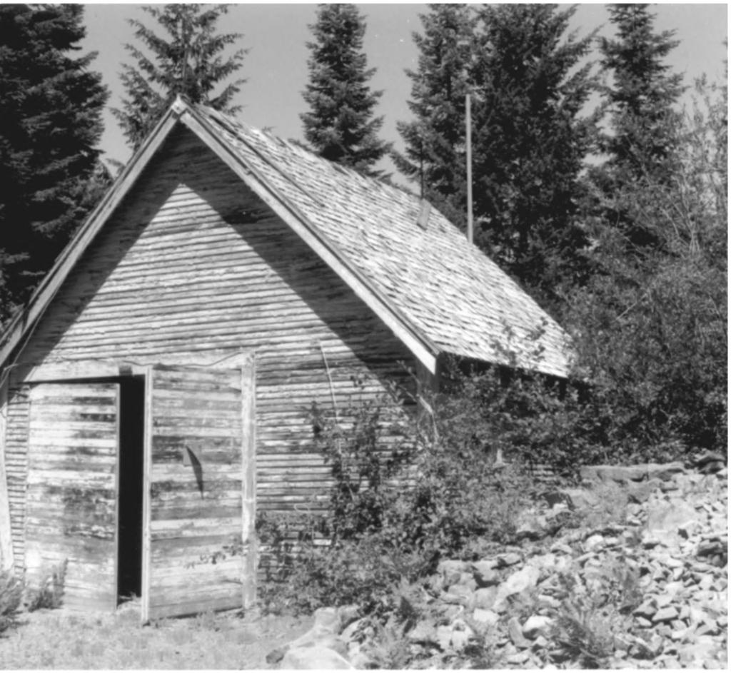
7 United States Department of the Interior National Register of Historic Places Continuation Sheet Mt. Stella Lookout Section number 7 Page 1 Description Setting Mt. Stella Lookout is situated on Mt. Stella in the NW 1A of the NW 1A of Section 26, Township 30 South, Range 3 East, W.M., in northeastern Jackson County, Oregon on the Prospect Ranger District of the Rogue River National Forest. Mt. Stella's summit is 4,715 feet above sea level. Mt. Stella is an eroded andesitic remnant in the Cascade Range, probably dating to the early-to-mid Pleistocene Epoch vulcanism. The summit provides a panoramic view of the upper Rogue River country, including the rim of Crater Lake and California's Mt. Shasta to the south. To the north about six miles, the ridge system of which Mt. Stella is a part connects to the Rogue-Umpqua Divide. The west slope of the mountain drains into Flat Creek, the south, east, and northeast slopes drain directly into the Rogue River. By May of most years, the summit is largely free of snow. Vegetation of the summit includes forest cover of white fir and noble/shasta red fir, golden chinquapin, and of Douglas-fir at lower elevations. Dwarf chinquapin, manzanita, oceanspray, serviceberry, and other shrubs/small tree species dominate the understory and open areas. Forest Service Road , the Mt. Stella access road, gains the summit from a ridge-crest saddle located over a mile to the northwest. The road ascends southeasterly to near the summit, where it switchbacks to the north and ends about 300 feet beyond the switchback, at the lookout site. Structural Description Oriented with its entrance to the south, Mt. Stella Lookout is a standard wood-frame, hipped-roof "L-4" style lookout cabin. It is approximately 14' x 14' in plan, and is mounted on a 30' high, 8'x 8' timber tower. The lookout is a balloon-frame structure with a wood-shingled hipped roof with an 8:12 pitch. Below the "wrap-around" bank of windows, the walls are sheathed in what appears to be the original 1" x 6" single-v rustic siding. Banks of two-over-two light fixed-sash windows encase most of the structure. A single wood-panel door is situated in the south elevation next to the southeast corner. Fixed shutters currently conceal the windows. Mt. Stella Lookout is a variant of the L-4 lookout style that has extended ceiling joists forming external attachments for the "awning" type window shutters when the structure is in use. Once gray in color, the structure has remained unpainted for at least twenty years. Weathered wood is exposed in a number of places where peeling paint is absent. A three-foot wide catwalk of 2" x 4"
8 United States Department of the Interior National Register of Historic Places Continuation Sheet Mt. Stella Lookout Section number 7 Page 2 planks surrounds the entire cabin, extending beyond the support posts of the cross-braced, unpainted, creosote-treated tower. A four-foot high guardrail encloses a catwalk, with an intermediate rail situated two feet above the catwalk floor. The cabin is reached by two flights of stairs that rise from a landing at the east base of the tower. The highest portion of the stairway forms an extended area of the catwalk at the southeast corner. At the southwest base of the tower, directly below the intermediate stairway landing that spans much of the west-side width of the tower, stands an opensided shower stall structure. Evidently a small water tank (no longer present), located somewhat higher on the tower, supplied solar-heated water for personnel use. The cabin interior is arranged according to the standard L-4 plan, with cabinets, spaces for cot/stove/table, and a firefmder. The tower stairs have been removed to discourage visitors from climbing the tower. Mt. Stella Lookout has lost some physical integrity due to deteriorated condition. The roof is dilapidated and needs major refurbishing. In addition to the lookout tower, the Mt. Stella site includes two other structures. A Civilian Conservation Corps (CCC) "garage/shed" constructed about 1937 is situated approximately 150 feet southwest of the lookout. A privy (ca. 1960) is located on the southeast slope of the summit, and probably replaced an earlier structure.- The garage/shed is a gable-roofed (12:12 pitch), balloon-frame structure measuring 16' 5" by 18' 3", with wood-shingle roofing and double-run shiplap siding painted gray. The front of the building is oriented to the south, with double, side-hinged swinging doors for the garage. The structure has two bays; a 10'- wide dirt floor garage to the west and a 6' 5"-wide enclosed storage shed on the east (reached by an interior door from the garage and an exterior door on the north). Like the lookout, the garage/storage structure has not been painted in many years. Like other standard Forest Service facilities of its kind, the privy is constructed of 4" x 4" and 2" x 4" frames, sheathed in 1" x 10" planks (boardand-batten style) and measures approximately 4' x 4' in plan. A U.S. Cellular communications tower is proposed at the Mt. Stella site, to be located over 400 feet from the lookout tower and over 200 feet outside of the National Register of Historic Places-eligible property boundary. Several measures, including construction of the tower to resemble a timber "snag," will be implemented to substantially reduce the structure's visual impacts on the historic lookout; this project has been reviewed and approved by the Oregon State Historic Preservation Office.
9 United States Department of the Interior National Register of Historic Places Continuation Sheet Mt. Stella Lookout Section number 8 Page i Significance Mt. Stella Lookout, an "L-4" hipped-roof style lookout built in 1933, is locally significant for its association with the development of fire detection on the Rogue River National Forest. Submitted as part of a multiple property submission, "U.S. Forest Service Historic Structures on the Rogue River National Forest, Oregon," Mt. Stella Lookout represents the associated historic context, "Fire Suppression on the Rogue River National Forest " The resource meets the registration requirements set forth in the registration document. It was established during the historic period, has retained its integrity of setting, location, design, and materials, and it evokes its historic associations with early fire suppression on the Forest. Previously declared eligible to the National Register of Historic Places under Criterion A as an important component of early fire protection practices on the Rogue River National Forest, Mt. Stella Lookout exemplifies the hipped- roof style L-4 lookout developed in Structurally strong under heavy snow-loads, the type remained the Forest Service's primary national standard lookout (whether as a ground cabin or on a tower) through the 1930s to 1950s. During this period, the agency established its goal of providing "double coverage," (i.e. all seen-areas visible from at least two different observation points), on the National Forests. Mt. Stella retains its physical integrity; modifications are minor and few. Out of well over two hundred L-4 style lookouts built in Oregon, Mt. Stella Lookout is one of the last forty structures remaining of its type in Oregon. Additionally, Mt. Stella Lookout has been declared eligible under Criterion C as an excellent representative of the L-4 fire lookout. Like other lookouts of its type Mt. Stella Lookout was built according to standardized plans and from pre-cut kits. This particular type of lookout embodies the distinctive style, location, appearance, and construction methods/materials of fire lookouts build during the historic period. Forest records indicate that construction of the Mt. Stella Lookout was definitely begun in 1932 and finished in 193 3, making it one of the first hipped-roof L-4 lookouts to be built in the nation. It was probably purchased as a ready-to-build "kit" from Aladdin Manufacturing Company in Portland, Oregon, and then erected on the peak by a Forest Service crew that probably included Ray Schemerhorn, the first lookout of record at Mt.
10 United States Department of the Interior National Register of Historic Places Continuation Sheet Mt. Stella Lookout Section number 8 Page 2 Stella in The access road probably was hot in place at this time, and pack-mules would have transported the components to the summit. It is unlikely that the Civilian Conservation Corps was involved in construction of the lookout. The Corps was established by President Roosevelt in the spring of 1933 but did not become operative in southwestern Oregon until later that summer. The lookout cabin served as residence and workspace. The Civilian Conservation Corps probably built the garage/shed between 1936 and 1938, when C.C.C crews erected similar structures at a number of lookout sites on the Forest, including Hershberger, Blue Rock, Dutchman, and Cinnabar, after the crews had built roads to their summits (Brown, 1972). The structure housed the vehicle of the lookoutman, served as a woodshed, and stored other supplies. During World War II, Mt. Stella, like a few other lookouts on the Rogue River National Forest, served as an Aircraft Warning Service (AWS) observation post. From mid-1942 through the winter of and into late 1943, Mr. and Mrs. Lowell Ash lived at Mt. Stella as AWS observers. No enemy aircraft were observed but radio checks and daily reporting kept the couple busy. During the winter, over nine feet of snow accumulated on the summit, requiring strenuous effort to keep the stairs and catwalk useable and the telephone line operative. Unlike similar garages at other lookout sites, the CCC-built structure at Mt. Stella was not converted into living quarters for the AWS observers, who instead lived in the lookout atop an ice-coated tower. About 1946, the original tower, built of four 10" x 12" inch peeled poles in slanted upright positions, was replaced with the current tower of milled timbers and lumber/the newer tower proved more resistant to decay than the original untreated posts peeled from native firs. The lookout cabin remained in place as the new tower was built up to its floor and then the old tower was dismantled. About this time a standard Forest Service privy was probably placed on the property. (The current privy probably dates to the early 1970s.). Mt. Stella continued in use as an active fire detection facility through the 1950s, 1960s, and 1970s. In the mid-1980s Mt. Stella acquired an "inactive/emergency use" status, with occasional fire-detection use into the early 1990s. Installation of a Remote Automated Weather System (RAWS) station (a Forest-Service fire-management-associated facility that includes a short radio tower and transmitter box) about 1983 just north of the tower,
11 United States Department of the Interior National Register of Historic Places Continuation Sheet Mt. Stella Lookout 8 3 Section number Page and removal of the lookout tower's stairs are the only recent changes to the site. Because of its small size and unobtrusive siting, the addition of the RAWS station had a comparatively minor impact to the site. It is virtually invisible from the main elevation/approach to the site (i.e. the parking area at the end of the access road.) Although unpainted for many years and in only fair condition in some of their exposed wooden components, both the lookout and the garage/shed retain sufficient physical integrity, and modifications, other than the 1946 tower replacement, are few. The site also retains its integrity of association, appearance, location, and feeling. It has been used as a lookout site throughout its active service period, and it remains readily identifiable as a historic fire lookout. Mt. Stella Lookout is significant for its associations with the development of the Rogue River National Forest, and specifically with fire detection on the Forest between 1927 and It is additionally significant for its embodiment of the distinctive characteristics of its type as an L-4 style lookout once widely in use throughout Oregon and the Pacific Northwest.
12 Ma. to»4«ol«united States Department of the Interior National Register of Historic Places Continuation Sheet Mt. Stella Lookout 9 1 Section number Page Bibliography LaLande, Jeff 1998 Proposed U.S. Cellular Communications Tower at Mt. Stella, near Mt. Stella Lookout: A Heritage Resource Evaluation and Project Assessment Report, (C.R. Job RR-1139) Rogue River National Forest. LaLande, Jeff 1999 Field Visit to Mt. Stella Lookout, August 4, 1999.
13 United States Department of the Interior National Register of Historic Places Continuation Sheet Mt. Stella Lookout Section number 10 Page J- A USGS map of the Union Creek Quadrangle is included with this nomination. A photocopied section of this map with the site location indicated by an arrow, is also contained in the nomination document. Boundary Description: Mt. Stella Lookout is situated on National Forest land in the NW 1A of the NW V4 of Section 26, Township 30 South, Range 3 East, W.M., in northeastern Jackson County, Oregon. The property is further identified on USGS Map Union Creek Quadrangle, 7.5 minutes series, included with this nomination. For purposes of this nomination, the property may be further described as an circular parcel, whose outer boundary is determined by measuring approximately feet 250 feet south from the southwest corner of the lookout to form the outer boundary of a circle, and scribing a circle 300 feet in diameter that encompasses the lookout, CCC-built garage, privy, and approximately 100 feet of the road. It also includes immediately adjacent open areas, including the RAWS station, and surrounding conifer stands above the 4,680' elevation contour. The entire property encompasses an area at the highest part of the mountain, approximately 300 feet in diameter, comprising 1.5 acres more or less. Boundary Justification For purposes of this National Register nomination, the boundary includes the area of Mt. Stella summit immediately encompassing the lookout tower, former AWS residence and privy, and that portion of the access road from which the lookout site is visible (approximately the last 100 feet of road). This area has historically been part of the lookout operation and the boundary forms a discrete, visually identifiable area within which fire detection activities have been the major human activity.
14 United States Department of the Interior National Register of Historic Places Continuation Sheet Mt. Stella Lookout ^.. Photographs 1 Section number Page Photographs Photograph No. 1 1) Mt. Stella Lookout 2) NW l/4 Section 26, T 30 South, Range 3 East, W.M., Jackson County Oregon 3) Photographer: Katherine Atwood 4) Date of Photograph: August ) Negative holder: Rogue River National Forest P.O. Box 580 Medford, Oregon ) View of north and east elevations 7) Photograph number 1 of 3 Photograph No. 2 1) Mt. Stella Lookout Garage 2) NW 1A Section 26, T 30 South, Range 3 East, W.M., Jackson County Oregon 3) Photographer: Katherine Atwood 4) Date of Photograph: August ) Negative holder: Rogue River National Forest P.O. Box 580 Medford, Oregon ) View of south elevation 7) Photograph number 2 of 3 Photograph No. 3 1) Mt. Stella Lookout 2) NW J/4 Section 26, T 30 South, Range 3 East, W.M., Jackson County Oregon 3) Photographer; Unknown 4) Date of Photograph: c ) Negative holder: Rogue River National Forest P.O. Box 580 Medford, Oregon ) Historic View Mt. Stella Lookout 7) Photograph number 3 of 3
15 United States Department of the Interior National Register of Historic Places Continuation Sheet Mt. Stella Lookout Photographs 2 Section number Page Property Owner Notification U.S. Forest Service J. Michael Lunn, Forest Supervisor JefFLaLande, Forest Archaeologist P.O. Box 520 Medford, Oregon 97501
16 LOOKOUT TO^ER I / PATH LOOKOUT $ SITE S6ALE I" = 60 5ITETOPO SCALE I" = 40 Mt. Stella Lookout

17 i/. Mt «Stella Lookout C*Creek _NWl/4 NW1/4 S26 T30S R3E WM "^-^ '^USGS Map Union Creek Oregon 7.5 minute series \J

18

19


20


21 0


22

23 Wt
NPS Form a OMB Approval No SUPPLEMENTARY LISTING RECORD. NRIS Reference Number: Date Listed: 12/29/2000
 NPS Form 10-900-a OMB Approval No. 1024-0018 United States Department of the Interior National Register of Historic Places Continuation Sheet Section number Page SUPPLEMENTARY LISTING RECORD NRIS Reference
; * --.-.,., rj ; United States Department of the Interior \ ' '"] I National Park Service
![; * --.-.,., rj ; United States Department of the Interior \ ' '] I National Park Service](/thumbs/88/117765392.jpg "; * --.-.,., rj ; United States Department of the Interior \ ' '] I National Park Service") NPS Form 10-900 OMB No. 1024-0018 (Rev. 10-90) : / i' -_ :. - : ; ; * --.-.,., rj ; United States Department of the Interior \ ' '"] I National Park Service NATIONAL REGISTER OF HISTORIC PLACES REGISTRATION
NPS Form 10-900 OMB No. 1024-0018 (Rev. 10-90) : / i' -_ :. - : ; ; * --.-.,., rj ; United States Department of the Interior \ ' '"] I National Park Service NATIONAL REGISTER OF HISTORIC PLACES REGISTRATION
street & number: COUNTY ROUTE 3, HC-88, BOX 17 not for publication: N/A city/town: WHEELER vicinity: X state: WV county: WEBSTER code: 101 zip code:
 NPS Forn 10-900 OMB No. 10024-0018 (Oct. 1990) United States Department of the Interior National Park Service NATIONAL REGISTIR OF HISTORIC PLACES REGISTRATICN FCRX =========================================================---------=======
National Register of Historic Places Registration Form
 NPS Form 10-900 OMB No. 10024-0018 (Oct. 1990) Registration Form This form is for use in nominating or requesting determinations for individual properties and districts. See instructions in How to Complete
D not for publication D vicinity
 NPS Fonn I 0-900 (Oct. 1990) OMB No. 10024-0018 United States Department of the Interior National Park Service National Register of Historic Places Registration Form This fom1 is for use in nominating
Architectural Inventory Form
 OAHP1403 Rev. 9/98 COLORADO CULTURAL RESOURCE SURVEY Architectural Inventory Form Official eligibility determination (OAHP use only) Date Initials Determined Eligible- NR Determined Not Eligible- NR Determined
United States Department of the Interior National Park Service. Boundary Expansion Listed in National Register January 11, 2017
 NPS Form 10900-a (Rev. 8/2002) OMB No. 10240018 United States Department of the Interior National Park Service Boundary Expansion Listed in National Register January 11, 2017 National Register of Historic
National Register of Historic Places Registration Form
 NPS Form 10-900 OMB No. 10024-0018 (Oct. 1990) United States Department of the Interior National Park Service National Register of Historic Places Registration Form 1. Name of Property historic name Hickory
National Register of Historic Places Registration Form
 National Park Service National Register of Historic Places Registration Form This form is for use in nominating or requesting determinations for individual properties and districts. See instructions in
 Page 1 Original Update HISTORICAL STRUCTURE FORM FLORIDA MASTER SITE FILE Consult Guide To Historical Structure Forms for detailed instructions Site # 8OR9844 Recorder # 26 Recorder Date 2/20/08 Site Name
Anderson Mt. Proposed Wilderness Additions to the Rogue-Umpqua Divide Wilderness-- T30S R3E (mostly) Sections 4 & 9, and T29S R3E Section 33
 Sections 4 & 9, and T29S R3E Section 33") Anderson Mt. Proposed Wilderness Additions to the Rogue-Umpqua Divide Wilderness-- T30S R3E (mostly) Sections 4 & 9, and T29S R3E Section 33 When the 35,701 acre Rogue-Umpqua Divide Wilderness was designated
Anderson Mt. Proposed Wilderness Additions to the Rogue-Umpqua Divide Wilderness-- T30S R3E (mostly) Sections 4 & 9, and T29S R3E Section 33 When the 35,701 acre Rogue-Umpqua Divide Wilderness was designated
National Register of Historic Places Registration Form
 National Park Service National Register of Historic Places Registration Form This form is for use in nominating or requesting determinations for individual properties and districts. See instructions in
National Register of Historic Places Registration Form
 NPS Form 10-900 OMB No. 10024-0018 (Oct. 1990) United States Department of the Interior National Park Service National Register of Historic Places Registration Form 1. Name of Property historic name other
National Register of Historic Places Registration Form
 NPS Form 10-900 OMB No. 1024-0018 (Expires 5/31/2012) United States Department of the Interior National Register Listed National Park Service May 1, 2012 National Register of Historic Places Registration
National Register of Historic Places Registration Form
 NPS Form 10-900 (Oct. 1990) OMB No. 10024-0018 United States Department of the Interior 'fonal Park Service National Register of Historic Places Registration Form This form is for use in nominating or
National Register of Historic Places Registration Form
 NPS Form 10-900 OMB No. 1024-0018 (Rev. 10-90) United States Department of the Interior National Park Service National Register of Historic Places Registration Form 1. Name of Property historic name Newcomer
NPS Form OMB No (Oct. 1990)
") NPS Form 10-900 OMB No. 10024-0018 (Oct. 1990) United States Department of the Interior National Park Service NATIONAL REGISTER OF HISTORIC PLACES REGISTRATION FORM 1. Name of Property historic name:_lost
NPS Form 10-900 OMB No. 10024-0018 (Oct. 1990) United States Department of the Interior National Park Service NATIONAL REGISTER OF HISTORIC PLACES REGISTRATION FORM 1. Name of Property historic name:_lost
NE¼ of NE¼ of NE¼ of NE¼ of section Roof configuration (enter one): Gabled Roof / Front Gabled Roof
: Gabled Roof / Front Gabled Roof") OAHP1403 Rev. 9/98 COLORADO CULTURAL RESOURCE SURVEY Official Eligibility Determination (OAHP use only) Date Initials Determined Eligible - National Register Architectural Inventory Form Determined Not
OAHP1403 Rev. 9/98 COLORADO CULTURAL RESOURCE SURVEY Official Eligibility Determination (OAHP use only) Date Initials Determined Eligible - National Register Architectural Inventory Form Determined Not
National Register of Historic Places Registration Form
 NPS Form 10-900 OMB No. 1024-0018 (Expires 5/31/2012) United States Department of the Interior National Register Listed National Park Service May 1, 2012 National Register of Historic Places Registration
United States Department of the Interior National Park Service NATIONAL REGISTER OF HISTORIC PLACES REGISTRATION FORM. Wilmoth, Bernard E.
 NPS Form 10-900 OMB No. 10024-0018 (Oct. 1990) United States Department of the Interior National Park Service NATIONAL REGISTER OF HISTORIC PLACES REGISTRATION FORM 1. Name of Property historic name: other
Appendix D Reevaluation of Structures on Bock House Property
 Appendix D Reevaluation of Structures on Bock House Property Page 1 Original Update HISTORICAL STRUCTURE FORM FLORIDA MASTER SITE FILE Consult Guide To Historical Structure Forms for detailed instructions
National Register of Historic Places Registration Form
 NPS Form 10-900 OMB No. 1024-0018 (Rev. 10-90) United States Department of the Interior National Park Service National Register of Historic Places Registration Form 1. Name of Property historic name Evans,
National Register of Historic Places Registration Form
 NPS Form 10-900 OMB No. 1024-0018 (Rev. 10-90) United States Department of the Interior National Park Service National Register of Historic Places Registration Form 1. Name of Property historic name Strode-Morrison-Tabler
Maryland Historical Trust Inventory No. 15/6 Maryland Inventory of Historic Properties Form
 Inventory No. 15/6 Maryland Inventory of 1. Name of Property (indicate preferred name) historic Becraft Farm other 2. Location street and number 28500 Ridge Road not for publication city, town Mount Airy
National Register of Historic Places Multiple Property Documentation Form
 NPS Form 10-900-b OMB No. 1024-0018 Revised Aug. 2002 Expires 12-31-2005 Multiple Property Documentation Form This form is for use in documenting multiple property groups relating to one or several contexts.
ate: AR County: Pulaski Code: AR Zip Code: Noncontributing buildings sites structures objects Total
 Mims-Ereedlove-Priest-Weatherton House Name of Property Little Rock, AR County and State ~- -,s Form 10-900 'V. 8-86) OMB No. 1024-0018 United States Department of the Interior National Park Service NATIONAL
United States Department of the Interior National Park Service NATIONAL REGISTER OF HISTORIC PLACES REGISTRATION FORM
 NPS Form 10-900 (Oct. 1990) OMB NO. 10024-0018 United States Department of the Interior National Park Service NATIONAL REGISTER OF HISTORIC PLACES REGISTRATION FORM As the designated authority under the
NPS Form OMB No Exp Status occupied X unoccupied work in progress Accessible yes: restricted yes: unrestricted _5Lno
 NPS Form 10-900 OMB No. 1024-0018 Exp. 10-31-84 United States Department of the Interior National Park Service National Register of Historic Places Inventory Nomination Form See instructions in How to
United States Department of the Interior National Park Service NATIONAL REGISTER OF HISTORIC PLACES REGISTRATION FORM
 NPS Form 10-900 (Oct. 1990) OMB No. 10024-0018 United States Department of the Interior National Park Service NATIONAL REGISTER OF HISTORIC PLACES REGISTRATION FORM 1. DR JOHN C. IRONS RESIDENCE hlstoric
MINNESOTA HISTORIC.PROPERTIES INVENTORY FORM. Yes_ No X Restricted
 HISTORIC NAME: CURRENT NAME: LEGAL DESC.: MINNESOTA HISTORIC.PROPERTIES INVENTORY FORM Hartley Sugar Camp W % of Gov't. Lot 3 and T55, R24, Sec. 9 COUNTY: Itasca CITY/TWP.: Trout Lake Twp. ADDRESS: of
AH pp. I Ti. Nov 7 I) I I y
 I I y") ..------------------------------------------ ------------ - - -- - NPS Form 10-900 (Rev. 8-86) United States Department of the Interior ~a tional Park Service NATIONAL REGISTER OF HISTORIC PLACES REGISTRATION
..------------------------------------------ ------------ - - -- - NPS Form 10-900 (Rev. 8-86) United States Department of the Interior ~a tional Park Service NATIONAL REGISTER OF HISTORIC PLACES REGISTRATION
COVER SHEET. Reduced Vertical Separation Minimum (RVSM) Information Sheet Part 91 RVSM Letter of Authorization
 Information Sheet Part 91 RVSM Letter of Authorization") COVER SHEET Reduced Vertical Separation Minimum (RVSM) Information Sheet Part 91 RVSM Letter of Authorization NOTE: FAA Advisory Circular 91-85 ( ), Authorization of Aircraft and Operators for Flight in
COVER SHEET Reduced Vertical Separation Minimum (RVSM) Information Sheet Part 91 RVSM Letter of Authorization NOTE: FAA Advisory Circular 91-85 ( ), Authorization of Aircraft and Operators for Flight in
not for publication: N/A city/town: St. Albans vicinity: N/A state: WV county : Kanawha code: 039 zip code:25177
 #PS F o 10-900 ~ OMB NO. 10024-0018 (OC~. 1990) United States Department of the Interior National Park Service LSATIOHAL REGISTER OF HISTORIC PLACES REGISTRATION FORM 1. Name of Property ST. ALBANS CHESAPEAKE
Building Permit Application
 Building Permit Application Co-Owner Name Lot # Address City State Zip Phone (home) (cell) Contractor (if applicable) The above named co-owner hereby makes application to Cedar Shores Campground Condominium
FOREST FIRE LOOKOUT TOWERS OF THE ARAPAHO-ROOSEVELT NATIONAL FORESTS AND ROCKY MOUNTAIN NATIONAL PARK
 This site contains links to other Internet sites. These links are not endorsements of any products or services in such sites, and no information in such site has been endorsed or approved by the USDA Forest
National Register of Historic Places Registration Form
 NPS Form 10-900 OMB No. 10024-0018 (Oct. 1990) Registration Form This form is for use in nominating or requesting determinations for individual properties and districts. See instructions in How to Complete
NPS Form OMB No (Rev ) U. S. Department of the Interior Name of Property: Hungry Mother State Park Historic District
 U. S. Department of the Interior Name of Property: Hungry Mother State Park Historic District") NPS Form 10-900 OMB No. 1024-4018 (Rev. 10-90) U. S. Department of the Interior Name of Property: Location: 5. Classification Ownership of Property (Check as many boxes as apply) Category of Property (Check
NPS Form 10-900 OMB No. 1024-4018 (Rev. 10-90) U. S. Department of the Interior Name of Property: Location: 5. Classification Ownership of Property (Check as many boxes as apply) Category of Property (Check
Appendix E Historic Property Inventory Forms
 Appendix E Historic Property Inventory Forms TECHNICAL MEMORANDUM Sound Transit Federal Way Link Extension WISAARD Survey Entries PREPARED FOR: COPY TO: PREPARED BY: Sound Transit Alisa Swank/ CH2M MaryNell
National Register of Historic Places Registration Form
 NPS Form 10-900 (Oct. 1990) OMB NO. 10024-0018 Registration Form This form is for use in nominating or requesting determinations for individual properties and districts. See instructions in How to Complete
STATE OF WASHINGTON ARCHAEOLOGICAL SITE INVENTORY FORM
 STATE OF WASHINGTON ARCHAEOLOGICAL SITE INVENTORY FORM Smithsonian Number: 45 County: Chelan Date: 6/12/2018 Human Remains? DAHP Case No.: Archaeological Sites are exempt from public disclosure per RCW
National Register of Historic Places Registration Form
 NPS Form 10-900 OMB No. 10024-0018 (Oct. 1990) Registration Form This form is for use in nominating or requesting determinations for individual properties and districts. See instructions in How to Complete
Town: Sharon Place (neighborhood or village): Sharon. ame of Area: Present Use: Date (month / year): July 2008
: Sharon. ame of Area: Present Use: Date (month / year): July 2008") FORM A - AREA MASSACHUSETTS HISTORICAL COMMISSION MASSACHUSETTS ARCHIVES BUILDING 220 MORRISSEY BOULEVARD BOSTON, MASSACHUSETTS 02125 Photograph Assessor s Sheets USGS Quad Area Letter Form Numbers in
FORM A - AREA MASSACHUSETTS HISTORICAL COMMISSION MASSACHUSETTS ARCHIVES BUILDING 220 MORRISSEY BOULEVARD BOSTON, MASSACHUSETTS 02125 Photograph Assessor s Sheets USGS Quad Area Letter Form Numbers in
1 buildings sites structures objects 1 0 TOTAL
 Name of Property County and State 4. National Park Service Certification --------- I, hereby certify that this property is: Signature of Keeper Date of Action entered in the National Register See continuation
Rogue Gorge (Mt. Stella) Roadless Area-- T30S R3E (primarily in portions of Sections 23, 26, 33, 34 & 35)
 Roadless Area-- T30S R3E (primarily in portions of Sections 23, 26, 33, 34 & 35)") Rogue Gorge (Mt. Stella) Roadless Area-- T30S R3E (primarily in portions of Sections 23, 26, 33, 34 & 35) Rogue River-Siskiyou National Forest--High Cascades Ranger District Upper, higher elevation trail
Rogue Gorge (Mt. Stella) Roadless Area-- T30S R3E (primarily in portions of Sections 23, 26, 33, 34 & 35) Rogue River-Siskiyou National Forest--High Cascades Ranger District Upper, higher elevation trail
National Register of Historic Places Registration Form
 National Park Service National Register of Historic Places Registration Form This form is for use in nominating or requesting determinations for individual properties and districts. See instructions in
Abandoned or Vacant; Agricultural; Camp; Other Residential Agriculture; Archaeology, Historic; Architecture; Politics Government; Social History
 Inventory No: Historic Name: HRV.G Civilian Conservation Camp Common Name: Address: City/Town: Village/Neighborhood: Local No: 13-7.01 Year Constructed: Architect(s): Architectural Style(s): Use(s): Significance:
county Lonoke code 085 zip code
 ~~~~~~~~~~~ AR NPS Form I 0-900 (Oct. 1990) United States Department of the Interior National Park Service National Register of Historic Places egistration Form w-l.3-1 / OMB No. 10024-0018 This form is
Maryland Historical Trust Inventory No. PG: 86A-026 Maryland Inventory of Historic Properties Form
 Inventory No. PG: 86A-026 Maryland Inventory of 1. Name of Property (indicate preferred name) historic other 2. Location street and number 12811 Croom Road not for publication city, town Naylor vicinity
Total 1 Total. Current Functions (Enter categories from instructions) Materials (Enter categories from instructions)
 Materials (Enter categories from instructions)") Site Inventory Form State Inventory No. 29-00962 New Supplemental State Historical Society of Iowa Part of a district with known boundaries (enter inventory no.) 29-03685 (November 2005) Relationship:
Site Inventory Form State Inventory No. 29-00962 New Supplemental State Historical Society of Iowa Part of a district with known boundaries (enter inventory no.) 29-03685 (November 2005) Relationship:
[Docket No. FAA ; Directorate Identifier 2007-NM-031-AD; Amendment ; AD ]
![[Docket No. FAA ; Directorate Identifier 2007-NM-031-AD; Amendment ; AD ]](/thumbs/95/125338134.jpg "[Docket No. FAA ; Directorate Identifier 2007-NM-031-AD; Amendment ; AD ]") [Federal Register: May 22, 2007 (Volume 72, Number 98)] [Rules and Regulations] [Page 28597-28601] From the Federal Register Online via GPO Access [wais.access.gpo.gov] [DOCID:fr22my07-7] DEPARTMENT OF
[Federal Register: May 22, 2007 (Volume 72, Number 98)] [Rules and Regulations] [Page 28597-28601] From the Federal Register Online via GPO Access [wais.access.gpo.gov] [DOCID:fr22my07-7] DEPARTMENT OF
COVER SHEET. Reduced Vertical Separation Minimum (RVSM) Information Sheet Part 91 RVSM Letter of Authorization
 Information Sheet Part 91 RVSM Letter of Authorization") COVER SHEET Reduced Vertical Separation Minimum (RVSM) Information Sheet Part 91 RVSM Letter of Authorization NOTE: FAA Advisory Circular 91-85, Authorization of Aircraft and Operators for Flight in Reduced
COVER SHEET Reduced Vertical Separation Minimum (RVSM) Information Sheet Part 91 RVSM Letter of Authorization NOTE: FAA Advisory Circular 91-85, Authorization of Aircraft and Operators for Flight in Reduced
SUPERSEDED. [Docket No. FAA ; Directorate Identifier 2015-SW-014-AD; Amendment ; AD ]
![SUPERSEDED. [Docket No. FAA ; Directorate Identifier 2015-SW-014-AD; Amendment ; AD ]](/thumbs/95/123244441.jpg "SUPERSEDED. [Docket No. FAA ; Directorate Identifier 2015-SW-014-AD; Amendment ; AD ]") [Federal Register Volume 80, Number 95 (Monday, May 18, 2015)] [Rules and Regulations] [Pages 28172-28175] From the Federal Register Online via the Government Publishing Office [www.gpo.gov] [FR Doc No:
[Federal Register Volume 80, Number 95 (Monday, May 18, 2015)] [Rules and Regulations] [Pages 28172-28175] From the Federal Register Online via the Government Publishing Office [www.gpo.gov] [FR Doc No:
[Docket No. FAA ; Product Identifier 2018-SW-041-AD; Amendment ; AD ]
![[Docket No. FAA ; Product Identifier 2018-SW-041-AD; Amendment ; AD ]](/thumbs/86/94894664.jpg "[Docket No. FAA ; Product Identifier 2018-SW-041-AD; Amendment ; AD ]") [Federal Register Volume 83, Number 175 (Monday, September 10, 2018)] [Rules and Regulations] [Pages 45545-45548] From the Federal Register Online via the Government Publishing Office [www.gpo.gov] [FR
[Federal Register Volume 83, Number 175 (Monday, September 10, 2018)] [Rules and Regulations] [Pages 45545-45548] From the Federal Register Online via the Government Publishing Office [www.gpo.gov] [FR
National Register of Historic Places Registration Form
 NPS Form 10-900 OMB No. 10024-0018 (Oct. 1990) Registration Form This form is for use in nominating or requesting determinations for individual properties and districts. See instructions in How to Complete
NPS Form OMB No (Rev. Aug. 2002) (Expires )
 (Expires )") Beaconsfield Supply Store,1 NATIONAL REGISTER FORMS TEMPLATE January 2006 NPS Form 10-900 OMB No. 1024-0018 (Rev. Aug. 2002) (Expires 1-31-2009) REGISTRATION FORM 1. Name of Property historic name Beaconsfield
Beaconsfield Supply Store,1 NATIONAL REGISTER FORMS TEMPLATE January 2006 NPS Form 10-900 OMB No. 1024-0018 (Rev. Aug. 2002) (Expires 1-31-2009) REGISTRATION FORM 1. Name of Property historic name Beaconsfield
, Name of Property. ... Ownership of Property: public-state
 1 6 NPS Form 10-900 (Rev. 8-86) OMB NO. 1024-0018 IVR 4/zd/T-- United States Department of the Interior National Park Service NATIONAL REGISTER OF HISTORIC PLACES REGISTRATION FORM --------------d---d----------------4------------------------
Address 347 Whitney Street. East elevation, camera facing southwest.
 FORM B BUILDING Assessor s Number USGS Quad Area(s) Form Number MASSACHUSETTS HISTORICAL COMMISSION MASSACHUSETTS ARCHIVES BUILDING 220 MORRISSEY BOULEVARD BOSTON, MASSACHUSETTS 02125 Town Northborough
Name of related multiple property listing: Historic and Architectural Resources in Abilene, Texas
 NPS Form 10-900 (Rev. 8-86) United States Department of the Interior National Park Service NATIONAL REGISTER OF HISTORIC PLACES REGISTRATION FORM 1. NAME OF PROPERTY Historic name: Magee, J.D., House Other
Current Functions (Enter categories from instructions) Materials (Enter categories from instructions)
 Materials (Enter categories from instructions)") Site Inventory Form State Inventory No. 92-00542 New Supplemental State Historical Society of Iowa Part of a district with known boundaries (enter inventory no.) 92-00349 (November 2005) Relationship:
Site Inventory Form State Inventory No. 92-00542 New Supplemental State Historical Society of Iowa Part of a district with known boundaries (enter inventory no.) 92-00349 (November 2005) Relationship:
NATIONAL REGISTER OF HISTORIC PLACES REGISTRATION FORM
 NPS Form 10-900 OMB No. 1024-0018 (Rev. 10-90) United States Department of the Interior National Park Service NATIONAL REGISTER OF HISTORIC PLACES REGISTRATION FORM 1. Name of Property historic name Compton-Johnson
THE CESSNA AIRCRAFT COMPANY
 Page 1 2010-20-10 THE CESSNA AIRCRAFT COMPANY Amendment 39-16444 Docket No. FAA-2010-0380; Directorate Identifier 2009-NM-009-AD PREAMBLE Effective Date (a) This AD becomes effective November 1, 2010.
Historic Property Report
 Historic Name: Shadle Park Reservoir Property ID: 708465 Location Address: Location Comments: GeographicAreas: 4302 N Belt St, Spokane, Washington, USA Wellesley Ave & N Belt St Spokane,T25R42E01,SPOKANE
[Docket No. FAA ; Directorate Identifier 2016-NM-155-AD; Amendment. AGENCY: Federal Aviation Administration (FAA), DOT.
, DOT.") This document is scheduled to be published in the Federal Register on 04/17/2017 and available online at https://federalregister.gov/d/2017-07551, and on FDsys.gov [4910-13-P] DEPARTMENT OF TRANSPORTATION
This document is scheduled to be published in the Federal Register on 04/17/2017 and available online at https://federalregister.gov/d/2017-07551, and on FDsys.gov [4910-13-P] DEPARTMENT OF TRANSPORTATION
Front Carport Design Standards, Requirements & Application
 Front Carport Design Standards, Requirements & Application THIS PAGE INTENTIONALLY LEFT BLANK. Carport: A structure designed or used to shelter vehicles that is open on at least two sides. Carport shall
I Signature of commenting official Date I. / Title State or Federal agencylbureau or Tribal Government 1
 National Park Service National Register of Historic Places Registration Form LISTED ON: VLR 09/20/2012 NRHP 11/20/2012 This form is for use in nominating or requesting determinations for individual properties
National Register of Historic Places Registration Form
 NPS Form 10-900 OMB No. 10024-0018 (Oct. 1990) Registration Form This form is for use in nominating or requesting determinations for individual properties and districts. See instructions in How to Complete
S Central Coast Heritage Protection Act APRIL 21, 2016
 STATEMENT OF GLENN CASAMASSA ASSOCIATE DEPUTY CHIEF, NATIONAL FOREST SYSTEM U.S. FOREST SERVICE U.S. DEPARTMENT OF AGRICULTURE BEFORE THE UNITED STATES SENATE COMMITTEE ON ENERGY AND NATURAL RESOURCES
[Docket No. FAA ; Directorate Identifier 2007-NM-291-AD; Amendment ; AD R1]
![[Docket No. FAA ; Directorate Identifier 2007-NM-291-AD; Amendment ; AD R1]](/thumbs/80/81019372.jpg "[Docket No. FAA ; Directorate Identifier 2007-NM-291-AD; Amendment ; AD R1]") Federal Register: January 7, 2008 (Volume 73, Number 4)] [Rules and Regulations] [Page 1052-1055] From the Federal Register Online via GPO Access [wais.access.gpo.gov] [DOCID:fr07ja08-5] DEPARTMENT OF
Federal Register: January 7, 2008 (Volume 73, Number 4)] [Rules and Regulations] [Page 1052-1055] From the Federal Register Online via GPO Access [wais.access.gpo.gov] [DOCID:fr07ja08-5] DEPARTMENT OF
THE BARNACLE 3485 MAIN HIGHWAY
 THE BARNACLE 3485 MAIN HIGHWAY Designation Report City of Miami REPORT OF THE CITY OF MIAMI PLANNING AND ZONING DEPARTMENT TO THE HISTORIC AND ENVIRONMENTAL PRESERVATION BOARD ON THE POTENTIAL DESIGNATION
NATIONAL REGISTER OF HISTORIC PLACES REGISTRATION FORM
 (Rev. 10-90) NPS Form 10-900 OMB No. 1024-0018 NATIONAL REGISTER OF HISTORIC PLACES REGISTRATION FORM This form is for use in nominating or requesting determinations for individual properties and districts.
in 7.x M (Oct. 1990) United States Department of the Interior National Park Service 1. NAME OF PROPERTY
 United States Department of the Interior National Park Service 1. NAME OF PROPERTY") (Oct. 1990) United States Department of the Interior National Park Service NATIONAL REGISTER OF HISTORIC PLACES REGISTRATION FORM 1. NAME OF PROPERTY HISTORIC NAME: Jacala Restaurant OTHER NAME/SITE NUMBER:
(Oct. 1990) United States Department of the Interior National Park Service NATIONAL REGISTER OF HISTORIC PLACES REGISTRATION FORM 1. NAME OF PROPERTY HISTORIC NAME: Jacala Restaurant OTHER NAME/SITE NUMBER:
National Register off Historic Places Inventory Nomination Form
 MPS Fonn 10-900-a (3^ United States Department of the Interior National Park Service National Register off Historic Places Inventory Nomination Form For NPS use only received date entered OMB No 1M4-0018
State Level Historic Documentation Report. John Blue Bridge Hampshire County
 State Level Historic Documentation Report State Project No. S314-28-22.27 Federal Project No. BR-0028(058)D John Blue Bridge Hampshire County Prepared by: Randy Epperly, Historian Department of Transportation
AHPP. LISTED ========================================================================
 NPS Form 10-900 (Rev. 8-86) Jnited States Department of the Interior ational Park Service OMB No. 1024-0018 LISTED NATIONAL REGISTER OF HISTORIC PLACES REGISTRATION FORM AHPP. 1. Historic Name: Bush-Dubisson
VARIOUS RESTRICTED CATEGORY HELICOPTERS
 Page 1 2012-14-11 VARIOUS RESTRICTED CATEGORY HELICOPTERS Amendment 39-17125 Docket No. FAA-2012-0739; Directorate Identifier 2012-SW-044-AD. PREAMBLE (a) Applicability This AD applies to Arrow Falcon
United States Department of the Interior National Park Service NATIONAL REGISTER OF HISTORIC PLACES REGISTRATION FORM
 NPS Form 10-900 (Rev. 8-86) OMB No. 1024-0018 United States Department of the Interior National Park Service NATIONAL REGISTER OF HISTORIC PLACES REGISTRATION FORM other name/site number: "Maple Shadows:"
National Register of Historic Places Registration Form
 NPS Form 10-900 (Rev. 01/2009) OMB No. 1024-0018 United States Department of the Interior National Park Service National Register of Historic Places Registration Form This form is for use in nominating
FLAGLER WORKER S HOUSE FORT DALLAS PARK S.E. 4 STREET
 FLAGLER WORKER S HOUSE FORT DALLAS PARK 60-64 S.E. 4 STREET Designation Report City of Miami REPORT OF THE CITY OF MIAMI PLANNING DEPARTMENT TO THE HERITAGE CONSERVATION BOARD ON THE POTENTIAL DESIGNATION
White Mountain National Forest Saco Ranger District
 United States Department of Agriculture Forest Service White Mountain National Forest 33 Kancamagus Highway Conway, NH 03818 Comm: (603) 447-5448 TTY: (603) 447-3121 File Code: 1950 Date: February 26,
M7 AEROSPACE LP
 Page 1 2011-02-04 M7 AEROSPACE LP (TYPE CERTIFICATE PREVIOUSLY HELD BY FAIRCHILD AIRCRAFT INCORPORATED) Amendment 39-16577 Docket No. FAA-2011-0014 Directorate Identifier 2010-CE-066-AD PREAMBLE Effective
Register of Historic Kansas Places Registration Form
 Kansas State Historical Society Register of Historic Kansas Places Registration Form This form is for use in nominating individual properties and districts. The format is similar to the National Register
Intent to Request Revision From OMB of One Current Public Collection of. Information: Certified Cargo Screening Standard Security Program
 This document is scheduled to be published in the Federal Register on 12/13/2018 and available online at https://federalregister.gov/d/2018-26931, and on govinfo.gov 9110-05-P DEPARTMENT OF HOMELAND SECURITY
- request for determination of eligibility meets the documentation
 NPS Form 10-900 OMB No. 10024-0018 (Oct. 1990) United States Department of the Interior National Park Service NATIONAL REGISTER OF HISTORIC PLACES REGISTRATION FORM historic name: Reed's Mill other name/site
[Docket No. FAA ; Product Identifier 2018-CE-006-AD; Amendment. AGENCY: Federal Aviation Administration (FAA), Department of Transportation
, Department of Transportation") This document is scheduled to be published in the Federal Register on 11/05/2018 and available online at https://federalregister.gov/d/2018-24007, and on govinfo.gov [4910-13-P] DEPARTMENT OF TRANSPORTATION
This document is scheduled to be published in the Federal Register on 11/05/2018 and available online at https://federalregister.gov/d/2018-24007, and on govinfo.gov [4910-13-P] DEPARTMENT OF TRANSPORTATION
[Docket No. FAA ; Product Identifier 2017-NM-124-AD; Amendment ; AD ]
![[Docket No. FAA ; Product Identifier 2017-NM-124-AD; Amendment ; AD ]](/thumbs/85/92086735.jpg "[Docket No. FAA ; Product Identifier 2017-NM-124-AD; Amendment ; AD ]") [Federal Register Volume 83, Number 161 (Monday, August 20, 2018)] [Rules and Regulations] [Pages 42017-42022] From the Federal Register Online via the Government Publishing Office [www.gpo.gov] [FR Doc
[Federal Register Volume 83, Number 161 (Monday, August 20, 2018)] [Rules and Regulations] [Pages 42017-42022] From the Federal Register Online via the Government Publishing Office [www.gpo.gov] [FR Doc
The following criteria shall be applied within the boundaries of the AO District:
 Sec. 419 (a) Purpose AIRPORT OVERLAY DISTRICT (AO) The purpose of the Airport Overlay District is to regulate and restrict the height of structures, objects, or natural growth, regulate the locations of
Fremont Point Cabin Reconstruction and Expansion Project Project Proposal & Public Scoping Documentation
 Fremont Point Cabin Reconstruction and Expansion Project Fremont-Winema National Forests Silver Lake Ranger District The Silver Lake Ranger District of the Fremont-Winema National Forests is proposing
[Docket No. FAA ; Directorate Identifier 2007-SW-04-AD; Amendment ; AD ]
![[Docket No. FAA ; Directorate Identifier 2007-SW-04-AD; Amendment ; AD ]](/thumbs/96/128270880.jpg "[Docket No. FAA ; Directorate Identifier 2007-SW-04-AD; Amendment ; AD ]") [Federal Register: January 3, 2008 (Volume 73, Number 2)] [Rules and Regulations] [Page 397-400] From the Federal Register Online via GPO Access [wais.access.gpo.gov] [DOCID:fr03ja08-4] DEPARTMENT OF TRANSPORTATION
[Federal Register: January 3, 2008 (Volume 73, Number 2)] [Rules and Regulations] [Page 397-400] From the Federal Register Online via GPO Access [wais.access.gpo.gov] [DOCID:fr03ja08-4] DEPARTMENT OF TRANSPORTATION
SUPERSEDED. [Docket No. FAA ; Directorate Identifier 2007-NM-141-AD; Amendment ; AD ]
![SUPERSEDED. [Docket No. FAA ; Directorate Identifier 2007-NM-141-AD; Amendment ; AD ]](/thumbs/88/114626771.jpg "SUPERSEDED. [Docket No. FAA ; Directorate Identifier 2007-NM-141-AD; Amendment ; AD ]") [Federal Register: June 11, 2008 (Volume 73, Number 113)] [Rules and Regulations] [Page 32991-32993] From the Federal Register Online via GPO Access [wais.access.gpo.gov] [DOCID:fr11jn08-4] DEPARTMENT
[Federal Register: June 11, 2008 (Volume 73, Number 113)] [Rules and Regulations] [Page 32991-32993] From the Federal Register Online via GPO Access [wais.access.gpo.gov] [DOCID:fr11jn08-4] DEPARTMENT
Architectural Inventory Form
 COLORADO CULTURAL RESOURCE SURVEY Page 1 of 3 Official Eligibility Determination (OAHP use only) Rev. 9/98 OAHP1403 Date Initials Determined Eligible National Register Determined Not Eligible National
Maryland Historical Trust Inventory No. PG: 75A-007 Maryland Inventory of Historic Properties Form
 Inventory No. PG: 75A-007 Maryland Inventory of 1. Name of Property (indicate preferred name) historic other 2. Location street and number 3101 Ritchie Road not for publication city, town Forestville vicinity
Langley Register of Historic Places Nomination Form
 FOR OFFICE USE ONLY Langley Register of Historic Places Nomination Form Received Type all entries 1. Name of Property Historic: Jacob Anthes Bunkhouse/Cookhouse And/or common: South Whidbey Historical
Historic Inventory Report
 Location Field Site No. 3394-134 DAHP No. Historic Name: Common Name: Cabinetrends Property Address: 24619 Pacific Hwy S, Kent, WA 98032 Comments: Tax No./Parcel No. 3601800165 Plat/Block/Lot Acreage.24
[Docket No. FAA ; Product Identifier 2016-NM-205-AD; Amendment. AGENCY: Federal Aviation Administration (FAA), DOT.
, DOT.") This document is scheduled to be published in the Federal Register on 11/24/2017 and available online at https://federalregister.gov/d/2017-23998, and on FDsys.gov [4910-13-P] DEPARTMENT OF TRANSPORTATION
This document is scheduled to be published in the Federal Register on 11/24/2017 and available online at https://federalregister.gov/d/2017-23998, and on FDsys.gov [4910-13-P] DEPARTMENT OF TRANSPORTATION
Decision Memo Ice Age Trail Improvement (CRAC 37)
") Decision Memo Ice Age Trail Improvement (CRAC 37) U.S. Forest Service Chequamegon-Nicolet National Forest, Medford-Park Falls Ranger District Taylor County, Wisconsin T32N, R2W, Town of Grover, Section
Decision Memo Ice Age Trail Improvement (CRAC 37) U.S. Forest Service Chequamegon-Nicolet National Forest, Medford-Park Falls Ranger District Taylor County, Wisconsin T32N, R2W, Town of Grover, Section
National Register off Historic Places received NOV U 1985 Inventory Nomination Form date ante** DEC j 2 BBS
 NPS Form 10400 042) 0MB No. 1024-0018 Exp. 10-31-84 United States Department off the Interior National Park Service For NFS us* only National Register off Historic Places received NOV U 1985 Inventory
[Docket No. FAA ; Product Identifier 2017-CE-049-AD; Amendment ; AD ]
![[Docket No. FAA ; Product Identifier 2017-CE-049-AD; Amendment ; AD ]](/thumbs/85/91560764.jpg "[Docket No. FAA ; Product Identifier 2017-CE-049-AD; Amendment ; AD ]") [Federal Register Volume 83, Number 30 (Tuesday, February 13, 2018)] [Rules and Regulations] [Pages 6114-6118] From the Federal Register Online via the Government Publishing Office [www.gpo.gov] [FR Doc
[Federal Register Volume 83, Number 30 (Tuesday, February 13, 2018)] [Rules and Regulations] [Pages 6114-6118] From the Federal Register Online via the Government Publishing Office [www.gpo.gov] [FR Doc
[Docket No. FAA ; Directorate Identifier 2015-NM-124-AD] Airworthiness Directives; The Boeing Company Airplanes
![[Docket No. FAA ; Directorate Identifier 2015-NM-124-AD] Airworthiness Directives; The Boeing Company Airplanes](/thumbs/85/92059879.jpg "[Docket No. FAA ; Directorate Identifier 2015-NM-124-AD] Airworthiness Directives; The Boeing Company Airplanes") This document is scheduled to be published in the Federal Register on 05/13/2016 and available online at http://federalregister.gov/a/2016-11169, and on FDsys.gov [4910-13-P] DEPARTMENT OF TRANSPORTATION
This document is scheduled to be published in the Federal Register on 05/13/2016 and available online at http://federalregister.gov/a/2016-11169, and on FDsys.gov [4910-13-P] DEPARTMENT OF TRANSPORTATION
[Docket No. FAA ; Product Identifier 2017-SW-004-AD] Airworthiness Directives; Airbus Helicopters Deutschland GmbH (Type Certificate
![[Docket No. FAA ; Product Identifier 2017-SW-004-AD] Airworthiness Directives; Airbus Helicopters Deutschland GmbH (Type Certificate](/thumbs/74/70260856.jpg "[Docket No. FAA ; Product Identifier 2017-SW-004-AD] Airworthiness Directives; Airbus Helicopters Deutschland GmbH (Type Certificate") This document is scheduled to be published in the Federal Register on 11/03/2017 and available online at https://federalregister.gov/d/2017-23201, and on FDsys.gov [4910-13-P] DEPARTMENT OF TRANSPORTATION
This document is scheduled to be published in the Federal Register on 11/03/2017 and available online at https://federalregister.gov/d/2017-23201, and on FDsys.gov [4910-13-P] DEPARTMENT OF TRANSPORTATION
Commonwealth of Massachusetts Massachusetts Historical Commission 220 Morrissey Boulevard, Boston, Massachusetts
 Inventory No: Historic Name: Common Name: Address: HRV.165 Blood, Joseph House Farnsworth, Jonathan - Beaman, Jonathan House 74 Poor Farm Rd City/Town: Village/Neighborhood: Local No: 9-17 Year Constructed: