NPS Form a OMB Approval No SUPPLEMENTARY LISTING RECORD. NRIS Reference Number: Date Listed: 12/29/2000
|
|
|
- Brendan Casey
- 5 years ago
- Views:
Transcription
1 NPS Form a OMB Approval No United States Department of the Interior National Register of Historic Places Continuation Sheet Section number Page SUPPLEMENTARY LISTING RECORD NRIS Reference Number: Date Listed: 12/29/2000 Hershberqer Mountain Lookout Douglas OR Property Name County State U.S. Forest Service Historic Structures on the Rogue River National Forest, MPS Multiple Name This property is listed in the National Register of Historic Places in accordance with the attached nomination documentation subject to the following exceptions, exclusions, or amendments, notwithstanding the certification included in the nomination documentation. -XL ^_.. Signature/oiK the Keeper Amended Items in Nomination: Date of Action Resource Category: The appropriate resource category is: Building Significance: Architecture is added as an area of significance under Criterion C. These revisions were confirmed with the U.S. Forest Service DISTRIBUTION: National Register property file Nominating Authority (without nomination attachment)
2 NFS Form a (8-86) OMB No United States Department of the Interior NATIONAL REGISTER OF HISTORIC PLACES CONTINUATION SHEET Section 3 Page 1 U. S. Forest Service Historic Structures on the Rogue River National Forest MPS SECTION 3: FEDERAL AGENCY CERTIFICATION As the designated authority under the National Historic Preservation Act, as amended, I hereby certify that the nominations listed below meet the documentation standards for registering properties in the National Register of Historic Places and meet the procedural and professional requirements set forth in 36 CFR Part 60. In my opinion, the properties meet the National Register Criteria. I recommend that these properties be considered significant locally. Signature of certifying official/fpo pate Federal Agency and bureau: U.S. Department of Agriculture, Forest Service, Pacific Northwest Region Admimistrative Star Ranger Station Building/"Tack Room" (1911) Willow Prairie Cabin (1924) Big Elk Guard Station (1929) Fire Lookouts Hershberger Mountain Lookout (1924) Dutchman Peak Lookout (1927) Mt Stella Lookout (1933) Squaw Peak Lookout (1943) Snow Survey Cabins Whaleback Snow-Survey Cabin (1937) Honeymoon Creek Snow Cabin (1943) CCC/FERA Recreation Facilities McKee Bridge Campground ( ) Wrangle Shelter ( ) Dead Indian Soda Springs Shelter (1936) Fish Lake Shelter (1936) Parker Meadows Shelter (1936)
3 NPS Form (Oct. 1990) United States Department of the Interior National Register of Historic Places Registration Form Kri 3, AOQ24-091, "u-h. PUCES This form is for use in nominating or requesting determinations for individual properties and districts. See instructions in How to Complete the National Register of Historic Places Registration Form (National Register Bulletin 16A). Complete each item by marking "x" in the appropriate box or by entering the information requested. If an item does not apply to the property being documented, enter "N/A" for "not applicable." For functions, architectural classification, materials, and areas of significance, enter only categories and subcategories from the instructions. Place additional entries and narrative items on continuation sheets (NPS Form a). Use a typewriter, word processor, or computer, to complete all items. 1. Name of Property historic other names/site number Hershberger Mountain Lookout 2. Location street & number city or town Approx. 7 mi. north of Union Creek for pub ication ~Rogue River National Forest Prospect Q vicinity state code 19 zip code State/Federal Agency Certification As the designated authority under the National Historic Preservation Act, as amended, I hereby certify that this D nomination D request for determination of eligibility meets the documentation standards for registering properties in the National Register of Historic Places and meets the procedural and professional requirements set forth in 36 CFR Part 60. In my opinion, the property O meets D does not meet the National Register criteria. I recommend that this property be considered significant D nationally D statewide D locally. (D See continuation sheet for additional comments.) Signature of certifying official/title Date State of Federal agency and bureau In my opinion, the property (XI meets D does not meet the National Register criteria. (D See continuation sheet for additional.)" March Signature of certifying official/title/ Deputy SHPO Date Oregon State Historic Preservation Office State or Federal agency and bureau 4. Certification hereby certify that the property is: ^entered in the National Register. D See continuation sheet. D determined eligible for the National Register D See continuation sheet. D determined not eligible for the National Register. O removed from the National Register. D other, (explain:) Date of Action 7
4 Hershberqer Mountain Lookout Name of Property Douglas County and State Oregon 5. Classification Ownership of Property (Check as many boxes as apply) D private D public-local D public-state 0 public-federal Category of Property (Check only one box) D building(s) D district D site 0 structure D object Name of related multiple property listing Rogue River National Forest 6. Function or Use Historic Functions (Enter categories from instructions) GOVERNMENT: fire lookout Number of Resources within Property (Do not include previously listed resources in the count.) Contributing Noncontributing 1 hnilriinns sites structures objects Total Number of contributing resources previously listed onirvt*ft& National Register N/A Current Functions (Enter categories from instructions) GOVERNMENT: Vacant 7. Description Architectural Classification (Enter categories from instructions) firp lookout Materials (Enter categories from instructions) foundation walls STONE: CONCRETE WOOD: Weatherboard WOOD: -Shingie other Narrative Description (Describe the historic and current condition of the property on one or more continuation sheets.) Please see continuation sheets
5 Hershberger Mountain Lookout Name of Property 8. Statement of Significance Applicable National Register Criteria (Mark "x" in one or more boxes for the criteria qualifying the property for National Register listing.) 0 A Property is associated with events that have made a significant contribution to the broad patterns of our history. Douglas County and State 'Areas of Significance (Enter categories from instructions) CONSERVATION Oregon POLITICS/GOVERNMENT D B Property is associated with the lives of persons significant in our past. S C Property embodies the distinctive characteristics of a type, period, or method of construction or represents the work of a master, or possesses high artistic values, or represents a significant and distinguishable entity whose components lack individual distinction. Period of Significance D D Property has yielded, or is likely to yield, information important in prehistory or history. Criteria Considerations (Mark "x" in all the boxes that apply.) Property is: D A owned by a religious institution or used for religious purposes. D B removed from its original location. D C a birthplace or grave. D D a cemetery. D E a reconstructed building, object, or structure. Significant Dates Significant Person (Complete if Criterion B is marked above) N/A Cultural Affiliation N/A D F a commemorative property. D G less than 50 years of age or achieved significance within the past 50 years. Architect/Builder Unknown Narrative Statement of Significance (Explain the significance of the property on one or more continuation sheets.) 9. Major Bibliographical References Bibliography (Cite the books, articles, and other sources used in preparing this form on one or more continuation sheets.) Previous documentation on file (NFS): D preliminary determination of individual listing (36 CFR 67) has been requested 0 previously listed in the National Register D previously determined eligible by the National Register D designated a National Historic Landmark D recorded by Historic American Buildings Survey D recorded by Historic American Engineering Record # Primary location of additional data: D State Historic Preservation Office D Other State agency S Federal agency D Local government D University D Other Name of repository: Rogue River National Forest
6 Hershberger Mountain Lookout Name of Property 10. Geographical Data Douglas County and State Oregon Acreage of Property.R acres UTM References (Place additional UTM references on a continuation sheet.) 1 IliQl IsU i4 Ui3 n I Ui?l fa 4 I 48 iq Zone Easting Northing 9\, I I I, I., I I, I. I.. Verbal Boundary Description (Describe the boundaries of the property on a continuation sheet.) Zone Easting 4 I L I I D See continuation sheet I I I i Northing I I I I I I i Boundary Justification (Explain why the boundaries were selected on a continuation sheet.) 11. Form Prepared By name/title Katherine C. Atwood organization (for) USDA Forest Service street & number 365 Holly Street telephone (541) city or town Ashland state Oregon zip code Additional Documentation Submit the following items with the completed form: Continuation Sheets Maps Photographs A USGS map (7.5 or 15 minute series) indicating the property's location. A Sketch map for historic districts and properties having large acreage or numerous resources. Representative black and white photographs of the property. Additional items (Check with the SHPO or FPO for any additional items) Property Owner (Complete this item at the request of SHPO or FPO.) name USDA Forest Service Rogue River National Forest street & number P.O. Box S2n telephone QQ city or town state Oregon zip code Q7 5nl Paperworfc Reduction Act Statement: This information is being collected for applications to the National Register of Historic Races to nominate properties for listing or determine eligibility for listing, to fist properties, and to amend existing listings. Response to this request is required to obtain a benefit in accordance with the National Historic Preservation Act, as amended (16 U.S.C. 470 ef seg.)- Estimated Burden Statement: Public reporting burden for this form is estimated to average 18.1 hours per response including time for reviewing instructions, gathering and maintaining data, and completing and reviewing the form. Direct comments regarding this burden estimate or any aspect of this form to the Chief. Administrative Services Division,, P.O. Box 37127, Washington, DC ; and the Office of Management and Budget, Paperwork Reductions Projects ( ), Washington, DC
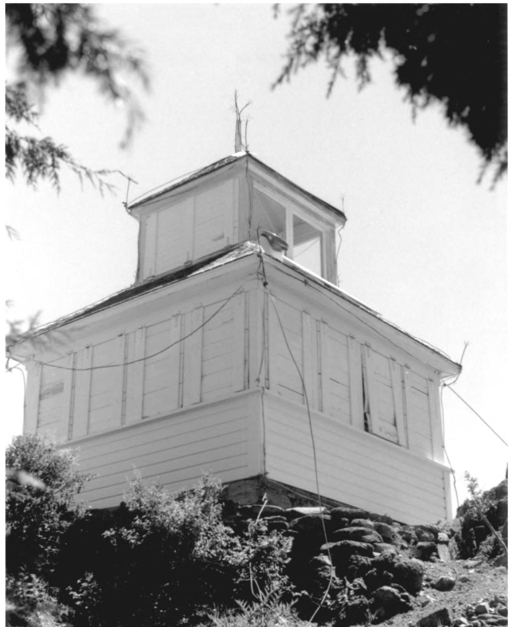
7 1MO»«OMi ****** Ho. *0»*OOH United States Department of the Interior National Register of Historic Places Continuation Sheet Hershberger Mountain Lookout Section number 7 Page i Description Setting Hershberger Mountain Lookout is situated on the south point of Hershberger Mountain at approximately 6,200 feet above sea level. It is located in the SE 1A of the NW 1A of Section 22, Township 29 South, Range 3 East, (W.M.) in Douglas County, Oregon. Hershberger Mountain forms one of the highest points of the Rogue-Umpqua Divide that separates the drainage of the Rogue River on the south from that of the Umpqua River on the north. The view from the lookout includes (clockwise from the northeast;) Fish Mountain, Mt. Bailey, Mt. Thielsen, Crater Lake Rim and Mt. Scott, Rabbit Ears, Mt. McLoughlin, Mt. Shasta, the Rogue River Valley, the Rogue-Umpqua Divide, and the South Umpqua drainage to the west. Hershberger Mountain is composed of andesitic rock of late Tertiary age. Hershberger Mountain summit is composed of an open rock outcrop that contains scattered Shasta red/noble fir, Alaskan yellow cedar, and mountain hemlock. The slopes below the summit are heavily forested with trees of these species, as well as Douglas-fir, sugar pine, and other conifers. The gently sloped terrain at the base of the mountain forms a mosaic of moist meadows, grassy "balds," and dense forest. There is no permanent source of water at the lookout site; drinking water is obtainable at several springs located lower on the mountain's slope to the south and west. Forest Service roads access the lookout from the Rogue River/Union Creek vicinity. The road ends in a small parking area immediately below the lookout. A metal stairway and a short length of trail lead from the parking area to the lookout structure. Two other structures are located on the site, both of them close to the level of the access road. The first is a small residence (formerly a garage), that was converted during World War II into winter quarters for Aircraft Warning Service spotters. The building has served in the more recent past as shelter for Forest Service radio relay equipment. The second structure is a long-abandoned and severely deteriorated privy. Structural Description Built in 1925, Hershberger Mountain Lookout is a standard "D-6" cupola-style lookout structure with a wood frame and a wood-shingled, hipped roof, a kind commonly built by the Forest Service during the 1920s in Oregon and Washington in District [now Region]
8 United States Department of the Interior National Register of Historic Places Continuation Sheet Hershberger Mountain Lookout Section number 7 Page 2 Six. Oriented with its door on the east elevation next to the northeast corner of the building, the two-story lookout is a "ground cabin" with no tower, and rests on a mortared-rock and concrete foundation. As is typical of D-6 cupola lookouts, the building has a square plan measuring approximately 12' by 12' in size. The ground floor formerly served as the living quarters, with stove, table, cupboards, bed, and other furniture. A ceiling-hinged ladder from the lower floor reaches the fire-spotting observatory in the second-story cupola. The cupola held an Osborne fire-finder alidade, much of which remains. The exterior walls of the building are horizontal shiplap siding, painted gray. The roof is surfaced with cut wood shingles. Top-hinged (interior-swing) windows (original) provide lighting and visibility for the interior of the ground floor. The single door is located in the east elevation, adjacent to the northeast corner. By 1990 Hershberger Mountain Lookout had experienced some replacement of original components and has suffered deterioration to surface materials. Although the building's framework was sound, portions of the foundation were crumbling and the weathered shingle roof needed replacement. Some of the exterior wall siding was cracked, warped, or missing, and moisture had compromised the Celotex interior. Among replacement features were several top-hinged "awning" shutters for the ground-floor window, and horizontal slider windows in the cupola. In 1991, with a Forest Service grant providing money for materials, and volunteer Forest Service personnel and employing community volunteers, the lookout received careful rehabilitation. Workers re-mortared the foundation, re-shingled the roof with identical size and pattern of cut wood shingles, replaced a small portion of siding with like material, Repaired and replaced poltions of the interior floor, removed damaged Celotex wallboard and refinished the original double-vee tongue-in-groove paneled wood siding, replacing boards where necessary. Workers constructed new, individual wood shutters for the building. The cupola's modern "slider" windows were replaced with appropriate bottom-hinged, interior-swing windows. The original lightning protective device remained on the structure. The plank "catwalk" with wooden railing along the east, south, and west sides is an addition. It replaced a two-sided catwalk, built in the 1960s, that enclosed the east and south sides. Research has yet to reveal whether Hershberger Mountain Lookout originally was fitted with a catwalk rail. Present plans call for replacing the three-sided rail with a wooden, porch style catwalk that would enclose only the east side. The metal stairs from the parking area are not original, although they have been in place for many years.
9 MO. tan eon United States Department of the Interior National Register of Historic Places Continuation Sheet Hershberger Mountain Lookout Section number 7 Page 3 Civilian Conservation Corps workers probably constructed the former garage in the late 1930s. Similar structures were erected at Mt. Stella, Dutchman Peak,, and other lookouts. This garage was converted to residential use in the early 1940s for use as a residence for Air Warning Service personnel stationed at Hershberger Lookout. Measuring approximately 18'x 22' in size, the structure is of frame construction with a pitched, wood-shingled roof with exposed rafters. Wood "double-drop" siding sheaths the building; the former wide door opening has been enclosed, and a single, walk-in door installed. Solar panels have been installed on the structure's roof, and the interior has been substantially modified.
10 Mo. M»*OBH United States Department of the Interior National Register of Historic Places Continuation Sheet Hershberger Mountain Lookout Section number 8 Page 1 Significance Hershberger Mountain Lookout, a D-6 cupola structure built in 1925 and long in use as a fire lookout, is significant for its association with early fire detection on the Rogue River National Forest. Submitted as part of a multiple property submission, " U.S. Forest Service Historic Structures on the Rogue River National Forest, Oregon," Hershberger Mountain Lookout represents the associated historic context, "Fire Suppression on the Rogue River National Forest, " The cupola-style lookout, built from about World War I to the beginning of the Great Depression, is symbolic of the Forest Service's initial attempts at standardization and centralized planning in the field of fire detection. The cupola lookout represents the agency's early fire suppression efforts in the forests of the Pacific Northwest - of the "lonely vigil" of a fire observer stationed on the summit of a remote peak. Hershberger Mountain is also significant for its role in the Aircraft Warning Service (AWS) program, which began fifty-seven years ago, when the lack of radar protection for the Pacific Coast of the United States caused many fire lookouts to double as aircraft warning observation stations until Although the maximum number of such lookouts built by the Forest Service in Oregon is unknown, there were certainly well over seventy-five such structures. Hershberger Mountain Lookout is one of the last eight remaining D-6 cupola lookouts within Oregon and one of very few remaining within the wider Pacific Northwest and California regions. The resource meets the registration requirements set forth for historic fire lookouts of its type in the registration document. Constructed in 1925, it was established during the historic period, and has retained its integrity of setting, location, design, and materials, and it evokes ^jrecj^histprjc^ais^cia^tipnsjvith jtshistoric context. Hershberger Mountain Lookout embodies the distinctive characteristics of its type as a D-6 cupola lookout through its design and materials. Hershberger Mountain Lookout, previously declared eligible to the National Register of Historic Places under Criterion A as an important component of early fire protection practices on the Rogue River National Forest also played a role the World War II "homefront" activities of the Aircraft Warning Service. The lookout has additionally been declared eligible to the National Register of Historic Places under Criterion C as an excellent representative of the D-6 cupola lookout, a particularly significant style of fire lookout built between 1918 and 1929 from standardized plans and often from prefabricated kits.
11 United States Department of the Interior National Register of Historic Places Continuation Sheet Hershberger Mountain Lookout Section number 3 Page 2 Hershberger Mountain Lookout is virtually identical in construction to other cupola lookouts built on the Rogue River National Forest, including those at Mt. McLoughlin, Hall's Point, Dutchman Peak, Rustler Peak, Wagner Butte, and numerous other places in Oregon and Washington during the years between 1918 and Oregon and Washington formed District [now Region] Six of the Forest Service, hence the label "D- 6" was given to this distinctive style of lookout. In 1916, Crater National Forest examiner Harold D. Foster apparently envisioned a structure similar to the "D-6" cupola lookout when he recommended a small cabin "with a ribbon of glass and fitted perhaps on top of a tower... a house with many windows on the highest point would be far superior to a tent, for the observer could be protected and yet be on the watch... in fact would be on duty every hour of daylight" (Foster 1916:36). The earliest record of Hershberger Mountain being used as a fire lookout dates to There was no permanent structure at the site at this time, and the lookoutman most likely resided at a tent-camp in one of the lower elevation meadows to the south. In 1925, fire lookoutman Walter Scott and others erected the present cupola building. The materials were almost certainly from a pre-manufactured lookout kit, especially fashioned for District Six of the Forest Service. Clyde Onn replaced Scott as the observer at Hershberger Mountain in 1926 or Mr. Onn had one of the longest lookout careers on the National^ Forest, spending each fire season at Hershberger Mountain from the late 1920s through World War II. During the war, he and his wife spent the winter of on the mountain as Aircraft Warning Service observers. Teams of sled-dogs were used to bring groceries and other supplies up to the snow-bound couple. No enemy aircraft were sighted. Recreational visits by the public to Hershberger Mountain began after the Civilian Conservation Corps built improved roads to the Rogue-Umpqua Divide during the 1930s. In 1938 Onn reported sixty visitors in three weekends; two years later the figure was over one-hundred visitors in less than a month - some of them tourists from South Dakota, Michigan, New Jersey, and Washington D.C. Hershberger Mountain Lookout reported a number of fires during the 1930s and in later years. It remained an active lookout until 1978 and since that time has served as an emergency-use site (e.g. members of a rehabilitation team spotted and "called in" a fire
12 United States Department of the Interior National Register of Historic Places Continuation Sheet Hershberger Mountain Lookout Section number 8 Page 3 from the lookout during one fire season). As during the 1930s to 1960s, the lookout continues to be the destination of numerous motoring and hiking enthusiasts each summer. In 1991 the Forest Service nominated Hershberger Mountain Lookout to the National Historic Lookout Register, a private honorific roll established as a voluntary, nation-wide project of the American Resources Group. The nomination was accepted in July Hershberger Mountain Lookout is significant for its associations with the development of the Rogue River National Forest, and specifically with the early period of fire detection on the Forest that occurred between 1918 and It is additionally significant for its embodiment of the distinctive characteristics of its type as a D-6 cupola style lookout, once widely in use throughout Oregon and the Pacific Northwest.
13 United States Department of the Interior National Register of Historic Places Continuation Sheet Hershberger Mountain Lookout Section number 9 Page 1 Bibliography Foster, Harold D The Fire Lookout System on the Crater National Forest, Crater National Forest, Medford, Oregon. LaLande, Jeff 1991 Evaluation and Project Description: Hershberger Mountain Lookout (C.R. Job RR-833), Rogue River National Forest. LaLande, Jeff 1999 Field Visit to Hershberger Mountain Lookout, August 4, 1999.
14 Ho. IBMOOU United States Department of the Interior Hershberger Mountain Lookout Section number 1Q Page -1 A USGS map of the Fish Mountain quadrangle is included with this nomination. A photocopied section of this map with the site location indicated by an arrpw, is also contained within the nomination document. Boundary Description: Hershberger Mountain Lookout is situated on National Forest land in the SE 1A of the NW Vi of Section 22, Township 29 South, Range 3 East, W.M., in Douglas County, Oregon. The property is further identified on USGS map Fish Mountain Quadrangle, 7.5 minutes series, included with this nomination. For purposes of this nomination, the property may be further described as a circular parcel measuring approximately 400 feet in diameter, whose outer boundary is determined by measuring approximately 200 feet from the southeast corner of Hershberger Mountain Lookout to encompass the former garage/aws residence. The acreage of the circle that includes the lookout and associated outbuilding consists of 2.8 acres more or less, at the summit of Hershberger Mountain. Boundary Justification The boundary includes the area of Hershberger Mountain summit immediately encompassing the lookout tower and the former AWS residence incorporated within the 400-foot diameter circle. This area has historically been part of the lookout operation and the boundary Jbrms a discrete, visually identifiable area within which fire detection activities have been the major human activity.
15 United States Department of the Interior National Register of Historic Places Continuation Sheet Hershberger Mountain Lookout Section numbetrh. i 2E?P]Page i Photographs Photograph No. 1 1) Hershberger Mountain Lookout 2) NW 1A Section 22, T 29 South, Range 3 East, W.M., Douglas County Oregon 3) Photographer: Katherine Atwood 4) Date of Photograph August ) Negative holder: Rogue River National Forest P.O. Box 520 Medford, Oregon ) View of south elevation 7) Photograph number 1 of 3 Photograph No. 2 1) Hershberger Mountain Lookout 2) NW VA Section 22, T 29 South, Range 3 East, W.M., Douglas County Oregon 3) Photographer: Katherine Atwood 4) Date of Photograph August ) Negative holder: Rogue River National Forest P.O. Box 520 Medford, Oregon ) View of the north and west elevations 7) Photograptrnutnber 2 of3 -_ -. Photograph No. 3 1) Hershberger Mountain Lookout 2) NW 1A Section 22, T 29 South, Range 3 East, W.M., Douglas County Oregon 3) Photographer: Unknown 4) Date of Photograph: ) Negative holder: Rogue River National Forest P.O. Box 520 Medford, Oregon ) Historic View 7) Photograph number 3 of 3
16 rat+oou United States Department of the Interior National Register of Historic Places Continuation Sheet iiershberger Mountain Lookout Section number i:l Page I Property Owner Notification U.S. Forest Service J. Michael Lunn, Forest Supervisor Jeff LaLande, Forest Archaeologist P.O. Box 520 Medford, Oregon 97501

17 Hershberger Mountain Lookout / SE 1/4 NW 1/4 322 T29S R3E I /T.-r» \ / (W.M.) USGS Map Fish Mountain OR 7.5 minute series S-FATES GEOLCX^ICAL SITUVKY... USGS, NaVNOAA PUS TAKEN... WHO MAP EDITED LAMBERT CONIX3RMAI. C(?N1C VFRSE MERCATOR... ZONE SCALE 1: KIUMJLRS MF.1ERS.5 0 M1IFS IOUO
18 X \\ 11 -h- N Hershberger Mountain Lookout Not to Scale


19

20 U


21 ^^##1

22

23

24
National Register of Historic Places Continuation Sheet
 NFS Form 10-900-a OMB Approval No. 1024-0018 (8-86) United States Department of the Interior National Register of Historic Places Continuation Sheet Section number Page SUPPLEMENTARY LISTING RECORD NRIS
; * --.-.,., rj ; United States Department of the Interior \ ' '"] I National Park Service
![; * --.-.,., rj ; United States Department of the Interior \ ' '] I National Park Service](/thumbs/88/117765392.jpg "; * --.-.,., rj ; United States Department of the Interior \ ' '] I National Park Service") NPS Form 10-900 OMB No. 1024-0018 (Rev. 10-90) : / i' -_ :. - : ; ; * --.-.,., rj ; United States Department of the Interior \ ' '"] I National Park Service NATIONAL REGISTER OF HISTORIC PLACES REGISTRATION
NPS Form 10-900 OMB No. 1024-0018 (Rev. 10-90) : / i' -_ :. - : ; ; * --.-.,., rj ; United States Department of the Interior \ ' '"] I National Park Service NATIONAL REGISTER OF HISTORIC PLACES REGISTRATION
street & number: COUNTY ROUTE 3, HC-88, BOX 17 not for publication: N/A city/town: WHEELER vicinity: X state: WV county: WEBSTER code: 101 zip code:
 NPS Forn 10-900 OMB No. 10024-0018 (Oct. 1990) United States Department of the Interior National Park Service NATIONAL REGISTIR OF HISTORIC PLACES REGISTRATICN FCRX =========================================================---------=======
National Register of Historic Places Registration Form
 NPS Form 10-900 OMB No. 10024-0018 (Oct. 1990) Registration Form This form is for use in nominating or requesting determinations for individual properties and districts. See instructions in How to Complete
D not for publication D vicinity
 NPS Fonn I 0-900 (Oct. 1990) OMB No. 10024-0018 United States Department of the Interior National Park Service National Register of Historic Places Registration Form This fom1 is for use in nominating
National Register of Historic Places Registration Form
 National Park Service National Register of Historic Places Registration Form This form is for use in nominating or requesting determinations for individual properties and districts. See instructions in
Architectural Inventory Form
 OAHP1403 Rev. 9/98 COLORADO CULTURAL RESOURCE SURVEY Architectural Inventory Form Official eligibility determination (OAHP use only) Date Initials Determined Eligible- NR Determined Not Eligible- NR Determined
United States Department of the Interior National Park Service. Boundary Expansion Listed in National Register January 11, 2017
 NPS Form 10900-a (Rev. 8/2002) OMB No. 10240018 United States Department of the Interior National Park Service Boundary Expansion Listed in National Register January 11, 2017 National Register of Historic
National Register of Historic Places Registration Form
 National Park Service National Register of Historic Places Registration Form This form is for use in nominating or requesting determinations for individual properties and districts. See instructions in
National Register of Historic Places Registration Form
 NPS Form 10-900 OMB No. 10024-0018 (Oct. 1990) United States Department of the Interior National Park Service National Register of Historic Places Registration Form 1. Name of Property historic name Hickory
National Register of Historic Places Registration Form
 NPS Form 10-900 OMB No. 1024-0018 (Expires 5/31/2012) United States Department of the Interior National Register Listed National Park Service May 1, 2012 National Register of Historic Places Registration
 Page 1 Original Update HISTORICAL STRUCTURE FORM FLORIDA MASTER SITE FILE Consult Guide To Historical Structure Forms for detailed instructions Site # 8OR9844 Recorder # 26 Recorder Date 2/20/08 Site Name
Anderson Mt. Proposed Wilderness Additions to the Rogue-Umpqua Divide Wilderness-- T30S R3E (mostly) Sections 4 & 9, and T29S R3E Section 33
 Sections 4 & 9, and T29S R3E Section 33") Anderson Mt. Proposed Wilderness Additions to the Rogue-Umpqua Divide Wilderness-- T30S R3E (mostly) Sections 4 & 9, and T29S R3E Section 33 When the 35,701 acre Rogue-Umpqua Divide Wilderness was designated
Anderson Mt. Proposed Wilderness Additions to the Rogue-Umpqua Divide Wilderness-- T30S R3E (mostly) Sections 4 & 9, and T29S R3E Section 33 When the 35,701 acre Rogue-Umpqua Divide Wilderness was designated
National Register of Historic Places Registration Form
 NPS Form 10-900 OMB No. 1024-0018 (Expires 5/31/2012) United States Department of the Interior National Register Listed National Park Service May 1, 2012 National Register of Historic Places Registration
National Register of Historic Places Registration Form
 NPS Form 10-900 (Oct. 1990) OMB No. 10024-0018 United States Department of the Interior 'fonal Park Service National Register of Historic Places Registration Form This form is for use in nominating or
National Register of Historic Places Multiple Property Documentation Form
 NPS Form 10-900-b OMB No. 1024-0018 Revised Aug. 2002 Expires 12-31-2005 Multiple Property Documentation Form This form is for use in documenting multiple property groups relating to one or several contexts.
National Register of Historic Places Registration Form
 NPS Form 10-900 OMB No. 10024-0018 (Oct. 1990) United States Department of the Interior National Park Service National Register of Historic Places Registration Form 1. Name of Property historic name other
National Register of Historic Places Registration Form
 NPS Form 10-900 OMB No. 1024-0018 (Rev. 10-90) United States Department of the Interior National Park Service National Register of Historic Places Registration Form 1. Name of Property historic name Newcomer
United States Department of the Interior National Park Service NATIONAL REGISTER OF HISTORIC PLACES REGISTRATION FORM. Wilmoth, Bernard E.
 NPS Form 10-900 OMB No. 10024-0018 (Oct. 1990) United States Department of the Interior National Park Service NATIONAL REGISTER OF HISTORIC PLACES REGISTRATION FORM 1. Name of Property historic name: other
NPS Form OMB No (Oct. 1990)
") NPS Form 10-900 OMB No. 10024-0018 (Oct. 1990) United States Department of the Interior National Park Service NATIONAL REGISTER OF HISTORIC PLACES REGISTRATION FORM 1. Name of Property historic name:_lost
NPS Form 10-900 OMB No. 10024-0018 (Oct. 1990) United States Department of the Interior National Park Service NATIONAL REGISTER OF HISTORIC PLACES REGISTRATION FORM 1. Name of Property historic name:_lost
ate: AR County: Pulaski Code: AR Zip Code: Noncontributing buildings sites structures objects Total
 Mims-Ereedlove-Priest-Weatherton House Name of Property Little Rock, AR County and State ~- -,s Form 10-900 'V. 8-86) OMB No. 1024-0018 United States Department of the Interior National Park Service NATIONAL
MINNESOTA HISTORIC.PROPERTIES INVENTORY FORM. Yes_ No X Restricted
 HISTORIC NAME: CURRENT NAME: LEGAL DESC.: MINNESOTA HISTORIC.PROPERTIES INVENTORY FORM Hartley Sugar Camp W % of Gov't. Lot 3 and T55, R24, Sec. 9 COUNTY: Itasca CITY/TWP.: Trout Lake Twp. ADDRESS: of
United States Department of the Interior National Park Service NATIONAL REGISTER OF HISTORIC PLACES REGISTRATION FORM
 NPS Form 10-900 (Oct. 1990) OMB No. 10024-0018 United States Department of the Interior National Park Service NATIONAL REGISTER OF HISTORIC PLACES REGISTRATION FORM 1. DR JOHN C. IRONS RESIDENCE hlstoric
NE¼ of NE¼ of NE¼ of NE¼ of section Roof configuration (enter one): Gabled Roof / Front Gabled Roof
: Gabled Roof / Front Gabled Roof") OAHP1403 Rev. 9/98 COLORADO CULTURAL RESOURCE SURVEY Official Eligibility Determination (OAHP use only) Date Initials Determined Eligible - National Register Architectural Inventory Form Determined Not
OAHP1403 Rev. 9/98 COLORADO CULTURAL RESOURCE SURVEY Official Eligibility Determination (OAHP use only) Date Initials Determined Eligible - National Register Architectural Inventory Form Determined Not
National Register of Historic Places Registration Form
 NPS Form 10-900 OMB No. 1024-0018 (Rev. 10-90) United States Department of the Interior National Park Service National Register of Historic Places Registration Form 1. Name of Property historic name Evans,
Appendix D Reevaluation of Structures on Bock House Property
 Appendix D Reevaluation of Structures on Bock House Property Page 1 Original Update HISTORICAL STRUCTURE FORM FLORIDA MASTER SITE FILE Consult Guide To Historical Structure Forms for detailed instructions
United States Department of the Interior National Park Service NATIONAL REGISTER OF HISTORIC PLACES REGISTRATION FORM
 NPS Form 10-900 (Oct. 1990) OMB NO. 10024-0018 United States Department of the Interior National Park Service NATIONAL REGISTER OF HISTORIC PLACES REGISTRATION FORM As the designated authority under the
SUPERSEDED. [Docket No. FAA ; Directorate Identifier 2015-SW-014-AD; Amendment ; AD ]
![SUPERSEDED. [Docket No. FAA ; Directorate Identifier 2015-SW-014-AD; Amendment ; AD ]](/thumbs/95/123244441.jpg "SUPERSEDED. [Docket No. FAA ; Directorate Identifier 2015-SW-014-AD; Amendment ; AD ]") [Federal Register Volume 80, Number 95 (Monday, May 18, 2015)] [Rules and Regulations] [Pages 28172-28175] From the Federal Register Online via the Government Publishing Office [www.gpo.gov] [FR Doc No:
[Federal Register Volume 80, Number 95 (Monday, May 18, 2015)] [Rules and Regulations] [Pages 28172-28175] From the Federal Register Online via the Government Publishing Office [www.gpo.gov] [FR Doc No:
AH pp. I Ti. Nov 7 I) I I y
 I I y") ..------------------------------------------ ------------ - - -- - NPS Form 10-900 (Rev. 8-86) United States Department of the Interior ~a tional Park Service NATIONAL REGISTER OF HISTORIC PLACES REGISTRATION
..------------------------------------------ ------------ - - -- - NPS Form 10-900 (Rev. 8-86) United States Department of the Interior ~a tional Park Service NATIONAL REGISTER OF HISTORIC PLACES REGISTRATION
National Register of Historic Places Registration Form
 NPS Form 10-900 OMB No. 1024-0018 (Rev. 10-90) United States Department of the Interior National Park Service National Register of Historic Places Registration Form 1. Name of Property historic name Strode-Morrison-Tabler
THE BARNACLE 3485 MAIN HIGHWAY
 THE BARNACLE 3485 MAIN HIGHWAY Designation Report City of Miami REPORT OF THE CITY OF MIAMI PLANNING AND ZONING DEPARTMENT TO THE HISTORIC AND ENVIRONMENTAL PRESERVATION BOARD ON THE POTENTIAL DESIGNATION
FOREST FIRE LOOKOUT TOWERS OF THE ARAPAHO-ROOSEVELT NATIONAL FORESTS AND ROCKY MOUNTAIN NATIONAL PARK
 This site contains links to other Internet sites. These links are not endorsements of any products or services in such sites, and no information in such site has been endorsed or approved by the USDA Forest
Maryland Historical Trust Inventory No. PG: 86A-026 Maryland Inventory of Historic Properties Form
 Inventory No. PG: 86A-026 Maryland Inventory of 1. Name of Property (indicate preferred name) historic other 2. Location street and number 12811 Croom Road not for publication city, town Naylor vicinity
COVER SHEET. Reduced Vertical Separation Minimum (RVSM) Information Sheet Part 91 RVSM Letter of Authorization
 Information Sheet Part 91 RVSM Letter of Authorization") COVER SHEET Reduced Vertical Separation Minimum (RVSM) Information Sheet Part 91 RVSM Letter of Authorization NOTE: FAA Advisory Circular 91-85 ( ), Authorization of Aircraft and Operators for Flight in
COVER SHEET Reduced Vertical Separation Minimum (RVSM) Information Sheet Part 91 RVSM Letter of Authorization NOTE: FAA Advisory Circular 91-85 ( ), Authorization of Aircraft and Operators for Flight in
THE CESSNA AIRCRAFT COMPANY
 Page 1 2010-20-10 THE CESSNA AIRCRAFT COMPANY Amendment 39-16444 Docket No. FAA-2010-0380; Directorate Identifier 2009-NM-009-AD PREAMBLE Effective Date (a) This AD becomes effective November 1, 2010.
National Register of Historic Places Registration Form
 NPS Form 10-900 OMB No. 10024-0018 (Oct. 1990) Registration Form This form is for use in nominating or requesting determinations for individual properties and districts. See instructions in How to Complete
Current Functions (Enter categories from instructions) Materials (Enter categories from instructions)
 Materials (Enter categories from instructions)") Site Inventory Form State Inventory No. 92-00542 New Supplemental State Historical Society of Iowa Part of a district with known boundaries (enter inventory no.) 92-00349 (November 2005) Relationship:
Site Inventory Form State Inventory No. 92-00542 New Supplemental State Historical Society of Iowa Part of a district with known boundaries (enter inventory no.) 92-00349 (November 2005) Relationship:
not for publication: N/A city/town: St. Albans vicinity: N/A state: WV county : Kanawha code: 039 zip code:25177
 #PS F o 10-900 ~ OMB NO. 10024-0018 (OC~. 1990) United States Department of the Interior National Park Service LSATIOHAL REGISTER OF HISTORIC PLACES REGISTRATION FORM 1. Name of Property ST. ALBANS CHESAPEAKE
National Register of Historic Places Registration Form
 NPS Form 10-900 OMB No. 10024-0018 (Oct. 1990) Registration Form This form is for use in nominating or requesting determinations for individual properties and districts. See instructions in How to Complete
Appendix E Historic Property Inventory Forms
 Appendix E Historic Property Inventory Forms TECHNICAL MEMORANDUM Sound Transit Federal Way Link Extension WISAARD Survey Entries PREPARED FOR: COPY TO: PREPARED BY: Sound Transit Alisa Swank/ CH2M MaryNell
[Docket No. FAA ; Directorate Identifier 2015-NM-124-AD] Airworthiness Directives; The Boeing Company Airplanes
![[Docket No. FAA ; Directorate Identifier 2015-NM-124-AD] Airworthiness Directives; The Boeing Company Airplanes](/thumbs/85/92059879.jpg "[Docket No. FAA ; Directorate Identifier 2015-NM-124-AD] Airworthiness Directives; The Boeing Company Airplanes") This document is scheduled to be published in the Federal Register on 05/13/2016 and available online at http://federalregister.gov/a/2016-11169, and on FDsys.gov [4910-13-P] DEPARTMENT OF TRANSPORTATION
This document is scheduled to be published in the Federal Register on 05/13/2016 and available online at http://federalregister.gov/a/2016-11169, and on FDsys.gov [4910-13-P] DEPARTMENT OF TRANSPORTATION
Total 1 Total. Current Functions (Enter categories from instructions) Materials (Enter categories from instructions)
 Materials (Enter categories from instructions)") Site Inventory Form State Inventory No. 29-00962 New Supplemental State Historical Society of Iowa Part of a district with known boundaries (enter inventory no.) 29-03685 (November 2005) Relationship:
Site Inventory Form State Inventory No. 29-00962 New Supplemental State Historical Society of Iowa Part of a district with known boundaries (enter inventory no.) 29-03685 (November 2005) Relationship:
1 buildings sites structures objects 1 0 TOTAL
 Name of Property County and State 4. National Park Service Certification --------- I, hereby certify that this property is: Signature of Keeper Date of Action entered in the National Register See continuation
[Docket No. FAA ; Directorate Identifier 2013-NM-081-AD] Airworthiness Directives; The Boeing Company Airplanes
![[Docket No. FAA ; Directorate Identifier 2013-NM-081-AD] Airworthiness Directives; The Boeing Company Airplanes](/thumbs/95/123065974.jpg "[Docket No. FAA ; Directorate Identifier 2013-NM-081-AD] Airworthiness Directives; The Boeing Company Airplanes") This document is scheduled to be published in the Federal Register on 08/05/2013 and available online at http://federalregister.gov/a/2013-18800, and on FDsys.gov [4910-13-P] DEPARTMENT OF TRANSPORTATION
This document is scheduled to be published in the Federal Register on 08/05/2013 and available online at http://federalregister.gov/a/2013-18800, and on FDsys.gov [4910-13-P] DEPARTMENT OF TRANSPORTATION
FLAGLER WORKER S HOUSE FORT DALLAS PARK S.E. 4 STREET
 FLAGLER WORKER S HOUSE FORT DALLAS PARK 60-64 S.E. 4 STREET Designation Report City of Miami REPORT OF THE CITY OF MIAMI PLANNING DEPARTMENT TO THE HERITAGE CONSERVATION BOARD ON THE POTENTIAL DESIGNATION
M7 AEROSPACE LP
 Page 1 2011-02-04 M7 AEROSPACE LP (TYPE CERTIFICATE PREVIOUSLY HELD BY FAIRCHILD AIRCRAFT INCORPORATED) Amendment 39-16577 Docket No. FAA-2011-0014 Directorate Identifier 2010-CE-066-AD PREAMBLE Effective
COVER SHEET. Reduced Vertical Separation Minimum (RVSM) Information Sheet Part 91 RVSM Letter of Authorization
 Information Sheet Part 91 RVSM Letter of Authorization") COVER SHEET Reduced Vertical Separation Minimum (RVSM) Information Sheet Part 91 RVSM Letter of Authorization NOTE: FAA Advisory Circular 91-85, Authorization of Aircraft and Operators for Flight in Reduced
COVER SHEET Reduced Vertical Separation Minimum (RVSM) Information Sheet Part 91 RVSM Letter of Authorization NOTE: FAA Advisory Circular 91-85, Authorization of Aircraft and Operators for Flight in Reduced
National Register off Historic Places Inventory Nomination Form
 MPS Fonn 10-900-a (3^ United States Department of the Interior National Park Service National Register off Historic Places Inventory Nomination Form For NPS use only received date entered OMB No 1M4-0018
[Docket No. FAA ; Directorate Identifier 2007-NM-031-AD; Amendment ; AD ]
![[Docket No. FAA ; Directorate Identifier 2007-NM-031-AD; Amendment ; AD ]](/thumbs/95/125338134.jpg "[Docket No. FAA ; Directorate Identifier 2007-NM-031-AD; Amendment ; AD ]") [Federal Register: May 22, 2007 (Volume 72, Number 98)] [Rules and Regulations] [Page 28597-28601] From the Federal Register Online via GPO Access [wais.access.gpo.gov] [DOCID:fr22my07-7] DEPARTMENT OF
[Federal Register: May 22, 2007 (Volume 72, Number 98)] [Rules and Regulations] [Page 28597-28601] From the Federal Register Online via GPO Access [wais.access.gpo.gov] [DOCID:fr22my07-7] DEPARTMENT OF
Address 347 Whitney Street. East elevation, camera facing southwest.
 FORM B BUILDING Assessor s Number USGS Quad Area(s) Form Number MASSACHUSETTS HISTORICAL COMMISSION MASSACHUSETTS ARCHIVES BUILDING 220 MORRISSEY BOULEVARD BOSTON, MASSACHUSETTS 02125 Town Northborough
NPS Form OMB No Exp Status occupied X unoccupied work in progress Accessible yes: restricted yes: unrestricted _5Lno
 NPS Form 10-900 OMB No. 1024-0018 Exp. 10-31-84 United States Department of the Interior National Park Service National Register of Historic Places Inventory Nomination Form See instructions in How to
Name of related multiple property listing: Historic and Architectural Resources in Abilene, Texas
 NPS Form 10-900 (Rev. 8-86) United States Department of the Interior National Park Service NATIONAL REGISTER OF HISTORIC PLACES REGISTRATION FORM 1. NAME OF PROPERTY Historic name: Magee, J.D., House Other
National Register of Historic Places Registration Form
 NPS Form 10-900 OMB No. 10024-0018 (Oct. 1990) Registration Form This form is for use in nominating or requesting determinations for individual properties and districts. See instructions in How to Complete
Maryland Historical Trust Inventory No. 15/6 Maryland Inventory of Historic Properties Form
 Inventory No. 15/6 Maryland Inventory of 1. Name of Property (indicate preferred name) historic Becraft Farm other 2. Location street and number 28500 Ridge Road not for publication city, town Mount Airy
STATE OF WASHINGTON ARCHAEOLOGICAL SITE INVENTORY FORM
 STATE OF WASHINGTON ARCHAEOLOGICAL SITE INVENTORY FORM Smithsonian Number: 45 County: Chelan Date: 6/12/2018 Human Remains? DAHP Case No.: Archaeological Sites are exempt from public disclosure per RCW
[Docket No. FAA ; Directorate Identifier 2007-NM-291-AD; Amendment ; AD R1]
![[Docket No. FAA ; Directorate Identifier 2007-NM-291-AD; Amendment ; AD R1]](/thumbs/80/81019372.jpg "[Docket No. FAA ; Directorate Identifier 2007-NM-291-AD; Amendment ; AD R1]") Federal Register: January 7, 2008 (Volume 73, Number 4)] [Rules and Regulations] [Page 1052-1055] From the Federal Register Online via GPO Access [wais.access.gpo.gov] [DOCID:fr07ja08-5] DEPARTMENT OF
Federal Register: January 7, 2008 (Volume 73, Number 4)] [Rules and Regulations] [Page 1052-1055] From the Federal Register Online via GPO Access [wais.access.gpo.gov] [DOCID:fr07ja08-5] DEPARTMENT OF
NPS Form OMB No (Rev. Aug. 2002) (Expires )
 (Expires )") Beaconsfield Supply Store,1 NATIONAL REGISTER FORMS TEMPLATE January 2006 NPS Form 10-900 OMB No. 1024-0018 (Rev. Aug. 2002) (Expires 1-31-2009) REGISTRATION FORM 1. Name of Property historic name Beaconsfield
Beaconsfield Supply Store,1 NATIONAL REGISTER FORMS TEMPLATE January 2006 NPS Form 10-900 OMB No. 1024-0018 (Rev. Aug. 2002) (Expires 1-31-2009) REGISTRATION FORM 1. Name of Property historic name Beaconsfield
I Signature of commenting official Date I. / Title State or Federal agencylbureau or Tribal Government 1
 National Park Service National Register of Historic Places Registration Form LISTED ON: VLR 09/20/2012 NRHP 11/20/2012 This form is for use in nominating or requesting determinations for individual properties
NATIONAL REGISTER OF HISTORIC PLACES REGISTRATION FORM
 NPS Form 10-900 OMB No. 1024-0018 (Rev. 10-90) United States Department of the Interior National Park Service NATIONAL REGISTER OF HISTORIC PLACES REGISTRATION FORM 1. Name of Property historic name Compton-Johnson
National Register of Historic Places Registration Form
 NPS Form 10-900 (Oct. 1990) OMB NO. 10024-0018 Registration Form This form is for use in nominating or requesting determinations for individual properties and districts. See instructions in How to Complete
AHPP. LISTED ========================================================================
 NPS Form 10-900 (Rev. 8-86) Jnited States Department of the Interior ational Park Service OMB No. 1024-0018 LISTED NATIONAL REGISTER OF HISTORIC PLACES REGISTRATION FORM AHPP. 1. Historic Name: Bush-Dubisson
[Docket No. FAA ; Product Identifier 2017-CE-049-AD; Amendment ; AD ]
![[Docket No. FAA ; Product Identifier 2017-CE-049-AD; Amendment ; AD ]](/thumbs/85/91560764.jpg "[Docket No. FAA ; Product Identifier 2017-CE-049-AD; Amendment ; AD ]") [Federal Register Volume 83, Number 30 (Tuesday, February 13, 2018)] [Rules and Regulations] [Pages 6114-6118] From the Federal Register Online via the Government Publishing Office [www.gpo.gov] [FR Doc
[Federal Register Volume 83, Number 30 (Tuesday, February 13, 2018)] [Rules and Regulations] [Pages 6114-6118] From the Federal Register Online via the Government Publishing Office [www.gpo.gov] [FR Doc
National Register of Historic Places Registration Form
 National Park Service National Register of Historic Places Registration Form This form is for use in nominating or requesting determinations for individual properties and districts. See instructions in
Intent to Request Revision From OMB of One Current Public Collection of. Information: Certified Cargo Screening Standard Security Program
 This document is scheduled to be published in the Federal Register on 12/13/2018 and available online at https://federalregister.gov/d/2018-26931, and on govinfo.gov 9110-05-P DEPARTMENT OF HOMELAND SECURITY
Decision Memo Broken Wheel Ranch Equestrian Outfitter Special-Use Permit Proposed Action
 Decision Memo Broken Wheel Ranch Equestrian Outfitter Special-Use Permit USDA Forest Service Mississippi Bluffs Ranger District, Shawnee National Forest Jackson and Union Counties, Illinois Proposed Action
NPS Form OMB No (Rev ) U. S. Department of the Interior Name of Property: Hungry Mother State Park Historic District
 U. S. Department of the Interior Name of Property: Hungry Mother State Park Historic District") NPS Form 10-900 OMB No. 1024-4018 (Rev. 10-90) U. S. Department of the Interior Name of Property: Location: 5. Classification Ownership of Property (Check as many boxes as apply) Category of Property (Check
NPS Form 10-900 OMB No. 1024-4018 (Rev. 10-90) U. S. Department of the Interior Name of Property: Location: 5. Classification Ownership of Property (Check as many boxes as apply) Category of Property (Check
[Docket No. FAA ; Product Identifier 2018-SW-018-AD; Amendment 39- AGENCY: Federal Aviation Administration (FAA), DOT.
, DOT.") This document is scheduled to be published in the Federal Register on 05/23/2018 and available online at https://federalregister.gov/d/2018-10922, and on FDsys.gov [4910-13-P] DEPARTMENT OF TRANSPORTATION
This document is scheduled to be published in the Federal Register on 05/23/2018 and available online at https://federalregister.gov/d/2018-10922, and on FDsys.gov [4910-13-P] DEPARTMENT OF TRANSPORTATION
VARIOUS RESTRICTED CATEGORY HELICOPTERS
 Page 1 2012-14-11 VARIOUS RESTRICTED CATEGORY HELICOPTERS Amendment 39-17125 Docket No. FAA-2012-0739; Directorate Identifier 2012-SW-044-AD. PREAMBLE (a) Applicability This AD applies to Arrow Falcon
[Docket No. FAA ; Product Identifier 2017-CE-049-AD; Amendment ; AD R1]
![[Docket No. FAA ; Product Identifier 2017-CE-049-AD; Amendment ; AD R1]](/thumbs/93/111165002.jpg "[Docket No. FAA ; Product Identifier 2017-CE-049-AD; Amendment ; AD R1]") [Federal Register Volume 83, Number 89 (Tuesday, May 8, 2018)] [Rules and Regulations] [Pages 20719-20725] From the Federal Register Online via the Government Publishing Office [www.gpo.gov] [FR Doc No:
[Federal Register Volume 83, Number 89 (Tuesday, May 8, 2018)] [Rules and Regulations] [Pages 20719-20725] From the Federal Register Online via the Government Publishing Office [www.gpo.gov] [FR Doc No:
Historic Property Report
 Historic Name: Shadle Park Reservoir Property ID: 708465 Location Address: Location Comments: GeographicAreas: 4302 N Belt St, Spokane, Washington, USA Wellesley Ave & N Belt St Spokane,T25R42E01,SPOKANE
SUPERSEDED [ U] DEPARTMENT OF TRANSPORTATION. Federal Aviation Administration. 14 CFR Part 39 [66 FR /5/2001]
![SUPERSEDED [ U] DEPARTMENT OF TRANSPORTATION. Federal Aviation Administration. 14 CFR Part 39 [66 FR /5/2001]](/thumbs/89/99040723.jpg "SUPERSEDED [ U] DEPARTMENT OF TRANSPORTATION. Federal Aviation Administration. 14 CFR Part 39 [66 FR /5/2001]") [4910-13-U] DEPARTMENT OF TRANSPORTATION Federal Aviation Administration 14 CFR Part 39 [66 FR 13227 3/5/2001] [Docket No. 2000-NM-416-AD; Amendment 39-12128; AD 2001-04-09] RIN 2120-AA64 Airworthiness
[4910-13-U] DEPARTMENT OF TRANSPORTATION Federal Aviation Administration 14 CFR Part 39 [66 FR 13227 3/5/2001] [Docket No. 2000-NM-416-AD; Amendment 39-12128; AD 2001-04-09] RIN 2120-AA64 Airworthiness
[Docket No. FAA ; Product Identifier 2018-CE-001-AD; Amendment 39- AGENCY: Federal Aviation Administration (FAA), DOT.
, DOT.") This document is scheduled to be published in the Federal Register on 09/18/2018 and available online at https://federalregister.gov/d/2018-19853, and on govinfo.gov [4910-13-P] DEPARTMENT OF TRANSPORTATION
This document is scheduled to be published in the Federal Register on 09/18/2018 and available online at https://federalregister.gov/d/2018-19853, and on govinfo.gov [4910-13-P] DEPARTMENT OF TRANSPORTATION
United States Department of the Interior National Park Service NATIONAL REGISTER OF HISTORIC PLACES REGISTRATION FORM
 NPS Form 10-900 (Rev. 8-86) OMB No. 1024-0018 United States Department of the Interior National Park Service NATIONAL REGISTER OF HISTORIC PLACES REGISTRATION FORM other name/site number: "Maple Shadows:"
in 7.x M (Oct. 1990) United States Department of the Interior National Park Service 1. NAME OF PROPERTY
 United States Department of the Interior National Park Service 1. NAME OF PROPERTY") (Oct. 1990) United States Department of the Interior National Park Service NATIONAL REGISTER OF HISTORIC PLACES REGISTRATION FORM 1. NAME OF PROPERTY HISTORIC NAME: Jacala Restaurant OTHER NAME/SITE NUMBER:
(Oct. 1990) United States Department of the Interior National Park Service NATIONAL REGISTER OF HISTORIC PLACES REGISTRATION FORM 1. NAME OF PROPERTY HISTORIC NAME: Jacala Restaurant OTHER NAME/SITE NUMBER:
, Name of Property. ... Ownership of Property: public-state
 1 6 NPS Form 10-900 (Rev. 8-86) OMB NO. 1024-0018 IVR 4/zd/T-- United States Department of the Interior National Park Service NATIONAL REGISTER OF HISTORIC PLACES REGISTRATION FORM --------------d---d----------------4------------------------
SUPERSEDED. [Docket No. FAA ; Directorate Identifier 2009-SW-01-AD; Amendment ; AD ]
![SUPERSEDED. [Docket No. FAA ; Directorate Identifier 2009-SW-01-AD; Amendment ; AD ]](/thumbs/95/122757580.jpg "SUPERSEDED. [Docket No. FAA ; Directorate Identifier 2009-SW-01-AD; Amendment ; AD ]") [Federal Register: February 4, 2010 (Volume 75, Number 23)] [Rules and Regulations] [Page 5681-5683] From the Federal Register Online via GPO Access [wais.access.gpo.gov] [DOCID:fr04fe10-2] DEPARTMENT
[Federal Register: February 4, 2010 (Volume 75, Number 23)] [Rules and Regulations] [Page 5681-5683] From the Federal Register Online via GPO Access [wais.access.gpo.gov] [DOCID:fr04fe10-2] DEPARTMENT
[Docket No. FAA ; Directorate Identifier 2015-NM-101-AD] Airworthiness Directives; The Boeing Company Airplanes
![[Docket No. FAA ; Directorate Identifier 2015-NM-101-AD] Airworthiness Directives; The Boeing Company Airplanes](/thumbs/90/104311804.jpg "[Docket No. FAA ; Directorate Identifier 2015-NM-101-AD] Airworthiness Directives; The Boeing Company Airplanes") This document is scheduled to be published in the Federal Register on 12/31/2015 and available online at http://federalregister.gov/a/2015-32850, and on FDsys.gov [4910-13-P] DEPARTMENT OF TRANSPORTATION
This document is scheduled to be published in the Federal Register on 12/31/2015 and available online at http://federalregister.gov/a/2015-32850, and on FDsys.gov [4910-13-P] DEPARTMENT OF TRANSPORTATION
National Register off Historic Places Inventory Nomination Form
 NPS Fomi ia-900-a OMB Ho. 1024-0018 Exp. 10-31-S4 United States Department of the Interior National Park Service National Register off Historic Places Inventory Nomination Form For HPS UM only received
10-10F, DC-10-30, DC-10-30F, DC-10-40, MD-10-30F, MD-11,
 [Federal Register: July 10, 2003 (Volume 68, Number 132)] [Rules and Regulations] [Page 41063-41065] From the Federal Register Online via GPO Access [wais.access.gpo.gov] [DOCID:fr10jy03-6] DEPARTMENT
Town: Sharon Place (neighborhood or village): Sharon. ame of Area: Present Use: Date (month / year): July 2008
: Sharon. ame of Area: Present Use: Date (month / year): July 2008") FORM A - AREA MASSACHUSETTS HISTORICAL COMMISSION MASSACHUSETTS ARCHIVES BUILDING 220 MORRISSEY BOULEVARD BOSTON, MASSACHUSETTS 02125 Photograph Assessor s Sheets USGS Quad Area Letter Form Numbers in
FORM A - AREA MASSACHUSETTS HISTORICAL COMMISSION MASSACHUSETTS ARCHIVES BUILDING 220 MORRISSEY BOULEVARD BOSTON, MASSACHUSETTS 02125 Photograph Assessor s Sheets USGS Quad Area Letter Form Numbers in
[Docket No. FAA ; Directorate Identifier 2010-NM-107-AD; Amendment ; AD ]
![[Docket No. FAA ; Directorate Identifier 2010-NM-107-AD; Amendment ; AD ]](/thumbs/95/125067740.jpg "[Docket No. FAA ; Directorate Identifier 2010-NM-107-AD; Amendment ; AD ]") [Federal Register Volume 76, Number 37 (Thursday, February 24, 2011)] [Rules and Regulations] [Pages 10215-10216] From the Federal Register Online via the Government Printing Office [www.gpo.gov] [FR Doc
[Federal Register Volume 76, Number 37 (Thursday, February 24, 2011)] [Rules and Regulations] [Pages 10215-10216] From the Federal Register Online via the Government Printing Office [www.gpo.gov] [FR Doc
[Docket No. FAA ; Product Identifier 2017-NM-164-AD; Amendment ; AD ]
![[Docket No. FAA ; Product Identifier 2017-NM-164-AD; Amendment ; AD ]](/thumbs/85/92086732.jpg "[Docket No. FAA ; Product Identifier 2017-NM-164-AD; Amendment ; AD ]") [Federal Register Volume 83, Number 172 (Wednesday, September 5, 2018)] [Rules and Regulations] [Pages 45041-45044] From the Federal Register Online via the Government Publishing Office [www.gpo.gov] [FR
[Federal Register Volume 83, Number 172 (Wednesday, September 5, 2018)] [Rules and Regulations] [Pages 45041-45044] From the Federal Register Online via the Government Publishing Office [www.gpo.gov] [FR
[Docket No. FAA ; Directorate Identifier 2010-CE-032-AD; Amendment ; AD ]
![[Docket No. FAA ; Directorate Identifier 2010-CE-032-AD; Amendment ; AD ]](/thumbs/93/114212134.jpg "[Docket No. FAA ; Directorate Identifier 2010-CE-032-AD; Amendment ; AD ]") [Federal Register: July 27, 2010 (Volume 75, Number 143)] [Rules and Regulations] [Page 43807-43809] From the Federal Register Online via GPO Access [wais.access.gpo.gov] [DOCID:fr27jy10-4] DEPARTMENT
[Federal Register: July 27, 2010 (Volume 75, Number 143)] [Rules and Regulations] [Page 43807-43809] From the Federal Register Online via GPO Access [wais.access.gpo.gov] [DOCID:fr27jy10-4] DEPARTMENT
State Level Historic Documentation Report. John Blue Bridge Hampshire County
 State Level Historic Documentation Report State Project No. S314-28-22.27 Federal Project No. BR-0028(058)D John Blue Bridge Hampshire County Prepared by: Randy Epperly, Historian Department of Transportation
[Docket No. FAA ; Directorate Identifier 2012-NM-218-AD] AGENCY: Federal Aviation Administration (FAA), DOT.
![[Docket No. FAA ; Directorate Identifier 2012-NM-218-AD] AGENCY: Federal Aviation Administration (FAA), DOT.](/thumbs/94/120859820.jpg "[Docket No. FAA ; Directorate Identifier 2012-NM-218-AD] AGENCY: Federal Aviation Administration (FAA), DOT.") This document is scheduled to be published in the Federal Register on 02/10/2014 and available online at http://federalregister.gov/a/2014-02715, and on FDsys.gov [4910-13-P] DEPARTMENT OF TRANSPORTATION
This document is scheduled to be published in the Federal Register on 02/10/2014 and available online at http://federalregister.gov/a/2014-02715, and on FDsys.gov [4910-13-P] DEPARTMENT OF TRANSPORTATION
[Docket No. FAA ; Directorate Identifier 2009-NE-41-AD; Amendment ; AD ]
![[Docket No. FAA ; Directorate Identifier 2009-NE-41-AD; Amendment ; AD ]](/thumbs/92/107979374.jpg "[Docket No. FAA ; Directorate Identifier 2009-NE-41-AD; Amendment ; AD ]") [Federal Register: April 2, 2010 (Volume 75, Number 63)] [Rules and Regulations] [Page 16662-16664] From the Federal Register Online via GPO Access [wais.access.gpo.gov] [DOCID:fr02ap10-9] DEPARTMENT OF
[Federal Register: April 2, 2010 (Volume 75, Number 63)] [Rules and Regulations] [Page 16662-16664] From the Federal Register Online via GPO Access [wais.access.gpo.gov] [DOCID:fr02ap10-9] DEPARTMENT OF
SUPERSEDED. [Docket No. FAA ; Directorate Identifier 2011-SW-005-AD; Amendment ; AD ]
![SUPERSEDED. [Docket No. FAA ; Directorate Identifier 2011-SW-005-AD; Amendment ; AD ]](/thumbs/95/123244499.jpg "SUPERSEDED. [Docket No. FAA ; Directorate Identifier 2011-SW-005-AD; Amendment ; AD ]") [Federal Register Volume 76, Number 66 (Wednesday, April 6, 2011)] [Rules and Regulations] [Pages 18865-18869] From the Federal Register Online via the Government Printing Office [www.gpo.gov] [FR Doc
[Federal Register Volume 76, Number 66 (Wednesday, April 6, 2011)] [Rules and Regulations] [Pages 18865-18869] From the Federal Register Online via the Government Printing Office [www.gpo.gov] [FR Doc
[Docket No. FAA ; Directorate Identifier 2011-CE-031-AD; Amendment ; AD ]
![[Docket No. FAA ; Directorate Identifier 2011-CE-031-AD; Amendment ; AD ]](/thumbs/79/80098504.jpg "[Docket No. FAA ; Directorate Identifier 2011-CE-031-AD; Amendment ; AD ]") [Federal Register Volume 77, Number 27 (Thursday, February 9, 2012)] [Rules and Regulations] [Pages 6663-6666] From the Federal Register Online via the Government Printing Office [www.gpo.gov] [FR Doc
[Federal Register Volume 77, Number 27 (Thursday, February 9, 2012)] [Rules and Regulations] [Pages 6663-6666] From the Federal Register Online via the Government Printing Office [www.gpo.gov] [FR Doc
_1 0_ Total. Number of contributing resources previously listed in the National Register: 0
 20S' NPS Form 10-900 (Rev. 8-86) United States Department of the Interior National Park Service NATIONAL REGISTER OF HISTORIC PLACES REGISTRATION FORM OMB No. 1024-0018 P p r.f? R FLS 19 1992 NATIONAL
[Docket No. FAA ; Directorate Identifier 2012-CE-013-AD] Airworthiness Directives; Revo, Incorporated Airplanes
![[Docket No. FAA ; Directorate Identifier 2012-CE-013-AD] Airworthiness Directives; Revo, Incorporated Airplanes](/thumbs/94/120859874.jpg "[Docket No. FAA ; Directorate Identifier 2012-CE-013-AD] Airworthiness Directives; Revo, Incorporated Airplanes") This document is scheduled to be published in the Federal Register on 08/16/2012 and available online at http://federalregister.gov/a/2012-20107, and on FDsys.gov [4910-13-P] DEPARTMENT OF TRANSPORTATION
This document is scheduled to be published in the Federal Register on 08/16/2012 and available online at http://federalregister.gov/a/2012-20107, and on FDsys.gov [4910-13-P] DEPARTMENT OF TRANSPORTATION
[Docket No. FAA ; Directorate Identifier 2004-NM-252-AD; Amendment ; AD ]
![[Docket No. FAA ; Directorate Identifier 2004-NM-252-AD; Amendment ; AD ]](/thumbs/95/125338089.jpg "[Docket No. FAA ; Directorate Identifier 2004-NM-252-AD; Amendment ; AD ]") [Federal Register: October 5, 2005 (Volume 70, Number 192)] [Rules and Regulations] [Page 58002-58005] From the Federal Register Online via GPO Access [wais.access.gpo.gov] [DOCID:fr05oc05-6] DEPARTMENT
[Federal Register: October 5, 2005 (Volume 70, Number 192)] [Rules and Regulations] [Page 58002-58005] From the Federal Register Online via GPO Access [wais.access.gpo.gov] [DOCID:fr05oc05-6] DEPARTMENT
[Docket No. FAA ; Directorate Identifier 2007-NM-204-AD; Amendment ; AD ]
![[Docket No. FAA ; Directorate Identifier 2007-NM-204-AD; Amendment ; AD ]](/thumbs/96/128211125.jpg "[Docket No. FAA ; Directorate Identifier 2007-NM-204-AD; Amendment ; AD ]") [Federal Register: July 2, 2008 (Volume 73, Number 128)] [Rules and Regulations] [Page 37781-37783] From the Federal Register Online via GPO Access [wais.access.gpo.gov] [DOCID:fr02jy08-4] DEPARTMENT OF
[Federal Register: July 2, 2008 (Volume 73, Number 128)] [Rules and Regulations] [Page 37781-37783] From the Federal Register Online via GPO Access [wais.access.gpo.gov] [DOCID:fr02jy08-4] DEPARTMENT OF
Historic Inventory Report
 Location Field Site No. 3394-134 DAHP No. Historic Name: Common Name: Cabinetrends Property Address: 24619 Pacific Hwy S, Kent, WA 98032 Comments: Tax No./Parcel No. 3601800165 Plat/Block/Lot Acreage.24
NATIONAL REGISTER OF HISTORIC PLACES REGISTRATION FORM
 (Rev. 10-90) NPS Form 10-900 OMB No. 1024-0018 NATIONAL REGISTER OF HISTORIC PLACES REGISTRATION FORM This form is for use in nominating or requesting determinations for individual properties and districts.
[Docket No. FAA ; Product Identifier 2017-NM-182-AD; Amendment ; AD ]
![[Docket No. FAA ; Product Identifier 2017-NM-182-AD; Amendment ; AD ]](/thumbs/91/106887793.jpg "[Docket No. FAA ; Product Identifier 2017-NM-182-AD; Amendment ; AD ]") [Federal Register Volume 83, Number 200 (Tuesday, October 16, 2018)] [Rules and Regulations] [Pages 52143-52146] From the Federal Register Online via the Government Publishing Office [www.gpo.gov] [FR
[Federal Register Volume 83, Number 200 (Tuesday, October 16, 2018)] [Rules and Regulations] [Pages 52143-52146] From the Federal Register Online via the Government Publishing Office [www.gpo.gov] [FR
Register of Historic Kansas Places Registration Form
 Kansas State Historical Society Register of Historic Kansas Places Registration Form This form is for use in nominating individual properties and districts. The format is similar to the National Register
county Lonoke code 085 zip code
 ~~~~~~~~~~~ AR NPS Form I 0-900 (Oct. 1990) United States Department of the Interior National Park Service National Register of Historic Places egistration Form w-l.3-1 / OMB No. 10024-0018 This form is
[Docket No. FAA ; Directorate Identifier 2012-NM-192-AD; Amendment. Airworthiness Directives; ATR-GIE Avions de Transport Régional Airplanes
 This document is scheduled to be published in the Federal Register on 04/20/2015 and available online at http://federalregister.gov/a/2015-07162, and on FDsys.gov [4910-13-P] DEPARTMENT OF TRANSPORTATION
Maryland Historical Trust Inventory No. PG: 75A-007 Maryland Inventory of Historic Properties Form
 Inventory No. PG: 75A-007 Maryland Inventory of 1. Name of Property (indicate preferred name) historic other 2. Location street and number 3101 Ritchie Road not for publication city, town Forestville vicinity
National Register of Historic Places Registration Form
 NPS Form 10-900 OMB No. 10024-0018 (Oct. 1990) Registration Form This form is for use in nominating or requesting determinations for individual properties and districts. See instructions in How to Complete