At Home in the South: Investigations in the Vicinity of Caracol's South Acropolis: 2003 Field Report of the Caracol Archaeological Project
|
|
|
- Dwayne Baker
- 6 years ago
- Views:
Transcription
1 At Home in the South: Investigations in the Vicinity of Caracol's South Acropolis: 2003 Field Report of the Caracol Archaeological Project Arlen F. Chase and Diane Z. Chase Department of Sociology and Anthropology University of Central Florida - Report submitted to the Belize Institute of Archaeology At Home in the South: Investigations in the Vicinity of Caracol's South Acropolis: 2003 Field Report of the Caracol Archaeological Project Arlen F. Chase and Diane Z. Chase University of Central Florida
2 The 2003 field season of the Caracol Archaeological Project took place from early February through the end of March. A trip also was made to Belize in January 2003 to hire workmen and to participate in the formal opening of a fully stabilized Caana by the Government of Belize and the Tourism Development Project. The 2003 excavation crew for the Caracol Archaeological Project consisted of a total of 25 individuals (see Table 1). New investigations undertaken during the 2003 field season focused on locales at the rear of the South Acropolis that potentially could have housed attached specialists. Further work was also undertaken on South Acropolis structures previously investigated by the Caracol Archaeological Project in the early 1990s as well as on two looted epicentral structures located outside the South Acropolis. Our 2003 efforts additionally aided the Tourism Development Project, under the direction of Dr. Jaime Awe, in their clearing, recording, and artifact processing of the South Acropolis buildings prior to final stabilization. The particular areas focused on by 2003 excavations were: Structures D5, D9, D11, D12, and D14, as well as a collapsed chultun - all new excavations either south of or immediately adjacent to the larger, more formal architecture in the South Acropolis. Further excavation and recording of Structures D4, D5, D7, D16, D17, and D18 Ð areas previously excavated by the Caracol Archaeological Project - and recording of these areas in conjunction with the Tourism Development Project, as well as processing of artifactual materials from these areas recovered by both the CAP and TDP. Recording of looters' trenches made prior to 1985 in Structures D1 and A9, combined with minimal new excavation in these vicinities. As in the recent past, funding for the 2003 field season came from the Ahau Foundation, the Stans Foundation, the University of Central Florida Trevor Colborn Endowment, and private donations to the University of Central Florida. The Problem: Further Definition of Epicentral Caracol's Urban Form and Function Previous excavations have shown that Caracol, like other urban centers, is composed of architectural units with differing functions. It has been suggested that the city of Caracol may have been organized in a concentric plan much like the urban model proposed by Burgess (1923) with an urban core surrounded by poorer transitional neighborhoods and suburban areas at the outskirts (A. Chase et al. 2001). Causeways connected downtown Caracol with the surrounding settlement, agricultural fields, and special function termini thought to have functioned as "market" areas in an administered economy (A. Chase 1998). The interpretations of Caracol urbanism are bolstered by settlement survey, excavation, and analyses (including both artifacts and stable isotope studies of human bone). These combined analyses and excavations have suggested that Caracol settlement was distinguished by household production (A. Chase and D. Chase 1994a; A. Chase et al. 2002). Specialists were not attached to elite households; rather, production locales for chert, shell, and other items were primarily localized within residential compounds disbursed throughout the site. Settlement was characterized by relatively evenly spaced individual plazuela groups as opposed to sets of clustered or nested plazuela groups; it has been suggested that this pattern was necessitated by efficient use of agricultural fields (A. Chase and D. Chase 1998, 2001a). Epicentral Caracol forms the heart of the site's urban landscape. During the Late Classic Period, this area contained monumental architectural units with varying administrative and residential functions (A. Chase and D. Chase 2001b). Besides anchoring the central B Group, Caana served as a presumed royal residential compound associated with individuals found on Caracol's stone monuments. The A Group lacked residential functions, serving in a largely ceremonial and ritual capacity. Barrio functioned as an elite residential compound (albeit one with no identifiable ancestral mortuary shrine). The Central Acropolis formed a more typical elite residential compound with two eastern and one northern mortuary structures. And, the walled areas near the Machete causeway functioned as a specialized workshop area and residence for non-agricultural workers. The 2003 investigations continued to focus on urban form and function by excavating in less well studied areas of the Caracol epicenter. In
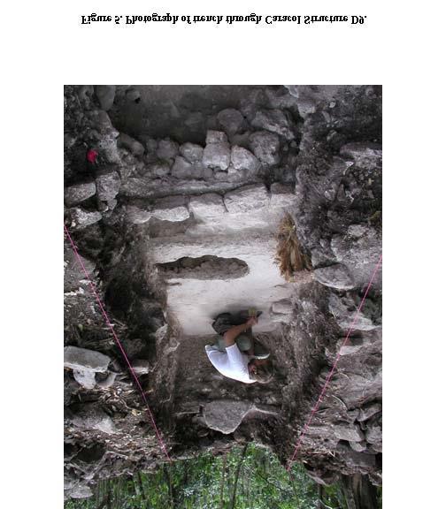
3 particular, investigations concentrated on the smaller structures bounding the southern part of the South Acropolis and on two looted pyramids. The primary focus of investigation was the South Acropolis (Figure 1). Work here in 1990 and 1992 had focused on looted Structure D4 and Structures D17 and D18 (previously investigated by Anderson [1958, 1959]), finding a new tomb in Structure D16. This earlier work had demonstrated that the northern and central parts of the South Acropolis Ð in spite of the recovered tombs Ð did not appear to have a residential function. Thus, it was imperative to discern how the smaller structures may have functioned within this architectural complex. As the Tourism Development Project was slated to start the final stabilization process of the South Acropolis in the Spring of 2003, it was decided to focus the efforts of the Caracol Archaeological Project in this same area to maximize the recovery of archaeological data and aid the clearing efforts that were undertaken by the Tourism Development Project. This would also result in a more comprehensive season report that would incorporate past excavation efforts. A secondary focus of the 2003 investigations were Structures A9 and D1, both of which have been severely looted; the goal was to record the looters' trenches and to carry out limited excavation relative to these two buildings so as to gain an understanding of how these architectural concentrations functioned in terms of the overall epicenter. New South Acropolis Excavations: 2003 The South Acropolis consists of three integrated plaza areas, all sharing the same raised platform. The northernmost plaza is ringed by the largest architecture. The two southern plazas are lower in level than the northern ones and are delimited by smaller constructions. While most of the larger buildings defining the northern plaza of the South Acropolis had been excavated prior to 2003 (see below), no investigations had been undertaken in either the smaller structures comprising the northern plazas or in the smaller western structures of the northern plaza (Figure 2). Given the enigmatic function of the larger architecture in the South Acropolis, it was believed that excavation in these smaller buildings (Structures D8- D15) could hold the key to understanding how the South Acropolis fit into Caracol's urban plan. The conjoined plazas in the South Acropolis and the mix of both larger and smaller constructions are relatively unique at Caracol. Were these structures lived in? Did Structures D9 and D11 fit with more general residential expectations relating to mortuary activities? Or, were all of these buildings used in some other way, perhaps by attached specialists? Excavations undertaken during 2003 sought to determine the form, function, and temporal dimensions of these smaller buildings in an attempt to determine how they were used in relation to the rest of the South Acropolis. In particular, we wanted to know whether they might have served as residential or other special function structures. As a result of the 2003 investigations, residential functions can be assigned minimally to those structures lining the southeast plaza of the South Acropolis. These excavations also succeeded in locating not only in situ burials, but also de facto debris (D. Chase and A. Chase 2000) associated with two different time periods. Investigations did not suggest that these plazas served as craft production areas. It is hoped that future stable isotope studies of the recovered human remains will be able to determine if the individuals consumed the identified palace diet or the lesser protein and maize diet characteristic of the walled areas adjacent to the Machete causeway (A. Chase et al. 2001). Structure D9 Located in the southeast corner of the South Acropolis is a lower plaza level. Structure D9 is the eastern building for the plaza bounded by Structures D7 and D16 to the north, 3 small platforms to the south, and Structure D11 to the west. The structure was selected for excavation to test for the existence of Caracol's typical Late Classic residential group eastern mortuary patterns (A. Chase and D. Chase 1994b). Initial investigation required removal of backdirt from South Acropolis clearing excavations. Suboperation C164B (Figure 3, Figure 4, and Figure 5) consisted of an axial trench, measuring 6.3 m north-south by 1.5 m east-west, placed through the presumed mid-line of Structure D9. Evidence for at least two sequent constructions was uncovered in this locus and four discrete burials were encountered. The core of the latest building contained a reconstructable dish (Figure 12b) and several sherds from a broken face cache. The core of the earlier building consisted of hard-packed fill. Both versions of Structure D9 had been built on a plastered surface that may have
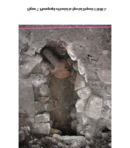
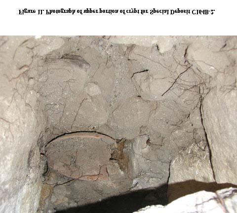
4 represented the original plaza platform and that covered large boulders comprising a dry-core fill; all of the burials penetrated into the dry-core fill level and, thus, their contents were generally not well-preserved. Stratigraphy and artifacts indicate that the Structure D9 construction and use dates to the Late and Terminal Classic eras. S.D. C164B-1 (Figure 6, Figure 7) consisted of a crude crypt placed in front of the final construction of Structure D9. It was sealed by a plaster floor that abutted the lowest step of this edifice. Large capstones covered the partially open-air crypt. The burial deposit had been placed in a small open-air chamber barely below ground level and cut into dry core fill; thus, the contents of the crypt were not well preserved because of collapse and access to animals. Skeletal analysis indicates that there were 2 adults within the chamber, 1 older than the other. Based on the position of the long bones, it would appear that one had been articulated and placed supine with head to the south. Ante-mortem tooth loss is evident in one mandible. Heavy wear was visible on the recovered teeth and calculus deposits were also present. Phalanges and vertebrae show evidence of arthritis. Three vessels (Figure 8) were grouped together in the southern part of the chamber and a concentration of small shell objects (Figure 9) were found beneath the bone towards the north part of the crypt. Their were obsidian blade fragments within the fill. The pottery vessels indicate that this interment dates to the Late to Terminal Classic era. S.D. C164B-2 (Figure 10, Figure 11) was located immediately west of S.D. C164B-1. The southern part of this chamber had been cut away by the placement of S.D. C164B-1, indicating that some time presumably elapsed between the positioning of these two burials. The interment contained the remains of 1 partial adult with head to the north. Associated with this individual were an obsidian lancet and a single pottery vessel (Figure 12a). The vessel type indicates that the crypt may be assigned a Late Classic date. S.D. C164B-3 (Figure 13) was placed within an unlined cist and covered with a minimal number of captstones. The remains consisted of a single individual aged as being from birth to 1 year old at the time of death. No artifactual items accompanied the burial. The burial was placed prior to the construction of the earlier version of Structure D9, probably in the later part of the Late Classic Period. S.D. C164B-4 (Figure 14) was intruded through the floor in front of the lowest step for the earlier version of Structure D9. It was sealed by fill for the steps of the later version of that edifice. It appears that a crude cist was carved out of the dry-core fill and that a single adult with head to the north was placed into the cist and covered by large capstone. The teeth of this individual had pyrite inlays and calculus deposits. No artifacts can be specifically attributed as accompanying this interment, although a complete point (Figure 28d) was recovered in the fill covering the burial. Structure D5 As mapped by Satterthwaite (see Figure 1), only a single structure demarcated the southern side of the southeast South Acropolis plaza. Remapping this area during 2003, however, revealed the existence of three small platforms where one had originally been indicated (Figure 2). The westernmost of these three platforms was randomly selected for testing and was designated as Structure D5 (a label that had originally been incorrectly assigned to the eastern half of Structure D4); the middle platform retained the Structure D10 designation; and, the eastern platform was designated as Structure D36. Suboperation C164C (Figure 15, Figure 16, Figure 17) consisted of an axial trench, measuring 5.3 m north-south by 1.5 m east-west, placed over the westernmost northern platform defining the southeast plaza in the South Acropolis. Clearing the humus within the trench revealed a simple lineof-stone building with two crude broad steps on its northern side. Continued excavation into the core of the upper construction revealed that it immediately overlay another construction that appeared to face east. Two steps for this earlier construction were exposed, the uppermost one in section and the lower one about 50 cm east of section. A floor abutted this lower step; crushed on this floor and against the side of the step were most of four pottery vessels (Figure 18). These vessels represent both serving and storage functions and date to the later part of the Late Classic Period. The remains of a corner of an even earlier construction, represented by the plaster turn-ups of a buried floor and a few facing stones, was recovered in the northern part of this excavation. The northern part of the trench was dug to bedrock and revealed yet one more buried floor. The fill
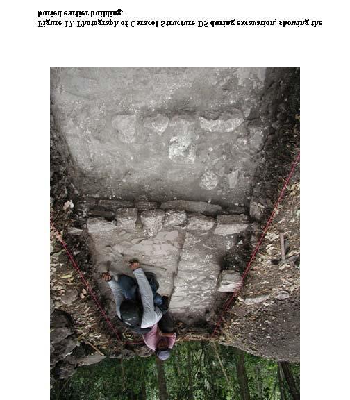
5 material for the lowest flooring was Preclassic in date. Collapsed Chultun A sunken area, or sump, was evident in the plaza between Structure D5 and Structure D16. The surface depression was believed to have been caused by either the collapse of an open-air chamber or of an open-air chultun. Accordingly, the feature was selected for further investigation. Suboperation C164D (Figure 19, Figure 20, Figure 21, Figure 22) consisted of an excavation measuring 4.0 m north-south by 1.65 m east-west placed over the sump that was evident in the plaza. Initial clearing of the humus revealed the remnants of a plaster floor on the north side of the excavation, tilted at an 80 degree angle, indicating that a collapse had indeed occurred. Excavation succeeded in following the collapse downward and revealed a line of stones that ran parallel to the western excavation limit. These stones turned into a wall facing which extended across the limit of the former chultun and abutted its bedrock sides. This facing was set directly on the floor of the chamber. The flooring of the chamber consisted of hard limestone shelves that stepped down from west to east. The entire floor of the chamber was excavated, both behind and in front of the wall. Situated behind the wall and on the floor of the chamber in front of the wall were a series of reconstructible vessels, which permit the use of this chultun to be dated to the Protoclassic / Late Preclassic era (Figure 23: b,c,d,e,f,g,h,j from behind the wall; all others from floor in front of wall). A figurine head (Figure 28a) that can be dated to this same era was found in the collapse that filled the chamber. Structure D11 The most massive structure north of the central architecture is Structure D11. This building forms the western limit for the southeast plaza and the eastern limit for the southwest plaza in the South Acropolis. It extends out of the raised platform supporting Structure D18 and extends to the southern edge of the South Acropolis, effectively blocking passage between the southeast and southwest plazas. Excavation revealed that Structure D11 was part of the southeast plaza, something that could not be ascertained by surface features alone. Suboperation C165B (Figure 24, Figure 25, Figure 26) consisted of an axial trench, measuring 2.0 m north-south by 14.6 m east-west, through Structure D11. Surface clearing of the entire trench revealed no remnants of any stone superstructure, but did find the lower two courses of a stairway on its eastern side. A late plaster floor abutted the lower step. The lack of well-defined architecture may be due to the late date of the last version of Structure D11, if a reconstructible cooking vessel (Figure 27b) found in the western extent of the excavation can be related to the use of this edifice. Penetration of the structure core recovered Late Classic ceramics, a pottery figurine head, and most of a pottery whistle (Figure 28a and 28b). Deep excavation within the core of the latest version of Structure D11 uncovered an earlier version of the structure. The earlier construction's shorter axis ran east-west and measured 4.7 m; it rose 0.75 m above an even earlier platform floor, which ran beneath all of Structure D11. A separate plaza floor abutted the eastern limit of this earlier building, indicating that it too was aligned with the southeast plaza. Penetration of the earlier building's core revealed an almost concrete-like matrix and some isolated human skull fragments. Structure D12 The southwest plaza of the South Acropolis is defined by the rear of Structure D11 on the east, by the rear of Structure D17 on the north, by Structure D13 on the west, and by Structure D12 on the south. Structure D12 was selected for excavation based on the fact that it did not have a large tree blocking its central axis. Suboperation C166B (Figure 29, Figure 30, Figure 31) was an axial trench, measuring 1.5 m east-west by 5.5 m north-south, placed through Structure D12. Like the uppermost buildings throughout all the northern plaza areas in the South Acropolis, the architecture was very indistinct and defined only by lines of stone. Clearing revealed the corner of a potential bench in the southern part of the trench and possible steps in the northern part of the excavation. Three floors were encountered. The uppermost abutted what was left of the latest version of Structure D12. The other two floors lay beneath the fill for Structure D12 and represented platform surfaces capping extensive dry core boulder fill. No deposits were recovered in this excavation.
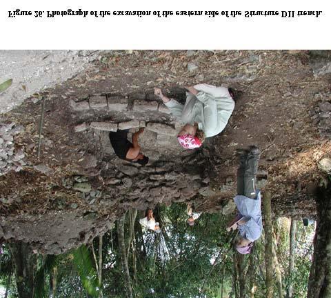
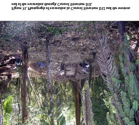
6 Structure D14 Two low buildings, Structures D14 and D15, exist at the western end of the main South Acropolis plaza. Structure D14 was selected for excavation because of its position on the southern side of this plaza and the fact that all of the other southern buildings in this plaza (Structures D16, D17, and D18) had produced tombs. Structure D14 did not conform to this pattern. Suboperation C163B (Figure 32, Figure 33, Figure 34) consisted of an axial trench 1.5 m east-west by 6.0 m north-south placed over Structure D14. Initial clearing revealed several lines of stone representing a multi-level perishable building. Penetration of the core of this latest construction revealed an early construction represented by a single line of stone set upon the original plaza floor. Unlike the dry-core fill found beneath the southern plaza floors, the fill for the upper plaza floor consisted of large fill stones set within a hard-packed dirt matrix. No deposits were recovered in this investigation. Summary of New 2003 South Acropolis Excavations The new 2003 excavations Ð now all backfilled - focused on smaller structures in the South Acropolis and significantly added to the time depth for the occupation of this area through the recovery of the extensive deposit of Late Preclassic / Protoclassic materials from the collapsed chultun. The vessel from the rear of Structure D11 also indicates that this area was used through the end of the Terminal Classic era. No workshop debris could be detected in any of the recovered artifactual remains from the excavations in the small structures of the South Acropolis. As the excavations were large enough to have recovered such debris, it does not appear that these buildings were used for the production of specialized artifacts. However, a good case can be made that at least the southeast plaza functioned as a residential group. Not only were four Late-to-Teminal Classic burials recovered in Structure D9, but serving and storage vessels were recovered on an earlier floor within Structure D5. These data strongly suggest that the northeast plaza of the South Acropolis was a residential area. However, a new question is raised by these data. What is the relationship between the inhabitants of the southeast plaza and the rest of the South Acropolis? Were these individuals caretakers or the primary users of this area? This question can still not be answered definitively without additional analysis. Continuing South Acropolis Excavations: 2003 Prior to the 2003 field season, the major architecture in the South Acropolis had been partially, but not completely, tested and excavated. Initial excavations within this group were originally conducted by Belize's first archaeological commissioner, A.H. Anderson (1958, 1959), in the 1950s. Clean-up and areal clearing intended to make the area more readily accessible to tourists was the primary focus of the subsequent USAID- GOB funded Caracol Archaeological Project investigations carried out in 1990 and These investigations recorded and amplified the previous work that had been done on Structures D17 and D18 and cleaned up and recorded the looting that had occurred on Structure D4 (before exposing the entire building); the research also uncovered a new tomb in Structure D16 and tested Structures D6 and D7. All of Anderson's open excavations were backfilled, as were the looter's trenches in Structure D4. Furthermore, the summits of Structures D4 and D17, the western base of Structure D18, and the tombs in Structures D17 and D18 were all stabilized as an outcome of this effort. The archaeological data collected as a result of this work suggested that the three central buildings in the South Acropolis functioned as important, presumably non-residential, mortuary structures and that Structure D4 had not had a residential function. The recent Tourism Development Project at Caracol also selected the South Acropolis as one of its focal points for further stabilization. The Caracol Archaeological Project carried out a close articulation with the TDP during 2003 and helped in the clearing efforts for these buildings through assigning lots and processing artifacts that came from the TDP excavations (the suboperations assigned to TDP excavations in the South Acropolis are shown in Figure 35). Based on the TDP clearing effort (Figure 36), the CAP also added to plans and sections that had been started in 1990 and 1992 for Structures D4, D6, D7, D16, D17, and D18. An additional penetrating excavation was also undertaken in Structure D4. Structure D4
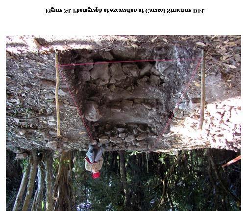
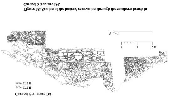
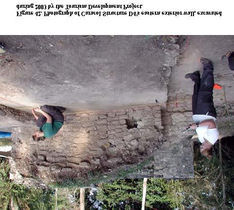
7 When visited in 1983, the western half of Structure D4 had been pitted by looters. A deep trench ran through the western side of Structure D4, penetrating both a bench located here and the floors beneath the bench. Because of this looting and the revealed architecture, Structure D4 was selected for further excavation in 1990 and was then subsequently stabilized by the Caracol Archaeological Project during the 1991 field season. Once it was uncovered, it became evident that Structure D4 formed a formal entranceway into the South Acropolis. Individuals would have had to pass through this building in order to enter the plazas and structures beyond. With its two massive side benches, Structure D4 can be thought of as something like a waiting area and/or guardhouse. The ancillary buildings, permanent to the west and impermanent to the east, faced north Ð to parts of the site exterior to the South Acropolis. Thus, the enitre northern building Ð Structure D4 and its wings Ð served to provide privacy to any activities that were carried out within the plazas making up the South Acropolis. Suboperations C72BÐC72J consisted of excavations undertaken in 1990 that were involved in the areal clearing of Structure D4 and its western annex (Figure 37). Suboperation C72B involved the clean-up of the looters' trench through the western summit of Structure D4; this section (Figure 38) was augmented by Supoperation C72H which excavated the southern area exterior to the building. Suboperation C72I consisted of the axial trench through Structure D4 (Figure 39). This excavation revealed the existence of earlier buildings buried in the core of Structure D4, in fact revealing the buried side of an earlier construction that appeared to face to the south. Special Deposit C72B-1 was assigned for the heavily burnt, fragmentary, and plentiful human remains that were found within a pit in the northern extent of the trench that encompassed the original looters' excavation. The black soil that defined this pit was sealed by eroded light brown floor bedding for the floor surface that was immediately north of Structure D4. Within this pit were the cremated remains of minimally one individual. The only other materials found in association with this human bone were fragmentary obsidian blades. Suboperation C72K was an excavation carried out in February 1994 on axis to Structure D4 to look for a lower northern step (Figure 40). The excavation recovered a single row of stone and measured 1.5 m north-south by 3.0 m east-west. Suboperations C72LÐC72Q were assigned during the 2003 field season for clearing excavations undertaken by the TDP in and around Structure D4 (see Figure 35 and Figure 42). For the summit excavations, the newly revealed architecture was drawn at 1:20 and added to earlier drawings (Figure 37). Additionally, Suboperation C72N was assigned to a 2 m north-south excavation used to penetrate the terrace immediately south of Structure D4 and add the dry core fill that was revealed to the earlier section (Figure 39). A small test was also made in a discontinuity in the plaster surface west of Structure D4 within Suboperation C72M (Figure 41), but it proved to only be an area of eroded flooring. Structure D6 A flat area was evident on the northern flank of the arm linking Structures D4 and D7. This platform, noticeable in mapping, had been designated Structure D6. Suboperation C89B (Figure 43, Figure 44) was assigned for an exploratory excavation made into Structure D6 during the 1992 field season. All that was discovered were crude walls comprising the rear wall for the western arm of Structure D4 and the eastern limit of the Structure D4 southern stair outset. In reality, Structure D6 was probably not a formal building, but was rather just an architectural terrace. Structure D7 Dominating the eastern side of the main interior plaza of the South Acropolis is Structure D7. A small excavation was made at the base of Structure D7 in 1992 by the CAP, but recovered no visible architecture. In 2002, the TDP cleared the entire building prior to its stabilization. They too found a lack of visible architecture on the sides and base of the structure. At the summit of Structure D7, however, three building substructures were uncovered. The central one was set back to the east and the two side substructures faced the central platform (see Figure 2). Suboperations C91B and CD20A (Figure 45) were assigned to excavations undertaken in Structure D7. Suboperation C91B was 3.8 m east-west by 2.0 m north-south excavation placed on axis to Structure D7 at its base in This excavation was halted after initial clearing because it
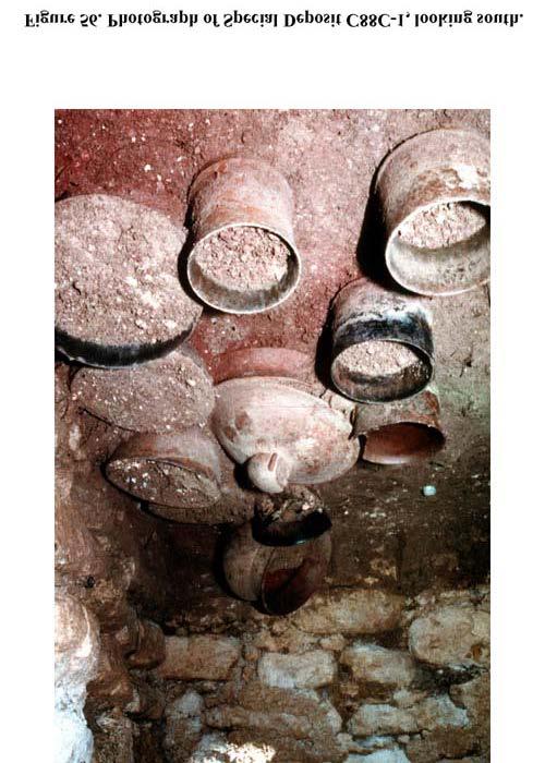
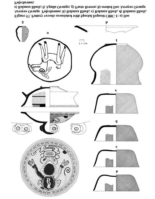
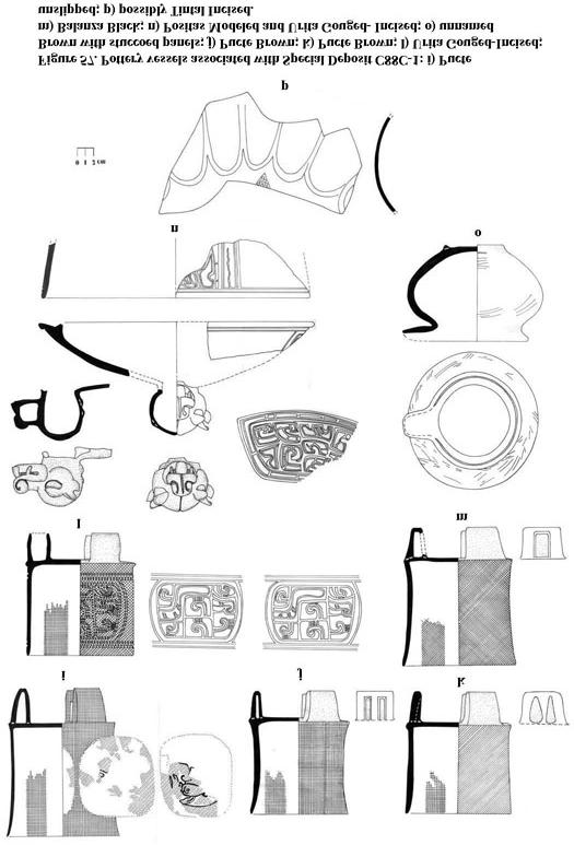
8 recovered neither architecture nor any evidence of caching activity, as would normally be expected if the structure had functioned as an eastern ancestral shrine (D. Chase and A. Chase 1998). Suboperation CD20A was assigned to the clearing of Structure D7 in 2002 by the Tourism Development Project prior to stabilization in These excavations recovered 3 substructures at the summit of the building, but little else in the way of architecture. Two tombs were, however, encountered during the 2002 clearing operations; data presented below indicates that these chambers appear to have been used relatively early in the history of the South Acropolis and that at least one had been re-entered (see D. Chase and A. Chase 2003). All of the mortuary activity in the central structures post-dates the use of the eastern Structure D7. Special Deposit C20A-1 (Figure 46) was assigned for a tomb that was encountered in the core of the central summit substructure south of the central axis. No pottery vessels were recovered from this chamber. Presumably because of its proximity to the surface and its location in dry core fill, the bone was not in a good state of preservation. Special Deposit C20A-2 (Figure 47) was assigned for a tomb that was found partway down the western slope of Structure D7. This tomb had been refilled with core material and, because it shows no indication of having intact capstones, is believed to have been accidentally re-entered at a later time and then treated in accord with other patterns that are noted for Caracol (D. Chase and A. Chase 2003). Some of the nine vessels (Figure 48) that can be assigned to this chamber were clearly intact on the floor of the chamber, according well with an accidental re-entry. However, the inclusion of potential cache vessels (specifically Figure 48a) in this chamber as well as "Charlie Chaplins" (Figure 49e and 49f) and other small shell objects generally found in caches is problematic and may indicate that specific rituals were carried out when this re-entry occurred. The presence of 4 limestone bars (Figure 49a-d) in this chamber is also intriguing given their presumed association with weaving and twining. The nine vessels that were recovered in association with S.D. CD20A-2 are all of Early Classic date and this assemblage is clearly earlier than any of the other mortuary deposits encountered in the South Acropolis. Structure D16 The architectural focus of the South Acropolis is the large raised platform that makes up the southern side of its main plaza. Three buildings surmount this raised platform: Structure D17 on the west end; Structure D18 in the middle; and, Structure D16 on the eastern end (Figure 50). In contrast to Structures D17 and D18, Structure D16 is barely visible in terms of architecture, appearing almost as if a flat surface with a slight bump across its northern end. This appearance may be due to later stone-robbing at this locus, especially as it is clear that a complicated architectural sequence exists here and that Structure D16 is earlier than either Structure D17 or Structure D18. Suboperations 88B and 88C (Figure 51, Figure 52) were assigned for the areal clearing and axial penetration of Structure D16 during Suboperation C88B was assigned for the western part of the summit structure and its articulation with Structure D18. Suboperation C88C was assigned for the axial trench and the eastern part of Structure D16's summit. At least 3 building phases could be ascertained as a result of these excavations. The latest building phase was represented by a partial facing at the summit of the plaza above all other floors and walls; its existence lends strong support for an interpretation of stone-robbing at this locus. The middle phase of construction has low broad steps leading up to the summit of the platform. It was cut through on its western end by a covered crypt and it, in turn, is believed to seal an Early Classic tomb in its core. At least in the front of Structure D16, this middle phase overlays even earlier platforms, which appear to be off-axis to the east from the construction that is now visible. Special Deposit C88B-1 (Figure 53) cut into architecture that makes up the middle phase of construction for Structure D16. When uncovered, the crypt had its capstone intact, but was literally just under the ground surface. For whatever reason, no bone or artifacts were recovered in this crypt. Special Deposit C88C-1 (Figure 54, Figure 55, Figure 56) was assigned to a well constructed tomb that was presumably sealed by the middle construction effort in Structure D16. When found, the chamber was barely a meter below the ground surface. At one time, the interior walls of the chamber had been plastered. The floor of the tomb had a layer of cinnabar under the vessels and bones. The tomb contained the remains of 2
9 individuals, both of whom were adults and 1 of whom was female. Nine teeth inlaid with pyrite were recovered, all from one individual and all maxillary teeth indicating that one of the individuals had decorated teeth from premolar to premolar. Thirteen whole and 3 partial ceramic vessels were recovered from the chamber, all of Early Classic date (Figure 57a, Figure 57b). Other artifacts from the chamber include a set of composite obsidian earflares (Figure 58c), 2 antler figurines (Figure 58a and 58b), 4 complete spondylus shells, 5 stingray spine fragments, 2 pyrite mirror pieces, 237 shell beads, 12 shell inlays, 1 shell pendant, 1 shell figure, 2 shell tubes, 3 pearls, 1 jadeite pendant, 3 jadeite beads, 2 crystal mosaic inlays, 48 hematite mosaic pieces, 75 malachite mosaic pieces, and 1 obsidian drill. Suboperations 88D and 88E were assigned in 2003 for the basal excavations on axis to Structure D16 (C88E) and for the basal excavation of the eastern side and northeast corner of Structure D16 (C88D). In general, only a basal course of cut stone was recovered on the northern side of the platform. Structure D17 The western side of the central platform was crowned by Structure D17. A.H. Anderson excavated a tomb in this building in He then returned in subsequent years to continue excavations at Caracol. A short visit is recorded in 1954 with Gordon Willey and a full field season is noted for During one of these seasons, it is believed that Anderson placed an axial trench through Structure D17. In 1990 this open excavation was recorded and backfilled when Structure D17 was areally exposed. Structure D17 was consolidated during the 1991 field season. The building proved to have three doors facing south and three inner doors to the rear room, the eastern two of which were blocked by later construction. As excavated, the eastern part of the inner rear room contained a series of raised platforms, as if a stair to a second story. The western part of Structure D17 was gone, having presumably slid off the summit. Suboperation C37B (Figure 59, Figure 60) was designated for the areal excavation of Structure D17 and for the clean-up of Anderson's trench during the 1990 field season. Once the building was cleared, a cross-section was also drawn showing the relationship between Structure D18, Structure D17, and S.D. C37B-1 (Figure 61). During this work, a footed cylinder (Figure 27a) was found in the alley between Structure D17 and Structure D18. Special Deposit C37B-1 (Figure 62) was excavated by A.H. Anderson in He entered the tomb through its collapsed entrance and found a single adult in the chamber who was accompanied by 9 well preserved pottery vessels of early Late Classic date and 4 jadeite beads. After excavation, Anderson placed a wooden door in the entranceway and used the tomb as a storage area. Suboperation C37E and C37J were designated for excavations undertaken during the 2003 field season at the base of Structure D17. Suboperation C37E continued the Structure D17 section line to include the northern basal architecture. A single line of stone articulating with the associated plaza floor was encountered in this excavation. Suboperation C37J was designated for materials that were recovered as a result of the excavation of the basal substructure corner for Structure D17. Structure D18 Perhaps the most important building in the South Acropolis, Structure D18 commands not only the central platform, but also the entire South Acropolis. Little of the latest building remains, presumably removed by A.H. Anderson in 1958 when he excavated the infilled tomb in Structure D18. The CAP excavations revealed that, Structure D18, which faced north, covered an earlier building that had once faced west. When the final phase of Structure D18 was built, the earlier building had been converted into a large tomb with an entryway being constructed through the building's north wall. This entryway had been hidden within the frontal stairway for the latest version of Structure D18. At some point in time, it may be surmised that the tomb roof collapsed or that access was accidentally gained into the tomb. This appears to have occasioned the removal of the chamber's roof and its infilling. Luckily, this fill was placed over the intact remains of the chamber; its re-entry patterns are in accord with others noted for Caracol (D. Chase and A. Chase 2003).
10 Suboperations C37C and C37D (Figure 63, Figure 64, Figure 65) were assigned for archaeological work undertaken on Structure D18 in 1990 (C37C) and 1992 (C37D). This work included opening up an axial trench through the building as well as areally clearing the structure's outer walls, the western side in 1990 and the eastern side in The latest version of Structure D18 had two stairway modifications, both of which covered the tomb included in the core of the construction. Axial excavations in the southern portion of Structure D18 revealed the southern wall of the buried building. Excavations west of the room used as a tomb demonstrated that the buried building had once been a two-room edifice. The single inner door of this building had been blocked when the rear room was turned into a tomb. The rear room also had a bench, which continued beneath the make-shift southern wall for the tomb chamber. Excavations on the northern exterior of this buried building succeeded in getting down to plaza level, something that Anderson (1959) could not do. Deep excavations into the core of the earlier building recovered a large ceramic sample (Figure 66a, Figure 66b) that indicates that this earlier building must have been constructed in the Early Classic era. Remnants of even earlier constructions were recovered buried in the core of the earlier building at plaza level. Special Deposit C37C-1 (Figure 67, Figure 68) was excavated by Anderson in Nails, used to guide his drawings, were recovered in 1990 during the clearing of this chamber. Anderson (1959) had originally found the entranceway to the buried tomb because the stairway for the latest version of Structure D18 had collapsed. However, the tomb had been completely infilled with construction core and he entered it by digging down through the core of the latest version of Structure D18. That everything was intact on the floor of the chamber is consistent with an ancient accidental tomb re-entry (D. Chase and A. Chase 2003). Two articulated adult individuals were recovered from within the tomb. On the bench was a supine body with head to the south and with inlaid jadeite teeth; on the floor west of the bench was another individuals with head to the north. Fourteen pottery vessels accompanied this interment along with 1 figurine and 1 whistle as well as "scores of tiny flat beads made of shell and jade and scores of very small oliva shells" (Anderson 1959: ). The vessels all date to the early part of the Late Classic Period (Tepeu 1 equivalent vessels). Suboperations C37F-C37I were new excavations undertaken during the 2003 field season prior to final stabilization. Suboperation C37F was assigned to the continuation of the axial trench through Structure D18. Suboperations C37G and C37H were assigned for the areal clearing of the northern face of the platform supporting Structure D18. Suboperation C37I was assigned to all materials coming out of the central plaza of South Acropolis during New 2003 Non-South Acropolis Excavations: Structures A9 and D1 Structures A9 and D1 had already been looted by the onset of the first full season of the Caracol Archaeological Project in The summit of Structure A9 had an open east-west trench through it. A summit-to-base trench had been driven into Structure D1 from its western side. Cursory examination of the looters' trenches in each of these structures in 1985 showed no evidence that any deposits had been encountered; however, the trenches were not formally cleared and recorded. The 2003 field season remedied this situation. Structure D1 Structure D1 is situated strategically adjacent to the main reservoir north of the South Acropolis. Although appearing to be in isolation, it likely formed an architectural complex with Structure D2, a tall pyramid located on the edge of the raised epicentral area immediately west of Structure D1. As a result of the 2003 investigations, it is possible to state that Structure D1 faced west, as all of its intact facings were oriented in this direction. However, the sides of Structure D1 were not investigated, meaning that its form is still not known. Nor is its obvious relationship with the main reservoir understood. Suboperations C167B and C167C (Figure 69, Figure 70, Figure 71) were assigned to excavations undertaken to understand the architecture and construction of Structure D1, a building that had been savaged by an earlier looters' trench. The sides of the open excavation were cleaned and drawn, finding only a very few facings halfway up the trench. Multiple phases of Structure D4 had once existed, with the dry-core fill
11 making up the core of most of these buildings. No deposits were encountered. The artifactual materials recovered in the core of the building can only be used to place the latest construction effort for Structure D1 in the broadest sense of the Late Classic Period (i.e., after A.D. 550). Suboperation C167C was a new excavation, measuring 3.05 m east-west by 1.25 m north-south, made at the summit of D1 that effectively was a continuation of the open trench. Together Suboperations C167B and C167C stretched for a total distance of 15.7 m. Two steps that were oriented to the west as well as a preserved floor were encountered in Suboperation C167C (Figure 70). All of the open excavations in Structure D1 were backfilled as a conjoined effort of the CAP and TDP following recording. Structure A9 The summit of Structure A9 had looted prior to 1985, but neither major architecture nor deposits had been encountered. Based on the spatial relationships between structures immediately south of Caracol's A Plaza (Figure 72), it appeared on the map that Structures A9 and A15 formed a two-building group. They both shared the same raised platform and appeared to demarcate a small private plaza on the very edge of the western epicenter. However, the exact relationship of Structure A9 to other buildings in this part of Caracol was not clear. A narrow alley separated Structures A1 and A9. However, the western "end" of this alley was defined by a structural projection appended to the back of Structure A1; this platform had yielded a tomb, 2 caches, and a greater than life-size seated stucco figure (A. Chase and D. Chase 1997). Thus, Structure A9 could have been associated with this ritual complex as well. Small excavations were, therefore, undertaken at the base of Structure A9 to resolve its relationship to either Structure A15 or Structure A1. Surprisingly, these excavations revealed that Structure A9 faced east and was probably paired with the south-facing Structure A8 to form a small, very open plaza area at the southeast entrance to the A Plaza. Suboperation C162B (Figure 72, Figure 73) was a 2 m by 2 m excavation set in the presumed corner formed by Structure A9 and the raised platform that was also associated with Structure A15. No formal architecture was encountered. Rather, a sloping layer of construction fill was encountered, the top of which was littered with broken pottery. One of the vessels encountered in this lens proved to be a rather large reconstructible olla (Figure 74). As a result of this investigation (and others undertaken during 2003), it may be posited that the area south of Structure A9 and west and north of Structure A15 was in the process of being infilled at the end of the Terminal Classic Period, probably to form a base for future construction. Suboperations C162C and C162D (Figure 72, Figure 73, Figure 75) were two small trenches placed along the northern base of Structure A9 to determine if this structure faced south. Suboperation C162C measured 3 m north-south by 2 m east-west and succeeded in finding a terrace facing and plaza floor that were associated with Structure A9. This excavation also encountered a crude line of stone that projected at right angles from the terrace facing and probably represented a basal pad for a perishable structure (Figure 75). In order to ensure that this line-of-stone did not represent the ripped-out side of a stairway, a second excavation was placed 1.5 m west of Suboperation C162C. Suboperation C162D measured 2.2 m northsouth by 1.6 m east-west. This excavation was dug down to the same plaza floor level that had been found in Suboperation C162C. Like C162C, Suboperation C162D did not reveal any steps; nor were any other architectural features found in this test. Based on these two investigations, it was determined that Structure A9 did not face south. Suboperation C162E (Figure 72, Figure 76, Figure 78) was placed over the eastern basal axis of Structure A9 in line with the looters' trench on the summit. Suboperation C162E measured 2.8 m north-south by 2.2 m east-west. It was located 2.8 m north of Suboperation C162B. This investigation produced the missing stairway for Structure A9. At least 5 distinct steps could be delineated within the areal investigation. These steps rested direct on a plastered plaza floor. A test through this plaza floor produced no deposits, but did contain Late Preclassic sherd material. This excavation demonstrated that access to the Structure A9 summit was gained from its eastern side. Suboperation C162F (Figure 77) was assigned for material was recovered as a result of detailing the east-west looters' trench at the summit of Structure A9. No dateable material was recovered. While a plaster floor could be seen in the summit section, no facings could be discerned that
12 were associated with it. A smaller north-south cross-trench at the summit was not recorded. Summary Previous excavations have shown that Caracol, like other urban centers, is composed of architectural units with differing functions. Epicentral Caracol is at the heart of the site's urban landscape and is tied to the surrounding core area settlement and agricultural fields via its intrasite causeways. Many architectural units within the site epicenter differ from those found in the surrounding hinterland, varying in architectural form and serving a greater variety of functions relating to residence, ritual, administration, and production. The 2003 research investigated urban form and function by excavating in several less well-studied areas of the Caracol epicenter, particularly the smaller structures directly associated with the South Acropolis and previously looted structures not directly associated with Caracol's major plazas. The investigations undertaken during the 2003 field season not only complemented research undertaken during previous seasons at the site by the Caracol Archaeological Project, but also will worked with and supplemented the stabilization efforts undertaken as part of the IDB Tourism Development Project directed by Dr. Jaime Awe. The bulk of the 2003 work focused on the South Acropolis and it is appropriate to try to place the results of this work within a broader perspective. Initially, the excavations within the small structures south and west of the South Acropolis's larger architecture had hoped to find workshop or activity areas that could be related to attached specialists. There were not found. However, the work undertaken within these buildings helps place the South Acropolis into temporal context. The ceramics encountered in the collapsed chultun in the South Acropolis' southeast plaza demonstrate that the South Acropolis was flourishing at the end of the Late Preclassic Period and that ritual activities were taking place in this vicinity even then (based on the recovered incensarios). Further investigations in the South Acropolis would undoubtedly find other deposits associated with this time period. By the beginning of the Early Classic Period, the South Acropolis appears to have functioned as an elite residential unit. Structure D7 was clearly used as a mortuary structure with burial patterns that were consistent with those found in later residential groups. Had deeper penetration been made of this badly preserved building, a tomb dating to the Late Preclassic / Protoclassic era may have been encountered. However, the residential functions of the South Acropolis shifted sometime toward the end of the Early Classic Period. This is indicated not only by the mortuary patterns found in the southern Structures D16, D17, and D18 that span the late Early Classic to early Late Classic, but also by the construction of a formal eastern temple (now buried within Structure D18) in the later part of the Early Classic as well. The architectural additions to the South Acropolis at the end of the Early Classic, the southern mortuary focus that continued through the middle of the Late Classic, the re-entry of the Structure D7 lower tomb, and the construction of a non-residential southern gateway building (Structure D4) for the South Acropolis all indicate that the function of this area had shifted to other activities by the beginning of the Late Classic era. The poor preservation and stone removal in the central architecture of the South Acropolis indicate that its main plaza never regained a residential function. However, the 2003 excavations in the smaller structures surrounding the southeast plaza of the South Acropolis indicate that this group did have a residential function sequent to the deposition of the Late Classic tomb in Structure D17. In situ ceramics recovered on an early floor within Structure D5 indicate serving and storage functions here in the later part of the Late Classic Period. Burials recovered from Structure D9 also date from this same time, but continue into the Terminal Classic Period as well. Thus, an intriguing temporal sequence can be established for the South Acropolis in which the complex apparently started out as an elite residential unit in the Late Preclassic to Early Classic Period, shifted to a non-residential, presumably public function at the end of the Early Classic Period, and then partially regained a residential function in the later part of the Late Classic Period. From a practical standpoint, the concentration of the 2003 research excavations in a single portion of the site that was undergoing stabilization not only greatly facilitated in-field communication and movement of personnel, but also permitted the integration of archaeological data collected over half a century. The long-term research approach taken by the Caracol Archaeological Project also means that each field season
13 provides additional understanding and field data that can be conjoined with previously accumulated information to shed new light specifically on the site of Caracol and, eventually, on broader questions concerning the ancient Maya. Acknowledgements The figures included within this report were drafted by Amy Morris and Anna Ostrowska, as well as by Arlen and Diane Chase; all figures were finalized in Photoshop by Arlen Chase. The IDB Tourism Development Project, directed by Jaime Awe, provided the original plan of the in situ artifacts in the lower Structure D7 tomb. Dr. Awe also significantly aided in easing the Caracol Archaeological Project logistics for the 2003 field season; among numerous other things, his Tourism Development Project handled the bureaucratic paperwork for our Belizean workmen, provided our camp with electricity, and - most importantly - constructed a new "two-seater" for project use. References Anderson, A.H "Recent Discoveries at Caracol Site, British Honduras." Proceedings of the 32 nd International Congress of Americanists, pp , Copenhagen "More Discoveries at Caracol, British Honduras." Actas del 33 rd Congreso Internacional des Americanistas, pp , Costa Rica. Burgess, Ernest W (1967) "The Growth of the City: An Introduction to a Research Project." In R.E. Park, E.W. Burgess, and R.D. McKenzie, Eds., The City, pp University of Chicago Press, Chicago. Chase, Arlen F "Planeacion Civica e Integracion de Sitio en Caracol, Belice: Definiendo una Economia Administrada del Periodo Clasico Maya," Los Investigadores de la Cultura Maya 6(1):26-44, Universidad Autonoma de Campeche, Campeche. Chase, Arlen F. and Diane Z. Chase 1994a "Details in the Archaeology of Caracol, Belize: An Introduction." In D. Chase and A. Chase, Eds., Studies in the Archaeology of Caracol, Belize, pp Monograph 7. Pre-Columbian Art Research Institute, San Francisco. 1994b "Maya Veneration of the Dead at Caracol, Belize," in Merle Robertson and Virginia Fields, Eds., Seventh Palenque Round Table, 1989, pp , Pre-Columbian Art Research Institute, San Francisco Caracol Archaeological Project Season Report, available at "Scale and Intensity in Classic Period Maya Agriculture: Terracing and Settlement at the 'Garden City' of Caracol, Belize," Culture and Agriculture 20(2): a "Ancient Maya Causeways and Site Organization at Caracol, Belize," Ancient Mesoamerica 12(2): b "The Royal Court of Caracol, Belize: Its Palaces and People," in Takeshi Inomata and Stephen D. Houston, Eds., Royal Courts of the Ancient Maya: Volume 2: Data and Case Studies, pp , Westview Press, Boulder. Chase, Arlen F., Diane Z. Chase, and William A. Haviland 2002 "Maya Social Organization from a "Big Site" Perspective: Classic Period Caracol, Belize and Tikal, Guatemala." InV. Testler, R. Cobos, and M. Greene, Eds., La Organizaci n Social entre los Maya Prehispanicos, Coloniales, y Moderno, pp Instituto Nacional de Antropolog a e Historia, Mexico, D.F. Chase, Arlen F., Diane Z. Chase, and Christine White 2001 "El Paisaje Urbano Maya: La Integraci n de los Espacios Construidos y la Estructura Social en Caracol, Belice," in A.Ciudad Ruiz, M. Josefa Iglesias Ponce de Leon, and M. Del Carmen Martinez Martinez, Eds, Reconstruyendo la Ciudad Maya: El Urbanismo en las Sociedades Antiguas, pp , Sociedad Espanola de Estudios Mayas, Madrid. Chase, Diane Z. and Arlen F. Chase 1998 "The Architectural Context of Caches, Burials, and Other Ritual Activities for the Classic Period Maya (as Reflected at Caracol,
14 Belize)," in Stephen D. Houston, Ed., Function and Meaning in Classic Maya Architecture, pp , Dumbarton Oaks, Washington, D.C "Inferences about Abandonment: Household Archaeology and Caracol, Belize." Mayab 13: "Secular, Sagrado, y Revisitado: La Profanacion, alteracion, y reconsagracion de los Antiguos Entierros Mayas," in A. Ciudad Ruiz, M.H. Ruz Sosa, and M.J.Iglesias Ponce de Leon, Eds., Antropolog a de la Eternidad: La Muere en la Cultura Maya, pp , Publicaci n 7, Sociedad de los Estudios Mayas, Madrid. TABLE 1: Caracol Project Members: 2003 Field Season Staff: Amy Morris C111 Arlen F. Chase C1 Diane Z. Chase C2 Jorge Garcia C144 Amanda Groff C150 Ben Marshall C152 Willie Rivers C138 Shawn Botts C157 Shoshana Caplan C158 Melina Hoffman C159 Kerri Masem C160 Jennifer Navarra C161 Shayna Michaels C153 Eric Shippee C162 Megan Simpson C163 Erik Stanley C164 Belizean Labor: Rita Wilshire Marvin Alexander Chable Carlos Castellanos Carlos Castellanos, Jr. Jaime Iglesias Mis Noe Rivas Aurora Gongora Alicia Hernandez Carlos Ivan Mendez Figures Figure 1. Reconstructed plan of the South Acropolis and its buildings prior to the 2003 field work (from A. Chase and D. Chase 2001b). Figure 2. New plan of the South Acropolis made during the 2003 field season, showing actual lines of stone as well as excavations undertaken in 2003; plan is not full rectified. Figure 3. Axial section through Caracol Structure D9. Figure 4. Upper and lower plans of the excavation through Caracol Structure D9.
15 Figure 5. Photograph of trench through Caracol Structure D9. Figure 6. Plans related to Special Deposit C164B-1: capstones overlaying burial and burial itself. Figure 7. Photograph of burial in Special Deposit C164B-1. Figure 8. Vessels from Special Deposit C164B-1: a) probably Azucar Impressed; b) probably Azucar Impressed; c) Belize Red. Figure 9. Shell artifacts associated with Special Deposit C164B-1. Figure 10. Plan of Special Deposit C164B-2. Figure 11. Photograph of upper portion of crypt for Special Deposit C164B-2. Figure 12. Vessels from Caracol Structure C9: a) eroded Machete Polychrome from Special Deposit C164B-2; b) probably eroded Machete Polychrome from within core of Structure D9. Figure 13. Plan of Special Deposit C164B-3. Figure 14. Plans related to Special Deposit C164B-4: capstones overlaying burial and burial itself. Figure 15. Axial Section through Caracol Structure D5. Figure 16. Upper and lower plans of axial excavation through Caracol Structure D5. Figure 17. Photograph of Caracol Structure D5 during excavation, showing the buried earlier building. Figure 18. Vessels associated with the buried earlier building in Caracol Structure D5: a) probably Machete Polychrome; b) eroded Palmar Orange-Polychrome; c) Subin Red; d) Cambio Unslipped. Figure 19. North-south Section of collapsed chultun in excv. C164D and recovered wall profile. Figure 20. East-west Cross-Section of collapsed chultun in excv. C164D. Figure 21. Plan of chultun bottom in excv. C164D. Figure 22. Photograph of in situ pottery being excavated at the bottom of the collapsed chultun (excv. C164D) and east of the chultun wall facing. Figure 23a, Figure 23b, Figure 23c Figure 23. Pottery recovered in association with the bottom of the collapsed chultun (excv. C164D): a) Sierra Red; b) possibly Union Appliqued; c) Sapote Striated; d) Lagartos Punctated; e) Paila Unslipped; f) Alta Mira Fluted; g) Paila Unslipped; h) unnamed type; i) Sierra Red; j) Sierra Red; k) Sierra Red; l) Paybono Black; m) Sierra Red; n) Lagartos Punctated; o) Sierra Red; p) Sacluc Black-on-Orange; q) unnamed type; r) possibly Sarteneja Usulutan; s) related to Paila Unslipped; t) Sierra Red; u) Laguana Verde Incised; v) Paila Unslipped; w) Paila Unslipped; x) Paila Unslipped; y) burned Altar Mira Fluted; z) Sapote Striated; aa) unnamed punctuated type. Figure 24. Axial Section through Caracol Structure D11. Figure 25. Plan of Caracol Structure D11 with humus removed. Figure 26. Photograph of the excavation of the eastern side of the Structure D11 trench. Figure 27. Terminal Classic pottery vessels recovered in association with Structures D11
16 [b) Cambio Unslipped] and D17 [a) eroded Danta Polychrome]. Figure 28. Artifacts recovered from the South Acropolis southern excavations: a) ceramic head from excv. C164D; b) ceramic head from excv. C165B; c) pottery whistle [minus head] from excv. C165B; d) chert point from excv. C164B. Figure 29. Axial Section through Caracol Structure D12. Figure 30. Plan of excavation through Caracol Structure D12 after removal of humus. Figure 31. Photograph of excavation in Caracol Structure D12 and the western end of the excavation through Caracol Structure D11. Figure 32. Axial Section through Caracol Structure D14. Figure 33. Plan of excavation through Caracol Structure D14 following removal of humus. Figure 34. Photograph of excavation of Caracol Structure D14. Figure 35. Schematic diagram of the northern plaza and structures of the South Acropolis showing the locations of the suboperations related to the clearing operations undertaken by the Tourism Development Project and the Caracol Archaeological Project. Figure 36. Photograph of central platform in the South Acropolis undergoing clearing excavation during Figure 37. Detailed plan of Caracol Structure D4 and its "wings." Figure 38. Section of the looters' excavation through the southern bench in Caracol Structure D4. Figure 39. Axial Section of Caracol Structure D4 [through its central doorways]. Figure 40. Axial Section of the 1994 test through the basal stair of Caracol Structure D4. Figure 41. Section of a 2003 test through the eastern "wing" of Caracol Structure D4. Figure 42. Photograph of Caracol Structure D4's eastern exterior wall, excavated during 2003 by the Tourism Development Project. Figure 43. Section through the 1992 Caracol Structure D6 excavation. Figure 44. Plan of the 1992 Caracol Structure D6 excavation. Figure 45. Section and Profile from 1992 work on Caracol Structure D7 with the addition of the two tombs and the basal facing found during 2002 by the Tourism Development Project. Figure 46. Section, Cross-Section, and Plan of the upper Caracol Structure D7 tomb. Figure 47. Cross-Section and Plan of the lower Caracol Structure D7 tomb. Figure 48. Pottery vessels recovered in association with the lower Caracol Structure D7 tomb: a) Quintal Unslipped; b) eroded Dos Arroyos Orange Polychrome; c) Quintal Unslipped; d) Quintal Unslipped; e) Quintal Unslipped; f) Quintal Unslipped; g) eroded Balanza Black; h) Pita Incised; i) Quintal Unslipped. Figure 49. Artifacts recovered in association with the lower Caracol Structure D7 tomb: a,b,c,d) limestone bars; e,f,g,j,l,m)shell; h,i,k) jadeite. Figure 50. Combined plans of the walls and facings of Caracol Structures D16, D17, and D18, also showing relationship between the three tombs associated with these buildings.
17 Figure 51. Axial section through Caracol Structure D16. Figure 52. Plan of Caracol Structure D16 showing recovered facings and deposits. Figure 53. Plan of Special Deposit C88B-1. Figure 54. Section, Cross-Section, and Wall Elevation of chamber holding Special Deposit C88C-1. Figure 55. Plan of Special Deposit C88C-1. Figure 56. Photograph of Special Deposit C88C-1, looking south. Figure 57a, Figure 57b Figure 57. Pottery vessels associated with Special Deposit C88C-1: a) Dos Arroyos Orange Polychrome; b) Balanza Black; c) Balanza Black, d) Balanza Black; e) Balanza Black; f) Aguila Orange; g) Pucte Brown; h) eroded Dos Arroyos Orange Polychrome; i) Pucte Brown with stuccoed panels; j) Pucte Brown; k) Pucte Brown; l) Urita Gouged-Incised; m) Balanza Black; n) Positas Modeled and Urita Gouged- Incised; o) unnamed unslipped; p) possibly Tintal Incised. Figure 58. Artifacts associated with Special Deposit C88C-1: a) antler figurine; b) antler figurine; c) pair of composite obsidian earflares on pottery backings. Figure 59. Axial section through Caracol Structure D17. Figure 60. Plan of Caracol Structure D17. Figure 61. Cross-Section of alley between Caracol Structures D17 and D18, showing the position of the Structure D17 tomb relative to the floor of the rear room in Structure D17. Figure 62. Section, Cross-Section, and Plan of the tomb in Caracol Structure D17. Figure 63. Axial Section of Caracol Structure D18. Figure 64. Section of opposite wall of the Axial Section for Caracol Structure D18 north of buried building showing the existence of facings covering the earlier structure; these facings were associated with an earlier version of Caracol Structure D18-1 st. Figure 65. Plan of Caracol Structure D18, showing all recovered walls and facings. Figure 66a, Figure 66b Figure 66. Partial pottery vessels, all of Early Classic date, from within the fill of the buried earlier building within the core of Caracol Structure D18: a) Quintal Unslipped; b) Dos Arroyos Orange Polychrome; c) Quintal Unslipped; d) Dos Arroyos Orange Polychrome; e) related to Hoya Punctated; f) probably Balanza Black; g) Dos Arroyos Orange Polychrome; h)related to Hoya Punctated; i) Dos Arroyos Orange Polychrome; j) Aguila Orange; k) Dos Arroyos Orange Polychrome; l) probably Dos Hermanos Red; m) Aguila Orange; n) Dos Aguadas Gray Polychrome; o) Quintal Unslipped; p) Aguila Orange; q) Dos Arroyos Orange Polychrome; r) Quintal Unslipped; s) Aguila Orange; t) Quintal Unslipped; u) Caldero Buff Polychrome; v) probably Balanza Black; w) Dos Arroyos Orange Polychrome; x) eroded Dos Hermanos Red; y) Aguila Orange; z) unnamed red fluted; aa) Aguila Orange; bb) Dos Arroyos Orange Polychrome; cc) Quintal Unslipped; dd) San Blas Red-on-Orange; ee) Dos Arroyos Orange Polychrome; ff) Yaloche Cream Polychrome; gg) probably Balanza Black; hh) eroded Balanza Black; ii) proably Urita Gouged-Incised; jj) unnamed unslipped modeled. Figure 67. Plan of the tomb within Caracol Structure D18. Figure 68. Elevations of the northern and southern walls of the tomb within Caracol Structure D18.
18 Figure 69. Axial Section through Caracol Structure D1. Figure 70. Plan of facings and floor on the summit of Caracol Structure D1. Figure 71. Photograph of the axial trench through Caracol Structure D1, after cleaning. Figure 72. General Plan of the basal portions of Caracol Structures A1, A8, A9, and A10 showing the locations of the 2003 excavations relative to Structure A9. Figure 73. Sections of three separate excavations in the vicinity of the northern and eastern sides of Caracol Structure A9. Figure 74. Partial pottery vessel [a) probably Cambio Unslipped] recovered from excv. C162B. Figure 75. Plan of excv. C162C at the level of the plaza floor. Figure 76. Section and Plan of axial excavation on the eastern base of Caracol Structure A9. Figure 77. Axial Section of the looters' excavation at the summit of Caracol Structure A9. Figure 78. Photograph of the excavations undertaken on the eastern base of Caracol Structure A9.
19
20
21
22
23
24
25
26
27
28
29
30
31
32
33
34
35
36
37
38
39
40
41
42
43
44
45
46
47
48
49
50
51
52
53
54

55
56
57
58
59
60
61
62
63
64
65
66
67
68
69
70
71
72
73
74
75
76
77
78
79
80
81
82
83
84
85
86
87
88
89
90
91
92
93
94
95
96
97

98
99


100 About Videos RETURN HOME Home Season Reports About the Dig Blogs For Students Drs. Chase Work Kids Section Undergraduate students Nelissa and Allison on top of Caana 2016 UCF Anthropology
Investigating Early Long-Distance Interaction in Caracol s Epicenter: Caracol Archaeological Project Investigations for 2015
 Investigating Early Long-Distance Interaction in Caracol s Epicenter: Caracol Archaeological Project Investigations for 2015 Arlen F. Chase and Diane Z. Chase University of Central Florida report prepared
Interpreting Ancient Maya Society Through Residential Groups:
 Interpreting Ancient Maya Society Through Residential Groups: Investigating Early Long-Distance Interaction in Caracol s Epicenter: Caracol Archaeological Project Investigations for 2017 Arlen F. Chase
Architectural Analysis in Western Palenque
 Architectural Analysis in Western Palenque James Eckhardt and Heather Hurst During the 1999 season of the Palenque Mapping Project the team mapped the western portion of the site of Palenque. This paper
oi.uchicago.edu TALL-E BAKUN
 TALL-E BAKUN ABBAS ALIZADEH After I returned in September 1991 to Chicago from Cambridge, Massachusetts, I began preparing for publication the results of 1937 season of excavations at Tall-e Bakun, one
IKLAINA ARCHAEOLOGICAL PROJECT 2016 FIELD REPORT Michael B. Cosmopoulos
 IKLAINA ARCHAEOLOGICAL PROJECT 2016 FIELD REPORT Michael B. Cosmopoulos Introduction The overarching objective of the Iklaina project is to test existing hierarchical models of state formation in Greece
In 2014 excavations at Gournia took place in the area of the palace, on the acropolis, and along the northern edge of the town (Fig. 1).
.") Gournia: 2014 Excavation In 2014 excavations at Gournia took place in the area of the palace, on the acropolis, and along the northern edge of the town (Fig. 1). In Room 18 of the palace, Room A, lined
Gournia: 2014 Excavation In 2014 excavations at Gournia took place in the area of the palace, on the acropolis, and along the northern edge of the town (Fig. 1). In Room 18 of the palace, Room A, lined
Trench 91 revealed that the cobbled court extends further to the north.
 Report on the 2013 Gournia Excavations The 2013 excavations at Gournia were conducted June 17 July 26 under the aegis of the American School of Classical Studies at Athens and the supervision of the KD
218 R. S. BORAAS AND S. H. HORN
 were able to show a sequence of ceramic corpora much more fully representative than those available from the occupation surfaces and structures higher on the mound. This ceramic series obtained from D.
archeological site LOS MILLARES
 archeological site LOS MILLARES Aerial view of the plain of Los Millares between the Rambla de Huéchar and the River Andarax The archaeological site of Los Millares is located in the township of Santa
IMTO Italian Mission to Oman University of Pisa 2011B PRELIMINARY REPORT (OCTOBER-DECEMBER 2011)
") IMTO Italian Mission to Oman University of Pisa 2011B PRELIMINARY REPORT (OCTOBER-DECEMBER 2011) The 2011B research campaign took place in the area around Salut from October, 19 th, to December, 16 th.
IMTO Italian Mission to Oman University of Pisa 2011B PRELIMINARY REPORT (OCTOBER-DECEMBER 2011) The 2011B research campaign took place in the area around Salut from October, 19 th, to December, 16 th.
THE EL-QITAK PROJECT. oi.uchicago.edu
 oi.uchicago.edu THE EL-QITAK PROJECT T H O M A S - L - M C C L E L L A N T he 1987 season at el-qitar ran from May 2 t o July 29th and marked the last major season of excavation there because the site
The Greek-Swedish-Danish Excavations at Kastelli, Khania 2010 a short report
 The Greek-Swedish-Danish Excavations at Kastelli, Khania 2010 a short report During six weeks from 19 July to 27 August the Greek-Swedish-Danish Excavations continued work in the Ag. Aikaterini Square
Amarna Workers Village
 Amarna Workers Village The Egyptian city of Amarna was the pet building project of the pharaoh Akhenaten, who oversaw construction of his new capital between 1346 and 1341 BCE. The city was largely abandoned
Following the initial soil strip archaeology is sprayed up prior to planning and excavation
 Barton Quarry & Archaeology Over the past half century quarries have been increasingly highlighted as important sources of information for geologists, palaeontologists and archaeologists, both through
ARCHAEOLOGICAL INVESTIGATIONS IN GUADALUPE, NORTHEAST HONDURAS
 ARCHAEOLOGICAL INVESTIGATIONS IN GUADALUPE, NORTHEAST HONDURAS Markus Reindel, Franziska Fecher and Peter Fux Archaeological investigations in Honduras have focused on the western, Mesoamerican part of
CARLUNGIE EARTH HOUSE
 Property in Care (PIC) ID: PIC015 Designations: Scheduled Monument (SM90059) Taken into State care: 1953 (Guardianship) Last reviewed: 2004 HISTORIC ENVIRONMENT SCOTLAND STATEMENT OF SIGNIFICANCE CARLUNGIE
REEVALUATING THE MIMBRES COLLAPSE AT THE BLACK MOUNTAIN SITE
 REEVALUATING THE MIMBRES COLLAPSE AT THE BLACK MOUNTAIN SITE Kathryn J. Putsavage Southwestern New Mexico is famous for its pottery, the remarkable black-on-white bowls of the Mimbres phase (A.D. 1000-1150)
The Tel Burna Archaeological Project Report on the First Season of Excavation, 2010
 The Tel Burna Archaeological Project Report on the First Season of Excavation, 2010 By Itzick Shai and Joe Uziel Albright Institute for Archaeological Research Jerusalem, Israel April 2011 The site of
ANNUAL REPORT: ANCIENT METHONE ARCHAEOLOGICAL PROJECT 2014 FIELD SCHOOL
 ANNUAL REPORT: ANCIENT METHONE ARCHAEOLOGICAL PROJECT 2014 FIELD SCHOOL Director(s): Co- Director(s): Professor Sarah Morris, Cotsen Institute of Archaeology, UCLA John K. Papadopoulos, Cotsen Institute
FOUNDATIONS OF ARCHAEOLOGY A WALK IN VERNDITCH CHASE
 FOUNDATIONS OF ARCHAEOLOGY A WALK IN VERNDITCH CHASE 1. A Tale of two Long Barrows Long barrows were constructed as earthen or drystone mounds with flanking ditches and acted as funerary monuments during
New Studies in the City of David The Excavations
 The 2013-2014 Excavations Israel Antiquities Authority The intensive archaeological work on the city of David hill during the period covered in this article has continued in previously excavated areas
4. Bronze Age Ballybrowney, County Cork Eamonn Cotter
 4. Bronze Age Ballybrowney, County Cork Eamonn Cotter Illus. 1 Location map of the excavated features at Ballybrowney Lower (Archaeological Consultancy Services Ltd, based on the Ordnance Survey Ireland
IKLAINA ARCHAEOLOGICAL PROJECT 2012 FIELD REPORT
 IKLAINA ARCHAEOLOGICAL PROJECT 2012 FIELD REPORT Michael B. Cosmopoulos The sixth season of the Iklaina Archaeological Project was conducted for six weeks in June and July 2012. Τhe project is conducted
AN ARCHAEOLOGICAL ASSESSMENT OF BOERNE CITY PARK, KENDALL COUNTY, TEXAS. Thomas C. Kelly and Thomas R. Hester
 AN ARCHAEOLOGICAL ASSESSMENT OF BOERNE CITY PARK, KENDALL COUNTY, TEXAS Thomas C. Kelly and Thomas R. Hester Center for Archaeological Research The University of Texas at San Antonio Archaeological Survey
The Mapping of Ix Chel: A Terminal Classic Secondary Maya Site on the Northern Vaca Plateau, Belize, Central America
 The Mapping of Ix Chel: A Terminal Classic Secondary Maya Site on the Northern Vaca Plateau, Belize, Central America Pierre Robert Colas Vanderbilt University Katja Christiane Stengert Universität Hamburg
Archaeologists for Hire: An In-Class Activity
 Archaeologists for Hire: An In-Class Activity Beyond Grades: Capturing Authentic Learning Conference Welcome to the Marveloso Valley, a fictional valley on the central coast of Peru. Over the decades,
Gorse Stacks, Bus Interchange Excavations Interim Note-01
 Gorse Stacks, Bus Interchange Excavations 2015 Prepared for: Cheshire West & Chester Council Interim Note-01 1 Introduction & Summary Background Since c. 2000 investigations associated with redevelopment
The$Cisterns$of$No.on$ $ Angela$Commito$
 The$Cisterns$of$No.on$ $ Angela$Commito$ Aerial$view$of$No.on,$looking$northeast$ View$looking$up$cistern$sha
Notes from the Field: An Island off an Island - Understanding Bronze Age Society in Mochlos, Crete
 57 Notes from the Field: An Island off an Island - Understanding Bronze Age Society in Mochlos, Crete Luke Kaiser School of Anthropology, University of Arizona I pushed a wheelbarrow up over the berm of
Jneneh in the Upper Wadi az-zarqa, in North Central Jordan, First Season 2011.
 Jneneh in the Upper Wadi az-zarqa, in North Central Jordan, First Season 2011. Khaled Douglas Jneneh is located in the north-western periphery of the city of Zarqa (grid ref. 250.88E 165.25N), in North
Department of Tourism, Culture and Recreation Provincial Archaeology Office 2012 Archaeology Review February 2013 Volume 11
 Department of Tourism, Culture and Recreation Provincial Archaeology Office 2012 Archaeology Review February 2013 Volume 11 Area 14 of FjCa-14 in Sheshatshiu, portion of feature in southeast corner of
Excavations at El Palenque, San Martín Tilcajete: A Late Formative Subregional Center in the Oaxaca Valley, México
 FAMSI 2000: Elsa M. Redmond Excavations at El Palenque, San Martín Tilcajete: A Late Formative Subregional Center in the Oaxaca Valley, México Research Year: 1999 Culture: Zapotec Chronology: Late Pre-Classic
Draft Report. 7. Excavations in the temenos gateway, Area (TG5) Author - D. A. Welsby Period 1-2. Period 1. Period 2. Derek A.
 Author - D. A. Welsby Period 1-2. Period 1. Period 2. Derek A.") 7. Excavations in the temenos gateway, Area (TG5) Derek A. Welsby When Griffith excavated the temples at Kawa in 1929-31, work followed by that of Macadam and Kirwan in the winter of 1935-6, the temenos
7. Excavations in the temenos gateway, Area (TG5) Derek A. Welsby When Griffith excavated the temples at Kawa in 1929-31, work followed by that of Macadam and Kirwan in the winter of 1935-6, the temenos
E X C A V A T I O N O F T H E E A R L Y I R O N A G E S E T T L E M E N T A T A Z O R I A By Donald C. Haggis and Margaret S. Mook
 E X C A V A T I O N O F T H E E A R L Y I R O N A G E S E T T L E M E N T A T A Z O R I A By Donald C. Haggis and Margaret S. Mook Figure 1. B3500: Sondage from the east, showing Archaic cobble fill and
: southern pilaster of the entrance. The tomb owner, Redi, is depicted in painted raised relief ( a 8014) Plate 15
 Plate 15") 15. 2086: southern pilaster of the entrance. The tomb owner, Redi, is depicted in painted raised relief ( a 8014) Plate 15 16. 2086: south wall. Redi is seated with a woman, receiving a lotus, and entertained
15. 2086: southern pilaster of the entrance. The tomb owner, Redi, is depicted in painted raised relief ( a 8014) Plate 15 16. 2086: south wall. Redi is seated with a woman, receiving a lotus, and entertained
CARN BAN LONG CAIRN HISTORIC ENVIRONMENT SCOTLAND STATEMENT OF SIGNIFICANCE. Property in Care (PIC) ID: PIC059 Designations:
 ID: PIC059 Designations:") Property in Care (PIC) ID: PIC059 Designations: Scheduled Monument (SM90051) Taken into State care: 1962 (Guardianship) Last reviewed: 2004 HISTORIC ENVIRONMENT SCOTLAND STATEMENT OF SIGNIFICANCE CARN
Property in Care (PIC) ID: PIC059 Designations: Scheduled Monument (SM90051) Taken into State care: 1962 (Guardianship) Last reviewed: 2004 HISTORIC ENVIRONMENT SCOTLAND STATEMENT OF SIGNIFICANCE CARN
Provincial Archaeology Office Annual Review
 2017 Provincial Archaeology Office Annual Review Provincial Archaeology Office Department of Tourism, Culture, Industry and Innovation Government of Newfoundland and Labrador March 2018 Volume 16 A brief
Ground Penetrating Radar Survey Report:
 Ground Penetrating Radar Survey Report: German Hospice in Jerusalem, Israel Data Acquired June 19, 2003 Report compiled August 26, 2003 Survey and Report Published by Mnemotrix Systems, Inc. Copyright
Archaeological Investigations Project South East Region SOUTHAMPTON 2/842 (C.80.C004) SU
 SU") SOUTHAMPTON City of Southampton 2/842 (C.80.C004) SU 4382 1336 125 BITTERNE ROAD WEST, SOUTHAMPTON Report on the Archaeological Evaluation Excavation at 125 Bitterne Road West, Southampton Russel, A. D
SOUTHAMPTON City of Southampton 2/842 (C.80.C004) SU 4382 1336 125 BITTERNE ROAD WEST, SOUTHAMPTON Report on the Archaeological Evaluation Excavation at 125 Bitterne Road West, Southampton Russel, A. D
Jane C. Waldbaum Archaeological Field School Scholarship - Report.
 Jane C. Waldbaum Archaeological Field School Scholarship - Report. Eastern Boeotia Archaeological Project, 2017 Novella Nicchitta Figure 1 EBAP's team for 2017 This year I had the pleasure of participating
ARDESTIE EARTH HOUSE HISTORIC ENVIRONMENT SCOTLAND STATEMENT OF SIGNIFICANCE. Property in Care no: 24
 Property in Care no: 24 Designations: Scheduled Monument (SM90021) Taken into State care: 1953 (Guardianship) Last reviewed: 2004 HISTORIC ENVIRONMENT SCOTLAND STATEMENT OF SIGNIFICANCE ARDESTIE EARTH
archeological site TÚTUGI
 archeological site TÚTUGI Aerial view of the sub-area Ia (Photo: Jose Julio Botía) Located in the vicinity of the urban centre of Galera, this necropolis, which dates back to the 5th century B.C., represents
archaeological site GADES Columbaria Roman Theatre Salting Factory
 archaeological site GADES Columbaria Roman Theatre Salting Factory In the final days of the Roman Republic and the early years of Augustus rule, the city of Gades experienced a period of economic and political
Cave and Basin & Castle Internment Camp Site Visit Report Sarah Beaulieu December 7, 2015
 Cave and Basin & Castle Internment Camp Site Visit Report Sarah Beaulieu December 7, 2015 Figure 1.1 Cave and Basin National Historic Site Internment Exhibit Banff National Park was the site of two internment
Contents. Crossrail Limited RESTRICTED. Summary of LSS85 archive Broadgate Excavations C257-MLA-T1-XTC-C101_WS
 Summary of LSS85 archive Broadgate Excavations Contents 1 Purpose...4 2 Scope...4 3 Definitions...4 4 LSS85 Archive Summary Report...4 5 Summary Data - Burials found in Liverpool Street...5 6 Note from
ROUKEN GLEN: BANDSTAND 2015 DATA STRUCTURE REPORT
 ROUKEN GLEN: BANDSTAND 2015 DATA STRUCTURE REPORT Author (s) Ian Hill Editors Report Date June 2015 Working Partners Funders Phil Richardson East Renfrewshire Council East Renfrewshire Council, Heritage
The Year in Review 2014, Beothuk Institute Inc. We have had several highlights this year. At the AGM in May there were two guest speakers, Dale
 The Year in Review 2014, Beothuk Institute Inc. We have had several highlights this year. At the AGM in May there were two guest speakers, Dale Jarvis set the stage for the story gathering that the Beothuk
THE HEUGH LINDISFARNE
 LINDISFARNE COMMUNITY ARCHAEOLOGY THE HEUGH LINDISFARNE Archaeological excavations in June 2017 Invitation to volunteers THE HEUGH, LINDISFARNE, NORTHUMBERLAND: ARCHAEOLOGICAL EXCAVATIONS 2017 INTRODUCTION
THIRD HOMEWORK ASSIGNMENT Settlement Patterns
 Tulane University Chris Rodning NAME INTRODUCTION TO ARCHAEOLOGY ANTH 334 F2008 SCORE of 30 points THIRD HOMEWORK ASSIGNMENT Settlement Patterns This assignment asks you to discuss settlement pattern data
Erica Kinias Brown University, Department of the History of Art and Architecture
 Erica Kinias Brown University, Department of the History of Art and Architecture Archaeological Institute of America Jane C. Waldbaum Scholarship Fund Research Outcomes With the generous support from the
Urbanization and Landscape Change along Croatia s Adriatic Sea:
 Urbanization and Landscape Change along Croatia s Adriatic Sea: ANT477 Field Research in Archaeology Croatia (Summer 2016); 3 cr May June 12 Gen.Ed.: Cultural Diversity and International Perspectives;
The importance of Jerusalem for the study of Near Eastern history and. archaeology and for the study of the Biblical text (both old and new) cannot
 cannot") Setting the Clock in the City of David: Establishing a Radiocarbon Chronology for Jerusalem's Archaeology in Proto-historical and Historical Times Yuval Gadot, Johana Regev, Helena Roth and Elissabeta
Setting the Clock in the City of David: Establishing a Radiocarbon Chronology for Jerusalem's Archaeology in Proto-historical and Historical Times Yuval Gadot, Johana Regev, Helena Roth and Elissabeta
HEATHROW COMMUNITY NOISE FORUM
 HEATHROW COMMUNITY NOISE FORUM 3Villages flight path analysis report January 216 1 Contents 1. Executive summary 2. Introduction 3. Evolution of traffic from 25 to 215 4. Easterly departures 5. Westerly
CHULTUNS IN THE SURROUNDING AREAS OF THE YAXHA LAGOON, PETEN
 10 CHULTUNS IN THE SURROUNDING AREAS OF THE YAXHA LAGOON, PETEN Zoila Calderón Bernard Hermes Keywords: Maya Archaeology, Guatemala, Petén, Yaxha, Topoxte, chultuns, Preclassic, Early Classic, Late Classic,
Azoria 2004 B700 Final Trench Report RQC
 Azoria 2004 B700 Final Trench Report RQC B700 is a room -2.5m by 4.5m, bounded by wall B711 to north, wall B703 to east, wall B706 to south, and wall B717 to west. B700 is an Archaic storeroom with an
Recent Research on Four Sites Spanning 13,000 years from Southwestern New Brunswick, Canada.
 Recent Research on Four Sites Spanning 13,000 years from Southwestern New Brunswick, Canada. Brent D. Suttie¹, Michael A. Nicholas¹, Jason S. Jeandron², Grant R. Aylesworth³, Ashley B. Brzezicki¹, and
220 NOTES AND NEWS REFERENCES
 220 NOTES AND NEWS pottery uncovered in each building, the inscription (found during the 2008 season), the seal and various metal objects. The site functioned as a rich urban centre. One would expect mention
Labraunda Preliminary report
 Labraunda 2012. Preliminary report The excavations at Labraunda this year were very successful and lasted for eight weeks. Our main new discovery is obviously the gold coin from Philip II discovered in
CHAPTER FIVE PROSPECTS FOR FUTURE ECONOMIC DEVELOPMENT
 CHAPTER FIVE PROSPECTS FOR FUTURE ECONOMIC DEVELOPMENT 5.1 GENERAL The recommended type and location of future land uses in Alpine should, in part, consider potential opportunities for future economic
6 EXPLORING CLASSIC MAYA POLITICS: YALBAC, CENTRAL BELIZE
 6 EXPLORING CLASSIC MAYA POLITICS: YALBAC, CENTRAL BELIZE Lisa J. Lucero The long-term research goals of the Valley of Peace Archaeology (VOPA) project are to address the question of how Classic Maya rulers
CAMEROON. Overview. Selected Research Results. The Central Courtyard Area (Unit 1)
") CAMEROON Research at DGB-1, Northern Cameroon, 2008 Scott MacEachern, Joseph-Marie Datouang Djoussou and Rébecca Janson Scott MacEachern Department of Sociology and Anthropology Bowdoin College Brunswick,
CAMEROON Research at DGB-1, Northern Cameroon, 2008 Scott MacEachern, Joseph-Marie Datouang Djoussou and Rébecca Janson Scott MacEachern Department of Sociology and Anthropology Bowdoin College Brunswick,
HEATHROW COMMUNITY NOISE FORUM. Sunninghill flight path analysis report February 2016
 HEATHROW COMMUNITY NOISE FORUM Sunninghill flight path analysis report February 2016 1 Contents 1. Executive summary 2. Introduction 3. Evolution of traffic from 2005 to 2015 4. Easterly departures 5.
1 ANCIENT MAYA HOUSES, HOUSEHOLDS, AND RESIDENTIAL GROUPS AT CARACOL, BELIZE
 1 ANCIENT MAYA HOUSES, HOUSEHOLDS, AND RESIDENTIAL GROUPS AT CARACOL, BELIZE Arlen F. Chase and Diane Z. Chase Analysis of ancient residential groups has been hampered by not fully understanding their
THE FORMER GIRLS' HIGH SCHOOL IN MOSTAR A D A P T I V E R E - U S E P R O P O S A L F O R
 THE FORMER GIRLS' HIGH SCHOOL IN MOSTAR A D A P T I V E R E - U S E P R O P O S A L F O R A M A J O R P U B L I C B U I L D I N G I N T H E O L D C I T Y 1. INTRODUCTION Dr. Stefano Bianca, Director, Historic
TH E FIRST SEASON of investigations at the
 QUSEIR AL-QADIM Janet H. Johnson & Donald Whitcomb TH E FIRST SEASON of investigations at the ancient port of Quseir al-qadim on the Red Sea in Egypt took place in winter, 1978; the investigations were
First announcement concerning the results of the 2005 exploratory season at Tel Kabri
 First announcement concerning the results of the 2005 exploratory season at Tel Kabri Assaf Yasur-Landau Tel Aviv University (assafy@post.tau.ac.il) Eric H. Cline The George Washington University (ehcline@gwu.edu)
The Sand House A Victorian Marvel
 The Sand House A Victorian Marvel A talk given by Richard Bell to Tickhill & District Local History Society in April 2007 The majority of Doncaster s 21st Century residents are oblivious to the unique
TOEFL ibt Quick Prep. Volume 1. Go anywhere from here.
 TOEFL ibt Quick Prep Volume 1 Go anywhere from here. INTRODUCTION Introduction ABOUT THE TOEFL ibt TEST The TOEFL ibt test measures your ability to use and understand the English language as it is read,
Plates. Kom Firin I 193. Plate 96 View of the southwestern part of Kom Firin, looking west-southwest.
 Plates Plate 96 View of the southwestern part of Kom Firin, looking west-southwest. Plate 97 Ramesside temple: wall 0157 and clean sand 0189 (TG), view to north. Plate 98 Ramesside temple: wall 0135 (TD),
Pella in Jordan Early Bronze Age Fortifications, a Late Bronze Age Palace and a Hellenistic Villa. by Stephen Bourke Introduction
 The Near Eastern Archæology Foundation BULLETIN NUMBER 55 February 2012 Pella in Jordan 2011 Early Bronze Age Fortifications, a Late Bronze Age Palace and a Hellenistic Villa by Stephen Bourke Introduction
Excavations in a Medieval Market Town: Mountsorrel, Leicestershire,
 Excavations in a Medieval Market Town: Mountsorrel, Leicestershire, by John Lucas Mountsorrel is situated 12 kms north of Leicester and forms a linear settlement straddling the A6, Leicester to Derby road.
aiton.new 1/4/04 3:48 AM Page 2
 aiton.new 1/4/04 3:48 AM Page 2 Below: An aerial view of area A of the excavations. A massive square building that appears to be a fortress was discovered in this area at the top of the tell. aiton.new
Ancient and Egyptian Architecture
 Ancient and Egyptian Architecture Topics Egyptian Civilization Egyptian Architectural Characteristics Mastabas Saqqara Pyramid at Medum Khufu s Pyramid at Giza Additional Giza Structures Characteristics
Remote Sensing into the Study of Ancient Beiting City in North-Western China
 Dingwall, L., S. Exon, V. Gaffney, S. Laflin and M. van Leusen (eds.) 1999. Archaeology in the Age of the Internet. CAA97. Computer Applications and Quantitative Methods in Archaeology. Proceedings of
Rotorua District Council. Economic Impacts of City Focus. Technical Annexures. by McDermott Miller Strategies
 Rotorua District Council Economic Impacts of City Focus Technical Annexures by McDermott Miller Strategies 19 December 2014 Copyright McDermott Miller Limited is the author of this report and holds all
Spadina Avenue Built Form Study Preliminary Report
 STAFF REPORT ACTION REQUIRED Spadina Avenue Built Form Study Preliminary Report Date: July 9, 2014 To: From: Wards: Reference Number: Toronto and East York Community Council Director, Community Planning,
By : K. Blouin, Th. Faucher, N. Hudson, M. Kenawi, A. Kirby, R. Mairs, G. Marchiori, M. Van Peene
 THMUIS, A NEW LAND IN THE EASTERN NILE DELTA FIRST CANADIAN MISSION AT THMUIS By : K. Blouin, Th. Faucher, N. Hudson, M. Kenawi, A. Kirby, R. Mairs, G. Marchiori, M. Van Peene The first Canadian Mission
AREA A. BASTIAAN VAN ELDEREN Calvin Theological Seminary, Grand Rapids, Michigan
 AREA A BASTIAAN VAN ELDEREN Calvin Theological Seminary, Grand Rapids, Michigan During the 1968 and 1971 seasons six Squares were excavated in Area A, all but one (A.6) to bedrock.' Approximately threefourths
East Midlands Region LEICESTER 3/16 (E.62.A010) SK
 SK") LEICESTER City of Leicester 3/16 (E.62.A010) SK 5853 0433 12 NEW ST., CASTLE WARD, LEICESTER Cottage to the Rear of 12 New St., Castle Ward, Leicester - A Photographic Survey and Archaeological Watching
LEICESTER City of Leicester 3/16 (E.62.A010) SK 5853 0433 12 NEW ST., CASTLE WARD, LEICESTER Cottage to the Rear of 12 New St., Castle Ward, Leicester - A Photographic Survey and Archaeological Watching
New Archaeological Discoveries South of the Hanyuan Hall at the Daming Palace of Tang Dynasty
 New Archaeological Discoveries South of the Hanyuan Hall at the Daming Palace of Tang Dynasty The Xi an Tang City Archaeology Team, IA, CASS Key words: Imperial Palaces-China-Tang Dynasty Hanyuan Hall
Island Bay Foreshore: Archaeological Issues
 Island Bay Foreshore: Archaeological Issues arczoo Ltd, PO Box 14 575, WELLINGTON ph 04 388 5338 email aczoo@paradise.net.nz Prepared for Wellington City Council February 2005 1 Introduction Wellington
Ancient Greek Buildings/ Fortifications. Matthew Jackson
 Ancient Greek Buildings/ Fortifications Matthew Jackson What is a fortification? -The combination of terrain and available materials to form a means of defense against potential attackers -Represent the
Çatalhöyük 2015 Archive Report by members of the Çatalhöyük Research Project
 Çatalhöyük 2015 Archive Report by members of the Çatalhöyük Research Project Chapter 4 Excavations in the TPC Area Arkadiusz Marciniak, Patrycja Filipowicz, Jędrzej Hordecki, Paul Eklöv Pettersson Introduction
Wessex Archaeology. Little Stubbings, West Amesbury, Salisbury, Wiltshire. Archaeological Watching Brief. Ref:
 Wessex Archaeology Little Stubbings, West Amesbury, Salisbury, Wiltshire Ref: 63280.02 March 2007 LITTLE STUBBINGS, WEST AMESBURY, NR SALISBURY, WILTSHIRE ARCHAEOLOGICAL WATCHING BRIEF Prepared for: P
The Yingtianmen Gate-site of the Sui and Tang Eastern Capital in Luoyang City
 Nandajie The Yingtianmen Gate-site of the Sui and Tang Eastern Capital in Luoyang City Tang Luoyang City-site Archaeological Team, Institute of Archaeology, Chinese Academy of Social Sciences Key words:
Archaeology Internship in the Great Smoky Mountains National Park Summer 2010, Leila Donn
 Archaeology Internship in the Great Smoky Mountains National Park Summer 2010, Leila Donn This past summer I spent three months working as an archaeology intern in the Great Smoky Mountains National Park
Tacara is better preserved than Apadana and the Treasury Why? *Perhaps it was spared when the Macedonian king Alexander the Great destroyed
 Tacara is better preserved than Apadana and the Treasury Why? *Perhaps it was spared when the Macedonian king Alexander the Great destroyed Persepolis in 330 B.C. *His men were especially interested in
The Atlas of Hillforts of Britain and Ireland. Hillfort survey notes for guidance
 The Atlas of Hillforts of Britain and Ireland Hillfort survey notes for guidance The collection of surveys for the Atlas is now finished but you can use this form and the accompanying Notes for Guidance
Washington Township MASTER PLAN. Addendum: Washington Township Master Plan
 Washington Township MASTER PLAN Addendum: Washington Township Master Plan CHAPTER XI RECREATION CORE DISTRICT Introduction The Recreation Core District generally encompasses the areas north of 30 Mile
TELL ES-SWEYHAT EXPEDITION TO SYRIA
 TELL ES-SWEYHAT EXPEDITION TO SYRIA THOMAS A. HOLLAND The fifth season of archaeological excavations was conducted during October and November 1991 at the Early Bronze Age site of Tell Es-Sweyhat, which
National Standard for Tonnage Measurement and Calculation of the Vessels Engaged on International Voyages General Definitions 2.
 National Standard for Tonnage Measurement and Calculation of the Vessels Engaged on International Voyages General 1. (1) The tonnage of a ship shall consist of gross tonnage and net tonnage. (2) The gross
A day with Macedonian Archaeology Arheo Park Brazda
 A day with Macedonian Archaeology Arheo Park Brazda The archeological site Gradiste Brazda is situated nearly 15 km north of Skopje, on a humble hill that rises over the village of Brazda. According to
Henderson Mountain Avalanche Accident Two riders caught, one partially buried, one fully buried
 Henderson Mountain Avalanche Accident Two riders caught, one partially buried, one fully buried Custer-Gallatin National Forest 28 November 2014 Synopsis A group of 6 or 7 snowmobilers (part of a larger
Excavation in Area G: squares m/14-15, new building BG1 (trench supervisor: Cleto Carbonara)
") Excavation in Area G: squares m/14-15, new building BG1 (trench supervisor: Cleto Carbonara) The excavation in the Area G started in the 1 st October has two main purposes: To understand the real extension
Excavation in Area G: squares m/14-15, new building BG1 (trench supervisor: Cleto Carbonara) The excavation in the Area G started in the 1 st October has two main purposes: To understand the real extension
A Near Eastern Megalithic Monument in Context
 Special Volume 3 (2012), pp. 143 147 Mike Freikman A Near Eastern Megalithic Monument in Context in Wiebke Bebermeier Robert Hebenstreit Elke Kaiser Jan Krause (eds.), Landscape Archaeology. Proceedings
Figure 1.1 St. John s Location. 2.0 Overview/Structure
 St. John s Region 1.0 Introduction Newfoundland and Labrador s most dominant service centre, St. John s (population = 100,645) is also the province s capital and largest community (Government of Newfoundland
A New Fragment of Proto-Aeolic Capital from Jerusalem
 TEL AVIV Vol. 42, 2015, 67 71 A New Fragment of Proto-Aeolic Capital from Jerusalem Doron Ben-Ami and Yana Tchekhanovets Israel Antiquities Authority The article deals with a fragment of a proto-aeolic
An archaeological evaluation at 14 Vineyard Street, Colchester, Essex March 2006
 An archaeological evaluation at 14 Vineyard Street, Colchester, Essex March 2006 report prepared by Ben Holloway commissioned by Colchester Borough Council CAT project code: 06/4b Colchester Museums accession
Archaeological Investigations Project Yorkshire & Humberside Region NORTH YORKSHIRE 2/1113 (C.36.J002) SD
 SD") NORTH YORKSHIRE Craven 2/1113 (C.36.J002) SD 93607800 CRAY BECK, BUCKDEN, UPPER WHARFEDALE Cray Beck, The Archaeological Investigation of a Stone Feature Archetype Wensleydale : ArcheType Archaeological
NORTH YORKSHIRE Craven 2/1113 (C.36.J002) SD 93607800 CRAY BECK, BUCKDEN, UPPER WHARFEDALE Cray Beck, The Archaeological Investigation of a Stone Feature Archetype Wensleydale : ArcheType Archaeological
3. COLTA / HUGA CONNECTIONS - PRELIMINARY
 9 3. COLTA / HUGA CONNECTIONS - PRELIMINARY 3.1 COLTA The Chain of Lakes Trail Association (COLTA) trail, formerly identified as the Chester Spur Line, was completed and opened for use in June 2011. The