23) Nantlle vale (Dyffryn Nantlle)
|
|
|
- Prosper Parsons
- 5 years ago
- Views:
Transcription
1 23) Nantlle vale (Dyffryn Nantlle) Nantlle vale is one of the three great slate quarrying areas of North Wales, the others being the Bethesda - Llanberis area in the north, and that of Ffestiniog further south. Each of these areas used different techniques to extract the slate (although producing a more or less standard product) which has resulted in markedly different topographical characteristics in each area. The reason for these differences is the varying formation of the slate beds in the surrounding rocks. As has already been seen at Penrhyn and Dinorwic, the slate strata of Cambrian rock outcrops directly on the side of the mountain there, and can be extracted by simply quarrying into the hillside. At Nantlle however these same beds have a much steeper, near-vertical dip and outcrop on the valley floor. In order to quarry this slate, pits have to be dug down into the strata and the slate blocks hauled out. This form of quarrying and the vertical dip of the beds have led to the characteristic landscape of deep, vertically sided pits (twllau), now frequently flooded, and overlooked by the slate rubbish tips. Quarrying at Nantlle goes back many hundreds of years. The first slate quarry in Wales was probably that at Cilgwyn, which produced roofing slate for local use on a small scale in the mediaeval period. Very little in the way of systematic working of the slate was attempted until the roads to the nearest point of shipment (Caernarfon) had been sufficiently improved to justify expenditure on development. This situation had come about by c.1800, whereupon the Crown common land began to be leased to local gentlemen and merchants who started to capitalise and enlarge the existing quarries and open new ones. Although more money was now available, none of the early companies was wealthy enough to undertake quite the same sort of extensive development that was being carried out at Penrhyn and Dinorwic at this time. As a result, no large quarry to rival the two giants emerged despite early hopes for Cilgwyn, and the pattern of a number of quarries run by different companies - the ownership frequently changing due to bankruptcy and sale - was to remain. The district can best be approached from the west along the road from Talysarn village. This was the original line of the main road to Rhyd-Ddu (B4418) and it passed straight through the quarrying area until
 first")


2 encroachment of the pits forced it to be rerouted in the 1920 s. A 3 ft 6 in gauge horse-drawn tramway carrying slate from the pits ran down to the old L&NWR branch terminus station at Talysarn until as late as 1965: the course of this can be seen (489531) first on the right then on the left side of the road, in some places tunneling under the front gardens of the adjacent houses. This line was the sole remaining portion of the 3 ft 6 in gauge Nantlle Railway of 1828, established to expedite the transport of slate from the quarries to the port of Caernarfon, to which it originally ran. The construction of the railway eliminated the long haul over difficult roads to the port, but the sections west of Talysarn were later taken over by standard gauge railway companies who rebuilt and realigned them: that beyond Pen-y-Groes by the Carnarvonshire Railway Co. in 1867, and that between Pen-y-Groes and Talysarn by the L&NWR Co. in The road and railway eventually pass under separate arches in a tall slate slab bridge known as Pont Fawr (494532; pictures right). This bridge connected parts of the Talysarn slate quarry, and the most notable event in its life was in January 1879 when a quarry locomotive fell off it and was destroyed. Our colour picture shows the Nantlle Tramway rails still in place in On passing under the bridge one enters the main quarrying area, where to the left can be seen the water-filled pit or twll of the Talysarn quarry. As all the quarried slate in the Nantlle area had to be raised up out of deep pits (waste rock included) a method other than the simple gravity inclines used elsewhere had to be found to bring the material to the mills and tips. The system adopted was the use of aerial ropeways, known variously as Blondins or Jerry M s. A cable was strung across the pit, along which ran a small cradle with a wheel at each end. From this cradle hung further cables, terminating in a chain sling that could be attached to the body of the tram wagons. One of these wagons, running on temporary railway lines at the base of the pit, would be loaded with slates and moved into the central area to be attached to the chain of the Blondin. It was then lifted vertically to the top surface level of the pit; whence the cradle with wagon attached could then be hauled in horizontally until over the landing stage at the upper level. Here the wagon is lowered onto further tracks; the waste could be tipped and good slate taken to the mills either on this level or on a lower one down conventional inclines. This was the system at its simplest; often the waste and good slate would be landed at different points, and frequently there would be several Blondins in operation over one pit. A landing stage for the Talysarn quarry can be seen on the left of the pit; from there the slate was taken on the level to the tips and mills across the high bridge. On the south side of the road two inclines leave the main tramway route and if the shorter, left-hand one is climbed, a walk round the tips will lead to an impressive general view of the workings. Directly ahead can be seen the vast 600 ft deep pit of the Dorothea Slate Quarry, started in 1829 and named after the wife of the landlord, Richard Garnons esq. ( ); it was worked until 1970 and has since become flooded (photo right by David Mills). A path leads down from here to the bestpreserved and grandest relic of the Nantlle Vale quarries, the Dorothea pumping engine. This is a Cornish beam engine with 68 inch diameter cylinder, built by Holman brothers of Camborne in 1904, used to keep the great main pit dry. It cost the company 1,925 new and was one of the very last of the big Cornish engines built. It worked continuously until 1955 when it was superseded by electric pumps, then was retained for emergency use. It is basically complete, with the steam winch and shearlegs used for replacement of the wooden pump rods, and two Lancashire boilers survive in the roofless boiler house. Although mainly in a good state of preservation (some restoration work having been undertaken by the Industrial Steam


3 Preservation Group) the future of this fine engine at the time of writing is uncertain. All except the first of this set of pictures were taken by David Mills.. This picture shows the Dorothea Quarry war memorial plaque, made, naturally from its own slate, which is positioned on the main side wall of the engine house. The image below looks across the valley from the north side of the Talysarn Quarry pit, with the engine house right of centre, and an incline to its left. The roof of the large Dorothea mills building is seen left of centre; the big pit is to the left again and below, hidden by the trees here.. Just beyond the engine house are an interesting collection of buildings, inclines and earthworks around the edge of the main pit. A smithy is on the left; behind and above it the remains of one of the aerial ropeway stations. The wooden head-frames hang out over the sheer side of the pit, and the building formerly


4 occupied by the horizontal steam winding engine survives with its lean-to boiler house alongside. Towering above this site is a vast dry-walled slate-slab bastion on the edge of the slate tips which once supported another cableway system; it is visible just above centre of the left hand picture above. The landing stage and the building that housed two overtype locomotive boilers for powering stationary steam engines can be identified (picture right, by David Mills) Nearby, one of the quarry steam locomotives, the small Hunslet Dorothea remained in very derelict condition in its collapsed shed until 1972, when it was finally removed for preservation. In the background of our 1969 picture, below left, some of the wooden headframes for the Blondin ropeway systems are seen. A long transporter-type incline connects the waste tips with ground level. Following the edge of the pit brings one to the site of the huge main Dorothea dressing mill (complete until recently; picture below right). The engine and boiler house at one time used to drive the line shafting can still be found at the rear of the buildings. Returning to the Talysarn quarry at (495533), the track of the main Nantlle tramway can be followed. On the hillside above this (498536; at the top of Blaen-y-Cae quarry) there is a small steam winding engine used for driving the aerial ropeway, inscribed Henderson Cableway, Aberdeen, Scotland. This machine comprises a complete unit with winding drum, two inclined cylinders with reversing gear, and driving position. It was probably latterly powered by compressed air.


.")

5 The Nantlle Tramway curves round the back of Talysarn Hall, with its stable block (right) adjacent. This was a small mansion standing beside the former main road, predating the quarry workings but now ruined and almost engulfed by them. The entrance to a tunnel on an abandoned alignment of the tramway can be seen on the left. There are several branches and inclines to quarries, including one around the far end of the large pit into the Dorothea quarry mills. The principal route meanwhile tunnels under the erstwhile main road and emerges into more open country (photo right, by DVM), where at least two former alignments may be discerned. An incline leads off to the left to serve the mills of the Penybryn Quarry, whose now rubbish-filled pits were worked from 1770 to All the various routes converge again to terminate at the foot of the final inclines leading up into Pen-yr-Orsedd Quarry (508537). Here on the right is an old stable block for the horses working the tramway, which was later used as a rail-road transhipment shed. There are remains of a small cast-iron waterwheel on the end of the building, once used to power chaff cutting equipment installed within. The building is shown near top right in our photo, which is looking westwards from near the top of the second incline, and also shows the drumhouse of the lower incline Our next set of pictures shows the inclines themselves in more detail, with track still largely in situ in 1970, and extensive dual-gauge arrangements around the yard at the top.


6 Pen-yr-Orsedd Quarry, reached easily via the inclines and flights of steps, was opened in 1816, and is the last quarry in North Wales where Blondins can still be seen at work. The electric drive and steel pylons now used represent an improvement on the older types we have previously seen, but much of this equipment is nevertheless over 60 years old Only one of the three pits is now worked (508543), and although a bulldozer is used at the bottom quarry level the slate is still loaded into wagons for hoisting up on the wire rope; the only other access to the pit, used by workmen, is by the traditional vertical wooden ladders fixed to the rock face. The wagons when landed on the rails at the pit top are nowadays hauled to the mill by a farm tractor, the last of the narrow-gauge diesel locomotives having ceased work a few years ago. A small hut on the very edge of the pit directly beneath the cableway is occupied by the man controlling operations. He signals via a bell code to the driver in the engine house when to lower, raise etc, and is also responsible for positioning the wagons on the track as they descend. The hut itself is equipped with hooks so that it may be picked up and moved by using the ropeway as required, to maintain a good view of the proceedings. The electric winch-houses are often some distance from, and out of sight of the pit, resulting in complicated lengths of wire rope running over pulleys in channels in the ground. Two of the engine houses originally contained steam winding equipment and can be identified by their split level design, with the former boiler house at the back being at a lower level than the main engine room. A pile of ash outside one further confirms its use. These two examples are on the left of the road going up out of the quarry from the topmost working level. This area contains fairly extensive railway trackwork of 1 ft 11 1 / 2 in gauge, some of which is still in use, together with a short length of the 3 ft 6 in gauge track. Several wagons of the latter system were once used to carry finished slates down the main tramway to Talysarn, but they now stand derelict..


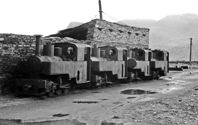

7 In 1977 four steam locomotives were stored hereabouts by their owners pending restoration

 but the southern part was in 1977 being adapted for use as a narrow gauge railway museum and contains several quarry diesel")
 depicting scenes in the quarry and at the battlefront at the time of the First World War.")

8 The next main level down the hillside contains the workshops complex (picture right), where the quarry machinery is maintained. This is entered through gates into a small courtyard; the various buildings around which contain several interesting machine tools. Adjacent to the workshops is a large old dressing mill, once powered by a big centrally situated waterwheel whose wheel pit and operating platform can be seen. The northern end of the building has fallen in (bottom left of picture) but the southern part was in 1977 being adapted for use as a narrow gauge railway museum and contains several quarry diesel locomotives and other stock brought in from elsewhere. A small building attached to the southern end still contains an old slate planing machine built by De Winton and Co., but no longer in operation. Also on this level until very recently was the beautifully carved slate plaque quarry war memorial (right) depicting scenes in the quarry and at the battlefront at the time of the First World War. This has now been removed for display to a wider audience in Nantlle village. Our last pictures at Pen-yr-Orsedd show the dual-gauge connecting tramway between the works and mills level, together with its incline.. Beyond the quarrymen s cottages in the village, the slate-strewn landscape ends abruptly. At one time this upper part of the Nantlle valley was instead worked for copper and lead, though with far less intrusion onto the scenery. The first of these sites to be reached is the Symdde-Dylluan or Tal-y-sarn Copper Mine (538533). This was started by Cornishmen in 1761 and was in good production by 1800, when women from Anglesey (the Ledis Copor ) came to work here. Latterly the ore was sent out via the Nantlle Railway to Caernarfon, thence to Swansea for smelting. Two waterwheel pits will be found by the riverbank not far from the road, and mark the site of the ore-dressing mills. Some of the adits on the hillside above can still be entered. Cottages once inhabited by the miners survive at (541534). On the opposite side of the valley are lead workings of the Mountain Lode mine operated by a London company for a few years around Several adits were connected by tramways and inclines, and the main incline can still be easily traced leading down under the road at (532533) to the riverbank, where the


9 ore dressing was done. A chute leads into an upper building used for crushing, and the mill building below has a waterwheel pit. Judging by the lack of spoil tips production at this site was minimal and short-lived. The most famous of the Nantlle Vale mines was Drws-y-Coed (546534) but the extensive remains here were unfortunately bulldozed circa The main shaft is hard by the road, with a dressing mill adjacent. The waterwheel was protected by a huge wind-wall, which still stands, and was fed from reservoirs higher up the valley. An interesting feature is the wooden drainage pipe leading from the shaft, exposed during the recent demolition and left intact. Most of the remaining area of the valley floor was once given over to settling pits for ore separation, and there is also evidence of tramways bringing in ore from other outlying shafts further up the valley. Returning westwards, the present main road through the valley was constructed in 1932 as a bypass to completely avoid the still-expanding quarry workings; the river hereabouts was canalized for the same reason. Adjacent to the road further extensive slate workings will be seen on the south side, these being an isolated group not connected to the Nantlle Tramway. They may be easily explored and contain some buildings and other features of interest. Keith A. Jaggers November 1978 Updates February 2012 The route of the Nantlle Tramway eastwards through Talysarn village from the old station is firstly a green verge, and then an access way still walled off from the main street. After some bungalow frontages, the line crossed over the road at the Cavour Street junction; the tunnels under the chapel steps and house gardens have been filled in. The route is then largely obliterated, and the Pont Fawr bridge and its high approach walls have been completely removed, presumably for safety reasons. It was about 100 yards east of the new roundabout, just before the flooded Talysarn Quarry pit on the left. The Dorothea beam engine and its house are listed grade 1, but nonetheless looking sadly neglected nowadays; the site has had several owners making any restoration negotiations or activity difficult... The nearby incline (upper left of the LH picture) is easily visible and walkable; the smithy is a ruin and the ropeway tower bastion is still impressive, though with some ominous wide cracks in its walling (right, above). The flooded Dorothea quarry pit is used for training in underwater diving techniques. The huge main mill is utterly ruinous, with just parts of the walls still standing. The steam winding engine at the top of Blaen-y-Cae Quarry is a remarkable survival, not much changed from our photos, no doubt due to its inaccessibility. Talysarn Hall and its stables remain in increasing dereliction (pictures below), and the flooded quarry pits are still impressive...


10 . The various Nantlle Tramway routes are still for the most part easily discernable and walkable, though the whole area is much more densely wooded and overgrown than previously. There are several interesting slate-built tunnels, bridges and buttressed structures to be found along the way...
11 The area around the foot of the main Pen-yr-Orsedd inclines is heavily wooded, and the lower incline is obliterated by a twisting quarry access road constructed in the 1970s. However the upper incline is still traceable and its drumhouse stands derelict. The old Pen-yr-Orsedd Quarry operation finally closed down in 1979, but part has subsequently been re-opened on a limited scale, and access beyond this incline is not currently possible for security reasons. However the non-worked areas have reportedly been looked after sympathetically by the Nantlle Valley local heritage group; the surviving Blondins are Scheduled Monuments. Most other ferrous material mainly the tramway tracks and wagons has long since been removed for scrap. Of the workshop and mill buildings, some are in use, others conserved, with the rest remaining derelict pending attention. The Pen-yr-Orsedd war memorial now stands just inside the entrance gates to Baladeulyn Chapel in Nantlle village, but facing north its delicately carved details are difficult to photograph, as always. At Simdde Dylluan copper mine, the waterwheel pits are still evident near the river; most of the site has been landscaped, but there are some building remains and adit entrances are still visible. The miner s terrace of cottages at Drws-y-Coed is a roofless ruin. The Mountain Lode incline passes under the main road just west of the bend, and its cutting is still clear on the NE side. At Drws-y-Coed mine the waterwheel wind wall remains are somewhat diminished so much less impressive than formerly; the dressing mill buildings are ruinous beside the road, and incorporated into a new farm structure behind. A tramway embankment is still clearly visible a few yards eastwards, on the north side of the main road. Of the old slate quarry workings by the Nantlle by-pass road, from east to west, Gwernor is overgrown, Ty Mawr East is an inert waste material tip site, but Ty Mawr West is still being worked on a small scale for its valuable green slate. At Ty n y Weirglodd the old tramway incline can be seen from the main road ascending between the landscaped tips. A minor road passes through the tips of the Tan-yr-Allt workings.
10) Port Penrhyn and the 1800 horse tramway
 Port Penrhyn and the 1800 horse tramway") 10) Port Penrhyn and the 1800 horse tramway Slates from what became the workings of Penrhyn Quarries have been shipped from Abercegin near Bangor since about 1700. Originally boats were loaded on the beach
10) Port Penrhyn and the 1800 horse tramway Slates from what became the workings of Penrhyn Quarries have been shipped from Abercegin near Bangor since about 1700. Originally boats were loaded on the beach
8) Penmaenmawr and the granite quarries
 Penmaenmawr and the granite quarries") 8) Penmaenmawr and the granite quarries Penmaenmawr is a "resort" of largely Victorian origins, then famous for the patronage of W. E. Gladstone but now somewhat diminished in importance in the tourist
8) Penmaenmawr and the granite quarries Penmaenmawr is a "resort" of largely Victorian origins, then famous for the patronage of W. E. Gladstone but now somewhat diminished in importance in the tourist
26) The Lleyn peninsula south coast
 The Lleyn peninsula south coast") 26) The Lleyn peninsula south coast The Afon Daron and its tributaries running generally northeast from Aberdaron could once boast no less than six or seven watermills operating in a distance of less than
26) The Lleyn peninsula south coast The Afon Daron and its tributaries running generally northeast from Aberdaron could once boast no less than six or seven watermills operating in a distance of less than
29) Blaenau Ffestiniog and district
 Blaenau Ffestiniog and district") 29) Blaenau Ffestiniog and district The town of Blaenau Ffestiniog, until recently carefully avoided by tourists and neatly excluded by the National Park boundary, was the third great centre of the slate
29) Blaenau Ffestiniog and district The town of Blaenau Ffestiniog, until recently carefully avoided by tourists and neatly excluded by the National Park boundary, was the third great centre of the slate
7) Conwy and district
 Conwy and district") 7) Conwy and district The former borough of Conway (now usually rendered as the Welsh form Conwy) is entered from the east via a long, narrow causeway or "cob" across the entrance to the estuary of the
7) Conwy and district The former borough of Conway (now usually rendered as the Welsh form Conwy) is entered from the east via a long, narrow causeway or "cob" across the entrance to the estuary of the
A487 PONT SEIONT ARCHAEOLOGICAL RECORDING REPORT NO Y mddiriedolaeth Archaeolegol Gwynedd Gwynedd Archaeological Trust
 A487 PONT SEIONT ARCHAEOLOGICAL RECORDING REPORT NO. 148 Y mddiriedolaeth Archaeolegol Gwynedd Gwynedd Archaeological Trust A487 PONT SEIONT ARCHAEOLOGICAL RECORDING prepared for Welsh Office Highways
24) Penygroes to Caernarfon
 Penygroes to Caernarfon") 24) Penygroes to Caernarfon We have seen how the quarrying districts of Moel Tryfan and Nantlle Vale both sent their products by tramway in the general direction of the sea at Caernarfon, and can now proceed
24) Penygroes to Caernarfon We have seen how the quarrying districts of Moel Tryfan and Nantlle Vale both sent their products by tramway in the general direction of the sea at Caernarfon, and can now proceed
Prior's Moor, Billingsley
 Prior's Moor, Billingsley David Poyner & Robert Evans (SCMC Journal No.6) Introduction Priors Moor is located in Billingsley where two small brooks (now known as Ray's and Scott's Brooks) unite to form
Reservoir Tin workings
 The workings are quite over-grown and covered in moss, suggesting that they date to the earliest period of mining. This is supported by the fact that their head race was cut off by the reservoir (D49/47)
11) Railways and Quarrying at Bethesda
 Railways and Quarrying at Bethesda") 11) Railways and Quarrying at Bethesda The Penrhyn Railway was built in 1878 to replace the inclines of the old tramway by a level route and so facilitate locomotive working throughout. To achieve this,
11) Railways and Quarrying at Bethesda The Penrhyn Railway was built in 1878 to replace the inclines of the old tramway by a level route and so facilitate locomotive working throughout. To achieve this,
Mining & Railways in Weardale. by Barry Kindleysides
 Mining & Railways in Weardale by Barry Kindleysides In 1154 King Stephen granted all the mineral rights in Weardale to his nephew Hugh Bishop of Durham. From then on a succession of Bishops owned these
Lodsbridge Mill, Selham, West Sussex
 Lodsbridge Mill, Selham, West Sussex A small estate with an 18th Century former watermill on the banks of the River Rother, separate 17th Century cottage, spa complex and stabling, total 18.73 acres (7.58
Walk 1: Highfield, Lob Wood and The River Wharfe
 Walk 1: Highfield, Lob Wood and The River Wharfe Start: The Hen Pen Garden, Main Street, Addingham LS29 0NS, SE 077 498. Alternative Start: Near Bolton Bridge SE 071 525 (see page 6). Full walk: 4.5 miles
Hay Wood, Rowington and Baddesley Clinton - Warwickshire
 Hay Wood, Rowington and Baddesley Clinton - Warwickshire Starts at Lay-by alongside Hay Wood 2 hours 30 minutes 5.5miles 8.8km Leisurely ID: 0.683 Developed by: John Clift Checked by: Andy Page www.ramblersroutes.org
A hidden heritage. A hidden heritage. The Incline and Winding House. To the Brendon Hills. By bus. By car. On foot
 How to to find find us us The Incline and Winding House To the Brendon Hills By bus For up to date information check the Travel Line website at www.travelinesw.com or the Exmoor National Park Getting around
CWMGIEDD FROM ABERCRAVE
 Abercrave to Cwmgiedd Walk Page 1 Starting from The Abercrave Inn. Grid Ref: SN 824128 From the Abercrave Inn, an 11.3km (7 miles) walk to the foothills of the Cribarth Mountain, then through forest to
North Wales Miners Association Trust Ltd Wrexham South Mine Trail
 North Wales Miners Association Trust Ltd Wrexham South Mine Trail An 18 mile circular trail by car or bike, passing features relating to the local coal, lead and iron industries. Note that some of the
The Holes Creek Bridge Replacement By Bradley McClelland
 The Holes Creek Bridge Replacement By Bradley McClelland Each time there is a heavy rainstorm, the folks along Sheffield Road in the Dayton, Ohio suburb of West Carrollton have cause to be concerned. Holes
National No. 2 (Bob Ciminel 2012)
") National No. 2 (Bob Ciminel 2012) Coming timetable east out of Muse Junction, we begin ascending the 1% grade to National Tunnel at MP 27. After passing through the tunnel s 823-foot bore we begin our
National No. 2 (Bob Ciminel 2012) Coming timetable east out of Muse Junction, we begin ascending the 1% grade to National Tunnel at MP 27. After passing through the tunnel s 823-foot bore we begin our
The Remains of the Ontario and Western Railway Fifty Years after Abandonment
 The Remains of the Ontario and Western Railway Fifty Years after Abandonment Oswego to Cadosia Drew James New York Ontario and Western Railway Oswego to Cadosia Oswego Fulton Pennellville Central Square
FOUNDATIONS OF ARCHAEOLOGY A WALK IN VERNDITCH CHASE
 FOUNDATIONS OF ARCHAEOLOGY A WALK IN VERNDITCH CHASE 1. A Tale of two Long Barrows Long barrows were constructed as earthen or drystone mounds with flanking ditches and acted as funerary monuments during
Wicklow Mountains Path Survey
 Wicklow Mountains Path Survey Glenmacnass Tonelagee Start to Finish: O 114 030 to O 085 016 Altitude (lowest highest): 370m 817m Weather: Sunny day, hot Access: Military Road, Glenmacnass Surveyed by:
Self-Guided Walk Langdale Pikes. Start & Finish: NT car park (free to members) at Sticklebarn - on the right just beyond the New Dungeon Ghyll hotel.
 at Sticklebarn - on the right just beyond the New Dungeon Ghyll hotel.") Self-Guided Walk Langdale Pikes Key Information These mountains form a collection of spires and cliffs on the north side of Langdale. This walk visits four of the main tops Pavey Ark, Harrison Stickle,
Self-Guided Walk Langdale Pikes Key Information These mountains form a collection of spires and cliffs on the north side of Langdale. This walk visits four of the main tops Pavey Ark, Harrison Stickle,
11 Majors Barn. 19 Mill Street Exploring Abergavenny
 11 Majors Barn 19 Mill Street Exploring Abergavenny Cover: Mill Street from Monmouth Road 2 mill street EXPLORING ABERGAVENNY For several years the Abergavenny and District Civic Society has been studying
Bratton Fleming Station (Lynton and Barnstaple Railway) A station for the Narrow Gauge Drawings and notes by CHRIS LEIGH
 A station for the Narrow Gauge Drawings and notes by CHRIS LEIGH") Bratton Fleming Station (Lynton and Barnstaple Railway) A station for the Narrow Gauge Drawings and notes by CHRIS LEIGH The Lynton to Barnstaple railway line was operated for just 37 years. It suffered
Bratton Fleming Station (Lynton and Barnstaple Railway) A station for the Narrow Gauge Drawings and notes by CHRIS LEIGH The Lynton to Barnstaple railway line was operated for just 37 years. It suffered
The Sand House A Victorian Marvel
 The Sand House A Victorian Marvel A talk given by Richard Bell to Tickhill & District Local History Society in April 2007 The majority of Doncaster s 21st Century residents are oblivious to the unique
Barnsley, Dearne & Dove Canals Trust HS2 Mitigation Options
 Page 1 of 13 Barnsley, Dearne & Dove Canals HS2 Mitigation Options December 2013 Elsecar Branch, Top Pound Prepared by Ulrich Signer, Director, BDDCT Mike Silk, Engineer, BDDCT The Barnsley, Dearne and
United States Department of the Interior National Park Service. Boundary Expansion Listed in National Register January 11, 2017
 NPS Form 10900-a (Rev. 8/2002) OMB No. 10240018 United States Department of the Interior National Park Service Boundary Expansion Listed in National Register January 11, 2017 National Register of Historic
Ystwyth and Rheidol Bridleway Routes. Route 2:Llanilar Circular
 Ystwyth and Rheidol Bridleway Routes Route 2:Llanilar Circular Route overview and terrain: A long circle using connecting ridges with fine views to link the Rheidol and Ystwyth river valleys. The route
Trail Phasing Plan. Note: Trails in the Clear Creek Canyon area (Segments will be finalized in the future to minimize wildlife impacts
 Note: Trails in the Clear Creek Canyon area (Segments 2 5 and a future JCOS connection) will be finalized in the future to minimize wildlife impacts Trail Phasing Plan P Parking 3 Easy Trail Intermediate
The rezoning application is recommended for consideration of approval.
 Date: November 26, 2012 To: From: Chairperson and Members Planning and Housing Committee Ken O Brien, MCIP Manager of Planning & Information Cliff Johnston, MCIP Director of Planning Re: Department of
DETROIT, TOLEDO, AND IRONTON RAILROAD PHOTOGRAPHS SUBSERIES, Accession 548
 Finding Aid for DETROIT, TOLEDO, AND IRONTON RAILROAD PHOTOGRAPHS SUBSERIES, 1922-1923 Finding Aid Published: June 2011 20900 Oakwood Boulevard Dearborn, MI 48124-5029 USA research.center@thehenryford.org
archeological site LOS MILLARES
 archeological site LOS MILLARES Aerial view of the plain of Los Millares between the Rambla de Huéchar and the River Andarax The archaeological site of Los Millares is located in the township of Santa
Excavations in a Medieval Market Town: Mountsorrel, Leicestershire,
 Excavations in a Medieval Market Town: Mountsorrel, Leicestershire, by John Lucas Mountsorrel is situated 12 kms north of Leicester and forms a linear settlement straddling the A6, Leicester to Derby road.
LONDON DO NOT ALIGHT HERE WALK SUNDAY 25 FEBRUARY 2018
 LONDON DO NOT ALIGHT HERE WALK SUNDAY 25 FEBRUARY 2018 Parkland Walk Site of Former Crouch End Station Travel Arrangements We will be catching the 9.20 am train from Biggleswade. A one-day travel card
Return of the Minehead Turntable
 Return of the Minehead Turntable A few years ago the thought of having a turntable at Minehead would have been unbelievable. We had the 55 turntable rescued from Pwllheli stored at Minehead for many years,
A hidden heritage. The Watchet to Washford trail. How to find us. To Watchet
 How to find us To Watchet For up to date information check the Travel Line website at www.travelinesw.com or the Exmoor National Park Getting around pages at www.exmoor-nationalpark.gov.uk/getting-around.
Llandudno Junction. Regeneration Proposals for the Future. December 2009
 Llandudno Junction Regeneration Proposals for the Future December 2009 Llandudno Junction - Vision Statement 1 Purpose 1.1 The purpose of this document is to describe key priorities to support the regeneration
Following the Worcester & Birmingham Canal Feeder in Kings Norton Visiting Lifford Reservoir & Wychall Reservoir. Lifford
 Worcester-Birmingham & Droitwich Canals Society SUMMER WALK Following the Worcester & Birmingham Canal Feeder in Kings Norton Visiting Lifford Reservoir & Wychall Reservoir Lifford Reservoir Wychall Reservoir
Captions/Proof Sheets for 97 Alberta Coal Branch & related images to accompany Kodak PhotoCD and slides; A C Lynn Zelmer, photographer
 A selection of 100 35mm colour slides was sent to Kodak Australia for scanning to PhotoCD format as an experiment in c1997. Since the digital images were intended for use at a conference, appropriate images
ISOM & ISSOM forbidden symbol comparison
 & forbidden symbol comparison Forbidden symbols and their relatives Symbol 2000 (Long, Middle) 2007 (Sprint) 201 Impassable cliff An impassable cliff, quarry or earth bank (see 106) is shown with a 0.35
Welcome to Priory Quay
 Welcome to Priory Quay Moments from the busy Dorset town of Christchurch, nestled between the magnificent Priory church and waters of Christchurch Harbour lies the marina development of Priory Quay. Comprising
National Model Railroad Association
 National Model Railroad Association Home :: Achievement Program :: Engineer - Civil Achievement Program Model Railroad Engineer - Civil The requirements for Model Railroad Engineer - Civil may look long
History of Vauxhall Bridge
 History of Vauxhall Bridge 1832 map 1844. The Norwich to Yarmouth railway opened. The only access from Vauxhall station to the town was via Cory s Suspension Bridge, a toll bridge. The Norfolk Railway
B.R. CONFLAT A. WW 02
 B.R. CONFLAT A. WW 02 History. B.R. produced no fewer than six main types of conflat wagons between 1951 and 1958, with the most numerous being the conflat A, for which six different diagrams were issued.
Leaden Boot Challenge ROUTE INSTRUCTIONS
 Leaden Boot Challenge ROUTE INSTRUCTIONS Section 1 Alstonefield to Ilam From the village hall car park turn R then L and pass through the village keeping to the R to enter Church Street. Pass the Church
Doncaster Circular Walk Growth of a market town
 Doncaster Circular Walk Growth of a market town Walk summary: A short, historical walk around the heritage of the market town of Doncaster. You will visit the river, canal and railway, all of which helped
The Swansea Canal near Glanrhyd north of Pontardawe
 INSPIRING LANDSCAPES FASCINATING HISTORY & LEGEND GREAT WALKS IN THE SWANSEA VALLEY Pontardawe to Ystalyfera along the Swansea Canal and Cycle Path and the Legend of Ynysygeinon Rock! Historic & Geographic
: southern pilaster of the entrance. The tomb owner, Redi, is depicted in painted raised relief ( a 8014) Plate 15
 Plate 15") 15. 2086: southern pilaster of the entrance. The tomb owner, Redi, is depicted in painted raised relief ( a 8014) Plate 15 16. 2086: south wall. Redi is seated with a woman, receiving a lotus, and entertained
15. 2086: southern pilaster of the entrance. The tomb owner, Redi, is depicted in painted raised relief ( a 8014) Plate 15 16. 2086: south wall. Redi is seated with a woman, receiving a lotus, and entertained
C E N T R A L C A T S K I L L S
 120 C E N T R A L C A T S K I L L S Central Catskills Once out of the southern parts of the Catskills, the Long Path enters the more well traveled and civilized regions. The trail joins the Devil s Path,
Slad over to Pitchcombe and back
 The walk climbs up from Slad over Wickridge Hill, descends to near Pitchcombe, then climbs back over Wickridge hill and round the back of Slad. Page 1 Start Point: SO 8718 0732 The Woolpack, Slad Length:
Invergordon in World War II
 Invergordon in World War II Sites and Features Listing The Invergordon in World War II project run by Invergordon Museum investigated wartime activity in Invergordon during the Second World War. Over 900
4. Bronze Age Ballybrowney, County Cork Eamonn Cotter
 4. Bronze Age Ballybrowney, County Cork Eamonn Cotter Illus. 1 Location map of the excavated features at Ballybrowney Lower (Archaeological Consultancy Services Ltd, based on the Ordnance Survey Ireland
24 EARL STREET WALKING TOUR
 24 EARL STREET WALKING TOUR This walk covers four city blocks of Earl Street, one of the oldest streets in Kingston. APPROXIMATELY 45 MINUTES Please be respectful of private property. 24 EARL STREET WALKING
Revitalization of the previous Marine Police Headquarters in Tsim Sha Tsui
 Revitalization of the previous Marine Police Headquarters in Tsim Sha Tsui The former Marine Police Headquarters was constructed in 1884, comprises a main building, a stable block and signal tower. The
29 Plas Derwen. Exploring Abergavenny
 29 Plas Derwen Exploring Abergavenny Cover: rhythm 2 plas derwen EXPLORING ABERGAVENNY For several years the Abergavenny and District Civic Society has been studying the streets, spaces and buildings of
Open Report on behalf of Richard Wills Executive Director for Communities. Planning and Regulation Committee. County Matter Application - S38/0590/13
 Agenda Item 5.10 Report Reference: 5.10 Regulatory and Other Committee Open Report on behalf of Richard Wills Executive Director for Communities Report to: Planning and Regulation Committee Date: 10 June
28) Portmadoc. Our plan shows the main features of interest.
 Portmadoc. Our plan shows the main features of interest.") 28) Portmadoc The town of Portmadoc is of particular interest to the industrial archaeologist. From virtually nothing at the beginning of the nineteenth century, it was developed into a town and harbour
28) Portmadoc The town of Portmadoc is of particular interest to the industrial archaeologist. From virtually nothing at the beginning of the nineteenth century, it was developed into a town and harbour
Chapter 2 Route window W25 Maidenhead station. Transport for London
 Chapter 2 Route window W25 Maidenhead station MAIDENHEAD STATION 2 Route window W25 Maidenhead station 2.6 The drawings provided at the end of this chapter present the main features of the route window,
The fascinating history around the Legend of Richard Burton
 INSPIRING LANDSCAPES FASCINATING HISTORY & LEGEND GREAT WALKS IN AFAN FOREST PARK Walk the trail in memory of the legend of Richard Burton including a historic exploration of his birthplace village The
The Cleo s Bath North Side Hike
 The Cleo s Bath North Side Hike This hike is a cross-country hike from Pinecrest Lake to the north side of Cleo s Bath. It is quieter and much less crowded than the normal route, which goes up the south
I I I I LINDEN TO WOOD FORD SURVEY ITEMS OF HISTORICAL SIGNIFICANCE I I I I I I I I I I I I I
 LNDEN TO WOOD FORD SURVEY TEMS OF HSTORCAL SGNFCANCE ------------------------------------------------------------------------------ --- - CONTENTS OF THE REPORT 1.0 ntroduction to the Report 1.1 Parameters
Sponsored by. statestreet.com
 /STATESTREETISLANDWALK #ISLANDWALKJSY Sponsored by statestreet.com Important Information If you forget everything else PLEASE remember the following.» Remember to check OUT of every checkpoint» If you
Site Publicity and Signage Policy Schedule, version 3
 Didcot Railway Centre Living museum of the Great Western Railway Home of the Great Western Society Site Publicity and Policy Schedule, version 3 To be read alongside the Site facilities and features descriptions,
My parents moved into Outram cottages in 1942 so I grew up there. As a child you don't notice anything particular about where you live, but as I
 Outram cottages My parents moved into Outram cottages in 1942 so I grew up there. As a child you don't notice anything particular about where you live, but as I became older I noticed things about the
At the time, the portion of the line through Eagle County remains wholly under the ownership of Union Pacific Railroad (UP).
.") Chapter 5 The Railroad Corridor as a Trail Corridor The intent of this chapter is to identify how the rail corridor, if available for lease or purchase in all or part, could be incorporated into the core
Chapter 5 The Railroad Corridor as a Trail Corridor The intent of this chapter is to identify how the rail corridor, if available for lease or purchase in all or part, could be incorporated into the core
Dufferin Jog Elimination Project
 Project Project Status Update November 14 2007 Project History Planning Alternatives Criteria Measured Project Benefits Structural Configurations Considered Structural Design Considerations The Preferred
Hickman s (Diamond) Mills
 Mills") Hickman s (Diamond) Mills On the east branch of Naaman's Creek, near the northwest boundary of Lower (and Upper) Chichester townships, was the saw- and grist-mill of Samuel Hickman, which was one of the
Hickman s (Diamond) Mills On the east branch of Naaman's Creek, near the northwest boundary of Lower (and Upper) Chichester townships, was the saw- and grist-mill of Samuel Hickman, which was one of the
Dnigi Hut. Dnigi is Dnaina for Moose. Location:
 Dnigi Hut in places. Stay on the main thoroughfare. Continue along the ridge top, going east to a pass above Knob Creek. Just beyond here look for a left turn which descends north-northwest (61,45.578,-148,52.414,2081
Gorse Stacks, Bus Interchange Excavations Interim Note-01
 Gorse Stacks, Bus Interchange Excavations 2015 Prepared for: Cheshire West & Chester Council Interim Note-01 1 Introduction & Summary Background Since c. 2000 investigations associated with redevelopment
A Tour of the Valle del Gizio
 Walk 25 A Tour of the Valle del Gizio Walking time 5hrs 30mins (4hrs if Colle Mitra is omitted) Difficulty 2 (likely to be snowbound in winter months); 1 (if Colle Mitra is omitted) Ascent/descent 570m/570m
Cotswold Canals Restoration
 Gloucestershire Society for Industrial Archaeology Cotswold Canals Restoration Phase 1b. Saul Junction to The Ocean, Stonehouse Project S01 Stroudwater Canal Features Influenced by the Ship Canal to Gloucester
A travel description of the Brisbane Airport Domestic Terminal Precinct. Author: Mr Terry Boyle of the Tactual Mapping Committee (September 2013)
") A travel description of the Brisbane Airport Domestic Terminal Precinct Author: Mr Terry Boyle of the Tactual Mapping Committee (September 2013) Brisbane Airport is located approximately 18 kilometres
A travel description of the Brisbane Airport Domestic Terminal Precinct Author: Mr Terry Boyle of the Tactual Mapping Committee (September 2013) Brisbane Airport is located approximately 18 kilometres
Lidar Imagery Reveals Maine's Land Surface in Unprecedented Detail
 Maine Geologic Facts and Localities December, 2011 Lidar Imagery Reveals Maine's Land Surface in Unprecedented Detail Text by Woodrow Thompson, Department of Agriculture, Conservation & Forestry 1 Introduction
Investigative Report #2 Old Montauk Highway May 18, 1999
 archived as http://www.stealthskater.com/documents/montauk_trip_02.pdf more related documents at http://www.stealthskater.com/px.htm note: because important websites are frequently "here today but gone
Centurion Way Chichester
 Centurion Way Chichester Work book of plans to show details of the Centurion Way, its links, and potential developments and enhancements from linking to the South Downs National Park all the way to the
Along Birkenhead Lines 3 rd, 4 th & 5 th March 2017 Event Guide CONTENTS
 Along Birkenhead Lines 3 rd, 4 th & 5 th March 2017 Event Guide CONTENTS Stepping Back in time 2 Rails to Woodside 3 The Last Knockings of Steam 4 Locomotive Fleet 5 What s On Guide X --------------------------
Ty Samson Borth-y-Gest, Nr Porthmadog. People Property Places
 Ty Samson Borth-y-Gest, Nr Porthmadog People Property Places A beautifully restored period property with stunning sea views in one of the most sought after picturesque waterfront locations Features Open
Threats to possible orbital light-rail in outer London from the current Brent Cross planning application...
 Threats to possible orbital light-rail in outer London from the current Brent Cross planning application... (We need safeguarding in place, for better times!) Map from Transport 2025 document. Boris photo:
The Swansea Canal & St Catherine s Church at Pontardawe
 INSPIRING LANDSCAPES FASCINATING HISTORY & LEGEND GREAT WALKS IN THE SWANSEA VALLEY Clydach to Pontardawe along the Swansea Canal, at Pontardawe the railway that never was! Historic & Geographic Background
Mountain Valley Pipeline, LLC Mountain Valley Pipeline Project Docket No. CP
 16. Prior to construction, Mountain Valley shall file with the Secretary, for review and approval by the Director of OEP, a segment-specific construction and operation access plan for the area between
Walk 1. Cotswold Water Park. Gateway Centre to Cerney Wick, railway track to Lake 6, Gateway Centre.
 Cotswold Water ark Walk way A Swindon/ Cirencester Thomas and Severn Canal way to Cerney Wick, railway track to Lake, way. Spine Road East Hotel Time: hours (short walk km) Distance: km A level walk along
Pontfadog. Walk A. Walk A
 Walk A A Bird s eye view of the village 2km. (1 1 /2 miles); height gain 45m. (150ft) about 45 minutes. Six minutes walk along the main road towards Glyn Ceiriog reach a signpost to Llwynmawr. Take the
Leaden Boot Challenge 2016 ROUTE INSTRUCTIONS
 Leaden Boot Challenge 2016 ROUTE INSTRUCTIONS Section 1 Alstonefield to Ilam (CP2) From the village hall car park turn R then L and pass through the village keeping to the R to enter Church Street. Pass
The meeting house is a converted Plymouth Brethren Chapel which originally was two cottages. It has medium significance.
 Quaker Meeting House, Ashburton Foales Court, off North Street, Ashburton, Devon, TQ13 7QE National Grid Reference: SX 75574 69951 Statement of Significance The meeting house is a converted Plymouth Brethren
Oakwood House. Photograph taken in 2004 when members of the ODHS were kindly shown round by members of the staff.
 From Oak Leaves, Part 13, Autumn 2013 - published by Oakwood and District Historical Society [ODHS] Oakwood House and the Origins of Oakwood, North Leeds. By Neville Hurworth The location of the boundaries
Filming on the GCR - Alan Brassey details the filming for
 Filming on the GCR - Alan Brassey details the filming for the BBC. Graham Wignall was on hand to take the spectacular photographs The Great Central Railway rightly enjoys a very good reputation for providing
Just under a mile from Cawfields car park where the walk begins is Great Chesters Roman Fort. It is behind the tree, looking from the west.
 Tynedale U3A Hadrian s Wall Group Cawfields to Birdoswald Just under a mile from Cawfields car park where the walk begins is Great Chesters Roman Fort. It is behind the tree, looking from the west. Great
Hunter Water S170 Register
 SHI No.: 3630112 Location Name: 800 Salisbury Rd, Munni NSW 2420 Other ID nos HW ID: 130. Description: The house is set on a buff over looking the creek The house is built in the colonial style, single
Mankato s Transportation Heritage
 Mankato s Transportation Heritage City of Mankato Mankato Heritage Preservation Commission May 11, 2017 1. Union Depot, 112 S. Riverfront Drive, c. 1896. The railroads were Mankato s dominant transportation
5) The lower Conwy valley Llanrwst to Glanconwy
 The lower Conwy valley Llanrwst to Glanconwy") 5) The lower Conwy valley Llanrwst to Glanconwy Llanrwst is an old market town, the most interesting feature of which is the magnificent three-arched stone bridge over the Afon Conwy, built by Sir Richard
5) The lower Conwy valley Llanrwst to Glanconwy Llanrwst is an old market town, the most interesting feature of which is the magnificent three-arched stone bridge over the Afon Conwy, built by Sir Richard
Appendix C. Cultural Heritage Properties
 Appendix C Cultural Heritage Properties Existing Conditions Report Page 1 Don River Mouth Naturalization and Port Lands Flood Protection Project Appendix C: Inventory of Cultural Heritage Properties in
Architectural Analysis in Western Palenque
 Architectural Analysis in Western Palenque James Eckhardt and Heather Hurst During the 1999 season of the Palenque Mapping Project the team mapped the western portion of the site of Palenque. This paper
Approximate distance: 4.7 miles For this walk we ve included OS grid references should you wish to use them. Start. End
 Approximate distance: 4.7 miles For this walk we ve included OS grid references should you wish to use them. Start End 1 2 3 4 N 5 W E S Reproduced by permission of Ordnance Survey on behalf of HMSO. Crown
NEWBORO AND PORTLAND HARBOUR REDVELOPMENT PLANS
 INTRODUCTION The Municipal docks in both Newboro and Portland were transferred to the Township of Rideau Lakes by Parks Canada in 2002. Little has been done to improve the docks physical condition or role
are greasable that the units *Positive indexing for raising roll down the track on and
 We at the Thomas family have deep roots in the Maine tradition of craftsmanship and innovation. Dale Thomas began working with steel in 1959 and for almost five decades gained extensive experience in steel
Beautiful Walks from the Blue Ball Inn
 Walk No. 2 WINSTONS WALK Countisbury, Wind Hill, Watersmeet, Ash Bridge and Winston s path. 5 Miles approx. Walking time- Two and a half hours approx. (Not including Breaks) OS 1:25,000 Sheet 64/74 Lynton
Afon Adda Refurbishment Bangor
 Afon Adda Refurbishment Bangor Archaeological Assessment Revised Report GAT Project No. 1876 Report No. 628 April 2006 Ymddiriedolaeth Archaeolegol Gwynedd Gwynedd Archaeological Trust Craig Beuno, Ffordd
12 Plantation Crack Area.
 12 Plantation Crack Area. There has always been some good, though limited, bouldering at Plantation Crack. Over the years this has been developed and now adds up to a fairly substantial area spread along
Although only small, this offers a very clear illustration of the style of working in the Rossendale quarries.
 You are here: The Journey > Selected Heritage sites > Fecit End Delf Fecit End Delf Although only small, this offers a very clear illustration of the style of working in the Rossendale quarries. Location: