The Collin County Historical Commission works in partnership with the Texas Historical Commission
|
|
|
- Berniece Sherman
- 6 years ago
- Views:
Transcription


1 The Collin County Historical Commission works in partnership with the Texas Historical Commission Collin County Historical Commission Heard-Craig House, McKinney Frankford Episcopal Church, Frankford Pecan Grove Cemetery, McKinney Presbyterian Church, Prosper City Hall, Weston Well House, Nevada


2 Cruising Historical Collin County Collin County is rich with centuries of history. Long before settlers arrived, Indian tribes, including Caddo and Comanche, claimed this as their territory. Later, brave settlers traveled here and made new lives on the fertile blackland prairie. The early settlers Before becoming a state, the Republic of Texas had financial troubles, and Mexico was threatening to invade. Its very existence depended on attracting people to settle the vast expanse of land. In North Texas, the answer lay in the Peters Colony, which began in 1841 when the Republic contracted with 20 men, offering land in exchange for organizing a colony. A married man received 640 acres; a single man received 320 acres. Most of the colonists came from the upper South. They had relatively few slaves. Union sentiments were strong in Peters Colony, a fact that later led Collin County to be one of a handful in the state to oppose secession. Collin County developed with more of a midwestern culture than a southern one, which meant that the area had more artisans and professionals. News of Peters Colony spread by word-of-mouth; therefore, many of the settlers already knew one another. As a result of these prior relationships, the colony developed commercially much faster than other inland parts of the state. The history of Collin County Collin McKinney played a conspicuous part in Texas struggle for freedom. He was a member of the provisional government organized in 1835, a signer of the Declaration of Independence from Mexico, one of the authors of the fi rst constitution written for the state, and he represented the large Red River County in four congresses of the Republic of Texas. After Texas became a state, the legislature carved up the state s large, northeastern region known as Fannin County into fi ve separate counties. One was named Collin in recognition of Collin McKinney s services to Texas. Agriculture and the economy Agriculture especially developing dairy farming continued to be an important factor in the county s economy. By 1980, the introduction of light industry, combined with the growth of the Dallas metropolitan area, produced a successful diverse economy. Overall, Collin County s population increased from 41,692 in 1960, to 144,576 in 1980, to nearly 750,000 in The diversifi ed economy continues to diminish the number of farms. Today, the county little resembles what was settled in the 1840s. Thornton House, Plano Preserving the past Since growth has eradicated many small farming towns and sites of historical signifi cance, the Collin County Historical Commission created this brochure as a driving tour through our beautiful county to preserve the stories of the past. We hope you will learn more of the history and have an appreciation of the struggles and triumphs of the early settlers of Collin County. Interurban Museum, Plano Onion Shed, Farmersville Chestnut Square, McKinney
 Cemetery Lavon Wylie Murphy Parker Lucas Lowry")

3 Synopsis of the County McKINNEY THE COUNTY SEAT AND NORTHWEST COLLIN COUNTY McKinney Trade Days Grounds Prosper Celina Weston SOUTHWEST COLLIN COUNTY Allen Plano Richardson The Frankford Historic Site The Shawnee Trail and Preston Road Lebanon Frisco SOUTHEAST COLLIN COUNTY Princeton Farmersville Copeville Josephine Nevada Old Bellew (Abston) Cemetery Lavon Wylie Murphy Parker Lucas Lowry Crossing NORTHEAST COLLIN COUNTY Melissa Anna Westminster Blue Ridge Parkhill Prairie Valdasta Walking tours information available from: Allen: Allen Chamber of Commerce, 210 W. McDermott Drive Farmersville: Visitor s Center, 201 S. Main Street McKinney: Old Collin County Courthouse, 311 N. Tennessee Plano: Interurban Museum, 901 E. 15th Street or call Post Office Mural, Farmersville
4


5 McKINNEY AND NORTHWESTERN COLLIN COUNTY The northwest portion of Collin County is a diverse area, much of which lies in the path of the rapid expansion encroaching from the south. McKinney, the county seat, has served as the hub of Collin County for more than 150 years. From the three distinct historic districts on the east side of U.S. 75, to the housing and commercial developments growing on its west side, visitors discover a city with a great heritage. McKINNEY: From U.S. 75, take Exit 40 and turn east on Louisiana. Travel two miles to begin your McKinney visit in historic downtown the heart and soul of McKinney. Downtown offers good eats, a bit of the grape for wine afi cionados, personal pampering at fi rst-class salons and spas, and noteworthy galleries in additional to a wide selection of specialty shops. The Visitor Guide to McKinney, the Walking Tour of the Historic District and Downtown, and the tourism map are available at the McKinney Tourism Services visitor center or on the Internet: The historic Collin County Courthouse, built in 1875 and drastically remodeled in 1927, anchors the downtown square and was recently restored as the McKinney Performing Arts Center. The cornerstone of performing and visual arts, its focal point is the Courtroom Theatre, seating 480 and featuring a vintage Wurlitzer Theatre pipe organ. Delaney House, Chestnut Square, McKinney A must-visit location is the McKinney Cotton Mill Historic District, which is listed on the national register of historic places. The Cotton Mill, located at 610 Elm Street, is the remaining building of what was once a community within McKinney. Houses for mill workers were located close to the site. At McKinney, the county seat, has served one time, this mill was the largest as the hub of Collin County for more producer of woven denim cloth west than 150 years. of the Missisippi. McKinney s third Historic District the Residential District is roughly bound by the streets West Lamar, North Benge, West Louisiana, and North Oak. Architectural styles in this area include Queen Anne, late 19th- and 20th-century revivals, and late 19th- and early 20th-century American movements. Pecan Grove Cemetery, located at Hwy. 5 (McDonald Street) and Eldorado/Industrial Blvd., is situated on property originally granted by the Republic of Texas in Pecan Grove is the fi nal resting place for many Texas pioneers, from governors to gunslingers. Heroes of the Texas Revolution are interred here, as are verterans of the Mexican War, The Civil War, and every war thereafter.


 to Celina. Hwy. 289 lies just to the west of Preston Road/ Shawnee Trail. This trail was a good route for early travelers because of its very rocky soil.")

6 TRADE DAYS GROUNDS: From U.S. 75, take U.S. 380 west approximately three miles. You will come to the Trade Days grounds, located on the former county seat known then as Buckner. There is a small cemetery on the eastern boundary of the grounds. A Texas Historic Marker marks this spot. PROSPER: Continue west on U.S. 380 to Prosper, originally founded as the Rock Hill Community. The already established town of Prosper moved when the Frisco Railroad came through in 1902 and established depots a few miles north. On the south side of Prosper at the intersection of First Street and Business Hwy. 289 is the historically signifi cant Presbyterian Church. Old Collin County Courthouse WESTON: Leaving the square, go east on Pecan Street to the signal light at Hwy. 289 and F.M Take F.M miles to Weston, which lies at the intersection of C.R. 543 and F.M Settlers began arriving in this region prior to 1840, making Weston one of the oldest towns in the county. Weston s early history was reputed to be wild and wooly. Downtown is only two blocks long and retains much of the early fl avor. Take C.R. 543 back to U.S. 75 and return to McKinney. First Methodist Church, McKinney CELINA: Return to Hwy. 289 and turn left (north) to Celina. Hwy. 289 lies just to the west of Preston Road/ Shawnee Trail. This trail was a good route for early travelers because of its very rocky soil. The route, as originally laid out from Dallas to the Red River, did not cross any creeks and thus could be traveled quite easily. Celina was established in 1879 one mile south of its current location. Just like Prosper, when the railroad was established in the area, residents moved their homes and businesses to a new, closer location. A thriving business area developed on Louisiana Street facing the railroad. For more history of Celina, stop at the museum located at 205 Pecan Street, on the square. Downtown Celina


7 SOUTHWESTERN COLLIN COUNTY Today, southwest Collin County is known for its spectacular homes, upscale shopping and super highways. Where we see the city boundaries of Dallas, Richardson, Plano, Allen and Frisco, pioneer families saw rich, fertile soils and blackland prairies bursting with blooms in spring and lighted at night by the star-fi lled sky. To understand the county s history, one must step out of today s hectic pace and visit what remains of a fascinating past. ALLEN: Beginning from the county seat of McKinney, drive south on U.S. 75 to the city of Allen. Established in 1870 by a railway agent and named for Ebenezer Allen, a railroad promoter, this city has the curious distinction of being the location of the fi rst train robbery in Texas history, led by Denton outlaw Sam Bass. Settled in the 1840s as a part of the Peters Colony and inhabited prior to settlement by Caddo and Comanche Indian tribes the farming community of Allen benefi tted from its location along the north-south railroad tracks, as it was a convenient waterstop for steam engines, which required a refi ll every seven miles. To keep the water supply steady, a stone dam was built in This old stone dam is located north of Exchange Parkway, along Cottonwood Creek. Thornton, an African-American landowner, farmer and developer. Old City Cemetery: Now the Pioneer Cemetery, where many early Plano leaders are buried. Douglass Community Wall: Heritage Farmstead, Plano A mosaic mural depicting the people and history of the Douglass Community, including leaders and churches. Today the Douglass Community is a candidate for designation as a Conservation District. Travel approximately two miles west of Downtown Plano to 1900 W. 15th Street, the Heritage Farmstead Museum. A working farm from 1891 until 1972, and one of the few remaining farmsteads PLANO: Continuing south on U.S. 75 is Collin County s largest city, Plano. Incorporated in 1873 and named by early Railroad Dam, Allen settler Dr. Henry Dye as a description of the area s terrain, Plano s economy for much of its history was based on surrounding farms, ranches and its railroad stop. Exit U.S. 75 at 15th Street and turn to the east. Originally called Mechanic Street, 15th Street is the heart of historic Plano. The Interurban Railway Museum, located between Haggard Park and the DART Rail Station, provides an interesting look at life in southwest Collin County for the fi rst half of the 1900s. It is also a good place to begin walking tours of Downtown Plano or driving tours of the surrounding historic housing district. Consider these stops: Douglass Community. Two blocks south of Downtown Plano, immediately to the west of the railroad track. Established soon after the Civil War; named for the Frederick Douglass School, which served Plano s African-American community until Thornton House: On 13th Street; built in the late 1800s by John


8 in southwest Collin County on its original site, the Farrell-Wilson Farmstead is representative of many prosperous farms of its day. Open to the public as a living history museum, the Heritage Farmstead exists to preserve, teach and demonstrate life on the Blackland Prairie of Texas from the 1890s to the mid-1920s. RICHARDSON: Returning to U.S. 75 and continuing south is the northern section of the city of Richardson. It was founded in 1873 as a result of the railroad and named for its contractor, E.H. Richardson. There are two historic sites in the Collin County section of Richardson, both cemeteries. Located at Glenville between U.S. 75 and Plano Road, and between Renner and Campbell Roads, lies the Jacob Routh Cemetery, established in It bears a Texas State Historical Marker. Off Brand Road in Breckinridge City Park is the Gatliln-Race-Hilltop Cemetery. This fenced, private cemetery was known from as the Race-Catlett Cemetery. The Shawnee Trail... was carved by centuries of migrating buffalo and traveling Indians. THE FRANKFORD HISTORIC SITE: Return to U.S. 75. Exit Campbell Road and head west until it intersects with Frankford Road. Turn west onto Frankford Road to the North Dallas Tollway southbound access road. Turn south and then east onto Briargrove. Turn right onto Spyglass Road and right again at Muirfi eld to reach the Frankford Historic Site, which is now a part of the city of Dallas. Originally called Indian Springs, it is the most intact example of 19th-century settlement still existing in Collin County. Important to in mid-20th century; and a historic cemetery. THE SHAWNEE TRAIL and PRESTON ROAD: The Shawnee Trail runs north following the ancient Texas Road, and was carved by centuries of migrating buffalo and traveling Indians. From Dallas to the Red River, the Shawnee Trail came to be known as Preston Road (S.H. 289). The springs at Frankford provided a camping ground, encouraging Native Americans, buffalo, settlers, Spanish longhorns and produce wagons to follow this route. So heavily used for so long, it is said that wagon ruts still exist along its perimeter. The Shawnee Trail Texas State Historical marker is at Lebanon Road. LEBANON: West of Preston Road and three miles southeast of Frisco is Lebanon. Now only a street name, it once was a bustling community and center for the cattle being driven north. FRISCO: Now one of the fastest-growing cities in America, the heart of Frisco lies at Preston Road and Main Street (F.M. 720). Once a village that benefi tted from the cattle drives and, later, a permanent train station, it developed as a hub for area cotton farmers, providing cotton gins and grain elevators. Sculptures at Frisco Central Park feature the Shawnee Trail longhorn cattle and drovers and brings life to a fascinating history. The Heritage Village Park and Museum houses relocated area historic buildings and memorabilia of North Texas history. From the intersection of Preston Road and S.H. 121, turn east and return to McKinney. Frankford Cemetery both Native American Indians and pioneers, Frankford once boasted the White Rock Masonic Lodge, a post offi ce, schools and businesses. Today, the site consists of a beautifully restored prairie gothic church built in the 1890s; a windmill attesting to the early reliance on pumped ground water; the old Addison depot, relocated on the site Heritage Village Park, Frisco


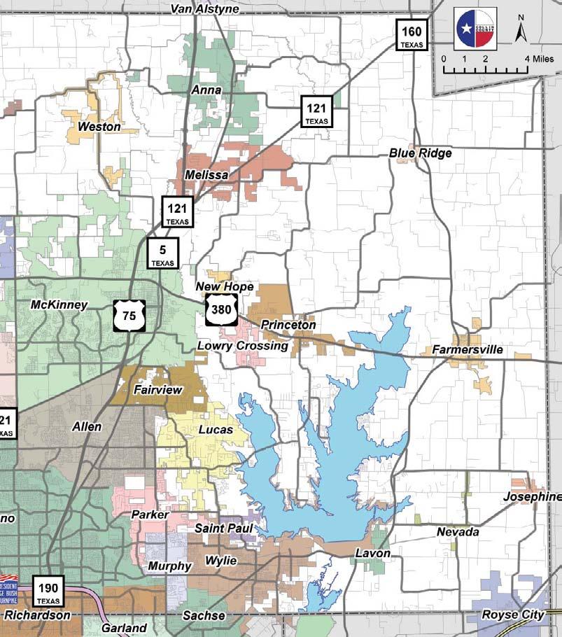
9 SOUTHEASTERN COLLIN COUNTY Southeast Collin County is home to several communities which retain their early 20thcentury character and refl ect the agricultural heritage of the area. All surround Lake Lavon, which was built on the East Fork of the Trinity River in the early 1950s for fl ood control and water supply. PRINCETON: Driving east from McKinney on U.S. 380, you will come to the city of Princeton. The town began in 1886, after the Missouri, Kansas and Texas Railway Company extended its line from Greenville to McKinney. During the 1880s and 90s, the town became a center for cotton and onions. Labor and War Camp: In 1940, a migrant-labor camp was built in Princeton north of what is now U.S In 1945, this location was turned into a prisoner of war camp. A Texas State Historical Marker gives the history of the camp. A sign on U.S. 380 indicates the direction to the site and marker. of the present-day Garland Electric Plant on Lake Lavon. In 1886, however, the Gulf, Colorado and Santa Fe Railway Co. came to the vicinity, and the residents of Black Spot moved to the present location which became known as Copeville. Old Bellew (Abston) Cemetery Central National Road: Turn east on C.R. 543, which will become C.R Drive 4.5 miles to C.R On the south side of the intersection of C.R. 596 and C.R. 641 is a Texas State Marker identifying the route of the Central National Road of the Republic of Texas. JOSEPHINE: Continue on C.R. 596 east to Josephine. In its early years, Josephine was a thriving town that included the Josephine State Bank and a silent movie theater. The town was destroyed by fi re in 1910 and again about 25 years later. In 1986, Josephine was honored with the Governor s Community Achievement Award through the efforts of the Josephine Beautifi cation Committee. NEVADA: Take Hwy. 6 west to Nevada. In 1886, the Cotton Belt Railroad came through Nevada, then a small town of industrious pioneers. Town lots and streets were marked off, houses were built First Baptist Church, Farmersville FARMERSVILLE: Continuing east on U.S. 380, you cross Lake Lavon and enter Farmersville. The town, named by pioneers for their chief occupation, was incorporated on June 1, By 1900, the town had six cotton gins and two railroad lines, which hosted six passenger trains a day. In the 1930s, Farmersville was known as the Onion Capital of North Texas, shipping out more than 1,000 carloads of East Collins Sweets each year. Audie Murphy, the most decorated soldier in WWII, called Farmersville home. His life is commemorated each June on Audie Murphy Day. A walking tour brochure of the Historic Downtown is available at the Visitors Center, 201 S. Main. COPEVILLE: From Farmersville, drive south on Hwy. 78 to Copeville. The town, originally known as Black Spot, was located just north Well House, Nevada and businesses were established facing an area in the form of a square. In May of 1927, a tornado struck Nevada, killing 27 and wounding 75 people. The only structure on the square which survived was the Well House. The town never recovered. OLD BELLEW (ABSTON) CEMETERY: From Nevada, return to Hwy. 78 on Hwy. 6 and turn back north. Travel about one mile, and pull to the left to a roadside park. Elias Bellew Cemetery is named for a slave who is buried in the cemetery. A Texas Historical Marker honors the


10 gravesite of John Abston ( ), a soldier in the American Revolution. LAVON: Take Hwy. 78 south to Lavon. This town, settled in 1854, was fi rst named Thompson Switch. The Southwestern Railroad came through in 1888, and growth ensued. A bank built in 1907 and later used as a café was featured in the 1967 movie, Bonnie and Clyde. WYLIE: Continue on Hwy. 78 to the city of Wylie, which was incorporated in 1856 along the rights-of-way of the Colorado and Santa Fe Railroads. By 1920, the community had more than 35 businesses, including two banks, a school and a weekly newspaper. MURPHY: From Wylie, take F.M. 544 to Murphy. Attracted by the offer of land grants from the Peters Colony, the fi rst settlers of Murphy arrived in the area in The St. Louis Southwestern Railway reached the area in From the 1880s until the 1950s, Murphy served as a shipping point for area farmers and livestock owners. Brown House, Wylie PARKER: Going north on F.M. 2551, you will pass the South Fork Ranch, made famous in the TV show Dallas. The city of Parker developed around the gristmill and general store built in the early 1880s. The St. Louis, Arkansas and Texas Railway surveyed the community and laid out town lots. Later, the company decided to run its tracks through Wylie instead. Although bypassed by the railroad, Parker continued to serve as a retail point for area farmers. LUCAS: Turn right on F.M and go to F.M A left turn takes you through Lucas. Very little is left of the original town. Lucas Going north on F.M. 2551, you will pass was named after Gabriel the South Fork Ranch, made famous in H. Lucas, whose father the TV show Dallas. arrived in Gabriel opened a store there in For nearly a century, the economy of the area was based upon agriculture, chiefl y cotton and corn. LOWRY CROSSING: Turn right on F.M Go over Lake Lavon and watch for F.M Turn left and follow this winding, picturesque road for several miles through former agricultural land that is rapidly being developed. At the point where Bridgefarmer Rd. (C.R. 729) comes into F.M. 546, turn right. About 1/8-mile south of this point is the historical Trinity River crossing that gave the town of Lowry Crossing its name. John Lowry, who settled in the area in the mid-19th century, made a living as a grocer and as the owner of mules which would be invaluable as they pulled wagons out of the nearby muddy river. Continuing on Bridgefarmer Rd., go to U.S Turn left and return to McKinney.


11 NORTHEASTERN COLLIN COUNTY The northeast portions of Collin County were once part of the empresario colony, known as the Peters Colony. Colonists came and settled despite trouble with Indians and the conditions of the Peters organization. The towns did not evolve until the railroad extended from north to south in Today, there are only remnants of a few communities that were founded, and many no longer exist at all. MELISSA: From McKinney, head north on U.S. 75; take the S.H. 121 exit; get in left lane exiting at Hwy. 5 to Melissa. A railroad engineer became the fi rst merchant in Melissa in The school was one of the fi rst buildings erected, followed by churches, gins and other businesses. In April, 1921, a tornado caused extensive damage to the city; the community remained small during the 1900s. As you travel north on Hwy. 5, note St. Paul Baptist Church on your left. This church was demolished by the tornado, but it was later rebuilt. An annual homecoming has been held for more than 100 years. Continue north to Fannin Road. Turn left and follow to Melissa Road. Veer right and watch for the cemetery sign on the right. Melissa Cemetery was a private family cemetery that later became public. Lewis Sherley, who originally homesteaded the land, was buried here in Purchased from the family in 1889, the cemetery has graves of many early pioneer families and descendants. Backtrack to Hwy. 5 and turn left. Go two blocks to Harrison Street and turn left. The Scott- Barker House, built in the 1870s, lost only one chimney during the 1921 tornado. It is a fi ne example of an L-Plan Victorian dwelling with distinctive mansard-type roofs. St. Paul s Baptist Church, Melissa Crossing Hwy. 5, going east on Harrison, the Melissa Christian Church will be on your right. The sanctuary, built near the present site in 1878, was destroyed by the 1921 tornado. It was replaced by the present structure in Retrace the route to Hwy. 5, turn right going north to the outskirts of the town. Turn left on C.R. 365 until you see a sign for Highland Cemetery, where you will turn left on to C.R This cemetery holds graves of families that settled the Highland area early on. ANNA: Leaving Highland, turn left and follow C.R. 365 north. The road will bend to the right and meet Hwy. 5. Turn left and continue to Anna. This town credits its beginnings with the railroad, as settlement began in A thriving agriculture community for many years, the population dwindled after years of crop failure and with the advent of WWII, when many moved to the cities to work in war factories. Go to Fourth Street and turn right. Just over the railroad tracks is A. Sherley and Bro. Store and Museum. Built in 1889, this fi rst brick building in Anna housed a business that sold a complete line of goods for the agricultural area: hardware; leather goods, including saddles and tack for horses and teams; household furnishings and Sherley Store, Anna groceries; farm machinery; grain; lumber; caskets and burials. (Shown by appointment; ) Looking south of Sherley Bros., by the water tower is the First Christian Church, a denomination brought to Texas by Collin McKinney and his family. It was built in 1893 of cypress wood, and an addition was added in the 1950s. Continuing south from the church, turn left at the dead end (F.M. 455) and continue east. Cross over S.H. 121 and continue on C.R. 475 to see two old iron bridges. Turn onto C.R. 476 to the fi rst bridge, then retrace to C.R. 475 to the second bridge. Replacing wooden structures, these iron truss bridges were built to accommodate mechanized farm equipment. The uniqueness of the bridges can be found in their handmade quality, using square-headed nuts and bolts. WESTMINSTER: Retrace the route back to S.H. 121 and turn right. You reach a sign that says Westminster (F.M. 2862). Turn left to drive into what was once a thriving town with a railroad spur. Begun in the 1860s and known then as Seven Points, this town was home to a Methodist, and, later, a Baptist, college. The demise of the railroad combined with changes in agriculture and WWII caused the population to dwindle.


. Follow this to C.R. 668 going east. The prairie will be on the left.")
12 Historic Iron Bridge BLUE RIDGE: Return to S.H. 121, cross over and follow F.M until it dead ends. Turn left on F.M. 545 going to Blue Ridge. The leaders of 70 pioneer families found a ridge covered with tiny blue fl owers and decided this was the perfect place to settle. The fi rst post offi ce was established in Once a thriving community, Blue Ridge later met the fate of many other agricultural towns in the area. The town is now growing once more. Just before reaching a dead end, look to your right and see the town square. On your left will be N. Main Street; turn left to see the Blue Ridge Methodist Church on your right. The original church had a tabernacle for summer revivals. This building was moved to this spot in 1913, survived a devastating tornado in 1919, was expanded in 1923, and continues the tradition of its founders. Continue on N. Main until you see the Blue Ridge Cemetery. Settlers were buried here as early as Later, four lanes lined with cottonwood trees in the form of a cross were added, leading to the center tabernacle used for funerals. PARKHILL PRAIRIE: To reach Parkhill Prairie, take the street south of the cemetery. Go east to fi nd Hwy. 78. Turn right (south), watch for C.R. 825 and turn left (east). Drive a distance, and watch for signs. C.R. 825 will turn right (south). Follow this to C.R. 668 going east. The prairie will be on the left. Parkhill Prairie is a 436-acre preserve featuring a 55-acre relic of the Blackland Tallgrass Prairie. It represents one of the best examples of rare, unspoiled prairie habitat within the state. The preserve provides magnifi cent views of the countryside, much like those viewed by early settlers more Blue Ridge Water Tower than 100 years ago. Today less than one Parkhill Prairie represents one of the best examples of rare, unspoiled prairie habitat within the state. The preserve provides magnificent views of the countryside, much like those seen by early settlers more than 100 years ago. percent of the original 12 million acres of Blackland Prairie remains in Texas. To return to McKinney, backtrack on C.R. 825, cross over Hwy. 78 to Business 78 into Blue Ridge. Turn left on F.M. 545 and travel down to historic Valdasta. Take F.M south to U.S Turn right on U.S. 380 into McKinney and onto U.S. 75. First Christian Church, Anna
Economy 3. This region s economy was based on agriculture. 4. This region produced items such as textiles, iron, and ships in great quantities. For th
 Geography 1. This region has a climate of warm summers and snowy cold winters. 2. This region has a climate that is generally warm and sunny, with long, hot, humid summers, and mild winters, and heavy
A History of West Chicago
 A History of West Chicago The Prairie Prairie Inhabitants Winfield Mounds Dickson Mounds, near Lewistown, in southern Illinois. An example of what Native burial mounds look like. First Permanent Settlers
Warm Up Use complete sentences
 Warm Up Use complete sentences What do you think are 3 differences between the Northern US and the Southern US that caused the Civil War? (asking what you think so there are no wrong answers except silly
CHAPTER 1 INTRODUCTION MORENO VALLEY GENERAL PLAN 1. INTRODUCTION. 1.1 What is a General Plan?
 1. INTRODUCTION 1.1 What is a General Plan? A General Plan is a comprehensive long-term strategy for the physical development of a city. It determines how land may be used and the infrastructure and public
APPENDIX B. Historic Structures
 University of Arkansas, Fayetteville Campus Old Main. The University Hall building was built from 1872 74 and modeled after the main building of the University of Illinois. The building itself is a demonstration
SH 121: FM 423 To SH 121 At US 75 Interchange. APPENDIX A: Figures
 Re-evaluation FM 423 To SH At US 75 Interchange APPENDIX A: Figures Old Denton Rd Josey Ln Parkwood Blvd Ohio Dr ROAD Coit Rd Alma Dr Prosper Cross Roads Oak Point Little Elm Denton County Collin County
BACKROADS BICYCLE/AUTOMOBILE TOUR OF MIDDLESEX, VERMONT
 BACKROADS BICYCLE/AUTOMOBILE TOUR OF MIDDLESEX, VERMONT (created and published by the Middlesex Historical Society) Welcome to a 25-mile self-guided historical tour of the backroads of Middlesex. You may
Top PLACES. 1Morton Street. TO VISIT in Richmond-Rosenberg. Special Section. wirtten by Heather Lowrie. Richmond
 Special Section Rose-rich spotlight Top 5 PLACES Photo by Jen Petty TO VISIT in Richmond-Rosenberg wirtten by Heather Lowrie Downtown Morton Street 1Morton Street Richmond If you are looking for great
Welcome to the Midwest!
 Welcome to the Midwest! Why do we call the Midwest "America's Heartland"? 5 9 7 4 2 Farm State 6 8 1 St. Louis 3 St. Louis, Missouri "Gateway to the West" Frontier: the beginning of unexplored land Pioneers:
Hudson Valley Vernacular Architecture Dutch Barn Preservation Society Field Trip to the Palatine Region of the Mohawk Valley May 18, 2013
 Hudson Valley Vernacular Architecture Dutch Barn Preservation Society Field Trip to the Palatine Region of the Mohawk Valley May 18, 2013 Trip Schedule Site Arrive Depart Old Palatine Church 10:30 am 11:15
DALLAS-FORT WORTH 2017 TAX RATES
 DALLAS-FORT WORTH 2017 TAX RATES CONTENTS COLLIN COUNTY... 03 DALLAS COUNTY... 04 DENTON COUNTY... 05-06 JOHNSON COUNTY... 07 KAUFMAN COUNTY... 07 PARKER COUNTY... 07 ROCKWALL COUNTY... 07 TARRANT COUNTY...
HISTORICAL MARKERS issued by
 HISTORICAL MARKERS issued by INDIANA HISTORICAL BUREAU in MONTGOMERY COUNTY, INDIANA 2016 Compiled by Dian Moore, Montgomery County historian NUMBER NAME 54.1962.1 Lane Place 54.1963.1 Major General Lew
In 1850, Congress passed a law donating two and one half million acres to the State of Illinois for the use of the Illinois Central Rail Road.
 Merna The town of Merna was founded by primarily Irish and German farmers. Their faith and families were an integral part of who they were. There was and still is today a strong sense of community. Most
Subject to Sale, Withdrawal or Error
 We are proud to offer an exclusive listing on a ranch in a very highly desired part of Northeast New Mexico. This ranch truly expresses the long understood real estate requirements of location, location,
ARKANSAS HISTORIC PRESERVATION PROGRAM. An agency of the Department of Arkansas Heritage
 ARKANSAS HISTORIC PRESERVATION PROGRAM An agency of the Department of Arkansas Heritage Treasure is hidden all over Arkansas, right in our own backyards. We need two things to find it: knowledge and exploration.
Taos Pueblo, New Mexico
 Taos Pueblo, New Mexico The Southwest Border Area Precipitation Climates of the US U.S. and Canada The Southwest Border Area A region of three dominating cultures: Native American, Spanish American, and
Communication in the West and the Transcontinental Railroad!!!
 Communication in the West and the Transcontinental Railroad!!! What was communication like during Westward Expansion? If people wanted to get letters from the West back to the East, the fastest way was
DALLAS SPORTS, HISTORY, CULTURE, AND MORE
 DALLAS, TEXAS DALLAS SPORTS, HISTORY, CULTURE, AND MORE The city of Dallas offers something for everyone. With its 26 neighborhoods, 12,000 places to eat, and almost unlimited shopping opportunities, Dallas
Hartsel Springs Ranch 4,637 Acres Park County, Colorado $4,780,000
 Hartsel Springs Ranch 4,637 Acres Park County, Colorado $4,780,000 Presented By: Farm, Ranch & Recreational Real Estate Hartsel Springs Ranch 4,637 Acres Park County, Colorado $4,780,000 Property Description
Overland Stagecoach Service through Tucson If it weren t for stagecoaches, Tucson wouldn t have developed to be the town we see today!
 Ring s Reflections by Bob Ring Overland Stagecoach Service through Tucson 1857-1880 If it weren t for stagecoaches, Tucson wouldn t have developed to be the town we see today! Let s set the stage (sorry).
Family Fun Summer. Challenges in Albion!
 Family Fun Summer Challenges in Albion! Dear Parents, Your children have been learning about fun facts that make Albion AMAZING! This booklet shares the facts with you along with some interesting challenges.
In some ways missions were like small towns. They provided for the spiritual and physical needs of the people that lived within their protective
 In some ways missions were like small towns. They provided for the spiritual and physical needs of the people that lived within their protective walls. Since the chief goal of the mission was to convert
Spanish Missions History and Purpose
 Spanish Missions History and Purpose Columbus's voyage of discovery opened a new world of possibilities for the Spanish. In the Americas, Spain soon began to use its soldiers to increase the size of its
TEXAS VISITORS GUIDE. Nature. ARt. Shopping. music. VisitMcKinney.com/Guide
 TEXAS VISITORS GUIDE Nature ARt Shopping music VisitMcKinney.com/Guide Enjoy M C K I N N E Y Located just 30 minutes north of Dallas and steeped in hometown charm, McKinney is a world away from the big-city
Paths, Plank Roads, and Planes
 S 10 Trail Summary HERITAGE TRAILS Paths, Plank Roads, and Planes Ride along the Paths, Plank Roads, and Planes trail and track the story of development and progress as written through the necessity of
Warm ups *What was the most valuable natural resource in the development of the Northeast? Why? *What does a megalopolis refer to?
 Warm ups 9.22.2016 *What was the most valuable natural resource in the development of the Northeast? Why? *What does a megalopolis refer to? Lesson Objective: *identify the key natural resources that influenced
THE HIGHWAY 50 SURVIVAL CHALLENGE
 THE HIGHWAY 50 SURVIVAL CHALLENGE In July 1986, Life magazine described Nevada s Highway 50 from Ely to Fernley as the Loneliest Road in America. Life said there were no attractions or points of interest
Langford Road, East Candia. East Candia. A Walking Tour. Published by Candia Heritage Commission September 2013
 Langford Road, East Candia East Candia A Walking Tour Published by Candia Heritage Commission September 2013 Methodist Church In 1894, the Methodist Society built a church at what is today 163 Langford
PARKING Access Points
 Parking Overview N PLANO RD PARKING Access Points 190 N PRESIDENT GEORGE BUSH HWY 13 2CL 3CL ROUTH CREEK STATE ST 1CL One CityLine STATE STREET ROUTH CREEK AVI 1CL LOBBY ROUTH CREEK AND PLANO ROAD 14 Two
History of Burlingame, Kansas. By John Hill Louisiana purchase by the United States from France (includes present-day Burlingame)
") History of Burlingame, Kansas By John Hill 1803 Louisiana purchase by the United States from France (includes present-day Burlingame) 1806 Zebulon Pike s exploration of the southwest portion of the Louisiana
History of Burlingame, Kansas By John Hill 1803 Louisiana purchase by the United States from France (includes present-day Burlingame) 1806 Zebulon Pike s exploration of the southwest portion of the Louisiana
population date of map cupar %
 population 7427 6766 date of map 1856 1896 cupar In 12th century Cupar was established as the county town of Fife. It prospered in its early days on the back of the wool industry and later grew as a market
A capital city destination and home to the state s only outlet center LITTLE ROCK ARKANSAS
 A capital city destination and home to the state s only outlet center LITTLE ROCK ARKANSAS Highlights IDEAL LOCATION Located in Little Rock, the capital city of Arkansas Easily accessible at the intersection
VISITORS GUIDE VisitMcKinney.com/Guide
 VISITORS GUIDE VisitMcKinney.com/Guide Nature Art Shopping Music Welcome! Located just 30 minutes north of Dallas and steeped in smalltown charm, McKinney is a world away from the big-city bustle. From
Leasing Brochure. Park Plaza Shopping Center 1150 N. Federal Highway, Pompano Beach, Florida Under Construction - Coming Very Soon
 Park Plaza Shopping Center 1150 N. Federal Highway, Pompano Beach, Florida 33062 Leasing Brochure Under Construction - Coming Very Soon Exclusive Leasing Broker 2048 East Sample Road, Lighthouse Point,
OKLAHOMA HISTORY OKLAHOMA S GEOGRAPHY
 OKLAHOMA HISTORY OKLAHOMA S GEOGRAPHY BOARD QUESTIONS 1) HOW BIG IS OKLAHOMA? 2) HOW MANY COUNTIES ARE IN OKLAHOMA? 3) HOW FAR IS IT FROM OKC TO LAS ANGLES, CALIFORNIA? 4) HOW MANY STATE BORDER OKLAHOMA?
December 2017 Oregon City First Capital City in The West
 December 2017 Oregon City First Capital City in The West A History of Oregon City see page 2. Webfooters Post Card Club PO Box 17240 Portland OR 97217-0240 www.thewebfooters.com Oregon City: The First
GORGEOUS NEW SUBDIVISION
 GORGEOUS NEW SUBDIVISION From $170,000 Paved county road New subdivision with NO HOA Ag exempt PROPERTY DESCRIPTION Location: From Weatherford, Take 920 towards Peaster. Turn Left on FM 1885, and then
Below is the section of the Byway discussed in the Tazewell County meeting. Primary coal sites are noted on the map.
 APPENDIX H: PUBLIC PARTICIPATION SERIES OF TOWN MEETINGS Virginia Coal Heritage Trail Corridor Management Plan Meeting in Richlands on the Tazewell County portion of the Pocahontas Trail September 21 st
Tour 12 - Historic Plumas County
 SPECIALTY tour 12 page 1 Tour 12 - Historic Plumas County This tour highlights many of Plumas County s historic attractions and small museums. Local experts may be available for tours or presentations
Tracy Ranch 403+/- Acres Comanche County, Texas $965,185 ($2,395/acre)
") Office: (214) 361-9191 Tracy Ranch 403+/- Acres Comanche County, Texas $965,185 ($2,395/acre) LOCATION: The ranch is located in the northwestern portion of Comanche County near the Eastland County line,
Office: (214) 361-9191 Tracy Ranch 403+/- Acres Comanche County, Texas $965,185 ($2,395/acre) LOCATION: The ranch is located in the northwestern portion of Comanche County near the Eastland County line,
Lewis & Clark Return Home
 Lewis & Clark Return Home On March 23, 1806, Meriwether Lewis, William Clark, and their team started for home. At first they took the same path. But after they crossed the Rocky Mountains, the group split
Section 1: Vocabulary. Be able to determine if the word in bold is used correctly in a sentence.
 Section 1: Vocabulary. Be able to determine if the word in bold is used correctly in a sentence. Hardships: difficult conditions or situations that cause discomfort and/or suffering Pioneers: the people
Sheffield Island Camden County, GA
 For Sale $3,150,000 Sheffield Island Camden County, GA 452.5 Total Acres 230 Estimated Upland Acres William Lattimore 912.596.7019 Overview A rare opportunity to own a portion of a pristine island off
AOTA ArtTrek Locations
 AOTA ArtTrek Locations ArtTrek is a summer-long Grand County, CO art adventure. Highlighted by snow-covered mountain vistas and rolling meadows threaded with sparkling streams and rivers, numerous sites
North Portal of Jenson Tunnel 1998 Richard E. Napper, MMR
 A publication devoted to the Frisco Railroad, Prototype and Modeling Volume 5 Number 1 March 2013 North Portal of Jenson Tunnel 1998 Richard E. Napper, MMR The Meteor is published quarterly in PDF format
Corridor Management Plan for Virginia Coal Heritage Trail WMTH Corporation, 2011, trailsrus.com
 CHAPTER IV: HIGHLIGHTS Along the The St. Paul loop travels over 80 miles through the counties of Russell, Scott, Lee and Wise before ending back at St. Paul. As noted earlier, St. Paul holds the distinction
ALBION E. SHEPARD HOUSE
 Texas Historical Commission staff (BB), 8/5/2013, rev 9/23/13, 11/12/13 27 x 42 Official Texas Historical Marker with post Brewster County (Job #13BS01) Subject (Atlas 17696) UTM: 13 668898E 3343090N Location:
Holmesburg 1860 to 1900
 Holmesburg 1860 to 1900 Holmesburg continued to grow rapidly during and after the Civil War. The 1862 map below shows the village scurrying with life. There were stores and businesses on Main St from Decatur
A Historical Timeline of Cedar Falls
 A Historical Timeline of Cedar Falls 1700-1750 The Meskwaki (Fox), after having been forced out of their former homes further east, move into the area by 1750. They are allied with the Sauk through language
35EXPRESS PROJECT UPDATE FOR DENTON COUNTY COMMISSIONERS
 35EXPRESS PROJECT UPDATE FOR DENTON COUNTY COMMISSIONERS 35EXPRESS PROJECT OVERVIEW 2 ABOUT THE 35EXPRESS PROJECT 3 DESIGN-BUILD TEAM 4 PROJECT PARTNERS Great partnerships make this project work Collaboration
Fletchertown (71A-022)
") Fletchertown (71A-022) Fletchertown is a late-nineteenth-century rural African-American community in northeastern Prince George s County. The community is located south of Huntington and northwest of Bowie.
Fletchertown (71A-022) Fletchertown is a late-nineteenth-century rural African-American community in northeastern Prince George s County. The community is located south of Huntington and northwest of Bowie.
Frederick County, MD Rural Roads Tour # 3
 Frederick County, MD Rural Roads Tour # 3 Unionville Loop Tour mileage: Approx. 63 miles Driving time: about 3 ½ hours (not including stops) There are 5 separate tours of Frederick County s Rural Roads.
SAN MIGUEL CREEK RANCH. q Trinidad, Las Animas County, Colorado q
 SAN MIGUEL CREEK RANCH q Trinidad, Las Animas County, Colorado q 2 s San Miguel Creek Ranch is a scenic well-balanced cattle and trophy hunting ranch that showcases the very best of Southern Colorado.
Area Attractions & Hotels
 Area Attractions & Hotels Holiday Inn & Suites - *** www.holidayinn.com/mckinneytexas Contact: Amy Nelson Phone: 469.952.2044 ext. 507 3220 Craig Drive McKinney, Texas 75070 30 miles to DFW Airport Homewood
DRAFT. Public Meetings November 7, 9, 15, Year UTP Planning Effort Cost/Revenue Matrix FY FY 2026
 Collin FM 2478 FM 1461 to US 380 (Prosper) US 380/McKinney Bypass Candidate Project; Collin Roadway Action Plan #3 $32,600,000 $32,600,000 A Collin FM 2514 East of Lavon Parkway to North of Drain Dr. Roadway
3400 AT CITYLINE REVOLUTIONIZES THE TRADITIONAL OFFICE BUILDING.
 3400CITYLINE.COM 3400 AT CITYLINE REVOLUTIONIZES THE TRADITIONAL OFFICE BUILDING. 10 finished ceiling height Extensive floor to ceiling glass Premium common area finishes All structured parking OUTDOOR
Independence: overview
 : overview Kentucky Ave 8: p.30 SUGAR CREEK SATA FE. OREGO, CALIFORIA 7: p.29 6: p.28 9: p.31 10: p.32 Square, Jackson County Courthouse. Photo: Vireo Trail swale area, Santa Fe Trail. Photo: Vireo HISTORIC
LENNARD SHELL VALLEY, MANITOBA
 A BRIEF HISTORY OF LENNARD AND SHELL VALLEY, MANITOBA BY JOHN GOODES A BRIEF HISTORY OF LENNARD AND SHELL VALLEY 2 I. Lennard For the settlers from Bucovina who began to arrive in the Asessippi district
Unit 13: La Entrada The Spanish Enter New Mexico
 Assessment Activities: Student Activity Sheet Activity 1. Matching Place Names Draw a line to connect the Spanish Place Name with its English definition. 1. Los Alamos a. mayor 2. Española b. the stream
(Short Listing) DUPUYER ACREAGE, ROCKY MOUNTAN FRONT
 DUPUYER ACREAGE, ROCKY MOUNTAN FRONT") (Short Listing) DUPUYER ACREAGE, ROCKY MOUNTAN FRONT This unique property is located 8½ miles northwest of Dupuyer, Montana and approximately thirty 30 miles northwest of Choteau, Montana. Great Falls
(Short Listing) DUPUYER ACREAGE, ROCKY MOUNTAN FRONT This unique property is located 8½ miles northwest of Dupuyer, Montana and approximately thirty 30 miles northwest of Choteau, Montana. Great Falls
The Santa Cruz Valley National Heritage Area. National Heritage Area. A heritage-based economic development strategy
 The Santa Cruz Valley National Heritage Area National Heritage Area A heritage-based economic development strategy Santa Cruz Valley Heritage Alliance Our Mission: Connect people to the cultural, historic,
Walking Tour. America s first textile village. Intro Walking Tour Directions. Water Powered! BlackstoneHeritageCorridor.org
 Walking Tour slatersville North Smithfield, RI America s first textile village. Intro Walking Tour Directions Slatersville Congregational Church and Mill. Photo courtesy of the Blackstone Valley Tourism
SPARTA Finding treasures off the beaten path just got a lot easier.
 FIND TREASURES OFF THE BEATEN PATH IN WHITE CO., TN By Amy Davis, Herald Citizen Staff Herald Citizen, Cookeville, TN Thursday, 23 February 2012, pg. A 9 SPARTA Finding treasures off the beaten path just
Flying W Guest Ranch. Oklahoma - Beckham County - Elk City
 Flying W Guest Ranch Oklahoma - Beckham County - Elk City 2 Flying W Guest Ranch is a well-known guest ranch in a historic location about 90 miles west of Oklahoma City near Elk City, Oklahoma. Situated
A Half Century of Tucson-Area Stagecoach Service s
 Ring s Reflections by Bob Ring A Half Century of Tucson-Area Stagecoach Service 1870-1920s Last week I wrote about overland stagecoach operations through Tucson. This week I ll tell the story of how Tucson
This section of the Plan provides a general overview of the Smoky Mountain Region. It consists of the following four subsections:
 SECTION 3 COMMUNITY PROFILE This section of the Plan provides a general overview of the Smoky Mountain Region. It consists of the following four subsections: 3.1 Geography and the Environment 3.2 Population
Chapter 6 The Spanish Colonial Period
 Chapter 6 The Spanish Colonial Period The Spanish had lost interest in Texas after the failed expeditions of the 1500 s. They did build colonies in New Mexico along the upper Rio Grande (remember that
RAY YENKANA Willowbrook Cr, Dawson Creek BC Canada $2,847,000
 1716 Willowbrook Cr, Dawson Creek BC Canada For SALE $2,847,000 This is a rare find, 32 townhomes in Dawson Creek, BC. Excellent investment in a single title multi family complex. Vendor has upgraded this
TABLE OF CONTENTS IV. II. VI. III. LOCATION FRISCO STATION OVERVIEW WALKABILITY LIFESTYLE SITE PLAN
 TABLE OF CONTENTS I. LOCATION IV. II. FRISCO STATION OVERVIEW V. WALKABILITY III. SITE PLAN VI. LIFESTYLE LOCATION DALLAS NORTH TOLLWAY DALLAS NORTH TOLLWAY AIRPORT ACCESSIBILITY DENTON 35E MCKINNEY MCKINNEY
Last Updated: 11/27/2017 To view network selection criteria for doctors and hospitals, visit
 Blue Choice PPO SM A Division of Health Care Service Corporation, a Mutual Legal Reserve Company, an Independent Licensee of the Blue Cross and Blue Shield Association Search Criteria: State: TX Location:
Ranch. Creek. Cow. Mountain
 Cow Creek Mountain Ranch Situated along the southwestern hills of the Laramie Mountains and the Medicine Bow-Routt National Forest in northeastern Albany County, Wyoming. 58 E. Benteen Street Buffalo,
OKLAHOMA (Route 66 Mother Road s Glory Days)
") OKLAHOMA (Route 66 Mother Road s Glory Days) Little Rock to Fort Smith 159 mi. / 2 hr. 30 min. / I-40 Fort Smith to Oklahoma City - 182 miles / 2 hr. 53 min. / I-40 Oklahoma City to Erick (last city before
OKLAHOMA (Route 66 Mother Road s Glory Days) Little Rock to Fort Smith 159 mi. / 2 hr. 30 min. / I-40 Fort Smith to Oklahoma City - 182 miles / 2 hr. 53 min. / I-40 Oklahoma City to Erick (last city before
Cassadaga HISTORIC WALKING TOUR OF
 HISTORIC WALKING TOUR OF Cassadaga This tour was developed by Citizens for a Better Cassadaga, with the generous financial support of the Chautauqua County Health Network, as part of Creating Healthy Schools
TOWNSHIP OF HILLSIDE, NJ.
 TOWNSHIP OF HILLSIDE, NJ. HILLSIDE Formed as Township: 1913 1970 Population: 21,636 Land Area 2.70 square miles The initial settlement of the township now known as present day Hillside followed shortly
next purchase at Antelope Springs Ranch. These centrally located parcels are strategically positioned between Roswell and Artesia, New Mexico.
 Wide open spaces and beautiful sunsets! That s what you get when you make your next purchase at Antelope Springs Ranch. These centrally located parcels are strategically positioned between Roswell and
Jackson County Historical Society News
 Jackson County Historical Society News volume twenty, number one november 2012 The Jackson County Historical Society will meet at the First Christian Church of Jefferson on Sunday, November 11, 2012, at
Human Geography of Canada
 Human Geography of Canada History and Government of Canada Like the United States, people migrated across Beringia into Canada, these people were the ancestors of the Inuit (Eskimos) 16 th and 17 th centuries,
WELCOME. property shot or lifestyle. can t finish this page until I have actual photo can you edit any of the copy?
 property shot or lifestyle can t finish this page until I have actual photo can you edit any of the copy? WELCOME THE SHOPS AT HIGHLAND VILLAGE IS SOUTH DENTON COUNTY S EXCLUSIVE OPEN-AIR TOWN CENTER,
Piscataway (84-023) Mary Quarterly, 3rd Ser., Vol. 36, No. 4. (Oct., 1979), pp Preservation Section, 1.
 Mary Quarterly, 3rd Ser., Vol. 36, No. 4. (Oct., 1979), pp Preservation Section, 1.") Piscataway (84-023) Piscataway, located in southwestern Prince George s County, is one of the oldest villages in the county. Piscataway takes its name from a Native American tribe of the same name that
Piscataway (84-023) Piscataway, located in southwestern Prince George s County, is one of the oldest villages in the county. Piscataway takes its name from a Native American tribe of the same name that
Unit 11: Travel and Trade
 Unit 11: Travel and Trade Today Due: Current Events Article Assignment Quiz: Unit 10 (Value of Land) In class: Unit 11 (Travel and Trade) HW: wkbk 97-102, study for quiz 11, read Unit 12 (155-166) Lesson
A thriving mountain city with over 9 million visitors ASHEVILLE NORTH CAROLINA
 A thriving mountain city with over 9 million visitors ASHEVILLE NORTH CAROLINA Highlights IDEAL LOCATION Excellent regional access with location on I-26 Location at Exit 33 is one of the region s primary
BOOGIE WOOGIE AUTO TOUR 1
 BOOGIE WOOGIE AUTO TOUR 1 4 6 3 5 7 1 2 10 9 8 Route # 1 Alternate Return Route 1 Historic Harrison County Courthouse & Museum 2 Texas & Pacific Railway Depot & Museum 3 Antebellum Childhood Home Lady
4th Grade Third 9 Weeks Test
 4th Grade Third 9 Weeks Test Multiple Choice Identify the choice that best completes the statement or answers the question. 1 A waterway for ships that is dug across land is called a. A port C river B
Segment 2: La Crescent to Miller s Corner
 goal of the USFWS refuges is to conserve, protect and enhance fish, wildlife and plants and their habitats for the continuing benefit of the American people. Refuge lands are used largely for fishing,
Spanish Colonies on the Borderlands
 Spanish Colonies on the Borderlands Pages 90 93 Nov 1 8:14 PM 1 Today's Objectives *Describe Spain s colony in Florida. *Explain how Spain established settlements throughout much of North America. *Describe
THANKSGIVING AND CHRISTMAS
 Historical Society Newsletter Inside This Issue October 2012 THANKSGIVING AND CHRISTMAS Volume 21, Issue 8 The first Christmas was celebrated mid 4th century. It has evolved into what we are familiar with
7-Eleven Allegis Group, Inc. American Benefits Council American Hotel & Lodging Association American Staffing Association American Supply Association
 July 22, 2014 Senator Johnny Isakson U.S. Senate 131 Russell Senate Office Building Washington, DC 20510 RE: S. 2546, The Auto Enroll Repeal Act Dear Senator Isakson: On behalf of the undersigned businesses,
BUTCHER CREEK RANCH. Butcher Creek Ranch. Roscoe, Montana. Reduced to $1,650,000.
 BUTCHER CREEK RANCH Butcher Creek Ranch Roscoe, Montana Reduced to $1,650,000. Offered Exclusively By: Sonny Todd Real Estate 301 West First Avenue, PO Box 788 Big Timber, Montana 59011 Office: (406) 932-1031
Topics. Review: The Age of Santa Anna Texas Revolution Mexican-American War Exam Oct. 28 ( )
") Topics Review: The Age of Santa Anna Texas Revolution 1835-1836 Mexican-American War 1846-1848 Exam Oct. 28 (1521-1850) 1 Mexican Politics during the 19 th Century Overall instability Military dominated
Topics Review: The Age of Santa Anna Texas Revolution 1835-1836 Mexican-American War 1846-1848 Exam Oct. 28 (1521-1850) 1 Mexican Politics during the 19 th Century Overall instability Military dominated
Mexico. Chapter 10. Chapter 10, Section
 Chapter 10, Section World Geography Chapter 10 Mexico Copyright 2003 by Pearson Education, Inc., publishing as Prentice Hall, Upper Saddle River, NJ. All rights reserved. Chapter 10, Section World Geography
Middle Creek a streaming resource
 Middle Creek a streaming resource The Middle Creek Watershed has a long history of human activity. Native Americans used the watershed before the European settlers; they traveled, hunted, and settled in
League of Michigan Bicyclists Cross State Route LENAWEE COUNTY
 League of Michigan Bicyclists Cross State Route LENAWEE COUNTY History & Geography: Lenawee County got its start when 30 people arrived from Jefferson County, New York and settled along the Raisin River
Bike MS Ride, West Michigan Riding In Historical Allegan County
 Bike MS Ride, West Michigan Riding In Historical Allegan County The Michigan Chapter of the National MS Society would like to extend our gratitude to the Steering Committee for the West Michigan Bike MS
Chapter 12 Manifest Destiny ( ) Section 3 War With Mexico
 Section 3 War With Mexico") Assess your agreement with the following statement: The United States government acted morally in its acquisition of the land of the present-day continental United States. A. Strongly agree B. Somewhat
Assess your agreement with the following statement: The United States government acted morally in its acquisition of the land of the present-day continental United States. A. Strongly agree B. Somewhat
A Guide to the services available near your new home. Bridgewater Crossing. Community Guide
 A Guide to the services available near your new home Bridgewater Crossing Community Guide Copyright 2011 Toll Brothers, Inc. All rights reserved. These resources are provided for informational purposes
MERGANSER COMMONS AT BONAIRE
 MERGANSER COMMONS AT BONAIRE Columbia Properties, Inc. Harman Jenkins (678) 460-3122 Lauren O Neill (678) 460-3135 Merganser Commons at Bonaire Table of Contents Executive Summary 1 Quick Facts. 2 Aerial.....3
Lesson 1: Land and Climate of the West Land and Water of the West 1. There are 13 states in the West, divided into 3 regions a. Southwest: Nevada,
 Lesson 1: Land and Climate of the West Land and Water of the West 1. There are 13 states in the West, divided into 3 regions a. Southwest: Nevada, Utah, Arizona, New Mexico b. Mountain States: Wyoming,
Treaty Oaks Ranch 323+/- Acres Hood County, Texas $1,776,500
 Bret Polk Mobile: (254) 965-0349 Office: (214) 361-9191 Treaty Oaks Ranch 323+/- Acres Hood County, Texas $1,776,500 LOCATION: The ranch is located in a desirable area 10+/- miles south of Granbury, Texas,
Other Agencies and Organizations
 Daniel Boone National Forest 1700 Bypass Road WInchester, KY 40391 859-745-3100 Location Northern terminus is near Morehead, Kentucky. Southern terminus is located in the Big South Fork NRRA in Tennessee.
18 th Annual Trail of Tears Commemorative Motorcycle Ride 2011
 For more information contact: Jerry Davis 256 218-0753 or ATTOTCA Website http://al-tntrailoftears.net IMMEDIATE RELEASE: September 2011 18 th Annual Trail of Tears Commemorative Motorcycle Ride 2011 BRIDGEPORT