THE MALTA COASTAL WALK
|
|
|
- Branden Brandon Ramsey
- 6 years ago
- Views:
Transcription
1 THE MALTA COASTAL WALK A WONDERFUL WALK AROUND THE ENTIRE COAST OF MALTA Jonathan Henwood and Emmet McMahon GREAT WALKS SERIES
2 THE MALTA COASTAL WALK This 155 km walk takes you around the entire island by a route that is interesting, safe, varied and very enjoyable. It is not a uniform sign-posted track but a combination of limestone paths, town pavements, minor country roads and some sections across open countryside. The route goes as near to the coast as is practical and safe but must of necessity avoid coastal promontories, quarries or land in private ownership. There are some slightly challenging uphill sections but the route, in the main, is along level paths. The walk can be done by any reasonably fit person, and a pair of walking shoes is adequate in all but the worst of weather. The overall walk is divided into 13 sections of between 7 and 15 km each. Importantly, there is ready access by bus to the starting and finishing point of each section. There are few places in the world where walks of moderate distance can bring you past so many fascinating features of environmental, cultural and landscape interest. This guide includes maps and detailed descriptions of the route and the main features to be encountered. Each section includes comments on wildlife, archaeology and geology to increase your appreciation of the many wonderful features to be visited on this pleasant ramble around the coast of Malta. KEY FEATURES u Valletta and the Three Cities u Outstanding sea views u Dramatic cliffs, sandy beaches u Stone Age temples u Nature reserves and tranquil countryside u Forts, towers and churches u Wild plants and varied habitats u Blue Grotto and St Paul s Island THIS BOOK IS SUPPORTED BY Further information on features of the coastal walk and other walks in Malta and Gozo are in the books - Malta: 10 Great Walks,Gozo: 10 Great Walks and The Gozo Coastal Walk, available at
3 THE MALTA COASTAL WALK A WONDERFUL WALK AROUND THE ENTIRE COAST OF MALTA CONTENTS Introduction...2 Buses...5 Accommodation...6 Some Practical Advice...6 INDIVIDUAL SECTIONS OF THE WALK The Peninsula of Valletta...8 The Three Cities...18 Kalkara to Marsaskala...26 Marsaskala to Birżebbuġa...34 Birżebbuġa to Żurrieq...42 Żurrieq to Dingli...48 Dingli to Baħrija...56 Baħrija to Golden Bay...64 Golden Bay to Ċirkewwa...72 Ċirkewwa to Mellieħa Mellieħa to Buġibba Buġibba to Saint Julian s Saint Julian s to Valletta
4

5 MAP SYMBOLS The following symbols are given as a general guide to the features and facilities located on or near the route of the walk. Walking route Optional route Cliffs Footpath Major road Minor road Quarry Valley bed Buildings Public toilets Ferry Beach Food/ drink Hotel Museum Cartruts Megalithic remains Temple Fort/ tower/ battery Church / Chapel Cemetry Mapbase OpenStreetMap contributors ( CC BY-SA ( TABLE SUMMARY Section Distance/ Approx. Major Difficulty Public Cafeterias Avoid km duration/ hrs inclines toilets Easy ü ü Rough seas Easy ü ü / Medium ü ü Rough seas Medium ü ü / Medium ü ü Windy, wet weather Hard ü ü Windy, wet weather Hard ü ü Windy, wet weather Medium ü ü Windy, wet weather Medium ü ü Windy weather Easy ü ü Windy weather Medium ü ü Wet weather Medium ü ü / Easy ü ü /

6 INTRODUCTION There is something especially fulfilling in rambling around the entire coast of an island. This is particularly true in the case of Malta as the route of this coastal walk takes you past a wide variety of impressive features, both natural and manmade. This 155 km walk leads you around the entire island by a route that is as near to the coast as is practical, safe and accessible. Walking is one of the best ways to discover and appreciate Malta s natural environment, beautiful landscapes and man-made marvels. There are few places in the world where walks of moderate distance can bring you past so many fascinating features in such a short distance, and with ready access through public transport. The many points of interest along the Coastal Walk include: Ü Valletta and the historic Three Cities Ü Wild countryside and nature reserves Ü Dramatic cliffs and sandy beaches Ü Outstanding sea views Ü Neolithic temples and enigmatic cart ruts Ü Castles, towers and forts Ü Chapels, churches and cathedrals The Malta Coastal Walk is not a uniform, sign-posted route but a combination of limestone paths, town footpaths and promenades, minor country roads and some sections across open countryside. There are some slightly challenging uphill sections but the route, in the main, is along level paths. The coastal walk can be done by any reasonably fit person with a pair of adequate walking shoes, in all but the worst of weather. WALKING ALONG THE COASTAL CLIFFS 2
7 This guide has divided the overall walk into 13 sections (see map inside the front cover), with each start and end point easily accessible by public transport. The walks take longer than their lengths (7 15 km) would suggest, as the path can be slow and challenging in places, and because there is so much to see and admire. Each section (except the first around Valletta) comprises about four to six hours of walking (including some small breaks), and most can be extended or shortened to suit personal preferences. Almost all sections provide opportunities for minor diversions from the main route to visit nearby features of interest (caves, botanical gardens, churches, etc.). Taking into account important stops for coffee, toilets and for viewing, you should really allow a whole day for each section so as to get most pleasure from the experience. You may start on this circular route at any point you like, but we have chosen to begin and end at Valletta which has excellent bus connections to the rest of the island. From here you may get a bus (at least every hour) to all the towns and main points of touristic interest on Malta. Using the maps in this book, you can undertake the walk in any way that suits you, although we describe the clockwise route. You may walk in an anti-clockwise direction but it is easier to follow the directions by going clockwise, as a walk described in one direction may prove quite difficult to follow from the opposite direction. The route goes as near to the coast as is practical and safe but must of necessity avoid impassable coastal promontories, quarries or land in private ownership. At times you may have to use your own judgement about minor route details or suitable short cuts. You can always ask the locals for help - they are friendly and English is very widely spoken as a second language. Some parts of the route take you along cliffs, though rarely close to the cliff edge. It is best not to walk alone on cliffs, particularly in windy conditions. For safety, do bring a mobile phone with you there is virtually full mobile phone coverage throughout the island. You are rarely far from a village or café (and a toilet), but do always carry water with you, a hat and sun-screen as there are many days of long and bright sunshine. As there is so much to see, examine and enjoy along the 155 km route it is recommended to visitors that the walk be spread over a minimum of thirteen days, with some days in between for relaxation. For that reason the coastal walk is divided into the following sections, each of which can be completed in a day. Importantly, the starting and end point of each section is accessible by public transport. The Peninsula of Valletta The Three Cities Kalkara to Marsaskala Marsaskala to Birżebbuġa Birżebbuġa to Żurrieq Żurrieq to Dingli Dingli to Baħrija Baħrija to Golden Bay Golden Bay to Ċirkewwa Ċirkewwa to Mellieħa 11 Mellieħa to Buġibba 12 Buġibba to Saint Julian s 13 Saint Julian s to Valletta 3

8 RURAL LIFE IN MALTA The paths are generally along fairly level ground as Malta has no mountains. The highest point on the island, at just over 250 m, is near Dingli on the south coast. There are a number of inclines where you rise quite quickly from sea level to a track on a plateau or cliff top, and although the height difference may seem modest, it can prove a little challenging for some. The main difficulty arises from rambling across rough terrain without paved paths or even no path, a situation you will encounter at a number of locations. For this reason, do wear appropriate walking shoes and gear when undertaking walks outside of the urban sections. WHEN TO GO WALKING? Malta enjoys a Mediterranean climate but this does not mean that every day, all year round, will be pleasant for walking. The summer months from July to mid- September are normally very hot, sometimes over 40 0 C. Most summer days are far too hot for a long walk though short walks can be undertaken in the early morning or late evening. Sunburn and dehydration are common so do always carry water, and wear a hat and strong sunscreen. The months of January and February are cool and often rainy and windy. While you can walk in such weather it may not be so pleasant. Always bring a jacket with you and it is wiser to wear long trousers and good walking shoes when rain is around. Some portions of the route are on exposed soil that may become sticky and slippery. In bad weather it is preferable to walk along paved paths such as in Valletta, Sliema, Mdina or the Three Cities. The best months for walking are in spring (March to June) and autumn (Mid- September to December). You may be unlucky and get some bad weather (too rainy or too hot) but in general you can expect many pleasant days of happy rambling. Have a look at the weather forecast before you plan your walk. Consult for a detailed five-day forecast. 4
 has taken over operation of the old (but fun) public bus service and operates a fleet of modern air-conditioned buses.")
9 BUSES There are no trains on Malta, but the bus service is cheap and efficient. A new company (Arriva) has taken over operation of the old (but fun) public bus service and operates a fleet of modern air-conditioned buses. Full information on routes and timetables can be found on its website at The bus routes serve all major population centres and most points of touristic interest on the island. The central bus terminus is in Valletta and buses from here travel to all parts of the island. There is also a terminus at Sliema and at Buġibba that can connect you to key locations on the north and west of the island and to the ferry port of Ċirkewwa. It is generally better to buy a full day ticket or a multi-day bus ticket rather than to pay for individual trips. You can buy tickets on the bus. It is not always easy to understand the bus routes and timetable, as there are so many variations. The best way to find out current and detailed information is to ask the receptionist in your hotel, or a local person. Taxis are readily available throughout Malta but can sometimes prove expensive for short journeys. As the meter is rarely brought into use, it is normally best to agree a price in advance of taking a journey. Taxis are most useful where the start or ending point of your walk is not on a convenient bus route, or for a group of travellers who can share the cost. VISITING KEY SITES There are a number of key sites you should visit in Malta. While some are open-air sites, others such as museums and some temples have controlled visitor access. The principal sites and buildings are managed by Heritage Malta - for details visit The entrance charges are reasonable and you can purchase single, combination or block tickets, with reductions for seniors and students. Other sites are managed by Din l-art Ħelwa and are generally open from Monday to Friday 9.00 am to 3.00 pm, Sunday to 3.00 pm, although some less popular sites do not have set opening times. For details visit THE COASTAL ROUTE 5
10 ACCOMMODATION As Malta is so small and the bus service so user-friendly it is practical to do the entire coastal walk while based in one location. This makes life simpler as you do not have to carry your luggage with you or to arrange for its transfer to another hotel. Malta offers a wide range of accommodation including luxury and budget hotels, guesthouses, hostels and villas, farmhouses and apartments for rent. You are rarely far from a café for a coffee and cake and there is an abundance of restaurants for a good evening meal. The choice of hotel will vary with your budget, the areas you want to walk in, and how long you plan to stay. The simplest way to get a listing of hotels and special offers for accommodation on Malta is to log on to which is the official Malta Tourism website or simply Google Hotels Malta. Most tourists stay in the coastal stretch from Sliema to Saint Julian s or at Saint Paul s Bay, as these areas have many facilities and easy bus connections. Some who prefer more tranquil locations or to be near a sandy beach, may choose to stay at Golden Sands or Mellieħa. SOME PRACTICAL ADVICE u Please help to conserve the clean and valuable natural environment of Malta. Carry your litter back with you and do not pick any wild plants, as many species are endangered. u Follow the set route and paths, avoiding short cuts through cultivated fields or private property. u If you find yourself a little lost and having to cross a cultivated field, do so along the perimeter to avoid damaging the crop. If you have used a gate, ensure you close it securely. u Remember to bring water, a hat and sunscreen, especially in the hot months. u Make sure you wear comfortable clothes and good walking shoes. In summer a pair of shorts is adequate while in winter and spring, long trousers and a light jacket are advised. u Avoid walking along cliff edges, especially in windy weather. u Bring a mobile phone for safety purposes. In an emergency ring 112. u Avoid walking on your own and preferably inform someone of your route. u Plan your walk so that you are back before nightfall, as in some areas the path can be dangerous in low light. u A simple compass may prove useful. ETHICAL WALKING Please support the Leave no Trace ethos which encourages ramblers to minimise their impact on the environment. It is based on a set of seven principles: Plan ahead and prepare Be considerate of others Respect plants, wildlife and farm animals Travel on durable ground Leave what you find Dispose of waste properly Be careful with fire. 6
11 NOTES 7
12
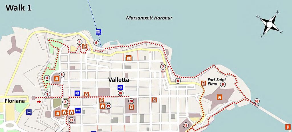
13 THE PENINSULA OF VALLETTA KEY FEATURES u THE MAGNIFICENT GRAND HARBOUR u DRAMATIC FORT SAINT ELMO u THE WORLD WAR II SIEGE BELL WALK 1 u BEAUTIFUL BUILDINGS, MUSEUMS AND CHURCHES u MASSIVE DEFENCE WALLS This first section of the coastal walk takes you around the edge of the magnificent peninsula of Valletta with its great walls and its wonderful views of Marsamxett and the Grand Harbour. At seven kilometres, it is the shortest section of the overall walk and for many, the most interesting, as it takes you back in time around a city that still retains many of its original medieval elements. The walk begins at the gate of Valletta and passes around, on top of, and outside the historic and imposing battlements that form the perimeter of this UNESCO world heritage city. The route provides stunning panoramas across the island and exciting views from sea level. It passes a myriad of historic sites and allows you opportunities to make short diversions into the city itself to see points of special interest such as museums and churches. Further information on museums and visitor attractions in the city may be found at This very pleasant walk should take you about three hours. However it is so rich in features of interest that you should allow an entire day to linger over the magnificent views or to visit some of the many cafés, palaces, museums, gardens and churches along the route. The walk is entirely along pavements and coastal promenade and is without difficult ascents. Avoid the walk in stormy weather as some parts down at sea level are very exposed to wind and waves. The route starts and finishes near the Valletta bus terminus, next to the main entrance to the city. THE WALK The route, shown on Map 1, begins at the central entrance to Valletta, near the impressive Triton s Fountain. The Triton s fountain was designed by the famed Maltese Sculptor Vincent Apap in 1959 as part of the original bus terminus for Malta. It depicts three mythological Greek gods with an upper body of a man and tail of a fish, holding a central plate. It is a stunning piece of local sculpture, more so due to the unique system of hidden pipes, passage ways and chambers which channel water into the upper plate. Happily, the formerly drab entrance to this historic city has recently been redeveloped to a design by the Italian architect Renzo Piano restoring part of the original glory to this square. 9

14 walk 1 A CITY BUILT BY GENTLEMEN FOR GENTLEMEN Valletta, a UNESCO World Heritage site, is situated on a peninsula overlooking the Grand Harbour, one of the great natural harbours of the world. The Knights of Malta commenced its construction in 1580 shortly after the defeat of the Turks in the first siege of Malta. The Knights decided they needed a stronger and better base and so they undertook the development of a new capital city on the formerly empty peninsula and named it Valletta after their Grand Master and hero of the siege, Jean de La Valette. As the Knights were members of the richest families of Europe finance was not a constraint. A main design requirement for the city was the ability to withstand another sea and land siege and so the leading architects of Europe were employed in its design and construction. Valletta is still today completely surrounded by walls of a staggering size, extent and beauty. For the following 220 years or so, under the generally benign rule of the Knights, Malta enjoyed an age of peace and prosperity. There are excellent buildings throughout Malta, but Valletta is exceptional in having so many fine churches, museums, palaces, and historic buildings, all within a well preserved walled city. There were significant losses from bombing during the Second World War but much remains to astound the visitor with the style and beauty of its medieval past. Begin the walk by rambling across the bridge into the city 1. Looking down into the moat from the right of the bridge you can see what was formerly the terminus of Malta s only train line that linked the capital to Mdina/Rabat in the centre of the island. Entering Freedom Square, the modern building to your right is the parliament building. Note the nearby Opera House 2 to the left of the parliament building. This was bombed in 1942 and remained a ruin until 2012 when it was redeveloped and brought into use as an open-air theatre. Admire the intricate designs of the building opposite the opera house, a remnant of pre-war Valletta. Sadly, many such buildings were destroyed by bombing in World War II. TRITON S FOUNTAIN 10

15 walk 1 MANOEL ISLAND FROM HASTINGS Take a left turn at the Café Royale, go down Triq l-ordinanza (triq means street) and take the first turn left before a fort known as Saint John s Cavalier 3. Due to its height, the fort enabled troops to defend the main gate and to fire directly into enemy lines. Strolling uphill for about 50 m, you reach Hastings Garden 4. Go into this pleasant public garden to view the bastion walls, noting their thickness at about six metres. The Knights had lost the island of Rhodes to a Turkish siege, and nearly lost Malta in the 1565 siege, so they clearly knew a thing or two about defence. You will now readily believe that these battlements are the strongest, longest and most impressive medieval defence walls in the world. The view from the walls across the country is superb - you can see Mdina (the old capital) in profile and the radar dome that is situated on the high Dingli cliffs on the south coast of Malta. As you walk to the right through the garden you can admire Msida Creek and its marina, Manoel Island and Marsamxett Harbour. The restored fort on Manoel Island is particularly impressive. Walk to the right, leaving the garden through the last gate, near an obelisk - the remains of a monument to Sir Frederic Ponsonby, which was struck by lightning. The gate leads into a car park in front of a row of beautiful period houses. Pass on the left into the lower car park and exit onto the public road. This lower car park area was formerly an anti-aircraft battery - note the circular rails in the ground and the mounts for heavy artillery. The monument in the middle is dedicated to Robert Cavendish Spencer, a distinguished British Navy Officer and great-great-uncle to Princess Diana. TOWARDS FORT SAINT ELMO Continue downhill onto the public road, turning left into Triq Sant Andrija. The road curves as it heads down to sea level, passing the San Biagio Bastion 5. At the bend, notice the site of another anti-aircraft battery and on your left, after a flight of steps, the Fortress Builders Centre a museum in honour of the building of the bastions, 11
 to bring you to the jetty for the Sliema ferry 6.")
.")
16 walk 1 FORT MANOEL ISLAND FROM HASTINGS GARDEN which is worth a visit particularly for its old maps. The road passes under a bridge (with a plaque dating to 1568) to bring you to the jetty for the Sliema ferry 6. This ferry service to Sliema operates about every 40 minutes and is a great and inexpensive way of taking a short boat trip. Take the road towards the tip of the peninsula, passing the water polo ground (a popular summer sport). You can see many cuttings in the natural rock wall below the battlements, most of which are sealed by doors. These were air raid shelters cut from the rock by the citizens of Valletta during World War II. Many were privately owned by separate families, some had several rooms. With an air raid virtually every day for 18 months it was important for the citizens to have a nearby shelter. Note the impressive spire of the Anglican Saint Paul s Cathedral dominating the narrow streets above you. THE BASTIONS AND CATHEDRAL 12

17 Rambling along by the coastal road you may notice the unusual shapes of the windswept limestone wall. Soon you come to a large entrance tunnel to the right, known as the Jew s Sally Port 7. You may care to divert through the tunnel for a few minutes to get a glimpse of narrow streets which make few concessions to modernity. Waste collection is a challenge here as there is not enough room for bins, and rubbish bags have to be left out in narrow streets for the daily collection. As there are few lifts in the old buildings, ropes and pulleys are sometimes used to get deliveries, such as bread and groceries, up to the higher floors. The washing hanging out of windows, the variety of noises and smells and the small shops all combine to give the ambience of a crowded medieval city. Continue the walk along the coast, passing by boathouses 8 converted into summer/holiday homes alongside an inlet for small boats. Behind the boathouses, in the corner, notice a small gate sealed with limestone blocks, one of the former entrances to Fort Saint Elmo. Across the water you have a good view of Sliema and Tigné Peninsula, and among the new high-rise development you can just distinguish Fort Tigné at sea level. Walk around the seaward tip of Valletta at the feet of the seemingly impregnable walls of Fort Saint Elmo 9. These mighty ramparts were designed to serve both as a physical obstacle and a visible deterrent. The original fort (built around 1560) was completely destroyed during the Turkish siege of 1565 that so nearly ended the rule of the Knights. It was re-built quickly and modified over the following centuries in response to changing military tactics and weapons. It played an important role in the defence of the island against the German/Italian siege of World War II. Because of its strategic location at the mouth of the harbour, the fort provided a perfect location for anti-aircraft guns. It was the guns on these ramparts that defeated an audacious but futile Italian e-boat attack on the Grand Harbour in walk 1 VIEW TOWARDS SLIEMA 13

18 walk 1 FORT SAINT ELMO ATTACK ON FORT SAINT ELMO The seaward tip of Valletta is dominated by Fort Saint Elmo. It was here in 1565 that the Knights made a glorious stand against the forces of Suleiman the Magnificent. Suleiman was a formidable enemy at the peak of his power, and his army, the most powerful in the world at that time, had even reached the walls of Vienna. The Knights numbered about 600 and had around 6,000 soldiers (many of whom were untrained Maltese) to defend the island. Learning of the invasion plan, the Knights set about improving the defenses of Fort Saint Elmo and their main base at Fort Saint Angelo, across the Grand Harbour from the then uninhabited peninsula of Valletta. The Turkish fleet of 180 ships, carrying about 40,000 soldiers, arrived in 1565 and quickly identified the Grand Harbour as its preferred anchorage. The entrance to the Harbour was however protected by Fort Saint Elmo. Turkish spies had reported that the fort had a number of weaknesses, in particular because it was overlooked by higher ground. The Turks set up 14 massive siege guns on the high ground of the peninsula and in May 1565 commenced their fierce barrage. The Turks expected the fort to fall within a week, but the courageous defenders held out for 31 days, as La Valette had ordered them to fight to the last. The Knights lost around 1,200 troops, including 120 Knights, while the Turks lost about 8,000 men on what should have been only a quick sideshow to the siege of the Knight s main base in Fort Saint Angelo. After the fall of Fort Saint Elmo the bodies of the knights, some living, most dead, were mutilated, tied to wooden crosses and floated across on the tide to the Christian forces. If this was intended to break the morale of the Knights, it was not successful. In response, La Valette ordered the killing of all Turkish prisoners, with their heads being shot by cannon into the Turkish lines. The message was clear this was to be a fight to the finish. The action then moved across the Grand Harbour to a siege of the Three Cities, the area through which you will pass in the next section of the walk. 14
19 THE GRAND HARBOUR Passing around the tip of the peninsula you can see a number of steps leading to an iron bridge 10. The original bridge was destroyed by an e-boat during World War II. Walking up the steps and across the bridge you see the very impressive entrance to the Grand Harbour and a long breakwater with a lighthouse at its tip. Walk to the other end of the bridge to enjoy this world-class view. The breakwater, dating from 1910, ensures that the Grand Harbour is a safe haven for ships in all seasons. It proved a formidable deterrent against enemy submarines during World War II. Walk down from the bridge - notice a structure to your left much like a rubble wall, which was a small but sturdy battery. The inscription next to the steps reads Continue along the path directly at the base of the bastions. As you turn a corner you unexpectedly meet narrow paths, small cliffs, caves and steps cut into the limestone rock. Note a number of air raid shelters cut into the rock and the numerous sentry points established during World War II to detect attacks by sea. Valletta hosts an underground labyrinth of air-raid shelters, stores, water reservoirs and tunnels. When you reach a narrow (but safe) footbridge, you can appreciate the huge amount of work undertaken by the Knights in constructing the outer defence walls of Valletta. After some more rock-cut steps you pass by an interesting room with the sign reading Boom Defence (1905). This housed the machinery which operated an iron net which, when spread between this point and the opposite side of the Grand Harbour, prevented the entry of enemy submarines. Further on you pass over another small iron bridge to reach an area of modest summer boathouses 11, formerly the location of an antiaircraft battery. Climb the steps to reach the coastal road opposite the original 17 th century Knight s Hospital. The former Knights Hospital has now been magnificently renovated to create the Mediterranean Conference Centre 12. You can pay a fee to do a tour of this beautiful building but for the moment just look in through the main door to get a glimpse of its scale and quality. Turn right along the road (with your back to the sea) to reach the main entrance of Fort Saint Elmo, passing by some granaries cut as vertical cylinders into the limestone, with caps like bases of columns. During the French occupation in 1798 the fort was used as a prison. Later the British upgraded the fort to house a series of coastal defence guns. Re-enactments in period costume are held in the fort every month and are well worth a visit. You may care to visit the National War Museum situated at the Drill Hall of Lower Fort Saint Elmo, whose collection focuses on the two World Wars. Turn back from Saint Elmo towards the Knight s Hospital and walk along the coastal road until you come to the World War II Siege Memorial 13. This impressive monument with its famous Siege Bell (rings at noon each day) overlooks the majestic Grand Harbour which was the scene of such horrendous conflict and aerial battles. The monument is a memorial to those who lost their life in that harrowing second siege of Malta. During the war submarines operating from Malta were responsible for the loss in some months of up to 50% of the supplies being shipped from Italy to Rommel s forces in Africa. The success of Malta in withstanding the siege was a very major factor in the defeat of the German/Italian forces in Africa and in determining the course of the whole war. In recognition of the collective bravery of its people, the island was awarded the George Cross by King George VI so as to bear witness to the heroism and devotion of its people. walk 1 15

20 walk 1 From the Siege Memorial, go straight across the road to Triq il-mediterran and ramble uphill to the peaceful Lower Barrakka Garden 14. At its centre is a small Greek-style mausoleum in memory of Governor Sir Alexander Ball. He had been in command at the defeat of the French in 1800 (the French under Napoleon had captured Malta in 1798 on their way to invade Egypt). Continue to ramble along by the bastion of the upper coast road, taking time to admire fleeting views of the narrow streets of Valletta which, as you see, is still very much a lived-in city. This pleasant path, partly shaded by olive trees, turns left along the bastion and passes beside some lovely pre-war houses. Continue on the path along the bastions to pass over the ornate Victoria Gate 15. The path rises as you walk up the steps located in front of the curiously named Hotel British. At the end of this path you turn left to reach the Upper Barrakka Gardens 16. This small park, the gift of an 18 th century Knight to the city of Valletta, is famous for its statues and its views, as well as being a pleasant spot for a coffee. Admire the panoramic view of the Three Cities and impressive Fort Saint Angelo on peninsulas across the harbour. From this viewpoint you readily understand why the Grand Harbour is regarded as one of the finest in the world, with deep water right up to the city s walls. You can also appreciate the strategic value of this harbour which was capable of providing safe anchorage to the entire British Mediterranean fleet. Coming out of the Upper Barrakka Gardens, you find yourself in a small square across the road from the Prime Minister s Office 17, the former Palace of the Knights of Castille. Also across the road is the Saint James Cavalier, one of the two main forts protecting the entrance to Valletta. It has been sensitively redeveloped as a cultural centre and now hosts shows, films and exhibitions. You cross the road to pass to the right around Saint James Cavalier and in front of the church of Our Lady of Victories, the first building to be constructed in the city (about 1585). The road runs through a small square dedicated to Grandmaster Jean De La Valette, the hero of the 1565 siege and the founder of this magnificent city. The downhill road leads back into Freedom Square and the starting point of the walk. VIEW FROM THE BRIDGE 16
 to take a coffee or ice cream in the superbly beautiful interior of Café Cordina 18?")
21 walk 1 VIEW FROM UPPER BARAKKA GARDENS There is much to see and experience in Valletta. Why not walk through the central street, (Republic Street) to take a coffee or ice cream in the superbly beautiful interior of Café Cordina 18? Afterwards, you may stroll around to admire such architectural gems as the nearby Saint John s Cathedral 19, one of 25 churches in Valletta. You should also consider visiting the Grand Master s Palace 20 and the National Museum of Archaeology. Make sure to explore the many narrow and stepped streets throughout this hilly peninsula. More information on the many places of interest in Valletta can be obtained through VISITING VALLETTA S KEY SITES The Co-Cathedral of Saint John is a gem and a must see, representing an example of high Baroque architecture, and the epitome of the Knights spiritual and military role. Its most famous pieces are Caravaggio s beheading of Saint John, and many paintings and carvings of Mattia Preti. The cathedral and museum are open everyday except Sunday, with reduced times on Saturday. Details at The stern exterior of the Grand Master s Palace conceals a sumptuous interior, once the residence of the Grand Masters of the Knights. It boasts 5000 suits of armour including those from La Valette and many fine frescoes. Also accessible from the same entrance are the State Apartments. The Grand Master s Palace is open everyday, whereas the State Apartments may be occasionally closed. Details at The National Museum of Archaeology in Republic Street displays an exceptional array of artefacts from Malta s unique prehistoric periods, starting with the first arrival of man in the Ghar Dalam phase (5200 BC) and running up to the Tarxien phase (2500 BC). The Museum is open everyday. Details at 17
22
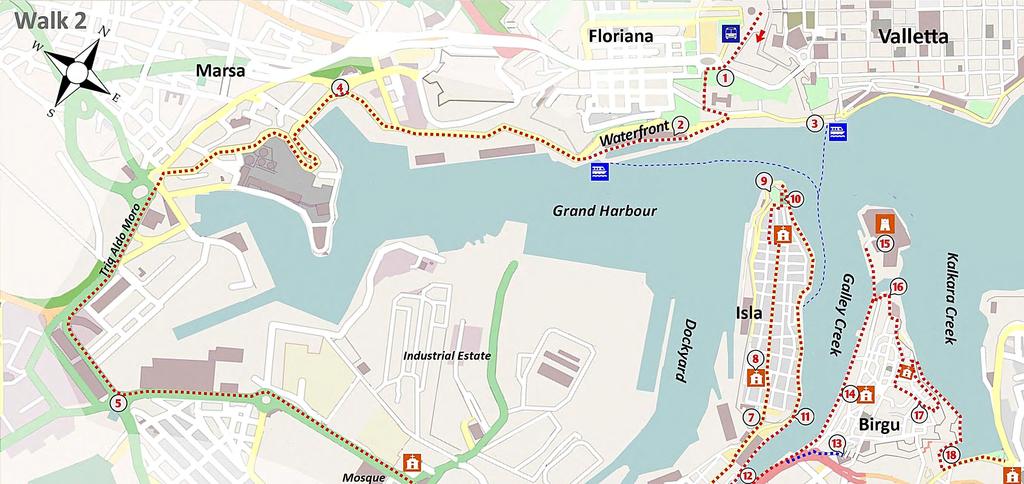
23 THE THREE CITIES KEY FEATURES u THE GRAND HARBOUR u DRAMATIC FORT SAINT ANGELO u THE MEDIEVAL THREE CITIES u MUSEUMS, PALACES AND CHURCHES WALK 2 This 14 km section of the walk takes you from Valletta around the coast of the magnificent Grand Harbour. Rambling along city pavements you pass the liner dock at Floriana and enjoy panoramic views across the harbour to the medieval cities of Birgu, Isla and Bormla. These are also known respectively as Vittoriosa, Senglea and Cospicua and together they form an area known as the Three Cities. The walk takes you through the busy commercial docks area and past the shipyards that played such a central role during World War II. Passing through a tunnel under Saint Paul s Bastion you approach the Three Cities area with their wealth of classic buildings and impressive fortifications. It was in this area that the Knights built their first base on Malta (starting in 1530) and, despite heavy bombing, many wonderful buildings have survived to impress the visitor. This very interesting walk brings you along narrow medieval streets and coastal footpaths passing palaces, churches, monuments and the impressive Fort Saint Angelo which dominates this side of the harbour. The walk is entirely along pavements and coastal promenades and is quite easy. As there is so much to see and admire you should allocate a full day to enjoy this walk at a leisurely pace. There are many opportunities for a coffee, lunch and toilets along the way. You can take a bus back to Valletta from the ending point at Kalkara. THE WALK The route (see Map 2) begins at the central gate of Valletta. You pass between the city walls and the bus terminus to cross the busy road and join the curving downhill footpath, with fantastic views across the Grand Harbour. To your right you can see the Cenotaph pillar, Malta s War Memorial for those who died in World War I. Passing a small wartime monument 1 you turn left to pass the second wartime memorial, that to the King s Own Malta Regiment. Take the downhill steps through a small wooded area. At the bottom, the building on the left is the King George Memorial Building, currently a hospital. Cross the parking area and take the next flight of steps and then the road downhill to the left towards the cruise liner terminal. At the bottom of the hill, some 300 m to the right, you reach the Valletta Waterfront 2 with its stone buildings dating from the time of the Knights now magnificently restored. 19
. Ü Departing from Lascaris Wharf 3 : The Valletta Ferry Service offers regular trips (phone 2346 3862, www.vallettaferryservices.")
24 walk 2 THE VALLETTA WATERFRONT OPTIONAL BOAT RIDE TO THE THREE CITIES There are two main options: Ü Departing from Valletta Waterfront 2 : The yellow Malta Water Taxis (Phone , Ü Departing from Lascaris Wharf 3 : The Valletta Ferry Service offers regular trips (phone , A & S Water Taxis operate traditional boats and cruises (Phone / , WALKING TO ISLA The walk through the inner part of the Grand Harbour has few merits as it passes in the main through non-descript commercial and industrial areas. Some people prefer to reach the Three Cities by bus (from Valletta to Isla); others may opt for a short and pleasant boat trip (see box above). The walking route continues from the inland end of the Valletta Waterfront where it exits onto the main road. Keep to this road as its flanks the Grand Harbour. This part of the inner harbour area was the main base of the Turkish Army for the 1565 assault on the Knights based at Fort Saint Angelo. Recent excavation works here have unearthed a number of skeletons from an old cemetery belonging to the Turks. At the roundabout 4, take the road left and through the crossroads to continue uphill along a winding road. The large building on your left is a soon-to-be decommissioned power station. Follow the road that goes downhill and left at a minor roundabout to reach a wide main road (Triq Aldo Moro). Walk along this road as it turns left to reach a major crossroads 5. To your right notice the spire of the Church of the Addolorata Cemetery. Turn left uphill to reach another roundabout where you take the major road opposite which continues uphill. At the top, on the right, you pass Malta s sole mosque. At the next roundabout take the second exit downhill which heads towards the Three 20


25 Cities. The road goes through a tunnel under the impressive Bastion of Saint Paul 6 part of the outer defence wall of the Three Cities. Continuing on the main road for 350 m where you take the turn immediately to the left of the Church of Saint Paul. You are now rambling along the central road of the peninsula and towards the entrance to the medieval city of Isla 7. The Knights set out the city of Isla on a grid pattern and while the orderly street layout remains, little is now left of the original town. You will notice that many of the buildings just inside the impressive entrance gate are of post-war construction, a consequence of bombing in World War II. Walk through the entrance gate into a square and following THE NARROW SIDE STREETS OF ISLA. the main road through the centre, you soon come to a small square and the Parish Church of Our Lady of Victories 8. The original church of 1743 was destroyed in 1941 during an intense air attack on the aircraft carrier HMS Illustrious, berthed nearby. The Feast of Our Lady of Victories falls on 8 th September - the same day that the Turks abandoned the siege of 1565 and the day when Italy surrendered to the THE GARDJOLA allied forces in You can see why the Maltese have a particular devotion to Our Lady! As you walk further into the city you should take the opportunity to wander into some of the narrow side-streets. To the left, you can see the dockyards that were the focus of so many bombing raids. You can also notice a number of old buildings that escaped the bombing. A particularly important survivor is the 1662 Church of Saint Philip Neri at the end of the central main road. Pass around by the left of this church, go down the steps and then turn right to come to a small garden at the tip of the bastion 9. From here you get a spectacular view of the Grand Harbour, the dockyards, Valletta, the entrance to the Grand Harbour and Fort Saint Angelo. The sentry box (known as the gardjola) at the tip of the garden displays symbols of watchfulness and good luck: the eye, the ear and the crane bird. The inscription in Latin assures the citizens that they may rest at ease as the tower is watching for their safety walk 2 GALLEY CREEK Exiting the garden, you go downwards immediately on the left through a tunnel to reach a lovely small square above the coast road. On the left is a Sally Port that leads down to sea level at Galley Creek (so named because the Knights moored their boats here). On the way through the Sally Port notice the lower bastion walls 10, 21

26 walk 2 IL-MAĊINA now occupied by a football field and car park. In 1554, the Order imported a large iron chain from Venice that allowed them to seal Galley Creek from attacking boats by stretching it between this battery and Fort Saint Angelo. Head inland along the promenade of Galley Creek. A few meters past the battery you can notice the store from which this chain was deployed. Walking further inland you may also notice a cave in the wave-sculpted limestone known as l-għar ta Mikelin (Michael s Cave), originally known as the Mermaid s cave. Continue inland along this popular promenade where locals come to fish and relax in their boats, some of them the traditional multicoloured luzzu. As the promenade widens you will pass the monument to Colonel Juan Azopardo, a native of Isla who is honoured as the founder of the Argentinean Navy. This now peaceful spot housed a wooden bridge that was a crucial means of communication between Isla and Birgu during the Great Siege of Ramble on past the arched Dockyard Terraces constructed in 1550 as residences for the Galley Captains. During the British period they served as a military barracks, and nowadays are private residences. The lovely small house on their left was the original chapel, as the small belfry shows. You reach a huge bastion 11, now hollowed through to allow the passage of traffic. In earlier days it housed a large wooden crane (known as il-maċina) used for the unloading and servicing of the Knights galleys. THE CITY OF BIRGU To reach Birgu on the opposite peninsula you walk along the quay in an area known as Dock One 12. Inhabited since prehistoric times, this area has been in use as a dock since the Phoenicians ruled the island. Walking along the dock promenade you can notice a series of high magazines known as the galley houses in which the Knights stored their galleys. Follow the route along the coast as it makes a u-turn and heads out along the peninsula of Birgu. This small city was protected by a massive wall with only one access point through a heavily defended gate. In recent times a number of other entrances have been made through the wall to allow access for vehicles. Fortunately the original gate 13 has been retained and this is worthy of a visit. With Galley Creek 22
, you enter a small square containing the Malta at War Museum.")
27 walk 2 THE FREEDOM MONUMENT to your left, take the short detour uphill to come to the first of Birgu s gates. After admiring the stone carving of cannons and the date in Latin letters - MDCCXXII (1722), you enter a small square containing the Malta at War Museum. A visit to this museum includes a tour of the very extensive air-raid shelters that were hollowed out in the thick walls that you see around you. Further in, you can see a number of other gates that formed this formidable entrance. To continue on the main route you must retrace your steps to the coast to head towards the tip of the peninsula. The path takes you past the Freedom Monument 14 located near the quay where the last British military contingent departed from Malta in 1979, ending a connection of 180 years. Note the friendliness of the figures bidding each other farewell. Behind the monument is the parish church of Saint Lawrence, an early Christian martyr who was roasted alive by order of the Roman Emperor Valeria. Today he is the patron saint of cooks! This church was in existence before the arrival of the Knights, but it was taken over by them, expanded and embellished. The church has a richly decorated interior and a variety of artistic treasures. Walking towards Fort Saint Angelo you pass along the busy modern marina. On the right is an imposing building that now houses the Maritime Museum, well worth a visit. The museum building, constructed as a bakery by the British in 1842, was regarded as the most beautiful bakery in the world. Further along the waterfront is the grand Palace of the General of the Galleys. An adjoining palace was destroyed by World War II bombing but now, in its place, is a lovely hotel built to a similar design. Other period buildings did survive and have been restored as part of the attractive development along the Birgu waterfront. FORT SAINT ANGELO Before reaching Fort Saint Angelo 15 you cross over a moat hewn in the rock between the fort and the town. Its main function was defensive but the moat was also used for the berthing of vessels during rough weather or for minor repairs. The fort is closed to the public at present because of restoration works, but you can admire its impressive exterior. 23

28 walk 2 FORT SAINT ANGELO When the Knights arrived in Malta in 1530 they established their base at Birgu and immediately set about constructing a robust castle at the tip of the peninsula, on the site of a medieval stronghold. The fort was almost completely destroyed during the siege of 1565 but the Knights repaired it quickly and continued to strengthen it until it reached its current size and layout in The man mainly responsible for the current appearance of the fort was Colonel de Grunenberg, engineer to the King of Spain. His design gave the fort a series of gun batteries aimed at controlling the entrance to the Grand Harbour. His coat of arms is to be seen over the gateway to the fort. Few fortifications anywhere in Europe can match the qualities of its fusion of medieval, renaissance and baroque elements. The ramparts are built from the very toughest coralline limestone which enabled it to withstand centuries of rain and wind and heavy bombing. The British made few alternations to the fort and utilised it mainly for storage within its many underground bomb-proof magazines. Between 1912 and 1979 the fort served as the headquarters of the British Mediterranean fleet. It was bombed heavily during World War II, receiving 69 direct hits. It is surprising therefore to learn that many historic elements have survived, including the 15 th century Castellan House on the upper part of the fort. This is now occupied by the Sovereign Military Hospitallier Order of the Knights of Saint John of Jerusalem, of Rhodes and of Malta the successor organisation to the Knights of Malta. The bell that announced the lifting of the Ottoman siege in 1565 is still hanging from the highest point of the fort. FORT SAINT ANGELO 24

29 NARROW STREETS OF THE COLLACHIO You cannot walk around the seaward side of Fort Saint Angelo and so you must retrace your steps. Passing back over the bridge and moat you take the narrow steps to your left in between the modern buildings and follow these steps uphill to a minor road. Turn left and up some more steps to reach some benches 16 overlooking Fort Saint Angelo. You now head inland and the first left, following Triq Santa Skolastika to eventually reach the Church of Saint Anne, with a titular painting considered one of the best works of Knight Mattia Preti. Walk on through a crossroads to turn left into Triq Hilda Tabone, the heart of the Knight s zone in Birgu, known as the Collachio. Strolling through this narrow road, you reach the lovely Auberge of France at No. 24/26 and beside it, the Auberge of Provence, both now private residences. As you walk along, take a look into the second road on the right which is a typical medieval street. You may care to take a short detour 50 m down the street to view the oldest building in Birgu which has distinctive Gothic arches and a Norman facade. Walking further along the road you can note the plaques commemorating buildings no longer there and on the next road to the right, notice a distinctive column - the remains of the Auberge of Castille 17. At the end of the road turn left and then immediately right into a small parking area. Walk up the steps located on your left onto the parapet of a bastion overlooking Kalkara Creek and walk left through an area known as il-mandraġġ - formerly a port for the maintenance of vessels. Continue on until you reach steps going down through the road towards a small tunnel opened in the fortifications to allow access to the shore. The building on the left is the Sacra Infermeria, established by the Knights in the mid 16 th century. Next to the building is a convent where Benedictine nuns have lived since True to their strict vow of contemplation, the nuns never leave the convent. Ramble down the steps of the tunnel towards the shore of Kalkara Creek and turn right, heading inland. Across the creek you can see a partly demolished British Army building which served as a hospital during and after World War II. The road passes in front of the great bastions of il-mandraġġ and curves into a boatyard 18. Pass through the boatyard to join a promenade. Ramble along to the left to reach a playground in front of Kalkara Parish Church. Here you may care to relax with a coffee before taking the bus back to Valletta. walk 2 25
30

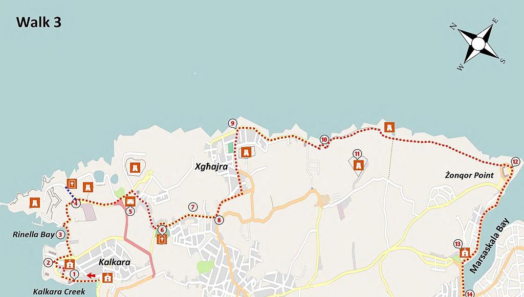
31 KALKARA to MARSASKALA KEY FEATURES u MAGNIFICENT FORTS u THE LARGEST GUN IN THE WORLD u PLEASANT COASTLINE TRACK u MARSASKALA BAY WALK 3 This 11 km section of the walk begins at Kalkara on the eastern side of the strategic Grand Harbour. You ramble past historic forts, military cemeteries and buildings and the world s largest gun, before passing through countryside to reach the small coastal village of Xgħajra. The route then proceeds along a tranquil path parallel to the lowlying coast to reach pretty Marsaskala Bay. The walk is on a comfortable combination of promenades, pavements and flat country track and has no significant climbs or challenges. There are public toilets and an opportunity for a coffee at Kalkara square, at Xgħajra and at Marsaskala. Frequent buses can take you from Valletta to Kalkara and from Marsaskala to Valletta. THE WALK The route is shown on Map 3. A bus from Valletta will take you to the starting point at the small park opposite the parish church of Kalkara. The original parish church, like many other buildings in this area, was destroyed by bombing in World War II. Kalkara is believed to be one of the oldest inhabited zones in Malta due to its accessible yet protected creeks. Strolling along the promenade with Kalkara Creek to the left, you can admire terraced houses with traditional Maltese balconies. The bastions of Birgu and Fort Saint Angelo are in full view and, across the Grand Harbour, the high battlements of Valletta give the impression of a truly medieval city. At a fork on the road, you take the road to the right. A short distance uphill you pass Villa Portelli 1 on the left, now the Maritime Institute, originally built as a summer residence and later used as a residence for senior British Navy staff. This road continues uphill towards the Bighi complex 2 which lies on a promontory jutting into the Grand Harbour between Kalkara Creek and Rinella Bay. About 100 m beyond Villa Portelli, turn to the right to view the VILLA PORTELLI 27
 served as a place of pilgrimage and prayer for the victims of the plague of the early 1800 s. It has a unique hexagonal shape, a small cupola and a belfry.")
 through a post-war housing estate to reach a viewing point opposite the magnificent Villa Bighi 2.")
32 walk 3 oldest chapel in the area, that of Christ the Saviour. Early documents indicate that a chapel existed on this site since The present building (dating from 1680) served as a place of pilgrimage and prayer for the victims of the plague of the early 1800 s. It has a unique hexagonal shape, a small cupola and a belfry. The paintings and statues in the chapel s interior make it worth a visit, though unfortunately it is rarely open. From the chapel the route continues to the left (back to the coastal road) through a post-war housing estate to reach a viewing point opposite the magnificent Villa Bighi 2. CHAPEL OF CHRIST THE SAVIOUR VILLA BIGHI This lovely villa with its attractive, symmetrical facade was built by the superior of the Knights, Fra Giovanni Bichi, (also an Admiral in the Papal Navy) for his private use after his retirement. Construction started around 1675 but Bichi did not survive to see it finished as he became a victim of the plague that struck the island in After his death the building was used as a quarantine centre for incoming vessels. Upon the insistence of Lord Nelson, Villa Bighi and its grounds were converted into a major naval hospital and in this capacity it served the eastern Mediterranean fleet in the 19th and 20th centuries. Nowadays it hosts a centre for the Arts and Science, though much restoration is still required as a result of bombing in World War II. VILLA BIGHI 28

33 TOWARDS XGĦAJRA Head inland to the right along a wide curving road, with views across the water to the main entrance to Fort Ricasoli and some oil storage tanks within its ditch. Take the left road downhill towards lovely Rinella Bay 3, the only sandy bay in the area and much used by locals. On the right behind the high wall is a military cemetery and a munitions depot. Walk around the beach to take the road uphill to the right past some former barracks now private residences. walk 3 FORT RICASOLI Fort Ricasoli, constructed by the Knights in 1670, occupies the promontory that forms the eastern arm of the Grand Harbour. Together with Fort St Elmo, it s guns commanded the approaches to the Grand Harbour and was extremely active in the defence of Malta during World War II. The fort suffered severely from enemy bombing, with much of the internal structure being badly damaged. The fort continued to be an active military installation throughout the British period providing training for navy staff. In recent years, this huge fort has been host to five major film sets, amongst which are Gladiator and Troy. Continuing along the road, you reach a large roundabout 4 where your route continues inland. However, it is worthwhile to take a detour of 150 m to the left towards Fort Ricasoli and the plague cemetery of Wied Għammieq. In 1837 a cholera plague once again swept through Malta and Fort Ricasoli was used as an emergency hospital. The cemetery of Wied Għammieq was hastily established and some 855 were buried there in a mass grave. The cemetery became an important centre of devotion and in 1878 it was renovated with the addition of a chapel. From a viewing point directly above the cemetery you are able to see part of the mighty 100-ton Armstrong gun at Fort Rinella. Look carefully as the gun is well camouflaged and, in spite of its size, Is not easy to see. You may also care to take a short walk down to sea level to admire some of the strong bastions of Fort Ricasoli. Unfortunately walking directly along the coast from here is not possible as the area is leased to the Rinella film studios. Back to the main path, about 100 m beyond the roundabout 4 you pass Fort Rinella on the left. Surprisingly for such a wealth of forts, this is the only one from the British period which is open to the public. THE 100-TON GUN 29
34 walk 3 THE WORLD S LARGEST GUN The 100-ton Armstrong gun at Fort Rinella arrived in Malta from England in The gun was ferried by sea to Rinella Bay from where it was manhandled to its current location. The transfer operation, involving about 100 men and many horses, lasted three months. The gun was located so as to fire over the top of the parapet without exposing the gun-crew to enemy fire. Given its massive proportions the gun could not be worked manually and a hydraulic/ steam system was used to traverse and load it. The rate of fire was once every four minutes. Operation of the gun required up to 40 men under a battery commander and a master gunner. In 1906, after just twenty years in service, the 100-ton guns in British service were declared obsolete. As a consequence Fort Rinella was abandoned without having fired a shot in anger. The gun has been restored and, once again, dramatically fired. Fort Rinella is open Tuesday to Sunday from to 6.00 pm. Details of the visit and guided tours are found on Walk along the main road and after passing a small pillbox 5, you reach the entrance to Smart City, Malta s technological centre (still under construction). To your left, you may just notice the walls of Fort Santu Rokku, built by the British in You now turn to the right past some residences to come to the Capuċċini British Naval Cemetery 6, under the care of the Commonwealth War Graves Commission. The cemetery holds over 1000 casualties separated into Protestant and Catholic sections. Most of the 351 Commonwealth burials from the First World War are located in a triangular plot within the Protestant section. Among those buried here are 22 men who died when HMS Russell was sunk by a mine off Malta in April The cemetery stays open Monday to Friday until dusk, and on weekends and public holidays from to dusk. From the entrance to the cemetery take the road (signposted to Xgħajra) which runs around the peripheral wall of the cemetery. At a Y-junction take the road left past modern houses and, at a point about 200 m beyond that junction, look into the field on the left. The small buildings 7 belonged to the Saint Peter s Heavy Anti-Aircraft Battery, one of many such batteries charged with defending a portion of sky from Axis attacks during World War II. This battery, armed with four 4.5-inch guns, received a direct hit from an enemy bomb. A World War II position finding station may be noted a little further along the road. This formed part of a chain of stations whose function was to locate enemy targets at sea and to relay the information to the coastal forts. Walking on you reach a roundabout 8 where you take the first exit left towards the coastal village of Xgħajra. The road curves downhill and you take the fourth road on the left to go downhill to another roundabout. Continuing towards the coast you can notice the hardly visible Delle Grazie Battery built during the British period as an irregular pentagon with a ditch running along its periphery. The unusual block structure on top of the fort is a sound locator built during World War II to locate enemy ships far out at sea. THE COASTAL TRACK TO MARSASKALA Continuing downhill you reach the coastal promenade 9 of Xgħajra, where you turn to the east towards Marsaskala. On your journey parallel to the coast you will encounter a wide variety of defence-related structures such as searchlights, batteries and pillboxes. 30


35 COASTAL DEFENCES Due to its geographical location close to the Grand Harbour, the coast of Xgħajra is littered with defence structures preventing a direct invasion of the harbour. The importance of defending this area goes back to the times of the Knights, during which two watch towers and an entrenchment wall stretching from Kalkara to Żonqor Point in Marsaxlokk were built. Later as military tactics became SEARCHLIGHT EMPLACEMENT more complex five major forts were built and various small beach defence posts and lookouts were installed nearly every 200 metres of the coast. Beach posts, commonly known as pill boxes were reinforced concrete block structures able to withstand hits. These camouflaged structures were built on two storeys, with one small entrance guarded by a heavy metal door and an observation turret. Stationed troops were also capable of counterattack through machine guns at each top corner. Through the coast you also notice other reinforced rooms often close to the pillbox. These coastal defence lights enabled visibility during the night, whereas semicircular block structures for searchlights aided guns from forts in finding their targets. walk 3 PILLBOX AND LIGHTS ROOM 31

36 walk 3 KNIGHT S TOWER From the promenade you pass onto an earthen coastal track with open countryside on the right. The path goes around a small bay 10 with cliffs topped by a low wall. The rock is highly friable along this coast and the edge of the cliff should only be approached with care. Continuing along the track you pass a beach post and a separate beach searchlight position. The path curves slightly to the right and runs on top of the remains of the fortified Knights wall, consisting of a low ditch cut in stone with a defensive masonry wall on top. The wall runs along the coast from Kalkara to Marsaskala, although it has been mostly destroyed or eroded by the rough seas. After a few metres you pass by a two-storey block building, a coastal searchlight emplacement from World War II. At this point you are directly in front of Fort San Leonardo 11, which is inland but hidden behind a short rise. It is the last of the large coastal batteries built by the British to protect this area of coast. Rambling on for 32

37 another 200 m you come to the tower of Triq il-wiesgħa, dating from the time of Grand Master De Redin, and a pillbox on its landside. The limestone pavement along the coast is perfect for saltpans; some can be seen directly below the tower. walk 3 MARSASKALA BAY The path curves and widens into an earthen track over highly fractured limestone coast. It leads along the flat coast of Malta towards the tip of Marsaskala Bay, passing more pillboxes and a large expanse of saltpans. The path links to the town promenade at Żonqor Point 12, where you find the last pillbox in the series, and a stretch of saltpans excavated in the soft yellow limestone. As you stroll inland you get a wonderful view across the inlet. This narrow bay (more a creek really) provides safe anchorage for many small boats, without the need for a breakwater. The modern town buildings facing the sea are attractive, if over-intensive and the general impression is of a pleasant and peaceful seaside town. Few foreign tourists come to Marsaskala and its many shops and cafés cater mostly for day-trippers from other parts of Malta. The promenade brings you to the parish church of Saint Anne and its impressive bell tower. Continue along the promenade past the area for boat maintenance and the garden in front of the church. You may care to look through the narrow side streets which rise in between the seafront buildings to glimpse the old mansion of Villa Apap Bologna. The town of Marsaskala was formerly known for its various mansions serving as summer residences to Malta s rich and noble class. Unfortunately the majority of these villas are in a state of disrepair and engulfed by modern buildings. Continue walking along the peaceful promenade as it curves around the bay towards the bridge at its innermost part. There are a variety of restaurants facing the promenade some with excellent fish. Here you may consider a coffee or lunch at one of the many restaurants and later catch a bus back to Valletta from the terminus 13 near the inner part of the bay. MARSASKALA BAY 33
38
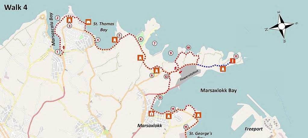
39 MARSASKALA to BIRŻEBBUĠA KEY FEATURES u PANORAMIC SEA VIEWS u BEAUTIFUL CLIFFS AND BAYS u WONDERFUL PLANT DIVERSITY u QUAINT FISHING VILLAGE WALK 4 This pleasant walk of 15 km from the town of Marsaskala to Birżebbuġa on Marsaxlokk Bay provides wonderfully varied views of cliffs, bays, towns and tranquil countryside. The coastal limestone cliffs (some as white as those of Dover) have been eroded by rain, wind and waves to create a myriad of impressive shapes and structures. You will also enjoy viewing castles, forts, pillboxes and a diversity of wild plants. Bring your swim suit - you may want to take a swim in one of the pleasant bays. There are cafés, shops and toilets along the promenades of Marsaskala, Marsaxlokk and Birżebbuġa, but it is important to carry some water with you. Frequent buses will take you from Valletta to Marsaskala and from Birżebbuġa to Valletta. THE WALK The route is shown on Map 4. Take the bus from Valletta to the town of Marsaskala, getting off at the bus terminus at the inner part of the bay near the bridge 1. Before you pass over the low bridge, you can note in the water the long leaves of the seaweed known as Sea Grass or Neptune Grass. Sea grass meadows are found in clean waters and are important as a nursery for young fish and small marine animals such as crabs, shrimps and the impressive Noble Pen shell. At the inner part of the bay, on the landside of the bridge, there is a small, wetland. It is a modest reserve providing a safe home for some ducks, birds, plants and fish that thrive in brackish water. THE SALTPANS As you walk up along the tree-lined curving promenade, you come to an extensive area of saltpans 2 cut by hand in the limestone rock. Saltpans have been used since Roman times as a means of harvesting salt from the sea. Seawater is fed into the shallow depressions through a system of hand-dug channels and, after concentration and evaporation by wind and sun during the hot summer months, the white sea-salt can be collected, bagged and sold. The production process is very labour intensive and is no longer commercially viable. Note the World War II pillboxes at both sides of the mouth of this vulnerable bay. 35

40 walk 4 SAINT THOMAS TOWER At the tip of the peninsula, you pass, on the right, the impressive Saint Thomas Tower 3 constructed by the Knights shortly after the 1614 landing of 6,000 Turkish soldiers in nearby Marsaskala Bay. Immediately beyond the derelict hotel, go down onto the rocky limestone, and make your way along the coast through an area of saltpans and towards a pillbox. (Avoid the temptation to stay on the roadside path - it will also take you to the bay, but by a longer and less interesting route.) Rise up to the level of the pillbox, and follow the wide path inland with care, avoiding the edge. The rocks here are quite friable, so it is best to follow the path some distance back from the edge. Passing another pillbox, you walk through a public garden, and continue on towards Saint Thomas Bay. THE COAST OF SAINT THOMAS BAY 36

41 SAINT THOMAS BAY This popular bathing area has a well located café 4 overlooking the pretty bay. You may want to take a break here and perhaps buy some water and a snack, as you will not meet another shop until you arrive at Marsaxlokk, about two hours away. The bay has a small pier and an attractive beach much favoured in the summer months by the Maltese. The view ahead is dominated by the high chimney of the Delimara power station, at the edge of Marsaxlokk Bay. You ramble along the beach, passing a number of simple summer residences. Note the intensive erosion of the soft stone at this end of the beach below the Irħama Battery, dating from the Knight s period. At the end of the bay take the narrow path heading straight and uphill across the peninsula 5. WILDLIFE ALONG THE ROUTE Admire the diversity of plants along the uphill path, including the endemic Maltese salt tree, the samphire, sea lavender and capers. The small buds of the wild caper are picked in early summer and, when pickled, make a tasty addition to salads and traditional Maltese sauces. On a fine day you will usually see some lizards and perhaps a lazy chameleon or a snake, all of which are harmless to humans. There are a number of sub-species of lizards in Malta; these originally comprised a single species but have since diverged a little through physical isolation on the different islands. There are also four species of snakes, including the leopard snake - mentioned in the Bible as biting Saint Paul after his shipwreck on Malta, about 60 AD. THE STAR OF BETHLEHEM FLOWER Next, you will come to a bay with attractive white cliffs. Out to sea, you can notice some fish farms for sea bream and sea bass and some round pens for the fattening of tuna for export, principally to Japan. Walk along the path near the edge of the cliffs passing by the former radio relay station 6, built in the 1970s for the German Deutsche Welle network and now a protected area managed by NGOs. The area is noted for its plant diversity and various remains such as two towers and a defence wall from the time of the Knights. A neolithic temple once stood here, but it was claimed by the sea when the cliffs were eroded. The path turns inland beside a high wall on the left and leads to a small tower and behind it (hardly visible) is a chapel dedicated to the Shipwreck of Saint Paul. At a Y-junction, divert 100 m to the left along the seaward path to get a spectacular view of caves, cliffs and bays formed from white limestone, an area 7 known as il-ħofra (the Hole). Now turn back to the junction, and follow the track inland to gain pleasant views of open countryside. Go past the remains of Saint Peter s Battery, and turn left along a minor road with views of Marsaxlokk in the distance. Take the first turning on the left to ramble along a country track, passing on your right the old Tas-Silg Fort 8 now proving useful as a sanctuary for homeless dogs. After passing around the fort you come to a T-junction where you turn right to meet a minor road. Follow this road towards the power station and after 300 m take a left at a residence. This road walk 4 37


42 walk 4 THE PATH ALONG WHITE CLIFFS leads towards the rim of another circular bay 9. Here you take the path to the right towards Saint Peter s Pool 10, a small inlet popular with swimmers and fishermen. Make your way along the coastal shelves to circle around the inlet. Follow the coastline past some quirky boulders and then a second small cove. Walk past a pool and at the mouth of the second cove, you take the rocky path, inland and uphill, which joins an earthen track. Continue along the track inland to reach a T-junction on the minor public road between Delimara Point and Marsaxlokk. OPTION TO DELIMARA POINT You have an option at the T-junction of turning to the left and walking to (and then back from) Delimara Point. This adds about two kilometres to your journey but has a number of points of interest. The old lighthouse 11 at the tip of the peninsula is a very fine example of Maltese construction, and another extensive system of saltpans is located at the very tip. You will also pass Fort Delimara, built by the British in 1881 to protect Marsaxlokk Bay from invasion. This sheltered bay had proved a convenient landing place for pirates, Ottoman soldiers and, in 1798, Napoleon s army. THE COASTAL ROCKS 38

43 walk 4 THE COLOURFUL LUZZU MARSAXLOKK BAY The main route continues to the right, and you now ramble inland with the power station to your left. You get an outstanding view of Marsaxlokk Bay - Malta s second largest natural harbour and the island s main fishing base. The bay nowadays is dominated by the activities of the commercially successful Freeport. The intensive shipping activity in the bay seems to co-exist happily with other uses such as fish farming, boating and leisure. About 200 m beyond the power station and just past the curve in the minor road, you take the first downward path to the left 12, and descend to the public (but little used) road that leads to Marsaxlokk village. Keeping to the left along the coast whenever possible, you will pass by a small wetland area 13, formerly ponds used to store and fatten fish caught by local fishermen. Often it is difficult to pass directly along the coast due to high water and therefore will have to divert 150 m inland along the main road and take the first left. You soon arrive at the docking area used by the fishing boats - a good place to see the colourful traditional fishing boats, the Luzzu, with an eye painted on the prow to bring good luck. A little further on, at the weekends, you come to a busy market with stalls selling fish and cheap Asian goods of limited interest to walkers. The range of fish includes octopus, morays, grouper, tuna, swordfish, sea bass and lampuki, a fish used in a number of traditional dishes. The lampuki migrate past Malta in the autumn and are 39

44 walk 4 SAN LUĊJAN TOWER caught by a method known as kannizzati that has been in use since Roman times. Fishermen weave fronds of palm trees into large rafts that are then pulled out to sea. Seeking shade, the lampuki forms schools underneath the rafts and are then easily caught using a large mesh net. Also, the town has a number of pleasant cafés and restaurants in which to relax before rambling along the edge of the bay to Birżebbuġa. The route continues along the promenade past some attractive houses and a hardstand area for boat maintenance 14 overlooked by the Knights Vendome redoubt. The road goes right and immediately left towards the Tower of San Luċjan, from the time of Knights. A Roman villa and baths was discovered in this area, hardly surprising given the pleasant nature of this sheltered bay. The path goes down onto the pebble beach and past a pillbox, curving left along the cliffs and uphill along the friable rock. At the brow of the hill you get good views of Fort San Lucjan and the Freeport. The path goes downhill past a small wooded area and an oil tank, and right at the junction onto the main road. Fort San Lucjan is said to have its origin in a woman s dream, in which Saint John spoke to her and told her to urgently advise the Grand Master of the Knights to fortify Marsaxlokk harbour as a Turkish attack was imminent. The contents of the dream quickly reached the Grand Master, who gave it no importance, until to his shock the Turks assaulted the harbour that summer in 1614, just as the woman predicted! After the attack, the Grand Master ordered the immediate construction of the fort. The Fort is now well restored and serves as a base for the Malta Aquaculture Research Centre. Follow the main road left with care, walking past an oil depot 15 and then an old LPG bottling plant. This promenade area along a rock shore leads towards the Ferretti Battery, an 18th century battery complete with bridge, moat and fortifications, which has been conserved and reused as a restaurant. Notice that the moat is connected to sea water, which is rare in the Maltese Islands. Once you pass the battery take the steps down to sea level, and then walk on till you reach a promenade. At this point, you could consider a visit to Għar Dalam 16, a unique cave about 500 m uphill and inland from this inner part of the bay. The remains of a nearby prehistoric village 17 at Borġ in-nadur are also of interest. 40

45 THE GĦAR DALAM CAVE The islands of Malta came into existence about 10 million years ago when the limestone rock of the seabed was pushed upwards by tectonic plate movements. Further tectonic activity has created faults, ridges and rift valleys throughout the islands, while erosion by rain and sea has also contributed to a variety of landforms on quite a small land mass. Ice ages caused a drop in sea level and a temporary land connection to Italy, which allowed the free movement of animals, including elephants, hippos and deer, into Malta. These large animals eventually reduced in size (a common occurrence in animal species on small islands), as shown by the remains of these animals found in the Għar Dalam cave 16, just outside Birżebbuġa. The cave and its associated museum are open to visitors. The cave and its associated museum are open to visitors everyday till 5.00 pm. Details at walk 4 The promenade now fringes the lovely bay of Saint George. Just where the promenade widens, look out for a pair of cart ruts on the coast leading into the sea. Rather than being formed in the sea, these cart ruts became partially submerged when sea level rose and because of the ongoing North-South tilting of Malta. To your right, you can note the parapet wall of Saint George s redoubt, and an old country chapel dating from 1683 which is behind it. Continue along the promenade through a small public garden and past another oil depot. You ramble past a memorial dedicated to the end of the cold war. It was at a historic meeting near this spot in Malta that U.S. President George H. W. Bush and U.S.S.R. leader Mikhail Gorbachev agreed a new peaceful relationship, just a few weeks after the fall of the Berlin Wall in Continue along the promenade, past the Gżira Battery, now converted into the redoubt bar and on towards Pretty Bay 18. The walk ends at the beach, where you may take a bus back to Valletta or to Marsaskala. FOSSILS FROM THE GĦAR DALAM MUSEUM 41
46

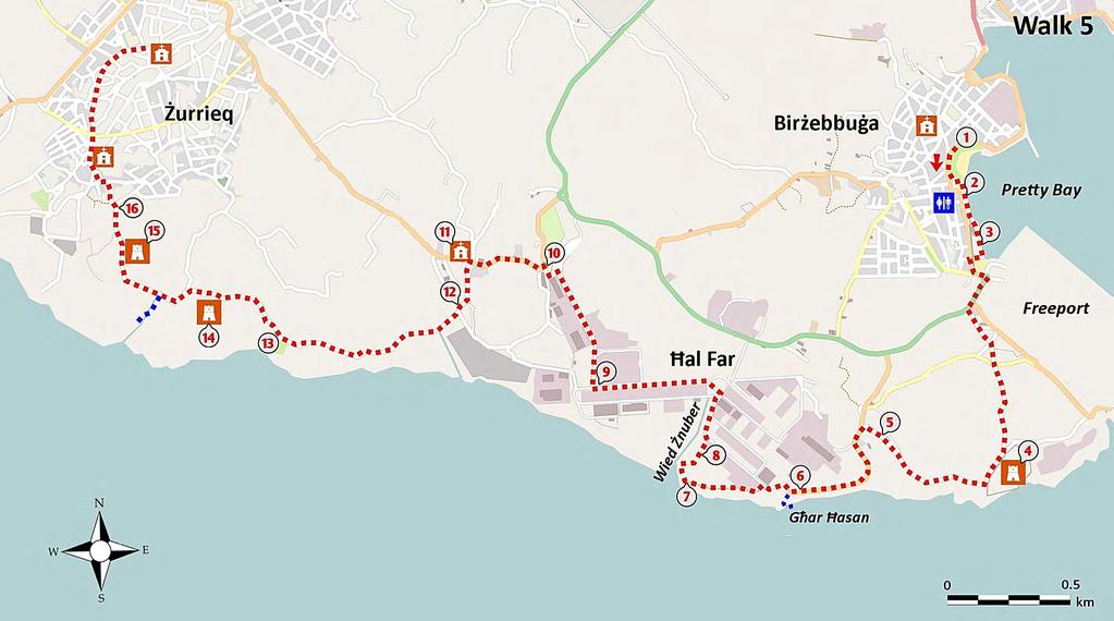
47 BIRŻEBBUĠA to ŻURRIEQ KEY FEATURES u PRETTY BAY u TRANQUIL COUNTRYSIDE u CAVE OF GĦAR ĦASAN u ANCIENT TOWN OF ŻURRIEQ WALK 5 This 15 km section of the walk starts at the popular sandy beach at Pretty Bay in Birżebbuġa. You pass by the busy Freeport commercial area to reach Fort Bengħisa, an abandoned British Fort. The cliffs in this area are impressive and beautiful but because of their inaccessibility you get few opportunities to admire them. You should take the opportunity of visiting the dramatic cliff-side cave of Għar Ħasan. After viewing the impressive gorge of Wied Żnuber the route takes you a little inland around an industrial zone, then past the remains of the medieval chapel of tal-bakkari and on through tranquil countryside. The walk concludes at the ancient town of Żurrieq, inhabited since prehistoric times. There are opportunities for a coffee and toilet break at Birżebbuġa and Żurrieq, but none in between. Frequent buses will take you from Valletta to Marsaxlokk and from Żurrieq to Valletta. THE PROMENADE WALK 43

48 walk 5 THE CLIFFS AND IL-MARA ROCK PILLAR THE WALK The route is shown on Map 5. The walk begins on the coastal promenade 1 in Birżebbuġa, which is easily reached by bus from Valletta. Rambling on from the small park at Pretty Bay you pass between a row of restaurants 2 and the sea. Continue along the promenade past a public toilet to reach a parking area 3, at the end of which you turn to the right onto the main road. The high wall you pass on your right is a fortified wall from the time of the Knights, a defensive structure common along low lying coastal areas. Follow the road to the left (with care) until you reach a roundabout where you take the third exit along the main road. The area to your left beside the coast is occupied by the Malta Freeport, the island s principal commercial port as its deep water can accommodate large container ships and tankers. Following the main road, you take the second exit on the left to pass an old barracks building and ramble along a country road, heading towards Fort Bengħisa 4 on the coast, about one kilometre away. This large polygonal fort was built by the British in 1909 and served, with its counterpart of Fort Delimara and other smaller forts, to protect the commercially important Marsaxlokk Bay. Since it s abandonment by the British forces in the 1970s it has fallen into considerable disrepair and is not open to the public. Continue along the road to the right near the ditch of the fort, going downhill and then uphill. The path gives occasional glimpses of the sheer coastal cliffs, although mostly they cannot be reached because of private land. The road curves inland past some farmhouse buildings 5, to come to a wide road. Take the road to the left, and then left again after about 50 m, keeping to this wide road with trees as it curves towards the cliffs. The path provides a number of opportunities for a view of the coast through gaps in the rubble wall on the left. There are many caves and conduits along the cliffs, formed through erosion of water. A rock column known as il-mara (the woman) juts upwards from the coast beneath Fort Bengħisa. 44

49 You come to a small parking area 6 where you notice a fence that keeps the public away from the cliff edge. Although the rocks appear sturdy, rock falls are not uncommon and near here, a large section of rock plunged in one piece into the sea in If you wish to visit the cave of Għar Ħasan (see box below) you should pass through the gap in the fence next to a small rural room, bearing in mind that the instability of the cliffs makes it somewhat dangerous. Proceed along the concrete path beyond the fence and down some steps towards the edge of the cliffs. The path turns left and you go down the face of the cliff on rock steps (with a railing) to reach the mouth of the cave. LEGEND OF GĦAR ĦASAN CAVE This cave, situated some 75 m above sea level, provides breathtaking views of the Mediterranean Sea and cliffs. Its extraordinary internal shape is a result of the erosion action of underground water that has dissolved limestone held between two layers of hard coralline limestone. This is evident in the smooth surface of the rock and the many fractures in the wall and roof. A 16 th century legend relates that during Count Roger s rule of Malta (1092), an Arab named Ħasan kidnapped a Maltese girl and sought refuge in the cave, keeping her imprisoned there. Seeking to escape from Malta, Ħasan established contact with some Berber pirates. Just as he was lowering the girl down the cliffs to a pirate ship waiting on the sea below, Ħasan was surprised by a group of Maltese who had come to rescue the girl. In the ensuing commotion, he let go of the rope and both Ħasan and the girl plunged to their death in the merciless sea below. One of a number of alternative versions recounts how Ħasan was killed by his captive who managed to return safely to her village. Explore this amazing cave with care, perhaps going through the right side tunnel towards another opening. Do not attempt to go past the inner gate as the innermost part of the cave hosts a rare community of Mediterranean mouseeared bats. walk 5 GĦAR ĦASAN 45


50 walk 5 THROUGH THE ĦAL FAR INDUSTRIAL ZONE From the car park 6 you take the road which goes inland and then to the left. Take the first left along an earthen track flanked by fencing and continue along this path as it approaches the cliff edge. The garrigue alongside the path is rich in Mediterranean heath with its lovely pink flowers. From the path you enjoy magnificent views of the cliffs and the deep gorge of Wied Żnuber. Despite the industrial character of this area, it hosts FLOWERS OF THE MEDITERRANEAN HEATH a number of rare species; of particular importance are the shearwaters who have established safe nesting sites along the inaccessible cliffs. The path reaches a British military structure 7 from World War II. This, the Ħal Far area, hosted a military airstrip during World War II and many fortified structures such as these were used to defend against German/Italian air raids. Your path goes inland and downhill, passing some mounds of rubble stone along the side of Wied Żnuber, a deep gorge leading to the sea. Unfortunately there is no path across the valley and the coastal land on the far side is inaccessible to walkers. Thus you must make a detour inland before your route again comes close to the coast. Where the path downhill stops abruptly you walk to the right up some rock steps towards an abandoned sewage plant 8 and on reaching an open reservoir you take a narrow path to the left that will take you up to the industrial zone of Ħal Far. Following the road inland, you take the second turn to the left to head along a straight road for about 700 m, with factories on each side. Turn right to pass the Playmobil Funpark 9 and stay on this wide straight road for about 800 m. Turn left through a minor road towards a garage and follow this road as it curves right out of the THE CLIFFS AND INDUSTRIAL ZONE 46
51 industrial estate to reach a T-junction with a public road 10. Turn left along a country road and after about 400 m you pass a group of attractive houses to reach the site of the medieval chapel of tal-bakkari 11. Ramble down the narrow road to the left in front of the chapel (Sqaq tal Mejdiet) for about 200 m to come to a T-junction where you turn left and then coming to a wide road 12 you go left again. Stay on this wider road as it heads north and after about 500 m you start to get views of the sea and the small island of Filfla. The minor coastal road meanders uphill and downhill passing small well-tended fields and wild garrigue. After about one kilometre you pass, on your left, the gates of an old landfill 13. The route now takes you up a slightly challenging incline where, at the top, you see concrete structures 14 on the left - these belonged to a heavy antiaircraft battery from World War II. THE VIEW OF FILFLA TOWARDS ŻURRIEQ Rambling on past the battery you come to a T-junction where you turn left downhill, to go across a small terraced valley. At the floor of the valley you may care to detour for a few metres along an earthen path to the left to get wonderful views of Filfla and the wild coast. Back on the main route you go steeply uphill to pass the Knights Tower of Il-Wardija 15. This tower, constructed by the Knights in 1659, is one of a set of thirteen such towers guarding the coast around the island. Rambling on you enter the outskirts of the town of Żurrieq where at a Y-junction 16 next to some communication pylons you keep to the left until you reach a residential road. From here take the road opposite heading downhill to the centre of town passing the old Chapel of the Immaculate Conception and many interesting old residences. Continue to ramble downhill through the narrow streets of this traditional town to reach the main square with its church and cafés and a bus stop from where you can get a bus to Valletta. THE TOWN OF ŻURRIEQ Żurrieq is one of the oldest towns in Malta and has a population of about 10,500 inhabitants. The first documented reference to the town dates from 1,400 AD but the discovery of many ancient remains shows that the area was inhabited long before then. The wide collection of ruins and remains explored by archaeologists date back to the Bronze Age and Punic times, and includes items from the Roman, Knights and British eras. Structures dating back to the 15 th and 16 th century can be found throughout the town. Features of interest include the Punic Tower, the Xarolla Windmill, cart ruts at Tal-Baqqari, Tal- Ħlantun Tower, Palazzo Gianbatist, Wardija Tower and Bubaqra Tower. Further information from walk 5 47

52
53 ŻURRIEQ to DINGLI CLIFFS KEY FEATURES u THE BLUE GROTTO u STONE AGE TEMPLE COMPLEXES u MAJESTIC UNSPOILT COASTLINE u DINGLI CLIFFS WALK 6 The 15 km walk showcases probably the most beautiful section of coastline in Malta. It starts near the Blue Grotto, then proceeds along the panoramic road to pass the Neolithic temple complex of Mnajdra and Ħaġar Qim (a designated World Heritage Site). After perhaps a short visit to this exceptional archaeological site, you descend to sea level where you ramble along an exciting coastal path to reach the lovely cove of Għar Lapsi. The route heads inland for a short distance before turning to the coast to pass near a Bronze Age settlement and some ancient chapels. This coastal area is rich in biodiversity and is of great scenic beauty. You enjoy wonderful views of cliffs and the small island of Filfla. You may care to enjoy a coffee at a new interpretation centre and restaurant ( The Cliffs ) before ending the walk at the nearby village of Dingli. The walk is in the main along good paths and rural roads, though there is a short challenging section as you descend to the coastal path at sea level. There are cafés and public toilets at the starting and end points of the walk, and at the Ħaġar Qim visitor centre. A bus can take you from Valletta to the town of Żurrieq or directly to the Blue Grotto. You can take a bus from the town of Dingli to Valletta. That bus passes through Rabat where you have the option of changing to a bus going to Sliema. THE WALK You can start this walk (see Map 6) at the ancient town of Żurrieq and walk two kilometres down the wide road and promenade along Wied Babu to reach the Blue Grotto 1. Alternatively, as this the walk is long (at 15 km), you may prefer to take a bus directly to the Blue Grotto. The coast road above this popular attraction has a modern promenade with steps leading down among agave plants to a small rock garden overlooking the cliffs. The garden provides a spectacular view of the Blue Grotto, a rock arch at sea level that is shaped like the flying buttress of a medieval cathedral. Walking to the left along the garden wall you enjoy varying views of the impressive cliffs and caves at sea level. Take your time to look at this beautiful panorama, including the steep sides of Wied Babu, a short dry valley formed by water seeping from the rain catchment area around Żurrieq. 49

54 walk 6 THE BLUE GROTTO GOING DOWN TO WIED IŻ-ŻURRIEQ You may care to undertake the worthwhile but challenging descent from the high coast road to the seashore at Wied iż-żurrieq. There is no onward path from sea level and to continue on the main route you must make the walk back up the hill! Take the curving road downhill and, after 100 m, the stony pathway to the left. This will lead you down to the coast where you will find cafés, souvenir shops and public toilets. You can admire the Knight s tower and, a little further along, a garden that leads to a popular swimming area among the rocks. The water here is deep and clean and with the sun shining at the right angle, the colour of the light reflecting from the underwater algae and rock surfaces is very beautiful. The cave and arches of the Blue Grotto are best appreciated from the sea, so if the weather is fine you should consider taking the offer of a short boat trip to view the nearby features. Afterwards you can have a coffee and a bite in one of the cafés, before taking the road uphill. The sea between the coastline at the Blue Grotto and the island of Filfla has been recognised as an important breeding ground for sharks such as the hammerhead. You may be comforted to learn that sharks are (unfortunately) no longer common, due to over-fishing. This coastal area hosts magnificent biodiversity on cliff faces, caves and valleys as their inaccessibility protects them from human interference. 50
55 THE TEMPLES OF ĦAĠAR QIM AND MNAJDRA Your walk continues west along the panoramic road that has, in parts, a modern promenade from which you can enjoy wonderful views out to sea and the small island of Filfla 2. The cliffs and sea between the coastline and Filfla are legally protected because of their rare sea birds, wild plants and marine life (such as whales and the green, and loggerhead turtles). The garrigue to the right hosts a variety of plants, some of which are very rare. After about one kilometre you turn left towards the visitor centre 3 of the temple complex of Ħaġar Qim and Mnajdra. The centre has toilets and a café and provides useful information about this important archaeological park. You may care to make a short visit to this very special world heritage site; one ticket (purchased at the visitor centre) allows you access to both temples. Our main route passes close to the temples as you head down to a coastal path, so that, even without a ticket, you will get a good general picture of their scale and structure. walk 6 THE NEOLITHIC TEMPLES Modern archaeology has shown that on Malta, people without a written language or knowledge of metal had constructed large, highly sophisticated structures several hundred years before the Egyptians began work on the pyramids. The temple building period started around 3600 BC, while the earliest signs of human activity in Malta date back to about 5000 BC. The Stone Age Maltese built their temples singly and in groups, decorating and enlarging them during a period of over 1000 years. Their decorated interiors were originally thought to have been inspired by the great Greek civilizations of Crete and Mycenae, but it is now clear that Malta s temple culture had flourished and died before those Greek civilizations were born. The Temple culture came to a mysterious end around 2500 BC. Ħaġar Qim 4 (built between 3000 BC and 2500 BC) lies at the top of a hill and is built from soft globigerina limestone blocks, while the nearby Mnajdra complex is built of harder coralline blocks. Ħaġar Qim (meaning the Rocks of Adoration) is notable for its impressive and finely-smoothed entrance facade, for the huge stone blocks used in its construction, and for the artefacts found on the site - particularly the Venus of Malta and other female statuettes. It is composed of a main temple and three additional megalithic sections which are probably older that the main temple itself. The temple has a forecourt and a facade with large corner-stone blocks and has a series of apses, some containing free-standing altars, pens for sacrificial animals, and an oracle hole which contained statues of fat ladies, believed to be symbols of fertility. The Mnajdra complex 5 is comprised of three adjacent temples, each with different uses, as shown from the artefacts found on-site. The lowest temple was probably used for astronomical observation since it is aligned in such a way that on the vernal and the autumnal equinox sunlight passes through the main doorway and lights up the major axis. On the solstices, sunlight illuminates the edges of megaliths to the left and right of this doorway. These temples are magnificent pieces of ancient engineering. The blocks, the largest estimated at 20 tonnes, had to be cut and shaped using primitive stone tools and then transported to the site from nearby quarries using sweat and muscle and with the help of logs or rock spheres. Artefacts found during excavation at the sites are to be seen in the National Archaeological Museum in Valletta and the Park s visitor centre. The Ħaġar Qim Park is open all year from 9.00 am till 5.00 pm, with longer hours in summer. 51


56 walk 6 ĦAĠAR QIM TEMPLE COASTAL ROUTE TO GĦAR LAPSI You require tickets to enter the temples but access to the surrounding archaeological park is free and it is through this park that the route of our walk descends to sea level. Getting down to the coast through garrigue can be challenging because, for a short distance, it descends along a rocky incline which will be slippery in wet weather. The optional route along the upper coastal road (see box on page 54) should be taken on wet or very windy days. To take the lower route by the coast you set out from the visitor centre and head towards the Ħaġar Qim Temple, safe from the elements under its white protective dome. You take the path to the left which heads down towards the Mnajdra Temple at a lower level. At a point about 200 m from the Mnajdra Temple you turn to the left to ramble along a rocky path down to the Congreve Memorial 6. General Congreve served as Governor of Malta between 1924 and 1927 and died there. At his request, he was buried at sea in the channel between the coast and Filfla, now known as the Congreve Channel. After enjoying the views, particularly of the rock arch to the left, you descend to FLOWERS OF THE MALTESE SPURGE THE SEA CHAMOMILE 52

57 the coastal path that leads you to the cove of Għar Lapsi, which you can see to your right. The best route for this descent is located a few paces to the left on the seaward side of the Congreve Memorial and goes down through rocky garrigue. This is the most difficult part of the route, which, as you can see, will be slippery in wet weather. Make your way down this incline and continue ahead towards the sea to meet a wider track going to the right towards Għar Lapsi. The coast is a wilderness area, largely without human intervention. Ramble to the west along this path enjoying the views and noticing the interesting geology and plant life. You will have to use your judgement at a number of points as the path may fizzle out, only to restart some metres ahead, and at junctions where you should generally follow the inland path. The path passes beneath Wied il-magħlaq, a short dry valley, rich in flora. This general area hosts a number of orchids including the endemic Maltese pyramidal orchid and the very rare naked-man orchid. Endemic or rare beetles, ants and snails are also to be found in this region. Notice the layering of the deposits. The path goes inland around a bay 7 where a large chunk of coast has been eroded right up to a sheer fault line, forming a number of caves. Take care along this section. Continue along the wide trail towards a parking area for Għar Lapsi 8. The small cove, with water of a lovely blue colour, is like a natural swimming pool. The rocky coast here is excellent for snorkelling and the inlet makes a good entry point for divers. Further ahead, near to a large hardstone quarry, you can see the start of the Dingli Cliffs. From the cove the route goes uphill past a Reverse Osmosis Plant 9 where you can notice the highly saline reject water being returned to the sea. Walk uphill past some views of spectacular cliffs 10 and then a quarry until you reach a roundabout 11. walk 6 THE COASTAL AREA 53

58 walk 6 THE OPTION ALONG THE UPPER ROAD Leaving Ħagar Qim behind, ramble along the main coastal road for about two kilometres (see Map 6). During World War II the nearby town of Qrendi and its surrounds hosted garrisons of British troops in preparation for action against Rommel s forces in North Africa. Qrendi was also the site of an airstrip 12 built for the Allied invasion of Sicily and for that reason this area was bombed on a number of occasions. The road curves towards the coast and you will see on the left a number of hardstone quarries around the small valley of Wied il-magħlaq. Further on you see the beautiful inlet of Għar Lapsi 8, a popular bathing spot during the summer months. Continue walking until you reach a roundabout 11 where, to your left, you can see the winding road down to Għar Lapsi. We suggest you go about 500 m down this road to view some spectacular cliffs 10. The walk down to Għar Lapsi may seem tempting and not so long but the uphill return can be very tiring. So having admired the view, you may prefer to turn around and go back up to the roundabout and head inland on the main route of this section of the walk. TOWARDS FAWWARA From the roundabout 11 you ramble uphill to pass Id Dar tal-providenza, a home for the disabled run by the Catholic Church. A little further on, to your left, you notice an old aqueduct 13 running across a field. Take the first left after the aqueduct and follow the minor road as it winds its way gently uphill among small fields. At a Y-junction take a left and keep to this meandering road which leads to a chapel dedicated to the Annunciation of Our Lady 14. This 18 th century chapel is nowadays used for private retreats. Notice the stone with the inscription GR on it, a property marker from the days of the British, referring to King George II. The road goes past some buildings and then downhill towards another chapel, that of our Lady of Mount Carmel 15 which looks unexceptional from the path. A short walk forward along the path and downhill to the left leads to a small square from where you can admire the details of the facade. If you go further downhill you reach a small hand dug reservoir, with water from a spring. The chapel is built over a tunnel, at the end of which there is a door guarding a natural spring. This spring gives the area its name - Fawwara, meaning an overflowing source. A chapel was built here in the early 16 th century in thanks for the divine restoration of the spring during a severe drought. The present chapel, which has been recently restored, is from the 18 th century. THE CHAPEL OF FAWWARA 54


59 The route continues to the right of the chapel and past the marker stone, becomes a rocky path and passes by some formerly inhabited caves. It twists sharply uphill towards Dingli Cliffs and at the very top you are rewarded with a breathtaking view. A Bronze Age settlement 16 is located about 50 m inland and contains caves, silos and the outer defensive wall of the village. Follow the track until it reaches the main road and turn left. Keeping to the left hand side of the road, the route provides many wonderful and varied views of the layered cliffs. Ramble along this road for about 1.5 km and just before the chapel of Saint Mary Magdalene you can see two short sets of cart ruts 17. This 17 th century chapel is built on the site of one from the early 15 th century. Although a simple structure, it is wonderfully located - take a walk on the wooden decking around the chapel. The view from the front of this chapel is the best place from which to admire the layered Dingli Cliffs. The route continues along the cliff road, passing a radar dome and, on the right, The Cliffs interpretation centre and restaurant 18. This visitor centre, at just over 250 m above sea level, is located near the highest point in Malta. After a coffee perhaps, you can ramble the short distance into the traditional town of Dingli. From Dingli you can get a bus to Valletta and, less frequently, a bus to Sliema - both buses make a stop at Rabat/Mdina. THE MARKER STONE THE CLIFFS OF DINGLI walk 6 THE CLIFFS INTERPRETATION CENTRE AND RESTAURANT This privately owned centre is owned and managed by two brothers from nearby Dingli. The centre provides very useful and interesting information about the area, its flora, fauna and geology. The owners are keen and knowledgeable environmentalists and give preference to the use of sustainable resources and local products, including wild plants. The menu is varied and interesting. Why not try the Maltese Platter (smoked Maltese sausage, marinated butterbeans, fresh tomatoes, fresh Maltese ġbejna, marinated olives in orange and fennel seeds, bigilla dip and anchovy arioli). More information on 55
60
61 DINGLI CLIFFS to BAĦRIJA KEY FEATURES u DRAMATIC CLIFFS OF DINGLI u OUTSTANDING VIEWS u LUSH VALLEY OF BAĦRIJA u RARE FRESHWATER CRAB WALK 7 This magnificent 12 km walk leads you from the town of Dingli to the majestic southern coast with its high cliffs and small fertile fields on a plateau close to the sea. You ramble parallel to the coast along a safe cliff-top road, enjoying breathtaking views. To avoid an impassable coastal strip the route turns inland to bring you through peaceful countryside, lush valleys and past an ancient church. This is the most rural area in Malta and you will enjoy the small well-tended fields and the diversity of wild plants. You get an option of a challenging but rewarding detour along a section close to the coast with outstanding scenery. As you approach the village of Baħrija you have the opportunity of exploring one of the last remaining refuges of the freshwater crab. The route brings you near to cliffs but the path is generally at a safe distance from the edge and there is little danger to the sensible walker. One should take particular care in wet or windy weather. There are public toilets and cafés at the main squares of Dingli and Baħrija, but none in between. Buses from Valletta and other regions will take you to the start of the walk in Dingli. The town of Baħrija is connected by bus only to Rabat/Mdina, from where you can catch a bus to Sliema or Valletta. THE WALK The walk starts at the bus stop in Dingli square (see Map 7), and proceeds uphill along the main road 1 to the nearby cliffs. The cliffs reach a height of 253 m making this the highest point in Malta. From the cliff top you can enjoy wonderful panoramic vistas out to the island of Filfla. You can admire the small fields on the fertile plateau nestling between the upper cliffs and the lower coastal cliffs. Your walking route is along the upper level as access to the lower plateau is often difficult or hindered by private ownership issues. Having admired the view, you ramble along the cliff-side road towards the north, to pass the well known Bobby s Restaurant. Keep on this road for about one km and, after passing some old villas, you come to a Y-junction close to a disused explosives factory 2. Take your time to admire the view of the peaceful agricultural land around you and, towards the north, the impressive cliffs of Miġra l-ferħa. 57

62 walk 7 A LESSON IN GEOLOGY The rocks of Malta are of sedimentary limestone which started to form underwater some 200 million years ago through the compaction of shells, coral, sediment and other material that fell to the sea bed. Five distinct layers can be distinguished, with each layer representing a different phase of development of the Mediterranean Sea and its inhabitants, and showing an interesting timeline of events, including drying up of the sea. The rocks are arranged in the following layer cake succession: Upper Coralline Limestone Greensand Blue Clay Globigerina Limestone Lower Coralline Limestone Malta emerged from the sea floor around 8 million years ago and has since been moulded by tectonic activity, sea, wind, rain and humans. Tectonics have played an important role in causing a tilting of Malta towards the north-east. This has resulted in high cliffs along the south (such as at Dingli) and low lying coast along the north-west (such as at Sliema). On the upper Dingli Cliffs you are standing on a layer of tough coralline limestone underlain by an impervious clay layer. Rain falling on the fractured surface of the top layer percolates into the ground until it meets the clay layer. The water then travels sideways to emerge as a spring along the cliff edge. The lower plateau is composed of clay washed out by groundwater and resting on a layer of lower coralline limestone. This fertile lower strip is largely devoted to agricultural, made possible by springs along the cliff walls. VIEW OF MIĠRA L-FERĦA 58

63 walk 7 VERDANT VALLEY BELOW THE CHAPEL Just before the factory, the route takes a sharp turn inland, to follow a rural road through garrigue and pockets of agricultural land. After about 400 m, just before a small climb, take the Y-junction left 3 at a farm building and ramble on through tranquil countryside. Continue along this rural road keeping to the main path as it twists and turns, until it joins a wider road. Walk to the left along this road, past a niche, until you reach a Y-junction in front of some farm buildings 4. Walking to the left, you pass through the farming area of Ta Baldu. In this region the hard coralline layer is underlain with impervious clay, which causes the formation of a perched ground water aquifer. The Romans constructed baths in this area to take advantage of these springs. Follow the tranquil road which is heading towards the coast, and running along a valley edge towards a cluster of farmhouse buildings. You enjoy magnificent views of the verdant agricultural valley below. The route along the rural road turns right and immediately left, to follow a rough track alongside a wall made from sturdy limestone blocks, said to date from the Roman period. At the end of the wall you come to a clearing 5 where you turn inland along a minor road. Continue along this road to arrive at a T-junction with a wider road, where you turn left and uphill. Follow the road for nearly one km, towards a chapel with a distinct belfry. When you reach a building 6, you can take a short detour to the Chapel of Mtaħleb. This chapel (dating from 1656) was built on the site of an earlier one, and is dedicated to the Nativity of Our Lady. The chapel is often open for Mass, (details at The chapel is perched at the edge of the cliff and is an ideal location for a short rest while enjoying amazing views of cliffs, low hills and caves. 59
64 walk 7 MIĠRA L-FERĦA From the main road continue left, overlooking an area known as Miġra l-ferħa, regarded as the landing place of Count Roger the Norman in 1090 AD (see box below). At the Y-junction take the minor road left and then right to pass through garrigue with low lying aromatic plants adapted to this exposed windswept area. Note the residences perched at the edge of the cliffs and the caves beneath them. It was common for rural families to use caves for the keeping of animals or for storage of tools and crops. Along the route you may notice some abandoned quarries now used as small agricultural plots. COUNT ROGER IN MALTA In the year 1090 AD the Arabs in Sicily were divided, and Count Roger the Norman, taking advantage of the situation, invaded the island and defeated the Arabs. With Sicily under Norman Rule, Count Roger wanted to secure his southern colonies and invaded Malta, landing at Miġra l-ferħa, without much Arab resistance. It is alleged the Maltese rushed to greet Count Roger, hence the name of the area, which literally means the Happy Coming. In a short time, the islands were under Norman Rule and Christian slaves were set free. The new colonisers proved flexible and the Arabs were allowed to govern the islands and to exercise their laws and religion, on condition that they acknowledge the Normans as masters and to pay an annual tribute. Legend has it that before returning to Sicily Count Roger cut a strip from his own flag and awarded it to the Maltese who adopted it as their red and white flag. However, the Arabs soon started to plot against the new rulers and planned a massacre of the Maltese. Fortunately the plotting was overheard by a peasant girl tending her flock and she quickly informed her family. The Maltese fell on the traitors and in a short battle in the Baħrija area, the scheming Arabs were slaughtered, while the rest were ousted by the Norman army. Malta became a Norman colony until 1194 AD. A number of Norman buildings survive from that period, the most impressive of which is the Norman House in Mdina, which is open to the public. After about 700 m the road narrows and you reach a Y-junction 7 and turn left downhill, to reach a hairpin bend. At this point, there is an option of a challenging though rewarding detour towards Miġra l-ferħa (see box on page 61 for details). This downhill route is quite steep and without a proper path along the edge of the lower cliffs. However, if you have the time and energy and are prepared to be careful, this is a wonderful detour down to sea level. This option adds about 3 km to the overall walk. Alternatively, you may wish to keep things simple and continue on the shorter main route to Baħrija, about two kilometres distant. To reach Baħrija by this main route, you take the minor road to the right and continue forward along the cliffs. The minor road narrows and goes steeply downhill along a rock promontory on your left. This wonderful path nestles between cliffs and the lush valley of Wied tal-baħrija. This valley has a permanent spring running through it and is one of the few remaining refuges of the endemic freshwater crab and other species of plants and animals in need of an all-year supply of water. Directly ahead is another promontory known as il-qlejgħa, noted for a Bronze-Age settlement at its tip. The road levels out at a Y-junction 11 where you can enjoy the pleasant and tranquil rural setting. 60

65 OPTION TO MIĠRA L-FERĦA The detour to Miġra l-ferħa provides a rare opportunity to explore the lower level of coastal cliffs and their wild shoreline. The path is somewhat strenuous and there are some challenging parts were you may need to get down on all fours, for a short distance. Do not undertake this optional route if the weather is wet or windy or if you have a fear of heights. To take this option, you ramble down the winding road from the Y-junction 7, admiring the pleasant views. At the bottom of this steep road you come to a wide clearing, used as a parking area. From the edge of the car park you can admire the lower cliffs. You should explore this area by walking to the right towards a deep gorge 8 which leads down to the water s edge. The path down to sea level is slightly difficult to follow. At the innermost part of the gorge, next to the car park, take the rocky track along the edge of the valley towards a promontory which divides the gorge in two. On the right of the promontory, a set of rock steps leads downhill along a magnificent (though slippery) path. The views at the bottom are truly wonderful. Back up from the gorge, the path heads left into a clearing, and at its opposite end there is a narrow footpath, along the cliff edge. Take this level path which is generally set safely back from the cliff edge, though there are three sections at which it comes close to the edge. Enjoy the many sights and sounds of this wild coast, and observe the many boulders along the way. walk 7 VIEW AT BOTTOM OF GORGE After about two kilometres, the path reaches a low ridge of yellow limestone 9. From the innermost part (on the right) of the ridge you can easily climb a few metres down along the rock face towards the lower level. This area, known as il-blata tal-melħ (literally Rock Salt), is so named because of the saltpans in the area. Climb down carefully from the ridge and walk along walk along the lower rockc level towarda a set of quirky boulders. You can locate a set of steps 61


66 walk 7 THE QUIRKY ROCK ALONG THE PATH, KNOWN AS IŻ-ŻUGRAGA (THE SPINNING TOP). leading directly down to sea level. This is a popular fishing spot in summer where people from Baħrija come to try their luck. Admire the view of the cliffs from where you have just walked and ahead the promontory of Ras ir-raħeb (Priest s promontory), which curves to the left. At the very tip of this promontory are the remains of a place of worship dating from the Roman period, hence the name of the area. The strenuous path uphill starts just behind the final set of yellow boulders, from where you take a set of hidden rock hewn steps up to the top of the limestone shelf. From here, you walk directly inland and to the left of a small room cut in the rock, then onto an uphill path. This rocky path is not so obvious at first but then it rises steeply and curves to the right, on clay soil. After about 200 m going uphill the path passes the edge of some agricultural fields and reaches an earthen road 10. Follow this road to the right as it rises, gently at first, past a gate to reach a Y-junction 11 where you re-join the main route to heading to Baħrija 12. IL-BLATA TAL-MELĦ 62

67 walk 7 RARE FRESHWATER CRAB ON TO BAĦRIJA From the Y-junction 11 take the road inland and downhill into Baħrija valley. The path curves to the right past reeds and then crosses over running water. The reeds are harvested for use as shades for houses or wind breaks for crops. You should spend some time around here, perhaps walking a few metres to the right towards a small waterfall. With some luck you will be able to see the rare and legally protected freshwater crab. However, you should explore with care, as crabs live in submerged burrows in mud which are easily damaged. Do not attempt to catch or harm any as they are very endangered. The population of crabs on the island has fallen to very low levels as excessive groundwater abstraction has reduced the number of natural freshwater springs. Ramble up the steep hill past a villa and towards a small cluster of farmhouses. You continue right along the pleasant rural road into the main square of the village of Baħrija. Just before you reach the square, at a T junction there is a short stretch of cart ruts. The Baħrija area is very rich in archaeological remains ranging from prehistoric to late medieval times. Various megaliths, pottery sherds and settlements from the Bronze age were found in the area. Nowadays, Baħrija is a small remote rural village, famous for its local restaurants specializing in rabbit dishes. Reaching the village square, you will find a café and a nearby bus stop from where you can catch a bus to Rabat/Mdina. 63
68
69 BAĦRIJA to GOLDEN BAY KEY FEATURES u OUTSTANDING PANORAMIC VIEWS u BEAUTIFUL SANDY BEACHES u VICTORIA LINES u UNUSUAL GEOLOGY WALK 8 This magnificent scenic walk of about 10 km takes you from the remote village of Baħrija northward through tranquil agricultural land to reach the Great Fault and the western end of the Victoria Lines. You then ramble to the west past many old military structures, enjoying wonderful views as far as the cliffs of Gozo. You descend from a high escarpment to ramble along the coast, passing by the beautiful and isolated bay of Fomm ir-riħ. Proceeding along a rural path among fields and wild garrigue, you reach a cliff top overlooking Ġnejna Bay and the spectacular Għajn Tuffieħa Bay. It was in the golden sand of Ġnejna beach that, to much public interest, a lone loggerhead turtle recently made her nest. Your route goes inland a little to get around a cliff system and you then turn parallel to the coast, passing among garrigue and coastal sand dunes to reach the popular beach at Golden Bay. Along the route you pass many features of historic interest such as churches, towers and British-era defences. There are cafés and toilets at Ġnejna and Golden Bay. To reach the starting point in Baħrija you must take a bus from Rabat (Mdina). You can return to Sliema, Valletta or Saint Paul s Bay directly by direct bus from Golden Sands. THE WALK The walk begins in the main square of Baħrija 1, a village (population 3,000) set in a rich agricultural area of fertile red soil. The square is untypical in that the church is not located at the centre of the town but at its periphery. From the bus stop opposite the playground in the main square you walk left (facing inland) past an old chapel and then right to approach the modest modern church. Just in front of the new church you take a rocky track to the left through garrigue. From here, you can see clearly the Chapel of the Immaculate Conception 2 to which you are headed. However, there is an impassable valley (not visible from your current position) between you and the chapel. The track first heads in the direction of the chapel but soon turns inland to avoid the valley. The garrigue here is rich in aromatic wild thyme and, in the right season, orchids. Continue along the track as it takes you past some farm buildings to reach a country road where you turn left. Soon you come to the Chapel of the Immaculate Conception, known as il-kunċizzjoni. It was built by Grand Master 65


70 walk 8 THE CHAPEL OF KUNĊIZZJONI Antoine Manoel de Vilhena in 1736, as shown on the inscription on the nearby arch Fondazione Paola On the façade of the chapel you can see three coats of arms and, at the top, the eight pointed cross of Malta. If you examine the façade closely, you may notice a number of ancient graffiti depicting galleys of the Knights. At the chapel, turn right along a narrow road to reach a small memorial 3. You are now entering a section of the Victoria Lines built in the late 19 th century to defend THE PATH DOWNHILL 66

71 the southern part of Malta from invaders landing at beaches to the north. As you can see, the wall is built on a natural escarpment overlooking a fertile valley. The view from here is exceptional. You can see the high cliffs of Gozo and, in the foreground, the bays of Ġnejna and Għajn Tuffieħa and the easily recognised Radisson Golden Sands Hotel. To your right, you can just notice Fort Binġemma 4, one of three great forts along the Victoria Lines. THE GREAT FAULT AND FORT BINĠEMMA The limestone rock that is Malta emerged from the sea floor around 8 million years ago and has since been moulded by tectonic activity, sea, wind, rain and humans. Tectonic activity has created a number of major faults; one caused the uplifting of a steep and high escarpment stretching across Malta from sea to sea. This remarkable feature is known as the Great Fault. Malta has proved extremely attractive to foreign powers because of its strategic location at the centre of the Mediterranean, and the size and depth of its natural harbours. As you have seen, the high cliffs along the south of Malta provide a natural barrier against invasion by sea while the beaches in the northern part of the island are a weakness in this regard. The British Army, in the 19 th century, decided to take advantage of this formidable natural escarpment and so they constructed a linear defensive system ( the Victoria Lines ) on its top. Fort Binġemma, one of three large polygonal forts, was constructed with a dual land and coast defence role. In World War II the fort was equipped with anti-aircraft guns to harass the German/Italian planes flying from their bases in Sicily to attack the Grand Harbour. The Great Fault and the Victoria Lines are recognised as a UNESCO listed site. You walk to the left along the Victoria Lines enjoying wonderful views and a great diversity of plant life. On warm days you can expect to see many lizards and possibly a chameleon or snake (all harmless) sunning themselves on the rocks of this normally walk 8 FLOWERS OF THE WILD THYME IN EARLY SUMMER 67

72 walk 8 quiet track. Stay on this former military path as it curves downhill and then turn left 5 onto a rocky track towards the coast. In this area you can notice many abandoned military buildings including a barracks and searchlight emplacements. Together these form the Saint Martin Electric Light Battery, a defence post at the most western section of the Victoria Lines which played a strategic role in providing illumination of targets for the formidable guns of Fort Binġemma. Meeting the Victoria Lines again, you go left by the wall and downhill along a rough narrow path among garrigue and wild plants. The path goes past a World War II observation post and ahead you can see a large reservoir used to store water for irrigation of the local well-cultivated fields. Where the rough path reaches the bottom 6, it joins a minor public road where you turn to the right and then to the left. As you ramble on past the reservoir 7, you get wonderful views of Fomm ir-riħ Bay. This isolated circular bay with its attractive beach and edging of boulder scree, is very beautiful. Consider a short break while overlooking the blue waters of the bay before proceeding along the road towards the bleak promontory of Ras il-pellegrin. Notice the soft brown rock in this area, which is composed of fossilized soil and collapses easily to form boulder scree. Walk along the road to the other end of the bay, past some rural rooms. Keep to the road past a Y junction and where the paved road comes to an end, you turn to the right 8 along an earthen path. Sometimes there is a chain across the track at this (and other points) and a road sign to prevent entry by cars and motorbikes. You continue past the sign along this slightly rising track which curves right between small pockets of cultivated land and garrigue. The track then curves uphill to the left and after a short distance you come to a high point next to some railings which overlooks the sandy beach of Ġnejna Bay 9. THE MAGNIFICENT VIEW OF FOMM IR-RIĦ BAY 68

73 walk 8 ĠNEJNA BAY ĠNEJNA BAY To reach the beach you descend along the narrow but safe cliff-side path, with its useful handrails. This interesting path snakes among small pockets of cultivated land with many fruit trees, including the Bambinella tree, a tasty miniature pear unique to Malta. After about 200 m the path turns downhill to the right over clay. The sandy beach of Ġnejna and the clean and safe water of the bay make this a popular summer destination for families. The bay is still a centre of traditional fishing that includes attracting fish at night using lamps. 69

74 walk 8 TURTLES IN ĠNEJNA BAY In summer 2012 a single loggerhead turtle made her way to Ġnejna Bay. Driven by maternal instinct, she laid several dozen eggs in the clean moist sand, covered them, wished them luck and returned to the sea. This was a joyful and exceptional event no loggerhead turtle had been recorded as breeding in Malta in over 50 years. The arrival of the turtle caused considerable public and scientific interest and resulted in the beach being declared an emergency conservation area so as to provide maximum protection for the valuable eggs. The nest was cordoned off and continuously monitored by a team of volunteers and professionals. There was great excitement among the media and the public as the day for hatching approached and passed. Unfortunately none of the 79 eggs hatched, due, according to experts, to natural reasons. You leave Ġnejna along the inland road, and after 50 m, just after a car lay-by, take the narrow uphill track. The track rises steeply on clay and curves to the right towards a rocky plateau. As the path approaches the top, it zigzags on the rocks and boulders. At the top go left towards the Ta Lippija Tower 10, built by the Knights in Here you can enjoy wonderful views of Ġnejna Bay with its striking clay slopes and limestone cliffs. Follow the rocky path which is set back at a safe distance from the cliff edge. Note the many cracks at the edge, some almost two metres in width. The limestone around here is heavily fractured because of an unstable underlying clay layer, a key feature of the geology of this area. The path passes through garrigue, an under-appreciated habitat which in this area is noted for its seasonal flowers, such as crocuses in autumn and orchids in winter. The path passes some small fields, alongside a rubble wall delineating WALKING ALONG THE QARRABA PROMONTORY 70

75 walk 8 GĦAJN TUFFIEĦA BAY the remains of an old military road. Notice the quirky shaped Ras il-qarraba promontory and the unusual shapes formed by clay as it slips slowly downwards over the yellow limestone. When the path reaches a point 11 directly opposite the Qarraba promontory you divert inland for about 30 m along a rocky path that takes you down from the plateau to a lower level. From this lower level, there is an option of taking the path to the left down to the small bay of Għajn Tuffieħa. The main route goes inland to the right among clay slopes and dunes with rich vegetation, including esparto grass that helps to stabilise the sandy/clay soil. The path heads uphill and then down into a small valley to rise steeply up to a rock outcrop 12 (which may be slippery!). The view of the bay from here is superb. The path now goes downhill to pass a World War II observation post and reach a car park 13. GOLDEN BAY From the car park, walk to the left past the former Riviera Hotel (now in danger of collapse from unstable foundations) towards the tower of Għajn Tuffieħa, built by the Knights in 1637 to guard against landings in the bay by Ottoman troops or pirates. The two-storey tower, manned by a captain and three soldiers, was armed with a single cannon. The tower has been restored and is open to the public for an hour every day, in the afternoon. Notice the World War II pillbox camouflaged to look like an agricultural building. Take the earthen path to the right of the tower as it curves between cliffs and small fertile fields. You enjoy wonderful views down to Golden Bay and the Radisson Blu Golden Sands Resort. The earthen track ends near a reservoir 14 where you take the road to the left towards a car park. You soon come to the well-located Apple s Eye restaurant 15 where you may consider a coffee and perhaps a swim in the clean waters of the bay. There is a bus stop close to the restaurant from which you can get a regular bus to Valletta, Sliema and Buġibba. 71
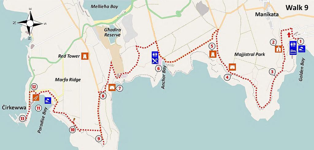
76
77 GOLDEN BAY to ĊIRKEWWA KEY FEATURES u MAJJISTRAL NATIONAL PARK u WONDERFUL PLANT DIVERSITY u WHIMSICAL POPEYE VILLAGE u PANORAMIC VIEWS WALK 9 This majestic walk of 12 km starts at the beach of Golden Bay and brings you through the wild and wonderful Majjistral National Park, with its stunningly beautiful coastline. The park is a protected nature reserve where wilderness areas of garrigue and boulder scree co-exist comfortably with cultivated parcels of fertile red earth, stone-age remains and traditional stone huts known as girna. Rambling at a safe distance from the dramatic cliffs you enjoy wonderful panoramic sea views and landscapes. The unexpectedly luxuriant growth among the boulder scree at the foot of the cliffs is both surprising and beautiful. On exiting the park the track leads you past the surreal Popeye s Village and, after a short and slightly challenging climb, up onto the Marfa Ridge. From this high point you can admire outstanding views of the coast of Gozo, and inland, the Red Tower watching over a tranquil, fertile valley. The radar station near the fragile cliff edge is also of interest. You ramble downhill through wild countryside, passing lovely Paradise Bay, to reach the ferry port of Ċirkewwa. This walk is of moderate difficulty, with two challenging climbs. The walk should take you around five hours and there are cafés and toilets at Golden Bay, Popeye village, Paradise Bay and Ċirkewwa. You should carry water with you and a hat for protection against the sun as the route is very exposed to the weather. Wear adequate shoes as the tracks are often rough and can become mucky in places after rain. In warmer months you should consider bringing your swimming gear for use in the clear waters of either Golden Bay or Paradise Bay. A frequent bus service will take you from Valletta or Sliema to the starting point at Golden Bay and back from the end point at the Ċirkewwa ferry terminal to Valletta, Sliema and other destinations. THE WALK The walk starts near to the beach at Golden Bay, in front of the Apple s Eye restaurant 1. Here you may consider a coffee as you will not have access to a café and toilet facilities until you arrive at Anchor Bay about two hours further along the route. Note the remnants of the rare sand dune system at the back of the beach and the fragmented rocks of the cliffs. From the car park in front of the Apple s Eye 73
78 walk 9 THE GARRIGUE OF XAGĦRA L-ĦAMRA restaurant (literally from the Maltese name for the area, Għajn Tuffieħa) you head north and to the right, passing the entrance to a Scouts camping ground. After about 50 m you take the left at a T-junction to walk slightly uphill. After about 100 m, at a Y-junction, you take a rough track through a gate on the left, to ramble through a former British military base. This camp was constructed by the British Navy in 1902 as a training centre for the Royal Marines and included residential quarters for the troops and their families and a shooting range. During World War I it served as a hospital for wounded soldiers and during World War II it played a role in deterring a possible invasion by Italian/German forces through the shallow bays in this area. The route passes through the abandoned base that included an Anglican chapel 2 and runs west towards the tip of a promontory. There is a network of paths here that you can choose from, but those near the cliff edge provide the most spectacular views. The rocky track runs along at a safe distance from the cliff edge, through garrigue and slightly uphill. Notice an old water reservoir to your right 3, built to supply the military base and some old farm buildings lying in ruin. The landscape at the brow of the ridge is quite harsh, receiving many long hours of sunshine in summer and strong winds in winter. Nevertheless this garrigue area hosts a variety of robust small plants. While the growing conditions are very challenging, with little rain, a lot of sun and a lot of wind, many plants have adapted successfully by employing a variety of coping techniques. The plants to be found here include thyme with its aromatic scent, heath with lovely pink flowers, lentisk and buckthorn and, depending on the season, bulbs such as garlics, daffodils, iris and rare flowers such as orchids. 74

79 MAJJISTRAL NATIONAL PARK Ü 6 km of protected coastline and marine habitats Ü Variety of habitats such as boulder scree, garrigue, temporary freshwater pools Ü 430 species of plants Ü 9 species of breeding birds including the rare Yelkouan shearwater Ü Variety of historical and archaeological features For more info, see walk 9 The rocky path now runs towards the western point of the promontory where you can visit a man-made cave at the edge. Looking down at the boulder scree at the foot of the cliff you notice how verdant is the vegetation compared to the garrigue area on the exposed cliff-top plateau. This moist and boulder-strewn coastal habitat is formed when blue clay at the base of a cliff is eroded by wave and spring water causing the upper layer of limestone to collapse. These boulder scree areas are amongst the best preserved habitats on Malta and Gozo as they are so inaccessible to humans. They host a variety of plant species such as carob and olive trees, sea lavenders and salt-tolerant species such the Maltese salt tree. The scree also provides a safe home to a variety of birds such as the tree sparrow, a number of warbler species and Malta s national bird, the blue rock thrush. Walking on, the path along the edge of the cliff turns inland along a promontory and after about 100 m you join a small rocky footpath, to the left from the wider main path. Follow this smaller path along the cliff to enjoy wonderful views of this rugged coastline. To the northwest, on most days, you can see as far as the impressive Ta Ċenċ cliffs on Gozo. BAY AND BOULDER SCREE 75

80 walk 9 THE TOWER The route passes an inconspicuous set of steps 4 leading down into the boulder scree and then goes slightly uphill in the direction of a tower. Your route passes a World War II pillbox on a rocky uphill path flanked by rubble walls. Along the way you can notice some attractive small buildings constructed of rubble stones, entirely without cement. These traditional girna were used by farmers mainly for the storage of agricultural tools and supplies. The path uphill leads to the Ta Ċiantar Tower 5, a recently restored fortified 19 th century farmhouse. Noting its location you can see why it was used during World War II as an observation tower to spot enemy planes approaching from Sicily to the west. The views from here towards the islands of Comino and Gozo really are world-class. From the tower, the earthen path goes inland to reach a junction with a main road. Take the tarmac road to the left with care as it heads north through garrigue. The aromatic plants of garrigue attract a variety of butterflies such as the swallowtail, red admiral and white butterfly and bees such as the bumble bee, honey bee and carpenter bee. The abundance and variety of such plants, particularly thyme, give Maltese honey an especially attractive flavour. POPEYE VILLAGE Continue rambling along the straight downhill road (passing a rubble-clad pillbox on the left) which curves gently inland to reach Anchor Bay, known locally as il-prajjiet. To your surprise, within the boulder scree you see the colourful and surrealistic Popeye Village 6. Isn t it wonderful? This unique site, constructed in 1980 as a film set for the musical Popeye starring Robin Williams, is now operated as a fun park for families. You can get a superb view of the colourful film set from near the concrete pillbox. At this stage you may consider a short break at the cafeteria. From the car park in front of the cafeteria, ramble along the straight inland road to take the second earthen road to the left. The track becomes quite rough as it goes POPEYE VILLAGE 76

81 walk 9 VIEW FROM THE PILLBOX uphill through garrigue and a few low pine trees. At a cross roads in the garrigue take a left uphill to reach the crest of the hill. A World War II observation post lies in ruin on a nearby rock outcrop. The rocky path goes downhill on the left of the structure, joining a wider path incised in the rock. This path was made by the British to facilitate movement between pillboxes and observation posts. The path reaches an asphalted road that runs around the perimeter of a sewage treatment plant that treats domestic effluent from the north of the island. Malta is exceptional in that virtually every town, house and hotel is connected to the public sewerage system which now, thanks to EU support (and laws), leads to a modern treatment plant, such as you see before you. Head north from the sewage plant along the tarmac road, which then heads right and after about 300 m take the steep uphill road to the left towards a pillbox 7 with an amazing view of the coast below. The British forces built large numbers of these pillboxes during World War II to provide an immediate defence of the islands against a German/Italian invasion. Take a look (carefully) at the gorge below the pillbox. To your left along the south-western coast you can see the rocky promontories and bays and in front of you, the unsurpassable Ras il-qammieħ promontory. On the opposite side of the road from the pillbox you can see the ruins of a searchlight emplacement. Walk past the pillbox and take the earthen track immediately on the right. After 150 m take the right fork up a cobbled pathway which climbs among small fields with white clay soil, to meet a set of wide concrete steps leading to the top of the Marfa Ridge. On the climb you pass (on your left) an apiary constructed within caves 8, probably dating from the Roman era. MARFA RIDGE Relaxing on the ridge, you can admire the small and productive fields in the valley below and the ponds of the Għadira Nature Reserve that provides an important and safe refuge for a variety of water birds. Note the Red Tower some 700 m away to the east. This impressive tower, constructed by the Knights in 1649, has been sensitively restored and is now open to the public. Ramble to the west along the ridge road to 77


82 walk 9 THE APIARY reach a British era radar station 9. Have a wander around the area, noticing (from a safe distance) the many large and impressive fissures at the cliff edge. You are now on the most western point of Malta and can enjoy a 360 degree vista that includes the dramatic Ta Ċenċ cliffs of Gozo and some of its towns and tall churches. In the other direction, you can see the series of high cliffs that protected Malta from invasion on its southern side. Retrace your steps along the ridge road for about 50 m to take a rocky path to the left, that later goes downhill. This old military path was constructed by the British to provide access between individual military points and the radar station. At the end of this rough path take a left for about 10 m and then a right towards the cliff edge. The path leads you along the edge and passes by a traditional girna. On your left notice a small rock arch set in the boulder scree down by sea level. The path passes by a set of GIRNA 78

83 walk 9 PARADISE BAY rock-hewn steps leading to tiny fields at a lower level. Further on, an attractive stone archway 10 is like some door to a distant imaginary world. Admire the variety of trees and plants growing among the boulders in this moist and sheltered habitat. Looking inland from the archway you can just notice the remnants of a rubble wall, behind which there is a depression known as a doline, a common feature in the Maltese landscape. Walking inland towards it, you can notice the contrast of the lush vegetation within the doline with that of the surrounding wind-swept garrigue. A doline is the depression formed when the roof of an underground cave collapses. The cave formed over many thousands of years when slightly acidic rainwater dissolved the limestone rock of which the island is composed. The most dramatic dolines are to be found at the Dwejra area on Gozo where one doline is estimated to have a diameter of 350 m. In earlier centuries some dolines were used as very basic dwellings for people because of the protection they afforded from the sun and wind in exposed areas. Follow the rough path north along the cliff edge for about 500 m, without any turns, to reach the rim of Paradise Bay 11. The path goes to the right along the rim of the bay towards a road, passing the steps down to the beach. The curving bay with its beach of golden sand provides a safe and pleasant bathing area that is very popular for swimming and snorkelling during the summer months. Walk past the steps leading down to the beach and continue on to the car park. After the slight uphill climb, you take a narrow path uphill through garrigue from the left hand corner of the parking area. There are some prehistoric cart ruts running parallel to the cliff in the garrigue near this path, though they are not easily noticed. They are located approximately parallel to the seventh light pole from the end of the road. Cart ruts consist of linear depressions in the limestone that always come in parallel pairs about a metre apart and sometimes run for over 100 m. Despite considerable study and speculation, their origin remains shrouded in mystery. Walk to the right towards the road and ramble downhill, passing a Reverse Osmosis plant 12 on your right. Malta does not receive enough rainfall to support its high demand for water and employs three such RO plants to make potable water from seawater. At the T-junction with the main road turn left towards the ferry terminal 13 the main gateway to Gozo. From the busy bus terminus here you can catch a bus to Valletta, Sliema and several other destinations. 79

84

85 ĊIRKEWWA to MELLIEĦA BAY KEY FEATURES u PICTURESQUE BAYS u PRISTINE WILD HABITATS u FORTS AND TOWERS u SANDY BEACHES AND ROCKY SCREE WALK 10 This 11 km section takes you from the ferry port of Ċirkewwa around the coast of the Marfa peninsula passing small bays and sandy beaches and giving you wonderful views across to the island of Comino. This vulnerable coastline has always been heavily protected and you will pass many defence structures from the times of the Knights and the British. The walk along the northern coast of Mellieħa Bay showcases small coves and the boulder scree which make for a very attractive panorama. As you ramble along the promenade of Għadira beach with its long stretch of golden sand, you can appreciate why it is the most popular in Malta. This pleasant walk is mostly along promenades and good level paths. Cafés and toilets are available in Ċirkewwa and Għadira beach and at some hotels along the route. There are many bus connections to the starting point of Ċirkewwa. You can catch a bus to Valletta, Sliema and Buġibba from the end of the walk. THE WALK The walk starts at the Ċirkewwa ferry terminal 1 and proceeds east along a coastal promenade towards the opposite end of the Marfa peninsula. As you stroll along you can admire the wonderful views across to the island of Comino and the Knights Tower of Santa Marija. After about one km you pass a large reddish structure 2, coloured much like a little palace. This is a battery dating from 1716 known as the Wied Musa Battery. In the 19 th century the battery was extended and another floor built for use by the Governor as a summer residence. Notice also a small pillbox just before the battery. These square blocks of reinforced concrete were armed with machine guns at each corner. Since this area represented an easy landing point for attackers, the coast has been seriously guarded since the time of the Knights, and particularly during World War II. A short detour to the area beneath the battery reveals the parapet wall that surrounded the gun platform, originally armed with 4 eight-pounder guns. WIED MUSA BATTERY 81

86 walk 10 COMINO S BLUE LAGOON 82 THE ISLAND OF COMINO Comino is the small island midway between Gozo and Malta. With an area of 2.5 square kilometres and only three permanent residents, it is largely unspoiled. Traffic is non-existent, while noise is the exception rather than the rule. Comino is very much what Malta would have looked like during the time of the Knights, so you can feel that this is a trip back in time. The island is a designated protected area because of its plants, animals, scenery and geology. It hosts historic defensive features because of its strategic location between the two islands. Comino is perhaps best known for its beautiful Blue Lagoon but it has many other points of historical interest and great ecological value. You can get to Comino by taking a small ferry to the island from Ċirkewwa or the small harbour opposite the Riviera. The island is a great destination for a day s outing. The very pleasant features of the outing include the boat trip to the island, impressive sea caves and other geological features, forts and look-out points, a wide range of native plants, birds and animals, stunning views and an opportunity to swim at the beautiful Blue Lagoon. Rambling along the promenade you pass the Riviera Hotel and a small harbour where you can take a boat to Comino for a wonderful day trip. Just beyond the hotel, the path veers to the left through a gate and along a small sandy beach, known as ir- Ramla tal-bir. Near the centre of the beach you can see a small redoubt from the time of the Knights 3. The path passes at the back of the Marfa Hotel and after 150 m you reach an area of open garrigue. You head towards a pillbox that has been turned into a summer residence. From here you can see a large cluster of boathouses, used in the summer months as residences. Your route continues along the coast to pass in front of the first of those boathouses and along a small beach, known as Ramlet il-qortin. During winter, this beach is

87 walk 10 THE COASTAL AREA engulfed with the remains of neptune grass washed on shore. This organic material is of great ecological value and is sometimes harvested by locals for worms and shrimps to be used for fishing. Near the centre of the beach you can note the former Eskalar Redoubt 4, now converted into a summer residence. Continue to the end of the sandy beach taking the road uphill on the opposite end through the boathouse complex. Follow the road uphill as it curves left and at the crossroads continues forward towards the bay of Little Armier. On your let just visible is the Ta Maċċja Battery (also known as the Vendome Battery). You reach a beachside café known locally as it-torri ta l-armier where you may consider a rest and coffee break. MANY COASTAL DEFENCES The defence of the northern coast of Malta was taken very seriously by the Knights due to its easy accessibility from the sea. The complex coastal defences built in the 17 th and 18 th century consisted of coastal towers, batteries and redoubts, and fortified walls. A group of French military engineers who inspected the coastal defences in 1714 recommended the building of coastal batteries, redoubts and entrenchments, if necessary along the entire coast of Malta, except the inaccessible cliffs of Dingli. Since many Knights gave funds for the construction works, this idea was well under way when the French military engineer Philip de Vendome visited in 1715 to oversee works. However, the Knights soon realised that they did not have enough troops to man all the proposed fortifications and abandoned the construction plan. Forts were only defended in summer and, in case of invasion, it was planned that the infantry would retreat to the Great Fault, where the Victoria Lines are in place today. Batteries are relatively large structures which occupied strategic positions on promontories overlooking bays. They are composed of a semi-circular platform for cannons, surrounded by a parapet wall, and two block rooms at the back. Redoubts are relatively smaller than batteries and were built in the middle of the sandy bay to disrupt enemy landings. The defence system along the Marfa promontory is one of the most intact on the island. 83

88 walk 10 The route continues along by the beach passing some tall palm trees and continuing past the just visible Barriera Redoubt 5 and then uphill towards a cluster of boathouses. At the brow of the hill on the left you can notice the remains of a trench and low bastion wall, on top of which a number of boathouses have been built. The route continues to the left beside an impressive fortified line stretching for about 500 m along this exposed coast. Midway along the line, the original dry moat and the remains of a diamond-shaped buttress are evident. At the boathouses, the path turns right and then immediately left onto a sandy beach. Head along the coastline across the sand, noting the red rock deposited by a long-gone river. Further on you pass the remnants of a sand dune habitat, a very rare ecosystem on Malta, with salt tolerant species such as the sea daffodil which in spring has wonderfully scented white flowers. The path continues along the beach and then around a rocky promontory at the centre of which you see Torri l-abjad (the White Tower) 6 and another fortified wall from the times of the Knights. This area was heavily protected by the British forces against a potential Axis invasion during World War II and you will pass by many remains of a defensive nature from that era. Once around the promontory you reach a small inlet known as Daħlet ix-xmajjar, which has a camping site. The rocks of this area are rugged and impassible (hence the local name of Aħrax) and as there is no safe route along the cliff edge, the route heads inland. You may care to make a short detour to the left to view an interesting geological feature known as the Dragonara 7. This collapsed cave is connected by an underground channel to the sea and in times of rough northwesterly swell, seawater gushes excitedly into the air. You head inland along a straight earthen road through garrigue and after about 750 m you take the first earthen track to the left. The track passes through thickets of acacia and pine trees towards cliffs, which provide nesting sites for the rare Yelkouan shearwater. Follow the path along the cliff edge to come to a chapel 8 and statue devoted to our Lady of the Immaculate Conception. Because of the absence of light pollution this area is popular for stargazing, especially during the Perseid meteor showers in mid-august. THE CLIFFS OF MELLIEĦA BAY 84


89 walk 10 AZURE STONECROP WILD CAPER SKIPPER BUTTERFLY MEADOW SAFFRON FLOWER LOBED ARGIOPE WILD ARTICHOKES TOWARDS GĦADIRA BEACH From the statue, the path turns right and inland to follow the northern edge of Mellieħa Bay. The small bays in this area and the boulder scree make for a very attractive vista. Your track is along rocky ground towards a wooded area mainly composed of acacia trees. There is a network of paths located at the top of the cliff, of which you should choose the one closest to the cliffs (though still at a safe distance from the edge). The path passes through some clearings which are a favourite spot for Sunday picnics. Keep to the path at the top of the cliff and avoid the temptation of taking a path down through the boulder scree as these are all dead-ends. After about 1.5 km the path goes close to the main road and then follows the coastline left towards a small rural room at the cliff edge 9. Rambling past the room on a path parallel to the coast you reach a Knights bastion wall known as Taħt is-sur. After the break in the bastion, walk further along the coast towards another section of the high bastion wall. Further progress along this coastal strip is not possible as 85


90 walk 10 KNIGHTS BASTION WALL the path ends in the grounds of a hotel. Therefore, you should take the wide rocky road uphill to the right which leads to a public road used by cars 10. This road soon comes to a busy junction, where you take the road downhill (with care) towards Għadira Beach. This sandy beach is the largest and most frequented beach on Malta, with its shallow water attracting large crowds during summer weekend. Across the road from the beach BirdLife Malta has converted a former wetland area into the important Għadira nature reserve 11, open to the public. GĦADIRA BAY 86

91 GĦADIRA NATURE RESERVE This six hectare site was originally used for the production of salt from seawater in the times of the Knights. About 20 years ago BirdLife Malta converted the area into a nature reserve with lagoons, islands, observation hides and a visitor centre. This reserve is a very rare habitat in Malta and provides a valuable sanctuary for breeding species of birds such as warblers, corn buntings, coot and plover. Visiting species include grebes, ducks, herons, kingfishers, egrets, waders and birds of prey. The reserve also hosts some local flora and fauna, such as rabbits, hedgehogs, chameleon, geckos, lizards, snakes, shrimps and killifish. A number of rare plants now survive only in this reserve. The centre welcomes visitors, typically on Saturdays and Sundays from November until May from a.m. to 4.00 p.m. Further information is available at walk 10 GĦADIRA RESERVE Rambling along the promenade you pass a central rocky promontory 12 where you can see a pair of parallel cart ruts running close to the coast. Continue to the end of the promenade to reach a bus stop at the outskirts of the town of Mellieħa. Frequent buses from here can bring you to Valletta, Sliema and Buġibba. 87
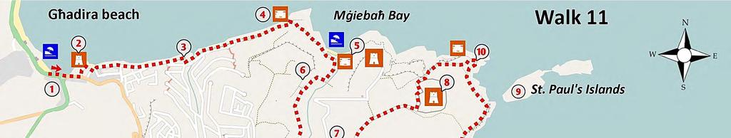
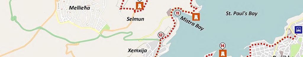
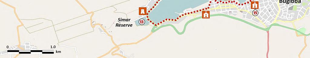
92
93 MELLIEĦA to SAINT PAUL S BAY KEY FEATURES u SELMUN PALACE u SAINT PAUL S ISLANDS u IMPRESSIVE TOWERS AND FORTS u TRANQUIL FERTILE VALLEYS WALK 11 This 13 km section is a walk of two halves. The first, starting at Mellieħa, is along the beautiful unspoiled peninsula of Mġiebaħ with its spectacular sea views and tranquil old-world countryside. The second half of the walk, starting at Xemxija, is along promenades through the highly developed tourist area around St Paul s Bay. The two halves make an interesting contrast on this pleasant and easy walk. Starting at the sandy beach at Mellieħa, the route takes you past small peaceful bays and unspoiled garrigue to the beautiful Selmun Palace, an 18 th century hunting lodge. You then ramble on past the abandoned Fort Campbell to enjoy great views of Saint Paul s islands. You turn inland parallel to the coast to reach beautiful Mistra Bay and then on by the coast to reach the town of Xemxija at the inner part of Saint Paul s Bay. The route now takes you on a promenade around an urbanised coastline onto the Buġibba peninsula. You enjoy great views across St Paul s Bay with its many leisure and fishing boats and small harbours. You finish the walk at the main piazza, close to the bus terminus. Though most buildings along the route are modern, some are of historic and cultural value. These include the Wignacourt Tower, built by the Knights in 1610 and a chapel dedicated to the Shipwreck of Saint Paul. The route is almost entirely along level tracks and urban foot paths and is without significant climbs. You can reach the starting point by taking a bus to Għadira/Mellieħa beach from Valletta, Sliema or Buġibba. From the ending point near the Buġibba bus terminus you can catch a bus to Sliema, Valletta and other destinations. THE WALK The walk starts at the Mellieħa end of Għadira beach, in front of the Seabank Hotel 1. Walking to the east you take the first minor road to the left into a small boat parking area. A concrete path leads to the remains of the Westreme Battery 2 dating from Only the unusual large square blockhouse remains; this has been turned into a museum named Tunnara. The building was used as a coastal defence post During World War II and later, as a store for the fishing of bluefin tuna. Because of past overfishing throughout the Mediterranean the bluefin catch is now controlled under an EU quota. Malta had an allowance of about 160 tonnes in 2012 and these 89


94 walk 11 are mostly caught using traditional longline methods. The caught fish are usually transferred to coastal tuna farms off Malta where they are fattened and exported to Japan. Passing around the museum you reach a minor road, where you walk left along the rocky shoreline. Keep to the road nearest to the coast, passing in front of various flats, then garages used as summer residences. The road leads to an open area, turns slightly ROCK ROSES inland 3 and continues left past a small valley and a stretch of garages for about 500 m. These are constructed on two levels, and you should be on the lower level. At the last garage, on the left corner, take the steps down to an earthen track. Of the several tracks here, you should take the lower. Notice the vegetation typical of low rocky coasts, such as the golden samphire, Maltese salt tree and Lentisk bushes. After about 300 m the track passes through an area rich in reeds and rushes, due to water from a spring. The track arrives at the ruins of a partly demolished World War II lookout post 4, well camouflaged in rubble stone. This area is noted for its wild rock roses, with their pink or yellow flowers and dark green leaves. From this point there are a number of paths along the coast; the best path goes through the breach in the rubble wall at the back of the lookout post and on through an abandoned field. The rocky path goes upwards and snakes through boulder scree. It has a number of branches, but you should keep to the main path. You get good views of the most unspoilt coastline in the east of Malta, which, because of its inaccessibility has remained undeveloped. After about 600 m, the path leads to a clearing on clay, often used as a small parking space for nearby Mġiebaħ Bay. From the right hand corner of the parking area, close to the camouflaged pillbox 5, you get a pleasant view of this small bay with its reddish sand. You might consider a swim and a rest in this MĠIEBAĦ BAY 90

 and the view across this tranquil countryside is wonderful.")
95 walk 11 THE APIARIES, MODERN AND OLD tranquil bay. From the pillbox 5, turn inland along a path which leads to a narrow road flanked by a high rubble wall on one side and reeds on the other. The road turns sharply right - follow this narrow road uphill through Mġiebaħ Valley, passing an old farmhouse. This protected area is famous for its honey since ancient times (mġiebaħ means apiary) and the view across this tranquil countryside is wonderful. A rock-cut apiary 6 can be reached by taking the steps in the rubble wall after the first bend in the road and walking uphill and right along the narrow path for about 100 m. SELMUN PALACE SELMUN PALACE 91

96 walk 11 Rambling along the main road past an old farmhouse, you pass over a small bridge and then reach a crossroads. Take the left along a rough track past a pillbox to reach the Selmun Palace 7. This beautiful fortified palace was built in the early 18 th century and was used by the Knights as a hunting lodge and for relaxation. Opposite the palace there is a recently restored farmhouse serving as a visitor s centre. Take the road to the right of the palace and ramble on for about one km through open countryside towards Fort Campbell 8. Reaching a T-junction, you take a left towards the fort to go past the original officer s quarters and then to the left along the walls of the fort. Notice a small doorway through the perimeter wall which gives access to explore the fort. This large fort is built on a high point of the peninsula so that its large guns could defend the entrances to both Mellieħa and Saint Paul s Bay. Most of the perimeter wall and buildings are still intact and you can still see the circular rails of the guns. FORT CAMPBELL This, the last British fort built in Malta, was constructed in 1937 when a major war seemed very probable. Its layout is quite different from earlier forts on Malta in being designed to survive attack by bombers rather than a land assault. Its walls were thin, appearing almost as a civilian construction. The main purpose of the fort was to control entry to Mellieħa and Saint Paul s Bay and to harass any enemy ship near the coast on the way to attacking the Grand Harbour. To this end, it was fitted with 2 six-inch breech loading coastal guns. It also had several machine gun bunkers, rifle loop-holes and searchlight emplacements. The principal novelty of the design was the way in which the buildings were low and inconspicuous and were spread out within the perimeter walls. This helped to make the fort less conspicuous to land forces and less vulnerable to enemy bombing. The fort was decommissioned in the 1970s after the departure of British forces from the island and is now in an abandoned state, open to the elements and vandalism. THE WALLS OF FORT CAMPBELL 92

97 walk 11 VIEW OF THE COAST Your route follows the path along the wall of the fort and, where it ends, the path curves right and steeply downhill over clay slopes towards the coast. To your left you can admire the wild impenetrable boulder scree. On the promontory you can see the partly demolished Knights Tower of Għajn Ħadid. Follow the path downhill with care, enjoying the views to Saint Paul s Islands 9 where tradition holds that Saint Paul was shipwrecked on his way to Rome in 60 AD, an event recorded in the Bible. A statue of the saint is visible on the larger island, witness to the local legend. The wildlife in this protected conservation area includes a sub-species of lizard found only on those bleak islands. The route now takes you down along a path through clay slopes and to the water s edge along a flat yellow limestone coast. You can see that the low lying coastline is littered with saltpans. Salt production in this area continued until the early 20 th century supplying local fishermen and the town of Mellieħa. Along this vulnerable coastline you will pass many remains of a system which formed the first line of defence for Fort Campbell. The fort is located in an area which is easily accessed by naval landing craft and so the British constructed a line of lookouts, pillboxes and coastal searchlight batteries. The latter were semi-circular structures with a door at the front which opened to reveal the searchlight. The pillboxes (square concrete structures with high windows) were armed with machine guns. Continue along the rocky coast passing a partly collapsed building 10, originally used for salt storage. The route turns slightly inland and uphill due to inaccessible clay and then to the right parallel to the coast. A small path once leads to the water level and past a partly collapsed pillbox, a result of building a heavy structure on a clay foundation. The views along this rocky inaccessible coastline are wonderful. The path goes up from sea level and past Saint Paul s Islands, then curves around a circular bay and past a searchlight battery (located just beneath the level of the path). The rocky path through garrigue goes towards the Mistra Battery (from the time of the Knights) and then on to the pleasant Mistra Bay 11, a popular spot for boating. As you walk around the curving edge of the bay you can admire, looking inland, the 93

98 walk 11 small terraced fields of fertile soil that are such a contrast to the bleak rocky areas you have just walked through. At the southern end of the bay, next to some boathouses and a small quay, you take the narrow path uphill among boulder scree. The path may be at times slippery but at the top you will be amply rewarded by wonderful views of the bay. The rocky path passes by a small abandoned quarry now colonised by pine trees. This area was until the early 19 th century a major quarrying area from which stone was shipped for construction of the Grand Harbour breakwater. The path goes through a small wooded area along the cliff edge, past a high masonry wall, the boundary of a former oil depot now returned to garrigue habitat, towards a parking area 12. TOWARDS BUĠIBBA From the roundabout on the main road you ramble downhill to a coastal promenade which will take you past the linear town of Xemxija and around the inner part of the bay. Xemxija, a small resort town, has been inhabited since prehistoric times and Punic tombs, silos and temple remains are located on the hill behind the modern buildings. As you the inner reaches of the bay, you see to your right the Xemxija Fortress, originally a Knight s Fort built to protect the bay, now a classy club. On the land side of the road, behind a grove of trees, you can notice the Simar Nature Reserve 13. This former wetland was drained by farmers to make agricultural land, but because of high salts levels the fields were unproductive and were abandoned. In the early 1990s it was converted into a wildlife sanctuary by Birdlife Malta. Over 160 bird species have been recorded at this small but valuable reserve. It is open to the public on Sundays from November to May (details from Follow the promenade along the edge of the bay, past a small wall with three coasts of arms, the sole remains of the Dellija Battery constructed by the Knights. Keep on the promenade, past a breakwater for protecting the small boats of amateur fishermen. The path continues along the main road, which may be quite busy with traffic, and passing a chapel, you take the first left downhill (Sqaq tax-xama ). The path joins a coastal promenade that will take you all the way around this peninsula. VIEW OF THE COAST 94


99 walk 11 THE WIGNACOURT TOWER Across the tranquil water you enjoy stunning views of Mistra Bay, the cliffs of Selmun and Saint Paul s Islands. The promenade passes around some small bays to reach the Wignacourt Tower, built by the Knights in This, the oldest surviving coastal defence tower in Malta, is open to the public every day and houses a small museum. The views from the roof make a short visit very worthwhile. A little further on you pass a water polo pitch, and then keeping to the left, you may notice several square rock-cut pools near the water s edge; these are the remains of Roman baths. The promenade goes towards the old harbour of Saint Paul s Bay, known as il-menqa. A narrow walkway between the Menqa and a small modern apartment block will bring you past a small cove and into a square, containing a chapel dedicated to the Shipwreck of Saint Paul 15. This national shrine is situated at the place where many believe that the saint and his companions were welcomed onto safe land by the Maltese, after the shipwreck. If you happen to be passing while the chapel is open, do visit to admire the many quality paintings, most notably the Miracle of the Viper, commissioned by Grandmaster Wignacourt and done in the style of the famed Italian artist Caravaggio. Continuing along the promenade to the left of the chapel you pass by a small breakwater, often with many anglers trying their luck. The promenade passes a myriad of cafés, shops and hotels and after 500 m leads you to the square of Buġibba. You can reach the bus terminus by walking 300 m further along the promenade and taking the uphill road to the right, just before the Dolmen Hotel. THE SMALL HARBOUR AND CHAPEL 95
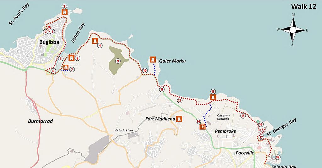
100
101 SAINT PAUL S BAY to SAINT JULIAN S BAY KEY FEATURES u SALINA LAGOONS u EARLY CHRISTIAN CATACOMBS u COASTAL GARRIGUE u SAINT JULIAN S BAY WALK 12 This interesting and pleasant walk of 14 km brings you past a wide range of contrasting habitats and features of interest. The walk begins at the bus terminus in Buġibba and takes you along a busy coastal promenade around the tip of the peninsula. You then ramble along the edge of Salina Bay where you can see the former salt production lagoons (now a nature reserve) that gave the bay its name. You have the opportunity of visiting some early Christian catacombs before embarking on a ramble along a paved footpath close to the low level seashore. You pass coastal towers from the time of the Knights, a Splash and Fun Park, a saltpan complex before strolling through an abandoned British army base at Pembroke. You then ramble through wild coastal garrigue to arrive at the pretty Saint George s Bay. It is only a short walk further along to reach the well known Love Statue at the inner part of Saint Julian s Bay, and the end of our walk. This walk is entirely along level paths and is without physical challenges. You can take a bus to the starting point at the bus terminus in Bugibba from Sliema and Valletta. Frequent buses can take you from the end point in Saint Julian s Bay to Sliema, Valletta and Buġibba. There are cafés and toilets at the start and finish and at a café near the Splash and Fun Park, about midway along the route. THE WALK The route is shown on Map 12. From the bus terminus 1, go downhill to the coastal promenade and turn right heading out to the tip of the Buġibba peninsula. You pass by hotels, the most interesting of the latter is the Dolmen Hotel 2. You may be surprised to learn that the hotel takes its name from a real Bronze Age dolmen which is incorporated as a feature within the hotel grounds. You can visit these ancient remains by going through the hotel lobby. Your route along the promenade passes by a low masonry wall, the remains of a fortified wall from the times of the Knights, built to protect the low lying coastline from enemy landings. The promenade widens into a piazza beside the new National Aquarium, which hosts a rich variety of local and tropical fish. You ramble past the Qawra Tower 3, a small fortification built in 1637, primarily as a watchtower. At the tip of the peninsula you can see a small island. 97
102 walk 12 This used to be a part of the mainland but the narrow land bridge was excavated to accommodate a radar system. The route now takes you back inland along a promenade dominated by hotels and tourist infrastructure, with the narrow Salina Bay to your left. You enjoy pleasant views across the bay towards the Għallis Tower 4 and, further on, the tower of Qalet Marku. These towers were built by the Knights in the 17 th century to guard against Ottoman invasion or pirate landings along the low-lying coast and to provide a rapid means of communication with Valletta. Walking past several hotels and restaurants, take the first public road on the left (Triq il-luzzu) downhill towards the coast and follow the road in front of the summer apartment complex and then in front of garages used as summer residences. This road goes past a gate and towards the inner part of Salina Bay, where you can see the salt production facilities which gave the bay its name. Here, in the early 17 th century, the Knights constructed a series of large lagoons 5 for the production of sea salt. The commercial production of sea salt on Malta ended when mines in Germany and Poland sold their salt at a much lower price than that produced from the evaporation of seawater. SALT FROM SEAWATER Gozo and Malta have a long tradition of producing salt from seawater and there are about 40 sites on the two islands where this process was employed. Saltpans are reputed to have been in use here since Roman times. Salt was a valuable commodity in those days; Roman soldiers were sometimes paid with salt this is the origin of the English word salary. The Knights of Malta held a monopoly over the production of salt on the islands and those who harvested salt without authorisation faced a heavy penalty. Here in Salinas Bay in the early 17 th century the Knights constructed a major salt production complex based on evaporation from large lagoons. By 1620, this complex was producing 4,000 tons per year, enough to supply domestic demand and leave a surplus for export. The production of salt at all other sites in Malta was small-scale in comparison, being based on the use of ponds and basins cut by hand in the flat limestone rock. The basic production process is simple to understand. In early summer seawater is fed into a series of shallow basins through a system of hand-dug channels. After concentration through evaporation of water by wind and sun during the hot summer months, the white sea-salt can be collected and bagged. The process is very labour intensive and salt produced by this method must of necessity be expensive. Follow the earthen path towards the inner part of the bay, through a wetland area and on into Kennedy Grove 6, a small wooded area planted in memory of the late President of the United States. This is a very popular area for family picnics. On leaving the grove, you turn left to join a main road and walk alongside a canal, formerly used for transportation of salt. You soon come to a junction where you cross the road and take a minor detour to the right towards the Chapel of the Annunciation, dating to the 17 th century. Note the unusual buttress walls, built as a later addition to reinforce the structure. Ramble to the right of the chapel and through a breach in the rubble wall adjacent to the last dwelling. A small pathway at the edge of the field leads you to the Latnija catacombs 7. Although small in comparison with those in Rabat/Mdina, the catacombs are an important record of the sizeable Christian community that lived in 98

103 walk 12 THE LATNIJA CATACOMBS AND CIRCULAR AGAPE TABLE this area in the period 500 to 1,000 AD. The catacombs open onto a low ridge facing a now lost Roman harbour, making this a small but important archaeological site. These ancient burial chambers have a number of features of interest, including a circular agape table with a triclinium (dining hall) hewn out of rock, a feature common to Maltese catacombs. Returning to the main road, you walk further along the coast past a large squarish building on your right 8. This is the Ximenes Redoubt, named after the Grandmaster who, in 1715, commissioned it and another redoubt (now demolished) on the opposite site of the bay. Salina Bay was considered as one of the most important anchorages in the north of Malta and its defence formed a critical part of the island-wide coastal defence scheme. Although not a large bay, its anchorage location provided direct access into the plains north of the Great Fault (which you will see later on this walk) and a quick entry point into the very heart of the island. In antiquity, Salina Bay was actually much larger and served the Romans as an important harbour. It extended well into the plains of Burmarrad but by the middle ages, these inner reaches had largely silted up. ALONG THE NORTHERN COAST Your route now takes you past the Coastline Hotel and out along the exposed northern coast. The dry coastal limestone here appears quite bleak and supports only a limited range of mainly salt-tolerant plants such as the sea chamomile and lavender. To the right, across the road, you pass by the old Għallis Tower 4. The route along the pavement takes you towards a low lying island, opposite which, inland on your right, is the site of the old landfill 9. This is currently being rehabilitated with extensive planting to turn it into a conservation area, a welcome addition to this densely populated island. Further along you pass by a small sandy bay 10 and the low lying peninsula of Qalet Marku, with the Knight s tower at its outer point. 99

104 walk 12 You can notice that the low lying coastline here is a sharp contrast to the high cliffs (over 250 m at Dingli) along the southern side of the island. The limestone rock that is Malta rose from the seabed about 8 million years ago and has since has been shaped by rain, wind and tectonic forces. The latter have tilted Malta towards the north east, creating two very distinct types of coast. In addition, Malta is crossed by two main fault systems representing the effects of two separate rifting episodes in the vicinity of the archipelago. The older of the two, the Great Fault, trends SW to NE, while the Magħlaq Fault system trends approximately NW to SE along the southern coast of the island. Inland, a little ahead, you can notice The Great Fault, a high natural escarpment that runs across the island from sea to sea. This natural ridge was considered to have great potential for protecting the Grand Harbour from an invasion through the accessible bays on the north of the island. To this end the British Army constructed a major defensive line ( The Victoria Lines ), with forts, batteries, pillboxes etc. along this 13 km escarpment. THE VICTORIA LINES Some thousands of years ago, geological activity resulted in the formation of a ridge that runs across Malta from sea to sea. In the late 19 th century the British Army took advantage of the cliffs and high points of this ridge to build an extensive system of defensive walls, forts and strong points. In honour of the Queen at that time, these were named the Victoria Lines. The aim was to protect the heavily populated central and south from an enemy invading through easy landing sites in the north of the island. The militarization of the entire ridge by the British Army began in 1875 with the construction of a number of strategically sited forts and batteries. The fortifications initially consisted of three large independent forts at Madliena, Binġemma and Mosta. In the 1880s all the individual fortified elements were linked together with a continuous infantry wall which followed the natural configuration of the crest of the ridge. The defensive features VICTORIA LINES included batteries, magazines and, during World War II, searchlight emplacements. Towards the end of the 19 th century new military strategies (fight them on the beaches!) and new technology had combined to undermine the likely effectiveness of the Lines. Military exercise held in 1900 suggested that it could be by-passed with relative ease and by 1907 the Victoria Lines had already lost much of their military significance and were largely abandoned. During the Second World War the lines were again brought into use and were fortified with pillboxes and anti-aircraft units. 100


105 walk 12 MADLIENA TOWER You reach an open parking area with a kiosk 11, a pleasant spot for a break and perhaps a visit to the nearby public toilets. The square is quite lovely, with an old chapel dedicated to Saint Peter the Fisherman, unfortunately in a neglected state of repair. Opposite the chapel is an interesting building, a hexagonal redoubt dating back to the Knights, and one of several along this coast, aimed at preventing enemy landings. It is now used as a bar. PEMBROKE AND SAINT GEORGE S BAY Ramble along the track close to the coast, passing between the sea and the back of the Splash and Fun Water Park. Notice the extensive saltpans cut into the coastal limestone. After passing a caravan site 12, the path heads inland towards the Madliena COASTAL GARRIGUE 101

106 walk 12 Tower 13. To reach the tower, follow the earthen road in front of the caravan site, which gives way to a concrete path going inland and uphill. Take the second left, and follow the rocky path to the tower. This tower was the only one of the Knights towers which the British military upgraded to play a defensive role similar to that of Martello towers built around the coast of Britain. The modifications included the construction on top of the tower of a circular emplacement for a single gun. Notice also a concrete searchlight building and a nearby fougasse, a low cost cannon dug into the limestone and used during the time of the Knights. Ramble along the concrete pathway at the back of the tower and turn to the left towards the coast. This area, Pembroke, has a long history as a military zone. In the 1860s the British army built a large military base here, with living quarters and training grounds. German prisoners of war were housed here during World War II. Several buildings from the British era can still be seen, including the Pembroke Military Cemetery 14 that is open Mondays to Friday for visits. The British Army transferred ownership of the site to the Maltese government at the time of their departure in Your path now passes through an area of coastal garrigue, a formerly widespread habitat, now under threat almost everywhere through human activities. There are several rifles ranges on your right which are sometimes used by the Malta Army. Warning Signs will alert you if the ranges are in use. If so, you will have to detour inland for a few hundred metres to walk inland from the rifle ranges. The route continues along the coast to pass between the sea and a Reverse Osmosis plant 15. Notice the line of pipes and pumps along the shore that supply the plant with seawater and return the concentrated reject brine to the sea. You continue to ramble close to the sea, passing next to a small football ground and towards a public garden 16 set into a steep slope. Your route now takes you up through the garden and onto a main road on the upper level. At the roundabout you walk opposite past the Corinthia Hotel and downhill along the Hotel Saint George s Bay. The pretty beach 17 is a summer favourite of the students who attend the THE PYRAMIDAL ORCHID 102


107 walk 12 SAINT GEORGE S BAY language schools in this popular area. Many Russian, Spanish and Eastern European students come to Malta each year to learn English and to improve their social and drinking skills. They are an attractive and good-natured lot who fill up buses and cheap cafés and add greatly to the liveliness of the area. At the background of the beach you can notice the gardens and building of Villa Rosa, one of the few remaining exquisite old mansions which graced this area. The villa overlooks the ecologically significant valley of Wied Ħarq Ħamiem which originally flowed into Saint George s Bay. You ramble along the coastal path as it winds around the bay then heads parallel to the coast, passing the Westin Hotel and the Dragonara Casino. Keep to this road until you reach the modern Portomaso complex with its striking blue tower. From the roundabout in front of the entrance to the luxurious Portomaso marina 18, you ramble right through the small public park and then downhill to the left to reach Saint Julian s Bay with its many cafés and bus stops. The walk ends at the well known Love Statue at the inner part of Saint Julian s Bay. This is a centre of activity especially during the cool evenings of the summer months. SPINOLA BAY 103

108
109 SAINT JULIAN S to VALLETTA KEY FEATURES u PRETTY BAYS AND PANORAMIC SEA VIEWS u PLEASANT TREE LINED PROMENADE u DRAMATIC BATTLEMENTS OF VALLETTA u ARGOTTI BOTANIC GARDENS WALK 13 This 12 kilometre section starting at Saint Julian s Bay takes you along a pleasant seaside promenade, around curving bays and through the popular tourist resort of Sliema. Along the route you can enjoy a wide variety of sea views and admire the many quality stone buildings. At Tigné peninsula the path turns inland to run along the edge of Sliema Creek, passing Manoel Island and reaching Msida Creek. Here you cross a bridge at the beautiful twin-spire Church of Saint Joseph the Worker and turn seawards again. Passing through the historic suburb of Floriana with its charming Botanic Gardens and the Mall Garden where the Knights played bowls in the 18 th century, you arrive at the main entrance of the majestic city of Valletta. You can take a bus to the starting point from Valletta, from Buġibba and from other points along the coastal road. You are rarely more than 200 metres from a café. The Valletta bus terminus is next to the finishing point of the walk. THE WALK The route is shown on Map 13. The walk begins at the innermost part of Saint Julian s Bay, at the Love monument, a popular meeting spot for young people. This pretty part of the bay, named Spinola Bay, is surrounded by period houses and still contains a number of traditional colourful fishing boats. The majority of the old boathouses have been converted into fashionable shore-side restaurants. It is a very attractive area, particularly at night, when the extensive coloured lighting creates a romantic Mediterranean ambience. Rambling along the promenade as it curves around the small bays, you can notice the eclectic mix of buildings. The water polo grounds to your left provide a relaxing evening s entertainment for drinkers in the overlooking bars. A little further on to the right you can see the impressive Balluta Buildings 1. This classy apartment block, built in 1928, would not be out of place in London or Paris. Continuing along the promenade past the Church of Our Lady of Mount Carmel, you turn right at the beautiful Barracuda restaurant to pass a group of palm trees and an impressive stone-globe water feature. Soon, you find yourself overlooking Independence Gardens 2 - a pleasant linear park whose name celebrates the 105

110 walk 13 PROMENADE WALK freedom obtained from Britain in Malta is a member of the Commonwealth and continues to have many connections with Britain. In particular the Maltese are enthusiastic supporters of British football clubs. Independence Gardens is a haven for stray cats. The local council has provided designated cat feeding points in the park and have banned the feeding at any other point. Across the water of Saint Julian s Bay, the Dragonara Casino stands out like a fake Las Vegas casino, but is in fact the former palace of an Italian noblewoman. As you continue along the promenade you come to Saint Julian s Tower 3, built by the Knights in 1658 as part of a network to provide early warning of a Turkish invasion. Each tower is within viewing distance of the next, so that a signal, such as smoke, can pass from the tip of Malta to Valletta in a couple of minutes. As an alternative to the path along the promenade, and depending on the weather, you may descend to the flat limestone at the sea s edge by means of a road just in front of the tower. It is surprisingly tranquil at this lower level where the traffic noise can hardly be heard. This rocky shelf is very popular in summer with tourists and locals. As there is no tide of any consequence you can lie close to the cooling sea. You are probably aware that Malta has few sandy beaches and that the coast is almost totally composed of yellow limestone which formed underwater many millions of years ago. The fossil shells you can see in the limestone along this stretch give testimony to its watery origins. The limestone rock along Sliema has been modified over the years by the need for defence from invaders (Turks/French/Italians/Germans) and to allow easy access to the sea for swimmers. As you walk further on, notice a number of square pools cut in the rock near the water s edge. In the early 20th century, Maltese entrepreneurs had the brilliant idea of carving out these pools, providing covers for protection against the sun and renting them to families for private use, on a daily basis. SLIEMA After a stroll of perhaps 500 m along the coastal limestone you walk back up onto the promenade, and soon pass an attractive low fort, formerly the Sliema Point Battery 106

111 and known amongst the Maltese as Il-Fortizza 4. In spite of its ancient appearance it was built in 1876 and served as a searchlight position in World War II. The interior of the fort has been remodelled to turn it into a restaurant and the work included the roofing-over of the parade ground to form a large room in the centre. Shortly beyond the fort you come to a road junction, with Tigné peninsula to your left 5. Go directly across the road to join the footpath that brings you ahead through the commercial centre of Sliema. The road contains many shops and, on the left behind green railings, the magnificent but dilapidated Villa Drago, a sad reminder of a time when Sliema was dominated by elegant homes. As you come to a junction, take the pedestrian road (Triq Bisazza) which goes downhill giving you views of Sliema Creek and, in the distance, the proud city of Valletta. Go across the coastal road to join the seaside promenade. You will see the embarkation point 6 for the ferry to Valletta and will receive many offers of boat trips around the harbour. A boat trip from Sliema strand is a must-do activity. You can take a two-hour trip around the harbour, which is great, or a whole day trip around the Maltese islands. A good option is to take the local ferry from Sliema to Valletta that is cheap, takes only 10 minutes and provides spectacular views. The view across the water to Valletta from here is as good as you will get anywhere in the world, particularly at night. Valletta, a world heritage city, still has the appearance of a medieval city and there are few modern intrusions in the vista. The Anglican Cathedral in Valletta can be seen cheek by jowl with the impressive dome of the Catholic Church of Mount Carmel. To the left, at the tip of Valletta you can see the mighty defensive walls of Fort Saint Elmo. Few of the many tourists admiring this view of the fort are aware of the critical role it played in the defence of Western Europe against an expansionist Ottoman Empire! The route now takes you to the right along a tree-lined coastal promenade where you can see many leisure boats and optimistic anglers. Be sure to look in the clear water of the bay, often large schools of small fish are to be seen. You pass Manoel Island 7, just a little offshore and now connected by a short bridge. walk 13 COASTAL WALKWAY 107
112 walk MANOEL ISLAND 13 Manoel Island contained a quarantine hospital constructed in 1643 to house an influx of plague and cholera victims from vessels, unfortunately destroyed by bombing in World War II. The island contains a substantial star-shaped fort with its walls and ditches constructed from the limestone rock of the island itself. It was built between 1723 and 1755 under the patronage of Portuguese Grand Master Manoel de Vilhena. It suffered severely from bombing during the Second World War when the island served as a British submarine base. This naval base made a substantial contribution to the defeat of Rommel s forces in Africa as, in some months, submarines destroyed up to 50% of the ships ferrying vital supplies from Italy to the German forces. The fort is currently under reconstruction. Notice that the left side of the island still contains an untouched natural habitat of mixed trees and shrubs. Military bases throughout the world have (unintentionally) played a vital role in protecting endangered habitats by restricting public access. Take a short walk across the bridge to Duck Village. This unique low cost facility consists of a complex of small brick houses that provide basic but seemingly adequate accommodation for many duck families. The ducks seem untroubled by the presence of cats and vice versa. It will make you smile. Return to the promenade to continue your walk towards Valletta, through a small park 8. Staying near to the coast you pass alongside a marina which offers vital protection against winter storms for many luxury boats. While the Mediterranean in summer is quite tranquil, it s winter storms are frequent and surprisingly fierce. It was one such storm that caused the ship carrying Saint Paul to Rome to be shipwrecked on Malta and led to Malta becoming the first Christian country. As the path curves to the right 9 you may notice some bollards that are made from real cannons embedded in cement. Continue rambling as the path curves inland to run along Msida Creek which provides a safe anchorage for many boats. The creek is a flooded river valley, formed many thousands of years ago by rainwater that gradually dissolved the soft limestone rock on its journey to the sea. With the rise in sea levels after the last ice age the river valley was flooded and became an inlet of the sea. You walk past some restaurants and the Black Pearl ship. Walking further inland along the tree-lined promenade adjacent to the marina, you pass in front of the well know Busy Bee coffee shop. If you are not in a hurry, a coffee break is in order- make sure to order their famous cannoli. ON TO FLORIANA As you approach the innermost part of the bay, you can admire the beautiful twin spires of the Church of Saint Joseph the Worker 10, the parish church of Msida. When originally built the church overlooked the sea inlet, but land reclamation to accommodate new roads has somewhat damaged its setting. Keeping to the path adjacent to the coast, cross over the bridge and turn left to ramble through a linear park along Msida Creek. After about 500 metres the path turns to the right to run alongside the narrow inlet of Pieta, with many small boats. You can notice across the water the various layers of strog bastions protecting the city of Valletta and its suburb of Floriana. Reaching the innermost part of the creek turn left along the promenade towards an old arched building at the water s edge, formerly an old boathouse, now a 108
113 classy restaurant. Cross the road from the boathouse with care as this is a very busy junction. Ramble to the right and after a few metres take the earthen path uphill to the left and through the attractive pine-covered slope (called a Pinetum). At the time of construction of the walls, this was an open unplanted area so that the defenders could clearly target an attacking enemy. At the top of the hill take the path to the right close to the bastions of the outer defence lines of Floriana. Continuing along this curving path you pass the impressive Portes des Bombes 11, the former outer baroque gate of Floriana. The gate was substantially modified to make way for the main road into Valletta. Continue to ramble along the tree-lined main road into Floriana, where there are many points of interest including the circular Sarria Church and the Argotti Botanical Gardens 12. These gardens are located down the first road to the left. It is a great pleasure to divert into these delightful gardens for perhaps 30 minutes (entrance free) to enjoy the plants, a rest and the outstanding views from their high walls. The gardens were originally developed in the 18 th century as a private summer residence for Grand Master of the Knights, Emmanuel Pinto. The gardens are divided into two main parts, a semi-private area (open during office hours only) and a public area. The former contains examples of endangered Maltese and Mediterranean plants of scientific interest, including the Sandarac tree (Malta s national tree) and the Ephedra tree (the only example remaining on the island). The gardens also house rare plants and medicinal herbs cultivated for botanical studies and a large collection of cacti and succulent plants. This section also contains an exquisite nymphaeum dating back to 1741, decorated throughout with red coral and shells. From the main gate of the Argotti Gardens, next to the fountain shaped like a spire (dating from the time of the Knights), cross the road to the left and walk along the tree lined road towards Valetta. On the left you pass the Mall Garden 13, created by the Knights in the 18 th century as a bowling green. To your right you can admire the parish church of Floriana with its impressive twin domes. This church is named after Saint Publius who was the governor of Malta when Saint Paul was shipwrecked on the island in 60 AD. He became Malta s first bishop and was later martyred in Rome for his Christian beliefs. The church was very badly damaged by a bomb during World War II, but fortunately its many wonderful paintings and statues had been removed off-site for safety. The large square in front of the church contains what appear to be the bases of Roman columns. These are the caps of grain storage silos - deep cylindrical wells carved vertically within the natural limestone and which were used to store wheat up walk 13 VIEW OF VALLETTA 109


114 walk 13 MSIDA CHURCH to the 1980s. These granaries were strategically located within the defensive walls so as to provide a food supply in the event of a siege. The large square is now used for a variety of public meetings and Pope John Paul II addressed the faithful here during his two visits to Malta. Ramble past the monument to the Independence of Malta and carefully cross the road into the area known as il-biskuttin (the biscuit). You are now nearing the luxurious Phoenicia Hotel 14, one of the classic hotels of the British Empire. It has a beautiful lobby and retains some of the ambience of the colonial period. The new gate to Valletta and the bus terminus is only 100 m further on. If this is the ending point of your round Malta Coastal walk you may care to reward yourself with a coffee or a drink in this most pleasant hotel. PORTES DES BOMBES 110
THE DIRECTORATE FOR QUALITY AND STANDARDS IN EDUCATION The Department for Curriculum Management Education Assessment Unit A Tour of Valletta
 THE DIRECTORATE FOR QUALITY AND STANDARDS IN EDUCATION The Department for Curriculum Management Education Assessment Unit 2015-16 A Tour of Valletta Fieldwork for Year 6 Primary Carried out by Fieldwork
Valletta Landmarks Tour
 Copyright by GPSmyCity.com - Page 1 - Valletta Landmarks Tour Valletta proudly boasts a number of breathtaking landmarks and monuments that will impress even the most well-traveled visitor. This huge city,
Malta. ECCE Delegates and Kamra tal-periti. Excursions Programme May 2011
 ECCE Delegates and Kamra tal-periti Excursions Programme 03-08 May 2011 Malta This programme has been exclusively tailor made by On Site Malta for: ECCE Delegates and KAMRA TAL-PERITI Page 2 TUESDAY 3
Year 6 SOCIAL STUDIES Time: 1 hour
 HALF YEARLY EXAMINATIONS Maria Regina College Scholastic Year 2017-2018 Year 6 SOCIAL STUDIES Time: 1 hour Name: Class: School: Read the following instructions carefully: Write your name, surname, your
S5.1.3 Important notes about Birgu. Research by Etienne Vella Għajnsielem
 S 5.1 The Old Cities S5.1.3 Important notes about Birgu. Research by Etienne Vella Għajnsielem Birgu is the oldest city in Cottonera. As a peninzula (a piece of land in the shape of a tongue over the sea)
HOST project Fit On Olive Trails
 HOST project Fit On Olive Trails Żejt iż-żejtun Marathon Tourist Package: Itinerary for Foreign Visitors Malta: Żejtun, Valletta and Surrounding Localities malta EXPLORE OUR WORLD Co-funded by the COSME
TEACHING AND LEARNING EVENT 2:
 TEACHING AND LEARNING EVENT 2: TESTING, IMPLEMENTATING AND DISSEMINATING THE EPICC EDUCATIONAL GOLD STANDARD MATRIX IN SPIRITUAL CARE FOR PRE- REGISTRATION NURSING AND MIDWIFERY STUDENTS 24-28 September
INFORMATION FOR PARTICIPANTS
 HANDS ON EXPERIENCE FOR VET TRAINERS 22 nd to 24 th November 2016 INFORMATION FOR PARTICIPANTS Dear participants, We are happy to welcome you as participants for the VET Trainers meeting. We hope to spend
GSE 50+ PROGRAMMES 2019 SAMPLE ACTIVITY PROGRAMME
 GSE 50+ PROGRAMMES 2019 SAMPLE ACTIVITY PROGRAMME CARNIVAL PROGRAMME : 1 ST TILL 15 TH MARCH WEEK 1 Arrivals From 13:00 till 00:30 - GOZO AFTERNOON TOUR + CARNIVAL in Gozo: We will travel to Cirkewwa Ferry
During the World War II many houses were destroyed because of enemy action. Large houses were billeted during those years to house soldiers.
 TARXIEN History: The name Tarxien is likely to be derived from the Old Semitic word Tirxa meaning a big stone or a plateau that rises slowly from sea level. From excavations carried out during the last
Valletta AN INSIDER S GUIDE TO MALTA S CAPITAL SAMPLE FULL OF LOCAL KNOWLEDGE
 FULL OF LOCAL KNOWLEDGE Valletta AN INSIDER S GUIDE TO MALTA S CAPITAL PERFECT GUIDE FOR: CRUISE PASSENGERS DAY VISITORS EXTENDED STAYS VALLETTA 2018 SAMPLE 1 ABOUT THE AUTHOR Hi there! I m Ed, a traveller-turned-expat
HOST project Fit On Olive Trails
 HOST project Fit On Olive Trails Żejt iż-żejtun Marathon Tourist Package: Itinerary for Foreign Visitors Malta: Żejtun, Valletta and Countryside Walks and Bike Routes malta EXPLORE OUR WORLD Co-funded
European Science Foundation COST Action TU0701 Improving the Quality of Suburban Building Stock
 European Science Foundation COST Action TU0701 Improving the Quality of Suburban Building Stock Department of Building & Civil Engineering University of Malta INTERNATIONAL CONFERENCE MALTA, 7 th 8 th
MALTA THE JEWEL OF THE MEDITERRANEAN SEA
 MALTA THE JEWEL OF THE MEDITERRANEAN SEA 2018 Fabio Besta High School 13 th September- 14 th October MALTA MALTA IS AN ARCHIPELAGO OF THREE ISLANDS MALTA, GOZO AND COMINO- IN THE MEDITERRANEAN SEA. ITS
PHOTO BOOK OF OUR SCHOOL TRIP TO ENGLAND. London Brighton Portsmouth Hastings. Sunday, April 29th - Saturday, May 5th 2018
 PHOTO BOOK OF OUR SCHOOL TRIP TO ENGLAND London Brighton Portsmouth Hastings Sunday, April 29th - Saturday, May 5th 2018 What a rough crossing! London London Monday, April 30th Monday, April 30th We arrived
Map of Malta, Gozo, Comino and some small islands. Only the three largest are inhabited.
 MALTA 11. - 15. JUNE 2011 Day 2 The we took the bus to Mdina. We stayed in Gzira Day trip to Mdina Map of Malta, Gozo, Comino and some small islands. Only the three largest are inhabited. Mdina lies centrally
Tourism diversification of the Malta destination
 Presentation to University of Westminster Tourism Studies students 26 October 2017 Tourism diversification of the Malta destination Dr. John Ebejer Institute for Tourism, Travel and Culture University
PHOTOBOOK OF OUR SCHOOL TRIP TO ENGLAND
 Collège les Mailheuls COURSAN PHOTOBOOK OF OUR SCHOOL TRIP TO ENGLAND Sunday, April 29 th - Friday, May 4 th 2018 What a rough crossing! London Monday, April 30 th We arrived in London around 10 am in
EAQUALS Malta Handbook
 1 EAQUALS Malta Handbook 2 General Information Climate Malta's climate is typically Mediterranean and thus strongly effected by the sea. The Maltese Islands have a pleasantly sunny which avereges around
w w w. d r a k e s - i s l a n d. c o m
 w w w. d r a k e s - i s l a n d. c o m 1 A Piece of History Named after Plymouth s most famous patron and situated in the heart of Plymouth Sound, Drake s Island has a rich history having been a religious
Positano the best walks
 Positano the best walks Walking behind the scenes of the world s most beautiful resort town including the complete Sentiero degli Dei TRIP NOTES 2018 Genius Loci Travel, 2018. All rights reserved. INTRODUCTION
The Battle of Quebec: 1759
 The Battle of Quebec: 1759 In the spring of 1759, the inhabitants of Quebec watched the river with worried eyes. They waited anxiously to see whether the ships of the French, or those of the British fleet,
Malta. 10 Great. Walks
 Malta 10 Great Walks This book is for people who like walking, not just as a form of exercise, but also because of the places and people of interest to be encountered along the way. This book describes
ACCOMMODATION FOR THE 17TH BPW EUROPEAN CONFERENCE
 ACCOMMODATION FOR THE 17TH BPW EUROPEAN CONFERENCE A visitor will find a vast selection of hotels on the Maltese Islands, ranging from the larger internationally-branded resorts to the small family-run
archeological site LOS MILLARES
 archeological site LOS MILLARES Aerial view of the plain of Los Millares between the Rambla de Huéchar and the River Andarax The archaeological site of Los Millares is located in the township of Santa
Valletta Harbour. Medical and Military History in Malta
 Valletta Harbour Medical and Military History in Malta 30th September 5th October 2018 Upper Barrakka Gardens, Valetta Malta s beauty is battle-scarred, thanks to the island s strategic position in the
Cinque Terre (Short Break) The best walks between coloured villages and terraced vineyards TRIP NOTES 2019 Genius Loci Travel. All rights reserved.
 The best walks between coloured villages and terraced vineyards TRIP NOTES 2019 Genius Loci Travel. All rights reserved.") Cinque Terre (Short Break) The best walks between coloured villages and terraced vineyards TRIP NOTES 2019 Genius Loci Travel. All rights reserved. INTRODUCTION The Cinque Terre gets its name from the
Cinque Terre (Short Break) The best walks between coloured villages and terraced vineyards TRIP NOTES 2019 Genius Loci Travel. All rights reserved. INTRODUCTION The Cinque Terre gets its name from the
EXPLORE DISCOVER LEARN CONNECT ENJOY Unique holidays in North Cyprus with the local experts
 Vivid Cyprus is an established North Cyprus holiday and tour agency which offers a personalised service for its clients before and during their Northern Cyprus holiday. As one of the pioneers of responsible
Identify aspects that have changed and others that have remained the same in the old cities of the Maltese Islands.
 S 5.1 The Old Cities S5.1.2 Identify aspects that have changed and others that have remained the same in the old cities of the Maltese Islands. A. The old cities of the Maltese Islands To understand what
Gozo Island: Malta s best kept secret
 City Tourism Gozo Island: Malta s best kept secret ITM London St George's Church Gozo (joy in Castilian), is tranquil and unique, the island of myths and miracles. It is the smaller, sleepier and more
MALTESE HISTORY. A. The Early Years of the Order of St John in Malta. Form 3
 MALTESE HISTORY A. The Early Years of the Order of St John in Malta Form 3 1 Unit A.1 - The Granting of Malta and Tripoli to the Order of St John 1. The loss of Rhodes The Grand Master L Isle Adam and
Essential Question: What is Hellenism? What were the lasting characteristics of the Roman Republic & the Roman Empire?
 Essential Question: What were the lasting characteristics of the Roman Republic & the Roman Empire? Warm-Up Question: What is Hellenism? Why was Alexander of Macedonia considered great? In addition to
Fort Ticonderoga Carillon Battlefield Walking Trail Guide
 Fort Ticonderoga Carillon Battlefield Walking Trail Guide Copyright Fort Ticonderoga. Photo Credit Carl Heilman II Length: Approximately 1¾ mile Welcome to Fort Ticonderoga s Walking Trail Blue markers
Arrival. Our representative to meet the group on arrival at airport and escort to adapted transport. Transfers airport hotel airport.
 Arrival Our representative to meet the group on arrival at airport and escort to adapted transport Transfers airport hotel airport Luggage Handling Signage Assistance throughout the groups stay A welcome
Cyprus and Greece. We spent time enjoying the views over the sea and slowly strolled back to the hotel to complete our introductory day.
 Cyprus and Greece We are traveling again, this time spending two weeks in the Eastern Mediterranean, first in Cyprus and then in Greece. We have visited both countries before but it has been about 20 years
GOZO COLLEGE SECONDARY SCHOOL
 GOZO COLLEGE SECONDARY SCHOOL Half Yearly Exams 2017-2018 Subject: HISTORY GENERAL Form: YEAR 10 Time: 1h 30 min Name: Class: Page 1 of 12 1. Choose the right answer. 1. The Maltese islands came under
Channel Islands Occupation Society
 INTRODUCTION The subject of the Conservation Statement is Kempt Tower, built in 1834 in St Ouen s Bay, Jersey. The primary purpose of the statement is to draw together existing information, to set down
A leisurely one mile stroll through the history of Aldershot s Manor park, considered by many as the most attractive and pleasant parts of our town.
 Figure 1 Entrance to Park from the Aldershot Green/Churchill road end A leisurely one mile stroll through the history of Aldershot s Manor park, considered by many as the most attractive and pleasant parts
HALF YEARLY EXAMINATIONS 2015/2016 FORM: 3 History (Option) Time: Name: Class:
 Time: Name: Class:") Name: Class: G I R L S S e c o n d a r y S c h o o l L - I M R I E Ħ E L HALF YEARLY EXAMINATIONS 2015/2016 FORM: 3 History (Option) Time: 1.30 Ex 1: Study the list of the following events during the early
Name: Class: G I R L S S e c o n d a r y S c h o o l L - I M R I E Ħ E L HALF YEARLY EXAMINATIONS 2015/2016 FORM: 3 History (Option) Time: 1.30 Ex 1: Study the list of the following events during the early
BOUTIQUE HOTEL & SPA MACINA GRAND HARBOUR MARINA
 BOUTIQUE HOTEL & SPA MACINA GRAND HARBOUR MARINA SOPHISTICATION LEGACY LUXURY The ALOF is a remarkable restoration project of a unique World Heritage Site into an elegant, minimal and modern luxury boutique
SLOW ADVENTURE - CROATIA Self-Guided Hiking along the Dalmatian Coast Split to Dubrovnik
 SLOW ADVENTURE - CROATIA Self-Guided Hiking along the Dalmatian Coast Split to Dubrovnik Enjoy walking along ancient Greek, Roman, and Venetian trails while discovering the local culture and gastronomy
Regina KOS AMARGOS IOS SANTORINI ASTIPALIA TILOS RHODES
 Regina KOS AMARGOS IOS SANTORINI ASTIPALIA TILOS RHODES DAY 1: Begin your cruise in Kos, one of the most fertile islands in the Dodecanese. Like Rhodes, it is abundant with ancient remains and beautiful
Mediterranean Islands small group tour. From $7,995 AUD. Malta & Sicily Mediterranean Islands small group tour. 10 Mar 19 to 22 Mar 19
 From $7,995 AUD Single $8,995 AUD Twin share $7,995 AUD 13 days Duration Europe Destination Malta & Sicily Mediterranean Islands small group tour 10 Mar 19 to 22 Mar 19 Mediterranean Islands small group
The North Africa Campaign:
 The North Africa Campaign: The Battle of El Alamein October 1942 General Rommel, The Desert Fox General Montgomery ( Monty ) North Africa Before 1942, the Axis suffered only 3 major defeats: Commonwealth
Mandraki Harbor Tour of Rhodes
 Copyright by GPSmyCity.com - Page 1 - Mandraki Harbor Tour of Rhodes Mandraki is one of the three harbors in Rhodes. It is famous, because it is believed that the great statue of Colossus, one of the Seven
KAMENETZ-PODOLSKI. 1/8, Lit.G, Igorivska str, Kyiv, tel./fax: bluechip.ua
 KAMENETZ-PODOLSKI 1/8, Lit.G, Igorivska str, Kyiv, 04070 tel./fax: +38 044 201-10-60 bluechip.ua Preliminary program. Day 1. Arrival to Kamenetz-Podolski Check in Breakfast Walking city tour fortress of
THE BLOCK HOUSE. A time where yesterday is not necessarily the day before today: but a past that no longer exists.
 THE BLOCK HOUSE Going around in Tell el Eisa, obvious to those who know where to go, you can cross small areas where there are still many relics from the period of the battles of El Alamein. Some of these
Pyrenees Les to Andorra
 Pyrenees Les to Andorra 12 th May to 20 th May 2018 13 th October to 21 st October 2018 The Pyrenees Those of you who have already been to the Pyrenees will agree that it is one of the most fascinating
BISHOPSTONE CIRCULAR WALK
 BISHOPSTONE CIRCULAR WALK 4½ miles (7¼ km) - allow 2 hours (see maps on final pages) Introduction This walk is within the North Wessex Downs Area of Outstanding Natural Beauty and starts from the small,
GOLDEN EARS PROVINCIAL PARK
 GOLDEN EARS PROVINCIAL PARK Trail Information as of October 10 th 2015 Do not underestimate the mountainous wilderness of Golden Ears Provincial Park. The combination of rugged terrain and rapidly changing
Pisa, Cinque Terre, Portovenere & the Portofino Peninsula
 Pisa, Cinque Terre, Portovenere & the Portofino Peninsula walking between coloured fishing villages and terraced vineyards TRIP NOTES 2018 Genius Loci Travel, 2018. All rights reserved. INTRODUCTION Through
1. Ħajt Ruman This Roman wall once probably formed part of a rural Roman farm or villa.
 ĦAL SAFI History: The village of Safi, or Ħal Safi, situated in the south of Malta, is the home to 2066 inhabitants (NSO Census 2011). The origin of the village's name is uncertain. Probably, it derived
D-Day. June 6th, 1944
 D-Day June 6th, 1944 The Move on to France Because the Germans were being fought in Italy, the allies planned to move forward with their plan to open up the western front in Europe The Plan Winston Churchill
The Ħal Saflieni Hypogeum Access Statement
 The Ħal Saflieni Hypogeum Access Statement This document is intended to help you plan your visit to the Ħal Saflieni Hypogeum World Heritage Site. Details about accessibility and limitations are described
The. History Walk. WWII Armaments factory
 The History Walk WWII Armaments factory 4.8-6.5 kilometres (3-4 miles) 2.5-3.5 hours Terrain: easy Can be slippery when wet No stiles Unsuitable for a pushchair/wheelchair Uses OS map 197 Parking: Pulborough
The Atlas of Hillforts of Britain and Ireland. Hillfort survey notes for guidance
 The Atlas of Hillforts of Britain and Ireland Hillfort survey notes for guidance The collection of surveys for the Atlas is now finished but you can use this form and the accompanying Notes for Guidance
50+ Programme Package Price List
 www.english-malta.com #mygatewaytosuccess 50+ Programme Price List 2018 50+ Programme Package Price List All prices are in Euro ( ) and per Person per Week. Price includes General English Course 20 lessons
Attractions: Address: on the right side of the Parish Church
 ŻURRIEQ History : In the south of Malta, one finds the village of Żurrieq, or Iż -Żurrieq, bordering Safi, Kirkop, Mqabba, Qrendi, and Birzebugga. The name of the village is thought to derive from the
La Tour de la Lanterne
 The Seven Wonders La Tour de la Lanterne La Tour des 4 Sergeants The nowadays lantern tower was built in the 15th century. It got its name from the small glass tower where a candle was lit every night
Valletta Harbour. Travelling Surgical Society of Great Britain and Ireland tour to Malta
 Valletta Harbour Travelling Surgical Society of Great Britain and Ireland tour to Malta 10 17 May 2019 A street in Mdina Malta s beauty is battle-scarred, thanks to the island s strategic position in the
Canada s Contributions Abroad WWII
 Canada s Contributions Abroad WWII Battle of the Atlantic (1939-1945) Struggle between the Allied and German forces for control of the Atlantic Ocean. The Allies needed to keep the vital flow of men and
Villa Sophie Region: Dubrovnik Sleeps: 12
 Villa Sophie Region: Dubrovnik Sleeps: 12 Overview From the waterfront promenade in glorious Zaton Bay, step straight into a 15th Century residence and be amazed by the luxurious interiors, inviting swimming
Fort Carillon/Ticonderoga
 Fort Carillon/Ticonderoga A P H O T O G R A P H I C H I S T O R Y B E H I N D T H E S T R A T E G I C K E Y T O B O T H B R I T I S H A N D A M E R I C A N V I C T O R I E S I N T H E N O R T H. S E V
History and heritage in Saint-Paul de Vence
 History and heritage in Saint-Paul de Vence Saint-Paul de Vence, city of arts. Yes, but not only! Although readily associated with artists and their works, Saint-Paul de Vence is also a major heritage
The Great Malvern Town Centre Walk. The Great Malvern Alternative Town Centre Walk
 The Great Malvern Alternative Town Centre Walk This is an abridged version of walk 4, from the Pictorial Guide to the Malvern Hills Book Two: Great Malvern Available from the Tourist Information Centre,
INTRODUCTION ITINERARY PERU - CUSCO & MACHU PICCHU DISCOVERY TRIP CODE PETSCMD DEPARTURE. Daily DURATION. 5 Days LOCATIONS. Cusco and Machu Pichu
 INTRODUCTION This tour is a suggested itinerary designed by our specialist team! Choose this itinerary or alter it to design your own Journey. We have taken the highlights of Cusco and squeezed them into
Jersey International Motoring Festival 2016
 Jersey International Motoring Festival 2016 Enjoy a Wonderful 5 or 7 Day Tour to the Channel Islands for the 2016 Jersey International Motoring Festival! Jersey Sparkling Seas, golden sands, rugged cliffs,
S4.2 FABLES, LEGENDS AND HISTORY
 S4.2 FABLES, LEGENDS AND HISTORY S4.2.3 We will look at a historical text based on evidence. A. The following extract is about a historical event, that is, an event that really happened. The Arrival of
INTRODUCTION ITINERARY PERU - LUXURY MACHU PICCHU EXPERIENCE TRIP CODE PETSCLX DEPARTURE. Daily DURATION. 5 Days LOCATIONS. Peru
 INTRODUCTION The Chimu Collections range consists of boutique properties, cruises & itineraries, throughout Latin America, designed for travellers seeking unique experiences. We have taken the highlights
Jewels of the Bay of Naples
 Jewels of the Bay of Naples Ischia & Procida: exploring the volcanic islands of the world s most famous bay TRIP NOTES 2019 Genius Loci Travel. All rights reserved. INTRODUCTION The Bay of Naples is one
Team: Venetians A. Find the sight on the map and fill in the text at its description
 Team: Venetians A 6 8 2 4 1 7 5 3 Find the sight on the map and fill in the text at its description 1 The is the only bastion to escape demolition and survive to the present day. It is on the north west
INTRODUCTION ITINERARY PERU - CUSCO & MACHU PICCHU DISCOVERY TRIP CODE PETSCMD DEPARTURE. Daily DURATION. 5 Days LOCATIONS. Cusco and Machu Pichu
 INTRODUCTION This tour is a suggested itinerary designed by our specialist team! Choose this itinerary or alter it to design your own Journey. We have taken the highlights of Cusco and squeezed them into
Malta A travel report about the student trip of the Gymnasium Donauwörth
 Malta A travel report about the student trip of the Gymnasium Donauwörth 11. - 16.09.2016 Day 1 - Arrival The long awaited school trip finally begins The long awaited school trip to Malta began early on
Attractions. All In The Memorial The Memorial
 The Memorial 1815 The Memorial Buried at the foot of the Lion's Mound, the Memorial 1815 enables you to experience one of the most turbulent times in our History... as if you were there. Guided by a soldier
Beautiful Walks from the Blue Ball Inn
 Walk No. 5 RIVER VALLEYS AND MOOR Countisbury, Watersmeet, Hillsford Bridge, Cheriton, Shilstone Hill, Rockford and Chiselcombe. 8.5 MILES APPROX. Walking time four and a half hours approx. OS 1;25,000
Mediterranean aboard Oceania Marina VENICE TO ROME Ancient Glory ****BOOK NOW****
 Mediterranean aboard Oceania Marina VENICE TO ROME Ancient Glory 7-day Voyage Oceania Marina October 26 November 2, 2018 ****BOOK NOW**** Deck 9: Soraya 082-651-8222, Bee 087-495-9355, Anne 082-414-5556,
Mikula Apartment Region: Dalmatian Coast Sleeps: 4
 Mikula Apartment Region: Dalmatian Coast Sleeps: 4 Overview In a simply stunning and very romantic location right on the water front, one bedroom Mikula Apartment, with its amazing sea-views and jacuzzi
DUBROVNIK KORČULA SPLIT BOL HVAR PELJEŠAC MLJET DUBROVNIK
 8 days - 7 nights in Half Board on Small ship cruise along the charming Croatian coastline and islands on the lavishly designed, fully air-conditioned Deluxe vessels with spacious en-suite cabins. DUBROVNIK
Heritage Enterprise. Revitalizing urban life and cultural heritage in Paola and Valletta. By Dr Malcolm Borg
 Heritage Enterprise Revitalizing urban life and cultural heritage in Paola and Valletta By Dr Malcolm Borg This case study originally appeared in Cities for the future: Innovative and principles-based
CELTIC CRUISING ON TOUR - ALGARVE CRUISE 7 TH -13 TH SEPTEMBER 2019
 CELTIC CRUISING ON TOUR - ALGARVE CRUISE 7 TH -13 TH SEPTEMBER 2019 Portugal s warm southern coast offers an attractive combination of sunshine, easy cruising and sandy beaches to explore from the comfort
Field Course : Level 2 Introductory note for the teachers
 Field Course : Level 2 Introductory note for the teachers This field course takes place outdoors, inside the outer bailey of the Castle Guillaume-le-Conquérant of Falaise. This course is organized so that
Woodland Walk If you enjoyed this walk there are two others available in the same area.
 The Woodland Walk 11-12 kilometres (7-8 miles) 4-5 hours Terrain: some easy hills Can be slippery when wet 5 stiles Unsuitable for a pushchair/wheelchair Uses OS map 197 Parking: Pulborough Station and
INTRODUCTION ITINERARY PERU - CUSQUENITA (LITTLE CUSCO) TRIP CODE PETSCUS DEPARTURE. Daily DURATION. 4 Days LOCATIONS. Peru
 TRIP CODE PETSCUS DEPARTURE. Daily DURATION. 4 Days LOCATIONS. Peru") INTRODUCTION This tour is a suggested itinerary designed by our specialist team! Choose this itinerary or alter it to design your own Journey. On a limited time frame, or want to visit the Cusco region
INTRODUCTION This tour is a suggested itinerary designed by our specialist team! Choose this itinerary or alter it to design your own Journey. On a limited time frame, or want to visit the Cusco region
Deluxe cruise DALMATIAN PARADISE. Split - Split
 Deluxe cruise DALMATIAN PARADISE Split - Split Small ship cruises along the charming Croatian coastline and islands on the lavishly designed, fully air-conditioned vessels with spacious en-suite cabins.
INTRODUCTION ITINERARY PERU - LUXURY MACHU PICCHU EXPERIENCE TRIP CODE PETSCLX DEPARTURE
 INTRODUCTION The Chimu Collections range consists of boutique properties, cruises & itineraries, throughout Latin America, designed for travellers seeking unique experiences. We have taken the highlights
Written by Peter Hammond Monday, 01 February :51 - Last Updated Wednesday, 27 September :32
 To view this article as a PowerPoint, click here. To listen to the audio, click here. 7 th October is the anniversary of the Battle of Lepanto, one of the most decisive naval battles in history, which
ALL SPORTS ACTIVITIES ARE HIGHLIGHTED IN RED.
 England #2 Sports Tour London, Liverpool & York 9 Day / 7 Night Program www.victorysportstours.com SUGGESTED PROGRAM PLEASE NOTE: Actual sequence and timing of activities will revolve around your game
The Cinque Terre & the Portofino Peninsula
 The Cinque Terre & the Portofino Peninsula Walking between coloured fishing villages and terraced vineyards 8-day walking tour with 3 different bases in charming hotels TRIP NOTES 2018 Genius Loci Travel,
The Heart of the Cilento National Park
 The Heart of the Cilento National Park Through the amazing nature and rural landscapes of genuine Southern Italy (9 days) TRIP NOTES 2019 Genius Loci Travel. All rights reserved. INTRODUCTION The region
Itinerary B - Naples, Capri, Pompei and the Amalfi coast
 Italy - Walking Along the Amalfi Coast 2018 Individual Self-Guided Hiking Tour 8 days / 7 nights 2 different programs to discover the Amalfi Coast, Naples, Pompeii, the Vesuvius Naples and its surroundings
Byelorussian Battlefields
 Byelorussian Battlefields All Flames Of War battles need terrain! Battles in the Second World War were rarely fought over open plains with unobstructed lines of sight. In Flames Of War, wide open tables
Gubeikou Great Wall Trip Instructions
 Quiet, Wild, Fantastic Views--History / Background of Gubeikou Gubeikou is one of the most well-known strategic pass and most accessible sections of the Wall in Beijing. About 120 kilometers from downtown
Approximate distance: 4.5 miles For this walk we ve included OS grid references should you wish to use them. Start. End
 Approximate distance: 4.5 miles For this walk we ve included OS grid references should you wish to use them. 2 1 Start End 4 3 N W E S Reproduced by permission of Ordnance Survey on behalf of HMSO. Crown
The Best of the Cinque Terre
 The Best of the Cinque Terre Walking between coloured fishing villages and terraced vineyards TRIP NOTES 2019 Genius Loci Travel. All rights reserved. INTRODUCTION You walk through the extensive footpath
Landscapes of Gallipoli
 Landscapes of Gallipoli The Roman architecture office COdESIGN is since 14 years working on several projects in the south-eastern city Gallipoli in Salento, in order to revive the city and realize a more
The Northern Isles History and Landforms Day One: Arrival to the Orkneys
 The Northern Isles History and Landforms This tailor-made programme journeys to the islands that lie to the north of Scotland. The windswept and barren Orkney and Shetland Islands preserve a distinctive
PASSAGE ALONG THE ELBE
 PASSAGE ALONG THE ELBE An eight night river cruise from Prague to Berlin aboard the MS Elbe Princesse 3rd to 11th April *, 29th May to 6th June & 18th to 26th September 2020 Join us aboard the delightful
Day 1 Arrival Transfer to Hotel - Dinner
 Historical Malta Day 1 Arrival Transfer to Hotel - Dinner Arrival at Malta International Airport On arrival, one of our representatives will meet you at the airport and show you to your transport to the
Major Battles During WWII Events that Changed the Course of the War
 The Battle of Britain Major Battles During WWII Events that Changed the Course of the War With all of Europe under its control, as the last hold out The English Channel is only at the most narrow point
A Circular Walk from Chapel Carn Brea
 A Circular Walk from Chapel Carn Brea 4.3 Miles A Walk Visiting Five Historic Ancient Sites This circular walk offers the possibility of several alternatives, depending on the walker s available time and