1. About the Respondent. 2. Response to the Requirement. Our profile. Our Point of Contact. RDC Doc No
|
|
|
- Alfred Howard
- 5 years ago
- Views:
Transcription
1 RDC Doc No About the Respondent Our profile This is a Registration of interest by The (the Respondent) alone to supply the Requirements. Item Local authority name: Physical address: Postal address: Website: Detail Huia St, Taumarunui PO Box 1001, Taumarunui Our Point of Contact Item Detail Contact person: Peter Till Position: CEO Phone number: Mobile number: address: petert@ruapehudc.govt.nz 2. Response to the Requirement 1. Programme(s) you are interested/able to support Ultra Fast Broadband Initiative Rural Broadband Initiative Mobile Black Spot


2
3
4 Contents INTRODUCTION... 5 LOADING RUAPEHU SURVEY... 6 Upload and Download Speed Results... 6 Satisfaction... 7 PRIORITY AREAS FOR ALL INITITATIVES... 9 URBAN RUAPEHU UFB Priority Areas Taumarunui Raetihi Ohakune National Park/Whakapapa Village Owhango Waiouru Rangataua Areas of Local Authority Assistance Consenting Support Existing Local Authority Infrastructure to Facilitate Deployment Investment Options RURAL RUAPEHU RBI Priority Areas Raetihi Ohakune Road Whakapapa Village Horopito Ohura/Matiere Pipiriki Kakahi Kaitieke Valley, Retaruke and Whakahoro Ongarue/Waimiha Rangataua Areas of Local Authority Assistance Consenting Support Existing Local Authority Infrastructure to Facilitate Deployment Uptake and Awareness Assistance Investment Options MOBILE RUAPEHU Current Coverage Significant Tourist Areas Pureora Forest/ Timber Trail National Cycleway Loading Ruapehu: 3
5 Mountains to Sea National Cycleway Whanganui River The Ohakune Mountain Road Ohakune Okahukura to Tokirima State Highways Emergency Services Areas of Local Authority Assistance Consenting Support Identification of Infrastructure, Land and Land Access Uptake and Awareness Assistance Investment Options ASSUMPTIONS APPENDICES Appendix 1 Urban 50km/ph speed areas Appendix 2 Taumarunui Meshblock Data Appendix 3 Raetihi Meshblock Data Appendix 4 Ohakune Meshblock Data Appendix 5 National Park and Whakapapa Village Meshblock Data Appendix 6 Owhango Meshblock Data Appendix 7 Waiouru Meshblock Data Appendix 8 Rangataua Meshblock Data Appendix 9 Raetihi Ohakune Road Meshblock Data Appendix 10 Horopito Meshblock Data Appendix 11 Ohura and Matiere Meshblock Data Appendix 12 Pipiriki Meshblock Data Appendix 13 Kakahi Meshblock Data Appendix 14 Kaitieke, Retaruke and Whakahoro Meshblock Data Appendix 15 Ongarue and Waimiha Meshblock Data Appendix 16 Ruapehu District Plan Network Utilities Rules Appendix 17 Council Street Light Poles Appendix 18 Council Underground Asset Maps Appendix 19 Ruapehu State Highway Counts (Source, NZTA) Appendix 20 Cabinet Locations Appendix 21 Mountains to Sea Cycleway Counts (June 2014 June 2015) LOADING RUAPEHU SURVEY INDIVIDUAL RESPONSES LETTERS OF SUPPORT Loading Ruapehu: 4
6 INTRODUCTION The Ruapehu District is one of New Zealand s most beautiful, adventurous and exciting areas. It is where adventure begins. However, the adventure, quality of life and economic capacity of the District has not reached its fullest potential due to the lack of connectivity. Our community has told us that this is not good enough and we agree. This Registration of Interest is well supported by the community. This can be seen in the letters of support from local businesses, tourism operators, emergency services and Councillors and the individual survey responses from the community. The Ruapehu is a predominantly rural District, with significant tracts of agriculture, forestry, conservation, defence estates and a growing tourism industry. The District covers a large land area (673,019ha) much of which is remote and difficult to access. The District has been in a state of population decline for the past few decades. We have a Usual Resident Population (URP) of about 11,844 people with large increases in the population in winter and increasingly over the summer months saw a peak population of approximately 21,960 people. Although this number of people is not in the District every day, there are a number of days each year when this figure is reached. Tourism is the District s fastest growing industry. Visitor numbers continue to climb, with a 35% growth between 2004 and The largest increase is in summer visitors (December February), with between 70 80% growth in the last ten years. The mountain alone attracts large numbers of visitors, with over 70,000 walking the Tongariro Crossing (1,500 per day over summer) and over 350,000 on the ski fields each winter. The Whanganui River also sees many visitors using the jet boats, kayaking, canoes and taking other river trips. Additionally, as the quantity, quality and availability of Ruapehu s mountain biking and walking trails develops, summer numbers will continue to grow. Ruapehu also hosts a large number of holiday homes which are occupied on weekends and summer and winter months. Over 60% of the houses in National Park and Ohakune (and over 30% of the entire District) are holiday homes. The people owning and visiting in these homes are not counted in resident population, but make up a temporary potential increase of 7,000 people to the population. With 641 business units, the primary sector contained the largest number of business units (36%i) in The sector has experienced the largest decline over the past decade. Despite this, primary industries contribute 21.1% to the District s GDP; this is well above the national average of 7.4%. Ruapehu is in the Manawatu/Whanganui Region which produces $9.1billion of GDP and has a GDP per capita of $39,442. Ruapehu District is part of the Whanganui Manawatu Regional Development Strategy. This Strategy cannot be achieved or serve our community without internet and mobile coverage improvements. The future of living, tourism and farming is desperately needed in the Ruapehu. I fully support this Registration of interest. Don Cameron MAYOR Loading Ruapehu: 5
7 LOADING RUAPEHU SURVEY conducted an online community survey of internet speeds. The survey received 205 responses from across the District. The priorities identified for all three initiatives in this ROI have been informed by the information collected in the survey. The survey included a speed test by Ookla and the following questions: Address. Upload and Download speeds. Please rate your satisfaction with speed, reliability and cost. Who is your internet provider? What plan do you have with your provider? What are you able to do on the internet at the moment? What extra things would you like to be able to do on the internet? What is your mobile phone coverage like at your house/business? Please state the company you are with. Are you interested in having infrastructure located on your property to help improve telecommunication services to yourself and area? Especially if you have a high hills. Have you got a story to share about the internet at your house/business? Good, bad and ugly. The individual responses are included in the appendices. Upload and Download Speed Results The following upload and download speed averages (mbps) were returned for both urban and rural areas. Many properties were unable to take the test and survey as their internet speed was either too slow or they are on dial up connections. Horopito Kakahi Karioi Up Down Mahoe/Manunui Matiere National Park Up Down Ohakune Ohura Ongarue Up Down Owhango Piriaka Pokaka Up Down Raetihi Rangataua Raurimu Up Down Loading Ruapehu: 6


8 Taumarunui Tokirima Waimiha Up Down Waiouru Whakapapa Up Down Satisfaction Respondents were asked to rate their satisfaction with their current internet service. The majority of respondents were very dissatisfied with speed, reliability and cost. Overall a recurring trend emerged of residents being dissatisfied in paying for poor and expensive services. The survey asked respondents to provide their story. The comments demonstrated a high level of dissatisfaction, especially with rural users and those just outside of townships. There were multiple stories of people trying to connect multiple times unsuccessfully, due to no supplier connecting the property. This high rate of dissatisfaction and previous attempts of users suggests the potential for uptake by Ruapehu communities. Loading Ruapehu: 7
9 Responses of particular interest that demonstrate the dissatisfaction of the community are below. Please see Appendix 21 for all of the individual responses. Number Location Number Location 32 Owhango 116 Owhango 41 Erua 121 Tokirima 46 Raetihi 126 Ohakune 51 Owhango 130 Horopito 67 Taumarunui 144 National Park 69 Taumarunui 147 Owhango 72 Taumarunui 156 Owhango 82 National Park 165 Matiere 85 Taumarunui 167 Taumarunui 101 Pokaka 169 Ohakune 102 Owhango 172 Taumarunui 104 National Park 173 Ohakune 111 Raetihi 188 National Park 113 Matiere 189 Owhango 114 National Park 192 Whakapapa Village 115 Raetihi 194 Taumarunui Loading Ruapehu: 8

10 PRIORITY AREAS FOR ALL INITITATIVES Loading Ruapehu: 9

11 URBAN RUAPEHU Ruapehu is home to five main urban centres Taumarunui, Ohakune, Raetihi, Waiouru and National Park. Our urban areas are home to the majority of Ruapehu residents and service a large agricultural and growing tourism industry. Other business includes retail, accommodation, food, tourism, industrial, office, local government, rural and rural support (shearing, repairs, machinery and fencing etc). Many residents feel their quality of life is negatively affected by the lack of quality and affordable internet services. Furthermore, urban based businesses are also increasingly frustrated with the difficulties poor internet presents. Although welcomed and fostered, the winter tourism peaks notoriously affect the internet in our main tourist towns, Ohakune and National Park. During peak times, generally early mornings and evenings when visitors return from their day activities, the internet is slow and will often stop. This affects not only the experience of the visitors but also the operation and sales of the businesses. Taumarunui, Raetihi, Ohakune, National Park/Whakapapa Village, Owhango, Waiouru and Rangataua have been identified as priorities for the deployment of UFB. My business struggles at times with access to the internet for Eftpos transactions. The potential to loose sales is a constant concern National Park business During Winter School Holidays and weekends the Eftpos which runs on internet stops totally. It makes it impossible to sell anything Ohakune business After school, after work, during school holidays and other busy periods here in National Park it s pointless using the internet National Park resident We are an education provider; poor internet speeds and the cost inhibit our ability to be effective. Taumarunui community education provider The internet in our house is terrible! If other people are on the internet at night, then it slows down to a point where it s like we are on dial up! It s horrible and useless. And Skype is horrendous with the internet so slow. I would love to Skype my family more, but just get frustrated and give up. Would love for this to be fixed! Taumarunui resident I invested in hardware to use VOIP several years ago I would like to use my VOIP reliably. I am trying to run a business from home, yet I basically don't have a usable phone most of the time now due to incredibly slow download speeds at peak times. Owhango resident Loading Ruapehu: 10
12 UFB Priority Areas Taumarunui Taumarunui is the largest township and is the first main settlement to the North of the district. It is positioned on the junction of Whanganui and Ongarue rivers and State Highway 4 and 43. The town services a large rural community and sector. Taumarunui was once a very active and prosperous township with successful farming, forestry, rail and meat processing businesses. Since the departure of the majority of the forestry sector, the loss of the meat works and rail industry the town has suffered economic and population losses. Census Statistics Population No of Households Median Household income ($) Percentage with Internet (%) Taumarunui For Taumarunui statistics by meshblock please see appendix 2. Taumarunui Population Growth Projections to Taumarunui Description of Business Activities in Taumarunui Taumarunui has a wide mix of business activities ranging from retail, accommodation, food, tourism, industrial, office, local government, rural and rural support (shearing, repairs, machinery and fencing, etc). The top five industries (in order) are education and training, retail, health care and social assistance, construction, agriculture, forestry and fishing Tourism is a growing industry in Taumarunui and tourist numbers are on the rise particularity in the summer months. Local tourism operator, Forgotten World Adventures, sees more than 6,000 visitors through each year and this number continues to rise. Being a stone s throw away from multiple National Cycleways, Taumarunui has seen a welcomed increase in tourism operators (new and old) offering bike hire services. List of Health Care Facilities in Taumarunui Centralisation of healthcare services and training has meant a significant decline in rural health funding and support. The Taumarunui Hospital is a rural secondary level hospital that serves the Taumarunui area (more than 4,500 residents) and wider King Country areas (more than 11,800 residents). Elderly and unwell patients needing to go to Waikato Hospital are required to make the two hour journey to Waikato Hospital privately or in an inadequate hospital shuttle. Investment in infrastructure to support 21 st century healthcare methods will aid the significantly older population in Taumarunui which seems to attract more and more retirees. Facility Taumarunui Hospital and Medical Centre Taumaurunui Community Kokiri Trust (GP) Dr Pfeffer Medical Centre (GP) Address Kururau Rd 17 Morero Tce 41 Miriama St Loading Ruapehu: 11
13 Facility Avonlea Rest Home Te Arahina o Arihia Rest Home Ruapehu Dental Excellence Unichem Pharmacy Address 52 Ward St 9 Golf Rd 58 Miriama St 93 Hakiaha St School Fibre Status School Address Status Taumarunui High School 202 Golf Rd Connected Tarrangower Primary School 25 Manson St Connected St Patricks Catholic Primary School 12 High St Connected Turaki Primary School 46 Tumoana St Connected Taumarunui Primary School 1 Maata St Connected Te Kura Kaupapa Maori o Taumarunui 35 Makere St Interest registered Manunui Primary School 140 Totara St Connected Ngakonui Valley Primary School 826 Taumarunui Ngapuke Rd Connected Ngapuke Primary School 1245 Taumarunui Ngapuke Rd Connected Internet Situation conducted a speed test and internet survey. These averages are derived from this survey. Average Upload Average Download 3.48 mbts 7.46 mbts Raetihi Raetihi is located 10km west of Ohakune on State Highway 4. Raetihi was once a large and bustling community with strong retail, rural and forestry businesses. The town has suffered population and economic losses resulting in multiple empty stores, very few industrial activities and a small community. Census Statistics Median Household Population No of Households income ($) Percentage with Internet (%) Raetihi For Raetihi statistics by meshblock please see appendix 3. Raetihi Population Growth Projections to Raetihi Description of Business Activities in Raetihi Raetihi has a small range of businesses including retail, accommodation, food, tourism, industrial, office, local government, rural and rural support (shearing, repairs, machinery and fencing etc). The top five industries (in order) are agriculture, forestry and fishing, education and training, manufacturing, accommodation and food services. Loading Ruapehu: 12
14 List of Health Care Facilities in Raetihi Facility Waimarino Health Centre (GP) (services Raetihi, Ohakune and surrounds) (Offers internet based appointments but system is unreliable) Address 38 Seddon St School Fibre Status School Address Status Raetihi Primary School 24 Grey St Connected Internet Situation conducted a speed test and internet survey. These averages are derived from this survey. Average Upload Average Download Ohakune 1.80 mbts 1.99 mbts Ohakune sees the largest number of tourists in the District each year. Ohakune is located on the southern side of Mount Ruapehu and on State Highway 49. Ohakune is heavily reliant on tourism and there has been ongoing demand for holiday homes in the area. This demand is anticipated to continue over the next decade. Census Statistics Median Household Population No of Households income ($) Percentage with Internet (%) Ohakune For Ohakune statistics by meshblock please see appendix 4. Ohakune Population Growth Projections to Ohakune Description of Business Activities in Ohakune Ohakune has a small range of businesses including retail, accommodation, food, tourism, industrial, office, local government, rural and rural support (shearing, repairs, machinery and fencing etc). The main industries are tourism and recreational services. List of Health Care Facilities in Ohakune Facility Unichem Pharmacy Turoa Ski Field Doctor (ski season only) Address 21 Goldfinch St Turoa Ski Field Loading Ruapehu: 13
15 School Fibre Status School Address Status Te Kura Kaupapa o Ngati Rangi 40 Burns St Contract Signed Ruapehu College 30 Tainui St Connected Ohakune Primary School 52 Arawa St Connected Internet Situation conducted a speed test and internet survey. These averages are derived from this survey. Average Upload 3.50 Average Download 7.22 National Park/Whakapapa Village National Park is a small settlement set between the Tongariro National Park and Erua Conservation Area. The township is bound by State Highway 4 to the east and the North Island Main Trunk Line to the west. The township is heavily reliant on tourism associated with the ski areas and other outdoor activities. Whakapapa Village is located on the Northern slopes of Mount Ruapehu and supports the Whakapapa Ski Field. The Whakapapa Village is located 18km from National Park and is supported by National Park for business and workforce. Census Statistics Median Household income ($) Percentage with Internet (%) Population No of Households National Park Whakapapa Village For National Park and Whakapapa statistics by meshblock please see appendix 5. National Park Population Growth Projections to National Park Whakapapa Village Population Growth Projections to 2021 There are no population projections for Whakapapa Village. Description of Business Activities in National Park National Park has a small range of businesses including retail, accommodation, food and tourism. The main industries are tourism and hospitality. Whakapapa Village is predominantly tourism based and has multiple food and beverage businesses including Chateau Tongariro. List of Health Care Facilities in National Park Facility Address Loading Ruapehu: 14
16 Whakapapa Ski Field Doctor (ski season only) Whakapapa Ski Field School Fibre Status School Address Status National Park School 21 Carroll St Connected Internet Situation conducted a speed test and internet survey. These averages are derived from this survey. Average Upload 0.64 Average Download 0.92 Owhango Owhango is a small settlement located between National Park and Taumarunui (bisected by State Highway 4 and the Railway Line). A small commercial area is located along the State Highway. The Tongariro Forest Conservation Area is located to the east. Infrastructure, including telecommunications, is a major constraint on any future development within Owhango. Owhango has increasingly become popular with Mountain goers and has the potential to grow into another accommodation base for Mt Ruapehu visitors given its proximity to the Mountain. Census Statistics Median Household Population No of Households income ($) Percentage with Internet (%) Owhango For Owhango statistics by meshblock please see appendix 6. Owhango Population Growth Projections to Owhango Description of business activities in Owhango Owhango is home to a small commercial area which includes a mechanic, café and some accommodation businesses. The town services a large rural area and thousands of Mt Ruapehu bound skiers traveling to and from the North. List of Health Care Facilities in Owhango There are no health care facilities in Owhango. School Fibre Status School Address Status Owhango School 23 Ohorere St Connected Internet Situation conducted a speed test and internet survey. These averages are derived from this survey. Loading Ruapehu: 15
17 Average Upload 0.80 Average Download 0.82 Waiouru Waiouru is largely dominated by the Army Camp. State Highway 1 also runs through the centre of the township, as well as the national Main Trunk Railway Line, located to the west. Waiouru is connected to Ohakune and the rest of the District by State Highway 49. It is not anticipated that there will be significant residential development in Waiouru over the next decade. Waiouru is, however, a significant thoroughfare for many North Island travellers, soon to be increased by the 2016 opening of Sir Peter Jackson s life size recreation of a WW1 battlefield. Census Statistics Median Household Population No of Households income ($) Percentage with Internet (%) Waiouru For Waiouru statistics by meshblock please see appendix 7. Waiouru Population Growth Projections to Waiouru Description of Business Activities in Waiouru The businesses IN Waiouru are primarily food, petrol and businesses based around army base support. The Waiouru Army Museum is also a key economic contributor to the town. The museum sees more than 80,000 visitors through each year which is set to increase with the opening to the WW1 battlefield recreation. List of Health Care Facilities in Waiouru Facility Waiouru Army Camp Medical Centre Address Army Base School Fibre Status The following schools are connected to fibre in Waiouru (see appendix 15 for maps) School Address Status Waiouru School 58 Weir Tce Contract Signed Internet Situation conducted a speed test and internet survey. These averages are derived from this survey. Average Upload 4.12 Average Download 8.37 Rangataua Rangataua is a small settlement 10km east of Ohakune. The majority of housing in the settlement are holiday homes. Rangataua is a popular settlement and experiences a population peak during the ski season when an influx of visitors uses the homes. Loading Ruapehu: 16
18 Census Statistics Median Household Population No of Households income ($) Percentage with Internet (%) Rangataua For Rangataua statistics by meshblock please see appendix 8. Rangataua Population Growth Projections to 2021 Population projections are not available for Rangataua. Description of Business Activities in Rangataua Rangataua business is predominantly private visitor accommodation rentals. List of Health Care Facilities in Rangataua There are no health care facilities in Rangataua School Fibre Status There are no schools in Rangataua. Internet Situation The conducted a speed test and internet survey. These averages are derived from this survey. Average Upload 2.41 Average Download 0.64 Loading Ruapehu: 17
19 Areas of Local Authority Assistance Consenting Support The Ruapehu District Plan The Ruapehu District Plan defines a telecommunication network utility as: Means an activity (including the associated facilities, works and structures) undertaken by a network utility operator and includes The operation of a telecommunication network as defined in section 5 of the Telecommunications Act 2001 ( means a system comprising telecommunication links to permit telecommunication ). Therefore, Telecommunication activities are subject to the Network Utility section of the Ruapehu District Plan. Please see appendix 16 for the Network Utility Rules. Resource Consenting is prepared to waive the fees for any necessary resource consents for the successful supply company until the completion of the roll out. Aerial Consents The Ruapehu District Plan classifies Aerials as Discretionary Activities in the Urban and Rural zone and Non Complying in the Protected Areas Zone. Overhead Cabling The location of new overhead cabling is permitted in the rural zone and discretionary in the rural and protected areas zone. Required additions and extensions to overhead lines are permitted activities in all zones. Ducts and Trenching Consents The undergrounding of lines is a permitted activity in all zones of the district providing material removed is less than 1,000m 3 per certificate of title in rural zones and 100m 3 in residential zones. It is unlikely this volume will be removed from one title. If the undergrounding was to occur in the road designation, a Corridor Access Request (CAR) is required. It is unknown where the existing fibre ducts are laid in the District. To the knowledge of Council, accurate and current maps are unavailable to the public. Town Wide CAR Approvals and Reinstatement Standards operates under the National Code of Practice for Utility Operators' Access to Transport Corridors. Reinstatement to this code is required. As part of this, the CAR system is used for processing CARs. This system allows for town wide CARs and Council is prepared to process these. Please see costs section below. Loading Ruapehu: 18


20 Ground Conditions There is only soil and rock depth data available for Taumarunui and the northern parts of the District. Hard rock and soils which make augering or digging difficult is found at depths of 100cm or more. Hardrock depths for Taumarunui Existing Local Authority Infrastructure to Facilitate Deployment Building Infrastructure is prepared to undertake negotiations with the successful supply company to locate infrastructure on Council buildings. These include, but are not limited to, Council Offices, Libraries, Information Sites, Water and Wastewater Treatment Plants, Swimming Pools, Public Toilets, Memorial Halls. Council is prepared to provide this space on pro bono lease agreements. Roading Infrastructure is also prepared to undertake negotiations with the successful supply company to locate facilities on Council road reserve. Pole Infrastructure Council manages approximately 1,300 streetlights. 421 of these are mounted on Council s lighting poles. The others are on power poles managed by The Lines Company (TLC). Most of the street lighting is in urban areas, with 52% of all lights in Taumarunui. Rural lighting is provided in the vicinity of major intersections. The Council owned light poles are mapped in appendix 17. The District s power poles owned and managed by TLC are of a standard design and have the potential for infrastructure co location. TLC has indicated it does not intend to use the poles for co location. Council is prepared to undertake negotiations with the successful supply company to use Council owned street light poles. The use of the poles is not included in the current fees and charges, so will be decided upon negotiation. Loading Ruapehu: 19
21 Pipe Infrastructure There are no disused Council assets of significant lengths in the District. Underground Asset Maps owns and maintains a network of approximately 125.8km of water pipes and 102km of wastewater pipes. These are mapped in appendix 18. Fibre Backhaul Links Chorus is the backhaul link owners in the District. It is unknown where the backhaul links are located. Please see appendix 20 for the location of known cabinets in the District. Fees and Levies Where a resource consent is needed for Discretionary Activities a $1,500 deposit (+ actual and reasonable costs) is chargeable. Council charges a $125 monitoring fee for resource consents. All minor upgrading, all operations and maintenance are permitted activities in all zones and will not incur a fee. Charges for Successful Supply Company Permission Cost Permitted Activities No fee Discretionary Activity No fee for successful supply company Corridor Access Request $125 Resource Consent Monitoring Fee No fee for successful supply company Minor upgrading, all operations and maintenance No fee Utilisation of Existing Council Communications Council has a range of existing communication channels with the community. Council is prepared to utilise these to assist with publicising the availability of improved services to the district. The following options are currently available: Council Facebook pages (Council Facebook, RD Youth Council, i SITES and Rural Fire). Council website. Printed information at our offices, libraries, and i SITES. Connecting Council to UFB Currently none of the Council offices are connected to UFB due to the quoted cost for connections by the current supplier. Council is in the process of looking into connecting to fibre and associated finance options The Taumarunui, Ohakune and Raetihi Offices are combined with the Libraries. These are supplied with free wireless to the public by the Aotearoa Peoples Network Kaharoa. Connection of Council buildings will allow the libraries (and APNK) to also be connected to UFB Community Research As previously discussed, Council undertook a community wide speed test and survey. Loading Ruapehu: 20
22 The survey was conducted over two weeks and received 204 responses. A high level of dissatisfaction and requests for upgrades were evident. The individual responses are included in the appendices and the Loading Ruapehu Survey section above. Working with the Successful Supply Company. Council is prepared to utilise all communication channels to disseminate information on improvements for the successful supply company. Investment Options Council Investment Council considers the consenting support and asset use offered to the successful supply company as investment into the deployment. The full extent of Council investment for the deployment of UFB will be decided and detailed in the Digital Enablement Plan. Loading Ruapehu: 21


23 RURAL RUAPEHU Ruapehu is a proudly rural District. The primary sector is the highest economic contributor to the Rural Ruapehu is isolated, remote and suffers from poor internet servicing. Rural internet is the worst in the District and is of high concern to the community. Many rural properties are subject to extremely slow, unreliable and expensive internet. Furthermore, many have no internet connection. This lack of connectivity contributes to the isolation of these communities. A recent Council survey found 70% of farmers have a computer and only 20% use it for the farm. Poor internet services severely effects the efficient and effective operation of the agricultural sector. Many farmers struggle to undertake simple operational tasks such as ing, internet banking, online purchasing and NAIT tagging. This limits the agricultural potential of the Ruapehu. The physical and mental health benefits of improved internet service will also be invaluable for our rural community. sees high speed, reliable and affordable rural broadband as an essential service to enable the economic development of the District. Additionally, rural broadband will create opportunities for both existing and new businesses to generate high value service exports which, under the Business Growth Agenda, is increasingly important to international trade. Council believes that, with the necessary technological infrastructure, Ruapehu District has the capacity to contribute to the Central Government goal of increased exports. Raetihi Ohakune Road, Whakapapa Village, Horopito, Ohura/Matiere, Pipiriki, Kakahi and Kaitieke Valley/Whakahoro. Ongarue/Waimiha and Rangataua have been identified as priority areas for the Rural Broadband Initiative. There is a world of opportunities available and it is just beyond our reach. Matiere resident We are all a jolly bunch of young, energetic hospitality workers who would love to get back home and unwind on the internet (be it movies, games, music, video chatting, etc). A substantial upgrade would be immensely appreciated. Staff of Chateau Tongariro Absolutely pathetic service with both broadband and cellphone. Very frustrating especially considering that we pay for it. Horopito resident It is time for the Ruapehu District to be brought up to Ultra fast Broadband speed because we as a rural district are expected to and receiving more and more pressure to conduct our business through internet the same way as urban centres. Councillor Elaine Wheeler National Park Ward and Owhango resident Quite hopeless we pay for a connect but do not have the service. We cannot always pay wages on time and have to go into town at night to complete our business. Taumarunui rural resident and business We don't have any [internet] and desperately need it. Tokirima resident No broadband here have to use mobile wifi which costs us a fortune Ohakune rural resident Loading Ruapehu: 22
24 RBI Priority Areas Raetihi Ohakune Road Raetihi Ohakune Road is the 10km road that connects Raetihi and Ohakune. There are residential dwellings, farms, accommodation facilities, golf club and market gardens along and serviced by this road. Many households are still on dial up services. Census Statistics Population No of Households Median Household income Percentage with Internet Ohakune Raetihi Road , For Raetihi Ohakune Road statistics by meshblock please see appendix 9. Raetihi Ohakune Road Population Growth Projections to 2021 There are no growth projections available for Raetihi Ohakune Road. Description of Business Activities in Raetihi Ohakune Road Raetihi Ohakune Road and the surrounding area contains farms, accommodation facilities, golf club and market gardens List of Health Care Facilities in Owhango Facility Waimarino Health Centre (GP) (services Raetihi, Ohakune and surrounds) (Offers internet based appointments but is unreliable) Ohakune Pharmacy Address 38 Seddon St Raetihi 21 Goldfinch St Ohakune School Fibre Status There are no schools on Raetihi Ohakune Road. Internet Situation conducted a speed test and internet survey. These averages are derived from this survey. Average Upload 0.27 Average Download 0.92 Whakapapa Village Whakapapa Village is located on the Northern slopes of Mount Ruapehu and supports the Whakapapa Ski Field. The Whakapapa Village is located 18km from National Park and is supported by National Park for business and workforce. Census Statistics Population No of Households Median Household income Percentage with Internet Whakapapa Village For Whakapapa Village statistics by meshblock please see appendix 5. Loading Ruapehu: 23
25 Whakapapa Population Growth Projections to 2021 There are no population projections available for Whakapapa Village Description of Business Activities in Whakapapa Village Whakapapa Village is a predominantly tourism based and has multiple food and beverage businesses including Chateau Tongariro. List of Health Care Facilities in Whakapapa Facility Whakapapa Ski Field Medical Centre Address Whakapapa Ski Field School Fibre Status There are no schools in Whakapapa Village Internet Situation conducted a speed test and internet survey. These averages are derived from this survey. Average Upload 2.41 Average Download 2.59 Horopito Horopito is located 14km from Ohakune and 21km from National Park. This area has been recently subdivided and is beginning to see residential growth on these residential and lifestyle blocks. The settlement has no water or wastewater services and telecommunications are also lacking. Census Statistics Median Household Percentage with Population No of Households income Internet Horopito For Horopito statistics by meshblock please see appendix 10. Horopito Population Growth Projections to 2021 There are no growth projections available for Horopito. Description of Business Activities in Horopito. Horopito is home to Smash Palace wreckers, private visitor accommodation and farming activities. List of Health Care Facilities in Horoptio There are no health care facilities in Horopito. School Fibre Status There are no schools in Horopito. 24
26 Internet Situation The conducted a speed test and internet survey. These averages are derived from this survey. Average Upload 0.96 Average Download 0.75 Ohura/Matiere The Ohura and Matiere area is located to the west and north west of the District and is predominantly a farming community. The area is large and results in a wide dispersal of the population. Ohura and Matiere have experienced population and economic decline since the decline of coal consumption and the subsequent closure of the local mine and the local prison. The decline of the usage of rail in New Zealand has also contributed to the population and economic decline of this rich rural asset. However, in recent years local tourism operator, Forgotten World Adventures, sees more than 60% of its clientele through Ohura and Matiere often stopping for lunch an picking up tourists who have opted to stay off the beaten track. Census Statistics Population No of Households Median Household income Percentage with Internet Ohura , Matiere For Ohura and Matiere statistics by meshblock please see appendix 11. Ohura Population Growth Projections to Ohura Matiere Growth Projections to 2021 There are no growth projections available for Matiere Description of Business Activities in Ohura and Matiere Ohura and Matiere are predominantly agricultural areas. Local tourism operator, Forgotten World Adventures, sees more than 50% of its clientele through Ohura ad Matiere List of Health Care Facilities in Ohura and Matiere There are no health care facilities in Ohura or Matiere School Fibre Status School Address Status Ohura Valley Primary School 2626 Ngarimu St Interest Registered Matiere School 2106 Main Road Interest Registered Internet Situation conducted a speed test and internet survey. These averages are derived from this survey. Ohura Matiere Average Upload Average Download
27 Pipiriki Pipiriki is a small settlement located at the southernmost point of the District on the Whanganui River. The settlement is located 27km from Raetihi along narrow, winding and gravel roads. Pipiriki is the access point for jet boat rides to the Bridge to Nowhere and now boasts a campground, two cabins and a small takeaway food shop. The importance of quality and reliable telecommunications to Pipiriki has been demonstrated in the recent rain event which washed away the road to Pipiriki and completely isolating the community and visitors. Communications to Pipiriki were difficult to re establish and caused a delay in response and recovery. Census Statistics Median Household Percentage with Population No of Households income Internet Pipiriki For Pipiriki statistics by meshblock please see appendix 12. Pipiriki Population Growth Projections to 2021 There are no growth projections available for Pipiriki. Description of Business Activities in Pipiriki Pipiriki businesses are mainly farming, accommodation, food and a small tourism industry based on the Whanganui River. List of Health Care Facilities in Pipiriki There are no health care facilities in Pipiriki. School Fibre Status There are no schools in Pipiriki. Internet Situation Pipiriki is predominantly on dial up or satellite services. Many have no internet connections. No members of the public from Pipiriki took the survey or test due to limited or no access. Kakahi Kakahi is located 10km from Taumarunui. The settlement services a wide and productive agricultural area. Tourist attractions in Kakahi include glow worm caves, annual rodeos and many beautiful swimming holes. Kakahi experienced population and economic decline when the local saw mill closed. Kakahi is rich in history and has the potential to grow into a tourist destination given its beauty and proximity to Mt Ruapehu. Census Statistics Median Household Percentage with Population No of Households income Internet Kakahi For Kakahi statistics by meshblock please see appendix 13. Kakahi Population Growth Projections to 2021 There are no growth projections available for Kakahi. 26
28 Description of Business Activities in Kakahi Kakahi businesses include farming, a Christian camp and a general store. List of Health Care Facilities in Kakahi There are no health care facilities in Kakahi. School Fibre Status School Address Status Kakahi School Mohio Rd Interest not registered Internet Situation conducted a speed test and internet survey. These averages are derived from this survey. Average Upload 1.12 Average Download 1.18 Kaitieke Valley, Retaruke and Whakahoro Kaitieke is located 35km from Taumarunui and 18km from Owhango. The settlement services a wide and productive agricultural area. Whakahoro is located 27km from Kaitieke and is an important location for jet boating, canoeing and kayaking operations on the Whanganui River. Retaruke is 10km from Whakahoro and 17km from Kaitieke. Retaruke and Whakahoro see an influx in visitors during May for duck shooting season. Due to being located within 30 km of each other we have consolidated the associated information. Census Statistics Population No of Households Median Household income Percentage with Internet Kaitieke/Whakahoro/Retaruke For Kaitieke and Whakahoro statistics by meshblock please see appendix 14. Kaitieke and Whakahoro Population Growth Projections to 2021 There are no growth projections available for Kaitieke and Whakahoro Description of Business Activities in Kaitieke and Whakahoro This area is predominantly faming and some tourism. List of Health Care Facilities in Kaitieke and Whakahoro There are no health care facilities in Kaitieke and Whakahoro School Fibre Status School Address Status Kaitieke School Kaitieke Rd Interest registered Internet Situation Kaitieke and Whakahoro are predominantly on dial up or satellite services. Many have no internet connections. No members of the public from Kaitieke and Whakahoro took the survey or test due to limited or no access. 27
29 Ongarue/Waimiha The Ongarue and Waimiha area is located to the north of the district and is predominantly a farming community. The rise of tourism is the area is also significant, with the increased use of the Pureora Forest and Timber Trail National Cycleway. The safety and profitability of the accommodation and tourism operators which utilise this area will increase with internet improvements. Census Statistics Population No of Households Median Household income Percentage with Internet Ongarue Waimiha For Ongarue and Waimiha statistics by meshblock please see appendix 15. Ongarue and Waimiha Population Growth Projections to 2021 There are no growth projections available for Ongarue and Waimiha Description of Business Activities in Ohura and Matiere Ongarue and Waimiha business includes tourism and farming. List of Health Care Facilities in Ohura and Matiere There are no health care facilities available in Ongarue and Waimiha. School Fibre Status School Address Status Ongarue School Ongarue Village Rd Interest Registered Internet Situation conducted a speed test and internet survey. These averages are derived from this survey. Ongarue Waimiha Average Upload Average Download Rangataua Rangataua is a small settlement 10km east of Ohakune. The majority of housing in the settlement are holiday homes. Rangataua is a popular settlement and experiences a population peak during the ski season when an influx of visitors uses the homes. Census Statistics Population No of Households Median Household income Percentage with Internet Rangataua For Rangataua statistics by meshblock please see appendix 8. Rangataua Population Growth Projections to 2021 Population projections are not available for Rangataua. 28
30 Description of Business Activities in Rangataua Rangataua business is predominantly private visitor accommodation rentals. List of Health Care Facilities in Rangataua There are no health care facilities in Rangataua School Fibre Status There are no schools in Rangataua. Internet Situation The conducted a speed test and internet survey. These averages are derived from this survey. Average Upload 2.41 Average Download 0.64 Areas of Local Authority Assistance Consenting Support Ruapehu District Plan The Ruapehu District Plan defines a telecommunication network utility as: Means an activity (including the associated facilities, works and structures) undertaken by a network utility operator and includes The operation of a telecommunication network as defined in section 5 of the Telecommunications Act 2001 ( means a system comprising telecommunication links to permit telecommunication ). Therefore, Telecommunication activities are subject to the Network Utility section of the Ruapehu District Plan. The relevant rules of the Ruapehu District Plan are provided in appendix 17. Resource Consenting is prepared to waive the fees for any necessary resource consents for the successful supply company until the completion of the roll out. Aerial Consents The Ruapehu District Plan classifies Aerials as Discretionary Activities in the Urban and Rural zone and Non Complying in the Protected Areas Zone. Overhead Cabling The location of new overhead cabling is permitted in the rural zone and discretionary in the rural and protected areas zone. Required additions and extensions to overhead lines are permitted activities in all zones. Land and Land Access undertook a community wide survey which included the question: 29
31 Are you interested in having equipment located on your property to help improve telecommunication services to yourself and your area? Places that have a high hills or are particularly remote are ideal. Over 80 respondents indicated interest in having equipment located on their property, including Ongarue, National Park, Taumarunui, Horopito, Raetihi, Kakahi, Ohakune, Waiouru and Waimiha. Council is prepared to facilitate contacting these land owners and any necessary associated consenting. Ducts and Trenching Consents The undergrounding of lines is a permitted activity in all zones of the District, providing material removed is less than 1m000m 3 per certificate of title in rural zones and 100m 3 in residential zones. It is unlikely this volume will be removed from one title. If the undergrounding was to occur in the road designation a CAR is required. It is unknown where the existing fibre ducts are laid in the district. To the knowledge of Council accurate and current maps are unavailable. Town Wide CAR Approvals and Reinstatement Standards operates under the National Code of Practice for Utility Operators' Access to Transport Corridors. Reinstatement to this code is required. As part of this the CAR system is used for processing corridor access requests. This system allows for town wide CARs and Council is prepared to process these. Please see costs section below. Existing Local Authority Infrastructure to Facilitate Deployment Building Infrastructure is prepared to undertake negotiations with the successful supply company to locate facilities on the Council buildings. These include, but are not limited to, Council Offices, Libraries, Information Sites, Water and Wastewater Treatment Plants, Swimming Pools, Public Toilets and Memorial Halls. Council is prepared to provide this space on pro bono lease agreements. Roading Infrastructure is also prepared to undertake negotiations with the successful supply company to locate facilities on Council road reserve. Pole Infrastructure Council manages approximately 1,300 streetlights. 421 of these are mounted on Council s lighting poles. The others are on power poles managed by The Lines Company (TLC). Most of the street lighting is in urban areas, with 52% of all lights in Taumarunui. Rural lighting is provided in the vicinity of major intersections. The Council owned light poles are mapped in appendix 18. The Districts power poles owned and managed by TLC are of a standard design and have the potential for infrastructure co location. TLC has indicated it does not intend to use the poles for co location. Council is prepared to undertake negotiations with the successful supply company to use Council owned street light poles. The use of the poles is not included in the current fees and charges so will be decided upon negotiation. 30
32 Costings Charges for successful supply company Permission Cost Permitted Activities No fee Discretionary Activity No fee for successful supply company Corridor Access Request $125 Resource Consent Monitoring Fee No fee for successful supply company Minor upgrading, all operations and maintenance No fee Uptake and Awareness Assistance Utilisation of Existing Council Communications Council has a range of existing communication channels with the community. Council is prepared to utilise these to assist with publicising the availability of improved services to the district. The following options are currently available: Council Facebook pages (Council Facebook, Youth Council, i SITE, and Rural Fire). Council website. Printed information at our offices, libraries, and i SITES. Connecting Council to UFB Currently, none of the Council offices are connected to UFB due to the quoted cost for connections by the current supplier. Council is in the process of looking into connecting to fibre and associated finance options. The Taumarunui, Ohakune and Raetihi Offices are combined with the Libraries. These are supplied with free wireless to the public by the Aotearoa Peoples Network Kaharoa. Connection of Council buildings will allow the libraries (and APNK) to also be connected to UFB. Community Research As previously discussed, Council undertook a community wide speed test and survey. The survey was conducted over two weeks and received 205 responses. A high level of dissatisfaction and requests for upgrades were evident. The individual responses are included in the appendices and the Loading Ruapehu Survey section above. Working with the Successful Supply Company. Council is prepared to utilise all communication channels to disseminate information on improvements for the successful supply company. Investment Options Council Investment Council considers the consenting support and asset use offered to the successful supply company as investment into the deployment. The full extent of Council investment for the deployment of Rural Broadband will be decided and detailed in the Digital Enablement Plan. 31


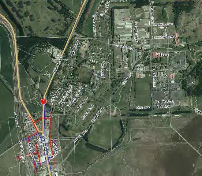
33 MOBILE RUAPEHU Ruapehu is a large region with inconsistent and unreliable mobile phone service. Ruapehu is home to many popular tourist attractions, the majority of which are outdoor and adventure based. The tourism industry has grown exponentially in the District as a whole and particularly in the summer months. The Ruapehu District is now experiencing a 74% increase in visitor nights compared to visitor nights experienced in 2003/04. Visitor Nights July January Yearly total 2003/04 40,762 24, , /14 56,767 54, ,242 This sees many people venturing, alone or in tour groups, to activities of high risk in remote areas. Most attractions are isolated geographically and often with non existent telecommunication services. Many of the District s tourism activities occur in rural and remote areas. Therefore, improved services to popular tourist areas will benefit nearby farming communities. The District is heavily reliant on primary industries, most predominantly farming. A lack of mobile service is a constant frustration for our rural communities, both personally and in their farming activities. The poor communication facilities are a matter of concern to Ruapehu Emergency Services. The emergency services of the Ruapehu are jeopardised daily by poor communication services. Not only is the reliability of making emergency calls impinged upon, so is the operation and response of the services. Members of the Emergency services have provided letters of support to this ROI (see appendix 22). Improved mobile services in the District will bring economic, safety and social benefits to the business, communities and visitors of the Ruapehu. Ohakune, Pureora Forest/ Timber Trail National Cycle Way, Mountains to Sea National Cycleway, Whanganui River, Ohakune Mountain Road, Okahukura to Tokirima, State Highway 4, State Highway 47, State Highway 43/Forgotten World Highway have been identified as critical mobile black spots. We have lost business as we have missed after hour call outs due to no coverage at certain times. This has often caused our customer some distress at not being able to contact someone to secure their property. Taumarunui business In the last 3 months there has been 3 serious incidents I firmly believe it is only a matter of time before there is a fatal accident Epic Cycle Adventures Our largest hurdle in terms of safety, is communication with our clients, as the river and tracks are isolated with no roads in or out, and no phone reception at any point Raetihi tourism operator At present we are missing business opportunities as clients level messages on our mobile phones that we cannot retrieve until we go to town. It is expected that everyone has mobile coverage, and we have none. We and our staff often work alone away from our houses all day, with machinery and stock. Mobile phone coverage would greatly enhance out safety. Rural Taumarunui business Many of the District s at risk areas suffer from poor and inconsistent mobile phone reception. This is concerning for all emergency services in the District Nick Watson Emergency Management and Rural Fire Officer Loading Ruapehu: 32
 Significant Tourist Areas The Ruapehu District is home to many popular")


34 Current Coverage Current 3G coverage as mapped by network providers (Spark left, Vodafone middle, 2Degrees right) Significant Tourist Areas The Ruapehu District is home to many popular summer and winter tourism attractions, including: Turoa Ski field. Whakapapa Ski field. Tongariro Crossing. Whanganui River. Mountains to Sea National Cycleway. Timber Trail National Cycleway. Forgotten World Highway (road, cycle and trails). Ohakune Old Coach Road. Ruapehu Crater Lakes. Tongariro/Mount Doom hike. Ohakune Mountain Road. Ohakune. Bridge to Nowhere. Okahukura to Tokirima Road. 33

35 All of these areas suffer from poor mobile service coverage and are of a safety concern. However, the following are of particular concern to Council, local emergency services, civil defence, rural fire, tourism operators, users and communities. The areas of priority are detailed below in order of priority. Pureora Forest/ Timber Trail National Cycleway The Central North Island Rail Trail/Central North Island Rail Trail/Timber Trail National Cycleway is located in Pureora Forest Park. Currently, the trail is 44km long and see thousands of users a year. The park also contains a campground at Piropiro Flats, used by cyclists, hikers and general campers. The road to access the trail and the forest itself is unserviced by all network providers. This has been an area identified by Ruapehu Rural Fire, Taumarunui Emergency Services and Waitomo District Council as an area of high safety concern. The major tourism operator, Epic Cycle Adventures, has also voiced concerns over the lack of communication facilities: Safety is a major concern on the trail because, essentially, once people have committed to the ride, there are very few places where they can either decide to abandon their ride or where emergency services can reach them in the case of an accident. Due to the fact that there is little to no cellphone reception on the trail, in an emergency the only way to get assistance is for a co rider to ride out to Pureora (no coverage, so would need to find a land line) or Ongarue (limited coverage). In a worst case scenario, this ride could be up to 30km. I firmly believe that it is only a matter of time before there is a fatal accident on the trail. Cellphone coverage would make the trail far safer and I believe that it is vital to the continued success of the trail. The Timber Trail is beginning to stimulate the local economies and will continue to do so, provided people keep coming. Any perceived safety issues would have a detrimental impact on this much needed economic benefit. Please see appendix 22 for full letter of support. Timber Trail route in the Pureora Forest 34
 Cycleway is 317kms in length and starts in either National Park or Ohakune and finishes in Whanganui.")

36 Mountains to Sea National Cycleway Mountains to Sea National Cycleway is one of seven New Zealand Cycle Trail Quick Start projects announced by the Government in The Mountains to Sea (M2C) Cycleway is 317kms in length and starts in either National Park or Ohakune and finishes in Whanganui. Users consist of multiple day and one day trip riders, both with and without guides. See appendix 21 for weekly and daily use data. Annual Average Traffic Trail Section Fishers Track 3,807 Marton Sash and Door Tramline 1,233 Ohakune Old Coach Road 6,028 Kaiwhakauka Trail 238 Mangapurua Loop 2,800 Poor communication facilities were highlighted in the 2010 Feasibility Report on the trail. Council sees this as an opportunity to improve the safety of the trail as it was not addressed when the trail was established. Whanganui River The Whanganui River is a popular host to canoeing, kayaking and jet boating activities. Approximately 12,500 paying visitors are on the river every year. This does not include those using the river for private canoeing, kayaking, jet boating and hunters and trampers in the area. The river courses through steep ravines and is remote. The Whanganui River has no mobile phone reception from any provider. Mountains to Sea route This is of significant safety concern for all emergency services, tourism operators and users. Tourism operators on the Whanganui River have reported that the lack of reception is of significant detriment to their operation, as people are uncomfortable with being out of contact for days in remote areas and when undertaking activities of risk. Whanganui River Adventures has voiced its concerns: Our largest hurdle in terms of safety, is communication with our clients, as the river and tracks are isolated with no roads in or out, and no phone reception at any point. All companies on the river regularly meet to talk about safety and the dangers on the river. Having cellphone reception along the Whanganui River Whanganui Riverroute 35


37 would save so much time and money for all of the operators on the Whanganui River. It would bring more visitors to the area, as a lot of people feel uncomfortable not having any contact with anyone for days. As operators on the river flooding also a huge risk, as flooding can occur at any stage. If we could call our customers in the event of a flood, we can give them the best advice based on the actual river levels, and coordinate evacuations/rescues a lot more efficiently. See appendix 22 for the full letter of support. The Ohakune Mountain Road This road connects the Turoa Skifield with Ohakune. It is the busiest road in the District, with over 4000 movements at peak times. This road has limited service and, although the road is busy and can be considered safer than the other roads in the District, the benefit to mountain users will be positive for attracting and retaining Turoa ski field users. Ohakune Ohakune is the District s main tourism area and services a wide range of tourism activities. However, mobile networks are often Ohakune Mountain Road overloaded in the winter months due to the rise in population for the ski season. This is both a safety and convenience issue that is of concern to the community, Council, emergency services and businesses. Okahukura to Tokirima This area contains a productive farming community. Improved telecommunications facilities will be of economic, safety and social benefit to the community and individuals based in this area. This road is also an important support road of the Forgotten World Adventure operation. This road follows the rail lines closely and is used by support vehicles. Okahukura to Tokirima route 36

38 State Highways The District contains State Highways 1,4,41,43,47,48 and 49. Outside urban areas, the highways have limited and unreliable mobile service coverage across all networks. State Highways 4, 47 and 43 are the priority highways for improved mobile service coverage. The road user counts for all of Ruapehu Highways from are tabled in appendix 20. State Highway 4 State Highway 4 is the District s main highway and runs from north of Taumarunui to south of Raetihi. 37
39 This highway services many tourism areas including the Pureora Forest Park, Whanganui River, connects motorists to Whakapapa Village via State Highway 47 and to the short highway to Ohakune via State Highway 49. State Highway 4 is the only route north when State Highway 1 (Desert Road) is closed. This is a common occurrence in the winter, due to poor weather and driving conditions. The highway has limited and unreliable mobile service from all networks. Improved mobile service along the entire highway is considered to be a safety priority. State Highway 47 State Highway 47 is the highway that connects Taupo/Turangi to National Park, Whakapapa Ski field and Tongariro Crossing. This is a popular route for independent travellers, guided tours and shuttles coming from Taupo and Turangi to experience the Tongariro National Park. The road has limited and unreliable mobile service. This is a civil defence and emergency services concern. State Highway 43/Forgotten World Highway The Forgotten World Highway is an increasingly popular highway that connects Taumarunui to Stratford via Whangamomona and is becoming increasingly popular with tourists. This road is 150km of narrow, windy and predominantly gravel surface. This is of high safety concern as the road travels through remote areas. The highway was ranked second most dangerous road by the New Zealand Police in 2013 (Taranaki Daily Times 27/03/15). Additionally, the increasing number of cyclists taking this route increases the safety risk of the highway. The majority of the road has no mobile service from any mobile network. This area is also utilised by Forgotten World Adventures who use decommissioned rail lines for rail tours. This operation is continually hampered by poor communication facilities. By improving the mobile service to the highway, there is an opportunity to improve the coverage to the rail lines. The safety of the operation is also jeopardised. This safety concern has been identified by owner/operator Ian Balme: As an employer within the District of more than 25 staff, FWA sees more than 6,000 visitors through the Forgotten World Highway (State Highway 43) and Stratford Okahukura Line (SOL) each year. State Highway 43 and the SOL is marred by mobile black spots, making for growing safety concerns with the ever growing number of tourists making their way between the Ruapehu and Stratford Districts. Please see appendix 22 for the full letter of support. This area is also home to numerous farming operations. This community will also benefit from improved connectivity. Emergency Services Ruapehu s emergency services are daily impinged upon by poor communication services. The limited availability of network coverage from all providers limit the safe, efficient and effective operation of the emergency services and civil defence of Ruapehu. 38
40 Members of all emergency services and civil defence have provided letters of support for the eradication of mobile black spots: There are numerous dead spots where we lose contact with our control room, and they cannot be made aware of what is happening at the emergency situation we are either responding to or in attendance at, which does not help us carry out our operation smoothly Barry Fisher (Chief Fire Officer Taumarunui) Many of the District s at risk areas suffer from poor and inconsistent mobile phone reception. This is concerning for all emergency services in the District Nick Watson (Emergency Management and Rural Fire Officer). Please see appendix 22 for the full letters of support. Areas of Local Authority Assistance Consenting Support Ruapehu District Plan The Ruapehu District Plan defines a telecommunication network utility as: Means an activity (including the associated facilities, works and structures) undertaken by a network utility operator and includes The operation of a telecommunication network as defined in section 5 of the Telecommunications Act 2001 ( means a system comprising telecommunication links to permit telecommunication ). Therefore, Telecommunication activities are subject to the Network Utility section of the Ruapehu District Plan. The relevant rules of the Ruapehu District Plan are provided in appendix 17. Resource Consenting is prepared to waive the fees for any necessary resource consents for the successful supply company until the completion of the roll out. Aerial Consents The Ruapehu District Plan classifies Aerials as Discretionary Activities in the Urban and Rural zone and Non Complying in the Protected Areas Zone. Overhead Cabling The location of new overhead cabling is permitted in the rural zone and discretionary in the rural and protected areas zone. Required additions and extensions to overhead lines are permitted activities in all zones. 39
41 Trenching Consents The undergrounding of lines is a permitted activity in all zones of the district providing material removed is less than 1,000m 3 per certificate of title in rural zones and 100m 3 in residential zones. It is unlikely this volume will be removed from one title. If the undergrounding were to occur in the road designation a Corridor Access Request is required. Town Wide CAR Approvals and Reinstatement Standards operates under the National Code of Practice for Utility Operators' Access to Transport Corridors. Reinstatement to this code is required. As part of this the CAR system is used for processing CARs. This system allows for town wide CARs and Council are prepared to process these. Please see costs section below. Costings Charges for successful supply company Permission Cost Permitted Activities No fee Discretionary Activity No fee for successful supply company Corridor Access Request $125 Resource Consent Monitoring Fee No fee for successful supply company Minor upgrading, all operations and maintenance No fee Identification of Infrastructure, Land and Land Access Pole Infrastructure Council manages approximately 1,300 streetlights. 421 of these are mounted on Council s lighting poles, the others are on power poles managed by TLC. Most of the street lighting is in urban areas, with 52% of all lights in Taumarunui. Rural lighting is provided in the vicinity of major intersections. The Council owned light poles are mapped in appendix 18. The District s power poles owned and managed by TLC are of a standard design and have the potential for infrastructure co location. TLC has indicated it does not intend to use the poles for colocation. Council is prepared to undertake negotiations with the successful supply company to use Council owned street light poles. The use of the poles is not included in the current fees and charges so will be decided upon negotiation. Building Infrastructure is prepared to undertake negotiations with the successful supply company to locate facilities on the Council Buildings. These include but are not limited to: Council Offices, Libraries, Information Sites, Water and Wastewater Treatment Plants, Swimming Pools, Public Toilets, Memorial Halls. Council is prepared to provide this space on pro bono lease agreements. 40
42 Roading Infrastructure is also prepared to undertake negotiations with the successful supply company to locate facilities on Council Road Reserve. Land and Land Access undertook a community wide survey which included the question: Are you interested in having equipment located on your property to help improve telecommunication services to yourself and your area? Places that have high hills or are particularly remote are ideal. Over 80 respondents indicated interest in having equipment located on their property, including Ongarue, National Park, Taumarunui, Horopito, Raetihi, Kakahi, Ohakune, Waiouru and Waimiha. Council is prepared to facilitate contacting these land owners and any necessary associated consenting. Uptake and Awareness Assistance Utilisation of Existing Council Communications Council has a range of existing communication channels with the community. Council is prepared to utilise these to assist with publicising the availability of improved services to the district. The following options are currently available: Council Facebook pages (Council Facebook, Youth Council, i SITE, and Rural Fire). Council website. Printed information at our offices, libraries, and i SITES. Community Research Council has undertaken a community wide speed test and survey. The survey (see appendix 23 for all individual responses) was conducted over two weeks and received 205 responses. The survey also asked what is your mobile coverage like at your home/business. A high level of dissatisfaction was evident. Working with the Successful Supply Company. Council is prepared to utilise all communication channels to disseminate information on improvements for the successful supply company. Investment Options Council Investment Council considers the consenting support and asset use offered to the successful supply company as investment into the deployment. The full extent of Council investment for the deployment of Rural Broadband will be decided and detailed in the Digital Enablement Plan. 41
43 ASSUMPTIONS Assumptions have been made that the coverage maps provided by any provider or means are as accurate. The survey and test has an unknown margin of error. All tests were taken for mbps. Statistics for access to broadband has been changed from access to internet as per MBIE guidance. 42
44 APPENDICES 1 50km Zones 2 Taumarunui Meshblock Data 3 Raetihi Meshblock Data 4 Ohakune Meshblock Data 5 National Park and Whakapapa Village Meshblock Data 6 Owhango Meshblock Data 7 Waiouru Meshblock Data 8 Rangataua Meshblock Data 9 Raetihi Ohakune Road Meshblock Data 10 Horopito Meshblock Data 11 Ohura and Matiere Meshblock Data 12 Pipriki Meshblock Data 13 Kakahi Meshblock Data 14 Kaitieke and Whakahoro Meshblock Data 15 Ongarue and Waimiha Meshblock Data 16 Network Utility Rules 17 Council Street Light Pole Locations 18 Council Underground Asset Maps 19 State Highway Counts 20 Cabinet Locations 21 Mountains to Sea Cycleway Counts 22 Letters of Support 23 Loading Ruapehu Survey Responses 43
45 Appendix 1 Urban 50km/ph speed areas 44
46 45
47 46
48 47
49 Appendix 2 Taumarunui Meshblock Data No of Households Median Household income % of households w internet Meshblock Population Taumarunui by Mesh block // Area Unit MB MB MB MB MB MB MB MB MB MB MB MB MB MB MB Tarrangower MB MB N/A N/A MB MB MB MB N/A N/A MB N/A N/A MB MB MB MB Sunshine/ Hospital Hill MB MB MB MB MB MB MB MB MB N/A N/A MB MB MB MB MB MB N/A N/A 48
50 Median Household income % of households w internet Meshblock Population No of Households MB N/A N/A MB N/A N/A MB N/A N/A MB N/A N/A N/A MB N/A N/A MB MB MB MB MB MB MB MB MB MB MB MB MB MB N/A N/A MB N/A N/A MB N/A MB N/A MB MB N/A N/A MB N/A N/A MB MB MB N/A N/A MB Taumarunui Central MB MB MB MB N/A MB N/A N/A MB MB MB N/A MB MB MB Manunui
51 Appendix 3 Raetihi Meshblock Data No of Households Median Household income % of households w internet Meshblock Population Raetihi by Mesh block // Area Unit MB MB MB MB N/A MB MB MB MB MB MB MB Raetihi Appendix 4 Ohakune Meshblock Data No of Households Median Household income % of households w internet Meshblock Population Ohakune by Mesh Block // Area Unit MB MB MB N/A MB N/A N/A MB MB N/A MB MB MB MB MB N/A MB MB MB N/A N/A MB MB MB MB MB MB N/A MB MB MB N/A Ohakune
52 Appendix 5 National Park and Whakapapa Village Meshblock Data No of Households Median Household income % of households w internet Meshblock Population National Park by Mesh block // Area Unit MB MB MB MB National Park Whakapapa by Meshblock//Made up of parts of the following area units: Raurimu and Tangiwai MB MB N/A N/A MB MB MB MB MB MB MB Whakapapa Appendix 6 Owhango Meshblock Data No of Households Median Household income % of households w internet Meshblock Population Owhango by Mesh block // Area Unit MB MB MB Owhango Appendix 7 Waiouru Meshblock Data No of Households Median Household income % of households w internet Meshblock Population Waiouru by Meshblock // Area Unit MB MB MB MB N/A MB N/A MB MB
53 Median Household income % of households w internet Meshblock Population No of Households MB N/A N/A MB N/A N/A MB N/A 0 MB MB MB MB N/A N/A MB MB MB MB MB MB N/A N/A N/A MB MB MB MB MB MB MB MB MB Waiouru Appendix 8 Rangataua Meshblock Data Median Household income % of households w internet Meshblock Population No of Households Rangataua by Meshblock // within the Tangiwai Area Unit N/A N/A N/A N/A N/A N/A Rangataua
54 Appendix 9 Raetihi Ohakune Road Meshblock Data Median Household income % of households w internet Meshblock Population No of Households Ohakune Raetihi Road by Meshblock // Within the Tangiwai Area Unit Ohakune Raetihi Road Appendix 10 Horopito Meshblock Data Median Household income % of households w internet Meshblock Population No of Households Horopito by Meshblock // Within the Tangiwai Area Unit N/A N/A Horopito
55 Appendix 11 Ohura and Matiere Meshblock Data Median Household income % of households w internet Meshblock Population No of Households Ohura by Meshblock // Within both the Ohura and Otangiwai Heao Area Units N/A N/A N/A N/A N/A N/A N/A Ohura Matiere by Meshblock // Within the Otangiwai Heao Area Unit N/A N/A N/A N/A N/A Matiere Appendix 12 Pipiriki Meshblock Data Median Household income % of households w internet Meshblock Population No of Households Pipiriki Meshblock // Within the Tangiwai Area Unit N/A Pipiriki Appendix 13 Kakahi Meshblock Data Median Household income % of households w internet Meshblock Population No of Households Kakahi by Meshblock // Within the Ngapuke Area Unit N/A N/A N/A Kakahi
56 Appendix 14 Kaitieke, Retaruke and Whakahoro Meshblock Data Median Household income % of households w internet Meshblock Population No of Households Kaiteke, Retaruke, Whakahoro by Meshblock // Within the Tangiwai Area Unit N/A N/A N/A Kaitieke/Retaruke/ Whakahoro Appendix 15 Ongarue and Waimiha Meshblock Data Median Household income % of households w internet Meshblock Population No of Households Ongarue by Meshblock // Within the Otangiwai Heao Area Unit N/A N/A N/A Ongarue Ongarue by Meshblock // Within the Otangiwai Heao Area Unit N/A N/A N/A Ongarue


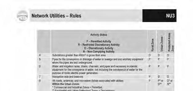
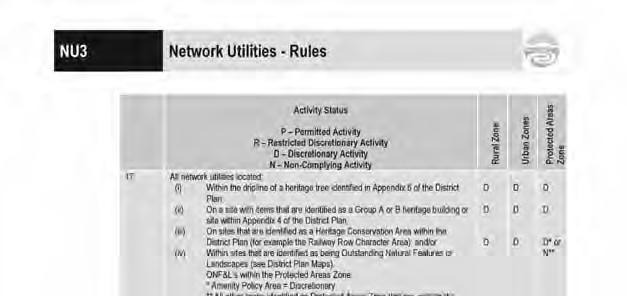
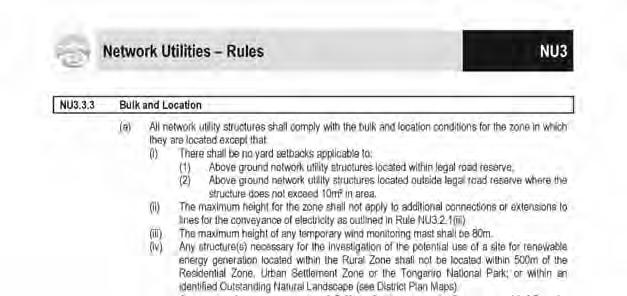
57 Appendix 16 Ruapehu District Plan Network Utilities Rules 56


58 57

59 58


60 59


61 60


62 61


63 62


64 Appendix 17 Council Street Light Poles Council owned light poles (Taumarunui) Council Owned Light Poles (Ohakune) 63

 64")
65 Council Owned Light Poles (Raetihi) Council Owned Light Poles (Owhango) 64
")
66 Council Owned Light Poles (Waiouru) National Park/Whakapapa Village (No Council owned light poles in Whakapapa Village) 65
, Red lines (Wastewater) Council")

67 Appendix 18 Council Underground Asset Maps Note: Blue lines (Water), Red lines (Wastewater) Council water and wastewater pipe locations (Taumarunui) Council water and wastewater pipe locations (Ohakune) 66

68 Council water and wastewater pipe locations (Raetihi) Council water and wastewater pipe locations (Waiouru) 67
")
 68")
69 Council water and wastewater pipe locations (Owhango) Council water and wastewater pipe locations (National Park) 68
")
70 Council water and wastewater pipe locations (Rangataua) 69
71 Appendix 19 Ruapehu State Highway Counts (Source, NZTA) SH RS RP Site Ref Description Direction Equipment ID: Mangatupoto Both Single Loop ID: Okaihae Rd Both Single Loop ID: Matapuna Both Single Loop ID: Owhango Both Single Loop ID: Raurimu Both Single Loop ID: HOROPITO Telemetry Site 37 Both Telemetry ID: Waimarino Both Dual Loop ID: Sth of River Rd Both Single Loop ID: Tokorima Both Tube ID: TeMaire Both Tube ID: Mania Rd Both Tube ID: National Park Both Single Loop ID: Nth of SH48 Both Single Loop ID: Whakapapa Nui Stream Both Single Loop ID: West of Ohakune Both Single Loop ID: Ohakune East Both Single Loop ID: Waiouru Both Dual Loop AADT (2010) AADT (2011) AADT (2012) AADT (2013) AADT (2014) % Heavy 70
72 Appendix 20 Cabinet Locations Cabinet Name (ICMS) Locality Alternative cabinet Name Notes District Council Regional Council X coord Y coord Comments / History RBI Site Name RBI Timing (year) Status BAU Cabinet upgrades Timing RFS date DSLAM name DSLAM Type Weekly growth sheet VDSL capable FD ISAM 7330 ISAM Pre RBI DSLAMS Aug 2011 MRP/C MRP MRP Ruapehu DistricManawatu-Wan MRP ASAM ASAM MRP MRP/E MRP IWI Ruapehu DistricManawatu-Wan MRP/E ASAM ASAM MRP/E MTW/B MTW Ruapehu DistricManawatu-Wan MTW/B Conklin Conklin MTW/B NAT NAT Ruapehu DistricManawatu-Wan NAT ASAM ASAM NAT NAT/B NAT Ruapehu DistricManawatu-Wan NAT/B 2 Complete NAT/B ISAM VDSL NAT/B OGU/AK OGU TMN/AK Ruapehu DistricManawatu-Wan Use OGU/AK to generate covera TMN/AK Conklin Conklin TMN/AK OKN OKN Ruapehu DistricManawatu-Wan OKN ISAM/ASAM VDSL ASAM OKN OKN/E OKN Ruapehu DistricManawatu-Wan OKN/E ISAM VDSL ISAM OKN/E OKN/G OKN Ruapehu DistricManawatu-Wan OKN/G ISAM VDSL ISAM OKN/G OR/N OR Ruapehu DistricManawatu-Wan OR/N 4 On.Target OR/N Conklin vdsl Conklin OR/N OWN/AM OWN OWN Ruapehu DistricManawatu-Wan OWN/AM ASAM ASAM OWN/AM Owhango OWN/AP OWN Ruapehu DistricManawatu-Wan OWN/AP ASAM ASAM OWN/AP Kakahi RET RET Ruapehu DistricManawatu-Wan RET ASAM ASAM RET RET/AH RET Ruapehu DistricManawatu-Wan RET/AH Conklin Conklin RET/AH RET/P RET Ruapehu DistricManawatu-Wan RET/P Conklin Conklin RET/P TMN TMN Ruapehu DistricManawatu-Wan TMN ISAM/ASAM VDSL ISAM/ASAM TMN TMN/A TMN Ruapehu DistricManawatu-Wan TMN/A 4 On.Target TMN/A ASAM vdsl ASAM TMN/A TMN/AB TMN Ruapehu DistricManawatu-Wan TMN/AB Conklin Conklin TMN/AB TMN/AS TMN Ruapehu DistricManawatu-Wan TMN/AS 3 Complete TMN/AS ISAM VDSL TMN/AS TMN/AU TMN Ruapehu DistricManawatu-Wan TMN/AU 3 Complete TMN/AU ISAM VDSL TMN/AU TMN/B TMN new 1/11 Ruapehu DistricManawatu-Wan TMN/B ISAM VDSL ISAM TMN/B TMN/BJ TMN Ruapehu DistricManawatu-Wan TMN/BJ Conklin Conklin TMN/BJ TMN/BN TMN Ruapehu DistricManawatu-Wan TMN/BN Conklin Conklin TMN/BN TMN/BR TMN Ruapehu DistricManawatu-Wan TMN/BR Conklin Conklin TMN/BR TMN/BU TMN Ruapehu DistricManawatu-Wan TMN/BU 3 Complete TMN/BU ISAM VDSL TMN/BU TMN/C TMN new 1/11 Ruapehu DistricManawatu-Wan TMN/C ISAM VDSL ISAM TMN/C TMN/CB TMN Ruapehu DistricManawatu-Wan TMN/CB Conklin Conklin TMN/CB TMN/E TMN Ruapehu DistricManawatu-Wan TMN/E ISAM VDSL ISAM TMN/E TMN/G TMN Ruapehu DistricManawatu-Wan TMN/G ISAM VDSL ISAM TMN/G TMN/P TMN Ruapehu DistricManawatu-Wan TMN/P 5 On.Target TMN/P Conklin vdsl Conklin TMN/P TMN/T TMN Ruapehu DistricManawatu-Wan TMN/T ASAM ASAM TMN/T TMN/W TMN Ruapehu DistricManawatu-Wan TMN/W 3 Complete TMN/W ISAM VDSL TMN/W WIR WIR Ruapehu DistricManawatu-Wan WIR 1 WIR ISAM/ASAM VDSL ASAM WIR TNZ Ca b site code USE FOR EXTRACTS/ PUBLISH 71


73 Appendix 21 Mountains to Sea Cycleway Counts (June 2014 June 2015) 72
Manawatu District Economic Profile
 Manawatu District Economic Profile Our community Population has grown by 1,000 residents since 2014 to reach 29,800. Population is 86.4% European, with Maori 14.3% of the population. This compares with
Policy Communications. Policy highlights. Our plan. National is committed to connecting New Zealanders to each other and to the world.
 Our plan National believes in connecting New Zealanders to each other and to the world. A more digitally connected New Zealand supports a growing economy and jobs, safer and healthier communities, our
Combined Policy and Bylaw Review 2017
 Consultation Document - Combined Policy and Bylaw Review 2017 Consultation Document 28 August to 6 October 2017 Combined Policy and Bylaw Review 2017 Dog Control Policy Review Local Alcohol Policy Review
PROTECTED AREAS ZONE - POLICY
 PROTECTED AREAS ZONE - POLICY.1 Introduction The Protected Areas Zone applies to the land depicted on the Ruapehu District Plan Maps as: Amenity Policy Area. Protected Areas - Conservation. (c) Protected
1 INFORMATION REQUIREMENTS
 1 INFORMATION REQUIREMENTS 1.1 BACKGROUND 2 1.2 WHAT IS THE DISTRICT PLAN 3 1.3 DISTRICT PLAN STRUCTURE 4 1.4 HOW TO USE THE DISTRICT PLAN 5 1.5 STRATEGIC FRAMEWORK 6 Whanganui District Plan (15 January
Policy National s plan for regional New Zealand. Policy highlights. Backing our regions. Delivering for New Zealanders
 Policy 2017 National s plan for regional New Zealand Backing our regions Policy highlights New Zealand is a nation of opportunities and that s all because of the hard work and enterprise of New Zealanders,
Provincial Review 2016: Limpopo
 Provincial Review 2016: Limpopo Limpopo s growth since 2003 has been dominated by the mining sector, especially platinum, and by national construction projects. As a result, the provincial economy grew
The Economic Impact of Tourism in North Carolina. Tourism Satellite Account Calendar Year 2015
 The Economic Impact of Tourism in North Carolina Tourism Satellite Account Calendar Year 2015 Key results 2 Total tourism demand tallied $28.3 billion in 2015, expanding 3.6%. This marks another new high
Quick Start Track 1: Hokianga to Opua/Russell
 Quick Start Track 1: Hokianga to Opua/Russell Kaikohe to Okaihau section PROJECT DESCRIPTION The overall opportunity is to develop a 90-kilometre trail from the Hokianga Harbour on the West coast through
The Economic Impact of Tourism in North Carolina. Tourism Satellite Account Calendar Year 2013
 The Economic Impact of Tourism in North Carolina Tourism Satellite Account Calendar Year 2013 Key results 2 Total tourism demand tallied $26 billion in 2013, expanding 3.9%. This marks another new high
ABOUT HOSPITALITY NEW ZEALAND
 Election Manifesto ABOUT HOSPITALITY NEW ZEALAND Hospitality New Zealand (HNZ) is a member-led, not-forprofit organisation representing the largest membership group in our tourism industry. With approximately
Economic Impact of Tourism in South Dakota, December 2018
 Economic Impact of Tourism in South Dakota, 2018 December 2018 1) Key Findings Growth rebounds in 2018 as a strong hunting season drives tourism growth Key facts about South Dakota s tourism sector Key
Tourism Satellite Account Calendar Year 2010
 The Economic Impact of Tourism in Georgia Tourism Satellite Account Calendar Year 2010 Highlights The Georgia visitor economy rebounded in 2010, recovering 98% of the losses experienced during the recession
Timetable Change Research. Re-contact survey key findings
 Timetable Change Research Re-contact survey key findings Key project objectives Measure the impact of the timetable changes on customers, what actions have they taken as a result Gauge how have the timetable
Snowsport. 84 Snowsport. Skills Active Workforce Scan Skills Active Workforce Scan 2018 Snowsport 85
 Snowsport The snowsport industry offers skiing, snowboarding, cross-country skiing, alpine walking and trekking, and other on-piste activities. With advances in alpine equipment and snowmaking technology,
TOURISM IN WESTLAND MARCH 2012
 TOURISM IN WESTLAND MARCH 2012 Tourism in Westland The Westland District Council co-ordinated three tourism industry related meetings during February 2012. These were held in Haast, Fox Glacier and Hokitika.
ASCOT SUBURB PROFILE
 ASCOT SUBURB PROFILE CONTENTS SUBURB HIGHLIGHTS 2 3 4 4 5 5 ASCOT & SURROUNDS LOCATION & LIFESTYLE DEMOGRAPHICS EMPLOYMENT FUTURE INFRASTRUCTURE WA MARKET TRENDS ACCESSIBILITY ENTERTAINMENT & RECREATION
Cracow 2013/2023 Place Based Plan
 Cracow 2013/2023 Place Based Plan Cracow Place Based Plan Page 1 The Cracow Place Based Plan is a controlled document. Please visit the Banana Shire Website at http://www.banana.qld.gov.au/index.php/71
OUR GOAL. We are. Ruapehu. Statement of Proposal. Statement of Proposal - Easter Sunday Shop Trading Policy 2018 Draft
 Statement of Proposal - Draft OUR GOAL. We are. Ruapehu. www.ruapehudc.govt.nz Statement of Proposal 1 Key dates Consultation opens Friday 1 December 2017 Consultation closes Friday 26 January 2018 Hearings
Your Transport Levy Your Transport Future. Sunshine Coast Council Transport Levy Annual Report
 Your Transport Levy Your Transport Future Sunshine Coast Council Transport Levy Annual Report 2016-2017 www.sunshinecoast.qld.gov.au T 07 5475 7272 F 07 5475 7277 Locked Bag 72 Sunshine Coast Mail Centre
WELLINGTON $422 MILLION $614 MILLION $83 MILLION 22% SPEND $1.9 BILLION
 WELLINGTON WELLINGTON $1.9 BILLION FORECAST TOTAL WELLINGTON INVESTMENT The Wellington region s transport challenges are dominated by the region s concentration of population in the metropolitan cities,
Economic Impact of Tourism in South Dakota, December 2017
 Economic Impact of Tourism in South Dakota, 2017 December 2017 1) Key findings 1) Growth continues in 2017 but pales against the event driven years of 2015 and 2016 in South Dakota Key facts about South
Queensland Economic Update
 Queensland Economic Update Chamber of Commerce & Industry March 2018 cciq.com.au Queensland Economic Update: Summary National Accounts GDP expanded 2.3% during calendar year 2017. QLD state final demand
Contents Manningham at a Glance... 6 Location and Area... 6 Manningham Activity Centres... 6 Manningham Suburbs... 6 Population... 8 Forecast... 9 For
 Contents Manningham at a Glance... 6 Location and Area... 6 Manningham Activity Centres... 6 Manningham Suburbs... 6 Population... 8 Forecast... 9 Forecast 2011 2036... 9 Population Forecast... 9 Gross
Reference: 06/13/0594/F Parish: Fritton & St Olaves Officer: Mrs M Pieterman Expiry Date:
 Schedule of Planning Applications Committee Date: 21 st January 2014 Reference: 06/13/0594/F Parish: Fritton & St Olaves Officer: Mrs M Pieterman Expiry Date: 20-01-2014 Applicant: Proposal: Site: Lord
Queenstown Lakes District Council. Review of District Plan Business Zones Capacity and Development of Zoning Hierarchy
 Queenstown Lakes District Council Review of District Plan Business Zones Capacity and Development of Zoning Hierarchy McDermott Miller Strategies Limited in association with Allan Planning & Research Limited
HEALTH SECTOR ECONOMIC INDICATORS REPORT
 HEALTH SECTOR ECONOMIC INDICATORS REPORT For: Mid North Coast Local Health District Report prepared by: April 2013 Table of Contents Introduction 3 Executive Summary 4 Output 5 Value-Added 7 Workforce
VISITOR ECONOMY STRATEGY
 ECONOMY STRATEGY WESTERN 6 6% GDP 3.5M NIGHTS 3.5m The Western Bay of Plenty subregion incorporates the Western Bay of Plenty District and Tauranga City. The Western Bay of Plenty District covers 212,000
Gold Coast: Modelled Future PIA Queensland Awards for Planning Excellence 2014 Nomination under Cutting Edge Research category
 Gold Coast: Modelled Future PIA Queensland Awards for Planning Excellence 2014 Nomination under Cutting Edge Research category Jointly nominated by SGS Economics and Planning and City of Gold Coast August
Gold Coast. Rapid Transit. Chapter twelve Social impact. Chapter content
 Gold Coast Rapid Transit Chapter twelve Social impact Chapter content Social impact assessment process...235 Existing community profile...237 Consultation...238 Social impacts and mitigation strategies...239
The Economic Impact of Tourism in Maryland. Tourism Satellite Account Calendar Year 2015
 The Economic Impact of Tourism in Maryland Tourism Satellite Account Calendar Year 2015 MD tourism economy reaches new peaks The Maryland visitor economy continued to grow in 2015; tourism industry sales
The Economic Impact of Tourism in Hillsborough County. July 2017
 The Economic Impact of Tourism in Hillsborough County July 2017 Table of contents 1) Key Findings for 2016 3 2) Local Tourism Trends 7 3) Trends in Visits and Spending 12 4) The Domestic Market 19 5) The
1.1 To promote safe and environmentally responsible overnight camping within the Ruapehu District.
 Council Policy Policy Title: Responsibility: Group Manager Community Services First Adopted: 13 March 2012 Review Frequency: Three yearly or as required Last Reviewed: February 2018 Next Review Due: February
East Lancashire Highways and Transport Masterplan East Lancashire Rail Connectivity Study Conditional Output Statement (Appendix 'A' refers)
") Report to the Cabinet Member for Highways and Transport Report submitted by: Director of Corporate Commissioning Date: 1 June 2015 Part I Electoral Divisions affected: All East Lancashire Highways and
Report to the Cabinet Member for Highways and Transport Report submitted by: Director of Corporate Commissioning Date: 1 June 2015 Part I Electoral Divisions affected: All East Lancashire Highways and
Waikato Regional Economic Development Strategy
 Waikato Regional Economic Development Strategy 1 TO FROM Economic Development Committee Ben Dunbar-Smith - Economic Development Programme Manager DATE 6 April 2016 SUBJECT Waikato Regional Economic Development
RUAPEHU TONGARIRO NATIONAL PARK & THE WHANGANUI RIVER VISITRUAPEHU.COM
 RUAPEHU TONGARIRO NATIONAL PARK & THE WHANGANUI RIVER VISITRUAPEHU.COM Welcome to Ruapehu Escape to Ruapehu, just half a day and a world away from our biggest cities, you ll arrive in a living landscape
Provincial Review 2016: KwaZulu-Natal KwaZulu-Natal
 Provincial Review 2016: KwaZulu-Natal KwaZulu-Natal KwaZulu-Natal has a strong role in South Africa s manufacturing and agriculture, and has its largest port and main North-South freight corridor. Its
Location Report. Coffs Harbour U Retire ( ) Retire with Property
 Retire with Property") Location Report Coffs Harbour Retire with Property 1300 U Retire (873 847) www.superannuationproperty.com Coffs Harbour Location Coffs Harbour is a regional town on the North Coast of New South Wales
Location Report Coffs Harbour Retire with Property 1300 U Retire (873 847) www.superannuationproperty.com Coffs Harbour Location Coffs Harbour is a regional town on the North Coast of New South Wales
The Travel and Tourism Industry in Vermont. A Benchmark Study of the Economic Impact of Visitor Expenditures on the Vermont Economy 2005
 The Travel and Tourism Industry in Vermont A Benchmark Study of the Economic Impact of Visitor Expenditures on the Vermont Economy 2005 INTRODUCTION GENERAL November, 2006 This 2005 update of the original
Mäori Economy in the Waikato Region Summary
 Mäori Economy in the Waikato Region Summary 1 KEY OBSERVATIONS OF THE WAIKATO MÄORI ECONOMY Mäori make a significant contribution to the economy in the Waikato region. This executive summary highlights
Annual Gross Domestic Product (Production Measure)
") June 2017 Executive Summary Page 2 Latest Quarter Economic Trends page 3 Economic Outlook page 4 Labour Force page 5 Retail Activity page 6 Building Activity page 7 Tourism Trends page 8 Local Authorities
June 2017 Executive Summary Page 2 Latest Quarter Economic Trends page 3 Economic Outlook page 4 Labour Force page 5 Retail Activity page 6 Building Activity page 7 Tourism Trends page 8 Local Authorities
Te Kowhai COMMUNITY PLAN
 1 2011-2021 Te Kowhai COMMUNITY PLAN Vision To realise a lifestyle potential 2 Map of Te Kowhai area 3 4 History of the plan In 2004 the Te Kowhai Community Group Committee and the residents put together
Submission to. Christchurch City Council. on the. Draft Long Term Plan Date: 12 April 2018
 Submission to Christchurch City Council on the Draft Long Term Plan 2018-2028 Date: 12 April 2018 Tourism Industry Aotearoa (TIA) welcomes the opportunity to comment on the Long Term Plan 2018-2028 of
Submission to. South Wairarapa District Council. on the. Draft Long Term Plan Date: 23 April 2018
 Submission to South Wairarapa District Council on the Draft Long Term Plan 2018-2028 Date: 23 April 2018 Tourism Industry Aotearoa (TIA) welcomes the opportunity to comment on the Long Term Plan 2018-2028
SUMMER VILLAGE OF SILVER SANDS. Municipal Development Plan
 SUMMER VILLAGE OF SILVER SANDS Municipal Development Plan Bylaw 253-2014 Adopted August 22, 2014 Summer Village of Silver Sands Municipal Development Plan Bylaw No. 253-2014 Page 2 1 INTRODUCTION 1.1 SETTING
PAGE 602
 PAGE 601 PAGE 602 PAGE 603 PAGE 604 PAGE 605 PAGE 606 PAGE 607 PAGE 608 PAGE 609 PAGE 610 PAGE 611 PAGE 612 PAGE 613 PAGE 614 PAGE 615 PAGE 616 PAGE 617 PAGE 618 PAGE 619 PAGE 620 PAGE 621 PAGE 622 PAGE
Submission to. Palmerston North City Council. on the. Draft Long Term Plan Date: 23 April 2018
 Submission to Palmerston North City Council on the Draft Long Term Plan 2018-2028 Date: 23 April 2018 Tourism Industry Aotearoa (TIA) welcomes the opportunity to comment on the Long Term Plan 2018-2028
Tourism Impacts and Second Home Development in Pender County: A Sustainable Approach
 Tourism Impacts and Second Home Development in Pender County: A Sustainable Approach (Funded by North Carolina Sea Grant) Center for Sustainable Tourism Division of Research and Graduate Studies East Carolina
GISBORNE DISTRICT COUNCIL BUSINESS CASE PROPOSAL. Eastland Port Access. Pedestrian Safety Rakaiatane Rd. Page 1 of 4
 GISBORNE DISTRICT COUNCIL BUSINESS CASE PROPOSAL Eastland Port Access Pedestrian Safety Rakaiatane Rd Page 1 of 4 Introduction This proposal has been developed by Gisborne District Council (GDC) to provide
D R O N E T R A C K E R. making your world possible
 D R O N E T R A C K E R 2 0 1 8 1 C O N T E N T S Background 3 Number of responses recreational vs commercial operators Profile of a recreational operator 5 Profile of a commercial operator 9 Business
Rangitīkei District Council
 Rangitīkei District Council Assets and Infrastructure Committee Meeting Agenda Thursday 9 August 2018 9:30 AM Contents 1 Welcome...3 2 Council Prayer...3 3 Apologies/leave of Absence...3 4 Members conflict
People. Product. Promotion. Tourism Industry Priorities for Election 2018
 People. Product. Promotion. Tourism Industry Priorities for Election 2018 Introduction Tourism in Ontario Tourism is a growth market, projected to generate more than $31 billion in visitor spending in
From: OECD Tourism Trends and Policies Access the complete publication at: Mexico
 From: OECD Tourism Trends and Policies 2014 Access the complete publication at: http://dx.doi.org/10.1787/tour-2014-en Mexico Please cite this chapter as: OECD (2014), Mexico, in OECD Tourism Trends and
5 Rail demand in Western Sydney
 5 Rail demand in Western Sydney About this chapter To better understand where new or enhanced rail services are needed, this chapter presents an overview of the existing and future demand on the rail network
Produced by: Destination Research Sergi Jarques, Director
 Produced by: Destination Research Sergi Jarques, Director Economic Impact of Tourism North Norfolk District - 2016 Contents Page Summary Results 2 Contextual analysis 4 Volume of Tourism 7 Staying Visitors
Produced by: Destination Research Sergi Jarques, Director
 Produced by: Destination Research Sergi Jarques, Director Economic Impact of Tourism Norfolk - 2016 Contents Page Summary Results 2 Contextual analysis 4 Volume of Tourism 7 Staying Visitors - Accommodation
Wakatipu Area Strategy Plan
 Wakatipu Area Strategy Plan September 2009 Executive Summary The Ministry of Education has developed an area strategy plan in response to population growth in the Wakatipu area. The Ministry predicts that
Waiouru Welcome Inn, 2 Ngauruhoe St, Waiouru 4825
 Notes for Guests Please note that all our units are nonsmoking; we have placed ashtrays on the tables outside each unit for your use. Check in/out Times Check in is from 2pm through to 10pm each day. Check
Submission to. Waitaki District Council. on the. Draft Long Term Plan Date: 30 April 2018
 Submission to Waitaki District Council on the Draft Long Term Plan 2018-2028 Date: 30 April 2018 Tourism Industry Aotearoa (TIA) welcomes the opportunity to comment on the Long Term Plan 2018-2028 of Waitaki
Wellington $312 $49 $456 OVERVIEW WELLINGTON REGIONAL SUMMARY
 National Land Transport Programme 2015 18 Wellington WELLINGTON REGIONAL SUMMARY OVERVIEW The Wellington region is made up of a number of cities, urban areas and supporting rural hinterland. The city is
Submission to. Wairoa District Council. on the. Draft Long Term Plan Date: 26 June 2018
 Submission to Wairoa District Council on the Draft Long Term Plan 2018-2028 Date: 26 June 2018 Tourism Industry Aotearoa (TIA) welcomes the opportunity to comment on the Long Term Plan 2018-2028 of Wairoa
Briefing Pack for the role of Executive Manager, Roads and Drainage Whitsunday Regional Council
 Briefing Pack for the role of Executive Manager, Roads and Drainage Whitsunday Regional Council Whitehaven Beach Closing date for Applications is Monday 15 th May 2017 BRIEFING PACK CONTENTS THE POSITION,
2. Industry and Business
 72 Statistical Yearbook of Abu Dhabi 2016 2. Industry and Business Business Enviroment Manufacturing Oil and Gas Petrochemicals Electricity and Water Construction Transport Information and Communication
DEXUS Property Group (ASX: DXS) ASX release
 ASX release") 6 May 2013 DEXUS and DWPF to acquire strategic office investment in Perth DEXUS Property Group (DEXUS or DXS) and DEXUS Wholesale Property Fund (DWPF) today announced the joint acquisition of a strategic
6 May 2013 DEXUS and DWPF to acquire strategic office investment in Perth DEXUS Property Group (DEXUS or DXS) and DEXUS Wholesale Property Fund (DWPF) today announced the joint acquisition of a strategic
The Economic Impact of Tourism in Jacksonville, FL. June 2016
 The Economic Impact of Tourism in Jacksonville, FL June 2016 Highlights Visitor spending surpassed $2.0 billion in 2015, growing 4.4%. As this money flowed through Duval County, the $2.0 billion in visitor
Performance Clackamas Clackamas County Strategic Plan
 June 2017 update Performance Clackamas Clackamas County Strategic Plan Strategic Goals and Milestones This is the June 2017 update to Performance Clackamas, the Clackamas County Strategic Plan. The plan
A TRANSPORT SYSTEM CONNECTING PEOPLE TO PLACES
 THE MAYOR'S VISION FOR TRANSPORT A TRANSPORT SYSTEM CONNECTING PEOPLE TO PLACES VISION We will build a transport system that works for everyone, connecting people to the places they want to go within the
Getting Rural Youth Ready for Work in Burma. (Myanmar) Project No:
 Project No:") Final Technical Report Getting Rural Youth Ready for Work in Burma Supported by (Myanmar) Project No: 108265-001 Implemented by Tag International Development Yangon, Myanmar 31 st January 2017 Implemented
Final Technical Report Getting Rural Youth Ready for Work in Burma Supported by (Myanmar) Project No: 108265-001 Implemented by Tag International Development Yangon, Myanmar 31 st January 2017 Implemented
Future Economy. Future Econo. Conditions for Growth. Conditions for Growth. Growth for Business. Growth for Business. Isles of Scilly.
 Isles of Scilly Evidence Base Future Economy Future Economy Conditions for Growth Conditions for Growth Growth for Business Growth for Business Future Econo CONTENTS Introduction... 3 Economic Overview...
Business Growth (as of mid 2002)
") Page 1 of 6 Planning FHWA > HEP > Planning > Econ Dev < Previous Contents Next > Business Growth (as of mid 2002) Data from two business directories was used to analyze the change in the number of businesses
Page 1 of 6 Planning FHWA > HEP > Planning > Econ Dev < Previous Contents Next > Business Growth (as of mid 2002) Data from two business directories was used to analyze the change in the number of businesses
Coastal Peak Population Survey
 Coastal Peak Population Survey Final Report 2012-2013 September 2014 Executive Summary The Whangarei District Council conducted a survey to determine peak populations of coastal areas between the 21 December
WORLD TRADE ORGANIZATION
 WORLD TRADE ORGANIZATION Trade Policy Review Body RESTRICTED 1 October 2007 (07-3988) Original: English TRADE POLICY REVIEW Report by SAINT KITTS AND NEVIS Pursuant to the Agreement Establishing the Trade
11 January Dear Public Consultations Team of the White Paper Task Force,
 Public Consultations Team White Paper Task Force Department of Foreign Affairs and Trade RG Casey Building John McEwan Crescent Barton ACT 0221 Australia 11 January 2017 Dear Public Consultations Team
Israel. Tourism in the economy. Tourism governance and funding
 Israel Tourism in the economy Tourism accounts directly for 2.8% of Israel s GDP and about 3.5% of total employment. The combined total of direct and indirect tourism jobs is estimated at 230 000, representing
LORD HOWE ISLAND MARINE PARK PROFILE OF LOCAL BUSINESSES. Department of Environment Climate Change & Water. Prepared For: Prepared By:
 LORD HOWE ISLAND MARINE PARK PROFILE OF LOCAL BUSINESSES Prepared For: Department of Environment Climate Change & Water Prepared By: Arche Consulting Pty Ltd Version: June 2010 Arche Consulting T + 61
an engineering, safety, environmental, traffic and economic assessment of each option to inform a preferred route option choice; 3) Development and as
 Development and as") Page: 42 Infrastructure Services REPORT TO ABERDEENSHIRE COUNCIL COMMITTEE 26 APRIL 2018 A96 ABERDEEN TO INVERNESS DUALLING POSITION STATEMENT 1 Recommendations Aberdeenshire Council is recommended to:
Page: 42 Infrastructure Services REPORT TO ABERDEENSHIRE COUNCIL COMMITTEE 26 APRIL 2018 A96 ABERDEEN TO INVERNESS DUALLING POSITION STATEMENT 1 Recommendations Aberdeenshire Council is recommended to:
LOT 105 Fast Food site
 LOT 105 Fast Food site Information Memorandum VASSE VILLAGE, WESTERN AUSTRALIA Where is Vasse? Vasse is an award-winning estate situated 10km west of Busselton at the junction of the Busselton Bypass and
Customer consultation
 Customer consultation Anglian Waterways navigation charges 2018/19 July 2017 Introduction We need to increase the boat registration charges payable for any boat kept, used or let for hire on our Anglian
Submission to. Southland District Council on. Draft Stewart Island/Rakiura Visitor Levy Policy and Bylaw
 Submission to Southland District Council on Draft Stewart Island/Rakiura Visitor Levy Policy and Bylaw Date: 9 November 2018 Tourism Industry Aotearoa (TIA) welcomes the opportunity to comment on Southland
PLANNING THE SUNBURY GROWTH CORRIDOR
 SUNBURY GROWTH CORRIDOR NOVEMBER 2016 PLANNING THE SUNBURY GROWTH CORRIDOR Sunbury Planning Background The Victorian Planning Authority, in consultation with Hume City Council, is undertaking a number
Economic Impact Analysis. Tourism on Tasmania s King Island
 Economic Impact Analysis Tourism on Tasmania s King Island i Economic Impact Analysis Tourism on Tasmania s King Island This project has been conducted by REMPLAN Project Team Matthew Nichol Principal
$244 $45 OVERVIEW National Land Transport Programme Bay of Plenty BAY OF PLENTY REGIONAL SUMMARY
 2015 18 National Land Transport Programme Bay of Plenty BAY OF PLENTY REGIONAL SUMMARY OVERVIEW Transport investment in the Bay of Plenty is targeted to support significant residential growth, new industrial
2.2 For these reasons the provision of tourist signing will only be considered:
 TOURIST SIGNING POLICY 2015 1. DEFINITION 1.1 A tourist destination is defined as a permanently established attraction which attracts or is used by visitors to an area and is open to the public without
ANNEXURE A Terminology and definitions
 ANNEXURE A Terminology and definitions The definitions used to describe a tourist or tourism is often inconsistent which leads to confusion. The differences between the terms that are most often inconsistent
The Economic Impact of Tourism in Maryland. Tourism Satellite Account Calendar Year 2016
 The Economic Impact of Tourism in Maryland Tourism Satellite Account Calendar Year 2016 County Results Washington County, Visitors Washington County Visitors (thousands) Year Overnight Day Total Growth
Produced by: Destination Research Sergi Jarques, Director
 Produced by: Destination Research Sergi Jarques, Director Economic Impact of Tourism Oxfordshire - 2016 Economic Impact of Tourism Headline Figures Oxfordshire - 2016 number of trips (day & staying) 27,592,106
the regional agenda in context
 the regional agenda in context population change in victoria, 2006 2016 Decline 0.0% to less than 10% 10% to less than 20% 20% or more Truganina Doreen Cranbourne East Regional population growth broadly
Airport Planning Area
 PLANNING AREA POLICIES l AIRPORT Airport Planning Area LOCATION AND CONTEXT The Airport Planning Area ( Airport area ) is a key part of Boise s economy and transportation network; it features a multi-purpose
MARKET OUTLOOK. 01 Walkability & Accessibility 02 Infrastructure & Employment 03 Demographics 04 Residential Analysis 06 Rental Analysis
 MARKET OUTLOOK EAST LEPPINGTON Located within the rapidly expanding South West Growth Centre of Sydney, the East Leppington Precinct is well positioned to benefit from the region s strong infrastructure
North Waikato Integrated Growth Management
 North Waikato Integrated Growth Management Programme Business Case Draft Revision C November 2017 Contents 1. Introduction... 10 1.1 Partners and key stakeholders... 11 2. Programme context... 12 2.1 Geographic
The Economic Impact of Tourism on Galveston Island, Texas Analysis
 The Economic Impact of Tourism on Galveston Island, Texas 2012 Analysis Headline Results Headline results Tourism is a significant contributor to business sales, employment, and taxes on Galveston Island.
BUSINESS OPPORTUNITIES IN TANZANIA
 BUSINESS OPPORTUNITIES IN TANZANIA FACT PACK June 2015 Business Sweden in Nairobi TANZANIA BRIEF FACTS BASIC FACTS Population: 49,639,138 (2014) Area: 947,300* sq. km Capital: Dar es Salaam Languages:
Produced by: Destination Research Sergi Jarques, Director
 Produced by: Destination Research Sergi Jarques, Director Economic Impact of Tourism Epping Forest - 2014 Economic Impact of Tourism Headline Figures Epping Forest - 2014 Total number of trips (day & staying)
ECONOMIC DEVELOPMENT. Whanaketanga ōhanga
 ECONOMIC DEVELOPMENT Whanaketanga ōhanga Mauri mahi, mauri ora; mauri noho, mauri mate Industry begets prosperity (security); idleness begets poverty (insecurity). Our support for economic growth and development
Community profile Parklands/Queenspark/ Northshore
 Community profile Parklands/Queenspark/ Northshore (Census area units: Parklands, Waimairi Beach) Christchurch Central City Parklands/Queenspark and Northshore are suburbs on the northeast side of Christchurch,
Auckland Transport Quarterly Indicators Report 2018/19
 Attachment 1 Auckland Transport ly Indicators Report 218/19 September 218 Table of Contents Page 2. 1. Executive summary 2. External indicators 3. Performance by Key Priority 3.1 Deliver an efficient and
Report to: Greater Cambridge Partnership Joint Assembly 18 January A10 Foxton level crossing bypass and travel hub
 Report to: Greater Cambridge Partnership Joint Assembly 18 January 2018 Lead officer: Chris Tunstall GCP Director of Transport A10 Foxton level crossing bypass and travel hub 1. Purpose 1.1 The list of
Produced by: Destination Research Sergi Jarques, Director
 Produced by: Destination Research Sergi Jarques, Director Economic Impact of Tourism Oxfordshire - 2015 Economic Impact of Tourism Headline Figures Oxfordshire - 2015 Total number of trips (day & staying)
TOURISM AS AN ECONOMIC ENGINE FOR GREATER PHILADELPHIA
 TOURISM AS AN ECONOMIC ENGINE FOR GREATER PHILADELPHIA 2015 Visitation and Economic Impact Report FINAL REPORT SUBMITTED TO: VISIT PHILADELPHIA 30 S. 17 th St, Suite 2010 Philadelphia, PA 19103 FINAL REPORT
5 Demography and Economy
 5 Demography and Economy Demography People have probably lived on Great Barrier Island (Aotea) since the 13 th century. There are few written observations about the number of Maori settled here but these