AIR INSTALLATION COMPATIBLE USE ZONE REPORT. Selfridge Air National Guard Base Michigan Air National Guard Mount Clemens, Michigan
|
|
|
- Annabel O’Brien’
- 5 years ago
- Views:
Transcription

1 AIR INSTALLATION COMPATIBLE USE ZONE REPORT Selfridge Air National Guard Base Michigan Air National Guard Mount Clemens, Michigan October 2009
2 ACRONYMS AND ABBREVIATIONS ABD AFB AFI AGL AICUZ ANG ANGB APZ BASH cps CZ db DNL DoD DTW FAA FAR Hz IFR INM MSL NZ SEL SLUCM U.S. UFC USAF USEPA VFR Average Busy Day Air Force Base Air Force Instruction Above Ground Level Air Installation Compatible Use Zone Air National Guard Air National Guard Base Accident Potential Zone Bird/Wildlife Aircraft Strike Hazard Cycles Per Second Clear Zone Decibel Day-Night Average Sound Level Department of Defense Detroit Metropolitan-Wayne County Airport Federal Aviation Administration Federal Aviation Regulation Hertz Instrument Flight Rule Integrated Noise Model Mean Sea Level Noise Zone Sound Exposure Level Standard Land Use Coding Manual United States Unified Facilities Criteria United States Air Force United States Environmental Protection Agency Visual Flight Rule

3
4 TABLE OF CONTENTS ACRONYMS AND ABBREVIATIONS... INSIDE FRONT COVER SECTION 1 PURPOSE AND NEED INTRODUCTION PURPOSE AND NEED PROCESS, PROCEDURE, AND NOISE METRICS SECTION 2 INSTALLATION DESCRIPTION DESCRIPTION OF SELFRIDGE AIR NATIONAL GUARD BASE HISTORY CURRENT MISSION ECONOMIC IMPACT LOCAL ECONOMIC CHARACTERISTICS BASE IMPACT SECTION 3 AIRCRAFT OPERATIONS INTRODUCTION AIRCRAFT OPERATIONS RUNWAY AND FLIGHT TRACK UTILIZATION AIRCRAFT MAINTENANCE RUNUP OPERATIONS AIRCRAFT FLIGHT PROFILES SECTION 4 LAND USE COMPATIBILITY CRITERIA INTRODUCTION NOISE EXPOSURE PAST, PRESENT, AND POTENTIAL FUTURE AIRCRAFT NOISE LEVELS CLEAR ZONES AND ACCIDENT POTENTIAL ZONES SAFETY OF FLIGHT RUNWAY AIRSPACE IMAGINARY SURFACES RESTRICTED AND/OR PROHIBITED LAND USES LAND USE COMPATIBILITY GUIDELINES SECTION 5 LAND USE ANALYSIS INTRODUCTION EXISTING LAND USE LAND USE COMPATIBILITY DISCUSSION FUTURE LAND USE AND ZONING SECTION 6 IMPLEMENTATION INTRODUCTION AIR FORCE RESPONSIBILITIES LOCAL COMMUNITY RESPONSIBILITIES SECTION 7 REFERENCES i
5 APPENDIX A APPENDIX B APPENDIX C APPENDIX D APPENDIX E APPENDIX F THE AICUZ CONCEPT, PROGRAM, METHOD, AND POLICIES AIRSPACE CLEAR ZONES AND ACCIDENT POTENTIAL ZONES 127 TH WING BIRD/WILDLIFE AIRCRAFT STRIKE HAZARD (BASH) PLAN (91-212) AND RELATED FAA CIRCULAR (AC 150/ B) NOISE NOISE LEVEL REDUCTION GUIDELINES LIST OF FIGURES Selfridge ANGB Location Map Selfridge ANGB, DTW, and Other Nearby Airports Arrival Flight Tracks Departure Flight Tracks Closed Pattern Flight Tracks Aircraft Maintenance Engine Static Runup Locations Average Busy Day Noise Contours for Clear Zones and Accident Potential Zones Class B Air Force Runway Airspace Imaginary Surfaces Generalized Existing Land Use Generalized Zoning LIST OF TABLES Historic and Projected Population in Harrison Township, Chesterfield Township, and Macomb County, MI Personnel by Classification Average Busy-Day Airfield Operations for Full-Strength Operations Area Within Noise Contours (off-dod Property) Land Use Compatibility Guidelines Generalized Existing Land Use within DNL 65 db and Greater Noise Exposure Area (outside of Selfridge ANGB) Generalized Existing Land Use within CZs and APZs (outside of Selfridge ANGB) Off-Base Population Within the Noise Zones, CZs, and APZs Noise Levels at Specific Points Generalized Zoning within DNL 65 db and Greater Noise Exposure Area (outside of Selfridge ANGB) Generalized Zoning within CZs and APZs (outside of Selfridge ANGB) ii

6 SECTION 1 PURPOSE AND NEED 1.1 INTRODUCTION This study is an update of the 1999 Selfridge Air National Guard Base (ANGB), Michigan, Air Installation Compatible Use Zone (AICUZ) Study. The update presents and documents the changes to the AICUZ for the period and is based on the February 2009 aircraft operational conditions, as modified to reflect operations once all units currently beddown at the installation are at full strength. This Selfridge ANGB AICUZ Study reaffirms United States Air Force (USAF) policy of assisting local, regional, state, and federal officials in the areas neighboring Selfridge ANGB by promoting compatible development within the AICUZ area of influence and protecting USAF operational capability from the effects of land use that are incompatible with aircraft operations. Specifically, this report documents changes in aircraft operations since the last study and provides noise contours and compatible use guidelines for land areas neighboring the installation based on updated aircraft operations. This information is provided to assist local communities and to serve as a tool for future planning and zoning activities. Changes that occurred since the 1999 Selfridge ANGB AICUZ Study include: Beddown of A-10 aircraft (assigned to Air National Guard [ANG]); Beddown of CH-47 aircraft (assigned to Army National Guard); Beddown of Cessna 210, Cessna 550, Beechcraft 300, EC-120, H-60, and AS-350 aircraft (assigned to Department of Homeland Security); Beddown of KC-135E aircraft followed by replacement of KC-135E aircraft with KC-135R/T aircraft (currently assigned to ANG but originally assigned to Air Force Reserves); Reassignment of C-130 and F-16 aircraft to other installations; Relocation of the TF-34 Engine Intermediate Maintenance; Replacement of the engines in the Coast Guard HH-65 helicopters (Turbomeca Arriel 2C2 CG turboshaft for Avco Lycoming LTS C3); 1-1
7 Addition, elimination, and modification of aircraft flight tracks to correspond to flight operational changes; and Technical improvements to the NOISEMAP noise-modeling computer program, from Version 6.5 to Version PURPOSE AND NEED The purpose of the AICUZ program is to promote compatible land development in areas subject to aircraft noise and accident potential. The USAF provides the AICUZ Study to all local communities to assist them in preparing local land use plans. Construction of noise-sensitive land uses near areas of elevated noise, land uses in the Clear Zones (CZs) and Accident Potential Zones (APZs) that unduly increase risk associated with aircraft mishaps, and obstruction to flight in the airspace are of great concern to Selfridge ANGB. The USAF is very interested in minimizing such incompatible land uses because of the potential for this type of development to result in restrictions being placed on flying operations. As Macomb County and the townships of Harrison and Chesterfield prepare and modify land use development plans, recommendations from this updated AICUZ Study should be included in the planning process to prevent incompatible land use development. Appropriate land use controls help to ensure that Selfridge ANGB will continue to be able to fulfill its mission. USAF AICUZ guidelines reflect land use recommendations for the CZs, APZs I and II, and the four noise zones exposed to noise levels at or above 65 decibels (db) Day-Night Average Sound Level (DNL). These guidelines were established on the basis of studies prepared and sponsored by several federal agencies, including the United States Department of Housing and Urban Development, United States Environmental Protection Agency (USEPA), USAF, and state and local agencies. The guidelines recommend land uses that are compatible with airfield operations while allowing maximum beneficial use of adjacent properties. The USAF has no desire to recommend land use regulations that render property economically useless. It does however, have an obligation to the inhabitants of the Selfridge ANGB area of influence and the citizens of the United States (U.S.) to point out ways to protect the public investment in the installation and the people living in areas adjacent to the installation. The AICUZ area of influence includes the area within the DNL 65 db and greater noise exposure area, and the area within the CZs and APZs. Selfridge ANGB has undergone several mission changes since the previous AICUZ report was published in Because these mission changes have led to substantial changes in noise exposure near the base, Selfridge ANGB identified a need for a new AICUZ report to be completed after all new units had been beddown. As of the date when operational data for this 1-2
8 report was gathered, certain units were not yet at full-strength. In these cases, the frequency of aircraft operations was estimated based on the expected number of flying hours for which the unit is expected to be funded or other similar factors. Noise contours published in this report reflect noise conditions in the vicinity of Selfridge ANGB for the foreseeable future or until another major mission change takes place. 1.3 PROCESS, PROCEDURE, AND NOISE METRICS Preparation and presentation of this update to Selfridge ANGB s AICUZ Study is part of the continuing USAF participation in the local planning process. Guidance for the USAF AICUZ program is contained in Air Force Instruction (AFI) , Air Installation Compatible Use Zone Program, which implements Department of Defense (DoD) Instruction , Air Installations Compatible Use Zones. This AICUZ Study is accompanied by a Citizen s Brochure, which summarizes the study. As local communities prepare land use plans and zoning ordinances, the USAF recognizes it has the responsibility to provide input on its activities relating to the community. This study is presented in the spirit of mutual cooperation and assistance by Selfridge ANGB to aid in the land use planning process around the base (Appendix A). The AICUZ program uses the latest technology to define noise levels in areas near USAF installations with a flying mission. Data collection for this effort was conducted at Selfridge ANGB in February Information collected included flight track information (where we fly), flight profile information (how we fly), ground engine runup information, and information on the frequency of each type of event. The USAF reviewed and validated the data through a communicative process that was finalized in June After verification for accuracy, the data were input into the NOISEMAP (Version 7.32) computer program to produce DNL noise contours. The noise contours for Selfridge ANGB were plotted on an area map and overlaid with the CZ and APZ areas for the airfield. Background maps, as well as data on land use and zoning, were provided by the Macomb County Planning and Economic Development Department. Data on local weather conditions was also collected, because temperature, relative humidity, and other atmospheric factors influence how quickly sound is absorbed by the atmosphere as it travels outwards from its source. Using the methodology published in Air Force Handbook , AICUZ Program Manager s Guide, the standard day weather conditions at Selfridge ANGB were determined. The standard day conditions are 62.8 degrees Fahrenheit with a relative humidity of 72 percent. 1-3
9 [This page intentionally left blank.] 1-4
10 SECTION 2 INSTALLATION DESCRIPTION 2.1 DESCRIPTION OF SELFRIDGE AIR NATIONAL GUARD BASE Selfridge ANGB is located in Macomb County, Michigan, on the western shore of Lake Saint Clair. The installation lies immediately to the east of the City of Mount Clemens, and to the north of the City of Detroit (see Figure 2.1-1). As of the 2000 Census, Macomb County was home to 788,149 persons and was the third most populous county in the state of Michigan. Interstate 94 runs north-south near the western boundary of the base. The primary access to the base is via County Route 59, which runs along the northern boundary of the base. Selfridge ANGB includes approximately 680 buildings, a 9,000 foot active runway, over a million square yards of taxiway and paved aircraft parking ramps, thirty-nine miles of paved roads, and seven miles of railroad track. The active runway (Runway 01/19) can accommodate all U.S. military aircraft and has both precision and non-precision published navigational approaches. Closed runways on the installation are used for rotary-wing aircraft training operations. Selfridge ANGB is the only stand-alone military air base currently open in Michigan. Land uses on the 3,600-acre Selfridge ANGB include administrative, aircraft operations and maintenance, airfield, industrial, open space, outdoor recreation, and water. The majority of the land area on the base is dedicated to airfield operations (i.e., active runway, inactive runway, parking apron, taxiways). 2.2 HISTORY Selfridge ANGB is named after Lieutenant Thomas E. Selfridge who was killed September 17, 1908, in an aircraft crash while flying with Orville Wright at Fort Meyer, Virginia. Lieutenant Selfridge was the first military officer to pilot an engine-driven aircraft and the first to meet his death in powered flight. On July 1, 1917, Selfridge Field was opened when the U.S. Army leased 640 acres of land from Henry B. Joy. On July 16, 1917, two months after the start of World War I, actual pilot training began at the airfield. Many world-renowned pilots trained or were stationed at Selfridge Field, among them Eddie Rickenbacker, Curtis LeMay, Earl E. Patridge, Carl Tooey Spaatz, Joseph Cannon, Emmett Rosie O Donnell, and James Doolittle. After World War II, Selfridge Field expanded to its present size of 3,600 acres. In 1947, Selfridge Field became Selfridge Air Force Base (AFB). On July 1, 1971, Selfridge AFB was transferred to the Michigan Air National Guard. 2-1


11 Figure Selfridge ANGB Location Map 2-2
, and flies two distinctly different missions in the KC-135R/T and the")

12 2.3 CURRENT MISSION The 127 th Wing, Michigan ANG, is the host unit at Selfridge ANGB. It supports three separate Major Commands (Air Combat Command, Air Mobility Command, and Air Force Special Operations Command), and flies two distinctly different missions in the KC-135R/T and the A-10. The KC-135R/T aircraft are assigned to the 171 st Air Refueling Squadron. These aircraft provide aerial refueling support to USAF, Navy, Marine Corps, and allied nation aircraft. The A-10 aircraft are assigned to the 107 th Fighter Squadron. The primary mission of the A-10 is to provide close air support to ground forces by attacking tanks, armored vehicles, and other ground targets. The Michigan National Guard has three distinct missions: A-10 aircraft KC-135R/T aircraft Federal - to assist the federal government in defending the sovereign interests of the U.S. when they are threatened or violated; State - to protect the lives and property of Michigan citizens during times of natural disaster and to preserve peace, order, and public safety at the direction of the Governor; and, Local - to contribute to communities in which its units are based and provide resources and equipment, as applicable regulations allow, to the communities. The installation supports several tenant units representing all branches of the military as well as the Coast Guard and U.S. Customs and Border Protection. Tenant units with flying missions include Coast Guard Air Station Detroit, Army Aviation Support Facility #2, and the U.S. Customs and Border Protection Northern Air Wing. Coast Guard Air Station Detroit flies the H-65 Dolphin helicopter in support of their mission to protect the public, the environment, and U.S. economic and security interests in any maritime region. The Army Aviation Support Facility #2 supports Detachment 1 B Co th Aviation, which flies CH-47 Chinook helicopters. The primary function of the CH-47 is tactical and logistical air support. The U.S. Customs and Border Protection Northern Air Wing flies several aircraft types including both 2-3
13 fixed- and rotary-wing aircraft. Customs and Border Protection provides security and access control at America s borders with the priority mission being preventing terrorists and terrorists weapons from entering the U.S. Tenant organizations that do not have flying missions, but that contribute to the function of the installation, include the following: Navy Operations Support Center Marine Wing Support Group-47 Marine Wing Support Squadron 471-Det B Defense Reutilization and Marketing Office J-RISE, EUCOM (Reserve Intel Command) Naval Mobile Construction Battalion 26 Co. F, 425th Infantry Regiment 1st Battalion, 24th Marine Regiment Joint Combat Support Systems Michigan Air Guard Historical Association Air Museum Army and Air Force Exchange Service Defense Commissary Agency Central Macomb Community Credit Union 2.4 ECONOMIC IMPACT For nine decades, Selfridge ANGB has filled key defense and security needs for the nation and the state of Michigan while providing important social and economic support to the southeast Michigan region. This section describes jobs and expenditures associated with operations at the installation LOCAL ECONOMIC CHARACTERISTICS Selfridge ANGB is located within Macomb County and borders on Harrison Township and Chesterfield Township. Chesterfield Township is located to the north of the installation and 2-4
14 Harrison Township is located to the south. As shown in Table 2.4-1, the population of Macomb County was estimated to be 831,077 in 2007 and is estimated to have grown by approximately 5 percent between 2000 and 2007 (U.S. Census Bureau 2009). The population of Chesterfield Township is estimated to have grown by 18 percent between 2000 and 2007 and the population of Harrison Township is estimated to have grown by 7 percent during the same time period. Table Historic and Projected Population in Harrison Township, Chesterfield Township, and Macomb County, MI Area 2000 Census 2007 Estimate Percent Growth Chesterfield Township 37,829 44,566 18% Harrison Township 24,475 26,091 7% Macomb County 788, ,077 5% Notes: Population estimates are for July 1, 2000 and July 1, 2007 Source: U.S. Census Bureau BASE IMPACT Selfridge ANGB directly employs over 6,220 personnel. The exact number of persons working on the installation at any given time varies due to unit deployments, Reserve and National Guard training events, and individual unit manning adjustments. However, the installation typically employs greater than 500 active duty personnel, 1,720 civilians, and 4,000 Reservists and Guardsmen (Table 2.4-2). It should be noted that many of the personnel assigned to Reserve and National Guard units do not work at Selfridge ANGB full-time. Classification Table Personnel by Classification Personnel (Approximate) Military - Active Duty 500 Military - Reserve and Guard 4,000 Total Military 4,500 Total Civilian 1,720 Grand Total 6,220 Source: Selfridge ANGB 2008 In 2008, 127 th Wing payroll exceeded 88 million dollars and non-payroll expenditures exceeded 43 million dollars (Table 2.4-3). The input of the installation to the local economy is particularly valuable because it is less strongly affected by economic trends than other industries in the region. 2-5
15 Table Annual Economic Impact Category Annual Dollars ($) Payroll Military Active Duty 12,031,363 Military Traditional Guard 22,697,612 Civilian Federal 52,392,718 Civilian State 1,548,429 Total 88,670,122 Expenditures Fly Program 11,651,597 Military Personnel Expenditures 2,178,480 Real Property Maintenance 6,233,137 Other Operations and Maintenance Spending 23,366,100 Total 43,429,314 Grand Total 132,099,436 Source: Selfridge ANGB
16 SECTION 3 AIRCRAFT OPERATIONS 3.1 INTRODUCTION To describe the relationship between aircraft operations and land use at and around the airfield, it is necessary to fully evaluate the exact nature of flying activities. The February 2009 aircraft operations data collection at Selfridge ANGB included where aircraft fly, how high they fly, how many times they fly over a given area, and the time of day they operate. Interviews were held with representatives from each flying unit, as well as Air Traffic Control and Transient Alert to gather this information. Section 3.2 discusses the number of airfield operations flown at Selfridge ANGB per Average Busy Day (ABD). Section 3.3 discusses runway and flight track utilization for all operations by aircraft type. Section 3.4 describes aircraft maintenance activity and Section 3.5 discusses aircraft flight profiles. 3.2 AIRCRAFT OPERATIONS Based on data collected in February 2009, approximately 108 airfield operations per ABD will be flown at Selfridge ANGB once all flying units are at full-strength (Table 3.1-1). An airfield operation is defined as one takeoff/departure, one approach/landing, or half a closed pattern. A closed pattern consists of two portions, a takeoff/departure and an approach/landing, i.e., two operations. A sortie is a single military aircraft flight from the initial takeoff through the termination landing. The minimum number of airfield operations for one sortie is two operations, one takeoff (departure) and one landing (approach). Some of the flying units currently based at Selfridge ANGB have recently beddown at the installation and have not yet received their full aircraft inventory. Aircraft operations flown by these units will increase over time until the full complement of aircraft are on-station. This should occur for all units by about Because the AICUZ program is intended to facilitate prudent long-term land use planning, end-state operational data was used to generate noise contours for this report. Although the number of military and civil aircraft operations at an installation usually varies from day to day, NOISEMAP requires input of the specific numbers of daily flight and aircraft maintenance engine runup operations. The USAF does not follow the FAA s use of the average annual day in which annual operations are averaged over an entire 365-day year. Neither does the USAF use the worst-case day since it typically does not represent the typical noise exposure. Instead, the USAF uses the ABD concept in which annual operations for an aircraft type are averaged over the number of flying days per year by that aircraft type. Days in which flying operations are limited or non-existent (e.g., holidays and weekends) are not used in computing the ABD operations. Flying by Selfridge ANGB flying units ranges from 240 to
17 days per year. Transient Alert operations are based on 355 days per year reflecting the number of days on which that organization is normally open for business. Table Average Busy-Day Airfield Operations for Full-Strength Operations Aircraft Type 7 a.m. 10 p.m.* Arrivals 10 p.m. 7 a.m. 7 a.m. 10 p.m. * Departures 10 p.m. 7 a.m. Closed Pattern Airfield Operations 7 a.m. 10 p.m. * 10 p.m. 7 a.m. KC-135R/T A HH CH Cessna Cessna Beechcraft EC H AS Transient Aircraft Total Note: A sortie is a single military aircraft flight from the initial takeoff through the termination landing and includes at least one takeoff/departure and one landing/arrival airfield operation. Two closed pattern operations make up a single closed pattern event. Table summarizes the projected ABD aircraft operations for the Selfridge ANGB airfield based on information provided by base staff, flying units, and Air Traffic Control personnel. Flying units at Selfridge ANGB operate 10 different aircraft types. The 127 th Wing KC-135R/T and A-10 aircraft make up the majority of the operations (64 percent). HH-65 aircraft (Coast Guard) and CH-47 aircraft (Army Reserve) fly 11 percent and 8 percent of operations, respectively. In total, U.S. Customs and Border Protection aircraft (Cessna 210, Cessna 550, Beechcraft 300, EC-120, H-60, and AS-350) fly approximately 13 percent of all airfield operations flown each ABD. In addition, several types of transient aircraft visited Selfridge ANGB during Fiscal Year 2008, flying approximately 4 percent of total operations on an ABD. Approximately 8 percent of the operations occur during the night period between 10 p.m. to 7 a.m. Night sorties (10 p.m. to 7 a.m.) are minimized to the extent practicable. However, the mission sometimes requires flying during this time period. U.S. Customs and Border Protection aircraft, in particular, fly frequently during this time (33 percent of total airfield operations). KC-135R/T, CH-47, H-65, and A-10 aircraft fly less than 10 percent of their total airfield operations during this time period. 3-2
18 3.3 RUNWAY AND FLIGHT TRACK UTILIZATION Runway 01/19 is 9,000 feet long and 150 feet wide and is the only active runway on Selfridge ANGB. When deciding which runway threshold to use for a particular aircraft operation (arrival, departure, or closed pattern), the primary consideration is often the direction and intensity of wind. Both fixed-wing and rotary-wing aircraft typically take off and land into a headwind whenever possible for safety reasons. At Selfridge ANGB, when winds do not dictate otherwise, arrivals are typically made from the north (to Runway 19) and departures are made to the north (Runway 01). This is because airspace to the south of the installation is relatively congested due to aircraft operations at nearby Detroit Metropolitan-Wayne County Airport (DTW). DTW is the 12 th busiest airport in the U.S. and is located approximately 40 miles southwest of Selfridge ANGB (Figure 3.3-1). Aircraft arriving to and departing from DTW traverse areas to the south and west of Selfridge ANGB. As a result, Radar Approach Control often directs Selfridge ANGB air traffic maneuvering in the DTW departure corridor to remain below altitudes used by DTW aircraft until there is no potential for conflict. Selfridge ANGB Class D airspace extends approximately seven nautical miles to the north, east, and south and approximately five nautical miles to the west. This configuration reflects the preference for using the areas to the east of the installation as opposed to areas to the west of the installation. Prior to entering Class D airspace, pilots are required to establish radio contact with the air traffic control tower and radio contact must be maintained until the aircraft has exited the airspace. In certain circumstances, the tower will direct pilots maneuvering in Class D airspace such that mid-air collisions are avoided. Air traffic to the east of the base flies over Lake Saint Clair and relatively sparsely developed areas, while areas to the west are densely developed and contain several airports. Preferentially routing air traffic to the east of the installation reduces noise impacts and potential air traffic conflicts. Additional discussion on airspace classifications can be found in Appendix B. Furthermore, several particularly noise-sensitive locations, including the town of Mount Clemens and two elementary schools, have been designated as overflight avoidance areas. Other airports within the area of influence for aircraft arrival and departure flight tracks at Selfridge ANGB include the Detroit City Airport, Windsor International Airport (Canadian), Oakland County International Airport, and several smaller airfields without air traffic control facilities. Additionally, the Canadian border runs from the southwest to the northeast approximately 10 miles south of Selfridge ANGB. Aircraft require clearance to enter Canadian airspace. 3-3


19 Figure Selfridge ANGB, DTW, and Other Nearby Airports 3-4
20 Considering the above limitations, Selfridge ANGB aircraft use the following basic flight patterns: departures; straight-in approaches; overhead landing patterns; Instrument Flight Rule (IFR) or radar closed patterns; Visual Flight Rule (VFR) or closed patterns; and re-entry VFR patterns. Flight patterns specific to Selfridge ANGB result from several considerations, including: takeoff patterns routed to avoid noise sensitive areas as much as possible; USAF criteria governing the speed, rate of climb, and turning radius for each type of aircraft; efforts to control and schedule missions to keep noise levels low, especially at night; and, coordination with the FAA to minimize conflict with civilian aircraft operations. Planning for areas surrounding an airfield considers three primary aircraft operational/land use determinants: (1) aircraft accident potential to land users; (2) aircraft noise; and (3) hazards to operations from land uses (e.g., height of structures). Each of these concerns is addressed in conjunction with mission requirements and safe aircraft operations to determine the optimum flight track for each aircraft type. The flight tracks depicted in Figures through are the result of such planning and depict the representative flight tracks used for noise modeling. The flight track locations represent the various types of arrivals, departures, and closed patterns accomplished at Selfridge ANGB. The location for each track is representative for the specific track and may vary due to air traffic control, weather, and other reasons (e.g., one pilot may fly the track on one side of the depicted track, while another pilot may fly the track slightly to the other side). 3-5


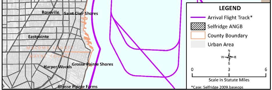
21 Figure Arrival Flight Tracks 3-6


22 Figure Departure Flight Tracks 3-7


23 Figure Closed Pattern Flight Tracks 3-8

.")
24 Air Installation Compatible Use Zone Report 3.4 AIRCRAFT MAINTENANCE RUNUP OPERATIONS To the maximum extent possible, aircraft maintenance static engine runup locations have been established in areas to minimize noise for people on base, as well as for those in surrounding communities (Figure 3.4-5). Aircraft engine static runup operations are accomplished by based flying units and their associated maintenance functions. Figure Aircraft Maintenance Engine Static Runup Locations 3-9
25 ABD aircraft maintenance runup operations were calculated similarly to flight operations described in Section 3.1. Weekly, monthly, or annual estimates of runups provided by Selfridge ANGB aircraft maintenance personnel were divided by the typical number of days that runups are performed over the respective period. Maintenance operations during the night period (10 p.m. to 7 a.m.) are extremely rare, occurring approximately once per month. 3.5 AIRCRAFT FLIGHT PROFILES For purposes of this AICUZ Study, aircraft flight profiles denote the aircraft power settings, altitudes above runway level, and airspeeds along each flight track. Aircraft flight profiles were obtained from Selfridge ANGB personnel for all based aircraft types. Generic flight profiles from the BASEOPS database were used to model operations for transient aircraft types. Noise data from the NOISEFILE database were used to model operations for all aircraft types. In cases where NOISEFILE did not contain entries for a particular aircraft type, a similar aircraft was selected as a surrogate. All surrogate aircraft used were the same as had been used in previous environmental analysis documentation. 3-10
26 SECTION 4 LAND USE COMPATIBILITY CRITERIA 4.1 INTRODUCTION The DoD developed the AICUZ program for military airfields in Using this program at its installations, the DoD works to protect aircraft operational capabilities and to assist local government officials in protecting and promoting the public s health, safety, and quality of life. The goal is to promote compatible land use development around military airfields by providing information on aircraft noise exposure and accident potential. AICUZ reports describe three basic types of constraints that affect, or result from, flight operations. The first constraint involves noise zones based on the DNL metric and the DoD NOISEMAP method. Using the NOISEMAP program, which is similar to FAA s Integrated Noise Model (INM), the USAF produces noise contours showing the noise levels generated by aircraft operations. The AICUZ report contains noise contours plotted in 5 db increments, ranging from DNL 65 db to 80+ db (see Section 4.2). The second constraint involves CZs and APZs based on statistical analysis of past DoD aircraft accidents. DoD analysis has determined that areas immediately beyond the ends of runways and along the approach and departure flight paths have elevated potential for aircraft accidents (see Section 4.4). The third constraint involves areas that the FAA and the DoD identified for height limitations (see Section 4.5). Other land use considerations discussed in this report include factors that could pose a direct threat to aircraft during flight (see Section 4.6). Land uses that could obstruct pilot vision through generation of dust, smoke, or steam or that could prevent pilot communications (e.g., high-intensity electrical emissions) should be sited properly to avoid potential safety issues. In addition, land uses that would attract birds could increase the level of Bird/Wildlife Aircraft Strike Hazard (BASH). Land uses that are attractive to birds include, but are not limited to, sanitary landfills, dredging operations, wetland areas, or the growing of certain vegetation. 4.2 NOISE EXPOSURE NOISEMAP Version 7.3 was used to calculate and plot the DNL noise contours based on the average busy-day aircraft operations data collected in 2009 and described in Sections 3.1 through 3.5. Figure shows the DNL noise contours plotted in 5 db increments, ranging from DNL 65 db to DNL at or above 80 db. 4-1


27 Air Installation Compatible Use Zone Report Figure Average Busy Day Noise Contours for
28 Different sounds have different frequency content. When describing sound and its effect on a human population, A-weighted db sound levels are typically used to account for the response of the human ear. The term A-weighted refers to a filtering of the sound signal to emphasize frequencies in the middle of the audible spectrum and to de-emphasize low and high frequencies in a manner corresponding to the way the human ear perceives sound. This filtering network has been established by the American National Standards Institute. The A-weighted noise level has been found to correlate well with people s judgments of the noisiness of different sounds and has been in use for many years as a measure of community noise. Table shows the off-dod property noise exposure within the DNL 65 db and greater noise exposure area for aircraft operations at Selfridge ANGB in terms of acreage. Table Area Within Noise Contours (off-dod Property) DNL Noise Zone Acres Total PAST, PRESENT, AND POTENTIAL FUTURE AIRCRAFT NOISE LEVELS AICUZ noise contours describe the noise characteristics of specific operational environments, and as such, change over time as operational changes occur. Should significant mission changes occur at Selfridge ANGB, the AICUZ could be amended and noise contours could exceed those published in this report. Selfridge ANGB has recently undergone major mission changes including drawdown of the F-16 units and beddown of an A-10 unit. As a result of these mission changes, noise levels have decreased as compared to those experienced in While there are currently no known plans to change units or operational characteristics at Selfridge ANGB, such changes could occur at some point in the future. The DoD periodically reviews unit basing and force structure, making changes to better reflect strategic objectives and to maximize taxpayer return on investment. With these thoughts in mind, Selfridge ANGB has updated the 1999 AICUZ report, providing flight track, aircraft operational tempo, and noise contour information reflecting full-strength operations of units currently beddown at the installation. We would, however, like to point out that continuing to use the larger 1999 noise contours for land use planning would help to protect 4-3
29 the Selfridge ANGB mission and allow for future aircraft changes and or added mission activity with fewer land use impacts. This buffer zone would increase operational flexibility at the base. 4.4 CLEAR ZONES AND ACCIDENT POTENTIAL ZONES Areas around airports are exposed to the possibility of aircraft accidents even with wellmaintained aircraft and highly trained aircrews. Despite stringent maintenance requirements and countless hours of training, past history makes it clear that accidents may occur. The risk of people on the ground being killed or injured by aircraft accidents is small. However, an aircraft accident is a high-consequence event and when a crash does occur the result is often catastrophic. Because of this, the USAF does not attempt to base its safety standards on accident probabilities. Instead, it approaches this safety issue from a land use-planning perspective. Designation of safety zones around the airfield and restriction of incompatible land uses can reduce the public s exposure to safety hazards. The AICUZ program includes three safety zones: the CZ, APZ I, and APZ II. These zones were developed from analysis of over 800 major USAF accidents that occurred within 10 miles of a USAF installation between 1968 and Figure C.3 in Appendix C summarizes the location of these accidents. Figure depicts the CZs and APZs for Runways 01/19 at Selfridge ANGB. At either end of the runway is a 3,000-foot by 3,000-foot CZ. The CZ has the highest accident potential of the three zones, with 27 percent of accidents studied occurring in this area. Accident potential within the CZ is so high that the necessary land use restrictions would prohibit reasonable economic use of land. It is USAF policy to request that Congress authorize and appropriate funds to purchase the real property interests in this area to prevent incompatible land uses. Selfridge ANGB has taken several proactive steps to limit incompatible development in its northern and southern CZs. Selfridge ANGB owns the majority of the land in the northern CZ and has purchased easements in the remainder of the land that prevent incompatible development. In the southern CZ, the majority of the area south of the Clinton River has been developed as single-family residential for several decades. After discussions with Congressional delegates, this area has been exempted from the USAF policy to purchase all CZ lands (USAF 1979). At the southwest corner of the southern CZ, in the housing development Brigantine Estates, there is another privately held area. The USAF purchased a restrictive easement disallowing the development of any incompatible land uses in the portion of Brigantine Estates located within the CZ. 4-4


30 Figure Clear Zones and Accident Potential Zones 4-5
31 APZ I is a 3,000-foot by 5,000-foot area that lies along the extended runway centerline, just beyond the end of the CZ. APZ I possesses somewhat less accident potential than the CZ, containing 10 percent of the accidents studied. Land use compatibility guidelines in APZ I allow reasonable economic uses of the land, such as industrial/manufacturing, transportation, communication/utilities, wholesale trade, open space, recreation, and agriculture. However, uses that concentrate people in small areas are not acceptable. APZ II is a 3,000-foot by 7,000-foot area lying beyond the APZ I, extending to 15,000 feet from the runway threshold. APZ II has less accident potential than APZ I, with 6 percent of the accidents studied occurring in this zone. Accident potential in APZ II is less critical than APZ I, but still possesses potential for accidents. Acceptable land uses include those of APZ I, as well as low-density single-family residential and those personal and business services and commercial/retail trade uses of low intensity or scale of operation. High-density functions such as multi-story buildings, places of assembly (e.g., theaters, churches, schools, restaurants, etc.), and high-density office uses are not considered appropriate. High people densities should be limited to the maximum extent possible in APZ II. The optimum density recommended for residential usage (where it does not conflict with noise criteria) in APZ II is one-to-two dwelling units per acre. 4.5 SAFETY OF FLIGHT RUNWAY AIRSPACE IMAGINARY SURFACES Runway airspace imaginary surfaces define volumes of airspace that must remain free of obstructions to air navigation in order to maintain safety of flight in the airfield airspace. Any object that passes through the surface is termed an obstruction to air navigation. Obstructions may include: natural objects or man-made structures that protrude above the planes or imaginary surfaces; and/or man-made objects that extend more than 500 feet above ground level (AGL) at the site of the structure. Runway imaginary surfaces are standard for all Class B runways, as defined in Unified Facilities Criteria (UFC) , Airfield and Heliport Planning and Design. Figure depicts the runway airspace imaginary surfaces for a Class B runway, such as Runway 01/19 at Selfridge ANGB. USAF obstruction criteria in UFC are based on those contained in Federal Aviation Regulation (FAR) Part 77, Objects Affecting Navigable Airspace, Subpart C. FAR Part 77 provides guidance on submittal of FAA Form , Notice of Proposed Construction or 4-6
32 Alteration. The form notifies the FAA of construction or alteration of structures proximate to imaginary surfaces around airfields. Figure Class B Air Force Runway Airspace Imaginary Surfaces The following paragraphs contain definitions of the runway airspace imaginary surfaces for USAF Class B runways. All surfaces are defined from 580 feet above mean sea level (MSL), the established airfield elevation at Selfridge ANGB. Primary Surface (labeled as A in Figure 4.5-1) - This surface immediately surrounds the runway, and must be kept free of all obstructions not directly required for airfield operations. 4-7
33 CZ Surface (labeled as B in Figure 4.5-1) CZs are 3,000-foot by 3,000-foot areas defined relative to the runway ends. With few exceptions, these areas must be kept free of all obstructions not directly required for airfield operations. Approach-Departure Clearance Surface (labeled as C and D in Figure 4.5-1) - This imaginary surface is symmetrically centered on the extended runway centerline, beginning as an inclined plane (glide angle) 200 feet beyond each end of the primary surface, and extending for 50,000 feet. The slope of the approach-departure clearance surface is 50:1 until it reaches an elevation of 500 feet above the established airfield elevation. It then continues horizontally at this elevation to a point 50,000 feet from the starting point. The width of this surface at the runway end is 2,000 feet, flaring uniformly to a width of 16,000 feet at the end point. Inner Horizontal Surface (labeled as E in Figure 4.5-1) - This imaginary surface is an oval plane at a height of 150 feet above the established airfield elevation. The inner boundary intersects with the approach-departure clearance surface and the transitional surface. The outer boundary is formed by scribing arcs with a radius 7,500 feet from the centerline of each runway end and interconnecting these arcs with tangents. Conical Surface (labeled as F in Figure 4.5-1) - This is an inclined imaginary surface extending outward and upward from the outer periphery of the inner horizontal surface for a horizontal distance of 7,000 feet to a height of 500 feet above the established airfield elevation. The slope of the conical surface is 20:1. The conical surface connects the inner and outer horizontal surfaces. Outer Horizontal Surface (labeled as G in Figure 4.5-1) - This imaginary surface is located 500 feet above the established airfield elevation and extends outward from the outer periphery of the conical surface for a horizontal distance of 30,000 feet. Transitional Surface (labeled as H in Figure 4.5-1) - This imaginary surface extends outward and upward at right angles to the runway centerline and extended runway centerline at a slope of 7:1. The transitional surface connects the primary and the approach-departure clearance surfaces to the inner horizontal, the conical, and the outer horizontal surfaces RESTRICTED AND/OR PROHIBITED LAND USES The land areas outlined by these criteria should be regulated to prevent uses that might otherwise be hazardous to aircraft operations. The following uses should be restricted and/or prohibited. 4-8
34 Releases into the air of any substance that would impair visibility or otherwise interfere with the operation of aircraft (e.g., steam, dust, or smoke). Light emissions, either direct or indirect (reflective), that would interfere with pilot vision. Electrical emissions that would interfere with aircraft communications systems or navigational equipment. Uses that would attract birds or waterfowl including, but not limited to, operation of sanitary landfills, waste transfer facilities, maintenance of feeding stations, sand and gravel dredging operations, stormwater retention ponds, created wetland areas, or the growing of certain vegetation (127 th Wing BASH Plan [91-212] and Related FAA Circulars [AC150/ B])(Appendix D). Structures within 10 feet of aircraft approach-departure and/or transitional surfaces. 4.6 LAND USE COMPATIBILITY GUIDELINES Each AICUZ Study contains land use guidelines. Table identifies land uses and possible noise exposure and accident potential combinations for Selfridge ANGB. These noise guidelines are essentially the same as those published by the Federal Interagency Committee on Urban Noise in the June 1980 publication, Guidelines for Considering Noise in Land Use Planning and Control. The U.S. Department of Transportation publication, Standard Land Use Coding Manual (SLUCM), has been used to identify and code land use activities. The designations are a combination of criteria listed in the Legend and Notes at the end of the table. For example, Y 1 means land use and related structures are compatible without restriction at a suggested maximum density of 1-2 dwelling units per acre, possibly increased under a Planned Unit Development where lot coverage is less than 20 percent. 4-9
35 Table Land Use Compatibility Guidelines (Page 1 of 3) LAND USE APZS NOISE ZONES (DNL) SLUCM No. Name CZ APZ I APZ II Residential 11 Household units Single units; detached N N Y 1 A 11 B 11 N N Single units; semidetached N N N A 11 B 11 N N Single units; attached row N N N A 11 B 11 N N Two units; side-by-side N N N A 11 B 11 N N Two units; one above the other N N N A 11 B 11 N N Apartments; walk up N N N A 11 B 11 N N Apartments; elevator N N N A 11 B 11 N N 12 Group quarters N N N A 11 B 11 N N 13 Residential hotels N N N A 11 B 11 N N 14 Mobile home parks or courts N N N N N N N 15 Transient lodgings N N N A 11 B 11 C 11 N 16 Other residential N N N 1 A 11 B 11 N N 20 Manufacturing 21 Food & kindred products; manufacturing N N 2 Y Y Y 12 Y 13 Y Textile mill products; manufacturing N N 2 Y Y Y 12 Y 13 Y Apparel and other finished products made from fabrics, leather, and similar N N N 2 Y Y 12 Y 13 Y 14 materials; manufacturing 24 Lumber and wood products (except furniture); N Y 2 Y Y Y 12 Y 13 Y 14 manufacturing 25 Furniture and fixtures; manufacturing N Y 2 Y Y Y 12 Y 13 Y Paper & allied products; manufacturing N Y 2 Y Y Y 12 Y 13 Y Printing, publishing, and allied industries N Y 2 Y Y Y 12 Y 13 Y Chemicals and allied products; manufacturing N N N 2 Y Y 12 Y 13 Y Petroleum refining and related industries N N Y Y Y 12 Y 13 Y Manufacturing 31 Rubber and misc. plastic products, manufacturing N N 2 N 2 Y Y 12 Y 13 Y Stone, clay and glass products manufacturing N N 2 Y Y Y 12 Y 13 Y Primary metal industries N N 2 Y Y Y 12 Y 13 Y Fabricated metal products; manufacturing N N 2 Y Y Y 12 Y 13 Y
36 Table Land Use Compatibility Guidelines (Page 2 of 3) LAND USE APZS NOISE ZONES IN DNL db SLUCM No. Name CZ APZ I APZ II Professional, scientific, and controlling instruments; photographic and optical N N N 2 Y A B N goods; watches and clocks manufacturing 39 Miscellaneous manufacturing N Y 2 Y 2 Y Y 12 Y 13 Y Transportation, Communications and Utilities 41 Railroad, rapid rail transit and street railroad N 3 Y 4 Y Y Y 12 Y 13 Y 14 transportation 42 Motor vehicle transportation N 3 Y Y Y Y 12 Y 13 Y Aircraft transportation N 3 Y 4 Y Y Y 12 Y 13 Y Marine craft transportation N 3 Y 4 Y Y Y 12 Y 13 Y Highway & street right-ofway N 3 Y Y Y Y 12 Y 13 Y Automobile parking N 3 Y 4 Y Y Y 12 Y 13 Y Communications N 3 Y 4 Y Y A 15 B 15 N 48 Utilities N 3 Y 4 Y Y Y Y 12 Y Other transportation communications and utilities N 3 Y 4 Y Y A 15 B 15 N 50 Trade 51 Wholesale trade N Y 2 Y Y Y 12 Y 13 Y Retail trade-building materials, hardware and N Y 2 Y Y Y 12 Y 13 Y 14 farm equipment 53 Retail trade-general merchandise N N 2 Y 2 Y A B N 54 Retail trade-food N N 2 Y 2 Y A B N 55 Retail trade-automotive, marine craft, aircraft and N Y 2 Y 2 Y A B N accessories 56 Retail trade-apparel and accessories N N 2 Y 2 Y A B N 57 Retail trade-furniture, home furnishings and equipment N N 2 Y 2 Y A B N 58 Retail trade-eating and drinking establishments N N N 2 Y A B N 59 Other retail trade N N 2 Y 2 Y A B N 60 Services 61 Finance, insurance and real estate services N N Y 6 Y A B N 62 Personal services N N Y 6 Y A B N 62.4 Cemeteries N Y 7 Y 7 Y Y 12 Y 13 Y 14,21 63 Business services N Y 8 Y 8 Y A B N 4-11
37 Table Land Use Compatibility Guidelines (Page 3 of 3) LAND USE APZS NOISE ZONES IN DNL db SLUCM No. Name CZ APZ I APZ II Repair services N Y 2 Y Y Y 12 Y 13 Y Professional services N N Y 6 Y A B N 65.1 Hospitals, nursing homes N N N A* B* N N 65.1 Other medical facilities N N N Y A B N 66 Contract construction services N Y 6 Y Y A B N 67 Governmental services N N Y 6 Y* A* B* N 68 Educational services N N N A* B* N N 69 Miscellaneous services N N 2 Y 2 Y A B N 70 Cultural, Entertainment and Recreational 71 Cultural activities (including churches) N N N 2 A* B* N N 71.2 Nature exhibits N Y 2 Y Y* N N N 72 Public assembly N N N Y N N N 72.1 Auditoriums, concert halls N N N A B N N Outdoor music shell, amphitheaters N N N N N N N 72.2 Outdoor sports arenas, spectator sports N N N Y 17 Y 17 N N 73 Amusements N N Y 8 Y Y N N 74 Recreational activities (including golf courses, riding stables, water N Y 8,9,10 Y Y* A* B* N recreation) 75 Resorts and group camps N N N Y* Y* N N 76 Parks N Y 8 Y 8 Y* Y* N N 79 Other cultural, entertainment and recreation N Y 9 Y 9 Y* Y* N N 80 Resources Production and Extraction 81 Agriculture (except livestock) Y 16 Y Y Y 18 Y 19 Y 20 Y 20, to Livestock farming and 81.7 animal breeding N Y Y Y 18 Y 19 Y 20 Y 20,21 82 Agricultural related activities N Y 5 Y Y 18 Y 19 N N 83 Forestry activities and related services N 5 Y Y Y 18 Y 19 Y 20 Y 20,21 84 Fishing activities and related services N 5 Y 5 Y Y Y Y Y 85 Mining activities and related services N Y 5 Y Y Y Y Y 89 Other resources production and extraction N Y 5 Y Y Y Y Y 4-12
38 LEGEND SLUCM - Standard Land Use Coding Manual, U.S. Department of Transportation. Y - (Yes) - Land use and related structures are compatible without restriction. N - (No) - Land use and related structures are not compatible and should be prohibited. Y x - (yes with restrictions) - Land use and related structures generally compatible; see notes N x - (no with exceptions) - See notes NLR - (Noise Level Reduction) - NLR (outdoor to indoor) to be achieved through incorporation of noise attenuation measures into the design and construction of the structures (see Appendix E, Section E.4). A, B, or C - Land use and related structures generally compatible; measures to achieve NLR of A (DNL 25 db), B (DNL 30 db), or C (DNL 35 db) need to be incorporated into the design and construction of structures. A *, B *, and C * - Land use generally compatible with NLR. However, measures to achieve an overall noise level reduction do not necessarily solve noise difficulties and additional evaluation is warranted. See appropriate footnotes. * - The designation of these uses as compatible in this zone reflects individual federal agency and program consideration of general cost and feasibility factors, as well as past community experiences and program objectives. Localities, when evaluating the application of these guidelines to specific situations, may have different concerns or goals to consider. NOTES 1. Suggested maximum density of 1-2 dwelling units per acre possibly increased under a Planned Unit Development where maximum lot coverage is less than 20 percent. 2. Within each land use category, uses exist where further definition may be needed due to the variation of densities in people and structures. Shopping malls and shopping centers are considered incompatible in any accident potential zone (CZ, APZ I, or APZ II). 3. The placing of structures, buildings, or aboveground utility lines in the CZ is subject to severe restrictions. In a majority of the CZs, these items are prohibited. See AFI and UFC for specific guidance. 4. No passenger terminals and no major aboveground transmission lines in APZ I. 5. Factors to be considered: labor intensity, structural coverage, explosive characteristics, and air pollution. 6. Low-intensity office uses only. Meeting places, auditoriums, etc., are not recommended. 7. Excludes chapels. 8. Facilities must be low intensity. 9. Clubhouse not recommended. 10. Areas for gatherings of people are not recommended. 11A. Although local conditions may require residential use, it is discouraged in DNL db and strongly discouraged in DNL db. An evaluation should be conducted prior to approvals, indicating a demonstrated community need for residential use would not be met if development were prohibited in these zones, and there are no viable alternative locations. 11B. Where the community determines the residential uses must be allowed, measures to achieve outdoor to indoor NLR for DNL db and DNL db should be incorporated into building codes and considered in individual approvals. 11C. NLR criteria will not eliminate outdoor noise problems. However, building location and site planning, and design and use of berms and barriers can help mitigate outdoor exposure, particularly from near ground level sources. Measures that reduce outdoor noise should be used whenever practical in preference to measures that only protect interior spaces. 12. Measures to achieve the same NLR as required for facilities in the DNL db range must be incorporated into the design and construction of portions of these buildings where the public is received, office areas, noise sensitive areas, or where the normal noise level is low. 13. Measures to achieve the same NLR as required for facilities in the DNL db range must be incorporated into the design and construction of portions of these buildings where the public is received, office areas, noise sensitive areas, or where the normal noise level is low. 14. Measures to achieve the same NLR as required for facilities in the DNL db range must be incorporated into the design and construction of portions of these buildings where the public is received, office areas, noise sensitive areas, or where the normal noise level is low. 15. If noise sensitive, use indicated NLR; if not, the use is compatible. 16. No buildings. 17. Land use is compatible provided special sound reinforcement systems are installed. 18. Residential buildings require the same NLR required for facilities in the DNL db range. 19. Residential buildings require the same NLR required for facilities in the DNL db range. 20. Residential buildings are not permitted. 21. Land use is not recommended. If the community decides the use is necessary, personnel should wear hearing protection devices. 4-13
39 [This page intentionally left blank.] 4-14
40 SECTION 5 LAND USE ANALYSIS 5.1 INTRODUCTION Land use planning and control is a dynamic, rather than a static process. The specific characteristics of land use determinants will always reflect, to some degree, the changing conditions of the economic, social, and physical environment of a community, as well as changing public concern. The planning process accommodates this fluidity in which decisions are normally not based on boundary lines, but rather on more generalized area designations. Computer technology has enabled Selfridge ANGB to more precisely display its flight tracks, airspace control surfaces, noise contours, and accident potential areas for land use planning purposes. In 1917, Selfridge ANGB (then known as Selfridge Field) was established in a relatively undeveloped area in Macomb County. Between 1920 and 1930, the county doubled in population, spurred in part by the establishment of the base and in part by development of suburbs outside of nearby Detroit. Population growth and associated development have continued steadily in Macomb County from 1940 to the present. Recently growth in the region has slowed somewhat, due to deflation in the housing market and contraction in the manufacturing sector. Geographic Information Systems (GIS) technology has enabled Selfridge ANGB to more precisely display its flight tracks and noise contours for land use planning purposes. Digital representations of noise contours, CZs, and APZs have been used to exactly delineate areas that are not in compliance with USAF AICUZ recommendations. For the purpose of this Study, existing land uses on the figures in this section are generalized into one of the following 10 categories: Single-Family Residential: This category includes all types of single-family residential land uses except manufactured homes. Multi-Family Residential: This category includes multi-family residential land uses. Mixed Use: The Macomb County Mixed-Use generalized land use classification describes areas in which facilities of several types are located together (e.g., residential, offices, and commercial spaces located in one structure). Manufactured Home Park: This category includes manufactured homes. This type of residential development is treated separately from other residential land uses 5-1
41 because of its properties with regards to outdoor-to-indoor noise attenuation and potential for high numbers of dwellings per acre. Commercial: This category includes retail, restaurants, and other types of commercial establishments. Industrial: This category includes manufacturing, warehousing, and other similar uses. Institutional: This category includes publicly owned lands and/or land to which the public has access, including military reservations and training grounds, public buildings, schools, churches, cemeteries, and hospitals. Selfridge ANGB itself is not included in this land use analysis. Agriculture: This category includes agricultural areas and grazing lands. Open Space/Water: This category includes undeveloped land areas. Bodies of water may be used for several purposes including recreation (e.g., recreational fishing, swimming), commercial purposes (e.g., commercial fishing), transportation/utility (e.g., ferries), or even residential (e.g., house boats). Typically, such uses are lowintensity and, as such, water is lumped together with open space for the purpose of quantitative analysis. For clarity, maps in this report will use different symbols for water and open land. Transportation/Utility: This category includes roads, railroads and other transportation-related land uses, as well as land uses related to utilities. The 10 generalized land use classifications were compared against land use data provided by Macomb County to identify land uses that are compatible, conditionally compatible, and incompatible. Compatibility was determined using a simplified land use compatibility matrix. Each Macomb County generalized land use classification was assigned an equivalent Air Force SLUCM code (see Table 4.6-1). Zones that are unconditionally compatible are colored green, zones that are conditionally compatible are colored yellow, and zones that are unconditionally incompatible are colored red (see Table 5.2-1). The same compatibility designation process that was conducted for land use was also carried out for zoning. Macomb County generalized zoning categories are not the same categories that the county uses for describing generalized land use. For example, no separate generalized zoning designation exists for agriculture, open space, or recreation whereas these categories are used to 5-2
42 describe land use. At the same time, the county has designated an Office generalized zoning classification, which has no direct equivalent generalized land use classification. Land use and zoning compatibility analysis was not carried out for Selfridge ANGB itself. All construction projects on the installation must undergo an internal USAF planning process, which includes AICUZ considerations. Development on the installation is subject to operational requirements that do not apply to civilian development outside the installation s boundaries. 5.2 EXISTING LAND USE As previously described, Selfridge ANGB is located to the east of the Town of Mount Clemens in Macomb County. The portion of Macomb County in which the installation is located has become fairly heavily developed. However, some land areas remain as open space. The following analysis quantifies, by total acreage, existing land use types in each of the Selfridge ANGB compatible use zones. Figure is an overlay of the 2009 noise contours, CZs, and APZs on an aerial photograph of the vicinity of Selfridge ANGB. Generalized land uses have been overlaid on the map, in areas affected by noise contours greater than DNL 65 db and APZs. An analysis was performed on the property lying inside the noise zones or accident potential zones but outside the Selfridge ANGB boundaries. The acreage of each generalized existing land use type was calculated within each of the noise zones (Table 5.2-1) and the CZs and APZs (Table 5.2-2). Table shows the estimated number of persons residing within the noise zones, CZs, and APZs. In addition to the analysis of generalized land use, a detailed noise level analysis was run for specific points that are particularly noise sensitive or that have the potential to become noise sensitive if proposed development is carried out. These points include two schools (Emma V Lobbestael Elementary and South River Elementary), the Town of Mount Clemens, the Brigantine Estates subdivision, and the undeveloped area immediately north of the base that is zoned for light industrial land use. Time-average noise levels (DNL) and the highest singleevent noise levels (Sound Exposure Level) expected to occur on an ABD at these locations are listed in Table The Sound Exposure Level noise metric reflects total noise energy of a single aircraft overflight event normalized to one second. Land uses at all five locations analyzed are considered to be compatible with the DNL noise level. Displaying the SEL metric shows that, despite overall noise levels being considered acceptable at these locations, individual overflight events can be quite loud. 5-3


43 Air Installation Compatible Use Zone Report Figure Generalized Existing Land Use 5-4
44 Table Generalized Existing Land Use within DNL 65 db and Greater Noise Exposure Area (outside of Selfridge ANGB) Macomb County Generalized USAF SLUCM Equivalent NOISE CONTOURS (DNL) Land Use Classifications (see Table 4.6-1) Residential Districts Single-Family Residential (single units; detached) Multi-Family Residential (Apartments; walk up) Mixed-Use (Apartments; walk up) Manufactured Home Park 14 (Mobile home parks or courts) Non-Residential Districts Agriculture 81.5 to 81.7 (livestock farming and animal breeding) Industrial 39 (Misc. manufacturing) Recreation 72.2 (outdoor sports arenas, spectator sports) Commercial 53 (retail trade, general merchandise) Institutional 68 (educational services) Transportation / Utility 48 (motor vehicle) Other Districts/Overlays Open Space/Water n/a Note: Cells colored red indicate land uses that are not compatible in the given noise zone/cz/apz. Yellow cells and green cells indicate land uses that are conditionally compatible and compatible, respectively. Table Generalized Existing Land Use within CZs and APZs (outside of Selfridge ANGB) Macomb County Generalized Land USAF SLUCM Equivalent ACCIDENT POTENTIAL Use Classifications (see Table 4.6-1) CZ APZ I APZ II Residential Districts Single-Family Residential (single units; detached) Multi-Family Residential (Apartments; walk up) Mixed-Use (Apartments; walk up) Manufactured Home Park 14 (Mobile home parks or courts) Non-Residential Districts Agriculture 81.5 to 81.7 (livestock farming and animal breeding) Industrial 39 (Misc. manufacturing) Recreation 72.2 (outdoor sports arenas, spectator sports) Commercial 53 (retail trade, general merchandise) Institutional 68 (educational services) Transportation / Utility 48 (motor vehicle) Other Districts/Overlays Open Space n/a Note: Cells colored red indicate land uses that are not compatible in the given noise zone/cz/apz. Yellow cells and green cells indicate land uses that are conditionally compatible and compatible, respectively. 5-5
45 Specific Point Table Off-Base Population Within the Noise Zones, CZs, and APZs Zone Number of People db DNL db DNL db DNL 0 Clear Zones 162 Accident Potential Zone I 1,854 Accident Potential Zone II 4,399 Note: 1. Estimated number of people within each zone estimated based on U.S. Census Bureau data for the year Where census blocks were partially included, assumed population included was proportional to percentage of the census block included. Table Noise Levels at Specific Points Time-averaged Noise Level (db DNL) Highest Single-Event Noise Level (db SEL) Lobbestael Elementary South River Elementary Town of Mount Clemens (center of town) Brigantine Estates Subdivision (point nearest runway) Undeveloped Area North of the Base (point nearest runway) LAND USE COMPATIBILITY DISCUSSION Privately owned areas affected by Selfridge ANGB compatibility zones lie to the north and south of the installation. Land use and zoning compatibility with AICUZ recommendations are discussed first for the area south of the installation and then for the area to the north of the runway. For each compatible use zone (e.g., CZ, APZ I, APZ II, noise zones), current land use compatibility is discussed. The land use compatibility discussion is followed by a discussion of zoning compatibility. Noise contours at Selfridge ANGB affect a total of approximately 122 acres not including Selfridge ANGB acreage (Table 5.2-1). Of this acreage, 37.2 acres are developed in a manner that is conditionally compatible (31 percent) and 84.7 acres are compatible (69 percent) with current noise levels. All conditionally compatible land areas are single-family residential. CZs and APZs affect approximately 1,687 acres, not including the area on Selfridge ANGB (Table 5.2-2). Of this total acreage affected, acres (26 percent) are incompatibly developed, acres are conditionally compatibly developed (37 percent), and acres (37 5-6
46 percent) are compatibly developed. Incompatible areas are single-family residential, multifamily residential, mixed use, manufactured homes, commercial, institutional, and transportation/utility. Conditionally compatible areas are single-family residential, industrial, commercial, and transportation/utility. 5.4 FUTURE LAND USE AND ZONING In order to make a complete assessment of the encroachment situation at Selfridge ANGB, one must consider not only current conditions, but also expected future conditions. Zoning is an important predictor of future land use and will be discussed in this section relative to future development near the base. Figure shows zoning within the current AICUZ area of influence. Because Michigan is a Home Rule state, each township establishes its own zoning code, with support from the county as needed. Most of the land within the Selfridge ANGB area of influence has been developed (see Figure 5.2-1) and major changes in land use patterns in these developed areas are considered unlikely. More likely would be incremental increases in population density in previously developed areas associated with projects that would replace or expand existing facilities. An example would be a project to re-develop a single-family residential area as multi-family residential. In many cases, such re-development would require a modification to or variance from existing zoning regulations. Selfridge ANGB encourages county, city, and township planners to coordinate with the base regarding any zoning change requests that may ultimately affect the base. The largest contiguous area of open land in the vicinity of Selfridge ANGB lies to the north of the installation immediately to the east of Interstate 94. This area has been zoned for industrial use and is expected to be developed as a mixture of industrial and commercial land uses in the near future. The majority of the industrial and commercial land use sub-categories are conditionally compatible with the APZ I and db DNL zones that cover a portion of the area. Development proposals reviewed by Selfridge ANGB staff to date have been found to be compatible. The staff at Selfridge looks forward to continuing to coordinate on proposed development plans for this area as the plan evolve. The area to the north of Selfridge ANGB is particularly important to the continued viability and mission flexibility of the installation as the majority of aircraft operations at the installation depart to the north and arrive from the north. All development projects near the base should be assessed for compatibility using the land use compatibility matrix at Table and for potential effects on safety of flight, as described in Section


47 Air Installation Compatible Use Zone Report Figure Generalized Zoning 5-8
48 For the purposes of quantitative future encroachment analysis, it was assumed that land areas will develop according to current zoning unless prevented from doing so by restrictive easement or some other factor. For example, it was assumed that the open area north of the installation will be developed for industrial land use because it is zoned for that type of development. Exceptions to this methodology include instances where an easement is held by the USAF that prevents further incompatible development (i.e., two areas in the northern CZ and one area in the southern CZ) or where an agreement has been reached that recognizes the permanence of the existing land use (i.e., the exempt CZ in the southern CZ). The total number of acres of each generalized zoning classification was calculated within each of the sets of noise contours (Table 5.4-1) and within the CZs and APZs (Table 5.4-2). Zoning mirrors existing land use throughout much of the AICUZ area of influence. Zoning is compatible in 84.0 (69 percent) of the 122 acres affected by noise levels at greater than 65 DNL db. The remaining 38.1 acres (31 percent) are zoned for usage considered to be conditionally compatible. The conditionally compatible land areas are single-family residential. Zoning of the off-base acreage within the CZs and APZs is such that 28 percent of the zoned land usage is incompatible (469.8 acres), 46 percent is conditionally compatible (779.4 acres), and only 26 percent is compatible (436.0 acres). Incompatibly zoned lands in the CZ and APZs are low-density residential, medium-density residential, mixed use, manufactured homes, commercial, transportation, and industrial. Areas that are zoned conditionally compatibly include low-density residential, commercial, office, industrial, and transportation. More land is zoned incompatibly/conditionally compatibly than is currently used incompatibly/conditionally compatibly. Incompatible development can be expected to increase in future years, as land continues to be developed in accordance with current zoning. Development projects of concern include any projects that would result in higher population densities in APZs than are recommended, development of noise-sensitive land uses in areas of elevated aircraft noise, or projects that would pose a risk to safety of flight (e.g., through increasing BASH hazard, impairing pilot vision). At Selfridge ANGB, the majority of aircraft operations depart to the north and arrive from the north, resulting in the northern approach to the runway being overflown much more frequently than the southern approach. As a result, maintaining operational flexibility in this area is extremely important to the long-term viability of the base. Chesterfield Township has provided plans for proposed development of a portion of the area north of the base that is currently open space. Selfridge ANGB staff reviewed these plans and found them to be compatible with the installation mission. The staff at Selfridge ANGB look forward to continuing to coordinate with Chesterfield Township as proposed development plans evolve or as new projects are proposed. 5-9
49 Table Generalized Zoning within DNL 65 db and Greater Noise Exposure Area (outside of Selfridge ANGB) Macomb County Generalized USAF SLUCM Equivalent Noise Contours (DNL) Zoning Classifications (see Table 4.6-1) Residential Districts Low-Density Residential ( (single units; detached) Units/Acre) Medium-Density Residential (Apartments; walk up) (>7 Units/Acre) Mixed-Use (Apartments; walk up) Manufactured Housing 14 (Mobile home parks or courts Non-Residential Districts Light Industrial 39 (Misc. manufacturing) Commercial 53 (retail trade, general merchandise) Office 65 (professional services) Transportation / Utility 48 (motor vehicle) Other Districts/Overlays Natural Features n/a Note: Cells colored red indicate land uses that are not compatible in the given noise zone/cz/apz. Yellow cells and green cells indicate land uses that are conditionally compatible and compatible, respectively. 1. Of these acres, 2.2 are included in an easement preventing further incompatible development. Table Generalized Zoning within CZs and APZs (outside of Selfridge ANGB) Macomb County Generalized Zoning Classifications Residential Districts Low-Density Residential (0-6 Units/Acre) Medium-Density Residential (>7 USAF SLUCM Equivalent Accident Potential (see Table 4.6-1) CZ APZ I APZ II (single units; detached) (Apartments; walk up) Units/Acre) Mixed-Use (Apartments; walk up) Manufactured Housing 14 (Mobile home parks or courts Non-Residential Districts Light Industrial 39 (Misc. manufacturing) Commercial 53 (retail trade, general merchandise) Office 65 (professional services) Transportation 48 (motor vehicle) Other Districts/Overlays Water n/a Note: Cells colored red indicate land uses that are not compatible in the given noise zone/cz/apz. Yellow cells and green cells indicate land uses that are conditionally compatible and compatible, respectively. 1. Of these acres, 29 are covered by an easement that prohibits incompatible development or are within the residential area south of the Clinton River exempted from AF CZ purchase policy (Meis 1979) 2. All 28.2 acres are covered by an easement preventing incompatible development. 3. Of these acres, 6.0 are covered by an easement preventing incompatible development 5-10

50 SECTION 6 IMPLEMENTATION 6.1 INTRODUCTION Implementation of the AICUZ Study must be a joint effort between the USAF and adjacent communities. The role of the USAF is to minimize impact on the local communities by Selfridge ANGB aircraft operations. The role of the communities is to ensure that development in the surrounding area is compatible with accepted planning, zoning, and development principles and practices. 6.2 AIR FORCE RESPONSIBILITIES In general, the USAF perceives its AICUZ responsibilities as encompassing the areas of flying safety, noise abatement, and participation in the land use planning process. Well-maintained aircraft and well-trained aircrews do a great deal to ensure that aircraft accidents are avoided. Despite the best aircrew training and aircraft maintenance intentions, however, history clearly shows that accidents do occur. It is imperative flights be routed over sparsely populated areas as regularly as possible to reduce the exposure of lives and property to a potential accident. A-10 aircraft refueling from KC-135R/T aircraft Commanders are required by USAF policy to periodically review existing traffic patterns, instrument approaches, weather minima, and operating practices, and evaluate these factors in relationship to populated areas and other local situations. This requirement is a direct result and expression of USAF policy that all AICUZ plans must include an analysis of flying and flying-related activities designed to reduce and control the effects of such operations on surrounding land areas. Noise is generated from aircraft both in the air and on the ground. In an effort to reduce the noise effects of Selfridge ANGB operations on surrounding communities, the installation routes aircraft flight operations to avoid populated areas. Preparation and presentation of this Selfridge ANGB AICUZ Study is one phase of continuing USAF participation in the local planning process. It is recognized that as the local community updates its land use plans, the USAF must be ready to provide additional input when needed. 6-1
51 It is also recognized that the AICUZ program is an ongoing activity even after compatible development plans are adopted and implemented. Selfridge ANGB personnel are prepared to participate in the continuing discussion of zoning and other land use matters as they may affect, or may be affected by the base. Base personnel also are available to provide information, criteria, and guidelines to state, regional, and local planning bodies, civic associations, and similar groups. Participation in land use planning can take many forms. The simplest of these forms is straightforward, consistent two-way discussion and information sharing with neighboring land owners. Copies of the AICUZ Study, including maps, will be provided to local communities and counties and regional planning departments and zoning administrators. Through this communication process, the base reviews applications for development or changed use of properties within the noise impact and safety areas, as well as other nearby parcels. The base coordinates closely with surrounding communities on zoning and land use issues. 6.3 LOCAL COMMUNITY RESPONSIBILITIES Residents in the area neighboring Selfridge ANGB and base personnel have a long history of working together for mutual benefit of the area around the airfields and installation. For example, local jurisdictions have considered Selfridge ANGB flying operations during development of comprehensive plans. Adoption of the following recommendations will strengthen this relationship, increase the health and safety of the public, and help protect the integrity of the installation s flying mission: Incorporate AICUZ policies and guidelines into the comprehensive plans for Macomb County, Harrison Township, and Chesterfield Township. Use overlay maps of the AICUZ noise contours and USAF Land Use Compatibility Guidelines to evaluate existing and future land use proposals. Continue to inform Selfridge ANGB of planning and zoning actions that have the potential of affecting base operations. Modify existing zoning ordinances and subdivision regulations to support the compatible land uses outlined in this study through implementation of a zoning overlay district based on noise contours and accident potential zones. Adopt fair disclosure ordinances requiring realtors to notify potential buyers of real property of the location of the property relative to CZ/APZs and noise contours 6-2
52 SECTION 7 REFERENCES 127 th Wing Bird/Wildlife Aircraft Strike Hazard (BASH) Plan June. Brigantine Homes LLC Brigantine Homes LLC information published on the website. Accessed on 2 June Available Online at Federal Aviation Administration (FAA) Detroit Sectional Aeronautical Chart, 78 th Edition, effective 9 Apr 2009 to 24 Sep Available Online at: Meis, Joseph F Personal Communication between Mr. Meis, Principal Deputy Assistant Secretary of the Air Force (Manpower, Reserve Affairs, and Installations) and Congressman Bonior via letter, dated 16 February Michigan Economic Development Corporation Michigan Economic Development Corporation website. Accessed on 2 June Accessible Online at: AE4EF2DE2D09/ChesterfieldCorpCtrDetailInfo.pdf Selfridge Air National Guard Base (ANGB) Personal Communication with Selfridge ANGB Public Affairs via Document titled Description of Selfridge Air National Guard Base. Provided on 24 April United States Census Bureau U.S. Census Bureau Website; Population Estimates in Minor Civil Divisions, 2000 to 2007, Available Online at: 7-1
53 [This page intentionally left blank] 7-2
54 APPENDIX A THE AICUZ CONCEPT, PROGRAM, METHOD, AND POLICIES
55
56 APPENDIX A THE AICUZ CONCEPT, PROGRAM, METHOD, AND POLICIES A.1 CONCEPT Federal legislation, national sentiment, and other external forces, which directly affect the United States Air Force (USAF) mission, serve greatly to increase the role of the USAF in environmental and planning issues. Problems of airfield encroachment from incompatible land uses surrounding installations, as well as air and water pollution and socioeconomic impact, require continued and intensified USAF involvement. The nature of these problems dictates direct USAF participation in comprehensive community and land use planning. Effective, coordinated planning that bridges the gap between the federal government and the community requires establishment of good working relationships with local citizens, local planning officials, and state and federal officials. This depends on creating an atmosphere of mutual trust and helpfulness. The Air Installation Compatible Use Zone (AICUZ) concept has been developed in an effort to: protect local citizens from noise exposure and accident potential associated with flying activities; and prevent degradation of the capability of the USAF to achieve its mission by promoting compatible land use planning. The land use guidelines developed herein are a composite of a number of other land use compatibility studies that have been refined to fit the Selfridge Air National Guard Base (ANGB) aviation environment. A.2 PROGRAM Installation commanders establish and maintain active programs to promote the maximum feasible land use compatibility between air installations and neighboring communities. The program requires that all appropriate government bodies and citizens be fully informed whenever AICUZ or other planning matters affecting the installation are under consideration. This includes positive and continuous programs designed to: provide information, criteria, and guidelines to federal, state, regional, and local planning bodies, civic associations, and similar groups; A-1
57 inform such groups of the requirements of the flying activity, noise exposure, aircraft accident potential, and AICUZ plans; describe the noise reduction measures that are being used; and ensure that all reasonable, economical, and practical measures are taken to reduce or control the impact of noise-producing activities. These measures include such considerations as proper location of engine test facilities, provision of sound suppressors where necessary, and adjustment of flight patterns and/or techniques to minimize the noise impact on populated areas. This must be done without jeopardizing safety or operational effectiveness. A.3 METHOD The AICUZ consists of land areas upon which certain land uses may obstruct the airspace or otherwise be hazardous to aircraft operations, and land areas that are exposed to the health, safety, or welfare hazards of aircraft operations. The AICUZ includes: Accident Potential Zones (APZs) and Clear Zones (CZs) based on past USAF aircraft accidents and installation operational data (see Appendix C); Noise zones (NZ) produced by the computerized Day-Night Average A-weighted Sound Level (DNL) modeling of the noise created by aircraft flight and maintenance operations (see Section 4 of the Study); and The area designated by the FAA and the USAF for purposes of height limitations in the approach and departure zones of the base (see Section 4 of the Study). Areas near the base where attraction of additional birds would increase Bird/Wildlife- Aircraft Strike Hazard (BASH) hazard (see Appendix D) The APZ, CZ, and NZ are the basic building blocks for land use planning with AICUZ data. Compatible land uses are specified for these zones, and recommendations on building materials and standards to reduce interior noise levels inside structures are provided in Section 4. As part of the AICUZ Program, the only real property acquisition for which the USAF has requested and received Congressional authorization, and for which the installation and major commands request appropriation, are the areas designated as the CZ. Compatible land use controls for the remaining airfield area of influence should be accomplished through the community land use planning processes. A-2
58 A.4 AICUZ LAND USE DEVELOPMENT POLICIES The basis for any effective land use control system is the development of, and subsequent adherence to, policies that serve as the standard by which all land use planning and control actions are evaluated. Selfridge ANGB recommends the following policies be considered for incorporation into the comprehensive plans of agencies in the vicinity of the base s area of influence: A.4.1 POLICY 1 To promote the public health, safety, peace, comfort, convenience, and general welfare of the inhabitants in the airfield area of influence, it is necessary to: guide, control, and regulate future growth and development; promote orderly and appropriate use of land; protect the character and stability of existing land uses; prevent destruction or impairment of the airfield and the public investment therein; enhance the quality of living in the areas affected; and protect the general economic welfare by restricting incompatible land use. A.4.2 POLICY 2 In furtherance of Policy 1, it is appropriate to: establish guidelines of land use compatibility; restrict or prohibit incompatible land use; prevent establishment of any land use which would unreasonably endanger aircraft operations and the continued use of the airfield; incorporate the AICUZ concept into community land use plans, modifying them when necessary; and adopt appropriate ordinances to implement airfield area of influence land use plans. A-3
59 A.4.3 POLICY 3 Within the boundaries of the CZ, certain land uses are inherently incompatible. The following land uses are not in the public interest and must be restricted or prohibited: uses that release into the air any substance, such as steam, dust, or smoke which would impair visibility or otherwise interfere with the operation of aircraft; uses that produce light emissions, either direct or indirect (reflective), which would interfere with pilot vision; uses that produce electrical emissions which would interfere with aircraft communication systems or navigation equipment; uses that attract birds or waterfowl, such as operation of sanitary landfills, maintenance or feeding stations, or growth of certain vegetation; and uses that provide for structures within 10 feet of aircraft approach-departure and/or transitional surfaces. A.4.4 POLICY 4 Certain noise levels of varying duration and frequency create hazards to both physical and mental health. A limited, though definite, danger to life exists in certain areas adjacent to airfields. Where these conditions are sufficiently severe, it is not consistent with public health, safety, and welfare to allow the following land uses: residential; retail business; office buildings; public buildings (schools, churches, etc.); and recreation buildings and structures. A.4.5 POLICY 5 Land areas below takeoff and final approach flight paths are exposed to elevated danger of aircraft accidents. The density of development and intensity of use must be limited in such areas. A-4
60 A.4.6 POLICY 6 Different land uses have different sensitivities to noise. Standards of land use acceptability should be adopted, based on these noise sensitivities. In addition, a system of Noise Level Reduction guidelines (Appendix F) for new construction should be implemented to permit certain uses where they would otherwise be prohibited. A.4.7 POLICY 7 Land use planning and zoning in the airfield area of influence cannot be based solely on aircraftgenerated effects. Allocation of land used within the AICUZ should be further refined by consideration of: physiographic factors; climate and hydrology; vegetation; surface geology; soil characteristics; intrinsic land use capabilities and constraints; existing land use; land ownership patterns and values; economic and social demands; cost and availability of public utilities, transportation, and community facilities; and other noise sources. A.5 BASIC LAND USE COMPATIBILITY Research on aircraft accident potential, noise, and land use compatibility is ongoing at a number of federal and other agencies. These and all other compatibility guidelines must not be considered inflexible standards. They are the framework within which land use compatibility questions can be addressed and resolved. In each case, full consideration must be given to local conditions such as: A-5
61 previous community experience with aircraft accidents and noise; local building construction and development practices; existing noise environment due to other urban or transportation noise sources; time periods of aircraft operations and land use activities; specific site analysis; and noise buffers, including topography. These basic guidelines cannot resolve all land use compatibility questions, but they do offer a reasonable framework within which to work. A.6 ACCIDENT POTENTIAL Each end of Runway 01/19 at Selfridge ANGB has a 3,000-foot by 3,000-foot CZ and two APZs (APZ I and APZ II). Accident potential on or adjacent to the runway or within a CZ is so high that the necessary land use restrictions would prohibit reasonable economic use of land. As stated previously, it is USAF policy to request Congress to authorize and appropriate funds for the necessary real property interests in this area to prevent incompatible land uses. APZ I is less critical than the CZ, but still possesses a elevated risk factor. This 3,000-foot by 5,000-foot area has land use compatibility guidelines sufficiently flexible to allow reasonable economic use of the land, such as industrial/manufacturing, transportation, communication/utilities, wholesale trade, open space, recreation, and agriculture. However, uses that concentrate people are not acceptable. APZ II is less critical than APZ I, but still possesses potential for accidents. APZ II, also 3,000 feet wide, is 7,000 feet long extending to 15,000 feet from the runway threshold. Acceptable uses include those of APZ I, as well as low-density single-family residential and those personal and business services and commercial/retail trade uses of low intensity or scale of operation. High-density functions such as multi-story buildings, places of assembly (theaters, churches, schools, restaurants, etc.), and high-density office uses are not considered appropriate. High-density populations should be limited to the maximum extent possible. The optimum density recommended for residential usage (where it does not conflict with noise criteria) in APZ II is one dwelling per acre. For most nonresidential usage, buildings should be limited to one story, and the lot coverage should not exceed 20 percent. A-6
62 Land use guidelines for the two APZs are based on a hazard index system that compares the relationship of accident occurrence for five areas: on or adjacent to the runway; within the CZ; in APZ I; in APZ II; and in all other areas within a 10 nautical mile radius of the runway. Accident potential on or adjacent to the runway or within the CZ is so high that few uses are acceptable. The risk outside APZ I and APZ II, but within the 10 nautical mile radius area, is worthy of consideration, but is acceptable if sound engineering and planning practices are followed. Land use guidelines for APZs I and II have been developed. The main objective has been to restrict all people-intensive uses because there is greater risk in these areas. The basic guidelines aim at prevention of uses that: have high residential density characteristics; have high labor intensity; involve above-ground explosives, fire, toxic, corrosive, or other hazardous characteristics; promote population concentrations; involve utilities and services required for area-wide population, where disruption would have an adverse impact (telephone, gas, etc.); concentrate people who are unable to respond to emergency situations, such as children, elderly, handicapped, etc.; and pose hazards to aircraft operations. There is no question that these guidelines are relative. Ideally, there should be no peopleintensive uses in either of these APZs. The free market and private property systems prevent this where there is a demand for land development. To go beyond these guidelines, however, A-7
63 substantially increases risk by placing more people in areas where there may ultimately be an aircraft accident. A.7 NOISE Nearly all studies analyzing aircraft noise and residential compatibility recommend no residential uses in noise zones above DNL 75 decibels (db). Usually, no restrictions are recommended below noise zone DNL 65 db. There is currently no consensus between DNL db. These areas may not qualify for federal mortgage insurance in residential categories according to United States Department of Housing and Urban Development Regulation 24 CFR 51B. In many cases, United States Department of Housing and Urban Development approval requires noise attenuation measures, the Regional Administrator s concurrence, and an Environmental Impact Statement. The United States Department of Veterans Affairs also has airfield noise and accident restrictions that apply to its home loan guarantee program. Whenever possible, residential land use should be located below DNL 65 db according to USAF land use recommendations. Residential buildings within the DNL db noise contours should contain noise level reduction in accordance with the USAF land use compatibility guidelines in the AICUZ Study, Table Most industrial/manufacturing uses are compatible in the airfield area of influence. Exceptions are uses such as research or scientific activities that require lower noise levels. Noise attenuation measures are recommended for portions of buildings devoted to office use, receiving the public, or where the normal background noise level is low. The transportation, communications, and utilities categories have a high noise level compatibility because they generally are not people-intensive. When people use land for these purposes, the use is generally very short in duration. Where buildings are required for these uses, additional evaluation is warranted. The commercial/retail trade and personal and business services categories are compatible without restriction up to DNL 70 db; however, they are generally incompatible above DNL 80 db. Between DNL db, noise level reduction measures should be included in the design and construction of buildings. The nature of most uses in the public and quasi-public services category requires a quieter environment, and attempts should be made to locate these uses below DNL 65 db (a USAF land use recommendation), or else provide adequate noise level reduction. Although recreational use has often been recommended as compatible with high noise levels, recent research has resulted in a more conservative view. Above DNL 75 db, noise becomes a A-8
64 factor that limits the ability to enjoy such uses. Where the requirement to hear is a function of the use (e.g., music shell, etc.), compatibility is limited. Buildings associated with golf courses and similar uses should be noise attenuated. With the exception of forestry activities and livestock farming, uses in the resources production, extraction, and open space category are compatible almost without restrictions. A-9
65 [This page intentionally left blank.] A-10
66 APPENDIX B AIRSPACE
67
68 APPENDIX B AIRSPACE Most procedures governing aircraft operations and airspace use distinguish between two types of flight rules - visual and instrument, which dictate how and where a pilot can operate. Pilot qualifications/certifications and the type of flight aviation generally dictate which rules must be used. For instance, general aviation pilots who possess only a private license and fly light aircraft normally operate under Visual Flight Rules (VFR). VFRs do not require air traffic control (ATC) clearances and generally allow pilots to fly unrestricted under 18,000 feet above MSL using visual references such as towns, highways, and railroads as a means of navigation. VFR rely on see-and-avoid flight, which requires pilots to be visually alert for and to maintain safe distances from other obstacles (e.g., populated areas, clouds). Most other air traffic, including air passenger carriers, business aircraft, and military aircraft, operate under Instrument Flight Rules (IFR), which require pilots to be trained and certified in instrument navigational procedures and ATC clearance requirements that provide separation between all aircraft operating under IFR. The respective procedures established under VFR and IFR for flight operations and airspace use help segregate aircraft operating under each set of rules. Class A Airspace. Class A airspace includes operating altitudes above 18,000 feet above MSL. Formerly referred to as Positive Control Areas, Class A airspace is dominated by commercial and military aircraft utilizing jet routes between 18,000 and 45,000 feet MSL. Class B Airspace. Class B airspace comprises contiguous cylinders of controlled airspace, which can extend from ground level up to 14,500 feet above MSL. The radii of the cylinders increase incrementally with the shortest radius located closest to the airfield complex and the longest radius located up to 30 NM from the airfield at altitudes between 8,000 and 14,500 feet MSL. This increasing radius with increasing altitude gives the airspace structure the shape of an upside down wedding cake. This shape roughly corresponds to the paths of aircraft approaching and departing from the airport. Prior to operating in Class B airspace, pilots must contact controlling authorities and receive clearance to enter the airspace. Aircraft operating within Class B airspace must be equipped with specialized electronics that allow air traffic controllers to accurately track aircraft speed, altitude, and position. Class B airspace is typically associated with major airports. Class C Airspace. Class C airspace is controlled airspace that starts at the surface and extends to 4,000 feet AGL. Within Class C airspace, aircraft are required to maintain two-way radio communication with local ATC entities. Class C airspace areas were designed and implemented B-1
69 to provide additional ATC into and out of primary airports where aircraft operations are periodically at high-density levels. Class D Airspace. Class D airspace is generally that airspace from the surface to 2,500 feet above the airport elevation. Class D airspace only surrounds airports that have an operational control tower. Class D airspace is also tailored to meet the needs of the airport. Pilots are required to establish and maintain two-way radio communications with the ATC facility providing air traffic control services prior to entering the airspace. Class E Airspace. Class E airspace can be described as general controlled airspace and includes designated federal airways, portions of the jet route system, and area low routes. Federal airways have a width of 4 statute miles on either side of the airway centerline and occur between 700 feet AGL and 18,000 feet MSL but may have a floor located at ground level at non-towered airfields. These airways frequently intersect approach and departure paths of both military and civilian airfields. B-2
70 APPENDIX C CLEAR ZONES AND ACCIDENT POTENTIAL ZONES
71
72 APPENDIX C CLEAR ZONES AND ACCIDENT POTENTIAL ZONES C.1 GUIDELINES FOR ACCIDENT POTENTIAL Areas around airports are exposed to the possibility of aircraft accidents even with wellmaintained aircraft and highly trained aircrews. Despite stringent maintenance requirements and countless hours of training, history makes it clear that accidents do happen. When the AICUZ Program began, there were no current comprehensive studies on accident potential. To support the program, the USAF completed a study of USAF aircraft accidents that occurred between 1968 and 1972 within 10 nautical miles of airfields. The study of 369 accidents revealed that 75 percent of aircraft accidents occurred on or adjacent to the runway (1,000 feet to each side of the runway centerline) and in a corridor 3,000 feet (1,500 feet either side of the runway centerline) wide, extending from the runway threshold along the extended runway centerline for a distance of 15,000 feet. The USAF updated these studies and this information is presented later in this section. The CZ, APZ I, and APZ II were established based on crash patterns. The CZ starts at the end of the runway and extends outward 3,000 feet. It has the highest accident potential of the three zones. The USAF adopted a policy of acquiring property rights to areas designated as CZs because of the high accident potential. APZ I extends from the CZ an additional 5,000 feet. It includes an area of reduced accident potential. APZ II extends from APZ I an additional 7,000 feet in an area of further reduced accident potential. Research in accident potential conducted by the USAF was the first significant effort in this subject area since 1952 when the President s Airport Commission published The Airport and Its Neighbors, better known as the Doolittle Report. The recommendations of this earlier report were influential in the formulation of the APZ concept. The risk to people on the ground being killed or injured by aircraft accidents is small. However, an aircraft accident is a high consequence event, and when a crash does occur, the result is often catastrophic. Because of this, the USAF does not attempt to base its safety standards on accident probabilities. Instead, the USAF approaches this safety issue from a land use planning perspective. C-1
73 C.2 GUIDELINES FOR ACCIDENT POTENTIAL Military aircraft accidents differ from commercial air carrier and general aviation accidents because of the variety of aircraft used, the type of missions, and the number of training flights. In 1973, the USAF performed a service-wide aircraft accident hazard study to identify land near airfields with elevated accident potential. Accidents studied occurred within 10 nautical miles of airfields. The study reviewed 369 major USAF accidents during , and found that 61 percent of those accidents were related to landing operations, and 39 percent were takeoff related. It also found that 70 percent occurred in daylight, and that fighter and training aircraft accounted for 80 percent of the accidents. Because the purpose of the study was to identify accident hazards, the study plotted each of the 369 accidents in relation to the airfield. This plotting found that the accidents clustered along the runway and its extended centerline. To further refine this clustering, a tabulation was prepared that described the cumulative frequency of accidents as a function of distance from the runway centerline along the extended centerline. This analysis was done for widths of 2,000, 3,000, and 4,000 total feet. Table C.1 reflects the location analysis. Table C.1. Location Analysis WIDTH OF RUNWAY EXTENSION (FEET) Length From Both Ends of Runway (feet) 2,000 3,000 4,000 Percent of Accidents On or Adjacent to Runway (1,000 feet to each side of runway centerline) to 3, ,000 to 8, ,000 to 15, Cumulative Percent of Accidents On or Adjacent to Runway (1,000 feet to each side of runway centerline) to 3, ,000 to 8, ,000 to 15, Figure C.1 indicates that the cumulative number of accidents rises rapidly from the end of the runway to 3,000 feet, rises more gradually to 8,000 feet, then continues at about the same rate of increase to 15,000 feet, where it levels off rapidly. The location analysis also indicates 3,000 feet as the optimum runway extension width and the width that includes the maximum percentage of accidents in the smallest area. C-2
74 Cumulative % of Accidents ' 8000' 15000' 24000' Runway Extension 2000' 3000' 4000' Figure C.1. Distribution of Air Force Aircraft Accidents (369 Accidents ) Using the optimum runway extension width, 3,000 feet, and the cumulative distribution of accidents from the end of the runway, zones were established that minimized the land area included and maximized the percentage of accidents included. The zone dimensions and accident statistics for the study are shown in Figure C Runway 84 Accidents 22.8% Clear Zone APZ 1 APZ II 144 Accidents 39.0% 29 Accidents 7.9% Other Accidents within 10 Nautical Miles 94 Accidents % 18 Accidents 4.9% Figure C.2. Air Force Aircraft Accident Data (369 Accidents ) 3000 C-3
75 The original study was updated to include accidents through September This updated study includes 838 accidents during the period. Using the optimum runway extension width of 3,000 feet, the accident statistics of the updated study are shown in Figure C Runway 209 Accidents 24.9% Clear Zone APZ 1 APZ II 230 Accidents 27.4% 85 Accidents 10.1% Other Accidents within 10 Nautical Miles 267 Accidents % 47 Accidents 5.6% Figure C.3. Air Force Aircraft Accident Data (838 Accidents ) 3000 Using the designated zones and accident data, it is possible to calculate a ratio of percentage of accidents to percentage of area size. These ratios indicate the CZ, with the smallest area size and the highest number of accidents, has the highest ratio, followed by the runway and adjacent area, APZ I, and then APZ II. Table C.2 reflects this data. Table C.2. Accident to Area Ratio Ratio of Percentage of Accidents to Percentage of Area (Air Force Accident Data ) Area 1 (Acres) Number 2 Accident Accident Per Acre Percent of Total Area Percent of Total Accidents Ratio: 3 % Accidents to % Area Runway Per 2.3 acres Area Clear Zone Per 1.8 acres APZ I Per 8.1 acres APZ II Per 20.5 acres Other Area 264, Per 989 acres Notes: 1 Area includes land within 10 nautical miles of runway. 2 Total number of accidents is 838 (through 1995). 3 Percent total accidents divided by percent total area. Additional accident data for 1986 through July 1995 has been analyzed. Specific location data for some of the accidents were not available and these were not included in the analysis. Table C.3 compares the data with the data through July 1995: C-4
76 Table C.3. Additional Accident Data Zone Accidents % of Total Accidents % of Total On-Runway Clear Zone APZ I APZ II Other (Within 10 nautical miles) Total Analysis shows that the cumulative changes evident in accident location through July 1995 reconfirm the dimensions of the CZs and APZs. C.3 DEFINABLE DEBRIS IMPACT AREAS The USAF also determined which accidents had definable debris impact areas, and in what phase of flight the accident occurred. Overall, 75 percent of the accidents had definable debris impact areas, although they varied in size by type of accident. The USAF used weighted averages of impact areas, for accidents occurring only in the approach and departure phase, to determine the following average impact areas: Average Impact Areas for Approach and Departure Accidents Overall Average Impact Area Fighter, Trainer, and Misc. Aircraft Heavy Bomber and Tanker Aircraft 5.06 acres 2.73 acres 8.73 acres C.4 FINDINGS Designation of safety zones around the airfield and restriction of incompatible land uses can reduce the public s exposure to safety hazards. USAF accident studies have found that aircraft accidents near USAF installations occurred in the following patterns: 61 percent were related to landing operations. 39 percent were related to takeoff operations. 70 percent occurred in daylight. C-5
77 80 percent were related to fighter and training aircraft operations. 25 percent occurred on the runway or within an area extending 1,000 feet out from each side of the runway. 27 percent occurred in an area extending from the end of the runway to 3,000 feet along the extended centerline and 3,000 feet wide, centered on the extended centerline. 15 percent occurred in an area between 3,000 and 15,000 feet along the extended runway centerline and 3,000 feet wide, centered on the extended centerline. USAF aircraft accident statistics found 75 percent of aircraft accidents resulted in definable impact areas. The size of the impact areas were: 5.06 acres overall average acres for fighters and trainers acres for heavy bombers and tankers. C-6
78 APPENDIX D 127 TH WING BIRD/WILDLIFE AIRCRAFT STRIKE HAZARD (BASH) PLAN (91-212) AND RELATED FAA CIRCULAR (AC 150/ B)
79
80 APPENDIX D MICHIGAN AIR NATIONAL GUARD, SELFRIDGE AIR NATIONAL GUARD BASE, 127 TH WING BIRD/WILDLIFE AIRCRAFT STRIKE HAZARD (BASH) PLAN WG (MI ANG) Selfridge ANGB, MI May WG BASH Plan BIRD/WILDLIFE AIRCRAFT STRIKE HAZARD (BASH) PLAN BASIC PLAN 1. References: AFI /MAJCOM Supplements AFI /MAJCOM Supplements AFPAM FAR Part FAA AC 150/ FAA Handbook Introduction. A bird/wildlife aircraft strike hazard exists at the Selfridge Air National Guard Base (MI ANG) and its vicinity, due to resident and migratory bird species and other wildlife. Daily and seasonal bird movements create various hazardous conditions. This plan establishes procedures to minimize the hazard to Michigan Air National Guard aircraft at the installation and in their operating areas. This plan updates existing documents and is based on historical bird/wildlife strike records from the 127 WG and its operating areas, the October 2007 Selfridge ANGB BASH Plan, and the spring 2008 visit by NGB. As part of that visit, a review of historical records, documentation, and updated hazard assessment are included in APPENDIX 1, attached to the updated Bird/Wildlife Aircraft Strike Hazard Plan. Detailed observations, and the biological and operational basis for resulting recommendations are included in the appendix for implementing the 127 WG BASH Plan. Birds observed in the vicinity are listed in APPENDIX 2. Additional BASH references are attached in APPENDIX 3. No single solution exists to this BASH problem, and a variety of techniques and organizations are involved in the control program. This plan is designed to: D-1
81 a. Establish a Bird Hazard Working Group (BHWG) and designate responsibilities to its members. b. Establish procedures to identify high hazard situations and to aid supervisors and aircrews in altering or discontinuing flying operations when required. c. Establish aircraft and airfield operating procedures to avoid high-hazard situations. d. Provide for disseminating information to all assigned and transient aircrews on bird hazards and procedures for bird avoidance. e. Establish guidelines to decrease airfield attractiveness to birds. f. Provide guidelines for dispersing birds when they are present on the airfield. g. Provide guidelines for avoiding birds in operating areas away from the airfield. h. Identify organizations/oprs with authority to upgrade, initiate, or downgrade Bird Watch Conditions. i. Provide guidelines to maintain the working relationship between ANG and tenant units on the Selfridge ANG Base. 3. Summary of Recommendations: a. Designate ANG personnel or contractors to conduct the wildlife control program. b. Maintain current depredation permits for all agencies and personnel to control birds, mammals, and other wildlife that may pose potential aviation hazards. c. Maintain turf over the entire AOA with a dense, uniform monoculture of grass maintained between 7 and 14 inches (AF Mandate). d. Remove all old operating surfaces, broken tarmac, bare areas, etc. from the AOA. e. Continue to eliminate wetland habitat within the AOA and ensure any mitigation efforts are conducted off-site. See MOA with US Army Corps of Engineers Memo. D-2
82 f. Remove all trees and brush within the AOA and ensure all landscaping vegetation in proximity to the field is selected such that it does not attract birds and other wildlife. g. Construct or replace any new sections of fencing to recommended standards. Monitor the security fences and gates for wildlife breeches and treat sections where breeches routinely occur. h. Conduct dispersal operations using standard frightening techniques such as bioacoustics, pyrotechnics, gas cannons, or others. ANG and tenant agencies must have this equipment at their disposal to supplement airport personnel as needed. i. Remove or configure with anti-perching devices, any known bird perches or nest sites in the AOA. j. Conduct harassment or depredation activities on birds nesting and roosting in hangars and other airfield structures. k. Disperse roosting birds from local area sites through active harassment or depredation. l. Conduct training for all aircrews and use the Bird Avoidance Model and Avian Hazard Advisory System for flight planning when away from the home airfield. m. Prohibit all personnel from feeding or otherwise attracting birds or other wildlife on base property. 4. BASH Plan Execution: a. Concept of Operations: (1) Phases. Designate Phase I and Phase II periods of bird activity based on historical information. Phase II represents heavy bird activity, normally associated with migratory seasons. Records indicate migratory seasons (April June and September November) as most likely periods of significantly increased local bird activity. Publish Phase I and II designations in the Flight Information Publication and post in Base Operations/Flight Planning room, as appropriate. D-3
83 (2) Coordination. Reducing the bird strike hazard at the 127 WG requires a cooperative effort between several MI ANG organizations, tenant units, and the surrounding community. The OPR for coordinating this plan is the 127 WG Safety Office. (3) Bird Hazard Working Group (BHWG): (a) Function. Collects, compiles, and reviews data on bird strikes. Identifies and recommends actions to reduce hazards. Recommends changes in operational procedures. Prepares informational programs for aircrews. Assists the installation commander by acting as a point of contact for off-installation BASH issues. (b) (c) (d) Authority. The BHWG submits all recommendations to the installation commander for approval. Implementation is through the normal chain of command. Composition. The chairperson will be the Vice Wing Commander or designee. As a minimum, the group will consist of a representative from flight safety, aircraft maintenance, civil engineering (pest management, natural resources, grounds maintenance, etc.), airfield management, environmental management, ATC, and representatives from other tasked organizations (ANNEX A) as required. Meeting minutes will be maintained and appropriate distribution made. Meeting Schedule. As requested by the chairman of the BHWG, but at least semi-annually in accordance with AFI b. Tasks: ANNEX C outlines the general and continuing tasks and responsibilities for each organization and gives specific hazard reduction measures for varying bird hazard conditions. ANNEXES: A C M S Tasked Organizations Operations Mapping, Charting and Geodesy Bird Hazard Warning System: Operation Bird Watch D-4
84 Y Reports and Forms Z Distribution D-5
85 127 WG (MI ANG) Selfridge ANGB, MI June 2008 ANNEX A TO 127 WG BASH Plan TASKED ORGANIZATIONS: MICHIGAN AIR NATIONAL GUARD: 127 WG/CC 127 WG/CV 127 WG/SE 127 WG/PA 127 WG/CP 127 WG/BCE 127 OG/CC 127 ARG/CC 127 OG/AT 127 WG/OTM 127 MXG/CC 127 MSG/CC 127 SFS/CC 127 WG/CEV 127 MDS/SGPB 127 MDS/SGPM 191 MXS/CC 171 ARS/CC NOTE: This list is representative only; other interested or required agencies may be tasked as needed. D-6

86 D-7
87 D-8
88 D-9
89 D-10
90 D-11
91 D-12
92 D-13
93 D-14


94 D-15
95 D-16
96 D-17
97 D-18
98 D-19
99 D-20
100 D-21
101 D-22
102 D-23
103 D-24


104 D-25
The following criteria shall be applied within the boundaries of the AO District:
 Sec. 419 (a) Purpose AIRPORT OVERLAY DISTRICT (AO) The purpose of the Airport Overlay District is to regulate and restrict the height of structures, objects, or natural growth, regulate the locations of
Appendix B CLEAR ZONES AND ACCIDENT POTENTIAL ZONES
 Appendix B CLEAR ZONES AND ACCIDENT POTENTIAL ZONES 2007 AICUZ Study B-1 THIS PAGE INTENTIONALLY LEFT BLANK B-2 2007 AICUZ Study CLEAR ZONES AND ACCIDENT POTENTIAL ZONES B.1 Guidelines For Accident Potential
Flying Cloud Airport (FCM) Zoning Process: Informing a Mn/DOT Path Forward
 Zoning Process: Informing a Mn/DOT Path Forward") : Informing a Mn/DOT Path Forward A Review of the Flying Cloud Airport (FCM) Joint Airport Zoning Board (JAZB) Process and the Draft Airport Zoning Ordinance B A RPZ RPZ A B C Zone Chad E. Leqve Director
: Informing a Mn/DOT Path Forward A Review of the Flying Cloud Airport (FCM) Joint Airport Zoning Board (JAZB) Process and the Draft Airport Zoning Ordinance B A RPZ RPZ A B C Zone Chad E. Leqve Director
Appendix C AIRPORT LAYOUT PLANS
 Appendix C AIRPORT LAYOUT PLANS Appendix C AIRPORT LAYOUT PLANS Airport Master Plan Santa Barbara Airport As part of this Airport Master Plan, the Federal Aviation Administration (FAA) requires the development
APPENDIX H 2022 BASELINE NOISE EXPOSURE CONTOUR
 APPENDIX H 2022 BASELINE NOISE EXPOSURE CONTOUR This appendix sets forth the detailed input data that was used to prepare noise exposure contours for 2022 Baseline conditions. H.1 DATA SOURCES AND ASSUMPTIONS
Chapter Six ALP Drawings. Tacoma Narrows Airport. Master Plan Update
 Chapter Six ALP Drawings Master Plan Update The master planning process for the (Airport) has evolved through efforts in the previous chapters to analyze future aviation demand, establish airside and landside
ORDINANCE NO. _2013-
 ORDINANCE NO. _2013- AN ORDINANCE OF THE TOWNSHIP OF CONEWAGO, DAUPHIN COUNTY, PENNSYLVANIA, PROVIDING FOR AIRPORT ZONING REGULATIONS WITHIN THE AIRPORT ZONING OVERLAY DISTRICT CREATED BY THIS ORDINANCE
SITE ELEVATION AMSL...Ground Elevation in feet AMSL STRUCTURE HEIGHT...Height Above Ground Level OVERALL HEIGHT AMSL...Total Overall Height AMSL
 ******************************************** * Federal Airways & Airspace * * Summary Report * ******************************************** File: User Assigned File Name Latitude: NAD83 Coordinate Longitude:
STAFF REPORT. Airport Land Use Consistency Determination Betteravia Plaza. MEETING DATE: January 21, 2016 AGENDA ITEM: 8D
 STAFF REPORT SUBJECT: Airport Land Use Consistency Determination Betteravia Plaza MEETING DATE: AGENDA ITEM: 8D STAFF CONTACT: Andrew Orfila RECOMMENDATION: Adopt findings for the Betteravia Plaza project
APPENDIX D FEDERAL AVIATION REGULATIONS, PART 77
 APPENDIX D FEDERAL AVIATION REGULATIONS, PART 77 Subparts A through C PART 77 - OBJECTS AFFECTING NAVIGABLE AIRSPACE Subpart A General 77.1 Scope. 77.2 Definition of terms. 77.3 Standards. 77.5 Kinds of
Public Release AICUZ Study Air Installations Compatible Use Zones (AICUZ) Study NAS Pensacola and NOLF Saufley. May 2011
 Study NAS Pensacola and NOLF Saufley. May 2011") Public Release - 2010 AICUZ Study Air Installations Compatible Use Zones (AICUZ) Study NAS Pensacola and NOLF Saufley Pensacola, FL May 2011 NAS Pensacola and NOLF Saufley Mission of NAS Pensacola and
Public Release - 2010 AICUZ Study Air Installations Compatible Use Zones (AICUZ) Study NAS Pensacola and NOLF Saufley Pensacola, FL May 2011 NAS Pensacola and NOLF Saufley Mission of NAS Pensacola and
DRAFT MASTER PLAN UPDATE
 DRAFT MASTER PLAN UPDATE CHAPTER VI: AIRPORT LAYOUT PLAN NARRATIVE DRAFT REPORT APRIL 2017 PREPARED BY: Table of Contents WESTCHESTER COUNTY AIRPORT 6 AIRPORT LAYOUT PLAN NARRATIVE REPORT... 6-1 6.1 AGIS
Airport Land Use Compatibility Plan (ALUCP) Update. Public Information Meeting #4 June 8 & 9, 2016
 Update. Public Information Meeting #4 June 8 & 9, 2016") Airport Land Use Compatibility Plan (ALUCP) Update Public Information Meeting #4 June 8 & 9, 2016 Agenda 1. Study Process 2. Noise Complaint Patterns 3. Proposed Overflight Areas (AOA) 4. Proposed Land
Airport Land Use Compatibility Plan (ALUCP) Update Public Information Meeting #4 June 8 & 9, 2016 Agenda 1. Study Process 2. Noise Complaint Patterns 3. Proposed Overflight Areas (AOA) 4. Proposed Land
APPENDIX K LAND USE. Charles M. Schulz - Sonoma County Airport Draft Environmental Impact Report July 2011 K-1
 APPENDIX K LAND USE Charles M. Schulz - Sonoma County Airport Draft Environmental Impact Report July 2011 K-1 Appendix K Land Use THIS PAGE INTENTIONALLY LEFT BLANK Charles M. Schulz - Sonoma County Airport
PLAN Anoka County - Blaine Airport
 Reliever Airports: NOISE ABATEMENT PLAN Anoka County - Blaine Airport INTRODUCTION The noise abatement plan for the Anoka County-Blaine Airport was prepared in recognition of the need to make the airport
STAFF REPORT. Airport Land Use Plan Consistency Review: Santa Barbara Airport Master Plan. MEETING DATE: November 19, 2015 AGENDA ITEM: 7D
 STAFF REPORT SUBJECT: Airport Land Use Plan Consistency Review: Santa Barbara Airport Master Plan MEETING DATE: AGENDA ITEM: 7D STAFF CONTACT: Peter Imhof, Andrew Orfila RECOMMENDATION: Adopt findings
129 th RQW/SE P.O. Box 103, MS#1 Moffett Federal Airfield, CA
 MID-AIR COLLISION AVOIDANCE (MACA) HANDBOOK 129 th RQW/SE P.O. Box 103, MS#1 Moffett Federal Airfield, CA 94035-0103 129TH RESCUE WING MOFFETT FEDERAL AIRFIELD, CA 1 NOV 2013 TABLE OF CONTENTS FLYING SAFETY
Seymour Johnson AFB AICUZ Update Air Installation Compatible Use Zone
 Seymour Johnson AFB AICUZ Update Air Installation Compatible Use Zone Prepared For: United States Air Force Air Combat Command December 2011 TABLE OF CONTENTS 1.0 PURPOSE AND NEED... 1-1 1.1 Introduction...
Article 11 Airport District
 Cities County A Article 11 Article 11 Section 11.01 Intent (a) A. The A is established to provide for uses, activities, facilities, and structures necessary for the safe and efficient operation of aircraft
2009 Muskoka Airport Economic Impact Study
 2009 Muskoka Airport Economic Impact Study November 4, 2009 Prepared by The District of Muskoka Planning and Economic Development Department BACKGROUND The Muskoka Airport is situated at the north end
RULES OF TENNESSEE DEPARTMENT OF TRANSPORTATION AERONAUTICS DIVISION CHAPTER LICENSING AND REGISTRATION OF AIRPORTS TABLE OF CONTENTS
 RULES OF TENNESSEE DEPARTMENT OF TRANSPORTATION AERONAUTICS DIVISION CHAPTER 1680-1-2 LICENSING AND REGISTRATION OF AIRPORTS TABLE OF CONTENTS 1680-1-2-.01 Purpose 1680-1-2-.06 Repealed 1680-1-2-.02 Definitions
Airport Planning Area
 PLANNING AREA POLICIES l AIRPORT Airport Planning Area LOCATION AND CONTEXT The Airport Planning Area ( Airport area ) is a key part of Boise s economy and transportation network; it features a multi-purpose
ARTICLE 34 AIRPORT HEIGHT COMBINING ZONE (AH) (Amended by Ordinance #295 Effective June 26, 2009)
 (Amended by Ordinance #295 Effective June 26, 2009)") ARTICLE 34 AIRPORT HEIGHT COMBINING ZONE (AH) (Amended by Ordinance #295 Effective June 26, 2009) Section 34.10 - Purpose and Intent The purpose of the Airport Height Combining Zone (AH) is to protect
ARTICLE 34 AIRPORT HEIGHT COMBINING ZONE (AH) (Amended by Ordinance #295 Effective June 26, 2009) Section 34.10 - Purpose and Intent The purpose of the Airport Height Combining Zone (AH) is to protect
APPENDIX F AIRSPACE INFORMATION
 APPENDIX F AIRSPACE INFORMATION Airspace Use DEFINITION OF AIRSPACE Airspace, or that space which lies above a nation and comes under its jurisdiction, is generally viewed as being unlimited. However,
During all other times operators are required to use the designated run-up locations for run-ups above idle power.
 OVERVIEW Thank you for your interest in the Portland International Airport Management Program. We appreciate your commitment to noise abatement and helping us remain good neighbors. The Port of Portland
Executive Summary. MASTER PLAN UPDATE Fort Collins-Loveland Municipal Airport
 Executive Summary MASTER PLAN UPDATE Fort Collins-Loveland Municipal Airport As a general aviation and commercial service airport, Fort Collins- Loveland Municipal Airport serves as an important niche
AIRPORT LAND USE COMPATILIBILTY AIRPORT LAND USE COMPATIBILIITY
 CHAPTER 7 AIRPORT LAND USE COMPATILIBILTY CHAPTER 7 AIRPORT LAND USE COMPATIBILIITY 7.0 INTRODUCTION On airport aviation related development is typically compatible with aircraft operations. On airport
According to FAA Advisory Circular 150/5060-5, Airport Capacity and Delay, the elements that affect airfield capacity include:
 4.1 INTRODUCTION The previous chapters have described the existing facilities and provided planning guidelines as well as a forecast of demand for aviation activity at North Perry Airport. The demand/capacity
CATCODE ] CATCODE
![CATCODE ] CATCODE](/thumbs/82/85644630.jpg "CATCODE ] CATCODE") Runways. FAC: 1111 CATCODE: 111111 OPR: AFCEC/COS OCR: AF/A3O-A 1.1. Description. The runway is the paved surface provided for normal aircraft landings and take offs. Runways are classified as either Class
Runways. FAC: 1111 CATCODE: 111111 OPR: AFCEC/COS OCR: AF/A3O-A 1.1. Description. The runway is the paved surface provided for normal aircraft landings and take offs. Runways are classified as either Class
Effective Altitude. R-3103 To 30,000 (To 9,144 meters) Source: NACO 2002 Notes: 1 By NOTAM issued 12 hours in advance
 Source: NACO 2002 Notes: 1 By NOTAM issued 12 hours in advance") 8.4 AIRSPACE USE 8.4.1 Affected Environment The affected airspace environment is described below in terms of its principal attributes, namely controlled and uncontrolled airspace, special use airspace,
8.4 AIRSPACE USE 8.4.1 Affected Environment The affected airspace environment is described below in terms of its principal attributes, namely controlled and uncontrolled airspace, special use airspace,
STAFF REPORT. Airport Land Use Plan Consistency Review: Old Town Village Mixed Use Project City of Goleta. MEETING DATE: June 18, 2015 AGENDA ITEM: 5M
 STAFF REPORT SUBJECT: Airport Land Use Plan Consistency Review: Old Town Village Mixed Use Project City of Goleta MEETING DATE: AGENDA ITEM: 5M STAFF CONTACT: Peter Imhof, Andrew Orfila RECOMMENDATION:
Tinker Air Force Base, Oklahoma
 Table 5.4 Generalized Zoning within the Tinker AFB Clear Zones and Accident Potential Zones (Off-Installation) Category Acreage Residential 1,486 Commercial 191 Industrial 128 Public/Quasi-public 0 Recreational/Open/Agricultural/Low
at: Accessed May 4, 2011.
 3.11 SAFETY 3.11.1 Background and Methodology As with other forms of transportation, there is risk associated with aviation activities. This section focuses on risk to those on the ground near airports.
Airport Obstruction Standards
 Airport Obstruction Standards Dr. Antonio Trani Department of Civil and Environmental Engineering Virginia Tech Outline of this Presentation Obstructions to navigation around airports Discussion of Federal
FRENCH VALLEY AIRPORT (F70) Sky Canyon Dr. Murrieta, CA. Phone: Riverside FAA FSDO Complaint Line: (951)
 Sky Canyon Dr. Murrieta, CA. Phone: Riverside FAA FSDO Complaint Line: (951)") FRENCH VALLEY AIRPORT (F70) 37600 Sky Canyon Dr. Murrieta, CA Phone: 951-600-7297 Riverside FAA FSDO Complaint Line: (951) 276-6701 Visit the F70 website for additional information regarding the airport
FRENCH VALLEY AIRPORT (F70) 37600 Sky Canyon Dr. Murrieta, CA Phone: 951-600-7297 Riverside FAA FSDO Complaint Line: (951) 276-6701 Visit the F70 website for additional information regarding the airport
Consideration will be given to other methods of compliance which may be presented to the Authority.
 Advisory Circular AC 139-10 Revision 1 Control of Obstacles 27 April 2007 General Civil Aviation Authority advisory circulars (AC) contain information about standards, practices and procedures that the
The purpose of this Demand/Capacity. The airfield configuration for SPG. Methods for determining airport AIRPORT DEMAND CAPACITY. Runway Configuration
 Chapter 4 Page 65 AIRPORT DEMAND CAPACITY The purpose of this Demand/Capacity Analysis is to examine the capability of the Albert Whitted Airport (SPG) to meet the needs of its users. In doing so, this
Reliever Airports: NOISE ABATEMENT PLAN Flying Cloud Airport (FCM)
") Reliever Airports: NOISE ABATEMENT PLAN Flying Cloud Airport (FCM) INTRODUCTION The Noise Abatement Plan (FCM Plan) for the Flying Cloud Airport has been prepared in recognition of the need to make the
Reliever Airports: NOISE ABATEMENT PLAN Flying Cloud Airport (FCM) INTRODUCTION The Noise Abatement Plan (FCM Plan) for the Flying Cloud Airport has been prepared in recognition of the need to make the
1.0 OUTLINE OF NOISE ANALYSIS...3
 Table of Contents 1.0 OUTLINE OF NOISE ANALYSIS...3 2.0 METHODOLOGY...3 2.1 BACKGROUND...3 2.2 COMPUTER MODELING...3 3.0 EXISTING NOISE ENVIRONMENT...4 3.1 EXISTING SANTA MONICA MUNICIPAL AIRPORT NOISE...4
St. Paul Downtown Airport (STP)
") Reliever Airports: NOISE ABATEMENT PLAN St. Paul Downtown Airport (STP) 1 INTRODUCTION The noise abatement plan for the St. Paul Downtown Airport (STP) was prepared in recognition of the need to make the
Reliever Airports: NOISE ABATEMENT PLAN St. Paul Downtown Airport (STP) 1 INTRODUCTION The noise abatement plan for the St. Paul Downtown Airport (STP) was prepared in recognition of the need to make the
FUTENMA REPLACEMENT FACILITY BILATERAL EXPERTS STUDY GROUP REPORT. August 31, 2010
 FUTENMA REPLACEMENT FACILITY BILATERAL EXPERTS STUDY GROUP REPORT August 31, 2010 MANDATE AND SCOPE OF WORK: In order to achieve the earliest possible relocation of Marine Corps Air Station Futenma, the
AIRSPACE PROTECTION. Guidance and considerations for development in the vicinity of Ohio s airports and heliports
 AIRSPACE PROTECTION Guidance and considerations for development in the vicinity of Ohio s airports and heliports UPDATED SPRING 2018 AIRSPACE PROTECTION When construction is proposed near public use airports
Agenda: SASP SAC Meeting 3
 Agenda: SASP SAC Meeting 3 Date: 04/12/18 Public Involvement Plan Update Defining the System Recommended Classifications Discussion Break Review current system Outreach what we heard Proposed changes Classification
4.2 AIRSPACE. 4.2 Airspace. Supplemental Draft Environmental Impact Statement August 2008 Military Training Activities at Mākua Military Reservation
 4.2 AIRSPACE 4.2.1 Impact Methodology Impacts on airspace use were assessed by evaluating the potential effects of the proposed training activities on the principal attributes of airspace use, as described
Appendix B Ultimate Airport Capacity and Delay Simulation Modeling Analysis
 Appendix B ULTIMATE AIRPORT CAPACITY & DELAY SIMULATION MODELING ANALYSIS B TABLE OF CONTENTS EXHIBITS TABLES B.1 Introduction... 1 B.2 Simulation Modeling Assumption and Methodology... 4 B.2.1 Runway
Comparison Between Old and New ALUC Plans
 A P P E N I X H Comparison Between Old and New ALUC Plans OVERVIEW This Placer County Airport Land Use Compatibility Plan (ALUCP) sets forth land use compatibility criteria for the environs of Auburn Municipal,
1.1.3 Taxiways. Figure 1-15: Taxiway Data. DRAFT Inventory TYPICAL PAVEMENT CROSS-SECTION LIGHTING TYPE LENGTH (FEET) WIDTH (FEET) LIGHTING CONDITION
 WIDTH (FEET) LIGHTING CONDITION") 1.1.3 Taxiways EWN has an extensive network of taxiways and taxilanes connecting the terminal, air cargo, and general aviation areas with the runways as listed in Figure 1-15. A 50-foot wide parallel taxiway
1.1.3 Taxiways EWN has an extensive network of taxiways and taxilanes connecting the terminal, air cargo, and general aviation areas with the runways as listed in Figure 1-15. A 50-foot wide parallel taxiway
What Is The Proposed 29Palms Training Land Acquisition and Airspace Establishment Project? Frequently Asked Questions Airspace Related June 2014
 MARINE CORPS / DEPARTMENT OF THE NAVY SUBMIT SPECIAL USE AIRSPACE PROPOSALS TO THE FEDERAL AVIATION ADMINISTRATION TO MEET MARINE EXPEDITIONARY BRIGADE TRAINING REQUIREMENTS 1. Why has the Marine Corps
What Is The 29Palms Training Land Acquisition and Airspace Establishment Project Frequently Asked Questions Airspace Related July 2015
 MARINE CORPS / DEPARTMENT OF THE NAVY SUBMIT SPECIAL USE AIRSPACE PROPOSALS TO THE FEDERAL AVIATION ADMINISTRATION TO MEET MARINE EXPEDITIONARY BRIGADE TRAINING REQUIREMENTS 1. Why has the Marine Corps
CHAPTER 6 NOISE EXPOSURE
 CHAPTER 6 NOISE EXPOSURE FAA requires that the NEM submitted for review represent the aircraft noise exposure for the year of submittal (in this case 2008) and for a future year (2013 for OSUA). However,
KTRK HIGH. Truckee Tahoe Airport Truckee, California, United States
 Diagram #1: Abatement Arrival Procedures All Aircraft Categories / All Runways p. 1 of 9 Diagram #2: Abatement Departure Procedures All Aircraft Categories / All Runways p. 2 of 9 NOISE ABATEMENT PROCEDURES
APPENDIX C NOISE ANALYSIS
 APPENDIX C NOISE ANALYSIS KBE Final - 10/11/16 Existing Noise The extent of existing noise resulting from aircraft operations at Central Colorado Regional Airport (AEJ) was determined using the FAA-approved
Department of Defense DIRECTIVE
 Department of Defense DIRECTIVE NUMBER 5030.61 May 24, 2013 Incorporating Change 2, August 24, 2017 USD(AT&L) SUBJECT: DoD Airworthiness Policy References: See Enclosure 1 1. PURPOSE. This directive establishes
Table 5-15 Special Use Airspace in the SBMR Airspace ROI
 5.4 AIRSPACE 5.4.1 Affected Environment The affected airspace environment is described below in terms of its principal attributes, namely controlled and uncontrolled airspace, special use airspace, military
Source: Chippewa Valley Regional Airport ASOS, Period of Record
 Chapter 1 Inventory Runway wind coverage is the percentage of time a runway can be used without exceeding allowable crosswind velocities. Allowable crosswind velocities vary depending on aircraft size
ex) & Comple nce Avoidan 1 August 2010
 & Comple nce Avoidan 1 August 2010") 23 rd Wing, Detachment 1 MacDilll Air Force Base (Deployed Fighter Unit Comple ex) & Avon Park Air Force Range (Restricted Area R-2901) Mid-Air Collision Avoidan nce ( M.A.C. A.) 1 August 2010 Purpose
23 rd Wing, Detachment 1 MacDilll Air Force Base (Deployed Fighter Unit Comple ex) & Avon Park Air Force Range (Restricted Area R-2901) Mid-Air Collision Avoidan nce ( M.A.C. A.) 1 August 2010 Purpose
LAX Community Noise Roundtable. Aircraft Noise 101. November 12, 2014
 LAX Community Noise Roundtable Aircraft Noise 101 November 12, 2014 Overview Roles and Responsibilities for Aircraft Noise Relevant Federal Regulations Relevant California Regulations Aircraft Noise Metrics
Notice of Extended Comment Period for an Intent to Adopt a Negative Declaration
 County of Santa Clara Department of Planning and Development Planning Office County Government Center, East Wing, 7 th Floor 70 West Hedding Street San Jose, California 95110-1705 (408) 299-5770 FAX (408)
> Aircraft Noise. Bankstown Airport Master Plan 2004/05 > 96
 Bankstown Airport Master Plan 2004/05 > 96 24.1 Why Is Aircraft Noise Modelled? Modelling of the noise impact of aircraft operations has been undertaken as part of this MP. Such modelling is undertaken
Memorandum. Federal Aviation Administration. Date: June 19, Richard Doucette, Environmental Protection Specialist. From: To:
 Federal Aviation Administration Memorandum Date: June 19, 2008 From: To: Subject: Richard Doucette, Environmental Protection Specialist LaVerne Reid, Airports Division Manager John Donnelly, Regional Counsel
NOISE ABATEMENT PLAN. St. Paul Downtown Airport Holman Field
 NOISE ABATEMENT PLAN St. Paul Downtown Airport Holman Field MAC Department of Environment Office of Aviation Noise and Satellite Programs June 2008 1 INTRODUCTION The noise abatement plan for the St. Paul
SUBCHAPTER E AIRSPACE
 PART 71 DESIGNATION OF CLASS A, B, C, D, AND E AIRSPACE AREAS; AIR TRAFFIC SERVICE ROUTES; AND REPORTING POINTS Sec. SPECIAL FEDERAL AVIATION REGULATION NO. 97 [NOTE] 71.1 Applicability. 71.3 [Reserved]
USE OF 3D GIS IN ANALYSIS OF AIRSPACE OBSTRUCTIONS
 USE OF 3D GIS IN ANALYSIS OF AIRSPACE OBSTRUCTIONS A project by by Samuka D. W. F19/1461/2010 Supervisor; Dr D. N. Siriba 1 Background and Problem Statement The Airports in Kenya are the main link between
Public Comment on Condor MOA Proposal
 Public Comment on Condor MOA Proposal Michael Wells, Lt. Colonel (retired) P.O. Box 274 Wilton, ME 04294 20 November, 2009 1. As a retired Air Force Lt. Colonel, squadron commander, F-15 Instructor Pilot,
USE OF RADAR IN THE APPROACH CONTROL SERVICE
 USE OF RADAR IN THE APPROACH CONTROL SERVICE 1. Introduction The indications presented on the ATS surveillance system named radar may be used to perform the aerodrome, approach and en-route control service:
Overview ICAO Standards and Recommended Practices for Aerodrome Safeguarding
 Overview ICAO Standards and Recommended Practices for Aerodrome Safeguarding References The Convention on International Civil Aviation (Chicago Convention) ICAO SARPS Annex 14 Vol. I, 7 th Edition, July
Chapter 9 - AIRPORT SYSTEM DESIGN
 Chapter 9 - AIRPORT SYSTEM DESIGN 9.01 GENERAL This chapter discusses the development program for Dutchess County Airport to the year 2020. This airport system design is based upon the airport's existing
4.6 AIRSPACE. Approach to Analysis
 4.6 AIRSPACE Section 4.6 describes the impacts that could potentially occur to the existing airspace environment from the proposed action. Potential impacts would stem from the establishment of new Special
Appendix K: MSP Class B Airspace
 Appendix K: MSP Class B Airspace K All of the open sky covering the United States, from less than an inch off the ground all the way to outer space, is part of America s airspace. This airspace resource
Ted Stevens Anchorage International Airport FAR Part 150 Study Update Glossary of Common Acoustic and Air Traffic Control Terms
 Ted Stevens Anchorage International Airport FAR Part 150 Study Update Glossary of Common Acoustic and Air Traffic Control Terms ADOT&PF (Alaska Department of Transportation and Public Facilities): The
Westover Metropolitan Airport Master Plan Update
 Westover Metropolitan Airport Master Plan Update June 2008 INTRODUCTION Westover Metropolitan Airport (CEF) comprises the civilian portion of a joint-use facility located in Chicopee, Massachusetts. The
Runway Length Analysis Prescott Municipal Airport
 APPENDIX 2 Runway Length Analysis Prescott Municipal Airport May 11, 2009 Version 2 (draft) Table of Contents Introduction... 1-1 Section 1 Purpose & Need... 1-2 Section 2 Design Standards...1-3 Section
Fresno Area Mid-Air Collision Avoidance Program (MACA) California Air National Guard 144 th Fighter Wing, Fresno, CA
 California Air National Guard 144 th Fighter Wing, Fresno, CA") Fresno Area Mid-Air Collision Avoidance Program (MACA) California Air National Guard 144 th Fighter Wing, Fresno, CA As of March 2013 Mid-Air Collision Avoidance This briefing contains material that can
Fresno Area Mid-Air Collision Avoidance Program (MACA) California Air National Guard 144 th Fighter Wing, Fresno, CA As of March 2013 Mid-Air Collision Avoidance This briefing contains material that can
Washington Dulles International Airport (IAD) Aircraft Noise Contour Map Update
 Aircraft Noise Contour Map Update") Washington Dulles International Airport (IAD) Aircraft Noise Contour Map Update Ultimate ASV, Runway Use and Flight Tracks 4th Working Group Briefing 8/13/18 Meeting Purpose Discuss Public Workshop input
Washington Dulles International Airport (IAD) Aircraft Noise Contour Map Update Ultimate ASV, Runway Use and Flight Tracks 4th Working Group Briefing 8/13/18 Meeting Purpose Discuss Public Workshop input
Airport Land Use Compatibility Plan (ALUCP) Update. Public Information Meeting #2 December 1, 2015
 Update. Public Information Meeting #2 December 1, 2015") Airport Land Use Compatibility Plan (ALUCP) Update Public Information Meeting #2 December 1, 2015 Agenda 1. Welcome and Introductions 2. Status of Study 3. Long-term Planning Activity Level Annual Service
Airport Land Use Compatibility Plan (ALUCP) Update Public Information Meeting #2 December 1, 2015 Agenda 1. Welcome and Introductions 2. Status of Study 3. Long-term Planning Activity Level Annual Service
6. Cross-Country Flight Limitations. The following criteria shall be applied to the conduct of cross-country flights.
 curricula; student training flights contained in CNATRA-approved curricula; and static displays in the continental United States (CONUS). TRAWING commanders may delegate this authority to squadron commanding
FINAL ENVIRONMENTAL ASSESSMENT FOR QSEU LOWER PATTERN ALTITUDE AT MOODY AIR FORCE BASE, GEORGIA
 FINAL ENVIRONMENTAL ASSESSMENT FOR QSEU116038 LOWER PATTERN ALTITUDE AT MOODY AIR FORCE BASE, GEORGIA April 2012 Report Documentation Page Form Approved OMB No. 0704-0188 Public reporting burden for the
Airport Land-Use Compatibility
 Airport Land-Use Compatibility Partnering for Airspace Viability at the Watertown International Airport Photo by: Watertown Daily Times Presented by: Grant Sussey, Airport Manager Jefferson County Andy
Chapter The All-new, World-class Denver International Airport Identify Describe Know Describe Describe
 Chapter 10 The aerospace subject is very large and diverse. As seen in previous chapters, there are many subject areas. So far you have learned about history, weather, space and aerodynamics. Now you will
Draft Concept Alternatives Analysis for the Inaugural Airport Program September 2005
 Section 10 Preferred Inaugural Airport Concept 10.0 Introduction The Preferred Inaugural Airport Concept for SSA was developed by adding the preferred support/ancillary facilities selected in Section 9
Addendum - Airport Development Alternatives (Chapter 6)
") Bowers Field Addendum - Airport Development Alternatives (Chapter 6) This addendum to the Airport Development Alternatives chapter includes the preferred airside development alternative and the preliminary
Bowers Field Addendum - Airport Development Alternatives (Chapter 6) This addendum to the Airport Development Alternatives chapter includes the preferred airside development alternative and the preliminary
March 2016 Safety Meeting
 March 2016 Safety Meeting AC 61 98C Subject: Currency Requirements and Guidance for the Flight Review and Instrument Proficiency Check Date: 11/20/15 AC No: 61-98C Initiated by: AFS-800 Supercedes: AC
KPAO HIGH. Palo Alto Arpt Of Santa Clara Co Airport Palo Alto, California, United States Diagram #1: Noise Abatement Procedures All Runways
 NOISE ABATEMENT PROCEDURES by Whispertrack Diagram #1: Abatement Procedures All Runways p. 1 of 6 Diagram #2: Abatement Procedures All Runways p. 2 of 6 OVERVIEW Palo Alto (airport) is located within one-half
FLASHCARDS AIRSPACE. Courtesy of the Air Safety Institute, a Division of the AOPA Foundation, and made possible by AOPA Holdings Company.
 AIRSPACE FLASHCARDS Courtesy of the Air Safety Institute, a Division of the AOPA Foundation, and made possible by AOPA Holdings Company. The Air Safety Institute is dedicated to making flying easier and
The Noise & Environmental office reviews airline schedules and night-time performance of the airlines operating at the Airport.
 OVERVIEW Addressing the impact of aircraft noise has been an ever present and high priority at since the Airport Authority purchased the Airport from Lockheed in 1978. To further compliance with the state
Why are the underground fuel tanks being removed and replaced with above ground tanks?
 AIRPORT/CITIZEN FAQ This list of Frequently Asked Questions (FAQs) with responses are provided to share information related to airport topics with the Citizens of Georgetown. The questions / responses
Learning More About: Protecting and Evaluating Airspace for Airports
 Learning More About: Protecting and Evaluating Airspace for Airports Introduction Tall structures, smoke, and Tall Structures rising terrain are just a few conditions that can create hazardous conditions
II. Purpose and Need. 2.1 Background
 II. 2.1 Background The Metropolitan Washington Airports Authority is preparing an Environmental Assessment of potential environmental impacts associated with proposed enhancements to the Runway 4-22 and
1.0 Project Background Mission Statement and Goals Objectives of this Sustainable Master Plan
 TABLE OF CONTENTS CHAPTER 1 INTRODUCTION 10 Project Background 1-1 11 Mission Statement and Goals 1-1 12 Objectives of this Sustainable Master Plan 1-2 CHAPTER 2 INVENTORY 20 Airport Background 2-1 201
Chapter 4.0 Alternatives Analysis
 Chapter 4.0 Alternatives Analysis Chapter 1 accumulated the baseline of existing airport data, Chapter 2 presented the outlook for the future in terms of operational activity, Chapter 3 defined the facilities
DEPARTMENT: CIVIL ENGINEERING SEMESTER: III SUBJECT CODE / Name: CE2303/ Railway, Airport and Harbors Engineering 2 MARK QUESTIONS AND ANSWERS
 DEPARTMENT: CIVIL ENGINEERING SEMESTER: III SUBJECT CODE / Name: CE2303/ Railway, Airport and Harbors Engineering 2 MARK QUESTIONS AND ANSWERS 1.Define wind Coverage (AUC NOV/DEC 2010),(AUC NOV/DEC 2011)
AERONAUTICAL SURVEYS & INSTRUMENT FLIGHT PROCEDURES
 AERONAUTICAL SURVEYS & INSTRUMENT FLIGHT PROCEDURES Current as of November 2012 ALASKA AVIATION SYSTEM PLAN UPDATE Prepared for: State of Alaska Department of Transportation & Public Facilities Division
KOAK HIGH. Metropolitan Oakland Intl Airport Oakland, California, United States
 NOISE ABATEMENT PROCEDURES by Whispertrack Diagram #1: North Field Abatement Procedures All Aircraft Categories / Runways: 10L, 10R, 28L, 28R & 33 p. 1 of 9 NOISE ABATEMENT PROCEDURES by Whispertrack Diagram
FORT LAUDERDALE-HOLLYWOOD INTERNATIONAL AIRPORT ENVIRONMENTAL IMPACT STATEMENT DRAFT
 D.3 RUNWAY LENGTH ANALYSIS Appendix D Purpose and Need THIS PAGE INTENTIONALLY LEFT BLANK Appendix D Purpose and Need APPENDIX D.3 AIRFIELD GEOMETRIC REQUIREMENTS This information provided in this appendix
Technical Report. Aircraft Noise Analysis. Portola Valley and Woodside, California. July Prepared by: Aircraft Noise Abatement Office
 Technical Report Aircraft Noise Analysis Portola Valley and Woodside, California Prepared by: San Francisco International Airport P.O. Box 8097 San Francisco, California 94128 (650) 821-5100 Introduction
ACTION TRANSMITTAL
 Transportation Advisory Board of the Metropolitan Council of the Twin Cities ACTION TRANSMITTAL 2018-16 DATE: February 9, 2018 TO: Transportation Advisory Board FROM: Technical Advisory Committee PREPARED
Proposed Establishment of and Modification to Restricted Areas; Fort Sill, OK
 This document is scheduled to be published in the Federal Register on 10/19/2015 and available online at http://federalregister.gov/a/2015-26499, and on FDsys.gov 4910-13 DEPARTMENT OF TRANSPORTATION Federal
FOR THE. Headquarters Air Force Reserve Command
 AIR INSTALLATION COMPATIBLE USE ZONE (AICUZ) STUDY FOR THE HOMESTEAD AIR RESERVE BASE, FLORIDA Headquarters Air Force Reserve Command October 2007 ABBREVIATIONS AND ACRONYMS 2005 BRAC 2005 Base Closure
TORONTO PEARSON INTERNATIONAL AIRPORT NOISE MANAGEMENT
 TORONTO PEARSON INTERNATIONAL AIRPORT NOISE MANAGEMENT Noise and the GTAA The GTAA is sensitive to the issue of aircraft noise and how it affects our neighbours. Since assuming responsibility for Toronto
-NOTE: NOT TO BE USED FOR NAVIGATION PURPOSES-
 APPENDIX 1-B INSTRUMENT APPROACH PROCEDURES March 2010 SKYHAVEN AIRPORT -NOTE: NOT TO BE USED FOR NAVIGATION PURPOSES- -NOTE: NOT TO BE USED FOR NAVIGATION PURPOSES- -NOTE: NOT TO BE USED FOR NAVIGATION