ASIAN ALPINE E NEWS. Issue No. 27 June 2018
|
|
|
- Helen Murphy
- 5 years ago
- Views:
Transcription

1 ASIAN ALPINE E NEWS Issue No. 27 June 2018 Extract published in last AAE25 with permission from Roli Books from the book "Legendary Maps from the Himalayan Club", edited by Harish Kapadia. Available from Contents TAMOTSU (TOM) NAKAMURA Page 2 ~ 9 Golden Flying Route: Trans-Himalaya from West Tibet (Ali) to Lhasa HENGDUAN MOUNTAINS CLUB Page 10 ~ 45 Legacy of Silver Turtle Ski Expedition 2016 Photo Album Untrodden Peaks of the Lhagu Glacier & Ata Glacier-Kangri Garpo East KANGRI GARPO THE LAST FRONTIER IN THE GREATER RANGES 1

")
2 1 TAMOTSU (TOM) NAKAMURA Golden Flying Route: Trans-Himalaya from West Tibet (Ali) to Lhasa


3 2


4 3

5 4


6 5

 and Bhutan Himalaya.")
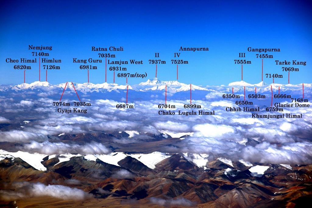
7 Remarks: Most of pictures were taken by Liu Yuhong and one picture by other Chinese. Area covers Indian Himalaya, Nepal Himalaya, Trans-Himalaya (Tibet) and Bhutan Himalaya. Peak Identification: by the Himalayan Association of Japan 6


8 7


9 8
10 HENGDUAN MOUNTAINS CLUB Legacy of Silver Turtle Ski Expedition 2016 Photo Album Untrodden Peaks of the Lhagu Glacier & Ata Glacier-Kangri Garpo East KANGRI GARPO THE LAST FRONTIER IN THE GREATER RANGES Edited by Tamotsu (Tom) Nakamura (All copyrights of pictures belong to Silver Turtle marked / ST, Alpine Club of Kobe University marked / ACKU, Tom Nakamura marked / TN and Hideki Watanabe marked / HW, Wuri Wusa and Liu Yuhong) Most of the mountaineers, even though they are Himalayan experts, would undoubtedly be unable to give correct answers to these questions: Which glacier flows down to the lowest altitude in Tibet? Which glacier has the largest surface area also in Tibet? The former is the Ata Glacier (south) of 14km in length, which end reaches 2,440m above sea level, and the latter is the Lhagu Glacier which is 30km in length by 2 5km width that reminds us of those in Patagonia and Alaska as well. The both glaciers are located in the eastern part of Kangri Garpo mountains range. More than 40 peaks exceeding 6,000m still remain unclimbed. The highest peak Ruoni 6882m which had been first identified by a British early explorer and plant hunter, Frank Kingdon-Ward in In 1973, 1976 and 1980 the Lanzhou Institute of Glaciology and Geocryology and the Chinese Academy of Sciences conducted field researches of Kangri Garpo East, the Ata Glacier and the Lhagu Glacier. In 2003 the Alpine Club of Kobe University (ACUK) challenged the highest summit of Rouni but retreated from at 5,900m. In 2006 Silver Turtle team entered the Lhagu Glacier for ski-climbing and unveiled the glacier. They brought back stunning, alluring and breathtaking pictures surrounding the Lhagu Glacier. Selection of these picture are introduced here. In 2009, ACKU and Wuhan Geology Collage joint expedition succeeded in the first ascent of the second highest peak Lopchin 6,805m Lopchin is the only 6,000m ever climbed in the range. Geography and Glaciers Kangri Garpo is a sizeable mountain range stretching 280km from northwest to southeast in N: and E: It exists between Tsangpo Great Bend, the eastern end of Himalayas, and Baxoila Ling that is the western end of the Hengduan Mountains. Kenneth Mason described little about the mountains of East of the Himalayas, whilst Frank Kingdon-Ward specified the mountain in question to be in an extension of Sino Himalaya. On the contrary, however, the Chinese Academy of Science maintains their opinion that Kangri Garpo is to be defined as an independent range from a point of the view that the geographical structure has a similarity to that of Nyainqentanglha range in the north of Kangri Garpo. 1

11 The range is encircled by three tributaries of the Tsangpo-Brahmaputra. The northern side is deeply eroded where Parlung Tsangpo, a tributary of the Tsangpo river forms a narrow and precipitous gorge in the valley. To the south and east of the range, the Lohit river (Chinese name is Zayul Qu) has an important role. The river separates into two tributaries, Kangrigarpo Qu (river) to the northwest and Sang Qu to the northeast. The confluence is in a small upper point at Samai in the Zayul County not far to the border with Arnachal Pradesh, India. In the south of the range, Dihang River, a tributary of Brahmaputra is flowing in low level of m, and the mountain ridges do not exceed an altitude of 4000m which does not function as a climatic barrier effect. Therefore, Kangri Garpo, which constitutes the southernmost rim of Qinghai-Tibet Plateau, receives a direct humid southwest seasonal wind from the Indian Ocean. This causes much precipitation in the monsoon season and heavy snowfall in winter and spring. The north of the watershed has a complicated topography. The eastern end is a high plateau while to the west the valley of Parlung Tsangpo becomes a forested deep gorge. In the south the valleys are extremely eroded. For at least three months a year, villages are isolated from the outside world because of heavy snow. In an area surrounding Ata Kang La and Lhagu Glacier, 61 glaciers are observed over 200 square km. The total surface area of all the glaciers in Kangri Garpo amounts to 1683 square km according to the survey conducted by China Academy of Science. The survey also indicates that Kangri Garpo is a mountain range where the ratio of glacial coverage is the largest in Tibet. In particular, glaciers of Kangri Garpo are concentrated in the eastern part of the range. 2

 6000m peaks")
12 Rich in Fantasy surrounding Lhagu Glacier-(above) 5480m (below) 6000m peaks east face: ST 3

13 4

14 The Lhagu Glacier and Ata Glacier are the crux of the Kangri Garpo East In particulars, harmony of alluring snow peaks and glacier is enchanting. 5
 Liu Yuhong (below) Peak Identifcation: Tatsuo Inoue, Alpine Club of Kobe University")
15 Kangri Garpo Range is a bit far away from commercial air flights route from Chengdu to Lhasa and Kathmandu, Nepal. Pictures: Wuri Wusa (above) Liu Yuhong (below) Peak Identifcation: Tatsuo Inoue, Alpine Club of Kobe University (ACKU) 6

16 7


17 Dawn in Kangri Garpo East viewed from Lhagu village: TN Glacier terminus of Lhagu Glacier: TN 8


18 Views from near Lhagu village towards Lhagu Glaciers and surrounding 6000m peaks: TN 9


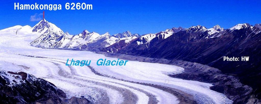
19 Lhagu Glacier and 6377m peak in the glacier head: ST Hamokongga 6260m east face receiving sunshine in dawn: ST 10

 Silver")
20 (above)shugden Gompa, entrance to mountains: TN (below) Silver Turtle team: ST 11


21 (above) Silver Turtle team and villagers, porters (below) Dawn in the mountains: ST 12
 unique")

22 (above) Before entering glacier (below) unique strata showing marks of glacier movement: ST 13


23 Lhagu Glacier lower part mid-stream and branch glaciers: ST 14

 of the Lhagu")
24 Setting up an advance camp on the left rim (east side) of the Lhagu Glacier 15
")

25 (above) Nameless 6000m peaks (below) 6091m peak-center, Gongyada 6432m-right: ST 16


26 Zeh 6017m east face and branch glacier of Lhagu Glacier: ST 17


27 (above) Nameless 6000m peak (below) Luqendo II m east face: ST 18


28 (above) Reconnaissance: ST (below) 6377m-left, Lhagu Gl, Hamokongga 6260m-right: TN 19


29 (above) Zeh 6170m, ascending to upper camp (below) Camp on upper glacier: ST 20


30 Ascending Lhagu Glacier 21


31 Upper Lhagu Glacier and 6350m peak northeast face: ST 22


32 (above) Gongyada 6432m-left, Zeh 6127m-right (below) 6000m peak in upper glacier: ST 23


33 (above) To the glacier headwaters (below) 6377m seen from upper Dome 5900m: ST 24


34 (above) 6536m Pk highest in Lhagu Glacier: ST (below) Gemsong 6525m & Midui Glacier: TN 25


35 Descending to lower camp after finishing activity in Upper Lhagu Glacier: ST 26

 NW face: ACKU")
36 Ruoni 6882m highest peak in Kangri Garpo (above) NE face: TN, (below) NW face: ACKU 27

 Shana 5596m")
37 (above) Twin Pks 6200m-left 6290m-right E face (below) Shana 5596m NW face: ACKU 28


38 (above) Lopchin 6805m 2nd highest (below) Pk 6726m 3rd highest east face: ACKU 29


39 (from left) Pk 6720m, Zyaddo 6205m in front, 6554m only top, 6340m, Twins 6200m,6290m E-NE face viewed from road to Dema La: TN Ruoni 6882m-left Lopchin 6805m-right NE face viewed from road to Dema La: TN 30


40 Dojitsenza 5662m east face viewed from road to Dema La: TN Dema La 4920m from Rawu to Zayul: TN 31


41 Ata Kangri 5760m-left, north of Ata Kang La 4612m: TN 6000m peak north face and Gheni West Glacier viewed from road to Dema la: TN 32


42 Gheni 6150m north face seen from road to Dema La: TN 6000m Pks-left, Gheni 6150m-center, 5850m-right N face viewed from Ata Glacier: ACKU 33


43 Panorama looking to south from road to Dema La: TN 5700m peak north face seen from road to Dema La: TN 34


44 Huhe Kangri 6327m north face-center beyond col seen from road to Dema La: TM Yuhe Kangri 6327m east face, easternmost of Kangri Garpo: HW 35


45 New glacial lakes being born in North Ata Glacier: TN Young monk reading a sutra, Shugden Gompa: TN 36
Deep Gorge Country ( Three
 Y u n n a n P r o v in c e H e n g d u a n M o u n t a in s Deep Gorge Country ( Three Parallel Rivers : Salween, Mekong, Yangtze), exploration. My many voyages o f discovery to what I call East o f the
Part I. Gankar Punsum
 TAMOTSU TATSUO (TIM) NAKAMURA INOUE The First Hightlights Ascent of on Lopchin the Eastern Feng Himalaya (KG-2) 6,805m Autumn Gankar 2009 Punsum, Expedition Namcha to the Kangri Barwa and Garpo Gyala East
Future Climbing Park Nyainbo Yuze in Qinghai
 JAPANESE ALPINE NEWS 2014 HENGDUANG MAOUNTAINS CLUB Future Climbing Park Nyainbo Yuze in Qinghai A GUIDE TO MOUNTAINEERING IN CHINA (jointly edited and published by the China Mountaineering Association
In 2003 the Third Koksil Glacerier was visited by Bernard Vaucher and his Pakistan friend Ishaq Ali. They reached the Peak 5,717 (Jacky Chhish)
") JAPANESE ALPINE NEWS 2012 TATSUO JANUSZ (TIM) MAJER INOUE The First Koksil Ascent Valley of Lopchin Ghujerab Feng Mountains (KG-2) 6,805m Autumn 2009 Exploration Expedition 2011 to Northern Kangri Karakoram,
JAPANESE ALPINE NEWS 2012 TATSUO JANUSZ (TIM) MAJER INOUE The First Koksil Ascent Valley of Lopchin Ghujerab Feng Mountains (KG-2) 6,805m Autumn 2009 Exploration Expedition 2011 to Northern Kangri Karakoram,
Two Peaks in the Headwaters of Karcha Nala JAC Tokai to the Indian Himalayas
 KAZUO HOSHI Two Peaks in the Headwaters of Karcha Nala JAC Tokai to the Indian Himalayas The Tokai Section of the Japanese Alpine Club (hereinafter described as JAC Tokai) conducted 11 expeditions to the
Map-1 Climbing route to Lopchin Feng
 ANG TATSUO TSHERING (TIM) INOUE SHERPA Mountaineering The First Ascent and of Adventure Lopchin Feng Tourism (KG-2) in West 6,805m Nepal Autumn Prospect 2009 Expedition to the and Kangri Potentiality Garpo
DISCOVERY & FIRST DESCENT OF MEKONG HEADWATERS
 Masayuki Kitamura DISCOVERY & FIRST DESCENT OF MEKONG HEADWATERS Quest for True Source and Rafting Down By international geographic convention, the source of a river is the furthest source of water from
The Himalayan Future Transition, Equity and Ecological Stability. Jayanta Bandyopadhyay
 The Himalayan Future Transition, Equity and Ecological Stability Jayanta Bandyopadhyay Himalaya the Mountain of Diversity The Himalaya has been mentioned in many writings, both ancient and modern, scientific
Autumn 2009 Expedition to the Kangri Garpo East Mountains, Tibet
 JAPANESE ALPINE NEWS 2015 KIMIKAZU TATSUO (TIM) SAKAMOTO INOUE Exploration The First in Ascent Kinner of and Lopchin Spiti of Feng Indian (KG-2) Himalaya 6,805m 2014 Autumn 2009 Expedition to the Kangri
H I M A L AYA TAMOTSU NAKAMURA
 130 EAST OF THE H I M A L AYA From the Alps of Tibet to the eastern fringes of the Hengduan Mountains, this mysterious land holds countless unclimbed summits. Incredibly complex, the region can be explained,
If you are looking for a book by William CAREY Travel and Adventure in Tibet, Including the Diary of Miss Annie R. Taylor's Remarkable Journey from
 Travel And Adventure In Tibet, Including The Diary Of Miss Annie R. Taylor's Remarkable Journey From Tau-Chau To Ta-Chien-Lu Through The Heart Of The Forbidden Land By William CAREY READ ONLINE If you
Rapid decrease of mass balance observed in the Xiao (Lesser) Dongkemadi Glacier, in the central Tibetan Plateau
 Dongkemadi Glacier, in the central Tibetan Plateau") HYDROLOGICAL PROCESSES Hydrol. Process. 22, 2953 2958 (2008) Published online 8 October 2007 in Wiley InterScience (www.interscience.wiley.com).6865 Rapid decrease of mass balance observed in the Xiao
HYDROLOGICAL PROCESSES Hydrol. Process. 22, 2953 2958 (2008) Published online 8 October 2007 in Wiley InterScience (www.interscience.wiley.com).6865 Rapid decrease of mass balance observed in the Xiao
REPORT. MANASLU EXPEDITION (8163 m) Track NE (traditional)
 Track NE (traditional)") REPORT MANASLU EXPEDITION (8163 m) Track NE (traditional) Contents Expedition passport 2 Description of the route 3 Description of the expedition 4-5 Scheme of the route 6 Map of the route 7 Map of the
REPORT MANASLU EXPEDITION (8163 m) Track NE (traditional) Contents Expedition passport 2 Description of the route 3 Description of the expedition 4-5 Scheme of the route 6 Map of the route 7 Map of the
INDIA HIMALAYA STOK KANGRI ASCENT 21 DAYS
 INDIA HIMALAYA STOK KANGRI ASCENT 21 DAYS No words can describe the overwhelming experience of being among the world s greatest mountains you really have to be here! The enormous glaciated peaks, challenging
Exploration of RANGTIK TOKPO and SHIMLNIG TOKPO alpine climbing potentials in Zanskar
 Haptal mountains 2016 Slovenian expedition Exploration of RANGTIK TOKPO and SHIMLNIG TOKPO alpine climbing potentials in Zanskar In summer 2016 Anastasija Davidova Nastja and I (Matija Jošt Matic) spent
GUIDE INDIA HIMALAYA STOK KANGRI ASCENT 21 DAYS SUMMER 2019
 GUIDE INDIA HIMALAYA STOK KANGRI ASCENT SUMMER 2019 21 DAYS WHERE ARE YOU GOING? INDIA HIMALAYA No words can describe the overwhelming experience of being among the world s greatest mountains you really
CLIMBING A NAMELESS PEAK AND SHORT SURVEYS AROUND MUSTANG TO THE NORTHWEST
 CLIMBING A NAMELESS PEAK AND SHORT SURVEYS AROUND MUSTANG TO THE NORTHWEST The summer 2001 in Mustang was about to end when we placed training camps at a point of 4070m and 4780m (both GPS height) en route
OUR COUNTRY INDIA L OCATIONAL SETTING
 7 India is a country of vast geographical expanse. In the north, it is bound by the lofty Himalayas. The Arabian Sea in the west, the Bay of Bengal in the east and the Indian Ocean in the south, wash the
Warming planet, melting glaciers
 Warming planet, melting glaciers Arun B Shrestha abshrestha@icimod.org International Centre for Integrated Mountain Development Kathmandu, Nepal Asia-Pacific Youth forum on Climate Actions and Mountain
Base Camp Trek. Trek dates October to early December and end of February to May
 Base Camp Trek This special version of the trek to Everest Base Camp is designed for anyone who is very fit and has some trekking experience. The route to base camp is the same as the longer trek but with
MT KILIMANJARO TREK- LEMOSHO ROUTE
 #Trekking MT KILIMANJARO TREK- LEMOSHO ROUTE 10 Days 9 Nights Overview Take the challenging and less-travelled Lemosho route up to the highest peak in Africa, considered by many to be the most beautiful
ASIAN ALPINE E NEWS. Issue No.35, September 2018
 ASIAN ALPINE E NEWS Issue No.35, September 2018 Unexplored Mekong Headwaters: Sunshine Glacier no 3 and largest of the Glaciers showing here the upper Neve portion centre top, our campsite was under the
The height of Machu is 6630m on the Swiss map, 6612m on the Russian map and 6603m on Google Earth.
 Hispar Expedition 2017 Expedition Final Report MEF reference: 17-42 Country and region visited: Pakistan, Hunza Valley, Karakoram. Objective To make the first ascent of Machu (6630m) by the southwest and
GUIDE NEPAL EVEREST BASE CAMP 21 DAYS SUMMER 2019
 GUIDE NEPAL EVEREST BASE CAMP SUMMER 2019 21 DAYS WHERE ARE YOU GOING? NEPAL Birthplace of Buddha and home of Everest, the tiny kingdom of Nepal is the greatest adventure paradise of all! Discover the
Conference and Journey Sichuan October Part I Conference at Sichuan University and Mt. Siguniang
 TAMOTSU (TOM) NAKAMURA Conference and Journey Sichuan October 2017 Part I Conference at Sichuan University and Mt. Siguniang 1. Sichuan University 1) The Sixth International Conference of Mountain Outdoor
China: Natural Environments. Outline. Group Discussion. Territory and Location. Neighbors. Topography Hydrology/river systems. News on China?
 News on China? China: Natural Environments Youqin Huang GOG/EAS 160 1 Youqin Huang GOG/EAS 160 2 Group Discussion What are the most significant physical features in China? Name two What are their implications
Mountain Passes in Himalayas : India
 Mountain Passes in Himalayas : India Overall, the Himalayan mountain system is the world s highest, and is home to the world s highest peaks, the Eightthousanders. There are 14 Himalayan peaks with elevation
PERUVIAN ANDES ADVENTURES. ARTESONRAJU CLIMB 6025m (19767 ft) Grade: D+ to TD/ Technical. Routes: The two routes to climb Artesonraju are;
 Grade: D+ to TD/ Technical. Routes: The two routes to climb Artesonraju are;") PERUVIAN ANDES ADVENTURES ARTESONRAJU CLIMB 6025m (19767 ft) Grade: D+ to TD/ Technical Routes: The two routes to climb Artesonraju are; *Via the Paron Valley South East Ridge 5 days (option for 6 with
PERUVIAN ANDES ADVENTURES ARTESONRAJU CLIMB 6025m (19767 ft) Grade: D+ to TD/ Technical Routes: The two routes to climb Artesonraju are; *Via the Paron Valley South East Ridge 5 days (option for 6 with
Climate Change and State of Himalayan Glaciers: Issues, Challenges and Facts
 Climate Change and State of Himalayan Glaciers: Issues, Challenges and Facts D.P. Dobhal dpdobhal@wihg.res.in Wadia Institute of Himalayan Geology Dehra Dun Major Issues Are the Himalayan glaciers receding
Development of Ski Resorts in the Indian Himalayas
 Development of Ski Resorts in the Indian Himalayas AMITABH SHARMA SKI HIMALAYAS # 1 Pocket 52, C.R Park New Delhi 110019 +91-9816055555 Email : amitabhsharma_manali@rediffmail.com The Himalayas are a vast
Himalayan Glaciers Climate Change, Water Resources, and Water Security. Henry Vaux, Committee Chair December 10, 2012
 Himalayan Glaciers Climate Change, Water Resources, and Water Security Henry Vaux, Committee Chair December 10, 2012 Study Context Glacial meltwater is commonly thought h to significantly ifi contribute
Assessment of glacier water resources based on the Glacier Inventory of China
 104 Annals of Glaciology 50(53) 2009 Assessment of glacier water resources based on the Glacier Inventory of China KANG Ersi, LIU Chaohai, XIE Zichu, LI Xin, SHEN Yongping Cold and Arid Regions Environmental
The dynamic response of Kolohai Glacier to climate change
 Article The dynamic response of Kolohai Glacier to climate change Asifa Rashid 1, M. R. G. Sayyed 2, Fayaz. A. Bhat 3 1 Department of Geology, Savitribai Phule Pune University, Pune 411007, India 2 Department
Everest Advanced Base Camp Trek
 We call this the Highest trek in the world, 15 days culture and wilderness on the Tibetan Plateau. With an average altitude in excess of 3500m, Tibet can truly be described as the roof of the world. Lying
2015 Cordillera Central Mountains of Peru, Sullcon and Paca climbing Expedition
 Introduction The Cordillera Central (also called the Huarochiri or Pariacacca Mountains) is the closest Andean Mountain Range to Lima the Capital of Peru (see Map 1). It is located approximately 80 to
Nepal Hirnalaya and Tibetan Plateau: a case study of air
 Annals of Glaciology 16 1992 International Glaciological Society Predictions of changes of glacier Inass balance in the Nepal Hirnalaya and Tibetan Plateau: a case study of air teinperature increase for
GLACIER STUDIES OF THE McCALL GLACIER, ALASKA
 GLACIER STUDIES OF THE McCALL GLACIER, ALASKA T John E. Sater* HE McCall Glacier is a long thin body of ice shaped roughly like a crescent. Its overall length is approximately 8 km. and its average width
Everest Base Camp, Nepal
 Everest Base Camp, Nepal This outstanding trek to the base camp of the world s highest mountain will take you through the lush valleys of Sagarmatha National Park, with time to explore its villages and
Kathmandu Summit Club INDIAN HIMALAYA ADVENTURE EXPEDITION MANUAL. associates
 Kathmandu Summit Club INDIAN HIMALAYA ADVENTURE EXPEDITION MANUAL associates 2 Explore Ladakh and help raise funds for the Australian Himalayan Foundation conservation efforts to protect the Snow Leopard
Observation of cryosphere
 Observation of cryosphere By Sagar Ratna Bajracharya (email: sagar.bajracharya@icimod.org) Samjwal Ratna Bajracharya Arun Bhakta Shrestha International Centre for Integrated Mountain Development Kathmandu,
READING QUESTIONS: Chapter 7, Glaciers GEOL 131 Fall pts. a. Alpine Ice from larger ice masses flowing through a valley to the ocean
 READING QUESTIONS: Chapter 7, Glaciers GEOL 131 Fall 2018 63 pts NAME DUE: Tuesday, October 23 Glaciers: A Part of Two Basic Cycles (p. 192-195) 1. Match each type of glacier to its description: (2 pts)
From Rassa to Sumur..a journey of exploration and climbing.
 From Rassa to Sumur..a journey of exploration and climbing. In 2001, a glimpse of Rassa glacier, during our expedition to Arganglas valley indicated great opportunity for exploration and climbing. In July
ANNAPURNA SANCTUARY The Jewel in the Crown
 COMMUNITY ACTION TREKS LTD Stewart Hill Cottage, Near Hesket Newmarket, Wigton, Cumbria, CA7 8HX Tel: 01768 484842 Email: info@catreks.com Web: www.catreks.com ANNAPURNA SANCTUARY The Jewel in the Crown
Untrodden Mountains in West Sichuan, China
 The Untrodden Mountains in West Sichuan, China Tamotsu Nakamura TODAY the map has no more secrets. Idle minds repeat that parrot phase. But who knows all Tibet, or its far-away frontier on western China?
South Simvu: Kanchenjunga s last kept Secret
 South Simvu: Kanchenjunga s last kept Secret Text & Photographs: Anindya Mukherjee Maps, if caviare 1 to the general, are, as Louis Stevenson has insisted, very suggestive to persons with proper imagination.
Mendenhall Glacier Facts And other Local Glaciers (updated 3/13/14)
") University of Alaska Southeast School of Arts & Sciences A distinctive learning community Juneau Ketchikan Sitka Mendenhall Glacier Facts And other Local Glaciers (updated 3/13/14) This document can be
University of Alaska Southeast School of Arts & Sciences A distinctive learning community Juneau Ketchikan Sitka Mendenhall Glacier Facts And other Local Glaciers (updated 3/13/14) This document can be
NAAR PHU. tel (UK): tel (outside UK): web:
: tel (outside UK): web:") NAAR PHU Land-only duration: 26 days Grade: Strenuous Trekking days: 19 days Max altitude: 5416m Price: From 1795 We can run this on dates to suit you for a minimum group size of 1. Dates: The 2 main trekking
NAAR PHU Land-only duration: 26 days Grade: Strenuous Trekking days: 19 days Max altitude: 5416m Price: From 1795 We can run this on dates to suit you for a minimum group size of 1. Dates: The 2 main trekking
South, Southeast, and East Asia Physical Geography
 South, Southeast, and East Asia Physical Geography Mountains A. B. C. Mountains are important in Asia because they influence: Population patterns Movement of people and goods Climate Himalaya Mountains
c. 1 inch = 0.6 miles e. 1:100,000 f. 1:250,000 f. 1 inch = 4.0 miles
 High School Advance Geology Map Test 2014 Name Use the information on each map to provide the best answer to the questions. Fill in the bubble of the best answer on your answer sheet. Answer questions
Kathmandu Summit Club INDIAN HIMALAYA ADVENTURE EXPEDITION MANUAL. associates
 Kathmandu Summit Club INDIAN HIMALAYA ADVENTURE EXPEDITION MANUAL associates 2 Explore Ladakh and help raise funds for the Australian Himalayan Foundation conservation efforts to protect the Snow Leopard
EXPEDITIONS & NOTES. Trekkers approaching Saraswati col at the head of Mana glacier
 Trekkers approaching Saraswati col at the head of Mana glacier 342 13 In Search of the Elusive Arwa Col Avilash Bisht We were all exhilarated. We could see Kalindi pass right across and a host of peaks
THE HIMALAYAN EXPRESS Apr 2018
 THE HIMALAYAN EXPRESS Apr 2018 OVERVIEW Tour Date: 6 April 2018 30 April 2018 Tour Duration: 25 days Tour Cost ($AUD): $16,550 Single Supplement ($AUD): $3,250 In 2006 Travel Directors became the first
LANGTANG, GANJA LA & YALA PEAK
 COMMUNITY ACTION TREKS LTD Stewart Hill Cottage, Near Hesket Newmarket, Wigton, Cumbria, CA7 8HX Tel: 01768 484842 Email: info@catreks.com Web: www.catreks.com LANGTANG, GANJA LA & YALA PEAK Grade: Strenuous
! Kilimanjaro Expedition
 ! Kilimanjaro Expedition Tanzania 2016 Climb Only: $4,350 (land costs) Feb 4-12; June 12-20; July 10-18; Aug 6-14; Sept 11-19; Dec 4-12 2016 Climb & Safari: $5,850 (land costs) Feb 4-15; June 12-23; July
PANGARCHULLA KUARI PASS ALAKNANDA
 PANGARCHULLA KUARI PASS ALAKNANDA PANGARCHULLA & KUARI PASS TREK & ALAKNANDA RAFTING EXPEDITION Apr 06-16, 2019 info@ GARHWAL TREK & RAFT: INTRODUCTION Starting the trek from Auli, turns Kuari Pass into
The Role of Glaciers in the Hydrologic Regime of the Nepal Himalaya. Donald Alford Richard Armstrong NSIDC Adina Racoviteanu NSIDC
 The Role of Glaciers in the Hydrologic Regime of the Nepal Himalaya Donald Alford Richard Armstrong NSIDC Adina Racoviteanu NSIDC Outline of the talk Study area and data bases Area altitude distributed
Japanese Alpinists in the Himalaya
 Japanese Alpinists in the Himalaya I. THE FIRST ASCENT OF CHOGOLISA P r o f. T ak eo K uw abara T h e A c a d e m ic A l p i n e C l u b o f K y o t o went on an expedition to Chogolisa (7.654 m.; 25,110
READING QUESTIONS: Glaciers GEOL /WI 60 pts. a. Alpine Ice from larger ice masses flowing through a valley to the ocean
 READING QUESTIONS: Glaciers GEOL 131 18/WI 60 pts NAME DUE: Tuesday, March 13 Glaciers: A Part of Two Basic Cycles (p. 192-195) 1. Match each type of glacier to its description: (2 pts) a. Alpine Ice from
Lesson 5: Ice in Action
 Everest Education Expedition Curriculum Lesson 5: Ice in Action Created by Montana State University Extended University and Montana NSF EPSCoR http://www.montana.edu/everest Lesson Overview: Explore glaciers
Summer Haute Route Trek 2018 TRIP NOTES
 Summer Haute Route Trek 2018 TRIP NOTES Summer Haute Route Trek 9 days (7 days trekking, 2 travel days) 2018 Trip Notes All material Copyright Adventure Consultants Ltd 2017/2018 This alpine classic follows
Mount Kilimanjaro Climbing via Marangu Route 6 day-itinerary
 Mount Kilimanjaro Climbing via Marangu Route 6 day-itinerary (For the 5-day route, simply exclude the additional acclimatisation day at Horombo hut - day 3 on the itinerary below.) Total hiking distance:
Markha Valley Trek 2016
 Markha Valley Trek 2016 Area: Ladakh Himalayas Duration: 11 Days Max. Altitude: 5150 mts/16895 ft) Grade: Moderate to challenging Season: Mid June - October The Markha Valley Trek is certainly one of the
Status of the Glacier Research in the HKH region. By Dr. S. I. Hasnain School of Environmental Sciences Jawahar Lal Nehru University INDIA
 Status of the Glacier Research in the HKH region By Dr. S. I. Hasnain School of Environmental Sciences Jawahar Lal Nehru University INDIA The climate of Himalaya is essentially dominated by the south-west
PHYSIOGRAPHIC DIVISION OF INDIA
 PHYSIOGRAPHIC DIVISION OF INDIA INTRODUCTION India is vast country there have great diversity in it s physical features. Physical Division Of India are divided into following five Division. 1. The Northern
SS8G1 The student will describe Georgia with regard to physical features and location.
 SS8G1ab Standards SS8G1 The student will describe Georgia with regard to physical features and location. a. Locate Georgia in relation to the region, nation, continent, and hemispheres. b. Describe the
Skiing and Snowshoes on Un-groomed Fernan Saddle Terrain
 Skiing and Snowshoes on Un-groomed Fernan Saddle Terrain Three ski or snowshoe routes are available from the Fernan Saddle Parking Lot which either do not cover routes ordinarily groomed for snow machine
BHUTAN. Aim. Secret Compass achieve the extraordinary
 Secret Compass achieve the extraordinary https://www.secretcompass.com BHUTAN Ever dreamt of claiming your own first ascent? This ambitious Himalayan trekking expedition is your rare chance to summit what
Mt Everest North Base Camp & Mt Kailash Pilgrimage Kora
 Mt Everest North Base Camp & Mt Kailash Pilgrimage Kora Tashi delek! Tibetan Guide Travel Tours is a small travel agency based in Lhasa. We always work hard and take responsible for our clients by using
Stok Kangri Trek 2013
 Stok Kangri Trek 2013 Area: Ladakh Duration: 11 Days Altitude: 6153 mts Grade: Moderate to Challenging Towering at an impressive 6153 m, Stok Kangri is a serious challenge. Although at such an impressive
Photos from the sacred mountains of Tibet, & Peru. Ron Anderson, April 12, 2011
 Photos from the sacred mountains of Tibet, & Peru Ron Anderson, April 12, 2011 1 My first memory, at age 3, was seeing giraffes and Mt. Kilimanjaro (Tanzania) from the back of a truck on route to Ethiopia
glacier Little Ice Age continental glacier valley glacier ice cap glaciation firn glacial ice plastic flow basal slip Chapter 14
 Little Ice Age glacier valley glacier continental glacier ice cap glaciation firn glacial ice plastic flow basal slip glacial budget zone of accumulation zone of wastage glacial surge abrasion glacial
Quick Revision Geography (India & World) [Series-2]
![Quick Revision Geography (India & World) [Series-2]](/thumbs/87/96516026.jpg "Quick Revision Geography (India & World) [Series-2]") Quick Revision Geography (India & World) [Series-2] Revision Notes For 2015 Economy, Environment, Geography, History, Polity, CA Compilation By TeamWork Important Images: Link (by Kaushal) NCERT Compilation:
Quick Revision Geography (India & World) [Series-2] Revision Notes For 2015 Economy, Environment, Geography, History, Polity, CA Compilation By TeamWork Important Images: Link (by Kaushal) NCERT Compilation:
THE McCALL GLACIER PROJECT AND ITS LOGISTICS
 THE McCALL GLACIER PROJECT AND ITS LOGISTICS I Robert W. Mason* Locating a suitable glacier N August 1956 after the United States I.G.Y. Glaciological Panel had decided to organize a glacial-meteorological
Cryosphere Monitoring Programme in the Hindu Kush Himalayas and Cryosphere Knowledge Hub
 Cryosphere Monitoring Programme in the Hindu Kush Himalayas and Cryosphere Knowledge Hub Pradeep Mool Programme Coordinator Cryosphere Initiative ICIMOD The First Asian CryoNet Workshop International Centre
Himalaya Nelles Map: Incl. Tibet / Kashmir / Nepal / Sikkim / Bhutan 3rd (third) Revised Edition By Nelles Published By Nelles Verlag GmbH (2006)
 Revised Edition By Nelles Published By Nelles Verlag GmbH (2006)") Himalaya Nelles Map: Incl. Tibet / Kashmir / Nepal / Sikkim / Bhutan 3rd (third) Revised Edition By Nelles Published By Nelles Verlag GmbH (2006) READ ONLINE If looking for the book Himalaya Nelles Map:
Himalaya Nelles Map: Incl. Tibet / Kashmir / Nepal / Sikkim / Bhutan 3rd (third) Revised Edition By Nelles Published By Nelles Verlag GmbH (2006) READ ONLINE If looking for the book Himalaya Nelles Map:
GO LADAKH! An initiation to Ladakh. What is it? 10th edition of the annual CWH group trip to the land of passes. 3 rd 11 th June 2017.
 GO LADAKH! An initiation to Ladakh What is it? 10th edition of the annual CWH group trip to the land of passes. 3 rd 11 th June 2017. What would you call a journey traversing 3 of the 5 highest motorable
Nepal. Annapurna Circuit Trek
 Nepal Annapurna Circuit Trek Nepal Annapurna Circuit Trek TRIP GRAD MODERAT-HARD DATES: 11th-28th March 2019 DURATION: 18 Days This trek offers fascinating landscape, Bhotia (Tibetan) Buddhist culture
TRIP ITINERARY. Mardi Himal Trek Itinerary 1. Mardi Himal Trek- 6-day Route
 Mardi Himal Trek Itinerary 1 Mardi Himal Trek- 6-day Route TRIP ITINERARY There is no other place like it on Earth. The majestic, celebrated Annapurna region is the most distinct and popular trekking area
2015 Brain Wrinkles. SS8G1b
 SS8G1b Georgia is a geographically diverse state that is divided into five regions. The first three regions (Appalachian Plateau, Valley and Ridge, and Blue Ridge) are in the mountains and foothills of
Monitoring of Mountain Glacial Variations in Northern Pakistan, from 1992 to 2008 using Landsat and ALOS Data. R. Jilani, M.Haq, A.
 Monitoring of Mountain Glacial Variations in Northern Pakistan, from 1992 to 2008 using Landsat and ALOS Data R. Jilani, M.Haq, A. Naseer Pakistan Space & Upper Atmosphere Research Commission (SUPARCO)
Mt. Kilimanjaro Trek. WanderTours P.O. Box Seattle WA Itinerary dates: January 23 - February 1, 2019 Tour Escort: Beth Whitman
 WanderTours P.O. Box 16102 Seattle WA 98116 Mt. Kilimanjaro Trek Itinerary dates: January 23 - February 1, 2019 Tour Escort: Beth Whitman HIGHLIGHTS The six-day Machame Route to Uhuru Peak, considered
DALHOUSIE WINTER TREKKING EXPEDITION
 DALHOUSIE WINTER TREKKING EXPEDITION Winter Himalayan Trekking Expedition 2016-17 To groom the youngsters in the field of adventures and environmental awareness, Invincible NGO presents the most interactive
Glaciers. Reading Practice
 Reading Practice A Glaciers Besides the earth s oceans, glacier ice is the largest source of water on earth. A glacier is a massive stream or sheet of ice that moves underneath itself under the influence
Stok Kangri, (6121ms) Ladakh, Indian Himalayas
 Ladakh, Indian Himalayas") Stok Kangri, (6121ms) Ladakh, Indian Himalayas This outstanding trek to the summit of India s highest mountain Stok Kangri, (6,121m/20,082ft) is the perfect challenge for trekkers, who want to summit an
Stok Kangri, (6121ms) Ladakh, Indian Himalayas This outstanding trek to the summit of India s highest mountain Stok Kangri, (6,121m/20,082ft) is the perfect challenge for trekkers, who want to summit an
Glaciers, Glacial Lakes and GLOF
 Glaciers, Glacial Lakes and GLOF N Samjwal Ratna Bajracharya International Centre for Integrated Mountain Development Kathmandu, Nepal Inventory of Glaciers, Glacial Lakes and GLOF in the Himalaya Afghanistan
HIGHLIGHTS: TOUR INCLUDES: +44 (0)
") +44 (0)20 8741 7390 Enjoy a Patagonian adventure like no other, as you travel deep into the heart of the majestic Torres del Paine National Park in the company of expert photographer and wildlife guide,
+44 (0)20 8741 7390 Enjoy a Patagonian adventure like no other, as you travel deep into the heart of the majestic Torres del Paine National Park in the company of expert photographer and wildlife guide,
Mearns Castle High School. Geography Department. Glaciated Landscapes
 Mearns Castle High School Geography Department Glaciated Landscapes Lesson One: Location of Glaciated Uplands in the British Isles The Ice Age in Britain began about 1,000,000 years ago and lasted until
DRUK PATH, BHUTAN. Meeting the locals, Bhutan Ann Foulkes, trekmountains
 DRUK PATH, BHUTAN Meeting the locals, Bhutan Land-only duration: 13 days Grade: Moderate Trekking days: 6 days Max altitude: 4210m Price: Contact us We can run this on dates to suit you for a minimum group
Present health and dynamics of glaciers in the Himalayas and Arctic
 Present health and dynamics of glaciers in the Himalayas and Arctic AL. Ramanathan and Glacilogy Team School of Environmental Sciences, Jawaharlal Nehru University AL. Ramanthan, Parmanand Sharma, Arindan
ISLAND PEAK EXPEDITION 2018 TRIP NOTES
 ISLAND PEAK EXPEDITION 2018 TRIP NOTES ISLAND PEAK CLIMB Nepal 2018 Departure 1 April 26 - May 19, 2018 (pre-monsoon) Departure 2 October 15 - November 7, 2018 (post-monsoon) Trip Notes All material Copyright
BHUTAN THE LAYA TREK
 COMMUNITY ACTION TREKS LTD Tel: 01 Email: info@catreks.com Web: www.catreks.com BHUTAN THE LAYA TREK Grade: Demanding Duration: 20 days land-only Trekking Days: 13 Maximum Altitude: 4900m Minimum numbers:
GUIDE MOROCCO 14 DAYS SUMMER 2019
 GUIDE MOROCCO SUMMER 2019 14 DAYS WHERE ARE YOU GOING? MOROCCO Discover the blazing colours and enticing aromas of Marrakech; a crossroads for travellers and traders for centuries where souks and bazaars
Unit 1: Physical Geography Notes
 - How has the physical world impacted settlement patterns? o Major factors in the decision-making process of o Before the boom controlling the physical environment was not possible on a large scale - Physical
VINSON MASSIF EXPEDITIONS 2017/2018 TRIP NOTES
 VINSON MASSIF EXPEDITIONS 2017/2018 TRIP NOTES VINSON MASSIF 2017/2018 Expedition Notes All material Copyright Adventure Consultants Ltd 2017/2018 During the southern summer of 2017/2018, Adventure Consultants
Top 20 Walking Journeys
 Top 20 Walking Journeys 1 Camino de Santiago Spain 2 Everest Base Camp Nepal 3 Kilimanjaro Tanzania 4 Milford Track New Zealand 5 Overland Track Tasmania, Australia 6 Inca Trail Peru 7 Torres del Paine
Shaping of North America. Physical Geography II of the United States and Canada. The Last Ice Age. The Ice Age. Pleistocene Polar Ice Cap 2/14/2013
 Physical Geography II of the United States and Canada Prof. Anthony Grande AFG 2012 Shaping of North America The chief shaper of the landscape of North America is and has been running water. Glaciation
Langtang Valley to Kyanjin Gompa Trek
 The Langtang Valley sits within the first national park designated in Nepal the Langtang National Park. The valley offers some of the most spectacular mountain trekking and scenery near to Kathmandu. Just
SHARE-Asia Project: Meteoclimatic Research in Himalaya and Karakorum
 SHARE-Asia Project: Meteoclimatic Research in Himalaya and Karakorum Gianni Tartari, Vuillermoz E., Verza GP., Schommer B. Ev-K 2 -CNR Committee, Bergamo, Italy 4 th CEOP International Meeting, Tokyo 28
The Inventory of Glacial Lakes
 Chapter 8 The Inventory of Glacial Lakes 8.1 BRIEF DESCRIPTION OF GLACIAL LAKE INVENTORY The inventory of glacial lakes has been systematically carried out using topographic maps. As not all the topographic
Island Peak (Imja Tse )
") Popularly known as Imja Tse, Island Peak is the most climbing peaks in Nepal. It appears as an island of the icy sea while viewing form Dingbuche and on close inception, it exposes itself to be the most
Popularly known as Imja Tse, Island Peak is the most climbing peaks in Nepal. It appears as an island of the icy sea while viewing form Dingbuche and on close inception, it exposes itself to be the most