Tolko Industries Ltd. Southern Interior Forest Stewardship Plan
|
|
|
- Noel Andrews
- 5 years ago
- Views:
Transcription

1 Tolko Industries Ltd. Southern Interior Forest Stewardship Plan Thompson/Okanagan Forest Region Thompson Rivers Forest District Kamloops TSA Cascades Forest District Merritt TSA Okanagan-Shuswap Forest District Okanagan TSA & TFL 49 Selkirk Natural Resource District Arrow TSA FSP Term: 5 Years ( ) Commencing: January 1, 2018 FSP ID# To be assigned
2
3 Preamble to FSP Tolko Southern Interior Woodlands has prepared this Forest Stewardship Plan (FSP) for operations within the Thompson Rivers, Cascades, Okanagan-Shuswap and Selkirk Natural Resource Districts. The FSP defines Forest Development Units (FDU s) within which timber harvesting and road construction activities may occur during the 5-year term of the plan. These activities must be conducted consistent with the results, strategies, measures and standards specified in the FSP which in turn must be consistent with the objectives set by government for the resource values found within the FDU s of the FSP. Despite the exemption from the requirement to prepare a result or strategy for the objective set by government for timber provided by FPPR section 12(8), a result or strategy for the FPPR section 6 Timber Objective has been specified. The FSP holder much achieve a result, carry out a strategy, meet a stocking standard or implement a measure in the FSP only to the extent that doing so is consistent with the FSP holders timber harvesting rights under a licence in that it does not unduly constrain the ability of the FSP holder to exercise those rights. This FSP is structured to include the following components: - Administration and Interpretation (Part 1) provides definitions of terms used in the FSP; links to specific legislation; the overall organization of the FSP; provisions for cancellation and exemption; and authorities from government. - Term (Part 2) provides details on the date the FSP was submitted to government for approval; the specified term of the FSP; and the commencement date of the FSP. - Application of the FSP (Part 3) specifies what the FSP applies to, including which Licences and agreement holders and provides for dis-application of a licence or agreement holder from the FSP. - Forest Development Units (Part 4) outlines five FDU s applicable to the FSP, specifies which licences and agreement holders will operate within each FDU, and provides an FDU Overview Map. - Results or Strategies (Part 5) specifies results or strategies consistent to the extent practicable with each applicable objective set by government. Each objective is summarized and sourced. In some instances, such as the objective for Soils, there exists a default practice requirement that has been adopted as the result or strategy for the FSP; in other instances, this plan either replaces the default or in situations in which there is no such default it proposes a result or strategy designed to be consistent with governments established objective. Sources of objectives addressed by the plan include: objectives prescribed under FRPA 149 (1); objectives established under FPC and continued under FRPA 181 for Specified Designations designated under FPC and continued under FRPA 180; objectives established under section 93.4 of the Land Act, objectives established under FPC section 3-5, and continued under Land Act section 93.8 as an objective established under Land Act section 93.4; and objectives established through the Government Actions Regulation. - Measures (Part 6), specifies measures for invasive plants and natural range barriers as required by FPPR sections 17 and 18.
4 - Stocking Standards (Part 7) provides background information on the requirements for stocking standards; the election of stocking standards generally for each cutblock and any specified variations from the stocking standards. - Signatures (Part 8), includes the signatures of the Preparing Forester, the person required to prepare the plan. - Appendices include Stocking Standards (Appendix A); Objectives for Interpretive Forest Sites, s or Recreation Trails continued under FPPR section 181 (Appendix B); Fly Hills Marten RMZ Sub-units (Appendix C); FSP Maps (Appendix D); and FSP Notice, Review and Comment (Appendix E).
5 Table of Contents 1 ADMINISTRATION AND INTERPRETATION Definitions Relevant Date for Legislation and Objective References Definition from Legislation Changes to Legislation Expressions Inclusive Organization Headings and Preamble Appendices Part of FSP Application of Results and Strategies Cancellation of Designation, Objective, Notice, Species or Order Exemptions under FPPR section Conditional Exemptions under FPPR section Protection of Existing CPs and RPs Authority from Government No Prohibition on Activities Otherwise Permitted or Required TERM Date of Submission Term Commencement of Term APPLICATION Application to Agreements and Holders of Agreements Dis-application of FSP Cutblocks or Roads Approved under a Previous FSP FOREST DEVELOPMENT UNITS Forest Development Units FDU Overview Map Identifying Required Values within Forest Development Units RESULTS AND STRATEGIES Timber Soils Wildlife - FPPR section 7(1) Species at Risk and KHLPO Wildlife Objectives Wildlife - OSLRMP LUO Wildlife Objectives Water, Fish, Wildlife and Biodiversity within Riparian Areas iii
6 5.6 Retention of Trees in a Riparian Management Zone OSLRMP LUO Enhanced Riparian Management Zone Retention OSLRMP LUO Enhanced Riparian Reserves KHLPO Riparian Management Areas and Inland Fisheries KHLPO Water Management KBHLPO Consumptive Use of Streams Fisheries Sensitive Watersheds Water in Community Watersheds Wildlife and Biodiversity Landscape Level Wildlife and Biodiversity Stand Level Old Growth Management OSLRMP LUO Basic Levels of Coarse Woody Debris Areas OSLRMP LUO Basic and Enhanced Levels of Coarse Woody Debris Areas Visual Quality Cultural Heritage Resources KHLPO Archaeological Assessments Interpretive Forest Sites, s or Recreation Trails KHLPO Recreation and Tourism Zones KHLPO Remote Recreation and Tourism Zones OSLRMP LUO Intensive Recreation Areas OSLRMP LUO Regionally Significant Trail Corridors KHLPO Settlement Resource Management Zones OSLRMP LUO Community/Crown Interface KHLPO Range Measures Invasive Plants Natural Range Barriers Stocking Standards Establishment of Free Growing Stands Definitions Stocking Standards FDU #1-Kamloops, FDU #2-Merritt Stocking Standards FDU #3-Okanagan, FDU #4-TFL 49, FDU #5-Arrow Signatures of the Preparing Forester and the Person Required to Prepare the Plan Signature of Preparing Forester Signature of Person Required to Prepare the Plan iv
7 APPENDICES Appendix A Stocking Standards Appendix B Objectives for Interpretive Forest Sites, s or Recreation Trails continued under FPPR section Appendix C Fly Hills Marten RMZ Sub-Units Map Appendix D Forest Stewardship Plan Maps by FDU Appendix E Notice, Review and Comment v
8 1 ADMINISTRATION AND INTERPRETATION 1.1 Definitions Definitions appearing in the body of this FSP are presented in italics for ease of recognition. In this FSP, unless this FSP specifies, or the context requires otherwise: 1. Act means the Forest and Range Practices Act RSBC 2002, c.69; 2. adjacent as defined in FPPR 65(1) means an area that is sufficiently close to a cutblock that, due to its location, could directly impact on, or be impacted by, a forest practice carried out within the cutblock ; 3. administrative boundary means features including but not limited to private property lines, area-based tenure boundaries, protected area boundaries, or boundaries associated with the buffer of an inventory permanent sample plot that may influence primary forest activities; 4. agreement means an agreement listed in Paragraph 3.1, unless this FSP no longer applies to that agreement; 5. agreement holder is defined in FPPR section 1 and means a holder of an agreement under the Forest Act, other than a woodlot licence and for the purposes of this FSP, applies to the agreement holders listed in Paragraph 3.1, or any successor or assignee of that agreement, unless this FSP no longer applies to that agreement holder; 6. applicable SAR notice means (i) a notice issued under FPPR section 7(2) entitled: a) NOTICE INDICATORS OF THE AMOUNT, DISTRIBUTION AND ATTRIBUTES OF WILDLIFE HABITAT REQUIRED FOR THE SURVIVAL OF SPECIES AT RISK IN THE ARROW BOUNDARY FOREST DISTRICT dated December 30, 2004; b) NOTICE INDICATORS OF THE AMOUNT, DISTRIBUTION AND ATTRIBUTES OF WILDLIFE HABITAT REQUIRED FOR THE SURVIVAL OF SPECIES AT RISK IN THE OKANAGAN SHUSWAP FOREST DISTRICT dated December 30, 2004; c) NOTICE INDICATORS OF THE AMOUNT, DISTRIBUTION AND ATTRIBUTES OF WILDLIFE HABITAT REQUIRED FOR THE SURVIVAL OF SPECIES AT RISK IN THE CASCADES FOREST DISTRICT dated December 30, 2004; d) NOTICE INDICATORS OF THE AMOUNT, DISTRIBUTION AND ATTRIBUTES OF WILDLIFE HABITAT REQUIRED FOR THE SURVIVAL OF SPECIES AT RISK IN THE HEADWATERS FOREST DISTRICT dated (ii) December 30, 2004; or The undated document entitled BACKGROUND INFORMATION FOR WILDLIFE HABITAT FOR SPECIES AT RISK OBJECTIVES UNDER THE KAMLOOPS LAND AND RESOURCE MANAGEMENT PLAN, IN THE KAMLOOPS FOREST DISTRICT. 7. BEC means Biogeoclimatic Ecosystem Classification; 8. CP means a Cutting Permit; 9. current means, in the context of a FSP, timber sale licence, CP or RP, an approved document that has not expired or been replaced; 10. cutblock means an area: (i) (ii) in which a holder of a Licence has harvested timber under a CP or timber sale licence; or in which a holder of a Licence is authorized to harvest timber but where harvesting has not occurred; 1
9 11. damaged timber means timber that has been or is in imminent danger of being damaged, significantly reduced in value, lost or destroyed due to damage agents such as fire, insect infestation, disease, or wind, as determined by a qualified professional. 12. damaged timber assessment means an assessment of a stand of damaged timber completed by a qualified professional, that will: (i) Evaluate the nature, amount, severity and distribution of the timber damage agent(s) and the resulting damage to timber; (ii) Evaluate the likelihood of spread of the timber damage agent(s), and the potential for damage to additional timber; and (iii) Contain applicable primary forest activity recommendations necessary to be consistent to the extent practicable with all of the applicable objectives set by government, while limiting the activities to the extent necessary to address the damaged timber. 13. dbh means diameter breast height, a standard method of expressing the diameter of the bole of a tree, generally measured at a height 1.3 metres above the point of germination. 14. established cutblock means a cutblock that has been: (i) harvested under a licence to which this FSP applies; (ii) declared under this FSP; (iii) included within a current CP issued under a licence to which this FSP applies, whether the CP is or is not subject to this FSP; or (iv) identified spatially in the BC Geographic Warehouse as a cutblock: a) harvested under a timber sale licence or major licence to which this FSP does not apply; or b) included in a timber sale licence or current CP issued under a major licence to which this FSP does not apply. 15. established road means a road that has been: (i) constructed under a CP or RP issued under or associated with a licence to which this FSP applies; (ii) declared under this FSP; (iii) included within a current CP or RP issued under or associated with a licence to which this FSP applies, whether the CP or RP is or is not subject to this FSP; (iv) identified spatially in the BC Geographic Warehouse as a road: a) constructed by a person other than a holder of this FSP; or b) included within a CP or RP issued in respect of a Licence to which this FSP does not apply. 16. FDU means a Forest Development Unit; 17. Forest Act means the Forest Act R.S.B.C. 1996, c.157; 18. forested area means a polygon identified in the VRI as contributing to the forest management land base, as indicated by the Forest Management Land base Indicator attribute. This attribute indicates whether a polygon is forested or has been forested and is capable of producing a stand of trees. Polygons classified as lakes, rock, alpine, shrub and wetland are not considered forested area. 19. FPC means the Forest Practices Code of British Columbia Act R.S.B.C. 1996, c. 159 and all regulations there under; 20. FPPR means the Forest Planning and Practices Regulation B.C. Reg. 14/2004; 21. FRPA means the Act and the regulations there under; 22. FSP means a Forest Stewardship Plan; 23. FSP holder or holder means the agreement holders listed in Paragraph 3.1, or any successor or assignee of that agreement, unless this FSP no longer applies to that agreement holder; 2
10 24. GAR means the Government Actions Regulation B.C. Reg. 582/2004; 25. government means the government of British Columbia; 26. height means the average height of a specified forested area, as confirmed by: (i) (ii) VRI attribute PROJ_HEIGHT_1; or a survey that is available to or completed by the FSP holder. 27. initial silviculture activities means the latter of site preparation, initial reforestation including tree planting or direct seeding, or debris pile burning; 28. KBHLPO means the Kootenay Boundary Higher Level Plan Order, established pursuant to FPC sections 3(1), 3(2), and 9.1, objectives of which are continued under section 93.8 of the Land Act as objectives established by the minister under section 93.4 of the Land Act, and effective October 26, 2002; 29. KHLPO means the Kamloops Higher Level Plan Order, established pursuant to section 93.4 of the Land Act, and dated Jan 8, 2009; 30. KLRMP means the Kamloops Land and Resource Management Plan; 31. legislated planning date means: (i) (ii) subject to Clause (ii), the date 4 months before the date of submission; or if an enactment or an objective set by government requires that a date different than the date referred to in Clause (i) be applied under this FSP, then that different date; 32. licence means an agreement under the Forest Act; 33. major licence has the meaning given to it under the Forest Act; 34. minister means the minister responsible for the Forest Act; 35. net area to reforest or NAR has the meaning given to it in FPPR section 1 (2); 36. OGMA means an Old Growth Management Area as defined in Paragraphs , , and ; 37. OSLRMP means the Okanagan-Shuswap Land and Resource Management Plan; 38. OSLRMP LUO or LUO means the PROVINCE OF BRITISH COLUMBIA, ORDER OF THE MINISTER OF AGRICULTURE AND LANDS ESTABLISHING OBJECTIVES SET BY GOVERNMENT IN THE AREA COVERED BY THE OKANAGAN-SHUSWAP LAND AND RESOURCE MANAGEMENT PLAN IN THE OKANAGAN SHUSWAP FOREST DISTRICT, established pursuant to section 93.4 of the Land Act, and effective March 1, 2007; 39. practicable means that which is feasible or performable given the relevant circumstances and includes consideration for being both practical and reasonably economically feasible; 40. primary forest activity has the meaning given to it in FPPR section 1, and means one or more of the following: (i) timber harvesting; (ii) silviculture treatments; or (iii) road construction, maintenance and deactivation ; 41. qualified professional means a registered member in good standing with a professional association whose training, ability and experience makes the member professionally competent in the relevant area of practice; 42. range agreement means a grazing tenure held by a range agreement holder and issued under the Range Act or Land Act. Spatial and attribute data for range agreements are housed in the BC Geographic Warehouse. 43. road has the meaning given to it in FPPR section1; 44. RP means a road permit; 45. safety hazard means a situation or circumstance the holder determines to be a potential source of harm to workers based on WorkSafe BC regulations and policies, or the general public. Safety hazards include but are not limited to danger trees (snags), inadequate visibility, falling objects, steep slopes, unstable terrain, etc; 46. scenic area has the meaning given to it under FPPR section 1; 47. THLB means Timber Harvesting Land Base as defined in the Timber Supply Review document for the Timber Supply Areas applicable to this FSP; 48. TSA means a timber supply area; 3
11 49. VRI means Vegetation Resource Inventory, the photo-based inventory data of the BC provincial forest which is housed in the BC Geographic Warehouse. The VRI data that is relevant to specific FSP results or strategies is the version of VRI that is available not less than 18 months prior to cutting authority application or amendment; 50. wildlife habitat area as defined in FPPR section1 means a wildlife habitat area (i) continued under section 180 (b) [grandparenting specified designations] of the Act, or (ii) established under the Government Actions Regulation. 1.2 Relevant Date for Legislation and Objective References In this FSP, unless this FSP specifies otherwise: a) reference to legislation, an established objective, a notice under section 7(2) of the FPPR, a designation of a species to which such a notice or established objective applies, an establishment of an area referred to in section 14(3)(a) to (i) of the FPPR or an order made by government means that legislation, established objective, notice, designation, area or order as it was on the legislated planning date; and b) without limiting the generality of sub-paragraph a), but by way of illustrating examples, the references to: (i) sections of the FPPR in Paragraphs 5.2.1; (ii) notices in Paragraphs and 5.3.3; (iii) scenic areas and visual quality objectives in Paragraph ; (iv) the Invasive Plants Regulation in Paragraph 6.1, are references to those sections, notices, scenic areas, visual quality objectives, and regulations as they were on the legislated planning date, unless such legislation is repealed or notice, designation, objective or order is cancelled, in which case the reference to that legislation, notice, designation, objective or order does not apply. 1.3 Definition from Legislation In this FSP, unless this FSP specifies, or the context requires otherwise, words and phrases defined in FRPA or the Forest Act and the regulations under them have the same meaning as those definitions, as they were on the Legislative Planning Date. 1.4 Changes to Legislation Subject to Paragraph 1.2, if legislation referred to in this FSP is renamed or a provision of legislation referred to in this FSP is renumbered, the reference in this FSP is to be construed as a reference to the provision as renamed or renumbered, as the case may be. 1.5 Expressions Inclusive In this FSP, unless this FSP specifies, or the context requires otherwise: a) the singular includes the plural and the plural includes the singular; and b) the masculine, the feminine and the neuter are interchangeable and each includes the body corporate. 4
12 1.6 Organization This FSP is divided into parts, paragraphs, subparagraphs, clauses, subclauses and sections, illustrated as follows: 1. Part; 1.1 Paragraph; (a) Subparagraph; (i) Clause; (A) Subclause; (I) Section, and a reference to a subparagraph, clause, subclause or section is to be construed as a reference to a subparagraph, clause, subclause or section of the paragraph, subparagraph, clause or subclause, as the case may be, in which the reference occurs. 1.7 Headings and Preamble The headings and Preamble in this FSP are for ease of reference only and are not to be construed as part of this FSP. 1.8 Appendices Part of FSP The Appendices to this FSP are a part of this FSP and any reference in this FSP to this FSP includes a reference to the Appendices. 1.9 Application of Results and Strategies Each result and strategy in this FSP applies to an area that is subject to a CP or RP held by an agreement holder. Notwithstanding the foregoing, in a proceeding in respect of an alleged failure to achieve a result or carry out a strategy, the result or strategy applies only to the agreement holder whose CP or RP is located in the area subject to the proceeding Cancellation of Designation, Objective, Notice, Species or Order Without limiting any other provision in this FSP, if: a) a designation or other thing referred to in Paragraph 4.3, other than a cutting permit or a road permit; b) an established objective; c) a notice under section 7 of the FPPR; d) a designation of a species; or e) an order in respect of the foregoing, for or in respect of which a result or strategy is included under this FSP, is cancelled or is otherwise no longer in effect, the result or strategy under this FSP pertaining to the thing referred to in subparagraph (a) to (e) no longer applies effective the date that thing is cancelled or otherwise no longer in effect. 5
13 1.11 Exemptions under FPPR section 7 If an exemption is given under section 7(3) of the FPPR that applies in respect of a species and an area to which a result or strategy in this FSP pertains, that result or strategy does not apply to the extent of the exemption Conditional Exemptions under FPPR section 12 The FSP holder is exempt from the FPPR practice requirement sections specified in Table 1.12 by including an applicable result or strategy in this approved FSP: Table 1.12 Conditional Exemptions Paragraph in this FSP FPPR section providing Conditional Exemption FPPR Practice Requirement section to which the Exemption Applies (1) 64 (1) (2) 65 (2) (1) (2) Protection of Existing CPs and RPs Unless specified otherwise in this FSP, an area within a FDU is not subject to a result or strategy under Part 5, a measure under Part 6 or a stocking standard under Part 7 if: a) the area is subject to a cutting permit or road permit that, under section 19(1) of the Act, is not affected by approval of this FSP; b) section 7(1) of the Act provides that such an area is considered to have received the Minister s approval under section 16(1) of the Act for that area without being subject to such result, strategy, measure or stocking standard; c) in respect of a result or strategy, section 2(2) of the GAR provides that the objective to which it pertains does not apply to the area; d) in respect of a result or strategy, the objective to which that result or strategy pertains specifies that the objective does not apply to the area; or e) FRPA otherwise provides that the area is not subject to such component of this FSP Authority from Government Without limiting any other provision in this FSP, this FSP does not apply to a primary forest activity undertaken by an agreement holder if and to the extent the government, with the consent of the agreement holder, expressly authorizes such activities to be undertaken in a manner that differs from the requirements of this FSP No Prohibition on Activities Otherwise Permitted or Required Despite any other provision in this FSP, nothing in this FSP prevents, affects or limits an agreement holder from carrying out an activity permitted by section 4(1.1) of the FPPR. 6
14 The provisions of this FSP do not apply to the extent necessary to allow the holder of this FSP and its employees, servants, agents, contractors and subcontractors to carry out fire control or suppression in accordance with an enactment. 2 TERM 2.1 Date of Submission The date of submission of this FSP for approval is. 2.2 Term For the purposes of section 6(1) (a) of the Act, the term of this FSP is 5 years, commencing on the date specified in Paragraph 2.3 unless: a) the holders of this FSP elect to replace it with another approved FSP; or b) it is extended pursuant to FRPA. 2.3 Commencement of Term For the purposes of section 6(1) (b) of the Act, the term of this FSP commences on January 1,
15 3 APPLICATION 3.1 Application to Agreements and Holders of Agreements For the purposes of FRPA section 3(4), this FSP applies to each cutting permit issued and each road permit granted: a) on or after the date the term of this FSP commences, as specified in Paragraph 2.3; b) within an FDU; and c) in respect of the agreements under the Forest Act and the agreement holders specified in Table 3.1. Table 3.1 FSP Agreement Holders and Agreements FDU Number FDU Name TSA/TFL Agreement Holder Forest Act Agreement 1 Kamloops Kamloops Tolko Industries Ltd. FLs A18686, A Kamloops Kamloops Ashcroft Indian Band NRFL A Kamloops Kamloops Skeetchestn Indian Band RFL A89992 NRFLs A88945, A Kamloops Kamloops Gilbert Smith Forest Products Ltd. FLs A18692, A Kamloops Kamloops Neskonlith Indian Band RFL A Kamloops Kamloops West Fraser FL A Kamloops Kamloops Tk emlupsemc Forestry Development Corp NRFL A73555, RFL A Merritt Merritt Tolko Industries Ltd. FLs A18696, A18697, A Merritt Merritt Upper Nicola Band FL A Okanagan Okanagan Tolko Industries Ltd. FLs A18667, A18672, A74912, TL T Okanagan Okanagan Stella-Jones Inc. FLs A18632, A Okanagan Okanagan Gorman Bros. Lumber Ltd. FL A Okanagan Okanagan Yucwmenlucwu ( Caretakers of the Land ) LLP RFL A Okanagan Okanagan Monashee Community Forest K2X 3 Okanagan Okanagan Okanagan Indian Band FL A TFL 49 TFL 49 Tolko Industries Ltd. TFL 49 5 Arrow Arrow Tolko Industries Ltd. FL A Arrow Arrow Yucwmenlucwu ( Caretakers of the Land ) LLP FL A Dis-application of FSP At any time during the term of this FSP, an agreement holder may elect to dis-apply this FSP from an agreement it holds, as specified in Paragraph
16 3.3 Cutblocks or Roads Approved under a Previous FSP Consistent with FRPA section 21(2), cutblocks or roads approved under a previous FSP or FDP will be subject to this FSP for a result or strategy under Part 5, a measure under Part 6 or a stocking standard under Part 7 if an amendment to the cutblock or road site plan states that the application of the current FSP provision applies. 9
17 4 FOREST DEVELOPMENT UNITS 4.1 Forest Development Units For the purposes of the FRPA section 5(1)(a)(ii) and FPPR section 14(1)(a), the FDUs that apply to agreement holders and agreements specified in Paragraph 3.1 are indicated in Table 4.1 and shown on the Forest Stewardship Plan Maps in Appendix D to this FSP. An overview map is shown in section 4.2 for illustrative purposes. Table 4.1 Forest Development Units FDU Number FDU Name Description 1 Kamloops Kamloops TSA, excluding KLRMP Battle Bluffs Habitat Resource Management Zone H10 2 Merritt Merritt TSA 3 Okanagan Okanagan TSA and Monashee Community Forest 4 TFL 49 TFL 49 Area 5 Arrow Portions of the Arrow TSA as indicated on the FSP maps in Appendix D 10


18 4.2 FDU Overview Map 11
19 4.3 Identifying Required Values within Forest Development Units For the purposes of FPPR sections 14(2) and (3), Table and the Forest Stewardship Plan Maps in Appendix D to this FSP identify the things referred to in those sections that are in the FDUs and in effect as of the legislated planning date. These items include: ungulate winter range, wildlife habitat area, fisheries sensitive watershed, scenic area, community watershed, old growth management area, area in which commercial harvesting is prohibited by anther enactment, and cutting permits and road permits that are held by the agreement holder if that is the person required to prepare the plan. Table Cutting Permits and Road Permits held by the agreement holder that is the person required to prepare the plan, and are in effect as of the legislated planning date FDU # Licence Cutting Permit/Road Permit 1 FL A18686 CP s 252, 257, 258, 259, 260, 261, 363, 369, 373, 377, 378, 379, 382, 386, 393, 394, 398, 400, 401, 403. (timbermark prefix ES4) RP R FL A84658 CP s 112, 115, 116, 255, 390, 402, 994, 15K. (timbermark prefix DG2) RP R FL A18696 CP s 636, 811 (timbermark prefix EU5) RP R FL A18697 CP s 217, 229, 267, 289, 293, 295, 296, 346, 349, 350, 351, 456, 459, 544, 557, 558, 560, 566, 567, 568, 569, 570, 571, 572, 574, 630, 635, 637, 638, 740, 751, 752, 753, 764. (timbermark prefix EU6) RP R FL A74911 CP s 203, 204, 211, 214, 215, 265, 268, 290, 294, 298, 299, 352, 451, 454, 458, 551, 554, 559, 563, 573, 634, 639, 640, 641, 728, 744, 746, 748, 754, 812, 813, 814, 815. (timbermark prefix BJ5) RP R FL A18667 CP s 243, 247, 253, 361, 377, 400, 463, 467, 470, 473, 496, 497, 501, 533, 538, 539, 542, 545, 547, 548, 573, 577, 679, 689, 701, 702, 785, 806, 817, 930, 939, 982, 984, 988, 989. (timbermark prefix ER4) RP R FL A18672 CP s 101, 102, 104, 105, 106, 108, 109, 205, 313, 340, 348, 352, 361, 398, 412, 419, 420, 430, 445, 450, 454, 455, 458, 459, 460, 464, 466, 467, 468, 469, 470, 471, 473, 476, 479, 481, 484, 485, 487, 488, 489, 490, 492, 493, 494, 495, 496, 497, 498, 533, 534, 535, 536, 537, 538, 540, 543, 544, 546, 547, 549, 551, 553, 554, 555, 558, 559, 563, 564, 565, 566, 567, 568, 569, 607, 631, 632, 648, 653, 655, 656, 657, 658, 659, 660, 661, 662, 663, 664, 665, 667, 668, 670, 748, 781, 812, 813, 850, 912, 914, 915. (timbermark prefix ER9) RP R FL A74912 CP s 303, 328, 343, 388, 389, 532, 541, 589, 603, 604, 802, 919, 921, 922, 923, 924, 926, 927, 928, 929, 930, 931, 932, 933, 935, 936, 937, 938, 939, 940, 941, 942, 943, 945, 946, 947, 948, N66, N72, N76, N78, N86, N87, N90, N91, N94, N95, N96. (timbermark prefix BJ6) RP R TL T0816 CP s AC, AD, EB, GA, (timbermark prefix TAXB) CP J (timbermark prefix T0816) RP R TFL 49 CP s 571, 696, 698, 738, 745, 746, 750, 754, 760, 763, 764, 765, 766, 859, 860, 868, 981, 983, 989, 990, 991, 992, 993, 997, N64, N65, N73, N82, N89, N90, N97. (timbermark prefix 49/) RP R FL A20191 CP 85 (timbermark prefix FA7) RP R
20 5 RESULTS AND STRATEGIES 5.1 Timber Source of Objective: FPPR section 6 Timber The objectives set by government for timber are to a) Maintain or enhance an economically valuable supply of commercial timber from British Columbia s forests, b) Ensure that delivered wood costs, generally, after taking into account the effect on them of the relevant provisions of this regulation and of the Act, are competitive in relation to equivalent costs in relation to regulated primary forest activities in other jurisdictions, and c) Ensure that the provisions of this regulation and of the Act that pertain to primary forest activities do not unduly constrain the ability of a holder of an agreement under the Forest Act to exercise the holder s right under the agreement. Applicable FDUs: #1-Kamloops, #2-Merritt, #3-Okanagan, #4-TFL 49, #5-Arrow Definitions For the purposes of this result or strategy: a) the ability of the FSP holder to exercise its timber harvesting rights under a licence is deemed to be unduly constrained if the FSP holder cannot fully exercise those rights over the cut control period applicable to the licence under the Forest Act; and b) the delivered wood costs incurred by the FSP holder in exercising its timber harvesting rights under the licence are deemed to be less competitive than equivalent costs in relation to regulated primary forest activities in other jurisdictions if they exceed those costs Result or Strategy for Timber Applicable FDUs: #1-Kamloops, #2-Merritt, #3-Okanagan, #4-TFL 49, #5-Arrow For the purposes of FRPA section 5(2), FPPR section 6 and FPPR section 27, the FSP holder must achieve a result, carry out a strategy, meet a stocking standard or implement a measure in this FSP only to the extent that doing so is consistent with the FSP holders timber harvesting rights under a licence in that it does not: 1. unduly constrain the ability of the FSP holder to exercise those rights; or 2. cause the delivered wood costs incurred by the FSP holder in exercising those rights to be less competitive than equivalent costs in relation to regulated primary forest activities in other jurisdictions. 13
21 5.2 Soils Source of Objective: FPPR section 5 Soils The objective set by government for soils is, without unduly reducing the supply of timber from British Columbia's forests, to conserve the productivity and the hydrologic function of soils. Applicable FDUs: #1-Kamloops, #2-Merritt, #3-Okanagan, #4-TFL 49, #5-Arrow Result or Strategy for Soils Applicable FDUs: #1-Kamloops, #2-Merritt, #3-Okanagan, #4-TFL 49, #5-Arrow In relation to the objective set by government for soils that is set out in section 5 of the FPPR, the FSP holder adopts as a strategy, FPPR section 35 (Soil disturbance limits) and FPPR section 36 (Permanent access structure limits) as those sections were on the legislated planning date of this FSP. 5.3 Wildlife - FPPR section 7(1) Species at Risk and KHLPO Wildlife Objectives KHLPO Mountain Goat Source of Objective: FPPR section 7(1) Wildlife, triggered by a notice provided under FPPR 7(2). The objective set by government for wildlife is, without unduly reducing the supply of timber from British Columbia's forests, to conserve sufficient wildlife habitat in terms of amount of area, distribution of areas and attributes of those areas, for (a) the survival of species at risk, (b) regionally important wildlife, and (c) the winter survival of specified ungulate species. Source of Objective: KHLPO section To conserve the diversity and abundance of native species and their habitats throughout the Kamloops LRMP. Source of Objective: KHLPO section Ensure habitat needs of all naturally occurring wildlife species are provided for. Special attention will be paid to those red- and blue-listed species, as defined by Ministry of Environment, and species designated as regionally important (e.g. Mule Deer). Source of Objective: KHLPO section The overall objective of special resource management zones for habitat and wildlife management areas is to: maintain or enhance identified wildlife habitat areas. Applicable FDUs: #1-Kamloops Definitions For the purposes of this strategy: Mountain Goat winter range means areas that are identified as mountain goat winter range, provided as spatial data supporting the FPPR section 7(2) Notice for Mountain Goat. escape terrain means rock outcrops or cliffs with slopes greater than 60%, within Mountain Goat Winter Range. 14
22 early seral state means a VRI polygon with an age less than 40 years as determined by VRI attribute PROJ_AGE_ Result or Strategy for KHLPO Mountain Goat Applicable FDU: #1-Kamloops In relation to the objectives set by government for the winter survival of Mountain Goat, where the FSP holder harvests a cutblock or constructs a road within Mountain Goat winter range, the FSP holder will either: 1. meet all of the following requirements: a) not harvest VRI polygons comprised of >50% Douglas-fir at least 12 metres in height with a canopy closure exceeding 70%, unless that harvesting is: (i) required to alleviate a safety hazard and there is no other practicable option for alleviating the safety hazard; (ii) required for road access and no practicable alternative road location exists; or (iii) conducted consistent with the recommendations of a damaged timber assessment; b) at the conclusion of that harvesting, not cause there to be: (i) more than 33% of the forested area within 200 metres (slope distance) of escape terrain in an early seral state; and (ii) less than 50% of the pre-harvest, non-lodgepole pine basal area retained within a cutblock, exclusive of road rights-of-way and landings, unless the harvesting is: A. required to alleviate a safety hazard and there is no other practicable option for alleviating the safety hazard; or B. conducted consistent with the recommendations of a damaged timber assessment; c) not construct a new road, unless no practicable alternative road location exists; and d) restrict access to new constructed road within Mountain Goat winter range to the extent that it is non-passable to a standard four-wheel drive pickup truck within six months of the conclusion of harvesting the cutblock accessed by that road, where use of the road beyond the cutblock accessed by that road is not required by the FSP holder on an ongoing basis. Where the road is reactivated on a short-term basis to complete initial silviculture activities, restrict access to the road to the extent that it is non-passable to a standard four-wheel drive pickup truck within three months of the conclusion of the initial silviculture activities; or 2. otherwise ensure that such harvesting or road construction does not, at the conclusion of that harvesting or road construction, have a material adverse impact on the winter survival of Mountain Goat KHLPO Moose Source of Objective: KHLPO section [a] Maintain thermal and visual cover for moose, and enhance browse production. [b] Maintain suitable forest cover attributes with respect to thermal cover and forage production. Source of Objective: KHLPO section The overall objective of special resource management zones for habitat and wildlife management areas 15
23 is to: maintain or enhance identified wildlife habitat areas. Source of Objective: KHLPO section [H12 - Skwilatin Wildlife Habitat] Maintain or enhance forage production and habitat requirements in critical moose winter range. Applicable FDUs: #1-Kamloops Definitions For the purposes of this strategy: moose winter range means, within FDU #1, the area identified as Critical Moose Winter Range on Map 1: Critical Deer & Moose Winter Range for Kamloops Higher Level Plan of the Kamloops Higher Level Plan Order, dated January 8, moose management unit means an area consisting of moose habitat and a 200 metre (slope distance) zone applied to the outside edge of moose habitat. moose habitat means a W1, W2, W3 or W5 wetland that contains not less than 20% moose forage cover, as determined by a qualified professional. visual screen means vegetation and/or topography that partially or completely obstructs the view from a road surface into an adjacent area. moose forage means palatable species of plants that are a food source for moose, including willow (Salix spp.), birch (Betula spp.) and Red-osier dogwood (Cornus stolonifera) Result or Strategy for KHLPO Moose Applicable FDU: #1-Kamloops In relation to the objectives set by government for moose in the KLRMP area, where the FSP holder harvests a cutblock, constructs a road or conducts silviculture treatments within moose winter range, the FSP holder will either: 1. meet all of the following requirements: a) at the conclusion of harvesting a cutblock in a moose management unit, when the harvest area of the cutblock is added to the area of established cutblocks, not cause greater than 40% of the forested area within the moose management unit to be less than 10 metres in height; b) not construct a new permanent road within 200 metres (slope distance) of moose habitat, unless no practicable alternative road location exists; c) where new permanent road is constructed within 200 metres (slope distance) of moose habitat, at the conclusion of the road construction and where practicable, retain a visual screen along and/or between the new permanent road and moose habitat, unless the safe use of the road warrants removal of the visual screen; and d) retain, moose forage at the conclusion of harvesting and silviculture treatments (including brushing, weeding and stand tending) where present and practicable, unless retaining moose forage impedes the ability of a stand to reach free growing status; or 2. otherwise ensure that such harvesting, road construction, or silviculture treatments do not, at the conclusion of that harvesting, road construction or silviculture treatment, have a material adverse impact on the thermal cover, visual cover and forage requirements of moose. 16
24 5.3.3 Merritt TSA Moose Source of Objective: FPPR section 7(1) Wildlife, triggered by a notice provided under FPPR 7(2). The objective set by government for wildlife is, without unduly reducing the supply of timber from British Columbia's forests, to conserve sufficient wildlife habitat in terms of amount of area, distribution of areas and attributes of those areas, for (a) the survival of species at risk, (b) regionally important wildlife, and (c) the winter survival of specified ungulate species. Applicable FDUs: #2-Merritt Definitions For the purposes of this strategy: moose winter range means, within FDU #2-Merritt, the area identified as moose winter range on Figure 2 Ungulate Winter Range in the Merritt Timber Supply Area, issued as part of the material supporting the FPPR section 7(2) Notice for Moose. visual screen means vegetation and/or topography that partially or completely obstructs the view from a road surface into an adjacent area. moose forage means palatable species of plants that are a food source for moose, including willow (Salix spp.), Birch (Betula spp.) and Red-osier dogwood (Cornus stolonifera). moose habitat means a W1, W2, W3 or W5 wetland that contains at least 20% moose forage cover, as determined by a qualified professional. non-greened up means areas within established cutblocks and harvested cutblocks to which this FSP applies that have been harvested or is planned to be harvested in a manner that does not satisfy at least one of the following criteria: 1. at least 75% of the net area to be reforested is stocked: (i) such that the average height of the tallest 10% of the trees on the area is a minimum of the applicable height specified in Paragraph [Result or Strategy for Wildlife and Biodiversity Landscape Level]; (ii) in accordance with the stocking standards applicable to the cutblock; and (iii) with at least 400 trees per hectare of a commercially valuable species that are at least 1.3 metres in height; 2. 40% or more of the basal area of the stand at the commencement of the harvesting was or will be retained at the conclusion of the harvesting; 3. no point within the net area to be reforested is more than two tree lengths from either the cutblock boundary or a group of trees reserved from harvesting that is greater than or equal to 0.25 hectares in size; or 4. no point within the net area to be reforested is more than one tree length from a group of trees reserved from harvesting that is less than 0.25 hectares in size. patch means the area of a cutblock to which this FSP applies and any contiguous areas that are nongreened up at the time harvest is completed on the area of the cutblock. total area harvested means the total harvested area of cutblocks within moose winter range to which this FSP applies, harvested by the FSP holder in each calendar year. 17
25 Result or Strategy for Merritt TSA Moose Applicable FDU: #2-Merritt In relation to the objectives set by government for moose in the Merritt TSA, when conducting harvesting, road construction or silviculture treatments within moose winter range, the FSP holder will: 1. ensure that more than 50% of the total area harvested exists as patches greater than 20 hectares in size, where practicable and to the extent that such patches are consistent with other obligations the FSP holder has under FRPA; 2. not construct a new permanent road within 200 metres (slope distance) of moose habitat, unless no practicable alternative exists; 3. where new permanent road is constructed within 200 metres (slope distance) of moose habitat, at the conclusion of the road construction and where practicable, retain a visual screen along and/or between the new permanent road and moose habitat, unless the safe use of the road warrants removal of the visual screen; and 4. retain moose forage at the conclusion of harvesting and silviculture treatments (including brushing, weeding and stand tending) where practicable, unless retaining moose forage impedes the ability of a stand to reach free growing status KHLPO Deer Source of Objective: KHLPO section [a] Maintain or enhance forage production and habitat requirements in critical deer winter range. [b] Disperse the timber harvest throughout the winter range and spread it out evenly over the rotation. [c] Maintain at least 25% of forested area in thermal cover. Link thermal cover units together with suitable travel corridors, especially mature Douglas-fir vets on ridges. Source of Objective: KHLPO section The overall objective of special resource management zones for habitat and wildlife management areas is to: maintain or enhance identified wildlife habitat areas. Source of Objective: KHLPO section [H11 - Skull Wildlife Habitat] Maintain or enhance forage production and habitat requirements in critical deer winter range. Applicable FDUs: #1-Kamloops Definitions For the purposes of this strategy: critical deer winter range means an area that: a) is identified as critical deer winter range on Map 1: Critical Deer & Moose Winter Range for Kamloops Higher Level Plan of the Kamloops Higher Level Plan Order, dated January 8, 2009; or b) is within the Skull Wildlife Habitat Management Area. suitable snow interception cover or SIC means: 1. a VRI polygon within critical deer winter range that: a) is greater than 0.25 hectares in size; b) is conifer leading; c) has a crown closure class of: (i) 2 or greater in the BG, PP or IDFxh BEC; (ii) 5 or greater in the ESSF and ICH BEC; 18
26 (iii) 4 or greater in all other BEC zones; or 2. an area managed with a single-tree or group selection silviculture system. thermal cover unit means single or contiguous SIC polygons that are: a) not in an established cutblock; b) in an established cutblock where harvest is complete; or c) in an established cutblock where single-tree or group selection silviculture system management is planned. ridge means a topographic feature consisting of a continuous elevated crest of land at least 50 metres in length, where the ground slope perpendicular and downslope of both sides of the crest exceeds 20% for a distance of at least 20 metres (all distances measured as slope distance) Result or Strategy for KHLPO Deer Applicable FDU: #1-Kamloops In relation to the objectives set by government for Deer, where the FSP holder harvests a cutblock or constructs a road within critical deer winter range, the FSP holder will either: 1. meet all of the following requirements at the conclusion of harvesting a cutblock or constructing a road: a) not cause there to be less than 25% of the forested area in a thermal cover unit retained as SIC; unless harvesting resulting in less than 25% SIC retention is: (i) required to alleviate a safety hazard and there is no other practicable option for alleviating the safety hazard; (ii) required to construct road access and no practicable alternative road location exists; or (iii) conducted consistent with the recommendations of a damaged timber assessment; and b) retain wildlife trees consistent with Paragraph [Result or Strategy for Wildlife and Biodiversity Stand Level], focusing retention on ridges in Douglas-fir leading stands, where practicable; or 2. otherwise ensure that such harvesting or road construction does not, at the conclusion of that harvesting or road construction, have a material adverse impact on the habitat requirements for the winter survival of deer Coastal Tailed Frog Source of Objective: FPPR section 7(1) Wildlife, triggered by a notice provided under FPPR 7(2). The objective set by government for wildlife is, without unduly reducing the supply of timber from British Columbia's forests, to conserve sufficient wildlife habitat in terms of amount of area, distribution of areas and attributes of those areas, for (a) the survival of species at risk, (b) regionally important wildlife, and (c) the winter survival of specified ungulate species. Applicable FDUs: #2-Merritt Definitions For the purposes of this strategy: 19
27 occurrence site means the location on a stream having an occurrence of coastal tailed frogs as identified spatially: a) in the applicable SAR notice; b) by the BC Conservation Data Centre not less than 12 months prior to cutting authority application or amendment; or c) in a wildlife habitat area proposed by the ministry responsible for Environment not less than 12 months prior to cutting authority application or amendment, and that is outside of an established cutblock or established road. tailed frog habitat means the area within 100 metres (slope distance) upstream and downstream of an occurrence site, and 50 metres (slope distance) on each side of the stream as measured from the edge of the stream channel bank and perpendicular to the stream axis. core area means the portion of the tailed frog habitat within 30 metres (slope distance) on each side of the stream as measured from the edge of the stream channel bank and perpendicular to the stream axis. management area means the portion of the tailed frog habitat outside of the core area. tailed frog habitat crossing assessment means an assessment completed by a qualified professional that evaluates potential impacts to tailed frog habitat at a proposed road crossing site and provides recommendations regarding crossing width, crossing structure type, sediment control measures and access control Result or Strategy for Coastal Tailed Frog Applicable FDU: #2-Merritt In relation to the objectives set by government for Coastal Tailed Frog, when conducting harvesting, road construction or silviculture treatments within tailed frog habitat, the FSP holder will: 1. within a core area: a) not construct a new road unless required for a stream crossing and no practicable alternative road location exists; and b) not harvest a cutblock; 2. within a management area: a) not cause there to be less than 70% of the pre-harvest basal area remaining at the conclusion of harvesting; and b) not construct a new road unless required for a stream crossing and no practicable alternative road location exists; 3. not employ the use of pesticides; 4. ensure a tailed frog habitat crossing assessment is completed prior to constructing a new road within tailed frog habitat, and construct the crossing consistent with the recommendations of the assessment; and 5. if the FSP holder harvests a cutblock within a management area, establish the wildlife tree retention area that pertains to that cutblock in the core area or management area prior to harvesting the cutblock, where practicable and consistent with Paragraph [Result or Strategy for Wildlife and Biodiversity Stand Level]. 20
28 5.3.6 Flammulated Owl Source of Objective: FPPR section 7(1) Wildlife, triggered by a notice provided under FPPR 7(2). The objective set by government for wildlife is, without unduly reducing the supply of timber from British Columbia's forests, to conserve sufficient wildlife habitat in terms of amount of area, distribution of areas and attributes of those areas, for (a) the survival of species at risk, (b) regionally important wildlife, and (c) the winter survival of specified ungulate species. Applicable FDUs: #2-Merritt, #3-Okanagan, #5-Arrow Source of Objective: KHLPO section To conserve the diversity and abundance of native species and their habitats throughout the Kamloops LRMP. Source of Objective: KHLPO section Ensure habitat needs of all naturally occurring wildlife species are provided for. Special attention will be paid to those red- and blue-listed species, as defined by Ministry of Environment, and species designated as regionally important (e.g. Mule Deer). Source of Objective: KHLPO section The overall objective of special resource management zones for habitat and wildlife management areas is to: maintain or enhance identified wildlife habitat areas. Applicable FDUs: #1-Kamloops Result or Strategy for Flammulated Owl Applicable FDUs: #1-Kamloops, #2-Merritt, #3-Okanagan, #5-Arrow In relation to the objectives set by government for Flammulated Owl, the strategies specified in the following Paragraphs are the strategies for Flammulated Owl: 1. Paragraph [Result or Strategy for KHLPO Deer ]; 2. Paragraph [Result or Strategy for OSLRMP LUO Williamson s Sapsucker]; 3. Paragraph [Result or Strategy for KLRMP Area Old Growth Management Areas]; 4. Paragraph [Result or Strategy for Non-Spatial Old Growth]; and 5. Paragraph [Result or Strategy for KBHLPO Old and Mature Forests] Great Basin Gopher Snake Source of Objective: FPPR section 7(1) Wildlife, triggered by a notice provided under FPPR 7(2). The objective set by government for wildlife is, without unduly reducing the supply of timber from British Columbia's forests, to conserve sufficient wildlife habitat in terms of amount of area, distribution of areas and attributes of those areas, for (a) the survival of species at risk, (b) regionally important wildlife, and (c) the winter survival of specified ungulate species. Applicable FDUs: #2-Merritt, #3-Okanagan 21
29 Definitions For the purposes of this or strategy: occurrence site means the location of an occurrence of Great Basin Gopher Snake, as identified spatially: a) by the BC Conservation Data Centre not less than 12 months prior to cutting authority application or amendment; or b) in a wildlife habitat area proposed by the ministry responsible for Environment not less than 12 months prior to cutting authority application or amendment, that is located outside of an established cutblock or established road. core area means an area within 200 metres (slope distance) of an occurrence site Result or Strategy for Great Basin Gopher Snake Applicable FDUs: #2-Merritt, #3-Okanagan In relation to the objectives set by government for Great Basin Gopher Snake, the FSP holder will: 1. within a core area: a) not construct a new road unless no practicable alternative road location exists; b) not harvest a cutblock; c) not employ the use of pesticides; and 2. if the FSP holder constructs a new road within a core area: a) not construct that road between April and October of any given year; b) not remove or disturb rock outcrops, talus slopes or concentrations of boulders; and c) restrict access to that road to the extent that it is non-passable to a standard four-wheel drive pickup truck within one year of the conclusion of initial silviculture activities on the cutblock accessed by that road, where use of that road beyond the cutblock accessed by that road is not required by the FSP holder within two years following the conclusion of initial silviculture activities on the cutblock Spotted Bat Source of Objective: FPPR section 7(1) Wildlife, triggered by a notice provided under FPPR 7(2). The objective set by government for wildlife is, without unduly reducing the supply of timber from British Columbia's forests, to conserve sufficient wildlife habitat in terms of amount of area, distribution of areas and attributes of those areas, for (a) the survival of species at risk, (b) regionally important wildlife, and (c) the winter survival of specified ungulate species. Applicable FDUs: #2-Merritt, #3-Okanagan Source of Objective: KHLPO section To conserve the diversity and abundance of native species and their habitats throughout the Kamloops LRMP. Source of Objective: KHLPO section Ensure habitat needs of all naturally occurring wildlife species are provided for. Special attention will be paid to those red- and blue-listed species, as defined by Ministry of Environment, and species designated as regionally important (e.g. Mule Deer). 22
30 Source of Objective: KHLPO section The overall objective of special resource management zones for habitat and wildlife management areas is to: maintain or enhance identified wildlife habitat areas. Applicable FDUs: #1-Kamloops Definitions For the purposes of this strategy: occurrence site means the mapped location of an occurrence of Spotted Bat that where cliff features or talus slope is also present, and is identified spatially: a) in the applicable SAR notice; b) by the BC Conservation Data Centre not less than 12 months prior to cutting authority application or amendment; or c) in a wildlife habitat area proposed by the ministry responsible for Environment not less than 12 months prior to cutting authority application or amendment, that is located outside of an established cutblock or established road. core area means an area not less than 5 hectares, incorporating an occurrence site. management area is an area located 100 metres (slope distance) beyond the edge of a core area Result or Strategy for Spotted Bat Applicable FDUs: #1-Kamloops, #2-Merritt, #3-Okanagan In relation to the objectives set by government for Spotted Bat, the FSP holder will: 1. within a core area: a) not construct a new road unless no practicable alternative road location exists; b) not harvest a cutblock; 2. within a management area: a) not construct a new road unless no practicable alternative road location exists; b) not cause there to be less than 50% of the pre-harvest basal area retained at the conclusion of harvesting, unless the harvesting is: (i) required to alleviate a safety hazard and there is no other practicable option for alleviating the safety hazard; or (ii) conducted consistent with the recommendation of a damaged timber assessment; c) retain single or grouped tree reserves at the conclusion of harvesting or silviculture treatments, consistent with Paragraph [Result or Strategy for Wildlife and Biodiversity Stand Level]; d) not employ the use of pesticides; 3. if the FSP holder constructs a new road within a core area or management area: a) not construct a road between March 1 and October 31 of any given year; b) not remove rock or talus; c) restrict access to that road to the extent that it is non-passable to a standard four-wheel drive pickup truck within one year of the conclusion of initial silviculture activities on the cutblock accessed by that road, where use of that road beyond the cutblock accessed by that road is not required by the FSP holder within two years following the conclusion of initial silviculture activities on the cutblock; and 23
31 4. if the FSP holder harvests a cutblock within a management area, establish the wildlife tree retention area that pertains to that cutblock in the core area or management area prior to harvesting that cutblock, where practicable and consistent with Paragraph [Result or Strategy for Wildlife and Biodiversity Stand Level] Coeur d'alene Salamander Source of Objective: FPPR section 7(1) Wildlife, triggered by a notice provided under FPPR 7(2). The objective set by government for wildlife is, without unduly reducing the supply of timber from British Columbia's forests, to conserve sufficient wildlife habitat in terms of amount of area, distribution of areas and attributes of those areas, for (a) the survival of species at risk, (b) regionally important wildlife, and (c) the winter survival of specified ungulate species. Applicable FDUs: #5-Arrow Result or Strategy for Coeur d'alene Salamander Applicable FDU: #5-Arrow In relation to the objectives set by government for Coeur d'alene Salamander, the FSP holder will not construct a new road unless no practicable alternative road location exists, or harvest a cutblock, where the road or cutblock is within 50 metres (slope distance) of a continuously wet talus slope, or areas of continuously wet fractured bedrock, located in the ICH BEC zone, unless a qualified professional confirms that the area is not Coeur d'alene Salamander habitat Tiger Salamander Source of Objective: FPPR section 7(1) Wildlife, triggered by a notice provided under FPPR 7(2). The objective set by government for wildlife is, without unduly reducing the supply of timber from British Columbia's forests, to conserve sufficient wildlife habitat in terms of amount of area, distribution of areas and attributes of those areas, for (a) the survival of species at risk, (b) regionally important wildlife, and (c) the winter survival of specified ungulate species. Applicable FDUs: #3-Okanagan Definitions For the purposes of this strategy: occurrence site means the location of an occurrence of Tiger Salamander, as identified spatially: a) in the applicable SAR notice; b) by the BC Conservation Data Centre not less than 12 months prior to cutting authority application or amendment; or c) in a wildlife habitat area proposed by the ministry responsible for Environment not less than 12 months prior to cutting authority application or amendment, that is located outside of an established cutblock or established road. 24
32 core area means an area not less than 5 hectares, incorporating an occurrence site and any aquatic habitat within 250 metres (slope distance) of the occurrence site. management area is an area located 100 metres (slope distance) beyond the edge of a core area Result or Strategy for Tiger Salamander Applicable FDU: #3-Okanagan In relation to the objectives set by government for Tiger Salamander the FSP holder will: 1. within a core area: a) not construct a new road unless not practicable alternative road location exists; b) not harvest a cutblock. 2. within a management area: a) not construct a new road unless not practicable alternative road location exists; b) not cause there to be less than 40% of the pre-harvest basal area retained at the conclusion of harvesting or silviculture treatments; c) not employ the use of pesticides; 3. if the FSP holder constructs a new road within a core area or management area, restrict access to that road to the extent that it is non-passable to a standard four-wheel drive pickup truck within one year of conclusion of initial silviculture activities on the cutblock accessed by that road, where use of that road beyond the cutblock accessed by that road is not required by the FSP holder within two years following the conclusion of initial silviculture activities on the cutblock; and 4. if the FSP holder harvests a cutblock within a management area, establish the wildlife tree retention area that pertains to that cutblock in the core area or management area prior to harvesting the cutblock, where practicable and consistent with Paragraph [Result or Strategy for Wildlife and Biodiversity Stand Level] Great Basin Spadefoot Toad Source of Objective: FPPR section 7(1) Wildlife, triggered by a notice provided under FPPR 7(2). The objective set by government for wildlife is, without unduly reducing the supply of timber from British Columbia's forests, to conserve sufficient wildlife habitat in terms of amount of area, distribution of areas and attributes of those areas, for (a) the survival of species at risk, (b) regionally important wildlife, and (c) the winter survival of specified ungulate species. Applicable FDUs: #3-Okanagan Definitions For the purposes of this strategy: occurrence site means the location of an occurrence of Great Basin Spadefoot Toad, as identified spatially: a) in the applicable SAR notice; b) by the BC Conservation Data Centre not less than 12 months prior to cutting authority application or amendment; or 25
33 c) in a wildlife habitat area proposed by the ministry responsible for Environment not less than 12 months prior to cutting authority application or amendment, that is located outside of an established cutblock or established road. core area means an area not less than 5 hectares, incorporating an occurrence site and any aquatic habitat within 250 metres (slope distance) of the occurrence site. management area is an area located 100 metres (slope distance) beyond the edge of a core area Result or Strategy for Great Basin Spadefoot Toad Applicable FDUs: #3-Okanagan In relation to the objectives set by government for Great Basin Spadefoot Toad the FSP holder will: 1. within a core area: a) not construct a new road unless not practicable alternative road location exists; b) not harvest a cutblock. 2. within a management area, when conducting primary forest activities on a cutblock: a) not construct a new road unless not practicable alternative road location exists; b) retain single or grouped tree reserves at the conclusion of harvesting or silviculture treatments, consistent with Paragraph [Result or Strategy for Wildlife and Biodiversity Stand Level]; c) not employ the use of pesticides; 3. if the FSP holder constructs a new road within a core area or management area, restrict access to that road to the extent that it is non-passable to a standard four-wheel drive pickup truck, within one year of the conclusion of initial silviculture activities on the cutblock accessed by that road, where use of that road beyond the cutblock accessed by that road is not required by the FSP holder within two years following the conclusion of initial silviculture activities on the cutblock; and 4. if the FSP holder harvests a cutblock within a management area, establish the wildlife tree retention area that pertains to the cutblock in the core area or management area prior to harvesting the cutblock, where practicable and consistent with Paragraph [Result or Strategy for Wildlife and Biodiversity Stand Level] Fringed Myotis Bat Source of Objective: FPPR section 7(1) Wildlife, triggered by a notice provided under FPPR 7(2). The objective set by government for wildlife is, without unduly reducing the supply of timber from British Columbia's forests, to conserve sufficient wildlife habitat in terms of amount of area, distribution of areas and attributes of those areas, for (a) the survival of species at risk, (b) regionally important wildlife, and (c) the winter survival of specified ungulate species. Applicable FDUs: #3-Okanagan Definitions For the purposes of this strategy: occurrence site means the location of an occurrence of Fringed Myotis Bat, as identified spatially: 26
34 a) by the BC Conservation Data Centre not less than 12 months prior to cutting authority application or amendment; or b) in a wildlife habitat area proposed by the ministry responsible for Environment not less than 12 months prior to cutting authority application or amendment, that is located outside of an established cutblock or established road. core area means an area not less than 3 hectares, incorporating an occurrence site and any rock outcrop features within 100 metres (slope distance) of the occurrence site. management area is an area located 100 metres (slope distance) beyond the edge of a core area Result or Strategy for Fringed Myotis Bat Applicable FDUs: #3-Okanagan In relation to the objectives set by government for Fringed Myotis Bat the FSP holder will: 1. within a core area: a) not construct a new road unless no practicable alternative road location exists; b) not harvest a cutblock; 2. within a management area: a) not construct a new road unless no practicable alternative road location exists; b) not harvest a cutblock between May 1 and August 31 of any given year; c) not disturb rocky outcrops, loose boulders or talus; d) not employ the use of pesticides; e) at the conclusion of harvesting a cutblock and where practicable, not cause there to be less than three (3) of the largest Ponderosa Pine or Douglas-fir trees retained per hectare; 3. if the FSP holder constructs a new road within a core area or management area: a) not construct that road between May1 and August 31 of any given year; b) not remove rocky outcrops, loose boulders or talus; c) restrict access to that road to the extent that it is non-passable to a standard four-wheel drive pickup truck within one year of the conclusion of initial silviculture activities on the cutblock accessed by that road, where use of that road beyond the cutblock accessed by that road is not required by the FSP holder within two years following the conclusion of initial silviculture activities on the cutblock; and 4. if the FSP holder harvests a cutblock within a management area, establish the wildlife tree retention area that pertains to the cutblock in the core area or management area prior to harvesting the cutblock, where practicable and consistent with Paragraph [Result or Strategy for Wildlife and Biodiversity Stand Level] Lewis s Woodpecker Source of Objective: KHLPO section To conserve the diversity and abundance of native species and their habitats throughout the Kamloops LRMP. Source of Objective: KHLPO section Ensure habitat needs of all naturally occurring wildlife species are provided for. Special attention will be paid to those red- and blue-listed species, as defined by Ministry of Environment, and species designated as regionally important (e.g. Mule Deer). 27
35 Source of Objective: KHLPO section The overall objective of special resource management zones for habitat and wildlife management areas is to: maintain or enhance identified wildlife habitat areas. Applicable FDUs: #1-Kamloops Definitions For the purposes of this strategy: occurrence site means the location of an occurrence of Lewis s Woodpecker, as identified spatially: a) in the applicable SAR notice; b) by the BC Conservation Data Centre not less than 12 months prior to cutting authority application or amendment; c) or in a wildlife habitat area proposed by the ministry responsible for Environment not less than 12 months prior to cutting authority application or amendment, that is located outside of an established cutblock or established road core area means an area located within 100 metres (slope distance) of an occurrence site. management area is an area located 100 metres (slope distance) beyond the edge of an occurrence site. mature tree means a lodgepole pine tree at least 12.5 cm dbh, or another tree species at least 17.5 cm dbh. stub means a mature tree that is either mechanically felled or broken off at least 3m above the ground Result or Strategy for Lewis s Woodpecker Applicable FDUs: #1-Kamloops In relation to the objectives set by government for Lewis s Woodpecker the FSP holder will: 1. within a core area: a) not construct a new road unless no practicable alternative road location exists; b) not harvest a cutblock; 2. within a management area: a) not construct a new road unless no practicable alternative road location exists; b) not employ the use of pesticides; c) at the conclusion of harvesting a cutblock and where practicable: (i) not cause there to be less than six (6) dead standing trees or stubs per hectare of the largest diameter stems; (ii) retain live ponderosa pine and black cottonwood great than 30 cm dbh; 3. if the FSP holder constructs a new road within a core area or management area, restrict access to that road to the extent that it is non-passable to a standard four-wheel drive pickup truck within one year of the conclusion of initial silviculture activities on the cutblock accessed by that road, where use of that road beyond the cutblock accessed by that road is not required by the FSP holder within two years following the conclusion of initial silviculture activities on the cutblock; and 4. if the FSP holder harvests a cutblock within a management area, establish the wildlife tree retention area that pertains to the cutblock in the core area or management area prior to harvesting the cutblock, where practicable and consistent with Paragraph [Result or Strategy for Wildlife and Biodiversity Stand Level]. 28
36 Wildlife KHLPO General Wildlife Objectives Source of Objective: KHLPO section To conserve the diversity and abundance of native species and their habitats throughout the Kamloops LRMP. Source of Objective: KHLPO section Ensure habitat needs of all naturally occurring wildlife species are provided for. Special attention will be paid to those red- and blue-listed species, as defined by Ministry of Environment, and species designated as regionally important (e.g. Mule Deer). Source of Objective: KHLPO section The overall objective of special resource management zones for habitat and wildlife management areas is to: maintain or enhance identified wildlife habitat areas. Applicable FDUs: #1-Kamloops Result or Strategy for KHLPO General Wildlife Objectives Applicable FDUs: #1-Kamloops In relation to the general wildlife objectives set by government, the FSP holder will be consistent with the results or strategies applicable to FDU #1 specified in: 1. Paragraph 5.3 [Wildlife - FPPR section 7(1) Species at Risk and KHLPO Wildlife]; 2. Paragraph 5.5 [Water, Fish, Wildlife and Biodiversity within Riparian Areas ]; 3. Paragraph 5.6 [Retention of Trees in a Riparian Management Zone]; 4. Paragraph 5.14 [Wildlife and Biodiversity Landscape Level ]; 5. Paragraph 5.15 [Wildlife and Biodiversity Stand Level ; and 6. Paragraph 5.16 [Old Growth Management ]. 5.4 Wildlife - OSLRMP LUO Wildlife Objectives OSLRMP LUO Elk Areas Source of Objective: OSLRMP LUO Objective 6, Elk Areas The objective for areas shown on Map 6 (of the Order) is to maintain congregation areas and movement corridors between summer and winter ranges for Elk. Applicable FDUs: #3-Okanagan Definitions For the purposes of this strategy: elk corridor means an area identified as Elk Habitat Corridor on the map titled Wildlife-Elk Habitat RMZ Corridor, on page WILDLIFE_ELK 4-6 of the OSLRMP. elk congregation area means an area identified as an Elk Congregation Area on the map titled Wildlife-Elk Congregation Areas, on page WILDLIFE_ELK 4-7 of the OSLRMP. elk areas means the areas identified as Elk Areas on LUO Map 6. 29
37 mule deer winter range means the ungulate winter range identified in GAR Order Ungulate Winter Range #U Okanagan TSA. suitable snow interception cover or SIC means: a) a VRI polygon that: (i) is greater than 0.25 hectares in size; (ii) is Douglas-fir leading; (iii) is age class 8 or older; and (iv) has a crown closure class of 4 or greater. contributing snow interception cover means an area in an elk congregation area that is: a) SIC and not in an established cutblock; b) not in an established cutblock and was SIC immediately prior to being harvested; c) SIC and is in an established cutblock where harvest is complete; or in an established cutblock that is planned to be harvested in a manner that will provide SIC upon conclusion of harvesting Result or Strategy for OSLRMP LUO Elk Applicable FDUs: #3-Okanagan In relation to the objectives set by government for elk areas, where the FSP holder harvests a cutblock within elk areas, the FSP holder will: 1. if the cutblock is within an elk corridor either: a) meet all of the following requirements at the conclusion of harvesting; (i) not cause less than 30% of the forested area, including established cutblocks, within the elk corridor to be greater than 16.0 metres in height; (ii) not cause more than 30% of the forested area, including established cutblocks, within the elk corridor to be less than 3.0 metres in height; (iii) if less than 40% of the pre-harvest basal area in the harvested cutblock is retained at the conclusion of harvesting, limit the maximum horizontal distance across the interior of the harvested cutblock to 425 metres (horizontal distance), measured from one outside cutblock edge to another; or b) otherwise ensure that such harvesting does not, at the conclusion of that harvesting, have a material adverse impact on elk movement between summer and winter ranges; and 2. if the cutblock is within that portion of the elk congregation area that is outside of mule deer winter range either: a) conduct harvesting consistent with GAR Order Ungulate Winter Range #U Okanagan TSA point 9, Schedule 1 - General Wildlife Measures 2 through 9 and 12, and Table 1, not causing contributing snow interception cover to be less than the lesser of 33% of the forested area, or the amount that existed prior to harvesting the cutblock; or b) otherwise ensure that such harvesting does not, at the conclusion of that harvesting, have a material adverse impact on elk congregation. 30
38 5.4.2 OSLRMP LUO Marten Source of Objective: OSLRMP LUO Objective 7, Marten Areas The objective for areas shown on Map 7 (of the Order) is to maintain forage, cover and connectivity for Marten. Applicable FDUs: #3-Okanagan, #4-TFL Definitions For the purposes of this strategy: marten areas means the areas identified as Marten Areas on LUO Map 7. Fly Hills Marten RMZ means the area identified as Marten Habitat on the map displayed on OSLRMP page WILDLIFE_MARTEN 4-4. Fly Hills Marten RMZ sub-units means the five mapped sub-units which, when combined together comprise the Fly Hills Marten RMZ, as indicated on the map displayed in Appendix C of this FSP. marten corridors means areas of retention established within the Fly Hills Marten RMZ, consisting of OGMA, Enhanced Riparian Reserve and wildlife tree retention, and managed internally by the FSP holder. debris pile means an accumulation of woody debris mechanically piled to a height of at least 2 metres and a diameter of at least 5 metres, which is left on site at the conclusion of harvesting or site preparation activities Result or Strategy for OSLRMP LUO Marten Applicable FDUs: #3-Okanagan, #4-TFL 49 In relation to the objectives set by government for marten areas, where the FSP holder harvests a cutblock within marten areas, the FSP holder will: 1. if the cutblock is within a marten area, meet all of the following requirements: a) prior to harvesting the cutblock, establish wildlife tree retention areas where practicable and consistent with Paragraph [Result or Strategy for Wildlife and Biodiversity Stand Level], within or adjacent to: (i) OGMA s; (ii) enhanced riparian reserves; (iii) riparian management areas; or (iv) very xeric to xeric sites within or adjacent to the cutblock; b) at the conclusion of harvesting and silviculture treatments, retain basic and enhanced levels of coarse woody debris consistent with Paragraph [Result or Strategy for OSLRMP LUO Basic and Enhanced Levels of Coarse Woody Debris Areas] within; (i) (ii) a cutblock within the Fly Hills Marten RMZ; the riparian management area of one stream per 40 hectares of harvest area for S4, S5 or S6 streams that do not have an enhanced riparian reserve (as defined in Paragraph 5.8.1), for marten areas that are located outside the Fly Hills Marten RMZ; 2. If the cutblock is within the Fly Hills Marten RMZ either: a) meet all of the following requirements at the conclusion of harvesting and silviculture treatments: (i) not cause there to be less than 2300 hectares of marten corridors; 31
39 (ii) retain where practicable at least one unburnt debris pile per hectare within the portion of the cutblock that is located within 50 metres of: A. riparian areas; or B. cutblock edges directly adjacent to areas meeting the height requirements of Paragraph [Result or Strategy for Wildlife and Biodiversity Landscape Level]; and (iii) not cause there to be less than 33% of the forested area that is within at least 4 of the 5 Fly Hills RMZ sub-units to be 19 metres or greater in height; or b) otherwise ensure that such harvesting and silviculture treatments do not, at the conclusion of that harvesting or silviculture treatment, have a material adverse impact on marten forage, cover and connectivity requirements OSLRMP LUO Fisher Areas Source of Objective: OSLRMP LUO Objective 8, Fisher Areas The objective for areas shown on Map 8 (of the Order), is to maintain forage, cover and connectivity for Fisher. Applicable FDUs: #3-Okanagan, #4-TFL Definitions For the purposes of this strategy: fisher areas means the areas identified as Fisher Areas on LUO Map Result or Strategy for OSLRMP LUO Fisher Applicable FDUs: #3-Okanagan, #4-TFL 49 In relation to the objectives set by government for fisher areas, where the FSP holder harvests a cutblock within fisher areas, the FSP holder will: 1. prior to harvesting the cutblock, establish wildlife tree retention areas, where practicable and consistent with Paragraph [Result or Strategy for Wildlife and Biodiversity Stand Level], within or adjacent to: (i) OGMA s; (ii) Enhanced Riparian Reserves as defined in Paragraph 5.8.1; (iii) riparian management areas; or (iv) areas 0.2 hectares or greater where cottonwood comprises > 80% of the trees per hectare, measured by the number of standing stems greater than 17.4 cm dbh; 2. at the conclusion of harvesting and silviculture treatments on the cutblock: a) retain basic and enhanced levels of coarse woody debris within the riparian management area of S5 and S6 streams consistent with Paragraph [Result or Strategy for OSLRMP LUO Basic and Enhanced Levels of Coarse Woody Debris Areas]; and b) retain cottonwood greater than 75.0 cm dbh, where practicable. 32
40 5.4.4 OSLRMP LUO Bighorn Sheep Areas Source of Objective: OSLRMP LUO Objective 9, Bighorn Sheep Areas The objective for areas shown on Map 9 (of the Order), is, for the purposes of conserving the suitability of Bighorn Sheep habitat that is not in established deer winter ranges, to retain sufficient forest cover during primary forest activities, including sanitation and salvage activities, to provide for the thermal, snow interception and security requirements of Bighorn Sheep. Applicable FDUs: #3-Okanagan, #4-TFL Definitions For the purposes of this strategy: bighorn sheep areas means the areas identified on LUO Map 9. special features means open grasslands, mineral licks, rutting areas, lambing areas and loafing sites identified by the ministry responsible for wildlife. bighorn sheep planning cell means each spatially separate and distinct portion of the bighorn sheep areas identified on LUO Map 9. crown closure means the percentage of ground area covered by the vertically projected crowns of the tree cover for each tree layer within the polygon and provides an estimate of the vertical projection of tree crowns upon the ground, as confirmed by: a) VRI attribute CROWN_CLOSURE; or b) a survey of the forested area within the bighorn sheep planning cell that is available to or completed by the FSP holder Result or Strategy for OSLRMP LUO Bighorn Sheep Applicable FDUs: #3-Okanagan, #4-TFL 49 In relation to the objectives set by government for bighorn sheep, where the FSP holder harvests a cutblock within bighorn sheep areas, the FSP holder will: 1. prior to harvesting the cutblock: a) refer a proposed cutblock to the ministry responsible for wildlife, requesting that special features located within or adjacent to the cutblock be identified; b) where the ministry responsible for wildlife identifies special features within or adjacent to the cutblock within the timeline specified in the referral, establish the wildlife tree retention area that pertains to the cutblock such that it encompasses or is adjacent to those special features that are identified within or adjacent to the cutblock, where practicable and consistent with Paragraph [Result or Strategy for Wildlife and Biodiversity Stand Level]; 2. at the conclusion of harvesting the cutblock, when the harvest area of the cutblock is added to the area of established cutblocks in a bighorn sheep planning cell, either: a) not cause greater than 67% of the forested area to: (i) be less than 16 metres in height; and (ii) have less than 26% crown closure; or b) otherwise ensure that such harvesting does not have a material adverse impact on the thermal, snow interception and security requirements of bighorn sheep. 33
41 5.4.5 OSLRMP LUO Williamson s Sapsucker Source of Objective: OSLRMP LUO Objective 11, Williamson s Sapsucker The objective for Williamson s Sapsucker is to conserve critical breeding habitat. Applicable FDUs: #3-Okanagan Definitions For the purposes of this strategy: Williamson s Sapsucker area of occupation means an area: 1. identified in Figure 2, page 6 of B.C. Ministry of Forests, Lands and Natural Resource Operations Best management practices for timber harvesting, roads, and silviculture for Williamson s Sapsucker in British Columbia: Okanagan-Boundary Area of Occupancy. B.C. Ministry of Forests, Lands and Natural Resource Operations, Nelson, BC. 15 pp ; 2. within a 500 meter radius (slope distance) of a Williamson s Sapsucker breeding location, identified by the BC Conservation Data Centre not less than 12 months prior to cutting authority application or amendment; or 3. proposed by the ministry responsible for Environment as a Williamson s Sapsucker wildlife habitat area, not less than 12 months prior to cutting authority application or amendment, which is located outside of an established cutblock or established road. Williamson s Sapsucker primary forest activity design means a design of primary forest activities, developed by a qualified professional that provides for the conservation of Williamson s Sapsucker critical breeding habitat during harvesting, road construction and maintenance, and silviculture treatments by considering: a) pre-harvest stand condition; b) forest health factors such as insect infestation, root disease, blowdown, and wildfire; c) site conditions that may affect worker or public safety; d) activity timing windows; e) critical breeding habitat suitability; f) forest stand management practices and g) Williamson s Sapsucker critical breeding habitat requirements, including: (i) nest tree retention and recruitment; (ii) live tree retention targets; (iii) sap tree habitat targets; and (iv) coarse woody debris retention Result or Strategy for OSLRMP LUO Williamson s Sapsucker Applicable FDUs: #3-Okanagan In relation to the objectives set by government for Williamson s Sapsucker, where the FSP holder carries out a primary forest activity that is located within a Williamson s Sapsucker area of occupation, the FSP holder will: 1. prior to harvesting a cutblock or constructing a road, ensure a Williamson s Sapsucker primary forest activity design is developed; and 2. conduct harvesting, road construction and maintenance, and silviculture treatments consistent with the Williamson s Sapsucker primary forest activity design. 34
42 5.4.6 Wildlife - OSLRMP LUO Forest Road Construction Source of Objective: OSLRMP LUO Objective 10b(i), Map 10 The objective for areas shown on LUO Map 10 is to limit the adverse impacts of forest road construction on the habitat values of Grizzly Bear, Moose, Mountain Goat, Mule Deer, grasslands and low elevation forests (Ecosystem Natural Disturbance Type 4) Applicable FDUs: #3-Okanagan, #4-TFL 49 Source of Objective: OSLRMP LUO Objective 10b(ii), Map 10 The objective for areas shown on LUO Map 10 is to limit the adverse impacts of forest road construction on walk-in lakes (listed in LUO Schedule); Applicable FDUs: #3-Okanagan, #4-TFL Definitions For the purposes of this strategy: Grizzly Bear Habitat RMZ means the specified area shown in the map set out in Schedule A of GAR ORDER Grizzly Bear Specified Area # critical grizzly bear habitat means areas within the Grizzly Bear Habitat RMZ that include: a) avalanche tracks; b) glacier lily complexes; c) meadow/wetland complexes; d) riparian site series as per OSLRMP Table 2 Riparian Site Series, page Wildlife_Grizzly 4-13 ;or e) burn areas that no longer contribute to the THLB and are dominated by Vaccinium species. grizzly bear suitability areas means those areas within the Grizzly Bear Habitat RMZ that: a) North of Highway 6, are identified on the map on page Wildlife_Grizzly 4-15 of the OSLRMP as High-Moderate or High grizzly habitat suitability b) South of highway 6, are identified on the map on page Wildlife_Grizzly 4-15 of the OSLRMP as Moderate, High-Moderate or High grizzly habitat suitability. critical moose winter habitat means, within those specified areas shown in the map set out in Schedule A of GAR ORDER Ungulate Winter Range #U Okanagan TSA, a zone extending 200 metres (slope distance) from the outer edge of a W1 wetland, a W3 wetland in the MSdm2 or MSxk BEC, or a W5 wetland. mountain goat plateau habitat means the specified areas shown in the map set out in Schedule A of GAR ORDER Ungulate Winter Range #U Okanagan TSA, as well as a zone extending 200 metres (slope distance) from the edge those areas. mule deer winter range means the specified areas shown in the map set out in Schedule A of GAR ORDER - Ungulate Winter Range #U Okanagan TSA. NDT4 areas means ecosystems with frequent stand-maintaining fires located within the LUO Map 10 area, and identified as the following BEC s: a) Bunchgrass (all variants); b) Ponderosa Pine (all variants); and c) Interior Douglas-fir xh1 and xh2 variants. walk-in lakes means the lakes listed in the OSLRMP LUO Schedule. 35
43 5.4.8 Result or Strategy for OSLRMP LUO Forest Road Construction Applicable FDUs: #3-Okanagan, #4-TFL 49 In relation to the objectives set by government to limit the adverse impacts of forest road construction on identified habitat values established in OSLRMP LUO 10b(i, and ii), the FSP holder will: 1. not construct new road unless required for a stream crossing, or no other practicable road location exists, within: a) critical grizzly bear habitat; b) grizzly bear suitability areas; c) critical moose winter habitat; d) 500 metres (slope distance) of a walk-in lake; e) mule deer winter range; or f) NDT 4 areas; 2. if the FSP holder constructs a new road within: a) critical grizzly bear habitat; b) grizzly bear suitability areas; or c) critical moose winter habitat, restrict access to that road to the extent that it is non-passable to a standard four-wheel drive pickup truck within one year of the conclusion of initial silviculture activities on the cutblock accessed by that road, where use of the road beyond the cutblock accessed by that road is not required by the FSP holder within two years following the conclusion of initial silviculture activities on the cutblock; and 3. if the FSP holder constructs a new road within mountain goat plateau habitat: a) restrict access to that road to the extent that it is non-passable to a standard four-wheel drive pickup truck within six months of the conclusion of harvesting the cutblock accessed by that road, where use of the road beyond the cutblock accessed by that road is not required by the FSP holder on an ongoing basis; and b) if that road is reactivated on a short-term basis to complete initial silviculture activities on a cutblock, restrict access to that road to the extent that it is non-passable to a standard four-wheel drive pickup truck within three months of the conclusion of the initial silviculture activities on that cutblock. 5.5 Water, Fish, Wildlife and Biodiversity within Riparian Areas Source of Objective: FPPR section 8 The objective set by government for water, fish, wildlife and biodiversity within riparian areas is, without unduly reducing the supply of timber from British Columbia's forests, to conserve, at the landscape level, the water quality, fish habitat, wildlife habitat and biodiversity associated with those riparian areas. Applicable FDUs: #1-Kamloops, #2-Merritt, #3-Okanagan, #4-TFL 49, #5-Arrow Result or Strategy for Riparian Areas Applicable FDUs: #1-Kamloops, #2-Merritt, #3-Okanagan, #4-TFL 49, #5-Arrow In relation to the objectives set by government for water, fish, wildlife and biodiversity within riparian areas set out in section 8 of the FPPR, the FSP holder adopts FPPR sections 47 (4) to (6) [Stream Riparian Classes], 48 (3) to (5) [Wetland Riparian Classes], 49 (2) and (3) [Lake Riparian Classes], 50 (1) [Restrictions in a Riparian Management Area], 51 (1) and (3) [Restrictions in a Riparian Reserve Zone], 52 (2) [Restrictions in a Riparian Management Zone] and 53 [Temperature Sensitive Streams] as those sections were on the legislated planning date of this FSP. 36
44 5.6 Retention of Trees in a Riparian Management Zone Source of Objective: FPPR section 12(3) Despite section 12.1(2) and (6), a person who prepares a forest stewardship plan must specify in it, for the objective set out in section 8, a result or strategy that addresses retention of trees in a riparian management zone. Applicable FDUs: #1-Kamloops, #2-Merritt, #3-Okanagan, #4-TFL 49, #5-Arrow Definitions For the purposes of this strategy: RMZ affected area means the area of riparian management zone contained within a cutblock to which this FSP applies. RMZ retained basal area equivalency or RMZ RBAE means, for an RMZ that has been partial cut, the proportion of RMZ tree basal area retained that is equivalent to RMZ area, determined from the following equation: RMZ RBAE = basal area/ha of trees retained trees in the RMZ x RMZ harvest area basal area/ha of RMZ RMZ retention means the treed proportion of the RMZ affected area retained at the conclusion of harvesting based on a combination of RMZ area reserved from harvest and RMZ RBAE, determined from the following equation: % = (RMZ area reserved from harvest) + (RMZ RBAE) X 100 RMZ affected area S6L means a stream as defined in FPPR section 47(3b) [Stream riparian classes], where the yearround wetted stream width is greater than 1.5m Result or Strategy for Retention of Trees in a Riparian Management Zone Applicable FDUs: #1-Kamloops, #2-Merritt, #3-Okanagan, #4-TFL 49, #5-Arrow In relation to the objectives set by government for retention of trees in a riparian management zone, at the conclusion of harvesting a cutblock to which this FSP applies that includes a riparian management zone, the FSP holder will not cause RMZ retention to be less than specified in Table 5.5.2, unless the harvesting is conducted: 1. consistent with FPPR section 50; 2. to alleviate a safety hazard and there is no other practicable option for alleviating the safety hazard; 3. with a harvest system that precludes the achievement of the RMZ retention specified in Table 5.6.2, and there is no practicable harvest system alternative to harvest the cutblock; or 4. as a result of recommendations included in a damaged timber assessment. 37
45 Table Riparian Management Zone Tree Retention Riparian Class RMA width (m) RRZ width (m) RMZ width (m) RMZ Retention (%) S1-A Stream S1-B stream S2 stream S3 stream S4 stream (fish bearing) S4 stream (non-fish bearing) S5 stream S6L stream S6 stream >0 L1-A lake N/A L1-B lake L2 lake L3 lake L4 lake W1 wetland W2 wetland W3 wetland W4 wetland W5 wetland OSLRMP LUO Enhanced Riparian Management Zone Retention Source of Objective: OSLRMP LUO Objective 10c, Map 10 During primary forest activities, including sanitation and salvage activities, to provide for the conservation of water, fish, wildlife, and biodiversity associated with streams by maintaining (ii) an enhanced level of riparian management zone retention. Applicable FDUs: #3-Okanagan, #4-TFL Definitions For the purposes of this strategy: enhanced RMZ retention means the RMZ retention prescribed in Table by applicable stream riparian class, to achieve consistency with the objective Result or Strategy for OSLRMP LUO Enhanced Riparian Management Zone Retention Applicable FDUs: #3-Okanagan, #4-TFL 49 In relation to the objective set by government to provide for the conservation of water, fish, wildlife, and biodiversity associated with streams by maintaining an enhanced level of riparian management zone retention, at the conclusion of harvesting a cutblock to which this FSP applies that includes a stream 38
46 riparian management zone, the FSP holder will not cause enhanced RMZ retention to be less than specified in Table 5.7.2, unless the harvesting is conducted: 1. consistent with FPPR section 50; 2. to alleviate a safety hazard and there is no other practicable option for alleviating the safety hazard; 3. with a harvest system that precludes the achievement of the enhanced RMZ retention specified in Table 5.7.2, and there is no practicable harvest system alternative to harvest the cutblock; or 4. as a result of recommendations included in a damaged timber assessment. Table OSLRMP LUO Enhanced Riparian Management Zone Tree Retention Enhanced RMZ Retention Riparian Class (%) S1-A Stream 50 S1-B stream 50 S2 stream 50 S3 stream 50 S4 stream (fish bearing) 30 S4 stream (non-fish bearing) 30 S5 stream 50 S6L stream 50 S6 stream >0 5.8 OSLRMP LUO Enhanced Riparian Reserves Source of Objective: OSLRMP LUO Objective 10c, Map 10 During primary forest activities, including sanitation and salvage activities, to provide for the conservation of water, fish, wildlife, and biodiversity associated with streams by maintaining (i) enhanced riparian reserves over a total of 10,000 hectares of timber harvesting land base Applicable FDUs: #3-Okanagan, #4-TFL Definitions For the purposes of this result: enhanced riparian reserve or ERR, means a minimum 0.1 hectare reserve within the THLB, identified and tracked internally by the FSP holder, and supplemental to the statutory reserves specified under FPPR, that: a) is within the riparian management zone of a stream; or b) is contiguous with a riparian management zone of a stream Result or Strategy for OSLRMP LUO Enhanced Riparian Reserves Applicable FDUs: #3-Okanagan, #4-TFL 49 39
47 In relation to the objective set by government to provide for the conservation of water, fish, wildlife, and biodiversity associated with streams by maintaining an enhanced level of riparian reserves, at the conclusion of harvesting a cutblock the FSP holder will not cause there to be less than: a) 3114 hectares of ERR identified for Tolko in the Okanagan FDU; b) 1057 hectares of ERR identified for Tolko in the TFL 49 FDU; and c) 157 hectares of ERR for Stella-Jones in the Okanagan FDU. 5.9 KHLPO Riparian Management Areas and Inland Fisheries Source of Objective: KHLPO section Riparian Management Areas Manage riparian areas, including streams, wetlands and lakes in accordance with the Forest Planning and Practices Regulation and the Kamloops and Clearwater District Lakeshore Management Guidelines or other applicable management tools or agency agreements. Source of Objective: KHLPO section Inland Fisheries Maintain a mosaic of angling opportunities within the recreational spectrum (i.e. walk-in lakes, drive-to lakes, trophy lakes). Applicable FDUs: #1-Kamloops Result or Strategy for KHLPO Riparian Management Areas and Inland Fisheries Applicable FDUs: #1-Kamloops In relation to the objective set by government for Riparian Management Areas and Inland Fisheries, the FSP holder will: 1. not construct new road within 200 metres (slope distance) of a L1, L2 or L3 lake, unless no practicable alternative road location exists; 2. if the FSP holder constructs a new road within 200 metres (slope distance) of a L1, L2 or L3 lake restrict access to that road to the extent that it is non-passable to a standard four-wheel drive pickup truck within one year of the conclusion of initial silviculture activities on the cutblock accessed by that road, where use of that road beyond the cutblock accessed by that road is not required by the FSP holder within two years following the conclusion of initial silviculture activities on that cutblock; and 3. ensure harvesting and road construction is consistent with results or strategies specified in: a) Paragraph [Result or Strategy for Retention of Trees in a Riparian Management Zone]; b) Paragraph 5.19 [Visual Quality]; and c) Paragraph [Result or Strategy for Wildlife and Biodiversity Stand Level] KHLPO Water Management Source of Objective: KHLPO The objective set by government for water management is to ensure implementation of a referral process to notify all potentially impacted water licencees when development is proposed. Applicable FDUs: #1-Kamloops 40
48 Definitions For the purpose of this strategy: water licence means a licence issued under the Water Sustainability Act or a former water licence related Act, that authorizes the diversion and use of water for the purposes of domestic consumption or irrigation purposes and was issued not less than 12 months prior to cutting authority application or amendment. Water licence spatial and attribute data is housed in the BC Geographic Warehouse. point of diversion means the location where water is legally diverted for the purpose specified in a water licence. water management mitigation strategy means a plan developed by the FSP holder to mitigate potential impacts to a water licence that are related to harvesting and road construction and identified by a water licence holder. The strategy specifies: a) what actions are to be undertaken; b) who is responsible for undertaking the actions; c) where the actions will occur; and d) when the actions will be completed Result or Strategy for KHLPO Water Management Applicable FDUs: #1-Kamloops In relation to the objective set by government for water management, where the FSP holder proposes harvesting or road construction that is within the catchment area of an S3, S4, S5 or S6 stream which is directly connected to a point of diversion, and is located less than two kilometres (horizontal distance) upstream from that point of diversion, the FSP holder will: 1. prior to harvesting a cutblock or constructing a road: a) refer the proposed harvesting or road construction activities to the holder of a water licence, requesting that the water licence holder identify concerns about their water licence that may be related to the activities; b) where the water licence holder responds within the timelines specified in the referral and identifies concerns, develop a water management mitigation strategy that addresses the concerns of the water licence holder to the extent that it is practicable to do so; c) communicate the water management mitigation strategy to the water licence holder; and 2. conduct harvesting or road construction consistent with the water management mitigation strategy KBHLPO Consumptive Use of Streams Source of Objective: KBHLP Order, Objective 6 To reduce the impacts of forest development on streams licensed for human consumption. Applicable FDUs: #5-Arrow 41
49 Definitions For the purpose of this strategy: water licence means a licence issued under the Water Sustainability Act or a former water licence related Act that authorizes the diversion and use of water for the purposes of domestic consumption and was issued not less than 12 months prior to cutting authority application or amendment. Water licence spatial and attribute data is housed in the BC Geographic Warehouse. point of diversion means the location where water is legally diverted for the purpose of domestic consumption, as authorized in a water licence. stream side management provisions as defined in KBHLPO Objective 6 (1) a), means specific measures to safeguard water licenced for human consumption that must be described for activities in the stream side management zone. These provisions are applied consistent with KBHLPO Objective 6 (1) b) and c). In addition, these provisions will apply to a stream consistent with KBHLPO Objective 6 (1) b) and c) where a water licence and point of diversion exists that is not shown of KBHLPO Map 6.1. stream side management zone as defined in KBHLPO Objective 6 means from the edge of the stream channel bank or the outer edge of the active floodplain, to a minimum distance of 30 metres on each side of the stream, or to the top of the inner gorge, whichever is greater Result or Strategy for KBHLPO Consumptive Use Streams Applicable FDUs: #5-Arrow In relation to the objective set by government for water management, where the FSP holder proposes harvesting or road construction that is within the stream side management zone of a S5 or S6 stream where the stream side management provisions of KBHLPO Objective 6 apply, the FSP holder will: 1. prior to harvesting a cutblock or constructing a road within that stream side management zone, ensure a qualified professional specifies stream side management provisions related to primary forest activities; and 2. conduct harvesting or road construction consistent with the specified stream side management provisions Fisheries Sensitive Watersheds Source of Objectives: Two Orders given under Government Actions Regulation sections 14(1) and 14(2): Order Fisheries Sensitive Watersheds Thompson Region dated March 28, 2007 Order Fisheries Sensitive Watersheds Okanagan Region dated March 28, 2007 For each Fisheries Sensitive Watershed identified by the Orders, the objective set by government is to: (i) Conserve the natural hydrologic conditions, natural stream bed dynamics and integrity of stream channels in the Fisheries Sensitive Watershed, (ii) Conserve the quality, quantity and timing of water flows required by fish in the Fisheries Sensitive Watershed, and (iii) Prevent the cumulative hydrological effects of primary forest activities in the Fisheries Sensitive Watershed from resulting in a material impact on the fish habitat in the watershed. Applicable FDUs: #3-Okanagan, #4-TFL 49 42
50 Definitions For the purposes of this strategy: fisheries sensitive watershed means areas identified under GAR Order Fisheries Sensitive Watersheds Thompson Region dated March 28, 2007, and GAR Order Fisheries Sensitive Watersheds Okanagan Region dated March 28, fisheries sensitive watershed assessment means a qualified professional assessment of a fisheries sensitive watershed that: 1. reviews the: cumulative hydrological effects of existing and proposed human activities (including established cutblocks and established roads) on the watershed; rates of hydrologic recovery within the watershed; watershed characteristics; and watershed processes; 2. identifies the potential for primary forest activities to result in a material impact to: a) natural hydrologic conditions, natural stream bed dynamics, and integrity of stream channels; b) quality, quantity and timing of water flows required by fish; and c) fish habitat; 3. includes recommendations to mitigate potential material impacts identified in part 2 of the definition; and 4. where it relates to an existing assessment, is considered relevant if a qualified professional determines that the assessment recommendations continue to be valid Result or Strategy for Fisheries Sensitive Watersheds Applicable FDUs: #3-Okanagan, #4-TFL 49 In relation to the objective set by government for fisheries sensitive watersheds established in the identified Orders, before harvesting a cutblock or constructing a road within a fisheries sensitive watershed, the FSP holder will: 1. if a fisheries sensitive watershed assessment has been completed for that fisheries sensitive watershed and is considered relevant, conduct harvesting and road construction consistent with the recommendations of the a fisheries sensitive watershed assessment; or 2. if a fisheries sensitive watershed assessment has not been completed for that fisheries sensitive watershed, or if a fisheries sensitive watershed assessment is no longer considered relevant: a) ensure a fisheries sensitive watershed assessment is completed prior to harvesting a cutblock or constructing a road within a fisheries sensitive watershed; and b) conduct harvesting and road construction consistent with the recommendations of the fisheries sensitive watershed assessment Water in Community Watersheds Source of Objective: FPPR section 8.2 The objective set by government for water being diverted for human consumption through a licenced waterworks in a community watershed is to prevent to the extent that it does not unduly reduce the supply of timber from British Columbia's forests the cumulative hydrological effects of primary forest activities within the community watershed from resulting in (a) a material adverse impact on the quantity of water or the timing of the flow of the water from the waterworks, or (b) the water from the waterworks having a material adverse impact on human health that cannot be addressed by water treatment required under (i) an enactment, or (ii) the licence pertaining to the waterworks. 43
51 Applicable FDU s: #1-Kamloops, #2-Merritt, #3-Okanagan, #4-TFL 49, #5-Arrow Definitions For the purpose of this strategy: community watershed has the meaning given to it in FPPR section 8.2(1), and contains a licenced waterworks through which water is being diverted for human consumption. community watershed assessment means a qualified professional assessment of a community watershed that: 1. reviews the: cumulative hydrological effects of existing and proposed human activities (including established cutblocks and established roads) on the watershed; rates of hydrologic recovery within the watershed; watershed characteristics; watershed processes; and waterworks infrastructure; 2. identifies the potential for primary forest activities to result in: a) a material adverse impact on the quantity of water or the timing of the flow of the water from the waterworks; and b) the water from the waterworks having a material adverse impact on human health that cannot be addressed by required water treatment required under an enactment or the licence pertaining to the waterworks; 3. includes recommendations to mitigate potential material adverse impacts identified in part 2 of this definition; and 4. where it relates to an existing assessment, is considered relevant if a qualified professional determines that the assessment recommendations continue to be valid Result or Strategy for Water in Community Watersheds Applicable FDU s: #1-Kamloops, #2-Merritt, #3-Okanagan, #4-TFL 49, #5-Arrow In relation to the objective for water in community watersheds that is set out in section 8.2 of the FPPR, for the portions of all FDU s that fall within a community watershed, the FSP holder adopts FPPR sections 59 [Protecting Water Quality], 60(2) [Licenced Waterworks], and 61 [Excavated or Bladed Trails], as those sections were on the legislated planning date of this FSP. In addition to the adoption of these practice requirements, the FSP holder will: 1. if a community watershed assessment has been completed for that community watershed and is considered relevant, conduct harvesting and road construction consistent with the recommendations of the community watershed assessment; or 2. if a community watershed assessment has not been completed for that community watershed, or if a community watershed assessment is no longer considered relevant: a) ensure a community watershed assessment is completed prior to harvesting a cutblock or constructing a road within the community watershed; and b) conduct harvesting and road construction consistent with the recommendations of the community watershed assessment. 44
52 5.14 Wildlife and Biodiversity Landscape Level Source of Objective: FPPR section 9 The objective set by government for wildlife and biodiversity at the landscape level is, without unduly reducing the supply of timber from British Columbia's forests and to the extent practicable, to design areas on which timber harvesting is to be carried out that resemble, both spatially and temporally, the patterns of natural disturbance that occur within the landscape. Applicable FDUs: #1-Kamloops, #2-Merritt, #3-Okanagan, #4-TFL 49, #5-Arrow Source of Objective: KBHLPO Objective 4 To provide for more cost-effective timber harvesting based on section 68(4) of the Operational Planning Regulation (OPR), establish the green-up height as 2.5 metres for areas adequately stocked and 3.0 metres for areas not adequately stocked, based on the criteria in the regulations, except in: i. community watersheds; ii. visually sensitive areas to be defined and determined by the District Manager, Ministry of Forests (MOF), within known scenic areas as identified in objective 9; iii. Enhanced Resource Development Zones - Timber as identified in objective 7and iv. the specified fire-maintained ecosystems as identified in objective 8(d). Applicable FDUs: #5-Arrow Source of Objective: KBHLPO Objective 7 (2) Pursuant to section 68(4) of the OPR, the green-up height for ERDZ-T s as shown on Map 7.1 is established as successful regeneration of cutblocks provided this is consistent with any landscape unit patch size objectives that are established for any landscape unit that incorporates the ERDZ-T. Applicable FDUs: #5-Arrow Definitions For the purposes of this strategy: "existing cutblock" as defined in FPPR section 65(1) means a cutblock that was previously harvested under an agreement other than a minor tenure ; "new cutblock" as defined in FPPR section 65(1) means a cutblock on which harvesting has not yet started and that is adjacent to an existing cutblock ; "non-conforming portion" means an area within an existing cutblock for which the stocking and height requirements of paragraph (3) have not been met Result or Strategy for Wildlife and Biodiversity Landscape Level Applicable FDU s: #1-Kamloops, #2-Merritt, #3-Okanagan, #4-TFL 49, #5-Arrow In relation to the objective for wildlife and biodiversity at the landscape level that is set out in section 9 of the FPPR, and consistent with FPPR sections 12.4(1) and (2), the FSP holder: 1. adopts as a result FPPR section 64(1) [Maximum cutblock size] as that section was on the legislated planning date of this FSP; 45
53 2. will not harvest timber on a new cutblock unless: a) all existing cutblocks that are adjacent to the new cutblock meet the requirements set out in subsection 3, or b) the combined area of the new cutblock and any non-conforming portions that are immediately adjacent to the new cutblock does not exceed the requirements relating to cutblock size set out in FPPR section 64(1) [maximum cutblock size]; 3. for the purpose of subsection 2(a), an existing cutblock must meet the criteria set out in one of the following paragraphs: a) at least 75% of the net area to be reforested of the existing cutblock is stocked such that the average height of the tallest 10% of the trees on the area is the minimum height established in Table , and (i) is stocked in accordance with the applicable stocking standards for that cutblock, as described in Part 7 of this FSP; or (ii) stocked with at least 700 trees per hectare of a commercially valuable species that are at least 1.3 metres in height; b) the part of the net area to be reforested of the existing cutblock that is closest to the new cutblock (i) must be at least half of the net area to be reforested, (ii) is stocked such that the average height of the tallest 10% of the trees on the area is the minimum height established in Table ; (iii) is stocked A. in accordance with the applicable stocking standards for that cutblock, as described in Part 7 of this FSP, or B. with at least 700 trees/ha of a commercially valuable species that are at least 1.3 m in height; and 4. Subparagraph 2 does not apply if FPPR sections 64 (2), (3) or (4), as those sections were on the legislated planning date of this FSP, apply to the new cutblock. Table Green-Up Heights FDU #1-Kamloops #2-Merritt #3-Okanagan #4-TFL 49 #5-Arrow within ERDZ-Timber, excluding the Connectivity Corridor #5-Arrow within scenic areas and Community Watersheds #5-Arrow, including ERDZ-Timber Connectivity Corridor Minimum average height of the tallest 10% of the trees 3 metres 3 metres 2 metres, as specified in the District Manager letter of September 26, 2001 entitled Re: 2 metre Green-up height. 2 metres, as specified in the District Manager letter of September 26, 2001 entitled Re: 2 metre Green-up height. The height of successful regeneration for areas adequately stocked, as specified in KBHLPO Part 2, Objective 7. 3 metres, as specified in KBHLPO Part 2, Objective 4(1). 2.5 metres, as specified in KBHLPO Part 2, Objective 4(1). 46
54 5.15 Wildlife and Biodiversity Stand Level Source of Objective: FPPR section 9.1 The objective set by government for wildlife and biodiversity at the stand level is, without unduly reducing the supply of timber from British Columbia's forests, to retain wildlife trees. Applicable FDUs: : #1-Kamloops, #2-Merritt, #3-Okanagan, #4-TFL 49, #5-Arrow Definitions For the purposes of this strategy: block area means the net area to be reforested of a cutblock combined with the area occupied by proposed permanent access structures within a cutblock. wildlife tree as defined in FPPR section 1 means a tree or group of trees that (a) provide wildlife habitat, and (b) assist in the conservation of stand level biodiversity. wildlife tree retention area or WTRa as defined in means FPPR section 1 means an area occupied by wildlife trees that is located (a) in a cutblock, (b) in an area that is contiguous to a cutblock, or (c) in an area that is sufficiently close to the cutblock that the wildlife trees could directly impact on, or be directly impacted by, a forest practice carried out in the cutblock. wildlife tree retained basal area equivalency or WTRBAE means the equivalent area of individual, clumps or groups of wildlife trees retained within a cutblock, determined by the following equation: WTRBAE = basal area/ha of individual retained wildlife trees x block area basal area/ha of block wildlife tree retention or WTR means the proportion of block area retained as wildlife trees at the conclusion of harvesting, based on a combination of distinct WTRa reserved from harvest and WTRBAE, determined from the following equation: WTR % = (WTRa reserved from harvest) + (WTRBAE) X 100 block area Result or Strategy for Wildlife and Biodiversity Stand Level Applicable FDUs: #1-Kamloops, #2-Merritt, #3-Okanagan, #4-TFL 49, #5-Arrow In relation to the objectives set by government for wildlife and biodiversity at the stand level set out in section 9.1 of the FPPR and consistent with FPPR section 12.5(1), where the FSP holder harvests timber on a cutblock to which this FSP applies, the FSP holder will retain wildlife trees as follows: 1. at the conclusion of harvesting all cutblocks within a cutting permit, the wildlife tree retention that relates to the cutting permit will be not less than 7% of the total block area of the cutblocks within the cutting permit; 2. at the conclusion of harvesting a cutblock, the wildlife tree retention that relates to that cutblock will be: a) for cutblocks with a block area >5 hectares, not less than 3.5%; b) for cutblocks with a block area <5 hectares, greater than 0%; and 3. for the purposes of Paragraph (1) and (2), a wildlife tree retention area may relate to more than one cutblock if all of the cutblocks that relate to the wildlife tree retention area collectively meet the applicable requirements of this section. 47
55 Result or Strategy for Restrictions on Harvesting Wildlife Tree Retention Applicable FDUs: #1-Kamloops, #2-Merritt, #3-Okanagan, #4-TFL 49, #5-Arrow In relation to the objectives set by government for wildlife and biodiversity at the stand level set out in section 9.1 of the FPPR, and consistent with FPPR section 12.5(2), the FSP holder will not harvest wildlife tree retention unless: 1. prior to harvest: a) the trees on the net area to be reforested of the cutblock to which the wildlife tree retention relates have developed attributes consistent with a mature seral condition; or b) a qualified professional identifies replacement WTR that is equivalent to the WTR to be harvested in terms of: (i) area; or (ii) wildlife tree retained basal area equivalency; 2. the wildlife tree retention specified in Paragraph has been exceeded, in which case at the conclusion of harvesting, WTR will be not less than the amount specified in Paragraph ; or 3. the harvesting is conducted: a) for the purpose of maintaining a road; b) to alleviate a safety hazard and there is no other practicable option for alleviating the safety hazard; or c) as a result of recommendations included in a damaged timber assessment Old Growth Management KLRMP Area Old Growth Management Areas Source of Objectives: Land Act section 93.4 Ministerial Order, Old Growth Management Objectives for the Kamloops LRMP Area, dated March 5, 2013 The objectives set by government for Old Growth Management are: 1. Conserve biodiversity by retaining old forest values and attributes, or rare features within OGMAs across the landscape over time. 2. Maintain all timber within OGMAs except as required to accommodate the following purposes: a) to prevent the spread of insect infestation or disease that pose a significant threat to forested areas external to the OGMA; b) to address safety hazards associated with primary forest activities; c) to provide for guyline clearance and tailhold anchors; d) to address fuel management concerns and related safety hazards; e) to provide road access where no alternative practicable option for road location exists; or f) to facilitate timber harvesting that will result in operationally practicable cutblock boundaries. 3. Primary forest activities conducted for the purposes under Objective #2 must: a) be conducted to the minimum extent necessary to accommodate the purpose; and b) not exceed the lesser of two hectares or 10% of an individual OGMA polygon per 20 year timeframe. Applicable FDU: #1-Kamloops 48
56 Definitions For the purposes of this strategy: Order means Land Act section 93.4 Ministerial Order, Old Growth Management Objectives for the Kamloops LRMP Area, dated March 5, Result or Strategy for KLRMP Area Old Growth Management Areas Applicable FDU: #1-Kamloops In relation to the objectives set by government for Old Growth Management Areas, the FSP holder will conduct primary forest activities consistent with the objectives of the Order Biodiversity Emphasis Source of Objective: FPC section 4 Order, Order Establishing Provincial Non-Spatial Old Growth Objectives, effective June 30, The objective set by government for biodiversity emphasis is required for the purpose of implementing old growth forest objectives in the Order. Biodiversity emphasis is assigned to landscape units as described in the Order. Applicable FDU: #2-Merritt, #3-Okanagan, #4-TFL 49 Source of Objective: KBHLPO, Part 2, Objective 1 Biodiversity Emphasis The objective set by government for biodiversity emphasis is required for the purpose of implementing old and mature forest objectives in the Order. Biodiversity emphasis is assigned to landscape units as described in the Order. Applicable FDU: #5-Arrow Definitions For the purposes of this strategy: Order means, in FDU s #2, #3 and #4, Order Establishing Provincial Non-Spatial Old Growth Objectives, effective June 30, 2004, and in FDU #5 the KBHLPO Result or Strategy for Biodiversity Emphasis Applicable FDU: #2-Merritt, #3-Okanagan, #4-TFL 49, #5-Arrow In relation to the objectives set by government for Biodiversity Emphasis, cutblock and road construction will be consistent with the biodiversity emphasis assigned within the applicable Order. 49
57 Non-Spatial Old Growth Objectives Source of Objective: FPC section 4 Order, Order Establishing Provincial Non-Spatial Old Growth Objectives, effective June 30, The objective set by government for Non-Spatial Old Growth Management is to contribute to the conservation of biodiversity, by maintaining old forest to the levels specified in the Order, subject to specifications and provisions within the Order. Applicable FDU: #2-Merritt, #3-Okanagan, #4-TFL Definitions For the purposes of this strategy: old growth management area or OGMA means: a) within FDU #2-Merritt, a non-legal area, spatially identified as an OGMA to meet the objectives specified in the Order. The OGMA source data is depicted on a OGMA Consolidated Map and housed by the Ministry responsible for Forests in accordance with the Cascades Forest District Agreement For Managing OGMA Consolidation Mapping, as approved by the DOIT committee members on July 15, 2013; and b) within FDU s #3-Okanagan, and #4-TFL 49, a non-legal area, spatially identified as an OGMA to meet the objective specified in the Order. The OGMA source data is housed in the BC Geographic Warehouse as Old Growth Management Areas Non-Legal. Changes to this data related to incursion and replacement are housed internally by the holder. OGMA consolidated map means the most current depiction of OGMA source data within FDU #2, as updated time to time in accordance with the Cascades Forest District Agreement For Managing OGMA Consolidation Mapping. minor OGMA incursion means harvesting within an OGMA that does not exceed the lesser of 10 hectares or 10% of an individual OGMA polygon, and is conducted: a) when recommended by a damaged timber assessment; b) to alleviate safety hazards associated with primary forest activities; c) to maintain or construct a road where no alternative practicable option for road location exists; or d) to facilitate timber harvesting that will result in operationally practicable cutblock boundaries in relation to a physical feature or administrative boundary. Order means the Order Establishing Provincial Non-Spatial Old Growth Objectives, effective June 30, Result or Strategy for Non-Spatial Old Growth Applicable FDU: #2-Merritt, #3-Okanagan, #4-TFL 49 In relation to the objectives set by government for Non-Spatial Old Growth Management Areas, the FSP holder will: 1. not construct a road or harvest a cutblock within an OGMA unless the road construction or harvesting qualifies as a minor OGMA incursion; 2. if the FSP holder constructs a road or harvests a cutblock within an OGMA, and the minor OGMA incursion exceeds 1.0 hectares: a) prior to reporting the harvest completion of the cutblock, the FSP holder will identify an area to replace the minor OGMA incursion that:: 50
58 (i) is the same area or larger than the minor OGMA incursion; (ii) is within the same landscape unit and BEC as the minor OGMA incursion; (iii) is comprised of VRI polygons that are consistent with one of the following: A. the age of old forest identified in section 2 of the Order; B. section 6 of the Order; or C. of equal or greater age class than the OGMA to be harvested; and b) if that road construction or cutblock harvesting is located in FDU #2, ensure that the host of the OGMA consolidated map is provided with the spatial data related to that road construction or cutblock harvesting within 12 months of the date of the minor OGMA incursion KBHLPO Old and Mature Forests Source of Objective: KBHLPO, Part 2, Objective 2 and 5(3, 4 and 6) [old within connectivity corridors] The objective set by government for Old and Mature Forest in the KBHLP area is to contribute to the conservation of biodiversity, by maintaining mature and old to the levels specified in the Order, subject to specifications and provisions within the Order. Applicable FDU: #5-Arrow Definitions For the purposes of this strategy: Order means the KBHLPO. old growth management area or OGMA means a non-legal area, spatially identified as an OGMA in order to meet the objective for Old forest specified in the Order. The OGMA source data is housed in the BC Geographic Warehouse as Old Growth Management Areas Non-Legal. Changes to this data related to incursion and replacement are housed internally by the holder. minor OGMA incursion means harvesting within an OGMA that does not exceed the lesser of 10 hectares or 10% of an individual OGMA polygon, and is conducted: a) when recommended by a damaged timber assessment; b) to alleviate safety hazards associated with primary forest activities; c) to maintain or construct a road where no alternative practicable option for road location exists; or d) to facilitate timber harvesting that will result in operationally practicable cutblock boundaries in relation to a physical feature or administrative boundary. mature and old forests have the meanings given to them in KBHLPO Objective Result or Strategy for KBHLPO Old and Mature Forests Applicable FDU: #5-Arrow In relation to the objectives set by government for Old and Mature Forest in the KBHLP area, the FSP holder will: 1. conduct harvesting and road construction within the KBHLPO area consistent with KBHLPO Objective 2; 2. with respect to KBHLPO Objective 2 Old forest levels: 51
59 a) not construct a road or harvest a cutblock within an OGMA unless the road construction or harvesting qualifies as a minor OGMA incursion; b) if the FSP holder constructs a road or harvests a cutblock with an OGMA and the minor OGMA incursion exceeds 1.0 hectares, prior to reporting the harvest completion of the cutblock, identify an area to replace the minor OGMA incursion that: (i) is the same area or greater than the minor OGMA incursion; (ii) is within the same landscape unit and BEC as the minor OGMA incursion; and (iii) is comprised of VRI polygons that are consistent with one of the following: A. the age of mature or old forests as identified in Objective 2 of the Order; or B. of equal or greater age class than the OGMA that is harvested; and 3. with respect to KBHLPO Objective 2, Mature + Old forest levels, prior to harvesting a cutblock or constructing a road within a Landscape Unit where Mature + Old requirements are specified: a) complete a seral stage distribution spatial analysis of the forested area within the Landscape Unit where harvesting is proposed that includes the impact of established cutblocks, established roads and the proposed harvesting and road construction to the seral stage distribution; and b) if the result of the analysis indicates that the KBHLPO Objective 2 Mature + Old targets will not be maintained, not harvest a cutblock or construct a road unless a Registered Professional Forester prepares a recruitment strategy to achieve the targets, consistent with KBHLPO Objective 2(5) and footnote k OSLRMP LUO Basic Levels of Coarse Woody Debris Areas Source of Objective: OSLRMP LUO Objective 1, Basic Levels of Coarse Woody Debris Areas The objective for areas shown on LUO Map 1 is, for the purposes of conserving soil, wildlife habitat and biodiversity at the stand level, to retain basic levels of coarse woody debris, including but not limited to stub trees, standing trees, firmwood reject logs and poor quality grade 4 logs across sites subject to timber harvesting. Applicable FDUs: #3-Okanagan, #4-TFL Definitions For the purpose of this strategy: basic levels of coarse woody debris areas means the areas shown on OSLRMP LUO Map 1 as Basic Levels of Coarse Woody Debris Areas. mature tree means a lodgepole pine tree at least 12.5 cm dbh, or another tree species at least 17.5 cm dbh. stub means a mature tree that is either mechanically felled or broken off at least 3m above the ground. 52
60 Result or Strategy for OSLRMP LUO Basic Levels of Coarse Woody Debris Areas Applicable FDUs: #3-Okanagan, #4-TFL 49 In relation to the OSLRMP LUO Objective 1, Basic Levels of Coarse Woody Debris Areas, where the FSP holder harvests a cutblock: a) within a basic levels of coarse woody debris area; b) that has a NAR greater than 20 hectares; c) that is not subject to a broadcast burn prescription; and d) that is harvested with a ground based harvest system; at the conclusion of harvesting the cutblock, where practicable the FSP holder will not cause there to be less than an average 2 per hectare of: (i) standing mature trees; (ii) stubs; or (iii) any combination thereof OSLRMP LUO Basic and Enhanced Levels of Coarse Woody Debris Areas Source of Objective: OSLRMP LUO Objective 2, Basic and Enhanced Levels of Coarse Woody Debris Areas The objective for areas shown on LUO Map 2 is, for the purposes of conserving the suitability of Grizzly Bear, Marten and Fisher habitat at the stand level, and within landscape units of higher biodiversity emphasis, to retain basic and enhanced levels of coarse woody debris, including but not limited to, standing trees, stub trees and tree pieces across sites subject to timber harvesting. Applicable FDUs: #3-Okanagan, #4-TFL Definitions For the purpose of this strategy: basic and enhanced levels of coarse woody debris areas means the areas shown on OSLRMP LUO Map 2 as Basic and Enhanced Levels of Coarse Woody Debris Areas. mature tree means a lodgepole pine tree at least 12.5 cm dbh, or another tree species at least 17.5 cm dbh. stub mean a mature tree that is either mechanically felled or broken off at least 3m above the ground. tree piece means a portion of a tree at least 3 metres in length and a minimum diameter of 30 cm Result or Strategy for OSLRMP LUO Basic and Enhanced Levels of Coarse Woody Debris Areas Applicable FDUs: #3-Okanagan, #4-TFL 49 In relation to the OSLRMP LUO Objective 2, Basic and Enhanced Levels of Coarse Woody Debris Areas, if the FSP holder harvests a cutblock: 53
61 a) within basic and enhanced levels of coarse woody debris areas: b) that has a NAR greater than 20 hectares; c) that is not subject to a broadcast burn prescription; d) that is harvested with a ground based harvest system; and e) if that cutblock is located within: (i) an area mapped as moderately-high or high grizzly habitat suitability on page Wildlife_Grizzly 4-15 of the OSLRMP; (ii) the Fly Hills Marten RMZ (as defined in Paragraph ); (iii) marten areas (as defined in Paragraph ) located outside of the Fly Hills RMZ and contains the riparian management area of an S4, S5 or S6 stream that does not have an enhanced riparian reserve (as defined in Paragraph 5.8.1); (iv) fisher areas (as defined in Paragraph ) and contains a riparian management area of an S5 or S6 stream; (v) the Seymour, Upper Shuswap, and Ashnola landscape units; or (vi) the high biodiversity emphasis portion of the Anarchist landscape unit; at the conclusion of harvesting that cutblock and within those areas associated with that cutblock that are identified in clause e), where applicable and subject to Paragraphs and , the FSP holder will not cause there to be less than an average 10 per hectare of: A. standing mature trees; B. stubs; C. tree pieces; or D. any combination thereof Visual Quality Definitions For the purposes of these strategies: visual landscape inventory or VLI means an inventory that identifies and delineates areas of visual sensitivity near communities and along travel corridors throughout the province. It includes information about the visual condition, characteristics and sensitivity to alteration. VLI spatial and attribute data is housed in the BC Geographic Warehouse. visual sensitivity unit or VSU is a component of the VLI and means a distinct topographical unit as viewed from one or more viewpoints, established for the purpose of visual inventory classification. visual sensitivity class or VSC is a component of the VLI and can be described as a relative measure of the sensitivity of a VSU to visual alteration, applied on a scale of 1 through 5, where the higher numerically the VSC, the less likely a visual alteration will cause concern and/or the more the VSU can be altered before causing concern. visual quality objective or VQO has the meaning given to it in FPPR section 1. VQO spatial and attribute data is housed in the BC Geographic Warehouse. significant public viewpoint means a place or location on the water or land that is accessible to the public, provides a viewing opportunity and has relevance to the landscape being assessed. landform means a distinct topographic feature, three dimensional in form, that is generally defined by ridges, valleys, shorelines and skylines, a number of which can make up a complete landscape. altered forest landscape, as defined in FPPR section 1, means forest landscape that 54
62 a) is viewable from a significant public viewpoint, b) contains cutblocks or roads, and c) is in one of the categories prescribed under FPPR section 1.1. categories of visually altered forest landscape have the meaning given to them under FPPR section 1.1, and are defined by subjective measures of some or all of the following attributes: a) scale (or size); b) ease of seeing (or visual acuity); and c) shape (or appearance). foreground alteration means an altered forest landscape that is located not more than 1.0 kilometres from a significant public viewpoint. non-visually effective green up or non-veg means areas within established cutblocks and harvested cutblocks to which this FSP applies that are visible from a significant public viewpoint and have been harvested or are planned to be harvested in a manner that does not satisfy at least one of the following criteria: 1. at least 75% of the net area to be reforested is stocked with at least 400 trees per hectare that are at least 3.0 metres in height; 2. 40% or more of the basal area of the stand at the commencement of the harvesting was or will be retained at the conclusion of the harvesting; 3. no point within the net area to be reforested is more than two tree lengths from either the cutblock boundary or a group of trees reserved from harvesting that is greater than or equal to 0.25 hectares in size; or 4. no point within the net area to be reforested is more than one tree length from a group of trees reserved from harvesting that is less than 0.25 hectares in size. landform percent alteration means the proportion of a landform that is altered forest landscape and non-greened up, measured in perspective view from a significant public viewpoint, and calculated as: % = landform area as non-veg altered forest landscape X 100 landform area KHLPO Visual Quality in Scenic Areas with a VSC, without a VQO Source of Objective: FPPR section 9.2 (2) The objective set by government in relation to visual quality for a scenic area, that a) was established on or before October 24, 2002, and b) for which there is no visual quality objective is to ensure that the altered forest landscape for the scenic area c) in visual sensitivity class 1 is in either the preservation or retention category, d) in visual sensitivity class 2 is in either the retention or partial retention category, e) in visual sensitivity class 3 is in either the partial retention or modification category, f) in visual sensitivity class 4 is in either the partial retention or modification category, and g) in visual sensitivity class 5 is in either the modification or maximum modification category. Applicable FDUs: #1-Kamloops (only applies to former Headwaters Forest District portion of FDU #1) Source of Objective: KHLPO section
63 The primary objective in Visually Sensitive Areas is to ensure that the levels of visual quality expected by society are achieved on Crown land in keeping with the concepts and principles of integrated resource management. Applicable FDUs: #1-Kamloops Source of Objective: KHLPO section Maintain viewscapes in recreation and tourism areas to a standard that does not detract from the recreational enjoyment of users. Applicable FDUs: #1-Kamloops Result or Strategy for KHLPO Visual Quality in Scenic Areas with a VSC, without a VQO Applicable FDUs: #1-Kamloops In relation to the objectives set by government for visual quality in a scenic area for which there is an established visual sensitivity class from a visual landscape inventory and no legally established visual quality objective, the FSP holder will: 1. prior to harvesting a cutblock or constructing a road in that scenic area ensure that a qualified professional designs the altered forest landscape (including established cutblocks and established roads) resulting from the cutblock harvesting and road construction, when assessed from a significant public viewpoint: a) to be consistent to the extent practicable with a category of visually altered forest landscape that is applicable to the established visual sensitivity class as indicated in Table a and described in FPPR section 9.2(2); and Table a Category of Visually Altered Forest Landscape Applicable to a VSC VSC 1 VSC 2 VSC 3 VSC 4 VSC 5 preservation or retention retention or partial retention partial retention or modification partial retention or modification modification or maximum modification b) for the purposes of subparagraph (a) an altered forest landscape is consistent with the scale attribute applicable to the category of visually altered forest landscape that applies to that landform if the landform percent alteration does not exceed the limit for the applicable visual sensitivity class as specified in Table b. Table b Landform Percent Alteration Limits VSC 1 VSC 2 VSC 3 VSC 4 VSC if the FSP holder proposes to harvest a cutblock or construct a road in that scenic area for the purpose of removing damaged timber, timber adjacent to an administrative boundary, or timber associated with a safety hazard or foreground alteration, prior to harvesting the cutblock or constructing the road, ensure that a qualified professional: a) conducts a damaged timber assessment where applicable; 56
64 b) designs the altered forest landscape (including established cutblocks and established roads) resulting from the cutblock harvesting and road construction, when assessed from a significant public viewpoint to be consistent: (i) with the recommendations of an applicable damaged timber assessment; (ii) to the extent practicable with a category of visually altered forest landscape that is applicable to the established visual sensitivity class, as indicated in Table a and described in FPPR section 9.2(2); and c) prepares a rationale supporting the altered forest landscape design that indicates which attributes of the applicable category of altered forest landscape (scale, visual acuity, shape) the altered forest landscape design is consistent with, given that it is not practicable to be consistent with all of the attributes of the applicable category of altered forest landscape, taking into account the circumstances or conditions applicable to that scenic area that are related to the damaged timber, administrative boundary, safety hazard or foreground alteration. 3. conduct the cutblock harvesting and road construction consistent with the qualified professional design Visual Quality in Scenic Areas with a VQO Source of Objective: FRPA section 181 The objectives set by government for visual quality in scenic areas are the established Visual Quality Objectives, applied in accordance with FPPR Section 1.1, [Categories of Visually Altered Forest Landscape]. Applicable FDUs: #1-Kamloops, #2-Merritt, #3-Okanagan, #4-TFL 49 Source of Objective: GAR section 7(1) Order, December 31, 2005 The objectives set by government for visual quality in scenic areas are the established Visual Quality Objectives, applied in accordance with FPPR Section 1.1, [Categories of Visually Altered Forest Landscape]. Applicable FDUs: #5-Arrow Source of Objective: KHLPO section The primary objective in Visually Sensitive Areas is to ensure that the levels of visual quality expected by society are achieved on Crown land in keeping with the concepts and principles of integrated resource management. Applicable FDUs: #1-Kamloops Source of Objective: KHLPO section Maintain viewscapes in recreation and tourism areas to a standard that does not detract from the recreational enjoyment of users. Applicable FDUs: #1-Kamloops Source of Objective: OSLRMP LUO Objective 10a The objective for the area shown on LUO Map 10 is to maintain resources and values associated with Community/Crown Interface areas and scenic areas when planning and implementing forest health operations. Applicable FDUs: #3-Okanagan, #4-TFL 49 57
65 Result or Strategy for Visual Quality in Scenic Areas with a VQO Applicable FDUs: #1-Kamloops, #2-Merritt, #3-Okanagan, #4-TFL 49, #5-Arrow In relation to the objectives set by government for visual quality in scenic areas with a VQO, the FSP holder will: 1. prior to harvesting a cutblock or constructing a road in that scenic area, ensure a qualified professional designs the altered forest landscape (including established cutblocks and established roads) resulting from the cutblock harvesting and road construction, when assessed from a significant public viewpoint: a) to be consistent to the extent practicable with the established VQO, as defined by the applicable category of visually altered forest landscape; and b) for the purposes of subparagraph (a), an altered forest landscape is consistent with the scale attribute applicable to the category of visually altered forest landscape that applies to that landform if the landform percent alteration does not exceed the limit for the applicable visual sensitivity class specified in Table ; Table Landform Percent Alteration Limits Category of Visually Altered Forest Landscape applicable to a VQO VSC 1 VSC 2 VSC 3 VSC 4 VSC 5 Preservation Retention Partial Retention Modification Maximum Modification if the FSP holder proposes to harvest a cutblock or construct a road in that scenic area for the purpose of removing damaged timber, timber adjacent to an administrative boundary, or timber associated with a safety hazard or foreground alteration, prior to harvesting the cutblock or constructing the road, ensure that a qualified professional: a) conducts a damaged timber assessment where applicable; b) designs the altered forest landscape (including established cutblocks and established roads) resulting from the cutblock harvesting and road construction, when assessed from a significant public viewpoint, to be consistent: (i) (ii) with the recommendations of an applicable damaged timber assessment; to the extent practicable with the VQO, given the circumstances and conditions applicable to the scenic area that are related to the damaged timber, administrative boundary or safety hazard; c) prepares a rationale supporting the altered forest landscape design that indicates which attributes of the VQO (scale, visual acuity, shape) the altered forest landscape design is consistent with, to the extent that it is not practicable to be consistent with all of the attributes of the VQO, taking into account the circumstances or conditions applicable to that scenic area that are related to damaged timber, administrative boundary, safety hazard, or foreground alteration; and 3. conduct the cutblock harvesting and road construction consistent with the qualified professional design. 58
66 KHLPO Visual Quality outside Visually Sensitive Areas Source of Objective: KHLPO section Areas outside the identified visually sensitive areas in the Kamloops LRMP are managed for landscape objectives as follows: alterations may dominate the characteristic landscape but must borrow from natural line and form to such an extent and on such a scale that they are compatible to natural occurrences. Applicable FDUs: #1-Kamloops Result or Strategy for KHLPO Visual Quality outside Visually Sensitive Areas Applicable FDUs: #1-Kamloops In relation to the KHLPO objective for areas outside the identified visually sensitive areas, or areas within the identified visually sensitive areas in the Kamloops LRMP that do not have established visual quality objectives or visual sensitivity classes, the FSP holder will: 1. ensure consistency with: a) Paragraph [Result or Strategy for Wildlife and Biodiversity Landscape Level]; and b) Paragraph [Result or Strategy for Wildlife and Biodiversity Stand Level] OSLRMP LUO Tourism Areas Foreground Visual Quality Source of Objective: OSLRMP LUO Objective 5 Tourism Areas The objective for areas shown on LUO Map 5 is to maintain foreground visual quality from viewpoints on existing tourism areas, facilities, trails and natural features important for tourism. Applicable FDUs: #3-Okanagan, #4-TFL Definitions tourism areas means the areas indicated on the OSLRMP LUO Map 5 as Tourism Areas. foreground viewpoint means, within a tourism area, a location of an existing facility, trail or natural feature important to tourism that is accessible to the public, provides a viewing opportunity and is located not more than 1.0 km from a cutblock or road. foreground visual quality design means a design of cutblock harvesting and road construction, completed by a qualified professional, to address visual quality from a foreground viewpoint. The design may include but is not limited to the creation of cutblock boundaries that are irregular shape or the retention of individual or clumps of trees to provide partial foreground visual screening and increase visual variety Result or Strategy for OSLRMP LUO Tourism Areas Foreground Visual Quality Applicable FDUs: #3-Okanagan, #4-TFL 49 In relation to the OSLRMP LUO Objective 5, Tourism Areas, if the FSP holder harvests a cutblock or constructs a road within tourism areas as indicated on LUO Map 5, the FSP holder will: 59
67 1. within tourism areas that overlap with scenic areas, ensure consistency with Paragraph [Result or Strategy for Visual Quality in Scenic Areas with a VQO]; 2. within tourism areas that are located outside of scenic areas, where the FSP holder determines that a cutblock or road will be visible from a foreground viewpoint: a) prior to harvesting the cutblock or constructing the road, ensure that a foreground visual quality design is completed; and b) conduct harvesting and road construction consistent with the foreground visual quality design Cultural Heritage Resources Source of Objective: FPPR section 10 The objective set by government for cultural heritage resources is to conserve, or, if necessary, protect cultural heritage resources that are (a) the focus of a traditional use by an aboriginal people that is of continuing importance to that people, and (b) Not regulated under the Heritage Conservation Act. Applicable FDUs: #1-Kamloops, #2-Merritt, #3-Okanagan, #4-TFL 49, #5-Arrow Definitions For the purpose of this strategy: potentially affected First Nations means those First Nations with interest within an area: a) as indicated by the government maintained database housing this information; or b) who have expressed their interest directly to the FSP holder. cultural heritage resource or CHR means an object, a site or the location of a traditional societal practice that is of historical, cultural or archaeological significance to British Columbia, a community or an aboriginal people, that is the focus of a traditional use by an aboriginal people that is of continuing importance to that people, and that is not regulated under the Heritage Conservation Act. CHR evaluation means a field or office based process conducted: a) by an authorized member of a potentially affected First Nations or a qualified professional; and b) where the potentially affected First Nations has shared information with the FSP holder regarding the presence, relative value and abundance of a CHR; c) in order to: (i) assess the potential direct impact of primary forest activities on a CHR; and (ii) provide site information or recommendations for the development of strategies to mitigate the potential direct impact of primary forest activities on a CHR. CHR evaluation protocol means a signed agreement or the portion of a signed agreement between the FSP holder and a potentially affected First Nations that defines the framework and timing of a CHR evaluation. CHR mitigation strategy means a plan to mitigate the direct impact of primary forest activities on an identified CHR, based on: a) the relative value or importance of a particular cultural heritage resource to a traditional use by an aboriginal people; 60
68 b) the relative abundance or scarcity of a cultural heritage resource that is the focus of a traditional use by an aboriginal people; c) the historical extent of a traditional use by an aboriginal people of a cultural heritage resource; d) the impact on government granted timber harvesting rights of conserving or protecting a cultural heritage resource that is the focus of a traditional use by an aboriginal people; and e) options for mitigating the impact that a forest practice might have on a cultural heritage resource that is the focus of a traditional use by an aboriginal people Result or Strategy for Cultural Heritage Resources Applicable FDUs: #1-Kamloops, #2-Merritt, #3-Okanagan, #4-TFL 49, #5-Arrow In relation to the objective for cultural heritage resources that is set out in section 10 of the FPPR, where a potentially affected First Nations has not been contacted in order to identify where a CHR evaluation is recommended for areas of proposed harvesting or road construction, the FSP holder will: 1. prior to harvesting a cutblock or constructing a road: (a) share information regarding the location of the proposed harvesting and road construction to potentially affected First Nations, ensuring existing CHR evaluation protocols are followed where they exist, and request that the potentially affected First Nations: (i) indicates the presence, relative value and abundance of a CHR; and (ii) identifies where a CHR evaluation is recommended; (b) where a potentially affected First Nations responds within the timelines specified as part of the information sharing and identifies the need for a CHR evaluation, ensure a CHR evaluation is completed on the area of proposed harvesting and road construction; (c) where a CHR evaluation includes recommendations to mitigate the direct impact of primary forest activities on a CHR, develop a CHR mitigation strategy; 2. conduct primary forest activities on the area that is the focus of the CHR evaluation consistent with the CHR mitigation strategy; and 3. if a previously unidentified CHR is encountered during harvesting or road construction, modify or stop these activities to the extent necessary to protect the CHR, and apply subparagraph 1 to the CHR KHLPO Archaeological Assessments Source of Objective: KHLPO section Undertake archaeological assessments in all High and Medium Potential areas identified in the Archaeological Overview Assessment. Applicable FDUs: #1-Kamloops Result or Strategy for KHLPO Archaeological Assessments Applicable FDUs: #1-Kamloops In relation to the objectives set by government to undertake archaeological assessments in all High and Medium Potential areas identified in the Archaeological Overview Assessment, the FSP holder will undertake archaeological assessments consistent with the Implementation Guidelines for the Kamloops 61
69 AOA model and process (Version September 2013 Appendices updated Nov 2014, or as this document is amended from time to time) Interpretive Forest Sites, s or Recreation Trails Source of Objective: FRPA 181 Interpretive forest sites, recreation sites and recreation trails that were legally designated under FPC have been continued under FRPA section 180. Where objectives for these interpretive forest sites, recreation sites and recreation trails were legally established under FPC, the objectives have been continued under FRPA 181. Applicable FDUs: #1-Kamloops, #2-Merritt, #3-Okanagan, #4-TFL 49, #5-Arrow Definitions For the purposes of this strategy: objective means, within the applicable FDU, the legally established objective(s) for: a) s and Trails in the Clearwater Forest District, dated March 24, 1997; b) s and Trails within the Salmon Arm Forest District, dated September 15, 1997; c) The Eagle Creek Recreation Trail in the Arrow Boundary Forest District, dated May 26, 1998; d) s and Trails within the Cascades Forest District, dated January 31, 2000; e) Rose Swanson Sensitive Area, Order to Establish a Sensitive Area and Objectives, dated April 30, 1997; and f) s and Trails within the Arrow TSA. site means a recreation site or area legally designated under FPC, and continued under FRPA section 180, for which a legal objective is continued under FRPA section 181. The extent of these sites is identified spatially on files held in the B.C. Geographic Warehouse. The list of sites and objectives is included in Appendix B to this FSP; and trail means a recreation trail legally designated under FPC, and continued under FRPA section 180 for which a legal objective is established under FRPA section 181. The location of these trails is identified spatially on files held in the B.C. Geographic Warehouse. The list of trails and objectives is included in Appendix B to this FSP Result or Strategy for Interpretive Forest Sites, s or Recreation Trails Applicable FDUs: #1-Kamloops, #2-Merritt, #3-Okanagan, #4-TFL 49, #5-Arrow In relation to the objectives set by government for interpretive forest sites, recreation sites and recreation trails, the FSP holder will: 1. prior to harvesting a cutblock or constructing a road within 100 metres (slope distance) of a site or trail: a) refer proposed harvesting or road construction to the Ministry responsible for recreation, requesting input on the proposal as it relates to the established site or trail objectives; b) where the Ministry responsible for recreation responds within the timelines specified in the referral and provides input on the harvesting or road construction proposal, incorporate the input into the development of a harvesting and road construction management strategy to the extent that it is practicable to do so; c) communicate the management strategy to the Ministry responsible for recreation; and 2. conduct harvesting and road construction consistent with the developed management strategy. 62
70 5.23 KHLPO Recreation and Tourism Zones Source of Objective: KHLPO section Road and trail construction, maintenance and deactivation and other surface disturbances and construction will be undertaken in a manner that meets the management objectives of each recreation and tourism zone, in accordance with direction from an approved plan, local process, or enhanced referral Applicable FDUs: #1-Kamloops Definitions For the purposes of this result: recreation and tourism RMZ means the areas spatially identified on KLRMP Figure 11: Special Resource Management Recreation and Tourism, and labelled as Recreation and Tourism Resource Management Zones Result or Strategy for KHLPO Recreation and Tourism Zones Applicable FDUs: #1-Kamloops In relation to the objective set by government for recreation and tourism Zones, where government initiates an access management plan or process for a recreation and tourism RMZ and the FSP holder has been provided an opportunity to participate in the planning process, the FSP holder will conduct cutblock harvesting, road construction and road deactivation within the recreation and tourism RMZ consistent with the direction provided in the access management plan or process, to the extent that it is practicable to do so KHLPO Remote Recreation and Tourism Zones Source of Objective: KHLPO section Extractive uses are permitted providing they are consistent with the objectives of the resource management zone. Applicable FDUs: #1-Kamloops Definitions remote recreation and tourism RMZ means the following areas spatially identified in KLRMP Figure 11: Special Resource Management Recreation and Tourism, labelled as Recreation and Tourism Resource Management Zones, and designated as Management Category: Remote in KLRMP section Area-Specific Objectives and Strategies: R2. Bischoff; R4. Bone; and, R7. North Thompson Glacier 63
71 Result or Strategy for KHLPO Remote Recreation and Tourism Zones Applicable FDUs: #1-Kamloops In relation to the objective set by government for remote recreation and tourism zones, where the FSP holder proposes harvesting or road construction within a remote recreation and tourism RMZ, the FSP holder will: 1) prior to harvesting a cutblock within a remote recreation and tourism RMZ, ensure a qualified professional designs the cutblock harvesting to be consistent with Paragraph [Result or Strategy for Wildlife and Biodiversity Landscape Level]; 2) conduct harvesting consistent with the qualified professional design; and 3) ensure that cutblock harvesting, road construction and road deactivation activities are consistent with Paragraph [Result or Strategy for KHLPO Recreation and Tourism Zones ] OSLRMP LUO Intensive Recreation Areas Source of Objective: OSLRMP LUO Objective 3 Intensive Recreation Areas The objective for areas shown on LUO Map 3 is that primary forest activities, including sanitation and salvage activities, will not have a material adverse impact on the potential for a diverse range of quality recreational experiences that exist immediately before the activity. Applicable FDUs: #3-Okanagan, #4-TFL Definitions For the purpose of this strategy: intensive recreation areas means the areas shown on the OSLRMP LUO Map 3 as Intensive Recreation Areas. intensive recreation area mitigation strategy means a plan developed by the FSP holder to mitigate a material adverse impact on the potential for a diverse range of quality recreational experiences that is identified by a recreation user group. The strategy specifies: a) what actions are to be undertaken; b) who is responsible for undertaking the actions; c) where the actions will occur; and d) when the actions will be completed Result or Strategy for OSLRMP LUO Intensive Recreation Area Applicable FDUs: #3-Okanagan, #4-TFL 49 In relation to the OSLRMP LUO Objective 3, Intensive Recreation Areas, the FSP holder will: 1. prior to harvesting a cutblock or constructing a road within an intensive recreation area: a) refer the proposed harvesting or road construction to the Ministry responsible for recreation, requesting that recreation user groups with an interest in the area where the FSP holder proposes the harvesting and road construction be identified; b) where the Ministry responsible for recreation responds in writing within the timelines specified in the referral, and identifies recreation user groups with an interest in the area, refer the proposed harvesting and road construction to the identified recreation user 64
72 groups, requesting that the group identify concerns about the proposed activities in relation to their recreation use; c) where a recreation user group responds in writing within the timelines specified in the referral and identifies a concern, develop an intensive recreation area mitigation strategy to address the concern to the extent that it is practicable to do so, having regard to: (i) the location of the recreation value in relation to the planned harvesting or road construction; (ii) the existing condition of the recreation value; (iii) the frequency of use of the recreation value; (iv) the relative abundance or scarcity of the recreation value; (v) the potential direct impact of the planned primary forest activities on the recreational feature; (vi) the impact on the agreement holder s timber harvesting rights of conserving or protecting that recreational feature; d) communicate the intensive recreation area mitigation strategy to the recreation user group; and 2. conduct harvesting or road construction consistent with the intensive recreation area mitigation strategy OSLRMP LUO Regionally Significant Trail Corridors Source of Objective: OSLRMP LUO Objective 4 Regionally Significant Trail Corridors The objective for regionally significant trail corridors shown on LUO Map 4 is that primary forest activities, including sanitation and salvage activities, will not have a material adverse impact on the potential for a diverse range of quality recreational experiences that exist immediately before the activity. Applicable FDUs: #3-Okanagan, #4-TFL Definitions regionally significant trail corridor means a trail indicated on OSLRMP LUO Map 4 as a Regionally Significant Trail Corridor. The FSP holder acknowledges that the mapped trail locations may be inaccurate. The following strategies apply to the on-ground trail location at the time forest activities are being conducted. If there is a discrepancy between the trail location indicated on LUO Map 4 and the actual on-ground trail location, the location on the ground governs. category A trail means a trail indicated on Map 4 of the OSLRMP LUO as a Regionally Significant Trail Corridor and identified as a category A trail on page REC 4-5 of the OSLRMP, as summarized in Table category B trail means a trail indicated on Map 4 of the OSLRMP LUO as a Regionally Significant Trail Corridor, and identified as a category B trail on page REC 4-5 of the OSLRMP, as summarized in Table
73 Table Regionally Significant Trail Corridors List of Trails (source: OSLRMP List of Trails, page REC 4-5) Brent Mountain Trails Centennial Trail (located in the Ashnola/Joe Lake area, and only those portions outside of the Snowy protected area) Isintok Trail, from the Brent Mountain protected area to Isintok Lake Kettle Valley Railway Mission Creek (Okanagan Lake to Greystokes) Shingle Creek Trail The trail from Big Meadow Lake to Corporation Lake to the Myra-Bellevue protected area The trail from Lacoma Lake to Jackpine and Banana Lakes, and only those portions outside of the Trepanier protected area The Canyon Rim Trail on the north side of Shorts Creek canyon Big Meadow Highland Trail (west and east side high level trail Hudson s Bay Company Brigade Trail (where identifiable) Mara Lookout (from Owl Head) McDougall Rim (trailhead to Hidden Lake) Nuttal Lake Okanagan High Rim Powers Creek Trail Category A A A A A A A A A B B B B B B B B Result or Strategy for OSLRMP LUO Regionally Significant Trail Corridors Applicable FDUs: #3-Okanagan, #4-TFL 49 In relation to the OSLRMP LUO Objective 4, Regionally Significant Trail Corridors, the FSP holder will: 1. not construct a new road within 100 metres (slope distance) either side of a category A trail unless the road is required to cross the trail or no other practicable alternative road location exists; 2. where a category A trail or category B trail is located within a scenic area with an established VQO, conduct harvesting and road construction consistent with Paragraph [Result or Strategy for Visual Quality in Scenic Areas with a VQO]; 3. where a category A trail or category B trail is not located within a scenic area with an established VQO, conduct harvesting and road construction consistent with Paragraph [Result or Strategy for OSLRMP LUO Tourism Areas Foreground Visual Quality]; and 4. at the conclusion of harvesting the portion of a cutblock located within 100 metres (slope distance) either side of a category A trail, not cause there to be less than 66% of the pre-harvest basal area retained within that portion of the cutblock unless the harvesting is consistent with the recommendations of a damaged timber assessment KHLPO Settlement Resource Management Zones Source of Objective: KHLPO section 2.2 Manage land within community growth boundary to meet the objectives set out in approved community land use plans. Applicable FDUs: #1-Kamloops 66
74 Definitions For the purpose of this result: settlement resource management zones means the areas spatially identified on KLRMP Figure 7: Settlement Resource Management Zones, and labelled as Settlement Result or Strategy for KHLPO Settlement Resource Management Zones Applicable FDUs: #1-Kamloops In relation to the objective set by government for Settlement Resource Management Zones, where government has developed and approved a community land use plan within an area identified as a settlement resource management zone, the FSP holder will conduct cutblock harvesting and road construction within the settlement resource management zone consistent with the direction provided in the approved community land use plan, to the extent that it is practicable to do so OSLRMP LUO Community/Crown Interface Source of Objective: OSLRMP LUO Objective 10a, Map 10 The objective for areas shown on LUO Map 10 is to maintain resources and values associated with Community/Crown Interface areas and scenic areas when planning and implementing forest health operations. Applicable FDUs: #3-Okanagan, #4-TFL Definitions community/crown interface area means an area identified as Community/Crown Interface on the map titled Community/Crown Interface RMZ, on page CCI 4-9 of the OSLRMP. local government means a local government as that term is defined in the Local Government Act, Chapter #323 (RSBC 1996), representing a regional district within a Community/Crown Interface Area Result or Strategy for OSLRMP LUO Community/Crown Interface Applicable FDUs: #3-Okanagan, #4-TFL 49 In relation to the OSLRMP LOU Objective 10a Community/Crown Interface areas and scenic areas, where harvesting a cutblock or constructing a road is proposed within a community/crown interface area, the FSP holder will: 1. if that harvesting or road construction is located within a scenic area, ensure that the harvesting or road construction is consistent to the extent practicable with the strategy described in Paragraph [Result or Strategy for Visual Quality in Scenic Areas with a VQO]; 2. if the FSP holder proposes to harvest a cutblock or construct a road for the purpose of removing damaged timber, prior to harvesting the cutblock or constructing the road: a) ensure that a damaged timber assessment is completed; b) refer the proposed harvesting or road construction activity to the local government within that portion of the community/crown interface area, requesting the identification of concerns it may have related to the activity; 67
75 c) where the local government responds in writing within the timelines specified in the referral and identifies a concern, develop a strategy to mitigate the concern to the extent that it is practicable to do so; d) communicate with the local government, indicating how the concern has been addressed; and 3. where a strategy to mitigate a concern has been developed, conduct harvesting or road construction consistent with the mitigation strategy, and the recommendations of the damaged timber assessment KHLPO Range Source of Objective: KHLPO section Minimize tree/grass/cattle conflicts through integrated management practices. Applicable FDUs: #1-Kamloops Definitions For the purposes of this strategy: road deactivation project means a project conducted by the FSP holder which is unrelated to cutblock harvesting or road construction, and that has the potential to reduce existing road access for cattle management. range referral means communication to a range agreement holder or the Ministry responsible for range that: a) identifies the location of previously un-referred, proposed cutblock harvesting, road construction, or road deactivation projects; b) includes a request that the range agreement holder or the Ministry responsible for range identify potential conflicts related to the integration of cattle management and the proposed cutblock harvesting, road construction, or road deactivation projects; and c) specifies a timeline to respond to the referral. range mitigation strategy means a plan developed to address potential conflicts between cattle management and primary forest activities that specifies: a) what actions are to be undertaken; b) who is responsible for undertaking the actions; c) where the actions will occur; and d) when the actions will be completed Result or Strategy for KHLPO Range Applicable FDUs: #1-Kamloops In relation to the objectives set by government to minimize tree/grass/cattle conflicts through integrated management practices, the FSP holder will: 1. prior to harvesting a cutblock, constructing a road or conducting a road deactivation project within a range agreement area: 68
76 a) if a range referral with respect to that cutblock harvesting, road construction or road deactivation project has not been conducted with a potentially affected range agreement holder within that range agreement area, conduct a range referral with that range agreement holder; b) where that range agreement holder responds within the timelines specified in the range referral and identifies potential conflicts related to the integration of cattle management and that cutblock harvesting, road construction or road deactivation project, develop a range mitigation strategy which addresses the potential conflicts identified by the range agreement holder, to the extent that it is practicable to do so; c) communicate the range mitigation strategy to the range agreement holder; d) if a range agreement is not assigned to a crown range area, conduct a range referral with respect to that cutblock harvesting, road construction or road deactivation project with the Ministry responsible for range; e) where the Ministry responsible for range responds within the timelines specified in the range referral and identifies potential conflicts related to the integration of cattle management and that cutblock harvesting, road construction or road deactivation project, develop a range mitigation strategy which addresses the potential conflicts identified by the Ministry responsible for range, to the extent that it is practicable to do so; and 2. conduct those activities that are identified within the range mitigation strategy as the responsibility of the FSP holder consistent with the range mitigation strategy. 69
77 6 MEASURES 6.1 Invasive Plants Source of Objective: FPPR section 17 For the purposes of section 47 [invasive plants] of the Act, a person who prepares a forest stewardship plan must specify measures in the plan to prevent the introduction or spread of species of plants that are invasive plants under the Invasive Plants Regulation, if the introduction or spread is likely to be the result of the person s forest practices. Source of Objective: FRPA section 47 A person carrying out a forest practice or a range practice must carry out measures that are (a) specified in the applicable operational plan, or (b) authorized by the minister to prevent the introduction or spread of prescribed species of invasive plants. Applicable FDUs: #1-Kamloops, #2-Merritt, #3-Okanagan, #4-TFL 49, #5-Arrow Definition For the purposes of this measure: invasive plant zone means a zone determined by the FSP holder, encompassing an invasive plant occurrence site, and the area within 500 meters of that Site. grass seed means Canada Common #1 or higher standard forage mixture, as defined by the Canada Seeds Act, and applied at manufacturer s prescribed rates. invasive plant occurrence site means a location of a species of plant prescribed in section 2 of the FRPA Invasive Plant Regulation, that is identified in the government maintained Invasive Alien Plant Program (IAPP), not less than 12 months prior to CP application Invasive Plants Measures Applicable FDUs: #1-Kamloops, #2-Merritt, #3-Okanagan, #4-TFL 49, #5-Arrow In relation to the requirement established by government to specify measures to prevent the introduction or spread of invasive plants, the FSP holder will: 1. where the FSP holders activities are within an invasive plant zone and those activities result in distinct areas of exposed soil, apply grass seed based on the criteria established in Table 6.1.2; and 2. instruct contractors and/or staff to visually inspect and manually remove any vegetation from vehicles, machinery or equipment prior to transporting to or from a road or cutblock. 70
78 Table Grass Seed Application Criteria Activity Construction, reconstruction, deactivation of permanent roads Timber Harvesting, Silviculture Treatments (excluding stump removal treatments to prevent the spread of root disease) Description of Soil Exposure Areas to be Seeded road cut slopes, fill slopes, ditch lines and right-of-way landings. distinct areas of exposed soil exceeding 0.1 contiguous hectares, except for areas that the FSP holder is contractually obligated to reforest Maximum time from soil exposure to initial grass seed application 16 months 16 months 6.2 Natural Range Barriers Source of Objective: FPPR section 18 For the purposes of section 48 of the Act [natural range barriers], a person who prepares a forest stewardship plan must specify measures to mitigate the effect of removing or rendering ineffective natural range barriers. Source of Objective: FRPA section 48 A person carrying out (a) a forest practice, or (b) a range practice that directly or indirectly removes or renders ineffective a natural range barrier must carry out measures that are (c) specified in an operational plan for the area, or (d) authorized by the minister to mitigate the removal or the ineffectiveness of the natural range barrier. Applicable FDUs: #1-Kamloops, #2-Merritt, #3-Okanagan, #4-TFL 49, #5-Arrow Definition For the purpose of this measure: natural range barrier or NRB means a naturally occurring feature such as a river, rock face, or dense timber that stops or impedes livestock movement to and from an adjacent area for range management purposes. NRB referral means communication to a range agreement holder or the Ministry responsible for range that: a) identifies the location of previously un-referred, proposed cutblock harvesting and road construction; b) includes a request that the range agreement holder or the Ministry responsible for range identify the location of natural range barriers that may be rendered ineffective by the proposed harvesting or road construction; and c) specifies a timeline to respond to the referral. mitigation actions means activities or range development installations constructed or installed consistent with Ministry standards and subject to Ministry approval, that have the purpose of replacing a 71
79 natural range barrier rendered ineffective by harvesting or road construction. These actions may include but are not limited to any or all of: a) creation of logging debris fences; b) adjusting cutblock boundaries or road locations; or c) installation of range developments such as fences, cattle guards or gates. NRB mitigation strategy is a plan developed to mitigate the removal or the rendering ineffective of a natural range barrier, that specifies: a) what mitigation actions are to be undertaken; b) who is responsible for undertaking the mitigation actions; c) where the mitigation actions will occur; and d) when the mitigation actions will be completed Natural Range Barrier Measures Applicable FDUs: #1-Kamloops, #2-Merritt, #3-Okanagan, #4-TFL 49, #5-Arrow In relation to the requirement established by government to specify measures to mitigate the effect of removing or rendering ineffective natural range barriers, the FSP holder will: 1. Prior to harvesting a cutblock or constructing a road within a range agreement area: a) if a NRB referral has not been conducted with a potentially affected range agreement holder within that range agreement area with respect to that cutblock harvesting or road construction, conduct a NRB referral with that range agreement holder; b) where that range agreement holder responds within the timelines specified in the NRB referral and identifies a natural range barrier that will be removed or rendered ineffective by that cutblock harvesting or road construction, develop a NRB mitigation strategy, incorporating the information communicated by the range agreement holder to the extent that it is practicable to do so; c) communicate the NRB mitigation strategy to the range agreement holder; d) if a range agreement is not assigned to a crown range area, conduct a NRB referral with the Ministry responsible for range with respect to that cutblock harvesting or road construction; e) where the Ministry responsible for range responds within the timelines specified in the NRB referral and identifies that a natural range barrier will be removed or rendered ineffective by that cutblock harvesting or road construction, develop a NRB mitigation strategy, incorporating the information communicated by the Ministry responsible for range to the extent that it is practicable to do so; and 2. conduct activities that are identified within the NRB mitigation strategy as the responsibility of the FSP holder consistent with the NRB mitigation strategy. 72
80 7 STOCKING STANDARDS Background Information Regarding Stocking Standards Legal Reference: FPPR sections 16, 44, and 45; FRPA section 29(1). 7.1 Establishment of Free Growing Stands A holder of this FSP that harvests a cutblock to which this FSP applies will establish a free growing stand as required by section 29 of the Act, in accordance with the stocking standards set out in this Part and in Appendix A to this FSP, as of the commencement of the term of this FSP. The stocking standards as specified in this section and in Appendix A to this FSP may also be applied to cutblocks harvested under a previous FSP or FDP for licences specified in Table 3.1. For a cutblock harvested under the authority of a FDP or previous FSP, the amendment from a previous stocking standard to an applicable stocking standard under this FSP will take effect with an associated RESULTS submission by the holder of this FSP. 7.2 Definitions For the purposes of this Part: (a) countable tree means a coniferous tree that is: (i) in an Even-Aged Stand at least: (A) 50% of the median height of the preferred and acceptable well-spaced trees in the survey plot; if the median height is 2m or greater; or (B) 30% of the median height of the preferred and acceptable well-spaced trees in the survey plot; if the median height is less than 2m; or (ii) in an Multi-Layered Stand, is in Layer 3; (b) deviation from potential or DFP means a survey method relevant to stands with substantial variation in the size and spatial arrangement of live trees retained after harvest with an even aged management regime. This method is described in section of the Silviculture Surveys Procedures Manual, dated April 1, 2016, or as this document is amended from time to time. (c) disturbance from other causes means disturbance not caused by a holder; and caused by human activities including, but not limited to, road construction, mineral exploration, or forest management activities done by a party other than a holder; (d) even-aged stand means a post-harvest stand of trees consisting of: (i) one or two Layers; or (ii) consisting of three or more Layers with less than 100 total trees per hectare in Layer 1 and Layer 2 combined; (e) layer means any of Layer 1, Layer 2, Layer 3 or Layer 4; 73
81 (f) Layer 1 means mature trees at least 12.5 centimetres in diameter at breast height; (g) Layer 2 means pole trees 7.5 to 12.4 centimetres in diameter at breast height; (h) Layer 3 means sapling trees greater than 1.3 metres in height and up to 7.4 centimetres in diameter at breast height; (i) Layer 4 means regeneration trees less than 1.3 metres in height; (j) Multi-Layered Stand means a post-harvest stand of trees consisting of 2 or more Layers; (k) root disease means naturally occurring disturbance agents in forests that pose a significant threat to host trees and spread below ground at root contacts. These disturbance agents include laminated (or Phellinus) and Armillaria root disease. For the purposes of Paragraph , root disease will be considered moderate or heavy when the applicable host species susceptibility rating is indicated as Medium or High for the applicable BEC zone, as delineated in Table 1 of British Columbia s southern interior forests: Armillaria root disease stand establishment decision aid, BC Journal of Ecosystems and Management: Volume 9(2):60-65; and/or Table 1 of Southern Interior Forest Region: Laminated root disease Stand Establishment Decision Aid, BC Journal of Ecosystems and Management 12(2): (l) silvo-pasture means a cutblock where: (i) an agreement holder is working with MFLNRO to achieve objectives for both timber and domestic forage production; and (ii) a Site Plan identifies the cutblock as silvo-pasture. (m) SU means standard unit as indicated in a Site Plan. (n) well-spaced means a distance between trees that is greater than or equal to the minimum inter-tree distance specified in Paragraph and/or Paragraph Stocking Standards FDU #1-Kamloops, FDU #2-Merritt Stocking Requirement For the purposes of section 16(1) of the FPPR and section 29(1) of FRPA, section 44(1) of the FPPR will apply to each area to which this FSP applies where a holder of this FSP is required to establish a free growing stand Survey Standards Unless indicated otherwise within this FSP, generally accepted silviculture survey rules will apply for blocks with stocking obligations under this FSP General Standards Variations from General Standards Paragraph is subject to Paragraph
82 Species, Free Growing Height, and Minimum Stocking For Even-Aged Stands, the species, stocking and minimum free growing height for the relevant BEC zone, subzone and site series are as found in Appendix A to this FSP. Where the BEC zone, subzone and site series for the applicable even-aged stand is not listed in Appendix A to this FSP, the preferred and acceptable species, stocking and minimum free growing heights identified in the Reference Guide for FDP Stocking Standards dated September 2016 will apply. Where: Notations Regarding Prescribed Species a) white pine is planted, a blister rust resistant provenance will be used; and b) western larch is planted, it will not comprise more than 50% of the planted stand and will be considered a preferred species where it is listed as an acceptable species in Appendix A to this FSP Stocking Density for Multi-Layered Stands For a Multi-Layered Stand, the minimum stocking standard for the relevant BEC zone, subzone and site series, as determined from cross-referencing the Target Stocking from an Even-Aged Stand specified in Paragraph , will be as found in Appendix A to this FSP Maximum Density Maximum density is: a) 25,000 countable conifer stems per hectare where the lodgepole pine component of the coniferous component of the inventory of the SU is greater than or equal to 80% of the stems; or b) 10,000 countable conifer stems per hectare for all other SUs Regeneration Date Where applicable under Paragraph 7.3.1, the period for determining the regeneration date is not more than 7 years. In the declaration of the regeneration date, the stocking of temporary access structures will not be considered where ongoing access is required for future silviculture activities Minimum Inter-Tree Distance The minimum inter-tree distance is 2.0 metres Tree Height to Brush Ratio For a crop tree considered to be free growing it must be at least: a) 125% above the brush in the ESSF, IDF, MS, SBPS, dry SBS (mesic or drier), PP and BG BGC zones; b) 150% above the brush in the ICH and wet SBS (moister than mesic) BGC zones, or c) free of competitive brush species as determined by an acceptable survey procedure Standard for Area Subject to Intermediate Cutting For harvesting referred to in sections 16(4) and 44(4) of the FPPR, 50% or more of the basal area of the stand immediately before harvesting will be retained at the conclusion of harvesting. 75
83 7.3.4 Variances from General Standards Standard Units Consisting of a Mosaic or a Complex of Site Series Where more than one site series is located within a standard unit: a) the Minimum Stocking Standard that applies to the standard unit is that under Paragraph that applies to the dominant site series within that standard unit; and b) the preferred and acceptable species that apply to the standard unit are those that under Paragraph apply to any of the site series within that standard unit Reduced Minimum Inter-Tree Distance Under Special Circumstances The minimum inter-tree distance specified in Paragraph : a) is reduced to no less than 0.80 metres on sites that: (i) have high water tables; (ii) cold soils which create hummocky stumps from trees growing on raised microsites; (iii) where snow or slash creep are expected due to snow depth and slope steepness; (iv) other areas where trees are frequently found to be growing in clumps; or (v) are within Riparian Management Areas; b) is reduced to no less than 1.6 metres on sites that: (i) have stumps pulled from the soil; (ii) have high cattle use and trees are planted utilizing obstacles; (iii) are difficult to raw plant (heavy debris or rocky soils) and obstacle utilization is needed; (iv) on cutblocks or SUs which are replanted; or (v) Layers 3 and 4 within Multi-Layered Stands; and c) does not apply for Layer 1 within a Multi-Layered Stand Stocking in Cattle Areas Where damage to tree seedlings by cattle is observed on a cutblock by the holder of this FSP that harvested the cutblock, and the current or continuing use by cattle will or can reasonably be expected to, adversely affect the density, survival, or performance of conifer seedlings relative to the applicable stocking standard specified under Paragraph , that holder: a) will notify the relevant range agreement holder, or holders; b) may contact an applicable Ministry representative; and c) where reforestation activities have included a site preparation and planting strategy that attempts to mitigate the impacts of cattle damage and establishes initial stocking to a level identified as the Target Stocking applicable under Paragraph , then: (i) for the purposes of Paragraph , the affected area, or areas will be stratified from the standard unit in which they occur; (ii) the stocking standards under Paragraph that would otherwise apply to of the affected area will be reduced to the extent necessary to reflect the differing growing environment and the level of seedling damage or mortality created by the cattle on the cutblock, and d) notify the applicable ministry that Paragraph has been applied Reduced Minimum Free Growing Height Under Special Circumstances The minimum free growing height applicable under Paragraph is reduced to: 76
84 a) 40 cm for Multi-Layered Stands within the Interior Douglas-fir zone; or b) 80% of the height specified in that Paragraph where greater than 20% of the basal area of merchantable timber at the commencement of harvesting of a cutblock is retained as of the completion of harvesting to achieve a result or carry out a strategy in this FSP Douglas-fir Within Ungulate Winter Range For the purpose of Paragraph , Douglas-fir is a preferred species within areas mapped as GAR Ungulate Winter Range Variance from Tree Height to Brush Ratio For the purpose of Paragraph 7.3.2: a) the tree height to brush ratio does not apply within the riparian management area of a stream; and b) where mature deciduous trees are retained for biodiversity values, the stems will not be considered competing vegetation, irrespective of their inclusion or exclusion as an acceptable species Subalpine Fir as a Preferred Species For the purposes of Paragraph , within the ESSF, subalpine fir is a preferred species: a) above 1600 metres in elevation; or b) where it comprises greater than 50% of the stand volume immediately before harvesting Deciduous Acceptability Existing Layer 1 Aspen, cottonwood or birch will be considered an acceptable species within an SU, where: a) root disease is considered moderate to heavy and the presence of deciduous trees will assist in reducing the spread of the disease due to the presence of the mixed species; or b) cutblocks are located within the lower elevation IDFdk and IDFxh BEC zones, adjacent to grassland dominated sites Late Free Growing The late free growing duration will be 20 years from the commencement of harvesting for each cutblock, unless an amendment to extend the late free growing duration has been accepted by the District Manager Declaration of Free Growing A cutblock or SU may be declared free growing when the stand has attained the free growing standards defined for it, and the stand is reasonably expected to continue to meet or exceed those standards. For the purposes of this declaration, temporary access structures will be considered part of the SU and not stratified separately Post Treatment Density If spacing activities are necessary a holder of this FSP will select a post treatment density of 1200 to 4500 countable crop trees per hectare considering: 77
85 a) species composition; b) future health concerns; c) forest product expectations; and d) other forest management factors of the local area High Rock / Low Soil SUs For sites that have: a) shallow soil over rock (i.e., soil < 20 cm deep on 40% or more of a SU); or b) very high coarse fragment content (coarse fragments >75% on 40% or more of a SU), the acceptable stocking levels will be: (i) (ii) (iii) a target of 1000 stems per hectare; a minimum of 400 stems per hectare of the preferred and acceptable species; and a minimum of 300 stems per hectare of the preferred species, for the species specified in the stocking standards in Appendix A to this FSP Silviculture Survey Plot Location Where a silviculture survey plot, or plots, for a SU occurs within a Disturbance From Other Causes, or within a Riparian Management Zone specified in Paragraph 5.6.2, the plot, at the discretion of the surveyor, will: a) not be included in the survey results; or b) be offset outside of the Disturbance From Other Causes or RMZ, unless the area of the survey plot within the Disturbance From Other Causes or RMZ is similar to the vegetation type of the stratum being surveyed outside of the Disturbance From Other Causes or RMZ; then the plot will be included in the survey results for that SU or cutblock Stocking Standards and Crown Closure Where standing trees are retained within the net area of a SU that: a) results in an area, or areas, with a crown closure greater than 5%; and b) if a holder reasonably expects the standing trees to adversely affect the density, survival and performance of conifer seedlings the holder may: (i) stratify the affected area, or areas, from the SU; and (ii) use the Deviation From Potential (DFP) stocking evaluation methodology. 7.4 Stocking Standards FDU #3-Okanagan, FDU #4-TFL 49, FDU #5-Arrow Stocking Standards Election For the purposes of s.16(1) of the FPPR, section 44(1) of the FPPR will apply to each area to which this FSP applies where an agreement holder is required under s. 29(1) of the Act to establish a free growing stand. 78
86 7.4.2 Stocking Standards General Subject to Paragraph 7.4.4, for the purposes of s.16(3) of the FPPR, for each area to which this FSP applies where an agreement holder is required under s. 29(1) of the Act to establish a free growing stand, that agreement holder will do so in accordance with the stocking standards set out in Appendix A of this FSP. Regen delay specified Appendix A is synonymous with regeneration date Stocking Standards for Areas of Intermediate Cutting or Harvesting of Special Forest Products For timber harvesting referred to in section 16(4) and 44(4) of the FPPR, a minimum of 20 m 2 of basal area of ecologically suitable species (as determined by preferred or acceptable species in Appendix A for the site series) will be retained at the conclusion of harvesting Variations from General Stocking Standards Despite Paragraph an agreement holder may apply the following stocking standards in the following situations or circumstances: a) the minimum inter-tree distance will be: (i) 1.0 metre on cutblocks that are developed as silvo-pastures; (ii) 1.6 metres on sites that: A. are hygric or sub-hydric; or B. are within ESSF subzones dc1, dc2, vc, vv, wc2 and wc4; C. comprise no more than 20% of the survey plots in a block; and D. are clearly recorded on the survey cards (iii) 2.0 metres on all other sites. b) where more than one site series is located within a standards unit, and the additional site series are less than one hectare in size, the stocking standard in Appendix A that applies is the Standard applicable to the dominant site series. Additional preferred species may be added to the preferred species of the Standard from Appendix A from the subdominant site series for those specific areas of the mosaic or complex. Additional acceptable species may be added to the acceptable species of the Standard from Appendix A from the subdominant site series for those specific areas of the mosaic or complex. c) on transitional sites occurring between two BEC units where each BEC unit cannot be clearly delineated or mapped, the stocking standard in Appendix A that applies is that applicable to the dominant BEC unit. Additional preferred species may be added to the preferred species of the Standard from Appendix A from the sub-dominant BEC unit. Additional acceptable species may be added to the acceptable species of the Standard from Appendix A from the sub-dominant BEC unit. d) the following maximum densities apply: (i) 25,000 countable stems per hectare for Lodgepole Pine leading stands (Lodgepole Pine > 80% of the inventory); or (ii) 10,000 countable stems per hectare for all other stands. e) Douglas-fir (Fdi) is a preferred species within all GAR Mule Deer Ungulate Winter Ranges. f) where patches of mature trees are retained, under the clearcut silviculture system, for WTR or structural diversity purposes and such patches are included in the NAR, when plots land in such a 79
87 patch, silviculture surveyors will record a Forest Cover Label for the patch but otherwise, for the purposes of determining stocking/free growing, may offset, in a predetermined and consistent manner, any plots that fall wholly or partially within these patches. g) where a layer 1 preferred or acceptable species comprises at least 10% of the pre-harvest stand but is excluded from planting due to the elevational restrictions of footnotes 13 or 14, of the applicable stocking standard in Appendix A, that species may be planted to a maximum of 35% if it is a preferred species or to a maximum of 15% if it is an acceptable species. h) Despite subparagraph a), an election to apply Appendix A FSP Stocking Standards to specific cutblocks harvested under the FPC can be made via amendments to either a Silviculture Prescription or a Site Plan. i) where a cutblock is developed as a silvo-pasture: (i) preferred and acceptable species will be those listed in the applicable stocking standard from Appendix A of this FSP; (ii) target stocking will be 400 well-spaced stems per hectare; (iii) minimum preferred and acceptable stocking will be 0 (zero) well-spaced stems per hectare; (iv) regen delay will be up to 4 years from the commencement date; (v) early free growing will be 0 (zero) years from the commencement date; (vi) late free growing will be no more than 4 years from the commencement date; and (vii) minimum free growing height will be at least 15 centimeters. 80


88 8 SIGNATURES OF THE PREPARING FORESTER AND THE PERSON REQUIRED TO PREPARE THE PLAN 8.1 Signature of Preparing Forester Preparing Forester I certify that the work described herein fulfills the standards expected of a member of the Association of British Columbia Forest Professionals and that I did personally supervise the work Jamie Skinner, R.P.F. Forestry Superintendent, SI Woodlands Tolko Industries Ltd. 8.2 Signature of Person Required to Prepare the Plan Authorized Licencee Signature Michael Bragg, R.P.F. Woodlands Manager Forestry, SI Woodlands Tolko Industries Ltd. 81
89 APPENDICES BGC Classification Zone / SZ Site Series Appendix A Stocking Standards FDU #1 Kamloops Even-Aged Stands Preferred (p) Species (conifer) Acceptable (a) Target Stocking (well spaced/ha) Min pa Min p Latest Assessment (yrs.) Free Growing Species ESSFdc2 01 Pl Sx Bl, Pa Pl 1.6 Min ht (m) Others Pl Sx Bl Pa Pl 1.2 Others Pl Sx Bl Pa Pl 1.2 Others Pl Se Bl Pa Pl 1.2 Others Pl Se Bl Pa Pl 1.6 Others Pl Se Bl Pl 1.6 Others Pl Se Bl Pl 1.2 Others non-forested ESSFwc2 01 Bl Se Pl Pl 1.6 Others Pl Se Bl Pl 1.2 Others Se Pl Bl Pl 1.2 Others Bl Se Pl Pl 1.6 Others Bl Se Pl Pl 1.6 Others Bl Se Pl Pl 1.6 Others Bl Se Pl Pl 1.6 Others Bl Se Pl Pl 1.2 Others Pl Se Bl Pl 1.2 Others non-forested
90 BGC Classification Species (conifer) Stocking (well spaced/ha) Free Growing Zone / SZ Site Series Preferred (p) Acceptable (a) Target Min pa Min p Latest Assessment (yrs.) Species Min ht (m) ICHmk2 01 Fd Pl Sx Bl Cw Lw Pl Lw 2.0 Fd 1.4 ICHmk2 Sx 0.8 (cont.) Others Fd Pl Sx Lw Pl Lw 1.4 Fd 1.0 Others Fd Pl Sx Cw Lw Pl, Lw 1.4 Fd 1.0 Others Fd Pl Sx Bl Cw Lw Pl Lw 2.0 Fd 1.4 Sx 0.8 Others Fd Pl Sx Bl Cw Lw Pl Lw 2.0 Fd 1.4 Others Pl Sx Fd Bl Cw Lw Pl Lw 1.4 Fd 1.0 Others 0.8 ICHmw3 01 Fd Sx Pw Cw Pl Bl Hw Lw Pl Pw 2.0 Lw 2.0 Fd 1.4 Others YC Fd Cw Pw Sx Bl Hw Pl Lw Pl Pw 2.0 Lw 2.0 Fd 1.4 Others Fd Pl Pw Cw Lw Pl Pw 1.4 Fd 1.0 Others Fd Pl Pw Cw Sx Bl Lw Pl Pw 1.4 Lw 1.4 Fd 1.0 Others Fd Pl Pw Cw Sx Lw Pl Pw 2.0 Lw 2.0 Fd 1.4 Others Fd Cw Sx Pw Bl Pl Lw Pl Pw 2.0 Lw 2.0 Fd 1.4 Others Cw Fd Hw Sx Pw Bl Pl Lw Pl Pw
91 BGC Classification Zone / SZ Site Series Preferred (p) Species (conifer) Acceptable (a) Target Stocking (well spaced/ha) Min pa Min p Latest Assessment (yrs.) Free Growing Species Lw Fd Others ICHmw3 07 Cw Sx Fd Pw Bl Hw Pl Lw Pl Pw 2.0 (cont.) Lw 2.0 Fd 1.4 Others Cw Hw Pl Sx Pw Bl Pl 1.4 Others non-forested Min ht (m) ICHvk1 01 Cw Sx Hw Bl Fd Pw Pw 2.0 Fd 1.4 Others Fd Cw Sx Bl Hw Pw Pl Pw 2.0 Lw 2.0 Fd 1.4 Others Cw Fd Hw Sx Bl Pw Pw Lw 2.0 Fd 1.4 Others Cw Fd Hw Sx Bl Pw Pw Lw 2.0 Fd 1.4 Others Cw Sx Bl Hw Pw Pw 1.4 Others Cw Hw Sx Bl Pw Pl 1.4 Others 0.8 ICHwk1 01 Cw Fd Hw Sx Bl Pw Lw Pl Pw 2.0 Lw 2.0 Fd 1.4 Others Fd Pl Cw Pw Sx Pl Pw 1.4 Fd 1.0 Others Fd Cw Hw Pw Sx Lw Pl Lw 2.0 Fd 1.4 Others Fd Cw Sx Hw Pw Lw Pl Pw 2.0 Lw 2.0 Fd 1.4 Others Cw Sx Bl Fd Hw Pw Pl Pw 2.0 Lw Lw
92 BGC Classification Species (conifer) Stocking (well spaced/ha) Free Growing Zone / SZ Site Series Preferred (p) Acceptable (a) Target Min pa Min p Latest Assessment (yrs.) Species Fd Others Min ht (m) ICHwk1 (cont.) 06 Cw Sx Bl Hw Pw Pl Pw 1.4 Others Cw Hw Sx Bl Pl 1.4 Others non-forested IDFdk1 01 Fd Pl Py Sx Lw Pl 1.0 Lw 1.0 Fd 0.8 Sx 0.6 Py Fd Py Pl 1.0 Fd 0.8 Py Fd Pl Py Pl 1.0 Fd 0.8 Py Fd Pl Py Sx Lw Pl Lw 1.0 Fd 0.8 Others Fd Sx Pl Bl Lw Pl Lw 1.0 Fd 0.8 Others Pl Sx Fd Bl Pl 1.0 Fd 0.8 Others non-forested IDFdk2 01 Fd Pl Py Sx Lw Pl Lw 1.0 Fd 0.8 Sx 0.6 Py Fd Py Fd 0.8 Py Fd Pl Py Pl 1.0 Fd 0.8 Py Fd Pl Sx Py Lw Pl Lw 1.4 Fd 1.0 Py Sx
93 BGC Classification Zone / SZ Site Series Preferred (p) Species (conifer) Acceptable (a) Target Stocking (well spaced/ha) Min pa Min p Latest Assessment (yrs.) Free Growing Species 05 Fd Sx Pl Cw Lw Pl Lw 1.4 Min ht (m) Fd 1.0 IDFdk2 Others 0.8 (cont.) 06 Pl Sx Fd Bl Pl 1.0 Fd 0.8 Others Pl Sx Cw Bl Pl 1.0 Others non-forested IDFmw2 01 Fd Pl Cw Sx Bl Lw Pl Lw 1.6 Fd 1.0 Others YC Fd Pl Cw Bl Sx Lw Pl Lw 1.6 Fd 1.0 Others YS Fd Pl Sx Bl Cw Lw Pl Lw 1.6 Fd 1.0 Others Fd Pl Py Lw Pl Lw 1.2 Fd 0.8 Py Fd Pl Py Cw Sx Lw Pl Lw 1.6 Fd 1.0 Others Fd Sx Pl Cw Lw Pl Lw 1.6 Fd 1.0 Others Sx Pl Cw Pl 1.2 Others 0.6 IDFxh2 01 Fd Py All Py Fd All Py Fd All Py Fd All Fd Py All Fd Py All Fd Sx Py Cw All
94 BGC Classification Zone / SZ Site Series Preferred (p) Species (conifer) Acceptable (a) Target Stocking (well spaced/ha) Min pa Min p Latest Assessment (yrs.) Free Growing Species 08 Sx Fd Pl Pl 0.8 Min ht (m) Others 0.6 MSdm2 01 Pl Sx Fd Bl Lw Pl Lw 1.4 Others non-forested Fd Pl Bl Sx Pl 1.0 Others Pl Fd Sx Bl Lw Pl Lw 1.4 Others Pl Sx Fd Bl Cw Lw Pl Lw 1.4 Others Pl Sx Fd Bl Lw Pl Lw 1.4 Others Pl Sx Bl Pl 1.0 Others 0.6 MSxk 01 Pl Fd Sx Bl Pl 1.4 Others Pl Fd Bl Pl 1.0 Others non-forested non-forested Pl Fd Bl Sx Pl 1.0 Others Pl Fd Sx Bl Lw Pl Lw 1.4 Others Pl Fd Sx Bl Pl 1.4 Others Pl Sx Fd Bl Pl 1.4 Others Pl Sx Bl Pl 1.0 Others 0.6 SBSmm 01 Pl Sx Fd Bl Pl Lw 2.0 Fd 1.4 Others Pl Fd Sx Pl 1.4 Fd 1.0 Others Fd Pl Sx Pl 1.4 Fd 1.0 Others Pl Fd Sx Pl 1.4 Fd 1.0 Others Pl Fd Sx Bl Pl Lw
95 BGC Classification Zone / SZ Site Series Preferred (p) Species (conifer) Acceptable (a) Target Stocking (well spaced/ha) Min pa Min p Latest Assessment (yrs.) Free Growing Species Min ht (m) Fd 1.4 Others 1.0 SBSmm 06 Pl Sx Fd Bl Pl Lw 2.0 (cont.) Fd 1.4 Others Pl Sx Fd Bl Cw Pl 2.0 Fd 1.4 Others Pl Sx Bl Pl 1.4 Others non-forested SBPSmk 01 Fd Pl Sx Pl 1.6 Fd 1.0 Sx Fd Pl Sx Pl 1.2 Fd 0.8 Sx Fd Pl Pl 1.6 Fd Fd Pl Sx Pl 1.6 Fd 1.0 Others Fd Pl Sx Pl 1.6 Fd 1.0 Sx Pl Sx Pl 1.6 Sx Sx Pl Bl Pl 1.2 Others Sx Pl Sb Pl 1.2 Others
96 FDU #1 Kamloops Multi-Layered Stands Target Stocking from Even- Aged Stand Layer Stocking (well-spaced/ha) (well-spaced/ha) Target Minimum Preferred and Acceptable Minimum Preferred
97 BGC Classification Zone / SZ Site Series FDU #2 Merritt Even Aged Stands Preferred (p) Species (conifer) Acceptable (a) Target Stocking (well-spaced/ha) Min pa Min p Free Growing Species ESSFdc1 01 Pl Sx Bl Pl 1.6 Min ht (m) Others Pl Bl Sx Pl 1.2 Others Pl Bl Sx Pl 1.2 Others Pl Sx Bl Pl 1.6 Others Pl Sx Bl Pl 1.2 Others Pl Sx Bl Pl 1.2 Others 0.6 ESSFdc2 01 Pl Sx Bl Pa Pl 1.6 Others Pl Sx Bl Pa Pl 1.2 Others Pl Sx Bl Pa Pl 1.2 Others Pl Sx Bl Pa Pl 1.2 Others Pl Sx Bl Pa Pl 1.6 Others Pl Sx Bl Pl 1.6 Others Pl Sx Bl Pl 1.2 Others 0.6 ESSFmw 01 Sx Pl Ba Bl Pw Pl 2.0 Others Pl Fd Sx Bl Pa Pl 1.4 Others Pl Fd Sx Bl Pa Pl 1.4 Others Pl Sx Fd Ba Bl Pw Pa Pl 2.0 Others Bl Sx Ba Pl Pw Pl 2.0 Others Bl Sx Ba Pl Pw Pl 2.0 Others Sx Ba Bl Pl Cw Pl 1.4 Others Bl Sx Pl Pl 1.4 Others 0.8 ESSFxc 01 Pl Sx Bl Pl
98 BGC Classification Zone / SZ ESSFxc (cont.) Site Series Preferred (p) Species (conifer) Acceptable (a) Target Stocking (well-spaced/ha) Min pa Min p Free Growing Species Min ht (m) Others Pl Bl Sx Pl 1.2 Others Pl Sx Bl Pl 1.2 Others Pl Sx Bl Pl 1.6 Others Pl Sx Bl Pl 1.6 Others Pl Sx Bl Pl 1.2 Others 0.6 IDFdk1 01 Fd Pl Py Sx Lw Pl 1.0 Lw 1.0 Fd 0.8 Sx 0.6 Py Fd Py Pl Pl 1.0 Fd 0.8 Py Fd Pl Py Pl 1.0 Fd 0.8 Py Fd Pl Py Sx Lw Pl Lw 1.0 Fd 0.8 Others Fd Sx Pl Bl Lw Pl Lw 1.0 Fd 0.8 Others Pl Sx Fd Bl Pl 1.0 Fd 0.8 Others 0.6 IDFdk2 01 Fd Pl Py Sx Lw Pl Lw 1.0 Fd 0.8 Sx 0.6 Py Fd Py Pl Pl 1.0 Fd 0.8 Py Fd Pl Py Pl 1.0 Fd 0.8 Py Fd Pl Sx Py Lw Pl Lw 1.4 Fd Sx Py
99 BGC Classification Zone / SZ Site Series Preferred (p) Species (conifer) Acceptable (a) Target Stocking (well-spaced/ha) Min pa Min p Free Growing Species 05 Fd Sx Pl Cw Lw Bl Pl Lw 1.4 IDFdk2 Fd 1.0 (cont.) Others Pl Sx Fd Bl Pl 1.0 Min ht (m) Fd 0.8 Others Pl Sx Cw Bl Pl 1.0 Others 0.6 IDFdk3 01 Fd Pl Sx Pl 1.4 Fd 1.0 Sx Fd Pl Pl 1.0 Fd Fd Pl Pl 1.0 Fd Fd Pl Pl 1.4 Fd Fd Pl Pl 1.4 Fd Fd Pl Pl 1.4 Fd Fd Pl Sx Pl 1.0 Fd Fd Pl Sx Bl Pl 1.0 Fd 0.8 Sx Bl Sx Pl Bl Pl 1.0 Sx Bl 0.6 IDFxh1 01 Fd Py Lw All Py Fd All Py Fd All Py Fd All Fd Py All Fd Py Lw All Fd Py Lw Cw All Fd Pl Sx Cw Pl Others
100 BGC Classification Zone / SZ Site Series Preferred (p) Species (conifer) Acceptable (a) Target Stocking (well-spaced/ha) Min pa Min p Free Growing Species IDFxh2 01 Fd Py All 0.6 Min ht (m) 02 Py Fd All Py Fd All Py Fd All Fd Py All Fd Py All Fd Sx Py Cw All Sx Fd Pl Pl 0.8 Others 0.6 MSdm2 01 Pl Sx Fd Bl Lw Pl Lw 1.4 Others Fd Pl Bl Sx Pl 1.0 Others Pl Fd Sx Bl Lw Pl Lw 1.4 Others Pl Sx Fd Bl Cw Lw Pl Lw 1.4 Others Pl Sx Fd Bl Lw Pl Lw 1.4 Others Pl Sx Bl Pl 1.0 Others 0.6 MSxk 01 Pl Fd Sx Bl Pl 1.4 Others Pl Fd Bl Pl 1.0 Others Pl Fd Bl Sx Pl 1.0 Others Pl Fd Sx Bl Lw Pl Lw 1.4 Others Pl Fd Sx Bl Pl 1.4 Others Pl Fd Sx Bl Pl 1.4 Others Pl Sx Bl Fd Pl 1.0 Others 0.6 PPxh2 01 Py Fd All Py Fd All
101 BGC Classification Zone / SZ PPxh2 (cont.) Site Series Preferred (p) Species (conifer) Acceptable (a) Target Stocking (well-spaced/ha) Min pa Min p Free Growing Species 03 Py Fd All Py Fd All 0.6 Min ht (m) 06 Fd Py All Pl Sx Fd Py All 0.6 CWHms1 01 Cw Fd Sx Hw Ba Yc Pw Pw Fd 2.25 Cw Hw Yc 1.50 Sx 1.00 Ba Pl Fd Fd 1.50 Pl Cw Fd Sx Ba Fd 2.25 Cw 1.50 Sx 1.00 Ba Cw Fd Sx Ba Hw Pw Fd 3.00 Pw 2.50 Cw Hw 2.00 Sx 1.25 Ba Cw Hw Yc Sx Ba Cw Hw Yc 1.50 Sx 1.00 Ba Cw Fd Yc Sx Ba Bg Fd 3.00 Bg 2.50 Cw Yc 2.00 Sx 1.25 Ba Ba Cw Ss Fd Sx Ss 4.00 Fd 3.00 Cw 2.00 Sx 1.25 Ba Cw Ba Cw 2.00 Ba Pl Cw Pl Cw Yc Pw Sx Pw Sx Cw Yc Cw
102 FDU #2 Merritt Multi-Layered Stands Target Stocking from Even- Aged Stand Layer Stocking (well-spaced/ha) (well-spaced/ha) Target Minimum Preferred and Acceptable Minimum Preferred


103 FDU #3 Okanagan, FDU #4 TFL 49, FDU #5 Arrow Even Aged Stands 96
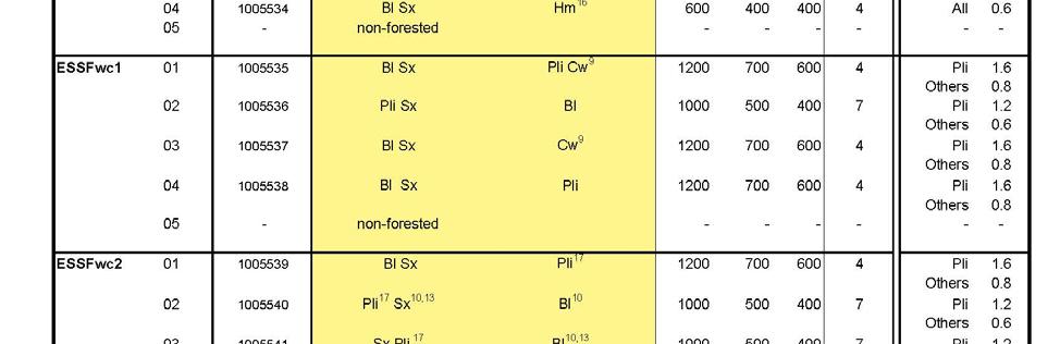
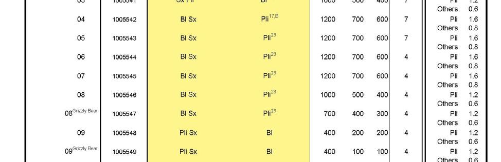
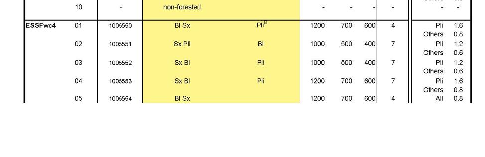
104 97

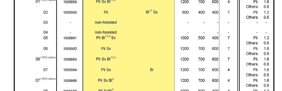
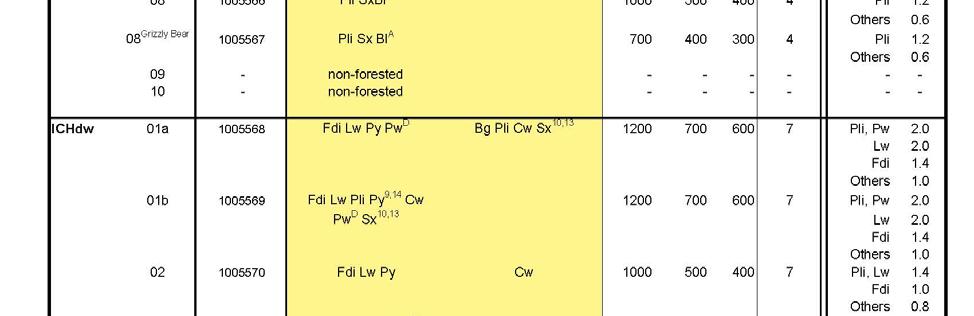
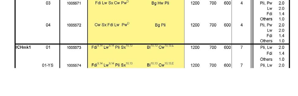
105 98
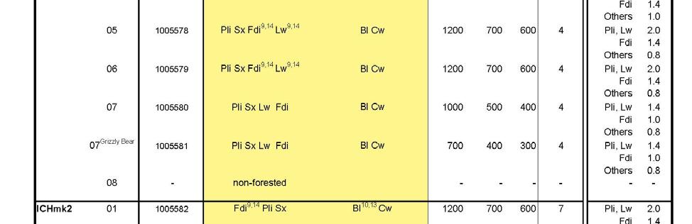

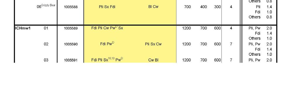
106 99
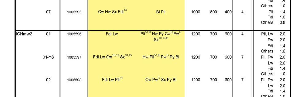
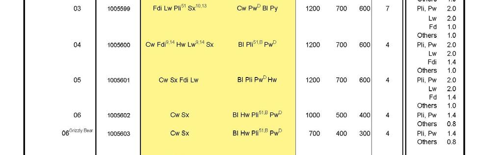
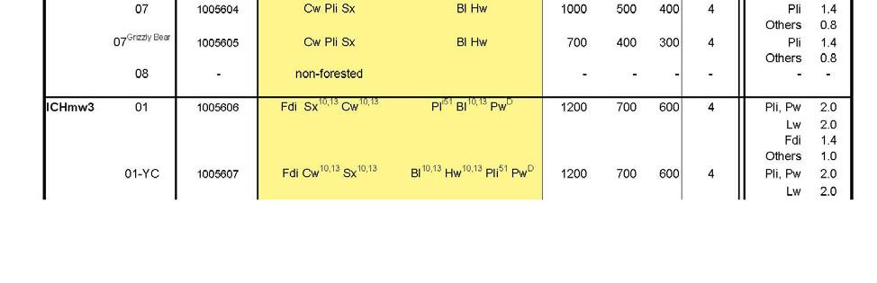
107 100
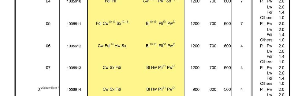
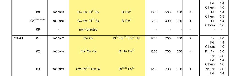

108 101

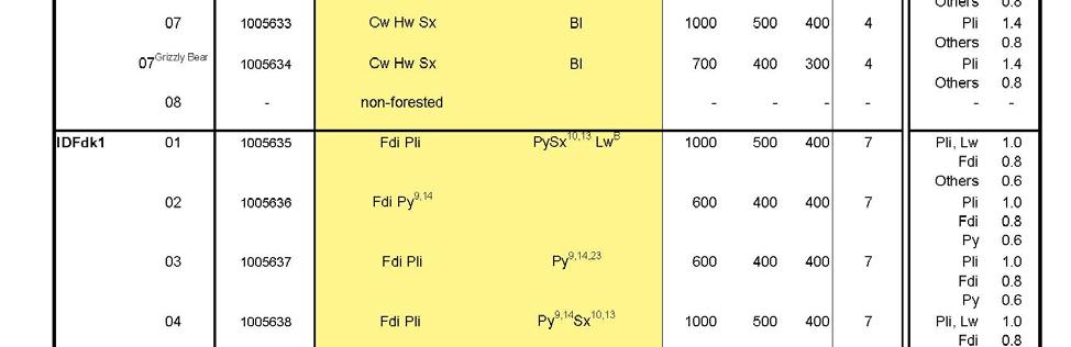
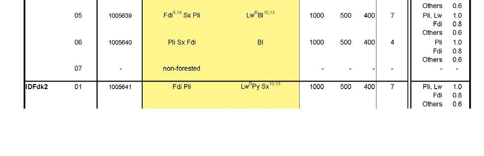
109 102

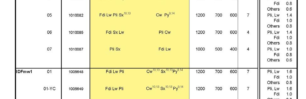
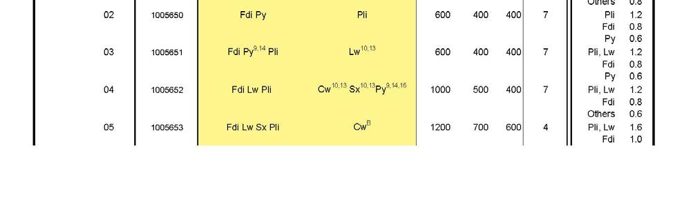
110 103
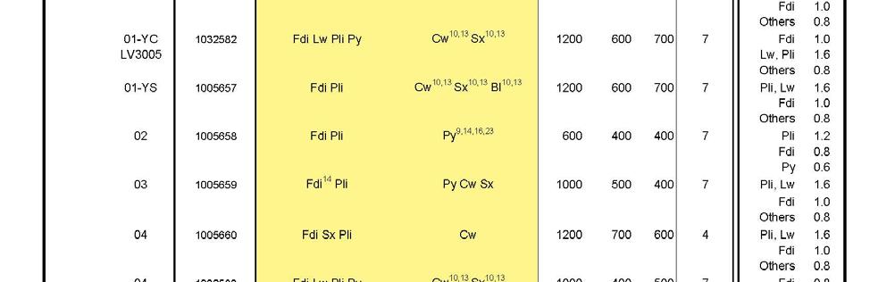
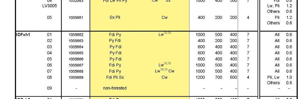
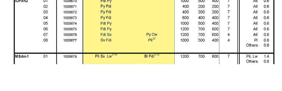
111 104

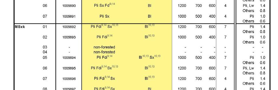
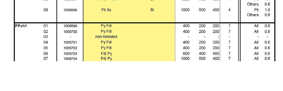
112 105
113 106

114 FDU #3 Okanagan, FDU #4 TFL 49, FDU #5 Arrow Uneven aged Stands 107


115 FDU #3 Okanagan, FDU #4 TFL 49, FDU #5 Arrow Stocking Standard Footnotes 108
116 Appendix B Objectives for Interpretive Forest Sites, s or Recreation Trails continued under FPPR section 181. FDU #1- Kamloops s and Trails or Trail continued Under FRPA section 180 Allan Creek Recreation Trail Boundary Lake Chappel Recreation Trail Clemina Creek Recreation Trail Coldscaur Lake North Recreation Site Coldscaur Lake South Recreation Site Dennis Lake Double Lakes East Maury Lake Ejas Lake Project No / or Trail Objectives continued under FRPA section /03/24 Recreation Experience Objectives: To provide opportunities for semi-primitive motorized and modified roaded recreation experiences. Recreation Feature Objectives: To protect the alpine/high sub-alpine and small lake features. Recreation Activity Objectives: To provide opportunities for snowmobiling activities during winter season and hiking, scenic viewing and hunting (during the regulated season) during the remainder of the year. Public Recreation Objectives: Winter snowmobile trail head access is via a maintained public highway /03/24 Recreation Experience Objectives: To provide opportunities for modified roaded recreation experiences. Recreation Feature Objectives: To protect the small lake, fish and developed campsite features. Recreation Activity Objectives: To provide opportunities for summer camping, sport fishing, canoeing and boating activities. Public Recreation Objective: To maintain summer, 2 wheel drive, forest road access to the site /03/24 Recreation Experience Objectives: To provide opportunities for semi-primitive motorized and modified roaded recreation experiences. Recreation feature objective: To protect the small / mid lake and fisheries experience. Recreation activity objective: To provide opportunities for snowmobiling activities during winter season and hiking, scenic viewing and hunting. Public recreation objective: To maintain summer access to trailhead and winter access via maintained public highway /03/10 Recreation Experience Objectives: To provide opportunities for semi-primitive motorized and modified roaded recreation experiences. Recreation Feature Objectives: To protect the alpine/high sub-alpine, wetland vegetation and small lake features. Recreation Activity Objectives: To provide opportunities for snowmobiling activities during the winter season and hiking, scenic viewing and hunting (during the regulated season) during the remainder of the year. Public Recreation Access Objectives: Winter snowmobile trail head access is via a maintained public highway. Summer access is provided by Forest Service road (suitable for 4 wheel drive vehicles) to various points along the trail system beginning at approximately 3 km from the highway /03/24 Recreation Experience Objectives: To provide opportunities for modified roaded recreation experiences. Recreation Feature Objectives: To protect the mid-sized lake, fish and developed campsite features. Recreation Activity Objectives: To provide opportunities for summer camping, sport fishing and boating activities. Public Recreation Objectives: To maintain summer, 2 wheel drive, Forest Service road access to the site /03/24 Recreation Experience Objectives: To provide opportunities for modified roaded recreation experiences. Recreation Feature Objectives: To protect the mid-sized lake, rock arch, fish and developed campsite features. Recreation Activity Objectives: To provide opportunities for summer camping, sport fishing, canoeing, boating, scenic viewing and nature study/appreciation activities. Public Recreation Objectives: To maintain summer, 2 wheel drive, Forest Service road access to the site /03/24 Recreation Experience Objectives: To provide opportunities for modified roaded recreation experiences. Recreation Feature Objectives: To protect the small lake, fish and developed campsite features. Recreation Activity Objectives: To provide opportunities for sport fishing, boating, canoeing, summer camping and scenic viewing activities. Public Recreation Objectives: To maintain summer, 2 wheel drive, Forest Service road access to the site /03/24 Recreation Experience Objectives: To provide opportunities for modified roaded recreation experiences. Recreation Feature Objectives: To protect the mid-sized lakes, fish and developed campsite features. Recreation Activity Objectives: To provide opportunities for summer camping, sport fishing, canoeing and boating activities. Public Recreation Access Objectives: To maintain summer, 2 wheel drive, Forest Service road access to the site /03/24 Recreation Experience Objectives: To provide opportunities for modified roaded recreation experiences. Recreation Feature Objectives: To protect the mid-sized lake, fish and developed campsite features. Recreation Activity Objectives: To provide opportunities for summer camping, sport fishing, canoeing and boating activities. Public Recreation Objectives: To maintain summer, 2 wheel drive, forest road access to the site /03/24 Recreation Experience Objectives: To provide opportunities for modified roaded recreation experiences. Recreation Feature Objectives: To protect the mid-sized lake, fish and developed campsite features. Recreation Activity Objectives: To provide opportunities for summer camping, sport fishing, canoeing and boating activities. Public Recreation Objectives: To maintain summer, 2 wheel drive, forest road access to the site. 109
117 or Trail continued Under FRPA section 180 Fowler Lake Gannet Lake Gordon Bay Graffunder Lakes North Recreation Site Grizzle Lake East Honeymoon Bay Italia Lake Kitty Anne Lake Lawrence Lake East Lawrence Lake West Lolo Lake Project No / or Trail Objectives continued under FRPA section /03/10 Recreation experience objectives: To provide opportunities for natural roaded recreation experiences. Recreation feature objectives: To protect the small lake, fish and regenerating stand features. Recreation activity objectives: To provide opportunities for sport fishing, and canoeing and potential for future summer camping activities. Public recreation access objectives: To maintain summer, 2 wheel drive, forest road access to the vicinity of the site while managing the lake as a walk-in access /03/24 Recreation Experience Objectives: To provide opportunities for modified roaded recreation experiences. Recreation Feature Objectives: To protect the small lake, fish and developed campsite features. Recreation Activity Objectives: To provide opportunities for summer camping, fishing, canoeing and boating activities. Public Recreation Objective: To maintain summer, 2 wheel drive, Forest Service Road and spur road access to the site /03/24 Recreation Experience Objectives: To provide opportunities for modified roaded recreation experiences. Recreation Feature Objectives: To protect the large lake, fine textured beach, fish and developed campsite features. Recreation Activity Objectives: To provide opportunities for summer camping, beach activities, swimming/bathing, sport fishing, canoeing and boating activities. Public Recreation Objectives: To maintain summer, 2 wheel drive, Forest Service Road access to the site /03/24 Recreation Experience Objectives: To provide opportunities for modified roaded recreation experiences. Recreation Feature Objectives: To protect the small lake, fish and developed campsite features. Recreation Activity Objectives: To provide opportunities for summer camping, sport fishing, canoeing and boating activities. Public Recreation Access Objective: To maintain summer, 2 wheel drive, Forest Service Road and spur road access to the site /03/24 Recreation Experience Objectives: To provide opportunities for modified roaded recreation experiences. Recreation Feature Objectives: To protect the small lake, fish, developed and cabin features. Recreation Activity Objectives: To provide opportunities for summer camping, sport fishing, canoeing, and boating activities. Public Recreation Objectives: To maintain summer, 2 wheel drive, Forest Service road access to the site /03/24 Recreation Experience Objectives: To provide opportunities for modified roaded recreation experiences. Recreation Feature Objectives: To protect the large lake, fine textures beach, fish and developed campsite features. Recreation Activity Objectives: To provide opportunities for summer camping, beach activities, swimming/bathing, sport fishing and boating activities. Public Recreation Objectives: To maintain summer, 2 wheel drive, Forest Service Road and 4 wheel drive spur road access to the site /03/24 Recreation Experience Objectives: To provide opportunities for modified roaded recreation experiences. Recreation Feature Objectives: To protect the mid-sized lake, fish and developed campsite. Recreation Activity Objectives: To provide opportunities for summer camping, sport fishing, canoeing and boating activities. Public Recreation Objectives: To maintain summer, 2 wheel drive, Forest Service road access to the site /03/24 Recreation Experience Objectives: To provide opportunities for modified roaded recreation experiences. Recreation Feature Objectives: To protect the small lake, fish and developed campsite features. Recreation Activity Objectives: To provide opportunities for summer camping, sport fishing canoeing, boating and scenic viewing activities. Public Recreation Objective: To maintain summer, 2 wheel drive, forest road access to the site /03/24 Recreation Experience Objectives: To provide opportunities for modified roaded recreation experiences. Recreation Feature Objectives: To protect the small lake, fish and developed campsite. Recreation Activity Objectives: To provide opportunities for summer camping, sport fishing, boating and canoeing, activities. Public Recreation Objectives: To maintain summer, 2 wheel drive, Forest Service road access to the site /03/24 Recreation Experience Objectives: To provide opportunities for modified roaded recreation experiences. Recreation Feature Objectives: To protect the small lake, fish and developed campsite features. Recreation Activity Objectives: To provide opportunities for summer camping, sport fishing, canoeing and boating activities. Public Recreation Objectives: To maintain summer, 2 wheel drive, Forest Service road access to the site /03/24 Recreation Experience Objective: To provide opportunities for modified roaded recreation experiences. Recreation Feature Objective: To protect the small lake, fish and developed campsite features. Recreation Activity Objective: To provide opportunities for summer camping, sport fishing, canoeing, boating and scenic viewing activities. Public Recreation Objective: To maintain summer, 2 wheel drive, forest road access to the site. 110
118 or Trail continued Under FRPA section 180 McCorvie Lake North Recreation Site Messiter Lake Moira Lake North Moira Lake South Moose Lake Mud Lake Recreation Trail Mystery Lake North Thompson Crossing Recreation Site Raft Mountain Recreation Trail Reflector Lake North Rocky Point Project No / or Trail Objectives continued under FRPA section /03/24 Recreation Experience Objectives: To provide opportunities for modified roaded recreation experiences. Recreation Feature Objectives: To protect the small lake and fish features. Recreation Activity Objectives: To provide opportunities for sport fishing, canoeing and potential or future summer camping activities. Public Recreation Objective: To maintain summer, 2 wheel drive, forest road access to the site /03/24 Recreation Experience Objectives: To provide opportunities for modified roaded recreation experiences. Recreation Feature Objectives: To protect the small lake and fish features. Recreation Activity Objectives: To provide opportunities for sport fishing and canoeing with potential for future summer camping activities. Public Recreation Objectives: To maintain summer, 2 wheel drive, forest road access to the site /03/24 Recreation experience objectives: To provide opportunities for modified roaded recreation experiences. Recreation Feature Objectives: To protect the mid-sized lake, fish and regenerating stand features. Recreation Activity Objectives: To provide opportunities for sport fishing, boating, canoeing and potential for future summer camping activities. Public Recreation Objectives: To maintain summer, 2 wheel drive, forest road access to the site /03/24 Recreation Experience Objectives: To provide opportunities for modified roaded recreation experiences. Recreation Feature Objectives: To protect the mid-sized lake, fish and developed campsite features. Recreation Activity Objectives: To provide opportunities for summer camping, sport fishing, canoeing and boating activities. Public Recreation Objectives: To maintain summer, 2 wheel drive, forest road access to the site /03/24 Recreation Experience Objectives: To provide opportunities for modified roaded recreation experiences. Recreation Feature Objectives: To protect the small lake, fish and developed campsite features. Recreation Activity Objectives: To provide opportunities for summer camping, sport fishing and canoeing activities. Public Recreation Objectives: To maintain summer, 2 wheel drive, forest road access to the site /03/24 Recreation Experience Objectives: To provide opportunities for modified roaded recreation experiences. Recreation Feature Objectives: To protect the large lake, fish and developed campsite and land trail features. Recreation Activity Objectives: To provide opportunities for summer camping, hiking, sport fishing, canoeing and boating. Public Recreation Objectives: To maintain summer, 2 wheel drive, Forest Service Road and 4 wheel drive spur road access to the site /03/10 Recreation experience objectives: To provide opportunities for modified roaded recreation experiences. Recreation feature objectives: To protect the small lake, fish and developed campsite features. Recreation activity objectives: To provide opportunities for summer camping, sport fishing and canoeing. Public recreation objectives: To maintain summer, 2 wheel drive, Forest Service Road and 2 wheel drive spur road access to the site /03/10 Recreation experience objectives: To provide opportunities for modified roaded recreation experiences. Recreation feature objectives: To protect the large river and fish features. Recreation activity objectives: To provide opportunities for sport fishing, and canoeing and potential for future summer camping activities. Public recreation access objectives: To maintain summer, 2 wheel drive, Forest Service road access to the site /03/24 Recreation Experience Objectives: To provide opportunities for semi-primitive, natural roaded and modified roaded recreation experiences. Recreation Feature Objectives: To protect the alpine/high sub-alpine and small lake features. Recreation Activity Objectives: To provide opportunities for primarily snowmobiling as well as snow sport activities during winter season and hiking, scenic viewing and hunting (during the regulated season) during the remainder of the year. Public Recreation Objectives: Winter snowmobile trail head access is via a maintained public road. Summer access is provided by maintained Forest Service road (suitable for 2 wheel drive vehicles) to Moilliett Creek in the Raft River and to Caligata Lake at the headwaters of Spahats Creek. Rough Forest Service road (suitable for 4 wheel drive vehicles) provides summer access to the upper elevation areas in the vicinity of Willis Lake /03/24 Recreation Experience Objectives: To provide opportunities for modified roaded recreation experiences. Recreation Feature Objectives: To protect the small lake and fish features. Recreation Activity Objectives: To provide opportunities for sport fishing, canoeing and potential for future summer activities. Public Recreation Objectives: To maintain summer, 2 wheel drive, Forest Service road access to the vicinity of the site /03/24 Recreation Experience Objectives: To provide opportunities for modified roaded recreation experiences. Recreation Feature Objectives: To protect the large lake, fish and developed campsite features. Recreation Activity Objectives: To provide opportunities for summer camping, swimming/bathing, sport fishing, canoeing and boating activities. Public Recreation Objectives: To maintain summer, 2 wheel drive, Forest Service Road and spur road access to the site. 111
119 or Trail continued Under FRPA section 180 Rock Island Sicily Lake South Silence Lake Silvertip Falls Stukemapten Lake Tsikwustum Creek North Recreation Site Tsikwustum Creek South Recreation Site White Lake Windy Lake Project No / or Trail Objectives continued under FRPA section /03/24 Recreation Experience Objectives: To provide opportunities for modified roaded recreation experiences. Recreation Feature Objective: To protect the large lake, islets, fine textured beach and fish features. Recreation Activity Objectives: To provide opportunities for swimming/bathing, beach activities, nature study/appreciation, sport fishing, boating, canoeing activities with potential for future summer camping activities. Public Recreation Objectives: To maintain summer, 2 wheel drive, forest road access to the site /03/24 Recreation Experience Objective: To provide opportunities for modified roaded recreation experiences. Recreation Feature Objectives: To protect the small lake, fish and developed campsite. Recreation Activity Objectives: To provide opportunities for summer camping, sport fishing, boating and canoeing activities. Public Recreation Objectives: To maintain summer, 2 wheel drive, Forest Service road access to the site /03/24 Recreation Experience Objectives: To provide opportunities for natural roaded recreation experiences. Recreation Feature Objectives: To protect the mid-sized lake, fish and developed campsite features. Recreation Activity Objective: To provide opportunities for summer camping, sport fishing and boating activities. Public Recreation Access Objective: To maintain summer, 2 wheel drive, Forest Service Road and spur road access to the site /03/10 Recreation experience objectives: To provide opportunities for modified roaded recreation experiences. Recreation feature objectives: To protect the site specific waterfall, creek, developed trail and campsite features. Recreation activity objectives: To provide opportunities for summer camping, hiking and scenic viewing activities. Public recreation objectives: To maintain summer, 2WD Forest Service Road to the site /03/24 Recreation Experience Objectives: To provide opportunities for modified roaded recreation experiences. Recreation Feature Objectives: To protect the small lake, fish and developed campsite features. Recreation Activity Objectives: To provide opportunities for summer camping, sport fishing, boating and canoeing activities. Public Recreation Objectives: To maintain summer, 2 wheel drive, Forest Service Road to the site /03/24 Recreation Experience Objectives: To provide opportunities for modified roaded recreation experiences. Recreation Feature Objectives: To protect the large lake, fine textured beach, fish, creek and developed campsite features. Recreation Activity Objectives: To provide opportunities for summer camping, beach activities, swimming/bathing, sport fishing, canoeing and boating. Public Recreation Objectives: To maintain summer, 2 wheel drive, Forest Service Road access to the site /03/24 Recreation Experience Objectives: To provide opportunities for modified roaded recreation experiences. Recreation Feature Objectives: To protect the large lake, fine textured beach, fish and developed campsite features. Recreation Activity Objectives: To provide opportunities for summer camping, beach activities, swimming/bathing, sport fishing, canoeing and boating. Public Recreation Objectives: To maintain summer, 2 wheel drive, Forest Service road and spur road access to the site /03/24 Recreation Experience Objectives: To provide opportunities for modified roaded recreation experiences. Recreation Feature Objectives: To protect the small lake, fish and developed campsite features. Recreation Activity Objectives: To provide opportunities for summer camping, sport fishing and canoeing activities. Public Recreation Objectives: To maintain summer, 2 wheel drive, forest road access to the site /03/24 Recreation Experience Objectives: To provide opportunities for modified roaded recreation experiences. Recreation Feature Objectives: To protect the small lake, fish and developed trail and campsite features. Recreation Activity Objectives: To provide opportunities for summer camping, sport fishing, boating and canoeing activities. Public Recreation Objectives: To maintain summer, 2 wheel drive, forest road access to the site. or Trail continued Under FRPA section 180 Abbott Lake FDU #2- Merritt s and Trails Project No / or Trail Objectives continued under FRPA section /01/31 The objective is to manage the Abbott Lake recreation site for a roaded recreation experience. The campsite will be maintained and the lake shoreline and natural vegetation will be conserved. Opportunities for camping, picnicking, boating and swimming will be available at the site. Very rough road access to the site will be maintained for four-wheel drive vehicles. 112
120 or Trail continued Under FRPA section 180 Andy's Lake Another Lake Antler Lake Billy Lake Bluey Lake Bob Lake E. Bob Lake W. Bobs Lake Boot Lake Boss Lake Brook Lake Buck Lake Butler Lake Cabin Lake Project No / or Trail Objectives continued under FRPA section The objective is to manage the Andy's Lake recreation site for a roaded recreation experience. The campsite will be maintained and the lake shoreline and natural vegetation will be conserved. Opportunities for camping, picnicking, boating and swimming will be available at the site. Access to lake from recreation site is by non-motorized trail. It is also a part of the Thynne Mtn. snowmobile trail system. An emergency shelter is located across from the recreation site The objective is to manage Another Lake for a semi primitive non-motorized recreation experience. The lake shoreline and natural vegetation will be conserved. Opportunities for camping (no facilities on site), picnicking, boating and swimming will be available. Access is by non-motorized trail The objective is to manage the Antler Lake recreation site for a roaded and semi primitive non-motorized recreation experience. The trailhead, trail and the campsite will be maintained; the lake shoreline and natural vegetation will be conserved. Opportunities for camping, hiking, picnicking, boating and swimming will be available at the site. Camping facilities are available at the trailhead/parking area. Access to the lake is by non-motorized trail The objective is to manage the Billy Lake recreation site for a roaded recreation experience. The campsite will be maintained; the lake shoreline and natural vegetation will be conserved. Opportunities for camping, picnicking, boating and swimming will be available at the site The objective is to manage the Bluey Lake recreation site for a roaded recreation experience. The campsite will be maintained; the lake shoreline and natural vegetation will be conserved. Opportunities for camping, picnicking, boating and swimming will be available at the site. Very rough road access to the site will be maintained for four-wheel drive vehicles The objective is to manage Bob Lake E. for a roaded recreation experience. The lake shoreline and natural vegetation will be conserved. Opportunities for camping (no facilities on site), picnicking, boating and swimming will be available. Very rough road access to the lake; also walk in access from Bob Lake West The objective is to manage the Bob Lake W. recreation site for a roaded recreation experience. The campsite will be maintained; the lake shoreline and natural vegetation will be conserved. Opportunities for camping, picnicking, boating and swimming will be available at the site. Very rough road access to the site will be maintained for fourwheel drive vehicles The objective is to manage the Bobs Lake recreation site for a roaded experience. The campsite will be maintained; the lake shoreline and natural vegetation will be conserved. Opportunities for camping, picnicking, boating and swimming will be available at the site The objective is to manage the Boot Lake recreation site for a roaded recreation experience. The campsite will be maintained; the lake shoreline and natural vegetation will be conserved. Opportunities for camping, picnicking, boating and swimming will be available at the site. Very rough road access to the site will be maintained for four-wheel drive vehicles The objective is to manage the Boss Lake recreation site for a roaded recreation experience. The campsite will be maintained; the lake shoreline and natural vegetation will be conserved. Opportunities for camping, picnicking, boating and swimming will be available at the site. ATV opportunities are available nearby The objective is to manage Brook Lake for a semi primitive non-motorized recreation experience. The trailhead, trail and lake shoreline and natural vegetation will be conserved. Opportunities for camping (no facilities on site), picnicking, boating and swimming will be available at the site. Lake is located within a community watershed. Access is by non-motorized trail. Snowmobile activities are available in the winter The objective is to manage the Buck Lake recreation site for a roaded recreation experience. The campsite will be maintained; the lake shoreline and natural vegetation will be conserved. Opportunities for camping, picnicking, boating and swimming will be available at the site The objective is to manage Butler Lake for a semi primitive non-motorized recreation experience. The trailhead, trail, lake shoreline and natural vegetation will be conserved. Opportunities for camping (no facilities on site), picnicking, boating and swimming will be available. Access is by a non-motorized trail The objective is to manage the Cabin Lake recreation site for a roaded recreation experience. The campsite will be maintained; the lake shoreline and natural vegetation will be conserved. Opportunities for camping, picnicking, hiking, mountain biking and 113
121 or Trail continued Under FRPA section 180 Project No / or Trail Objectives continued under FRPA section 181 swimming will be available at the site. Very rough road access to the site will be maintained for four-wheel drive vehicles. Calling Lake Chain Lake W. Centre Lake Clifford Lake Copper Creek Davis Lake Deadman Lake S. Debbie Lake Dewdney Dot Lake Eastmere / Westmere Lake Elkhart Lake Farr Lake Garrison Lake The objective is to manage the Calling Lake recreation site for a roaded recreation experience. The campsite will be maintained; the lake shoreline and natural vegetation will be conserved. Opportunities for camping, picnicking, hiking, mountain biking and swimming will be available at the site. Very rough road access to the site will be maintained for four-wheel drive vehicles The objective is to manage the Chain Lake W. recreation site for a roaded recreation experience. The campsite will be maintained; the lake shoreline and natural vegetation will be conserved. Opportunities for camping, picnicking, boating and swimming will be available at the site The objective is to manage Centre Lake for a roaded recreation experience. The lake shoreline and natural vegetation will be conserved. Opportunities for hiking, nature observation and picnicking will be available The objective is to manage the Clifford Lake recreation site for a roaded recreation experience. The campsite will be maintained; the lake shoreline and natural vegetation will be conserved. Opportunities for camping, picnicking, boating and swimming will be available at the site The objective is to manage the Copper Creek recreation site for a roaded recreation experience. The campsite will be maintained; the river/creek shoreline and natural vegetation will be conserved. Opportunities for camping, picnicking and swimming will be available at the site. During the winter, the recreation site may serve as a trailhead for the Placer Mountain snowmobile trail The objective is to manage the Davis Lake recreation site for a roaded recreation experience. The campsite will be maintained; the lake shoreline and natural vegetation will be conserved. Opportunities for camping, picnicking, boating and swimming will be available at the site. Located within a Ducks Unlimited project area. ATV opportunities are available nearby The objective is to manage Deadman Lake S. recreation site for a roaded recreation experience. The campsite will be maintained; the lake shoreline and natural vegetation will be conserved. Opportunities for camping, picnicking, boating and swimming will be available at the site The objective is to manage Debbie Lake for a roaded recreation experience. The lake shoreline and natural vegetation will be conserved. Opportunities for camping (no facilities on site), picnicking, boating and swimming will be available. Access is by a rough four-wheel drive road The objective is to manage the Dewdney recreation site for a roaded recreation experience. The campsite will be maintained; the river shoreline and natural vegetation will be conserved. Opportunities for camping, river canoeing, kayaking, picnicking and swimming will be available at the site. Hiking opportunities are available nearby on a portion of the historic Dewdney Trail The objective is to manage the Dot Lake recreation site for a roaded recreation experience. The campsite will be maintained; the lake shoreline and natural vegetation will be conserved. Opportunities for camping, picnicking, hiking, boating and swimming will be available at the site The objective is to manage the Eastmere / Westmere Lake recreation site for a semi primitive non-motorized recreation experience. The lake shoreline and natural vegetation will be conserved. Opportunities for camping (no facilities on site), picnicking, boating and swimming will be available at the site. Access is by non-motorized trail The objective is to manage the Elkhart Lake recreation site for a roaded recreation experience. The campsite will be maintained; the lake shoreline and natural vegetation will be conserved. Opportunities for camping, picnicking, boating and swimming will be available at the site The objective is to manage Farr Lake for a roaded recreation experience. The lake shoreline and natural vegetation will be conserved. Opportunities for camping (no facilities on site), picnicking, boating and swimming will be available at the site The objective is to manage the Garrison Lake recreation site for a semi primitive non-motorized recreation experience. The campsite will be maintained; the lake shoreline and natural vegetation will be conserved. Opportunities for hiking, camping, picnicking and swimming will be available at the site. Access is by non-motorized trail. 114
122 or Trail continued Under FRPA section 180 Gill Lake Recreation Site Gillis Lake E. Gillis Lake W. Glimpse Lake N. Project No / or Trail Objectives continued under FRPA section The objective is to manage Gill Lake recreation site for a roaded recreation experience. The lake shoreline and natural vegetation will be conserved. Opportunities for camping (no facilities on site), picnicking, boating and swimming will be available. Access is by non-motorized trail from utility corridor The objective is to manage Gillis Lake E. for a roaded recreation experience. The lake shoreline and natural vegetation will be conserved. Opportunities for camping (no facilities on site), picnicking, boating and swimming will be available at the site The objective is to manage the Gillis Lake W. recreation site for a roaded recreation experience. The campsite will be maintained; the lake shoreline and natural vegetation will be conserved. Opportunities for camping, picnicking, boating and swimming will be available at the site The objective is to manage the Glimpse Lake N. recreation site for a roaded recreation experience. The campsite will be maintained; the lake shoreline and natural vegetation will be conserved. Opportunities for camping, picnicking, boating and swimming will be available at the site. Glimpse Lake SW The objective is to manage the Glimpse Lake SW recreation site for a roaded recreation experience. The campsite will be maintained; the lake shoreline and natural vegetation will be conserved. Opportunities for camping, picnicking, boating and swimming will be available at the site. Goose Lake N. Goose Lake S. Gordon Lake Granite Creek Gus Pond Gwen Lake Gypsum Lake S. Gypsum Lake W. Hamilton Pond Harmon Lake East The objective is to manage the Goose Lake N. recreation site for a roaded recreation experience. The campsite will be maintained; the lake shoreline and natural vegetation will be conserved. Opportunities for camping, picnicking, boating and swimming will be available at the site. Very rough road access to the site will be maintained for fourwheel drive vehicles The objective is to manage the Goose Lake S. recreation site for a roaded recreation experience. The campsite will be maintained; the lake shoreline and natural vegetation will be conserved. Opportunities for camping, picnicking, boating and swimming will be available at the site The objective is to manage the Gordon Lake recreations site for a roaded recreation experience. The campsite will be maintained; the lake shoreline and natural vegetation will be conserved. Opportunities for camping, picnicking, boating and swimming will be available at the site. Very rough road access to the site will be maintained for fourwheel drive vehicles The objective is to manage the Granite Creek recreation site for a roaded recreation experience. The campsite will be maintained; the river/creek shoreline and natural vegetation will be conserved. Opportunities for camping, picnicking, canoeing, kayaking and swimming will be available at the site The objective is to manage Gus' pond recreation site for a semi primitive nonmotorized recreation experience. The lakeshore and adjacent vegetation will be conserved. Opportunities for camping (no facilities on site), picnicking, boating and swimming will be available; no motorized use permitted as per the Pennask LRUP The objective is to manage Gwen Lake recreation site for a roaded recreation experience. The campsite will be maintained; the lake shoreline and natural vegetation will be conserved. Opportunities for camping, picnicking, boating and swimming will be available at the site. Very rough road access to the site will be maintained for four-wheel drive vehicles The objective is to manage Gypsum Lake S. for a roaded recreation experience. The lake shoreline and natural vegetation will be conserved. Opportunities for camping (no facilities on site), picnicking, boating and swimming will be available at the site The objective is to manage the Gypsum Lake W. recreation site for a roaded recreation experience. The campsite will be maintained; the lake shoreline and natural vegetation will be conserved. Opportunities for camping, hiking, picnicking, boating and swimming will be available at the site The objective is to manage Hamilton Lake for a roaded recreation experience. The lake shoreline and natural vegetation will be conserved. Opportunities for camping (no facilities on site), picnicking, boating and swimming will be available. Access is by a rough four-wheel drive road The objective is to manage the Harmon Lake E. recreation site for a roaded recreation experience. The campsite will be maintained; the lake shoreline and natural vegetation will be conserved. Opportunities for camping, picnicking, hiking, boating and swimming will be available at the site. 115
123 or Trail continued Under FRPA section 180 Harmon Lake West Helmer Lake Hook Lake N. Island Lake Jacobson Lake Jackson Lake Jameson Lake Jim Kelly Creek Johnny Lake John's Lake Jono Lake Kane Lake Kump Lake LeRoy Lake Lightning Lake Project No / or Trail Objectives continued under FRPA section The objective is to manage the Harmon Lake W. recreation site for a roaded recreation experience. The campsite will be maintained; the lake shoreline and natural vegetation will be conserved. Opportunities for camping, picnicking, boating and swimming will be available at the site. This site also contains some walk-in sites The objective is to manage the Helmer Lake recreation site for a roaded recreation experience. The campsite will be maintained; the lake shoreline and natural vegetation will be conserved. Opportunities for camping, picnicking, boating and swimming will be available at the site. Walk-in from nearby Helmer Interchange; gate locked Tuesday before May long weekend and open Friday before Thanksgiving weekend The objective is to manage the Hook Lake N. recreation site for a roaded recreation experience. The campsite will be maintained; the lake shoreline and natural vegetation will be conserved. Opportunities for camping, picnicking, boating and swimming will be available at the site. Very rough road access to the site, via the utility corridor The objective is to manage the Island Lake recreation site for a roaded recreation experience. The campsite will be maintained; the lake shoreline and natural vegetation will be conserved. Opportunities for camping, picnicking, boating and swimming will be available at the site The objective is to manage the Jacobson Lake recreation site for a roaded recreation experience. The campsite will be maintained; the lake shoreline and natural vegetation will be conserved. Opportunities for camping, picnicking, hiking, boating, equestrian and swimming will be available at the site The objective is to manage the Jackson Lake recreation for a semi primitive motorized recreation experience. The lakeshore and adjacent vegetation will be conserved. Opportunities for camping (no facilities on site), picnicking, boating and swimming will be available; no motorized use permitted as per the Pennask LRUP The objective is to manage Jameson Lake for a roaded recreation experience. The lake shoreline and natural vegetation will be conserved. Opportunities for camping (no facilities on site), picnicking, boating and swimming will be available. Access is by rough four-wheel drive road The objective is to manage Jim Kelly Creek for a roaded recreation experience. The river shoreline and natural vegetation will be conserved. Opportunities for camping (no facilities on site), picnicking and swimming will be available The objective is to manage the Johnny's Lake recreation site for a roaded recreation experience. The campsite will be maintained; the lake shoreline and natural vegetation will be conserved. Opportunities for camping, picnicking, boating and swimming will be available at the site The objective is to manage John's Lake for a semi primitive non-motorized recreation experience. The lake shoreline and natural vegetation will be conserved. Opportunities for camping (no facilities on site), picnicking, boating and swimming will be available. Access is by non-motorized trail The objective is to manage Jono Lake for a roaded recreation experience. The lake shoreline and natural vegetation will be conserved. Opportunities for camping (no facilities on site), picnicking, boating and swimming will be available. Access is by rough four-wheel drive road The objective is to manage the Kane Lake recreation site for a roaded recreation experience. The campsite will be maintained; the lake shoreline and natural vegetation will be conserved. Opportunities for camping, equestrian, hiking, picnicking, boating and swimming will be available at the site. In the winter, there are opportunities for crosscountry skiing The objective is to manage the Kump Lake recreation site for a roaded recreation experience. The campsite will be maintained; the lake shoreline and natural vegetation will be conserved. Opportunities for camping, picnicking, boating and swimming will be available at the site The objective is to manage the LeRoy Lake recreation site and trail for a roaded and semi primitive non-motorized recreation experience. The trailhead, trail and campsite will be maintained; the lake shoreline and natural vegetation will be conserved. Opportunities for hiking, mountain biking, equestrian use, camping, picnicking, boating and swimming will be available at the site. Roaded to trailhead, then walk-in to the site The objective is to manage the Lightning Lake recreation site for a roaded recreation experience. The campsite will be maintained; the lake shoreline and natural vegetation will be conserved. Opportunities for camping, picnicking, boating and swimming will be available at the site. Very rough road access to the site will be maintained for fourwheel drive vehicles. 116
124 or Trail continued Under FRPA section 180 Lily Lake Link Lake Little Box Canyon Little Douglas Lake Little Mellin / Holmes Recreation Site Little Spahomin Lake Recreation Site Lodestone Lake Lodwick Lake N. Lodwick Lake S. Loosemore Lake Lundbom Lake E. Lundbom Lake W. Mab Lake Marquart Lake Mellin Lake Project No / or Trail Objectives continued under FRPA section The objective is to manage the Lily Lake recreation site for a roaded recreation experience. The campsite will be maintained; the lake shoreline and natural vegetation will be conserved. Opportunities for camping, picnicking, boating and swimming will be available at the site The objective is to manage the Link Lake recreation site for a roaded recreation experience. The campsite will be maintained; the lake shoreline and natural vegetation will be conserved. Opportunities for camping, picnicking, boating and swimming will be available at the site The objective is to manage the Little Box Canyon recreation site for a roaded recreation experience. The campsite will be maintained; the river/creek shoreline and natural vegetation will be conserved. Opportunities for camping (no facilities on site), picnicking, river boating and swimming will be available at the site. Very rough road access to the site The objective is to manage the Little Douglas Lake recreation site for a semi primitive non-motorized recreation experience. The campsite will be maintained; the lake shoreline and natural vegetation will be conserved. Opportunities for camping (no facilities on site), picnicking, boating and swimming will be available at the site. Access is by nonmotorized trail The objective is to manage Little Mellin/Holmes recreation site for a semi primitive non-motorized recreation experience. The lakeshore and natural vegetation will be conserved. Opportunities for camping (no facilities on site), picnicking, boating and swimming will be available at the site. No motorized use permitted, as per the Pennask LRUP The objective is to manage Little Spahomin Lake Recreation site for a semi primitive non-motorized recreation experience. The trail will be maintained and natural vegetation will be conserved. Opportunities for camping (no facilities on site), picnicking, boating and swimming will be available at the site. No motorized use permitted, as per the Pennask LRUP The objective is to manage the Lodestone Lake recreation site for a roaded recreation experience. The lake shoreline and natural vegetation will be conserved. Opportunities for camping, picnicking, hiking, mountain biking, equestrian, boating and swimming will be available at the site. Access is by a rough four-wheel drive road The objective is to manage Lodwick Lake N. recreation site for a recreation experience. The campsite will be maintained; the lake shoreline and natural vegetation will be conserved. Opportunities for camping, picnicking, boating and swimming will be available at the site The objective is to manage Lodwick Lake S. recreation site for a roaded recreation experience. The campsite will be maintained; the lake shoreline and natural vegetation will be conserved. Opportunities for camping, picnicking, boating and swimming will be available at the site The objective is to manage the Loosemore Lake recreation site for a roaded recreation experience. The campsite will be maintained; the lake shoreline and natural vegetation will be conserved. Opportunities for camping, picnicking, boating and swimming will be available at the site The objective is to manage the Lundbom Lake E. recreation site for a roaded recreation experience. The campsite will be maintained; the lake shoreline and natural vegetation will be conserved. Opportunities for camping, picnicking, boating and swimming will be available at the site The objective is to manage the Lundbom Lake W. recreation site for a roaded recreation experience. The campsite will be maintained; the lake shoreline and natural vegetation will be conserved. Opportunities for camping, picnicking, boating, equestrian and swimming will be available at the site The objective is to manage Mab Lake for a roaded recreation experience. The lake shoreline and natural vegetation will be conserved. Opportunities for camping (no facilities on site), picnicking, boating and swimming will be available. Access is by a rough four-wheel drive road The objective is to manage the Marquart Lake recreation site for a roaded recreation experience. The campsite will be maintained; the lake shoreline and natural vegetation will be conserved. Opportunities for camping, picnicking, boating and swimming will be available at the site. Site on the west end is walk-in from the parking lot The objective is to manage the Mellin Lake recreation site for a semi primitive non-motorized recreation experience. The trail will be maintained. The lake shoreline and adjacent natural vegetation will be conserved. Opportunities for camping (no facilities on site), picnicking, boating and swimming will be available. No motorized use permitted, as per the Pennask LRUP. 117
125 or Trail continued Under FRPA section 180 Michael Lake Missezula Lake N. Murphy Lake Murray Lake N. Murray Lake S. Mystery Lake N'Kwala Recreation Site Old Hedley Road E. Old Hedley Road W. Osprey Lake N. Osprey Lake S. Peter Hope Lake N. Peterhope Lake S. Pimainus Lake Placer Lake Plateau Lake Project No / or Trail Objectives continued under FRPA section The objective is to manage Michael Lake for a roaded recreation experience. The lake shoreline and natural vegetation will be conserved. Opportunities for camping (no facilities on site), picnicking, boating and swimming will be available. Very rough access to the site will be maintained for four-wheel drive vehicles The objective is to manage the Missezula Lake N. recreation site for a roaded recreation experience. The campsite will be maintained; the lake shoreline and natural vegetation will be conserved. Opportunities for camping, picnicking, boating and swimming will be available at the site The objective is to manage the Murphy Lake recreation site for a roaded recreation experience. The campsite will be maintained; the lake shoreline and natural vegetation will be conserved. Opportunities for camping, picnicking, boating and swimming will be available at the site. Access to lake from the recreation site is by a non-motorized trail The objective is to manage the Murray Lake N. recreation site for a roaded recreation experience. The campsite will be maintained; the lake shoreline and natural vegetation will be conserved. Opportunities for camping, picnicking, boating and swimming will be available at the site The objective is to manage the Murray Lake S. recreation site for a roaded recreation experience. The campsite will be maintained; the lake shoreline and natural vegetation will be conserved. Opportunities for camping, picnicking, boating and swimming will be available at the site The objective is to manage Mystery Lake for a semi primitive motorized recreation experience. The lake shoreline and natural vegetation will be conserved. Opportunities for camping (no facilities on site), picnicking, boating and swimming will be available. Very rough road access to the site via the utility corridor The objective is to manage the N'Kwala recreation site for a roaded recreation experience. The campsite will be maintained; the river shoreline and natural vegetation will be conserved. Opportunities for camping, picnicking, river canoeing, kayaking and swimming will be available at the site The objective is to manage the Old Hedley Road E. recreation site for a roaded recreation experience. The campsite will be maintained; the river shoreline and natural vegetation will be conserved. Opportunities for camping, picnicking, river canoeing, kayaking and swimming will be available at the site The objective is to manage the Old Hedley Road W. recreation site for a roaded recreation experience. The campsite will be maintained; the river shoreline and natural vegetation will be conserved. Opportunities for camping, picnicking, river canoeing, kayaking and swimming will be available at the site The objective is to manage the Osprey Lake N. recreation site for a roaded recreation experience. The campsite will be maintained; the lake shoreline and natural vegetation will be conserved. Opportunities for camping, picnicking, boating and swimming will be available at the site The objective is to manage Osprey Lake South for a semi primitive motorized recreation experience. The lake shoreline and natural vegetation will be conserved. Opportunities for camping (no facilities on site), picnicking, boating and swimming will be available. Access is by motorized trail The objective is to manage the Peterhope Lake N. recreation site for a roaded recreation experience. The campsite will be maintained; the lake shoreline and natural vegetation will be conserved. Opportunities for camping, picnicking, boating and swimming will be available at the site The objective is to manage Peterhope Lake S. for a roaded recreation experience. The lake shoreline and natural vegetation will be conserved. Opportunities for camping (no facilities on site), picnicking, boating and swimming will be available The objective is to manage the Pimainus Lake recreation site for a roaded recreation experience. The campsite will be maintained; the lake shoreline and natural vegetation will be conserved. Opportunities for camping, picnicking, boating and swimming will be available at the site The objective is to manage the Placer Lake recreation site for a roaded recreation experience. The lake shoreline and natural vegetation will be conserved. Opportunities for camping (no facilities on site), picnicking, boating and swimming will be available at the site. Very rough road access to the site will be maintained for four-wheel drive vehicles The objective is to manage the Plateau Lake recreation site for a roaded recreation experience. The campsite will be maintained; the lake shoreline and natural vegetation will be conserved. Opportunities for camping, picnicking, boating and swimming 118
126 or Trail continued Under FRPA section 180 Project No / or Trail Objectives continued under FRPA section 181 will be available at the site. Very rough road access to the site will be maintained for fourwheel drive vehicles. Power Lake Prosser Lake Rampart Lake Red Rock Canyon Reservoir Lake Rey Lake Ricky Lake Robertson Lake Rogene Lake Roscoe Lake Shea Lake Silver Lake Stevens Lake Stoney Lake Stringer Lake The objective is to manage Power Lake for a roaded recreation experience. The lake shoreline and natural vegetation will be conserved. Opportunities for camping (no facilities on site), picnicking, boating and swimming will be available. Access is by rough four-wheel drive road via the utility corridor The objective is to manage the Prosser Lake recreation site for a roaded recreation experience. The campsite will be maintained; the lake shoreline and natural vegetation will be conserved. Opportunities for camping, picnicking, boating and swimming will be available at the site. Very rough access to the site will be maintained for four-wheel drive vehicles The objective is to manage the Rampart Lake recreation site for a roaded recreation experience. The campsite will be maintained; the lake shoreline and natural vegetation will be conserved. Opportunities for camping, picnicking, boating and swimming will be available at the site The objective is to manage the Red Rock Canyon for a roaded recreation experience. The river shoreline and natural vegetation will be conserved. Opportunities for camping (no facilities on site), kayaking, canoeing, picnicking and swimming will be available at the site The objective is to manage the Reservoir Lake recreation site for a roaded recreation experience. The campsite will be maintained; the lake shoreline and natural vegetation will be conserved. Opportunities for camping, picnicking, boating and swimming will be available at the site. Very rough road access to the site will be maintained for fourwheel drive vehicles The objective is to manage Rey Lake for a roaded recreation experience. The lake shoreline and natural vegetation will be conserved. Opportunities for camping (no facilities on site), picnicking, boating and swimming will be available. Access is by a very rough four-wheel drive road via the utility corridor The objective is to manage the Ricky Lake recreation site for a roaded recreation experience. The campsite will be maintained; the lake shoreline and natural vegetation will be conserved. Opportunities for camping, picnicking, boating and swimming will be available at the site The objective is to manage Robertson Lake for a roaded recreation experience. The lake shoreline and natural vegetation will be conserved. Opportunities for camping, picnicking, boating and swimming will be available at the site The objective is to manage Rogene Lake for a semi primitive non-motorized recreation experience. The lake shoreline and natural vegetation will be conserved. Opportunities for camping (no facilities on site), picnicking, boating and swimming will be available. Access is via Bob's-Elkhart Trail (project 5877); no motorized use permitted The objective is to manage the Roscoe Lake recreation site for a roaded recreation experience. The campsite will be maintained; the lake shoreline and natural vegetation will be conserved. Opportunities for camping, picnicking, boating, hiking and swimming will be available at the site. Rough seasonal four-wheel drive access The objective is to manage the Shea Lake recreation site for a roaded recreation experience. The campsite will be maintained; the lake shoreline and natural vegetation will be conserved. Opportunities for camping, picnicking, boating and swimming will be available at the site The objective is to manage the Silver Lake recreation site for a roaded recreation experience. The campsite will be maintained; the lake shoreline and natural vegetation will be conserved. Opportunities for camping, picnicking, boating and swimming will be available at the site The objective is to manage Stevens Lake for a roaded recreation experience. The lake shoreline and natural vegetation will be conserved. Opportunities for camping (no facilities on site), picnicking, boating and swimming will be available at the site The objective is to manage the Stoney Lake recreation site for a roaded recreation experience. The campsite will be maintained; the lake shoreline and natural vegetation will be conserved. Opportunities for camping, picnicking, boating and swimming will be available at the site The objective is to manage the Stringer Lake recreation site for a roaded recreation experience. The campsite will be maintained; the lake shoreline and natural vegetation will be conserved. Opportunities for camping, picnicking, boating and swimming will be available at the site. 119
127 or Trail continued Under FRPA section 180 Surrey Lake Sussex Lake Sutter Creek Tahla Lake Thalia Lake N. Thalia Lake S. The Keeper Third Lake Tulameen Falls Tupper Lake Two Island Lake Tyner Lake Upper Boulder Lake Vinson Lake Vuich Falls Wasley Lake Project No / or Trail Objectives continued under FRPA section The objective is to manage Surrey Lake for a roaded recreation experience. The lake shoreline and natural vegetation will be conserved. Opportunities for camping (no facilities on site), picnicking, boating and swimming will be available at the site The objective is to manage the Sussex Lake recreation site for a roaded recreation experience. The campsite will be maintained; the lake shoreline and natural vegetation will be conserved. Opportunities for camping, picnicking, boating and swimming will be available at the site The objective is to manage the Sutter Creek recreation site for a roaded recreation experience. The campsite will be maintained; the creek shoreline and natural vegetation will be conserved. Opportunities for camping, picnicking and swimming will be available at the site The objective is to manage the Tahla Lake recreation site for a roaded recreation experience. The campsite will be maintained; the lake shoreline and natural vegetation will be conserved. Opportunities for camping, picnicking, boating and swimming will be available at the site The objective is to manage the Thalia Lake N. recreation site for a roaded recreation experience. The campsite will be maintained; the lake shoreline and natural vegetation will be conserved. Opportunities for camping, picnicking, boating and swimming will be available at the site The objective is to manage the Thalia Lake S. recreation site for a roaded recreation experience. The campsite will be maintained; the lake shoreline and natural vegetation will be conserved. Opportunities for camping, picnicking, boating and swimming will be available at the site The objective is to manage The Keeper for a roaded recreation experience. The river shoreline and natural vegetation will be conserved. Opportunities for camping (no facilities on site), picnicking and swimming will be available. Access is by a rough fourwheel drive road The objective is to manage the Third Lake recreation site for a roaded recreation experience. The campsite will be maintained; the lake shoreline and natural vegetation will be conserved. Opportunities for camping, picnicking, boating and swimming will be available at the site The objective is to manage Tulameen Falls for a semi primitive non-motorized recreation experience. The creek shoreline and natural vegetation will be conserved. Access is by non-motorized trail The objective is to manage the Tupper Lake recreation site for a roaded recreation experience. The campsite will be maintained; the lake shoreline and natural vegetation will be conserved. Opportunities for camping, picnicking, boating and swimming will be available at the site The objective is to manage Two Island Lake recreation site for a semi primitive non-motorized recreation experience. The trail will be maintained. The lake shoreline and natural vegetation will be conserved. Opportunities for camping (no facilities on site), picnicking, boating and swimming will be available. Access is by non-motorized trail as per the Pennask LRUP The objective is to manage the Tyner Lake recreation site for a roaded recreation experience. The campsite will be maintained; the lake shoreline and natural vegetation will be conserved. Opportunities for camping, picnicking, boating and swimming will be available at the site The objective is to manage Upper Boulder Lake for a semi primitive nonmotorized recreation experience. The trail, lake shoreline and natural vegetation will be conserved. Opportunities for camping (no facilities on site), picnicking, boating and swimming will be available. Access to the lake is by a non-motorized trail The objective is to manage Vinson Lake for a semi primitive non-motorized recreation experience. The trail, lake shoreline and natural vegetation will be conserved. Opportunities for camping (no facilities on site), picnicking, boating and swimming will be available. Access to the lake is by a non-motorized trail The objective is to manage the Vuich Falls recreation site for a roaded recreation experience. The campsite will be maintained; the river/creek shoreline and natural vegetation will be conserved. Opportunities for camping, picnicking and swimming will be available at the site The objective is to manage Wasley Lake recreation site for a semi primitive nonmotorized recreation experience. The trail will be maintained. The lake shoreline and natural vegetation will be conserved. Opportunities for camping (no facilities on site), picnicking, boating and swimming will be available. Access is by non-motorized trail as per the Pennask LRUP. 120
128 or Trail continued Under FRPA section 180 Wells Lake Zum Peak Godey Creek Interpretive Trail Harmon Lake Interpretive Trail Bob's - Elkhart Lake Trail China Ridge Recreation Trail Garrison Lake Recreation Trail Gill Lake Trail Gus Pond Recreation Trail Gypsum Mountain Recreation Trail Jackson Lake Recreation Trail Kane Valley Recreation Trail Project No / or Trail Objectives continued under FRPA section The objective is to manage the Wells Lake recreation site for a roaded recreation experience. The lake shoreline and natural vegetation will be conserved. Opportunities for camping (no facilities on site), picnicking, boating and swimming will be available at the site. Very rough road access to the site will be maintained for four-wheel drive vehicles The objective is to manage the Zum Peak recreation site for a roaded recreation experience. The campsite will be maintained; the creek shoreline and natural vegetation will be conserved. Opportunities for camping, picnicking, hiking and swimming will be available at the site The objective is to manage Godey Creek interpretative trail for a semi primitive non-motorized recreation experience. The trail will be maintained. The natural vegetation will be conserved. Opportunities for nature study, hiking, viewing and picnicking will be available. The total width of the recreation trail right-of-way shall be 2.5 meters on either side of the centre line of the trail The objective is to manage the Harmon Lake interpretative trail for a semi primitive non-motorized recreation experience. The trail will be maintained; and natural vegetation will be conserved. Opportunities for nature study, hiking, viewing and picnicking will be available. The total width of the recreation trail right-of-way shall be 2.5 meters on either side of the centre line of the trail The objective is to manage the Bob's - Elkhart Lake recreation trail for a semi primitive non-motorized recreation experience. The total width of the recreation trail rightof-way shall be 2.5 meters on either side of centre line of the trail. The trail will be maintained and adjacent vegetation conserved. Opportunities may include, but are not limited to, hiking, mountain biking and equestrian use. Facilities are only available at Bob's Lake recreation site trailhead In winter, when snow is on the ground, the objective is to manage the China Ridge recreation trail for a semi primitive non-motorized recreation experience, opportunities for cross country skiing are available, no motorized use permitted, other than for track-setting, trail grooming activities and at designated crossings. In the summer, during the snow-free season, the objective is to manage the trail for a roaded resource recreation experience. The trail will be maintained and adjacent vegetation conserved. The trail width of the recreation trail right-of-way shall be 2.5 meters on either side of centre line of the trail. Facilities include open shelters throughout the system and an emergency shelter issued under SUP 19107L The objective is to manage the Garrison Lake recreation trail for a semi primitive non-motorized recreation experience. The trail will be maintained and adjacent vegetation conserved. Opportunities for hiking, mountain biking and equestrian uses are available; no motorized use permitted. The total trail width of the recreation trail right-of-way shall be 2.5 meters on either side of the centre line of the trail The objective is to manage Gill Lake Trail for a semi primitive non-motorized recreation experience. The trail and natural vegetation will be conserved. Opportunities for hiking, mountain biking, and equestrian uses are available; no motorized use permitted. The total width of the recreation trail right-of-way shall be 2.5 meters on either side of the centre line of the trail The objective is to manage the Gus Pond recreation trail for as semi primitive non-motorized recreation experience. The trail will be maintained and adjacent vegetation conserved. Opportunities for hiking, mountain biking and equestrian uses are available, no motorized use permitted as per the Pennask LRUP. The total width of the recreation trail right-of-way shall be 2.5 meters either side of the centre line of the trail The objective is to manage the Gypsum Mtn. recreation trail for a semi primitive non-motorized recreation experience. The trail will be maintained and adjacent vegetation conserved. Opportunities for hiking, mountain biking and equestrian uses are available; no motorized use permitted. The total width of the recreation trail right-of-way shall be 2.5 meters on either side of the centre line of the trail The objective is to manage the Jackson Lake recreation trail for a semi primitive non-motorized recreation experience. The trail will be maintained and adjacent vegetation conserved. Opportunities for hiking, mountain biking and equestrian uses are available; no motorized use permitted as per the Pennask LRUP. The total width of the recreation trail right-of-way shall be 2.5 meters on either side of the centre line of the trail In winter, when snow is on the ground, the objective is to manage the Kane Valley recreation trail for a semi primitive non-motorized recreation experience. Opportunities for cross-country skiing are available; no motorized use permitted, other than for track-setting and trail grooming activities. In the summer, during the snow free season, the objective is to manage the trail for a roaded resource recreation experience; opportunities for hiking, equestrian, mountain biking and trail bike/atv riding are available. The trail will be maintained and adjacent vegetation conserved. The total width of the 121
129 or Trail continued Under FRPA section 180 Project No / or Trail Objectives continued under FRPA section 181 recreation trail right-of-way shall be 2.5 meters on either side of the centre line of the trail. Knight Lake Recreation Trail Little Douglas Lake Recreation Trail Little Mellin / Holmes Recreation Trail Little Spahomin Lake Recreation Trail Lundbom / Tent Mtn. Bike Trail Mellin Lake Recreation Trail Norgaard Lake Recreation Trail Rainbow Lake Recreation Trail Roscoe Lake Recreation Trail Two Island Recreation Trail Walker Lake Recreation Trail Wasley Lake Recreation Trail The objective is to manage the Knight Lake recreation trail for a semi primitive non-motorized recreation experience. The trail will be maintained and adjacent vegetation conserved. Opportunities for hiking, mountain biking and equestrian uses are available; no motorized use permitted. The total width of the recreation trail right-of-way shall be 2.5 meters on either side of the centre line of the trail The objective is to manage the Little Douglas Lake recreation trail for a semi primitive non-motorized recreation experience. The trail will be maintained and adjacent vegetation conserved. Opportunities for hiking, mountain biking and equestrian uses are available; no motorized use permitted. The total width of the recreation trail right-of-way shall be 2.5 meters on either side of centre line of the trail /01/31 The objective is to manage Little Mellin / Holmes Lake recreation trail for a semi primitive non-motorized recreation experience. The trail will be maintained and natural vegetation will be conserved. Opportunities for hiking, mountain biking and equestrian uses are available. No motorized use permitted, as per the Pennask LRUP. The total width of the recreation trail right-of-way shall be 2.5 meters on either side of the centre line of the trail The objective is to manage Little Spahomin Lake recreation trail for a semi primitive non-motorized recreation experience. The trail will be maintained and natural vegetation will be conserved. Opportunities for hiking, mountain biking and equestrian uses are available. No motorized use permitted, as per the Pennask LRUP. The total width of the recreation trail right-of-way shall be 2.5 meters on either side of the centre line of the trail The objective is to manage Lundbom / Tent Mountain trail for a semi primitive non-motorized recreation experience. The trail and natural vegetation will be conserved. Opportunities for hiking, mountain biking, and equestrian uses are available. No motorized use permitted. The total width of the recreation trail right-of-way shall be 2.5 meters on either side of centre line of the trail The objective is to manage the Mellin Lake recreation trail for a semi primitive non-motorized recreation experience. The trail will be maintained and adjacent vegetation conserved. Opportunities for hiking, mountain biking and equestrian uses are available; no motorized use permitted as per the Pennask LRUP. The total width of the recreation trail right-of-way shall be 2.5 meters on either side of the centre line of the trail The objective is to manage the Norgaard Lake recreation trail for a semi primitive non-motorized recreation experience. The trail will be maintained and adjacent vegetation conserved. Opportunities for hiking, mountain biking and equestrian uses are available; no motorized use permitted as per the Pennask LRUP. The total width of the recreation trail right-of-way shall be 2.5 meters on either side of the centre line of the trail The objective is to manage the Rainbow Lake recreation trail for a semi primitive non-motorized recreation experience. The trail will be maintained and adjacent vegetation conserved. Opportunities for hiking, mountain biking and equestrian uses are available; no motorized use permitted as per the Pennask LRUP. The total width of the recreation rightof-way shall be 2.5 meters on either side of the centre line of the trail The objective is to manage the Roscoe Lake recreation trail for a semi-primitive non-motorized recreation experience. The trail will be maintained and adjacent vegetation conserved. Opportunities for hiking, mountain biking and equestrian uses are available; no motorized use permitted. The total width of the recreation trail right-of-way shall be 2.5 meters on either side of the centre line of the trail The objective is to manage the Two Island Lake recreation trail for a semi primitive non-motorized recreation experience. The trail will be maintained and adjacent vegetation conserved. Opportunities for hiking, mountain biking and equestrian uses are available; no motorized use permitted as per the Pennask LRUP. The total width of the recreation trail right-of-way shall be 2.5 meters on either side of the centre line of the trail The objective is to manage the Walker Lake recreation trail for a semi primitive non-motorized recreation experience. The trail will be maintained and adjacent vegetation conserved. Opportunities for hiking, mountain biking and equestrian uses are available; no motorized use permitted as per the Pennask LRUP. The total width of the recreation trail right-of-way shall be 2.5 meters on either side of the centre line of the trail The objective is to manage the Wasley Lake recreation trail for a semi primitive non-motorized recreation experience. The trail will be maintained and adjacent vegetation conserved. Opportunities for hiking, mountain biking and equestrian uses are available; no motorized use permitted as per the Pennask LRUP. The total width of the recreation trail right-of-way shall be 2.5 meters on either side of the centre line of the trail. 122
130 FDU #3 and #4 - Okanagan s and Trails FPC Sensitive Area File Number Sensitive Area Objectives Rose Swanson Sensitive Area Site or Trail continued Under FRPA section 180 Harper Lake Skimikin Lake Wallensteen Lake Rose Swanson Established pursuant to FPC section 5, effective April 30, The following objectives are established for the Rose Swanson Sensitive Area: Maintain and enhance trail network for use by recreationists. Protect visual quality of the area. Maintain recreation values by limiting timber harvesting to low impact silviculture systems. Protect area against vandalism and timber theft. Project No / Site or Trail Objectives continued under FRPA section The objectives are to manage Harper Lake recreation site for a roaded recreation experience. The Crown land portion of the shoreline and coniferous vegetation features will be retained. Opportunities for camping, picnicking, fishing, and boating will be provided at the site. Gravel road access to the site will be maintained for two wheel drive vehicles from late April to mid-october The objectives are to manage the Skimikin Lake for a roaded recreation experience. The Crown Land portion of the shoreline and coniferous vegetation features will be retained. Opportunities for camping, picnicking, boating fishing, hiking, and cross country skiing will be maintained. Paved road access will be maintained on a year round basis The objectives are to manage the Wallensteen Lake recreation site for a roaded recreation experience. The lake shoreline and coniferous vegetation will be retained. Opportunities for camping, picnicking, fishing, and boating will be maintained. Gravel road access will be maintained for a two wheel drive vehicle from early June to mid-october. Wap Lake Queest Mountain Frog Falls Cooke Creek Kidney Lake Dale Lake Elbow Lake Grassy Lake 1564 The objectives are to manage Wap Lake West recreation site for a roaded recreation experience. The lake shoreline and the coniferous vegetation will be retained. Opportunities for camping, picnicking, fishing, scenic viewing, nature study and boating will be maintained. Access by gravel road and road maintenance will allow access from mid- April to mid-october via two wheel drive The objectives are to manage the Queest Mountain recreation site for a roaded recreation experience. The alpine setting will be maintained in a natural state. Opportunities for camping, picnicking, viewing and hiking will be provided. Gravel road access will be maintained for four wheel drive vehicles from early July to mid-october The objectives are to manage the Frog Falls recreation site for a roaded recreation experience. The old growth cedar hemlock forest will be retained. Opportunities for camping, picnicking, viewing, hiking and nature study will be provided. Gravel road access will be maintained for two wheel drive vehicles from mid-april to mid-october The objectives are to manage the Cooke Creek recreation site for a roaded recreation experience. The coniferous forested river banks will be retained. Opportunities for swimming, camping, picnicking, fishing, boating, canoeing, forest interpretation and hiking will be provided at the site. Paved road access to the site will be maintained year round The objectives are to manage the Kidney Lake recreation site for a roaded recreation experience. The lake shoreline and the coniferous vegetation features will be retained. Opportunities for camping, picnicking, fishing, boating and viewing will be provided at the site. Gravel road access for two wheel drive vehicles will be maintained from late April to mid-november The objectives are to manage the Dale Lake recreation site for a roaded recreation experience. The lake shoreline of swamp complexes and coniferous vegetation will be retained. Opportunities for camping, picnicking, fishing, and canoeing will be provided at the site. Gravel road access to the site will be maintained for two wheel drive vehicles from late April to mid-november The objectives are to manage the Elbow Lake recreation site for a roaded recreation experience. The lake shoreline and coniferous vegetation will be retained. Opportunities for camping, picnicking, fishing, and viewing will be provided at the site. Gravel road access to the site will be maintained for four wheel drive vehicles from late April to mid-november The objectives are to manage the Grassy Lake recreation site for a roaded recreation experience. The lake shoreline and coniferous vegetation will be retained. Opportunities for camping, picnicking, fishing, boating and viewing will be provided at the site. Gravel road access will be maintained for four wheel drive vehicles from early June to early November. 123
131 Site or Trail continued Under FRPA section 180 Holiday Lake Noreen Lake Noisy Creek Spruce Lake Stoney Lake Reeves Lake Cummins Lake Cariboo Lake Bryden Lake Nellie Lake Humamilt Islands Humamilt Lake South Recreation Site Seymour River Falls Humamilt Lake East Project No / Site or Trail Objectives continued under FRPA section The objectives are to manage the Holiday Lake recreation site for a roaded recreation experience. The lake shoreline and coniferous vegetation will be retained. Opportunities for camping, picnicking, fishing, and viewing will be provided for at the site. Gravel road access will be maintained for four wheel drive vehicles from early June to early November The objectives are to manage the Noreen Lake recreation site for a roaded recreation experience. The lake shoreline and coniferous vegetation will be retained. Opportunities for camping, picnicking, fishing, and boating will be provided at the site. Gravel road access will be maintained for four wheel drive vehicles from early June to early November The objectives are to manage the Noisy Creek recreation site for a roaded recreation experience. The lake shore and coniferous vegetation will be retained. Opportunities for camping, picnicking, hiking, viewing, boating, fishing and water sports will be provided for at the site. Gravel road access will be maintained for two wheel drive vehicles from late April to mid-november The objectives are to manage the Spruce Lake recreation site for a roaded recreation experience. The lake shoreline and coniferous forest vegetation will be retained. Opportunities for camping, picnicking, fishing, and canoeing will be provided at the site. Gravel road access will be maintained for four wheel drive vehicles from mid- June to late October The objectives are to manage the Stoney Lake recreation site for a roaded recreation experience. The lake shoreline and coniferous vegetation will be retained. Opportunities for camping, picnicking, fishing, and canoeing will be provided at the site. Gravel road access will be maintained for four wheel drive vehicles from mid- June to late October The objectives are to manage the Reeves Lake recreation site for a semi primitive nonmotorized recreation experience. The lake shoreline and coniferous vegetation will be retained. Opportunities for hiking, camping, fishing, and viewing will be provided for at the site. A walk in trail of 2.5 kilometres will be maintained from early May to mid-october The objectives are to manage the Cummins Lake recreation site for a roaded recreation experience. The lake shoreline and semi-alpine coniferous vegetation will be retained. Opportunities for camping, picnicking, canoeing and viewing will be provided for at the site. Gravel road access will be maintained for four wheel drive vehicles from mid- June to late October The objectives are to manage the Cariboo Lake recreation site for a semi primitive nonmotorized recreation experience. Opportunities for hiking, camping, viewing, fishing, and canoeing will be provided for at the site. Gravel road access will be maintained for four wheel drive vehicles to the site boundary and a walk in trail of one kilometre to the lake will allow access from late June to early October. The coniferous forest and semi-alpine areas will be retained in their natural state The objectives are to manage the Bryden Lake recreation site for a semi primitive nonmotorized recreation experience. Opportunities for hiking, camping, fishing, canoeing and viewing will be provided for at the site. Gravel road access to the Pement-Bryden trail head will be maintained for four wheel drive vehicles from mid-may to late October. The hiking trail will be maintained for the same time period The objectives are to manage the Nellie Lake recreation site for a roaded recreation experience. The lake shoreline and coniferous vegetation will be retained. Opportunities for camping, picnicking, fishing, boating and viewing will be provided for at the site. Gravel road access will be maintained for two wheel drive vehicles on a year round basis The objectives are to manage the Humamilt Islands recreation site for a semi primitive nonmotorized recreation experience. The islands of this site will be retained in a natural state. Opportunities for camping, picnicking, fishing, boating and viewing will be provided for at the site. Access will be by boat only and the lake will be ice free from late April to early November The objectives are to manage the Humamilt Lake South recreation site for a roaded recreation experience. The lake shoreline and coniferous vegetation will be retained. Opportunities for camping, picnicking, fishing, viewing, and boating will be provided for at the site. Gravel road access will be maintained for two wheel drive vehicles from mid-april to late November The objectives are to manage the Seymour Falls recreation site for a roaded recreation experience. The river banks and coniferous vegetation will be retained. Opportunities for camping, picnicking, viewing, hiking and fishing will be provided for at the site. Gravel road access will be maintained for two wheel drive vehicles from mid- April to late November The objectives are to manage the Humamilt Lake East recreation site for a roaded recreation experience. The lake shoreline and coniferous vegetation features will be retained. Opportunities for camping, picnicking, boating, fishing, and hiking will be provided for at the site. Gravel road access will be maintained for two wheel drive vehicles from mid- April to late November. 124
132 Site or Trail continued Under FRPA section 180 Project No / Site or Trail Objectives continued under FRPA section 181 Humamilt Lake West 1889 The objectives are to manage the Humamilt Lake West recreation site for a roaded recreation experience. The lake shoreline and coniferous vegetation features will be retained. Opportunities for camping, picnicking, boating, fishing, and viewing will be provided for at the site. Gravel road access will be maintained for two wheel drive vehicles from mid-april to late November. Pement-Bryden Lake Trail 1890 The objectives are to manage the Pement-Bryden recreation trail for a semi primitive nonmotorized experience. The coniferous vegetation will be retained. Opportunities for hiking and viewing will be provided at the trail. Access to the trail will be maintained for four wheel drive vehicles. Trail use will be for foot travel only no motorized use allowed. Pement Lake 1891 The objectives are to manage the Pement Lake recreation site for a semi primitive nonmotorized recreation experience. Opportunities for hiking, camping, fishing, canoeing and viewing will be provided at the site. Gravel road access to the Pement-Bryden trail head will be maintained for four wheel drive vehicles from mid-may to late October. The hiking trail will be maintained for the same time period. Herman Lake 1897 The objectives are to manage the Herman Lake recreation site for a roaded recreation experience. The lake shoreline of swamp complexes and the coniferous forests will be retained in a natural state. Opportunities for camping, picnicking, viewing, and canoeing will be provided at the site. Gravel road access for two wheel drive vehicles will be maintained from mid-april to mid-november. Wap Lake East 1905 The objectives are to manage Wap Lake East recreation site for a roaded recreation experience. The lake shoreline of swamp complexes and the coniferous forest feature will be retained. Opportunities for camping, picnicking, fishing, scenic viewing, nature study and boating will be maintained. Access by gravel road and road maintenance will allow access from mid-april to mid-october via two wheel drive. Larch Hills Trails 1916 The objectives are to manage Larch Hills recreation trails for both summer and winter recreation opportunities. In winter the trails will be managed for a semi-primitive nonmotorized complex of cross country ski trails. In summer the trail system will provide opportunities for hiking, trail hiking, horseback riding, motor cycle riding and forest interpretation. Gravel road access for two wheel drive vehicles will be maintained on a year round basis Gorge Creek Trail 1923 The objectives are to manage the Gorge Creek recreation trail for a roaded recreation experience. Opportunities for hiking, viewing and picnicking will be provided on this trail system. Paved road access will be maintained on a year round basis. Kernaghan Lake North Recreation Site Kernaghan Lake South Recreation Site Kwikoit Creek Rosemond Lake 1925 The objectives are to manage the Kernaghan Lake recreation site for a roaded recreation experience. The lake shoreline and coniferous forest features will be retained. Opportunities for camping, hiking, picnicking, fishing and viewing will be provided at the site. Gravel road access will be maintained for four wheel drive vehicles from early June to mid-november The objectives are to manage the Kernaghan Lake South recreation site for a roaded recreation experience. The lake shoreline and coniferous forest features will be retained. Opportunities for camping, fishing, picnicking, and viewing will be provided at the site. Gravel road access will be maintained for four wheel drive vehicles from early June to mid- November The objectives are to manage the Kwikoit Creek recreation site for a roaded recreation experience. The coniferous forest features will be retained on site. Opportunities for camping, picnicking, fishing, viewing and hiking will be provided for at the site. Gravel road access will be maintained for two wheel drive vehicles from mid-april to late November The objectives are to manage the Rosemond Lake recreation site for a roaded recreation experience. The lake shoreline and coniferous forest features will be retained. Opportunities for camping, picnicking, viewing, fishing, hiking and boating will be provided at the site. A gravel road will be maintained for four wheel drive vehicles from mid-april to early November. Cottonbelt Trail 1930 The objectives are to manage the Cottonbelt recreation trail for a semi primitive recreation experience. Opportunities for hiking, exploring, viewing and non-site location camping is available along the trail. Gravel road access will be maintained to the trail head for two wheel drive vehicles from mid-may to late October. No motorized use will be permitted on the trail. Seymour Lookout Trail 1931 The objectives are to manage the Seymour Lookout recreation trail for a semi primitive recreation experience. The coniferous forests and alpine features along the trail will be retained. Opportunities for hiking, viewing, and exploring will be available along the trail system. Gravel road access will be maintained for two wheel drive vehicles from mid-may to late October. Mara Lookout Trail 1932 The objectives are to manage the Mara Lookout trail for a semi primitive experience. The coniferous and alpine forest features along the trail will be retained. Opportunities for hiking, camping, viewing, and exploring will be provided along the trail system. Gravel road 125
133 Site or Trail continued Under FRPA section 180 Project No / Site or Trail Objectives continued under FRPA section 181 access to the trail head will be maintained for four wheel drive vehicles from mid-june to early October. No motorized use will be allowed. Eagle Pass Ridge Trails 1934 The objectives are to manage the Eagle Pass Ridge trail for a semi primitive recreation experience. The coniferous forest and alpine forest features will be retained. Opportunities for hiking, viewing, exploring and camping will be available along this trail system. A very rough gravel road access will be maintained for four wheel drive vehicles from mid-june to mid-october. No motorized use will be permitted on the trail. Mount Ida Trail 1935 The objectives are to manage the Mount Ida trail for a roaded recreation experience. The coniferous forest along the trail system will be retained. Opportunities for hiking, viewing, exploring will be provided for along the trail system. Access to the trial head will be maintained for four wheel drive vehicles from early May to mid-october. No motorized use will be permitted on the trail system. Pukeashun Trail 1938 The objectives are to manage the Pukeashun recreation trail for a semi primitive recreation experience. The coniferous forest features along the trail is maintained. Opportunities for hiking, viewing, and exploring will be provided in the summer months while snowmobiling will be a winter opportunity. Access to the trail head will be maintained for four wheel drive vehicles in the summer months and no access by vehicles will be maintained in the winter months. Humamilt North Crowfoot Mountain Trail 1949 The objectives are to manage the Humamilt Lake North recreation site for a roaded recreation experience. The lake shoreline and coniferous vegetation features will be retained. Opportunities for camping, picnicking, boating, fishing, and viewing will be provided for at the site. Gravel road access will be maintained for two wheel drive vehicles from mid-april to mid-october The objectives are to manage the Pukeashun recreation trail for a roaded recreation experience in the summer months, while providing a semi primitive recreation experience in the winter months. In summer opportunities for hiking, trail bike riding, motor cycle riding and viewing will be available. In winter opportunities for snowmobiling and viewing will be the focus. In the summer months a gravel road will be maintained for two wheel drive vehicles, to the trail head. In winter access may vary depending on industrial operations. Skimikin Trails 1982 The objectives for Skimikin recreation trails are to provide a roaded recreation experience. The coniferous forest features will be retained. In winter opportunities for cross country skiing will be available while in summer the trail system will provide opportunities for hiking, bike riding, viewing, and forest interpretation. A paved road is maintained year around to the site. Willow Point Beach Tsuius Narrows Pintail Lake Cache Cabin Carram Lake Mount Begbie 1986 The objectives are to manage the Willow Point beach recreation site for a semi-primitive motorized recreation experience. Access to this site is only by boat. The coniferous forest features and the lake shoreline will be retained. Opportunities for camping, picnicking, boating, fishing and viewing will be provided at the site The objectives are to manage the Tsuius Narrows recreation site for a semi-primitive motorized recreation experience. The lake shoreline and the coniferous forest features will be retained. Opportunities for camping, boating, viewing, fishing and swimming will be available at the site. Access to this site is by boat The objectives are to manage the Pintail Lake recreation site for a roaded recreation experience. The lake shoreline and coniferous forest features will be retained. Opportunities for camping, picnicking, fishing, canoeing and viewing will be available at the site. Gravel road access four wheel drive vehicles will be maintained from mid-may to mid- November The objectives are to manage the Cache Cabin recreation site for a semi-primitive nonmotorized recreation experience in the summer months while managing a semi-primitive motorized experience in the winter months. The surrounding coniferous forest vegetation and swamp complexes will be retained. The cabin will be kept in good repair and open for public use. Opportunities are available for camping, hiking, snowmobiling, cross country skiing as the season dictates. Summer access for four wheel drive will be maintained to the Mara Mountain hiking trail. Winter access will vary due to industrial operations The objectives are to manage the Carram Lake recreation site for a roaded recreation experience. The lake shore and coniferous forest features will be retained. Opportunities for camping, picnicking, fishing and viewing will be provided at the site. Access will maintained for four wheel drive vehicles from mid-june to mid-october The objectives are to manage the Mount Begbie recreation site for a semi-primitive nonmotorized recreation experience. The coniferous forest and alpine feature will be retained. Opportunities for hiking, wilderness camping, viewing and photography will be provided throughout this mountainous site. Gravel road access will be maintained for four wheel drive vehicles to the trail head leading to this site. Access by vehicle will be late June to late September. 126
134 Site or Trail continued Under FRPA section 180 Mara Mountain Snowmobile Trail Queest Mountain Snowmobile Trail or Trail continued Under FRPA section 180 Beaver Lake Idaho Peak Box Lake Recreation Site Wilson Lake East Little Wilson Lake Wilson Lake West Silverton Creek Recreation Trail Eagle Creek Recreation Trail Dennis Creek Recreation Trail Kuskanux Creek Recreation Trail Kimbol Lake Recreation Trail Project No / Site or Trail Objectives continued under FRPA section The objectives are to manage the Mara Snowmobile trail for a semi-primitive motorized recreation experience. The alpine and coniferous forest features along the trial will be maintained. Opportunities for snowmobiling, viewing and exploring will be provided on the trail system. Trail access will vary due to industrial operations and snow conditions. Access will be by four wheel drive The objectives are to manage the Queest Mountain snowmobile trail for a semi-primitive motorized recreation experience. The alpine and coniferous forest features along the trail system will be retained. Opportunities for snowmobiling, viewing and exploring will be provided on the trail network. Trail access will vary with the industrial operations and snow conditions. Access will be by four wheel drive. FDU #5 - Arrow s and Trails Project No / or Trail Objectives continued under FRPA section /05/05 The objective is to manage the Beaver Lake recreation site for a roaded recreation experience. The campsite will be maintained; the lake shoreline and natural vegetation will be conserved. Opportunities for camping, picnicking and boating will be available at the site /05/05 The objective is to manage roaded portion of the Idaho Peak recreation site for a semi primitive recreation experience. The trails will be maintained; the alpine vegetation will be conserved. Opportunities for viewing and picnicking will be available. No mechanized or equestrian use on the Alamo and Idaho Peak Trails /05/05 The objective is to manage the Box Lake recreation site for a roaded recreation experience. The campsite will be maintained; the lake shoreline and natural vegetation will be conserved. Opportunities for camping, picnicking, boating and swimming will be available at the site /05/05 The objective is to manage the Wilson Lake East recreation site for a roaded recreation experience. The campsite will be maintained; the lake shoreline and natural vegetation will be conserved. Opportunities for camping, picnicking and boating will be available at the site /05/05 The objective is to manage the Little Wilson recreation site for a roaded recreation experience. The campsite will be maintained; the lake shoreline and natural vegetation will be conserved. Opportunities for camping, picnicking and boating will be available at the site /05/26 The objective is to manage the Wilson Lake West recreation site for a lakeside, roaded resource recreation experience. The campsite will be maintained and the lake shoreline and natural vegetation conserved. Opportunities for camping, picnicking, swimming, boat launching and viewing will be available at the site. Access is by boat or road /05/26 The objective is to manage the Silverton Creek recreation trail for a forested and subalpine semi primitive recreation experience. The trail will be maintained and adjacent vegetation conserved. Opportunities for hiking are available, no mechanized uses permitted /05/26 The objective is to manage the Eagle Creek recreation trail for a forested and subalpine semi primitive recreation experience. The trail will be maintained and adjacent vegetation conserved. Opportunities for hiking, equestrian and viewing are available, no mechanized uses permitted /05/26 The objective is to manage the Dennis Creek recreation trail for a forested and subalpine semi primitive recreation experience. The trail will be maintained and adjacent vegetation conserved. Opportunities for hiking and viewing are available, no mechanized uses permitted /05/26 The objective is to manage the Kuskanax Creek recreation trail for a forested, semi primitive non-motorized recreation experience. The trail will be maintained and adjacent vegetation conserved. Opportunities for hiking and mountain biking are available /05/26 The objective is to manage the Kimbol Lake recreation trail for a forested, semi primitive non-motorized recreation experience. The trail will be maintained and adjacent vegetation conserved. Opportunities for hiking and viewing are available. 127
135 or Trail continued Under FRPA section 180 Cedar Grove Trail K&S Railroad Recreation Trail Bannock Point Wensley X Country Wakefield Recreation Trail Alps Alturas Recreation Trail Kaslo River Trailway Recreation Trail Billy Valentine Recreation Trail Project No / or Trail Objectives continued under FRPA section /05/26 The objective is to manage the Cedar Gove recreation site for a forested nonmotorized recreation experience. The trail will be maintained and adjacent vegetation conserved. Opportunities for hiking and viewing are available, no mechanized uses permitted /05/26 The objective is to manage the K & S Railroad recreation trail for a forested recreation experience. The trail will be maintained and adjacent vegetation conserved. Opportunities for hiking, mountain biking and viewing are available, no motorized use permitted /05/26 The objective is to manage the Bannock Point recreation site for a lakeside recreation experience. The campsite and trail will be maintained; the lake shoreline and natural vegetation will be conserved. Opportunities for camping, picnicking, and swimming will be available at the site. Access is by non-motorized trail and boat /05/26 In winter, when cross country ski tracks are set, the objective is to manage the Wensley Cross Country recreation site for non-vehicle use, with the exception of snowmobiles used track setting, trail grooming and forest management activities. In summer, during the snow free season, the objective is to manage the trail for a forested, roaded resource recreation experience with opportunities for hiking, mountain biking and trail bike riding /05/26 The objective is to manage the Wakefield recreation trail for a forested alpine/subalpine, semi primitive non-motorized recreation experience. The trail will be maintained and adjacent vegetation conserved. Opportunities for hiking, mountain biking and viewing uses are available, no motorized use permitted /05/26 The objective is to manage the Alps Alturas recreation trail for a forested and subalpine semi primitive non-motorized recreation experience. The trail will be maintained and adjacent vegetation conserved. Opportunities for hiking and viewing uses are available, no mechanized uses permitted /03/31 The objective is to manage the Kaslo River Trailway recreation trail for a forested, semi primitive recreation experience. The trail will be maintained and adjacent vegetation conserved. Opportunities for historic interpretation, cross-country skiing, mountain biking, hiking and equestrian use. Sections for motorized use are available /05/26 The objective is to manage the Billy Valentine recreation trail for a forested and subalpine semi primitive non-motorized recreation experience. The trail will be maintained and adjacent vegetation conserved. Opportunities for hiking and viewing uses are available, no mechanized uses permitted. 128


136 Appendix C Fly Hills Marten RMZ Sub-Units Map 129
MANAGEMENT DIRECTION STATEMENT June, 1999
 Thompson River District MANAGEMENT DIRECTION STATEMENT June, 1999 for Clearwater River Corridor (Addition to Wells Gray Park) Ministry of Environment Lands and Parks BC Parks Division ii Table of Contents
MANAGEMENT DIRECTION STATEMENT June, 1999
 Thompson River District MANAGEMENT DIRECTION STATEMENT June, 1999 for Roche Lake Provincial Park Ministry of Environment Lands and Parks BC Parks Division Table of Contents I. Introduction A. Setting
Chapter 9: National Parks and Protected Areas
 Part 9.1 Torngat Mountains National Park Reserve 9.1.1 The area set out in the Map Atlas (shown for illustrative purposes only in schedule 9-A) and described in appendix D-2 shall become a National Park
Robson Valley Avalanche Tract Mapping Project
 Robson Valley Avalanche Tract Mapping Project Prepared for: Chris Ritchie Ministry of Water Land and Air Protection 325 1011 4th Avenue Prince George, BC. V2L3H9 and Dale Seip Ministry of Forests 1011
ANAGEMENT. LAN November, 1996
 M ANAGEMENT P LAN November, 1996 for Paul Lake Provincial Park Ministry of Environment, Lands and Parks BC Parks Department Paul Lake Provincial Park M ANAGEMENT P LAN Prepared by BC Parks Kamloops Area
Rule Governing the Designation and Establishment of All-Terrain Vehicle Use Trails on State Land
 Rule Governing the Designation and Establishment of All-Terrain Vehicle Use Trails on State Land 1.0 Authority 1.1 This rule is promulgated pursuant to 23 V.S.A. 3506. Section 3506 (b)(4) states that an
Pillar Park. Management Plan
 Pillar Park Management Plan January 2014 Pillar Park Management Plan Approved by: Jeff Leahy Regional Director Thompson Cariboo Region BC Parks January 9, 2014 Date Brian Bawtinheimer Executive Director
Yard Creek Provincial Park. Management Plan
 Yard Creek Provincial Park Management Plan Draft January 2010 Yard Creek Provincial Park Management Plan Approved by: telàlsemkin/siyam/chief Scott Benton Bill Williams Squamish Executive Director ation
Dragon Mountain Park. Management Plan. Public Review Draft
 Disclaimer: This draft management plan contains preliminary proposals that are subject to change and therefore may not necessarily reflect the position of the Ministry of Environment. At the conclusion
APPENDIX. Alberta Land Stewardship Act AMENDMENTS TO THE SOUTH SASKATCHEWAN REGIONAL PLAN
 APPENDIX Alberta Land Stewardship Act AMENDMENTS TO THE SOUTH SASKATCHEWAN REGIONAL PLAN 1 All references to Alberta Environment and Sustainable Resource Development, Environment and Sustainable Resource
A GUIDE TO MANITOBA PROTECTED AREAS & LANDS PROTECTION
 A GUIDE TO MANITOBA PROTECTED AREAS & LANDS PROTECTION Manitoba Wildands December 2008 Discussions about the establishment of protected lands need to be clear about the definition of protection. We will
OMINEACA PROVINCIAL PARK
 OMINEACA PROVINCIAL PARK AND PROTECTED AREA PURPOSE STATEMENT AND ZONING PLAN March 2003 OMINECA PROVINCIAL PARK AND PROTECTED AREA Purpose Statement and Zoning Plan Omineca Park and Omineca Protected
AMENDMENT NO. 03 TO THE OFFICIAL PLAN FOR THE TOWNSHIP OF ADJALA-TOSORONTIO OAK RIDGES MORAINE CONSERVATION PLAN
 AMENDMENT NO. 03 TO THE OFFICIAL PLAN FOR THE TOWNSHIP OF ADJALA-TOSORONTIO OAK RIDGES MORAINE CONSERVATION PLAN Adopted by Council July 19 th, 2004 Approved with modifications by the Province of Ontario
Okanagan Shuswap LRMP
 Okanagan Shuswap LRMP Draft Terms of Reference for the OGMA Advisory Committees July 5, 2001 (Draft #3) Introduction As part of the Cabinet approved objectives and strategies contained in the Okanagan
Wilderness Areas Designated by the White Pine County bill
 Wilderness Areas Designated by the White Pine County bill SEC. 321. SHORT TITLE. This subtitle may be cited as the `Pam White Wilderness Act of 2006'. SEC. 322. FINDINGS. Congress finds that-- The White
ANAGEMENT P LAN. February, for Elk Lakes and Height of the Rockies Provincial Parks. Ministry of Environment, Lands and Parks BC Parks Division
 M ANAGEMENT P LAN February, 1999 for Elk Lakes and Height of the Rockies Provincial Parks Ministry of Environment, Lands and Parks BC Parks Division Elk Lakes & Height of the Rockies Provincial Parks M
CONSOLIDATED GROUP (NON-MEC GROUP) TSA USER AGREEMENT. Dated PERSON SPECIFIED IN THE ORDER FORM (OVERLEAF)
 TSA USER AGREEMENT. Dated PERSON SPECIFIED IN THE ORDER FORM (OVERLEAF)") CONSOLIDATED GROUP (NON-MEC GROUP) TSA USER AGREEMENT Dated CORNWALL STODART LAWYERS PERSON SPECIFIED IN THE ORDER FORM (OVERLEAF) CORNWALL STODART Level 10 114 William Street DX 636 MELBOURNE VIC 3000
CONSOLIDATED GROUP (NON-MEC GROUP) TSA USER AGREEMENT Dated CORNWALL STODART LAWYERS PERSON SPECIFIED IN THE ORDER FORM (OVERLEAF) CORNWALL STODART Level 10 114 William Street DX 636 MELBOURNE VIC 3000
MANAGEMENT DIRECTION STATEMENT October, 1999
 Thompson River District MAAGEMET DIRECTIO STATEMET October, 1999 for Wire Cache Provincial Park Ministry of Environment Lands and Parks BC Parks Division Ministry of Environment, Lands and Parks BC Parks
PROVINCE OF BRITISH COLUMBIA ORDER OF THE LIEUTENANT GOVERNOR IN COUNCIL. Pres
 PROVINCE OF BRITISH COLUMBIA ORDER OF THE LIEUTENANT GOVERNOR IN COUNCIL Order in Council Al;-:, Approved and Ordered juti 0 ZOCA Executive Council Chambers, Victoria Lieutenant Governor On the recommendation
MANAGEMENT DIRECTION STATEMENT June, 1999
 Garibaldi/Sunshine Coast District MAAGEMET DIRECTIO STATEMET June, 1999 for Homathko Estuary Provincial Park Ministry of Environment Lands and Parks BC Parks Division TABLE OF COTETS Introduction...1
KANANASKIS COUNTRY PROVINCIAL RECREATION AREAS MANAGEMENT PLAN DRAFT TERMS OF REFERENCE - November 20, 2007
 KANANASKIS COUNTRY PROVINCIAL RECREATION AREAS MANAGEMENT PLAN DRAFT TERMS OF REFERENCE - November 20, 2007 BACKGROUND There are 42 Provincial Recreation Areas (PRAs) within Kananaskis Country located
Fred Antoine Park. Management Plan. Final Public Review Draft
 Fred Antoine Park Management Plan Final Public Review Draft March 2016 Fred Antoine Park Management Plan Approved by: Jeff Leahy Regional Director Thompson Cariboo Region BC Parks Date Brian Bawtinheimer
Legend. à à Glacier à à Ã. CRA Tenure Amendment Line CRA Tenure Amendment Area Land File Toby Creek Adventures Tenure Mapping 2016
 500000 550000 CRA Amendment Overview Map Map 1 of 15 5650000 5650000 2 3 Arrow 4 6 5 10 7 9 8 11 Whiteswan Getmapping, Aerogrid, IGN, Alpine 1:400,000 Kilometers 0 10 20 Document Path: P:\16.0002.00_Toby
FINGER-TATUK PROVINCIAL PARK
 FINGER-TATUK PROVINCIAL PARK PURPOSE STATEMENT AND ZONING PLAN March 2003 FINGER-TATUK PROVINCIAL PARK Purpose Statement and Zoning Plan Finger-Tatuk Provincial Park is 17,151 ha in size. It includes the
Steps in the Management Planning Process
 Steps in the Management Planning Process Developing a management plan for Kalamalka Lake Park will follow a multi-stage process. The planning process for this park is currently in the Draft Management
Bridge River Delta Park. Management Plan. Final Public Review Draft
 Bridge River Delta Park Management Plan Final Public Review Draft March 2016 Bridge River Delta Park Management Plan Approved by: Jeff Leahy Regional Director Thompson Cariboo Region BC Parks Date Brian
Birch Point Provincial Park. Management Plan
 Birch Point Provincial Park Management Plan 2 Birch Point Provincial Park Table of Contents 1. Introduction... 3 2. Park History... 3 3. Park Attributes... 4 3.1 Natural... 4 3.2 Recreational... 4 4. Park
FILE: /PERM EFFECTIVE DATE: May 16, 2014 AMENDMENT:
 APPROVED AMENDMENTS: Effective Date Briefing Note /Approval Summary of Changes: FILE: 11000-00/PERM EFFECTIVE DATE: May 16, 2014 AMENDMENT: Table of Contents 1. POLICY APPLICATION... 1 2. PRINCIPLES AND
2.0 PARK VISION AND ROLES
 2.0 PARK VISION AND ROLES 2.1 Significance in the Protected Area System Marble Range and Edge Hills provincial parks protect 6.8% of the Pavillion Ranges Ecosection, which is located in the Southern Interior
M.J. Milne & Associates Ltd.
 M.J. Milne & Associates Ltd. March, 29 Tolko Industries Ltd. 6 Yellowhead Highway RR#, Site, C Kamloops, BC V2C K Attention: Mr. Michael Bragg, R.P.F. Dear Sir: Re: Risk Rating Evaluation Non-status Roads
Dragon Mountain Park. Management Plan
 Dragon Mountain Park Management Plan December 2015 Dragon Mountain Park Management Plan Approved by: Peter Weilandt A/Regional Director Thompson Cariboo Region BC Parks December 14. 2015 Date Brian Bawtinheimer
Kwadacha Wilderness Provincial Park and Kwadacha Addition (Kwadacha Recreation Area) Purpose Statement and Zoning Plan
 Purpose Statement and Zoning Plan") Kwadacha Wilderness Provincial Park and Kwadacha Addition (Kwadacha Recreation Area) Purpose Statement and Zoning Plan Located in a remote area of the northern interior of BC, this large park straddles
Kwadacha Wilderness Provincial Park and Kwadacha Addition (Kwadacha Recreation Area) Purpose Statement and Zoning Plan Located in a remote area of the northern interior of BC, this large park straddles
Daisy Dean Trail 628/619 ATV Trail Construction
 Background and Purpose and Need The Daisy Dean ATV Trail Construction Project is located in the Little Belt Mountains, Musselshell Ranger District, Lewis and Clark National Forest approximately 32 miles
As outlined in the Tatshenshini-Alsek Park Management Agreement, park management will:
 Management Strategy General Strategy The priority management focus for the park is to ensure that its internationally significant natural, cultural heritage and recreational values are protected and that
Part 137. Agricultural Aircraft Operations. CAA Consolidation. 10 March Published by the Civil Aviation Authority of New Zealand
 Part 137 CAA Consolidation 10 March 2017 Agricultural Aircraft Operations Published by the Civil Aviation Authority of New Zealand DESCRIPTION Part 137 prescribes rules, that are additional to and exceptions
Stuart River Provincial Park Purpose Statement and Zoning Plan
 Stuart River Provincial Park Purpose Statement and Zoning Plan Stuart River Provincial Park protects three-quarters of the 110 kilometer long Stuart River corridor between Stuart Lake and the Nechako River.
Reference: 06/13/0594/F Parish: Fritton & St Olaves Officer: Mrs M Pieterman Expiry Date:
 Schedule of Planning Applications Committee Date: 21 st January 2014 Reference: 06/13/0594/F Parish: Fritton & St Olaves Officer: Mrs M Pieterman Expiry Date: 20-01-2014 Applicant: Proposal: Site: Lord
Marchand Provincial Park. Management Plan
 Marchand Provincial Park Management Plan 2 Marchand Provincial Park Table of Contents 1. Introduction... 3 2. Park History... 3 3. Park Attributes... 4 3.1 Natural... 4 3.2 Recreational... 4 3.3 Additional
KOOTENAY LAKE PROVINCIAL PARK (MIDGE CREEK SITE)
") KOOTENAY LAKE PROVINCIAL PARK (MIDGE CREEK SITE) PURPOSE STATEMENT AND ZONING PLAN February 2003 Approved by: KOOTENAY LAKE PROVINCIAL PARK (Midge Creek Site) Purpose Statement and Zoning Plan Primary
KOOTENAY LAKE PROVINCIAL PARK (MIDGE CREEK SITE) PURPOSE STATEMENT AND ZONING PLAN February 2003 Approved by: KOOTENAY LAKE PROVINCIAL PARK (Midge Creek Site) Purpose Statement and Zoning Plan Primary
MANAGEMENT DIRECTION STATEMENT October, 1999
 Thompson River District MAAGEMET DIRECTIO STATEMET October, 1999 for orth Thompson Islands Provincial Park Ministry of Environment Lands and Parks BC Parks Division Ministry of Environment, Lands and Parks
Role of the Protected Area
 Role of the Protected Area Provincial and Regional Context Height of the Rockies and Elk Lakes provincial parks lie in southeastern British Columbia in the Rocky Mountains, about 85 km southwest of Calgary,
ANAGEMENT. LAN November, 1996
 M ANAGEMENT P LAN November, 1996 for Coldwater River Provincial Park Ministry of Environment, Lands and Parks BC Parks Department Coldwater River Provincial Park M ANAGEMENT P LAN Prepared by BC Parks
Nakina Moraine Provincial Park. Interim Management Statement. Ontario. Ministry of Natural Resources
 Nakina Moraine Provincial Park Interim Management Statement Ontario Ministry of Natural Resources 1999, Queen's Printer for Ontario Printed in Ontario, Canada Additional copies of this publication can
MANAGEMENT DIRECTION STATEMENT February 2001
 Thompson River District MAAGEMET DIRECTIO STATEMET February 2001 for Greenstone Mountain Provincial Park Ministry of Environmen Lands and Parks BC Parks Division Table of Contents Introduction... 1 Purpose
Appendix 1: Best Management Practices For Hang Gliding and Paragliding in Jasper National Parks
 Appendix 1: Best Management Practices For Hang Gliding and Paragliding in Jasper National Parks Name of Best Management Practice Best Management Practices for Hang Gliding and Paragliding in Jasper National
Decision Memo Ice Age Trail Improvement (CRAC 37)
") Decision Memo Ice Age Trail Improvement (CRAC 37) U.S. Forest Service Chequamegon-Nicolet National Forest, Medford-Park Falls Ranger District Taylor County, Wisconsin T32N, R2W, Town of Grover, Section
Decision Memo Ice Age Trail Improvement (CRAC 37) U.S. Forest Service Chequamegon-Nicolet National Forest, Medford-Park Falls Ranger District Taylor County, Wisconsin T32N, R2W, Town of Grover, Section
MANAGEMENT DIRECTION STATEMENT October, 1999
 Thompson River District MAAGEMET DIRECTIO STATEMET October, 1999 for Chu Chua Cottonwood Provincial Park Ministry of Environment Lands and Parks BC Parks Division Ministry of Environment, Lands and Parks
Finn Creek Park. Management Direction Statement Amendment
 Finn Creek Park Management Direction Statement Amendment November 2013 Management Direction Statement Amendment Approved by: Jeff Leahy Regional Director, Thompson Cariboo BC Parks November 12, 2013 Date
In this document the following words shall have the following meanings: Airport Coordination Limited, the Coordinator of London City Airport
 LOCAL RULE 1 ADMINISTRATION OF THE LONDON CITY MOVEMENT CAP 1. POLICY A planning condition applicable at London City Airport limits the number of aircraft movements permitted at London City Airport to
White Mountain National Forest Saco Ranger District
 United States Department of Agriculture Forest Service White Mountain National Forest 33 Kancamagus Highway Conway, NH 03818 Comm: (603) 447-5448 TTY: (603) 447-3121 File Code: 1950 Date: February 26,
INFORMATION NOTICE 15-2 Limited & Excluded Lands
 INFORMATION NOTICE 15-2 Limited & Excluded Lands Schedule 1 (Land Description) of onshore petroleum Agreements issued by the Department of Energy details the total hectares calculated. Total hectares are
112th CONGRESS. 1st Session H. R. 113 IN THE HOUSE OF REPRESENTATIVES
 HR 113 IH 112th CONGRESS 1st Session H. R. 113 To provide for additions to the Cucamonga and Sheep Mountain Wilderness Areas in the Angeles and San Bernardino National Forests and the protection of existing
MANAGEMENT DIRECTION STATEMENT October, 1999
 Thompson River District MAAGEMET DIRECTIO STATEMET October, 1999 for Harry Lake Aspen Provincial Park Ministry of Environment Lands and Parks BC Parks Division Ministry of Environment, Lands and Parks
Planning & Building Department
 Page 1 of Report Planning & Building Department To: Subject: Community Development Committee Protecting Escarpment Rural Land (PERL) Proposed Niagara Escarpment Plan Amendment Niagara Escarpment Commission
IN THE MATTER OF. SCOTTISH WIDOWS LIMITED (Transferor) and. RL360 LIFE INSURANCE COMPANY LIMITED (Transferee)
 and. RL360 LIFE INSURANCE COMPANY LIMITED (Transferee)") IN THE ROYAL COURT OF GUERNSEY ORDINARY DIVISION IN THE MATTER OF SCOTTISH WIDOWS LIMITED (Transferor) and RL360 LIFE INSURANCE COMPANY LIMITED (Transferee) AN APPLICATION PURSUANT TO SECTION 44 OF THE
IN THE ROYAL COURT OF GUERNSEY ORDINARY DIVISION IN THE MATTER OF SCOTTISH WIDOWS LIMITED (Transferor) and RL360 LIFE INSURANCE COMPANY LIMITED (Transferee) AN APPLICATION PURSUANT TO SECTION 44 OF THE
Continental Divide National Scenic Trail Legislative History and Planning Guidance
 Continental Divide National Scenic Trail Legislative History and Planning Guidance Legislation, Policy, and Direction Regarding National Scenic Trails The National Trails System Act, P.L. 90-543, was passed
The following criteria were used to identify Benchmark Areas:
 7.0 BENCHMARK AREAS The Churn Creek Protected Area offers a significant opportunity to learn more about how grassland ecosystems function. One of the key tools that will be used to monitor larger grassland
Aeronautical Prices and Terms and Conditions
 Aeronautical Prices and Terms and Conditions 1 July 2017 Terms and Conditions Christchurch International Airport Limited ( CIAL ) is registered as a limited liability company under the Companies Act in
2.2 For these reasons the provision of tourist signing will only be considered:
 TOURIST SIGNING POLICY 2015 1. DEFINITION 1.1 A tourist destination is defined as a permanently established attraction which attracts or is used by visitors to an area and is open to the public without
Mackinnon Esker Ecological Reserve Draft - Management Plan
 Mackinnon Esker Ecological Reserve Draft - Management Plan May 2011 Photo Credit: This document replaces the direction provided in the Carp Lake Provincial Park and Protected Area and Mackinnon Esker Ecological
Policy PL Date Issued February 10, 2014
 Subject RENEWABLE ENERGY ON CROWN LAND Compiled by Renewable Energy Program, Biodiversity Branch Replaces Policy Directives Waterpower Site Release Crown Land Onshore Windpower Development - Crown Land
INTRODUCTION. Mailing address: Burke County Community Development Attn: Tim Johnson P. O. Box 219 Morganton, NC
 REQUEST FOR QUALIFICATIONS: PROFESSIONAL, EXPERIENCED TRAIL BUILDERS FOR THE CONSTRUCTION OF THE FONTA FLORA STATE TRAIL LAKE JAMES SECTION BURKE COUNTY COMMUNITY DEVELOPMENT INTRODUCTION Burke County
CAAV VAR 15 DFR Jan-2011 Version 1.0
 CAAV VAR 15 DFR 2011 Vietnam Aviation Regulations (VAR) Part 15 REGULATION ON CREW MEMBER DUTY, FLIGHT AND REST PERIOD OF AOC HOLDER 01-Jan-2011 Version 1.0 Contents Contents... 2 SUBPART A: GENERAL...
Existing Resource Information
 Botanical and Wildlife Vegetation alliances/wildlife habitats Grasslands annual/perennial Chaparral mixed/montane/chamise-redshank Riparian montane/valley foothill riparian Sierran mixed conifer Montane
5.0 OUTDOOR RECREATION OPPORTUNITIES AND MANAGEMENT
 5.0 OUTDOOR RECREATION OPPORTUNITIES AND MANAGEMENT 5.1 Introduction This section describes the range of recreational activities that currently take place in Marble Range and Edge Hills Parks, as well
Part 145. Aircraft Maintenance Organisations Certification. CAA Consolidation. 10 March Published by the Civil Aviation Authority of New Zealand
 Part 145 CAA Consolidation 10 March 2017 Aircraft Maintenance Organisations Certification Published by the Civil Aviation Authority of New Zealand DESCRIPTION Part 145 prescribes rules governing the certification
Decision (Applicant claims urgent public need )
") Decision (Applicant claims urgent public need ) Page 1 Application: Applicant: Address: 93-09 UPN Royal City Taxi Ltd. 436 Rousseau St, New Westminster BC V3L 3R3 Principals: GHUMAN, Parambir DHLLON, Chamkaur
Decision (Applicant claims urgent public need ) Page 1 Application: Applicant: Address: 93-09 UPN Royal City Taxi Ltd. 436 Rousseau St, New Westminster BC V3L 3R3 Principals: GHUMAN, Parambir DHLLON, Chamkaur
Watchorn Provincial Park. Management Plan
 Watchorn Provincial Park Management Plan 2 Watchorn Provincial Park Table of Contents 1. Introduction... 3 2. Park History... 3 3. Park Attributes... 3 3.1 Natural... 4 3.2 Recreational... 4 3.3 Additional
Peace Region. MANAGEMENT Plan. January for Toad River Hot Springs Provincial Park. Ministry of Environment. Environmental Stewardship Division
 Peace Region MANAGEMENT Plan January 2009 for Toad River Hot Springs Provincial Park Ministry of Environment Environmental Stewardship Division Toad River Hot Springs Park Approvals Page Forward This management
Licence Application Decision ICB Simplified Process
 Licence Application Decision ICB Simplified Process Application # 2361-18 Applicant Silver City Stagelines Ltd. Principals Address Fritz Keller 1283 Columbia Ave, Trail, BC, V1R 1J3 Current Licence Passenger
Labrador - Island Transmission Link Target Rare Plant Survey Locations
 27-28- Figure: 36 of 55 29-28- Figure: 37 of 55 29- Figure: 38 of 55 #* Figure: 39 of 55 30- - east side Figure: 40 of 55 31- Figure: 41 of 55 31- Figure: 42 of 55 32- - secondary Figure: 43 of 55 32-
3.1. Unless otherwise agreed between INFLITE and the Charterer and specified in the Charter Booking Confirmation, normal terms of payment will be:
 INFLITE Charters Limited & INFLITE Ski Planes Ltd Terms and Conditions Domestic Aircraft Charter & Aviation Tourism The following terms and conditions (the Conditions ) shall apply to all chartering of
Skihist Park. Management Plan. Draft for public review
 Skihist Park Management Plan Draft for public review August 2017 This document replaces the Skihist Park Management Plan (November 1996). Skihist Park Management Plan Approved by: Jeff Leahy Regional Director
Revision of the Third Air Package
 Not applicable Not applicable Not applicable Revision of the Third Air Package Recitals to note Recital 5 states that, To ensure consistent monitoring of the compliance with the requirements of the operating
Proposed Official Plan Amendment 41 to the Region of York Official Plan
 COMMITTEE OF THE WHOLE NOVEMBER 18, 2002 REGION OF YORK OFFICIAL PLAN AMENDMENT 41 THE OAK RIDGES MORAINE CONSERVATION PLAN Recommendation The Commissioner of Planning recommends: 1. That the City of Vaughan
D IRECTION S TATEMENT
 Vancouver Island Region M ANAGEMENT D IRECTION S TATEMENT September 2003 for Lower Nimpkish Provincial Park Ministry of Water, Land and Air Protection Environmental Stewardship Lower Nimpkish Provincial
RULES OF TENNESSEE DEPARTMENT OF TRANSPORTATION AERONAUTICS DIVISION CHAPTER LICENSING AND REGISTRATION OF AIRPORTS TABLE OF CONTENTS
 RULES OF TENNESSEE DEPARTMENT OF TRANSPORTATION AERONAUTICS DIVISION CHAPTER 1680-1-2 LICENSING AND REGISTRATION OF AIRPORTS TABLE OF CONTENTS 1680-1-2-.01 Purpose 1680-1-2-.06 Repealed 1680-1-2-.02 Definitions
Canada CAR s FTDT. Part VII - Commercial Air Services Subpart 0 - General Division III. Flight Time and Flight Duty Time Limitations and Rest Periods
 Canada CAR s FTDT Part VII - Commercial Air Services Subpart 0 - General Division III Flight Time and Flight Duty Time Limitations and Rest Periods Gazette - 1 Contents Contents... 2 DIVISION I GENERAL...
Northwest Timberlands
 Seral Stage and Patch Size Distribution Analyses for the North Coast Timber Supply Area March 3, 2008 Funded by: Investment Account (through Timber Ltd.) Project # 660900 Investment Schedule COTSA2669
(i) Adopted or adapted airworthiness and environmental standards;
 Adopted or adapted airworthiness and environmental standards;") TECHNICAL ARRANGEMENT FOR THE ACCEPTANCE OF AIRWORTHINESS AND ENVIRONMENTAL APPROVAL OF CIVIL AERONAUTICAL PRODUCTS BETWEEN THE CIVIL AVIATION BUREAU, MINISTRY OF LAND, INFRASTRUCTURE AND TRANSPORT, JAPAN
TECHNICAL ARRANGEMENT FOR THE ACCEPTANCE OF AIRWORTHINESS AND ENVIRONMENTAL APPROVAL OF CIVIL AERONAUTICAL PRODUCTS BETWEEN THE CIVIL AVIATION BUREAU, MINISTRY OF LAND, INFRASTRUCTURE AND TRANSPORT, JAPAN
Dividing Lake Provincial Nature Reserve
 - Do Not Remove i, '" i ' Dividing Lake Provincial Nature Reserve I!.' Interim Management Statement Amendment 2001-001 Park Boundary Amendment Approved: r.in'r entral Zone, Ontario Parks PJ Date 2. ()/
Air Operator Certification
 Civil Aviation Rules Part 119, Amendment 15 Docket 8/CAR/1 Contents Rule objective... 4 Extent of consultation Safety Management project... 4 Summary of submissions... 5 Extent of consultation Maintenance
MANAGEMENT DIRECTION STATEMENT
 Lower Mainland District MAAGEMET DIRECTIO STATEMET January 2001 for Liumchen Ecological Reserve Ministry of Environment Lands and Parks BC Parks Division Table of Contents Page Introduction... 1 Purpose
WORKSHEET 1 Wilderness Qualities or Attributes Evaluating the Effects of Project Activities on Wilderness Attributes
 WORKSHEET 1 Wilderness Qualities or Attributes Evaluating the Effects of Project Activities on Wilderness Attributes Date: 3/7/2017 Roadless Area: Ruby South Description of Project Activity or Impact to
TRAILS WHERE TO FIND TRAILS IN NOVA SCOTIA
 TRAILs SIGNAGE Know the Signs............................ 44 WHERE YOU CAN RIDE Roads and Highways........................ 46 Designated Trails........................... 47 Established Trails...........................
Clearwater Lake Provincial Park. Draft Management Plan
 Clearwater Lake Provincial Park Draft Management Plan Clearwater Lake Provincial Park Draft Management Plan Table of Contents 1. Introduction... 3 2. Park History... 4 3. Park Attributes... 4 3.1 Location/Access...4
Bill S-5: An Act to amend the Canada National Parks Act (Nááts ihch oh National Park Reserve of Canada)
") Bill S-5: An Act to amend the Canada National Parks Act (Nááts ihch oh National Park Reserve of Canada) Publication No. 41-2-S5-E 16 May 2014 Revised 22 October 2014 Penny Becklumb Tim Williams Economics,
Bill S-5: An Act to amend the Canada National Parks Act (Nááts ihch oh National Park Reserve of Canada) Publication No. 41-2-S5-E 16 May 2014 Revised 22 October 2014 Penny Becklumb Tim Williams Economics,
National Parks (Wilderness) Act 1992
 Act 1992") No. 40 of 1992 TABLE OF PROVISIONS PART 1 PRELIMINARY Section 1. Purpose 2. Commencement 3. Principal Act PART 2 WYPERFELD NATIONAL PARK 4. Additions to Wyperfeld National Park 5. Deer hunting in Alpine
No. 40 of 1992 TABLE OF PROVISIONS PART 1 PRELIMINARY Section 1. Purpose 2. Commencement 3. Principal Act PART 2 WYPERFELD NATIONAL PARK 4. Additions to Wyperfeld National Park 5. Deer hunting in Alpine
PROTECTED AREAS ZONE - POLICY
 PROTECTED AREAS ZONE - POLICY.1 Introduction The Protected Areas Zone applies to the land depicted on the Ruapehu District Plan Maps as: Amenity Policy Area. Protected Areas - Conservation. (c) Protected
Wallace Lake Provincial Park. Management Plan
 Wallace Lake Provincial Park Management Plan 2 Wallace Lake Provincial Park Table of Contents 1. Introduction... 3 2. Park History... 3 3. Park Attributes... 4 3.1 Natural... 4 3.2 Recreational... 4 4.
Draft Protocol for Monitoring the Effectiveness of Mountain Goat Winter Ranges
 Draft Protocol for Monitoring the Effectiveness of Mountain Goat Winter Ranges DRAFT Version 1.0 March 2009 DRAFT Protocol for Monitoring the Effectiveness of Mountain Goat Winter Ranges 1 Citation: Province
Requirement for bonding and other forms of security
 Consumer Protection Group Air Travel Organisers Licensing Requirement for bonding and other forms of security ATOL Policy and Regulations 2016/02 Contents Contents... 1 1. Introduction... 2 Assessment
S Central Coast Heritage Protection Act APRIL 21, 2016
 STATEMENT OF GLENN CASAMASSA ASSOCIATE DEPUTY CHIEF, NATIONAL FOREST SYSTEM U.S. FOREST SERVICE U.S. DEPARTMENT OF AGRICULTURE BEFORE THE UNITED STATES SENATE COMMITTEE ON ENERGY AND NATURAL RESOURCES
Numaykoos Lake Provincial Park. Management Plan
 Numaykoos Lake Provincial Park Management Plan 2 Numaykoos Lake Provincial Park Table of Contents 1. Introduction... 3 2. Background... 3 3. Park Purpose... 5 4. Park Management Guidelines... 6 Appendix...
GHANA CIVIL AVIATION AUTHORITY
 GHANA CIVIL AVIATION AUTHORITY ADVISORY CIRCULAR AC-08-011-003 Crew Flight Duty & Rest Periods Section 1... 3 1.1 Applicability... 3 1.2 Definitions... 3 1.3 Acronyms... 4 1.4 Knowledge or Suspicion of
THUNDER HILL PROVINCIAL PARK
 THUNDER HILL PROVINCIAL PARK PURPOSE STATEMENT AND ZONING PLAN February 2003 Approved by: THUNDER HILL PROVINCIAL PARK Purpose Statement and Zoning Plan Primary Role The primary role of Thunder Hill Provincial
Victor Lake Park. Management Plan
 Victor Lake Park Management Plan November 2012 Victor Lake Park Management Plan Approved by: Jeff Leahy, Regional Director Thompson Cariboo Region BC Parks March 28, 2012 Date Brian Bawtinheimer, Executive
AMENDMENT #230 TO THE OFFICIAL PLAN OF THE TOWNSHIP OF KING PLANNING AREA
 AMENDMENT #230 TO THE OFFICIAL PLAN OF THE TOWNSHIP OF KING PLANNING AREA Oak Ridges Moraine Conservation Plan Amendment to Township of King Official Plan Amendment #23 (Hamlet Secondary Plan) October
communication tower means a tower or structure built to support equipment used to transmit communication signals;
 Ontario Ministry of Natural Resources Subject Communication Tower Sites on Crown Land Compiled by - Branch Lands & Waters Section Land Management Policy PL 4.10.02 Replaces Directive Title Communication
BACK. 3 Quality Assurance. June 12, 2014 Amendment No
 Timber Pricing Branch Quality Assurance 3 Quality Assurance June 12, 2014 Amendment No. 1 3-1 Cruising Manual 3.1 Introduction Ministry of Forests, Lands and NRO MFLNRO audits timber cruises to ensure