Rutherford Lake/Fernandez Pass BCM Course Area Guide Backcountry. Trip Code Team Leader
|
|
|
- Baldwin Austin
- 6 years ago
- Views:
Transcription
1 Rutherford Lake/Fernandez Pass BCM Course Area Guide Backcountry Trip Code Team Leader
2 Table of Contents Trail Summary... 3 Trail Information... 3 Trail Description... 4 Route Description... 5 Trail Distances... 5 Trail Elevation Profile... 5 Map... 6 Key to Trail Map... 8 Camp Site Information... 8 Map Legend... 9 Hazards... 9 Recommended Destinations Fishing Summits Daily Outline Curriculum Checklist Team Leader Recommendations Team Leader Comments Team Leader Feedback Form Emergency Information BCM Phone Numbers
3 Trail Information Trailhead Name: Trailhead Camp: Norris Trailhead Bowler Grp Campground (Bring Water, No Water) Clover Meadow Campground Permit (Expiration): 10-Year Special use permit (Spring 2020) Permit Pick-Up: Special Use Permit is provided in Trip Binder. Wilderness Permit: Wilderness Permit is in your Trip Binder. Permit Pick-Up: Sierra National Forest Service Office Hwy 41, Oakhurst, CA, Closed Sunday, Open 8:30am-5pm M-Sa Trail Name(s): Type of Trail: Mileage: Alternate Routes: Alternate Mileage: Trail Location: Maps: Flora/Fauna: Trail names are unknown. Please record any trail signs that you see for future records. Out and Back miles No information is available. Feedback is great! No information is available. Feedback is great! Sierra National Forest Ansel Adams Wilderness Bass Lake Ranger District BCM provides Trails Illustrated Maps: T.I. #309 (Yosemite SE/Ansel Adams Wild.) The Laws Field Guide to the Sierra Nevada Sierra Birds: A Hiker's Guide by John Muir Laws Weather Trends: Average High 88 F / Average Low 32 F 3
4 Trail Description Hiking in California is dry and fast. Beautiful granite slabs make for an easier terrain, great picnic areas and flat, smooth campsites. Expect to hike through pine forests and fields of Manzanita brush. Manzanita, which literally means "little apple" in Spanish, is characterized by orange or red bark and twisting branches. Sometimes Manzanita grow to the height of small trees. The mountain ranges of California are known for their excellent light quality, referred to as alpenglow. When the sun is just below the horizon, a red glow can sometimes be seen on the opposite horizon. Look for alpenglow after sunset or before sunrise, when there is no direct sunlight. Instead, light reflects off airborne snow, water, or ice particles low in the atmosphere. At any time of day, the views above tree line are stunning. During wildflower season, late spring through early summer, expect lots of lupins, paintbrush, columbine, and California poppies. Watch for marmots and pikas--they are everywhere. 4

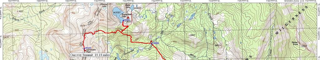
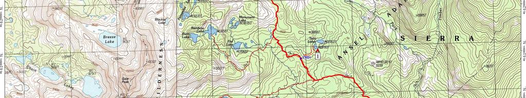
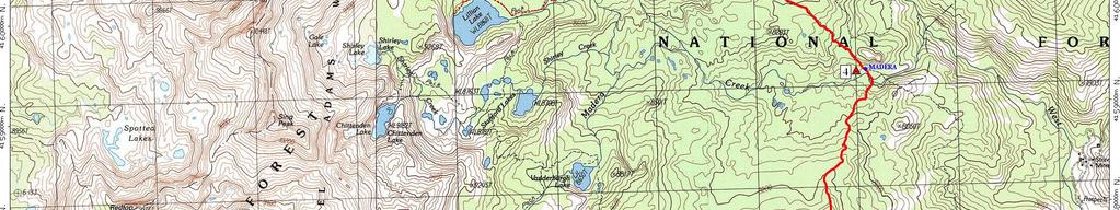
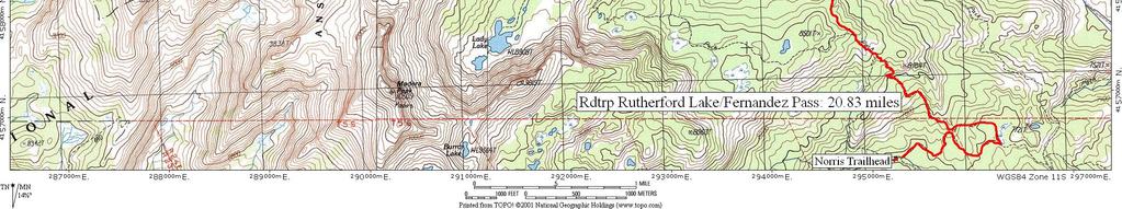
5 Route Description Overview From Norris Trailhead hike to Rutherford Lake, out-and-back. Summit Fernandez Pass or a neighboring peak. Details Follow this linear route beginning at Norris Trailhead, travel NE on the trail to Twin Lakes for camp. Continue NW on the trail to travel to Rutherford Lake, your second campsite. Fernandez Pass is a little further west and southern. This will be your summit destination. If there is a safe route to a peak above Fernandez Pass, you may summit a peak in addition to the pass. Return to Rutherford Lake for another camping night. Head SE to spend night four along Madera Creek. On the last day your group will exit where you started. Day hikes to Lillian Lake or Rainbow Lake are good options for short days. Twin Lakes-1 to Rainbow Lake: 2.28 miles Twin Lakes-1 to Lillian Lake: 2.28 miles Rutherford Lakes-2 or 3 to Anne Lake: 0.33 miles Trail Elevation Profile* Elevation Gain:5,441 ft. Min. Elevation:7,597 ft. Elevation Loss:5,438 ft. Max. Elevation:10,100 ft. * The elevation details and corresponding graphic pertain to the main route only not alternate routes. 5
6 6
7 7
8 Camp Site Information Favorites 1- Twin Lakes (TWIN) - UTM E N 2- Fernandez Creek (CREEK) - UTM E N 3- Rutherford Lake (RUTH) - UTM E N 4- Madera Creek (MADERA) - UTM E N Good Alternative No information is available. Feedback is appreciated! Not Recommended No information is available. Feedback is appreciated! Refer to trail map for corresponding numbered campsites. 8
9 Map Legend Campsites (Not all sites are recommended.) Kitchen area Reported Water Source (River, Pond, Creek, Spring) Portages Point of Interest Hazards Fishing Main Route --- Alternate Routes Points of Interest No information is available. Feedback is appreciated! Fishing No information is available. Feedback is appreciated! Refer to trail map for corresponding hazards. 9
10 Hazards The biggest hazards are afternoon storms and the public. Keep hydrated, wear sunscreen, and be self-aware, taking care of problems immediately. Sprains, strains, blisters, and river crossings are all possible hazards. Animals Poisonous Plants Weather Hazards Lightning Exposures No Water Between Scree Slopes Black bears are common especially in campgrounds. Rattle snakes are uncommon though present. Bees, wasps, and spiders are all possible hazards. Animals are wild. Do not approach any animal. Poison Oak Intense high altitude sun. Watch for dehydration and heat exhaustion. Afternoon thunderstorms common. No information is available. Feedback is appreciated! Loose talus. Watch for rock fall and shifting rocks. Early season creeks may not be crossable. Refer to trail map for corresponding locations. 10


11 Summit FERNANDEZ PASS (FPASS)- UTM E N Hiking to Fernandez Pass is a good option for summit day. Hiking to a peak above Fernandez Pass could be even more exciting for the teens. Please assess if there is a safe route and if the group is ready for the challenge. A typical view whilst in the trail of Fernandez Pass. Refer to trail map for corresponding locations. 11
12 Area History These trails travel through national forest and a wilderness area, both public lands, owned by the federal U.S. government and protected from private commerical development, but for different purposes. The initial and continued mission of the National Forest Service, established in 1905 (within the Department of Agriculture), is: "...the greatest good of the greatest number of people in the long run. Focused on conservation, timber and mineral deposits are managed in a manner similar to agriculture or farmed crops. Wilderness Areas were established with preservation in mind. The Congressional Wilderness Act of 1964 was approved to secure for the American people of present and future generations the benefits of an enduring resource of wilderness. As such, Wilderness designation protects the area from roads, logging, oil and gas drilling, and any commercial enterprises. In part, to retain the quiet, motorized and mechanical vehicles and motorized equipment are not allowed. Local Environment The Sierra Nevada Mountains are an uplifted, tilted block of granite 400 miles long by 100 miles wide; the result of fault-line tectonic plate activity. Subsequent erosion, due to streams and glaciers, carved out U-shaped valleys, lakes, rugged peaks and cliffs. Sediment fills lakes creating meadows. There are several threats to the natural condition of the Sierras: air pollution, light pollution, and global warming, evident in the thinning snowpacks. Stray light, particularly from San Joaquin Valley, brightens the night sky. Darkness allows vistors views of the stars, while nocturnal animals depend on darkness to hunt, conceal their location, navigate, and reproduce. Artificial light can disrupt plant cycles. 12
13 Daily Outline Recommendations Expedition Preparation and Planning Day 1 Day 2 Day 3 Day 4 Day 5 Day 6 Day 7 Clover Meadow Campground IN THE FIELD Tioga High Schl. HOME Meet at BCM Office Issue Individual Gear Pre-trip teen surveys Duffle Shuffle Issue BCM Group Gear Camp a Clover Meadow Campground. From Norris Trailhead, head east, then north. Camp at Twin Lakes after about 6 miles. Follow the trail NW to travel to Rutherford Lake (3.23 miles from Twin Lakes - one-way) and spend the night there. Travel to Fernandez Pass (2.29 miles - one-way), then return to Rutherford Lake where group will spend the night. Travel SE retracing your steps--from another direction--from day two. The group is expected to spend the night along Madera Creek. Hike out this morning; exit at Norris Trailhead (3.73 miles downhill) Clean gear Laundry Showers Pick Up Breakfast for Day 7 Evaluations & Surveys (D/A Profile) Celebration Dinner Call office with ETA Coordinate with Youth Leader for how to get teens home. Team Leader debrief with RPM (volunteers welcome, but not required to join.) 13
14 Curriculum Checklist Day 1 Welcome Introductions & Ice Breaker Expectations Policies 7-Day Overview Day 2 Trust Activity Policies Review Daily Activities Quote of the Day Reflection Roundtable Journaling Lessons Lost & Alone Camp Craft 101 LNT Group Travel Food Waste Disposal Campsite Selection Health & Hygiene 201 Cat-Holes Pack Packing Food Protection Water Treatment Lightning Safety Outcomes Set expectations, roles & responsibilities. Establish structure & daily routine. Build Trust. Establish common understanding of trip purpose. Reflect on physical and emotional stresses. Understand one is capable of overcoming & learning from challenges. Work as a team to overcome challenges. Support and encourage each other to overcome challenges. Peak hike: overcome challenges, reflect, and learn from experiences. Celebrate achievement. Create Meaning: How did we overcome challenges? Create Meaning: What are our strengths and weaknesses? Create Meaning: How do we transfer what we have learned home? Setting individual goals for the future. Record learning and achievement in something tactile that teens can take home with them as a reminder of their experience. 14
15 Team Leader Comments This area will be used for free form comments from Team Leaders to future Team Leaders. Please use the Field Journal for feedback and comments. 15
16 Emergency Information Location Base Camp Backcountry (On-Trail) Hospital 911 Services? Yes Oakhurst Community Medical Center Victoria Lane Oakhurst, CA am-9pm daily Local Contact Cell Phone Coverage? BCM Phone Numbers Bass Lake Ranger District Road 225 North Fork, CA No Emergency Phone Number If an emergency arises on trip that needs immediate assistance, call the emergency number first to reach a BCM staff member. If you do not receive a return call within 20 minutes, refer to the emergency contact sheet you received at the beginning of your trip or directly reach out to BCM staff. Regional BCM office numbers are listed below. Denver Office Chicago Office Pacific NW Office San Francisco Office (cell) (cell) (cell) Additional Emergency Information: Oakhurst Community Medical Center provides urgent care, 9am-9pm daily (24 hour Emergency): Victoria Lane, Oakhurst, CA 93644, Cell Phone Coverage: No information is available. Feedback would be great! 16
Lillian Lakes BCM Course Area Guide Backcountry
 Emergency Information Location Base Camp Backcountry (On-Trail) Hospital 911 Services? Yes Oakhurst Community Medical Center 48677 Victoria Lane Oakhurst, CA 93644 559.683.2992 Local Contact Cell Phone
Lillian Lakes BCM Course Area Guide Backcountry. Trip Code Team Leader
 Lillian Lakes BCM Course Area Guide Backcountry Trip Code Team Leader Table of Contents Trail Summary... 3 Trail Information... 3 Trail Description... 4 Route Description... 5 Trail Distances... 5 Trail
McGee Creek BCM Course Area Guide Backcountry. Trip Code Team Leader
 McGee Creek BCM Course Area Guide Backcountry Trip Code Team Leader Table of Contents Trail Summary... 3 Trail Information... 3 Trail Description... 4 Route Description... 5 Trail Distances... 5 Trail
Hetch Hetchy BCM Course Area Guide Backcountry
 Emergency Information Location Hospital Backcountry (On-Trail) Yosemite Medical Clinic Ahwahnee Drive, Yosemite Valley 209.372.4637 8am-7pm drop-in 911 Services? Yes Local Contact Cell Phone Coverage?
Marvine Creek Trail BCM Course Area Guide Backcountry. Trip Code Team Leader
 Marvine Creek Trail BCM Course Area Guide Backcountry Trip Code Team Leader Table of Contents Trail Summary... 3 Trail Information... 3 Trail Description... 4 Route Description... 5 Trail Distances...
Medicine Bow Trail BCM Course Area Guide Backcountry
 Emergency Information Location Base Camp Backcountry (On-Trail) Hospital Ivinson Memorial Hospital 255 North 30th Street Laramie, WY 82072 Phone: 307.742.2141 Ivinson Memorial Hospital 255 North 30th Street
Rutherford Lake/Fernandez Pass
 Rutherford Lake/Fernandez Pass BCM Course Area Guide Base Camps BCM San Leandro Office Tioga High School Base Camp General Information BCM Headquarters 1667 Vine St. Denver, CO 80206 303.271.9200 www.bigcitymountainers.org
Marvine Creek Trail. BCM Course Area Guide Base Camp. Colorado Rocky Mountain School Base Camp BCM Denver Office
 Marvine Creek Trail BCM Course Area Guide Base Camp Colorado Rocky Mountain School Base Camp BCM Denver Office Table of Contents Letter from the Regional Program Manager... 3 General Information... 5 Trailhead
McGee Creek. BCM Course Area Guide Base Camp. Camp High Sierra Base Camp BCM San Leandro Office
 McGee Creek BCM Course Area Guide Base Camp Camp High Sierra Base Camp BCM San Leandro Office General Information BCM Headquarters 1667 Vine St. Denver, CO 80206 303.271.9200 www.bigcitymountainers.org
CIEC 9 PEAKS AWARD SUPPLEMENT POSSIBLE ROUTES FOR THE 9 PEAKS AWARD TRIP
 CIEC 9 PEAKS AWARD SUPPLEMENT POSSIBLE ROUTES FOR THE 9 PEAKS AWARD TRIP As you plan your trip, be aware of 3 regulations in this wilderness: 1. Camp only in designated campsites. 2. No campfires allowed.
12-day North Cascades Backpacking Leadership Course Course Location Course Goals
 12-day North Cascades Backpacking Leadership Course The North Cascades form a remote, beautiful and exciting range of glaciated peaks, alpine terrain and rolling forests. Spanning nearly a million acres,
Sierra National Forest
 Sierra National Forest Summer 2018 Wilderness Ranger Intern Application Wilderness Intern Rangers are integral members of the wilderness team working in the Sierra National Forest s spectacular wilderness
Itinerary Overview. Sangre de Cristo Alpine Backpacking 22 days Ages Course Description
 Itinerary Overview Sangre de Cristo Alpine Backpacking 22 days Ages 16-18 Course Description Welcome, you re in for an experience of a lifetime! Imagine hiking through rolling forests, sharing alpine meadows
McGee Creek. BCM Course Area Guide Base Camp. College Track of Oakland Girls Expedition 8/5/11
 McGee Creek BCM Course Area Guide Base Camp College Track of Oakland Girls Expedition 8/5/11 BCM San Francisco Bay Area Office Camp Mather, property of San Francisco Recreation and Park General Information
Ten Lakes. BCM Course Area Guide Base Camps. BCM San Leandro Office Yosemite National Park Valley School Tioga High School Base Camp
 Ten Lakes BCM Course Area Guide Base Camps BCM San Leandro Office Yosemite National Park Valley School Tioga High School Base Camp General Information BCM Headquarters 1667 Vine St. Denver, CO 80206 303.271.9200
YOSEMITE ON HORSEBACK: THREE RIDES ALONG TIOGA ROAD Cindy Casey White Wolf Area, May Lake Loop, Ragged Peak Loop
 YOSEMITE ON HORSEBACK: THREE RIDES ALONG TIOGA ROAD Cindy Casey White Wolf Area, May Lake Loop, Ragged Peak Loop The high country along Tioga Road presents us with some of the most dramatic scenery in
Hetch Hetchy. BCM Course Area Guide Base Camps. BCM San Leandro Office Yosemite National Park Valley School Tioga High School Base Camp
 Hetch Hetchy BCM Course Area Guide Base Camps BCM San Leandro Office Valley School Tioga High School Base Camp General Information BCM Headquarters 1667 Vine St. Denver, CO 80206 303.271.9200 www.bigcitymountainers.org
Aconcagua Leadership and Guide Training Course
 Aconcagua Leadership and Guide Training Course Cerro Aconcagua is located in the central Andes of Argentina near the border with Chile. At 22,841ft (6,962m), it is one of the seven summits and the only
Course Description. Oregon Pacific Crest Trail Backpacking for Adults
 Overview This backpacking course is designed to prepare and train you to tackle the Pacific Crest Trail (PCT) and other long distance hiking trails on your own. It is also designed so that if you desire,
Itinerary Overview. Yosemite, Joshua Tree & San Francisco Outdoor Educator 65 Days (Fall)
") Itinerary Overview Yosemite, Joshua Tree & San Francisco Outdoor Educator 65 Days (Fall) In General - Wilderness travel is difficult and rewarding. Arriving physically fit will enhance your experience
Itinerary Overview Yosemite, Joshua Tree & San Francisco Outdoor Educator 65 Days (Fall) In General - Wilderness travel is difficult and rewarding. Arriving physically fit will enhance your experience
Hiking California's Trinity Alps Wilderness: A Guide To The Area's Greatest Hiking Adventures (Regional Hiking Series) By Dennis Lewon READ ONLINE
 By Dennis Lewon READ ONLINE") Hiking California's Trinity Alps Wilderness: A Guide To The Area's Greatest Hiking Adventures (Regional Hiking Series) By Dennis Lewon READ ONLINE With over 600 miles of trails and 500000 acres of wilderness
Hiking California's Trinity Alps Wilderness: A Guide To The Area's Greatest Hiking Adventures (Regional Hiking Series) By Dennis Lewon READ ONLINE With over 600 miles of trails and 500000 acres of wilderness
A Long Weekend in Yosemite. 4 Days
 A Long Weekend in Yosemite 4 Days A Long Weekend in Yosemite On this relaxed yet action-paced 4-day hiking adventure, discover the wildly scenic, glacially sculpted Yosemite Valley, deep in the heart of
California Section L - Page 1
 64 N. 63 N. 62 N. 725000m 726000m 727000m California Section L - Page 1 728000m 729000m 730000m CA Section L - 38.3 miles Start - Hwy 80 [Donner Summit], mile 1157.1 End - Hwy 49 [near Sierra City], mile
Itinerary Overview: What you will be doing Maroon Bells Alpine Backpacking 22 days
 Itinerary Overview: What you will be doing Maroon Bells Alpine Backpacking 22 days 0BCourse Description Welcome, you re in for an experience of a lifetime! Imagine hiking through rolling forests, sharing
Route Combo) Mt. Bierstadt - Bierstadt, Sawtooth, Evans
 Mt. Bierstadt - Bierstadt, Sawtooth, Evans") Climbing 14ers can be very dangerous, please read the Mountaineering Safety Page and make sure you have a map+compass and can use them effectively, without the help of electronic devices. Route Combo)
Climbing 14ers can be very dangerous, please read the Mountaineering Safety Page and make sure you have a map+compass and can use them effectively, without the help of electronic devices. Route Combo)
2019 Work Week Crew. Schedule and Descriptions
 2019 Work Week Crew WAWONA WW1 Mariposa Grove Restoration and Invasive Plant Removal June 2 June 8 YOSEMITE VALLEY YV1 Washington Column Climber s Trail Rehabilitation June 9 June 15 YV2 Weed Warriors/
The Logger's Retreat at Yosemite
 The Logger's Retreat at Yosemite Summary Vacation in Yosemite Magnificent mountain views! Hot tub! Family-friendly! Description 3 bedrooms, 5 bathrooms; perfect home for 1 or 2 families up to 12 persons
Oregon Section B - Page m
 Oregon Section B - Page 1 5 35000m 5 36000m 5 37000m 5 38000m 46 57000m 46 58000m Hwy5B - Interstate Highway 5 - mi 1716.4-4271 ft RD1717 - PCT departs paved Old Highway 99 - mi 1716.8-4357 ft PL1717 -
White Mountain Wilderness Trails
 The area in which these hikes are located is rugged high mountain country along the Mogollon Rim. This famous eastwest escarpment separates Arizona's high plateau from the basin and range below. These
Itinerary Overview. Continental Divide Alpine Backpacking 22 days Ages Course Description
 Itinerary Overview Continental Divide Alpine Backpacking 22 days Ages 16-18 Course Description Welcome, you re in for an experience of a lifetime! Imagine hiking through rolling forests, sharing alpine
LESSON 5 Wilderness Management Case Studies
 LESSON 5 Wilderness Management Case Studies Objectives: Students will: review the key points of the Wilderness Act of 1964. brainstorm solutions for Wilderness management issues. Materials: Í Leave no
Itinerary Overview. Maroon Bells Mountaineering 22-days. Course Description
 Itinerary Overview Maroon Bells Mountaineering 22-days Course Description Welcome, you re in for an experience of a lifetime! Imagine hiking through rolling forests, sharing alpine meadows with mountain
SATURDAY NIGHT LAKE LOOP
 BACKCOUNTRY GUIDE SATURDAY NIGHT LAKE LOOP This trail winds through the hills west of Jasper and visits several small lakes. It can be hiked as a long day or an easy overnight trip. Photo: R Gruys SEMI-PRIMITIVE
List of Challenges. Draw a Map of Your Hike
 List of Challenges Junior Ranger Wildlife Adventures Draw a Map of Your Hike Explore Pella Crossing Hey kids! Do you love animals as much as the Boulder County Park Rangers? Join us on Saturday, June 2
John Muir Trail: Northbound. 13 Days. to Yosemite
 John Muir Trail: Northbound 13 Days to Yosemite John Muir Trail: Northbound to Yosemite Tackle the northbound half of the John Muir Trail set in California's stunning Sierra Nevada, beginning in Lake Florence
Appendix I Case-Studies in Wilderness Management
 Appendix I Case-Studies in Wilderness Management Management Issue Scenarios Note: These scenarios are meant to be used as guidelines for the program leader rather than to be read verbatim. Introduce a
TREK THE ROCKIES ABOUT THE CHALLENGE TREK THE ROCKIES FOR HIGHLAND HOSPICE CANADA TREK DEMANDING
 TREK THE ROCKIES CANADA TREK DEMANDING ABOUT THE CHALLENGE The Canadian Rockies are justifiably world-famous for their magnificent scenery: the combination of impressive, jagged mountains, bright turquoise
Itinerary Overview. Colorado San Juan Mountaineering 15-days
 Itinerary Overview Colorado San Juan Mountaineering 15-days Course Description Welcome, you re in for an experience of a lifetime! Imagine hiking through rolling forests, sharing alpine meadows with mountain
Itinerary Overview. Sawatch Range Mountaineering Ages days
 Itinerary Overview Sawatch Range Mountaineering Ages 14-16 22 days Course Description Welcome, you re in for an experience of a lifetime! Imagine hiking through rolling forests, sharing alpine meadows
Special Considerations
 BACKCOUNTRY GUIDE SKYLINE An exceptionally beautiful backpacking route: the highest trail in. Photo: R. Bray SEMI-PRIMITIVE 44.1 km, 2-3 day hike Elevation from Maligne Lake: 1410 m gain, 192 m loss Maximum
Itinerary Overview and Travel Information: 15-Day Alaska Alpine Backpacking Course for Adults
 Itinerary Overview and Travel Information: 15-Day Alaska Alpine Backpacking Course for Adults Course Description Welcome, you re in for the experience of a lifetime! Imagine hiking through rolling forests,
Kit Carson-Challenger Ridge Trail Project
 Kit Carson-Challenger Ridge Trail Project Project Accomplishments Report-USFS December 15, 2015 Photo courtesy of Justin Peterson 815 South 25 th Street, Suite 101 Colorado Springs, CO 80904 Dedicated
MOUNTAIN BIKING THE CASCADE LOOP
 MOUNTAIN BIKING THE CASCADE LOOP By Henry Freimuth All photographs by Henry Freimuth The Cascades are on the Spanish Creek, which is a tributary of the Feather River. The Feather River was named by Spanish
How to Become a Hike Leader Hike Leader Skills Using the Mountaineers Website to Schedule, Manage and Close a Hike Hike Leader Responsibilities Table
 How to Become a Hike Leader Hike Leader Skills Using the Mountaineers Website to Schedule, Manage and Close a Hike Hike Leader Responsibilities Table Top Scenario Presenters: David Geeraerts Carla Jonientz
Southern Shenandoah Valley Chapter
 Southern Shenandoah Valley Chapter June 7, 2018 Members of the State Water Control Board c/o Office of Regulatory Affairs, Department of Environmental Quality P.O. Box 1105 Richmond, Virginia 23218 citizenboards@deq.virginia.gov
Oregon Section F - Page 1 WGS84 Zone 10T m
 08 N. 07 N. 06 N. Oregon Section F - Page 1 WGS84 Zone 10T LavaCampLakeTR - Lava Camp Lake Trail #4060 junction. - mi 1982.6-5287 ft LavaCampLake - Lava Camp Lake, campground, outhouse, 1/2 mile NE of
SYNOPSIS WEATHER AND SNOWPACK
 Peak 6996 Avalanche Fatality Incident Report Glacier National Park, MT Date of Avalanche: 31 March 2010 Date of Investigation: 2 April 2010 Investigation Team: Erich Peitzsch (USGS), Ted Steiner (Chugach
Backpacking Merit Badge Workbook
 Merit Badge Workbook This workbook can help you but you still need to read the merit badge pamphlet. The work space provided for each requirement should be used by the Scout to make notes for discussing
RE: Access Fund Comments on Yosemite National Park Wilderness Stewardship Plan, Preliminary Ideas and Concepts
 September 30, 2016 Superintendent Yosemite National Park Attn: Wilderness Stewardship Plan P.O. Box 577 Yosemite, CA 95389 RE: Access Fund Comments on Yosemite National Park Wilderness Stewardship Plan,
HIKING IN THE CANADIAN ROCKIES
 HIKING IN THE CANADIAN ROCKIES Distance Time Elevation y MORAINE LAKE TRAILS THE ROCKPILE 0.8 km (0.5 mi) 20 min 30 m (98 ft) Located adjacent to the Lodge, the short interpretive trail up the Rock Pile
Oregon Section C - Page 1 WGS84 Zone 10T m
 00 N. 99 N. 98 N. 97 N. 96 N. 557000m Oregon Section C - 74.4 miles Start - Hwy 140, mile 1773.4 (near Fish Lake) End - Hwy 138, mile 1847.8 (near Cascade crest) Elevation Gain +8,111' Elevation Loss -7,145'
Hiking Las Vegas.com
 Hike: Mt. Wilson via First Creek Canyon route Trailhead: First Creek marked Distance: 10 miles up and back Elevation gain: 3,400 feet Elevation of Peak: 7,070 feet Time: 7 to 9 hours (up and back) Difficulty:
24-day Nepal Backpacking Leadership and Guide Training Course
 24-day Nepal Backpacking Leadership and Guide Training Course Course Location Draped along the spine of the Himalaya, Nepal is a land of spectacular scenery, ancient temples, and some of the best trekking
California Section K - Page 1 WGS84 Zone 10S m
 750000m 751000m 752000m California Section K - Page 1 753000m 754000m 755000m WGS84 Zone 10S 757000m 04 N. 03 N. 04 N. 02 N. 05 N. 05 N. 06 N. 06 N. 01 N. Overnight camping is prohibited for approximately
General Skills Task list
 General Skills Task list Name Official Start Completion Trainee Training /s Trainer/s Participate in Candidate Training and get on Peak Adventures payroll Complete Candidate Task List Pay for and attend
Backpacking Merit Badge Workbook
 Merit Badge Workbook This workbook can help you but you still need to read the merit badge pamphlet. The work space provided for each requirement should be used by the Scout to make notes for discussing
Proceedings, International Snow Science Workshop, Breckenridge, Colorado, 2016
 AVALANCHE FORECASTING AND MESSAGING FOR UNUSUAL AVALANCHE CONDITIONS IN A MARITIME SNOW CLIMATE-BURIED SURFACE HOAR INTERNATIONAL SNOW SCIENCE WORKSHOP 2016 IN BRECKENRIDGE, CO Steve A. Reynaud Sierra
We Speak. Oregon. Connecting Visitors to Local Experts on the Ground. traveloregon.com
 Connecting Visitors to Local Experts on the Ground traveloregon.com Updated 8/17/2012 Usage Guidelines Dear Tourism and Hospitality Partner, The program was developed to help provide great customer service
Rogue Gorge (Mt. Stella) Roadless Area-- T30S R3E (primarily in portions of Sections 23, 26, 33, 34 & 35)
 Roadless Area-- T30S R3E (primarily in portions of Sections 23, 26, 33, 34 & 35)") Rogue Gorge (Mt. Stella) Roadless Area-- T30S R3E (primarily in portions of Sections 23, 26, 33, 34 & 35) Rogue River-Siskiyou National Forest--High Cascades Ranger District Upper, higher elevation trail
Rogue Gorge (Mt. Stella) Roadless Area-- T30S R3E (primarily in portions of Sections 23, 26, 33, 34 & 35) Rogue River-Siskiyou National Forest--High Cascades Ranger District Upper, higher elevation trail
Roduner Ranch FOR SALE. 5,878± Acres Potential Development Land. Merced County, California. Offices Serving The Central Valley
 FOR SALE 5,878± Acres Potential Development Land Merced County, California Offices Serving The Central Valley F R E S N O V I S A L I A B A K E R S F I E L D 7480 N. Palm Ave, Ste 101 3447 S. Demaree Street
Hike at Pico Blanco Labor Day Weekend!
 Hike at Pico Blanco Labor Day Weekend! The Pico Blanco Hymn Here among the trees majestic Pleasures you will find On the trails of Pico Blanco With your friends and mine Trail the Eagle ever onward This
Crystal Lake Area Trails
 Lake Area Trails Welcome to the Lake area of the Big Snowy Mountains! This island mountain range in central Montana features peaks reaching to 8,600 feet and long, high ridges from which vistas of the
Other Agencies and Organizations
 Daniel Boone National Forest 1700 Bypass Road WInchester, KY 40391 859-745-3100 Location Northern terminus is near Morehead, Kentucky. Southern terminus is located in the Big South Fork NRRA in Tennessee.
FINAL TESTIMONY 1 COMMITTEE ON RESOURCES UNITED STATES HOUSE OF REPRESENTATIVES. July 13, 2005 CONCERNING. Motorized Recreational Use of Federal Lands
 FINAL TESTIMONY 1 STATEMENT OF DALE BOSWORTH CHIEF Of the FOREST SERVICE UNITED STATES DEPARTMENT OF AGRICULTURE Before the SUBCOMMITTEE ON FORESTS AND FOREST HEALTH And the SUBCOMMITTEE ON NATIONAL PARKS,
Mountain Footsteps. Photo: Ric Carless
 ho: Ric Carless Road Directions Middle White River FS Roads Deep Lake and Driftwood Lake see page 101, Connor Lakes along Maiyuk Creek see page 105, and for access Top of the World rovincial ark see page
DALHOUSIE WINTER TREKKING EXPEDITION
 DALHOUSIE WINTER TREKKING EXPEDITION Winter Himalayan Trekking Expedition 2016-17 To groom the youngsters in the field of adventures and environmental awareness, Invincible NGO presents the most interactive
Proposed Scotchman Peaks Wilderness Act 2016 (S.3531)
") 1 Proposed Scotchman Peaks Wilderness Act 2016 (S.3531) Frequently Asked Questions PLACE Where is the area that would be designated as Wilderness? The lands outlined in S.3531 lie within Idaho along its
1 Proposed Scotchman Peaks Wilderness Act 2016 (S.3531) Frequently Asked Questions PLACE Where is the area that would be designated as Wilderness? The lands outlined in S.3531 lie within Idaho along its
MT KILIMANJARO TREK- LEMOSHO ROUTE
 #Trekking MT KILIMANJARO TREK- LEMOSHO ROUTE 10 Days 9 Nights Overview Take the challenging and less-travelled Lemosho route up to the highest peak in Africa, considered by many to be the most beautiful
Hermosa Area Preservation The Colorado Trail Foundation 4/11/2008
 Hermosa Area Preservation The Colorado Trail Foundation 4/11/2008 Legend d o Tr ail NPA - National Protection Area ra NCA - National Conservation Area o e C Th The Colorado Trail lo FS inventoried Roadless
Drawing Conclusions and Making Inferences
 Drawing Conclusions and Making Inferences G TO THE STUDENT In this book, you will learn how to use the reading strategy called Drawing Conclusions and Making Inferences. With your teacher s help, you will
Photographing Upper Peninsula Waterfalls
 Photographing Upper Peninsula Waterfalls Tod Poirier Freelance Photographer Photography is one of my passions. The following spread showcases several Upper Peninsula waterfalls. At times a single drop
Koroc River Palmer River Loop
 parkscanada.gc.ca Multi-Day Hiking Route Koroc River Palmer River Loop Torngat Mountains National Park T. Knight, Parks Canada 425000m.E. 64 15'0"W 30 64 10'0"W 35 64 5'0"W 40 64 0'0"W 45 63 55'0"W 50
ROAD AND TRAIL PROJECT APPROVAL
 ROAD AND TRAIL PROJECT APPROVAL www.marincountyparks.org Marin County Parks, 3501 Civic Center Dr, Suite 260, San Rafael, CA 94903 DATE: July 12, 2017 PRESERVE: Gary Giacomini Open Space Preserve PROJECT:
Bradshaw Trails Series
 Bradshaw Trails Series Curtis James Troop 7014 Curtis.James@erau.edu My Motto: Never get lost! Hiking Rules Bradshaw Hiking Patch Series Hiking Tools Hiking Rules Hiking Merit Badge* Take five 10-mile
Hiking Las Vegas.com
 Hike: Juniper Peak up and back Trailhead: Oak Creek Canyon marked Distance: 5.5 miles round trip Elevation gain: 2,200 feet Elevation peak: 6,109 feet Time: 4 to 5 hours - Up and back Difficulty: 3 Danger
Understanding user expectations And planning for long term sustainability 1
 Understanding user expectations And planning for long term sustainability 1 What is a natural surface trail? It can be as simple has a mineral soil, mulched or graveled pathway, or as developed as elevated
Route #1) Mt. of the Holy Cross - North Ridge
 Mt. of the Holy Cross - North Ridge") Climbing 14ers can be very dangerous, please read the Mountaineering Safety Page and make sure you have a map+compass and can use them effectively, without the help of electronic devices. Route #1) Mt.
Climbing 14ers can be very dangerous, please read the Mountaineering Safety Page and make sure you have a map+compass and can use them effectively, without the help of electronic devices. Route #1) Mt.
We Speak. Oregon. Connecting Visitors to Local Experts on the Ground. traveloregon.com
 Connecting Visitors to Local Experts on the Ground traveloregon.com Updated August, 2013 Usage Guidelines Dear Tourism and Hospitality Partner, The program was developed to help provide great customer
Trip Report: Backpack to East Boulder Lake in California Trinity Alps, July 7-9, 2016
 Trip Report: Backpack to East Boulder Lake in California Trinity Alps, July 7-9, 2016 Trekkers: Richard Hales, Aleece Townsend, Carol Mockridge, Rosalie Rybka, Elisabeth Zinser Day 1: Richard and Aleece
April 10, Mark Stiles San Juan Public Lands Center Manager 15 Burnett Court Durango, CO Dear Mark,
 Mark Stiles San Juan Public Lands Center Manager 15 Burnett Court Durango, CO 81301 Dear Mark, We are pleased to offer the following comments on the draft San Juan Public Lands Center management plans
Mazatzal Wilderness Trail Maintenance and Exploration
 Mazatzal Wilderness Trail Maintenance and Exploration March 15-19 (Wednesday - Sunday) Difficulty: Beginner Camping: Car Camping Mileage: Wednesday ~4 miles Thursday ~4-6 miles Friday ~4-6 miles Saturday
Resource Typing Template
 Resource Typing Template Resource: Mountain Search and Rescue Categories: Transportation (ESF 1) Communication (ESF 2) Public Works and Engineering (ESF 3) Firefighting (ESF 4) Information & Planning (ESF
Children's Discovery Trail Guide - Lost Creek
 Children's Discovery Trail Guide - Lost Creek Thank you for spending time learning and observing some of the secrets of Red Rock Canyon Conservation Area has to offer. Feel free to talk to a ranger if
JULY JULY 21 MID YEAR. tenaya lodge yosemite fish camp, ca
 DCA 2018 ANNUAL MEETING JULY 18 JULY 21 MID YEAR tenaya lodge yosemite fish camp, ca Preliminary Schedule of Events WEDNESDAY, JULY 18 8:30 am - 9:30 am Executive Committee Meeting * 9:30 am - 11:00 am
Leave No Trace. Prepared for Boy Scout Troop 63 Woodbridge, CT
 Leave No Trace Prepared for Boy Scout Troop 63 Woodbridge, CT What is Leave No Trace? Leave No Trace is a program that evolved from outdoor codes taught by the United States Forest Service, the Bureau
Presented by: 100± Acres Madera County. For Additional Information Please Contact:
 100± Acres Madera County For Additional Information Please Contact: Crystal Leininger Sales Associate Pearson Realty 916.903.8039 cleininger@pearsonrealty.com CA DRE# 01707325 Jade Mills Property Specialist
Hiking and kayaking/canoeing in the Boundary Waters
 Hiking and kayaking/canoeing in the Boundary Waters Boundary Waters, Minnesota May 24 th May 27 th, 2013 Comprehensive guide and packing list Trip at a glance: Enjoy your Memorial Day weekend in the wilderness
Camping Merit Badge Workbook
 Merit Badge Workbook This workbook can help you but you still need to read the merit badge pamphlet. This Workbook can help you organize your thoughts as you prepare to meet with your merit badge counselor.
BROCHURE. APPLE HILL WOODS 118 +/- Acres Camino, California. Presented by Jim Copeland
 BROCHURE APPLE HILL WOODS 118 +/- Acres Camino, California Presented by Jim Copeland 1 The Property This 118 acre is a rare gem in the Sierra Nevada foothills. Covered with lush forestland and scattered
American Conservation Experience
 ACE Project Report For Tonto National Forest, Arizona Trail Association and Arizona State Parks Title of Project: 4 Peaks Trail Maintenance Award Contract Number: ASP NM11021 Project Partner: Paul Burghard
Preferred Recreation Recommendations Stemilt-Squilchuck Recreation Plan March 2018
 Preferred Recreation Recommendations Stemilt-Squilchuck Recreation Plan March 2018 Below are the recommended recreation ideas and strategies that package together the various recreation concepts compiled
2019 DAY HIKE AT IRON MOUNTAIN SATURDAY, JANUARY 19
 WHERE? In Google Maps, paste the following coordinates for Iron Mountain: 32.978215,-116.972593 or CLICK ON THIS LINK. I. Purpose of the Day Hike A. THE WBC Day Hike is a relatively short trail hike to
Prostate Gathering in the Sierra High Country The Fourth Annual Jan Zlotnick Memorial August 19-24, 2018
 Prostate Gathering in the Sierra High Country The Fourth Annual Jan Zlotnick Memorial August 19-24, 2018 Thank you for your interest in the Fourth Annual Jan Zlotnick Memorial Gathering in the General
1 Glacial Erosion and
 www.ck12.org Chapter 1. Glacial Erosion and Deposition CHAPTER 1 Glacial Erosion and Deposition Lesson Objectives Discuss the different erosional features formed by alpine glaciers. Describe the processes
Itinerary Overview. Yosemite, Joshua Tree & San Francisco Instructor Development 65 Days (Fall)
") Itinerary Overview Yosemite, Joshua Tree & San Francisco Instructor Development 65 Days (Fall) In General - Wilderness travel is demanding. It can literally take every waking moment to get from point A
Itinerary Overview Yosemite, Joshua Tree & San Francisco Instructor Development 65 Days (Fall) In General - Wilderness travel is demanding. It can literally take every waking moment to get from point A
Course Description. North Cascades Alpine Backpacking for Veterans
 Course Overview Join other Veterans in the North Cascades Range of Washington for the opportunity to connect outside of the military in one of the most remote and beautiful alpine environments in the lower
JUNIOR RANGER. William Heise County Park Junior Rangers Program Guide
 JUNIOR William Heise County Park Junior Rangers Program Guide JUNIOR William Heise County Park Junior Rangers Table of Contents. Table of Contents.... 2 Hello Prospective Junior Rangers... 3 Draw What
Non-motorized Trail Plan & Proposal. August 8, 2014
 Town of Star Valley Ranch, Wyoming and the Star Valley Ranch Association in partnership with the USDA Forest Service, Bridger-Teton National Forest, Greys River Ranger District Non-motorized Trail Plan
Trail Beginning Elevation: 7553 ft The Poison Creek Trailhead is located at the end of National Forest Road 646E (NF-646E).
.") West Mountain Trails Poison Creek Trail #134 Length: 2.9 miles (4.7 km) Difficulty Horseback: A good trail for the first time west mountain rider, some steep sections Hiking: Most Difficult USGS Maps:
West Mountain Trails Poison Creek Trail #134 Length: 2.9 miles (4.7 km) Difficulty Horseback: A good trail for the first time west mountain rider, some steep sections Hiking: Most Difficult USGS Maps:
Our Summer in Yosemite
 Our Summer in Yosemite Plague Etiologic agent: Yersinia pestis Vector- Fleas Reservoir - Rodents Reservoirs of plague in CA Resistant reservoirs: deer mice, voles, some chipmunks Susceptible/amplifying