Table of Contents. Introduction
|
|
|
- Hilary Alexander
- 5 years ago
- Views:
Transcription
1 Table of Contents Introduction... 1 Ordering Patches... 2 Centennial and I & M Canal Trail... 2 I & M Canal Trail... 3 Chief Wauponsee Glacial Trail... 7 Rock Run Greenway Trail... 8 Hike the Rock Trail... 9 Old Plank Road Trail Hickory Creek Barrens Thorn Creek Nature Preserve Little Scouter Natural Trail Award Joliet Historic Ironworks Site KANKAKEE RIVER STATE PARK Hidden Oaks Conservation Area Midewin National Tallgrass Prairie Goose Lake Prairie Little Scouter Center Piece Introduction Welcome to the Prairieland Trail System. This is a system of trails within the Will, Grundy, and Kankakee Counties and is meant to serve the scouting organizations within those areas, but of course is open for everyone to enjoy. The trails within this brochure are pre-existing trails and parks created by various park organizations, such as Will County Forest Preserve, local Park Districts, as well as State and
2 Federal park services. These trails have been combined here to better serve people interested in hiking within Will, Grundy, and Kankakee County. The system offers a number of different types of trails in terms of terrain, length, and things to see, so there is something here for every type of hiker. We hope you enjoy these trails and if you find there are some additional trails we should consider, please feel to contact us at: prairielandtrails@gmail.com. Ordering Patches Patches are $3 each, plus a $5 shipping charge. Patches can be ordered by sending a list of desired patches and payment to: Robert Wilcox S 104 th AV Monee, IL Centennial and I & M Canal Trail This hike covers the Centennial and I&M Canal Trail which runs 20.1 miles along the I & M Canal in Will and Cook County. The trail goes through historic portions of Lockport, the historic village, and ends at the Joliet Historic Ironworks site, which is a great place to stop. The centennial trail was named to commemorate the 100 th anniversary of the formation of the Metropolitan Water reclamation District. The hike is meant to be done in two stages: Trail #1: Covers the Will County portion of the trail, which is known as the I & M Canal Trail. Length is miles. Map : Start: 135 th and Des Plaines River Dr. Romeoville, IL (Cook-Will Border) End: Joliet Historic Ironworks Site Joliet, IL Trail #1: Covers the Cook County portion of the trail, which is known as the Centennial Trail. Length is 9.91 miles Map: Start: Columbia Woods Forest Preserve Willow Springs, IL End: 135 th and Des Plaines River Dr. Romeoville, IL(Cook-Will Border)

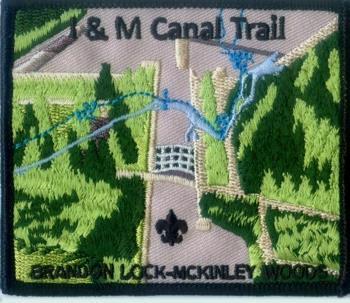
3 I & M Canal Trail The I & M Calan tral spans 61.9 miles from Joliet to LaSalle and, you guessed it, follow along the I & M Canal. This trail is meant for the avid hiker looking for a significant challenge. The trail itself has a number of historic sites. Points of interest, and parks to checkout along the way, such as Brandon Lock, McKinley Woods, Seneca Grainery, a few aquaducts, the Ottawa Scouting Museum, Chief Shabbona gravesite, the steamboat basin, and much more. There are also camping opportunities at some of the parks for hikers looking to make this into a multi-day adventure. Start: Outskirts of Joliet End: LaSalle Site: (Includes Maps) Trail 1: Brandon Lock McKinley Woods. Length: 14 miles Start: Brandon Road and Route 6 (Brandon Lock) End: McKinley Woods (Channahon, IL) Trail 2: McKinley Woods Gebhardt Woods. Length: 14 miles
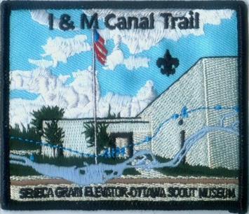
4 Start: McKinley Woods (Channahon, il) End: Gebhardt Woods (Morris, IL) Note: The nettle creek aquaduct has collapsed and during repairs hikers will have to go around the block. Trail 3: Gebhardt Woods Seneca Grain Elevator. Length 10 miles Start Gebhardt Woods (Morris, IL) End: M.J. Hogan Grain Elevator Seneca, IL Trail 4: Seneca Grain Elevator Ottawa Scout Museum Length: 12.9 miles Start M.J. Hogan Grain Elevator Seneca, IL End: Ottawa Scouting Museum Ottawa, IL
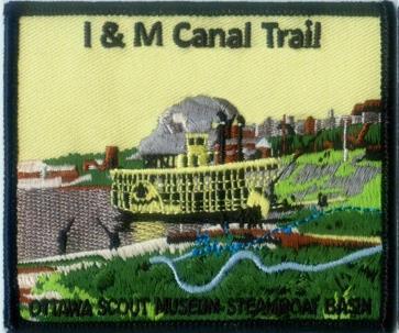
5 Trail 5: Ottawa Scouting Museum Steamboat Basin Length: 14.2 miles Start: Ottawa Scouting Museum Ottawa, IL (A couple blocks from the trail) 14.2 miles End: Trail End (Near Intersection of A Street and 351 in Lasalle, IL) Notes: The trail is washed out in sections at Buffalo Rock State Park. Follow the road that parallels the trail. Traffic is light on the road, but speeds are quick.


6 I & M Canal Trail Patch Sete

7 Chief Wauponsee Glacial Trail This trail is named after Chief Wauponsee, a Potawatomi Indian Chief and follows a glacier lake. The trail Goes from Joliet to the Kankakee River and passes through Manhattan, Symerton, Midewin and finally into Kankakee. The total length is 22 miles and has been broken into two approximately 10 mike hikes. Trail 1: Length: 8.4 miles Start: Drop off by tracks just north of Rowell and Fuller Street in Joliet, IL End: Manhattan Train station just south of Elwood Road Trail 2: Length: 13 miles Start: Manhattan Train Station just of Elwood Road End: Route 113 and Washington St Wilmington, IL

8 Rock Run Greenway Trail The Rock Run Greenway Trail is a flat, paved linear trail and travels 9.93 miles through the forest, prairie, and wetland of Rock Run Preserve. Distance: 9.93 miles Start: Lower Rock Run Preserve in Joliet, IL. Get on I & M canal trail west and then follow the 16 mile bike loop signs. End: Theodore Marsh

9 Hike the Rock Trail Hike the rock trail is a 16 mile loop trail that consists of the Rock run greenway trail, the Joliet Junction Trail, and the I & M Canal trail. Hikers will set out northward along the Rock Run Trail, which passes through property owned by Joliet Junior College and by the Forest Preserve District of Will County to the Rock Run Greenway Black Road Access. Street routes will take hikers to the District s Theodore Marsh Preserve, on Theodore Street in Crest Hill, where they will begin hiking southward along the Joliet Junction Trail. In Rockdale, this trail joins with the I & M Canal State Trail, which will be used to return to the starting point at the lower rock run preserve. Distance: 16 mile loop Start: Lower Rock Run Preserve in Joliet, IL. Get on I & M canal trail east and then follow the 16 mile bike loop signs. This is the Rock Run Greenway trail, Joliet Junction Trail, and part of the I & M Canal trail forming a 16 mile loop. End: Lower Rock Run Preserve. Map:
10 Old Plank Road Trail The old Plank road trail is full of history. It originated as part of the Great Sauk Trail that ran through Illinois, Indiana, and parts of Michigan. The trail was used by the Sauk, Fox, Ho-Chunk (Winnebago), Kickapoo, Potawatomi, Kaskaskia, and Peoria tribes. As settlers moved into the area, the trail was converted into a wagon trail and in the 1840s the trail was slated to become a plank road, which is where the trail gets its name. In the 1850s, the Michigan Central Railroad made it into a rail trail. The rail trails were abandoned in the 1970s and then converted into a hiking trail which opened in The hike is broken into two trails and there is a two patch set for this hike. The first trail ends at Breidert Green park in Frankfort, IL. There s many activities in this park, so you can coordinate the hike with a fun activity in the park. The second trail starts in Breidert park and ends at Beacon Hill Park in Park Forest. Distance:22 miles Trail #1: Distance 11 miles Start: Old Plank Road Trail Washington Street access. Park is near corner of Washington and Adella Avenue in Joliet, IL End: Breidert Green Park Frankfort, IL Trail #2: Distance 11 miles Start: Breidert Green Park Frankfort, IL End: Beacon Hill Park Park Forest, IL More info and map:

11 Old Plank Road Trail Patch Set

12 Hickory Creek Barrens The preserve is part of the Hickory Creek preservation system, which conserves more than 2,000 acres of land. The preserve is the District's largest individual preserve, and the majority of the land was acquired for a regional storm water reservoir which was never constructed. This access area features the New Lenox Historical Society's historic one-room Schmuhl School. The brick school we see now was erected in 1932 and classes were started in This new school was modern for its time having a furnace in the basement, electricity, water and indoor chemical toilets. It also was a one-room school and had all eight grades in the one classroom. The typical school enrollment was 12 students. Distance: 5.93 miles Start: Hickory Creek Barrens Nature Preserve on Schoolhouse road just north of 30 in New Lenox. Follow the outer loop on the map listed below. End: Hickory Creek Barrens Nature Preserve. Map:

13 Thorn Creek Nature Preserve Thorn Creek Woods protects a diversity of habitats, including forest, prairie, savanna, wetland, and a portion of Thorn Creek. Wildlife found at the preserve includes the southern flying squirrel, warbler, woodpecker, and a variety of hawk species. The preserve is also home to a variety of plant species, including basswood and sugar maple. Thorn Creek Woods features the Thorn Creek Nature Center, which was converted from a historic 1862 church and is managed by the Village of Park Forest. The Nature Center offers nature education opportunities for families. Distance: 2.5 miles Start: 270 S Old Monee Road Park Forest, IL. Follow the wetland trail on the map. Source: 270 S Old Monee Road. More Info: Map:

14 Little Scouter Natural Trail Award The Little Scouter Nature Trail Award is designed with the younger scout or any youth in mind. Each site has a nature center or accommodations to learn more about the natural history of the area. The hikes are all relatively short and generally easy for the younger hikers. By visiting each of these centers, hiking the nature trails and picnicking in the area, each youth will improve their knowledge of the area and make some lasting memories. Trail Requirements To meet the requirements for the awards offered for your visit to each of these nature centers you must do the following; Visit the nature center building and sign the guest book, if available (Ironworks excluded) Hike all nature trails at each center Have a picnic lunch at the nearest picnic area.

15 Joliet Historic Ironworks Site The Joliet Iron and Steel Works was once the second largest steel mill in the United States. Joliet Iron Works was initially run from 1869 to 1936.Joliet Steel Works eventually became unprofitable and all operations were ceased by the early 1980s. In the 1990s, the Forest Preserve District of Will County purchased the property containing the ruins of the ironworks to preserve a piece of history. The site itself features the remnants of the steel mill, which are on display throughout the site. Distance: 1.3 miles Start: on I-80, take Exit 132 and follow US 53 north for 1.7 miles. Follow IL 53 through downtown Joliet, and then look for the Joliet Iron Works Historic Site sign as IL 53 follows East Columbia Street to the left. End: Back at the parking lot where the hike begins. More Info: Map: JolietIronWorksMap-2011.pdf

16 KANKAKEE RIVER STATE PARK Several prehistoric sites are documented within Kankakee River State Park. The park is within a region used by Illini and Miami Indians at the time of the first European contact in the 1670s and 1680s. By 1685 the Miami were sufficiently numerous that the Kankakee River was called the River of the Miami. Kickapoo and Mascouten also were in the region from 1679 until the 1760s. Potawatomi Indians hunted along the Kankakee River in the 1760s, and by the 1770s the Potawatomi, Ottawa and Chippewa nations - "The Three Fires" - dominated the area. The most extensive village was "Rock Village" or "Little Rock Village" inside the present-day park near the mouth of Rock Creek. In 1830 it was the site of the last great Indian Council. Following the Black Hawk War in 1832, the Potawatomi ceded all of their land along the Kankakee and Illinois rivers to the United States. Most Potawatomi left the area by the end of the decade, except for Chief Shaw-waw-nas-see, whose grave is commemorated by a boulder along the nature trail at Rock Creek. The trail along Rock Creek lets hikers take in the beauty of limestone canyons and a frothy waterfall. Distance: 3 miles Start: 5314 West Rt. 102 Bourbonnais, IL. Follow the Trail on Rock Creek. 1.5 miles until the end of the park property. End: Trail loops back to starting point. More info: Map:

17 Hidden Oaks Conservation Area Hidden Oaks Conservation area ensures that visitors of all ages and backgrounds have opportunities to connect with nature. Through interactive exhibits and hands-on activities, Hidden Oaks Nature Center inspires curiosity and exploration of the natural world in guests of all ages. Whether hitting the trails with a self-guided Discovery Pack, registering for innovative nature programs, coming out for a special event or joining our summer/winter camps, there's something for everyone at Hidden Oaks. Hidden Oaks conservation area is located at 419 Trout Farm Rd in Bolingbrook, IL. Start: Once you ve arrived at Hidden oaks and checked out the discovery center, pick one of the hikes from the map below. All trails are appropriate for young scouts. More info: Map:

18 Midewin National Tallgrass Prairie Midewin National Tallgrass Prairie is the first national tallgrass prairie and, at 19,000 acres, the largest piece of contiguous open space in northeastern Illinois. Midewin was established in 1996 on the former Joliet Arsenal. It is currently a "prairie under construction" as staff and volunteers restore the land from war plants to prairie plants. We offer many ways for you to enjoy your public land through hiking, biking, horseback riding, bird-watching, hunting and volunteering. Currently, there are trails Distance: 3 miles Start: Welcome Center S. State Route 53 Wilmington, IL A short drive will take you to the Hoff Road Trailhead. Follow the Twin oaks interim trail east to where the trail meets with the Bunker Field The Bunker Field Trail offers hikers a look into open bunkers left behind during the Joliet Army Arsenal era. Once done, get back on the Twin oaks interim trail going west and follow the trail to Turtle pond where there is a picnic area perfect for lunch. After lunch, get on old Chicago Road and follow it north back toe Hoff Road Trail Head. End: Hoff Road Trail Head. More Info: Map:

19 Goose Lake Prairie Goose Lake Prairie was sculpted by glaciers. The flat landscape with its clay-based soils was formed as the last vast sheets of ice melted more than 14,000 years ago. The area became part of a continuous grassland that stretched from Indiana to the Rockies. At one time, well over half of Illinois was covered with prairies, earning it the nickname of The Prairie State. Goose Lake Prairie, whose original 240 acres were purchased by the state in 1969, now totals 2,537 acres and is the largest remnant of prairie left in Illinois. Buffalo, wolf and prairie chicken once inhabited the area that is now Goose Lake Prairie. A reconstructed cabin at Goose Lake Prairie stands as a monument to the pioneer spirit. The original cabin was built by John and Agnes Cragg in the late 1830s near Mazon, 10 miles to the southwest. A predecessor to a truck stop, the Cragg cabin served as a stop on the old Chicago- Bloomington Teamster Trail. The second story - which was added to accommodate the Cragg s six children, making it one of the first two-story homes in Grundy County - earned the cabin the nickname of The Palace. Distance: miles, depending on the trail chosen. Start: Goose Lake Prairie Visitor Center. There are three trails: Tall Grass, Sagashaka, and Prairie View. All The trails loop around back to the Visitor Center. End: Visitor Center. More Info: Map:

20 Little Scouter Center Piece Center piece for the Little Scouter Nature Trail Award. Be sure to get this patch if you have completed one of the trails that are part of the Little Scouter Nature Trail Award.
WTR226R STEVE WEBER, WILL COUNTY TREASURER 05/24/ LEVY TAX BODY LEVY DIST PER CENT 006 FOREST PRESERVE DIST OF WILL COUNTY 35,759,224.
 006 FOREST PRESERVE DIST OF WILL COUNTY 35,759,224.22 4,269,222.71 11.938801 011 WILL CO. PUBLIC BLDG. COMM. 4,024,532.38 480,537.23 11.940200 201 CUSTER TWP TOWN FUNDS 91,231.55 16,137.24 17.688222 202
Delaware Wildlife Area
 Delaware Wildlife Area 8 miles away from Delaware 4,670 acre Wildlife Area 1) Take Rt. 36/East Williams Street eastward 2) Take left onto Rt. 42/Lake Street 3) Slight left onto Horseshoe Rd./CR. 220 4)
IOWA ORNITHOLOGISTS' UNION - Birding Sites in Dallas County
 IOWA ORNITHOLOGISTS' UNION - Birding Sites in Dallas County Printed on 7/19/2018 Beaver Bottoms Wetland (restricted) (Important Bird Area) GPS Coordinates:, Ownership: Private (see directions for access)
Segment 2: La Crescent to Miller s Corner
 goal of the USFWS refuges is to conserve, protect and enhance fish, wildlife and plants and their habitats for the continuing benefit of the American people. Refuge lands are used largely for fishing,
Appendix I. National Wetland Inventory Maps for Select Areas within the Illiana Corridor Study Area
 Appendix I ational Wetland Inventory Maps for Select Areas within the Illiana Corridor Study Area RIDGE RD CATO FARM RD. Clay RIDGE RD LOREZO RD PIE BLUFF RD Co Hwy 7 Bryant Ditch MATEO-DESELM Co Hwy 9
CELEBRATE WEST GREENWICH GEOCACHING THROUGHOUT WEST GREENWICH
 CELEBRATE WEST GREENWICH GEOCACHING THROUGHOUT WEST GREENWICH The West Greenwich Land Trust (WGLT) is sponsoring Celebrate West Greenwich, an event designed to celebrate the beauty and history of scenic
Send to: This form must be filed with the Trail Committee. We will will not camp Estimated time of arrival POKAGON - KEKIONGA TRAILS NOTICE
 CHAIN O LAKES TRAIL POKAGON - KEKIONGA TRAILS NOTICE Nov. 2007 Send to: This form must be filed with the Trail Committee Pokagon - Kekionga Trails Inc. at least five (5) days in advance of hike. P.O. Box
ORLAND PARK (CHICAGO), ILLINOIS
, ILLINOIS") ORLAND PARK (CHICAGO), ILLINOIS A GROWING OPPORTUNITY Ranked among the top 100 places to live, Orland Park is a premier community located 25 miles southwest of Chicago s Loop. Orland Park continues its
ORLAND PARK (CHICAGO), ILLINOIS A GROWING OPPORTUNITY Ranked among the top 100 places to live, Orland Park is a premier community located 25 miles southwest of Chicago s Loop. Orland Park continues its
Stephens State Park Trails
 TRAILS OF ALLAMUCHY MOUNTAIN & STEPHENS STATE PARKS Allamuchy Mountain and Stephens State Parks contain 28 marked trails providing access to diverse landscapes for walking, hiking, biking, bird-watching,
Lobbying for the Future. It's been my privilege over the past few years to do political work for the Sierra Club.
 Sauk-Calumet Group Feb.-Apr. Issue 2016 - Volume 35, Issue 1 by Patrick Coffey, Political Chair Lobbying for the Future It's been my privilege over the past few years to do political work for the Sierra
Matthiessen State Park Dells Area Hike
 90 Easy Hikes Close to Home At the south end of the hike, you ll climb on top of a mound left over from a former coal-mining operation in the park. Not far from Goose Lake Prairie, the town of Morris hosts
I&M Canal National Heritage Corridor
 Flagg Creek Historical Society Museum & Robert Vial House Address 7425 Wolf Rd City Burr Ridge County Cook 603-662-6220 Fax N/A Website www.pleasantdaleparks.org/vial_house.htm 19xx & 1998 Mngmt Flagg
A History of West Chicago
 A History of West Chicago The Prairie Prairie Inhabitants Winfield Mounds Dickson Mounds, near Lewistown, in southern Illinois. An example of what Native burial mounds look like. First Permanent Settlers
The gorges of Mohican Park in Ohio create a hiker's paradise Sunday, May 22, 2011 By Bob Downing, Akron Beacon Journal
 Pittsburgh Post-Gazette The gorges of Mohican Park in Ohio create a hiker's paradise Sunday, May 22, 2011 By Bob Downing, Akron Beacon Journal Bob Downing Big Lyons Falls drops 80 feet into a shady U-shaped
National Recreation Trail Update Form
 National Recreation Trail Update Form Introduction Thank you for taking the time to complete this form. Your assistance will help ensure that the National Recreation Trail (NRT) database is complete and
2. Goals and Policies. The following are the adopted Parks and Trails Goals for Stillwater Township:
 D. PARKS AND TRAILS 1. Introduction Stillwater Township s population is relatively low, with most residents living on rural residences on large lots. The need for active park space has been minimal in
National Recreation Trail Application for Designation
 National Recreation Trail Application for Designation Introduction Thank you for your interest in the National Recreation Trail (NRT) program. Completed NRT application packages must be submitted by December
ASRA 2018 Hike Schedule
 ASRA 2018 Hike Schedule Date/Day Destination Hike Info Meeting Info Leader Feb 10, Saturday Stagecoach and 9:00 at the Confluence kiosk. Manzanita trails Parking fee required. We ll hike along the trail
IOWA ORNITHOLOGISTS' UNION - Birding Sites in Cerro Gordo County
 IOWA ORNITHOLOGISTS' UNION - Birding Sites in Cerro Gordo County Printed on 11/17/2018 Blue-wing Marsh GPS Coordinates: 43.0834956379463,-93.4430980682373 Pure natural area primarily used for hunting.
U.S. National Forest Campground Guide
 U.S. National Forest Campground Guide Southwestern Region Arizona, New Mexico, Oklahoma and Texas National Forests and Grasslands in the Southwestern Region NF = National Forest NG = National Grassland
Crystal Lake Area Trails
 Lake Area Trails Welcome to the Lake area of the Big Snowy Mountains! This island mountain range in central Montana features peaks reaching to 8,600 feet and long, high ridges from which vistas of the
(Short Listing) DUPUYER ACREAGE, ROCKY MOUNTAN FRONT
 DUPUYER ACREAGE, ROCKY MOUNTAN FRONT") (Short Listing) DUPUYER ACREAGE, ROCKY MOUNTAN FRONT This unique property is located 8½ miles northwest of Dupuyer, Montana and approximately thirty 30 miles northwest of Choteau, Montana. Great Falls
(Short Listing) DUPUYER ACREAGE, ROCKY MOUNTAN FRONT This unique property is located 8½ miles northwest of Dupuyer, Montana and approximately thirty 30 miles northwest of Choteau, Montana. Great Falls
Dixon Trail Construction - From the Top of the Mountain 2016 Interim Report Friends of Cheyenne Mountain State Park September 2 nd, 2016
 - Dixon Trail Construction - From the Top of the Mountain 2016 Interim Report Friends of Cheyenne Mountain State Park September 2 nd, 2016 Prepared by: Andy Riter, Program Coordinator, and Joe Lavorini,
Pinellas County Environmental Lands
 Pinellas County Environmental Lands In addition to traditional parks and recreation facilities, Pinellas County owns and manages a system of environmental lands that provides specialized resource-based
HISTORICAL MARKERS issued by
 HISTORICAL MARKERS issued by INDIANA HISTORICAL BUREAU in MONTGOMERY COUNTY, INDIANA 2016 Compiled by Dian Moore, Montgomery County historian NUMBER NAME 54.1962.1 Lane Place 54.1963.1 Major General Lew
MISSISSIPPI RIVER VISITOR CENTER
 MISSISSIPPI RIVER VISITOR CENTER Program Guide Page 2 Visiting Us? While visiting our facility your group can experience navigation up close! We offer the best view of the mighty Mississippi River and
Trail Phasing Plan. Note: Trails in the Clear Creek Canyon area (Segments will be finalized in the future to minimize wildlife impacts
 Note: Trails in the Clear Creek Canyon area (Segments 2 5 and a future JCOS connection) will be finalized in the future to minimize wildlife impacts Trail Phasing Plan P Parking 3 Easy Trail Intermediate
IOWA ORNITHOLOGISTS' UNION - Birding Sites in Linn County
 IOWA ORNITHOLOGISTS' UNION - Birding Sites in Linn County Printed on 6/15/2018 Bever Park (ebird Hotspot) GPS Coordinates: 41.9851219,-91.6269125 Restrooms Parking Trails ADA Accessible Trails Boyson Trail
BACK COUNTRY UNIT PREFERRED ALTERNATIVE
 BACK COUNTRY UNIT PREFERRED ALTERNATIVE San Francisco (118 mi) Carmel-By-The-Sea Carmel River Carmel Valley Road State Beach Private Property Point Lobos State Reserve Point Lobos Ranch RUSTIC CAMPING
Field Trips
 2017 2018 Field Trips www.yourmetroparks.net 513.867.5835 The mission of the MetroParks of Butler County is to provide a superior park system that maximizes the community s quality of life through conservation,
Pocahontas Area Map Jasper INFORMATION CENTRES Lake Louise Field Golden Banff
 Pocahontas Miette Hot Springs Area Map Jasper Maligne JASPER Columbia Icefield Saskatchewan River Crossing INFORMATION CENTRES Banff National Park Louise Kootenay Park Lodge Yoho National Park Columbia
Did It. naturalists. Young. Moving and melting ice shaped many of Minnesota s land features. 30 Minnesota Conservation Volunteer
 Young naturalists by Mary Hoff Photography by Gary Alan Nelson T he Glacier Did It Moving and melting ice shaped many of Minnesota s land features. Shut your eyes. Imagine that it s a sunny summer day
ORLAND PARK (CHICAGO), ILLINOIS
, ILLINOIS") ORLAND PARK (CHICAGO), ILLINOIS A GROWING OPPORTUNITY Ranked among the top 100 places to live, Orland Park is a premier community located 25 miles southwest of Chicago s Loop. Orland Park continues its
ORLAND PARK (CHICAGO), ILLINOIS A GROWING OPPORTUNITY Ranked among the top 100 places to live, Orland Park is a premier community located 25 miles southwest of Chicago s Loop. Orland Park continues its
4 Rock River Cruise. The Ride
 4 Rock River Cruise Among the many attractions on this ride are the charming town of Oregon, the John Deere Historic Site, and a handful of picturesque parks where you ll be enveloped in the local scenery.
A Symposium on Fire Its History and Future Role in Shaping Ecosystems
 The Illinois Prescribed Fire Council Registration Package for A Symposium on Fire Its History and Future Role in Shaping Ecosystems Thursday and Friday, May 7 th and 8 th, 2009 At The Field Museum Chicago,
Baltimore County Nature Quest NEW TRAILS 2014
 Baltimore County Nature Quest NEW TRAILS 2014 Nature Quest Park Locations Robert E. Lee Park Cromwell Valley Park Agricultural Ctr. & Farm Park Honeygo Regional Park Marshy Point Park and Nature Center
Little Grand Canyon near Pomona, Illinois
 Little Grand Canyon near Pomona, Illinois Below: View of the trail and the terrain created using the Map My Hike app Below: Summary of the hike created using the Map My Hike app Presented by: Jennifer
Berg Ridge BERG RIDGE 1
 Berg Ridge BERG RIDGE 1 Berg Ridge: $13,650,000 ($75,000 / ERU) Jordanelle Basin Wasatch County, Utah LOCATION: North Central Utah in the Jordanelle Basin of Wasatch County a 45-minute drive from downtown
Mississippi River Visitor Center. Program Guide
 Mississippi River Visitor Center Program Guide Visiting us? While visiting our facility your group can experience navigation up close! We offer the best view of the mighty Mississippi River and of the
FINAL TESTIMONY 1 COMMITTEE ON RESOURCES UNITED STATES HOUSE OF REPRESENTATIVES. July 13, 2005 CONCERNING. Motorized Recreational Use of Federal Lands
 FINAL TESTIMONY 1 STATEMENT OF DALE BOSWORTH CHIEF Of the FOREST SERVICE UNITED STATES DEPARTMENT OF AGRICULTURE Before the SUBCOMMITTEE ON FORESTS AND FOREST HEALTH And the SUBCOMMITTEE ON NATIONAL PARKS,
The following trails completed their work utilizing funds awarded by the Greenways Foundation:
 The Greenways Foundation Grant Awards 2013 and 2014 Our grant program has been in place since 2012 and is funded entirely by the proceeds received through our Indiana BMV specialty license plate. Please
Kit Carson-Challenger Ridge Trail Project
 Kit Carson-Challenger Ridge Trail Project Project Accomplishments Report-USFS December 15, 2015 Photo courtesy of Justin Peterson 815 South 25 th Street, Suite 101 Colorado Springs, CO 80904 Dedicated
This Passport: Revised October 20, 2017, EAM # Discovering the Trails of Webster, NY
 This Passport: Revised October 20, 2017, EAM #161923 Discovering the Trails of Webster, NY The Town of Webster invites you to explore and experience our diverse outdoor adventures! Here s your opportunity
Waterways and Floods. by Michael Pearce. Smith-Layton Archive. Sponsored by Linda L. Lester
 Smith-Layton Archive Waterways and Floods Charlene Duval, Executive Secretary cduval@sourisseauacademy.org Leilani Marshall, Archivist lmarshall@sourisseauacademy.org by Michael Pearce Phone: 408 808-2064
Explore your Town With The Kingston Area Trail Passport
 Explore your Town With The Kingston Area Trail Passport Don t forget to stop at the children's room in the library for your prize when you collect 5 Passport Stamps! For more natural resource related information,
Superstition Wilderness Trails West: Hikes, Horse Rides, And History By Jack Carlson, Elizabeth Stewart
 Superstition Wilderness Trails West: Hikes, Horse Rides, And History By Jack Carlson, Elizabeth Stewart This trail highlights the immense diversity of the desert in a quick 5.5 mile a nice, easy path through
F.O.K.O.S. Friends of Kingston Open Space A GUIDE TO KINGSTON OPEN SPACE
 F.O.K.O.S. Friends of Kingston Open Space A GUIDE TO KINGSTON OPEN SPACE Friends of Kingston Open Space (FOKOS) was formed when a handful of concerned citizens joined together to learn what could be done
Northeast Quadrant Distinctive Features
 NORTHEAST QUADRANT Northeast Quadrant Distinctive Features LAND USE The Northeast Quadrant includes all the area within the planning area that is east of Interstate 5 and to the north of State Route 44.
SIMON CANYON AREA OF CRITICAL ENVIRONMENTAL CONCERN (ACEC)
") SIMON CANYON AREA OF CRITICAL ENVIRONMENTAL CONCERN (ACEC) Activities: Facilities: Season / Hours: Description: Hiking, backpacking, fishing, picnicking, watchable wildlife. A graveled parking area, picnic
SIMON CANYON AREA OF CRITICAL ENVIRONMENTAL CONCERN (ACEC) Activities: Facilities: Season / Hours: Description: Hiking, backpacking, fishing, picnicking, watchable wildlife. A graveled parking area, picnic
PART 12 - Directory Services 1st Revised Sheet 1 SECTION 3 - Directory Distribution
 PART 12 - Directory Services 1st Revised Sheet 1 GENERAL All terms and conditions set forth in this Section, including but not limited to those applicable to line(s) and network access line shall be fully
Illinois Community College Board. Table 1 A SUMMARY PROFILE OF THE ILLINOIS PUBLIC COMMUNITY COLLEGES
 Illinois Community College Board Table 1 A SUMMARY PROFILE OF THE ILLINOIS PUBLIC COMMUNITY COLLEGES District Size 2016 Tax Rates Extended Student Enrollment 2016 Tax Educ. All Annual FY 18 Annual Dist.
Kit Carson-Challenger Ridge Trail Project Annual Performance Report-2014 October 22, 2014
 1 Kit Carson-Challenger Ridge Trail Project Annual Performance Report-2014 October 22, 2014 Willow Lake and Kit Carson Peak 2 SUMMARY The Rocky Mountain Field Institute began Phase 1 of a multi-phase,
Driving Time: 3 hours (allow extra time for stops)
") Scenic Byways loop This journey takes visitors through the eastern edge of Mt. Rainier National Park and along two of Washington s most beloved scenic byways, the Chinook Byway and the White Pass Scenic
Scenic Byways loop This journey takes visitors through the eastern edge of Mt. Rainier National Park and along two of Washington s most beloved scenic byways, the Chinook Byway and the White Pass Scenic
County - Illinois Resource & Relocation Guide
 LaSalle County - Illinois 2018-2019 Resource & Relocation Guide 1 2 3 CONTENTS 7 Welcome Published By: In association with 8-9 Newcomer Information 10 Help Hotlines 11 Health & Hospitals 13 Local Education
Wool Ranch 20 Acres 20 +/- acres Sunol, CA Alameda County
 Wool Ranch 20 Acres 20 +/- acres Sunol, CA Alameda County 707 Merchant Street Suite 100 Vacaville, CA 95688 707-455-4444 Office 707-455-0455 Fax californiaoutdoorproperties.com CalBRE# 01838294 Introduction
APPENDIX D TIERED FREIGHT PROJECTS
 APPENDI D TIERED FREIGHT PROJECTS September 2017 [This page is intentionally blank] Tier Map ID Type Jurisdiction INTERSTATE CORRIDORS 1 20 I-80 from I-355 to Harlem Ave I $123,839,000 I-80 1 14 I-80 from
UMASS CROSS-COUNTRY Trails
 UMASS CROSS-COUNTRY Trails 1) EGG (43 min) (A) From Cage proceed to North Pleasant street (by campus pond). Make left and head toward LGRT and pass School of Education. Pass Puffton Apt complex (on left)
Difficult Run Stream Valley Park
 Difficult Run Stream Valley Park The more intense mountain bikers have known about for Difficult Run for some time. Equestrians have known it longer. Eight miles of unpaved trail, the Rails to River Trail
Municipal Park Descriptions: 1. Bear Hollow Park 4100 Bear Hollow Park Court, Murrysville, PA acres
 MUNICIPAL PARK DESCRIPTIONS Murrysville has a wide variety of parks and recreational facilities including sports fields, neighborhood parks, community parks, a Community Center, and extensive natural areas
Cuyahoga Valley National Park Ohio
 Cuyahoga Valley National Park Ohio Brandywine Falls The Ledges The Beaver Marsh Temperate Deciduous Forest How To Get There... Located between Cleveland & Akron, Ohio Cuyahoga Valley National Park can
2009 RIVER TOWN OF THE YEAR AWARD APPLICATION Supplemental Material Images
 2009 RIVER TOWN OF THE YEAR AWARD APPLICATION Supplemental Material Images Our History The earliest record of settlement along the river is in 1854; one of the earliest in Carroll County. About this time
Non-motorized Trail Plan & Proposal. August 8, 2014
 Town of Star Valley Ranch, Wyoming and the Star Valley Ranch Association in partnership with the USDA Forest Service, Bridger-Teton National Forest, Greys River Ranger District Non-motorized Trail Plan
proof Northwest District
 1 Northwest District The Northwest Florida Water Management District is the most rural of all five water management districts. From just east of Tallahassee west to the Florida/Alabama line, and from the
2 7 5 L O O P 2 5 : : E
 275 loop 25 :: Eden Park 125 Eden Park 25 In Brief Eden Park offers an array of activities, including a playhouse, amphitheater, conservatory, art museum, outdoor sculptures, and gardens. Plan to spend
Summary. River and way from. River and through the. goods from. Chicago. Ship Canal. Grade Level: 7 th. 8 th. historic time. of the.
 Chicago River Classroom Activity Summary Students will construct a time line using events from U.S. and Illinois History. Then they will attempt to place events particular to the history of the Chicago
Cincinnati Nature Center s
 120 60 hikes within 60 miles: cincinnati 24 Cincinnati Nature Center s Rowe Woods i KEY AT-A-GLANCE INFORMATION Length: 8.9 miles Configuration: Loop Difficulty: Difficult Scenery: Forest, ponds, prairie,
Acquisition in fee simple of approximately one-half acre of property on the shore of Spring Lake to expand the Lakeside Beach Park.
 Lakeside Beach TF00-136 $122,550.00 in fee simple of approximately one-half acre of property on the shore of Spring Lake to exp the Lakeside Beach. 2000 River Ravines TF00-150 $910,000.00 in fee simple
THE USA. The capital of USA is Washington D.C., in the District of Columbia.
 THE USA The United States of America is the richest and one of the biggest countries in the world. It has a population of about 295 million people. It is divided into 50 states; two of them, Alaska and
Centred Outdoors is an open invitation for people of all ages and fitness levels to explore ten outdoor destinations in Centre County, Pennsylvania,
 Centred Outdoors is an open invitation for people of all ages and fitness levels to explore ten outdoor destinations in Centre County, Pennsylvania, throughout the summer of 2018. Together, we ll stress
Segment 4: Hokah to Mound Prairie
 Root River Wildlife Management Area The main unit of this WMA is located just north of the Root River and the city of Hokah. Its 443 acres include mixed hardwoods of oak, basswood, ash, cottonwood, elm
FRONTIER TRAILS Tour groups cruising through the
 on location: midwest randy mink NEBRASKA S FRONTIER TRAILS Tour groups cruising through the heart of Nebraska don t have to stray far from the superhighway to get a taste of early life on the prairie.
Hiking Trail Descriptions
 Hiking Trail Descriptions For ye shall go out with joy. And be led forth with peace. The mountains and the hills shall break forth before you in singing. And all the trees of the fields shall clap their
Glacier National Park, MT
 Glacier National Park, MT July 28 Aug. 1, 2010 We decided to go to Glacier National Park for our family vacation this year. We had a great time seeing beautiful scenery and a variety of wildlife which
Trailhead Ambassadors 2018 Latourell Falls: Alternative Hikes
 Trailhead Ambassadors 2018 Latourell Falls: Alternative Hikes General Note: The Historic Highway is closed from the Bridal Veil exit to its eastern end near Wyeth i.e., the Waterfall Alley section. The
Trail Guide. The Nunckatessett Greenway. Wildlands Trust. AmeriCorps MassLIFT. Bridgewater, MA & West Bridgewater, MA
 This trail guide was compiled by Allison Gillum, Regional Conservationist, and Sarah Kugel, Community Outreach Coordinator, serving at Wildlands Trust through the AmeriCorps MassLIFT program. Wildlands
Student Reading 13.10: The Regions of Ohio
 Student Reading 13.10: The Regions of Ohio Ohio has five natural regions which formed more than 10,000 years ago. A natural region is an area that shares the same natural features. These places have similar
ROANOKE MOUNTAIN ADVENTURES 2-8 hours / Varies Based on Activity
 Insert Date Here ROANOKE MOUNTAIN ADVENTURES 2-8 hours / Varies Based on Activity The Ultimate Outdoor Adventure in Virginia s Blue Ridge Have a group and looking to get them outdoors for some adventure?
Region 1 Piney Woods
 Region 1 Piney Woods Piney Woods 1. This ecoregion is found in East Texas. 2. Climate: average annual rainfall of 36 to 50 inches is fairly uniformly distributed throughout the year, and humidity and temperatures
Central Overland Trail Utah & Nevada Driving Guide, First Edition, 2016
 Central Overland Trail Utah & Nevada Driving Guide, First Edition, 2016 Page 51 In the third paragraph, second sentence, change 0.4 miles to 0.1 miles. In the fourth paragraph, second sentence, change
Young State Park. Charlevoix County, Michigan
 Young State Park Charlevoix County, Michigan 1920 2010 Young State Park, on Lake Charlevoix (previously called Pine Lake) originated in 1920 when 100+ acres of land was donated to the State by Boyne City.
The mission of Liberty State Park is to provide the public with access to the harbor s resources, a sense of its history and a charge of
 Liberty State Park The mission of Liberty State Park is to provide the public with access to the harbor s resources, a sense of its history and a charge of responsibility to its continued improvement.
Roduner Ranch FOR SALE. 5,878± Acres Potential Development Land. Merced County, California. Offices Serving The Central Valley
 FOR SALE 5,878± Acres Potential Development Land Merced County, California Offices Serving The Central Valley F R E S N O V I S A L I A B A K E R S F I E L D 7480 N. Palm Ave, Ste 101 3447 S. Demaree Street
President Roosevelt and Naturalist John Burroughs at Fort Yellowstone. Ruined Castles of Yellowstone. East Entrance Station
 President Roosevelt and Naturalist John Burroughs at Fort Yellowstone Ruined Castles of Yellowstone East Entrance Station President Roosevelt at Liberty Cap Yellowstone Lake, Mary s Bay Fire Hole River
CRAZY HORSE TRAIL GUIDE
 CRAZY HORSE TRAIL GUIDE Abridged Version: July 2016 This is a short form of our interpretive trail guide for the Crazy Horse Trail. The full version of the guide has a more detailed description of the
FEASIBILITY CRITERIA
 This chapter describes the methodology and criteria used to evaluate the feasibility of developing trails throughout the study areas. Land availability, habitat sensitivity, roadway crossings and on-street
W E L C OM E TO BAC K Y AR D N AT U R E C E N TER S SITE R E SOURCE PAC K E T S!
 LITTLE HOUSE OF GLENCOE Last updated September 7, 2011 W E L C OM E TO BAC K Y AR D N AT U R E C E N TER S SITE R E SOURCE PAC K E T S! BackYard Nature Center (BYNC) has selected and described six nature
A Publication of Friends of Sleeping Bear Dunes
 A Publication of Friends of Sleeping Bear Dunes 2014, Friends of Sleeping Bear Dunes, P.O. Box 545, Empire, MI 49630 www.friendsofsleepingbear.org info@friendsofsleepingbear.org Learn more about the Friends
Partners: Michigan California Timber Company Shasta-Trinity National Forest Pacific Crest Trail Association The Trust for Public Land
 Partners: Michigan California Timber Company Shasta-Trinity National Forest Pacific Crest Trail Association The Trust for Public Land Describe the project location, size, opportunities, and timing. Provide
Preferred Recreation Recommendations Stemilt-Squilchuck Recreation Plan March 2018
 Preferred Recreation Recommendations Stemilt-Squilchuck Recreation Plan March 2018 Below are the recommended recreation ideas and strategies that package together the various recreation concepts compiled
Projects Awarded GOCO Funding in El Paso County
 Grant Type Fiscal Year Sponsor Title Grant Amount Acres Conserved Inspire 2016 City of Colorado Springs Out the Door Pikes Peak! $75,000.00 0 Parks 2016 Colorado State Parks 2016 City of Manitou Springs
(Jo Daviess, Stephenson, Winnebago, Boone, Carroll, Ogle, Whiteside, Lee, Rock Island, Henry counties)
") District 1 (Cook, DuPage, Will, McHenry, Kane and Lake Counties) District 2 -Jane Byrne Interchange reconstruction in Chicago o $76.6 million; $31.8 million spent o Spread over four separate contracts
District 1 (Cook, DuPage, Will, McHenry, Kane and Lake Counties) District 2 -Jane Byrne Interchange reconstruction in Chicago o $76.6 million; $31.8 million spent o Spread over four separate contracts
Milwaukee River (Washington County) Segment. Kewaskum. Æÿ B. Æÿ D Southern. Kewaskum. Segment.
 Segment. Kewaskum. Æÿ B. Æÿ D Southern. Kewaskum. Segment.") Ice Age Trail Washington County Washington County FOND DU LAC WASHINGTON Æ% 28 Æÿ H Milwaukee River (Washington County) Æÿ B Æÿ S State Forest Northern Kettle Moraine Æÿ H Æ% 28 Ice Age Trail Alliance
Ice Age Trail Washington County Washington County FOND DU LAC WASHINGTON Æ% 28 Æÿ H Milwaukee River (Washington County) Æÿ B Æÿ S State Forest Northern Kettle Moraine Æÿ H Æ% 28 Ice Age Trail Alliance
Saturday, June 17 to Sunday June 25, Stampede to Cody
 Saturday, June 17 to Sunday June 25, 2017 Stampede to Cody Wind River Canyon Wind River Canyon is a scenic Wyoming canyon carved out by the Wind River. It is located between the cities of Shoshoni and
TAYLOR CANYON RANCH COLORADO - ROUTT COUNTY - STEAMBOAT SPRINGS
 TAYLOR CANYON RANCH COLORADO - ROUTT COUNTY - STEAMBOAT SPRINGS Tucked up against the steep valley shaped by Mt. Pau and rising to the Routt National Forest, Taylor Canyon Ranch is an easily accessible,
Bike MS Ride, West Michigan Riding In Historical Allegan County
 Bike MS Ride, West Michigan Riding In Historical Allegan County The Michigan Chapter of the National MS Society would like to extend our gratitude to the Steering Committee for the West Michigan Bike MS
What Is An Ecoregion?
 Ecoregions of Texas What Is An Ecoregion? Ecoregion a major ecosystem with distinctive geography, characteristic plants and animals, and ecosystems that receives uniform solar radiation and moisture Sometimes
Meshach Browning Trail System at the Deep Creek Lake Lion s Club Park on Bumble Bee Rd.
 Meshach Browning Trail System at the Deep Creek Lake Lion s Club Park on Bumble Bee Rd. The Meshach Browning trail system will be a public, non-motorized, multi-use (running, dog-walking, cross country
throu Booth Hill Green Belt
 s k r a p s l l u b m u r T Explore gh Geocaching throu Booth Hill Green Belt This was originally a concept to try and preserve some of the land in our town, without hurting the developers that are creating
Windsor Kingsville Essex Tour:
 An Ontario's Southwest Cycling Itinerary Windsor Kingsville Essex Tour: Pedal into the Heart of Southern Ontario s Wine Country CYCLE LOTS TO SEE AND LOTS TO DO IN ONTARIO S SOUTHWEST Total Distance: 130
Oregon Equestrian Trails Mt. Hood Chapter
 Oregon Equestrian Trails Mt. Hood Chapter November 17, 2010 To: Michelle Lombardo, Mt. Hood National Forest From: Barb Adams, Oregon Equestrian Trail, Mt. Hood Chapter Re: Barlow and Hood River Ranger