ON OCTOBER 3, 1982 Dana
|
|
|
- Phebe O’Brien’
- 5 years ago
- Views:
Transcription
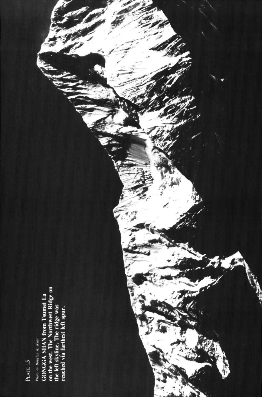
1 Gongga Shan- Minya Konka Revisited DOUGLAS KELLEY and JOSEPH E. MURPHY ON OCTOBER 3, 1982 Dana Coffield and Douglas Kelley reached the summit of Gongga Shan, a 24,891-foot peak in western Sichuan province of the People s Republic of China. Fifty years earlier two other Americans, Richard Burdsall and Terris Moore made the first ascent of the mountain, then called Minya Konka. In the intervening years savage weather and avalanche combined to defeat six of nine expeditions to the peak, and more lives were lost attempting the mountain than had made it to the summit. The 1932 expedition was a remarkable achievement. It sailed from Boston at the height of the depression, spent two months at sea, and docked at Shanghai as the Japanese began shelling the city. There the expedition split; four members continued, travelling fifteen hundred miles up the Yangtse river to find a mountain whose height and location were unknown. Theodore Roosevelt s sons had seen the mountain from considerable distance while searching for pandas and reported that it was higher than Everest. Moore s party found the peak, surveyed it, and after 27 days reached the summit by the northwest ridge. For a quarter century thereafter, Minya Konka remained the highest summit reached by Americans. In 1957 the Chinese in launching their first major mountaineering expedition selected Minya Konka, which they renamed Gongga Shan. Gongga was the logical choice because it is one of China s four sacred mountains and the highest peak in China proper. They picked the northwest ridge as their route. It was a massive effort with twenty-one Chinese climbers, an equal number of scientists, and a large support group. The team made the attempt under the leadership of Shi Zhan Chun who later led the successful Chinese Everest expedition, Thirteen climbers were caught in an avalanche on the snow chute below Camp I. Many were injured, but only one perished. Six members of the team reached the top and of these three died while descending the summit ridge. When the Chinese opened eight peaks to foreigners in 1980, the first expeditions allowed to return to Gongga were American. One American See A.A.J., 1981, pages 309 to

2 GONGGA SHAN-MINYA KONKA REVISITED 47 Gomba, 5755 meters, 18,840 feet, first ascent, via South Ridge, October 12, 1982 (Coffield, Lehner); October 13, 1982 (Andrews, Murphy). PERSONNEL: Joseph E. Murphy, leader, Edmund D. Andrews, Dana Coffield, Sharon Caulfield, Barbara Kelley, Douglas A. Kelley, Michael C. Lehner; Mr. Wong, liaison ofher, Mr. Liu, interpreter.
3
4 42 THE AMERICAN ALPINE JOURNAL 1983 expedition attempted a new route up the south face. The team was led by Andy Harvard and included Henry Barber, Lou Reichardt, and Jed Williamson. The other expedition sought to repeat the northwest ridge. Four members, Yvon Chouinard, Rick Ridgeway, Kim Schmitz and ABC cameraman Jonathan Wright were caught in an avalanche just above Camp I and swept down fifteen hundred feet. Wright died in the fall and was buried on the mountain. In 1981 a Swiss expedition was to attempt the peak from the southeast, via the Hailoko Glacier, and a Japanese expedition tried the northeast ridge. The Swiss were turned by bad weather to other peaks. One Japanese fell when 100 meters from the summit. The other seven in the summit party retreated, but they too pitched down the north face and were killed. In the Spring of 1982, Japanese, Swiss and Canadian expedition? attempted the peak. The Canadians tried the original route, but were turned back at Camp I by an accident and unfortunate weather. The Japanese approached the mountain from the east, placed two men within 300 meters of the summit, but then retreated in the face of storms. After one member perished from exposure, the other staggered into Base Camp and discovered that his teammates had abandoned him. He survived a nineteen-day ordeal but later lost his fingers and feet from frostbite. Three Swiss climbers attained the summit, reaching the northwest ridge from the east, but one slipped descending the summit ridge and died. The experience of the prior expeditions caused us to approach our preparations with great caution. Our expedition was initiated by Ned Andrews and Doug Kelley who had met in Peru on separate expeditions in In 1980 we applied for permission to attempt the mountain by the northwest ridge and were granted a permit for the fall of Joe Murphy flew to Beijing in February 1981 to complete the arrangements and sign the protocol. The party consisted of seven Americans: Joe Murphy, leader, Ned Andrews, deputy leader, Sharon Caulfield, Dana Coffield, Barbara Kelley, Doug Kelley, and Michael Lehner, and two Chinese, Mr. Wong, liaison officer, and Mr. Liu, interpreter. On the advice of the Chinese we planned a two-month expedition to allow sufficient time for the attempt. We knew that the Canadians had but two good days in eighteen in the spring of The Swiss, a year earlier, had seen but four fair days in fifty. The Swiss geologist Imhof had predicted bad weather in September and early October. We knew that our prospects would depend on favorable weather. We arrived in Beijing on September 3, reached Chendu 1200 miles to the southwest by train on the 9th after a stop in Xian to see the archaeological site, and made the end of the road at Liu Baxiang by minibus on the 13th. From here horses carried our equipment, but to minimize expenses we planned not to use porters. After crossing a l5,200-foot pass, the Tsemei La, we arrived at the See A.A.J., 1982, pages 383 to 385. See Climbs and Expeditions section of this Journal.

5 .
6
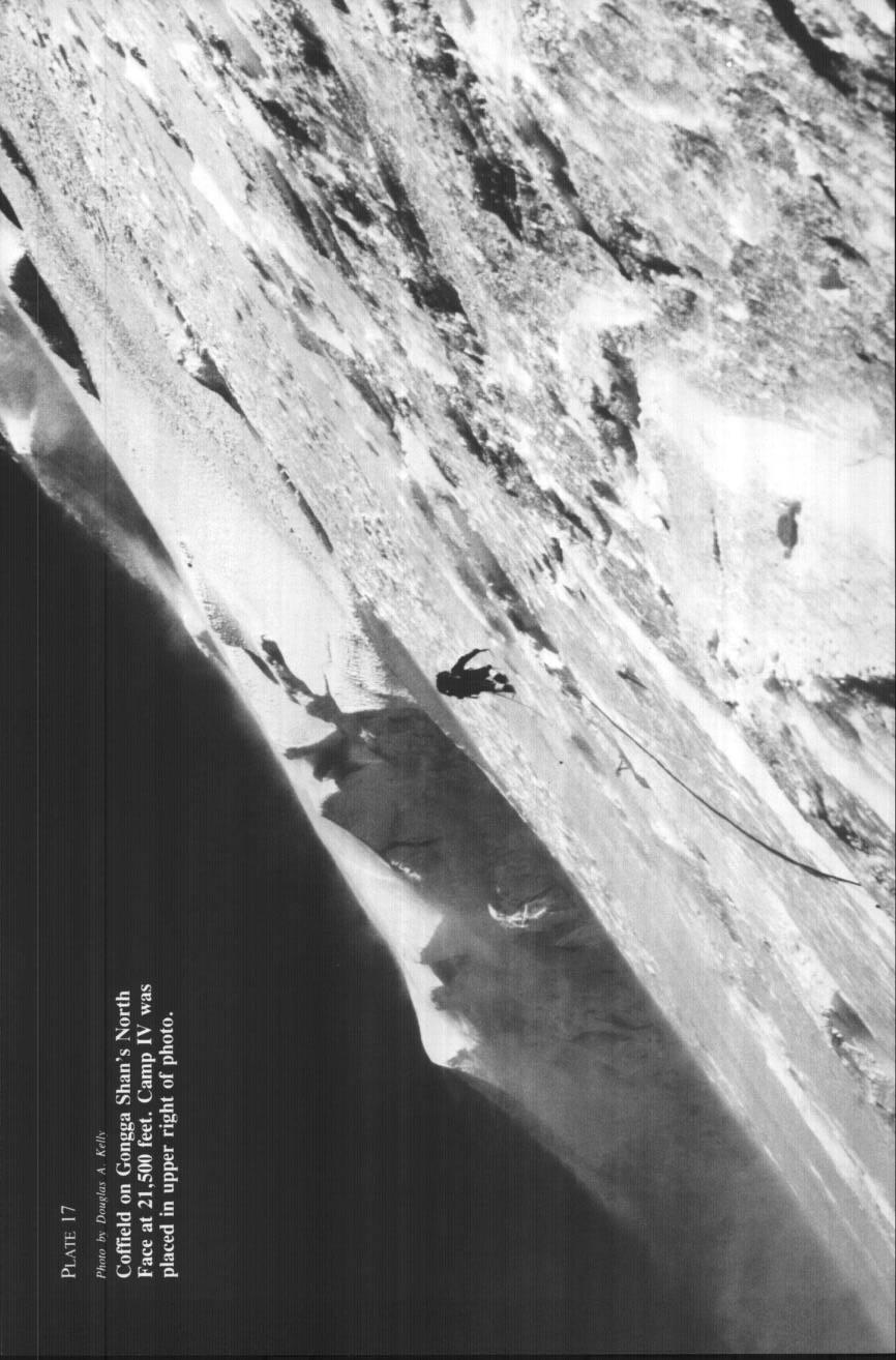
7 GONGGA SHAh-MINYA KONKA REVISITED 45 Gongga Gompa Lamasery at 12,600 feet on September 16 where we established Base Camp. We were still in the grip of the monsoon which had brought daily rain since the first of September. On arrival at the lamasery Michael Lehner became violently ill with dysentery. On September 17 we began carrying loads to Advanced Base Camp located at 14,500 feet, five miles away in a meadow just below the northwest ridge. The route descended 300 feet from the lamasery to the Little Gomba River valley and then followed the river to the meadow. The carry was long and arduous because it involved crossing the river several times. Over the next three days we carried thirteen loads to Advanced Base. Because of the difficulty that past parties had in establishing Camp I and uncertain weather, we felt it important to commence exploration of the route to Camp I as soon as possible. At a team meeting on the 18th Murphy designated Coffield and D. Kelley as the lead team, and himself and Lehner as the second team. Kelley and Coffield moved to Advanced Base Camp on September 19 and immediately began exploring the route to Camp I. Although not technically difficult, the route from Advanced Base to the ridge was objectively the most dangerous area on the mountain. AI1 the previously reported avalanches had occurred in the afternoon. Kelley and Coffield decided that they would only travel on the snow from dawn to 9:30 A.M., the time the morning sun hit the slope. The traditional route followed a snowfield to the right of a rock pyramid. The Canadians got mired down when they tried to avoid the snow and stay on the rock. We found a couloir between the two which, despite continuing rockfall, remained free of avalanche danger except while climbing the rock band and traversing the lower part of the snowfield on the way to the couloir. We relied primarily on that route thereafter. On the afternoon of the 23rd, Coffield and Kelley moved to a temporary camp at 16,200 feet, just below the rock band to avoid the tiresome three-a.m. starts. They arrived just in time to watch an avalanche sweep over their previous day s route across the rock band. It was an ominous sign. The following day they moved to Camp I at 18,000 feet. Camp II was established on the ridge at 19,800 feet on September 26. Kelley and Coffield were confined to the snow cave they had dug in an indentation in the ridge line for the next three days by 60 to 80 m.p.h. winds which blew northwest along the ridge. Murphy and Lehner broke through to Camp II on the 29th and spent a night in a tent next to the snow cave. The winds were so high they blew Murphy s pack off the ridge, and so Murphy and Lehner returned to Advanced Base Camp to obtain replacement equipment for the former and additional high-altitude provisions. On September 30 Coffield and Kelley proceeded up the broad, gentle ridge against high winds in low visibility carrying provisions to Camp III. The camp was placed at 20,800 feet to the north of a three hundred-foot bulge in the ridge called the Hump. The Hump was the major technical obstacle of the climb, extremely steep on the west, nearly as steep and avalanche prone on the east. It would have to be renegotiated on the descent from the summit ridge.
8 46 THE AMERICAN ALPINE JOURNAL I983 They spent a sleepless night on October 1, holding the tent down in gale-force winds. A foot of snow fell during the night, but the next morning was clear and windless. Coffield led around the east side of the Hump but retreated because the slope was avalanche prone. They then found a crevasse which sloped diagonally upward for two-and-a-half pitches to the crest of the Hump. From that point they descended three hundred feet to the narrow, corniced ridge between the Hump and the main summit ridge. They continued up the ridge onto the east face, against high winds, and pitched Camp IV in a diagonal crevasse at 22,000 feet. The campsite gave protection from avalanches but was difficult to find on the descent. On October 3 Coffeld and Kelley left for the summit at seven A.M. on a bright, clear, almost windless day. They ascended the ridge on firm snow until blocked by weirdly shaped snow gendarmes a thousand feet below the summit. They traversed east across snow-encrusted rock in deterioriating weather. Beyond the maze of snow formations, they front-pointed 150 feet to the northeast face which led to the summit. They attained the summit at 4:30 P.M. in low visibility and began the descent at five P.M. They arrived at Camp IV after several hours in darkness, in a driving snowstorm, replete with thunder and lightning. The next day they retraced their steps to Camp II. The reascent of the Hump was treacherous due to a foot of new snow and whiteout conditions. Michael Lehner greeted them at Camp II where he had spent two nights waiting for them in a bivouac sack after carrying a load of provisions from Camp I. Gongga was not to release them easily and they received yet another night of snow. After another agonizing decision about avalanche conditions between Camp II and Camp I, the three returned to Advanced Base without mishap on October 5. In the following week we climbed two additional peaks northwest of Advanced Base. On October 6 Andrews and Caulfield attempted Nochma but were turned back by adverse weather. Andrews and Murphy made the first ascent of Nochma (18,790 feet) by the southeast ridge on October 8, and two days later Coffield, D. Kelley, B. Kelley and Lehner made the second ascent. On October 12 Coffield and Lehner made the first ascent of Gomba (18,840 feet) by the south ridge; Andrews and Murphy made the second ascent on October 13. Summary of Statistics: AREA: Sichuan Province, People s Republic of China. ASCENTS: Gongga Shan (Minya Konka), 7587 meters, 24,891 feet, fourth ascent, via Northwest Ridge, October 3, 1982 (Coffield, D. Kelley). Nochma, 5727 meters, 18,790 feet, First ascent, via Southeast Ridge, October 8, 1982 (Andrews, Murphy); October 10, 1982 (Coffield, B. Kelley, D. Kelley, Lehner).
The height of Machu is 6630m on the Swiss map, 6612m on the Russian map and 6603m on Google Earth.
 Hispar Expedition 2017 Expedition Final Report MEF reference: 17-42 Country and region visited: Pakistan, Hunza Valley, Karakoram. Objective To make the first ascent of Machu (6630m) by the southwest and
Draft II - Trip Report by Kurt Wibbenmeyer
 Draft II - Trip Report by Kurt Wibbenmeyer COLORADO MOUNTAIN CLUB FAIRWEATHER MOUNTAIN EXPEDITION 2010 TEAM Rich McAdams Leader Mike Butyn Wayne Herrick Gerry Roach Bill Blazek Dave Covill Jim Rickard
PERUVIAN ANDES ADVENTURES. ARTESONRAJU CLIMB 6025m (19767 ft) Grade: D+ to TD/ Technical. Routes: The two routes to climb Artesonraju are;
 Grade: D+ to TD/ Technical. Routes: The two routes to climb Artesonraju are;") PERUVIAN ANDES ADVENTURES ARTESONRAJU CLIMB 6025m (19767 ft) Grade: D+ to TD/ Technical Routes: The two routes to climb Artesonraju are; *Via the Paron Valley South East Ridge 5 days (option for 6 with
PERUVIAN ANDES ADVENTURES ARTESONRAJU CLIMB 6025m (19767 ft) Grade: D+ to TD/ Technical Routes: The two routes to climb Artesonraju are; *Via the Paron Valley South East Ridge 5 days (option for 6 with
Mount Daly a Most Prominent Peak via South Ridge
 Mount Daly a Most Prominent Peak via South Ridge Difficulty: Class 3 Exposure: Exposed in places along the ridge Summit Elevation: 13,305 Elevation Gain: 4100 from trailhead; 1800 from Capitol Lake camp
The Story of Stickeen
 r4 WT/Math/Rdg Rel '03 4/3/03 11:55 AM Page 65 Read this selection. Then answer the questions that follow it. The Story of Stickeen John Muir (1838 1914) was a well-known author and explorer who helped
Skiing and Snowshoes on Un-groomed Fernan Saddle Terrain
 Skiing and Snowshoes on Un-groomed Fernan Saddle Terrain Three ski or snowshoe routes are available from the Fernan Saddle Parking Lot which either do not cover routes ordinarily groomed for snow machine
From Rassa to Sumur..a journey of exploration and climbing.
 From Rassa to Sumur..a journey of exploration and climbing. In 2001, a glimpse of Rassa glacier, during our expedition to Arganglas valley indicated great opportunity for exploration and climbing. In July
Route #1) Mt. of the Holy Cross - North Ridge
 Mt. of the Holy Cross - North Ridge") Climbing 14ers can be very dangerous, please read the Mountaineering Safety Page and make sure you have a map+compass and can use them effectively, without the help of electronic devices. Route #1) Mt.
Climbing 14ers can be very dangerous, please read the Mountaineering Safety Page and make sure you have a map+compass and can use them effectively, without the help of electronic devices. Route #1) Mt.
Future Climbing Park Nyainbo Yuze in Qinghai
 JAPANESE ALPINE NEWS 2014 HENGDUANG MAOUNTAINS CLUB Future Climbing Park Nyainbo Yuze in Qinghai A GUIDE TO MOUNTAINEERING IN CHINA (jointly edited and published by the China Mountaineering Association
PERUVIAN ANDES ADVENTURES. EXPEDITION Climbing Alpamayo & Huascaran. PEAKS: Maparaju 5350m Alpamayo 5947m Huascaran Sur 6768m
 PERUVIAN ANDES ADVENTURES EXPEDITION Climbing Alpamayo & Huascaran PEAKS: Maparaju 5350m Alpamayo 5947m Huascaran Sur 6768m 23 days Huaraz to Huaraz Grade: Technical, physically demanding This is a comprehensive
21 Aug. 2004, 9:45am, at the Paradise trailhead. The day before the climb, we all took part in a one-day climbing school to refresh our skills in
 21 Aug. 2004, 9:45am, at the Paradise trailhead. The day before the climb, we all took part in a one-day climbing school to refresh our skills in walking with crampons on snow and ice, and in arresting
REPORT. MANASLU EXPEDITION (8163 m) Track NE (traditional)
 Track NE (traditional)") REPORT MANASLU EXPEDITION (8163 m) Track NE (traditional) Contents Expedition passport 2 Description of the route 3 Description of the expedition 4-5 Scheme of the route 6 Map of the route 7 Map of the
REPORT MANASLU EXPEDITION (8163 m) Track NE (traditional) Contents Expedition passport 2 Description of the route 3 Description of the expedition 4-5 Scheme of the route 6 Map of the route 7 Map of the
Grizzly Peak A - East Ridge July 15, 2012
 Grizzly Peak A - East Ridge July 15, 2012 Difficulty: Difficult Class 2/Class 3 Upper Elevation: 13,995 feet Trailhead Elevation: 11,360 feet Elevation Gain: 3,000 feet Round-trip Length: 6.0 miles Trailhead:
Nanda Devi East Base Trek Photo Log - October 2016
 Nanda Devi East Base Trek Photo Log - October 2016 As one drives through Kumaon the most noticeable aspect is how different the terrain is as compared to Garhwal. The foothills are a lot more gentle in
Route #2) Mt. Massive - Southwest Slopes
 Mt. Massive - Southwest Slopes") Route #2) Mt. Massive - Southwest Slopes Difficulty: Class 2 Ski: Advanced, D6 / R2 / III Exposure: Summit Elevation: Trailhead Elevation: Elevation Gain: Round-trip Length: Trailhead: County Sheriff:
Route #2) Mt. Massive - Southwest Slopes Difficulty: Class 2 Ski: Advanced, D6 / R2 / III Exposure: Summit Elevation: Trailhead Elevation: Elevation Gain: Round-trip Length: Trailhead: County Sheriff:
2015 Cordillera Central Mountains of Peru, Sullcon and Paca climbing Expedition
 Introduction The Cordillera Central (also called the Huarochiri or Pariacacca Mountains) is the closest Andean Mountain Range to Lima the Capital of Peru (see Map 1). It is located approximately 80 to
Two Peaks in the Headwaters of Karcha Nala JAC Tokai to the Indian Himalayas
 KAZUO HOSHI Two Peaks in the Headwaters of Karcha Nala JAC Tokai to the Indian Himalayas The Tokai Section of the Japanese Alpine Club (hereinafter described as JAC Tokai) conducted 11 expeditions to the
Muchu Chhish Expedition 2014
 Muchu Chhish Expedition 2014 MEF reference 14/21 Country and region visited: Pakistan, Batura Muztagh, Karakoram. Objectives: To make the first ascent of Muchu Chhish 7453m by the south and west ridges.
Avalanches and the Mount Whitney Basin
 Avalanches and the Mount Whitney Basin 10 April 2006 by Bob Rockwell Prelude Avalanches are a fact of life in high mountains in winter, and we take courses to find out about them. We learn how to assess
18 day itinerary: ACONCAGUA Normal Route 15 day trek. T r i p I t i n e r a r y
 T r i p I t i n e r a r y HIGHLIGHTS Summit the highest mountain in South America, and the second highest of the Seven Summits Breath-taking views of the Andes Three days set aside for the summit attempt
Mt. Thielsen Trip Report: April 29, 2012
 Mt. Thielsen Trip Report: April 29, 2012 Outing Organizer: Geoff Hance, with Brent McGregor Elevation Gain: 3,800 feet, over warming snow, with an exposed summit block Distance: About 9 miles round trip
PERUVIAN ANDES ADVENTURES. TOCLLARAJU CLIMB or ISHINCA + TOCLLARAJU CLIMBING. Tocllaraju 4 Days Ishinca + Tocllaraju 5 or 6 days
 PERUVIAN ANDES ADVENTURES TOCLLARAJU CLIMB or ISHINCA + TOCLLARAJU CLIMBING Tocllaraju 4 Days Ishinca + Tocllaraju 5 or 6 days PEAKS Tocllaraju: 6034m (19797 ft) Grade: D / Hard / Some steep & technical
Chasing Skylines in Kyrgyzstan BMC Reference: 15/ 02
 Chasing Skylines in Kyrgyzstan 2015 BMC Reference: 15/ 02 21/02/2015 to 15/03/2015 Contact: Sophie Nunn Email: Sophienunn@gmail.com, Phone: 07540454054 Address: 7 Richmond Lodge, 6 Victoria Avenue, Swanage,
A TRAVERSE OF MOUNT COOK. By MRS. J. THOMSON
 14 The Traverse of Mt. Cook A TRAVERSE OF MOUNT COOK By MRS. J. THOMSON On the afternoon of the 29th January, 1916, I left the Hermitage for the Hooker Hut with an Australian friend intent on seeing what
Excelsior Pass Avalanche Accident January 1, 2008
 Excelsior Pass Avalanche Accident January 1, 2008 Accident Summary Time: 1 January 2008, approximately 13:00 hrs Location: Near Excelsior Pass to east of Church Mt, Northern Washington Cascades WA Activity:
The First Ascent of Mount McArthur
 The First Ascent of Mount McArthur D on ald M onk and G eo rg e W M ount a l l e r s t e in M c A r t h u r, 14,000 feet, is an impressive, double-summit peak just north of the Logan massif in the St.
Morning Star Peak Avalanche Accident
 Morning Star Peak Avalanche Accident Saturday, December 4, 2010 Date: 2010-12-13 Submitted by: Oyvind Henningsen Everett Mountain Rescue and Mark Moore NWAC Place: Morning Star Peak, north-central WA Cascades
Alaska Heli Skiing. Leadership & Guide Training Course Information 12 days. Course Location
 Alaska Heli Skiing Leadership & Guide Training Course Information 12 days Course Location The town of Skagway, Alaska at the northern end of Alaska s inside passage is surrounded by an extremely jagged,
TREK KILIMANJARO ABOUT THE CHALLENGE KILIMANJARO TREK - 11 DAY TANZANIA TREK RED 3
 TREK KILIMANJARO TANZANIA TREK RED 3 ABOUT THE CHALLENGE Climb the highest freestanding mountain in the world! Kilimanjaro is the highest mountain on the African continent at 5896m. Its snow-capped summit
Island Peak (Imja Tse )
") Popularly known as Imja Tse, Island Peak is the most climbing peaks in Nepal. It appears as an island of the icy sea while viewing form Dingbuche and on close inception, it exposes itself to be the most
Popularly known as Imja Tse, Island Peak is the most climbing peaks in Nepal. It appears as an island of the icy sea while viewing form Dingbuche and on close inception, it exposes itself to be the most
Mt. Sneffels (from Yankee Boy Basin) - A Cool Fourteener
 - A Cool Fourteener") Mt. Sneffels (from Yankee Boy Basin) - A Cool Fourteener Difficulty: Difficult Class 3 Exposure: Summit Elev.: 14,150 feet Trailhead: Yankee Boy Basin Climbers: Rick Crandall; Shan Stuart; Laura Welch
Mt. Sneffels (from Yankee Boy Basin) - A Cool Fourteener Difficulty: Difficult Class 3 Exposure: Summit Elev.: 14,150 feet Trailhead: Yankee Boy Basin Climbers: Rick Crandall; Shan Stuart; Laura Welch
Note: Coordinates are provided as Universal Transverse Mercator UTM Zone U21, North American Datum 1983 (NAD 83).
.") Northern Traverse Route Description The Northern Traverse (formerly the North Rim Traverse) is an unmarked and rugged backcountry hiking route. It is known be a demanding hike, because of its terrain and
Northern Traverse Route Description The Northern Traverse (formerly the North Rim Traverse) is an unmarked and rugged backcountry hiking route. It is known be a demanding hike, because of its terrain and
Mountaineering in the Cordillera Blanca, Peru
 Mountaineering in the Cordillera Blanca, Peru ANUMC Expedition Proposal June-July 2019 Introduction: The Andes of South America form the world s highest mountain range outside of Asia and, as the longest
The First Ascent of Mt. Robson, THE FIRST ASCENT OF MT. ROBSON, THE HIGHEST PEAK OF THE ROCKIES (1913)
") The First Ascent of Mt. Robson, 1913 19 THE FIRST ASCENT OF MT. ROBSON, THE HIGHEST PEAK OF THE ROCKIES (1913) BY CONRAD KAIN (Translated by P. A. W. Wallace) On reaching the Robson Glacier after the ascent
The First Ascent of Mt. Robson, 1913 19 THE FIRST ASCENT OF MT. ROBSON, THE HIGHEST PEAK OF THE ROCKIES (1913) BY CONRAD KAIN (Translated by P. A. W. Wallace) On reaching the Robson Glacier after the ascent
Henderson Mountain Avalanche Accident Two riders caught, one partially buried, one fully buried
 Henderson Mountain Avalanche Accident Two riders caught, one partially buried, one fully buried Custer-Gallatin National Forest 28 November 2014 Synopsis A group of 6 or 7 snowmobilers (part of a larger
The First Ascent of Mount Russell
 The First Ascent of Mount Russell HELLMUT RAITIIEL, Deulscher Alpenverein M OUNT RUSSELL lies on the southwestern corner of Mount McKinley National Park. From one of our two American companions, Bob Goodwin,
! Kilimanjaro Expedition
 ! Kilimanjaro Expedition Tanzania 2016 Climb Only: $4,350 (land costs) Feb 4-12; June 12-20; July 10-18; Aug 6-14; Sept 11-19; Dec 4-12 2016 Climb & Safari: $5,850 (land costs) Feb 4-15; June 12-23; July
MOUNT KILIMANJARO TREK
 TANZANIA TREK EXTREME ABOUT THE CHALLENGE Climb the highest freestanding mountain in the world! Kilimanjaro is the highest mountain on the African continent at 5896m. Its snow-capped summit rises high
Broad Peak Central from China
 Broad Peak Central from China OSCAR CADIACH, Centre Excursionista de Tarragona, Spain URINGATHIRDSUMMITATTEMPT frustrated by bad weather, five of us were trapped for four days at Camp III at 7350 meters.
TUPPER DESIGNATED ACCESS ROUTE
 TUPPER DESIGNATED ACCESS ROUTE 1 FOR ACCESS/EGRESS TO CONNAUGHT, LOOKOUT, STONE ARCH, PORTAL PATHS AND TUPPER TRAVERSE EGRESS Length: 2.6km Vertical Gain: +162m / -83m (Values are for access. For egress,
Dnigi Hut. Dnigi is Dnaina for Moose. Location:
 Dnigi Hut in places. Stay on the main thoroughfare. Continue along the ridge top, going east to a pass above Knob Creek. Just beyond here look for a left turn which descends north-northwest (61,45.578,-148,52.414,2081
MOUNT MADELINE GUIDED ASCENT 2018/2019 TRIP NOTES
 MOUNT MADELINE GUIDED ASCENT 2018/2019 TRIP NOTES Mount Madeline Trip Notes All material Copyright Adventure Consultants Ltd 2018/19 Mount Madeline (2,536m) is the second highest peak in the Darran Mountains,
Hiking Las Vegas.com
 Hike: Mt. Wilson via First Creek Canyon route Trailhead: First Creek marked Distance: 10 miles up and back Elevation gain: 3,400 feet Elevation of Peak: 7,070 feet Time: 7 to 9 hours (up and back) Difficulty:
REPORT for Championships of Mountaineering of Baltic States Khan-Tengri and West-Pobeda 2008
 REPORT for Championships of Mountaineering of Baltic States Khan-Tengri and West-Pobeda 2008 alpinism.ee 1 Club MTÜ Matkamise ja Mägironimise Edendamise Klubi www.alpinism.ee Passport Class of the route
CIEC 9 PEAKS AWARD SUPPLEMENT POSSIBLE ROUTES FOR THE 9 PEAKS AWARD TRIP
 CIEC 9 PEAKS AWARD SUPPLEMENT POSSIBLE ROUTES FOR THE 9 PEAKS AWARD TRIP As you plan your trip, be aware of 3 regulations in this wilderness: 1. Camp only in designated campsites. 2. No campfires allowed.
Example of the layout of a Fieldwork Atlas
 Example of the layout of a Fieldwork Atlas Example of a Worksite with multiple facilities and work goals in one area: Map Center 49 3 46 N 117 3 11 W Noname Area with typical travel route marked. Avalanche
Exploration of RANGTIK TOKPO and SHIMLNIG TOKPO alpine climbing potentials in Zanskar
 Haptal mountains 2016 Slovenian expedition Exploration of RANGTIK TOKPO and SHIMLNIG TOKPO alpine climbing potentials in Zanskar In summer 2016 Anastasija Davidova Nastja and I (Matija Jošt Matic) spent
Aconcagua Leadership and Guide Training Course
 Aconcagua Leadership and Guide Training Course Cerro Aconcagua is located in the central Andes of Argentina near the border with Chile. At 22,841ft (6,962m), it is one of the seven summits and the only
6 DAYS MACHAME ROUTES ON KILIMANJARO
 6 DAYS MACHAME ROUTES ON KILIMANJARO Day 1: Moshi Machame camp In the morning, we depart from our base hotel at approximately 8:00 AM for the Machame village where you begin the trek. From the park entrance
ALPAMAYO EXPEDITION 2018 TRIP NOTES
 ALPAMAYO EXPEDITION 2018 TRIP NOTES Alpamayo Expedition Trip Notes July 2 to 20, 2018 Plus Artesonraju Add On: July 21 to 26, 2018 All material Copyright Adventure Consultants Ltd 2017/18 In July 2018,
STEVE PRESCOTT FOUNDATION - Mt. Kilimanjaro Challenge
 STEVE PRESCOTT FOUNDATION - Mt. Kilimanjaro Challenge MACHAME ROUTE (DURATION: 8 DAYS including Crater Camp) ABOUT THE ROUTE: Many say this is the most beautiful route up Kilimanjaro; your efforts will
GOLDEN EARS PROVINCIAL PARK
 GOLDEN EARS PROVINCIAL PARK Trail Information as of October 10 th 2015 Do not underestimate the mountainous wilderness of Golden Ears Provincial Park. The combination of rugged terrain and rapidly changing
County Line trail - Miller Peak to Little Navaho
 County Line trail - Miller Peak to Little Navaho 7-17-2008 This hike features a portion of the County Line trail in the Teanaway that receives extremely little use despite offering a spectacular ridge-run
ANUMC Ski Mountaineering Expedition. Classic Haute Route ANUMC Expedition Fund Application By Andrew Gough
 ANUMC Ski Mountaineering Expedition Classic Haute Route 2010 ANUMC Expedition Fund Application By Andrew Gough Introduction: The Haute route (or High Mountaineers Route ) is one of the worlds most famous
The Battle of Quebec: 1759
 The Battle of Quebec: 1759 In the spring of 1759, the inhabitants of Quebec watched the river with worried eyes. They waited anxiously to see whether the ships of the French, or those of the British fleet,
TOP OF THE WORLD MA! (WELL EUROPE AT LEAST)
") TOP OF THE WORLD MA! (WELL EUROPE AT LEAST) Well guys here I am safely home in sunny Barrowford and already the memories of the effort of the other week are dimming in my mind Mont Blanc, not so bad. Err
TOP OF THE WORLD MA! (WELL EUROPE AT LEAST) Well guys here I am safely home in sunny Barrowford and already the memories of the effort of the other week are dimming in my mind Mont Blanc, not so bad. Err
MT. THALAY SAGAR (6904 M / FT) EXPEDITION, 2008 ORGANISED BY :
 EXPEDITION, 2008 ORGANISED BY :") MT. THALAY SAGAR (6904 M / 22651 FT) EXPEDITION, 2008 ORGANISED BY : MOUNTAINEERS ASSOCIATION OF KRISHNANAGAR CHURCH ROAD, KRISHNAGAR-741101, NADIA, W.B. LEADER S REPORT 1. Name of the Association : Mountaineers
MT. THALAY SAGAR (6904 M / 22651 FT) EXPEDITION, 2008 ORGANISED BY : MOUNTAINEERS ASSOCIATION OF KRISHNANAGAR CHURCH ROAD, KRISHNAGAR-741101, NADIA, W.B. LEADER S REPORT 1. Name of the Association : Mountaineers
The Summits of Canada Expedition Information and Education Summary
 The Summits of Expedition Information and Education Summary A historic Canadian adventure, the Summits of Expedition, will take place in 2006 to put the first Canadian Team on the highest point of s thirteen
Base Camp Trek. Trek dates October to early December and end of February to May
 Base Camp Trek This special version of the trek to Everest Base Camp is designed for anyone who is very fit and has some trekking experience. The route to base camp is the same as the longer trek but with
MT TASMAN GUIDED ASCENT 2017/18 TRIP NOTES
 MT TASMAN GUIDED ASCENT 2017/18 TRIP NOTES Mount Tasman / Horo Koau Trip Notes All material Copyright Adventure Consultants Ltd 2017-2018 Mount Tasman (3,498m / 11,378ft) is considered by many to be the
Avalanche Awareness and Leading a Companion Rescue
 Avalanche Awareness and Leading a Companion Rescue Introduction: Traveling in the backcountry is a great way to enjoy the outdoors and friends. It s important that when we travel in the backcountry we
Rongai 6 Days 5 Nights
 Rongai 6 Days 5 Nights The Rongai Route is one of the easiest routes and the success rate is very high. The route starts on the North side of the mountain just South of the Kenyan border and is one of
Guide Book Excerpts. Wham Ridge 2006
 Guide Book Excerpts Wham Ridge 2006 Approach: Molus Lake / Elk Park / Vestal Creek Roach and Roach Description Take the Durango & Silverton Narrow Gauge train from either Durango or Silverton and get off
SEVEN SUMMITS TRAINING COURSE NEW ZEALAND 2017 / 2018 COURSE NOTES
 SEVEN SUMMITS TRAINING COURSE NEW ZEALAND 2017 / 2018 COURSE NOTES Seven Summits Training Course 2017/2018 Course Notes All material Copyright Adventure Consultants Ltd 2016-2017 Welcome to Adventure Consultants
Guide Book Excerpts From Colorado Hut to Hut, Volume 1 Northern & Central Regions, by Brian Litz
 Guide Book Excerpts From Colorado Hut to Hut, Volume 1 Northern & Central Regions, by Brian Litz Sangree M. Froelicher Hut HUT 11,630 ELEVATION DATE BUILT 1998 SEASONS Thanksgiving through April 30 (winter);
Mt. Rainier Three-Day Muir Climb
 Mt. Rainier Three-Day Muir Climb Details below provided by AAI Elevation: 14,411 feet Guide Service: Alpine Ascents International (AAI) Fundraising minimum: $5,000.00 USD Muir Three-Day Overview Our three-day
Mt. Massive Southwest Slopes
 Mt. Massive Southwest Slopes Difficulty: Class 2 Exposure: Summit Elevation: 14,421 feet Trailhead Elevation: 10,500 feet Elevation Gain: 4,050 feet Round-trip Length: 8.00 miles Trailhead: N. Halfmoon
Gernot Eichbaum reports Shisha Pangma: Expedition Above the Clouds
 Gernot Eichbaum reports Shisha Pangma: Expedition Above the Clouds On May 15, 2007, at 11:53 AM, we were finally standing, exhausted but exuberant, at the central summit of Shisha Pangma. The world lay
Climbing Oak and Brushy Top Mountains
 Climbing Oak and Brushy Top Mountains Story and photographs by Vann Helms www.blueridgeimpressions.org Brushy Top Mountain- February 2, 2014 Brushy top summit After a January of record breaking cold weather,
MT FRIENDSHIP TREK. A Mountaineering Expedition in Pir Panjal Range of Himalayas!
 MT FRIENDSHIP TREK A Mountaineering Expedition in Pir Panjal Range of Himalayas! With a view to promote Youth into the less explored field of Mountaineering or Mountain Hiking, Invincible the youth run
MT ASPIRING COURSE & ASCENT 2018/2019 TRIP NOTES
 MT ASPIRING COURSE & ASCENT 2018/2019 TRIP NOTES Mount Aspiring Course and Guided Ascent Course Notes All material Copyright Adventure Consultants Ltd 2018-2019 Mount Aspiring is a majestic, soaring peak
Punta Union Pass Santa Cruz Ulta Trek
 PERUVIAN ANDES ADVENTURES SANTA CRUZ QUEBRADA ULTA TREK & PISCO CLIMB 10 days (plus one rest day in Huaraz) Santa Cruz Ulta Trek 6 Days Grade: Moderate to Hard Punta Union Pass Santa Cruz Ulta Trek This
Climbing Trikora and Mandala
 Climbing Trikora and Mandala After climbing Carstensz Pyramid and 3 surrounding peaks (Sumantri, Ngga Pulu, East Carstensz) in February, Anthony Nightingale, Dan Zokaites and Steven Drive Liwe, this time
THE McCALL GLACIER PROJECT AND ITS LOGISTICS
 THE McCALL GLACIER PROJECT AND ITS LOGISTICS I Robert W. Mason* Locating a suitable glacier N August 1956 after the United States I.G.Y. Glaciological Panel had decided to organize a glacial-meteorological
Pakistan, Charakusa Valley, Link Sar Expedition 2014
 Pakistan, Charakusa Valley, Link Sar Expedition 2014 Overview Team Members: Jonathan Griffith and Kevin Mahoney Our aim for this trip was the first ascent of Link Sar (7041m) in the Charakusa Valley, Pakistan.
Avalanche accident case study: Persistent buried weak layer in the Central Idaho Mountains
 Avalanche accident case study: Persistent buried weak layer in the Central Idaho Mountains Doug Abromeit* Forest Service National Avalanche Center Bozo Cardozo Sun Valley Helicopter Ski Guides Ketchum,
ASIAN ALPINE E NEWS. Issue No. 27 June 2018
 ASIAN ALPINE E NEWS Issue No. 27 June 2018 Extract published in last AAE25 with permission from Roli Books from the book "Legendary Maps from the Himalayan Club", edited by Harish Kapadia. Available from
TREK THE ROCKIES ABOUT THE CHALLENGE TREK THE ROCKIES FOR HIGHLAND HOSPICE CANADA TREK DEMANDING
 TREK THE ROCKIES CANADA TREK DEMANDING ABOUT THE CHALLENGE The Canadian Rockies are justifiably world-famous for their magnificent scenery: the combination of impressive, jagged mountains, bright turquoise
Twin Lakes Avalanche Incident 1/31/2016
 Twin Lakes Avalanche Incident 1/31/2016 Location: Place State Published by: Dave Bingaman (PAC), George Halcom (PAC), and Kent May (PAC) Twin Lakes, Salmon River Mountains Idaho Date 01/31/2016 Time Summary
Lewis & Clark Return Home
 Lewis & Clark Return Home On March 23, 1806, Meriwether Lewis, William Clark, and their team started for home. At first they took the same path. But after they crossed the Rocky Mountains, the group split
Trip Report: Backpack to East Boulder Lake in California Trinity Alps, July 7-9, 2016
 Trip Report: Backpack to East Boulder Lake in California Trinity Alps, July 7-9, 2016 Trekkers: Richard Hales, Aleece Townsend, Carol Mockridge, Rosalie Rybka, Elisabeth Zinser Day 1: Richard and Aleece
AORAKI MT COOK GUIDED ASCENT 2017/2018 TRIP NOTES
 AORAKI MT COOK GUIDED ASCENT 2017/2018 TRIP NOTES Aoraki Mount Cook Trip Notes All material Copyright Adventure Consultants Ltd 2017/2018 Aoraki Mount Cook (3,754m / 12,316ft) is an impressive and massive
SYNOPSIS WEATHER AND SNOWPACK
 Peak 6996 Avalanche Fatality Incident Report Glacier National Park, MT Date of Avalanche: 31 March 2010 Date of Investigation: 2 April 2010 Investigation Team: Erich Peitzsch (USGS), Ted Steiner (Chugach
THE THREE PEAKS OF TANZANIA
 THE THREE PEAKS OF TANZANIA Longido, Mt Meru, and Kilimanjaro in 13 days Day 1 Arrival Longido approx 10kms trekking FBA can arrange your flights to Nairobi or Kilimanjaro. If booking your own flights,
MT TUTOKO GUIDED ASCENT
 MT TUTOKO GUIDED ASCENT 2018/2019 TRIP NOTES Mount Tutoko Trip Notes All material Copyright Adventure Consultants Ltd 2018/19 Mount Tutoko (2,746m) is the highest peak in the Darran Mountains, located
Central Overland Trail Utah & Nevada Driving Guide, First Edition, 2016
 Central Overland Trail Utah & Nevada Driving Guide, First Edition, 2016 Page 51 In the third paragraph, second sentence, change 0.4 miles to 0.1 miles. In the fourth paragraph, second sentence, change
Trail Beginning Elevation: 7553 ft The Poison Creek Trailhead is located at the end of National Forest Road 646E (NF-646E).
.") West Mountain Trails Poison Creek Trail #134 Length: 2.9 miles (4.7 km) Difficulty Horseback: A good trail for the first time west mountain rider, some steep sections Hiking: Most Difficult USGS Maps:
West Mountain Trails Poison Creek Trail #134 Length: 2.9 miles (4.7 km) Difficulty Horseback: A good trail for the first time west mountain rider, some steep sections Hiking: Most Difficult USGS Maps:
KUSHILAND Expeditions & Tour Safaris Ltd
 KILIMANJARO TREK MACHAME ROUTE TOUR CODE KMC 02 7 DAYS MACHAME ROUTE Kilimanjaro s Machame Route, often referred to as the Whiskey route, is more scenic and is longer than Marangu. The minimum duration
Death Valley Is a Beautiful but Dangerous Place
 Death Valley Is a Beautiful but Dangerous Place Welcome to This Is America with VOA Learning English. Today we visit one of America s great national parks. It is a place of strange and silent beauty. As
Quandary Peak East Ridge
 Quandary Peak East Ridge Difficulty: Class 1 / 2 June 28,2013 Exposure: Summit Elev.: 14,265 feet Trailhead Elev.: 10,850 feet Elevation Gain: 3,450 feet Roundtrip: 6.75 miles Hikers: Shan Stuart, Rick
Vatnajökull Glacier Expedition (IMG51)
") 2018 Vatnajökull Glacier Expedition (IMG51) Nine-Day Cross Country Ski-Tour with Pulkas / Sledges across the mighty Vatnajökull Glacier in Iceland - Expedition manual - Content overview Expedition overview
2018 Vatnajökull Glacier Expedition (IMG51) Nine-Day Cross Country Ski-Tour with Pulkas / Sledges across the mighty Vatnajökull Glacier in Iceland - Expedition manual - Content overview Expedition overview
Marangu 6 Days 5 Nights
 Marangu 6 Days 5 Nights Marangu Route is also known as the Coca Cola or tourist route. It is the easiest and shortest route to the summit. This is also the only route with the comforts of sleeping huts
Part 1: Introduction to Decision Making
 Part 1: Introduction to Decision Making 1.1 - Anatomy of a Decision ABOUT AIARE Learning Outcomes Identify that backcountry decision making involves five key components: Plan, Observe, Teamwork, Choose
In 2003 the Third Koksil Glacerier was visited by Bernard Vaucher and his Pakistan friend Ishaq Ali. They reached the Peak 5,717 (Jacky Chhish)
") JAPANESE ALPINE NEWS 2012 TATSUO JANUSZ (TIM) MAJER INOUE The First Koksil Ascent Valley of Lopchin Ghujerab Feng Mountains (KG-2) 6,805m Autumn 2009 Exploration Expedition 2011 to Northern Kangri Karakoram,
JAPANESE ALPINE NEWS 2012 TATSUO JANUSZ (TIM) MAJER INOUE The First Koksil Ascent Valley of Lopchin Ghujerab Feng Mountains (KG-2) 6,805m Autumn 2009 Exploration Expedition 2011 to Northern Kangri Karakoram,
Mountaineering- Mt Kilimanjaro
 Mountaineering- Mt Kilimanjaro Mount Kilimanjaro is the highest mountain in Africa and is one of the seven summits. This mountain speaks for itself with several thousand visitors summiting each year. We
AVIATION INVESTIGATION REPORT A05P0032 SETTLING WITH POWER ROLL-OVER
 Transportation Safety Board of Canada Bureau de la sécurité des transports du Canada AVIATION INVESTIGATION REPORT A05P0032 SETTLING WITH POWER ROLL-OVER TASMAN HELICOPTERS LTD. BELL 212 (HELICOPTER) C-GEEC
RUSSIA. Elbrus. I
 RUSSIA Elbrus RUSSIA Elbrus Mount Elbrus is the highest peak in Russia and Europe and although many mountaineers visit the area to climb the mountain, there are also many other attractions here. On the
Sapa, Vietnam. Words by Adam Horler photos Andrew J Loiterton film by Jon Moore. Sapa
 Sapa, Vietnam Words by Adam Horler photos Andrew J Loiterton film by Jon Moore To the outside world, Vietnam is associated with many things; years of war, endless rice fields, exceptional cuisine. What
Field Day 2008 Wes Hayward, w7zoi.
 Field Day 2008 Wes Hayward, w7zoi. I vowed to myself that Field Day this year would be a backpacking effort. Sometimes I get away from this and either do a drive in effort with friends, or sometimes a
Machame 7 Days 6 Nights
 Machame 7 Days 6 Nights If Marangu is the Coca Cola route, then the Machame Route is the Whiskey route. It is the second most popular and one of the most scenic routes on the mountain. All climbers sleep