NATIONAL ACTION PLAN for Conservation of Wetlands of High Significance in Bulgaria
|
|
|
- Cora Manning
- 6 years ago
- Views:
Transcription
1 LIFE FOR THE BURGAS LAKES PROJECT (LIFE08/NAT/BG/000277) implemented by the Bulgarian Society for the Protection of Birds with the financial support of LIFE+ Program of the European Union NATIONAL ACTION PLAN for Conservation of Wetlands of High Significance in Bulgaria МИНИСТЕРСТВО НА ОКОЛНАТА СРЕДА И ВОДИТЕ
2 Authors: Ventzislav Vassilev team leader, author of the general parts of the plan Rossen Vassilev coordinator, author of the wetland characteristics Dr. Petar Yankov avifauna Dr. Nevena Kamburova, Research Associate avifauna Dr. Yordan Uzunov, Senior Research Associate hydrobiology, invertebrate fauna Dr. Lachezar Pehlivanov, Senior Research Associate fish fauna Prof. Dr. Boiko Georgiev mammals Dr. Georgi Popgeorgiev herpetofauna, GIS and maps Boris Assyov flora and vegetation Stefan Avramov coordinator protected areas and species Radostina Tzenova coordinator of stakeholder work, editor Yurii Kornilev editor of the Bulgarian and English version of the Plan Sofia, 2013 Publication of Bulgarian Biodiversity Foundation Design and print by C print Ltd., Burgas ISBN:

3 R. Tzenova
4 Acknowledgments The authors express their gratitude to the experts, government institution representatives and other stakeholders who have provided information, comments and recommendations during the preparation of the plan. We acknowledge the contribution of the MOEW representatives and, mainly, Mrs. Aylin Hasan (the National Coordinator for the Ramsar Convention) for editing the Bulgarian and English versions of the plan, for information and photos provided, and for taking an active part in the meetings and discussions related to this plan. We value very highly the contribution of Lyubomir Profirov and of senior scientific collaborator Dr. Tanyo Michev, who, being the main authors of the first national plan (1995), became involved in this update by making recommendations and by providing information. We are grateful to Stoycho Stoychev (Conservation Director, BSPB) and to Stefan Avramov (Protected areas and species, BBF) for their comments and improvements to the plan. We acknowledge the contribution of the Royal Society for the protection of Birds (RSPB) team and the Secretariat of the Ramsar Convention for their support for the plan s finalization. We are grateful to Ventzislav Gradinarov and Peter Todorov from BBF for the translation of the document to English. 4 National Action Plan for Conservation of Wetlands of High Significance in Bulgaria
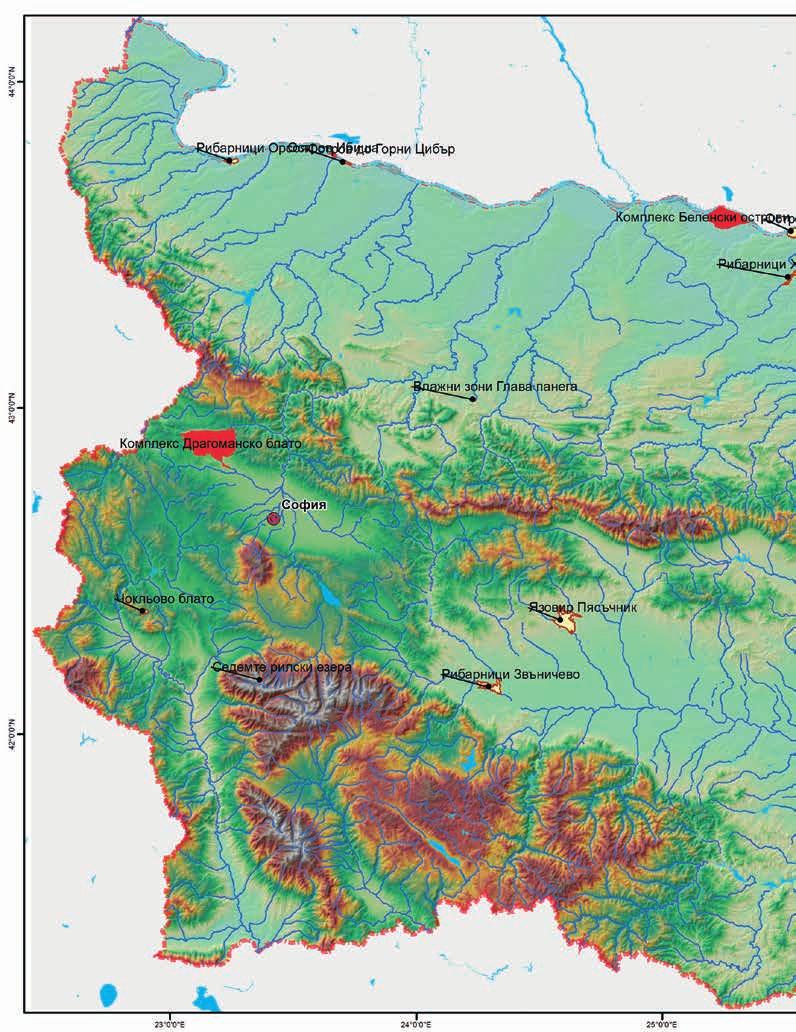
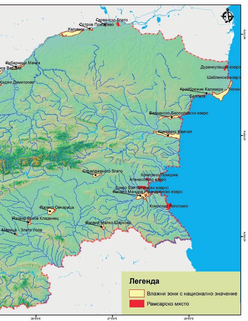
5 Contents 1. Summary 2. Introduction 2.1. Grounds for the Plan Development Process of the Plan Intent and Features of the Plan Goals and Tasks of the Plan Legal and Institutional Framework Regulatory Framework International Conventions and European Union Regulations National Legislation Strategic and program documents Institutional Framework Roles and Responsibilities of the Institutions Social and Economic Aspects Social Aspects Economic Aspects Economic Benefits and Ecosystem Services General Status of Wetlands in Bulgaria General Status and Trends for Bulgaria s Wetlands Review of the Implementation of the Previous Plan at the national level Characteristics of Bulgaria s Most Significant Wetlands Ramsar Sites Srebarna Ropotamo Complex Atanasovsko Lake Durankulak Lake Shabla Lake Belene Islands Complex Ibisha Island Poda Pomorie Wetland Complex Vaya Lake (Burgas Lake) Dragoman Marsh Karst Complex National Action Plan for Conservation of Wetlands of High Significance in Bulgaria
6 6.2 Potential Ramsar Sites and Other Wetlands with National Importance... Mandra Dam / Mandra Lake Ovcharitsa Dam Pyasachnik Dam The Glava Panega wetlands Rozov Kladenets Reservoir Maritsa - Zlato pole Choklyovo blato Chengene Skele Island near Upper Tsibar Orsoya Fisheries Vardim Island The Mechka Fisheries Kalimok Pozharevo Island Garvan marsh Kaliakra - Tyulenovo coastline Baltata Kamchia Complex Varnensko-Beloslavsko Lake Complex Malko Sharkovo Water Reservoir Straldzha Marsh Veleka - Silistar The Seven Rila Lakes Hadzhi Dimitrovo fisheries Zvanichevo fisheries Priorities and measures 7.1 Priorities for conservation, maintenance and restoration of wetlands in Bulgaria Horizontal measures for protection and wise use of wetlands List of specific priority measures / projects for conservation and improvement of the environmental status of wetlands General wetland status monitoring guidelines Monitoring and Evaluation of the Plan Timeframe and budget for the nature conservation activities Timetable and budget Possible sources of financing of proposed activities Literature National Action Plan for Conservation of Wetlands of High Significance in Bulgaria

7 Summary 1 This National Action Plan for Conservation of Wetlands of High Significance in Bulgaria ( ) was prepared according to the Terms of Reference approved with letter No / of the Minister of Environment and Water and in fulfilment of the national priorities in biodiversity protection. The territorial scope of the plan includes 11 wetlands as priority territories which at present are part of the list of the Ramsar Convention. The narrative part of the plan describes in details 25 additional wetlands that cover one or more of the Ramsar nomination criteria or have big potential for protection and restoration, but are not listed in the Ramsar Convention. The analysis of the wetlands included in the plan extends to their main geographical, physical and ecological characteristics, conservation value, threats and trends, economic use, recommendations, measures, ecosystem functions and economical and social significance. The analysis is based solely on compilation of available data and publications. No additional research was conducted. The data related to wetlands and the list of species (presented in an Annex) were updated by the experts, part of the team of authors. The horizontal measures that have to be implemented on national level are: Implementation of the measures for provision of information, coordination and reporting in relation to Bulgaria s commitments to the Ramsar Convention; Institutional coordination in relation to the implementation of the Biodiversity act, management of Natura 2000 sites, and implementation of the Ramsar Convention requirements and guidelines; Provision of adequate financial resources for wetland conservation, support and restoration, from public and private sources; Restoration and/or improvement of the water regimes in Bulgarian wetlands, including also wetlands outside the current management plan; Poaching control initially considered as a specific measure, but because of the national character of the issue, subsequently formulated as a horizontal measure; Closing the existing gaps in scientific data related to wetlands by targeted research and monitoring; Introduction and support of economic mechanisms for wetland conservation, including inventorying and evaluation of the ecosystem services; Integration of wetlands as a topic in environmental education; International and trans-boundary coordination of nature protection measures; Identification at the national level of a system of measures intended to adapt wetland management to climate changes; Inventorying and impact assessment of invasive species. Iv. Zafirov 7
8 The main categories of the proposed specific measures referring to the specific wetlands in the country are as follows: Updating of wetland management plans. This measure is relevant for all described wetlands for the next 10 years since there are no management plans in effect in most of these wetlands or the approved management plans have expired (as is the case of the Durankulak Lake) and the plans of the remaining areas will require updating at a later stage; Conducting of water-regime improvement studies and of other measures for restoration of important wetlands; Water regime restoration required first and foremost in wetlands whose water regimes have been severely impacted by human intervention causing obvious ecosystem degradation; Restoration of the natural vegetation in cases where significant deforestation or substitution of the natural vegetation with alien/atypical species has been identified; Limiting of pollution for wetlands localized in the proximity of big industry complexes (for example Mandra Lake, Vaya Lake, Varnensko-Beloslavsko Lake); Limiting the ingress of nutrients and eutrophication; Site -specific supporting measures; Strict control of poaching; Support of site-specific economic uses. Such uses are fish breeding in fish farms whose restoration could restore the water regimes and the populations of protected species; Control of invasive species; Other specific measures included in the wetland description. This includes all other specific measures prescribed by the protected area management plans currently in effect. used abbreviations BBF Bulgarian Biodiversity Foundation BSBCP Bulgarian-Swiss Biodiversity Conservation Programme BSPB Bulgarian Society for the Protection of Birds EU European Union EIA Environmental Impact Assessment IBA Important Bird Areas (according to the list of BirdLife International) IBER - BAS Institute of Biodiversity and Ecosystem Research at the Bulgarian Academy of Sciences MOEW Ministry of Environment and Water of Bulgaria MR Managed reserve PAA Protected areas Act PS Protected site PA Protected area SG State Gazette 8 National Action Plan for Conservation of Wetlands of High Significance in Bulgaria
9 Introduction The reasons for the Plan The first National Action Plan for Conservation of Wetlands of High Significance in Bulgaria was prepared by an independent team of experts led by T. Michev and approved by the MOEW in The plan has not been updated until 2012, despite the long period since its elaboration, the significant change in the environmental legislation, the social and the economic conditions, the threats and the anthropogenic impacts. This explains the need for updating of the plan an entirely new process of gathering of baseline information, studying and planning. This plan was prepared in accordance with the Terms of Reference approved with letter No / of the Minister of Environment and Water. The elaboration of a national wetland conservation plan conforms to the priority measures for achieving of the strategic objective to reduce and limit the loss of biological diversity embedded in the National Environmental Strategy and in its Action Plan (approved with Decision of the Council of Ministers 353 of ). The elaboration of national policies and plans for the wetlands is provided for in the Ramsar Convention; this necessity is formulated in more detail in Recommendation 6.9 approved by the Conference of the Parties (COP) of March The particular guidelines for the scope of national policies and for the planning process are provided in Handbook 2 Development and implementation of National Wetland Policies, adopted by COP7 (1999), COP8 (2002), and COP9 (2005). This plan is based on the third edition of this handbook (2007). The national wetland plan elaboration process is not explicitly specified by the national legislation. Therefore, this plan was developed in adherence to the accepted practices for development of national strategic and planning documents, and to the practices adopted in Chapter V of Environmental Protection Law Development Process of the Plan The updating of this plan is part of the actions of the Life for the Burgas Lakes project implemented by the Bulgarian Society for Protection of Birds in partnership with the Bulgarian Biodiversity Foundation, Chernomorski solnici Ltd., the Royal Society for the Protection of Birds, and Burgas Municipality and financed under the LIFE+ program of the EU. The plan was commissioned by the Ministry of Environment and Water as a government institution directly responsible for the formulation and implementation of the national environmental policies and for the enforcement of the environmental legislation. The Bulgarian Biodiversity Foundation, a partner of the BSPB in this project, led in the elaboration of the plan. The development process started in 2010, following approval of the proposed Terms of Reference and formation of the team of authors. Experts from the scientific community (IBER - BAS), non-governmental organizations with experience in biodiversity conservation and wetland management (BBF, BSPB) were involved. The main challenges and approaches for the development of this plan were discussed at a working meeting in MOEW on October 26, The participants defined the scope and content of the plan more accurately, and identified the criteria for identification of the substantial wetlands requiring more detailed consideration in the plan. The particular parameters of the studies and the data sources were identified during the ensuing sequence of meetings of experts. The plan relies largely on data, available at the time from various field studies, monitoring schemes and results from previous projects. No further field studies had been provided for in the planning process. The experts involved in the updating National Action Plan for Conservation of Wetlands of High Significance in Bulgaria

10 provided individual expert reports covering abiotic and biotic parameters of the pre-determined wetlands, lists of species and habitats of significance for conservation, anthropogenic impacts, threats, uses and wetland significance. Indicative numbers of bird species as well as enumeration of some of the priority conservation species are included in the descriptions of the wetlands. The number of bird species is based on already published and publicly available materials. The draft plan was submitted for comments and corrections to a wider range of stakeholders, such as government institutions, non-government organizations and scientific institutions. The plan was presented at a public hearing with representatives of the MOEW, NNPS, BAS, RIEW and NGOs, conducted on February 26, 2013, and received a positive review of the Ramsar Convention Secretariat. The plan was accepted by virtue of Minutes No. 16 from the meeting of the National Biodiversity Council on at the MOEW as the basis for planning and implementation of measures for sustainable management and conservation of Bulgaria s most significant wetlands at the national level and at the wetland level Intent and Features of the Plan The intent of this plan is to act as a management tool for conservation of the ecosystems and the biodiversity typical for wetlands. Its development and implementation are most highly related to the implementation of the national commitments under the Ramsar Convention. The plan should become a part of the mid-term national environment protection policy. Iv. Zafirov The period of this plan is 10 years ( ). The authors strived to produce a document useful for the planning period and enabling the securing of national and European financing for the recommended measures. The territorial scope of the plan is national, with specific descriptions, characteristics and priority measures aimed at Bulgaria s most significant wetlands. The selection of most significant wetlands is and always will be a subject of discussion because of the various criteria of significance applicable to each site and the changing status of each site. The first meetings and discussions led to the agreement that the plan should include specific characteristics and analyses of the following categories of wetlands: (1) The 11 priority wetlands, presently listed in the Ramsar Convention: Atanasovsko Lake Belene Islands Complex Durankulak Lake Ibisha Island Shabla Lake Poda Pomorie Wetlands Complex Complex Ropotamo Srebarna Vaya Lake Dragoman Marsh Karst Complex (approved as a Ramsar site later in the planning process). 10 National Action Plan for Conservation of Wetlands of High Significance in Bulgaria

11 R. Vassilev (2) Wetlands not included in the Ramsar List, but are known to meet one or more of the designation criteria, and other wetlands of national importance which do not meet the criteria of the Ramsar Convention at present, but whose conservation and recovery potential is high: Baltata Kamchia Complex Pyasychnik Dam Chengene Skele Malko Sharkovo Rozov Kladenets Reservoir Choklyovo Marsh Water Reservoir The Seven Rila Lakes Garvan Marsh Mandra Dam Straldzha Marsh Glava Panega Wetlands Maritsa Zlato Pole Vardim Island Hadzhi Dimitrovo Fisheries Mechka Fisheries Varnensko-Beloslavsko Island Near Gorni Tsibar Orsoya Fisheries Lake Complex Kaliakra Tyulenovo coastline Ovcharitsa Dam Veleka - Silistar Kalimok Pozharevo Island Zvanichevo Fisheries 2.4. Goals and Tasks of the Plan Overall Goal To provide the foundation for planning and implementation of conservation and sustainable management of Bulgaria s most significant wetlands. Specific Tasks: Updating the information about the current state of Bulgaria s wetlands of priority importance, including their significance for nature conservation and their main characteristics; Evaluating the threats to wetlands as ecosystems and to typical species and habitats; Reviewing the conservation measures taken so far; Identifying the required wetland conservation measures and the means for implementing them. National Action Plan for Conservation of Wetlands of High Significance in Bulgaria

12 3 The Legal and Institutional Framework 3.1. The Regulatory Framework The accession of the Republic of Bulgaria to the EU in 2007 and the preparatory process included harmonization of the environmental legislation. We should note here first the complete transposing of the Birds Directive and the Habitats Directive of the EU, which regulate the creation of the European Ecological Network Natura This process is significantly advanced in Bulgaria at present which provides completely new tools for conservation and management of the significant wetlands which belong, without exception, to the National Ecological Network. Transposing the Water Framework Directive has led to substantial changes in the water management approach such as the introduction of the basin principle, an ecosystem approach, recognition of the biological parameters as leading in determining the environmental status of the water and introduction of integrated river-basin management plans The International Conventions and European Union Regulations Ramsar Convention on Wetlands, in force in Bulgaria since 24 January 1976, State Gazette (SG) issue 56/ The objective of the Convention is conservation and sustainable use of the wetlands as waterfowl habitats which are considered an international resource. The Convention has been expanded to include all aspects of wetland conservation. Convention on Biological Diversity ratified on 29 February 1996 and entered into force in Bulgaria on 16 July 1996, SG issue 19/1999. The objectives of the Convention, to be pursued in accordance with its relevant provisions, are the conservation of biological diversity, the sustainable use of its components and the fair and equitable sharing of the benefits arising out of the utilization of genetic resources, including by appropriate access to genetic resources and by appropriate transfer of relevant technologies, taking into account all rights over those resources and to technologies, and by appropriate funding. Convention on Migratory Species (Bonn Convention), ratified with an act SG issue 69 /1999, SG issue 16/2000; into force since 01 November Convention on the Conservation of European Wildlife and Natural Habitats (Bern Convention), ratified on 25 January 1991, entered into force in Bulgaria on 1 May 1991, SG issue 23/1995. Council Directive 92/43/EEC of 21 May 1992 on the conservation of natural habitats and of wild fauna and flora. Council Directive 2009/147/EC on the conservation of wild birds. The EU Water Framework Directive (WFD; 2000/60/EC) transposed in the Water Act and in its secondary legislation documents. The WFD is aimed at attaining a good ecological status/potential of the surface water bodies and good chemical/quantitative status of groundwater. The WFD does not impose any specific goals and measures for the wetlands. In most cases, these are included in specific surface water bodies (such as river sections, dams, river-side or seaside lakes, marshlands, firths, etc.) whose good ecological status and ecological objectives are determined by biological, chemical and hydromorphological parameters wich are important to the wetlands as well. 12 "Balkani" Society
13 The National Legislation Environmental Protection Act (SG issue 91/ ) a framework act defining the roles of the institutions in environment protection and in many other aspects such as gathering of and access to environmental information, the mechanisms for Environmental Impact Assessment, environmental assessment of plans and programs, etc. Biodiversity Act (SG issue 77/ ) regulates the relations between those involved in the conservation and sustainable use of biological diversity, protection of species and habitats, and building of the Natura 2000 National Ecological Network. This act regulates also the introduction of alien species, the reintroduction of native species, and the trading in endangered species. Protected Areas Act (SG issue 133/ ) regulates the identification, categorization and protective regimes of protected areas, the management planning, the responsible institutions and their obligations. Fisheries and Aquacultures Act (SG issue 41/ ) regulates the organization, management, use and conservation of fish resources in the Bulgarian aquatic systems and basins, as well as the trading in fish and in other aquatic organisms. Water Act (SG issue 67/ ) This act regulates the management of Bulgaria s water as an inseparable part of the country s natural resources, and the right to ownership over water systems and water basins. The Water Act is fully harmonized with the European Water Framework Directive 2000/60/EU. Regulation on the Development of Plans for Management of Protected Areas (adopted with Decree of the Council of Ministers No. 7/ , SG issue 13/ ). Regulation on the Conditions and Procedures for Assessment of the Compatibility of Plans, Programs, Projects and Investment Proposals with the Scope and Objectives of Conservation of the Protected sites (Natura 2000 sites) (adopted with Decree of the Council of Ministers No. 120/ , SG issue 73/ ) Strategic and program documents The National Action Plan for Conservation of Wetlands of High Significance in Bulgaria takes into account a number of strategic and program documents that formulize the environmental and sustainable development policy on European and international level such as: European strategy Europe 2020 an EU fundamental strategic document for intelligent, sustainable and affiliate growth. EU Biodiversity strategy until 2020 aimed at achieving six priority goals: habitat and species conservation, support and restoration of ecosystems and ecosystem services, inclusion of the biodiversity goals in various EU policy fields, control of invasive species, and the contribution of EU towards evasion of biodiversity loss on worldwide scale. Strategic plan for Biodiversity , including Aichi Biodiversity Targets. Strategic plan of the Ramsar Convention on wetlands for the period , adopted with Resolution X.1, and modified with Resolution XI.3, determining the main tendencies and guidelines for implementation of the goals of the Convention for the planned period. National Environmental Strategy for the period with the relevant Action plan enunciation the national policy in the field of protection and sustainable management of the biodiversity. National Action Plan for Conservation of Wetlands of High Significance in Bulgaria
14 3.2. Institutional Framework Roles and Responsibilities of the Institutions The Ministry of Environment and Water (MOEW) is the main competent executive authority on environment and water management in the Republic of Bulgaria. The Ministry is the institution responsible for the elaboration and implementation of the national nature conservation policy, including the policy related to wetlands. Using its regional and specialized structures, the Ministry monitors and manages most protected area categories, enforces the legally established permitting regimes in those protected areas, plays a leading role in the determination of nature conservation priorities and their relevant financing from the national budget and from EU funds. The National Nature Protection Service (NNPS) is a specialized authority under the Minister of Environment and Water for management, control and conservation of biodiversity, protected natural areas and natural ecosystems. The service is responsible for elaboration and implementation of the national policy for biodiversity conservation, protection of rare and threatened species and protected territories as well as elaboration of strategies, programs and plans, preparation of normative acts for biodiversity conservation, and development of the system of protected territories. The Executive Environment Agency (EEA) is an administrative agency under the Minister of Environment and Water performing management, coordination and information related activities for environment protection and control in Bulgaria. This Agency designs and manages the National Environmental Monitoring System and the information related to the status of the environment, including the biological diversity, throughout the entire country. It is also a national reference center for the European Environmental Agency. The Regional Inspectorates of Environment and Water (RIEWs) are the units implementing the national environment protection policy at the regional level. Their functions include monitoring, regulation and provision of information. The RIEWs are the competent authorities managing protected areas without dedicated administrative units and located outside of national and nature parks. These protected areas include many wetlands of national and international importance. The Basin Directorates (BD) are administrative structures in the MOEW system established for management of water at the basin and territorial levels. The basin management principle follows the natural location of the catchments between watershed areas of one or several main rivers in the Republic of Bulgaria. Four basin management regions are identified in the Republic of Bulgaria. The Ministry of Regional Development and Public Works (MRDPW) coordinates the territorial and urban development, construction and regional development. Cooperating with other government authorities, it provides the conditions for efficient use of land, energy and other resources, and for sustainable development at the regional and municipal levels. The Ministry of Agriculture and Foods (MAF) is the institution responsible for the formulation and implementation of the national and EU agricultural policies. The Executive Forest Agency (EFA) and its subordinate structures are responsible for the management and protection of forests, regulation of the use of forest resources, forest renewal, management of nature parks, and prevention of poaching. The Bulgarian Academy of Science (BAS) supports and develops scientific potential and research infrastructure, including for studies of wetlands and their biodiversity, and provides scientific information necessary for the management and restoration of the wetlands. 14 National Action Plan for Conservation of Wetlands of High Significance in Bulgaria
15 The Social and Economic Aspects The Social Aspects The political, social, economic and legal environment in which this plan was created is significantly different from that in 1995, when the previous national wetlands plan was created. The social and economic public transformations during the past two decades have led to changes of the factors affecting the wetlands and all other natural ecosystems. The nature conservation policies and practices considered in detail in the Regulatory Framework chapter have developed as well. Bulgaria s social environment has been improving during the past 17 years with improvements of the working and living conditions, the level of income, the mobility and the access to social services. The increase in average income in Bulgaria during the past decade brought along improvements in household livelihood and increased consumption of goods and services. However, this trend applies mainly to large towns; the social differences between the large towns and the province have increased. The local demographic trends of importance in wetland management are related mainly to changes in welfare and migration factors that have effect on the anthropogenic pressure on the natural areas. A general demographic problem in Bulgaria is posed by depopulation and aging of the population in the rural areas. These social trends have diverse effects on the natural areas. On one hand, certain direct uses of/for resources have declined. On the other hand, however, it is believed nowadays that environmentally sound uses in protected areas by the local population should be encouraged to counterbalance the unsustainable economic practices. Also, the migration of young specialists towards more attractive regions and business areas restricts heavily the local expertise in natural area management. Environmental awareness and active standpoint of the public are considered the strongest driving force for the development and implementation of the environmental policies. Traditionally, the civil societies and non-governmental organizations which are active in this field have been represented well since the early 1990s in Bulgaria. However, despite the many years of efforts to raise the environmental awareness of the public, the citizens with an active position and conscious environmental behavior are still few. The insufficient level of awareness of the social, economic and environmental benefits from the conservation of the natural ecosystems and of wetlands have led to insufficient public support for their conservation and sustainable use The Economic Aspects Bulgaria has exhibited stable macroeconomic trends during the past decade, including a lasting GDP increase, financial and banking stability and improvements in the investment climate. The global financial crisis left its imprint on the country s economy by the end of 2008 and 2009 (5.5 % shrinking of the economy in 2009). New growth has been observed in 2010 and The economic drivers causing changes in wetland use, threats and impacts are presented below by sectors: Construction and Urbanization The construction sector has shown a large increase following 1995 and has been the main economic driver until when the global financial crisis impacted the investors who maintained the sector in such an active state. Residential and holiday resort construction and its related infrastructure have affected the natural ecosystem mainly by partial elimination and fragmentation of the habitats. National Action Plan for Conservation of Wetlands of High Significance in Bulgaria
16 The development plans of many municipalities provide for expansion of many urban centers, allowing for new construction in nature sites. Transport The construction and reconstruction of the transport-infrastructure are carried out mainly by EU co-financed government projects. The projects with potential to impact priority wetlands are: Improvement of the navigation along the Bulgarian-Romanian section of the Danube through dredging and construction of waterengineering facilities; Construction and reconstruction of roads near or inside wetlands. The impact of each of these projects should be evaluated individually in view of the potential for cumulative impact on biodiversity. In the cases where the projects involve Natura 2000 sites, EIA and compatibility assessments are obligatory. Power generation Bulgaria s energy consumption during the past decade has gradually increased, with the gross domestic product peaking in The share of renewable energy sources has also increased. According to Eurostat, Bulgaria is the most energy intensive state of all 27 EU member states. The energy consumption per unit of GDP in Bulgaria is five times higher than the EU average. This shows that an enormous potential for energy-saving and energy-efficient technologies exists. The most significant direct effects on wetlands and on their biodiversity are caused by the hydro-power facilities and the ensuing changes of river-system flow rates. Construction of wind-farms is also encouraged, but is, at the same time, subject to substantial opposition by the nature-conservation community due to the expected negative impacts on birds inhabiting or using the wetlands. The indirect global impact of power generation on wetlands is related to climate changes since both the energy and the transport sectors generate most of the carbon emissions. The current climate models developed by the European Commission and by independent institutes place Bulgaria in a geographic area which will be affected substantially by climate changes in the following decades. The expected effects are droughts, changed distribution of precipitation and increased risk of flash floods. Tourism Tourism, a sector of significant development in the past decade, accounts for a substantial share of Bulgaria's GDP. Despite the financial crisis of the recent years, the near-future prospects of tourism development continue to be good. The high interest of the investors in building new accommodation facilities and tourist infrastructure has, in some cases, contravened the objectives of protected areas, with many recorded instances of illegal or unsound construction. Environmental, educational and other types of alternative tourism near the protected wetlands may benefit from their natural and aesthetic values and may provide economic incentives for long-term conservation of the wetlands. Industries The industrial production facilities have diverse effects with pollution of environmental media (air, water, soil) being among the most important. Some wetlands suffer from lasting former pollutions (such as petrochemical pollution in the Burgas wetlands). 16 National Action Plan for Conservation of Wetlands of High Significance in Bulgaria

17 R. Tzenova Agriculture Agriculture continues to be fragmented and relatively inefficient, as compared to the remaining EU member states, despite the new possibilities for subsidies and support through the Common Agricultural Policy of the EU. The wetlands are affected by agriculture mainly by diffuse pollution with nutrients and pesticides. Forestry Forest management and application of the forestry practices along wetland shores influence directly the status of the ecosystem. Different felling types determine the quality and the fragmentation of forest habitats, while restoration activities frequently change the composition of species in the forests. As a rule, lower and wet areas near standing and flowing water are considered suitable poplar areas. In many cases this has led to replacing the natural diverse water-side vegetation with hybrid poplar monoculture. Such poplars growing quickly but provide poor habitat from the ecological perspective. In a broader sense, maintaining higher numbers of trees in the wetland watershed areas has a positive effect on the hydrological regime by restricting erosion and the inflow of sediments and pollutants. Fisheries and Aquacultures Some of Bulgaria s wetlands with the highest biodiversity conservation value comprise of artificial or modified water bodies used as fisheries. These are the Mechka fisheries, the Orsoya fisheries and the Plovdiv fisheries. In most cases, fresh-water fisheries have a positive effect for the maintenance of a regular water regime and for the general ecological status of the water bodies. Almost all cases where fish farming is discontinued as a result of non-profitability or for other reasons are related to degradation by drying, plugging, and admission of other environmentally unsound uses or investment projects in the acquired terrain. National Action Plan for Conservation of Wetlands of High Significance in Bulgaria
.")
18 Т. Stefanova The fishing sector is an example of direct resource use in wetlands. Small-scale industrial fishing or sports fishing is carried out in many wetlands in Bulgaria (such as the Durankulak Lake). Where fishing or aquacultures are still practiced, the ecological status is affected directly by the production / catching practices. 4.3 Economic Benefits and Ecosystem Services Wetlands are part of our natural wealth. They are specific types of ecosystems whose existence and functioning provide a number of ecological, social and economic benefits. Understanding and properly communicating these benefits may be of great significance for wetland conservation by creating the necessary public and political support. The current wetland conservation and management approach includes the notion of ecosystem services which are the entire range of tangible and intangible benefits to people and to society. The ecosystem services provided by wetlands are considered below by type, and each wetland may provide several or all of these. Water regime maintenance and prevention of floods in many cases wetlands act as retention basins capable of absorbing extreme water quantities, such as those occurring during intensive precipitation. In this manner, they prevent or mitigate the effects of floods on adjacent agricultural or urban areas. This role receives ever increasing consideration in the context of the integrated flood-risk management approach (introduced in Europe by means of Directive 2007/60/EEC) Groundwater maintenance and recharging wetlands are hydraulically connected to shallow (soil) aquifers. The surface water naturally collected in the wetlands recharge the groundwater. Previous to this, the water is filtered to some extent through the vegetation, the microflora and the benthic sediments. Bank strengthening of particular importance for wetlands along the sea coast line where the aquatic and water-side vegetation limit coast erosion and stabilize the beaches and the dunes. 18 National Action Plan for Conservation of Wetlands of High Significance in Bulgaria

19 Retention of sediments and nutrients the surface water washes away large quantities of sediments which usually contain nutrients. Upon entering standing water, these sediments settle and remain in the wetland. This is the cause of the usually high biological productivity of wetlands on the one hand, and on the other hand limits the flow of nutrient toward the rivers and the Black Sea. The transformation of the nutrients into biomass through the wetland food chain might be beneficial, nevertheless exceeding certain thresholds may lead to eutrophication and all related negative impacts for the ecosystem. Water purification wetlands retain, store and transform into biomass and sediments a large portion of the pollutants diluted in surface water. Many non-persistent pollutants are transformed chemically into non-hazardous substances. On the other hand, the persistent organic pollutants and heavy metals are fixed for long periods of time and their flow toward the groundwater, the rivers and the sea is limited. This specific feature of the wetlands makes them vulnerable to pollution. Maintenance of high biodiversity although wetlands cover small areas, they comprise ecosystems which are among the richest in species diversity and habitats of the highest significance for conservation. This is explained with the high productivity and intermediate position between the terrestrial and aquatic environments. The highest numbers of birds occurring in one place have been established in some wetlands (such as the Atanasovsko Lake), as compared to all other types of ecosystems in Bulgaria. The wetlands are of importance for nesting, migrating and wintering species. Wetland products a number of biological and non-biological resources which may be extracted directly from the wetlands. These are the fish resources used in the Shabla and Durankulak lakes, and in many inland water bodies. Salt production in the Atanasovsko and Pomoriysko lakes by traditional means is proven as an environmentally sound use of the resources and as a support function. Reed harvesting under certain conditions looks like a prospective niche, considering the modern fuel-pellet technologies. Other uses include medicinal plants (e.g. Loddon Lily), and medicinal mud. Recreation and tourism the aesthetic value of the landscape and the rich biological diversity attract visitors from among the local population and tourists. Mitigation and adaptation to climate change this includes the fixing of atmospheric carbon in wetlands, which, although lesser than in other terrestrial ecosystems, is a positive role. Considering their highest vulnerability from climate changes, wetlands may act as a model of adaptation. The economic valuation of ecosystem services may provide serious arguments for wetland conservation. In some cases these services may be paid for by the users or may be supported by subsidies. In all cases, however, awareness of the economic benefits from natural ecosystems is beneficial for the wetland conservation and sustainable use policies and measures. Most often, the Total Economic Value is used in the economic valuation of ecosystem services and includes: (i) direct-use value; (ii) indirect-use value; (iii) option-use value; and (iv) non-use value. G. Popgeorgiev National Action Plan for Conservation of Wetlands of High Significance in Bulgaria
20 20
21 21
22 5 General Status of Wetlands in Bulgaria 5.1 General Status and Trends for Bulgaria s Wetlands Wetlands occupy a comparatively small part of Bulgaria s territory approximately 0.8%. According to T. Michev and M. Stoinova, 2007, stand-alone wetlands and simple complexes in Bulgaria occupy 39,908 ha, and those included in more complex polystructural complexes occupy 50,330 ha. However, their conservation value as representative locations of specific ecosystem types which are rare for Bulgaria is high. Most wetlands are also habitats for many protected plant and animal species. Wetland ecosystems are most affected by human activity leading to their significant shrinking and loss of related biodiversity. The highest loss in wetland area and structure has occurred in the 20 th century as a result of rapid industrialization, urbanization, use of lands for farming and other purposes, pollution and change of water-body morphology. The intensive drying and ploughing up during the 20 th century has left a very small number, especially inland, of wetlands in Bulgaria. The roughest estimates show that the area occupied by wetlands decreased by a factor of 20. These trends are largely limited nowadays. The most significant wetlands are under legal protection of some sort protected areas through the Protected Areas Act and/or protected areas in the Natura 2000 network through the Biodiversity Act. The current legislation requires environmental impact assessment for all infrastructure projects or human activities having more substantial impacts on nature (EIA and environmental assessment according to the Environment Protection Act and/or compatibility assessment according to the Biodiversity Act). However, there is no shortage of anthropogenic impacts and threats to the ecological status of wetlands. The main types of negative anthropogenic impacts are the result of: Drying of floodplains, swamps and old river beds and interruption of the natural connection between wetlands and other water bodies; wetland transformation into arable lands. Historically, this group of anthropogenic impacts has caused the highest loss of wetlands. Changes in the water regime caused by river bed straightening and morphological changes of other natural water bodies. Most corrections in Bulgaria have been carried out during the second half of the 20th century, but the threat is still valid. Pollution from industrial, agricultural and other sources; to some extent, all wetlands are subject to, or at risk of, pollution. The impact is most substantial in areas located in immediate proximity to industrial sites (such as the Burgas lakes). Agricultural pollution is often diffusive, without a clearly established source, but is the cause of long-term deterioration of the environmental status (such as in the Shabla and Durankulak lakes). Inflow of sediments and nutrients is a natural process accelerated by many human activities. Causes eutrophication and rapid succession of wetlands which are transformed to other biotope types. Abandonment of natural or anthropogenically maintained wetlands is regarded as significant only recently. Many wetlands of significance for biodiversity exist in their present state because of certain maintenance activities related to economic use. Examples of this are the many fish farms in Bulgaria and the Atanasovsko and Pomorie lakes salt factories. The deteriorated economic conditions have led to partial abandonment of these uses, leading directly to drying or degradation of the wetlands. Poaching and disturbance of the avifauna and other animal groups; unfortunately, poaching is still a widespread phenomenon, despite efforts to control it. In most cases the wetlands are attractive not only because of their biodiversity, but also for the possibilities for illegal hunting and fishing (such as the Pyasachnik water reservoir and other unguarded wetlands). Climate change has been underestimated until recently, but this threat is being considered more seriously because of the collected scientific data confirming the global climate changes, that also allows forecasting. Bulgaria is regarded as one of Europe s areas which will be affected most heavily by droughts and extreme climate phenomena (extreme temperatures, drought and short floods), with the respective impacts on biodiversity. 22 National Action Plan for Conservation of Wetlands of High Significance in Bulgaria
. Creation of artificial wetlands. Examples of this are the salt factories along the Black Sea coastline, the inland fisheries and water reservoirs, treatment lagoons etc.")
23 Of course, we should consider also the human actions which cause direct or indirect improvement of the wetlands. These are: Targeted maintenance and restoration (considered in more detail in item 6.2). Creation of artificial wetlands. Examples of this are the salt factories along the Black Sea coastline, the inland fisheries and water reservoirs, treatment lagoons etc., which, although artificial or heavily affected by man, create new valuable natural habitats. Economic uses of the wetlands, leading to the maintenance of a favorable water regime or other factors related to the functioning of wetlands as ecosystems (such as fish farming, cutting of reeds etc.). Environmentally sound practices in other parts of the river basin, limiting erosion and the inflow of sediments, nutrients, pollution, etc. 5.2 Review of the Implementation of the Previous Plan at the national level The Plan for Conservation of Bulgaria s Most Significant Wetlands (1995) is the first national planning document in this field and is directly associated with the implementation of the national commitments under the Ramsar Convention. Regardless of the significant social and economic changes and changes of environment protection policies and legislation during the past 18 years, many views expressed in the previous plan have remained current. The 1995 plan defines priority nature conservation measures for protection and improvement of the status of 11 wetlands and wetland complexes defined as most significant in Bulgaria. Although specific for individual sites, the proposed measures may be united in the following groups: Appointment of site administration; Organization of regular monitoring; Stopping or minimization of the threat factors; Restoration of the natural water regime in the sites, if necessary; Preparation of a management plan; Management plan implementation. Although there was no dedicated funding for management plan implementation, the measures specified in the plan have served as grounds to initiate many nature conservation projects and activities financed by international donors, the national budget and the EU funds. "Balkani" Society National Action Plan for Conservation of Wetlands of High Significance in Bulgaria
24 The following table shows the progress for the main groups of wetland management measures proposed in the 1995 plan. Wetland complex Established administration Regular monitoring Limited negative factors Improved water regime Implemented restoration measures Management plan Notes Srebarna Durankulak Lake Shabla Lake Burgas lakes Pomorie Lake Ropotamo complex The Vardim Island The Belene Island Estuaries of the Veleka River and the Silistar River Management Plan is available. Management Plan in action since 2001: expired actions period, a new management plan is being prepared. Digging of a canal that links it with Danube river partially improved the water regime, but additional measures are necessary. Measures for restriction of poaching and other anthropogenic factors partially fulfilled. Included in the Montreux list of the Ramsar Convention due to the breaching of the water regime. Management plan Improvement of the water regime, direct and indirect natureconservation activities for a project under the Bulgarian-Swiss Biodiversity Conservation Programme. Main anthropogenic impacts are not overcome. Included in the list of Montreux from the Ramsar Convention as a threatened object due to strong hunting pressure and disturbed water balance. Management plan Direct and indirect nature-conservation activities for a project under the Bulgarian-Swiss Biodiversity Conservation Programme. Management plan of the Atanasovsko lake nature reserve 2003, management plan of the Poda protected site Construction of a nature conservation and visitor centre, information activities, monitoring and conservation under projects of the BSBCP. Management plan Direct and indirect nature conservation activities under projects of Green Balkans NGO. Partial restriction of anthropogenic impacts has been achieved through the implemented measures, nevertheless the main threats are not overcome. Direct and indirect nature-conservation activities under the project of the Bulgarian-Swiss Biodiversity Conservation Programme. Management Plan of the Persina Nature Park, Implemented restoration and other nature conservation activities under projects of the MOEW, the Persina Nature Park Directorate and WWF. Garvansko Marsh Research and observations conducted in the period The marsh near Malak Preslavets Research and observations conducted in the period No management plan elaborated and the monitoring plan is not implemented. 24 National Action Plan for Conservation of Wetlands of High Significance in Bulgaria
25 In respect of the first and general measure, suggested by the 1995 s plan Appointment of administration at the site we consider that all wetlands have been provided with responsible administration. Wetlands that are incorporated in the borders of Nature or National parks are managed by relevant park directorate and the rest by the Regional Inspectorate for Environment and Water. Despite of this the aforementioned does not mean that sufficient resources are provided for the wetlands management. In most cases the responsible administration does not have at its disposal sufficient capacity and means for implementation of effective management. Implemented projects with higher significance Some of the most significant wetland conservation and restoration projects in Bulgaria are specified here without the authors claiming comprehensive presentation because of the growing number of nature conservation projects and initiatives during the recent years. Improvement of the water regime in the Srebarna reserve by digging in of a channel connecting the lake to the Danube. Conservation activities and environmental monitoring were carried out by the Institute of Biodiversity and Ecosystem Research at the Bulgarian Academy of Sciences (successor to the Central Laboratory of General Ecology). The Burgas Wetland project of the Bulgarian-Swiss Biodiversity Conservation Programme ( ) aims to protect the Atanasovsko, Pomorie, Mandra and Burgas lakes. It involves elaboration and implementation of management plans, introduction of sustainable uses of natural resources in the lakes, studies and ecosystem monitoring. Various information and education campaigns were carried out during the project. The Coastal Dobrudzha project of the Bulgarian-Swiss Biodiversity Conservation Programme ( ) involves a management plan for the Shabla and Durankulak lakes and implementation of nature conservation, information and education activities. The Strandzha Ropotamo project of the Bulgarian-Swiss Biodiversity Conservation Programme ( ) involves wetland conservation and management in the southernmost part of the Black Sea coastline: the Ropotamo River, the Stamopolu and Alepu localities, the Silistar Protected site, and the Veleka River estuary. The Pomorie Lake Conservation, Restoration and Sustainable Management by the Green Balkans Federation financed by the Global Environmental Facility / the World Bank ( ). Many studies were carried out during this project, a management plan was produced with a monitoring scheme, and priority conservation measures and an awareness/educational program were carried out. Urgent measures for restoration and conservation of species and habitats of European significance in the protected areas complex of the Pomorie Lake of the Green Balkans Federation financed by the European Fund for Regional Development of the EU and by the state budget of the Republic of Bulgaria via the Operational programme Environment Wetlands Restoration and Pollution Reduction project financed by the Global Environmental Facility / the World Bank ( ). This project is aimed at restoration and elaboration of management programs for the Persina Nature Park and the Kalimok-Brashlen Protected site, and at supporting of the local people in mastering environmentally sound economic activities. The Danube Wetland Management project financed under the PHARE programme. An integrated monitoring system was prepared, a visitor centre constructed, and management plans elaborated for the Persina Nature Park and the Kalimok- Brashlen Protected site. The Life for the Burgas Lakes project of the Bulgarian Society for Protection of Birds, financed by the LIFE+ EU programme ( ). The Dragoman Marsh an Example of Wetland Conservation in Bulgaria of the Balkans Wildlife Society with financial support by the Global Environmental Facility and the NGO fund of the EEC. A wetland conservation centre was constructed under this project, direct conservation activities carried out, a management plan was prepared and sustainable practices of biomass use were studied and introduced. The activities in the Dragoman Marsh were supplemented and co-financed under several projects. Conservation and sustainable development of the Karst complex in the Dragoman Marsh in Bulgaria implemented by the Balkans Wildlife Society and by the Bulgarian Biodiversity Foundation with financial support by the DBU Deutsche Bundesstiftung Umwelt; Activities of the WWF the Danube-Carpathian Program, concerning wetlands along the Danube and restoration of inundated forests on the Bulgarian islands in the Danube, restoration of specific locations such as the Kaikusha Marsh in the Persina Nature Park. Creation of economic mechanisms for wetland restoration in the project to study the potential for innovative sources of financing such as the payments for ecological services and nature conservation, implemented by WWF and co-financed by the GEF. National Action Plan for Conservation of Wetlands of High Significance in Bulgaria
26 Trans-boundary conservation of the Pygmy cormorant and the Ferruginous duck in key locations in Romania and Bulgaria (LIFE07 NAT/RO/000681), implemented by the WWF the Danube-Carpathian Program. Restoration of the Kaikusha Marsh in the Persina Nature Park. This WWF project involves improvements of the water regime in the marsh and a demonstration introduction of a biomassfiring and solar power heating plant in the building of the Persina Nature Park. Restoration of an old bow of the Veselina River near the Minya village, carried out by the WWF in the period Project Trans-boundary model for nature protection and sustainable utilization of nature resources along the stream of Danube River ( ) carried out by the BSPB, funded by the Trans-boundary Cooperation Program Romania Bulgaria Тhe main goal was elaboration of a map with the sensitive territories along Danube River. Conclusions: Bulgaria s socio-economic context in which wetland management has taken place has changed drastically during the past 18 years. On one hand this is related with the change and the increase of the anthropogenic pressure and impacts, and on the other hand the improved possibilities and support for sustainable management, funding and restoration of wetlands. The National Plan for Conservation of Bulgaria s Most Significant Wetlands (1995) has been executed according to a project-wise approach, lacking concrete stakeholder engagements. However, the plan served as a basis for conduction of numerous successful nature protection and restoration activities. The plan was in extremely urgent need of updating. During the past period a number of nature protection projects aimed at research, protection, maintenance and restoration of wetlands have been implemented. The total territory of the wetlands that are subject of legislative protection has been increased significantly. The implementation of the ecological network Natura 2000 that encompasses without exceptions all significant wetlands in Bulgaria has contributed to this the most. Seven new Ramsar sites have been nominated since In general, the state of the wetlands has not improved due to the diverse anthropogenic pressure and/or transition towards unsustainable use practices. It has to be stated that the wetlands with higher categories of protection according to the Protected areas act (reserve, managed reserve, national and nature park) and with accepted management plan have significantly higher level of protection and management than the rest. The funding for nature protection, maintenance and restoration activities is based on project-wise approach with diverse funding and varying approaches. Horizontal measures are not sufficiently interceded. A significant level of capacity and experience from the side of the state institutions and the NGOs and scientific organization has been achieved during the past period. This combined with the increased EU funding possibilities will allow more effective and integrated implementation of the wetland protection policy in Bulgaria during the subsequent years. 26 National Action Plan for Conservation of Wetlands of High Significance in Bulgaria

27 Characteristics of Bulgaria s Most Significant Wetlands 6 Evgeni Dinev 6.1 Ramsar Sites Srebarna Ropotamo Complex Atanasovsko Lake Durankulak Lake Shabla Lake Belene Islands Complex Ibisha Island Poda Pomorie Wetland Complex Vaya Lake (Burgas Lake) Dragoman Marsh Karst Complex 27

28 Srebarna Brief description The Srebarna Reserve encompasses an eutrophic lake on the bank of the Danube between river km 393 and 391, standing 18 km to the west from the town of Silistra. The village of Srebarna is located on the west shore of the lake. The designated reserve includes the lake as well as former agricultural lands, located northwards from the lake, a belt of tree plantations on the riverbank of Danube, the island of Komluka and the aquatory locked between the island and the bank of the river. Approximately two-thirds of the lake surface is reedy with Phragmites australis and Typha (Typha angustifolia, T. latifolia, T. laxmanii) as well as with other marshland plants. Natural floating islands (kochki) formed by sediments, entangled by the roots of the overgrowing reeds are typical for the lake. The reed beds gradually turn into wet meadows to the north part of the lake. The northwest part of the lake as well as the riverbank of Danube are characterized by strips of riverine tree-shrub vegetation, with single specimens of White Willow (Salix alba). Conservation Status Srebarna was designated as a reserve in In 1977, the Srebarna Lake was designated as a biosphere reserve and listed as a UNESCO world natural and cultural heritage in In 1998 the nature protection status of the lake was changed from strict reserve to managed reserve due to the need of conduction of activities that allow the management of the wetland. Protected site Srebarna with code BG , designated in accordance with the Birds and the Habitats Directives. 28 National Action Plan for Conservation of Wetlands of High Significance in Bulgaria
29 Biodiversity 139 vascular plant taxons, of which 11 rare and endangered, have been established in the Srebarna Nature Reserve. This wetland is most important for the conservation of Aldrovanda vesiculosa (Bulgaria s only location) and Cicuta virosa, as well as Stratiotes aloeides, Nymphaea alba, Trapa natans, Nephrodium telypteris, Carex disticha, Galium rubioides. Eleven natural habitats listed in Annex I of Directive 92/43/EEC have been identified. The most significant and spacious among these are 3150 Natural eutrophic lakes with Magnopotamion or Hydrocharition type vegetation, 6250* Pannonian loess steppe grasslands, 6430 Hydrophilous tall herb fringe communities of plains and of the montane to alpine levels and 91E0* Alluvial forests with Alnus glutinosa and Fraxinus excelsior (Alno-Pandion, Alnion incanae, Salicion albae). Six species of invertebrates, six fish species, five amphibians and reptiles and seven mammal species represent the fauna of significance for nature conservation that is found on the territory of the reserve. From the total number of 227 bird species, 127 to 140 are considered as nesting and 94 species are considered as wintering and migrating species (Mitchev, Kamburova, Profirov, unpublished data). Sixty-five species are listed in Bulgaria s Red Data Book and 90 species are listed as SPEC species occurring in the region. The nesting Pelecanus crispus, Phalacrocorax pygmeus, Aythya nyroca, Crex crex, are globally endangered. Four species that are globally endangered (Anser erythropus, Branta ruficollis, Oxyura leucocephala and Haliaetus albicilla) can be found during wintering time and migration. Land Ownership and Land Use The maintained reserve area is 902 ha and is exclusively state property managed by the Ministry of Environment and Water and its regional units. Land use is reduced to maintenance allowed in the designation order. The remaining Natura 2000 protected area and Ramsar site include areas with different permanent forms of use and different types of ownership, but mainly pastures, permanent forests, and meadows. State and municipal private properties prevail. At present only maintenance, guidance, regulation and restoration measures that are listed in the reserve s management plan are allowed. Other allowed actions include conduction of activities with certain economic potential such as periodical reed mowing and mud gathering from the bottom of the basin. Organized ecotourism, regulated fishing and encouragement of traditional crafts and activities are possible in the adjacent territories. Site-Status Changes and Trends. Threats. The most important factor affecting a substantial change of the ecological nature of the Srebarna Lake and its surrounding areas is the construction of the dykes during the 1940s. The unfavorable effects of this are interruption of access of water from the Danube to the lake causing complete disturbance of the natural water regime of the wetland, interruption of the seasonal flow-through of the water, accelerated eutrophication and succession. Attempts to restore the link to the Danube were made in 1968 when a sluiced channel was excavated, and in 1979, during the building of a dyke, and also in 1994 during which a new canal with two sluices was constructed. The latter succeeded in improving the connection and circulation of the water from the Danube into the lake is possible during high-water level events. R. Petrova 29

30 R. Petrova In 1993 the wetland was included in the Montreux list of Ramsar sites threatened by alterations of their ecological characteristics, caused by strong disturbance of the water balance. The current threats are: changing water regimes, periodic partial drying of the lake and high water-level fluctuations; overgrowth of open water areas with reed and willow (acceleration of the natural lake-swamp-wet meadow succession); removal of the typical water-side vegetation; increased eutrophication caused by accumulation of nutrients; increased quantity of sediments on the lake bottom; illegal fishing with nets and other forms of poaching; burning of floating reed islands; urban waste pollution; large-scale spreading of grey willow in the reed islands; entry of invasive species. Conservation Measures Undertaken In 1979 the hydraulic link between the lake and the Danube River was restored by the destruction of 600 meters of the northern dyke located in the northwestern part of the reserve. The so called South dyke for protection of the agricultural lands located in the area north and northeast from the lake was constructed. A project to restore the connection of the lake to the Danube by an artificial canal was completed in The ability to regulate the water level of the lake has allowed an average depth of more than 2.00 m to be achieved. The partially restored water-exchange has created favorable conditions for the functioning of the lake system. The status of nutrient such as nitrite, nitrate and phosphate ions is normal. The lake s eutrophication has decreased significantly. A project for replacement of the hybrid poplar plantations with natural forest-bush vegetation was implemented. Specific Conservation Measures Needed Research and actualization of the information of key importance for the ecosystem management, also including identification and assessment of the water regime and the hydraulic link with the Danube River; Actualization of the management plan including preparation of the scientifically based methods and instructions for management of overflow regime optimal for the ecosystem; Conduction of annual monitoring of the most important components of the ecosystems in the reserve; Additional research for improvement of the lake s water regime and clarification of the need for goal-oriented management of the succession process, including management of the reeds and the organogenic sediments; Implementation and maintenance of a suitable water regime for the ecosystem by hydro-technical measures construction of a second channel ensuring water flowing through the system; Restriction of succession and reduction of the level of eutrophication in the reserve with a view to maintaining optimal conditions for existing habitats and globally endangered species; Involving the local population in active management and stewardship of the reserve. Creation of economic interests in its conservation. Economic and Cultural Significance and Ecosystem Benefits/Services Srebarna has high ecosystem value as an irreplaceable functional element of the Danube s ecosystem and as a biodiversity pool as well as prerequisite for development of environmentally sound forms of economic activities. The lake acts as a trap for nutrients and may be maintained as such by regular biomass removal (cutting of reeds). In view of the supporting role and the high significance of the reed cutting, this activity requires economic incentives. 30 National Action Plan for Conservation of Wetlands of High Significance in Bulgaria

31 Ropotamo Complex Brief description The Ropotamo Complex includes the estuary part of the eponymous river and its adjacent territories, including inundated forests, sand dunes, a beach strip, deeply disjointed coastline with rocky mulls and narrow deep bays, the St. Thomas Island, and the Alepu, Artkutino and Stamopolu marshes. The Ropotamo Complex is approximately 50 km south of Burgas and the subject of this description is the region outlined by the coastline with the bays and the St. Thomas Island (the Snake Island), the Alepu Marsh, the Arkutino Marsh, and the Ropotamo River as far as 1 km south of the bridge and of the Stamopolu Marsh. 5,500 ha of the complex are designated a Ramsar site. Conservation Status The Ropotamo managed reserve was designated in 1992 with the objective of protecting habitat diversity and the rich flora and fauna, including birds, in the site. In order to provide protection to threatened habitats, flora and fauna species, six more protected territories have been designated: the Velyov vir (the Water Lillies) (a maintained reserve, 13,6 ha, the Alepu Marsh (a natural landscape, 166,7 ha), the Sand dunes in the Perla locality (a natural landscape, 24 ha), the Rock Formations, Fiords and Seal Cave in the Maslen Nos Locality (a natural landscape, 17,6 ha), Stamopolu (a protected site, 40 ha). The Ropotamo Complex was designated an Important Bird Area (IBA) in Due to its importance for conservation of rare and endangered habitats, plants and animals, including birds, at the European level, half of the territory of the complex was designated a CORINE site in In 2007, this area was designated a Ropotamo Complex Natura 2000 site (under the Birds Directive), with code BG , with a total area of 3 867,63 ha (including 580,14 ha of aquatic area); and Ropotamo (according to the Habitats Directive) code BG , total area: ,82 ha (including 2 954,75 ha of aquatic area). National Action Plan for Conservation of Wetlands of High Significance in Bulgaria
; the firth of the Ropotamo River; inundated forests; broad-leaved forests of Italian oak; coastal dunes with psamophytic vegetation; secondary scrub and grass communities; rocky")
32 R. Tzenova Biodiversity The Ropotamo Complex includes a large variety of habitats: coastal marshes with hygrophytic vegetation (reeds, cattail, club rush) and hydrophytic vegetation (Water Lily, Frog-bit, duckweed); the firth of the Ropotamo River; inundated forests; broad-leaved forests of Italian oak; coastal dunes with psamophytic vegetation; secondary scrub and grass communities; rocky marine coast; underwater caves and marine bays. This complex is an important stepping stone bio-corridor. It includes forest and dune habitats of significant surface area that are subject of protection according to the Habitats Directive. This is the only site in the southern part of the Black Sea Coastline where Eastern white oak woods (91AA) remain. This site is of importance for the geographic coherence of the network of rare habitats with scattered distribution in small areas along the Black Sea coastline (1130, 2120, 91F0, 91E0, 92A0, 91AA). The complex hosts 60% of Bulgaria's reptiles, 57% of the mammals, 60% of the freshwater fish fauna and 50% of the nesting avifauna. During the recent years the territory of the Ropotamo Complex has been visited by 255 bird species, of which 123 are nesting and 67 are listed in Bulgaria's Red Data Book (Dobrev and Dimitrov, Management plan of the Ropotamo Complex). Of those bird species, 104 are of European conservation concern (Category SPEC), 10 species are globally threatened and classified as SPEC1, while 27 species are threatened in Europe, classified as SPEC2 and 67 species are classified as SPEC3. This location provides suitable habitats to 87 species from Annex 2 of the Biodiversity Act, which are in need of special protection measures. Of these, 83 are also listed in Annex І of Directive 79/409 of the EU. The area includes non-fragmented habitats suitable for wolves, but this species is only marginally represented nowadays, and the area is aimed to restore the natural range of the species. Land Ownership and Land Use State property 44%; Municipal property 52%; Private property 4%. Forest lands prevail. The complex includes territories with various regimes Ropotamo reserve is strictly protected territory, with no economic activities allowed. Various touristic, forestry, hunting and fishing activities are allowed and predominant for the rest of the complex s territory. 32 National Action Plan for Conservation of Wetlands of High Significance in Bulgaria

33 Site-Status Changes and Trends. Threats. Common threats: Change in land use, construction of tourist infrastructure and increased tourist flow. Threats to natural habitats: Unrestricted and unregulated construction of temporary and permanent buildings and tourism infrastructure, excessive felling, urban pollution, compaction and littering of habitats, compacting due to unreglamented vehicle access outside of paved roads. Threats to aquatic habitats: changes in the water regime and drying of marshes, eutrophication. Em. Todorov Conservation Measures Undertaken The studies, carried out during the Bulgarian-Swiss Biodiversity Conservation Programme, have been followed by elaboration of the Ropotamo Reserve Management Plan. Specific Conservation Measures Needed Maintenance of a suitable water regime for proper functioning of the wetlands included in the complex; Sustainable tourism and tourist infrastructure development. Tourists should visit only the areas specified in the Management Plan; Monitoring of the populations of species in the area, especially of the species whose nature-conservation status is high; No changes in the forms of land use; Prevention of habitat compaction and of any unregulated access of motor vehicles outside the paved roads; Prevention of urban waste in the habitats and industrial pollution, removal of illegal dump sites; Restriction of felling and of allowed quantities of removed deadwood. Economic and Cultural Significance and Ecosystem Benefits/Services The Ropotamo River and the river-side inundated forests are a popular tourism site used intensively by tourists visiting the southern Black Sea coastline. The conservation of habitats and rare plant, animal and mushroom species is crucial for protection of tourism in the site and for securing of ways to offer most diverse tourism products. Some of the remaining more significant ecosystem benefits are related to the trapping of nutrients and reduction of pollutants entering the Black Sea. RIEW Burgas 33

34 Atanasovsko Lake Brief description A hyper-saline lake on the sea coast, resembling a firth in its northern part and a lagoon in its southern part. A significant part of its area is used as a salt facility, but the traditional salt production process has been preserved there. The salt pans are separated from the Black Sea through a dyke and hydro-technical equipment with a sluice. The total capacity of the facilities is 3.2 million cubic meters and the average water level is 30 cm. Smaller fresh-water marshes and swamps exist around the lake, as does a system of channels overgrown with marsh vegetation. To the south, the lake borders on the urban part of the town of Burgas and extends approximately 10 km away to the north from the town. The lake, oriented from north to south, is 9.5 km long and 4.2 km at its widest. The altitude is between 1 m to -1 m below the sea level. Most of the lake altitude is negative, with the water level is being 0,6 m below sea level during the summer ,3 ha of the complex have been defined as a Ramsar site. Conservation Status The northern part of the lake has been a maintained reserve since The lake was declared a wetland of international significance under the Ramsar Convention in 1984, and the Ramsar site was enlarged in In 2007, this area was included in the Natura 2000 network under the name of Protected site Atanasovsko ezero in accordance with the Birds Directive and the Habitats Directive with a code BG and a territory of 7 208,89 ha. 34 National Action Plan for Conservation of Wetlands of High Significance in Bulgaria
 of the entire protected area (7 200 ha).")
35 Biodiversity The site is representative as the rarest ecosystem type for Bulgaria (coastal halophytic communities). The priority habitat 1150 * Coastal lagoons covers 20.6 % (1 483,2 ha) of the entire protected area (7 200 ha). This is the largest compact area occupied by this habitat in Bulgaria, highly valuable for its relative area, its representativeness and its importance for natureconservation. 233 higher plant species have been established in the lake. Dominant among these are Marsh Samphire (Salicornia herbacea), Salicornia europea, Sueda maritima, Reed (Phragmites australis), Narrowleaf Cattail (Typha angustifolia), Campestris (Vicia campestris), Sea Wormwood (Artemisia maritima). The lake is the biggest location for Salicornia and the Elegant orchid in the country and the only significant find of Artemia in the country. Two invertebrate species, two species of fishes, and 20 species of amphibians and reptilians of significance for conservation have been established. The Atanasovsko Lake is part of the Burgas lake complex one of the three wetland complexes where most significant concentrations of waterfowl occur along the Bulgarian Black Sea coast. There are 317 bird species identified in the Atanasovsko lake area, 17 of which are nesting and 100 are listed in the Bulgaria s Red Data Book (Mitchev et al. 2003, Management plan of the Atanasovsko Lake). 127 of the listed birds are species of European conservation concern (SPEC) (BirdLife International, 2004). 19 species are classified as SPEC1 or European species of global conservation concern, 28 species are classified as SPEC2 and 80 species are classified as SPEC3. This location provides suitable habitats to 105 species from Annex 2 of the Biodiversity Act, which are in need of special conservation measures. Of these, 103 are also listed in Annex I of Directive 79/409 of the EU. The Atanasovsko Lake lies along the Via Pontica route and is a typical narrow migration front site for migrating hovering birds from a significant part of Northern, Eastern and Central Europe. Up to 240,000 storks, pelicans and cranes and up to 60,000 raptors fly over the site during autumn migration each year (Mitchev et al. 2003, Management plan of the Atanasovsko Lake). This is the site of Europe s highest concentration during migration of the White Pelican (Pelecanus onocrotalus) and the Dalmatian Pelican (Pelecanus crispus), the Marsh Harrier (Circus aeruginosus), the Red-footed Falcon (Falco vespertinus). Together with the remaining Burgas lakes, this is one of the most favourable locations where pelicans and storks roost and rest between the Danube delta and the Bosporus. As the lake does not freeze during the winter, it is of international importance for the wintering waterfowl. Land Ownership and Land Use Distribution by land ownership: State property 29%; Municipal property 15%; Private property 56%. The water areas are mainly salt pans and channels, and the adjacent lands are mostly occupied by ploughed lands. The main economic activity in the site is salt production, which has imparted the contemporary appearance of the wetland. According to the current management plan, traditional salt production is allowed as a supporting activity in the reserve, as is the maintenance of an adequate water regime. Agricultural activities, mainly cereal growing, are practiced in the adjacent areas. The lake is in the immediate proximity to the Burgas airport and to Mina Cherno more neighbourhood. There are tourism sites near the reserve. Site-Status Changes and Trends. Threats. The proximity of Atanasovsko Lake to the densely populated town and to the international airport to the east is the reason for the heavy anthropogenic pressure to the lake. The lake is used for traditional salt production and the habitats which are typical of this wetland are heavily dependent on this activity in its present form. The lower economic efficiency of the traditional salt production process and the obsolete infrastructure pose risks to salt production in its current form and are considered a serious threat for the maintenance of the wetland in general. B. Boev 35

.")
36 Conservation Measures Undertaken A management plan for the managed reserve has been adopted (2003). A number of information and awareness-raising activities, regular biodiversity monitoring and restoration of the infrastructure and preservation of the traditional salt producing activities have been carried out under projects of nongovernmental organizations and scientific institutes. Evgeni Dinev Specific Conservation Measures Needed Update of the management plan for the next 10 years period; Maintenance activities (described in the management plan). The old dykes and barriers are in need of rehabilitation through methods and at a time consistent with the ecological requirements of waterfowl; Maintenance of an adequate water regime and prevention of entry of polluted water in the reserve are required; Elimination of any illegal wastewater discharges into the northeastern part of the reserve. Economic and Cultural Significance and Ecosystem Benefits/Services First and foremost, Atanasovsko Lake is highly significant as a unique and representative wetland, which is habitat of a rich avifauna. The main economic significance of the wetland is related to salt production. This economic use is consistent with the nature conservation objectives and regimes, since traditional salt mining depends on the maintenance of the water regime in the ecosystem and on the prevention of its pollution. Atanasovsko Lake has a potential for specialized tourism as well. The tourist access and traffic should be managed carefully in order to avoid disturbance or other unfavourable impacts. BBF 36 National Action Plan for Conservation of Wetlands of High Significance in Bulgaria

37 Durankulak Lake Brief description A wetland which includes the coastal firth of the Durankulak Lake with its adjacent sand dunes, marine aquatic area, grass communities, forest-tree and brush plantations and arable agricultural lands. Located in north-eastern Bulgaria, not far from the Romanian border, and east of the Durankulak village. Its altitude is approximately 0.5 m. The predominant habitats are the open water areas and the vast hydrophilic higher plants vegetation covering predominantly the northern part of the lake (Orlovoto Blato Marsh), the southwestern part (Vaklinskya Rakav Branch), as well as the marsh on the southeast. The territory of the Ramsar site is 350 ha, of which 253 ha are open water areas. Conservation Status The Durankulak Lake has been a protected area under the Protected Areas Act since In order to provide protection for endangered waterfowl the status of the lake was changed to Protected site in The lake was included in the Ramsar convention list in The lake was designated an Important Bird Area in 1989 by BirdLife International. Due to the lake s significance for the protection of rare and endangered habitat, plants and animals including birds on European level, 23% of the territory of the Important Bird Area is designated as CORINE site. The lake lays within the Natura 2000 sites Durankulashko ezero (code BG , according to the Birds Directive) and Ezero Durankulak (code BG , according to the Habitats Directive). National Action Plan for Conservation of Wetlands of High Significance in Bulgaria

38 Biodiversity There are five endemic plants to the Balkan Peninsula in the lake and 27 other plants of international and national significance for conservation. The Durankulak Lake is inhabited by 254 bird species, of which 92 species are nesting and 72 are listed in Bulgaria s Red Data Book. Within the listed birds, 136 are species of European conservation concern (SPEC) (BirdLife International, 2004). Seven species are classified as SPEC1 or European species of global conservation concern, 18 species are classified as SPEC2 and 66 species are classified as SPEC3. This location provides suitable habitats to 213 species included in the annexes of the Biodiversity Act, which are in need of special protection measures (Georgiev, 1998, Management plan of natural complex Durankulak lake). The Durankulak Lake is of global importance for the waterfowl, especially during the winter because of the high concentrations of geese. Together with the White-fronted Goose (Anser albifrons), the globally endangered Red-breasted Goose (Branta ruficollis) nests here in substantial numbers; almost the whole global population inhabits the Durankulak and Shabla Lakes in January and February, which undoubtedly places these lakes among the most significant wetlands in the world. Land Ownership and Land Use Municipal property 23%, state property 38%, private property 39%. Arable lands occupied by cereal crops prevail in the adjacent areas. The Durankulak Lake is located among some of the most fertile lands in Bulgaria the sea-side Dobrudzha. This explains the intensive agricultural use even of areas included in the nature complex. The lake and its related ground water are of importance for irrigation of the neighboring arable lands. Site-Status Changes and Trends. Threats. Illegal draw of water for drinking and irrigation causing fluctuations of the water level during the period of active exploitation May through October. Separation of the Kartaliysko Marsh from the lake by means of a dyke, disturbing the water regime of this part of the lake. Nutrient overload is the main cause of accelerated eutrophication and of un-balancing of the aquatic ecosystem of the lake. Large-scale illegal net-fishing in the lake. In 1993 the wetland was included in the Montreux list of Ramsar sites threatened by changes to their ecological characteristics, caused by disturbed water balance and poaching. M. Iliev 38


39 Conservation Measures Undertaken The lake has an elaborated and operative management plan including a wide spectrum of conservation measures (1998). Every year counting of birds in the region is organized. BSPB organizes ornithological monitoring and detailed researches of the wintering geese. An information center has been constructed by Le Balkan Foundation on the west shore of the lake. Specific Conservation Measures Needed Update of the management plan for the next 10 years period; Minimization of the degradation processes in the lake by means of restriction of the inflow of nutrients and of other solid and liquid pollutants, and by restoration of a close-tonatural water regime; Exact regulation of hunting and fishing; Regulation of grazing with a view to sustainable use of the pastures and conservation of the steppe/semi-steppe nature of some of them; Provision of the trophic base required by the wintering geese and ducks in and outside the nature complex; Management of the reeds aimed to reduce the eutrophication in the water body and to increase the biological diversity; Non-admittance of the construction of summer-houses or other types of settlements and hotel complexes along the shores of the lake. M. Iliev Economic and Cultural Significance and Ecosystem Benefits/Services The Durankulak Lake is highly important in the cultural and ecosystem respects as an important habitat of waterfowl. The provision of drinking and irrigation water is of key significance as an ecosystem service, since water is the most important ecosystem component determining the existence of the wetland. The groundwater from the watershed area of the Durankulak Lake is used for water supply and irrigation. Water pump facilities are positioned in different locations in the lake watershed area, and only three (two irrigation and one water supply pumping stations) are positioned within the boundaries of the nature complex. Fishery and aquaculture are important economic activities linked with the direct use of the lake. The rich ornithofauna as well as the archeological findings serve as basis for development of specialized tourism. National Action Plan for Conservation of Wetlands of High Significance in Bulgaria

 as well as Coastal Sedge (Carex riparia) and others. The reedbeds are the main habitat type in the complex. The open water areas are significant in size.")
40 Shabla Lake Brief description The complex includes the Shabla Lake and the Shabla Lagoon overlying Sarmatian limestones in north-eastern Bulgaria, 5 km. to the northeast of the town of Shabla. The Shabla Lake is a firth brackish lake near the sea coast. The semi-saline Shabla Lagoon is located 1.5 km to the southeast of the lake and is separated from the sea by high dunes. The shores of the lake are overgrown by vast formations of Reed (Phragmites australis) mixed with Narrowleaf and Broadleaf Cattail (Typha angustifolia, T. latifolia) as well as Coastal Sedge (Carex riparia) and others. The reedbeds are the main habitat type in the complex. The open water areas are significant in size. The lake is mostly fed by ground water. Open water areas are predominant in the Shabla Lagoon, while hydrophilic vegetation covers a relatively narrow strip along the lake shore. The dunes and sand beach overgrown by psamophytic vegetation are also important habitats. The territory of the Ramsar site is 404 ha, of which 150 ha of open water. Conservation Status The Shabla Lake was designated as a Protected site in During the same year the lake was proclaimed a wetland of international significance and designated as a Ramsar site. In 1989 the territory was designated as Important Bird Area by BirdLife International. In 1998 the complex is proclaimed as CORINE site due to its significance for protection of rare and endangered habitat, plants and animals including birds on European level. The lake falls into the boundaries of the Natura 2000 protected sites Shablenski ezeren komplex (code BG , according to the Birds Directive) and protected site Ezero Shabla - Crapetz (code BG , according to the Habitats Directives). 40 National Action Plan for Conservation of Wetlands of High Significance in Bulgaria

41 Biodiversity The largest number of plant species of significance for conservation 16, including the priority species H. ponticum, B. hirsuta, S. thymiofolia, and L. tauricum ssp. bulgaricum have been found on the sand dunes. Five species of significance for conservation occur in the open water areas, three among the hydrophilic vegetation, and four among the xerophytic grass communities. Five invertebrate species are of conservation significance. Three fish species and 21 species of amphibian and reptiles included in Annex 2 and 3 of the Biodiversity act are frequently observed in the complex. The territory of the Shabla Lake Complex is frequented by 248 bird species, of which 96 are nesting, 88 are wintering and 69 are listed in Bulgaria s Red Data Book 137 of the listed birds are species of European conservation concern (SPEC) (BirdLife International, 2004). Seven species are classified as SPEC1 or European species of global conservation concern, 16 species are classified as SPEC2, or unfavorable conservation status in Europe, 64 species are classified as SPEC3. This location provides suitable habitats to 223 species from the Biodiversity Act, which are in need of special protection measures (Georgiev, 2003, Management plan of the Protected landscape Shablensko ezero). It is of key importance for the globally endangered Red-breasted Goose in winter, as it and the Durankulak Lake support its whole global population. Of substantial importance during the various parts of the year for seven globally endangered bird species. Land Ownership and Land Use State property 38%; Municipal property 14%; Private property 48%. The groundwater connected to the water in the two lakes is the subject of significant abstraction for drinking purposes for the surrounding settlements and for the district center Dobrich and for agricultural-land irrigation purposes. The wetland is located in the fertile lands of sea-side Dobrudzha and, therefore, there is significant agricultural use of adjacent areas, mainly for production of cereals. The protected site regime prohibits the use of pesticides and artificial fertilizers in the lands included in its boundaries. However, such materials may be brought by groundwater from the adjacent areas is possible. Economic fishery had been practiced more widely until the 60s of the 20th century, following which the lake had been used to supply fish for the government residence only. Sport-fishing is also practiced. The biodiversity is threatened by hunting and poaching. Site-Status Changes and Trends. Threats. Most of the complex is in good condition due to the special regime over part of the area. Common threats: Excessive water use, illegal hunting and fishing, disturbance, pollution (with chemicals from the neighboring agricultural lands). Intensive hunting of water fowl and forestry and recreational activities in a lesser degree are typical for the region. The Shabla lake complex is highly sensitive to all activities with effect on the water regime and on water quality in the wetlands. M. Iliev 41
42 The current water abstraction from surface and ground water for drinking and for irrigation is not controlled and inconsistent with the optimal water level in the lakes. The lakes are polluted with nutrients (ammonia salts, nitrites, nitrates and phosphates) and with organic matter resulting from intensive agriculture and animal breeding in the region. Violations of hunting and biodiversity protection laws by poachers and large scale net hunting are common for Shabla Lake and especially for Ezerets Lake. Considerable number of tourists enters the Shablenskata tuzla during the nesting period, when the birds are especially vulnerable towards disturbances. Other human activities impacting the quality of valuable habitats are the expansion of American ash (Fraxinus americana) among the water-side vegetation of the Ezerets lake, artificial planting of Eleagnus angustifolia and of other exotic species; proximity of wind farms, construction of new recreation and tourism facilities, illegal extraction of sand from the dunes near the Shabla lagoon, and littering of the entire area; military exercises and uncontrolled movement of military equipment in the region from the military range near the Shabla lagoon. Many activities in the residence (recreation, fishing, mowing, forestation, shooting) are inconsistent with the environmental requirements and with the nature-conservation status. Conservation Measures Undertaken A management plan was developed during the Bulgarian Swiss Biodiversity Conservation Program for the period and was updated in the period. Many awareness raising and information activities have been carried out, and the control over the protected area has been improved. An artificial lake for nesting of terns and other plover liked birds was constructed by the BSPB in Specific Conservation Measures Needed Actualization of the Management plan and implementation of integral approach in the management of the protected territories and the Natura 2000 sites; Minimizing of eutrophication in the lake by means of measures to reduce the content of nutrients in the water ecosystems and restoration of a close-to-natural water regime in the lake; Management of hydrophilic vegetation increasing of the area of open water spaces, rotation cutting, grazing of cattle aimed to decelerate eutrophication and to improve the conditions of biodiversity; Regulation and control of fishing in order to avoid impacts on the rare and endangered biodiversity representatives on the one hand and to meet the needs of the local population on the other; Restoration of the natural characteristics of most of the grass communities by regular grazing, cleaning of litter and controlling of the ruderal vegetation; Creation of infrastructure for learning tourism and for nature-conservation education. Improvement of the control of the tourist flow, especially during the nesting period; Regular monitoring of the ecosystem s most important abiotic and biotic factors; Implementation of efficient monitoring and protection in accordance with the protected-area regimes by allocation of a permanent team, coordination and capacity building among the responsible institutions. Economic and Cultural Significance and Ecosystem Benefits/Services The site has a very high ecosystem significance as an irreplaceable functional element of the Via Pontica migration route, as a biodiversity supporting reservoir, as a factor for the local microclimate and as a prerequisite for development of environmentally sound forms of economic activity (such as ecotourism). 42 National Action Plan for Conservation of Wetlands of High Significance in Bulgaria

43 Belene Islands Complex Brief description Belene is Bulgaria's largest group of islands in the Bulgarian part of the Danube River. The complex is located between 560 and 576 km, opposite the town of Belene, and 18 km west of the town of Svishtov. Elevation above sea level is 25.5 m. It has formed naturally by the processes of sediment transport and deposition. Presently, this group includes two larger and 15 smaller islands. The largest is Belene Island with its three fresh-water swamps, together with their surrounding old-growth riparian forests of Alnus, Salix and Populus. The three swamps are interlinked and drained in the Danube river through a canal. During high-spring waters and if the guard of the canal is open fresh water flows into the swamps. The predominant habitat is that of natural flooded forests of Willows (Salix sp.) and White Poplars (Populus alba), and, on the Milka Island, Elms (Ulmus laevis). These forests have formed in direct relation to the water regime of the Danube. The high water prevents complete development of spring-time vegetation. The withdrawal of the water coincides with the high summer temperatures, resulting in overgrowth of summer vegetation. This complex covers 6 897,58 ha, of which ha of them are designated protected areas. Conservation Status The terrestrial territory of the Belene Complex is a part of the designated in the year of 2000 Nature park Persina. There are two reserves in the complex the islands of Milka and Kitka established in 1956 and 1981 for protection of the unique riverine flooding forests. The Managed reserve Persina east and the adjacent buffer zone as well as the Protected site Persina East were designated in 1981 for protection of representative wetlands with characteristic habitats and nesting sites of terns, ducks and geese. In 1998 the Persina (Belene) island was proclaimed a CORINE site due to its significance for protection of rare and threatened habitat, plants and animals including birds on European level. The territory is proclaimed as an Important Bird Area in 1989 by BirdLife International. The complex falls into the boundaries of Natura 2000 protected sites according to both the Birds and Habitats Directives. In 2002 the complex is proclaimed a Ramsar site. National Action Plan for Conservation of Wetlands of High Significance in Bulgaria


44 Al. Ivanov Biodiversity Seven types of habitat of conservation significance according to the Biodiversity act and the Habitats Directive are frequented in the complex. The complex flora includes 112 species of algae, 19 species of lichens, 21 species of fungi and 475 vascular plants 30 of which are included in the Bulgaria s Red data book, 24 in the Biodiversity act and 12 are of high European conservation status. 294 species of medicine plants are frequented at the complex. Willow communities are of extreme importance. The water invertebrate fauna is presented by four species of conservation significances, the amphibians and reptiles by 24 species as well as the fishes with 24 species. The complex is of high significance for the populations of many bird species, one of which is the globally endangered Dalmatian Pelican (Pelecanus crispus). This complex is an important migration station for all groups of waterfowl along the Danube River and a significant nesting site for the Ferruginous Duck, the White-tailed Eagle, the Spoonbill and the Glossy Ibis, Pygmy Cormorant and the European Roller (Coracias garrulus). 211 species of birds have been identified in the region, 63 of which are included in the Bulgaria s Red data book and 184 are under the protection of the Biodiversity law. Until 1970, the Belene Island supported the largest mixed colony of herons, ibises, spoonbills and cormorants along the Bulgarian side of the Danube, with more than 5,000 nesting birds. The building of dikes along the periphery of the island and of a drainage system, and the construction of the Iron Gates facility in the Serbian-Romanian sector have caused gradual decline and disappearance of the colony. At present the only mixed heroncormoran colony that exists is located at two small Romanian islands in the vicinity of the Goliama Barzia island. The number of the nesting birds during 2005 is 200 pairs (without big cormorans). These birds are feeding mainly at the park territory and their future is depending on the park s habitats conditions (Shurolinkov, 2006 in Management plan of Nautre park Persina). Land Ownership and Land Use 47% owned by the state; 10% municipal property and 43% private property. Most of the terrestrial parts of the Belene island complex is occupied by extensive crops (incl. rotational crops with periodic setting aside of arable land) and broad-leaved/deciduous forests. The western part of the Belene island is still used as a prison. Parts of the island are used for agriculture by the prison administration, for grazing of sheep and cattle and for hybrid-poplar forest crops. No land uses are allowed in the strict reserve other than fishing and gathering of the reed harvest. In the areas around the wetlands: The Danube is used for navigation and fishing. It is also part of the state border with Romania. The lands along the Danube are used for agriculture. 44 National Action Plan for Conservation of Wetlands of High Significance in Bulgaria

45 Site-Status Changes and Trends. Threats. Most of the complex is in good status owing to the protective regime and to the water-regime restoration work. This complex is an example of a restoration of a damaged wetland and of the importance for protection of natural complexes before reaching a critical condition. The general threats are: drying in order to maintain agricultural and forestry areas, forest management activities during periods of sensitivity for the birds, disturbance, water pollution of the Danube river, replacing of the natural tree species with species of economic significance, a large-scale project to increase the capacity for navigation of the Danube and introduction of invasive species. Conservation Measures Undertaken The National Plan for Conservation of Bulgaria s Wetlands of 1995 and other documents since 1990 recommend wetland restoration, partial removal of the dykes and separation of the island in a western and eastern parts. In 2000, the complex was recategorized as a Maintained reserve and was included in the Persina Nature Park. The actual restoration begins with the Wetlands Restoration and Pollution Reduction Project financed by the World Bank and by the Bulgarian Government, initiated in Two inlets and one outlet sluices and open channels have been constructed. Along these, the water from the Danube may enter the wetlands during high water levels in the river. A number of other conservation and information activities and, also, management capacity building have been fulfilled. A management plan for the Nature Park Persina covering the period of was developed. Specific Conservation Measures Needed Implementation of an integrated approach and involvement of the local communities, the administration and the business in the conservation of the complex; Maintenance of a specific regime of the water bodies, adherence to the recommendations of the Persina Nature Park Management Plan; Studying of the effect of the restoration measures implemented until the present moment and preparation of recommendations for additional activities for restoration of the water regime of the natural habitats; Monitoring of priority habitats and species; Control of invasive species; Limitation of the agricultural activities on the territory on Nature park Persina; Supportive measures for management of the water regime and habitat restoration in Protected landscape Kaikusha. Economic and Cultural Significance and Ecosystem Benefits/Services The site has a very high ecosystem significance as an irreplaceable functional element of the Danube ecosystem as a biodiversity supporting reservoir and as a prerequisite for development of environmentally sound forms of economic activity. This complex is an example of a restoration of a damaged wetland and of the importance of protection of natural complexes before their reaching a critical condition. "Persina" DNP 45

46 Ibisha Island Brief description This place includes the forested island in the Danube (km. 717) and its adjoining river section and river banks. Located north of the village of Dolni Tsibar and east of the town of Lom. Altitude: 50 m. The territory of the Ramsar site is ha. The island comprises river sediments, mainly loam and sand. Most of the island is overgrown with plants typical of the flooded forests on the islands in the Danube Black alder (Alnus glutinosa), White willow (Salix alba) and Crack willow (Salix fragilis), White poplar (Populus alba) and Black poplar (Populus nigra), combined in some places with poplar crops and hygrophyte grass associations. Typical habitats are alluvial forests with Alnus glutinosa, Salix alba and Salix fragilis, White willow (Populus alba) and Black willow (Populus nigra), that are mixed with poplar cultures and hygrophytic grass communities at certain places. The forests have a rich, virtually impenetrable undergrowth of pseudolianas and blackberry (Rubus sp.). The western bank of the island comprises a vast sand strip without vegetation. Shallow areas form in the river around the island. Conservation Status Part of the island territory is under strict protection as a Managed reserve. IN 1997 BirdLife International designates the place as Important Bird Area. In 1998 the island is proclaimed for CORINE site due to its significance for protection of rare and endangered habitat, plants and animals including birds on European level. The Ibisha island falls into the boundaries of Natura 2000 protected sites under both European Directives the Birds and the Habitats Directives. 46 National Action Plan for Conservation of Wetlands of High Significance in Bulgaria
 and one of the most important sites for Night Heron (Nycticorax nycticorax), Squacco Heron (Ardeola")
47 Biodiversity Five invertebrate species, 22 species of fishes and eight species of amphibians and reptiles with conservational significance are frequented at the island. The place is of global significance for protection of the Pygmy Cormorant (Phalacrocorax pygmeus) and one of the most important sites for Night Heron (Nycticorax nycticorax), Squacco Heron (Ardeola ralloides) and the Common Spoonbill (Platalea leucorodia) and the Pygmy Cormorant. In the last years ( ) a tendency for progressive decrease of the number of the nesting herons in favor of the increasing number of the Great cormorants and drying of poplar trees is observed. Land Ownership and Land Use State property 100 % forest. In the protected area forest management only. Outside forestry, fishing, river navigation, agriculture. Site-Status Changes and Trends. Threats. The Ibisha Island is sensitive to forestry management activities in the island and to the hydrology of the Danube River. All forest activities related to clear cutting, removal of the forest undergrowth, as well as afforestation with hybrid poplar have negative impact on the riverine forests. Large-scale investment projects for increasing of the capacity for navigation of international transport corridor No1 of the Danube River may cause negative change in the hydrological regime of the river (deepening of the fairway, disappearance of the shallow areas along the central river flow, and, at the same time, accumulation of more sediment in the lateral branches of the river. Conservation Measures Undertaken Preparation of a management plane of the Managed reserve Ibisha is forthcoming. BSPB is conducting bird monitoring on site. Specific Conservation Measures Needed Protection of coastal habitats, restriction of felling; Restriction of the planting of non-native and invasive tree and brush species and gradual replacement of the existing forest crops of non-native species; Restoration of overflow forests; Studying the possibilities for restoration of the marsh located in the vicinity of the village of Dolni Tzibar; Provision and maintenance of the overflow character of the Gorni Tibar overflow area (located between the dyke of the right bank of the Tzibritza River and the Danube dyke) which is the main feeding place for the heron colony birds; Monitoring of fish populations; Control of fishing; Limitation of the abstraction of aggregate materials from the bed of the Danube; Restriction of construction works in the bank-side areas of the Danube; Maintenance of a sustainable water regime; Aligning of the navigation-improvement measures with the conservation objectives and selection of an environmentally optimal option. Economic and Cultural Significance and Ecosystem Benefits/Services The Ibisha Island is mainly significant for conservation by providing habitats to rare and endangered species. Its economic importance is related mainly to the future use of forest and fish resources, which should be carried out sustainably and in line with the aim to achieve a favourable nature-conservation status. Iv. Zafirov National Action Plan for Conservation of Wetlands of High Significance in Bulgaria

48 Poda Brief description A coastal wetland, part of the Mandra lake complex. Located south of the industrial zone of the town of Burgas, comprising one of the so-called Burgas wetlands. The lake is separated from the Mandra lake by a dyke and by International Road E87. The present document considers Poda separately from the Mandra lake because of its physical isolation and of the difference in protected status. In the past the area was characterized by shallow swamps the surface of which almost entirely covered by water vegetation. Anthropogenic impacts such as construction of fishing barriers, construction of a dye and conversion of the eastern part of the Mandra lake in an oxidation lake for the Neftochim plant, have affected the wetland significantly. Presently, it is a mosaic of shallow standing water with freshwater, brackish and salt-water characteristics, and of dry sections with coastline vegetation. Reeds (Phraegmites australis) occupy the largest area among the main plant associations. The height, the density, the growth rate and the structure of its formations are very important for the composition of the ornithofauna in the locality (especially the nesting orhitnofauna). Conservation Status According to the national nature protection legislation Poda has a status of a Protected site since During the same year Poda is proclaimed for Important Bird Area. Since 1994 the wetland is proclaimed for CORINE site. Poda falls within the boundaries of a Natura 2000 protected sites under both the Habitat and the Bird Directives. In 2002 Poda is proclaimed for a Ramsar site with size of 307 ha. 48 National Action Plan for Conservation of Wetlands of High Significance in Bulgaria

.")
49 Biodiversity 231 higher plant species have been established there. Of these, five species are included in Bulgaria s Red Data Book: Gypsophilla trichotoma Wend., Silene euxina Rupr., Eryngium Maritimum L., Lactuca tatarica and Coryspermum nitidum. Four species of invertebrates, two species of fishes and 21 species of amphibians and reptilians, included in the Red book have been observed in Poda. One of Europe s sites richest in bird diversity per unit of area, including 249 species per 1 km 2 (65% of all bird species established Iv. Zafirov in Bulgaria). 71 species are included in the Bulgaria s Red data book and 137 are considered as SPEC species. Of crucial importance for seven globally threatened species. Poda meets the Ramsar criteria for population range with five bird species, two of which are globally threatened: White-headed Duck (Oxyura leucocephala) and Dalmatian Pelican (Pelecanus crispus). With its specific location and with the nature of its habitats, Poda is of key significance for the migration of more than 160 bird species of all orders, 30 species of which find shelter and food in the wetland. Land Ownership and Land Use 100% owned by the state. Two petroleum pipelines, currently unused, and a drinking water supply pipeline, go across the protected territory. The water basins of Poda and the aquatic territory in the immediate proximity to the wetland are used for fishing. Site-Status Changes and Trends. Threats. Due to many years of systematic conservation, the protected territory is in a very good condition. Cooperation between NGOs and governmental institutions has been achieved in organizing the Nature conservation centre for the protected territory and for wetland management, organization of bird-watching tourism and non-traditional recreational activities, ecological education, scientific researches and as a place for organization of conservation activities. Threats: increasing anthropogenic pressure due to the proximity of a large city, a port, transport and other infrastructure and related pollution, illegal hunting and fishing, disturbance, eutrophication of the wetland, Burgas port expansion plans and plans for construction of natural gas transport facilities; introduction of non-native fish species; excessive fishing. BSPB 49
.")
50 Iv. Zafirov Conservation Measures Undertaken Since the designation of the Protected site activities for systematic protection of the protected territory are conducted with high priority such as: Bulgaria s first Nature Conservation Centre was established there in 1997 and personnel employed to ensure systematic conservation of the protected site (BSPB). A management plan was elaborated and put into action in The main activities envisaged in the plan (management and maintenance of the habitats and populations of the target species by management of reed massifs, provision of artificial nesting sites, improved enforcement against poaching, monitoring, education etc.) have been realised, and the required resources have been provided by the BSPB In 2010, the activities were continued with an entire complex of measures provided for in a BSPB project within the EU LIFE+ programme, aiming, among other things, to raise the partnership-building capacity of the local institutions, to ensure sustainability of wetland conservation. Specific Conservation Measures Needed Protection of the habitat diversity, creation of conditions for nesting; Control of fishing and poachers; Monitoring; Information materials. Economic and Cultural Significance and Ecosystem Benefits/Services High ecosystem importance. This wetland (and mainly the Foros bay) is an important habitat of fish species valuable as an industrial fishing resource. This site has a tourism value mainly as a site for specialized learning tourism (bird watching). Environmental education can be developed successfully. The site has very high ecosystem significance as an irreplaceable functional element of Via Pontica migratory route, as a biodiversity supporting reservoir and as a factor for development of educational, nature protection and nature friendly economic activities. 50 National Action Plan for Conservation of Wetlands of High Significance in Bulgaria

51 Pomorie Wetland Complex Brief description The Pomorie Lake is a natural hyper-saline lake a sea coast lagoon, part of which has been converted to salt ponds. Also, it includes salty marshes and reed fields. Together with the Burgas wetlands, the lake forms the largest and most significant conservation complex along the southern Black Sea coastline. The area includes the estuary of the Aheloi River. It is located approximately 25 km to the north of Burgas, next to the road to Varna and to the northern part of the town of Pomorie. The lake is 6.7 km long and km at its widest. The elevation above sea level varies between 0.8 m and approximately 5 m. The lake with the salt ponds covers an area of approximately 850 ha. The total Ramsar site area is 921,5 ha. Most of the lake comprises open water without vegetation on the banks. Halophyte grass vegetation and shallow water with hydrophilic vegetation occur on the shores, where narrow-leaf cattail and common reed prevail. The salt ponds comprise a multitude of hyperhaline basins of water with medium salinity. The ponds are separated with wood-mounded dikes that are partially overgrown with halophyte vegetation. Conservation Status Protected territory since In 2002 the lake is proclaimed for a wetland with international importance according to the Ramsar convention. In 1989 the territory is designated as an Important Bird Area and in 2007 it became part of the Natura 2000 network: Protected Site Pomoriysko ezero with code BG according to the Bird Directive and Protected site Pomorie with code BG according to the Habitat Directive. National Action Plan for Conservation of Wetlands of High Significance in Bulgaria

52 Biodiversity The following natural habitat types of significance for conservation, according to the Biodiversity Act and to the Habitats Directive have been established: 1150 Coastal lagoons; 1160 Large shallow inlets and bays; 1170 Reefs; 1310 Salicornia and other annuals colonizing mud and sand; 1530 Pannonic salt steppes and salt marshes; 2110 Embryonic shifting dunes; 2120 Pannonic dunes along the shoreline with Ammophila arenaria (white dunes); 92D0 Southern riparian galleries and thickets (Nerio-Tamaricetea and Securinegion tinctoriae). The vascular plants listed in Bulgaria s Red Data Book are: Parapholis incurva, Lemna gibba, Gypsophila trichotoma, Silene euxina, Halimione portulacoides, Petrosimonia brachiata, Suaeda heterophyla, Euphorbia paralias, E. peplis, Frankenia pulverulenta, and Trachomitum venetum. The species enjoying a European endangered species are: Corispermum nitidum, Lepidotrichum uechtritzianum, Tamarix sp. D. Popov / Green Balkans Five species of invertebrates, one species of fish and 18 species of amphibians and reptiles included in the Red book of Bulgaria are inhabiting the Pomorie Wetland Complex. The lake is one of the three most significant wetlands along the Black Sea Coastline, where waterfowl congregate. 268 bird species, of which 57 nesting species and 196 migrating species, 74 species included in the Bulgaria s Red data book and 139 species considered in category SPEC have been established in the lake and in its adjacent area. The lake is one of the most important nesting sites in Bulgaria for Spoonbills, Black-winged Stilts, Little Terns, Common Terns, Sandwich Terns, and Kentish Plovers. It is located along the Via Pontica migration route and is used as a key resting site during migration by waterfowl in significant quantities. Land Ownership and Land Use In the protected territory bigger part of the land is state ownership; In the salt ponds 70% private ownership and 30% state ownership; Adjacent areas mainly private ownership. The economic activities that are typical for the territory are mainly production of salt, abstraction of medicinal mud and tourism. Site-Status Changes and Trends. Threats. Anthropogenic pressure from the tourist town of Pomorie; changes in the land use status and construction along the lake s periphery; intensification of salt production; pollution of coastal water (from urban and industrial sources), pollution of the water in the lake from the surrounding lands; poaching, illegal fishing; construction and urban waste; Expansion of invasive species such as Amorpha fruticosa and Spartium junceum, which have been overcome in the last years. 52 National Action Plan for Conservation of Wetlands of High Significance in Bulgaria

53 Conservation Measures Undertaken A number of information-related and direct nature conservation activities have been implemented between 1995 and 2005 within a project of the Bulgarian-Swiss Biodiversity Conservation Programme. A project of the Green Balkans Federation has been implemented between 2005 and 2010 with financing from the GEF/The World Bank to draft a plan for management, improvement of the water regime and increasing of the capacity for management of the wetland, and for promotion of sustainable tourism and other direct conservation-related and awareness activities. Additional nature conservation work is carried out within a project financed by the Environment Operating Programme for construction and restoration of more than 2800 sq.m. of nesting habitats used by rare and threatened species, construction of visitor infrastructure, and for awareness-raising and public activities. Specific Conservation Measures Needed Maintenance of a suitable water regime in the wetland; Maintenance of the traditional salt production process; Limitation of anthropogenic pressures (tourist access); Identification and designation of the areas for visiting by tourists, according to the Management Plan; Limiting of pollution; Removal of illegal dump sites; Limiting of the impact of invasive species by removal; Accurate mapping of the habitats of protected plant species and restriction of human activities in these areas; Maintenance of the current regime of moderate compaction required for maintenance of the habitats; Maintenance of the current humidity regime; Protection of habitats 2110 and 2120; Control of fishing; Monitoring. Economic and Cultural Significance and Ecosystem Benefits/Services The Pomorie Lake is significant from the historical and cultural perspective as a site for production of sea salt by traditional methods. Salt production has been an important practice and economic activity in the region for more than two millennia. The annual output is approximately 30,000 t. Approximately 30% of the place comprises salt ponds. The organic lye resulting from salt production is known for its medicinal properties and is used in mud-curing medical procedures. Two medicinal facilities have been built during the 20th century and are visited mainly by tourists at the Black Sea during the summer season. The lake is a habitat of blue-green algae an important biological product for the pharmaceutical industry providing a substance for medicines used in oncology. The Pomorie Lake is significant as a site of specialized learning tourism and of ecological education related to its resident ornithofauna. D. Popov / Green Balkans 53

54 Vaya Lake (Burgas Lake) Brief description A shallow brackish coastal lake an open firth with a weak connection to the sea and with hydrophilic vegetation along the shores. The lake and its adjoining swamped areas comprise the largest reed massif in Bulgaria. The site is important for wintering, nesting and migrating birds. Located to the west of Burgas, and in contact, along its entire eastern part, with the industrial and residential sections of the town. The lake is 9.6 km long toward the west, and is as wide as 4.5 km (averaging at 2.8 km). The lake itself is at the sea level, and is approximately 0.2 m higher in its western part, but its northern and southern shores are higher, reaching m above sea level. Hydrophilic vegetation, mainly reeds (Phragmites australis), narrow-leaf cattail (Typha angustifolia), broad-leaf cattail (Typha latifolia) etc., grows in a strip around the banks and forms vast massifs in the western and north-eastern parts of the lake. There are several small marshes near the north-eastern part of the lake, and fish farms have been constructed in its north-western part. There are wet swampy meadows around the lake, with halophytic grass associations (domineered by weeping alkali grass (Puccinellia convoluta), mesoexotherm grass vegetation (predominantly bulbous bluegrass (Poa bulbosa), perennial ryegrass (Lolium perenne) etc.), arable lands and pasture lands. Conservation Status Part of the territory of the Vaya lake is under protection according to the national nature protection law. Protected site Vaya encompasses the reed missives located in the south-west part of the lake. It is designated for protection of threatened bird species. In 1989 BirdLife International designates the lake as an Important Bird Area. In 1998 Vaya is proclaimed for CORINE site due to its significance for protection of rare and endangered habitat, plants and animals including birds on European level. Vaya lake falls into the boundaries of proposal for Natura 2000 Protected site under the Birds Directive and the Habitats Directive. The lake is a Ramsar site with territory of 2900 ha. 54 National Action Plan for Conservation of Wetlands of High Significance in Bulgaria
 are well represented in the lake.")
55 Biodiversity Habitat Types listed in Annex I to Habitats Directive and in the Biodiversity Act such as 1310 Salicornia and other annuals colonizing mud and sand and 410 Mediterranean salt meadows (Juncetalia maritimi) are well represented in the lake. 91 species of plants that are listed in the Red book are found in the lake: Acanthus spinosus, Aeluropus littoralis, Gypsophilia trichotoma, Limonium gmelini, Phalaris aquatica, Saccharum ravennae, Heptаptera triquetra, Halimone portulacoides, Halimone pedunculata, Silene euxina. Five species of water invertebrate fauna and 20 species of amphibians and reptiles that are listed in the Red book are also found in the lake. The ornitofauna is rich and presented by 262 species, from which 108 species are waterfowl and eight species are globally endangered. 148 species belong to the SPEC category and 67 species are listed in the Red Data Book of Bulgaria (Dimitrov et al. 2005). The lake is a particularly important resting site where the Dalmatian Pelican (Pelecanus crispus) and the White Pelican (Pеlecanus onocrotalus), the Pygmy Cormorant (Phalacrocorax pygmeus), and the Corncrake (Crex crex) rest during migration. The Burgas lake is internationally significant for the wintering of a significant number of waterfowl, mainly the Pygmy Cormorant, the Whooper Swan (Cygnus cygnus), the White-fronted Goose (Anser albifrons), the Common Pochard (Aythya ferina) and the Tufted Duck (Aythya fuligula), as well as the globally endangered Red-breasted Geese and and globally vulnerable Lesser White-fronted (Anser erythropus) Geese, and the Dalmatian Pelican. The lake is the only wetland in Bulgaria where up to 7% of the White-headed Duck (Oxyura leucocephala) population in Bulgaria congregates. The lake is of significance for the European Otter (Lutra lutra). Iv. Zafirov Land Ownership and Land Use State property 87%; Municipal property 7%; Private property 6%. The water area of the lake is exclusive state property. Hunting and fishing are practiced in the lake itself. Many agricultural, transporting and industrial activities are carried out in the adjoining areas. National Action Plan for Conservation of Wetlands of High Significance in Bulgaria

56 A. Andreeva Site-Status Changes and Trends. Threats. The overall condition of the wetland is unsatisfactory, with a trend toward deterioration of the bird protection conditions. The general threats are: excessive anthropogenic pressure backfilling of wetland sections and construction, pollution with petrochemicals, chemical products and solid municipal waste, overfishing and use of fishing facilities which pose hazards to the birds, illegal hunting and fishing, significant disturbance, deteriorated connection of the lake to the sea, electrical lines which are a hazard for the birds and wind-farm construction plans. The threats specific to the ornithofauna are: disturbance, illegal shooting; deterioration of the trophic base, killing by power lines around the lake, lack of nesting sites; pollution; excessive shooting; use of chemicals in agriculture. Some specific threats for the fish and the herpetofauna are: overfishing, introduction of non-native fish species; deforestation; destruction of water-side vegetation; pollution by herbicides and pesticides, fires during the active period. Conservation Measures Undertaken A management plan was prepared in Singular activities (improved enforcement against poaching, monitoring, construction of artificial islands attracting pelicans to nest), but no human and financial resources have been secured for complete implementation of the plan. The application of some of the measures provided for in the plan started in 2010 within the BSPB project under the EU LIFE+ programme (mainly to increase the capacity of the local institutions, build partnerships etc.). Specific Conservation Measures Needed Maintenance of the water regime and, in particular, the connection to the Black Sea, on which the salinity of water and other important characteristics of the wetland depend; Limitation of industrial pollution; Limitation of diffuse pollution from agricultural lands; Control of construction and industrial waste pollution; Management and maintenance of the reed habitats in the western part of the lake (Dimitrov et al., 2005); Control of fishing. Economic and Cultural Significance and Ecosystem Benefits/Services The ecosystem significance of the site is extremely high as a key functional element of the Via Pontica migration route, as a biodiversity supporting reservoir, as a factor for the local microclimate and as a prerequisite for development of environmentally sound forms of economic activity (such as ecotourism, well regulated utilization of water and fish resources). 56 National Action Plan for Conservation of Wetlands of High Significance in Bulgaria


57 Dragoman Marsh Karst Complex Brief description The Dragoman Marsh karst complex is unique in Bulgaria and is one of the few of its type on the Balkan Peninsula. The Dragoman Marsh karst complex is located in Western Bulgaria, in four municipalities: Dragoman, Godech, Slivnitsa and Kostinbrod. It includes limestone hills with intermediate depressions where the wetlands have formed. The entire karst complex is located 20 km south of the crest of the Chepan Mountain which is a part of the Stara Planina Mountain. The average altitude is 850 m above the sea level and the highest peak is the Petrovski krast peak (1 206 m.). Typical marsh vegetation grows in the Dragoman marsh, with open water remaining throughout the year in some areas. Following the discontinuation of drainage in the 1950s, the marsh has gradually restored itself to surface area of approximately 400 ha in The Chepan ridge is overgrown with dry calciphilic grass and shrub vegetation with a significant number of rare and endemic species. Austrian pine (Pinus nigra) crops and rarefied broad-leaved forests occur in some areas. "Balkani" Society 57
 of the Natura 2000 national ecological network. The territory of the Ramsar site is 14 967 ha.")
58 "Balkani" Society Conservation Status This Ramsar site overlaps almost completely with the Dragoman Protected Site (according to the Habitats Directive) and partially with the Rayanovtsi site (according to the Birds Directive) of the Natura 2000 national ecological network. The territory of the Ramsar site is ha. Biodiversity The site includes a various habitat types listed in Annex I to Habitats Directive 92/43EEC including priority types such as: 40A0* Subcontinental peri-pannonic shrub; 6110* Open rupicolous calcareous or basophilic grasslands of the Alysso- Sedion albi.; 6210* Semi-natural dry grasslands and scrubland facies on calcareous substrates (Festuco-Brometalia) and 7220* Petrifying springs with tufa formation (Cratoneurion). 30 vascular plant species included in Bulgaria s Red Data Book have been established. 10 of these species are endemic to the Balkan Peninsula or to Bulgaria bird species, nine amphibians, nine reptiles, 23 mammals and 180 vascular plant species have been registered in this Ramsar site. The number of nesting waterfowl has increased from 11 species in 1999 to 22 species (with 700 pairs) in A heron colony consisting of White Heron (Egretta alba), and Ardea purpurea and Grey Heron appears in In 2008 the number of nesting white herons amounts to 8 9 species thus turning the marsh in the most important nesting place for this species in the country. The population of the globally threatened Ferruginous Duck has increased from 1 2 couples to couples (Balkani Wildlife Association). The Chepan Mountain and its surrounding karst hills contain many rare plant species, endemic to Bulgaria and to the Balkan Peninsula. A species which is new for the Bulgarian flora was discovered Plantago maxima. The region is rich in interesting invertebrate species and includes a large diversity of butterflies and dragon flies of European and global significance. This is the only area in the Sofia plain where Spermophilus citellus will be conserved. Economic activities Agriculture is the main activity around the Dragoman marsh. Specialized tourism has developed during the recent years as well. 58 National Action Plan for Conservation of Wetlands of High Significance in Bulgaria

59 Site-Status Changes and Trends. Threats. The overall condition of the wetland is good, the improvement trend being due to the nature conservation activities and to the discontinued draining. General threats: draining and drying up of wet habitats, excessive water use, burning of reed massifs, chemical and solid municipal waste pollution, poaching, significant disturbance, electrical power lines endangering the birds, wind farm construction plans. Conservation Measures Undertaken Following 2000, this wetland has been the subject of nature conservation activities (the Balkani Wildlife Association), and the main measures for its long-term conservation have been carried out: improvement of enforcement against poachers, habitat and bird maintenance work, awareness activities involvement of local communities and monitoring. In 2011, the site was designated an internationally important wetland, according to the Ramsar convention. Specific Conservation Measures Needed A general recommendation is to carry detailed mapping of all plant species of significance for conservation in the zone and monitoring of the areas every five years to evaluate the effects from the conservation practices. Economic and Cultural Significance and Ecosystem Benefits/Services The biological diversity is the main tourism resource of the site. High ecosystem importance as a part of an important migration route, as a storage of water resources and support of biodiversity, and a prerequisite for development of nature conservation education, ecotourism and other environmentally sound forms of economic activity. The wetland has the capacity to trap nutrients and pollutants which otherwise would enter the groundwater of the karst complex, and to bind the atmospheric carbon to the biomass. "Balkani" Society 59

60 Archive of project DIR "Mapping and identification of conservation status of natural habitats and species phase I" 60 National Action Plan for Conservation of Wetlands of High Significance in Bulgaria
61 6.2 Potential Ramsar Sites and Other Wetlands with National Importance Mandra Dam / Mandra Lake Ovcharitsa Dam Pyasachnik Dam The Glava Panega wetlands Rozov Kladenets Reservoir Maritsa - Zlato pole Choklyovo blato Chengene Skele Island near Upper Tsibar Orsoya Fisheries Vardim Island The Mechka Fisheries Kalimok Pozharevo Island Garvan marsh Kaliakra - Tyulenovo coastline Baltata Kamchia Complex Varnensko-Beloslavsko Lake Complex Malko Sharkovo Water Reservoir Straldzha Marsh Veleka - Silistar The Seven Rila Lakes Hadzhi Dimitrovo fisheries Zvanichevo fisheries National Action Plan for Conservation of Wetlands of High Significance in Bulgaria
62 Mandra Dam / Mandra Lake Description The Mandra dam (or the Mandra Lake) is the southernmost and the largest of the three Burgas lakes, with a surface area of the open water body of approximately 1,300 ha. It is 8 km long and as wide as 1.3 km. It is located in a well formed river valley, perpendicular to the sea coast, and the estuary and the dam are in immediate proximity to the southern end of the town of Burgas. Four rivers enter the lake: Izvorska, Fakiyska, Sredetska and Rusokastrenska. The complex includes also the cascading fish-breeding pools in the north-western part of the lake, in the valley south of the village of Cherni vrah. The wetland forms a natural complex with the Poda Protected site, comprising the easternmost part of the Mandra Lake. Since Poda is separated by a dam, its nature conservation status is different and it is considered above as a separate wetland, this description includes only the Mandra water reservoir without the Poda Protected site. Conservation Status This site is included in the Natura 2000 national ecological network as the Mandra - Poda Protected Site (BG ). Biodiversity The main habitat in the complex is the lake, with a significant open water surface area (approximately 1,400 ha), standing water and sections with hydrophilic vegetation along the shores. Forests, mainly of Pedunculate Oak (Quercus pedunculiflora), Common Oak (Quercus robur) and Maple (Acer campestrе) grow along the southern banks. he ornithofauna includes 270 bird species of which 124 waterfowl species, 127 SPEC, nine globally threatened species; 83 species from Annex 2 of the Biodiversity Act, requiring special protection measures. Meets the Ramsar criteria for population range for 16 bird species, three of which are globally threatened: the Red-breasted Goose (Branta ruficollis), the White-headed Duck (Oxyura leucocephala) and the Dalmatian Pelican (Pelecanus crispus). Critical for wintering of the Whooper Swan (Cygnus cygnus), the Pygmy Cormorant, the White-headed Duck and the Tufted Duck in Bulgaria as well as for other waterfowl species (80, ,000 birds), especially during severe winters. The specific location of the lake along the Via Pontica migration route (located to the west of the Black Sea coastline and being a water body embedded furthest in the dry land, at a specific distance from similar intermediate stations to the north and south along the migration route etc.), makes this lake one of the most important stations for migrating birds along the Black Sea coastline. Economic activities The main economic activities in the lake involve use of the water by Lukoil Neftochim for industrial purposes. Site-Status Changes and Trends. Threats. The main threats involve significant anthropogenic impacts construction of coastline sections of the wetland and destruction of the natural habitats (particularly wet meadows) in the area, excessive water use, development of the surrounding infrastructure, chemical and solid municipal waste pollution from the watershed area, excessive fishing and use of fishing facilities endangering the birds, illegal hunting and fishing, significant disturbance, existence of electrical power lines which are hazardous to birds, wind-farm and recreation facility construction plans. The Mandra Lake is the main source of industrial water for the Neftochim Petrochemical Refinery, located to the west of Burgas. A petrol line runs across the complex and may cause significant damage to the wetland in the event of an emergency. Conservation Measures Undertaken The preparation of a management plan was started in 2005, but not completed. Singular activities (improved enforcement against poaching, monitoring, construction of artificial islands attracting pelicans to nest), but no human and financial resources have been secured for complete conservation of the wetland. The application of some of the required nature conservation measures started in 2010 within the BSPB project under the EU LIFE+ programme (especially to increase the capacity of the local institutions, build partnerships etc.). 62 National Action Plan for Conservation of Wetlands of High Significance in Bulgaria

63 Specific Conservation Measures Needed Restriction of industrial and agricultural pollution; Maintenance of water engineering facilities; Restriction of construction in the wet meadows. Economic and Cultural Significance and Ecosystem Benefits/Services High ecosystem importance as a key functional part of the Via Pontica migration route, as a 'storage' for support of biodiversity, as a factor for the local microclimate and a prerequisite for development of sustainable economic activities (such as: ecotourism and good regulation of water and fish resources). BSPB Ovcharitsa Dam Description A dam located in-line the Ovcharitsa River to the east of the town of Radnevo, not freezing during the winter. The dam is surrounded by low hills with arable lands. Hydropower Plant 2 of the Maritsa Basin is located in immediate proximity to the embankment. This location includes also the many smaller standing-water bodies near-by, the settling ponds of Hydropower Plant 2, and the courses of several small rivers. The dam has an open water area with slanting slopes and shallow parts poor in hydrophilic vegetation. Some of the neighboring small water bodies are also overgrown with coastal hydrophilic vegetation, mainly Cattail. The surrounding hills are occupied by agricultural lands where winter wheat is planted in most cases. Marsh and hydrophytic grass vegetation, strips of trees, predominantly willow occur in some parts of the valleys of the rivers entering the dam. Conservation Status Designated in 1998 a CORINE site because of its European significance for conservation of rare and threatened bird species. In 1989, the area was designated an IBA, and was included in the Natura 2000 network, in accordance with the Birds Directive ( Yazovir Ovcharitsa BG ), in Biodiversity The Ovcharitsa dam is a location of international importance for wintering water birds, with to individuals water birds of approximately 35 species concentrating there each year. 160 bird species are established in the dam. 88 species are considered with high conservation status according to the national and international laws and documents. 4 species are classified as SPEC1 or European species of global conservation concern, six species are classified as SPEC2 or unfavorable conservation status in Europe, and 21 species are classified as SPEC3. This location provides suitable habitats to 70 species from the Biodiversity Act, which are in need of special protection measures. A colony of 200 coupes of small white and night heron was found in National Action Plan for Conservation of Wetlands of High Significance in Bulgaria
64 Land Ownership and Land Use The areas adjacent to the dam are occupied mainly by private and public agricultural lands and pastures. The water dam is used actively for fishing and fish farming. Agriculture is practiced in the adjoining areas. Site-Status Changes and Trends. Threats. Intensified tendency towards industrialization and construction on the terrains around the dam. Intensive human activity causing disturbance of water bird species. Poaching (shooting of threatened species) has been established. The agricultural activities around the dam involve the use of pesticides and artificial fertilizers with negative effect on water quality. Burning down of stubbles, headlands, meadows and pastures as well as plowing of meadows and pastures and cutting of riverine tree vegetation has been found. Conservation Measures Undertaken Proposed as a protected site under the national legislation, but not approved. Annual winter monitoring of the birds is conducted. Green Balkans Federation of nature-conservation NGOs implement activities part of the project Development of management plans for Protected site Yazovir Ovcharitsa BG and Protected site Yazovir Zhrebchevo BG At present a management plan for a Protected site is in process of development. Winter bird monitoring is conducted each year. Signals for violations of ecological legislation have been sent to the relevant bodies. Suitable habitats along the riverine zone and the springs flowing into Ovcharitsa dam have to be restored/constructed. Specific Conservation Measures Needed Exact regulation of hunting and fishing; Restriction of the inflow of nutrients and of other solid and liquid pollutants by regulated use of pesticides and artificial fertilisers in agriculture in the watershed area; Support for the agricultural crops which are traditional in the region. Pyasachnik Dam Description The Pyasachnik dam is located in the north-western part of the Upper Thracian valley, along the upper stream of the eponymous river. The location includes also a strip of cultivated land and small forests around the shores of the dam. The dam is located approximately 2 km to the northwest of the village of Lyuben, Plovdiv area. Average elevation above sea level 299 m. The Pyasachnik dam is recharged mainly by the rivers of Pyasachnik, Kalavashtitsa and Gerenska. Water from the Strelchenska Luda Yana River and from the Topolnitsa Dam is transferred into this dam via an artificial channel. The Pyasachnik dam is an entirely open water body without any hydrophilic vegetation overgrowing the banks. In some areas on the low hills around the dam lake there are mixed deciduous forests of cerris oak (Quercus cerris) and pubescent oak (Quercus pubescens), artificial plantations of Austrian pine (Pinus nigra) and open spaces with wet meadows and cultivated lands. Conservation Status Yazovir Pyasachnik is an Important Bird Area and was designated a protected site with code BG in accordance with the Birds Directive. It overlaps, partially, with Protected site Reka Pyasachnik BG (according to the Habitats Directive). Biodiversity There are 146 bird species identified in the Pyasachnik dam area, 44 of which are listed in Bulgaria s Red Data Book. 72 of the species occurring there are species of European conservation concern (SPEC) (BirdLife International, 2004). Five species are classified as SPEC1 or European species of global conservation concern, 15 species are classified as SPEC2 and 52 species are classified as SPEC3. The dam is of international importance as a nesting site for water birds, with up to individuals congregating there, the most numerous being the White-fronted goose (Anser albifrons). For many bird species, the dam lake is also an important interim station used during spring-time and autumn migrations as a resting and feeding site. The area is one of the several nesting sites for the Osprey (Pandion haliaetus) in Bulgaria. The Panicheri micro-dam lake is home to a mixed colony of little egrets (Egretta garzetta) and night herons (Nycticorax nycticorax). 64 National Action Plan for Conservation of Wetlands of High Significance in Bulgaria

65 T. Stefanov Land Ownership and Land Use State property 75%; Municipal property 11%; Private property 14%. Water from the Pyasachnik dam is used for irrigation of agricultural lands. The adjacent lands are cultivated and mainly seasonal crops are grown there. Site-Status Changes and Trends. Threats. The general condition of the wetland is satisfactory, with a trend toward deterioration of the bird conservation conditions caused by increased disturbance, water use and recreation, as well as hunting. The Pyasachnik water reservoir and its adjacent territories are affected by human activities related mainly to unsustainable use of fish resources and, also, by hunting, agriculture, water management and forestry. Poaching (illegal shooting of protected species, use of floating nets in which birds often get snagged) causes direct destruction of the birds. Activities such as sports fishing, hunting, moving motor vehicles etc., disturb the birds. Intentional disturbance of fish-eating birds by fish breeders is observed in the region as well. The different items of the site are vulnerable to different degrees, but the Pyasachnik and the Panicheri micro-dam lakes are most affected because of their use for commercial fishing and by the required facilitated access to the site. Water level management and, in particular, draining of the micro-dam lakes as a fish-farming practice, deprive the nesting, migrating and wintering birds of a suitable trophic base. Unsustainable forestry is practiced around the dam lake, such as felling of trees and bushes, planting of non-native species and illegal felling, burning of reeds and stubble, illegal dumping of municipal and construction waste, causing deterioration of the habitats and disturbance of the natural functions of the wetland. Deliberate disturbance of fish-eating birds cause by the fish producers is observed in the region. The use of pesticides and artificial fertilizers in the surrounding cultivated lands and in the upper flows of the rivers entering the dam lake impact the quality of the water. Heavy metal pollution is present, brought with the water transferred from the Topolnitsa dam lake. Conservation Measures Undertaken Episodic poaching control measures and annual winter-time bird monitoring are carried out. Specific Conservation Measures Needed Development of management plan; Additional monitoring of the ornithofauna; Control of poaching; Specific conservation measures for ornitofauna species, such as placement of man-made nest boxes, protection of the shore tree and bush vegetation that is used for nesting by birds; Raising the public awareness about the importance of the site. Economic and Cultural Significance and Ecosystem Benefits/Services High ecosystem significance as an important inland migration station, as a local-microclimate factor, and as a factor of significance for agriculture, fishing and recreation. The economic importance is related to the irrigation and waterretention functions of the lake. The site has a recreational value and is a popular location for sports-fishing. National Action Plan for Conservation of Wetlands of High Significance in Bulgaria

66 The Glava Panega wetlands Description Bulgaria s largest karst spring Glava (or Zlatna) Panega. It is located in the lands of the village of Zlatna Panega, in the triangular mountain section. Comprises two basins: a larger eastern, and western one. The surface area of the eastern pond is 2.3 ha and that of the western pond is 0.36 ha. Conservation Status The karst spring was designated a nature landmark with a surface area of 1.5 ha, and as an A -rated sanitary protection belt area. The wetland is included in the Karlukovo Special Protection Area (code BG ) in accordance with the Habitats Directive. Biodiversity The wetland and the adjacent terrains include eight types of natural habitats that are subject of protection under the Habitats Directive 92/43/ЕС. Protected site Karlukovo serves for protection of habitats of 18 mammal species among which are the European wolf, otter, steppe and marble polecat and 12 bat species. 22 species of amphibians and reptiles of high conservation significance occur in the Glava Panega wetlands. Land Ownership and Land Use 100 % owned by the state. The wetland is the main water source for the Titan Zlatna Panega cement plant. Site-Status Changes and Trends. Threats. As part of the large karst complex, the wetland is sensitive to transferring of polluted water from neighbouring areas, mainly as a result of municipal wastewater discharges. Other threats are also solid waste pollution by unconscientious tourists, illegal fishing and logging in the area. Conservation Measures Undertaken Designation of the Glava Panega Protected site. Inclusion of the territory in Natura 2000 national ecological network. Specific Conservation Measures Needed Hydrological and hydrogeological studies of the region; Control of logging, fishing, poaching and tourist-flow control; Inclusion of specific measures in the Protected site Karlukovo management plan. Economic and Cultural Significance and Ecosystem Benefits/Services With its specific landscape, the significance of the locality is related to both culture and tourism. The economic importance is related to its use as a water source. G. Popgeorgiev 66
67 Rozov Kladenets Reservoir Description A dam lake located between the town of Galabovo and the village of Obruchishte, in the Sokolitsa River valley, at the point of confluence with the Sazliika River. Surrounded by low hills ( m above sea level) and, to the east and west, by settlements and by a large industrial complex. A small water body exists around one kilometer north of the dam. The natural connection of the site to the Sazliika River valley means that the site includes also a part of the valley. Open water prevails in the lake, without vegetation along the shores. The water level in the lake north of the dam is not constant and is frequently decreasing to form dry land with a mosaic of smaller water bodies. The dam has been used as the natural water source for technical water supply of two thermal power plants the Brikel HPP and the Maritsa East 3 HPP. Conservation Status IIn 1997, the dam and the adjacent terrains were designated as an Important Bird Area by BirdLife International. In 1998 the dam was proclaimed for CORINE site due to its European significance for protection of rare and threatened bird species. In 2008 the lake was designated a Natura 2000 Protected site ( Yazovir Rozov Kladenets code BG ). Biodiversity The Rozov Kladenets dam, whose water does not freeze even in the coldest winter days, and its adjacent areas are important as a resting site for migrating water birds during the winter. 143 bird species have been established: 62 with SPEC status (SPEC1 five species, SPEC2 15 species, SPEC3 42 species); 43 species from Annex 2 of the Biodiversity Act, requiring special protection measures; 47 species of the Red Data Book of Bulgaria; 38 species from Annex I to Directive 79/409/EEC The site meets the Ramsar criteria for population range with three bird species, one of which is the globally threatened Dalmatian Pelican (Pelecanus crispus). Critical for stationing and wintering of many waterfowl species, especially during more severe winters, since its watesr never freeze. Land Ownership and Land Use State property 59%; Municipal property 8%; Private property 33%. The areas adjoining the water reservoir are used mainly for agriculture and pastures. This water reservoir is an economic resource providing water (for hydro power, irrigation, and fish farming). The adjoining lands are of significance for agriculture. Site-Status Changes and Trends. Threats. The Rozov Kladenets dam is close to a town and an industrial zone where intensive human activities are carried out. Access to it is not restricted. The site is sensitive to all human activities causing disturbance, especially entry with boats in the lake prior to the sunrise, when the birds spend the night in the water. Illegal hunting and fishing as well as ploughing of pastures and meadows are identified in the area. The industrial zone affects the wetland by causing pollution. Conservation Measures Undertaken Although designated a Protected site in accordance with the Biodiversity Act, it is not under any legal protection in accordance with the Protected Areas Act, although the dam lake was proposed for designation as a protected area in 1997 due to its significance for birds. In 1997, the area was designated Important Bird Area by BirdLife International, and was defined in 1998 as a CORINE site due to its European significance for the conservation of rare and threatened bird species. Singular activities improved enforcement against poaching, monitoring have been conducted, but no human and financial resources have been secured for complete conservation of the wetland. Specific Conservation Measures Needed Elaboration of a management plan; Conduction of regular monitoring; Control of poaching; Awareness raising. Economic and Cultural Significance and Ecosystem Benefits/Services High ecosystem significance as an important inland migration station, as a factor for the local microclimate and as a significant economic resource for hydropower, agriculture, fish-farming and with potential for development of new environmentally sound forms of economic activity such as ecotourism. National Action Plan for Conservation of Wetlands of High Significance in Bulgaria

68 Maritsa - Zlato pole Description This is the largest natural wetland along the Maritsa River. It includes an old river bed of the river, with several water bodies, reed massifs, the river itself with some islands, pastures and agricultural lands, and the surrounding areas where willows and riparian vegetation grows. Small oak groves occur near the Maritsa locality. It is located several kilometres away from the town of Dimitrovgrad, south of the Zlato pole village. To the south, it borders the Svilengrad railway line and on Rainovo village. The site includes the old river bed and several basins, reed missives, the river and its islands, agricultural lands and the adjacent terrains overgrown with willow and river-side vegetation. Small spots of oak forests are found in the vicinity of Maritsa. River, used by the globally endangered Pygmy Cormorant (Phalacrocorax pygmeus) as a night-roosting site during the winter. The region is a typical nesting habitat for the Levant Sparrow Hawk (Accipiter brevipes). Land Ownership and Land Use State property 35%; Municipal property 12%; Private property 53%. The lands around the wetland are used mainly for agriculture. Site-Status Changes and Trends. Threats. The Zlato pole site is a small area in a densely populated region and is, therefore, highly sensitive to water and forestry management activities. The identified threats are: cutting of the natural river-side tree and bush vegetation and planting of nontypical species; extraction of sand and gravel, poaching and pollution. Sv. Spasov - Conservation Status A protected site according to the Protected Areas Act of 2001, with a surface area of 8.48 ha. In 2005, the area was designated an Important Bird Area, and in 2007 was approved for inclusion in the Natura 2000 National Ecological Network. Biodiversity This location has been designated a protected site for protection of habitats of threatened plant species, reptiles and water bird species. 80 bird species, of which 35 are of European conservation concern, have been established there. Three species are classified as SPEC1 or European species of global conservation concern, 11 species are classified as SPEC2, and 21 species are classified as SPEC3.This location provides suitable habitats to 28 species from Annex 2 of the Biodiversity Act, which are in need of special protection measures. Of these, 26 are also listed in Annex І of Directive 79/409 of the EU. This is one of the most significant sites in Bulgaria along the Maritsa Conservation Measures Undertaken Designation as a Natura 2000 Special Protection Area. Specific Conservation Measures Needed Elaboration of a management plan for the protected site; Maintenance of the natural water regime and of the natural river-side vegetation; Non-admission of activities during the nesting period and during the night-roosting of the cormorants during the winter (ensuring of non-disturbance); Regulation of hunting and fishing in the region. Economic and Cultural Significance and Ecosystem Benefits/Services The wetland supports the biodiversity which has no sufficient habitats in the surrounding cultivated lands. It is an important part of the Maritsa River as a bio corridor. It has potential as a water-retaining volume and as a trap for nutrients and pollutants along the Maritsa River, but this potential should be further developed. 68 National Action Plan for Conservation of Wetlands of High Significance in Bulgaria

69 Choklyovo blato Description A peat marsh in the lands of Bunovo village (Kyustendil municipality) and Baikalsko village (Radomir municipality). Average height above sea level 876 m. Conservaion Status Protected site; Special Protection Area of the Natura 2000 network. Biodiversity Seven higher plant species of significance for conservation have been established there. Lathyrus palustris, Menyanthes trifoliata, Pedicularis palustris, Peucedanum palustre, Salix pentandra, Salix rosmarinifolia and Utricularia minor. Natural habitats according to Annex I to Directive 92/43EEC are: 3150 Natural eutrophic lakes with Magnopotamion or Hydrocharition type vegetation; 7230 Alkaline fens; 91M0 Pannonian-Balkanic turkey oak-sessile oak forests. 104 bird species have been established: 36 SPEC (SPEC1 two species, SPEC2 eight species, SPEC3 26 species); 21 species from Annex 2 of the Biodiversity Act, requiring special protection measures; 26 species of the Red Data Book of Bulgaria; 21 species from Annex I to Directive 79/409/EEC. The two species of primary European nature conservation concern (SPEC1) are the Ferruginous Duck (Aythya nyroca) and the Corncrake (Crex crex). Conservation Measures Undertaken Designated as Protected site in 1992 in accordance with the Protected Areas Act for conservation of natural habitats of rare and threatened bird species and of a peat deposit. Specific Conservation Measures Needed Elaboration of a management plan; Limitation of pollution with chemical fertilizers and pesticides; Control of illegal fishing. Economic and Cultural Significance and Ecosystem Benefits/Services Of significance as a factor of the local microclimate and as a storage, maintaining the biodiversity in the region, as a recreation resource and as a source of peat for medicinal purposes. Land Ownership and Land Use Peat is abstracted from the marsh. The adjoining lands are used mainly for agriculture. Site-Status Changes and Trends. Threats. The overall condition of the wetland is satisfactory, with a trend toward deterioration mainly due to increasing urbanization. Threats: chemical and solid urban waste pollution, illegal hunting and fishing, disturbance. B. Assyov National Action Plan for Conservation of Wetlands of High Significance in Bulgaria

70 Chengene Skele Description A small bay on the Black Sea, near the estuary of the Marinka River. Located south of Kraimorie villlage, in immediate proximity to the Burgas-Sozopol motorway. The part of the river near the estuary includes vast and dense reed areas, where the predominant species are common reed, narrow-leaf cattail and lake cane. The bottom of the bay upstream of the estuary is covered by salty deposits forming vast 5 10 cm deep shallows (Bulgaria s only seaside silt field). The shore represents a sand strip with stony sections in some parts. The slopes of the river valley and of the bay are overgrown with forests and shrub of Oriental hornbeam (Carpinus orientalis) with Mediterranean elements. Conservation Status A Protected site according to the Birds and Habitats Directives ( Zaliv Chengene Skele BG ), with a territory of ha. The site is a Bird important area and also an important plant area. Biodiversity The bay is one of the most representative localities of the protected algae species of Zostera marina. The following habitats according to Annex I to Directive 92/43EEC have been established: 1110 Sand Banks, which are slightly covered by sea water all the time; 1140 Mudflats and sand-flats not covered by seawater at low tide and 1410 Mediterranean salt meadows (Juncetalia maritimi). The ornithofauna includes 180 species, 80 of European significance for conservation (SPEC1 six species, SPEC2 21 species, SPEC3 53 species); 52 species from Bulgaria s Red Data Book; 65 species from Annex 2 of the Biodiversity Act, requiring special protection measures; 58 species from Annex I to Directive 79/409/EEC. A stationing migration point of the Dalmatian Pelican (Pelecanus crispus). Of international importance as a nesting site for the Pygmy cormorant (Phalacrocorax pygmeus) and the Glossy Ibis (Plegadis falcinellus). Very important also for the migrating birds along the Via Pontica route, especially the Plovers (Charidiiformes). Land Ownership and Land Use State property 98%; municipal property 2%. The traditional use of the bay is for marine fishing. A petroleum pipeline runs across the bay. Site-Status Changes and Trends. Threats. The overall condition of the wetland is satisfactory, with a trend toward deterioration due to accelerated processes of eutrophication and lack of maintenance activities (management of reedbeds and habitats in the estuary of Marinka River). BSPB Conservation Measures Undertaken Subject to monitoring and to overall improvement of enforcement by the RIEW in the Burgas wetlands. Specific Conservation Measures Needed Elaboration of a management plan; Stopping of construction, cleaning of the area from municipal waste; Conducting of an awareness campaign among fishermen and residents about the significance of the region. Economic and Cultural Significance and Ecosystem Benefits/Services Of a very high ecosystem importance as a key functional part of the Via Pontica migration route and as a potential for education, research and environmentally sound economic activities. 70 National Action Plan for Conservation of Wetlands of High Significance in Bulgaria

71 Island near Upper Tsibar Brief description A newly formed island on the Danube, located on the 715 river kilometer along the Danube, east of the Ibisha Island and north-east of the village of Gorni Tsibar and covered with young tree vegetation. Typical features of this island are the large fine-sand bars of changing size depending on the level of the water in the river. In some areas, the sand bars are overgrown by willow scrub. The central part of the island is overgrown by a young forest of white willows (Salix alba) and white poplars (Populus alba). Conservation Status Designated as an Important Bird Area in 1997 and included in the Natura 2000 National Ecological Network in 2007 ( Ostrov do Gorni Tsibar code BG ) with territory of ha. Biodiversity The bird fauna of the island comprises 45 species of which 17 are considered SPEC species SPEC1 three species, SPEC2 two species, SPEC3 12 species; 36 species from Annex 2 of the Biodiversity Act, requiring special protection measures; 21 species from the Red Data Book of the Republic of Bulgaria and 15 species from Annex I to Directive 79/409/EEC. Meets the Ramsar criteria for population range with two bird species, one of which is the globally endangered Dalmatian Pelican (Pelecanus crispus), of which the island near Gorni Tsibar is of international significance. This wetland is important also for the Cormorant (Phalacrocorax carbo) and is used constantly by up to 2,300 individuals of the species as a resting site during the nesting period and during the post-nesting roving, and during migration. Land Ownership and Land Use State property 100%. In the past, used for logging, fishing in the Danube, river navigation, tourism in the western part of the island. Site-Status Changes and Trends. Threats. Threats: significant fluctuations of the water level in the Danube, overgrowing with willow and poplar, illegal hunting and fishing, disturbance, petrochemical and chemical pollution, large-scale project for increasing of the navigating capacity of the Danube. Conservation Measures Undertaken Initial efforts to improve the state of the island were made in 2010 within an international BSPB project as part of the Transboundary Cooperation Programme. Specific Conservation Measures Needed Elaboration of a management plan; Monitoring of the ornithofauna. Economic and Cultural Significance and Ecosystem Benefits/Services Mainly of nature protection significance. B. Boev 71
72 Orsoya Fisheries Description The fisheries occupy the former Orsoisko marsh together with its surrounding flood plains. The fisheries are located between the villages of Orsoya and Dobri dol, in the immediate proximity to the Danube. The fisheries are separated from the adjacent wet meadows by dykes. The banks of the Danube also belong to the site. The main habitat comprises hygrophytic marsh and swamp vegetation. Common reed and narrow-leaf cattails prevail. Yellow floating heart, frog-bit, and, less frequently, water lily grow in the deep parts of the basin. The site includes the tree and brush vegetation along the river bank. During high water level in the Danube in the spring, much of the Orsoiska pan valley is flooded by water and remains flooded until mid-summer. Conservation Status The fisheries are a protected site according to the Protected Areas Act of 2001, with a surface area of 15 ha. In 1989, the site was designated an IBA, and was approved as a Natura 2000 protected site in 2007 under the name Ribarnitsi Orsoya with code BG , and surface area ha. Biodiversity The main habitat comprises fish-farms overgrown with hygrophytic marsh and swamp vegetation. Open water areas, reed massifs, swampy meadows and dry hills with artificial poplar plantations and hydrophilic grass formations alternate around the fish farms. The fish farms are internationally important for water birds along the Danube. 177 bird species, of which 77 are of European conservation concern, have been established in this territory. Five species are classified as SPEC1 or European species of global conservation concern, 22 species are classified as SPEC2 and 49 species are classified as SPEC3. In total, 45 bird species listed in Annex І of Directive 79/409/EC, and other migrating water birds occur on a regular basis in the Orsoya fisheries. The site is of global importance for the Ferruginous Duck during the nesting period, and during migration, and, also, for the Pygmy Cormorant during migration. This is one of the permanent nesting sites of the Black-necked Grebe in Bulgaria. Data that the Dobirodloskoto Marsh, which is located 2 km to the west of the Orsoya fisheries is of high importance for the waterfowl species are available. The marsh is not included in the Natura 2000 Protected site. Land Ownership and Land Use State property 53%; Municipal property 8%; Private property 39%. Fishing and agriculture in the adjoining lands. Site-Status Changes and Trends. Threats. The main negative factor is the high water level fluctuations in the fisheries, which depends on the artificial link to the Danube. Other threats are the removal of aquatic and water-side vegetation; draining for long periods of time; disturbance through hunting and fishing; introduction of non-native fish species; invasive species, especially Pecottus glehni, pollution; fires during the active period; damage to habitats in the bank-side area (embankment, bank strengthening); dredging of the fairway. Conservation Measures Undertaken Approximately 32% of the site (the fisheries) was placed under legal protection in This area was declared a KOT by BirdLife International in In 1998, the fisheries were designated a CORINE site because of their European significance for the conservation of rare and endangered habitats, plants and animals, including birds. Specific Conservation Measures Needed Elaboration of a management plan; Maintenance of a suitable water regime in the fisheries; yearround maintenance of a minimum water level (0.7 to 1 m) in at least 80% of the basins; Regulation of hunting and fishing in the region; Restoration of the natural state of the wetland, through restoration of the natural link with the Danube river; ceasing of water pumping from the marshes and removal of the internal dykes; restoration of the natural riparian vegetation; Protection of the coastal habitats of the aquatic fauna; restricting fairway dredging; Control of fishing; Restriction of the extraction of inert materials from the bed of the Danube. Economic and Cultural Significance and Ecosystem Benefits/Services Mainly of nature protection significance. 72 National Action Plan for Conservation of Wetlands of High Significance in Bulgaria

73 Vardim Island Description Located in the Danube, between river kilometers 546 and 542, east of the town of Svishtov, north of the eponymous village. Vardim Island is almost entirely covered with an inundated forest, cut in the western part of the island and converted to a poplar plantation. The main habitat on the island comprises a natural flooded forest of a complex structure. There are very few open grass areas. During high water levels in the spring, part of the island is flooded, but is dry during the remaining months. Conservation Status The island and part of the surrounding water flows of Danube are designated as Protected site Ostrov Vardim with code (BG ) and a territory of 1, ha. A part of the island was designated as the Old Oak Protected area. Biodiversity The Vardim Island is a representative site for the bird species depending on river-side flooded forests. 75 bird species, of which 21 are listed in Bulgaria s Red Data Book, have been established on the island. 31 of the species occurring there are species of European conservation concern (SPEC) (BirdLife International, 2004). Two species are classified as SPEC1 or European species of global conservation concern, 11 species are classified as SPEC2 and 18 species are classified as SPEC3. The international importance of the Vardim Island is determined by the fact that it is one of the five most important Bulgarian nesting sites for the Cormorant (Phalacrocorax carbo), the Night Heron (Nycticorax nycticorax) and the Spoonbill (Platalea leucorodia), which form significant colonies there. Land Ownership and Land Use State property 99.66%; Municipal property 0.4%. Forestry, hunting, sports fishing in the Danube, river navigation, tourism. Site-Status Changes and Trends. Threats. Threats: Damage to habitats in the bank-side area (embankment, bank strengthening); Illegal fishing, forest logging the in the vicinity of the heron colonies; dredging of the fairway; damage to benthic and other habitats, replacement of natural forests with artificial plantations; destruction of water-side vegetation. Conservation Measures Undertaken The island and its adjacent sections of the Danube are placed under protection as a Special Protection Area. No specific conservation and restoration measures have been applied so far. Specific Conservation Measures Needed Elaboration of a management plan; Sustainable management of the forests on the island should be guaranteed, because they occupy most of the site and provide habitats for the birds which are the subject of conservation Gradual replacing of the existing poplar crops with natural growth forests is required; Control of fishing; Restriction of dredging in the fairway; Restriction of the abstraction of aggregate materials from the bed of the Danube; Restoration of the water regime in the Runtava Bara locality. Economic and Cultural Significance and Ecosystem Benefits/Services At present, the economic significance of the island is related mainly to logging and fishing in the Danube. Em. Todorov 73

74 The Mechka Fisheries Brief description Comprises a former river-side marsh converted to fisheries. Located on the bank of the Danube, in the section between 552 and 516 river kilometers, 4 5 km of Mechka Village. The fish ponds are overgrown with hygrophytic and hydrophytic vegetation among which common reeds, water chestnut, water lily and cattails prevail. Orchard trees and poplars have been planted along the dykes. Wet meadows surround the fisheries. Conservation Status The area was designated as Important Bird Area in In 2007, the Mechka Fisheries IBA was approved as Protection site Ribarnitsi Mechka with code BG and territory of 2, ha. Comprises of the Dekiltash Protected landscape designated in accordance with the Protected Areas Act in 1970 and with territory of 1.75 ha. Biodiversity 177 bird species have been established there, out of which 72 are of European conservation concern. The fisheries are a site of global importance for the Ferruginous duck and are of European importance for the Little Bittern, the Whisked Tern and the Black Tern. The site is extremely important for the globally threatened species Pygmy Cormorant and Dalmatian Pelican during migration and wintering. Land Ownership and Land Use State property 84%; Municipal property 10%; Private property 6%. Fish farming and fishing, forestry, agriculture in the adjacent lands, navigation in the Danube. Site-Status Changes and Trends. Threats. The wetland is deteriorating due to the change in fish-farm management practices, draining for long periods of time, between September and April, removal of the native vegetation in some ponds, and conversion of some of the ponds to cultivated land. Considerable part of the basins are drained and turned into cultivated lands. Threats: The high water-level fluctuations in the fisheries, which depends on the artificial link to the Danube. Removal of aquatic and water-side vegetation; draining for a long period of time. Due to its small size, the territory is sensitive to any disturbance hunting, fishing during the nesting season, collection of plants and animals, etc. Conservation Measures Undertaken Placing under legal protection. Specific Conservation Measures Needed Elaboration of a Management Plan for the Special protection area; Restoration of the operation of the fish farms as a fishproduction enterprise; Maintenance of a suitable water regime in the fisheries; yearround maintenance of a minimum water level (0.7 to 1 m) in at least 80% of the basins; Control of the illegal hunting and fishing in the region. Economic and Cultural Significance and Ecosystem Benefits/Services There is potential for restoration of fish farming in the wetland, which would have a positive effect on the ecosystem (mainly through the maintenance of a constant water regime). However, this would require economic incentives or a subsidy from the state. Еm. Todorov 74

75 Kalimok Description The Kalimok Complex includes a large former Danube River bank marsh located north of the village of Nova Cherna that was transformed into fishponds, the Bezimenen (Nameless) Island covered by flooded forests, as well as the section of the Danube bank between them. The marsh was drained during the 50s. It was separated from the Danube by a dyke and with drainage channels. Because the lands are not suitable for agriculture, fishponds are build, the water surfaces of which are divided by wet and boggy meadows into two sections eastern and western. The water basins get periodically dry and the water level is maintained by pumping water from the Danube. At present the fishponds are abandoned for economic reasons. South of the fishponds eastern part the wet meadows get transformed into a marsh. Conservation Status The Kalimok-Brashlen Protected site (BG ), with a surface area of 5,771.6 ha, was designated in The Kompleks Kalimok Protected site with code BG and territory of 9, ha was designated in Biodiversity The Kalimok fish farms are internationally important for water birds along the Danube. 188 bird species, of which 61 are listed in Bulgaria s Red Data Book, have been established there. 85 of the species occurring there are species of European conservation concern (SPEC) (BirdLife International, 2004). Nine species are classified as SPEC1 or European species of global conservation concern, 18 species are classified as SPEC2 and 58 species are classified as SPEC3. This location provides suitable habitats to 71 species from Annex 2 of the Biodiversity Act, which are in need of special protection measures. Of these, 64 are also listed in Annex І of Directive 79/409/EU. The fishponds are of a global importance for the Ferruginous Duck (Aythya nyroca) nesting here, as well as a resting site for the Dalmatian Pelican (Pelecanus crispus). One of the few nesting Black-winged Stilt (Himantopus himantopus) colonies are present here. Land Ownership and Land Use State property 64%; Municipal property 9%; Private property 27%. Fish farming and fishing, forestry, agriculture in the adjacent lands, navigation in the Danube. Site-Status Changes and Trends. Threats. The implemented restoration measures implemented have so far improved the humidification of key territories from the site, but the succession of the marshes continues to be an ecological problem. The later leads to habitat degradation, closing of open water surfaces by reed and bulrush massifs and decrease of the population of species of high conservation value. Sv. Spasov/ Other identified threats: Lasting drying up of the channels and of the marshes. Damage of habitats in the bank-side areas; dredging of the fairway; illegal fishing; unauthorized manipulations with the water regime regulation devices; non-authorized cultivation of state owned agricultural land by private farmers. Conservation Measures Undertaken A management plan was elaborated and approved in The implementation of the management plan and the plan activities are entrusted to the Directorate of Nature park Rusenski Lom. The wetland is subject of investments from one of the biggest nature conservation projects in Bulgaria Restoration of wetlands and pollution reduction funded by GEF/World Bank ( ). The protected site was included as a priority site in the Danube Parks project. A network of protected areas along the Danube. Development and implementation of international strategies for conservation of the natural heritage along the Danube. Humidification facilities sluices at Danube river and south protection dyke were constructed. The Protected landscape is considered as a priority site in relation to the project Danube parks a network of protected territories along Danube river: Development and implementation of international strategies for protection of the natural heritage along Danube river. National Action Plan for Conservation of Wetlands of High Significance in Bulgaria

76 Specific Conservation Measures Needed Identification and implementation of effective measures for limitation of the succession, through management of reed beds aiming at clearance of open water surfaces and canals, which are necessary for the migration and reproduction of fishes and restoration of the colonial nesting birds; Studying the effect of the restoration work implemented until the present moment and development of recommendation for additional activities for restoration of the water regime and the natural habitats; Restoration and maintenance of former natural forests currently planted with poplars, willow, acacia and other non-native species or varieties. Reintroduction of valuable tree species at favorable sites (pedunculate oak, Caucasian ash, etc.). Maintenance of key elements of the biodiversity decaying timber, islands of the old age; hollowed trees and withered tops; Efficient management of the flooding regime; Limiting of the activities in the river bottom such as fairway corrections. Restriction of the abstraction of aggregate materials from the bed of the Danube; Control of illegal fishing; Restriction of construction works in the bank-side areas of the Danube; Sustainable management of the reed massifs; Implementation of integrated long-term monitoring. Yordan Kutsarov Economic and Cultural Significance and Ecosystem Benefits/Services According to the management plan for the Kalimok-Brashlen Protected Site, this wetland, being a protected area and a special protection area, provides real possibilities for better demand and higher prices for local products and services, consistent with the market standards for authenticity and quality, by certification schemes and acceptance of brand names. The development of alternative forms of tourism, combined with the development of traditional fishing, animal breeding and other agricultural practices and possibilities to offer environmentally clean products, are a prerequisite for the economic rejuvenation of the region. The wetland provides other ecosystem services as well, which are not related directly to any economic benefits: A relatively large retention volume of significance for flooding prevention, with potential to retain nutrients and provide for self-purification of the water. Pozharevo Island Description An island in the Danube, covered with tree vegetation, Located north of the village of Pozharevo, at river kilometers 424 to 423 along the Danube. The island is annually flooded by the Danube, most often in the February April period. The banks represent sand strips. The main habitat of the island is the forest of willow (Salix spp.) with a rich underbrush. Conservation Status Two Protected sites have been designated the Saya Kulak, in 2003 for protection of a typical landscape, and the Pozharevo Island Protected site for conservation of characteristic bird habitats. n 1998, approximately 75% of the site was designated a CORINE site because of its European significance for conservation of rare and threatened habitats, plants and animals, including birds. The lake was designated as Important Bird Area by BirdLife International in Protected site Pozharevo Garvan part of Natura 2000 with code BG and territory of ha was designated in Biodiversity 69 bird species, of which 16 are listed in Bulgaria s Red Data Book, have been established in the Pozharevo Island. 25 of the species occurring there are species of European conservation concern (SPEC) (BirdLife International, 2004). Four species are classified as SPEC1 or European species of global conservation concern, five species are classified as SPEC2 and 16 species are classified as SPEC3. This location provides suitable habitats to 21 species from Annex 2 of the Biodiversity Act, which are in need of special 76 National Action Plan for Conservation of Wetlands of High Significance in Bulgaria
, a species, threatened with becoming extinct on the planet.")
77 protection measures. Of these, 19 are also listed in Annex І of Directive 79/409 of the EU. Pozharevo Island is of a global importance as a nesting habitat for the Pygmy Cormorant (Phalacrocorax pygmeus), a species, threatened with becoming extinct on the planet. Here is located one of the five largest Bulgarian mixed colonies of Night Heron (Nycticorax nycticoraх) and Squacco Heron (Ardeola ralloides). In winter the island hosts regularly two more globally threatened species Dalmatian Pelican (Pelecanus crispus) and Red-breasted Goose (Branta ruficollis). It is of international importance for the wintering of other waterfowl birds, especially of the Black-throated Diver (Gavia arctica), the Cormorant (Phalacrocorax carbo), the Smew (Mergus albellus), and the Greylag Goose (Anser anser), which occur in significant numbers. The Pozharevo Island is a permanent feeding and resting ground for the White-tailed eagle (Haliaeetus albicilla). Land Ownership and Land Use State property 87%; Municipal property 12%; Private property 1%. Forest management is practiced on the island. Fishing in the Danube is a tradition. Site-Status Changes and Trends. Threats. Pollution of the Danube; Damage to habitats in the bank-side area (embankment, bank strengthening), deforestation; destruction of water-side vegetation; fires during the active period; dredging of the fairway; illegal fishing; Conservation Measures Undertaken In 2009, within a pilot project of the Green Balkans Non-Profit Company, the Borrowed Nature Association, and AMECO of the Netherlands, a management plan for the Pozharevo-Garvan Protected site (Habitats Directive) was elaborated, and it includes the Pozharevo Island IBA and the Garvan marsh IBA. Currently, the plan is not approved. Specific Conservation Measures Needed According to the pilot management plan, the priority wetland conservation and maintenance measures are: Protection of all natural forests in the islands and on the bank strip; Prohibition of felling in sections with natural habitats which are subject to protection; Planning of long-term gradual transformation of forest areas; Bank strengthening; Compensatory payments for forests in which restrictions apply; Elaboration and implementation of a project for optimization of the water regime in the Pozharevsko marsh; Encouraging of agricultural producers toward sustainable management of agricultural lands in order to maintain the wet habitats; Introduction of a ban on ploughing of meadows and pastures. Economic and Cultural Significance and Ecosystem Benefits/Services The main significance of the wetland is related to biodiversity conservation. It has potential as a recreation site. Еm. Todorov 77
78 Garvan marsh Description The Garvan marsh is located on the bank of the Danube, near the eponymous Garvan village and 30 km west of the town of Silistra. In the past it had been connected directly to the river. Presently, the water area of the marsh is small (approximately 40 ha) and is not deeper than m. Hydrophilic vegetation such as reeds, cattails, rushes, pondweed, water crowfoot and frog-bit grow on its shores. The marsh is in an advanced stage of succession. Conservation Status The marsh has been the Garvan marshes Protected landscape since 1985, with a surface area of ha. In 2005, the site was designated a IBA, and was included in 2008 in the Natura 2000 National Ecological Network as the Garvansko blato Protected site (code BG ) according to the Birds Directive, with an area of ha. Biodiversity 26 bird species, with five of European conservation concern, have been established in the marsh. The site is of European significance for the Ferruginous duck which nests there. Also, the Red-necked grebe and the Little Bittern are present in representative numbers. Five of the species occurring there are species of European conservation concern (SPEC) (BirdLife International, 2004). One species is classified as SPEC1, or European species of global concern, and one species is classified as of European concern, in the SPEC2 category, and three species in the SPEC3 category. Land Ownership and Land Use State property 47%; Municipal property 3%; Private property 50%. The economic activities are mainly agriculture in the neighboring lands. Site-Status Changes and Trends. Threats. Threats: Being very small, the wetland is vulnerable to waterregime, water quality and human activity changes (the Garvan village is located near-by). The wetlands does not have a direct link with the Danube river and dries completely when the underground water level is low. Other threats are: pollution with waste water discharged from the village, and rapid eutrophication. Herpetofauna and the ichthyofauna specific threats: Damage to habitats in the bank-side area (embankment, bank strengthening); Fishing, dredging of the fairway; Overfishing; illegal fishing; Damage of benthic habitats, destruction of water-side vegetation; Pollution with herbicides and pesticides near the water basins; Fires during the active period. Conservation Measures Undertaken In 2009, within a pilot project of the Green Balkans Non-Profit Company, the Borrowed Nature Association, and AMECO of the Netherlands, a management plan for the Pozharevo-Garvan protected area (Habitats Directive) was elaborated, and it includes the Pozharevo Island IBA and the Garvan marsh IBA. At the current moment the plan is not approved. Specific Conservation Measures Needed Urgent restoration is required to prevent further deterioration and destruction of valuable bird habitats. This includes a project with high priority focused on restoration of the water regime in the marsh; Conservation of coastal habitats; Control of fishing; Restriction of dredging in the fairway; Restriction of the abstraction of aggregate materials from the bed of the Danube. Economic and Cultural Significance and Ecosystem Benefits/Services The main significance of the wetland is related to biodiversity conservation. The marsh has potential for restoration which would increase the value of the ecosystem services such as water treatment and capturing of nutrients. 78 National Action Plan for Conservation of Wetlands of High Significance in Bulgaria
.")
79 Kaliakra - Tyulenovo coastline Brief description Spans the coast strip with the adjoining aquatic area between the Shabla cape and the pier in the town of Kavarna. The area includes also the Balgarevo Village and the Rusalka resort. The coast strip has up to 100 m high vertical rock massifs with caves and rock niches (a cliff coast). The vegetation is dominated by grass associations with scarce trees and shrub species. It develops on shallow soil and almost protruding lime rocks. Conservation Status The site is included in the boundaries of the Natura 2000 Protected site Kaliakra Tyulenovo, including a dry-land area of 5, ha and a marine area of 5, ha. Within its boundaries the following protected areas have been designated according to the Protected Areas Act Kaliakra reserve, Protected site Stepite and Protected site Yailata. Biodiversity The last and the best preserved steppe habitats in Bulgaria are located in the region between Balgarevo Village, Cape Kaliakra and the site of Eni Kulak. They are a combination of specific relief, soil and climatic conditions and are of paramount conservation importance, as they maintain characteristic species of the steppe biome. Most of the plants belong to the xerotherm type of formations. The Kaliakra flora is similar to the Crimean one. An important place for plants, due to the variety of rare species and the diversity of habitats with high nature conservation value at the national and international levels. Forty rare, threatened and endemic plant species and subspecies occur in Kaliakra, of which eight are threatened or rare in Europe, and 20 are included in Bulgaria's Red Data Book, with 10 having the status of threatened with extinction. Birds: 237 bird species: 102 SPEC: SPEC1 eight species, SPEC2 30 species, SPEC3 64 species; 96 species from Annex 2 of the Biodiversity Act, requiring special protection measures; 84 species of the Red Data Book of Bulgaria; 79 species from Annex I to Directive 79/409/EEC. The Kaliakra-Tyulenovo complex is Bulgaria s only Special Protection Area preserving the largest coastal rock massifs along the Bulgarian Black Sea coastline. The rocky sea coast is inhabited by Bulgaria s only colony of shag (Phalacrocorax aristotelis). More than 50,000 song birds have been registered during the autumn migration during the daylight hours alone. Archive of project DIR
80 Land Ownership and Land Use State property 45%; Municipal property 15%; Private property 40%. The main economic activities are tourism, agriculture and fishing. Site-Status Changes and Trends. Threats. Most of the complex is in an extremely unsatisfactory state. General threats: extreme anthropogenic pressure, especially by unregulated development of tourism, presence of wind farms, petrochemical pollution of the marine territory and of the coastal areas, overfishing, illegal hunting and fishing, disturbance (especially by unregulated practicing of extreme attractions for tourists and underwater diving), presence of a military range, construction of new facilities for recreation and tourism, presence of electrical power lines posing dangers to the birds. Conservation Measures Undertaken Implementation of most of the measures provided for in the Plan was intensified in 2010 by the two BSPB projects within the EU LIFE+ programme by way of an integrated approach and involvement of the local communities in conservation of the complex, and by specific measures to reduce the negative impacts (such as insulating of electrical power lines). RIEW- Varna carries out activities on improving the enforcement of antipoaching measures, monitoring. Specific Conservation Measures Needed Prevention of changes in land use; Restriction of construction and adoption of an area development plan; Prevention of further construction of wind farms and application of suitable administrative measures in addition to the current measures, aimed to restore the habitats destroyed by construction; Restriction, within acceptable boundaries, of the tourist flows to the sand and grass habitats included in the site (including full prohibition of any access by motor vehicles to the beach near the Bolata dere locality); Prevention of industrial and municipal waste from polluting the region; Conduction of monitoring. Economic and Cultural Significance and Ecosystem Benefits/Services The site has a very high ecosystem significance as an irreplaceable functional element of the Via Pontica migration route, as a model of endangered habitat types and as a prerequisite for development of environmentally sound forms of economic activity. The biodiversity of the site is the main feature and fundamental value. Conservation is exceedingly required for preservation of the natural value of the site and to enable the offering of diverse tourist products there. Baltata Brief description Includes the westernmost flooded forest in Bulgaria, along the estuary of the Batova River, west of the Albena resort. The river springs from the Frangensko plateau under the name Dzhevizliyska. It flows north and turns east near Batovo village, entering the Black Sea between Varna and Balchik. It is formed from karst springs. This is the only non-drying river in the Dobrudzha region. The estuary of the river is a firth, in which the reserve is located. Baltata is located in immediate proximity to the Albena resort. Conservation Status Baltata Maintained Reserve has a territory of ha and is designated for protection of unique longoz forest located in the mouth of Batova River. Baltata is included in the larger Batova Protected site (BG ) according to the Birds Directive, and the Dolinata na reka Batova (BG ) according to the Habitats Directive. In 2005 BirdLife International proclaimed the place for IBA. 80 National Action Plan for Conservation of Wetlands of High Significance in Bulgaria
 (BirdLife International, 2004).")
81 Biodiversity 184 bird species are frequent in the region, 50 of which are included in the Bulgarian Red data book (1985). 80 species are of European conservation concern (SPEC) (BirdLife International, 2004). Seven species are classified as SPEC1, or European species of global concern, and 24 species are classified as of European concern, in the SPEC2 category, and 49 species in the SPEC3 category. This location provides suitable habitats for 70 species from Annex 2 of the Biodiversity Act, which are in need of special protection measures. Of these, 62 are also listed in Annex І of Directive 79/409 of the EU. The most important site s characteristic is its geographical location on the west Black Sea migration route Via Pontica. Three bird migration routes gather over the valley of Batova river one coming from the interior of the Dobrudzha plateau, the second consisting of birds that follow the natural coast line and the third consisting of birds that fly directly over the sea from the Kaliakra cape in the direction of Baltata. Baltata also lies on the most concentrated migration route of storks flying from northwest Bulgaria, the birds gain altitude between the Dobrudzha and Frengensko plateau and fly at a low altitude when passing over the plateau. The highest numbers of migrating Pelecanus onocrotalus and Grus grus along the north coast are reported from Baltata. During migration times birds of prey spend the night in the Baltata forests. Land Ownership and Land Use Tourism, agriculture, forestry, hunting and fishing. Site-Status Changes and Trends. Threats. The overall condition of the wetland is unsatisfactory, and although there is no clearly defined negative trend, the draining and utilization processes around it are causes for concern. General threats: deteriorated natural water regime and draining of the wetland complex, significant anthropogenic pressure due to the proximity of a large sea-side resort, continuing construction along the coastline from Kranevo, destruction of natural habitats (especially wet meadows), excessive water use, pollution with waste water. Conservation Measures Undertaken There is no management plan and various nature conservation activities are conducted in the region (improved enforcement against poachers, monitoring, marking of protected area boundaries, construction of elements of tourism infrastructure), but no human and financial resources needed for comprehensive conservation of the site have been provided. In 2010, a project within the EU LIFE+ programme was put in motion to protect the Saker falcon (BSPB) by minimizing the use of chemicals, isolation of hazardous electrical conductors, involvement of the local community in biodiversity conservation, etc. Specific Conservation Measures Needed Management plan; Support for sustainable tourism; Prohibition of the construction of obstructing facilities; Prevention of pollution. BSPB Economic and Cultural Significance and Ecosystem Benefits/Services The ecosystem significance of the site is extremely high as a key functional element of the Via Pontica migration route, as an important factor for the local microclimate (defining to a large extent the attractiveness of the Albena resort) and as a prerequisite for development of environmentally sound forms of economic activity (such as ecotourism, well regulated recreation, etc.). National Action Plan for Conservation of Wetlands of High Significance in Bulgaria

82 Kamchia Complex Description The lower stretch and the estuary of the Kamchia River with one of Europe s northernmost flooded forests, including a sea bay, a sandy beach and sand dunes, small fresh-water marshes, and broad-leaf forests along the slopes of the river valley. The complex is located approximately km south of the town of Varna and extends to the east from the Varna Burgas motorway as far as Staro Oryahovo village. It includes riparian flooded forests known as Bulgarian inundated forests ( longoz ) around the estuary and along the lower stretch of the Kamchia river, vast sand dunes and a beach strip, brush and grass communities, fresh-water marshes and a marine territory, as well as adjacent fisheries. Vast areas become flooded during the winter and the spring and attract large numbers of water birds. Conservation Status The Kamchia Reserve, a Protected site according to the Birds Directive ( Kompleks Kamchia BG ) with a territory of , 56 ha and to the Habitats Directive ( Kamchia BG ), an Important Bird Area, an important plant area, a CORINE site, UNESCO biosphere reserve. Biodiversity The main habitat in the complex is the flooded forest of field ash (Fraxinus oxycarpa), pedunculate oak (Quercus pedunculiflora), field elm (Ulmus minor), field maple (Acer campestrе) and black alder (Alnus glutinosa), with an underbrush mainly consisting of common hawthorn (Crataegus monogyna), cornel tree (Cornus mas) and dogwood (Cornus sanguinea), frequently combined with mesophylic and hydrophytic grass. The ornithofauna includes 237 bird species, 101 SPEC: SPEC1 seven species, SPEC2 25 species, SPEC3 69 species; 82 species from Annex 2 of the Biodiversity Act, requiring special protection measures; 95 species of the Red Data Book of Bulgaria; 76 species from Annex I to Directive 79/409/EEC. Land Ownership and Land Use State property 61%; Municipal property 6%; Private property 33%. Tourism, forestry, hunting and fishing. Site-Status Changes and Trends. Threats. The overall condition of the wetland is unsatisfactory, with an expressed negative trend caused by increasing drying processes and utilization of the sea coast. General threats: deteriorated natural water regime and draining of the flooded forest and of other wetlands in the complex, partially as a result of regulation of the flows by upstream dam lakes (historically, the most significant draining was that of the Starooryahovsko marsh), intrusion of sea water in the aquifer supporting the flooded forest, significant and increasing anthropogenic pressure on the beach strip and on the dunes, deterioration of natural habitats (especially the sand dunes, Archive of project DIR the wet meadows and some parts of the flooded forest), excessive water use, pollution with waste water, chemicals and solid municipal waste, illegal hunting and fishing, significant disturbance, presence of power lines hazardous to the birds, a precedent with the removal of a protected area as a result of investment interests, plans for the construction of a recreation complex. 82 National Action Plan for Conservation of Wetlands of High Significance in Bulgaria
83 Conservation Measures Undertaken Although a management plan exists, the included conservation activities are conducted partially in the region (improved enforcement against poachers, marking of protected area boundaries, construction of elements of tourism infrastructure), but no human and financial resources needed for comprehensive conservation of the site have been provided. Specific Conservation Measures Needed Restriction of construction and adoption of a development plan for the region, restriction of tourist access to the sand habitats included in the site (and full prohibition for access by motor vehicles); Monitoring by means of permanent sites in randomly selected plots; Maintenance of the quality of the forest habitats by replanting native species; Control of fishing; Ban the construction of barriers in the river; Prevention of water pollution; Measures to destroy the bank of invasive species at the site and in its neighboring areas (such as the beach of the Kamchia resort where large quantities of Amorpha fruticosa and Oenothera sp. grow), non-admission of the use of invasive species such as Amorpha fruticosa, Robinia pseudoacacia, Ailanthus altissima, Elaeagnus spp. and Oenothera spp. in landscape greening and as forestry crops. Economic and Cultural Significance and Ecosystem Benefits/Services The ecosystem significance of the site is extremely high as a key functional element of the Via Pontica migration route, as an important factor for the local microclimate and as a prerequisite for development of environmentally sound forms of economic activity (such as ecotourism, well regulated recreation, etc.). The existing natural features allow for offering of a rich variety of tourist products and use of the tourist infrastructure during most of the year. The elaboration of spatial development plans for the resorts of Shkorpilovtsi and Kamchia is of extreme importance because provisions should be made for maximum allowable numbers of beds, thus limiting to some extent the load on the site (the region is visited additionally by a large number of daily tourists). Varnensko-Beloslavsko Lake Complex Brief description The Varnensko-Beloslavsko Lake complex includes two lakes the Varnensko and the Beloslavsko lakes, connected via an artificial channel and located west of the town of Varna. The Varnensko Lake is a natural coastal firth lake. Open water areas prevail in the complex. The wide connection to the Black Sea has led to increased salinity of the water in both lakes. Reed massifs dominated by common reeds (Phragmites australis), narrow-leaf cattails (Typha angustifolia) and rushes (Shoenoplectus litoralis) exist in the northern part of the Varnensko Lake (the Kazashko Protected site) and the western part of the Beloslavsko Lake. The massifs in the western part of the Beloslavsko Lake are substantial in size and transition into wet and swampy meadows. Conservation Status The wetland is included in the SPA Varnensko-Beloslavsko ezero (code BG ), which partially overlaps with the SCI Varnensko-Beloslavski kompleks. The complex includes the Protected site Yatata with an area of 154 ha and protected site Kazashko. National Action Plan for Conservation of Wetlands of High Significance in Bulgaria

84 Biodiversity A salt-water basin with marsh samphire (Salicornia sp.) and other halophytic vegetation along its banks exists to the north. Varnensko-Beloslavsko lake complex is a wetland of international importance because of the wintering waterfowl. More than 20,000 water birds of 64 species concentrate at the site each year. 202 species are frequent in the complex, 59 species of which are listed in the Red Data Book of Bulgaria and 91 species are of European conservation concern SPEC (BirdLife International, 2004): SPEC1 seven species, SPEC2 21 species, SPEC3 63 species. The site provides suitable habitats for 70 species from Annex 2 of the Biodiversity Act, requiring special protection measures; 64 species from Annex I to Directive 79/409/EEC. The site is of extreme importance for birds during the migration times. During the period as well as during the winter the complex is a site with global importance for the Pygmy Cormorant (Phalacrocorax pygmeus). The lake is important for the wintering of many waterfowl species such as the Ferruginous Ducks, cormorants, ducks and others since its water does not freeze during the winter time. The globally threatened Dalmatian Pelican (Pelecanus crispus) and Ferruginous Duck (Aythya nyroca) are found in the lake during migration times and the White-headed Duck (Oxyura leucocephala) can be found during the winter. Land Ownership and Land Use State property 61%; Municipal property 21%; Private property 18%. The lake is in the immediate proximity of the town of Varna and its industrial zones west of the town. Its water and its adjacent areas are used for many industrial activities and chemical production processes. Municipal and industrial wastewater treated to varying degrees is discharged into the lake. The lake is also used for navigation. Site-Status Changes and Trends. Threats. The overall condition of the wetland is satisfactory, with a trend towards deterioration caused by the nearby industrial zones and settlements. General threats: significant anthropogenic pressure by construction on parts of the wetland, intensive industrial activities along almost the entire periphery of the lake, movement of boats (including large cargo ships), pollution with petrochemicals, chemical preparations and municipal solid waste, causing eutrophication of the water body, overfishing, illegal hunting and fishing, significant disturbance, electrical power lines endangering the birds, coastline urbanization plans and plans for development of industrial, tourist and recreation infrastructure. Specific to the herpetofauna and ichthyofauna: introduction of non-native fish species; pollution; deforestation; destruction of water-side vegetation; infrastructure facilities; herbicides, pesticides near the water basins; fires during the active period; fishing. Conservation Measures Undertaken A draft management plan was elaborated in 1999, but has not been made official. Sporadic activities have been implemented (improved enforcement against poaching, monitoring, involvement of the local community), but no human and financial resources have been secured for complete conservation of the lake. Specific Conservation Measures Needed Elaborating/updating and approval of a management plan. Economic and Cultural Significance and Ecosystem Benefits/Services The ecosystem significance of the site is high as an important functional element of the Via Pontica migration route, as a biodiversity supporting reservoir, as a factor for the local microclimate and as a prerequisite for development of environmentally sound forms of economic activity (such as ecotourism, well regulated use of water and fish resources). N. Petkov/ 84 National Action Plan for Conservation of Wetlands of High Significance in Bulgaria
85 Malko Sharkovo Water Reservoir Description The dam is located in the Strandzha Mountain, near the boundary with Turkey, on the land of Malko Sharkovo village. The water reservoir usually does not freeze during the winter. The dam has an open water area, with slanting slopes and shallow portions poor in hydrophilic vegetation. Meadows are present on a small area along its banks. The surrounding hills are occupied by grass associations and agricultural lands where winter wheat is planted in most cases. Small groves occur in places. Conservation Status Designated as an Important Bird Area by BirdLife International in Proclaimed for CORINE site in 1998 due to its European importance for the protection of rare and threatened bird species. Designated as Natura 2000 Protected site Yazovir Malko Sharkovo code BG with a territory of 1 327,76 ha. Biodiversity The Malko Sharkovo water reservoir is a permanent roosting site for wintering water birds. There are 45 species identified in the area, 16 of which are listed in Bulgaria s Red Data Book (1985). 14 of the species occurring there are species of European conservation concern (SPEC) (BirdLife International, 2004). Four species are classified as SPEC1 or European species of global conservation concern, four species are classified as SPEC2 and six species are classified as SPEC3. This location provides suitable habitats for 14 species from Annex 2 of the Biodiversity Act, which are in need of special protection measures. Of these, 12 are also listed in Annex І of Directive 79/409/EU. This water reservoir is of international importance as a wintering site for the White-fronted Goose (Anser albifrons) with up to 16,000 geese congregating during the winter. It is of national significance for the Mute Swan (Cygnus olor), the Whooper Swan (Cygnus cygnus) and the Red-breasted Goose (Branta ruficollis) who winter there. A nesting colony of Night Herons (Nycticorax nycticorax) exists in the water reservoir. Land Ownership and Land Use State property 29%; Municipal property 19%; Private property 52%. Agriculture, hunting, fishing. Site-Status Changes and Trends. Threats. The general condition of the wetland is satisfactory, with a trend toward deterioration of the conditions needed for bird conservation, caused by increased disturbance, water use and recreation, as well as hunting. General threats: disturbance, illegal hunting and fishing, pollution with solid municipal waste, chemicals and fertilizers from the surrounding cultivated lands, excessive water extraction, presence of electrical power lines which are dangerous for the birds. Conservation Measures Undertaken A management plan has not been elaborated and special nature conservation measures have not been taken, except for episodic measures against poaching and annual winter monitoring of birds. Specific Conservation Measures Needed Elaboration of a management plan; Control of poaching; Maintenance of an optimal water regime. Economic and Cultural Significance and Ecosystem Benefits/Services High ecosystem significance as an inland migration station, as a local-microclimate factor, and as a factor of significance for agriculture, fishing and recreation. National Action Plan for Conservation of Wetlands of High Significance in Bulgaria
86 Straldzha Marsh Description The Straldzha complex includes the Tserkovski Dam Lake with a surface area of around 180 ha, and with neighbouring wetlands and swamps, which are remnants of the eastern part of the former Straldzha marsh (formerly Bulgaria's largest inland marsh). Located 1 2 km south of the Burgas-Sofia motorway, south of Venets village. The lake itself is an open water area, partially overgrown with hydrophilic vegetation in the eastern part, where cattails (Typha spp.) prevail. The lake is surrounded by a low hill to the north (234.6 m above sea level) and by flat cultivated lands to the south (approximately 150 m above the sea level). The area west of the lake is occupied by low-lying wet meadows, swamps with a system of drainage channels, during rainy spring periods, by small temporary marshes. The wet meadows are overgrown with mesophilic grass vegetation. Conservation Status The lake was designated as an Important Bird Area by BirdLife International in In 1998 it was designated a CORINE site for its European significance for protection of rare and threatened habitats, animals and plants including wintering waterfowl. It was included in the Natura 2000 National Ecological Network as Straldzha Protected site (code BG ) in accordance with the Habitats Directive and as Kompleks Straldzha Protected site (code BG ) and in keeping with the Birds Directive with a territory of 2 872,98 ha. Biodiversity 143 bird species have been established: 70 SPEC, SPEC1 six species, SPEC2 20 species, SPEC3 44 species; 55 species from Annex 2 of the Biodiversity Act, requiring special protection measures; 64 species of the Red Data Book of Bulgaria; 50 species from Annex I to Directive 79/409/EEC The location of the complex along the important migration route and the fact that it is one of the few wetlands in this part of the country, make the complex one of the most important stations during bird migration. The lake is a site where water birds such as the White Pelican (Pelecanus onocrotalus), the Glossy Ibis (Plegadis falcinellus), the Spoonbill (Platalea leucorodia) congregate during migration. The wetlands are significant nesting sites for the Corncrake (Crex crex), the Montagu s harrier (Circus pygargus), the Spotted Crake (Porzana porzana) and the Little Crake (Porzana parva), the European Roller (Coracias garrulus) and other species also nest in the complex. Land Ownership and Land Use State property 13%; Municipal property 17%; Private property 70%. Agriculture, hunting and fishing. Site-Status Changes and Trends. Threats. The overall condition of the wetland is unsatisfactory, with a deteriorating trend caused by the increasing urbanization, drying processes and transformation of the surrounding pastures into vineyards. General threats: drainage of the remains of the former Straldzha marsh, destruction of natural habitats (mainly wet meadows), excessive water use, pollution with petrochemicals, chemical products and solid municipal waste, overfishing and fishing practices which pose hazards to the birds, illegal hunting and fishing, significant disturbance, deteriorated connection of the lake to the sea, electrical lines which are a hazard for the birds. Conservation Measures Undertaken In 1999, the BSPB and the Karnobat municipality started a wetland-restoration initiative, but it was discontinued due to lack of financing. Sporadic activities were carried out (improved enforcement against poaching, monitoring), but no system for comprehensive conservation of the wetland exists. Specific Conservation Measures Needed Elaboration of a management plan; Restoration of an adequate water regime; Prevention of degradation; Control of poaching. Economic and Cultural Significance and Ecosystem Benefits/Services The ecosystem significance of the site is high as a migration corridor and as a storage facility for water resources, as a biodiversity supporting reservoir, and as a prerequisite for development of environmentally sound forms of economic activity (such as ecotourism, well regulated utilization of water and fish resources). 86 National Action Plan for Conservation of Wetlands of High Significance in Bulgaria

87 Veleka - Silistar Description The area covers the Veleka River (from the estuary to the west, to the village of Kosti), the sea coast to the east as far as the Rezovska River, and approximately 10 km of the flow of this river. The site is 100 km south of Burgas, near the boundary with Turkey. Its altitude varies between 0 and 200 m. Conservation Status The Silistar Protected site is included in the Strandzha Nature Park and in the Natura 2000 zone. Biodiversity The site includes a variety of natural habitats including 10 habitats that are under protection according to Directive 92/43/ ЕЕС. Five globally threatened species can be observed in the region during the migration period the Pygmy Cormorant (Phalacrocorax pygmeus), the Dalmatian Pelican (Pelecanus crispus), the Ferruginous Duck (Aythya nyroca), the Corncrake (Crex crex) and the Aquatic Warbler (Acrocephalus paludicola). The lower stretch of the Veleka River is a narrow migration front for soaring birds. Almost the entire populations of storks and raptors flying along the Via Pontica migration route cross the Strandzha Mountain, the raptors frequently spending the nights in the forests. Strandzha is one of Bulgaria s most important locations in the European Union for 15 threatened bird species, including the Black Stork (Ciconia nigra), the Egyptian Vulture (Neophron percnopterus), the Short-toed Eagle (Circaetus gallicus), the Lesser Spotted Eagle (Aquila pomarina), the Golden Eagle (Aquila chrysaetos), the Booted Eagle (Hieraaetus pennatus), the Gray Woodpecker (Picus canus). Land Ownership and Land Use Tourism and forestry. Site-Status Changes and Trends. Threats. Change in land use. Construction of tourist infrastructure and increased tourist flow. Habitat compaction and unregulated access of motor vehicles outside the asphalt-top roads. Pollution of terrestrial habitats with solid municipal waste. Industrial pollution of marine and fresh-water habitats. Excessive felling in forest habitats. Conservation Measures Undertaken Studies and awareness activities within the Strandzha project of the Bulgarian-Swiss Biodiversity Conservation Programme and preparation of Management plans financed through the Principality of Monaco. Specific Conservation Measures Needed Non-admission of any changes in the forms of land use. Restriction of the construction of tourism infrastructure and elaboration of a development plan of the area limiting the number of beds for overnight accommodation. Tourist-flow management; Prevention of habitat compaction and of any unregulated access of motor vehicles outside the asphalt-top roads; Prevention of urban waste in the habitats and, also, pollution of marine and fresh-water habitats with industrial waste water; Restriction of felling and maintenance of forest habitats; Restriction of construction. Economic and Cultural Significance and Ecosystem Benefits/Services The conservation of habitats and rare plant and mushroom species is important for the protection of the touristic value of the site and for securing of ways to offer a diverse tourism product. R. Tzenova 87

88 The Seven Rila Lakes Description The Seven Lakes of the Rila Mountain are a specific lake complex of glacial origin and are among a few such formations in Bulgaria and in South Europe. The lakes are located in the Damg part of the North-Western Rila Mountain at altitudes between 2,100 and 2,500 m. The circus of the lakes is the largest in Rila. It is located to the east of the Hayduta peak (referred to also as Haramiyata), south of the steep rocky slopes of the Razdela saddle and of the Otovishki peak, and west of the peak just above the Babreka lake. The lakes are recharged by surface runoff mainly created by snowmelt, and are drained by the German river, which is one of the most important tributaries of the Struma river. Conservation Status They are located in the Rila National Park. Biodiversity Most of the seven lakes are in the high-mountain treeless zone. The lakes at lower altitudes enter the sub-alpine zone where dwarf pine (Pinus mugo) communities prevail. 14 types of habitats of significance for conservation (included in Annex I of the Habitats Directive) are established at the site. Land Ownership and Land Use 100% Public state property. Their location in the Rila National Park limits the economic activities, except for tourism, which is intensive in this part of the mountain. Site-Status Changes and Trends. Threats. The lakes follow a natural evolution leading to progressive eutrophication with a trend toward diminishing surface area, gradual drying up and transition toward peat bogs in which flowing water bodies meander. An increased anthropogenic pressure causing progressive negative changes in a number of characteristic habitats has been observed during the recent decades. The increased tourist flow pre-determines the eutrophication of the lake complex to the detriment of the conditions in the area. The threats are related to tourism development construction of tourist infrastructure, increased flow of tourists, accumulation of urban waste, increased nitrogen content of the soil in the region, extraction of water and overgrowing with Sparganium angustifolium. The increased tourist flow creates a risk of eutrophication of the lake complex. Conservation Measures Undertaken Legal protection within the Rila National Park; Elaborated management plan for Rila National Park and implementation of measures from the plan. Specific Conservation Measures Needed Inclusion of specific measures when updating of the Rila National Park management plan for a subsequent 10-year period; Regulation of the tourist flow and all tourist related services; Specialized monitoring of the succession processes and, if necessary, artificial limitation of competitive species; There is an urgent need to evaluate the nitrogen loading of the soils conducted in parallel with a control area with a normal tourist flow, and taking of measures to restrict, balance and channel this flow. Economic and Cultural Significance and Ecosystem Benefits/Services The Seven Rila lakes are among Bulgaria s most attractive tourist attractions. They are highly significant because of their landscape, spiritual, aesthetic and recreational value. The lakes are visited by thousands of followers of spiritual teachings who consider the location a holy place. The Seven lakes act as a natural snow-water retaining reservoirs. They also retain nutrients. 88 M. Nikolov
89 Hadzhi Dimitrovo fisheries Description The Hadzhi Dimitrovo fisheries comprise a complex of two micro-dams with smaller water reservoirs converted into fishponds, together with the adjacent wetlands and arable lands. The water area is 195 ha. The fishponds are located in the Central Danube Plain north of the Е83 main road on both sides of Studena Reka River a tributary of Yantra River on the territories of the villages Alekovo and Hadzhi Dimitrovo. The average altitude is 47 m. To a large extent, the water area is overgrown by hydrophilic vegetation, both along the banks, and, partially, in the inner areas. The pools are m deep. They are surrounded by pastures, arable lands and bushes. Singular old poplars and willows are still present around the fishponds. Conservation Status 48% of the Hadzhi Dimitrovo fisheries were placed under legal protection in 2005 with the designation of the Rusalka Protected site for protection of threatened bird species. The fisheries were designated a Natura 2000 Special Protection Area Ribarnitsi Hadzhi Dimitrovo code BG according to the Birds Directive and a territory of ha. Biodiversity 116 bird species, of which 33 are listed in Bulgaria s Red Data Book, have been established there. 53 of the species occurring there are species of European conservation concern (SPEC) (BirdLife International, 2004). One species is classified as SPEC1, or European species of global concern, and one species is classified as of European concern, in the SPEC2 category, and 40 species in the SPEC3 category. This location provides suitable habitats to 36 species from Annex 2 of the Biodiversity Act, which are in need of special protection measures. Of these, 35 are also listed in Annex І of Directive 79/409 of the EU. These fishponds are among Bulgaria s most important places of EU significance for four water fowl nesting here in significant numbers the globally threatened Ferruginous Duck (Aythya nyroca), the Whiskered Tern (Chlidonias hybridus), the Black Tern (Chlidonias niger) and the Night Heron (Nycticorax nycticorax). Land Ownership and Land Use State property 44%; Municipal property 27%; Private property 29%. Fish breeding and fishing, agricultural operations in the adjacent lands. Site-Status Changes and Trends. Threats. The condition of the site depends directly on the fishing practices used there. The quality key bird habitats may be threatened by further intensification of fish breeding, and by its potential discontinuing. The most serious negative impacts on the aquatic habitats are the drying up of the fish ponds, removal of reeds and cleaning up of the aquatic vegetation. The use of pesticides and artificial fertilizers in the surrounding cultivated land causes changes of the chemical composition of the water and of its quality. Intensive hunting during the winter is the cause of significant disturbance of water fowl. Specific Conservation Measures Needed Preservation of the extensive fish breeding procedures allowing the presence of floating and water-side vegetation. This may be ensured by subsidies for aqua-ecological measures and compensatory payments under Natura 2000; Elaboration of a management plan for the Special Protection Area, including the Protected site; Restriction and controlling the use of plant protection in adjacent lands; Monitoring of the condition of the aquatic ecosystem and of the population of the protected species and their habitats. National Action Plan for Conservation of Wetlands of High Significance in Bulgaria

90 Zvanichevo fisheries Description The fisheries comprise a complex of extensively used fish ponds and small water impoundments on both sides of the Maritsa River, as well as wet meadows, rice paddies and cultivated areas between the Maritsa and Topolnitsa Rivers, the beds of both of these rivers, and the point of entry of the Topolnitsa River into the Maritsa River. The Zvanichevo fisheries are located west of the town of Pazardzhik, between the Maritsa River and the Topolnitsa River, in the lands of the villages of Boshulya, Velichkovo, Yunatsite, Dragor, Mokrishte, Zvanichevo and Kovachevo. The average altitude is 215 m. 36% to 65% of the ponds in the fisheries are occupied by aquatic hydrophilic vegetation, predominantly reeds. Conservation Status Designated a Protection site within the Natura 2000 National Ecological Network ( Ribarnitzi Zvanichevo code BG ) with a territory of 1, ha. Biodiversity 96 bird species, of which 24 are listed in Bulgaria s Red Data Book, have been established in the Zvanichevo fisheries. 34 of the species occurring there are species of European conservation concern (SPEC) (BirdLife International, 2004). Three species are classified as SPEC1 or European species of global conservation concern, ten species are classified as SPEC2 or unfavorable conservation status in Europe, and 21 species are classified as SPEC3. This location provides suitable habitats to 27 species from Annex 2 of the Biodiversity Act, which are in need of special protection measures. Of these, 22 are also listed in Annex І of Directive 79/409 of the EU. The Zvanichevo fisheries are the only place in the Thracian valley used for nesting by the Whiskered Tern (Chlidonias hybridus) and one of the most important sites in Bulgaria of EU significance for the globally threatened Ferruginous Duck (Aythya nyroca) which nests there in significant numbers. This complex is highly important for many migrating and wintering water fowl and diving birds. The site is globally significant for the conservation of the Great Egret (Egretta alba) which congregates there in numbers exceeding 1% of its biogeographic population. The globally threatened Pygmy Cormorant (Phalacrocorax pygmeus) uses this site as a regular feeding site during the winter. Land Ownership and Land Use State property 28%; Municipal property 14%; Private property 58%. Fish breeding and fishing, agricultural operations in the adjacent lands. Iv. Zafirov Site-Status Changes and Trends. Threats. The Zvanichevo fisheries are located near the town of Pazardzhik a densely populated town with an industrial zone. They are subject to severe human pressure by on-going urbanization in the region and by intensive human activity. The biggest threat to the wetland habitats are the draining of the fish ponds caused by discontinued operation of the fish farms and by the high price of water. The method of extensive fish breeding allowing for the presence of aquatic floating and water-side hydrophilic vegetation is of key significance for the value of the site. Intensified fish production will lead to further deterioration of these habitats which are of key significance for the birds. Cutting of three and brush vegetation along the banks of the Maritsa River, planting of species not-native in the area, burning of the water-side hydrophilic vegetation and converting the fish ponds to sand pits cause further deterioration of the habitats which are important for the Ferruginous Duck, for the Pygmy Cormorant and for other species requiring such wetland habitats. 90 National Action Plan for Conservation of Wetlands of High Significance in Bulgaria
91 Specific Conservation Measures Needed Elaboration of a management plan; Supporting and subsidizing of environmentally sound fish-breeding practices in accordance with the wetland management and conservation objectives; Maintenance of suitable water regime and limiting the extraction of inert materials from the immediate vicinity; Prevention of illegal dumping of waste near the fish ponds; Monitoring of the condition of the conserved species and their habitats. A series of recommendations for additional wetlands that might be considered as being of significance for the protection of natural ecosystems and biodiversity have been received as a result of the conducted consultations with stakeholders and the public discussion of the plan. The authors decided not to include detailed descriptions of these wetlands in chapter 6 Characteristics of Bulgaria s Most Significant Wetlands at the current state as well as not to formulate specific measure for them since this would slow down the process of adoption of the plan. Despite this, the authors honour these justified propositions and thus mention them here: Malak Preslavets marsh proposed by the Regional inspectorate of environment and water Ruse, the marsh is non-drying up, proclaimed as Protected site Blato Malak Preslavets according to the Bird Directive with code BG ; Konush dam proposed by Zeleni Balkani and the Basin directorate for the East Aegean sea region - Plovdiv; proclaimed as Protected site Yazovir Konush in accordance with the Bird Directive with code BG ; Nikolaevo fisheries proposed by Zeleni Balkani, included in the Protected site Yazovir Zhrebchevo in accordance with the Bird Directive with code BG ; Tsalapitsa rice fields proposed by Basin directorate for the East Aegean sea region - Plovdiv; proclaimed as Protected site Orizishta Tsalapitsa in accordance with the Bird Directive with code BG All priorities and horizontal measures suggested in the plan are valid for the above mentioned wetlands. The wetlands should also be considered as places for development and implementation of specific nature protection measures resulting from the subject and the status of protection, and should be also subject of development of management plans. National Action Plan for Conservation of Wetlands of High Significance in Bulgaria

92 7 Priorities and measures 7.1 Priorities for conservation, maintenance and restoration of wetlands in Bulgaria The current priorities of the Republic of Bulgaria concerning the wetlands are formulized in accordance with the goals of the Ramsar Convention and the Ramsar Strategic Plan , the EU Biodiversity Strategy to 2020 as well as on the basis of relevant national strategic documents: Priority 1 Limitation of the unfavorable anthropogenic factors that affect the wetlands as ecosystems. The general means for protection of the wetlands are the various legislative protection statuses (according to the Protected Areas Act and the Biodiversity Act) and the related regimes and management measures. Priority 2 Preserving the good ecological status of the wetlands, described in the current plan as significant for conservation of biodiversity, and non-admission of net loss of wetlands territories in the country, including maintenance measures; Priority 3 Wise use of the country s wetlands in relation to their long-term protection of their ecosystem services and the related benefits for the public. The maintenance of the wetland ecosystem function through sustainable utilization of their resources contributes to the quality of life of the local communities, their livelihood and is also an important approach for limitation and adaptation towards the global climate change. Priority 4 Restoration of wetlands, the state of which has been disturbed as a result of various anthropogenic impacts, but which have a restoration potential and/or are an important habitat for rare and threatened species. Restoration and maintenance of the water regime, which is often related to design and construction of hydro technical facilities, plays the most important role in the restoration process. Priority 5 Public awareness raising and creation of public support for wetland conservation, maintenance and restoration. Popularization of the social, economic and ecological benefits of the wetlands may be realized through various forms of ecological education as well as through demonstrations of mechanisms for sustainable use of natural resources. The support for sustainable forms of use of the wetlands is of great significance for the raising of public awareness, especially by the local communities. BSPB 92
93 7.2 Horizontal measures for protection and wise use of wetlands Implementation of the national commitments to the Ramsar Convention Functioning of the National Ramsar committee, actualization of the Ramsar Information Sheets (RIS) for all approved sites as wetlands of international importance and elaboration of regular reports for implementation of the Convention. Institutional coordination in relation to the application of the Biodiversity Act, Natura 2000 management and implementation of the requirements and recommendations of the Ramsar Convention Wetland management takes place at various institutional levels. The management goals and approaches have to be coordinated with all stakeholders for actions which may affect the natural territories. The main coordinative mechanisms on a local level are the forthcoming Natura 2000 protected sites management plans. Provision of an adequate administrative capacity and financial resource for wetland conservation, maintenance and restoration measures The main sources of funding for these purposes are public the national budget and co-funding through various EU financial instruments. The main source for funding of the nature protection measures, included in the action plan is expected to be the Operational Programme Environment that is in preparation for the period Outside of the direct funding from the Biodiversity sector all wetland related activities have to be supported by other funding mechanisms such as sustainable flood protection, climate change adaptations, science and innovations. The need of targeted funding for pre-investment assessments is an important aspect of the funding of restoration measures for the wetlands. The territories of all wetlands that are subject of the current plan are included in the Natura 2000 protected sites. Therefore, the priorities for EU provided funding resources since 2014 will be regulated by the Priority Activities Framework to Natura 2000 sites. This is the first time in which such an approach is included in the EU financial period. The Priority Activities Framework aims to achieving integration of various financial instruments and effective distribution of means corresponding to the nature protection priorities of the member states. In Bulgaria the document is under development. A continuous improvement of the capacity of the responsible administrations for efficient management and protection of the wetlands is necessary. This process should be integrated in the definition / formation of the management bodies for the Natura 2000 sites. Restoration and/or improvement of the water regime of the wetlands with high significance in Bulgaria Drainage and degradation of the Bulgarian wetlands due to anthropogenic disturbance of the water regime is valid to a greater or lesser extend for almost all of the natural wetlands in the country. Despite the fact that the improvement of the water regime is pointed as specific measures for most of the wetlands included in the current plan, during public consultations this measure was also identified as a horizontal measure. Control of illegal use of wetland resources The legal framework defining the control of poaching in Bulgaria is relatively clear and detailed. Very frequently, fails in the poaching control are caused by insufficient institutional capacity, public tolerance and, in some cases, conflicting interests. The reinforced control may include frequent and regular checkups of the sites described in the current plan by the controlling bodies, as well as joint checkups with nongovernmental/civic organizations. Overcoming of existing gaps in scientific knowledge about wetlands through targeted studies and monitoring The gaps in the information and actualization of data for key biotic and abiotic characteristics of the ecosystem have to be overcome for the purpose of wetland management. Regarding the abiotic factors this mainly included the hydrologic features because in most cases the ecological state is directly dependent on the water regime. There is insufficient or outdated information about some organism groups/habitats. It is believed that the ongoing mapping of Natura 2000 species and habitats and assessment of their Nature Conservation Status will increase the overall knowledge about wetlands and about biodiversity in Bulgaria in general. The management objectives (for protected areas and Natura 2000 sites for example) will require additional targeted studies of the biotic and abiotic components of natural ecosystems. Development of a national internet database with scientific research related to the most significant wetlands in Bulgaria with public access is required. National Action Plan for Conservation of Wetlands of High Significance in Bulgaria

94 Spatial and functional linkage of wetlands as habitat types The wetlands function to maintain rich biodiversity as well as other ecosystem services depend directly on their spatial and functional linkage with neighbouring wetlands, forest and lands with high natural value. The maintenance and restoration of these linkages has been incorporated in the Biodiversity Act as well as in the green infrastructure concept, which lately receives considerable support on European level. In practice, this includes restoration of the linking elements of the landscape with ecosystem functions as well as restoration of spot wetlands in the region that are important places for birds that are feeding and nesting in protected sites. Introduction of, and support for, economic mechanisms for wetland conservation The EU Biodiversity Strategy to year 2020 as well as other international key strategic documents underline that the biodiversity loss leads to tremendous economic losses for the public and especially for the economic subjects of various economic sectors that depend directly on the ecosystem services. First, inventorying and valorization of ecosystem services are needed for all of the more substantial wetlands. At present, there are no nationally recognized methods in this regard, but the trend in the entire EU is for a very rapid accumulation of information and elaboration of information in this regard. According to the Activity 5 of the EU Biodiversity Strategy the ecosystem services values have to be integrated in the national systems for economic analysis and reporting by Introduction of compensatory mechanisms for sustainable management of the Natura 2000 sites, agro-ecological and aqua-ecological measures in the Operational programs for the period have to be in consideration with the concrete needs for maintenance measures for the wetlands as well as for their water catchment areas (for example maintenance of reedbeds and limiting the biogenic inflow). Private investments can be supported by introduction of mechanisms for ecosystem services payments (such as direct payments business to business and subsidies state to business ). Environmental education and public awareness There are traditional and negative stereotypes regarding marshes as areas of no use to humans. These stereotypes should be overcome through environmental education and the notion of wetlands as rich and diverse pieces of nature and as oasis of life should be instilled in the minds of the young generations. Specialized topics may be integrated in the official study program in both primary and secondary schools and in extracurricular education as well. According to the recommendations of the Ramsar Convention s Programme on communication, education, participation and awareness (CEPA) (Resolution X.8, 2008) each country should elaborate a National Action Plan for communication, education, participation and awareness of the wetlands in their territory. Such plan has to be prepared for Bulgaria until Implementation of the programme includes conduction of national awareness raising campaigns and events for the public (such as celebration of the International wetlands day), demonstration projects popularizing the wetland benefits for the local communities as well as integration of the informative networks into the management plans. The country s wetlands offer various possibilities for conducting educational activities in the nature for all age groups from out-of-class lessons and games for the youngest to student practices and specializations for university students. Currently, in many of them regular or incident educational activities are being carried out. Ramsar sites Poda, Belene Islands Complex, Dragoman marsh karst complex, Durankulak Lake and Pomorie Lake are among the few places that have visitor centers. Possibilities exist for additional integration of specialized themes for wetlands in the official primary and high schools curriculums as well as in additional forms of out of class education. It is recommended to create of a web page / information portal for Bulgaria s wetlands (which could be administrated by the MOEW or by another organization), which will provide baseline information about wetlands (including the information in this plan), and about any current wetland restoration or improvement projects in Bulgaria. Also wetlands monitoring data could be published on the page (as reports or articles). BSPB 94 National Action Plan for Conservation of Wetlands of High Significance in Bulgaria
95 International and trans-boundary coordination of wetlands conservation measures Bulgaria takes part in several trans-boundary and international initiatives that are related to wetland management: the country participates in MedWet and BlackSeaWet regional initiatives of the Ramsar Convention. Bulgaria is also a member state of the ICPDR the International Commission for the Protection of the Danube River in the framework of which trans-boundary research and monitoring as well as elaboration of management plan for the international river basin have been conducted. Joint efforts for establishment of trans-boundary wetland sites in accordance to the Ramsar Convention protected territories with joint management with the Romanian government continue to be implemented. There is a need for measures for strengthening of already developed partnerships and for establishment of new, through the implementation of joint projects, establishment of joint commissions and working groups for management of transboundary wetlands and complexes. Monitoring of biodiversity components and other key parameters of wetlands The monitoring is required for tracking any status changes and trends resulting from specific anthropogenic impacts and for observing background environmental changes. This is considered in more detail in section 7.4. Organizing regular workshops for all organizations involved in wetland-related work is key in order to upgrade the monitoring protocols and the required wetland restoration measures. Identification of system with measures for adaptation to the climate change at the national level The probable impacts on wetlands caused by climate change are expected to be the result of factors such as droughts, change in the quantity and distribution of precipitation, floods and, to a lesser extent, temperature changes. Presently, however, there is no study of the trends and of the potential impact of these factors on Bulgaria s ecosystems and on the wetlands as well. There is a need for conduction of research of the tendencies and the potential impact of these factors for the Bulgarian ecosystems and wetlands. The research can be conducted independently or as a part of national research on the adaptation towards climate change. The role of the wetlands and their ecosystem services (waterretention, regulation of the water regimes in the river basins, the natural flood defence) have to be adequately represented in the relevant plans and strategies the National Strategy for Adaptation to Climate Change and the Management Plans for river basins. The wetlands resistance towards the climate change effects should be improved through funding and implementation of restoration measures (especially for the water regime). Invasive species According to the Strategy 1.9 of the Ramsar Strategic Plan for the member states have to be encouraged to prepare national inventory of the invasive species that are changing and are threatening the ecological characteristics of the wetlands and especially Ramsar sites at present. The conduction of such inventory is necessary for Bulgaria. Wetlands and tourism Realization of sustainable tourism in the wetlands is considered as one of the most universal economic activities that simultaneously lead to economic, social and ecological benefits. The touristic and recreational potential of wetlands is utilized to a certain extent; however, no quantity assessment can be done due to the lack of summarized data and capacity assessment. Analysis of the tourist potential, capacity and guidelines for regulation of the touristic flow have to be elaborated for all wetlands of national significance. Visitor centers and the relevant interpretation infrastructures have been developed fully or partially near the more significant and interesting wetlands. However, this infrastructure has to be maintained and renewed. Construction of new facilities has to be done in consistency with the integral management of the territories as well as with the contemporary understanding for environmentally friendly and interactive touristic interpretation. The sites along the Black sea cost currently are included in regular touristic daytrips organized by non-specialized tour operators. Organized, specialized trips such as bird-watching are also conducted. Efforts must be exerted in the direction of attractive interpretation as well as in provision of products and services, the added value of which remains in the wetland. National Action Plan for Conservation of Wetlands of High Significance in Bulgaria
96 7.3 List of specific priority measures / projects for conservation and improvement of the environmental status of wetlands The table below gives a systematic presentation of the specific measures described for each wetland: Wetland/ Wetlands complex Changes of the legally defined conservation status Management plan (elaboration / updating) * Water regime restoration Restoration of natural vegetation Limitation of pollution Restriction of nutrient inflow Maintenance measures Improved control of poaching / disturbance Support for wetland use Control of invasive species Notes / Other measures Srebarna Х X X Х Х Х Х Ropotamo Complex Х X X X Atanasovsko Lake Х X X Х X Durankulak Lake Х X X X Х X X Shabla Lake Х X X X X Х X X Belene Islands Complex Х X Х X X X Ibisha Island Х Х X Poda Х Х X Pomorie Wetland Complex Х X X X Х Х X Vaya Lake Х X X X Х Dragoman Marsh Karst Complex Mandra Water Reservoir Priority implementation of the measures from the management plan Measures for removal of the wetland from the Montreux list Implementation of the measures from the management plan Urgent restoration of salt production infrastructure Implementation of the measures from the management plan Taking efforts for removal of the wetland from the Montreux list Implementation of the measures from the management plan Implementation of the measures from the management plan Consideration of the Danube navigation measures Consideration of the Danube navigation measures Control of access, Restoration of salt production Implementation of the measures from the management plan Х Х Х Х Management of the reedbeds Х Х Х Х Х Ovcharitsa Dam Х Х X X X X Pyasachnik Dam Х Х X Glava Panega Wetlands Х X Proposed protected areas in accordance with the Protected Areas Act Rozov Kladenets Reservoir X X Maritsa - Zlato pole Х X X X 96 National Action Plan for Conservation of Wetlands of High Significance in Bulgaria
97 Wetland/ Wetlands complex Changes of the legally defined conservation status Management plan (elaboration / updating) * Water regime restoration Restoration of natural vegetation Limitation of pollution Restriction of nutrient inflow Maintenance measures Improved control of poaching / disturbance Support for wetland use Control of invasive species Notes / Other measures Choklyovo blato Х X X X Chengene Skele Х X Х Island near Gorni Tsibar Х X X Consideration of the Danube navigation measures Orsoya Fisheries Х X X X X Х Restoration of fish breeding Vardim Island Х Х X X Restoration of the water regime in the Runtava Bara locality. Consideration of the Danube navigation measures Mechka Fisheries Х Х X X Х Restoration of fish breeding Kalimok Х Х X Х Pozharevo Island Х X Garvan Marsh Х Х Х X Kaliakra - Tyulenovo coastline Baltata X X Х Kamchia Complex Х X X X X Varna Beloslav Lake X X Malko Sharkovo Water Reservoir X X X Straldzha Marsh Х X X Veleka - Silistar Х X X Implementation of the measures from the existing management plan Consideration of the Danube navigation measures Consideration of the Danube navigation measures Control of access to vulnerable habitats Limiting of investment projects Control of access to vulnerable habitats Limiting of construction Control of construction. Adoption of the MP of the Strandzha Nature Park The Seven Rila Lakes Х X Control of tourist flows Hadzhi Dimitrovo Fisheries Zvanichevo Fisheries X Х Х Х X Х Х * The measure Management plan (elaboration / updating) has been marked for all wetlands because even the management plans which are currently being implemented will need updating for the implementation period of this national plan. Also, they will need integration with the Natura 2000 sites management plans. National Action Plan for Conservation of Wetlands of High Significance in Bulgaria

98 7.4 General wetland status monitoring guidelines Monitoring of key wetland status parameters is needed in order to fill out the scientific information regarding the characteristics of the wetlands and for on-going evaluation of their condition, trends, and the effect of the nature conservation measures under way. There are several national monitoring systems in Bulgaria that can be applied successfully to wetland monitoring without too much additional financing or efforts. These are: Monitoring of the environmental status of water in compliance with the Water Framework Directive 2000/60/EEC. The monitoring is planned and controlled by the River Basin Management Directorates and includes a range of biological, physical, chemical, and hydromorphological quality elements approved by the Minister of Environment and Water. Some wetlands belong to or are covered by surface water monitoring points (for status, chemical and ecological monitoring). On-site monitoring is carried out by specialized authorities the Regional laboratories of Executive Environment Agency. It is recommended that the next updating of the monitoring network (during the post-2015 river basin management planning work) in or of the most significant wetlands in Bulgaria that waterbody status monitoring points be established/included in the cases where the waterbodies include or comprise of wetlands. National Biodiversity Monitoring System. The system has been developed during the recent decade and although not fully functional (although forthcoming), is expected to provide the main information required for informed biodiversity related decision making. The main list of monitoring subjects includes: 252 invertebrate species; 51 fish species; 21 amphibian and reptile species; 310 bird species; 18 mammal species (excluding bats); 13 bat species; 16 mushroom species; 13 moss species; 194 vascular plant species (five ferns, one clubmoss, one gymnospermous and 187 angyospermous plant species); Habitats 65 types of the Habitats Directive and 16 other types according to the Palearctic classification without corresponding codes in the Habitats Directive. The monitoring points for all sites have been identified. There are observation methodologies for most sites and data gathering forms as well. Hydrological and meteorological monitoring carried out by the National Institute of Meteorology and Hydrology. Specific parameters and monitoring data may be crucial for wetland management (mainly with regard to the hydrological regime). National monitoring schemes carried out by governmental and non-governmental organizations for specific reasons. One example of such monitoring is the mid-winter counting of waterfowl carried out by the BSPB, EEA, and RIEWs in the entire country on an annual basis and covering all wetlands of importance for the birds. Determination of the favourable nature conservation status (NCS) of species and habitats. At present, this process is carried out in Bulgaria for Natura 2000 management purposes. The initial NCS determination will allow determination of the management objectives for individual Natura 2000 sites (including wetlands) and, using follow-up monitoring, monitoring of the trends in the condition of key species/habitats. In addition, specialized monitoring schemes for indicators at the local-level may be applied in certain areas. Examples are monitoring schemes elaborated in the protected area management plans. Experience shows that their efficiency depends directly on the provision of the necessary human and administrative resources (by the park administration or a relevant RIEW). 98 BSPB

99 Monitoring and Evaluation of the Plan 8 The proposed monitoring and evaluation system for the plan includes the following: A mid-term review in the 5 th year after entering into force and, if necessary, update of the priorities and measures; A final implementation review on the 9 th year from the implementation, as part of the preparation of a plan for the subsequent 10 years period. The mid-term and the final evaluations should be carried out using the same indicators, allowing for comparability and tracking the progress. The main proposed indicators are: Indicator Baseline value Target value Wetlands with adopted management plans Favorable conservation status of key species and habitats that are typical for the wetlands Number of wetlands with implemented water regime improvement measures Number / Area of wetlands with implemented maintenance measures for the period of the plan Have to be calculated for each wetland We consider five as the fundamental value based on the review of the previous plan, although there are more wetlands. We consider zero as the baseline value. Elaborated National CEPA programme 0 1 Positive or neutral tendency when comparing the intermediate and the final assessment wetlands B. Boev National Action Plan for Conservation of Wetlands of High Significance in Bulgaria
100 9 Timeframe and budget for the nature conservation activities National level 9.1. Timetable and budget Activity Integration of maintenance and restoration measures and economic mechanisms for wise use of wetlands during the operational programs for period Implementation of the Ramsar Convention obligations: functioning of the National Ramsar Committee, actualization of the Ramsar Information Sheets for all Ramsar sites and preparation of regular reports for the implementation of the Convention Integration of the status and measures for wetlands and management plans for river basins for the period after 2015 Assessment and valorization of the wetlands ecosystem services in Bulgaria Inclusion of the ecosystem services and their values in the financial mechanisms that will be active after 2020 Preparation and implementation of national information campaign for the wetland benefits informational materials and events (as a result of the ecosystem services assessment) Elaboration of a national inventory of the invasive species and their impact on the wetland ecosystems National level identification of the system of measures for climate change adaptation Trans-boundary cooperation and participation in trans-boundary projects Indicative Budget (BGN) 0 Executing organization MOEW, Ministry of agriculture and food, Executive agency Fisheries and Aquaculture, Ministry of regional development and public works, Council of ministers MOEW Period of realization 2014 Ongoing until MOEW, Basin directorates Elaboration of National CEPA Programme Wetland level Elaboration of management plans and actualization of the approved plans Implementation of restoration measures (infrastructure) for the water regimes in 14 wetlands Implementation of other restoration measures Implementation of measures for pollution limitation Not calculated MOEW or project from external organization MOEW or project from external organization MOEW or project from external organization MOEW or project from external organization MOEW or project from external organization MOEW or projects from external organizations MOEW or projects from external organizations MOEW/Regional inspectorates of environment and water MOEW/Regional inspectorates of environment and water, NGO, BAS Regional inspectorates of environment and water, NGO, BAS Regional inspectorates of environment and water, Basin directorates, owners and users National Action Plan for Conservation of Wetlands of High Significance in Bulgaria
 20 000 000 Not calculated Measures for limitation of poaching and guarding of the wetlands 120 000 Financial support for compensatory and other economic mechanisms 10 000 000 Visitor")
101 Activity Implementation of measures for limitation of the biogenic inflow and limitation of succession processes Implementation of maintaining measures, provided in the management plans Indicative Budget (BGN) Not calculated Measures for limitation of poaching and guarding of the wetlands Financial support for compensatory and other economic mechanisms Visitor centers, touristic and interpretative infrastructure Limitation of invasive species Not calculated Executing organization Regional inspectorates of environment and water, Basin directorates, Ministry of agriculture and food, owners and users Bodies of competence for wetland management Regional inspectorates of environment and water, Executive agency Fisheries and Aquaculture, Forestry Executive Agency Ministry of agriculture and food, Executive agency Fisheries and Aquaculture through operational programs MOEW, Regional inspectorates of environment and water, NGO Bodies of competence for wetland management Period of realization Ongoing until Ongoing until 2022 BSPB The authors that have developed the current management plan suggest the aforementioned indicative values for implementation of the main activities of the plan. The valuation is based on the expert judgment and uses as basis values and activities the ones that have already been funded for the period Nevertheless the current actualization of the National wetland management plan does not foresee detailed financial analysis and detailed actualization of the funding needs. The process of preparation of the National Priority Actions Framework for Natura 2000 sites is of crucial importance for securing an efficient and well-aimed funding for the wetlands by EU funds in the period of This process has already started in Bulgaria and it is expected to be finalized in The process includes assessment of the funding needs, based on the most actual data for the nature protection status of species and habitats that are subject of protection according to the EU Bird and the Habitats Directives. All wetlands that are subject of the current plan are part of the Natura 2000 sites. Due to this all of them are subject of detailed analysis and definition of the funding priorities in the framework of National Priority Actions Framework for Natura
102 9.2. Possible sources of financing of proposed activities: Current EU financing and co-financing programs Operational Programme Environment The Operational Programme Environment is the main national level financial instrument co-financed by the EU and by the national budget allocated for activities leading to improvements, conservation and restoration of the natural environment and to development of environmental infrastructure. Regarding Priority axis 3, Biodiversity, financing is provided for elaboration and implementation of protected area management plans and Natura 2000 site management plans, raising of the awareness about the Natura 2000 network, creation of protected area management authorities, implementation of activities in accordance with the needs identified in the approved management plans for conservation and restoration of habitats and for regulated use of species, elaboration of action plans for all threatened species, implementation of activities aimed to mitigate the impacts of climate change on biodiversity, and elaboration of any future projects for subsequent financing within priority axis 3. Rural Development Program With regard to wetland conservation and management of interest are the agro-environmental measures and the potential for compensatory payments to farmers in Natura 2000 areas. The Fisheries and Aquacultures Operational Programme The operating program can finance many other activities aimed to limit any fishing and aquaculture related impacts on the natural ecosystems in marine waters and in inland water bodies. For example, such possibilities are provided for in Measure 1.4 Small-scale coastal fishing, Measure 2.2 Aqua-environmental measures, Measure 3.2. Measures intended for conservation and protection of the aquatic fauna and flora, and possibilities for alternative environmentally sound activities under Axis 4, Sustainable development of fishing areas, as long as they are provided for in the relevant local development strategies. The EU LIFE+ Programme LIFE+ is a financial mechanism especially created to support specific environmental conservation and management activities and practices. The Nature and Biodiversity component supports mid-size and large projects for establishing and managing of the Natura 2000 network, and for conservation of species and habitats of significance for the community. So far, this program has financed a significant number of projects for conservation, restoration and sustainable use of wetlands, including projects in Bulgaria. This program will continue during the next program period ( ) with additional focus on climate change mitigation and adaptation measures. Trans-boundary operational programs The trans-boundary cooperation programs allow for financing and exchange of experience, good practices, improved communication between stakeholders, and trans-boundary management of shared natural resources. From the perspective of wetland conservation and management, trans-boundary cooperation with Romania is the most important because of the highest number of priority wetlands along the Danube. However, wetlands which can be included in trans-boundary projects also exist in areas on the Bulgarian border with Serbia, Greece and Turkey. Possibilities for EU financing during the program period Structural funds (The European Regional Development Fund (ERDF), and the European Social Fund (ESF); The structural funds are expected to play a major role in the next programming period as sources of financing of a wide range of activities for biodiversity conservation, efficient management of the Natura 2000 network, and introduction of the green infrastructure concept in practice. These funds can support a number of nature conservation and restoration activities in wetlands, provided that such activities are embedded adequately in the relevant national operational programs, which are the mechanisms for management and distribution of structural funds in each EU member state. 102 National Action Plan for Conservation of Wetlands of High Significance in Bulgaria
103 Cohesion fund The Cohesion fund will continue to be an accessible source of financing for Bulgaria during the period According to Article 3.3(c)(iii) of the EC proposal for Cohesion Fund Regulation, protecting and restoring biodiversity, including through green infrastructures will be eligible for financing. European Rural Development Fund (ERDF) The proposed ERDF regulation includes support under Axis 2 of the agricultural policy for public goods achieved by efficient Natura 2000 management. Compensations will be provided to farmers and forest users suffering economic restrictions from compliance with Natura 2000 regimes. Support will be provided also to agricultural activities and investments leading to conservation of natural resources and to adaptation to climate changes. European Agricultural Fund for Rural Development (EAFRD) The proposed regulation of EAFRD includes support of the second axis of the agricultural policy for public goods, achieved through the effective management of Natura 2000 network. Farmers and forestry stocks utilizers who experience economic difficulties due to the adherence to the Natura 2000 regimes will be compensated. Agricultural activities and investments leading to protection of the natural resources and adaptation to the climate change effects will be supported. The European Fisheries Fund (EFF) In the period , the EFF will support activities aimed to sustainable fishing practices, an ecosystem approach in fishresource management and specific measures in the marine Natura 2000 areas. Regarding fisheries and aquacultures in the inland water bodies, the fund will support compensatory payments for introduction of measures consistent with the aims of the Natura 2000 objectives and for involvement of the fishermen as stakeholders in protected area management, conservation and monitoring. National sources of funding Environmental Protection Activities Management Enterprise (EPAME) One of the three main priorities for project financing of the EPAME is 'to reduce and limit the loss of biological diversity', which includes: conservation of rare and threatened species, development of the national Natura 2000 environmental network and increase in public awareness about the role and significance of biodiversity. National Trust Eco-Fund / Green Investment financing scheme Green investment comprises projects which are financed from revenues from international trade in prescribed emission units (PEU) of greenhouse gases. This scheme finances mainly investment projects leading to direct reduction of carbon emissions. Such wetland related projects may include introduction of new reed biomass utilization methods and processes. Priority axis 3 Soft greening will provide financing for a wider range of projects. Bilateral cooperation programs EEC Financial Mechanism and Norwegian Financial Mechanism The financial mechanism of the European Economic Space includes Priority Axis 2 Biodiversity and Ecosystems, to which wetland restoration and conservation projects may be applied. This mechanism also includes an NGO fund for small projects, where biodiversity related citizen and education initiatives may apply. Private investments and payments for ecosystem services Private investments in the maintenance of wetland ecosystem functions are still rare. However, it is entirely possible in the cases where business interests coincide with measures for maintenance of hydrological or ecological characteristics of water bodies of significance for biodiversity. Such cases are salt factories, fisheries and rice fields whose sustainable economic use is possible without substantial negative environmental impacts. National Action Plan for Conservation of Wetlands of High Significance in Bulgaria
![Literature Beshovski, V. (1994): The fauna of Bulgaria, Vol. 23, Sofia, BAS. [In Bulgarian] Bondev, Y. (1991): The flora of Bulgaria. Map М 1: 600000 with explanatory text.](/docs-images/78/78026884/images/104-0.jpg "Sofia, University publishing company. [In Bulgarian] Bulgarian Society for the Protection of Birds (2002): Management plan for Protected area Poda. [In Bulgarian] Dimitrov M., T. Michev, L.")
104 Literature Beshovski, V. (1994): The fauna of Bulgaria, Vol. 23, Sofia, BAS. [In Bulgarian] Bondev, Y. (1991): The flora of Bulgaria. Map М 1: with explanatory text. Sofia, University publishing company. [In Bulgarian] Bulgarian Society for the Protection of Birds (2002): Management plan for Protected area Poda. [In Bulgarian] Dimitrov M., T. Michev, L. Profirov, K. Nyagolov (2005): Waterbirds of Bourgas Wetlands. Bourgas Wetlands Publication Series 6, 159 pp. Dimitrov, D. (edit.) (2002): Conspectus of the Bulgarian vascular flora. Chorology and floristic elements. [In Bulgarian] Dobrev, S., Dimitrov, M. (1997): Management plan for Ropotamo reserve (draft version - plan has not been officially accepted) [In Bulgarian] Georgiev, D. and colleagues (1998): Management plan for Nature complex Durankulashko Lake, Ministry of Environment and Water / Bulgarian-Swiss Biodiversity Conservation Programme. [In Bulgarian] Hibaum, G. and collective (2001) Management plan for maintained reserve Srebarna, Ministry of Environment and Water, Central Laboratory of General Ecology Kostadinova, Y., Kovatchev, A., Michev, T., Dimitrov, M., Dereliev, S., Georgiev, D., Ralev, A., Karafezlieva, R., Kamburova, N., ( ): Ramsar identification lists for the Bulgaria s Ramsar sites [In Bulgarian] Michev, T. and colleagues (1995): National Action Plan for the conservation of the most important wetlands in Bulgaria, Ministry of Environment and Water [In Bulgarian] Michev,T. and colleagues (2003): Management plan for Managed reserve Atanasovsko lake, Ministry of Environment and Water/ Bulgarian Society for Protection of Birds/ /Bulgarian-Swiss Biodiversity Conservation Programme Ministry of Environment and water (2005): Natura 2000 standard data forms ( [In Bulgarian] Ministry of Environment and Water (2008): Management plan for Nature park Persina [In Bulgarian] Ministry of Environment and Water (2008): Management plan for Protected landscape Kalimok Brushlen [In Bulgarian] Ramsar Convention Secretariat (2005): Integrated Framework for wetland inventory, assessment and monitoring (IF-WIAM), Ramsar Convention Secretariat, Gland, Switzerland. Ramsar Convention Secretariat (2007): National Wetland Policies: Developing and implementing National Wetland Policies. Ramsar handbooks for the wise use of wetlands, 3rd edition, vol. 2. Ramsar Convention Secretariat, Gland, Switzerland. Ramsar Convention Secretariat (2009): Ramsar Strategic Plan , Ramsar Convention Secretariat, Gland, Switzerland. Ramsar Convention Secretariat (2010): Wetland CEPA: The Convention s Programme on communication, education, participation and awareness (CEPA) Ramsar handbooks for the wise use of wetlands, 4th edition, vol. 6. Ramsar Convention Secretariat, Gland, Switzerland. Stoyneva, M. P. and T. M. Michev (2007): Inventory of Bulgarian Wetlands and their Biodiversity, Publ. House Svetlostrouy, Sofia. 104 Sv. Spasov/
Draft LAW. ON SOME AMENDAMENTS IN THE LAW No.9587, DATED ON THE PROTECTION OF BIODIVERSITY AS AMENDED. Draft 2. Version 1.
 Technical Assistance for Strengthening the Capacity of the Ministry of Environment, Forests and Water Administration in Albania for Law Drafting and Enforcement of National Environmental Legislation A
Tourism and Wetlands
 CONVENTION ON WETLANDS (Ramsar, Iran, 1971) 43 rd Meeting of the Standing Committee Gland, Switzerland, 31 October 4 November 2011 DOC. SC43-27 Tourism and Wetlands Action requested. The Standing Committee
Order of the Minister of Environment #39, August 22, 2011 Tbilisi
 Registration Code 360050000.22.023.016080 Order of the Minister of Environment #39, August 22, 2011 Tbilisi On preparatory stages and procedure of the methodology for Elaborating structure, content and
World Wetlands Day 2011 Forests for water and wetlands. Events of Green Balkans NGO for the World Wetlands Day 2011 Report
 World Wetlands Day 2011 Forests for water and wetlands Events of Green Balkans NGO for the World Wetlands Day 2011 Report 1. The Ramsar Convention and WWD The Convention on Wetlands of International Importance
PRESPA BIOSPHERE RESERVE MANAGEMENT MACEDONIAN PERSPECTIVE
 PRESPA BIOSPHERE RESERVE MANAGEMENT MACEDONIAN PERSPECTIVE Secretariat by Ohrid, 10.03.2016 Prespa Ohid TBB reserve Biodiversity richness trans-boundary level Total Species richness Registered over 1500
The results of the National Tourism Development Strategy Assessments
 The results of the National Tourism Development Strategy Assessments - 2012 (I) The assessment tool In 2012 the Sustainable Tourism Working Group of the CEEweb for Biodiversity prepared a guidance for
Protection of Ulcinj Saline
 Strasbourg, 25 March 2015 T-PVS/Files (2015) 21 [files21e_2015.docx] CONVENTION ON THE CONSERVATION OF EUROPEAN WILDLIFE AND NATURAL HABITATS Standing Committee 35 th meeting Strasbourg, 1-4 December 2015
4) Data sources and reporting ) References at the international level... 5
 Data sources and reporting ) References at the international level... 5") D- 1: Protected areas (PA) 1) General description... 2 1.1) Brief definition... 2 1.2) Units of measurement... 2 1.3) Context...2 2) Relevance for environmental policy... 2 2.1) Purpose... 2 2.2) Issue...
D- 1: Protected areas (PA) 1) General description... 2 1.1) Brief definition... 2 1.2) Units of measurement... 2 1.3) Context...2 2) Relevance for environmental policy... 2 2.1) Purpose... 2 2.2) Issue...
Resolution XI.7. Tourism, recreation and wetlands
 11 th Meeting of the Conference of the Parties to the Convention on Wetlands (Ramsar, Iran, 1971) Wetlands: home and destination Bucharest, Romania, 6-13 July 2012 Resolution XI.7 Tourism, recreation and
Ohrid Lake and Prespa Lake, Sub basin s on Crn Drim river basin International Workshop, Sarajevo, Bosna and Hercegovina May 2009
 Ohrid Lake and Prespa Lake, Sub basin s on Crn Drim river basin International Workshop, Sarajevo, Bosna and Hercegovina 18-20 May 2009 Ms. Darinka Jantinska Ministry of Environment and Physical Planning
We, Ministers, assembled in Berlin for the International Conference on Biodiversity and Tourism from 6 to 8 March 1997
 March 8th, 1997 Berlin Declaration BIOLOGICAL DIVERSITY AND SUSTAINABLE TOURISM We, Ministers, assembled in Berlin for the International Conference on Biodiversity and Tourism from 6 to 8 March 1997 -
Terms of Reference (ToR) for a Short-Term assignment
 for a Short-Term assignment") Terms of Reference (ToR) for a Short-Term assignment Technical assistance requested Expert for climate change mitigation and adaptation Project Title Outline of the Climate Adaptation Strategy and basin-wide
Terms of Reference (ToR) for a Short-Term assignment Technical assistance requested Expert for climate change mitigation and adaptation Project Title Outline of the Climate Adaptation Strategy and basin-wide
MEETING CONCLUSIONS. Andean South America Regional Meeting Lima, Peru 5-7 March ECOTOURISM PLANNING
 MEETING CONCLUSIONS Andean South America Regional Meeting Lima, Peru 5-7 March 2002 1.0 ECOTOURISM PLANNING 1.1 Protected Areas Ecotourism in Protected Areas is part of an integrated vision of tourism
Global Sustainable Tourism Destinations Criteria
 Global Sustainable Tourism Destinations Criteria Draft destination level Global Sustainable Tourism Criteria as proposed after Destinations and International Standards joint working group meeting and follow-up
BABIA GÓRA DECLARATION ON SUSTAINABLE TOURISM DEVELOPMENT IN MOUNTAIN AREAS
 BABIA GÓRA DECLARATION ON SUSTAINABLE TOURISM DEVELOPMENT IN MOUNTAIN AREAS The participants of the International Workshop for CEE Countries Tourism in Mountain Areas and the Convention on Biological Diversity",
ACTION PLAN FOR THE PERIOD concerning the STRATEGY ON IMPLEMENTATION OF THE FRAMEWORK AGREEMENT ON THE SAVA RIVER BASIN
 Doc. 1S-26-O-11-5/1-2 ACTION PLAN FOR THE PERIOD 2011-2015 concerning the STRATEGY ON IMPLEMENTATION OF THE FRAMEWORK AGREEMENT ON THE SAVA RIVER BASIN April 2011 Table of Contents INTRODUCTION... 5 1.
TOWARDS SUSTAINABLE MANAGEMENT OF MARINE AND COASTAL HABITATS ASIA- PACIFIC DAY FOR THE OCEAN
 TOWARDS SUSTAINABLE MANAGEMENT OF MARINE AND COASTAL HABITATS WANNAKIAT THUBTHIMSANG PHUKET MARINE BIOLOGICAL CENTER, DMCR, THAILAND ASIA- PACIFIC DAY FOR THE OCEAN 20 NOVEMBER 2018, CONFERENCE ROOM 4,
 AGREEMENT Between Director of the Białowieża National Park, based in Białowieża (Poland) and Director of the National Park Bialowieża Forest, based in Kamieniuki (Belarus) and Head Forester of the Białowieża
Danube River Basin District
 Danube River Basin District Part B National Report BULGARIA Information required according to Art. 3 (8) and Annex I of the EU Water Framework Directive prepared by Ministry of Environment and Water 2
Transboundary Water Management in Republic of Macedonia
 12th International Conference EUROPE-INBO 2014 12-15 November 2014, Bucharest, Romania. Transboundary Water Management in Republic of Macedonia Ylber Mirta Head of Department for Waters ymirta@gmail.com
Danube River Basin District
 Danube River District Part B - Report 2003 ROMANIA Information required according to Art. 3 (8) and Annex I of the EU Water Framework Directive Reporting deadline: June 22, 2004 Prepared by National Administration
Protected Areas & Ecotourism
 Protected Areas & Ecotourism IUCN Best Practice Guidelines, tools & protected area/ecotourism highlights from around the world Kathy Zischka, Director Annual General Meeting Australian 2 November Committee
Evian Encounter 2006 The Carpathian Wetland Initiative
 Evian Encounter 2006 The Carpathian Wetland Initiative Results of the 6 th Evian Encounter 15-17 November 2006, Evian, France An activity of the Ramsar Convention project financed by the Danone Group The
QUÉBEC DECLARATION ON ECOTOURISM World Ecotourism Summit Québec City, Canada, 2002
 QUÉBEC DECLARATION ON ECOTOURISM World Ecotourism Summit Québec City, Canada, 2002 The participants at the Summit acknowledge the World Summit on Sustainable Development (WSSD) in Johannesburg, August/September
Case Study: 1. The Clarence River Catchment
 Case Study: 1. The Clarence River Catchment The NSW coastline is a great natural asset, making an enormous contribution to the economy. The resources of coastal catchments such as the Clarence River Catchment,
Biosphere Reserves of India : Complete Study Notes
 Biosphere Reserves of India : Complete Study Notes Author : Oliveboard Date : April 7, 2017 Biosphere reserves of India form an important topic for the UPSC CSE preparation. This blog post covers all important
The Conservation Contributions of Ecotourism Cassandra Wardle
 The Conservation Contributions of Ecotourism Cassandra Wardle PhD Candidate, Gold Coast, Australia Supervisors: Ralf Buckley, Aishath Shakeela and Guy Castley State of the Environment State of the Environment
ARTWEI ARTWEI ARTWEI
 Protection / Management Plans for Natura 2000 areas and Maritime Spatial Plan for internal sea waters - including the Szczecin Lagoon Szczecin, 7th May 2011 Andrzej Zych Inspectorate of Coast Protection
Danube River Basin. a source for transboundary cooperation. Exploring the Results and Potential for Transboundary Water Management Cooperation
 Danube River Basin a source for transboundary cooperation Exploring the Results and Potential for Transboundary Water Management Cooperation Philip Weller ICPDR, Executive Secretary Joint Meeting EUWI
COMMISSION IMPLEMENTING REGULATION (EU)
") 18.10.2011 Official Journal of the European Union L 271/15 COMMISSION IMPLEMENTING REGULATION (EU) No 1034/2011 of 17 October 2011 on safety oversight in air traffic management and air navigation services
18.10.2011 Official Journal of the European Union L 271/15 COMMISSION IMPLEMENTING REGULATION (EU) No 1034/2011 of 17 October 2011 on safety oversight in air traffic management and air navigation services
REGIONAL AGREEMENT AND FRAMEWORK FOR MARINE MAMMALS CONSERVATION IN THE WCR: THE SPAW PROTOCOL AND THE MARINE MAMMAL ACTION PLAN
 REGIONAL AGREEMENT AND FRAMEWORK FOR MARINE MAMMALS CONSERVATION IN THE WCR: THE SPAW PROTOCOL AND THE MARINE MAMMAL ACTION PLAN ALESSANDRA VANZELLA-KHOURI SPAW Programme Officer United Nations Environment
Satoquo SEINO (Graduate School of Engineering, Kyushu University, Japan)
") A reconsideration of horseshoe crab conservation methodology in Japan over the last 100 years and prospects for a marine protected area network in Asian seas Satoquo SEINO (Graduate School of Engineering,
A reconsideration of horseshoe crab conservation methodology in Japan over the last 100 years and prospects for a marine protected area network in Asian seas Satoquo SEINO (Graduate School of Engineering,
Biodiversity Management Plan at Zlatna Panega Quarry, Titan Cement Bulgaria
 Biodiversity Management Plan at Zlatna Panega Quarry, Titan Cement Bulgaria Kostis Dragasakis Titan Group Quarries & Raw Materials Technology Manager Background TITAN Group is an independent, vertically
Scientific Support to the Danube Strategy
 Monday, 29 September 2014 CONCEPT PAPER Scientific Support to the Danube Strategy The of the European Commission is coordinating an initiative aiming to provide scientific support to the European Union
Third Environmental Performance Review of Bosnia and Herzegovina: recommendations
 Economic Commission for Europe Committee on Environmental Policy Twentieth-third session Geneva, 14 17 November 2017 Item 7 of the provisional agenda Environmental performance reviews 26 October 2017 Third
Planning and Policy Tourism Vice Ministry Sustainable Tourism Planning Direction General International Expert Workshop on Biodiversity Mainstreaming
 Planning and Policy Tourism Vice Ministry Sustainable Tourism Planning Direction General International Expert Workshop on Biodiversity Mainstreaming 17-19 November 2015 Mexico City 1 Planning and Policy
The Danube Experience
 The Danube Experience Dealing with Hydromorphological Issues the Danube Experience Philip Weller Executive Secretary, ICPDR Danube River Basin- Overview The Danube River Basin is the most international
European Union Delegation in Albania Organization for Security and Co-operation in Europe Presence in Albania
 The Secretariat of the Convention on the Conservation of European Wildlife and Natural Habitats (Bern Convention). The Secretariat of the Convention on Wetlands of International Importance especially as
Project Data Sheet BASIC PROJECT DATA
 BASIC PROJECT DATA Full project title: Short project title: (acronym) Improvement of navigation in the joint Bulgarian-Romanian section of the Danube river from km 530 to km 520 Batin and from km 576 and
Basic criteria: Final HMWB designation for the Danube River
 Basic criteria: Final HMWB designation for the Danube River A joint and harmonised approach Document number: ICWD/346 Annex 13 of the DRBM Plan ICPDR / International Commission for the Protection of the
Ecological Corridors: Legal Framework for the Baekdu Daegan Mountain System (South Korea) Katie Miller* Kim Hyun**
 Katie Miller* Kim Hyun**") Ecological Corridors: Legal Framework for the Baekdu Daegan Mountain System (South Korea) Katie Miller* Kim Hyun** Information concerning the legal instruments discussed in this case study is current as
Ecological Corridors: Legal Framework for the Baekdu Daegan Mountain System (South Korea) Katie Miller* Kim Hyun** Information concerning the legal instruments discussed in this case study is current as
MSc Tourism and Sustainable Development LM562 (Under Review)
") MSc Tourism and Sustainable Development LM562 (Under Review) 1. Introduction Understanding the relationships between tourism, environment and development has been one of the major objectives of governments,
MSc Tourism and Sustainable Development LM562 (Under Review) 1. Introduction Understanding the relationships between tourism, environment and development has been one of the major objectives of governments,
Assessment of Environmental Impacts of the proposed Sectoral Operational Programme for Tourism and Spa Industry
 Unofficial translation of the original document produced in Czech language Assessment of Environmental Impacts of the proposed Sectoral Operational Programme for Tourism and Spa Industry Assessment team:
The Lower Prut Floodplain Natural Park (Romania)
") The Lower Prut Floodplain Natural Park (Romania) Gabriela Costea Natural Sciences Museum Complex Galati (Romania) & member of the Scientific Council of the Lower Prut Floodplain Natural Park The Prut The
The Lower Prut Floodplain Natural Park (Romania) Gabriela Costea Natural Sciences Museum Complex Galati (Romania) & member of the Scientific Council of the Lower Prut Floodplain Natural Park The Prut The
HELLENIC REPUBLIC Voluntary National Review on the Implementation of the 2030 Agenda for Sustainable Development. 16 July 2018
 HELLENIC REPUBLIC Voluntary National Review on the Implementation of the 2030 Agenda for Sustainable Development 16 July 2018 1 HELLENIC REPUBLIC Voluntary National Review on the Implementation of the
MULTILATERALISM AND REGIONALISM: THE NEW INTERFACE. Chapter XI: Regional Cooperation Agreement and Competition Policy - the Case of Andean Community
 UNCTAD/DITC/TNCD/2004/7 UNITED NATIONS CONFERENCE ON TRADE AND DEVELOPMENT Geneva MULTILATERALISM AND REGIONALISM: THE NEW INTERFACE Chapter XI: Regional Cooperation Agreement and Competition Policy -
COMMISSION OF THE EUROPEAN COMMUNITIES. Draft. COMMISSION REGULATION (EU) No /2010
 No /2010") COMMISSION OF THE EUROPEAN COMMUNITIES Brussels, XXX Draft COMMISSION REGULATION (EU) No /2010 of [ ] on safety oversight in air traffic management and air navigation services (Text with EEA relevance)
COMMISSION OF THE EUROPEAN COMMUNITIES Brussels, XXX Draft COMMISSION REGULATION (EU) No /2010 of [ ] on safety oversight in air traffic management and air navigation services (Text with EEA relevance)
Project Data Sheet BASIC PROJECT DATA. Rehabilitation and Development of Transport and Navigation on the Sava River Waterway. Full project title:
 BASIC PROJECT DATA Full project title: Short project title: (acronym) Rehabilitation and Development of Transport and Navigation on the Sava River Waterway Project logo: Project website: www.savacommission.org
ANNEX V. List of Abbreviations
 ANNEX V List of Abbreviations SEE R&D EU TEN-T GROSEE FP NUTS LAU ESPON Cohesion SMART SWOT MEGA FUA GDP PUSH PIA TRACC RO BG GR EUROSTAT BBU OTP FYROM EC FMA FOCI ECR2 South East Europe Research and Development
THE REPUBLIC OF SERBIA MINISTRY OF ENVIRONMENTAL PROTECTION DEVELOPMENT OF THE ECOLOGICAL NETWORK IN SERBIA
 THE REPUBLIC OF SERBIA MINISTRY OF ENVIRONMENTAL PROTECTION DEVELOPMENT OF THE ECOLOGICAL NETWORK IN SERBIA Establishment of the Ecological Network in Serbia As a first step towards establishment of the
Policy PL Date Issued February 10, 2014
 Subject RENEWABLE ENERGY ON CROWN LAND Compiled by Renewable Energy Program, Biodiversity Branch Replaces Policy Directives Waterpower Site Release Crown Land Onshore Windpower Development - Crown Land
Forms of Natural Protection in Greece
 Forms of Natural Protection in Greece 105 th Primary School of Thessaloniki NATIONAL PARKS AND PROTECTED AREAS The irregular and constantly increasing human intervention in nature and the relentless exploitation
Official Journal of the European Union L 337/43
 22.12.2005 Official Journal of the European Union L 337/43 PROTOCOL on the implementation of the Alpine Convention of 1991 in the field of tourism Tourism Protocol Preamble THE FEDERAL REPUBLIC OF GERMANY,
FICHE DE PRÉSENTATION DE PROJET TITRE : BOURGAS REGION - FIRE DANCE, BIRDS, NATURE AND SEA PAYS : BULGARIE
 FICHE DE PRÉSENTATION DE PROJET TITRE : BOURGAS REGION - FIRE DANCE, BIRDS, NATURE AND SEA PAYS : BULGARIE 1. Background Bourgas region is the most south-eastern part of Bulgaria. It is located on the
How MPAs, and Best Fishing Practices Can Enhance Sustainable Coastal Tourism 10 July 2014 Mark J. Spalding, President The Ocean Foundation
 How MPAs, and Best Fishing Practices Can Enhance Sustainable Coastal Tourism 10 July 2014 Mark J. Spalding, President The Ocean Foundation TOF Expertise Established a unique model of resort partnerships
W 1/8 European Union Maritime Spatial Planning Platform. MSP in the Black Sea. Laura Alexandrov NIMRD. #BalticMSP
 W 1/8 European Union Maritime Spatial Planning Platform MSP in the Black Sea Laura Alexandrov NIMRD #BalticMSP Black Sea countries http://www.msp-platform.eu/sea-basins/black-sea-0 https://www.google.ro/search?q=black+sea+map&tbm=isch&tbs=rimg:
Draft Resolution on wetlands in polar and subpolar regions
 RAMSAR CONVENTION ON WETLANDS 54th Meeting of the Standing Committee Gland, Switzerland, 23 27 April 2018 Submitted by Sweden Draft Resolution on wetlands in polar and subpolar regions Doc. SC54-21.14
MONTEREY REGIONAL AIRPORT MASTER PLAN TOPICAL QUESTIONS FROM THE PLANNING ADVISORY COMMITTEE AND TOPICAL RESPONSES
 MONTEREY REGIONAL AIRPORT MASTER PLAN TOPICAL QUESTIONS FROM THE PLANNING ADVISORY COMMITTEE AND TOPICAL RESPONSES Recurring topics emerged in some of the comments and questions raised by members of the
COMMUNICATION AND AWARENESS-RAISING STRATEGY
 MEMORANDUM OF UNDERSTANDING ON THE CONSERVATION OF MIGRATORY SHARKS CMS/Sharks/Outcome 3.5 14 December 2018 3 rd Meeting of the Signatories (Sharks MOS3) Monaco, 10 14 December 2018 COMMUNICATION AND AWARENESS-RAISING
Transboundary River Management in the Danube Basin
 Southern Illinois University Carbondale OpenSIUC Key Note Presentation World River Day 2011 11-2011 Transboundary River Management in the Danube Basin Philip Weller International Commission for the Protection
EUROPEAN UNION STRATEGY FOR THE DANUBE REGION EUSDR. Pillar II Protecting the Environment in the Danube Region
 EUROPEAN UNION STRATEGY FOR THE DANUBE REGION EUSDR Pillar II Protecting the Environment in the Danube Region Priority Area 6: Preserving biodiversity, landscapes and the quality of air and soils dr. Florian
Public Seminar 30 October 2018, Lisbon. Water sector in B&H
 Public Seminar 30 October 2018, Lisbon Water sector in B&H Ministry of Foreign Trade and Economic Relations www.mvteo.gov.ba Boško Kenjić, Head of Department Tel: +387 33 262 155 E-mail: bosko.kenjic@mvteo.gov.ba
Nature Conservation and Developing Sustainable tourism in Myanmar
 Nature Conservation and Developing Sustainable tourism in Myanmar Myanmar Tourism O Tourism in Myanmar has boomed in recent years, with the industry generating nearly $1.8 billion in revenue in 2014 as
A GUIDE TO MANITOBA PROTECTED AREAS & LANDS PROTECTION
 A GUIDE TO MANITOBA PROTECTED AREAS & LANDS PROTECTION Manitoba Wildands December 2008 Discussions about the establishment of protected lands need to be clear about the definition of protection. We will
June 29 th 2015 SOS LEMURS SPECIAL INITIATIVE
 June 29 th 2015 SOS LEMURS SPECIAL INITIATIVE 1 SUMMARY FOREWORD...3 SOS LEMURS HELP US SAVE MADAGASCAR S ICONS...3 EMERGENCY ACTION PLAN...4 WHY PROTECT LEMURS?... 4 THE IUCN ACTION PLAN!... 5 GENERAL
THE CARICOM REGIONAL IMPLEMENTATION PLAN
 THE CARICOM REGIONAL IMPLEMENTATION PLAN Presented at the First Regional Workshop on Ensemble Climate Modeling August 20-29, 2012 University of the West Indies, Mona, Jamaica By Joseph McGann, Programme
Member s report on activities related to ICRI
 Member s Report INTERNATIONAL CORAL REEF INITIATIVE (ICRI) 32 nd General Meeting 7-9 December 2017 Nairobi, Kenya Member s report on activities related to ICRI MALAYSIA Reporting period November November
FRAMEWORK LAW ON THE PROTECTION AND RESCUE OF PEOPLE AND PROPERTY IN THE EVENT OF NATURAL OR OTHER DISASTERS IN BOSNIA AND HERZEGOVINA
 Pursuant to Article IV4.a) of the Constitution of Bosnia and Herzegovina, at the 28 th session of the House of Representatives held on 29 April 2008, and at the 17 th session of the House of Peoples held
CO-OPERATION IN DANUBE RIVER BASIN - THE ROLE OF SHMI SLOVENSKÝ HYDROMETEOROLOGICKÝ ÚSTAV
 CO-OPERATION IN DANUBE RIVER BASIN - THE ROLE OF SHMI WMO RAVI Hydrological Forum 2016 Oslo, 1 Danube, the 2nd longest in Europe. 2857 km Flows across 10 European states River basin - 817 000 km2 1/11
Managing environmental risks in the Danube Region
 Environmental Risks Managing environmental risks in the Danube Region www.danubeenvironmentalrisks.eu INTRODUCTION The Danube Region represents one fifth of the European Union s total area and is home
Draft Resolution on wetlands in polar and subpolar regions
 RAMSAR CONVENTION ON WETLANDS 54th Meeting of the Standing Committee Gland, Switzerland, 23 27 April 2018 Submitted by Sweden Draft Resolution on wetlands in polar and subpolar regions SC54-Com.15 (21.14)
Adapting to climate change by promoting sustainable livelihoods, human and food security, and resilient ecosystems
 Adapting to climate change by promoting sustainable livelihoods, human and food security, and resilient ecosystems ICRI Indian Ocean Day December 13, 2011 Regional Challenges Atlantic Caribbean Challenge
Assessment of National Tourism Development Strategy -Czech Republic-
 Sustainable Tourism Working Group Assessment Criteria for National Tourism Development Strategies, Assessment of National Tourism Development Strategy -Czech Republic- This analysis was prepared based
DaHar Danube Inland Harbour Development
 The European Union's Southeast Europe programme supporting DaHar Danube Inland Harbour Development DaHar WP 4 A4: Local Action Plan of the Port of Novi Sad Final version: 30 th of December 2013 This project
Management of a Large The Danube. Mr. Mitja Bricelj ICPDR President Perth,13 October 2010
 Management of a Large International ti River Basin: The Danube Mr. Mitja Bricelj ICPDR President Perth,13 October 2010 From the Black Forest From the Black Forest to the Black Sea Human activities damaged
PPCR/SC.4/5 October 9, Meeting of the PPCR Sub-Committee Washington, D.C. October 28, REVIEW OF ON-GOING WORK OF THE MDBs IN DJIBOUTI
 PPCR/SC.4/5 October 9, 2009 Meeting of the PPCR Sub-Committee Washington, D.C. October 28, 2009 REVIEW OF ON-GOING WORK OF THE MDBs IN DJIBOUTI Proposed Sub-Committee Decision The Sub-Committee reviewed
Congo names four large Ramsar sites
 Congo names four large Ramsar sites 1 February 2008 Congo The Republic of Congo designates four sites on World Wetlands Day 2008 The Direction Générale de l'environnement of the Republic of Congo has taken
ABCG Presentation, Washington DC: Increasing Conservation Land, Wildlife Protection and Benefits to Landowners
 ABCG Presentation, Washington DC: Increasing Conservation Land, Wildlife Protection and Benefits to Landowners USAID/Uganda Tourism for Biodiversity Program Kaddu Kiwe Sebunya Chief of Party Ksebunya @awf.org
Status of Antillean Manatees in Belize
 Status of Antillean Manatees in Belize Belize regional stronghold of the Antillean Manatee (Trichechus manatus manatus) Belize population is estimated to be in the region of 800 to 1000 animals Highest
The Challenges for the European Tourism Sustainable
 The Challenges for the European Tourism Sustainable Denada Olli Lecturer at Fan S. Noli University, Faculty of Economy, Department of Marketing, Branch Korça, Albania. Doi:10.5901/mjss.2013.v4n9p464 Abstract
National Park Service Wilderness Action Plan
 National Park Service U.S. Department of the Interior National Park Service Wilderness Action Plan National Wilderness Steering Committee National Park Service "The mountains can be reached in all seasons.
Ministry of environment, mining and spatial planning activities and methane action plan of republic of Serbia Dragana Mehandžić Ministry of
 Ministry of environment, mining and spatial planning activities and methane action plan of republic of Serbia Dragana Mehandžić Ministry of environment, mining and spatial planning Department of project
BEFORE PROJECT THE BEGINNING
 BEFORE PROJECT THE BEGINNING SWBNP is a final sample of the former Lakes of Danube. On an area of 241 km2, PN-BmB retain 10% of the former Inland River Delta, the former Lake of Brăila and Ialomiţei, who
Hydropower development in Valbona VALLEY National Park IN Albania
 POSITION PAPER MARCH 2017 Hydropower development in Valbona VALLEY National Park IN Albania Hydropower development in Valbona Valley National Park, currently totaling 14 plants, is among the most egregious
Lake Ohrid. our shared responsibilities and benefits. Protecting
 Towards strengthened governance of the shared transboundary natural and cultural heritage of the Lake Ohrid region Protecting Lake Ohrid region our shared responsibilities and benefits This publication
33. Coiba National Park and its Special Zone of Marine Protection (Panama) N 1138 rev)
 N 1138 rev)") World Heritage status of the area and the Outstanding Universal Value of the Monarch butterfly migration phenomenon, c) Explore options for the development of non-butterfly related tourism activities;
World Heritage status of the area and the Outstanding Universal Value of the Monarch butterfly migration phenomenon, c) Explore options for the development of non-butterfly related tourism activities;
BIOSPHERE LANZAROTE MEMORANDUM POSITIONING AS A SUSTAINABLE TOURISM ENTERPRISE MEMORANDUM FOR LANZAROTE 2017
 MEMORANDUM POSITIONING AS A SUSTAINABLE TOURISM ENTERPRISE MEMORANDUM FOR LANZAROTE 2017 Tourism, characterized for its diversification and constant change, is nowadays one of the most influential industries
European Charter for Sustainable and Responsible Tourism
 Annex 1. First draft text of the European Charter for Sustainable and Responsible Tourism European Charter for Sustainable and Responsible Tourism I. INTRODUCTION II. OBJECTIVES Working together to make
(4) Protected Areas in Japan 4-1) Outlines of Protected Area Systems in Japan
 Protected Areas in Japan 4-1) Outlines of Protected Area Systems in Japan") (4) Protected Areas in Japan 4-1) Outlines of Protected Area Systems in Japan a) Protected Areas System Under the Nature Conservation Law 1) Wilderness Areas To conserve primeval natural environment, natural
(4) Protected Areas in Japan 4-1) Outlines of Protected Area Systems in Japan a) Protected Areas System Under the Nature Conservation Law 1) Wilderness Areas To conserve primeval natural environment, natural
Nature Conservation Agency (NCA) Salacgrīva 05/07/2018
 Salacgrīva 05/07/2018") Nature Conservation Agency (NCA) Salacgrīva 05/07/2018 Nature Conservation Agency ensures implementation of unified nature protection policy in Latvia Specially protected nature areas in Latvia Specially
Nature Conservation Agency (NCA) Salacgrīva 05/07/2018 Nature Conservation Agency ensures implementation of unified nature protection policy in Latvia Specially protected nature areas in Latvia Specially
TRANSBOUNDARY COOPERATION ON WATER MANAGEMENT
 3 rd Istanbul International Water Forum European Regional Process towards the 7 th World Water Forum PLOVDIV TRANSBOUNDARY COOPERATION ON WATER MANAGEMENT Nicola Karnolski - Director of East Aegean Sea
Section 1 Introduction to Sustainable Tourism
 Section 1 Introduction to Sustainable Tourism What is Sustainable Tourism? In defining Sustainable Tourism it is useful to start with an understanding of sustainable development. A term popularised following
REDD+ IN YUCATAN PENINSULA
 REDD+ IN YUCATAN PENINSULA JOINING FORCES TO PRODUCE AND PRESERVE 2 3 Campeche, Yucatan, and Quintana Roo combat deforestation together in the Yucatan Peninsula and build a new path for growth A peninsular
Morocco. Tourism in the economy. Tourism governance and funding. Ref. Ares(2016) /06/2016
 /06/2016") Ref. Ares(2016)3120133-30/06/2016 II. PARTNER COUNTRY PROFILES MOROCCO Morocco Tourism in the economy Tourism is one of the main economic drivers in Morocco. The Moroccan tourism sector performed well
Ref. Ares(2016)3120133-30/06/2016 II. PARTNER COUNTRY PROFILES MOROCCO Morocco Tourism in the economy Tourism is one of the main economic drivers in Morocco. The Moroccan tourism sector performed well
Project Concept Note
 North-East Asian Subregional Programme for Environmental Cooperation (NEASPEC) 1. Overview 1. Project Title 2. Goals Project Concept Note Study on Transborder Movement of Amur Tigers and Leopards using
Implementation of the Water Convention, including its complementary role to the EU Water Framework Directive
 Implementation of the Water Convention, including its complementary role to the EU Water Framework Directive Experience of Serbia Dragana Milovanović Ministry of Agriculture, Forestry and Water Management
SUSTAINABLE AIR TRANSPORT IN THE FUTURE TEN-T
 SUSTAINABLE AIR TRANSPORT IN THE FUTURE TEN-T This document is part of a series of technical support documents to the green paper "TEN-T : A policy review Towards a better integrated trans-european transport
How should the proposed protected area be administered and managed?
 SPERRGEBIET CONSERVATION PLANNING Questionnaire In big words the main objectives of this questionnaire are to contribute to: 1. finding approaches and mechanism for implementing a multi-use protected area
There was consensus among the participants that a strong European aviation industry is critical to ensure the right to
 Bruges Declaration Introduction The European aviation industry stands at a crossroads. It is restructuring to face the economic crisis and the growing global competition. The aviation industry is also
Ocho Rios, Jamaica GEF-IWCAM AND IABIN INDICATORS MECHANISM WORKSHOP March TNC s Marine Protected Area Work.
 TNC s Marine Protected Area Work in the Caribbean GEF-IWCAM AND IABIN INDICATORS MECHANISM WORKSHOP 10-12 March 2008 Ocho Rios, Jamaica Caribbean Decision-Support System 3 years (2003-2006) $2.2 million