EXCAVATIONS AND RESTORATION OF THE COMPLEX OF KHOR RORI INTERIM REPORT (OCTOBER 2000-APRIL 2001)
|
|
|
- Doris Willis
- 5 years ago
- Views:
Transcription
1 EXCAVATIONS AND RESTORATION OF THE COMPLEX OF KHOR RORI INTERIM REPORT (OCTOBER 2000-APRIL 2001) Introduction The Italian Expedition in Dhofar (MID Missione Italiana in Dhofar) has continued its research in the Khor Rori area 1 during two new archaeological expeditions: the first in October-November 2000 (SUM00B) and the second in February-April 2001 (SUM01A) 2. MID s project is carried out thanks to the continuous support of the Ministry of Information and the National Committee for the Supervision of Archaeological Survey in the Sultanate of Oman. In the course of the two expeditions archaeological research was carried out in three different areas of the monumental complex of Khor Rori, the fortified town called Sumhuram (Fig. 1). 1. the city gate, 2. the area eastern of the palace-temple and south of the city gate, 3. the area situated in the north-western corner of the city, near the area where the AFSM performed some excavation works 3. In order to protect not only the monumental complex of Khor Rori, but also its territory, which is rich in historical objects and natural beauty, MID some time ago proposed the realisation of an Archaeological-Naturalistic Park. During this period studies have been carried out in these sites as well as in the proposed park area. A geometric relief of the settlement on the promontory to the north-east of Khor Rori has been done, with its relative test excavations, as well as a geometric relief of part of the necropolis that lies to the north-west of Khor Rori. 1 A. Avanzini et al., , During the 2000 expedition our working team was made up of the following members: Prof. Alessandra Avanzini (director), Chiara Benvenuti (senior student) Arch. Vincenzo Labianca (surveyor architect), Dr. Alessandra Lombardi (archaeologist), Dr. Mario Mascellani (land surveyor), Arch. Roberto Orazi (field director), Prof. Alexander V. Sedov (chief-archaeologist), Dr. Barbara Wilkens (archaeo-zoologist). We must also mention the always important presence of Prof. Paolo Costa (archaeologist). The 2001 expedition saw the presence of the following members: Prof. Alessandra Avanzini, Arch. Cinzia Bacigalupo (photogrammetry surveyor), Dr. Vittoria Buffa (archaeologist), Arch. Vincenzo Labianca, Dr. Mario Mascellani, Dr. Marta Mariotti (palinologist), Arch. Roberto Orazi, Daniele Ricci (senior student), Prof. Alexander V. Sedov, Gianna Testardi (senior student). 3 R.L. Cleveland, 1960,
2 3 1 2 Fig. 1 - Plan of the town and reference grid. 6
3 In this period a number of related activities were carried on by the MID: 1. The program for the exhibition The frankincense route, Khor Rori Oman between the Mediterranean and the Indian Ocean was defined. This exhibition will be articulated in 4 sections: 1. Frankincense (naturalistic aspects, relative to the incense tree and its habitat 4, its importance to the western imagination). 2. The city of Khor Rori and its territory. 3. Navigation and trade between Rome, the Arabian Sea and the Indian Ocean. 4. Natural environment and modernity in Dhofar. 2. While we are working on the project for the Archaeological Park, we will also create an information system that will serve to store and handle the informations gathered during the works. The structure of the records to catalogue the material has been established as well as the logical model that will be the starting point for the creation of the data base. We have also created the lexicon necessary to control the insertion of the data in the archive (for ex.: a lexicon for the ceramic shapes, one for the different types of material, etc.). Once the project of the data base have been brought to completion, we can work on the applications connected to it. The most appropriate information technology tool for the handling of a large naturalistically, environmentally and archaeologically protected area is without doubt G.I.S. technology (Geographic Information System). 3. The final report of MID s campaigns between 1996 and 2000 is in press. 1.The city gate The area of the monumental complex of the city gate (Fgs. 2, 3) which juts northward from the walls of Sumhuram was mostly examined in the former MID campaigns (SUM99 and SUM00A) during which time the internal bayonet path of areas A1, A2, A3 and A4 was completely opened and freed of fallen materials. In the earlier campaigns the vast outer easterly area (A7) in which opens small secondary access to the city (the socalled postern s exit) was also examined 5. In order to complete the investigation of the complex and bring the architectonic structures completely to light, especially in view of beginning conservation and restoration procedures, the outer western area (A13), between the piece of city wall M15 and the sequence of thick walls M8 and M9, which close the complex itself on the west remained to be examined. Thus in the course of our latest two campaigns in Khor Rori, we focussed our research entirely on the external western area A13, which had an enormous accumulation of detritus and fallen stones along the façades of walls M8, M9, and M15, rising sometimes to the height of the walls themselves The city wall and the ancient restoration work Archaeological research was first focused on the northern side of the city wall (M15) in the tract, about 7 m long, between the western wall of the gate complex (M8) and the large gap in the very same wall M15, by the north-eastern corner of the palace-temple 4 To study this specific aspect in the SUM01A campaign, some naturalist colleagues from the University of Pisa (prof. Franco Strumia) and from the University of Firenze (prof. Mauro Raffaelli) participated. 5 For the results cf. A. Avanzini et al., ,
4 Fig. 2 - Plan of working area: the city gate; the area A8; the palace-temple.
5 Fig. 3 - Detailed plan of working area: the city gate; the area A8; the palace-temple.
6 (Fgs. 2, 3). After removing a huge stratum (US49) consisting of material fallen after the collapsing of the wall and a second filling (US51) partly mixed with the first one and made of richer earth (we also found traces of food, namely animal bones and shells as well as charcoals, ceramic and stone fragments) we unearthed the above mentioned side of the wall. Wall M15, almost in correspondence with the point where it joins the gate wall M8, forms an offset 1,60 m deep 6 and, in this point, seems to be fairly well preserved: fragments of whitish plaster are still attached to it (Fig. 4). Moving in a western direction, with respect to the above mentioned offset, the city wall s side seems to be made of two overlapping structures: the top part, which recedes about 30 or 40 cm from the border of the lower one, seems to be vertical enough, whereas the lower one appears to be inclined forward. At the base of these two overlapping structures we found another wall structure consisting of two rows of roughly worked stones interspersed with a filling made of smaller stones (Fig. 5). After an accurate analysis of the strange structure we came to the conclusion that the inclined part was once the original city wall. At some point in its history, it subsided and as a consequence it assumed such an inclined position with respect to the external side of the city. The top part collapsed leaving the lower part in such a dangerously inclined position (in the position in which it still appears today). When this happened the inhabitants of Sumhuram deemed it necessary to build a buttress (the wall structure consisting of two rows of stones with the filling) at the foot of the remaining part of the wall and reconstruct the missing section (the top part of the two overlapping structures). In this case we can talk about ancient restoration works the results of which, the construction of part of a wall, must be preserved since they are part of the history of the city. These works of restoration probably were carried out in a not very late phase of the city, corresponding to the 3 rd phase of area A8 (see below), as a charcoal sample shows drawn from the filling (US57), leaning against the wall that supports M15. The analysis 14 C of the above-mentioned sample (GX-27585) has given the date 1790±50 BP, that is in absolute terms 160±50 AD. The collapsing of the above mentioned wall must have been due to the subsiding of a certain number of walls that involved a much larger area and the traces of which can be found in the large gap present in the city wall near the north-eastern corner of the palacetemple The western wall (M8), the external turret (M2+M9) and the stone platform We continued our work on the western side of the thick wall that separates the city gate on that side (M8, M2 and M9) (Fgs. 2, 3). It was necessary to verify the hypothesis advanced in the course of preceding archaeological expeditions and that were all almost completely confirmed 7. 6 See the current plan (Fig. 2), which is different in this point from the one published in the former report (p. 192, fig. 3). 7 Already in the course of the earlier campaigns (see the theoretical reconstruction of the sequence of the three walls, M8, M2, M9 in Avanzini et al., , 192, fig. 3) we had hypothesized an architectonic structure divided into three bodies. In particular it had been supposed that the north-west corner tower 10

7 Fig. 4 - Offset of the city wall M15. For security reasons, given the instability of wall M8, the excavation along the western side outside the city gate were conducted beginning from the most northern corner, where we unearthed some kind of a corner turret (M9), about 3,20 m thick, that closes the city gate on the western side. The western façade of turret M9, which is well conserved, has been entirely recovered as far as the south corner. This turret is adjacent wall M2. The fact that they have the same length (m 6,40) proves that this wall nucleus was an addition made after the construction of the walls for the third gate (the most external one) even though, on the basis of what we know so far, we cannot define exactly the temporal distance that separates the dates of their construction. We also unearthed a large platform perfectly in line with the northern corner of wall M9 and parallel to the western side of the same wall. It is made of a row of big calcareous stones connected to M9. The platform (US72) for an extension of about 2 m runs in a western direction and it seems that its surface was smoothed with mortar and paved with of the gate complex was constituted by two adjacent walls (M2 e M9) which in turn leaned on the south wall M8. The initial reconstruction, after the systematic excavation of the area, has been almost entirely confirmed, with the sole exception of M8, whose thickness is less than originally expected (see fig. 2 in this paper and fig. 3 in Avanzini et al., ). 11

8 Fig. 5 - View of M15 with the ancient restoration. packed earth (US59), compacted with pebbles and gravel; this paving has been only partly preserved (Fig. 6). The platform and the paving that covered it, following the natural inclination of the ground, rises noticeably in a southern direction. The filling removed in this area (US58) contained traces of food, ashes, ceramic fragments and stone objects: the fragment of a grinding mill, a stone polisher and a whetstone. The western elevation of the wall M8 was brought completely to light during the campaign SUM01A, in the course of which the demolition of the falling top of the wall allowed us to continue the excavation, taking up from where we had suspended during the earlier campaign, i.e. from the southeast corner, between M15 and M8. The work continued in order to clean the whole wall (M8 and M9). Starting with the southeast corner, between M8 and M15, a series of strata have been removed. They were separated by probable pavement levels and all characterized by human traces, with consistent traces of burning, food residue (bones and shells), abundant ceramic shards and stone and metal objects. Stratus US77 was removed and inside it a lot of findings were revealed such as animal bones, sea shells used as oil lamps (Fig. 7), whetstones, necklace pendants (stone and mother of pearl), bronze nail, glass rim, and quite a large quantity of pottery. In the south-eastern corner, between M8 and M15, traces of a fire were found. The stratum US77 was resting on a compact and clayey layer of cultural deposits (US84), over 1 m in depth, containing several stones and, mainly on the northern part, 12
.")
9 Fig. 6 - The stone platform connected with the turret M9. some bigger stones coming from the partially collapsed wall M9. In the southern part some pieces of a very thick plaster were revealed, three pieces of which were well finished and painted (no evidence was found whether they were came from M15). In US84 a great number of animal bones and several sea shells were found. Among these last, five Chlamys Townsendi used as oil lamps. In addition to this, five wethstones, several fragments of a chlorite vessel (one of which with two incised letters), two stamp holders (S200-S201), a rectangular section stone stick (S197), a mother of pearl pendent and quite an amount of pottery, the edge of an iron knife (MI13) (Fig. 8) and, on the northern part, nearby the wall M9, some pieces of a thick plaster were found. Two of these pieces contained a graffito design representing a warrior wearing a short skirt and a bow (Fig. 9). In the same layer some iron melting slag were revealed. The new stratum of very hard and well packed clayey deposit US92, about 50 cm in depth, that contained traces of fire, had returned a lot of objects: a pendant of sea shell (Sh34), a stone percussion-pin (S246) and a vitrified internal part of a melting pot (G9), some iron melting slag, some bronze pieces, two iron nails (MI 14 and 15), two wethstones, two oil lamps made with sea shells and several fragments of pottery and stone vessels. In US93, made of very hard packed earth, a few middle size stones and a few internal vitrified parts of a melting pot were found together with two small stone loom weights (S231 - S232) (Fig. 10), a very nice stone pendant (S258) (Fig. 11), a small bronze plaque and four bronze coins (Co ). 13


10 Fig. 7 - Clamys townsendi used as oil lamp. Fig. 8 - Iron knife. Fig. 9 - Plaster with warrior (h. 14 cm). 14

, a very well preserved iron razor (MI20), some stone objects, a bronze coin (Co93) and several chlorite fragments.")
11 Fig Stone loom weight (S 231). Fig Stone pendant. Stratus US93 covered a pavement (US94) of earth mixed with ashes and compacted stones. There were remains of plaster at the foot of walls M8 and M9, which ended at this level, with the classic overlap on the pavement. Resting on pavement US94, which is in all probability connected with the pavement the covered the platform at the northern corner of M9, were found diverse objects: a bone used as a knife (B9), some beads of a necklace, an oil lamp (sea shell), a very well preserved iron razor (MI20), some stone objects, a bronze coin (Co93) and several chlorite fragments. In the southern part, just at the base of the offset between M8 and M15, a small opening was made, about 1 m in depth, to the underlying natural rock and this brought to light a stone buttress, clearly leaning on the outer wall M15 and for now to be found only in correspondence with the offset of this same M15 (Fig. 12). The examination of this part of A13 has allowed us to uncover entirely the façades of walls M8 and M9. After a first example of ancient rebuilding of that part of the city wall included between the city gate and the palace-temple (Fig. 5), M8 has shown a second example of ancient collapse and reconstruction. In this case only the northern and the lower parts of the original wall are still in situ 8. These parts are made of quite regular and squared ashlars joined together by means of some hard mortar. At a certain time of its life the wall seems to have collapsed almost completely and have been rebuilt using much smaller and roughly squared ashlars (Fig. 13). 8 An analogous situation has been found on the western face of M8 (inside corridor A3), which seemed entirely collapsed into the center, having been conserved at the base in single row of stones. On this side of the wall, however, there are no traces of ancient restoration. 15
, because of the sequence of strata that are witness to frequent human presence, with an abundance and")
12 Fig Stone buttress at the base of the offset on M15. The examined area (between the notch formed by turret M9 and the offset between M15 and M8), because of the sequence of strata that are witness to frequent human presence, with an abundance and variety of objects and frequent traces of burning, seems to indicate a continued use (perhaps of artisan or commercial nature) over time. It is not to be excluded that just outside of or near to the principal entrance to the city, in a corner defined and protected by the high architectonic structures, and thus always shaded from the sun, there may have been various human activities perhaps even artisan workshops Restoration work: methods of documentation At this time almost the whole complex of the city gate has been brought to light (with the only exception of the south-eastern area), it is therefore possible to start the preparation of a building yard and the first restoration actions activity. 16
, as well as the preparation of an enclosure to stock materials and tools and")
13 Fig View of western side of M8. It seems important to underline that the cleaning of the walls often brings to light structures very near to collapse. The creation of a team of skilled workers is therefore very urgent (probably to be selected from the building industry), as well as the preparation of an enclosure to stock materials and tools and the purchasing of the necessary building equipment together with applying pressure to bring electrical power as soon as possible. In order to face this new and important phase of the work it seems useful to pay attention to the following matters. The largest walls of Khor Rori are built with two external stone faces and an internal filling made of small boulders and earth. Due to the large amount of stone boulders it is not only expensive, but even difficult if not dangerous, to provide a consolidation of the internal filling by means of low pressure injections. The presence of earth will not assure the homogeneous distribution of the mortar and a sudden change of pressure could lead to a further collapse of the structures. Therefore the consolidation of these most important wall structures (city gate, city wall, palace-temple) shall have to be carried on, in most of the cases, by means of dismantling and rebuilding one of the two external stone faces. This procedure implies the main problem to assure the most precise reconstruction of the dismantled walls. In this as in other cases, the recent great progress of Information Technology (IT) comes to our aid. Thanks to some programs of photo rectification available in these last years, it is possible to transform a normal picture into a geometric document to be printed in a specific scale or to be traced in order to produce a drawing. 17

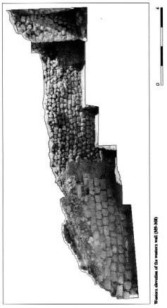
14 In order to do so it is necessary to gather the space coordinates of few points visible in the picture, with the help of a total station. The result is a geometric elevation of the façade we want to represent containing the spatial position of each stone. We can than number all the stones of the wall and reproduce the same numbers on the different ashlars with a removable paint in order to assure a precise reconstruction of the dismantled structure. An example of this procedure has been used to represent a part of the city wall located between the city gate and the palace-temple (Fig 14) and to represent the first structures to be restored as the external wall and the western wall of the city gate (Fgs ). Fig City wall: north elevation of the wall between the city gate and the palace-temple (M15). 18


15 Fig City gate: elevation of the external wall (M1). 19

16 Fig City gate: western elevation of the western wall (M9-M8); eastern elevation of the western wall (M8-M2). 20
17 2.Area connecting the gate complex and the palace-temple (Area A8) This area is situated east of the palace-temple and is comprised between this building and the first entrance gate, the most internal one. The continuation of the works started during the preceding season (SUM00A) 9 was aimed at analysing the area along the eastern wall of the palace-temple and in the area adjacent to it. The excavations at Area A8 (Fgs. 2, 3) have revealed various construction phases, with notable and recurrent structural changes: over time this urban zone has in fact seen a large square (which joined the first gate with the palace-temple), and then the construction, demolition and re-use of secondary buildings, and in the last phase the renewal of the first urban situation with its square. Archaeological examination during these last two campaigns has thus clarified an extremely complex stratigraphic situation which appeared in many respects obscure and indecipherable. Five constructional phases corresponding, most probably, with five major periods of the city existence were revealed during the excavations (Fgs. 17, 18, 19) The 1 st phase The construction of the city-walls, the palace-temple and a huge square between the first city-gate and the palace-temple must be referred to this phase, which was, probably, the first period of existence of the fortified town called Sumhuram. Square between the first gate and the palace-temple (Area A8). The earliest floors (US76 and US64) revealed during the excavations covered apparently the entire square between the first city-gate and the eastern wall of the palace-temple. The floor US76 was traced in the eastern part of the square. Unfortunately, its western part was heavily disturbed by the construction of the building BA1 (see below). Probably, at a certain point the floor US76 had a kind of step, and in the western part of the square it was continued as floor US64. At least both above-mentioned floors, US76 and US64, were made from packed earth and levelled the gravel filling above the bedrock. So far no constructions connected with these earliest floors were found at the area with two exceptions a channel running SW-NE direction in the eastern part of the square, and two wells constructed in the gravel filling above the bedrock discovered in the western part of the square (they were found under the floor US64 in the rooms A14 and A19). The channel (Fig. 20) was dug in the upper part of the gravel filling. Its walls and bottom were well trampled. Near the corner of the southern buttress of the first gate (M5) the channel made a bend and run apparently along the northern face of the wall M5 joining further down the channel discovered in the Area A4 (Fig. 17) along the wall M6 and the western buttress of the second gate (Fig. 21). The curve of the channel was made from stones: small flat stone blocks constituted its walls and bed, and even a kind of small sluice was constructed. At the corner of the southern buttress of the first gate (M5) flat stone blocks were mounted into the floor US76 carefully covering the channel (Fig. 22). Thus, inside the gates it was an underground channel, and in the square an open one. 9 See: A. Avanzini et al., ,

18 N Fig Area A8: detailed plan. 22
19 Fig Stratigraphic section N-S of area A8.
20 Fig Stratigraphic section E-W of area A8.


21 Fig Area A8: channel in the square. Fig Channel in the corridor A4. 25

 and eastern wall (M16) of the palace-temple. At the end of the SUM00A campaign, a corner of what could be a passage or a niche was discovered in the eastern face of wall M16.")
22 Fig Flat stones blocking the channel. Fig Well in A14. The wells discovered under the floors of the rooms A14 against wall M15 (Fig. 23) and A19 were 0.55x0.6 m and 0.45x0.5 m in size accordingly. The well in the room A14 was traced down to 1.6 m depth. The well in the room A19, with a visible depth of about 0.5 m, was covered with a triangular flat stone block. The purpose of construction of these wells remained unknown, but probably it was connected with the drainage or sewage systems of the ancient town. City-wall (M15) and eastern wall (M16) of the palace-temple. At the end of the SUM00A campaign, a corner of what could be a passage or a niche was discovered in the eastern face of wall M16. It was located about 6 m from the junction of the eastern wall of the palace-temple and the city-wall (M15), exactly where the wall M16 was heavily damaged. The remains of such construction led us to advance the hypothesis about the second entrance to the internal court of the palace-temple, in addition to the one already known to us as the small zigzag passage. After removing the stones piled up at that spot, 26
23 Fig Section of west side (M16) of the palace-temple.
 of the palace-temple, and the top part of which is clearly visible (Fig.2).")
24 it became clear that the corner was the northern face of the offset or niche about 1 m deep and more than 5 m wide (its southern part was destroyed completely). The offset is similar to the one located in the centre of the southern wall (M17) of the palace-temple, and the top part of which is clearly visible (Fig.2). Thus, we didn t find any traces of the second entrance to the palace-temple in its eastern wall, although the presence of two monumental prismatic-shaped stone blocks, 1.3 and 1.2 m long, found in the collapsed central part of wall M16 (Fig. 24), may speak about its existence. Theoretically, both blocks could be used as architrave of a possible door in the northern part of the niche, but neither floor, nor sidewalls of this theoretical passage were found. We may assume that both pieces were used as simple stone blocks in the niche construction. So far the only entrance to the inner courtyard of the palace-temple through the wall M16 was the small zigzag passage occupying the southern part of the uncovered niche. A large part of a stone paved path was unearthed in front of it (Fig. 25). Both walls, the city-wall (M15) and the eastern wall (M16) of the palace-temple were erected above the bedrock, which had an inclination from east to west. In the soundings dug in the rooms A17 and A18, both belonging to the building BA1 (see below), the foundations of the walls M15 and M16 were reached at the points and accordingly. The space between the bedrock and the earliest floors US76 and US64 (see above) was filled up with gravel mixed with brown loam; no finds were recovered from these layers (US 87 and 88 in room A17, and US 89 in room A18) except for a few animal bones under Fig Stone paving at the small zigzag entrance to palace-temple. 28
25 floor US76. Layers of white gravel, apparently the remains of stone cutting, were traced in both soundings as well as layers of medium size stones mixed with reddish loam (in the lower part of the filling). The top of the filling along the wall M15, between walls M26 and M7, was made from several rows of mud-bricks placed horizontally. The width of this construction is 1.7 m (6-7 rows). We cannot exclude the possibility that these mud-bricks represented remains of a pre-existent structure on the site before the construction of the walls of the city (such a suggestion must be carefully checked in the future) The 2 nd phase It seems that the second phase showed a kind of decline in the city occupation, which is reflected in the construction of the building in the corner formed by the city-wall (M15) and the eastern wall (M16) of the palace-temple. This construction closed the view and probably blocked direct access from the first gate to the palace-temple. Square between the first gate and the palace-temple (Area A8). The corner formed by the city-wall (M15) and the eastern wall (M16) of the palace-temple was occupied by the building constructed, probably, after a rather short period of occupation of the square: its internal walls (M27, M28, M31, M32) were built above the filling (US64) accumulated during the period when the square was in use. Quite a number of characteristic finds (fragments of Dressel 2-4 amphorae, bronze coins classified as early Hadrami imitations ) were revealed in the US64. Five rooms formed the Building BA1: A14, A17, A18, A19 and A26 (Fig. 2). It seems that the external walls of the building (M26 and M33) were constructed in the foundation trench dug in the eastern part of the square following the offset in the wall M15 and the niche in the central part of the wall M16. The location of the entrance to the building is uncertain, but probably it was in its eastern wall (M26): a kind of doorstep and an internal step 0.8 m wide remained in the middle part of this wall. The core of the building was a central corridor (room A18), 2.5x5.8 m in size, from which two entrances with stone doorsteps 0.3 m high led to the rooms A14 and A19 (Fig. 26). Small pillars, 0.4 m wide, constructed in the middle of the room against walls M28 and M31 divided the corridor into two parts. A narrow bench, 0.3 m wide, was built along the S-E part of the wall M31. The N-E corner of the corridor was occupied by a staircase, 0.8 m wide, which led to the roof of the building (the walls of the building were so poorly constructed that it s hard to imagine the existence of the upper floor of the building). Two steps of the staircase remained in situ.afoundation of an oven made from plaster was discovered in the central part of the corridor. The foundation was about 0.6x0.8 m in size, and was strengthened with an external row of stones. The filling of the room was soft brown loam mixed with organic remains, small stones, fragments of animal bones, pottery and charcoal (US48). Several stone (S72, ) and bronze (MB2) objects, a lamp (Sh6), made from seashell chlamys townsendi were found in the filling. The N-W corner of the building was occupied by the room A14 (the so-called subterranean kitchen ), already partly excavated during the SUM00A season. It is an almost square room, about 2.55x3.0 m in size, located in the corner formed by the walls M15 and M16. An amorphous narrow stone bench, about 0.6 m wide and m high, was 29
.")
26 Fig Building BA1. carelessly built along the eastern wall (M27) of the room. Its N-E corner was occupied by a cubic-shaped construction, the outer surfaces of which were plastered. The vertebra of a whale and the low stone of a hand mill were mounted in the top rows of this construction (Fig. 27). A fireplace and part of the carefully plastered floor (US29B) were unearthed, during the 2000A expedition, in the centre of the room. A nicely paved oval pit, 0.55x0.6 m in size and 1.2 m deep, was found immediately next to the fire-place, against wall M15. It was filled with very soft brown loam containing a lot of organic remains and animal bones (US61). A cubic-shaped grinding stone (S17) was found in the filling of the pit. One of the entrances to the room, c. 1.0 m wide, was in its SW corner. It had a stone doorstep 0.3 m high. Room A17, situated against the wall M15, is adjacent to the room A14. It is the square room, 2.4x2.6 m in size, and its floor (US50) is situated about 0.3 m deeper than the floor of the room A14 (Fig. 28). The position of the entrance to the room is unclear, but probably it was located in the S-E corner once connecting rooms A17 and A18. It was about 1.1 m wide, and, probably, had two low steps. It seems, when the room was abandoned, but during the existence of the building, the entrance was blocked with stones. Part of the floor US50 in the N-E corner of the room and adjacent part of the city-wall M15 were plastered. Room A19, revealed to the south of the corridor A18, was constructed against the wall M16 (Fig. 29). It was adjacent to the corridor and was separated from it by a very badly preserved wall M31. Its Western wall was, probably, the wall of a collapsed niche, and 30


27 Fig Cubic-shaped structure with the whale vertebra in A14. Fig The room A17 Fig The room A19 with the lower part of a column. 31
28 the eastern (M32) and southern (M33; partly destroyed) walls were carelessly built from fieldstones. The room was rectangular in shape, and 2.4x2.8 m in size. There were two entrances: in the N-W corner, m wide with a low stone doorstep, connecting the room and the corridor A18, and in the N-E corner, c. 0.6 m wide, connecting it with the room A26. The broken lower part of a column mounted into the bedrock was found in the centre of the room. Probably, it once supported the roof of the structure. The floor of the room (US48) was reinforced by a thin stone wall, whose blocks covered the well unearthed under the floor (see above). Two bronze early Hadramawt imitations (Co53 and Co54) were found under the floor US48 near the broken column in the stratum US64 accumulated above the bedrock. The S-E corner of the building was occupied with almost square room A26, 2.5x2.6 m in size. Here US90 marked the period of occupation of the room; it consisted of light brown loam containing charcoal, animal bones, shells and pottery fragments. Two coins were found in US90 (Co80, Co81). The floor US90 was lower than the floors of adjacent rooms A19 and A18. A stone bench was constructed along three walls (M33, M32 and M31) of the room (part of the bench constructed along the wall M31 was narrower than the other parts). The floor and at least the lower part of the benches were plastered with mortar. A stone block, apparently the base for pillar to support the ceiling, was discovered in the centre of the room (cf. the pillar in the centre of adjacent room A19). The entrance to the room A26 was located, most probably, in its N-W corner, where a three-step staircase remained in situ. Cultural deposits represented by US29bis (room A14), US48 (rooms A18 and A19), US48 and US90 (room A26) were accumulated, most probably, during the life of the building BA1. In US48 five coins were found (Co79, Co78, Co77, Co76, Co75). Building BA2. Remains of what might be ruins of another building contemporary to the building BA1 were discovered under the foundation of the room A28 of the building BA3 (see below). So far remains of a stone wall (M56) and a step down to the floor of a room (?) were unearthed in layer US99, which is greyish loam mixed with charcoal, pottery fragments and animal bones. In US99 one coin was found (Co92). In room A27 (building BA3) the layer below floor US79 (layer US100) was investigated for a depth of more than 1 meter. It contained pottery shards, some animal bones, some charcoal along with stone objects (S274, S275, S276, S281, and S282), and a coin (Co101). No traces of a floor or a wall have found: layer US100, a very compact greyish brown loam, rested on the same gravel filling that have been found in the two soundings in the rooms A18 (US89) and A17 (US87 and US88). The gravel filling (US104) has been investigated for a depth of only 0.10 m. The rest of the square A8 with its channel was still in function during the life of the building BA1. It seems that the passage to the entrance of the palace-temple located in its wall M16 was also in function, although it s not clear when it was constructed The 3 rd phase Considerable changes were made during the next period of the city existence. Square between the first gate and the palace-temple (Area A8). The building BA1 was completely destroyed, and its major parts as well as the eastern part of the square A8 was 32

29 levelled with layer US38, above which the floor US22 was constructed. The rooms A18 and A19 were demolished while the room A17 was abandoned and converted into some kind of rubbish pit, where remains from cleansing of the new square were, probably, accumulated. These remains constituted the stratum US50 crumbled brown loam mixed with a large quantity of animal bones, pottery fragments, ash, charcoal, organic remains and small stones. A number of iron (?) slags was revealed in the top part of the stratum mostly along the wall M15. Stone, shell and bronze objects as well as some coins were found during the excavations. It should be pointed out that the stratum US38 and the floor US22, both referred to the third phase of the city existence, were traced only above the southern wall (M28) of the room A17, but not above its filling (stratum US50). This is without doubt an indication that the rubbish in the ruins of A17 was accumulated during the third phase. The only room still in function during the third phase was the kitchen A14 (Fig. 30). It was slightly renovated: (1) new layers of plaster covered the floor US29bis including the fire-place, adjacent wall M15, cubic structure in the N-E corner and the part adjacent to the bench; (2) the second step was added in the entrance; (3) the southern wall (M28) of the room was reinforced and slightly widened. All these renovations might be connected with the construction of the floor US22, when the kitchen was transformed into the subterranean room (the difference between layer US38 and room s floor US29bis was about 0.4 m; the difference between floor US22 and room s floor US29bis was about 0.65 m.). Thus, the filling of the room A14 was mostly accumulated during the second period of its Fig Room A14 during the 3 rd phase. 33

30 functioning, and the pottery assemblage from US29bis represented the third phase of the city existence. The construction of the new wide square with the channel running across its eastern part was the result of all above-mentioned renovations. But there were more visible constructions in addition to the channel: the upper parts of the walls M26 (the small part against the city-wall M15), M28 and M33 remained on the new surface and were even renovated with new rows of stones; the construction of the new wall M34 was also connected with the floor US22. It is not clear why such constructions were made. For the walls M33 and M34 we may assume that it was a way to mark the passage to the entrance of the palacetemple, but the purpose of other walls or rather, fences remained unknown. Building BA3. The new building was constructed to the east of the square A8, next to the southern buttress of the first gate (M5). Till now we have succeeded in excavating only its western part (Fgs. 2, 17). The walls M51, M55 and M52 were the external walls of the house, and they were constructed in the foundation trench dug from the floor US22. A partition wall M53 divided the excavated part of the house into two rooms, A27 and A28, reaching down only to the floors of the two rooms and not below the floor US22, like the external walls. An entrance with a doorstep, c. 0.8 m wide, connected the room A28 with the square. A rectangular low (0.3 m) porch, c. 0.7x1.4 m in size, was built outside the entrance. A semicircular construction was discovered around the S-W corner of the building BA3 (Fig. 31). Its purpose is not clear, but probably it was built to reinforce the foundation of the external corner of the building, which rested on the ruins of the previous Fig Building BA3 with semicircular construction. 34
31 building BA2 (see above). The floor of the room A28, the floor US97, was reached at the point 35.96, and the floor US79 of the room A27 at the point The layer US97 above the pavement in the room A28 was formed from greyish loam mixed with a few bones, pottery fragments and shells; iron slags were also found as well as a round grinding stone (S279). The floor US79 in the room A27 was roughly paved with unworked stones of medium size. Fragments of pottery, animal bones, iron slags, stone objects (S226, S229), and two iron axes (MI18, MI19) were found on the pavement. In the occupation layer accumulated above the floor US79 a quantity of animal bones, pottery, charcoal, oil lamps made from shells (chlamys townsendi), objects like grinding stones, pestles, whetstones (S213, S217, S216, S215, Sh26), and two coins (Co86, Co87) were found The 4 th phase Minor changes were made during the next constructional phase. The entire surface of the square was again renovated now with very well packed gravel floor US29 (Fig. 18), which covered practically all remains of the previous structures in the western part of the square including walls M26 and M28. But the walls marking the passage to the entrance of the palace-temple (walls M33 and M34) remained and were even renovated, which indicates that the palace-temple was still in use. The new floor covered also the porch in front of the entrance to the building BA3, but the building itself was still in function as well as, most probably, the channel in the eastern part of the square The 5 th phase This is the last period of the city occupation, when life remained only in a few parts of the town and most of its buildings were completely abandoned. At Area A8 the new floor US21 that covered all previous structures without exception marked this phase (Fig. 18). In the portion of the area excavated during the last campaign floor US21 was made from hard packed brownish loam. Construction of the offering place discovered in the season SUM00A against the eastern wall (M16) of the palace-temple was connected with this floor (Fig. 32). In the deposits accumulated above the floor US21 one bronze coin was found (Co83). In the N-W part of the excavated area A8 the layer US21 was covered with layer US78 consisted of light reddish brown loam mixed with medium size stones. Apparently, the stratum US78 marked the abandonment of the area Dating of the phases There are several hallmarks, which may help to date tentatively the constructional phases described above, and periods of the city existence connected with them. Dating of the 1 st phase: from the late 1 st cent. BC to the early 1 st cent. AD. This is the period of construction of the city-walls and a prominent building such as the palace-temple. There is some evidence, which allows us to connect the foundation of 35

32 Fig View of the interred room. On the left: the offering table. the city with Yashhur il Yuhar ish, son of Abiyasa, mukarrib of Hadramawt, who ruled, probably, in the late 1 st cent. BC early 1 st cent. AD or, even with his predecessor. The radiocarbon analysis of charcoal and wood samples from the layers compared with construction works of the city-walls gave the following dates: 2170±70 BP (GX-27579; the sample from the upper part of gravel filling immediately under the floor US76), 2160±70 BP (GX-27582; the sample from the filling of the well under the floor in the room A14). There is also a possibility that the city was founded on the place of an early Hadramawt settlement: presence of some pottery shards with parallels in the pottery corpus from Wadi Hadramawt of the 3 rd -2 nd cent. BC as well as unusual concentration in the lower layers of the site bronze coins classified as early Hadramawt imitations (with owl on the reverse) may well speak about such a proposal. The above mentioned early material corresponded with the radiocarbon dates derived from the samples collected in the US50, the filling of the room A17: 2480±80 BP (GX-27577) and 2220±70 BP (Gx ). None of the structures revealed at Khor Rori so far could be connected with such early material, but if the supposition about their existence at the site is to be confirmed, this constructional phase of the settlement might be designated as pre-sumhuram period. The period of occupation connected with the 1 st constructional phase lasted at least till the first decades of the 1 st cent. AD, when, according to the Periplus of the Erythrean Sea (written c AD), Moscha Limen=Sumhuram was a flourished city-port to export frankincense 10. The charcoal samples from the layer US64, which corresponded with the first living activity at the ancient town, gave the dates 2020±70 BP (GX-27580) and 2030±80 BP (GX-27583). Dating of the 2 nd phase: from the early 1 st to the late 2 nd cent. AD. This period is characterised by a certain decline in the city life, when rather badly exe- 10 On this first phase of the city and a possible articulation in two periods, see A. Avanzini, R. Orazi, The construction phases of Khor Rori s monumental gate, soon to appear in AAE. 36
33 cuted constructions like building BA1 were built at the rather important areas of the town (square behind the principal gates of the city). The radiocarbon dates obtained from charcoal samples from the cultural deposits accumulated above the floors in the rooms A14 and A18 are 2000±40 BP (GX-26645), 1990±70 BP (GX-27576) and 1960±40 BP (GX ). It gives some ideas about the time of construction of the building BA1 and affiliated structures first decades of the 1 st cent. AD. The period of occupation of the ancient town connected with the 2 nd constructional phase lasted till the late 2 nd cent. AD. It is worth mentioning the absence of the Hadrami coinage of the late 1 st and 2 nd cent. AD from the rather numerous numismatic material from Khor Rori, which confirmed, probably indirectly, the hypothesis about the period of decline in Sumhuram. Dating of the 3 rd phase: from the late 2 nd to the mid-3 rd cent. AD. This was the period of a serious renovation of the city including its fortification. It seems that at least in the Area A8 the initial planning was restored: an old/new square was re-arranged above the remains of the building BA1. The hallmark for the dating of this period is the coin of Ili adhdh Yalut, son of Ammidhakhar, king of Hadramawt, found at the square under the floor US22 (Hadramawt coin type 5.3). The reconstruction works carried out at the city-wall M15 to re-build its external face, gave the following radiocarbon dates for this activity: 1770±60 BP (GX-27584) and 1790±50 BP (GX-27585). Thus, we can date the renovation of Sumhuram close to the late 2 nd -early 3 rd cent. AD, and connect these activities with the name of Ili adhdh Yalut, son of Ammidhakhar, king of Hadramawt (c. AD ). Dating of the 4 th phase: from the mid-3 rd to the early 4 th cent. AD. This was, probably, the last period when Khor Rori existed as a town, and its main constructions like gate complex and palace-temple were still in use. Apparently, the late Himyarite coinage (bronze small crude «series with Bucranium») marked the end of this period. Dating of the 5 th phase: first half of the 4 th cent. AD. This is the period of late occupation of the ruins of the city, when the life existed only in the certain areas of the settlement. Its major buildings like, for instances, the palacetemple, were not in use anymore, but still some pagan cults were performed (cf. the offering place constructed against the wall M16) (Fig. 32). The dating of the period is based on the result of radiocarbon analysis of the sample collected from the drainage channel of the offering place, which gave the date 1650±40 BP (sample GX-26643). The sample obtained from the US21, the layer of destruction of the main buildings of the ancient town, provided the very near date of 1630±40 BP (GX-26645). 3. Khor Rori s north-western area (area F6) The new area for excavations was selected in the north-western part of the city (Fgs. 33, 34), in the huge square between the palace-temple and the western city-wall. The big trench excavated by R.Cleveland in 1960 was located immediately south of the selected area. The main goal of the work was to check the location and direction of the proposed 37
34 Fig Plan of working area by the N-W side of the city (F6).
35 city streets and squares in order to identify the general layout of the city planning and to determine the stratigraphy of this part of the ancient city. In the course of the excavations we were fortunate to determine a detailed stratigraphy of the area, to trace three main constructional phases of the buildings, and to refer them to the main periods of the city existence. The general results of the campaign can be summarised as follows (Fgs. 34, 35, 36) The 1 st phase Alarge square (A20), two streets (A29 and A32) and at least three houses (BF1-BF3) erected against offsets of the northern and western city-walls were discovered at Area F6. Two of them, buildings BF1 and BF2, were partly excavated by R.Cleveland in (buildings against the northern wall of the city), and the third one (BF3) by MID during the SUM00A and SUM00B seasons (building against the western city-wall). Building BF3. Nearly one third of the building was explored. It seems that the building consisted of two adjoining rectangular edifices was erected, most probably, above the bedrock (Fgs. 33, 37). The walls M48, M40, M38 and M39 separated the southern edifice from the streets A29 (to the north) and A32 (to the south), and square A20 (to the east of the building). The northern edifice was erected next to the north of the previous one, and the wall M47 separated it from the small L-shaped street A29 located between buildings BF3 and BF2. The width of the street is about 1.5 m (the eastern part) and 3.3 m (the northern part). Two entrances both about 1.0 m wide, in the wall M40 and in the wall M47, led inside the basements or ground storeys of both edifices from the square A20 and street A29. Two adjoining rooms A22a (2.8 m wide) and A22b (2 m wide) constituted the ground storey of the southern edifice. Part of the room A22a was excavated to its earliest floor US86 (at the point 33.05). A three-step staircase led to this floor from the entrance located in the wall M40. The rooms A22a and A22b were separated by a partition wall M49. Only one room A25 was partly unearthed so far in the northern edifice. The southern edifice had an upper storey constructed in about 1.6 m above the ground one. The big rectangular room A22, 5.5 m wide, constituted the upper storey of the building. It seems a row of pillars supporting the ceiling of the construction was placed in the centre of the room along its long axis: two big stone blocks standing on the partition wall M49 were found in situ (the distance between them is about 2 m). It seems that the floor of the room A22 was paved with stone slabs: a row of sandstone blocks was unearthed along the wall M39, and the pavement was also traced in the northern part of the room, in the western section at the point The pavement of the southern part of the room did not preserve, but in the section one can trace the white layer of mortar, on which stone slabs of the pavement were once placed. This layer was discovered in 1.2 m above the earliest floor US86 of the room A22a. The access to the upper storey was, most probably, through an internal staircase located somewhere in unexcavated part of the room A22a. 11 Cf. n
36 N Fig Working area by the N-W side of the city (F6): detailed plan.
37 Fig Stratigraphic section E-W of area F6.
38 Fig Stratigraphic section N-S of area F6.

39 Fig Building BF3. The external walls of the structure were m wide, and were preserved to a height of more than 1.5 m. They were constructed from roughly dressed limestone blocks, and their lower rows were mounted into a kind of cement mortar. Probably the exterior of the building was faced with polished limestone slabs, fragments of which were found in the filling outside the building. Deposits accumulated in room A22a above the earliest floor consisted of dark brown rather soft loam mixed with fragments of animal bones, pottery shards, pieces of carbon and ashes (layer US86). Nine bronze coins (Co.63-67, 69-72) were found in the filling along with a number of stone, bronze, shell and glass objects. Building BF2. It seems that the building which consisted of two adjacent rectangular rooms and was excavated by Cleveland was also erected during the 1 st constructional phase. One of these rooms, A24, had an entrance, 0.8 m wide, from the square A20. From outside the entrance was designed in a form of a rather amorphous porch built from fieldstones. There was a two-step staircase inside the entrance leading down to the original floor of the building, which was about 0.5 m deeper than the floor US55 of outside square A20. Only small part of the room was excavated, which revealed in its southern corner a slightly raised plastered platform with a cavity on its upper surface. Most probably, the platform was used to store a big jar for water (?). Square A20, streets A29 and A32. Only a small part of the square A20 and street A29 connected with the first phase of the building BF3 was unearthed. It seems that the corner of the street A29 formed by walls M38-39 and M47 was occupied by a workshop of 43
.")
40 unclear character: remains of a small (1.5x1.6 m in size) platform carefully plastered with mortar and an oven next to it were found. An upper part of a Dressel 2-4 amphora was mounted into the corner of the platform serving as a kind of drainage pipe (Fig. 38). Quite a number of grinding stones, pestles and mortars, pottery shards and a bronze coin (Co.91) were found in the layer US98 above the platform and around the oven The 2 nd phase Considerable changes were made after a certain period of the buildings existence. Building BF3. The building BF3 was very much renovated: both entrances to the ground storey, from the square A20 and street A29, were carefully blocked with stones, the upper parts of the external walls M40 and M47 were rebuilt, and an almost square room A21 was attached to the N-E corner of the southern edifice (Fig. 39). The new room A21 was x2.55 m in size, and had a stepped entrance, 1.2 m wide, constructed in the centre of its eastern wall: four steps mounted into a kind of cement mortar were made from huge sandstone blocks. The steps were cm wide and cm high. A high floor of the room situated in about 0.7 m above the surface of the ancient square A20 (floor US55) was carefully paved with sandstone slabs (the central one was 0.75x1.1 m in size). The S-W corner of the room was occupied by another three- Fig Dressel 2-4 amphora used as a drainage pipe. 44


41 Fig Square in front of the stepped entrance of building BF3. step staircase which led to the upper storey of the building situated 0.6 m above the floor pavement. The staircase was rather small, about 1.2 m wide. It steps, cm wide and cm high, were made from roughly cut limestone blocks. The upper step was paved with polished limestone slab. The width of the entrance to the room on the upper storey was 1.2 m, and was paved with stone slabs as was the entire floor of the upper room A22 (see above). The sidewalls of the entrance were faced with small sandstone slabs mounted into a kind of cement mortar. The upper staircase was renovated at least once, when its northern border was reinforced with small stones, and steps were paved with re-used limestone slabs (a complete one and fragments of other two were found nearby fell down from the staircase). A complete bronze bell (Fig. 40) was found on the middle step of the staircase (MB26). The ruins of the upper room revealed a complete limestone mortar (S130) (Fig. 41), fragments of base of a huge stone vessel (S136) and a grinding stone with a cavity on one of its sides (S123). Three lower rows of external walls of the new room with staircase were made from well-cut sandstone blocks placed onto a kind of plinth constructed from roughly dressed limestone. The gaps between sandstone blocks were carefully plastered with mortar. Fig Complete bronze bell (h. cm 3.5). 45

42 Fig Complete limestone mortar S130 (h. 32 cm). Three-four rows above the sandstone blocks were made from roughly cut limestone, and were topped with very well made limestone blocks, which levelled the entire surface of the external walls. It is not clear what kind of structure was placed above this level of well-cut limestone blocks. Probably, it was made from wood, mud-bricks and/or other light materials. The only purpose in building such a construction as room A21 was to give direct access to the upper storey of the building BF3, straight from square A20. It is not clear whether the ground floor of the building was still in use after such a reconstruction or whether it was completely filled to make a real basement for the newer building. It is also not clear how the access to the northern edifice, to the room A25 was designed. All these renovations were made on the floor US55, which was traced in the street A29 and on the square A20: the foundation of the external walls of the room A21, walls M35, M36 and M37 was found at the level which roughly corresponded with the floor US55, e.g. in c. 1.0 m higher than the bases of the external walls M48, M40, M38, M39 and M47 of the building BF3. Another cosmetic renovation such as new layers of plaster on the lower rows of external walls for protection against rain and floodwaters was connected with the floor US54 46
43 (see below). Building BF2. It seems that the building BF2 was in function without visible changes to its layout. We may assume that only renovation of the small porch in front of the entrance to the room A24 and an upper step of its staircase were connected with some construction activities of the 2 nd phase. Square A20, streets A29 and A32. It seems that the floors US55 and US54 traced on the square and in the streets must be associated with the life in this part of the city during the 2 nd construction phase. The floor US55 completely covered the remains of the workshop with oven and drainage platform. It seems that another oven was built instead, but now against the wall M42 of the building BF2. Only its lower part dug into the floor, where firewood was placed, remained intact. It was rectangular in shape, 0.35x1.3 m in size and about 0.45 m deep. Its long walls were made from sandstone blocks (the lower part of the building s wall was used as one of the short walls). The lower part of the oven filling contained ash. Whether it was simply a re-allocation of the workshop or something else remained so far unknown. It seems that the contemporary floor of the street A32 was high than the floor US55 of the street A29: it roughly corresponds with floor US54 unearthed in the square A20 in front of the building BF3 (Fig. 39). Probably, such a difference was connected with general inclination of the rock, on which the city was founded, in the north-south direction. The floor US54 was constructed all over the open square A20 in front of the building BF3, and in the northern (A29) and southern (A32) streets. Along the outer surface of the wall M40 it was paved with fieldstones of medium and small size. In the northern part of the trench it was traced in m above the previous floor US55. The floor was made from packed earth, and some parts of it were plastered with a kind of cement mortar. The floor US54 covered the oven excavated against the external wall of the westernmost structure (see above) as well as the porch in front of the entrance to one of its rooms, where instead a stone doorstep was constructed. It seems that Cleveland s 1960 excavations stopped at the surface, which roughly corresponded with our US54 floor. The strata US55 and US54 accumulated above the floors constituted of rather compact brown loam mixed with organic remains, animal bones, and pottery fragments. A number of stone (S ,110,111,118,119,128,134), shell (Sh8), and iron (MI6) objects including three bronze coins (Co50-52) were found, for instance, in the stratum US The 3 rd phase It seems that the layer US54 was the last one connected with life in the dwellings, and layers US56, US71 and US80 were accumulated when this part of the ancient city was already in a state of neglect. A boat-shaped grave was discovered in the corner formed by the walls M44 and M45. The grave pit (Fig. 42) was almost rectangular in shape, 0.3x1.1 m in size and m deep. There were two rows of pavement made from small stones around the grave pit. A nice limestone incense-burner on the truncated-pyramid shaped base (S133) was re-used in this pavement (Fig. 43). The grave was also ringed by a semi-circular row of large field- 47

44 Fig Boat-shaped grave. stones, while the corner made from two external walls of the buildings formed another part of the circle. It showed that the grave was constructed when surrounded buildings BF1 and BF2 were still intact. Unfortunately, the grave was empty: neither bones nor funeral goods were preserved. The very last building activity at the Area F6 was, probably, connected with construction of the platform made from re-used sandstone blocks and polished limestone slabs. It was discovered near the outer S-E corner of the room A21. Apparently, all stone blocks and slabs were taken from the ruins of the building BF3. The platform was situated in m above the floor US54 but no real horizontal surface was traced at this level in the trench. The platform was in some way connected with the stratum US71, which revealed, in addition to animal bones and seashells a very small amount of pottery fragments. Taking into account a huge amount of the seashells (oliva bulbosa) discovered with holes on the narrow sides, we may assume that a kind of a workshop to produce necklaces was located here during the very late period of Sumhuram existence. The ruins of the building BF3 were also occupied by the above mentioned workshop (cf. floors US85 and US83 discovered in the room A22) Dating of constructional phases Dating of the 1 st phase. The material revealed so far in the deposits accumulated in the ruins of the room A22a (fragments of Dressel 2-4 amphorae and terra sigillata bowls, bronze issues of Yashhur il Yuhar ish, son of Abiyasa, mukarrib of Hadramawt, e.g. Hadrami coins type 4), allow us to date the beginning of the first constructional phase in this part of the city close to the very early 1 st cent. AD. It seems that the entire phase roughly corresponds with the first two constructional phases revealed at the Area A8 (see above). Dating of the 2 nd phase. There is some evidence (characteristic pottery shards, coin of the Ili adhdh Yalut, son of Ammidhakhar, king of Hadramawt) that the second phase in 48

45 the Area F6 roughly corresponds with the 3 rd and, probably, the 4 th phases revealed at the Area A8. In other words, the reconstruction of the building BF3 and its further existence must be placed in the period between the late 2 nd and the early 4 th cent. AD. The radiocarbon analysis of a charcoal sample from the upper part of the US54 collected in front of the building BF3 gave the date 1820±60 BP (GX-27581). Most probably the sample came from the burnt light materials of structures built above the well-cut limestone blocks in the walls M35-M36-M37 of the room A21 (see above). In other words, it indicated the period when reconstruction of the building BF3 was made. Dating of the 3 rd phase. This is the period of the so-called late occupation of the site, which might be placed somewhere in the first half of the 4 th cent. AD (corresponds with the 5 th phase at the Area A8). Fig Limestone incense-burner. 4.The archaeological park The site of Khor Rori and it surrounding area have been placed on the UNESCO list of places to preserve both for the archaeological site and for the natural qualities of the region. The area covered by the Archaeological-Natural Park of Khor Rori is delimited, in the South, by the Indian Ocean (about 600 m distance from the site), in the East, by the small village of Taqa (about 2 km.) and, in the West and in the North by the road Salalah- Mirbat (about 2 km.). There are many sites of archaeological and naturalistic interest present in this territory. Once formed, the Archaeological Park will be a powerful instrument for planning and managing all the actions related to scientific research, conservation, implementation and enjoyment of the site and its territory Al-Hamr al-sharqiya In order to prepare the documentation of the structures included within the borders of the archaeological and naturalistic park of Khor Rori, during the campaign SUM00B we started investigating the settlements situated on the promontory (al-hamr al-sharqiya) that delimits the mouth of the Wadi Darbat on the eastern side (Fig. 44). 49

46 Fig The promontory of al-hamr al-sharqiya: view from Khor Rori Measuring the emerging structures Already in June 2000 we surveyed the long wall that delimits the promontory on the site overlooking towards the inland. This is the only side from which the enemy s threat could arrive since the other three sides of the promontory rise steeply from the ocean. This long wall is made of roughly worked stone blocks assembled either dry or using mortar mixed with a large quantity of earth. Starting from its eastern corner and at about one third of its length, the wall is about 700 m (Fig. 45); there is the only door that led outside it and that opens on the plateau that with more or less deep subsidences covers the whole promontory. On the top of the above mentioned wall there is a kind of walkway that could be reached thanks to some small steps located at regular intervals along the internal side of the wall. This walkway, that on the external side was protected, so it seems, by some kind of a stone balauster of which very little is left, led after a few steps to a series of turrets. They were all placed on the external side of the wall (in other words they were looking towards the land), with an interval of about m between them and guaranteed a perfect defence of the impressive barrier. During the SUM00B campaign we completed the works started in June. After reaching the plateau, the whole tract that forms the gate extends itself towards the West presents traces of the presence of numerous huts. More precisely we discovered some stone elements arranged in circles that sometimes are isolated but that more often are grouped so as to form a more complex structure (bronze age?) (Fig. 46). Proceeding in a easterly direction, after finding traces of huts similar to the ones above described we found an area apparently free of any construction. Immediately after, we found a second wall barrier that protected a large settlement situated near the farthest side 50
47 51 Fig Al-Hamr al-sharqiya: general plan.
48 of the promontory. This second structure started from the city wall that protected the promontory towards the inland and moved almost perpendicularly towards the south. After about 80 m the direction changed towards the east and also here, forming an almost right angle corner until it closed the settlement near the eastern side of the promontory. All along the external side of the first tract (N-S) of the above mentioned structure there are some turrets built for defensive purposes whereas the second tract (E-W) is less well preserved and thus is more difficult to interpret. Both the remains of the second wall structure and the ones of the internal settlement are in very poor condition. None of the wall structure emerges for more than 30 or 40 cm above the surface level and to make the situation even worse parts of these structures are completely missing. Geometric measurements thus took a particularly long time and it was not always easy to interpret emerging structures. The settlement is thus delimited in the north by the long external defensive wall and on the western and southern side is delimited by the second more internal wall; the eastern side which is smaller looks directly over the ocean (Fig. 45). On the basis of the measurement of the emerging structures, it seems that the settlement consisted of a series of houses adjacent the one to the other and to the eastern side; it also seems that there was a house with a patio. Other rooms are adjacent the southern side whereas towards the eastern part of that side some rooms variously grouped seem to indicate the presence of a palace. North of Fig Al-Hamr al-sharqiya: bronze age (?) huts. 52
49 this building and so along the northern side there are some small narrow rooms placed according to a disposition which is characteristic of stores. All the eastern part of the settlement seems on the contrary to be in a very poor state and it is difficult to interpret with the only exclusion of a look out turret that is situated at the farthest eastern side of the long wall that surrounds the promontory, and that controlled the whole eastern and south-eastern area of the Indian Ocean Archaeological surveys Excavation surveys were carried out in three different places and more precisely in two of the rooms of the house with a patio, in one room of the palace and in a small area of the stores. During the first surveys carried out in the so called house with a patio three walls joined together (M2, M3 and M4) and adjacent to the main wall M1, that closes the settlement on the eastern side, separate an area which in its turn is subdivided into two communicating rooms (A1 and A2) from a fourth wall (M5), built separately on which an internal communication door (70 cm wide) opens. The dimensions of the two trapezoidal rooms (A1 and A2) with the longest sides turned towards the east have similar dimensions (about 3.0x2.5 m) and only one external access that opens in the northern wall (M4), joining wall M3 and that leads in A1 (width of the door opening: 80 cm) (Fgs. 47, 48). During the second survey carried out in the palace we explored only one rectangular room (A3), 2.50x4.0 m in size with only one entrance towards the southern side on wall M9 and 1.10 m large (Fgs. 49, 50). During the third survey carried out in the so-called stores we explored the northern part of a room (A4) built along the northern fortification wall and only about 1 m from it. There is one internal door that apparently led into a parallel room built along the western side M12 (width of the door opening: 90 cm). This room is rectangular, regularly shaped and is 2.10 m wide; it has been unearthed for about 5.10 m lengthwise until we reached the hinge of the door (Fgs. 51, 52). The walls of the rooms we explored seem to be built with a certain accuracy and precision: their foundations are adjacent the bedrock and the brick work is made of two rows of middle sized calcareous stones regularly squared and the shape of which has been made more regular thanks to the use of pebbles and gravel. We found no traces of mortar or plaster. It seems that the walls have been dry assembled or that at the most they have been cemented with a rudimental mud mixture. With the exclusion of the thick external wall M1, which is 1 m thick, the width of the internal walls in the different rooms does not vary much: in the house with a patio the walls (M2, M3 and M4) are all 50 cm thick, whereas the internal division M5 is more narrow (44 cm); in the palace the four walls (M6, M7, M8 and M9) are all 60 cm thick; in the stores the northern wall (M10) is 68 cm thick, whereas the other two walls uncovered (M11 and M12) are 60 cm thick. The stratigraphic sequence is analogous in the three tests, and only a little different in ambient A3. In A1 and A2 (relative to the house with a patio ) and in A4 (in the area of the stores ), after the removal of consistent layers of detritus (respectively US1, US4, and 53

50 Fig Al-Hamr al-sharqiya: plan of survey at house with a patio. Fig Al-Hamr al-sharqiya: excavation at house with a patio. 54

51 Fig Al-Hamr al-sharqiya: plan of survey at the palace. Fig Al-Hamr al-sharqiya: excavation at the palace. 55

52 Fig Al-Hamr al-sharqiya: plan of survey at the stores. Fig Al-Hamr al-sharqiya: excavation at the stores. (A4) 56
53 US10) made up of large stones fallen from the walls mixed with smaller stones and soft wind-borne earth and characterized by an almost total lack of objects, there begin the softer filler layers (respectively US3, US9, US17) with ashes and traces of burning, ceramic shards, stones, glass, and food residue (bones and shells). These fillers terminate in the three ambients on the pavements in packed earth, only partially conserved in A2 (US11) and A4 (US24), which are instead well determined in A1 (US5). In A3 the situation was different: immediately after the removal of the thin top layer, which is the current walking level, there was found a first filling (US2) which is very soft, and mostly made up of ashes mixed with soft wind-borne earth in which a very large quantity of ceramic has been found (both rough kitchen ware and finer glazed table ware), numerous shells and animal bones. This first filling covered a very poorly conserved pavement (US12), preserved only in short lengths inside the area and in the doorway. The pavement US12 covered the destruction stratum US6 which was characterized by fallen stones mixed with ash, food remains (with a large concentration of shells from the mactridae family), ceramic shards and various objects. It is likely that this area was re-used even in ancient times as an outside dump, after the collapse of the walls and after a rough and summary compacting of the surface (US12). The ceramics from this first level, even though still under examination, do not seem substantially different from those found under diverse layers of detritus in the other three areas, and allows us to hypothesize that the re-use of A3 is of the settlement s own history. In all the rooms we explored, with the exception of A1 (where we found a second packed earth paving US20, cm under the first US5), we discovered two occupation levels: the first one is more recent and is constituted by packed earth pavements (US5, US11, US12 and US24) and the second one which is the original one is constituted by the bedrock itself, levelled and smoothed with compact clay strata, the thickness of which varied depending of the need. So for example in A3 a large portion of emerging rock that crosses the whole room lengthwise, is naturally inclined towards the west and it seems that it was levelled with a mixture of clay that unfortunately is only partially preserved (Fig. 50). All these rooms seem to have been intentionally built on the top of large regular portions of emerging calcareous rocks, which obviously are found at different heights. This explains, for example, the difference in level between the pavements of the communicating rooms A1 and A2 and the presence of the steps to reach A2 from A1 (Fig. 53). The difference in level of the rock emerging in the two structures is in fact about 18 cm, being lower in A2; a similar level difference was found also in the case of the packed earth pavements US5 and US11. If from the point of view of material culture we can notice a certain continuity with Sumhuram, especially as far as the stone objects are concerned (grind stones and pestles), from the point of view of architectonic structures and ceramic products (Fig. 54), the difference seems extremely evident: the pottery found in the course of our surveys belongs 12 The sample (GX-27586), from US9 in A2, has given the dating 1130±60 BP, or, 820±60 AD in real time; a second sample from pavement US5 in A1 (GX-27587), gave a date of 1190±100 BP = 760±100 AD; and a third (GX-27588) from the pavement (US18) made of bedrock in A4 gave the following result: 1010±60 BP = 940±60 AD. 57


, whose beginning seems datable between the XI and XII cent A.D. 13.")
54 Fig Al-Hamr al- Sharqiya: communication door, with steps, between A1 and A2. Fig Small Islamic glazed cup (diam. rim.: 14 cm). clearly to the Islamic period. This early interpretation has been confirmed by the dating, between VIII and X cent. AD, given by the 14 C from some pieces of charcoal 12. Even though the study of the settlement is still in a preliminary phase, one can recognize the importance of the site even from a topographic examination, which reveals a good-sized habitat with a complex urban structure and an imposing fortification wall. The first datings, even though they must be verified and confirmed by systematic study of the ceramic shards, allow us to place the life and history of the settlement after the abandonment of Sumhuram and prior to the foundation of the large port of al-balîd (the ancient Ẓafar), whose beginning seems datable between the XI and XII cent A.D. 13. It is interesting to attempt to discover the name of the settlement by studying ancient 13 See: P. Costa, 1979, 146 e 1997,
55 documents The necropolis north-west of Khor Rori During the last campaign (SUM01A), in the ambit of Archaeological-Naturalistic Park s project, we started investigating also a quite large necropolis located north-west of Khor Rori. The main purpose of the survey was to test the documentation procedures in order to prepare the archaeological investigation. Unfortunately it was not possible to perform the programmed archaeological tests on some tombs because of priority of carrying out the work in Khor Rori. The necropolis is located some m north west of Khor Rori along the left side of wadi Darbat just south of the Salalah Mirbat road, and is reachable only by the unpaved road that leads to Khor Rori. Other tombs, located north of the road, have not been investigated. The necropolis lies on a wadi terrace that slopes softly towards the water just in the place where wadi Darbat, with a double right angle, turns first east than again south in order to set out again on its run toward the Arabian sea. It covers an area of more than m 2 being 480 m x 150 m on average (Fgs. 55, 56). The graves consist of roughly oblong structures erected with large wadi boulders (the so called boat-shaped tombs), generally joined together to form groups of a few or several tombs, with a few tumuli scattered here and there mainly in the central part of the area. The long axis of the boat shaped tombs has no fix direction changing from northsouth to north/east-south/west (Fig. 57). On the right side of the wadi, few small caves which could have been used for burial purposes, were noticed, but no investigation was carried out. Afew graves appear to have been desecrated and their content robbed. Owing to the large number of graves as well as to the lack of time to survey all of them, only a part of the whole area was surveyed. It was possible to give the coordinates and the geometrical references to 26 tombs and few were mapped (Fig. 58). The graves of the surveyed department were numbered; the subsequent addition of the code KRG (Khor Rori Graves) could facilitate their recording in the database of the archaeological park Methods of documentation Owing to the above mentioned lack of archaeological investigation no dating of the graves was carried out and the main purpose of the survey has turn out to be the testing of a new procedure of documentation based on the combined use of a total station and of a photo rectification program. Thank to the use of a light digital camera and of a telescopic pole in order to bring the camera to an eight of 4 or 5 m, several zenith pictures of the surveyed tombs were taken. Thanks to the transferring of the photos to the computer and their viewing in the monitor, it was possible to select the pictures and discard those not needed. The pictures, where the points of collimation taken with the total station were visible, were joint together in order to achieve the representation of the whole tomb and perform its 59
56 Fig Necropolis N-W of Khor Rori: plan of the total surface and the surveyed area. 60


57 Fig View of the necropolis north-west of Khor Rori. Fig Necropolis N-W of Khor Rori: plan of tombs 3 and 6. 61
IMTO Italian Mission to Oman. University of Pisa SUMHURAM. Preliminary Report. February March 2016 (SUM16A)
") IMTO Italian Mission to Oman University of Pisa SUMHURAM Preliminary Report February March 2016 (SUM16A) PRELIMINARY REPORT (SUM16A) February March 2016 The first IMTO s campaign of 2016 (SUM16A), under
IMTO Italian Mission to Oman University of Pisa SUMHURAM Preliminary Report February March 2016 (SUM16A) PRELIMINARY REPORT (SUM16A) February March 2016 The first IMTO s campaign of 2016 (SUM16A), under
Excavation in Area G: squares m/14-15, new building BG1 (trench supervisor: Cleto Carbonara)
") Excavation in Area G: squares m/14-15, new building BG1 (trench supervisor: Cleto Carbonara) The excavation in the Area G started in the 1 st October has two main purposes: To understand the real extension
Excavation in Area G: squares m/14-15, new building BG1 (trench supervisor: Cleto Carbonara) The excavation in the Area G started in the 1 st October has two main purposes: To understand the real extension
IMTO Italian Mission to Oman University of Pisa 2011B PRELIMINARY REPORT (OCTOBER-DECEMBER 2011)
") IMTO Italian Mission to Oman University of Pisa 2011B PRELIMINARY REPORT (OCTOBER-DECEMBER 2011) The 2011B research campaign took place in the area around Salut from October, 19 th, to December, 16 th.
IMTO Italian Mission to Oman University of Pisa 2011B PRELIMINARY REPORT (OCTOBER-DECEMBER 2011) The 2011B research campaign took place in the area around Salut from October, 19 th, to December, 16 th.
Report on the excavations on the site Novopokrovskoe II in V. Kol'chenko, F. Rott
 Report on the excavations on the site Novopokrovskoe II in 2016 V. Kol'chenko, F. Rott In 2016 the Novopokrovskiy archeological group of the Institute of History and Heritage of the National Academy of
Jneneh in the Upper Wadi az-zarqa, in North Central Jordan, First Season 2011.
 Jneneh in the Upper Wadi az-zarqa, in North Central Jordan, First Season 2011. Khaled Douglas Jneneh is located in the north-western periphery of the city of Zarqa (grid ref. 250.88E 165.25N), in North
In 2014 excavations at Gournia took place in the area of the palace, on the acropolis, and along the northern edge of the town (Fig. 1).
.") Gournia: 2014 Excavation In 2014 excavations at Gournia took place in the area of the palace, on the acropolis, and along the northern edge of the town (Fig. 1). In Room 18 of the palace, Room A, lined
Gournia: 2014 Excavation In 2014 excavations at Gournia took place in the area of the palace, on the acropolis, and along the northern edge of the town (Fig. 1). In Room 18 of the palace, Room A, lined
New Studies in the City of David The Excavations
 The 2013-2014 Excavations Israel Antiquities Authority The intensive archaeological work on the city of David hill during the period covered in this article has continued in previously excavated areas
IKLAINA ARCHAEOLOGICAL PROJECT 2016 FIELD REPORT Michael B. Cosmopoulos
 IKLAINA ARCHAEOLOGICAL PROJECT 2016 FIELD REPORT Michael B. Cosmopoulos Introduction The overarching objective of the Iklaina project is to test existing hierarchical models of state formation in Greece
Trench 91 revealed that the cobbled court extends further to the north.
 Report on the 2013 Gournia Excavations The 2013 excavations at Gournia were conducted June 17 July 26 under the aegis of the American School of Classical Studies at Athens and the supervision of the KD
The Greek-Swedish-Danish Excavations at Kastelli, Khania 2010 a short report
 The Greek-Swedish-Danish Excavations at Kastelli, Khania 2010 a short report During six weeks from 19 July to 27 August the Greek-Swedish-Danish Excavations continued work in the Ag. Aikaterini Square
CARLUNGIE EARTH HOUSE
 Property in Care (PIC) ID: PIC015 Designations: Scheduled Monument (SM90059) Taken into State care: 1953 (Guardianship) Last reviewed: 2004 HISTORIC ENVIRONMENT SCOTLAND STATEMENT OF SIGNIFICANCE CARLUNGIE
4. Bronze Age Ballybrowney, County Cork Eamonn Cotter
 4. Bronze Age Ballybrowney, County Cork Eamonn Cotter Illus. 1 Location map of the excavated features at Ballybrowney Lower (Archaeological Consultancy Services Ltd, based on the Ordnance Survey Ireland
218 R. S. BORAAS AND S. H. HORN
 were able to show a sequence of ceramic corpora much more fully representative than those available from the occupation surfaces and structures higher on the mound. This ceramic series obtained from D.
IMTO Italian Mission to Oman University of Pisa PRELIMINARY REPORT (FEBRUARY-MARCH 2009)
") IMTO Italian Mission to Oman University of Pisa PRELIMINARY REPORT (FEBRUARY-MARCH 2009) SALUT PRELIMINARY REPORT (FEBRUARY-MARCH 2009) INTRODUCTION The archaeological excavation on the site of Salut was
IMTO Italian Mission to Oman University of Pisa PRELIMINARY REPORT (FEBRUARY-MARCH 2009) SALUT PRELIMINARY REPORT (FEBRUARY-MARCH 2009) INTRODUCTION The archaeological excavation on the site of Salut was
Archaeologists for Hire: An In-Class Activity
 Archaeologists for Hire: An In-Class Activity Beyond Grades: Capturing Authentic Learning Conference Welcome to the Marveloso Valley, a fictional valley on the central coast of Peru. Over the decades,
The Yingtianmen Gate-site of the Sui and Tang Eastern Capital in Luoyang City
 Nandajie The Yingtianmen Gate-site of the Sui and Tang Eastern Capital in Luoyang City Tang Luoyang City-site Archaeological Team, Institute of Archaeology, Chinese Academy of Social Sciences Key words:
Draft Report. 7. Excavations in the temenos gateway, Area (TG5) Author - D. A. Welsby Period 1-2. Period 1. Period 2. Derek A.
 Author - D. A. Welsby Period 1-2. Period 1. Period 2. Derek A.") 7. Excavations in the temenos gateway, Area (TG5) Derek A. Welsby When Griffith excavated the temples at Kawa in 1929-31, work followed by that of Macadam and Kirwan in the winter of 1935-6, the temenos
7. Excavations in the temenos gateway, Area (TG5) Derek A. Welsby When Griffith excavated the temples at Kawa in 1929-31, work followed by that of Macadam and Kirwan in the winter of 1935-6, the temenos
aiton.new 1/4/04 3:48 AM Page 2
 aiton.new 1/4/04 3:48 AM Page 2 Below: An aerial view of area A of the excavations. A massive square building that appears to be a fortress was discovered in this area at the top of the tell. aiton.new
archeological site LOS MILLARES
 archeological site LOS MILLARES Aerial view of the plain of Los Millares between the Rambla de Huéchar and the River Andarax The archaeological site of Los Millares is located in the township of Santa
ARDESTIE EARTH HOUSE HISTORIC ENVIRONMENT SCOTLAND STATEMENT OF SIGNIFICANCE. Property in Care no: 24
 Property in Care no: 24 Designations: Scheduled Monument (SM90021) Taken into State care: 1953 (Guardianship) Last reviewed: 2004 HISTORIC ENVIRONMENT SCOTLAND STATEMENT OF SIGNIFICANCE ARDESTIE EARTH
The importance of Jerusalem for the study of Near Eastern history and. archaeology and for the study of the Biblical text (both old and new) cannot
 cannot") Setting the Clock in the City of David: Establishing a Radiocarbon Chronology for Jerusalem's Archaeology in Proto-historical and Historical Times Yuval Gadot, Johana Regev, Helena Roth and Elissabeta
Setting the Clock in the City of David: Establishing a Radiocarbon Chronology for Jerusalem's Archaeology in Proto-historical and Historical Times Yuval Gadot, Johana Regev, Helena Roth and Elissabeta
Architectural Analysis in Western Palenque
 Architectural Analysis in Western Palenque James Eckhardt and Heather Hurst During the 1999 season of the Palenque Mapping Project the team mapped the western portion of the site of Palenque. This paper
IKLAINA ARCHAEOLOGICAL PROJECT 2012 FIELD REPORT
 IKLAINA ARCHAEOLOGICAL PROJECT 2012 FIELD REPORT Michael B. Cosmopoulos The sixth season of the Iklaina Archaeological Project was conducted for six weeks in June and July 2012. Τhe project is conducted
The Italian Archaeological Mission in Sudan Ca Foscari University of Venice
 The Italian Archaeological Mission in Sudan Ca Foscari University of Venice Karima (Sudan) November-December 2012 The 2012 season of the Italian Archaeological Mission at Jebel Barkal was carried out between
Following the initial soil strip archaeology is sprayed up prior to planning and excavation
 Barton Quarry & Archaeology Over the past half century quarries have been increasingly highlighted as important sources of information for geologists, palaeontologists and archaeologists, both through
IAS Prelims Exam: Ancient History NCERT Questions: The Harappan Civilisation Set II
 IAS Prelims Exam: Ancient History NCERT Questions: The Harappan Civilisation Set II Questions asked from Ancient Indian History section in IAS Prelims Exam are quite easy but the candidates need to memorise
Excavations in a Medieval Market Town: Mountsorrel, Leicestershire,
 Excavations in a Medieval Market Town: Mountsorrel, Leicestershire, by John Lucas Mountsorrel is situated 12 kms north of Leicester and forms a linear settlement straddling the A6, Leicester to Derby road.
220 NOTES AND NEWS REFERENCES
 220 NOTES AND NEWS pottery uncovered in each building, the inscription (found during the 2008 season), the seal and various metal objects. The site functioned as a rich urban centre. One would expect mention
Archaeological Investigations Project South East Region SOUTHAMPTON 2/842 (C.80.C004) SU
 SU") SOUTHAMPTON City of Southampton 2/842 (C.80.C004) SU 4382 1336 125 BITTERNE ROAD WEST, SOUTHAMPTON Report on the Archaeological Evaluation Excavation at 125 Bitterne Road West, Southampton Russel, A. D
SOUTHAMPTON City of Southampton 2/842 (C.80.C004) SU 4382 1336 125 BITTERNE ROAD WEST, SOUTHAMPTON Report on the Archaeological Evaluation Excavation at 125 Bitterne Road West, Southampton Russel, A. D
The Atlas of Hillforts of Britain and Ireland. Hillfort survey notes for guidance
 The Atlas of Hillforts of Britain and Ireland Hillfort survey notes for guidance The collection of surveys for the Atlas is now finished but you can use this form and the accompanying Notes for Guidance
IKLAINA ARCHAEOLOGICAL PROJECT 2015 FIELD REPORT Michael B. Cosmopoulos
 IKLAINA ARCHAEOLOGICAL PROJECT 2015 FIELD REPORT Michael B. Cosmopoulos The 2015 season of the Iklaina project took place from June 1 to July 7. The project is conducted under the auspices of the Athens
ANNUAL REPORT: ANCIENT METHONE ARCHAEOLOGICAL PROJECT 2014 FIELD SCHOOL
 ANNUAL REPORT: ANCIENT METHONE ARCHAEOLOGICAL PROJECT 2014 FIELD SCHOOL Director(s): Co- Director(s): Professor Sarah Morris, Cotsen Institute of Archaeology, UCLA John K. Papadopoulos, Cotsen Institute
oi.uchicago.edu TALL-E BAKUN
 TALL-E BAKUN ABBAS ALIZADEH After I returned in September 1991 to Chicago from Cambridge, Massachusetts, I began preparing for publication the results of 1937 season of excavations at Tall-e Bakun, one
Labraunda Preliminary report
 Labraunda 2012. Preliminary report The excavations at Labraunda this year were very successful and lasted for eight weeks. Our main new discovery is obviously the gold coin from Philip II discovered in
B 1200: The Napatan palace and the Aspelta throne room.
 B 1200: The Napatan palace and the Aspelta throne room. The labyrinthine mud brick walls southwest of B 800 are the remains of the Napatan palace, designated "B 1200," at Jebel Barkal (fig. 1). Until now
Remote Sensing into the Study of Ancient Beiting City in North-Western China
 Dingwall, L., S. Exon, V. Gaffney, S. Laflin and M. van Leusen (eds.) 1999. Archaeology in the Age of the Internet. CAA97. Computer Applications and Quantitative Methods in Archaeology. Proceedings of
THE EL-QITAK PROJECT. oi.uchicago.edu
 oi.uchicago.edu THE EL-QITAK PROJECT T H O M A S - L - M C C L E L L A N T he 1987 season at el-qitar ran from May 2 t o July 29th and marked the last major season of excavation there because the site
By : K. Blouin, Th. Faucher, N. Hudson, M. Kenawi, A. Kirby, R. Mairs, G. Marchiori, M. Van Peene
 THMUIS, A NEW LAND IN THE EASTERN NILE DELTA FIRST CANADIAN MISSION AT THMUIS By : K. Blouin, Th. Faucher, N. Hudson, M. Kenawi, A. Kirby, R. Mairs, G. Marchiori, M. Van Peene The first Canadian Mission
Çatalhöyük 2015 Archive Report by members of the Çatalhöyük Research Project
 Çatalhöyük 2015 Archive Report by members of the Çatalhöyük Research Project Chapter 4 Excavations in the TPC Area Arkadiusz Marciniak, Patrycja Filipowicz, Jędrzej Hordecki, Paul Eklöv Pettersson Introduction
Amarna Workers Village
 Amarna Workers Village The Egyptian city of Amarna was the pet building project of the pharaoh Akhenaten, who oversaw construction of his new capital between 1346 and 1341 BCE. The city was largely abandoned
archeological site TÚTUGI
 archeological site TÚTUGI Aerial view of the sub-area Ia (Photo: Jose Julio Botía) Located in the vicinity of the urban centre of Galera, this necropolis, which dates back to the 5th century B.C., represents
Ancient Greek Buildings/ Fortifications. Matthew Jackson
 Ancient Greek Buildings/ Fortifications Matthew Jackson What is a fortification? -The combination of terrain and available materials to form a means of defense against potential attackers -Represent the
Cetamura Results Prior to 2000
 Cetamura Results Prior to 2000 Excavations at the hilltop of Cetamura del Chianti (695m above sea level) near Siena by Florida State University have unearthed a habitation with a long and diverse history,
The Tel Burna Archaeological Project Report on the First Season of Excavation, 2010
 The Tel Burna Archaeological Project Report on the First Season of Excavation, 2010 By Itzick Shai and Joe Uziel Albright Institute for Archaeological Research Jerusalem, Israel April 2011 The site of
Leptis Magna. 9 LEPTIS MAGNA s NORTH COAST
 9 LEPTIS MAGNA s NORTH COAST The following observations were made on August 24, 25 and 26, 2000, thanks to the kind hospitality of the late Professor André Laronde during his year 2000 campaign of the
BATHING CULTURE AND THE DEVELOPMENT OF URBAN SPACE: CASE STUDY POMPEII TOPOI C-6-8 REPORT OF THE FIFTH SEASON, MARCH
 BATHING CULTURE AND THE DEVELOPMENT OF URBAN SPACE: CASE STUDY POMPEII TOPOI C-6-8 REPORT OF THE FIFTH SEASON, MARCH 2017 Prof. Dr. Monika Trümper, Dr. Christoph Rummel in cooperation with Prof. Dr. Mark
TELL ES-SWEYHAT EXPEDITION TO SYRIA
 TELL ES-SWEYHAT EXPEDITION TO SYRIA THOMAS A. HOLLAND The fifth season of archaeological excavations was conducted during October and November 1991 at the Early Bronze Age site of Tell Es-Sweyhat, which
Department of Tourism, Culture and Recreation Provincial Archaeology Office 2012 Archaeology Review February 2013 Volume 11
 Department of Tourism, Culture and Recreation Provincial Archaeology Office 2012 Archaeology Review February 2013 Volume 11 Area 14 of FjCa-14 in Sheshatshiu, portion of feature in southeast corner of
The Sanctuary of Athena Alea at Tegea: Recent Excavations in the Northern Area. Results and Problems
 The Sanctuary of Athena Alea at Tegea: Recent Excavations in the Northern Area. Results and Problems Chiara Tarditi The excavations in the northern area of the sanctuary of Athena Alea at Tegea, organized
FOUNDATIONS OF ARCHAEOLOGY A WALK IN VERNDITCH CHASE
 FOUNDATIONS OF ARCHAEOLOGY A WALK IN VERNDITCH CHASE 1. A Tale of two Long Barrows Long barrows were constructed as earthen or drystone mounds with flanking ditches and acted as funerary monuments during
BRAP BEAT. Results of Week 2 By Kent Bramlett
 BRAP BEAT Results of Week 2 By Kent Bramlett The second week has produced real progress and advancement of our understanding in each of the three areas. The Qasr team removed the 1st century AD pavement
TH E FIRST SEASON of investigations at the
 QUSEIR AL-QADIM Janet H. Johnson & Donald Whitcomb TH E FIRST SEASON of investigations at the ancient port of Quseir al-qadim on the Red Sea in Egypt took place in winter, 1978; the investigations were
First announcement concerning the results of the 2005 exploratory season at Tel Kabri
 First announcement concerning the results of the 2005 exploratory season at Tel Kabri Assaf Yasur-Landau Tel Aviv University (assafy@post.tau.ac.il) Eric H. Cline The George Washington University (ehcline@gwu.edu)
The City-Wall of Nineveh
 The City of Nineveh Nineveh has a very long history, with finds dating already back at fifth millennium. As part of the Assyrian empire, the city served as a regional center during the Middle and Early
The Syrian Middle Euphrates Archaeological Project (PAMES).
.") The Syrian Middle Euphrates Archaeological Project (PAMES). Seven years of research (2005-2011) of the Spanish and Syrian Archaeological Mission in Deir ez-zor. With the support of Aïdi Foundation In September
The Syrian Middle Euphrates Archaeological Project (PAMES). Seven years of research (2005-2011) of the Spanish and Syrian Archaeological Mission in Deir ez-zor. With the support of Aïdi Foundation In September
GLACIER STUDIES OF THE McCALL GLACIER, ALASKA
 GLACIER STUDIES OF THE McCALL GLACIER, ALASKA T John E. Sater* HE McCall Glacier is a long thin body of ice shaped roughly like a crescent. Its overall length is approximately 8 km. and its average width
Contents. Crossrail Limited RESTRICTED. Summary of LSS85 archive Broadgate Excavations C257-MLA-T1-XTC-C101_WS
 Summary of LSS85 archive Broadgate Excavations Contents 1 Purpose...4 2 Scope...4 3 Definitions...4 4 LSS85 Archive Summary Report...4 5 Summary Data - Burials found in Liverpool Street...5 6 Note from
The$Cisterns$of$No.on$ $ Angela$Commito$
 The$Cisterns$of$No.on$ $ Angela$Commito$ Aerial$view$of$No.on,$looking$northeast$ View$looking$up$cistern$sha
ROUKEN GLEN: BANDSTAND 2015 DATA STRUCTURE REPORT
 ROUKEN GLEN: BANDSTAND 2015 DATA STRUCTURE REPORT Author (s) Ian Hill Editors Report Date June 2015 Working Partners Funders Phil Richardson East Renfrewshire Council East Renfrewshire Council, Heritage
Ground Penetrating Radar Survey Report:
 Ground Penetrating Radar Survey Report: German Hospice in Jerusalem, Israel Data Acquired June 19, 2003 Report compiled August 26, 2003 Survey and Report Published by Mnemotrix Systems, Inc. Copyright
Pella in Jordan Early Bronze Age Fortifications, a Late Bronze Age Palace and a Hellenistic Villa. by Stephen Bourke Introduction
 The Near Eastern Archæology Foundation BULLETIN NUMBER 55 February 2012 Pella in Jordan 2011 Early Bronze Age Fortifications, a Late Bronze Age Palace and a Hellenistic Villa by Stephen Bourke Introduction
Lancaster Castle THE CASTLE STUDIES GROUP JOURNAL NO 26:
 Lancaster Castle. The Henry IV gatehouse from the south-east. The C15 gatehouse subsumes a C12/13 stone gateway, observable inside the gate passage beyond the portcullis. The lower level loops originally
[UNEDITED DRAFT-INTERNAL USE ONLY] Steven M. Ortiz and Samuel R. Wolff
![[UNEDITED DRAFT-INTERNAL USE ONLY] Steven M. Ortiz and Samuel R. Wolff](/thumbs/96/128776431.jpg "[UNEDITED DRAFT-INTERNAL USE ONLY] Steven M. Ortiz and Samuel R. Wolff") Tel Gezer G-56/2007 p. 1 Tel Gezer, 2007 Excavation Summary Report [UNEDITED DRAFT-INTERNAL USE ONLY] Steven M. Ortiz and Samuel R. Wolff Introduction The second season of the renewed excavations of Tel
Tel Gezer G-56/2007 p. 1 Tel Gezer, 2007 Excavation Summary Report [UNEDITED DRAFT-INTERNAL USE ONLY] Steven M. Ortiz and Samuel R. Wolff Introduction The second season of the renewed excavations of Tel
ARCHAEOLOGICAL INVESTIGATIONS IN GUADALUPE, NORTHEAST HONDURAS
 ARCHAEOLOGICAL INVESTIGATIONS IN GUADALUPE, NORTHEAST HONDURAS Markus Reindel, Franziska Fecher and Peter Fux Archaeological investigations in Honduras have focused on the western, Mesoamerican part of
New Archaeological Discoveries South of the Hanyuan Hall at the Daming Palace of Tang Dynasty
 New Archaeological Discoveries South of the Hanyuan Hall at the Daming Palace of Tang Dynasty The Xi an Tang City Archaeology Team, IA, CASS Key words: Imperial Palaces-China-Tang Dynasty Hanyuan Hall
THE FORMER GIRLS' HIGH SCHOOL IN MOSTAR A D A P T I V E R E - U S E P R O P O S A L F O R
 THE FORMER GIRLS' HIGH SCHOOL IN MOSTAR A D A P T I V E R E - U S E P R O P O S A L F O R A M A J O R P U B L I C B U I L D I N G I N T H E O L D C I T Y 1. INTRODUCTION Dr. Stefano Bianca, Director, Historic
Pen-y-gaer Roman Vicus, Cwmdu, Powys: Draft Interim Report
 CPAT Report No 1107 Pen-y-gaer Roman Vicus, Cwmdu, Powys: ARCHAEOLOGICAL EXCAVATION THE CLWYD-POWYS ARCHAEOLOGICAL TRUST CPAT Report No 1107 Pen-y-gaer Roman Vicus, Cwmdu, Powys: ARCHAEOLOGICAL EXCAVATION
: southern pilaster of the entrance. The tomb owner, Redi, is depicted in painted raised relief ( a 8014) Plate 15
 Plate 15") 15. 2086: southern pilaster of the entrance. The tomb owner, Redi, is depicted in painted raised relief ( a 8014) Plate 15 16. 2086: south wall. Redi is seated with a woman, receiving a lotus, and entertained
15. 2086: southern pilaster of the entrance. The tomb owner, Redi, is depicted in painted raised relief ( a 8014) Plate 15 16. 2086: south wall. Redi is seated with a woman, receiving a lotus, and entertained
CAMEROON. Overview. Selected Research Results. The Central Courtyard Area (Unit 1)
") CAMEROON Research at DGB-1, Northern Cameroon, 2008 Scott MacEachern, Joseph-Marie Datouang Djoussou and Rébecca Janson Scott MacEachern Department of Sociology and Anthropology Bowdoin College Brunswick,
CAMEROON Research at DGB-1, Northern Cameroon, 2008 Scott MacEachern, Joseph-Marie Datouang Djoussou and Rébecca Janson Scott MacEachern Department of Sociology and Anthropology Bowdoin College Brunswick,
III. THE EARLY HELLADIC POTTERY FROM THE MASTOS IN THE BERBATI VALLEY, ARGOLID
 III. THE EARLY HELLADIC POTTERY FROM THE MASTOS IN THE BERBATI VALLEY, ARGOLID by JEANNETTE FORSÉN The Swedish investigations of the hillock Mastos in the western part of the Berbati valley, ca. 3 km south
In September, 1966, an
 ANNE S. ROBERTSON, D LITT THE ROMAN CAMP(S) ON HILLSIDE FARM, DUNBLANE, PERTHSHIRE This paper is published with the aid of a grantfrom H.M.Treasury In September, 1966, an emergency excavation was begun,
Deddington Castle, Oxfordshire: A Summary of Excavations *
 Deddington Castle, Oxfordshire: A Summary of Excavations 1977 1979* R.J. Ivens for Queen s University, Belfast, and DoE Between 1947 and 1951 Prof. E.M. Jope carried out a series of rescue excavations
We have compared the way a historian works to the way a detective
 2.8 Primary and Secondary Sources We have compared the way a historian works to the way a detective works. The main difference between detectives and historians is the evidence they work with. Detectives
Azoria 2004 B700 Final Trench Report RQC
 Azoria 2004 B700 Final Trench Report RQC B700 is a room -2.5m by 4.5m, bounded by wall B711 to north, wall B703 to east, wall B706 to south, and wall B717 to west. B700 is an Archaic storeroom with an
Wessex Archaeology. Little Stubbings, West Amesbury, Salisbury, Wiltshire. Archaeological Watching Brief. Ref:
 Wessex Archaeology Little Stubbings, West Amesbury, Salisbury, Wiltshire Ref: 63280.02 March 2007 LITTLE STUBBINGS, WEST AMESBURY, NR SALISBURY, WILTSHIRE ARCHAEOLOGICAL WATCHING BRIEF Prepared for: P
Dura Europos (Tell al-salilhiye) دورا أسوبورو
 دورا أسوبورو") Dura Europos (Tell al-salilhiye) دورا أسوبورو Deir Ez-Zor Governorate Temple of Bel in Dura Europos/Photo: Wikimedia Commons Satellite-based Damage Asessment to Historial Sites in Syria April 2, 2014 DIG
Dura Europos (Tell al-salilhiye) دورا أسوبورو Deir Ez-Zor Governorate Temple of Bel in Dura Europos/Photo: Wikimedia Commons Satellite-based Damage Asessment to Historial Sites in Syria April 2, 2014 DIG
Excavations at Vagnari 2017
 Excavations at Vagnari 2017 Maureen Carroll Since 2012, our excavations at the Roman imperial estate at Vagnari in Puglia (Fig. 1) have concentrated on the northern edge of the village (vicus) of the estate
Frankfurter elektronische Rundschau zur Altertumskunde 2 (2006) Hazar Lake Sunken City. Çiğdem Özkan-Aygün
 Hazar Lake Sunken City. Çiğdem Özkan-Aygün") Hazar Lake Sunken City Çiğdem Özkan-Aygün Abstract In October 2005, an underwater survey was undertaken at Lake Hazar, where a sunken walled settlement was discovered which might confirm reports by travelers
Hazar Lake Sunken City Çiğdem Özkan-Aygün Abstract In October 2005, an underwater survey was undertaken at Lake Hazar, where a sunken walled settlement was discovered which might confirm reports by travelers
Friends Meeting House, Hitchin. 1 Paynes Park, Hitchin, Hertfordshire, SG5 1EH. National Grid Reference: TL Statement of Significance
 Friends Meeting House, Hitchin 1 Paynes Park, Hitchin, Hertfordshire, SG5 1EH National Grid Reference: TL 18282 29279 Statement of Significance A meeting house of 1957 designed by Paul V. Mauger and erected
The Coach House, Mill Lane, Cookham, Berkshire
 The Coach House, Mill Lane, Cookham, Berkshire An Archaeological Watching Brief For Ms Sophia Butler by Stephen Hammond Thames Valley Archaeological Services Ltd Site Code CMC 03/104 October 2003 Summary
Documentation of Mosaic Tangible Heritage in Jordan Jarash Governorate
 Documentation of Mosaic Tangible Heritage in Jordan Jarash Governorate Catreena Hamarneh, Abdel Majeed Mjalli, Mohamed al-balawneh Introduction In the year 2005 a project was launched to build up a data
Provincial Archaeology Office Annual Review
 2017 Provincial Archaeology Office Annual Review Provincial Archaeology Office Department of Tourism, Culture, Industry and Innovation Government of Newfoundland and Labrador March 2018 Volume 16 A brief
THE HEUGH LINDISFARNE
 LINDISFARNE COMMUNITY ARCHAEOLOGY THE HEUGH LINDISFARNE Archaeological excavations in June 2017 Invitation to volunteers THE HEUGH, LINDISFARNE, NORTHUMBERLAND: ARCHAEOLOGICAL EXCAVATIONS 2017 INTRODUCTION
FOREWORD. S. S. Frere. The Culver Street site in relation to the fortress (top) and the Roman city (below).
 and the Roman city (below).") THE BIG DIG BEGINS FOREWORD Colchester has always been seen as an important Roman site owing to its known status as a Roman colonia - the first of only four in the country - and owing to the presence there
THE BIG DIG BEGINS FOREWORD Colchester has always been seen as an important Roman site owing to its known status as a Roman colonia - the first of only four in the country - and owing to the presence there
archaeological site GADES Columbaria Roman Theatre Salting Factory
 archaeological site GADES Columbaria Roman Theatre Salting Factory In the final days of the Roman Republic and the early years of Augustus rule, the city of Gades experienced a period of economic and political
AN ARCHAEOLOGICAL ASSESSMENT OF BOERNE CITY PARK, KENDALL COUNTY, TEXAS. Thomas C. Kelly and Thomas R. Hester
 AN ARCHAEOLOGICAL ASSESSMENT OF BOERNE CITY PARK, KENDALL COUNTY, TEXAS Thomas C. Kelly and Thomas R. Hester Center for Archaeological Research The University of Texas at San Antonio Archaeological Survey
E X C A V A T I O N O F T H E E A R L Y I R O N A G E S E T T L E M E N T A T A Z O R I A By Donald C. Haggis and Margaret S. Mook
 E X C A V A T I O N O F T H E E A R L Y I R O N A G E S E T T L E M E N T A T A Z O R I A By Donald C. Haggis and Margaret S. Mook Figure 1. B3500: Sondage from the east, showing Archaic cobble fill and
Gorse Stacks, Bus Interchange Excavations Interim Note-01
 Gorse Stacks, Bus Interchange Excavations 2015 Prepared for: Cheshire West & Chester Council Interim Note-01 1 Introduction & Summary Background Since c. 2000 investigations associated with redevelopment
AREA A. BASTIAAN VAN ELDEREN Calvin Theological Seminary, Grand Rapids, Michigan
 AREA A BASTIAAN VAN ELDEREN Calvin Theological Seminary, Grand Rapids, Michigan During the 1968 and 1971 seasons six Squares were excavated in Area A, all but one (A.6) to bedrock.' Approximately threefourths
As both one of the few substantially preserved pharaonic Egyptian. expulsion, the site of Deir el-ballas is of great archaeological and historic
 The 2017 Season at Deir el-ballas Peter Lacovara As both one of the few substantially preserved pharaonic Egyptian settlements as well as the forward capital for the Theban kings during the Hyksos expulsion,
A New Fragment of Proto-Aeolic Capital from Jerusalem
 TEL AVIV Vol. 42, 2015, 67 71 A New Fragment of Proto-Aeolic Capital from Jerusalem Doron Ben-Ami and Yana Tchekhanovets Israel Antiquities Authority The article deals with a fragment of a proto-aeolic
Land off Birdie Way, Rush Green, Hertford, Hertfordshire
 Land off Birdie Way, Rush Green, Hertford, Hertfordshire An Archaeological Evaluation for Bride Hall Development Limited by Sarah Coles Thames Valley Archaeological Services Site Code RGH00/ 01 January
BRONZE AGE FIELD SYSTEM AT SOUTHAMPTON AIRPORT
 Proc. Hampshire Field Club Archaeol. Soc. 65, 2010, 1-6 (Hampshire Studies 2010) BRONZE AGE FIELD SYSTEM AT SOUTHAMPTON AIRPORT By J SULIKOWSKA With contributions by LORRAINE MEPHAM and CHRIS J STEVENS
A Near Eastern Megalithic Monument in Context
 Special Volume 3 (2012), pp. 143 147 Mike Freikman A Near Eastern Megalithic Monument in Context in Wiebke Bebermeier Robert Hebenstreit Elke Kaiser Jan Krause (eds.), Landscape Archaeology. Proceedings
An archaeological evaluation at 19 Beverley Road, Colchester, Essex February 2003
 An archaeological evaluation at 19 Beverley Road, Colchester, Essex February 2003 report prepared by Carl Crossan on behalf of Mr G and Mrs H Prince NGR: TL 98655 24844 CAT project ref.: 03/2d Planning
THE SANCTUARY OF THE HORNED GOD RECONSIDERED
 MARIUSZ BURDAJEWICZ National Ethnographical Museum, Warsaw THE SANCTUARY OF THE HORNED GOD RECONSIDERED The French Archaeological Mission and Cyprus Government Joint Expedition to Enkomi, directed by P.
Cholesbury New House, Parrots Lane, Cholesbury, Buckinghamshire
 Cholesbury New House, Parrots Lane, Cholesbury, Buckinghamshire An Archaeological Watching Brief For Mr Martin Wood by Sean Wallis Thames Valley Archaeological Services Ltd Site Code PLC 06/135 March 2007
EXCAVATIONS IN PHILIPPI
 EXCAVATIONS IN PHILIPPI In the years 1956-1957 I excavated the extra muros basilica in Philippi.1 Inside the church many tombs were found with Greek insriptions, which are of great importance because they
Looking north from the SW shieling site with Lub na Luachrach in the foreground
 Looking north from the SW shieling site with Lub na Luachrach in the foreground Upper Gleann Goibhre - Shieling sites Two shieling sites in the upper reaches of the Allt Goibhre were visited and recorded
6 The excavation so far 6.1 Project history Monte Polizzo is 6 km. northwest of Salemi, in Trapani province, western Sicily (37 56 N, E.
 6 The excavation so far 6.1 Project history Monte Polizzo is 6 km. northwest of Salemi, in Trapani province, western Sicily (37 56 N, 12 46 E. The site consists of an interconnected group of ridges. The