CARNASSARIE CIST II, ARGYLL
|
|
|
- Benedict Tucker
- 5 years ago
- Views:
Transcription


1 CARNASSARIE CIST II, ARGYLL An Archaeological Excavation August 2015 Roderick Regan Kilmartin Museum Argyll, PA31 8RQ Tel: Scottish Charity SC022744

2 Summary Following the report of the possible discovery of a second cist on Carnassarie Farm by the owner, the site was examined to reveal what appeared to be an intact cist structure situated on a prominent natural knoll. The subsequent excavation revealed a well made cist structure that had been constructed within a pit cut into the natural bedrock. The cist contained a complete tripartite food vessel that no doubt accompanied a burial, although no bones had survived the acidic soils. The relatively small size of the cist suggests the individual it contained was likely a child. Looking east from the cist towards Carn Ban cairn ii

3 Contents page 1. Introduction 1 2. The Project Circumstances 3 3. Archaeological Background 4 4. The Landscape Setting of the Cist 5 5. Excavation Results The Cist Structure The Cist Fill The Cist Cover and Cairn Artefacts Discussion References 18 Appendix 1: Context Descriptions 19 Appendix 2: Context List 20 Appendix 3: Finds List 20 Appendix 4: Photo List 21 Appendix 4: DES Entry 24 Acknowledgements This cist uncovered Kilmartin Museum would like to thank Rosemary Neagle for reporting the cist and her help in the excavation. We would also like to thank Alison Sheridan and Rodger Anderton for their help and insights on the site and thanks also go to Sheila Clark for proof reading the report. iii
4 1 Introduction This report deals with the results of excavation work on a newly discovered cist site at Carnassarie Farm. The work took place over two days in early August 2015 and the site code used was CRC 15. W N Coll E Ardnamurchan Morvern Ardfern Ford Tiree S Mull Lorn Figure 2 Carnassarie Mid Argyll Kilmartin Colonsay Jura Cowal Knapdale Islay Bute Slocvavullin Irish Sea Gigha Kintyre Arran Crinan Kilmichael Glassary Bridgend N W E S Sound of Jura Tayvallich Achnamara Cairnbaan Lochgilphead Ardrishaig Loch Gilp Achahoish Loch Fyne Kilmory Loch Sween 0 5 Kilometres Figure 1: Location of Carnassarie in Argyll 1

5 2 The Project Circumstances In August 2013 Rosemary Neagle the proprietor of Carnassarie Farm, observed what appeared to be the shape of a large flat stone situated under the grass/topsoil cover and thinking this might represent a cist she approached Kilmartin Museum to investigate the site. During the ensuing visit the topsoil was removed from around the possible cist which revealed a large capstone with the remains of a possible small stone cairn sealing what appeared to be an intact cist structure. The site was then covered with geotextile and the topsoil reinstated. In early August 2015 a team from Kilmartin Museum returned to the site in order to examine the site more fully Cup marked rock Ormaig Rock Art Cup marked rock Saddle quern Cist I Cup marked rock Cupmarked rock Cairn Cairn? Cup marked rock Cup marked rock Head Dyke Cist II Cup marked rock Cup marked rock Cup marked rocks Cup marked rock Carn Ban Carnassarie Mor Standing Stones Carnassarie castle Cairn & Cist Cup marked rock Figure 2: Location of Cist II
6 3 Archaeological Background The area within and around Carnassarie Farm has been the subject of a series of archaeological studies. Many of the earlier studies, principally those conducted by Marion Campbell, subsequently appeared in the Royal Commissions Inventory of Mid-Argyll (Campbell and Sandeman 1964, RCHAMS 1988). More recently, work conducted by Alan Begg and Heather James has reported on sites within Carnassarie Farm (Begg 1998, James 2006) and several archaeological sites have been more sporadically reported within Discovery and Excavation in Scotland. As part of the Dalriada Project a systematic walkover survey of Carnassarie Farm was conducted by Kilmartin Museum in the spring of 2007 which recorded over 240 sites (Regan 2007). The present cist site was recorded as Site 110 during the survey and described as A natural rise that appears to have been artificially enhanced with a possible earthen mound. The mound is 13.5m in width N/S and stands c.4m tall on W and 1.5m tall on E. Upright stone slabs in the centre of the mound suggest a possibly disturbed cist. Possibly also dating to the prehistoric period were two probable burial monuments, which, along with several previously unrecorded cup-marked rock panels, added an upland dimension to the story of prehistoric activity in Kilmartin Glen. The presence of a saddle quern and the recovery of a worked piece of quartz also indicated possible early occupation of the slopes around Carnassarie. Aside from the Prehistoric period, this work has also highlighted the presence of fairly extensive, but dispersed, settlement on the eastern slopes of Sron an Tighe Dhuibh. It is not known when this settlement was last inhabited, although it was certainly abandoned prior to the compilation of the 1 st Edition Ordnance Survey in The size and form of some of the larger rectangular structures perhaps indicates a Post Medieval date, although other structures may be earlier in origin. The survey has also shown that the head dyke to the west of the township of Carnassarie Mor strictly delineated activities on either side. The eastern and internal area was given over to rig and furrow cultivation. To the west on Cnoc Creach little settlement or cultivation evidence was found, thus this area has been interpreted as pasture. Although the north west of the survey area contained an occasional structure and field, it would appear to have been mainly exploited for peat which would undoubtedly have supplied both Carnassarie Mor and the settlement/s on Cnoc Creach. While the survey provided a more comprehensive picture of settlement activity, large gaps remain in our knowledge about its chronology and function. To better understand the significance of the survey results several sites were highlighted for further work, including potential excavation. In 2008 the site of what appeared to be an artificially levelled terrace was investigated. The site measured approximately 25m by 18m with upright stones forming a rough arc around the southern side. Several large stones appeared to delineate its southern periphery and were thought to perhaps be the remnants of a large kerb. A linear bank appeared to survive on its western side and some upright slabs of stone lay within its circuit, which were initially thought to be the remnants of a cist. The working hypothesis was that this feature was the robbed out remnants of a burial cairn or some form of enclosure (Ellis 2008). The finds included a few abraded and fairly undiagnostic sherds of prehistoric pottery and a single thumbnail scraper. There also appeared to be dumping of soil along the S edge of the platform, the dumped soils containing quantities of burnt bone and charcoal, the later including barley seeds. The seeds were sent for C14 dating and returned a date of 2210 ± 30 BP; this late Iron Age date along with what may be 3
.")


7 evidence of domestic dumping, perhaps indicates that the terrace was the site of a roundhouse. In 2012 a burial cist was discovered by the owner of the farm and was subsequently excavated by Kilmartin Museum (Regan 2012). The cist was situated on the edge of an elevated terrace and although it appeared undisturbed contained no primary grave goods or evidence of a burial. 4 The Landscape Setting of the Cist The cist lies approximately 700m N of the deserted settlement of Carnassarie Mor and is situated on a prominent raised knoll at a height of 175m AOD (centred NM , Figure 2). The surrounding ground is now used as sheep pasture. The mound of the knoll is a prominent feature in the landscape affording extensive views down Kilmartin Glen to the sea at Crinan and overlooks Ford Glen to the east. The knoll mound also overlooks the prehistoric monuments of the Carnassarie Standing Stones (NMRS: NM80SW 22) and a burial cairn (NMRS: NM80SW 21) to the south and the impressive burial cairn Carn Ban (NMRS: NM80SW28) to the east. In addition the knoll can be seen from the cist excavated in 2012, which lies approximately 500m to the north east. The cist knoll and head dyke looking south down Kilmartin Glen The prominent knoll or mound on which the cist is situated appears is roughly 14m in diameter stands to a height of 2-3m above the surrounding landscape. The knoll appears to be entirely natural with degraded bedrock for the most part lying under thin soil cover. The two upright slabs noticed during the survey work, that were thought might be part of a disturbed cist, are also natural features, these the remains of harder epidiorite bands lying between softer rock, their prominence the result of differential erosion, which has produced this unusual landscape feature. The landscape prominence of the knoll and its unusual appearance may also have been appreciated in later times as the head dyke of Carnassarie Mor skirts its western side and bifurcates just beyond the knoll to the north. 4
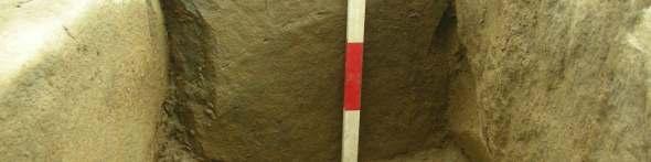
8 5 Excavation Results Bedrock Trench Natural Outcrops Top of Knoll metres Figure 3: The cist location on the top of the knoll 5.1 The Cist Structure The removal of topsoil cover [001] from around the north, west and south sides of the cist revealed that bedrock lay below to a depth of 0.11m. This also revealed the edge of the construction pit for the cist on these sides. While not fully excavated, the pit, [014], was an irregular oval measuring 2.10m by 1.50m. Apart from the function of containing the cist structure itself another aim of the individuals digging the pit would appear to have been to create a relatively flat base to the cist. In one place the base had been slightly over excavated and there are what appear to be pick or digging-stick marks cutting into the bedrock where it had been prised away. The next stage of construction was the insertion of the side slabs, these packed out and supported by fragments of schist and rounded cobbles [004] between the outer cist sides and the cut bedrock, this no doubt supporting the slabs prior to the insertion of the end slabs. 5
9 The cist chamber was constructed from four closely fitted epidiorite slabs, the longer side slabs oriented NNW-SSE ( ). Overall the internal chamber measured 0.79m long, 0.42 wide and 0.40m-0.42m deep. The north end slab [010] measured 0.40m long by 0.39m high by 90mm thick. The east side slab [011] measured 1.06m long by 0.36m high by 0.91mm thick and had been levelled at the north by a chock stone. This stone had split near its centre and this may have occurred during the construction of the cist. The south end slab [012] measured 0.40m long by 0.39m high by 90mm thick. A small chock stone had been inserted on its upper east side to fill a resultant gap. The west side slab [013] measured 0.85m long by 0.36m high by 0.12m thick. Both end slabs show signs of having been trimmed along their edges to create a neat tight fit against the side slabs. While there was no evidence of housing grooves in the side slabs for the end slabs, slight grooves or channels had been cut into the bedrock to house the base of the end slabs, effectively making the top of the slabs level with the top of the side slabs. The upper edges of the side slabs also showed evidence of having been trimmed to create a more level surface; whether this had been done pre or post insertion into the cist pit was difficult to ascertain. The side slabs at the south end of the cist were longer than the inner chamber which could easily have been enlarged at this end, suggesting the relatively small size of the cist chamber was intended. Pit Cut [014] [010] Food vessel [009] Pick marks? [011] [013] Packing [004] [012] Trench metres Figure 4: The Cist Structure 6

![[013] 0 Figure 5: E-W](/docs-images/94/118232815/images/10-1.jpg "Section 0.")
![5 S N [012] [010] 0](/docs-images/94/118232815/images/10-2.jpg "Figure 6: N-S Section")
10 Metres Metres E W 0.5 [003] [002] [011] [013] 0 Figure 5: E-W Section 0.5 S N [012] [010] 0 Figure 6: N-S Section The cist structure from north 7


11 The cist structure from south North end slab East side slab 8


12 South end slab West side slab Pick-marks? in the bedrock at the base of cist 9

![vessel [009] lying on](/docs-images/94/118232815/images/13-1.jpg "the base of the cist at")


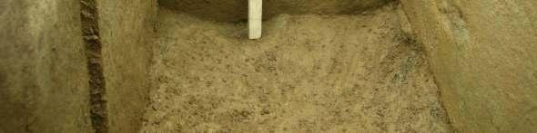
13 5.2 The Cist Fill The cist contained a food vessel [009] lying on the base of the cist at its northern end and lying on its side its mouth, inclined to the west. The food vessel Position of the food vessel at the north end of cist 10
![The fill of the cist chamber was recorded in four spits [005]-[008] with [008] representing the basal fill.](/docs-images/94/118232815/images/14-0.jpg "These recorded deposits were homogenous throughout, being a light yellow brown sandy silt which included occasional schist and quartz fragments along with small")


14 The fill of the cist chamber was recorded in four spits [005]-[008] with [008] representing the basal fill. These recorded deposits were homogenous throughout, being a light yellow brown sandy silt which included occasional schist and quartz fragments along with small quantities of charcoal and burnt bone. Several small fragments of post medieval pottery was also recovered from the fills, one from as low down as deposit [007] just above the basal fill of the cist. The burnt bone and charcoal fragments were well scattered throughout the fill with no apparent concentrations of material, although their frequency slightly increased within the lower half of the cist fill. Remnants of degraded bracken roots were present along the edges of the cist and pockets of looser soil suggested disturbance by animal burrows, the evidence of which was seen more clearly within the uppermost cist fill. The infilled cist Evidence of animal burrowing in the upper cist fill 11
15 5.3 The Cist Cover and Cairn The main cist cover consisted of a large sub oval slab of epidiorite schist [003] measuring 1.52m long, 1.00m wide and up to 0.11m thick. Packing/sealing stones were then closely fitted around the cist cover on its northern, western and southern sides. Cairn [002] Capstone [003] metres Figure 6: Capstone and cairn Capstone from north west 12

![Over the north west extent of the capstone was what appeared to be the remains of a small stone cairn [002], this formed from slabs of epidiorite](/docs-images/94/118232815/images/16-1.jpg "schist, red granite and lava stone, all of which can be sourced locally.")

16 Packing around north end of capstone The absence similar packing on the eastern side might suggest it was never present or that this side had been subject to later erosion as this side coincides with the steeper edge of the knoll. Over the north west extent of the capstone was what appeared to be the remains of a small stone cairn [002], this formed from slabs of epidiorite schist, red granite and lava stone, all of which can be sourced locally. The stones that made up this small heap directly overlaid the cist cover and each other, with no significant soil accumulation between; this suggests the cairn is contemporary with the cist structure. The cairn and cist were covered by grass turf that lay over a mid brown clayey silt [001] that included occasional schist and quartz fragments with rare small charcoal and bone fragments. The cairn overlying the capstone from the north 13
17 6 Artefacts A full list of the finds from the excavation appears in Appendix 3. The food vessel The burial was accompanied by a tripartite vase food vessel [009], highly decorated with rectangular-toothed combs arranged as bands of horizontal lines and herringbone decoration. The vessel also had a band of zig-zag false relief between the rim and the highest of two carinations. The typology of the pot suggests a probable date of between BC (A. Sheridan pers. comm.). Post medieval Pot Post medieval pottery was recovered from three of the four cist fills, [005], [006] and [007]. Burnt Bone Small quantities of fragmented burnt bone were recovered from all the cist fills and the surrounding subsoil. Quartz Small fragments of quartz were present throughout the fill of the cist and the surrounding subsoil, however only three fragments were large enough to have possibly been utilised as tools. Charcoal Charcoal was also present within all the cist fills although like the bone no concentrations were noted. 7 Discussion Without the presence of the food vessel within the cist there would have been no apparent evidence that the cist contained a burial. While burnt bone was present within the cist there was no concentration that allows the interpretation of a cremation deposit that may have accompanied the food vessel. The most likely scenario was that the cist contained a body, the small size of the structure perhaps indicating that the structure was built for a child. The very fine silty infill of the cist indicates that the chamber silted up gradually over time and that the finds, particularly the small post medieval pot sherds, indicate that this process took some time. The difficulty with understanding this process is that the cist currently occupies the very top of the knoll and it is hard to see where the silt filling the cist derived from. One explanation may be that the knoll was originally higher, another being that an earthen mound covered the cists and cairn; in both scenarios the knoll or mound suffered from gradual erosion through weathering. The well sorted fine silty fill of the cist was very similar to that of Cist I excavated in 2012; this also contained a post mediaeval pottery sherd in its upper fill. At the time this led to the suggestion that the cist may have been disturbed, however the evidence from Cist II now suggests this may not have been the case. Tripartite food vessels have been recovered from several other sites in the Kilmartin area. The nearest example was recovered from a cist within Carnassarie cairn excavated in 1930 by J. Hewat Craw (Craw 1931). This cist was similarly orientated NW-SE with the food vessel, now in the national Museum of Scotland, lying on its side a little to the north of the middle of the cist. The cist however was much larger, measuring 3 feet 11 inches (c.1.2m) by 2 feet 1 inch (c.0.62m) and being 1 foot 6 inches deep (c.0.41m) although no body was in evidence. 14
.")
18 Craw also recovered a similar vessel from a cist he excavated along with two others which had been revealed by quarrying at Bruach an Druimein on the Poltalloch Estate in 1928 (Craw 1929). Another tripartite vessel was recovered from the same estate earlier in the century, although its exact provenance remains unknown (Anderson 1905). The central cist within the Glebe cairn also contained a tripartite food vessel while another example came from a cist at Ford (Greenwell 1866, Strachan 1886). All the above mentioned cists occupied prominent features in the landscape. The cist at Ford was situated on a prominent natural knoll as were those at Bruach an Druimein, a second cist containing a jet necklace. The Glebe and Carnassarie cairns became prominent landscape features, although it is unclear whether the cists with the food vessels were primary inhumations under the cairns or later insertions into the cairns. Situated on a prominent knoll and containing a food vessel one can only surmise that the cist at Carnassarie contained an individual of some importance or perhaps a member of an important group or family within the wider community. Like the nearby cist excavated in 2012 the cist overlooks some of the more spectacular monuments in the Kilmartin Glen area, including the Glebe cairn, Carn Ban, the Carnassarie standing stones and cairn. Intervisibility between these monuments was also no doubt of some importance as at least two of these, the cairn at Carnassarie and the Glebe cairn, contained cists with food vessels, suggesting their near contemporary use as places of burial. Both these cists however were larger in size suggesting they contained adult burials while, as mentioned above, the small size of this second cist recently uncovered on Carnassarie farm indicates it contained the burial of an infant or child. The Carnassarie cairn food vessel 15


19 Poltalloch food vessel, its provenance unknown Glebe cairn food vessel 16
20 8 References Anderson, J Description of sepulchral urns exhibited by Col. Malcolm, C.B., of Poltalloch, Proceedings of the Antiquaries of Scotland, 39, 241. Begg, A Deserted Settlements of Kilmartin Parish. Argyll & Bute Library Service. Craw, J. H On a jet necklace from a cist at Poltalloch, Argyll, Proceedings of the Antiquaries of Scotland, 63, Craw, J. H Further excavations of cairns at Poltalloch, Argyll, Proceedings of the Antiquaries of Scotland, 66, Campbell, M and M. Sandeman, 1962 Mid Argyll: an Archaeological Survey, Proceedings of the Antiquaries of Scotland, 95, Ellis, C Carnassarie Excavation, Dalriada Project, Data Structure Report. Greenwell, W An Account of Excavation in Cairns near Crinan, Proceedings of the Antiquaries of Scotland, James, H. F Mid Argyll Medieval Rural Settlement Project, Data Structure Report. GUARD Report Glasgow University. Regan, R Carnassarie Farm, Archaeological Walkover Survey, Kilmartin House Museum Report No. 15. Regan, R Carnassarie Cist, Argyll, an Archaeological Excavation. Kilmartin House Museum Report. RCAHMS 1988 The Royal Commission on the Ancient and Historical Monuments of Scotland. Argyll: an inventory of the monuments volume 6: Mid-Argyll and Cowal, prehistoric and early historic monuments, Edinburgh. Strachan, J. A Donations to the Society, Proceedings of the Antiquaries of Scotland, 20,
21 Appendix 1: Context Descriptions [001]Layer. Mid brown clayey silt with occasional schist and quartz fragments with rare small burnt bone fragments. [002] Cairn. The cairn consisted of a small heap of stones located over the north and east of the capstone. The stones were of mixed petrology, the largest stone measuring 0.34m by 0.14m by 80mm. The cairn material stood up to 0.20m above the capstone [003] [003] Capstone. Slab of epidiorite schist measuring 2.00m long, 0.64m wide and 0.11m thick [004] Fill. Construction pit packing and fill around the outside of the cist. This comprised of rounded cobbles and angular fragments of schist, the largest stone measuring 0.36m by 0.14m by 70mm. The stones were in a mid to dark brown silty loam (not fully excavated). [005] Fill. Light yellow brown clayey silt including occasional schist and quartz fragments along with small quantities of charcoal, burnt bone and pot. [006] Fill. Light yellow brown clayey silt including occasional schist and quartz fragments along with small quantities of charcoal, burnt bone and pot. [007] Fill. Light yellow brown clayey silt including occasional schist and quartz fragments along with small quantities of charcoal, burnt bone and pot. [008] Fill. Light yellow brown clayey silt including occasional schist and quartz fragments along with small quantities of charcoal and burnt bone. [009] Food Vessel [010] North end of cist. Slab of epidiorite schist measuring 0.58m long by 0.58m high by 80mm thick. [011] East side of cist. Slab of epidiorite schist measuring1.30m long by 0.53m high by 0.13m thick. [012] South end of cist. Slab of epidiorite schist measuring 0.57m long by 0.57m high by 60mm thick. [013] West side of cist. Slab of epidiorite schist measuring1.50m long by 0.50m high by 0.14m thick. [014] Cut. Oval construction cut for cist measuring c. 2.10m by c.1.45m (not fully excavated). 18
22 Appendix 2: Context List Number Description 001 Topsoil 002 Cairn 003 Cap stone 004 Pit fill/packing 005 Cist Fill 006 Cist Fill 007 Cist Fill 008 Cist Fill 009 Food Vessel 010 N end slab 011 E side slab 012 S end slab 013 W side slab 014 Pit cut Appendix 3: Finds List Context Type Number Description 001 BN 4 Burnt bone 005 PT 7 Small sherds of post medieval pot 005 ST 1 Small fragment of quartz 005 BN 19 Burnt bone 005 CH 2 Charcoal fragments 006 PT 2 Small sherds of post medieval pot 006 BN 46 Burnt bone 006 CH 3 Charcoal fragments 007 PT 1 Small sherd of post medieval pot 007 BN 50 Burnt bone 007 CH 7 Charcoal fragments 007 ST 1 Fragment of quartz 007 ST 1 Fragment of quartz 007 Phosphate samples BN 3 Burnt bone 008 BN Burnt bone 1mm retent 008 CH Charcoal fragments 4mm retent 008 BN Burnt bone 1mm retent 008 Phosphate samples PT Food vessel 19
23 Appendix 4: Photo List Photo No. Description Direction from 1 Knoll from SE SE 2 Knoll from SE SE 3 Knoll from NW NW 4 Knoll from NW NW 5 Knoll from NW NW 6 Cist from NE NE 7 Knoll from NW NW 8 Knoll from NW NW 9 Knoll from NW NW 10 Knoll from NW NW 11 Knoll from NW NW 12 Knoll from NW NW 13 Knoll from NW NW 14 Cist from NE NE 15 Cist from NE and crew NE 16 Cist and cairn N 17 Cist and cairn N 18 Cist and cairn S 19 Cist and cairn S 20 Cist and cairn E 21 Cist and cairn E 22 Cist and cairn N 23 Cist and cairn S 24 Cist and cairn N 25 Cist and cairn W 26 Cist and cairn W 27 Cist and cairn E 28 Cist and cairn E 29 Natural outcrop on knoll E 30 Natural outcrop on knoll S 31 Natural outcrop on knoll S 32 Cist and cairn N 33 Cist and cairn N 34 Cist and cairn W 35 Cist and cairn NE 36 Cist and cairn S 37 Cist and cairn S 38 Cist capstone S 39 Cist and cairn W 40 Cist and cairn N 41 Cist and cairn E 20
24 42 Cist and cairn E 43 Cist and cairn N 44 Cist and cairn E 45 Cist and cairn NE 46 Cist and cairn N 47 Cist and cairn NW 48 Cist and cairn NW 49 Cist and cairn SW 50 Cist and cairn W 51 Cist and cairn W 52 Cist and stone packing N 53 Cist and stone packing NW 54 Cist and stone packing NW 55 Cist and stone packing NW 56 Cist and stone packing NW 57 Cist and stone packing SW 58 Cist and stone packing S 59 Capstone removed 60 Upper disturbed soil in cist NE 61 Upper disturbed soil in cist N 62 Upper disturbed soil in cist N 63 Cist and upper fill N 64 Cist and upper fill N 65 Cist and upper fill S 66 Cist and upper fill S 67 Rim of food vessel 68 Rim of food vessel 69 Rim of food vessel 70 Excavation of food vessel 71 Excavation of food vessel 72 Excavation of food vessel 73 Excavation of food vessel 74 Excavation of food vessel 75 Excavation of food vessel 76 Excavation of food vessel 77 Cist and food vessel S 78 Cist and food vessel S 79 Cist and food vessel S 80 Cist and food vessel E 81 Cist and food vessel E 82 Cist and food vessel E 83 Cist and food vessel S 84 Cist and food vessel S 85 Cist and food vessel E 86 Cist and food vessel E 21
25 87 Cist and food vessel NW 88 Cist and food vessel W 89 Cist and food vessel W 90 Cist and food vessel W 91 Cist and food vessel W 92 Cist and food vessel W 93 Cist and food vessel NE 94 Cist and food vessel NE 95 Cist and food vessel NE 96 Cist and food vessel NE 97 Cist and food vessel E 98 Cist structure N 99 Cist structure S 100 Cist structure S 101 Cist structure S 102 Cist structure S 103 Cist structure N 104 Cist structure N 105 Southern end slab N 106 Eastern side slab W 107 Western side slab E 108 Northern end slab S 109 Pick marks E 110 Cist structure S 111 Cist structure S 22
26 Appendix 5: DES Entry LOCAL AUTHORITY: PROJECT TITLE/SITE NAME: Argyll and Bute Carnassarie Cist II PROJECT CODE: CRC 15 PARISH: NAME OF CONTRIBUTOR: NAME OF ORGANISATION: TYPE(S) OF PROJECT: Kilmartin Roddy Regan Kilmartin Museum Archaeological Excavation NMRS NO(S): SITE/MONUMENT TYPE(S): SIGNIFICANT FINDS: Burial cist Tripartite Food Vessel NGR (2 letters, 6 figures) NM START DATE (this season) August 2015 END DATE (this season) August 2015 PREVIOUS WORK (incl. DES ref.) (Survey) James, H. F Medieval and Later Landscape and Settlement in Mid Argyll and Knapdale, GUARD Projects 1416, 1446 & 1447, Glasgow University (Survey) Regan, R Carnassarie Farm, Archaeological Walkover Survey. Kilmartin Museum Report. (Excavation) Regan, R Carnassarie Cist, Argyll, An Archaeological Excavation. Kilmartin Museum Report. MAIN (NARRATIVE) DESCRIPTION: (May include information from other fields) In August 2013 Rosemary Neagle the proprietor of Carnassarie Farm, observed what appeared to be the shape of a large flat stone situated under the grass/topsoil cover and thinking this might represent a cist she approached Kilmartin Museum to investigate the site. During the ensuing visit the topsoil was removed from around the possible cist which revealed a large capstone with the remains of a possible small stone cairn sealing what appeared to be an intact cist structure. The site was then covered with geotextile and the topsoil reinstated. In early August 2015 a team from Kilmartin Museum assisted by Dr Alison Sheridon from the NMS returned to the site in order to more fully examine the site. The cist is situated on the top of a prominent raised knoll (187m AOD) affording extensive views down Kilmartin Glen to the sea at Crinan and overlooks Ford Glen at the E. The knoll mound also overlooks the prehistoric monuments of the Carnassarie Standing Stones (NMRS: NM80SW 22) and a burial cairn (NMRS: NM80SW 21) to 23
27 the S and the impressive burial cairn Carn Ban (NMRS: NM80SW28) to the E. In addition the knoll can be seen from the cist excavated in 2012 which lies approximately 500m to the NE. The pit that held the cist was cut into natural bedrock, the cist itself constructed from four closely fitting slabs forming the side,s these sealed by the large capstone. The cist contained a complete tripartite food vessel that no doubt accompanied a burial, although no skeletal remains had survived the acidic soils. The relatively small size of the cist suggests the individual it contained was likely a child. PROPOSED FUTURE WORK: CAPTION(S) FOR ILLUSTRS: SPONSOR OR FUNDING BODY: Kilmartin Museum ADDRESS OF MAIN CONTRIBUTOR: ADDRESS: ARCHIVE LOCATION (intended/deposited) Kilmartin Museum, Kilmartin, Argyll, PA31 8RQ museum@kilmartin.org The archive will be deposited with Kilmartin Museum and copies of the report lodged with WoSAS SMR, the NMRS and OASIS database 24
CARNASSARIE CIST, ARGYLL
 CARNASSARIE CIST, ARGYLL An Archaeological Excavation January 2013 Roderick Regan Kilmartin House Museum Argyll, PA31 8RQ Tel: 01546 510 278 museum@kilmartin.org Scottish Charity SC022744 Summary Following
NETHER LARGIE FALLEN STANDING STONE
 NETHER LARGIE FALLEN STANDING STONE EXCAVATION REPORT March 2013 Roderick Regan Kilmartin House Museum Argyll, PA31 8RQ Tel: 01546 510 278 museum@kilmartin.org Scottish Charity SC022744 Summary An outlying
4. Bronze Age Ballybrowney, County Cork Eamonn Cotter
 4. Bronze Age Ballybrowney, County Cork Eamonn Cotter Illus. 1 Location map of the excavated features at Ballybrowney Lower (Archaeological Consultancy Services Ltd, based on the Ordnance Survey Ireland
An archaeological excavation at 193 High Street, Kelvedon, Essex September 2009
 An archaeological excavation at 193 High Street, Kelvedon, Essex September 2009 report prepared by Ben Holloway and Howard Brooks on behalf of Marden Homes CAT project ref.: 09/4g NGR: TL 8631 1913 (c)
IMTO Italian Mission to Oman University of Pisa 2011B PRELIMINARY REPORT (OCTOBER-DECEMBER 2011)
") IMTO Italian Mission to Oman University of Pisa 2011B PRELIMINARY REPORT (OCTOBER-DECEMBER 2011) The 2011B research campaign took place in the area around Salut from October, 19 th, to December, 16 th.
IMTO Italian Mission to Oman University of Pisa 2011B PRELIMINARY REPORT (OCTOBER-DECEMBER 2011) The 2011B research campaign took place in the area around Salut from October, 19 th, to December, 16 th.
ROUKEN GLEN: BANDSTAND 2015 DATA STRUCTURE REPORT
 ROUKEN GLEN: BANDSTAND 2015 DATA STRUCTURE REPORT Author (s) Ian Hill Editors Report Date June 2015 Working Partners Funders Phil Richardson East Renfrewshire Council East Renfrewshire Council, Heritage
CARN BAN LONG CAIRN HISTORIC ENVIRONMENT SCOTLAND STATEMENT OF SIGNIFICANCE. Property in Care (PIC) ID: PIC059 Designations:
 ID: PIC059 Designations:") Property in Care (PIC) ID: PIC059 Designations: Scheduled Monument (SM90051) Taken into State care: 1962 (Guardianship) Last reviewed: 2004 HISTORIC ENVIRONMENT SCOTLAND STATEMENT OF SIGNIFICANCE CARN
Property in Care (PIC) ID: PIC059 Designations: Scheduled Monument (SM90051) Taken into State care: 1962 (Guardianship) Last reviewed: 2004 HISTORIC ENVIRONMENT SCOTLAND STATEMENT OF SIGNIFICANCE CARN
Wessex Archaeology. Little Stubbings, West Amesbury, Salisbury, Wiltshire. Archaeological Watching Brief. Ref:
 Wessex Archaeology Little Stubbings, West Amesbury, Salisbury, Wiltshire Ref: 63280.02 March 2007 LITTLE STUBBINGS, WEST AMESBURY, NR SALISBURY, WILTSHIRE ARCHAEOLOGICAL WATCHING BRIEF Prepared for: P
Looking north from the SW shieling site with Lub na Luachrach in the foreground
 Looking north from the SW shieling site with Lub na Luachrach in the foreground Upper Gleann Goibhre - Shieling sites Two shieling sites in the upper reaches of the Allt Goibhre were visited and recorded
BRONZE AGE FIELD SYSTEM AT SOUTHAMPTON AIRPORT
 Proc. Hampshire Field Club Archaeol. Soc. 65, 2010, 1-6 (Hampshire Studies 2010) BRONZE AGE FIELD SYSTEM AT SOUTHAMPTON AIRPORT By J SULIKOWSKA With contributions by LORRAINE MEPHAM and CHRIS J STEVENS
CARLUNGIE EARTH HOUSE
 Property in Care (PIC) ID: PIC015 Designations: Scheduled Monument (SM90059) Taken into State care: 1953 (Guardianship) Last reviewed: 2004 HISTORIC ENVIRONMENT SCOTLAND STATEMENT OF SIGNIFICANCE CARLUNGIE
Brenig Archaeology Trail
 Walk Information: Maps: OS Explorer 264 Distance: 2.5 miles / 4 kilometres Duration: Allow 2.5 hours for the circular walk Difficulty: easy. Well-marked trail over fields. Start and finish: SH 98325741
Gorse Stacks, Bus Interchange Excavations Interim Note-01
 Gorse Stacks, Bus Interchange Excavations 2015 Prepared for: Cheshire West & Chester Council Interim Note-01 1 Introduction & Summary Background Since c. 2000 investigations associated with redevelopment
Following the initial soil strip archaeology is sprayed up prior to planning and excavation
 Barton Quarry & Archaeology Over the past half century quarries have been increasingly highlighted as important sources of information for geologists, palaeontologists and archaeologists, both through
Excavations in a Medieval Market Town: Mountsorrel, Leicestershire,
 Excavations in a Medieval Market Town: Mountsorrel, Leicestershire, by John Lucas Mountsorrel is situated 12 kms north of Leicester and forms a linear settlement straddling the A6, Leicester to Derby road.
FOUNDATIONS OF ARCHAEOLOGY A WALK IN VERNDITCH CHASE
 FOUNDATIONS OF ARCHAEOLOGY A WALK IN VERNDITCH CHASE 1. A Tale of two Long Barrows Long barrows were constructed as earthen or drystone mounds with flanking ditches and acted as funerary monuments during
BRONZE-AGE FOOD VESSEL (b) USED AS A BURIAL URN BROWN CANDOVER, [To face page 249]
![BRONZE-AGE FOOD VESSEL (b) USED AS A BURIAL URN BROWN CANDOVER, [To face page 249]](/thumbs/93/118018967.jpg "BRONZE-AGE FOOD VESSEL (b) USED AS A BURIAL URN BROWN CANDOVER, [To face page 249]") BRONZE-AGE FOOD VESSEL (b) USED AS A BURIAL URN BROWN CANDOVER, HANTS [To face page 249] 249 TWO BRONZE AGE DISCOVERIES IN HANTS. BY S. E. WlNBOLT, M.A. (i.) Brown Candover. East of the road at Brown Candover,
BRONZE-AGE FOOD VESSEL (b) USED AS A BURIAL URN BROWN CANDOVER, HANTS [To face page 249] 249 TWO BRONZE AGE DISCOVERIES IN HANTS. BY S. E. WlNBOLT, M.A. (i.) Brown Candover. East of the road at Brown Candover,
An archaeological watching brief on land adjacent to 50 Rosebery Avenue, Colchester, Essex May/June 2003
 An archaeological watching brief on land adjacent to 50 Rosebery Avenue, Colchester, Essex May/June 2003 report prepared by C Crossan on behalf of Highfield Homes Ltd NGR: TM 0035 2500 CAT project ref.:
Henderson Mess, RAF Halton, Buckinghamshire
 Henderson Mess, RAF Halton, Buckinghamshire An archaeological watching brief for Stepnell Ltd by Stephen Hammond Thames Valley Archaeological Services Ltd Site Code RHA03/85 October 2003 Summary Site name:
Archaeological Evaluation Report
 Holywell House Osney Mead Oxford o a November 2007 Client: Knowles and Son Issue N o : 1 OA Job N o : 3826 Planning Ref N o : 02/01800/FUL NGR: SP 502 055 Client Name: Knowles and Son Client Ref No: Document
Archaeological Watching Brief on land at Alpha, Gore Road, Eastry, Kent July 2010
 Archaeological Watching Brief on land at Alpha, Gore Road, Eastry, Kent July 2010 SWAT. Archaeology Swale and Thames Archaeological Survey Company School Farm Oast, Graveney Road Faversham, Kent ME13 8UP
Pen Cerrig-calch prehistoric cairns
 Walk Information: Maps: OS Explorer OL13 Distance: 8 miles / 13 kilometres Duration: Allow at least 6 hours for the circular walk Difficulty: medium. Some narrow paths, occasionally rough underfoot Start
The Archaeology of Cheltenham
 The Archaeology of Cheltenham The archaeology collection of The Wilson contains a rich quantity of material relating to the prehistoric and Roman occupation of the North Cotswolds and parts of the Severn
In 2014 excavations at Gournia took place in the area of the palace, on the acropolis, and along the northern edge of the town (Fig. 1).
.") Gournia: 2014 Excavation In 2014 excavations at Gournia took place in the area of the palace, on the acropolis, and along the northern edge of the town (Fig. 1). In Room 18 of the palace, Room A, lined
Gournia: 2014 Excavation In 2014 excavations at Gournia took place in the area of the palace, on the acropolis, and along the northern edge of the town (Fig. 1). In Room 18 of the palace, Room A, lined
Land at Briar Rose, Afforsk, Gamrie, Banff, AB45 3ES Trench for erection of wind turbine
 Land at Briar Rose, Afforsk, Gamrie, Banff, AB45 3ES Trench for erection of wind turbine Cameron Archaeology 2 April 2011 Land at Briar Rose, Afforsk, Gamrie, Banff, AB45 3ES Trench for erection of wind
An archaeological watching brief at the Sixth Form College, North Hill, Colchester, Essex
 An archaeological watching brief at the Sixth Form College, North Hill, Colchester, Essex July 2001 on behalf of Colchester Borough Council CAT project ref.: 01/7B Colchester Museum accession code: 2001.126
Azoria 2004 B700 Final Trench Report RQC
 Azoria 2004 B700 Final Trench Report RQC B700 is a room -2.5m by 4.5m, bounded by wall B711 to north, wall B703 to east, wall B706 to south, and wall B717 to west. B700 is an Archaic storeroom with an
IKLAINA ARCHAEOLOGICAL PROJECT 2016 FIELD REPORT Michael B. Cosmopoulos
 IKLAINA ARCHAEOLOGICAL PROJECT 2016 FIELD REPORT Michael B. Cosmopoulos Introduction The overarching objective of the Iklaina project is to test existing hierarchical models of state formation in Greece
An archaeological evaluation at 14 Vineyard Street, Colchester, Essex March 2006
 An archaeological evaluation at 14 Vineyard Street, Colchester, Essex March 2006 report prepared by Ben Holloway commissioned by Colchester Borough Council CAT project code: 06/4b Colchester Museums accession
Provincial Archaeology Office Annual Review
 2017 Provincial Archaeology Office Annual Review Provincial Archaeology Office Department of Tourism, Culture, Industry and Innovation Government of Newfoundland and Labrador March 2018 Volume 16 A brief
The Old Shire Horse Centre, Bath Road, Woolley Green, Maidenhead, Berkshire
 The Old Shire Horse Centre, Bath Road, Woolley Green, Maidenhead, Berkshire An Archaeological Watching Brief For Mr Derek Chesterman by Andrew Mundin Thames Valley Archaeological Services Ltd Site Code
Architectural Analysis in Western Palenque
 Architectural Analysis in Western Palenque James Eckhardt and Heather Hurst During the 1999 season of the Palenque Mapping Project the team mapped the western portion of the site of Palenque. This paper
An archaeological evaluation at 19 Beverley Road, Colchester, Essex February 2003
 An archaeological evaluation at 19 Beverley Road, Colchester, Essex February 2003 report prepared by Carl Crossan on behalf of Mr G and Mrs H Prince NGR: TL 98655 24844 CAT project ref.: 03/2d Planning
An archaeological excavation and watching brief at the Musket Club, Homefield Road, Colchester, Essex December 2004-February 2005
 An archaeological excavation and watching brief at the Musket Club, Homefield Road, Colchester, Essex December 2004-February 2005 report prepared by Howard Brooks on behalf of RMPA and the MoD CAT project
Chiselbury Camp hillfort
 Chiselbury Camp hillfort Reasons for Designation Large univallate hillforts are defined as fortified enclosures of varying shape, ranging in size between 1ha and 10ha, located on hilltops and surrounded
E&M West Buildings Union Street, Aberdeen, AB10 1GD
 E&M West Buildings 32-38 Union Street, Aberdeen, AB10 1GD 30 November 2011 E&M West Buildings 32-38 Union Street, Aberdeen, AB10 1GD CONTENTS 1 INTRODUCTION 3 2 ARCHAEOLOGICAL BACKGROUND 4 3 THE WATCHING
Survey of Deadwater Fell and Peel Fell
 4 December 2014 Survey of Deadwater Fell and Peel Fell Team: John Barnard, Chris Crocker, Richard Cooper and Graham Jackson 1) Introduction Deadwater Fell (Hill 3542, Section 33, OS 1:50000 Map 80, OS
Investigations at Jackdaw Crag Field, Boston Spa, SE , in by Boston Spa Archaeology and Heritage Group
 0 Investigations at Jackdaw Crag Field, Boston Spa, SE 42304632, in 2006-7 by Boston Spa Archaeology and Heritage Group www.bostonspaheritage.co.uk Preface and Summary This report records the results of
Long Cairn Divis County Antrim
 Survey Report No. 66 Harry Welsh Long Cairn Divis County Antrim 2 Ulster Archaeological Society 2018 Ulster Archaeological Society c/o School of Natural and Built Environment Queen s University Belfast
TH E FIRST SEASON of investigations at the
 QUSEIR AL-QADIM Janet H. Johnson & Donald Whitcomb TH E FIRST SEASON of investigations at the ancient port of Quseir al-qadim on the Red Sea in Egypt took place in winter, 1978; the investigations were
Land off Birdie Way, Rush Green, Hertford, Hertfordshire
 Land off Birdie Way, Rush Green, Hertford, Hertfordshire An Archaeological Evaluation for Bride Hall Development Limited by Sarah Coles Thames Valley Archaeological Services Site Code RGH00/ 01 January
Wheatlands House, Fleet Hill, Finchampstead, Berkshire
 Wheatlands House, Fleet Hill, Finchampstead, Berkshire An Archaeological Watching Brief For JCA International by James McNicoll-Norbury Thames Valley Archaeological Services Ltd Site Code WFF 08/26 August
Cholesbury New House, Parrots Lane, Cholesbury, Buckinghamshire
 Cholesbury New House, Parrots Lane, Cholesbury, Buckinghamshire An Archaeological Watching Brief For Mr Martin Wood by Sean Wallis Thames Valley Archaeological Services Ltd Site Code PLC 06/135 March 2007
Report on an archaeological watching brief at Thomas Lord Audley School, Monkwick, Colchester
 Report on an archaeological watching brief at Thomas Lord Audley School, Monkwick, Colchester July 2000 for WS Atkins Property Services Colchester Archaeological Trust 12 Lexden Road, Colchester, Essex
Archaeological Investigations Project South East Region SOUTHAMPTON 2/842 (C.80.C004) SU
 SU") SOUTHAMPTON City of Southampton 2/842 (C.80.C004) SU 4382 1336 125 BITTERNE ROAD WEST, SOUTHAMPTON Report on the Archaeological Evaluation Excavation at 125 Bitterne Road West, Southampton Russel, A. D
SOUTHAMPTON City of Southampton 2/842 (C.80.C004) SU 4382 1336 125 BITTERNE ROAD WEST, SOUTHAMPTON Report on the Archaeological Evaluation Excavation at 125 Bitterne Road West, Southampton Russel, A. D
Trench 91 revealed that the cobbled court extends further to the north.
 Report on the 2013 Gournia Excavations The 2013 excavations at Gournia were conducted June 17 July 26 under the aegis of the American School of Classical Studies at Athens and the supervision of the KD
Unlocking Our Coastal Heritage Project: Crane Castle Promontory Fort, Illogan, Cornwall
 Unlocking Our Coastal Heritage Project: Crane Castle Promontory Fort, Illogan, Cornwall As part of a wider project funded by the Rural Development Programme for England (RDPE) and administered through
Eglwyseg Mountain a landscape of prehistoric cairns and later industry
 Eglwyseg Mountain a landscape of prehistoric cairns and later industry Walk Information: Maps: OS Explorer 256 Distance: 5.3 miles / 8.5 kilometres (linear) or up to 9.6 miles / 15.5 kilometres (circular)
The Coach House, Mill Lane, Cookham, Berkshire
 The Coach House, Mill Lane, Cookham, Berkshire An Archaeological Watching Brief For Ms Sophia Butler by Stephen Hammond Thames Valley Archaeological Services Ltd Site Code CMC 03/104 October 2003 Summary
Street Sweeper Dump Site, RAF Lakenheath ERL 160
 ARCHAEOLOGICAL MONITORING REPORT Street Sweeper Dump Site, RAF Lakenheath ERL 160 A REPORT ON THE ARCHAEOLOGICAL MONITORING, 2006 (Planning app. no. F/2006/0021/GOV) Jo Caruth Field Team Suffolk C.C. Archaeological
ARDESTIE EARTH HOUSE HISTORIC ENVIRONMENT SCOTLAND STATEMENT OF SIGNIFICANCE. Property in Care no: 24
 Property in Care no: 24 Designations: Scheduled Monument (SM90021) Taken into State care: 1953 (Guardianship) Last reviewed: 2004 HISTORIC ENVIRONMENT SCOTLAND STATEMENT OF SIGNIFICANCE ARDESTIE EARTH
The Atlas of Hillforts of Britain and Ireland. Hillfort survey notes for guidance
 The Atlas of Hillforts of Britain and Ireland Hillfort survey notes for guidance The collection of surveys for the Atlas is now finished but you can use this form and the accompanying Notes for Guidance
Lordenshaw. What are cup & ring marks?
 Lordenshaw Lordenshaw hill has one of the largest clusters of ancient cup and ring marked stones in the UK. We ve chosen four interesting spots we d like to share with you. What are cup & ring marks? The
New Studies in the City of David The Excavations
 The 2013-2014 Excavations Israel Antiquities Authority The intensive archaeological work on the city of David hill during the period covered in this article has continued in previously excavated areas
Archaeological Investigations Project Yorkshire & Humberside Region NORTH YORKSHIRE 2/1113 (C.36.J002) SD
 SD") NORTH YORKSHIRE Craven 2/1113 (C.36.J002) SD 93607800 CRAY BECK, BUCKDEN, UPPER WHARFEDALE Cray Beck, The Archaeological Investigation of a Stone Feature Archetype Wensleydale : ArcheType Archaeological
NORTH YORKSHIRE Craven 2/1113 (C.36.J002) SD 93607800 CRAY BECK, BUCKDEN, UPPER WHARFEDALE Cray Beck, The Archaeological Investigation of a Stone Feature Archetype Wensleydale : ArcheType Archaeological
S E R V I C E S. Land to the rear of Ashdown, Basingstoke Road, Spencers Wood, Reading, Berkshire. Archaeological Evaluation.
 T H A M E S V A L L E Y ARCHAEOLOGICAL S E R V I C E S Land to the rear of Ashdown, Basingstoke Road, Spencers Wood, Reading, Berkshire Archaeological Evaluation by Susan Porter Site Code: ASW12/21 (SU
archaeological evaluation of sites to the west of the castle in 1988
 FLNT CASTLE archaeological evaluation of sites to the west of the castle in 1988 -.., - w -... " - Clwyd-Powys Archaeological Trust '.. - Flint Castle, Delyn: evaluation of sites west of the castle in
A FIELDWALKING PROJECT AT HOLLINGBURY, BRIGHTON. by JOHN FUNNELL
 Introduction A FIELDWALKING PROJECT AT HOLLINGBURY, BRIGHTON by JOHN FUNNELL Members of the Brighton and Hove Archaeological Society walked the field at Hollingbury during the months of December 1991 and
Holyport Manor Special School, Highfield Lane, Cox Green, Maidenhead, Berkshire
 Holyport Manor Special School, Highfield Lane, Cox Green, Maidenhead, Berkshire An Archaeological recording action For CgMs Consulting by Jennifer Lowe Thames Valley Archaeological Services Ltd Site Code
Archaeological Monitoring at Ham Farm, Ham Road, Faversham, Kent
 Archaeological Monitoring at Ham Farm, Ham Road, Faversham, Kent NGR: 601750.0mE 162695.0mN Site Code HAM/WB/12 Report for A.J. Bray SWAT ARCHAEOLOGY Swale and Thames Archaeological Survey Company The
NORTH YORKSHIRE 2/1340 (C ) SE
 SE") NORTH YORKSHIRE Craven 2/1339 (C.36.6001) SD 97606975 SD 94507750 KILNSEY TO BUCKDEN WATER PIPELINE Kilnsey to Buckden Water Pipeline, North Yorkshire. Geophysical Survey (Report no. 841) Webb, A Leeds
NORTH YORKSHIRE Craven 2/1339 (C.36.6001) SD 97606975 SD 94507750 KILNSEY TO BUCKDEN WATER PIPELINE Kilnsey to Buckden Water Pipeline, North Yorkshire. Geophysical Survey (Report no. 841) Webb, A Leeds
CASTLELAW HILL FORT HISTORIC ENVIRONMENT SCOTLAND STATEMENT OF SIGNIFICANCE. Property in Care (PIC) ID: PIC131
 ID: PIC131") Property in Care (PIC) ID: PIC131 Designations: Scheduled Monument (SM90064) Taken into State care: 1933 (Guardianship) Last reviewed: 2012 HISTORIC ENVIRONMENT SCOTLAND STATEMENT OF SIGNIFICANCE CASTLELAW
Property in Care (PIC) ID: PIC131 Designations: Scheduled Monument (SM90064) Taken into State care: 1933 (Guardianship) Last reviewed: 2012 HISTORIC ENVIRONMENT SCOTLAND STATEMENT OF SIGNIFICANCE CASTLELAW
Gors Lydan barrows and medieval huts
 Walk Information: Maps: OS Explorer 214 Distance: 5.5 miles / 9 kilometres Duration: 4.5 to 5 hours Difficulty: Easy. Good paths and no steep gradients Start and finish: SO 11977545 Walk summary The walk
The Yingtianmen Gate-site of the Sui and Tang Eastern Capital in Luoyang City
 Nandajie The Yingtianmen Gate-site of the Sui and Tang Eastern Capital in Luoyang City Tang Luoyang City-site Archaeological Team, Institute of Archaeology, Chinese Academy of Social Sciences Key words:
Florence House, High Street, Hurley, Berkshire
 Florence House, High Street, Hurley, Berkshire An Archaeological Watching Brief For Mr Michael Waterhouse by Jo Pine Thames Valley Archaeological Services Ltd Site Code FHH04/52 May 2004 Summary Site name:
Preliminary report on the 2013 season at Plakari
 Preliminary report on the 2013 season at Plakari Jan Paul Crielaard the 2013 excavations During the 2013 field season (8 July 5 August), excavations were continued on the southern slope of Terrace 2 (Trench
Report on provision of Unpaid Care Argyll and Bute
 Report on provision of Unpaid Care Argyll and Bute 18 th November 2016 Argyll and Bute Health and Social Care Partnership Public Health Information Contents Introduction... 2 Estimate of number of adult
ANTONINE WALL - BARHILL
 Property in Care (PIC)no: PIC168 Designations: Scheduled Monument (SM90008) Taken into State care: 1960 (Guardianship) Last reviewed: 2005 HISTORIC ENVIRONMENT SCOTLAND STATEMENT OF SIGNIFICANCE ANTONINE
THE HEUGH LINDISFARNE
 LINDISFARNE COMMUNITY ARCHAEOLOGY THE HEUGH LINDISFARNE Archaeological excavations in June 2017 Invitation to volunteers THE HEUGH, LINDISFARNE, NORTHUMBERLAND: ARCHAEOLOGICAL EXCAVATIONS 2017 INTRODUCTION
Excavation in Area G: squares m/14-15, new building BG1 (trench supervisor: Cleto Carbonara)
") Excavation in Area G: squares m/14-15, new building BG1 (trench supervisor: Cleto Carbonara) The excavation in the Area G started in the 1 st October has two main purposes: To understand the real extension
Excavation in Area G: squares m/14-15, new building BG1 (trench supervisor: Cleto Carbonara) The excavation in the Area G started in the 1 st October has two main purposes: To understand the real extension
Archaeological Investigation of Coloane, Macau
 Archaeological Investigation of Coloane, Macau Received 13 March 1974" W. KELLY AND W. MEACHAM INTRODUCTION UP UNTIL July 1972, when a field survey of Coloane Island was undertaken by members of the Hong
archeological site LOS MILLARES
 archeological site LOS MILLARES Aerial view of the plain of Los Millares between the Rambla de Huéchar and the River Andarax The archaeological site of Los Millares is located in the township of Santa
CULTURAL HERITAGE RESOURCES IMPACT ASSESSMENT ON MALOKONG HILL
 CULTURAL HERITAGE RESOURCES IMPACT ASSESSMENT ON MALOKONG HILL AFRICAN HERITAGE CONSULTANTS CC 2001/077745/23 Tel/fax: (012) 567 6046 Cell: 082 498 0673 E-mail: udo.heritage@absamail.co.za DR. UDO S KÜSEL
Excavations South-East of Park Farm, Ashford, Kent. Part 1: Main Report
 Excavations South-East of Park Farm, Ashford, Kent Part 1: Main Report Wessex Archaeology, Portway House, Old Sarum Park, Salisbury SP4 6EB tel: 01722 326867 fax: 01722 337562 email: info@wessexarch.co.uk
Specification for Grip blocking using Peat Dams
 Technical Guidance Note 1 Specification for Grip blocking using Peat Dams 1. Introduction Moorland drains (grips) have been dug across much of the Yorkshire upland peatlands. Many of these grips have become
CASTLE OF OLD WICK HISTORIC ENVIRONMENT SCOTLAND STATEMENT OF SIGNIFICANCE. Property in Care(PIC) ID: PIC282 Designations:
 ID: PIC282 Designations:") Property in Care(PIC) ID: PIC282 Designations: Scheduled Monument (SM90065) Taken into State care: 1957 (Guardianship) Last reviewed: 2004 HISTORIC ENVIRONMENT SCOTLAND STATEMENT OF SIGNIFICANCE CASTLE
Property in Care(PIC) ID: PIC282 Designations: Scheduled Monument (SM90065) Taken into State care: 1957 (Guardianship) Last reviewed: 2004 HISTORIC ENVIRONMENT SCOTLAND STATEMENT OF SIGNIFICANCE CASTLE
Deddington Castle, Oxfordshire: A Summary of Excavations *
 Deddington Castle, Oxfordshire: A Summary of Excavations 1977 1979* R.J. Ivens for Queen s University, Belfast, and DoE Between 1947 and 1951 Prof. E.M. Jope carried out a series of rescue excavations
Report on the excavations on the site Novopokrovskoe II in V. Kol'chenko, F. Rott
 Report on the excavations on the site Novopokrovskoe II in 2016 V. Kol'chenko, F. Rott In 2016 the Novopokrovskiy archeological group of the Institute of History and Heritage of the National Academy of
Manor Farm, Wilcot, Pewsey, Wiltshire
 Manor Farm, Wilcot, Pewsey, Wiltshire An Archaeological Evaluation for Mr W. Madiment by Helen Moore Thames Valley Archaeological Services Ltd Site Code MFP02/78 September 2002 Summary Site name: Manor
ANTONINE WALL - DULLATUR
 Property in Care (PIC) ID: PIC172 Designations: Scheduled Monument (SM90017); Taken into State care: 1960 (Guardianship) Last reviewed: 2018 HISTORIC ENVIRONMENT SCOTLAND STATEMENT OF SIGNIFICANCE ANTONINE
o a London Borough of Barnet Stoney Wood Lake Silk Stream Flood Alleviation Scheme Archaeological Watching Brief Report Oxford Archaeology
 Silk Stream Flood Alleviation Scheme Stoney Wood Lake London Borough of Barnet Archaeological Watching Brief Report o a Oxford Archaeology November 2004 Client: Halcrow on behalf of Environment Agency
218 R. S. BORAAS AND S. H. HORN
 were able to show a sequence of ceramic corpora much more fully representative than those available from the occupation surfaces and structures higher on the mound. This ceramic series obtained from D.
The Greek-Swedish-Danish Excavations at Kastelli, Khania 2010 a short report
 The Greek-Swedish-Danish Excavations at Kastelli, Khania 2010 a short report During six weeks from 19 July to 27 August the Greek-Swedish-Danish Excavations continued work in the Ag. Aikaterini Square
Draft Report. 7. Excavations in the temenos gateway, Area (TG5) Author - D. A. Welsby Period 1-2. Period 1. Period 2. Derek A.
 Author - D. A. Welsby Period 1-2. Period 1. Period 2. Derek A.") 7. Excavations in the temenos gateway, Area (TG5) Derek A. Welsby When Griffith excavated the temples at Kawa in 1929-31, work followed by that of Macadam and Kirwan in the winter of 1935-6, the temenos
7. Excavations in the temenos gateway, Area (TG5) Derek A. Welsby When Griffith excavated the temples at Kawa in 1929-31, work followed by that of Macadam and Kirwan in the winter of 1935-6, the temenos
PONTOP SMITHY DIPTON, COUNTY DURHAM
 PONTOP SMITHY DIPTON, COUNTY DURHAM ~ ARCHAEOLOGICAL EXCAVATION ~ OCTOBER 2016 Prepared for: Land of Oak & Iron Landscape Partnership By: The Archaeological Practice Ltd. Project code: AP 16/43 Stage:
A New Fragment of Proto-Aeolic Capital from Jerusalem
 TEL AVIV Vol. 42, 2015, 67 71 A New Fragment of Proto-Aeolic Capital from Jerusalem Doron Ben-Ami and Yana Tchekhanovets Israel Antiquities Authority The article deals with a fragment of a proto-aeolic
Scheduled Monument (SM90085) Taken into State care: 1966 (Guardianship) Last reviewed: 2004 CROOKSTON CASTLE
 Taken into State care: 1966 (Guardianship) Last reviewed: 2004 CROOKSTON CASTLE") Property in Care (PIC) ID: PIC119 Designations: Scheduled Monument (SM90085) Taken into State care: 1966 (Guardianship) Last reviewed: 2004 HISTORIC ENVIRONMENT SCOTLAND STATEMENT OF SIGNIFICANCE CROOKSTON
Property in Care (PIC) ID: PIC119 Designations: Scheduled Monument (SM90085) Taken into State care: 1966 (Guardianship) Last reviewed: 2004 HISTORIC ENVIRONMENT SCOTLAND STATEMENT OF SIGNIFICANCE CROOKSTON
Northamptonshire Archaeology
 Northamptonshire Archaeology A programme of archaeological observation, investigation and recording at St Andrews Church, Spratton, Northamptonshire Northamptonshire Archaeology 2 Bolton House Wootton
An archaeological watching brief at 97 High Street, Colchester, Essex March 2010
 An archaeological watching brief at 97 High Street, Colchester, Essex March 2010 report prepared by Donald Shimmin on behalf of Flying Trade Group plc CAT project ref.: 10/3a Colchester and Ipswich Museums
COULTER MOTTE HISTORIC ENVIRONMENT SCOTLAND STATEMENT OF SIGNIFICANCE. Property in Care (PIC) ID: PIC092
 ID: PIC092") Property in Care (PIC) ID: PIC092 Designations: Scheduled Monument (SM90082) Taken into State care: 1932 (Guardianship) Last reviewed: 2015 HISTORIC ENVIRONMENT SCOTLAND STATEMENT OF SIGNIFICANCE COULTER
Property in Care (PIC) ID: PIC092 Designations: Scheduled Monument (SM90082) Taken into State care: 1932 (Guardianship) Last reviewed: 2015 HISTORIC ENVIRONMENT SCOTLAND STATEMENT OF SIGNIFICANCE COULTER
Jneneh in the Upper Wadi az-zarqa, in North Central Jordan, First Season 2011.
 Jneneh in the Upper Wadi az-zarqa, in North Central Jordan, First Season 2011. Khaled Douglas Jneneh is located in the north-western periphery of the city of Zarqa (grid ref. 250.88E 165.25N), in North
ANNUAL REPORT: ANCIENT METHONE ARCHAEOLOGICAL PROJECT 2014 FIELD SCHOOL
 ANNUAL REPORT: ANCIENT METHONE ARCHAEOLOGICAL PROJECT 2014 FIELD SCHOOL Director(s): Co- Director(s): Professor Sarah Morris, Cotsen Institute of Archaeology, UCLA John K. Papadopoulos, Cotsen Institute
An archaeological fieldwalking evaluation at Tile House Farm, Great Horkesley, Essex July-September 2005
 An archaeological fieldwalking evaluation at Tile House Farm, Great Horkesley, Essex commissioned by ADP Chartered Architects on behalf of The Ingleton Properties Ltd and Mersea Homes CAT project code:
FIELD BOUNDARIES, A MEDIEVAL STRUCTURE AND DEAD SHEEP AT IWADE, KENT
 FIELD BOUNDARIES, A MEDIEVAL STRUCTURE AND DEAD SHEEP AT IWADE, KENT Pre-Construct Archaeology Limited Unit 54, Brockley Cross Business Centre, 96 Endwell Road, Brockley, London SE4 2PD tel: 020 7732 3925
South East Region SOUTHAMPTON 3/1050 (E.80.H006) SU
 SU") SOUTHAMPTON 3/1050 (E.80.H006) SU 43351328 16 HAWKESWOOD ROAD Report on the Archaeological Observations at 16 Hawkeswood Road, Bitterne Manor Russil, A & Smith, M Southampton : Southampton City Council
SOUTHAMPTON 3/1050 (E.80.H006) SU 43351328 16 HAWKESWOOD ROAD Report on the Archaeological Observations at 16 Hawkeswood Road, Bitterne Manor Russil, A & Smith, M Southampton : Southampton City Council
The Neolithic Chambered Tombs of Breconshire
 CPAT Report No 1126 The Neolithic Chambered Tombs of Breconshire THE CLWYD-POWYS ARCHAEOLOGICAL TRUST CPAT Report No 1126 The Neolithic Chambered Tombs of Breconshire N W Jones January 2012 The Clwyd-Powys
Instruction Manual. A step-by-step guide to building your own igloo. Andy Meldrum All rights are reserved.
 Instruction Manual A step-by-step guide to building your own igloo. Andy Meldrum 2007 1 Contents 1 Introduction 2 Get properly kitted up. 3 Choose and prepare your site. 4 Create the base. 5 Mark out the
ARCHAEOLOGICAL INVESTIGATIONS IN GUADALUPE, NORTHEAST HONDURAS
 ARCHAEOLOGICAL INVESTIGATIONS IN GUADALUPE, NORTHEAST HONDURAS Markus Reindel, Franziska Fecher and Peter Fux Archaeological investigations in Honduras have focused on the western, Mesoamerican part of
ROUKEN GLEN: MANSION HOUSE 2013 DATA STRUCTURE REPORT
 ROUKEN GLEN: MANSION HOUSE 2013 DATA STRUCTURE REPORT Author (s) Editors Report Date May 2014 Working Partners Funders Paul Murtagh Phil Richardson East Renfrewshire Council East Renfrewshire Council,
Excavations at Cadbury Camp Congresbury, Somerset
 Excavations at Cadbury Camp Congresbury, Somerset Keith S Gardner (with notes by Vince Russett) Clevedon and District Archaeological Society 1959 Note: This report formerly existed only in a hand-written