Queen s University Belfast
|
|
|
- Chester Logan Dean
- 5 years ago
- Views:
Transcription


1 Queen s University Belfast Data Structure Report: No. 12. On behalf of
2 Data Structure Report: Tully, County Fermanagh John Ó Néill and Dr. Brian Williams. (Grid Reference H ) (CAF DSR 012) (Licence No. AE/02/80) (SMR No. FER 172:031)
3 Contents Page List of Figures 2 List of Plates 2 Summary 12 Introduction 13 General Background Reason for Excavation and Research Objectives Archiving Credits and Acknowledgements Excavation 17 Methodology Account of the excavations Trench 1 Trench 2 Trench 3 Trench 4 Trench 5 Trench 6 Trench 7 Trench 8 Trench 9 Trench 10 Trench 11 Trench 12 Trench 13 Trench 14 Analysis undertaken during the excavations Artefactual Dating Discussion 21 Recommendations for further work 22 Introduction Programme of post-excavation analysis Analysis of the Environmental Samples Further Excavation Bibliography 23 Appendix One: Context List 24 Appendix Two: Harris Matrices 25 Appendix Three: Photographic Record 26 Appendix Four: Field Drawing Register 29 Appendix Five: Small Finds Register 30 Appendix Six: Sample Register 34 1
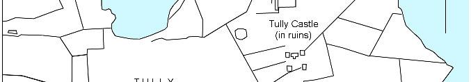
4 List of Figures: Page Figure 1. General location map 3 Figure 2: 1:10,000 map that show s Tully Castle, Tully and the village of Church Hill. 4 Figure 3. 1 st edition OS map of Tully Castle and Tully. 5 Figure 4. 1:1,500 map showing the location of the trenches. 6 Figure 5. Plan of 18 th century cottage, 180 m south of Tully Castle. 7 Figure 6. Plan of Trench Figure 7. Section through Trench 12 9 List of Plates Plate 1. View of Trench Four during excavation. 10 Plate 2. View of Trench Five with clay floor and fireplace visible. 10 Plate 3. View of metalled surface at eastern end of Trench Twelve. 11 Plate 4. View of Trench Fourteen, during excavation. 11 2

5 12

6 13


7 14
8 15
9 Figure 5. Plan of 18 th century cottage, 180 m south of Tully Castle 16
10 Figure 6. Plan of Trench 12 17
11 Figure 7. Section through Trench 12 18


12 Plate 1. View of Trench Four during excavation. Plate 2. View of Trench Five with clay floor and fireplace visible. 19


13 Plate 3. View of metalled surface at eastern end of Trench Twelve. Plate 4. View of Trench Fourteen, during excavation. 20
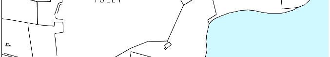
14 1. Summary 1.1 The site of the Tully investigations lies on the southern shore of Lough Erne, close to Tully Castle, which was built by Sir John Hume between 1610 and Tully Castle is located on the shore of Lough Erne, three miles north of Derrygonnelly, at the end of a laneway off the Belleek road (A46). The Castle, its surrounding bawn and a village referred to in contemporary documents are recorded in the SMR as FER 172:031. The National Grid Reference for the site is H The excavations were undertaken by the Centre for Archaeological Fieldwork at Queens University Belfast, under the direction of Dr. Brian Williams of Environment and Heritage Service: Built Heritage, under licence number AE/02/ The fieldwork took place in August 2002 with the aims of identifying archaeological materials dating to the period that might help locate the village established by Sir John Hume and referred to in contemporary documentation. 1.4 Some fourteen test trenches were opened in total. Trenches 1 to 10 were opened at the Hassard cottages, 150 m to the south of Tully Castle. Trenches 11 to 14 were opened at the location marked as Tully on the first edition of the Ordnance Survey maps of the area. The trenches varied in size from 1 m square test pits to 8 m by 1 m in length trenches. 1.5 On the basis of the 2002 fieldwork, an argument cannot be made for placing the village around the cottages beside the castle or at the location marked Tully on the first edition Ordnance Survey maps. It would appear that Church Hill, formerly known as Drumenagh, remains the strongest candidate for Sir John Humes village. 21
15 2. Introduction 2.1 General The following report details the preliminary results of the archaeological excavation at Tully Castle, undertaken by Dr. Brian Williams of Environment and Heritage Service, Built Heritage and a team from the Centre for Archaeological Fieldwork, School of Archaeology and Palaeoecology at Queen s University Belfast in August This programme of work was undertaken on behalf of the Environment and Heritage Service, DOE NI, who funded the excavations. 2.2 Background The site lies on the southern shore of Lough Erne, close to Tully Castle, three miles north of Derrygonnelly. The castle is approached via sign-posted a laneway off the Belleek road (A46). The Castle, its surrounding bawn and a village referred to in contemporary documents are recorded in the SMR as FER 172:031. The National Grid Reference for the site is H The earliest references to Sir John Homes development of the Tully Castle site come from his grant of 1610 which outlines the extent of his lands. While Carew s survey of 1611 was unfavourable, progress towards the construction of a castle had been made by 1613 when Sir Josias Bodley could report that Sir John Hume hath built his house of lime and stone, 3 stories high, of good strength scoured on one side from spikes of the staircase, and on the other with 2 small flanks, jutting out on corbels from the corner of the third story: it is 51 feet long and 21 broad. 4 or 5 of his people are on the place, but as yet no estates made out to any tenants. Workmen he hath sent of Scotland to take in hand the bawn, of which some were newly arrived whilst I was there. Of cattle he hath above nine score head upon the ground. (Hastings MSS 1947, 169). Modern investigation of the castle suggests that while the style is Scottish, the masons were Irish (Waterman 1959), which is consistent with the arrival of settlers in the years following 1613 after the construction of the castle In , Captain Nicholas Pynnar reported further to the crown on the progress of Hume s work. He states Sir John Hume hath 2000 acres, called Carrynroe. Upon this proportion there is a bawne of lime and stone, 100 feet square and 14 feet high, having four flankers for the defence. There is also a fair strong castle, 50 feet long and 21 feet broad. He hath made a village near unto the bawne, in which is dwelling 24 families. (Hill 1877, 499). 22
16 2.2.4 Sir Francis Annesley and Sir James Perrotts account of Humes estate, in 1622 (Ó Gallachair 1958), airs various grievances of the tenants of whom, while stated as 24 families, no more than 18 individuals could be presented to them. The English tenants complain that the landlords are rarely resident and that the Irish can outbid them for rents, leading to the British tenants leaving the land. In general, the influx of settlers to Ulster after 1613 and 1614 has been noted elsewhere (Perceval-Maxwell 1973, ), with a decline after 1619 coinciding with a rise in emigration to Virginia after 1618 (Robinson 1978). In 1622 a rector for the parish is named as John Barker, although it is not certain where he and his flock had to worship (e.g. Parke 1982, 17) The castle surrendered in the face of a force of 800 men, under Rory Maguire, on the evening of Christmas Eve 1641, on condition of safe conduct for the local Protestant settlers who had sought refuge with her. Then, the "rebels having stripped the inhabitants, except Lady Hume, of all their clothes, imprisoned them in the vaults and cellars" of the castle. The men were bound hand and foot and "thrown into the courtyard where they lay all night" (1654 deposition by Patrick Hume quoted in Parke 1982). The next day (Christmas Day) Maguire removed the Humes to a barn owned by a John Goodfellow at Tully, described as a stones throw from the castle, giving the impression that the promised safe passage was about to be provided. Maguire then massacred all sixteen men and sixty-nine women and children in the castle, sparing only the Humes. They then pillaged and burnt the castle, which has remained a ruin to this day. The numbers of those slaughtered at the castle seems on a par with the documented population of the village recorded by Pynnar as near unto the bawne William Parke includes a local tradition from Church Hill (i.e. Drumenagh) that a Maguire attacked and burnt that village first and that only one little girl, who hid in a manger, survived the attack (Parke 1982, 19). The modern Church Hill village is still laid out in a series of long narrow garden plots fronting onto the road A census of Ireland from 1659 records only 4 people at Tully (2 English and 2 Irish) and 4 English at the nearby site of Drumenagh (Pender 1939, 115). By 1688, Sir John Hume, 2 nd baronet, erected a church at Drumenagh, which subsequently acquired the name Church Hill. The massacre victims of 1641 are locally believed to have been buried at this site. The village grew in importance during the eighteenth century when it lay astride the main Dublin to Ballyshannon road (Parke 1982, 25). The building of the new road after 1821 saw the decline of the village, as described in the Ordnance Survey Memoirs (Day and Williams 1992). Lewis (1837) adds no further detail to this picture, although the church was superseded as parish church by Benmore in 1831, further speeding the decline of the village. 23
17 2.2.2 The castle was studied and excavated by Dudley Waterman in the 1950s. A ten-year programme of repair at the castle, followed its acquisition by the Department of Environment in Reason for Excavation and Research Objectives The location of the village referred to by Pynnar in 1618 is uncertain. While some authors, such as Parke, have settled upon Church Hill (formerly Drumenagh), it was still considered possible that the village either lay in the lands in the immediate vicinity of Tully Castle, or at the location marked Tully on the first edition of the Ordnance Survey maps. As some issues had arisen as to the status of the various lands around the castle, that are in the ownership of Environment and Heritage Service, a short excavation was undertaken to try and locate features dating to 1613 to 1641 in the vicinity of the castle Previous examination of the site had suggested that the area around the restored cottage and a ruined cottage, to the south of the castle, were the most likely location for a village in the immediate area. It was proposed to open a series of trenches in appropriate locations, to try and identify features that might be related to this village. A second set of trenches were opened in the area marked Tully on the Ordnance Survey maps to test the validity of this option In the course of the investigations fourteen test trenches were opened across the site (see figure X). The results of the investigations are outlined below. 2.4 Archiving A copy of this report has been deposited with the Environment and Heritage Service, DOE NI. All site records and finds are temporarily archived within the School of Archaeology and Palaeoecology, Queen s University Belfast. Site records, including context sheets, plans and photographic archive, small finds and samples, as retained by the School of Archaeology and Palaeoecology, are listed in the Appendices at the end of this report. 2.5 Credits and Acknowledgements The excavations were directed by Dr. Brian Williams of Environment and Heritage Service, assisted by John Ó Néill, Ruth Logue, Sarah Gormley, Keith Adams, Liz Thomas and Thom Kerr from the Centre of Archaeological Fieldwork, School of Archaeology and Palaeoecology at Queens University Belfast. 24
18 2.5.2 The illustrations and images included in this report were produced by Keith Adams, Ruth Logue and John Ó Néill. 25
19 3. Excavation 3.1 Methodology Some fourteen test trenches were opened in total. Trenches 1 to 10 were opened at the Hassard cottages, 150 m to the south of Tully Castle. Trenches 11 to 14 were opened at the location marked as Tully on the first edition of the Ordnance Survey maps of the area On removal of the topsoil deposit from the trenches, any variations in the underlying soil deposits were cleaned up by trowel and then recorded. Individual features were photographed both prior to, and following, excavation and included in a series of overall plans (Scale 1:20) of the site which were prepared throughout the course of the excavation. Section drawings (Scale 1:20) were undertaken of the exposed archaeological deposits within the drainage ditch (for details of site photography see Appendix Three and for field illustrations see Appendix Four). In addition to the photography and illustration, the principal site records consisted of context sheets augmented by separate registers of small finds (Appendix Five) and samples (Appendix Six). 3.2 Account of the Excavation As the majority of the excavation trenches did not produce features of archaeological interest, a Harris Matrix is only included for Trench 12 in Appendix Two. The following sections provide an account of the excavation of each trench. 3.3 Trench Trench 1 was opened to the north-east of the castle cottage and measured 5 m by 1 m. The removal of the topsoil (C101) revealed a rough, natural, stony surface (C102) at a depth of 0.10 m. The finds from C101 included a modern tile, handmade brick, slate, iron nails, an earthen ware glazed strap handle, a sherd of decorated earthernware, Belleek pottery, stamped pottery and creamwares. 3.4 Trench Trench 2 was opened to the south-west of the castle cottage, alongside a ruined outhouse, and measured 5 m by 1 m. The removal of the topsoil (C201) revealed a surface of rounded and sub-angular limestone pebbles up to 80 mm in length (C202) at a depth of 0.10 m. The topsoil finds included a chert concave scraper, creamware, stone wares, black ware, ferrous 26
20 and copper alloy objects, slate and bottle glass (including some Eddimans Embrocation). The lower deposit (C202) was 0.15 m in depth. This deposit contained some handmade brick, glass and nineteenth century pottery. Some traces of stone surface were present beneath C202, and recorded as C203, but did not appear to represent a feature discrete from C Trench Trench 3 was laid out across the banks at either side of a laneway leading from the castle cottage to Tully Castle itself. There were two cuttings opened across the western and eastern banks. These were designated Trench 3a (3.5 m by 1 m) and Trench 3b (2.5 m by 1 m), with the intention of linking them together into a single 10 m long trench, in the event that deposits of archaeological interest were encountered. Trench 3a revealed a sod bank over a metaled surface and dating to the nineteenth century. Trench 3b revealed a recently reconstituted sod bank. 3.6 Trench Trench 4 was opened with the ruined cottage further to the south of the castle cottage. This cottage is known at the Hasard Cottage. The trench was opened in the northernmost room of the cottage against the gable wall and measured 4 m by 1 m. The room had been used to garage a trap. The loose organic modern fill overlay the compacted surface of the natural clay at a depth of 10 mm. A modern spud stone was found in the doorway. 3.7 Trench Trench 5 was opened within the main living room of the Hasard cottage and measured 5 m by 2 m. The organic modern fill was removed to uncover a compact clay floor. Investigation of the hearth area revealed a mortared base with a lot of burning in the vicinity. The mortared base of the fireplace was removed and a thick deposit of broken glass was uncovered. This appeared to date to the earlier twentieth century. 3.8 Trench Trench 6, measuring 5 m by 1 m, was opened at a right angle to Trench 3. No archaeological deposits were present within the trench. 3.9 Trench 7 27
21 3.9.1 Trench 7, measuring 5 m by 1 m, was opened at in the area between the two cottages. No archaeological deposits were present within the trench Trench Trench 8 was a 2 m by 1 m test pit between the two cottages below Tully Castle. No finds earlier than nineteenth century in date were recovered and no archaeological features noted Trench Trench 9 was a 1 m square test pit within the middle room of the ruined cottage below Tully Castle. The trench was located directly below the visible remains of a fireplace. No finds earlier than nineteenth century in date were recovered and no archaeological features noted Trench Trench 10 was a 1 m square test pit across the collapsed wall of the ruined cottage below Tully Castle. The original wall was built directly onto the underlying clay with no evidence of a foundation trench. No finds earlier than nineteenth century in date were recovered and no archaeological features noted Trench Trench 11 was a 1 m square test pit to the rear of a cottage at Tully. No finds earlier than nineteenth century in date were recovered and no archaeological features noted Trench Trench 12 was opened alongside a building considered to the oldest by the current owner, Mr. Basil Fawsett. Initially measuring 5 m by 1 m, it was extended at both ends to finally measure 8 m by 1 m in length. A series of deposits and cuts were present in the trench, representing activities extending back towards the eighteenth century and possibly earlier. It was noticeable that a plinth, on which the cottage stood, was exposed at ground level, well above the base of the trench The earliest deposit was a metalled surface (C1204 and C1202) present at the eastern end of the trench and was at least 1.50 m in width and 0.10 m in depth. This was partly overlain by a compact clay surface (C1208) which was, in turn, overlain by a mixed clay deposit (C1206 and C1203) that filled a depression, or cut feature, at the western end of the trench. As all of 28
22 these features were mainly exposed in section, it would be unwise to interpret them beyond recognising that they represent a series of level reflecting long-term use of the farm area. The earliest features, such as C1204, could not be clearly dated, due to the absence of chronologically significant finds Trench Trench 13 was a 1 m square test pit to the rear of a cottage at Tully. No finds earlier than nineteenth century in date were recovered and no archaeological features noted Trench Trench 14 measured 5 m by 1 m. The soils within the trench could be divided into distinct horizons, an upper sod layer (C1401) and a lower layer which contained a higher concentration of stone (C1402). Finds of glazed earthenware from C1401 (e.g. Find 14005) suggest activity dating to the seventeenth century Artefactual Dating. The majority of the finds recovered during the excavations were nineteenth or twentieth century in date, although some earlier finds were recovered. A chert concave scraper (Find 2014) was recovered from Trench 2 and is probably Neolithic in date. A pock-marked pebble from Trench 14 (Find 14009) may also be prehistoric in date. A small number of pottery sherds may be seventeenth century in date, including a stoneware sherd from Trench 2 (Find 2007), glazed earthen ware sherds from Trench 14 (Find 14005). Pieces of hand made brick were recovered from a number of trenches, particularly Trenches 12 and 14. Some marked pieces of Belleek pottery were recovered from Trench 1 (Find 1009). The Belleek pottery was founded in 1858 and the marks include a green stencilled stoneware logo with a well executed wolf-hound, round tower and harp of a ribbon inscribed Belleek, probably dating to the 1860s and a more degenerate version stencilled in black that is slightly later in date. A bottle recovered from Trench 2 (Find 2013) was an intact example of Ellimans Embrocation, a horse linament devised by James Elliman of Slough and manufactured from 1847 onwards, although the Tully Castle find is twentieth century in date. 29
23 4 Discussion 4.1 It should be apparent from the above account of the excavations that a general paucity of seventeenth century finds was recovered from the test trenches. Given the proximity of some of the trenches to the castle buildings, the absence of finds of early seventeenth century date is surprising. On this basis it would appear that the village of Church Hill is the most likely candidate for the early seventeenth century village. 4.2 The trenches in the vicinity of the castle cottages did produce a very small number of finds that may be seventeenth century in date. Given the proximity to Tully Castle, the presence of seventeenth century finds from manuring or other processes should be expected. There is no reason to believe, on the basis of the excavations, that a village existed at this location. Given the need for a clear field of fire around the bawn, the defensive layout of the bawn itself would have been reciprocated in the need to avoid providing cover for any potential attackers by lacing stone buildings within short range of the castle. 4.3 The trenches at the location marked Tully on the first edition Ordnance Survey maps, produced a small number of seventeenth century finds. Trench 12 suggested a long history of use of the site, as does the layout with planted lanes and plots on the Ordnance Survey map. It is worth remembering that Patrick Humes deposition refers to a barn owned by John Goodfellow at Tully (see section above). Thus, while Tully may not be the location of Sir John Humes village, it is likely that a farm was present here in The location of Sir John Humes village, described as near unto the bawne, does not appear to lie at the modern castle cottages or at Tully. The 1659 census records only 4 people at Tully and 4 at Drumenagh (see above). By 1688, Sir John Hume, 2 nd baronet, erected a church at Drumenagh, which subsequently acquired the name Church Hill. The massacre victims of 1641 are locally believed to have been buried at this site. The layout of the village at Church Hill certainly suggests an early date, although it may be a later seventeenth century development, contemporary with the building of the church. While no excavation was undertaken at Church Hill, it would appear that it is the strongest candidate for the location of the village founded by Sir John Hume. 30
24 5 Recommendations for Further Work 5.1 Introduction No recommendations for further work on the Tully Castle project are made here. The limited finds of seventeenth century date, and the nature of the other materials recovered during the 2002 field season do not require further analysis. On this basis, it is proposed that a short note be prepared on the results of the excavation to be published in the Ulster Journal of Archaeology, or some other appropriate publication. 5.2 Church Hill As section 4.4 concludes, the most likely location for Sir John Humes village is at the modern village of Church Hill. The village is recorded within the Sites and Monuments Record for County Fermanagh as FER172:053. The validity of assigning an early seventeenth century date to Church Hill could be tested if an opportunity arises as a response to a development proposal within the footprint of the village. 31
25 6. Bibliography Day, A. and McWilliams, P Parishes of County Fermanagh II : Lower Lough Erne. Ordnance survey memoirs of Ireland, Vol. 14. Belfast : Institute of Irish Studies. Hastings MSS 1947 Report on the Hastings MSS 4. Historic Manuscripts Commission. London. Hill, G The Plantation of Ulster at the commencement of the seventeenth century. Belfast. Lewis, S A topographical dictionary of Ireland : comprising the several counties, cities, boroughs, corporate, market, and post towns, parishes, and villages, with historical and statistical descriptions, embellished with engravings of the arms of the cities, bishopricks, corporate towns, and boroughs;and of the seals of the several municipal corporations. With an appendix, describing the electoral boundaries of the several boroughs, as defined by the act of the 2d & 3d of William IV. London. Ó Gallachair, P. A 1958 A Fermanagh Survey. Clogher Record 2, Parke, W.K The Parish of Inishmacsaint. Graham and Sons, Omagh. Pender, S A Census of Ireland, c Irish Manuscripts Commission. Dublin. Perceval-Maxwell, M The Scottish Migration to Ulster in the Reign of James I. London. Robinson, P.S British settlement in Co. Tyrone Irish Economic and Social History, 5, Waterman, D Tully Castle, Co. Fermanagh. Ulster Journal of Archaeology, 22,
26 Appendix One: Context list Context No. Trench No. Description Topsoil deposit Natural Topsoil deposit Sod and stone layer below Concentration of stones within Topsoil deposit Sod deposit Topsoil deposit Topsoil deposit Clay Floor Topsoil deposit Topsoil deposit Topsoil deposit Topsoil deposit Hearth/flagged floor Topsoil deposit Foundation layer Topsoil deposit Gravel yard surface Upper layer of metalled surface Redeposited mixed clay Possible metalled surface Modern organic deposit Midden deposit? Modern organic deposit Redeposited mixed clay Cobbled surface? Midden deposit? Midden deposit? Cut? Natural? Decayed sandstone - possibly natural Layer of Mortar Cut Topsoil deposit Topsoil deposit Possible metalled surface 33
27 Appendix Two: Harris Matrix No Harris Matrices included, except for Trench 12 (below) Trench 12 Matrix 34
28 Appendix Three: Photographic Record All images retained as numbered colour prints. Number Description 1 General shot of interior of ruined cottage to south of Tully Castle 2 General shot of interior of ruined cottage to south of Tully Castle 3 General shot of collapsed north-east wall of ruined cottage to south of Tully Castle 4 General shot of collapsed north-east wall of ruined cottage to south of Tully Castle 5 View of northern room of ruined cottage before excavation 6 View of northern room of ruined cottage before excavation 7 View of northern room of ruined cottage before excavation 8 Laneway to the south-west of the restored cottage 9 Laneway to the south-west of the restored cottage 10 Laneway running south from castle cottages to 'Tully' 11 Laneway running south from castle cottages to 'Tully' 12 Surveying at 'Tully' 13 Surveying at 'Tully' 14 Trench 2 during excavation from North 15 Trench 2 during excavation from North 16 Trench 2 during excavation from South 17 Trench 2 during excavation from South 18 Trench 2 during excavation from South 19 Trench 2 during excavation from South 20 Trench 2 during excavation from South 21 Trench 3a from south-west during excavation 22 Trench 3a from south-west during excavation 23 Trench 3a from the north-east during excavation 24 Trench 3a from the north-east during excavation 25 Trench 3b from the south-west north-east during excavation 26 Trench 3b from the south-west north-east during excavation 27 Trench 3a, metalling of laneway from the north-east 28 Trench 3a, metalling of laneway from the north-east 29 Trench 3a, metalling of laneway from the north-east 30 Trench 4 from the south-west 31 Trench 4 from the south-west 32 Trench 4 from the south-west 33 Trench 4 from the north-east 34 Trench 4 from the north-east 35 Trench 4 from the north-east 36 Trench 5 during excavation 37 Trench 5 during excavation 38 Trench 5 with beaten clay floor and fireplace exposed 39 Trench 5 with beaten clay floor and fireplace exposed 40 Trench 5 with beaten clay floor and fireplace exposed 41 Trench 5 with beaten clay floor and fireplace exposed 42 Trench 5: fireplace before removal of hardcore base 35
29 43 Trench 5: fireplace before removal of hardcore base 44 Trench 5: Filming removal of the base of the fireplace 45 Trench 5: Filming removal of the base of the fireplace 46 Trench 5: Filming removal of the base of the fireplace 47 Trench 5: Filming removal of the base of the fireplace 48 Trench 5: Filming removal of the base of the fireplace 49 Trench 5: Filming removal of the base of the fireplace 50 Trench 5: Filming removal of the base of the fireplace 51 Trench 5: Filming removal of the base of the fireplace 52 Trench 5: Filming removal of the base of the fireplace 53 Trench 5: Filming removal of the base of the fireplace 54 Trench 5: Fireplace during excavation 55 Trench 5: Fireplace during excavation 56 Trench 5: Fireplace during excavation 57 Trench 5: Scorched ground below fireplace 58 Trench 5: Scorched ground below fireplace 59 Trench 6 during excavation, looking north-east 60 Trench 6 during excavation, looking north-east 61 Trench 7 during excavation, looking south-west 62 Trench 7 during excavation, looking north-east 63 Trench 8 during excavation, looking north-east 64 Trench 8 during excavation, looking north-east 65 Trench 8 during excavation, looking north-east 66 Trench 9 during excavation 67 Trench 10 during excavation 68 Trench 10 during excavation 69 Trench 11 after removal of topsoil 70 Trench 11 after removal of topsoil 71 General shot of Trench 12 during excavation 72 General shot of Trench 12 during excavation 73 General shot of Trench 12 during excavation 74 General shot of Trench 12 during excavation 75 General shot of Trench 12 during excavation 76 Trench 12 after removal of overlying gravel, exposing C Trench 12 after removal of overlying gravel, exposing C Trench 12 after removal of overlying gravel, exposing C Trench 12 after removal of overlying gravel, exposing C View of C1210, from the west 81 Section through west end of Trench Section through west end of Trench Section through west end of Trench View of western end of Trench View of western end of Trench View of western end of Trench Trench 12, metalled surface C1202/C View of metalled surface as exposed in section 89 View of metalled surface as exposed in section 90 View of metalled surface as exposed in section 91 View of metalled surface as exposed in section 36
30 92 Trench 13 after excavation 93 Trench 13 after excavation 94 Trench 14 after excavation 95 Trench 14 after excavation 37
31 Appendix Four: Field Drawing Register. Drawing Description Type Scale Date 1 Trench 3a and 3b Plan 1: Trench 14 Plan 1: Trench 3a Plan 1: Ruined 18 th century cottage ground plan Plan 1: Trench 5 Plan 1: Trench 10 Plan 1: Trench 3b (C302) Plan 1: Trench 9 Plan 1: Ruined 18 th century cottage ground plan Plan 1: Trench 5 Plan 1: Trench 9 Plan 1: Trench 10 Plan 1: Trench 12 (C1201-3, C1205, C1207-8, Plan 1:20 C1216) Trench 12 (C1203-4, C1206, C1208-9) Plan 1: Trench 12 (sw facing section) Section 1: Trench 12 (C1202-3, C1205, C1207-8) Plan 1: Trench 12 (C1203, C1205, C1208-9) Plan 1: Trench 12 (C1204) Plan 1: Trench 14 Plan 1: Trench 12 (sw facing section) Section 1:
32 Appendix Five: Small Finds Register Find no. Material Object Trench Context Number 1000 Building material Modern Tile Building material Handmade Brick Building material Slate ferrous Iron Nails ferrous Miscelaneous Iron Ceramic Glazed earthenware. Strap handle Ceramic Decorated earthenware Ceramic Miscellaneous earthenware Building material Mortar/plaster Ceramic Belleek pottery Ceramic Stamped pottery Ceramic Miscellaneous decorated pottery Ceramic Cream ware Ceramic Miscellaneous undecorated pottery glass Glass Building material Slate Building material Handmade Brick copper alloy Cartridge (Shotgun) copper alloy Copper alloy Ceramic Black ware Ceramic Black ware Ceramic unglazed earthenware Ceramic impressed stoneware Ceramic ribbed stoneware Ceramic misellaneous stoneware Ceramic Miscellaneous decorated pottery
33 2011 Ceramic Miscellaneous undecorated pottery glass glass glass Ellimans Embrocation chert flake Building material Slate ferrous Iron Nails Building material Handmade Brick Ceramic Decorated pottery Ceramic Miscellaneous undecorated pottery glass glass Building material Handmade Brick stone Cut pebble ferrous miscellaneous iron Building material Handmade Brick Ceramic undecorated pottery Building material Handmade Brick Building material Slate Ceramic Decorated pottery plastic Plastic ferrous Iron Nails ferrous Miscellaneous Iron glass Glass Building material Black-glazed tile ferrous Iron Nails ferrous Miscellaneous Iron Building material Handmade Brick Building material Mortared Sandstone Building material Slate Building material Concrete glass Glass
34 5005 glass Glass Bottle ferrous Iron Nails metal Zinc Washer ferrous Iron Sickle Blade ferrous Iron Fork Prongs metal Miscellaneous Metal ferrous Iron Horse Shoe glass Glass Ceramic Decorated pottery Ceramic undecorated pottery metal Miscellaneous Metal Building material Handmade Brick Building material Slate Ceramic undecorated pottery glass Glass Building material Slate Ceramic Pottery ferrous Iron Horse Bit Building material Slate Building material Handmade Brick ferrous Iron Nails ferrous Miscellaneous iron Ceramic Decorated pottery Ceramic undecorated pottery glass Glass Building material Handmade Brick Building material Mortared Sandstone ferrous miscellaneous iron Ceramic ribbed stoneware glass Glass Ceramic Decorated pottery Ceramic undecorated pottery glass glass Building material Handmade Brick
35 12004 bone Bovine Vertebrae Building material Handmade Brick wood Wood bone Bovine tooth Building material Handmade Brick Ceramic Earthenware Ceramics bone Burnt Bone bone Bone glass Glass Bottle Building material Handmade Brick Ceramic Cream ware Ceramic undecorated pottery Ceramic Black/Brown glazed earthenware Ceramic Decorated pottery Ceramic North Devon Ware Ceramic Willow pattern bowl ferrous Miscellaneous Iron glass Glass stone Hammerstone ferrous Slag copper alloy Clipped coin? Button? Building material Handmade Brick Ceramic undecorated pottery Ceramic Willow pattern bowl Ceramic Yellow glazed bowl glass Glass
36 Appendix Six: Sample Register No samples retained during the course of the excavation. 43
ROUKEN GLEN: BANDSTAND 2015 DATA STRUCTURE REPORT
 ROUKEN GLEN: BANDSTAND 2015 DATA STRUCTURE REPORT Author (s) Ian Hill Editors Report Date June 2015 Working Partners Funders Phil Richardson East Renfrewshire Council East Renfrewshire Council, Heritage
Archaeological Watching Brief on land at Alpha, Gore Road, Eastry, Kent July 2010
 Archaeological Watching Brief on land at Alpha, Gore Road, Eastry, Kent July 2010 SWAT. Archaeology Swale and Thames Archaeological Survey Company School Farm Oast, Graveney Road Faversham, Kent ME13 8UP
Excavations in a Medieval Market Town: Mountsorrel, Leicestershire,
 Excavations in a Medieval Market Town: Mountsorrel, Leicestershire, by John Lucas Mountsorrel is situated 12 kms north of Leicester and forms a linear settlement straddling the A6, Leicester to Derby road.
Gorse Stacks, Bus Interchange Excavations Interim Note-01
 Gorse Stacks, Bus Interchange Excavations 2015 Prepared for: Cheshire West & Chester Council Interim Note-01 1 Introduction & Summary Background Since c. 2000 investigations associated with redevelopment
Archaeological Evaluation Report
 Holywell House Osney Mead Oxford o a November 2007 Client: Knowles and Son Issue N o : 1 OA Job N o : 3826 Planning Ref N o : 02/01800/FUL NGR: SP 502 055 Client Name: Knowles and Son Client Ref No: Document
Land off Birdie Way, Rush Green, Hertford, Hertfordshire
 Land off Birdie Way, Rush Green, Hertford, Hertfordshire An Archaeological Evaluation for Bride Hall Development Limited by Sarah Coles Thames Valley Archaeological Services Site Code RGH00/ 01 January
Archaeological Watching Brief at the Brick Stables and Wagon Lodge, Abbey Barns, Abbey Road, Faversham, Kent September 2010
 Archaeological Watching Brief at the Brick Stables and Wagon Lodge, Abbey Barns, Abbey Road, Faversham, Kent September 2010 SWAT. Archaeology Swale and Thames Archaeological Survey Company School Farm
Department of Tourism, Culture and Recreation Provincial Archaeology Office 2012 Archaeology Review February 2013 Volume 11
 Department of Tourism, Culture and Recreation Provincial Archaeology Office 2012 Archaeology Review February 2013 Volume 11 Area 14 of FjCa-14 in Sheshatshiu, portion of feature in southeast corner of
Archaeological Investigations Project South East Region SOUTHAMPTON 2/842 (C.80.C004) SU
 SU") SOUTHAMPTON City of Southampton 2/842 (C.80.C004) SU 4382 1336 125 BITTERNE ROAD WEST, SOUTHAMPTON Report on the Archaeological Evaluation Excavation at 125 Bitterne Road West, Southampton Russel, A. D
SOUTHAMPTON City of Southampton 2/842 (C.80.C004) SU 4382 1336 125 BITTERNE ROAD WEST, SOUTHAMPTON Report on the Archaeological Evaluation Excavation at 125 Bitterne Road West, Southampton Russel, A. D
Wheatlands House, Fleet Hill, Finchampstead, Berkshire
 Wheatlands House, Fleet Hill, Finchampstead, Berkshire An Archaeological Watching Brief For JCA International by James McNicoll-Norbury Thames Valley Archaeological Services Ltd Site Code WFF 08/26 August
Holyport Manor Special School, Highfield Lane, Cox Green, Maidenhead, Berkshire
 Holyport Manor Special School, Highfield Lane, Cox Green, Maidenhead, Berkshire An Archaeological recording action For CgMs Consulting by Jennifer Lowe Thames Valley Archaeological Services Ltd Site Code
Wessex Archaeology. Little Stubbings, West Amesbury, Salisbury, Wiltshire. Archaeological Watching Brief. Ref:
 Wessex Archaeology Little Stubbings, West Amesbury, Salisbury, Wiltshire Ref: 63280.02 March 2007 LITTLE STUBBINGS, WEST AMESBURY, NR SALISBURY, WILTSHIRE ARCHAEOLOGICAL WATCHING BRIEF Prepared for: P
4. Bronze Age Ballybrowney, County Cork Eamonn Cotter
 4. Bronze Age Ballybrowney, County Cork Eamonn Cotter Illus. 1 Location map of the excavated features at Ballybrowney Lower (Archaeological Consultancy Services Ltd, based on the Ordnance Survey Ireland
Long Cairn Divis County Antrim
 Survey Report No. 66 Harry Welsh Long Cairn Divis County Antrim 2 Ulster Archaeological Society 2018 Ulster Archaeological Society c/o School of Natural and Built Environment Queen s University Belfast
The Old Shire Horse Centre, Bath Road, Woolley Green, Maidenhead, Berkshire
 The Old Shire Horse Centre, Bath Road, Woolley Green, Maidenhead, Berkshire An Archaeological Watching Brief For Mr Derek Chesterman by Andrew Mundin Thames Valley Archaeological Services Ltd Site Code
An archaeological excavation at 193 High Street, Kelvedon, Essex September 2009
 An archaeological excavation at 193 High Street, Kelvedon, Essex September 2009 report prepared by Ben Holloway and Howard Brooks on behalf of Marden Homes CAT project ref.: 09/4g NGR: TL 8631 1913 (c)
BRONZE AGE FIELD SYSTEM AT SOUTHAMPTON AIRPORT
 Proc. Hampshire Field Club Archaeol. Soc. 65, 2010, 1-6 (Hampshire Studies 2010) BRONZE AGE FIELD SYSTEM AT SOUTHAMPTON AIRPORT By J SULIKOWSKA With contributions by LORRAINE MEPHAM and CHRIS J STEVENS
Chapter 4 Research on Block 13, Lots 3 and 4
 Chapter 4 Research on Block 13, Lots 3 and 4 George Calfas History Block 13, Lots 3 and 4 Oral history and the written record Squire McWorter acquired the deed to Block 13, Lots 3 and 4 in 1854. Squire
Chiselbury Camp hillfort
 Chiselbury Camp hillfort Reasons for Designation Large univallate hillforts are defined as fortified enclosures of varying shape, ranging in size between 1ha and 10ha, located on hilltops and surrounded
Monitoring Report No. 119
 SITE OF THE OMAGH WORKHOUSE AND FEVER HOSPITAL OMAGH COUNTY TYRONE LICENCE NO.: AE/07/29 BRIAN SLOAN 1 Site Specific Information Site Name: Omagh General Hospital Townland: Lisnamallard SMR No. : N/A State
South East Region SOUTHAMPTON 3/1050 (E.80.H006) SU
 SU") SOUTHAMPTON 3/1050 (E.80.H006) SU 43351328 16 HAWKESWOOD ROAD Report on the Archaeological Observations at 16 Hawkeswood Road, Bitterne Manor Russil, A & Smith, M Southampton : Southampton City Council
SOUTHAMPTON 3/1050 (E.80.H006) SU 43351328 16 HAWKESWOOD ROAD Report on the Archaeological Observations at 16 Hawkeswood Road, Bitterne Manor Russil, A & Smith, M Southampton : Southampton City Council
FOUNDATIONS OF ARCHAEOLOGY A WALK IN VERNDITCH CHASE
 FOUNDATIONS OF ARCHAEOLOGY A WALK IN VERNDITCH CHASE 1. A Tale of two Long Barrows Long barrows were constructed as earthen or drystone mounds with flanking ditches and acted as funerary monuments during
The Coach House, Mill Lane, Cookham, Berkshire
 The Coach House, Mill Lane, Cookham, Berkshire An Archaeological Watching Brief For Ms Sophia Butler by Stephen Hammond Thames Valley Archaeological Services Ltd Site Code CMC 03/104 October 2003 Summary
Report on an archaeological watching brief at Thomas Lord Audley School, Monkwick, Colchester
 Report on an archaeological watching brief at Thomas Lord Audley School, Monkwick, Colchester July 2000 for WS Atkins Property Services Colchester Archaeological Trust 12 Lexden Road, Colchester, Essex
Archaeological Monitoring at Ham Farm, Ham Road, Faversham, Kent
 Archaeological Monitoring at Ham Farm, Ham Road, Faversham, Kent NGR: 601750.0mE 162695.0mN Site Code HAM/WB/12 Report for A.J. Bray SWAT ARCHAEOLOGY Swale and Thames Archaeological Survey Company The
New Studies in the City of David The Excavations
 The 2013-2014 Excavations Israel Antiquities Authority The intensive archaeological work on the city of David hill during the period covered in this article has continued in previously excavated areas
Investigations at Jackdaw Crag Field, Boston Spa, SE , in by Boston Spa Archaeology and Heritage Group
 0 Investigations at Jackdaw Crag Field, Boston Spa, SE 42304632, in 2006-7 by Boston Spa Archaeology and Heritage Group www.bostonspaheritage.co.uk Preface and Summary This report records the results of
Cholesbury New House, Parrots Lane, Cholesbury, Buckinghamshire
 Cholesbury New House, Parrots Lane, Cholesbury, Buckinghamshire An Archaeological Watching Brief For Mr Martin Wood by Sean Wallis Thames Valley Archaeological Services Ltd Site Code PLC 06/135 March 2007
Henderson Mess, RAF Halton, Buckinghamshire
 Henderson Mess, RAF Halton, Buckinghamshire An archaeological watching brief for Stepnell Ltd by Stephen Hammond Thames Valley Archaeological Services Ltd Site Code RHA03/85 October 2003 Summary Site name:
ULSTER ARCHAEOLOGICAL SOCIETY
 ULSTER ARCHAEOLOGICAL SOCIETY Survey Report: No. 52 Survey and surface artefact collection at Ballytaylor, County Antrim UAS/14/01 In association with HENRY WELSH, KARA WARD AND MOIRA O ROURKE 2 Ulster
IMTO Italian Mission to Oman University of Pisa 2011B PRELIMINARY REPORT (OCTOBER-DECEMBER 2011)
") IMTO Italian Mission to Oman University of Pisa 2011B PRELIMINARY REPORT (OCTOBER-DECEMBER 2011) The 2011B research campaign took place in the area around Salut from October, 19 th, to December, 16 th.
IMTO Italian Mission to Oman University of Pisa 2011B PRELIMINARY REPORT (OCTOBER-DECEMBER 2011) The 2011B research campaign took place in the area around Salut from October, 19 th, to December, 16 th.
An archaeological fieldwalking evaluation at Tile House Farm, Great Horkesley, Essex July-September 2005
 An archaeological fieldwalking evaluation at Tile House Farm, Great Horkesley, Essex commissioned by ADP Chartered Architects on behalf of The Ingleton Properties Ltd and Mersea Homes CAT project code:
Aylesbury Masonic Hall, Ripon Street, Aylesbury, Buckinghamshire
 Aylesbury Masonic Hall, Ripon Street, Aylesbury, Buckinghamshire An Archaeological Recording Action for Wakefield Building Services by Andrew Mundin Thames Valley Archaeological Services Ltd Site Code
Provincial Archaeology Office Annual Review
 2017 Provincial Archaeology Office Annual Review Provincial Archaeology Office Department of Tourism, Culture, Industry and Innovation Government of Newfoundland and Labrador March 2018 Volume 16 A brief
In 2014 excavations at Gournia took place in the area of the palace, on the acropolis, and along the northern edge of the town (Fig. 1).
.") Gournia: 2014 Excavation In 2014 excavations at Gournia took place in the area of the palace, on the acropolis, and along the northern edge of the town (Fig. 1). In Room 18 of the palace, Room A, lined
Gournia: 2014 Excavation In 2014 excavations at Gournia took place in the area of the palace, on the acropolis, and along the northern edge of the town (Fig. 1). In Room 18 of the palace, Room A, lined
An archaeological evaluation at 14 Vineyard Street, Colchester, Essex March 2006
 An archaeological evaluation at 14 Vineyard Street, Colchester, Essex March 2006 report prepared by Ben Holloway commissioned by Colchester Borough Council CAT project code: 06/4b Colchester Museums accession
Northamptonshire Archaeology
 Northamptonshire Archaeology A programme of archaeological observation, investigation and recording at St Andrews Church, Spratton, Northamptonshire Northamptonshire Archaeology 2 Bolton House Wootton
Tamlaght Finlagan Foyle Alluvial Plain ITM Coordinates , ; , ; , NG Coordinates
 Asset Ref No. Heritage Type LDY009:002 PLANTATION CHURCH & GRAVEYARD on earlier site: WALWORTH OLD CHURCH; LDY009:007 Walworth C17th Bawn; LDY009:019, Ballykelly, Walworth Plantation Village Ballekelle
BROOKLYN COLLEGE EXCAVATIONS AT THE NEW UTRECHT REFORMED CHURCH
 BROOKLYN COLLEGE EXCAVATIONS AT THE NEW UTRECHT REFORMED CHURCH SUMMER 2002 The New Utrecht Reformed Church is the fourth oldest church in Brooklyn. Founded in 1677, in the heart of the Dutch town of New
Florence House, High Street, Hurley, Berkshire
 Florence House, High Street, Hurley, Berkshire An Archaeological Watching Brief For Mr Michael Waterhouse by Jo Pine Thames Valley Archaeological Services Ltd Site Code FHH04/52 May 2004 Summary Site name:
An archaeological watching brief at the Sixth Form College, North Hill, Colchester, Essex
 An archaeological watching brief at the Sixth Form College, North Hill, Colchester, Essex July 2001 on behalf of Colchester Borough Council CAT project ref.: 01/7B Colchester Museum accession code: 2001.126
THE HEUGH LINDISFARNE
 LINDISFARNE COMMUNITY ARCHAEOLOGY THE HEUGH LINDISFARNE Archaeological excavations in June 2017 Invitation to volunteers THE HEUGH, LINDISFARNE, NORTHUMBERLAND: ARCHAEOLOGICAL EXCAVATIONS 2017 INTRODUCTION
Manor Farm, Wilcot, Pewsey, Wiltshire
 Manor Farm, Wilcot, Pewsey, Wiltshire An Archaeological Evaluation for Mr W. Madiment by Helen Moore Thames Valley Archaeological Services Ltd Site Code MFP02/78 September 2002 Summary Site name: Manor
An archaeological watching brief on land adjacent to 50 Rosebery Avenue, Colchester, Essex May/June 2003
 An archaeological watching brief on land adjacent to 50 Rosebery Avenue, Colchester, Essex May/June 2003 report prepared by C Crossan on behalf of Highfield Homes Ltd NGR: TM 0035 2500 CAT project ref.:
Draft Report. 7. Excavations in the temenos gateway, Area (TG5) Author - D. A. Welsby Period 1-2. Period 1. Period 2. Derek A.
 Author - D. A. Welsby Period 1-2. Period 1. Period 2. Derek A.") 7. Excavations in the temenos gateway, Area (TG5) Derek A. Welsby When Griffith excavated the temples at Kawa in 1929-31, work followed by that of Macadam and Kirwan in the winter of 1935-6, the temenos
7. Excavations in the temenos gateway, Area (TG5) Derek A. Welsby When Griffith excavated the temples at Kawa in 1929-31, work followed by that of Macadam and Kirwan in the winter of 1935-6, the temenos
Queen s University Belfast
 Queen s University Belfast Data Structure Report: No. 11. On behalf of Data Structure Report: Mahee Castle, Mahee Island, County Down Philip Macdonald () (Licence No. AE/02/79) (SMR No. Down 017:004) Contents
Clarendon Palace, Wiltshire: archaeology and history (notes for visitors, prepared by the Royal Archaeological Institute, 2017)
") Clarendon Palace, Wiltshire: archaeology and history (notes for visitors, prepared by the Royal Archaeological Institute, 2017) Clarendon Palace was probably the most spacious royal residence in England
Clarendon Palace, Wiltshire: archaeology and history (notes for visitors, prepared by the Royal Archaeological Institute, 2017) Clarendon Palace was probably the most spacious royal residence in England
Following the initial soil strip archaeology is sprayed up prior to planning and excavation
 Barton Quarry & Archaeology Over the past half century quarries have been increasingly highlighted as important sources of information for geologists, palaeontologists and archaeologists, both through
E&M West Buildings Union Street, Aberdeen, AB10 1GD
 E&M West Buildings 32-38 Union Street, Aberdeen, AB10 1GD 30 November 2011 E&M West Buildings 32-38 Union Street, Aberdeen, AB10 1GD CONTENTS 1 INTRODUCTION 3 2 ARCHAEOLOGICAL BACKGROUND 4 3 THE WATCHING
ROUKEN GLEN: MANSION HOUSE 2013 DATA STRUCTURE REPORT
 ROUKEN GLEN: MANSION HOUSE 2013 DATA STRUCTURE REPORT Author (s) Editors Report Date May 2014 Working Partners Funders Paul Murtagh Phil Richardson East Renfrewshire Council East Renfrewshire Council,
Archaeological Investigations Project Yorkshire & Humberside Region NORTH YORKSHIRE 2/1113 (C.36.J002) SD
 SD") NORTH YORKSHIRE Craven 2/1113 (C.36.J002) SD 93607800 CRAY BECK, BUCKDEN, UPPER WHARFEDALE Cray Beck, The Archaeological Investigation of a Stone Feature Archetype Wensleydale : ArcheType Archaeological
NORTH YORKSHIRE Craven 2/1113 (C.36.J002) SD 93607800 CRAY BECK, BUCKDEN, UPPER WHARFEDALE Cray Beck, The Archaeological Investigation of a Stone Feature Archetype Wensleydale : ArcheType Archaeological
o a London Borough of Barnet Stoney Wood Lake Silk Stream Flood Alleviation Scheme Archaeological Watching Brief Report Oxford Archaeology
 Silk Stream Flood Alleviation Scheme Stoney Wood Lake London Borough of Barnet Archaeological Watching Brief Report o a Oxford Archaeology November 2004 Client: Halcrow on behalf of Environment Agency
The Yingtianmen Gate-site of the Sui and Tang Eastern Capital in Luoyang City
 Nandajie The Yingtianmen Gate-site of the Sui and Tang Eastern Capital in Luoyang City Tang Luoyang City-site Archaeological Team, Institute of Archaeology, Chinese Academy of Social Sciences Key words:
ANNUAL REPORT: ANCIENT METHONE ARCHAEOLOGICAL PROJECT 2014 FIELD SCHOOL
 ANNUAL REPORT: ANCIENT METHONE ARCHAEOLOGICAL PROJECT 2014 FIELD SCHOOL Director(s): Co- Director(s): Professor Sarah Morris, Cotsen Institute of Archaeology, UCLA John K. Papadopoulos, Cotsen Institute
Monitoring Report No. 227
 City of Derry Airport Longfield More townland Eglinton County Derry AE/10/61 Ruth Logue Site Specific Information Site location: City of Derry Airport, Airport Road, Eglinton, BT47 3GY Townland: Longfield
The Greek-Swedish-Danish Excavations at Kastelli, Khania 2010 a short report
 The Greek-Swedish-Danish Excavations at Kastelli, Khania 2010 a short report During six weeks from 19 July to 27 August the Greek-Swedish-Danish Excavations continued work in the Ag. Aikaterini Square
East Midlands Region LEICESTER 3/16 (E.62.A010) SK
 SK") LEICESTER City of Leicester 3/16 (E.62.A010) SK 5853 0433 12 NEW ST., CASTLE WARD, LEICESTER Cottage to the Rear of 12 New St., Castle Ward, Leicester - A Photographic Survey and Archaeological Watching
LEICESTER City of Leicester 3/16 (E.62.A010) SK 5853 0433 12 NEW ST., CASTLE WARD, LEICESTER Cottage to the Rear of 12 New St., Castle Ward, Leicester - A Photographic Survey and Archaeological Watching
HB/10/06/003 Camus House, 46 Lisky Rd, Strabane. Foyle Valley
 Asset Ref No. Heritage Type House, Gates, Outbuildings, Walling Including Around Flax Drying Green. Built Post-Medieval house Location OS 6-inch map sheet Townland Parish LCA Foyle Valley ITM Coordinates
CARLUNGIE EARTH HOUSE
 Property in Care (PIC) ID: PIC015 Designations: Scheduled Monument (SM90059) Taken into State care: 1953 (Guardianship) Last reviewed: 2004 HISTORIC ENVIRONMENT SCOTLAND STATEMENT OF SIGNIFICANCE CARLUNGIE
A FIELDWALKING PROJECT AT HOLLINGBURY, BRIGHTON. by JOHN FUNNELL
 Introduction A FIELDWALKING PROJECT AT HOLLINGBURY, BRIGHTON by JOHN FUNNELL Members of the Brighton and Hove Archaeological Society walked the field at Hollingbury during the months of December 1991 and
S E R V I C E S. Land to the rear of Ashdown, Basingstoke Road, Spencers Wood, Reading, Berkshire. Archaeological Evaluation.
 T H A M E S V A L L E Y ARCHAEOLOGICAL S E R V I C E S Land to the rear of Ashdown, Basingstoke Road, Spencers Wood, Reading, Berkshire Archaeological Evaluation by Susan Porter Site Code: ASW12/21 (SU
I I I I LINDEN TO WOOD FORD SURVEY ITEMS OF HISTORICAL SIGNIFICANCE I I I I I I I I I I I I I
 LNDEN TO WOOD FORD SURVEY TEMS OF HSTORCAL SGNFCANCE ------------------------------------------------------------------------------ --- - CONTENTS OF THE REPORT 1.0 ntroduction to the Report 1.1 Parameters
Archaeological Investigations Project East Midlands Region NORTHAMPTONSHIRE
 NORTHAMPTONSHIRE 2/92 (C.34.A002) WAKEFIELD LODGE Wakefield Lodge, Northamptonshire. Archaeological Walkover Survey Bashford, D & Croft, A Oxford : Oxford Archaeology, 2001, 15pp, figs, tabs, refs Work
Land at Briar Rose, Afforsk, Gamrie, Banff, AB45 3ES Trench for erection of wind turbine
 Land at Briar Rose, Afforsk, Gamrie, Banff, AB45 3ES Trench for erection of wind turbine Cameron Archaeology 2 April 2011 Land at Briar Rose, Afforsk, Gamrie, Banff, AB45 3ES Trench for erection of wind
Appendices A (Our ambition for nature (A3 plan) and further information)
 and further information)") Appendices A (Our ambition for nature (A3 plan) and further information) Penny Hill Farm Nature Conservation vision Key: Tenancy boundary Meadow restoration & Mowing/meadow F33 Mowing/meadow Progress towards
Appendices A (Our ambition for nature (A3 plan) and further information) Penny Hill Farm Nature Conservation vision Key: Tenancy boundary Meadow restoration & Mowing/meadow F33 Mowing/meadow Progress towards
An archaeological evaluation at 19 Beverley Road, Colchester, Essex February 2003
 An archaeological evaluation at 19 Beverley Road, Colchester, Essex February 2003 report prepared by Carl Crossan on behalf of Mr G and Mrs H Prince NGR: TL 98655 24844 CAT project ref.: 03/2d Planning
TH E FIRST SEASON of investigations at the
 QUSEIR AL-QADIM Janet H. Johnson & Donald Whitcomb TH E FIRST SEASON of investigations at the ancient port of Quseir al-qadim on the Red Sea in Egypt took place in winter, 1978; the investigations were
Archaeological Investigations Project Eastern Region. Essex 2/197 (C.22.F025) TL
 TL") Essex Braintree 2/197 (C.22.F025) TL 75502284 BLANDFORD HOUSE, 7 LONDON ROAD, BRAINTREE Blandford House, 7 London Road, Braintree, Essex Davis, E Chelmsford : Essex County Council Field Archaeology Unit,
Essex Braintree 2/197 (C.22.F025) TL 75502284 BLANDFORD HOUSE, 7 LONDON ROAD, BRAINTREE Blandford House, 7 London Road, Braintree, Essex Davis, E Chelmsford : Essex County Council Field Archaeology Unit,
Afon Adda Refurbishment Bangor
 Afon Adda Refurbishment Bangor Archaeological Assessment Revised Report GAT Project No. 1876 Report No. 628 April 2006 Ymddiriedolaeth Archaeolegol Gwynedd Gwynedd Archaeological Trust Craig Beuno, Ffordd
Dunyvaig Castle Dun Naomhaig. Isle of Islay
 Dunyvaig Castle Dun Naomhaig Isle of Islay Dunyvaig Castle Dunyvaig Castle, Dun Naomhaig, located on Islay s southern coast, is an unrealised asset, not just for Islay but for the whole of Scotland. Islay
Trench 91 revealed that the cobbled court extends further to the north.
 Report on the 2013 Gournia Excavations The 2013 excavations at Gournia were conducted June 17 July 26 under the aegis of the American School of Classical Studies at Athens and the supervision of the KD
The Scottish Borders Peles (Tower Houses) and Bastles
 and Bastles") The Scottish Borders Peles (Tower Houses) and Bastles Bonjedward House Timpeandean Tower ruins Peles (tower houses) and bastles is a simple classification (by me) of homes in the Scottish Borders from
The Scottish Borders Peles (Tower Houses) and Bastles Bonjedward House Timpeandean Tower ruins Peles (tower houses) and bastles is a simple classification (by me) of homes in the Scottish Borders from
IKLAINA ARCHAEOLOGICAL PROJECT 2012 FIELD REPORT
 IKLAINA ARCHAEOLOGICAL PROJECT 2012 FIELD REPORT Michael B. Cosmopoulos The sixth season of the Iklaina Archaeological Project was conducted for six weeks in June and July 2012. Τhe project is conducted
Unlocking Our Coastal Heritage Project: Crane Castle Promontory Fort, Illogan, Cornwall
 Unlocking Our Coastal Heritage Project: Crane Castle Promontory Fort, Illogan, Cornwall As part of a wider project funded by the Rural Development Programme for England (RDPE) and administered through
The Year in Review 2014, Beothuk Institute Inc. We have had several highlights this year. At the AGM in May there were two guest speakers, Dale
 The Year in Review 2014, Beothuk Institute Inc. We have had several highlights this year. At the AGM in May there were two guest speakers, Dale Jarvis set the stage for the story gathering that the Beothuk
Channel Islands Occupation Society
 INTRODUCTION The subject of the Conservation Statement is Kempt Tower, built in 1834 in St Ouen s Bay, Jersey. The primary purpose of the statement is to draw together existing information, to set down
CASTLE OF OLD WICK HISTORIC ENVIRONMENT SCOTLAND STATEMENT OF SIGNIFICANCE. Property in Care(PIC) ID: PIC282 Designations:
 ID: PIC282 Designations:") Property in Care(PIC) ID: PIC282 Designations: Scheduled Monument (SM90065) Taken into State care: 1957 (Guardianship) Last reviewed: 2004 HISTORIC ENVIRONMENT SCOTLAND STATEMENT OF SIGNIFICANCE CASTLE
Property in Care(PIC) ID: PIC282 Designations: Scheduled Monument (SM90065) Taken into State care: 1957 (Guardianship) Last reviewed: 2004 HISTORIC ENVIRONMENT SCOTLAND STATEMENT OF SIGNIFICANCE CASTLE
Survey Report No. 37 Grace McAlister. Survey of Island Taggart Strangford Lough, County Down
 Survey Report No. 37 Grace McAlister Survey of Island Taggart Strangford Lough, County Down 2 Ulster Archaeological Society 2017 Ulster Archaeological Society c/o School of Natural and Built Environment
St. Patrick s Street Development Brief
 St. Patrick s Street Development Brief Bardas Chorcai Cork Corporation August 2001 Contents Introduction and background The Development Brief Area Protected and valuable buildings Urban context Objectives
REPORT NUMBER 001 ARCHAEOLOGICAL DOWSING SURVEY BISHOPS SUTTON NEAR ALRESFORD HAMPSHIRE. D P BRYAN BA (Hons) MARCH 2012
 MARCH 2012") REPORT NUMBER 001 ARCHAEOLOGICAL DOWSING SURVEY AT BISHOPS SUTTON NEAR ALRESFORD HAMPSHIRE D P BRYAN BA (Hons) MARCH 2012 1 Table of Contents 1. Introduction 1.1 Project Background Page 2 1.2 Site Location
REPORT NUMBER 001 ARCHAEOLOGICAL DOWSING SURVEY AT BISHOPS SUTTON NEAR ALRESFORD HAMPSHIRE D P BRYAN BA (Hons) MARCH 2012 1 Table of Contents 1. Introduction 1.1 Project Background Page 2 1.2 Site Location
South East SOUTHAMPTON
 Southampton SOUTHAMPTON 3/1056 (E.80.M010) SU 44181114 SO19 7PE 1 FOREST VIEW, SOUTHAMPTON Report on the Archaeological Watching Brief at 1 Forest View, Southampton, SOU 1232 Leivers, M Southampton : Southampton
oi.uchicago.edu TALL-E BAKUN
 TALL-E BAKUN ABBAS ALIZADEH After I returned in September 1991 to Chicago from Cambridge, Massachusetts, I began preparing for publication the results of 1937 season of excavations at Tall-e Bakun, one
12. The Ballyhanna Research Project: an introduction Michael MacDonagh
 12. The Ballyhanna Research Project: an introduction Michael MacDonagh Illus. 1 Location of Ballyhanna church and cemetery, Co. Donegal (based on the Ordnance Survey Ireland map). The cemetery People were
Late-nineteenth-century view of the Macy house on Liberty Street GPN2044. Nantucket Historical Association
 MACY-CHRISTIAN OLDEST HOUSE HOUSE Late-nineteenth-century view of the Macy house on Liberty Street GPN2044 10 Nantucket Historical Association MACY-CHRISTIAN» OLDEST HOUSE Macy-Christian House In the early
Society Member to Supervise the Building of James Monroe s Birthplace House Charles Belfield, a councilor of the War of 1812 Society in the
 Society Member to Supervise the Building of James Monroe s Birthplace House Charles Belfield, a councilor of the War of 1812 Society in the Commonwealth of Virginia has been designated as the supervisor
IKLAINA ARCHAEOLOGICAL PROJECT 2015 FIELD REPORT Michael B. Cosmopoulos
 IKLAINA ARCHAEOLOGICAL PROJECT 2015 FIELD REPORT Michael B. Cosmopoulos The 2015 season of the Iklaina project took place from June 1 to July 7. The project is conducted under the auspices of the Athens
IAS Prelims Exam: Ancient History NCERT Questions: The Harappan Civilisation Set II
 IAS Prelims Exam: Ancient History NCERT Questions: The Harappan Civilisation Set II Questions asked from Ancient Indian History section in IAS Prelims Exam are quite easy but the candidates need to memorise
Street Sweeper Dump Site, RAF Lakenheath ERL 160
 ARCHAEOLOGICAL MONITORING REPORT Street Sweeper Dump Site, RAF Lakenheath ERL 160 A REPORT ON THE ARCHAEOLOGICAL MONITORING, 2006 (Planning app. no. F/2006/0021/GOV) Jo Caruth Field Team Suffolk C.C. Archaeological
IKLAINA ARCHAEOLOGICAL PROJECT 2016 FIELD REPORT Michael B. Cosmopoulos
 IKLAINA ARCHAEOLOGICAL PROJECT 2016 FIELD REPORT Michael B. Cosmopoulos Introduction The overarching objective of the Iklaina project is to test existing hierarchical models of state formation in Greece
LDY014. Shantallow; Elagh More; Derry C ; C ; C
 Asset Ref No. Heritage Type LDY 014:018: Tower Museum, St. Columb s Inauguration Stone LDY 014A:003: Enclosure: Doherty Tower or Castle Aileach LDY 014:032: Tower-House: O'Doherty's Castle or The Magazine
First Floor Plan. Second Floor Plan
 The Flint Homestead was built by 1709 for Ephraim Flint (1641 1723) and his wife Jane Bulkeley. They did not have any children. In 1723 he willed his mansion house to his nephew, John Flint, and to John
archaeological evaluation of sites to the west of the castle in 1988
 FLNT CASTLE archaeological evaluation of sites to the west of the castle in 1988 -.., - w -... " - Clwyd-Powys Archaeological Trust '.. - Flint Castle, Delyn: evaluation of sites west of the castle in
Amarna Workers Village
 Amarna Workers Village The Egyptian city of Amarna was the pet building project of the pharaoh Akhenaten, who oversaw construction of his new capital between 1346 and 1341 BCE. The city was largely abandoned
Erica Kinias Brown University, Department of the History of Art and Architecture
 Erica Kinias Brown University, Department of the History of Art and Architecture Archaeological Institute of America Jane C. Waldbaum Scholarship Fund Research Outcomes With the generous support from the
Archaeological Watching Brief Report
 Belvedere Nurseries Fenny Stratford Nr Milton Keynes Buckinghamshire Archaeological Watching Brief o oa a June 2006 Client Name: Goodsons Associates on behalf of Dobbies Garden Centre PLC Issue N o : 1
NORTH YORKSHIRE 2/1340 (C ) SE
 SE") NORTH YORKSHIRE Craven 2/1339 (C.36.6001) SD 97606975 SD 94507750 KILNSEY TO BUCKDEN WATER PIPELINE Kilnsey to Buckden Water Pipeline, North Yorkshire. Geophysical Survey (Report no. 841) Webb, A Leeds
NORTH YORKSHIRE Craven 2/1339 (C.36.6001) SD 97606975 SD 94507750 KILNSEY TO BUCKDEN WATER PIPELINE Kilnsey to Buckden Water Pipeline, North Yorkshire. Geophysical Survey (Report no. 841) Webb, A Leeds
Energy from Waste and Recycling Facility Trident Park, Cardiff. Planning History. January 2010 SLR Ref: B
 Energy from Waste and Recycling Facility Trident Park, Cardiff Planning History January 2010 Ref: 402-0036-0306B Viridor Ltd. i 402/0036/00306B CONTENTS 1.0 INTRODUCTION... 1 2.0 GENERAL HISTORY... 3
Reservoir Tin workings
 The workings are quite over-grown and covered in moss, suggesting that they date to the earliest period of mining. This is supported by the fact that their head race was cut off by the reservoir (D49/47)
Plates. Kom Firin I 193. Plate 96 View of the southwestern part of Kom Firin, looking west-southwest.
 Plates Plate 96 View of the southwestern part of Kom Firin, looking west-southwest. Plate 97 Ramesside temple: wall 0157 and clean sand 0189 (TG), view to north. Plate 98 Ramesside temple: wall 0135 (TD),
South East WEST SUSSEX 3/1146 (E ) SU
 SU") WEST SUSSEX Arun 3/1146 (E.45.6000) SU 97370032 'GREENFIELDS', MIDDLETON-ON-SEA 'Greenfields', Middleton-on-Sea, West Sussex. Archaeological Excavation Saunders, M J Reading : Thames Valley Archaeological
WEST SUSSEX Arun 3/1146 (E.45.6000) SU 97370032 'GREENFIELDS', MIDDLETON-ON-SEA 'Greenfields', Middleton-on-Sea, West Sussex. Archaeological Excavation Saunders, M J Reading : Thames Valley Archaeological