STATUS QUO REPORT OF WATERWAY MAINTENANCE
|
|
|
- Jodie Sullivan
- 6 years ago
- Views:
Transcription
1 NETWORK OF DANUBE WATERWAY ADMINISTRATIONS South-East European Transnational Cooperation Programme STATUS QUO REPORT OF WATERWAY MAINTENANCE RO AFDJ Document ID: O 4.5 Activity: 4.1 Author / Project Partner: Date: Version: Claudiu Dutu / AFDJ 2009_09_ Claudiu Dutu / AFDJ 2009_11_ Claudiu Dutu / AFDJ 2009_12_ Claudiu Dutu / AFDJ 2010_01_ FINAL
2 TABLE OF CONTENTS 1 LIST OF ABBREVIATIONS SCOPE OF DOCUMENT INTRODUCTION Responsibility for waterway, institutions manage the navigations conditions CHARACTERISTIC OF WATERWAY River stretch characterisation Waterway parameters (depth, wide, etc.) WATERWAY maintenance Main activities for waterway maintenance hydrology, survey, signalization Hydrology Survey Bottlenecks Signalization Dredging River engineering constructions and execution; Common sector, waterway maintenance; Waterway maintenance in the ice period; Waterway maintenance in the lowest level period; Waterway maintenance in the highest level period; Report about the prevention and restoration of flood damages; Planning for lock maintenance and repairing;... 27
3 1 LIST OF ABBREVIATIONS ABBR. AFDJ APPD (EAEMDR) Hm Nm rkm PLOVPUT SVP Abbreviation River Administration of the Lower Danube Executive Agency for Exploration and Maintenance of the Danube River Hectometre Nautical mile River kilometre Directorate for Inland Waterways Serbia Sound Velocity Profile 1_SQR_waterway_maintenance_v10_AFDJ.doc Page 3 of 28
4 2 SCOPE OF DOCUMENT Activity 4.1 is related to the waterway maintenance activities on the Danube. According to description of work Act. 4.1 (Task 4.1.1) every partner shall identify and describe the status quo on waterway maintenance and what are the problems. The status quo report shall contain relevant information about: hydrology, survey, fairway axis, limits and gauge, floating and coastal signalization, signalization for high and low level, dredging works, maintenance works and hydro technical construction, fairway information, ENC, tracking and tracing centre, skippers, report on the prevention and restoration of flood damages, feasibility studies for the sustainable removal of bottlenecks, exchange know-how and planning for lock maintenance and repair, action plan for cross-border projects like joint marking system (inland navigation traffic signs), responsibility on the fairway, waterway maintenance in the ice, lowest and highest period. 1_SQR_waterway_maintenance_v10_AFDJ.doc Page 4 of 28
5 3 INTRODUCTION 3.1. Responsibility for waterway, institutions manage the navigations conditions The section of the Danube in Romania is an important section of the Pan-European Transport Corridor number VII. The Romanian stretch of the Danube River is from the border line - km 1075 to the river mouth in the Black Sea, on Sulina branch, in Sulina roadstead, on the shipping branches of the Danube, Borcea, Bala, Macin, Valciu, Caleia, on Chilia branch with its secondary branches, on Sfantu Gheorghe channel with the rectifications channels and on the secondary branches of the Sulina Channel, named the Old Danube. The assurance of navigation conditions on Danube by means of dredging works, topo-hydrographical survey, coast and floating signalization, piloting on the maritime Danube sector between Sulina roadstead and Braila and in the Danube maritime ports, special transport on the river and maritime Danube, internal and international tugging as well as carrying out are the obligations of the Romanian state according to the international conventions and agreements to which Romania is part, which were entrusted to it by the Ministry of Transports, Constructions and Tourism in accordance with the law in force. At the Romanian sector are the two dams Iron Gates 1 (km 943) and Iron Gates 2 (863), which were both designed to produce the hydroelectric power and to improve the navigation on the Danube. These both dams are managing by the Hidroelectrica, and they have the responsibilities for the maintenance of the locks. Both dams are equipped with the locks at Romanian and Serbian side. Locks are situated aside the dam and the dimensions are 310 x 34 x 5 m. The AFDJ is responsible for: -from km 1075 and km , waterway maintenance for the left coastal and floating signalization of the waterway, border with Serbia; -from km till km 610, the Romanian Administration is responsible for the all floating signalization for the waterway and for coastal signalization on the left bank, border with Bulgaria; -from km 610 till km 375, the AFDJ is responsible for the coastal signalization of the left bank, border with Bulgaria -from km 375 till Nm , the maintenance of the waterway is responsibility of AFDJ, -from Nm till Nm 43, the floating maintenance of the waterway and the coastal signalization of right bank; -from Nm 43 - Nm 0 till Hm in the Sulina Bar, the maintenance of the waterway is responsibility of AFDJ, The following agreements were concluded: Bilateral agreement between the governments of Romania and the Soviet Union, Moscow as to the functioning of the River Administration of the Lower Danube of Galati, for the maintenance of the fairway and the accomplishment of hydrotechnical works on maritime Danube sector (Sulina - Braila); Bilateral agreement between the governments of Romania and the People's Republic of Bulgaria, Sofia as to the maintenance and improvement of the navigation fairway on the Romanian - Bulgarian sector of Danube between km 375 and 845.5; 1_SQR_waterway_maintenance_v10_AFDJ.doc Page 5 of 28
6 Bilateral agreement between the governments of Romania and the Federative Socialist Republic of Yugoslavia, Belgrade 1976 with regard to the establishment and control of application of navigation rules, maintenance and improvement of navigation conditions on the sector where Danube is border line between the two states from km to km _SQR_waterway_maintenance_v10_AFDJ.doc Page 6 of 28
7 4 CHARACTERISTIC OF WATERWAY 4.1. River stretch characterisation Regarding several criteria the Romanian stretch can have next characterisation. The Romanian river stretch is along the left bank of the river from the border line km 1075 to the km 375, and for both river bank between km 375 till Nm , and from Nm till Nm 43 only right bank and from Nm 43 till Black Sea the both river bank. A second criteria geo-political can divide the Romanian stretch in next sections: -border with Serbia, km 1075 till km ; -border with Bulgaria, km till km 375; -border with Ukraine, Nm till Nm 43. Third criteria about free flow can divide, thus: -km 1075 till Iron Gates 1 is reservoir (lake); -Km 943 (Iron Gates 1) till km 863 (Iron Gates 2) is the same reservoir (lake); -km 863 (Iron Gates 2) till Hm is free flow section. The main tributaries to the Danube, in the Romanian stretch are as following : Jiu at the km 691, Olt at the km 604, Arges at the km 432, Siret km 155 and Prut Nm The Romanian Danube stretch attains at the maximum class rating of Class VII, that allowing transit of nine pushed barges Waterway parameters (depth, wide, etc.) Fairway is the navigable part of the waterway and is defined by 3 parameters depth, width and radius of curvature. The recommendations of the Danube Commission for the Romanian stretch are following: Minimal depth in the fairway H Sections with free flow H 2.5 m Sections under the influence of the backwater H 3.5 m Minimal width of the fairway B Sections with free flow Sections with easily scouring bottom B 180 m Sections with easily scouring bottom in meander B 200 m Sections with rock bottom B 100 m Shoals with easily scouring bottom B 150 m Sections under the influence of the backwater B 200 m Minimal radius of curvature (along the fairway axis) R R 1000 m Sections with unfavorable geomorphologic conditions R 750 m Fairway with B, with regard to the radius of curvature, in accordance to the Danube Commission recommendations is: B = m for R > 4000 m (straight section) 1_SQR_waterway_maintenance_v10_AFDJ.doc Page 7 of 28
8 B = m for R < 4000 m (curvature - meander) A. River Danube rkm 1075 Baziaş - rkm 175 Brăila Minimal Dimension FAIRWAY rkm retention rkm FREE FLOW Width of fairway Depth of faiurway 3,5 2,5 Vertical clearence 16,5 19 Radius of curvature B. Sea Danube rkm 175 Brăila rkm 0 Sulina Minimal Dimension rkm FAIRWAY Width of fairway 180 Depth of faiurway 7,30 Vertical clearence Radius of curvature _SQR_waterway_maintenance_v10_AFDJ.doc Page 8 of 28


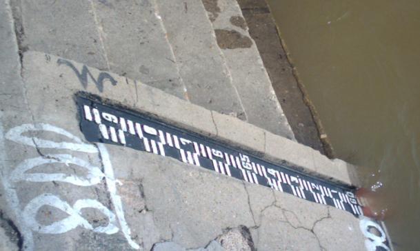
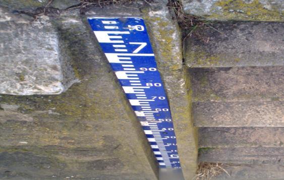
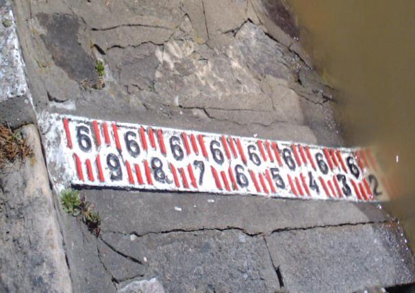
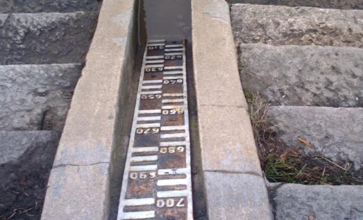
9 5 WATERWAY MAINTENANCE 5.1. Main activities for waterway maintenance hydrology, survey, signalization Hydrology In Romania, there are 23 hydro-meteorological stations manage by the River Administrations of the Lower Danube. Daily are gathering information about level, temperature, pressure, etc. All these information are available to the AFDJ website, to the sections levels. Data, forecasts and warnings are presented in special bulletins and transmitted to the Ministry of Transport. In Romania, the Romanian Water Authority, have in special sections installed tide gauges that are in close cooperation with the AFDJ tide gauges. For waterway maintenance is very important to know the level and forecast. These two parameters are in close cooperation with the position of the buoy and the fairway. 1_SQR_waterway_maintenance_v10_AFDJ.doc Page 9 of 28


10 1_SQR_waterway_maintenance_v10_AFDJ.doc Page 10 of 28


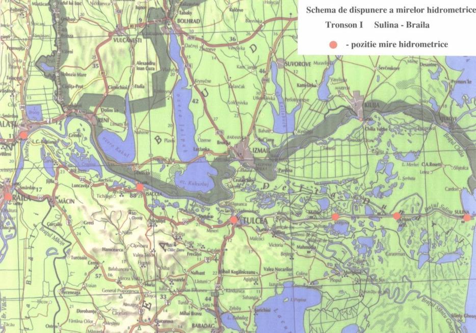
11 Survey Topo-hydrographical surveys represent the gathering method of the raw data from field. After processing of these data, the result will be the basis for establishing the fairway, the position of the buoys, in respect of the gauges of the Danube Commission. The AFDJ have 3 survey ships, 2 with river classes and one with maritime class, that use the equipment, like multibeam sonda Atlas fansweep 20, singlebeam Atlas 350, GPS Trimble 750S, SVP Atlas and motion sensor TSS These 3 survey ships are located in Giurgiu branch, in Galati and the last one in Sulina, for Sea Danube. Results in critical points after survey with Donaris, on the river Danube and Sea Danube: Bogdan-Secian km 785 1_SQR_waterway_maintenance_v10_AFDJ.doc Page 11 of 28


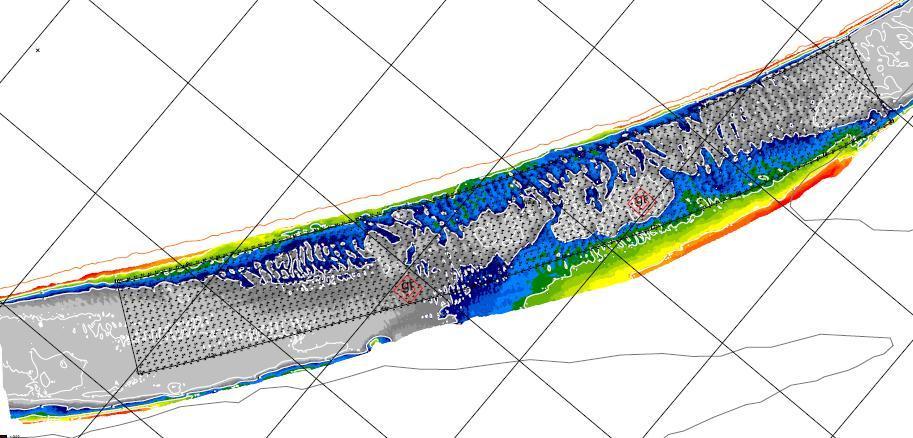
12 Albanesti km 276 Corabia 630 Seimeni km 292 1_SQR_waterway_maintenance_v10_AFDJ.doc Page 12 of 28
13 Bottlenecks In the Romanian stretch of the Danube, there are o lot of bottlenecks in the next points: Salcia km 824, Bogdan-Secian km 785, Pietrisu-Dobrina km 759, Linovo km 738 Bechet km 677, Corabia km 630, Turcescu km 345, Caragheorghe km 344, Lebada km 337, Marleanu km 326, Fermecatu amonte km 322, Fermecatru aval km 318, Cernavoda aval km 297, Seimeni km 292, Albanesti km 276, Harsova aval km 251, Giurgeni Vadu Oii km _SQR_waterway_maintenance_v10_AFDJ.doc Page 13 of 28

14 On the second arms there are identified a few critical points: Borcea arm at Borcea km 99, 97, 93 and Bordusani km 24. Macin arm at Piatra Frecatei km 63, Bedeloiu km 43 and Carcaliu km 26 Chilia arm at Tatanir, km 75 Saint George at Ada Marinescu km Signalization All coastal and floating signalization is built in our workshops. Their location is carried out by field personnel. Signalling sailing line on the Danube is carried out by ship-type specific signalling. Every month, signalling races are conducted. Floating signs for winter is replaced with special signals for the winter (more resistant to winter conditions). Maintenance is signalling coastal whenever needed and consists of cleaning, painting, straightening, clearing the area, etc.. Signalling coast is composed of indicators kilometres or nautical miles and coastal signals about Rules of Navigation. Signalling floating buoys consists of large (which may be electric or not) and low during winter signals from metal. 1_SQR_waterway_maintenance_v10_AFDJ.doc Page 14 of 28

, river buoys (with or without light), kilometres mark (without light), nautical miles (without light).")
15 Also, the signs change (replace) if there is damage, the loss of the signal, and when sailing line changes (narrowing, widening, change from one bank to another), or depending on necessity to navigation consistent with the variation of the Danube. The types of signals used as DFND (Danube Commission) are: coastal (with or without light), indicator panels, lights (with white light, yellow, red or green) Floating: sea buoys (with or without light), river buoys (with or without light), kilometres mark (without light), nautical miles (without light). For modernization of the activities in support to ensure optimal conditions for the smooth navigation, AFDJ Galati approved and implemented on a modern program efficiency phase of this work. Thus, in 2004 have been purchased and have made the following: -30 buoys made the type SHIP DESIGN mm 2 - Sulina; -15 buoys at sea made Mm Workshop 2 - Sulina; -7 lamps with solar panel purchased from Tehnoton Iasi, which were placed on 7 lights on Sulina channel, replacing legacy systems that work with acetylene cylinders; -1 lamp with solar panel in a buoy type testing SHIP DESIGN; -2 lamps purchased from PHARE MARINE England, which were placed in Ceatal Izmail (MM 43) and fog St. George (MM 34); -were put into service two input lights - out of the mouth of the Sulina Canal; -sandblasting and painting their buoys with reflective paint; -placement of reflective film on coastal panel signals, headlamp and epiu the Sulina channel to increase visibility at night; monitoring and coastal signs floating in the sea and Danube river Danube was done by boat range and later with the three American boats Nautics type; -reduce the number of strokes of signaling and resource efficiency by establishing specific problems resulting from racing boats sector verification inspection; -have been purchased and is operating two programs: 1_SQR_waterway_maintenance_v10_AFDJ.doc Page 15 of 28


16 Dredging Danube shipping, work is carried out with their machines by: - Topohidrografice measurement analysis and prioritization of performance at each critical point; - Provisions of dredging; - Opinions by seafarers; - Coordinating implementation of dredging work; - Regular checks of the activity measurements topohidrografice, field trips aboard the dredging equipment; - Tracking topohidrografice efficiency measurements, establishing objective measures of business performance by geomorphological evolution of the area, levels, indicating optimal dredging sites; - Follow the work of dredging quality measurements, quantities achieved certification; - Checking reports weekly, monthly, coming from departments / agencies, the dredging work at the indicator, targeting them and advance the achievements of the service plan; 1_SQR_waterway_maintenance_v10_AFDJ.doc Page 16 of 28
17 5.2. River engineering constructions and execution; Technical Assistance for the Improvement of the Navigation Conditions on the Danube, reference EUROPEAID/114893/D/SV/RO, The contract is endorsed for co-financing in accordance with the Limits of the Financing Memorandum ISPA 2002/RO/16/P/PA/011 by the European Commission. The specific objectives for this service contract are, in accordance with the ISPA Financing Memorandum 2002/RO/16/P/PA/011; 1. The study of three possible measures along the Danube; 2. The completion of an ISPA application for one measure, which shall improve the navigation conditions between Calarasi and Braila; 3. Design and completion of the necessary works tender dossier(s) for this measure. Subsequent completion of the works shall promote sustainable mobility, more efficient and low-cost and environmentally friendly inland waterway transport on the Danube, notably through improved navigation conditions on the Calarasi-Braila Section The distribution of the discharges between the Lower Old Danube and the Bala branch shows that for medium to high daily discharges about 50 % flows into the Lower old Danube before 1970, but this percentage has dropped to only 40% nowadays. For low discharges in Silistra (usually in summer-autumn), in the 1970 s about 30% continued into the Lower Old Danube. Nowadays, only about 20% continues into the Lower Old Danube, but remaining constant for the last 10 years. It can be concluded that there is a decreasing trend for the discharge in the Lower Old Danube. Present navigation conditions on the Danube For the Danube between Calarasi and Braila, the design guidelines as established by the Danube Commission recommend a channel depth of 25 dm below the reference level ENR. Upstream of the Iron Gates I and II, the recommended water depths are 35 dm below the minimum retention levels of the 2 respective dams. According to the Danube Commission recommendations, for the free flowing stretches of the Danube between rkm and km 62.97, the width of the fairway is as follows (next text in French): a) sur les sections à lit à terrain meuble au moins 180 m b) sur les sections à lit ou à seuils rocheux au moins 100 m c) sur les sections de seuils à terrain meuble au moins 150 m Thus, the recommended channel width is 180 m at ENR 25 dm, but for sections with sandbars a channel width of 150 m can be considered. The channel radius of 1000 m has been recommended, or 750 m when unfavorable from a geomorphological point of view. Based on the actual bathymetry and the existing navigation fairway, several site visits and discussions with local authorities an assessment was made of critical locations. Navigation problems can occur because of several reasons. Most frequently, insufficient navigation channel depth and/or width, or a to high navigation channel curvature cause these navigation problems. 1_SQR_waterway_maintenance_v10_AFDJ.doc Page 17 of 28
18 Some of the most important critical locations are: Caragheorghe sand bar(km ), Lebada (km ), Mirleanu (km ), Fermecatu island (km ); Cochirleni (km ), Cernavoda (km ), Fasolele island (km 292), Alvanesti (km 276), Hirsova (km ), Giurgeni-Vadu Oii (km ) and Ostrovo Lupu (km 196). -Bala branch: The proposed solution for the Bala branch consists of a bottom sill in combination with a guiding wall. One of the development strategies consists of relocating the sill to a location more upstream on the Bala branch. The reason for this is a possible reduction in the construction costs of the guiding wall. The necessary quantities for the construction of the bottom sill will probably remain almost the same when the sill is moved up to 300 m more upstream. Because of this, the guiding wall part downstream of the sill can also be reduced with 300 m, which results in a major reduction of the necessary quantities of materials and therefore also a major cost-reduction. -Caragheorghe sand bar(km ): The solution for this bottleneck is to dredge the navigation channel between rkm 345 and 343. The dredge material can be used to construct the guiding wall and to fill up the scour hole behind the existing parts of the sill. -Lebada (km ). Dredging of the shallow locations at rkm 340 and between rkm is the main solution for solving this bottleneck. From a technical point of view, disposal of the dredged material can be done in the Turcescu branch or in the Epurasul branch, both solutions ensuring the further closing of these branches. If necessary the Epurasul can further be closed by constructing a bottom sill on the entrance of the branch. Some bank s will also be necessary to protect the upstream end of the Epurasul island. -Mirleanu (km ), The navigation bottleneck at Mirleanu is situated just at the downstream end of Seica island or branch. The solution for this bottleneck consists of dredging the shallow sections at km 328 and 326 and disposing the material in the Seica branch. Furthermore, it can be necessary to further close the side branches forming the Seica island by bottom sills or to direct the flow away from Seica Island by constructing groins. -Fermecatu island (km ); Navigation problems (insufficient water depth) also occur at Fermecatul Island, as well upstream as downstream. This is certainly due to the presence of several, rather large, side branches near the island. The solution for this bottleneck consists of dredging the main channel and disposing the material in the other branches. Furthermore, some measures for flow regulation to reduce the influence of Tiu and Ceaciru (groins. bottom. sills) can be constructed if necessary. -Cochirleni (km ), the navigation bottleneck at Cochirleni is situated near rkm 309. at the upstream and of the island. The proposed solution consists of dredging at the up- and downstream end of the island. Disposal of the material can be done in the side branch on the right bank. A possible 2 nd phase measure is to close the side branch on the right bank even further by constructing a sill. -Cernavoda (km ), Near rkm 29 there is a small navigation bottleneck, which in extreme conditions can become a real problem. Solution for this problem is to dredge the critical section to a sufficient depth. -Fasolele island (km 292), Near Fasolele island navigation problems can occur near the upstream end of the island because of insufficient navigation depth and because of a to high channel curvature. Dredging the critical location can solve the problem of insufficient depth. The dredging material can be disposed in the side-branch. A more drastic solution for the problem, both solving problems with depth and curvature, is to close the current navigation channel and create a new navigation channel in the side branch, thus straightening the navigation channel. The dredged material can be used for closing the other branch. The further closure of the old navigation channel will have to be done by constructing sill. 1_SQR_waterway_maintenance_v10_AFDJ.doc Page 18 of 28
19 -Alvanesti (km 276), Because of the widening of the river cross section near rkm the cross section get shallower and navigation problems might occur. The solution for this problem is to dredge the navigation channel to sufficient depth and dispose the material in a nearby side branch (Balaban branch). -Hirsova (km ), Near Hirsova, navigation problems might occur due to shallow cross-sections near rkm 250, resulting in insufficient width of the navigation channel. The proposed solution is to dredge the critical location and to dispose the material in the Celea Mica branch upstream the critical location or in the nearby shallow section on the right bank. -Giurgeni-Vadu Oii (km ) Because of the bend of the river between rkm 245 and 242 river cross sections get wider and shallow causing possible navigation problems because the available channel width is not sufficient. The solution for this bottleneck is to dredge the navigation channel. Disposal of the material in the river close to the critical location is difficult. possibly a few kilometers upstream. -Ostrovo Lupu (km 196) If navigations to go back through the Danube instead of through the Caleia branch. Some flow regulation works and dredging works are necessary for ensuring navigation again. The dredging works have to be concentrated on the area in the Danube just downstream of the splitting with Caleia branch. Furthermore. Flow regulation works are necessary to direct the flow back into the main Danube. Flow regulation works can include: constructions of a bottom sill at the upstream end of the Caleia branch, construction of groins near the confluence of the Valciu branch, construction of groins on the Danube just upstream the split with the Caleia branch. Current Position issue kilometer 1 Sector 1:km1075- km863 2 Sector 2:km863- km170(includes shipping arms) Bank: Left/ Right Naming Techinical description Gura Nerei-Ostrovul Mar Depth : 3.5m Sailing line width :180m Length area:212km Haulage length :174km Mar-Braila islet Depth : 2.5m Sailing line width : m Length area:693km Haulage length :652km 3 Km 225 left Borcea Arm Depth : 2.5m Sailing line width : m Length area:102km Haulage length :84km 4 Km 226 left Bala Arm Depth : 2.5m Sailing line width : m Length area:10km Haulage length :10km 5 Km 228 left Macin Arm Depth : 2.5m Sailing line width : m Length area:97km Haulage length :88.5km 6 Km 230 left Valciu Arm Depth : 2.5m Sailing line width : m Length area:42km Haulage length :30km 7 Km 235 left Caleea Arm Depth : 2.5m Sailing line width : m Length area:11km Haulage length :10km 8 Km 238 left Landing place 12.50m reinforced concrete,reinforced 1_SQR_waterway_maintenance_v10_AFDJ.doc Page 19 of 28
20 concrete beams at the rate + 2m. (Mattress fascinated by 1m) 9 Km 238 left Landing place Destroyed 90%. 10 Km 237 left River landing place 50% of work is covered by a pumping station platform. 11 Km 237 left River landing place Destroyed 90%. 12 Km 238 left Mal defense left Defense mattresses left bank of fascinated by 1m thick and 30 m wide. 13 Km 239 left Defense mal left to upstream. Mattresses fascinated with 1m thick and 30 m wide. 14 Km 239 left Mal defense left Fascinated by 1m thick and 30 m wide. 15 Km 239 left Mal defense left Mattresses fascine 30 m wide and 0.75m thick. 16 Km 239 left Mal defense left Mattresses fascine 30 m wide and 0.75m thick. 17 Km left Mal defense left Inverse filter bank slope of 25 cm thickness of ballast and crushed stone. 18 Km km left Mal defense left Mattresses fascine 0.75m thick and 25m wide. 19 Km km left Mal defense left Mattresses fascine 0.75m thick and 25m wide. 20 Km km left Mal defense left Mattresses fascine 0.75m thick and 20m wide. 21 Km km left Mal defense left Mattresses fascine 0.75m thick and 30m wide. 22 Km km left Mal defense left Prism rockfill and filter head opposite mattress 25 cm thick. 23 Km km left Mal defense left Prism rockfill and filter head opposite mattress 25 cm thick. 24 Km 243 left Pitching the Danube Salt fascine, piles of wood and rockfill. downstream and upstream 25 Sector III Km 170 Mm 34 (navigable arm). left Depth: 7.32m Sailing line width : m Length area:107km Haulage length :84.5m 26 Km 170 left Chilia Arm Depth: 2.5m Sailing line width : m Length area:96km Haulage length :85m 27 Berth IV maritime bank head(110m) 28 Berth 34 river, 108 m left pitching of Danube Made of raw stone with cement mortar in the thickness of 30cm. left pitching of Danube Mats fascinated by 40m wide, rough stone rockfill based. 29 Berth 35 river left pitching of Danube Rockfill of raw stone at the base, mattress fascinated by 40 m wide. 30 Berth 34 river left pitching of Danube Mats fascinated latime.coronament to share 40 m 6, rockfill basis. 31 Km 150 downstream Berth 16(150m lenght) 32 Berth V-VI, former berth VII 33 Head upstream - downstream of the ferry berth 3 left Pitching over river vessels berthing Rockfill of raw stone at the base. Fascine mattress thickness of 1m. left Pereu la Dunare Coronament la cota +6. Zidarie din piatra bruta cu mortar de ciment. left pitching of Danube Canopy to +4.5 share, rockfill at the bottom, a bottom appliance mattress fascinating. 1_SQR_waterway_maintenance_v10_AFDJ.doc Page 20 of 28
21 34 Downstream of profile 6-4 berth river. 35 Downstream profile 12-15, berth Station river - boating Vadul 37 Sector IV km km0 left pitching of Danube Mats fascinated by 12 m long canopy at an average rate, based on rough stone rockfill. Left pitching of Danube Rough stone masonry with cement mortar, mattress fascinated by 40 m wide and massive rockfill. left Keys down the Danube. Rough stone masonry. right Navigable arm Depth: 2.5 m Sailing line width: m Length area:63km Haulage length :52.97km 38 Km 62 right Sf.Gheorghe Arm Depth: 2.5 m Sailing line width: m Length area:100km Haulage length :100km 39 Mm Mm Dike nord=1.338m Dike Sud= 370m left Defense bank Papadia Mattresses fascine type Danube, geotextile filter, prism rockfill, clothing the stone block. left Parallel dykes Channel Sulina Est si Vest dams. 41 Km 60 L=275m left Groin guard Dikes 42 Km 58 Left/right Groin stone Made of raw stone from the shore to deep to keep the banks for erosion. 43 Km56 right Pitching Stone masonry laid on a layer of filter S=11.800mp reverse. 44 Km54 left Sulina channel pitching Stone masonry laid on a layer of filter S=115.20mp around. = 30cm thick stone masonry. 45 Km52 left Sulina channel pitching Stone masonry laid on a layer of filter S=254.80mp around. = 30cm thick stone masonry. 46 Km 50 S=4650mp left Sulina channel pitching Stone masonry laid on a layer of filter around. = 30cm thick stone masonry. 47 Km48 right Sulina channel pitching Stone masonry laid on a layer of filter S=70.109mp around. = 30cm thick stone masonry. 48 Km46 left Sulina channel pitching Stone masonry laid on a layer of filter S=18.231mp around. = 30cm thick stone masonry. 49 Km 44 L=700m left Sulina Canal shore Mattress type fascine Danube, clothing 50 Km 42 L=1105m left Sulina Canal shore Mattress type fascine Danube, clothing 51 Km 40 L=952m left Sulina Canal shore Mattress type fascine Danube, clothing 52 Km 38 L=800m left Sulina Canal shore Mattress type fascine Danube, clothing 53 Km 36 L=1105m left/right Sulina Canal shore Mattress type fascine Danube, clothing 54 Km 34 L=1202m left/right Sulina Canal shore Mattress type fascine Danube, clothing 55 Km 32 left/right Sulina Canal shore Mattress type fascine Danube, clothing 56 Km 30 left/right Sulina Canal shore Mattress type fascine Danube, clothing 57 Km 28 L=914m left/right Sulina Canal shore Mattress type fascine Danube, clothing 58 Km 27 L=1040m left/right Sulina Canal shore Mattress type fascine Danube, clothing 59 Km 26 L=700m left/right Wharf Ceamurlia Mattress type fascine Danube, clothing 1_SQR_waterway_maintenance_v10_AFDJ.doc Page 21 of 28
22 60 Km 25 L=752m left/right Wharf Obretin Mattress type fascine Danube, clothing 61 Km 24 L=1032m left/right Sulina Canal shore Mattress type fascine Danube, clothing 62 Km 23 L=957m left/right Sulina Canal shore Mattress type fascine Danube, clothing 63 Km 22 L=1205m left/right Sulina Canal shore Mattress type fascine Danube, clothing 64 Km 21 L=500m left/right Sulina Canal shore Mattress type fascine Danube, clothing 65 Km 20 L=800m left/right Sulina Canal shore Mattress type fascine Danube, clothing 66 Km 19 L=950m left/right Sulina Canal shore Mattress type fascine Danube, clothing 67 Km 18 left/right Sulina Canal shore Mattress type fascine Danube, clothing 68 Km 17 left/right Sulina Canal shore Mattress type fascine Danube, clothing 69 Km 16 left Sulina Canal shore Mattress type fascine Danube, clothing 70 Km 15 L=1790m left/right Pitching of Sulina Embroidered stone masonry placed on a channel. layer of filter around. 71 Km 14 L=2280m right Pitching of Sulina Embroidered stone masonry placed on a channel. layer of filter around. 72 Sector V Km 0 Sulina 73 Dike N =1.993m Dike S = 1.115m 74 Dike Port Sulina L=100m 75 Dike Port Sulina L=100m 76 Dike Port Sulina L=101.2m 77 Dike Port Sulina L=78.40m 78 Dike Port Sulina L=201.8m 79 Dike Port Sulina L=208.3m 80 Dike Port Sulina L=208.3m 81 Dike Port Sulina L=150m 82 Dike Port Sulina L=203.5m 83 Dike Port Sulina L=100m 84 Dike Port Sulina L=97.10m 85 Dike N =4580m Dike S = 4351m left/right Sulina area. Depth : 7.32m Sailing line width : m Lenght area :11.1km Haulage lenght :11.1km left Old dikes Raw stone and drivers on 2 strings. left Dike submerged Built of rough stone. left Dike submerged Built of rough stone. left Dike insubmerged Built of rough stone. left Dike insubmerged Built of rough stone. left Dike insubmerged Built of rough stone. left Dike insubmerged Built of rough stone. left Dike insubmerged Built of rough stone. left Dike submerged Built of rough stone. left Dike submerged Built of rough stone. left Dike submerged Built of rough stone. left Dike insubmerged Built of rough stone. 1_SQR_waterway_maintenance_v10_AFDJ.doc Page 22 of 28
23 86 Dike N =50m Dike S = 50m 87 Dike N =50m Dike S = 50m 88 Dike N =100m Dike S = 100m 89 Dike N =203m Dike S = 203m 90 Dike N =202m Dike S = 206m 91 Dike N =358m Dike S = 358m 92 Dike N =155m Dike S = 197m 93 Dike N =155m Dike S = 197m 94 Dike N =125m Dike S = 125m 95 Dike N =100m Dike S = 100m 96 Dike N =100m Dike S = 100m 97 Dike N =100m Dike S = 100m 98 Dike N =101m Dike S = 101m 99 Dike N =102m Dike S = 101m 100 Dike N =84m Dike S = 84m 101 Dike N =204m Dike S = 204m 102 Km 13 L=950m left Sulina shore. Mattress type fascine Danube, clothing 103 Km 12 L=2.367km left Sulina shore. Mattress type fascine Danube, clothing 104 Km11 left Download Free Port fishermen. 105 Km 10 left Download Pescara - Trap. 1_SQR_waterway_maintenance_v10_AFDJ.doc Page 23 of 28
24 5.3. Common sector, waterway maintenance; Bilateral agreement between the governments of Romania and the Federative Socialist Republic of Yugoslavia, Belgrade 1976 with regard to the establishment and control of application of navigation rules, maintenance and improvement of navigation conditions on the sector where Danube is border line between the two states from km to km Bilateral agreement between the governments of Romania and the People's Republic of Bulgaria, Sofia as to the maintenance and improvement of the navigation fairway on the Romanian - Bulgarian sector of Danube between km 375 and 845.5; Bilateral agreement between the governments of Romania and the Soviet Union, Moscow as to the functioning of the River Administration of the Lower Danube of Galati, for the maintenance of the fairway and the accomplishment of hydrotechnical works on maritime Danube sector (Sulina - Braila); Given the special conditions offered by the Danube river, both in terms of navigation corroborated with the route and geographical location (east-west) of ancient times, shipping areas and the mouth of the estuary in the Black Sea constituted an important objective for riparian countries. Thus, to establish an agreement about the rules of navigation on the Danube and to ensure free navigation on the Danube, on 18 August 1948, the Belgrade regime has signed the Convention on Navigation on the Danube. Romania is the Danube, the natural border with Yugoslavia (Serbia), Bulgaria, Moldova (1,000 m) and Ukraine. In the Belgrade Convention and the subsequent agreements signed at the government and the Danube Commission recommendations were established common areas of activity and functions in each coastal State Party to ensure the navigation conditions on the jurisdiction. Thus: -Between Baziaş (km. 1075) and Gura Timok (km ), the Danube is common with Serbia. In this sector there is close cooperation between the AFDJ - RA Galati and PLOVPUT Beograd, which resulted in the regular working level meetings of experts, the following joint activities: -Development, analysis and signal joint plan agreed on common sector of the Danube; -Control measures (long profile of the sector in km km , sections cross); -Exchange of hydrometeorological data (Hydrometeorological Bulletin, weather, etc..) -Joint headquarters in the ice; Sector of Danube river between km (Timoc) - km. 375 (Silistra) is common with Bulgaria. In this area, cooperation between A.F.D.J. - RA Galati and APPD RUSSE, takes place in the Agreement signed between the Government of Bulgaria and Romania, signed in Sofia in 1955 and based Danube Commission
25 Recommendations. Thus, regularly held meetings of specialists, Romanian and Bulgarian, which, in the Session of the Mixed Commission, which is conducted annually, or in working groups and where to examine all aspects of providing common navigation conditions on the Danube (km km ). During these meetings to discuss plan signaling winter - summer are hydrometeorological data exchange, joint measures to establish programs on the Danube, the critical points of the joint. Annual Joint Technical Committee meets Romanian - Bulgarian, to bridge "Friendship" Giurgiu - Russe, which is presented and analyzed following the results of measurements carried out jointly topohidrografice during periods of low and high levels of the Danube, to trace the morphological evolution of riverbed Danube Bridge in the Giurgiu - Russe. Also in the cooperation between the two parties in accordance with paragraph 6 of the Intergovernmental Agreement (Sofia 1955) and section 15 of the Regulation, held annual meetings to determine how collaboration for periods with ice. In the Maritime Danube, between the Danube and Prut River confluence to 71 Mm + ½, Romania has a common border with Moldova. For this short sector, Romania has not signed any agreement with Moldova, as it joined quite late in the Danube Commission (after the Soviet Union collapsed). In this area, maintenance sailing line belongs to Romania. Sector Maritime Danube between Mm 71 + ½ and Izmail - 43 Mm and 43 Mm Chilia at the km. 20, is the common border with Ukraine. In Ukraine there is collaboration, where ice is highlighted meetings where the parties to determine how common intervention in special circumstances winter (ice), the reciprocal exchange of hydrometeorological information and other items necessary to ensure the conditions of navigation in accordance with Danube Commission recommendations Waterway maintenance in the ice period; During the ice period, the information about ice, water and air temperature, visibility is often collected and sent to seafarers, by own website or special bulletin. It also keep in touch with the Administration Hydroelectric and the Administrations of neighbouring countries, PLOVPUT from Serbia and APPD (EAEMDR) from Bulgaria. It is create an Emergency Command, leading all operations and take any decisions to overcome the period. If the situation requires it, run and measured critical points, if not, run monthly verification measures. Signaling during this period is specified winter period, and at least monthly to check voyages, and the repositioning or planting buoys. 1_SQR_waterway_maintenance_v10_AFDJ.doc Page 25 of 28
26 5.5. Waterway maintenance in the lowest level period; During low levels period more often information are gathering from the 23 weather stations on the variation of water level of the Danube. This information is submitted to the Ministry of Transport through a special newsletter and are available on the website. It is create an Emergency Command, that is leading all operations and take any decisions to overcome the period. It also keep in touch with the Administration Hydroelectric and the Administrations of neighbouring countries, PLOVPUT - Serbia and APPD (EAEMDR) - Bulgaria. The voyages checking signalling and reposition buoys on the fairway. Vessel measurements remain on the sector to perform periodic verification measures at critical points. Results of daily measurements are transmitted to central station via Internet, and then be provided to seafarers. During low levels period it will perform survey of the flows and measurements are made in sections calibrated, then has changes data with Romanian Waters Administration Waterway maintenance in the highest level period; During high levels period more often information are gathering from the 23 weather stations on the variation of water level of the Danube. Depending on the levels (attention, hazard and flood) will perform to very often. These information are submitted to the Ministry of Transport through a special newsletter and are available on the website. It is create an Emergency Command, that is leading all operations and take any decisions to overcome the period. It also keep in touch with the Administration Hydroelectric and the Administrations of neighbouring countries, PLOVPUT - Serbia and APPD (EAEMDR) - Bulgaria. Daily, to keep in touch with Hidroelectrica and receive reports about the situation in the lake. The voyages checking signalling and reposition buoys on the fairway. If the situation requires the rarest signs floating in the sector. Vessel measurements remain on the sector, to perform periodic verification measurement at critical points. It performs measurements of currents Results of daily measurements are transmitted to central station via the Internet, and then be provided to seafarers. During high levels it will perform survey of flows and measurements that are made in calibrated sections, then data are changes with the Romanian Waters Administration Report about the prevention and restoration of flood damages; During a flood period the number of gauge stations is increased, where is necessary. The water level observations are performed on an hourly base and at the automatic stations this is a permanent process. Updated information regarding the river water levels is distributed through the AFDJ website, s, fax transmissions and telephone calls. 1_SQR_waterway_maintenance_v10_AFDJ.doc Page 26 of 28
27 A permanent connection is maintained with the Local and Central Authorities, Regional institutions, Romanian Water Administration and organizations that are responsible for the dykes maintenance Planning for lock maintenance and repairing; On the Romanian sector of Danube, there are two dams Iron Gates 1 at km 943 and Iron Gates 2 km 863. At Iron Gates 1, that are 2 locks built, each country manage one (Serbia - Djerdap and Romania - Hydroelectric), with dimensions of 310 x 34 x 4.5 m. The Iron Gates 2, Hydroelectric maintain 2 locks, a normal lock 310 x 34 x 4.5 m, functional and the second, smaller in size 140 x 14 x 2.5 m. In point of Cernavoda, start the Danube - Black Sea canal, and was added to lock the entrance channel. The Danube - Black Sea and White Gate Midia Navodari, all ports and locks are maintained by the Administration of Navigable Channels Constanta. 1_SQR_waterway_maintenance_v10_AFDJ.doc Page 27 of 28
28 - End of document - 1_SQR_waterway_maintenance_v10_AFDJ.doc Page 28 of 28
1) Riverbed surveying
 Riverbed surveying") 1) Riverbed surveying The topo-hydrographic surveys include data collection, systematisation and processing for the monitoring of the evolution of the hydrolographical situation on the Danube Surveys are
1) Riverbed surveying The topo-hydrographic surveys include data collection, systematisation and processing for the monitoring of the evolution of the hydrolographical situation on the Danube Surveys are
Project Data Sheet BASIC PROJECT DATA
 BASIC PROJECT DATA Full project title: Short project title: (acronym) Improvement of navigation in the joint Bulgarian-Romanian section of the Danube river from km 530 to km 520 Batin and from km 576 and
Paper 87 - INTERNATIONAL COLLABORATION CONCERNING THE USE OF THE DANUBE RIVER IN ROMANIA
 Paper 87 - INTERNATIONAL COLLABORATION CONCERNING THE USE OF THE DANUBE RIVER IN ROMANIA CIORTAN R.; DUMITRU M.; SUCIU I.; KRKLJUS D. Ph.D, Corresponding Member of the Romanian Academy of Technical Sciences,
Project Data Sheet BASIC PROJECT DATA. Improvement of the systems for navigation and topo-hydrographic measurements on the Danube River
 BASIC PROJECT DATA Full project title: Short project title: (acronym) Improvement of the systems for navigation and topo-hydrographic measurements on the Danube River Project logo: Project website: Project
STATUS QUO REPORT ON WATERWAY MAINTENANCE
 NETWORK OF DANUBE WATERWAY ADMINISTRATIONS South-East European Transnational Cooperation Programme STATUS QUO REPORT ON WATERWAY MAINTENANCE Document ID: O 4.7 Activity: 4.1 Access and improve methods,
Danube River Basin District
 Danube River District Part B - Report 2003 ROMANIA Information required according to Art. 3 (8) and Annex I of the EU Water Framework Directive Reporting deadline: June 22, 2004 Prepared by National Administration
The Danube Experience
 The Danube Experience Dealing with Hydromorphological Issues the Danube Experience Philip Weller Executive Secretary, ICPDR Danube River Basin- Overview The Danube River Basin is the most international
WATER MANAGEMENT IN ROMANIA. Elisabeta CSERWID National Institute of Hydrology and Water Management ROMANIA
 WATER MANAGEMENT IN ROMANIA Elisabeta CSERWID National Institute of Hydrology and Water Management ROMANIA 2 I - Water management in Romania Romania general information Location: S-E Europe Surface: 238,391
CO-OPERATION IN DANUBE RIVER BASIN - THE ROLE OF SHMI SLOVENSKÝ HYDROMETEOROLOGICKÝ ÚSTAV
 CO-OPERATION IN DANUBE RIVER BASIN - THE ROLE OF SHMI WMO RAVI Hydrological Forum 2016 Oslo, 1 Danube, the 2nd longest in Europe. 2857 km Flows across 10 European states River basin - 817 000 km2 1/11
Project Data Sheet BASIC PROJECT DATA. Rehabilitation and Development of Transport and Navigation on the Sava River Waterway. Full project title:
 BASIC PROJECT DATA Full project title: Short project title: (acronym) Rehabilitation and Development of Transport and Navigation on the Sava River Waterway Project logo: Project website: www.savacommission.org
DaHar Danube Inland Harbour Development
 The European Union's Southeast Europe programme supporting DaHar Danube Inland Harbour Development DaHar WP 4 A4: Local Action Plan of the Port of Novi Sad Final version: 30 th of December 2013 This project
REPUBLIC OF CROATIA MINISTRY OF MARITIME AFFAIRS, TRANSPORT AND INFRASTRUCTURE AGENCY FOR INLAND WATERWAYS
 REPUBLIC OF CROATIA MINISTRY OF MARITIME AFFAIRS, TRANSPORT AND INFRASTRUCTURE AGENCY FOR INLAND WATERWAYS BRATISLAVA, MAY 3rd, 2012 Inland Waterways in Republic of Croatia Significant waterways in the
Common Principles and Technical Requirements for Pan-European River Information Services (RIS)
") Common Principles and Technical Requirements for Pan-European River Information Services (RIS) Joint Presentation of the and the Geneva, October 2008 Content Inland Waterways of the Region Legal Background
Common Principles and Technical Requirements for Pan-European River Information Services (RIS) Joint Presentation of the and the Geneva, October 2008 Content Inland Waterways of the Region Legal Background
The Lower Prut Floodplain Natural Park (Romania)
") The Lower Prut Floodplain Natural Park (Romania) Gabriela Costea Natural Sciences Museum Complex Galati (Romania) & member of the Scientific Council of the Lower Prut Floodplain Natural Park The Prut The
The Lower Prut Floodplain Natural Park (Romania) Gabriela Costea Natural Sciences Museum Complex Galati (Romania) & member of the Scientific Council of the Lower Prut Floodplain Natural Park The Prut The
POINT OF VIEW on the proposed solutions for improving navigation at critical points at Bechet, Corabia, Belene and Popina
 FAST DANUBE C.N.F.R NAVROM S.A. Galaţi POINT OF VIEW on the proposed solutions for improving navigation at critical points at Bechet, Corabia, Belene and Popina 20.09.2018 Critical point from Bechet (km
The strategic importance of the Danube for a sustainable development of the region. Transnational pilot-workshop Cross-programme ETC Danube projects
 The strategic importance of the Danube for a sustainable development of the region Transnational pilot-workshop Cross-programme ETC Danube projects Manfred Seitz 28 September 2009 Course of presentation
NATIONAL PLAN FOR IWW MAINTENANCE IN THE REPUBLIC OF SERBIA
 NETWORK OF DANUBE WATERWAY ADMINISTRATIONS South East European Transnational Cooperation Programme NATIONAL PLAN FOR IWW MAINTENANCE IN THE REPUBLIC OF SERBIA FOR THE PERIOD 2011 2020 Document ID:... Activity:
The Danube A Stream of Energy
 Danube Business Talks 2018 The Danube A Stream of Energy Hans-Peter Hasenbichler, Managing Director, viadonau 10 October 2018, Meliá Vienna viadonau stands for modern waterway management Company owner:
The Danube Commission Historical background
 The Danube Commission Historical background Taking into consideration its historical predecessors, the European Danube Commission and the International Danube Commission, the current Danube Commission
The Role of Logistics in the Implementation of the Intermodal Transport Strategy in Romania. Strategies for the Road Infrastructure in Dobrogea Region
 The Role of Logistics in the Implementation of the Intermodal Transport Strategy in Romania. Strategies for the Road Infrastructure in Dobrogea Region Iordanoaia Florin Maritime University Constanta, Romania
Contracting maintenance services. Contracting of dredging activitites on the Bulgarian section of the Danube River rkm 610 rkm 374.
 Contracting maintenance services Contracting of dredging activitites on the Bulgarian section of the Danube River rkm 610 rkm 374.100 2 Contract specifics According to an agreement between MTITC and EAEMDR
Danube River Basin District
 Danube River Basin District Part B National Report BULGARIA Information required according to Art. 3 (8) and Annex I of the EU Water Framework Directive prepared by Ministry of Environment and Water 2
Fotos: viadonau, NEWADA duo Layout: viadonau
 COMMON DANUBE REPORT 2013 Impressum NEWADA duo project consortium Network of Danube Waterway Administrations data and user orientation Information about the project consortium can be found on pp. 30-31
"Transboundary coordination according to the FD Directive in the shared river basins of Greece
 Workshop on Transboundary Issues Budapest March 31st April 1st "Transboundary coordination according to the FD Directive in the shared river basins of Greece Katerina Triantafyllou, ECOS Consulting S.A.
Table of. contents. Fotos: viadonau, NEWADA duo Layout: viadonau
 COMMON DANUBE REPORT 2013 Table of contents Scope of the document... 5 Highlights 2012... 6 In the same boat...7 Level of transport volume... 9 Transport volume per commodity types... 12 Continued growth
COMMISSION IMPLEMENTING REGULATION (EU)
") 18.10.2011 Official Journal of the European Union L 271/15 COMMISSION IMPLEMENTING REGULATION (EU) No 1034/2011 of 17 October 2011 on safety oversight in air traffic management and air navigation services
18.10.2011 Official Journal of the European Union L 271/15 COMMISSION IMPLEMENTING REGULATION (EU) No 1034/2011 of 17 October 2011 on safety oversight in air traffic management and air navigation services
BASIC PROJECT DATA. Network of Danube Waterway Administrations
 BASIC PROJECT DATA Full project title: Network of Danube Waterway Administrations Short project title: (acronym) NEWADA Project logo: Project website: www.newada.eu Project ID: PA1A005 Need and added value
Thirteenth International Water Technology Conference, IWTC , Hurghada, Egypt 1249
 Thirteenth International Water Technology Conference, IWTC 13 2009, Hurghada, Egypt 1249 EVALUATION OF LOCAL SCOUR AROUND BRIDGE PIERS (RIVER NILE BRIDGES AS CASE STUDY) Sherine Ismail Assoc. Prof., Survey
PROJECTION FOR ROMANIA DANUBE STRATEGY
 PROJECTION FOR ROMANIA DANUBE STRATEGY Peter LANGER 1, Marin ANDREICA 2, Eugen ALBU 3 Abstract The paper highlights a few management consequences of the projection for Romania Danube Strategy, focusing
NATIONAL PLAN FOR IWW MAINTENANCE IN THE REPUBLIC OF CROATIA
 NETWORK OF DANUBE WATERWAY ADMINISTRATIONS South-East European Transnational Cooperation Programme NATIONAL PLAN FOR IWW MAINTENANCE IN THE REPUBLIC OF CROATIA FOR THE PERIOD 2011-2018 Document ID:...
The search results explanations of hydrological data
 Introduction The search results explanations of hydrological data Depending on the parameter, the instrumental measuring or visual observation method is used for the hydrological observations. Instrumentally
COMMISSION OF THE EUROPEAN COMMUNITIES. Draft. COMMISSION REGULATION (EU) No /2010
 No /2010") COMMISSION OF THE EUROPEAN COMMUNITIES Brussels, XXX Draft COMMISSION REGULATION (EU) No /2010 of [ ] on safety oversight in air traffic management and air navigation services (Text with EEA relevance)
COMMISSION OF THE EUROPEAN COMMUNITIES Brussels, XXX Draft COMMISSION REGULATION (EU) No /2010 of [ ] on safety oversight in air traffic management and air navigation services (Text with EEA relevance)
ACTION PLAN FOR THE PERIOD concerning the STRATEGY ON IMPLEMENTATION OF THE FRAMEWORK AGREEMENT ON THE SAVA RIVER BASIN
 Doc. 1S-26-O-11-5/1-2 ACTION PLAN FOR THE PERIOD 2011-2015 concerning the STRATEGY ON IMPLEMENTATION OF THE FRAMEWORK AGREEMENT ON THE SAVA RIVER BASIN April 2011 Table of Contents INTRODUCTION... 5 1.
Sava Commission Activities. KICK-OFF MEETING DANTE, February 17, 2017, Budapest
 Sava Commission Activities KICK-OFF MEETING DANTE, February 17, 2017, Budapest 1 Establishment of the ISRBC 2 Decay of SFRY a challenge to WRM in the Sava river basin Sava river used to be the biggest
The Timok River Basin in Serbia
 The Timok River Basin in Serbia UNECE Workshop on Integrated Transboundary Water Resources Management in SEE, Sarajevo, 18-20 May, 2009 Dragana Ninković, Dipl.-Ing. Dušan Dobričić, Dipl.-Ing. Content 1.
The results of the National Tourism Development Strategy Assessments
 The results of the National Tourism Development Strategy Assessments - 2012 (I) The assessment tool In 2012 the Sustainable Tourism Working Group of the CEEweb for Biodiversity prepared a guidance for
OICE (Roma) & ANCE (Salerno) delegation in visit to Bucharest Camber of Commerce
 & ANCE (Salerno) delegation in visit to Bucharest Camber of Commerce") BUCHAREST CHAMBER OF COMMERCE AND INDUSTRY 140 years at the service of the business community Business Opportunities OICE (Roma) & ANCE (Salerno) delegation in visit to Bucharest Camber of Commerce 2008,
BUCHAREST CHAMBER OF COMMERCE AND INDUSTRY 140 years at the service of the business community Business Opportunities OICE (Roma) & ANCE (Salerno) delegation in visit to Bucharest Camber of Commerce 2008,
Contribution to the implementation of the EUSDR's Action Plan. Priorities for the year 2013 Ministry of Infrastructure of Ukraine
 Contribution to the implementation of the EUSDR's Action Plan. Priorities for the year 2013 Ministry of Infrastructure of Ukraine November, 2012 Belgrad Priorities of the Transport Strategy of Ukraine
Rehabilitation and development of navigation on the Sava river
 Rehabilitation and development of navigation on the Sava river 3rd Joint Statement Implementation Meeting, Vienna, April 5-6, 2011 Background of the project Recognized as a priority project in the framework
HYDRAULIC DESIGN OF THE TOURISTIC BERTHING IN ASWAN CITY
 HYDRAULIC DESIGN OF THE TOURISTIC BERTHING IN ASWAN CITY Dr. Hossam El-Sersawy Researcher, Nile Research Institute (NRI), National Water Research Center (NWRC), Egypt E-mail: h_sersawy@hotmail.com Dr.
A Romanian, Hungarian and Ukrainean transboundary basin: Somes - Tisa
 A Romanian, Hungarian and Ukrainean transboundary basin: Somes - Tisa dr. eng. Costica Sofronie, dr. eng. Daniela Radulescu NATIONAL ADMINISTRATION APELE ROMANE Transboundary Network of Basin Organizations
2014 floods in Serbia
 16 th Meeting of WGF, Rim, 9-10 October 2014 2014 floods in Serbia Radovanka Pavlović Ministry of Agriculture and Environmental Protection Republic Water Direcrorate, Belgrade, Serbia Specific cyclone
Sava Commission Activities. DANUBE SKILLS KICK OFF EVENT, February 21, 2017, Bucharest
 Sava Commission Activities DANUBE SKILLS KICK OFF EVENT, February 21, 2017, Bucharest 1 Establishment of the ISRBC 2 Decay of SFRY a challenge to WRM in the Sava river basin Sava river used to be the biggest
REPUBLIC OF SOUTH AFRICA
 REPUBLIC OF SOUTH AFRICA SAN HYDROGRAPHIC OFFICE NATIONAL REPORT TO THE IHO HYDROGRAPHIC COMMISSION ON ANTARCTICA (HCA) 11 TH MEETING, HOBART, AUSTRALIA 05-07 OCTOBER 2011 2 11 TH HCA MEETING REPORT BY
Management of a Large The Danube. Mr. Mitja Bricelj ICPDR President Perth,13 October 2010
 Management of a Large International ti River Basin: The Danube Mr. Mitja Bricelj ICPDR President Perth,13 October 2010 From the Black Forest From the Black Forest to the Black Sea Human activities damaged
Serving the Tampa Bay Maritime Community Since Celebrating over 125 Years of Service
 Serving the Tampa Bay Maritime Community Since 1886 Celebrating over 125 Years of Service Tampa Bay Pilots Association Piloting is an essential service of such paramount importance that its continued existence
Danube River Basin. a source for transboundary cooperation. Exploring the Results and Potential for Transboundary Water Management Cooperation
 Danube River Basin a source for transboundary cooperation Exploring the Results and Potential for Transboundary Water Management Cooperation Philip Weller ICPDR, Executive Secretary Joint Meeting EUWI
EU Strategy for the Danube Region framework for development of inland navigation
 EU Strategy for the Danube Region framework for development of inland navigation Belgrade, 6 March 2013 International Conference Sava River A Transport corridor & tourist destination Markus Simoner, via
WORKING TOGETHER TO ENHANCE AIRPORT OPERATIONAL SAFETY. Ermenando Silva APEX, in Safety Manager ACI, World
 WORKING TOGETHER TO ENHANCE AIRPORT OPERATIONAL SAFETY Ermenando Silva APEX, in Safety Manager ACI, World Aerodrome Manual The aim and objectives of the aerodrome manual and how it is to be used by operating
Kavala, Greece, 18 July 2013
 Kavala, Greece, 18 July 2013 In 1996 1997 Odessa region established direct communications on inter-regional level with Romanian border counties of Galati and Tulcha. In June 1997, the Agreement About relationships
NETWORK OF DANUBE WATERWAY ADMINISTRATIONS data & user orientation SOUTH EAST EUROPE TRANSNATIONAL COOPERATION PROGRAMME ATLAS OF BERTH
 NETWORK OF DANUBE WATERWAY ADMINISTRATIONS data & user orientation SOUTH EAST EUROPE TRANSNATIONAL COOPERATION PROGRAMME ATLAS OF BERTH Republic of Croatia Document ID O 4.2.6 Activity Act. 4.2 Author/organisation
STATUS QUO REPORT ON WATERWAY MAINTENANCE HUNGARY
 NETWORK OF DANUBE WATERWAY ADMINISTRATIONS South-East European Transnational Cooperation Programme STATUS QUO REPORT ON WATERWAY MAINTENANCE HUNGARY Document ID: O.4.3 Activity: 4.1 Author / Project Partner:
Lessons Learned from the Floods this May
 Building Resiliance to Disasters in Western Balkans and Turkey Design a Regional Multi-Hazard EWS Composed of harmonized National EWS econd Meeting of the Design Team 9 11 September 2014, Durrës, Albania
TARIFF OF HARBOUR DUES
 PORT OF GDYNIA AUTHORITY S.A. JOINT-STOCK COMPANY TARIFF OF HARBOUR DUES Valid from 1 July 2007 The Tariff established by the Port of Gdynia Authority, S.A. under Resolution no. 168/II/2004 of 18 August
REPUBLIC OF MOZAMBIQUE
 SAIHC14-5.4F REPUBLIC OF MOZAMBIQUE INSTITUTO NACIONAL DE HIDROGRAFIA E NAVEGAÇÃO NATIONAL REPORT TO THE 14 th SOUTHERN AFRICA AND ISLANDS HYDROGRAPHIC COMMISSION CONFERENCE Saint-Gilles La Réunion 6 th
ALL SHIPOWNERS, OPERATORS, MASTERS AND OFFICERS OF MERCHANT SHIPS, AND RECOGNIZED ORGANIZATIONS
 REPUBLIC OF Marine Notice THE MARSHALL ISLANDS No. 7-041-6 OFFICE OF THE MARITIME ADMINISTRATOR Rev. 3/14 TO: SUBJECT: ALL SHIPOWNERS, OPERATORS, MASTERS AND OFFICERS OF MERCHANT SHIPS, AND RECOGNIZED
Presentation from 2015 World Water Week in Stockholm. The authors, all rights reserved. SIWI siwi.org
 Presentation from 2015 World Water Week in Stockholm www.worldwaterweek.org The authors, all rights reserved SIWI siwi.org WORLD WATER WEEK Stockholm, 23 th August 2015 Co-operative water governance: catalyst
INFORMATION PAPER ON APPLICATION SPECIFIC MESSAGES (ASM)
") INFORMATION PAPER ON APPLICATION SPECIFIC MESSAGES (ASM) Edition 1.1 Version: 09-05-2017 Author: Vessel Tracking and Tracing Expert Group: Sup group ASM Table of Content 1 Inland AIS State of the art...
INFORMATION PAPER ON APPLICATION SPECIFIC MESSAGES (ASM) Edition 1.1 Version: 09-05-2017 Author: Vessel Tracking and Tracing Expert Group: Sup group ASM Table of Content 1 Inland AIS State of the art...
MANAGING COASTAL HAZARDS THROUGH BENEFICIAL REUSE OF DREDGED SAND AND AN ADAPTIVE WORKS STRATEGY
 MANAGING COASTAL HAZARDS THROUGH BENEFICIAL REUSE OF DREDGED SAND AND AN ADAPTIVE WORKS STRATEGY Isabelle Ghetti 1, B.Morgan 2, R.Massie 1, Gary Blumberg 2 1 Shoalhaven City Council, Nowra, NSW 2 Royal
Stability Pact for SEE. Working Table II. Sava River Basin Initiative
 Stability Pact for SEE Working Table II Sava River Basin Initiative Background Prior to disintegration of former Yugoslavia, the Sava was a river basin of national interest Now, it belongs to four countries:
BRISK Sub-regional risk of spill of oil and hazardous substances in the Baltic Sea
 BRISK Sub-regional risk of spill of oil and hazardous substances in the Baltic Sea Part-financed by the European Union Photo: Nikolay Vlasov / HELCOM Maritime traffic in the Baltic The Baltic Sea today
L 342/20 Official Journal of the European Union
 L 342/20 Official Journal of the European Union 24.12.2005 COMMISSION REGULATION (EC) No 2150/2005 of 23 December 2005 laying down common rules for the flexible use of airspace (Text with EEA relevance)
Importance of the Danube in the Development of the European inland transport. Inland and Port Infrastructure Development in Romania
 Vol. 5, No. 1/2015 Importance of the Danube in the Development of the European inland transport. Inland and Port Infrastructure Development in Romania Romeo Boşneagu 1, Carmen Elena Coca 2 Abstract: Europe
Nature Conservation and Regional Development in Floodplains and Wetlands in the Central and Lower Danube River Basin
 Nature Conservation and Regional Development in Floodplains and Wetlands in the Central and Lower Danube River Basin Project Manager: Dr. Johann Schreiner Project Coordination: Dr. Katrin Heuer, Dr. Martina
Conference on Search and Rescue
 Conference on Search and Rescue (Saint Denis de La Réunion, September 3 7, 2007) WP/6 Draft Agreement between Ministries Responsible for Civil Aviation and Defense (Original text in the French language)
Simulation Analysis on Navigation Indexes of Wanzhou Yangtze River Highway Bridge after the Anti-Collision Device Construction by Ship Model Test
 Engineering, 216, 8, 86-814 http://www.scirp.org/journal/eng ISSN Online: 1947-394X ISSN Print: 1947-3931 Simulation Analysis on Navigation Indexes of Wanzhou Yangtze River Highway Bridge after the Anti-Collision
Specification for Grip blocking using Peat Dams
 Technical Guidance Note 1 Specification for Grip blocking using Peat Dams 1. Introduction Moorland drains (grips) have been dug across much of the Yorkshire upland peatlands. Many of these grips have become
ANNEX V. List of Abbreviations
 ANNEX V List of Abbreviations SEE R&D EU TEN-T GROSEE FP NUTS LAU ESPON Cohesion SMART SWOT MEGA FUA GDP PUSH PIA TRACC RO BG GR EUROSTAT BBU OTP FYROM EC FMA FOCI ECR2 South East Europe Research and Development
FRAMEWORK LAW ON THE PROTECTION AND RESCUE OF PEOPLE AND PROPERTY IN THE EVENT OF NATURAL OR OTHER DISASTERS IN BOSNIA AND HERZEGOVINA
 Pursuant to Article IV4.a) of the Constitution of Bosnia and Herzegovina, at the 28 th session of the House of Representatives held on 29 April 2008, and at the 17 th session of the House of Peoples held
International Sava River Basin Commission - An example of EU/non EU country cooperation in water management
 International Sava River Basin Commission - An example of EU/non EU country cooperation in water management Improvement and co-operation possibilities in the water sector with non-eu countries Ulm, 29
3 NINE GEO-MORPHOLOGICAL DANUBE REACHES 3.1 Introduction. 3.2 Definition Procedure
 3 NINE GEO-MORPHOLOGICAL DANUBE REACHES 3.1 Introduction The Danube River is the second largest stream in Europe spanning between its source and its mouth in the Black Sea a total of 2,857 km and covering
APPLICATION OF THE NO-SPECIAL-FEE SYSTEM IN THE BALTIC SEA AREA
 CONVENTION ON THE PROTECTION OF THE MARINE ENVIRONMENT OF THE BALTIC SEA AREA HELSINKI COMMISSION - Baltic Marine HELCOM 19/98 Environment Protection Commission 15/1 Annex 19 19th Meeting Helsinki, 23-27
Official Journal of the European Union L 337/43
 22.12.2005 Official Journal of the European Union L 337/43 PROTOCOL on the implementation of the Alpine Convention of 1991 in the field of tourism Tourism Protocol Preamble THE FEDERAL REPUBLIC OF GERMANY,
COMMONWEALTH OF THE BAHAMAS MINISTRY OF PUBLIC WORKS & TRANSPORT NASSAU HARBOUR PORT IMPROVEMENT PROJECT. Nassau Harbour Port Improvement Project
 COMMONWEALTH OF THE BAHAMAS MINISTRY OF PUBLIC WORKS & TRANSPORT NASSAU HARBOUR PORT IMPROVEMENT PROJECT AUGUST 2009 OVERALL VIEW OF NASSAU HARBOUR AERIAL VIEW OF NASSAU HARBOUR PROJECT HISTORY 1960 s
Implementation of WFD in Serbia and Montenegro
 Ministry of Agriculture, Forestry and Water Management Directorate for Water Implementation of WFD in Serbia and Montenegro Nikola Marjanovic, PhD Civ. Eng. SERBIA AND MONTENEGRO SERBIA Area: 88.361 km
Scientific Support to the Danube Strategy
 Monday, 29 September 2014 CONCEPT PAPER Scientific Support to the Danube Strategy The of the European Commission is coordinating an initiative aiming to provide scientific support to the European Union
Implementation of the Water Convention, including its complementary role to the EU Water Framework Directive
 Implementation of the Water Convention, including its complementary role to the EU Water Framework Directive Experience of Serbia Dragana Milovanović Ministry of Agriculture, Forestry and Water Management
Danube River Basin District
 16 th June 2004 Danube River Basin District Part B - Report 2003 REPUBLIC OF MOLDOVA Information required according to Art. 3 (8) and Annex I of the EU Water Framework Directive Reporting deadline: June
SAFETY AND SECURITY IN THE DANUBE REGION. Made by: Bernadett Szakács Barbara Sándor
 SAFETY AND SECURITY IN THE DANUBE REGION Made by: Bernadett Szakács Barbara Sándor ABOUT US University of Pannonia -Economics,Tourism,Management Previous research -Film induced tourism Erasmus Rovaniemi
Transboundary Water Management in Republic of Macedonia
 12th International Conference EUROPE-INBO 2014 12-15 November 2014, Bucharest, Romania. Transboundary Water Management in Republic of Macedonia Ylber Mirta Head of Department for Waters ymirta@gmail.com
Cross border cooperation between Ukraine and Moldova: achievements, opportunities and problems DANUBE FINANCING AND CAPACITY BUILDING DIALOGUE
 Cross border cooperation between Ukraine and Moldova: achievements, opportunities and problems Igor Studennikov Executive Director Centre for Regional Studies, Odessa, Ukraine Member of the Executive Committee
THE REPUBLIC OF SERBIA MINISTRY OF ENVIRONMENTAL PROTECTION DEVELOPMENT OF THE ECOLOGICAL NETWORK IN SERBIA
 THE REPUBLIC OF SERBIA MINISTRY OF ENVIRONMENTAL PROTECTION DEVELOPMENT OF THE ECOLOGICAL NETWORK IN SERBIA Establishment of the Ecological Network in Serbia As a first step towards establishment of the
Priority Area Tourism in the EU Strategy for the Baltic Sea Region: State of Implementation and Perspectives
 Priority Area Tourism in the EU Strategy for the Baltic Sea Region: State of Implementation and Perspectives Andrea Herrmannsen, State Chancellery Mecklenburg-Vorpommern Conference Building A Baltic Sea
Creating partnerships for sustainable tourism development
 Sustainable Tourism at Inland Water Destinations UNWTO Danube Floating Conference Creating partnerships for sustainable tourism development Daniela Schily GIZ project leader 27.05.2013 Seite 1 Page 1 BMZ
I. The Danube Area: an important potential for a strong Europe
 Final Declaration of the Danube Conference 2008 The Danube River of the European Future On 6 th and 7 th October in the Representation of the State of Baden-Württemberg to the European Union I. The Danube
The Procedures for Entry and Departure into and from, Taipei Harbor
 The Procedures for Entry and Departure into and from, Taipei Harbor Promulgated in accordance with Letter Reference Pei-Kang-Hang-Tzu No. 718 on May 31, 2004 Ⅰ These procedures are enacted in order to
DANUBIUS. Danube International Centre for Advanced Studies for River-Delta-Sea systems
 DANUBIUS Danube International Centre for Advanced Studies for River-Delta-Sea systems Adrian Stănică GeoEcoMar astanica@geoecomar.ro Viorel Vulturescu M.E.N. viorel.vulturescu@ancs.ro Manuela Sidoroff
TWENTY-SECOND MEETING OF THE ASIA/PACIFIC AIR NAVIGATION PLANNING AND IMPLEMENTATION REGIONAL GROUP (APANPIRG/22)
") INTERNATIONAL CIVIL AVIATION ORGANIZATION TWENTY-SECOND MEETING OF THE ASIA/PACIFIC AIR NAVIGATION PLANNING AND IMPLEMENTATION REGIONAL GROUP (APANPIRG/22) Bangkok, Thailand, 5-9 September 2011 Agenda
INTERNATIONAL CIVIL AVIATION ORGANIZATION TWENTY-SECOND MEETING OF THE ASIA/PACIFIC AIR NAVIGATION PLANNING AND IMPLEMENTATION REGIONAL GROUP (APANPIRG/22) Bangkok, Thailand, 5-9 September 2011 Agenda
EU Strategy for the Danube Region
 EU Strategy for the Danube Region Priority Area PA7 Knowledge Society 1st Danube:Future Workshop - CHALLENGES AND POTENTIALS FOR A SUSTAINABLE DEVELOPMENT IN THE DANUBE REGION: CONTRIBUTING TO HORIZON
BEFORE PROJECT THE BEGINNING
 BEFORE PROJECT THE BEGINNING SWBNP is a final sample of the former Lakes of Danube. On an area of 241 km2, PN-BmB retain 10% of the former Inland River Delta, the former Lake of Brăila and Ialomiţei, who
Presenter : Dodin/Jean-Paul, Jeremie
 Presenter : Dodin/Jean-Paul, Jeremie Seychelles National Meteorological Services Seychelles International Airport Ministry of Environment & Energy Environment Department P.O Box 1145 Victoria Mahe Tel:
SEA DUBAI. By Rasiena
 SEA DUBAI By Rasiena 1 Progress in Dubai s maritime sector Ideally located between Europe and Asia, Dubai has attracted sailors and traders for centuries. Over the years, Dubai has established itself on
Transboundary River Management in the Danube Basin
 Southern Illinois University Carbondale OpenSIUC Key Note Presentation World River Day 2011 11-2011 Transboundary River Management in the Danube Basin Philip Weller International Commission for the Protection
Government Decree on Inspecting Foreign Ships in Finland (1241/2010)
") NB: Unofficial translation; legally binding texts are those in Finnish and Swedish Finnish Transport Safety Agency Government Decree on Inspecting Foreign Ships in Finland (1241/2010) Section 1 Scope of
NB: Unofficial translation; legally binding texts are those in Finnish and Swedish Finnish Transport Safety Agency Government Decree on Inspecting Foreign Ships in Finland (1241/2010) Section 1 Scope of
DOCKING AND ROUTING PLAN
 DOCKING AND ROUTING PLAN TABLE OF CONTENT Contents Table of content... 2 1 Introduction... 3 1.1 Background... 3 1.2 Document Scope... 3 1.3 Harbour dues... 3 2 ROUTING TO SHIPYARD... 4 2.1 General...
Credit No IN. National Project Director 9,Institutional Area, Lodhi Road, New Delhi Tel:
 Sub:Selection of Consultants for preparation of eco-tourism management plan forvedaranyam area in Tamil Nadu. ICZMP (Integrated Coastal Zone Management Project) Credit No. 4765 0 IN Amendment #1 The TOR
Doc. No. 1S-26-O-11-4/2-2 STRATEGY ON IMPLEMENTATION OF THE FRAMEWORK AGREEMENT ON THE SAVA RIVER BASIN
 Doc. No. 1S-26-O-11-4/2-2 STRATEGY ON IMPLEMENTATION OF THE FRAMEWORK AGREEMENT ON THE SAVA RIVER BASIN April 2011 Table of Contents 1. Introduction... 5 2. Framework for transboundary cooperation in
Provincial Railway Technical Standards
 GENERAL: INDEX: The standards and requirements listed in this document are intended for use on provincially regulated railway public grade crossings. These standards are considered the minimum requirements
ROMANIA s EXPERIENCE
 Ministry of Foreign Affairs of Romania EUSDR National Coordinator EU Strategy for the Danube Region ROMANIA s EXPERIENCE - 2016 - What is the EU Strategy for the Danube Region (EUSDR)? A joint initiative
Managing environmental risks in the Danube Region
 Environmental Risks Managing environmental risks in the Danube Region www.danubeenvironmentalrisks.eu INTRODUCTION The Danube Region represents one fifth of the European Union s total area and is home