HERITAGE ASSESSMENT. Franklin County Council Chambers (Former) 13 Massey Avenue, Pukekohe. Heritage Unit, Auckland Council.
|
|
|
- Theodore Christian Dawson
- 5 years ago
- Views:
Transcription

1 HERITAGE ASSESSMENT Franklin County Council Chambers (Former) 13 Massey Avenue, Pukekohe Prepared for Heritage Unit, Auckland Council July 2017 (Final)
2 HERITAGE ASSESSMENT Franklin County Council Chambers (Former) 13 Massey Avenue, Pukekohe Prepared for Heritage Unit, Auckland Council July 2017 Cover image: View of the principal east and south elevations (The Heritage Studio, 2017) Note: Copyright permissions have yet to be obtained.
3 1.0 Purpose The purpose of this document is to consider the place named the Franklin County Council Chambers (Former), 13 Massey Avenue, Pukekohe against the criteria for the evaluation of historic heritage in the Auckland Unitary Plan (Operative in part 1 ) (AUPOip). The document has been prepared by The Heritage Studio Ltd. on the specific instructions of Auckland Council s Heritage Unit. It is solely for the use of Auckland Council for the purpose it is intended in accordance with the agreed scope of work. All photographs in the document were taken by The Heritage Studio Ltd. in 2017, unless noted otherwise. 2.0 Identification Site address 13 Massey Avenue, Pukekohe 2120 Legal description and Certificate of Title identifier LOT 1 DP CT-21D/78 NZTM grid reference Easting: / Northing: Longitude: / Latitude: Ownership Auckland Unitary Plan zoning Existing scheduled item(s) Additional controls Heritage New Zealand Pouhere Taonga (HNZPT) listing details Pre-1900 site (HNZPT Act 2014 Section 6) Merj Holdings Limited Business - Town Centre Zone None Overlays - Natural Resources (High-Use Aquifer Management Areas; and Quality-Sensitive Aquifer Management Areas) Controls - Building Frontage Control (General Commercial Frontage); Height Variation Control; and Macroinvertebrate Community Index None No, the place does not predate 1900 and has no identified archaeological values CHI reference(s) NZAA site record number(s) None 1 Operative in part, 15 November 2016, updated 14 December 2016 and 23 May Franklin County Council Chambers (Former) Final, July
4 3.0 Constraints This evaluation is based on the information available at the time of the assessment. Due to the timeframe presented, historical and contextual research for the evaluation was undertaken to an extent that enables the place to be evaluated against the criteria, but is not exhaustive. It is important to note that additional research may yield new information about the place. Partial access was made to the interior of the building, principally the front portion. The physical description and visual observations are therefore based on plans, documents and those parts of the building visible at the time of inspection. This evaluation does not include an assessment of archaeological values or an assessment of the importance of the place to Mana Whenua. Furthermore, this evaluation does not include a structural assessment or condition report; any comments on the structural integrity or the condition of the building are based on visual observations only. 4.0 Historical summary Refer to Appendix 1 for a fully referenced historical background and Appendix 2 and Appendix 3 for supplementary information. The land upon which the former Franklin County Council Chambers was constructed formed part of original Allotment 30, Suburban Section 2, Parish of Pukekohe, following the subdivision of the Pukekohe Block in By 1911, the land was in the ownership of brothers and local businessmen, William and David Roulston. A year later, their land was subdivided in 51 lots, two of which (lots 19 and 20) were acquired by the Chairman, Councillors and inhabitants of the County of Franklin on 11 August Franklin County formed in 1912 following the re-establishment of county government in South Auckland after the implementation of the Franklin and Manukau Counties Act (1911). Formally constituted on 1 April 1912, Franklin County s primary elections took place on 22 June 1912 and the Council s first meeting was held on 4 July 1912 in Pukekohe s Masonic Hall. Following the appointment of Mr W. C. Motion as Chairman, one of the key matters raised during the meeting was the location of the county headquarters. Despite offers to use the Buckland Hall, the selection of Pukekohe, with its ability to provide the most conveniences, was considered to be in the best interests of the district. Once the decision was made to establish offices in Pukekohe, the County Council sought accommodation in the area, which resulted in an offer from Mr Roulston of two quarter-acre sites located on Hall (later Roulston) Street at a price of 225 and 200. In 1913, Council commissioned local architect, L. C. A. Potter ( ) who had recently set up practice in Pukekohe to design the new offices. The Council Chambers was one of his first projects in the township. Other early examples of his Pukekohe work included the Times Building, a brick residence in Harrington Avenue, and alterations and additions to Roulston s King Street premises, all of which were put out for tender in The successful contractors were Macpherson & Harvey of Tuakau. Completed by February 1914, the Franklin County Council Chambers was described as a handsome structure. The single-storey brick building was designed with a prominent main elevation that fronted Hall Street. Finished in red and grey plaster and tuck pointed in white putty to represent brick, the principal façade featured classical elements with double entrance doors framed with Ionic columns. Internally, the building comprised a vestibule, assistant clerk s office, the council chamber auditorium, Franklin County Council Chambers (Former) Final, July
5 the council chamber with a horseshoe shaped table, the county clerk s room, two strong rooms, the county engineer s room, the committee room, and the contractors room. By the time the County Council Chambers were completed, Pukekohe was known as the service and retail centre for the Franklin area. The construction of new roads, development of the land and the expansion of the horticultural industry facilitated significant progress in the locality and a rapid increase in Pukekohe s population. The township s commercial core (King Street) also experienced considerable development during the early decades of the twentieth century, with the County Council Chambers contributing to one of a number of masonry buildings erected in the town, providing a sense of permanence. Other examples included the Post Office (1909, demolished in 1976), the Webster Building (1909), the Bank of New Zealand (1912), the O Connor s Building (1913), and the nearby Franklin Times Offices (c.1913). In c , a single-storey brick extension was built to the rear of the Council Chambers providing additional office accommodation, storage and toilet facilities. The design and materials of the extension followed that of the existing structure, having little impact on the overall appearance of the building. The existing layout also appears to have remained largely unaltered, apart from the insertion of an internal wall to create two separate offices and presumably an additional doorway to access the space. In 1987, the internal layout was modified slightly with the removal and insertion of a number of partitions. In 1961, the original County Council land (Allotments 19 and 20) was subdivided into five lots, with the Chambers taking up the majority of Lot 1 (the present-day certificate of title boundary). The site and building remained in the ownership of the Chairman, Councillors and inhabitants of the County of Franklin until 1972, when the property was transferred to a group of chartered accountants. They held onto the property (with some variations in ownership) until the present owners, Merj Holdings Limited acquired the property in The building is currently used as offices for real estate agents, Signature Homes. 5.0 Physical description A site visit was undertaken on 15 March 2017, during which time the exterior and part of the interior was viewed. For plans and photographic records, refer to Appendix 3 and Appendix Location, context and site The former Franklin County Council Chambers is located in the centre of Pukekohe, a rural service town situated on the southern edge of the Auckland Region between the shores of the Manukau Harbour and the mouth of the Waikato River, approximately 50 kilometres south of the CBD. Pukekohe generally comprises a mixture of traditional and modern development that illustrate the town s growth and development from an area of dispersed rural living to Auckland s second largest urban area. The Pukekohe town centre is encircled by a ring road where four arterial roads from the north, south, east and west converge. The subject site is situated in the southern portion of the town centre, visible at the crossroads of Massey Avenue and Roulston Street. The conspicuous corner property forms part of a relatively level site measuring approximately 465m 2. Neighbouring properties predominantly comprise a mixture of traditional and modern buildings in either commercial or community uses. Of particular note is the corrugated outbuilding located just beyond the western boundary, once used as a smithy and garage prior to the subdivision of the Council yard. Vehicular access onto the site is gained from both Massey Avenue and Roulston Street, Franklin County Council Chambers (Former) Final, July


 contexts")
6 providing access to an L-shaped tarmac and concrete driveway/parking area along the northern and western boundaries. The former Franklin County Council Chambers occupies its original site and is orientated to face Roulston Street to the east. The building is positioned on its eastern and southern roadside boundaries and extends almost the length and depth of the site. Figure 1: The location of the former Franklin County Council Building within its local and regional (inset) contexts (Auckland Council GeoMaps). Figure 2: The location of the subject building in the context of the Pukekohe Town Centre and ring road (Auckland Council GeoMaps). Franklin County Council Chambers (Former) Final, July


 is a relatively modest, single-storey brick structure, built over an extended rectangular plan.")

7 Figure 3: The subject building located on a corner site in its town centre setting, orientated to the east (Auckland Council GeoMaps). Figure 4: The subject building sits on the edge of its eastern and southern boundaries. Note the former garage and smithy structure to the northwest that once formed part of the Council yard (Auckland Council GeoMaps). Figure 5: Looking roughly west from the Massey Avenue-Roulston Street intersection, showing the location and setting of the subject building (Google Street View, Dec 2015). 5.2 Structure The Franklin County Council Chambers (Former) is a relatively modest, single-storey brick structure, built over an extended rectangular plan. The building stands on a plastered base and features a hipped roof, boxed eaves and timber joinery. External walls are finished in painted render with the exception of the north elevation, which has exposed painted brickwork, whilst the roof structure is covered in corrugated metal. The chimneys have been removed. Orientated to face Roulston Street, the building is highly visible, particularly on the approach from the east along Massey Avenue. Figure 6: East (front) and south elevations. Figure 7: Part west (rear) and north elevations. Franklin County Council Chambers (Former) Final, July


8 5.3 Exterior A key component of the Franklin County Council Chambers is its distinctive principal elevation, characterised by its classical detailing that provides the focus of the building s otherwise restrained design. The façade s plastered quoins, stepped parapet and deeply profiled open segmental pediment convey a sense of strength and permanence, while the central entrance, flanked by double windows, reinforces its symmetry. Concrete steps lead to the main recessed entrance, framed by Ionic columns and surmounted by a segmental pediment. The original pair of folding doors have been replaced with a glazed aluminium door and side-light. A fixed timber toplight remains overhead. Either side of the entry is a pair of double-hung sash windows, framed with a profiled cill, three Ionic columns and a triangular pediment complete with plastered dentils. Each of the four timber widows feature top sashes with decoratively arranged glazing bars and stained glass. Other embellishments include profiled cornices, plastered scrolls and corbels. The original red and grey plaster finish applied to the front elevation (Figure 21 and Figure 31) has been replaced with a white, grey and green paint finish. The remaining three elevations feature a series of four-pane, double-hung sash windows with multi-glazed, stained glass top-lights. The recessed timber units are set within plastered openings with a plastered cill. Two smaller openings with aluminium framed units are visible on the south elevation, and a rear timber door with glazed toplight is situated in the west elevation. A centrally-positioned flagpole stands just behind the parapet; modern signage is attached to the front elevation and several air-conditioning units are fixed to the roof structure and on the north elevation. Figure 8: The building s neo-classical façade, with its painted plaster finish. Figure 9: Central entry and decorative timber sash windows, Ionic columns and profiled pediments. Figure 10: Stepped parapet and deeply profiled open segmental pediment with decorative plastered scrolls and corbels. Figure 11: A series of double-hung sash windows with multi-glazed top lights, and smaller aluminium units on the south elevation. Franklin County Council Chambers (Former) Final, July


 box beam and batten ceiling, arranged in a criss-cross pattern over sheet material and decorated with a fibrous plaster ceiling rose")
9 5.4 Interior Whilst the layout of the building s interior has been modified to accommodate its current use, the retention of the main central corridor and several internal walls reinforces the legibility of the early 1940s floorplan. The current plan comprises an entrance vestibule that leads into a large reception area and onto a corridor from which most rooms are clearly separated and accessed. A three-quarter height partition separates the reception area from the offices beyond, and at least one false ceiling has been inserted in one of the offices. The interior retains a high level of original fabric and features. Of particular note is the oiled timber (possibly rimu) box beam and batten ceiling, arranged in a criss-cross pattern over sheet material and decorated with a fibrous plaster ceiling rose (ventilator). Originally lined with asbestos sheeting and oiled rimu battens, the inner face of the external walls and some internal walls retain a sheet material and painted batten finish, edged with traditional deeply-profiled timber skirting boards and architraves. The existence of at least one of the strong rooms is of interest, however, it is unclear whether the original fireplaces remain. Figure 12: The partition between the reception area and offices beyond. Figure 13: Timber beam and batten ceiling with decorative ceiling rose. Figure 14: Looking down the central corridor towards the rear door. Figure 15: Sheet material and batten internal wall, with profiled timber architrave. Figure 16: The door to one of the original strong rooms. Franklin County Council Chambers (Former) Final, July
10 5.5 Condition Based on visual observations only, the external fabric and features of the Franklin County Council Chambers appear to be in very good condition. 5.6 Use The building is currently (2017) in commercial use, occupied by real estate agents, Signature Homes. 5.7 Summary of key features The Franklin County Council Chambers, including all exterior and interior fabric and features associated with its original construction (1914) and addition (c ). 6.0 Comparative analysis Refer to Appendix 3 and Appendix 4 for further details. When considering the former Franklin County Council Chambers in relation to other similar or related places within the locality, region or nation, the key comparison is with other purpose-built buildings of the council/local government building type, particularly those associated with county councils. Emphasis has been placed on the early or first examples, principally dating from the late nineteenth and early twentieth centuries. Whilst the council/local government buildings have been the principal theme, consideration has also been given to shared physical qualities. The comparisons made are based on the known places within the locality, region and nation, and the level of research permitted within the project timeframe. It is therefore acknowledged that more targeted research leading to a broader comprehensive comparison with other heritage places within a broader geographic area may yield further information. 6.1 National context Examples of the council/local government building type can be found throughout New Zealand. Whether a small-scale structure built in a provincial town, or a grand landmark that served an urban centre, each made an important contribution to the establishment and/or development of local governance in their jurisdictions. The significance of this building type for representing important aspects of the country s history, particularly during the late-nineteenth and early-twentieth centuries, is recognised in the inclusion of over two-dozen such buildings in the New Zealand Heritage List/Rārangi Kōrero (the List ) (administered by HNZPT). The scale and style of the buildings were generally tailored to reflect the size and importance of the council and community it served, ranging in design from modest buildings of domestic proportions to elaborate large-scale structures. Many have now been converted to accommodate alternative uses, such as museums, offices, private dwellings, and even a pub, to ensure their long-term future. County council buildings can be viewed as a sub-category of the council/local government building type, holding an intimate association with the foundation and subsequent evolution of the Counties Act, first introduced in New Zealand in Approximately 13 examples exist on the List, ranging from the former Maniototo Council Council Offices (1878) in Naseby, a single-storey building with Italianate detailing that is now in use as a museum, to the former Buller County Chambers (1940) in Westport, a striking Moderne structure now utilised as a medical centre. In this context, it is apparent that whilst the former Franklin County Council Chambers is Franklin County Council Chambers (Former) Final, July
11 neither a rare nor an early example of the building type, it is a good representative example, particularly when compared to others located in provincial towns. It shares a number of physical similarities with the majority of the county council buildings on the List, many of which are single-storey masonry structures with a symmetrical principal façade. It is apparent that variations of the classical style and proportions were often adopted for the council/local government building type, possibly to convey a sense of authority and progress. The Franklin County Council Chambers classical detailing is a key feature of the building s architecture, a quality shared with other examples such as the former Waitaki County Council Chambers (1882) in Oamaru, the former Ashley County Council Offices (1922) in Balcairn, and the former Uawa County Council Building (1922) in Tolaga Bay. Although spanning a period of forty years, it is clear that close comparisons can be made between these examples and the subject building s scale, proportions and architectural influences. 6.2 Regional context In Auckland, several late-nineteenth and early-twentieth century examples of purposebuilt council buildings are known to still exist, all of which now have an alternative use. Varying in scale and style, they range from the former Grey Lynn Council Chambers and Fire Station (1889), a distinctive two-storey late-victorian building, to the former Waiuku Town Board (later Borough) Offices (1939), a modest single-storey structure of streamline design. Recognised as representative examples of an increasingly uncommon building type in the region, four of these former council buildings are currently scheduled as significant historic heritage places in the AUPOip, and one is included in the List. In this regional context, the former Franklin County Council Chambers is the only known example of an early, purpose-built County Council building to remain in Auckland. 6.3 Local context In Pukekohe, the former Franklin County Council Chambers (1914) is one of three purpose-built council/local government buildings that remain in the town, all of which have new uses. The other examples are the second former Franklin County Council Building (1958), a now three-storey structure occupied by the Freemasons, and the former Pukekohe Municipal Chambers and Public Library (1960), a single-storey structure currently in use by the Franklin Historical Society and the local Plunket. They form part of a broader group of municipal buildings in the vicinity, including the former Fire Station (1930) and the War Memorial Town Hall (1957). In terms of building type, the former Franklin County Council Chambers is the earliest purpose-built council/local government building remaining in the locality. Stylistically, the former Franklin County Council Chambers shares the greatest similarities with the nearby Times Building, also designed by architect, L. C. A. Potter in The buildings are comparable in form, scale, construction and architectural detailing, and each have a streetscape presence that bookend a section of Roulston Street between Massey Avenue and Devon Lane. Their virtually identically scaled façades differ only in their architectural detailing. It is apparent however, that the Times Building has experienced a greater level of change, with a visible addition to the rear, replacement windows, and the loss of some historic fabric following a fire. The style of the former Franklin County Council Chambers can also be compared to the former Cambridge Court House (now the Cambridge Museum) (1909). The singlestorey building was completed during a time when L. C. A. Potter was actively working in Cambridge and may have been influenced by its symmetrical, Neo-classical façade. Features such as the stepped parapet, deeply profiled pediment and Ionic columns that frame the front entrance may well have provided inspiration for the design of the Chambers four years later. Franklin County Council Chambers (Former) Final, July
12 7.0 Significance criteria (a) Historical The place reflects important or representative aspects of national, regional or local history, or is associated with an important event, person, group of people or idea or early period of settlement within the nation, region or locality. The former Franklin County Council Chambers has considerable historical value for reflecting important aspects of social, political and economic history in the locality and region. Purpose-built in 1914 as the first offices of the newly formed Franklin County Council, the Chambers is closely linked to the re-establishment of county governance in South Auckland and played a central role in Franklin s development as a county. As one of the only known examples of an early twentieth century county council building remaining in the region, the place is also an important remnant of a legislative system that characterised local government in Auckland for over a century. As a place where important policy and financial decisions were made, the building is of interest for its close association with the former County Council, Councillors and council employees who made a significant contribution to the history and development of the locality for over 70 years. Completed during a period of growth and prosperity in Pukekohe, the former Franklin County Council Chambers is a symbol of the township s progress and importance as the political and economic centre of Franklin County during the early twentieth century. Overall, the place has considerable historical value within the locality and region. (b) Social The place has a strong or special association with, or is held in high esteem by, a particular community or cultural group for its symbolic, spiritual, commemorative, traditional or other cultural value. The former Franklin County Council Chambers has moderate social value as a place of public interaction, community focus and as the base for local government administration in the County for over 70 years. Closely associated with the Pukekohe and surrounding communities, it was a place where matters of local interest were discussed and debated, and where important governance and legislative decisions that affected the day-to-day lives of the area s citizens were made and implemented. Although the building ceased to operate as the County Council offices in the 1970s, it continues to play a role in defining communal identity and distinctiveness, and whilst it is unclear whether the place is held in high public esteem, its inclusion in a number of local publications and interpretation panels means that it remains a marker that the local communities identify with. The place has moderate social value within the locality. Franklin County Council Chambers (Former) Final, July
13 (c) Mana Whenua The place has a strong or special association with, or is held in high esteem by Mana Whenua for its symbolic, spiritual, commemorative, traditional or other cultural value. An assessment of the place s value to Mana Whenua has not been undertaken as part of this evaluation. (d) Knowledge The place has potential to provide knowledge through scientific or scholarly study or to contribute to an understanding of the cultural or natural history of the nation, region or locality. Established as the first Franklin County Council Chambers and highly visible within the Pukekohe town centre, the place is a tangible reminder of the important role the early County Council played in the development of the locality. A symbol of local government in Franklin and a reminder of the division of town and county legislation throughout the country, the place has the potential to enhance public understanding and appreciation of the locality s and region s political history. However, the building alone is unlikely to provide historical information not already available from documentary sources. Furthermore, the existence of an interpretation panel adjacent to the place means that the on-site potential of this early twentieth century structure to yield meaningful or useful information not already available is reduced. As such, the place is considered to have little knowledge value. The place has little knowledge value with the locality. (e) Technological The place demonstrates technical accomplishment, innovation or achievement in its structure, construction, components or use of materials. The place is not known to demonstrate a creative or technical accomplishment, innovation or achievement in its structure, construction, components or use of materials and as such is considered to have no technological value. The place has no technological value. (f) Physical attributes The place is a notable or representative example of a type, design or style, method of construction, craftsmanship or use of materials or the work of a notable architect, designer, engineer or builder. The former Franklin County Council Chambers has considerable physical attributes value as a good representative example of the early council/local government building type, as a notable, albeit modest, local example of classical architecture, and for providing insight into the work of local architect, L. C. A. Potter. Purpose-built as the Franklin County Council Chambers in 1914, the place represents the small-scale local government buildings that have become Franklin County Council Chambers (Former) Final, July
14 increasingly uncommon across the region and country. Its largely intact, classically-inspired principal façade is of particular note for demonstrating the ongoing influence of classical architecture on civic buildings during the early twentieth century. External design and material elements such as the Ionic columns, segmental and triangular pediments, and the plastered brick finish, convey a sense of solidity, permanence and authority, tailored to reflect the size and importance of the council and community the building served, while the existence of original internal fabric and features provides an insight into the way in which such buildings were decorated and used. Of particular note are the box beam and batten ceiling with plastered rose, profiled timber mouldings, and the existence of at least one strong room. The extension of the Chambers in the early 1940s, undertaken in a manner that respected the original construction, does little to detract from the original part of the building, and could be viewed as the physical expression of the county s growth and status. Designed by local architect, L. C. A. Potter, the Chambers represents one of his early Pukekohe projects and one of only a small number of civic building commissions in his career. Although less prolific on a regional scale than some other architects active during the early decades of the twentieth century, Potter nevertheless made an important contribution to the building stock of the locality during this period. Overall, the place has considerable physical attributes value within the locality. (g) Aesthetic The place is notable or distinctive for its aesthetic, visual, or landmark qualities. Located on a corner site at the edge of the Pukekohe town centre, the former Franklin County Council Chambers has moderate aesthetic value as a conspicuous and familiar building in the context of the locality. Despite its modest size, the symmetry and architectural detailing of the building s principal elevation provides an aesthetic quality that is evocative of its municipal beginnings and contributes to its streetscape presence. The place has moderate aesthetic value within the locality. (h) Context The place contributes to or is associated with a wider historical or cultural context, streetscape, townscape, landscape or setting. Situated on its original (albeit subdivided) site for over 100 years, the former Franklin County Council Chambers has considerable context value as an important component of the locality s and region s early twentieth century historical and cultural landscape. Although now in separate ownership, the former garage and smithy located to the northwest of the Chambers is of particular interest for its historical relationship with the subject building and the former County Council yard. Of thematic interest as a purpose-built county council building, the place has collective value as one of a group of inter-related structures across Auckland directly associated with the region s development of local governance. In a local context, it forms part of a collection of early twentieth century structures in the Pukekohe town centre that have coherence because of their age, scale and materials, and for illustrating the patterns of local political, economic or Franklin County Council Chambers (Former) Final, July
15 commercial history associated with the growth and development of Pukekohe as the largest town in Franklin. The place has considerable context value within the locality and region. 8.0 Statement of significance The former Franklin County Council Chambers has considerable historical value for reflecting important aspects of social, political and economic history in the locality and region, and moderate social value as a place of public interaction, community focus and as the base for local government administration in the County for over 70 years. The place has considerable physical attributes value as a good representative example of the early council/local government building type, as a notable, albeit modest, local example of classical architecture, and for providing insight into the work of local architect, L. C. A. Potter. Located on a corner site at the edge of the Pukekohe town centre, the former Franklin County Council Chambers has moderate aesthetic value as a conspicuous and familiar building in the context of the locality, and has considerable context and collective value as an important component of the locality s and region s early twentieth century historical and cultural landscape. 9.0 Extent of the place for scheduling The identified extent of place is the area that is integral to the function, meaning and relationships of the place. The land upon which the former Franklin County Council Chambers was built was subdivided in 1961, and it is the resultant boundary that forms the present-day Certificate of Title (CT) boundary for 13 Massey Avenue. Given that the place has retained its relationship with its original (albeit subdivided) site, the proposed extent of place encompasses the CT boundary. In accordance with the methodology 2, the proposed extent of place also incorporates sections of the footpath along the eastern and southern boundaries, which provides the building (situated directly on these boundary edges) with some breathing space and to ensure that views of the place are not obstructed (as shown in Figure 17). Partial access inside the building was made as part of this evaluation, indicating that aspects of its early internal layout, fabric and features remain. In order to ensure the appropriate management of these elements, which contribute to the understanding and appreciation of the place, it is considered appropriate to include the interior of the building in the extent of place. 2 Methodology for Evaluating Historic Heritage Significance (2013). Franklin County Council Chambers (Former) Final, July

16 Figure 17: Showing the extent of place of the former Franklin County Council Chambers, which encompasses the CT boundary (Auckland Council GeoMaps) Recommendations Based on the preceding evaluation, the former Franklin County Council Chambers, 13 Massey Avenue, Pukekohe is shown to demonstrate considerable historical, social, physical attributes and context values, and moderate aesthetic value within the locality. Overall, the former Franklin County Council Chambers is of considerable historic heritage significance within the locality and meets the threshold to be included as a Category B historic heritage place in the Schedule of Historic Heritage. The extent of place includes all that land set out in Figure Table of Historic Heritage Values Significance Criteria (A-H) Value* (None, Little, Moderate, Considerable, Exceptional) Context (Local, Regional, National, International) A- Historical Considerable Local and Regional B- Social Moderate Local C- Mana Whenua Not evaluated Not evaluated D- Knowledge Little Local E- Technological None N/a F- Physical Attributes Considerable Local G- Aesthetic Moderate Local H- Context Considerable Local and Regional Franklin County Council Chambers (Former) Final, July
17 *Levels of significance or value: Exceptional: of outstanding importance and interest; retention of the identified value(s)/significance is essential. Considerable: of great importance and interest; retention of the identified value(s)/significance is very important. Moderate: of some importance and interest; retention of the identified value(s)/significance is desirable. Little: of limited importance and interest. NA/None: none identified 12.0 Overall significance Place Name and/or Description Category Primary Feature Known Heritage Values Extent of Place Franklin County Council Chambers (Former) 13 Massey Avenue, Pukekohe B Council Chambers A, F, H All that land captured within the CT boundary, as shown in Figure 17. Exclusions (within the extent of place) Additional Controls for Archaeological Sites or Features Place of Maori Interest or Significance Author: The Heritage Studio Ltd. Carolyn O Neil, Heritage Consultant Date: July 2017 Reviewer: Auckland Council Cara Francesco, Principal Specialist Built Heritage - Policy Date: June 2017 Franklin County Council Chambers (Former) Final, July
18 APPENDICES Appendix 1: Historical background Appendix 2: Supplementary information: Historical Appendix 3: Supplementary information: Architectural Appendix 4: Comparative analysis: Supplementary information Appendix 5: Photographic record Franklin County Council Chambers (Former) Final, July
19 APPENDIX 1 Historical background Early local governance in Franklin The first local body established in the Franklin area was the Pukekohe Highway District, formed in 1861 by a group of Pukekohe East landowners under the Public Roads and Works Ordinance (1845). 3 This represented the start of a 149-year tradition of an independent local government in the Franklin area. Within six months, the passing of the Auckland Provincial Highways Act (1862) resulted in the disbandment of the body and in October 1862, a new Pukekohe Highway District became operational. The formation of a further 13 highway districts in the Franklin area followed between 1867 and 1876, with their trustees answerable to the Auckland Provincial Council. 4 Highway boards (known as road boards from 1882) continued to administer their respective areas for the following four decades. However, it became apparent that the steady growth and development of towns during the late nineteenth century required an alternative means of governance in urban areas. As a result, town districts were established. In 1882, Papakura became the first town district formed in South Auckland, followed by Pukekohe in 1905, and Waiuku, Tuakau and Mercer in In 1912, Pukekohe became the first area in Franklin to gain borough status, but it would be another 43 years before Waiuku and Tuakau achieved this status, in Franklin County 7 The introduction of the Counties Act in 1876 saw the establishment of 63 counties across New Zealand, including the county of Manukau. 8 This newly constituted area was formed from the southern part of Eden County and encompassed an area from the Otahuhu portage in the north to the Waikato River in the south. It was divided into seven electoral districts: Otahuhu, Howick, Papakura, Maungatawhiri, Pukekohe, Waiuku, and Awhitu, and included 24 existing highway districts (Figure 23 and Figure 24). 9 The new county council was nevertheless short-lived; meeting only twice before the resistance to take over financial responsibility for county roads resulted in it effectively becoming dissolved. 10 The re-establishment of county government in South Auckland occurred in 1912 with the implementation of the Franklin and Manukau Counties Act (1911). This saw the 3 Nona Morris, Early days in Franklin (Christchurch: Cadsonbury Publications, 1999 ed.), 199; Bruce Ringer, A brief history of local government in the Franklin area, Auckland Libraries website: mentinfranklin.aspx (accessed ). 4 Ibid. 5 Bruce Ringer, A brief history of local government in the Franklin area, Auckland Libraries website: mentinfranklin.aspx (accessed ). 6 Ibid. 7 Franklin County was named in honour of Lady Jane Franklin, wife of Sir John Franklin, the Artic explorer. In 1841, Lady Franklin visited Robert Maunsell s mission station at the Waikato Heads, from Bruce Ringer, A brief history of local government in the Franklin area, Auckland Libraries website: mentinfranklin.aspx (accessed ). 8 Bruce Ringer, A brief history of local government in the Franklin area, Auckland Libraries website: mentinfranklin.aspx (accessed ). 9 1 November 1876, Manukau s Journey: A Manukau Timeline, Auckland Libraries website: (accessed ). 10 Ibid. Franklin County Council Chambers (Former) Final, July

20 division of the old Manukau County into two new counties. 11 Formally constituted on 1 April 1912, Franklin County covered the southern portion of the old Manukau County, and between 1913 and 1918, all 15 road districts within the area merged in the new Franklin County (refer to Table 1, Figure 18 and Appendix 2). 12 On 30 May 1912, the County was divided into eight electoral districts, or ridings: Awhitu, Waiuku, Waipipi, Mauku, Pukekohe, Drury, Mercer and Hunua, and in 1915, the capital rateable value of the County was approximately 3,500, Figure 18: Index map of Franklin County (eastern portion), 1914 (Auckland Survey Office, South Auckland Research Centre.AL.). Road district Hunua Road District 1913 Mauku Road District 1913 Pollock Settlement Road District 1913 Waipipi Road District 1913 Mercer Road District 1914 Waiuku Road District 1914 Awhitu Road District 1915 Drury Road District 1915 Paparata Road District 1915 Pukekohe East Road District 1915 Pukekohe West Road District 1915 Opaheke Road District 1916 Pokeno Road District 1916 Maungatawhiri Road District 1917 Karaka Road District 1918 Date of merger Table 1: Showing the road districts within the Franklin area and the date of their merger into the new Franklin County (excluding Pukekohe borough) April 1912, Manukau s Journey: A Manukau Timeline, Auckland Libraries website: (accessed ). 12 Ibid. 13 Nona Morris, 193. Franklin County Council Chambers (Former) Final, July
, J. A. Renall (Awhitu), H.")
21 The County Council Franklin County s primary elections took place on 22 June 1912, and the new Franklin County Council held its first meeting on 4 July 1912 in the Masonic Hall, Pukekohe. 14 The meeting was in full attendance, presided over by Returning Officer, Mr J. T. Stembridge and included newly elected members, J. Henry (Mauku riding representative), J. A. Renall (Awhitu), H. Wilcox and D. Fulton (Pukekohe), R. Higginson (Waiuku), W. C. Motion (Waipipi), G. Campbell (Hunua), J. Flanagan (Drury), and R. Lyons (Mercer). 15 Mr Motion was appointed Chairman, and Mr Stembridge Clerk. 16 The former, whose father established the first flourmills in Auckland, settled in Otaua in the early 1890s. He became Justice of the Peace and an active member of the community, holding the positions of Chairman of the Otaua school committee, member of the Waipipi Road Board, director of the New Zealand Dairy Association, and trustee for several public bodies. 17 The Council became responsible for a wide range of roading matters and also managed a number of domains and reserves. One of the key matters raised during the first meeting was the location of the county headquarters. Despite offers to use the Buckland Hall, the selection of Pukekohe, with its ability to provide the most conveniences, was considered to be in the best interests of the district. 18 Figure 19: Whilst this image is recorded as showing members of the newly elected Franklin County Council (and associated personnel) at the council s first meeting held in the Masonic Hall, Pukekohe on 4 July 1912, this same photograph also accompanied an article written about the new Franklin County Council Offices in June 1914 (see Appendix 2), showing the horse-shoe desk which is described in the article. It is therefore possible that this is a photograph of the interior of the new County Council Chambers opened in February 1914 (Manukau Research Library, FRA: I, 4. Footprints 00914) June 1912, Manukau s Journey: A Manukau Timeline, Auckland Libraries website: (accessed ). 15 Franklin County, Pukekohe & Waiuku Times, Volume 1, Issue 18, 10 July 1912, 2, Papers Past (accessed ). 16 Ibid. 17 The Franklin County, Pukekohe & Waiuku Times, Volume 1, Issue 19, 17 July 1912, 2, Papers Past (accessed ). 18 Franklin County, Pukekohe & Waiuku Times, Volume 1, Issue 18, 10 July 1912, 2, Papers Past (accessed ). Franklin County Council Chambers (Former) Final, July

22 The office site Following the decision to establish offices in Pukekohe, the County Council sought accommodation in the area. 19 In May 1913, the Council received an offer of two quarter-acre sites from Mr Roulston, at a price of 225 and The land, located in Hall (later Roulston) Street, formed part of original Allotment 30, Suburban Section 2, Parish of Pukekohe, first owned by Henry Wightman following the subdivision of the Pukekohe Block in 1865 (refer to Appendix 2, Figure 35). 21 By 1911, part of Allotment 30 was in the ownership of brothers and local businessmen, William and David Roulston. 22 A year later, their land 23 was subdivided into 51 lots, and on 11 August 1913, the Chairman, Councillors and inhabitants of the County of Franklin formally acquired lots 19 and Council commissioned local architect, L. C. A. Potter to design the new offices and builders were invited to tender for the construction of the building by the beginning of September The successful contractors were Macpherson 25 & Harvey of Tuakau. Figure 20: Tender notice advertised in the Pukekohe & Waiuku Times, 19 August 1913 (Page 3 Advertisements Column 4, Pukekohe & Waiuku Times, Volume 2, Issue 120, 19 August 1913, 3, Papers Past (accessed ). Franklin County Council Chambers Completed by February 1914, The Franklin County Council Chambers occupied a portion of Lot 20 on the corner of Hall Street and the newly dedicated Roulston (later Massey) Avenue. 26 The single-storey building was described in a contemporary newspaper articles as a handsome structure, and detailed thus: The exterior walls are of brick, with a plaster base two feet high all round the building, while the front is finished in red and grey plaster, the red portion being tuck pointed in white putty to represent brick. A fine effect is 19 Ibid. 20 Franklin County Council, Pukekohe & Waiuku Times, Volume 1, Issue 92, 13 May 1913, 2, Papers Past (accessed ). 21 SO 364, LINZ records. 22 DP 7366, LINZ records; Pukekohe, The Cyclopedia of New Zealand [Auckland Provincial District], 1902, from the NZETC website: (accessed ). 23 Comprising original Allotments 29, 282 and part 30, Suburban Section 2, Parish of Pukekohe. Refer to Appendix CT NA210/156, LINZ records. 25 Also spelt McPherson. 26 Country News, Auckland Star, Volume XLV, Issue 29, 3 February 1914, 11, Papers Past (accessed ). Franklin County Council Chambers (Former) Final, July

23 obtained with the contrast between the parapet cornices, facings, etc. (which are carried out in grey plaster), and the red brick-work. The Ionic columns at either side of the main entrance and those at each side and in the centre of the window openings, give a strengthening effect to the general design and materially enhance its appearance. Entering the building by the concrete steps leading up to the main entrance, and passing through a handsome pair of folding doors, one first meeting with a vestibule, on the right of which is the assistant clerk s office, 12ft. by 10ft. On the left is a door leading to the auditorium of the Council Chamber. Continuing straight ahead, one enters through a pair of doors hung on patent spring hinges, which allow these door to open either way. The main corridor is 6ft. wide. On the left is a door leading to the Council Chamber, which is 28ft. 6in. long by 14ft. wide. The Council table takes the shape of a horse-shoe Almost opposite the door of this Chamber is the door leading to the County Clerk s room, which is 14ft. by 14ft. and fitted up with ample cupboards and pigeonholes for all necessary stationary and documents. Off this room is the strong room, having a Ratner fireproof door. The inside is fitted with shelving, etc., to suit all requirements for some time to come. Further along the corridor is another door leading to the County Engineer s room, which is 18ft. by 14ft. This room also has a fireproof strong room for the reception of plans and specifications, etc., and is fitted up in a similar manner to the one in the County Clerk s office. Each strong room is 6ft. square On the left of the corridor, and behind the Council Chamber, is the Committee Room, which is 14ft. by 10ft. Behind this again is a 3ft. 6in. passage way, leading to the back door, also to the Contractors Room, which has been provided for the use of contractors in which to take off plans without leaving the building. This room is 8ft. square, and no doubt the contractors of the district will find it a great convenience. 27 Figure 21: Exterior view of the Franklin County Council Chambers, 1924 (South Auckland Research Centre, Footprints 03223). 27 Franklin County Chambers, Pukekohe & Waiuku Times, Volume 3, Issue 205, 19 June 1914, 1, Papers Past (accessed ). Refer to Appendix 2. Franklin County Council Chambers (Former) Final, July

24 The Pukekohe context By the time the County Council Chambers were completed, Pukekohe was known as the service and retail centre for the Franklin area. The construction of new roads, development of the land and the expansion of the horticultural industry facilitated significant progress in the locality and a rapid increase in Pukekohe s population. 28 The township s commercial core (King Street) also experienced considerable development during the early decades of the twentieth century. 29 Reported by the Auckland Star as another substantial ornament to the structures in Pukekohe 30, the County Council Chambers was one of an increasing number of masonry buildings erected in the town, some replacing earlier timber structures and providing a sense of permanence. Other examples included, the Post Office (1909, demolished in 1976) 31, the Webster Building (1909), the Bank of New Zealand (1912), the O Connor s Building (1913), and the nearby Franklin Times Offices (c.1913) 32. Pukekohe and its centre continued to remain the subject of positive reports, being described in 1922 as a well-equipped town [that] boasts a number of fine brick Government buildings, including a large two-storey post office, one of the most up-todate country [sic] offices in New Zealand and a newly completed courthouse. 33 Figure 22: Looking east along King Street, Pukekohe, c Note the larger masonry Post Office and Bank of New Zealand buildings set amongst smaller timber structures (South Auckland Research Centre, FRA: I, 5 / Footprints 04843, reproduced by courtesy of Pukekohe Library). Subsequent developments One of the first known changes carried out to the Franklin County Council Chambers occurred in the early 1940s when it was extended to the rear. The single-storey brick 28 Census Returns, Evening Post, Volume LXXXIII, Issue 98, 27 April 1911, 2, Papers Past (accessed ). 29 Auckland Star, Auckland Star, Volume XLIII, Issue 48, 24 February 1912, 4, Papers Past (accessed ). 30 Country News, Auckland Star, Volume XLV, Issue 29, 3 February 1914, 11, Papers Past (accessed ) September 1966, Manukau s Journey: A Manukau Timeline, Auckland Libraries website: (accessed ). 32 About the Times, Pukekohe & Waiuku Times, Volume 2, Issue 148, 25 November 1913, 2, Papers Past (accessed ). 33 Doubly Famous, Auckland Star, Volume LIII, Issue 44, 22 February 1922, 10, Papers Past (accessed ). Franklin County Council Chambers (Former) Final, July
25 addition elongated the building s floorplan providing supplementary office accommodation, storage and toilet facilities. 34 The design and materials of the extension followed that of the existing structure, having little impact on the overall appearance of the building. The existing layout also appears to have remained largely unaltered, apart from the insertion of an internal wall to create two separate offices and presumably an additional doorway to access the space. In 1941, plans for a new shed on the County Council yard were submitted. The proposed shed joined a number of other buildings that occupied the site, including a car shelter, two detached sheds, a garage, a smithy and the Council Chambers. 35 During this time, Mr J. N. (John Norman) Massey (son of the late Prime Minister, William F. Massey) was chairman of the County Council, a position he held for 25 years from 1928 to In this role, Mr Massey had superseded Mr Motion, Mr Joseph Flanagan and Mr Henry Wilcox. 37 In 1958, a new building for the Franklin County Council opened across the road, on the corner of Massey Avenue and Roulston Street. 38 The two-storey structure cost a total of 60,000 and provided office accommodation for Franklin County Council until the governing body was dissolved under the Local Government (Auckland Region) Reorganisation Order in In 1961, the original County Council land (Allotments 19 and 20) was subdivided into five lots, with the Chambers taking up the majority of Lot 1 (present-day certificate of title boundary). 40 The site and building remained in the ownership of the Chairman, Councillors and inhabitants of the County of Franklin until 1972, when the property was transferred to chartered accountants, John James White, Robert Anthony Kriletich, Patrick Joseph McCormick and Patrick John Hanna. 41 From 1972, the building was occupied by Cooper White & Associates (now Campbell Tyson), the oldest and largest chartered accountancy firm in the Franklin District. 42 Ten years later, the property remained in the same ownership apart from Patrick Joseph McCormick. 43 In 1987, alterations involving the removal and installation of internal partitions were carried out for occupiers, R. Greer and Sons. 44 Two years later, as executor, The New Zealand Guardian Trust Company Limited acquired John James White s share in the property, which was subsequently transferred to Robert Anthony Kriletich and Patrick John Hannah in equal shares. 45 The property transferred to Merj Holdings Limited in 2000 and remains in company s ownership (2017). 46 The former Franklin County Council Chambers is currently used as offices for real estate agents, Signature Homes. 34 Auckland Council property records. Refer to floorplan in Appendix Auckland Council property records. Refer to site plan in Appendix Bruce Ringer, A brief history of local government in the Franklin area, Auckland Libraries website: mentinfranklin.aspx (accessed ). 37 Franklin County, New Zealand Herald, Volume LXXIII, Issue 22536, 29 September 1936, 12, Papers Past (accessed ). 38 Franklin County Council s New 60,000 Offices Opened Yesterday, Franklin Times, 16 May 1958, Ibid., Bruce Ringer, A brief history of local government in the Franklin area, Auckland Libraries website: mentinfranklin.aspx (accessed ). 40 DP 49318, LINZ records. Refer to Appendix CT NA21D-78, LINZ records. Refer to Appendix Our History, Campbell Tyson website: (accessed ). 43 CT NA21D-78, LINZ records. Refer to Appendix Auckland Council property records. Refer to floorplan in Appendix CT NA21D-78, LINZ records. Refer to Appendix Ibid. Franklin County Council Chambers (Former) Final, July
26 Chronological summary Chronology of events and changes The following table provides a chronological summary of known key events and physical changes associated with the former Franklin County Council Chambers. Date Event/Change 1865 Original Allotment 30, Suburban Section 2, Parish of Pukekohe, which formed part of the Pukekohe Block subdivision, was in the ownership of Henry Wightman Part of Allotment 30 was in the ownership of brothers and local businessmen, William and David Roulston Franklin County was formally constituted on 1 April, and was divided into eight electoral districts on 30 May. Elections took place on 22 June and the new Franklin County Council held its first meeting on 4 July The County Council acquired two quarter-acre sites (Lots 19 and 20 of original Allotment 30) in Hall (later Roulston) Street from Mr Roulston The Franklin County Council Chambers were completed. Designed by local architect, L. C. A Potter, the single-storey brick structure was built by contractors, Macpherson & Harvey. c A single-storey rear addition elongated the Chambers providing additional office accommodation, storage and toilet facilities A new shed was proposed within the site, fronting Roulston Street Lots 19 and 20 were subdivided into five lots. The Chambers took up the majority of Lot 1 (present-day certificate of title boundary) The property was transferred from the Chairman, Councillors and inhabitants of the County of Franklin to chartered accountants, John James White, Robert Anthony Kriletich, Patrick Joseph McCormick and Patrick John Hanna. The building was occupied by Cooper White & associates (now Campbell Tyson), the oldest and largest chartered accountancy firm in the Franklin District The property was in the ownership of John James White, Robert Anthony Kriletich and Patrick John Hanna Alterations involving the removal and installation of internal partitions were carried out for occupiers, R. Greer and Sons John James White s share in the property was transferred in equal shares to Robert Anthony Kriletich and Patrick John Hanna Merj Holdings Limited acquired the property Merj Holdings Limited continue to own the property, now in use as offices for real estate agents Signature Homes. Franklin County Council Chambers (Former) Final, July

.")
27 APPENDIX 2 Supplementary information: Historical Historical maps and images Figure 23: A map showing the eastern half of Manukau County, showing allotments and parish, survey and county boundaries from the Tamaki River to the Waikato River, 1907 (Sir George Grey Special Collections, Auckland Libraries, NZ Map 478). Figure 24: A map showing the western half of Manukau County, showing allotments and parish, survey and county boundaries, from the Manukau Harbour to the Waikato River, 1902 (Sir George Grey Special Collections, Auckland Libraries, NZ Map 4790). Franklin County Council Chambers (Former) Final, July

28 Figure 25: Close-up of Figure 23, showing the Pukekohe allotment boundaries. Franklin County Council Chambers (Former) Final, July
 (Franklin Electric Power Board Archives: Franklin Heritage")
29 Figure 26: Part of the Pukekohe Borough Reticulation No. 1, 1947, showing the names and locations of electricity users including Franklin County (circled) (Franklin Electric Power Board Archives: Franklin Heritage Collection, Pukekohe Library, Auckland Libraries). Franklin County Council Chambers (Former) Final, July
.")
30 Figure 27: Showing the local government areas within the Auckland region in At this time, Franklin was one of three counties in the region (New Zealand Geographical Society, Auckland in Ferment, 1967, 113). Franklin County Council Chambers (Former) Final, July


31 Figure 28: Assistant engineer, Arnold C. Bettany at his desk in the Franklin County Council chambers, 1924 (South Auckland Research Centre, Footprints 03224). Figure 29: Franklin County engineering staff in the Franklin County Council offices, April 1937 (South Auckland Research Centre, Footprints 03952). Figure 30: Franklin County staff, outside the County Council Building, c.1946 (South Auckland Research Centre, Footprints 04033). Franklin County Council Chambers (Former) Final, July
.")
.")
32 Figure 31: View of the Franklin County Council Chambers, c.1956 (Auckland Council property records). Figure 32: Exterior view of the Franklin County Council Building, May 1986 (Manukau Research Library, courier collection, box 27/30, Footprints 00579). Franklin County Council Chambers (Former) Final, July

 prior to its addition and the broader site")
33 Figure 33: Looking south-east across Pukekohe and the town centre. The identified area shows the rear of the subject building and its site, Refer to Figure 34 below for a close-up image (Whites Aviation Collection WA G, Alexander Turnbull Library). Figure 34: Close-up image of Figure 33 showing the rear of the subject building (circled) prior to its addition and the broader site with ancillary structures. Note the more rural setting of the site during Franklin County Council Chambers (Former) Final, July

. Figure 36: Close-up image of Figure 35, showing the former Franklin County Council Building (circled).")
34 Figure 35: Looking northwest across Pukekohe and the town centre. The identified area shows part of Roulston Street, and the site of the subject building, 8 Sept Refer to Figure 36 below for a close-up image (Whites Aviation Collection WA F, Alexander Turnbull Library). Figure 36: Close-up image of Figure 35, showing the former Franklin County Council Building (circled). Franklin County Council Chambers (Former) Final, July

 Close-up of above plan, showing Allotment 30 and the name of the then owner of the land Henry")
35 Land Information New Zealand (LINZ) records SO 364 Figure 37: (Above) Plan of the Pukekohe Block, c.1875, highlighting Allotment 30 of Suburban Section 2 Parish of Pukekohe, upon which the subject building was constructed some decades later (Plan SO 364, LINZ records). Figure 38: (Left) Close-up of above plan, showing Allotment 30 and the name of the then owner of the land Henry Wightman. Franklin County Council Chambers (Former) Final, July
36 DP 7366 Figure 39: Plan showing Allotment 29 and part of Allotment 30 (latter highlighted), 1911, upon which the subject building was later constructed and the dedication of what would become Roulston (later Massey) Avenue. The land was surveyed for Mr William Roulston and Mr David Roulston (DP 7366, LINZ records). Franklin County Council Chambers (Former) Final, July
 are those acquired by the Franklin County Council a year later for the site of the new Council Chambers.")
37 DP 7997 Figure 40: Plan showing the subdivision of Allotments 29, 282 and part of Allotment 30 into 51 lots, surveyed for W and D Roulston, Lots 19 and 20 (highlighted) are those acquired by the Franklin County Council a year later for the site of the new Council Chambers. At this time, the site was located on the corner of Roulston (later Massey) Avenue and Hall (later Roulston) Street (DP 7997, LINZ records). Franklin County Council Chambers (Former) Final, July
.")
38 DP Figure 41: Plan showing the subdivision of part Allotment 30, Chambers by this time was located on Lot 20 (DP 30052, LINZ records). The Franklin County Council Franklin County Council Chambers (Former) Final, July
.")
39 DP Figure 42: Plan showing the subdivision of Lots 19 and 20 (part Allotment 30) into five lots. Note the footprint of the Franklin County Council Chambers demarcated on Lot 1 (DP 49318, LINZ records). Franklin County Council Chambers (Former) Final, July
40 Certificate of Titles NA85/243 Franklin County Council Chambers (Former) Final, July
41 NA192/148 (illegible) Franklin County Council Chambers (Former) Final, July
42 NA192/148 (cont.) Franklin County Council Chambers (Former) Final, July
43 NA210/156 Franklin County Council Chambers (Former) Final, July
44 NA210/156 (cont.) Franklin County Council Chambers (Former) Final, July
45 NA21D/78 Franklin County Council Chambers (Former) Final, July
46 NA21D/78 (cont.) Franklin County Council Chambers (Former) Final, July
47 NA21D/78 (cont.) Franklin County Council Chambers (Former) Final, July
, from Manukau s Journey, Auckland Libraries website: http://www.aucklandcity.govt.nz/dbtwwpd/manukaudatabases/journey/photos/19121apra.htm (accessed 10.05.2017).")
48 Franklin and Manukau Counties Act (1911) A copy of the act to constitute Franklin and Manukau Counties (New Zealand Statutes, 1911, No. 12.), from Manukau s Journey, Auckland Libraries website: (accessed ). Franklin County Council Chambers (Former) Final, July
 Final, July")
49 Franklin County Council Chambers (Former) Final, July
 Final, July")
50 Franklin County Council Chambers (Former) Final, July
 Final, July")
51 Newspaper article examples: Papers Past Extract from Franklin County Council, Waiuku Times, Volume 2, Issue 118, 12 August 1913, 3 Franklin County Council Chambers (Former) Final, July

 Final,")
52 Land and buildings, New Zealand Herald, Volume L, Issue 15388, 25 August 1913, 4 Franklin County Council Chambers (Former) Final, July

53 Newspaper article about the Franklin County Council Chambers, including a description (partially included in Appendix 1) and exterior and interior photographs of the new building. Franklin County Chambers, Pukekohe & Waiuku Times, Volume 3, Issue 205, 19 June 1914, 1 Franklin County Council Chambers (Former) Final, July

54 APPENDIX 3 Supplementary information: Architectural Architect: L. C. A. Potter ( ) The Franklin County Council Chambers was designed by local architect, L. C. A. (Llewellyn (Llew) Claude Arthur) Potter. Born on 5 August 1880 at Whakahara, near Dargaville, he was one of 14 children born to Emily Mary (nee. Gooch) and James John Potter both of whom immigrated to New Zealand from Birmingham, England in Little is known about Potter s early life, where he studied or trained, but by 1905 he was working as a joiner for Mackrell and Colley, a well-known Gisborne firm of builders, contractors, and timber merchants established in In January 1908, Potter commenced practice as an architect and building supervisor in Cambridge. Based at The Laurels, he claimed to have previously designed a number of business premises and residences in Gisborne and Rotorua. 49 Based on tender notices advertised in contemporary newspapers (refer to table below), one of Potter s first commissions in Cambridge was the design of a residence in Wilson Street for Figure 43: L. C. A. Potter, n.d. (a detail from a photograph taken at the wedding of his daughter. Part of the family collection, scanned by T. Montgomery, from WikiTree website: ). Mr G. V. Hooper. This was followed by a number of other local residences, including a ten-roomed house at Te Awamutu for Mr A. Hyde and a Catholic School in Cambridge. Potter moved his offices to Victoria Street, Cambridge in 1909 and sought a lad to assist at his practice. 50 Two years later, he relocated to Ngaruawahia, and, notwithstanding the design of a residence in Remuera, principally worked on buildings within the locality. 51 On 27 January 1913, Potter commenced practice in Pukekohe, working first out of the Times Building 52 then relocating to No. 2 Roulston s Buildings the following year. 53 His services included the preparation of plans and estimates, and the supervision of the building s construction. On 22 April 1914, he married Annie Myles ( ) at 47 Births, Death and Marriages Online, James John Potter ( ), Llewellyn Claude Arthur Potter ( ), both from the WikiTree website: (both accessed ). 48 Supreme Court, Poverty Bay Herald, Volume XXXII, Issue 10457, 8 September 1905, 3, Papers Past; Gisborne, Mackrell and Colley, NZETC website, (both accessed ). 49 Waikato Independent, Waikato Independent, Volume VII, Issue 457, 7 January 1908, 4, Papers Past; Page 4 Advertisements Column 1, Waikato Independent, Volume VII, Issue 466, 30 January 1908, 4, Papers Past (both accessed ). 50 Page 6 Advertisements Column 1, Waikato Independent, Volume IX, Issue 673, 12 June 1909, 6, Papers Past (accessed ). 51 Page 4 Advertisements Column 1, New Zealand Herald, Volume XLIII, Issue 14790, 20 September 1911, 4, Papers Past (accessed ). 52 This would have been the earlier Times Building, and not the one Potter designed later that year. 53 Page 2 Advertisements Column, Pukekohe & Waiuku Times, Volume 1, Issue 65, 4 February 1913, 2, Papers Past; Page 2 Advertisements Column 2, Pukekohe & Waiuku Times, Volume 3, Issue 192, 5 May 1914, 2, Papers Past (both accessed ). Franklin County Council Chambers (Former) Final, July
, the new Times Building (1913), and the Franklin County Council Chambers (1914).")

55 Ngaruawahia. 54 The following three years were seemingly the most prolific in Potter s career, working predominantly on projects at Pukekohe and Ngaruawahia. These included the a brick residence in Harrington Avenue (1913), the new Times Building (1913), and the Franklin County Council Chambers (1914). In 1915, he was appointed agent for the British Dominions General Insurance Company Ltd., a position he held until at least 1917 when he was engaged by Pukekohe Borough Council to carry out the roles of building and sanitary inspector and nuisance inspector. 55 Potter once again relocated his offices in 1919, this time moving to Matamata where he was based until at least Despite continued commissions, particularly in Ngaruawahia, architectural work seemed to slow during this time. Potter s last known commission was for the design of brick premises in Ngaruawahia for H. J. Salbrey in Little is known about his work after this time. L. C. A. Potter passed away at Papatoetoe on 10 May He was survived by his wife, Annie, and their three children. 58 Figure 44: Residence at Harrington Avenue soon after completion, designed by Potter for Mr W. Adams in 1913 (courtesy F. Snook (owner), from Auckland Council, Pukekohe Heritage Survey, 2014). Figure 45: 12 Harrington Avenue, 2014 (Auckland Council, 2014). Examples of Potter s known work The following table lists the known works of L. C. A. Potter undertaken between 1908 and The list is not necessarily exhaustive, being largely based on tender notices advertised in newspapers of the time. Whilst some notices include a building s name, the majority refer only the building type and street or suburb, making it difficult to make a connection between the notice and a particular building. Where a possible association has been made, based on other sources, this has been included in brackets. It is also possible that a number of the buildings no longer exist. Potter was most active during his early years in Cambridge, and during his time in Pukekohe in the 1910s. Whilst the majority of his commissions involved the design of 54 Llewellyn Claude Arthur Potter ( ), both from the WikiTree website: (accessed ). 55 Local and General, Pukekohe & Waiuku Times, Volume 4, Issue 91, 4 October 1915, 2, Papers Past; Pukekohe Borough Council, Pukekohe & Waiuku Times, Volume 6, Issue 253, 23 February 1917, 4, Papers Past; Page 3 Advertisements column 3, Pukekohe & Waiuku Times, Volume 6, Issue 254, 27 February 1917, 3, Papers Past (all accessed ). 56 Page 12 Advertisements Column 1, New Zealand Herald, Volume LCI, Issue 17222, 26 July 1919, 12, Papers Past; Page 5 Advertisements Column 8, New Zealand Herald, Volume LXV, Issue 19950, 19 May 1928, 5, Papers Past (both accessed ). 57 Llewellyn Claude Arthur Potter ( ), both from the WikiTree website: (accessed ). 58 Births, Death and Marriages Online, Franklin County Council Chambers (Former) Final, July
56 new residences, principally in the south Auckland/north Waikato area, he also worked on projects in places such as Remuera and Helensville. In addition to residences, Potter was also responsible for the design of shops, municipal buildings, a school, a hotel and a theatre. Despite having a relatively modest portfolio when compared to some of his more well-known contemporaries, it is clear that Potter made his mark, contributing to the development of a number of townships, particularly Pukekohe and Ngaruawahia, during key periods in their histories. Date Project (tenders for): Source 1908 Residence in Wilson Street, Cambridge for Mr G. V. Hooper Papers Past 1908 Residence at Hairini for Mr T. Weal Papers Past 1908 Residence at Whitehall for Mr P. Muirhead Papers Past 1908 Catholic School, Cambridge Papers Past 1908 Extensive alterations and additions to Alexandra Hall for Mr C. Boyce Papers Past 1909 Ten-roomed residence at Te Awamutu for Mr A. Hyde Papers Past 1911 Residence at Remuera Papers Past 1911 Residence at Huntly Papers Past 1911 Block of shops at Ngaruawahia Papers Past 1911 Shops and offices at Ngaruawahia Papers Past 1911 Alteration and additions to residence at Horotiu Papers Past 1912 Residence at Huntly Papers Past 1912 Picture Theatre at Huntly for Ralph s Estate (King s Hall) Papers Past 1913 Residence at Pukeoware for Mr. E. R. Rudge Papers Past 1913 Residence in Harrington Avenue, Pukekohe for Mr W. Adams Papers Past 1913 Times Building, Pukekohe Papers Past 1913 Alterations and additions to premises in King Street, Pukekohe for J. and D. Roulston. Papers Past Papers Past 1913 Residence at Pukekohe Papers Past 1913 Franklin County Council Chambers, Pukekohe Completed in 1914 Papers Past 1914 Cottage at Tuakau Papers Past 1915 The Mauku Hotel for the Campbell and Ehrenfried Co. Ltd. Papers Past 1915 Alterations to store at Helensville Papers Past 1915 Two-storeyed residence in wood and brick at Papatoetoe Papers Past 1915 Alterations and additions to residence at Pukeoware Papers Past 1915 Residence at Ngaruawahia Papers Past Franklin County Council Chambers (Former) Final, July
57 Date Project (tenders for): Source 1915 Shops at Ngaruawahia Papers Past 1916 Residence at Puni Papers Past 1916 Removal of residence at Ngaruawahia and associated work Papers Past 1916 Additions to residence at Ngaruawahia Papers Past 1919 Premises in brick at Ngaruawahia Papers Past 1920 Premises in brick at Ngaruawahia Papers Past 1923 Premises at Ngaruawahia in reinforced concrete Papers Past 1926 Additions to premises at Ngaruawahia in brick and reinforced concrete Papers Past 1928 Catholic Presbytery at Morrinsville Papers Past 1929 Premises in brick at Ngaruawahia for H. J. Saulbrey, Esq. Papers Past Franklin County Council Chambers (Former) Final, July
58 Plan: c.1940s addition The following plan shows the extension added to the rear of the Franklin County Council Chambers during the c.1940 (Auckland Council property records). Franklin County Council Chambers (Former) Final, July
.")
59 Plan: 1941 site plan Plan showing the Franklin County Council yard and associated buildings, including the Chambers, car shelter and sheds, a smithy and garage. Note that the plan of the building shows the rear addition (Auckland Council property records). Franklin County Council Chambers (Former) Final, July
60 Plan: 1987 internal alterations Plan showing internal alterations including the removal and insertion of new partition walls (Auckland Council property records). Franklin County Council Chambers (Former) Final, July


61 APPENDIX 4 Comparative analysis: supplementary information The following documentation provides supplementary information to section 6.0 of the report by attempting to identify known places that can be compared to the Franklin County Council Chambers by way of building type and style. The first section identifies examples of purpose-built county council buildings across the country that are included on the New Zealand Heritage List/Rārangi Kōrero. The second looks at known latenineteenth and early-twentieth century examples of council buildings that exist in the Auckland region. The final comparison considers other council buildings in Pukekohe and an example of a similarly designed local structures. The comparisons made are based on known places within the region and nation, and it is acknowledged that further targeted research leading to a more comprehensive comparison with other heritage places may yield further information. The Franklin County Council Chambers (Former) ( ) Location: 13 Massey Avenue, Pukekohe National context: County council buildings (New Zealand Heritage List) Maniototo County Council Offices (Former) (1878) Eyre County Council Buildings (1880) Copyright: PhilBee NZ Phil Braithwaite, from Heritage New Zealand s online list Location: 3 Earne Street and Leven Street, Naseby HNZPT: Category 2 (#2268) Copyright: David Ayers, 12/04/2010, from Heritage New Zealand s online list Location: 465 Mill Road, Ohoka HNZPT: Category 2 (#3737) Franklin County Council Chambers (Former) Final, July
, taken by Susan Irvine Location: 50")

, taken by Alison Dangerfield 30/05/2008 Location: Queen Street, Wairoa HNZPT:")
 Copyright: NZ Historic Places Trust (now Heritage New Zealand), taken by Karen Astwood 01/06/2009")
 (1922) Copyright: Andrew Caldwell (www.flickr.")
 Copyright: NZ Historic Places Trust (now")
62 Lake County Council Chambers (Former) ( ) Waitaki County Council Chambers (Former) (1882) Copyright: NZ Historic Places Trust (now Heritage New Zealand), taken by Susan Irvine Location: 50 Ballarat Street and Stanley Street, Queenstown HNZPT: Category 2 (#2337) Copyright: Francis Vallance, 31/12/2007, from Heritage New Zealand s online list Location: 100 Thames Street, Oamaru HNZPT: Category 2 (#2311) County Chambers (1902) Council Chambers (Former) (1913) Copyright: NZ Historic Places Trust (now Heritage New Zealand), taken by Alison Dangerfield 30/05/2008 Location: Queen Street, Wairoa HNZPT: Category 2 (#2775) Hawke s Bay Countyt Council Offices (Former) (c.1910s) Copyright: NZ Historic Places Trust (now Heritage New Zealand), taken by Karen Astwood 01/06/2009 Location: 92 Fairfax Street, Murchison HNZPT: Category 2 (#1635) Ashley County Council Council Offices (Former) (1922) Copyright: Andrew Caldwell ( 10/12/2016, from Heritage New Zealand s online list. Location: 12 Browning Street, Napier HNZPT: Category 2 (#4820) Copyright: NZ Historic Places Trust (now Heritage New Zealand) Location: 1091 Upper Sefton Road, Balcairn HNZPT: Category 2 (#7279) Franklin County Council Chambers (Former) Final, July
, taken by Mike Vincent Location: 31 Solander Street and")

 taken by Stuart Park Location: 1 South Road, Kaitaia HNZPT:")
 Buller County Chambers")
 Franklin County Council Chambers")
63 Uawa County Council Building (Former) (1922) County Council Building (Former) (1923) Copyright: NZ Historic Places Trust (now Heritage New Zealand), taken by Mike Vincent Location: 31 Solander Street and Endeavour Street, Tolaga Bay HNZPT: Category 2 (#3560) Mangonui County Council Building (Former) (1923) Copyright: Heritage New Zealand, taken by Greg Mason, 08/06/2001 Location: 102 Seddon Street, Raetihi HNZPT: Category 2 (#7280) Pahiatua County Council Chambers (Former) ( ) Copyright: NZ Historic Places Trust (now Heritage New Zealand) taken by Stuart Park Location: 1 South Road, Kaitaia HNZPT: Category 2 (#3892) Copyright: NZ Historic Places Trust (now Heritage New Zealand), taken by Karen Astwood Location: 136 Main Street & Huia Street, Pahiatua HNZPT: Category 2 (#4021) Buller County Chambers (Former) (1940) Copyright: Shellie Evans flyingkiwigirl, 19/03/2015, from Heritage New Zealand s online list Location: 161 Palmerston Street, Westport HNZPT: Category 1 (#5001) Franklin County Council Chambers (Former) Final, July
 (1889) Mount Eden Borough Council Building")
 HNZPT:")
 Northcote")
 (1927)")

 (1939) Google Street View, Oct 2015")
64 Regional context: Council/local government building type in Auckland Grey Lynn Borough Council Offices (Former) (1889) Mount Eden Borough Council Building (Former) (1911) Auckland Council, 2012 Auckland Council, 2012 Location: 1 Williamson Avenue, Grey Lynn Auckland Council: Category B (#01903) HNZPT: Category 2 (#572) One Tree Hill Borough Council Offices (Former) (1911) Location: Valley Road, Mount Eden Auckland Council: Category B (#01895) Northcote Borough Council Chambers (Former) (1912) Google Street View, Oct 2015 Location: Manukau Road, Epsom Mount Albert Borough Council Chambers (Former) (1927) Auckland Council, n.d. Location: 152 Queen Street, Northcote Point Auckland Council: Category B (#01030) Waiuku Town Board/Borough Council Building (Former) (1939) Google Street View, Oct 2015 Auckland Council, 2015 Location: 615 New North Road, Kingsland Location: 2 Queen Street, Waiuku Franklin County Council Chambers (Former) Final, July
 (1958)")

 (1913) Copyright: Cambridge Museum")
")
65 Local context: Pukekohe council buildings and local style comparisons Franklin County Council Building (Former) (1958) Pukekohe Municipal Chambers and Public Library (Former) (1960) Location: 8 Roulston Street, Pukekohe Cambridge Court House (Former) (1909) Location: 22 Edinburgh Street, Pukekohe The Times Building (Former) (1913) Copyright: Cambridge Museum Location: 24 Victoria Street, Cambridge Location: 1 Roulston Street, Pukekohe Franklin County Council Chambers (Former) Final, July


66 APPENDIX 5 Photographic record The Heritage Studio Ltd. took the following photographs on 15 March Franklin County Council Chambers (Former) Final, July


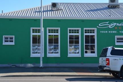

67 Franklin County Council Chambers (Former) Final, July


68 Franklin County Council Chambers (Former) Final, July


69 Franklin County Council Chambers (Former) Final, July
St. Patrick s Street Development Brief
 St. Patrick s Street Development Brief Bardas Chorcai Cork Corporation August 2001 Contents Introduction and background The Development Brief Area Protected and valuable buildings Urban context Objectives
 Page 1 Original Update HISTORICAL STRUCTURE FORM FLORIDA MASTER SITE FILE Consult Guide To Historical Structure Forms for detailed instructions Site # 8OR9844 Recorder # 26 Recorder Date 2/20/08 Site Name
September 13, Presented by: Jeremy Parsons PLANNING & ECONOMIC DEVELOPMENT DEPARTMENT
 Recommendation to Designate Property Located at 828 Sanatorium Road, Hamilton (Mountain Sanatorium Brow Campus) Under Part IV of the Ontario Heritage Act () September 13, 2018 Presented by: Jeremy Parsons
301 7½ Street SW
 301 7½ Street SW 104-0213-0072 Primary Resource Information: Single Dwelling, Stories 2.00, Style: Other, ca 1890 July 2006: This late-19th-century, 3-bay, 2-story, hip-roofed frame I-house features projecting
HISTORICAL AND SOCIAL SIGNIFICANCE PHOTOGRAPH: M.VAIR-PIOVA, 5/12/2014
 DISTRICT PLAN LISTED HERITAGE PLACE HERITAGE ASSESSMENT STATEMENT OF SIGNIFICANCE HERITAGE ITEM NUMBER 608 MILL ISLAND AND SETTING AVON RIVER BETWEEN HEREFORD-WORCESTER/71 HEREFORD STREET, 110 CAMBRIDGE
Perth and Kinross Council Development Control Committee 12 December 2012 Report of Handling by Development Quality Manager
 Perth and Kinross Council Development Control Committee 12 December 2012 Report of Handling by Development Quality Manager 4(3)(i) 12/570 Alterations and replacement windows at Milnathort Town Hall, 1
Friends Meeting House, Leicester. 16 Queens Road, Leicester, LE2 1WP. National Grid Reference: SK Statement of Significance
 Friends Meeting House, Leicester 16 Queens Road, Leicester, LE2 1WP National Grid Reference: SK 59852 02815 Statement of Significance A meeting house purpose-built on a new site in 1955 and slightly enlarged
Schedule of Planning Applications Committee Date: 23 May Reference: 06/18/0064/F Great Yarmouth Officer: Mr J Beck Expiry Date:
 Schedule of Planning Applications Committee Date: 23 May 2018 Reference: 06/18/0064/F Great Yarmouth Officer: Mr J Beck Expiry Date: 24-04-2018 Applicant: Proposal: Site: Mr Mavroudis Clear weather hoardings
East Melbourne Precinct HO2. March 2015
 East Melbourne Precinct HO2 March 2015 Local Heritage Planning Policy Review Statements of Significance Melbourne s Local Heritage Planning Policy Review project includes the preparation of statements
Penrith Heritage Inventory
 Address: 1348-1362 Castlereagh Road Suburb / Nearest Town: Castlereagh 2749 Local Govt Area: Penrith State: NSW DUAP Region: Sydney West Historic region: Sydney Parish: County: Cumberland Other/Former
PSP 75 Lancefield Road. Northern Jacksons Creek Crossing Supplementary Information
 PSP 75 Lancefield Road Northern Jacksons Creek Crossing Supplementary Information September 2017 The northern crossing of Jacksons Creek proposed within the Lancefield Road PSP is a key part of the ultimate
DESIGNATION REPORT KENNEDY-BAKER-WALKER-SHERRILL HOUSE (1849) 9320 KINGSTON PIKE (CLT ) KNOXVILLE, TENNESSEE July 12, 2007
 9320 KINGSTON PIKE (CLT ) KNOXVILLE, TENNESSEE July 12, 2007") DESIGNATION REPORT KENNEDY-BAKER-WALKER-SHERRILL HOUSE (1849) 9320 KINGSTON PIKE (CLT 132-027) KNOXVILLE, TENNESSEE July 12, 2007 Description The Kennedy-Baker-Walker-Sherrill House is located on the south
DESIGNATION REPORT KENNEDY-BAKER-WALKER-SHERRILL HOUSE (1849) 9320 KINGSTON PIKE (CLT 132-027) KNOXVILLE, TENNESSEE July 12, 2007 Description The Kennedy-Baker-Walker-Sherrill House is located on the south
Visual and Sensory Aspect
 Updated All Wales LANDMAP Statistics 2017 Visual and Sensory Aspect Final Report for Natural Resources Wales February 2018 Tel: 029 2043 7841 Email: sw@whiteconsultants.co.uk Web: www.whiteconsultants.co.uk
PENTLAND HOUSE, EDINBURGH QUALITY OFFICE INVESTMENT
 PENTLAND HOUSE, EDINBURGH QUALITY OFFICE INVESTMENT INVESTMENT SUMMARY Quality Office investment located in Scotland s Capital City Let to The Scottish Ministers with over 10 years unexpired Low passing
THE CORPORATION OF THE TOWN OF NIAGARA-ON-THE-LAKE. BY-LAW NO (214 Four Mile Creek Road)
") THE CORPORATION OF THE TOWN OF NIAGARA-ON-THE-LAKE BY-LAW NO. 4807-15 (214 Four Mile Creek Road) A BY-LAW TO DESIGNATE THE PROPERTY KNOWN MUNICIPALLY AS WOODBOURNE, 214 FOUR MILE CREEK ROAD, IN THE TOWN
THE CORPORATION OF THE TOWN OF NIAGARA-ON-THE-LAKE BY-LAW NO. 4807-15 (214 Four Mile Creek Road) A BY-LAW TO DESIGNATE THE PROPERTY KNOWN MUNICIPALLY AS WOODBOURNE, 214 FOUR MILE CREEK ROAD, IN THE TOWN
401, and 415 King Street West - Zoning Amendment Application - Preliminary Report
 STAFF REPORT ACTION REQUIRED 401, 407-409 and 415 King Street West - Zoning Amendment Application - Preliminary Report Date: January 27, 2011 To: From: Wards: Reference Number: Toronto and East York Community
A21 TONBRIDGE TO PEMBURY DUALLING. Statement of Case
 A21 TONBRIDGE TO PEMBURY DUALLING Statement of Case In Respect of Applications for the Demolition of Listed Buildings Under the Provisions of the Planning (Listed Buildings and Conservation Areas) Act
THE FORMER BRADBURY HALL, CHATSWORTH ROAD, CHESTERFIELD. GROUP LEADER, DEVELOPMENT MANAGEMENT
 AGENDA ITEM NO. 7 THE FORMER BRADBURY HALL, CHATSWORTH ROAD, CHESTERFIELD. MEETING: PLANNING COMMITTEE DATE: 17 TH MAY 2004 REPORT BY: WARD: COMMUNITY FORUM: GROUP LEADER, DEVELOPMENT MANAGEMENT HOLMEBROOK
HISTORICAL AND SOCIAL SIGNIFICANCE PHOTOGRAPH : SIMON DAISLEY, 2013
 DISTRICT PLAN LISTED HERITAGE PLACE HERITAGE ASSESSMENT STATEMENT OF SIGNIFICANCE HERITAGE ITEM NUMBER 701 AKAROA LIGHTHOUSE AND SETTING - BEACH ROAD, BETWEEN AYLMERS VALLEY-HEMPLEMAN, AKAROA PHOTOGRAPH
City of Kingston Report to Municipal Heritage Committee Report Number MHC
 To: From: Resource Staff: Date of Meeting: August 25, 2014 Subject: City of Kingston Report to Municipal Heritage Committee Report Number MHC-14-055 Chair and Members of Municipal Heritage Committee Lanie
Historical value The building was erected on a new site to serve a new meeting and in itself is of low historical value.
 Quaker Meeting House, Welwyn Garden City 109 Handside Lane, Welwyn Garden City, Hertfordshire, AL8 6SP National Grid Reference: TL 23149 12617 Statement of Significance As first built in 1926 to the designs
Section Three, Part 14 Signs
 PART 14 SIGNS SIGNS 14.1 INTRODUCTION This part of the District Plan sets out the requirements in respect of signs. These matters were formerly controlled by bylaws. 14.2 OVERVIEW Signs form an integral
ATTACHMENT 1 TO CLAUSE 2 ENVIRONMENT AND INFRASTRUCTURE COMMITTEE Attachment 1: Jubilee Clock Tower Heritage Assessment
 Attachment 1: Jubilee Clock Tower Heritage Assessment ATTACHMENT 1 TO CLAUSE 2 STATEMENT OF SIGNIFICANCE VICTORIA STREET CLOCK TOWER/JUBILEE CLOCK TOWER INTRODUCTION: The Victoria Clock Tower is of considerable
For Sale Retail Investment Portfolio. Aberdeen, Galashiels & Hawick
 For Sale Retail Investment Portfolio Aberdeen, Galashiels & Hawick Home Summary Tenancy Schedule Aberdeen Galashiels Hawick Covenant Strength Further Info Portfolio Summary 3 retail units all let to. Properties
Mixed use conversion and redevelopment opportunity
 Mixed use conversion and redevelopment opportunity STRATTON HOUSE C A M P U S High West Street, Dorchester, Dorset For sale THE OPPORTUNITY d Impressive historic buildings in a town centre location d Currently
HERITAGE PROPERTY RESEARCH AND EVALUATION REPORT
 ATTACHMENT NO. 4 HERITAGE PROPERTY RESEARCH AND EVALUATION REPORT WILLIAM LUKE BUILDINGS 774 YONGE STREET, TORONTO Prepared by: Heritage Preservation Services City Planning Division City of Toronto March
2433 Dufferin Street Zoning By-law Amendment Application - Preliminary Report
 STAFF REPORT ACTION REQUIRED 2433 Dufferin Street Zoning By-law Amendment Application - Preliminary Report Date: July 22, 2014 To: From: Wards: Reference Number: North York Community Council Director,
CHAPTER 6 NOISE EXPOSURE
 CHAPTER 6 NOISE EXPOSURE FAA requires that the NEM submitted for review represent the aircraft noise exposure for the year of submittal (in this case 2008) and for a future year (2013 for OSUA). However,
THE BARNACLE 3485 MAIN HIGHWAY
 THE BARNACLE 3485 MAIN HIGHWAY Designation Report City of Miami REPORT OF THE CITY OF MIAMI PLANNING AND ZONING DEPARTMENT TO THE HISTORIC AND ENVIRONMENTAL PRESERVATION BOARD ON THE POTENTIAL DESIGNATION
808 Cherry Avenue
 808 Cherry Avenue 104-0213-0059 Primary Resource Information: Single Dwelling, Stories 2.00, Style: Other, ca 1900 July 2006: This 2-story, 3-bay frame I-house features a central-front gable, a brick pier
29 Plas Derwen. Exploring Abergavenny
 29 Plas Derwen Exploring Abergavenny Cover: rhythm 2 plas derwen EXPLORING ABERGAVENNY For several years the Abergavenny and District Civic Society has been studying the streets, spaces and buildings of
HB/10/06/003 Camus House, 46 Lisky Rd, Strabane. Foyle Valley
 Asset Ref No. Heritage Type House, Gates, Outbuildings, Walling Including Around Flax Drying Green. Built Post-Medieval house Location OS 6-inch map sheet Townland Parish LCA Foyle Valley ITM Coordinates
Display of 1 no. internally illuminated advertisement hoarding
 Committee Date: 22/08/2013 Application Number: 2013/04695/PA Accepted: 01/07/2013 Application Type: Advertisement Target Date: 26/08/2013 Ward: Ladywood Summer Row, Birmingham, B3 1JU Display of 1 no.
FLAGLER WORKER S HOUSE FORT DALLAS PARK S.E. 4 STREET
 FLAGLER WORKER S HOUSE FORT DALLAS PARK 60-64 S.E. 4 STREET Designation Report City of Miami REPORT OF THE CITY OF MIAMI PLANNING DEPARTMENT TO THE HERITAGE CONSERVATION BOARD ON THE POTENTIAL DESIGNATION
Friends Meeting House, Hitchin. 1 Paynes Park, Hitchin, Hertfordshire, SG5 1EH. National Grid Reference: TL Statement of Significance
 Friends Meeting House, Hitchin 1 Paynes Park, Hitchin, Hertfordshire, SG5 1EH National Grid Reference: TL 18282 29279 Statement of Significance A meeting house of 1957 designed by Paul V. Mauger and erected
WHANGANUI DISTRICT HERITAGE INVENTORY
 WHANGANUI DISTRICT HERITAGE INVENTORY Register Item No: 314 Type: Building Site: Pre-1900 Archaeological Interest Name: GRAND HOTEL Location: 99 St Hill Street (cnr Guyton Street), Whanganui Legal Description:
Inclusion on the City of Toronto's Heritage Register Midtown in Focus Phase 1: Main Street Properties
 PG22.5 REPORT FOR ACTION Inclusion on the City of Toronto's Heritage Register Midtown in Focus Phase 1: Main Street Properties Date: August 10, 2017 To: Toronto Preservation Board Planning and Growth Management
Architectural Inventory Form
 OAHP1403 Rev. 9/98 COLORADO CULTURAL RESOURCE SURVEY Architectural Inventory Form Official eligibility determination (OAHP use only) Date Initials Determined Eligible- NR Determined Not Eligible- NR Determined
Doncaster Market Place Conservation Area
 Doncaster Market Place Conservation Area Review December 2014 www.doncaster.gov.uk/conservationareas Doncaster Market Place Conservation Area Review Since the appraisal undertaken in March 2007, the general
URBAN DESIGN REPORT. Proposed Residential Development, Old Church Road, Caledon East
 Proposed Residential Development, Old Church Road, Caledon East TABLE CONTENTS: 1.0 DEVELOPMENT 1.1 Introduction-Analysis of Guiding Principles and Documents 1.2 Community Design and Architectural Design
Claro Community Archaeology Group
 Site Record Form Item Number Claro Community Archaeology Group 60940161 Date Initials Inspected Access Visibility NGR Centre 434851 458431 NGR Linear Item Description HOUSE Site Data Roundell's Manor History
City of Surrey PLANNING & DEVELOPMENT REPORT File:
 City of Surrey PLANNING & DEVELOPMENT REPORT PROPOSAL: Planning Report Date: February 25, 2008 Development Permit Development Variance Permit in order to allow additional awnings and to allow the awnings
Friends Meeting House, Leek. Overton Bank, Leek, ST13 5ES. National Grid Reference: SJ Statement of Significance
 Friends Meeting House, Leek Overton Bank, Leek, ST13 5ES National Grid Reference: SJ 98200 56563 Statement of Significance The meeting house was purpose-built in 1697 and has high heritage value, as an
Change dormers and main entry on the river side of the house. Site: 43 Riverbank Road, Block 10 Lot 3
 City of Burlington Historic Preservation Commission Meeting Minutes: December 2, 2015 The City of Burlington Historic Preservation Commission held its regular monthly meeting on Wednesday, December 2,
Claro Community Archaeology Group
 Site Record Form Item Number Claro Community Archaeology Group 60940162 Date Initials Inspected Access Visibility NGR Centre 434513 458452 NGR Linear Item Description HALL HOUSE Site Data Old Hall Coach
Appendix E Historic Property Inventory Forms
 Appendix E Historic Property Inventory Forms TECHNICAL MEMORANDUM Sound Transit Federal Way Link Extension WISAARD Survey Entries PREPARED FOR: COPY TO: PREPARED BY: Sound Transit Alisa Swank/ CH2M MaryNell
(DEFINITIONS); FLAGS AND SIGNS:
; FLAGS AND SIGNS:") 153.002 (DEFINITIONS); FLAGS AND SIGNS: (adopted 07/12/16) Flag: A. Description: a piece of durable fabric of distinctive design attached to a permanent pole that is used as a symbol or decorative feature
153.002 (DEFINITIONS); FLAGS AND SIGNS: (adopted 07/12/16) Flag: A. Description: a piece of durable fabric of distinctive design attached to a permanent pole that is used as a symbol or decorative feature
ROUKEN GLEN: BANDSTAND 2015 DATA STRUCTURE REPORT
 ROUKEN GLEN: BANDSTAND 2015 DATA STRUCTURE REPORT Author (s) Ian Hill Editors Report Date June 2015 Working Partners Funders Phil Richardson East Renfrewshire Council East Renfrewshire Council, Heritage
Yew Tree Road, Chamberlain House, Moseley, Birmingham, B13 8QG. Listed Building Consent for various external and internal alterations.
 Committee Date: 19/09/2013 Application Number: 2013/06022/PA Accepted: 09/08/2013 Application Type: Listed Building Target Date: 04/10/2013 Ward: Moseley and Kings Heath Yew Tree Road, Chamberlain House,
A. CONCLUSIONS OF THE FGEIS
 Chapter 11: Traffic and Parking A. CONCLUSIONS OF THE FGEIS The FGEIS found that the Approved Plan will generate a substantial volume of vehicular and pedestrian activity, including an estimated 1,300
TOURISM & PUBLIC SERVICES RURAL SIGNAGE POLICY
 Policy and Procedures Subject Title: Tourism and Public Services Rural Signage Policy Corporate Policy (Approved by Council): X Policy Ref. No.: ROADS-01-07 Administrative Policy (Approved by CAO): By-Law
Friends Meeting House, Pickering. 19 Castlegate, Pickering, YO18 7AX. National Grid Reference: SE Statement of Significance
 Friends Meeting House, Pickering 19 Castlegate, Pickering, YO18 7AX National Grid Reference: SE 79795 84336 Statement of Significance The meeting house was built in 1793; the attached burial ground was
TORONTO TRANSIT COMMISSION REPORT NO. SUBJECT: TORONTO-YORK SPADINA SUBWAY EXTENSION STATION NAMES IN THE CITY OF VAUGHAN
 TORONTO TRANSIT COMMISSION REPORT NO. MEETING DATE: February 29, 2011 SUBJECT: TORONTO-YORK SPADINA SUBWAY EXTENSION STATION NAMES IN THE CITY OF VAUGHAN ACTION ITEM RECOMMENDATIONS It is recommended that
I508. Devonport Peninsula Precinct
 I508. Devonport Peninsula Precinct I508.1. Precinct description The purpose of the Devonport Peninsula precinct is to provide for the comprehensive residential development of the former Navy housing land
FILE NO. ANMICALGIC-1
 MUNICIPAL GOVERNMENT BOARD FILE NO. ANMICALGIC-1 IN TEE MATTER OF THE "Municipal Government Act" AND IN THE MATTER OF an application by the City of Calgary, in the Province of Alberta, to annex certain
North & West Melbourne Precinct HO3. March 2015
 North & West Melbourne Precinct HO3 March 2015 Local Heritage Planning Policy Review Statements of Significance Melbourne s Local Heritage Planning Policy Review project includes the preparation of statements
SUMMER VILLAGE OF SILVER SANDS. Municipal Development Plan
 SUMMER VILLAGE OF SILVER SANDS Municipal Development Plan Bylaw 253-2014 Adopted August 22, 2014 Summer Village of Silver Sands Municipal Development Plan Bylaw No. 253-2014 Page 2 1 INTRODUCTION 1.1 SETTING
HISTORIC SITE FORM HISTORIC SITES INVENTORY
 HISTORIC SITE FORM HISTORIC SITES INVENTORY 1 IDENTIFICATION Name of Property: House at 569 Park Avenue PARK CITY MUNICIPAL CORPORATION (10-08) Address: 569 Park Avenue City, County: Park City, Summit
Friends Meeting House, Warwick. 39 High Street, Warwick, CV34 4AX. National Grid Reference: SP Statement of Significance
 Friends Meeting House, Warwick 39 High Street, Warwick, CV34 4AX National Grid Reference: SP 28071 64737 Statement of Significance Warwick Meeting House has exceptional heritage significance as a fine
BOARD OF ADJUSTMENT AGENDA
 BOARD OF ADJUSTMENT AGENDA February 28, 2018 I. Call to Order II. III. Approval of Minutes Old Business: 1. Coleman Bass Construction (VAR17-0112) Variance* 1800 NW Mystic Avenue Interior Side Setback
RED HOUSE FARM NORTH NEWBALD, BEVERLEY, EAST YORKSHIRE
 RED HOUSE FARM NORTH NEWBALD, BEVERLEY, EAST YORKSHIRE Tel: 01653 697820 CHARTERED SURVEYORS AUCTIONEERS VALUERS LAND & ESTATE AGENTS FINE ART & FURNITURE RED HOUSE FARM NORTH NEWBALD BEVERLEY, EAST YORKSHIRE
01 INTRODUCTION. Student Learning Hub University of Bristol, Beacon House. Proposals for Beacon House. Have your say
 01 INTRODUCTION Proposals for Beacon House Welcome to this exhibition which shows proposals being brought forward by the University of Bristol to refurbish and improve Beacon House (former Habitat Building)
12, 14 and 16 York Street - Amendments to Section 16 Agreement and Road Closure Authorization
 REPORT FOR ACTION 12, 14 and 16 York Street - Amendments to Section 16 Agreement and Road Closure Authorization Date: April 27, 2018 To: Toronto and East York Community Council From: Senior Strategic Director,
I507 Devonport Naval Base Precinct
 I507. Devonport Naval Base I507.1. Precinct Description The Devonport Naval Base precinct covers most of the land held by the Crown for the HMNZ Naval Base (south yard) in Devonport. It incorporates the
DESIGN CONTROL GUIDELINES NORTHLAKE HOME LOTS
 www.northlake.co.nz DESIGN CONTROL GUIDELINES NORTHLAKE HOME LOTS NORTHLAKE PHILOSOPHY The stunning landscape of Northlake is deserving of protection, as is your investment in your Northlake property.
Seaforth Walking Tour
 Seaforth Walking Tour 1: Victoria Park The land for Victoria Park was donated to the Town by Dr. William Gouinlock in 1875, (one year after Seaforth was officially incorporated). The bandshell was constructed
ri. Name historic: Oak Cliff United Methodist Church Date 7/17/97 and! or common:
 [ Dallas Landmark Landmark Nomination Commission Form ri. Name historic: Oak Cliff United Methodist Church Date 7/17/97 and! or common: L2. Location addresses: 541-49 E. Jefferson location! neighborhood:
North Adelaide Community Centre
 Adelaide City Council Community Land Management Plan Tynte Street Library and North Adelaide Community Centre Adelaide City Council Community Land Management Plan Tynte Street Library and North Adelaide
STREET STATEMENT OF SIGNIFICANCE MARCH 2017
 1195 12 TH STREET STATEMENT OF SIGNIFICANCE MARCH 2017 HISTORIC CONTEXT The Rush House is located in the historic Ambleside neighbourhood of West Vancouver. Due to its position along the Burrard Inlet,
I I I I LINDEN TO WOOD FORD SURVEY ITEMS OF HISTORICAL SIGNIFICANCE I I I I I I I I I I I I I
 LNDEN TO WOOD FORD SURVEY TEMS OF HSTORCAL SGNFCANCE ------------------------------------------------------------------------------ --- - CONTENTS OF THE REPORT 1.0 ntroduction to the Report 1.1 Parameters
Portway Farm, Twyford
 Portway Farm, Twyford Buckinghamshire Archaeological Society HISTORIC BUILDING REPORT / April 2011 Including HS2 high-speed rail line Impact Assessment SURVEY AND REPORT: Sue Fox and John Brushe Report
WELCOME WELCOME TO OUR EXHIBITION ON THE FUTURE OF TOOTING HIGH STREET
 WELCOME Aerial view of the site and surrounding area WELCOME TO OUR EXHIBITION ON THE FUTURE OF 111-113 TOOTING HIGH STREET The existing building is underused and does not fulfil the potential of its location.
Town: Sharon Place (neighborhood or village): Sharon. ame of Area: Present Use: Date (month / year): July 2008
: Sharon. ame of Area: Present Use: Date (month / year): July 2008") FORM A - AREA MASSACHUSETTS HISTORICAL COMMISSION MASSACHUSETTS ARCHIVES BUILDING 220 MORRISSEY BOULEVARD BOSTON, MASSACHUSETTS 02125 Photograph Assessor s Sheets USGS Quad Area Letter Form Numbers in
FORM A - AREA MASSACHUSETTS HISTORICAL COMMISSION MASSACHUSETTS ARCHIVES BUILDING 220 MORRISSEY BOULEVARD BOSTON, MASSACHUSETTS 02125 Photograph Assessor s Sheets USGS Quad Area Letter Form Numbers in
Average annual compensation received by full-time spa employees.
 1 Introduction This report presents the findings from the employee compensation and benefits section of the 2017 U.S. Spa Industry Study. The study was commissioned by the International SPA Association
11 Majors Barn. 19 Mill Street Exploring Abergavenny
 11 Majors Barn 19 Mill Street Exploring Abergavenny Cover: Mill Street from Monmouth Road 2 mill street EXPLORING ABERGAVENNY For several years the Abergavenny and District Civic Society has been studying
FOR SALE. Zeus Packaging, Central Park, Mallusk, Newtownabbey, BT36 4FS. Investment Opportunity - Modern, Fully Let Industrial Facility
 FOR SALE Zeus Packaging, Central Park, Mallusk, Newtownabbey, BT36 4FS Investment Opportunity - Modern, Fully Let Industrial Facility Features Modern single let industrial investment property Located within
L 2-1. Heritage Report: Reasons for Heritage Designation. Wilkinson / Lundy Farmhouse 715 Queen Street West
 L 2-1 Heritage Report: Reasons for Heritage Designation Brampton Heritage Board Date: January 15, 2013 Wilkinson / Lundy Farmhouse 715 Queen Street West January 2013 1 L 2-2 Profile of Subject Property
A meeting house built on a new site in 1961 to the design of Joseph Konrad. The building is of low heritage significance.
 Friends Meeting House, Beverley Quaker Lane, (off Woodlands), Beverley, HU17 8BY National Grid Reference: TA 02930 39656 Statement of Significance A meeting house built on a new site in 1961 to the design
Lagnagiogan Isle of Iona, Argyll & Bute, PA76 6SP. bellingram.co.uk
 Lagnagiogan Isle of Iona, Argyll & Bute, PA76 6SP bellingram.co.uk An exceptionally rare opportunity to purchase a property on the idyllic Isle of Iona Detached, 1½ storey former croft house 2 reception
Supporting information to an application for preapplication 3 rd February 2017
 Development Services, West Lindsey District Council, Guildhall, Marshall s Yard, Gainsborough DN21 2NA Supporting information to an application for preapplication advice. 3 rd February 2017 Proposal for
Spadina Avenue Built Form Study Preliminary Report
 STAFF REPORT ACTION REQUIRED Spadina Avenue Built Form Study Preliminary Report Date: July 9, 2014 To: From: Wards: Reference Number: Toronto and East York Community Council Director, Community Planning,
377 Spadina Rd & 17 Montclair Ave Zoning Amendment Application Final Report
 STAFF REPORT ACTION REQUIRED 377 Spadina Rd & 17 Montclair Ave Zoning Amendment Application Final Report Date: September 14, 2016 To: From: Wards: Reference Number: Toronto and East York Community Council
Felden Orchard I Bulstrode Lane I Felden. aitchisons.co.uk TOWN & COUNTRY
 Felden Orchard I Bulstrode Lane I Felden aitchisons.co.uk TOWN & COUNTRY Felden Orchard I Bulstrode Lane I Felden HP3 0BP A Home with Immense Character Felden is a delightful hamlet surrounded by rolling
1 INFORMATION REQUIREMENTS
 1 INFORMATION REQUIREMENTS 1.1 BACKGROUND 2 1.2 WHAT IS THE DISTRICT PLAN 3 1.3 DISTRICT PLAN STRUCTURE 4 1.4 HOW TO USE THE DISTRICT PLAN 5 1.5 STRATEGIC FRAMEWORK 6 Whanganui District Plan (15 January
Scala House, 36 Holloway Circus, Queensway, Birmingham, B1 1EQ
 Committee Date: 31/10/2013 Application Number: 2013/06196/PA Accepted: 15/08/2013 Application Type: Full Planning Target Date: 14/11/2013 Ward: Nechells Scala House, 36 Holloway Circus, Queensway, Birmingham,
Council Policy Tourist Oriented Destination Signs
 POLICY 373 APPROVED @ City of Kelowna 1435 Water Street Kelowna, BC V1Y 1J4 250 469-8500 kelowna.ca Council Policy Tourist Oriented Destination Signs Contact Department: Civic Operations Traffic Operations
Welcome to our exhibition
 Welcome to our exhibition We are bringing forward a new, employment-led scheme for the Vauxhall Cross Island site in the heart of Vauxhall. We are keen to hear local views on our proposals ahead of submitting
HOUSEHOLD TRAVEL SURVEY
 HOUSEHOLD TRAVEL SURVEY Household Travel Survey i TABLE OF CONTENTS Page 1.0 INTRODUCTION... 1 2.0 SUMMARY OF TRAVEL... 2 2.1 All-Day Travel Patterns... 2 2.1.1 Automobile Availability... 2 2.1.2 Trip
Inclusion on the City of Toronto Inventory of Heritage Properties 27 Front Street East (St. Lawrence Centre)
") STAFF REPORT ACTION REQUIRED Inclusion on the City of Toronto Inventory of Heritage Properties 27 Front Street East (St. Lawrence Centre) Date: December 20, 2012 To: From: Toronto Preservation Board Toronto
STAFF REPORT ACTION REQUIRED Inclusion on the City of Toronto Inventory of Heritage Properties 27 Front Street East (St. Lawrence Centre) Date: December 20, 2012 To: From: Toronto Preservation Board Toronto
C E N T R A L T A U R A N G A H E R I T A G E S T U D Y P A R T T W O
 C E N T R A L T A U R A N G A H E R I T A G E S T U D Y P A R T T W O I N V E N T O R Y A N D R E C O R D F O R M S P R E P A R E D F O R T A U R A N G A C I T Y C O U N C I L E N V I R O N M E N T B A
HISTORY IN THE MAKING. The UK s most important city centre development outside London. Being delivered by:
 UPDATE JANUARY 2016 HISTORY IN THE MAKING The UK s most important city centre development outside London. Being delivered by: THE HEART OF THE CITY St Philip s Square Birmingham Museum & Art Gallery A
PLANNING STATEMENT FORMER HSBC BANK, 18 HIGH STREET, AMESBURY
 PLANNING STATEMENT FORMER HSBC BANK, 18 HIGH STREET, AMESBURY 21 Dec 17 Introduction Amesbury has a vibrant nightlife with three public houses, two hotel bars and a nightclub within the town centre as
SLIDING WINDOW & DOOR LOCK
 AUSTRALIA Patents Act 1990 COMPLETE SPECIFICATIONS INNOVATION PATENT SLIDING WINDOW & DOOR LOCK INVENTOR: MR GHASSAN HADDAD G.J.N.R. HOLDINGS PTY LTD (ACN 135 397 312) 1 SLIDING WINDOW LOCK Inventor: Mr
Village of Skokie Downtown Area Sign Guidelines. for CX Core Mixed Use Zoning District
 Village of Skokie Downtown Area Sign Guidelines for CX Core Mixed Use Zoning District January 2011 (c) 2011 Published by the Village of Skokie, 5127 W. Oakton Street, Skokie, Illinois 60077 Signs are important
Local Government Boundary Commission for Scotland Fifth Review of Electoral Arrangements Consultation on Ward Boundaries
 Item 3 To: Council On: 30 April 2015 Report by: Director of Finance & Resources Heading: Local Government Boundary Commission for Scotland Fifth Review of Electoral Arrangements Consultation on Ward Boundaries
RESEARCH AND EVALUATION SUMMARY: 297 AND 299 SHERBOURNE STREET
 ATTACHMENT NO. 6 RESEARCH AND EVALUATION SUMMARY: 297 AND 299 SHERBOURNE STREET William Elliott Houses: principal (west) elevations (Heritage Preservation Services, 2016) HISTORICAL CHRONOLOGY Key Date
RAY YENKANA Willowbrook Cr, Dawson Creek BC Canada $2,847,000
 1716 Willowbrook Cr, Dawson Creek BC Canada For SALE $2,847,000 This is a rare find, 32 townhomes in Dawson Creek, BC. Excellent investment in a single title multi family complex. Vendor has upgraded this
DRAFT MADE AVAILABLE FOR PUBLIC COMMENT HERITAGE STATEMENT PROVIDED IN RESPECT OF AN APPLICATION IN TERMS OF SECTION 34(1)
") DRAFT MADE AVAILABLE FOR PUBLIC COMMENT HERITAGE STATEMENT PROVIDED IN RESPECT OF AN APPLICATION IN TERMS OF SECTION 34(1) - 146 Kloof Road, Bantry Bay, Cape Town (Erven 117RE & 619, Bantry Bay) PREPARED
DRAFT MADE AVAILABLE FOR PUBLIC COMMENT HERITAGE STATEMENT PROVIDED IN RESPECT OF AN APPLICATION IN TERMS OF SECTION 34(1) - 146 Kloof Road, Bantry Bay, Cape Town (Erven 117RE & 619, Bantry Bay) PREPARED
National Register of Historic Places Inventory Nomination Form
 NPS Form 10-900-a Exp. 10-31-84 Continuation sheet 4 5 item number 7 Page 45 NAME: Knight Estate LOCATION: 486 East Avenue,,--v..u^-^ OWNER: State of Rhode Island Department of Education Board of Regents
Kent Pedestrian Guard Railing Assessment
 Kent Pedestrian Guard Railing Assessment Canterbury Final Report for JTB March 2012 Project Number B1649000 Jacobs Eng UK Ltd, Miller House, Lower Stone Street, Maidstone, Kent ME15 6GB Document control