WHAT WE KNEW: DATA AND OBSERVATION PAPERS
|
|
|
- Milton Mills
- 5 years ago
- Views:
Transcription

1 WHAT WE KNEW: DATA AND OBSERVATION PAPERS 231/786
2 Market District in Context What Might Change The City has changed considerably over the past 15 to 20 years and is expected to continue changing over the next 25 years. The diagram below summarises changes that have occurred since 1996/97 and how the City might look in ADDITIONAL FROM 2040 Additional residents for the city, 27,000 Additional workers for the city, 50,000 Construction of new dwellings, 15,040 Adelaide City in 1996/97 Adelaide City in 2014 Adelaide City in 2040 Resident population of around 15,300 (ABS 1996) 89,276 City workers (ACCLUE 1997) The City economy was valued at about $9.6 billion dollars or 15.8% of the State s economy South Australia hosted 6,397 International students Estimated resident population of 22,200 (ERP, June 2013) Estimated daily visitor population in excess of 228,000, around 118,200 of those people are in the City each day for work Around 4,900 businesses are located in Adelaide City (ACCLUE 2011) The City economy is valued at $15.5 billion dollars or just over 17% of SA s economy More than 26,000 international students studying in SA (5.1% of the national share) $593.5 million of development approved in the City in 2012/13, having recovered from a significant slump post GFC Estimated resident population of 48,000 Around 168,000 people are in the City each day for work Park Lands Trail completed Tram line extended to Semaphore, enhancing public transport access to the City and a tram loop connects Districts within the City Greater share of international students The City economy has further increased in value and as a percentage of the State s economy
3 Market District in Context Population The City s residential population is culturally diverse. For the City as a whole between 2006 and 2011, the number of people who spoke a language (other than English) at home, increased by 58%. In 2011, the three largest non-english language groups spoken at home were: Mandarin 1990 people, an 82% increase from 2006 Cantonese 661 people, a 47% increase from 2006 Arabic 316 people, almost a 400% increase from 2006 Projected dwellings by types Other High density Medium density Separate house in 5 Australians experience disability, such as vision impairment, mobility limitations, stroke, autism and hearing impairment Projected household composition type 20,000 15,000 10,000 There are around 720 residents in the Market District. Residents are predominantly yo and 30% were born in Australia. People born in China, Malaysia and Korea comprise 30% 5,000 0 Couples with children Couples without children One parent families Other families Group household Lone person Other not classifiable household DAILY VISITOR POPULATION 228,673 International student projections 60,000 50,000 40,000 30,000 Shopping 33% 20,000 Working 23% 10,000 Meeting friends 13% Studying 6% Low growth Medium growth 2020 High growth International residents projections 5,000 4,000 3,000 2,000 1, China United Kingdom Malaysia India South Korea
 Adelaide City 8M visitors each year into the Adelaide Central Markets 1,602,871 Retail, accommodation and food services comprise 68%")
4 Market District in Context Population The Adelaide Central Market, Coles Supermarket, U-Park and adjacent Chinatown/Plaza/Arcade form the retail and economic spine of the Market District Tourism visitation to Adelaide Metro and Adelaide City (2012/13) Adelaide City 8M visitors each year into the Adelaide Central Markets 1,602,871 Retail, accommodation and food services comprise 68% of business and 37% of employees in the District WORKERS TARGET FOR ADELAIDE CBD 6,652,000 Adelaide Metro Employment by Industry Forecasts (top 5 industries) 60, ,000 50, , ,000 30, ,000 10, Financial, Prof. & Admin. OFFICE SPACE PROJECTION FOR ADELAIDE CBD 2010 NR A H a nd M e d ical Pre Public Admin & Safety Health & Social Assis Accomm. & Food cinct SQM 1,300, C C SQM 2,050,000 C Office Growth Employment Density High Low Enterprise Adelaide C Coworking centres 2011 Land Use Survey 234/786
5 Market District in Context Moving COMPARATIVE AVERAGE DAILY PARKING FEE FOR OFF-SREET PARKING Number of cyclists to and from the City through the parklands (7am to 7pm) 12,000 10,000 8,000 6,000 4,000 MELBOURNE $66 SYDNEY $64 BRISBANE $39 2, PERTH ADELAIDE $31 $23 Mode split for day trips in and around the City PUBLIC TRANSPORT 42% increase in daily trips by 2038 ADELAIDE PERTH MELBOURNE 34% 37% 46% Current (2011) mode split No Smart move: 2038 mode split 35% additional road space required Smart move: 2038 mode split 0% additional road space required SYDNEY 57% PUBLIC CAR PARK SPACES COMPARISON 42,700 ADELAIDE ,500 MELBOURNE ,690 PERTH ,000 SYDNEY 2008
6 Market District in Context Moving Pedestrians Daytime % 2,440 +5% 2002 and 2011 decrease 2011 additional streets studied 2002 and 2011 increase 3, % 16, % 14, % Priority north-south active links, including for cycling (Source SmartMove) 8, % 18, % 16, % 6,970-20% 6,400-23% 5, % 3,210 Pedestrians Evening 3, % 2,710-37% 1, % 3, % 1, % 2, % 1, % % % 2, % 2, % 2011 additional streets studied 710 BA BA BA BA Park Lands Trail Possible Bikeways route Possible alternative Bikeways route Adelaide Free Bikes Bike Art Trail
 Commercial Car Parks > 350 spaces each (approx) < 20k Traffic")

 Neighbourhood (31 300 buses/day) (II) Regional (501 1000 buses/day) Key inner suburb bus corridors BL Bus")
7 Market District in Context Moving k < 20k < 20k < 20k 20 30k 30 40k 20 30k < 20k < 20k < 20k < 20k High parking demand 20 30k Medium parking demand < 20k < 20k Low parking demand Significant City Places (based on 30 year future place designations) Commercial Car Parks > 350 spaces each (approx) < 20k Traffic volumes (DPTI 2009/10; SCATS 2011) Non-ancillary car parks not allowed (Core Pedestrian Area) NRAH BL B Bus Stops Existing train Proposed underground train Existing station Proposed underground station Existing tram and stops Preferred tram loop and stops Proposed mass transit route Proposed O-Bahn upgrade B Intra/interstate bus Existing streets with bus priority measures BUS HIERARCHY: (III) District ( buses/day) (I) Metropolitan ( buses/day) Proposed streets with bus priority measures (IV) Neighbourhood ( buses/day) (II) Regional ( buses/day) Key inner suburb bus corridors BL Bus Layover Connector (Jan 2014)

8 WEST TCE Market District in Context Development Recent Development Map Adelaide City Adelaide Oval redevelopment New Royal Adelaide Hospital University of South Australia West Campus expansion Convention Centre expansion Riverbank precint upgrade Rundle Mall redevelopment Victoria Square redevelopment Victoria Park redevelopment The Market District as part of the western part of the CBD is envisaged for future City growth. It will undergo change with numerous medium to high level buildings. The image provides an indicationof how the District might change over the next 30 years. 196 North Tce NORTH TCE 30 Victoria St 14 Dwellings 227 North Tce 300 beds 12 Bank St 39 Dwellings HINDLEY ST 304 Waymouth St 222 beds Light Square 503 beds 65 King William St 129 Dwellings 160 Rundle Mall 98 Dwellings Hindmarsh Square CURRIE ST KING WILLIAM ST 210 Grote St WAYMOUTH ST 403 beds 47 Gouger St 143 West Tce 25 beds 14 beds 130A Wright St 24 Dwellings Victoria Square MORPHETT ST FRANKLIN ST GROTE ST VICTORIA SQ Whitmore Square Hurtle Square GOUGER ST Compiled from the 2011 Land Use Survey using the Student Accommodation & Student Apartment categories WRIGHT ST High level and consistent historic character (>80%) High level historic character (60-79%) Mixed historic character (40-59%) Interspersed heritage character (<39%) Local Heritage Place State Heritage Place The Market District has heritage buildings, as well as streets with historic character.

, SOUNDWAVE FESTIVAL (OVER 40,000 ATTENDEES) AND THE AUSTRALIA DAY CONCERT (OVER 30,000 ATTENDEES).")

9 Market District in Context Social and Cultural Central Markets established 1971 Aboriginal Flag flown for first time in Australia in Victoria Square. Fast Facts 1 Convention Centre 1. THE CITY HOSTS MANY 2 Adelaide Casino 3 Dunstan Playhouse 4 Migration Museum EVENTS EACH YEAR, MOST NOTABLY THE FRINGE FESTIVAL, WHICH ATTRACTED OVER 1.8 MILLION PEOPLE INTO THE CITY IN OTHER NOTABLE EVENTS HELD IN THE CITY INCLUDE CLIPSAL 500 (OVER 250,000 ATTENDEES), SOUNDWAVE FESTIVAL (OVER 40,000 ATTENDEES) AND THE AUSTRALIA DAY CONCERT (OVER 30,000 ATTENDEES). 6 SA Museum Samstag Art Museum Nexus Multicultural Arts Centre 6 9 Adelaide College of Arts SINCE REDEVELOPMENT, EVENTS AT THE ADELAIDE OVAL HAVE ATTRACTED OVER 1 MILLION PEOPLE, INCLUDING 40,000 TO 50,000 PEOPLE ATTENDING AFL GAMES EACH WEEK. 5 Art Gallery Arts SA Hindley Street Queens Theatre 3 Ri Aus 4 Ayers House Museum 5 Tandanya 6 Her Majesty s 1 Leigh Street Central Market & Gouger Street The districts are located in proximity to a number of iconic South Australian cultural institutions, in particular along North Terrace. The districts themselves have a range of notable cultural facilities in the north and east % TO 85% OF CITY RESIDENTS FEEL SAFE IN THEIR NEIGHBOURHOOD OR COMMUNITY (DCSI, 2013) 239/786 2 Peel Street Adelaide Town Hall 1 Tampawardli Event Space 2 Light Square/Wauwi Event Sapce 3 Victoria Square/ Tarntanyangga Event Space 4 Elder Park
 50 Rundle St U-Park 2008-09")
10 Market District in Context Environmental LARGE PV INSTALLATIONS TO DATE IN THE ADELAIDE CITY ACC Residential Electricity Consumption and SA Electricity Generation from PV 60, COUNCIL BOUNDARY , KW Capacity 40,000 Adelaide Central Bus Station 50 Central Market ACC Residential Electricity Consumption (MWh) 50 Rundle St U-Park SA Electricity Generation from Rooftop PV (Gwh) Adelaide Railway Station 21.6 State Library 20 Art Gallery 20 Parliament House 20 SA Museum 20 ACC Community Electricity Consumption TOTAL Industrial 1% Residential 7% Commercial 92% 30ºC Night Time Day Time Thermal Image of Three Districts 240/786 20ºC 10ºC 0


11 3 City Districts Trends and Current Thinking
12 2014 The City of Adelaide Three Districts 2014 Evidence Base Contents Acknowledgement to Country...2 Introduction...4 Spatial Vision for the Future of the City...7 Residents and Students...9 Houses and Apartments...11 Community Facilities...12 Acknowledgement to Country Adelaide City Council acknowledges the traditional Country of the Kaurna People of the Adelaide Plains and pays respect to Elders past and present. We recognise and respect their cultural heritage, beliefs and relationship with the land. We acknowledge that they are of continuing importance to the Kaurna People living today. What you said before...13 Park Lands, Squares and Footpaths...14 Places...15 History, Heritage and Character...16 Capacity for Future Growth...18 What Craig Allchin thought...20 Working, Education and Retail...22 Information Communication...24 Culture, Night Time Entertainment and Events...24 Pedestrians and Cyclists...27 Public Transport...28 What Jan Gehl thought...30 Traffic and Parking...32 Energy, Water, Waste, Biodiversity and Climate Change


13 2014 The City of Adelaide Three Districts 2014 Evidence Base Introduction Welcome to the 3 City Districts Trends and Current Thinking Paper is a very significant date in the history of the City of Adelaide, in which we will celebrate 200 years of local governance. As we move toward 2040, it is timely to consider the long-term future of the City of Adelaide. Gathering, synthesising and confirming the views of our community and City stakeholders is occuring as part of Council s placemaking approach to improving the City. This Background Paper is intended to inform further public conversation about the future of the western part of the Adelaide CBD. It takes a long-term view of the future and opportunities. The result will be the development of District Plans for the Market, Mid West and New West Districts that are endorsed by Council, community and stakeholders. This Paper builds on the work we are doing for several related planning projects Adelaide 2040, the Adelaide Park Lands Strategy and the Adelaide City Planning Strategy. You can find more information about these evidencebased projects on the Picture Adelaide 2040 website. In 2011, we started to talk about ideas for the future through our Picture Adelaide 2011 campaign, Council s largest and most successful engagement activity to date. We asked you what you loved about Adelaide, what you wanted to improve, and what new things you wanted to see happening in the City. The response was overwhelming. You, the people of Adelaide, provided nearly 3000 ideas, sharing with us your inspiration and direction for the City s future. From those ideas Council devised One City, Many Futures - a strategy envisaging a future Adelaide as a city with a connected business scene, a strong community, and an exciting creative industry. Your ideas and feedback, together with the broader context provided by other plans for South Australia and the National Urban Policy, were incorporated into a new City vision. This vision Adelaide: One City, Many Places is core to the City of Adelaide Strategic Plan and other major planning projects such as the City of Adelaide s Smart Move Transport and Movement Strategy Picture Adelaide 2040 is a continuation of that greater conversation about the future of the City, ultimately realising the long term vision of Adelaide: One City, Many Places. This Paper describes the current situation in the western part of the Adelaide CBD with some facts and figures, and key policy directions at all levels of government, as well as some projections where feasible. These chapters are intended to prompt thinking and debate around the future of our City. We hope you find the material in this Background Paper informative, challenging and inspiring, but also as a starting point for you to help us imagine the future. The data is the best available at March It is not intended as a complete set of all the data that the Adelaide City Council has on the City of Adelaide past, present and future. For further statistical information about the City of Adelaide, please visit the research page on the Adelaide City Council s website adelaidecitycouncil.com/city-living/ welcome-to-adelaide/city-facts-andfigures. The statistics and trends are focused on the area of the combined three districts, but we have included statistics and trends that help to tell the story of the three districts in a wider context. For instance:»» between 1996 and 2011, the City s contribution to the State economy increased from 15.8% to 17%»» between 2001 and 2011, the City s resident population grew from 14,951 to 21,590»» between 2004 and 2012, student enrolments grew from 59,000 to 86,700 When considering the districts right now, there are many elements that need to be considered. The districts are very much about people: where they work, study, live, play, how they move, what energy they use, and what carbon they produce. Council s Placemaking Strategy provides the overarching framework to support the creation of One City, Many Places. The first stage of this strategy identifies the placemaking outcomes that will be achieved for the City and the centrepiece initiatives that will be progressed over the next two years. Council s Placemaking Strategy has commenced with Place Pilots to be implemented at Melbourne Street, Topham/Bentham/Pitt and Hindley Street (west). This Evidence Base complements data collation for the Place Pilots of Topham/Bentham/Pitt and also Hindley Street (west). Outcome 1 of the City of Adelaide Strategic Plan One City, Many Places, is making a City of Great Places: A City of outstanding buildings and places designed for people and the environment. District Planning and Placemaking are being undertaken to align with this Outcome. Districts New West Mid West Market Place Plots Hindley Street Melbourne Street Topham/Bentham/Pitt 4 5

14 2014 The City of Adelaide Three Districts 2014 Evidence Base Spatial Vision for the Future of the City In 2013, Council adopted a Spatial Vision for the Future of the City. This was endorsed by the Minister for Planning in late The Spatial Vision is an integrated plan of the major land use, built form and transport envisaged futures for the City. It is a 10 year vision within a 30 year context. The Spatial Vision was prepared based on policy already adopted:»» Adelaide City policies of the 30 Year Plan for Greater Adelaide (2010)»» Envisaged futures for areas in the Development Plan, as envisaged in the Capital City and Residential and Main Street Development Plan Amendments»» The Adelaide Park Lands Management Strategy (endorsed 2010) and Park Lands Landscape Master Plan (endorsed 2011)»» Smart Move Transport and Movement Strategy Planning and creating the Districts desired future needs to have regard to the envisaged land use, built form and transport future provided in the Spatial Vision. 30 Year Plan for Greater Adelaide Spatial Vision for the future of the City Integrated Transport and Land Use Plan (draft 2013) SmartMove Development Plan 6 7

 AREA (MAIN STREETS) CENTRAL ACTIVITY AREA (EAST + WEST) CENTRAL CENTRAL ACTIVITY ACTIVITY AREA (EAST + AREAWEST) (EAST + WEST) INSTITUTIONAL")
15 CORRIDOR (MIXED INFILL) COMMERCIAL INFILL RESIDENTIAL INFILL 2014 The City of Adelaide Three Districts 2014 Evidence Base HISTORIC CONSERVATION PARK LANDS AREAS OPEN WOODLAND/SPORTS ADELAIDE: CITY, MANY PLACES ADELAIDE: ONEONE CITY, MANY PLACES ADELAIDE: ONE CITY, MANY PLACES the future the City SpatialSpatial visionvision for thefor future of theof City Spatial vision for the future of the City Residents and Students URBAN AREAS URBAN AREAS URBAN AREAS CENTRAL ACTIVITY AREA (CORE) CENTRAL CENTRAL ACTIVITY ACTIVITY AREA (CORE) AREA (CORE) CENTRAL ACTIVITY AREA (MAIN STREETS) CENTRAL CENTRAL ACTIVITY ACTIVITY AREA (MAIN STREETS) AREA (MAIN STREETS) CENTRAL ACTIVITY AREA (EAST + WEST) CENTRAL CENTRAL ACTIVITY ACTIVITY AREA (EAST + AREAWEST) (EAST + WEST) INSTITUTIONAL INSTITUTIONAL INSTITUTIONAL ACTIVITY CENTRE ACTIVITY ACTIVITY CENTRE CENTRE CORRIDOR (MIXED INFILL) CORRIDOR (MIXED INFILL) CORRIDOR (MIXED INFILL) COMMERCIAL INFILL COMMERCIAL INFILL INFILL COMMERCIAL RESIDENTIAL INFILL RESIDENTIAL INFILL INFILL RESIDENTIAL HISTORIC CONSERVATION HISTORICHISTORIC CONSERVATION CONSERVATION REGIONAL REGIONALREGIONAL DISTRICT DISTRICT DISTRICT NEIGHBOURHOOD NEIGHBOURHOOD NEIGHBOURHOOD LOCAL LOCAL LOCAL The districts do not neatly fit demographic areas. Nonetheless, applying the CAD West demographic area to the districts (see map opposite), the combined districts have around 4500 residents in 2013, and are forecast LINKS to grow to around 10,000 residents by The age distribution of the combined districts in 2011 is dominated by year olds, and this age group is forecast to increase in predominance. These trends are consistent with wider City trends of a growing resident population that is increasingly younger and in small sized households. International students continue to be a large segment within the City s resident population. City renters have grown from 51% to 55% of the resident population in the last 10 years. PRIORITY PUBLIC PRIORITYPRIORITY PUBLIC PUBLIC TRANSPORT CORRIDORS TRANSPORT CORRIDORS TRANSPORT CORRIDORS PARK LANDS PATHS PARK LANDS PATHS PARK LANDS PATHS PARK LANDS TRAIL PARK LANDS TRAIL PARK LANDS TRAIL BIKEWAYS ROUTE BIKEWAYSBIKEWAYS ROUTE ROUTE Three Districts overlain on Spatial Vision Map Given the young and culturally diverse profile of residents/students in the districts, these trends could be expected to continue. METROPOLITAN PRIO TRA REGIONAL PAR PAR DISTRICT BIKE NEIGHBOURHOOD LOCAL For the City, between 2009 and 2012, total student enrolments reduced from around 91,000 to 87,000. International student enrolments reduced consistent with national trends. Student numbers are expected to increase in 2014, with enrolments in the higher education sector up overall and public and private schools at capacity. MORE INFORMATION Spatial Vision for the Future of the City adelaidecitycouncil.com CIVIC, CULTURAL AND URBAN PARKS URBAN GARDENS PARK LANDS AREAS PARK LANDS PARKAREAS LANDS AREAS OPEN WOODLAND/SPORTS OPEN WOODLAND/SPORTS OPEN WOODLAND/SPORTS STRUCTURED PARKLAND/SPORTS STRUCTURED PARKLAND/SPORTS STRUCTURED PARKLAND/SPORTS CIVIC, CULTURAL AND URBAN PARKS CIVIC, CULTURAL AND URBAN CIVIC, CULTURAL ANDPARKS URBAN PARKS URBAN GARDENS URBAN GARDENS URBAN GARDENS LINKS LINKS LINKS METROPOLITAN METROPOLITAN METROPOLITAN STRUCTURED PARKLAND/SPORTS The City s residential population is culturally diverse. For the City as a whole between 2006 and 2011, the number of people who spoke a language (other than English) at home, increased by 58%. In 2011, the three largest non-english language groups spoken at home were: m m 1000m New + Old buildings with people»» Mandarin 1990 people, an 82% increase from 2006»» Cantonese 661 people, a 47% increase from 2006»» Arabic 316 people, almost a 400% increase from / m

 50-54 Group households Lone")
 MORE INFORMATION Population Forecasts, City Facts and Figures, adelaidecitycouncil.")
16 Forecast population, households and average household size 10, Houses and Apartments Forecast population / households 8,000 6,000 4,000 2,000 0 Total population Households Average household size Forecast age structure 5 year age groups Number of persons Forecast household types Number of households 2,500 2, Couple families with dependents Couples without dependents Age group (years) Group households Lone person households Household type One parent family Other families and over Average household size (persons) MORE INFORMATION Population Forecasts, City Facts and Figures, adelaidecitycouncil.com For the CAD West Area, the number of households is forecast to grow from 1,254 in 2011 to 4,317 in 2036, an increase of 3,063. Extrapolating this for the three districts, households are estimated to grow from around 1,500 in 2011 to 5,000 in Paralleling the trend for growth in residents, the forecast is for most growth in lone person households as well as couples without dependents, which typically reside in smaller sized dwellings. Group households are forecast to grow, probably due to the anticipated larger numbers of year old residents. A group household consists of two or more unrelated people where all persons are aged 15 years and over. Group households are generally transient in nature, with their formation often associated with a period of transition for young adults from living with parents to forming their own partnership. Whilst there has been a plateauing in growth in student enrolments in last few years, the long term growth is also in more students living in the City. Between 2006 and 2011, international students living in the City increased 72% from 2,194 to 3,770. Students live in both custom designed student housing as well as other housing forms. In 2011, the three districts have just over 1400 student beds in custom designed student housing, as well as a number of dedicated housing complexes. The three districts mirror the City s wide housing trends of mixed housing stock, with young people and students being the main drivers of demand for apartments. 143 West Tce 25 beds 304 Waymouth St 222 beds 210 Grote St 403 beds Light Square 30 Victoria St 300 beds 130A Wright St 24 Dwellings 12 Bank St 503 beds 65 King William St 129 Dwellings 47 Gouger St 14 beds Victoria Square Three Districts MORE INFORMATION Population Forecasts, City Facts and Figures, adelaidecitycouncil.com CAD West used by id consulting 196 North Tce 14 Dwellings 160 Rundle Mall 98 Dwellings Hindmarsh Square Compiled from the 2011 Land Use Survey using the Student Accommodation & Student Apartment categories 227 North Tce 39 Dwellings 10 11


17 2014 The City of Adelaide Information to plan for 2040 Community Facilities What you said before The three districts are serviced by the wide range of community facilities on offer in the wider City, including health and education that service the wider SA community. During mid-2011, Council undertook an extensive community consultation known as Picture Adelaide people participated, contributing 3000 ideas about what they loved, or wanted to see improved or created in the City. The map above illustrates the core community services in and near to the districts that are often considered necessary for a sustainable community. In comparison to longer term established residential areas, the districts themselves are characterised 1 1 by few services (e.g. no local doctor). This underscores that parallel with increasing population will bring both opportunities for market lead services as well as for the public sector to review provision. 5 4 W 6 W W 4 W P 2 Public and private schools in the City are at capacity. The need for additional public secondary school services in the City has been identified by Council and the State Government These ideas were broken down into six main themes which formed the basis to create draft city visions and strategic planning documents. In late 2011, stage 2 of the consultation was undertaken, known as One City Many Futures submissions were made by the community relating to the draft city visions and strategy documents. Here are a range of comments made by the participants: MORE INFORMATION pictureadelaide.com.au I wish there was less traffic congestion in the city. Going home by bus can take up to 48 minutes with most of that being lost time getting out of the city Anonymous via Make our streets more people friendly Anonymous via Imagine the squares closed off to all traffic, with cafés, fountains, street entertainment and events Anonymous via More public art and street trees Anonymous via 3 W W 3 4 W 4 W 3 4 W P F P 3 Wider green footpaths and shared streets in CBD core Anonymous via More activated laneways with bars and seating Anonymous via 4 W 2 C 2 C W Adelaide High 1 RAH (2016) Library Public Toilets 2 Public Primary 2 Doctor C Community Centre W Worship Place 3 Private School 3 Housing Services Adelaide City Council Three Districts 4 Tafe 4 Support Services 4 Post Office 5 University P Police Information Centre 6 College of Arts F Fire Child Care MORE INFORMATION City Living adelaidecitycouncil.com 12 13


18 2014 The City of Adelaide Three Districts 2014 Evidence Base Park Lands, Squares and Footpaths Places There is growing awareness of the connection between people s health and wellbeing, and the design and layout of cities to encourage healthy lifestyles. Council s Placemaking Strategy seeks unique districts and great places with strong individual character. In 2010, 65% of City workers were physically active for at least 30 minutes on most days of the week, 21% were not active but intended to be physically active, and 12% were not active and did not intend to be in the next six months. In 2011, more than 50% of City residents were heavily active, claiming to exercise daily or most days, 34% were physically active one to three times per week, 8% less often and 2% were completely inactive. The most common form of physical activity among residents is recreation, particularly in the form of walking, running or jogging, recreational cycling, swimming and by use of a fitness centre/gym. Squares and Park Lands adjacent to the CBD s population of workers have been noted to receive greater use. Many CBD footpaths are not enjoyable for people with disabilities due to variable paving, excess noise, high wind, a lack of trees and shade. The 2011 Picture Adelaide results indicate a strong desire for more activity in the City and Park Lands. A number of comments expressed support for non-traditional recreational facilities. An outcome of the Adelaide Park Lands Management Strategy is to create diverse and increased opportunities for activity with a particular focus on outdoor recreation. In the districts, no dedicated play spaces exist for children. As a high amount of residential and workforce growth is planned, this underscores a need for improved physical activity opportunities. Light Square/Wauwi and the western Park Lands are being looked at for opportunities to create play spaces. Play spaces Low Informal Use / Medium Sport Use Low Informal Use / High Sport Use Low Informal Use / High Sport Use Dedicated Play Spaces Recreational Facilities that Offer Play Opportunities Forecast Growth Amount of population growth planned over next 30 years Low To Move Light Square/ / Waue Wauwe Whitmore Square / Ivaritji The new Royal Adelaide Hospital will influence upgrading of the western portion of North Terrace s footpaths. Medium Victoria Square / Tarndanyangga MORE INFORMATION»» Adelaide Park Lands Management Strategy, Adelaide Park Lands Authority, 2010»» Active City Residents Survey, Adelaide City Council, 2011»» Be Active City Workers, Harrison Research, Adelaide City Council, 2010»» Background Paper Active City Strategy, Adelaide City Council, 2012»» Spatial Vision for the Future of the City 2013 adelaidecitycouncil.com»» Adelaide Park Lands Visitation Research 2013 High Source: Spatial Vision for the Future of the City 2013 Adelaide Park Lands Visitation Research Study 2013 For the districts, an initial assessment is that the sense of place within the districts is variable. Places like the Central Market and environs, and Hindley Street s nightlife, are iconic within South Australia. Leigh Street, Gilbert Place, and more recently Peel Street, are intimate, diverse dining and business streets that add to the character of the districts. Waymouth Street near King William has emerged as a dining and evening place in its own right. University SA located in the New West District is dominant, accompanied by a strong arts feel. Emerging from North Terrace s building site is a modern medical precinct. Outside of these dominant places, the balance of the districts are predominated by a mix of low scale commercial and residential premises. There are individual pubs, groups of cottages and St Mary s School, however, few notable great places with strong individual character. The Spatial Vision for the Future of the City articulates East and west of the CBD are areas of buildings that are underdeveloped, and provide much of the opportunity for population growth. How, where, and what future is created needs further consideration, including what locations are the heart, future main streets. This Spatial Vision articulates envisaged built form, and movement patterns at a high level. These areas are at risk of ad hoc development leading to an amorphous urban area, which may be a suitable outcome, but given aspirations for quality places and limited land in the City, this should be avoided. Investigations within a collaborative approach are needed In order to determine the aspirational desired future east and west of the CBD Tampawardli Initial Place Assessment Modern Medical University and Arts Mixed Light Square / Wauwe Whitmore Square / Ivaritji Hindley Street Night Life; Leigh & Peel Streets Central Market & Environs Business Victoria Square / Tarndanyangga MORE INFORMATION»» Public Spaces and Public Life Study, 2011, Gehl Architects»» Adelaide Fine Grain, 2013, Craig Allchin Three Districts»» Spatial Vision for the Future of the City adelaidecitycouncil.com 14 15


19 WEST TCE 2014 The City of Adelaide Three Districts 2014 Evidence Base History, Heritage and Character The three districts exist on the traditional lands of the Kaurna people. From 1836, whilst Colonel Light surveyed the city and town acres, early European pioneers temporarily settled in the Park Lands on what is now the new RAH/railway site, opposite the Newmarket Hotel. Between 1847 and 1852, population surged due to the copper boom in the mid-north of South Australia. A later population influx through Adelaide was associated with the Victorian gold boom. People of British, Irish, Jewish, German, Chinese and Afghan nationalities came, reflecting early cultural diversity. People with a Chinese background established the first Chinese Temple on the western side of Morphett Street between Hindley Street and North Tce, and a Chinatown sprang up around it. The temple remained for 40 years until the 1920s. People from Greek and Italian backgrounds came pre World War 1 and between the wars, with a major influx after the Second World War. Many initially settled in the City s north west and south west before moving into the suburbs. The Central Market was established in 1869 and became the shopping precinct for local residents, as well as Rundle and Hindley Streets. Later Moore s department store, People Stores and others established around the Market. A windmill was built c1842 on West Tce opposite the Cemetery for milling flour. Other industries also established, e.g. soap factory; foundries on North Tce (cnr Victoria St), Light Square/Wauwi and Currie St. There were 11 tobacco factories including one on Light Sq/ Wauwi (what is now Cobb s nightclub). MORPHETT ST High level and consistent historic character (>80%) High level historic character (60-79%) Mixed historic character (40-59%) Interspersed heritage character (<39%) Local Heritage Place State Heritage Place NORTH TCE HINDLEY ST CURRIE ST WAYMOUTH ST FRANKLIN ST GROTE ST GOUGER ST WRIGHT ST KING WILLIAM ST VICTORIA SQ Note: the assessment of the historic character of each street included identifying buildings of historic appearance, as well as buildings that are formally heritage listed. With the introduction of the motor vehicle, many coachbuilders and liveries around Waymouth and Gouger Streets diversified. There were coachbuilders in Waymouth St from as early as 1853 and businesses changed and grew until the 1960s. The West End brewery was the major employer and industry in the City s north west. Hotels established on many street corners. The Empire Theatre (still standing at 61 Grote Street) and the now Her Majesty s Theatre were established as early entertainment venues. Other venues were often attached to hotels. There were many simple cottages across the western part of the City. Those poorly kept and considered substandard were mentioned in the early 1900 s by Charles Reade in his lantern slide show when presenting the case for garden suburb planning (resulting in Reade being appointed govt town planner in the 1918 and designing Col Light Gardens amongst others). The Aboriginal Heritage Act was established in 1998 to protect indigenous heritage. The layout of urban areas enveloped by Park Lands from 1836 is also of heritage value, and was protected through National Heritage listing in November Since the 1970 s, successive Council s have been active regarding European heritage, entailing that the districts have a number of individual buildings protected for their heritage value. The most recent heritage listings were completed in In terms of the built character that exists in 2014, very few major streets in the three districts can be described as having consistent built character, or having high proportions of historic character buildings. Major Streets have a mixed built character with the occasional designated heritage building interspersed. The exception is Grote Street (Morphett Street to Victoria Square/Tarntanyangga) which is characterised by a high level of historic character. The character of buildings fronting minor streets is also mostly mixed, though a number have a high level of historic character. Examples include Gray, Leigh, Bentham, Market and Oakley Streets. Since the early 1990 s, Council has offered a range of supportive measures and financial incentives to assist owners with the conservation of their heritage listed buildings. In 2014, conservation works up-to $200k, subject to assessment, are eligible for 50% support, with works above $200k eligible for 25%. MORE INFORMATION»» Adelaide (City) Development Plan contains a full list of individual heritage listings»» adelaidecitycouncil.com/heritage. The online 3D Model also has photos from 1936»» SA Government, Department for Environment, Water and Natural Resources»» environment.gov.au/heritage»» National Trust SA 16 17

20 2014 The City of Adelaide Three Districts 2014 Evidence Base Capacity for Future Growth By looking at the types of development applications lodged between 2010 and 2014 (Table 1), we can start to see development trends within the districts. Table 1: Highest number of Development Applications by type ( ) in the Districts As mentioned, the City s resident and workforce population is anticipated to grow in the future. In 2012, Council participated in a joint study regarding potential population yield with the State Department of Planning, Transport and Infrastructure. For the City as a whole (see Table Potential City Population Yield), the 2014 Development Plan provides significant capacity to meet the population growth targets in the 30 Year Plan for Greater Adelaide. Whilst this is the estimated capacity, a 2013 population analysis by demographic specialists forecast a 2036 resident population reasonably less than the target. This highlights the importance of data and monitoring trends over time, as well as the uncertainty of planning over a 30 year timeframe. Type of development New West New West Market Total Internal alterations / fit-outs Change of land use External alterations Signage Multi-storey building (4+ levels) The most common type of development was internal alterations, conveying the re-use of existing building stock. This is further emphasised by the large number of applications undertaking external alterations to existing buildings. The second highest number of application types was for a change of land use. The most commonly occurring change of land use was to café/restaurant, licensed venue, shop and office. These land use changes are within existing buildings and do not include any new buildings proposed. Change of Land Use for Individual Tenancies in the Three Districts Hotel accomodation 1% Function space 1% Community garden 1% Theatre space 3% Storage 3% Place of worship 3% Massage therapy 3% Gallery 3% Entertainment venue 5% Office 10% Indoor recreation centre 1% Motor vehicle showroom 1% Residential 1% Temporary Carpark 1% Cafe/Restaurant 32% Table: Potential City Population 2013 Population 30 Year Plan Targets Residents 21,500 27,300 additional Workers 118,200 50,000 additional Potential Capacity under 2014 Development Plan Three Districts 2036 Forecast (id consulting 2013) 2040 Potential Total Population 60,140 38,959 Approx 48,000 80,230 Approx 170,000 The three districts are envisaged to do much of the overall City s heavy lifting in terms of future growth. This means it is envisaged the areas will undergo change, with numerous medium to high rise buildings built with high levels of residential growth. The image provides an indication of how the three districts, could change over the next 30 Years. This data gives insight into the type of new businesses starting or of the relocation of existing business into the districts, as well as the mixed use nature of the districts. This is also reinforced by the high number of signage applications. The other trend is the total of 24 multistorey developments, conveying an interest by developers in the districts. Shop 13% MORE INFORMATION»» Spatial Vision for the Future of the City adelaidecitycouncil.com»» Population Forecasts, City Facts and Figures adelaidecitycouncil.com»» 3D Model adelaidecitycouncil.com Licenced Venue 19% 18 19


21 2014 The City of Adelaide Three Districts 2014 Evidence Base What Craig Allchin Thought Craig Allchin s Adelaide fine grain explored and advised on the most effective ways to activate the smaller streets and spaces of Adelaide. It was formally noted by Council in April Allchin explored Adelaide s square mile and considered a less defined map of precincts was the way to consider the City. This concept he considered would allow change over time in response to Adelaide s economic and cultural forces rather than political will. Allchin s work has an underlying approach and understanding of the City as an ecosystem. This metaphor suggests that if you change one thing, it will have consequences elsewhere. Over the entire study area, Allchin s most important concept is that of critical mass : The main challenge is that there is too much space and not enough people in the same places at the same time for it to feel vibrant and active outside the main peak periods The solution we propose involves attracting a wider range of people into smaller, more defined areas (Adelaide Fine Grain, p. 10) The report makes recommendations that any government intervention should be in small strategic areas (best located right in the core of the City), where the impact and roll-on effects will be greatest. Meanwhile, take a much more hands-off approach in other areas. This means ensuring that the government controlled systems support rather than hinder fine grain development, but on the whole, leave the areas to develop organically without too much intervention and giving Adelaide s communities a sense of ownership. Who is Craig Allchin? Craig Allchin is a qualified practicing architect and director of Six Degrees Architecture. Craig has worked on a variety of projects over the years, with his most recent work focussing on urban analysis including a number of studies analysing aspects of an urban area or system and drawing from that recommendations. Much of his work has been focussed around the Fine Grain of cities, such as Melbourne and Sydney, as well as overseas. Craig was engaged by Council to analyse the opportunities and challenges of the City and aligning those with the broader context, often through a research based analysis of systems and challenging assumptions to find alternative approaches to maximise the potential benefits; in this case Adelaide s laneways and its Fine Grain. Craig s work focusses on building on what is unique to a place. MORE INFORMATION» Adelaide Fine Grain 2013 Craig Allchin adelaidecitycouncil.com The report has and will continue to inform the approach to place pilots and district planning in Council s Placemaking Strategy. Whilst Allchin considers the northwest the neglected side of the City, he considers it is emerging as an area open to innovation and enterprise. Allchin believes these districts have undergone a recent revitalisation resulting in some eclectic architecture. With this in mind, he sees the future of the area open to creative uses and activities and could become alike to Brunswick, Melbourne. Therefore Allchin states that planning policy should be looser to foster experimentation and a culture of creativity in these districts. Allchin s research has a focus on the smaller streets and laneways which could become active and important city links. Allchin considers that Bank, Leigh, Topham, Bentham and Pitt should be revitalised to promote walkability of this major north-south pedestrian link. A key to the success of areas is holding people in an area in non-peak periods. Allchin recognises Waymouth Street as a good example that emerged organically in a non-designated area and is now one of the best strips in town. It is believed that a key to this natural success was because of the built form on Waymouth Street with many small shopfronts with good character. New and interesting things happen in low rent spaces (Adelaide Fine Grain, 2013) Allchin s Suggested Precincts NEW HOSPITAL SITE INNER WEST RIVERSIDE FESTIVAL EXHIBITION CASINO CORE RETAIL + BUSINESS PRECINCT MARKETS RESTAURANTS CHINATOWN UNIVERSITY + MUSEUM PRECINCT WEST END HINDLEY STREET RUNDLE MALL SOUTH Three Districts 20 21


22 2014 The City of Adelaide Three Districts 2014 Evidence Base NRAH and Medical Precinct Employment Density High Low Three Districts Enterprise Adelaide C C C Coworking centres 2011 Land Use Survey C Working, Education and Retail Office Growth In 2014, the three districts are characterised by high employment density in the east, and low to the west. North of North Terrace, employment density will increase with the NRAH establishing in 2016 and along with the SAHMRI and Adelaide University, the medical precinct being progressively developed. Office development has tended to expand the CBD southwards, hence Franklin Street s office role has grown. For the City as a whole, between 2006 and 2008, the City workforce grew from 108,000 to 118,000. City workforce growth has been in the office and services sectors, whilst manufacturing, wholesale trade and transport have been decreasing. With wider economic conditions plateauing, the City workforce has been maintained around 118,000 in The CBD office vacancy rate increased from 12.1% to 12.4% in the 6 months to January 2014, the highest level in 14 years and above the national average of 10.4%. The vacancy increase was due to 30,566 sqm of additional supply coming into the market over the last 6 months. Overall demand was positive, with 5,818 sqm being absorbed. Demand for premium and A Grade office space has been driven by local businesses with education, health and professional services taking up the majority of the space. Businesses are relocating often to better quality offices due to good stock options, cheaper fit-out costs, and better incentives by the landlord. This is leaving high vacancies in B, C and D grade office stock within the City, which in turn provides opportunities for relocations and expansions. Three co-working centres encourage business start-up, and Council s Enterprise Adelaide offers support (see Employment Density Map) City education remains robust. International students continue to be a large segment within the tertiary education sector with positive impacts on City life and the economy. While there has been a downturn in the number of international students in the past three years, this is in line with national trends. There are positive signs of return to growth, and student numbers are expected to increase in Enrolments in the higher education sector are up overall. Night time employment is focussed around Hindley Street and North Terrace, related to the Riverbank area, and around Central Market/Gouger Street. A number of individual car parks and hotels also provide night time employment. The Good Evening Adelaide Strategy sets out a vision to grow and diversify the offering after 5pm. The NRAH opening in 2016 will add a significant concentration of night time employment. Retail activities in the districts are concentrated in and around the Central Market/Gouger Street, and around King William/Hindley Streets. The majority of the three districts have individual stores interspersed. A number of retail areas are emerging, such as Trades Hall Lane, Pitt Street, Hindley Street (west), North Terrace (west), the northern end of West Terrace, and minor streets south of Gouger Street. There are a number of retail premises in the districts that cater for the needs and demands of a culturally diverse population, such as from Asian and European backgrounds. Retail trends include the acceleration of the globalisation of trade allowing consumers greater choice and opening up new supply chains for retailers. The trend favours larger retailers with greater knowledge and resources to navigate the complexities of global trade. Global brands have a preference for prominent locations within the centre of a city s retail district. There is a broad trend toward customisation/uniqueness of the retail offer and less emphasis on being the lowest cost provider. The increase in on-line retail sales is affecting sales and revenue in retail stores across the City. Council is currently working on a Retail Strategy for the City that aims to address these challenges. NRAH Total Night Time Employment (open after 6pm) Three Districts 2011 Land Use Survey Where Can I Buy Shoes and Clothes? Existing and emerging retail precincts Three Districts High Low 2011 Land Use Survey MORE INFORMATION»» Draft Retail Strategy adelaidecitycouncil.com»» Night time data, Good Evening Adelaide adelaidecitycouncil.com»» Property Council of Australia Office Market Report January


 RIVERBANK 2014 The City of Adelaide Three Districts 2014 Evidence Base Restaurant and Café Seats 0 2 1 100 101 200 201 500 501 2687")
23 Information Communication The districts share in the City s role as an information communications hub, with high speed broadband/internet available to nearly all buildings. Almost all Internet Service Providers provide ADSL2+ services within the City. With the free Wi-Fi expanding in recent years, the districts streets and public areas have a reasonable coverage. Whilst there are sectors of the SA economy that are successful in ICT, it faces strong competition. Through the Digital Strategy, Council seeks to deliver a well connected city with empowered communities, through the smart use of technology. To be progressively implemented, projects like City wide Wi-Fi, 3D, and smart technologies for parking and pedestrian counts at place like the Central Market are intended to be established. Adelaide Free City WiFi Coverage (approximate coverage and service) RIVERBANK 2014 The City of Adelaide Three Districts 2014 Evidence Base Restaurant and Café Seats Three Districts MORE INFORMATION»» Digital Strategy adelaidecitycouncil.com»» adelaidefreewifi.com.au Safer City Pathways project Night Entertainment Three Districts MORE INFORMATION»» Good Evening Adelaide adelaidecitycouncil.com»» Reverb 2013 Martin Elbourne Thinker in Residence»» Funding and Incentives, adelaidecitycouncil.com 1 Culture, Night Time Entertainment and Events Hindley Street s vibrant evening and late night concentration of activities is well established, having being complemented by a number of small venues in nearby streets, such as Leigh Street and Peel Street. Tourist accommodation exists mostly along North Terrace. The Central Market/Gouger Street area is characterised by a range of restaurants, cafés, and a number of hotels and clubs. The balance of the districts have a number of hotels interspersed. For the overall City, the average daytime population of approximately 87,000 students and 118,000 workers reduces to around 27,000, often due to a mass exodus of people leaving in the early evening. The Good Evening Adelaide Strategy jointly prepared by Council and the State Government is seeking to foster a greater range of night time activities. The Elbourne Thinker in Residence Report is seeking to foster more live The districts are located in proximity to a number of iconic South Australian cultural institutions, in particular along North Terrace. The districts themselves have a range of notable cultural facilities in the north and east. 6 Central Market & Gouger Street music entertainment. The districts are part of the City where events are continuing to grow. Within the districts, major events spaces include Victoria Square/Tarntanyangga (3 5000) and Light Square/Wauwi (2,000). The emerging Riverbank area is to the north, including a redeveloped Adelaide Oval with increased capacity, which is envisaged to result in increased visitation to the districts, especially on event days. Major event spaces adjoin, including the iconic Elder Park, whilst in the nearby western park lands, Tambawodli is a major event space. These spaces also offer opportunities for a variety of events Hindley Street Convention Centre Adelaide Casino Dunstan Playhouse Migration Museum Art Gallery SA Museum Samstag Art Museum Nexus Multicultural Arts Centre 9 Adelaide College of Arts 1 Arts SA 2 Queens Theatre 3 Ri Aus 4 Ayers House Museum 5 Tandanya 6 Her Majesty s 1 Leigh Street Peel Street Adelaide Town Hall Tampawardli Event Space Light Square/Wauwi Event Sapce Victoria Square/ Tarntanyangga Event Space Elder Park As is the case across the City, impacts of events, such as noise, people movement, waste and if in the Squares, impact on landscape, needs managing. The districts share the overall City s diverse cultural offer and steady growth in bars and clubs. Fostering safety remains important, with a range of measures in place including information, night time transport options, CCTV, policing, and regulatory reform. The joint Council/State Government Safer City Pathways project will include CCTV and safety upgrades focussing on the north south corridor from the Riverbank to the Central market. A wayfinding strategy is also under preparation

24 2014 The City of Adelaide Three Districts 2014 Evidence Base Pedestrians Daytime % 2,440 +5% Pedestrians Evening 3, % 2,710-37% 3, % 16, % 8, % 18, % 14, % 16, % 6,970-20% 1, % 1, % 3, % 2, % 1, % % % 6,400-23% 5, % 2, % 2, % 3, and 2011 decrease 2002 and 2011 increase 2011 additional streets studied Priority north-south active links, including for cycling (Source SmartMove) Three Districts BA Pedestrians and Cyclists BA Jan Gehl s pedestrian counts indicate from 2002 to 2012, the numbers of pedestrians increased. The districts have a higher amount of pedestrian activity in the daytime. The districts are characterised by a number of on-road bike facilities and bike racks predominantly east of Morphett Street. Between 2003 and 2011, people cycling to the City increased by 88%. The Adelaide Free Bike Program has increased in use, and the district has a number of locations from which Adelaide Free Bikes operates. MORE INFORMATION»» Cycling adelaidecitycouncil.com»» SmartMove Transport and Movement Strategy »» Public Spaces and Public Life Study, 2011, Gehl Architects BA Park Lands Trail Possible Bikeways route Possible alternative Bikeways route Adelaide Free Bikes Bike Art Trail Three Districts BA 26 27

25 2014 The City of Adelaide Three Districts 2014 Evidence Base Public Transport The City s role as the hub of metropolitan Adelaide s public transport network involves the districts. Buses are the dominant public transport mode, and this is intended to continue. This means King William, Currie and Grote Streets, and part of West Terrace, will continue with a pivotal role in bus movement into the future. With NRAH being established in 2016, public transport services may alter. The current tram loop is proposed to be expanded through the centre of the districts. In the long term, an underground train is planned to be established, under the southern part of the district. These plans are contained in the 2013 draft State Government Integrated Transport and Land Use Plan, and also mirrored in Council s 2012 Smart Move. NRAH Bus Stops Existing train Proposed underground train Existing station Proposed underground station Preferred tram loop and stops Proposed O-Bahn upgrade B B Existing tram and stops Proposed mass transit route Intra/interstate bus Three Districts BL MORE INFORMATION»» Draft Integrated Transport and Land Use Plan dpti.sa.gov.au»» SmartMove Transport and Movement Strategy Study, 2011, Gehl Architects Existing streets with bus priority measures Proposed streets with bus priority measures BUS HIERARCHY: (I) Metropolitan ( buses/day) (II) Regional ( buses/day) (III) District ( buses/day) (IV) Neighbourhood ( buses/day) Key inner suburb bus corridors BL Bus Layover Connector (Jan 2014) Three Districts 28 29


26 2014 The City of Adelaide Three Districts 2014 Evidence Base What Jan Gehl Thought A f u tu r e We s t Te r r a c e Gehl s Public Spaces and Public Life Study, 2011 considered the City and North Adelaide and makes five broad recommendations: Re-integrate the River Torrens Celebrate the Park Lands Reclaim the streets Unify the Squares Some of Gehl s recommendations could be adopted in the districts. In relation to the finding of car dominance, Gehl suggests this could be improved through road dieting. This is where unused road space is utilised for the widening of footpaths, outdoor dining, tree planting and community activities such as verge gardens. Cyclist facilities could also be further separated from the vehicle carriageway. Celebrate the Park Lands B e f o re - e x i s t i n g s i t u a t i o n Develop the built form Gehl also suggests visions to activate Light Square/Wauwi to celebrate the unique Park Lands of Adelaide. Furthermore concentrated development of the built form around the edges and squares, with podiums to emphasise the human scale of the city is important to Gehl s vision. An increase of residents within the area will assist with the activation of the Squares and Park Lands. Unify the Squares For the districts, Gehl s findings included: Car dominance - There are underutilised laneways which act as thoroughfares for cars and are not used highly by pedestrians. Access down Port Road is the heaviest entry/ exit point of the city. West Terrace is the busiest City road. Victoria Square/ Tarntanyangga and Light Square/ Wauwi are also heavily used vehicle routes. Gehl believes that a major reason for car dominance is the design of the streets which seems to give unnecessarily high priority to vehicles. Because of this high car usage, these major roads create high noise levels. There are also a large amount of offstreet car parks in the west. Pedestrian movement - There are a few established arcades within the Mid-West and Market Districts and some laneways which present good opportunities to increase pedestrian movement. The pedestrian entrances to the Central Market are unattractive or hidden. Several streets within the districts are lacking active and pleasant frontages. Few public benches exist, which makes these streets less inviting for pedestrians. From Gehl s pedestrian count statistics, it was evident that there are low levels of pedestrian movement during the day in the west; however there is an improvement at night due to high levels of evening activities. S t rforms engthe t h e i n d i v i-dcurrie, u a l ch a r a c t e rother - Scattered heritage. Poor Other ofn transport lighting in some areas. Little offers of Grote and King William Streets have p g ra d e tpublic h e s q u a re stransport i n t h e c i t y c e n t re play/physical activity space. very UAdelaide high usage. Gehl has a good base for becoming a more active and lively city - the physical structure is there with the beautiful recognised anlight,increase users city plan of Colonel but opportunities of for a bicycle range of activities need strengthening. within the districts between 2002 and The analysis states that the six squares in Adelaide city have indifferent characters and lack identity. The 2011;centre however noted that bicycle lanes squares need a breath of fresh air and should be providing identity for the neighbourhood. They must be the sparkling still require improvement tointensify further pearls in the public space network that unify and the experiences in the city. On these pages are displayed various ideas and characters for five of the six squares. promote cycling. Vision f or West Terrace Simple and clear raised pedestrian crossings and dropped kerbs at key intersections. An attractive pedestrian environment with wide footpaths. Adjusted road space for vehicular traffic (6 lanes) to reflect similar corridors carrying similar traffic. Street trees adding character and a recreational dimension. Green median with a tram line. Dedicated lanes for bicycles. Mix of public and private functions - service, offfice, culture and residences. Building structures to create an urban edge and street corners as focal points. Reclaim the Streets 3.8 m 4m 3.8 m West Terrace 1: m 3.8 m 3.8 m 3.8 m 19 m carriageway 3.8 m 1.75 m green median 3.8 m 3.8 m A f u tu r e K i n g W i l l i a m S t r e e t 3.8 m 19 m carriageway 4.8 m footpath Existing situation, West Terrace 1: m more space for extended footpaths, bicycle lanes and medians on West Terrace. V i s i o n f o r L i g h t S q u a re - C u l t u re & L e a rn i n g B e fo re 2.7 m footpath 1.5 m m bicycle lane with green border 3.3 m 3.3 m 3.3 m 10 m 9.9 m carriageway 3.3 m 2.5 m 1.5 m Make West Terrace a distinct boulevard supporting all means of transportation; walking, bicycling, public transport and vehicular traffic - while still providing an attractive environment. A streetscape consisting of street tree planting, green medians, wide footpaths, bicycle lanes, generous crossing facilties and an active building edge. 5.7 m parking bicycle lane footpath *parking, stop for public transport & street elements (furnishing) Proposed situation, West Terrace 1:250 36m Gehl s 2011 report is an update of his 2002 report. 6m Recommendations Gehl Architects Public Spaces and Public Life Adelaide 2011 Vi s i o n f o r Vi c t o ri a S q u a re - R e n d e z v o u s & E xc h a n g e 91 Vision for King William Street An attractive pedestrian environment with wide footpaths Who is Jan Gehl? m 34 m Pedestrian zone Vehicular zone Activities Student lounge - book bazaar, outdoor study and pausing Crossover university and business - knowledge sharing and exhibitions Global meetings - outdoor serving with ethnic food and specialities Communication of art, culture and history - open-air films, music and theatre Play and relaxation 3.3 m 12.4 m carriageway Tramline on grass Proposed conditions Existing conditions Character A hotspot connecting and blending culture, education and business in an innovative setting promoting creativity and progress. A cultural lounge with playful and informal furniture invites all ages to settle for a long or short time. Solid surfaces invite flexible use and provide space for temporary happenings and physical activities. Artistic lighting gives a distinct atmosphere after dark. Prioritise transparent ground floor frontages with active functions. Orientate entrances towards the street. Jan Gehl has been recognised globally for his research into cities where he identifies a range of potentials,acachievements, and C h a ra c t e r tivities An attractive and active meeting space where the pulse of the city can be experienced. An The grand meeting place challenges makes allcorner aspects of city everyday recreational spaceand with active edges linked torecommendations the rest of the city. relating Civic information, to Speakers A space for flexible use and staying activities all year round - the city s gathering space when Event space Adelaideto hostscreate a public party. Electronic information stands andgehl monitors are installed from a Tourist informationof Adelaide in 2002 life better cities. undertook study which people have access to historical tales, event calendars and visitor information including Reading in the park - papers and books current activities, festivals and exhibitions. Lunch park and most recently in 2011 and published this detailed research, titled Water features and movable chairs Public Spaces and Public Life Study. This study was noted by Council in m 10.5 m Dedicated lanes for bicycles 3m 3m Adjusted road space for vehicular traffic (one lane in each direction) Active and transparent ground floors - retail, cafés, bars, restaurants with opportunities for interior functions to spill into the public space 3m 10.5 m Simple and clearly marked crossings at desire lines Green median 6m Develop the Built Form 6 mst 1:200 King William 10.5 m 3m carriageway footpath tram line 3m central zone for stops 3m tram line 10.5 m A f u tu r e B e n t h a m S t r e e t 6m carriageway footpath Existing situation, King William Street 1: metres more space for extended footpaths and bicycle lanes on King William Street. Public Spaces and Public Life Adelaide 2011 Gehl Architects Recommendations B e fo re *parking, stop for public transport & street elements (furnishing) King William St 1: m 1.5 m bicycle lane footpath 3.3 m carriageway 3m tram line 3m central zone for stops 3m tram line 3.3 m 1.5 m carriageway bicycle lane 10 m footpath Proposed situation, King William Street 1:250 King William Street as the main street with a focus on a high quality link and designed so that it serves as a meeting place featuring good lighting, high quality materials and street furniture. Low level of noise and a busy atmosphere of many people visiting, working and living here are distinct trademarks. Cycling is a natural part of this street. Recommendations Gehl Architects Public Spaces and Public Life Adelaide MORE INFORMATION» Public Spaces and Public Life Study, City of Adelaide 2011, Gehl Architects adelaidecitycouncil.com Vision for Bentham Street City retreats for pausing and recreation, shopping for specialities, staying at outdoor cafés and bars. Soft edges to support interaction between function, building and the public realm. Let the laneways and side streets be surprising and innovative to create and underline an exceptional atmosphere. Unifying surfaces establish a common space for movements and recreation. City living could be situated in the upper floors and still leave room for options for retail, galleries, businesses, community facilities etc /786 B ri n g i n m o re re s i d e n t s I n t ro d u c e g re e n p o c ke t s Laneways of various scales can become places for specialty city living, with retailers, cafés and restaurants enriching and diversifying the city offer and adding new experiences. C re a te m o re d i v e r s e a re a s 31
27 2014 The City of Adelaide Three Districts 2014 Evidence Base Traffic and Parking Energy, Water, Waste, Biodiversity and Climate Change Streets with more than 20,000 vehicles per day experience noise and smell and are difficult for pedestrians to cross impacting on the street s amenity and ability to encourage activation. Within the districts, North and West Terraces, and Currie, Morphett and Grote Streets experience these challenges. The eastern and northern parts of the districts experience high demand for parking. Commercial off-street car parks are widely established in the eastern part of the districts, with further non-ancillary commercial car parks not allowed in the heart of the CBD. On-street space in the districts is used for multiple purposes, and often varying over a 24 hour period. There are around 3,100 spaces between North Terrace, West Terrace, Wright Street and King William Street. These are characterized by:»» 49% un-ticketed parking»» 18% ticketed parking»» 13% loading»» 7% motorcycle The balance of spaces are for a mix of needs, such as bicycle, bus, disabled, emergency, and taxi. MORE INFORMATION»» SmartMove Transport and Movement Strategy High parking demand Medium parking demand Low parking demand < 20k < 20k < 20k Significant City Places (based on 30 year future place designations) Commercial Car Parks > 350 spaces each (approx) < 20k Traffic volumes (DPTI 2009/10; SCATS 2011) 20 30k 20 30k 30 40k 20 30k 20 30k < 20k < 20k < 20k < 20k < 20k < 20k Non-ancillary car parks not allowed (Core Pedestrian Area) Three Districts Premises in the districts have access to mains water, gas and electricity. CBD electricity supply has been upgraded. The APA Group plan to replace all City gas mains over the next 4 years. Gas, electricity and water prices are rising. Peak electricity demand is a challenge for Greater Adelaide. Water security for the City is a shared responsibility. The Glenelg Adelaide Pipeline brings recycled water to the Park Lands. The Torrens Lake is occasionally closed due to poor water quality, contributed to by stormwater pollution. The districts comprise mainly impervious surfaces (e.g. buildings, paving). Following rainfall, this results in high levels of pollution (litter, organic, heavy metals, sediments and oils) moving through catchments to the Torrens River and ultimately the sea. Very little remnant vegetation exists in the districts with one section near the train line. The Wirranendi area is gradually being revegetated by volunteers. Council offers a waste and recycling collection service to residential premises and small businesses with domestic levels of waste generation. A residential hard waste collection occurs four times a year. A specific service is in place at the Central Market. Long term strategies influencing Council s waste services seek to contribute to the attainment of an environmentally sustainable City by increasing kerbside recycling rates from 41% in to 50% by 2015 on the way to 60% by For the City, between 2006 and 2010, carbon emissions decreased, primarily due to the lower carbon intensity of the SA electricity grid arising from renewable energy, especially wind. For the City, most emissions are from commercial buildings (53%) and transport (36%). The Council is adjusting its own operations, such as Remnant Vegetation 6 Wirranendi 5 7 Water Infrastructure Stormwater Catchments Stormwater Storage Basin Torrens Lake 8 street lighting and buildings, to reduce carbon impact. The districts share in the Urban Heat Island (UHI) effect. UHI is the temperature difference between urban and surrounding natural areas. 9 Stormwater Drain GAP recycled water pipeline Three Districts


28 2014 The City of Adelaide Three Districts 2014 Evidence Base Flinders University research indicates:»» The City experiences significant temperature differences between the built up areas and the surrounding Park Lands»» The difference in temperature is more prevalent at night, averaging 1.5 C and regularly reaching 5 C during warm evenings. Maximum differences are in the range of 8-9 C.»» The hottest areas are in the City s north and north west particularly during the day. During the night time, heat is concentrated in the northern section of King William Street.»» Council is working with the University of SA and partner organisations in a research project to understand the environmental, social and economic impacts of climate change and the UHI effect and develop measures to respond to make a more climate resilient environment and community. 30ºC Day Time Night Time 20ºC 10ºC Thermal Image of Three Districts Three Districts Council is also developing Green Infrastructure Guidelines. Green infrastructure refers to measures that respond to urban and climatic challenges by building with nature, including street trees and gardens, stormwater treatment and reuse, green roofs and walls, and parks and open space. The Bureau of Meteorology and CSIRO s State of the Climate 2012 highlights trends which continue to match previous climate change predictions, including:»» Australian annual average daily mean temperatures have increased by 0.9 C since 1910»» Setting of extreme climate records continue to increase e.g. The frequency of extreme (record) hot days has been more than double the frequency of extreme cold days during the past ten years»» Each decade has been warmer than the previous decade since the 1950s»» here has been a trend over recent decades towards increased spring and summer monsoonal rainfall across Australia s north; higher than normal rainfall across the centre; and decreased late autumn and winter rainfall across the south Climate records have continued to be set with 2013 the hottest year on record for Australia and Adelaide recording the most number of days over 40 in a summer during the 2013/14 summer. MORE INFORMATION»» Sustainable Adelaide adelaidecitycouncil.com Climate modelling from the CSIRO (2007) predicted that the average number of days over 35 c for Adelaide would increase from 17 days to 23 days per year by A recent report by the Climate Council has stated that this has already occurred
29 25 Pirie Street Adelaide South Australia

30 Character and brief history of the Central Market and environs Meat Hall in the Cental Market in the early 1960s before redevelopment. Adelaide City Archives Patricia Sumerling May 2015
31 Contents: 1. Character and setting of the Central Market precinct 1.1 Gouger Street 1.2 Grote Street 1.3 Morphett Street 1.4 Victoria Square 1.5 Franklin Street 2. Background - Central Market Breaking away from the East End Market Rebuilding the market Depression and dilapidation Catering for the automobile 3. Events & Activities 4. Photos: State Library & Adelaide City Council Archives 5. References, Bibliography, Appendix 6. Acknowledgements

32 1 Character and setting of the Central Market precinct. The main activity of the 14 acre area west of Victoria Square, between Gouger, Grote streets, Victoria Square west and Morphett Street, is the Central Market that began trading informally in 1869 from four town acres and now operates across almost eight. 1 Approaching the market through the Grote Street entrance, the red brick facade dating from 1900, of which only half remains, is its dominating feature. The Central Market s fine brick façade of 1900 set a trend for other buildings to be constructed in this material in this area. SLSA B9614, View looking westwards along Grote Street in SLSA 4468.

33 Before 1900, the character of the market location between Gouger, Grote, Morphett streets and Victoria Square west, was made up of one storey buildings and a scattering of two storey hotels and churches, that were then landmark buildings. The character of the main streets in the market area was transformed over the next 20 years to become mostly two storey buildings. With the electrification of Adelaide trams in 1909 the Municipal Tramways Trust (MTT) laid rails and turnouts in Victoria-square and also laid tracks into Grote-street for the extension of services to the south-western part of the city. The tram service runs along Grote Street. SLSA B6297, The extension of the new electric trams along King William Street through Victoria Square to Glenelg further stimulated shoppers interest to visit the Central Market which had been rebuilt between 1899 and The Daily Herald reported that Grote street was forging ahead rapidly, as the commercial centre of that portion of the city. There are some fine warehouses, equipped like these of Rundle Street and King William streets, the Central Market, and several places of amusement, so no wonder it is a thriving locality. 2 As the market became increasingly popular, this in turn created the mild building boom in that thoroughfare. 3

34 Including the Central Market proper that has about 76 stalls, currently, there are more than 550 retail outlets located within five distinct geographical sections of the market precinct. They are the Central Market, the Market Arcade, the Market Plaza, Chinatown and Gouger Street. Of the many single and two-storeyed shops, cafes and commercial outlets, some of the structures date from the late nineteenth century and early 1900s. They have small frontages from which intense retailing activities of specialist shops, restaurants and cafes take place. On both sides of Gouger Street, it is visually rich with its adornments to the many fine cosmopolitan restaurants and café outlets of verandahs, awnings and balconies, making for comfortable outdoor dining. Currently in 2015 there is an abundance of specialty shops that vary from retailers of Chinese herbal medicine, to organic produce, motoring books, furniture, shoes, menswear, cars, Indian herbs and spice, hi fi equipment and a host of other goods. On the northern corner of Gouger Street and Victoria Square the large reinforced concrete former Moore s Department Store, now Supreme Courts and named the Sir Samuel Way Building, dominates the eastern end of the street. Because of the several law courts nearby and many legal chambers, it is not uncommon to see lawyers strolling through the market or dining in restaurants, celebrating a win over a glass of wine or enjoying coffee while they discuss their latest case. 4 Moore s Department Store and The hustle and bustle of Victoria Square in SLSA B 12986, 1954
35 Chinatown was officially opened 2 October However, Asian traders have established businesses in the market and west of the Market Plaza since the early 1980s. Vivid colours, smells and tastes are what to experience here. The entrance to each end of Moonta Street is enhanced by showy Chinese arches with green pagoda style roofs. On the northern entrance, the street is guarded by exotic lion statues to keep evil spirits at bay. The immediate area is crammed with noodle and dumpling shops, Asian groceries and cafes providing Vietnamese, Malaysian, Chinese, Japanese, Thai, Hong Kong, Indian and other exotic fare. Westwards along Gouger Street at , the 1914 red brick two storey former Osborne Hall, once built and owned by the renowned bakeries, Ellis Ltd, is now home to one of the hottest nightclubs in town, the Mars Bar. As for Grote Street, visually it couldn t be more different from that of Gouger Street and its precinct of cafés, restaurants and shops. While Grote Street is also made up of small-scale shops and offices, several large venues provide activities of a different kind that have a large impact on the street. One of these venues is the Hilton Hotel built in 1982 on land owned by the Corporation of the City of Adelaide that is part of the Adelaide Central Market Precinct. Completed about October, it was opened in time for Christmas. Dominating the east end of Grote Street as a hotel of international standard, the arrivals and departures of guests to and from Keswick Railway Station or the airport, in private cars and limousines, taxis and coaches, provide a major activity in this part of the market precinct. Alongside the hotel in Grote Street, the 1968-built supermarket of Coles New World is a busy and necessary adjunct to the fresh produce market. In February l967, a 50 year lease was granted to Weinarts Pty Ltd. for the redevelopment of the eastern two acres that once included wondorous glass arcades of shops and the Langham Hotel. 5 In June l968, the first stage of the redevelopment was completed and a month later Coles opened for business on 20 July Westwards of the market is the large red brick three storey warehouse, once Vardon s printing works, on the southern side at Grote Street, that is now part of Chinatown. Next door are the three former school buildings that provide accommodation for residential living and commercial activities.

36 Opposite the Hilton Hotel, Coles supermarket and the Central market, much activity takes place in the evenings in the form of concerts, opera and theatrical productions at the Tivoli Hotel. Nearby are two hotels, the Metropolitan and the Hampshire, that cater for an appreciative clientele, day and night. Since its recent completion, the huge Bus Station, next to the Church of Christ, creates an atmosphere of constant arrivals and departures in country and interstate coaches a place of hellos and farewells, of delight and sadness. Unlike Gouger Street, Grote Street is a main thoroughfare for country, interstate and suburban buses. There are several suburban bus stops outside the market and in front of the Tivoli Hotel. Imagery of this is of shoppers of all nationalities waiting for their bus, loaded down with bags, shopping trolleys and pushers. This assessment now reviews the Central Market precincts in more detail. 1.1 Gouger Street West side of Victoria Square to Morphett Street The eastern end of Gouger Street, and Victoria Square, is dominated by two large public buildings. One is the massive reinforced concrete Supreme Court, the Sir Samuel Way Building (the 1916 former Moore s Department Store), the main facade of which fronts Victoria Square. It complements the impressive 1869 Supreme Court stone building on the southern side of Gouger Street at Victoria Square. Its own history is one of acute jealousy by the judges of the day. Earlier accommodated in the Supreme Court since its construction in 1850 on the eastern side of Victoria Square at 2-22 Angas Street, on seeing the superiority of the new court house as it was being constructed on the corner of Gouger Street from 1865, the three judges were so consumed with envy that, because they were cramped and unhappy in their now dated building, they hi-jacked the new court house for their own use as the Supreme Court. 6 The Supreme Court was opened in SLSA B30117, 1907


37 The closest building of note to the 1869 Supreme Court, in the Gouger Street south streetscape is the elegant former built Supreme Court Hotel that was first known as the Rainbow Tavern when it was first licensed in April Renamed the Supreme Court Hotel in 1874, it surrendered its licence in 1970 after trading for 117 years. Since then, reflecting on the strong representation of the legal fraternity in the locality, it has become chambers for a legal firm. The Supreme Court Hotel in Gouger Street trade from 1853 until SLSA B3255, On the western corner of Mill Street and Gouger Street, there was a large two storey showy corner shop owned for years by the Solomon family which has now been replaced by new development. The Solomon s Carpet shop is next to the SA Adelaide Creche at Gouger Street. Both are now replaced by a five storey offices and shops. SLSA B 12972, 1954.

38 In the post-war period Solomon s was a well-known general trader of furnishings, clothing, Manchester, drapery, men s & ladies clothing. After the 1950s it became Solomon s carpet shop. Alongside Solomon s shop was the elegant two storey South Adelaide Creche at 15 Gouger Street that was the centre of controversy when the building was demolished in the 1990s. Dating from the 1890s, the almost doll s house -like structure was made possible through the efforts of generous children. To find enough money to build the creche, Uncle Harry (David Hughes) and his Sunbeams (one in five children in South Australia became a Sunbeam), raised funding by donating their precious pennies, held bazaars and fetes. When the membership of 19,000 children had raised sufficient, the Sunbeams Society held a lively street event to lay the foundation stone on 8 August The event was a festive occasion amid banners flying and drums beating, the merry chatter of 3500 Sunbeams and an immense crowd of spectators. 7 The SA Adelaide Creche was paid for by the fundraising efforts of children who were members of the Sunbeam Society. SLSA B 7660, When completed four months later, the creche was opened on 17 December 1896 and operated for about 30 years. Reluctantly, it was forced to close in the Great Depression years when mothers or their unemployed husbands could no longer afford the daily fee of tuppence. In 1985 the building was subject to a development application and all but the facade was demolished, contributing to the frowned-upon practice of facadism. Further upsets were caused when the pair of elegant carved plaster cherubs in the facade were deliberately defaced. Years later the remains of the building were finally put out of their misery when the facade was demolished to make way for a five storey office block.


39 From the early 1880s until the 1900s on the southern side of Gouger Street between the South Adelaide Creche at Gouger Street on Town Acre 407, and Morphett Street, the town acres were mostly made up of small single storey residences and a few shops. The southside of Gouger Street looking west. SLSA B2446, Fronting the market in the 1880s on the northern side of Gouger Street, businesses included a saddler, greengrocer, Fox Brother butchers, two shoemakers, Mrs E Kirkman s school, Madge the baker and a tarpaulin maker. However, east of the market on Town Acre 379 was the City Market Hotel that later became the Langham Hotel, which was licensed in The Talbot Hotel at 104 Gouger Street, was licensed in1850. SLSA B9022, 1895.

40 The Talbot Hotel in SLSA B 8750, 1939 Up until about 1900, the town acres along Gouger Street north, but west of the market, had comprised a high density residential area made up of humble single storey residences for workers served by the Talbot Hotel since Built as a brick single storey six room structure, the Talbot Hotel was referred to briefly as the Robin Hood Hotel in It was rebuilt as a two storey hotel in 1879 and it is quite possible that the earlier fabric of the one storey hotel still exists beneath the render. Until about 2000, this hotel only ever had three owners, with the Devenport family owning it for 72 years. The Talbot Hotel is the only hotel still trading in the Gouger Street Market precinct since the closure and demolition of the Langham Hotel in 1968 to make way for the market redevelopment, followed by the closure of the Supreme Court Hotel in Until about 1905, there was a building known as the Academy that was east of the Talbot Hotel on Town Acre 381 next to the market. It was historically notable as it was formally opened on 1 March 1842 as the United Presbyterian Church, the first such Scottish church in South Australia. 8 Although the foundation stone was laid on 5 December 1840, on St Andrew s Day, the Scottish Kirk building took some time to construct owing to an economic recession that did not abate until the mid 1840s. It was believed that during the construction, the sandstone copings were brought from Van Diemen s Land. After the construction of St Andrew s Church in Wakefield Street in February 1859, the Gouger Street church building was used for other purposes. By the 1880s it was known as an Academy of some sort, which by the 1890s was known as Gouger Hall. 9

41 Footings of this church/academy/hall are now buried beneath the former Peoplestores building that was built over it at Gouger Street in However, the footings of the southern and western remains of the church were exposed in February 1983 when work was carried out on the former Peoplestores. 10 Peoplestores relocated from Rundle Street and built a two storey building 140 feet in width that fronted the market in Gouger Street. 11 The buildings of Peoplestores. The flamboyant Black's shoe shop still fronts Gouger Street. SLSA B7416, 1936 The new shop which was built in red brick had stone pilasters, cornices, balustrades and a facade that was broken up by three handsome pediments and flanked by stone pinnacles. Its five departments could be directly accessed from the market. From the Gouger Street entrances wide staircases led to the upper floor. 12 In July 1910 a fire broke out to the rear of the shop but was put out before it spread. 13 About 1939, the store was given a very modern art deco makeover. Peoplestores after its art deco makeover. It is now a car park, SLSA B8175, 1939.
42 One of the most substantial and culturally important buildings on the northern side of Gouger Street was at , the red brick two storey former Osborne Hall, built for the renowned bakery, Ellis Limited. These premises are now home to one of the hottest nightclubs in town, the Mars Bar for Gays and Lesbians. In 1914 baker and owner of several renowned city cafes, Ellis Limited, built the impressive two storey brick building. On the ground floor to the rear of the building was a large bakery that was fitted with absolutely the latest appliances for turning out the great variety of goods necessary in the firm s restaurants. The refrigeration plant for cold storage was another fine feature, that ensured supplies of ice-cream to meet almost any demand. At the same time the company acquired the sole rights in South Australia from Peters American Delicacy Company to make their famous ice cream de luxe. Ellis Ltd also had an ice-making plant capable of producing a ton per day, the quantity of which could be doubled on short notice. While all this took place on the ground floor of their building, the first floor comprised a large and well-constructed banqueting chamber, which was known as Osborne Hall. 14 There is an explanation as to why it was called this. The banqueting hall was used as a public dance hall for more than 50 years. In the 1950s when square dancing became popular, this was one of the venues. By 1960 Osborne Hall became the venue for the Embassy Ballroom, it having moved there after decades of being located in Grenfell Street. However, as the trend in social dancing faded after the 1960s, the hall was used by various dance companies, including the Australian Dance Theatre Company from the mid 1970s. The hall is now an important venue for the various Adelaide cultural festivals that take place each year. Very much part of the streetscape at 47 Gouger Street, on the southern side, is a distinctive two storey brick building on the east side of Market Street. Now a Chinese restaurant, it was built for a furniture and ironmonger Messrs Haselgrove & Co. The owner, CF Haselgrove, established his business in Gouger Street about When the company needed to find larger premises during its expansion period, tenders for a new warehouse were advertised by architects Rutt and Lawson and it was duly built on the corner of Market Street in When CF Haselgrove died in February 1928, his sons took over and continued operating the business into the 1970s.

43 Haselgroves Ironmongers built a new warehouse on the corner of Market Street in SLSA B1463, Eastwards of Haselgrove & Co off Gouger Street at 8 Compton Street, a few steps from the market, between 1910 and 1914, were very popular tea rooms. Established by one of the city s most colourful citizens, Albert Augustine Edwards, always called Bert, they were set up for the youth of the city, particularly for young footballers of the West Adelaide Football Club. Bert became a publican of city hotels the Duke of Brunswick, Newmarket, Castle and the Black Horse in Hindmarsh. He was a city councilor between 1914 and 1931 and again between 1948 until his death in He was also a State Labor MP for the seat of Adelaide from 1917 until Born in the back streets of the west end of the city, because of his philanthropy of assisting any citizen down on their luck, he was titled the king of the west end. Unfortunately, because of his sexual preferences, he was convicted of sodomy in 1931 and sent to prison for 2 ½ years. When released he continued as a publican and won back his city council seat in 1948 which he retained until his death. When he died, his funeral was one of the larges seen in the city, such was his popularity, despite his scandalous fall from grace. While Bert was believed to have run a Two Up school to the rear of the shop, he was never caught by the police. However, years after Bert relinquished the licence to this shop, in March 1923 Michael Krogdahl was in court appealing against his conviction for running a common gaming house on these premises in September 1922 and was fined five guineas.

44 Bert Edwards and one of his waiters outside his Tea Rooms in SLSA B1831.

45 1.2 Grote Street Victoria Square to Morphett Street The Grote streetscape is dominated by the Hilton Hotel, the Central Market and the recently constructed Bus Station. The street is lined with many two storey shops, offices and other small sized commercial outlets. The Grote Street thoroughfare is one of the widest in the city but recent landscaping and the planting of trees, have improved the sense of scale for the buildings fronting the street. (B 9615, 1927) Southside of Grote Street is virtually unchanged. SLSA B 9615, In the 1880s small scale development similar to Gouger Street took place in Grote Street. On the southern side fronting the market there were several shops, a blacksmith, the Cowrie Fish Company, a confectioners and a coffee shop. On the north side of Grote Street (opposite the market), the town Acres of 307 to 312 were made up of single storey workers cottages, one or two shops and two hotels, the Hampshire and the Metropolitan. The Hampshire Hotel at 110 Grote Street, licensed in April 1856, was rebuilt in 1911 as part of the upsurge in development along Grote Street. It was constructed in brick, the use of which in a 20 year period became a trend in this part of Adelaide when brick making became mass produced.


46 The Hampshire Hotel before it was rebuilt in SLSA B29773, East of the Hampshire Hotel on Town Acre 311 was the 1856-built Christian Disciples Chapel that later became the site of the Church of Christ. The Church of Christ added other buildings to this complex up to The Church of Christ site in Grote Street SLSA B 2940, The Church of Christ site after the addition of a new church. SLSA B 3402, 1926.
47 However, only the 1926 church building and smaller one to the rear of the complex now remains, but is now dominated by the adjacent Bus Terminal, recently constructed. The main Church building is now an Asian buffett venue known as the Koba Restaurant, while the building to the rear is now the Star Dance Academy, an Institute for Performing Arts. West of the Hampshire Hotel the former Gothic Revival styled church and offices at 116 Grote Street on Town Acre 311 was built of brick within the boom years of the Central Market s for Seventh Day Adventist worshippers with its first service being held on 21 November In 1928 it was transferred to the Liquor Trades Union where it remained until the 1990s. It has been used as an X rated movie house, a theatre and now it is the Promethium Nightclub. The 1914 Seventh Day Adventist chapel became offices for the Liquor Trades Union Hall. SLSA B30117, The streetscape evolved followed the rebuilding of the market in Its rebuilding acted like a magnet for new or existing businesses that chose to move to the area and establish themselves there, or for existing local businesses that expanded. Notable in the streetscape, are several brick buildings built in the first two decades of the twentieth century. On the northern side of the street the Tivoli Theatre (also known as Her Majesty s Theatre) was opened in September Since opening night, the theatre has become very much part of Adelaide s cultural life as the venue for concerts, operas, and all forms of theatrical entertainment.

48 The Tivoli Theatre and shops in Grote Street. SLSA B9593, One of Australia s most famous comedians, Harry van der Sluys, was born in Adelaide. He became a boy soprano and was billed as Little Boy at the Tivoli Hotel not long after the theatre opened. When he grew up and went interstate to pursue his career as Roy Rene, also known as Little Mo, he sometimes returned to his home town to perform at one of Adelaide s several theatres. It was notable, when after an absence of nine years, he returned to perform at the Tivoli Theatre in a vaudeville performance called Laughter Unlimited in July The show ran for several months and with his typical Australian sense of humour, which he unusually heightens with a Hebrew drawl, he would have brought many a smile to those who could find the money for tickets, for it was in the middle of the Great Depression when smiles and job security were in short supply. 15 The Tivoli Theatre became a place of much sensation shortly before the outbreak of the First World War in 1914 when the tango was introduced to Adelaide by way of Tango Teas. Considered risqué and immoral, after the first Tango Tea was held on 2 March as part of an afternoon of vaudeville entertainment, clergymen denounced the lewd dance from their pulpits. But that wasn t all that was complained of. As part of the show there was a fashion show of girls in X-ray underwear of corsets, peg-top petticoats and other feminine finery in dainty shades of satin with lace and frills.

49 Although the audience was mostly made up of women, a few men also attended who held their breath as the ladies pirouetted before them in apparel seldom seen by them. Segments of the fashion show were seen as daring as the tango and caused an outcry among the more prudish citizens. Even one of the newspapers stated that the graceful models dolling their negligees should 'not again be presented to a mixed audience'. 16 The general opinion about the afternoon's entertainment was that 'one could not believe one was in Adelaide, the scene was far more like what one imagines Paris or London to be'. 17 They were at the Tivoli Theatre. For those attending the Tivoli Theatre over 100 years, wonderful images are thrown up as one imagines the glamorous frocking and bejewelling of women in furs, ball gowns, or in later times, kaftans or bling. Of course, it wasn t unknown for men to dress up for the occasion too. Eastwards, between Trades Hall Lane and Penaluna Lane are three 2 storey shops that were built in the early 1900s in red brick, which was the trendy material at the time. Several businesses went on to be city institutions. They are fishmongers, Cappo Bros and hairdresser and tobacconists, Charles Tunney & Sons. The Antique Market in Grote Street is located in the former Short s Auction Rooms. SLSA B1864, Next to Penaluna Lane, Charles Edward Tunney began his business in 1910 with two hairdressing apprentices. He and his wife lived above the shop where they raised their three children. The business provided the family with an honest, modest, but comfortable living, enabling it to thrive through three generations.
50 Charles Tunney established a small bookstall that also sold newspapers. However, unwittingly, he was tripped up by trivial by-laws and legislation covering retailers and their shops. For a trivial misdemeanor, he was taken to court in November 1912, for selling a newspaper after hours. He was fined almost three pounds for an offence that he couldn t even remember committing. 18 Grandson, John Tunney, took over from his father Bill and ran Tunney s for 30 years. In an article by the Advertiser it described the woodpanelled shop for being famous for its old fashioned jars of specialblend loose tobacco and able to boast for the largest range of cigars in Adelaide and its range of smokers requisites. The glass display cases were filled with pipes of all types, cigar cases, tobacco pouches, lighters, hip flasks, ashtrays, and elaborate cigar cutters that would look at home on a surgeon s operating room tray. 19 Sadly, with fewer people smoking, masses of paperwork needed even for a small business and much behind-the-scenes work, John Tunney closed his doors on 28 February 2004, just six years before the business was able to celebrate its centenary. While the shop has now become a ladies hairdressers, much of the original shop-front has been retained. From this group of shops was Cappo Bros who moved into the confines of the market in 1994 after having been located on the north side of Grote Street at No 22 for decades. The Cappo family from Molfetta, Italy, started business before the 1920s in Alexander Street, Port Pirie, producing ice-cream and selling groceries and fish. 20 About 1920 Mick Cappo set up as a fish merchant in the city. Another Cappo family member established their fish retail outlet in the Grote Street shop about the same time. Before Christmas in 1932 a Cappo advert announced Look at this! Cappo Bros. City Fish Market, Grote Street have secured an enormous supply of Crays for the week-end. Crays at prices never heard of in the city. 100 bags of crays for Friday s trade. 21 On 2 September 1954 the Advertiser reported the largest (reputed) tuna ever seen in Adelaide when Cappo Bros showed off a six foot, 179 lb fish from Port Lincoln, in their shop. 22 It is hard to believe now but in 1952, Cappo was selling whiting fillets for 5/6d per pound and perch fillets at 3/6d, while schnapper cutlets were selling elsewhere for five shillings.

51 By 1960 about 11 shops were at one time squeezed into this group of three buildings. Already an institution, is the little boot and shoe repair shop known as A Class Shoe Repairs at 34 Grote Street, now run by Rocco Sparro and his wife Rose which they took over in 1994 from Greek migrants, the Pyrlis brothers. 23 They had run the shop since before Also in this precinct is the Antique Market that has been situated here for more than three decades with many odd stalls located within the former auction rooms. It is one of the great treasure houses of the city. Now replaced by 1960s development, the Melville Café had moved into the precinct comprising the Rechabite Hall and Trades Union Hall on the corner of Grote Street in Re-locating from Hindley Street, the owner CH Melville transferred it on to Philip Constantine who rebuilt the premises in 1924 into a huge two storey affair with verandah, using his own design. It was one of the most popular cafes in the area, being close to the theatre, the market and the Rechabite Hall and Trades Union Hall alongside. The Melville Café in Grote Street replaced part of Walter Morris workshops in SLSA B 1753, 1923.


52 The handsome Grote streetscape showing the Melville Café, the Union Trades Hall, the Rechabite Hall and Cowell Bros. SLSA B2285, So alongside the Rechabite Hall was one of the most important buildings in Grote Street. This was the beautiful classically designed Trades Union Building that was built in Plans for the Trades Union Hall by architect TH Smeaton. Observer, 21 March 1896, p41.

53 It became the centre of many celebrations, political rallies, protests and union meetings that took place if not in the hall, then in Grote Street. The first Labor Day march that took place after it was opened, was held on 31 August The procession was a mile long and stretched all the way along Grote Street. All three buildings at this location were replaced in the progressive sixties. Its construction was timely for it was a year of industrial unrest such as in engineering firms and with agitation among machine-displaced bootmakers, whose troubles would have been dealt with in the new Trades Hall. 24 Opened on 14 March 1896, the building was officially handed over to the Chairman of the Managing Committee, the Hon WA Robinson MLC. Designed in a classical style by architect TH Smeaton, it was a two storey building with a large basement. The facade was in Mitcham stone, with cement dressings, while the rest was constructed of bluestone and bricks. The principal entrance is flanked with pairs of disengaged columns, continued in the Ionic on the first floor, and surmounted by a pediment, this part of the front standing out 3 ft. from the line of the main building. The northern corner area of Grote Street and Victoria Square was a very busy place for over 50 years from the 1880s. On this Town Acre 306, was the large one storey timber merchants of Cowell Bros. Cowell Bros on the corner of Victoria Square and Grote Street. The three storey Marine and Harbors Building was moved 70 ft to the north in 1979 to make way for the SGIC Building. SLSA B6301, Next to Cowells was the impressive Rechabite and Temperance Hall that was built in six months and opened 25 July Designed by FW Dancker, it was constructed of Glen Osmond Stone with ornamental dressing around windows and cornices finished in cement. At the front were two shops facing Grote Street. It had a large hall that was 63 x 37 ft.

54 In the postwar period, this became the regular venue for old style dancing. This building and the one alongside it, the Trades Union Hall, made an aesthetically pleasing streetscape. Before the completion of the market in 1900, a large two storey shop was built on the southern corner of Grote Street and Victoria Square. The two storey buildings on the corner of Victoria Square and Grote Street on the southern side. SLSA B 4468, This building was demolished in the 1960s to make way for Coles Supermarket. In February l967, a 50 years lease was granted to Weinarts Pty Ltd. for the redevelopment of the eastern two acres on which the glass arcades of shops and the Langham Hotel were located. 25 In June l968, the first stage of the redevelopment was completed and a month later Coles opened for business. Immediately east of the Grote Street market s brick facade, a two storey shop with three tenancies was built in 1906 and leased out for 20 years. Built in brick with an ornate colonnade balcony, one part was owned and occupied by butchers WH Bruce, and another part was leased in October 1909 to the fledgling business college of Muirden s. William Herbert Bruce, a well-known Adelaide butcher, had a colourful and successful life. He first became associated with the Central Market when he sold cheap suits there before 1900, building up an Australia wide tailoring business. For a while, he also travelled the country with early moving pictures, pioneered the cheapjack business in the market and owned a large farm at Black Forest where he raised pigs for his first love, that of being a butcher. His business of WH Bruce included the production of smallgoods, bacon-curing and poultry raising. 26 His

55 smallgoods factory produced 12 tons of sausages per week, 6 tons of Fritz, a ton of black and white pudding, one ton of brawn and 5000 dozen saveloys. Bruce s company was so successful, that it took over city rival, Conrads. WH Bruce is one of the oldest businesses associated with the market precinct. In the South Australian Directory of 1970, it was still listed as trading at 15 Grote Street. The WH Bruce Building was immediately east of the market façade in Grote Street. SLSA B50422, Operating from the same building was Muirden s, the premier commercial college of the era. Established in 1887 as the Shorthand and Business Training Academy, in 1900 William Muirden renamed his college as Muirden College Ltd. In 1906 he moved his college from King William Street for ten years to the Grote Street building. This building was demolished in the mid-1960s market redevelopment scheme.


56 A typing class in progress at Muirden s Business College in BSLSA The site of where the façade of the former Empire Theatre is now located, immediately alongside the market s brick facade and is an entrance into the Central Market, had a life before the theatre s construction in It was an open-air theatre that was patronised on summer nights in 1907 and This open-air roofless vaudeville theatre known as the Hippodrome was very popular with the public on warm evenings. 27 It did not disappear but was relocated to the Gouger Street and Victoria Square corner where it continued until the construction of the Moore s Department Store. The Empire Theatre on Town Acre 332 at Grote Street could seat more than 1000 patrons. It was built in just 10 ½ weeks and was built in depth of more than 100 feet. The grand opening took place over Easter on 10 April 1909). The Empire Theatre alongside the Central Market in SLSA B2288, 1924.

57 As the most modern and up-to-date Vaudeville Theatre in Australia, it was also described as the most up-to-date building of its kind in the State. 28 Its marble stairway and tiered vestibule gave it reputedly the finest entrance of any theatre in Australia. 29 (B13020, 1952) The theatre was lofty, well-lighted, and had a novel addition to the ceiling. To ensure coolness in the summer there was a sliding roof measuring about 25 ft. x 15 ft that could be opened to the stars. 30 Adelaide resident Walter Lockett remembered the retractable roof. They had one panel that used to slide over with a pulley and chains and they d open that up to let the air come in on hot nights. Sometimes a change would come quick and it would start to rain and you d hear these chains going and this would go across. In the meantime the people down below are getting some water on them. 31 The interior of the Empire Theatre shortly before it was gutted for use as part of Peoplestores. SLSA B13020, The vaudeville entertainment on opening night included a star-studded cast. With tickets costing between sixpence and two shillings, the special feature was the showing of new moving pictures. However, live theatre was short-lived and the vaudeville-built theatre had become a silent movie cinema by mid 1910 and a talkie cinema from the mid 1920s until about In its latter days as a seedy and cheap picture theatre and known as the bug palace, it was a mecca for the children of the city who paid three-pence to see serials, Daniel Boone and other cowboy shows on Saturday afternoons. Thereafter, it was used for various events such as concerts and occasional films.
58 For its final encore, the theatre became a concert hall used in December 1952 by Peoplestores for a staff Christmas function. The business acquired the former theatre in 1953 and in April of that year, converted it as an addition to their stores in Gouger Street. After Peoplestores closed in the 1970s, the former Empire Theatre was gutted and utilized to become part of the market. The facade that now acts as one of the entrances into the market, is a remnant of one of Adelaide s oldest silent movie theatres. Westwards along Grote Street to the western corner of Moonta Street the former massive English Bond red brick printing works at Grote Street (Town Acre 331) was built for Joseph Vardon. As a printer, politician and a director of the Adelaide Fruit and Produce Market in the East End, he built his three storey printing works in Established in 1871 as Vardon, Price Ltd, then Vardon & Pritchard, the business went on to be known as Vardon and Sons Ltd. It was one of the oldest printing houses in the city. In 1949 it became a public company in order to raise funds for expansion purposes. 32 Around this time the printers made a large addition to the earlier building, which now forms part of Moonta Street at over 76.2 metres (250 feet in depth). Earlier in 1940, the printers were fined for unlawfully printing over a thousand tickets for a lottery run by soldiers, believing the lottery to be legitimate. 33 The company ceased printing from these premises before 1970 and for a number of years it was used as the Star Parking station. After being transformed into becoming a major part of Chinatown, the first floor is still used for car parking. This location adjoining Moonta Street is now the heart of Chinatown. From the early 1980s Asian traders such as Chinese, Indian and Vietnamese have established retail outlets, cafes and groceries here. (More here about the Malacca Corner in 1982, Asian Gourmet, Hong Fat BBQ, Thuan Phat Supermarket) However, there is a long history of Chinese people living in the city. Between the late 1870s and about the 1920s more than a hundred Chinese people lived in and around the corner of Hindley Street and Morphett Street. Indeed, this was the site of the first Chinatown. As part of the community, there were Chinese shops, laundries, carpenters, grocers and restaurants. There was also a Chinese school and temple.
59 So it is of no surprise that in 1913, the Central Market had its first Chinese restaurant called the Canton Café. It was opened in Grote Street on 25 February by Dair Loy in the two storey building that was also occupied by Muirden s Business College and WH Bruce s butcher shop, immediately east of the market façade. See image B Dair Loy s menu was ambitious for there were between dishes to choose from that included chup sui (chicken with bamboo shoots and mushrooms), hew min (long soup with duck and fowl), and woon hoon (short soup with duck and fowl). One could also choose to have a banquet in which as many as 18 courses were served. It was also intended to install steam cleaners, and thereby obviate unnecessary handling of the plates. Of note was that one of the services provided was a room set apart for ladies, whose wants will be attended to by a white waitress. 34 Further, for those too timid to sample Chinese food, there was a choice of European food. When the Market Plaza was struggling to survive in the 1980s, an Asian consortium acquired it from property developers to redevelop a cosmopolitan ambience in and around Moonta Street to become Adelaide s own Chinatown. Established in 1989, it was fully supported by Adelaide City Council members who believed the concept would add to the cosmopolitan atmosphere of the Central Market area and turn the shopping centre into a success. 35 One city councilor believed it was a great opportunity to revive a dying area of the town into a tourist attraction. And so this is what was achieved. The redevelopment process was similar to Melbourne s Little Bourke Street, complete with a decorative Chinese gateway to let the good spirits in, Chinese hanging lanterns, banners and other decorations with an Asian theme. Following a three year upgrade in which a Chinese Gateway and lion statues were installed, the southern entrance was officially opened on 2 October 2004 by the Chinese Ambassador to Australia, Madame Fu Ying. She also performed the traditional Chinese ceremony of dotting the eyes (Hoi Gong) of the new marble lions standing guard at the gateway. The 10 metre high by 12 metre wide highly colourful gateway of red, green, yellow and brown, was designed along traditional lines of Chinese architecture and shipped to Adelaide in many pieces from Suzhou, a city near Shanghai. Much like a jigsaw, they were reconstructed by eight Suzhou Chinese artisans in July The gates comprise four massive wooden pillars that support the elaborately carved wood with upturned eaves and glazed tiles.

60 Crafted on the eaves, are well-known characters, birds and animals from ancient legends and fairy tales. The dragon head and fish tail in the middle signify happiness and good fortune. The three Chinese characters declare it the China Town Gateway. The pair of Chinese carved marble lion statues, which were a gift to the people of Adelaide from the People s Republic of China, arrived in Adelaide from Beijing in August Standing guard either side of the pillars, they accentuate the grandness of the decorated archway. In the Buddhist faith, the lion is considered a divine animal of nobleness and dignity, which can protect the truth and keep off evils. Chinatown is the most vibrant part of the Central Market. Since the extension of the Glenelg tram was opened on 14 October 2007, one can be forgiven for thinking one was in Hong Kong, for the trams are often packed with Asian students and tourists heading for the market to shop, eat and socialise. To the west of Moonta Street and the former printer s warehouse are three substantial former school buildings. The two storey building alongside the warehouse was erected for the Advanced School for Girls in In the 1980s it became the Education Department of South Australia, Centre for Performing Arts. The streetscape showing the three schools in Grote Street alongside the Vardon s warehouse. SLSA B9268, The middle school building, that was built as a one storey Training School in 1875, had a second storey added to it in It became part of the Multicultural Education Centre. The most western school building was constructed as the oldest of the three buildings in 1875 as a single storey structure. It also became part of the Multicultural Education Centre. All three buildings now provide both residential accommodation and commercial outlets. (B9268, 1935) For nearly a 100 years the imagery of the precinct would have been of school children going to and from school.
61 1.4 The West side of Victoria Square (see 2 of 2) 1 The official date of opening was a year later on 22 January Daily Herald, 23 December 1910, p7. 3 Advertiser, 9 April 1909 p6. 4 Central Market Precinct, brochure, ACC, ACC Annual Report, l966-67, p6. 6 Marsden, Stark & Sumerling, The Heritage of the City of Adelaide: An Illustrated Guide, 1990, p Marsden, Stark & Sumerling, The Heritage of the City of Adelaide: An Illustrated Guide, 1990, p Donovan, Marsden & Stark, City of Adelaide Heritage Study, 1982, p 46; The church building also appears on the 1842 Kingston Map and the 1880 Smith Survey. 9 South Australian Directory, Adelaide City Archives, File / Scotch Church demolition. 11 Advertiser, 11 April 1953, p8, Theatre as store. 12 Advertiser, 8 July 1905, p8, a fine new building. 13 South Australian Register, 9 July 1910 p South Australian Register, 21 January 1914 p6 Ice cream de lux 15 Advertiser, 24 July 1933 p 10 Return of Roy Rene ; see also News, 18 September 1933 p 6, Ninth week of Mo ; Advertiser, 23 November 1954 p3. SA born comedian Roy Rene dies. 16 Observer? 17 Observer 7 March South Australian Register, 22 November 1912, p11 Early closing prosecutions. 19 Advertiser, 28 February 2004 p 19. Last gasp for a legend of tobacco. 20 Advertiser, 2 October 1939, p7. The many friends of Mr Mick Cappo. 21 News, 1 December 1932 p2. 22 Chronicle, 2 September 1954 p6. Giant tuna in Adelaide shop. 23 Advertiser, 31 March 2014, Tales of the City. 24 South Australian Register, 31 December 1896, p4. 25 ACC Annual Report, l966-67, p6. 26 Border Watch, 19 June 1934, p3. See also Chronicle, 26 July 1924 p47 WH Bruce, Big butchering business. 27 Advertiser, 2 January 1907 p9; 2 November 1908, p11. The Hippodrome. 28 Quiz, 8 April 1909, p6. 29 Advertiser, 5 April 1909, p Advertiser, 9 April 1909 p6. 31 Adelaide City Archives Oral History Project, Walter Lockett, OH69, 1992, p Advertiser, 24 March 1954 p 6, Vardon price to raise 50, News, 19 July 1940, p3 Camp lottery draws fines for three. 34 South Australian Register, 25, 26 February 1913, p7; Advertiser, 25 February 1913, p8. 35 City Messenger, 16 August Market Plaza revamp hinges on Chinatown development.
62 1.4 The West side of Victoria Square A place of much activity and dominating the market precinct boundary, are the two large buildings of the Supreme Court and the Hilton Hotel with an arcade running between them into the market. On the corner of Gouger Street, the Supreme Court, known as the Sir Samuel Way Building, was once one of Adelaide s biggest and most successful department stores. Moore s Department Store traded until the early 1980s. Originally there was a large two storey building on site about 1909 that was established as Charles Moore s second shop in the locality. Following the Central Market s rebuilding in , businessman Charles Moore saw the potential of it stimulating trade in the area. He took a huge gamble when he demolished his existing two storey shop and also took over an adjoining open air cinema site to build a huge reinforced concrete department store that was far away from Adelaide s established shopping centre of Rundle and Hindley streets. Moore had earlier established a shop at Gouger Street about 1884 before the Central Market was rebuilt in 1900, but moved to the two storey shop fronting Victoria Square in His gamble to build a new department store overlooking Victoria Square paid off and it was opened 29 August The mayor officially opening the department store, announced that this event was unique in the state s commercial history, and would encourage the progress and development of its surroundings. 2 It was declared that the transformation of the corner of Gouger street and Victoria square was one of the most fascinating chapters of the development of the city. 3 In building Moore s Department Store, it replaced Best s Pictures at the Trocadero Summer Gardens located at a vacant lot at what was called Moore s Corner on the corner of Gouger Street. It was Adelaide s only open-air theatre when it first began showing films to the strains of a live orchestra at weekends from 23 October Providing seating for 1600 patrons, it cost a shilling for a chair and sixpence for a seat. After the first show it was promising to be one of the greatest successes in the history of open-air entertainments. 4 It continued to operate throughout the summer months to about When the open-air cinema was displaced, so also were several substantial dwellings facing the square.


63 Moore's Department Store before it was rebuilt. Views shows Bett's open-air cinema, the Trocadero Summer Gardens that the new building displaced. SLSA B2187, In its history, several fires have taken place in the market precinct, but the fire at Moore s Department Store on 2 March 1948, was one of Adelaide s most spectacular. With it completely gutting the department store in just 3 ½ hours, only the concrete shell and the marble staircase survived. Fire at Moore's Department Store in SLSA B21599.
64 But like the phoenix rising from the ashes, after hasty renovations, only six months later on the morning of 8 September when the store was reopened for business, the queue of keen shoppers was five wide and 30 yards long and shoppers were still queuing at lunchtime. After many decades of commercial success, the store began losing popularity from the 1970s and finally closed in This wasn t the end for the former department store for it was bought by the SA Superannuation Fund Investment Trust in the early 1980s. The Trust transferred it on to the state government which had plans to create more courtrooms. When the building was radically transformed and given a new life as part of the court system, its dominant feature was the new roof which had been adorned with a hipped terracotta tile roof and central dome. The building has now functioned as court rooms for almost 25 years. On the corner of Franklin Street and Victoria Square, the four storey elegant building that can be seen in photograph SLSA B 6301, was built for the National Mutual Life Insurance Company in In 1914 the Marine and Harbors government department moved into it and were located here until the late 1970s. When the state government wanted to build the SGIC building on this site, the façade and several feet in depth of the building, were hydraulically moved 30 metres to the north to its present site by Baulderstone Hornabrook. Victoria Square, the heart of the city, covers several Town Acres. Many attempts over 175 years have been made to beautify it, fence it, pave it, revegetate it, divide it up into segments and clutter it with statues. Despite this, routes for buses, trams and motor vehicles have always been generously catered for, with bus, tram and coach stops. When the trams were electrified in 1909, temporary tram sheds were built on the east side of Victoria Square and large public conveniences were constructed on the north west side of the square. Not only was it the first public lavatories for women, but a rest room was provided for the tram conductors and drivers. In the 1990s, the public conveniences were the centre of much controversy when it was decided it should be demolished in order to deter people from congregating together in the square. It was a missed opportunity for there was keen interest to renovate it and turn it into an outlet quirkily called Café Lulu (See image SLSA B6297, 1933 for view of Victoria Square public conveniences)


65 Tram stop for punters going to the race track in SLSA B 7798/ Franklin Street Three town acres on the southern side of Franklin Street between Pitt Street and Victoria Square was subject to considerable development after the Second World War, whereby substantial two to five storey late nineteenth century offices and warehouses adorned with verandahs and balconies, with much use of cast iron enrichment, were swept away by mid-twentieth century structures. The southern side of Franklin Street at Victoria Square in SLSA B13021.


66 In this location Walter Morris Timber Merchant s business operated at 21 Franklin Street on Town Acre 266. His premises stretched through to Grote Street. This mid nineteenth century streetscape once included the earlier Maughan Church and its two storey shops on the corner of Pitt Street on Town Acre 265. Not only were the church s two storey shops rebuilt, but so too was the church in the mid 1960s. Franklin Street, the Maughan Church and shops in All now demolished except for building at far right of photo. See B 2444 p43. SLSA B9595. Sadly, nothing is left of this entire nineteenth century streetscape except for the building at far right of picture built for the automobile industry. But in the 1960s the Maughan Church built a superbly designed church which is now being considered as a heritage building worthy of retention. Franklin Street in 1927, Town Acre 265. SLSA B9613.


67 The new Maughan Church being built in SLSA B West of these commercial and ecclesiastical buildings to Morphett Street, the Smith Survey maps of 1880, Sheet 50, show that the remaining eight town acres ( , ) were a large residential area with dwellings fronting Franklin Street. They were made up of various size dwellings of small to medium that were single storey, detached residences, semidetached and row housing. Dwellings on corner of Franklin and Bowen streets. Town Acre 262 SLSA B2950, 1925.


68 Franklin Street dwellings in 1925, TA 265. SLSA B2993. Eastwards, on the corner of Franklin Street and Victoria Square was the Windsor Castle Inn, first licensed in 1850, and the substantial showy 2 storey Morialta Chambers fronting Victoria Square on Town Acre 267. Morialta Chambers was built in 1877 as a large two storey building of Glen Osmond stone. With it described as an ornament to the street, Edmund Wright designed this elegant building as offices for lawyers. Morialta Chambers and the Windsor Castle Hotel on the corner of Franklin Street and Victoria Square in SLSA B69004.

69 The Windsor Castle Hotel and the stopping place for country buses in 1949 on the corner of Victoria Square and Franklin Street. SLSA B The building graced Victoria Square until the mid 1950s when it was demolished to make way for one of the most modern buildings of the day. This was the MLC Building completed in 1957 and described as a benchmark building embodying advances in construction technique (such as curtain walling) that have since altered the face of the central business district. It is a landmark building in Victoria Square. It was described that the beauty of our structure of pale green, purple and silver, holds and delights the eye from all quarters, and in sunlight or under grey skies it is undoubtedly the outstanding building of Adelaide. 5 Its construction also saw the demolition of the Windsor Castle Hotel that was first licensed in December 1850 and rebuilt about the same time as the Morialta Chambers. After the Second World War, the Windsor Castle Hotel appears to have been akin a terminus for country and interstate buses. The most notable and substantial historical building in Franklin Street is the magnificent General Post Office Building that dominates the streetscapes of King William Street, Victoria Square and Franklin Street. Adjoining it in Franklin Street is the former three storey telephone exchange of 1907 which was once crowded with hundreds of young women, who as telephonists, found a career that gave them a sense of independence and a job that was not one of a drudgery, such as in domestic service or working in a sweatshop factory.
 on the northern side of Franklin Street, and the three adjacent town")
70 The General Post Office on the corner of Victoria Square and Franklin Street in SLSA B3223. While the four town acres adjoining the post office were mostly of a commercial nature, the six Town Acres west of this ( ) on the northern side of Franklin Street, and the three adjacent town acres fronting Waymouth Street, were dense residential areas, serviced by several hotels and a church. Of these six town acres, only the former Shakespeare Hotel building in Waymouth Street survives as a building of some age. On the north side of Franklin Street, the Hotel Franklin at with its former trade union hall (Town Acre 242) is isolated from the two early twentieth century offices eastwards along the street on Town Acre 239. Licensed in March 1855 as the Bristol Tavern, the two storey addition attached to the east of the hotel was a trade union hall that was in use by the United Trades and Labor Union between 1884 and However, a larger trade union hall was built in Grote Street in See image B At Franklin Street on the corner of Bentham Street is a 1916 four storey office block Darling House, and at Franklin Street is the five storey high substantial brick structure on the western side of Bentham Street. These two buildings and the hotel are but a reminder of the once impressive nineteenth century Franklin streetscape. Bentham Street is now a popular pedestrian walkway between the Central Market, Currie Street and North Terrace.

71 Historically, Franklin Street became much associated with the motor trade after the Second World War. There were numbers of outlets between Franklin and Waymouth streets associated with the horse trade for making saddles and bridles or coach-building. One such business was the renowned Duncan & Fraser Company. Many of these earlier companies simply adapted to the increasing demands of the motor trade as horse transport faded away. Skills such as those of coach-builders were still much needed. For more than 40 years companies operating in the motor trade in this area included Goodman s Used Cars. There was Mann s Motors at Franklin Street and Australian Motors. It was in this location in Franklin Street that a site was chosen to become a country bus terminal that opened in September 1969 with an extension in October After years of planning for a more up-to-date Bus Station, it was finally rebuilt and opened in With its two main entrances from Franklin Street and Grote Street, this important terminal adds to the general transport activities in Grote Street. Adelaide Motors in Franklin Street in 1928, TA 264. SLSA B 4815.

72 Mann s Motors at Franklin Street in 1925, with the building being a car park in 2015 SLSA B 2444.
73 2 Background - Central Market Breaking away from the East End Market The market first began trading when on Saturday 23 January l869 at about 3.l5 am, a small but noisy procession wound its way from the East End Market towards the Victoria Square environs. To the lively strains of the Concordia Band, eight carts laden with produce were driven by market gardeners in a determined attempt 'to secesh' from the East End Market. 8 When the market gardeners arrived on site between Gouger and Grote streets, about 500 customers had bought out the entire stock of goods for sale by 6 am. 9 So began the first day of the market back in l869 on a site without any structure other than a fence and a couple of gas lights. 10 The official opening took place a year later in 22 January l From then onwards until the present day the Central Market has continued to evolve as a vital part of the cultural heritage of the city, becoming a Mecca for trading for any merchant, grower, wholesaler or retailer selling directly to the consumer. Six months after the market opened as the City Market, wood and iron sheds were constructed in June l869. Opened for business on (Tuesdays??), Thursdays, Fridays(???) and Saturday mornings, as many as 50 to l00 produce carts used the new facilities. The two sheds each approximately l60 ft x 50 ft x l6 ft. high were constructed weeks apart and fitted up with gas lighting. 12 In l873 the two sheds were joined together by 'throwing a roof over the central roadway between the two sheds as well as the erection of a lofty and well-built shed along the western boundary of Acre 380'. 13 Activities on site were so many that a five roomed dwelling was built for the clerk of the market on Town Acre 333. In November l877 it was reported that 'this city market is slowly but steadily working its way into public favour.' 14 From the time that the market sheds were built for stall-holders, several shops were also built each year along the perimeter of the market facing the streets. By l878 the four town acre site which had originally cost the corporation 4000, was now worth, with all its structures,

74 Because of the market's increasing popularity and the need to provide facilities such as accommodation and stronger refreshment for working men, the two storey Langham Hotel was built and opened in December 1879 on Town Acre 379 with a stable block to the rear off Gouger Street. 16 In the early l880s while goods sold at the market included vegetables, fruit, hay, fish and game, pressure was put on the mayor to provide a separate establishment for use as a fish market. This became a reality following the opening of the railways to the north to Port Augusta and Port Pirie that could transport regular supplies of fish for the public to buy if there was a central depot from which it could be distributed. 17 Fishmonger, Edwin Daw, was selling fish from the shop he rented on three days a week. On 20 December l884 a newly constructed brick fronted shed for a fish market on TA 379 facing Gouger Street was leased to Daw for 30 years. (It remained on-site until September l923). Edwin Daw s 1878 Central Fish Market before its demolition in the 1920s to make way for an arcade of shops. SLSA B 1082, The immediate precinct including the four town acres that made up the original market (Town Acres 333, 334, 379 and 380) between Gouger and Grote streets is made up of 14 town acres in all. The other eight town acres west of the market, located between Gouger, Grote and Morphett streets are TAs 329, 330, 331, 332, 381, 382, 383, 384. Until l900, sheds, shops and stalls were crammed into the existing spaces of the market town acres as the demand arose but it was becoming very evident that the early structures were far from ornamental. While there were 35 shops and 260 stalls, the l869 sheds were dilapidated.

75 Rebuilding the market So it was, almost 31 years after the original timber and iron sheds were built, that plans were drawn up for rebuilding the market that included an impressive two-storey brick facade facing Grote Street. Initially, the Advertiser reported the completed building should form one homogenous whole'. 18 By rebuilding the market as a more permanent shopping precinct, it was hoped residents from the southern part of the city would choose to shop at the new market, as would shoppers from the southern suburbs such as Unley, Goodwood, Wayville and Parkside. In doing so, this would lessen the impact of shoppers on Rundle and Hindley streets. The city proper s population increased from 38,479 in 1881 to about 42,294 in Before the building of the first suburban supermarkets in the mid 1950s and the rise in the use of motor vehicles, people from the suburbs made regular journeys to shop in Rundle and Hindley streets where there were about eight department stores as well as an abundance of specialized shops. However, the corporation was concerned at the impact of the huge numbers of shoppers to these two retail shopping streets. When the City Corporation chose to rebuild the market it was with conscious purpose that the Central Market area would become Adelaide s second shopping precinct. The rebuilding of the market included 50 per cent more stalls. With a large shed to cover the stalls, the market created a permanent shopping precinct. By the end of November 1899, the market had been remodeled at a cost of Plan showing the numbering of stalls up until the 1960s Adelaide City Archives.

76 However, the brick facade fronting Grote Street was yet to be built. The corporation s chief draughtsman, R. Sloan, under the direction of the city engineer, J. Vicars, produced the architectural plans. It was hoped that the facade s design would also grace Gouger Street: The building will be in red brick, with terra-cotta facings, and will undoubtedly be seen to special advantage in Grote Street, the magnificent width of this thoroughfare giving excellent opportunities for viewing architectural beauties. As can be seen the building is to be two storeys in height, the lower of which is to be filled with shops, with handsome plate-glass fronts. The arches above the shop fronts are to be filled with stained glass, which will greatly add to the appearance. 20 Included in the 1899 plans was an 80 x 32 ft assembly room on the first floor suitable for wedding parties, dances and parties in general. 21 The foundation stone was laid 8 February l900, but when the Grote Street additions were completed, they were not quite as the original plans depicted, for the original facade plans were much altered. Alternative plans show two towers with an arch between. 22 The original plan for the Central Market façade. ACC Annual Report, 1899, p10. However, upon completion a l2l foot verandah was added to the facade. 23 As part of the additions a large hall, the Federal Hall, was built into the western side of the brick façade and opened 25 June Affectionately called Broderick s Federal Hall because Councillor JB Broderick had lobbied for it, he was a caterer for illuminations and decorations for entertainments. The type of uses soon after the hall s opening included a concert in aid of Catholic institutions, a Seventh Day Adventist conference and a three day fair for the Sunbeam Society in November. From the 1920s Federal Hall became a large snooker and billiards hall, where the city s males congregated in large numbers to play on about two dozen tables. For many years it acquired a certain

77 reputation that is associated with betting, wheeling and dealing and other questionable activities. Despite this, the billiard hall was in use until the redevelopment of the market in the 1980s. Federal Hall in 1966, then used as a snooker hall. Adelaide City Archives. A couple of years after opening when the gas lighting was replaced by electricity in March l902, the mayor and members of his council visited on a Saturday night to witness the effectiveness of the new lighting. 24 At the market in April 1915, one of the most ambitious building programs, costing 28,957, began with the construction of an arcade of shops on the eastern side of the market using the remaining vacant land. On these frontages it is proposed to build 36 first-class one storey modern shops and on the eastern frontage nine second-class shops to replace the l0 existing shops there. The roof of the arcade is to be constructed of glass in iron framing, and floor will be of tiles or slagetto paving. 25 The arcade was erected between Grote and Gouger streets extending from the eastern market roadway to Moore's department store fronting Victoria Square. A 30 ft wide arcade approximately 200 feet long running east and west from the eastern roadway of the market to the former Page Street was the main feature. Off this main glass arcade, were several other smaller arcades. Stained glass and Wunderlich ceilings

78 were used in abundance in the structure and large louvre lantern lights divided into bays with panels of stamped metal surmounted the centre of the arcades for their whole lengths. The arcades were closed, when not in use, with ornamental iron gates hung at the northern and southern entrances, with large collapsible gates at the main eastern and western entrances. The design for the arcades was prepared in the engineer's department of the corporation. They were officially opened by the Lord Mayor on Friday 17 December The Market s glass arcades. Adelaide City Archives 1966.

79 The Meat Hall in the 1960s. Adelaide City Archives. The glass arcades in the 1960s. Adelaide City Archives.


80 The glass arcades in the 1960s. Adelaide City Archives. The market was so popular that in April l920, it was opened for another day on Tuesdays. 26 In December l922 when the lease to the 100 foot square fish market expired, the building was demolished to make way for a further large extension to the market with an arcade running north and south from the existing main arcade and providing a further 32 shops on the eastern side. This scheme cost l8,989 and was built by Anderson and Co. 27 These shops were built within the Market in Adelaide City Archives.

81 Early in the morning of 27 December l925 the market caught fire on the northeastern side. Prompt efforts of the fire brigade prevented it spreading into the arcade. However, two shops were destroyed while eight were slightly damaged. 28 In l927 the market consisted of 252 stalls, three promenades, two roadways for vehicles and had a centre promenade running east and west Depression, dilapidation and dire neglect Following growing criticism that the butchers' stalls were unsanitary and generally in poor repair throughout the early l920s, it was not until June l930 that the city engineer's office made plans for the reconstruction of fly-proof stalls. But they were not begun until By this time the effects of the Great Depression saw 23 shops in the arcade, and one in the market proper, unoccupied. Central Market stalls in SLSA B With 30 years having been spent rebuilding the market, adding new shops and arcades, to make the precinct so successful, the next 30 years is a tale of woeful neglect. From the Great Depression, through the Second World War and into the l960s, apart from repairs, washing and painting, there were no major works undertaken at the market.


82 Market shops in early 1960s before demolition to make way for the redevelopment of market. Adelaide City Archives The Grote Street eastern façade and shops before their demolition to make way for Coles New World Supermarket Adelaide City Archives.


83 The two shops on the eastern side of the market façade before demolition to make way For Coles New World Supermarket and the Hilton Hotel. Adelaide City Archives. Behind the scenes in the early 1960s. Adelaide City Archives.

84 The row of shops that were demolished as part of the 1960s redevelopment of The market. Adelaide City Archives Catering for the automobile After years of neglect, when the corporation planned an upgrade of the market in the l960s, the works were radical. It was within this spirit of a new broom that it was planned to sweep away all the old-fashioned elements of the market. Regretfully, this included all the iron and glass market arcades that were one of the city s architectural gems. Further, only half of the Grote Street brick facade was retained. Both these decisions took place during a period when much that was old or unfashionable was swept away to be replaced by the new- all in the name of progress.

85 Opening day of Coles New World Supermarket 10 July Adelaide City Archives. At this time the automobile was given the highest priority in the city. City roads were widened or newly created and car parks on former residential and commercial sites were built in increasing numbers. When the market was first under review for redevelopment in l955-56, a rooftop car park for 230 cars was planned. In March l958, it was reported that 'Adelaide City Council would be justified in spending at least 2 million in redeveloping the city market area.' It was seen as a cost that would not only profit the council but could also stimulate a dramatic growth in the southern section of the city. 29 The city certainly needed some form of stimulation for the city's population had plummeted from 35,000 to 28,000 in l95l and continued falling to l4,000 in l972. The corporation commissioned architects, Cheeseman, Doley, Brabham & Neighbour to undertake plans for the redevelopment of the market. Costing over 400,000, builders Wilckens and Burnside Limited commenced works on l8 January l

86 Construction of Rooftop Car Park Central Market, Adelaide City Archives. The market had always been known as the City Market but to celebrate the market s redevelopment, on 16 August 1965, it was officially renamed the Central Market. The following year on l7 June l966, Lord Mayor Irwin, opened the new market. On its first day, the rooftop car park saw a turnover of 3600 cars using the 230 bay carpark. Behind the Grote Street brick facade, as happened in 1900, all traces of the old market were removed. The 76 remodeled stalls were situated on six brightly lit malls running north-south with the facility for selling from both sides instead of one as previously. 31 Each stall had 'mezzanine storage areas above and additional shops were constructed under the car park ramps'. For those who drove into the market and used the car parks, escalators were conveniently installed between the ground floor and car parks. In February l967, a 50 year lease was granted to Weinarts Pty Ltd. for the redevelopment of the eastern two acres that had contained an arcade of shops and the Langham Hotel. 32 In June l968, the first stage of the redevelopment was completed and a month later CJ Coles opened for business on 10 July 1968.

87 Coles New World Supermarket on opening day 10 July Adelaide City Archives. For ten years, the Central Market had few alterations except for increasing the capacity of the car park to 530 under cover at this 'oneshop' shopping complex. On the night of 27 June l977, the market suffered its second fire when a major portion of the southern stall area was badly damaged causing half a million dollars worth of damage. Major restoration and rejuvenation works were quickly undertaken. 33 But from this period onwards until l983, the market was bedevilled by several major redevelopment schemes that never came to fruition. As fierce competition from suburban shopping centres continued, stallholders demanded more overhead car parks. 34 Since 1983 the market has undergone major refurbishment and continues to be one of the major attractions of the city. 3. Events and Activities 8 August Laying of foundation stone for South Adelaide Creche in Gouger St 31 August 1896 First Labor day celebration march along Grote Street from new Trade Union Hall. 6 March SAR 7/3/1900 A never to be forgotten march - from Parade Ground through city by Bushmen from Town Hall. Bell pealed as Lord and Lady Tennyson shook hands with officer commanding and then marched off to Victoria Square and along Gouger to Morphett Street, all the streets were gaily decked with
88 bunting. Along Morphett St to Hindley St and back to their camp. About to board the Troopship Mablemore for Cape Town for the Boer War Electrification of trams. Adelaide to Glenelg 21 December Fire at Peoplestores in Gouger Street Captain Sturt s statue unveiled in Victoria Square by Governor Sir Henry Galway 25 December 1927 Fire in market 28 February Removal of Victoria Square iron fencing to University of Adelaide (Advertiser 28/2/1929 p14 with picture, removing Vic Sq fencing) 9 January (Naracoorte Herald 13/1/1931 p2) Serious riot at Treasury. Riot Act read. Protest against replacement of beef by mutton in rations (called the Beef Riot). The battle of the Treasury ended by a crowd of rioters hurling their weapons at the police and making their escape to Grote Street. Some re- assembled at Col Light s statue (then in Victoria Square). Then rushed to Windsor Castle Hotel for bottles and glasses for ammunition Royal visit of Duke & Duchess of Gloucester includes Gouger St Moore s Department store gutted by fire Royal visit includes Gouger St Dec 1964 Commencement of rebuilding Market 17 June 1966 Opening of rebuilt Market May Demolition of Glass Arcades 10/7/ Opening of Coles 27 June Serious fire in market Rebuilding of market 2 October 2004 Official opening of Chinatown by Chinese Ambassador to Australia 4. Photos 5. References, Appendix, Bibliography Acknowledgements to Robert Thornton and Jane Radcliff of the Adelaide City Archives, Robert Martin, Rocco & Rose Sparro. 1 Advertiser, 13 January 1906, Central Market Improvements. 2 Marsden, Stark and Sumerling, Heritage of the City of Adelaide: an Illustrated Guide, p The Daily Herald, 30 August 1916 p7. Magnificent Business Enterprise.
89 4 South Australian Register, 23 October 1909 p14, 30 October 1909, p15, 21 March 1910, p9, Best s Pictures. 5 Marsden, Stark & Sumerling, Heritage of the City of Adelaide: An Illustrated Guide, 1990, p Janet Gould, Central West Precinct Alive, p Information for this brief overview of the Market is taken from Patricia Sumerling s history of the market for the ACC in South Australian Register SAR), 25 January l Observer, 30 January l SAR, l9 June l869, supp. p SAR, 24 Jan. l870, p3. 12 SAR, l9 January l869, supp. p 4 13 ACC Annual Report, l873, pin the early 1980s ACC Annual Report, l877, pll. 15 ACC Annual Report, l879-80, p ACC Annual Report, l879-80, p ACC Annual Report, l88l-80, pl Advertiser, 8 February l SAR, 28 November 1899, p7. 20 Advertiser, 8 February ACC Annual Report, l899/l900, pl ACC Annual Report, 1899/1900, p ACC Annual Report, l90l, pl0. 24 ACC Digest of Proceedings, l7 March l SAR, 20 October l9l4. p7. Improving City Market. 26 ACC Annual Report, l9l5, pp. 30-l; l9l6, p.22; media release to Advertiser and SAR, l0 August l9l5. 27 ACC Annual Report, l922, ppl3, 4l. 28 ACC Annual Report, l925, p News, 25 March l ACC Annual Report, l964-65, p Advertiser, l5 June l ACC Annual Report, l966-67, p6. 33 ACC Annual Report, l Australian, 3 September l983.
90 RETAIL OBSERVATION PAPER MARKET DISTRICT first quarter 2015 ABOUT THE OBSERVATION PAPERS The observation papers provide information that is relevant to the future of the Market District. Each paper is focussed on particular aspects but they are interrelated. The intent is that the papers alongside the workshops and conversations help people to consider the range of factors affecting the future of the District. Comments, questions, extra information are all encouraged. Contact Council via placemaking.adelaidecitycouncil.com/placemaking-home/market-district WHAT WE KNOW The retail core and economic spine of the Market District is centred on the Adelaide Central Market, Coles Supermarket, UPark and adjacent Chinatown/Market Plaza/Market Arcade precinct. The associated streets bordering the overall Markets including Wright Street, Gouger Street, Grote Street and Franklin Street all contribute to the District in varying degrees with their mix of retail and hospitality offerings. The attraction of over 8.5 million visitors each year into the Adelaide Central Market is due to the unique market position it holds as the primary fresh food retail centre in the city. It has held a leadership position for many years but the establishment of several farmers markets and strong competition from the large supermarket chains has challenged the unique offer as direct competition to the Adelaide Central Market. The Market has a unique advantage in that it captures tourist dollars from visitors staying at city hotels, but it must work hard to capture city workers and resident spend in a competitive market. The convenience of the UPark above the Adelaide Central Market and Arcade cannot be underestimated as a major attractor of pedestrian numbers throughout the whole precinct including visitors to Chinatown and the Gouger Street restaurants. The Market also attracts many visitors and shoppers travelling on the tram through the city due to the convenience of the Victoria Square/Tarntanyangga stop and the city north/south link. Workers at the new SAHMRI building can easily catch the tram to the Market at lunch time.
91 The quality of traders within the Adelaide Central Market and attached arcades affects the drawing power of the precinct. The critical mass of cheaper downmarket traders in the Market Arcade, Market Plaza and Chinatown affects the market position of the centre offering a unique mix in the city. In amongst the discount shops there are some well recognised and popular stores including Public (Franklin Street), Dare Hair Studio (Market Arcade), Blefari, Argo, Taxpayer (Victoria Square/Tarntanyangga), Marino Foods, Lucias, Zuma Café, Barossa Fine Foods, O Connell Meats, Angelakis Seafood (Central Market), Goodies & Grains (Market Plaza), Glasshouse Hotel, Gauchos and San Churro (Gouger Street). TRENDS Pedestrian circulation Pedestrians access the Markets from all directions but anecdotally pedestrians walk in from Gilbert Street/Gouger Street on the south side, Victoria Square/Tarntanyangga to the east and Grote Street to the north. While foot traffic from the south side around Morphett Street is lower, the Markets play an important role for south city residents. Pedestrians include city workers visiting during the peak 12-2pm lunch time period, before work or after work. Shopping by workers during lunch time tends to be smaller baskets that are easier to carry back to work and store. The Adelaide Central Market can be accessed from several entrances on Grote and Gouger Street but also through the Market Arcade to the east and Market Plaza to the west. New counting technology will assist with deeper analysis of hot spot areas in the District. Vehicular traffic Vehicles can travel relatively easily along all streets around the Market District but the Gouger Street car park entrance can be congested at busy times. The shorter frequency stay for food shopping can increase the number of traffic movements in and out of the UPark at any given time. The environment within the car park can seem a little harsh due to the metal barriers and poles, however vehicles appear to circulate efficiently. If visitors miss the car park entrance along Grote Street, they can easily continue with easy left hand turns to the Gouger Street entry. Cars travelling towards Victoria Square/Tarntanyangga along Grote Street are not able to gain access to the Central Market UPark. The east west movement of cars works well along Franklin and Grote Streets due to their wider boulevard lanes, but Gouger and Wright Streets are a much smaller width and the shopfronts and offices that line each street are consistent with scale. The smaller shopfronts along Gouger Street give it more of a main street feel. Attractors, anchors, destinations The precinct relies on a range of anchors including the collective mix of fresh food businesses, Coles Supermarket, UPark, Chinatown and Gouger Street restaurants. The unique characteristics of these
92 destinations mean that they can draw customers from a larger catchment area extending into the inner suburbs and beyond. Postcode surveys can help to define the catchment area; however, separating city workers in the data will be essential. Mix of shops The dominant retail category within the District is food: food retail (fruit & veg, bakery, nuts, meats, etc.), food cafes, restaurants and takeaway (food court businesses in Chinatown) in addition to food offer within the Coles supermarket. There are also many gift/souvenir businesses that pitch to a lower price point in the Adelaide Central Market and lack quality merchandising standards. These merchandise standards are replicated throughout some shops in Central Market Arcade and Market Plaza. The development of a revitalised mix will be reliant on creating an overall brand that captures a retail theme throughout the precinct. A believable brand could encompass the multicultural mix of shops including food destinations, Moroccan spices, Italian coffee, Chinese food courts, Argentinian restaurants and more. The Market Quarter is an umbrella brand but sub-brands can also be developed beneath this brand. Parking The well-used UPark in the Central Market has more than 900 car spaces available in a very convenient position. The cost structure does not encourage staff parking but focusses on shorter term parking for visiting shoppers. Some on-street parking is also available in Franklin Street, Wright Street, Gouger Street (angled) supported by 200 car spaces in the Bus Station UPark opposite Chinatown. High quality streetscape The upgraded section of Grote Street has new paving, furniture and trees which complements the upgraded Victoria Square/Tarntanyangga. Other streets could be upgraded in the future to encourage pedestrian use and future upgrades of existing shops and buildings. Management There is a lack of overall management within the District between the various groups. The Central Market has a management Board and management staff in addition to a Traders Group. Chinatown, Grote Street and Gouger Street all have Associations, with Council funding provided to the last two groups that employ a Coordinator. Franklin Street and Wright Street do not have specific representative bodies (though Wright Street is in the wider City South Association area). Gouger Street relies on a President and Coordinator but no financial members, while the Grote Street Precinct Group is a very active and engaging group that communicates with their businesses and stakeholders frequently. The Grote Street group has hired a part-time Coordinator for many years to manage communications, newsletters, meetings and promotions to bring the retailers together in a collaborative manner on a very small budget. Marketing and promotions The Grote Street Business Precinct has been very active in creating and linking with events and promotions in the street with very little funding. Their promotional website is easy to understand
93 and navigate with sections for members, local news, history, business directory, projects, achievements, partnerships and sponsors. A past chairperson is a web designer and has been instrumental in maintaining the site. Grote Street, Gouger Street and the Market are launching a new collaborative website, The Market Quarter, to include Chinatown, Central Market and Gouger Street businesses. It has not been commissioned at this stage. While the Adelaide Central Market has a marketing fund for advertising, promotions and events, the retailers outside the Central Market do not have this facility. The Adelaide Central Market is able to build a brand and identity through media activity. The subject of sustainable funding should be considered for the future of the District. The current identity of the District hinges on the active brands in the market including the Adelaide Central Market predominantly and Chinatown/Grote Street to a lesser degree. The other brand elements are mainly focussed on street banners and signage. Grote Street is very active in this space with many events promoted on visible colourful banners along Grote Street all the way from Victoria Square/Tarntanyangga to Morphett Street. Maintained buildings The buildings within the whole precinct can be assessed for presentation quality and maintenance. The Hilton, Central Market and Bus Station are all presented well to the street. The Coles supermarket is well presented but still has a large inactive wall facing Grote Street. Clean and safe The streets and precincts around the busy Central Market and attached arcades are considered safe for visitors and pedestrians. The Central Market has its own security staff on-site to deal with any issues that may arise. The current role of each street/precinct Wright Street and Franklin Street play a lesser role in the District while the key Central Market/Chinatown and the Arcades are the main destinations. Gouger Street and Grote Street play a supportive role to the main destination: the Adelaide Central Market. Pedestrian traffic numbers will determine ant trails in and around the precinct.
94 ISSUES The strengths and weaknesses of each street/precinct: a. Franklin Street & link streets to Grote Street Strengths Street links Victoria Square/Tarntanyangga to West Terrace Public restaurant/cafe Quest apartments Car parking facility Bus Station/Upark Link from the Railway Station to the Central Market Care car park Busy through traffic Weaknesses Vacancies mainly office Inconsistent building presentation Former bus station site (awaiting upgrading by the Conservation Council SA) Vacancies on the Morphett Street corners Laneways currently lack character Lacks an identity No critical mass or cluster of retailers Grote Street Strengths Adelaide Central Market & UPark Bus Station & UPark Chinatown Market Plaza & Arcade Gouger Street Hilton Hotel Office blocks Coles Supermarket Passing traffic Gateway from the western suburbs Public transport access including the tram Connector bus from the city Streetscape good quality Precinct is generally safe Grote Street Precinct Group is active Good online presence New Market Quarter partnership Banners and flags define the precinct Connection to precincts Link to the environment as a green precinct Weaknesses Lack of funding for sustained marketing Lack of promotion to city workers Lack of promotion to city residents and inner suburbs residents Mix is mainly food focussed Lack of customer behaviour research No pedestrian data Leakage of retail spend not measured No public toilets/facilities or signage Vacant shops poorly presented No coordinated leasing strategy Street scale not conducive to a small main street Some poor building stock Inactive frontage on the supermarket Governance
95 b. Adelaide Central Market Strengths Well-known brand Unique ambience, atmosphere Ability to draw from outside the normal local catchment 80 food traders/retailers in one location UPark car park facilities ACMA Management Group Hilton Hotel adjacent Coles Supermarket adjacent City residents (especially City South) Marketing & events WiFi available Many unique brands including Samtass, O Connell Meats, Lucias, TBar, Marinos Meat, and Lana Lang Shoes Critical mass of small businesses Public transport connections Proximity to Gouger Street (restaurants etc.) Weaknesses Some poor presentation in sections Mix of businesses can be improved Limited space for expansion Poor presentation in and around the Market Adjacent Market Arcade is dated Ownership dispersed across various entities who control the centres linking to the Market c. Market Arcade Strengths A critical mass of low price point retailers Good services for customers, i.e. engravers, shoe repairs Receives a lot of UPark custom from the escalators Location next to Adelaide Central Market Weaknesses Poor merchandising standards Centre has poor ambience, feels tired Outdoor Mall towards Victoria Square/Tarntanyangga is not well presented Eastern set of escalators deliver customers too far towards Victoria Square/Tarntanyangga to benefit the centre d. Chinatown (including Market Plaza) Strengths Critical mass of food retailers and restaurants Great atmosphere Recognised brand Strong entrance statements Location next to Central Market Colourful and vibrant Good food court areas Attracts solid customer traffic Weaknesses No room for expansion No joint marketing fund Website content lacks detail Some poor merchandising Area looking tired
96 e. Gouger Street & link streets to Wright Street Strengths Cluster of restaurants/cafes Recognised identity Loyal Asian customers Strong evening economy Memorable identity Open late Convenient car parking Link to City South New apartments Potential for extension of other multi-cultural areas such as an Indian theme Weaknesses Some links have not been developed Governance lacking No sustainable marketing Signage quality variation Some shopfronts looking tired f. Victoria Square/Tarntanyangga & frontages There is only one cluster of retail in Victoria Square/Tarntanyangga on the western side including Taxpayer, Kwik Kopy and several cafes. Around the Square is predominantly offices and court buildings. OPPORTUNITIES The Central Market Arcade could have some physical changes that improve the presentation of the centre to position it as mid-price market rather than discount. Often small centres have very low ceilings but the Arcade actually has ceiling room to lift the shopfronts by 750mm-1 metre with glass and quality signage. Some new blade signage for shops and repainting and a short term improvement could be achieved. Potential customer markets Various market segments can be targeted through a range of campaigns. Examples of various customer markets include tourists, sports fans, accommodation (hotels, apartments, and hostels), local residents, shoppers and short stay visitors. A postcode survey would assist with defining the catchment area. As detailed previously, tourists are attracted to the Central Market and Chinatown but capturing a larger share of city workers will be a challenge for the future. Marketing to the city worker population is a big opportunity as this customer segment market of 118,000 is available to city businesses Monday to Friday exclusively.
97 Locally grown food for sale digital wayfinding signage idea of bike hub inside/at new bus station with bike servicing and undercover storage for bikes. active people then walk XX steps to the markets and chinatown
98 MARKET DISTRICT PLAN: BUSINESS WHAT WE KNOW Market District Residential Facts The Market District forms part of the north west of the CBD (referred to as CAD West by demographers), which is forecast to experience the greatest amount of residential growth within the city over the next 20 years, increasing by over 5,600 residents (from 3,961 to 9,594). Consistent with the growth forecast for the north west of the CBD, the Market District is currently in a state of some transformation and growth. This is primarily due to the recent construction of the Rowlands Apartments containing 93 apartments over 15 storeys and the Vision on Morphett building under construction containing 185 apartments over 18 storeys. These two new apartment buildings will bring approximately 500 new residents to the District over the next couple of years (assuming an average occupancy rate of 1.8 people). This will increase the residential population to approximately 1,220 people. The residents of these two new apartment buildings are likely to make a significant contribution to the local economy. The predominant housing type in the Market District is typically medium to high density style housing. High density apartment living is likely to remain the predominant housing type into the future. In addition to this, the newly constructed Quest apartments on Franklin Street offer 95 selfcontained apartments for short term accommodation purposes. Prior to these recent developments, the population had remained relatively stable at 720 residents between the 2006 and 2011 census periods. The age distribution in the Market District in 2011 was dominated by year olds (30%) who were primarily students from non-english speaking backgrounds. However, forecasts predict an increase in other age groups coming to the broader north west of the CBD over the next 20 years including under 15 year olds and retirees. It is possible that this slight diversification in age groups will also occur in the Market District, however the trend for small size households is expected to continue. The District s residential population is culturally diverse, consistent with the broader City s population, with approximately 30% of the population being born in countries other than Australia. The most frequently nominated countries after Australia are China, Malaysia and Korea, collectively representing 30%. The predominance of people from an Asian background is not surprising given the proximity to Chinatown and Gouger Street, both of which accommodate a large number of Asian restaurants and businesses. Unlike the rest of the city, the area does not contain a large number of residents from an Arabic background. Consistent with this, the most frequent non-english speaking languages spoken at home in 2011 were Mandarin (149 people) and Cantonese (51 people). These were closely followed by other Asian languages including Japanese, Korean and Thai (a combined total of 27 people).
99 TRENDS ANZIC Activity Classification Number of businesses Number of employees Number of businesses Number of employees Accommodation and Food Services Administrative and Support Services Agriculture, Forestry and Fishing Arts and Recreation Services Construction Education and Training Electricity, Gas, Water and Waste Services Financial and Insurance Services Health Care and Social Assistance Information Media and Telecommunications Manufacturing Mining Other Services Professional, Scientific and Technical Services Public Administration and Safety Rental, Hiring and Real Estate Services Retail Trade Transport, Postal and Warehousing Wholesale Trade TOTAL As at 2011, the Market District comprised 5.7% of the total number of city Workers (this included North Adelaide). 12% of city businesses were located in the Market District. The predominant industries in the Market District were retail, accommodation and food services. These sectors represented over 68% of the businesses and 37.5% of the employees in the Market District. In 2006, these figures were 50% and 42% respectively. In actual terms, the number of businesses in these sectors grew by 83 and the number of employees grew by 145 between 2006 and The next significant sector was Professional, Scientific and Technical, of which there were 61 businesses in the District employing 1,321 people. A number of these may have been legal firms due to the proximity and location of the Magistrate and Supreme Courts. In 2006, while there were 44% more Professional, Scientific and Technical businesses, they employed 671 people, around half the number employed in This indicates a reduction of the number of professional, scientific and technical businesses, but those that exist are increasing their number of employees. This trend was also mirrored in administration and support services, which steadied in number of businesses but grew from 143 to 811 (a four-fold growth) in employee numbers between 2006 and The office vacancy rate for the Adelaide CBD was 13.8 per cent in July 2014, up from 12.4 per cent in January

100 2014. Before the GFC, the CBD office vacancy rate was at a low of 4% in July 2008 but has been steadily increasing each count. New developments, however, have continued in the CBD. Since January 2011, over 83,000 square metres of new office stock has been added to the supply, some of this being along Franklin Street in the new Australian Tax Office building (the largest floor space office in Adelaide) and further west at 70 Franklin Street. The increase in the July 2014 vacancy rate was due to a slump in tenant demand for new office space. There was 13,006 sqm of negative demand for office space in the Adelaide CBD to July There was a small increase (6,788 sqm) of new office supply as a result of new office construction coming online for Adelaide CBD. Vacancy rates were highest in Adelaide s older office buildings B, C and D grade stock. Supply of new office stock is expected to increase over the next 18 months in Adelaide s CBD. In the second half of 2014, some 18,520 sqm of new office space will come online, and a further 20,470 sqm of new office space is in the pipeline for In the Market District, a new law courts building is being progressed by the State Government south of Gouger Street and located between King William Street, Wright Street and Mill Street.

101 ISSUES There has only been an 11% increase in Mandarin and Cantonese speaking people in the District since 2006, significantly lower than the city as a whole, which experienced an 82% and 47% increase in Mandarin and Cantonese respectively. Note: Residential Statistics for the Market District are drawn from Australian Bureau of Statistics Census Areas 116 and 124.

102 Land in the city is able to be developed for medium and high rise buildings. However, not every site will be redeveloped. The map below illustrates some of the key landholdings as well as land in public ownership in the Market District area. OPPORTUNITIES Chinese consulate

103 ENVIRONMENTAL OBSERVATION PAPER MARKET DISTRICT - first quarter 2015 ABOUT THE OBSERVATION PAPERS The observation papers provide information that is relevant to the future of the Market District. Each paper is focussed on particular aspects but they are interrelated. The intent is that the papers alongside the workshops and conversations help people to consider the range of factors affecting the future of the District. Comments, questions, extra information are all encouraged. Contact Council via placemaking.adelaidecitycouncil.com/placemakinghome/market-district WHAT WE KNOW Climate change Climate change data general Globally, 13 of the 14 hottest years have occurred this century (since 2000). In the last decade, hot weather records have occurred three times more often than cold weather records. Comparing the past 15 years to the period 1951 to 1980, the frequency of very warm months has increased five-fold and the frequency of very cool months has decreased by around a third. Each decade has been warmer than the previous decade since the 1950s. (Sources: Bureau of Meteorology and CSIRO s State of the Climate 2012, Climate Council) 2013 was the hottest year on record for Australia, and Adelaide recorded the most number of days over 40 C in a summer during the 2013/14 summer was the hottest year on record globally. Climate modelling from the CSIRO (2007) predicted that the average number of days over 35 C for Adelaide would increase from 17 days to 23 days per year by A recent report by the Climate Council has stated that this has already occurred. Under a high emissions scenario the average number of days over 35 C could rise to 47 days per 2070 year.
, anthropogenic heat (e.g. generated from cars and air conditioners) and lack of greenery and shading.")
104 The Urban Heat Island effect The urban heat island (UHI) effect is the difference in temperature between built up urban areas and surrounding rural/natural environments. UHI is caused by the greater amounts of heat absorbent surfaces (e.g. bitumen), anthropogenic heat (e.g. generated from cars and air conditioners) and lack of greenery and shading. The City of Adelaide experiences significant temperature differences (UHI effect) between the built up areas and the surrounding parklands. The difference in temperature is more prevalent at night, averaging 1.5 C and regularly reaching 5 C during warm evenings. Maximum differences are in the range of 8-9 C. (Data from Flinders University UHI project) Figure 1: Heat map of the northwest of the city (need to add graphic highlighting district) Urban stormwater pollution and litter Stormwater pollution degrades urban waterways, such as Torrens River, and coastal water environments. Urban stormwater pollution has contributed to significant losses to sea grass ecosystems in Adelaide s gulf waters. The Adelaide CBD is mainly covered in hard impervious surfaces. Following rainfall this results in high levels of litter, organic pollution, heavy metals, sediments and oils being transported to receiving waterways and ultimately the sea. The Market area, with its high level of retail and hospitality businesses is likely to generate high levels of litter. Figure 2 shows the stormwater catchments in the northwest of the city.

105 Figure 2: Stormwater catchments in the northwest of the city (need to add graphic highlighting district) Waste and recycling Council s Waste and Recycling Services Policy defines Council s role as a waste management service provider, clarifies eligibility criteria, reduces amenity impacts from service provision, overcomes barriers to servicing larger or more complex sites and provides optional enhanced services. Council will support businesses to transition to a private waste collection service should they no longer be eligible for a Council service as outlined in the Policy. A business is eligible for Council s waste and recycling service if their waste generation in each waste stream does not exceed the capacity of the following: In main streets and defined CBD areas: o 240L of general waste per week o 360L of commingled recycling per week, including cardboard o 240L of food organics per week. Other areas:
106 o o 240L of general waste per week 360L of commingled recycling per fortnight, including cardboard. Note: to remain eligible for a Council service businesses need to retain both general waste and co-mingled recycling bins and correctly use these services (i.e. a business cannot solely use only waste or recycling services). A business is ineligible for Council service if its waste volumes exceed the maximum service allowances, and is obligated to use a commercial collection service in such circumstances. What this means for the Market District: The current commercial kerbside cardboard collection service will change from being presented loose on footpaths to being collected in 240L or 360L yellow lid recycling bins with other recyclable items. A reduction in bins on streets as: o Council will service eligible businesses only and will assist those businesses who will no longer receive a Council service to transition to an appropriate commercial service for their waste and recycling needs and volumes. o Council introduces shared bin service provision for high density and townhouse style developments. Fewer bins and cardboard on streets will improve amenity and accessibility. ISSUES Climate Change Like much of the rest of the CBD the UHI effect is significant in the Market District. Higher average temperatures and more extreme heat will create an increasingly unhealthy and unattractive environment for the Precinct. The Market District has relatively low amounts of greenery and canopy cover and significant coverage of hard surfaces (see Figure 3) accentuating the UHI effect and hot conditions. Impacts associated with extreme heat include reduced productivity of staff due to illness and time off work, reduced patronage of businesses due to people not venturing out on hot days and increase in illness and mortality rates among the general population.

107 Figure 3: Levels of tree canopy cover and hard surfaces in ACC (need to add graphic highlighting district)
108 OPPORTUNITIES Climate Change A key opportunity will be the incorporation of measures to provide a cooler and more people friendly environment. This includes things such as introducing more tree canopy cover and greenery (green spaces, roofs and walls), reducing the amount of heat absorbent hard surfaces and improving pedestrian connections. Urban stormwater pollution and litter Water sensitive Urban Design Water sensitive urban design (WSUD) is a land planning and engineering design approach which integrates the urban water cycle, including stormwater, groundwater and wastewater management and water supply, into urban design to minimise environmental degradation and improve aesthetic and recreational appeal. Implementing WSUD overlaps with the provision of green infrastructure and can contribute to reducing urban pollution and cooling the city. RELATED COUNCIL PROJECTS: Working with the University of SA and partner organisations in a research project under the Cooperative Research Centre (CRC) for Low Carbon Living to better understand the environmental, social and economic impacts of climate change and the UHI effect and to develop measures to respond to making a more climate resilient environment and community. Developing Green Infrastructure Guidelines for the City. Green infrastructure refers to a range of measures or ingredients that contribute to solving urban and climatic challenges by building with nature, including street trees and gardens, stormwater treatment and reuse, green roofs and walls and parks and open space. Working with service providers to seek opportunities to increase green infrastructure throughout the City. Working on the Resilient East Eastern Region Climate Change Adaptation project. Implementing the Waste and Recycling Services Policy.
109 SOCIAL OBSERVATION PAPER MARKET DISTRICT - first quarter 2015 ABOUT THE OBSERVATION PAPERS The observation papers provide information that is relevant to the future of the Market District. Each paper is focussed on particular aspects but they are interrelated. The intent is that the papers alongside the workshops and conversations help people to consider the range of factors affecting the future of the District. Comments, questions, extra information are all encouraged. Contact Council via placemaking.adelaidecitycouncil.com/placemaking-home/market-district WHAT WE KNOW Cultural Diversity The Market District is characterised by a high level of cultural history and diversity that includes Aboriginal, Chinese, Arabic and Korean in its resident, business and visitor populations. In the urban environment this diversity is represented through cultural spaces such as Chinatown and a range of predominantly Asian restaurants and retail outlets. Additionally, features of Victoria Square/Tarntanyangga reflect the important Aboriginal heritage of the area. Acknowledging the traditional owners The Aboriginal traditional owners of the land on which Adelaide City is located, the Kaurna people, have a strong ongoing connection to this area. Victoria Square/Tarntanyangga has been an important central meeting place for Aboriginal people, before colonisation when Kaurna people and other clan groups gathered there for traditional ceremonies and dances. During the 1960s the Aboriginal community renewed its activities in the Square, with the area in front of what was then the central Police Station (now the Commonwealth Law Courts building) becoming a gathering place. On July 12, 1971 the Aboriginal flag was flown for the first time in the Square. It now flies permanently alongside the Australian flag on one of the two flagpoles in the centre of the Square, now called Reconciliation Plaza in recognition of the Square s Aboriginal heritage. The Council also acknowledges the traditional custodianship of the Adelaide Plains area by Kaurna people, and in 2002 it formally recognised this relationship by bestowing the dual name Victoria Square/Tarntanyangga. Upgrade of the Square included plans for education and celebration of Aboriginal culture and beliefs through dance, music, performance, interpretation and design. Access and Inclusion People with Disability


110 We know that the incidence of disability increases with age. Currently ABS data suggests that 1 in 5 Australians experience disability such as vision impairment, mobility limitations, stroke, autism and hearing impairment. This is not limited to older people but includes everyone such as those born with impairments through to those who acquire disability through illness or injury. Council has an Access and Inclusion Strategy that sets out strategies for breaking down barriers. This builds on the legislative requirements that exist, such as the Disability Discrimination Act, and aims to create collaboration in which people with disability are given the opportunity to express their real life experience rather than designers relying on prescribed standards. Photo: The northern side of Grote Street is a good example of an accessible street design with wide footpath, smooth paving, regular seating and natural shade from trees. Unfortunately many people with disability still experience discrimination and are unable to enjoy the same rights to access as their peers. At Council s recent workshop Experiencing Adelaide, one participant spoke about phoning a restaurant to inquire about the accessibility of their business and were reassured it was accessible, only to find on arrival that there was a step at the front door which stopped them being able to enter the restaurant in their electric wheelchair. The meaning of accessibility in this context is still not well understood by the wider population, and some businesses that do offer good accessibility don t recognise this as a point of difference worth promoting. Photo: Despite some barriers, the Adelaide Central Market is a place that people of all abilities love to explore. Universal Design Universal Design takes into account the full range of human diversity, including physical, perceptual and cognitive abilities, as well as different body sizes and shapes. By designing for this diversity, we can create places and things that are more functional and more user-friendly for everyone, thus contributing to place making for all. Community Facilities
111 Community facilities are defined as physical resources such as community centres, libraries, recreational centres, childcare and senior citizen centres, and art, culture and performance spaces. These resources are important features of strong, supportive local communities (Elton 2011). Community facilities are particularly important to people who lack personal resources or who experience social isolation, such as single person households, elderly people and people with disability. While the Market District doesn t have a full set of facilities, many of their functions are evident in other venues and in particular at the Adelaide Central Market itself. Between 2006 and 2031, lone person households in Australia are projected to grow from 1.9 million to 3.2 million, with the proportion of all households containing only one person rising from 24% to 28% (ABS). The Central Markets The Markets encompasses the Adelaide Central Market, adjacent Plaza and Arcade, and extends to nearby streets. The role this Markets area plays as a meeting place, for social connection and interaction, and for information and recreation, are demonstrated daily in the activities undertaken by businesses and visitors. The Adelaide Central Market also has resources such as the Rawson's Elite Appliances Kitchen which is used for cooking demonstrations and classes. Some formal community partnerships are in place, including with Oz Harvest who recovers food for redistribution to disadvantaged communities, and The Big Issue who host an annual fundraising lunch in the Market. Library and Community Centre The South West Community Centre located to the south west of the Market District is a valuable community resource to residents and visitors of the area. Some of the most popular programming and services at the Centre include: Public PCs, English as a second language classes, cooking classes, Mum s and babies sessions, library book reservations and returns. In addition, the area is covered by the free City Wi-Fi, which is highly regarded. Despite these services, consultation has highlighted the desire for more access to public computers in or near the Central Markets. Arts & Culture Her Majesty s Theatre is a key feature of the arts, culture and performance identity of the area. However the Theatre has limited opening hours and the price point of performances can be high. There are a number of smaller live music and performance venues in the district especially along Grote Street. They include The Promethean, The Metropolitan Hotel and La Boheme. Additionally there are artist run studio spaces in the area. The Central Market has been a location for busking and for public and community art including murals. Co-created Community Spaces Ergo Apartments, located between Sturt Street and Wright Street, will deliver 177 apartments through a partnership project between Council and Hindmarsh Construction Australia. Stage One was completed in December 2013 and delivered 73 affordable apartments. A key aspect of the design is the permeable nature of the site which will allow Ergo and local residents to traverse and enjoy the site by way of footpaths and landscaped areas. A feature will be the former Minor Works

112 Building, a Council asset that will be co-created with the community for the benefit of the community. Some themes discussed during community consultation include: flexible and accessible - meetings, events, workshops, gatherings, performances, internet access classes such as fitness, art, languages, cooking play for children and adults including board games, bocce sustainability and recycling demonstrations and information. Other co-creation opportunities exist through ideas such as a community notice board within the Markets where people can promote local activities and events, and initiatives such the one being piloted by the Adelaide Leaders program called Little Free Library. Little Free Library is a concept where people can swap and borrow books for free. It includes a worldwide network, and Helicopter Park is the first children s version in Adelaide. Images below from The Franklin Street Bus Station Old and New The old bus station has most recently been a hub for Bike SA; however, as they move on, plans are in place for the Conservation Council of SA (CCSA) to relocate there. In preliminary discussions with Council, CCSA have discussed ideas for developing a community garden and a community kitchen within the site. Located above the new Central Bus Station is a Common Ground affordable housing complex. The site includes 39 units comprising 15 one-bedroom apartments and 24 studio apartments. The Central Bus Station has been a key element of Council s Hot Weather (Extreme Heat) Policy, remaining open 24 hours a day to offer shelter to vulnerable people during times of extreme weather. TRENDS Cultural Diversity Celebrating and facilitating cultural diversity In the Picture Adelaide 2040 consultation the Markets are described by many respondents as their favourite place. Its diverse, multicultural atmosphere is central to people s enjoyment of the area.
113 Chinese culture is a particularly strong feature of the area. It is visually represented through the use of Chinese language in shop signage and menus, and audibly through conversations among staff and customers. The concentration of Chinese residents and businesses, and observable aspects of Chinese culture such as food, clothing, celebrations, religion and language, allows a shared cultural experience and creates a sense of belonging for this community (Racism No Way 2014). There was an 82% increase in the number of Mandarin speakers and a 47% increase in Cantonese speakers from across the city. In total over 2,500 residents of the city use a Chinese language as their first language. A large number of the people who represent this growing percentage of Chinese language speakers are International students. Despite a small decline from (to 87,000), International student numbers are expected to rise again in A high percentage of these students reside in the Market District, often in group households with other students, and they contribute significantly to the vibrancy of the area. Other cultural groups are also growing in number, such as Korean and Arabic. From there was a 400% increase in people speaking Arabic as their first language in the Adelaide residential population (ABS). In 2006 there were 66 Arabic speakers, in 2011 there were 316. This includes people from the Middle East and Africa and may be reflected in more recent additions to the offerings at the Adelaide Central Market including La Souk and Taste of Marrakech. There is the opportunity to contribute to cultural exchange through celebrations in the Market District that reflect the diversity of residents, visitors and businesses. Chinese New Year, for example, is an annual highlight event in the Market District. Other cultural celebrations could be supported with Council grant funding, as in other parts of the city. Access and Inclusion An Ageing Population Although demographics for the Market District suggest that the years age group are forecast to increase in predominance, the demographics for the rest of the State and in fact the Nation show a rapid growth in the ageing population. The number of people aged 65+ will increase by 66.8% by In the Adelaide LGA, residents aged 65+ are anticipated to increase from 2,326 in 2011 to 4,461 in The way people design their lifestyle as they age is likely to change dramatically with notions of retirement evolving to focus on restructuring work to include less contact hours, more engagement with the community around them and likely more caring duties for ageing parents or grandchildren (Australian Institute of Family Studies 2006).
114 To discount the role older people will play in the development of the Market District is to ignore the great opportunities it presents. Council has already heard from people through Picture Adelaide 2040 of their city change experience, to smaller more centrally located housing that allows them to sell the car and take advantage of the wide range of resources available in the city. This means there are likely to be many more aged people using the city, including residents, visitors and workers. Many of these people are going to have a role in the care of grandchildren; therefore, facilities that cater to the needs of children will be as important to ageing people as to young families. Currently within Photo: Children participating in the Adelaide Central Market school holiday activities the Market District there are no formalised play spaces. However the Adelaide Central Market does have a well-established school holiday program which routinely books out and young children can regularly be seen enjoying the hustle and bustle of the Market. ISSUES Access and Inclusion One major barrier in the District is the lack of any accessible toilets that can support people who require the assistance of a personal support worker or who require additional support equipment. This means that visits to the area are cut short. In reality many people who require these facilities either don t come to the city or they hold on, leading to damaging health issues such as kidney infection. Community Facilities Some limiting features of the Central Market in terms of community facilities include: - Opening hours: Currently the Adelaide Central Market closes at 5.30pm Tuesday to Thursday, at 3pm Saturday and is closed all day Sunday and Monday. For a worker population who increasingly work beyond the scope of traditional 9am-5pm schedules, the ability for the Adelaide Central Market to offer a place to meet, shop and interact is limited. This is also true for city residents who increasingly live in lone person households in high density environments where public meeting places are highly valued. - Accessibility: While the Adelaide Central Market floor plan does feature wide aisles and a relatively flat surface to travel along, there are some aspects that create barriers to people with mobility limitations or other disabilities including intellectual and visual. These include concealed entrance points, lack of way-finding information and signage (on site and on-line), high service areas and/or service areas that require a step up, and a lack of compliant, quality accessible toilets. Outside the overall Markets, many crossing points and feeder streets present barriers to access, in particular examples such as Field Street and Pitt Street demonstrate an unfriendly and inaccessible pedestrian environment. Many people also report that the public transport
115 experience along Grote Street is difficult, with poorly considered seating arrangements and bus service practices such as failing to pull up to the kerb, announce bus number or alight at the designated stop being key issues. Many people with disability prefer the tram experience and the extension of the tram loop will enhance the travel experience for commuters coming to the Markets. - Unrealised opportunities for community partnerships: As well as the formal partnerships listed above, the Adelaide Central Market has partnered with Renewal Adelaide to offer temporary spaces for start-up food businesses demonstrating a commitment to the development of young entrepreneurs in the City. Additional opportunities exist to explore utilisation of Adelaide Central Market spaces including the Rawson s Elite Appliances Kitchen, for community programming that links to existing Council partnerships and other community initiatives. An example of this could be the Red Cross/Council partnership A New Place to Taste which encourages newly arrived refugees and migrants, particularly single males, to access healthy food and lifestyles by introducing them to resources such as the Market, and providing cooking classes. OPPORTUNITIES Cultural Diversity - Explore opportunities to build on the reconciliation initiatives demonstrated in Victoria Square/ Tarntanyangga, through linkages with the Adelaide Central Market. The potential to link with existing stall holders and producers, to promote Aboriginal culture in the Market has not yet been fully explored. - Further build on the strong Chinese cultural identity that has been established in the Market District through Chinese language signage and other cultural markers. - Consider what other emerging or established cultural identities are evident in the use of the Adelaide Central Market including those people who run businesses within the market and surrounding area. Consider the potential for a Little India precinct. Engage with these communities to determine opportunities for cultural exchange through celebrations and activities in the Market District. Access and Inclusion - Apply best practice universal design principles to the streetscape design in and around the Market District through collaboration with end users who are ageing or experience disability. - Connect traders and people with disability through forums that demonstrate the known benefits of considering accessibility as part of successful business models. - Invest in quality, centrally located, accessible public toilets that support a range of users including ambulant people, people who require adult change facilities and parents/carers with young children.
116 Community Facilities - Partnerships and promotion for children s programming and activities in the District, acknowledging the role ageing people have in the care of children and the learning opportunities that exist through visits to the Central Market and other destinations within the District such as Victoria Square/Tarntanyangga. - Further exploration of community programming opportunities that utilise Adelaide Central Market spaces such as the Rawson Elite Appliances Kitchen, with potential linkage to Council partnerships and services such as the Library Tricycle and Council Grants Program. - The opportunity to combine the live performance features of the Grote Street area through a street performance space or initiative to ensure that low income earners, young people, children and families can experience the benefits of these licenced or higher priced venues. The potential for a pedestrian environment at the southern end of Pitt Street was demonstrated through the Pitt Street Party in September A streetscape upgrade of Pitt Street would address accessibility concerns and could establish a public performance area that highlights the offerings of this cultural precinct. - Establishment of community-led uses for the Minor Works Building that connect local residents. Photo: reimagining Pitt Street


117 CULTURAL OBSERVATIONS PAPER - MARKET DISTRICT NOVEMBER 2014 PURPOSE The purpose of this paper is to set out what: Do we know currently about cultural activities and facilities in the Market District Trends are affecting the District Relevant themes have been the focus of customer conversations/research Issues Opportunities WHAT DO WE KNOW The Central Markets and Gouger Street are characterised by a wide diversity of food establishments, restaurants, cafés, and a number of hotels and clubs. The District contains a concentration of oriental, Asian based culture that is unique in metropolitan Adelaide. The District has a strong sense of identity and destination within metropolitan Adelaide. After Rundle Mall, the Markets are the second highest destination place for tourists in Adelaide, with a Visitor Information Desk in the Central Market. The Markets are also a significant meeting place for people from an Asian background, and for students due to their location in proximity to universities and student housing. The Good Evening Adelaide Strategy jointly prepared by Council and the State Government is seeking to foster a greater range of night time activities. The Elbourne Thinker in Residence Report is seeking to foster more live music entertainment. The District is part of the City where events are continuing to grow. Major event spaces include Victoria Square/Tarntanyangga, with capacity for people. Impacts of events, such as noise, people movement, waste and in Victoria Square, impact on landscape, needs managing. The Districts diverse cultural offer has seen steady growth in bars and clubs. Establishments like the Metropolitan Hotel, Talbot, Mars Bar, and Promethean have been established for many years, and added to with a variety of bars and karaoke venues. La Boheme in Grote Street is a unique venue established more recently. Dining has become more sophisticated, with premises such as Concubine, Mesalunga and The Marquis on Gouger Street, and Auge Ristorante on Grote Street establishing.
118 Chinatown, Her Majesty s Theatre, the Hilton and Quest, various hotels and the Central Bus Station attract people from wider Adelaide, regional South Australia, interstate, as well as from within the City itself. Her Majesty s Theatre is planning renovations and expanding seating capacity. The Conservation Council is moving to the former Bus Station on Franklin Street. Victoria Square has been partly upgraded through Stage 1 of a Masterplan, providing a space for numerous small to large events to occur as well as space for quiet respite and relaxation. Restaurants and night time establishment have further established along Morphett Street and westwards, largely as a flow on from Chinatown. A current project involves upgrading the lanterns and a lighting installation in Moonta Street. The outcome of this will be ED.. Eynesbury College on Franklin Street interact within the area in a wide variety of ways, including enabling Year 11 and 12 students to partner with artists in the design of the new artwork to be erected in the adjacent Trades Hall Lane. Connecting Gouger Street with Wright Street, Field Street has been added to with on road public art, undertaken in collaboration with the City South Association/ Council provides around $1.6M in grants for events/festivals annually across the City as a whole. Major sponsored events in the District include Tour Down Under (January), Tasting Australia (March?) and PAULA??? Council supports City wide activation through the Splash Program enabling trialing and testing of different ideas, and also seed funding to support identified gaps that hold back activation occurring. A number of activations have occurred within the District, such as NONI???? Portions of the District are active at 1am in the morning, with a focus on food at that time. The area is perceived as feeling safe due to the area being busy with people. A Day-Time Safety Audit was conducted in the Market Precinct in Late Night Safety Audits are conducted to ascertain perceptions of safety held by community members about specific City locations, mainly entertainment precincts, and to identify opportunities to improve safety and surveillance. Community volunteers are recruited to participate in the audits, with a diverse representation of volunteers including residents, students, property owners, precinct association members, business operators, licensees, visitors and people who go out and use these precincts during the day and/or night. The overall Safety Rating achieved for the Market Precinct area was 2.67 out of 7 (whereby, 7 is very unsafe, 4 is neutral and 1 is very safe). This is an improvement from the rating of 3.49 achieved in TRENDS Victoria Square appears to be increasing in a role as a meeting place for marches/parades/rallys, presenting both challenges around managing impacts as well as the opportunities to capitalize on the events. Trades Hall Lane is beginning to emerge in a new direction with various public art envisaged and initial discussions around the road space becoming a formal shared zone.
119 There appears to be increased interest to close Gouger Street to enable street parties (basis for this advice???). Part of the attraction is related to the concentration of restaurants along Gouger Street. ISSUES Fostering safety remains important, with a range of measures in place including information, night time transport options, CCTV, policing, and regulatory reform. Victoria Square tends to be used for events and activities, from small to large events that presents a challenge to Council around balancing the whole Square s role in both activity and respite. A challenge is also around the extent of business type activation in relation to businesses in nearby buildings, this challenge being currently addressed on a City wide basis through the Mobile Food Vending Guidelines. Balancing activation within the District, such increased evening activity and activity in public spaces such as Victoria Square, with associated noise and other impacts remains a matter needing monitoring. Nurturing the District, and the facilities within it, in such a way that maintains the areas unique and iconic attractions is an issue. With Reconciliation Plaza in the centre of Victoria Square able to be closed for events, testing the tolerance of the extent, number of and frequency of closures, and impact on traffic movement and access within the City, remains a matter needing monitoring, and consideration in future upgrades. Notwithstanding changes in recent years, Grote Street feels somewhat barren, in part due to the streets width, extent of traffic, servicing areas, lack of activation (southern Market side), and lack of trees. Franklin Street and a number of north south minor streets, such as Coglin Street and Morialta Street, are relatively inactive and of poor character. Whilst iconic and increasing in appeal, aspects within the District appear needing refreshing. Toilets are less than desirable. NAOMI, which toilets? OPPORTUNITIES Cultural growth in the District could be fostered through more short term activation, and potentially a creative industries hub. Creative industries potentially include advertising and marketing architecture specialist design and photographic services digital content including publishing broadcasting web search portals and telecommunications
120 software publishing and computer system design activities associated with motion picture video production and sound recording activities radio and television broadcasting sound recording and music publishing creative and performing arts activities including music and writing jewellery manufacture publishing activities eg newspapers, periodicals, books, directories, libraries archives This could be trialed to see what might emerge, building on the approach of other incubator hubs. The opportunity to work with the likes of Renew Adelaide around exploring opportunities in the District could be explored. The opportunity to co-create through an online portal where building owners can post available walls/spaces and artists can post ideas. Through this forum, both parties could join up to see what might be possible, including working with the Development Approval system. MORE INFORMATION Good Evening Adelaide Public Art Plan to find out more about the project, including 3 City Districts Trends and Current Thinking as well as for peoples storys of their favourite places The City of Adelaide. Information to plan for 2040 is available via
121 MARKET DISTRICT PLAN City Design & Transport Discussion Paper UDF SMART MOVE City Design & Transport Adelaide City Council
122 OVERVIEW This discussion paper provides contextual and observational guidance for the Market District Plan, from the perspective of the City Design & Transport program within Adelaide City Council. STRATEGIC CONTEXT SMART MOVE Smart Move The City of Adelaide s Transport and Movement Strategy Smart Move outlines Council s desired transport and movement outcomes for the City, and the strategies to achieve them over ten years. It was endorsed by Council in UDF Urban Design Framework The Urban Design Framework sets the approach for the physical design of Adelaide s public realm over the long term. It provides the overarching strategic vision right down to the technical details. Through the UDF, the public realm will be high quality, user friendly and sustainable in every sense of the word. KEY OPPORTUNITIES How easy, safe and convenient is it to arrive on foot or bike? Strengthening the north-south active cross-city links and improving bike facilities can attract more people to visit the district Are vehicles moving safely and at appropriate speeds? Traffic calming can make the streets safer and more pleasant for all users Could the Central Market businesses be better serviced? Improving the efficiency of servicing functions can reduce disruption and enhance the amenity for other users, as well as contribute to more sustainable business operations Can we bring the inside of the Central Market out? Strengthening the interface and connections between the the Market and the surrounding public spaces can making the Market more welcoming and greatly reinforce the identity of the district Is the whole footpath being used to its full potential? De-cluttering and improving the flexibility of footpath space can improve accessibility for all users and allow a much greater diversity of activities at different times of the day, week and year. How well do buildings greet the street? Ensuring that the ground floor facades of existing buildings and future developments are the best that they can be can help businesses to thrive and make the street more lively overall Is there enough green? Integrating plants and water-sensitive urban design can make streets more sustainable and inviting Much of the content of the UDF was endorsed by Council throughout 2014.


123 PUBLIC SPACES & PUBLIC LIFE STUDY 2011 by GEHL ARCHITECTS The Central Market has much to offer but as an introvert organism. Entrance and delivery lane from Gouger Street Problems Central Market is lacking attractive entrances from the pedestrian access points - the most inviting entrances are the ones connected to car parks! Generally car park entries are more prominent and inviting than pedestrian entries. Entrances, e.g from Victoria Square, are hidden and the invitation / wayfinding to enter the market is missing. The Market should be clearly visible and connected to the city network in a better way. The footpaths adjoining the Market are often interrupted by delivery lanes servicing the Market with goods. These delivery lanes create a very unfortunate street environment, where the building facades are interrupted by messy, smelly lanes and dark alley ways. These cause confusion for pedestrians regarding where to enter the Market. The ground floor frontages towards Grote Street are inactive and unattractive and create an unpleasant street environment. - Gehl Architects, Public Spaces & Public Life: City of Adelaide 2011, p.29. Closed frontages towards Grote Street Parking entry and exits on Grote Street Internationally recognised urban quality consulting firm Gehl Architects was commissioned by Adelaide City Council to conduct a Public Spaces and Public Life study for the City of Adelaide in 2011, following up on their 2002 study. It provides an analysis of the physical characteristics of the City and how it is used, along with recommendations which aim to enhance the City s public spaces. Recommendations from 2002, noted as still relevant in 2011 Encourage more diverse activities by reducing traffic in the north-south connecting streets and the connection from the Market to the railway station, identifying them as primary pedestrian links. Integrate functional and recreational pedestrian activities by offering good conditions to stay where people pass on their way to do necessary activities, such as the Market or the station Strengthen the Central Market by improving the connection to the Railway Station and Rundle Mall. Make a more visible Market by creating transparency in the ground floor frontages. Improve pedestrian access points to the Market by making more clearly visible entrances and improving the existing ones so vehicular traffic and pedestrian traffic are not mixed. - Gehl Architects, Public Spaces & Public Life: City of Adelaide 2011, p


 and destinations (places).")


124 MOVEMENT: LINK & PLACE APPROACH SMART MOVE Place Link North Terrace 2 West Terrace The Link & Place approach is employed throughout the Smart Move Strategy in order to help with planning Adelaide s streets. Using this classification, all streets are both movement conduits (links) and destinations (places). Achieving the balance between these two components is an essential first step for designing streets. The Link & Place approach outlines hierarchies to capture both traffic movement, as well as the intensity of street activity. This is expressed in the form of a matrix (above right) 3 Grenfell Street 4 Pirie Street 5 Residential streets
125 LINK CLASSIFICATION: CURRENT & FUTURE SMART MOVE FRANKLIN ST FRANKLIN ST MORPHETT ST GROTE ST Victoria Sq MORPHETT ST GROTE ST Victoria Sq GOUGER ST GOUGER ST Whitmore Sq WRIGHT ST KING WILLIAM ST Whitmore Sq WRIGHT ST KING WILLIAM ST Current Links Future Links Status Label & Level Movement Characteristics Average Daily Traffic Metropolitan (I) Carries traffic of 35,000 + metropolitan-wide origin. Regional (II) District (III) Neighbourhood (IV) Local (V) Carries traffic of regional-wide origin. Carries traffic of district-wide origin. Carries traffic of neighbourhood-wide origin. Carries local traffic from immediate streets. 20,000-35,000 8,000-20,000 3,000-8,000 < 3,000 Key Directions At present, high-levels of vehicle traffic are evident on most streets. 8 east-west routes carry more than 15,000 vehicles per day and 5 north-south routes carry more than 20,000 vehicles per day. As shown above left Victoria Square, Grote Street and sections of Morphett Street currently carry between 20,000-35,000 vehicles per day. As shown above right, key directions include reducing the volume of vehicles travelling through this area to between 3,000 and 8,000 per day on Gouger and Wright streets and between 8,000 and 20,000 per day on Grote, Franklin, Morphett and King William streets. This will be achieved through methods including:»» Improving and encouraging use of walking, cycling and public transport facilities»» Slowing and calming traffic to create a speed environment appropriate for the creation of great places
126 DAYTIME PLACE CLASSIFICATION: CURRENT & FUTURE SMART MOVE FLINDERS ST FLINDERS ST MORPHETT ST GROTE ST Victoria Sq MORPHETT ST GROTE ST Victoria Sq Whitmore Sq Current Daytime Places Status Label & Level Metropolitan (A) Regional (B) District (C) Neighbourhood (D) Local (E) GOUGER ST WRIGHT ST KING WILLIAM ST Intensity of on-street staying activities Very high and/or of state/metropolitan significance (due to cultural or tourist value). High, with City-wide interest and large numbers of on-street staying users within a large precinct. Moderate, with visible on-street staying activities like public seating, outdoor dining, or concentration of public transport stops. Low, with few attractors like corner shops or businesses that generate low levels of activity. Avg Distance Travelled Whitmore Sq Future Daytime Places Typical number of people staying 100m visual range 15 km km - 15 km km - 7 km km - 3 km 5-20 Used by local residents and workers only. < 1 km < 5 GOUGER ST WRIGHT ST Key Directions At present on-street activities are evident in a few concentrated areas across the city, such as Gouger Street (shown above left). The squares, such as Victoria Square, have not previously played a noticeable role in City Life, however this is already beginning to change with the redevelopment of the square. The enhancement and creation of a diverse range of City places is key in activating spaces between buildings. Building upon already successful streets and their anchors, in this case Gouger Street (shown above), will be key to ensuring further development of this area as a Place. Enhancement of the streets connecting Victoria Square to its surroundings will be essential in its activation. KING WILLIAM ST
127 EVENING PLACE CLASSIFICATION: CURRENT & FUTURE SMART MOVE FLINDERS ST FRANKLIN ST MORPHETT ST GROTE ST Victoria Sq MORPHETT ST GROTE ST Victoria Sq GOUGER ST GOUGER ST Whitmore Sq WRIGHT ST KING WILLIAM ST Whitmore Sq WRIGHT ST KING WILLIAM ST Current Evening Places Future Evening Places Status Label & Level Metropolitan (A) Regional (B) District (C) Neighbourhood (D) Local (E) Intensity of on-street staying activities Very high and/or of state/metropolitan significance (due to cultural or tourist value). High, with City-wide interest and large numbers of on-street staying users within a large precinct. Moderate, with visible on-street staying activities like public seating, outdoor dining, or concentration of public transport stops. Low, with few attractors like corner shops or businesses that generate low levels of activity. Avg Distance Travelled Typical number of people staying 100m visual range 15 km km - 15 km km - 7 km km - 3 km 5-20 Used by local residents and workers only. < 1 km < 5 Key Directions At present night time activity is limited, with Gouger Street being one of only seven areas of noticeable on-street evening activity. Low levels of evening activity contribute to lack of vibrancy and issues associated with safety. An increase of new evening and night time uses can be facilitated through encouraging the establishment of pubs and restaurants, as well as reinforcing and improving existing dining areas. Evening and night time uses should be encouraged in Victoria Square, which will help to reinforce connections to other night-life rich environments in the area.
128 pedestrian ACCESSIBILITY SMART MOVE Key Directions MORPHETT ST Whitmore Sq FRANKLIN ST GROTE ST GOUGER ST WRIGHT ST Future designation for key traffic and access routes (Link Levels I & II) and Significant City Places (Place Levels A & B) Victoria Sq KING WILLIAM ST Give priority to pedestrians on City streets»» Recognise pedestrian priority on all streets (unless designated to serve high levels of traffic), particularly in Significant City Places (shown left). The Market District is considered (nearly entirely) to be a Significant City place, therefore an emphasis should be placed on the prioritisation of pedestrians in order to foster on-street staying activities. Pedestrian priority can be achieved through: removing interruptions and obstructions along footpaths ensuring footpaths are wide enough increasing number of places where pedestrians can cross the road safely improving walking conditions in laneways and side streets, including widening of footpaths in appropriate places creating north-south pedestrian and bicycle active cross-city links (as detailed overleaf) improving pedestrian wayfinding enhancing access to bus and tram stops as well as the Adelaide Railway Station improving safety and security for pedestrians, particularly for use at night improving accessibility for pedestrians of all ages and levels of mobility increasing public amenity in the form of such things as seating, lighting, rubbish bins and Wi-Fi. Link level I Link level II Significant City Places (Place levels A and B) Existing slip lanes

129 pedestrian ACCESSIBILITY: NORTH-SOUTH LINKS & LANEWAYS SMART MOVE MORPHETT ST Whitmore Sq NORTH TCE FRANKLIN ST GROTE ST GOUGER ST WRIGHT ST Victoria Sq KING WILLIAM ST Key Directions Create north - south pedestrian and bicycle active cross-city links»» To improve north-south pedestrian and bicycle connections, as shown left, priority will be reinforced in these streets and laneways to provide a low-stress alternative to the main City street grid. Improve pedestrian access to the Park Lands and Squares»» New footpath connections will be created and developed between the Market District and Riverbank Precinct.»» Improved accessibility to the Park Lands through upgrading pedestrian crossings on adjacent roads along key pedestrian and bicycle lines (such as Owen/Russell/Compton Streets, which runs from South Terrace to the Market District).»» Improved accessibility to the Squares through better provision of pedestrian connections and implementing traffic calming measures to reduce vehicle speeds on adjacent streets. SOUTH TCE Proposed North-South Pedestrian Active Cross-City Links & Laneway connections to the City Park Lands & Squares Existing Park Lands trail Future Park Lands trail Existing Park Lands shared path Future Park Lands shared path (indicative) River Torrens linear trail Priority Park Lands paths for upgrade (forming part of the City of Adelaide Bikeways Network) Existing riverbank paths Future new/upgraded riverbank paths (indicative) North-south active cross-city links Proposed laneway and side street upgrades Improved accessibility to Park Lands and squares Compton St
130 Bicycle ACCESSIBILITY SMART MOVE Key Directions MORPHETT ST Whitmore Sq NORTH TCE FRANKLIN ST GROTE ST GOUGER ST SOUTH TCE WRIGHT ST Victoria Sq Future The City of Adelaide s Bikeways Network KING WILLIAM ST Create a safer cycling network within the City»» A network of bikeways is a network of priority cycling routes linking key inner rim suburb BikeDirect routes with key destinations within the square mile, North Adelaide and the Park Lands. The bikeways network will be developed to encourage cycling to and within the City by providing safe and low-stress routes that cater for the needs and abilities of all levels of cyclists. A safe bikeways network can be achieved through: accommodating cyclists on every street improving cyclist facilties at intersections and midblock crossing points extending time limits of peak period bicycle lanes reducing conflicts between cyclists and parked vehicles enabling cyclists to travel in both directions in one-way local streets advocating to apply best practice to South Australian cycling standards and practices. Improve the convenience of cycling in the City»» Improve cyclist information and navigation»» Encourage all new (and existing) commercial and institutional developments to provide adequate end-of-trip bicycle facilities»» Provide a network of secure bicycle parking facilities»» Improve access to bike facilities within the Market District area, which at present are relatively poor, in order to attract more people riding bikes to the area. Proposed bikeways route
131 PUBLIC TRANSPORT ACCESSIBILITY: RAIL SMART MOVE Key Directions Expand public transport services»» Work with State Government to deliver a tram loop that connects key destinations and major transit nodes, such as the Market District with Adelaide Railway Station. Shown left is a preferred tram loop option being explored by the State Government and Council. Work with State Government to improve integration between public transport, walking and cycling»» In order to improve attractiveness and safety of walking and cycling connections at and between tram stops, bus stops and the Adelaide Railway Station. MORPHETT ST Whitmore Sq FRANKLIN ST GROTE ST GOUGER ST WRIGHT ST Victoria Sq KING WILLIAM ST Work with State Government to improve public transport services for major City events»» To provide good public transport to major City events, and support State Government to achieve the statutory target of 70% of all patrons attending events at Adelaide Oval to arrive by public transport, walking or cycling. Existing & Proposed tram and rail network Proposed O-Bahn City access upgrade Existing tram line and stops Preferred City tram loop option
132 PUBLIC TRANSPORT ACCESSIBILITY: BUS SMART MOVE Bus hierarchy I II III IV MORPHETT ST Whitmore Sq FRANKLIN ST GROTE ST GOUGER ST WRIGHT ST Bus hierarchy on City streets based on Link & Place approach Existing streets with bus priority measures Proposed streets for bus priority measures Free City Connector Bus Service Metropolitan ( buses per day) Regional ( buses per day) District ( buses per day) Neighbourhood ( buses per day) Victoria Sq KING WILLIAM ST Key Directions Give greater priority to public transport on City streets»» Improve bus priority on key bus streets as identified through the Link and Place approach. Bus movement will be prioritised on City streets designated as metropolitan (I) and regional (II) bus corridors, such as Grote Street (shown left). Measures to be explored to achieve this include: a bus transit street with local vehicle access only peak period bus lanes bus lanes at all times bus priority at traffic signals clearways and turning restrictions.»» Work with State Government to establish the North Terrace and King William/Currie/Grenfell streets public transport interchange which will cater for over 90% of bus services and the City tram route by: developing Currie and Grenfell streets between Hindmarsh and Light squares as a bus transit street redesigning King William Street between Victoria Square and North Terrace to prioritise trams and buses improving pedestrian connections to and within the interchange area. Improve the public transport user experience»» Improve safety and waiting conditions at bus and tram stops by making them more attractive and inviting for waiting passengers, whether during the day or night. Improvements may include: comfortable seating protection against sun, rain and wind simple and easy-to-read information on public transport services, including real-time passenger information and next service arrival adequate levels of lighting surveillance cameras adequate footpath space to accommodate waiting passengers and passers-by.
 SMART MOVE Key Directions MORPHETT ST Whitmore Sq FRANKLIN ST GROTE ST GOUGER ST WRIGHT ST Victoria Sq KING WILLIAM ST Improve community bus services» In January 2014 Adelaide City Council and the")
133 PUBLIC TRANSPORT ACCESSIBILITY: BUS (CONT.) SMART MOVE Key Directions MORPHETT ST Whitmore Sq FRANKLIN ST GROTE ST GOUGER ST WRIGHT ST Victoria Sq KING WILLIAM ST Improve community bus services» In January 2014 Adelaide City Council and the Department of Planning, Transport and Infrastructure combined and upgraded the 99C and Adelaide Connector services to deliver the new Free City Connector bus service (route shown left in green), a more frequent, higher capacity and more accessible free bus service within the City. Specifically, the Free City Connector bus service is to be improved by: reviewing travel times, route and destinations on a regular basis (at least every 2 years) to ensure the service meets the needs of all users continued upgrade of bus stops to be accessible for people of all levels of mobility, and protect patrons against the weather continued enhancements of the service to make it more legible and attractive for existing and new users delivering real-time next bus service arrival at selected bus stops identifying opportunities to increase the bus service frequency and hours of operation through staged service improvements investigating supplementary City Connector routes and service to expand the coverage of the service. Bus hierarchy on City streets based on Link & Place approach Existing streets with bus priority measures Proposed streets for bus priority measures Free City Connector Bus Service Bus hierarchy I II III IV Metropolitan ( buses per day) Regional ( buses per day) District ( buses per day) Neighbourhood ( buses per day)
134 PUBLIC TRANSPORT ACCESSIBILITY: TAXI SMART MOVE Key Directions Establish better conditions for taxis»» Ensure taxis are adequately accommodated through: FLINDERS ST Ensuring adequate kerbside space is allocated at taxi ranks to enable efficient operation MORPHETT ST Whitmore Sq GROTE ST GOUGER ST WRIGHT ST Victoria Sq KING WILLIAM ST Incorporation of taxi ranks in all new major City projects (e.g. Adelaide Oval and Victoria Square) Investigation of emerging technologies and better systems for improving accessto taxi ranks»» Improve taxi rank waiting facilities, providing safe and secure facilities at strategic locations, particularly to accommodate City night life.»» Improve taxi information availability through signage to make it easier for people to find taxis. Taxi Ranks in the Market District Taxi Rank


135 EFFICIENT SERVICES SMART MOVE Key Directions Efficient servicing of the city has been identified as a key outcome on the Smart Move Strategy. Smart Move aims to create a city where:»» Freight deliveries are efficient and not disruptive for other street users»» Waste management practices are efficient and support the Sustainable City zero waste objectives and targets Ensure space is available for servicing the City, i.e. for pickups, deliveries and waste collection»» Improve knowledge and understanding of the City s servicing system by undertaking a full review, including issues and opportunities»» Improve loading zone management through investigating new methods and technologies for efficient service delivery that takes into account the demands of a growing city and the reallocation of street space towards pedestrians, cyclists and placemaking while also anticipating business needs.»» Explore opportunities for a common loading dock in busy precincts, such as the Market District»» Identify side streets and laneways where servicing functions are priorities»» Minimise the impact of servicing functions on side streets and laneways, in particular those identified for increased activation and pedestrianisation. Strengthen partnerships between council, those servicing the City and service providers»» Establish a City logistics forum to bring together Council, businesses and service delivery to determine new strategies for servicing the City»» Work with local precinct and resident groups to develop management plans for servicing key locations, particularly deliveries and waste management. Current servicing conditions in the Market District
 SMART MOVE Key Directions Minimise the impact of City services on other City users» Provide efficient waste pick up points at all redesign opportunities» Review Council s policies for servicing the")

136 EFFICIENT SERVICES (CONT.) SMART MOVE Key Directions Minimise the impact of City services on other City users» Provide efficient waste pick up points at all redesign opportunities» Review Council s policies for servicing the City in order to: Encourage servicing activities to be located off-street wherever possible Provide incentives for shared deliveries Provide for communal waste storage, disposal, collection and composting for larger developments Allow enforcement against organisations that have poor waste management practices» Introduce methods for minimising the unsightly effects of waste storage such as: Use of underground waste storage, particularly high-intensity locations (e.g. the Market District) Use of vacuum waste systems Screening of skips and bins, especially in locations coinciding with laneway regeneration projects innovative design of waste storage areas» Encourage the use of small and low impact vehicles for service deliveries» Review times for service deliveries to improve efficiency» Investigate the feasibility of establishing a freight delivery and consolidation centre» Develop behaviour change programs to improve waste disposal practices by residents and businesses Current servicing conditions in the Market District
137 ACCESS TO PARKING SMART MOVE Key Directions Prioritise space for pedestrians, cyclists and public transport users over onstreet parking spaces»» Prioritise pedestrian, cycling and placemaking over car parking provision, using, where necessary, spaces currently allocated for onstreet parking, particularly angle parking. However, efforts will be made to retain on-street parking for businesses that are less well-served by public transport and off-street parking. FRANKLIN ST»» In significant city places (shown left), priority for on-street parking will be given to buses, taxis, delivery vehicles, motorcycles/scooters and parking for people with impaired mobility. MORPHETT ST GROTE ST Victoria Sq»» Reduce the visual impact of multistorey car parks by: reviewing policies for the design of all new off-street parking structures Whitmore Sq GOUGER ST WRIGHT ST KING WILLIAM ST encouraging the implementation of public art on existing offstreet parking structures (e.g. the Rundle Lantern at Rundle Street UPark) encouraging parking operators (including Council-owned UParks) to activate the ground floor of multi-storey car parks Significant City Places ensuring that the width of vehicle entrances and exits are minimised at the street cross-overs, and the continuity of footpaths is maintained to prioritise pedestrian movement. Market District ON-STREET 541 CAR PARKS 3761 OFF-STREET CAR PARKS

138 COMMERCIAL OFF-STREET PARKING SMART MOVE MORPHETT ST FRANKLIN ST GROTE ST Victoria Sq Key Directions Optimise the use of on-street parking»» Charge for on-street parking in higher demand areas»» Optimise car parking pricing and time controls Improve the performance of on-street parking services»» Implement area parking zones»» Introduce more convenient parking fee payment options Achieve high utilisation of Commercial and private parking»» Provide real-time off-street car parking information for efficient access Whitmore Sq GOUGER ST WRIGHT ST KING WILLIAM ST Commercial Off-Street Parking Locations Commercial Off-Street Car Park ON-STREET 541 CAR PARKS 3761 OFF-STREET CAR PARKS
139 on-street PARKING CONTROLS SMART MOVE 1 HR TICKET car parks (114) Loading zones (91) 1 HR car parks (78) Motorcycle parks (53) 30 MIN car parks (49) 15 MIN car parks (43) 30 MIN TICKET car parks (27) 2 HR car parks (19) Bicycle At All Times (16) 2 HR TICKET car parks (14) Taxi Zone (13) Bus Zone (10) Permit Parking (10) Residential permit car parks (2) Disabled car parks (2) TOTAL: 541
140 CALM TRAFFIC SMART MOVE Key Directions Reduce speeds in the City»» Reduce speed limits in City streets with special emphasis on residential areas over time with supporting traffic calming measures, signage, information and education. Through design features, speeds in the City will be lowered to appropriate levels, as recommended left.»» Design for traffic speeds below 30km/h in Significant City Places and local streets Give greater priority to pedestrians at intersections»» Reduce pedestrian waiting times at traffic signals»» Set traffic signals to facilitate peak period vehicle access to Significant City Place locations and main streets, but not through the City.»» Introduce pedestrian count-down signals Discourage through traffic»» Apply a suite of traffic-calming measures to discourage through traffic Place Link Speeds above 50km/h Speeds of 50km/h or less Speeds of 40km/h or less Speeds of 30km/h or less Speeds between 10km/h and 30km/h Recommended target speed environment for different street types Source: Streets for People: A Compendium for South Australian Practice, South Australian Active Living Coalition (2012)
141 CALM TRAFFIC: CRASH STATISTICS SMART MOVE FRANKLIN ST 144 CASUALTIES (35%) MORPHETT ST 1 GROTE ST Victoria Sq Crashes 2 GOUGER ST Whitmore Sq WRIGHT ST KING WILLIAM ST Morphett Street, Franklin Street, Grote Street, Gouger Street & Wright Street Top Crash Locations # Location % of Total Crashes 8% 12% 1 Grote Street/Morphett Street Intersection 9% Most common crash types 2 3 Gouger Street/Morphett Street Intersection Whitmore Square/Wright Street/ Morphett Street T-Junction 8.5% 7.7% REAR ENDS 33% SIDE SWIPE 22%
 LANEWAYS (More specific Laneway typologies still to be developed) Within the Urban Design Framework, each street is assigned a Street Character Typology.")
142 STREET CHARACTER TYPOLOGIES & MATERIALS UDF STREET CHARACTER TYPOLOGIES MORPHETT ST FRANKLIN ST GROTE ST GOUGER ST VICTORIA SQUARE CITY STREETS BOULEVARDS HIGH ACTIVITY RETAIL STREETS SQUARES (Design attributes dependant on individual masterplan) LANEWAYS (More specific Laneway typologies still to be developed) Within the Urban Design Framework, each street is assigned a Street Character Typology. These typologies group together streets that are similar in terms of physical attributes, qualities that are desirable to reinforce and future aspirations. Specific guidance has been developed for each street typology and applying this over the long term will result in: A diverse hierarchy of distinctive street types, with a coherent structure overall Future transport functions accommodated effectively (as defined in the Smart Move Strategy) Street design that supports adjacent land uses and onstreet activities into the future The following pages provide practical demonstrations of how some of the long-term desired outcomes could be achieved in the future for four street typologies that are relevant to the study area. A N K L I N S T FRANKLIN ST FOOTPATH MATERIALS MORPHETT ST O T E S T G E R S T GROTE ST GOUGER ST VICTORIA SQUARE VICTORIA SQ NATURAL STONE (Granite / slate / bluestone) CONCRETE FLAGS PREDOMINANTLY CONCRETE FLAGS and/or ASPHALT PREDOMINANTLY RED BRICK and/or ASPHALT The Urban Design Framework sets out palettes of standard, pilot and heritage materials to be used in future upgrades of the public realm over the long term. The specific materials which may be used for any given street is determined by its Street Character Typology and its location in the context of the city. The map provides an indication of the footpath materials to be used in the area relevant to the Market District Plan (more detail provided in the UDF). At present, most streets in the study area are paved with materials which do not reinforce the heirarchy and coherent structure set out by the UDF.


143 CITY STREET DEMONSTRATION UDF FRANKLIN ST MORPHETT ST GROTE ST VICTORIA SQUARE GOUGER ST Concrete Flags Raised thresholds and continuous footpaths at street junctions to define pedestrian priority and to slow traffic speeds. Widened footpaths at junctions, shortening pedestrian crossing distances Mid-block crossings to enhance pedestrian permeability and safety Road surfacing for bike lanes to assist with visually narrowing the road environment and reducing traffic speeds On-street vehicular parking to focus on short-term, high turnover, loading and servicing needs Street tree planting and water sensitive urban design to improve amenity and sustainability outcomes Tightened street geometry to compress the street and to make all users more aware of each other Upgraded public lighting with the potential to incorporate smart parking services Uncluttered footpaths to encourage other activities on the street including seating and outdoor dining
144 CITYSTREET DEMONSTRATION UDF 36% (typical Cit Pedestrian/ Activity Traffic 33% 32% 44% Bike 14% 2 Bike 12% Park ys e t) Pedestrian/ Activity Traffic NT E R tre 3 CU R 5 Park Median 14% 5% 10% 1 Parking Bike Traffic Traffic Median Traffic Traffic Bike Parking 7 Footpath 6 4 Traffic 2 0m Standardised common service trenches and utility corridors improve utility maintenance efficiency. Bike Engineered soils and good irrigation to improve tree performance and long term health, incorporating passive storm water use and biofiltration10% through Park Median Water Sensitive Urban Design practices. 11% 6 improves 2Increased 4 planting 8m amenity, encourages street activation and increases property value. 23% FUTURE OPTION 3_30M CITY STREET_1:100 Footpath widening providing maximum additional space for pedestrians and activities such as outdoor dining, seating and landscaping. Upgraded public lighting with the potential to incorporate smart parking services. Consistent use of standardised paving materials to provide a coherent understanding within the overall hierarchy of streets Road surfacing for bike lanes to assist with visually narrowing the road environment and reducing traffic speeds 374/786 8% 38% Pedestrian/ Activity Median Traffic 36% Park 24% Park 14% 33% 14% Bike 12% Median 5% n) 1 25% emon Pedestrian/ L (D Activity st TIA r N ETraffic 16% Bikea tio 31% Pedestrian PO T Footpath


145 BOULEVARD DEMONSTRATION UDF MORPHETT ST FRANKLIN ST GROTE ST VICTORIA SQUARE GOUGER ST Concrete Flags Street tree planting and landscape treatments to increase shading and to act as a green gateway to the city. Pedestrian refuges and crossing facilities arranged with parking to facilitate crossing the street at strategic locations. Improved public transport facilities with shelter furniture and lighting. Provide convenient and safe parking facilities for people of all abilities. Surface treatments and tightened geometry to slow traffic and indicate a shared environment. Bike lanes with permeable paving to supply passive irrigation and soil volumes to sustain long term tree growth. Upgraded lighting on multifunction poles to include provision for banners and smart city infrastructure Uncluttered and organised footpaths to encourage activities in the public realm.
146 BOULEVARD DEMONSTRATION UDF Standardised common service trenches and utility corridors improve utility maintenance efficiency. Engineered soils and good irrigation to improve tree performance, incorporating WSUD practices. Improved public transport facilities with shelter furniture and lighting. Separated bike lanes incorporating permeable pavers where vehicular grade pavements are not required. Increased planting improves amenity, encourages street activation and increases property values. Upgraded lighting on multifunction poles to include provision for banners and smart city infrastructure Uncluttered and organised footpaths to encourage activities in the public realm. Pedestrian/ Activity CURRENT (typical Boulevard) Traffic 38% Park 24% 16% Bike 8% Median 14% POTENTIAL (Demonstration) Traffic 31% Park 11% Pedestrian 25% Bike 10% Median 23%


147 HIGH ACTIVITY RETAIL STREET DEMONSTRATION UDF FRANKLIN ST MORPHETT ST GROTE ST GOUGER ST VICTORIA SQUARE Example of natural stone Reduced lane widths to calm traffic and provide additional footpath space for pedestrian activity. Raised loading and short stay parking areas to allow for flexible use of footpath space (timed parking based on activities). Street tree planting and landscape treatments incorporating water sensitive urban design to sustain tree growth. Continuous footpaths at junctions with small streets and laneways to indicate pedestrian priority and to slow traffic. Safe parking facilities for people of all abilities. Wide uncluttered footpaths to ensure spaces are easy to navigate and for people to stop and engage with shopfronts. Consolidated and coordinated street furniture to provide amenity to people and to assist with defining zones of activity. Consistent use of materials based on position of street within the greater hierarchy of street types.
148 HIGH ACTIVITY RETAIL STREET DEMONSTRATION UDF Traffic 40% Pedestrian/ Activity 38% CURRENT (typical High Activity Retail Street) Park 22% Reduced lane widths to calm traffic and provide additional footpath space for pedestrian activity with contraflow facilities. Raised loading and short stay parking areas to allow for flexible use of footpath space (timed parking based on activities. Street tree planting and landscape treatments incorporating water sensitive urban design to sustain tree growth. Wide uncluttered footpaths to ensure spaces are easy to navigate and for people to stop and engage with shopfronts. Coordinated lighting including nightscape lighting to heritage and character elements to assist with wayfinding. Consistent use of materials based on position of street within the greater hierarchy of street types. POTENTIAL (Demonstration) Traffic 30% Park 20% Pedestrian 50%

 1 2 3 4 5 6 7 8 9 Raised thresholds and continuous footpaths at street junctions to define pedestrian priority and to slow traffic speeds.")


149 LANEWAYS (SMALL STREETS) DEMONSTRATION UDF FRANKLIN ST MORPHETT ST GROTE ST VICTORIA SQUARE GOUGER ST PLEASE NOTE This is one example of a draft laneway typology to be further developed. This type of treatment would only be appropriate for some laneways, such as the North-South Active Cross City Links. For other laneways, alternative typologies would apply (e.g. service lanes) Raised thresholds and continuous footpaths at street junctions to define pedestrian priority and to slow traffic speeds. Widened footpaths at junctions and mid-block crossings. Coordinated street furniture to assist with defining activities. Narrowed lane widths and tightened street geometry to accommodate servicing activities to street and to slow the environment. Use robust materials where high frequencies of traffic (car park entries) occur. Continuous footpath arrangement to slow traffic down. Footpath paving material to be consistently applied to provide a visual coherence within the overall street hierarchy. Incorporate tree planting with kerb protuberances to provide shade and a human scale. Continue footpath extensions and paving treatments around corners to allow buildings to fully engage with the street. Widen footpaths to enhance pedestrian usability, while providing short term car parking according to location and adjacent land uses. Upgrade public lighting to be at a pedestrian scale.


150 LANEWAYS (SMALL STREETS ) DEMONSTRATION UDF SMART MOVE 3 5 North-South Cross City Link CURRENT CONDITIONS 35 SMART MOVE FUTURE POSSIBILITIES Narrowed lane widths and tightened street geometry to slow the environment, while accommodating servicing activities to street. Footpath paving material to be consistently applied to provide a visual coherence within the overall street hierarchy. Increased tree planting improves amenity, encourages street activation and increases property value. Widen footpaths to enhance pedestrian usability, while providing short term car parking according to location and adjacent land uses. Upgrade public lighting to be at a pedestrian scale. Passive stormwater treatment through water sensitive urban design principles Incorporate contra-flow facilities for bikes Raised thresholds and continuous footpaths at street junctions to define pedestrian priority and to slow traffic speeds. PLEASE NOTE This is one example of a draft laneway typology to be further developed. This type of treatment would only be appropriate for some laneways, such as the North-South Active Cross City Links. For other laneways, alternative typologies would apply (e.g. service lanes)
 CITY SUITE SPECIAL SUITES (i.")
 The Urban Design Framework establishes suites of furnishings & urban elements to be used in each")


 to reinforce their identities as highprofile destinations within the City.")
151 FURNISHINGS & URBAN ELEMENTS UDF FRANKLIN ST MORPHETT ST GROTE ST VICTORIA SQUARE GOUGER ST Furnishings & Urban Elements Map Example of a SPECIAL SUITE (unique to Victoria Square) CITY SUITE SPECIAL SUITES (i.e. May include custom designed, site-specific furniture and urban elements, otherwise City Suite may be used) The Urban Design Framework establishes suites of furnishings & urban elements to be used in each part of Adelaide s public realm. The City Suite includes many standard items which are already well established and have stood the test of time, along with some new pilot items. Using a consistent suite for most of the city will deliver efficiencies and many benefits e.g. a unified, wellconsidered look and consistent backdrop for the inherent diversity of the city. Special Suites incorporating customised, site-specific furnishings may be used in Victoria Square and Gouger Street (eastern half) to reinforce their identities as highprofile destinations within the City. Examples of CITY SUITE furnishings (see UDF for full suite)


152 GREEN Applications INFRASTRUCTURE UDF A WSUD approach endeavors LIVINGto minimise these impacts by: ARCHITECTURE Treating storm water on site using bioretention and other measures to remove contaminants and improve water quality GREEN Reducing storm water run off through use of permeable ROOFS pavements, rooftop gardens and green walls Providing passive irrigation to the urban landscape (trees and planting). The Adelaide City Council already has a range of WSUD Strategies in place, with WSUD considered for all streetscape LIVING renewal programs. Implemented WSUD solutions can be found WALLS in a number of city streets including Hutt Street, Kermode Street and Flinders Street. Benefits WSUD INTEGRATED features not only improve storm water quality, but also WATER CYCLE positively contribute to the urban environment by providing MANAGEMENT enhanced green spaces and re connecting people to the natural processes and dynamic elements of the weather. There is clear evidence that an appropriately implemented WSUD approach leads to improved tree and plant health. URBAN Other benefits of WSUD include: FOREST URBAN Provision of irrigation to the urban landscape, urban forest FOOD and living architecture elements such as green roofs, walls and facades Figure 01: Green Infrastructure: City cooling through An Interrelated evapotranspiration Web Improved city biodiversity and creation of wildlife habitat Reduced capital costs and construction costs for storm water infrastructure Reducing peak flows, taking pressure of the drainage system and reducing flooding. GREEN STREETS WATER SENSITIVE URBAN DESIGN Approaches advocated in the Green Infrastructure Guidelines Raingardens can be incorporated into an urban public realm setting. Auckland Waterfront, New Zealand There is a variety of approaches advocated in the Urban Design Framework Green Increased Infrastructure property values Guidelines through improved amenity as outlined to above, including options for the public streetsand private realms. A detailed site analysis would be necessary to determine which approaches are most appropriate for each area. MORPHETT ST FRANKLIN ST GROTE ST GOUGER ST Street Tree Palettes Group 1 Group 2 Planting Themes (lower level plantings) Civic & Contemporary Urban Parks Markets Figure 16: WSUD Processes RIVER TORRENS & GULF OF ST VINCENT Example of Water Sensitive Urban Design Rain Garden in Grote St In terms of specific plant species, the Urban Design Framework sets out a Street Tree Palette for each major street, providing a variety of standard and pilot options. The UDF also sets out Planting Themes for the lower level plantings throughout the City. There are some plant species identified for each, but these are not definitive - rather they serve to illustrate desirable characteristics for plantings in each area to help reinforce local character and conditions. Adelaide City Council Green Infrastructure Guidelines: Final Draft Report 29


 The")
153 Planning, Placement and Character GREEN Street & Trees GREY are one of the INFRASTRUCTURE most important organising elements CURRENT CONDITIONS of a streetscape. They help create defining zones of movement, assist with traffic calming and provide shade for footpaths. In order to achieve long term success, it is integral that upfront planning for street greening is undertaken taken as an integral component of a streetscape upgrade or development. MORPHETT ST As a planned city, Adelaide has an ordered grid structure. To assist with wayfinding and the enhancement FRANKLIN of ST city character, street tree planting should be used to reinforce the grid structure. Tree species and material selections should also take into account the spatial characteristics of the variety of different streets that occur within the Light plan. Benefits From a planning and development point of view, the prioritisation and enhancement GROTE of the urban STstreetscape will lead to an overall improvement in the quality of urban life. Other benefits of a Green Streets approach include: The promotion of walking and cycling which encourage a healthy lifestyle Improved safety for pedestrians and children (not car dominated) The provision of shade for amenity, GOUGER respite ST and human comfort Integrated storm water management (connects into other Green Infrastructure approaches) Improved urban biodiversity (with appropriate species selections) Reinforcement and definition of the unique urban character of the city Assistance with navigation and wayfinding Existing Green Infrastructure VICTORIA SQUARE Mature street tree planting, Gover Street, North Adelaide Structural soil cells can be used to achieve optimum growing conditions for street trees in restricted locations 7m Street Trees (ACC GIS Database 2014) Street Plantings - Grass (assessed on-site, 2010) Street Plantings - Shrubs (assessed on-site, 4m 2010) The study area shows plenty of room for improvement 1.4m in terms of green infrastructure. At present, street trees are very sparsely scattered, with only those in the north-west corner of Victoria Square forming a continuous canopy. Lower plantings are few and far-between. Underground Services - Franklin St Example (2013 data) The underground services shown in the above map and section include telecommunication infrastructure, water reticulation, wastewater reticulation and electricity infrastructure. These are owned and managed by a variety of different service providers. When planning for green infrastructure, it is very important to take this into account as it can have a significant impact on the types and locations of Green Infrastructure in a street, especially trees. As indicated in the illustration, even a moderately sized tree requires a substantial amount of soil volume to ensure healthy growth. Volume Required: 5.7m3 Volume Required: 17m3 Volume Required: 28m3 Figure 15: Optimum Soil Volumes for Tree Planting


 lets it down.")
, but lacks enough engagement with the street to be active.")
154 CANNON BOWEN ST ELIZA ST ROWLANDS PL PENALUNA PL BENTHAM FRONTAGE ASSESSMENT METHODOLOGY YOUNG S FRANKLIN ST POST OFFICE 16% ACTIVE Frontage Assessment Conducted in Jan 2014 as part of the Fine Grain work with Six Degrees Urban. Active 54% TOTAL INACTIVE 29% TOTAL PASSIVE Inactive Inactive (improvable) Passive Passive (improvable) Under construction PITT ST GROTE ST TRADES H A L L L A MORIALTA ST VICTORIA SQUARE Assessing the nature of ground floor frontages can provide a useful snapshot of an area. Encouraging active frontages and minimising inactive frontages has a significant impact on the overall quality of a street. The UDF Building Interface Guidelines provides more detail on how the built form can help achieve this. Good visual and physical permeability, providing passive surveillance, and usually with high quality design & materials and often with a use that is publically accessible. Built form that has potential to be active, but just the way it has been used (or it being vacant) lets it down. Still provides some value to the street. Provides some value to the street (usually in terms of design quality and material), but lacks enough engagement with the street to be active. Makes no notable contribution to the street in terms of aesthetic value nor activity, but mostly due to its use (or lack thereof). Could be improved even without altering the built form. Makes no notable contribution to the street in terms of aesthetic value nor engagement with activity occuring inside.
155 Example Market Information Sources Background PCI Relation hmarket.com.au/atthe Market/Redevelopme nt/tabid/286/default.a spx ngboardroom.net/red evelopment-ofsydney-fish-markets/ u/local/stories/2011/0 6/15/ htm raph.com.au/news/ns w/majorredevelopment-totransform-sydneysurban-foreshorewasteland-aroundinner-harbour-andfish-market/storyfni0cx Sydney Fish Markets Proposal for a redevelopment announced in 2010 with partnership with the NSW Government Take two years to do CEO Grahame Turk was in support expressing that it would be great news for general public and tenants $40million, $20million (state government) New buildings, increased retail, mix use, increased car parking, aesthetic landscaping/ public areas Project is rejected in 2011 Concerns of business disruption during construction and increased rents More parking requests made project more expensive Turk We were unable to convince tenants it was a good thing. Then ex[presses concern about the future of the Market Fish Markets mentioned again in 2014 for greater dockland redevelopment (Will it go forth or new plan proposed?) Environmental: no mention on environmental sustainable features Social: The development would create a better meeting place for the people who use the area. However, it didn t seem to get off the ground, wasn t able to sell suggests a lack of engagement and it was a top down approach. Cultural: There is no evidence that the development highlighted cultural aspects. Economic: The largest factor would be economic. A revitalisation would increase rent spaces and attract more customers to the markets. Physical: big structural changes increasing aesthetics
156 Hong Kong Central Market g/wiki/central_market,_hong_kong l.co.uk/projects/centra l-market-regeneration- (central-oasis)/ /en/projects/heritagepreservation-andrevitalisation/central/c entral-market.aspx hongkong/2011/04/06/wha t-saved-centralmarket-theenvironment/ Rich history, with many developments and new owners Bazaar (no description of appearance),1858 Victorian 3 storey marble structure, demolished 1937, Bauhaus in 1939 Closed in 2003 Currently it is largely abandoned with few stores adjacent next to a refurbished pedestrian corridor inside Farrels has proposed a redevelopment design. Design preserves the Bauhaus architectural design, with modern features such glass facades and green walls Application 13 July 2013 two phases phase 1 = 2017/2018, phase 2 = 2019/2020 Air revitalisation (greening in the central city) Community engagement in 2010 and 2011 and design drawn from this engagement (Chinese only document) Important for air quality Low scale building to be kept and green to mitigate urban heat island Replaced by another high- would trap air in a skyscraper canyon and be outrages and detrimental Environmental: Entire development designed around improving air quality. Low scale design to keep air circulation and ventilation, mitigating street level air pollution and consequently having human health benefits. The green infrastructure also will mitigate urban heat island effects (Keep our markets low with higher buildings around?) Social: Not too evident. Keeping it as a market could be seen since it has been a market for 173 years. Air pollution mitigation could be seen as a health benefit for the people. Engagement was undertaken so the Urban renewal authority knows that it is what people want Cultural: The decision to refurbish rather than demolish and rebuilt to protect one of the only remaining examples of Bauhaus architecture in the city. Economic: Markets are reopening so there would be an economic agenda to create business. However, they have been closed since 2003 suggesting that something went wrong. (Is reactivation of the markets the most economically sound idea or are they taking a risk and upholding social and cultural aspects to the foreground before economics.) Physical: Not much information about
157 Sydney Chinatown ey.nsw.gov.au/vision/ betterinfrastructure/streetsand-publicplaces/chinatown developer.com/sydney s-chinatown-revampsreflect-traditionalchinese-gardens/ com/watch?v=vx8zixy III0 ey.nsw.gov.au/ data/ assets/pdf_file/0006/ / Attachment-Adrawing.pdf sydney.nsw.gov.au/co uncil/aboutcouncil/meetings/doc uments/meetings/201 0/Committee/Environ ment/240510/ _EHC_ITEM06_ATTAC HMENTC.PDF to the districts air quality Chinatown to join 2012 upgrades of Hay street, Factory Street and Kimber lane to pay homage to traditional Chinese gardens and reflect Australian Identity. Plan devised by consultation with people who live, work and visit the Chinatown area More pedestrian friendly, wider footpaths, timed lane closures, increased street lightening, furniture and art, more trees and plans and road/traffic changes. Lindy Lee (artist) Includes circular pavement, rocks, granite seating and fountains, suspended art, garden features (detailed design in document) Engagement processes were done by 2 workshops and 1 intercept survey 1WS = around 100 people, Vision = more walkable, balanced design with traditional and contemporary, more markets and street festivals, A place that is = friendly, cultural, clean and safe, sustainable etc., Desires = pedestrian streets, beautiful lighting, small bars, public seating, light rail, special place physical other than the retention of building form and appearance. Environmental: In terms of sustainability there does not appear to be too much environmental factors. More so natural environment has been represented within the design of the project, organic shapes, concentric circles to represent water, granite and other rocks to be used and attempts to soften building shapes. Social: The aim of the design was to create great public domain that people can and want to use. Community engagement also formed a large part so the council knows that it is what people want Cultural: Cultural elements are the biggest part of the redevelopment. Redevelopment has big cultural reflection in the design. Also in reflecting on the current Chinese heritage in the area attempts were made not to homogenise society but to accentuate the current culture and not suppresses, deny or inhibit them in any way. Economic: There appears to be no economic agenda in the redevelopment since it is mainly design. Better public space could though be seen to create better acting citizens and therefore more
158 for people with chinese heritage Intercept survey = 226 people mainly ages transport mode = public transport or foot, only staying for a few hours, postcodes, diverse demographics, young old, couples, place of intergenerational and intergender socialisation, cleanliness and crowd control main improvement concerns, avoid cultural theme park 2WS = present project to public productive. Physical: There is lots of physical change in terms of design. Transport changes will also occur with closing and restricting of streets
159 Perth Yagan Square ov.au/news-andupdates/article/citysquare-to-bringmarkets-back-to-thecbd ov.au/projects-andplaces/perth-citylink/newsupdates#/news-andupdates/article/perthpeople-to-make-theirmark-on-new-citysquare?&_suid= ov.au/news-andupdates/article/imagin ation-captured-onlinefor-new-city-square ov.au/documentsmedia/documents/cen tral-perth/perth-citylink/perth-city-linkmaster-plan.pdf ov.au/projects-andplaces/perth-citylink/placesattractions/yagansquare A part of the City Link redevelopment project Markets to be constructed in Yagan Square Ideas were developed through an interactive online game called City Square Ideas where participants would place icons in the square such as café s, markets, trees etc. Most common icons placed were retail markets, free wifi, fashion retail, trees and cafe Overall Master Plan of entire development had main consultation source of a web page, brochures, workshops, info lines, signs and mobile displays (Difficult to find results or are not published) Yagan square as a square will have multiple aspects including the markets, native biodiversity as well as have cultural recognition of the Whadjuk people (Sounds similar in a way to the Victoria Square development plans. Could be interesting to research more and develop links to the central market and Victoria square, instead of having markets directly in the square) Environmental: Representation of Western Australian biodiversity Social: The Square is meant to be a meeting place providing social interaction facilitation. The idea of having markets and overall design was also a community engagement outcome. Cultural: The overall design incorporates Whadjuk storytelling and the space is meant to be a place of public art. Economic: Introduction of markets would increase job opportunities and Square redevelopment can be a place that can foster economic development. For example, public space can create better working people and also attract tourists. Physical: No known physical details other than the possible design (Lack of information in general, WA government websites and plans are hard to extract information from)
160 Melbourne Queen Victoria Markets ne.vic.gov.au/aboutm elbourne/pages/quee nvictoriamarket.aspx ne.vic.gov.au/aboutm elbourne/documents/ QVM_Phase_2_Comm unity_engagement_re port.pdf Queen Victoria Markets to be redeveloped 2014 adjacent land purchased, community engagement continuing phases of engagement: phase 1 = identifying value and identity; phase 2 = presentation of 5 draft renewal concepts; phase 3 = response to a sing draft master plan Engagement in phase two focused on heritage, open space, car parking, Access, attractions and retail, hospitality, services Engagement included Participate Melbourne, an engagement hub, intercept surveys, specific group conversations, access and inclusion tours and submissions Key findings included = heritage is more than about buildings but also their use; car parking should be affordable easy to use and safe; open space should be for all seasons; make it more of an attraction; keep it as a market Environmental: No evidence as of yet from information sources Social: Large community engagement process will ensure that the final product is something that people want Cultural: No information as of yet from information sources Economic: No information as of yet from information sources Physical: No information as of yet from information sources
161 Milan Wholesale Market news.org/agenda/284 5/wholesale-marketredevelopmentproject-milan-expo- 2015/ The markets will be redesigned International design completion for the redevelopment assess the best project from a technical and architectural, environmental and energyorganizational, and economic sustainability point of view so that it can compete with the most advanced equivalents, domestic and foreign Winning designe announced in Expo 2015 Completion closes in January 2015 and feasibility study between February April and approval April May 2015 Environmental: No evidence as of yet from information sources Social: International design competition. Would represent a global vision (but what do the locals want?) Cultural: No information as of yet from information sources Economic: No information as of yet from information sources Physical: No information as of yet from information sources
162 Leicester Market (real photos of new building) market.co.uk/marketdevelopment/project/ ov.uk/your-councilservices/connectingleicester/leicestermarket-redevelopment/ December 2012 Leicester Mayor announce 7 million redevelopment plan Replace old market building with a new one with contemporary architecture, more space for goods and natural daylight filtering inside to ensure it is well lit Old market building to be demolished and created into open space and compliment the heritage Corn Building Public consultation on plans held in February and October 2013 Figure now placed at 9.2 million Environmental: The design appears to be environmentally friendly, with wooden construction materials and utilisation of natural sunlight to light the market during the day. Social: The development will create public space by removing the original market building and converting it into a square. Engagement on final design was also a part of the process. Cultural: The location of the new market building, removal of the old market building and creation of the public square highlights and compliments the adjacent heritage building. Economic: The new building has created more retail space Physical: The space will be changed dramatically by the presence of the new building and the demolition of the old one. This will provide new architecture and create new public space.
163 San Francisco Ferry Building Market (real photos of building) ngmarketplace.com/re novation.php Ferry building competed in 1898, in the Beaux Arts fashion and was prime location for people to enter and leave the city Biggest feature is the mosaic floored naive With the construction the golden gate bridge and other transport options over the bay the ferry building became largely unused, intensive alterations broke up the naïve and transformed it into an office building (but ferry services were still operating) In 2003 the building was restored to its original condition before these alterations Nive restored and become the place of a public market. Officens occupy the top floors Work was done on the mosaic flooring, arches, trusses, etc Ferry services still commence. Environmental: No environmental aspects seem apparent. Social: Reutilisation of the building as a public building with markets in the naïve. Returning space to the public. Cultural: Massive restoration of a historic building. Economic: Redevelopment would have created new jobs with the creation of markets. Office environment could have also improved from the previous ones. Physical: Restoration changed the building s use and form (back to original). There are no apparent changes to the ferry services.
164 197 Payneham Road St Peters SA 5069 Phone (08) Mobile Fax (08) MARKET DISTRICT STUDY INTERCEPT SURVEY FLOW COUNT OCCUPANCY COUNT RESEARCH REPORT JUNE 2015 N&M T Pty Ltd ACN atf N&M Truscott Trust t/a TRUSCOTT RESEARCH
165 CONTENTS INTRODUCTION 1 INTERCEPT SURVEY SUMMARY 4 FLOW COUNT 9 OCCUPANCY COUNT 20
166 INTRODUCTION The City of Adelaide is actively engaged in placemaking. The Market District is the current focus of this activity and research was required as part of the consultation process. Building on the approach developed for the 2014 Place Capital Inventory, Council engaged Truscott Research to carry out two data collection activities across the Market District: User intercept survey Flow and occupancy counts. All data collection took place between 11 and 15 June It should be noted that most of the interviewing and a substantial part of the counting took place outside of daylight hours. The weather was cold and sometimes wet. A tram strike took place in the fieldwork period. This impacted on the numbers available to be counted. Darkness and inclement weather affected the hit rate for the survey, although we have no way to quantify this. Interviewers also reported that potential respondents avoided being interviewed by claiming not to speak English well enough, although they appeared to be students. 400 users of the Market area were interviewed face to face. Hourly counts were made over 72 hours, resulting in 864 observations [occupancy counts for three circuits and flow counts for nine Places]. The research objectives are as follows: To provide an indication of how many people use the Market District and for what purposes; To assess user satisfaction with various elements of the Market District; To understand the impact of the Market District on users of the Market District; To complement the knowledge and understanding already gained from recent work with Market District stakeholders.
167 Data collection was organised in three circuits, each of which contain three Places: CIRCUIT PLACE # A 1 A 5 A 8 B 6 B 7 GOUGER ST north side footpath - outside SW entrance to Adelaide Central Market In MOONTA ST towards Gouger St end GOUGER ST south side footpath, just east of Compton St PITT ST eastern side, Franklin end, near Uniting Communities steps FRANKLIN ST south side footpath, immediately east of Bus Station B 9 GROTE ST south side footpath heritage buildings halfway between Moonta & Morphett St C 2 GROTE ST south side footpath outside entrance to Adelaide Central Market C 3 VICTORIA SQUARE western side just north of Grote St near Argo Café C 4 Entrance to MARKET ARCADE from Victoria Square Circuit A is entirely on Gouger St, running from Victoria Square to Morphett St. Circuit B includes a section of Grote St and a section of Franklin St, running into the northern end of Pitt St. The Western side of the Central Bus Station [Bowen St] is also covered. Circuit C takes in the eastern end of Grote St, a small portion of the western side of Victoria Square and the eastern entrance to the Market Arcade. These three circuits are shown in red on the map on the next page. Individual Places are marked by black squares. A set of detailed maps of the Places is included in the background documentation.
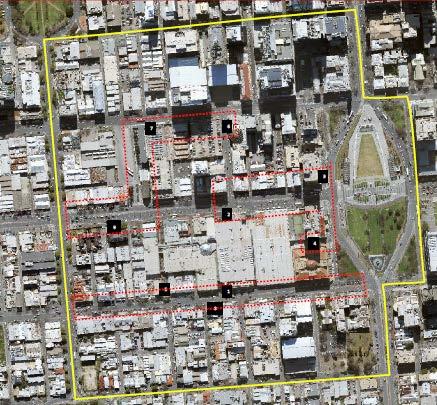
168
TOWN PLANNING SUBMISSION TO THE GREATER SYDNEY COMMISSION LANDS AT ARTARMON
 TOWN PLANNING SUBMISSION TO THE GREATER SYDNEY COMMISSION LANDS AT ARTARMON March 2017 TABLE OF CONTENTS 1.0 INTRODUCTION 3 2.0 THE SUBJECT SITE 4 3.0 STRATEGIC PLANNING CONTEXT 6 4.0 SUMMARY AND CONCLUSIONS
Securing a Sustainable Future: Implementing the 30-Year Plan for Greater Adelaide
 Planning Institute of Australia (SA) State of Renewal Conference Securing a Sustainable Future: Implementing the 30-Year Plan for Greater Adelaide Donna Ferretti - Director Statutory Planning Branch, Planning
PERTH CITY SWAN PERTH AIRPORT CURTIN UNIVERSITY WESTFIELD CAROUSEL TANGNEY CITY OF CANNING JANDAKOT AIRPORT SWAN TANGNEY
 THE CITY OF CANNING CITY OF CANNING PERTH CITY SWAN PERTH AIRPORT CURTIN UNIVERSITY WESTFIELD CAROUSEL TANGNEY CITY OF CANNING JANDAKOT AIRPORT SWAN TANGNEY UNTAPPED POTENTIAL The Canning City Centre,
Be in the heart of it all. Coffs Central - fashion, food and fun in the heart of the CBD
 Be in the heart of it all Coffs Central - fashion, food and fun in the heart of the CBD Coffs Harbour Jetty The mere presence of Coffs Central in our beautiful city has given a pulse to the heart of our
PCAL Case Study Retail Areas: Rouse Hill Town Centre
 PCAL Case Study Retail Areas: Rouse Hill Town Centre Introduction Rouse Hill Town Centre is a new mixed use development on a greenfield site in Sydney s North West. It has been planned to be a major hub
Business needs consumers! Get people back in to Port by attracting them!
 18 March 2013 Port Adelaide Precinct Plan Theme based analysis community feedback from Open Day Business District There were a range of suggestions for revitalising and boosting the Business District s
Sunshine Coast Council Locked Bag 72 Sunshine Coast Mail Centre QLD Submitted via online portal. 2 June 2017.
 Sunshine Coast Council Locked Bag 72 Sunshine Coast Mail Centre QLD 4560 Submitted via online portal 2 June 2017 Dear Sir /Madam, RE: DRAFT ENVIRONMENTAL AND LIVEABILITY STRATEGY The Green Building Council
STONES CORNER SUBURBPROFILE. Situated three kilometres from the Brisbane CBD, Stones Corner is located within one of Brisbane s key growth areas.
 1 SUBURBPROFILE Situated three kilometres from the Brisbane CBD, Stones Corner is located within one of Brisbane s key growth areas. OVERVIEW Situated three kilometres from the Brisbane CBD, Stones Corner
FEDERATION SQUARE MELBOURNE, AUSTRALIA CORPORATE PLAN
 FEDERATION SQUARE MELBOURNE, AUSTRALIA CORPORATE PLAN 201619 MELBOURNE S INSPIRATIONAL PUBLIC PLACE Federation Square is Melbourne s heartbeat, an inspirational precinct which concentrates community, cultural
The Coalition s Policy
 The Coalition s Policy Key Commitments Townsville is a city with immense potential. With a population of around 170,000, some 16,000 regional businesses, and regional product of over $11 billion, Townsville
USING THE SERVICE 98C 98A NORTH ADELAIDE 97A 99A 99C ADELAIDE CBD. Tram
 EXPLORE BY BUS NEW Temporary service linking the old RAH with the new RAH Effective 17 December 2017 USING THE SERVICE The free City Connector bus service runs on two loops an inner city loop and an extended
The Sunshine Coast is part of the global community and generates wealth through export, high-value industries and new investment.
 3.2 Strategic intent 3.2.1 Shaping growth an overview In 2031, the Sunshine Coast is renowned for its vibrant economy, ecological values, unique character and strong sense of community. It is Australia
North District Plan OVERVIEW
 OUR GREATER SYDNEY 2056 Revised Draft North District Plan OVERVIEW Hornsby Hunter's Hill Ku-ring-gai Lane Cove Mosman Northern Beaches North Sydney Ryde Willoughby Snapshot of the North District today
CITY RAIL LINK. New Public Transport Stations and Development Opportunities at Karangahape Road, Newton and Aotea Quarter
 134 AC_BEU_CCMP_3_TM5_8_FD.indd 134 20/07/12 12:30 PM 05 CITY RAIL LINK New Public Transport Stations and Development Opportunities at Karangahape Road, Newton and Aotea Quarter 5 MO VE 0 1 2 8 KEY 1 Britomart
Spadina Avenue Built Form Study Preliminary Report
 STAFF REPORT ACTION REQUIRED Spadina Avenue Built Form Study Preliminary Report Date: July 9, 2014 To: From: Wards: Reference Number: Toronto and East York Community Council Director, Community Planning,
CREATIVE. A city of authentic and internationally renowned experiences. Creative City of Adelaide Strategic Plan
 CREATIVE A city of authentic and internationally renowned experiences 44 Creative City of Adelaide 2016-2020 City of Adelaide 2016-2020 45 CREATIVE A city of authentic and internationally renowned experiences
PO Box 257 PO Box 257 PARRAMATTA NSW 2124 PARRAMATTA NSW 2124
 31 March 2017 Sean O Toole Sheridan Dudley District Commissioner - West District Commissioner - South West Greater Sydney Commission Greater Sydney Commission PO Box 257 PO Box 257 PARRAMATTA NSW 2124
ASCOT SUBURB PROFILE
 ASCOT SUBURB PROFILE CONTENTS SUBURB HIGHLIGHTS 2 3 4 4 5 5 ASCOT & SURROUNDS LOCATION & LIFESTYLE DEMOGRAPHICS EMPLOYMENT FUTURE INFRASTRUCTURE WA MARKET TRENDS ACCESSIBILITY ENTERTAINMENT & RECREATION
5 Rail demand in Western Sydney
 5 Rail demand in Western Sydney About this chapter To better understand where new or enhanced rail services are needed, this chapter presents an overview of the existing and future demand on the rail network
FREE CITY SERVICES. Detailed route information available on the metromate app and the Adelaide Metro website 98A 98C NORTH ADELAIDE 99A 99C ADELAIDE
 EXPLORE FREE SERVICES The free City Connector bus service runs on two loops an inner city loop and an extended loop around providing a link to popular attractions, shopping, dining and destinations. The
Gold Coast: Modelled Future PIA Queensland Awards for Planning Excellence 2014 Nomination under Cutting Edge Research category
 Gold Coast: Modelled Future PIA Queensland Awards for Planning Excellence 2014 Nomination under Cutting Edge Research category Jointly nominated by SGS Economics and Planning and City of Gold Coast August
MARKET OUTLOOK. 01 Walkability & Accessibility 02 Infrastructure & Employment 03 Population & Demographics 04 Residential Market 05 Rental Market
 MARKET OUTLOOK BRAYBROOK Close to the city in Melbourne s growing west, access to jobs, services and relative affordability are attracting new residents to Braybrook and driving price growth. 01 Walkability
Llandudno Junction. Regeneration Proposals for the Future. December 2009
 Llandudno Junction Regeneration Proposals for the Future December 2009 Llandudno Junction - Vision Statement 1 Purpose 1.1 The purpose of this document is to describe key priorities to support the regeneration
PLANNING THE SUNBURY GROWTH CORRIDOR
 SUNBURY GROWTH CORRIDOR NOVEMBER 2016 PLANNING THE SUNBURY GROWTH CORRIDOR Sunbury Planning Background The Victorian Planning Authority, in consultation with Hume City Council, is undertaking a number
OUTLOOK WATERLOO. Waterloo is a growing residential market, boasting high amenity that is well located to a number of major employment centres.
 OUTLOOK WATERLOO A CONTEXT ON BUSINESS, CULTURE, LIFESTYLE AND RESIDENTIAL Waterloo is a growing residential market, boasting high amenity that is well located to a number of major employment centres.
New free City connector bus service
 The Adelaide City Council invites engagement from the community about New free City connector bus service 99C City Loop and Adelaide Connector free bus services to merge: Project Summary Adelaide City
GUNGAHLIN TOWN CENTRE
 GUNGAHLIN TOWN CENTRE PLANNING REFRESH SNAPSHOT NOVEMBER 2018 CONTENTS INTRODUCTION....1 Australian Capital Territory, Canberra 2018 This work is copyright. Apart from any use as permitted under the Copyright
NOW LEASING FOOD AND BEVERAGE OPPORTUNITIES
 NOW LEASING FOOD AND BEVERAGE OPPORTUNITIES Right in the heart of Perth s CBD, Yagan Square will be one of the city s most popular meeting and celebration places and a major tourist destination. At just
T O U R I S M P L A N 2020
 T O U R I S M P L A N 2020 2 CITY OF HOLDFAST BAY TOURISM PLAN 2020 CONTENTS Executive Summary 4 Introduction 7 Tourism at a State and National Level 7 Tourism in the City of Holdfast Bay 7 Our Focus 8
10,100 People reside in North Perth
 ACTION PLAN THE HISTORY TODAY North Perth was subdivided as early as 1898. In March 1899, the area was declared North Perth Road District and was gazetted as a municipality in 1901. Housing in the area
Sustainable Urban Development. Presentation to WVCC 1 December 2010
 Sustainable Urban Development Presentation to WVCC 1 December 2010 Introduction Paul Carmody Hindmarsh (Consultation Manager) Tony Adams CB Richard Ellis (Planners) Simon Parsons PTW (Architects) Brett
CANNING CITY CENTRE. the new energy of the southeast
 CANNING CITY CENTRE the new energy of the southeast 2 INTRODUCTION From early beginnings as an important cultural and recreation place for the Beeloo Nyoongar people, to being a trading post connecting
Your Transport Levy Your Transport Future. Sunshine Coast Council Transport Levy Annual Report
 Your Transport Levy Your Transport Future Sunshine Coast Council Transport Levy Annual Report 2016-2017 www.sunshinecoast.qld.gov.au T 07 5475 7272 F 07 5475 7277 Locked Bag 72 Sunshine Coast Mail Centre
LEASING OPPORTUNITIES AUSTRALIAFAIR.COM.AU
 YOUR OPPORTUNITY IS NOW LEASING OPPORTUNITIES AUSTRALIAFAIR.COM.AU AUSTRALIA FAIR EVOLUTION With the evolution of the official Southport CBD and an associated boost in local economic indicators, Australia
Fraser Coast. Destination Tourism Strategy
 Fraser Coast Destination Tourism Strategy 2012 2016 Fraser Coast The Fraser Coast is home to two of the great icons of Queensland tourism, the world heritage listed Fraser Island and the whale watching
Reimagining Central Station Precinct
 Reimagining Central Station Precinct Submission by BusNSW 1. Introduction BusNSW members provide bus and coach transport services throughout NSW under various contractual and regulatory environments. This
Attachment 2 Agenda Item 6.1 Future Melbourne Committee 6 May 2014 Melbourne Music Strategy
 Attachment 2 Agenda Item 6.1 Future Melbourne Committee 6 May 2014 Melbourne Music Strategy A strategy for supporting and growing the city s music industry 2014 17 Contents Welcome... 3 1. Introduction...
Review of Government Secondary School Requirements within the Sunbury South Precinct Structure Plan
 Review of Government Secondary School Requirements within the Sunbury South Precinct Structure Plan Expert Witness Statement August 11 th, 2017 Prepared by Robert Panozzo Director, ASR Research Pty Ltd
Draft City Centre Transport Proposals
 Draft City Centre Transport Proposals Introduction This draft position paper provides an overview of the current City Centre transport issues, including concepts of the possible future City Centre transport
Draft Greater Sydney Region Plan
 Draft Greater Sydney Region Plan Submission_id: 31392 Date of Lodgment: 14 Dec 2017 Origin of Submission: Online Organisation name: Greenfields Development Company No. 2 Pty Limited Organisation type:
Housing in Hobart: an overview of the data. Richard Eccleston, Lisa Denny, Julia Verdouw & Kathleen Flanagan University of Tasmania May 2018
 Housing in Hobart: an overview of the data Richard Eccleston, Lisa Denny, Julia Verdouw & Kathleen Flanagan University of Tasmania May 2018 Informing the Housing Debate Tasmania is facing significant housing
TOURISM IN WESTLAND MARCH 2012
 TOURISM IN WESTLAND MARCH 2012 Tourism in Westland The Westland District Council co-ordinated three tourism industry related meetings during February 2012. These were held in Haast, Fox Glacier and Hokitika.
Gold Coast. Rapid Transit. Chapter twelve Social impact. Chapter content
 Gold Coast Rapid Transit Chapter twelve Social impact Chapter content Social impact assessment process...235 Existing community profile...237 Consultation...238 Social impacts and mitigation strategies...239
JOINT CORE STRATEGY FOR BROADLAND, NORWICH AND SOUTH NORFOLK EXAMINATION MATTER 3C EASTON/COSTESSEY
 Matter 3C Easton/Costessey Representor No. 8826 JOINT CORE STRATEGY FOR BROADLAND, NORWICH AND SOUTH NORFOLK EXAMINATION MATTER 3C EASTON/COSTESSEY SUBMISSION ON BEHALF OF TAYLOR WIMPEY DEVELOPMENTS AND
Tourism investment opportunities
 Tourism investment opportunities 1. Investor proposition Investment opportunities are underpinned by: Canberra tourism output projections are well above the national average and all other states (Tourism
June TEQ Marketing Strategy 2025 Executive Summary
 June 2018 TEQ Marketing Strategy 2025 Executive Summary Vision and The Opportunity Tourism and Events Queensland s (TEQ) Marketing Strategy 2025 provides a platform to realise the TEQ vision of inspiring
A Master Plan is one of the most important documents that can be prepared by an Airport.
 The Master Plan A Master Plan is one of the most important documents that can be prepared by an Airport. A Master Plan is a visionary and a strategic document detailing planning initiatives for the Airport
WHY INVEST IN QUEENSLAND URBIS MARKET OUTLOOK
 WHY INVEST IN QUEENSLAND URBIS MARKET OUTLOOK WHO IS URBIS? PERTH AUSTRALIA ADELAIDE BRISBANE GOLD COAST SYDNEY MELBOURNE Urbis is an integrated multi-disciplinary consulting firm with a unique and comprehensive
AdelAide, South AuStrAliA... Now is the time!
 Adelaide, South Australia... Now is the time! Now is the Time! Adelaide, South Australia is positioning itself on a global scale for major conventions. The destination is currently undergoing an unprecedented
Draft Western District Plan
 Powered by TCPDF (www.tcpdf.org) Draft Western District Plan Submission_id: 31732 Date of Lodgment: 15 Dec 2017 Origin of Submission: Online Organisation name: APP Corporation Pty Ltd Organisation type:
Public Transport for Perth in 2031
 South West Group Submission Public Transport for Perth in 2031 October 2011 South West Group Vision and Mission Local Governments in South Metropolitan Perth, through cooperation with industry, community
Kilometres. Blacktown. Penrith. Parramatta. Liverpool Bankstown. Campbelltown
 0 5 10 15 20 Kilometres Penrith Blacktown Parramatta Liverpool Bankstown Campbelltown accessibility outcomes Legend Outcomes targeted in Western Sydney are: public transport that is accessible throughout
9.1 INTRODUCTION 9.2 EXISTING DEVELOPMENT. Southern Cross University
 Property Strategy The property strategy delivers improved legibility, responds to the locational attributes of the site, and facilitates essential operational efficiencies. 9.1 INTRODUCTION Non-aviation
Community Sports Hub
 The Adelaide City Council invites engagement from the community about Project Summary Council is seeking your feedback on a draft agreement to enable the South Australian Cricket Association (SACA) to
June TEQ Marketing Strategy 2025 Executive Summary
 June 2017 TEQ Marketing Strategy 2025 Executive Summary Vision and The Opportunity Tourism and Events Queensland s (TEQ) Marketing Strategy 2025 provides a platform to realise the TEQ vision of inspiring
Part four. In this part you will find: The next steps to deliver the master plan
 Part four NEXT STEPS In this part you will find: The next steps to deliver the master plan 6. How COULD the Master Plan be delivered? There are a number of steps required to take the proposals in the master
Draft Greater Sydney Region Plan
 Powered by TCPDF (www.tcpdf.org) Draft Greater Sydney Region Plan Submission_id: 31119 Date of Lodgment: 12 Dec 2017 Origin of Submission: Online Organisation name: Serapark Pty Ltd Organisation type:
The Government s Aviation Strategy Transport for the North (TfN) response
 response") The Government s Aviation Strategy Transport for the North (TfN) response Transport for the North Background Good transport links are a crucial part of a strong economy supporting labour markets and delivering
The Government s Aviation Strategy Transport for the North (TfN) response Transport for the North Background Good transport links are a crucial part of a strong economy supporting labour markets and delivering
places Mooloolaba s heart five
 five places the mooloolaba heart 1 Flexible community event use of school oval 2 Enhanced streetscape District cycle route Future cross-block pedestrian link 5 Existing school buildings New signalised
Development Committee on 3 December 2013;
 7 2. Endorses the bus route for the new free City Connector bus service as set out in Attachment B to Item 9 on the Agenda for the meeting of the City Planning & Development Committee on 3 December 2013;
MISSING PIECES. PCEC Expansion DESTINATION PERTH. Developing Perth s Visitor Economy MAY Image courtesy Perth Convention & Exhibition Centre
 MISSING PIECES PCEC Expansion MAY 2016 Image courtesy Perth Convention & Exhibition Centre DESTINATION PERTH Developing Perth s Visitor Economy DESTINATION PERTH Perth is in the midst of a once in a generation
Tourism Development Framework for Scotland. Executive Summary- Development Framework to 2020 for the Visitor Economy (Refresh 2016)
") Tourism Development Framework for Scotland Executive Summary- Development Framework to 2020 for the Visitor Economy (Refresh 2016) Introduction The Tourism Development Framework for Scotland refresh 2016:
Tourism Development Framework for Scotland Executive Summary- Development Framework to 2020 for the Visitor Economy (Refresh 2016) Introduction The Tourism Development Framework for Scotland refresh 2016:
Bartlett Square Welcome. Investment Framework. London Airport Ltd
 1 Welcome Welcome to Luton s public exhibition on proposals for the (formerly known as Stirling Place) project which will comprise 2.5 acres of commercial development, providing up to 2,000 jobs for local
Public Submissions in response to the Bill closed on 2 July 2015 and Council lodged a copy of the submission provided as Attachment 1.
 54 PLANNING AND ECONOMIC COMMITTEE 8 JULY 2015 3 SUSTAINABLE PORTS DEVELOPMENT BILL Neil Quinn 1/58/14 #4771706 RECOMMENDATION: That Council endorses the Submission made to the Infrastructure, Planning
Mackay Region. Destination Tourism Strategy
 Mackay Region Destination Tourism Strategy 2012 2016 Mackay Region The Mackay region offers an abundance of natural attractions including national parks, gorges, the Great Barrier Reef, numerous islands
NORTH WEST GROWTH CENTRE
 OUTLOOK NORTH WEST GROWTH CENTRE A CONTEXT ON BUSINESS, CULTURE, LIFESTYLE AND RESIDENTIAL The North West Growth Centre is an emerging residential market that is expected to benefit from strong infrastructure
Schedule of Planning Applications Committee Date: 23 May Reference: 06/18/0064/F Great Yarmouth Officer: Mr J Beck Expiry Date:
 Schedule of Planning Applications Committee Date: 23 May 2018 Reference: 06/18/0064/F Great Yarmouth Officer: Mr J Beck Expiry Date: 24-04-2018 Applicant: Proposal: Site: Mr Mavroudis Clear weather hoardings
North Lanarkshire. Skills Assessment January SDS-1163-Jan16
 North Lanarkshire Skills Assessment January 2016 SDS-1163-Jan16 Acknowledgement The Regional Skills Assessment Steering Group (Skills Development Scotland, Scottish Enterprise, the Scottish Funding Council
Submission to. Southland District Council on. Draft Stewart Island/Rakiura Visitor Levy Policy and Bylaw
 Submission to Southland District Council on Draft Stewart Island/Rakiura Visitor Levy Policy and Bylaw Date: 9 November 2018 Tourism Industry Aotearoa (TIA) welcomes the opportunity to comment on Southland
Memorandum of Understanding with ACT Government
 MEDIA RELEASE 8 April 2015 Memorandum of Understanding with ACT Government The ACT Government and Canberra Airport today entered into a new Memorandum of Understanding (MoU) on key areas of common interest
OUTLOOK REDBANK PLAINS A CONTEXT ON BUSINESS, CULTURE, LIFESTYLE AND RESIDENTIAL
 OUTLOOK REDBANK PLAINS A CONTEXT ON BUSINESS, CULTURE, LIFESTYLE AND RESIDENTIAL Located within seven minutes of the Springfield CBD and 30 minutes of the Brisbane CBD, Redbank Plains proximity to major
GOLD COAST HOUSING REPORT SNAPSHOT
 GOLD COAST HOUSING REPORT SNAPSHOT Few cities have expanded like the Gold Coast. The once iconic surfing Mecca and holiday destination has grown to become the 6th largest city in Australia with a population
CAIRNS RECTANGULAR PITCH STADIUM NEEDS STUDY PART 1 CAIRNS REGIONAL COUNCIL DRAFT REPORT SEPTEMBER 2011
 CAIRNS RECTANGULAR PITCH STADIUM NEEDS STUDY PART 1 CAIRNS REGIONAL COUNCIL DRAFT REPORT SEPTEMBER 2011 CAIRNS RECTANGULAR PITCH STADIUM NEEDS STUDY PART 1 Cairns Regional Council September 2011 Coffey
Labor s plan to support art and culture throughout NSW
 MICHAEL DALEY & LABOR Labor s plan to support art and culture throughout NSW www.nswlabor.org.au Michael Daley NSW Labor Leader I believe NSW can become one of the most culturally vibrant societies in
ARTICLE // DEC 2014 EIGHT YEARS ON: KEY LEARNINGS FROM UNIVERSITY HILL
 ARTICLE // DEC 2014 EIGHT YEARS ON: KEY LEARNINGS FROM UNIVERSITY HILL Eight years ago the mandate from our client MAB Corporation was to join MAB s design team on the 104 hectare mixed use development
Greater Melbourne s Destination Management Visitor Plan. Executive Summary
 Greater Melbourne s Destination Management Visitor Plan Executive Summary Funding Partners The Australian Government through the Tourism Demand-Driver Program, administered by the Victoria State Government
URBAN DESIGN REPORT. Proposed Residential Development, Old Church Road, Caledon East
 Proposed Residential Development, Old Church Road, Caledon East TABLE CONTENTS: 1.0 DEVELOPMENT 1.1 Introduction-Analysis of Guiding Principles and Documents 1.2 Community Design and Architectural Design
Overview. Draft Central District Plan. November Local Government Areas: Bayside Burwood Canada Bay. Inner West Randwick Strathfield
 Draft Central District Plan Overview November 2016 Local Government Areas: Bayside Burwood Canada Bay Inner West Randwick Strathfield The City of Sydney Waverley Woollahra 1 Snapshot of the Central District
A subsidiary of Metro Property Development SUBURB PROFILE LARA 7TH JUNE 2017
 A subsidiary of Metro Property Development SUBURB PROFILE LARA 7TH JUNE 2017 OVERVIEW Lara is a suburb located in the Greater Geelong Area just 17kms from Geelong and 60kms to the Melbourne CBD. Lara is
Smart Cities Plan IMPLEMENTATION. Townsville City Deal. April 2017
 Smart Cities Plan IMPLEMENTATION Townsville City Deal April 2017 ACKNOWLEDGEMENTS The Commonwealth Government, Queensland Government and the Townsville City Council would like to thank the Townsville community
The Melbourne CBD: What is driving centralisation?
 November 2013 The Melbourne CBD: What is driving centralisation? Key Points Jones Lang LaSalle recorded a notable increase in the number of city Fringe 1 occupiers migrating to the Melbourne CBD over the
Nature Based Tourism in Australia Manifesto
 Nature Based Tourism in Australia Manifesto COVER NOTE This draft Manifesto has been crafted through consultation with State and Federal Governments; tourism and parks agencies; the investment community;
Parkland County Municipal Development Plan Amendment Acheson Industrial Area Structure Plan
 Parkland County Municipal Development Plan Amendment Acheson Industrial Area Structure Plan New Plan Acheson Industrial Area Structure Plan Amendment Parkland County Municipal Development Plan Board Reference
An Integrated Entertainment & Gaming Complex in Vaughan Special Committee of the Whole Meeting May 28, 2013
 An Integrated Entertainment & Gaming Complex in Vaughan Special Committee of the Whole Meeting May 28, 2013 1 Integrated Entertainment and Gaming Complex Overview Process to Date Highlights of Research
SYDNEY OPERA HOUSE. Artwork: Dreaming Sisters 2011 by Mary Smith. Copyright Mary Smith & Weave Arts Centre
 SYDNEY OPERA HOUSE reconciliation action plan Artwork: Dreaming Sisters 2011 by Mary Smith. Copyright Mary Smith & Weave Arts Centre SYDNEY OPERA HOUSE reconciliation action plan CONTENTS introduction
East Lothian. Skills Assessment January SDS-1154-Jan16
 East Lothian Skills Assessment January 2016 SDS-1154-Jan16 Acknowledgement The Regional Skills Assessment Steering Group (Skills Development Scotland, Scottish Enterprise, the Scottish Funding Council
Statistical Picture of Aboriginal and Torres Strait Islander School Students in Australia
 Chapter 2 Statistical Picture of Aboriginal and Torres Strait Islander School Students in Australia Statistical Picture The Australian Bureau of Statistics (ABS) reported that the estimated resident Aboriginal
COFFS HARBOUR MARKETSNAPSHOT
 MARKETSNAPSHOT NEW SOUTH WALES The Mid North Coast region is ranked fourth in Australia for business confidence with its regional economy growing at a healthy 4.1% p.a. and produces an annual Gross Regional
Background to the Determination As you are no doubt aware, the Adelaide City Council is constituted pursuant to Section 20 of the Act.
 Mr Deane Prior President Remuneration Tribunal GPO Box 2343 ADELAIDE SA 5000 Dear Mr Prior Thank you for the opportunity to make a submission regarding the allowances paid to members of the Adelaide City
The 30-Year Plan for Greater Adelaide. ECONOMIC PRIORITY 8: Adelaide, the Heart of the Vibrant State FOREWORD RIVERBANK AUTHORITY.
 1 VISION 2 PLANs The 30-Year Plan for Greater Adelaide RIVERBANK AUTHORITY ECONOMIC PRIORITY 8: Adelaide, the Heart of the Vibrant State ANDREW McEVOY 3 PRECINCTS health and Biomedical core entertainment
WHERE BUSINESS LEADS MAKE YOUR MARK. A unique opportunity for investors and developers.
 MAKE YOUR MARK WHERE BUSINESS LEADS A unique opportunity for investors and developers. Australia s only greenfield central business district within an existing urban area. 6 Dr Doug McTaggart Chairman,
IMPACT HOMES Introducing The Meadows Estate 3
 IMPACT HOMES Introducing The Meadows Estate 3 4 IMPACT HOMES Introducing The Meadows Estate INTRODUCTION The purpose of this guide is to introduce The Meadows, a residential community developed by Leda.
SANDY BAY RETAIL PRECINCT STREETSCAPE REVITALISATION - PALM TREES AND BANNER POLES - RESPONSE TO PETITION
 Page 41 REPORT TITLE: SANDY BAY RETAIL PRECINCT STREETSCAPE REVITALISATION - PALM TREES AND BANNER POLES - RESPONSE TO PETITION REPORT PROVIDED BY: Road Services Engineer Director City Infrastructure 1.
Tourism 201 CHAPTER 10
 Tourism 201 CHAPTER 10 202 Doncaster Unitary Development Plan Tourism 203 Tourism INTRODUCTION 10.1 The increasing importance of tourism is recognised in the UDP by having its own chapter. The benefits
Land Management Summary
 photo credit: ANGAIR Anglesea Heath Land Management Summary The Anglesea Heath (6,501 ha) was incorporated into the Great Otway National Park in January 2018. This provides an opportunity to consider the
Salisbury. A place to invest.
 Salisbury. A place to invest. Salisbury is a progressive, proactive and pro-business city. Already home to a host of international firms and flourishing entrepreneurs, Salisbury is a great place to position
For personal use only
 Cedar Woods Properties Limited Queensland Projects Tour Cedar Woods Presentation 2 Cedar Woods Charter Cedar Woods Purpose to create long term value for our shareholders through the disciplined acquisition,
PERTH AND KINROSS COUNCIL. 22 June 2016 DEVELOPING THE CULTURAL OFFER IN PERTH AND KINROSS UPDATE AND NEXT STEPS
 PERTH AND KINROSS COUNCIL 8 16/278 22 June 2016 DEVELOPING THE CULTURAL OFFER IN PERTH AND KINROSS UPDATE AND NEXT STEPS Report by Senior Depute Chief Executive (Equality, Community Planning & Public Service
WEST VILLAGE IS A VISIONARY NEW GLOBAL NEIGHBOURHOOD, SET TO REDEFINE WEST END.
 like nothing else WEST VILLAGE IS A VISIONARY NEW GLOBAL NEIGHBOURHOOD, SET TO REDEFINE WEST END. WITH NO OTHER PROJECT LIKE IT, THIS UNPRECEDENTED OPPORTUNITY WILL TRANSFORM BRISBANE. West Village is
This is a submission to Council s Delivery Plan and Operational Plan
 Goulburn Mulwaree Council Locked Bag 22 Goulburn NSW 2580 Emailed: strategy@goulburn.nsw.gov.au and council@goulburn.nsw.gov.au Marulan/Tallong Community Network C/O 843 Marulan South Road Marulan NSW,