DRAFT RECREATION RESOURCE MANAGEMENT PLAN
|
|
|
- Elizabeth Cook
- 5 years ago
- Views:
Transcription
1 DRAFT RECREATION RESOURCE MANAGEMENT PLAN FERC Project Nos. 935, 2071 and 2111 Prepared by: EDAW, Inc. Seattle, Washington and PacifiCorp Portland, Oregon April 2004
2
3 EXECUTIVE SUMMARY PacifiCorp FERC Project Nos. 935, 2071 and 2111 PacifiCorp, the U.S. Division of Scottish Power, operates the Lewis River Hydroelectric Projects (project) (FERC Project Nos. 935, 2071, and 2111). Commercial operations at the Merwin, Yale, and Swift 1 projects began in 1932, 1953 and 1958, respectively. Issuance of new licenses is expected in 2007, or shortly thereafter. Recognizing that project facilities have induced public recreation use and resulting needs in the vicinity of the project, PacifiCorp acknowledges responsibility for providing appropriate resources to help meet this existing and future recreation need over the term of the new licenses. PacifiCorp has prepared this Recreation Resource Management Plan (RRMP) under the authority of Title 18 Code of Federal Regulations (CFR) 4.51 (f) (5), which identifies the need to define the responsibilities of parties when public recreation facilities are to be provided at a hydroelectric project. Several agencies and other stakeholders participated in the development of the RRMP, including the USDA - Forest Service, National Park Service, USDI Bureau of Land Management, Washington Department of Natural Resources, Washington Department of Fish and Wildlife, Washington Interagency Committee for Outdoor Recreation, Vancouver-Clark Parks and Recreation Department, City of Woodland, Lewis River Community Council, Fire District #7, and interested local citizens. These agencies and other stakeholders will continue to participate in the implementation of the RRMP over the term of new licenses in an advisory capacity as part of a newly formed Lewis River Recreation Advisory Committee (LRC). During the relicensing study phase, PacifiCorp worked with a broad group of stakeholders to design and implement the recreation studies for the projects and to develop a series of alternatives, as well as proposed protection, mitigation, and enhancement measures (PM&Es). Cowlitz County Public Utility District No. 1 (Cowlitz PUD), licensee of the Swift No. 2 Hydroelectric Project (FERC Project No. 2213), is addressing the identified recreation resource needs of this separate project in its license application. PacifiCorp will use the RRMP to manage existing and future recreation resources associated with the project. The RRMP establishes a vision for managing recreation resources in the project vicinity, identifies proposed measures for existing and proposed recreation resources, and describes programs designed to implement those measures. More specifically, the RRMP is an implementation guide to plan, design, construct, renovate, monitor, fund, operate, and maintain existing and future public recreation facilities and programs in the project vicinity. The RRMP includes a number of recreation protection, mitigation, and enhancement measures (PM&Es) (included as Exhibits to this RRMP). Future recreation needs, such as expanding existing campgrounds at Yale Lake or Swift Reservoir, are also defined. These needs will be validated in the future through periodic monitoring of public recreation facility use and facility condition over the term of the new licenses. April 2004 Draft RRMP - Page i
4 PacifiCorp FERC Project Nos. 935, 2071 and 2111 To accomplish this purpose, five programs are included in this RRMP: 1. Recreation Facility Capital Improvement Program 2. Recreation Facility Operation and Maintenance Program 3. Recreation Dispersed Shoreline Use Program 4. Recreation Monitoring Program 5. Interpretation and Education Program Draft RRMP - Page ii April 2004
5 TABLE OF CONTENTS PacifiCorp FERC Project Nos. 935, 2071 and 2111 EXECUTIVE SUMMARY...I 1.0 INTRODUCTION PURPOSE AND INTENT VISION FOR RECREATION RESOURCES IMPLEMENTATION PRIORITIES IMPLEMENTATION PROGRAMS ISSUES AND ASSUMPTIONS EXPLANATION OF TERMS RRMP PLANNING, COORDINATION AND UPDATES PACIFICORP AND AGENCY ROLES SUMMARY ROLLING 5-YEAR RECREATION ACTION PLAN DEVELOPMENT ENVIRONMENTAL COMPLIANCE AND PERMITTING ANNUAL LEWIS RIVER RECREATION ADVISORY COMMITTEE REVIEW RESOURCE INTEGRATION AND COORDINATION PERIODIC RRMP REVIEW AND REVISION PERIODIC REPORTING TO THE FERC RRMP IMPLEMENTATION PROGRAMS RECREATION FACILITY CAPITAL IMPROVEMENT PROGRAM Recreation Capital Improvement Responsibilities Recreation Capital Improvement Priorities Recreation Concept Site Plans Recreation Facility Design and Setting Guidelines Americans with Disabilities Act (ADA) Compliance Recreation Capital Improvement Coordination and Approvals RECREATION FACILITY OPERATION AND MAINTENANCE PROGRAM Recreation Facility Operations Schedule Recreation Facility Maintenance Standards and Frequency Day-Use Agreement Concerning the Charging of Fees at PacifiCorp s Lewis River Recreation Facilities Law Enforcement and Public Services at Recreation Facilities RECREATION DISPERSED SHORELINE USE PROGRAM Defining Suitable Dispersed Shoreline Sites Dispersed Shoreline Site Hardening Responsibilities April 2004 Draft RRMP - Page iii
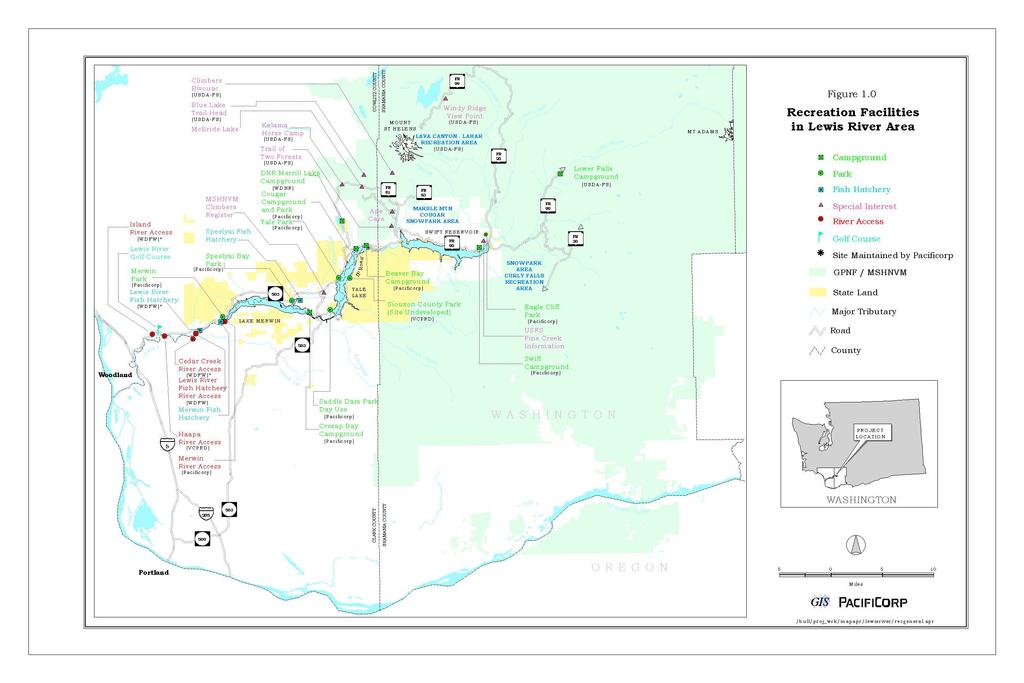
6 PacifiCorp FERC Project Nos. 935, 2071 and Dispersed Shoreline Site Sanitary Management Responsibilities Dispersed Shoreline Site Maintenance Responsibilities Dispersed Shoreline Site Management Controls Dispersed Shoreline Site Use and Resource Impact Monitoring Dispersed Shoreline Site Program Schedule RECREATION MONITORING PROGRAM Monitoring Program Responsibilities Monitoring Program Schedule Monitoring Reporting INTERPRETATION AND EDUCATION PROGRAM Recreation Resources Other Resources REFERENCES...31 LIST OF FIGURES Figure 1.0 Recreation Facilities in the Lewis River Area...3 LIST OF TABLES Table 1.0 Season and Hours of Operation of Project Recreation Facilities...18 Draft RRMP - Page iv April 2004
7 LIST OF EXHIBITS PacifiCorp FERC Project Nos. 935, 2071 and 2111 Exhibit A Exhibit B Exhibit C Exhibit D Exhibit E Exhibit F Exhibit G Exhibit H Exhibit I Exhibit J Exhibit K Exhibit L Exhibit M Exhibit N Rolling 5-Year Recreation Action Plan Framework Recreation Settings and Management Units Proposed Recreation Measures, Schedules, and Costs Conceptual Site Plans Recreation Monitoring Indicators and Standards Recreation Monitoring Sites Day-Use Site Fee Agreement Collection Agreement between PacifiCorp and the USDA-FS FERC License Terms and Conditions Recreation Developed Facility and Dispersed Site Maintenance Standards/Frequency Dispersed Shoreline Recreation Sites Law Enforcement and Emergency Services Agreements Agreement between PacifiCorp and WDFW on River Access Sites below Merwin Dam Tentative Agreements on Forest Road 90 Maintenance and Repair, Pine Creek Work Center Communication Support, and a Visitor Information Facility, June 26, 2003 April 2004 Draft RRMP - Page v
8 PacifiCorp FERC Project Nos. 935, 2071 and 2111 ACRONYMS AND ABBREVIATIONS ADA Americans with Disabilities Act ADAAG Americans with Disabilities Act Accessibility Guidelines for Buildings and Facilities CE Categorical Exclusion CFR Code of Federal Regulations Cowlitz PUD Public Utility District No. 1 of Cowlitz County, Washington EA Environmental Assessment EIS Environmental Impact Statement ESA Endangered Species Act FERC Federal Energy Regulatory Commission HPA Washington Department of Fish and Wildlife Hydraulics Project Approval I&E Interpretation and education LAC Limits of Acceptable Change LRC Lewis River Recreation Advisory Committee NPS U.S. Department of the Interior, National Park Service NEPA National Environmental Policy Act NHPA National Historic Preservation Act O&M Operations and maintenance PET Protected, endangered, and threatened PM&E Protection, mitigation and enhancement measure project, FERC Project Nos. 935, 2071, 2111 READ Resource Enhancement Alternatives Document ROS Recreation Opportunity Spectrum RRMP Recreation Resource Management Plan SEPA State Environmental Policy Act, Washington USDA-FS U.S. Department of Agriculture, Forest Service USDI-BLM U.S. Department of the Interior, Bureau of Land Management VCPRD Vancouver-Clark Parks and Recreation Department WDFW Washington Department of Fish and Wildlife WDNR Washington Department of Natural Resources WIAC Washington Interagency Committee for Outdoor Recreation Draft RRMP - Page vi April 2004
9 1.0 INTRODUCTION PacifiCorp FERC Project Nos. 935, 2071 and 2111 PacifiCorp, the Licensee, operates the (project) (FERC Project No. 935, 2071, and 2111) under licenses granted by the Federal Energy Regulatory Commission (FERC). The new FERC licenses will be for a period of up to 50 years beginning when the new licenses become final. Recognizing that project facilities have induced public recreation needs in the vicinity of the project, PacifiCorp acknowledges responsibility for providing appropriate resources to help meet this existing and future recreation need. PacifiCorp has prepared this Recreation Resource Management Plan (RRMP) as part of the FERC relicensing process to guide recreation resource management on project lands during the term of the new licenses. Within one year of the new licenses becoming final, this RRMP will be finalized and implemented. During the relicensing study phase, PacifiCorp worked with a broad group of stakeholders to design and implement the recreation studies for the projects and to develop a series of alternatives, as well as proposed protection, mitigation, and enhancement measures (PM&Es). The RRMP was prepared under the authority of 18 Code of Federal Regulations (CFR) 4.51 (f) (5), which identifies the need to define the responsibilities of parties when public recreation facilities are to be provided at a hydroelectric project, and to prepare a recreation plan (RRMP). Taken as a whole, the RRMP represents a single umbrella protection, mitigation, and enhancement (PM&E) measure for recreation resources for the project. The RRMP is specific to PacifiCorp s responsibility and does not make management or resource commitments for other agencies or tribes. This section describes key elements of the RRMP including: Purpose and intent of the RRMP Long-term vision of the RRMP Implementation phasing of the RRMP Overview of the five key RRMP programs: Recreation facility capital improvement program Recreation facility operations and maintenance program Recreation dispersed shoreline use program Recreation monitoring program Interpretation and education program Issues and assumptions for the RRMP Explanation of terms used in the RRMP Cowlitz County Public Utility District No. 1 (Cowlitz PUD), licensee of the Swift No. 2 Hydroelectric Project (FERC Project No. 2213), is addressing the identified recreation resource needs of this separate project in its license application. April 2004 Draft RRMP Page 1
10 PacifiCorp FERC Project Nos. 935, 2071 and PURPOSE AND INTENT The purpose of the RRMP is to specify PacifiCorp s involvement, role and responsibilities in implementing FERC license terms and conditions (Exhibit I FERC License Terms and Conditions). This responsibility includes managing and operating existing and future recreation facilities and use areas associated with the project including site-specific and programmatic measures. The RRMP identifies measures for existing and proposed recreation resources and describes programs designed to implement those measures. More specifically, the RRMP is an implementation tool to be used to plan, design, construct, renovate, monitor, fund, operate, and maintain existing and future public recreation facilities and programs in the project area for the term of the new licenses. Five programs are presented in the RRMP that are intended to implement site-specific and programmatic measures. These proposed measures were developed as a result of agency, tribal, and public consultation; technical studies conducted for relicensing by EDAW, Inc. for PacifiCorp; Resource Enhancement Alternatives Document (READ) process; and the Draft Environmental Assessment process for relicensing. 1.2 VISION FOR RECREATION RESOURCES The long-term vision for the project area has been defined by PacifiCorp and stakeholders during the relicensing process. This vision includes how project-related recreation resources should be managed in the project area (Figure 1.0) for the term of the new licenses and includes the following: A balance of various resource needs and the best outcome possible for the region s recreation resources (southwest Washington and the Portland/Vancouver metropolitan area); A recognition that not all existing and long-term recreation needs can be accommodated in the project area because of the need to balance resource needs; Recognition that fishing is an important recreation activity in the project area; Recognition that different project reservoirs represent different types of recreation settings along a spectrum from semi-primitive to rural, including project facilities. It is the desire of the stakeholders and PacifiCorp to preserve this existing range of settings and experiences into the future; Place a priority on enhancing the diversity of opportunities through ADA upgrades and a focus on new facilities/opportunities that are currently not provided; Make enhancements to the current system of parks before expanding; An acknowledgement that things will change over time and some adaptive management is an appropriate strategy to manage recreation resources in the future; A desire to maintain and/or improve the experience now enjoyed by residents of and visitors to the project area; and A commitment to monitoring and managing recreation resources in the project area including recreation facility capacity, shoreline dispersed recreation use, and others (see Section Recreation Monitoring Program). Draft RRMP - Page 2 April 2004
11
12 PacifiCorp FERC Project Nos. 935, 2071 and 2111 Although this RRMP includes the development of many new recreation opportunities and expansion of existing ones through the term of the new licenses, it is the intent of the RRMP to retain the different existing recreation settings found in the project area to the greatest extent possible. These different settings are defined as five recreation land classifications, including semi-primitive, roaded natural, rural and project facilities (Exhibit B Recreation Settings and Management Units) modeled after the USDA-FS Recreation Opportunity Spectrum (ROS) planning framework (Clark and Stankey 1979). Existing recreation management as well as future recreation development as defined in the RRMP will be consistent with these five recreation land classifications as defined below. Semi-Primitive (SP) Occasional evidence of human activity, including some minor structures. Predominantly natural environment (57.5 miles of shoreline, 45 percent of study area). Roaded Natural (RN) Moderate evidence of human activity, including occasional docks and other minor structures; occasional single-family homes or cabins. The setting is predominantly natural in appearance, but may include regularly maintained, light duty roads (47.4 miles of shoreline, 37 percent of study area). Rural (R) Human activity/presence is highly evident. Man-made structures are frequent and may be dominant features of the landscape. Natural environment is substantially modified but is still rural in nature (12.4 miles of shoreline, 10 percent of study area). Project Facilities (PF) Human activity/presence and man-made structures are a dominant feature of the landscape. This highly modified environment includes Project facilities such as dams, powerhouses, substations, and transmission lines (10.3 miles of shoreline, 8 percent of study area). In addition, six geographic recreation management units (Swift Reservoir, Swift Bypass Reach, Swift 2 Power Canal, Yale Lake, Lake Merwin, and Lower River Below Merwin Dam) have been defined. These management units are referred to and used in the Recreation Monitoring Program (Section 3.4) for data collection and analysis purposes and in RRMP decision-making by management area. 1.3 IMPLEMENTATION PRIORITIES An implementation priority system was developed for use in scheduling the PM&Es listed in Exhibit C Proposed Recreation Measures, Schedules, and Costs. The priority of each PM&E is listed with it in Exhibit C. This system is presented here to provide context for future decision making, possibly during plan updates. The three priority levels used for PM&E scheduling are: Priority 1 - Provide an enhanced diversity of recreation opportunities in the project area, generally during the first 5- to 10-years of the new licenses. In addition, when a April 2004 Draft RRMP Page 5
13 PacifiCorp FERC Project Nos. 935, 2071 and 2111 project recreation facility is constructed or a recreation program is initiated, maintain existing and new recreation facilities, programs and other resources in the project area for the license term (current year through the term of the new licenses, or as appropriate to the specific action); Priority 2 - provide upgrades and modernization of existing recreation facilities in the project area, generally during years 10 to 15 of the new licenses; Priority 3 - expand recreation facilities and opportunities up to specified limits (Exhibit C Proposed Recreation Measures, Schedules, and Costs) in the project area, generally during years 15 to 25 of the new licenses, or when the recreation monitoring threshold triggers for new development expansion are reached. 1.4 IMPLEMENTATION PROGRAMS This section provides an overview of the RRMP s five implementation programs. These programs address PacifiCorp s responsibilities for implementing future FERC license terms and conditions (Exhibit I FERC License Terms and Conditions). The five RRMP programs include: A Recreation Facility Capital Improvement Program (see Section 3.1) defines construction-related responsibilities to address some existing and future projectrelated recreation needs, identifies proposed recreation development projects, provides estimated costs for recreation measures, identifies locations and provides conceptual site plans of the development measures, and discusses general facility development standards and criteria to be used. A Recreation Facility Operations and Maintenance Program (see Section 3.2) that defines existing and future operation and maintenance responsibilities to address existing and future project-related recreation facility needs, provides estimated costs for operations and maintenance, and discusses general facility and use area maintenance standards. A Recreation Dispersed Shoreline Use Program (see Section 3.3) that defines suitable shoreline campsites and day use sites, site hardening and maintenance responsibilities and frequencies, and management controls and user information at dispersed shoreline sites on the project reservoirs. A Recreation Monitoring Program (see Section 3.4) that defines how recreation resource monitoring will be conducted at selected sites and areas and how the monitoring information will be used in decision-making. Features of this program include the use of monitoring standards and indicators. Specific details of the monitoring program are defined in Section 3.4 and in Exhibit E Recreation Monitoring Indicators and Standards, and in Exhibit F Recreation Monitoring Sites. An Interpretation and Education (I&E) Program (see Section 3.5) that defines how Draft RRMP - Page 6 April 2004
14 PacifiCorp FERC Project Nos. 935, 2071 and 2111 hydroelectric energy production, environmental, cultural, and informational interpretation and education will be coordinated and conducted on project lands. This program will involve several resource areas including recreation and aesthetics, fisheries, water quality, wildlife, botanical, and cultural. Input from these various resource areas will be used to help define the framework for the future preparation of a detailed I&E Program. The I&E Program will be developed in detail after the new licenses become final. This program will be developed over several months involving input from several agencies, tribes, and other stakeholders as described in Section 3.5. In addition, PacifiCorp will continue to provide information on available project recreation facilities and programs as is currently done. 1.5 ISSUES AND ASSUMPTIONS Several issues and assumptions addressed during relicensing are listed below. These are noted here so that they may be referred to when updating the RRMP over time as necessary. The project has induced public recreation need principally within, but also in areas adjacent to, the FERC project boundaries surrounding the project water bodies. To help satisfy this public recreation need, PacifiCorp has developed, operated, and maintained various existing public recreation facilities in the project area that will become a part of the new licenses. These facilities have generally satisfied existing need for public recreation and access to project water bodies. However, some existing facilities need to be renovated and upgraded as part of the new licenses and are noted in the RRMP. PacifiCorp also acknowledges that the need for public recreation facilities and access is anticipated to increase in the future, and that some needs may change over time as additional recreation activities or visitor preferences emerge. PacifiCorp will comply with guidelines to implement the federal Americans with Disabilities Act (ADA) that mandates upgrading some existing recreation facilities now and in the future as new ADA Accessibility Guidelines for Buildings and Facilities (ADAAG, as amended) are adopted for various types of outdoor recreation facilities and activities currently not addressed. PacifiCorp acknowledges the need to better manage shoreline dispersed camping and day use activities within the project boundary. PacifiCorp acknowledges that there are some off-project recreation impacts on U.S. Department of Agriculture, Forest Service (USDA-FS)-managed lands. These identified impacts result in the need for funding for the management of dispersed undeveloped campsites and day use sites. The stakeholders and PacifiCorp acknowledged that not all recreation needs requiring new facilities may be met during the term of the new licenses. Specific new April 2004 Draft RRMP Page 7
15 PacifiCorp FERC Project Nos. 935, 2071 and 2111 recreation developments in the project area are identified in the RRMP (Exhibit C Proposed Recreation Measures, Schedules, and Costs). 1.6 EXPLANATION OF TERMS Key terms and concepts used throughout the RRMP that are relevant to recreation planning for the project include: PacifiCorp - a U.S. Division of Scottish Power. Project - The, FERC Project Nos. 935, 2071, and Recreation resource measures solely associated with the Swift No. 2 Project (FERC Project No. 2213) are addressed separately by Cowlitz County Public Utility District No. 1 (Cowlitz PUD). Project boundary - The FERC project boundary as amended in the new licenses, including project reservoir recreation sites and the Merwin fishing access site below Merwin dam (see Exhibit G in volume I of the new FERC license applications for amended project boundaries). Project-related recreation need - The existing and future public recreation facilities, use areas, and programs that have been developed or are needed as a direct result of the development and operation of the project and are assigned to PacifiCorp. Project water bodies - The bodies of water that have been created by the project including the 3 reservoirs (Swift Reservoir, Yale Lake, and Lake Merwin). Project vicinity - The area of potential affect of the project that is principally located within, and adjacent to, the FERC project boundary surrounding Merwin, Yale, and Swift reservoirs, the wildlife habitat management lands, the three fish hatcheries for interpretive potential, trails, and the five fishing access sites below Merwin dam. Licenses - The FERC licenses for the Lewis River Projects, FERC Project Nos. 935 (Merwin Project), 2071 (Yale Project), and 2111 (Swift No. 1 Project) (excludes FERC Project No [Swift No. 2 Project]). 2.0 RRMP PLANNING, COORDINATION AND UPDATES An important part of the RRMP over the term of the new licenses will be ongoing planning, coordination, and updates related to recreation resources in the project area. Section 2.0 describes how the RRMP will be coordinated and updated during the term of the new licenses. Specific topics include the following: PacifiCorp and Agency Roles and Responsibility Summary Rolling 5-Year Recreation Action Plan Development Environmental Compliance and Permitting Draft RRMP - Page 8 April 2004
16 Annual Lewis River Recreation Advisory Committee Review Resource Integration and Coordination Periodic RRMP Review and Revision Periodic Reporting to the FERC 2.1 PACIFICORP AND AGENCY ROLES SUMMARY PacifiCorp FERC Project Nos. 935, 2071 and 2111 Implementation of the RRMP is the responsibility of PacifiCorp. PacifiCorp s expectations of the basic roles of the primary recreation resource entities involved in RRMP implementation are listed below. These entities include PacifiCorp, Cowlitz PUD, USDA-FS, Washington Department of Fish and Wildlife (WDFW), Washington Department of Natural Resources (WDNR), Washington Interagency Committee for Outdoor Recreation (WIAC), Vancouver-Clark Parks and Recreation Department (VCPRD), and the Clark, Cowlitz, and Skamania County Sheriff s Departments. It is acknowledged that PacifiCorp, through the RRMP, cannot assign funding, staffing, or other resource allocation responsibilities to other entities, such as the USDA-FS, unless specified in a memorandum of agreement or understanding or other legal document. PacifiCorp roles include: Implementation of the RRMP. Coordination and preparation of annual recreation plans as part of the Rolling 5- Year Recreation Action Plan process (Exhibit A Rolling 5-Year Recreation Action Plan Framework). Coordination with other project-related resource management plans. Preparation of periodic reporting to the FERC. Providing annual law enforcement funding to the county Sheriff s Departments per the Law Enforcement and Emergency Services Agreements (Exhibit L). Preparing periodic updates of the RRMP and track changes. Participating in annual or periodic Lewis River Recreation Advisory Committee (LRC) meetings, multiple-resource groups(s), or other planning and coordination frameworks yet to be determined. Support an ongoing partnership between the utilities, citizens and special interest groups, including state, federal and local government. Participate in the development of a Visitor Contact/Information Center at the town of Cougar (Exhibit N Tentative Agreements on Forest Road 90 Maintenance and Repair, Pine Creek Work Center Communication Support, and a Visitor Information Facility, June 26, 2003). April 2004 Draft RRMP Page 9
17 PacifiCorp FERC Project Nos. 935, 2071 and 2111 Cowlitz PUD roles include: Input on annual recreation plans as part of PacifiCorp s Rolling 5-Year Recreation Action Plan process (Exhibit A Rolling 5-Year Recreation Action Plan Framework). Participation in annual or periodic LRC meetings, multiple-resource groups(s), or other frameworks yet to be determined. USDA-FS roles include: Input on annual recreation plans as part of PacifiCorp s Rolling 5-Year Recreation Action Plan process (Exhibit A Rolling 5-Year Recreation Action Plan Framework). Participation in annual or periodic LRC meetings, multiple-resource groups(s), or other frameworks yet to be determined. In cooperation with PacifiCorp and others, take the lead role in developing a Visitor Contact/Information Center at the town of Cougar (Exhibit N Tentative Agreements on Forest Road 90 Maintenance and Repair, Pine Creek Work Center Communication Support, and a Visitor Information Facility, June 26, 2003). U.S. Department of the Interior-BLM (USDI-BLM), U.S. Department of the Interior- National Park Service (NPS), WDFW, WDNR, WIAC, VCPRD, Cowlitz County, Skamania County, City of Woodland, and Lewis River Community Council: Roles include: Input on annual recreation plans as part of PacifiCorp s Rolling 5-Year Recreation Action Plan process (Exhibit A Rolling 5-Year Recreation Action Plan Framework). Participation in annual or periodic LRC meetings, multiple-resource groups(s), or other frameworks yet to be determined. Clark, Cowlitz and Skamania County Sheriff s Departments: Roles include: Input on annual recreation plans as part of PacifiCorp s Rolling 5-Year Recreation Action Plan process (Exhibit A Rolling 5-Year Recreation Action Plan Framework). Participation in annual or periodic LRC meetings, multiple-resource groups(s), or other frameworks yet to be determined. Provide law enforcement services per separate agreements with PacifiCorp (Exhibit L Law Enforcement and Emergency Services Agreements). Draft RRMP - Page 10 April 2004
18 PacifiCorp FERC Project Nos. 935, 2071 and ROLLING 5-YEAR RECREATION ACTION PLAN DEVELOPMENT Prior to each annual meeting with other recreation providers and agencies in the project vicinity, PacifiCorp will prepare a plan to document and coordinate upcoming and past projects and operations. Planned recreation-related activities will be documented in a Rolling 5-Year Recreation Action Plan. A framework for this annual plan is presented in Exhibit A Rolling 5-Year Recreation Action Plan Framework. This framework plan will be tested in the initial years of implementation and will be adapted as necessary. PacifiCorp and the agencies will each designate their own Contact Person who will coordinate planned RRMP-related activities for their organization. At an annual meeting, the Rolling 5-Year Recreation Action Plan will be presented by PacifiCorp. The Action Plan will document progress in implementing the RRMP, the prior year s activities, the current upcoming year s activities, and the next 4 year s planned activities and estimated costs, and monitoring activities (see Section 3.4). These plans and costs will be detailed for the following RRMP programs: Section Recreation Facility Capital Improvements Section Recreation Facility Operations and Maintenance Section Recreation Dispersed Shoreline Use Section Recreation Monitoring Section Interpretation and Education (I&E) 2.3 ENVIRONMENTAL COMPLIANCE AND PERMITTING PacifiCorp will be responsible for environmental analyses, compliance, and permitting for recreation-related construction projects identified in Exhibit C Proposed Recreation Measures, Schedules, and Costs and Exhibit D Conceptual Site Plans. During annual meetings, PacifiCorp will consider the upcoming needs for environmental analyses, compliance, and permitting for all upcoming recreation projects. Because of the lead-time needed for some compliance activities surveys for protected, endangered, or threatened (PET) species, coordination of National Environmental Policy Act (NEPA) with FERC or Washington State Environmental Policy Act (SEPA) compliance, public involvement, conducting cultural resource inventories, or conducting Endangered Species Act (ESA) Section 7 consultation - advance scheduling of such activities is essential for timely implementation of the recreation projects. Such activities should be scheduled 2 years in advance, to the extent possible. PacifiCorp and the agencies will consult as necessary to determine scheduling needs. Environmental analysis, compliance, and permitting activities may include, but it not limited to the following: Washington SEPA and federal NEPA compliance U.S. Army Corps of Engineers administered Clean Water Act - Section 404 wetland permitting April 2004 Draft RRMP Page 11
19 PacifiCorp FERC Project Nos. 935, 2071 and 2111 WA Department of Ecology, Section 401 Water Quality Certification WDFW Hydraulics Project Approval (HPA) National Historic Preservation Act (NHPA) Section 106 compliance for cultural resources ESA compliance County zoning and permitting requirements Shoreline permits Others as needed To the extent possible, planned recreation projects will be grouped together to minimize environmental compliance and permitting needs and to foster review of cumulative effects. Such groupings may be geographical (by reservoir), temporal (in block of years), or topical (similar recreation facilities). If a planned recreation project is found to have significant impacts that cannot be adequately mitigated or avoided, alternative recreation projects or sites will be considered to satisfy the intended need of the original project. Alternative sites outside of the project vicinity will not be considered as alternatives unless agreed to by PacifiCorp. 2.4 ANNUAL LEWIS RIVER RECREATION ADVISORY COMMITTEE REVIEW A Lewis River Recreation Advisory Committee (LRC) will be formed as a part of the implementation of the RRMP and will meet at least annually. The role of the LRC will be to help coordinate planned activities being implemented by PacifiCorp as part of the RRMP's programs. Periodic LRC meetings will serve as a forum to discuss topics of mutual benefit and concern to those involved. Planned activities by other recreation providers in the project vicinity will also be discussed. LRC members to be invited will include: Yakama Nation Cowlitz Indian Tribe Cowlitz PUD USDA-FS USDI- BLM NPS WDFW WDNR WIAC VCPRD Cowlitz County Skamania County Clark, Cowlitz and Skamania County Sheriff's Departments City of Woodland Lewis River Community Council Draft RRMP - Page 12 April 2004
20 PacifiCorp FERC Project Nos. 935, 2071 and 2111 PacifiCorp PacifiCorp will prepare the Rolling 5-Year Recreation Action Plan (Exhibit A Rolling 5-Year Recreation Action Plan Framework) for the upcoming year (to the extent possible) and present this annual plan to the LRC at its annual meeting. The LRC will have the opportunity to review and comment on the annual plan for 30 days prior to its full implementation by PacifiCorp. The members of the LRC may provide comments to PacifiCorp concerning implementation of the recreation measures; however, the LRC shall not have the authority to alter implementation plans or the RRMP without the written agreement of PacifiCorp. PacifiCorp will, in its sole discretion, make any final decision regarding RRMP implementation and revisions, subject to any necessary FERC approvals. 2.5 RESOURCE INTEGRATION AND COORDINATION Project-related recreation actions being planned by PacifiCorp as part of the RRMP will be coordinated with other resources to avoid potential resource problems or conflicts. A framework for inter-resource coordination will be developed and implemented. This framework will involve periodic or annual meetings between the LRC and other project specific license implementation resource committees. Because of simultaneous enhancement activities occurring, both formal and informal communications are anticipated. An important goal of this communication is to achieve a balanced integration of sometimes competing or complementary resource goals for project lands and waters. As a result, resource coordination will include: Conducting ongoing and regular consultation with interested parties and project specific license implementation resource committees; Sharing of information and criteria that is used to make resource decisions; Clarifying resource priorities as necessary; and Coordinating or conducting an assessment or consultation that will help solve a particular problem or resolve key issues. 2.6 PERIODIC RRMP REVIEW AND REVISION Implementation of the recreation measures in the RRMP is expected to occur as detailed in the various programs through the term of the new licenses. However, some flexibility is built into the RRMP to address unanticipated changes in conditions over time. At annual LRC meetings where the Rolling 5-Year Recreation Action Plan (Exhibit A Rolling 5-Year Recreation Action Plan Framework) is discussed, the parties may consider potential adjustments in some specific actions or schedules if needed and appropriate. PacifiCorp may, at its sole discretion, implement such changes, or may continue to implement the RRMP as written. April 2004 Draft RRMP Page 13
21 PacifiCorp FERC Project Nos. 935, 2071 and 2111 The RRMP will be reviewed and updated by PacifiCorp every 6 and 12 years following the new licenses becoming final, or as agreed to by PacifiCorp. The six-year review will not include a reprinting of the document, if changes are needed and agreed to, an amendment to the plan will be prepared. However, all year-to-year changes will be tracked and documented. At the 12-year review, the document will be reprinted if changes are made during that review or the previous 6-year review. This review will occur in conjunction with the annual LRC meetings. Recommendations for changes to the RRMP may be submitted by LRC members and will be considered by PacifiCorp. Agreed-upon changes to the RRMP will be incorporated into a revised RRMP document. The revised RRMP will be submitted to the FERC for final review and approval. Any disagreements on revisions to the RRMP may be resolved using the dispute resolution process in the Settlement Agreement. Revisions to the RRMP will not contradict overall decisions made and agreed upon during the Settlement Agreement process in Factors that may trigger 6 and/or 12-year revisions of the RRMP include: Revisions and updates to agency land and resource management plans; Catastrophic natural events, such as major forest fires or natural disasters, and significant effects of social disorder; New federal and state policies, regulations, and laws that significantly affect recreation resources in the project area for the new license terms; and Documented changes in demographics use patterns, visitor needs, etc. If an implementation item in the RRMP is modified during the review and update process the modified action will be cost capped at the original budget amount in Exhibit C Proposed Recreation Measures, Schedules and Costs. For the modified action, these amounts will not exceed the original cost limits for design, engineering, permitting and construction, except to comply with changing legal mandates. PacifiCorp project management and administrative time will not be charged against these amounts. Plan updates or revisions will not increase the overall financial obligation shown in Exhibit C Proposed Recreation Measures, Schedules, and Costs. 2.7 PERIODIC REPORTING TO THE FERC PacifiCorp will periodically document progress made in the implementation of the RRMP by preparing monitoring reports. These monitoring reports will be reviewed by the LRC and filed with the FERC every 6 years when a FERC Form 80 is developed and filed with the FERC. These monitoring reports will document activities performed in the monitoring program (see Section 3.4) including: Progress made on implementation of planned actions per the RRMP and FERC license terms and conditions; Any changes made to the RRMP programs including recreation projects being implemented and their schedule; and Recreation facility capacity levels, user counts, and other monitoring efforts. Draft RRMP - Page 14 April 2004
22 PacifiCorp FERC Project Nos. 935, 2071 and RRMP IMPLEMENTATION PROGRAMS This section describes the RRMP s five programs that provide direction to PacifiCorp on how to manage recreation resources in the project area. In addition, these programs are developed to implement the FERC License Terms and Conditions (Exhibit I FERC License Terms and Conditions). These programs include: Recreation Facility Capital Improvement Program Recreation Facility Operation and Maintenance Program Recreation Dispersed Shoreline Use Program Recreation Monitoring Program Interpretation and Education Program Within the overall vision for recreation resources that are described in Section 1.2 of the RRMP, a package of recreation enhancements with the purpose of supporting and enhancing that vision and providing the best fit for sustainable public access and resource protection has been assembled. One of the major priorities is expanding the diversity of recreation opportunities available to the public by providing certain ADA upgrades to existing facilities and new opportunities including trails and group use shelters at existing day-use areas. The second priority is upgrading other existing facilities to be ADA compliant and providing a better experience for the visitor. The existing Cougar and Beaver Bay campgrounds are planned to be refurbished along with restrooms at Cougar Park and Speelyai Bay Park. Boat launch and river access upgrades are included in the early years of facility upgrades. As part of the longer-term vision, there is a need to address some of the demand for expanded camping facilities at Yale and Swift reservoirs. Cowlitz PUD, licensee of the Swift No. 2 Hydroelectric Project (FERC Project No. 2213), is addressing the identified recreation resource needs of this separate project in its license application. 3.1 RECREATION FACILITY CAPITAL IMPROVEMENT PROGRAM PacifiCorp will implement identified Recreation capital improvements that are intended to help meet many but not all of the existing and future recreation needs identified in the project area by upgrading existing facilities and/or constructing new facilities where appropriate as defined in Exhibit C Proposed Recreation Measures, Schedules, and Costs. The program identifies funding and construction responsibilities, construction schedules, recreation development site plans, facility development standards, and ADA compliance. Six capital improvement program elements are discussed below Recreation Capital Improvement Responsibilities PacifiCorp will be responsible for funding and construction implementation of the Recreation Capital Improvement Program presented in these two RRMP exhibits: April 2004 Draft RRMP Page 15
23 PacifiCorp FERC Project Nos. 935, 2071 and 2111 Exhibit C Proposed Recreation Measures, Schedules, and Costs Exhibit D Conceptual Site Plans PacifiCorp funding for this program is estimated and presented in Exhibit C Proposed Recreation Measures, Schedules, and Costs. Some of the items in Exhibit C are cost capped (these items are noted as such). For cost capped items, the budgets represent notto-exceed limits for design, engineering, permitting and construction, or as noted in Exhibit C. PacifiCorp project management and administrative time is not charged against the cost capped amount. For items that are not cost capped, the budget amounts are estimates of the funds needed to complete the project. These non-cost capped items will be implemented even if the actual dollar amount exceeds the estimate in Exhibit C Proposed Recreation Measures, Schedules, and Costs. PacifiCorp will be responsible for designing, permitting, and constructing the recreation facility projects identified as capital improvements in these exhibits. PacifiCorp will manage and perform most of the construction-related capital improvement projects. Detailed construction documents will be prepared by PacifiCorp and then submitted to the appropriate agencies for review and approval prior to construction. These construction documents will incorporate the results of available and required resource, engineering, topographic, geo-technical/soils, cultural resource and vegetative studies. These activities will be discussed at annual LRC meetings as appropriate Recreation Capital Improvement Priorities Capital improvement projects are categorized within three priorities (see Section 1.3). This overall guidance for prioritization was used in developing the implementation schedule (Exhibit C Proposed Recreation Measures, Schedules, and Costs) and will be used during annual LRC meetings to discuss and prioritize future projects as needed Recreation Concept Site Plans Recreation facility development and upgrades are identified to help satisfy existing and future project-related recreation needs in the project area and vicinity below Merwin dam. This includes new, expanded, and relocated public recreation facilities that will be implemented during the new license terms. Recreation development concept site plans for many of these improvements are included in Exhibit D Conceptual Site Plans. These plans provide conceptual design guidance only for proposed recreation projects contained in Exhibit C Proposed Recreation Measures, Schedules, and Costs. Additional detailed design and development of construction drawings will be needed to construct each project prior to implementation. Further refined concept plans will be required at the time that these individual projects are initiated Recreation Facility Design and Setting Guidelines The following facility design and setting guidelines will be used by PacifiCorp to site, construct, and upgrade recreation facilities identified in Exhibit C Proposed Recreation Measures, Schedules, and Costs and Exhibit D Conceptual Site Plans. Facility design Draft RRMP - Page 16 April 2004
24 PacifiCorp FERC Project Nos. 935, 2071 and 2111 and new facility siting will: Comply with ADA and its implementing accessibility guidelines (ADAAG), as amended; Comply with all appropriate public health and safety codes and regulations; Provide design continuity and a visitor experience consist with the recreation setting and management unit where the facility is located (Exhibit B Recreation Settings and Management Units); Provide the opportunity for a high quality visitor experience and/or enhance visitor convenience; Minimize facility and site deterioration and operations and maintenance costs; and Protect the natural and cultural environment. Recreation facilities constructed within USDA-FS-managed lands (hardened sites at Drift Creek Cove) will be designed and constructed to meet federal standards and design guidelines for the appropriate ROS setting as depicted in Exhibit B Recreation Settings and Management Units. Recreation facilities constructed on PacifiCorp-owned or managed lands will be designed and constructed to be consistent with the appropriate recreation setting and management unit (see Section 1.2) as depicted in Exhibit B Recreation Settings and Management Units. To be consistent with the recreation setting, where appropriate, recreation facility design will utilize North Pacific Province concepts depicted in the USDA-FS The Built Environment Image Guide for the National Forests and Grasslands (USDA-FS 2000). One exception is that PacifiCorp has adopted a standard concrete block restroom/shower building design with a red-colored metal roof at almost all of it recreation facilities. This building design may not be consistent with the USDA-FS design guidelines, but will be used as the standard for new restrooms at project facilities because of continuity and high visitor preference Americans with Disabilities Act (ADA) Compliance Many ADA-related facility improvements are identified in Exhibit C Proposed Recreation Measures, Schedules, and Costs and Exhibit D Conceptual Site Plans. These proposed improvements are based on both existing ADA guidelines as defined in ADAAG, such as parking, toilets, and boat docks; as well as proposed new ADAAG guidelines currently under review by the U.S. Access Board for other facilities, such as campsites, picnic sites, swimming areas, and trails. ADA compliance needs also include accessible pathway access to each of these primary site design elements. Any newly constructed or significantly expanded, modified or renovated facility will conform to the most current ADAAG, as amended, that is in effect at the time of design, permitting and construction Recreation Capital Improvement Coordination and Approvals Proposed capital projects will be reviewed annually at the LRC meetings and will be April 2004 Draft RRMP Page 17
25 PacifiCorp FERC Project Nos. 935, 2071 and 2111 included in the Rolling 5-Year Recreation Action Plan. New capital improvement projects will be coordinated and permitted, as needed, with the appropriate approving jurisdiction. PacifiCorp will acquire all necessary permits, certifications, and approvals as defined in Section 2.3 (additional requirements may exist at the time of project implementation that need to be complied with) to construct the capital improvement projects identified in Exhibit C Proposed Recreation Measures, Schedules, and Costs and Exhibit D Conceptual Site Plans. PacifiCorp and members of the LRC support the concepts of leveraging and cost sharing. Any entity seeking to propose a means of increasing public benefits and/or the efficiency of delivering recreation benefits to project visitors and area residents through cost sharing or fund leveraging shall present a proposal at the annual LRC meeting, or other means as appropriate. Such proposals will be considered by PacifiCorp as long as they do not conflict with the FERC license terms and conditions as defined in Exhibit I. Potential fund leveraging or cost sharing will be documented in the Rolling 5-Year Recreation Action Plan prior to implementation. Accounting for fund leveraging and cost sharing will occur at annual LRC meetings. 3.2 RECREATION FACILITY OPERATION AND MAINTENANCE PROGRAM This program defines PacifiCorp s developed recreation facility operations and maintenance (O&M) responsibilities, as well as O&M standards and frequencies to be used by PacifiCorp. Periodic O&M of existing and future recreation facilities is a required element of any recreation plan. As defined in Exhibit C Proposed Recreation Measures, Schedules, and Costs, PacifiCorp will perform all annual O&M of identified recreation facilities using the standards and frequencies defined in Exhibit J Recreation Developed Facility and Site Maintenance Standards/Frequency. This O&M performance will be through the use of a private concessionaire, or will be performed by PacifiCorp or other staff as necessary. PacifiCorp will schedule and perform all necessary O&M of recreation facilities by providing necessary personnel, equipment, materials, and management as appropriate. Annual O&M responsibilities and standards/frequencies for undeveloped shoreline dispersed sites (Exhibit K Dispersed Shoreline Recreation Sites) are addressed in Section 3.3, Recreation Dispersed Shoreline Use Program. PacifiCorp and LRC members may engage in annual O&M cost sharing and fund leveraging if this will provide added efficiency and cost reduction to the project and/or enhance the experience of area residents and project visitors. Such activity will be identified during annual LRC meetings and in the Rolling 5-Year Recreation Action Plan prior to implementation. The accounting for annual cost sharing and fund leveraging will occur at annual LRC meetings. Draft RRMP - Page 18 April 2004
26 PacifiCorp FERC Project Nos. 935, 2071 and Recreation Facility Operations Schedule Recreation facilities operated by PacifiCorp will be open and available for public use in the project area according to Table 1 below. This schedule was developed to accommodate area residents, boat and bank anglers, big game and waterfowl hunters, peak season and shoulder season reservoir and river visitors, and winter range habitat use by elk and other wildlife. Changes to Table 1 may be made after consultation with the LRC at annual meetings Recreation Facility Maintenance Standards and Frequency Adequate maintenance of PacifiCorp recreation facilities, both fee and non-fee sites, will be performed in accordance with the facility maintenance standards and frequencies defined in Exhibit I Recreation Developed Facility and Dispersed Site Maintenance Standards/ Frequency. These recreation facility maintenance standards and frequencies may be revised if needed as conditions change over time. Any changes will be reviewed as appropriate at annual LRC meetings. Table 1. Season and Hours of Operation of Project Recreation Facilities. Recreation Site Season/Hours of Operations Island River Access Year Round, 24 hours Cedar Creek River Access Lewis River Fish Hatchery River Access Johnson Creek Fishing Access Merwin River Access Merwin Park Speelyai Bay Park and Boat Launch Cresap Bay Campground and Day-Use/Boat Launch Saddle Dam Park and Boat Launch Yale Park and Boat Launch Cougar Campground and Cougar Park Beaver Bay Campground and Day Use Area/Boat Launch Swift Forest Camp and Day Use Area/Boat Launch Eagle Cliff Park Year Round, 24 hours Year Round, 24 hours Year Round, 24 hours Year Round, 24 hours Apr. 1 Sept. 30: 5:00 a.m. 9:00 p.m. Oct. 1 Mar. 31: 7:30 a.m. 6:00 p.m. Apr. 1 Thursday before Memorial Day: 5:00 a.m. 9:00 p.m. Friday before Memorial Day Sept. 30: 5:00 a.m. 10:00 p.m. Oct. 1 Mar 31: 7:00 a.m. 6:00 p.m. Friday before Memorial Day the end of Sept.: 6:00 a.m. 9:00 p.m. Friday before Memorial Day Labor Day: 5:00 a.m. 10:00 p.m. Apr. 1 Thursday before Memorial Day: 5:00 a.m. 9:00 p.m. Friday before Memorial Day Sept. 30: 5:00 a.m. 10:00 p.m. Oct. 1 Mar. 31: 7 a.m.-6 p.m. Friday before Memorial Day Labor Day: 6:00 a.m. 9:00 p.m. Last Saturday of Apr. third Monday of Sept.: 6:00 a.m. 9:00 p.m. Last Saturday of Apr. end of hunting season in Nov. (varies): 6:00 a.m. 9:00 p.m. Year Round, 24 hours April 2004 Draft RRMP Page 19
27 PacifiCorp FERC Project Nos. 935, 2071 and Day-Use Agreement Concerning the Charging of Fees at PacifiCorp s Lewis River Recreation Facilities PacifiCorp will continue to implement a parking fee program at its reservoir day-use facilities as defined in Exhibit G - Day-Use Site Fee Agreement through the term of the new licenses. Changes to the parking fee program, if any, will be reviewed per the adaptive management process outlined in the agreement in Exhibit G - Day-Use Site Fee Agreement Law Enforcement and Public Services at Recreation Facilities PacifiCorp will continue the current practice of providing supplemental funding for landbased and water-based law enforcement for visitor management and control. This funding will be used to promote the health and safety of project recreation visitors, area residents who use the project s recreation facilities, and PacifiCorp staff and contractors, and to protect Project-related fish, wildlife, and cultural resources. Public and private patrols may be used as appropriate. PacifiCorp will continue to provide for on-site recreation facility security and visitor management and control through the use of roving private security, company personnel, camp hosts, operations concessionaire personnel, and facility design and traffic control devices. PacifiCorp will continue the current practice of contracting with law enforcement agencies for supplemental land-based patrols and water-based patrols. These agreements may be modified over time as needed to address changing conditions in the project area. Agreements with the law enforcement agencies are presented in Exhibit L Law Enforcement and Emergency Services Agreement. 3.3 RECREATION DISPERSED SHORELINE USE PROGRAM This Recreation Dispersed Shoreline Use Program identifies a management approach that addresses dispersed shoreline campsites and day use sites on project reservoirs. This program focuses on boat-in dispersed campsite improvements and management while leaving dispersed day use sites in their current condition since few impacts at day use sites were observed. Seven elements are included in this program: Defining suitable dispersed shoreline sites Hardening of suitable shoreline campsites Sanitation and trash management at dispersed shoreline sites Dispersed shoreline site maintenance Dispersed shoreline site visitor management control Dispersed shoreline site use and resource impact monitoring Dispersed shoreline site program schedule Draft RRMP - Page 20 April 2004
28 3.3.1 Defining Suitable Dispersed Shoreline Sites PacifiCorp FERC Project Nos. 935, 2071 and 2111 During the 2001 relicensing studies, at least 92 dispersed shoreline campsites and day-use sites were identified in the project area (Exhibit K Dispersed Shoreline Recreation Sites). Demand projections at that time indicated that as many as 57 new shoreline dispersed sites would be needed to accommodate future camping demand over the next 30 year period for a total demand of 149 dispersed shoreline camp and day-use sites. However, the ability to develop new dispersed shoreline sites is limited by a lack of suitable areas and by ecological constraints. Constraints related to the development of new sites, combined with continuing high user demand, is expected to cause increased competition for the limited supply of dispersed shoreline sites at the project reservoirs in the future. Visitor use levels and site impacts at some of the existing dispersed shoreline campsites appear to be approaching overall site capacity as defined in Exhibit E Recreation Monitoring Indicators and Standards. This conclusion is based on impacts observed, such as vegetation damage and sanitation problems. However, at many other shoreline day-use sites, few impacts were observed and these day-use sites appear to be handling visitor use well with few observed problems. Of the 92 existing dispersed shoreline day-use sites and campsites on the three reservoirs, many have characteristics that make them suitable for long-term use as campsites with the potential for site hardening (Exhibit K Dispersed Shoreline Recreation Sites). Inventoried day use sites were typically much smaller and lacked evidence of overnight use and impacts such as fire rings, compared to the dispersed campsites. Further analysis of which dispersed sites are suitable for long-term use as campsites is still needed; this will be conducted upon the new licenses becoming final. However, an initial evaluation conducted in 2001 indicated that approximately dispersed shoreline campsites at Yale Lake and Swift Reservoir were suitable for long-term overnight camping and associated site hardening. Most existing day use dispersed sites did not require hardening and are thus not a focus of this program. One of the primary attributes that make these dispersed sites attractive for visitor use is the semi-primitive motorized setting, the low level of improvement, and the lack of management presence. The current semi-primitive setting found in many dispersed site areas (Exhibit B Recreation Settings and Management Units) is characterized by the following setting attributes: Undeveloped landscape Few built elements Primitive sanitation Boat access Low to moderate contact with other visitors Rustic materials Low level of visible management controls and/or oversight To manage dispersed shoreline camping and day use and to provide the desired visitor April 2004 Draft RRMP Page 21
29 PacifiCorp FERC Project Nos. 935, 2071 and 2111 experience, the following elements will address, through proper design and management, the ongoing use of project reservoir shorelines for dispersed camping and day-use activities. These program elements will be implemented on project lands and offered to adjacent private and public landowners upon the new licenses becoming final. The designation and location of boat-in campsites will be coordinated with other resource needs initially, and through time. The criteria listed below will be applied to determine which dispersed sites are suitable for designation as campsites and for related site hardening. Camping will only be allowed at designated dispersed shoreline campsites. Shoreline camping will not be allowed along the shoreline of Lake Merwin because of steeper shoreline conditions compared to the other reservoirs, few numbers of dispersed campsites here, and management limitations. This action will eliminate camping at 10 existing shoreline campsites. To be a suitable dispersed shoreline campsite or day use site, a site must: Not be in a jurisdictional wetland or affect their function. Not affect sensitive habitat or species. Not affect eligible cultural resource sites. For campsites, be of suitable size for overnight use, with an adequate boat-in shoreline, adequate level tent pad space, and adequate and safe campfire space. Have low (0 to 3 feet) to moderate (3 to 5 feet) bank access and low erosion potential. Not be in a location that collects large amounts of driftwood (interferes with boat beaching) Dispersed Shoreline Site Hardening Responsibilities Following a future updated inventory of dispersed shoreline sites on the project reservoirs, and an evaluation of these sites using the criteria for suitable sites listed above, suitable dispersed shoreline campsites may receive hardening improvements. Approximately 30 to 40 dispersed shoreline campsites will be hardened based on previous estimates. Hardening improvements that may be applied to each suitable campsite include: Fire Rings One metal fire ring will be installed at suitable dispersed shoreline campsites. Density of tree canopy will be taken into account when placing fire rings. Overhead tree canopy may need to be reduced to lower fire risk as campsites. Group sites will only have one fire ring. Picnic Tables One picnic table will be placed at each campsite. Picnic tables will be secured. Group sites may have more than one picnic table. Signage Each site will be signed Camping Permitted Here along with the universal symbol for camping. Toilets See the following section below. Tent Pads Construct level tent pads at designated shoreline campsites to direct use to most appropriate areas at sites. Draft RRMP - Page 22 April 2004
30 PacifiCorp FERC Project Nos. 935, 2071 and Dispersed Shoreline Site Sanitary Management Responsibilities No facilities or provisions currently exist at the dispersed shoreline campsites for the proper management and disposal of human waste. Some users have taken the initiative and have built primitive privies over pits in the ground at their favorite campsites. However, some visitors defecate a short distance from their campsite in the adjoining woods and do not bury their own waste. Testing of water in Drift Creek cove was performed as part of the 2001 relicensing studies to test for potential fecal coliform in the cove near several dispersed campsites. However, no positive test results were obtained indicating that this problem is not yet severe. To address this growing sanitation problem, three test programs will be conducted by PacifiCorp and are proposed to improve sanitary conditions at the project reservoir dispersed shoreline campsites. The first test program was proposed by the USDA-FS in an effort to improve the conditions along the Drift Creek Cove shoreline campsites. The USDA-FS has requested that PacifiCorp test the use of self-contained composting toilets at dispersed campsites on USDA-FS-managed land at Drift Creek Cove at Swift Reservoir. This test program will involve the placement of four self-contained composting toilets (similar or equal to BioLet NE or BioLet Basic toilets). These toilet units can be purchased for less then $1,500 not including delivery or set up. These are open-air toilets that can be placed on a small wood platform. A canvas or wood screen will be placed around them for privacy. Instructions on proper use will provided at each toilet site. These composting toilets may need to be retrieved in the winter or winterized in place. The success of these composting toilets will be monitored for a period of two years or seasons at Swift Reservoir. The areas around the campsites with composting toilets will be compared to similar sites without composting toilets and the amount of human waste observed on the ground surface will be noted. Incidents of vandalism and or improper use of these composting toilets, like filling them with garbage, will be noted during site visits. Records of staff hours and costs to service or repair these composting toilets will be kept and analyzed. The criteria for judging success of the program will include the reduction in improper disposal of human waste, the overall cost of toilet maintenance, the cost of toilet replacement if required, and a comparison to other methods that may be considered. A second test program will also be conducted by PacifiCorp and involves the use of waste buckets that are provided to shoreline campers at Swift Reservoir. Similar waste bucket programs have been used on other reservoirs and rivers. When overnight shoreline campers register at PacifiCorp-controlled access points, they are issued a five gallon waste bucket with a tight fitting lid and toilet seat that fits onto the bucket. Campers use these buckets while dispersed shoreline camping. Upon returning to the takeout point, dispersed campers return the waste bucket to park staff for processing and cleanup. A contract with a porta-potty servicing company would likely be developed to empty, clean, and ready the waste buckets for reuse using porta-potty chemicals. This program will also be tested for a two-year period at Swift Reservoir. The same key measures of effectiveness at controlling waste and overall costs of the program will be April 2004 Draft RRMP Page 23
31 PacifiCorp FERC Project Nos. 935, 2071 and 2111 used to measure success. The third test program to be conducted by PacifiCorp involves user education about the proper disposal of human waste. Overnight campers will be provided information and possibly a kit (see USDA-FS for example) or plastic trowel when they register about the proper procedures for burying their waste in the woods when camping. The amount of human waste observed on the ground at a sample of Yale Lake shoreline campsites will be compared to those at Swift Reservoir shorelines that are using the waste buckets and/or the composting toilets. The same key measures of effectiveness at controlling waste and overall costs of the program will be used to compare these three test programs and to measure their success. At the end of the two-year test period, results of the monitoring of the three test programs will be reviewed with the LRC. The USDA-FS and PacifiCorp will mutually agree to either expand the composting program at Drift Creek Cove or implement a mutually acceptable alternative program. This alternative program could be another test program or implementation of either the user education or waste bucket program at the Drift Creek Cove campsites. Should these test programs result in ineffective solutions, PacifiCorp will continue to address the issue of dispersed shoreline site sanitation in consultation with the USDA-FS and the LRC. For the remaining suitable dispersed shoreline campsites on Swift Reservoir and Yale Lake, the more successful of either the user education or waste bucket program will be implemented (assuming that one of these two options is reasonably successful). Other alternatives to the user education or waste bucket program could be developed and will be discussed with the LRC and tested, if mutually agreed upon. Evaluation of alternatives will be based on the effectiveness at managing the disposal of human waste at dispersed shoreline sites and the overall cost of each alternative program. If multiple alternative programs need to be tested the tests will be run concurrently, if possible Dispersed Shoreline Site Maintenance Responsibilities Accumulated trash at dispersed shoreline sites at the three project reservoirs will be periodically collected and properly disposed of by PacifiCorp. PacifiCorp will remove all user-built site amenities at all dispersed shoreline campsites and day use sites. This includes the removal, for example, of user built rock fire rings, docks, rafted logs, spikes in trees, signs, tables, chairs, ropes, and tarps. Anything that users have brought and left at day use sites and campsites will be included in this category. PacifiCorp will correct significant site erosion problems if ongoing erosion is being exacerbated by visitor use at day use sites and campsites along the project reservoir shorelines. PacifiCorp will adequately maintain dispersed shoreline campsite hardening improvements including fire rings, picnic tables, tent pads, toilets, and signage. Damaged facilities will be repaired as necessary to adequately protect the health and Draft RRMP - Page 24 April 2004
32 safety of visitors and to enhance visitor enjoyment. PacifiCorp FERC Project Nos. 935, 2071 and 2111 The frequency for maintaining dispersed shoreline sites is presented in Exhibit J Recreation Developed Facility and Dispersed Site Maintenance Standards/Frequency Dispersed Shoreline Site Management Controls The application of management controls and the dissemination of user information by PacifiCorp will initially focus on the following methods: Dissemination of information on use rules and resource protection through brochures. Signing of use rules at boat launches. Signing of designated campsites. Signing of closed campsites and day-use sites. Signing of the restriction on fires or camp stoves in day-use and campsites. Brochures with shoreline camping and day use rules will be developed and made available at registration booths, self-registration stations, and through the mail. This information will also be posted on the current recreation information section of the PacifiCorp website. These brochures will identify designated dispersed shoreline campsites on Yale Lake and Swift Reservoir and identify the restriction of such use at Lake Merwin. Shoreline dispersed site rules will be developed upon the new licenses becoming final. Examples of sample user rules include the following: Camping is permitted at designated campsites only. Sites are signed Camping Permitted Here. Shoreline camping is prohibited at Lake Merwin. Fires are permitted only in constructed fire rings at designated campsites. Seasonal restrictions may apply. Fires are not permitted anywhere else on the project shorelines. Cutting or damaging live trees is strictly prohibited. User constructed site improvements are not allowed. A pack-it-in, pack-it-out refuse removal system is in effect. Guidelines for disposal of human waste are posted and provided to visitors. Owners of vehicles parked overnight must register with park hosts Dispersed Shoreline Site Use and Resource Impact Monitoring Dispersed shoreline use at the three project reservoirs will be monitored during the term of the new licenses. Three key monitoring indicators will be assessed as defined in Exhibit E Recreation Monitoring Indicators and Standards, including site pioneering (creating new sites), site creep (enlargement of sites over time), and dispersed site occupancy. Monitoring measurements and standards, monitoring frequency, and potential management options are also noted in Exhibit E Recreation Monitoring Indicators and Standards. Monitoring of shoreline sites will be conducted near the end of April 2004 Draft RRMP Page 25
33 PacifiCorp FERC Project Nos. 935, 2071 and 2111 June. Monitoring results will be discussed at annual LRC meetings (as data becomes available) and shoreline dispersed site monitoring activities will be planned in the Rolling 5-Year Recreation Action Plan (Exhibit A Rolling 5-Year Recreation Action Plan Framework) as appropriate per the frequencies listed in Exhibit E Recreation Monitoring Indicators and Standards Dispersed Shoreline Site Program Schedule An initial evaluation conducted in 2001 indicated that approximately 30 to 40 dispersed shoreline campsites at Yale Lake and Swift Reservoir were potentially suitable for longterm overnight use and site hardening (Exhibit K Dispersed Shoreline Recreation Sites). Upon the new licenses becoming final, all existing dispersed shoreline sites will be reassessed at the three project reservoirs. All sites on Lake Merwin will be assessed for long-term day-use. This assessment will address site suitability to become designated hardened campsites, continued day use sites with no hardening, and site closure with signage. This assessment will occur during the first year of the new licenses becoming final. The results of this assessment will be discussed at the annual LRC meeting. During years two and three of the new licenses, following the dispersed site assessment and inventory during year one, a human waste disposal management program assessment will be conducted by PacifiCorp as defined in Section 3.3 above. This assessment will consider the advantages and disadvantages of three waste management techniques. A preferred solution(s) will be implemented following this 2-year assessment period. Also, during years two and three of the new licenses, following the dispersed site assessment and inventory in year one, suitable dispersed shoreline campsites will be hardened as appropriate with fire rings, picnic tables, signs, and potentially toilets (see test program above). Shoreline dispersed sites (campsites and day use sites) at the three project reservoirs will be maintained per the frequencies and activities defined in Section and Exhibit J Recreation Developed Facility and Dispersed Site Maintenance Standards/Frequency. 3.4 RECREATION MONITORING PROGRAM Recreation monitoring is an integral part of the RRMP and is a tool used to address changes over time and to identify when future recreation facilities or changes in management tools may be needed. This program, including Exhibit E Recreation Monitoring Indicators and Standards and Exhibit F Recreation Monitoring Sites, define monitoring responsibilities and reporting, as discussed below. PacifiCorp will perform periodic monitoring and reporting to the FERC through the existing FERC Form 80 requirement. In addition, PacifiCorp will provide additional monitoring of recreation resources in the project area over the term of the new licenses. Draft RRMP - Page 26 April 2004
34 PacifiCorp FERC Project Nos. 935, 2071 and 2111 Many of the planned recreation facilities were predetermined during settlement negotiations in 2003 and as a result do not require monitoring of use or triggers for implementation. Several other actions such as the expansion of existing campgrounds do require monitoring to trigger implementation, principally campground capacity utilization during the traditional season of use (Memorial Day to Labor Day weekend) and during the two peak use months of July and August. Other planned actions that will require periodic monitoring to implement, such as dispersed shoreline site management approaches and accessible fishing access site development. Annual and periodic monitoring will be used to make decisions about ongoing management of project recreation resources. Monitoring data will be collected, analyzed, and then discussed at annual LRC meetings and scheduled in the Rolling 5-Year Recreation Action Plan (Exhibit A Rolling 5-Year Action Plan Framework) as appropriate. In developing the indicators and standards presented in Exhibit E Recreation Monitoring Indicators and Standards, careful consideration was given regarding how each indicator would actually be monitored. This helped to establish a program that could be effectively implemented. In practice, decisions regarding future management may be made at the time that threshold standards are reached based on the field conditions at that time. In all cases, the entire suite of indicators should be reviewed and examined before management actions are taken. Decisions should never be made based on one indicator alone in isolation. Key considerations regarding the recreation monitoring indicators and standards included in Exhibit E Recreation Monitoring Indicators and Standards, include the following and are based on a modified Limits of Acceptable Change (LAC) type of recreation planning methodology (USDA-FS 1985): Monitoring Indicators Reflect important key issues that should be monitored to make decisions about the management of the resource; Specific variables are indicative and realistic of field conditions; Allows one to define desired conditions and assess effectiveness of management practices; and Should be measurable and responsive to possible management actions. Monitoring Standards Should be refined based on field conditions prior to full implementation; May use a judgmental process; Should not be idealistic goals, but conditions that can be achieved over time; May be a statement of existing conditions desired or status quo; and May be expressed in terms of probabilities (allows for some variability). April 2004 Draft RRMP Page 27
35 PacifiCorp FERC Project Nos. 935, 2071 and Monitoring Program Responsibilities To implement the Recreation Monitoring Program, PacifiCorp will collect recreation data in the project area per the monitoring indicators and standards in Exhibit E Recreation Monitoring Indicators and Standards, and at monitoring sites identified in Exhibit F Recreation Monitoring Sites. PacifiCorp already collects some of these data on an annual or periodic basis. Other data that are not currently being collected will be defined and a process for data collection will be further refined, such as criteria for measuring and monitoring shoreline campsite creep. Results of the monitoring effort will be used to make informed decisions about how best to manage recreation resources in the project area. The Recreation Monitoring Program includes two levels of monitoring. First, there is ongoing regular monitoring of recreation sites using readily available monitoring data collected during normal routine management of recreation resources, such as paid fee receipts, camp host counts, observations made when trash is collected, vehicle traffic counts, etc. Second, some monitoring indicators and standards that are defined in Exhibit E Recreation Monitoring Indicators and Standards, require additional or other monitoring activities that are not currently performed by PacifiCorp. These additional activities include dispersed shoreline site pioneering monitoring (annually) and site creep expansion monitoring (every 4 years) so that management actions can be taken before standards in Exhibit E Recreation Monitoring Indicators and Standards, are exceeded. PacifiCorp will consider appropriate monitoring data gathering and analysis techniques as appropriate. The use of camp hosts to perform more detailed counts is one example of a method that will be employed to provide daily counts at selected sites at a low cost. Recreation facility condition will be determined by periodic on-site inspections of each facility or use area per the maintenance standards identified in this RRMP. More in-depth detailed visitor surveys will be administered less frequently (every 12 years). These surveys will consider ongoing changes in visitor perceptions and needs, evolving perceived crowding and social capacity issues, and changing recreation activities and use patterns. In addition, these surveys will be used to assess the changing capacity of project recreation areas and to validate that some of the monitoring indicators have or have not been reached or exceeded. Based on available data gathered during annual and periodic monitoring, potential actions will be considered by PacifiCorp. These actions may include: Plan, design, expand, renovate, and/or construct facilities; Increase monitoring efforts as needed, such as collecting more detailed visitor counts at facilities in question; Begin planning, permitting, and designing new facilities or renovation; Pursue or wait on new construction; Modify monitoring indicators if conditions warrant; Increase visitor information in order to help redistribute use patterns; and Draft RRMP - Page 28 April 2004
36 Consider modifying the current reservation system Monitoring Program Schedule PacifiCorp FERC Project Nos. 935, 2071 and 2111 During the first 5 years of implementing the RRMP after the new licenses become final, PacifiCorp will field test the recreation monitoring standards and indicators (Exhibit E Recreation Monitoring Indicators and Standards) so that the baseline can be proofed and established. It is anticipated that some modifications to these standards and indicators may be needed. Once these are established, follow-on monitoring analyses will be used to track changes over time. PacifiCorp will modify the standards and indicators in consultation with the LRC. After the monitoring indicators and standards are tested, PacifiCorp will support the monitoring program using four schedules for data collection (annually and every 4, 6, or 12 years): Discuss available Recreation Monitoring Program data and analysis with the LRC at annual meetings. Annually schedule monitoring program activities in the Rolling 5- Year Recreation Action Plan (Exhibit A Rolling 5-Year Recreation Action Plan Framework) as needed. Annually, collect user and vehicle count and occupancy data at project recreation sites within specified management units per Exhibit F Recreation Monitoring Sites, using readily available data collection techniques, PacifiCorp contractors, and company personnel during normal routine management of recreation facilities. Annually, collect user count and site occupancy data at project ADA-accessible fishing access site(s) to determine if additional fishing access sites are needed (Exhibit C Proposed Recreation Measures, Schedules, and Costs). Annually, collect data on potential site pioneering at shoreline dispersed sites at the three project reservoirs. Every 4 years, collect and analyze site creep data from shoreline dispersed sites at the three project reservoirs. Every 6 years, compile the above user count data and file Form 80 with the FERC. Every 12 years (or sooner if use levels increase significantly), conduct more detailed visitor surveys to assess changes in visitor perceptions and needs, perceived crowding and user conflicts, acceptance of management actions, and changing use patterns and activities Monitoring Reporting PacifiCorp will provide periodic reporting of monitoring data previously collected and analyzed at annual LRC meetings, as available. User count information will be shared with the LRC on an annual basis. As appropriate, monitoring reporting will be segregated by recreation site, recreation management unit, and the project area as a whole. At the annual LRC meetings, it is expected that recreation resource management decisions for the project area will be reviewed and discussed. April 2004 Draft RRMP Page 29
37 PacifiCorp FERC Project Nos. 935, 2071 and 2111 PacifiCorp will also compile and file Form 80 reports to the FERC every 6 years. LRC members will have the opportunity to review and comment on draft Form 80 submittals prior to filing with the FERC. 3.5 INTERPRETATION AND EDUCATION PROGRAM Following acceptance of the new licenses, PacifiCorp will develop a detailed plan for the I&E Program for the project area. PacifiCorp will invite stakeholders to form a working group to develop a Plan for the I&E Program including the following members: PacifiCorp, Yakama Nation, Cowlitz Indian Tribe, Cowlitz PUD, USDA-FS, WIAC, WDFW, WDNR, VCPRD, Lewis River Community Council, and the City of Woodland Recreation Resources The purpose of the I&E Program is to provide enhanced experiences for visitors and residents, encourage participation in resource protection measures by area visitors, and promote cooperative, safe behaviors to benefit all project area resources and visitors. PacifiCorp will provide funding for the initial development of a detailed Plan for the I&E Program, as well as initial implementation and follow-on maintenance funding for continued support of the I&E Program as defined in Exhibit C Proposed Recreation Measures, Schedules, and Costs. Led by PacifiCorp, other recreation providers and resource managers in the project area will be invited to provide significant input into the development of the Plan for the I&E Program following the new licenses becoming final. The I&E Program will be updated over the term of the new licenses as appropriate. The I&E Program will only address project lands and waters and will involve the review and selection of: Appropriate themes; Appropriate interpretive media; Consistent signs and their design; Prioritized sites where the media will be located; Services to be provided; and Program elements to support the needs of other resource areas including aesthetics/visual, fisheries, water quality, terrestrial, and cultural. PacifiCorp will provide annual funding for continued maintenance of the I&E Program per Exhibit C Proposed Recreation Measures, Schedules, and Costs. This funding will be used to update messages, replace vandalized signs, provide continued services such as campfire talks, and other ongoing expenses. Ongoing I&E Program funding decisions will be reviewed at annual LRC meetings. Public fish passage viewing facilities/interpretation and Bull trout protection signs at the project, if provided in the SA, will be funded separately outside of the RRMP as part of the actions that describe those measures. If other specific I&E actions are included in the SA separate from the RRMP I&E Program the costs of those actions will not be included Draft RRMP - Page 30 April 2004
38 PacifiCorp FERC Project Nos. 935, 2071 and 2111 in the cost capped amounts shown in Exhibit C Proposed Recreation Measures, Schedules, and Costs Other Resources During the development of the detailed plan for the I&E Program following the new licenses becoming final, PacifiCorp will involve other natural and cultural resource representatives as appropriate. After the I&E Program is developed, ongoing communications with other resource areas will continue and specific requests related to the annual maintenance of the I&E Program will be considered by PacifiCorp and discussed at the annual LRC meeting. 4.0 REFERENCES Clark, R., and Stankey, G The Recreation Opportunity Spectrum: A Framework for Planning, Management and Research. USDA Forest Service Research Paper PNW-98. USDA-FS (U.S. Department of Agriculture, Forest Service). The Built Environment Image Guide for the National Forests and Grasslands. Washington, D.C. USDA-FS The Limits of Acceptable Change (LAC) System for Wilderness Planning. General Technical Report INT-176. January, Ogden, Utah. April 2004 Draft RRMP Page 31
39 PacifiCorp FERC Project Nos. 935, 2071 and 2111 This page left intentionally blank. Draft RRMP - Page 32 April 2004
40 Exhibit A Rolling 5-Year Recreation Action Plan Framework
41
42 Exhibit A. Rolling 5-Year Recreation Action Plan Framework ROLLING 5-YEAR RECREATION ACTION PLAN CALENDAR YEAR Lewis River Hydroelectric Project FERC Project Nos. 935, 2071, and 2111 PacifiCorp FERC Project Nos. 935, 2071, 2111 SUMMARY OF PLANNED ACTIVITIES FOR THIS CY 3.1 Recreation Facility Capital Improvement Program 3.2 Recreation Facility Operations and Maintenance Program 3.3 Recreation Dispersed Shoreline Use Program 3.4 Recreation Monitoring Program 3.5 Interpretation and Education Program April 2004 Draft RRMP Exhibit A Page 1
43 PacifiCorp FERC Project Nos. 935, 2071, 2111 Program/Activities 3.1 RECREATION FACILITY CAPITAL IMPROVEMENT PROGRAM PRIOR YEAR CY Dates $ CURRENT YEAR CY Dates $ OUT YEAR #1 CY Dates $ OUT YEAR #2 CY Dates $ OUT YEAR #3 CY Dates $ 3.2 RECREATION FACILITY OPERATIONS AND MAINTENANCE PROGRAM 3.3 RECREATION DISPERSED SHORELINE USE PROGRAM Draft RRMP Exhibit A Page 2 April 2004
44 PacifiCorp FERC Project Nos. 935, 2071, 2111 Program/Activities 3.4 RECREATION MONITO RING PROGRAM PRIOR YEAR CY Dates $ CURRENT YEAR CY Dates $ OUT YEAR #1 CY Dates $ OUT YEAR #2 CY Dates $ OUT YEAR #3 CY Dates $ 3.5 INTERPRETATION AND EDUCATION PROGRAM April 2004 Draft RRMP Exhibit A Page 3
45 PacifiCorp FERC Project Nos. 935, 2071, 2111 SUMMARY OF RESULTS FROM THE PREVIOUS RRMP CALENDAR YEAR ACTION PLAN (Insert bullet summaries below) Projects Completed Last Calendar Year Projects Not Completed and Carried Forward to the Current Year Unanticipated Events Annual Calendar Year Balance Sheet (in Excel) Item Budget Planned $ Budget Spent $ Budget Variance $ Comments Draft RRMP Exhibit A Page 4 April 2004
46 SUMMARY OF PLANNED ACTIVITIES FOR THE NEXT FOUR FOLLOWING CALENDAR YEARS (Insert bullet summaries below) 3.1 Recreation Facility Capital Improvement Program 3.2 Recreation Facility Operations and Maintenance Program 3.3 Recreation Dispersed Shoreline Use Program 3.4 Recreation Monitoring Program 3.5 Interpretation and Education Program PacifiCorp FERC Project Nos. 935, 2071, 2111 April 2004 Draft RRMP Exhibit A Page 5
47 Exhibit B Recreation Settings and Management Units
48
49 PacifiCorp FERC Project Nos. 935, 2071, 2111 Exhibit B. Recreation Settings and Management Units ROS Definitions for the Lewis River Project Area Semi-Primitive (SP) Occasional evidence of human activity, including some structures. Predominantly natural environment. Roaded Natural (RN) Moderate evidence of human activity, including occasional docks and other structures; occasional single-family homes or cabins. The setting is predominantly natural in appearance, but may include regularly maintained, light duty roads. Rural (R) Human activity/presence is highly evident. Man-made structures are frequent and may be dominant features of the landscape. Natural environment is substantially modified but is still rural in nature. Project Facilities (PF) Human activity/presence is a dominant feature of the landscape. Project generation facilities (dams, powerhouses, transmission lines) are common and evident. April 2004 Draft RRMP Exhibit B Page 1
50 PacifiCorp FERC Project Nos. 935, 2071, 2111 Table 1. Recreation Opportunity Classes for the Lewis River Project Area. Semi-Primitive (SP) Predominantly natural environment, unmo dified. Evidence of human activity, including structures, is occasional. Motorized use is permitted. Road access, if any, is generally via infrequently maintained four-wheel drive (4WD) roads. Site development is primarily for resource protection, such as erosion control. Generally low levels of use and user interaction/encounters. High probability of experiencing solitude, closeness to nature, and tranquility. Roaded Natural (RN) Predominately natural appearing. Moderate evidence of human activity, including occasional docks and other structures; occasional single family homes or cabins. Structures are visually subordinate from the water and/or primary travel routes. May include moderate site modifications. Regularly maintained, light duty roads. Low to moderate levels of use on occasion. User interaction/encounters are common. Activities are typically more passive such as camping, hiking and boat or bank angling. Rural (R) Substantially modified natural environment. Human activity/presence is highly evident. Man-made structures are a frequent and dominant feature of the landscape. Density of development is moderate to high. Recreation facilities designed primarily for user comfort. Roads are predominantly paved receiving moderate to heavy traffic. May include highways and main USDA-FS, state, or county roads. Moderate to high levels of use on occasion. User interaction/encounters are expected. Activities may include more active uses such as camping, water skiing and PWC use. Project Facilities (PF) Highly modified environment. Human activity/presence and man-made structures are a dominant feature of the landscape. Project generation facilities including dams, powerhouses, substations, and transmission lines are common and evident. Draft RRMP Exhibit B Page 2 April 2004
51 PacifiCorp FERC Project Nos. 935, 2071, 2111 Table 2. Description of Key Setting Characteristics for the Lewis River Project Recreation Opportunity Classification System. Characteristic Semi-Primitive Roaded Natural Resource Setting Visual Predominately unmodified, Predominately natural Character natural or natural appearing appearing, but with environment. moderate evidence of the sights and sounds of man. Man-made Structures Rare and isolated. Access Trail, road, and/or water access, including motorized boats. Managerial Setting Recreation Rustic and rudimentary Facilities facilities primarily for site protection. No evidence of synthetic materials. Roadways and Road Maintenance Infrequently maintained or non-existent. Primarily 2- track roads requiring high clearance vehicles. Generally scattered, remaining visually subordinate or unnoticed from the water and primary travel routes. Primarily road and water access with parking. Facilities providing some comfort as well as site protection. May include moderate site modifications. Regularly maintained light to moderate duty roads. Gravel or paved. Motorized Use Yes Yes Yes Social Setting Interaction With Others Low Low to moderate, occasionally high. Evidence of Use Activities Low concentration of users, but often evidence of others on roads/trails. Impacts confined to immediate site. Rugged hiking Picnicking Wildlife viewing Power boating Fishing Primitive camping Canoeing/kayaking Swimming/sunbathing Moderate evidence of use at camp sites and day-use areas. Trail hiking Picnicking Wildlife viewing Power boating Fishing Tent or RV camping Canoeing/kayaking Swimming/sunbathing Rural and Project Facilities Substantially modified natural environment with strong evidence of the sights and sounds of man. Readily apparent, common feature of the landscape. May include houses, docks, and retaining walls. Residential developments and other structures such as transmission lines, dams, bridges, marinas, and RV resorts or campgrounds may be a frequent and/or dominant feature of the landscape. Density is moderate to high. Primarily road and water access. Defined/developed parking areas are common. Facilities designed primarily for user convenience and comfort. Design may be more complex and refined. Moderate to heavy site modification. Paved roads. May include highways and heavily traveled roads. Moderate to high, occasionally very high. High evidence of other users. Jogging/trail hiking Group picnics Organized games Power boating Water skiing/pwc use RV or tent camping Fishing Canoeing/kayaking Swimming/sunbathing April 2004 Draft RRMP Exhibit B Page 3
52 PacifiCorp FERC Project Nos. 935, 2071, 2111 Recreation Management Units Swift Reservoir Management Unit This upstream management unit is characterized as a more primitive or lower level recreation use area and has portions designated in all 4 planning framework classifications. There are various developed camping and day use sites, as well as dispersed shoreline camping and day use sites in this area. Additionally, there are 3 private residential developments in this area. Two of these developments offer recreational facilities such as day use areas and boat moorage. This area receives the highest level of use during July and August and on holidays and weekends. Most visitors (62 percent) do not feel crowded, while 21 percent feel slightly crowded. There are fees associated with the PacifiCorp recreational sites in this management unit. Access is available only on the north side of the reservoir. Swift 2 Power Canal Management Unit This unit is characterized as a low impact dispersed recreation use area. The entire area is classified as Project Facilities in the planning framework. The undeveloped power canal access points, parking areas, and trails receive the highest use in July and August and during the fishing seasons. There are currently no fees and few management controls associated with this management unit. Road access is available only through the middle of this unit at a bridge crossing. Swift Bypass Reach Management Unit This unit is characterized as a primitive, low impact recreation use area and has portions designated in 2 planning framework classifications, Roaded Natural and Project Facilities. The undeveloped river access points and trails in the area receive the highest use during July and August and during the fall hunting season. There are currently no fees and few management controls associated with this management unit. Road access is available along FR 90, the Yale/IP Road and bridge, and other gravel roads in the area. Yale Lake Management Unit This unit is characterized as a comparatively high impact recreation use area and has portions designated in all 4 planning framework classifications. There are various developed camping and day use sites, as well as dispersed shoreline camping and day use sites in this area. There is 1 private residential development in the management unit; however, there are no recreational facilities provided at this development. The area received the highest use levels during July and August and on holidays and weekends. Most visitors (41 percent) to the area do not feel crowded, while 28 percent feel slightly crowded. There are fees related with all PacifiCorp recreational sites in this management unit. Road access is available along the western/northern shoreline along the SR 503 and SR 503 Spur. The Yale/IP Road along the opposite shoreline is being considered for potential non-motorized trail use. Draft RRMP Exhibit B Page 4 April 2004
53 PacifiCorp FERC Project Nos. 935, 2071, 2111 Lake Merwin Management Unit This unit is characterized as a comparatively moderate impact recreation use area and has portions designated in the following planning framework classes: Project Facilities, Rural, and Semi-Primitive. There are various developed camping and day use sites, as well as dispersed shoreline camping and day use sites in this area. Additionally, there are 3 private recreation developments in the area that provide shoreline day use and boat moorage facilities. The management unit receives the highest levels of use during July and August and on holidays and weekends. Most visitors (62 percent) do not feel crowded, while 21 percent feel slightly crowded. There are fees associated with all PacifiCorp recreational sites in this area. Road access is available along the northern/eastern shoreline along the SR 503 and SR 503 Spur. Lower Lewis River Below Merwin Dam Management Unit This unit is characterized as a low impact recreation use area. The entire management area falls under the Roaded Natural planning framework class. There are currently 6 developed river access sites in the area. Many private homes are located along both shorelines in this area. Two fish hatcheries are also located here. These sites receive the highest use during fall and spring fishing seasons and visitors do not perceive them as crowded. There are no fees and few management controls associated with this management unit. Road access is available along both shorelines at different locations. The public may access this reach at the 6 river access sites or other undeveloped shoreline areas. Table 3. Miles of Shoreline and Relative Frequency Distribution by Planning Framework Designations. Miles of Shoreline Planning Framework Designations Swift 2 Power Canal Swift Bypass Reach Lower Lewis River Total Project Area Swift Reservoir Yale Lake Lake Merwin Semi -Primitive Roaded Natural Rural Project Facilities Total Planning Framework Designations Swift 2 Power Canal Relative Frequency Distribution Swift Bypass Reach Lower Lewis River Total Project Area Swift Reservoir Yale Lake Lake Merwin Semi -Primitive 46% % 44% - 45% Roaded Natural 6% 1% 10% 36% - 47% 37% Rural 32% % 45% - 10% Project Facilities 11% 18% 42% 14% 11% 5% 8% April 2004 Draft RRMP Exhibit B Page 5
54
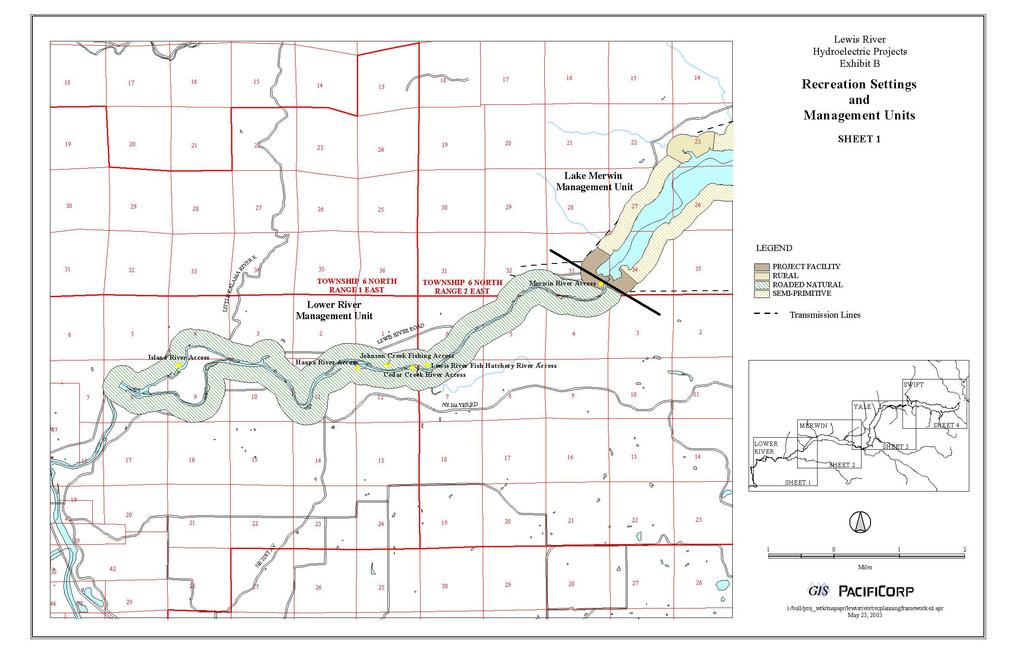
55
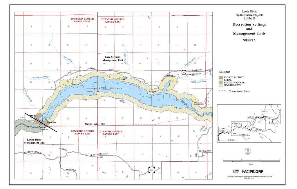
56
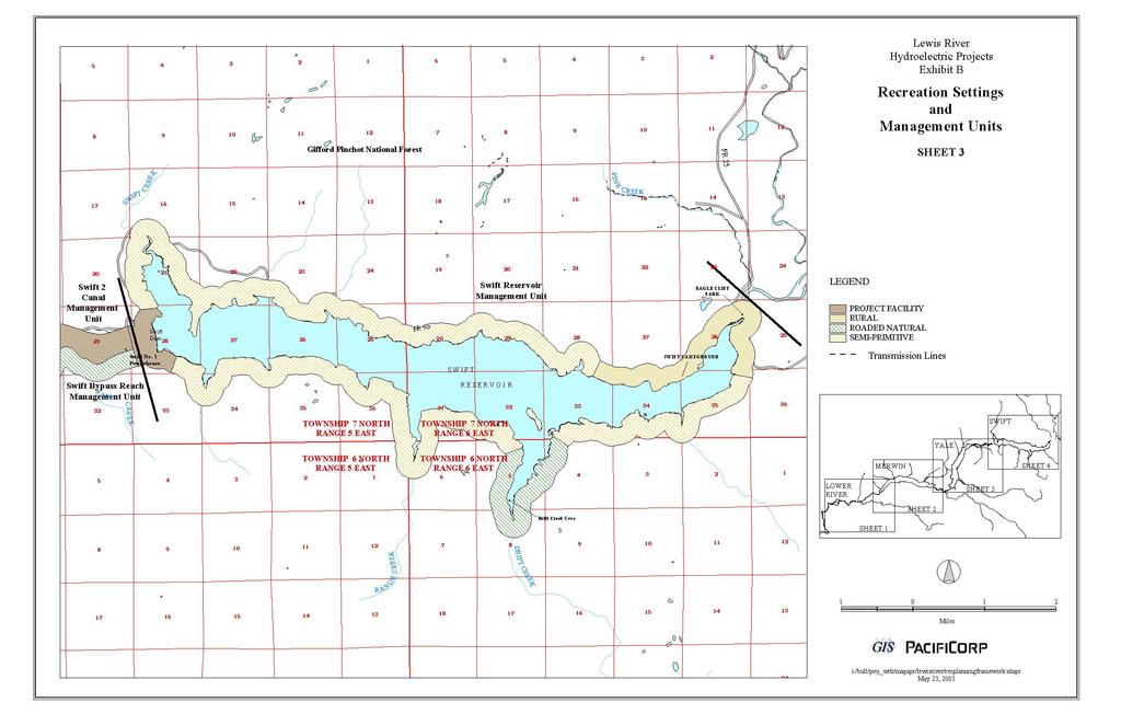
57
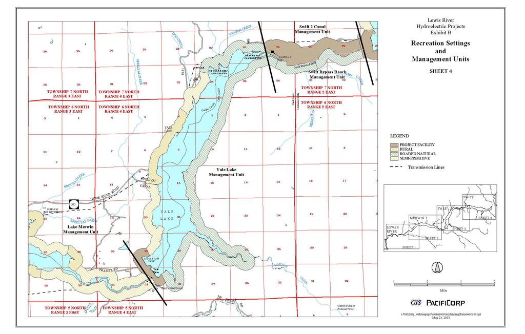
58
59 Exhibit C Proposed Recreation Measures, Schedules, and Estimated Costs
60
61 PacifiCorp FERC Project Nos. 935, 2071, 2111 Exhibit C. Proposed Recreation Measures, Schedules, and Costs. RECREATION FACILITY / CAPITAL IMPROVEMENT ACTIONS SWIFT RESERVOIR 1. Dispersed Shoreline Use Sites Recreation Dispersed Shoreline Use Program, inventory and harden appropriate shoreline dispersed campsites and day use sites for boat-in use at Swift Reservoir. Unsuitable dispersed campsites and day use sites will be identified and signed as closed. A test of composting toilets will be conducted at Drift Creek Cove to try and better manage campsite sanitary conditions. At 4 dispersed campsites in Drift Creek Cove, small composting toilets will be tested for two years. Also at Swift Reservoir, the use of portable toilet buckets will be tested for two years. This test will be conducted for a period of 2 years and then evaluated for success, along with a sanitation education program that will be concurrently tested at Yale Lake. Dispersed shoreline campsites and day use sites will be posted for pack it in/pack it out refuse removal by site users. Sites open for camping will be posted as camping allowed here. Priority (1-4) 1 / Schedule (C, L) 2 Priority 1 / Schedule L to L1 (inventory and test phase), L2 to L4 (implement) 2. Trails Develop a new non-motorized, natural surface trail extending from Eagle Cliff Park to the USDA-FS Priority 1 / Route boundary that will ultimately link up with the USDA-FS existing Lewis River Trail. Trail facilities will include an Study L1, Construction engineered trail, signage, and resource protection as appropriate. The trail will likely require rock and stair work in the L4 first trail section were Eagle Cliff is traversed or a trail built above the cliff. A detailed trail routing study will be performed in Year 1 after the new licenses become final to locate and design an appropriate trail corridor, preferably through PacifiCorp and WDNR-managed lands. Criteria to be used in this study include locating a safe, economical, and buildable trail route and avoiding potential impacts to Bull trout, to the extent practicable, by locating the trail away from sensitive habitat areas. A no or minimal cost trail easement must be obtained from WDNR before the trail project can commence. If the preferred trail route crosses privately owned land, a no or minimal cost trail easement will need to be obtained before the proposed trail project can commence. If easements can be obtained, design, permitting, can be obtained, construction will immediately follow the trail routing study. 3. I&E Program Following development of an I&E Program in Year 1 of the new licenses, install appropriate interpretive signs, kiosks, or other facilities to implement the program at Swift Reservoir (Costs included in Proposed Programmatic Actions-1. I&E Program). 4. ADA Accessibility Improvements At Swift Reservoir, renovate existing facilities over time and provide for new accessible recreation facilities to comply with the Americans with Disabilities Act (ADA) and its accessibility guidelines, as defined in ADAAG, as amended. ADA-accessible facilities to be considered will include: campsites, picnic sites, shelters, swim areas, fishing access sites, boat launches, toilets/restrooms/showers, trash receptacles, campground program areas, interpretive facilities, drinking faucets, telephones, parking, and primary pedestrian access routes and trails, as appropriate. Upon the new licenses becoming final, conduct an evaluation of ADA-accessibility needs using the latest ADAAG guidance, as amended. Upgrade facilities that are not otherwise planned for renovation. Priority 1 / Schedule L (program dev.), L1 to L5 (implement) Priority 1 / Schedule L (Study), L1 L7 for existing Swift Forest Camp Estimated Costs (2003 Dollars) Cost Estimate Breakouts and Notes (2003 Dollars) $160,000 $60,000 Capital, $20,000 Sanitation Test Program and $80,000 for 30 years of monitoring. Costs for full implementation of sanitation program cannot be estimated at this time. $157,000 $0 See Proposed Programmatic Actions for Study and Implementation Costs $205,000 $25,000 for ADA Evaluation Study and $180,000 Capital. 5. Day Use Facilities Provide a new day use group picnic shelter in the day use area of Swift Forest Camp. Size to cover six standard picnic tables and make available for reservations. 6. Day Use Facilities At Eagle Cliff Park, install a double vault toilet and create a small picnic area at the north (upstream) end of the parking area. Abandon and remove facilities in the old Eagle Cliff day-use area south of the roadway. Priority 1 / Schedule L4 Priority 2 / Schedule L10 $80,000 $75,000 April 2004 Draft RRMP Exhibit C - Page 1
62 PacifiCorp FERC Project Nos. 935, 2071, Campground and Group Camps Expand camping facility capacity when needed at Swift Reservoir, based on hitting monitoring trigger thresholds. At Swift Forest Camp, two alternatives were developed that provided approximately 27 new RV/tent campsites and two group sites or 40 new RV/tent sites. Expansion will occur between the existing campground and the area to the west. Campsite spur length will vary between 20 and 35 feet. Each campsite will have a level campsite spur, 1 picnic table, 1 fire ring/grill, and 1 tent pad area; water faucets, gray water sumps, and restroom/shower buildings will be shared between campsites. Redesign and relocation of the boat launch parking and access will probably be needed. Adequate buffer distance will be provided between facilities. Priority 3 / (Anticipated Schedule L20 to L29) monitoring threshold dependent $1,805,000 $500,000 Restroom Building, $150,000 for 30 campsites, $1,000,0000 Utility Upgrades and $155,000 for 15 site group camp with shelter. SWIFT RESERVOIR TOTAL $2,482,000 SWIFT BYPASS REACH 1. No facilities are proposed in this management unit by PacifiCorp. None None SWIFT BYPASS REACH TOTAL $0 YALE LAKE 1. Dispersed Shoreline Use Sites Recreation Dispersed Shoreline Use Program, inventory and harden appropriate shoreline dispersed campsites and day use sites for boat-in use at Yale Lake. Unsuitable dispersed campsites and day use sites will be identified and signed as closed. Facility improvements for site hardening at campsites may include fire rings, picnic tables, and tent pads based on site-specific conditions. In conjunction with the tests of composting toilets and bucket toilets at Swift Reservoir, an education program will be tested at Yale Lake to better manage campsite sanitation. Following validation in year three of the license, appropriate techniques for sanitation management, either the composting toilet program, bucket toilet, or education program will be implemented unless there is agreement between PacifiCorp and the LRC to test or implement another alternative. Dispersed campsites and day use sites will be posted for pack it in/pack it out refuse removal by site users. Sites open for camping will be posted as camping allowed here. 2. Trails Resolve recreation use and access issues along the 12 (11.97) mile Yale/IP Road. Goal is to have the existing roadway open to non-motorized multi-use recreation access from the bridge over the Lewis River at the eastern terminus to Healy Road to west. It may be that a continuous through trail is not possible to achieve in the near term; in that case an out-and-back trail would be pursued. As issues are resolved for at least an out- and-back trail the elements of Item 3 will be implemented to open that section of trail to public use. Methods to allow recreation use along the roadway may include possible fee and/or easement acquisition/clarification for trail use, with the goal to provide public non-motorized recreational access for the life of the licenses at the lowest cost. During this phase, studies will be completed for bridge safety evaluations, bridge safety retrofit and design, engineering, and permitting and rock fall hazard assessments. PacifiCorp s obligation is to provide a capped budget amount of up to $500,000 to apply toward these efforts. Any remaining funds will carry over and add to the cost capped amount in Item Trails Following resolution of potential trail use along the 12 mile Yale/IP Road corridor and the extent of the trail possible at this time, provide trail surface cleaning and pothole repair, 2 end trailheads (15 to 20 parking stalls with 1 vault toilet and 2 picnic tables, each) for continuous trail; if in the near term, only an out-and-back trail is possible, 1 trailhead will be constructed. A mid-point trailhead will also be developed and will include a single-hole vault toilet with 2 picnic tables. For either scenario (continuous trail or out-and-back trail), provide appropriate reservoir access, trail and other signage, necessary gates, and bridge safety railing retrofits. PacifiCorp s obligation is to provide a capped budget amount of up to $596,000 to apply toward this action. Priority 1 / Schedule L to L1 (inventory/test), L2 to L4 (implement) Priority 1 / Schedule L to L4 Priority 1 / Commence upon completion of Yale Capital Item #5. $190,000 $90,000 Capital, $20,000 Sanitation Test Program and 80,000 for 30 years of monitoring. Costs for full implementation of sanitation program cannot be estimated at this time. $500,000 $596, Trails and Interpretation - Provide trails and interpretive signage at the Beaver Bay wetland (Yale Interim Measure). Priority 1 / Construction 2004 Schedule C $80,000 Yale Implementation Project scheduled for April 2004 Draft RRMP Exhibit C - Page 2
63 PacifiCorp FERC Project Nos. 935, 2071, Trails - To enhance trail opportunities at Yale Lake, provide signs at all existing and future non-motorized, multi-use trails. Develop a non-motorized, multi-use, natural surface trail between Saddle Dam Park and Saddle Dam Trail (this is a small trail connection between the parking lot to the existing trail at the northern end of Saddle Dam). PacifiCorp and WDFW will work cooperatively to develop a mutually agreeable strategy to evaluate the potential impacts of equestrian use on elk in the Project area during the elk wintering season at Saddle Dam Farm. PacifiCorp will evaluate and implement improvements for horse trailer parking outside of the gate at Saddle Dam Park. The size of this trailer parking area will accommodate 5 to 10 vehicles with horse trailers and include a horse tie-up rail. As part of the I&E Program (see RRMP Section 3.5), provide appropriate signage to redirect equestrians to other appropriate winter-time trail route(s) and to educate them regarding winter elk foraging and habitat disturbance concerns. PacifiCorp will identify the existing trail route(s) through Saddle Dam Farm and will identify what vegetative or topographic screening, identify the existing vegetative or topographic screening, if any. PacifiCorp, in cooperation with WDFW, will plant appropriate vegetative screening or relocate the trail(s) to create a visual and noise buffer from existing elk foraging areas. If neither of these methods are deemed feasible or successful and if equestrian use warrants, PacifiCorp will, at the direction of WDFW, seasonally close the trail(s) via appropriate signage and gates. Provide a new non-motorized, multi-use, natural surface trail between Cougar Campground and Beaver Bay Campground. Approximately 2 miles in length. Provide a 0.5-mile non-motorized, multi-use, gravel surface trail loop from the public restroom at the town of Cougar to a reservoir overlook area and back. Evaluate and implement improvements for horse trailer parking outside of the gate at Saddle Dam Park. Size to accommodate 5 to 10 vehicles with horse trailers and a horse tie-up rail. Priority 1 / Schedule L to L5 6. ADA Accessibility Improvements - At Yale Lake, renovate existing facilities over time and provide for new Priority 1-2 / Schedule accessible recreation facilities to comply with the Americans with Disabilities Act (ADA) and its accessibility C, continue L to L7 for guidelines, as defined in ADAAG, as amended. ADA-accessible facilities to be considered will include: campsites, existing Yale Park, picnic sites, shelters, swim areas, fishing access sites, boat launches, toilets/restrooms/showers, trash receptacles, Saddle Dam Park and campground program areas, interpretive facilities, drinking faucets, telephones, parking, and primary pedestrian access Cougar Day-Use Area. routes and trails, as appropriate. Upon the new licenses becoming final, conduct an evaluation of ADA-accessibility Existing Cougar needs using the latest ADAAG guidance, as amended. Upgrade facilities that are not otherwise planned for renovation. Campground and Beaver Bay Campground upgraded under other actions. $254,000 $25,000 Connect Saddle Dam Park parking lot to Saddle Dam Trail, $102,000 Cougar Campground to Beaver Bay Campground Trail, $52,000 Restroom Loop Trail at Cougar Restrooms and $75,000 Horse Trail Parking Improvements at Saddle Dam. $374,000 $25,000 for ADA Evaluation Study and $349,000 Capital. 7. I&E Program Following development of an I&E Program in Year 1 of the new licenses, install appropriate interpretive signs, kiosks, or other facilities to implement the program at Yale Lake (Costs included in Proposed Programmatic Actions-1. I&E Program). 8. Boat Launch Provide a new boat launch at Saddle Dam Park and remove the 15 existing campsites (Completed Yale Interim Measure). 9. Boat Launch - At Yale Park, extend 1 concrete boat ramp lane approximately 10 to 20 feet horizontal and 1.5 to 3.0 feet vertical (depending upon topography) to improve reasonable year-round boater access (provide 3 feet of water depth at the toe of the ramp lane at 470 feet pool elevation). Replace the existing floating boat docks (Yale Interim Measure). 10. Boat Launch - At Beaver Bay Boat Launch, replace the floating boat dock and repair the eroded side banks next to the boat ramp using new riprap rock material (Yale Interim Measure). 11. Day Use Parking Provide an improved separation between the Beaver Bay boat launch parking area and the adjacent wetland. Provide a new earth berm, drainage ditch and fence and acquire all necessary permits. Location of new berm to be 10 to 15 feet on the reservoir side of the existing berm or other mutually acceptable location to WDFW and PacifiCorp. Priority 1 / Schedule L (program dev.), L1 to L5 (implement) $0 See Proposed Programmatic Actions for Study and Implementation Costs Priority 1 / Schedule C $365,000 Project Completed as Yale Implementation Priority 1 / Schedule L3 Priority 1 / Schedule L3 Priority 1 / Schedule L3 $200,000 $140,000 $20,000 April 2004 Draft RRMP Exhibit C - Page 3
64 PacifiCorp FERC Project Nos. 935, 2071, Day Use Facilities Provide a new day use group picnic shelter in the day use picnic area of Yale Park (options include Cougar Park and Beaver Bay). Size to cover six standard picnic tables and make available on reservation system. This shelter to be placed where users can access the shoreline to beach boats. Better define and expand the parking at Yale Park (Yale Interim Measure). 13. Day Use Facilities Replace or renovate the day-use restroom at Cougar Day-Use Park to meet modern ADA standards, as amended. 14. Campgrounds and Group Camps As a Priority 2 at Beaver Bay Campground, redesign the entire site and access routes and provide for a total of approximately 43 renovated RV/tent campsites and 1 renovated group camp accommodating approximately 15 RVs (remove approximately 20 campsites and the roadway adjacent to the wetland complex). During redesign and reconstruction, replace the 2 older, existing restrooms at Beaver Bay Campground (Yale Interim Measure). An option depending on demand is to convert Beaver Bay Campground during renovation to 4 group camps providing approximately 60 campsites. 15. Campgrounds - As a Priority 2 at Cougar Camp, renovate the existing tent-only campground to relocate sites farther back from the shoreline while retaining approximately 45 campsites (current number of sites is 45). 16. Trails Provide 12 miles of 10-ft. wide 2 asphalt paving (AC) along the Yale/IP Road trail corridor. Other two phases must be successfully completed before implementation of this action. 17. Campgrounds and Group Camps - Expand camping capacity when needed at Cougar Campground based on hitting monitoring trigger thresholds. Develop approximately 78 new RV/tent campsites and a new group site, or 90 new RV/tent campsites (each site will have a 20 to 35 foot level campsite spur, 1 picnic table, 1 fire ring/grill, and 1 tent area; water faucets, gray water sumps, and restroom/shower buildings will be shared between campsites. Composition of individual campsites/group sites will be determined closer to implementation of the actual project based on demand. These new sites will be developed between Cougar Camp and Lewis River Road in an undeveloped area, and potentially in the current Cougar Camp boat launch area that may be closed to allow increased campground capacity. Adequate buffer distance will be provided between Cougar Creek and Lewis River Road and the new campground expansion area. LAKE MERWIN 1. Dispersed Shoreline Use Sites Recreation Dispersed Shoreline Use Program, inventory existing campsites and dayuse sites and identify appropriate sites for continued day-use recreation. Unsuitable dispersed shoreline use sites (camping and day-use sites) will be identified and signed as closed. Remaining shoreline day use sites will be posted for pack it in/pack it out refuse removal by site users. All of the remaining sites will be posted as camping not allowed. Priority 1 / Schedule L6 $80,000 Priority 2 Schedule L5 $500,000 Priority 2 Schedule L12 Priority 2 Schedule L13 Priority 2 / Schedule L15 Priority 3 / (Anticipated Schedule L18 to L25) monitoring threshold dependent $2,965,000 $215,000 renovated campsites, $1,000,000 replace two older restrooms, $1,000,000 utility upgrades and $750,000 road way upgrades. $225,000 $265,000 YALE LAKE TOTAL $10,054,000 Priority 1 / Schedule L to L1 (inventory/test), L2 to L4 (implement) $3,300,000 $1,000,000 for two restroom shower buildings, $390,000 for 78 campsites, $600,000 Roadways, $1,000,0000 Utility Upgrades and $310,000 for 2; 15 site group camps with shelters. $90,000 $10,000 Capital and $80,000 for 30 years of monitoring. 2. Trails - At Lake Merwin, provide signs at all existing and future non-motorized, multi-use trails at Merwin Park (Marble Creek Costs are included in Merwin Capital Item #3) and Cresap Bay Campground. 3. Trails Improve the existing half-mile Marble Creek non-motorized, multi-use trail to ADA-accessible standards (ADAAG, as amended). Remove the old viewing platform. Evaluate the need for safety fencing at the trail terminus. Provide a bench or picnic table at the trail end, along with information about Marble Creek and the falls. 4. Trails Following further analysis, provide a non-motorized, multi-use trail easement across PacifiCorp-owned land to provide pedestrian access between a proposed new VCPRD-managed regional park south of Lake Merwin and the reservoir shoreline. The trail easement would be supported by a future VCPRD-managed parking area and other recreation facilities up the hill above Buncombe Hollow Road on non-pacificorp lands. The trail access would terminate at a naturally appearing, low development shoreline site. Priority 1 / Schedule L to L5 Priority 1 / Schedule L3 Priority 1 / Schedule L3 $5,000 $118,500 $10,000 April 2004 Draft RRMP Exhibit C - Page 4
65 PacifiCorp FERC Project Nos. 935, 2071, I&E Program Following development of an I&E Program in Year 1 of the new licenses, install appropriate interpretive signs, kiosks, or other facilities to implement the program at Lake Merwin (Costs included in Proposed Programmatic Actions-1. I&E Program). 6. ADA Accessibility Improvements - At Lake Merwin, renovate existing facilities over time and provide for new accessible recreation facilities to comply with the Americans with Disabilities Act (ADA) and its accessibility guidelines, as defined in ADAAG, as amended. ADA-accessible facilities to be considered will include: campsites, picnic sites, shelters, swim areas, fishing access sites, boat launches, toilets/restrooms/showers, trash receptacles, campground program areas, interpretive facilities, drinking faucets, telephones, parking, and primary access routes and trails, as appropriate. Upon the new licenses becoming final, conduct an evaluation of ADA-accessibility needs using the latest ADAAG guidance, as amended. Upgrade facilities that are not otherwise planned for renovation. Priority 1 / Schedule L (program dev.), L1 to L5 (implement) Priority 1 / Schedule C, continue L to L5 for existing Merwin Park, Speelyai Bay and Cresap Campground and Day-Use Area. See Proposed Programmatic Actions for Study and Implementation Costs $279,000 $25,000 for ADA Evaluation Study and $254,000 Capital. 7. Boat Launches Extend the boat launch ramp at Speelyai Bay Park by extending the existing concrete ramp approximately 6 feet vertical (45 feet horizontal). This extension will provide reasonable year-round boating access to the reservoir (provide 3 feet of water depth at the toe of the ramp lane at 227 ft. pool level). Also, replace the boarding floats. 8. Non-motorized Boating Access Provide an improved river access site at the Yale Bridge area for small, nonmotorized watercraft launching and take-out. Install new steps and railings along the hillside slope from the gravel parking area next to the bridge to the reservoir shoreline. Provide appropriate signage. Litter control will be pack-itin/pack-it-out. 9. Day Use Facilities Improve Merwin Park to encourage greater day use activity by providing 2 new volleyball courts, 1 new children s play structure (budget for play structure is capped at $150,000), and 4 new horseshoe pits. 10. Day Use Facilities Provide 2 new day use group picnic shelters at Merwin Park. Size each to cover 6 standard picnic tables and make available on the reservation system. Remove original fixed picnic tables on the hillside at Merwin Park and replace them with a suitable number of portable tables to match demand. Place the new picnic tables in the level grass area. 11. Day Use Facilities - Upgrade the existing restroom building at Speelyai Bay Park if possible, or replace it with new building that meets modern ADA standards. The upgrade, if possible, is to meet ADA standards within the existing structure. 12. Day Use If the Parking existing Improve structure parking cannot in be the upgraded quarry area then at it Speelyai will be replaced Bay Park, and evaluate the feasibility of providing additional parking under the nearby project transmission lines with trail access to the boat launch. LOWER RIVER (BELOW MERWIN DAM) 1. I&E Program Following development of an I&E Program in Year 1 of the new licenses, install appropriate interpretive signs, kiosks, or other facilities to implement the program in the Lower River area (Costs included in Proposed Programmatic Actions-1. I&E Program). 2. Day Use Improvements Provide two double-hole vault toilets, one each at Island River Access and Cedar Creek River Access. Provide new ADA-accessible vault toilets (CXT or equivalent) at the Merwin Hatchery River Access Site (single vault), Johnson Creek River Access Site (single vault), and Lewis River Hatchery River Access Site (double vault). 3. Day Use Improvements Provide 2 to 3 picnic tables at each of the 5 river access sites as space and site conditions allow. Priority 1 / Construction scheduled for 2004 Schedule C Priority 1 / Schedule L5 Priority 1 / Schedule L3 Priority 1 / Schedule L3 Priority 1 / Schedule L5 Priority 2 / Schedule L11 $80,000 $75,000 $250,000 $180,000 $500,000 LAKE MERWIN TOTAL $1,697,500 Priority 1 / Schedule L (program dev.), L1 to L5 (implement) Priority 1 / Schedule L1 Priority 2 / Schedule L10 $110,000 $100,000 Capital for Improvement of Quarry Parking and $10,000 for evaluation of parking under power lines. $0 See Proposed Programmatic Actions for Study and Implementation Costs $350,000 $7,500 LOWER RIVER (BELOW MERWIN DAM) TOTAL $357,500 April 2004 Draft RRMP Exhibit C - Page 5
66 PacifiCorp FERC Project Nos. 935, 2071, 2111 TOTAL ESTIMATED RECREATION FACILITY (CAPITAL IMPROVEMENT) COSTS $14,591,000 OPERATIONS AND MAINTENANCE (O&M) ACTIONS (30 YEAR TOTAL) SWIFT RESERVOIR 1. Annual Recreation Facility O&M (Existing) Provide for all annual O&M at existing developed recreation sites (Eagle Cliff Park and Swift Forest Camp, boat launch, and day use area) per maintenance standards and frequencies (The Swift Forest Camp item is contingent on an agreement for control of the Swift Forest Camp property via a longterm lease or purchase from WDNR for the term of the new licenses). 2. Annual Recreation Facility O&M (Future) Provide for all annual O&M at future recreation facilities new multiuse/non-motorized trail from Eagle Cliff Park to the USDA-FS boundary, and up to 27 new RV/tent campsites and 2 new group camps at Swift Forest Camp per maintenance standards and frequencies. 3. Campground Schedules - Keep Swift Forest Camp open through mid-november for camping use by hunters and others. Priority (1-4)/ Schedule (C, L) Priority 1 / Schedule C, continue L to L Term Priority 1 / Schedule L5 to L Term Priority 1 / Schedule C, continue L to L Term Priority 1 / Schedule L to L Term Estimated Costs (2003 Dollars) $3,588,000 $105, Shoreline Use Sites O&M Provide for all annual O&M at shoreline use sites per maintenance standards and $600,000 frequencies. 5. Control of Swift Forest Camp Property - Long Term Lease or Purchase of Swift Camp Property from WDNR Priority 1/ Schedule L to L Term $600,000 SWIFT RESERVOIR TOTAL (30 Years) $4,893,000 SWIFT BYPASS REACH No PacifiCorp O&M costs in this area. None None SWIFT BYPASS REACH TOTAL (30 Years) $0 YALE LAKE 1. Annual Recreation Facility O&M (Existing) Provide for all annual O&M at existing developed recreation sites per maintenance standards and frequencies. 2. Annual Recreation Facility O&M (Future) Provide for all annual O&M at future recreation facilities per maintenance standards and frequencies; including O&M of Yale Interim Measures, IP/Yale Road Trail, Saddle Dam Parks, Beaver Bay Campground, Cougar Camp/Park, Yale Park, and new trail segments. 3. Shoreline Use Sites O&M Provide for all annual O&M at shoreline use sites per maintenance standards and frequencies. LAKE MERWIN 1. Annual Recreation Facility O&M (Existing) Provide for all annual O&M at existing developed recreation sites per maintenance standards and frequencies. Priority 1 / Schedule C, continue L to L Term $4,692,000 Priority 1 / Schedule C (Yale Interim Measures), continue L to L Term (all others) $500,000 Priority 1 / Schedule L to L Term $600,000 YALE LAKE TOTAL (30 Years) $5,792,000 Priority 1 / Schedule C, continue L to L Term $0 Current Practice $4,692,000 Cost Estimate Breakouts and Notes (2003 Dollars) April 2004 Draft RRMP Exhibit C - Page 6
67 PacifiCorp FERC Project Nos. 935, 2071, Annual Recreation Facility O&M (Future) Provide for all annual O&M at future recreation facilities per maintenance standards and frequencies; including O&M of new facilities at Merwin Park, Marble Creek Trail and Speelyai Bay Park. Priority 1 / Schedule L to L Term 3. Campground Schedules - Keep Cresap Bay Campground and Day Use Area open through the month of September. Priority 1 / Schedule L to L Term 4. Shoreline Use Sites O&M Provide for all annual O&M at shoreline day use sites per maintenance standards and frequencies. Priority 1 / Schedule L to L Term $50,000 $150,000 $450,000 LAKE MERWIN TOTAL (30 Years) $5,342,000 LOWER RIVER (BELOW MERWIN DAM) 1. Annual Recreation Facility O&M (Existing) Provide for all annual O&M at existing developed PacifiCorp recreation sites (Merwin Hatchery Access and Johnson Creek Access) and future recreation facilities per maintenance standards and frequencies, including 2 new vault toilets. Priority 1 / Schedule C, continue L to L Term $391, Annual Facility Maintenance at New Facitlies - Provide for all annual O&M for new vault toilets. Priority 1 / Schedule $150,000 L1 3. Annual WDFW Recreation Facility O&M (Existing) In accordance with Exhibit M, provide for the annual O&M Priority 1 / Schedule L $526,800 at 3 lower river access sites owned by WDFW including: Island River Access, Cedar Creek River Access, and Lewis River Hatchery River Access. Seek an agreement between these two parties prior to the new licenses becoming final. Utilize maintenance standards and frequencies, including 1 new vault toilet. to L Term LOWER RIVER (BELOW MERWIN DAM) TOTAL (30 Years) $1,068,000 TOTAL ESTIMATED RECREATION O&M COSTS (30 Years) $17,095,000 PROGRAMMATIC ACTIONS Priority (1-4)/ Schedule (C, L) Estimated Costs (2003 Dollars) 1. Cougar Visitor Contact Center - See Exhibit N - Forest Road 90 Maintenance and Repair, Pine Creek Work Center Priority 1, L to L Term $75,000 Communications Support, and a Visitor Information Facility. See Section 3 of this agreement for the details of the commitment between PacifiCorp and the USDA-FS for support of either grant match funding or long-term maintenance of a visitor information center in Cougar on Company land. 2. I&E Program - Develop and implement a balanced and focused Interpretation and Education (I&E) Program. Budget for development of the I&E Plan is capped at $90,000. The I&E Plan will include sufficient details, specifications, and art work for follow-on printing, production, constructing and installation of I&E identified materials (signs, kiosks, etc.) during the follow-on implementation phase. The I&E Plan will focus on recreation resources, hydro power generation, natural resources, and cultural resources. Weekend campfire programs will be continued and expanded to roughly double the current effort making campfire programs available at all PacifiCorp campgrounds at least one weekend night during July and August. Once the Plan is developed, the I&E Program will be implemented over a 5 year period with a not to exceed capped budget of $20,000 per year for putting in place interpretive signs, kiosks, brochures, and other media. Maintenance and upgrades of the Program (signs, brochures, etc.) will occur annually thereafter up to a capped budget amount of $7,500 per year. Facility maintenance standards and frequencies will be used for signs, kiosks and other similar built facilities. 3. Visitor Management Control Implement additional visitor management controls, such as signs, barriers, and enforcement, to ensure a high quality recreation experience and to enhance public safety. 4. Communications on Recreation Facility Availability Provide earlier notice that project campgrounds and day use facilities are full or approaching capacity. This will be addressed in the I&E Program when fully developed and implemented. Provide real time information for use by visitors. Potential sites for disseminating this information may include Woodland Chamber of Commerce, Cougar Visitor Center, Jack s Restaurant, Island Access, and PacifiCorp s website. Priority 1 / Schedule L (program dev.), L1 to L5 (implement), L6 to L Term (program maintenance) Priority 1 / Schedule L to L Term Priority 1 / Schedule L to L Term Cost Estimate Breakouts and Notes (2003 Dollars) $377,500 $90,000 for Plan, $100,000 for Implementation, $187,500 maintenance and upgrades over the license term. $82,000 $5,000 April 2004 Draft RRMP Exhibit C - Page 7
68 PacifiCorp FERC Project Nos. 935, 2071, Recreational Access to Project Lands Continue the current practice of allowing appropriate non-motorized public day use access to all existing and future PacifiCorp-owned lands, and when possible, conservation easements, for recreational purposes. This would include hunting access, except where unsafe conditions exist, project security needs require exclusion of the public, or public access may harm protected resources. Public access will be addressed in the proposed I&E Program. 6. Land Ownership Retention for Recreation Purposes (Switchback Property) Maintain PacifiCorp ownership of company-owned lands along the south shoreline of the Lewis River below Merwin dam for future recreational use if needed. Develop this site in a similar manner as the Johnson Creek River Access Site when use at the other five river access sites managed by PacifiCorp on the Lewis River is at capacity during their peak use seasons (Spring and Fall). 7. Overnight Parking and Dispersed Shoreline Use - At Yale Lake and Swift Reservoir, permit overnight parking at the project boat launch parking areas for visitors who are using the shoreline for dispersed camping (excludes Lake Merwin). 8. Campground Gate Access and Scheduling At night, close but do not lock gates to the entrance of campgrounds to discourage cruising, vandalism and theft, and disturbance to campers, while maintaining site access for late arriving campers. Continue to lock gates at Project day use sites and boat launches at night. 9. Dispersed Camping Management Funding to the USDA-FS Provide annual funding of $5,220 (PacifiCorp s percentage of $6,000) to the USDA-FS for managing project related dispersed camping on USDA-FS-managed lands. Priority 1 / Schedule C, continue L to L Term Priority 1 / Schedule C, continue L to L Term Priority 1 / Schedule L to L Term Priority 1 / Schedule C, continue L to L Term Priority 1 / Schedule L to L Term $0 Continue current practice. $35,000 $0 $0 $156, Vehicular Access and Use Control Discourage dispersed upland (non-shoreline) camping and motorized use, by keeping project roads gated and maintained as necessary. Continue to work with adjacent private landowners and agency resource managers to restrict access from their non-project lands onto PacifiCorp-owned lands where undesirable motorized access is gained, such as to the IP/Yale Road corridor. 11. ADA Accessible Fishing Sites Conduct a study to identify the most suitable ADA-accessible fishing access site at Year 1 (L) of the new licenses. This study will include Swift, Yale and Merwin reservoirs along with the Lewis River between Merwin Dam and Island River Access. The Swift No. 2 Power Canal will also be included in the study. The most feasible site will be constructed in L4. Up to two additional sites will be built depending on use monitoring threshold triggers. The two additional sites will be cost capped at up to $250,000 each for planning, design, permitting and construction. 12. Public Use of Project RV Dump Stations - Allow the public to use existing RV sanitation dump stations within PacifiCorp-owned campgrounds for a nominal fee. PacifiCorp will coordinate with the USDA-FS (on FR 90) and WSDOT (on SR 503 and SR 503 Spur) to place signs indicating the universal symbol for an RV holding tank dump station on the advance direction signs leading to PacifiCorp-managed campgrounds. RV dump stations will be available at Swift Forest Camp, Beaver Bay Campground, Cougar Campground and Cresap Bay Campground. Priority 1 / Schedule C, continue L to L Term Priority 1 / Schedule L (study), L4 (implement) Priority 1 / Schedule L to L Term TOTAL ESTIMATED PROGRAMMATIC COSTS (30 Years) $1,461,100 TOTAL ESTIMATED 30-YEAR FACILITY (CAPITAL IMPROVEMENT), OPERATIONS $33,147,100 AND MAINTENANCE (O&M), AND PROGRAMMATIC COSTS $35,000 $765,000 $15,000 study and $250,000 each for up to three sites. $5,000 April 2004 Draft RRMP Exhibit C - Page 8
69 PacifiCorp FERC Project Nos. 935, 2071, Priority for New License Actions: Priority 1 - Provide enhanced diversity of recreation opportunities in the project area (generally in the first 5- to 10-year period, or L to L9). In addition, when a project recreation facility is constructed or a recreation program is initiated, maintain existing and new recreation facilities, programs and other resources in the project area for the license terms (Current through License terms, depending upon the action). Priority 2 - Provide upgrades and modernization of existing recreation facilities in the project area (generally in the next 10- to 15-year period, or L10 to L15). Priority 3 - Expand recreation facilities and opportunities up to specified limits in the project area (generally in the next 15- to 25-year period, or L16 to L25). 2 Scheduling: C (Current) = current year, current actions will continue as-is until the new licenses become final. L (License) = initial first year of the new licenses becoming final. L1, L2, L3, etc. = License plus an additional 1 year, 2 years, 3 years, etc. April 2004 Draft RRMP Exhibit C - Page 9
70
71 Exhibit D Conceptual Site Plans
72
73
74
75
76
77
78
79
80
81
82
83
84
85
86
87
88
89
90
91
92
93 Exhibit E Recreation Monitoring Indicators and Standards
94
95 PacifiCorp FERC Project Nos. 935, 2071, 2111 Exhibit E. Recreation Monitoring Indicators and Standards Table 1. Recreation Monitoring Indicators and Standards for Developed Recreation Facilities and Dispersed Shoreline Sites. Monitoring Indicators Developed Recreation Facilities RESOURCE: None identified SOCIAL: Perceived Crowding MANAGERIAL: Boat Use Levels Reservoir Surface Water Project Day Use Site Capacity Utilization Currently not a problem. None required Monitoring Standards Currently not a problem. Based on future detailed survey results (approx. every 12 years after the new licenses become final), average crowding score of 4.5 (scale of 1 to 9) should not be exceeded. Conduct studies sooner than every 12 years if use levels increase significantly. Currently not a problem. Based on future project reservoir boater counts (approx. every 6 years after the new licenses become final), average seasonal weekend watercraft counts should not exceed 25 acres/boat for each project reservoir. Based on future user counts at project day use sites (counts conducted approx. every 6 years after the new licenses become final), the weekly peak month (July and August) capacity utilization of the parking areas should not exceed 75 percent occupancy for the Swift Reservoir Management Unit individually, and the Yale Lake and Lake Merwin Management Units combined. Project Campground Capacity Utilization When day use site use levels reach the above standard, monitoring will be conducted annually and facility planning, permitting, and design will be initiated. Capacity will be assumed if use levels reach or exceed the standard for 3 out of 5 consecutive years. Based on future user counts at project campgrounds (counts conducted approx. every 6 years after the new licenses become final), the weekly peak month (July and August) capacity utilization of campsites should not exceed 90 percent occupancy for the Swift Reservoir Management Unit individually, and the Yale Lake and Lake Merwin Management Units combined. In addition, the weekly seasonal (Memorial Day to Labor Day period) capacity utilization of campsites should not exceed 60 percent occupancy for the Swift Reservoir Management Unit individually, and the Yale Lake and Lake Merwin Management Units combined. Both standards are to be reviewed concurrently, and only 1 standard needs to be triggered. When campground use levels reach one or both of the above standards, monitoring will be conducted annually and facility planning, permitting, and design will be initiated. Capacity will be assumed if use levels reach or exceed one or both of the above standards for 3 out of 5 consecutive years. Dispersed Shoreline Sites RESOURCE: Site Creep (Expansion) Dispersed shoreline sites will be evaluated on site every 4 years. A maximum of 10 percent expansion of the area of impact should be allowed without remediation (this percentage may vary and may be dependent upon the size of the site to be assessed during the initial testing of the monitoring standards and indicators). April 2004 Draft RRMP Exhibit E Page 1
96 PacifiCorp FERC Project Nos. 935, 2071, 2111 Monitoring Indicators Site Pioneering (New Sites) SOCIAL: Perceived Crowding MANAGERIAL: Dispersed Site Utilization (designated and hardened campsites) Monitoring Standards Dispersed shoreline sites will be evaluated on site every 4 years. A maximum of 5 percent expansion into sensitive habitat should be allowed without remediation (this percentage may vary and may be dependent upon the size of the site to be assessed during the initial testing of the monitoring standards and indicators). Dispersed shoreline sites will be evaluated on site every year. If new sites are located, they should be closed as they are identified. Currently not a problem. Based on future detailed survey results (approx. every 12 years after the new licenses become final), average crowding score of 3.5 (scale of 1 to 9) should not be exceeded. Conduct studies sooner than every 12 years if use levels increase significantly. Based on future user counts at project dispersed shoreline campsites (counts conducted approx. every 6 years after the new licenses become final), the weekly peak month (July and August) capacity utilization of designated and hardened dispersed campsites should not exceed 50 percent for each Management Unit (Swift, Yale, and Merwin). Day use sites are excluded. Table 2. Recreation Monitoring Indicators, Method of Measurement, and Management Options for Developed and Dispersed Recreation Sites. Monitoring Indicators and Frequency Method of Measurement Developed Recreation Facilities Visitor Use Levels at Monitor facility use levels during peak Project Day Use Sites month (July and August) timeframes based on user counts and vehicle counts Frequency = 6 years conducted at selected sample sites. Track data for each sample site, but also aggregate across sites in the Management Unit to develop an overall average/indicator. Perceived Crowding Frequency = 12 years (conduct sooner if use levels increase significantly) Boating Use Levels Frequency = 6 years Monitor visitor perceptions using the results of a detailed visitor survey and an established 9-point crowding scale to identify the percentage of users that feel crowded. Focus on selected sample sites during the summer recreation season (Memorial to Labor Day weekends) and during peak use months of July and August. Indicators to be tracked for each sample site and aggregated for the Management Unit. Monitor boating use on-water at project reservoirs for the season during weekends (count watercraft on-water). Monitor trends in watercraft types. Management Options to Consider When Capacity is Reached Redistribute use by providing visitors with information about alternative sites. Expand the open season. Enhance under utilized sites to make them more attractive. Provide adequate buffer between user groups and sites. Expand the open season. Address identified user conflicts. Provide additional enforcement. Provide visitors with information about alternative boat launches. Campground Capacity Utilization Monitor campground utilization by calculating the average capacity utilization Increase campground capacity. Draft RRMP Exhibit E Page 2 April 2004
97 PacifiCorp FERC Project Nos. 935, 2071, 2111 Monitoring Indicators and Frequency Frequency = 6 years. If a standard is reached, begin to track annually Dispersed Shoreline Sites Site Creep (Expansion) Frequency = 4 years Site Pioneering (New Sites) Frequency = 1 year Perceived Crowding Frequency = 12 years (conduct sooner if use levels increase significantly) Method of Measurement of project campgrounds during the summer recreation season (Memorial Day to Labor Day weekends) and during the 2 peak use months (July and August). Track campgrounds individually and also aggregate for the Management Unit. Monitor designated campsites for expansion of the area of impact. Initially, document the baseline conditions and then monitor for creep at sample sites in each Management Unit (Swift and Yale). Calculate the expansion of area of impact over initial measurement as a percentage. Annually survey the reservoir shoreline and record the number and type of dispersed undeveloped sites. Compare this information with baseline conditions. Evidence of new dispersed sites may include new bare ground, accumulated litter, site erosion, new structures, sanitation problems, and/or vegetation damage. Monitor dispersed site visitor perceptions using the results of a detailed visitor survey and the established 9-point crowding scale (see previous survey questions asked during relicensing) to identify users that feel crowded at varying levels. Focus on selected sample sites during the summer recreation season (Memorial Day to Labor Day weekends) and during the 2 peak use months of July and August. Indicators to be tracked for each sample site and aggregating across sites in the Management Unit (Swift and Yale). Management Options to Consider When Capacity is Reached Institute a limited entry system. Expand the reservation system (partial to full). Provide visitors with information about alternative sites. Erect natural barriers to better define site boundaries. Harden sites including fire rings, picnic tables, and/or tent pads on a site by site basis. Enforce use to officially designated dispersed sites only (signed). Site closures and rehabilitation. Provide additional enforcement. Provide education. Provide visitors with information about location of dispersed sites. Enforce use to officially designated dispersed sites only (signed). Institute a reservation system. Provide additional enforcement. Obliterate new sites. Redistribute use by providing visitors with information about alternative sites. Institute a reservation system. Provide additional buffer between sites. Address user conflicts as needed. Provide enforcement. April 2004 Draft RRMP Exhibit E Page 3
98 PacifiCorp FERC Project Nos. 935, 2071, 2111 Monitoring Indicators and Frequency Dispersed Site Occupancy Frequency = 6 years Method of Measurement Monitor the number of designated, hardened dispersed campsites occupied during the 2 peak months (July and August), both individually and aggregated for the Management Unit (Swift and Yale). Day use sites are excluded. Management Options to Consider When Capacity is Reached Provide visitors with information about alternative sites. Institute a reservation system. Draft RRMP Exhibit E Page 4 April 2004
99 Exhibit F Recreation Monitoring Sites
100
101 PacifiCorp FERC Project Nos. 935, 2071, 2111 Exhibit F. Recreation Monitoring Sites by Management Unit Management Unit Selected Monitoring Sites Swift Reservoir Swift Camp (Campground) Swift Camp (Boat Launch) All dispersed shoreline sites, including Drift Creek and island Swift Reservoir surface water area for boating Eagle Cliff Park Swift No. 2 Power Canal See Cowlitz PUD measures Yale Lake Lake Merwin Lower Lewis River Below Merwin Dam Cougar Camp (Campground) Beaver Bay (Campground) Saddle Dam Park (Boat Launch) Yale Park (Boat Launch) Beaver Bay (Boat Launch) Yale/IP Road Trail Corridor including trailheads All of dispersed shoreline sites Yale Lake surface water area for boating Cresap Bay (Campground) Cresap Bay (Boat Launch) Speelyai Bay (Boat Launch) Cresap Bay (Day Use Area) Merwin Park (Day Use Area) Lake Merwin surface water area for boating Parking areas at 5 river access sites April 2004 Draft RRMP Exhibit F Page 1
102 PacifiCorp FERC Project Nos. 935, 2071, 2111 This page left intentionally blank. Draft RRMP Exhibit F Page 2 April 2004
103 Exhibit G Day-Use Site Fee Agreement
104
105 PacifiCorp FERC Project Nos. 935, 2071 and 2111 Exhibit G. Day-Use Site Fee Agreement This agreement will be inserted upon completion. April 2004 Draft RRMP Appendix G - Page 1
106 PacifiCorp FERC Project Nos. 935, 2071 and 2111 This page left intentionally blank. Draft RRMP Appendix G - Page 2 April 2004
107 Exhibit H Collection Agreement between PacifiCorp and the USDA-FS
108
109 Exhibit H. Collection Agreement between PacifiCorp and the USDA-FS. PacifiCorp FERC Project Nos. 935, 2071 and 2111 This future exhibit will include a future Collection Agreement between PacifiCorp and the USDA-FS. This document is necessary to transfer funds from PacifiCorp to the USDA-FS for activities such as funding for dispersed recreation area management, Forest Road 90 maintenance, Cougar Visitor Contact facility, and/or Drift Creek-related activities. It will be inserted at the time of license issuance. April 2004 Draft RRMP Appendix H Page 1
110 PacifiCorp FERC Project Nos. 935, 2071 and 2111 This page left intentionally blank. Draft RRMP Appendix H Page 2 April 2004
111 Exhibit I FERC License Terms and Conditions
112
113 PacifiCorp FERC Project Nos. 935, 2071 and 2111 Exhibit I. FERC License Terms and Conditions This future exhibit will contain the future FERC License Terms and Conditions to be issued to PacifiCorp by the FERC upon license issuance. It is included herein so that details in the agreement will not be lost and may be cross-referenced as needed during the future implementation of the RRMP. To be inserted after FERC issues new license Terms and Conditions, related to recreation resources. April 2004 Draft RRMP Appendix I Page 1
114 PacifiCorp FERC Project Nos. 935, 2071 and 2111 This page left intentionally blank. Draft RRMP Appendix I Page 2 April 2004
115 Exhibit J Recreation Developed Facility and Dispersed Site Maintenance Standards/Frequency
116
117 PacifiCorp FERC Project Nos. 935, 2071, 2111 Exhibit J. Recreation Facility and Site Maintenance Standards/Frequency Maintenance Standard Boat Launch Ramps: Surface may be A-C, concrete or gravel. Surfaces are to be in good condition without potholes, cracks or heaves. Ramps are to be kept free of debris. Areas are to be free of overhanging brush; adequate sight distance is to be maintained. Recommended Frequency for Areas of Intensive Development Daily (in season): Inspect boat launches and remove debris. Immediately correct or report all deficiencies and hazards. Weekly (off-season): Inspect boat launches and remove debris. Recommended Frequency for Areas of Moderate Development Bi-Weekly (in season): Inspect boat launches and remove debris. Immediately correct or report all deficiencies and hazards. Weekly (off-season): Inspect boat launches and remove debris. Recommended Frequency or Areas of Minimal Development Bi-Weekly (in season): Inspect boat launches and remove debris. Immediately correct or report all deficiencies and hazards. Weekly (off-season): Inspect boat launches and remove debris. Buildings: Including restrooms, amphitheaters, interpretive displays, picnic shelters, RV dump stations, firewood shelters. Structures and associated fixtures are maintained in good repair, in safe, clean and sanitary condition at all times. All buildings receive an annual structural maintenance inspection. Items needing repair are corrected immediately or reported for scheduling. Daily: Inspect buildings and fixtures for repair needs; sweep or vacuum floors; clean sinks, windows, counters, seats and displays with appropriate methods; empty waste containers. Weekly: Mop floors if appropriate. As required: Replace light bulbs; remove spider webs and mud swallow nests; inspect and clean eave troughs. Daily: Inspect buildings and fixtures for repair needs; sweep or vacuum floors; clean sinks, windows, counters, seats and displays with appropriate methods; empty waste containers. Weekly: Mop floors if appropriate. As required: Replace light bulbs; remove spider webs and mud swallow nests; inspect and clean eave troughs. Not Applicable Camp/Picnic Site Fireplaces: Inspect for cleanliness and safety. Fireplaces should be free of unburned litter; grates should be intact, hinges working properly. Daily (minimum in season): Remove litter form fireplaces. Remove cold ashes when fireplace is over ½ full. Weekly (minimum in season): Remove litter form fireplaces. Remove cold ashes when fireplace is over ½ full. Weekly (minimum in season): Remove litter form fireplaces. Remove cold ashes when fireplace is over ½ full. Camp/Picnic Site Tables: Inspect for cleanliness and safety. Tables should be sturdy, clean, free from splinters, food debris and graffiti. Weekly (minimum in season) or when dirty: Wash picnic tables. Sand rough spots, tighten loose bolts and replace damaged boards immediately. Monthly (minimum in season) or when dirty: Wash picnic tables. Sand rough spots, tighten loose bolts and replace damaged boards immediately. Bi-Monthly (minimum in season) or when dirty: Wash picnic tables. Sand rough spots, tighten loose bolts and replace damaged boards immediately. The frequency of maintenance tasks shown above is a recommended level only. The actual frequency needed to maintain the maintenance standards will vary depending upon site specific variables such as park location, season of the year, number of park visitors, etc. Draft RRMP Exhibit K (08/18/03) 1
118 PacifiCorp FERC Project Nos. 935, 2071, 2111 Maintenance Standard Culverts and Ditches: Associated with park roads, parking lots, camploops and trails. Culverts and ditches will be kept open and repaired so they function as intended. Recommended Frequency for Areas of Intensive Development Yearly Pre-Winter (September/October): Perform inspections of culverts and ditches. After server weather events additional inspections may be warranted. Items needing repair are corrected immediately or reported for scheduling. Recommended Frequency for Areas of Moderate Development Yearly Pre-Winter (September/October): Perform inspections of culverts and ditches. After server weather events additional inspections may be warranted. Items needing repair are corrected immediately or reported for scheduling. Recommended Frequency or Areas of Minimal Development Yearly Pre-Winter (September/October): Perform inspections of culverts and ditches. After server weather events additional inspections may be warranted. Items needing repair are corrected immediately or reported for scheduling. Dispersed Shoreline Use Sites: Includes boat in shoreline day-use and camping sites. Areas are to be relatively free of litter and user built site improvements. Not Applicable Not Applicable Annually: Inspect day-use, camping and closed sites; remove user built site improvements including rock fire rings, docks, rafted logs, spikes in trees, signs, tables, chairs, ropes and tarps. Inspect company-installed amenities at campsites including fire rings, picnic tables and signs. Report deficiencies for repair scheduling. Collect litter. Report significant erosion problems caused by visitor use. Garbage/Litter Collection: All park areas are litter-free. Garbage cans are routinely emptied kept in good condition and free from odors. Litter is removed from open spaces, camp and picnic sites, trails, footpaths and parking areas as soon as it is seen. Garbage can liners are removed as soon as they are full, and are replaced with new liners. Litter is removed from open spaces, camp and picnic sites, trails, footpaths and parking areas as soon as it is seen. Garbage can liners are removed as soon as they are full, and are replaced with new liners. Litter is removed from open spaces, camp and picnic sites, trails, footpaths and parking areas as soon as it is seen. Garbage can liners are removed as soon as they are full, and are replaced with new liners. The frequency of maintenance tasks shown above is a recommended level only. The actual frequency needed to maintain the maintenance standards will vary depending upon site specific variables such as park location, season of the year, number of park visitors, etc. Draft RRMP Exhibit K (08/18/03) 2
119 PacifiCorp FERC Project Nos. 935, 2071, 2111 Maintenance Standard Gravel Surfaced Areas: Including roads, parking areas, and campsites. Surfaces are to be in good condition without potholes and mudholes. Areas are to be free of overhanging brush; adequate sight distance is to be maintained. Recommended Frequency for Areas of Intensive Development Quarterly: Inspect all areas; remove overhanging vegetation; correct minor surface deficiencies; schedule major repair needs such as grading or resurfacing. Inspect immediately after severe weather events. Items needing repair are corrected immediately or reported for scheduling. Recommended Frequency for Areas of Moderate Development Semi Annually: Inspect all areas; remove overhanging vegetation; correct minor surface deficiencies; schedule major repair needs such as grading or resurfacing. Inspect immediately after severe weather events. Items needing repair are corrected immediately or reported for scheduling. Recommended Frequency or Areas of Minimal Development Semi Annually: Inspect all areas; remove overhanging vegetation; correct minor surface deficiencies; schedule major repair needs such as grading or resurfacing. Inspect immediately after severe weather events. Items needing repair are corrected immediately or reported for scheduling. Marinas, Boat Docks, Swim Floats Fishing Piers and Swim Buoys: Decking and shoreline connection points are sound. Cleats, buoys and markers are visible and correctly located. Underwater and on-shore hazards, litter and unwanted vegetation are removed in marinas, near boat docks, swim floats, fishing piers and swim buoys. Bi-Weekly (minimum in season): Inspect all areas; immediately correct or report all deficiencies and hazards. Inspect immediately following severe weather or high water events. Pre and Post Season: When swim buoys are out of water inspect for cracked plastic, sharp edges, frayed cables or exposed cable ends. Clean buoys of accumulated algae when they are out of the water. Bi-Weekly (minimum in season): Inspect all areas; immediately correct or report all deficiencies and hazards. Inspect immediately following severe weather or high water events. Pre and Post Season: When swim buoys are out of water inspect for cracked plastic, sharp edges, frayed cables or exposed cable ends. Clean buoys of accumulated algae when they are out of the water. Not Applicable Natural Occurrences: Including snow, heavy rain, wind and floods. Public and employee safety is established immediately. Inspect park areas as soon as possible after the occurrence. Items needing repair are corrected immediately or reported for scheduling. Inspect park areas as soon as possible after the occurrence. Items needing repair are corrected immediately or reported for scheduling. Inspect park areas as soon as possible after the occurrence. Items needing repair are corrected immediately or reported for scheduling. Non-public Buildings: Including maintenance shops, pump houses, storage buildings, park residences. Building interior and exteriors will be maintained in a safe, clean condition at all times. All buildings will receive an annual structural maintenance inspection. Monthly: Perform safety and housekeeping inspection. Items needing repair are corrected immediately or reported for scheduling. Monthly: Perform safety and housekeeping inspection. Items needing repair are corrected immediately or reported for scheduling. Not Applicable The frequency of maintenance tasks shown above is a recommended level only. The actual frequency needed to maintain the maintenance standards will vary depending upon site specific variables such as park location, season of the year, number of park visitors, etc. Draft RRMP Exhibit K (08/18/03) 3
120 PacifiCorp FERC Project Nos. 935, 2071, 2111 Maintenance Standard Other Facilities and Activities: Including maintenance services, camp host sites, barrier-free campsites, areas of primary protection for cultural and natural resources and hazard trees. Items needing repair are corrected immediately or reported for scheduling. Recommended Frequency for Areas of Intensive Development Weekly: Inspect camp host sites and barrier free camps sites. Check boundaries of resource protection areas. Monthly: Inspect service contracts (like refuse hauling and firewood delivery). Annually: Inspect hazard trees. Recommended Frequency for Areas of Moderate Development Weekly: Inspect camp host sites and barrier free camps sites. Monthly: Inspect service contracts (like refuse hauling and firewood delivery). Check boundaries of resource protection areas. Annually: Inspect hazard trees. Recommended Frequency or Areas of Minimal Development Annually: Check boundaries of resource protection areas, inspect hazard trees. Paved Areas: Including roads, parking lots, campsite hardstands, pavement surface may be A-C, concrete or paver block. Surfaces are to be in good condition without potholes, cracks or heaves. Striping is to be clearly visible. Areas are to be free of overhanging brush; adequate sight distance is to be maintained. Quarterly: Inspect paved areas; correct minor repair needs such as potholes; remove debris and overhanging brush; schedule major repair needs such as striping, overlay or chip-seal. Items needing repair are corrected immediately or reported for scheduling. Semi Annually: Inspect paved areas; correct minor repair needs such as potholes; remove debris and overhanging brush; schedule major repair needs such as striping, overlay or chip-seal. Items needing repair are corrected immediately or reported for scheduling. Not Applicable Playground Equipment: All playground equipment is to be maintained in accordance with the standards set forth in the Handbook for Public Playground Safety, U.S. Consumer Product Safety Commission, Washington, D.C Weekly (minimum in season): Inspect to insure compliance and user safety. Immediately replace or remove any substandard components. Not Applicable Not Applicable The frequency of maintenance tasks shown above is a recommended level only. The actual frequency needed to maintain the maintenance standards will vary depending upon site specific variables such as park location, season of the year, number of park visitors, etc. Draft RRMP Exhibit K (08/18/03) 4
121 PacifiCorp FERC Project Nos. 935, 2071, 2111 Maintenance Standard Potable Water Hydrants: Inspect for cleanliness and operation. Faucets should turn on and off easily and should not leak. No litter, food debris nor vegetation should accumulate around the base. The base drain should take a full flow of water from the faucet. Recommended Frequency for Areas of Intensive Development Weekly: Turn on faucet to check operation and base drainage. Remove litter, debris and weeds from base. Repair faucet and drainage as needed. Items needing repair are corrected immediately or reported for scheduling. Recommended Frequency for Areas of Moderate Development Monthly: Turn on faucet to check operation and base drainage. Remove litter, debris and weeds from base. Repair faucet and drainage as needed. Items needing repair are corrected immediately or reported for scheduling. Recommended Frequency or Areas of Minimal Development Not Applicable Potable Water Systems: Including wells, treatment plants, lines, and pressure systems. All potable water systems must meet the requirements for federal and state safe drinking water. Each potable water system must be operated according to the specifications, standards and design features of the particular system. Daily (or as required): Monitor treatment plants and perform required tests. Prepare and submit reports as required. Items needing repair are corrected immediately or reported for scheduling. Daily (or as required): Monitor treatment plants and perform required tests. Prepare and submit reports as required. Items needing repair are corrected immediately or reported for scheduling. Not Applicable Registration Stations: Including campground registration booths, parking fee booths. Structures and associated fixtures are maintained in good repair, in safe, clean, operational condition at all time. All buildings receive an annual structural maintenance inspection. Daily: Inspect to insure visitor and employee safety; lighting and other operational hardware is functioning correctly. Items needing repair are corrected immediately or reported for scheduling. Daily: Inspect to insure visitor and employee safety; lighting and other operational hardware is functioning correctly. Items needing repair are corrected immediately or reported for scheduling. Not Applicable The frequency of maintenance tasks shown above is a recommended level only. The actual frequency needed to maintain the maintenance standards will vary depending upon site specific variables such as park location, season of the year, number of park visitors, etc. Draft RRMP Exhibit K (08/18/03) 5
122 PacifiCorp FERC Project Nos. 935, 2071, 2111 Maintenance Standard Restroom/Shower Buildings: Including pit and vault toilets, showers and restrooms inside other public and non-public buildings. Structures and fixtures are maintained in good repair, in clean and sanitary condition at all times. Items needing repair are corrected immediately or reported for scheduling. Recommended Frequency for Areas of Intensive Development Daily: Inspect building and fixtures for repair needs; sweep floors, dispose of floor sweepings in waste containers; mop floors with disinfectant solution; clean sinks, urinals, toilets, mirrors, counters and shower stall walls with disinfectant solution, use scouring powder when necessary; dry sinks and toilet seats; empty waste containers. Weekly: Wash restroom and shower walls with disinfectant; scrub shower walls to prevent soap scum build-up; open and clean floor drains; clean the pipe chase and inventory maintenance supplies. As required: Replace light bulbs, replace paper products; remove spider webs and mud swallow nests; inspect and clean eave troughs. Recommended Frequency for Areas of Moderate Development Three times per week: Inspect building and fixtures for repair needs; sweep floors, dispose of floor sweepings in waste containers; mop floors with disinfectant solution; clean sinks, urinals, toilets, mirrors, counters and shower stall walls with disinfectant solution, use scouring powder when necessary; dry sinks and toilet seats; empty waste containers. Alternate Weeks: Wash restroom walls with disinfectant; open and clean floor drains; clean the pipe chase and inventory maintenance supplies. As required: Replace light bulbs, replace paper products; remove spider webs and mud swallow nests; inspect and clean eave troughs. Recommended Frequency or Areas of Minimal Development Once per week: Inspect building and fixtures for repair needs; sweep floors; mop floors with disinfectant solution; clean toilets with disinfectant solution, use scouring powder when necessary; dry toilet seats; empty waste containers. Check capacity of vault toilets during weekly cleaning. Once per month: Wash restroom walls with disinfectant. As required: Replace paper products; remove spider webs and mud swallow nests; inspect and clean eave troughs; pump vaults as needed or at a minimum, once per year Sewage Treatment Systems: Including septic tanks and drainfields, lift stations and pressure lines. All sewage treatment systems must meet state and federal guidelines. People who manage waste treatment plants must meet required state licensing and continuing education requirements. Each treatment system must be operated according to the specifications, standards and design features of the particular system. Daily (or as required): Monitor treatment systems and perform required tests. Prepare and submit reports as required. Items needing repair are corrected immediately or reported for scheduling. Daily (or as required): Monitor treatment plants and perform required tests. Prepare and submit reports as required. Items needing repair are corrected immediately or reported for scheduling. Not Applicable The frequency of maintenance tasks shown above is a recommended level only. The actual frequency needed to maintain the maintenance standards will vary depending upon site specific variables such as park location, season of the year, number of park visitors, etc. Draft RRMP Exhibit K (08/18/03) 6
123 PacifiCorp FERC Project Nos. 935, 2071, 2111 Maintenance Standard Signs: Signs should be clean, legible and damage-free; signposts should be straight. All vehicle signs should be in conformance with the Manual for Uniform Traffic Control Devices (MUTCD). No visitor or handmade signs in recreation areas. Recommended Frequency for Areas of Intensive Development Weekly: Inspect signs. Replace signs with are missing or damaged within three days (in season, five days offseason). Traffic control signs must be replaced immediately. Recommended Frequency for Areas of Moderate Development Weekly: Inspect signs. Replace signs with are missing or damaged within five days (in season, ten days offseason). Traffic control signs must be replaced immediately. Recommended Frequency or Areas of Minimal Development Monthly: Inspect signs. Replace missing or damaged signs within five days (in season, ten days off-season). Traffic controls signs must be replaced immediately. Sink Waste Disposals: Inspect for cleanliness and operation. Disposals should take a full flow of water. The disposal screen, base and area should be free of food debris, litter and vegetation. The disposal should be properly signed. Daily: Pour a 2-gallon bucket of water into each disposal. Wash screen and disposal base daily. Remove litter, sticks and debris. Items needing repair are corrected immediately or reported for scheduling. Alternate days: Pour a 2-gallon bucket of water into each disposal. Wash screen and disposal base daily. Remove litter, sticks and debris. Items needing repair are corrected immediately or reported for scheduling. Not Applicable Trails and Footpaths: Including paved bicycle and footpaths, and surfaced hiking, interpretive, horse and mountain bike trails. Surfaces may be A-C, concrete, gravel, wood chip or native soil. Surfaces are to be in good condition without potholes, cracks or heaves, mudholes or weeds, including tree roots. Footbridges are to be sound, stringers and decking are to be rot-free. Areas are to be free of overhanging brush; adequate sight distance is to be maintained. Monthly: Inspect all areas; remove overhanging vegetation; correct minor surface deficiencies, schedule major repair needs such as overlay, grading or resurfacing. During season of operation inspect immediately after server weather events. Quarterly: Inspect all areas; remove overhanging vegetation; correct minor surface deficiencies; schedule major repair needs such as overlay, grading or resurfacing. During season of operation inspect immediately after severe weather events. Semi Annually: Inspect all areas; remove overhanging vegetation; correct minor surface deficiencies; schedule major repair needs such as grading or resurfacing. During season of operation inspect immediately after severe weather events. The frequency of maintenance tasks shown above is a recommended level only. The actual frequency needed to maintain the maintenance standards will vary depending upon site specific variables such as park location, season of the year, number of park visitors, etc. Draft RRMP Exhibit K (08/18/03) 7
124 PacifiCorp FERC Project Nos. 935, 2071, 2111 Maintenance Standard Turf Areas: All turf and grass areas should be healthy and vigorous. Specific treatments such as irrigation, verti-slicing, fertilization, and pesticide application should be undertaken when necessary and appropriate. If parks are open, entry points to areas receiving fertilizer and pesticide applications will be posted for an appropriate time before, during and after the treatment. Recommended Frequency for Areas of Intensive Development Intensely managed turf areas should be kept to moderates size around public buildings. Mowing should be sufficient to keep lawns looking neat and trim (about weekly during the growing season). Irrigation and fertilization are appropriate. Grass in campsites and along roadsides should be mowed when its height exceeds 4. Recommended Frequency for Areas of Moderate Development Grass within 50 feet of a building and in campsites should be mowed when its height exceeds 4. Roadsides should be mowed when grass exceeds 6 in height. Fields and open area meadows should be mowed when grass exceeds 12 in height. This standard does not apply to habitat areas Recommended Frequency or Areas of Minimal Development Roadsides should be mowed when grass exceeds 6 in high. Fields and rough grass areas should be mowed when grass exceeds 12 in height. This standard does not apply to habitat areas. The frequency of maintenance tasks shown above is a recommended level only. The actual frequency needed to maintain the maintenance standards will vary depending upon site specific variables such as park location, season of the year, number of park visitors, etc. Draft RRMP Exhibit K (08/18/03) 8
125 PacifiCorp FERC Project Nos. 935, 2071, 2111 Recreation Development Classifications Recreation Facility Name Intensive Development Moderate Development Minimal Development Cedar Creek River Access Site X Island River Access Site X Lewis River Hatchery Access Site X Johnson Creek River Access Site X Merwin Hatchery River Access Site X Merwin Park X Speelyai Bay Park X Cresap Bay Campground and Day- X Use Saddle Dam Park X Yale Park X Cougar Park X Cougar Camp X Beaver Bay Campground X Swift Forest Camp X Eagle Cliff Park X Shoreline Use Sites - All Reservoirs X The frequency of maintenance tasks shown above is a recommended level only. The actual frequency needed to maintain the maintenance standards will vary depending upon site specific variables such as park location, season of the year, number of park visitors, etc. Draft RRMP Exhibit K (08/18/03) 9
126
127 Exhibit K Dispersed Shoreline Recreation Sites
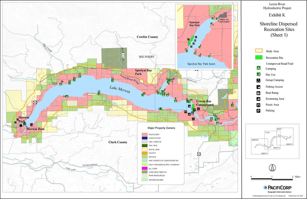
128
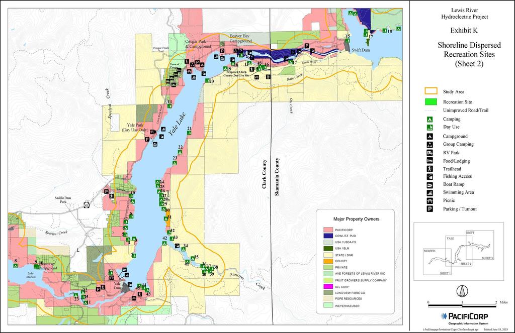
129
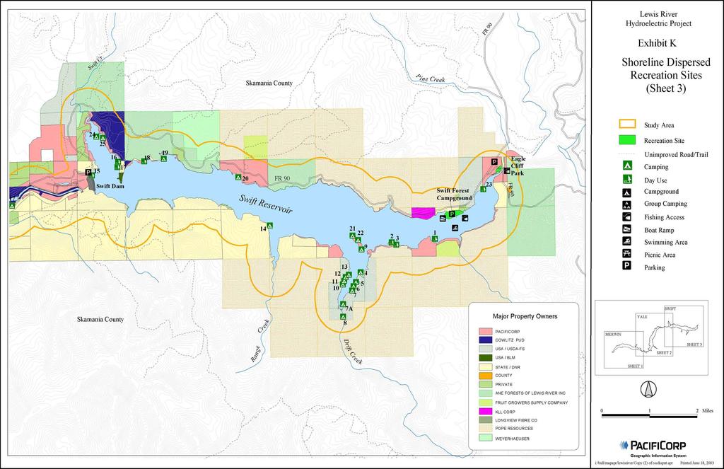
130
Wallowa Falls Hydroelectric Project FERC Project No. P-308 Proposed Study Plans - Recreation August 2011
 Wallowa Falls Hydroelectric Project FERC Project No. P-308 August 2011 Prepared by: PacifiCorp Energy Hydro Resources 825 NE Multnomah, Suite 1500 Portland, OR 97232 For Public Review Wallowa Falls Hydroelectric
Continental Divide National Scenic Trail Legislative History and Planning Guidance
 Continental Divide National Scenic Trail Legislative History and Planning Guidance Legislation, Policy, and Direction Regarding National Scenic Trails The National Trails System Act, P.L. 90-543, was passed
Understanding the caring capacity of the visitor experience Provide facilities to support a high level user experience Address visual quality through
 Understanding the caring capacity of the visitor experience Provide facilities to support a high level user experience Address visual quality through recreation ecological restoration opportunities Collaboration
TABLE OF CONTENTS LIST OF TABLES NONE LIST OF FIGURES NONE
 PacifiCorp / Cowlitz PUD FERC Project Nos. 935, 2071, 2111, 2213 TABLE OF CONTENTS 7.2 RECREATION DEMAND ANALYSIS (REC 2)... REC 2-1 7.2.1 Study Objectives... REC 2-1 7.2.2 Study Area... REC 2-1 7.2.3
Decision Memo Broken Wheel Ranch Equestrian Outfitter Special-Use Permit Proposed Action
 Decision Memo Broken Wheel Ranch Equestrian Outfitter Special-Use Permit USDA Forest Service Mississippi Bluffs Ranger District, Shawnee National Forest Jackson and Union Counties, Illinois Proposed Action
COMMISSION OF THE EUROPEAN COMMUNITIES. Draft. COMMISSION REGULATION (EU) No /2010
 No /2010") COMMISSION OF THE EUROPEAN COMMUNITIES Brussels, XXX Draft COMMISSION REGULATION (EU) No /2010 of [ ] on safety oversight in air traffic management and air navigation services (Text with EEA relevance)
COMMISSION OF THE EUROPEAN COMMUNITIES Brussels, XXX Draft COMMISSION REGULATION (EU) No /2010 of [ ] on safety oversight in air traffic management and air navigation services (Text with EEA relevance)
METROPOLITAN COUNCIL 390 North Robert Street, St. Paul, MN Phone (651) TDD (651)
 TDD (651)") DATE: March 27, 2012 METROPOLITAN COUNCIL 390 North Robert Street, St. Paul, MN 55101 Phone (651) 602-1000 TDD (651) 291-0904 TO: Metropolitan Parks and Open Space Commission FROM: Arne Stefferud, Planning
DATE: March 27, 2012 METROPOLITAN COUNCIL 390 North Robert Street, St. Paul, MN 55101 Phone (651) 602-1000 TDD (651) 291-0904 TO: Metropolitan Parks and Open Space Commission FROM: Arne Stefferud, Planning
COMMISSION IMPLEMENTING REGULATION (EU)
") 18.10.2011 Official Journal of the European Union L 271/15 COMMISSION IMPLEMENTING REGULATION (EU) No 1034/2011 of 17 October 2011 on safety oversight in air traffic management and air navigation services
18.10.2011 Official Journal of the European Union L 271/15 COMMISSION IMPLEMENTING REGULATION (EU) No 1034/2011 of 17 October 2011 on safety oversight in air traffic management and air navigation services
DIRECTOR S ORDER #41: Wilderness Preservation and Management
 These are relevant sections about Wilderness Management Plans from National Park Service 2006 Management Policies, Director s Orders #41 and Reference Manual 41. National Park Service U.S. Department of
Recreation Opportunity Spectrum for River Management v
 Recreation Opportunity Spectrum for Management v. 120803 Introduction The following Recreation Opportunity Spectrum (ROS) characterizations and matrices mirror the presentation in the ROS Primer and Field
RECREATION MANAGEMENT PLAN WELLS HYDROELECTRIC PROJECT FERC NO. 2149
 RECREATION MANAGEMENT PLAN WELLS HYDROELECTRIC PROJECT FERC NO. 2149 May 2010 Prepared by: Public Utility District No. 1 of Douglas County Copyright 2010. Public Utility District No. 1 of Douglas County.
Final Environmental Impact Statement for the Merced Wild and Scenic River. Comprehensive Management Plan, Yosemite National Park, Madera and Mariposa
 This document is scheduled to be published in the Federal Register on 02/26/2014 and available online at http://federalregister.gov/a/2014-04061, and on FDsys.gov DEPARTMENT OF THE INTERIOR 4312-FF NATIONAL
MONTEREY REGIONAL AIRPORT MASTER PLAN TOPICAL QUESTIONS FROM THE PLANNING ADVISORY COMMITTEE AND TOPICAL RESPONSES
 MONTEREY REGIONAL AIRPORT MASTER PLAN TOPICAL QUESTIONS FROM THE PLANNING ADVISORY COMMITTEE AND TOPICAL RESPONSES Recurring topics emerged in some of the comments and questions raised by members of the
Daisy Dean Trail 628/619 ATV Trail Construction
 Background and Purpose and Need The Daisy Dean ATV Trail Construction Project is located in the Little Belt Mountains, Musselshell Ranger District, Lewis and Clark National Forest approximately 32 miles
Appendix D Dispersed/Displaced Recreation Visitor Survey Results
 Appendix D Dispersed/Displaced Recreation Visitor Survey Results Dispersed/Displaced Recreation Visitor Survey Results Lewis River Hydroelectric Projects FERC Nos. 2111, 2213, 2071, and 935 Prepared by:
Rule Governing the Designation and Establishment of All-Terrain Vehicle Use Trails on State Land
 Rule Governing the Designation and Establishment of All-Terrain Vehicle Use Trails on State Land 1.0 Authority 1.1 This rule is promulgated pursuant to 23 V.S.A. 3506. Section 3506 (b)(4) states that an
UNITED STATES DEPARTMENT OF THE INTERIOR BUREAU OF LAND MANAGEMENT MANUAL TRANSMITTAL SHEET
 Form 1221-2 (June 1969) UNITED STATES DEPARTMENT OF THE INTERIOR BUREAU OF LAND MANAGEMENT MANUAL TRANSMITTAL SHEET Release 8-83 Date Subject 8353 Trail Management Areas Secretarially Designated (Public)
Wilderness Areas Designated by the White Pine County bill
 Wilderness Areas Designated by the White Pine County bill SEC. 321. SHORT TITLE. This subtitle may be cited as the `Pam White Wilderness Act of 2006'. SEC. 322. FINDINGS. Congress finds that-- The White
PURPOSE AND NEED. Introduction
 Public Scoping: Allocation of Recreation Capacity for Commercial Outfitter Guide Services on North Kruzof Island Trails (Kruzof Island Outfitter Guide) PURPOSE AND NEED Introduction The U.S. Department
FINAL REPORT OF THE USOAP CMA AUDIT OF THE CIVIL AVIATION SYSTEM OF THE KINGDOM OF NORWAY
 ICAO UNIVERSAL SAFETY OVERSIGHT AUDIT PROGRAMME (USOAP) Continuous Monitoring Approach (CMA) FINAL REPORT OF THE USOAP CMA AUDIT OF THE CIVIL AVIATION SYSTEM OF THE KINGDOM OF NORWAY (16 to 20 November
Proposed Action. Payette National Forest Over-Snow Grooming in Valley, Adams and Idaho Counties. United States Department of Agriculture
 United States Department of Agriculture Forest Service January 2012 Proposed Action Payette National Forest Over-Snow Grooming in Valley, Adams and Idaho Counties Payette National Forest Valley, Adams
MUNICIPALITY OF ANCHORAGE
 MUNICIPALITY OF ANCHORAGE ANCHORAGE PARKS & RECREATION Memorandum PRC 08-56 DATE: 5 August 2008 TO: FROM: SUBJECT: Parks & Recreation Commission Holly Spoth-Torres, Park Planner PRC 08-56 Far North Bicentennial
TERMS OF REFERENCE. Drone Advisory Committee (DAC) Role Name or Title Organization. Director, UAS Integration Office. Director, UAS Integration Office
 Role Name or Title Organization. Director, UAS Integration Office. Director, UAS Integration Office") TERMS OF REFERENCE Drone Advisory Committee (DAC) Committee Leadership Role Name or Title Organization Chairman Lead Designated Federal Officer Subcommittee Oversight Oversight Brian Krzanich Administrator
TERMS OF REFERENCE Drone Advisory Committee (DAC) Committee Leadership Role Name or Title Organization Chairman Lead Designated Federal Officer Subcommittee Oversight Oversight Brian Krzanich Administrator
Sawtooth National Forest Fairfield Ranger District
 United States Department of Agriculture Forest Service Sawtooth National Forest Fairfield Ranger District P.O. Box 189 Fairfield, ID. 83327 208-764-3202 Fax: 208-764-3211 File Code: 1950/7700 Date: December
Parkland County Municipal Development Plan Amendment Acheson Industrial Area Structure Plan
 Parkland County Municipal Development Plan Amendment Acheson Industrial Area Structure Plan New Plan Acheson Industrial Area Structure Plan Amendment Parkland County Municipal Development Plan Board Reference
St. Joe Travel Management EA CULTURAL RESOURCES
 St. Joe Travel Management EA CULTURAL RESOURCES Bruce Gibson May 2015 Regulatory Framework Forest Plan The Idaho Panhandle National Forests (IPNF) Forest Plan requires systematic cultural resource inventory
AGENCY SCOPING MEETING
 AGENCY SCOPING MEETING Environmental Impact Statement (EIS) Conducted for the Friedman Memorial Replacement Airport in the Wood River Region of South Central Idaho December 4, 2007 1:00 p.m. 4:00 p.m.
Rogue River Access and Management Plan Draft Alternatives
 Rogue River Access and Management Plan Draft Alternatives The Rogue River Access and Management Plan was initiated in December, 2011 and is being led by Jackson County Parks (JCP) and Oregon Department
COVER SHEET. Reduced Vertical Separation Minimum (RVSM) Information Sheet Part 91 RVSM Letter of Authorization
 Information Sheet Part 91 RVSM Letter of Authorization") COVER SHEET Reduced Vertical Separation Minimum (RVSM) Information Sheet Part 91 RVSM Letter of Authorization NOTE: FAA Advisory Circular 91-85 ( ), Authorization of Aircraft and Operators for Flight in
COVER SHEET Reduced Vertical Separation Minimum (RVSM) Information Sheet Part 91 RVSM Letter of Authorization NOTE: FAA Advisory Circular 91-85 ( ), Authorization of Aircraft and Operators for Flight in
EXHIBIT K TERMINAL PROJECT PROCEDURES PHASE I - DEVELOPMENT OF TERMINAL PROGRAM & ALTERNATIVES
 EXHIBIT K TERMINAL PROJECT PROCEDURES PHASE I - DEVELOPMENT OF TERMINAL PROGRAM & ALTERNATIVES Over the term of the Master Amendment to the Airline Use and Lease Agreement, the Kansas City Aviation Department
Tahoe National Forest Over-Snow Vehicle Use Designation
 Tahoe National Forest Over-Snow Vehicle Use Designation USDA Forest Service Tahoe National Forest February 20, 2015 Introduction The Forest Service, U.S. Department of Agriculture will prepare an Environmental
Fossil Creek Wild & Scenic River Comprehensive River Management Plan Forest Service Proposed Action - details March 28, 2011
 Fossil Creek Wild & Scenic River Comprehensive River Management Plan Forest Service Proposed Action - details March 28, 2011 Primary Goals of the Proposed Action 1. Maintain or enhance ORVs primarily by
JOSLIN FIELD, MAGIC VALLEY REGIONAL AIRPORT DECEMBER 2012
 1. Introduction The Federal Aviation Administration (FAA) recommends that airport master plans be updated every 5 years or as necessary to keep them current. The Master Plan for Joslin Field, Magic Valley
Watchorn Provincial Park. Management Plan
 Watchorn Provincial Park Management Plan 2 Watchorn Provincial Park Table of Contents 1. Introduction... 3 2. Park History... 3 3. Park Attributes... 3 3.1 Natural... 4 3.2 Recreational... 4 3.3 Additional
AVISTA CORPORATION SPOKANE RIVER AND POST FALLS HYDROELECTRIC DEVELOPMENTS RECREATION PLAN. Spokane River Hydroelectric Project FERC Project No.
 AVISTA CORPORATION SPOKANE RIVER AND POST FALLS HYDROELECTRIC DEVELOPMENTS RECREATION PLAN FERC LICENSE ARTICLES 416 & 417 Spokane River Hydroelectric Project FERC Project No. 2545 Prepared by: REC Resources
Business Item No XXX. Proposed Action That the Metropolitan Council approve the Coon Creek Regional Trail Master Plan.
 Business Item No. 2015-XXX Metropolitan Parks and Open Space Commission Meeting date: July 7, 2015 For the Community Development Committee meeting of July 20, 2015 For the Metropolitan Council meeting
Chapter 1 Introduction and Project Overview
 EPHRATA MUNICIPAL AIRPORT Chapter 1 Introduction and Project Overview The Port of Ephrata in cooperation with the Federal Aviation Administration (FAA) is updating the Airport Master Plan for Ephrata Municipal
Land Management Summary
 photo credit: ANGAIR Anglesea Heath Land Management Summary The Anglesea Heath (6,501 ha) was incorporated into the Great Otway National Park in January 2018. This provides an opportunity to consider the
National Park Service Wilderness Action Plan
 National Park Service U.S. Department of the Interior National Park Service Wilderness Action Plan National Wilderness Steering Committee National Park Service "The mountains can be reached in all seasons.
Lewis River Recreation Sites
 Lewis River Recreation Sites N 0 miles 2 4 8 Parking Fees Hours Visitors entering day-use sites with vehicles must pay applicable fees during peak recreation season. * Pass holders, please check in with
Theme: Predominately natural/natural appearing; rustic improvements to protect resources. Size*: 2,500 + acres Infrastructure**:
 Recreation Opportunity Spectrum (ROS) Classes The Recreation Opportunity Spectrum (ROS) provides a way to describe the variations in the degree of isolation from the sounds and influences of people, and
Bradley Brook Relocation Project. Scoping Notice. Saco Ranger District. United States Department of Agriculture Forest Service
 Bradley Brook Relocation Project United States Department of Agriculture Forest Service Scoping Notice White Mountain National Forest February 2011 For Information Contact: Jenny Burnett White Mountain
WILDERNESS PLANNING. Wilderness. Interagency Regional Wilderness Stewardship Training. Alamosa, Colorado - March 26-29, 2007
 WILDERNESS PLANNING Interagency Regional Wilderness Stewardship Training Alamosa, Colorado - March 26-29, 2007 Suzanne Stutzman Lead Planner/Wilderness Coordinator National Park Service, Intermountain
Chapter 1 Introduction and Project Overview
 Chapter 1 Introduction and Project Overview Kittitas County in cooperation with the Federal Aviation Administration (FAA) is updating the Airport Master Plan for Bowers Field Airport (FAA airport identifier
Project Planning, Compliance, and Funding
 Project Planning, Compliance, and Funding The plans above offer high level guidance to ensure that the A.T. is managed effectively as a whole unit in a decentralized management structure. Cooperative management
COVER SHEET. Reduced Vertical Separation Minimum (RVSM) Information Sheet Part 91 RVSM Letter of Authorization
 Information Sheet Part 91 RVSM Letter of Authorization") COVER SHEET Reduced Vertical Separation Minimum (RVSM) Information Sheet Part 91 RVSM Letter of Authorization NOTE: FAA Advisory Circular 91-85, Authorization of Aircraft and Operators for Flight in Reduced
COVER SHEET Reduced Vertical Separation Minimum (RVSM) Information Sheet Part 91 RVSM Letter of Authorization NOTE: FAA Advisory Circular 91-85, Authorization of Aircraft and Operators for Flight in Reduced
AIRPORT SPONSORSHIP POLICY
 AIRPORT SPONSORSHIP POLICY The Muskegon County Airport (MKG) Sponsorship policy (Policy) is intended to ensure Airport sponsorships are coordinated and aligned with its business goals, maximize opportunity
Unmanned Aircraft System (Drone) Policy
 Policy") Unmanned Aircraft System (Drone) Policy Responsible Officer: Chief Risk Officer Responsible Office: RK - Risk / EH&S Issuance Date: TBD Effective Date: TBD Last Review Date: New Policy Scope: Includes
Unmanned Aircraft System (Drone) Policy Responsible Officer: Chief Risk Officer Responsible Office: RK - Risk / EH&S Issuance Date: TBD Effective Date: TBD Last Review Date: New Policy Scope: Includes
Blueways: Rivers, lakes, or streams with public access for recreation that includes fishing, nature observation, and opportunities for boating.
 Parks, Open Space and Trails PRINCE WILLIAM COUNTY 2008 COMPREHENSIVE PLAN TRAILS PLAN CONTENTS The components of the trails plan are: Intent Definitions Goals, Policies, and Action Strategies Trails Map
Air Operator Certification
 Civil Aviation Rules Part 119, Amendment 15 Docket 8/CAR/1 Contents Rule objective... 4 Extent of consultation Safety Management project... 4 Summary of submissions... 5 Extent of consultation Maintenance
Flow Stand Up Paddle Board Parkway Plan Analysis
 Regional Parks Department Jeffrey R. Leatherman, Director County of Sacramento Divisions Administration Golf Leisure Services Maintenance Rangers Therapeutic Recreation Services Flow Stand Up Paddle Board
L 342/20 Official Journal of the European Union
 L 342/20 Official Journal of the European Union 24.12.2005 COMMISSION REGULATION (EC) No 2150/2005 of 23 December 2005 laying down common rules for the flexible use of airspace (Text with EEA relevance)
Safety Regulatory Oversight of Commercial Operations Conducted Offshore
 Page 1 of 15 Safety Regulatory Oversight of Commercial Operations Conducted Offshore 1. Purpose and Scope 2. Authority... 2 3. References... 2 4. Records... 2 5. Policy... 2 5.3 What are the regulatory
Preferred Recreation Recommendations Stemilt-Squilchuck Recreation Plan March 2018
 Preferred Recreation Recommendations Stemilt-Squilchuck Recreation Plan March 2018 Below are the recommended recreation ideas and strategies that package together the various recreation concepts compiled
REVISED AGENDA. Special Council Meeting. Monday, September 11, 2017 (REVISED TO INCLUDE ON-TABLE ITEMS)
") Mission Statement In carrying out its mandate, Bowen Island Municipality will work towards conducting operations in a way that: Improves the economic, environmental and social well-being for present and
Mission Statement In carrying out its mandate, Bowen Island Municipality will work towards conducting operations in a way that: Improves the economic, environmental and social well-being for present and
CHAPTER III: TRAIL DESIGN STANDARDS, SPECIFICATIONS & PERMITS
 CHAPTER III Trail Design Standards, Specifications & Permits This chapter discusses trail standards, preferred surface types for different activities, permits, and other requirements one must consider
Dear Reviewing Officer:
 From: To: Subject: Date: Attachments: Peter Hart FS-r02admin-review Objection Re: Maroon Bells Snowmass Wilderness Overnight Visitor Use Management Plan Monday, August 14, 2017 8:38:01 PM Final Objection
RE: Access Fund Comments on Yosemite National Park Wilderness Stewardship Plan, Preliminary Ideas and Concepts
 September 30, 2016 Superintendent Yosemite National Park Attn: Wilderness Stewardship Plan P.O. Box 577 Yosemite, CA 95389 RE: Access Fund Comments on Yosemite National Park Wilderness Stewardship Plan,
Committee Report. Community Development Committee For the Metropolitan Council meeting of August 12, Business Item No.
 Committee Report Business Item No. 2015-168 Community Development Committee For the Metropolitan Council meeting of August 12, 2015 Subject: Coon Creek Regional Trail Master Plan, Anoka County Proposed
Finance and Implementation
 5 Finance and Implementation IMPLEMENTATION The previous chapters have presented discussions and plans for development of the airfield, terminal, and building areas at Sonoma County Airport. This chapter
STUDY OVERVIEW MASTER PLAN GOALS AND OBJECTIVES
 INTRODUCTION An Airport Master Plan provides an evalua on of the airport s avia on demand and an overview of the systema c airport development that will best meet those demands. The Master Plan establishes
Official Journal of the European Union L 7/3
 12.1.2010 Official Journal of the European Union L 7/3 COMMISSION REGULATION (EU) No 18/2010 of 8 January 2010 amending Regulation (EC) No 300/2008 of the European Parliament and of the Council as far
Decision Memo Ice Age Trail Improvement (CRAC 37)
") Decision Memo Ice Age Trail Improvement (CRAC 37) U.S. Forest Service Chequamegon-Nicolet National Forest, Medford-Park Falls Ranger District Taylor County, Wisconsin T32N, R2W, Town of Grover, Section
Decision Memo Ice Age Trail Improvement (CRAC 37) U.S. Forest Service Chequamegon-Nicolet National Forest, Medford-Park Falls Ranger District Taylor County, Wisconsin T32N, R2W, Town of Grover, Section
Lewis River Recreation Sites
 Lewis River Recreation Sites Parking Fees Hours Visitors entering day-use sites with vehicles must pay applicable fees during peak recreation season. * Pass holders, please check in with booth attendant
MASTER PLAN EXECUTIVE SUMMARY
 Biscuit Run State Park Scottsville Road (State Route 20) Charlottesville, VA 22902 Biscuit Run State Park MASTER PLAN EXECUTIVE SUMMARY Department of Conservation and Recreation Division of Planning and
Creating a User-Driven Long-Distance OHV Trail Through Partnering
 Joseph Raffaele Outdoor Recreation Planner U.S. Bureau of Land Management Yuma, Arizona Creating a User-Driven Long-Distance OHV Trail Through Partnering BLM is a multiple-use land management agency within
National Wilderness Steering Committee
 National Wilderness Steering Committee Guidance White Paper Number 1 Issue: Cultural Resources and Wilderness Date: November 30, 2002 Introduction to the Issue Two of the purposes of the National Wilderness
BACKGROUND DECISION. Decision Memo Page 1 of 6
 DECISION MEMO DEVIL S ELBOW BY-PASS, BOUNDARY TRAIL NO.1 U.S. FOREST SERVICE T9N, R7E, SECTION 9 RANGE 5E COWLITZ COUNTY WA MOUNT ST. HELENS NATIONAL VOLCANIC MONUMENT, GIFFORD PINCHOT NATIONAL FOREST
4 Rights and duties in connection with the conduct of petroleum activities
 Guidelines for application for Acknowledgment of Compliance (AoC) for mobile facilities intended for use in the petroleum activities on the Norwegian Continental Shelf (Unofficial translation), issued
DEVELOPMENT PERMIT STAFF COMMITTEE REPORT JUNE 19, 2013 CITY OF VANCOUVER PLANNING AND DEVELOPMENT SERVICES
 CITY OF VANCOUVER PLANNING AND DEVELOPMENT SERVICES DEVELOPMENT PERMIT STAFF COMMITTEE REPORT JUNE 19, 2013 FOR THE DEVELOPMENT PERMIT BOARD JULY 15, 2013 760 PACIFIC BOULEVARD (COMPLETE APPLICATION) DE408507/408622
8 CROSS-BOUNDARY AGREEMENT WITH BRAMPTON TRANSIT
 8 CROSS-BOUNDARY AGREEMENT WITH BRAMPTON TRANSIT The Transportation Services Committee recommends the adoption of the recommendations contained in the following report dated May 27, 2010, from the Commissioner
(i) Adopted or adapted airworthiness and environmental standards;
 Adopted or adapted airworthiness and environmental standards;") TECHNICAL ARRANGEMENT FOR THE ACCEPTANCE OF AIRWORTHINESS AND ENVIRONMENTAL APPROVAL OF CIVIL AERONAUTICAL PRODUCTS BETWEEN THE CIVIL AVIATION BUREAU, MINISTRY OF LAND, INFRASTRUCTURE AND TRANSPORT, JAPAN
TECHNICAL ARRANGEMENT FOR THE ACCEPTANCE OF AIRWORTHINESS AND ENVIRONMENTAL APPROVAL OF CIVIL AERONAUTICAL PRODUCTS BETWEEN THE CIVIL AVIATION BUREAU, MINISTRY OF LAND, INFRASTRUCTURE AND TRANSPORT, JAPAN
Susitna-Watana Hydroelectric Project (FERC No ) Recreation Resources Study Study Plan Section Study Implementation Report
 Recreation Resources Study Study Plan Section Study Implementation Report") (FERC No. 14241) Recreation Resources Study Study Plan Section 12.5 2014 Study Implementation Report Prepared for Prepared by AECOM November 2015 TABLE OF CONTENTS 1. Introduction... 4 2. Study Objectives...
(FERC No. 14241) Recreation Resources Study Study Plan Section 12.5 2014 Study Implementation Report Prepared for Prepared by AECOM November 2015 TABLE OF CONTENTS 1. Introduction... 4 2. Study Objectives...
Policy PL Date Issued February 10, 2014
 Subject RENEWABLE ENERGY ON CROWN LAND Compiled by Renewable Energy Program, Biodiversity Branch Replaces Policy Directives Waterpower Site Release Crown Land Onshore Windpower Development - Crown Land
Certification Memorandum. Guidance to Certify an Aircraft as PED tolerant
 Certification Memorandum Guidance to Certify an Aircraft as PED tolerant EASA CM No.: CM-ES-003 Issue 01 issued 23 August 2017 Regulatory requirement(s): CS 23.1309(b)(1), CS 25.1309(a)(1), CS 27.1309(a),
USCIS Foreign Trader, Investor and Regional Center Program (FTIRCP)
") USCIS Foreign Trader, Investor and Regional Center Program (FTIRCP) EXECUTIVE SUMMARY FUNCTIONS The U.S. Citizenship and Immigration Service s (USCIS) Foreign Trader, Investor and Regional Center Program
USCIS Foreign Trader, Investor and Regional Center Program (FTIRCP) EXECUTIVE SUMMARY FUNCTIONS The U.S. Citizenship and Immigration Service s (USCIS) Foreign Trader, Investor and Regional Center Program
Department of Transportation, Federal Aviation Administration (FAA). SUMMARY: Under this notice, the FAA announces the submission deadline of
. SUMMARY: Under this notice, the FAA announces the submission deadline of") This document is scheduled to be published in the Federal Register on 05/09/2018 and available online at https://federalregister.gov/d/2018-09894, and on FDsys.gov [4910-13] DEPARTMENT OF TRANSPORTATION
This document is scheduled to be published in the Federal Register on 05/09/2018 and available online at https://federalregister.gov/d/2018-09894, and on FDsys.gov [4910-13] DEPARTMENT OF TRANSPORTATION
Rural Rustic Road Program
 Virginia Department of Transportation s Rural Rustic Road Program Prepared by the Local Assistance Division Virginia Department of Transportation 1401 East Broad Street Richmond, Virginia 23219 Michael
BACKCOUNTRY TRAIL FLOOD REHABILITATION PROGRAM
 BACKCOUNTRY TRAIL FLOOD REHABILITATION PROGRAM Backcountry Trail Flood Rehabilitation A June 2013 Flood Recovery Program Summary In June 2013, parts of Southern Alberta were devastated from significant
DECISION MEMO. Rawhide Trail #7073 Maintenance and Reconstruction
 Page 1 of 6 Background DECISION MEMO USDA Forest Service Jefferson Ranger District Jefferson County, Montana Rawhide Trail #7073 is located in the Elkhorn Mountain Range approximately 10 miles east of
Proposal to Redevelop Lower Kananaskis River-Barrier Lake. Bow Valley Provincial Park
 Frequently Asked Questions Proposal to Redevelop Lower Kananaskis River-Barrier Lake Bow Valley Provincial Park Frequently Asked Questions What has been decided? What are the details of the plan? What
Section II. Planning & Public Process Planning for the Baker/Carver Regional Trail began in 2010 as a City of Minnetrista initiative.
 Section II Planning & Public Process Planning for the began in 2010 as a City of initiative. city staff began discussions with the Park District on the possibility of a north/south regional trail connection
GENERAL ADVISORY CIRCULAR
 GENERAL CIVIL AVIATION AUTHORITY OF BOTSWANA ADVISORY CIRCULAR CAAB Document GAC-002 ACCEPTABLE FLIGHT SAFETY DOCUMENTS SYSTEM GAC-002 Revision: Original August 2012 PAGE 1 Intentionally left blank GAC-002
URBAN DESIGN REPORT. Proposed Residential Development, Old Church Road, Caledon East
 Proposed Residential Development, Old Church Road, Caledon East TABLE CONTENTS: 1.0 DEVELOPMENT 1.1 Introduction-Analysis of Guiding Principles and Documents 1.2 Community Design and Architectural Design
RUSHMORE CONNECTOR TRAIL PROPOSAL
 PURPOSE AND NEED Background The U.S. Forest Service, Black Hills National Forest (Forest Service) has received a special use permit application from the State of South Dakota Department of Game, Fish and
Federal Aviation Administration. Summary
 Federal Aviation Administration Memorandum Date: February 16, 2006 From: Kim Smith, Manager, Small Airplane Directorate, ACE-100 To: See Distribution Prepared by: Ervin Dvorak, (816) 329-4123 Subject:
Department of Defense DIRECTIVE
 Department of Defense DIRECTIVE NUMBER 5030.61 May 24, 2013 Incorporating Change 2, August 24, 2017 USD(AT&L) SUBJECT: DoD Airworthiness Policy References: See Enclosure 1 1. PURPOSE. This directive establishes
FINAL TESTIMONY 1 COMMITTEE ON RESOURCES UNITED STATES HOUSE OF REPRESENTATIVES. July 13, 2005 CONCERNING. Motorized Recreational Use of Federal Lands
 FINAL TESTIMONY 1 STATEMENT OF DALE BOSWORTH CHIEF Of the FOREST SERVICE UNITED STATES DEPARTMENT OF AGRICULTURE Before the SUBCOMMITTEE ON FORESTS AND FOREST HEALTH And the SUBCOMMITTEE ON NATIONAL PARKS,
NANAIMO AIRPORT LAND USE AND DEVELOPMENT PRINCIPLES
 NANAIMO AIRPORT LAND USE AND DEVELOPMENT PRINCIPLES Nanaimo Airport Commission (the Commission ) Nanaimo Airport ( YCD ) is owned by the Nanaimo Airport Commission, incorporated under the Canada Not-for-Profit
Provincial Railway Guides Section:
 This guide deals with the maintenance roles and responsibilities of provincial railways and road authorities regarding public grade crossing maintenance; development of public grade crossing maintenance
National Scenic Byways Program US Department of Transportation
 1 2 National Scenic Byways Program US Department of Transportation Abstract The Cowlitz-Wahkiakum Council of Governments in partnership with Cowlitz, Skamania and Lewis Counties and the U.S. Forest Service,
Welcome to the future of Terwillegar Park a Unique Natural Park
 Welcome to the future of Terwillegar Park a Unique Natural Park 1 Introduction The Terwillegar Park Concept Plan study will develop an overall concept plan, management objectives and development guidelines
Committee. Presentation Outline
 CW-33-15 11/9/2015 Community and Corporate Services Committee November 10, 2015 1 Presentation Outline Background Vision and Objectives Study Process and Timeline Public and Stakeholder Engagement Organization
Minimum Requirements References in National Park Service Policy
 Minimum Requirements References in National Park Service Policy 2006 NPS Management Policies Chapter 6: Wilderness Preservation and Management 6.3 Wilderness Resource Management 6.3.1 General Policy (in
Certification Memorandum. Large Aeroplane Evacuation Certification Specifications Cabin Crew Members Assumed to be On Board
 Certification Memorandum Large Aeroplane Evacuation Certification Specifications Cabin Crew Members Assumed to be On Board EASA CM No.: CM CS-008 Issue 01 issued 03 July 2017 Regulatory requirement(s):
DRAFT FINAL ACCESSIBILITY GUIDELINES FOR OUTDOOR DEVELOPED AREAS
 Date: October 19, 2009 DRAFT FINAL ACCESSIBILITY GUIDELINES FOR OUTDOOR DEVELOPED AREAS Introduction Background Whom Guidelines Apply To How to Submit Comments Contact for Further Information General Issues:
Ecological Corridors: Legal Framework for the Baekdu Daegan Mountain System (South Korea) Katie Miller* Kim Hyun**
 Katie Miller* Kim Hyun**") Ecological Corridors: Legal Framework for the Baekdu Daegan Mountain System (South Korea) Katie Miller* Kim Hyun** Information concerning the legal instruments discussed in this case study is current as
Ecological Corridors: Legal Framework for the Baekdu Daegan Mountain System (South Korea) Katie Miller* Kim Hyun** Information concerning the legal instruments discussed in this case study is current as
Proposal to Redevelop Lower Kananaskis River-Barrier Lake. Bow Valley Provincial Park. Frequently Asked Questions
 Proposal to Redevelop Lower Kananaskis River-Barrier Lake Bow Valley Provincial Park Frequently Asked Questions What is being proposed? What are the details of the proposal? Where is the project area located?
The Airport Charges Regulations 2011
 The Airport Charges Regulations 2011 CAA Annual Report 2013 14 CAP 1210 The Airport Charges Regulations 2011 CAA Annual Report 2013 14 Civil Aviation Authority 2014 All rights reserved. Copies of this
Port of Friday Harbor
 REQUEST FOR STATEMENTS OF QUALIFICATIONS (RFQ) TO PROVIDE ENGINEERING / CONSULTANT SERVICES AT FRIDAY HARBOR AIRPORT Dated: February 15, 2018 Pursuant to RCW, Chapter 39.80 and FAA AC 150/5100-14E, the