ALPINE NATIONAL PARK
|
|
|
- Georgina Norris
- 5 years ago
- Views:
Transcription

1 ALPINE NATIONAL PARK BOGONG UNIT MANAGEMENT PLAN Conservation & Environment
2 Management Plan ALPINE NATIONAL PARK BOGONG PLANNING UNIT Department of Conservation and Environment September 1992
3 This management plan has been prepared pursuant to Sections 17(2) and 47D of the National Parks Act Ian Harris General Manager. North West. National Parks and Public Land B T Evans Regional Manager North East L A Geary Regional Manager Alexandra F W Noble Regional Manager Central Gippsland M W Stone Regional Manager Bairnsdale G J Squires Regional Manager Orbost
4 FOREWORD The Alpine National Park is Victoria's largest and arguably most magnificent national park. The necessary legislation was passed by Parliament in May 1989, and the Park was proclaimed on 2 December 1989, bringing to reality a vision which had grown and developed among many Australians for more than 50 years. The Park forms a link with the long-established Kosciusko National Park in New South Wales, and its neighbour, Namadgi National Park, in the Australian Capital Territory. A Memorandum of Understanding on the future management of these Australian Alps National Parks has been signed by the responsible Ministers from the Commonwealth, New South Wales and Victoria. The Memorandum sets out the steps the Ministers have agreed to take to co-operate in the management of the Alps parks. Because of its size, the Alpine National Park has been divided into four units for planning purposes. This management plan covers the Bogong unit, which comprises almost 114,000 ha of public land. The State's highest peaks, including Mount Bogong, Mount Feathertop and several others, and the broad, undulating high plains combine to form some of the most spectacular landscapes in the State. Walking in summer and autumn, and cross country skiing in winter are just two of the pursuits enjoyed by thousands of visitors each year. Nationally significant plant and animal species, the most notable being the Mountain Pygmy-possum, give the unit a high conservation status. The four Alpine National Park management plans are the result of the most detailed and comprehensive public land planning project ever attempted in this State. Community participation has been the cornerstone of the project, and the thousands of individuals and organisations from all sections of the community are to be congratulated on their invaluable contribution. I would particularly like to acknowledge the advice provided by the Alpine Advisory Committee, made up of 16 community representatives. Following its tabling in the Victorian Parliament, this management plan will now be implemented. The plan sets the scene for the Park to be managed in a sound, efficient and co-ordinated manner, with clear directions for conservation, recreation and resource uses. The National Parks (Wilderness) Act 1992 specifies a number of areas in the Park as Wilderness Zones, or as Remote and Natural Areas. This management plan incorporates the provisions of the above legislation for these areas. Victoria's Alpine National Park is an inspiration to visitors from Victoria, elsewhere in Australia, and overseas. I believe that the careful and considered management indicated in this plan will ensure that the Park continues to inspire visitors for many generations to come. BARRY PULLEN Minister for Conservation and Environment Management Plan - Bogong Unit 3
5 ACKNOWLEDGEMENTS This plan was prepared by the Alpine Planning Project Team: John Harris. Project Manager Peter Jacobs. Planning Officer Ray Borschmann. Planning Officer Heather Lloyd. Planning Officer Gabrielle Balon. Planning Officer David Handscombe. Technical Assistant Lois Dennes. Word Processor Operator Lorraine Thompson. Word Processor Operator Fran Chalwell. Clerical Officer Rick McRae. Project Officer Many others have provided valuable assistance in the preparation of the plan, particularly: - Staff of the Department's North East, Alexandra, Central Gippsland, Bairnsdale and Orbost Regions - National Parks and Public Land Division staff, particularly Mr. Ian Weir, Assistant Director during most of the project - Staff of DCE's Drafting Services Section - Members of the Alpine Advisory Committee: Ms Gayle Lee (Convenor), Mrs Mary Howson, Ms Georgia Stewart, Cr John Whitsed, Mr Doug Humann, Mr John Van Gemert, Mr Ian Roper, Mr Doug Stevenson, Ms Sarah Stegley, Mr John Siseman, Cr Judith Henderson, Ms Debbie Johnston, Ms Leonie Wyld, Mr Jim Commins, Dr Dick Williams, Mr Neville Lester. (Note: Mrs Mary Howson replaced Ms Gayle Lee as convener from late 1991; Ms Sue Charles-Jones replaced Ms Gayle Lee as a member; Mr Gerry Rayner replaced Dr Dick Williams as a member). The financial assistance received from the Australian National Parks and Wildlife Service towards the costs of preparation of this plan is gratefully acknowledged. 4 Management Plan - Bogong Unit
6 USER GUIDE CONTENTS The Contents pages provide a broad guide to the plan. For specific topics or items, the Index at the end of the plan should be used. The Contents pages include lists of Appendices, Maps and Tables. The plan itself consists of ten parts as follows: PART I ALPINE NATIONAL PARK PART II MANAGEMENT OBJECTIVES - ALPINE NATIONAL PARK PART III ALPINE NATIONAL PARK MANAGEMENT PLANS Parts I, II and III cover the Park as a whole, and are common to each of the four Alpine National Park management plans. PART IV BOGONG PLANNING UNIT This part provides a brief description of the major features, activities and future management directions for the unit. PART V MANAGEMENT ZONES - BOGONG UNIT PART VI MANAGEMENT STRATEGIES This is the core of the plan, and is divided into eight chapters: Chapter 1 Management for Conservation of Resources Chapter 2 Management for Protection Chapter 3 Management for Visitor Use Chapter 4 Management for Resource Use Chapter 5 Interaction with Other Authorities and Landowners Chapter 6 Management of Authorised Uses Chapter 7 Management Organisation and Operations Chapter 8 Further Studies Each chapter is further subdivided into individual sections (e.g. 2.1 Fire Protection, 3.6 Horse Riding). The contents of each section are shown at the beginning of that section (e.g Introduction, Designated Horse Riding Areas). * The strategies and prescriptions relating to each section are marked with an asterisk and shown in bold type. Management Plan - Bogong Unit 5
7 PART VII PLAN IMPLEMENTATION This provides, in tabular form, a summary of the specific actions required to implement the plan. PART VIII DEFINITIONS Covers words and abbreviations used in the plan. PART IX REFERENCES Lists the major references used to assist in the preparation of the plan. PART X APPENDICES INDEX MAPS Comprises all maps referred to in the text. 6 Management Plan - Bogong Unit
8 CONTENTS PAGE PART I ALPINE NATIONAL PARK Brief Description Creation of the Park Legislative Basis for Management Australian Alps National Parks Co-operative Management Alpine Advisory Committee 15 PART II MANAGEMENT OBJECTIVES - ALPINE NATIONAL PARK Primary Management Objectives State Government Strategies 20 PART III ALPINE NATIONAL PARK MANAGEMENT PLANS Purpose of Management Plans Departmental Policies Planning Units Development of Park Management Plans Plan Approval Plan Implementation Plan Amendment, Updating and Replacement 24 PART IV BOGONG PLANNING UNIT Boundaries and Land Tenure Major Feature Recreation Resource Use Future Management 30 PART V MANAGEMENT ZONES - BOGONG UNIT Reference Zone Special Protection Zone Remote Zone Conservation A Zone Conservation B Zone Recreation Development Zone 41 PART VI MANAGEMENT STRATEGIES Management for Conservation of Resources Conservation of Native Flora Conservation of Native Fauna Cultural Resource Management Landscape and Architectural Design Reference Areas Geological and Geomorphological Sites Management for Protection Fire Protection Introduced Animals Introduced Plants Soil Conservation Water Catchment Protection Plant Diseases and Defoliators 101 Management Plan - Bogong Unit 7
9 3. Management for Visitor Use Tourism Overview Community Information and Education Recreation Opportunities Monitoring and Minimising Visitor Impacts Walking and Walking Tracks Horse Riding Camping Snow Recreation Zones Cross Country Skiing Oversnow Vehicles Other Snow Recreation Activities Roads and Vehicle Access Two Wheel Driving and Motor Cycling Four Wheel Driving Fishing Deer Hunting Bicycle Riding Canoeing and Boating Climbing and Abseiling Caves and Caving Aerial Operations Commercial Tourism Organised or Competitive Events Access for Visitors with Disabilities and Limited Mobility Huts Generators and Chainsaws Domestic Animals Visitor Safety Search and Rescue Liaison with User Groups Educational Institutions Management for Resource Use Grazing Timber Harvesting Gravel and Stone Extraction Mining and Mineral Exploration Apiculture Interaction with other Authorities and Landowners Alpine Resorts Commission State Electricity Commission Municipalities and Private Property Management of Authorised Uses Utilities and Services Defence Forces Training Plaques and Memorials Place Names Sponsorship and Advertising Refreshment Sales and Equipment Hire Management Organisation and Operations Management Structure and Staff Resources Volunteer Work Further Studies Research Monitoring Management Plan - Bogong Unit
10 PART VII PLAN IMPLEMENTATION 279 PART VIII DEFINITIONS 293 PART IX REFERENCES 299 PART X APPENDICES Australian Alps Visitor Code (for people with cars and camping) Australian Alps Visitor Code (for people with cars, visiting for a day) Code of Ethics - Cross Country Skiing Code of Ethics - Oversnow Vehicles 314 4A Code of Ethics - Four Wheel Driving Code of Ethics - Recreational Fishing Code of Ethics - Deer Stalking Code of Ethics - Huts Code of Ethics - Park Visits by Educational Institutions Alpine Walking Track Policy Statement Plant Species of National and State Significance Details of Special Protection Zone (restricted circulation - Department use only) Agreement on Provisions for Grazing Licences Agreement on Provisions for Licences for Tourism Operations 332 INDEX 333 MAPS 1 Alpine National Park End of Plan 2a Land Tenure - Bogong unit " 2b Land Tenure - Adjacent to Bogong unit " 3 Management Zones " 3a Recreation Development Zone - Rocky Valley Enlargement " 4 Recreation Opportunity Classes " 5 Walking Tracks " 6 Horse Riding " 7 Defined Camping Areas " 8 Snow Recreation Zones " 8a Snow Recreation Zones - Rocky Valley Enlargement " 8b Snow Recreation Zones - Mount Hotham Enlargement " 9 Roads " 10 Deer Hunting " 11 Huts " 12 Resource Uses " 13 Utilities and Services " Management Plan - Bogong Unit 9
11 LIST OF TABLES No. Page 1 Area Statement - Land Tenure 29 2 Management Zone Area Statement 35 3 Details of Special Protection Zone 38 4 Management Zones - Range of Activities Applicable 42 5 Priority of Management Objectives in Management Zones 43 6 Nationally Significant Plant Species 52 7 Threatened Fauna Species 61 8 Historic Sites 70 9 Visual Quality Objectives for Alterations to Landscape Reference Areas Sites of Geological and Geomorphological Significance 76 11A Management Zone Constraints - Fuel Reduction Burning and Fire Suppression DCE Publications Indicators of Environmental Impacts Caused by Visitors Recreation Monitoring Projects Management Responses to Visitor Actions Walking Track Categories Walking Tracks and Management Zones Walking Track Register and Classification Snow Recreation Zones Ski Trails and Tracks Pole Line Register Oversnow Vehicles - Burramys Management Areas Road Register Fisheries Value, Rating and Management Aims Hut Descriptions and Management Actions Bee Sites Utilities and Services Ranger Positions Research Projects Non-Recreation Monitoring Projects Management Plan - Bogong Unit
12 PART I Alpine National Park Management Plan - Bogong Unit 11
13 12 Management Plan - Bogong Unit
14 1 Brief Description Victoria's Alpine National Park covers 646,200 hectares of public land, extending from near Mansfield to the New South Wales border. It comprises most but not all of the State's alpine and subalpine environments, and substantial tracts of adjoining land. The Park is shown on Map 1. The Department of Conservation and Environment (DCE) is responsible for the management of the Park, which spans parts of five DCE Regions. The Park does not include the Alpine Resorts, which are managed by the Alpine Resorts Commission (ARC). The Alpine National Park covers one of the State's outstanding natural regions. It contains a wide range of natural environments, from the dry river valley of the Snowy River to the alpine summit of Victoria's highest peak, Mount Bogong. The special values of the Park are widely recognised: Nature Conservation The Park supports a wide variety of vegetation types, including about one third of Victoria's native flora species. Over half the State's land bird species and 40% of the mammal species are also found there. A number of these plant and animal species are rare, vulnerable or endangered. Water Catchments The headwaters of many of Victoria's major streams, and part of the headwaters of south eastern Australia's largest river system, the Murray, are located in the Alps. Landscape The diversity of landforms and vegetation has produced a wealth of very beautiful landscapes. Recreation The rugged terrain, superb scenery and ever changing weather together make the Park an outstanding venue for many different recreation activities. Cultural and Historic Features The history of human presence in the Alps spans thousands of years and involves numerous activities. Resource Use The Alps' resources are used for many different enterprises, including tourism, cattle grazing, timber harvesting, bee keeping, water production and mining. The significance of the Victorian Alps is recognised by the listing of the Alpine National Park in the Register of the National Estate. The Government has announced its intention to seek World Heritage listing, the first in Victoria, for the Alpine National Park and national parks in East Gippsland. Work is under way to identify the features or attributes of these areas which are of national or international significance, and which would form the basis of a nomination of these areas for World Heritage listing. 2 Creation of the Park The significance of the natural environments of the Victorian Alps has long been recognised. The concept of a Victorian Alpine National Park was first put forward in detail in 1949, when the then Town and Country Planning Association proposed a park of over 500,000 ha in the State's north eastern highlands. Twenty years later, the Association's successor, the Victorian National Parks Association (VNPA), made a detailed submission for an Alpine National Park to the State Government. In 1974, the VNPA published a detailed case for an Alpine National Park, extending from Mount Baw Baw to the New South Wales border, in its book "The Alps at the Crossroads". Management Plan - Bogong Unit 13
15 In 1970, the Land Conservation Council (LCC) was established by the Government to make recommendations on the use of public land in Victoria. In 1979, following studies which involved lengthy public consultation, the LCC recommended the creation of a series of national parks and other reserves in the alpine area. Bogong, Wonnangatta-Moroka and Cobberas-Tingaringy National Parks, Wabonga Plateau State Park, and the Avon Wilderness were established as a result of these recommendations. Following a special investigation of the alpine area, the LCC further recommended, in 1983, that these parks be extended and linked to form a large contiguous Alpine National Park. Legislation for the Alpine National Park was passed in the Victorian Parliament in May 1989 [National Parks (Alpine National Park) Act 1989], and the Park was formally proclaimed on 2 December Legislative Basis for Management Public land covered by the Alpine National Park management plans totals 705,880 ha, and comprises: - Areas reserved under the National Parks Act - Alpine National Park (including Mount Tamboritha Education Area and sixteen Reference Areas), Avon Wilderness - Areas reserved or to be reserved under the Crown Land (Reserves) Act - Sunnyside Education Area and the Howqua Hills, Grant, Mount Wills and Mount Murphy Historic Areas. DCE exercises its management responsibilities through the various Acts and Regulations which apply to the particular land tenures or to specific activities. The following Acts, regulations made pursuant to these Acts, and subsequent amendments, are relevant to the Alpine National Park: - National Parks Act 1975 specifies the objectives for national parks, and provides a legal framework for the management of national parks and other areas scheduled under the Act - National Parks (Alpine National Park) Act 1989 provides for an Alpine National Park and certain aspects of its management - National Parks (Amendment) Act 1989 provides for wilderness and prohibits new mining activities - National Parks (Wilderness) Act 1992 establishes Wilderness zones and Remote and Natural Areas - Land Act 1958 covers leasing, licensing, control and regulation of the use of unreserved Crown land - Crown Land (Reserves) Act 1978 covers leasing, licensing, management and use of reserved Crown land - Forests Act 1958 applies to the management of State forests and the protection of all protected public land - Land Conservation Act 1970 and the Soil Conservation and Land Utilization Act 1958 are relevant to the mitigation of soil erosion and the management of proclaimed water supply catchments - Vermin and Noxious Weeds Act 1958 and subsequent amendments are relevant to the control of all declared vermin and noxious weeds - Flora and Fauna Guarantee Act 1988 provides for the conservation of all Victoria's native plant and animal species - Wildlife Act 1975 covers all indigenous vertebrate species (other than fish), as well as deer and other species of declared wildlife - Fisheries Act 1968 applies to the management, licensing and control of amateur and commercial fisheries - Archaeological and Aboriginal Relics Preservation Act 1972 refers to the management of all archaeological sites and Aboriginal relics - Land Conservation (Vehicle Control) Act 1972 covers the prevention of soil erosion and damage to public land by vehicular traffic - Water Act 1958 applies to all impoundments, diversions and water works 14 Management Plan - Bogong Unit
16 - Reference Areas Act 1978 provides the legal framework for the management of Reference Areas - Health Act 1958 applies to water quality requirements for urban supplies - Planning and Environment Act 1987 governs statutory land use controls - Conservation Forests and Lands Act 1987 covers DCE administration, enforcement and Codes of Practice - Heritage Rivers Act 1992 provides for the protection of parts of certain rivers, and river catchments 4 Australian Alps National Parks Co-operative Management Victoria's Alpine National Park adjoins Kosciusko National Park in New South Wales, which in turn adjoins Namadgi National Park in the Australian Capital Territory. The three areas, with a total area of 1.4 million ha, include almost all the alpine and subalpine environments in mainland Australia. The responsible managing authorities are: - ACT Parks and Conservation Service - Namadgi NP - NSW National Parks and Wildlife Service (NPWS) - Kosciusko NP - Department of Conservation and Environment - Alpine National Park. Because a common approach to the management of Australia's alpine areas is desired, the Government Ministers responsible for the above three departments, and the Commonwealth Minister for Arts, Heritage and Environment, signed a memorandum of understanding in relation to the co-operative management of the Australian Alps National Parks in July The memorandum was revised in late The memorandum recognises the significance of the Australian Alps National Parks, and the signatories agree to pursue co-operative management and develop complementary policies to protect the scenery, water catchments, plants, animals and cultural heritage of the Alps. It also will promote greater awareness of the opportunities that these valuable resources provide for recreation and tourism in the mountains of south east Australia. The agreement will not alter the statutory or administrative responsibilities of any department or agency, but will encourage liaison and co-operation between all authorities with roles in the Australian Alps. 5 Alpine Advisory Committee A sixteen member Alpine Advisory Committee (AAC) has been appointed under the National Parks (Alpine National Park) Act This committee replaced the ten member Alpine Area Advisory Committee. The function of the AAC is to assist with the development of management plans for the Alpine National Park, as well as other specific tasks designated in the Agreements on grazing licences and tourism operations referred to in the Act (see Appendices 12 and 13). The Committee held seven meetings and had three field trips up to the time of approval of the plan. The membership of the AAC comprises: (i) One representative from each of the following organisations: - Victorian National Parks Association - Conservation Council of Victoria - Federation of Victorian Walking Clubs Inc. - Victorian Farmers' Federation - Mountain Cattlemen's Association of Victoria Inc. - Field Naturalists Club of Victoria Management Plan - Bogong Unit 15
17 (ii) (iii) (iv) - Australian Deer Association Inc. - Australian National Four Wheel Drive Council. One person engaged in commercial tour activities in the Park, nominated by the Director of the Victorian Tourism Commission. Two persons nominated by municipalities adjoining the Park. Five persons nominated by the Minister for Conservation and Environment. 16 Management Plan - Bogong Unit
18 PART II Management Objectives Alpine National Park Management Plan - Bogong Unit 17
19 18 Management Plan - Bogong Unit
20 1 Primary Management Objectives A number of primary management objectives have been identified for the Park. These have been derived after consideration of: - Natural features, values and uses - Relevant Government Acts and Regulations - Government land use decisions - Government policies and strategies. The objects of the National Parks Act 1975, as outlined in Section 4 of the Act, are: - To make provision, in respect of national and state parks (i) (ii) (iii) (iv) For the preservation and protection of the natural environment including wilderness areas in those parks For the protection and preservation of indigenous flora and fauna and of features of scenic or archaeological, ecological, geological, historic or other scientific interest in those parks For the study of ecology, geology, botany, zoology and other sciences relating to the conservation of the natural environment of those parks For the responsible management of the land in those parks. - To make provision in accordance with the foregoing for the use of parks by the public for the purposes of enjoyment, recreation or education and for the encouragement and control of that use. The Government has accepted LCC (1983) recommendations that the Alpine National Park be used to: (a) (b) (c) Provide opportunities for recreation and education associated with the enjoyment and understanding of natural environments Conserve and protect natural ecosystems Supply water and protect catchments and streams. These three primary Park management objectives have the highest priority. Other primary management objectives are listed below, not in order of priority. - Allow natural environmental processes to continue with a minimum of disturbance - Protect landscape values - Protect archaeological and historic sites and features - Provide recreation opportunities for disadvantaged people - Promote visitor safety and low impact visitor use - Develop and promote tourism - Promote an appreciation and understanding of the alpine environments - Preserve and protect the natural environments of Wilderness areas, and remote and natural areas - Provide for resource use in accordance with Government decisions, while minimising environmental impacts - Protect the Park, adjacent land and visitors from wildfire - Control or eradicate pest plants and animals - Encourage and undertake scientific research and monitoring, particularly that which will assist management Management Plan - Bogong Unit 19
21 - Co-operate with local, State and interstate government authorities, residents of the surrounding areas and other organisations to co-ordinate planning and resource management. Each management objective cannot be applied equally throughout the Park, because certain objectives would not be compatible in some areas and at some times. Management zones have been identified for the Bogong unit (see Part V Management Zones), primarily to indicate which management objectives have priority in any area. Table 5 indicates the management objectives which have priority in particular management zones. In Part VI Management Strategies, management objectives specific to individual sections are listed at the end of the introduction to each section. 2 State Government Strategies The primary management objectives for the Park are closely aligned with the State Government's three major strategy directions, as outlined in the Social Justice, Economic and Conservation Strategies. The Social Justice Strategy (Victorian Government 1987b) is aimed at ensuring that government agencies allocate resources and plan initiatives so that their distributional consequences are considered. It emphasises the creation of opportunities for disadvantaged people, extending access and participation, and protecting rights. The Economic Strategy (Victorian Government 1987d) is aimed at developing an internationally competitive and growing Victorian economy. Tourism is seen as a vital sector of that economy, capable of earning considerable "export" income through the attraction of interstate and overseas visitors. This will be achieved through development and promotion. The Conservation Strategy (Victorian Government 1987a) is aimed at the conservation and protection of ecological systems, and the use of the State's resources within a sustainable framework. The policies set out by the Economic and Social Justice Strategies will be achieved in this context of sustainable use. The Conservation Strategy has implications for the methods, styles and impacts of developments undertaken under the Economic and Social Justice Strategies. 20 Management Plan - Bogong Unit
22 PART III Alpine National Park Management Plans Management Plan - Bogong Unit 21
23 22 Management Plan - Bogong Unit
24 1 Purpose of Management Plans Outstanding areas such as the Alpine National Park require active management to ensure that management objectives are achieved. Planning involves a formal process of thinking ahead about the purpose of management and the alternative methods of achieving particular objectives. The purposes of this plan of management are to: - Provide clear directions for conservation, recreation and resource use by establishing objectives and a range of management actions to implement them - Assist the carrying out of all management activities in a sound, efficient and co-ordinated manner - Identify priorities for the allocation of available resources - Minimise conflicts between incompatible or competing activities - Prevent the slow and subtle erosion of the values of the Park by the cumulative effects of small, unplanned decisions - Facilitate community awareness of, and involvement in, the preparation of management plans. Management plans for the Park will guide the Department's Regional staff in carrying out their day to day management activities, and will provide broad directions and policies for future management. * The Regional Managers will ensure that all relevant DCE personnel have ready access to the Alpine National Park management plans. The plans will fulfil a vital role by informing the community on Park management. * Copies of the Park management plans will be publicly available for sale or perusal. 2 Departmental Policies NPPL has prepared a policy and procedure manual (CFL 1988a) which provides guidelines or directions for management of parks and public land. New and updated policies will be regularly prepared for addition to the manual. Policies on various issues and subjects are also prepared by other DCE Divisions. This plan is fully compatible with all current DCE policies. * Management of the Park will adhere to approved Departmental policies. 3 Planning Units In recognition of its size and diversity, the Park has been divided into four units for planning purposes. They are Wonnangatta-Moroka, Bogong, Dartmouth and Cobberas-Tingaringy. The planning units are geographical subdivisions, and are not related to DCE Regional boundaries. A separate comprehensive management plan applies to each planning unit. Thus, in effect, a single management plan of four volumes will apply to the Park. 4 Development of Park Management Plans Management plan preparation for the alpine area commenced in mid-1986, with the establishment of a six member project team at Bright. The work carried out by the project team included: - Ongoing consultations and meetings with DCE personnel involved in Park management. This includes staff of the five Regions involved as well as Head Office staff Management Plan - Bogong Unit 23
25 - Identifying and consulting with the wide range of community interest groups, user groups and individuals - Addressing local Shire Councils and consulting with other government departments and authorities which have responsibilities in the Alps - Briefing the Alpine Advisory Committee - Undertaking numerous field trips and inspections throughout the Alps - Undertaking ongoing publicity and information activities including press releases, TV and radio coverage, and exhibitions and displays at many venues - Preparing and releasing the 140 page document "Alpine Area Planning Proposals" for community comment and reviewing the 400 submissions received - Releasing the four proposed management plans for comment by the community, reviewing the 2240 submissions received, and preparing the final management plans. 5 Plan Approval Following consideration of community input and advice from the Alpine Advisory Committee, this plan was submitted for consideration by the Minister for Conservation and Environment. A copy was then laid before each House of the Victorian Parliament in the autumn 1992 session. 6 Plan Implementation * The Regional Managers will be responsible for the implementation of this Plan, except for those prescriptions where a Head Office Division/Branch or officer is specified. * This Plan will provide the basis for the preparation of annual budgets, works programmes, and the scheduling of activities and actions. Part VII Plan Implementation is a summary listing the projects, works and actions specified in this Plan. The summary includes the priority, duration and responsible body for each project or action. * The Regional Managers will ensure that copies of this Plan are held in all relevant offices and work centres, and that staff are made aware of the Plan contents and their responsibilities in its implementation. * National Parks and Public Land Division (NPPL) will be responsible for monitoring the implementation of this Plan, and for its ongoing amendment, in consultation with the Regions and other Head Office Divisions/Branches (see 7. Plan Amendment, Updating and Replacement below). 7 Plan Amendment, Updating and Replacement Planning is an ongoing process, and amendments to the Plan may become necessary because of such factors as: - Availability of additional resource data - Availability of results of monitoring or research - Additional management experience - Matters arising which are not adequately covered in the Plan - New strategic or policy decisions or directions. If changes to the Plan are necessary as a result of the above factors or any others, a process must exist to enable amendments to be made, and to ensure that actual working copies of the Plan are updated accordingly. 24 Management Plan - Bogong Unit
26 In the absence of such a process, the Plan would become progressively weaker and would gradually lose the respect of its users. 7.1 Plan Amendments This Plan has been approved by the Director of National Parks and Wildlife and endorsed by the relevant Regional Managers. Amendments, other than those of a minor nature, will require a formal process for approval. Action to have an amendment made may be initiated by Regions or Head Office Divisions/Branches. * NPPL will be responsible for monitoring the application of this Plan and for its amendment and updating. Minor amendments will be determined by the Minister, in consultation with the Director of National Parks and Wildlife and the AAC. Major amendments would be those involving issues of significant community interest and/or significant departure from the present plan. Such changes would require the full process of consultation within the Department (Regions, Head Office Divisions/Branches), and with the community (relevant user groups and authorities, AAC, National Parks Advisory Council). Proposed amendments would then be submitted to the Minister for consideration, and subsequently tabled before both Houses of Parliament. Plan copies will be updated for approved amendments (see 7.2 below). The plan makes provision for some changes to Park management to occur without the need for amendment of the plan. Examples include: - Amendments to the Special Protection zone when the status of a significant plant or animal species changes, or a new location is discovered - Application of carrying capacities to key horse riding routes, as these figures are determined 7.2 Updating of Plan Copies * NPPL will be responsible for transmitting approved amendments to Regions and Head Office Divisions/Branches, to enable "working" copies of the Plan to be updated. This information should be in written form as a direct addition to the appropriate section of the Plan, or as a replacement to an existing section or wording. * Regions and Head Office Divisions/Branches will be responsible for ensuring that all working copies in their area are updated accordingly. 7.3 Plan Replacement The need for a replacement Plan will depend on the success of the ongoing process of monitoring, seeking approval for amendments, and transmitting approved amendments to enable updating of working copies. * This Plan will remain in force for a minimum of eight years from the date of its approval, and then until it is superseded by a replacement approved Plan. Management Plan - Bogong Unit 25
27 26 Management Plan - Bogong Unit
28 PART IV Bogong Planning Unit Management Plan - Bogong Unit 27
29 28 Management Plan - Bogong Unit
30 1 Boundaries and Land Tenure The Bogong unit comprises 113,900 ha, mostly national park. Land tenure within the unit is detailed in Table 1 below and shown on Map 2a. Tenure adjacent to the unit is shown on Map 2b. Table 1 AREA STATEMENT - LAND TENURE Area Current Tenure Area (ha) Alpine National Park 1 National park 110,910 To be added to the Park on completion State forest 1,800 of timber harvesting 2 To be added to the Park after transfer Crown grant 1,190 from the SEC 113,900 1 Includes the area of six Reference Areas within the Park boundary - total 3780 ha (see Part VI, 1.5 Reference Areas). 2 East Kiewa (1800 ha) to be declared by July Major Features The unit contains Victoria's highest peak, Mount Bogong (1986 metres), and several others over 1800 metres. The broad, undulating Bogong High Plains and part of the Dargo High Plains are also major features of the unit, providing some of the most spectacular landscapes in the Alps. The unit's high significance for nature conservation is largely derived from the occurrence of the most extensive areas of alpine and subalpine communities in the State. These communities support a number of nationally significant plant and animal species, among them the Bogong Daisy-bush, Mountain Pygmy-possum, Broadtoothed Rat, Alpine Water Skink and a distinctive insect fauna. Parts of the Lake Hume, Ovens River (Bright), Upper Kiewa and Mitchell proclaimed water supply catchments are located within the Bogong unit. These catchments make nationally significant contributions to domestic and irrigation water supplies. Numerous historical sites reflect European presence in the area, which began with cattle grazing and mining activities in the 1850s. Remnants of historical features in the Bogong unit include huts, mining settlement sites, and mining routes. 3 Recreation In winter, a mantle of snow over the higher country turns the Bogong unit into one of the most popular cross country skiing areas in the State. Many visitors use the facilities of the Alpine Resorts at Mount Hotham and Falls Creek as their base, and ski from there into the Park. In summer and autumn in particular, walkers take advantage of the numerous walking routes and spectacular natural settings. The Alpine Walking Track traverses the unit, and the many huts are popular destinations for walkers and other visitors. Horse riding, often in social or club groups or as part of commercial tours, is increasing in popularity. 4 Resource Use Cattle grazing on the Bogong High Plains commenced in the 1850s, and most of the unit will continue to be available for this activity. Grazing was withdrawn from the highest peaks in the 1950s, and an additional area north of Middle Creek and Rocky Valley Storage was withdrawn in Management Plan - Bogong Unit 29
31 Timber harvesting was phased out of the unit in 1991, but may continue until 1999 in parts of the East Kiewa catchment, provided hydrological investigations show that logging does not cause unacceptable stream sedimentation. Water from the East and West Kiewa Rivers and their tributaries is used to generate electricity as part of the Kiewa Hydroelectric Scheme. 5 Future Management The fundamental aim of management will be to conserve the natural environment, upon which all other uses and activities depend. The Bogong unit contains the most extensive areas of alpine and subalpine vegetation communities in the State. The conservation of these communities, and their associated wildlife habitats, have a particularly high priority. Management will normally involve identifying sensitive species and/or significant sites or areas, and protecting them from management activities, productive uses, visitor use, wildfire, pest plants and pest animals. In some cases, it may be appropriate to manipulate habitat to favour or encourage particular species or communities. Providing a range of opportunities for visitors to experience this very beautiful and sensitive natural area, in ways that do not compromise its natural values, will also be an important aim of management. In terms of visitor numbers, the Bogong unit ranks with the Wonnangatta-Moroka unit as the most heavily used part of the Park. It is by far the most popular cross country skiing venue, and provision for the widest range of cross country skiing opportunities will be assisted by the introduction of a snow recreation zone scheme. The facilities in the Alpine Resorts are important to many visitors using the Park in winter, and DCE will continue to liaise closely with the Alpine Resorts Commission, particularly with regard to cross country skiing. The promotion of resort use in spring, summer and autumn also has implications for the Park. Provision for the major non-winter activities: walking and horse riding, will also continue. Commercial tours, particularly horse riding safaris, are increasing, and provision for this type of use will continue under the necessary controls. Adverse environmental and social impacts resulting from recreation activities will be minimised by application of the detailed prescriptions contained in this Plan, and an ongoing recreation monitoring programme will be undertaken. Education programmes, the promotion of codes of ethics for major recreation activities, and the seeking of community co-operation and support will be a major emphasis of management for all visitor activities in the unit. Soil conservation and protection from wildfire will continue to be emphasised in management of the Works Protection Area (WPA) of the Kiewa Hydroelectric Scheme. Liaison with the SEC will continue on all matters relating to the WPA. DCE will take a more active role in the management of huts in the unit, recognising their value as a recreation facility, their historic significance and their importance to grazing. Greenhouse Effect There is now wide acceptance in the scientific community that the surface temperature of the earth is slowly warming. This warming is due to the release of a number of gases into the atmosphere, notably carbon dioxide, methane, nitrous oxide and the chlorofluorocarbon gases. Although the greenhouse effect is a natural phenomenon which keeps the earth at a habitable temperature, current concern relates to an enhancement of this natural greenhouse effect due to the additional release of these gases as a result of human activities. 30 Management Plan - Bogong Unit
32 The greenhouse effect has the potential to cause significant changes to the Park. One major difficulty associated with climate change is that there is little understanding as to how global warming may affect local weather, patterns of rainfall, or seasonal temperature fluctuations. Despite this uncertainty, it has been suggested that a number of species and communities may be at risk from global warming. Those most at risk are: - Genetically impoverished and/or localised populations - Poor dispersers and annual plants - Specialised species, especially those dependent on mature or a specific seral stage of vegetation - Peripheral-disjunct populations - Coastal species - Montane and alpine species. Since many species present in the Park fall into one of the above categories, the greenhouse effect therefore has the potential to have major impacts on the Park. Management strategies which can be employed to minimise the potential impacts of climate change include: - Minimising the potential for invasion of pest plants and animals - Minimising disturbance to natural communities - Avoidance of fragmentation - Encouraging sympathetic management of adjacent privately owned land. The possible impacts of the greenhouse effect emphasise the importance of conserving and protecting the Park's natural ecosystems as the primary management objective. Management Plan - Bogong Unit 31
33 32 Management Plan - Bogong Unit
34 PART V Management Zones Bogong Unit Management Plan - Bogong Unit 33
35 34 Management Plan - Bogong Unit
36 1. Reference Zone 4. Conservation A Zone 2. Special Protection Zone 5. Conservation B Zone 3. Remote Zone 6. Recreation Development Zone The Bogong unit contains a diversity of natural environments and features, and has a wide variety of existing and potential demands for recreation activities and resource use. A number of primary management objectives have been defined for the Park (see Part II). The pursuit of such objectives often highlights uses or activities which satisfy some objectives, but are incompatible with others. To ensure that existing and potential conflicts between uses and activities are minimised, the Bogong unit has been subdivided into a number of management zones. In deciding the appropriate zone for a particular area of land, the following characteristics have been considered: - Conservation significance - Recreation uses and potential - Productive uses - Natural, historic and cultural features - Government land use decisions - Other factors such as remoteness, degree of modification and existing facilities. The objectives for delineating management zones are to: - Provide a broad guide to the public uses and management activities which are appropriate in certain areas - Indicate which management objectives have priority in any area. The five zones delineated for the Bogong unit are listed in Table 2 below, and shown on Map 3. Table 2 MANAGEMENT ZONE AREA STATEMENT Zone Area (ha) Reference 3,780 Special Protection # Remote 29,680 Conservation A 27,300 Conservation B 52,090 Recreation Development 1, ,900 # A precise area statement for this zone cannot be given until management statements have been prepared for each site. The area occupied by a Special Protection zone is included in the total for the underlying zone. Table 4 lists the range of activities applicable in each management zone. Table 5 indicates the priority for particular management objectives in specific management zones. Management Plan - Bogong Unit 35
37 1 Reference Zone (see Part VI, 1.5 Reference Areas) This zone comprises the six Reference Areas which have been recommended by the LCC and approved by the Government. These are examples of relatively undisturbed land types which have been set aside in perpetuity for scientific reference and study. They are, or will be, proclaimed under the Reference Areas Act 1978, and a separate management plan prepared for each Reference Area. A buffer will be defined for each Reference Area to protect it from damaging or potentially damaging activities nearby. The buffer will not be part of the Reference zone. Conservation * Management will aim to ensure that the only long term changes in these areas result from natural processes. Recreation * Public access to Reference Areas will be discouraged and no recreation activities will be permitted. Any existing vehicle tracks or walking tracks will be closed and rehabilitated, and relocated if necessary. Productive uses * No productive uses will be permitted, and the buffer will protect the Reference Area from potentially damaging activities nearby. Other management activities * Fire suppression will be carried out very sensitively (see Part VI, 2.1 Fire Protection). * Fire presuppression work will not be undertaken. * Pest plant and animal control will be carried out as specified in individual Reference Area management plans. * Non-disruptive scientific research may be conducted under permit. 2 Special Protection Zone This zone includes the locations of nationally significant plant species, significant vegetation communities, the habitats of wildlife species threatened at the State level, and sites of particular archaeological, geological or landscape significance (see Part VI, 1.1 Conservation of Native Flora, 1.2 Conservation of Native Fauna and 1.3 Cultural Resource Management). The zone is made up of 39 relatively small areas or sites which are managed primarily to maintain, protect or enhance the special features they encompass. Specific management actions or manipulations may be necessary to achieve this. In most cases, precise location details will not be made public, to protect the zone's features. It is likely that additional sites containing special or significant features will be identified within other zones in the future. This plan would then be amended to include these sites in the Special Protection zone. Table 3 below contains details of each site; Appendix 11 (restricted circulation) gives precise location details. * Precise location details of areas and sites in the Special Protection zone will generally be available for DCE use only. This information may be made available to other organisations and individuals only with the specific approval of the Regional Manager. 36 Management Plan - Bogong Unit
38 Relationship between Special Protection zone and underlying zones * The provisions for Special Protection zones will apply to all matters relating to the protection of the special feature(s) present. For all other matters, the provisions relevant to the underlying zone (e.g. Conservation A zone) will apply. Conservation * Each area or site will be managed to ensure the long term survival or preservation of its particular feature(s). Manipulation of a site to achieve this aim for flora or fauna species will require the approval of the Director of National Parks and Wildlife, in consultation with the Director, Flora and Fauna Branch. Recreation * New roads, walking tracks, ski tracks or trails, huts, pole lines or other facilities will not be constructed in this zone until the impacts of the proposed development on the special features present have been assessed. Development will only proceed if it can be clearly demonstrated that these features can be adequately protected. * Existing tracks and other facilities, and existing recreation activities, will be assessed for adverse impacts on the special features. They will be relocated or modified if necessary to protect these features. * If it is decided to interpret specific sites, the appropriate protective action will be taken. Productive uses * Only those productive uses which have been specifically provided for by Government decision will be permitted to continue, under strict control. Any activity adversely affecting the special area/site features will be excluded. Other management activities * Fire presuppression and suppression activities, and the control of pest plants and animals, will take account of the particular features of each area or site, and will aim to ensure their protection. Management Statements * The Regions will prepare a "management statement" for each site or area in the Special Protection zone. The statement will define the precise boundary of each area/site, and will provide management prescriptions covering conservation, monitoring, recreation, productive uses and management activities. * Where appropriate, management statements will be derived from the Flora and Fauna Guarantee Action Statement for that species or community (see 1.1 Conservation of Native Flora and 1.2 Conservation of Native Fauna). Management Plan - Bogong Unit 37
39 Table 3 DETAILS OF SPECIAL PROTECTION ZONE Site No. Significant Features Section (Map 3) 1 Burramys parvus - Mountain Pygmy-possum Carex cephalotes - Wire-head Sedge Celmisia sericophylla - Silky Daisy Gnaphalium nitidulum - Shining Cudweed Ranunculus eichleranus - Eichler's Buttercup Oreomyrrhis brevipes - Branched Caraway Cystopteris tasmanica - Bristle-fern Westringia lucida - Shining Westringia Celmisia sericophylla - Silky Daisy Burramys parvus - Mountain Pygmy-possum Abrotanella nivigena - Snow-wort Olearia frostii - Bogong Daisy-bush Olearia frostii - Bogong Daisy-bush Carex cephalotes - Wire-head Sedge Celmisia sericophylla - Silky Daisy Gnaphalium nitidulum - Shining Cudweed Oreomyrrhis brevipes - Branched Carraway Ranunculus eichleranus - Eichler's Buttercup Celmisia sericophylla - Silky Daisy Olearia frostii - Bogong Daisy-bush Burramys parvus - Mountain Pygmy-possum Mastacomys fuscus - Broad-toothed Rat Celmisia sericophylla - Silky Daisy Ranunculus eichleranus - Buttercup Burramys parvus - Mountain Pygmy-possum Mastacomys fuscus - Broad-toothed Rat Mastacomys fuscus - Broad-toothed Rat Olearia frostii - Bogong Daisy-bush Oreomyrrhis brevipes - Branched Carraway Deyeuxia affinis - Bent-grass Olearia frostii - Bogong Daisy-bush Gnaphalium nitidulum - Shining Cudweed Hierochloe submutica - Holy Grass Olearia frostii - Bogong Daisy-bush Deyeuxia affinis - Bent-grass Parantennaria uniceps - Parantennaria Celmisia sericophylla - Silky Daisy Hierochloe submutica - Holy Grass Parantennaria uniceps - Parantennaria Management Plan - Bogong Unit
40 Site No. Significant Features Section (Map 3) 21 Carex paupera - Dwarf Sedge Gnaphalium nitidulum - Shining Cudweed Kelleria laxa - Drapetes Scleranthus singuliflorus - Mossy Knawel Olearia frostii - Bogong Daisy-bush Burramys parvus - Mountain Pygmy-possum Sphenomorphus kosciuskoi - Alpine Water Skink Burramys parvus - Mountain Pygmy-possum Burramys parvus - Mountain Pygmy-possum Olearia frostii - Bogong Daisy-bush Carex capillacea - Hair Sedge Euphrasia scabra - Rough Eyebright Burramys parvus - Mountain Pygmy-possum Ranunculus eichleranus - Eichler's Buttercup Burramys parvus - Mountain Pygmy-possum Tiliqua casuarinae - She-oak Skink Olearia frostii - Bogong Daisy-bush Discaria nitida - Shining Anchor Plant Mastacomys fuscus - Broad-toothed Rat Fossil site Mastacomys fuscus - Broad-toothed Rat Carex raleighii - Raleigh Sedge Epilobium willisii - Carpet Willow-herb Tiliqua casuarinae - She-oak Skink Ranunculus eichleranus - Eichler's Buttercup Wahlenbergia densifolia - Fairy Bluebell Cystopteris tasmanica - Bristle-fern Carex paupera - Dwarf Sedge Wahlenbergia densifolia - Fairy Bluebell Wahlenbergia densifolia - Fairy Bluebell Remote Zone Several areas in the Park have been designated as "remote and natural areas" in the National Parks (Wilderness) Act These were identified by the LCC in its final recommendations on Wilderness (LCC 1991a). In this plan, these remote and natural areas make up the Remote zone. Thus, in the Bogong unit, the zone comprises: - Bundara/Cobungra - 13,700 ha - Bogong - 15,980 ha (excluding Hollonds Knob Reference Area). The major provisions of the Act for the protection and management of the Remote zone are found throughout the plan, and are summarised as follows: Management Plan - Bogong Unit 39
41 - No new roads will be constructed, or existing roads upgraded to carry more traffic or heavier vehicles - No new structures or facilities will be constructed or installed - Other than the maintenance of roads, tracks, structures and facilities, no new works, including excavation and earthworks, and felling or lopping of vegetation, will be undertaken, except in specified circumstances - Lawful activities and uses existing before the area was included as a remote and natural area on 30 June 1992 may continue, existing legal structures and works may be used for their intended purpose, and works/activities legally begun before the area was included may be completed. - Measures for the protection of the natural environment, vermin and weed control, fire protection, visitor safety, and disease control will be undertaken as necessary - Rehabilitation work, and other measures to minimise loss or degradation of the natural condition or appearance of the remote and natural area will be undertaken as necessary. 4 Conservation A Zone The major criteria for this zone is that it includes extensive areas of sensitive environments, with generally high conservation values. The Conservation A zone in the Bogong unit comprises the following communities, except those already included in Reference, Special Protection, Remote or Recreation Development zones: - Alpine and subalpine open areas (herbfields, grasslands, heathlands, mosslands and sedgelands) - Subalpine woodland, scrubland and open forest (predominantly Snow Gum or Black Sallee). A wide range of recreation opportunities will be available. Inputs into the management of recreation and productive uses in the Conservation A zone will be relatively high, in order to conserve natural values. Conservation * The Conservation A zone covers extensive areas of sensitive environments, with generally high conservation values. Recreation * A wide range of recreation activities will be managed to protect conservation values. Generally the road network will remain open to public access, but not extended (see Part VI, 3.12 Roads and Vehicle Access). * Visitor facilities such as huts and walking tracks will generally be limited. Additional or upgraded facilities will be constructed and maintained to the standard necessary to protect the sensitive environments. Some relatively unmodified areas in this zone have been identified as remote walking areas (see Map 5). New or upgraded facilities will not be established there (see Part VI, 3.5 Walking and Walking Tracks). Productive uses * Only those productive uses which have been specifically provided for by Government decision will be permitted to continue, under careful control (see Part VI, 4.1 Grazing). Other management activities * Fire suppression will be carried out in a sensitive manner. Fuel reduction burning will not be appropriate in the vegetation types included in this zone (see Part VI, 2.1 Fire Protection). * Pest plant and animal control will be undertaken as necessary. 40 Management Plan - Bogong Unit
42 5 Conservation B Zone This zone covers extensive parts of the unit. The environments included in it are considered to be relatively stable and less likely to be adversely affected by recreation and productive use activities than the sensitive environments included in the Conservation A zone. Conservation * The zone covers extensive areas of relatively robust environments, with generally moderate conservation values. Recreation * A variety of recreational uses will be appropriate. A moderate level of management input will be necessary to conserve natural values. * Generally, the existing road network will remain open for public access, with upgrading and limited extension where necessary. Visitor facilities such as walking tracks and camping areas will be provided as appropriate. Some relatively unmodified areas in this zone have been identified as remote walking areas (see Map 5). New or upgraded facilities will not be established there (see Part VI, 3.5 Walking and Walking Tracks). Productive uses * Only those productive uses which have been specifically provided for by Government decision will be permitted to continue. Other management activities * Fuel reduction burning activity will be undertaken in this zone. Fire suppression and pest plant and animal control will be carried out as required. 6 Recreation Development Zone (see Map 3a) This zone includes recreation areas, e.g. camping and/or picnic sites, which are intensively used by visitors. These relatively small areas may be modified and developed for their particular purpose. Conservation * Development will only be permitted if the results of an assessment of impacts on environmental values are acceptable. All necessary conditions or controls will be applied. Recreation * The primary purpose for inclusion of areas in this zone will be to provide for some forms of recreation at a relatively intensive level, while maintaining natural settings. Productive uses * Only those productive uses which have been specifically provided for by government decision will be permitted to continue. Other management activities * All activities and controls necessary to effectively manage the zone will be applied. Management Plan - Bogong Unit 41
43 Table 4 MANAGEMENT ZONES - RANGE OF ACTIVITIES APPLICABLE Activity 1. Visitor Use M a n a g e m e n t Z o n e s Reference Special Conservation Recreation Protection Remote A B Development Walking N COND Y Y Y Pack camping N COND Y Y Y Y Cross country skiing N COND Y Y Y Y Vehicle-based camping N COND Y Y Y Y Public vehicular access N COND Y Y Y Y Horse riding N COND AREA COND Y Y Fishing N COND Y Y Y Y Deer stalking N COND N AREA AREA N Commercial tours N COND Y Y Y Y Organised or competitive events N COND COND COND Y Y Rafting and kayaking N COND Y Y Y Y Bicycle riding N COND Y Y Y Y Climbing and abseiling N COND Y Y Y NA Recreational fossicking N N N N N N Chainsaws N N N N COND N 2. Resource Protection Fuel reduction burning N COND AREA N Y NA Control introduced plants COND COND Y Y Y Y Control introduced animals COND COND Y Y Y 3. Productive Uses Grazing N COND AREA AREA Y Y Timber harvesting N N N NA AREA N Gravel extraction/quarrying N N N COND COND COND Mineral exploration N N N N N N Mining N N N N AREA N Apiculture N N N AREA AREA N KEY: Y Permitted under normal prescriptions or conditions COND AREA N NA Permitted under special or newly proposed conditions. In the Special Protection zone, conditions will be determined according to the special features present (see Part V, 2 Special Protection Zone) Permitted in some areas Not permitted, or discouraged Not applicable 42 Management Plan - Bogong Unit
44 Table 5 PRIORITY OF MANAGEMENT OBJECTIVES IN MANAGEMENT ZONES Objectives M a n a g e m e n t Z o n e s Reference Special Conservation Recreation Protection Remote A B Development Preserve and protect natural environments Protect water catchments Provide a wide range of recreation opportunities Protect archaeological, historic and cultural features Provide education opportunities Provide for resource use Protect life and assets from fire Control pest plants and animals Identify research needs and encourage or undertake scientific research Undertake long term monitoring of environmental and social impacts KEY: 3 Management objective has a high priority in this zone 2 Management objective has a moderate priority in the zone 1 Management objective has a low priority in this zone 0 Management objective is inappropriate in this zone Management Plan - Bogong Unit 43
45 44 Management Plan - Bogong Unit
46 Part VI Management Strategies Management Plan - Bogong Unit 45
47 46 Management Plan - Bogong Unit
48 1 MANAGEMENT FOR CONSERVATION OF RESOURCES 1.1 Conservation of Native Flora Introduction Individual Species and Community Management Major Vegetation Communities Carex capillacea Management of Vegetation Communities Carex cephalotes Alpine and subalpine vegetation Carex raleighii Alpine Ash and open forest communities Discaria nitida Vegetation Plots Euphrasia scabra Significant Plant Species and Communities Ranunculus eichleranus Species Wahlenbergia densifolia Communities Westringia lucida Flora and Fauna Guarantee Kelleria laxa Information base Epilobium willisii General Management Prescriptions for Carex paupera Significant Plant Species and Communities Fen (Bog Pool) and Alpine Bog Communities Research and Monitoring Collection and Use of Plant Material Introduction The term native flora as used in this plan refers to all indigenous flora species be they vascular or non-vascular, aquatic or terrestrial. Information on non-vascular, and/or aquatic species is limited. In this plan therefore, no detailed prescriptions have been identified for species in these categories. Until more information is available, protection of these species will be provided by the general objectives and prescriptions relating to Park management. Flora in the Bogong unit has a high conservation value. The unit supports diverse vegetation communities, ranging from alpine herbfields and heathlands at the higher elevations to riparian forests. The most extensive area of alpine vegetation in Victoria is found on the Bogong High Plains. There are also more than 50 rare, vulnerable or endangered plant species in the unit, 22 of which have been identified as nationally significant. The objectives for management of native flora are to: - Conserve plant species and communities recognised as being of special significance - Conserve and maintain the diversity of natural plant communities - Undertake or encourage continued research and resource surveys to monitor vegetation changes - Rehabilitate disturbed areas - Minimise the introduction of non-indigenous species Major Vegetation Communities The following is a brief description of the major vegetation communities in the Bogong unit. These are described in more detail by McDougall (1982) and Walsh et al (1984). Alpine herbfields and heathlands are found on the most exposed sites, where snow remains the longest. Wet heathlands, mosslands and sedgelands are usually located in the drainage lines or wet depressions. Subalpine woodlands are dominated by Snow Gum, sometimes in association with small areas of subalpine heathland, mossland and grassland, and are widely distributed in the unit, usually between 1400 and 1700 metres elevation. Management Plan - Bogong Unit 47
49 Mountain Gum - Snow Gum forests are mainly on the northern slopes, and in some cases on more gentle topography between 1200 and 1500 metres. Understoreys may be heathy or grassy with scattered shrubs. Black Sallee woodlands are generally limited to streams and the margins of some plains. Understoreys are usually grassy with shrubs and ferns. Alpine Ash forests, including 1939 regrowth and mature forests, are also extensive, particularly in the East and West Kiewa valleys and below Mount Bogong. These forests generally grow between 900 and 1400 metres elevation. Open forest of Narrow-leaf Peppermint and Manna Gum are found in the Bundara River, Middle Creek, and East and West Kiewa areas. Understoreys may be wet gully type, shrubby or grassy. Dry open forest grows in small pockets near the Mitta Mitta River on dry northerly aspects. Species include Broad-leaf Peppermint and Candlebark. Similar forest types are also found in the Anglers Rest - Bundara River area Management of Vegetation Communities (i) Alpine and subalpine vegetation Sensitive vegetation communities such as the alpine and subalpine woodlands have been included in the Conservation A zone. The major potential sources of disturbance are fire, introduced plant species, grazing, vermin and recreation. Fire protection (see 2.1 Fire Protection) Wildfire has not significantly affected the alpine or subalpine ecosystems since at least The presence of Mountain Plum-pine (Podocarpus lawrencei), a slow growing and long lived shrub, implies the absence of fire from much of the area for a long period of time. Fire frequency and intensity in alpine and subalpine ecosystems is generally considerably less than in the montane environment. Frequent burning is likely to cause local extinction of some species. This is due to the short growing season in alpine areas which means many species take longer to reach maturity. Frequent burning may also reduce ground cover, which predisposes soils to erosion, and may lead to an invasion of exotic species and/or increase the shrub cover in some communities. * Fuel reduction burning will generally not be carried out in alpine and subalpine communities. * Fire protection plans will take into account the high conservation value and the sensitive nature of native vegetation communities in alpine and subalpine areas, and will aim to provide a high level of protection against fire. Cattle grazing (see 4.1 Grazing) Selective grazing of favoured species, trampling, destruction of peat lands, hydrological changes, weed introduction, faecal cover of vegetation and changes to the nutrient status of the soil are the main threats cattle pose to alpine and subalpine vegetation. Grazing was withdrawn from substantial areas in * To safeguard alpine and subalpine vegetation, grazing will be carefully monitored for the potential harmful effects of weed invasion, soil erosion and vegetation change. This will be undertaken by long term monitoring and research, and as a part of general supervision during the grazing season. * An assessment of the "carrying capacity" of all blocks on which grazing is to continue will be carried out, and stocking rates revised accordingly. Visitor use Recreation activities can damage vegetation communities, particularly where there is intensive use and/or where the soil moisture is high. * Controls will be applied to protect vegetation communities from damage by recreation activities (see 3.4 Monitoring and Minimising Visitor Impacts, and other recreation sections). 48 Management Plan - Bogong Unit
50 * Measures to protect vegetation from visitor use will include: - Appropriate location of walking tracks and camping areas - Control of horse riding routes, numbers of horses and camping sites - Closing, relocating or surfacing roads. Control of introduced plants and animals Hares are the major pest animal species which may have a significant effect on vegetation in alpine and subalpine environments. The precise effect of hares in these areas is not known. * Research into the effects of hares on vegetation communities in alpine and subalpine areas will be encouraged (see 2.2 Introduced Animals). Sorrel is the predominant pest plant species in the alpine and subalpine areas, and is present in alpine grasslands and open heathlands. * Management of pest plants will be in accordance with 2.3 Introduced Plants. * Efforts will be made to minimise the introduction of non-alpine species. Any pest plant and pest animal control works in the Conservation A zone will take into account the high conservation values and sensitive nature of the zone. (ii) Alpine Ash and open forest communities Although these communities are considered to be relatively robust and stable, management will still aim at minimising the effects of recreation and utilisation activities. These communities are included in the Conservation B zone. Fire protection (see 2.1 Fire Protection) * Fuel reduction burning will be carried out in accordance with the Regional Fire Protection Plans. As with other aspects of fire protection, it is planned to integrate with habitat protection. * Further research to determine the optimum fire regimes for vegetation communities will be undertaken and/or encouraged (see 8.1 Research). Cattle grazing (see 4.1 Grazing) "Bush" grazing (i.e. below 1220 metres elevation) is not at a high level in the Bogong unit and is considered to have a relatively low impact on conservation values. * To safeguard Alpine Ash and open forest vegetation communities, grazing will be monitored for the harmful effects of weed invasion, soil erosion and vegetation change. This will be undertaken by long term monitoring and research, and as part of general supervision of grazing. Visitor use * Recognised visitor activities will be subject to management prescriptions specified in Chapter 3 Management for Visitor Use, which aim to minimise adverse effects on soils, vegetation, water quality, wildlife and landscape. Control of introduced plants and animals * Control of introduced plants and animals will be in accordance with the management prescriptions in 2.2 Introduced Animals and 2.3 Introduced Plants, and will use techniques which minimise impacts on non-target species. Timber harvesting (see 4.2 Timber Harvesting) Timber harvesting has been completed in the unit, except for the Little Arthur Creek and East Kiewa River areas, where the Government provided for harvesting subject to an assessment of the results of the East Kiewa hydrological experiments. Management Plan - Bogong Unit 49
51 * All harvested areas will be rehabilitated and regenerated with local species and provenances. * In management blocks which are substantially unlogged (i.e. from which less than 50% of timber has been removed), flora and fauna surveys will be carried out before any further logging occurs, and sites containing significant plant or wildlife species will be excluded. A flora and fauna survey has been carried out for the Clover and Pretty Valley Forest Blocks (Tyrke et al 1988), and covers parts of the Bogong unit. Under the Government's Timber Industry Strategy (Victorian Government 1986), a Forest Management Plan will be prepared for Forest Management Areas and a forest coupe plan is required to be produced for each timber harvesting operation. * The Forest Management Plan will identify and provide prescriptions for the protection of flora and fauna by protecting sites of special habitat value, restricting the size of coupes and applying other conditions Vegetation Plots There are three fenced vegetation study plots in the Bogong unit. The two plots established by S. Carr and J. Turner in the 1940s were fenced to exclude cattle. They are in the catchments of Rocky Valley and Pretty Valley Creeks, and provide the best data on the condition of grazed and ungrazed vegetation over an extended period. Continued monitoring of both plots has been undertaken by DCE's Natural Resource Systems Division and the University of Melbourne School of Botany. A third vegetation plot has been established at New Species Gully and is also fenced. The most intact and extensive cushions of the Alpine Tuft-rush (Oreobolus pumilio) occur in this area, and provide shelter for species such as the rare herb Parantennaria uniceps. Several other plots have been established for particular research projects. * The fences around the above vegetation plots will be maintained in good order during the grazing season. They will be lowered over winter and raised prior to grazing recommencing. There are also 27 unfenced sites in the unit, which have been selected for monitoring the effects of cattle grazing on botanical composition and vegetation cover. The location of these transects and other data are given in Van Rees (1984) and on maps held by North East Region. * Regular monitoring of these sites will be continued Significant Plant Species and Communities (i) Species Victoria has about 3160 species of native plants, of which more than 500 are thought to be rare, vulnerable or endangered at the State level. Approximately 50 of the species in the above categories are found in the Bogong unit, 22 of which are also considered to be rare, vulnerable or endangered at the national level. The criteria used to define the abovementioned categories are given below (Gullan et al 1990): Endangered - these species are at risk of disappearing from the wild state within one or two decades if present land use and other casual factors continue to operate. Vulnerable - these species are not presently endangered but are at risk from disappearing from the wild over a longer period. This may be either through continued depletion, or because the species largely occurs on sites which are likely to experience changes in land use which would threaten the survival of the species in the wild. Rare - these species are considered to be at risk but not endangered or vulnerable. Such species may be represented by a relatively large population in a very restricted area, or by smaller populations spread over a wider range, or some intermediate combination of both distributions. 50 Management Plan - Bogong Unit
52 Lists of species within the above categories are continually being altered as additional information from research and management programmes becomes available. In this plan, rare, vulnerable or endangered plant species may be referred to collectively as "significant". While the protection of all native plant species is important, the existence of threats to the survival of some species means that they require special protection. The State Conservation Strategy (Victorian Government 1987a) provides a guide to the priorities for protection of plant species. * The highest priority for protection will be given to plant species which are significant on a national basis, and then to those which are significant on a State basis. * Within the nationally significant plant species found in the unit, the highest priority for protection will be given to those species under the greatest threat. Nationally significant species which occur in this unit are listed in Table 6 and their locations have been included in the Special Protection zone (see Table 3). It is recognised however that the protection of species which are significant at the State level (see Appendix 11) is also important. While these species have not been included in the Special Protection zone, details of their known localities are held by NPPL and the Regions, and they are also given protection under the Flora and Fauna Guarantee Act (see below). (ii) Communities Two vegetation communities are considered to be significant in the unit. The Fen (Bog Pool) community has been listed under the Flora and Fauna Guarantee Act (see below). This community is surrounded by and interdependent with the Alpine Bog community which has been recommended for listing under the Act. (iii) Flora and Fauna Guarantee In Victoria, the protection of species is provided for under the Flora and Fauna Guarantee Act 1988, which aims to ensure that all of the State's native species survive and flourish in the wild, and maintain their potential for evolutionary development. The Act provides the mechanism for the identification, nomination and listing of species and communities that are rare or threatened, and of potentially threatening processes. Management attention is then focussed on these groups through Action Statements. Action Statements are required for all species, communities and potentially threatening processes which have been listed under the Flora and Fauna Guarantee Act. The Action Statement must detail what has been done, and what is intended to be done to conserve and manage the species or community or process. Statements may also be prepared for non-listed species, processes or communities. A number of species, communities and potentially threatening processes which occur in the Park have been nominated for listing under the Flora and Fauna Guarantee Act. These nominations have been, or are in the process of being considered by the Scientific Advisory Committee (SAC). Some of these species, communities or processes have been accepted by the SAC for listing, some have had a preliminary recommendation for listing and are awaiting further information, while the remainder are considered to be ineligible for listing. All of the nominations which have been accepted by the SAC have also been through the procedures as defined in the Act, and have been added to Schedule 2 and 3 of the Act. These species, communities and potentially threatening processes are now considered to be "listed". Information on listed species in this unit may be found in Tables 6 and 7. For communities, the details are in Significant Plant Species and Communities, and information on potentially threatening processes occurs in appropriate sections of this plan. Management Plan - Bogong Unit 51
53 The listing process is dynamic, with additions and de-listings being made as a result of new information from research and management programmes. The listed species, communities and potentially threatening processes contained in this plan are current as of September * The locations of all listed species and communities will be included in the Special Protection zone (see Part V, 2 Special Protection Zone) and managed according to their management statement and/or Action Statement. * The management of potentially threatening processes which occur within the Park will be in accordance with their Action Statements. In addition to the protection afforded by the Flora and Fauna Guarantee Act, areas within the Park which contain nationally significant plant species have been included in the Special Protection zone. Table 6 NATIONALLY SIGNIFICANT PLANT SPECIES Sources: Gullan et al (1990) National Parks Flora Database (DCE n.d.) Conservation FFG Status # Status + Species R Abrotanella nivigena - Snow-wort R I Carex capillacea - Hair Sedge R L Carex cephalotes - Wire-head Sedge R Rec Carex paupera - Dwarf Sedge R I Carex raleighii - Raleigh Sedge R L Celmisia sericophylla - Silky Daisy R R Cystopteris tasmanica - Bristle-fern Deyeuxia affinis - Allied Bent-grass R L Discaria nitida - Shining Anchor Plant R Rec Epilobium willisii - Carpet Willow-herb R Eucalyptus neglecta - Omeo Gum V L Euphrasia scabra - Rough Eyebright V R Gnaphalium nitidulum - Shining Cudweed Hierochloe submutica - Holy grass E Rec Kelleria laxa - Drapetes R R R Olearia frostii - Bogong Daisy-bush Oreomyrrhis brevipes - Branched Carraway Parantennaria uniceps - Parantennaria R I Ranunculus eichleranus - Eichler's Buttercup R I Taraxacum aristum - Austral Dandelion R Rec Wahlenbergia densifolia - Fairy Bluebell V Westringia lucida - Shining Westringia Key # (See (i) Species) + (See (iii) Flora And Fauna Guarantee) R Rare L Listed V Vulnerable Rec Preliminary recommended for listing E Endangered I Ineligible for listing 52 Management Plan - Bogong Unit
54 (iv) Information base Known sites of significant plant species The known localities of each nationally significant plant species in the Bogong unit have been computer-mapped and listed by grid reference. Site information has also been compiled: elevation, topography, land tenure, dates of last wildfire and fuel reduction burn, year of last logging, grazing status and special site features present. * The above data base will be held in the North East, Central Gippsland and Bairnsdale Regional Offices, and will be updated as further information is collated. * Precise information on the localities of nationally significant species will be readily available to all DCE staff involved in management of the unit (see Appendix 12). This information will not be made available to the public, except in specific cases approved by the Regional Manager. Predicted sites Using computer modelling, the data for some nationally significant species in the Bogong unit has been used to produce predictions of other sites with similar characteristics, where these species may be found. * The data base on predicted sites will be updated as sites are surveyed (see Further Research) General Management Prescriptions for Significant Plant Species and Communities Management for the conservation of significant species and communities is made difficult because of the lack of information on species distribution, ecology and threats. Threats have been identified and detailed management actions proposed for only 11 of the 22 nationally significant plant species in the Bogong unit. Threats to significant species include the activities identified under Management of Vegetation Communities. Significant plant species and communities will generally be conserved by the protection of areas sufficiently large to support viable populations. Some species and communities depend on periodic fire for their continued survival. Where such requirements are known, specific sites may be manipulated by ecological burning to ensure the conservation of the species and community. * Sites where nationally significant plant species or vegetation communities are known to occur are included in the Special Protection zone and will be managed with the aim of ensuring the survival or preservation of the significant species (see Part V, 2 Special Protection Zone and Table 3). Manipulation of a site to achieve this aim will require the approval of the General Manager, NPPL - NW, in consultation with the Director, Flora and Fauna Branch. * The addition or removal of Special Protection zones due to changes in a plant species' national status or a vegetation community's significance, will require the approval of the General Manager, NPPL - NW, in consultation with the Director, Flora and Fauna Branch. Where an Action Statement (see (iii) above) exists for a species or community contained within the Special Protection zone, this should be used as a broad management guideline. However, additional site specific information will also be required. * A "management statement" will be prepared for each site or area in the Special Protection zone. The statement will define the precise boundary of each area/site, and will provide management prescriptions covering conservation, monitoring, recreation, productive uses and other management activities. * Fire suppression, fuel reduction burning and the control of pest plants and animals will take into account the presence of significant species and communities. Specific management zone requirements relating to fire are listed under 2.1 Fire Protection. Management Plan - Bogong Unit 53
55 * Efforts will be made to collate information on species distribution, ecology and threats (see Further Research). * Surveys will be undertaken at sites which are predicted to contain significant species (see Further Research). If such species are located, the sites will be included in the Special Protection zone and managed accordingly Individual Species and Community Management Latrobe University has received funding under the National Estate Grants programme to review the monitoring and management of some rare, vulnerable or endangered plant species. Information from this research has been used to provide management prescriptions for some of the significant species in the Bogong unit. Threats have been identified and more detailed management prescriptions provided for the following individual species: (i) Carex capillacea (Hair Sedge) This species has been found in the Strawberry Saddle area. It is located in wet, boggy areas on subalpine snow plains, often beside streams in Sphagnum bog areas. Using computer modelling, and data from sites outside the unit, additional sites have been predicted on Rocky Knobs and Heathy Spur. Trampling and degradation of bog areas by cattle threaten the species. * In addition to the general management prescriptions, C. capillacea sites will be monitored and efforts will be made to reduce the effects of grazing on the species (see 4.1 Grazing). (ii) Carex cephalotes (Wire-head Sedge) C. cephalotes which is very rare and restricted to high altitude areas, has been located in the Mount Bogong and Mount Nelse North areas in the Bogong unit. It has also been recorded just outside the unit south of Mount Loch. The species is found in wet, boggy areas on subalpine and alpine plains. Using computer modelling, additional sites have been predicted at areas near and adjacent to the known sites, and also at Twin Knobs, Mount Feathertop, Mount Fainter and Whiterock Creek. Cattle grazing threatens the species. The Mount Fainter North and Mount Fainter South sites are the only areas which are still grazed. * Apart from the general management prescriptions, no additional prescriptions are recommended, as it is considered that the species will benefit from the withdrawal of grazing in (iii) Carex raleighii (Raleigh Sedge) In the Bogong unit, C. raleighii has been located in the Mount Freezeout area, and outside the unit in the Red Bank Plain locality. The species is found between 840 and 1200 metres on wet flats in montane and subalpine river valleys and snow plains, scattered among sedges and grasses. Intensive cattle grazing is thought to be a threat to the species. Using data from the known sites, C. raleighii has also been predicted for one area along Long Spur Track. * Appropriate measures will be taken to protect the species from grazing in the Mount Freezeout area, and in any other area where it is located. * Attempts will be made to confirm the presence of C. raleighii elsewhere in the Bogong unit. Initially surveys will concentrate on Long Spur Track area (see Further Research). (iv) Discaria nitida (Shining Anchor Plant) D. nitida is known in the Bogong unit only in the Anglers Rest-Bundara River area. The species is found on stream banks, growing on rock outcrops and riverside gravel and sand. It is associated with Leptospermum grandifolium and Acacia siculiformis, in riparian scrub. 54 Management Plan - Bogong Unit
56 Little is known of the ecology of D. nitida. Heavy browsing by brumbies and cattle which prevents seedling regeneration threatens this species (Hall and Parsons 1987), while erosion of river banks where it grows may also be a threat. Using computer modelling, additional sites are predicted at sites near Tea-tree Creek and near the known Bundara River site. * In addition to the general management prescriptions: - The bed and banks of watercourses where D. nitida is located will be protected from activities that may promote erosion - The effects of grazing will be monitored and efforts will be made to reduce impacts on the species (see 4.1 Grazing). (v) Euphrasia scabra (Rough Eyebright) E. scabra is a semi-parasitic, strictly annual herb which has suffered a severe population decline since European settlement. Last century, this herb was widely collected across the State, but in recent times only seven populations have been found in Victoria (Scarlett 1985). The species has two forms, a lowland form, the preferred habitat of which is herbfield or grassfield with low tree or shrub cover, and a highland form which favours herbfield, grassfield and sedgeland without tree or shrub cover. In the Bogong unit, one Rough Eyebright population of the highland form, comprising two colonies, has been recorded in the vicinity of Buckety Plain. These colonies were monitored in The Clearwater Creek colony supported 300 flowering individuals, while at the site of the McNamara Track colony no individuals were found. The lack of individuals at this site does not necessarily mean that the species is no longer present here. The species is subject to extreme fluctuations in population size and flowering time which are influenced by seasonal conditions and host plant characteristics. Additional factors complicating monitoring of this species are its annual nature and the ability for viable seed to be stored in the soil for a number of years. Using computer modelling, a number of additional sites have been predicted in the unit at the following locations; Mount Cope and surrounding area, Dinner Plain - McNamara Hut, Langford Gap - Marm Point - Hollands Knob, Fitzgerald Hut - Kelly Track, and Quartz Ridge. The exact causes of the decline of this species in Victoria are unknown, although increased grazing pressure from domestic and feral animals, together with altered burning and hydrological regimes are thought to have contributed to the decline. Both sites in the Bogong unit are covered by a current grazing licence. Soil erosion from McNamara Track and its subsequent deposition is a potential threat to the site below the track. The invasion of Blackberry and other introduced plants is also a problem at this site. In accordance with the Flora and Fauna Guarantee Act, an Action Statement for this species is currently being prepared. * In addition to the general management prescriptions, the following actions will be implemented: - McNamara Track will be subject to an extended seasonal closure between 1 May and 30 November inclusive. The E. scabra site adjacent to the track will be monitored and this closure period will be reviewed accordingly - McNamara Track will be given a high priority for maintenance and control of pest plants. Protection will be given to the E. scabra site during, and following these works - The E. scabra population east of the Bogong High Plains Road, together with any additional populations identified, will also be monitored - Seed will be collected from known populations and lodged with the Royal Botanic Gardens. * Any additional prescriptions identified in the Action Statement for this species will be adhered to. Management Plan - Bogong Unit 55
57 (vi) Ranunculus eichleranus (Eichler's Buttercup) R. eichleranus is recorded at Mount Loch, Mount Feathertop, Lankey Plain, Mount Nelse and Mount Bogong. It is a perennial herb found in subalpine grasslands and Snow Gum woodlands at approximately 1700 metres. Using computer modelling, several additional sites have been predicted, including Omeo Plain, Twin Knobs, Wallace Gap-Basalt Hill, Pretty Valley, Mount Jim and Little Feathertop. Cattle are known to selectively graze R. eichleranus and pose the main threat to the species. Of the known sites in the unit, only Lankey Plain is still subject to grazing. * Appropriate measures will be taken to protect the species from grazing at the Lankey Plain site and at any other sites where it is located. * In addition to the general management prescriptions, further research will be carried out on the ecology of R. eichleranus (see Further Research). (vii) Wahlenbergia densifolia (Fairy Bluebell) W. densifolia is recorded at Lankey Plain, Gow Plain and Omeo Plain. It is found in open grassland and herbfields, usually on shallow soils. The species is palatable to herbivores, and rabbit grazing in particular appears to have a severe effect on the species. Using computer modelling, additional sites have been predicted east of Mount Loch, Swindler Creek and The Razorback. * In addition to the general management prescriptions, efforts will be made to reduce the effects of rabbits on W. densifolia (see 2.2 Introduced Animals). (viii) Westringia lucida (Shining Westringia) W. lucida has recently been recorded on the summit region of Mount Arthur. This is the only known occurrence in Victoria. It is a low dense shrub usually found in treeless areas above 1600 metres, although it sometimes occurs under Snow Gums. The Mount Arthur population comprises more than 100 plants and occurs in clumps surrounded by other shrub species. Little is known of the ecology of W. lucida and the effects of cattle grazing on the species has not been evaluated. * In addition to the general management prescriptions, the following actions will be implemented: - The known populations of W. lucida will be monitored, particularly to determine any effects of cattle grazing - Further efforts to locate W. lucida will initially concentrate on the Grey Hills area where a similar habitat is found. (ix) Kelleria laxa (Drapetes) A group of less than 20 individuals of K. laxa has been identified near Mount Jim. This is the only known population in the State and it is the only member of the genus in Victoria. Little is known of the species ecology. The species is threatened on account of its extreme rarity. It occurs in an area which is covered by a current grazing licence, and it is likely that heavy grazing would pose a significant threat to K. laxa. The population is also close to a pole line used by skiers and walkers, and therefore trampling may also have a detrimental effect. * In addition to the general management prescriptions, the following actions will be implemented: - Further research will be carried out on the ecology of K. laxa to assist with its conservation - Appropriate measures will be taken to protect the species from grazing - The pole line will be re-routed at an appropriate distance from the population. 56 Management Plan - Bogong Unit
58 (x) Epilobium willisii (Carpet Willow Herb) The only known record of E. willisii in Victoria is from Lankey Plain in Deliberate searches at this site and similar habitats since have failed to find any individuals of this species. It is considered to be extinct in Victoria and rare at the national level. Very little is known of the ecology of this species. * Efforts to locate this species at Lankey Plain and in areas of similar habitat will continue. (xi) Carex paupera C. paupera is known in Victoria from only two locations, both within this unit, at Omeo Plain and Mount Jim. The species occurs in wet areas known as "snow pools", which are an uncommon vegetation type found amongst grasslands in alpine areas. It is thought that the species is not selectively grazed by cattle, however any general disturbance to its habitat is a threat on account of the species rarity. Both locations where this species occurs are covered by current grazing licences. * In addition to the general management prescriptions, appropriate measures will be taken to protect the species from grazing. (xii) Fen (Bog Pool) and Alpine Bog Communities The Fen (Bog Pool) Community comprises the vegetation contained in pools of standing water within Alpine Bog Communities. The Fen (Bog Pool) Community is described by McDougall (1982) and has been listed under the Flora and Fauna Guarantee Act. The characteristic species of the community are; Carex gaudichaudiana (sedge), Myriophyllum pedunculatum (Mat Water-milfoil), Ranunculus millainii (Dwarf Buttercup) and Pratia surrepens (Mud Pratia). The Pools usually have permanent water, but at the end of a dry summer the free water may disappear, although the peaty soil remains very damp. The main threat to the community is physical disturbance, caused primarily by cattle. The pool vegetation is very susceptible to trampling and it suffers serious damage during drought years when cattle enter the pools to drink and to graze on the sedges (McDougall 1982). Processes which damage the surrounding Alpine Bog Community and reduce its water holding capacity (e.g. loss of cover, channelling and erosion) also threaten the survival of the Fen (Bog Pool) Community. The two communities are therefore ecologically interdependent. The Alpine Bog Community has also been recommended for listing under the Flora and Fauns Guarantee Act. * The boundaries of the Alpine Bog Community will be accurately mapped and then this area will be included in the Special Protection zone. This will mean that the Fen (Bog Pool) Community is also be given protection by this zoning. * Appropriate measures will be taken to protect both communities from grazing and trampling by cattle Research and Monitoring (see 8.1 Research and 8.2 Monitoring) Although habitat protection is the main focus of management aimed at conserving rare, vulnerable or endangered species, further research into species distribution and ecology is required. The monitoring of species within the Park provides information which can be used to improve the management of the species. DCE has developed a system called the Resource Evaluation and Monitoring System (REAMS) for species monitoring. The system is described in DCE (1991d). * Further surveys to collate information on the distribution and ecology of nationally significant plant species and communities in the Bogong unit will be undertaken and/or encouraged. * Initially, surveys to locate threatened species should concentrate on the predicted areas identified using computer modelling. Management Plan - Bogong Unit 57
59 * Further research to determine the optimum fire regimes for vegetation communities will be undertaken and/or encouraged Collection and Use of Plant Material During research or environmental education activities, the need may arise to collect living or dead plant specimens. Collection may also be required for educational/interpretive displays, or revegetation works. * Collection of plant material within the Park for educational purposes will be in accordance with NPPL policy 1.4P (CFL 1988a), and in accordance with NPPL policy 1.3P for research purposes. * Collection of seed and plant material for revegetation, rehabilitation and/or amenity planting within the Park will be in accordance with NPPL policy 2.2.1P (CFL 1988a). 58 Management Plan - Bogong Unit
60 1.2 Conservation of Native Fauna Introduction Broad-toothed Rat Habitat Management Spotted Tree Frog General Provisions She-oak Skink Threatened Wildlife Species Alpine Water Skink Flora and Fauna Guarantee Mountain Dragon Mountain Pygmy-possum Research and Monitoring General management Predicted sites Introduction The term native fauna as used in this plan refers to all indigenous fauna species, be they vertebrate or invertebrate, terrestrial or aquatic. Apart from fish, information on invertebrate and/or aquatic species is limited. In this plan therefore, no detailed prescriptions have been identified for species in these categories. Until more information becomes available, protection of these species will be provided by the general objectives and prescriptions relating to Park management. The alpine and subalpine open heathlands, in association with grasslands, mossfields, herbfields and occasional Snow Gums, support a diverse mammal fauna that includes the rare Mountain Pygmy-possum, the widespread but localised Broad-toothed Rat, Brown and Dusky Antechinus, Bush Rat, Lesser Long-eared Bat and Little Bat. Common bird species are the Australian Kestrel, Brown Falcon, Flame Robin, Little Raven, Pied Currawong and Richard's Pipit. Reptiles found in the alpine environments include the She-oak Skink, White-lipped Snake and the Alpine Copperhead. Insect fauna is diverse, the most notable species being the Bogong Moth which inhabits the area between November and April, as it aestivates away from the heat of the lowlands. Mammals in the subalpine woodland include those found in the alpine and subalpine open areas, as well as the Feather-tailed, Sugar and Greater Gliders, and the Common Brushtail and Common Ringtail Possums. Riparian forests have populations of small mammals including the Long-nosed Bandicoot, Brown and Dusky Antechinus and the Bush Rat. The wet open forests are habitat for the Black Wallaby, Common Wombat and arboreal and small terrestrial mammals. Birds include the Yellow-tailed Black-Cockatoo, Superb Lyrebird and the Satin Bowerbird. Dry open forests support mammals such as the Eastern Grey Kangaroo and Greater Long-eared Bat, and birds such as the Crimson Rosella and Yellow-rumped Thornbill. More comprehensive lists of native wildlife species and habitats in the Bogong unit are found in LCC (1977) and DCE (n.d.). CFL (1988c) provides a detailed wildlife bibliography. The objectives of native fauna management are to: - Improve the conservation status of threatened wildlife and maintain the conservation status of non-threatened wildlife - Conserve habitats that are able to support genetically viable faunal populations - Undertake ongoing research and resource surveys Habitat Management Protection of habitat is vital for the survival of native fauna and is a major commitment of the Government's nature conservation programme (Victorian Government 1987a). The conservation of native fauna depends on maintaining habitats that are sufficiently large and diverse to support genetically viable populations of species. Management Plan - Bogong Unit 59
61 Threats to habitat and wildlife which must be considered include inappropriate fire regimes, introduced plants, introduced animals and diseases (Chapter 2 Management for Protection), recreation activities (Chapter 3 Management for Visitor Use), and resource uses (Chapter 4 Management for Resource Use). * Habitats in the Bogong unit will be protected by management in accordance with the strategies and guidelines in 1.1 Conservation of Native Flora. * An appreciation of wildlife and wildlife habitat requirements will be promoted in Park education and interpretation programmes General Provisions Details relating to the distribution and ecology of many wildlife species found in the Park are limited. Additional information can contribute to improved wildlife management. * DCE's Atlas of Wildlife reporting cards will be made available for use in the Park. * The Regions, in consultation with NPPL, will undertake training of Park staff in both species identification and monitoring techniques. Rangers and other DCE staff will undertake and contribute to wildlife research and monitoring programmes. In some areas, historical modification to ecosystems (clearing, burning, grazing, introduction of exotic species) and catastrophic events (drought, wildfire, flooding) have shifted ecological balances favouring some species while being disadvantageous to others. In extreme cases, there may be a need to control population levels of a species in order to rehabilitate areas. * Any wildlife population control measures will be in accordance with NPPL policy 2.1.1P (CFL 1988a). There are a number of potential problems with wildlife translocation including disease transmission, competition by overcrowding, genetic contamination and diverting resources from more valuable conservation work. * Any wildlife translocation activities will be in accordance with NPPL policy 20.1PL (CFL 1988a). Restocking will be restricted to indigenous or previously indigenous species. * The introduction or release of indigenous fish species will require the approval of both the Director of National Parks and Wildlife and the Director of Fisheries (see 3.15 Fishing). During research or environmental education activities, the need may arise to collect living or dead wildlife specimens. Collections are sometimes also required for educational or interpretative display. * Collection of wildlife or remains within the Park will be subject to the provisions of the Wildlife Act 1975, and in accordance with NPPL policy 1.3P (CFL 1988a) (research purposes) or NPPL policy 1.4P (education activities) Threatened Wildlife Species Of more than 730 native vertebrate animals found in Victoria, almost 210 are considered to be threatened (DCE 1991a). The Flora and Fauna Guarantee Act 1988 aims to ensure that all of Victoria's native species survive and flourish in the wild, and maintain their potential for evolutionary development. The Act provides the mechanism for the listing of species and communities that are under threat, and for managing potentially endangering activities. The criteria used to list threatened fauna are those of the International Union of Conservation of Nature (IUCN) as listed below (DCE 1991a): Extinct - Species which have not definitely been located in the wild in Victoria during the past 50 years. 60 Management Plan - Bogong Unit
62 Endangered - Species which are under extreme threat, usually because they are very low in number or because much of their habitat has been destroyed. These are likely to become extinct in the near future unless necessary action is taken immediately. Also included are species which may be extinct but which have definitely been seen in the wild in the past 50 years. Vulnerable - Species which are under considerable threat and are likely to become endangered unless the necessary action is taken immediately. Rare - Species which are at risk either because they are found in limited locations throughout the State or because, despite being present in a number of places, there are very few individuals present at each location. These species may be both low in number and only present in a few places. Indeterminate - Species which are known to be either endangered, vulnerable or rare in Victoria, but there is not enough information known to say which of the three categories is appropriate. Insufficiently known - Species which are suspected but not definitely known to belong to any of the above categories, because of lack of information. Lists of species contained in the above categories are continually being altered as additional information from research and management programmes becomes available. Wildlife species within the Bogong unit which are classified in the above categories are listed in Table 7. Table 7 THREATENED FAUNA SPECIES Sources: DCE Wildlife Manual (DCE 1991a) Atlas of Victorian Wildlife Database (DCE n.d.) Conservation FFG Species Common Name Status * Status * Burramys parvus Mountain Pygmy-possum Vul L Mastacomys fuscus Broad-toothed Rat R Litoria spenceri Spotted Tree Frog End L Tiliqua casuarinae She-oak Skink Vul Sphenomorphus kosciuskoi Alpine Water Skink Vul Amphibolurus diemensis Mountain Dragon Ins KEY * (See Threatened Wildlife Species) + (see (i) Flora and Fauna Guarantee) End Endangered L Listed Vul Vulnerable Rec Preliminary recommendation for listing R Rare I Ineligible for listing Ind Indeterminate (known to be End, Vul or R) Ins Insufficiently known (suspected of being End, Vul or R) In this plan, species which are included in the above categories may be referred to collectively as "threatened". The State Conservation Strategy (Victorian Government 1987a), states that the highest priority for protection will be given to fauna species which are considered to be threatened at the national level. As information detailing categories of nationally threatened species is not readily available, the State conservation status of species as detailed in Table 7 will be used as a guide to priorities. * Initially the highest priority for protection of the above species will be given to those species identified as being under the greatest threat at the State level. Management Plan - Bogong Unit 61
63 * Known sites of threatened fauna species will be included in the Special Protection zone and managed with the aim of ensuring the survival or preservation of the significant species (see Part V, 2 Special Protection Zone and Table 3). Manipulation of a site to achieve this aim will require the approval of the General Manager, NPPL - NW, in consultation with the Director, Flora and Fauna Branch. * The addition or removal of Special Protection zones due to changes in the status of a species will require the approval of the General Manager, NPPL - NW, in consultation with the Director, Flora and Fauna Branch. Where Action Statements exist for a species or community contained within the Special Protection zone, these should be used to provide broad management guidelines. However, additional site specific information will also be required, and will be provided in the management statement. * A "management statement" will be prepared for each site or area in the Special Protection zone. The statement will define the precise boundary of each site, and will provide management prescriptions, covering conservation, monitoring, recreation, productive uses and other management activities. (i) Flora and Fauna Guarantee In Victoria, the protection of species and communities is provided for under the Flora and Fauna Guarantee Act An overview of the legislation as it applies to species in the Park is given in 1.1 Conservation of Native Flora. Fauna species which have been listed under the Act are included in Table Mountain Pygmy-possum The first living Mountain Pygmy-possum (Burramys parvus) was discovered in 1966 at the University Ski Club on Mount Higginbotham. Burramys is unique as it is the only Australian mammal restricted to the alpine and subalpine regions, and is the only marsupial to hibernate and to store food. In Victoria, Burramys has only been recorded in isolated sub-populations between Mount Bogong and Mount Higginbotham. The distribution of the species is associated with periglacial boulder/rock screes where the most distinctive vegetation community is Podocarpus heathland. DCE has prepared an Action Statement for this species (DCE 1991d), while the report "Management Strategy and Guidelines for the Conservation of the Mountain Pygmy-possum (Burramys parvus) in Victoria" (Mansergh, Kelly and Scotts 1989) provides an overall management strategy for the conservation of Burramys. The report describes the animal's biology and ecology, distribution and abundance, management objectives, management issues and strategies for general management of specific sites. The primary management objectives are to: - Maintain, conserve and enhance existing Burramys populations and habitat - Maintain and where possible, enhance present Burramys distribution - Increase public awareness of the conservation status and habitat requirements of Burramys. The management report contains detailed maps of Burramys "management areas" which comprise known sites and surrounding buffer zones. General and site-specific management prescriptions and guidelines are provided for Burramys at Mount Bogong, Bogong High Plains (Timms Spur, Mount McKay, Mount Niggerhead, Mount Cope, Basalt Temple and Bundara Scree), and the Mount Hotham area (Mount Higginbotham - Mount Loch). The prescriptions and guidelines for management areas are aimed at: - Ensuring consultation between all land managers (i.e. DCE, ARC and SEC) and a co-ordinated approach to management - Complete protection of Burramys habitat from the effects of development, erosion and deposition of sediment, and fire - Protection of Burramys from grazing and trampling, introduced species, and the effects of control of these species 62 Management Plan - Bogong Unit
64 - Consideration of genetic conservation as a means of increasing Burramys numbers - Revegetation of modified environments - Control of introduced predators - Improved control of rubbish and littering within or near Burramys habitat - Increasing the awareness of habitat managers and the public of the status of Burramys, its habitat and how they can assist its conservation - Further research and monitoring of populations and habitat, and other areas for research - Regular review of the general and site-specific management considerations. (i) General management * The strategies and guidelines contained in Mansergh et al (1989), together with the management actions outlined in the Action Statement, will provide the basis for the management of Burramys in the Bogong unit. * Any works planned by land managers within these management areas will be referred to the General Manager, NPPL - NW, and the Regional Manager (North East Region) for approval. Use of oversnow vehicles in Burramys management areas is covered under 3.10 Oversnow Vehicles. (ii) Predicted sites Using data from known Burramys sites, a computer modelling has been used to predict other sites with similar characteristics where the species may be found. * Research to locate populations of Burramys in the Bogong unit will initially concentrate on the areas identified by computer modelling. * Sites where Burramys is predicted will be maintained as far as possible in an undisturbed condition. * Further surveys will be carried out in areas where Burramys are predicted before any new productive uses, recreation or management activities begin or are proposed. It is predicted that the "Greenhouse Effect" (global warming due to the human-induced increase in atmospheric gases such as carbon dioxide and chlorofluocarbons) will have a major impact on population levels of Burramys (Mansergh and Bennett 1989). The main predicted effects include the reduction in size of suitable habitat due to climatic warming, together with a reduction in population numbers of the Bogong Moth, which aestivates in the Alps over summer and is the Possum's main food source Broad-toothed Rat In the Bogong unit, the Broad-toothed Rat (Mastacomys fuscus) has been recorded at JB Plain, Paw Paw Plain and near Tawonga Huts. The preferred habitat of Mastacomys is along drainage lines, where shrubs are absent or sparse, and a dense cover of sedges and grasses, which form the basis of the diet is present (Menkhorst pers. comm.). Broad-toothed Rats are captured infrequently by conventional small mammal traps, but this may be attributable to trap shyness rather than low numbers. The frequency of remains in predator scats, as found by Wallis et al (1982), indicates that this species is more common than trapping results suggest. Threats to the species have not been identified, but contributing factors may include predation by foxes and feral cats, reduction in areas of suitable habitat, and trampling and grazing of habitat by cattle (Menkhorst pers. comm.). * Management will aim at reducing the threat from predation by foxes and feral cats (see 2.2 Introduced Animals). Management Plan - Bogong Unit 63
65 * Research into species distribution ecology and threats will be undertaken and/or encouraged (see 8.1 Research). Using data from known Mastacomys sites, a computer modelling system has been used to predict many other sites with similar characteristics where the species may be found. * Any research undertaken to locate populations of Mastacomys in the Bogong unit will initially concentrate on the areas identified by computer modelling. * Sites where Mastacomys is predicted will be maintained as far as possible in an undisturbed condition. * Further surveys will be carried out in areas where Mastacomys is predicted before any new productive uses, recreation, or management activities are undertaken Spotted Tree Frog The Spotted Tree Frog (Litoria spenceri), which prefers to live amongst boulders and debris in fast flowing mountain streams, is one of Victoria's most endangered amphibians. It has been recorded at only 15 localities since its discovery in 1901, all but one of which were in Victoria. Since 1980, the species has only been recorded at five localities and is now known to exist at only two of these. Although none of the known localities nor existing populations occur in the Park, several of these sites are nearby or in rivers which form the Park boundary. The Wongungarra River supports a population, while the Big River has been known to support a population in the past. A research project to investigate the conservation status and biology of this species commenced in The report from this study together with and Action Statement are due for release in Using computer modelling, the data on the Big River and Wongungarra River sites has been used to produce preliminary predictions of five sites with similar characteristics where L. spenceri may be found in the Bogong unit. They are Tabletop Creek, Little Dargo River, Blue Rag Creek and the east branch of the Ovens River. * Surveys undertaken to locate the Spotted Tree Frog in the Bogong unit will concentrate initially on the sites predicted by computer modelling. * Further research into the species' distribution, ecology and threats will be undertaken and/or encouraged (see 8.1 Research) She-oak Skink The She-oak Skink (Tiliqua casuarinae) has been recorded near Mount Hotham and on the Dargo High Plains. There is insufficient data on the ecology and distribution of this vulnerable species to identify detailed management prescriptions or to use computer modelling to predict other possible sites. * Research into the distribution, ecology and threats to the She-oak Skink will be undertaken and/or encouraged (see 8.1 Research) Alpine Water Skink The Alpine Water Skink (Sphenomorphus kosciuskoi) has been recorded in the Mount Cope area. The species is considered vulnerable in Victoria and is restricted to alpine bogs and streams, generally in Sphagnum vegetation. Threats to the species are from grazing and trampling of habitat by cattle and brumbies. * Known sites of the Alpine Water Skink will be monitored to measure any change or degradation of habitat, and if necessary efforts will be made to reduce the effects of grazing. 64 Management Plan - Bogong Unit
66 * Research into the distribution, ecology and threats to this species will be undertaken and/or encouraged (see 8.1 Research) Mountain Dragon Mountain Dragon (Amphibolurus diemensis) has been found in the Bogong unit near the junction of Big River and Wildhorse Creek. This species occupies a range of habitats from wet open forest right through to alpine communities, often being noted in areas that have been cleared for the construction of powerlines where there are quantities of fallen timber (Jenkins and Bartel 1980). Further information is required before the conservation status of this species can be fully determined. Due to the Mountain Dragon's non-specific habitat preferences and relative mobility, no Special Protection zones have been identified for this species. * Research into species distribution, ecology and threats will be undertaken and/or encouraged Research and Monitoring (see 8.1 Research and 8.2 Monitoring) Although habitat protection is the main focus of management aimed at protection of native fauna, further research is required into the ecology of native species, particularly about the effects of fires and land use changes. The monitoring of species within the Park provides information which can be used to improve the management of the species. DCE has developed a system called the Resource Evaluation and Monitoring System (REAMS) for species monitoring. The system is described in DCE (1991d). * Research into the optimum fire regimes for all groups of native fauna in all vegetation communities in the unit will be undertaken and/or encouraged. Management Plan - Bogong Unit 65
67 1.3 Cultural Resource Management Introduction European Heritage General Provisions Management of Historic Sites Management of cultural resources Wallace Hut Interpretation Other historic sites Aboriginal Heritage Further research Management of Prehistoric Sites Introduction Cultural resources are objects or sites that have been made, modified or used by humans in the past and contain information about the past (e.g. Aboriginal stone artefacts, European buildings and mining relics). For convenience, Australian cultural resources can be divided into two categories; prehistoric, being the period before European settlement (1834 in Victoria) and historic, being the period following European settlement. Archaeological sites, both prehistoric and historic, are a valuable cultural, scientific and educational resource. They reveal past activities in an area, and form part of Victoria's cultural heritage. In addition, they help us understand the impact of human activities on the present landscape. The objectives of management of cultural resources are to: - Preserve and protect prehistoric and historic sites - Where appropriate, use sites and artefacts for the appreciation of visitors and as a resource for cultural research and education - Encourage further investigations into both the prehistory and history of the Bogong unit General Provisions (i) Management of cultural resources DCE has two sections which are involved with the assessment and management of prehistoric and historic sites. While each has a primary function, they also work closely together on some projects. The Victoria Archaeological Survey (VAS) is responsible for maintaining a register of all archaeological sites. VAS also investigates the deposits at these sites, determines their archaeological significance and develops management prescriptions to ensure their protection, in consultation with the appropriate Aboriginal community. The Historic Places Section (HPS) maintains an inventory of historic sites and relics and is involved with assessment of their significance, and if required, their restoration. HPS also provides advice on site and relic management. There are several Acts which relate to both prehistoric and historic sites including: Archaeological and Aboriginal Relics Preservation Act 1972 is a State Government Act under which all archaeological relics and sites are protected. Damage or disturbance (whether deliberate or inadvertent) without a permit is prohibited. Permits to interfere with archaeological relics may be granted by the Minister for Conservation and Environment in consultation with an advisory committee. Aboriginal and Torres Strait Islander Heritage Protection Act 1987 is a Commonwealth Government Act under which Aboriginal places and Aboriginal objects are protected. Permits to interfere with such places or objects may be granted by the relevant Aboriginal community. The boundaries of these communities are specified in the Act. Historic Buildings Act 1981 contains provisions relating to alterations of buildings listed on either the Historic or Government Buildings Registers. 66 Management Plan - Bogong Unit
68 Australia is a member of the UNESCO-sponsored International Council for the Conservation of Monuments and Sites (ICOMOS), which encourages good conservation and management of cultural resources throughout the world. To assist in such work, a set of principles for planning the care of heritage items called, the Charter for the Conservation of Places of Cultural Significance (Burra Charter) (Australia ICOMOS 1988), has been adopted by Australia ICOMOS. * All conservation and/or management work undertaken at prehistoric and historic sites will adhere to the principles contained in the Burra Charter. (ii) Interpretation While it is extremely important that cultural resources are protected, they also offer opportunities for education and recreation. Interpretation of cultural resources can help people to understand the influence humans have had in the alpine area Aboriginal Heritage Koorie (Aboriginal people of south eastern Australia) occupation of the higher valleys in the Bogong unit can be traced back at least four thousand years. The largest tribe was the Jaitmathang, who occupied areas throughout the north-eastern Alps including the upper Mitta Mitta, Tambo and Kiewa River watersheds. In summer, Koories from many tribes gathered for several weeks on the Bogong High Plains to feed on Bogong Moths. Groups of around 500 would gather to feast on these protein-rich insects. After Europeans arrived in the area, the numbers of Koories diminished rapidly, due to the effects of diseases introduced by, and conflict with, the Europeans. By 1862, only four or five members of the Jaitmathang tribe were still living. Today there appears to be very little evidence of Aboriginal occupation in the unit, apart from some stone implements found on the Bogong High Plains. Undiscovered sites are likely to occur throughout the region. Under the Aboriginal and Torres Strait Islander Heritage Protection Act 1987, the relevant communities which can issue permits for the interference with Aboriginal places and objects in the unit are the Shepparton Aboriginal Arts Council Co-operative Ltd and the Gippsland and East Gippsland Aboriginal Co-operative Ltd. The exact boundary details for each community may be found in Schedule 4 of the Act Management of Prehistoric Sites * All significant archaeological sites will be included in the Special Protection zone to ensure that management activities are planned and undertaken without damaging or destroying sites or relics (see Part V, 2 Special Protection Zone). * Any new significant sites found within the unit will be added to the Special Protection zone by the General Manager, NPPL - NW, in consultation with VAS. * VAS, together with the appropriate Aboriginal community as specified above, will be notified if any sites are discovered, and when development works are planned in areas either known or suspected to contain sites. * Management of archaeological sites is a DCE Regional responsibility. Regions will consult with VAS and the appropriate Aboriginal communities as specified above about site management and protection. * VAS will supply and update relevant information on all archaeological sites to Regions. This information will be held in appropriate DCE offices and measures to protect the confidentiality of this information will apply. Management Plan - Bogong Unit 67
69 * The Region will consult with VAS and the appropriate Aboriginal community as specified above regarding appropriate sites for interpretation and before making the locations of any archaeological sites public. * Further research into the prehistory of the Bogong unit will be undertaken and/or encouraged (see 8.1 Research) European Heritage While the term "European" is used here it is recognised that people from non-european countries (e.g. China, North America) also contributed to Australia's post-contact heritage. The first recorded European visitor to the Bogong High Plains was John Mitchell, who climbed from the Kiewa Valley in In 1851, stockmen Jim Brown and John Wells discovered the potential of the High Plains for grazing, and pioneered the route from Omeo to the Ovens Valley via Mount Hotham. They explored much of the area and named many prominent features including Mount Feathertop, Mount Niggerhead, Mount Fainter, Buckety Plain, The Razorback and Mount Jim. In 1854, the Government Botanist Baron von Mueller also explored the High Plains, and climbed Mount Loch and Mount Feathertop. Soon after the arrival of the graziers, gold was discovered in the Ovens and Dargo Rivers. Yields from the alluvial goldfields rapidly declined, so miners turned to reef gold in the mountains. Several large mines operated in the late 1800s, but most dwindled to extinction in the early years of the 1900s. The value of the mountains for recreation and tourism was soon realised, and in 1887, the Bright Alpine Club was established. In 1889, Club members made the first winter ascent of Mount Hotham. Walking and skiing initially concentrated on Mount Feathertop and Mount Hotham, and several old mining tracks were cleared for skiing and walking. In 1937, the SEC began construction of the Kiewa Hydroelectric Scheme. This has had a major impact on the area, particularly by providing vehicular access to the High Plains. Sites of European historical importance are found throughout the unit. There is evidence of early mining, grazing and recreation in huts, cattle yards, cairns, and old machinery and equipment. Explorers' routes, and traditional activities such as grazing, are also of considerable cultural and historic interest Management of Historic Sites (i) Wallace Hut Wallace Hut, located about one kilometre from the Bogong High Plains Road, was built by the Wallace brothers in The walls are split logs and the frame is constructed from Snow Gum poles. The original roof, made of shingles cut from Alpine Ash, has been roofed over with galvanised iron. Wallace Hut is listed on the Government Buildings Register and is classified by the National Trust. The Government Buildings Register, together with the Historic Buildings Register, are provided for under the Historic Buildings Act Alterations to buildings listed on either of these Registers require the written consent of the Minister for Planning and Housing. An alteration is considered to be any work which changes the appearance of a building, while replacing parts of the building with materials which match those of the original structure would be classified as repairs and maintenance. During 1989, the Government Buildings Register was closed and no more buildings will be added to it. It is anticipated that buildings on the Government Buildings Register will be transferred to the Historic Buildings Register. * Wallace Hut will be maintained in a manner which is consistent with its original character, design, materials and construction methods, according to the guidelines of the Burra Charter of Australia ICOMOS. 68 Management Plan - Bogong Unit
70 * Any alterations which are proposed for Wallace Hut will require the written consent of the Minister for Planning and Housing. Permission for such works will be organised through HPS. * Any repairs or maintenance to Wallace Hut should be referred to HPS for consideration and any necessary approvals. * Although there is no obligation to do so, the National Trust of Australia (Vic) will be consulted regarding any proposed alterations to Wallace Hut. (ii) Other historic sites Cope, Blair and Fitzgerald Huts are also classified by the National Trust while Cleve Cole, Weston and Tawonga Huts have been recorded by the Trust. None of the above huts have been listed on either the Government or Historic Buildings Registers. * All historic sites will be maintained in a manner which protects their significance according to the guidelines of the Burra Charter of Australia ICOMOS. * Although there is no obligation to do so, the National Trust of Australia (Vic) will be consulted regarding any proposed alterations to the above-mentioned huts. Huts within the Bogong unit which are either classified or recorded by the National Trust, and others considered to be historically significant by DCE are listed in Table 8 below. Their locations are shown on Map 11. Apart from huts, there are also many historic pole lines, township sites, mining equipment and other relics scattered throughout the unit. Until now, there have been no detailed surveys of historic areas and sites undertaken, hence the information required to catalogue them, assess their historical significance, and develop guidelines for their protection and maintenance is lacking. DCE is currently undertaking an Alpine Heritage Study. This study is researching and documenting the principle historic themes of the alpine area. The themes include Aboriginal contact and European occupation, grazing and agriculture, mining, forestry, scientific discovery, water utilisation and recreation. When this study is completed, it should provide valuable information on the historical significance of huts and other sites within the Park. * Until a detailed assessment of all historic areas and sites can be completed, any alterations, improvements or removal of any cattle yards, mining machinery or other relics, will be subject to the approval of the Regional Manager, after consultation with HPS, VAS and NPPL. The approval process for modifications to huts, including historic huts, is listed under 3.25 Huts (Table 25). * Development works such as toilets, fencing and signposting adjacent to an historic hut will be located and maintained in a manner which does not detract from the hut's historic integrity, and is consistent with the original character, design, materials and construction methods (see 1.5 Landscape and Architectural Design). * Management for recreation activities will be subject to normal prescriptions (see Chapter 3 Management for Visitor Use), with additional conditions to protect sites and features as necessary. The impacts of visitors on historic sites will be monitored and any appropriate protective measures taken. * Fire suppression, fuel reduction burning and the control of introduced plants and animals will take into account the presence of historic sites and artefacts, and will be undertaken in a manner which will minimise any adverse impacts on the significance of the historic features. To assist with the conservation of historic artefacts an Historic Mining Sites Assessment Committee comprising representatives from DCE, DMID and the community has been established. * The advice of the Historic Mining Sites Assessment Committee will be sought in the identification and assessment of the historical value of mining relics. * In consultation with the Region, HPS will request DMID to transfer to DCE the ownership of those mining relics considered to have historic significance. Management Plan - Bogong Unit 69
71 * Any additional historic sites identified will be managed in accordance with the above prescriptions. Some historic sites, such as graziers' huts and horse yards, are still used for their original purpose. * Further investigations will be undertaken by the Regions, HPS and NPPL to identify appropriate sites, areas or themes for interpretation (see 3.2 Community Information and Education). Table 8 HISTORIC SITES Date of National Trust G'ment Building Reference Map Name Construction Register Status Register Status Number Number Blair Hut 1931 Classified Bon Accord Hut Cleve Cole Hut 1937 Recorded Cope Hut 1929 Classified Honeymoon Hut c McNamara Hut (Dinner Plain) CRB Hut (Dinner Plain) c CRB Hut site - - EV Dargo 1:100,000 (Alpine Road) Tawonga Huts (4 huts) 1950s + Recorded their surrounds and associated yards Wallace Hut 1889 Classified Included Weston Hut 1932 Recorded McMillan Track Mayford c EU * Dargo 1:100,000 Louisville c EU * Dargo 1:100,000 Brocket c EV * Dargo 1:100,000 Golden Ridge Mine c EU Dargo 1:100,000 Dungey Track 1930s Horse yards pre EV Bogong 1:100,000 (Dinner Plain) * Approximate locations + Present buildings occupy a site where a series of huts have been built, the earliest in 1888 (iii) Further research * HPS will investigate and catalogue historic areas and sites in the Bogong unit as soon as possible. Priorities for protection and restoration, and guidelines for the maintenance of historic sites and areas, will be prepared by HPS in consultation with VAS. * Research by other organisations or individuals into the history of the Bogong unit will be encouraged. 70 Management Plan - Bogong Unit
72 1.4 Landscape and Architectural Design Introduction Design of Facilities Visual Management System SEC and ARC Facilities and Structures Computer Based Techniques Rehabilitation Works Introduction The landscape character of the Bogong unit is derived from a combination of its landform, climate, vegetation and land use. The unit contains several of Victoria's highest peaks, including the tallest, Mount Bogong. The broad, undulating Bogong High Plains are the most extensive high plains in Victoria. These features, with the alpine wildflowers, gnarled Snow Gums and tall eucalypt forests, comprise some of the most spectacular alpine scenery in the State. Much of the unit is covered by snow for part of the year, adding a seasonal dimension which results in a natural change to the landscape characteristics of the unit. The objectives of landscape management are to: - Protect and enhance the landscape qualities and diversity of the Park and surrounding areas - Minimise the visual impact of management activities in all landscapes within the unit - Ensure that all works are carried out in accordance with visual management principles and siting and design guidelines Visual Management System The Visual Management System (VMS) provides a framework for establishing management objectives with respect to landscape resources (Leonard and Hammond, 1983). The system is used to assess and map visual resources, establish objectives for management of visual resources in any area, and set the standards to apply to any developments or disturbance. Ta ble 9 VISUAL QUALITY OBJECTIVES FOR ALTERATIONS TO LANDSCAPE Landsca pe Concern for M'm ent Zone VisualResources VisualQuality Objectives A Highest Alterations m ust not be evident to the ca sualobserver. B Moderate Alterations m ay be appa rent to the ca sualobserver, but m ust ha rm onise with the surroundings. They m ust not dom inate established landsca pe cha racteristics. C Lowest Alterations m ay be dom inant, but as far as practica ble m ust ha rm onise with the surroundings. Management Plan - Bogong Unit 71
73 The location of an observer in relation to a particular scene, and the quality of that scene, can be systematically mapped, assessed and combined to develop a measure of relative visual sensitivity. This process is used to determine Landscape Management Zones (LMZ). Visual Quality Objectives are then developed for each LMZ (see Table 9 above). These objectives specify the minimum acceptable level of alteration to the landscape, and provide measurable standards for assessing and managing the visual impact of landscape alterations. The development of detailed project guidelines will ensure that the visual impact of particular activities conforms to the Visual Quality Objectives and development standards. These guidelines should apply to the development of roads and walking tracks, timber harvesting operations, the siting and design of structures, and any other alterations which have the potential to become visually intrusive. * VMS maps will be prepared and retained at DCE Regional offices. * Landscape project guidelines will be developed and applied to all management activities which have the potential to impact on landscape values. DCE's Landscape and Architectural Services Section (LASS) will be consulted as appropriate. * Alterations to the landscape will be in accordance with the Visual Quality Objectives for each of the mapped Landscape Management zones. * The visual impact of existing sites and facilities within the unit will be reduced where the impact is greater than the Visual Quality Objectives permit for that area Computer Based Techniques As part of the Visual Management System, LASS has developed the Visual Simulation Facility, which is a computer-based image-enhancing technique. This allows for proposed developments such as communication towers and buildings to be simulated, assessed for their visual impact, and modified to minimise any adverse impacts. * Where appropriate, computer based techniques will be applied to assist in planning developments and activities which could have a marked visual impact Design of Facilities A range of visitor facilities such as camping areas, day visitor areas, information boards and signs already exist in the Park, and this plan provides for a significant increase in these and similar facilities. Proper attention to layout, design and construction is necessary to ensure that: - Facilities are appropriate to the natural environment, and possibly cultural environment, of the particular site e.g. facilities in alpine environments may differ from those located in forested areas - There is consistency with facilities developed in similar environments elsewhere in the Park (e.g. in design, construction materials) - Facilities are functional and visually pleasing - Environmental impacts resulting from the construction of a facility, and its subsequent use, are kept to a minimum. The Department's Recreation Facilities Manual (CFL 1987e) provides a guide to the layout, design and construction of a range of recreation facilities. Much of this information is appropriate for the Alpine National Park, but further development of the manual is necessary. This plan contains detailed provisions relating to huts (see 3.25 Huts), historic sites (see 1.3 Cultural Resource Management), walking tracks (see 3.5 Walking and Walking Tracks) and public utilities (see 6.1 Utilities and Services). The general provisions below also apply. * The design and installation of visitor facilities will be appropriate to the site, and will be guided by the provisions of CFL (1987e). 72 Management Plan - Bogong Unit
74 * Signs will be in accordance with DCE's Signs Manual. * The assistance of LASS for site design, architectural design and staff training will be sought as appropriate. * Where designs or plans produced by LASS could have application elsewhere in the Park, copies will be forwarded to the other alpine Regions. This would be particularly appropriate for designs suitable for alpine and subalpine environments, and which could apply to similar environments elsewhere in the State (e.g. Mount Buffalo and Baw Baw National Parks). Suitable designs should be added to the Recreation Facilities Manual (CFL 1987e). * Facilities will be maintained to a high standard SEC and ARC Facilities and Structures * DCE will consult with the SEC about its structures and facilities in the Bogong unit, with the aim of achieving: - Removal of redundant facilities and structures - Replacement of SEC signs with standard DCE signs - Vegetation screening of facilities and structures and/or repainting in suitable colours. * DCE will comment on proposed developments in the SEC's Crown grant, and in the Falls Creek and Mount Hotham Alpine Resorts, which could adversely affect landscapes viewed from the Park. DCE may apply VMS when considering responses to proposed developments of land adjacent to the Park Rehabilitation Works * In consultation with the SEC, DCE will prepare a plan for the rehabilitation of areas disturbed by past construction works. The objectives of this plan will be to restore natural landscapes and revegetate bare and/or unstable surfaces. * The plan will: - Set priorities for the removal (for filling and construction purposes) of heaps of earth and rock resulting from aqueduct construction and other works. Removal of material will only be planned where it facilitates the primary objective of restoration and rehabilitation - Identify those heaps which will not be removed because regeneration is progressing satisfactorily - Establish prescriptions for revegetation work, with an emphasis on local native species, where material has been removed and at other sites. * Rehabilitation works will be in accordance with NPPL policy 2.3.1P (CFL 1988a). * The Rocky Valley - Pretty Valley area will have a high priority for rehabilitation activities. Management Plan - Bogong Unit 73
75 1.5 Reference Areas Introduction Management of Reference Areas Introduction The six Reference Areas in the Bogong unit: Whiterock Creek, Hollonds Knob, Boiler Plain, Lagoon Plateau, Shepherds Creek and Blue Rag, have, or are in the process of being proclaimed under the Reference Areas Act In this plan, the Reference Areas have been included in the Reference zone. Their land tenure is national park. These areas contain viable representations of one or more land types that are relatively undisturbed. They are to be preserved in perpetuity as a scientific reference, particularly for the comparative study of the problems arising from the impact of human activity. The Reference Areas Advisory Committee (RAAC) advises the Minister on the role, function and management of the Reference Area system in Victoria. The RAAC has a policy of not proceeding with the proclamation of any Reference Area until an approved Interim Management Statement (IMS), or a specific management plan has been developed for it. Table 10 below provides details of each Reference Area and the status of its management plan. Ta ble 10 REFERENCE AREAS Nam e Area (ha ) Proclaim ed IMS/M anagem ent Plan Status Blue Ra g 680 Yes IMS approved Boiler Plain 850 No Plan in prepa ration Lagoon Platea u 970 Yes Approved plan Shepherds Creek 710 Yes Approved plan Hollonds Knob 320 No Plan in prepa ration Whiterock Creek 250 No Plan inprepa ration 3780 The objectives of management for Reference Areas are to: - Ensure that the only long term changes to these areas result from natural processes - Provide for scientific studies and research, subject to appropriate conditions Management of Reference Areas To facilitate the proclamation of Reference Areas, an Interim Management Statement may be prepared to set broad management directives for a specific area until a management plan can be produced. This is not intended to substitute for a full management plan in the long term. When completed, the IMS required to be submitted to the RAAC for consideration prior to final approval by the Minister. The Reference Area may then be proclaimed. * Management plans for the Boiler Plain, Hollonds Knob, Whiterock Creek and Blue Rag Reference Areas will be prepared. Reference Areas will be managed in accordance with their IMS or management plan. 74 Management Plan - Bogong Unit
76 1.6 Geological and Geomorphological Sites Introduction Site Interpretation Sites Protection Introduction The assignment of geological and/or geomorphological significance to a site or area is determined by two groups of criteria (Rosengren and Peterson, 1988) viz: - The contribution the site makes to defining the physical characteristics of a region, and, - The importance of the site in displaying past and present geological and geomorphic processes and allowing analysis of the evolution of a region. The management objectives for geological and geomorphological features are to: - Protect geological resources, particularly sites and features of special significance - Interpret major sites and features, and promote an understanding of geological and geomorphological processes. Sites in the Bogong unit identified as being of geological and geomorphological significance are listed in Table 11 below Site Protection The sites of geological and geomorphological significance are considered to be relatively robust, with their size and national park status affording them sufficient protection from damage and disturbance. Except for sites of special significance which require protection (e.g. fossil sites), Special Protection zones have not been identified for the sites listed in Table 11. * Sites of geological and geomorphological significance will be protected from disturbance. Vegetation cover on significant sites will be maintained to minimise the erosion hazard. * Sites identified as being of special significance and requiring protection (e.g. fossil sites at Brandy Creek) will be included in the Special Protection zone. * The development of walking tracks, camping areas, roads, gravel pits and other works will be sited to minimise disturbance to sites of geological and geomorphological importance. Any of the these developments will take into account slope materials and stability (see 2.4 Soil Conservation). * Sampling for bona fide scientific research will be permitted in the unit subject to the issuing of a research permit (see 8.1 Research). * Collection of rock or fossil specimens for environmental education purposes and/or interpretative displays will be in accordance with NPPL policy 1.4P (CFL 1988a). * Fossicking for geological specimens, fossils and gems will not be permitted (see 4.4 Mining and Mineral Exploration) Site Interpretation The Basalt Hill site has potential for education and interpretation as an example of columnar jointing. The site is easily accessible from the Bogong High Plains Road. * The Basalt Hill site (excluding the quarry area) will be used in interpretation programmes to promote an understanding of geological processes in the unit (see 3.2 Community Education and Information). These programmes will take into account the nearby Special Protection zone. Management Plan - Bogong Unit 75
77 Table 11 SITES OF GEOLOGICAL AND GEOMORPHOLOGICAL SIGNIFICANCE (after McRae-Williams et al (1981), Rosengren (1984) and Rosengren and Petersen (1988)). 1:100,000 Site Name Geological/Geomorphological Features Significance Rating # Mapsheet Name & No. AMG Grid Reference Bogong High Plains, High plains, N Bogong 8324 Centred on North and South periglacial deposits Whisky Flat Blockstreams S Dargo Mount Tabletop and Tertiary volcanics S Dargo to Precipice Plain Mayford - Dargo Sub-basaltic sediments S Dargo River Valley The Twins Little disturbed alpine ridge R Dargo Basalt Hill and Bogong volcanics exposure, R Bogong Langford Gap periglacial landform Maroposa Spur and High alpine basalt plain R Dargo Boiler Plain King Spur - basalt cliffs Joint block scree slopes R Dargo and scree slopes Kiewa Fault - Tectonic influenced landform R Dargo Dargo River Valley Deep Creek Falls High plains landforms R Dargo Louisville - landslips Valley development L Dargo Black Snake Creek - dykes Acid dykes L Dargo # Key: N = National S = State R = Regional L = Local U = Unknown.
78 2 MANAGEMENT FOR PROTECTION 2.1 Fire Protection Introduction Fire detection Fire Protection Plans Fire suppression forces Fire Prevention Liaison with other authorities Fire Presuppression Fire Suppression Road access Burning for Ecological Purposes Helipads Visitor Safety Water points Fire Research and Monitoring Fuel reduction burning Introduction Wildfires are a regular occurrence in the Bogong unit. During , 46 fires started within the unit, 31 caused by lightning, 11 by human activities and four by unknown causes. The fires have burnt a total of 810 ha. The largest fire burnt 150 ha; 33 fires were suppressed before reaching five ha in size. Other fires have started outside the unit and subsequently entered it, but statistics of such fires are not readily available. The most severe fire recorded in the unit occurred in 1939, when most of the area was burnt. The frequency, intensity and season of fire have a major effect on the species composition and structure of vegetation communities. Grass species (e.g. Kangaroo Grass) benefit from a short fire interval of one to four years. Most wattles rely on a fire frequency of years. Alpine Ash regenerates profusely after very hot burns at a frequency of approximately years. However, some alpine species (e.g. Mountain Plum-pine) develop only where fire is absent for very long periods. The alpine vegetation communities are very susceptible to fire because of their slow regeneration. Factors which retard regeneration are the harsh climate, frost heave, and soil erosion due to wind and water. The potential for large fires is present nearly every year, as hot and windy conditions often follow a dry period. Dry lightning storms in summer can result in multiple wildfires. The Department is responsible for fire protection throughout the Park, and has some fire protection responsibilities on private land within 1.5 km of the Park boundary and in the Alpine Resorts. The fire protection objectives for the Bogong unit are to: - Control all wildfires - Protect human life and property from wildfires, both within the unit and adjacent to it - Protect natural values in and near the unit, including water catchments, vegetation and habitat, and the integrity of Reference and Special Protection zones - Restrict the spread of wildfires and, in strategic areas, reduce the intensity of wildfire - Reduce the incidence of wildfire Fire Protection Plans The Regional Fire Protection Plans for the North East, Central Gippsland and Bairnsdale Regions will apply to the Bogong unit. These plans cover the whole of their respective Regions, and are co-ordinated between Regions. Management Plan - Bogong Unit 77
79 In their preparation, major consideration was given to fire history, natural features, assets or property needing protection, presuppression activities and wildfire suppression. The plans were available for public comment prior to their approval. * The North East, Central Gippsland and Bairnsdale Regional Fire Protection Plans will be the major documents prescribing the fire protection strategies for the Bogong unit Fire Prevention * The programme to develop public awareness about the dangers of fire, fire protection and the Department's responsibilities will continue. The programme will include: - Adequate publicity about fire restrictions relating to burning off and campfires - Public education programmes covering the causes and consequences of wildfire, fire protection measures and the Department's responsibilities - Maintaining patrols of the more popular recreation areas including Mountain Creek, Bogong High Plains and the Mount Hotham area during the fire season Fire Presuppression (i) Road access Roads provide essential vehicle access for fire suppression and for perimeter control of fuel reduction burns. It is recognised that any extension to the road network would be of a minor nature. * Most of the existing road network will be maintained for fire protection (see 3.12 Roads and Vehicle Access). Any new roads required for fire protection purposes, other than temporary ones constructed during fire suppression or for fuel reduction burning, were identified in the Regional Fire Protection Plans. Approval of these plans required the assent of the Director of National Parks and Wildlife and the Regional Manager. * Temporary roads or firelines constructed during fire suppression or for fuel reduction burning will be closed and restored after use. * The locations of permanently closed roads (see 3.12 Roads and Vehicle Access) will be recorded on maps held in the appropriate DCE work centres. Access for fire suppression operations may be rapidly established along such routes. (ii) Helipads Some strategic helipads must be maintained, although temporary ones can usually be constructed in a short time. At higher elevations, helicopters can often land in natural clearings. The technique of rappelling crews from helicopters has reduced the need for helipads. However, it is successful only on small fires. * A network of permanent helipads will be maintained. Construction of a temporary helipad may have little impact (e.g. using hand tools to fell a small number of trees in a woodland community), or a high impact (e.g. using a bulldozer to clear an area of tall forest of a ridge top). * Temporary helipads will be constructed as necessary, with due regard being given to environmental impacts. Constraints will apply in the various management zones (see Table 11A). Temporary helipad sites will be rehabilitated after use. (iii) Water points Water is frequently used during fire suppression. Application may be from small or large vehicle tankers or from helicopters. 78 Management Plan - Bogong Unit
80 Water points many kilometres from a fire can be efficiently utilised by helicopters, depending on distance, elevation difference, and helicopter performance and water capacity. * Adequate water access points for vehicles and helicopters will be provided and maintained. The provisions for helipads in (ii) above will also apply to helicopter water points. (iv) Fuel reduction burning Fire behaviour is governed by weather conditions, topography and fuel properties. The fuel is the only factor which the land manager can control. Fuel reduction burning reduces the total weight of fine fuel and alters its spatial distribution, thereby reducing subsequent fire intensity. Substantial parts of the unit are planned not to be fuel reduced (see Zone Requirements). Those areas planned to be burnt have been mapped in the Regional Fire Protection Plans, and given one of four priorities. Priority 1 areas provide immediate protection to life, property and other high value assets. Priority 2 areas provide substantial barriers to the progress of wildfires. Priority 3 and 4 areas will complement protection of higher priority areas. Frequency of burning will vary, depending on priorities and rate of fuel accumulation, and will range from 3 to 20 years. * Fuel reduction burning will be carried out within the planning unit and in some adjacent areas. * The exact areas to be burnt will be documented annually as part of a three year works programme, in accordance with the Regional Fire Protection Plans and the constraints shown in Table 11A. Within the planned burning strategy, a major influence will be recent fire history. * Where possible, fuel reduction burning will be integrated with burning for ecological purposes (see below). (v) Fire detection Early detection of fires facilitates rapid first attack. Fire lookouts at Big Hill, Mount Benambra, Mount Hotham, Mount Stanley, Mount Porepunkah, Sam Hill, Mount McKay, Mount Wills and The Pinnacles overlook parts of the unit. Aerial reconnaissance complements the fire lookout system. * The system of fire lookouts will be maintained. No new lookouts are planned. * Aerial reconnaissance will be undertaken after most summer electrical storms and whenever else necessary. (vi) Fire suppression forces To enable fires to be controlled within a small area, well equipped, mobile crews are needed for first attack efforts. * Crews and equipment will be maintained at Bright, Mount Beauty, Mitta Mitta, Swifts Creek, Omeo and Dargo. Their level of preparedness will increase as fire danger rises. * Fire retardant mixing and loading facilities will be maintained at Mount Beauty (SEC), Benambra, Snowy Plains, Avondale and Groves Gap. Mobile equipment will be available for use at other airstrips. * Rappelling crews will be based at Benalla, and either Sale or Briagolong, although these locations may vary at the discretion of the Chief Fire Officer. * Inventories of additional assistance, crews and machinery will be maintained by the Regions. Management Plan - Bogong Unit 79
81 (vii) Liaison with other authorities In multiple fire situations or at large fires, a number of organisations could become involved in fire suppression. They include DCE, Country Fire Authority (CFA), State Electricity Commission (SEC) and Alpine Resorts Commission (ARC). A major wildfire in the SEC's Works Protection Area could have serious implications. Resulting charcoal and sediment movement could cause major damage to turbines and siltation of dams. SEC crews may provide initial attack on fires within or threatening the Kiewa Works Protection Area. * DCE will consult with the SEC when preparing those parts of the North East Regional Fire Protection Plan which are relevant to the protection of the SEC's Works Protection Area. The Fire Protection Plan will specify the role of the SEC, and will make adequate provision for the protection of SEC facilities in the Park. * DCE will consult and co-operate with the ARC in undertaking all aspects of DCE fire protection responsibilities in the Alpine Resorts. * Co-operation will be maintained through Regional and Municipal Fire Prevention Committees and attendance at CFA group and brigade meetings. * Participation of all relevant organisations at fire training days will be encouraged Fire Suppression Action taken to control wildfire varies with the seasonal fire conditions, fire danger, and the number of fires burning at the time. It may range from an indirect attack i.e. permitting or assisting a fire to burn out to chosen control lines, to a direct concentrated attack using all available resources. The fire suppression methods employed depend on the life, assets, values or property being threatened, the likely fire behaviour in the following hours or days, the methods and resources available, the relative costs of suppression methods and strategies, and the adverse effects that control methods could have on the environment. Use of earthmoving machinery in alpine and subalpine vegetation is undesirable because of the slow regeneration of the vegetation and the potential for soil erosion. In some circumstances however, it may be necessary to use machinery during fire suppression in these communities. * The decisions about control methods will be the responsibility of the officer-in-charge of fire suppression. These decisions will be in accordance with the management zone constraints shown in Table 11A, and will employ, as far as practicable, methods involving least disturbance to the environment will be employed. * The preferred suppression techniques, particularly in remote or environmentally sensitive areas, will involve the use of aircraft to drop fire retardant, foam or water, deployment of crews with hand tools, and back burning from control lines. * The use of earth moving machinery to construct firelines will be in accordance with Table 11A, and will be subject to careful planning and continuous supervision. * The possible impacts of chemical fire retardents on sensitive vegetation communities will be taken into account. * Rehabilitation work will be carried out following fire suppression operations as soon as practicable. * Regional staff involved in the Large Fire Organisation wil be made aware of the provisions of this Plan, particularly those relating to preferred suppression techniques and management zone constraints. 80 Management Plan - Bogong Unit
82 Roads, firelines, helipads and helicopter water points established temporarily for fire suppression are covered in (i), (ii) and (iii) above Burning for Ecological Purposes Some flora and fauna species depend on fire for their survival, and fire may be deliberately used to maintain habitat or vegetation communities. Ecological burning as a means of manipulating ecosystems is considered under 1.1 Conservation of Native Flora and 1.2 Conservation of Native Fauna. Fuel reduction burning and burning for ecological purposes may be integrated to achieve both fire protection and ecological objectives (e.g. in Priority 4 burning zones). * The provision and maintenance of a range of age classes in appropriate vegetation communities, and in particular the protection of long unburnt areas, will be an objective of management Visitor Safety During the fire danger period, visitors are at some risk due to wildfires. They could also be at risk during fuel reduction burning operations. Visitor education and sensible precautions can greatly reduce, but not remove, these risks (see 3.28 Visitor Safety). * During wildfires, DCE will make every reasonable effort to warn visitors of wildfire danger, or to evacuate them from danger areas. * Plans for fuel reduction burning will be available for public inspection at DCE offices for at least one month before operations begin. Advice of fuel reduction burning operations will be included in local newspapers, and notices will be placed in prominent positions on all major routes giving access to areas to be burnt, at least one week prior to the planned commencement of burning. * DCE will continue to educate people about the hazards associated with fire, and how to avoid them Fire Research and Monitoring To provide efficient protection from fire, fire behaviour must be well understood and suppression methods improved where possible. * DCE and other research organisations will continue to undertake applied fire research and monitoring on a State-wide basis. The current priorities are to: - Collect information on wildfire behaviour to help improve existing fire behaviour guides and to improve data for fire behaviour modelling - Develop a better understanding of fuel properties to assist in fuel management - Develop new methods to evaluate the results of fuel reduction burning operations. The use of remote sensing will be investigated - Examine further the application of ground and aerially applied retardant and foam in forest fire fighting and their effect on natural values. * Research into the fire regimes requiredto conserve habitats and maintain vegetation communities will be undertaken and/or encouraged (see 1.1 Conservation of Native Flora and 1.2 Conservation of Native Fauna). * Research into the ecological effects of fuel reduction burning will be undertakenand/or encouraged. Management Plan - Bogong Unit 81
83 Table 11A MANAGEMENT ZONE CONSTRAINTS - FUEL REDUCTION BURNING AND FIRE SUPPRESSION Fire Suppression Tactics M'ment Fuel Zone Fire Direct attack by Aircraft dropping Significant backburning Construct firelines using Construct temporary Zone Reduction Suppression crews using hand water, foam or from existing roads, earth moving machinery helipads or (see Burning Constraints tools retardent tracks or natural (All such work will be helitanker water Map 3) firelines subject to careful planning points (see (ii) and continuous supervision) & (iii)) Reference Not permitted Suppression should be A A* C D D undertaken outside Reference zone. If this is not practicable, suppression must be undertaken very sensitively Special FRB should not Protect the significant A A* C D in alpine/ B in alpine/ Protection be undertaken species or special subalpine subalpine until an assessment feature communities communities of its impact on C in forest C in forest the significant communities communities species or special feature has been undertaken Remote Normal FRB Maintain natural A A D in alpine/ D in alpine/ B in alpine/ constraints apply. and undisturbed subalpine subalpine subalpine In alpine/subalpine condition as far communities communities communities communities included as practicable A in forest C in forest D in forest in this zone, constraints communities communities communities on FRB will be as for the Conservation A zone
84 Fire Suppression Tactics M'ment Fuel Zone Fire Direct attack by Aircraft dropping Significant backburning Construct firelines using Construct temporary Zone Reduction Suppression crews using hand water, foam or from existing roads, earth moving machinery helipads or (see Burning Constraints tools retardent tracks or natural (All such work will be helitanker water Map 3) firelines subject to careful planning points (see (ii) and continuous supervision) & (iii)) Conservation A Not permitted, except Protect the high A A* D D B where a specific feature/asset needs protection, or a logical burning boundary necessitates the inclusion of small areas of this zone conservation values and sensitive nature of this zone Conservation B Normal FRB A A A B B constraints apply Recreation Not permitted; Protect visitors A A D D B Development conduct in adjacent and facilities areas if required Key: A Preferred method B Acceptable method, but must be used sensitively C Avoid using this method if possible D May only be used in extreme circumstances * Phosphorus - based retardents should be avoided if possible.
85 2.2 Introduced Animals Introduction Use of Poison Baits Wild Dogs Brumbies Pindone Cats General Foxes General Provisions Hares Monitoring Rabbits Co-ordination between Regions Goats LPRAC Pigs Staff authorisation Deer Research Hunter Assistance with Control Introduction There are many species of introduced animals found in the Bogong unit. Their management and control varies according to the species and its impact on the environment and adjacent land uses. The procedures and technical standards for pest animal control are detailed in the Vermin Pac manual (CFL 1987c). The management objectives relating to introduced animals are to: - Control or eradicate introduced animals, giving priority toward those causing unacceptable environmental or economic damage. - Use the most humane control methods possible and those with minimum impact on non-target species - Prevent further introduction of introduced species Wild Dogs Wild dogs are considered to include all animals of the genus Canis in the wild, including the Dingo, Dingo hybrids and feral dogs. Recent research indicates that the great majority of the present population of wild dogs in the Eastern Highlands can best be described as Dingo-like wild canids with the gene pool predominantly Dingo in composition. Feral dogs, hybrids and other atypical animals may be present, but few in number (Jones 1990). Wild dogs prey on wildlife, particularly small mammals, birds, reptiles and insects. However, it is assumed that wildlife adapted to the presence of Dingoes long before European settlement. Within national parks, the Dingo (Canis familiaris dingo) is considered to be an indigenous species. The incidence of hydatid tapeworm in wild dogs is high, but rare in domestic dogs. The intermediate stage of the hydatid worm, the hydatid cyst, can be fatal to humans. People can become infected by handling wild dogs and therefore strict hygiene must be practised. Wild dogs are found throughout most of the Bogong unit, the highest populations being in the Middle Creek/Bundara River area. In several areas adjoining the unit, wild dogs prevent effective sheep farming, and farmers have replaced sheep with cattle. Poisoning using the buried bait technique is selective and has minimal impact on native wildlife. The technique involves the establishment of bait stations where non poisoned meat or dried offal baits are buried about ten cm below ground level. When the dogger (i.e. the person employed to control wild dogs), is satisfied that only target species are taking the bait, poisoned material is buried at the station. 84 Management Plan - Bogong Unit
86 The treadle snare was developed as a humane alternative to steel-jawed traps. Steel-jawed traps may now be used by Departmental doggers only under exceptional circumstances. The use of electric fences may stop killing of sheep on individual properties by diverting wild dogs to other locations. Shooting alone is not a cost-effective control measure, but it is effective as a supplementary control. * Wild dogs will be controlled in the Park where protection of the primary production enterprises of nearby landowners is necessary, or where wild dog predation is shown to threaten the survival of native species. * All control work will be in accordance with the policies and practices defined in Vermin Pac (CFL 1987c) and NPPL policy 2.6.3P (CFL 1988a). * Control programmes will concentrate on the perimeters of the Park, where it borders primary production areas rather than extending deep within the Park. * Methods of control will include poisoning using buried 1080 baits, electric fencing, snaring and shooting, in accordance with approved procedures. Large steel-jawed traps may be used only in exceptional circumstances, and only with the approval of the Regional Manager Brumbies The original brumbies - horses roaming wild in the bush - were mostly escapees from the early settlers. When horses were in demand for domestic, pastoral and military uses, well bred stallions were released with the brumbies to prevent inbreeding and maintain a good type of horse. However, as the demand for horses declined, interest in brumbies for stock also waned. The present day brumby population, lacking the former genetic input, commonly contains animals with conformational defects. Horses are relatively close grazing animals compared with cattle and are known to preferentially graze certain areas. In mountain terrain, brumbies create tracks which mostly contour hillsides. Localised erosion problems are sometimes attributed to brumbies, and it is likely that they have a deleterious effect on the environment through the transport of weeds. The impacts of brumbies on soils and vegetation in the south of Kosciusko National Park have been assessed by Dyring (1990). Many visitors place a high value on seeing brumbies in the wild, as they considered them to be an integral part of Australian folklore. The main brumby populations within the unit are in the catchments of the Cobungra and Bundara Rivers. Estimates of numbers vary, but the population is likely to be of the order of 150, and slowly increasing. Numbers have been controlled by brumby running and trapping in winged yards. Brumby running involves horse riders pursuing and capturing brumbies. The weaker brumbies are those usually captured. Foals and yearlings are most sought after, for breaking in and use for domestic purposes. While some people enjoy brumby running, the activity cannot be justified in the Park as a recreation activity, and should only be permitted to continue if brumby running is having a significant effect in controlling brumby populations. * Brumby running permits will be issued by the Director of National Parks and Wildlife, in consultation with the Regional Manager. * Brumby running in the Bogong unit will be kept to a low level to minimise impacts. Permits to run brumbies will only be given to a small number of responsible individuals for a limited period. Brumby running is regarded as a management tool for control of brumbies, and not as a recreation activity. Permits will be issued only where there is an identified need for control, and brumby running is expected to result in a satisfactory population reduction. Management Plan - Bogong Unit 85
87 * The effectiveness of brumby running as a control measure will be evaluated during the period ending June 1996 by the following actions: - DCE will estimate the number of brumbies required to be removed each year to maintain effective population control - Brumby running clubs will be issued with a target number which they must aim to remove during the period of their permit - Clubs will supply DCE with accurate records of the number of brumbies they have removed, prior to the renewal of their annual permit. * If the evaluation shows that brumby running is not providing effective population control, either as a whole or at an individual or club level, it will be discontinued or non performing individuals or clubs will not have their permits renewed. In this case, other control means would be employed. * Conditions of permits will cover areas for running, notification of relevant grazing licensees, time of year, and use of firearms (see below). The general conditions relating to the use of horses will be relevant (see 3.6 Horse Riding), but where appropriate, these may be varied in the permit conditions for more efficient running. * Each brumby running group may carry and use one centre-fire rifle in the Park, for the sole purpose of destroying injured or ill animals. The rifle will remain concealed and unloaded at all other times while in the Park. The carriage and use of the firearm will conform with the Firearms Act and Regulations. * Where permits are issued, DCE will apply the maximum practicable level of field supervision. * Brumby running will not be permitted in the Reference zone. * Dogs will not be permitted to accompany brumby running expeditions. * Brumby running will not be permitted as part of commercial tour activities. * Where appropriate, DCE will inform the public of the effect of brumbies on the natural environment and the need to control brumbies in the Park Cats Feral cats are widespread in the alpine area, but their numbers and distribution are not well known. There is concern that their impact on native fauna is much greater than currently acknowledged. Some feral cats are caught in snares and some take wild dog baits. Cats are a threat to the Mountain Pygmy-possum and the Broad-toothed Rat. * Cats will be controlled, with priority being given to areas containing threatened wildlife species. Treadle snares are effective and will be used in conjunction with baiting. The use of wire possum cages will also be considered. * All control work will be in accordance with the policies and procedures defined in Vermin Pac (CFL 1987c) and NPPL policy 2.6.7P (CFL 1988a) Foxes Foxes are common, particularly on the fringes of forests and open country. Their populations are controlled by wild dog baits, snaring, by shooters seeking their fur (outside the Park), and by fox baiting programmes. Foxes prey on native wildlife and are a threat to the Mountain Pygmy-possum and the Broad-toothed Rat. Predation of native wildlife by foxes has been listed as a potentially threatening process under the Flora and Fauna Guarantee Act (see 1.1 Conservation of Native Flora). 86 Management Plan - Bogong Unit
88 * Foxes will be controlled in accordance with the policies and procedures defined in Vermin Pac (CFL 1987c) and NPPL policy 2.6.7P (CFL 1988a). * Methods of control will primarily be by poisoning, using 1080 and the buried bait technique. Trapping using the treadle snare, fumigation, shooting and harbour destruction may be used as a supplement or alternative to poisoning. Use of steel-jawed traps to capture foxes is prohibited. * Fox control techniques should be integrated into an overall program, correctly timed to ensure maximum protection of non-target species by directing control efforts towards the period when foxes are most vulnerable, or when wildlife/livestock are most at risk. This constraint may require fox control programmes to be implemented separately from wild dog control programmes at some times. * The baiting programme for foxes will continue in areas with threatened wildlife species (see Use of Poison Baits) Hares Hares are common, particularly on the alpine and subalpine plains. Little is known about their impact on the environment, although there is concern that their grazing pressure, particularly on young seedlings, could be very significant. There is no current control activity. * All control work will be in accordance with the policies and procedures defined in Vermin Pac (CFL 1987c) Rabbits Rabbits are widespread through the unit, but not at the higher elevations. Their numbers are relatively low, but they have the potential to breed rapidly. Studies in Kosciusko National Park have shown that rabbits retard regeneration of alpine and subalpine vegetation following fires (Leigh et al 1987). There are a number of rabbit control methods, and it is often necessary to use a combination of methods to achieve satisfactory control. * Rabbits will be controlled as necessary, in accordance with the policies and procedures defined in Vermin Pac (CFL 1987c) and NPPL policy 2.6.5P (CFL 1988a). Control methods will include fumigation, baiting, destruction of warrens and the removal of rabbit harbour and other methods which may become available, in accordance with approved procedures. The myxomatosis virus may be used, although there is little evidence that it effectively spreads through the population. * The use of bait refuges (i.e. sites where poison baits are placed under a protective structure allowing rabbits to enter, but keeping birds, wallabies, kangaroos and other larger native animals out) must be a requirement of any rabbit poison programmes where wildlife may be at risk. In addition, where the risk of non-target secondary poisoning restricts the use of 1080 poison, Pindone poisoned carrot may be used to control rabbits, providing refuges are used. * Rabbit control techniques should be integrated into an overall programme, correctly timed to ensure maximum long term rabbit control while avoiding non-target losses Goats Goats are uncommon in the unit. They are heavy browsers and have the potential to significantly alter vegetation communities. Shooting and trapping are effective methods of control for small populations, particularly in steep and rocky areas. Herding and trapping are suitable where herds are large and the country is reasonably accessible. * Goats have a high priority for control, and will be eliminated if possible, by shooting, trapping and herding as appropriate. Management Plan - Bogong Unit 87
89 2.2.9 Pigs There are no suspected populations of pigs in the Bogong unit. * Pigs have a high priority for control. Monitoring for their presence will continue with the aim of ensuring that they do not become established in the unit. Control methods may include shooting, trapping and baiting. * All control work will be in accordance with the policies and procedures defined in Vermin Pac (CFL 1987c) Deer Sambar deer are present below the tree line and are hunted in some parts of the unit (see 3.16 Deer Hunting). To date, they do not appear to have had a significant environmental impact. Recreational hunting has some effect of deer populations, but this has not been quantified. * In areas where recreational deer hunting is not permitted, deer numbers will be monitored and controlled if necessary. Deer stalkers may be individually authorised to stalk and take deer in these areas to assist in population control (see Hunter Assistance with Control) Use of Poison Baits The only current DCE-approved poisons to be used for pest animal control are 1080 and Pindone, although strychnine may be used in exceptional circumstances in instances of mouse plagues. (i) 1080 The chemical 1080 (Sodium monofluoroacetate) is a very effective and target specific oral poison used in the control of wild dogs, rabbits, feral pigs, foxes and feral cats. These target species have acute sensitivity to 1080 and a range of bait media and delivery techniques have been formulated to suit the species involved. Other animals, including marsupials, birds, reptiles, fish and amphibians are less susceptible to 1080 than the target species. Although 1080 is readily leached out of uneaten baits and broken down by soil micro-organisms, secondary poisoning of carnivores may occur, particularly when rabbits are the prime target. The use of 1080 was previously controlled by regulations made under the Health Act. A Code of Practice under the Drugs, Poisons and Controlled Substances Act is being developed to replace these regulations. (ii) Pindone The chemical Pindone is an anticoagulant poison which when used in baiting programmes reduces the risk of secondary poisoning. Native wildlife species (especially kangaroos and wallabies) are very susceptible to direct Pindone poisoning, and as such it is necessary to use bait refuges for Pindone application. (iii) General Care must be used when using poisons, particularly in areas of high wildlife conservation value. * Use of poisons will be in accordance with the policies and practices defined in Vermin Pac (CFL 1987c), and NPPL policy 2.6.2P (CFL 1988a). * Use of poisons within the Park must be authorised by the General Manager, NPPL - NW. * Authorisation to use poisons in the Park for control of pest animals will be subject to the following provisions: 88 Management Plan - Bogong Unit
90 - An assessment is made of non-target species likely to be present and likely to be susceptible to the poison - The poison and/or its application method are highly target-specific - Any potential disadvantage to wildlife species in general, or to individuals of a threatened species, is outweighed by the overall benefits of the control programme - Control programmes are monitored before and after implementation to evaluate the effects on the target population and on native wildlife General Provisions (i) Monitoring Populations of introduced animals must be monitored to determine the ongoing need for control and the effectiveness of control programmes. * Populations of all introduced animal species will be monitored. The method used will vary with the species. Wild dogs will be monitored by stock loss records, dog catches, and doggers' sightings of dogs and their signs. Rabbits will be monitored by rabbit transects, landowners' complaints and sightings. Other animals will be monitored by observations by DCE staff, landowners and visitors to the unit. * The Pest Management Information System (DCE 1990) will be used to record the occurrence of introduced animals. (ii) Co-ordination between Regions * Control measures for introduced animals will be co-ordinated between Regions as appropriate. (iii) LPRAC The Land Protection Regional Advisory Committees provide advice to the Regional Managers about introduced animals, from a community viewpoint. (iv) Staff authorisation * DCE staff or employees who use firearms, poisons, treadle snares or traps in the Park must be authorised to do so by the Director of National Parks and Wildlife. (v) Research * Further research will be undertaken and/or encouraged to: - Assess the impact of feral cats on native fauna, and into control methods - Develop methods of fox control - Assess the impact of hares on alpine and subalpine vegetation. * Any research into introduced animals will be undertaken in conjunction with DCE's Land and Catchment Protection Branch Hunter Assistance with Control Shooting, as a component of DCE control programmes, has proven useful for control of goats, wild dogs and foxes. All shooting has been carried out by authorised DCE staff, as the carrying and use of firearms in national parks is generally not permitted, with the exception of some areas where recreational deer hunting is allowed (see 3.16 Deer Hunting). Some hunters would volunteer to assist with control of introduced animals in the Park. Management Plan - Bogong Unit 89
91 * The voluntary assistance of responsible and experienced hunters may be sought to control specific populations of introduced animals, provided it can be clearly demonstrated that: - The population is causing, or has the potential to cause unacceptable environmental impacts - Shooting by volunteer hunters would be an effective control method - The use of volunteer hunters forms part of a planned control programme. * The use of firearms and dogs in the Alpine National Park will be subject to approval by the Director of National Parks and Wildlife. The use of dogs will not be approved other than in exceptional circumstances where their assistance is vital to the success of the control programme. * The use of volunteers to control introduced animals will be strictly in accordance with the following guidelines and with the provisions of 7.2 Volunteer Work: - DCE will identify the need for control to be undertaken, and will determine if shooting is the most effective control method, or if it would be a significant component of a control programme - DCE will initiate contact with appropriate groups or individuals and request their assistance - Permits will be issued on a short term basis for specified dates and specified areas - DCE officers will apply the maximum practicable level of field supervision to each shooting expedition - All necessary precautions for the safety of other visitors will be taken. * An evaluation of the effectiveness of volunteer hunters in controlling a specific introduced animal population will be undertaken on each occasion when the use of volunteer hunters is authorised. 90 Management Plan - Bogong Unit
92 2.3 Introduced Plants Introduction Public land boundaries Control Methods Operations programmes Monitoring Preventing Future Infestations and Spread Priorities for Control Plants with Historic Significance General areas Introduction Introduced plants are a major concern in the management of native vegetation. Alien plant species compete with native species, and where they become well-established, can significantly alter the structure and composition of indigenous vegetation communities. Introduced plants have often become established in the Park following environmental disturbances such as past gold mining activities, timber harvesting, human settlement, road construction and cattle grazing. Their spread is then caused by many agencies, including wind, water, introduced animals, native animals and visitors. Priorities for control of introduced plants are generally determined according to their threat to agricultural land or to values on public land. Introduced plants requiring control or elimination in the Park include Noxious weeds or other important "environmental" weeds. Noxious weeds are those introduced plants that must be eradicated or controlled under the Vermin and Noxious Weeds Act They are categorised as either Statewide Prohibited, Regionally Prohibited, Regionally Important or Regionally Reserved Noxious Weeds. Definitions of these categories are included in the Pest Plants Reference System manual (CFL 1988d). Environmental weeds are not necessarily classed Noxious, but nevertheless may have a significant impact on park values. Introduced plants listed for the Bogong unit are either Regionally Important or Regionally Reserved Noxious Weeds, or have not been declared as Noxious Weeds. Some of the latter are considered to be important "environmental weeds" in the Park. Blackberry is very widely distributed in the Bogong unit, particularly in sheltered gullies and on previously disturbed areas. It can severely impede access and has substantially altered the composition of plant communities in many locations. Due to its wide distribution and the difficulty of access to many infested areas, control of Blackberry is a formidable task. English Broom is also well established in the unit, particularly on the Bogong High Plains and along the Mitta Mitta valley. It is a serious threat to plant and animal communities, and a major control programme is required (Fallavollita and Norris 1992). Other introduced plants are generally not widespread within the unit, although locally their impact can be severe and they have the potential to spread. Small infestations of Paterson's Curse, St John's Wort and Sweet Briar could become significant if left unchecked. Sorrel, White Clover, Bent Grass and Flatweed are present in the alpine grasslands and open heathlands. The latter three are aggressive species and are spreading, particularly where bare ground appears. There are many introduced plants in the adjacent Mount Hotham and Falls Creek Alpine Resorts and the SEC Crown grant in the East Kiewa valley. Some have the potential to spread from there if left unchecked. Of particular concern are Japanese Swamp Daisy, Himalayan Honeysuckle, English Broom and Lupin. Sycamore has become established and is spreading in the Big River area, also infesting the Mitta Mitta River downstream in the adjacent Dartmouth unit. Management Plan - Bogong Unit 91
93 The management objectives relating to introduced plants are to: - Control or eradicate introduced plants, with priority toward noxious weeds and other environmental weeds those causing unacceptable environmental damage - Apply control measures which have minimum impact on non-target species - Minimise further establishment of introduced plants, primarily by minimising disturbance to native vegetation - Maintain and protect introduced plants of historic significance, provided their spread can be controlled Control Methods The most common controls are herbicide spraying, biological agents, burning, slashing and hand pulling. For larger infestations, herbicide spraying is usually the most effective method, although its use can be limited by lack of suitable access. The herbicides used will vary with plant species and may be changed as different products become available and are evaluated. Biological control can be very effective and species-specific. The most promising and likely biological agent is the Blackberry Rust which has undergone extensive evaluation. After some delay, the release of virulent rust strains was officially approved in The rust is the only feasible means of limiting the spread of Blackberry on a broad scale. In mid 1988, DCE made the first releases of a Leaf Mining Moth (Dialectica scalariella), as part of a biological control programme for Paterson's Curse. This insect was released in several parts of the State, including north east Victoria. Burning and slashing are not often used as controls. Burning may be used after spraying, and slashing is sometimes used in camping or picnic areas. Hand pulling may be effective for small infestations, particularly where access is difficult, but is very labour intensive. It is often an appropriate task for groups who volunteer to help with conservation projects. * Pest plant control measures will be in accordance with the policies and procedures continued in the Pest Plants Reference System manual (CFL 1988d), which provides recommendations for pest plant control, environmental safeguards and worker safety. Reference is particularly made to Policy No's 1-4 and 13. * Choice of control methods for introduced plants will be governed by the effectiveness of control, impact on non-target species, cost efficiency and available access. * Herbicides will be applied by ground based methods. * Mechanical methods such as slashing, burning and hand pulling will be used where practicable. * Biological controls will be applied after they have been evaluated and shown to be suitable, and have been approved for release. * Revegetation of treated areas will be undertaken where practicable, to minimise recolonisation by introduced species. The Bradley Method of bush regeneration (Bradley 1971) aims to manage plant communities in a manner that encourages the regeneration of native species and inhibits exotic plant growth. Its basic principles are to work from the least infested areas to the most densely infested, create minimal soil disturbance, and allow native plant regeneration to dictate the rate of weed removal. * Where practicable, DCE will integrate the principles of the Bradley Method of bush regeneration into current programmes to control introduced plants in the Park. 92 Management Plan - Bogong Unit
94 2.3.3 Monitoring To measure the effectiveness of control measures and to plan further control, an up to date knowledge of plant distribution is necessary. * Accurate records of control activities and the distribution of introduced plants will be maintained. The Pest Management Information System (DCE 1990) will be used to record the occurrence of introduced plants. The Land Protection Regional Advisory Committees provide advice to the Regional Managers about introduced plants, from a community viewpoint Priorities for Control (i) General areas The priorities for pest plant control are listed below, but not necessarily in order: - Areas adjacent to private property free of the target species - Roadsides, where the risk of re-infestation is high - Areas where DCE and landowners have a co-operative project to control pest plants on their respective land - Small or environmentally limited infestations where eradication is possible and where the re-introduction risk is low - Special Protection and Reference zones (see 1.5 Reference Areas) - Popular recreation areas and historic sites. These include Mountain Creek, Bogong High Plains, Mayford, East Ovens River near Harrietville, West Kiewa valley and walking tracks - SEC Crown grant, in conjunction with the SEC - Falls Creek and Mount Hotham Alpine Resorts, in conjunction with the ARC - Bogong High Plains Road and the Alpine Road, in conjunction with Vic Roads. Several small stands of conifers were planted by the SEC north of Rocky Valley Storage, as part of an experiment to increase snow drifts and increase run-off in spring. * These trees are no longer required, and will be removed. (ii) Public land boundaries * DCE will control the spread of infestations of Regionally Important Noxious Weeds in the unit that threaten to spread to adjoining areas free of these species. * Where practicable, DCE will initiate co-operative projects with adjacent landowners to effect control of noxious weeds or important environmental weeds. * DCE will investigate the source of the Sycamore infestation in the Big River area, and will aim to undertake a co-operative project with adjacent landowners to control Sycamore in the Bogong and Dartmouth units. (iii) Operations programmes * Operations programmes for the control of introduced plant species in the Park will be prepared annually, and will be co-ordinated between Regions and NPPL as appropriate. Records maintained in the Pest Management Information System (DCE 1990) will provide the basis for the programme. * The elimination of isolated pockets of English Broom will be undertaken as a high priority. Management Plan - Bogong Unit 93
95 2.3.5 Preventing Future Infestations and Spread Efforts will be made to minimise the further introduction of non-native plant species to the unit. In some situations, their introduction must be weighed against their value for uses such as soil stabilisation. To prevent further weed infestations, sites of likely weed establishment must be regularly checked, and any human activity that may lead to weed introduction or spread must be identified. * Roads, walking tracks, camping/picnic areas, huts, yards, gravel pits and logging areas will be regularly checked for weed infestation. DCE will consult with the ARC and SEC with regard to: - Ensuring that introduced plants in gardens and roadsides in alpine resorts and Crown grant areas are acceptable and will not spread into the Park - Controlling introduced plants that have escaped from gardens, or have been introduced by other means, such as Japanese Swamp Daisy, English Broom, Lupin and Himalayan Honeysuckle, and which have the potential to spread into the Park. * DCE will continue to consult with ARC, SEC and owners of private property adjoining the Park regarding the removal of noxious weeds. * The "alpine mix" of exotic grasses commonly used for soil stabilisation will be replaced by local native species when suitable species become available in quantity. Where practicable, natural regeneration techniques will be applied. * DCE will encourage the commercial production of suitable native species, as a high priority and will encourage the ARC, Vic Roads and SEC to use native species for soil stabilisation in areas adjoining the Park, where their use is practicable. * Horse feed taken into the unit must be of specified types and weed free (see 3.6 Horse Riding). Cattle graziers and horse riders will be encouraged to feed their horses on weed free food prior to entering the Park. * DCE will consult with Vic Roads and SEC to minimise the introduction of weeds into the Park from outside sources of gravel and soil Plants with Historical Significance European settlers planted exotic trees in many areas they settled. At some sites, these trees are still healthy and growing, and provide a link with early European activity. Currently there are no recognised historic trees in the Bogong unit. * If trees are identified as having historical significance, they will not be removed unlessthey are a hazard to visitors, or they are potentially a problem species. Seedlings which self propagate from the original trees will be removed. 94 Management Plan - Bogong Unit
96 2.4 Soil Conservation Introduction Grazing Erosion Control Operations above 1220 metres elevation Roading Recreation activities Fire suppression Rehabilitation Fuel reduction burning Land Protection Regional Advisory Committees Timber harvesting Introduction Soil loss is a process which has helped shape the existing mountains and valleys of the Alps. Natural agents such as plant diseases, drought and fire can remove or reduce vegetation over large areas, leaving the soil exposed to erosion by water, wind and frost. Fire is the natural agent with the greatest potential for disturbance to vegetation. Lightning causes fires in most years, and may start many fires simultaneously. Once an area is severely burnt, thunderstorms can cause extensive erosion. At higher elevations where plant growth is restricted by the harsh climate, the soil on burnt areas may remain susceptible to erosion for a long period. Many human activities can increase the rates of soil loss. They range from recreation activities to major construction projects involving significant earthworks. The long term protection of vegetation, animal habitat, water catchments and associated values or uses are ultimately dependant on the conservation of soil. Sediment in dams and streams increases electricity production costs due to increased wear on generating equipment and the need to remove silt from water storages. The objectives of management relating to soil conservation are to: - Protect the unit from degradation due to accelerated loss of soil - Minimise disturbance to soils and vegetation from any activity permitted in the Park - Rehabilitate disturbed sites Erosion Control * When planning and carrying out works or managing any activity in the Park, soil conservation will be given a high priority. * Land capability assessments will be undertaken to ensure that proposed developments and works are appropriately designed and sited. The major activities where soil protection is a consideration are: (i) Roading Construction and maintenance of roads have the potential to cause soil erosion and sedimentation of streams. Proper siting of roads and regular maintenance of drainage greatly reduces these risks. * New roads constructed for logging will conform with the Code of Forest Practices for Timber Production (CFL 1989c). * All roads will be regularly maintained, with the aim of minimising erosion. Where practicable, a leaf litter or low vegetation cover will be maintained, in preference to a bare soil surface. * The system of seasonal road closures will be maintained and extended if necessary (see 3.12 Roads and Vehicle Access). Roads which cause severe soil erosion problems may be closed or realigned. Management Plan - Bogong Unit 95
97 (ii) Fire suppression Fire suppression frequently involves construction of firebreaks using machines or hand tools. * When deciding on control methods and strategies, the potential level of soil disturbance will be a major consideration. Disturbance will be minimised as far as possible. Any necessary restoration work will be carried out after the fire is suppressed (see 2.1 Fire Protection). (iii) Fuel reduction burning Fuel reduction burning removes the litter layer and many smaller plants on the forest floor. This temporarily increases the risk of greater water run-off and soil erosion. When carried out on a planned basis and under suitable conditions, fuel reduction burning gives protection to broad areas from the more severe wildfires which are a potential threat every year. * Fuel reduction burning will continue to be carried out in and adjacent to the unit in a manner that minimises potential soil loss (see 2.1 Fire Protection). (iv) Timber harvesting Timber harvesting may be permitted in the East Kiewa and Little Arthur Creek areas following a hydrological study undertaken in the East Kiewa catchment between 1978 and 1988 (see 4.2 Timber Harvesting). The aim of this study was to determine the effects of logging on sediment bed-loads and stream turbidity. The clear felling and regeneration burning techniques employed leave logged areas bare of vegetation until regeneration is established. To minimise soil erosion, correct forestry procedures must be followed. * Any timber harvesting will be carried out in accordancewith the Code of Forest Practices for Timber Production (CFL 1989c). (v) Grazing Parts of the Bogong unit have been grazed for more than 130 years. A number of controls have been introduced since 1945 to ensure the maintenance of the vegetation cover. The major controls have been the exclusion of sheep and horse grazing, introduction of a defined grazing season, limits on stock numbers, the exclusion of all grazing from some areas, and banning the use of fire to promote suitable feed. Overgrazing may lead to an increase in the amount of bare soil and consequently an increase in soil erosion. * An assessment of the carrying capacity of all blocks on which grazing is to continue will be carried out. Stocking rates will be specified where no stocking allocation currently exists, or revised where this assessment indicates different levels from those currently licensed (see 4.1 Grazing). * Grazing management and supervision will continue and measures will be taken as necessary to promote soil conservation. (vi) Works above 1220 metres elevation (see 5.1 Alpine Resorts Commission and 5.2 State Electricity Commission) The SEC has made major investments in hydroelectric power generation works in the Bogong unit. It manages the Crown grant in the East Kiewa valley, and also has some management responsibilities in that part of the Park defined as the Kiewa Works Protection Area, which encompasses most of the Kiewa River catchment south of Mount Beauty (see Maps 2a and 2b). Facilities associated with the hydroelectric scheme include water storages, aqueducts, pipelines, roads, power stations and gauging stations. Earthworks may be associated with maintenance of these facilities. 96 Management Plan - Bogong Unit
98 The Falls Creek and Mount Hotham Alpine Resorts are major developments catering for both downhill and cross country skiers. Accommodation, ski lifts and tows, runs and trails, car parks and other facilities are provided for large numbers of visitors. Resort development can have substantial impacts on the sensitive alpine environments and on the landscape. The clearing of vegetation and earthworks for new ski runs can affect extensive areas on steep slopes. Soil erosion on such areas can be severe, particularly if revegetation is slow. Roads, car parks and building construction can also have serious adverse effects. If the ARC, SEC or any other authority propose to carry out any works above 1220 metres elevation which involve soil and vegetation disturbance, they are required to submit a plan of works to DCE's Director-General, under Section 66 of the Conservation, Forests and Lands Act * DCE will provide comment on the plan of works about any necessary measures to be taken for the protection of land, water, flora and fauna. * DCE will continue to exercise supervisory control over all earthworks carried out at elevations above 1220 metres, and will consult with and advise the ARC and SEC on revegetation techniques, erosion control, general catchment management and related matters. (vii) Recreation activities The provision and use of a range of recreation facilities have the potential to increase soil erosion. Erosion may occur on roads, walking tracks and ski trails. It may also occur where recreation activities are carried out away from these facilities. * When planning and constructing recreation facilities, and managing recreation activities, soil conservation will be given a high priority. * Recreation facilities will be monitored and maintained to minimise soil erosion (see 3.4 Monitoring and Minimising Visitor Impacts) Rehabilitation * Sites which have been disturbed will be rehabilitated. This will include returning the site to as close as practicable to its original landform, unless significant revegetation has already occurred. * Rehabilitation works will be in accordance with NPPL policy 2.3.1P (CFL 1988a). * Indigenous species will be used for soil stabilisation works when they are available in quantity at reasonable prices. DCE will encourage commercial production of suitable indigenous species which establish easily and colonise sites quickly. Where practicable, natural regeneration techniques will be applied. * Where native species are not available, appropriate non-invasive introduced species may be used as primary stabilisers (see 2.3 Introduced Plants). * Further research into the use of indigenous species for revegetation, and into revegetation techniques, will be carried out as a matter of high priority. * DCE will prepare a plan, in consultation with the SEC, for the rehabilitation of disturbed siteswithin the Works Protection Area (see 1.4 Landscape and Architectural Design) Land Protection Regional Advisory Committees A Land Protection Regional Advisory Committee has been established for each Region, and comprises representatives of landholders, Government departments and community groups with a direct interest in land protection. The Committee advises the Regional Manager on land protection policies and programmes affecting the Region, including soil conservation, from a community viewpoint. Management Plan - Bogong Unit 97
99 2.5 Water Catchment Protection Introduction Alpine Resorts Catchment Protection SEC Responsibilities Water Quality Research and Monitoring Implications of Some Activities LCC Rivers and Streams Investigation Introduction Water from the Bogong unit is an extremely valuable resource for nature conservation and human use. Water is essential to maintain vegetation communities and the fauna they support, and the aquatic environments of the stream systems. Falls Creek, Bogong and Mount Beauty rely almost solely on water from within the unit. Further downstream, water from the unit makes an important contribution to the flow of the Murray River, which is a vital source of water for domestic and irrigation purposes in three States. Irrigation for various agricultural purposes is important along the Ovens, Kiewa and Murray Rivers. The Kiewa Hydroelectric Scheme draws almost all its water intake from within the unit. The scheme supplies only a small percentage of Victoria's power, but is important for meeting peak loads. Annual precipitation in the unit is high, with maxima of over 2500 mm annually at some of the highest elevations. Snow contributes significantly to total precipitation above 1400 metres, and is particularly valuable because it releases water slowly into streams. Although precipitation is highest in winter, water production as measured by stream flow is highest in early spring. Sphagnum bogs also maintain stream flow by absorbing large quantities of water in winter, and slowly releasing it during the drier seasons. Major storages built to regulate stream flow are located outside the unit. Streams from the unit feed Lakes Hume and Dartmouth, which have a combined capacity of about 6.8 million megalitres. Smaller storages in the East Kiewa River catchment are associated with hydroelectricity production. Water quality must be taken into account when considering water use. Hardness, turbidity, colour, organic content and total dissolved solids are the main criteria used to determine quality. Water from the unit is of high quality. The proper management of water catchments is inextricably linked to the management of vegetative cover and protection of soil (see 2.4 Soil Conservation). A significant part of the Lake Hume proclaimed water supply catchment and parts of the Ovens River (Bright), Upper Kiewa and Mitchell proclaimed catchments are within the unit. DCE is responsible for water catchment management within the unit, while the Rural Water Commission is responsible for water management. Within the Kiewa Works Protection Area, the SEC shares these responsibilities. The management objective relating to water catchments is to: - Protect and manage water catchments to provide a continuing supply of high quality water Catchment Protection A complete vegetation cover is the best type of protection for water catchments. This is not always possible due to natural agents such as fire and diseases, and the desire to utilise the area for other purposes. 98 Management Plan - Bogong Unit
100 Fire is the natural agent with the potential to cause the greatest disturbance to vegetation. Lightning starts many fires each year and may cause a number of fires simultaneously. Thunderstorms accelerate erosion on severely burnt areas. At high elevations, secondary agents (wind, frost and water), promote erosion. Revegetation is slow in alpine and sub alpine vegetation communities, and burnt areas may remain susceptible to erosion for a long period. Many human activities can cause short or long term changes to vegetation. When these activities are planned and carried out, a major consideration is water catchment protection. Increase in sediment input to rivers and streams due to human activities has been listed as a potentially threatening process under the Flora and Fauna Guarantee Act (see 1.1 Conservation of Native Vegetation). * The protection of water catchment values will receive high priority in planning and carrying out works, and managing any activity in the unit. * The Regional Managers will continue to receive advice from the Land Protection Regional Advisory Committees on water catchment management (see 2.4 Soil Conservation) Water Quality Various activities in the unit have the potential to affect the quality of water for both local human consumption, and the total ecosystem, particularly when water levels are low in rivers and streams. The presence of cattle or horse manure in or close to water sources, and poor hygienic practices by campers, can seriously affect water quality. There is concern amongst medical authorities that Giardia, a water-borne parasitic organism which affects the health of humans, may become established in the Alps due to favourable climatic conditions, presence of domestic livestock, and the lack of toilet facilities at popular camping areas near streams. The organism may enter the water from infected human or animal faeces. The presence of Giardia may not only affect visitors to the Park, but also residents of towns drawing water from rivers well downstream. During drier times of the year, visitors may be well advised to boil or treat drinking water from some streams. Hygienic disposal of human waste is also a necessary precaution. * DCE education programmes and literature will emphasise the need for hygienic practices by Park visitors to protect water quality Implications of Some Activities The major activities relevant to the unit which have implications for the protection of water quality and catchments are listed below. Detailed prescriptions designed partly or wholly to protect catchment values are given in the relevant sections. - Fire presuppression and suppression activities, including protection from wildfire, and sensitive application of fire suppression activities in fragile areas (see 2.1 Fire Protection) - General recreation activities, including camping distances from water sources; hygienic disposal of human waste; provision of alternative water points where pollution from domestic animals is occurring; watering, washing and holding of horses, and minimising soil erosion on walking tracks (see 3.4 Monitoring and Minimising Visitor Impacts, 3.5 Walking and Walking Tracks, 3.6 Horse Riding and 3.7 Camping) - Roading and vehicle-based recreation, including minimising soil erosion on roads (see 3.12 Roads and Vehicle Access) - Resource utilisation activities, including practices to minimise soil erosion and vegetation disturbance, and requirements for rehabilitation (see 4.1 Grazing, 4.2 Timber Harvesting, 4.3 Gravel and Stone Extraction, 4.4 Mining and Mineral Exploration). Management Plan - Bogong Unit 99
101 2.5.5 Alpine Resorts (see 5.1 Alpine Resorts Commission) Falls Creek and Mount Hotham Alpine Resorts are major developments catering for both downhill and cross country skiers. Resort developments, which may involve clearing of vegetation and earth moving for ski runs, roads, car parks and building construction, can have substantial impact on water catchments. Prescriptions relevant to the protection of water catchments in Alpine Resorts are included under 2.4 Soil Conservation SEC Responsibilities (see 5.2 State Electricity Commission) The SEC's Works Protection Area (WPA) covers a significant part of the Bogong unit. Water from the East and West Kiewa Rivers and their tributaries is used to generate power at three hydroelectric power stations in the Kiewa valley. Prescriptions relevant to the protection of water catchments in the SEC Crown grant are included under 2.4 Soil Conservation. Experiments to increase snow drifts, and therefore water yields, by constructing or planting barriers to trap snow have not been successful. * Artificial barriers or introduction of exotic tree species to increase water yields will not be permitted in the Park. Phasmatid plagues have occurred five times since the Kiewa Hydroelectric Scheme commenced. They can defoliate large areas of forest, resulting in a high proportion of tree deaths. This has implications for soil protection and water production. * Phasmatid populations will be monitored, and controlled if necessary (see 2.6 Plant Diseases and Defoliators) Research and Monitoring The Rural Water Commission (RWC) has identified the need for a water quality research and monitoring programme in the Park. This programme would determine the nature and extent of water quality problems, identify the main contributing factors, and determine the implications for recreation. * In conjunction with the RWC, DCE will undertake a physical, chemical and biological research and monitoring programme in selected water bodies in the Park to determine water quality and any changes or trends. * DCE will also, in conjunction with the RWC, undertake research into establishing whether Giardia is present in alpine streams, and if present, its extent and severity LCC Rivers and Streams Investigation Final recommendations for the LCC's Rivers and Streams special investigation (LCC 1991b) included a number of rivers and catchments located wholly or partly within the Alpine National Park. Within the Bogong unit, the Mitta Mitta River was designated as a "heritage river", the catchments of the Wongungarra River headwaters and Blue Rag Creek as "essentially natural catchments", and the Dargo and Upper Big Rivers as "representative rivers". The LCC's recommendations relating to heritage rivers and essentially natural catchments were legislated in the Heritage Rivers Act 1992, and are incorporated into this management plan. 100 Management Plan - Bogong Unit
102 2.6 Plant Diseases and Defoliators Introduction Control of Diseases and Defoliators Introduction There are many native pathogens and insects which attack plants in the Bogong unit. They range from soil-borne fungi to leaf-eating insects and parasitic plants. They are part of the natural ecological system, being part of the food chain or contributors to nutrient cycles. Plagues of Phasmatid (Didymuria violescens), a native insect, have occurred in the East and West Kiewa catchments. They may cause extensive defoliation of Alpine Ash forests, resulting in a high proportion of tree deaths. Two defoliations in three years may kill complete stands. Heavy Phasmatid attack in the Kiewa area is of particular concern to the SEC for catchment management reasons. The management objective relating to plant diseases and defoliators is to: - Allow natural processes to occur within a reasonably broad range of tolerance, but to control outbreaks when other values or resources are seriously threatened Control of Diseases and Defoliators Under normal circumstances, there will be no need to control natural plant diseases and defoliators. If populations explode and threaten other values, either in the unit or adjacent land, consideration will be given to control. * Control of diseases and defoliators will be considered where: - There is concern about adverse effects on habitat - Commercial timber stands adjacent to the unit are threatened - Water catchment values are threatened. * The presence and extent of plant diseases and defoliators will be monitored and control measures undertaken as necessary. * Any spraying of pesticides in the Alpine National Park will require the approval of the General Manager, NPPL - NW. * The environmental effects of any control works will be monitored. * Maximum practicable protection against introduction of Cinnamon Fungus (Phytophthora cinnamomi) will be provided: - Earth, gravel or vegetative matter from an infected area must not be transported in or through the Park, unless tests show it to be free of Cinnamon Fungus - Any vehicle or machine known or suspected to have been working in an area infected by Cinnamon Fungus must be disinfected before being taken into the Park. Management Plan - Bogong Unit 101
103 3 MANAGEMENT FOR VISITOR USE Introduction Tourist Accommodation Tourist Strategies Visitor Facilities Wine and High Mountain Country Visitor Information Tourism Development Program Gippsland Hinterland Tourism Strategy Introduction The Alpine National Park is easily accessible from Australia's two largest cities and international gateways, Sydney and Melbourne, and from the national capital, Canberra. Almost 45% of Australia's population lives in these cities, or in the general area between them. The Bogong unit provides all-seasons recreation opportunities in spectacular alpine environments. In 1990, visitors spent an estimated 92,000 days in the unit. The area encompassing the former Bogong National Park received by far the most visitors, and has been identified as a key tourist asset to be used to increase year-round tourism in north east Victoria (VTC 1987). Visitors range from walkers, anglers and ski tourers through to international or interstate visitors on package or commercial tours. Their activities vary from the demanding and physically active to passive sightseeing. The beauty and grandeur of the mountain landscapes, the diversity of plants and animals, and the range of recreational activities are among the unit's many attractions. Visitors or tourists entering the Park fall into two categories. The majority visit the Park independantly, while a small proportion participate in commercially operated tours or activities. Commercial tourism is covered specifically in section Visitor numbers to the Alpine National Park are likely to grow due to such factors as increased population, more leisure time, improved mobility, and greater environmental awareness and interest in the environment. This will be influenced by the level of promotion of the area by tourism authorities, commercial interests and by DCE itself. The Victorian Tourism Strategy (Victorian Government 1984), the Wine and High Mountain Country Tourism Development Program (VTC 1987), the Gippsland Hinterland Tourism Strategy (CFL et al 1989), and DCE's Tourism Policy (CFL 1990) all recognise the economic benefit to the State of international, interstate and domestic visitors. In country towns surrounding the Bogong unit, (Bright, Mount Beauty, Harrietville and Omeo) cash flows are stimulated by tourist expenditure on accommodation, fuel, food and other supplies. DCE's Tourism Policy was developed in line with the Government's Social Justice, Economic and Conservation Strategies (Victorian Government 1987b, 1987d, 1987a) and seeks to deal equally with commercial and noncommercial users, ensure equitable access for disadvantaged users, and achieve the goal of sustainable tourism. When applied to the Alpine National Park, the Tourism Policy must be implemented within the constraints of the primary management objective for national parks, viz to preserve and protect the natural environment and conserve flora and fauna. If this cannot be successfully achieved, the very attractions which bring visitors to the unit may be compromised by visitor impacts (see 3.4 Monitoring and Minimising Visitor Impacts). Ecotourism is nature based tourism that fosters environmental appreciation and awareness. The Victorian Alps, of which the Bogong unit is a key component, has great potential for the development of ecotourism (DCE 1992). The management objectives for tourism are to: - Ensure that tourism within the Park is ecologically sustainable - Provide opportunities for visitors to experience the range of natural features and environments found in the Park. 102 Management Plan - Bogong Unit
104 3.1.2 Tourism Strategies (i) Wine and High Mountain Country Tourism Development Program This program (VTC 1987) incorporates the northern one-third of the Bogong unit within its boundary. The study examined trends in the tourism market and identified existing and potential tourism developments. The main attraction of the area as a destination was attributed to the range of activities available. Proposed expansion and development of facilities adjacent to the Alpine National Park as identified in the study may have a significant impact on the Park. For the Bogong unit, this relates to Bright and the Dinner Plain resort. (ii) Gippsland Hinterland Tourism Strategy In 1989, the Government released the Gippsland Hinterland Tourism Strategy (CFL et al 1989), which covers the eastern half of the Bogong unit. The key attractions contained within this area as identified by the Strategy are the natural scenic beauty and outdoor recreation opportunities. The tourism development strategies identified which are important for DCE management in the Bogong unit cover information, interpretation and promotion Tourist Accommodation DCE provides basic camping facilities at several locations in the Bogong unit, and dispersed camping is permitted in most other areas (see 3.7 Camping). The full range of accommodation facilities is readily available in nearby towns and at the Falls Creek, Mount Hotham and Dinner Plain resorts. Accommodation is greatly underutilised in the resorts outside the snow season. Several constructed camps (e.g. at Howman Gap, Bogong Village and Tawonga) and licensed huts (Wilkinson, Johnson and Rover Chalet) also provide accommodation for Park visitors. DCE does not consider that there is a need for accommodation developments within the Park. This conforms with DCE's policy that accommodation developments should be located on freehold land except in special circumstances (CFL 1990). Together with the ARC and VTC, DCE is participating in a non-winter high country marketing study. A primary aim of this study is to promote non-winter tourism in Victoria's high country, making use of the substantial accommodation and other infrastructure already available in the alpine resorts, which is under-utilised except during winter. * DCE will provide basic camping facilities only, and will encourage the use of adjacent resort accommodation outside the snow season for visitors to the Bogong unit Visitor Facilities * Picnic sites, camping areas, information boards, signs and other facilities will be maintained to a high standard. New facilities will be provided as appropriate (see 1.4 Landscape and Architectural Design, 3.2 Community Education and Information, 3.7 Camping and 3.14 Two Wheel Driving and Motor Cycling). * The protection of environmental values will have a high priority in the maintenance of existing facilities and in the design and siting of new facilities. * Access and facilities will be provided for visitors with limited mobility (see 3.24 Access for Visitors with Disabilities and Limited Mobility) Visitor Information (see 3.2 Community Education and Information) * Information on the Bogong unit will be readily available from a range of outlets and will be of a high standard. Management Plan - Bogong Unit 103
105 * A visitor centre will be established at Bright to provide a major source of information and assistance to visitors, and to enhance tourism in the area. * DCE will investigate the possibility of establishing a visitor centre in the township of Omeo, in conjunction with other relevant organisations. * DCE will consult with the SEC with the aim of providing material and information about the Park for display in the SEC's visitor centre at Mount Beauty. * DCE offices at Bright, Mount Beauty, Dargo and Swifts Creek will also provide literature and advice for visitors. * The Department will aim to ensure that promotion of the Alpine National Park by the Victorian Tourism Commission, regional and local tourist authorities, commercial operators and others is accurate and appropriate. Information and promotional materials will be produced jointly by DCE and the VTC where appropriate. * DCE visitor information and education programmes will emphasise the all-seasons recreation opportunities available in the unit. 104 Management Plan - Bogong Unit
106 3.2 Community Information and Education Introduction Information Facilities General Provisions Information centres Visitor surveys Information boards Promotional information Signs Interpretation Services Publications Contact with visitors Educational Organisations Holiday programmes Local Communities Nature walks Media/Filming Access Visitor codes Introduction The terms information, interpretation and education as they relate to the Alpine National Park can be explained as follows: - Information is the provision of factual details relating to facilities, activities and regulations relevant to the Park - Interpretation aims to increase people's understanding and appreciation of the Park through the use of original objects, by first hand experience, and by illustrative media rather than to simply provide facts - Education is the provision of programmes and materials designed to assist formal education groups. Interpretation and education help foster an understanding and appreciation of the Park's natural, cultural, historic and recreational values, and in turn, help visitors understand the reasons for Park management policies and practices. Interpretation and education can influence the actions of visitors and help them accept the conditions necessary for the protection of the Park's resources. The Bogong unit provides excellent opportunities for environmental education and interpretation. Organisations such as Mittagundi Outdoor Education Centre, Ministry of Education and Training (Bogong School Camp), and Department of Sport and Recreation (Howman Gap Alpine Centre) regularly use the area for outdoor education and recreation activities. The Department produces a range of printed material primarily for public information and education, including posters, maps and information sheets. These cover topics ranging from fire regulations to flora and fauna identification. Some publications are saleable, but most are available free of charge. Specific information on the Bogong unit includes walking track guides, guidelines for horse riding, and vegetation maps and guides. DCE offices at Bright, Mount Beauty and Swifts Creek provide verbal information and literature on the Bogong unit, and there are a number of information boards in and near the Park. Interpretation programmes are organised during major holidays and at other times to promote an understanding and awareness of the alpine environment. Activities provided include snowshoe shuffles, nature walks, possum prowls, childrens activities and slide talks. These programmes have been operating since in the Bogong area, and are very popular with visitors. The objectives of management for community information and education are to: - Enhance visitor enjoyment and understanding of the area through interpretation and provision of information - Assist in minimising any adverse social and environmental impacts of visitor use - Provide education and interpretation programmes for the full spectrum of visitors to the area and for the community in general Management Plan - Bogong Unit 105
107 - Promote educational opportunities for schools, tertiary institutions and community groups visiting the Park - Promote codes of ethics General Provisions (i) Visitor surveys Information and interpretation needs in the Bogong unit are diverse. In order to meet these needs and provide interpretation programmes that are relevant to the public, further information is required. This information can be obtained through visitor surveys. * Visitor surveys will be undertaken at various times of the year to ascertain the needs of visitors, with emphasis on information which will assist the design of interpretation programmes. Visitor surveys conducted by DCE will require the approval of the General Manager, NPPL - NW. Where appropriate, surveys will be undertaken in conjunction with the ARC. (ii) Promotional information The publication of information about the Park in books, magazines and maps has the potential to create visitor expectations which are unrealistic and cannot be met. Such information may also encourage the public to visit environmentally sensitive areas. * In order to avoid these problems, DCE will encourage authors and editors to provide information on areas which are readily accessible and more able to withstand the pressure of visitor use. * DCE will try to ensure, by consultation, that promotion of the Park by the VTC, commercial tour operators, educators and others is accurate, appropriate and comprehensive. Information and promotional materials will be produced jointly by DCE and other organisations where appropriate. * DCE will pursue opportunities for appropriate newspaper, radio and television coverage of the Park Interpretation Services (i) Contact with visitors Visitor groups often request Ranger talks. These talks are a useful way of communicating a personalised message to a number of visitors. * Where practicable and where resources permit, Ranger talks will be conducted as requested and as part of holiday interpretation programmes. Where appropriate, other DCE staff will be involved in interpretation programmes (see (ii) Holiday programmes below). Casual discussions between DCE staff and visitors, either in the field or at DCE offices, are also an important means of achieving the management objectives for community information and education. * Informal contact with Park visitors will have a high priority in Rangers' duties. (ii) Holiday programmes DCE conducts a range of interpretation programmes in the Bogong unit, including snowshoe shuffles, nature walks, possum prowls, childrens activities and slide talks. Most of the interpretation programmes are run within the Park, although some activities are based at nearby towns, where large numbers of visitors concentrate during the major holiday periods. Some similar activities are also undertaken by commercial operators. * During the main holiday periods (i.e. summer and Easter holidays) and during winter,interpretation programmes will be conducted in the Bogong unit and surrounding areas. 106 Management Plan - Bogong Unit
108 * Because of their specialised nature, interpretation and information services will be developed jointly by Regional and NPPL staff. Interpretation programmes will be co-ordinated between Regions as appropriate. * Regional staff will be responsible for holiday programmes. If additional seasonal staff are required, consideration will be given to recruiting them locally. Staff involved in interpretation programmes will receive appropriate training. * Interpretation programmes will be widely advertised prior to and during major holidays. * A wide range of activities, varying with the season, will be offered to visitors. * To ensure the continual improvement of information and interpretation services, formal evaluation of these services will be undertaken. (iii) Nature walks The establishment of five nature walks is specified in 3.5 Walking and Walking Tracks. These walks will cater for a wide range of visitors, and have a significant role in community education. * Notes will be prepared for each of these walks, or small information signs installed at points of interest. (iv) Visitor codes A range of voluntary codes of ethics have been developed to educate and encourage visitors to minimise the environmental and social impacts of their activities in the Park. These codes are covered under 3.4 Monitoring and Minimising Visitor Impacts Information Facilities (i) Information centres Bright At least one major visitor information and interpretation centre is required in the alpine area to foster understanding and appreciation of the alpine environment and management practices. Such a centre would also be a major source of information and assistance to visitors, and an asset to tourism in the Park and in adjacent areas. The township of Bright is ideally located for this purpose. Bright is recognized as one of Victoria's premier tourist destinations. The town serves as a centre and gateway for tourists seeking a wide range of recreational pursuits in the alpine environment. Popular activities include downhill and cross country skiing, walking, car touring, camping, fishing, boating, swimming, horse riding and photography. Numerous facilities have been established at Bright to cater for visitors, including hotels, motels, and large camping and caravan grounds. * A fully-equipped visitor information and interpretation centre will be established in Bright. The centre will contain a comprehensive display and will provide information on attractions and recreational opportunities for the whole alpine area as well as the local area. A full-time information officer will be employed. * The possibility of developing this centre as a co-operative venture with the Victorian Tourism Commission (VTC), ARC, Shire of Bright and the Bright and Ovens Tourist Authority will be investigated. Management Plan - Bogong Unit 107
109 Omeo The township of Omeo is strategically placed for those visitors who approach the Park from Gippsland. * In conjunction with the Shire of Omeo and other relevant organisations, DCE will investigate the establishment of a visitor information centre in the township of Omeo. Mount Beauty * DCE will consult with the SEC with the aim of providing material and informationabout the Park for display in the SEC's visitor centre at Mount Beauty. ARC offices * DCE will consult with the ARC with the aim of providing material and information about the Park for display in the ARC offices/day visitor areas at Mount Hotham and Falls Creek. (ii) Information boards Information boards at various locations provide visitors with information about the surrounding area. * The following information boards will continue to be maintained, with displays revised asnecessary: - Mount Loch car park - Mount Hotham Alpine Resort - day visitor centre - Falls Creek Alpine Resort office, and day visitor centre at Windy Corner - Mountain Creek camping area - Bungalow Spur - Harrietville - DCE offices - Bright and Mount Beauty. * An information board/shelter will be located west of the Rocky Valley dam wall, replacing the present board at the east of the wall. It will aim to present a sense of arrival in the Park, and information will be changed seasonally (see 3.9 Cross Country Skiing). The display may have to be raised each winter because of deep snow. * Additional information boards will be installed on the West Kiewa Logging Track, and at JB Plain, Swifts Creek, Dargo and Omeo. DCE will consult with Dinner Plain Pty Ltd about installation of an information board at Dinner Plain Resort. * Pamphlet boxes or signs will be installed at appropriate locations, particularly to provide camping information (see 3.7 Camping). (iii) Signs Signs are necessary on public land to indicate access and convey information to visitors. However inappropriate design or siting of signs can degrade a natural area considerably. Signs should fulfil their purpose without detracting from landscape values. * Directional, information, regulatory, warning, and Park entrance and boundary signs will be provided as appropriate. * The construction, installation, wording and colours of signs will be in accordance with the DCE Signs Manual. * In locations subject to deep snow, key signs will be raised prior to winter. * A signs plan will be developed by each Region. 108 Management Plan - Bogong Unit
110 * Where appropriate in intensively used visitor areas, signs should include internationally accepted symbols Publications Leaflets, maps and other publications on the Bogong unit are available. Some need updating and additional publications are required. Materials of a higher standard, and other media such as videos or audio-cassettes should also be considered if funds are available. * The Departmental publications listed in Table 12 will be retained, updated or introduced, and revised as necessary by the Regions, in co-operation with NPPL, Drafting Services Branch, HPS, and recreational organisations where appropriate. * DCE publications will include information on areas and facilities accessible to visitors with disabilities and limited mobility. * Copies of this management plan, and the plans covering the other units in the Alpine National Park, will be readily available to the public, for sale or perusal. There are a number of commercially-produced publications that provide specific and/or general information on subjects relevant to the Alpine National Park such as history, plant identification and bushwalking. * Suitable commercial publications will be made available for purchase at selected Departmental offices Educational Organisations (see 3.31 Educational Institutions) Several schools and other educational organisations have established centres or camps near the Bogong unit. These include Bogong School Camp, Mittagundi and Howman Gap Alpine Centre. Many other schools and organisations, such as the Council of Adult Education, also visit the Park for outdoor education purposes. * Where possible, DCE will assist schools and other educational organisations using the unit. This may involve talks, development of resource material, supply of literature, displays or other involvement Local Communities Local communities have the potential to fill a vital role in the management of the Park. However, individuals in these communities may rarely visit the Park, and may not be familiar with its features, or with DCE's management policies and practices. An increased level of awareness and knowledge of the Park within nearby communities may lead to the development of a sense of pride and ownership of the Park, which could have significant benefits in its future management. * DCE will initiate programmes aimed at the development of awareness and knowledge of the Park within local communities. These programmes could include the following actions: - Involvement in school trips, excursions and camps, and courses of study (see 3.31 Educational Institutions) - Employment of work-experience students in the Park - Involvement of local organisations in volunteer work in the Park (see 7.2 Volunteer Work) - Arranging visits to the Park by Shire Councils - Seeking local media coverage on a regular basis - Establishing Park literature outlets in local townships - Locating Park information boards in local townships. Management Plan - Bogong Unit 109
111 3.2.8 Media/Filming Access Media crews and personnel will normally have access to the Park under the same conditions that apply to all members of the public. However, situations may arise when access by crews and equipment would necessitate the use of forms of transport not permitted to the general public (e.g. landing of aircraft in the Park, use of vehicles on MVO roads, use of skidoos). It is anticipated that media presence would usually be of a short term nature. * The Regional Manager may authorise access to the Park by the media, for legitimate news gathering purposes, using forms of transport not permitted to the general public, provided that: - There is no suitable alternative venue accessible by means permitted to the public - There is no suitable alternative means of transport permitted to the public - Appropriate conditions to minimise any environmental or social impacts are specified - An appropriate level of DCE field supervision is applied. * Permission will not be given for entry into Reference zones. * Seasonally closed roads will not be made available for media/film vehicle access. * In the case of oversnow vehicles, permission may only be given for the use of skidoos, and for access into the Development and Semi Development snow recreation zones. The code of ethics for oversnow vehicles (see Appendix 4) must be adhered to. * Commercial filming and photography activities will be managed in accordance with NPPL pol icy 5.6P (CFL 1988a), and the prescriptions above. 110 Management Plan - Bogong Unit
112 Table 12 DCE PUBLICATIONS Title Status Remarks Cross Reference Specific to the Bogong unit Alpine National Park - Bogong Area Walking Track Guides - Bogong Area: In print - Falls Creek Resort and Bogong High Needs revision To be revised in conjunction with Plains Area the ARC to cover walks from Falls Creek in both the Resort and the Park - Mount Hotham - Feathertop Area Needs revision To be revised in conjunction with the ARC to cover walks from Hotham Village in both the Resort and the Park - Mount Feathertop - Bungalow Spur Track In print General Ski Touring Guide/s - Bogong Area To be prepared In consultation with user groups 3.9 Cross Country Skiing and the ARC Hotham - Dinner Plain Cross Country Ski Track In print Bicycle Riding - Bogong Area To be prepared 3.18 Bicycle Riding Nature Walk Notes To be prepared The use of small info rmation plaques 3.5 Walking and Walking Tracks rather than brochures should also Interpretation Services be considered on these walks Bogong High Plains Vegetation Map and Guide to Alpine Flora 1:1500 (4 sheets) Partly specific to the Bogong unit # In print, saleable Horse Riding: Bogong Area Needs revision 3.6 Horse Riding Deer Hunting: Alpine Area - East To be prepared 3.16 Deer Hunting and Cobberas- Tingaringy and Dartmouth plans Camping Guide: Bogong Area To be prepared 3.7 Camping Educational worksheets for teachers To be prepared In consultation with Ministry 3.3 Educational Organisations and students for Education and Training staff and EIS Common to the Alpine National Park Flora and Fauna Information Sheets To be prepared Could be produced on a unit, environment ( eg alpine or sub alpine) or Park-wide basis
113 Title Status Remarks Cross Reference Touring Guide to the Alpine National Park To be prepared, Touring information could be contained saleable on audio-cassettes Victoria's Alpine National Park (Map and notes) Alpine Walking Track Australian Alps Visitor Codes In print, saleable In print - For people with cars and camping } May be produced on an Australian Alps basis with DCE input and/or for use in - For people with cars, visiting for a day } Prepared the preparation of visitor information National Parks Horse Riding Code In print Prepared on Australian Alps basis with DCE input Walking in the Australian Alps - In print Prepared on Australian Alps basis Minimal Impact Bushwalking with DCE input Mountain Bike Code of Ethics In print Prepared by DCE in consultation with AMBA and Bike Victoria Four Wheel Driving Code of Ethics In print Joint preparation by VAFWDC and DCE Code of Ethics for: - Canoeing, kayaking and rafting + } - Cross country skiing } - Oversnow vehicle use } Appendices - Huts } Prepared; yet to be Printing may be in conjunction Appendices printed in appropriate with user groups where appropriate - Recreational fishing } format - Deer Stalking } - Caving + } - Visits to the Park by educational institutions } # Much of the content of these publications will be in common with other units in the Alpine National Park. Their title, specific sections and maps may relate to the Bogong unit. + Refer to Cobberas-Tingaringy unit management plan for these codes.
114 3.3 Recreation Opportunities Introduction ROS Classes Recreation Opportunity Spectrum Semi developed Roaded Natural Semi remote Remote Introduction In managing the Alpine National Park, DCE aims to provide a variety of recreational opportunities while preserving and protecting the environment. As far as practicable, these opportunities will be available for all members of the community. With careful planning and management, the Bogong unit has the potential to provide for a variety of recreation experiences and activities indefinitely. The expectations of visitors seeking recreational experiences vary considerably, both between and within different activities. For example, some walkers seek short, well constructed and marked tracks, whilst others seek remote, unmodified settings. Conflicts can occur when large numbers of people visit an area seeking different experiences Recreation Opportunity Spectrum Recreational opportunities within the Park can be assessed by means of the Recreation Opportunity Spectrum (ROS), which is described in detail in CFL (1987d). ROS classes should not be confused with Management Zones (see Part V), which have been defined on the basis of conservation, recreation, utilisation and management activity criteria. The basic assumption underlying the ROS approach is that quality recreational experiences can best be assured by providing a diversity of recreation opportunities. A recreation opportunity is defined as a chance for a person to participate in a specific recreational activity in a specific setting, in order to realise a predictable recreational experience. A setting is the combination of physical, biological, social and managerial conditions for a given site or location. The combination of activities, settings and experiences can be arranged along a spectrum, the ROS. On a Statewide basis, the complete spectrum is divided for convenience into five classes: Remote, Semi remote, Roaded Natural, Semi developed and Developed. In any area, settings change considerably between the non-snow and snow periods, and snow period recreation settings are managed as "zones" (see 3.8 Snow Recreation Zones). Outside the snow period, and for areas below the snow line, settings in the Bogong unit fall within four of the above classes: Semi developed, Roaded Natural, Semi remote and Remote. Map 4 shows the location of these classes, based on the implementation of prescriptions in this plan which affect ROS settings (e.g. roads, grazing). The Developed class would include towns, resorts and agricultural land, none of which occur within, or are planned for, the Bogong unit. They do occur adjacent to the unit, in Alpine Resorts or on private property ROS Classes (i) Semi developed This class includes developed areas, such as Rocky Valley and Pretty Valley storages, quarries such as Basalt Hill, and areas that have been recently harvested for timber, or that will be harvested in the near future. As Management Plan - Bogong Unit 113
115 harvested areas regenerate, the setting will revert to Roaded Natural, then in some cases to the Semi remote class. If timber harvesting in the East Kiewa valley proceeds, Semi developed areas will result (see 4.2 Timber Harvesting). A small area classed as Semi developed also occurs around the Rover Chalet and adjacent ski tow. (ii) Roaded Natural This class generally describes areas within one kilometre of major public access roads and private property. Facilities for visitors are concentrated within this class and include picnic sites, camping areas, short walks and lookout points along the major tourist roads. The importance of this setting to cater for car-based touring is recognised, particularly along the Bogong High Plains, Dargo High Plains and Alpine Roads. The Recreation Development zone (see Part V Management Zones) includes the most heavily visited and easily accessible areas within the unit. The zone provides for the development of camping areas with day visitor access, good roads and car parking, visitor information, short walks and an obvious management presence. Such facilities will complement the experience sought by visitors to this type of setting. The Roaded Natural class also includes areas within the unit used for production activities such as timber harvesting and mining. Timber harvesting areas include those logged in the past 15 years, with a one kilometre buffer. Areas where logging has taken place relatively recently, such as near Shannonvale, the West Kiewa valley, Mount Freezeout and Frosty Creek, are currently classified as Roaded Natural, as is the area around the Red Robin Mine and battery. The settings around productive use areas may change with time as logged areas regenerate and become more natural, or Government land use decisions are effected. Management should therefore recognise that the future settings of these areas may gradually tend towards the Semi remote or Remote classes. (iii) Semi remote The Semi remote class generally describes areas greater than one kilometre from major public access roads and private property, and includes areas within three kilometres of roads that receive only occasional use. Pole lines, huts, walking tracks, and low-use roads are currently developed features of the area. Due to the impact on the natural setting by licensed grazing of cattle for part of the year, the Semi remote class is divided into two sub-classes: Semi remote (grazed) This sub-class contains the characteristic of the Semi remote class described above, however licensed cattle grazing occurs for up to five months of the year. It includes the southern and western areas of the Bogong High Plains, and adjacent peaks including Mount Jim, Mount Bundara and The Fainters, and much of the Dargo High Plains and the Blue Rag Range. It also includes areas that would be classed as Remote but for grazing, such as Young Top. Semi remote (natural) No grazing occurs in this sub-class. It takes in a significant portion of the Bogong unit, including the northern Bogong High Plains, Mount Bogong, Mount Feathertop and The Razorback. Management strategies aim to retain the Semi remote setting while unobtrusively and passively controlling the environmental impact of recreational use. Where the Semi remote class adjoins the Remote class, it will be managed to complement the remote area. 114 Management Plan - Bogong Unit
116 (iv) Remote The Remote class describes areas at least three kilometres from all roads open to public access, and private property. Walking tracks are rare or maintained to a low standard. The expectation of interactions with other people is low. Remote settings are unmodified, with no evidence of buildings, structures or developments, and no productive activities take place. These areas are important in the social sense for people seeking isolation from human modification to the natural environment. The eastern fall of the Bogong High Plains into the Big River, the headwaters of the Big River and part of the Mount Bogong massif, and part of the Dargo River catchment comprise the Remote class, although relatively small in size. The Young Top area would be Remote but for grazing, and will be managed to reflect its remote character. This Plan recognises that no developments will take place in the Remote class. Management Plan - Bogong Unit 115
117 3.4 Monitoring and Minimising Visitor Impacts Introduction Management Responses to Visitor Actions Monitoring and Research Visitor Codes Carrying Capacity Enforcement Introduction In 1990, visitors spent an estimated 92,000 days in the Bogong unit, pursuing a variety of recreational activities. Aspects of many, if not all of these activities, have the potential to adversely affect the environment. Management of visitor use is essential to protect the natural features and values of the area. The intensity, distribution and timing of visitor use, group sizes and visitor behaviour can be managed to minimise the environmental and social impacts of visitor use. Environmental impacts are the effects on soils, vegetation, water quality, wildlife and landscape. Table 13 lists some of the important environmental impacts caused by visitors and the indicators of these impacts. Ta ble 13 INDICATORS OF ENVIRONM ENTAL IM PACTS CAUSED BY VISITORS Im pa cts Indica tors Soilloss Soilcom pa ctness Reduced water qu ality Cha nges invegetation and wildlife com m unities Da m age to or loss of naturalfea tures Gutters Increa sed sedim ent loa d instrea m s Ba re ground Strea m turbidity Increa sed ba cteriallevels Reduced num ber ofindividu als Cha nges inspecies com position Presence of introduced species Litter Deliberate da m age Wea r and tea r It is extremely difficult to quantify acceptable levels of impact on vegetation and wildlife communities, soils and water quality. Many complex and inter-related factors are involved, and on present knowledge, the decision on whether an impact is at an acceptable or unacceptable level is mainly subjective. Social impacts generally imply an interaction with other visitors. The most important considerations are: - The number of encounters with other visitors - Incompatible activities - The presence of management facilities - Evidence of management practices. The objectives for managing visitor use are to: - Minimise adverse social and environmental impacts caused by visitor use - Emphasise education, liaison with user groups and co-operation, using control by enforcement of regulations only when necessary. 116 Management Plan - Bogong Unit
118 3.4.2 Monitoring and Research A systematic and ongoing monitoring programme is necessary to determine the environmental and social impacts of recreation activities. Monitoring requirements for non-recreation topics are considered under the appropriate sections and are summarised in 8.2 Monitoring. The Resource Evaluation and Monitoring System (REAMS) may be an appropriate system on which to base recreation monitoring. REAMS is designed to assist in establishing works priorities, formalising monitoring procedures and refining management practices. The system is described in DCE (1991e). * A comprehensive recreation monitoring programme will be designed by NPPL in close consultation with the Regions. This programme will be implemented systematically and on an ongoing basis. Quantitative monitoring may include: - Collection of visitor statistics by observations, vehicle counts, visitor surveys and intention books - Monitoring of impacts on vegetation and soils by satellite imagery, project and "spot" aerial photography, ground photo plots, vegetation transects and measurements of bare ground. Qualitative monitoring may include: - Site inspections and recording of observations - Surveys seeking the opinions, needs and expectations of visitors. * Priorities for monitoring in the Bogong unit will be: - Impact of horses on tracks and camping areas - Impact of walkers on tracks - Impact of visitors on vegetation and soils near huts and at camping areas - Social impact of horse parties on other visitors - Impact of campfires and use of firewood. Table 14 below summarises the monitoring requirements for various recreation activities. Ta ble 14 RECREATION MONITORING PROJECTS Broa d Project Section Im pa cts on Rem ote zones V, 3 Visitor im pa cts on historic sites Im pa cts of walkers Im pa cts of horse riding Condition of horse ya rds Im pa cts of ca m ping Im pa cts of four wheeldrive vehicles , Im pa cts of deer hunting on other visitors Im pa cts of m ountainbikes Ba nk erosion from boa ting - Rock y Va lley Pereg rine Fa lcon activity - clim bing Im pa cts of com m ercial tour activities Im pa cts of organised or com petitive events Im pa cts of visitors on huts and surrounds Management Plan - Bogong Unit 117
119 * Research will be undertaken and/or encouraged to identify indicators of environmental impacts (e.g. vegetation loss, track entrenchment, track widening), with the aim of defining acceptable levels for each of these indicators. * Monitoring of recreation activities against these acceptable levels of impact will be undertaken, and appropriate actions applied when acceptable levels are approached or exceeded Carrying Capacity Carrying capacity is the level of use that an area, site or route can sustain without unacceptable impact or change occurring. A separate carrying capacity will apply to each activity. * Carrying capacities will be estimated for various recreation activities for popular sites and routes, and for areas showing signs of deterioration. These estimates will be determined by monitoring environmental and social impacts, and relating them to estimated levels of use. * Visitor use will be limited to the carrying capacity estimate. Where appropriate, carrying capacity will be increased or maintained by specific management actions (e.g. track surfacing). * Where it is necessary to limit the use of an area for a particular activity, a balance between commercial and non-commercial use will be sought. * The carrying capacity estimates for horse riding will be used to administer the permit system (see 3.6 Horse Riding) Management Responses to Visitor Actions A range of management responses can be applied to visitor activities causing unacceptable environmental impacts, as shown in Table 15 below. Ta ble 15 MANAGEMENT RESPONSES TO VISITOR ACTIONS Type of Visitor Exa m ples Mana gem ent Action Response Options Illeg al Off-roa d vehicle use Enforcem ent Ca reless, uninform ed or unskiled Using excessive am ounts of firewood. Educa tion, liaison with user Large horse or vehicle pa rties using groups or prom otion of track s inwet conditions. codes of ethics Relying on huts for shelter. Noisy beha viour in ca m ping area s Unavoida ble im pa cts Wea ring out popular walking track s Reduce use levels by providing alternatives. Perm itsystem Engineering or construction solutions * Management responses to adverse impacts resulting from visitor use will include: - Visitor education - Liaison with user groups - Promotion of codes of ethics 118 Management Plan - Bogong Unit
120 - Providing or suggesting alternative opportunities or routes - Engineering or construction solutions - Enforcement of regulations - Rationing of use by permit systems Visitor Codes A range of voluntary codes of ethics have been developed to educate and encourage visitors to minimise the environmental and social impacts of their activities in the Park. In most cases, these codes have been developed in conjunction with user groups. Some codes apply not only to the Alpine National Park, but to the Australian Alps as a whole, or have wider application to recreation activities on all public land. Many of the provisions of the codes (e.g. rubbish disposal) apply across a broad spectrum of visitor activities. Codes currently in print are: - Walking the Australian Alps - Minimal Impact Bushwalking - National Parks Horse Riding Code - Mountain Bike Code - Four wheel driving code - part of the pamphlet "Four wheel drive touring and the environment". Several other codes are included as Appendices to this plan: - Australian Alps Visitor Code (for people with cars and camping) - Australian Alps Visitor Code (for people with cars, visiting for a day) - Codes of ethics for cross country skiing, oversnow vehicles, recreational fishing, deer stalking and huts, canoeing, kayaking and rafting, and visits to the Park by education institutions. * DCE will publish the above codes in appropriate formats, will ensure that they are readily available, and will promote their use throughout the community Enforcement Although DCE will emphasise public education and will actively seek visitor co-operation, enforcement of regulations will still be required in some instances. Enforcement priorities in the Bogong unit currently relate to: - Off-road vehicle use, and use of closed roads - Entry of domestic dogs into the Park - Fire regulations. * Apart from normal day to day enforcement work, the Regions will identify specific activities and/or localities requiring enforcement action, and will plan and undertake the necessary enforcement programmes. * Enforcement programmes may involve some or all of the following resources: - Regional staff - Resource Protection Unit - NPPL - Victoria Police - User groups. Management Plan - Bogong Unit 119
121 * Programmes will be co-ordinated with adjoining Regions, and will cover public land outside the unit as appropriate. * Media coverage will be sought at the appropriate stages of any enforcement programme. 120 Management Plan - Bogong Unit
122 3.5 Walking and Walking Tracks Introduction McMillan Track General Provisions SEC Walking Tracks Walking Track Categories Roads Further Development of Walking Tracks Drinking Water Nature walks Remote Area Walking Access for people with disabilities Signs and Track Marking Short walks Permit System Other tracks Public Education and Information Future proposals for new tracks Liaison Razorback Track - Mount Feathertop Monitoring and Research Alpine Walking Track Introduction The alpine area has for many years been one of the State's most popular areas for walking. The Bogong unit contains some traditional walks, including the Razorback track and Bungalow Spur track to Mount Feathertop, and the ascent of Mount Bogong via Staircase Spur. The Alpine Walking Track also traverses the unit. Walkers are drawn to the Bogong unit by the outstanding natural beauty of the area, cultural features, the network of walking tracks and widely available maps and literature. Increasing numbers of visitors and the level of development in surrounding alpine resorts and nearby towns has reduced the remoteness of these walks over the years. However, the area is no less spectacular and is accessible to a large section of the community, not just the hardy and intrepid. Many walking tracks are also used by horse riders (see 3.6 Horse Riding). The objectives for management of walking and walking tracks are to: - Provide opportunities for a variety of walking experiences - Manage walking activities and walking tracks to minimise environmental and social impacts General Provisions * Walking is appropriate throughout the unit: - Along all tracks, including walking tracks designed for that purpose and on other roads and tracks, unless closed to walkers for management reasons - Away from defined walking tracks, provided that impacts on the environment are acceptable. * Walking will not be permitted in the Reference zone. * New walking tracks will be established in the Special Protection zone only if adequate protection of the special features present can be ensured. Existing walking tracks in this zone will be relocated if necessary to protect the special features present (see Part V, 2 Special Protection Zone). * All walking tracks in the unit will be maintained to the standard and order of priority specified in Table Walking Track Categories A system of walking track standards has been developed by DCE to provide for a variety of walking experiences (see Table 16). Management Plan - Bogong Unit 121
123 Ta ble 16 WALKING TRACK CATEGORIES TotalLength Ca tegory Track Standa rd (k m ) * A Track constructed to conform to guidelines in the "Outdoor Access for All" m anual (Kidd a nd Clark 1988). Fully sea led surface, width 1.5 m m 0.0 B Aphysica lly welldefined track up to 1.5 m inwidth, welldrained with a good surface Surfaced m ay be sufficiently firm and ba rrier-free to provide access to m inor facilities for visitors with disabilities. C D Awell defined track benched a nd drained. Up to 1 m wide, rougher tha n Ca tegory B a nd m ay ha ve som e steep sections (gradient grea ter tha n 1 in12). A track, defined through use, which m ay be benched, drained a nd clea red in sections E A track or footpa th defined through use, but ha ving no ba sic construction Su b total V Avehicle track, either for m anagem ent vehicles only or open to allvehicles, which 86.4 form s pa rt of a recognised walking route. TOTAL * (includes planned new and upgraded tracks) Ta ble 17 WALKING TRACKS AND MANAGEMENT ZONES Zone Appropriate track standard Reference SpecialProtection No tra ck s B, C, D (provided special fea tures ca n be protected) Rem ote As specified inta ble 18 Conserva tiona& B Recrea tion Developm ent C, D, E, V B, C, D, V * Only ifalrea dy existing, or to m inim ise environm entalim pa cts Further Development of Walking Tracks The extensive system of tracks in Bogong unit provides many opportunities for intermediate and more adventurous walkers. However, there is a need and great potential to develop shorter, more developed and easily accessible walks, close to alpine resorts and other popular areas, which require lower levels of skills and fitness. The provision of nature walks and access for visitors with disabilities and limited mobility are particularly appropriate. It is also desirable in some locations to expand the walking track system to provide further opportunities for horse riding, or alternatives to tracks where horse riding is not permitted. 122 Management Plan - Bogong Unit
124 Table 18 lists nine existing tracks for upgrading and five new tracks to be constructed. Some of the tracks to be upgraded will require construction of new sections. (i) Nature walks There are nature walks in many parks. They are easily accessible, and are popular with people who do not have the desire or knowledge to undertake longer walks. They may also have a valuable education function by interpreting the surroundings using of self-guided notes or information signs. * Nature walks will be developed at the following locations: - Roper Lookout Track (in conjunction with a ski trail - see 3.9 Cross Country Skiing) - Wallace Hut circuit, taking in Wallace Hut Track, Alpine Walking Track to Cope Hut, and return via a track to be constructed - Mountain Creek, based around the picnic area - Mount Hotham-Mount Loch circuit (in conjunction with Alpine Resorts Commission). The location of this track will be dependent on protection of sensitive vegetation on Mount Loch - Harrietville, focusing on the historic features and natural environments, and taking into account use by school groups. (ii) Access for people with disabilities (see 3.24 Access for Visitors with Disabilities and Limited Mobility) * The following walking tracks will be upgraded to provide access for visitors with disabilities : - Rocky Valley aqueduct track, which forms part of the track to Roper Lookout, will be maintained at category B standard, suitable for wheelchair access, along the aqueduct section - Langford West and East aqueducts will be maintained to a standard suitable for wheelchairs with BMX-type tyres - The section of the Wallace Hut Circuit nature walk from the Bogong High Plains Road to Wallace Hut will be upgraded to category B standard to provide wheelchair access. In places, this may require construction of a new walking track. (iii) Short walks * A walking track from the Bogong High Plains Road to Mount Cope will be developed to category D standard. * The walking track to Mount Tabletop will be upgraded to category D and be clearly defined where it leaves the Alpine Road at JB Plain. * The Hotham - Dinner Plain ski track (see 3.9 Cross Country Skiing) will also provide a walking route in the non-snow period. It will be particularly suitable for people wishing to walk from Dinner Plain into the Park. The track will link up with the Mount Tabletop walking track and will also provide access to Paw Paw Plain. * A walking track designed to provide access for climbers to the base of the cliffs west of Precipice Plain will be constructed to category D standard. (iv) Other tracks North West Spur Access to Tom Kneen Track to Mount Feathertop is at present across private property adjacent to Stoney Creek. Public water frontage on Stoney Creek provides legal access, but there is no constructed track. Management Plan - Bogong Unit 123
125 * DCE will construct a walking track on public water frontage adjacent to private property on Stoney Creek to provide public access to Tom Kneen Track. DCE will also investigate a land exchange with the owner of the Stoney Creek property to rationalise public and private land in this area. Diamantina Spur The Diamantina Spur walking track was once poorly defined, but now receives significant use as a route from Mount Feathertop to the Bogong High Plains. * The Diamantina Spur walking track will be recognised as an important link between Mount Feathertop and the Bogong High plains. It will be upgraded to category D standard. Granite Flat Track The lower section of Granite Flat Track is a vehicle track in poor condition. Recent road re-alignments in the area for logging allow for rationalisation of vehicle access and rehabilitation of poor tracks. * The section of Granite Flat Track which is open to vehicles will be closed and rehabilitated. A short walking track links a former logging road to Granite Flat Spur. Dinner Plain DCE recognises the need to provide and manage recreation opportunities for visitors to the adjacent Dinner Plain resort. Existing walking opportunities include tracks to Carmichael Falls and Mount Tabletop. The Hotham - Dinner Plain track and Dead Timber Hill ski trail will expand walking opportunities in the area (see 3.9 Cross Country Skiing). * The Hotham - Dinner Plain track and Dead Timber Hill ski trail will be managed to provide for walking in the non-snow period. (v) Future proposals for new tracks Proposals for new tracks will arise from time to time. * If new tracks are proposed: - Priority will be given to maintaining existing tracks, which may include realigning poorly sited sections, drainage and clearing - The track standard and purpose will be consistent with the management zoning scheme (see Table 17) and the ROS class (see 3.3 Recreation Opportunities). New tacks will not be constructed in Remote Walking Areas (see below) - The track will only be constructed where it can be demonstrated that there is a real demand, that the track can be sited to minimise soil erosion and avoid sensitive areas, and that no suitable existing alternative route is available - DCE will consult with FVWC over the proposal - Approval of the General Manager, NPPL - NW, is obtained prior to development works going ahead. 124 Management Plan - Bogong Unit
126 3.5.5 Razorback Track - Mount Feathertop The final ascent to Mount Feathertop from The Razorback is steep and exposed. Parts of the walking track are severely eroded due to heavy use, extreme climatic conditions, and in places, poor alignment. Visually, the track is becoming more noticeable from distant locations. * DCE will, as a high priority, investigate and implement appropriate works required to stabilise the walking track ascending Mount Feathertop summit from The Razorback. This may require reconstruction on the existing alignment, re-alignment, and/or use of artificial surfacing materials Alpine Walking Track The Alpine Walking Track (AWT) is a significant feature of the Alpine National Park and one that is of national significance. It is marked for 400 km from Walhalla in Gippsland to Cowombat Flat on the Victorian-NSW border. It forms the Victorian section of the proposed Tri-State Trail, a walking route from Melbourne to Canberra through mountainous areas and across the Alps. Fifty-five km of the AWT crosses the Bogong unit, including a six km subsidiary route to Mount Bogong summit. The section through the Bogong unit is by far the most popular part of the AWT. * The AWT will be managed as a significant feature of the Bogong unit. * Horses will be excluded from some sections of the AWT (see 3.6 Horse Riding). A long term aim in managing the AWT in the Alps is to make it vehicle-free whenever possible. In the Bogong unit, the AWT is entirely vehicle free with the exception of some MVO sections. * The impact of the AWT on Burramys parvus habitat at Basalt Temple will be monitored. The AWT will be re-aligned if necessary. Guidelines for management of the entire AWT have been prepared and are included in Appendix 9. They cover track marking, management of adjacent areas, provision of facilities and other issues. * Works undertaken on the AWT will be in accordance with the guidelines set out in Appendix McMillan Track In 1864, Angus McMillan led a track cutting expedition which aimed to improve links between the goldfields and the towns of Omeo, Dargo, Crooked River, Harrietville, Woods Point and the Jordan. In 1983, the Ben Cruachan Walking Club commenced a project, in co-operation with DCE, to relocate, map and mark McMillan's route. Fifteen kilometres of the route crosses the Bogong unit in the Dargo River area, mainly following existing vehicle tracks. * McMillan Track will be recognised and managed as a long distance walking route. * Track marking and signposting will be generally in accordance with the guidelines for management of the Alpine Walking Track (see Appendix 9). * Track markers will be those approved by DCE for use along McMillan Track SEC Walking Tracks The SEC have maintained some walking tracks in the Bogong unit for fire suppression access. Generally they are not useful for recreational walking, an exception being Greene Creek track which is used by the Bogong School Camp. Management Plan - Bogong Unit 125
127 * The SEC will maintain the Robbers Roost, Upper Fainter Creek and Big Hill walking tracks if required for their purposes. If the SEC ceases to service these walking tracks, DCE will not take over their maintenance. These tracks will not be publicised in any literature as they are not considered a necessary part of the walking track system for recreational use. * DCE will maintain the Greene Creek walking track under an arrangement with Bogong School Camp Roads Many roads provide important walking routes for walkers. * Routes described as category V in Table 18 will be maintained in a manner that provides a natural setting for walkers, as far as practicable Drinking Water In some cases, walkers, horses and cattle share sources of drinking water. This can be a problem where water points are scarce, particularly in dry seasons (see 2.5 Water Catchment Protection). * Where important water points for walkers are being polluted by cattle or horses, the source or sections of the stream will be fenced off where practicable to provide clean water for human consumption, and allow run off to be used by cattle or horses Remote Area Walking Areas within the unit which have remote characteristics are relatively small. Retaining the remote character of these areas is nevertheless important, and development of walking tracks and other facilities would diminish that character. Untracked ridges and spurs are also an important component in the variety of settings available to walkers. * The northern and eastern fall of the Bogong High Plains into the Big River east of the Alpine Walking Track, the Bundara River - Young Top area, and the upper Dargo River area are important for walkers seeking remote settings (see Map 5 and 3.3 Recreation Opportunities). Existing tracks in these areas will be maintained to category E standard, but no new tracks will be developed. Routes such as Batty and New Country Spur, Middle Creek, Maraposa Spur and Homeward Bound Spur will not be maintained. Some of the more popular destinations with established access have alternative undeveloped routes which are used by walkers seeking a more remote experience. This particularly applies to some routes onto Mount Bogong and Mount Feathertop. * Routes onto Mount Feathertop and The Razorback, such as North East and East Ridges and Champion Spur, will remain undeveloped. * Routes onto Mount Bogong such as Granny Spur - Horse Ridge, Audax Ridge and Little Bogong - West Peak will remain undeveloped. * In the event of fire presuppression and suppression operations, efforts will be made to retain the natural setting of these untracked areas Signs and Track Marking Signs to assist walkers will vary with the recreational setting and type of experience walkers would expect along the track (see 3.3 Recreation Opportunities). * In the Remote zone, where walkers will be expected to rely on maps and compass, signs and track markers will be minimal and used only where considered essential for public safety or environmental protection. 126 Management Plan - Bogong Unit
128 * In Semi remote and Roaded Natural ROS classes, use of map and compass will still be expected. However, a moderate level of markers and signs designed to assist walkers along popular routes will be provided. * Along nature walks and short walks designed for car-based tourers, signs will be more numerous and will provide information as well as complete navigational assistance. * All signs will be in accordance with the DCE Signs Manual. Track markers may be required in places to indicate directions and to mark the Alpine Walking Track and McMillan Track. * Track markers will be those approved by the Australian Standards Association, or the approved AWT or McMillan Track marker as appropriate. * As a general rule, track markers will be attached to poles, posts or totems. In more remote areas, or along long distance walking tracks where the use of poles, posts or totems is impractical, track markers may be fixed to trees (see Appendix 9). * Track markers will not be attached to signs Permit System Several walking tracks in the Bogong unit receive significant use by walkers. When combined with camping, impacts of large numbers can be substantial. As a response to minimising environmental and social impacts, limiting use may be necessary. This can be achieved by introducing a permit system. * A permit system may be introduced to apply to areas where the environmental or social impacts of walkers requires control. At present, Mount Feathertop attracts the most walkers, particularly on long weekends and at Easter. Limited opportunities for camping concentrates numbers in a few areas. * DCE will monitor the impact of walkers on Mount Feathertop and approaches, and introduce a permit system to control walkers, if necessary Public Education and Information At present, DCE walking track notes concentrate on the Falls Creek - Bogong High Plains and Hotham - Feathertop areas, and include self-guiding notes for the Bungalow Spur walking track. Various commercial publications also describe walking in the area. * DCE will continue to update and distribute walking track notes for the Falls Creek - Bogong High Plains and Hotham - Feathertop areas (see 3.2 Community Education and Information). DCE will consult with the ARC about the joint production of walking track notes where appropriate. * These information sheets will emphasise short, easily accessible walks for less experienced walkers, and will include: - Location of major established walking tracks and information on access, times and distances - Minimum impact codes - Camping conditions - Safety precautions (see 3.28 Visitor Safety). * Self-guided literature or small information signs will be provided for the proposed nature walks described in this section. * DCE will liaise with publishers about information printed in commercial publications, aiming to ensure that it reflects DCE management policy for the particular area. Management Plan - Bogong Unit 127
129 A minimum impact bushwalking guide titled "Walking the Australian Alps" has been developed. It aims to educate visitors on ways to minimise their impact on the environment. * DCE will promote minimum impact practices to walkers by: - Distribution of "Walking the Australian Alps" - Additions to appropriate DCE information sheets - Advice in talks to groups and individuals - Display of minimum impact guidelines in huts and on information boards Liaison There are many walking clubs in Victoria, representing thousands of walkers. The Federation of Victorian Walking Clubs Inc. (FVWC) is the umbrella organisation with over 50 affiliated clubs. The FVWC promotes walking as a recreational activity and encourages a responsible and minimal impact attitude to the environment. The FVWC also consults with various government departments, including DCE, over a range of issues. * DCE will continue to recognise FVWC as the representative body for walkers in Victoria. * A DCE Walking liaison officer will be appointed to facilitate contact between FVWC, other walking clubs and individuals, and the Department (see 3.30 Liaison with User Groups) Monitoring and Research * DCE will monitor the use and condition of walking tracks with the aim of maintaining tracks to an acceptable standard, and minimising environmental and social impacts (see 3.4 Monitoring and Minimising Visitor Impacts). * DCE will investigate the use of artificial track surfacing (e.g. matting) on sections of tracks where walker impacts are high (see 8.1 Research). * Data to assist monitoring will be collected from trip intention books located on popular routes (see 3.28 Visitor Safety) and from log books in huts. 128 Management Plan - Bogong Unit
130 Ta ble 18 WALKING TRACK REGISTER AND CLASSIFICATION Track Ref. No. Ca tegory Length Maintenance (M ap 5) (see Ta ble 16) (k m ) Priority Sta irca se Spu r 1 C 5.5 Hig h Ca m p Creek Gap 2 D 0.5 Moderate Esk da le Spu r 3 D 4.0 Hig h Gra nite Fla t 4 D 1.5 M odera te Gra nite Fla t - M ichellhu t link 5 D 0.5 Low Qu a rtz Ridg e 6 D 7.0 M odera te MountainCreek 7 V 6.0 Low MountainCreek Nature W alk * 8 C 2.0 High Ca irn Creek 9 E 3.0 Low Howm an Fa lls 10 D 0.5 Medium Big River Fire Trail 11 V 10.0 Low Tim m s Spur 12 E 2.5 Low Ba tty Hu t 13 E 3.5 Low Grey Hils 14 E 9.0 Low Spion Kopje 15 V 9.0 Low Johnston Hut 16 D 1.0 Medium Edm onson Hut 17 D 5.0 High Hea thy Spu r 18 D 5.0 Hig h Kelly 19 D 4.0 Medium D 15.0 Low Greene Creek 21 D 3.0 Low Howm a n Ga p - Spion Kopje 22 D 0.5 Low Marm Point 23 V 3.5 Low Langford Ea st and WestAqueduct (1)* 24 B (3) 16.0 High Mount Cope * 25 C 1.5 High Wallace CircuitNature W alk (1)* 26 B (3), C + V 6.0 High Roper Look out Nature W alk (1) pa rt * 27 B (3) + C 4.0 High Fa inter Fire 28 V 15.0 Low Niggerhea d 29 E 2.0 Low Mount Jim - Ta wonga Hut 30 E 2.0 Low Weston 31 D 6.0 Medium Young Hut 32 E 2.0 Low Young Top 33 E 13.0 Low Management Plan - Bogong Unit 129
131 Track Ref. No. Ca tegory Length Maintenance (M ap 5) (see Ta ble 16) (k m ) Priority Paling Spur 34 E 3.0 Low Brandy Creek 35 V 3.0 Low Dungey (Red Robinba ttery - Cobungra Gap) 36 V + C 3.0 Medium M a chinery Spu r 38 V 8.0 M ediu m Mount Loch Na ture W alk * 39 C + V 5.0 High Ra zorba ck 40 C 11.0 High BonAccord 41 C 11.5 High Bungalow Spur 42 C 10.0 High North Ra zorba ck 43 D 5.0 M ediu m Tom Kneen 44 D 7.5 Low Diam antina Spur * 45 D 4.5 Low Fea thertop Tra verse 46 D 0.5 M ediu m Ha rrietvile Na ture W alk * 47 C 3.0 High Hotha m - Dinner Plain(ski track ) 48 C 6.5 High Dea d Tim ber Hil* (ski trail) 49 D 2.0 High Ta bletop * 50 D 6.0 Medium Ca rm icha elfa lls 51 C 1.0 Medium Precipice Plaincliff * 52 D 0.5 Medium Alpine W alking Track : Machinery Spur Track - Cope Hut 53 D 20.0 } Cope Hut - La ngford Aqueduct 54 V + B (3) + D 7.0 (2) } Langford Aqueduct - Big River } - 49 High Fire Tra il(the Pa rk) 55 D 2.0 } The Pa rk - Roper Hut 56 V 9.0 } Roper Hut - Long Spur 57 D 11.0 } Mount Bogong Subsidiary 58 D 6.0 High McMilan Track 59 V 15.0 Medium TOTAL (1) Access for wheelcha irs willbe provided on these tracks (see 3.24 Access for Visitors with Disabilities and Lim ited Mobility). (2) Alrea dy included inwallace Hut Nature Walk and Langford Ea st and WestAqueducts. (3) Sections of these tracks also serve as MVO roa ds. * Proposed new track or upgrading ofexisting route (see Further Developm ent ofwalking Tracks). 130 Management Plan - Bogong Unit
132 3.6 Horse Riding Introduction Administering the permit system Designated Horse Riding Areas Prior rights of permit holders Areas where horse riding is permitted Promotion of permit system Areas where horse riding is not permitted Carrying Capacity and Monitoring Alternatives Cross Country Riding Education Horse Camps, Yards and Paddocks Minimising Impacts of Horse Riding DCE horse camps/yards Horse riding season Graziers' yards Conditions Applying to Horse Riding Siting and construction Maximum group size Horse camp/yard locations Horse camping General provisions Other Rider Education Horse Riding Permit System Horse Riding for Licensed Operations and Horse riding permit area Management Purposes Who needs a permit? Use of Firearms to Destroy Injured Horses Liaison Introduction Horses have a long association with the alpine area, particularly with the Bogong unit. In the 1850s, the first white explorers of the Bogong High Plains searched for grazing areas on horseback, and miners used horses for exploration in the upper Ovens and Dargo Rivers. Early this century, tourists rode to the "bungalow" on Mount Feathertop for skiing and walking. Horses continue to play an important role in the Park for recreational riding and for managing licensed operations such as grazing. The number of people taking part in recreational horse riding in the unit is growing considerably. About seven commercial operators run regular horse tours during summer and autumn, and many clubs and individual parties are active. Groups travel widely across the unit, the most popular areas being the Bogong High Plains, particularly around Falls Creek and Pretty Valley, the upper West Kiewa valley and Mount Bogong. The Bon Accord Track is also used by horse parties travelling from Harrietville to Mount Hotham. There is a limit to the growth in horse riding that can be accommodated in the Bogong unit. Maintaining a balanced use of horses is therefore essential in management of the area. The objectives for horse riding are to: - Provide for horse riding to continue over most of the unit, while minimising environmental and social impacts - Provide a range of opportunities and facilities for horse riders Designated Horse Riding Areas (see Map 6) (i) Areas where horse riding is permitted * Horses will be permitted generally throughout the unit, except within areas and on walking tracks listed below and shown on Map 6. Seasonal restrictions will apply in the Conservation A zone. (ii) Areas where horse riding is not permitted * Horses will not be permitted in the following locations: Management Plan - Bogong Unit 131
133 - Reference zones - Special Protection zones where horse riding is identified as a threat to significant species or communities - On the Mount Bogong massif, which includes the area north of the Big River and Big River Fire Track, and east of the Little Bogong Track and Moncrief Gap Fire Track. This exclusion will apply from 1 December 1993 for private groups, and from 1 December 1994 for existing commercial tour operators. An exception will be made within this area to permit horses to use the AWT from Long Spur to the yards near Cleve Cole Hut - Defined camping areas (see 3.7 Camping), except at Langford West and JB Plain - horses must be held in constructed yards provided, or if necessary in temporary yards adjacent to or within existing yards. Horse access to yards will be permitted on a specified route - Bog and wet heathland vegetation communities - On Mount Feathertop, The Razorback and approaches, which includes the area north and east of the Washington Creek and the Ovens River (East Branch), north and west of Diamantina River and West Kiewa Logging Track, and north of the junction of Bon Accord Track and Razorback Track - On the following tracks (see 3.5 Walking and Walking Tracks): (iii) Alternatives Alpine Walking Track. Duane Spur - between Roper Hut and Big River. Swindler Spur and Basalt Temple - from where the AWT leaves Machinery Spur Track to the Bogong High Plains at the junction with the Young Hut pole line. Other tracks. Carmichael Falls walking track. Mount Cope walking track }. Roper Lookout nature walk (including aqueduct) }. Mountain Creek nature walk }. Wallace Hut circuit nature walk (return section from Cope Hut } To be established to Wallace Hut Track). Mount Loch nature walk (where a separate track is constructed } away from the existing road). Harrietville nature walk }. Hotham - Dinner Plain and Dead Timber Hill walking tracks. * An alternative route to the Basalt Temple - Swindler Spur section of the AWT will be provided via Machinery Spur and Weston Track; Weston Track may require some realignment and upgrading. Dungey Track provides access to Dibbin Hut. * An alternative route to the Duane Spur - T Spur section of the AWT will be provided via Kelly Track, Track 107, Kangaroo Creek Track and Long Spur. A route linking Track 107 to Kangaroo Creek Track will be identified and marked. * Access for horses to the Cleve Cole Hut area from the Mitta Mitta Valley will be provided via Mulhauser Spur and Long Spur, and to the Bogong High Plains via Kangaroo Creek Track and Track 107 to Kelly Hut. 132 Management Plan - Bogong Unit
134 (iv) Education * Routes and areas where horses are not permitted will be signposted as appropriate, and this information will be included in the guide to horse riding to be prepared for the Bogong unit (see Rider Education). * DCE will advise mapping authorities and publishers about the location of Track 107 for inclusion on all new and updated maps Minimising Impacts of Horse Riding Much of the Bogong unit contains fragile alpine and subalpine vegetation and soils, which can easily be damaged by horses' hooves. Damage is greatest on steep slopes and when soil moisture is high. Research in Kosciusko National Park (Gillieson et al, in press) and monitoring of plots and transects in parts of the Alpine National Park (Bolwell 1990, DCE 1991g), have demonstrated the impacts of horses on soils and vegetation. Problems can also occur where other visitors feel uneasy in the presence of horses, particularly around camps and on narrow walking tracks, and object to the presence of manure and sharing of drinking spots. * DCE will take the necessary actions to minimise the environmental andsocial impacts of horse riding by: - Designating horse riding areas (see above) - Specifying conditions in horse riding permits and other literature (see below) - Limiting the total number of horses using routes/areas during the season (see Carrying Capacity and Monitoring) - Undertaking appropriate upgrading works on sensitive and/or popular horse routes - Promoting the National Parks Horse Riding Code (NPWS 1989) which is designed to educate the public on a broad range of issues, and encourage them to adopt minimum impact horse riding practices (see Rider Education) Conditions Applying to Horse Riding (i) Horse riding season The fragile alpine and subalpine environments must be protected from damage by horses during wet times of the year. The less fragile forested areas can more easily sustain year-round use. The seasonal restriction on horse riding is generally the same as that traditionally specified for grazing. However, the horse riding season is extended slightly in autumn to allow riding over school holidays. * Horse riding will generally be permitted all year round in the Conservation B zone. It is recognised that large horse parties and/or high total horse numbers can cause impacts in the Conservation B zone in winter. Although provision is made for year round horse riding in this zone, the horse riding permit system (see below) will enable the Regions to limit total numbers and group sizes on sensitive routes and areas. * Horse riding will be permitted in the Remote, Conservation A and Recreation Development zones from 1 December to 30 April. * The Regional Manager may, in any zone, place restrictions on the use of specific areas and tracks from time to time during the horse riding season, due to environmental conditions. * Three corridors will be permitted through the Conservation A zone to provide year-round horse access to some areas (see Map 6). They are: - Bogong Creek Saddle - to provide access to the Big River and the lower end of Timms Spur Management Plan - Bogong Unit 133
135 - Dungey Track - to provide access as far as hitching rails at Cobungra Gap - Machinery Spur Track - to provide access from the West Kiewa valley as far as the Red Robin Mine only. Mittagundi Outdoor Education Centre is a non-profit organisation providing outdoor education in a natural setting for young people. From the end of September to the end of May, groups walk across the Bogong High Plains from Watchbed Creek to the centre at Glen Wills, via Kelly walking track and Track 107, and return some times via Kelly Track. One packhorse is used to assist in carrying equipment and emergency provisions. Part of this route is within the Conservation A zone where horses are permitted only from 1 December to 30 April. * Mittagundi will be permitted to use one horse for packing equipment on walks from Watchbed Creek to Glen Wills via Kelly walking track and Track 107 or Kelly Track, outside the specified horse riding season under the following conditions: - Mittagundi continues its present charter of providing outdoor education for young people - One horse only will be permitted on each trip - Mittagundi will obtain approval from DCE prior to each trip outside the Conservation A horse riding season. The Regional Manager will provide approval subject to climatic conditions and soil moisture levels. It will be necessary for Mittagundi to have alternatives to using the packhorse, in the event of conditions prevailing that prevent such authorisation. (ii) Maximum group size Research in Kosciusko National Park (Gillieson et al, in press) has shown that even a small number of horses passing over the same area has significant impacts on soils and vegetation. Damage is particularly severe when soil moisture is high. Under such conditions, DCE may have to restrict horse use on some routes and in some areas. A proposed ride specified in a permit may have to be amended by DCE because of track or soil conditions. Controls on the number of horses in a group will minimise the need to amend planned rides. The impacts of horses on other visitors are also greatest when horse groups are large. The group sizes specified below has been set with the aim of minimising environmental and social impacts, while still enabling viable commercial tour operations. * The total number of horses permitted in one group will be 20 in the Remote, Conservation A and Recreation Development zones, and 28 in the Conservation B zone. This includes ridden horses, pack horses, spare horses and horses in training. Groups will not be permitted to join up for either riding or camping if this results in total group size exceeding 20 or 28 respectively. (iii) Horse camping Horse camping may either be in constructed yards (see Horse Camps, Yards and Paddocks) or dispersed (i.e. away from constructed yards). Horse camping is generally appropriate wherever horse riding is permitted, but the concentrated impacts of horse camping can be detrimental to vegetation, soils and other visitors. For this reason, horse camping is restricted from some specific and limited locations. * In addition to areas where horse riding is not permitted, horse camping will not be permitted in the Special Protection zone. * Normal camping conditions will apply to horse camps (see 3.7 Camping). * Horses must be held overnight in existing yards or by methods which are in accordance with the National Parks Horse Riding Code (see Rider Education). Tethering to trees overnight is not 134 Management Plan - Bogong Unit
136 permitted. In defined camping areas where horse camping is permitted, horses must be held in yards provided (see above). * A maximum of two nights consecutive camping in one location will be permitted, unless otherwise specified in the permit and only at a designated horse camp. * Horses must be held at least 30 metres from any hut, campsite or stream, unless already constructed permanent yards are closer. * Groups intending to use yards to which a grazing licensee has a prior right should check with the licensee that the yards will be available on the dates noted on the permit. (iv) Other * Horses must be watered downstream of huts or camps. Horses must not be washed in rivers, streams or aqueducts. Buckets must be used for washing and if necessary drinking, away from streams. * Feed will be restricted to the following types to minimise the spread of weeds: - Processed pellets - Certified clean lucerne chaff/hay - Rolled or cracked clean grain. * Nose bags must be used for feeding. * Backup vehicles will only be permitted on roads open for public use Horse Riding Permit System To avoid overuse of facilities and areas, detailed knowledge and control of horse riding activities is necessary. This can be achieved by implementing a permit system for horse riding. An administratively simple system is envisaged. The objectives of managing the permit system will be to: - Reduce environmental impacts of horse riding - Avoid conflicts between horse riding groups, and between horse riding and non-riding parties - Ensure that horse riders use only those areas where horses are permitted - Ensure that horse riders are aware of permit conditions and the horse riding code of ethics - Balance use of the unit between commercial and non-commercial groups. (i) Horse riding permit area Permits will apply only to the horse riding permit area which includes areas in the Park where: - Significant use of horses occurs, and/or - Control of horse riding is necessary to limit environmental or social impacts or particular sensitive areas. Horse riding in the Bogong unit is significant over an extensive area, with a high proportion of the unit being in the more sensitive Conservation A zone. The whole of the Bogong unit will therefore be included in the horse riding permit area. (ii) Who needs a permit? * A permit to undertake horse riding in the Bogong unit will be required by: Management Plan - Bogong Unit 135
137 - All commercial tour operators (see 3.24 Commercial Tourism) - All non-commercial groups of more than five horses. Non-commercial groups of five horses or less will not require a permit. (iii) Administering the permit system * To manage the permit system, the unit will be divided into horse management sections (see Carrying Capacity and Monitoring). An estimate of the carrying capacity of areas and particular routes within each management sections will be made, and permits will be issued within the determined carrying capacity. * Permits will be administered by North East, Central Gippsland and Bairnsdale Regions as appropriate. Where a horse party intends crossing Regional boundaries, the Region which is approached for the permit will consult with the other Regions involved. * The permit will specify: - Date(s) of trip - Number of horses in party - Proposed route - Dates for use of yards - Conditions applying to horse riding (see above) - Horse riding code. * In managing the horse riding permit system for commercial and non-commercial groups: - Separate horse parties will not be permitted to join up for either riding or camping if thi s results in the group exceeding the maximum number specified for each zone (see (ii) above) - High use of any one area during popular periods will be avoided (see Carrying Capacity and Monitoring). * A balance between commercial and non-commercial horse groups will be maintained in applying the permit system. The balance will be initially based on the current proportions of commercial and non-commercial use, within the constraints of the carrying capacities estimated for horse management areas. This may be adjusted from year to year as demands alter. Demand over popular times for riding (i.e. weekends and holidays) will be taken into account. Licensed commercial tour groups will be allocated proportional use for each operator, or in some cases a tender system may be introduced (see 3.22 Commercial Tourism). (iv) Prior rights of permit holders The holder of a horse riding permit will have a prior right of use over existing facilities in the unit, such as horse camps and yards, which will be specified in the permit. If the groups are small, the prior right may be shared in some cases. * Groups not specifically requiring a permit (see (ii) above) will nevertheless be encouraged to voluntarily contact DCE with details of their proposed trip. This will foster contact between horse groups and DCE, and in return DCE can provide advice on trip planning and encourage feedback. Such groups may be issued with a permit if they wish to secure a prior right to the use of facilities in the horse permit area. (v) Promotion of permit system * Regional staff will identify horse riding groups and will actively consult with them about the horse riding permit system. 136 Management Plan - Bogong Unit
138 3.6.6 Carrying Capacity and Monitoring The total number of horses using a route or area makes a significant contribution to the impacts on soils and vegetation that are attributable to horse use. * DCE will monitor the impacts of horse riding activities in the unit, and use the results to estimate carrying capacities for the routes and areas used by horses in the unit (see 3.4 Monitoring and Minimising Visitor Impacts). The estimate will enable specification of the maximum number of horses that may use a route or area within the horse riding permit area, over a horse riding season, without unacceptable environmental damage or social impact occurring. * The issue of permits for commercial horse tours, and non-commercial groups of over five horses will be in accordance with the carrying capacity estimates (see above). * The carrying capacity of popular routes will be increased where appropriate by upgrading works which may include realignments to avoid steep or wet areas, drainage and surfacing. The unit will be divided into sections for the purpose of managing horse riding. A carrying capacity will be determined for each section which will incorporate an allocation for popular routes, on a horse riding season basis. This may vary seasonally, depending on environmental conditions. For ease of management, sections take Regional boundaries into account. The sections are: 1. Bogong Creek 2. Cleve Cole Hut 3. Bogong High Plains North 4. Fainter 5. Bogong High Plains South 6. West Kiewa - Mount Loch 7. Young Top - Cobungra River 8. JB Plain 9. Dargo High Plains 10. Bon Accord Spur. * Popular routes will be allocated a maximum daily use to avoid high impacts during busy times such as Easter and long weekends. The following routes will have a maximum daily use not exceeding that comprising one commercial tour group and one private group of over five horses. This is a maximum only and will not prejudice limits set by a predetermined carrying capacity. It is recognised that additional use by small horse parties will also occur: - Heathy Spur - Bon Accord Spur - Kelly Track - Track 107. Other routes may be allocated a daily maximum use as necessary. * The above maximum daily use level may need to be amended once carrying capacities for these routes are determined Cross Country Riding Much of the Bogong unit comprises open high plains and alpine country. Horse riding off-track in this setting is pleasant and reduces the concentrated impact of single file riding along tracks. However, off-track riders should spread out as research in Kosciusko National Park has shown that in wet locations, even a small number of horses passing over the same area has a significant impact on vegetation. Off- Management Plan - Bogong Unit 137
139 track riding is less appropriate in lower forested country as it is difficult to spread out, and single file riding will inevitably result in new tracks forming. * Cross country riding off-track will be permitted in the open high plains and alpine areas in the Bogong unit, except for in bog and wet heathland areas where horses are not permitted. In the lower forested areas, only groups of five or less may ride off-track. * When riding off-track, horse riders must spread out to reduce concentrated impact Horse Camps, Yards and Paddocks The provision of facilities for horse riders will broaden the range of opportunities for riders, and help to minimise environmental and social impacts. The most appropriate facilities are: - Yards (in this section, the term horse yards may be taken to include horse paddocks) - Water - Camp sites - Vehicle access, if possible, for back-up support and loading/unloading - Basic toilets and fireplaces. Yards are an important requirement for horse riding parties. Horse yards are provided at Pretty Valley and Langford West, the former being heavily used. Groups also use graziers' yards and portable yards are increasing in popularity. (i) DCE horse camps/yards * DCE will assess the siting of existing yards, and will relocate, rationalise or rebuild them if necessary. * DCE will manage all horse yards, and will build new yards as listed below. Permanent yards for recreational horse riding use will not be constructed by private or commercial groups or individuals; such yards will be removed. (ii) Graziers' yards * Licensed graziers may be specifically authorised to construct yards to DCE specifications for licensed purposes (see 4.1 Grazing). * Where appropriate, DCE will consult with grazing licensees about the management of yards located at huts. Grazing licensees with a prior right to use a hut will also have a prior right to use yards associated with the hut for their licensed activities (see 3.25 Huts). (iii) Siting and construction * All yards will be properly constructed, but the size, design and materialswill vary with the requirements of the particular location. * Horse camps will be sited to minimise environmental impacts and conflict other visitors. Yards will be located where possible at least 100 metres from huts and streams, and downstream from other camping areas. Alternative camping areas for riders will be provided where yards are located near huts. * Where necessary and practicable, drinking water for horses will be piped to yards or other suitable locations (see 3.7 Camping). 138 Management Plan - Bogong Unit
140 (iv) Horse camp/yard locations "Designated horse camps" are locations where DCE provides yards and basic facilities for horse riding groups. * The existing horse camp at Pretty Valley will be relocated 300 metres west, to a benched area with formed road access previously established by the SEC. Camp sites are available immediately west and south west of the bench. * The existing yard will be closed and rehabilitated. The hut will remain in its present location for use as a refuge. The provision of further facilities for horses will be in areas south of Mount Nelse, the southern area of the Bogong High Plains and the upper West Kiewa valley. * In addition to horse camps at Pretty Valley and Langford West, horse camps will be developed at the following locations (see Map 6): - Upper West Kiewa valley (Diamantina River) * - high priority - Yards at old Young Hut site - Bogong Jack Saddle - Kelly Hut yards - McNamara Hut (Dinner Plain) vicinity * - Camp Valley (site of old stockyards near Cleve Cole Hut) - high priority - Big River * - where Track 107 link crosses Big River (see above (iii)) (the site is in the Dartmouth unit). (*) Accessible by private vehicle (v) General provisions * The use of yards by groups of more than five horses will be regulated as part of the horse riding permit system (see above). * Where necessary and practicable, horse groups will be required, as a condition of their permits, to use designated horse camps. * Horse yards will be monitored for signs of degradation from heavy use. From time to time, horse yards may require resting to allow stabilisation and regeneration Rider Education A Tri-state National Parks Horse Riding Code (NPWS 1989) has been developed by the National Parks and Wildlife Service of NSW, in conjunction with various State and Federal authorities, and horse riding groups involved in the Australian Alps. It has application for the entire mainland Australian alpine area. * The National Parks Horse Riding Code will be widely distributed and interpreted to horse riders. * A guide to horse riding in the Bogong unit will be produced and distributed to the public and commercial tour operators. It will include: - Conditions regulating horse riding - Horse riding code of ethics - Map showing areas where horse riding is not permitted - Location of designated horse camps and other suitable camping areas - Location of preferred riding routes Management Plan - Bogong Unit 139
141 - Details of who needs a permit, how to obtain a permit and further information Horse Riding for Licensed Operations and Management Purposes Horses are used for stock management and brumby running operations, which are licensed activities in the Bogong unit. * The use of horses for licensed operations will be in accordance with the conditions and codes prescribed for horse riding in general, apart from the following two prescriptions: - Grazing licences will continue to provide for the licensee and his/her employees to use horses, for stock management purposes, on specified walking tracks or in specified areas where horse riding is generally not permitted - Where appropriate, the conditions in a brumby running permit may vary from the general conditions applying to horse riding, to assist the efficiency of the operation (see 2.2 Introduced Animals). DCE uses horses from time to time for management purposes. * DCE may use or specifically authorise the use of horses for essential management purposes such as vermin control, search and rescue, stock management, packing equipment or track clearing, on walking tracks or in areas where horse riding is not normally permitted. * DCE may use horses for routine patrol, but not in areas or on walking tracks where horse riding is not normally permitted Use of Firearms to Destroy Injured Horses DCE recognises the problems associated with destroying a sick or injured horse in remote parts of the Park, where traditionally the carriage of firearms would not be permitted. * The Director of National Parks and Wildlife may grant permission for horse riding part ies intending to ride in the Alpine National Park permission to carry one centre fire rifle for the sole purpose of destroying sick or injured horses. The following conditions will apply: - The rifle will remain concealed and unloaded at all other times - The carriage and use of the firearm will conform with the Firearms Act and Regulations - Only the person or persons specifically authorised to use the firearm will carry or use it. The appropriate delegation from the Director of National Parks and Wildlife to the Regional Manager will be sought to more practically implement this provision. * Commercial horse tour operators may apply for authorisation for use of the firearm over the period of their commercial tour operator's licence. Only the licensee or his/her employees, as nominated by the licensee in the application, will be authorised to use and carry the firearm. * Non-commercial horse riding groups who wish to carry a firearm must apply for such authorisation when applying for their horse riding permit for each trip. Where the party is less than five horses, thereby not requiring a horse riding permit, separate application for authorisation to carry a firearm must be made. No more than one person from each party will be authorised to carry and use the firearm. * The owner of a horse which has been destroyed or has died by other means will be responsible for its removal from the Park if practicable Liaison There are many horse riding clubs in Victoria, representing thousands of horse riders. Two organisations aim to represent the views of horse riders State-wide. They are the Victorian Horse Council (VHC) and the Australian Trail Horse Riding Association (ATHRA). The VHC has been active in promoting a responsible and minimum 140 Management Plan - Bogong Unit
142 impact approach to horse riding. In addition, several horse trail riding clubs are based in towns adjacent to the alpine area. The Victorian Tour Operators Association (VTOA) has many members who are commercial horse tour operators. * DCE will liaise with the VHC, ATHRA and VTOA about matters relating to horse riding in the Park. * A DCE Horse Riding liaison officer will be appointed to facilitate contact between VHC, ATHRA, VTOA, other horse riding bodies and individuals, and the Department (see 3.30 Liaison with User Groups). Management Plan - Bogong Unit 141
143 3.7 Camping Introduction Pack Camping General Provisions Applying to All Camping Camping by Large Groups Area Restrictions Campfires Vehicle-based Camping General General Fuel stove only area Legal access to campsites Drinking Water Defined Camping Areas Minimum Impact Camping and Education Mayford Monitoring and Response to Impacts JB Plain Rubbish Buckety Plain Harrietville Introduction Camping in the Bogong unit is generally associated with recreation activities such as walking, horse riding, 2WD and 4WD touring, cross country skiing and fishing. The activity is generally dispersed across the unit, but specific areas are popular due to good water supplies, availability of flat sites, proximity to walking or driving routes, and shelter. Settings range from sites with basic facilities close to main tourist roads, to remote places with difficult access and no facilities. Most camping takes place in summer and autumn, although a significant and increasing number of people combine snow camping with cross country skiing. Two broad categories of campers are recognised; vehicle-based campers and pack campers. Specific provision for camping for horse riders is made under 3.6 Horse Riding. The objectives of management for camping are to: - Provide high quality settings for all campers by maintaining natural surroundings as far as possible - Ensure that camping has minimal impact on the environment - Maintain an appropriate range of camping opportunities within the constraints of providing only basic facilities General Provisions Applying to All Camping The National Parks Regulations and Forests (Part 1 - Fire Protection) Regulations are relevant to various aspects of camping. * Basic camping facilities only will be provided (i.e. tables, fireplaces and basic toilets). * Campers must comply with the following conditions: - Camps will be maintained and left in a clean and tidy condition - Camps will be located at least 20 metres from any river or stream; 30 metres is preferred (see Appendices 1-2) - Soaps and detergents will be disposed of at least 50 metres from any water source - Human waste will be buried at least 100 metres from any source of water - Fires will be lit in fireplaces where provided, or otherwise in accordance with fire protection regulations. * Any provision of camping facilities will be consistent with the objectives for the management zone and ROS class (see 3.3 Recreation Opportunities). 142 Management Plan - Bogong Unit
144 3.7.3 Area Restrictions * Camping is generally appropriate throughout the unit, either dispersed or in defined camping areas, except as detailed below. * Camping will not be permitted in the Reference zone. * In the Special Protection zone, camping will not be permitted if it is a threat to the significant features of the site. * To preserve the scenic quality of the area, camping will not be permitted within 200 metres of the Bogong High Plains Road or Pretty Valley Road, unless in a defined camping area or designated horse camp Vehicle-based Camping (i) General Vehicle-based camping is common in the Bogong unit. The main sites are Mountain Creek, Raspberry Hill and Langford West. Mayford is a popular destination for 4WD vehicle-based campers. * Dispersed vehicle-based camping will generally be permitted throughout the unit, subject to General Provisions and Area Restrictions, and provided legal access to sites exists. * Defined camping areas will be established at heavily used sites, or where alternative camping area are to be promoted. (ii) Legal access to campsites Vehicle access to existing campsites may sometimes involve driving a short distance off a formed road, particularly where the road is narrow and it is necessary to provide passage for through traffic. Leaving a formed road with a vehicle contravenes the Land Conservation (Vehicle Control) Regulations However, the intention of the Act is to protect soils and vegetation, not necessarily to exclude parking adjacent to a road, or restrict reasonable access to existing campsites close to a road where soils and vegetation would not be damaged Defined Camping Areas Defined camping areas have been identified at localities which are to be managed primarily for camping. The nature and level of visitor facilities, servicing requirements and priorities for such measures will vary from area to area. It is important that the relative remoteness and the natural settings of defined camping areas are recognised in any development work. Not all the defined camping areas listed will require a full range of facilities and intensive management immediately. Careful monitoring will be required to identify such needs before signs of heavy impacts become obvious. * The following areas will be defined camping areas (see Map 7): - Mountain Creek (2WD access) - Langford West (2WD access) - Raspberry Hill (2WD access) - Mayford (4WD access) } - JB Plain (2WD access) } To be established (see below) - Buckety Plain (2WD access) } - Harrietville (2WD access) } * Defined camping areas will be managed to meet the objectives for camping by: Management Plan - Bogong Unit 143
145 - Conducting Ranger patrols - Prohibiting the use of chainsaws within the defined camping area and within 200 metres of its boundaries - Ensuring that all camping takes place more than 20 metres from rivers or streams - Providing fireplaces and restricting the lighting of fires to fireplaces only - Locating basic toilets in popular areas - Retaining the informal nature of camping. Specific sites will not be provided, but campers will be encouraged to use appropriate areas by strategic placing of fireplaces and by forming level sites - Prohibiting camping by horse riding parties except where constructed horse yards are provided (see 3.6 Horse Riding). * Separate day-visitor facilities will be provided in defined camping areas as appropriate. * The development of facilities in defined camping areas will be inaccordance with the provisions of 1.4 Landscape and Architectural Design and 3.24 Access for Visitors with Disabilities and Limited Mobility. Facilities are presently provided at Mountain Creek, Langford West and Raspberry Hill. The following four areas will also be developed: (i) Mayford Mayford has much appeal to 4WD tourers as a remote destination. However, the relatively high number of campers using the area requires that some level of management be carried out with regard to provision of basic toilet facilities, control of campfires and routine patrols by DCE. * The defined camping area at Mayford will comprise a 150 metre wide section of frontage to the Dargo River adjacent to the main flat. Facilities will be basic and unobtrusive, and will reflect the remote and rugged nature of the area. To retain the remote nature of Mayford, this area will not be listed as a defined camping area in the guide to camping in the Bogong unit. (ii) JB Plain * A small camping area with basic facilities designed for overnight stays will be developed at JB Plain, in conjunction with picnic facilities. The walking track to Mount Tabletop will be upgraded (see 3.5 Walking and Walking Tracks) and will leave from this point. Cattle will be excluded from the camping-picnic area by fencing. The use of JB Plain Hut for accommodation will be discouraged (see 3.25 Huts). (iii) Buckety Plain * A small camping area with basic facilities will be developed 500 metres east of Buckety Plain, adjacent to the section of Faithfull Hut Track south of the locked gate. It will cater for short term vehicle-based campers visiting the Bogong High Plains. This will be in addition to two other areas located at nearby Raspberry Hill and Langford West. Provision for small camper-trailers and vans will be made. (iv) Harrietville * A camping area will be developed in the recreation reserve abutting the Alpine National Park at Harrietville, primarily for "Friday night camps" by walkers and skiers undertaking weekend trips to the Mount Feathertop and Mount Hotham areas. Facilities will be basic, to avoid competition with commercial camping grounds. 144 Management Plan - Bogong Unit
146 3.7.6 Pack Camping Pack campers are self contained travellers such as walkers and cross country skiers. Campsites are independent of vehicles and pack campers generally seek more remote settings, away from vehicle-based camping areas. Pack camping occurs throughout the unit, the more popular areas being concentrated along the Alpine Walking Track and around Mount Feathertop. Camps also tend to concentrate around huts, which may provide security or the opportunity to cook under shelter. This custom causes significant impact on huts and their surrounds in some cases (see 3.25 Huts). * Pack camping will generally be permitted throughout the unit, subject to General Provisions and Area Restrictions. * Alternative camping areas will be developed at some huts to encourage campers away from the immediate vicinity of the huts, and their use as an accommodation base will be discouraged (see 3.25 Huts). * Pack campers will be encouraged to disperse in their choice of sites and practice minimum impact camping. Separate facilities will not be provided Camping by Large Groups There are no large defined camping areas suitable for base camps for groups such as schools, Scouts, clubs and organisations in the Bogong unit. * At defined camping areas and for dispersed camping, the maximum group size will be 30 people. Large defined camping areas which can accommodate groups of up to 100 are available in the other units of the Alpine National Park. For activities other than camping, group size limits apply to: - Guided leisure and instruction activities } - Visits by educational institutions } See appropriate sections in the plan - Horse riding, vehicle convoys and bicycles } * Where group size limits do not apply, visitors will encouraged to follow the group size guidelines contained in various codes of ethics (e.g. walking, cross country skiing) Campfires (i) General The impact of campfires can be significant, particularly in alpine areas where soil and vegetation recover very slowly after fire. The effects of campfires include: - Increase in area of bare ground, leading to potential soil loss and invasion by weeds. This is most marked in popular areas where individual campfires are numerous - Destruction of vegetation by visitors searching for firewood which has become scarce around heavily used areas - Danger of fire escaping and burning fragile alpine environments. The use of portable, lightweight fuel stoves as an alternative to wood fires for cooking greatly reduces the impact of campers on the Park. The Australian Alps Visitor Code (see Appendix 1) and "Walking the Australian Alps" advise visitors to use a stove in preference to a wood fire. In defined camping areas, the provision of fireplaces and restricting the lighting of fires to fireplaces will assist in reducing these impacts. By public education and promotion of visitor codes, DCE aims to minimise the harmful effects of campfires. Management Plan - Bogong Unit 145
147 * Except in fuel stove only areas (see below), fires may be lit in the Park for cooking or for warmth, in accordance with the Fire Protection Regulations 1992 and the Park Regulations In the Recreation Development zone, and where fireplaces are provided in defined camping areas, fires will be restricted to fireplaces only. * DCE may provide firewood for fireplaces in the Recreation Development zone where resources permit. This includes defined camping areas at Langford West and Raspberry Hill, the proposed areas at Buckety Plain and JB Plain, Pretty Valley horse camp, and picnic areas. However, the emphasis will be on educating the public to use fuel stoves. * Fireplaces will be removed from picnic areas adjacent to Rocky Valley and Pretty Valley storages. * Where fires are permitted in fireplaces only, appropriate signs will be installed. * Visitors will be encouraged to carry and use portable stoves for cooking and heating, particularly in alpine and subalpine environments, and where fires are lit, to use firewood economically (see Appendices 1-2). * The use of chainsaws to collect firewood is prohibited in some areas (see 3.26 Generators and Chainsaws). (ii) Fuel stove only areas To reduce the impact of campfires in sensitive locations, fuel stove only areas have been identified. In these areas, open wood fires will not be permitted except in fireplaces or stoves provided in huts. * The following areas will be fuel stove only areas (see Map 7): - Mount Bogong massif - Mount Feathertop and approaches, including The Razorback. * Fuel stove only areas will be set aside in other locations where necessary (see 3.4 Monitoring and Minimising Visitor Impacts). * The location of fuel stove only areas will be widely publicised by: - Information in appropriate Park publications (see 3.2 Community Education and Information) - Signposting of access tracks - Liaison with publishers of relevant books publications and maps Drinking Water Cattle, horses or visitors seeking drinking water may damage vegetation and soils in some sensitive areas, and/or may pollute water supplies (see 2.5 Water Catchment Protection). * If necessary and practicable: - Water sources will be fenced off to provide clean water for human consumption, allowing run-off to be used by cattle and horses - Water will be piped from sensitive locations to more robust sites Minimum Impact Camping and Education The level of environmental and social impacts can be minimised by careful practices and considerate behaviour. The theory of minimum impact camping is that people can be educated to enjoy their camping experience even more in the knowledge that they will leave little or no trace of their visit. 146 Management Plan - Bogong Unit
148 Regulations such as those relating to the use of fire can be legally enforced. It is more desirable however to promote the ethic of minimum impact camping, and attempt to achieve management aims by public education and co-operation. * The minimum impact camping provisions in the Australian Alps Visitor Code for People with Cars and Camping (see Appendix 1) and "Walking the Australian Alps" will be widely publicised in DCE literature and explained verbally by staff. * A guide to camping in the Bogong unit will be produced and distributed to the public and commercial tour operators. It will cover such matters as: - Camping regulations - Locations of defined camping areas (with the exception of Mayford - see Defined Camping Areas) - Pets and firearms - Campfires, use of firewood and fuel stove only areas - Use of portable toilets - Rubbish disposal - Hygienic practices to protect water quality - Fire safety - Minimum impact camping guidelines - Use of huts. The location of information boards, which will include camping information, are outlined in 3.2 Community Information and Education Monitoring and Response to Impacts (see 3.4 Monitoring and Minimising Visitor Impacts) It is necessary to monitor camping areas to determine the level of management required to avoid site degradation. Indications of excessive impacts include: - Increased area of bare ground - Soil compaction - Damaged or destroyed vegetation - Increased presence of human waste and rubbish - Proliferation of fireplaces - Depletion of firewood. * DCE will monitor popular camping areas for indications of excessive or unacceptable impacts, and will take appropriate action where necessary. Options to avoid or reduce impacts include: - Providing more toilets and fireplaces - Closing off all or part of an area temporarily or permanently - Rotating areas - Encouraging the use of alternative areas - Increasing the ability of areas to withstand pressures (e.g. by gravelling, installing barriers) - Revegetation works - Regular servicing and patrolling - Prohibiting campfires Management Plan - Bogong Unit 147
149 - Supplying firewood. The objectives of the management zone and the ROS class in which the impact occurs will influence the options applied Rubbish * DCE will encourage visitors to take all their rubbish away with them, by promoting the Australian Alps Visitor Codes (see Appendices 1-2). * DCE will attack the problem of rubbish accumulation around camps and huts by cleaning all these areas and removing any possible rubbish receptacles. Appropriate signs will be installed at huts and popular camping and visitor use areas. * DCE will consult with the Shires of Bright and Omeo about the provision of rubbish disposal facilities for campers, at Mount Beauty and Omeo. 148 Management Plan - Bogong Unit
150 3.8 Snow Recreation Zones Introduction Zoning for Snow Recreation Introduction A considerable portion of the Alpine National Park is covered by snow for three to five months of the year, depending on seasonal conditions. The Bogong unit, containing most of Victoria's highest peaks, receives the State's heaviest snow falls, and provides some of the best opportunities in the State for cross country skiing and other snow-based recreation activities. Recreation opportunities vary markedly between the snow and non-snow periods. Cross country skiing, snow walking, mountaineering and ice climbing take over from walking, horse riding and fishing in the higher alpine and subalpine areas. Some places easily accessible by car in summer are accessible only by a long ski journey in the snow season. Management requirements and objectives vary between the snow and non-snow periods, to cater for the difference in recreation settings and opportunities available. The objectives of management for snow recreation are to: - Provide a range of opportunities for people taking part in snow recreation activities - Reduce conflict between visitors seeking different types of experiences Zoning for Snow Recreation To achieve the above management objectives, a snow recreation zoning scheme has been defined. Snow recreation zones apply only to areas where reliable snow cover enables snow recreation to take place. The zones are not related to the management zone scheme which covers the entire Park. However, it is important that works undertaken in a management zone are compatible with, or take into account, the requirements of the snow recreation zone which applies in during the snow period, and vice versa. The scheme recognises four snow recreation zones. The zones shown on Map 8 and described in Table 19. Management Plan - Bogong Unit 149
151 Table 19 SNOW RECREATION ZONES Zone NaturalA NaturalB Sem idevelopm ent Developm ent Setting and type of experience Lengthy a ccess by ski only. No pole lines or signs, occa sional huts. No printed track notes, high level of experience required. Level of encounters with other people very low. Interaction with oversnow vehicles not expected (*). No com petitive events. Access by skionly, shorter distance. Pole lines m ay be encountered. No new pole lines constructed. Som e signposting and track notes m ay be a va ilable. Sm all num ber of low use huts. Rea sonable level of experience required. Encounters with other people expected, but not high. Interaction with oversnow vehicles not expected (*). No new com petitive events. Close access. Hea vily used routes. Pole lines, high use huts m ay be present. Signposting obvious. Frequent encounters with other groups. Suitable for interm ediate skiers. Developm ent of ungroom ed ski trails appropriate. Minim al interaction with oversnow vehicles expected (*). Com petitive events appropriate. Relatively ea sy a ccess. Adja cent to a lpine resorts or m ajor roa ds. Full range of facilities could include groom ed ski track s, signposting, pole lines and track notes. High use of huts expected. High interaction with other people. Som e interaction with oversnow vehicles m ay be expected (*). Com petitive events com m on. * See 3.10 Oversnow Vehicles 150 Management Plan - Bogong Unit
152 3.9 Cross Country Skiing Introduction DCE Pole Lines Range of Skiing Opportunities SEC Pole Lines Facilities for Cross Country Skiers Competitive Ski Events Alpine Resorts Biathlon Bogong unit Other events Ski Trail and Track Overview JB Plain Management of Development Zone Dargo High Plains Road Management responsibility Skier Safety Categories of ski trails and tracks Skier Education and Information Development and maintenance prescriptions Code of ethics Machine snow grooming Ski touring guide Ski trail/track annual schedule Information boards Hotham - Dinner Plain ski track Liaison Heathy Spur ski track Signs and marking Introduction The sport of cross country skiing has grown in popularity in recent years. A large portion of the State's cross country skiing areas are within the Alpine National Park, the most popular localities being within the Bogong unit. These include areas adjacent to the Falls Creek and Mount Hotham Alpine Resorts, such as the Bogong High Plains and associated peaks, and the Mount Loch area. Mount Bogong is visited by more experienced skiers. It is geographically isolated from resorts and access is difficult, requiring a long climb. Roads maintained in winter to provide access to the resorts also provide access to cross country skiing venues such as The Razorback and Mount Feathertop, the Dargo High Plains and JB Plain. The management objectives for cross country skiing are to: - Provide a range of cross country skiing opportunities and experiences, with particular emphasis on intermediate and advanced level skiers - Provide limited facilities for skiers in the Park, to complement those provided in the alpine resorts - Educate skiers about the potential hazards of this activity Range of Skiing Opportunities The expectations of cross country skiers vary greatly. Cross country skiing can be undertaken on prepared snow that has been machine packed and which may have ski tracks cut into the surface, on unprepared marked trails, or in open, unprepared and unmarked areas. The following types of skiing are recognised: Cross country racing - the principal objective is competition. Prepared tracks and facilities are essential. Apart from special events, racing is generally catered for within alpine resorts. Cross country touring - this activity involves the greatest number and the widest range of skiers, mostly on day trips in or within a few kilometres of resorts or their vehicles. Skiers use prepared tracks where they are available, but will also seek untracked snow for tours away from crowds and developed areas. Some also take part in longer tours involving snow camping in tents, huts, caves or igloos. These skiers use both alpine resort areas and the Park. Management Plan - Bogong Unit 151
153 Cross country-downhill and ski mountaineering - for these activities, skiers use heavier ski equipment designed for tackling steep, untracked and often icy slopes, and sometimes carry weighty packs. They may ski in remote locations for extended periods. Ice axes, crampons and ropes may be necessary, and high standards of skiing, survival skills and navigation are essential. Resorts are often used for instruction and training for cross countrydownhill skiers on lift-serviced slopes. Lift-serviced downhill skiing - facilities for downhill skiing are provided in the alpine resorts. Portable ski tow systems have been used overseas to facilitate downhill skiing away from the usual resort facilities. Such portable systems would be an intrusion on the natural settings sought by many Park visitors. * With the exception of the ski tow at the Rover Chalet (see 3.25 Huts), ski tow or lift facilities of any type will not be permitted in the unit. Heliskiing is covered under 3.21 Aerial Operations. Biathlon - this competitive sport combines skiing and rifle shooting. A biathlon course has been relocated from the Park to the Mount Hotham Alpine Resort. At present, facilities for cross country skiers outside the alpine resorts are few. Strategically placed intention books, pole lines and huts are maintained in the Park to assist navigation and safety. Mechanical preparation of the snow surface is undertaken occasionally, and permission is granted for grooming for some competitive events Facilities for Cross Country Skiers (i) Alpine Resorts The Falls Creek and Mount Hotham Alpine Resorts provide a network of cross country ski trails and tracks. These are well defined and in many cases are groomed and cut regularly. Shelter for skiers is also provided. Some of these areas are becoming crowded, particularly in the Nordic Bowl at Falls Creek. However, there is potential to extend the trail system within both resorts. * DCE will liaise with the ARC and will encourage the full utilisation of resources within resort areas for development of facilities for cross country skiers. (ii) Bogong unit The snow recreation zoning scheme (see 3.8 Snow Recreation Zones) provides for a variety of cross country skiing opportunities. People seeking developed skiing areas are catered for within alpine resorts. The provision of remote skiing opportunities rests wholly with DCE. Due to the physical and climatic characteristics of the Bogong unit, opportunities for beginner level cross country skiers are limited. However, suitable areas for beginner skiers, with associated facilities, are available within the adjacent Falls Creek and Mount Hotham Alpine Resorts. Cross country skiing areas in resorts, which have traditionally provided facilities for cross country skiers, are becoming crowded, particularly for intermediate to advanced skiers. Consequently, there is a demand for ski track development in the Park. DCE accepts the responsibility to respond to such increasing skier demand in the Bogong unit and has provided for a network of ski trails/tracks of intermediate to advanced standard (see Table 20). It is not appropriate for DCE to duplicate resort infrastructure and facilities such as car parks and nordic shelters. * DCE's management emphasis will be to provide for intermediate and advanced level cross country skiers in the Bogong unit, and to encourage the full utilisation of resources within alpine resort areas for development of facilities for cross country skiers, particularly beginner level skiers. * Other than to maintain existing huts, skier shelter facilities will not be provided in the Park. 152 Management Plan - Bogong Unit
154 3.9.4 Ski Trail and Track Overview Ski trails and tracks are the most appropriate facility to be extended into the Bogong unit. A ski trail is a marked natural or cleared path suitable for skiing. A ski track is a mechanically groomed, packed snow surface often cut with parallel grooves, usually two sets, to facilitate skiing. Development of ski trails may require only minimal disturbance to the natural environment by removing a small number of trees, limbs and obstacles, providing markers and installing signs. Ski tracks, unless on open flat areas, cause more disturbance by the creation of a route clear of all trees, limbs and obstacles, to enable passage of oversnow vehicles with track grooming and cutting devices. On side slopes, the ground surface may also need to be levelled. There is provision for 44 km of ski trails and tracks in the Bogong unit, with a comfortable carrying capacity of over 1620 skiers at any one time (see Table 20). This capacity is far in excess of present use levels and reasonable projections of increased use levels during the period of this plan. Many more skiers ski away from tracks and trails. Ski trails and tracks are located in the Development zone of the Snow Recreation zoning scheme, and are generally limited to the relative safety and security of the Rocky Valley bowl area adjacent to Falls Creek Alpine Resort, and the area adjacent to the Alpine Road, linking Mount Hotham Alpine Resort and Dinner Plain resort. Ski trail and track development has been specifically excluded from the Mount Loch area due to its exposed nature, and subsequent concerns for the safety of unprepared and inexperienced people who may be attracted to this area by such facilities. Currently, 18 km of ski track is groomed, comprising the Bogong High Plains Road to the Big River Fire Trail, Sun Valley loop and the Hotham - Dinner Plain track. The ski trails and tracks prescribed in this plan are compatible with the following provisions: - They are in popular skiing areas where the demand for marked trails and tracks has extended beyond the alpine resorts, or where the Park forms a short link between developed resort areas - The location and type of development is compatible with the snow recreation zoning scheme - They are sited and designed to provide variety within the particular zone, such as varying width, terrain, marking and skiing ability required. * The existing ski trails/tracks will be maintained (within the constraints on grooming - see (iv) below) and provision is made for new trails/tracks to be developed as listed in Table 20, and in the locations shown on Maps 8a and 8b, as the need arises. * The carrying capacities listed in Table 20 and skier demand will be used to determine which trails/tracks have priority for development Management of the Development Zone Facilities associated with the development of ski trails and tracks are confined to the Development zone of the Snow Recreation zoning scheme (see 3.8 Snow Recreation Zones). (i) Management responsibility The Development zone provides for the development of facilities for cross country skiers which complement those in the adjacent alpine resorts. However, the management functions and legal responsibilities within the Development zone remain strictly with DCE. The distinction between the management objectives for national parks and alpine resorts, as defined in legislation, will continue to be recognised and reinforced if necessary. * DCE will be responsible for all development and maintenance of ski trails and tracks in the Park, including marking, signs, notice boards, literature, snow grooming, ski patrol and supervision and monitoring, and will determine priorities for trail/track development. Management Plan - Bogong Unit 153
155 (ii) Categories of ski trails and tracks Recognising the varying degree to which snow grooming and vegetation disturbance is appropriate, three categories of ski trials and tracks are defined (see Table 20). Category A ski tracks (total length 26.0 km) Category A ski tracks are those substantially located on existing roads or constructed routes. Because of their location substantially on existing roads or constructed routes, these ski tracks will be able to be groomed when snow cover is light, with little or no impact on soils and vegetation. These ski tracks would be available for grooming for most of the snow season. Where parts of category A ski tracks deviate from existing formed roads or routes, such as in sections of the Sun Valley loop and Hotham - Dinner Plain ski track, these sections will be given the same consideration as category B ski tracks. Specific provision has been made for slashing along the Hotham - Dinner Plain ski track (see (vi) below). Category B ski tracks (total length 13.0 km) Category B ski tracks are those located away from existing roads or constructed routes. The locations of the category B tracks defined in this plan are over natural vegetation - either Snow Grass up to 20 cm tall, or heathland with shrubs up to 80 cm tall. Many alpine shrub species lay down under the weight of early snow falls and are quickly covered with snow. Natural vegetation is a far better insulation for snow than poorly groomed and semi grassed cleared ground, and will hold snow for longer periods than cleared and regrassed areas (Mc Farlane et al 1981). Disadvantages associated with slashing are the obvious impacts on native vegetation and landscapes, the safety hazard posed by slashed stumps, and the damage caused by stumps to skis and grooming equipment. Judicious removal of overhanging tree limbs may be necessary to facilitate safe skiing and passage of snow grooming machines. The locations of category B tracks have been carefully selected so that slashing of the natural vegetation, tree removal and earthworks are unlikely to be required. Ski trails (total length 5.0 km) Ski trails comprise marked routes with no snow grooming. (iii) Development and maintenance prescriptions * Due to the impact on conservation values in a sensitive environment within a national park, only minimal earthworks, slashing of shrub vegetation and tree/limb removal will be permitted on ski tracks and trails, subject to the approval of the Regional Manager. * Maximum ski track width will be 4.5 metres. * Slashing of shrub vegetation and earthworks on routes temporarily groomed for conducting competitive events will not be permitted. * The Victorian Ski Association's Cross Country Ski Trail Manual (McFarlane et al 1981) will be used as a guide when designing and maintaining ski tracks and trails, installing signs and marking. * Facilities such as pole lines, markers and signs will reflect the natural character and set ting of skiing opportunities in the Park, as a contrast to the more highly developed alpine resorts. * Consideration will be given to the effect of the ski tracks and trails in the non-snow period. Where appropriate, they may double as walking tracks. If this is inappropriate, people will be discouraged from using them for walking (see 3.5 Walking and Walking Tracks). 154 Management Plan - Bogong Unit
156 (iv) Machine snow grooming Machine grooming is undertaken to level and pack the surface snow and/or to set tracks. Levelling the surface and packing is undertaken to preserve snow cover and provide a firm base. Most ski tracks are both groomed and track set. Track setting enables easier, faster classic-style skiing, while groomed-only lanes facilitates the skating technique. Currently the ARC grooms 18 km of ski track in the Bogong unit, comprising the Bogong High Plains Road to the Big River Fire Trail, Sun Valley loop and the Hotham - Dinner Plain track. Tracks are also groomed for competitive events. DCE does not have a priority for the purchase and operation of snow grooming machinery, nor for the hire of such equipment. However, DCE will allow grooming and/or track setting of the ski tracks specified in Table 20 by some other body, under DCE supervision. * Machine snow grooming and/or track setting of the above tracks, where specified, may be undertaken subject to an agreement with some other body. This will provide for that body to carry out the work using its equipment and at its expense, under DCE supervision. Machine grooming or track setting other than on the above specified tracks will not be permitted, except for authorised competitive events. * DCE will be responsible for all other development and maintenance of ski trails and tracks, in addition to supervising machine snow grooming and track setting. * Special care must be taken with regard to snow grooming of category B ski tracks under marginal snow conditions. If there is potential for soil or vegetation damage to occur, snow grooming will not be permitted. There is ample opportunity for the grooming of category A ski tracks. * The moving of snow onto ski tracks from adjacent areas may be permitted, subject to the approval of the Regional Manager, provided that there is no damage to soils or vegetation, and that impacts on the landscape on skiers skiing off tracks are minimised. * Artificial ski surfaces will be installed on bridges and their approaches, to avoid the need to move snow in these particularly sensitive areas. * Where machine snow grooming and/or track setting is permitted for authorised competitive events in the Park, event organisers may undertake such works under DCE supervision. * The use of oversnow vehicles by a body approved by DCE to undertake snow grooming will be strictly limited (see 3.10 Oversnow Vehicles). * If snow grooming and/or track setting is not undertaken, the ski tracks listed in Table 20 will be developed and maintained as marked ski trails only. * DCE will undertake/and or encourage monitoring of long term impacts of snow grooming machinery on the environment. (v) Ski trail/track annual schedule In providing a series of ski trails/tracks in the Park, it is essential for public safety and convenience, and efficient operations, that a consistent approach is taken throughout the ski season to the marking, grooming and setting of ski tracks. The standard of marking of ski trails/tracks must be very high and regularly maintained. If a route is to be maintained as a ski track, it must be regularly groomed and/or set. * An annual ski trail/track schedule will be prepared by the Region, in consultation with other bodies that intend to undertake machine grooming or track setting in the Park and relevant user groups as appropriate. This schedule will be subject to approval by the General Manager, NPPL - NW. The schedule will include: Management Plan - Bogong Unit 155
157 - The ski tracks to be groomed and set with tracks - The desirable grooming timetable - Bodies or authorities that will undertake the grooming - The type of equipment that may be used - Prescriptions/constraints that will apply - Pre-season works required (e.g any slashing, pruning, earthworks) - Supervision aspects - Permitted uses of oversnow vehicles - Personnel authorised to use oversnow vehicles (see 3.10 Oversnow Vehicles) - Process to be followed if shifting of snow by machine is to be carried out. * The grooming and track setting of ski tracks will be approved only where it is clearly intended that the route will be properly and regularly maintained throughout the ski season. Irregular or "oneoff" machine grooming or track setting will not be permitted, apart from requirements for authorised competitive events (see below). (v) Hotham - Dinner Plain ski track A 4.5 metre wide ski track has been developed to link Dinner Plain with the ARC's ski trails at Wire Plain. The route passes through snow plains and Snow Gum forest, and is benched to negotiate side slopes in places. Machine grooming is carried out on a regular basis by the ARC to provide a 13 km ski track between the two resorts; 6.5 km of this distance is in the Park. The prescriptions below apply to the section in the Park. Winter management * Oversnow vehicles may be used for authorised snow grooming (see (iv) above), limited ski patrol (in accordance with 3.10 Oversnow Vehicles), and search and rescue operations. They may not be used for routine ski patrol or as commuter vehicles. Use for search and rescue training will be kept to an minimum (see 3.10 Oversnow Vehicles). * Grooming or the passage of snow grooming machinery will not be permitted when snow conditions are such that damage to soils or vegetation may result. Non-winter management * The track may not be extended beyond a maximum width of 4.5 metres. * Non-winter grooming will be confined to tree and limb removal where essential, and slashing of Bossiaea thickets. All work will be undertaken by DCE or under DCE supervision. * Neither private nor management vehicles will be permitted to use the track except in emergencies. * The track will be available for walkers and bicycles. Horses will not be permitted. (vii) Heathy Spur ski track There has been some concern expressed over the suitability of Heathy Spur as a location for a ski track due to the exposed nature of this elevated ridge, and notoriously windy conditions often experienced at "The Park", at the eastern end of Heathy Spur (McFarlane 1983, 1988). * A ski track may be located on Heathy Spur with the approval of the Regional Manager and subject to: - A suitable sheltered route being found that will satisfy safety concerns 156 Management Plan - Bogong Unit
158 - Suitable temporary marking being established and regularly maintained - Appropriate warning signs being installed. * The section of Big River Fire Trail north of its intersection with the AWT will not be groomed unless the Heathy Spur ski track is also established. (viii) Signs and marking Some of the ski trail/track network is marked with permanent snow poles, but most will require marking with temporary pole lines during the snow period. * DCE will mark and maintain ski trails/tracks with temporary pole lines as appropriate, as each trail/track is developed. No new permanent pole lines will be installed. * Appropriate directional signs will be installed on ski trails/tracks. Warning signs will also be placed at several locations. Signs will be removed outside the snow season where appropriate (see Skier Education and Information). * McFarlane et al (1981) will be used as a guide when installing signs and track/trail marking. * Pole lines, markers and signs will be maintained to a high standard. * For signs and markers at or near resort boundaries, the ARC will be consulted as appropriate DCE Pole Lines Pole lines were first constructed by early graziers and miners to aid navigation in poor visibility. There is now an extensive system of pole lines throughout the Bogong unit (see Table 21), including the Alpine Walking Track which is marked from Mount Hotham to Mount Bogong by 1080 poles. Some numbers are attached to trees in the Big River area. The existing pole lines were erected by several organisations. They vary greatly in construction, height, distance between poles and condition. The need for pole lines to follow obvious routes such as ridge lines detracts from the natural landscape, particularly during the summer. However, it is generally accepted that some pole lines are essential, and they are used by visitors taking part in a variety of recreation activities. Pole lines can be an aid to navigation, but do not replace good navigation skills and a knowledge of survival techniques. They can in fact provide false security and lead the inexperienced into areas for which they are not equipped. Pole lines are particularly hazardous if they lead into exposed areas without a safe exit route. There are km of pole lines in the Bogong unit of which six km are to be removed. Reasons for removal are: - Pole line finishes in exposed or remote areas (Timms Lookout and Young Hut) - Pole line has fallen into disrepair and is no longer required (Razorback). * DCE will retain or remove pole lines, as specified in Table 21. * Pole lines will be regularly maintained to a high standard. * All pole lines to be retained will be brought to a common standard, except for SEC pole lines. Poles will be at least two metres high and spaced 40 metres apart, with closer spacings on sharp corners. * Where poles are continually buried by drifts, taller poles will be installed. Poles on Mount Bogong, to which additional lengths have been attached, will be replaced by taller poles. * A short section of pole line will be constructed from Wallace Hut to Langford West aqueduct to Management Plan - Bogong Unit 157
159 meet the AWT pole line. * No other new permanent pole lines willbe built, except for those required to re-route an existing pole line. Poles installed on new cross country ski trails or tracks will be designed for removal outside the snow season. * Minor realignments of pole lines will be undertaken where non-winteruse of the routes causes environmental impacts (e.g. to protect Kelleria laxa near Mount Jim). * When existing pole lines deviate from sections of the Bogong High Plains Road and Big River Fire Trail along which ski tracks are to be established, poles will be relocated to the road edge to facilitate safe track marking. * Notice of intention to remove any section of pole line will be clearly signposted two years prior to the actual removal. * Publishers of maps and guide books covering the Bogong area will be notified of any pole line removals or alterations SEC Pole Lines Pole lines constructed and used by the SEC for operation of the hydroelectric scheme are described in Table 21. * DCE will consult with the SEC to ensure that SEC pole lines are maintained to a high standard. * SEC pole lines will not be retained if the SEC no longer requires them for its operations. * DCE will consult with the SEC about numbering of poles, so that each pole is individually numbered, and there is no duplication of numbers within the unit. * DCE will consult with the SEC about SEC pole lines along routes which are prescribed to developed as ski trails/tracks (e.g. Rocky Valley aqueduct and Bogong High Plains Road). The marking standard may require alteration Competitive Ski Events (see 3.23 Organised or Competitive Events) (i) Biathlon Biathlon combines competitive rifle shooting and cross country skiing. A biathlon range is situated in the Mount Hotham Alpine Resort. * The location of biathlon circuits in alpine resorts will be encouraged. The use of firearms for fixed target shooting will not be permitted in the Park. (ii) Other events Currently there are six authorised competitive ski events that take place within the Bogong unit (see 3.23 Organised or Competitive Events). Several start within alpine resorts and extend into the Park. * Competitive ski events will be permitted within the Development and Semi Development snow recreation zones (see Map 8 and 3.8 Snow Recreation Zones). An exception to this permits the staging of the Mount Hotham - Falls Creek event which passes through the Natural B zone. * Snow grooming and track setting will be permitted in the Development and Semi Development zones for the staging of events, but only where slashing of shrub vegetation or slope modification are not required. Snow grooming and track setting will not be permitted in the Natural B zone for the staging of the Mount Hotham - Falls Creek event. Some events follow the route of ski tracks to be located in the Development snow recreation zone, while other events are partly located in the Semi Development zone. To provide for skier safety and maintain a range of 158 Management Plan - Bogong Unit
160 opportunities and settings for skiers, it is appropriate that where competitive event routes do not follow established ski tracks, they do not become established for periods of time significantly longer than the time taken to run the event. * The route of competitive events may be packed and groomedwell in advance of the event where the route follows established ski tracks in the Development zone. Where the route deviates from established ski tracks and/or extends into the Semi Development snow recreation zone, snow grooming and track setting will be permitted to commence: - Fourteen days (i.e. over only one weekend) prior to the Kangaroo Hoppett, Australian Birkebeiner and Birkebeiner Lite events - Four days prior to all other ski events. * When snow conditions are such that grooming would result in damage to soils or vegetation, grooming for competitive events will only be permitted on category A ski tracks or other closed roads (see (iv) Machine snow grooming). This may require relocation of the route of events onto roads (e.g. Langford aqueduct system, Bogong High Plains Road, Marum Point Track, Big River Fire Trail). At least two events use the area bordering the southern shore of Rocky Valley Storage. The locations of the Semi Development and Natural B zones in this area have been sited to: - Provide for events using the route around the Storage - Provide scope to run events on the northern side of Rocky Knobs ridge when snow conditions close to the Storage are poor - Preserve the natural setting of the area south of Rocky Knobs by not allowing events on the crest of, or south of Rocky Knobs ridge JB Plain Many people park their cars at JB Plain for skiing and snow play activities, often in association with the DCE guided cross country ski programme based there. The development of the Hotham - Dinner Plain ski track will also attract more visitors. * DCE will liaise with Vic Roads over the provision and snow clearing of a car park beside the Alpine Road at JB Plain Dargo High Plains Road The Dargo High Plains Road provides excellent skiing opportunities. The road is maintained by the Shire of Bright. It is closed to vehicles each snow season by gates located at Mount St Bernard and Gow Plain, and unauthorised oversnow vehicle use is therefore not permitted. * DCE will consult with the Shire of Bright or the Victoria Police if illegal oversnow vehicle use occurs on the Dargo High Plains Road. * There will be no development of skier facilities on the Dargo High Plains Road or Dargo High Plains Skier Safety Due to the risks inherent in snow recreation activities, public education concerning safety in the snow is essential. * DCE will continue to support snow safety education programmes, and will distribute relevant literature prepared by the Department of Sport and Recreation, ARC, Federation of Victorian Walking Clubs, Ski Touring Association of Victoria and the Victorian Ski Association. * DCE will emphasise snow recreation safety in interpretation programmes. Management Plan - Bogong Unit 159
161 * Warning signs emphasising the need to be thoroughly prepared and equipped will be placed at the beginning of the following major cross country ski routes: - Immediately west of the Rocky Valley dam wall (information board) - Mountain Creek (information board) - Trapyard Gap - The Razorback (in consultation with the ARC) - Mount Loch car park (information board) - Starts of Pretty Valley and Sun Valley loop ski tracks - Hotham - Dinner Plain track - Heathy Spur. Ski patrolling is covered under 3.29 Search and Rescue Skier Education and Information (i) Code of ethics A code of ethics for cross country skiing has been developed to educate skiers on how to minimise environmental and social impacts, and enjoy safe skiing (see Appendix 3). * The code of ethics for cross country skiing will be widely distributed and promoted amongst cross country skiers. (ii) Ski touring guide A guide to cross country skiing in the Bogong unit will be prepared. It will include: - General information on cross country skiing in the unit - Updated ski track/trail information as facilities are developed - Code of ethics for cross country skiing. A guide to the Hotham - Dinner Plain ski track has been produced by DCE and will be updated as necessary. (iii) Information boards * A major information board will be established in a suitable location west of Rocky Valley dam wall. It will emphasise: - Safety - Skills required for skiing in the Park - Ski trail and track network available - Cross country skiing code of ethics - Ski Touring Guide distribution - Other Park information. The other major information board relevant to skiers is at Mount Loch car park. * Information on this board will be changed seasonally, and the display may have to be raised each winter because of deep snow. 160 Management Plan - Bogong Unit
162 Liaison The Ski Touring Association of Victoria (STAV) represents a wide range of skiers, both those seeking developed facilities in alpine resorts and those seeking undeveloped areas away from the resorts. STAV has about 600 members with 36 affiliated clubs. The Victorian Ski Association (VSA) represents both cross country and downhill skiers. It has interest in all snow areas, with a particular orientation towards alpine resorts. Both organisations are active in promoting a safe and responsible attitude to cross country skiing. * DCE will continue to recognise STAV and VSA as representing the views of cross country skiers using the Park. * A DCE Cross Country Skiing liaison officer will be nominated to facilitate contact between STAV, VSA, other organisations and individuals, and the Department (see 3.30 Liaison with User Groups). Management Plan - Bogong Unit 161
163 TABLE 20 SKI TRAILS AND TRACKS Trail/Track Existing (E) Length Standard Groomed and Ungroomed Comfortable or (km) tracks set carrying Remarks proposed (P) capacity d Category A Ski Tracks (i.e. located on existing roads or constructed routes) Sun Valley loop E 5.5 Int * 220 b Part of this route is off existing road, and as such will be managed as category B Bogong High Plains Rd E 9.0 c Int * 360 b Tracks may be cut to the Big River Fire Trail only, - Langford Gap linking up with the Bogong loops when they are established. The remaining section to Langford Gap may be groomed only. A low level crossing at the dam wall will also be provided, possibly utilising one of the tiers. DCE will consult with the SEC and the ARC about works required on the tier to aid snow retention. The tier may not be suitable for passage of snow grooming machinery, in which case groomed tracks may take a lower route Hotham - Dinner Plain E 6.5 a Int-Adv * 235 b See (vi) Rocky Valley aqueduct P 1.5 Int * 60 b Big River Fire Trail P 3.5 Int-Adv * 126 b Provides part of the Bogong loops (see below), and a link to Heathy Spur. This track will not be groomed beyond its intersection with the AWT unless the Heathy Spur ski track is groomed Sub total 26.0 Category B Ski Tracks (i.e. constructed off existing roads or constructed routes) Rocky Creek loop P 1.0 Int * 40 b A short loop ski trac k, from about the mid point of the Rocky Valley aqueduct track back to the start of the track via a route west of the aqueduct
164 Trail/Track Existing (E) Length Standard Groomed and Ungroomed Comfortable or (km) tracks set carrying Remarks proposed (P) capacity d Bogong loops P 3.5 Int-Adv * 126 b A series of ski tracks utilising open areas, and partly incorporating the Bogong High Plains Road and Big River Fire Trail Upper Sun Valley loop P 4.0 Adv * 120 b An extension of the Sun Valley loop track to the south west into the headwaters of Rocky Valley Creek Heathy Spur P 4.5 Adv * 135 b See (vii) Ski Trails Sub total 13.0 Roper Lookout loop P 3.0 Int * 120 Incorporating part of the Rocky Valley aqueduct, then forming a loop on a higher but still sheltered route, and providing access to Roper Lookout Dead Timber P 2.0 Int * 80 In addition to providing a loop for skiers from Dinner Hill loop Plain to JB Plain, it will provide an alternative route for the Hotham - Dinner Plain track when wet or marginal snow conditions make the route south of Alpine Road unskiable Sub total 5.0 Total a Includes section in the Park only b Assumes dual tracks cut c Return dual tracks via same route i.e. 4 tracks cut d Comfortable carrying capacity determined from the following criteria: Ability Level Skier Spacing Skiers/kilometre Beginner/Novice 40 m 25 Intermediate 50 m 20 Advanced 65 m 15
165 Ta ble 21 POLE LINE REGISTER This register does not include tem porary pole lines installed prior to a nd rem oved a fter ea ch snow sea son. Pole line Length Managem ent Priority (k m ) Action Alpine Walking Track (AWT) Retain High Langford Gap - Cope Hut Tk Retain High Langford Gap - Big River Fire Trail- 4.0 Retain High The Pa rk 2, 4 Walla ce Hu t - AW T 0.5 Constru ct Mediu m Mount Bogong subsidiary 6.0 Retain High Sta irca se Spu r 1.0 Reta in Hig h Eskda le Spu r 1.0 Reta in Hig h Tim m s Look out 2.0 Rem ove High Young Hut 2.0 Rem ove Medium Weston Hut 2.0 Retain Medium Johnston Hut 1.0 Retain Medium Fitzgerald Hut 3.5 Retain Medium Walla ce Hu t 0.1 Reta in Mediu m Edm onson Hut 1.0 Retain Medium Ta wonga Hut - Mount Jim 2.5 Retain Medium The Ra zorba ck - BonAccord 2.0 Rem ove High SEC pole lines Langford a queduct West and Ea st Retain SEC responsibility Cope a queduct West and Ea st 7.0 Retain SEC responsibility Cope Sa ddle - Pretty Va lley 3.0 Retain SEC responsibility Rock y Va lley a queduct Retain SEC responsibility Snow sam pling line W allace Gap 1.0 Retain SEC responsibility Rock y Va lley Retain SEC responsibility Bogong High Plains Roa d Retain SEC responsibility TOTAL Pa rt of the AWT is not m arked by poles; num bers are a ttached to trees in this ca se. 2 Previously AWT prior to AWT rea lignm ent 3 Form s pa rt ofawt 4 Ski trails/tracks are prescribed to be developed a long these routes 164 Management Plan - Bogong Unit
166 3.10 Oversnow Vehicles Introduction Search and Rescue Regulation of Oversnow Vehicle Use Search and rescue operations General Search and rescue training Code of ethics Management Use Vehicle identification Ski Patrol Restricted Access - Burramys Management Areas Organised or Competitive Events Introduction Oversnow vehicles include "skidoos" (small single-tracked oversnow vehicles capable of carrying one - two people), larger oversnow tracked vehicles, "all-terrain" vehicles, hovercraft and other types of vehicles capable of travelling over snow. In the Bogong unit, oversnow vehicles are used for search and rescue activities, for essential management purposes, and to supervise and patrol competitive events. Oversnow vehicles are invaluable in some search and rescue operations, allowing search and rescue teams to cover greater distances in a shorter time than teams on skis or snowshoes. They also facilitate the transport of heavy and bulky materials. The following authorities and organisations use oversnow vehicles in the Park: Falls Creek State Emergency Service (SES) Search and rescue operations and training Victoria Police exercises Mount Hotham-based search and rescue personnel Alpine Resorts Commission Assisting with the above, and ski track preparation where permitted State Electricity Commission Patrolling of aqueducts and other management operations associated with hydroelectric power generation DCE Ski race organisers Search and rescue operations and training exercises. Management purposes such as maintenance of huts and pole lines, and supervision of competitive events Preparing ski tracks and monitoring progress of competitors. The presence of oversnow vehicles can detract from the enjoyment of other visitors, particularly those seeking solitude or remote experiences. Oversnow vehicles can also damage fragile alpine environments, and make ruts in snow which can be a hazard to skiers. Outside alpine resorts, the use of oversnow vehicles is confined to search and rescue and essential management operations (LCC 1983) (see (i) below). The objectives of management for oversnow vehicles are to: - Ensure that the use of oversnow vehicles in the Alpine National Park is confined to search and rescue and essential management operations - Ensure that the authorised use of oversnow vehicles has minimal impact on the enjoyment of other visitors. Management Plan - Bogong Unit 165
167 Regulation of Oversnow Vehicle Use (i) General * The use of oversnow vehicles will only be permitted for: - Search and rescue operations (see (i) below) - Search and rescue training, subject to specified conditions (see (i) below) - Essential management operations by DCE and other public authorities that have responsibilities in the Park (see below) - Limited ski patrol (see below) - Essential requirements for conducting authorised competitive ski events (see below and 3.9 Cross Country Skiing) - Specifically-approved news gathering activities by the media (see 3.2 Community Education and Information). * Oversnow vehicles may not be used in the Park for: - Recreational use, other than essential requirements for conducting authorised competitive ski events - Vehicle manoeuvrability or other trials - General driver training. * Where oversnow vehicles are used off roads open to the public, and not in accordance with the above provisions, DCE will enforce the Land Conservation (Vehicle Control) Regulations Road-registered oversnow vehicles may be legally used on open public roads, but not on seasonally closed roads or MVO roads. * Where appropriate, DCE will seasonally close roadsto prevent their use by oversnow vehicles. * DCE will consult with the Shire of Bright or the Victoria Police if illegal oversnow vehicle use occurs on the Dargo High Plains Road (see 3.9 Cross Country Skiing). * Signs will be installed at the followinglocations indicating that the road is closed during the snow period, and that only authorised oversnow vehicles may proceed beyond that point: Bogong High Plains Road - Near Rocky Valley dam wall - Trapyard Gap Dargo High Plains Road - Park boundary near Mount St Bernard - Road closure at Gow Plain. (ii) Code of ethics A code of ethics for oversnow vehicles has been produced by DCE to educate and encourage drivers to have minimal impact on the environment and Park visitors (see Appendix 4). * DCE will liaise with organisations and departments which are authorised to use oversnow vehicles in the Park and will promote the code of ethics for oversnow vehicles. (iii) Vehicle identification To assist with the enforcement of oversnow vehicle regulations and implementation of the code of ethics: * All oversnow vehicles authorised to enter the Park will be clearly marked with the identification of the organisation or department with which they are affiliated. 166 Management Plan - Bogong Unit
168 * In addition, privately owned vehicles which are used in association with authorised volunteer organisations such as the SES will be allocated and issued a number by DCE which will be clearly displayed on the vehicle. The number may be the same as that already issued by the ARC. * DCE will maintain a register of the names and addresses of the owners of each vehicle authorised to enter the Park and its corresponding identification number. * The Regional Manager will withdraw authorisation for drivers of oversnow vehicles to enter the Park if they breach oversnow vehicle regulations or fail to abide by the code of ethics Restricted Access - Burramys Management Areas (see 1.2 Conservation of Native Fauna) The Management Strategy and Guidelines for the Conservation of the Mountain Pygmy-possum (Burramys parvus) in Victoria (Mansergh et al 1989) identifies eight Burramys management areas located wholly or partly within the Park. Each of these management areas is contained within the Special Protection zone, and comprises preferred Burramys habitat with a surrounding buffer. The potential impact on Burramys which result from the use of oversnow vehicles include noise, disturbance, compaction of snow and physical damage to stands of Podocarpus (Broome and Mansergh 1989, DCE 1991d). The disturbance of individual animals in torpor may compromise their over wintering survival (Fleming 1985). The decrease in the insulative value of snow, as a result of compaction, may also threaten the survival of individuals. Mansergh et al (1989) recommends that oversnow vehicles avoid breeding habitat, especially stands of Podocarpus. * Oversnow vehicles will not be permitted in the Burramys management areas identified in Mansergh et al (1989), except in emergencies or as specified in Table 22 below. * Information on areas where the use of oversnow vehicles is restricted will be transmitted to organisations and departments which are authorised to use oversnow vehicles in the Park. Ta ble 22 OVERSNOW VEHICLES - BURRAMYS MANAGEMENT AREAS Managem ent area Map reference Prescriptions/Rem arks loca lity (M ansergh et al1989) Mount Bogong 3 Oversnow vehicle use unlikely Tim m s Spur area 4 Mount McKay 5 # The pa rt of the m anagem ent area within the Park does not containpreferred ha bitat. Oversnow vehicle use unlikely Mount Niggerhea d 6 Mount Cope 7 Oversnow vehicles perm itted to use Cope Ea st aqueduct track Ba salt Tem ple 8 Bunda ra Scree 9 Mount Higginbotha m 10 a Mount Loch 10c Oversnow vehicles perm itted to use Machinery Spur Track (Mount Loch Roa d). The Cha rles Derrick ski race traverses pa rt of this m anagem ent area. Track groom ing wil be perm itted for this event only, providing it is at lea st 50 m etres from the area s of preferred ha bitat. Snow farm ing and benching wil not be perm itted. Sea rch and rescue training m ay be perm itted providing the general route of the AWT is followed (see Sea rch and Rescue and Appendix 4) # Note:The land tenure bounda ries on this m ap ha ve been superseded. Management Plan - Bogong Unit 167
169 Search and Rescue (see 3.29 Search and Rescue) (i) Search and rescue operations Search and rescue operations are actions involved in response to a bona fide and official callout by Police or the SES to assist a person or persons believed to be sick, injured or missing in the Park. * The use of oversnow vehicles for search and rescue operations will be permitted in the Park. The type of oversnow vehicle which may be used will be that deemed most appropriate at the time by the officer-in-charge of the search and rescue operation. * DCE will request a copy of the search and rescue report on each occasion in which oversnow vehicles are used in the Park for search and rescue operations. DCE will evaluate their use and will consult with the operating body as appropriate. (ii) Search and rescue training Search and rescue training exercises are those organised by Police, SES or DCE to provide familiarisation and navigational training for those likely to be involved in an operation. Approval * The use of skidoos may be permitted for search and rescue training exercises, subject to the approval of the Regional Manager and under the conditions specified below and in the code of ethics for oversnow vehicles (see Appendix 4). * For permission to be granted to use oversnow vehicles for search and rescue training away from open public roads, it will need to be clearly demonstrated that driver training cannot be adequately conducted on open public roads or in alpine resorts, and that familiarisation with the terrain cannot be achieved on skis. Types of oversnow vehicles that may be used * The use of large oversnow tracked vehicles such as Hagglunds, large "all-terrain" vehicles, hovercraft or types of oversnow vehicles other than skidoos will not be permitted in the Park for training exercises. Small "all terrain bikes" may be permitted as an alternative to skidoos, subject to an assessment of their impact on the environment and the snow surface. Vehicle manoeuvrability training for non authorised types of oversnow vehicles can be undertaken in alpine resorts. Familiarisation can be gained on skidoos, or drivers can be guided by skidoo in the event of these vehicles being required for a search and rescue operation. Timing and frequency of exercises * Training exercises during the snow season will be permitted mid-week on a maximum of one half day per week, in each of the Falls Creek and Mount Hotham areas. Snow Recreation zone constraints * In the Development and Semi Development zones (except for Hotham - Dinner Plain track - see below), exercises will be permitted on one mid-week half day per week. The Hotham - Dinner Plain ski track is largely a cleared path through Snow Gum forest, side cut in places. It is not appropriate for skiers and skidoos to share the track, as skidoos cannot leave the track if the need arises to avoid skiers, and skidoos interfere with track grooming and setting. Familiarisation of the track can easily be achieved on skis. * Search and rescue training using oversnow vehicles wil generally not be permitted on the Hotham - Dinner Plain ski track. If the search and rescue co-ordinator at Mount Hotham or Dinner Plain believes it is absolutely necessary to use skidoos on the track for search and rescue training, this may be permitted on two mid week half days per season, by a maximum of three vehicles at any time. 168 Management Plan - Bogong Unit
170 * Natural A and Natural B zones: - Bogong High Plains - exercises will be permitted on up to five of the mid-week half days allocated each snow season. On the Bogong High Plains, two of the exercises should take place north of Rocky Valley and three to the south - Mount Hotham area - exercises will be permitted on up to three of the mid-week half days allocated each snow season. If in exceptional circumstances additional training exercises are considered necessary in the Natural A and B zones, the Regional Manager may grant such permission. Annual training schedules * Details of the season's training schedules for each of the Falls Creek and Mount Hotham areas will be determined by consultation between the Regional Manager and relevant bodies, prior to the start of the season Management Use * Management use of oversnow vehicles will be restricted to essential operations by authorities that have management responsibilities in the Park. Oversnow vehicles will not be used for routine patrols. All use will be in accordance with Appendix 4. * DCE may authorise some other body to use oversnow vehicles to groom specified ski tracks in the Development zone (see 3.9 Cross Country Skiing). The use of oversnow vehicles by that body other than for actual grooming operations will be strictly limited. The following conditions will apply: - Use will be strictly limited to activities essential to the grooming programme - Vehicles will be restricted to the ski track network approved for grooming that season - Drivers must be approved by DCE prior to each snow season. Only responsible personnel directly involved in snow grooming works will be approved - Vehicle use will be in accordance with Appendix 4. * The ARC, the ski lift company and the Sun Valley food concessionaire operating at Falls Creek Alpine Resort will be permitted to use oversnow vehicles on the Sun Valley Road for essential management purposes Ski Patrol It is intended that routine patrol of ski trails/tracks in the Park will be carried out on skis. The presence of oversnow vehicles, their noise and the ruts made in the snow detract from the enjoyment of many Park visitors. * Ski patrol using oversnow vehicles will be limited to during or immediately following particularly bad weather, if there is a real concern for visitor safety Organised or Competitive Events * The Regional Manager may authorise the use of oversnow vehicles as part of the conditions for an organised or competitive event. This authorisation would be for purposes essential to the conduct of the event only, and would specify the number of vehicles permitted and the areas in which they may operate. Management Plan - Bogong Unit 169
171 3.11 Other Snow Recreation Activities Introduction Tobogganing Snow Walking Heliskiing Mountaineering and Ice Climbing Introduction A limited number of visitors take part in snow-based recreation activities such as mountaineering and ice climbing, tobogganing and snow walking. The objectives for management of these activities are to: - Minimise damage to ski trails by walkers - Educate visitors about the dangers of tobogganing - Recognise the high risk associated with some snow based activities, such as mountaineering and ice climbing Snow Walking Snow walking is mostly undertaken by car travellers stopping for snow play activities, and to a lesser extent by walkers using snowshoes. No special provision for this activity is required, although walkers can damage ski trails. * Ski trails and tracks will be sited to discourage use by walkers in the snow season. Appropriate signs may be needed in areas where problems occur Mountaineering and Ice Climbing Mountaineering and ice climbing are very specialised activities, participants requiring considerable skill and specialised equipment. A few of the higher, more exposed peaks are suitable for mountaineering. Mount Feathertop is particularly suitable for more experienced mountaineers and ice climbers. The Melbourne University Mountaineering Club's hut on North West Spur, below Mount Feathertop, is a base for such activities. The sport is largely self-regulating and little DCE involvement is required, apart from the recognition that search and rescue operations are likely from time to time. * Mountaineering and ice climbing activities are high risk sports and will be recognised as such in search and rescue planning (see 3.29 Search and Rescue) Tobogganing Tobogganing usually takes place on suitable slopes close to roads as part of simple snow play activities. Tobogganing can be more dangerous than is usually appreciated, and back injuries are frequent. * Tobogganing may take place throughout the Park, but no areas will be specifically set aside for toboggans only. Visitors will be advised about the potential risks involved. The use of plastic bags, or wooden or steel sleds, will be discouraged in favour of moulded plastic toboggans Heliskiing This activity is covered under 3.21 Aerial Operations. 170 Management Plan - Bogong Unit
172 3.12 Roads and Vehicle Access Introduction Minimising Road Damage Rationalisation of Road Network Recorded information service - road conditions New Roads Other provisions Roads Open to Management Vehicles Only Monitoring and Maintenance of Roads Roads already closed Maintenance Additional closures "Adopt a Track" scheme Permanent Road Closures Monitoring of road conditions Seasonal Road Closures Liaison with Other Authorities Temporary Road Closures Roads Through Private Property Introduction Roads provide access for a wide range of recreational activities and productive uses in the Bogong unit. They link north east Victoria and Gippsland, and enable essential management operations such as fire prevention, fire suppression and control of pest plants and animals to be undertaken. A road is considered to be any road or vehicular track formed for the passage of vehicles with four or more wheels. The earliest tracks were constructed to link the various goldfields. The gradients were easy and the tracks narrow by today's standards. In 1937, the SEC began a road construction programme associated with the establishment of the Kiewa Hydroelectric Scheme. Many of these roads are used for DCE and SEC management purposes, and most remain closed to private vehicles. Major links between the north east and Gippsland are provided by the Alpine Road, the Dargo High Plains and Bogong High Plains Roads, and the Omeo Highway. The Alpine Road and Omeo Highway are kept open throughout the year, while the other roads are seasonally closed by snow. The Alpine Road and Omeo Highway are maintained by Vic Roads. The section of the Dargo High Plains Road within the unit is maintained by the Shire of Bright. The section of Bogong High Plains Road within the unit is part of the Park, and is maintained as a tourist road by Vic Roads. Other roading has been associated with fire protection and with timber harvesting. Many minor timber harvesting roads have been revegetated, but others have remained in use for fire protection, recreation and other purposes. A listing of all roads in the unit is provided in Table 23. The roads are shown on Map 9. It is Government policy to maintain a series of linked roads mainly of 4WD standard, to provide for touring throughout the Alpine National Park and adjacent public land. The provisions of this section, 3.13 Two Wheel Driving and Motor Cycling and 3.14 Four Wheel Driving, are compatible with this policy. The objective of management for road access is to: - Provide and properly maintain sufficient roads for management purposes, visitor use, approved resource uses and other activities Rationalisation of Road Network A review of the road network to meet the objectives of management has been completed in preparing this plan. The criteria for defining a suitable intensity of roads were: - Fire protection: an adequate network of roads is necessary for fire presuppression and suppression operations (see 2.1 Fire Protection) Management Plan - Bogong Unit 171
173 - Resource use: a number of roads are required to facilitate the management of utilisation activities such as grazing, timber harvesting, gravel and stone extraction, mining and apiculture (see Chapter 4 Management for Resource Use) - Recreation: roads are needed to provide touring routes for 4WD and 2WD vehicles, and to allow access to facilities or attractions for walkers, campers, anglers, skiers, hunters, canoeists and climbers. There is also a need for the absence of roads in areas where people seek remote- or wilderness-based recreation activities - Other management purposes: many roads provide for management activities such as pest plant and pest animal control, and search and rescue. The rationalisation of the road network resulting from the review will provide for proper management of the unit in accordance with the primary management objectives (see Part II Management Objectives - Alpine National Park). 404 km of roads will be maintained in the Bogong unit - 80 km of 2WD standard, 115 km of 4WD standard, and 209 km for management vehicles only. * Each Region will prepare a Regional Roading Strategy, which will specify an approved road network, maintenance priorities and frequencies, signs and other matters. Roads will be managed in accordance with the Strategy, and with the details in Table 23 in this Plan New Roads The existing road network is considered adequate for most management purposes, but some new roads may be constructed. * Roads may be constructed for timber harvesting in once-only logging areas (see 4.2 Timber Harvesting). These roads will conform with the Code of Forest Practices for Timber Production. * All logging roads will be closed and rehabilitated on the completion of harvesting, except for those specifically designated for addition to the Regional road network. Reasons for retaining roads may include fire protection, recreation, or the road may provide better access than an existing road. Within the Alpine National Park, retention of roads will require the approval of the General Manager, NPPL - NW, in consultation with the Regional Manager. * New permanent roads for fire protection in the Park will be identified in the Regional Fire Protection Plans. Approval of these plans requires the assent of the Director of National Parks and Wildlife and the Regional Manager. * No new roads will be constructed in the following areas, and upgrading of existing roads will be restricted to minor works aimed to minimise environmental impacts: - Remote zone - Catchments of the Wongungarra River headwaters and Blue Rag Creek (LCC 1991b). * Temporary roads or firelines may be constructedfor fire suppression or for fuel reduction burning. They will be closed and restored after use. * Sections of existing roads may be reconstructed to improve alignment. Realignments may exclude very steep sections subject to erosion, and boggy patches. * Major realignments of DCE roads will require the approval of the General Manager, NPPL - NW. User groups will be consulted about proposals for major realignments. * Construction of new roads and/or major realignments will be subject to an assessment of impacts on flora, fauna and cultural resources. * Sections of King Spur Track will be surfaced and/or realigned. The Government has accepted LCC (1983) recommendations to permit private vehicle access along the West Kiewa Logging Track to the Diamantina River. Access was opened in Management Plan - Bogong Unit
174 Roads Open to Management Vehicles Only Some roads are required for certain purposes, such as fire protection, but it is not appropriate to allow access to the general public. These roads are termed Management Vehicles Only (MVO) roads. Reasons for restricting public access may include: - A high risk of environmental damage if the road is used frequently - Preference to non vehicle-based recreation - Public safety. * Several MVO roads will be available for specified private vehicle use, in accordance with Government decisions or in accordance with the licence conditions for licensed huts: - Sun Valley Road, which will be available for use by the ski lift company operating in the adjacent Falls Creek Alpine Resort (LCC 1983) - Access for the operation of the Red Robin Mine:. West Kiewa Logging Track. Machinery Spur Track between the mine and battery. Machinery Spur Track south of the mine battery, when access is not possible on the West Kiewa Logging Track and in emergencies. - Cope Hut Track and Race Line Patrol Track to the Rover Chalet (see 3.25 Huts) - Wallace Hut Track to Wilkinson Lodge (see 3.25 Huts) - Big River Fire Trail and access track to Johnston Hut (see 3.25 Huts). * The MVO roads listed below will be closed, or will remain closed, to private vehicle access. They may only be used for: - Essential management operations by DCE and other public authorities that have responsibilities in the Park - Search and rescue operations - Stock management activities by grazing licensees - Specifically-approved news gathering activities by the media (see 3.2 Community Education and Information) - Approved research work. (i) Roads already closed SEC Works Protection Area Bald Hill - McKay Creek, Big Hill Fire Track, Big River Fire Track, Black Possum Spur, Cooper, Cope Hut, Cope Saddle, East Kiewa, Fainter, Junction Spur, Little Arthur, Little Bogong, Marm Point, Moncrief Gap, Sun Valley, Pretty Valley, Raceline Patrol Tracks, Roper Spur, Spion Kopje, Upper Little Arthur, Wallace Hut, West Kiewa, Wild Dog Spur. Most of these roads are managed and maintained by the SEC, but some may be transferred to DCE management. Outside SEC Area Brandy Creek, Kelly, Faithfull. (ii) Additional closures to public access Mayford Spur (driver safety, erosion), Bon Accord (also permanent closure from the river up Champion Spur). Management Plan - Bogong Unit 173
175 Permanent Road Closures * The roads or sections of roads listed below will be permanently closed. Breaching and barring will be undertaken where necessary and the roads revegetated. * The locations of permanently closed roads will be recorded on maps held in appropriate DCE offices. Access for fire suppression may be rapidly established along old alignments. - Long Spur: Dead-end road to be closed south of its junction with Shepherds Creek Track, to prevent vehicles entering Shepherds Creek Reference Area. - Homeward Bound: Dead-end logging road to be closed when regeneration works are completed. - Unnamed (CG 304): Three short dead-end roads off Blue Rag Range Track and one off Basalt Knob Track. Little or no recreation or management value. - Wongungarra: Very steep, erodible road. - Young Hut: Close at McNamara (Dinner Plain) Hut to prevent vehicles using this dead-end road from damaging mossbeds and snow plains. Young Hut Track will be re-named as Gray Hill Track, to avoid confusion as to its destination. - The Lanes: Dead-end logging road. Little or no recreation or management value. - Granite Flat Spur: Steep and erodible road, now redundant because of new logging road. Close at Hollow Hut; walking track links logging road to the spur. - Bon Accord: Close former fire access track from river up Champion Spur Seasonal Road Closures Seasonal road closures are applied where there is a high risk of road or environmental damage due to road use in wet conditions. Safety of drivers is also a consideration. As seasons vary, a fixed closure period may not prevent road damage if winter rains being earlier, or last longer than normal. In some years, it may be necessary to extend the road closure period to protect roads and the environment. Roads are now generally closed from the week after the Queen's Birthday holiday in June until, but not including, the last weekend in October. * Seasonal road closures will continue where the risk of road and/or environmental damage is high, or where there are driver safety concerns. The actual roads to be closed will be reviewed annually. * The dates of closure will be periodically reviewed in the light of road damage occurring at either end of the closed period. In any year, the closure period may be extended to allow for seasonal conditions. * The schedule of seasonal closures will be prepared annually by DCE, in consultation with the Victoria Association of Four Wheel Drive Clubs (VAFWDC). NPPL will co-ordinate the seasonal road closure programme. The closures will be widely advertised. * An extended seasonal closure from May to November inclusive will apply to McNamara Track, to protect locations of Rough Eyebright (see 1.1 Conservation of Native Flora). * Use of vehicles on seasonally closed roads will be permitted only in emergencies, or for enforcement purposes where there is clear evidence of a breach of regulations. * DCE will consult with Vic Roads regarding the closure of the Bogong High Plains Road, to ensure that visitors' vehicles are not trapped behind locked gates. * Where practicable, road closures will be signposted well in advance of the actual point of closure, to minimise driver inconvenience. 174 Management Plan - Bogong Unit
176 Roads which have been subject to seasonal road closures include Bogong High Plains (Vic Roads) and Dargo High Plains Roads (Shires of Bright and Avon), Dinner Plain, King Spur and Blue Rag Range Tracks Temporary Road Closures Circumstances may arise where roads need to be temporarily closed at short notice. Such closures would apply when unrestricted use under wet surface conditions would result in unacceptable road and/or environmental damage. Other reasons for temporary road closures would include major maintenance works, landslips and fire suppression operations. Temporary road closures would apply for a short period of time only. In the event of a road requiring frequent temporary closures due to wet surface conditions, an MVO classification may be appropriate. * The Regional Manager will close roads temporarily as the need arises. NPPL and the VAFWDC will be notified. Because temporary road closures will usually be applied at short notice, appropriate notifications and publicity will be necessary to minimise public inconvenience. * Information about temporary road closures will be included in DCE's recorded information service on Park road conditions (see below). Appropriate signs will be used in the Park Minimising Road Damage (i) Recorded information service - road conditions Most road damage occurs when roads are used under wet conditions. However, the majority of four wheel drivers plan their trips to the Park well in advance, and may be unaware of recent weather conditions, and consequent road surface conditions. Responsible drivers would postpone a planned trip or would visit alternative areas if they were aware that road surface conditions were such that excessive road damage could occur. DCE aims to minimise such damage by providing a weather/road surface information service, and encouraging drivers not to use four wheel drive roads in the Park when conditions are unsuitable. This action is seen as an alternative to the application of temporary or MVO road closures. * DCE will establish a recorded information service to provide weather and road surface information for each weekend or holiday period outside the seasonal road closure period. The recorded message will be based on information and advice gathered from key DCE work centres and other sources, and collated centrally. * The recorded message will advise calers not to use four wheel drive roads in the Park if conditions are unsuitable. This advice will be provided on a planning unit basis to allow for variation in conditions across the Park. * Other relevant information, such as details of temporary road closures, will also be provided. * The service will be widely advertised and promoted, and four wheel drivers will be encouraged to follow the advice provided. * Vehicle use of roads will be closely monitored, with particular emphasis on periods when the service advises against road use. DCE will aim for a significant reduction in road use during these periods. This service could be extended to appropriate areas outside the Alpine National Park. Management Plan - Bogong Unit 175
177 (ii) Other provisions * To minimise road damage and/or impacts on other visitors, the following limits will apply to all four wheel drive roads in the Park: - A maximum convoy size of ten vehicles - A maximum gross vehicle weight of four tonnes, except for essential management purposes and/or in emergencies Monitoring and Maintenance of Roads (i) Maintenance All roads need to be kept free of fallen trees and maintained for fire protection and general access. Use of roads by the public greatly assists in keeping roads open. Many fallen trees are cleared from roads by visitors and some people carry out minor drainage maintenance. Maintenance of drainage is essential to keep roads in good repair. Without adequate drainage water may cause deep ruts and channels. This makes access more difficult, and leads to increased soil erosion and stream siltation. Roads across alpine heathlands and grasslands require particular attention, as vehicles bypassing boggy or rutted areas can cause extensive damage by creating multiple sets of tracks. * Strategic fire protection roads will be cleared of fallen trees as soon as practicable after each winter, and the remainder of the road network cleared on a priority basis. * All roads will be regularly maintained, consistent with the need to minimise erosion. Where practicable, a leaf litter or low vegetation cover will be maintained, rather than a bare soil surface. * Roads across alpine heathlands and grasslands will be reinforced with rock or gravel where necessary to prevent excessive damage. Funds from the 4WD levy may be used for road maintenance and upgrading in the unit. (ii) "Adopt a Track" scheme The "Adopt a Track" scheme is being developed jointly by DCE and VAFWDC, to assist in road maintenance. Under the scheme, individual 4WD clubs would nominate roads (excluding MVO roads) on which they are prepared to undertake voluntary maintenance work. In accepting a nomination, DCE will recognise that the club will carry out activities such as clearing the road of fallen trees, maintenance of drainage, rubbish removal and other work. Normally only hand tools, including chainsaws, would be used. DCE would continue to have responsibility for major maintenance and any other work considered necessary. * The "Adopt a Track" scheme will be developed jointly by DCE and VAFWDC, in accordance with the general provisions of 7.2 Volunteer Work. No special privileges, such as use of closed roads, will be given to clubs or individuals involved in the scheme. (iii) Monitoring of road conditions The condition of roads will be continually monitored, as maintenance requirements vary with the amount of use, standard of construction, soils and seasons. Where maintenance requirements for a road become excessive and engineering solutions are not practicable, other management options will be considered. * DCE will review all roads on an ongoing basis, and may close roads temporarily, seasonally or 176 Management Plan - Bogong Unit
178 permanently, or close roads to use by private vehicles, as necessary, in consultation with user groups. NPPL will co-ordinate any actions relating to road closures Liaison with Other Authorities Several roads in the unit, particularly the major 2WD roads, are managed by Shires or Vic Roads. So that roadworks are sympathetic to the management of the Park, close liaison between DCE and these bodies is essential. * DCE will continue to consult with Vic Roads and the Shire of Bright about roadworks and road standards, with the aim of ensuring that the management objectives for the Park are met. The rehabilitation of gravel extraction sites will have a high priority (see 4.3 Gravel and Stone Extraction). * If a road is permanently closed, becomes available for management vehicle only, or is renamed, the Department of Property and Services and other map producers will be advised of the changes, and requested to amend maps accordingly. DCE maps and road signs will also be amended Roads Through Private Property Some roads through private property provide access to public land, but are not on Government road easements. Landowners are entitled to close these roads for public use, even though they may still allow access for DCE vehicles. Two such roads are Mount Battery Track and King Spur Track. * Where access to public land in a particular location is important, DCE will sek to provide legal access if it is not presently available. This could involve realignment of roads or land exchanges. Management Plan - Bogong Unit 177
179 Table 23 ROAD REGISTER The following roads are located within or along the boundary of the Bogong planning unit. Where roads continue outside the unit, the distances outside are not included. The distances are listed in the categories in which the roads will be managed. *PA: Primary access MA: Mine access L: Logging CM: Cattle management FP: Fire protection R: Recreation UA: Utility access (Transmission lines, hydraulic structures) Road or Ref No. D i s t a n c e s (km) Management Management Present Future Track Name (see Map 9) 2WD 2WD 4WD MVO Responsibility Purpose* Restrictions Management Sealed Unsealed Alpine NE Vic Roads PA Nil Unchanged Unnamed NE91A Vic Roads UA Nil Unchanged Bald Hill- McKay Creek NE SEC FP MVO DCE-MVO, possible logging Big Hill NE SEC FP MVO 3km to DCE - all MVO Big River NE SEC FP MVO 24km to DCE - all MVO; see Black Possum NE SEC FP MVO DCE - MVO Bogong High Plains NE Vic Roads R, FP Seasonal closure Unchanged; consult Vic Roads about seasonal closure (see ) Pump Station NE99A DCE UA Nil Unchanged Cooper NE SEC FP MVO DCE - MVO Cope Saddle NE SEC UA MVO Unchanged East Kiewa NE SEC FP MVO Unchanged Fainter NE SEC FP MVO DCE - MVO. Section from Tawonga Huts to Bogong Jack Saddle to remain permanently closed Junction Spur NE SEC FP MVO Unchanged Little Arthur NE SEC FP MVO DCE - MVO. Little Bogong NE SEC FP MVO DCE - MVO Moncrief Gap NE SEC FP MVO DCE - MVO Mountain Creek NE DCE R, FP Nil Unchanged Granite Flat Spur NE109A - - (3) - DCE R Nil Permanent closure Pretty Valley NE SEC UA Seasonal closure Unchanged
180 *PA: Primary access MA: Mine access L: Logging CM: Cattle management FP: Fire protection R: Recreation UA: Utility access (Transmission lines, hydraulic structures) Road or Ref No. D i s t a n c e s (km) Management Management Present Future Track Name (see Map 9) 2WD 2WD 4WD MVO Responsibility Purpose* Restrictions Management Sealed Unsealed Sun Valley NE110A SEC UA MVO Unchanged; see Race Line Patrol NE SEC UA MVO Unchanged; see Marm Point NE112A SEC UA MVO DCE - MVO Wallace Hut NE112B DCE UA MVO Unchanged; see Cope Hut NE112C DCE UA MVO Unchanged; see Spion Kopje NE SEC FP, UA MVO DCE - MVO Upper Little Arthur NE SEC FP MVO DCE - MVO West Kiewa NE DCE L, FP Seasonal closure; Unchanged; see MVO south of Diamantina River Machinery Spur NE DCE MA, FP MVO Unchanged; see Wild Dog Spur NE DCE FP MVO Unchanged Dargo High Plains CG Shire of Bright PA Seasonal closure Unchanged Unnamed CG1A Vic Roads UA } Dargo High Plains Rd Unchanged Frosty Creek CG1B DCE FP } seasonal closure Unchanged King Spur CG DCE FP, R Seasonal closure Unchanged. High priority for realignment Long Spur CG DCE FP } Permanent closure of southern section - } Seasonal closure Reference Area Shepherd Creek CG DCE - } (King Spur Track) Unchanged Golden Ridge CG DCE FP } Unchanged Homeward Bound CG6 - (3) - - DCE L Dargo High Plains Rd Close when logging and regeneration seasonal closure complete Blue Rag Range CG DCE FP, R Seasonal closure Unchanged Wongungarra CG7A (1) DCE FP Nil Permanent closure Unnamed CG (5) - DCE L Dargo High Plains Rd Permanent closure seasonal closure Basalt Knob CG DCE FP,R Nil Unchanged
181 *PA: Primary access MA: Mine access L: Logging CM: Cattle management FP: Fire protection R: Recreation UA: Utility access (Transmission lines, hydraulic structures) Road or Ref No. D i s t a n c e s (km) Management Management Present Future Track Name (see Map 9) 2WD 2WD 4WD MVO Responsibility Purpose* Restrictions Management Sealed Unsealed Dinner Plain B DCE FP, R Seasonal closure Unchanged. High priority for realignment or surfacing and drainage in wet areas Mayford Spur B DCE R Seasonal closure MVO Young Hut B DCE FP, R Nil Rename as Gray Hill Tk. Permanent closure west of McNamara Hut. High priority for realignment or surfacing and drainage in wet areas. Seasonal closure McNamara B DCE R Seasonal closure Close immediate surroun ds of McNamara Hut to vehicles. Apply extended seasonal closure from 1 May - 30 Nov Faithfull B290A DCE CM MVO Unchanged; access provided to Buckety Plain camping area Brandy Creek B284A DCE FP MVO Unchanged Kelly NE DCE CM, FP MVO western Unchanged part The Lanes NE (7) - DCE FP, R Nil Permanent closure Trapyard Gap B DCE FP Nil Realign southern section outside private property Bon Accord NE DCE FP Nil MVO; permanently close section from ri ver up Champion Spur
182 3.13 Two Wheel Driving and Motor Cycling Introduction Touring Information Touring Facilities Motor Cycles Introduction Several major roads provide excellent opportunities for people to visit extensive areas of the Alps in conventional (2WD) vehicles. These roads are also heavily used by visitors to the alpine resorts, and by through traffic between Gippsland and north east Victoria. They are the Alpine Road from Harrietville to Omeo via Mount Hotham, the Upper Kiewa Valley Road which joins the Bogong High Plains Road to link Mount Beauty to the Omeo Highway, and the Dargo High Plains Road. The latter two are closed by snow in winter. Other short 2WD roads lead to points of interest, such as Pretty Valley and Mountain Creek. Motor cyclists have greater touring opportunities as they can also use many 4WD roads. The management objective for two wheel driving and motor cycling is to: - Enable day visitors and longer term tourers to experience the alpine scenery and environment Touring Facilities The present road system caters extensively for touring, and any further road construction would be very limited. The 2WD access is listed in Table 23 and shown on Map 9 (see 3.12 Roads and Vehicle Access). Facilities for vehicle-based visitors, including food outlets and accommodation, are available in the townships adjacent to the unit and in the alpine resorts. * Picnic sites primarily catering for vehicle-based visitors will be maintained at Rocky Valley Storage (two sites), Pretty Valley Pondage and Raspberry Hill (see Map 3a), and at Mountain Creek, Stockyard Spur, JB Plain and Mother Johnson. Picnicking is not restricted to these sites. * Fireplaces will be removed from the Rocky Valley and Pretty Valley sites. * Camping areas primarily catering for vehicle-based visitors, and accessible to 2WD vehicles, will be maintained at Mountain Creek, Langford West and Raspberry Hill. Additional camping areas will be provided at Buckety Plain, JB Plain and Harrietville. These areas will be designated as "defined camping areas" and managed accordingly. Some controls will be necessary and basic facilities may be provided (see 3.7 Camping). * Car parks will be constructed at or near the junctions of the Bogong High Plains Road and the tracks to Wallace Hut and Cope Hut. The barrier at the southern end of the Big River Fire Track will be relocated closer to the Bogong High Plains Road and a car park constructed Touring Information * Vehicle-based touring information will be included in DCE publications as appropriate (see 3.2 Community Education and Information). * DCE will provide touring information to the Victorian Tourism Commission and other bodies for inclusion in promotional or commercial publications. * The development of day visitor facilities will be in accordance with the provisions of 1.4 Landscape and Architectural Design. Management Plan - Bogong Unit 181
183 Motor Cycles Motor cycles are a popular means of transport in many public land areas in Victoria, although within the Bogong unit, their use is relatively low. They are a relatively cheap and quick means of transport over most roads and, ridden responsibly, have little impact on road surfaces. The most frequent complaint about motor cycles concerns their noise. The Victorian branch of the Australian Motorcycle Trail Riders Association represents the interests of recreational motorcycle trail riders. * Motorcycle riding is a recognised recreation activity. No controls will be applied other than those applying to all other motorised vehicles (see 3.12 Roads and Vehicle Access). * The regulations relating to the off-road use of motor cycles will continue to be enforced. * The assistance of the Victoria Police will be sought in situations where motor cycles have unacceptable impacts on other visitors (e.g. excessive noise levels). * DCE will co-operate with motor cycle clubs to prepare and promote a motor cycle code of ethics. 182 Management Plan - Bogong Unit
184 3.14 Four Wheel Driving Introduction Liaison with Four Wheel Drivers Public Access Vehicle-Based Camping Off-Road Driving Introduction Four wheel driving is a popular and growing recreational activity in Victoria. Many people enjoy the challenge of driving on steep and rough tracks, and camping in remote locations. Four wheel driving often provides access for other activities such as deer hunting, fishing, walking and skiing. Opportunities for four wheel driving in the Bogong unit are relatively limited compared with other parts of the Park and adjacent public land. Most opportunities are in the south of the unit, particularly in the Mayford and Blue Rag Range areas. The objectives of management for four wheel driving are to: - Manage a network of roads within the unit as part of a wider 4WD touring network - Provide for four wheel driving within the unit Public Access (see 3.12 Roads and Vehicle Access) Roads which are available for public access are listed in Table 23. The network provides access to many features of the unit, and forms links for extended touring outside the unit. The main areas of restricted access are in the SEC Works Protection Area, including the Bogong High Plains, and the Reference zone. Roads will be managed to ensure that impacts from recreational vehicle use remains within acceptable limits. Sections of roads may be re-aligned to bypass very steep or boggy sections. Re-alignments reduce road damage and hence the need for maintenance, but may also gradually change some roads from 4WD to 2WD standard. * Management of the road network will conform to the detail listed in Table 23. * The main objective when maintaining 4WD roads will be to minimise future maintenance by providing adequate drainage and suitable gradients Off-Road Driving Driving vehicles off roads may lead to degradation of areas by the development of a maze of tracks or by physical damage to vegetation and soils. Driving a vehicle off a defined road is illegal under the Land Conservation (Vehicle Control) Regulations * The regulations relating to the off-road use of vehicles will continue to be enforced Liaison with Four Wheel Drivers In 1991, there were over forty 4WD clubs in Victoria with about 10,000 members. These clubs promote a responsible attitude to four wheel driving, conduct driver education programmes and liaise with DCE on a range of issues. Club members have assisted the Department in clean-up programmes, hut restoration and clearing fallen trees from roads. Almost all the clubs are affiliated with a governing body, the Victoria Association of Four Wheel Drive Clubs Inc (VAFWDC). Management Plan - Bogong Unit 183
185 * The Department will continue to recognise the VAFWDC as the body representing four wheel drivers in Victoria. * A DCE Four Wheel Driving liaison officer will be appointed to facilitate contact between the VAFWDC, individual clubs and the Department (see 3.30 Liaison with User Groups). A 4WD code of ethics has been developed in consultation with four wheel drivers (see 3.4 Monitoring and Minimising Visitor Impacts). It is designed to encourage a responsible and thoughtful approach to four wheel driving, with resultant minimal social and environmental impacts achieved by education and co-operation rather than by enforcement. * DCE will encourage all four wheel drivers to abide by the 4WD code of ethics, will publicise the code in appropriate literature, and include it in education programmes. * DCE will encourage four wheel drivers to contact the recorded information service on road conditions in the Park, and to follow the advice provided (see 3.12 Roads and Vehicle Access) Vehicle-based Camping (see 3.7 Camping) Vehicle-based camping is not as popular in the Bogong unit as it is elsewhere in the Park, although Mayford is a common destination for four wheel drivers. Defined camping areas accessible to both 2WD and 4WD based campers are listed under 3.13 Two Wheel Driving and Motor Cycling. * Dispersed vehicle-based camping (i.e. camping away from defined camping areas) will generally be permitted throughout in the unit, subject to the area restrictions listed under 3.7 Camping, and provided legal access to the sites exists. Vehicles are not permitted to drive off roads to campsites. 184 Management Plan - Bogong Unit
186 3.15 Fishing Introduction Management of Fisheries Legal and Policy Constraints General Fisheries Value and Rating Bait Fisheries value Value rating Stocking Monitoring Liaison Introduction Recreational fishing attracts people of all ages and socio-economic backgrounds, and is a major recreation activity in the Bogong unit. Many rivers within the unit offer very good recreational fishing for introduced Brown Trout (Salmo trutta) and Rainbow Trout (Oncorhynchus mykiss), with most waterways containing self-supporting populations of these species. The Kiewa, East Ovens, Cobungra, and Bundara Rivers are highly valued for Brown Trout fishing. Rocky Valley Storage is also popular for fishing, mainly for Brown Trout and to a lesser extent Rainbow Trout. Various rivers are recognised for their conservation value for native fish. They are the Big and Mitta Mitta Rivers for Macquarie Perch (Macquaria australasica), the Dargo River for Grayling (Prototroctes maraena), and the Ovens River for River Blackfish (Gadopsis marmoratus) and the newly identified Blackfish species G. bispinosus. Three species of native Mountain Trout (Galaxias sp.) inhabit the headwaters of streams on the Bogong High Plains. The management objective relating to recreational fishing is to: - Provide opportunities for legal recreational fishing for both native and introduced species - Conserve native fish populations Legal and Policy Constraints The Fisheries Act 1968 applies to recreational fishing in the unit. The Fishing Regulations specify aspects such as requirements for a fishing licence, methods of fishing, bag limits, seasons, types of bait and waters closed to fishing. Within the Alpine National Park, the National Parks Act 1975 provides additional controls on fisheries management and recreational fishing. DCE's Recreational Fishing in Inland Waters policy includes a sub-policy on fishing in parks. The provisions of this management plan are consistent with the above Acts, Regulations, policy and sub-policy. * Fishing regulations printed in DCE's Victorian Fishing Guide will be available at DCE offices and other outlets Fisheries Value and Rating (i) Fisheries value Waters in the unit have been assessed and rated for their fisheries value (CFL 1984). The values recognised are: - "Commercial", which indicates the presence of a species utilised by commercial fishermen - "Sport", which indicates the presence of a species utilised by amateur fishermen - "Conservation", which indicates the presence of a species which is rare, endangered or has some scientific value - "Special habitat", which is important for the survival or breeding of a fish species Management Plan - Bogong Unit 185
187 - "Culture", which comprises waters used for intensive or extensive aquaculture. None of the assessed waters have "commercial" or "culture" value. (ii) Value rating The fisheries value of each water for conservation and sport has been rated as low, average or high by a comparison of all similar fisheries values in other waters throughout Victoria. Low - indicates that the fisheries value of the water is not particularly important. Although the loss of that fisheries value may be important locally, it would not be serious to Victoria Average - indicates that the fisheries value is important to Victoria and should not be adversely affected High - indicates that the fisheries value is particularly important to Victoria. Changes to the water that would adversely affect its value would be opposed by the Fisheries Management Branch Management of Fisheries Conservation of native fish species has a high management priority. Legal fishing is not considered to threaten any native fish species within the Bogong unit. The management aims for different waters vary according to fisheries value and rating, and are shown in Table 24. (i) General * Fishing is an appropriate activity throughout the unit, except in: - Reference zones - Special Protection zones if the activity would have an adverse impact on the special features present. * Recreational fishing will be managed in accordance with DCE policies and the management aims described in Table 24. These aims do not over-ride the fundamental aim of conserving native fish populations. * The fisheries value, rating of waters and fisheries management will be periodically reviewed by the Department and revised where necessary. Waters which have not yet been assessed will be assessed and rated. * The closed season for River Blackfish is from 1 May until the second Friday in December, for waters south of the Great Dividing Range. * A closed season applies to Macquarie Perch for the tributaries of Lake Dartmouth. A bag limit and minimum legal length apply State-wide. * In accordance with the Park Regulations 1992, the use of nets, other than landing nets used for taking "angled" fish, will not be permitted in the Park. (ii) Bait * The use any live finned fish for bait is prohibited in the Park. * The collection of live bait by digging, cutting, felling of trees or any other means is prohibited within the Park. 186 Management Plan - Bogong Unit
188 (iii) Stocking * Subject to the detailed provisions relating to parks in DCE's Recreational Fishing in Inland Waters policy: - Stocking of indigenous fish species within the Park will be permitted - Stocking of introduced fish species within the Park will generally not be permitted, except for artificial waters and in some special cases. As shown in Table 24, almost all assessed waters in the unit have self-supporting populations of introduced fish. (iv) Monitoring Fish populations are regularly surveyed for management of recreational fishing and for conservation purposes. New information could result in a change of fisheries values and ratings. * Fish population surveys will continue as the need is identified by consultation between the relevant Region, Fisheries Management Branch and NPPL. * Management of fisheries may alter if there is a significant change to the fisheries values and ratings Liaison There are many recreational fishing clubs in Victoria, representing thousands of anglers. Two organisations aim to represent the views of anglers State-wide. They are the Victorian Recreational Fishermen's Advisory Council (VRFAC) and the Amateur Fishing Consultative Committee of Victoria (AFCCV). VRFAC is an advisory council to the Minister on management of recreational fishing in Victoria. The Regional Manager, North East Region, receives advice from the North East Recreational Fisheries Advisory Committee (NERFAC) about recreational fishing. * DCE will liaise with VRFAC, AFCCV and NERFAC about matters relating to fishing in the Bogong unit. A code of ethics for recreational fishing in the Park has been developed, based on a code prepared by the Australian Fresh Water Fisherman's Assembly (see Appendix 6). Management Plan - Bogong Unit 187
189 Table 24 FISHERIES VALUE, RATING AND MANAGEMENT AIMS Water Fisheries Value and Rating Most Recent Comments, Management Aims Conservation Sport Stocking Bundara River - Brown Trout - High Trout Manage existing self- supporting trout populations Cobungra River - Brown Trout - High Trout Manage existing self-supporting Brown Trout populations Dargo River Grayling - Average Brown Trout - Average Trout Manage existing self-supporting native fish and Brown Tr out populations Kiewa River - Rainbow Trout - High Trout Manage existing trout populations without stocking (upstream of Brown Trout - Average (downstream of upstream of Mount Beauty Mount Beauty) Mount Beauty) Mountain Creek - Brown Trout - Average - Manage existing trout populations which self-stock from Redfin - Average the Kiewa River. Manage existing self-supporting River Blackfish population Ovens River River Blackfish Brown Trout - High Trout Manage existing self-suppor ting native fish and Redfin (upstream of - Average (at Porepunkah) populations. Manage trout by periodic stocking in the Myrtleford) Porepunkah area Pretty Valley Creek - Brown Trout - Average - Manage existing self-supporting trout populations and Pondage Rocky Valley Storage - Brown Trout - Average Trout Manage trout populations by periodic stocking
190 3.16 Deer Hunting Introduction Deer Control in Non-Hunting Areas Deer Hunting Methods and Areas Liaison and Monitoring Safety Provisions Promotion of Ethical Hunting Introduction Deer were introduced to Victoria during the mid-nineteenth century from their native lands of India, Sri Lanka and Malaysia. Of the four species now present in Victoria, only Sambar (Cervus unicolor), has established in the Bogong unit. Sambar were released just east of Melbourne in 1865, and have spread through eastern Victoria and into New South Wales. They have adapted to a wide range of forest environments, but their impact on these environments is not known. Many hunters regard Sambar as the premier game animal in Australia. Sambar have a highly developed sense of smell and hearing, and are suspicious of anything out of the ordinary. These attributes, combined with their powerful build, speed and stamina, make them elusive even to experienced hunters. Sambar is a declared "game" species under the Wildlife Act To hunt Sambar, a person must carry a Game Licence, endorsed for hunting deer, issued by the Department of Conservation and Environment. In addition, to possess a firearm, a person must carry a Shooter's Licence which has been issued by the Department of Police and Emergency Services. The Wildlife (Game) Regulations 1990 contain specifications for the type of firearms and ammunition which may be used to hunt Sambar. Bow hunters only require a Game Licence endorsed for hunting deer. The Wildlife (Game) Regulations 1990 also contain the specifications for the types of bows and arrows which must be used when hunting deer. The management objective for deer hunting is to: - Provide for deer stalking in specified parts of the unit Deer Hunting Methods and Areas It is rare for a visual sighting to be the first signs of a deer noticed by a hunter. Usually a deer is tracked for some distance by hunters interpreting signs such as rubbings, droppings, browsing and hoof prints. Stalking is the term used when hunters track deer by interpreting their signs. Deer stalking is permitted in parts of the Park in accordance with the National Parks (Alpine National Park) Act This includes an area north of the Dargo River, where hunting was previously not permitted. The other form of hunting involves the use of hounds to pick up and follow the scent of a deer. The hunter can tell from the baying of the hounds when they are nearing the deer. The practice of deer hunting with scent-trailing hounds was reviewed by the State Government in July It will remain a legal hunting method, although it will not be permitted in the Alpine National Park. A strict Code of Practice has been prepared by DCE and the Department of Food and Agriculture, to cover the welfare of animals involved in hunting. * Deer hunting by stalking will be permitted on a seasonal basis in the Dargo River and Anglers Rest areas (see Map 10). A closed season will apply between 15 December and 15 February. * The use of spotlights to assist in the hunting of deer is prohibited under the Wildlife (Game) Regulations Management Plan - Bogong Unit 189
191 * Commercial deer hunting activities, including guiding and outfitting, will not be permitted in the Park Safety Provisions The use of firearms in areas frequented by other people automatically raises concerns for safety. For several reasons, deer hunting is a low risk sport: - The most popular times for deer hunting are from May to October, when visitor numbers, apart from skiers, are lowest - Hunting areas and skiing areas do not overlap - Hunters disperse widely, usually into forested gullies and well away from walking tracks and roads - Deer are not frequently sighted and therefore the number of shots are few. Some hunters may fire only two or three shots in a full season of hunting. * The following safety provisions will apply: - Firearms must be kept unloaded and bows not used within 100 metres of any hut, camp, camping or picnic area - Firearms and bows will remain unloaded and concealed while being carried in vehicles, and while not in actual use for stalking - Discharge of a firearm for any purpose other than hunting of Sambar is not permitted Promotion of Ethical Hunting Most hunters follow a general hunters' code of ethics. Many deer hunters belong to hunting clubs or associations, and are bound by their organisation's code of ethics. The Department aims to promote ethical hunting and to prevent unethical means of taking game. This can be achieved partly by regulation, but it must have the support of all ethical hunters to be effective. * DCE will promote: - The Government's Code of Practice for the Welfare of Animals in Hunting (Department of Agriculture and Rural Affairs 1990) - The code of ethics for deer stalking in the Alpine National Park (see Appendix 6). * Brochures explaining requirements for legal hunting will be available at DCE offices, and adeer Hunting information sheet, including detailed maps, will be prepared (see 3.2 Community Information and Education) Deer Control in Non-Hunting Areas * If it becomes necessary to control deer populations in areas where hunting is not permitted, hunters may be allowed to hunt deer under permit (see 2.2 Introduced Animals) Liaison and Monitoring Major deer hunting organisations include the Australian Deer Association, the Deerstalkers Club (SSAA Vic), the North Eastern Deerstalkers' Association and the Gippsland Deerstalkers' Association. The Regional Managers of North East and Central Gippsland Regions receive advice on recreational hunting from Regional Hunting Advisory Committees. * A DCE Deer Hunting liaison officer will be appointed to facilitate contact between hunting bodies, individuals and the Department (see 3.30 Liaison with User Groups) * DCE will consult with hunting organisations about monitoring of deer populations in the Bogong unit. * DCE will monitor the impact of deer hunting in the Park on other visitors. 190 Management Plan - Bogong Unit
192 3.17 Bicycle Riding Introduction Rider Education Bicycle Riding Provisions Introduction The Bogong unit has excellent potential for bicycle riding. Several roads and tracks are suitable for cycling through a range of landscape and vegetation types. Although no figures are available, the popularity of cycling in the unit has increased over recent years. Cyclists ride individually or in small groups on either conventional bicycles or mountain bikes, which have wider tyres, improved suspension and a wide range of gears. They are more suited to steeper and rougher tracks than conventional bikes. Based on overseas trends, mountain bike riding could expand rapidly. There is some potential for bicycles to damage fragile alpine ground cover vegetation and cause soil erosion, particularly if cyclists ride in large groups along narrow, steep tracks. Bicycle riding on these tracks could also conflict with walkers on popular routes. No walking tracks in the unit have been identified as suitable for bicycle riding. All public roads, some aqueducts, and most roads open to management vehicles only (MVO), are available for bicycle riding. Several aqueducts and MVO roads are not considered suitable because of surface conditions or for environmental reasons. The objectives of management for bicycle riding are to: - Provide a range of opportunities for bicycle riding - Minimise the impact of bicycle riding on the environment and on other users Bicycle Riding Provisions * Cycling will be permitted on all roads, including MVO roads, except Spion Kopje Track. The following routes are most suitable: - Bogong Village - Springs Saddle - West Kiewa Road - Big Hill Road - Mount Beauty - Moncrief Gap Track (Mount Beauty to Mountain Creek) - West Kiewa Logging Track to Blair Hut - Big River Creek Track - Marum Point Track - Big River Fire Track (from Bogong High Plains Road to Mount Nelse North, finishing at Warby Corner). * Cycling will be permitted along the Rocky Valley, Cope East, Cope West, Langford East and Langford West aqueducts only. * Cycling will be permitted on category V walking tracks, with the exception of Spion Kopje Track (see 3.5 Walking and Walking Tracks). * Cycling will not be permitted on roads which are seasonally closed. * DCE will consult with the SEC on the use of aqueducts and tracks under SEC management. * The maximum size for bicycle groups, including commercial tours, will be 20 people. * Competitive events and commercial bicycle tours may be permitted, subject to appropriate permit conditions (see 3.22 Commercial Tourism and 3.23 Organised or Competitive Events). Management Plan - Bogong Unit 191
193 * A programme to monitor bicycle riding in the unit will be established Rider Education A code of ethics for bicycle riding has been developed by DCE in conjunction with the Australian Mountain Bike Association and Bicycle Victoria. * DCE's mountain bike code of ethics will be widely distributed and promoted. * A guide to bicycle riding in the Bogong unit will be produced and distributed to visitors. It will include information on suitable tracks for bicycle riding and on the code of ethics. 192 Management Plan - Bogong Unit
194 3.18 Canoeing and Boating Introduction Boating Provisions Rocky Valley Storage Pretty Valley Pondage General Introduction Rocky Valley Storage and Pretty Valley Pondage were constructed as part of the Kiewa Hydroelectric Scheme, and continue to provide water for power generation. Power boats, sailing craft and dinghies are used on Rocky Valley Storage, but boating is not permitted on Pretty Valley Pondage. There are few opportunities for canoeing or kayaking in the unit. An exception is a seven km stretch along the lower reaches of the Bundara River, ending at the junction with the Mitta Mitta River. This short day paddle offers some challenges to canoeists, including several Grade 3-4 (difficult to very difficult) rapids Boating Provisions The management objective for canoeing and boating is to: - Provide opportunities for a range of activities while minimising impacts. The prescriptions below have been formulated to minimise noise levels, shoreline erosion, and disturbance to anglers and other visitors. (i) Rocky Valley Storage * Most forms of boating will be permitted. * Water skiing, paraflying, kite flying, jet skis, and boats containing toilets or sleeping accommodation will not be permitted. * A maximum speed limit of 10 km/hour, and a maximum engine capacity of 10 horsepower will apply to all power boats. * Boating will not be permitted between the dam wall and the red floating beacons, or within 30 metres of the shore, except at launching ramps. * Boats will be launched and removed from the water only at the two properly constructed launching ramps. (ii) Pretty Valley Pondage * Power boats of any type will not be permitted. (iii) General * Bank erosion will be monitored at both storages, and action taken to rectify or control any impacts. * Appropriate SEC staff will be authorised under the National Parks Act 1975 to control recreation use on the two storages in emergency situations such as the rapid withdrawal of water. Management Plan - Bogong Unit 193
195 3.19 Climbing and Abseiling Introduction Climbing Provisions Introduction Rock climbing and abseiling in Bogong unit is presently at a relatively low level. Mount Niggerhead and Precipice Plain are the most popular of the few recognised sites. Lack of access may limit the use of some other areas. A limited amount of ice and snow climbing occurs at Mount Feathertop, The Razorback and other localities, often as part of search and rescue training. The management objective for climbing and abseiling is to: - Provide for low impact, safe climbing Climbing Provisions * Climbing methods and equipment which minimise rock damage or disturbance will be encouraged. * Climbing and abseiling may be restricted at certain locations and times if necesary to protect faunal breeding sites or other features in need of protection. The Peregrine Falcon has been known to nest on steep, rocky cliffs and escarpments in the unit. It breeds from August to December, and climbing near nesting sites could disturb adult birds and interfere with breeding. * Climbing will not be permitted at sites where Peregrine Falcons are breeding, from August to December inclusive. Regional staff will monitor bird activity and notify the DCE Rock Climbing liaison officer (see below), who will pass on relevant information to the Victorian Climbing Club. * A DCE Rock Climbing and Abseiling liaison officer will be appointed to facilitate contact between climbing organisations and the Department (see 3.30 Liaison with User Groups). * Commercial climbing and abseiling activities will require a Guided Leisure and Instruction Permit. * The hazards of mountaineering and snow/ice climbing on areas where snow cornices are known to form will be publicised. 194 Management Plan - Bogong Unit
196 3.20 Caves and Caving Introduction Management of Bogong Cave Introduction The only documented cave in the Bogong unit is located on Mount Bogong, and is the highest elevation cave in Australia (1850 metres). Between November and April, the cave is a habitat for large populations of Bogong Moths, which aestivate away from the heat of the lowlands. It is important that the natural values of the cave are protected from vandalism and unintentional damage. Recreational caving has the potential to damage sensitive cave structures and associated flora and fauna. The Draft Strategy for the Management of Caves and Karst in Victoria (DCE 1991c) provides the current basis for cave management in this State. As part of this strategy, an information management system will be set up using the report prepared for DCE, "Victorian Caves and Karst - Strategies for Management and Catalogue" (Davey and White 1986b) as a database. A Caves Advisory Committee comprising representatives from DCE, Victorian Speleological Association (VSA), Australian Speleological Federation (ASF) and Department of Manufacturing and Industry Development (DMID), has been established to advise on the management of caves and karst in Victoria. The cave on Mount Bogong has only recently been documented in a report to the Victorian Speleological Association (Lawrence 1989). The cave has not yet been catalogued and should be considered "unclassified" until any archaeological/biological values can be investigated. The objectives of management for the cave on Mount Bogong (NE-2) are to: - Protect cave values - Provide opportunities for research - Provide opportunities for responsible cave recreation and exploration - Promote investigations to facilitate classification of the cave Management of Bogong Cave * The Draft Strategy will provide the basis for management of the cave on Mount Bogong, pending the development of the final Strategy. * DCE will encourage further investigation of the values of the Bogong cave to enable its classification under the system specified in the draft/final Strategy. Until the cave is classified, details of its location will only be made available at the discretion of the Regional Manager. * The code of ethics for caving included in the management plan for the Cobberas-Tingaringy unit of the Park will be a minimum base for all education, recreation, research and management activities conducted in the cave. * Smoking, littering, deposition of human wastes and camping will not be permitted in thecave or its entrance. * Breaking, moving, disturbing, digging, collecting or removing sediments, fossils, bones, charcoal, prehistoric or historic artefacts, guano, speleothems, minerals, cavernicolous plants or animals or any cave contents will not be permitted, except as provided for under Section 20 of the National Parks Act 1975 and with the permission of the Regional Manager. Where appropriate, a permit under the Wildlife Act 1975 or the Archaeological and Aboriginal Relics Preservation Act 1972 is also required. Management Plan - Bogong Unit 195
197 * Until the cave is classified, permission will not be given for commercial tour groups to enter the cave. Depending on the result, on the classification process, conditional permits may then be issued to such groups (see 3.22 Commercial Tourism). * The cave will be monitored annually, and restoration and maintenance will be undertaken where necessary. * Members of VSA and other groups will be encouraged to forward copies of cave trip reports to North East Region. This will provide valuable information on the condition and use of the cave. * Any new caves or extensions to existing caves will be assessed for their significance, will be protected from disturbance, and will be classified and managed in accordance with the principles of Davey and White (1986b). Information on such new discoveries will be forwarded to the VSA for incorporation into the Victorian Cave Database. * A DCE Caving liaison officer will be appointed to facilitate contact between the Department and VSA, ASF, other caving bodies and individuals (see 3.30 Liaison with User Groups). 196 Management Plan - Bogong Unit
198 3.21 Aerial Operations Introduction Heliskiing General Aircraft Use Hang Gliding and Paragliding Introduction Aircraft are used over the Bogong unit for: - Commercial passenger flights - Locally based joy flights - Recreational flying, including hang gliding and paragliding - Management operations such as fire fighting, aerial photography, search and rescue, transport of personnel, supplies and equipment, pest and disease control - Defence forces training - Media coverage. DCE has no control over use of airspace above the Alpine National Park. However, it does enforce regulations regarding landing within national parks. In national parks, the landing of helicopters or other aircraft, or the delivery of people or objects by parachute or any other means, is not permitted except in an emergency or for management purposes. DCE may provide approval for the media to land, as necessary, to cover particular news events, and may give approval for helicopter use for specific filming assignments. Low flying aircraft and the consistent presence of aircraft can detract from natural settings and affect visitors' enjoyment of the area. The objective of management for aircraft activities is to: - Ensure as far as is practicable that the use of aircraft over the Bogong unit does not conflict with visitors' enjoyment of the area General Aircraft Use The Civil Aviation Authority controls airspace over the Bogong unit, by way of the Civil Aviation Regulations and Orders. Under the Regulations, the minimum altitude for aircraft is 500 feet above ground level, or 1500 feet above ground level in built up areas. * DCE will seek the co-operation of the Civil Aviation Authority in controlling the use of airspace over the Bogong unit. Joy flights and flights to or between alpine resorts are among the aerial activities where minimum height provisions need to be maintained, and impact on Park visitors minimised. * DCE will consult with the Civil Aviation Authority and the ARC about helicopter flights to or from alpine resorts. The aim will be to establish flight corridors located to minimise impact on Park visitors, particularly those in more remote areas. * In accordance with the Park Regulations 1992, landing of aircraft, or landing of persons or objects by parachute or any other means, will not be permitted in the Alpine National Park, except in an emergency or in accordance with a permit granted by the Director of National Parks and Wildlife. * The Regional Manager may authorise the landing of aircraft in the Park for: - Emergency operations such as wildfire control or search and rescue activities Management Plan - Bogong Unit 197
199 - Research, survey or other works in accordance with Park or Departmental management objectives - Legitimate news gathering purposes by the media (see 3.2 Community Information and Education). * Approval will not be given for: - Landing in Reference or Special Protection zones other than in exceptional circumstances - Joy flights from or landing in the Park - Aerial recreational hunting Heliskiing Heliskiing involves the transport of skiers by helicopter to snow areas which are not serviced by ski lifts or tows. Skiers are returned to high points after the completion of their downhill run. Heliskiing would be an intrusion into the natural setting sought by many cross country skiers. * Heliskiing will not be permitted in the Bogong unit Hang Gliding and Paragliding The Bogong unit is not sought after as a venue for hang glider or paraglider launchings, although four nearby areas are important hang gliding venues (viz Mount Buffalo, which is one of the most popular areas in Australia, Mount Emu, Tawonga Gap and Mount Mittamatite). Hang gliders fly over the Bogong unit, but launchings and landings are uncommon, except for the occasional use of Mount Bogong. Hang gliding and paragliding are regulated by Civil Aviation Regulations, Civil Aviation Orders, and by the rules and regulations of the Hang Gliding Federation of Australia (HGFA). Launching and landing of such gliders is not permitted in national parks, except in areas set aside for that purpose by the Director of National Parks and Wildlife. No such areas are set aside in the Bogong unit, and there have been no requests for such sites. The site developed for hang gliding at Mount Emu will no doubt attract more hang gliders to land on Mount Bogong. This is a matter of concern because of possible environmental and social impacts, the lack of vehicle access, and the long walk required in the event of an accident. * Hang gliders and paragliders will be permitted to fly over the Bogong unit in accordance with aviation regulations but except for emergencies, launching or landing will not be permitted in the Alpine National Park unless an area has been specifically set aside under the Park Regulations * Any request for the use of a site by hang gliders or paragliders will be considered subject to the following conditions: - The request is from the HGFA - The establishment and operation of the site would involve only minimal impacts on the environment and other visitors. Tree felling and earthworks would not be permitted. - If the site is to be used regularly, HGFA must demonstrate that it can develop and maintain the site to DCE satisfaction - HGFA will take necessary precautions to provide for the safety and insurance of visitors at all times. * In the event of a request by the HGFA for a landing/launching site on Mount Bogong, the Director of National Parks and Wildlife may grant a permit for a limited number of landings and launchings per year. Only highly experienced pilots would be authorised and no facilities would be provided. 198 Management Plan - Bogong Unit
200 * DCE will continue to liaise with the HGFA and the Victorian Hang Gliding Association (VHGA) about matters regarding hang gliding and paragliding in Victoria. Management Plan - Bogong Unit 199
201 3.22 Commercial Tourism Introduction Road access Guided Leisure and Instruction Permits Watchbed Creek General provisions Contribution towards facilities Permit administration General Tender system Field Supervision and Monitoring of Permit Conditions Commercial Tours Maximum group size Use of Huts for Commercial Tours Advance notice of trips Phase In of New Provisions Horse riding tours Liaison Individual tour operators Phase in of new provisions Tours run in conjunction with other Individual tour operators licensed activities Other Departments and Associations Introduction A commercial tour is generally defined as an activity, operated as a private business, which offers adventure or outdoor recreational tours, or leadership and instruction courses, and which derives an income from the activity. Non commercial activities may also be undertaken by clubs, educational institutions or other organisations, usually for their own members. Participants may pay a fee, but the activity is not conducted on a profit-making basis. The commercial tourism industry has developed markedly in the Alps in the last decade. The significance of the Park to the industry is indicated by the fact that currently 46 operators, or almost half the tour operators using public land in Victoria, operate in the Alpine National Park. Currently about 11,000 visitor days (4% of the total visitor days in the Park) are attributable to participants on commercial tours. Such tours have a significant role in overall visitor activities in the Park. For example, visitors who would not normally be able to enjoy the Park's features because of lack of suitable equipment or transport, or lack of experience, may do so on commercial tours. The types of commercial tours operating in the Bogong unit include horse riding, cross country skiing, walking, camping, vehicle-based safaris, leadership courses and educational and nature tours. High quality Park experiences will be provided, but not all needs or expectations can be met. Priority will be placed on meeting the needs of visitors seeking Park experiences which are consistent with the protection of cultural and natural resources. A permit is required from the Department for all commercial guided leisure and instruction activities on public land. In addition to a guided leisure and instruction permit from DCE, vehicle-based tours carrying passengers require a licence from Vic Roads. DCE advises Vic Roads on licence conditions. DCE and the Victorian Tour Operators Association have jointly developed a document titled "Commercial Recreation Tours; a guide to operators of guided leisure and instruction activities on parks and other public land in Victoria" (DCE 1991b). This covers procedural, management and operational guidelines for tour operators. In May 1989, the Minister endorsed an agreement regarding tourism licences in the Alpine National Park (see Appendix 13). This covered provision for three year licences, use of huts and carriage of a firearm. The objectives of management for commercial tours are to: - Provide opportunities for visitors to experience the attractions of the unit by participating in commercial tours 200 Management Plan - Bogong Unit
202 - Ensure that guided leisure and instruction activities are compatible with Park management objectives and have minimal social and environmental impact on the Park and other visitors - Actively co-operate with commercial tour operators, with the aim of meeting the needs of the industry in a manner consistent with the preservation and protection of the Park's natural and cultural environment Guided Leisure and Instruction Permits (i) General provisions * A Guided Leisure and Instruction Permit will be required for all commercial tours in the Park. Where a Vic Roads licence is also required, DCE will advise Vic Roads of the conditions specified in the Guided Leisure and Instruction Permit for use of roads in the Park. This will include the load limit for 4WD roads. * A permit will also be required for a non commercial guided leisure and instruction activity where that activity is conducted on a regular or frequent basis, has the potential for environmental or social impacts, and/or is widely advertised. This includes clubs which offer courses to the public. * Guided leisure and instruction activities will include only those activities, and will operate only in those areas, that are available to the general public. (ii) Permit administration Who issues and renews permits? * Permits for guided leisure and instruction activities in the Park will be issued by the Director of National Parks and Wildlife, in consultation with the Region. Renewal of permits will be undertaken by the Region. Where non-adjacent or multiple Regions are involved, the appropriate Regional Manager will renew permits in consultation with other relevant Regional Manager(s). The Regional Manager may authorise variations to the permit (e.g. where it is necessary to close a road). However, any new activities or major variations will require authorisation from the Director of National Parks and Wildlife. * Permits for commercial tours in the Historic Areas will be issued by the Regional Manager. Information to be submitted with applications and renewals * Applicants for Guided Leisure and Instruction Permits willbe required, for both new applications and renewals, to: - Supply documentary evidence of:. Public liability insurance cover and Departmental indemnity for the duration of the permit. Current leader qualifications (there are no specified mandatory qualifications however these may be submitted in support of an application) - Provide detailed proposals for:. Type of activity. Dates of tour(s). Tour route(s). Equipment to be used. Campsites. Experience of leaders. Group size. This will greatly assist operators to plan their activities and advertise tours well ahead. It will enable DCE to rationalise the use of popular areas and routes, and to minimise overcrowding, conflict between users and degradation of sites. Management Plan - Bogong Unit 201
203 Assessment of applications * New applications and renewals will be considered on their merits, and subject to consideration of: - Current use levels in the area proposed - Appropriateness of the activity in the area proposed - Qualifications and/or experience of the applicant and his/her employees - Equipment available - Ability to undertake the activities proposed in a safe and environmentally sensitive manner. Special considerations for horse riding tours The entire unit is set aside as a horse riding permit area. In this area, a horse carrying capacity is determined for sections, and private groups of over five horses must also obtain a permit to ride. Permits are issued within the constraints of the carrying capacity. The carrying capacity is proportionally allocated to commercial and noncommercial use (see 3.6 Horse Riding). The proportion of the carrying capacity allocated to individual commercial tour operators will be determined by the issue of the guided leisure and instruction permit. * Where an application for issue or renewal of a guided leisure and instruction permit for horse riding is received, the following procedure will be followed: - The standard considerations listed above will be assessed - The trip details will be assessed in accordance with the horse riding permit system. If trips can be accommodated within the carrying capacity allocated to commercial use for the particular routes and areas applied for, the guided leisure and instruction permit may be granted (subject to other considerations listed above), and details recorded as part of the horse riding permit system - If the itinerary submitted cannot be accommodated, DCE will liaise with the tour operator about other suitable alternatives, or inform the applicant that the permit cannot be granted. * When assessing new applications, DCE will be aware of the level of use by existing operators, and what they may be expected to apply for, for the coming season. Preference will be given to existing licensed operators who are providing a satisfactory service. * DCE will stress to commercial horse tour operators the importance of submitting full trip details for the coming horse riding season as early as possible for consideration within the horse riding permit system. Operators who fail to do this risk non approval of their itinerary. Term of permit * New permits will normally be issued for an initial period of one year and may subsequently be renewed annually periods of up to three years, subject to satisfactory performance. The annual issue of a three year permit requires that tour details will need to be re-submitted to the Regional Manager for approval each year, prior to the season where appropriate. This is particularly important for horse tours, where an allocation of the carrying capacity must be made annually. Although tour details must be submitted annually, the intention of the three year permit is to provide as much stability for the operator as possible during that period. Adjustments may need to be made by DCE due to unforeseen circumstances, or the operator may wish to vary his or her original itinerary. Field supervision of guided leisure and instruction activities This is covered under Field Supervision and Monitoring of Commercial Tours. Further information The Commercial Recreation Tours guide (DCE 1991b) provides guidelines for the issue or renewal of permits, including provisions applying to tours that cross Regional boundaries, an annual review of each operator's performance, and a demerit points system for breaches of permit conditions. 202 Management Plan - Bogong Unit
204 (iii) Tender system * A tender system may be applied to any commercial tourism activity, anywhere in the Park where: - The area is under-utilised for guided leisure and instruction activities, and DCE believes it could be promoted for commercial use - The current level of guided leisure and instruction activity requires control, and there is competition between operators. As a priority, the tender system is most likely to be applicable to the horse riding permit area. * A tender system may apply within the horse riding permit area (see 3.6 Horse Riding) as follows: - Where the portion of the determined carrying capacity allocated to commercial tours is not fulfilled - Where the current use by more than one operator exceeds the determined carrying capacity allocated to commercial tours for a particular area/s, and a rationalisation of the total amount of use or number of operators is required. In the latter instance, operators will first be invited to determine details of the rationalisation amongst themselves, with DCE assistance. Failing resolution, a tender system will apply. * Tenders will be considered on the basis of: - Intended provision of service - Demonstrated capacity to conduct quality tours - Intentions/capabilities to provide informed environmental messages - Experience/training of leaders - Financial returns to the Government Permit Conditions Guided leisure and instruction activities will generally be subject to the same controls and regulations as other visitors. Tour groups have the potential to cause environmental or social impacts because of their size and/or regular use of particular areas or routes. (i) Maximum group size * The maximum party size (including leaders and staff) for each type ofactivity will be 20 people, except for: - 4WD tours - maximum of 10 vehicles and 30 people - Motorcycle tours - maximum of 10 vehicles - Horse tours - maximum of 20 horses in the Remote, Conservation A and Recreation Development zones and 28 horses in Conservation B zone. (ii) Advance notice of trips * The tour operator will be required to contact the Regional Manager or his nominee at least seven days prior to the commencement of any trip, to confirm intended routes, camping areas, number of participants, and other details. (iii) Horse riding tours * The general conditions relating to all horse riding groups will also apply to commercial horse tour groups (see 3.6 Horse Riding). Management Plan - Bogong Unit 203
205 * A horse riding tour operator may apply to the Director of National Parks and Wildlife for permission to carry and use one centre-fire rifle in the Park for the sole purpose of destroying injured or ill animals. The rifle will remain concealed and unloaded at all other times while in the Park. The carriage and use of the firearm will conform with the Firearms Act and Regulations (see 3.6 Horse Riding). (iv) Tours run in conjunction with other licensed activities It is inappropriate for commercial tour activities to be undertaken in conjunction with other licensed activities in the Park. Reasons include a reduced level of supervision and care of clients, and an inappropriate use of special privileges such as access to MVO roads and presence of dogs. However, some existing tours are based on the annual cattle drive to licensed blocks, and the end of season muster and drive to the home properties. * Commercial tours may not be undertaken in association with other licensed activities in the Park. An exception may only be made where a licensed grazier, who is also the holder of a guided leisure and instruction permit, involves tour participants in the annual cattle drive to his/her licensed block, or in the final muster and drive back to the home property. This does not provide for commercial tour participants to be involved in routine stock management work during the grazing season. * Where an operator proposes a tour that accompanies a cattle drive or mustering operation: - Details must be provided in the permit application - Tour participants must receive adequate supervision and care. * Dogs involved in stock management work will not be considered as part of a commercial tour, and will only be permitted in the licensed grazing area and on the stock route between the grazing area and the home property. Each dog must be tagged (see 4.1 Grazing). Dogs will not be permitted to accompany commercial tours other than the drives/muster as specified above. (v) Road access * Tour operators will not be permitted to use vehicles on roads open to management vehicles only, or on seasonally closed roads. * If a road, track or other route to be used by a tour operator is temporarily closed or considered unsuitable for use, DCE will consult with the tour operator about suitable alternative routes. (vi) Watchbed Creek * Cross country skiing commercial tour groups consistently using the Watchbed Creek area for snow camping trips will be required to comply with the following conditions: - Temporary toilets will be provided by the tour operators - Campfires will not be permitted. (vii) Contribution towards facilities Some commercial tours make significant use of facilities in the Park. This may include use of horse routes and camps, walking tracks, camping areas and toilets. The costs incurred by DCE in establishing and maintaining such facilities may be partly attributed to commercial tour use. * Where commercial tours make significant use of Park facilities, operators may be required to contribute towards the establishment or maintenance of these facilities. 204 Management Plan - Bogong Unit
206 (viii) General * All rubbish resulting from a tour activity will be removed by the tour operator and properly disposed of. * Dogs will not be permitted to accompany commercial tours, except in the case of some specific tours run in conjunction with licensed grazing activities (see (iv) above). * The establishment of permanent or semi permanent camps, bases, storage areas or supply dumps for guided leisure and instruction activities will not be permitted. This would not exclude a small dump of supplies placed for a short period before a specific trip. Heavy visitor use of popular areas can be indicated by the presence of toilet waste, and the impact of fires and firewood collection. This can be compounded by regular use by commercial tour groups. * Where practicable and necessary, the holder of a permit will be required as a condition of the permit to: - Use portable stoves, or if a fire must be lit, supply firewood from outside the Park, or from areas within the Park as specified by the Regional Manager (see 3.7 Camping) - Provide portable toilets Field Supervision and Monitoring of Commercial Tours Because of their regular use of popular routes and areas, and large groups sizes, commercial tours have the potential for significant impacts on the environment and other visitors. It is necessary that relevant field staff, particularly Rangers, have a sound knowledge of all guided leisure and instruction permits issued for their area of responsibility, and details of approved itineraries. This will enable a high level of supervision to be carried out. * Rangers will maintain contact with all guided leisure and instruction permit holders operating in their area, and will regularly meet tours in the field and inspect approved campsites and routes. An assessment will be made of: - Compliance with permit conditions - Impact of tours on the environment and other visitors - General standard of care, supervision and quality of service provided to the clients of the permit holder. * Supervision and review of tours crossing Regional boundaries will be co-ordinated between Regions. * Regions will provide an annual report to the General Manager, NPPL - NW, for each permit issued. This will detail: - Tour operator - Number and type of tours - Total days operator used Park (i.e. visitor days) - Fees charged - Reported infringements Use of Huts by Commercial Tours (see 3.25 Huts) In passing the National Parks (Alpine National Park) Act 1989, the Victorian Parliament provided for the use of huts by commercial tour operators under some circumstances. Management Plan - Bogong Unit 205
207 In accordance with the agreement made pursuant to the above Act regarding tourism licences in the Park, the Minister may permit a grazing licensee who has used, built or maintained a hut in connection with his or her licensed grazing activities in the Park, to have a prior right to the use of the hut for commercial tour activities (see Appendix 13). The prior right is dependant on firstly satisfying all other provisions and conditions applying to the issue or renewal of a guided leisure and instruction permit (see and above). * The granting of a prior right to use a hut for commercial tour operations will only be considered where: - The applicant is a grazing licensee in the Park - The grazing licensee is the proprietor of the commercial tour operation. * Any hut to which a prior right for use for commercial tours applies may not be modified or extended primarily to facilitate its use for commercial tours. * If a grazier/commercial tour operator sells or relinquishes the tour operation and/or ceases to hold a Guided Leisure and Instruction Permit, the right to use the hut for commercial tours will not be transferable, as it is available only to the existing traditional grazier. * If the grazier/commercial tour operator relinquishes his or her grazing licence, the right to use the hut for commercial tours will no longer apply. * DCE will display details of any prior right of use by tour operators, with other information, inside these huts. * Other than where a prior right exists for the use of a hut for commercial tours, tours will be required, as condition of their permit, to be self-sufficient in camping equipment, and will not be permitted to use huts for accommodation except in an emergency (see 3.25 Huts) Phase In of New Provisions Some provisions have been introduced in this plan which will affect the activities of some tour operators. Most of these changes have been specified for environmental reasons and will be implemented as soon as practicable. Some lead time will be necessary for horse tour operators taking trips to Mount Bogong to re-organise their activities. * DCE will co-operate with tour operators to facilitate any changes required to their activitiesas a result of this plan. * The tour operators who currently conduct horse tours to Mount Bogong will be permitted to continue such tours for the 1992/93 and 1993/94 horse riding seasons. Commercial horse tours on the Mount Bogong massif will cease from 1 December Liaison (i) Individual tour operators Commercial tour operators have significant potential to: - Influence tour participants by conducting their operations in ways which reflect a caring and sensitive approach to the environment. - Influence participants by the information passed on concerning the Park, the environment and DCE management policies - Create impacts on the natural environment and the enjoyment of other visitors, particularly around camping areas and along tracks. 206 Management Plan - Bogong Unit
208 * DCE will liaise closely with operators, and will aim to ensure that: - Information given to tour participants about the Park is accurate and comprehensive. Familiarisation tours and training may be offered to operators - Tour operators are aware of how they can minimise their impact on the Park and other visitors. Codes of ethics for various activities will be provided to tour operators where appropriate. (ii) Other Departments and Associations The Victorian Tour Operators Association (VTOA) represents the interests of most types of tour operators, and promotes the commercial tourism industry. * A DCE liaison officer will be nominated to provide an easy avenue of contact between individual commercial tour operators, VTOA, and the Department as a whole (see 3.30 Liaison with User Groups). * DCE will continue to advise and recommend conditions to Vic Roads concerning Vic Roads Bush Tour Licences issued for roads in the Park, and will pursue improved monitoring and authority over such licences issued for areas in the Park. * DCE will liaise with other government agencies such as the ARC to ensure a co-ordinated approach towards guided leisure and instruction activities. Management Plan - Bogong Unit 207
209 3.23 Organised or Competitive Events Introduction Impacts on the Park General Provisions Monitoring Introduction The Bogong unit provides the setting for many organised and competitive events which includes orienteering, foot races and cross country skiing events. These events often attract hundreds of competitors and require much organisation. Special maps and brochures are sometimes produced. These activities have the potential to damage tracks and vegetation, and detract from the experience of the other Park visitors, as in most cases the number of competitors will far exceed the maximum group sizes required or recommended for the relevant activity. Applications to conduct organised or competitive events must be carefully assessed, and if approved, must be carefully staged and managed to keep impacts to a minimum. Current events are: - Kangaroo Hoppet, Australian Birkebeiner and Birkebeiner Lite: nordic ski events, based on Falls Creek and the Bogong High Plains. This event has achieved international recognition, being accredited as one of the series of "Worldloppet" cross country ski races - The Charles Derrick Memorial: a nordic ski event, based at Mount Loch - The Mount Hotham to Falls Creek ski event, via Mount Jim and Pretty Valley - The Rocky Valley Rush: a nordic ski event around Rocky Valley - The Bogong Conquestathon, a foot race which ascends Mount Bogong via The Staircase and descends via Eskdale Spur - The Four Mountain Climb, a foot race which includes two mountains within the unit: Mount Feathertop via Bungalow Spur and Mount Hotham via Bon Accord Spur - The High O, a biennial orienteering event based on the Bogong High Plains - The Winter Classic, which includes small areas of the unit near the Cobungra River - The Mount Hotham - Dinner Plain ski race. The objectives for management of competitive events are to: - Provide for continuation of existing events under conditions that are compatible with Park management objectives - Locate new events, where appropriate and practicable, outside the Park - Ensure that competitive events do not have unacceptable environmental or social impacts General Provisions * Organised or competitive events will not be permitted in the Reference zone, and snow-based events will not be permitted in the Natural A and Natural B snow recreation zones (see 3.9 Cross Country Skiing). * Elsewhere in the Park, new events will be permitted only if it can be clearly demonstrated that they cannot be conducted outside the Park, and social and environmental impacts are acceptable (see Impacts on the Park). * Existing events which now use the Special Protection zone will be relocated if necessary, or conditions will be applied to protect the special features of the zone. 208 Management Plan - Bogong Unit
210 * The staging of any new organised or competitive event in the Park, or any major changes to an existing event, will be subject to approval by the General Manager, NPPL - NW. The re-staging of an event previously authorised by DCE will be subject to the approval of the Regional Manager. * Group sizes larger than those specified for particular activities (e.g. horse group size) or recommended in codes of ethics, may be permitted for specified events, subject to an assessment of the likely impacts. Appropriate conditions would apply, such as: - Horses being restricted to formed vehicle tracks - Runners avoiding bogs - Vehicles avoiding sensitive roads. * Private vehicles may not be used on MVO roads in association with organised or competitive events. Oversnow vehicles may be used in accordance with the provisions of 3.10 Oversnow Vehicles. * Orienteering and rogaining events will be conducted in accordance with NPPL policy 6.2.8P (CFL 1988a) Impacts on the Park To minimise impacts on the environment and other visitors, appropriate conditions will be required, particularly with respect to maximum number of participants and the location of courses or routes. * The major factors to be considered when assessing events, and listing conditions under which they may be conducted, will be: - Environmental impacts Fragile vegetation communities and soils susceptible to erosion and disturbance must be avoided. Start/finish areas require particular attention. - Impacts on other visitors Inconvenience to other Park visitors must be kept to a minimum. - Safety of competitors and spectators Events may be postponed or modified if fire danger is extreme, or weather conditions deteriorate to a level where competitors may be at risk. Spectator and competitor areas must be clearly defined. Other visitors must be made aware of the area where an event is held. - Availability of alternative venues Any opportunities to stage the event either partly or wholly outside the Park will be investigated and where possible, new events will not be located within the Park. In particular, the placement of start/finish areas outside the Park is preferable. - Additional facilities and services These may include portable toilets, rubbish bins and personnel for parking and general supervision. A ban on open fires may also be considered Monitoring * The impacts of existing events will be monitored, and if necessary the events will be modified to reduce impacts to an acceptable level (see 3.4 Monitoring and Minimising Visitor Impacts). Management Plan - Bogong Unit 209
211 3.24 Access for Visitors with Disabilities and Limited Mobility Introduction Dog Sledding Management for Access Liaison Introduction Visitors to the Alpine National Park have a range of abilities and disabilities. Visitors may include parents with children in pushers, older adults or people in wheelchairs. DCE aims to provide a range of access conditions to ensure that people, whether able bodied or disabled, are able to use existing and new recreational facilities, participate in a wide variety of programmes, and have access to a range of natural environments. People with disabilities have a range of abilities and recreational needs. Some are content to tour the Alps in vehicles, while others may wish to undertake more physically demanding activities such as cross country skiing. Visitors with disabilities may be involved in a variety of recreational activities in the Bogong unit, including camping, photography, bird watching, walking and bushwheeling, horse riding, vehicle-based touring and cross country skiing. The Bogong High Plains Road and the Alpine Road allow easy access for visitors with disabilities, and roads along several aqueducts in the unit provide further opportunities. Access for people with disabilities and limited mobility can be improved by the provision of barrier free routes between car parks, picnic and camping facilities, toilets, information centres and areas of interest. If such provision is made in the initial design phase, the complexity and expense is often considerably less than if a facility needs to be altered at a later stage. In some cases, existing facilities may be modified to improve accessibility. Readily available information on accessible areas will also improve opportunities for these visitors. Alternative methods of interpretation for visitors with visual, sensory or mental disabilities should also be considered. The Government's Social Justice Strategy (Victorian Government 1987b) emphasises the concept of equity and accessibility. This Strategy however does not provide for facilities, forms of access or activities for disadvantaged people which are not available to other Park visitors. The objective of management for visitors with disabilities and limited mobility is to: - Provide a range of recreational opportunities and access conditions to allow members of the community to enjoy the Park, irrespective of their age, physical, mental or sensory abilities Management for Access * Access and toilets for visitors with disabilities have been developed at Mountain Creek picnic area, and will be developed at Raspberry Hill picnic area and at Wallace Hut. * Wheelchair access to Wallace Hut from the Bogong High Plains Road will be developed for visitors with disabilities (see 3.5 Walking and Walking Tracks). * Access to Cope Hut from the adjacent track, and into the hut itself, will be upgraded to assist visitors with limited mobility. * The facilities and access listed above, and any camping areas or day visitor areas developed in the future, will as far as practicable include barrier free routes and facilities. Developments will be in accordance with the guidelines in Kidd and Clark (1988), DCE's Recreation Facilities Manual (CFL 1987e) and the Standards Association of Australia (1977) requirements. * DCE will consult with the SEC about the use of tracks along aqueducts by visitors in wheelchairs. Development work and monitoring to ensure that visitor use does not cause adverse impacts would be necessary. 210 Management Plan - Bogong Unit
212 * The following SEC aqueducts will be maintained to a standard suitable for wheelchair access: Rocky Valley, Langford East and Langford West (see 3.5 Walking and Walking Tracks). * The use of modified "sit skis" and sit sleds for cross country skiing will be further investigated. If the sit skis/sleds prove suitable, their use will be permitted on ski tracks. * Snowshoe shuffles for people with disabilities will be included in the winter interpretation programme for the Bogong unit. This activity will not be part of the fixed programme but will be available to groups on request. * Access facilities specifically designed for people with disabilities will be clearly identified using standard international symbols. * DCE publications will include information on areas accessible to people with disabilities and limited mobility Dog Sledding In 1986, there were requests to use dog sleds in the Bogong unit for people with disabilities. In winters 1988, 1989, and 1991, dog sledding trials were undertaken as part of an evaluation process. As a result of this evaluation it has been decided that dog sledding will not be permitted in the Alpine National Park. This form of access would not have been available to all visitors and hence would have been discriminatory. Other factors considered were safety issues, potential conflict with other visitors, damage to ski trails, and the availability of alternative options (e.g. sit skis/sleds) and alternative venues. * Dog sledding will not be permitted within the Alpine National Park. (Note: This matter is currently under review.) Liaison * A DCE liaison officer will be appointed to facilitate contact between organisations representing people with disabilities and the Department (see 3.30 Liaison with User Groups). Management Plan - Bogong Unit 211
213 3.25 Huts Introduction Vehicle access Crown Huts General provisions Use for licensed purposes Redundant or Illegal Huts Recreational use General Hut Management Refuge value All huts Historical significance Huts no longer required for licensed purposes Management huts New huts Huts associated with school camps Replacement huts Maintenance of Crown huts Monitoring hut condition Huts with a prior right Rubbish Huts with no prior right Use of Huts by Commercial Tour Operators General General Toilets at huts Tour operators who are also licensed graziers Licensed Huts Public Education Rover Chalet Liaison Wilkinson Lodge Introduction There are 57 huts in the Bogong unit, varying greatly in age, style of construction and condition. Of these, 24 were originally built by graziers, 12 by groups or Government authorities for recreation, ten by the SEC for management of the Hydroelectric Scheme, seven for mining, two for road building, one for logging, and one was recently built without authority. These huts are described in Table 25 and their locations are shown on Map 11. Most of these huts are now widely used by visitors for recreation, although many are also used for their original purpose. Nearly all the huts are open to the public, but some have locked sections. DCE classifies huts according to their values for refuge, management and historic purposes, as well as ownership. Huts in the Bogong unit are classified as either Crown, Licensed, Redundant or Illegal huts; these terms are defined below. In May 1989, the Minister endorsed two agreements relating to grazing licences and tourism licences in the Park (see Appendices 12 and 13). Each agreement includes provisions regarding huts. The objectives of management for huts are to: - Assess and classify huts to provide for future management requirements - Ensure that the use of huts and their surrounds has minimal impact on the environment - Educate the public on minimum impact hut use - Preserve and protect historic huts - Discourage reliance on huts for accommodation purposes, except where a prior right exists - Provide public access to all huts for refuge and shelter, on a first come-first served basis Crown Huts Crown huts are recognised by DCE as being valuable for one or more of the following: - Licensed use of public land - Refuge - Historical significance - Management purposes. Crown huts make up the bulk of the huts in Bogong unit (see Table 25). 212 Management Plan - Bogong Unit
214 (i) Use for licensed grazing purposes Public land licensees such as graziers often use a hut as a base for their operations. Most of these huts were constructed by the licensee or his/her predecessors. Such a hut is not licensed itself. It is a Crown hut, with the licensee having a prior right to its use. * A grazing licensee who has used, built or maintained a hut in connection with his or her licensed grazing activities in the Park, will have a prior right to the use of the hut while engaged in these activities (see Appendix 12). * Any prior right to use a hut will be specified in the grazing licence, and will be subject to the following conditions: - The licensee will maintain the hut in good repair, and provide adequate traditional shelter and refuge for the public - If the hut is destroyed by fire or otherwise, the licensee will have the right to re-build the hut in accordance with plans approved by the Director of National Parks and Wildlife, after consultation with the Alpine Advisory Committee - The licensee may modify the hut only with permission of the Director after consultation with the Alpine Advisory Committee - The licensee may maintain a small locked space for storage of equipment in the hut, the size of this locked space to be set out in the licence. (ii) Recreational use Huts are frequently used for recreation in the Bogong unit. Many walkers, skiers and horse riders use huts as destinations, shelter and accommodation. Some huts are visited for their historical interest, particularly since the publication of books about huts in the high country. Excessive demands can be placed on huts and their surrounds when they become destinations for campers and day visitors, or are used for accommodation. Problems associated with huts can include: - Trampling of vegetation and compaction of soil by vehicles, horses and people - Shortage of firewood and burning of live vegetation - Disposal of human waste - Proliferation of campfires - Accumulation of rubbish - Health hazards caused by dirty conditions - Visual intrusion of huts on the landscape due to inappropriate siting or appearance. * DCE will encourage visitors to be self-sufficient in camping equipment, rather than to rely on huts for accommodation. This will be achieved by: - An education programme, including promotion of "Walking the Australian Alps", which also discourages reliance on huts for accommodation - Keeping hut amenities very basic, emphasising the provision of refuge rather than accommodation - Providing alternative camping sites in the vicinity of, but not close to, huts where camping pressure is heavy. Management Plan - Bogong Unit 213
215 The priority order for providing and maintaining alternative camping sites near huts is: - Wallace - Cleve Cole - JB Plain - Dibbin - Edmonson - Tawonga - Federation - Roper - Kelly. The impact of fires and firewood collection can be significant around huts where recreational use is high. Potbelly type stoves have been installed at some huts for more efficient heating, and processed fuel has been provided from time to time. * DCE will replace open fires with pot-belly type stoves at huts where firewood collection is causing or has the potential to cause significant impact on the hut surrounds. * Where necessary, open fires may be banned or permitted only indce-constructed fireplaces in the vicinity of some huts (see 3.7 Camping). * Where practicable, processed fuel (e.g. briquettes) will be provided at high use huts for use in stoves. (iii) Refuge value Huts can provide a refuge for people caught in bad weather, and in extreme conditions, may ensure the survival of ill-equipped parties. A rest or recuperation under shelter can lift morale and give renewed strength and confidence to continue when weather improves. However, huts may be hard to find, fully occupied or may no longer exist. The consequences for ill-equipped parties who do not carry camping equipment could be disastrous if a party pushes on intending to find a hut when they should camp or turn back. * Huts will be maintained for refuge purposes on popular routes and in areas where use levels and the likelihood of severe climatic conditions make provision of a refuge desirable (see Table 25). * DCE education programmes will encourage visitors to be thoroughly prepared and equipped for their activity, rather than rely on huts for refuge. (iv) Historical significance Many huts in the Bogong unit are historically significant and are of architectural interest. Of these, six huts are on the National Trust Register. Wallace, Cope and Blair Huts are classified on the Register, while Tawonga, Weston and Cleve Cole Huts are recorded. Wallace Hut is also on the Government Buildings Register, which is administered by the Ministry for Planning and Housing. Other huts may be added to these registers from time to time. Historic huts reflect past land use activities which are an important part of Victoria's cultural heritage. Some huts are still used for the original purpose by families whose ancestors built them. The value of historic huts may be adversely affected if unsympathetic additions or alterations are made, or their use is incompatible with their preservation. Historic huts and their current status are listed in Table 8. Additions to this list may be made as a result of further studies (see 1.4 Cultural Resource Management). 214 Management Plan - Bogong Unit
216 * Historic huts will be maintained and managed to preserve their historic qualities. * Until a detailed assessment of the historic significance of all huts is completed, Historic Places Section will be consulted regarding alterations, improvements or removal of huts. * Any alterations or additions to an historic hut or its surrounds will be compatible with the historic or cultural values of the building. The approval process for such works is outlined in Table 25. * Although there is no legal obligation to do so, the National Trust of Australia (Vic) will be consulted regarding any works to be carried out on huts listed on their Register. Wallace Hut Built in 1889 by graziers, this hut has particular significance as it is on the Government Buildings Register. It is probable that in the near future, Wallace Hut will be transferred to the Historic Buildings Register. * Any work carried out on Wallace Hut will require specific approval from the Minister for Planning and Housing (see 1.4 Cultural Resource Management). * Overnight camping will not be permitted in Wallace Hut except in an emergency. Refuge facilities will be provided at nearby Wilkinson Lodge and will be publicised. * Tent camping close to the hut will be discouraged. An alternative camping area will be provided and signposted nearby. (v) Management huts Two refuge huts used by the SEC for operational purposes are at Langford Gap and Cope Saddle. These buildings are well maintained, but their appearance is deliberately obtrusive to ensure that SEC personnel have little difficulty in locating them. They are used mainly during the snow period, when aqueduct patrols are undertaken. There are also four buildings associated with mechanical operations on the Bogong Creek aqueduct. These are locked and not used for accommodation or designed as refuges. * The SEC huts at Langford Gap and Cope Saddle will remain open for public refuge. Their external appearance will be improved to blend with the natural surroundings. * During the snow period, modifications such as brightly coloured fixtures on the roof area will be added to make the huts obvious for SEC personnel seeking refuge. * The hut at Langford Gap will be relocated to a less visually obtrusive location nearby. * Buildings associated with mechanical operations on the Bogong Creek aqueduct will be locked and will remain only while being used by the SEC for that purpose. Other huts could be used occasionally as headquarters for emergency operations such as fire suppression or search and rescue. (vi) Huts associated with school camps Bogong Creek Huts The two Bogong Creek Huts were established and have been used by Bogong School Camp solely to accommodate staff and students whilst undertaking occasional trips from the camp at Bogong township. Their appearance and condition is poor and unsympathetic with the natural surroundings. * Bogong Creek Huts will be retained subject to an agreement between DCE and Bogong School Camp over maintenance of the huts (see (ii)). Management Plan - Bogong Unit 215
217 * DCE will prescribe to Bogong School Camp works which are required to significantly improve the appearance and condition of the huts and surrounds. DCE will encourage a rationalisation of the functions of the huts, with the aim of removing the larger hut. No additional buildings or extensions will be permitted, unless it includes removal of the larger hut with the smaller hut serving a wider function. * The condition and appearance of the huts will be reviewed by June If Bogong School Camp cannot demonstrate that they can maintain the huts and surrounds to a satisfactory standard, one or both huts will be removed. McNamara Hut (Buckety Plain) The Mittagundi Outdoor Education Centre rebuilt and maintains McNamara Hut in keeping with its original character and construction, and uses it from time to time to accommodate staff and students from their camp at Glen Valley. * Mittagundi will be permitted to use and maintain McNamara Hut under the terms of (ii) Maintenance of Crown Huts Crown huts are maintained by a variety of groups including public land licensees, recreation groups and DCE. (i) Huts with a prior right * Graziers with a prior right to use a hut for activities associated with grazing will be required to maintain the hut in good repair (see Crown Huts). * Where works are required that are beyond the obligation of the licensed grazier, such as restoration of an historic hut or alterations to a hut for aesthetic reasons, DCE may undertake such works or encourage volunteer groups to do so, in consultation with the person holding the prior right. (ii) Huts with no prior right DCE generally maintains Crown huts where no prior right exists. Volunteer groups may offer to assist. * Agreements between DCE and recognised users or volunteer groups may be arranged to maintain huts. Voluntary maintenance of a hut will be in accordance with the provisions of 7.2 Volunteer Work. * The agreement will not give a prior right to use of the hut, and will not involve any special privileges, such as use of private vehicles on a closed road. DCE may assist with transport of materials where possible. * Such an agreement would not be in the form of a licence. A letter of agreement between the Regional Manager and the party would be appropriate. * A small locked storage section may be permitted, details of which would be included in the letter of agreement. (iii) General * Alterations or additions to any huts will be consistent with the purpose of the hut, management objectives of the area, and historic or cultural values (see 1.4 Landscape and Architectural Design). The approval process for any such works to huts is outlined in Table 25. * In addition to huts already maintained by volunteer groups, interested groups will be encouraged to maintain Dibbin, Honeymoon, McNamara (Dinner Plain), Kelly and Roper Huts, the latter three in conjunction with licensed graziers who have a prior right over these huts. 216 Management Plan - Bogong Unit
218 * DCE will acknowledge a prior right or the contribution made by any volunteer group responsible for maintaining a hut, by providing appropriate information inside the hut (see Public Education). (iv) Toilets at huts * Basic toilets will be installed at all huts which attract a considerable number of people. * If a prior right is granted for the use of a hut by a commercial tour operator, the tour operator will be required to provide or contribute towards suitable toilet facilities and their maintenance Licensed Huts Licensed huts are those for which a licence for occupation has or will be issued under the National Parks Act, as distinct from huts used in conjunction with licensed operations. Licences were issued for several huts at various stages prior to the former Bogong National Park being proclaimed in Since then, a licence has been re-issued for Johnston Hut in the form of a maintenance agreement under the National Parks Act. Licences are also required for the Rover Chalet and Wilkinson Lodge. (i) Rover Chalet Section 32AB of the National Parks Act provides for the Minister to grant a 20 year tenancy for the land and buildings known as the Rover Scout Chalet. * An appropriate licence will be issued to the Scout Association of Australia, Victorian Branch, for tenancy of the Rover Chalet and adjacent ski tow. The licence will include the following conditions: - No extensions to the building or additional buildings will be approved - No extension of the ski tow or skiing area will be permitted - The ski tow and ski slope will be maintained in a safe condition - Slashing or removal of vegetation on the ski slope will not be permitted without specific approval by the Regional Manager - Any external building maintenance must be approved by DCE - The building surrounds will be kept clean and tidy - The external appearance of the building and surrounds will be improved and maintained in a manner that blends with the surroundings. North East Region will seek advice from LASS on this matter - An arrangement will be made with the Scout Association to allow other community groups to use the Chalet - The public refuge will be open at all times. (ii) Wilkinson Lodge Wilkinson Lodge, originally built by the SEC, was purchased from the Ski Club of Victoria by Melbourne Bushwalkers in This club held a lease on the site until The licence has not been re-issued. * Melbourne Bushwalkers Inc. will be issued with an appropriate licence for Wilkinson Lodge under the National Parks Act. The following conditions will apply: - A refuge area will be made available and will be open at all times for public use. The refuge will be part of the main body of the hut - Melbourne Bushwalkers wil be permitted to lock the remainder of the hut. However, use of the locked section will be available to the public via a booking system managed by Melbourne Bushwalkers - Other conditions, as specified in the licence for Johnston Hut, will apply where relevant. Management Plan - Bogong Unit 217
219 (iii) Vehicle access * The use of private vehicles on MVO roads to gain access to licensed huts, other than those associated with the Red Robin Mine, will be permitted only for the minimum number of trips required for the essential delivery or removal of items such as building materials or fuel, and will require prior approval by DCE. Permission will not be granted for carriage of persons, food or personal items (see 3.12 Roads and Vehicle Access). (iv) General provisions * Johnston Hut, Wilkinson Lodge, Rover Chalet, and the buildings associated with the Red Robin Mine will be the only licensed huts in the Bogong unit. No other huts will be licensed. * DCE will monitor compliance with licence conditions. A licence will be revoked if the terms are not adequately complied with. * If the licence for any of these huts is relinquished, revoked or not renewed, it will not be re-issued Redundant or Illegal Huts Redundant huts are those which have little or no value for recreational use or refuge, are not used for licensed purposes, and are not historically significant. They also do not have potential uses which would justify the cost of maintaining them. Illegal huts are those built without DCE authorisation. * Cairn Creek Hut is classified as Redundant in Table 25 and will be assessed by HPS for its historic significance. If it is not historically significant it will be removed and not replaced. If found to be historically significant it will be reclassified as a Crown hut. * The recently built unauthorised hut near the Biplane Mine site is classified as Illegal and will be removed. * Bogong Jack Saddle and Spring Saddle Huts have been used in the past by graziers, however it is yet to be determined if a prior right will be allocated. If a prior right is allocated, they will be managed as Crown Huts. If a prior right is not allocated, they will be assessed by HPS and if not historically significant they will be removed. * Any other huts which are built without DCE authorisation will be classified as Illegal and removed as soon as practicable General Hut Management (i) All huts * Each hut in the Bogong unit will be managed in accordance with the management actions specified in Table 25. (ii) Huts no longer required for licensed purposes Some huts are retained mainly for use in licensed operations. From time to time, public land licences may be relinquished, terminated or phased out (e.g. the withdrawal of grazing from parts of Bogong unit in 1991) or the hut may no longer be required for use by the licensee. * If the licensed use applying to a Crown hut ceases, the hut classification will be re-assessed. Those with historic or refuge value will remain as Crown huts. Others will be re-classified as Redundant and removed. (iii) New huts 218 Management Plan - Bogong Unit
220 There is no perceived need for any new huts for refuge, management or licensed purposes in the Bogong unit. It is possible that proposals for new huts could arise as a result of the 1991 grazing withdrawals and the relocation of displaced graziers (see 4.1 Grazing). * Construction of a new hut will be permitted only in exceptional circumstances. The proposed hut would have to fulfil an essential need for licensed grazing or management purposes, or refuge, and would be designed to fulfil its primary purpose only. * Construction of a new hut in the Alpine National Park will be subject to the approval of the Director of National Parks and Wildlife. * The design, construction materials and siting of any new hut must blend with the environment and meet management zone criteria (see 1.4 Landscape and Architectural Design). * New huts will not be constructed in the Reference or Special Protection zones. No new hut will be constructed in the Remote zone, except in the case of a proposal arising from the 1991 grazing withdrawals, and then only if it can be clearly demonstrated that there is no feasible alternative location outside the zone. (iv) Replacement huts If a hut is destroyed or falls into disrepair, a decision may have to be made on its replacement. * A proposed replacement hut would have to fulfil an essential need for licensed grazing or management purposes, or refuge. It would be designed to fulfil its primary purpose only. * If a proposal is made to replace an existing hut in poor condition: - Preference will be given to refurbishing the existing hut if possible - If this is not possible, and the hut is to be replaced, HPS will be consulted as to whether the original hut should be retained for its historic values. If not, it will be completely removed. * Approval for a replacement hut, and design, construction material and siting criteria will be as for new huts above. The Alpine Advisory Committee will be consulted regarding the replacement of a hut for which a licensed grazier had a prior right. (v) Monitoring hut condition * Huts and their surrounds will be continually monitored for evidence of potential or existing environmental impacts. If impacts become unacceptable, the appropriate action will be taken to reduce them (see 3.4 Monitoring and Minimising Visitor Impacts). (vi) Rubbish * As part of an overall rubbish control programme (see 3.8 Camping), visitors to huts will be encouraged to take all their rubbish away with them. * All rubbish pits located near huts will be cleaned up and filled in. No further use of pits will be permitted. * All possible rubbish receptacles will be removed from huts and their vicinity Use of Huts by Commercial Tour Operators (see 3.22 Commercial Tourism) (i) General Huts are a popular destination or visiting point for commercial tours. However, the use of huts for accommodation by commercial tour groups would be undesirable for several reasons: - Restricted access to other visitors. Huts have traditionally been available on a first come - first served basis, but visitors have not had to compete with commercial tour groups. If commercial tour groups were to use Management Plan - Bogong Unit 219
221 huts for accommodation, such use would most likely become an integral part of the tours, and social conflicts would undoubtedly result. Where use of huts for accommodation by commercial tours has occurred (e.g. Bluff Hut), it has generated considerable and ongoing community concern. DCE's Tourism Policy (CFL 1990) requires that commercial activities on public land do not restrict public access. - Regular use of huts by relatively large groups would lead to impacts on huts and their surrounds (see (ii) above) - Use of huts for accommodation is incompatible with DCE's policy of discouraging reliance on huts for accommodation (see (ii) and (iii) above) - Most huts are unsuitable for the accommodation of large groups, and pressure to undertake modifications would arise (e.g. Bluff and Lovick Huts). This has the potential to destroy the traditional charm and character that attract visitors to huts. In passing the National Parks (Alpine National Park) Act 1989, the Victorian Parliament provided for the use of huts by commercial tour operators under some circumstances (see (ii) below). * Except as provided for under (ii) below, commercial tour operators will not be permitted to use huts for accommodation purposes, except in an emergency. Tour groups will be required, as a condition of their licence, to be self-sufficient in camping equipment. * Where tour operators require built accommodation, they will be encouraged to utilise or develop facilities on freehold land, in accordance with DCE policy regarding accommodation developments (CFL 1990), or utilise facilities in alpine resorts. (ii) Prior rights for commercial tours In accordance with the agreement regarding tourism licences in the Park (see Appendix 13), the Minister may permit a grazing licensee who has used, built or maintained a hut in connection with his or her licensed grazing activities in the Park, to have a prior right to the use of the hut for commercial tour operations. * The granting of a prior right to use a hut for commercial tour operations will only be considered where: - The applicant is a grazing licensee in the Park - The grazing licensee is the proprietor of the commercial tour operation. * A hut to which a prior right for use for commercial tours applies may not be modified or extended primarily to facilitate its use for commercial tours. * Any new or replacement hut (see above) will be designed to fulfil its primary purpose only i.e. licensed grazing Public Education As well as promoting self sufficiency and non-reliance on huts for accommodation, DCE will emphasise: - A hut code of ethics (see Appendix 7) - Existing licences or prior rights. The hut code has been developed with assistance from the Federation of Victorian Walking Clubs to educate visitors about minimum impact use of huts and their proper care. 220 Management Plan - Bogong Unit
222 * DCE will display a copy of the hut code, details of any existing licence or prior right, and an acknowledgement of any volunteer group maintaining the hut (see 7.2 Volunteer Work), in a prominent position in all huts in a manner that does not impinge on the aesthetic or cultural fabric of the hut Liaison The Federation of Victorian Walking Clubs (FVWC) takes an active interest in the management of huts on public land. Although not necessarily representative of community attitude towards huts, it represents thousands of walkers who use huts during their recreation activities. The Mountain Cattlemen's Association of Victoria Inc. (MCAV) represents the views of graziers and their use of huts for licensed purposes. * DCE will consult with FVWC, MCAV and other organisations about general hut management in the Park. * A DCE Huts liaison officer will be appointed to facilitate contact between FVWC, MCAV, other organisations and individuals, and the Department (see 3.30 Liaison with User Groups). Management Plan - Bogong Unit 221
223 Table 25 HUT DESCRIPTIONS AND MANAGEMENT ACTIONS * H - Historical significance R - Refuge value L - Used for licensed purposes ** A - Very High B - High C - Moderate D - Low E - Nil *** Rebuilt - chock log construction Hut name Ref. No. Value* Class'n Prior Maintained Approval for Management action on Map 11 H R** L right by Alterations**** (see end of Table) Blair 26 Yes B Yes Crown Blair Blair/DCE 2 + Manage heavy recreation use. Encourage horse riding groups to use Diamantina horse camp (see 3.6 Horse Riding). Retain historic qualities (see (iv)) Batty 9 - D - Crown - DCE 5 Manage as a basic shelter only. Use not to be encouraged or promoted Biplane 41 - E - Illegal Remove Bivouac 1 - B - Crown - DCE 5 Manage as a basic shelter Bogong Creek 5 - C - Crown - Bogong School 5 Appearance and condition to be improved (see (vi)) (two huts) Camp Bogong Creek 4 - E SEC Crown SEC SEC 5 To remain locked and to be used only by SEC staff for Aqueduct (four huts) management purposes Bogong Jack Saddle 10 - C - Redundant See Bon Accord 34 Yes B - Crown - NE Trail Horse 4 Retain historic qualities (see (iv)) Riders/DCE Cairn Creek 6 - D - Redundant To be assessed by HPS. Remove if not historically significant Campbell Yard 27 - D Yes Crown Ryder Ryder 3 Consult with grazing licensee about rationalising number of (four huts) huts Cleve Cole 3 Yes A - Crown - Mount Bogong 4 + Encourage campers to use alternative camping area. Retain Club/DCE historic qualities (see (iv)). No campfires (see 3.7 Camping) Cope 23 Yes B - Crown - Outward Bound 4 + Discourage long term vehicle-based campers by removing Association/DCE bunks, installing appropriate signs and regular patrol. Retain historic qualities (see (iv))
224 * H - Historical significance R - Refuge value L - Used for licensed purposes ** A - Very High B - High C - Moderate D - Low E - Nil *** Rebuilt - chock log construction Hut name Ref. No. Value* Class'n Prior Maintained Approval for Management action on Map 11 H R** L right by Alterations**** (see end of Table) Cope Saddle 25 - B SEC Crown SEC SEC 5 Improve external appearance CRB 37 Yes D - Crown - DCE 4 Discourage overnight use. Retain and interpret historic qualities and features (see (iv)) Dibbin 32 *** B - Crown - DCE 5 Provide and encourage use of alternative camping area. Encourage volunteer group to maintain hut Edmonson 11 - B - Crown - Bogong School 5 Provide and encourage the use of alternative camping area Camp Faithfull 29 - D Yes Crown Faithfull Faithfull 3 - Federation 20 - A - Crown - DCE 5 Maintain as basic shelter. Discourage overnight use and camping around hut, provide alternative camping area at old Feathertop Hut site. No campfires (see 3.7 Camping) Honeymoon 38 Yes D - Crown - DCE 4 Ensure historic qualities are retained ( see (iv)). DCE or volunteer group to actively maintain JB Plain 40 - D Yes Crown Pooncarrie Pooncarrie 3 Manage as day refuge for skiers on Hotham - Dinner Plain Pty Ltd Pty Ltd/DCE ski trail. Install "Day shelter only" signs and patrol regularly Johnston 12 - C - Licensed Ski Club Ski Club 5 Continue to provide public access section and booking East East system (see ) Gippsland Gippsland Kelly 13 - C Yes Crown Roper/ DCE/Roper/ 3 Manage as part of horse camp (see 3.6 Horse Riding ). Maddison Maddison Encourage volunteer group to assist maintainence of hut Lankey Plain 42 - D - Crown - DCE 5 Maintain as basic shelter. Improve appearance Langford Gap 16 - B SEC Crown SEC SEC 5 Relocate to less obtrusive position and improve appearance McNamara 35 *** D - Crown - Mittagundi 5 Prevent vehicle access to immediate hut surrounds (see (Buckety Plain) (vi))
225 * H - Historical significance R - Refuge value L - Used for licensed purposes ** A - Very High B - High C - Moderate D - Low E - Nil *** Rebuilt - chock log construction Hut name Ref. No. Value* Class'n Prior Maintained Approval for Management action on Map 11 H R** L right by Alterations**** (see end of Table) McNamara 39 Yes D - Crown Kelly DCE/Kelly 2 Ensure historic qualities are retained (see (iv)); (Dinner Plain) encourage volunteer group to assist maintainence of hut. Construct new horse camp away from hut (see 3.6 Horse Riding) MUMC 15 - A - Crown - Melbourne Uni 5 Consult MUMC about reducing visual impact. Options Mountaineering include painting, relocation or removal Club Michell 2 - B - Crown - Mount Bogong Club 5 Maintain as basic shelter Pretty Valley 17 - B - Crown - DCE 5 Horse yard to be relocated (see 3.6 Horse Riding). Hut to remain for refuge Quintet Mine 36 - D - Crown Not to be maintained or promoted. Visitors not to be (two huts) encouraged Red 12a Yes D - Crown - DCE 4 Maintain as basic shelter. R etain historic qualities (see (iv)) Red Robin Battery 30 - C Yes Licensed Harris Harris 5 To remain only while mine operation continues and residence (3 huts) Red Robin Mine 31 Yes C Yes Licensed Harris Harris 4 Consult with lessee to preserve historic qualities of original (two huts) huts (see (iv)) Roper 8 - B Yes Crown Roper/ DCE/Roper/ 3 Provide and encourage use of alternative camping area (see Maddison Maddison (ii)). Encourage volunteer group to assist maintainence of hut Rover Chalet 22 - B - Licensed Scout Scout 5 Issue licence. Improve appearance and surrounds. Provide Association Association for use by other groups. (see ( i)) Springs Saddle 7 - D - Redundant See Tawonga 19 Yes B Yes Crown Hicks DCE/Hicks 2 + Maintain and encourage use of alternative camping area. (four huts) Consult with National Trust and grazing licensee about rationalising number of huts Treasure 43 - D Yes Crown Treasure Treasure 3 -
226 * H - Historical significance R - Refuge value L - Used for licensed purposes ** A - Very High B - High C - Moderate D - Low E - Nil *** Rebuilt - chock log construction Hut name Ref. No. Value* Class'n Prior Maintained Approval for Management action on Map 11 H R** L right by Alterations**** (see end of Table) Wallace 18 Yes B - Crown - DCE and 1 + Do not permit overnight use. Promote refuge at Wilkinson Scouts from Lodge. Provide and encourage use of alternative camping Rover Chalet area (see (iv)) West Kiewa 28 - D Yes Crown Briggs Briggs 3 Relocate yards. Direct recreational horse use to Diamantina horse camp (see 3.6 Horse Riding) Weston 24 Yes B Yes Crown Weston DCE/Weston/ 2 + Retain historic qualitie s (see (iv)) Surrey Thomas Rover Crew Wilkinson 21 Yes B - Licensed Melbourne Melbourne 4 Issue licence. Allow public access by booking Bushwalkers Bushwalkers (see (ii)). Retain historic qualities (see (iv)) Young 33 - C Yes Crown Hodgkin Hodgkin/Border 3 Maintain as basic shelter Bushwalkers **** Approval for hut modification 1 Minister, in consultation with Director of National Parks and Wildlife ( Dir of NPW), Historic Places Section (HPS) and Regional Manager (RM) 2 Dir of NPW in consultation with HPS, RM and Alpine Advisory Committee (AAC) 3 Dir of NPW in consultation with RM and AAC 4 Dir of NPW in consultation with RM and HPS 5 Dir of NPW in consultation with RM + Consult also National Trust of Australia ( Vic) (see (iv)) IMPORTANT NOTE: Until a detailed assessment of all huts is completed, HPS will be consulted over works to any hut.
227 3.26 Generators and Chainsaws Introduction Generators Chainsaws Visitor Education Introduction Many vehicle-based visitors carry chainsaws to enable them to clear fallen trees from roads or to cut firewood. Chainsaws are also used in the Bogong unit for licensed sawlog harvesting operations, and by DCE, SEC and some other government authorities for management operations, such as road and track clearing, fire suppression, and clearing along transmission lines and aqueducts. The objectives for managing the use of chainsaws and generators are to: - Minimise noise disturbance to other visitors and to wildlife - Minimise adverse effects of chainsaw use on camping areas - Provide for continued use for essential management purposes Chainsaws In the Conservation A zone, the alpine environments are treeless, and the sparse tree cover in subalpine environments requires protection. The Recreation Development zone could easily be degraded by the concentrated use of chainsaws to cut firewood. * Chainsaws may only be used to cut firewood in the Conservation B zone. They may not be used in: - Reference, Special Protection, Remote, Conservation A or Recreation Development zones - Defined camping areas or within 200 metres of their boundaries (see 3.7 Camping) - Other specified areas where wood fires are not permitted. * Firewood may only be used for campfires or barbecues, lit and maintained in accordance with the Fire Protection Regulations 1992 and the Park Regulations * Standing live or dead trees will not be felled. Fallen trees and branches may be utilised. * Chainsaws may be used to clear fallen trees or limbs from roads. * Chainsaws may be used for essential management purposes by DCE and other government authorities, and for licensed timber harvesting operations Generators * The use of generators will not be permitted, except: - For management or emergency purposes - In accordance with the conditions of a licence or permit issued under the National Parks Act. * Generators may not be used in defined camping areas or within 200 metres of their boundaries Visitor Education * Education programmes and vehicle-based camping guides will outline DCE requirements and guidelines for the use of chainsaws and generators, and will encourage the economical use of firewood. 226 Management Plan - Bogong Unit
228 3.27 Domestic Animals Introduction Brumby running Dogs Deer hunting with hounds General Dog sledding Cattle dogs Other Domestic Animals Introduction Domestic and other introduced animals are not normally permitted in national parks. The underlying principle of national park management is to preserve and protect the natural environment and to conserve flora and fauna. Some domestic animal species have the potential to escape and become feral, some are vector for the transmission of diseases, and some have other environmental impacts. None are part of the natural environment. The Park Regulations 1992 generally prohibit dogs and other animals from being brought into national parks. In the Alpine National Park, cattle grazing and horse riding are permitted to continue, in recognition of their traditional associations with the Alps, and dogs are permitted for some specific purposes. In the Bogong unit, dogs are used for stock management, wild dog control, as guide dogs for the blind, for search and rescue and for police purposes. Other than for these purposes, dogs are generally not permitted in the Alpine National Park. Domestic dogs can threaten wildlife by disturbing, frightening, maiming or killing native species, and can annoy visitors to the Park. Livestock on neighbouring private land can also be threatened if dogs are accidentally or deliberately released. The objectives of management for domestic animals are to: - Preserve and protect native wildlife from injury or disturbance by domestic animals - Minimise disturbance to natural environments - Ensure that domestic animals do not detract from visitors' enjoyment of the Park - Ensure that livestock on neighbouring private land is not threatened Dogs (i) General * Dogs will be prohibited in the Park, except where they meet the conditions of a grazing licence, are bona fide guide dogs accompanying blind people, are in use for search and rescue or security operations, are in use for DCE wild dog control. Dogs are permitted on the Alpine Road, and the Omeo Highway, which are not part of the Park. * In accordance with the Park Regulations 1992, dogs may travel in vehicles on the Bogong High Plains Road and Dargo High Plains Road, which are within the Park. * Where dogs are permitted, they must be kept under control at all times, in accordance with Dog Act (ii) Cattle dogs (see 4.1 Grazing) * Cattle grazing licences in the Park will provide for the use of dogs for management of stock. Management Plan - Bogong Unit 227
229 * The number of dogs to be used under each licence will be determined by the Regional Manager, and will be included as a condition of the licence. * Each dog will be tagged to enable the identification of dogs that are not legitimately being used for stock management. The loss of any dog will be reported to the Region immediately. * Tagged cattle dogs may be kept overnight within the Park provided they are chained. Some commercial tour operators are also licensed graziers, and incorporate stock management activities into their tours. In some cases, this has involved dogs accompanying tour groups. * Dogs will not be permitted to accompany commercial tours, other than cattle drives/muster as covered in 3.22 Commercial Tourism (iii) Brumby running (see 2.2 Introduced Animals) * Dogs will not be permitted for brumby running. (iv) Deer hunting with hounds (see 3.16 Deer Hunting) * Deer hunting with hounds is prohibited in the Park. (v) Dog sledding * Dog sledding will not be permitted in the Park (see 3.24 Access for Visitors with Disabilities and Limited Mobility) Other Domestic Animals * Apart from dogs, cattle and horses as specifically provided for in this plan, no other domestic animals of any type will be permitted in the Alpine National Park. 228 Management Plan - Bogong Unit
230 3.28 Visitor Safety Introduction Fire Safety Education Fuel Reduction Burning Safety Facilities Use of Firearms Visitor Registration Ski Tow - Rover Chalet Introduction There are inherent dangers and risks to people visiting the Alpine National Park, particularly in the Bogong unit, which contains the highest peaks and the most exposed environments. The rugged terrain and changeable weather can put visitors at risk throughout the year. Winter is potentially the most dangerous time to visit due to the extreme weather conditions that may be encountered, although snow may fall in any season. Hypothermia is the major threat to life, and is caused by the combination of cold, wet and windy conditions that can occur at any time of the year. Such conditions are particularly severe above the tree line. Other hazards in winter and spring are sheet ice conditions that can form after prolonged periods of heavy frost on snow, and "white outs", which are a common occurrence caused by the combination of thick fog against the white snow surface. This makes navigation extremely difficult. Summer wildfires and steep rocky slopes are hazards in the non-snow period. Compass error caused by the magnetic influence of basalt in parts of the Park also affect visitor safety. Refuge huts and pole lines can provide some security for visitors having difficulty coping with the conditions, but the chance of stumbling across such facilities when lost is small. There is also a danger that people can be tempted to ski or walk beyond their limits by the false security of pole lines and huts. More important than the provision of such facilities is the need to educate visitors taking part in recreation activities in the Alps to be self reliant by carrying appropriate survival equipment, and to have a good knowledge of survival techniques before venturing out. For visitors to remote areas, and those undertaking high risk sports such as mountaineering and ice climbing, the challenge of meeting nature on its own terms and the lack of refuge facilities and navigational aids are a major part of their experience. This needs to be respected when planning for visitor safety. For those seeking more passive activities such as pleasure driving and sightseeing, there is an expectation that lookout points, walking tracks and other facilities will be developed and maintained to provide a safe experience. The objectives for management of visitor safety are to: - Educate visitors about the inherent risks associated with recreational pursuits in the Park, and the precautions that should be taken - Maintain appropriate strategic facilities that may contribute to visitor safety - Ensure that any facilities provided are designed and maintained to a safe standard Education Safety education programmes applicable to alpine areas are undertaken by various groups and authorities. Literature has been produced by the Department of Sport and Recreation, Alpine Resorts Commission, Ski Touring Association of Victoria, Victorian Ski Association (VSA) and the Federation of Victorian Walking Clubs. The VSA has produced a video on cross country skiing safety. Management Plan - Bogong Unit 229
231 DCE covers visitor safety during seasonal interpretation programmes and talks to groups, and has placed warning signs on some popular walking tracks. * DCE will encourage and support education material and programmes aimed at visitor safety in alpine areas, will aim to ensure that this material is relevant and appropriate to the Park, and will make it readily available. * DCE will include visitor safety as an important component of its interpretation activities during seasonal programmes, talks to groups and informal discussions (see 3.2 Community Information and Education). * DCE literature such as walking track notes, ski touring guides and general Park notes will include visitor safety information Safety Facilities * Management of huts, ski trails and pole lines for safety and refuge purposes will be in accordance with 3.9 Cross Country Skiing and 3.25 Huts. * Signs warning of hazards and dangers will be sited at appropriate locations (see 3.9 Cross Country Skiing). * The fence above the open face of the Basalt Hill quarry will be maintained to prevent skiers inadvertently skiing over the edge during times of poor visibility Visitor Registration The registration of visitors' names and trip intentions are vital to search and rescue. Although details are not routinely monitored, peoples' movements can be checked if they are reported overdue. This information may avert a costly search or at least make it more efficient. * Trip intention books will be located and maintained at the start of all major walking tracks or skiing routes. Important locations are: - Staircase Spur - Bungalow Spur - Eskdale Spur - Bon Accord Spur - Granite Flat Spur - Tom Kneen Track - Heathy Spur - The Razorback - Quartz Ridge - Mount Loch car park - Watchbed Creek - West Kiewa valley - Pretty Valley. * During the snow period, additional books will be placed at the Rocky Valley dam wall and at the beginning of the Pretty Valley ski track and at Gow Plain. * The intention book at Watchbed Creek will be relocated onto the new alignment of the AWT near The Park. * Visitor registration books will be held at DCE offices at Bright, Mount Beauty, Dargo and Omeo. * Log books will be installed and maintained at all huts. When log books are full, they will be collected and passed on to the Latrobe Library, unless by local arrangement a grazier returns the book to the home property. * DCE will encourage the ARC to maintain visitor registration books at their offices at Mount Hotham and Falls Creek. * DCE will encourage visitors to use these intention books and the Trip Intentions formpublished by the Department of Sport and Recreation. 230 Management Plan - Bogong Unit
232 Fire Safety Knowledge of fire survival techniques is important to Park visitors, particularly those camping in more remote areas in summer. DCE can assist in the public education process concerning use of fire and fire safety. * The DCE brochure "What would you do if you were caught in a forest fire?" will be made available to visitors. * DCE will produce a guide to camping in the Bogong unit (see 3.7 Camping). This publication will include fire prevention and fire safety guidelines Fuel Reduction Burning (see 2.1 Fire Protection) Fuel reduction burning usually involves only low intensity fire, but safety of visitors must still be taken into account. * When fuel reduction burning programmes are planned, adequate precautions for visitor safety will be taken by: - Signs on access routes indicating as accurately as possible the dates when burning is intended - Notification through local media immediately prior to conducting burning operations - Patrols of all areas immediately prior to burning Use of Firearms Safety aspects of the use of firearms are covered under 3.16 Deer Hunting. Firearms are normally not permitted in national parks, but several exceptions apply in the Alpine National Park. Many visitors have little experience or understanding of firearms and their use, and do not expect to hear or see firearms in parks. DCE must ensure therefore that firearms are used in a safe and efficient manner, and as inoffensively as possible. All firearms must be used in accordance with the Firearms Act and Regulations and in addition, several conditions of use apply in the Alpine National Park, which are listed below. Deer hunting - hunting by stalking, using firearms or bows, is permitted seasonally in part of the unit. Strict conditions, including safety provisions, apply (see 3.16 Deer Hunting). Control of introduced animals - the assistance of responsible and experienced hunter may be sought to assist with control of introduced animals, under strict conditions (see 2.2 Introduced Animals). Horse riding and grazing - horse riding groups and grazing licensees may carry one rifle for the sole purpose of destroying injured animals (see 3.6 Horse Riding and 4.1 Grazing). Management use - DCE staff working in the Park may be required to use firearms for a range of purposes, from pest animal control and the humane destruction of native animals, to seed collection. * DCE staff carrying or using a firearm in the Park must be specifically authorised to do so by the Director of National Parks and Wildlife. * The use of firearms by staff in parks is comprehensively covered in NPPL policy 7.1.2P (CFL 1988a). Management Plan - Bogong Unit 231
233 Ski Tow - Rover Chalet The Scout Association of Australia (Victoria) operates a ski tow near their licensed hut, Rover Chalet (see 3.25 Huts). * DCE will require the Scout Association, as a condition of its licence, to manage and maintain the ski tow and ski slope in a manner that is safe to both downhill skiers using the facility and cross country skiers using the Langford West aqueduct track. 232 Management Plan - Bogong Unit
234 3.29 Search and Rescue Introduction Use of Oversnow Vehicles DCE Staff and Resources Ski Patrolling Radio Communications Helipads Search and Rescue Training Search and Rescue Plan Introduction The Victoria Police is responsible for search and rescue operations throughout the State. Within the Bogong unit, operations may involve a combination of organisation under police supervision. Local groups specifically equipped and experienced for search and rescue in the Bogong unit are: - Falls Creek SES - operates oversnow vehicles in winter. Use of these vehicles is particularly relevant on the Bogong High Plains - Birkebeiner Nordic Ski Club - based at Mount Beauty. The club has a section made up of experienced cross country skiers and walkers who can negotiate difficult terrain - ARC - operates suitably equipped ski patrols from Falls Creek and Mount Hotham, and has input into SES operations at Falls Creek - DCE - Rangers are trained and equipped to assist the police and SES, often using a skidoo based at Falls Creek. SES units are also located at Bright, Dinner Plain and Swifts Creek. The Victoria Police also calls on the Federation of Victorian Walking Clubs and the Victorian Nordic Rescue Service for assistance. There is usually no shortage of experienced people available to assist in search and rescue, but co-ordination can be difficult. Search and rescue operations can take place at any time of the year, but the major searches have been during the snow period. Operations may range from a simple check of huts for an overdue skier or walker, to extremely difficult searches and recoveries such as on the eastern face of Mount Feathertop in winter. Incompatible radio frequencies have caused communication problems, and this matter is being rectified. The objectives for management of search and rescue are to: - Co-operate with the Victoria Police and other bodies in all search and rescue matters - Provide resources for search and rescue - Provide registration facilities for visitors (see 3.28 Visitor Safety) DCE Staff and Resources * Rangers working in the Bogong unit wil be available to assist police in search and rescue operations. They will be suitably equipped and trained in general search and rescue procedures and operations, including snow craft, first aid, navigation, survival skills and the use of skidoos. * DCE will continue to base a skidoo at Falls Creek. * Close liaison will be maintained between DCE and local search and rescue groups, particularly the Falls Creek SES unit. Management Plan - Bogong Unit 233
235 Radio Communications At present, DCE does not have compatible radio frequencies with the SES, ARC and Police. An Alpine Search and Rescue (ASAR) channel in the UHF range, with a base station at Falls Creek Alpine Resort, provides radio coverage over most of the Bogong unit. A Victoria Police mobile repeater station also allows the channel to be used in other areas. To gain access to this network, DCE requires a VHF-UHF cross channel repeater, or compatible radios. This situation has been under review by a communications project team set up by the Victoria Police, which is looking at all aspects of radio communications. It is expected that an Alpine Search and Rescue (ASAR) channel in the UHF range will soon be available for use throughout the alpine area. * DCE will consult with the Victoria Policeabout facilities that may be required to ensure that DCE has suitable access to the ASAR channel Search and Rescue Training Search and rescue training exercises vary from small exercises involving local groups, such as the Falls Creek SES unit, to large exercises co-ordinated by the Victoria Police, and which may involve numbers of personnel, vehicles and sometimes aircraft. * Search and rescue training exercises in the Park involving over 20 personnel, and/or actions which are not normally permitted to the public, such as use of MVO roads, will require the approval of the General Manager, NPPL - NW. * Training exercises in the Park by less than 20 personnel, involving activities that are normally permitted to the public, will require approval by the Regional Manager Use of Oversnow Vehicles Oversnow vehicles fulfil a valuable search and rescue function. Drivers must be trained to become skilled in handling various conditions and to gain familiarity with potential search areas. Oversnow vehicles can detract from the experience of some visitors, and their tracks can create a hazard for skiers. * The use of oversnow vehicles for search and rescue operations will continue to be permitted. * Search and rescue training exercises will be permitted under specified conditions (see 3.10 Oversnow Vehicles and Appendix 4) Ski Patrolling There are no regular ski patrols of popular skiing areas in the Bogong unit, although members of the Mount Hotham ski patrol occasionally check areas adjacent to the resort. DCE Rangers also ski areas from time to time. As ski trails and tracks are developed in the unit, the need for ski patrols to check trails and manage visitor use may increase. * Groups such as the SES, ski clubs or Victorian Nordic Ski Rescue Service will be encouraged if they show interest in a volunteer ski patrol service (see 7.2 Volunteer Work). * The use of oversnow vehicles for routine patrol in the Park is inappropriate and will not be permitted. Patrols using oversnow vehicles will be restricted to times when there is a real concern for visitor safety (see 3.10 Oversnow Vehicles). 234 Management Plan - Bogong Unit
236 Helipads Search and rescue operations often involve the use of helicopters when conditions are suitable. There are a number of helipads located in the unit, established primarily for fire protection purposes. Past experience has indicated that helipads at Bivouac Hut, Federation Hut and the upper West Kiewa valley are the most strategic and reliable access points for operations during the snow period. Helipads can be visually intrusive however, and it is important that their siting and maintenance take landscape values into account. * Helipads will be maintained at Bivouac Hut, Federation Hut and the upper West Kiewa valley. Their maintenance will be in accordance with the Visual Management System (see 1.4 Landscape and Architectural Design). * Further helipads for search and rescue purposes will be established only if they are considered absolutely necessary by the Victoria Police, and their locations are environmentally acceptable to DCE Search and Rescue Plan As part of the State's disaster plan (DISPLAN), the Victoria Police has certain responsibilities to deal with emergency situations, and requires information on available resources and established procedures from land managers. * In conjunction with local police, DCE will produce an initial search and rescue plan which will collate and document information on potential hazards for visitors, DCE resources available to assist with an operation, location of intention books and huts, and initial actions which DCE would take before police arrive. * This plan will concern DCE resources and actions only. Production of a comprehensive plan is the responsibility of the Victoria Police. Management Plan - Bogong Unit 235
237 3.30 Liaison with User Groups Introduction DCE Liaison Officers Introduction DCE's predecessor, CFL, was formed by the amalgamation of the former agencies responsible for the management of public land or for particular activities on it. This action has improved liaison and ease of contact between land managers and the various organisations and individuals who visit, use or have an interest in public land. However, groups with interests or activities which extend over a number of Regions may have to make several contacts, and contact can be further complicated by the organisational structure within the Regions. To facilitate contact and liaison with the Department, a DCE liaison officer will be appointed for each of the major recreation activities in the Park. This person will be the initial contact in the Department for "umbrella" organisations (such as Victoria Association of Four Wheel Drive Clubs, Federation of Victorian Walking Clubs, Ski Touring Association of Victoria) and other bodies which need to contact a number of Regions or Divisions in the Department. Contact with user groups may be necessary on a State-wide basis rather than for the Park alone, and liaison officers may be appointed accordingly. The objective of appointing liaison officers is to: - Facilitate contact between user groups and the Department DCE Liaison Officers * A DCE liaison officer will be nominated for each of the following activities: - Four wheel driving - Cross country skiing - Deer hunting/hunting - Horse riding - Walking - Climbing and abseiling - Caving - Commercial tours - Visitors with disabilities - Huts - Canoeing, kayaking and rafting - Educational institutions - Other activities/functions as required. It is anticipated that these would be part time positions, filled by existing DCE staff. Liaison officers are already in place for several of the activities listed (e.g. four wheel driving). * Appointments to each position will be made after consultation between NPPL, other relevant Divisions/Branches and the Regions. * The liaison officer will be aware of the Department's policies for the particular activity and will have a general overview and appreciation of the activity on an Alps-wide or State-wide basis. 236 Management Plan - Bogong Unit
238 * The liaison officer will provide umbrella organisations and other groups with personal contact details and those of the appropriate contact person(s) in each Region. Groups will be invited to make contact as appropriate. * The responsibilities of the Regional Managers and the heads of Head Office Divisions/Branches will be clearly recognised. Any matter restricted to one or a limited number of Regions will normally be referred directly to the Region(s). * Membership of formal liaison groups, such as that established for four wheel driving, will include appropriate Head Office and Regional personnel. Management Plan - Bogong Unit 237
239 3.31 Educational Institutions Introduction Conditions for Visits by Educational Involvement with Educational Institutions Institutions Group size Use of huts Visitor code Liaison Introduction Groups from educational institutions make up a significant proportion of visitors to the Alpine National Park. There are several camps catering for such groups adjacent to the Bogong unit. These include Mittagundi Outdoor Education Centre at Glen Valley, Bogong School Camp and Howman Gap Alpine Centre. Other similar accommodation centres are located in Harrietville, Bright, Mount Beauty and Tawonga. Students from educational institutions in the general area also visit the Park from time to time on day trips. Groups from educational institutions sometimes enlist the services of a licensed commercial tour operator to assist in the running of their programmes. The Alpine National Park provides the setting and environment for education recreation, and social activities of students, and this use is encouraged by DCE. Institutions and students often request information from DCE on the wide range of land management issues relating to the Park, to assist their studies. The objectives of management for DCE involvement with educational institutions and their visits to the Park are to: - Encourage and assist use of the Park by educational institutions for education, recreation and social activities, provided the activities are compatible with Park management objectives - Promote an awareness of the Park and the natural environment amongst students - Provide information about natural resource management for school curricula - Minimise the impacts of educational institution groups on the Park and other visitors Involvement with Educational Institutions DCE staff have much to offer educational institutions by way of assisting in environmental education. There are potential long term benefits in creating an awareness amongst students of parks and the natural environment, which will in many cases influence their actions in later life. Work with such groups can be time consuming however, and the human resources are not always available. * DCE will co-operate with and assist educational institutions visiting the Park or staying in nearby accommodation. This may involve talks, Ranger-led walks, environmental games, awareness activities, design of education or recreation activities, supply of literature, displays or other involvement. * Where priorities permit, DCE will respond to requests from school groups for such assistance, and in addition will actively seek out and offer assistance to groups using the Park or the surrounding area. * In particular, DCE will strive to become involved with local schools and their programmes, promoting the Alpine National Park and general environmental awareness. This may range from Junior Ranger Programmes to involvement in curriculum development. 238 Management Plan - Bogong Unit
240 * DCE will co-operate with work-experience programmes run by schools and institutions. Meaningful, representative and varied work will be provided for participants. * DCE will provide information and literature on natural resource management issues in the Park for students and teachers who request such material (see Liaison) Conditions for Visits by Educational Institutions The Ministry for Education and Training has standard regulations and guidelines for government schools regarding outdoor education activities. Non-government schools have no such guidelines; individual schools set their own standards. (i) Group size Ministry for Education and Training regulations or guidelines set no maximum group size, provided teacher/student ratios are met, but it is generally accepted that smaller groups provide a better quality experience. Visitor codes, which are applicable to all visitors, promote small group sizes. * School groups camping in the Park will be subject to the provisions covering camping by large groups (see 3.7 Camping). * For school group activities in the Park other than camping, maximum group sizes will be those applying to guided leisure and instruction activities, i.e. a maximum of 20 people, except for: - Horse riding - maximum of 20 horses (Remote, Conservation A and Recreation Development zones) or 28 horses (Conservation B zone) - 4WD groups - maximum of 10 vehicles and 30 people. (ii) Use of huts Huts in the Park are not generally intended for providing accommodation except where emergency refuge is required. However, Bogong School Camp and Mittagundi have an established and traditional use of some huts which is permitted, and other huts such as Johnston, Wilkinson and Rover Chalet are available for booking by groups (see 3.25 Huts). An exception to the general rule would also apply if groups from educational institutions were conducted on tours by a commercial tour operator who had a prior right to use of a hut for tour purposes (see 3.22 Commercial Tourism). * Apart from the above exceptions, groups from educational institutions will not be permitted to use huts for accommodation except when emergency refuge is required. All such groups will be required to be self sufficient and properly equipped for camping out. * Bogong School Camp and Mittagundi will be encouraged to minimise the level of use and their reliance on the huts they are permitted to use. (iii) Visitor codes Various visitor codes have been developed to provide guidance as to how certain activities should be undertaken in the Park (e.g. "Walking the Australian Alps" and Australian Alps Visitor Codes - Appendices 1-2). A specific code for visits to the Park by educational institutions has also been developed (see Appendix 8). These codes should be adopted by educational institutions as standard conditions while visiting the Park. * DCE will distribute, promote and interpret visitor codes to groups from educational institutions visiting the Park Liaison The conditions that apply to use of the Park by groups from educational institutions, and relevant camping conditions such as fuel stove only areas, need to be widely distributed throughout the education system. The Management Plan - Bogong Unit 239
241 Ministry for Education and Training or groups such as the Victorian Outdoor Education Association may assist this process. Requests for DCE involvement in educational activities are usually processed through the appropriate Regional office or work centre. * A DCE Educational Institutions liaison officer will be appointed for the Alpine National Park to: - Distribute information to educational institutions regarding conditions for visiting the Park - Distribute relevant information about natural resource management issues in the Park to educational institutions - Direct requests from institutions for DCE involvement in their programmes to the relevant Region or work centre - Provide support, guidance and initiatives for DCE staff involved in programmes with educational institutions. It is not intended that this liaison officer would replace any established lines of communication between particular institutions and DCE staff, or discourage the development of future communications. 240 Management Plan - Bogong Unit
242 4 MANAGEMENT FOR RESOURCE USE 4.1 Grazing Introduction Fencing General DCE Role Reference and Special Protection Zones Licence Issue, Transfer and Re-allocation Research, Surveys and Monitoring General Licence Conditions Introduction Stock were taken up to the Bogong High Plains for summer grazing soon after the area was discovered in The numbers of cattle, sheep and horses increased steadily. In 1945, a range of controls on grazing were determined, in consultation with the local graziers. These resulted in the banning of the use of fire, the cessation of sheep and horse grazing, the control of stock numbers and the determination of stock entry and exit dates. Grazing was excluded from particularly sensitive areas on Mount Bogong in 1955 and from Mounts Hotham, Loch and Feathertop in Acting on LCC (1979 and 1983) recommendations, the Government decided to withdraw grazing from other sensitive areas in the Bogong unit in mid These areas are located east and north east of Falls Creek and near Mounts Bogong and Feathertop (see Map 12). The withdrawals involved 1100 head of cattle grazed by eight licensees on seven blocks. This decision was endorsed in legislation with the passing of the National Parks (Alpine National Park ) Act Currently about 3600 head of cattle graze in the unit on 26 blocks licensed to 15 individual licensees. Most grazing is on the high quality "alpine" blocks (i.e. in alpine and subalpine environments, above 1220 metres elevation). Smaller numbers of stock occupy "bush" blocks (i.e. in forest areas below 1220 metres). Grazing on the alpine blocks usually extends from December to early April. Each Region has a Land Protection Regional Advisory Committee (LPRAC) which advises the Regional Manager on various matters related to grazing. The Alpine Local Advisory Committee provides advice for the Bogong area to the North East Region's LPRAC, and the Benambra Local Advisory Committee provides advice on stocking rates and stock entry/exit dates for alpine grazing to Bairnsdale Region's LPRAC. In May 1989, the Minister endorsed an agreement regarding grazing licences in the Alpine National Park (see Appendix 12). This covered a range of licence conditions including: - Term of licences - Renewal, transfer and re-allocation of licences - Use of huts - Use of dogs, horses, vehicles and firearms. The management objectives for grazing are to: - Provide for grazing in areas specified in the National Parks (Alpine National Park) Act Apply appropriate licence conditions and supervision to minimise the impacts of grazing - Undertake or encourage further research and monitoring on the effects of grazing General DCE Role The prescriptions in this section apply to both "alpine" and "bush" grazing in the Bogong unit. * The LPRACs will advise the Regional Managers on such matters as stock entry and exit dates, stock numbers and other seasonal management. Management Plan - Bogong Unit 241
243 * The "carrying capacity" of all blocks on which grazing is to continue will be assessed. The estimate of carrying capacity will be based on the ability of the block to maintain vegetative cover and soil stability. Possible adverse impacts on significant plant species, plant communities, fauna habitats and recreation activities will also be considered. * The estimate of carrying capacity will be specified on the licence for each grazing block as the maximum number of stock which may be grazed on that block. * Grazing management and supervision wil be co-ordinated and consistent between Regions. Stock numbers and any environmental damage will be carefully monitored. * Salting of cattle will not be permitted in environmentally sensitive areas Licence Issue, Transfer and Re-allocation * The holder of an alpine or bush grazing licence at the time the Park was proclaimed (2 December 1989) will be entitled, on written application, to a seven year grazing licence in the Park. Subject to satisfactory performance by the licensee and adequate protection of environmental values, the licence would be renewable. * No licence will be issued or renewed until all outstanding licence fees owed by the applicant have been paid in full. * During the term of the licence, the licensee may transfer or assign the licence to another person, with the consent of the Minister after consultation with the Alpine Advisory Committee (AAC). * If a licensee dies, his or her personal representative may, within one year of the death, transfer or assign the licence as above. * If a licence is terminated for any reason, it may be re-allocated to another person by the Minister, after consultation with the AAC General Licence Conditions * Each grazing licence will specify the maximum of stock that may be grazed on thelicensed block. This maximum may be reduced by the Regional Manager to allow for seasonal conditions, or to protect significant natural features. * Grazing licences will provide for the use of dogs in the Park for stock management. Each grazing licence will include a condition specifying the number of dogs permitted, this number to be determined by the Regional Manager. * To enable general supervision of dogs in the Park, licensees will be issued with a collar tag for each dog to be used. Alternatively, dogs may be tattooed with a number issued by the Regional Manager. Cattle dogs may be kept in the Park overnight only if they are chained. * To facilitate general supervision of dogs in the Park, a tag for each dog to be used in accordance with a grazing licence must be worn by the dog or carried by the dog's supervisor. The tag may be issued by a municipality or by DCE. Shire licence tag numbers must be notified to the Regional Manager by the licensee prior to the start of the grazing season. Cattle dogs may be kept in the Park overnight only if they are chained. * Grazing licences will provide for the licensee and his employees to use horses, for stock management purposes, in areas or on walking tracks where horse riding is generally not permitted. * Grazing licences will provide for the licensee and his employees to use vehicles, for stock management purposes, on specified vehicle tracks which are closed to private vehicles. 242 Management Plan - Bogong Unit
244 * Grazing licences will provide for the licensee, while managing stock within the Park, to carry and use one centre-fire rifle for the sole purpose of destroying injured or ill animals. The rifle will remain concealed and unloaded at all other times while in the Park. The carriage and use of the firearm will conform with the Firearms Act and Regulations. * "Security system" keys will be issued to licensees on payment of a deposit, to provide access through locked gates or barriers. * A grazing licence may allow a licensee to have a prior right to use an existing hut when engaged in stock management, provided he or she has used, built or maintained the hut for that purpose (see 3.25 Huts). * No additional fences, yards or huts will be erected, other than in exceptional circumstances, and with specific permission from the Regional Manager (fences and yards), or the Director of National Parks and Wildlife (huts). * Only stock owned by the licensee may be grazed on a licensed block, except where the licence has been transferred or assigned with the consent of the Minister (see Licence Issue, Transfer and Re-allocation). * As is currently the case, licences will be liable to cancellation for non-compliance with licence conditions. Licences will be cancelled for non-payment of licence fees. * In the event of an unresolved dispute regarding the terms or conditions of a grazing licence, the Minister will appoint an independent panel to advise him/her about the matter. In determining the composition of the panel, the Minister will consult the AAC Fencing * Fences, paddocks and yards on areas where grazing is to continue will be assessed and rationalised where appropriate, in consultation with grazing licensees. Particular priority will be given to fences that restrict or deter public access. Fences, paddocks and yards will be removed from areas where grazing is withdrawn, except if they are of historic significance or fulfil some other purpose. * If cattle cannot be prevented from entering areas from which grazing has been withdrawn, fencing will be installed. Fencing has or may be installed in the following areas: - Mount Bogong - on a narrow saddle on Long Spur - Bogong High Plains - along the main Langford aqueduct and from Langford Gap to the headwaters of the creek east of Basalt Spur, incorporating a grid on the Bogong High Plains Road; Kelly Track Reference and Special Protection Zones * Grazing will be excluded from Reference Areas. The actions necessary to achieve this will be detailed in the individual Reference Area management plans. Some known habitats of Burramys, and the sites of a number of nationally significant plant species, several of which are adversely affected by grazing, occur in areas where grazing is to continue (see 1.1 Conservation of Native Flora). These sites are included in the Special Protection zone. * These sites will be inspected and appropriate measures, such as those listed in below, will be taken to protect the species from grazing. These measures will be detailed in the management statement to be prepared for each area/site in the Special Protection zone. The effectiveness of measures taken will be monitored. Management Plan - Bogong Unit 243
245 4.1.7 Research, Surveys and Monitoring * DCE will undertake research into grazing, and surveys and monitoring onthe effects of grazing on flora, fauna, soils and recreation, and work by other organisations or individuals will be encouraged and co-ordinated (see 8.1 Research). * The following investigations will have a high priority: - Additional permanent vegetation transects to monitor vegetation condition on grazed areas, particularly on any areas where stocking levels are increased following carrying capacity estimates - Studies to monitor hydrological performance and vegetation changes in areas withdrawn from grazing. * If research, surveys or general monitoring indicate that grazing is having adverse impacts on environmental or recreational values, one or more of the following options may be adopted, in consultation with the licensee: - Exclusion of stock from the site by fencing - Management of stock to reduce grazing intensity on the site - Reduction in stocking levels on the block to reduce grazing intensity. * The effectiveness of these measures will be monitored. 244 Management Plan - Bogong Unit
246 4.2 Timber Harvesting Introduction Logging Provisions Code of Forest Practices General Flora and fauna Landscape Minor Timber Produce Introduction Harvesting of Alpine Ash sawlogs in the unit commenced in the 1950s. The East Kiewa catchment was logged during the establishment of the Kiewa Hydroelectric Scheme. More recent operations were in the upper Ovens River, West Kiewa River, Big River and Bundara River areas. These logs were converted to seasoning quality and light construction timber at mills at several locations. Most of the mature sawlog resource in the unit has been harvested and the logged areas subsequently regenerated. There are significant areas of Alpine Ash forest resulting from the 1939 wildfires. The Government accepted LCC recommendations (1979 and 1983) to permit logging on a "once only" basis in specified areas: West Kiewa River, Bundara River, Middle Creek, Dead Horse Creek and Dargo River. Harvesting has been completed in all these areas. The Government also provided for timber harvesting to take place in two areas of the catchment of the East Kiewa River, subject to the results of hydrological experiments. The management objectives for timber harvesting are to: - Supply sawlogs and minor produce from areas specified by the Government, in an environmentally sensitive manner - Regenerate and rehabilitate harvested areas Code of Forest Practices The Code of Forest Practices for Timber Production (CFL 1989c) sets out principles and guidelines relating to the care of the environment during timber production operations throughout the State. Public participation was sought in preparing this Code, which was endorsed by Parliament in In accordance with the Timber Industry Strategy (Victorian Government 1986): * A Forest Management Plan will be prepared for each of 15 defined forest management areas covering the State. The Bogong unit includes parts of Central Gippsland and Wangaratta forest management areas. * A Forest Coupe Plan will be produced for each timber harvesting operation. The Coupe Plan will define the harvesting area, provide for the protection of water quality, soils, fauna habitat, landscape and cultural resources, and specify and prescribe many other aspects of the conduct of the operation Logging Provisions (i) General The only future timber harvesting that may be carried out in the unit would be in Little Arthur Creek and East Kiewa River areas (see Map 13), subject to an assessment of the results of hydrological experiments. Little Arthur Creek is part of the Park; the East Kiewa River area is State forest, and is to be added to the Park by mid 1999, by which time harvesting would be completed. Management Plan - Bogong Unit 245
247 Hydrological research in the East Kiewa catchment to determine the effects of logging on sediment bed-loads and turbidity commenced in Based on the results of these studies, the SEC has agreed that sedimentation levels are acceptable and sawlog harvesting and regeneration can proceed. DCE released a sawlog harvesting proposal for the East Kiewa area in 1991 for public comment (DCE 1991f). * Harvested areas will be regenerated with species and provenances native to the site. * All logging roads and tracks will be closed and rehabilitated on the completion of harvesting, except for those specifically designated for addition to the Regional road network (see 3.12 Roads and Vehicle Access). * The construction of extraction roads through parts of the unit, to enable the transport of logs harvested in State forest outside the unit, will be considered if the environmental impacts are acceptable and economically viable alternatives do not exist. * Timber harvesting in the Park will be subject to an agreement prepared under Section 25B of the National Parks Act, between the Director of National Parks and Wildlife and the Director-General. (ii) Flora and fauna * In management blocks which are substantially unlogged (i.e. from which less than 50 per cent of the timber has been removed), flora and fauna surveys will be carried out before logging and sites containing significant plant or wildlife species will be excluded from harvesting. Surveys of the flora and fauna of the Clover and Pretty Valley forest blocks, which include the locations of possible future harvesting in the East Kiewa/Little Arthur Creek areas (Tyrke et al 1988) and the Mount Freezeout area (Cherry et al 1987) have been completed. The loss of hollow-bearing trees from Victorian native forests, which can occur during timber harvesting operations, has been listed as a potentially threatening process under the Flora and Fauna Guarantee Act (see 1.1 Conservation of Native Flora). (iii) Landscape * The Visual Management System will be used to assist in minimising adverseeffects on the landscape; appropriate computer programs may also be used. * Harvesting operations in State forest adjacent to the Park will be planned to minimise adverse visual impacts on landscapes viewed from within the unit Minor Timber Produce * The harvesting of minor timber produce will not be permitted. The collection of firewood for campfires and barbecues is covered under 3.7 Camping and 3.26 Generators and Chainsaws. Unlicensed firewood collection takes place in the unit adjacent to the alpine resorts, particularly Mount Hotham. * A continuing education programme will be undertaken to inform ski lodge owners/occupiers that firewood may only be collected, under licence, from specified areas outside the Park. 246 Management Plan - Bogong Unit
248 4.3 Gravel and Stone Extraction Introduction Extraction and Rehabilitation Availability of Gravel and Stone Basalt Hill Quarry Introduction Gravel and stone is required for construction and maintenance of roads, and for works on aqueducts, car parks and rock walls. Long haulage distances add considerably to costs, so material is sought from sources close to where it will be used. Small volumes can often be obtained by road widening or removal of corners. For large volumes, gravel pits or quarries are necessary. The Basalt Hill quarry was an important source of material for the construction of the Rocky Valley dam wall. The quarry still supplies the SEC, ARC and Vic Roads. The objectives for management of gravel and stone extraction are to: - Provide material for Departmental use, and to make material available to other Government authorities from specified sites - Minimise the environmental effects of any extraction operation Availability of Gravel and Stone * When gravel or stone is required for DCE use, sources of material located outside the Park will be investigated. Where the utilisation of these sources is not feasible, sources within the Park may be utilised with the approval of the Director of National Parks and Wildlife. * Gravel and stone from the unit will generally be made available for DCE use only, with the exception of those locations listed below. * The existing quarry at Basalt Hill, the gravel pit at Pretty Valley and the gravel pit adjacent to the Omeo Highway north of Anglers Rest will be available for the extraction of stone and gravel by government authorities. Material may also become available as a result of rehabilitation of areas disturbed by construction works (see 1.4 Landscape and Architectural Design). * Where alternative sources of material are not available, gravel and stone may be made available to government authorities from other locations in the unit. Supply from the Park to other government authorities would be subject to the consent of the Director of National Parks and Wildlife and the approval of the Minister, provided that the Minister was of the opinion that there would be no significant effects on the Park. A licence would be issued under Section 27 of the National Parks Act. * Gravel and stone will not be made available from the Park to commercial operators or individuals. * Before extraction operations at any new site begin, DCE will assess the effects of the proposed operation on the environment. Extraction will not commence unless the results of this assessment are acceptable Extraction and Rehabilitation * The establishment of any new extraction site, or extension of an existing site, will be subject to an assessment of impacts on flora, fauna, landscape and cultural resources. Management Plan - Bogong Unit 247
249 * An extraction and rehabilitation plan will be prepared for all existing extraction sites, and prior to the commencement of operations for any new sites. Each plan will include prescriptions to minimise adverse effects on landscape, soils and flora, and will provide for rehabilitation of the site, progressively where practicable. * Where another authority is licensed to extract gravel or stone, rehabilitation works will be prescribed as a condition of the licence, or a levy will be charged on material extracted to pay for rehabilitation works to be undertaken by DCE. * Old pits and quarries will be rehabilitated on a priority basis. Parts of the Pretty Valley gravel pit will have a high priority. * DCE will consult with local Shires and Vic Roads to minimise the impacts of gravel extraction adjacent to roads traversing the unit, and will promote and advise on rehabilitation of extraction sites. DCE will exercise supervisory control over any earthworks carried out above 1220 metres elevation, and will advise on revegetation techniques, erosion control and related matters Basalt Hill Quarry The Government has accepted LCC (1979) recommendations to permit continued production stone from the Basalt Hill quarry to meet the requirements of Government authorities. * DCE will permit the SEC to manage Basalt Hill quarry, under Section 27 of the National Parks Act. * An extraction and rehabilitation plan will be prepared jointly by DCE and the SEC. This plan will take into account: - Protection of the features of the adjacent Special Protection zone - Visitor safety, particularly the danger of falls from the top of the quarry - Landscape aspects. 248 Management Plan - Bogong Unit
250 4.4 Mining and Mineral Exploration Introduction Red Robin Mine Mining Provisions Introduction The Bogong unit contains parts of the Harrietville, Dargo and Glen Wills - Sunnyside goldfields. Alluvial, sluice and reef mining took place in these areas, commencing in the 1850s on the Harrietville field. The most significant areas within the Harrietville field were the East Ovens River valley (site of the Monarch and Biplane mines, among others) and the Mount Loch locality, which includes the Quintet and Brandy Creek mine sites and the currently operating Red Robin Mine. The Dargo goldfield includes the sites of the mining settlements of Louisville, Mayford and Brocket. Gold mining declined to a low level of activity by the 1920s. Since that time, interest in mining has fluctuated with the market price of gold. Mining and exploration is administered by the Department of Manufacturing and Industry Development (DMID) under the Mines Act Section 40 of the National Parks Act 1975 deals specifically with mining in national parks and other parks included in schedules to the Act. Under the National Parks (Amendment) Act 1989, the Minister cannot consent to the granting of any mining tenement (e.g. lease, licence or claim) or extractions under the Extractive Industries Act, in national, State or wilderness parks, except in the case of pre-existing tenements, and in some cases, pre-existing applications for mining tenements. The objectives for management of mining and mineral exploration is to: - Provide for the continued operation of the Red Robin Mine in accordance with Government decisions, while minimising environmental impacts Mining Provisions * Exploration, mining, fossicking, or extractions under the Extractive Industries Act will not be permitted in the Park, except for operations at the Red Robin Mine. A company which was actively involved in mineral exploration in the Mount Freezeout area at the time the Park was proposed decided not to proceed with a mining lease application Red Robin Mine The Government has accepted LCC (1979) recommendations to allow operations at the Red Robin mine to continue. This mine has been in production since The mine complex comprises adits, stamping battery, ponds and accommodation. * Mining operations at the Red Robin mine will be permitted to continue under the terms and conditions of the current lease, which will be extended to cover those facilities and activities located in areas proclaimed as national park on 2 December * Lease conditions will include provisions covering: - Tailings disposal and treatment - Public safety - Disposal of effluents or treatment wastes - Rubbish disposal - New surface works or developments - Use of access roads (see 3.12 Roads and Vehicle Access). Management Plan - Bogong Unit 249
251 4.5 Apiculture Introduction Issue of Licences Areas Available for Apiculture General Provisions Introduction The Bogong unit is particularly important for honey production during summer, when flowering of the eucalyptus tends to be more frequent and more reliable than in drier areas. Colonies of bees which spend the summer in the mountains can work much more vigorously in the lowland areas in autumn, than colonies which have spent the summer in the lowlands. The main eucalypt species used by apiarists are Snow Gum, Alpine Ash, Candlebark and Narrow-leaf Peppermint. Hop Bitter-pea is a valuable shrub species. Lack of developed access for trucks carrying hives is the major constraint on the development of apiculture in the unit. This situation seems unlikely to change significantly in the near future. Most hives are placed adjacent to major roads such as the Alpine Road and the Dargo High Plains Road. Parts of the unit have been used by apiarists for many years, although not intensively. The Government has recognised this traditional use in accepting LCC (1983) recommendations to allow apiculture to continue in some areas. The management objective for apiculture is to: - Provide for apiculture to continue in areas specified by the Government Areas Available for Apiculture * Apiculture will be permitted in those parts of the Park shown on Map 13. Apiculture will not be permitted in Reference Areas, or within two km of their boundaries. * The maximum number of bee sites in the Park which may be occupied at any one time will be as specified in Table 26 below. Ta ble 26 BEE SITES Area 1 Loca lity details Maxim um num ber of bee sites to be occupied at any tim e Ba rry Mountains ) Da rgo High Plains Roa d 7 Da rgo River ) Anglers Rest 2 Om eo Highway 4 1 As defined inlcc (1983) 2 The num ber ofsites specified refers to the Pa rk on both sides of the Highway - the ea st side of the highway is in the Da rtm outh unit Issue of Licences * Each Region will nominate an officer who will be responsible for organising the issue of all apiary licences and who will be the contact person for apiary matters. * Temporary licences only will be issued. The period of the licence will be three or six months. 250 Management Plan - Bogong Unit
252 * The holder of a temporary licence will have the first option of renewal. Pre-booking of sites will not be permitted. * The location of each site will be accurately marked on a map of suitable scale held in the Regional office. The precise location may be determined in consultation with the apiarist. * The radius of each site will be 0.8 km. Therefore sites will normally be located at least 1.6 km apart. * Where appropriate when licensing a site, DCE will supply a small sign indicating that the site will be occupied by hives between specified dates, to avoid the site being occupied by campers before the placement of hives General Provisions * Where the closure of a road effectively prevents use of a bee site, every effort will be made to provide a suitable alternative site. * For visitor safety reasons and for security of hives, bee sites will not be located close to popular recreation areas at times of high visitor use. * Tree limbs may be pruned on access tracks to bee sites and at the sites themselves to facilitate access, at the discretion of a DCE field officer. Approval to remove whole trees will only be given in exceptional circumstances. A DCE field officer may also approve other minor works at the bee site. * Apiarists will be permitted to camp at their bee sites, subject to normal camping regulations and guidelines. * DCE will plan fuel reduction burning operations to minimise burning in areas of good honey producing species which are in heavy bud or flower. * DCE will encourage research into apiculture, particularly with respect to the effects of the activity on native flora and fauna. Management Plan - Bogong Unit 251
253 5 INTERACTION WITH OTHER AUTHORITIES AND LANDOWNERS 5.1 Alpine Resorts Commission Introduction Works and Developments General Provisions Non Winter Use of Resorts Recreation Liaison Fire protection DCE Bases in Alpine Resorts Flora and fauna Pest plant and animal control Introduction The alpine resorts at Falls Creek and Mount Hotham (see Map 2b) are managed by the Alpine Resorts Commission (ARC). The ARC is responsible for the operation, planning, development and promotion of the resorts, under the Alpine Resorts Act The resorts provide ski runs and lifts, accommodation and the necessary infrastructure for large numbers of winter visitors. During the 1990 snow season, Falls Creek Resort had 328,000 visitor days and Mount Hotham 271,000 visitor days. DCE and ARC consult extensively about recreation, particularly cross country skiing, fire protection and soil conservation. DCE has responsibilities relating to fire protection, vermin and weed control, and conservation of native wildlife and vegetation in alpine resort areas. DCE also has responsibilities with respect to any earthworks carried out at elevations above 1220 metres, and by Premier's directive, is required to exercise supervisory control over such operations. Through its representation on the management committees of each of the resorts, DCE provides direct advice about resort management. The management objectives with regard to the alpine resorts are to: - Carry out DCE responsibilities within alpine resorts, with the aim of minimising environmental impacts - Continue liaison with the ARC to minimise adverse impacts on the Bogong unit resulting from ARC operations - Ensure that in managing land in the Bogong unit, DCE gives due consideration to the requirements and wishes of the ARC General Provisions (i) Recreation * DCE will consult with the ARC with the aim of maximising cross country skiing opportunities within the resorts (see 3.9 Cross Country Skiing). * DCE will consult with the ARC about any organised or competitive events, or commercial tours, involving both Park and resort areas. * DCE will consult with the Civil Aviation Authority and the ARC about helicopter flights to or from alpine resorts. The aim will be to establish flight corridors located to minimise impact on Park visitors, particularly those in more remote areas. 252 Management Plan - Bogong Unit
254 (ii) Fire protection (see 2.1 Fire Protection) DCE is currently responsible for fire protection throughout the alpine resorts. However, current negotiations between DCE, ARC and CFA may result in the transfer of responsibility for fire protection in developed areas of the resorts ("prescribed village areas") to the CFA. DCE would remain responsible for fire protection elsewhere in the resorts. * DCE will consult and co-operate with the ARC and CFA in undertaking all aspects of DCE fire protection responsibilities relating to alpine resorts. (iii) Flora and fauna * DCE will advise the ARC on the conservation and management of native wildlife and vegetation, and may enter into an agreement under the Flora and Fauna Guarantee Act 1988, for the protection of flora and fauna or for the management of potentially endangering processes (see 1.1 Conservation of Native Flora and 1.2 Conservation of Native Fauna). The Mount Higginbotham, Mount Loch and Mount McKay Burramys habitats are partly within alpine resorts. Management prescriptions for the species at these sites are contained in Mansergh et al (1989) (see 1.2 Conservation of Native Fauna). (iv) Pest plant and animal control (see 2.2 Introduced Animal and 2.3 Introduced Plants) English Broom, Paterson's Curse and Blackberry are the main pest plants occurring in the alpine resorts. Lupin and Japanese Swamp Daisy, introduced as garden species, have spread well beyond their original plantings. Feral cats, hares and foxes are the most significant introduced animal species. Control of introduced plants and animals within the resorts is an ARC responsibility. * DCE will consult with and advise the ARC on all aspects of control of introduced plants and animals in the resorts. Where appropriate, DCE will combine with the ARC in conducting co-operative control measures in the resorts and adjoining areas of the Park. * DCE will consult with the ARC about domestic animals in the resorts, including species that may become feral, and including dogs that may accompany their owners into the Park Works and Developments If the ARC proposes to carry out any works in the resorts above 1220 metres elevation which involve soil and vegetation disturbance, it is required to submit a plan of works to DCE's Director-General, under Section 66 of the Conservation, Forests and Lands Act * DCE will provide comment on the plan of works about any necessary measures to be taken for the protection of land, water, flora and fauna. * DCE will continue to exercise supervisory control over all earthworks carried out at elevations above 1220 metres, and will advise the ARC on revegetation techniques, erosion control, general catchment management and related matters. * DCE will seek the opportunity to comment on proposed developments within the resorts which could adversely affect landscapes viewed from the Park. These provisions have particular relevance to resort developments such as new downhill ski runs. DCE has co-operated with the ARC in the preparation of guidelines for the management and practice of ski slope development, stabilisation and maintenance. * DCE will seek full involvement in all relevant aspects of any development proposals for alpine resorts. Management Plan - Bogong Unit 253
255 5.1.4 Non Winter Use of Resorts A key Government objective is to market, plan, develop and promote the use of the resorts outside the snow season. DCE has supported a joint ARC/VTC/DCE non-winter marketing study for specified areas, including Falls Creek and Mount Hotham. A primary aim of this study is to promote non-winter tourism in Victoria's high country, making use of the substantial accommodation and other infrastructure already available in the alpine resorts, which is under utilised outside the snow season. The Bogong plan clearly recognises that many visitors to the Park, both during and outside the snow season, depend on resort facilities such as roads, car parks, shelter and accommodation. It also recognises that there is great potential for increased use of resort facilities outside the snow season, and provides for increased visitor numbers in areas of the Park adjacent to the resorts. * DCE will support the full utilisation of facilities and resources within the resorts, with particular emphasis on the provision of accommodation outside the snow season Liaison * DCE's Regional Managers (North East and Bairnsdale Regions) will consult with the ARC's Resort Managers (Falls Creek and Mount Hotham Alpine Resorts), about matters of mutual concern or interest, with the aim of achieving the objectives of both organisations. * DCE will seek to maintain its representation on the management committee of each resort Bases in Alpine Resorts DCE staff have use of the Falls Creek Emergency Operations Base at Windy Corner when operating in the general area. * DCE will consult with the ARC with the aim of establishing a facility in the Mount Hotham Resort for DCE staff. 254 Management Plan - Bogong Unit
256 5.2 State Electricity Commission Introduction Water Storages Rocky Valley - Pretty Valley Gravel and Stone SEC Facilities and Access Timber Harvesting Works and Developments Recreation Landscape Flora and Fauna Fire Protection Liaison Introduction The SEC manages the Crown grant adjacent to the Bogong unit (see Map 2b). This area contains most of the works and facilities for the Kiewa Hydroelectric Scheme, which was commissioned in Water is diverted into the catchment of the scheme from the Bogong High Plains by a network of 40 km of aqueducts. Power is generated at three power stations located within the Crown grant between Falls Creek and Mount Beauty. Within the Bogong unit, and adjacent to the Crown grant, DCE manages a large area defined as the Kiewa Works Protection Area (WPA). A high priority is given to the prevention of soil erosion and to fire protection matters in the WPA, and there is active consultation with the SEC regarding its management. The National Parks (Alpine National Park) Act 1989, and Government-accepted LCC recommendations (1979, 1983) make provision for continued operation of the hydroelectric scheme within the Park. DCE will manage that part of the WPA which is within the Park in accordance with the primary management objectives specified in this Plan, and with the secondary objectives and provisions of this section. This should more than satisfy SEC requirements for the protection of its facilities, and its requirements for the quality, quantity and timing of water produced. The management objectives with regard to the State Electricity Commission are to: - Continue consultation and co-operation with the SEC to minimise adverse impacts on the unit resulting from SEC operations - Ensure that in managing the Park, land in the Bogong unit, DCE gives due consideration to the requirements and wishes of the SEC Rocky Valley - Pretty Valley The Rocky Valley - Pretty Valley area of 1190 ha (see Map 2a) is enacted to become national park, but at the time of approval of this plan, had not been proclaimed. Transfer of this land from the SEC Crown grant is necessary prior to proclamation. This plan has been written on the basis of management of the Rocky Valley - Pretty Valley area as part of the Park. However, this area cannot be legally managed as such until it is proclaimed. * Until the proclamation of the Rocky Valley - Pretty Valley area as national park, DCE will consult closely with the SEC regarding the implementation of the provisions of this plan in this area SEC Facilities and Access SEC personnel maintain a number of facilities within the WPA/Park, including aqueducts, roads, pole lines and huts. * The SEC will continue to occupy and utilise facilities required for the operation and maintenance of the works associated with the Kiewa Hydroelectric Scheme. * SEC personnel will have access to MVO roads and will be permitted to use oversnow vehicles, for essential management purposes. Management Plan - Bogong Unit 255
257 5.2.4 Works and Developments If the SEC proposes to carry out any works in the Crown grant above 1220 metres which involve soil and vegetation disturbance, it is required to submit a plan of works to DCE's Director-General, under Section 6 of the Conservation, Forests and Lands Act * DCE will provide comment on the plan of works about any necessary measures to be taken for the protection of land, water, flora and fauna. * DCE will continue to exercise supervisory control over all earthworks carried out at elevati ons about 1220 metres, and will advise the SEC on revegetation techniques, erosion control, general catchment management and related matters Landscape * DCE will consult with the SEC regarding SEC structures and facilities in the Bogong unit, with the aim of achieving: - Removal of redundant facilities and structures - Replacement of SEC signs with standard DCE signs - Planting of vegetation screens near other facilities and structures and/or re-painting them in suitable colours. * DCE will comment on proposed developments by the SEC on Crown grant areas which could adversely affect landscapes viewed from the Park. * In consultation with the SEC, DCE will prepare a plan for the rehabilitation of areas disturbed by construction works (see 1.4 Landscape and Architectural Design) Fire Protection (see 2.1 Fire Protection) Although DCE is primarily responsible for fire protection in that part of the WPA included in the Park, SEC crews may provide initial attack on fires in or threatening the WPA. The SEC maintains many roads within the WPA, partly or mainly for fire protection purposes. * The North East Regional Fire Protection Plan will make adequate provision for the protection of SEC facilities within the Park. * DCE will consult with the SEC when preparing those parts of the Fire Protection Plan relevant to protection of the WPA. * In accordance with the National Parks (Alpine National Park) Act 1989, the SEC may plan fire protection works, within the West Kiewa, East Kiewa and Rocky Valley-Pretty Valley areas, to protect its facilities. This planning will be undertaken in consultation with the Director-General and the Director of National Parks and Wildlife Water Storages Rocky Valley Storage and Pretty Valley Pondage are part of the Park, but their primary purpose is to supply water to the hydroelectric scheme. * The SEC will continue to manage and control the water in these two storages for that primary use. * The SEC may continue to provide water to the ARC at Falls Creek. * DCE will manage recreation activities such as fishing and boating to ensure that the quality, quantity and timing of water produced from these storages meets SEC requirements (see 3.18 Canoeing and Boating). 256 Management Plan - Bogong Unit
258 * Appropriate SEC staff will be authorised under the National Parks Act 1975 to control recreation use on the two storages in emergency situations such as rapid withdrawal of water Gravel and Stone (see 4.3 Gravel and Stone Extraction) The Government has accepted LCC (1979) recommendations to permit continued production stone and gravel from the Basalt Hill quarry and Pretty Valley gravel pit to meet the requirements of Government authorities. Provisions for the management of the Basalt Hill Quarry are included under 4.3 Gravel and Stone Extraction Timber Harvesting In the East Kiewa catchment, hydrological research has been undertaken to determine the effects of logging on sediment bed-loads and turbidity (see 4.2 Timber Harvesting). * The SEC and DCE will assess the results of this research and decide whether harvesting will proceed in the East Kiewa and Little Arthur Creek areas Recreation A variety of recreation activities are undertaken in that part of the Park included in the WPA. Provisions relating to these activities are included in the appropriate sections of the Plan: Walking and Walking Tracks Bicycle Riding Horse Riding Canoeing and Boating Camping Commercial Tourism Cross Country Skiing Access for Visitors with Disabilities and Roads and Vehicle Access Limited Mobility * DCE will consult with the SEC about recreation activities in the WPA, as appropriate Flora and Fauna * DCE will advise the SEC on the conservation and management of native wildlife and vegetation, and may enter into an agreement under the Flora and Fauna Guarantee Act 1988, for the protection of flora and fauna or for the management of potentially endangering processes (see 1.1 Conservation of Native Flora and 1.2 Conservation of Native Fauna). Part of the Burramys habitat at Mount McKay is within the SEC Crown grant. Management prescriptions for this species at this site are contained in Mansergh et al (1989) (see 1.2 Conservation of Native Fauna) Liaison * DCE's Regional Manager (North East) will consult with the SEC's Manager - Northern Area Power Grid about all matters relevant to the WPA/Park, with the aim of achieving the objectives of both organisations. Certain provisions of the SEC's Works Protection Area Regulations 1984 overlap with provisions of the National Parks Act In some cases the provisions are incompatible. * DCE will consult with the SEC about amendments which should be made to the Works Protection Area Regulations Provisions requiring attention include those relating to firearms, use of roads, commercial activities and domestic animals. Management Plan - Bogong Unit 257
259 5.3 Municipalities and Private Property Introduction Clearing of Native Vegetation Municipalities Along Park boundary Access Private property General Provisions Introduction The townships of Harrietville, Mount Beauty and the recently developed resort at Dinner Plain adjoin public land in the Bogong unit (see Map 2b). Other parcels of private land are used mainly for cattle grazing. Parts of the Shires of Bright, Omeo and Tallangatta are within the unit. The Dinner Plain resort, which adjoins the southern boundary of the Park, comprises accommodation lodges, commercial services and associated infrastructure. Access is via the Alpine Road, and improvements to the airstrip at Red Bank Plain are proposed to permit passenger aircraft to land. When completed, the resort village area will cover 40 ha, and have a capacity of 2,000 beds. The management objective for adjacent private land is to: - Ensure that in managing public land, DCE gives due consideration to the requirements and wishes of the individuals who own or manage adjacent private land Municipalities * DCE will liaise closely with the Shires of Bright, Omeo and Tallangatta about all relevant aspects of management in the Bogong unit. Particularly relevant matters are: - Fire protection - municipalities have direct input here through representation on CFA Municipal Fire Prevention Committees (see 2.1 Fire Protection) - Control of introduced plants and animals, and soil conservation. DCE's Land Protection Regional Advisory Committees include elected landholders who represent landholders from particular Shires or groups of Shires (see 2.2 Introduced Animals, 2.3 Introduced Plants, 2.4 Soil Conservation and 4.1 Grazing) - Tourism and visitor use - this may include management of roads and their environs and rubbish disposal facilities (see Chapter 3 Management for Visitor Use). Two members of the Alpine Advisory Committee represent the eleven Municipal councils whose municipalities adjoin the Park (see Part I, 5 Alpine Advisory Committee). * Where developments are proposed for private land near the Bogong unit, DCE will seek the opportunity to discuss and comment on the proposals, and will try to ensure that any potential impacts on the Park are minimised. Municipal councils may invite comment from DCE about developments or uses on land adjacent to the Park. This would occur where a planning permit is sought by an adjacent landholder. Such referrals would be formalised if DCE was identified as a "referral authority" in individual municipal planning schemes, as provided for under Section 55 of the Planning and Environment Act * DCE will request the Shires of Bright, Omeo and Tallangatta to list the Department as a "referral authority" under their municipal planning schemes, for all matters relevant to the Alpine National Park. The clearing of native vegetation on private property is covered in (ii) below. 258 Management Plan - Bogong Unit
260 5.3.3 Access * DCE will ensure that current legal access continues to be available to private property enclosed within public land in the unit. Where legal access does not exist, the Minister may grant reasonable right of access through the Park. Problems may arise when the drivers of vehicles seek access to public land, via private property, on tracks located off surveyed road alignments. In such cases, DCE will investigate the feasibility of relocating these tracks onto surveyed alignments (see 3.12 Roads and Vehicle Access) General Provisions * Co-ordinated programmes and co-operative projects will be developed with groups and individuals, especially for: - Fire protection matters (see 2.1 Fire Protection) - Vermin control (see 2.2 Introduced Animals) - Weed control (see 2.3 Introduced Plants). * If private land adjoining the unit is offered for sale, DCE will consider purchasing such land if it would be a worthwhile addition to the public estate and/or its purchase would assist DCE management Clearing of Native Vegetation (i) Along Park boundary On the boundary between the Park and private property, it may be desirable to clear vegetation within the Park to establish or maintain fencing and/or for fire protection. * The clearing of vegetation within the Park on Park/private property boundaries will be in accordance with NPPL policy P (CFL 1988a). (ii) Private property Under a recent amendment to the Planning and Environment Act 1987, private landholders wishing to clear areas of native vegetation greater than 0.4 hectares must apply for and be granted a permit from their municipal council. For areas greater than ten hectares, the application must be referred to DCE's Director-General for comment. A permit would not be granted if the Director-General objected. * In considering referrals, DCE will assess the impacts of the proposed private property clearing on native vegetation, wildlife, landscapes, soils and water catchment values in the general area, and will comment accordingly. Management Plan - Bogong Unit 259
261 6 MANAGEMENT OF AUTHORISED USES 6.1 Utilities and Services Introduction ANARE Building General Provisions SEC and Telecom Installations Introduction Many utilities and services are operated in the Bogong unit by public authorities. These include roads, water races and aqueducts, power lines, telephone cables, stream gauging stations, a television tower, tramway, quarries and trigonometric stations. Most installations are managed by the SEC as part of the Kiewa Hydroelectric Scheme. There are 31 km of aqueducts on the Bogong High Plains and a further nine km at Bogong Creek. A tram line runs adjacent to the Bogong Creek aqueduct and a number of SEC stream gauging stations are located at various points in the unit. SEC personnel regularly patrol and clean aqueducts and also maintain roads, pole lines and some refuge huts for staff. Individual sites are shown in Table 27 and on Map 14. Ta ble 27 UTILITIES AND SERVICES Utility Site Nu m ber or Sym bol (see M ap 14) Red Robinm ine 1 Telecom Hut 2 Weir 3 Gravelpit 4 Water tank 5 Da m wall 6 Water tower 7 Transm ission line 8 ANARE bu ilding 9 Da m wall 10 Quarry 11 Fire tower 12 Tram way 13 Television tower 14 Quarry 15 Gravelpit 16 Ta nks 17 Da m 18 Pum p station 19 Snowm aking facilities (pum p, etc) 20 Strea m gauge (4) Trig onom etric sta tion (7) S T 260 Management Plan - Bogong Unit
262 The management objectives with regard to utilities and services are to: - Make provision for public utilities and services where feasible alternative locations are not available outside the Park - Minimise the environmental impacts of associated installations and structures General Provisions * Existing and new approved installations and facilities managed by public authorities in the Park will be authorised under Section 27 of the National Parks Act. * Approval for new installations in the unit by DCE or other authorities willonly be given if it can be demonstrated that there are no feasible alternative locations available outside the Park, and environmental impacts are acceptable. Facility design is covered under 1.4 Landscape and Architectural Design. * New facilities or installations will not be permitted in the Reference or Remote zones. * DCE will consult with public authorities about management of utilities and services already in the unit. * Public authority personnel will continue to have access to utilities and services ANARE Building The ANARE building, located north of Rocky Valley Storage, was formerly used by the Antarctic Division. The building and surrounding area are currently used for storage purposes by the ARC. * The ANARE building will be licensed to the ARC for use for storage purposes until the end of 1993, under Section 26A of the National Parks Act. Unless the building is then required by the Antarctic Division or by DCE, it will be removed and the site rehabilitated. * Storage of materials will be permitted inside the building only. All materials stored outside will be removed SEC and Telecom Installations * Where practicable, DCE will require that power lines and Telecom cables be laid underground, following existing roads or tracks. * Proposals for overhead lines will be assessed by DCE and given consent only if they present minimum fire hazard, and minimum visual intrusiveness. * Wherever practicable, overhead lines will follow roads or tracks to facilitate maintenance, minimise tree clearing width and provide a firebreak. * The construction of any new installations, power lines and easement clearings will conform to VMS guidelines (see 1.4 Landscape and Architectural Design). * DCE will consult with the SEC about removal of redundant facilities and structures, appropriate signposting, landscaping activities and rehabilitation of disturbed areas (see 1.4 Landscape and Architectural Design). Management Plan - Bogong Unit 261
263 6.2 Defence Forces Training Introduction General Provisions Introduction Defence forces training is a legitimate use of public land. However such training can conflict with conservation objectives and recreation values of public land, especially in national parks. Defence forces training will be allowed in the Bogong unit of the Park, providing it involves only those activities which are permitted to the general public, are non intrusive and have low impact. Examples of such activities include walking, skiing and rafting trips, together with navigational exercises. Participants in training exercises will be subject to the same restrictions as the general public. The management objectives for defence forces training are to: - Provide for and manage appropriate training activities - Minimise the environmental and social impacts of approved exercises by applying appropriate conditions General Provisions * Defence forces training in the unit will be in accordance with NPPL policy 21.1PL (CFL 1988a), and with the additional conditions listed below. * Military training exercises will be subject to the same conditions as those applied to the general public. In particular: - Training exercises (such as bushcraft/survival activities) which involve removal, disturbance or damage to vegetation, wildlife, soils or other natural resources of the Park will not be permitted - Military training will not be permitted in the Reference zone. Training will only be permitted in the Special Protection zone if it does not adversely impact the features protected by this zone - The vehicle weight limit and convoy size defined for four wheel drive roads in the Park would apply to military training exercises (see 3.12 Roads and Vehicle Access) - For group activities, the maximum group size will be those applying to guided leisure and instruction activities (see 3.22 Commercial Tourism). - Camping by groups involved in military training will be in accordance with the group size provisions in 3.8 Camping. 262 Management Plan - Bogong Unit
264 6.3 Plaques and Memorials Introduction Location and Design General Management Introduction There are several plaques and memorials in the Bogong unit, reflecting the long association of graziers, skiers and others with the area. These markers can contribute to an understanding of significant historic events or people closely associated with the area's history. Plaques or markers may also be installed at lookout points, with information to assist in identifying distant features. Plaques and memorials in the unit include the cairn in memory of grazier Ben Cooper east of Tawonga Huts, the bronze Gadsden Memorial near the summit of Mount Bogong, recording a skiing tragedy, and the plaque commemorating the opening of the Bogong High Plains Road. Any requests for plaques and memorials in the Park require careful consideration. As these structures are permanent and potentially intrusive, it is important that they are carefully designed and located to avoid intrusion into the natural or cultural environment. The objectives for the management of plaques and memorials are to: - Permit commemorative plaques and memorials only for events or people of outstanding significance to the area - Minimise the environmental impact of plaques and memorials General Management * In the Alpine National Park, applications for plaques and memorials will be assessed individually and will be subject to the approval of the General Manager, NPPL - NW, in consultation with the Regional Manager. * Plaques or memorials will only be permitted if they commemorate events or people of outstanding significance to the area, if they serve a useful purpose in providing visitor information or if they acknowledge a significant contribution by either a commercial sponsor or volunteers (see 6.5 Sponsorship and Advertising or 7.2 Volunteer Work). * Plaques and memorials commemorating people will not be approved until at least three years after the death of the person concerned. Plaques commemorating events may be placed at the time of occurrence. * Approval will not be given for the erection of memorial huts in the Bogong unit (see 3.25 Huts). * If money is offered or donated to a memorial fund, DCE will encourage its use for visitor safety education programmes or visitor facilities, rather than for plaques or memorials Location and Design Plaques and memorials have the potential to intrude on the natural environment, especially in remote areas, and on cultural sites such as historic huts and archaeological sites. For this reason, the design and location of plaques and memorials needs to be given careful consideration. * Plaques or memorials will not be sited in the Reference, Special Protection or Remote zones, or in the Remote or Semi remote ROS classes. * Where possible, approved plaques and memorials will be sited in or adjacent to huts or other appropriate structures. Management Plan - Bogong Unit 263
265 * Plaques and memorials will be designed and sited so that they do not intrude upon or damage the cultural or natural environment. They will be designed to require minimum maintenance and to be resistant to vandalism. * The text of a commemorative plaque or memorial will be factual rather than eulogistic. * Plaques or memorials which have been placed without authorisation since the proclamation of the area as national park, and which do not meet the general requirements of and will be removed. If possible, the person/s responsible for siting plaque or memorial will be consulted before its removal. 264 Management Plan - Bogong Unit
266 6.4 Place Names Introduction Provisions Introduction Many of the names of topographical and other features in the Bogong unit reflect people or events associated with European exploration, settlement or use of the land. Examples are Mount Jim and Roper Lookout. Other names derive from Aboriginal occupation of the area such as "Bogong" (moth) and "Kiewa" (sweet water). Some names describe distinctive landforms and geological features, e.g. Mount Feathertop and Basalt Temple. In the future, the need may arise to name features because of their popularity with visitors, or for the convenience of management of the area, e.g. road names. The Place Names Committee, Department of Property and Services, has statutory responsibility for assigning names to topographical and other features, and publishes a Register of Place Names. The Committee normally consults with DCE during the process of assigning names to features. The objective of management for place names is to: - Ensure that appropriate and accurate names are given to features in the unit Provisions * In the Alpine National Park, all new place names will require approval by the General Manager, NPPL - NW. Approval for new place names, except for roads and developments such as camping areas and walking tracks, will also require the approval of the Place Names Committee. * Only events or people of outstanding significance to the Park will be commemorated by the naming of a Park feature. The feature to be named must be directly associated with the event or person concerned. * Names commemorating people will not be approved until at least three years after the death of the person concerned. * Place names will be simple and accurate. * The official place names published in the Place Names Register will be used on signs, maps and in publications to designate features in the unit. * If a road is renamed, DCE will advise the Department of Property and Services and other producers of maps and guides, and request that maps be amended accordingly. DCE mapsheets will also be amended. * Where Aboriginal place names are proposed, DCE will consult with the relevant Aboriginal community to ensure that the appropriate names are used. Management Plan - Bogong Unit 265
267 6.5 Sponsorship and Advertising Introduction Sponsorship Advertising Introduction DCE has a wide range of responsibilities. Projects inside and outside the Park must compete for resources. Sponsorship is one way to extend and develop projects and programmes within budget limitations, thereby increasing the services and opportunities available to the community. Sponsorship is a business arrangement where there is an exchange of benefits between two parties. In this case, DCE would offer a share in its image and resources in exchange for the sponsor's investment. Sponsorship may take the form of financial assistance or the provision of goods and services. It differs from a donation where there is no expectation of a return. Benefits which DCE may obtain from sponsorship include assistance in funding displays, equipment, publications, project development, research, and specific conservation or interpretations programmes. An increase in community awareness and involvement in DCE activities may also result. Sponsors obtain benefit through acknowledgement of their assistance in the form of advertising. Generally, advertising in the Park is considered inappropriate and unnecessary. This is because of its potential to intrude on the Park's natural and scenic resources, and the fact that there exist many, varied opportunities for advertising outside the Park. However, advertising through acknowledgement of a sponsor is acceptable because of the benefits DCE obtains through sponsorship. Limited advertising would also be allowed during organised or competitive events due to its temporary nature. Such advertising is only appropriate where it would promote a sponsor of the event. The management objectives for sponsorship and advertising are to: - Seek sponsorship for projects where resources are otherwise unavailable, and provide for suitable acknowledgement - Provide for limited advertising by sponsors of organised or competitive events - Ensure that any acknowledgement or advertising is appropriate and doesn't detract from Park values Advertising * Advertising will not be permitted in the Park except when associated with the following authorised activities: - Organised or competitive events - Equipment hire and sale of refreshments - Sponsorship programmes. By nature, advertising needs to be clearly visible. As a result, it has the potential to be intrusive and to detract from the aesthetic values of the Park. * When advertising in the Park is approved, conditions will be specified to ensure that it is aesthetically appropriate. * Advertising during organised or competitive events will only be permitted where it is temporary, short term, and where the advertiser is a sponsor of the event. Appropriate conditions will be specified in the approval for the event (see 3.23 Organised and Competitive Events). 266 Management Plan - Bogong Unit
268 * Advertising associated with equipment hire and sale of refreshments will only be permitted during the operation of the service. Appropriate conditions will be specified in the permit for the organised or competitive event, or the permit for a specific service (see 6.6 Refreshment Sales and Equipment Hire) Sponsorship * When planning projects, DCE will consider the option of sponsorship, and if appropriate make contact with suitable organisations/companies. * Sponsorship within the Park will be in accordance with NPPL policy 21.3PL (CFL 1988a). * If an organisation/company approaches DCE with an offer of sponsorship for a specific project, the proposed project will be assessed in light of other priorities. If there exists a higher priority project than that proposed, the sponsor will be encouraged to support it instead. * Projects/programmes which are sponsored will follow the normal Regional procedures for planing, and will conform with DCE guidelines and standards. * Acknowledgement of sponsorship will be restricted to the name and/or logo of the individual/organisation, together with a brief explanation of what they have provided, rather than a promotion or advertisement. Acknowledgement of sponsorship would be particularly appropriate on DCE publications relating to the Park. * If acknowledgement of sponsorship involves the placement of a plaque, it will be in accordance with 6.3 Plaques and Memorials. Management Plan - Bogong Unit 267
269 6.6 Refreshment Sales and Equipment Hire Introduction Conditions Governing Commercial Services Introduction The hire of equipment such as skis, snow chains, mountain bikes and canoes, and the sale of refreshments and other items are currently provided for outside the Park. However, there could be applications to conduct such commercial services within the Park in the future. The objective of management for refreshment sales and equipment hire is to: - Make provision for limited appropriate sales or hire services to visitors, where it is impracticable to provide such services outside the Park Conditions Governing Commercial Services * A proposed sales or hire service must enhance or complement appropriate visitor use or activity. * A service will not be permitted in the Park where it is practicable for that service to be conducted outside the Park. * Permission for the sale of refreshments and craft items will only be given to co munity organisations or clubs. Permission would only be granted during organised or competitive events. Conditions for the operation of such a service would normally be included with the conditions governing the conduct of the event. Separate approval and conditions would be necessary if the event and service were to be conducted by different community organisations. * No permanent or semi permanent structures will be established for the operation of sales or hire services. * Advertising in the Park associated with sales or hire services will be aesthetically appropriate, will be permitted only while the service is operating, and will be subject to specific conditions listed in the permit. It may be appropriate for DCE to erect signs. * Proposals for the provision of commercial services will require the approval of the General Manager, NPPL - NW. A permit would be issued under Section 21 of the National Parks Act. 268 Management Plan - Bogong Unit
270 7 MANAGEMENT ORGANISATION AND OPERATIONS 7.1 Management Structure and Staff Resources Introduction Ranger Staff Resource Conservation Seasonal Staff Public Land Management Staff Training Operations Authorisation of Staff Services Facilities in Alpine Resorts Co-ordination of Park Staff Introduction The Bogong unit includes parts of three DCE Regions - North East, Bairnsdale and Central Gippsland (see Map 1). Regional headquarters are at Wodonga, Bairnsdale and Traralgon respectively, and work centres covering the unit are at Bright, Mount Beauty, Dargo, Swifts Creek and Omeo. Close to Regional boundaries, arrangements exist between Regions to enable efficient operations from work centres. The Regions are responsible for administration and day to day management, and carry out management planning in conjunction with Branches in Head Office. Those Branches with direct interests or responsibilities in the Park are National Parks and Reserves, Land Catchment and Protection, Flora and Fauna, and Fisheries Management. The Branches provide specialist advice and support, and are responsible for the development of policies, prescriptions and standards, in close consultation with the Regions. They also have a monitoring role. Regional staff are subdivided into four functional units (not to be confused with the planning units for the Alpine National Park) and a variety of staff from each of the functional units have responsibilities in the Bogong planning unit. The functional units are: (i) Resource Conservation This unit develops strategies, plans and prescriptions, and provides advice, on all matters relating to: - Pest plants and animals - Fish and wildlife - Rare and endangered flora - Land degradation control - Soil conservation - Water catchment protection - Farm water supplies - Tree growing and management on private land - Fire effects on wildlife, soils, flora. Resource Conservation staff also monitor the implementation of these strategies, plans and prescriptions. Many activities are undertaken on both public and private land. (ii) Public Land Management This unit develops strategies, plans and prescriptions for all activities on public land relating to: - Resource utilisation - Fire protection Management Plan - Bogong Unit 269
271 - Recreation, including visitor facilities - Road and track maintenance and construction - Forest regeneration and tending - Private use of public land, and its use by other authorities - Land administration and statutory planning - Delegated management (Committees of Management). Public Land Management staff also monitor the implementation of these strategies, plans and prescriptions. (iii) Operations This unit is responsible for the operational implementation of all the activities listed above, for both private and public land. Associated activities include: - Enforcement - Extension, interpretation and education - Assessments and surveys. Operations staff prepare operational prescriptions and guidelines, and provide technical advice and general information for plans, prescriptions and guidelines prepared by the Resource Conservation and Public Land Management units. The unit is also responsible for the Region's vehicles, plant, other equipment, communications, buildings and other structures. The Region's works crews are part of the Operations unit. (iv) Services This unit is responsible for: - Budget development, administration and control - Human resource management functions, including hiring staff and staff development - Purchasing and control of supplies and stores - Payment of accounts and salaries - Typing, filing and information services. Personnel from all four units may be involved in fire suppression activities. The Regional Manager ensures that all activities are undertaken with close consultation and co-operation between the four functional units. Co-operation with other Regions, and with Head Office Divisions, is also necessary. The objective of management is to: - Ensure that sufficient levels of appropriately trained personnel, and other resources, are deployed to enable the implementation of this Plan - Ensure that high levels of communication, co-ordination and co-operation are established and maintained between staff involved in Park management Co-ordination of Park Staff Staff of five Regions, eleven Operations Areas and 13 work centres are involved in management of the Park. High levels of communication, co-ordination and co-operation between staff are essential to efficiently achieve 270 Management Plan - Bogong Unit
272 Park management objectives and facilitate a consistent approach to issues and problems. * The Regional Managers will ensure that high levels of communication and co-operation between staff involved in Park management are established and maintained. This will apply within and between Regions, Operations Areas and work centres. Specific actions to achieve this aim could include: - Inter- and intra- Regional meetings of Park staff - Co-ordinated works programmes near Regional or Operations Area boundaries e.g. weed control - Co-ordinated supervision of recreation activities crossing Regional or Operations Area boundaries e.g. commercial tours - Co-ordination of road closures - Co-ordination of enforcement programmes - A common approach to the development of facilities and signs, to reinforce the identity of the Park as a whole - Co-ordination of interpretation programmes - Co-ordinated approach to Park information material - Shared use of specialised equipment Ranger Staff Rangers are part of the Operations unit, and are mainly involved in park management, particularly recreation and conservation activities. Most Rangers have specific area responsibilities, and a geographical breakdown of current positions relevant to the Bogong unit is shown in Table 28 below. Not all the positions listed are involved in full-time work in the unit. Ta ble 28 RANGER POSITIONS Region Operations Work Num ber of Area Centre Positions North Ea st Brig ht Brig ht } 4 Bright Mount Bea uty } 2 Ba irnsda le Swifts Creek Swifts Creek 2 CentralGippsland Maffra Da rgo 2 * DCE will provide an appropriate number of Rangers to ensure that proper visitor supervision, interpretation and education programmes, prescribed works and other necessary management functions are carried out. * Contact with Park visitors will have a high priority in Rangers' duties. This will involve duty on some weekends and public holidays Seasonal Staff Seasonal staff are employed on a short term basis, usually during summer and Easter school holidays, and the peak ski season. They assist permanent staff to carry out interpretation programmes in the Park and in the surrounding towns and resorts. Management Plan - Bogong Unit 271
273 Additional employees are also engaged for summer "fire crews" during the fire season. These crews are available for other projects when not involved in fire protection activities. * Seasonal Rangers will be employed where possible during peak visitor periods, to assist permanent staff to carry out interpretation programmes. * Summer fire crews will be sought for works in the Bogong unit when required Staff Training Formal training in a variety of tasks, in addition to on the job training, is necessary if staff are to carry out their duties effectively and efficiently. * Training programmes will be provided for appropriate staff in: - Education and interpretation - Fire management - Alpine ecology - Soil conservation - Search and rescue (see 3.29 Search and Rescue) - First aid - Law enforcement Authorisation of Staff Appropriate staff should be authorised to enforce particular sections of the various Acts and Regulations relevant to activities within the Bogong unit. * Rangers and other appropriate staff will undertake the necessary training and be authorised officers under the following Acts: - National Parks Act Land Act Forests Act Wildlife Act Fisheries Act Firearms Act Conservation, Forests and Lands Act Facilities in Alpine Resorts Those parts of the Bogong unit adjacent to the Alpine Resorts are the most heavily used by visitors. DCE staff have use of the Falls Creek Emergency Operations Base at Windy Corner when working in the general area. No such facility exists in the Mount Hotham Resort. * DCE will consult with the ARC with the aim of establishing asimilar facility in the Mount Hotham Resort. 272 Management Plan - Bogong Unit
274 7.2 Volunteer Work Introduction Management of Volunteer Projects Acceptable Volunteer Tasks General Provisions Introduction A volunteer project or task is regarded as unpaid work carried out with specific Departmental approval. Volunteers have assisted DCE management in performing a variety of activities in the Bogong unit. "Friends" groups are organised under the auspices of the Victorian National Parks Association. The Friends of Bogong National Park group has undertaken track work, bridge installation, removal of pines and visitor surveys, making a valuable contribution to Park management. CFA volunteers traditionally assist with fire suppression and SES volunteers engage in search and rescue, although the latter is not primarily a DCE responsibility. "Operation Raleigh" volunteers assisted with hut rebuilding and brumby monitoring in the Bogong unit in A number of recreation and conservation groups assist with hut maintenance. Students from secondary schools and tertiary institutions may be involved in work experience programmes. Relevant work experience is a mandatory requirement for many tertiary courses. The management objectives for volunteer work are to: - Assist volunteers to carry out useful and meaningful tasks - Try to ensure that volunteers derive satisfaction and greater awareness of environmental matters and DCE policies from their involvement Acceptable Volunteer Tasks For AWU-oriented tasks, the following provisions are in accordance with the agreement reached in March 1988 on the second tier wage rise. * DCE will not solicit the assistance of volunteers to carry out tasks which would usually be performed by its own employees. * The types of work undertaken by volunteers will be consistent with most or all of the following guidelines: - The work is related to the aims or functions of the group carrying out the work and is likely to be of benefit to that group - The task is not listed on the Region's annual works programme - The type of work has not traditionally been carried out by DCE personnel in the general area - The task requires expertise or equipment not available within DCE - The need for the work is intermittent or irregular. * The following activities are considered suitable volunteer work tasks, provided they meet the prescriptions listed above, and the consultation process outlined below: - Maintenance of huts, except management huts (see 3.25 Huts) - Construction and maintenance of walking tracks, and ski tracks and trails - Maintenance of remote 4WD tracks (see 3.12 Roads and Vehicle Access) - Surveys and monitoring (e.g. visitors, fauna, flora) - Education programmes - Ski patrol (see 3.29 Search and Rescue) Management Plan - Bogong Unit 273
275 - Weed control - Vermin control (see 2.2 Introduced Animals) - Revegetation work - Clean up and removal of rubbish or redundant facilities or structures - Research projects (see 8.1 Research) - Staffing of visitor centres - Membership of advisory commitees - Fire protection (CFA). * For tasks considered to be AWU-oriented, the Region will discuss each project involving volunteers with the relevant local Union representative and Union organiser. Projects will proceed only after agreement has been reached. Discussions will be initiated well in advance of the proposed commencement date of the project. Australian Trust for Conservation Volunteers workers receive some payment for tasks performed. * Any tasks proposed to be carried out by the ATCV will require joint discussion and approval by ATCV, AWU and Regional representatives. * Regions will maintain liaison with local Victorian Public Service Association (VPSA) representatives about VPSA-oriented volunteer projects Management of Volunteer Projects * All volunteer projects or tasks will be defined as "conservation work", will be carried out by "conservation workers" under Section 56 of the Conservation, Forests and Lands Act 1987, and will require the approval of the Director-General pursuant to that section. * Volunteer projects will follow the normal Regional procedures for planning, costing and execution, and will conform with DCE guidelines and standards. * Voluntary groups will be encouraged to initiate projects and to assist in their planning with DCE personnel. * DCE may supply tools, materials and other logistical support for particular projects, as appropriate. Equipment which requires specialist skills or qualifications will not be made available for volunteer use. Volunteers may use their own equipment. * Where practicable, DCE personnel will be present on site to help and guide volunteers General Provisions * DCE will recognise that it is desirable for voluntary groups to obtain satisfaction from their projects, and will promote an awareness of environmental matters and DCE policies. * No special privileges or exclusive use will be granted to volunteers undertaking projects or tasks, although groups maintaining huts may be allowed to use a locked section for storage of equipment and materials (see 3.25 Huts). * Where an individual or group of volunteers has made a significant contribution to the Park, their contribution will be appropriately acknowledged. Acknowledgement in DCE publications such as Park notes, or on a plaque, would be restricted to the name and/or logo of the individual/group, together with a brief explanation of what they have provided. The placement of a plaque would be in accordance with 6.3 Plaques and Memorials. 274 Management Plan - Bogong Unit
276 * A volunteer who suffers personal injury or property damage while engaged in approved voluntary work will be entitled to compensation under Section 58 of the Conservation, Forests and Lands Act * Established procedures for the use of CFA volunteers for fire protection activities will continue. Management Plan - Bogong Unit 275
277 8 FURTHER STUDIES 8.1 Research Introduction Research by External Organisations General Provisions Introduction The relatively undisturbed natural environments of the Bogong unit provide an extensive range of research opportunities. DCE places a high priority on undertaking or encouraging research into management problems, and promoting the early incorporation of research results into management programmes. Considerable research has already been undertaken in the unit on a number of topics, especially hydrology and the effects of grazing. Examples are: - Long term research and monitoring of grazing exclusion plots established on the Bogong High Plains in the 1940s - Hydrological research into the effects of logging on sediment loads and turbidity in the East Kiewa catchment - Research into the ecology of the threatened Mountain Pygmy-possum. Specific research needs are referred to throughout this plan, and are summarised in Table 29 below. Ongoing research is needed to ensure that management programmes are soundly based, and are modified in response to research results. The objectives for research are to: - Identify needs and establish priorities - Undertake and/or encourage co-ordinated management-oriented research in the unit - Incorporate the results of research into management programmes General Provisions * Research projects must be approved by the Director of National Parks and Wildlife, after consultation with the Regional Manager. A research permit will be issued for approved projects. * Research projects in the Park will only be approved if it can be demonstrated that it is impracticable to undertake this work elsewhere. This principle will particularly apply in the case of Reference Areas. * The Regions, in close consultation with the NPPL Research Co-ordinator, will: - Identify research needs - Establish priorities - Initiate action to have the work undertaken by the appropriate body or individual. Options will include:. Departmental research branches or units. Tertiary institutions or individual students. Private bodies. Other government agencies - Process applications to conduct research projects - Allocate funds and arrange assistance for approved projects where appropriate 276 Management Plan - Bogong Unit
278 - Ensure that any necessary licences (e.g. to trap or collect native species) are obtained - Ensure that the collection of plant material is in accordance with NPPL policy 2.2.1P (CFL 1988a) - Ensure that projects are properly conducted and that adequate reports are prepared - Arrange for copies of reports to be distributed within the Department as appropriate. Ta ble 29 RESEARCH PROJECTS Broa d Project Section Determ ine optim um fire regim es for vegetation com m unities Collect inform ation on the ecology of nationally significa nt plant species 1.1.7, Distribution, ecology and threa ts to threa tened wildlife species Resea rch optim um fire regim es for all native wildlife groups Resea rch into Aboriginalhistory Resea rch into Eu ropea n history Im prove fire beha viour guides and m odelling Im prove fu elm ana gem ent techniqu es Eva luate results of fuel reduction burning Exam ine applica tion of fire retarda nts and foa m s Eva luate ecologica leffects of fuel reduction burning Resea rch brum by distribution and environm entalim pa cts Determ ine im pa cts of ca ts on fauna and into controlm ethods Develop fox controlm ethods Assess im pa ct of ha res on native vegetation Resea rch into the use of native species for revegetation and revegetation techniques Resea rch into va rious aspects of water qu ality Identify indica tors of environm entalim pa cts resulting from visitor use, and determ ine acceptable levels for ea ch Investigate the use of artificial track surfacing (e.g. m atting) on walking track s Resea rch effects of grazing on flora, fauna, soils and recrea tion Resea rch effects of apiculture on native flora and fauna Research by External Organisations Some research projects in the unit have been carried out by departments of tertiary institutions, such as the Melbourne University School of Botany. Others have been undertaken by individual tertiary students as part of their course of study. There is potential for more research work to be pursued by tertiary institutions or individual students, institutions such as the Museum of Victoria, by private bodies such as the Mammal Survey Group, and by private individuals. * DCE will encourage appropriate institutions, students and other bodies to undertake research projects. * NPPL's Research Co-ordinator will initiate and maintain contact with appropriate tertiary institutions about potential research projects in the Bogong unit. * NPPL will seek funds from external sources for projects to be carried out by DCE or by external organisations. Management Plan - Bogong Unit 277
279 8.2 Monitoring Introduction General Provisions Introduction Monitoring aims to detect change in a population or condition over time. Environmental monitoring is often long term in nature and needs to be carefully designed and systematically carried out. Monitoring of environmental and social impacts resulting from recreation activities is covered separately under 3.4 Monitoring and Minimising Visitor Impacts. Monitoring requirements for other purposes are covered in the appropriate sections and are summarised in Table 30 below. Ta ble 30 NON-RECREATION MONITORING PROJECTS Broa d Project Section Effects of grazing on vegetation and soils 1.1.3, Condition ofalpine Water Sk ink ha bitat Introduced anim alpopulations Introduced plant populations Plant disea ses and defoliators Fish populations Deer populations General Provisions * Monitoring projects will be designed jointly by the Regions and appropriate Head Office staff, and systematically implemented. * Monitoring in the Park by non-departmental organisations will require a research permit issued by the Director of National Parks and Wildlife (see 8.1 Research). All such monitoring projects will be subject to the general research provisions outlined. 278 Management Plan - Bogong Unit
280 Part VII Plan Implementation Management Plan - Bogong Unit 279
281 280 Management Plan - Bogong Unit
282 Plan Implementation * B = Bairnsdale CG = Central Gippsland NE = North East Project Section Priority Duration Action* III ALPINE NATIONAL PARK MANAGEMENT PLANS Make copies of this plan readily available III.1 High Ongoing NE, B, CG to DCE personnel and the public NPPL Amend and update this plan as necessary III.7.1 High Ongoing NPPL V MANAGEMENT ZONES Assess existing facilities, recreation activities, V.2 High Medium term NE, B, CG resource uses and management activities in the Special Protection zone, and relocate, modify or exclude them if necessary Prepare a management statement for each site in V.2 High Long term NE, B, CG the Special Protection zone 1.1 CONSERVATION OF NATIVE FLORA Maintain and monitor vegetation plots High Ongoing NPPL, NE Protect significant plant species High Ongoing NE, B, CG Undertake and/or encourage surveys, research Medium Ongoing NE, B, CG and monitoring relating to significant species Undertake and/or encourage research into optimum Medium Long term NPPL fire regimes for vegetation communities 1.2 CONSERVATION OF NATIVE FAUNA Manage Burramys habitat in accordance High Ongoing NE, B with Burramys management plan Undertake and/or encourage research on: Broad-toothed Rat Medium ) ) Spotted Tree Frog High ) ) She-oak Skink Medium ) Long term ) NPPL Alpine Water Skink Medium ) ) NE, CG Mountain Dragon Medium ) ) Survey predicted sites for: Broad-toothed Rat Medium ) ) NPPL Spotted Tree Frog High ) Medium term ) NE, CG Undertake and/or encourage research into Medium Long term NPPL optimum fire regimes for fauna groups Management Plan - Bogong Unit 281
283 * B = Bairnsdale CG = Central Gippsland NE = North East Project Section Priority Duration Action* 1.3 CULTURAL RESOURCE MANAGEMENT Investigate and catalogue historic and prehistoric Medium Long term HPS, VAS, NE areas and sites, and prepare guidelines for B, CG management and maintenance Undertake and/or encourage further research Medium Long term VAS, HPS into prehistory and history of the unit LANDSCAPE AND ARCHITECTURAL DESIGN Develop landscape project guidelines for High Ongoing NE, B, CG activities with potential impacts on landscape Consult with SEC and ARC about facilities and Medium Medium term NE structures Prepare and implement a plan for the rehabilitation Medium Ongoing NE of disturbed areas, in consultation with the SEC 1.5 REFERENCE AREAS Prepare management plans for four Reference Medium Medium term NPPL, NE Areas B, CG 2.1 FIRE PROTECTION Implement Fire Protection Plans High Ongoing NE, B, CG Publicise fire regulations and restrictions High Ongoing NE, B, CG Maintain vehicle access, helipads, High Ongoing NE, B, CG water points and fire towers Continue fuel reduction burning programme High Ongoing NE, B, CG Train, equip and maintain fire suppression High Ongoing NE, B, CG forces at various centres Assess needs for new permanent helipads Low Medium term NE Carry out research into fire behaviour, fuel Medium Medium term FMB characteristics, use of foam for fire fighting and ecological effects of fuel reduction burning 2.2 INTRODUCED ANIMALS Control wild dogs High Ongoing NE, B, CG Control other introduced animals Medium - High Ongoing NE, B, CG Initiate research on the impacts of and Medium Medium term LCP control methods for feral cats, foxes and hares NPPL Monitor populations of all introduced High Ongoing NE, B, CG animals 282 Management Plan - Bogong Unit
284 * B = Bairnsdale CG = Central Gippsland NE = North East Project Section Priority Duration Action* 2.3 INTRODUCED PLANTS Monitor occurrence of introduced plants High Ongoing NE, B, CG Control introduced plants in priority areas 2.3.2, High Ongoing NE, B, CG Prepare an annual control programme High Ongoing NE, B, CG for introduced plants Consult with the SEC and ARC about High Ongoing NE, B introduced plants Encourage production and use of native Medium Ongoing NE, B, CG species for revegetation work 2.4 SOIL CONSERVATION Provide for soil conservation in all High Ongoing CG, B, NE plans, prescriptions, and operations Control earthworks above 1220 m elevation High Ongoing NE, B, CG and provide advice to the ARC and SEC on various matters Rehabilitate disturbed sites High Long term NE Undertake further research into the High Long term LCP use of native species for revegetation, NPPL and into revegetation techniques 2.5 WATER CATCHMENT PROTECTION Provide for the protection of water High Ongoing B, NE, CG catchments in all plans, prescriptions and operations Undertake research and monitoring High Long term NPPL, LCP, into water quality and Giardia NE, B, CG 2.6 PLANT DISEASES AND DEFOLIATORS Monitor plant diseases and defoliators Medium Ongoing NE, B, CG and control them as necessary 3.2 COMMUNITY INFORMATION AND EDUCATION Conduct visitor surveys Medium Ongoing NE, B, CG Conduct holiday interpretation programmes High Ongoing NE, B Maintain notice boards and revise displays Medium Ongoing NE, B Install new notice boards and pamphlet boxes Medium Short term NE, B Establish Visitor Information Centre at Bright, Medium Medium term NE, B, and investigate establishment of a centre at NPPL Omeo and use of SEC facility at Mount Beauty Install and maintain signs as necessary High Ongoing NE, B, CG Management Plan - Bogong Unit 283
285 * B = Bairnsdale CG = Central Gippsland NE = North East Project Section Priority Duration Action* Update or prepare Departmental Low - High Ongoing NE, B publications NPPL Initiate programmes to develop knowledge and High Ongoing NE, B, CG awareness of the Park in local communities 3.4 MONITORING AND MINIMISING VISITOR IMPACTS Design and implement a comprehensive High Ongoing NPPL, NE recreation monitoring programme B, CG Determine carrying capacities for Medium-High Medium term NE, B, CG various recreation activities Determine and apply appropriate High Ongoing NE, B, CG responses to adverse visitor impacts Promote codes of ethics for visitor use High Ongoing NE, B, CG Undertake enforcement programmes as necessary Medium Ongoing NE, B, CG 3.5 WALKING AND WALKING TRACKS Maintain walking tracks to defined 3.5.2, High Ongoing NE, B, CG standards Table 18 Develop or upgrade in various locations: Low - High Medium term NE, B - Nature walks - Access for people with disabilities - Short walks - Other tracks Repair and upgrade track to Mount High Short term NE Feathertop summit Realign sections of AWT Medium Short term NE Promote minimum impact walking High Ongoing NE, B, CG Investigate use of artificial track surfacing High Medium term NE, B, CG NPPL 3.6 HORSE RIDING Provide alternative horse routes to High Short term NE parts of AWT Re-open part of Dungey Track Medium Short term NE, B Signpost areas and walking tracks High Short term NE, B where horses are not permitted Establish and manage permit system for High Ongoing NE, B all groups of over five horses Monitor the impacts of horse riding High Ongoing NE, B, CG and establish carrying capacities for recognised sections 284 Management Plan - Bogong Unit
286 * B = Bairnsdale CG = Central Gippsland NE = North East Project Section Priority Duration Action* Apply maximum daily use levels to High Long term NE, B specified high use routes Maintain existing horse camps and Medium - Medium term NE, B establish new horse camps High Prepare an updated guide to horse High Short term NE, B riding in Bogong unit NPPL Promote the National Parks Horse High Ongoing NE, B, CG Riding Code 3.7 CAMPING Promote/enforce camping regulations High Ongoing NE, B, CG Manage defined camping areas High Ongoing NE, B, CG Develop new defined camping at four Low-Medium Short term NE, CG, B locations Promote fuel stove only areas Medium Ongoing NE Promote minimum impact camping High Ongoing NE, B, CG Prepare and distribute camping High Short term NE information sheet NPPL Monitor popular camping areas and High Ongoing NE, B, CG take action to reduce impacts Undertake programme to encourage High Ongoing NE, B, CG visitors to take all rubbish away 3.9 CROSS COUNTRY SKIING Develop and maintain ski trails and tracks Low-High Long term NE, B in various locations in priority order Undertake or encourage monitoring Low Long term NPPL, NE of impacts of snow grooming B Prepare snow grooming programme High Ongoing NE, B prior to each snow season Install and maintain temporary pole lines, High Ongoing NE, B markers and signs on ski trails and tracks Maintain or remove pole lines as High Ongoing NE specified Table 21 Consult with SEC about pole lines Medium Short term NE Consult with Vic Roads about a Medium Short term B winter car park at JB Plain Promote snow recreation safety and High Ongoing NE, B, CG the code of ethics for cross country skiing Management Plan - Bogong Unit 285
287 * B = Bairnsdale CG = Central Gippsland NE = North East Project Section Priority Duration Action* 3.10 OVERSNOW VEHICLES Regulate illegal use of oversnow vehicles High Ongoing NE, B Implement vehicle identification High Ongoing NE, B system and manage authorised use of oversnow vehicles Liaise with management authorities High Ongoing NE, B and search and rescue bodies, and promote code of ethics for oversnow vehicle use Determine search and rescue training schedule for High Ongoing NE, B Falls Creek and Mount Hotham prior to the snow season 3.12 ROADS AND VEHICLE ACCESS Prepare Regional Roading Strategy High Medium term NE, B, CG Close and rehabilitate logging roads High Short term CG, NE on completion of harvesting Realign and/or surface parts of King Spur Track High Short term CG Close Bon Accord, Mayford Spur and Wongungarra Medium Short term NE, CG Tracks to private vehicles Permanently close specified roads Medium-High Short term B, NE, CG Apply seasonal road closures, with High Ongoing NPPL, NE, annual review B, CG Establish recorded information service on Park High Ongoing NPPL road conditions, and promote and monitor its use Regularly maintain all roads High Ongoing NE, B, CG Notify DPS and others of changes to road status High Short term B, NE, CG 3.13 TWO WHEEL DRIVING AND MOTOR CYCLING Establish and/or maintain picnic sites at various locations Medium Ongoing NE, B Construct car parks at Big River Fire Track and Medium Short term NE Wallace Hut Track Enforce regulations on off-road use by motorcycles High Ongoing NE, B, CG 3.14 FOUR WHEEL DRIVING Enforce regulations regarding off-road vehicle use High Ongoing NE, B, CG Promote 4WD code of ethics High Ongoing NE, B, CG 3.15 FISHING Manage fisheries according to their Medium Ongoing FM, NE value, rating and management aims B, CG 286 Management Plan - Bogong Unit
288 * B = Bairnsdale CG = Central Gippsland NE = North East Project Section Priority Duration Action* Monitor fish populations Medium Ongoing FM, NE B, CG 3.16 DEER HUNTING Promote deer hunting code of ethics High Ongoing NPPL, NE B, CG Consult with deer hunting organisations Medium Ongoing NPPL, NE about monitoring deer populations CG, B Wildlife Br 3.17 BICYCLE RIDING Monitor impacts of bicycle riding Low Ongoing NE Prepare bicycle riding information Low Short term NE sheet NPPL 3.20 CAVES AND CAVING Encourage investigation and classification Low Medium term NE of Mount Bogong cave by appropriate bodies 3.21 AERIAL OPERATIONS Consult with CAA and ARC about helicopter flights Medium Short term NPPL, NE 3.22 COMMERCIAL TOURISM Issue and administer permits for all commercial High Ongoing NE, B tours, with appropriate conditions CG, NPPL Undertake field supervision and monitoring of tours High Ongoing NE, B, CG Liaise closely with operators and other High Ongoing NE, B, CG appropriate bodies 3.23 ORGANISED OR COMPETITIVE EVENTS Relocate existing events from Special Protection Medium Short term NE, B zones, or apply suitable conditions 3.24 ACCESS FOR VISITORS WITH DISABILITIES AND LIMITED MOBILITY Develop/maintain facilities/access at Mountain Medium Short term NE Creek, Raspberry Hill, Wallace and Cope Hut Develop access to Wallace Hut Medium Short term NE Management Plan - Bogong Unit 287
289 * B = Bairnsdale CG = Central Gippsland NE = North East Project Section Priority Duration Action* Consult with the SEC about wheelchair access Medium Medium term NE along aqueducts Provide information on facilities and access High Ongoing NE for people with disabilities NPPL 3.25 HUTS Discourage reliance on huts for accommodation High Ongoing NE, B, CG Provide alternative camping sites near several huts Medium Medium term NE, B Consult with SEC to improve appearance of their huts Medium Short term NE Relocate SEC hut at Langford Gap Low Short term NE Prescribe works for Bogong Creek Huts to High Medium NE Bogong School Camp. Review conditions of huts by June 1995 Encourage volunteer groups to maintain several huts Medium Ongoing NE, B Issue licences for Rover Chalet and Wilkinson Lodge High Short term NPPL Assess Cairn Creek Hut and remove if it is not Low Medium term HPS, NE historically significant B, CG Remove illegal hut Medium Short term NE Manage each hut in accordance with Table High Ongoing NE, B, CG Undertake rubbish control programme High Ongoing NE, B, CG Monitor condition of huts Medium Ongoing NE, B, CG Promote hut code of ethics High Ongoing NE, B, CG Display appropriate information in all huts Medium Medium term NE, B, CG 3.27 DOMESTIC ANIMALS Make legal provision for dogs to travel High Short term NPPL on Bogong High Plains Road 3.28 VISITOR SAFETY Encourage and make available literature High Ongoing NE, B, CG on visitor safety Include visitor safety in interpretation programmes High Ongoing NE, B, CG Maintain Basalt Hill quarry fence High Ongoing NE Establish/maintain trip intention books and High Ongoing NE, B, CG log books and encourage their use 288 Management Plan - Bogong Unit
290 * B = Bairnsdale CG = Central Gippsland NE = North East Project Section Priority Duration Action* 3.29 SEARCH AND RESCUE Maintain liaison with local search High Ongoing NE, B and rescue bodies Investigate access to ASAR channel Medium Short term NE, ES Encourage volunteer ski patrols Medium Ongoing NE Maintain strategic helipads Medium Ongoing NE, B Prepare search and rescue plan High Short term NE 3.30 LIAISON WITH USER GROUPS Appoint a DCE liaison officer for Medium-High Short term NPPL each major recreation activity B, CG, NE 3.31 EDUCATIONAL INSTITUTIONS Co-operate with and assist educational High Ongoing NE, B, CG institutions using the Park Apply appropriate conditions to Park visits High Ongoing NE, B, CG by educational institutions 4.1 GRAZING Monitor stock numbers and environmental damage High Ongoing NE, B, CG Remove/rationalise fences, paddocks Medium Medium term NE, B, CG and yards where appropriate Issue and administer 7-year grazing High Ongoing NPPL, NE, licences B, CG Protect Special Protection zones from grazing High Medium term NE, B, CG Undertake and encourage research, surveys and High Ongoing NPPL, LCP monitoring on the effects of grazing NE, B, CG 4.2 TIMBER HARVESTING Prepare Coupe Plan for each harvesting area High Medium term NE Regenerate and rehabilitate harvested areas High Medium term NE Publicise firewood collection conditions Medium Ongoing NE, B to alpine resort users 4.3 GRAVEL AND STONE EXTRACTION Prepare extraction and rehabilitation Medium Ongoing NE, B, CG plans for all existing and new sites Rehabilitate old sites Medium Long term NE, B, CG Prepare plan for management of Basalt Hill quarry, High Short term NE in consultation with SEC Management Plan - Bogong Unit 289
291 * B = Bairnsdale CG = Central Gippsland NE = North East Project Section Priority Duration Action* 4.4 MINING AND MINERAL EXPLORATION Prepare and administer new lease for Medium Ongoing NPPL, NE Red Robin Mine 4.5 APICULTURE Nominate officer to be responsible Medium Short term NE, B, CG for apiary matters Encourage research into effects of Medium Long term NPPL apiculture on native flora and fauna 5.1 ALPINE RESORTS COMMISSION Consult with the ARC about all aspects High Ongoing NE of DCE responsibilities in the Resorts Encourage non winter use of resorts Medium Ongoing NPPL Seek to establish a DCE base at Mount Hotham Resort Low Short term NE 5.2 STATE ELECTRICITY COMMISSION Consult with the SEC about amendments to Medium Medium term NPPL, NE the WPA Regulations 5.3 MUNICIPALITIES AND PRIVATE PROPERTY Request that DCE be listed as a "referral Medium Short term B, NE, CG authority" for Shire planning schemes 6.1 UTILITIES AND SERVICES Authorise existing installations under Medium Medium term NPPL, NE National Parks Act B, CG Remove ANARE building and rehabilitate site Medium Short term NE 7.1 MANAGEMENT STRUCTURE AND STAFF RESOURCES Provide appropriate levels of all staff High Ongoing NE, B, CG Employ seasonal Rangers for interpretation High Ongoing NE, B, CG programmes Provide adequate staff training High Ongoing NE, B, CG Authorise staff for enforcement purposes Medium Ongoing NE, B, CG 8.1 RESEARCH Identify research needs, establish priorities, High Ongoing NPPL, NE and initiate action to have the work undertaken B, CG 290 Management Plan - Bogong Unit
292 * B = Bairnsdale CG = Central Gippsland NE = North East Project Section Priority Duration Action* Encourage research work by tertiary institutions, High Ongoing NPPL individual students and other bodies Seek funds for research work from High Ongoing NPPL external sources Management Plan - Bogong Unit 291
293 292 Management Plan - Bogong Unit
294 Part VIII Definitions Management Plan - Bogong Unit 293
295 294 Management Plan - Bogong Unit
296 Definitions 2WD 4WD AAC Aboriginal site Act ACT alpine apiculture aqueduct ARC ARI ASAR Australian Alps AWT backup vehicle campfire carrying capacity CFL commercial tour operator designated horse camp DCE DMID DPS Director-General dispersed camping ecological burning environmental effects FVWC feral animals fire management fire prevention fire pre-suppression fire protection fire suppression two wheel drive four wheel drive Alpine Advisory Committee a location containing features resulting from Aboriginal occupation or use a piece of Government Legislation Australian Capital Territory of an altitude higher than that which can sustain tree growth bee-keeping an artificial channel to conduct water. Associated with the Kiewa Hydroelectric Scheme Alpine Resorts Commission Arthur Rylah Institute of Environmental Research Alpine Search and Rescue (radio channel) that part of Australia comprising Victoria's Alpine National Park, Kosciusko National Park in NSW and Namadgi National Park in the ACT Alpine Walking Track used as a support vehicle to carry provisions and equipment small open fire in the outdoors, lit for cooking or warmth the maximum level of visitor use, or cattle stocking, that an area can withstand without environmental degradation the former Department of Conservation, Forests and Lands a person conducting a business for profit or gain by providing guided recreation activities for visitors an area set aside for the camping of horses Department of Conservation and Environment Department of Manufacturing and Industry Development Department of Property and Services chief administrator of DCE camping away from a defined camping area the deliberate burning of an area to maintain habitat or a vegetation community which is reliant on fire the result of an impact on the natural environment Federation of Victorian Walking Clubs domestic animal species that have escaped or have been released into a natural environment, and now occur there in free living populations all aspects of fire protection, fire suppression and the deliberate use of fire to achieve specific management objectives all activities concerned with minimising the incidence of wildfire, including public education and enforcement all activities undertaken before wildfire occurrence to decrease wildfire severity and to ensure more effective fire suppression all activities to protect areas from wildfires all activities connected with extinguishing a wildfire following its detection Management Plan - Bogong Unit 295
297 fossicking fuel reduction burning game gravel habitat helipad HGFA hobble HPS hypothermia introduced species Land Protection Regional Advisory Committee LASS LCC log book LPRAC machine grooming management activity management vehicle MCAV Minister monitoring MVO the recreational search for minerals, gemstones, old bottles and coins, using hand held equipment deliberate burning in a forest to reduce the fire hazard by removing the top layers of litter and low growing vegetation wildlife species may be declared as game, under the Wildlife Act 1975, to allow legal hunting of that species all road making material, including coarse aggregate, clay, shale and crushed hard stone the environment in which an animal or plant naturally lives or grows a site constructed for take off and landing of helicopters Hang Gliding Federation of Australia to loosely tie together a horse's legs to prevent straying DCE's Historic Places Section potentially fatal condition resulting from lowering of the body core temperature those which do not occur naturally in the Park comprises landholders, government departments and community groups with a direct interest in land protection DCE's Landscape and Architectural Services Section Land Conservation Council a book containing a record of people's visits and intentions Land Protection Regional Advisory Committee the use of an oversnow vehicle to mechanically alter the snow surface an activity undertaken by DCE or by another public authority that has responsibilities in the Park a vehicle operated by DCE or another public authority that has responsibilities in the Park Mountain Cattlemens Association of Victoria Minister for Conservation and Environment the regular or systematic assessment of a resource or activity Management Vehicles Only national park an area of land reserved under Schedule Two of the National Parks Act 1975 NPPL NPWD off-road Operations Area oversnow vehicle pest plants portable yards prehistory prescription prior right processed supplementary food DCE's National Parks and Public Land Division DCE's former National Parks and Wildlife Division the use of a vehicle in an area where a defined track does not exist subdivision of a DCE Region a vehicle designed to travel across snow introduced plants which pose a serious threat or problem to agricultural land, nonagricultural land or to conservation of native plant communities yards constructed of electric fencing twine charged with a small energiser the period before European settlement (1834 in Victoria) a clear direction specifying a course of action the right of a public land licensee to occupy, ahead of the general public, a Crown hut which was built, used or maintained by the licensee, for carrying out operations associated with the licence a commercially manufactured food for horses prepared from a variety of quality ingredients and containing no viable seeds 296 Management Plan - Bogong Unit
298 public land licensee RAAC refuge rehabilitate revegetation road route RWC SEC SES STAV significant species ski track ski trail State forest subalpine threatened species tri-state UHF VAFWDC VAS VHF VSA VTC VTOA vermin Visual Management System (VMS) wildfire wildlife translocation WPA a person, persons or company which holds a licence to use resources on public land Reference Areas Advisory Committee a structure/building which provides shelter to bring a place, site or feature back to near its original, natural condition planting or sowing of an area denuded or partly denuded of vegetation any road or track formed for the passage of vehicles having four or more wheels in relation to walking tracks, an unmarked, undeveloped section of land providing walking access between two points Rural Water Commission State Electricity Commission State Emergency Service Ski Touring Association of Victoria plant species that are rare, vulnerable or endangered a cross country skiing route with a mechanically groomed, packed snow surface cut with parallel grooves, usually two sets, to facilitate skiing a marked natural or cleared path suitable for cross country skiing Public land comprising reserved forest and protected forest an altitudinal range of land directly below alpine environments but above mountain forests. Generally above 1200 metres animal species which are rare, vulnerable or endangered across three States, being Victoria, New South Wales and the Australian Capital Territory Ultra High Frequency Victoria Association of Four Wheel Drive Clubs Victoria Archaeological Survey Very High Frequency Victorian Ski Association Victorian Tourism Commission Victorian Tour Operators Association pest animals declared as vermin under the Vermin and Noxious Weeds Act 1958, to facilitate their eradication or control a method of ranking the visual resources of an area to assist in land use planning and management any unplanned fire the deliberate transfer or removal of native animals from any locality (from either the wild or captivity) to another locality State Electricity Commission's Works Protection Area Management Plan - Bogong Unit 297
299 298 Management Plan - Bogong Unit
300 Part IX References Management Plan - Bogong Unit 299
301 300 Management Plan - Bogong Unit
302 References Australia ICOMOS revision. The Australia ICOMOS Charter for the Conservation of Places of Cultural Significance (The Burra Charter). Australian National Parks and Wildlife Service The Australian Alps National Parks Co-operative Management. A bibliography of information on the conservation and management of alpine ecosystems. Report Series No. 13. Bolwell, J Monitoring the Environmental Impact of Horse Riding in Alpine National Park - Bogong Unit. Charles Sturt University. Unpublished report. Bradley, J Bush Regeneration. Mosman Parklands and Ashton Park Association. Broome, L.S. and Mansergh, I.M The Mountain Pygmy-possum Burramys parvus (Broom) An Alpine Endemic. Proceedings on the First Fenner Conference on the Environment. Australian Academy of Science. Byrne, N. and Jones, D Cross Country Skiing in Bogong National Park. Occasional Paper Series NPW No. 2. Department of Conservation and Environment. Cherry, K., Brown, G., Carr, G., Horrocks, G., Menkhorst, K., Opie, A., and Triggs, B Flora and Fauna of the Freezeout and Pyke Forest Blocks, Central Gippsland, Victoria. Conservation, Forests and Lands. Ecological Survey Report No. 13. Commonwealth of Australia Memorandum of understanding in relation to the co-operative management of the Australian Alps National Parks. Council of Nature Conservation Ministers (CONCOM) Guidelines for Reservation and Management of Wilderness Areas in Australia. A Report by the CONCOM Working Group on Management of National Parks. Davies, J The Australian Alps National Parks Co-Operative Management. Proceedings of a working meeting of offices from management agencies. Australian National Parks and Wildlife Service (Canberra). Report Series No. 7. Davey, A.G. and White, S. 1986a. Management of Victorian Caves and Karst. A Report to the Department of Conservation, Forest and Lands. Davey, A.G. and White, S. 1986a. Victorian Caves and Karst - Strategies for Management and Catalogue. A Report to the Department of Conservation, Forest and Lands. Deer Advisory Council of Victoria Deer In Australia. Australian Deer Research Foundation Ltd. Department of Agriculture and Rural Affairs Code of Practice for the Welfare of Animals in Hunting. Department of Conservation and Environment The Pest Management Information System. Land Protection Division. Department of Conservation and Environment. 1991a. DCE Wildlife Manual, Wildlife Guideline W:18-Gu-01. (Unpublished report). Department of Conservation and Environment. 1991b. Commercial Recreation Tours: A guide to operators of guided leisure and instruction activities on parks and other public land in Victoria. Department of Conservation and Environment. 1991c. Draft Strategy for the Management of Caves and Karst in Victoria. Department of Conservation and Environment. 1991d. Action Statement No. 2 - Burramys parvus. Department of Conservation and Environment. 1991e. The Resource Evaluation and Monitoring System. Department of Conservation and Environment. 1991f. Sawlog Harvesting Proposal - East Kiewa. Department of Conservation and Environment. 1991g. Track Monitoring Project - Alpine Walking Track - King Billy/Mount Howitt Section - Alpine National Park. Department of Conservation and Environment Ecotourism - A Natural Strength for Victoria. Draft strategy. Department of Conservation and Environment. (n.d.). Atlas of Victorian Wildlife Database. (Computer database; includes data up to June 1990). Department of Conservation and Environment (n.d.). National Parks Flora Database. (Computer database; includes data up to July 1991). Management Plan - Bogong Unit 301
303 Department of Conservation, Forests and Lands Fisheries Value and Classification of Fresh and Estuarine Waters in Victoria (Unpublished report). Department of Conservation, Forests and Lands Exploration, Mining and Extractive Activities Manual. Department of Conservation, Forests and Lands. 1986a. Policy on Fuel Reduction Burning. Department of Conservation, Forest and Lands. 1986c. Timber Industry Strategy. Department of Conservation, Forests and Lands. 1987a. Alpine Area Planning Proposals - A Basis for Management. Department of Conservation, Forests and Lands. 1987c. Vermin Pac. Land Protection Division. Department of Conservation, Forests and Lands. 1987d. Victorian Public Land - Recreation Planning Manual (Unpublished report). Department of Conservation, Forests and Lands. 1987e. Recreation Facilities Manual. Department of Conservation, Forests and Lands. 1988a. National Parks and Public Land Policy and Procedure Manual. Department of Conservation, Forests and Lands. 1988c. A Guide to References on the Distribution of Wildlife in Victoria. Arthur Rylah Institute. Department of Conservation, Forests and Lands. 1988d. Pest Plants Reference System Manual. Land Protection Division. Department of Conservation, Forests and Lands. 1989c. Code of Forest Practices for Timber Production, Revision No. 1. Department of Conservation, Forests and Lands Presenting Victoria - DCE's Tourism Policy. Department of Conservation, Forests and Lands, Victorian Tourism Commission, and Ministry for Planning and Environment Gippsland Hinterland Tourism Strategy. Department of Crown Lands and Survey Register of Place Names in Victoria. Drying, J The Impact of Feral Horses (Equus cabalbus) on the Australian Mainland Subalpine and Montane Environments. M. App. Sci. Thesis, Division of Resource and Environmental Science, University of Canberra. Fallovollita, E. and Norris, K The Occurrence of Broom, Cytisus scoparius, in the Australian Alps National Parks. Draft report. Fleming, M.R The Thermal Physiology of the Mountain Pygmy-possum Burramys parvus (Marsupialia: Burramyidae). Aust. Mammal. Vol 8, pp Flood, J The Moth Hunters - Aboriginal Prehistory of the Australian Alps. Australian Institute of Aboriginal Studies, Canberra. Forbes, S.J., Gullan, P.K. and Walsh, N.G Sites of Botanical Significance in East Gippsland. Ministry for Conservation. Environmental Studies Series Report No Garven, I The Australian Alps National Parks Co-Operative Management. Proceedings of the Recreation Management Workshop and the third working meeting of officers from management agencies. Australian National Parks and Wildlife Service (Canberra). Report Series No. 9. Gill, A.M. Groves, R.H. and Noble, I.R. (eds) Fire and the Australian Biota. Australian Academy of Science. Good, R The Australian Alps National Parks Co-operative Management. Proceedings of the Catchment Management Workshop and second meeting of officers from management agencies. Australian National Parks and Wildlife Service (Canberra). Report Series No. 8. Good, R. (ed) The Scientific Significance of the Australian Alps. The Proceedings of the First Fenner Conference on the Environment. Australian Academy of Science. Gullan, P.K. and Norris, K.C An investigation of environmentally significant features (Botanical and Zoological) of Mt. Hotham, Victoria. Ministry for Conservation. Environmental Studies Series Report No Gullan, P.K., Cheal, D.C. and Walsh, N.G. (1990). Rare or Threatened Plants in Victoria. Department of Conservation and Environment. Hall, K.F.M. and Parsons, R.F. Ecology of Discaria (Rhamnaceae) in Victoria. Proc. R. Soc. Vict. Vol 99, No. 3. Harrison, M. (ed) The Australian Deerhunter's Handbook. The Australian Deer Research Foundation Limited. Jenkins, R. and Bartell, R A Field Guide to Reptiles of the Australian High Country. Inkata Press. 302 Management Plan - Bogong Unit
304 Johnson, D The Alps at the Crossroads. Victorian National Parks Association. Jones, E Physical Characteristics and Taxonomic Status of Wild Canids, Canis familiaris, from the Eastern Highlands of Victoria. Australian Wildlife Research. 17 pp Kidd, B.J. and Clark, R Outdoor Access For All: a guide to designing accessible outdoor recreation facilities. Department of Sport and Recreation, Victoria. Koehn, J.D. and O'Connor, W.G Biological Information for Management of Native Freshwater Fish in Victoria. Department of Conservation and Environment. Land Conservation Council, Victoria Report on the Alpine Study Area. (Two Volumes). Land Conservation Council, Victoria Final Recommendations, Alpine Area. Land Conservation Council, Victoria Supplementary Report for the Alpine Area Special Investigation. Land Conservation Council, Victoria Final Recommendations, Alpine Area Special Investigation. Land Conservation Council. 1990a. Descriptive Report. Wilderness Special Investigation. Land Conservation Council. 1991a. Final Recommendations. Wilderness Special Investigation. Land Conservation Council. 1991b. Final Recommendations, Rivers and Streams Special Investigation. Lawrence, R A Report to the Victorian Speological Association of the Discovery and Documentation of the Highest Cave in Australia. Geography Department, University of Melbourne. Leigh, J.H., Wimbush, D.J., Wood, D.H., Holgate, M.D., Slee, A.V., Stranger, M.G. and Forrester, R.I Effects of Rabbit Grazing and Fire on a Subalpine Environment. Aust. J. Bot. 35: Leonard, M. and Hammond, R Landscape Character Types of Victoria. Forests Commission, Victoria. Lumsden, L. and Bennett, S. Department of Conservation and Environment, Arthur Rylah Institute. Personal communication. Mansergh, I., Kelly, P., and Scotts, D Management Strategy and Guidelines for the Conservation of the Mountain Pygmy - possum (Burramys parvus) in Victoria. Arthur Rylah Institute for Environmental Research. Technical Report No. 53. Mansergh, I. and Bennett, S Greenhouse and Wildlife Management in Victoria. Common Ground Vol. 1 No. 2. Department of Conservation, Forests and Lands. McDougall, K The Alpine Vegetation of the Bogong High Plains. Ministry for Conservation. Environmental Studies, Publication No. 357 McFarlane, K.L., Cross Country Ski Trail Development, Mount Hotham. Victorian Ski Association. McFarlane, K.L., Cross Country Ski Trails, Falls Creek. Alpine Resorts Commission. McFarlane, K., Far, J. and Higgins, H Cross Country Ski Trail Manual. Victorian Ski Association. McRae-Williams, M.S., Rosengren, N.J. and Kraemers, S.M Sites of Geological and Geomorphological Significance in East Gippsland, Victoria. Ministry for Conservation. Environmental Studies Series Report No Melbourne University Mountaineering Club Bushwalking in the Victorian Alps. Menkhorst, P. Department of Conservation and Environment, Arthur Rylah Institute. Personal communication. Morgan, J An Annotated Bibliography of Research in the Victorian High Country. Department of Conservation and Environment. National Parks and Wildlife Division. Mosley, G Australian Alps World Heritage Nomination Proposal. Victorian National Parks Association. National Parks and Wildlife Service of New South Wales National Parks Horse Riding Code. National Parks Service, Victoria Bogong National Park Proposed Interim Management Plan. Natural Resources and Environment Committee Access to Victoria's Parks. Parliament of Victoria. Norris, K. and Mansergh, I Sites of Zoological Significance in East Gippsland. Ministry for Conservation. Environmental Studies Series Report No Pearce, K Walking Them Up. Australian Deer Research Foundation Ltd. Management Plan - Bogong Unit 303
305 Rosengren, N Sites of Geological and Geomorphological Significance in the Gippsland Lakes Catchment. Ministry of Conservation. Environmental Studies Services Report No Rosengren, N.J. and Peterson, J.A Heritage Values and the Geological and Geomorphological Significance of the Australian Alpine Zone. Proceedings of the First Fenner Conference on the Environment. Australian Academy of Science. Rowe, R.K A Study of the Land in the Catchments of the Upper Ovens and King Rivers. Soil Conservation Authority. Scarlett, N.H., A Register of Rare and Endangered Plant Species in Victoria Euphrasia scabra. Latrobe University (Unpublished). Siseman, J. and Brownlie, J Bogong National Park. Algona Publications. Siseman, J Alpine Walking Track. Pindari Publications. Siseman, J., Peck, F., and Brownlie, J Ski Touring in Australia. Algona Publications. Standards Association of Australia Design rules for access by the disabled AS Standards Association of Australia, Sydney. Stephenson, H Cattlemen and Huts of the High Plains. Graphic Books. Tyrke, A.S., Gillespie, G.R., Henry, S.R., Meggs, R.A. and Westaway, J Flora and Fauna of the Clover and Pretty Valley Forest Blocks, North East Victoria. Department of Conservation, Forests and Lands. Ecological Survey Report No. 25. Use of Trail Bikes on State Forest A report to the Minister of Forests by a working party. Van Rees, H Behaviour and diet of free-ranging cattle on the Bogong High Plains. Department of Conservation, Forests and Lands. Environmental Studies Series Report No Victorian Government Victoria, The Best is Within Your Reach. Victorian Tourism Strategy. Victorian Government Timber Industry Strategy. Victorian Government. 1987a. Protecting the Environment - A Conservation Strategy for Victoria. Victorian Government. 1987b. Social Justice Strategy. Victorian Government. 1987d. Victoria, The Next Decade. State Economic Strategy. Victorian Tourism Commission Wine and High Mountain Country Tourism Development Program. Walsh, N., Barley R. and Gullan, P The Alpine Vegetation of Victoria (excluding the Bogong High Plains Region). Department of Conservation, Forests and Lands. Environmental Studies Series Report No Williams, R.J. and Ashton, D.H Effects of disturbance and grazing by cattle on the dynamics of heathland and grassland communities on the Bogong High Plains. Aust. J. Bot. 35: Management Plan - Bogong Unit
306 Part X Appendices Management Plan - Bogong Unit 305
307 306 Management Plan - Bogong Unit
308 APPENDIX 1 AUSTRALIAN ALPS VISITOR CODE (For people with cars and camping) Don't be fooled - it can snow in summer too. Be prepared.. Mountain roads are hazardous - drive carefully. Stay on the formed roads and watch out for wildlife. Always check fire danger forecasts. No fires on total fire ban days. Use a portable stove instead of lighting a fire. If you don't have a fuel stove, use existing fireplaces and burn only dead, fallen timber. Choose a dry, firm camp site well away from streams. Bring enough to drink with you. Some mountain water may not be pure. To be safe, boil it. Wash up away from streams. Where toilets aren't provided, bury your waste. Keep the Alps clean. Let the wildflowers grow - a picked flower soon dies.. Leave your pets at home. Weather. Mountain weather changes very quickly. Don't be fooled - it can snow in summer too. Be prepared.. Protect yourself and family against cold wind and rain. Take warm clothing (jumper, gloves and cap), a raincoat and wear strong shoes.. Sunlight in the mountains burns even on cold days. Protect your skin and always wear a hat and sunscreen. Driving in the Alps. Drive carefully - mountain roads can be hazardous.. Stay on formed roads and watch out for wildlife, particularly at dusk.. Vehicles can be driven only on roads open to the public.. Take care where there are gravel surfaces and soft edges. Remember that other vehicles such as large trucks may be sharing the road with you.. Think before you park. Are you blocking a track which may be used in an emergency?. Carry wheel chains during winter. Care with fire. Always check fire danger forecasts. No fires on Total Fire Ban days.. Use a portable stove instead of lighting a fire.. If you light a fire, use existing fireplaces and burn only dead and fallen timber. Management Plan - Bogong Unit 307
309 . Keep the fire small.. Never leave a fire unattended.. Be absolutely sure the fire is out before you go, and remove any unburnt rubbish.. Cigarettes can start bushfires. Stub them out. Camping. Select a well-drained site so you don't need to dig a trench around the tent.. Camp at least 30 metres from streams or lakes.. Pitch your tent well away from trees with dead branches. Water and washing. Bring enough to drink with you. Some mountain water may not be pure. To be safe, boil water for at least 5 minutes.. To protect fragile stream edges, make as few trips for water as possible.. Do not use soap or detergent in rivers, streams and lakes. Wash up at your camp site and use biodegradable products. Dispose of wash up water at least 50 metres from any water source. Toilets. Use toilets where provided, otherwise bury all waste completely using a small shovel or trowel.. Select a spot at least 100 metres from water and your camp site. Rubbish. Keep the Alps clean - take your rubbish out. Ring pulls and cigarette butts are rubbish too.. Burning and burying rubbish doesn't work. It won't rot and animals dig it up.. In winter, don't hide your rubbish in the snow - it reappears in spring. Keeping the Alps natural. All native birds, mammals and reptiles, as well as rocks and soil, are protected by law. There are penalties for disturbing them.. Let wildflowers grow - a picked flower soon dies and can't produce seeds.. Firearms are not permitted in national parks and similar areas.. Leave nothing but footprints, take nothing but photos. Pets. Leave your pets at home. 308 Management Plan - Bogong Unit
310 APPENDIX 2 AUSTRALIAN ALPS VISITOR CODE (For people with cars, visiting for a day) Don't be fooled - it can snow in summer too. Be prepared.. Mountain roads are hazardous - drive carefully. Stay on the formed roads and watch out for wildlife. Always check fire danger forecasts. No fires on total fire ban days. Use existing fireplaces and burn only dead, fallen timber. Bring enough to drink with you. Some mountain water may not be pure. To be safe, boil it. Keep the Alps clean - take your rubbish out. Let wildflowers grow - a picked flower soon dies.. Leave your pets at home. Weather. Mountain weather changes very quickly. Don't be fooled - it can snow in summer too. Be prepared.. Protect yourself and family against cold wind and rain. Take warm clothing (jumper, gloves and cap), a raincoat and wear strong shoes.. Sunlight in the mountains burns, even on cold days. Protect your skin and always wear a hat and sunscreen. Driving in the Alps. Drive carefully, mountain roads can be hazardous.. Stay on formed roads and watch out for wildlife, particularly at dusk.. Take care where there are gravel surfaces and soft edges. Remember that other vehicles such as large trucks may be sharing the road with you.. Think before you park. Are you blocking a track which may be used in an emergency?. Carry wheel chains during winter. Care with fire. Always check fire danger forecasts. No fires on total fire ban days.. Use existing fireplaces and burn only dead and fallen timber.. Never leave a fire unattended.. Be absolutely sure the fire is out before you go.. Cigarettes can start bushfires. Stub them out. Management Plan - Bogong Unit 309
311 Water. Bring enough to drink with you. Some mountain water may not be pure. To be safe, boil it for at least 5 minutes. Rubbish. Keep the Alps clean - take your rubbish out. Ring pulls and cigarette butts are rubbish too.. In winter, don't hide your rubbish in the snow - it reappears in spring. Keeping the Alps natural. All native birds, mammals and reptiles, as well as rocks and soil, are protected by law. There are penalties for disturbing them.. Let wildflowers grow - a picked flower soon dies and can't produce seeds.. Firearms are not permitted in national parks and similar areas.. Leave nothing but footprints, take nothing but photos. Pets. Leave your pets at home. 310 Management Plan - Bogong Unit
312 APPENDIX 3 CODE OF ETHICS CROSS COUNTRY SKIING Cross country skiing in the Alpine National Park is undertaken: - On ski trails; routes are marked, but snow is ungroomed - On ski tracks; routes are marked and snow is groomed, often with tracks set - Off ski trail or track; no marking, grooming or track setting; generally away from high use areas. Skiing in the Park generally requires a standard above beginner level. Many areas are for advanced and experienced skiers only. On ski trails and tracks Before you go Obtain a topographic or ski trail map - decide on a route that matches your own or your group's ability. Check the weather - don't ski out too far if weather is poor or deteriorating. Let someone responsible know where you are going and when you expect to be back.. Prepare a day pack - warm beanie, wool or fibrepile jumper, water/wind proof coat and overpants, gloves, sunglasses or goggles, sunscreen, high energy food and drink, small first aid kit. Consider others Ski in control. When near others, watch your speed and keep poles tucked in. Don't walk on or block ski trails or tracks; clear the ski trail or track quickly if you fall.. Don't litter. Don't lose your way Always know where you are and where you are going.. If you are unfamiliar with the area: - Don't leave the general area of the ski trail or track - Don't follow unmarked ski tracks or oversnow vehicle tracks. Overtaking and passing. Ski on the left side of the ski trail or track. Allow other skiers to pass or overtake to the right by skiing in single file when necessary.. Be aware of faster skiers coming up behind, and always give way to oncoming skiers moving downhill. Management Plan - Bogong Unit 311
313 On return:. Report your return to the person you notified of your intentions. Off ski trail or track Skiing away from ski trails or tracks requires higher skiing, navigation and survival skills, and more thought and preparation. In addition to the points listed above : Before you go. Don't ski alone; organise a party.. Keep group sizes small; four is a good number but more than ten can have a high impact.. Plan the trip to suit the weakest skier in your group.. Add to your day pack - map and compass (and know how to use them), whistle, comprehensive first aid kit, spare ski tip and ski repair kit, torch, pocketknife, and bivvy bag or large plastic rubbish bag.. Make sure you are aware of the symptoms and treatment of hypothermia, a condition brought on by a combination of cold, wet and windy conditions, and compounded by exertion. On the snow Don't separate.. If conditions deteriorate or skiers become tired, turn back. Huts and pole lines. Don't be tempted to ski beyond the limits of the party's ability to reach a hut. Huts can be difficult to find, already full of people, or may no longer exist. Pole lines are useful, but can also offer false security. They may not lead to where you expect, and can encourage people to ski beyond their abilities. Overnight trips The leader of an overnight snow camping trip must be experienced. Special equipment and skills are essential. The extra effort and skill required to ski with a heavy pack is substantial. Tents and huts. Be self-sufficient in camping equipment. Never rely on finding a hut, and avoid using huts for accommodation except for emergency refuge. Tents are warmer and cleaner, have less impact on the Park, and your refuge is guaranteed.. Choose a campsite in a sheltered location at least 20 metres from a stream. Cooking and warmth. Avoid wood fires; their impact on the Park is significant. Carry and use a portable stove suitable for alpine conditions. Toilets. Carry a snow shovel for burying toilet waste, It is also useful for digging-in tents, building snow walls around the camp, building igloos and snow caves, and digging out doors of huts and toilets.. If camped near a hut, there is usually a pit toilet nearby; seek it out and use it. Otherwise: - Select a site at least 100 metres from water sources, huts or camps. Dig down through the snow into the soil if possible, burying toilet waste 15 cm into the soil. If this is not possible, select a site in a heathy area. Back fill soil and snow when finished.. Burn or carry out toilet paper. 312 Management Plan - Bogong Unit
314 . Carry out sanitary napkins, tampons, etc. More information This code does not list all skills and equipment necessary for ski trips, particularly those special items and skills needed for snow camping. Several books and brochures are available regarding safety in the mountains, and cover the equipment, skills and procedures which will help to ensure a safe and enjoyable trip. Seek these out at selected bookshops, outdoor shops, or the Outdoor Recreation Centre in Melbourne. Information about courses in ski tour leadership are also available from the Department of Sport and Recreation, and offices of the Department of Conservation and Environment and the Alpine Resorts Commission. Management Plan - Bogong Unit 313
315 APPENDIX 4 Road use CODE OF ETHICS OVERSNOW VEHICLES Road-registered oversnow vehicles may be used on open public roads. Check with DCE to determine the status of roads in the Park. Off-road use In the Alpine National Park, oversnow vehicles may be used away from open public roads for the following purposes only: - Search and rescue operations - Search and rescue training - Essential management operations by Government authorities - Essential requirements for the staging of authorised competitive ski events. For these purposes, drivers must be affiliated with, or employed by, the relevant body - State Emergency Service, Police, Alpine Resorts Commission, State Electricity Commission, Department of Conservation and Environment, or organisations authorised by DCE to stage competitive ski events. Search and rescue training. Stick to the specified training times and days - these are determined at the start of each season.. Keep to specified training areas - these are located mainly in the Development and Semi Development zones. Limited provision is made for training in the Natural A and Natural B zones.. Be safety conscious - travel in a minimum group size of three, and a maximum of six.. Use the Park only for exercises such as familiarity and navigation training that can't practically be carried out in Alpine Resorts. Management use. Avoid using the Natural A and Natural B zones as far as practicable.. Limit the number of vehicles being used at any time to a maximum of three.. Use vehicles only when absolutely necessary. Skidoos are not general patrol vehicles and don't replace skis. Driving guidelines. Care for the environment - in light snowcover, keep to formed roads. Where practicable, don't travel "off road" if snow cover is less than 30 centimetres.. Be courteous and considerate to other visitors at all times: - Travel parallel to, and at least 10 metres from pole lines, rather than directly along them - Keep clear of skiers and others, and keep speed and engine noise to a minimum - Minimise snow disturbance by travelling in single file where practicable 314 Management Plan - Bogong Unit
316 - Avoid crossing or travelling along prepared ski tracks or marked ski trails - Make sure your organisation or departmental logo, and for authorised private vehicles, DCE identification number, is clearly visible on your vehicle. Management Plan - Bogong Unit 315
317 APPENDIX 4A CODE OF ETHICS FOUR WHEEL DRIVING This code has been prepared specifically for four wheel driving activities in the Alpine National Park. It is based on the codes of ethics of the Victoria Association of Four Wheel Drive Clubs and the Australian National Four Wheel Drive Council.. Develop your driving skills and get to know the capabilities of your vehicle before visiting the Park. Many 4WD clubs conduct driver training courses.. Before leaving on a trip, check road conditions in the Park by phoning DCE's recorded information service. Follow the advice given, and visit alternative areas if necessary.. When planning your trip, remember that it's easier on roads, vehicles and drivers to tackle steep roads in a generally downhill direction.. Keep to constructed roads. Do not drive "off-road", or on closed roads.. Remove fallen trees or limbs from roads - don't drive around them.. Obey national parks regulations regarding dogs and firearms, and those which protect native plants and wildlife.. Take care with fire - obey all fire regulations. Extinguish your fire before leaving.. Practice "minimum impact" camping: - Choose campsites carefully - use existing sites where possible - Locate camps at least 20 metres, and preferably 30 metres, from rivers, streams and lakes - Don't use soap or detergent in rivers, streams or lakes - wash up well away from them, and dispose of wash up water at least 50 metres from any water source - Bury night soil at least 100 metres from rivers, streams and lakes - Use a portable stove in preference to an open fire - If you must light a fire, use only fallen timber and keep your fire small.. Keep the environment clean. Take all your rubbish home with you, and maybe some extra.. Respect the rights of other visitors to peace and solitude. Keep convoy size to ten vehicles or less - this helps to minimise road damage too.. Be self-reliant in camping gear; don't rely on huts for accommodation.. Be safety conscious - plan your trip carefully, maintain your vehicle and be fully equipped. Leave details of your proposed trip with a responsible person.. Join a 4WD club and support responsible 4WD touring. 316 Management Plan - Bogong Unit
318 APPENDIX 5 CODE OF ETHICS RECREATIONAL FISHING This code has been prepared specifically for the Alpine National Park, although it will also have application to other areas of public land. It is based on a draft code of practice for freshwater recreational angling prepared by the Australian Fresh Water Fishermen's Assembly in Observe fishing regulations - they are designed to conserve your fisheries.. Respect other anglers. When meeting another angler while fishing, discuss amicably and agree on a division of the available water.. Help conserve the fishery. Take only the fish you need and return others caught to the water. "Limit your catch, don't catch the limit.". When a fish is caught and is not to be returned, it should be despatched quickly.. If a fish is to be returned, keep it in the water as much as possible and handle it carefully with wet hands to avoid damage to skin and scales. Carefully remove the hook. The fish should be placed gently back in the water as quickly as possible and held upright until it recovers balance and is ready to swim away.. Gaffs are not usually appropriate for most fresh water species and should not be used unless a landing net is unsuitable to the fish size or conditions, and then only if the fish is subsequently killed quickly.. Obey national parks regulations regarding dogs and firearms, and those which protect native plants and wildlife.. Take care with fire - obey all fire regulations.. Practice "minimum impact" camping: - Choose campsites carefully - use existing sites where possible - Locate camps at least 20 metres, and preferably 30 metres, from rivers, streams and lakes - Don't use soap or detergent in rivers, streams or lakes - wash up well away from them. Dispose of wash up water at least 50 metres from any water source - Bury night soil at least 100 metres from rivers, streams and lakes - Use a portable stove in preference to an open fire - If you must light a fire, use only fallen timber and keep your fire small.. Keep the environment clean. Take all your rubbish home with you. Discarded nylon requires careful disposal. Management Plan - Bogong Unit 317
319 APPENDIX 6 CODE OF ETHICS DEER STALKING This code has been prepared specifically for the Alpine National Park. It is fully compatible with the Government's Code of Practice for the Welfare of Animals in Hunting, with the Australian Deer Association's national code of ethics, and with the code of ethics of the Deerstalkers Club (SSAA). It is recognised that members of hunting organisations will follow their own organisation's code of ethics, where one has been prepared. Legal requirements. Be aware of and obey: - All State regulations relating to firearms and the hunting of Sambar. - All Alpine National Park regulations relating to areas available for stalking, the closed season, and safety. Safe and humane hunting. Become a competent marksman; practice and check-fire your rifle outside the Park.. Be constantly aware of the dangers of firearms, and always apply safe firearm and hunting practices.. Only shoot at an animal when it can be clearly recognised, is within range, and a rapid kill can be reasonably expected.. Follow up and despatch wounded animals quickly and humanely. Care of the environment. Before leaving on a hunting trip, check road conditions in the Park by phoning DCE's recorded information service. Follow the advice given, and plan to use alternative routes if necessary.. Obey national parks regulations regarding dogs, and those which protect native plants and wildlife.. Take care with fire - obey all fire regulations.. Practice "minimum impact" camping: - Choose campsites carefully - use existing sites where possible - Locate camps at least 20 metres, and preferably 30 metres, from rivers, streams and lakes - Don't use soap or detergent in rivers, streams or lakes - wash up well away from them. Dispose of wash up water at least 50 metres from any water source - Bury night soil at least 100 metres from rivers, streams and lakes - Use a portable stove in preference to an open fire 318 Management Plan - Bogong Unit
320 - If you must light a fire, use only fallen timber and keep your fire small.. Keep the environment clean. Take all your rubbish home with you.. Carry out and use as much meat from a shot deer as practicable. Bury or dispose of offal from shot deer where it will not cause offence. Other visitors. Remember that some other Park visitors may feel uneasy or concerned at the sight or sound of firearms, or the sight of a dead animal. Help to develop and maintain a responsible image for hunters by respecting the feelings and rights of other visitors. Management Plan - Bogong Unit 319
321 APPENDIX 7 CODE OF ETHICS HUTS This code has been prepared to help ensure that visitors to huts on public land have minimal impact on the hut, the environment and other visitors. It has been prepared with the assistance of the Federation of Victorian Walking Clubs. Use of huts. Huts should be used for refuge only, and not for accommodation.. All walkers, skiers and vehicle-based visitors should be suitably equipped to camp, because it is dangerous to rely on huts. They may be difficult to locate, full of people or may no longer exist.. When camping near huts, spread out rather than concentrate camps at the hut itself. Alternative camping areas may be established nearby. Hut ownership. A few huts on public land are licensed to people and may be locked. Most are unlocked and are available for public use.. Some public land licensees (e.g. cattle graziers) have a "prior right" to use a particular hut when carrying out their licensed operation.. Except for prior rights, use of huts is on a first come-first served basis, but huts should be shared where possible. Fire. Portable camping stoves are preferable - use them whenever possible. Take care if using stoves in huts.. If you must light a fire, observe fire regulations - use existing fireplaces, clear away flammable material, keep the fire small and never leave it unattended.. Use as little firewood as possible and never cut green timber for fuel.. In some areas, open fires are banned. If unsure, check before you go. Water. Don't use soap or detergent in rivers, streams or lakes - wash up well away from them. Dispose of wash up water at least 50 metres from any water source.. Use tank water sparingly.. Boil or purify water if unsure of its quality. 320 Management Plan - Bogong Unit
322 Hygiene. Use toilets if available. Otherwise, bury night soil completely at least 100 metres from any stream, lake, hut or campsite.. During the snow period, consider the presence of toilet waste after the thaw.. Carry out tampons, sanitary napkins and nappies.. Avoid sickness by practising a high standard of hygiene in huts. Keep dishes and benches clean and cover all food. Horses. Horses must be held at least 30 metres from huts at all times, unless constructed yards are closer.. Don't leave horse feed in huts unless authorised to do so. Use nosebags for feeding. Avoid cluttering the hut with saddles and other bulky gear.. Water horses well downstream of huts and camps. Don't wash horses in streams. Behaviour. Avoid undue noise and respect other visitors' wishes to seek peace and serenity.. Huts are much more attractive without graffiti - write brief entries in the log book instead. On leaving. Carry out what you carried in. The philosophy of "burn, bash and bury" is years out of date.. Don't leave food scraps - they will encourage animals.. Ensure there is an adequate supply of firewood in the hut for an emergency - replace any firewood used.. Ensure that fires are cold.. Securely close the hut and leave it in the condition you would expect to find it.. Report any hut damage, absence of log book or use of emergency rations or equipment to the Department of Conservation and Environment. Management Plan - Bogong Unit 321
323 APPENDIX 8 CODE OF ETHICS PARK VISITS BY EDUCATIONAL INSTITUTIONS The Alpine National Park provides an excellent setting for visits by students for education, recreation and social activities. This code suggests ways to have safe, enjoyable and successful trip while minimising any environmental or social impacts of such visits. Planning. The Alpine National Park is a place of extremes, both in climate and terrain. With adequate preparation, these conditions can add vitality and character to a trip. Poor planning could lead to a disaster. - Be prepared and equipped for extremes of weather at any time of the year. Don't under estimate the effect of cold and wet conditions, or heat and intensity of the sun - Be aware of the natural physical hazards in some areas, such as fast flowing rivers, steep slopes, cliffs or icy conditions - Plan the trip according to the abilities of the weakest members of the group.. Discuss your visit with Department of Conservation and Environment (DCE) staff. They will be able to advise on: - Any special conditions applying to some localities, such as the requirement to obtain a camping permit or use fuel stoves - Road and track conditions - Appropriate places to carry out planned activities - Picnic and camping areas or other facilities - Constructed camps within or adjacent to the Park that may be available for accommodation.. Provide DCE staff with details of you itinerary. They may also be able to assist your programme planning and provide input and support. Minimum impact. Minimum impact codes are available for various activities (e.g. Walking the Australian Alps). Be familiar with and be guided by the one most appropriate to your planned activity. These are available at DCE offices. Activities and places The Park. Be familiar with national park regulations, and ensure your activity is compatible. Activities which would disturb flora or fauna or historical or archaeological sites are not permitted. 322 Management Plan - Bogong Unit
324 . Promote environmental and national park awareness and minimum impact practices, and include them as part of your programme. Adjacent areas. Some field activities may be more appropriate in State forest adjacent to the Park.. There are also several Education Areas adjacent to or near the Park. These have been set aside specifically for educational activities which may not be permitted in the Park, such as collection of biological material. DCE offices will advise on their locations. Group sizes. Smaller groups provide a better quality experience for students, and have less impact on the Park and other visitors. Camping. Provision is made for large groups to camp at a limited number of camping areas in the Park. DCE offices have details.. At other locations, the maximum group size for camping is 30 people. Other activities. For group activities other than camping, the maximum group size is 20 people, except for: - Horse riding - maximum of 20 horses (Remote, Conservation A and Recreation Development zones) or 28 horses (Conservation B zone) - 4WD groups - maximum of 10 vehicles and 30 people.. Larger groups visiting the Park must be prepared to break into smaller groups for individual activities and/or visit different areas. Other visitors. Respect the rights of other Park visitors to peace and serenity. Avoid noisy behaviour, particularly around camps. Huts. Generally, huts must not be relied on to provide accommodation, except where emergency refuge is required. A small number of locked, licensed huts may be booked for accommodation. Groups must be self sufficient in camping equipment if planning to stay overnight in the Park. After the visit. Information collected during your visit, project material, ideas and opinions may be useful to DCE staff in planning and managing the Park. Any feedback would be appreciated. Management Plan - Bogong Unit 323
325 APPENDIX 9 Logging ALPINE WALKING TRACK POLICY STATEMENT. A buffer will be maintained 100 metres each side of the track, free from logging, road activities and any other works that may affect the landscape quality of the AWT.. Road works that cross the AWT will be constructed and maintained in a manner that considers the needs of walkers using the track.. Where the AWT is a vehicular track, consideration should be given to alternative extraction routes during logging operations. Water points. In some areas, protection of springs from cattle is required. Where springs are being polluted by cattle, fencing will be carried out to provide good quality drinking water.. The Code of Forest Practices states that a 20 metre buffer along water courses is required where logging or earth moving operations are being carried out. This is generally considered adequate, although special consideration should be given to isolated springs. Camping. Generally no facilities are required.. Toilet facilities are generally considered necessary at huts. Where management authorities of water catchments feel that toilets are necessary, they should be considered.. Toilet facilities are not appropriate in Wilderness Areas or Remote zones.. In high usage areas, formalised fireplaces are acceptable.. Low impact camping will be promoted, especially in Wilderness Areas. Maintenance. An annual meeting is necessary with representatives from each Region and the Federation of Victorian Walking Clubs.. An annual inspection will be undertaken by Regions to assess the condition of the track.. A reporting procedure will be established.. Annual funding is necessary to finance works carried out by the Regions.. Refer to Alpine National Park management plans "Walking and Walking Tracks" Section for intended track standards and maintenance priority. Monitoring. Intention books should be promoted and maintained.. At present, intention books are located at: 324 Management Plan - Bogong Unit
326 - Starlings Gap (Upper Yarra Track) - Barry Saddle - Mount Loch - Watchbed Creek - Long Spur - Staircase Spur (feeder route) - Huts.. New intention books are required at: - Big Pats Creek (Upper Yarra Track) - Walhalla - Mount Whitelaw - difficult to check quickly - may be relocated to Mount Erica car park - Mount Skene - Mount Wills - Taylor Crossing - Johnnies Top - Headwaters of Stoney Creek.. The intention books should be located away from vehicle access where possible.. Local Police stations and Police search and rescue squad should be informed of the location of books.. A special format for books will be developed.. Intention books will be monitored in November and April. Details will be sent to National Parks and Public Land Division for recording. Data to be extracted includes: - Number of people registering - Size of groups - Number doing entire walk - Intended destination - Dates of travel. Re-routing of AWT. Re-routing of the AWT should only be considered where the quality of the track and walking experience can be improved.. Where Regions feel that the AWT needs to be re-routed, they should contact National Parks and Public Land Division. Alpine Walking Track marking policy The Alpine Walking Track from Walhalla to Cowombat Flat is not of uniform standard. It could be argued that it is a "route" and not a "track", following walking tracks, minor roads suitable for conventional vehicles, 4WD roads or just a basic marked route. This policy has been developed to provide basic criteria for use of Alpine Walking Track markers and other forms of marking. The policy should create reasonable consistency along the length of the track. Management Plan - Bogong Unit 325
327 Track markers are for assistance. It is not intended that walkers find their way with markers alone - they will require maps, compass and reasonable navigation skills. Points to note are: 1. Markers should be consistent and reliable through various terrain types. 2. Markers should be placed on totem or trees at 1.6 m above ground level, facing walkers, on the left hand side of track. 3. Markers should be placed so that they do not endanger walkers' eyes or horses' rumps. 4. Markers should be attached with nails that will not corrode the aluminium markers using the vertical holes only. Allow a 2 cm gap for growth of the tree. 5. In flat and featureless terrain, markers will need to be visible from one to another. 6. Where the route follows an existing track or road, and a deviation is required at an intersection where signposts exist, a confirmation marker should be placed 50 metres in the exit direction. 7. Where a deviation is required at an intersection where there are no signposts, markers should be placed 5 metres and 50 metres from the intersection in the exit direction. 8. Markers are not to be placed on signposts. 9. Along established tracks and roads, markers should not be used unless there is a change of direction. 10. Once directed onto a prominent feature such as a creek or a ridge, markers need only be placed at one km intervals or where an obvious deviation is possible. More markers will be required in the upstream direction (creeks) and downhill direction (spurs), as deviation from the correct route is more likely. 11. In remote areas, points of interest along the AWT are not to be indicated by signposts. 12. In open areas where trees are scarce, markers can be placed on a 200 mm x 500 mm vertical totem board, together with a routed arrow. Totems are to be left unpainted with the arrow painted black. 13. Orange arrows conforming to Australian Standards can be attached to AWT markers where a shortage of trees places limits on the use of AWT markers to indicate a change in direction. Marking in wilderness and remote areas 1. A minimal number of markers may be used. 2. No routed signs or totems will be used. 3. Where there is a shortage of trees, stone cairns may be used. 4. The track will be category "E" standard, i.e. no constructions works. 5. For the location of Wilderness Areas and Remote zones, refer to management plans. 326 Management Plan - Bogong Unit
328 APPENDIX 10 PLANT SPECIES OF NATIONAL AND STATE SIGNIFICANCE Sou rces: Gullan et al(1990 ) NationalParks Flora Da taba se (DCE n.d.) Status Species R v Abrotanella nivigena - Snow-wort - r Acacia dallachiana - Ca tkinwattle - v Brachyscom e tenuiscapa - Mou ntainda isy V e Ca ladenia reticulata - Veined Spider-Orchid R r Ca rex capilacea - Ha irsedg e R v Ca rex cepha lotes - Wire-hea d Sedg e R v Ca rex pa upera - Dwarf Sedg e R r Ca rex raleighi- Ra leigh Sedg e R r Celm isia sericophylla - Silky Da isy R r Cystopteris tasm anica - Bristle-fern R r Deyeu xia affinis - Alied Bent-g rass R e Discaria nitida - Shining Anchor Plant - r Epa cris glacialis - Reddish Bog Hea th - r Epilobium tasm anicum - Ta sm an Wilow-herb R x Epilobium wilis i- Ca rpet Wilow-herb R r Erythranthera australis - Sou thern Sheep-Grass R r Eu calyptus neg lecta - Om eo Gum - r Eu phrasia crassiuscula ssp. crassiuscula - Thick Eyebright - r Eu phrasia crassiuscula ssp. eg landulosa - Thick Eyebright - v Eu phrasia crassiuscula ssp. glandulifera - Thick Eyebright V v Eu phrasia eichleri- Bog ong Eyebright V e Eu phrasia scabra - Rou gh Eyebright - r Festuca eriopoda - La nky Fescu e V v Gnapha lium nitidulum - Shining Cu dweed R r Gnapha lium um bricola - CliffCu dweed R r Gram m itis poeppingiana - Alpine Finger-fern R v Hierochloe subm utica - Holy-g rass R r Juncus antarcticus - Cushion Rush E e Kelleria laxa - Drapetes R r Leu copog on m ontanus - Snow Bea rd-hea th - r Leu copog on piliferus - Trailing Bea rd-hea th - r Luzu la acutifolia - Sha rplea fwoodrush - v Luzu la atrata - Slender Woodrush - r Lycopodium scariosum - Sprea ding Clubm oss - r Mitrasacm e m ontana - Mou ntainmitrewort R r Olea ria frosti- Bog ong Da isy-bush - v Oreom yrrhis argentea - Silver Ca rraway R r Oreom yrrhis brevipes - Branched Ca rraway R v Parantennaria uniceps - Pa rantennaria - v Pelargonium helm s i- Mou ntainstork's-bil Management Plan - Bogong Unit 327
329 Status Species - v Plantago glacialis - Sm allstar Plantain - v Plantago m uelleri- Star Plantain - v Poa saxicola - Rock Tussock -g rass - r Pultenaea capitellata - Ha rd-hea d Bush-pea R r Ra nunculus eichleranus - Bu ttercu p - v Schizeilem a fragoseu m - Alpine Pennywort - r Scleranthu s singuliflorus - Mossy Knawel R r Ta raxacum aristum - AustralDa ndelion - r Uncinia com pa cta - Com pa ct Hook -sedg e R v Wahlenbergia densifolia - Fa iry Bluebell V v Westringia lucida - Shining Westringia Key: National State E e - enda ngered V v - vu lnerable R r - rare X x - presum ed extinct Management Plan - Bogong Unit 328
330 APPENDIX 11 DETAILS OF SPECIAL PROTECTION ZONE This information is for Departmental use only 329 Management Plan - Bogong Unit
331 APPENDIX 12 AGREEMENT ON PROVISIONS FOR GRAZING LICENCES IN THE ALPINE NATIONAL PARK The standard grazing licence includes a wide range of conditions. However, to accommodate the specific requirements of grazing licensees in the Alpine National Park, the following provisions will apply: 1. A person who, immediately before the commencement of section 7 of the National Parks (Alpine National Park) Act 1989, was the holder of a cattle grazing licence in respect of any part of the Alpine and Bush Grazing Licence Areas is entitled to be granted a cattle grazing licence in the Park. 2. A person to whom clause 1 applies may within 60 days after the commencement of section 7 of the National Parks (Alpine National Park) Act 1989 apply in writing to the Director for the grant of a cattle grazing licence. 3. The Minister may grant to an applicant under this Part, subject to adequate protection of conservation values, a cattle grazing licence in respect of a part of parts of the Alpine and Bush Grazing Licence Areas for a term of 7 years, or less if the Minister and the holder agree to a shorter term, which subject to good performance will be renewable, and subject to such fees and other reasonable terms and conditions, including terms and conditions about herd management, fencing, yards, water, responsible management, stocking rates and responsible protection of conservation values, in consultation with the lessee, as the Minister determines. 4. If an applicant under this Part - (a) has used, or built or maintained, an existing hut in the Alpine and Bush Grazing Licence Areas in connection with the applicant's exercise of grazing rights; and (b) applies to the Director in writing either in the application under clause 2 or in a separate application made before a licence is granted under that clause, for the right to use the hut when engaged in grazing activities - the Minister may include in the licence the grant of a first call for the holder to use the hut, when engaged in grazing activities, whether or not the hut is in the part of the Alpine and Bush Grazing Licence Areas to which the licence applies. 5. If a licence includes the right to use a hut, the terms and conditions of the licence include - (a) A duty of the holder to maintain the hut in good repair, and provide adequate traditional shelter and refuge for the public; (b) If the hut is destroyed by fire or otherwise, a right for the holder of the licence to re-build the hut in accordance with plans approved by the Director, after consultation with the Alpine Advisory Committee; (c) A right to modify the hut only with permission of the Director after consultation with the Alpine Advisory Committee; (d) A right to maintain a small locked space for storage of equipment in the hut, the size of this locked space to be set out in the licence. 6. A licence granted under this Agreement may be transferred or assigned by the holder, with the consent of the Minister after consultation with the Alpine Advisory Committee, to a person whom the Minister is satisfied is a member of a family of Mountain Cattlemen or any other approved person. 7. (1) If a holder of a licence dies, the personal representative of the holder may, within 12 months after the death, transfer or assign the licence in accordance with clause 6 as if the personal representative were the holder. Management Plan - Bogong Unit 330
332 (2) In the event of licences lapsing, for any reason, the licence may be re-allocated by the Minister after consultation with the Alpine Advisory Committee to a member of a family of Mountain Cattlemen and/or any other approved person. 8. Under the provisions of the National Parks Act 1975 and the National Parks Regulations, for the purpose of the licensee, his servants or agents performing activities directly related to the proper management of the stock which are the subject of this licence, the Director will set aside the licensed land together with other land in the Park necessary for the working of the licensee's stock as areas for the riding of horses and, for the same purpose, gives permission for working dogs to be within the Park. The Regional Manager may determine the maximum number of dogs permitted within the Park for the working of the stock which are the subject of this licence. 9. The licensee, in performing activities directly related to the proper management of the stock which are the subject of this licence and subject to the discretion of the Director or an authorised officer or the Regional Manager or his delegate, may use vehicles (to the extent necessary for the proper management of the stock) on tracks, formed for the passage of four-wheeled vehicles, which are not open for usage by the general public. 10. The licensee, in performing activities directly related to the proper management of the stock which are the subject of this licence, may carry and use one centre-fire rifle within the Park for the sole purpose of destroying injured or ill animals. The rifle shall remain concealed and unloaded at all other times while in the Park. The carriage and use of the firearm shall conform with the Firearms Act and Regulations. 11. In the event of an unresolved dispute regarding terms or conditions of a grazing licence, an independent panel will be appointed by the Minister after consultation regarding the panel's composition with the Alpine Advisory Committee. 331 Management Plan - Bogong Unit
333 APPENDIX 13 AGREEMENT ON PROVISIONS FOR LICENCES FOR TOURISM OPERATIONS IN THE ALPINE NATIONAL PARK The standard licence for tourism operations includes a wide range of conditions. However, to accommodate the specific requirements of tourism operators in the Alpine National Park, certain additional provisions will apply: 1. The Director may grant to an applicant, a tour operators licence for a term of up to 3 years, subject to such fees, terms and conditions, including those relating to tour safety and management, use of tracks, and protection of conservation and recreation values, as the Director determines. Subject to good performance, the licence may be renewed. 2. If an applicant has used, or built or maintained, an existing hut in the Alpine and Bush Grazing Licence Areas in connection with the applicant's exercise of grazing rights, the Minister may include in the licence the grant of a right of first call for the holder to use the hut for tour operations. 3. If a licence includes the right to use a hut, the terms and conditions of the licence include - (a) A duty of the holder to maintain the hut in good repair, and provide adequate traditional shelter and refuge for the public; (b) If the hut is destroyed by fire or otherwise, a right for the holder of the licence to re-build the hut in accordance with plans approved by the Director, after consultation with the Alpine Advisory Committee; (c) A right to modify the hut only with permission of the Director after consulting the Alpine Advisory Committee; (d) A right to maintain a small locked space for storage of equipment in the hut, the size of this locked space to be set out in the licence. 4. A licensed tour operator, in performing activities directly related to the proper operator of licensed tours, may carry and use one centre-fire rifle within the Park for the sole purpose of destroying injured or ill animals. The rifle shall remain concealed and unloaded at all other times while in the Park. The carriage and use of the firearm shall conform with the Firearms Act and Regulations. 5. All operations of tour licensees will be in accordance with the relevant provisions of the management plan. Management Plan - Bogong Unit 332
334 Index Aboriginal heritage 67 Acts and Regulations 14 Advertising 266 Aerial operations 197 Alpine Advisory Committee 15 Alpine Resorts Commission 252 Alpine Walking Track 125 Alpine Water Skink 64 Apiculture 250 Archaeological 67 Australian Alps National Parks Co-operative Management 15 Basalt Hill Quarry 248 Bee sites 250 Bicycle riding 191 Boating 193 Bogong Creek huts 215 Broad-toothed Rat 63 Brumbies 85 Burra Charter 67 Burramys 167 Campfires 145 Camping 142 Camping by large groups 145 Canoeing 193 Carrying capacities 118, 137 Cats 86 Caves and caving 195 Chainsaws 226 Cinnamon Fungus 101 Clearing of native vegetation 259 Climbing and abseiling 194 Codes of ethics 119 Commercial deer hunting 189 Commercial toursism 200 Community information and education 105 Competitive events 208 Competitive ski events 158 Conservation A Zone 40 Conservation B Zone 41 Conservation Strategy 20 Cross country riding 138 Cultural resource management 66 Deer hunting 189 Defence Forces training 262 Defined camping areas 143 Departmental policies 23 Dingo 84 Dog sledding 211 Dogs 204, 227 Domestic animals 227 Drinking water 99, 126, 146 Ecological burning 81 Educational institutions 238 Enforcement 119 Equipment hire 268 Essentially natural catchments 100 European heritage 68 Fencing 243 Filming access 110 Fire detection 79 Fire prevention 78 Fire protection 77 Fire research 81 Fire suppression 80 Firearms 86, 140, 231 Fireplaces 145 Fishing 185 Flora and Fauna Guarantee 51, 62 Foxes 86 Fuel reduction burning 79 Fuel stove only areas 146 Generators 226 Geological and geomorphological sites 75 Giardia 99 Goats 87 Gravel and stone extraction 247 Grazing 241 Grazing licences 242 Greenhouse effect 30 Hang gliding 198 Hares 87 Helipads 235 Heliskiing 198 Heritage river 100 Historic sites 68 Horse camping 134 Horse camps/yards 138 Horse riding 131 Horse riding areas 131 Horse riding permit system 135 Horse riding tours 202, 203 Hotham - Dinner Plain ski track 156 Huts 212 Information boards 108 Information centres 107 Interpretation programmes 106 Introduced animals 84 Introduced plants 91 Johnston Hut 218 Land Conservation Council 14 Land Protection Regional Advisory Committees 97 Liaison with user groups 236 Local communities 109 Management Plan - Bogong Unit 333
335 Management objectives 19 Management statement 37, 53, 62 Management structure 269 McMillan Track 125 Media access 110 Minimum impact camping 146 Mining and mineral exploration 249 Mittagundi 134, 216 Monitoring 278 Motor cycles 182 Mount Feathertop 125 Mountain Dragon 65 Mountain Pygmy-possum 62 Municipalities 258 MVO roads 173 Native fauna 59 Native flora 47 Nature walks 123 Noxious weeds 91 Off-road driving 183 Organised or competitive events 208 Oversnow vehicles 165 Paragliding 198 Park staff 270 Pigs 88 Place names 265 Plan amendments 25 Plan implementation 24 Planning units 23 Plant diseases and defoliators 101 Plaques and memorials 263 Poison baits 88 Pole lines 157, 158 Power lines 261 Private property 258 Publications 109, 111 Rabbits 87 Radio communications 234 Ranger staff 271 Recreation Development Zone 41 Recreation monitoring programme 117 Recreation opportunity spectrum 113 Red Robin Mine 218, 249 Reference areas 36, 74 Reference zone 36 Refreshment sales 268 Regional Fire Protection Plans 77 Remote zone 39 Representative rivers 100 Research 276 Road closures 174 Road damage 175 Roads 171 Rocky Valley Storage 193 Rover Chalet 217 Rubbish 148, 219 Schools 238 Search and rescue 168, 233 Seasonal road closures 174 She-oak Skink 64 Shires 258 Significant plant species 50 Signs 108, 126 Ski trails and tracks 153, 154 Snow grooming 155 Snow recreation zones 149 Soil conservation 95 Special protection zone 36 Sponsorship 266 Spotted Tree Frog 64 Staff training 272 State Electricity Commission 255 Telecom 261 Temporary road closures 175 Threatened wildlife species 60 Timber harvesting 245 Tobogganing 170 Tourism 102 Tourist accommodation 103 Track marking 127 Two wheel driving 181 Utilities and services 260 Vegetation communities 47, 48 Vegetation plot 50 Vehicle access 171 Vehicle-based camping 143 Visitor codes 119 Visitor impacts 116 Visitor registration 230 Visitor safety 229 Visitor surveys 106 Visitors with disabilities 123, 210 Visual Management System 71 Volunteer work 273 Walking 121 Walking tracks 121 Wallace Hut 68, 215 Water catchment protection 98 Water points 78 Wild dogs 84 Wilkinson Lodge Management Plan - Bogong Unit
336 MAPS Management Plan - Bogong Unit 337

337

338

339

340

341

342

343

344
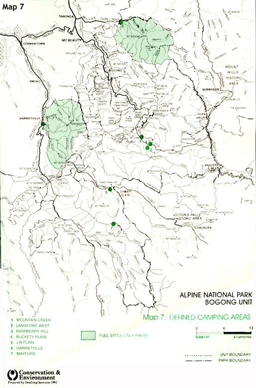
345
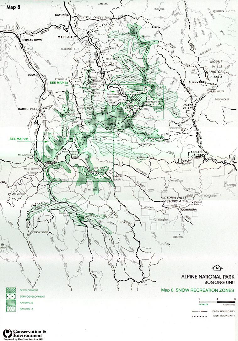
346
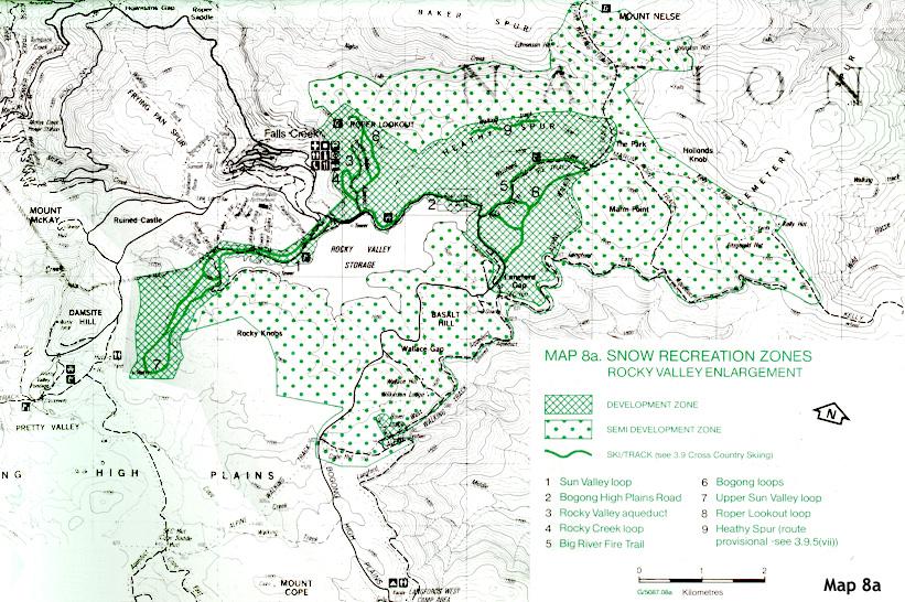
347

348
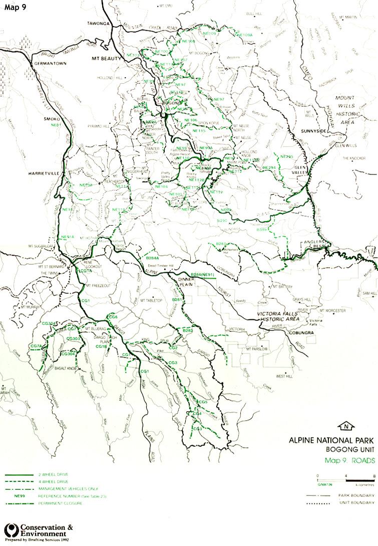
349

350

351

352
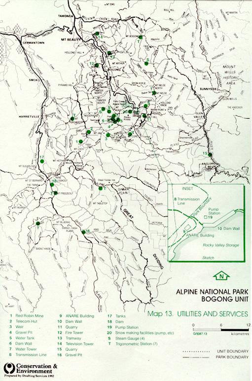
353
Land Management Summary
 photo credit: ANGAIR Anglesea Heath Land Management Summary The Anglesea Heath (6,501 ha) was incorporated into the Great Otway National Park in January 2018. This provides an opportunity to consider the
MANAGEMENT DIRECTION STATEMENT June, 1999
 Thompson River District MANAGEMENT DIRECTION STATEMENT June, 1999 for Roche Lake Provincial Park Ministry of Environment Lands and Parks BC Parks Division Table of Contents I. Introduction A. Setting
A GUIDE TO MANITOBA PROTECTED AREAS & LANDS PROTECTION
 A GUIDE TO MANITOBA PROTECTED AREAS & LANDS PROTECTION Manitoba Wildands December 2008 Discussions about the establishment of protected lands need to be clear about the definition of protection. We will
As outlined in the Tatshenshini-Alsek Park Management Agreement, park management will:
 Management Strategy General Strategy The priority management focus for the park is to ensure that its internationally significant natural, cultural heritage and recreational values are protected and that
National Parks (Wilderness) Act 1992
 Act 1992") No. 40 of 1992 TABLE OF PROVISIONS PART 1 PRELIMINARY Section 1. Purpose 2. Commencement 3. Principal Act PART 2 WYPERFELD NATIONAL PARK 4. Additions to Wyperfeld National Park 5. Deer hunting in Alpine
No. 40 of 1992 TABLE OF PROVISIONS PART 1 PRELIMINARY Section 1. Purpose 2. Commencement 3. Principal Act PART 2 WYPERFELD NATIONAL PARK 4. Additions to Wyperfeld National Park 5. Deer hunting in Alpine
Order of the Minister of Environment #39, August 22, 2011 Tbilisi
 Registration Code 360050000.22.023.016080 Order of the Minister of Environment #39, August 22, 2011 Tbilisi On preparatory stages and procedure of the methodology for Elaborating structure, content and
NATIONAL AIRSPACE POLICY OF NEW ZEALAND
 NATIONAL AIRSPACE POLICY OF NEW ZEALAND APRIL 2012 FOREWORD TO NATIONAL AIRSPACE POLICY STATEMENT When the government issued Connecting New Zealand, its policy direction for transport in August 2011, one
Marchand Provincial Park. Management Plan
 Marchand Provincial Park Management Plan 2 Marchand Provincial Park Table of Contents 1. Introduction... 3 2. Park History... 3 3. Park Attributes... 4 3.1 Natural... 4 3.2 Recreational... 4 3.3 Additional
Watchorn Provincial Park. Management Plan
 Watchorn Provincial Park Management Plan 2 Watchorn Provincial Park Table of Contents 1. Introduction... 3 2. Park History... 3 3. Park Attributes... 3 3.1 Natural... 4 3.2 Recreational... 4 3.3 Additional
Continental Divide National Scenic Trail Legislative History and Planning Guidance
 Continental Divide National Scenic Trail Legislative History and Planning Guidance Legislation, Policy, and Direction Regarding National Scenic Trails The National Trails System Act, P.L. 90-543, was passed
HUT POINT, ROSS ISLAND
 Measure 2 (2005) Annex K Management Plan for Antarctic Specially Protected Area No. 158 HUT POINT, ROSS ISLAND (including Historic Site and Monument No. 18, the historic Discovery hut of Captain R F Scott)
Conservation Partners for the National Reserve System Program: a Western NSW focus
 Conservation Partners for the National Reserve System Program: a Western NSW focus Cooper, N. 1, Webber, L. 2, Nicolson, K. 3 1 Department of Environment, Climate Change and Water NSW, PO Box 788 Broken
Draft Strategic Plans for Coillte s eight Business Area Units ( )
") Draft Strategic Plans for Coillte s eight Business Area Units (2011-2015) Response to Public Consultation from Mountaineering Ireland April 2013 1 Introduction Mountaineering Ireland welcomes this opportunity
Draft Strategic Plans for Coillte s eight Business Area Units (2011-2015) Response to Public Consultation from Mountaineering Ireland April 2013 1 Introduction Mountaineering Ireland welcomes this opportunity
MANAGEMENT DIRECTION STATEMENT June, 1999
 Thompson River District MANAGEMENT DIRECTION STATEMENT June, 1999 for Clearwater River Corridor (Addition to Wells Gray Park) Ministry of Environment Lands and Parks BC Parks Division ii Table of Contents
Numaykoos Lake Provincial Park. Management Plan
 Numaykoos Lake Provincial Park Management Plan 2 Numaykoos Lake Provincial Park Table of Contents 1. Introduction... 3 2. Background... 3 3. Park Purpose... 5 4. Park Management Guidelines... 6 Appendix...
Wallace Lake Provincial Park. Management Plan
 Wallace Lake Provincial Park Management Plan 2 Wallace Lake Provincial Park Table of Contents 1. Introduction... 3 2. Park History... 3 3. Park Attributes... 4 3.1 Natural... 4 3.2 Recreational... 4 4.
PROTECTED AREAS ZONE - POLICY
 PROTECTED AREAS ZONE - POLICY.1 Introduction The Protected Areas Zone applies to the land depicted on the Ruapehu District Plan Maps as: Amenity Policy Area. Protected Areas - Conservation. (c) Protected
Rule Governing the Designation and Establishment of All-Terrain Vehicle Use Trails on State Land
 Rule Governing the Designation and Establishment of All-Terrain Vehicle Use Trails on State Land 1.0 Authority 1.1 This rule is promulgated pursuant to 23 V.S.A. 3506. Section 3506 (b)(4) states that an
Twelve Apostles Marine National Park Australia
 EVALUATION REPORT Twelve Apostles Marine National Park Australia Location: Victoria, Australia coastal waters Global Ocean Refuge Status: Nominated (2017), Evaluated (2017) MPAtlas.org ID: 7703885 Manager(s):
Beaver Creek Provincial Park. Management Plan
 Beaver Creek Provincial Park Management Plan 2 Beaver Creek Provincial Park Table of Contents 1. Introduction... 3 2. Park History... 3 3. Park Attributes... 4 3.1 Natural... 4 3.2 Recreational... 4 4.
LOCAL PLAN FOR THE MANAGEMENT OF THE APPALACHIAN TRAIL IN MAINE. (GRAFTON NOTCH TO KATAHDIN) 1 January 2013 (Revised 5 February 2014)
 1 January 2013 (Revised 5 February 2014)") LOCAL PLAN FOR THE MANAGEMENT OF THE APPALACHIAN TRAIL IN MAINE (GRAFTON NOTCH TO KATAHDIN) 1 January 2013 (Revised 5 February 2014) The Appalachian Trail is a way, continuous from Katahdin in Maine to
LOCAL PLAN FOR THE MANAGEMENT OF THE APPALACHIAN TRAIL IN MAINE (GRAFTON NOTCH TO KATAHDIN) 1 January 2013 (Revised 5 February 2014) The Appalachian Trail is a way, continuous from Katahdin in Maine to
A summary of Draft Makara Peak Mountain Bike Park Master Plan
 A summary of Draft Makara Peak Mountain Bike Park Master Plan OVEMBER 216 Image: Peter Marshall 2 3 Introduction Since it was established in 1998, the Makara Peak Mountain Bike Park (Makara Peak) has grown
Wilderness Areas Designated by the White Pine County bill
 Wilderness Areas Designated by the White Pine County bill SEC. 321. SHORT TITLE. This subtitle may be cited as the `Pam White Wilderness Act of 2006'. SEC. 322. FINDINGS. Congress finds that-- The White
Alternative 3 Prohibit Road Construction, Reconstruction, and Timber Harvest Except for Stewardship Purposes B Within Inventoried Roadless Areas
 Roadless Area Conservation FEIS Summary Table S-1. Comparison of Key Characteristics and Effects by Prohibition Alternative. The effects summarized in this table A would occur in inventoried roadless areas
Official Journal of the European Union L 337/43
 22.12.2005 Official Journal of the European Union L 337/43 PROTOCOL on the implementation of the Alpine Convention of 1991 in the field of tourism Tourism Protocol Preamble THE FEDERAL REPUBLIC OF GERMANY,
A Master Plan is one of the most important documents that can be prepared by an Airport.
 The Master Plan A Master Plan is one of the most important documents that can be prepared by an Airport. A Master Plan is a visionary and a strategic document detailing planning initiatives for the Airport
PROUDLY BRINGING YOU CANADA AT ITS BEST. Management Planning Program NEWSLETTER #1 OCTOBER, 2000
 PROUDLY BRINGING YOU CANADA AT ITS BEST VUNTUT NATIONAL PARK Management Planning Program NEWSLETTER #1 OCTOBER, 2000 INTRODUCTION This newsletter launches the development of the first management plan for
Potential additions to Aoraki/Mount Cook National Park and the World Heritage Area
 Topic Paper: Potential additions to Aoraki/Mount Cook National Park and the World Heritage Area. Purpose This paper provides the relevant background and matters for consideration regarding potential additions
REAUTHORISATION OF THE ALLIANCE BETWEEN AIR NEW ZEALAND AND CATHAY PACIFIC
 Chair Cabinet Economic Growth and Infrastructure Committee Office of the Minister of Transport REAUTHORISATION OF THE ALLIANCE BETWEEN AIR NEW ZEALAND AND CATHAY PACIFIC Proposal 1. I propose that the
April 10, Mark Stiles San Juan Public Lands Center Manager 15 Burnett Court Durango, CO Dear Mark,
 Mark Stiles San Juan Public Lands Center Manager 15 Burnett Court Durango, CO 81301 Dear Mark, We are pleased to offer the following comments on the draft San Juan Public Lands Center management plans
PERTH AND KINROSS COUNCIL. Housing and Health Committee. 25 May Perth and Kinross Local Housing Strategy
 PERTH AND KINROSS COUNCIL 7 16/234 Housing and Health Committee 25 May 2016 Perth and Kinross Local Housing Strategy 2016-2021 Report by Director (Housing and Social Work) PURPOSE OF REPORT This report
Pembina Valley Provincial Park. Draft Management Plan
 Pembina Valley Provincial Park Draft Management Plan 2 Pembina Valley Provincial Park Table of Contents 1. Introduction... 3 2. Park History... 3 3. Park Attributes... 3 3.1 Natural... 3 3.2 Recreational...
Appendix A BC Provincial Parks System Goals
 Appendix A BC Provincial Parks System Goals The British Columbia Provincial Parks System has two mandates: To conserve significant and representative natural and cultural resources To provide a wide variety
APPENDIX. Alberta Land Stewardship Act AMENDMENTS TO THE SOUTH SASKATCHEWAN REGIONAL PLAN
 APPENDIX Alberta Land Stewardship Act AMENDMENTS TO THE SOUTH SASKATCHEWAN REGIONAL PLAN 1 All references to Alberta Environment and Sustainable Resource Development, Environment and Sustainable Resource
Priority Species, Communities, Ecosystems, and Threats
 Priority Species, Communities, Ecosystems, and Threats East Gippsland Regional Catchment Strategy 2015/2016 1.0 Objective This document aims to assist in the preparation of project applications for 2015-2016
158 HUT POINT, ROSS ISLAND
 Measure 13 (2015) Management Plan For Antarctic Specially Protected Area No. 158 HUT POINT, ROSS ISLAND (including Historic Site and Monument No. 18, the historic Discovery hut of Captain Robert Falcon
MANAGEMENT DIRECTION STATEMENT
 Lower Mainland District MAAGEMET DIRECTIO STATEMET January 2001 for Liumchen Ecological Reserve Ministry of Environment Lands and Parks BC Parks Division Table of Contents Page Introduction... 1 Purpose
Safety Regulatory Oversight of Commercial Operations Conducted Offshore
 Page 1 of 15 Safety Regulatory Oversight of Commercial Operations Conducted Offshore 1. Purpose and Scope 2. Authority... 2 3. References... 2 4. Records... 2 5. Policy... 2 5.3 What are the regulatory
Thematic Report on Mountain Ecosystems. Please provide the following details on the origin of this report. National Focal Point
 Thematic Report on Mountain Ecosystems Please provide the following details on the origin of this report. Contracting Party: Australia National Focal Point Full name of the institution: Department of the
Connie Rudd Superintendent, Black Canyon of the Gunnison National Park
 National Park Service U.S. Department of the Interior Black Canyon of the Gunnison National Park and Curecanti National Recreation Area Information Brochure #1 Wilderness and Backcountry Management Plan
UNITED STATES DEPARTMENT OF THE INTERIOR BUREAU OF LAND MANAGEMENT MANUAL TRANSMITTAL SHEET
 Form 1221-2 (June 1969) UNITED STATES DEPARTMENT OF THE INTERIOR BUREAU OF LAND MANAGEMENT MANUAL TRANSMITTAL SHEET Release 8-83 Date Subject 8353 Trail Management Areas Secretarially Designated (Public)
International Civil Aviation Organization REVIEW OF STATE CONTINGENCY PLANNING REQUIREMENTS. (Presented by the Secretariat) SUMMARY
 SUMMARY") BBACG/16 WP/4 31/01/05 International Civil Aviation Organization The Special Coordination Meeting for the Bay of Bengal area (SCM/BOB) and The Sixteenth Meeting of the Bay of Bengal ATS Coordination Group
BBACG/16 WP/4 31/01/05 International Civil Aviation Organization The Special Coordination Meeting for the Bay of Bengal area (SCM/BOB) and The Sixteenth Meeting of the Bay of Bengal ATS Coordination Group
SANBI PLANNING FORUM
 SANBI PLANNING FORUM SPATIAL PLANNING IN PROTECTED AREAS AND THEIR BUFFERS (South Africa) Ms Jayshree Govender, Dr Mike Knight and Mr Russell Smart 22 June 2017 OUTLINE 1) Introduction 2) Protected areas
Biosphere Reserves of India : Complete Study Notes
 Biosphere Reserves of India : Complete Study Notes Author : Oliveboard Date : April 7, 2017 Biosphere reserves of India form an important topic for the UPSC CSE preparation. This blog post covers all important
Proposed Action. Payette National Forest Over-Snow Grooming in Valley, Adams and Idaho Counties. United States Department of Agriculture
 United States Department of Agriculture Forest Service January 2012 Proposed Action Payette National Forest Over-Snow Grooming in Valley, Adams and Idaho Counties Payette National Forest Valley, Adams
Public Submissions in response to the Bill closed on 2 July 2015 and Council lodged a copy of the submission provided as Attachment 1.
 54 PLANNING AND ECONOMIC COMMITTEE 8 JULY 2015 3 SUSTAINABLE PORTS DEVELOPMENT BILL Neil Quinn 1/58/14 #4771706 RECOMMENDATION: That Council endorses the Submission made to the Infrastructure, Planning
OMINEACA PROVINCIAL PARK
 OMINEACA PROVINCIAL PARK AND PROTECTED AREA PURPOSE STATEMENT AND ZONING PLAN March 2003 OMINECA PROVINCIAL PARK AND PROTECTED AREA Purpose Statement and Zoning Plan Omineca Park and Omineca Protected
Wallace Lake Provincial Park. Draft Management Plan
 Wallace Lake Provincial Park Draft Management Plan Wallace Lake Provincial Park Draft Management Plan Table of Contents 1. Introduction... 3 2. Park History... 3 3. Park Attributes... 4 3.1 Natural...
5.0 OUTDOOR RECREATION OPPORTUNITIES AND MANAGEMENT
 5.0 OUTDOOR RECREATION OPPORTUNITIES AND MANAGEMENT 5.1 Introduction This section describes the range of recreational activities that currently take place in Marble Range and Edge Hills Parks, as well
FILE: /PERM EFFECTIVE DATE: May 16, 2014 AMENDMENT:
 APPROVED AMENDMENTS: Effective Date Briefing Note /Approval Summary of Changes: FILE: 11000-00/PERM EFFECTIVE DATE: May 16, 2014 AMENDMENT: Table of Contents 1. POLICY APPLICATION... 1 2. PRINCIPLES AND
CAIRNGORMS NATIONAL PARK BOUNDARY BILL
 These documents relate to the Cairngorms National Park Boundary Bill (SP Bill 72) as introduced in the Scottish Parliament on 21 September 2006 CAIRNGORMS NATIONAL PARK BOUNDARY BILL EXPLANATORY NOTES
Ouimet Canyon Provincial Nature Reserve. Management Plan
 Ouimet Canyon Provincial Nature Reserve Management Plan NOTE: This document has been scanned and formatted, and therefore is slightly different from the original version. -March 2002 Additional copies
2.0 PARK VISION AND ROLES
 2.0 PARK VISION AND ROLES 2.1 Significance in the Protected Area System Marble Range and Edge Hills provincial parks protect 6.8% of the Pavillion Ranges Ecosection, which is located in the Southern Interior
Planning & Building Department
 Page 1 of Report Planning & Building Department To: Subject: Community Development Committee Protecting Escarpment Rural Land (PERL) Proposed Niagara Escarpment Plan Amendment Niagara Escarpment Commission
Submission to the Draft Tasmanian Wilderness World Heritage Area Management Plan 2014 Tasmanian Government
 Submission to the Draft Tasmanian Wilderness World Heritage Area Management Plan 2014 Tasmanian Government Photo: Frankland Range, Tasmanian Wilderness World Heritage Area, by Dan Broun. MARCH 2015 Draft
Submission on the Tukituki Catchment Proposal: EPA reference numbers; NSP 13/ , NSP 13/ , NSP 13/ , NSP 13/02.
 Hutt Valley Tramping Club PO Box 30 883 LOWER HUTT 5045 Tukituki Catchment Proposal Environmental Protection Agency Private Bag 63 002 WELLINGTON 6140 29 July 2013 Submission on the Tukituki Catchment
Trappist Monastery Provincial Park. Management Plan
 Trappist Monastery Provincial Park Management Plan 2 Trappist Monastery Provincial Park Table of Contents 1. Introduction... 3 2. Park History... 3 3. Park Attributes... 4 3.1 Natural... 4 3.2 Recreational...
New Runway Project. Connecting people and places. Supporting business. Engaging with community
 New Runway Project Perth is investing in an important piece of infrastructure for Western Australia. The new runway will see Perth continue to connect lives, businesses and communities to a world full
MANAGEMENT DIRECTION STATEMENT
 Skeena District MAAGEMET DIRECTIO STATEMET July, 2000 for Driftwood Canyon Provincial Park Ministry of Environment Lands and Parks BC Parks Division i Table of Contents Driftwood Canyon Park Approvals
That Council endorses the attached submission on the Reef 2050 Long-term Sustainability Plan.
 4 ORDINARY MEETING 22 OCTOBER 2014 1 REEF 2050 LONG-TERM SUSTAINABILITY PLAN D Walton 8/24/18-01 #4506842v2 RECOMMENDATION: That Council endorses the attached submission on the Reef 2050 Long-term Sustainability
Implementation Framework. Expression of Interest. Queensland Ecotourism Investment Opportunities. Ecotourism Facilities on National Parks
 Queensland Ecotourism Investment Opportunities Implementation Framework Expression of Interest Ecotourism Facilities on National Parks Great state. Great opportunity. Contents Introduction...1 Purpose
COMMISSION IMPLEMENTING REGULATION (EU)
") 18.10.2011 Official Journal of the European Union L 271/15 COMMISSION IMPLEMENTING REGULATION (EU) No 1034/2011 of 17 October 2011 on safety oversight in air traffic management and air navigation services
18.10.2011 Official Journal of the European Union L 271/15 COMMISSION IMPLEMENTING REGULATION (EU) No 1034/2011 of 17 October 2011 on safety oversight in air traffic management and air navigation services
Pillar Park. Management Plan
 Pillar Park Management Plan January 2014 Pillar Park Management Plan Approved by: Jeff Leahy Regional Director Thompson Cariboo Region BC Parks January 9, 2014 Date Brian Bawtinheimer Executive Director
Yard Creek Provincial Park. Management Plan
 Yard Creek Provincial Park Management Plan Draft January 2010 Yard Creek Provincial Park Management Plan Approved by: telàlsemkin/siyam/chief Scott Benton Bill Williams Squamish Executive Director ation
Clearwater Lake Provincial Park. Draft Management Plan
 Clearwater Lake Provincial Park Draft Management Plan Clearwater Lake Provincial Park Draft Management Plan Table of Contents 1. Introduction... 3 2. Park History... 4 3. Park Attributes... 4 3.1 Location/Access...4
2.2 For these reasons the provision of tourist signing will only be considered:
 TOURIST SIGNING POLICY 2015 1. DEFINITION 1.1 A tourist destination is defined as a permanently established attraction which attracts or is used by visitors to an area and is open to the public without
Mr Mick Gentleman Chair, Standing Committee on Planning and Environment Committee ACT Legislative Assembly Canberra ACT 2601
 Mr Mick Gentleman Chair, Standing Committee on Planning and Environment Committee ACT Legislative Assembly Canberra ACT 2601 Dear Mr Gentleman Thank you for the opportunity to comment a second time on
Report of the Strategic Director of Place to the meeting of Executive to be held on 11 September 2018
 Report of the Strategic Director of Place to the meeting of Executive to be held on 11 September 2018 Subject: M Arrangements for the establishment of a West Yorkshire Urban Traffic Management Control
Consultation on Draft Airports National Policy Statement: new runway capacity and infrastructure at airports in the South East of England
 Tony Kershaw Honorary Secretary County Hall Chichester West Sussex PO19 1RQ Telephone 033022 22543 Website: www.gatcom.org.uk If calling ask for Mrs. Paula Street e-mail: secretary@gatcom.org.uk 22 May
State of Conservation of the Heritage Site. City of Potosí (Plurinational State of Bolivia) (ID Nº 420) (ii), (iv) y (vi)) EXECUTIVE SUMMARY
 (ID Nº 420) (ii), (iv) y (vi)) EXECUTIVE SUMMARY") State of Conservation of the Heritage Site City of Potosí (Plurinational State of Bolivia) (ID Nº 420) (ii), (iv) y (vi)) EXECUTIVE SUMMARY 1. State party's response to the decision 39 of the World Heritage
State of Conservation of the Heritage Site City of Potosí (Plurinational State of Bolivia) (ID Nº 420) (ii), (iv) y (vi)) EXECUTIVE SUMMARY 1. State party's response to the decision 39 of the World Heritage
Sand Lakes Provincial Park. Draft Management Plan
 Sand Lakes Provincial Park Draft Management Plan 2 Sand Lakes Provincial Park Table of Contents 1. Introduction... 3 2. Background... 3 3. Park Purpose... 5 4. Park Management Guidelines... 6 Appendix...
Bridge River Delta Park. Management Plan. Final Public Review Draft
 Bridge River Delta Park Management Plan Final Public Review Draft March 2016 Bridge River Delta Park Management Plan Approved by: Jeff Leahy Regional Director Thompson Cariboo Region BC Parks Date Brian
RE: Access Fund Comments on Yosemite National Park Wilderness Stewardship Plan, Preliminary Ideas and Concepts
 September 30, 2016 Superintendent Yosemite National Park Attn: Wilderness Stewardship Plan P.O. Box 577 Yosemite, CA 95389 RE: Access Fund Comments on Yosemite National Park Wilderness Stewardship Plan,
Assessing and Protecting the World s Heritage. Assessing and Protecting the World s Heritage
 Assessing and Protecting the World s Heritage NEFA BACKGROUND PAPER Assessing and Protecting the World s Heritage Prepared by: Dailan Pugh, 2014 With the NSW opposition parties threatening to open up the
Daisy Dean Trail 628/619 ATV Trail Construction
 Background and Purpose and Need The Daisy Dean ATV Trail Construction Project is located in the Little Belt Mountains, Musselshell Ranger District, Lewis and Clark National Forest approximately 32 miles
Cooloolabin Dam Recreation Management Discussion Paper. November 2013
 Cooloolabin Dam Recreation Management Discussion Paper November 2013 Contents November 2013... 1 Background... 3 Overview of Cooloolabin Dam... 6 Weed Management... 7 Cultural Heritage... 7 Commercial
Whitemouth Falls Provincial Park. Draft Management Plan
 Whitemouth Falls Provincial Park Draft Management Plan Whitemouth Falls Provincial Park Draft Management Plan Table of Contents 1. Introduction... 3 2. Park History... 3 3. Park Attributes... 4 3.1 Natural...
Curriculum Vitae - Tony Charters AM
 Curriculum Vitae - Tony Charters AM Education Bachelor of Science (Environmental Studies) School of Australian Environmental Studies Griffith University Major subject areas: land use planning, economics,
Appendix F Public authorities responses
 Planning Proposal under sec 55 of the EP&A Act LEP Refinements Appendix F Public authorities responses Appendix F Public authorities responses Prior to public exhibition, consultation was made with the
Dividing Lake Provincial Nature Reserve
 - Do Not Remove i, '" i ' Dividing Lake Provincial Nature Reserve I!.' Interim Management Statement Amendment 2001-001 Park Boundary Amendment Approved: r.in'r entral Zone, Ontario Parks PJ Date 2. ()/
11 January Dear Public Consultations Team of the White Paper Task Force,
 Public Consultations Team White Paper Task Force Department of Foreign Affairs and Trade RG Casey Building John McEwan Crescent Barton ACT 0221 Australia 11 January 2017 Dear Public Consultations Team
ENVIRONMENT ACTION PLAN
 ENVIRONMENT ACTION PLAN 2015 16 Airservices Australia 2015 This work is copyright. Apart from any use as permitted under the Copyright Act 1968, no part may be reproduced by any process without prior written
33. Coiba National Park and its Special Zone of Marine Protection (Panama) N 1138 rev)
 N 1138 rev)") World Heritage status of the area and the Outstanding Universal Value of the Monarch butterfly migration phenomenon, c) Explore options for the development of non-butterfly related tourism activities;
World Heritage status of the area and the Outstanding Universal Value of the Monarch butterfly migration phenomenon, c) Explore options for the development of non-butterfly related tourism activities;
APPENDIX I: PROCESS FOR FIRST NATIONS REGIONAL DIALOGUES
 Process and significance The bipartisan support of the Government and the Opposition for the Council to host a series of Aboriginal and Torres Strait Islander designed and led dialogues provided a historic
COMMISSION OF THE EUROPEAN COMMUNITIES. Draft. COMMISSION REGULATION (EU) No /2010
 No /2010") COMMISSION OF THE EUROPEAN COMMUNITIES Brussels, XXX Draft COMMISSION REGULATION (EU) No /2010 of [ ] on safety oversight in air traffic management and air navigation services (Text with EEA relevance)
COMMISSION OF THE EUROPEAN COMMUNITIES Brussels, XXX Draft COMMISSION REGULATION (EU) No /2010 of [ ] on safety oversight in air traffic management and air navigation services (Text with EEA relevance)
PART D: Stakeholder consultation
 PART D: Stakeholder consultation 4. Stakeholder consultation Iluka is committed to ongoing consultation with its stakeholders to achieve sustained mutual benefits for the life of the project. Ongoing
KANANASKIS COUNTRY PROVINCIAL RECREATION AREAS MANAGEMENT PLAN DRAFT TERMS OF REFERENCE - November 20, 2007
 KANANASKIS COUNTRY PROVINCIAL RECREATION AREAS MANAGEMENT PLAN DRAFT TERMS OF REFERENCE - November 20, 2007 BACKGROUND There are 42 Provincial Recreation Areas (PRAs) within Kananaskis Country located
MONTEREY REGIONAL AIRPORT MASTER PLAN TOPICAL QUESTIONS FROM THE PLANNING ADVISORY COMMITTEE AND TOPICAL RESPONSES
 MONTEREY REGIONAL AIRPORT MASTER PLAN TOPICAL QUESTIONS FROM THE PLANNING ADVISORY COMMITTEE AND TOPICAL RESPONSES Recurring topics emerged in some of the comments and questions raised by members of the
The South Gippsland Koala. For over 60 years, the plantation industry has shared a unique relationship with the Strzelecki Koala. protection.
 The South Gippsland Koala For over 60 years, the plantation industry has shared a unique relationship with the Strzelecki Koala. protection harmony THE CO-EXISTENCE OF THE KOALA WITH THE PLANTATIONS co-existence
Birch Point Provincial Park. Management Plan
 Birch Point Provincial Park Management Plan 2 Birch Point Provincial Park Table of Contents 1. Introduction... 3 2. Park History... 3 3. Park Attributes... 4 3.1 Natural... 4 3.2 Recreational... 4 4. Park
All About Ecotourism. Special thanks to Rosemary Black Charles Sturt University, Australia 1. Tourism largest business sector in the world economy
 All About Ecotourism By: Ed Krumpe & Rosemary Black, Charles Sturt University, Australia Tourism largest business sector in the world economy Impact Directly Employs 98 million & Generates $2 trillion
DECISION MEMO. Rawhide Trail #7073 Maintenance and Reconstruction
 Page 1 of 6 Background DECISION MEMO USDA Forest Service Jefferson Ranger District Jefferson County, Montana Rawhide Trail #7073 is located in the Elkhorn Mountain Range approximately 10 miles east of
This is a submission to Council s Delivery Plan and Operational Plan
 Goulburn Mulwaree Council Locked Bag 22 Goulburn NSW 2580 Emailed: strategy@goulburn.nsw.gov.au and council@goulburn.nsw.gov.au Marulan/Tallong Community Network C/O 843 Marulan South Road Marulan NSW,
FRAMEWORK LAW ON THE PROTECTION AND RESCUE OF PEOPLE AND PROPERTY IN THE EVENT OF NATURAL OR OTHER DISASTERS IN BOSNIA AND HERZEGOVINA
 Pursuant to Article IV4.a) of the Constitution of Bosnia and Herzegovina, at the 28 th session of the House of Representatives held on 29 April 2008, and at the 17 th session of the House of Peoples held
SUMMER VILLAGE OF SILVER SANDS. Municipal Development Plan
 SUMMER VILLAGE OF SILVER SANDS Municipal Development Plan Bylaw 253-2014 Adopted August 22, 2014 Summer Village of Silver Sands Municipal Development Plan Bylaw No. 253-2014 Page 2 1 INTRODUCTION 1.1 SETTING
Department of Environment, Climate Change & Water NSW. Stakeholder feedback
 Department of Environment, Climate Change & Water NSW Stakeholder feedback 1 Stakeholders group Blue Gum High Forest Group Guardians of Lane Cove NP Sydney Metropolitan Wildlife Service Ku-ring-gai Historical
Economic Development Sub- Committee
 Report title: Economic Development Sub- Committee Item No. Date of meeting: 24 November 2016 A47 Road Investment Strategy - update Responsible Chief Tom McCabe Executive Director, Community Officer: and
1.4 Previous research on New Zealand subantarctic tourism
 Figure 5 The subantarctic islands are nature reserves protecting habitats of great conservation value, such as that of the Southern Royal albatross, seen here at the Auckland Islands. Tourist visits must
ANAGEMENT P LAN. February, for Elk Lakes and Height of the Rockies Provincial Parks. Ministry of Environment, Lands and Parks BC Parks Division
 M ANAGEMENT P LAN February, 1999 for Elk Lakes and Height of the Rockies Provincial Parks Ministry of Environment, Lands and Parks BC Parks Division Elk Lakes & Height of the Rockies Provincial Parks M
Questions and Answers Cape Town Agreement of 2012
 Questions and Answers Cape Town Agreement of 2012 1. What is the Cape Town Agreement of 2012? The Cape Town Agreement of 2012 (the Agreement) sets internationally agreed minimum standards for the design,