The Point Roundabout Improvement Scheme
|
|
|
- Domenic Marsh
- 6 years ago
- Views:
Transcription

1 The Point Roundabout Improvement Scheme
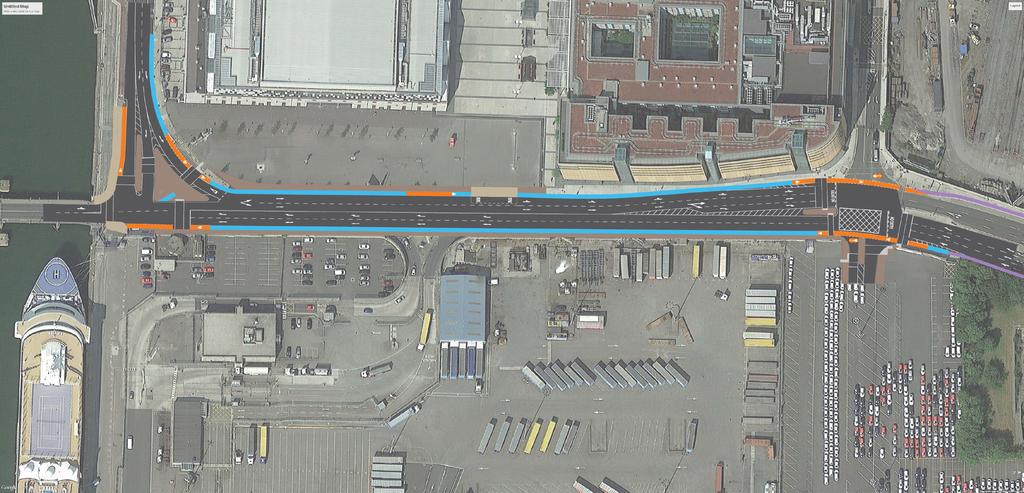
2 Background and Existing Situation The junction of North Wall Quay, East Wall Road and the East Link Bridge, also known as the Point roundabout, is located in the Dublin Docklands area. It is a key junction for pedestrians, cyclists and vehicular traffic travelling between areas north and south of the River Liffey. The junction is a three arm roundabout with no formal crossings for pedestrians and cyclists. There are high volumes of pedestrians, cyclists and vehicular traffic travelling through the junction during the peak commuter periods. This often results in high levels of queuing along the East Link Bridge during the peak PM period. During events at the 3 Arena there is significant pedestrian activity in the area as well as pick-up and drop-off activity. The existing vehicular access to Dublin Port (Terminal 3) is off East Wall Road and is a left-in, left-out junction. This junction arrangement results in additional HGV movements along East Wall Road as traffic exiting the Port must use the Point Roundabout to U-turn before travelling northwards. East Wall Road is becoming an increasingly important public transport node with an important bus stop served by frequent routes such as the 747, Aircoach and Swords Express and The Point Luas stop in the general area. As the existing facilities require buses which serve the northbound bus stop to stop online, general traffic is often delayed while passengers are boarding. The Point Roundabout Improvement Scheme looks to improve the road network in the local area for all road users by providing dedicated pedestrian and cycle crossing facilities at the Point Roundabout junction as well as improving the facilities along East Wall Road. It is also proposed to improve the traffic management in the area by providing an additional traffic lane northbound along East Wall Road and by relocating the Port access to the Sheriff Street Upper/East Wall Road junction.

3 Upper She riff Street Port Access (Left-in, Left-out) East Wall Roa d East Wall Road/ Sheriff Street Upper Junction North W all Quay Point Roundabout East Link Bridge


4 Proposed Scheme As part of the scheme it is proposed to upgrade the Point Roundabout junction to a three-arm signalised junction with a left-turn slip lane from North Wall Quay to East Wall Road. This junction will include toucan crossings to accommodate pedestrians and cyclists on North Wall Quay and the East Link Bridge. The upgrade of this junction will result in the requirement of a new access arrangement for Dublin Port to accommodate northbound movements. The scheme proposes to provide a new access to Dublin Port by providing a fourth arm at the signalised junction of East Wall Road and Sheriff Street Upper. This new access will enable the closure of the existing leftin left-out access to Dublin Port along East Wall Road. Additionally, to improve traffic management in the area, it is proposed to widen East Wall Road to provide an additional northbound lane along with a cycle track and footpath. The additional lane will allow a relatively free flow of traffic from North Wall Quay onto East Wall Road while also helping to ease the levels of queuing on the East Link Bridge.
5


6 Main Benefits The main benefit of the scheme will be the significant improvement to pedestrian and cycle facilities in the area, especially crossing facilities at the junction of North Wall Quay and East Wall Road. Pedestrians and cyclists will be able to cross this junction in a safe and convenient manner. The additional northbound lane will ease the levels of queuing experienced on the East Link Bridge while allowing northbound traffic to pass buses which are stopped online along East Wall Road. The proposed closure of the existing Port access and provision of a new access at the junction of East Wall Road and Sheriff Street Upper will reduce the number of HGV s travelling along East Wall Road. It also removes an existing conflict between pedestrians/ cyclists travelling southbound and HGV s accessing and egress from the Port. The scheme is also consistent with Dublin Port plans to develop their cruise ship facilities which would see a number of pedestrians at the Point junction.
7 Main Impacts Next Stages As the provision of safe and convenient pedestrian and cycle crossing facilities requires a reduction in junction capacity, there will be slight increases in queuing on certain arms of the main junctions. Traffic modelling shows that there will be an increase in queuing during peak periods on the East Wall Road and East Link Bridge arms of the Point junction. At the junction of East Wall Road and Sheriff Street Upper, it is estimated that there will be a small increase in queuing on East Wall Road (North) during the AM and PM peak hour periods. As there are a significant amount of utilities in the area, the works are likely to require the re-routing, replacement or protection of a number of services. This work will be carried out in co-ordination with the utility companies to minimise any disruptions. During the construction stage, mitigation measures will be put in place by the main contractor to minimise the impacts noise, dust and vibrations. Dublin City Council will endeavour to carry out works which may cause significant traffic disruption outside of peak traffic periods. An assessment of the risk of contaminated land within the works area has also been carried out, with the risk rated as being low to medium and it is unlikely that any significant mitigation would be required. Following this public consultation stage, submissions from the public and key stakeholders will be taken into account and changes will be made to the design where appropriate. Once a final design has been approved, the detailed design will be carried out and following a tender process a contractor for the works will be appointed. The construction stage is likely to last for 7 to 8 months. An indicative timeline for the project is as follows: 2015 Q3 Public Consultation 2016 Q Q1 Construction Stage 2015 Q Q2 Detailed Design & Procure Contractor
8 Details of the scheme proposals will be on display at the locations and times below each weekday from Friday 17 th July 2015 until Monday 31 st August Dublin City Council Civic Offices, Wood Quay, Dublin 8 (09:00 to 16:30). - Dublin Docklands Development Authority Offices, Custom House Quay, Dublin 1. (09:00 to 17:00). Members of the design team will be available to answer queries at the locations listed below on the following dates and times: - Dublin Docklands Development Authority Offices, Custom House Quay, Dublin 1: Wednesday 5 th August 2015, from 3pm to 6pm. Submissions or observations with respect to the proposed scheme may be made in writing to the following address before 16:30 on Monday 14 th September Submissions should be headed Point Roundabout Improvement Scheme. Executive Manager, Planning Department, Dublin City Council, Block 4 Floor 3 Civic Offices, Wood Quay, Dublin 8. This application relates to a proposed development within the North Lotts & Grand Canal Dock SDZ Planning Scheme area.
PART VIII APPLICATION FOR REVISED SOUTH SIDE TRAFFIC MANAGEMENT WORKS TO FACILITATE LUAS BXD PLANNING REPORT ROADS & TRAFFIC DEPARTMENT
 PART VIII APPLICATION FOR REVISED SOUTH SIDE TRAFFIC MANAGEMENT WORKS TO FACILITATE LUAS BXD PLANNING REPORT ROADS & TRAFFIC DEPARTMENT NOVEMBER 2012 1.0 INTRODUCTION This report has been prepared in support
Major Scheme Business Case Summary Report for Programme Entry
 Paper A Heart of South West Local Transport Board Major Scheme Business Case Summary Report for Programme Entry M5 Junction 25, Taunton July 2016 1 SCHEME SUMMARY Scheme Name M5 Junction 25, Taunton Date
M2 Junction 5. improvements scheme. Preferred route announcement
 M2 Junction 5 improvements scheme Preferred route announcement May 2018 Investing in your roads Why is the scheme needed? At Highways England we believe in a connected country and our network makes these
Proposals for the Harrogate Road / New Line Junction Improvement Scheme. August / September Supported by:
 Proposals for the Harrogate / New Line Junction Improvement Scheme August / September 2016 Supported by: Introduction Key Benefits Proposals are currently being developed for changes to the junction of
Blackburn Road Blackburn Level Crossing Removal. Frequently Asked Questions August 2014 GENERAL
 Frequently Asked Questions August 2014 Blackburn Road Blackburn Level Crossing Removal GENERAL What is the project? The Victorian Government has committed to eliminating a number of the busiest level crossings
Open Report on behalf of Richard Wills, Executive Director for Environment and Economy
 Agenda Item 7 Executive Open Report on behalf of Richard Wills, Executive Director for Environment and Economy Report to: Executive Date: 02 September 2014 Subject: Lincoln East West Link Road Phase 1
A63 Castle Street, Hull HullBID Network Lunch 24 August 2017
 A63 Castle Street, Hull HullBID Network Lunch 24 August 2017 James D Leeming Senior Project Manager What we will cover today? Introduction to Highways England and the Road Investment Strategy A63 Scheme
M621. Junctions 1 to 7 Improvement scheme. Share your views
 M621 Junctions 1 to 7 Improvement scheme Share your views Investing in your roads Every road user wants less congested roads to enable swift, safe, comfortable and informed travel. On behalf of the government,
D L R C C T R A F F I C N E W S
 D L R C C T R A F F I C N E W S Saturday, 9 th September 2017 to Friday, 15 th September 2017 A public service provided by Municipal Services Department of Dún Laoghaire-Rathdown County Council. Listed
5.5 Material Assets - Transportation
 5.5 Material Assets - Transportation 5.5.1 Introduction This Chapter presents the traffic and transportation assessment for the Demolition, Construction and Operational phases of the proposed new City
D L R C C T R A F F I C N E W S
 D L R C C T R A F F I C N E W S Saturday, 24 th June 2017 to Friday, 30 th June 2017 A public service provided by Municipal Services Department of Dún Laoghaire-Rathdown County Council. Listed below are
Chapter 2 Route window W25 Maidenhead station. Transport for London
 Chapter 2 Route window W25 Maidenhead station MAIDENHEAD STATION 2 Route window W25 Maidenhead station 2.6 The drawings provided at the end of this chapter present the main features of the route window,
M56. New Junction 11a Summary of the consultation report
 M56 New Junction 11a Summary of the consultation report August 2017 M56 New Junction 11a Summary of the public consultation The scheme The M56 New Junction 11a scheme is part of our continued programme
A. CONCLUSIONS OF THE FGEIS
 Chapter 11: Traffic and Parking A. CONCLUSIONS OF THE FGEIS The FGEIS found that the Approved Plan will generate a substantial volume of vehicular and pedestrian activity, including an estimated 1,300
WOKING INTEGRATED TRANSPORT PROJECT
 Civic Offices Gloucester Square Woking Surrey GU21 6YL Telephone (01483) 755855 Facsimile (01483) 768746 DX 2931 WOKING Email wokbc@woking.gov.uk Website www.woking.gov.uk 20 January 2017 Dear Resident/Business
5.7 Local road upgrades
 5.7 Local road upgrades Local roads around the St Peters interchange and the intersection of Campbell Road and Euston Road would be upgraded to ensure safe and efficient connections with the New M5, and
Finchley and Golders Green Area Committee 27 April 2017
 Finchley and Golders Green Area Committee 27 April 2017 Title Report of Wards Status Urgent Key Enclosures Officer Contact Details Junction of Regents Park Road / Tillingbourne Gardens, N3 Commissioning
Chapter 21 Route window W6 West Ealing station. Transport for London
 Chapter 21 Route window W6 West Ealing station WEST EALING STATION 21 Route window W6 West Ealing station Baseline conditions 21.6 West Ealing station is located in the London Borough of Ealing and is
M54 to M6/M6 Toll Link Road Public consultation
 to M6/M6 Toll Link Road Public consultation 15 September 2017 to 13 October 2017 Contents Introduction 4 5 Why do we need this scheme? 6 Previous consultation 7 8 Modified options 9 Option B West 10 Option
College Green Traffic Management Measures Consultation Submission On behalf of Parliament Street Businesses and Residents
 College Green Traffic Management Measures Consultation Submission On behalf of Parliament Street Businesses and Residents Final Submission May 2016 Document Control Contract Name Contract Number C149 2016
NEWSLETTER #04 June 2018
 A5 Old Stratford Roundabout Improvements NEWSLETTER #04 June 2018 PROJECT TIMING UPDATE We are now entering into the final stages of the roundabout improvement works. Despite a number of operational challenges,
Traffic Calming and Road Safety Provision Options Woore Village
 Traffic Calming and Road Safety Provision Options Woore Village Contents 1 Executive Summary 4 2 Introduction 6 2.1 Background 6 3 Existing Provisions and Conditions 7 3.1 Background supporting option
We further recognise that some pain and changes are required from the entire City in order to construct and deliver the project.
 70 Merivale Street PO Box 2001 South Bank QLD 4101 Ph: 07 3846 5191 Email: janinew@businesssouthbank.com.au www.businesssouthbank.com.au ABN 28 285 012 048 21 May 2018 The Right Honourable Lord Mayor Councillor
Chapter 7 Route Window C6 Farringdon station. Transport for London
 Chapter 7 Route Window C6 Farringdon station FARRINGDON STATION 7 Route Window C6 Farringdon station Fox and Knot Street Worksite Farringdon Crossover Worksite This worksite will be situated on the triangular
Chapter 6 Route Window NE5 Seven Kings station. Transport for London
 Chapter 6 Route Window NE5 Seven Kings station Transport SEVEN KINGS STATION 6 Route Window NE5 Seven Kings Station Transport Introduction 6.1 All construction activities in this route window are associated
Wolverhampton City Council
 Agenda Item: 7G Wolverhampton City Council OPEN EXECUTIVE DECISION ITEM Cabinet / Cabinet Team CABINET Date 24 MARCH 2010 Portfolio(s) Originating Service Group(s) COUNCILLOR MRS BRADLEY (REGENERATION
M25 J25 Improvement Scheme Report on Public Consultation June 2017
 M25 J25 Improvement Scheme Report on Public Consultation June 2017 This consultation report reflects the views of the consultation on the M25 J25 improvement scheme which took place between 16 January
D L R C C T R A F F I C N E W S
 D L R C C T R A F F I C N E W S Saturday, 23 rd September 2017 to Friday, 29 th September 2017 A public service provided by Municipal Services Department of Dún Laoghaire-Rathdown County Council. Listed
Downtown Ferry Basin Redevelopment - Stage 1. Integrated Transport Assessment
 Downtown Ferry Basin Redevelopment - Stage 1 Integrated Transport Assessment 12/11/2018 Project: Downtown Ferry Basin Redevelopment - Stage 1 Title: Integrated Transport Assessment Document Reference:
Transport Assessment Appendix M: Avonmouth Impacts
 Portishead Branch Line (MetroWest Phase 1) Environmental Impact Assessment Transport Assessment Appendix M: Avonmouth Impacts Prepared for West of England Councils December 2016 1 The Square Temple Quay
N11 Arklow / Rathnew & N7 Newlands Cross PPP Contract. Kieran Kelly
 N11 Arklow / Rathnew & N7 Newlands Cross PPP Contract Kieran Kelly N7/N11 PPP CONTRACT - OVERVIEW Section A N11 Arklow/Rathnew Scheme Section B Upgrade Works on Existing M11 (Arklow Bypass & Arklow to
Saighton Camp, Chester. Technical Note: Impact of Boughton Heath S278 Works upon the operation of the Local Highway Network
 Technical Note: Impact of Boughton Heath S278 Works July 2013 SAIGHTON CAMP CHESTER COMMERCIAL ESTATES GROUP TECHNICAL NOTE: IMPACT OF BOUGHTON HEATH S278 WORKS UPON THE OPERATION OF THE LOCAL HIGHWAY
Road Closure & Traffic Mangement Information during the 2018 ASICS Windermere Marathon Race.
 Road Closure & Traffic Mangement Information during the 2018 ASICS Windermere Marathon Race. This document provides information about the Temporary Traffic Orders & Permits in place for the 2018 events.
Context. Site Development. Brassington Avenue
 1 Context This public exhibition is being held to present NEW proposals for the development of the Brassington Ave site in Sutton Coldfield town centre. NEW Come and see proposals for We would very much
Sky Temporary Car Park Transport Statement
 001 Issue 26 August 2016 This report takes into account the particular instructions and requirements of our client. It is not intended for and should not be relied upon by any third party and no responsibility
SOUTH GLOS COUNCIL UPDATE FOR SUSCOM - JANUARY 2016
 SOUTH GLOS COUNCIL UPDATE FOR SUSCOM - JANUARY 2016 Go Ultra Low City Bid Success Announced on Monday 25 January, the Department for Transport (DfT) allocated 7M to the four West of England authorities
Cork County Council. M28 Cork to Ringaskiddy Motorway Scheme. Preferred Route Alignment & Junction Strategy Consultation Report
 Cork County Council M28 Cork to Ringaskiddy Motorway Scheme Preferred Route Alignment & Junction Strategy TABLE OF CONTENTS 1 INTRODUCTION... 1 1.1 PROJECT BACKGROUND... 1 1.2 CONSULTATION PROCESS... 2
Boxley Parish Council Highway Issues Briefing Note M2 junction 3 A229 Local Traffic Infrastructure
 Boxley Parish Council www.boxleyparishcouncil.org.uk Chairman: Bob Hinder Clerk: Pauline Bowdery Assistant Clerk: Melanie Fooks 28 November 2017 Boxley Parish Council Highway Issues Briefing Note M2 junction
YOU SAID, WE DID You were concerned about the bus stop design we have amended the design at 22 bus stops to create additional space between the bus an
 You were concerned about the bus stop design we have amended the design at 22 bus stops to create additional space between the bus and the cycle lane alignment. You were concerned about people with disabilities
Our ref: FRC/REC/Nov Steve Farrell Clerk to the Rural Economy and Connectivity Committee The Scottish Parliament.
 Major Transport Infrastructure Projects Forth Replacement Crossing Principal Contract Project Office King Malcolm Drive, Rosyth KY11 2DY Steve Farrell Clerk to the Rural Economy and Connectivity Committee
WELCOME TO PROJECT EVERGREEN 3 CHILTERN S PROPOSED NEW OXFORD TO LONDON ROUTE
 PROJECT EVERGREEN 3 WELCOME TO PROJECT EVERGREEN 3 CHILTERN S PROPOSED NEW OXFORD TO LONDON ROUTE Chiltern Railways is proposing a railway improvement scheme between Oxford and Bicester (the Evergreen
Proposed M9 Spur Extension. Kirkliston
 Forth Road Bridge N Queensferry Proposed Scotstoun Interchange Proposed Humbie Flyover Proposed M9 Spur Extension M9 Motorway Kirkliston A720 Edinburgh City Bypass M8 Motorway This drawing has been reproduced
Cork County Council. M28 Cork to Ringaskiddy Motorway Scheme. Carr s Hill Interchange & Associated Works Consultation Report
 Cork County Council M28 Cork to Ringaskiddy Motorway Scheme Carr s Hill Interchange & Associated Works TABLE OF CONTENTS 1 PROJECT BACKGROUND... 1 1.1 INTRODUCTION... 1 1.2 CONSULTATION PROCESS... 3 1.2.1
Wellesley Station Second Exit and Automatic Entrance Public Open House. Tuesday, September 23, 2014 Central YMCA 20 Grosvenor Street
 Wellesley Station Second Exit and Automatic Entrance Public Open House Tuesday, September 23, 2014 Central YMCA 20 Grosvenor Street 1 What are Second Exits? Second exits serve three functions: As a primary
East Link Project Update. Maintenance of Traffic During Construction. April 21, 2015
 East Link Project Update Maintenance of Traffic During Construction April 21, 2015 1 Agenda TFP project 242 Bellevue Way HOV Bellevue Way - Maintenance of Traffic During Construction Early Work Utilities
7.0 GROUND TRANSPORT DEVELOPMENT PLAN OVERVIEW. Sydney Airport Master Plan
 7.0 GROUND TRANSPORT DEVELOPMENT PLAN OVERVIEW Sydney Airport Master Plan 2033 87 7.0 GROUND TRANSPORT DEVELOPMENT PLAN OVERVIEW Key points On Airport Drive, non-airport through-traffic accounts for up
Event Title - Isle of Wight Festival MEMBERS BRIEFING June 2011
 Event Title - Isle of Wight Festival MEMBERS BRIEFING June 2011 DATES: 9 12 th June 2011 VENUE: OFFICER: Seaclose Park Newport Elaine Cesar Contact Number: 07970 009909 FESTIVAL OPERATIONS AND TRAFFIC
Report to: Greater Cambridge Partnership Joint Assembly 18 January A10 Foxton level crossing bypass and travel hub
 Report to: Greater Cambridge Partnership Joint Assembly 18 January 2018 Lead officer: Chris Tunstall GCP Director of Transport A10 Foxton level crossing bypass and travel hub 1. Purpose 1.1 The list of
Wellington $312 $49 $456 OVERVIEW WELLINGTON REGIONAL SUMMARY
 National Land Transport Programme 2015 18 Wellington WELLINGTON REGIONAL SUMMARY OVERVIEW The Wellington region is made up of a number of cities, urban areas and supporting rural hinterland. The city is
IRISH PARKING ASSOCIATION. The use of Pay and Display in Traffic Management in Kilkenny City
 IRISH PARKING ASSOCIATION The use of Pay and Display in Traffic Management in Kilkenny City Kilkenny City and Environs Draft Mobility Management Plan 2009-2014 2014 Draft Mobility Management Plan Background
Launceston City Council. Kings Meadows Traffic Management Report for Public Consultation
 Launceston City Council Kings Meadows Traffic Management Report for Public Consultation November 2013 This report: has been prepared by GHD for Launceston City Council and may only be used and relied on
M4 Junctions 3 to 12 Smart motorway
 Welcome The Highways Agency is proposing to improve the M4 motorway between Junction 3 and Junction 12 by introducing a Smart motorway scheme, which will: Relieve congestion and smooth the flow of traffic
Map showing location of public transport projects in vicinity of railway station
 Map showing location of public transport projects in vicinity of railway station Market Town Transport Strategy 2013 39 ID PT1a Specific Location Approach at Detail of Project Develop Area Master plan
New free City connector bus service
 The Adelaide City Council invites engagement from the community about New free City connector bus service 99C City Loop and Adelaide Connector free bus services to merge: Project Summary Adelaide City
Day and night time road closures and traffic changes on Campbell Street and surrounding streets, St Peters from Monday 9 April to Friday 13 April
 New M5 Work notification 4 April 2018 Day and night time road closures and traffic changes on Campbell Street and surrounding streets, St Peters from Monday 9 April to Friday 13 April A significant amount
Appendix C Stage 1 Road Safety Audit
 Monaghan County Council N2 Monaghan Town to Emyvale Road Improvements Part 8 Application Description of Proposed Development Appendix C Stage 1 Road Safety Audit Draft 1 11 April 2013 \\DUBNTS03\DUBLIN_JOBS\218000\218692-00\4.
M56. New Junction 11a Preferred route announcement
 New Junction 11a Preferred route announcement August 2017 New Junction 11a Preferred route announcement Introduction The New Junction 11A scheme introduces a new motorway junction to the motorway between
As at 1 May Sponsoring Authority. Halton Borough Council. Halton Borough Council. Halton Borough Council. Halton Borough Council
 Liverpool City Region Candidate M As at 1 May 2013 Sponsoring Authority Halton Borough Council Halton Borough Council Halton Borough Council Halton Borough Council Knowsley Council Knowsley Council Liverpool
Monthly Traffic Update
 Brisbane Airport Corporation Monthly Traffic Update PAGE 1 ISSUE 26 DECEMBER 2009 Northern Access Road Project opens 3 December Brisbane Airport Corporation (BAC) is pleased to announce that after two
Noise Mitigation Program
 Noise Mitigation Program Quick Facts 78% decrease year over year in complaints related to scheduled engine-run ups which is attributable to the new Ground Run-Up Enclosure (GRE) that went into operation
Proposed Housing Developments In Great Horkesley
 Proposed Housing Developments In Great Horkesley Introduction Colchester Borough Council is producing a plan the purpose of which is to guide development in the Borough through to the year 2033. The Local
1 PROJECT STATUS UPDATE 2 ND CONCESSION FROM BRISTOL ROAD TO DOANE ROAD TOWNS OF EAST GWILLIMBURY AND NEWMARKET
 Report No. 3 of the Regional Council Meeting of March 28, 2013 1 PROJECT STATUS UPDATE 2 ND CONCESSION FROM BRISTOL ROAD TO DOANE ROAD TOWNS OF EAST GWILLIMBURY AND NEWMARKET The recommends: 1. Receipt
TEUE-OAR-008. Tiverton EUE Extension. Option Assessment Report Final Draft December 2013
 TEUE-OAR-008 Tiverton EUE Extension Final Draft December 2013 Devon County Council County Hall Topsham Road Exeter Devon EX2 4QD PREPARED BY Name: Stuart Jarvis Position: Assistant Transport Planning Officer
John Betts School Crossing Review
 John Betts School Crossing Review Paddenswick Road London Borough of Hammersmith & Fulham August 2015 DOCUMENT CONTROL Project Centre has prepared this report in accordance with the instructions from the
A303. Sparkford to Ilchester Dualling Scheme. Public consultation. Welcome. Highways England -- creative MCR18_0016
 Sparkford to Ilchester Dualling Scheme Public consultation Welcome Background The /A358 corridor provides vital east-west connectivity between the south west and London and the south east for people, communities
A350 and C13 route management scheme
 A350 and C13 route management scheme Dorset County Council is working with town and parish councils to agree a medium-term solution for the A350 and C13. Dorset County Council has received 2,492,000 from
Frequently Asked Questions on the Route 29 Solutions Improvements Projects
 Frequently Asked Questions on the Route 29 Solutions Improvements Projects Background What are the Route 29 Solutions improvement projects? These projects include the Route 29/250 Interchange ( Best Buy
BUSINESS ZONE - OPTION 400 (Western footpath) Have your say. Love the Bay Delivering on the Cycleway
 Have your say. Love the Bay Delivering on the Cycleway") BUSINESS ZONE - OPTION 400 (Western footpath) Have your say Love the Bay Delivering on the Cycleway Consultation open from 31 July to 13 August 2017 1 Introduction After the Love the Bay community-based
BUSINESS ZONE - OPTION 400 (Western footpath) Have your say Love the Bay Delivering on the Cycleway Consultation open from 31 July to 13 August 2017 1 Introduction After the Love the Bay community-based
Business Case Approved. Under Construction. Business Case Approved. Under Construction
 Item 6 Appendix A: LGF Project Summary for South Essex Update September Project and A127 Network Resilience (Essex) Basildon Integrated Transport Package (Essex) Range of improvements at key locations
A31 Ringwood improvement scheme
 A31 Ringwood improvement scheme Public consultation June/July 2017 Improving the A31 Ringwood: The proposed improvements will smooth the fl ow of traffic and improve journey time by reducing average delays.
2018 Airport Master Plan Overview of Development Concepts. Greg Ballentine (WSP)
") 2018 Airport Master Plan Overview of Development Concepts Greg Ballentine (WSP) Thank You Stakeholder and community consultation has included discussions with over 40 stakeholder groups including airport
2018 Airport Master Plan Overview of Development Concepts Greg Ballentine (WSP) Thank You Stakeholder and community consultation has included discussions with over 40 stakeholder groups including airport
Hospital Link Project Project Update Winter 2018
 Hospital Link Project Project Update Winter 2018 General The project provides a link from Riverside Drive and the Transitway to the Hospital Link Road. Construction of the Hospital Link facility is open
Next Generation Cycleway Design. Improving connectivity and cycling behaviours through design
 Next Generation Cycleway Design Improving connectivity and cycling behaviours through design Safe segregation between Place Users to offer improved safety and a defined space for each user group Elevated
Christ Church Grammar School, Claremont
 Christ Church Grammar School, Claremont TRAFFIC MANAGEMENT AND TRANSPORT PLAN Prepared for CHRIST CHURCH GRAMMAR SCHOOL Prepared by Uloth and Associates 11 Sep 2014; Updated 17 Aug 2015; 29 July 2016,
From M1 (Swords): can park here. Reception is directly opposite this car park. From M50 (Ballymun)
: can park here. Reception is directly opposite this car park. From M50 (Ballymun)") Keelings Retail / Keelings Head Office Address: FoodCentral, St. Margaret s, Co. Dublin, Republic of Ireland Telephone: 01 8135600 53 26'24.4"N 6 17'04.6"W From M1 (Swords): Take the M1 to the Airport
Keelings Retail / Keelings Head Office Address: FoodCentral, St. Margaret s, Co. Dublin, Republic of Ireland Telephone: 01 8135600 53 26'24.4"N 6 17'04.6"W From M1 (Swords): Take the M1 to the Airport
4. The Council s LTCCP decision on 30 June 2009 confirmed the extended tram route and funding.
 145 11. TRAM EXTENSION PROJECT PROPOSED PARKING CHANGES AND STREET MODIFICATIONS IN LICHFIELD STREET, MANCHESTER STREET, HIGH STREET, TUAM STREET, ASH STREET, BEDFORD ROW AND OXFORD TERRACE General Manager
M3 junction 9 improvements scheme
 M3 junction 9 improvements scheme Have your say January to February 2018 M3 junction 9 improvement scheme Have your say Have your say M3 junction 9 scheme map This brochure provides a summary of the proposal
TRAFFIC MANAGEMENT INFORMATION ED SHEERAN PAIRC UI CHAOIMH
 TRAFFIC MANAGEMENT INFORMATION ED SHEERAN PAIRC UI CHAOIMH 1 RATIONALE The Garda Traffic Management Plan is designed to attempt to address the current infrastructural deficits with the location of the
Annex 1 Revised TEE, AMCB and Public Accounts Tables Print Version
 Annex 1 Revised TEE, AMCB and Public Accounts Tables Print Version NB. The Excel file also includes the BAFB and Full approval cost tables. South Yorkshire BRT Northern Route Full Approval September 2013
Chapter 8 Route Window NE7 Chadwell Heath station. Transport for London
 Chapter 8 Route Window NE7 Chadwell Heath station Transport CHADWELL HEATH STATION 8 Route Window NE7 Chadwell Heath station Baseline conditions 8.6 This route window lies within the London Boroughs of
A BORDER UPDATE LUIS E. RAMIREZ THOMAS PHOENIX, ARIOZNA FEBRUARY 27, 2012
 A BORDER UPDATE LUIS E. RAMIREZ THOMAS PHOENIX, ARIOZNA FEBRUARY 27, 2012 Key factors impacting the border The Economy! Border wait times increasing, in excess of 45+ minutes in 24-hour cycle Outdate infrastructure
CITY OF EDINBURGH COUNCIL WRITTEN SUBMISSION
 CITY OF EDINBURGH COUNCIL Summary WRITTEN SUBMISSION Waverley and Haymarket are significant stations for Scotland as well as Edinburgh. The number of passengers using them has grown substantially in recent
EXPLANATORY STATEMENT
 THE LONDON TO FISHGUARD TRUNK ROAD (A40) (PENBLEWIN TO SLEBECH PARK IMPROVEMENT) ORDER 200- AND THE LONDON TO FISHGUARD TRUNK ROAD (A40) (PENBLEWIN TO SLEBECH PARK IMPROVEMENT SIDE ROADS) ORDER 200-1.
07/08 08/09 09/10 Total Carisbrooke Rest of Newport
 1 2 3 kjh 4 Forecasting The base year models have been developed to assist in forecasting the likely impacts of a number of development proposals in the Newport area and to inform the suitability of the
Coca-Cola Zero Belfast Bikes.
 Coca-Cola Zero Belfast Bikes www.belfastbikes.co.uk Background BelfastBike Share Scheme October 2009 - Notice of Motion July 2011 - Outline Business Case OBC concluded that a public bike share scheme could
STATEMENT OF CASE ON BEHALF OF IMPERIAL WAR MUSEUM GROUP
 TRANSPORT AND WORKS ACT 1992 TRANSPORT AND WORKS (APPLICATIONS AND OBJECTIONS PROCEDURE) (ENGLAND AND WALES) RULES 2006 THE TRANSPORT FOR GREATER MANCHESTER (LIGHT RAPID TRANSIT SYSTEM) (TRAFFORD PARK
Board meeting
 Board meeting 28.11.17 Secretariat memorandum Author: Vincent Stops Agenda item: 8 Ref: LTW568 Drafted: 13.11.17 Oxford Street bus changes associated with pedestrianisation 1 Purpose of report 1.1. To
Parking Amendments - Bay Street, between Harbour Street and Queens Quay West (York Street, Bay Street, and Yonge Street Ramp Removal)
") REPORT FOR ACTION between Harbour Street and Queens Quay West (York Street, Bay Street, and Yonge Street Ramp Removal) Date: October 26, 2017 To: Toronto and East York Community Council From: Acting Director,
REPORT FOR ACTION between Harbour Street and Queens Quay West (York Street, Bay Street, and Yonge Street Ramp Removal) Date: October 26, 2017 To: Toronto and East York Community Council From: Acting Director,
CREATING CONNECTIONS IN THE CITY OF NIAGARA FALLS PUBLIC MEETING DECEMBER 6, 2017
 CREATING CONNECTIONS IN THE CITY OF NIAGARA FALLS PUBLIC MEETING DECEMBER 6, 2017 CONGESTION COSTS OUR ECONOMY The average commute in Ontario is already over 45 minutes, and that figure jumps to more than
15.0 TRAFFIC AND TRANSPORTATION
 15.0 TRAFFIC AND TRANSPORTATION 15.1 INTRODUCTION This section of the EIS has been prepared by Tom Phillips + Associates and follows on from the Traffic and Transportation sections prepared in respect
Guildford Borough Transport Strategy 2017, Topic Paper: Transport, June 2017 (accompanying Local Plan 2017) Local Plan Transport Strategy 2017
 Local Plan Transport Strategy 2017") Guildford Society Transport Group Position Paper August 2017 Based on submissions in response to the June/July 2017 Local Plan consultation including material presented to Drop-in Session 15 July 2017.
Guildford Society Transport Group Position Paper August 2017 Based on submissions in response to the June/July 2017 Local Plan consultation including material presented to Drop-in Session 15 July 2017.
As the Toronto Transit Commission (TTC) operates a transit service on Bay Street, City Council approval of this report is required.
 operates a transit service on Bay Street, City Council approval of this report is required.") REPORT FOR ACTION Construction Staging Area - 81 Bay Street Date: December 11, 2017 To: Toronto and East York, Community Council From: Acting Director, Transportation Services Toronto and East York District
REPORT FOR ACTION Construction Staging Area - 81 Bay Street Date: December 11, 2017 To: Toronto and East York, Community Council From: Acting Director, Transportation Services Toronto and East York District
Airdrie - Bathgate Railway and Linked Improvements Bill. Environmental Statement Page 1
 Environmental Statement Page 1 1.0 INTRODUCTION 1.1 The Scheme Proposal The scheme proposals are to re-open the Airdrie to Bathgate section of the former Bathgate and Coatbridge Railway (Monklands Railway)
Kilkenny Mobility Management age e Plan The plan sets out a series of mobility management proposals together with an implementation pro
 Kilkenny City and Environs Mobility Management Plan 2009 to 2014. Report and Presentation to Kilkenny Borough Council on 21st September, 2009 Kilkenny Mobility Management age e Plan 2009-2014 2014 The
LESLIE BARNS & CONNECTION TRACK. Construction Liaison Group Meeting #6 January 30, 2014
 LESLIE BARNS & CONNECTION TRACK Construction Liaison Group Meeting #6 January 30, 2014 Construction Liaison Group Jan 30 2014 1 OVERVIEW HAPPY BELATED NEW YEAR Works to Date Underground Utilities Bell
Councillor Briefing on Elvetham Chase
 Councillor Briefing on Elvetham Chase In partnership with the Calthorpe Estate, Wates Developments vision for Elvetham Chase is to provide an outstanding new community for Hart District that will become
Route 141 and I-44 Design-Build Project Community Involvement Group. March 21, 2016
 Route 141 and I-44 Design-Build Project Community Involvement Group March 21, 2016 Purpose of CIG 1. Share information with major stakeholders 2. Keep stakeholders informed of the process 3. Reduce uncertainty
Concord Road Interchange. Standard hours of work
 Artist impression of the Concord Road interchange, Concord - concept only WestConnex s M4 East will extend the M4 Motorway with two new 5.5 kilometre tunnels from Homebush to Haberfield, providing a bypass
South East Traffic Solution
 South East Traffic Solution A MAJORITY LIBERAL GOVERNMENT WILL: Complete the Hobart Airport Interchange project Fix the Tasman Highway near Tasmania Golf Club Replace the Midway Point Roundabout with additional
TABLE OF CONTENTS. Coral Springs Charter High School and Middle School Job No Page 2
 Job No. 15-019 Page 2 TABLE OF CONTENTS 1.0 INTRODUCTION... 4 2.0 EXISTING CONDITIONS... 5 3.0 TRAFFIC GENERATION... 7 4.0 TRIP DISTRIBUTION... 8 5.0 FUTURE CONDITIONS... 8 6.0 SITE ACCESS...13 7.0 CONCLUSION...13