Community Board 12 Parks & Cultural Affairs Commitee Presentation March 7, 2017 MKW + Associates, Parks Capital Design
|
|
|
- Estella Pierce
- 5 years ago
- Views:
Transcription

1 HIGHBRIDGE PARK ACHOR PARKS PROGRAM: COCEPTUAL MASTER PLA Located along Amsterdam Avenue / Fort George Avenue from 155th Street to Dyckman Street, in the Borough of Manhattan Community Board 12 Parks & Cultural Affairs Commitee Presentation March 7, 2017 MKW + Associates, Parks Capital Design
2 TOIGHT S AGEDA 1/ Introduction 2/ Highbridge Park Conceptual Master Plan 3/ Anchor Parks Phase 1 Schematic Design 5/ ext Steps Anchor Parks Highbridge Park Manhattan, Y

3 OUR COMMITMET: CREATE A BRIGHT, GREE FUTURE WITH A MORE ICLUSIVE AD IOVATIVE PARK SYSTEM Anchor Parks Highbridge Park Manhattan, Y


4 ACHOR PARKS Overview OUR OLD PARKS ARE OUR EW PARKS... Anchor Parks Highbridge Park Manhattan, Y

5 ACHOR PARKS Overview YC PARKS WILL IVEST $150 MILLIO TO REOVATE FIVE EIGHBORHOOD ACHOR PARKS OE I EACH BOROUGH Anchor Parks Highbridge Park Manhattan, Y
 Handball Courts (3) Volleyball Courts atural Areas Dog Run Competition Sized Playgrounds (7) John T.")
6 HIGHBRIDGE PARK: 130 ACRES OF... The City s Oldest Standing Bridge Historic Water Tower Year-round Recreation Center Wading Pool World Class Skate Park 2.5-Mile Mountain Biking Course BMX Jump Track Basketball Courts (7.5) Handball Courts (3) Volleyball Courts atural Areas Dog Run Competition Sized Playgrounds (7) John T. Brush Stairway Swimming Pool Ballfields (3) Anchor Parks Highbridge Park Manhattan, Y

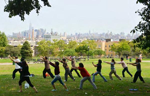
7 YC PARKS OVEMBER 2016 VISIOIG Anchor Parks Highbridge Park Manhattan, Y 140 PEOPLE SHARED THEIR IDEAS AD HOPES FOR HIGHBRIDGE PARK


8 YC PARKS JAUARY 2017 COMMUITY REPORT BACK MEETIG 70 PEOPLE ATTEDED Anchor Parks Highbridge Park Manhattan, Y
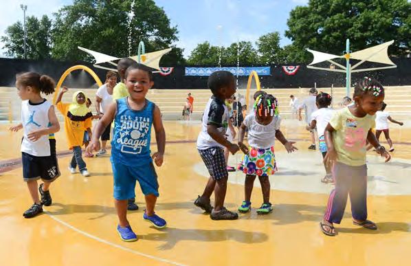
9 Goals Improve connectivity and access including mid-level path to the High Bridge, north and south park connections, and linkage to the Polo Grounds houses Improve quality of play and recreational experiences: reconstruct Adventure Playground and Fort George Playground Provide additional sports fields / practice fields Provide much-needed bathrooms / restrooms - ew bathroom at Adventure Playground - ew restrooms at Highbridge Pool bleachers - ew bathroom at Fort George Playground Provide outdoor gathering / picnic / event spaces Improve ADA access to Recreation Center Improve safety and security: provide park lighting Improve forest ecology and undertake forest restoration Complete restoration of historic Water Tower Add Highbridge Park signage / directories Improve / enhance park entrances / gateways Project Size: 130 ac Highbridge Park Project Goals 2

10 Manhattan City 2 MI Highbridge Park eighborhood 1000 FT Site 500 FT Highbridge Park Site Location 3

11 Flood Hazard Zones ZOE A - 1% annual-chance flood event. o Base Flood Elevation (BFE) exists. ZOE AE - 1% annual-chance flood event. BFE exists. ZOE AO - 1% annual-chance shallow flooding. VE - Areas along coasts subject to inundation by the 1% annual-chance flood event with additional hazards associated with storminduced velocity wave action. BFE exists. Site FLOODWAY - watercourse reserved to discharge base flood. ZOE X - Moderate risk areas within the 0.2% annual-chance floodplain. LIMIT OF MODERATE WAVE ACTIO Highbridge Park Flood Risk

12 Land Use Categories 1 And 2 Family Residential Multi-Family Residential Mixed Use Open Space And Outdoor Recreation Commercial Institutional Industrial Parking Transportation / Utilities Vacant Lots Site Highbridge Park Surrounding Land Use


13 1 - View to Sugar Hill Luminaries Lawn at right and typical sidewalk treatment along this part of Edgecombe Avenue on the left. 2 - View to a portion of Adventure Playground. 1 2 Highbridge Park Site Photos 6


14 3 - Sunken Playground consists of handball and basketball courts and sitting areas well below the adjacent sidewalk grade. 4 - Steps down into a depressed area along Edgecombe Avenue, originally designed as horseshoe pitches. 3 4 Highbridge Park Site Photos 7

15 5 - Panoramic view of grade differential at Highbridge Recreation Center and sidewalk along Amsterdam Avenue. 5 1 Highbridge Park Site Photos 8


16 6 - View of Highbridge Water Tower Plaza with the existing swimming pool to the left. 7 - A portion of Fort George Playground illustrating the expansive spray shower area. 7 6 Highbridge Park Site Photos 9

17 8 - Dyckman Rest, previously a playground, contains expansive asphalt, some mature trees and occasional benches only. 8 Highbridge Park Site Photos 10


18 W 160TH ST SOUTH SECTIO MID SECTIO ORTH SECTIO W 155TH ST W 155TH ST W 156TH ST BROADWAY W 157TH ST W 158TH ST AMSTERDAM AVE ST. ICHOLAS AVE W 159TH ST W 161TH ST W 162D ST W 163RD ST W 164TH ST W 165TH ST W 166TH ST W 167TH ST W 168TH ST JUMEL PLACE W 169TH ST W 170TH ST W 171ST ST W 172D ST W 173RD ST W 174TH ST W 175TH ST W 176TH ST W 177TH ST W 178TH ST W 179TH ST W 180TH ST W 181ST ST ST. ICHOLAS AVE W 182D ST W 183RD ST W 184TH ST W 185TH ST AUDUBO AVE AMSTERDAM AVE W 186TH ST W 187TH ST W 188TH ST W 189TH ST W 190TH ST W 191ST ST W 192D ST W 193RD ST DYCKMA ST 10TH AVE FREDERICK DOUGLASS BLVD EDGECOMBE AVE THE HIGH BRIDGE ALEXADER HAMILTO BRIDGE HARLEM RIVERHARLEM RIVER WASHIGTO BRIDGE Highbridge Park Site Analysis


19 W 155TH ST WEST SUSET December Sugar Hill Luminaries Lawn - slopes down to Edgecombe Ave - open lawn, sunny Existing picnic tables at base of Brush stairway COOGA S BLUFF PLAYGROUD Southern gateway at HBP to 155th Street, heavy traffic at intersection SUSET June SOUTH ORTH SOLAR PATH DIAGRAM EVEIG MID-DAY MORIG AMSTERDAM AVEUE SURISE December 21 SURISE June 21 EAST ST. ICHOLAS AVE Potential Overlooks Hazardous crossing of Harlem River Driveway / ramp. eed pedestrian crossing to provide access to Brush Stairway and into HBP Section of Highbridge Park adjacent to Polo Ground Houses separated by Harlem River Driveway ADVETURE PLAYGROUD - constructed late 70s, large open space segmented by serpertine concrete walls. Play equipment located within walls. Open spray area. Play equipment is dated and needs replacement. Proximity to Edgecombe Ave so utilities are available W 160TH ST MORRIS-JUMEL HISTORIC MASIO WAY Potential Overlooks EDGECOMBE AVE Old Aqueduct Trail - dirt paved, relatively accessible grade - potential linkage to middle path / accessible route to High Bridge HARLEM RIVER Accessible route: ramp up from Sunken Playground to street level is southern end of accessible route to the High Bridge W 165TH ST SUKE PLAYGROUD - set well below street level, includes handball, basketball, open space, gathering plaza, also accessible ramp to street level - courts in good condition Old horse shoe pit terraces - stairs down to shaded terraces Dramatic rock face outcroppings Existing Stone Retaining Walls - in poor condition, some collapsed sections Major rock outcropping / gathering area accessible by dirt trails End of Old Aqueduct Trail water line was tunneled through existing rock outcropping. Cutting or blasting rock would endanger the actual historic water line. This linkage would complete the southern accessible middle path if possible. MATCHLIE - SEE MID SECTIO LEGED PROJECT LIMITS PATHS STAIRS TRAILS ROADS AQUEDUCT TRAIL O PARK ACCESS STEEP SLOPE PARK ETRACE SPOT ELEVATIO BUILDIG + STRUCTURES OPE SUY PLAY AREA OUTDATED PLAY EQUIPMET HEAVY TRAFFIC CROSSIG UDERPERFORMIG SOCIAL SPACE SPRAY SHOWER GATHERIG OVERLOOK / VIEW BATHROOM BASEBALL BASKETBALL HADBALL PLAYGROUD Highbridge Park Site Analysis Diagram - South Section


20 MATCHLIE - SEE SOUTH SECTIO Highbridge Park Community Recreation Center - indoor recreation & access to highbridge park. Handicap access needs improvement from Amsterdam Avenue due to raised entry, 1 full story above grade Existing stairs from Water Tower plaza to High Bridge & accessible route End of vehicular RIVER access Recently constructed access road for Homeless encampment under reconstruction of Alexander Hamilton Bridge washington bridge DRIVEHARLEM HARLEM RIVER HIGHBRIDGE POOL - Moses era swimming pool, replaced historic Highbridge reservoir Accessible path on route to the High Bridge. Pavement in good condition. Bikeway/ greenway markings. no existing lighting Large unused / underutilized pool structure & bleachers, potential bathroom THE HIGH BRIDGE Fenced & gated connection to Water Tower Plaza W 175TH ST Relatively flat open space suitable for recreation RAMP TO GWB Well-used basketball courts (home of High Bridge Invitational Tournament) & volley ball courts orthern limits of south HBP. Extremely large & open rock outcropping relatively flat - adjacent lawn & open asphalt area are unused & provide opportunity for informal gathering. Area is greatly elevated above amsterdam avenue sidewalk level AMSTERDAM SKATE PARK AVE Existing path / trail leading north from High Bridge Manhattan gathering plaza, potential link to north HBP - not an accessible route HISTORIC WATER TOWER - Magnificent stone tower, vent structure for the aqueduct- iconic element for HBP, potential to open for public use ALEXADER HAMILTO BRIDGE vvv PLAZA - large open, paved, gathering area/ base of the historic water tower & east of HB pool. Access from recreation center and playground, also leads to stairs down to High Bridge gathering plaza - major overlook W 180TH ST AUDUBO AVE QUISQUEYA PLAYGROUD Main pathway - asphalt in very good condition, stone edge in fair condition. Existing lighting in disrepair - poles leaning, fixtures missing. LAUREL HILL TERRACE - no access into HBP for this entire stretch Difficult to find and indistinct access to skate park - series of steps - underpass - poor lighting & signage Switchback series of steps provide difficult access under Washington Bridge - difficult connection to skate park LAUREL HILL TERRACE Recently reconstructed steps, terraces & gathering areasoverlook Harlem River Potential linkage from skate park & north HBP to south section of park WASHIGTO BRIDGE W 185TH ST GRAD STAIRCASE AT LAUREL HILL TERRACE - closed to public, deterioration of concrete slabs, granite steps are unsafe - no handrails, no lighting, overlook plaza - not ADA compliant MATCHLIE - SEE ORTH SECTIO LEGED PROJECT LIMITS PATHS STAIRS TRAILS ROADS AQUEDUCT TRAIL O PARK ACCESS STEEP SLOPE PARK ETRACE SPOT ELEVATIO LIMIT OF PHASE 1 BUILDIG + STRUCTURES OPE SUY PLAY AREA OUTDATED PLAY EQUIPMET HEAVY TRAFFIC CROSSIG UDERPERFORMIG SOCIAL SPACE POOL GATHERIG OVERLOOK / VIEW BATHROOM BASEBALL BASKETBALL VOLLEYBALL Highbridge Park Site Analysis Diagram - Mid Section PLAYGROUD SKATE PARK 13


21 Raoul Wallenburg Playground in fair condition: Play equipment & spray shower needs updating, existing bathroom in good condition AMSTERDAM AVE MATCHLIE - SEE MID SECTIO L A U R E L H I L L T E R R A C E WEST SUSET December SUSET June SOUTH SOLAR PATH DIAGRAM EVEIG MID-DAY MORIG ORTH W 188TH ST 100 SURISE December 21 SURISE June 21 EAST Stairs at 187th Street closed to public - fenced off, deterioration of steps and stone walls, unsafe W 190TH ST FORT GEORGE PLAYGROUD - Large, asphalt-paved open space, outdated playground & spray area - unused large space acessed from sidewalk ST. ICHOLAS AVE AUDUBO AVE Juan Bosch sitting area / plaza in good condition HARLEM RIVER Steep slopes and rock outcropping throughout, some eroded areas W 192D ST 7.00 F O R T BMX bike course in good condition - good mapping / signage Dog Run in good condition G E O R G E A V E F O R T G E O R G E Existing stone retaining walls vary in condition from sound / good to unsound, poor - some repair of collapsed section, needs repointing and mortaring throughout Existing asphalt path down to Dyckman street in fair condition - no existing lighting or power - pathway gradient is steep, not accessible Triangular seating plaza at corner of Dyckman, Fort George Hill, & agle Ave - Potential gateway, improve seating area / plaza H I L L DYCKMA ST MOUTAI BIKE COURSE - dirt trails with some erosion, good mapping / signage Pathway along Harlem River Drive in fair condition HILLSIDE AVE Entry plaza / gateway to north end of HB - relatively flat grade BUCZEK FIELD - Synthetic turf recently installed, existing basketball courts in good condition AGLE AVE DYCKMA S REST- large, open asphalt area, perimeter seating & shade trees, on grade with sidewalk - unused open space 10TH AVE LEGED PROJECT LIMITS PATHS STAIRS TRAILS ROADS O PARK ACCESS STEEP SLOPE PARK ETRACE SPOT ELEVATIO LIMIT OF PHASE 1 BUILDIG + STRUCTURES OPE SUY PLAY AREA OUTDATED PLAY EQUIPMET HEAVY TRAFFIC CROSSIG UDERPERFORMIG SOCIAL SPACE SPRAY SHOWER GATHERIG OVERLOOK / VIEW BATHROOM BASEBALL BASKETBALL PLAYGROUD MOUTAI BIKE TRAILS Highbridge Park Site Analysis Diagram - orth Section BMX BIKE PARK DOG PARK 14

22 W 160TH ST SOUTH SECTIO MID SECTIO ORTH SECTIO BROADWAY W 165TH ST W 170TH ST W 175TH ST W 180TH ST AUDUBO AVE AMSTERDAM AVE W 185TH ST W 190TH ST DYCKMA ST ST. ICHOLAS AVE EDGECOMBE AVE W 155TH ST HARLEM RIVER THE HIGH BRIDGE ALEXADER HAMILTO BRIDGE WASHIGTO BRIDGE HARLEM RIVER Highbridge Park Conceptual Master Plan Key Plan
23 AMSTERDAM AVEUE ST. ICHOLAS AVE W 160TH ST JUMEL TERRACE W 165TH ST W 167TH ST JUMEL PLACE LEGED PATHS STAIRS TRAILS SPOT ELEVATIO W 155TH ST Sugar Hill Luminaries Lawn - Add amphitheater / outdoor classroom seating, add ADA seating and access - new planting - gateway icons WAY EDGECOMBE AVE MATCHLIE - SEE MID SECTIO HARLEM RIVER FREDERICK DOUGLASS BLVD Highbridge Park Conceptual Master Plan - South Section
24 W 155TH ST AMSTERDAM AVEUE ST. ICHOLAS AVE W 160TH ST JUMEL TERRACE W 165TH ST W 167TH ST JUMEL PLACE LEGED PATHS STAIRS TRAILS SPOT ELEVATIO WAY EDGECOMBE AVE MATCHLIE - SEE MID SECTIO Improvement to lower HBP in coordination with YCHA and HCDC FREDERICK DOUGLASS BLVD HARLEM RIVER Highbridge Park Conceptual Master Plan - South Section
25 W 155TH ST AMSTERDAM AVEUE ST. ICHOLAS AVE W 160TH ST Formalize entry to Croton Aqueduct trail from sidewalk - plaza / gathering JUMEL TERRACE W 165TH ST W 167TH ST JUMEL PLACE LEGED PATHS STAIRS TRAILS SPOT ELEVATIO WAY EDGECOMBE AVE MATCHLIE - SEE MID SECTIO FREDERICK DOUGLASS BLVD HARLEM RIVER Highbridge Park Conceptual Master Plan - South Section
26 AMSTERDAM AVEUE ST. ICHOLAS AVE W 160TH ST JUMEL TERRACE W 165TH ST W 167TH ST JUMEL PLACE LEGED PATHS STAIRS TRAILS SPOT ELEVATIO W 155TH ST WAY ew paving and lighting along Croton Aqueduct trail - add benches EDGECOMBE AVE MATCHLIE - SEE MID SECTIO HARLEM RIVER FREDERICK DOUGLASS BLVD Highbridge Park Conceptual Master Plan - South Section
27 W 155TH ST AMSTERDAM AVEUE ST. ICHOLAS AVE W 160TH ST ADVETURE PLAYGROUD - ew playground, spray area, new bathroom, plantings, lighting & gathering areas JUMEL TERRACE W 165TH ST W 167TH ST JUMEL PLACE LEGED PATHS STAIRS TRAILS SPOT ELEVATIO WAY EDGECOMBE AVE MATCHLIE - SEE MID SECTIO FREDERICK DOUGLASS BLVD HARLEM RIVER Highbridge Park Conceptual Master Plan - South Section
28 W 155TH ST AMSTERDAM AVEUE ST. ICHOLAS AVE W 160TH ST JUMEL TERRACE SUKE PLAYGROUD - Improve ADA accessible route to street level - connect linkage to Croton Aqueduct trail W 165TH ST W 167TH ST JUMEL PLACE LEGED PATHS STAIRS TRAILS SPOT ELEVATIO WAY EDGECOMBE AVE MATCHLIE - SEE MID SECTIO FREDERICK DOUGLASS BLVD HARLEM RIVER Highbridge Park Conceptual Master Plan - South Section
29 AMSTERDAM AVEUE ST. ICHOLAS AVE W 160TH ST JUMEL TERRACE W 165TH ST W 167TH ST JUMEL PLACE LEGED PATHS STAIRS TRAILS SPOT ELEVATIO WAY EDGECOMBE AVE MATCHLIE - SEE MID SECTIO W 155TH ST Stone retaining wall repairs FREDERICK DOUGLASS BLVD HARLEM RIVER Highbridge Park Conceptual Master Plan - South Section
30 AMSTERDAM AVEUE ST. ICHOLAS AVE W 160TH ST JUMEL TERRACE W 165TH ST W 167TH ST JUMEL PLACE LEGED PATHS STAIRS TRAILS SPOT ELEVATIO WAY EDGECOMBE AVE MATCHLIE - SEE MID SECTIO W 155TH ST Add lighting to accessible route to the High Bridge FREDERICK DOUGLASS BLVD HARLEM RIVER Highbridge Park Conceptual Master Plan - South Section

31 W 155TH ST AMSTERDAM AVEUE ST. ICHOLAS AVE W 160TH ST JUMEL TERRACE W 165TH ST W 167TH ST JUMEL PLACE LEGED PATHS STAIRS TRAILS SPOT ELEVATIO WAY EDGECOMBE AVE MATCHLIE - SEE MID SECTIO FREDERICK DOUGLASS BLVD HARLEM RIVER ew connection to complete linkage of Croton Aqueduct trail and accessible route to the High Bridge. May require bridge path from Sunken Playground to avoid cutting or blasting rock Highbridge Park Conceptual Master Plan - South Section
32 W 170TH ST Community garden / urban farming W 175TH ST AUDUBO AVE W 180TH ST W 185TH ST LEGED PATHS STAIRS TRAILS SPOT ELEVATIO AMSTERDAM AVE MATCHLIE - SEE SOUTH SECTIO LAUREL HILL TERRACE MATCHLIE - SEE ORTH SECTIO ALEXADER HAMILTO BRIDGE THE HIGH BRIDGE WASHIGTO BRIDGE HARLEM RIVER Highbridge Park Conceptual Master Plan - Mid Section
33 W 170TH ST Improve ADA access to the Rec Center at W 172nd Street W 175TH ST AUDUBO AVE W 180TH ST W 185TH ST LEGED PATHS STAIRS TRAILS SPOT ELEVATIO AMSTERDAM AVE MATCHLIE - SEE SOUTH SECTIO LAUREL HILL TERRACE MATCHLIE - SEE ORTH SECTIO ALEXADER HAMILTO BRIDGE THE HIGH BRIDGE WASHIGTO BRIDGE HARLEM RIVER Highbridge Park Conceptual Master Plan - Mid Section
34 W 170TH ST Improve water tower terrace - new pavement, lighting, benches - new gathering area W 175TH ST AUDUBO AVE W 180TH ST W 185TH ST LEGED PATHS STAIRS TRAILS SPOT ELEVATIO AMSTERDAM AVE MATCHLIE - SEE SOUTH SECTIO LAUREL HILL TERRACE MATCHLIE - SEE ORTH SECTIO ALEXADER HAMILTO BRIDGE THE HIGH BRIDGE WASHIGTO BRIDGE HARLEM RIVER Highbridge Park Conceptual Master Plan - Mid Section
35 W 170TH ST Open water tower to the public, add architectural uplighting to create visual beacon W 175TH ST AUDUBO AVE W 180TH ST W 185TH ST LEGED PATHS STAIRS TRAILS SPOT ELEVATIO AMSTERDAM AVE MATCHLIE - SEE SOUTH SECTIO LAUREL HILL TERRACE MATCHLIE - SEE ORTH SECTIO ALEXADER HAMILTO BRIDGE THE HIGH BRIDGE WASHIGTO BRIDGE HARLEM RIVER Highbridge Park Conceptual Master Plan - Mid Section
36 W 170TH ST W 175TH ST AUDUBO AVE Convert pool outbuilding / bleachers to new bathroom W 180TH ST W 185TH ST LEGED PATHS STAIRS TRAILS SPOT ELEVATIO AMSTERDAM AVE MATCHLIE - SEE SOUTH SECTIO LAUREL HILL TERRACE MATCHLIE - SEE ORTH SECTIO ALEXADER HAMILTO BRIDGE THE HIGH BRIDGE WASHIGTO BRIDGE HARLEM RIVER Highbridge Park Conceptual Master Plan - Mid Section
37 W 170TH ST W 175TH ST AUDUBO AVE W 180TH ST W 185TH ST LEGED PATHS STAIRS TRAILS SPOT ELEVATIO AMSTERDAM AVE MATCHLIE - SEE SOUTH SECTIO LAUREL HILL TERRACE MATCHLIE - SEE ORTH SECTIO ALEXADER HAMILTO BRIDGE Open / improve connection from water tower terrace to ballfield & Amsterdam Avenue THE HIGH BRIDGE WASHIGTO BRIDGE HARLEM RIVER Highbridge Park Conceptual Master Plan - Mid Section
38 W 170TH ST W 175TH ST AUDUBO AVE W 180TH ST W 185TH ST LEGED PATHS STAIRS TRAILS SPOT ELEVATIO AMSTERDAM AVE MATCHLIE - SEE SOUTH SECTIO LAUREL HILL TERRACE MATCHLIE - SEE ORTH SECTIO THE HIGH BRIDGE ew path & steps to complete linkage of south & north HBP - connect to skate park ALEXADER HAMILTO BRIDGE WASHIGTO BRIDGE HARLEM RIVER Highbridge Park Conceptual Master Plan - Mid Section
39 W 170TH ST W 175TH ST AUDUBO AVE W 180TH ST W 185TH ST LEGED PATHS STAIRS TRAILS SPOT ELEVATIO AMSTERDAM AVE MATCHLIE - SEE SOUTH SECTIO LAUREL HILL TERRACE MATCHLIE - SEE ORTH SECTIO ALEXADER HAMILTO BRIDGE THE HIGH BRIDGE ew multi-use / practice synthetic turf field WASHIGTO BRIDGE HARLEM RIVER Highbridge Park Conceptual Master Plan - Mid Section
40 W 170TH ST W 175TH ST AUDUBO AVE Improve open gathering space north of volley ball courts. Community events / gathering / picnic W 180TH ST W 185TH ST LEGED PATHS STAIRS TRAILS SPOT ELEVATIO AMSTERDAM AVE MATCHLIE - SEE SOUTH SECTIO LAUREL HILL TERRACE MATCHLIE - SEE ORTH SECTIO ALEXADER HAMILTO BRIDGE THE HIGH BRIDGE WASHIGTO BRIDGE HARLEM RIVER Highbridge Park Conceptual Master Plan - Mid Section
41 W 170TH ST W 175TH ST AUDUBO AVE Informal gathering at rock outcropping W 180TH ST W 185TH ST LEGED PATHS STAIRS TRAILS SPOT ELEVATIO AMSTERDAM AVE MATCHLIE - SEE SOUTH SECTIO LAUREL HILL TERRACE MATCHLIE - SEE ORTH SECTIO ALEXADER HAMILTO BRIDGE THE HIGH BRIDGE WASHIGTO BRIDGE HARLEM RIVER Highbridge Park Conceptual Master Plan - Mid Section
42 W 170TH ST W 175TH ST AUDUBO AVE W 180TH ST Improve connection from skate park to south HBP W 185TH ST LEGED PATHS STAIRS TRAILS SPOT ELEVATIO AMSTERDAM AVE MATCHLIE - SEE SOUTH SECTIO LAUREL HILL TERRACE MATCHLIE - SEE ORTH SECTIO ALEXADER HAMILTO BRIDGE THE HIGH BRIDGE WASHIGTO BRIDGE HARLEM RIVER Highbridge Park Conceptual Master Plan - Mid Section
43 W 170TH ST W 175TH ST AUDUBO AVE W 180TH ST W 185TH ST LEGED PATHS STAIRS TRAILS SPOT ELEVATIO AMSTERDAM AVE MATCHLIE - SEE SOUTH SECTIO LAUREL HILL TERRACE MATCHLIE - SEE ORTH SECTIO ALEXADER HAMILTO BRIDGE THE HIGH BRIDGE HARLEM RIVER WASHIGTO BRIDGE Improve access from main path to historic terrace / overlook & skate park - improve paths, steps, & lighting Highbridge Park Conceptual Master Plan - Mid Section
44 W 170TH ST W 175TH ST AUDUBO AVE W 180TH ST Improve access, visibility, & safety to skate park - provide lighting & signage W 185TH ST LEGED PATHS STAIRS TRAILS SPOT ELEVATIO AMSTERDAM AVE MATCHLIE - SEE SOUTH SECTIO LAUREL HILL TERRACE MATCHLIE - SEE ORTH SECTIO ALEXADER HAMILTO BRIDGE THE HIGH BRIDGE WASHIGTO BRIDGE HARLEM RIVER Highbridge Park Conceptual Master Plan - Mid Section
45 W 170TH ST W 175TH ST AUDUBO AVE W 180TH ST Repair & restore historic Grand Staircase, add handrails & lighting - create a new ADA plaza / gathering area W 185TH ST LEGED PATHS STAIRS TRAILS SPOT ELEVATIO AMSTERDAM AVE MATCHLIE - SEE SOUTH SECTIO LAUREL HILL TERRACE MATCHLIE - SEE ORTH SECTIO ALEXADER HAMILTO BRIDGE THE HIGH BRIDGE WASHIGTO BRIDGE HARLEM RIVER Highbridge Park Conceptual Master Plan - Mid Section

46 W 170TH ST W 175TH ST AUDUBO AVE W 180TH ST Improve pathway from 181st Street to 190th Street - improve visibility, restore signage, benches, planting, some retaining wall repair W 185TH ST LEGED PATHS STAIRS TRAILS SPOT ELEVATIO AMSTERDAM AVE MATCHLIE - SEE SOUTH SECTIO LAUREL HILL TERRACE MATCHLIE - SEE ORTH SECTIO ALEXADER HAMILTO BRIDGE THE HIGH BRIDGE WASHIGTO BRIDGE HARLEM RIVER Highbridge Park Conceptual Master Plan - Mid Section
47 ST. ICHOLAS AVE W 186TH ST W 188TH ST W 190TH ST W 192D ST F O R T G E O R G E A V E F O R T G E O R G E H I L L LEGED PATHS STAIRS TRAILS SPOT ELEVATIO AUDUBO AVE MATCHLIE - SEE MID SECTIO AMSTERDAM AVE L A U R E L H I L L T E R R A C E DYCKMA ST 10TH AVE Repair & Restore stairway at 187th Street - improve access to HBP HARLEM RIVER Highbridge Park Conceptual Master Plan - orth Section
48 ST. ICHOLAS AVE W 186TH ST W 188TH ST W 190TH ST W 192D ST F O R T G E O R G E A V E F O R T G E O R G E H I L L LEGED PATHS STAIRS TRAILS SPOT ELEVATIO AUDUBO AVE MATCHLIE - SEE MID SECTIO AMSTERDAM AVE L A U R E L H I L L T E R R A C E Potential playground / spray area improvements DYCKMA ST 10TH AVE HARLEM RIVER Highbridge Park Conceptual Master Plan - orth Section
49 ST. ICHOLAS AVE W 186TH ST W 188TH ST W 190TH ST W 192D ST F O R T G E O R G E A V E F O R T G E O R G E H I L L LEGED PATHS STAIRS TRAILS SPOT ELEVATIO AUDUBO AVE MATCHLIE - SEE MID SECTIO AMSTERDAM AVE L A U R E L H I L L T E R R A C E Improve park entrance DYCKMA ST 10TH AVE HARLEM RIVER Highbridge Park Conceptual Master Plan - orth Section
50 ST. ICHOLAS AVE W 186TH ST W 188TH ST W 190TH ST W 192D ST F O R T G E O R G E A V E F O R T G E O R G E H I L L LEGED PATHS STAIRS TRAILS SPOT ELEVATIO AUDUBO AVE MATCHLIE - SEE MID SECTIO AMSTERDAM AVE L A U R E L H I L L T E R R A C E Reconstruct pathway from 190th Street to Dyckman Street - new full depth asphalt, new electrical service, & new lighting, benches, & planting DYCKMA ST 10TH AVE HARLEM RIVER Highbridge Park Conceptual Master Plan - orth Section
51 ST. ICHOLAS AVE W 186TH ST W 188TH ST W 190TH ST W 192D ST F O R T G E O R G E A V E F O R T G E O R G E H I L L LEGED PATHS STAIRS TRAILS SPOT ELEVATIO AUDUBO AVE MATCHLIE - SEE MID SECTIO AMSTERDAM AVE L A U R E L H I L L T E R R A C E Repair / restore stone retaining wall DYCKMA ST 10TH AVE HARLEM RIVER Highbridge Park Conceptual Master Plan - orth Section
52 ST. ICHOLAS AVE W 186TH ST W 188TH ST W 190TH ST W 192D ST F O R T G E O R G E A V E F O R T G E O R G E H I L L LEGED PATHS STAIRS TRAILS SPOT ELEVATIO AUDUBO AVE MATCHLIE - SEE MID SECTIO AMSTERDAM AVE L A U R E L H I L L T E R R A C E DYCKMA ST 10TH AVE ew entry plaza / gateway to HBP (ADA accessible) - new pavements, planting, lighting, signage - gateway icon HARLEM RIVER Highbridge Park Conceptual Master Plan - orth Section
53 ST. ICHOLAS AVE W 186TH ST W 188TH ST W 190TH ST W 192D ST F O R T G E O R G E A V E F O R T G E O R G E H I L L LEGED PATHS STAIRS TRAILS SPOT ELEVATIO MATCHLIE - SEE MID SECTIO AUDUBO AVE AMSTERDAM AVE L A U R E L H I L L T E R R A C E ew Playground at Fort George - new play equipment, spray area, open play space, & new bathroom DYCKMA ST 10TH AVE HARLEM RIVER Highbridge Park Conceptual Master Plan - orth Section
54 ST. ICHOLAS AVE W 186TH ST W 188TH ST W 190TH ST W 192D ST F O R T G E O R G E A V E F O R T G E O R G E H I L L LEGED PATHS STAIRS TRAILS SPOT ELEVATIO MATCHLIE - SEE MID SECTIO AUDUBO AVE AMSTERDAM AVE L A U R E L H I L L T E R R A C E DYCKMA ST DYCKMA REST - ew playground, plaza, community gathering, spray area, benches, lighting & plantings 10TH AVE HARLEM RIVER Highbridge Park Conceptual Master Plan - orth Section

55 ST. ICHOLAS AVE W 186TH ST W 188TH ST W 190TH ST W 192D ST F O R T G E O R G E A V E F O R T ew sitting / gathering plaza, potential food concession, gateway icon G E O R G E H I L L LEGED PATHS STAIRS TRAILS SPOT ELEVATIO AUDUBO AVE MATCHLIE - SEE MID SECTIO AMSTERDAM AVE L A U R E L H I L L T E R R A C E DYCKMA ST 10TH AVE HARLEM RIVER Highbridge Park Conceptual Master Plan - orth Section

56 HIGHBRIDGE PARK ACHOR PARKS PROGRAM: PHASE 1 CAPITAL PROJECT Located between Laurel Hill Terrace/ Amsterdam Avenue and Harlem River Drive, in the Borough of Manhattan Community Board 12 Parks & Cultural Affairs Commitee Presentation March 7, 2017 MKW + Associates, Parks Capital Design
57 Goals Reinstate access to a 10-block stretch of the park Improve connectivity and pathways Make entrances, paths and trails more accessible Restore historic Grand Staircase at Laurel Hill Terrace Provide ADA accessibility at Grand Staircase terrace Improve safety and security with new park lighting Stabilize stone walls and edging Provide benches in scenic locations Create new community gathering spaces Reconnect community to the rich ecology / forest of the park Reconnect community to the historic elements of the park Total Budget: $10M - Phase 1 Mayoral Funding FY17 Project Size: 6.14 acres Anchor Parks Highbridge Park Phase1 Project Goals 2


58 SAFETY Lighting SAFETY Bathrooms Playspaces and Programming Multiuse Soccer / Football Field Connectivity, Paths, & Entrances SAFETY SAFETY Upkeep & Repair Park Amenities atural Areas & Gathering Areas Community Visioning Session, ovember 28, 2016 SAFETY SUMMARY Connectivity, Paths, & Entrances 131 atural Areas & Gathering Areas 104 Upkeep & Repair Park Amenities 75 Multiuse Soccer / Football Field 53 Playspaces and Programming 46 Bathrooms 33 Lighting 32 TOTAL 474 Anchor Parks Highbridge Park Phase1 Community Visioning Session 3
59 Manhattan City 2 MI Highbridge Park eighborhood 1000 FT Site Anchor Parks Highbridge Park Phase1 Site Location 500 FT 4

60 Flood Hazard Zones ZOE A - 1% annual-chance flood event. o Base Flood Elevation (BFE) exists. ZOE AE - 1% annual-chance flood event. BFE exists. ZOE AO - 1% annual-chance shallow flooding. VE - Areas along coasts subject to inundation by the 1% annual-chance flood event with additional hazards associated with storminduced velocity wave action. BFE exists. FLOODWAY - watercourse reserved to discharge base flood. Site ZOE X - Moderate risk areas within the 0.2% annual-chance floodplain. LIMIT OF MODERATE WAVE ACTIO Anchor Parks Highbridge Park Phase1 Flood Risk


61 Land Use Categories 1 And 2 Family Residential Multi-Family Residential Mixed Use Open Space And Outdoor Recreation Commercial Institutional Industrial Parking Site Transportation / Utilities Vacant Lots Anchor Parks Highbridge Park Phase1 Surrounding Land Use
 Spray shower Hudson River")


 Bennett Park Cedar Playground Basketball")


62 Fort Tryon Park Basketball (2) Playground (2) Fitness equipment Bathroom (2) Spray shower Hudson River University Woods Highbridge Park Gorman Park Dog-friendly Areas Fort Washington Park m rle 5 min (1/4 mile) walk radius Ri ve r 10 min (1/2 mile) walk radius Ha Barbecuing Areas Basketball Soccer Volleyball Baseball (2) Handball (8) Playgrounds Tennis (10) Bennett Park Cedar Playground Basketball Court Fitness Equipment Spray Shower Bathrooms Playground Beanstalk Playground Playground Bathroom Playground Morton Playground Playground Galileo Playground Playground Spray Shower Anchor Parks Highbridge Park Phase1 eighborhood Context 7


63 W 181ST ST WEST SUSET December W 182D ST SUSET June SOUTH W 183RD ST ORTH SURISE December 21 SOLAR PATH DIAGRAM 330 EVEIG MID-DAY MORIG WADSWORTH AVE ST. ICHOLAS AVE W 184TH ST SURISE June 21 EAST W 185TH ST W 186TH ST Switchback series of steps provide difficult access under Washington Bridge - difficult connection to skate park AMSTERDAM AVE LAUREL HILL TERRACE W 187TH ST GRAD STAIRCASE AT LAUREL HILL TERRACE - closed to public, deterioration of concrete slabs, granite steps are unsafe - no handrails, no lighting, overlook plaza - not ADA compliant W 188TH ST W 189TH ST W 190TH ST Steep slopes and rock outcropping throughout, some eroded areas W 191ST ST W 192D ST AUDUBO AVE HARLEM RIVER 7.00 Stairs at 187th Street closed to public - fenced off, deterioration of steps and stone walls, unsafe Anchor Parks Highbridge Park Phase1 Site Analysis W 193RD ST F O R T G E O R G E A V E F O R T G E O R G E H I L L MOUTAI BIKE COURSE - dirt trails with some erosion, good mapping / signage Pathway along Harlem River Drive in fair condition Existing stone retaining walls vary in condition from sound / good to unsound, poor - some repair of collapsed section, needs repointing and mortaring throughout Existing asphalt path down to Dyckman street in fair condition - no existing lighting or power - pathway gradient is steep, not accessible AGLE AVE HILLSIDE AVE DYCKMA ST 10TH AVE Entry plaza / gateway to north end of HB - relatively flat grade W 201ST AVE LEGED PROJECT LIMITS PATHS STAIRS TRAILS ROADS O PARK ACCESS STEEP SLOPE PARK ETRACE SPOT ELEVATIO LIMIT OF PHASE 1 BUILDIG + STRUCTURES OPE SUY PLAY AREA OUTDATED PLAY EQUIPMET HEAVY TRAFFIC CROSSIG UDERPERFORMIG SOCIAL SPACE SPRAY SHOWER GATHERIG OVERLOOK / VIEW BATHROOM BASEBALL BASKETBALL PLAYGROUD MOUTAI BIKE TRAILS BMX BIKE PARK DOG PARK 8


64 1 - Typical path configuration and materials to the South of the Grand Staircase at 184th Street. 2 - View of upper terrace of Grand Staircase at 184th Street including step up from sidewalk level. 2 1 Anchor Parks Highbridge Park Phase1 Site Photos 9


65 3 - View from upper terrace of Grand Staircase to existing lower walk and the High Bridge beyond. 4 - View of the Grand Staircase at 184th Street. 3 Anchor Parks Highbridge Park Phase1 Site Photos 4 10


66 5 - View illustrating the relationship between the mid-level walk of Highbridge Park, the Grand Staircase at 184th Street and Laurel Hill Terrace. 6 - Typical pathway alignment, grade and adjacencies of rubble stone walls and curbs. Anchor Parks Highbridge Park Phase1 Site Photos


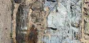
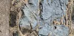
67 7 - Stone retaining walls are a blend of dry-laid and mortared components and may include integrated rock outcrops. 8 - One of the taller heights of existing retaining walls along a steep downslope, protected by fencing. 8 7 Anchor Parks Highbridge Park Phase1 Site Photos 12


68 9 - The pathway on the left slopes up to Amsterdam Avenue while the one on the right continues through the mid-level of Highbridge Park A series of stone terraces occurs along a narrower portion of the path (12 wide) in which trees have volunteered over time. Poor pavement condition is typical along this northern section Anchor Parks Highbridge Park Phase1 Site Photos 13


69 11 - Poor pavement condition is typical along this northern section. 12- The path down to Harlem River Drive becomes more open Anchor Parks Highbridge Park Phase1 Site Photos 14


70 13 - As the path approaches the Harlem River Drive/Dyckman Street intersection, the wooded character along it becomes more transparent Lower path to Harlem River Drive/Dyckman Street becomes less wooded and more park-like Anchor Parks Highbridge Park Phase1 Site Photos 15

71 C LAUREL HILL TERRACE ew Concrete Street Curb set to maximum allowable reveal ew Concrete Sidewalk set flush with existing Terrace edge 5 x 5 Scoring pattern Restore historic piermounted lighting to illuminate plaza 1939 Angled World s Fair Bench with back C Existing Terrace to remain Existing Parapet Wall Anchor Parks Highbridge Park Phase1 Detail Plan - Terrace at The Grand Staircase 16


72 Restore historic piermounted lighting to illuminate plaza 1939 Angled World s Fair Bench with back Existing Terrace to remain ew Concrete Sidewalk set flush with existing Terrace edge Existing Parapet Wall ew Concrete Street Curb set to maximum allowable reveal Existing Conditions Anchor Parks Highbridge Park Phase1 Detail Section C-C - Terrace at The Grand Staircase 17

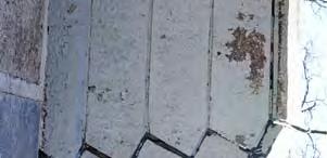
73 EXISTIG HISTORIC GRAD STAIRCASE Anchor Parks Highbridge Park Phase1 Existing Conditions 18


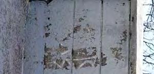
74 EXISTIG HISTORIC GRAD STAIRCASE Anchor Parks Highbridge Park Phase1 Existing Conditions 19


75 EXISTIG HISTORIC GRAD STAIRCASE AD PLAZA Anchor Parks Highbridge Park Phase1 Existing Conditions 20
76 Anchor Parks Highbridge Park Phase1 Staircase Restoration 21
77 Anchor Parks Highbridge Park Phase1 Staircase Restoration 22

78 Anchor Parks Highbridge Park Phase1 Staircase Restoration 23

79 Anchor Parks Highbridge Park Phase1 Staircase Restoration 24

80 D Side Walk Rain Garden Existing Sycamores 8 long 1939 World s Fair Bench with back Low Plant Bed Side Walk D Bottle Filler / Drinking Fountain Asphalt Block Pavement Anchor Parks Highbridge Park Phase1 Detail Plan - Entrance at Harlem River Drive and Dyckman Street 25


81 Existing Sycamores 8 long 1939 World s Fair Bench with back Rain Garden Existing Conditions Anchor Parks Highbridge Park Phase1 Detail Section D-D - Entrance at Harlem River Drive and Dyckman Street


82 W 182 nd Street W 183 rd Street W 184 th Street W 185 th Street W 186 th Street W 187 th Street W 188 th Street W 189 th Street W 190 th Street Amsterdam Avenue Amsterdam Avenue Laurel Hill Terrace Harlem River Drive A B C Anchor Parks Highbridge Park Phase1 Phase 1 Plan - Overall ' 300' 27


83 Laurel Hill Terrace A B W 186 th St Laurel Hill Terrace MATCHLIE Harlem River Drive Asphalt Top Coat Type B Light Pole / Fixture at 75 on center + - A 8 Long 1939 World s Fair Benches with Backs Detail Plan - Terrace at Grand Staircase B Legend ew Benches ew Light Poles Full Depth Asphalt Pavement Asphalt Top Coat Anchor Parks Highbridge Park Phase1 Phase 1 Plan - A


84 Amsterdam Avenue MATCHLIE MATCHLIE W 187 th St Laurel Hill Terrace Asphalt Top Coat Type B Light Pole / Fixture at 75 on center Long 1939 World s Fair Benches with Backs Anchor Parks Highbridge Park Phase1 Phase 1 Plan - B Full Depth Asphalt Pavement Legend ew Conc. Curb with 4 Steel Fence ew Benches ew Light Poles Full Depth Asphalt Pavement Asphalt Top Coat


85 Amsterdam Avenue MATCHLIE Harlem River Drive Detail Plan - Entrance at HRD and Dyckman Full Depth Asphalt Pavement Type B Light Pole / Fixture at 75 on center + - Legend ew Benches ew Light Poles Full Depth Asphalt Pavement Asphalt Top Coat Anchor Parks Highbridge Park Phase1 Phase 1 Plan - C 30

86 Anchor Parks Highbridge Park Phase1 Site Section A-A - At Grand Staircase

87 Anchor Parks Highbridge Park Phase1 Site Section B-B

88 E Existing vegetated upslope Existing Rough Stone Retaining wall or Rock Outcrop Height varies between 3 and 12 Varies r long 1939 World s Fair Bench with back in double or triple configurations Asphalt Top Course or ew Full Depth Asphalt ew Type B light pole/ fixture at 75 on center + - Existing Rubble Stone Curb 8 to 12 High Existing vegetated downslope E Anchor Parks Highbridge Park Phase1 Typical Site Plan 33

89 Existing vegetated upslope ew Type B light pole/ fixture at 75 on center + - Existing Rough Stone retaining wall or Rock Outcrop Height varies between 3 and 12 Existing Rubble Stone Curb 8 to 12 High Existing vegetated downslope 8 long 1939 World s Fair Bench with back in double or triple configurations Asphalt Top Course or ew Full Depth Asphalt Anchor Parks Highbridge Park Phase1 Typical Site Section E - E 34


90 Asphalt Pavement Asphalt Block Pavers Concrete Pavement 4-0 Steel Fence 1939 World s Fair Bench with Back Bottle Filler with Hi-Lo Drinking Fountains Type B Light Pole and Fixture Anchor Parks Highbridge Park Phase1 Site Furnishings 35
91 WHAT COMES EXT? Submit Phase 1 project to the Public Design Commission Continue design of Phase 1 project throughout 2017 Begin the Phase 2 project in May Anchor Parks Highbridge Park Manhattan, Y

92 Anchor Parks Highbridge Park Manhattan, Y THAK YOU!
Bellevue South Park. Located between E 26th and E 28th at Mt. Carmel Place, in the Borough of Manhattan.
 Bellevue South Park Located between E 26th and E 28th at Mt. Carmel Place, in the Borough of Manhattan. Community Board 6 Review January 2, 2018 Christopher M. Crowley, RLA NYC Parks Total Budget: Project
PIONEER PARK. City of Des Peres Parks Master Plan. SWT Design 46 INTRODUCTION
 PIONEER PARK INTRODUCTION Pioneer Park is a 7 acre neighborhood park located east of Interstate 270 and south of Manchester Road along Tallie Road. The park is situated in a residential neighborhood with
ballfields 5-8 red hook park
 ballfields 5- red hook park Bordered by Lorraine, Hicks, Henry, and Bay Streets In the Borough of Brooklyn Public Design Commission- Concept Review Submission May, 201 TRC Engineers, Inc. and Parks Capital
NORTHWEST SECTION CONTENTS: CLEVELAND PARK FOLWELL PARK RYAN LAKE PARK VICTORY PRAIRIE DOG PARK VICTORY PARK
 NORTHWEST SECTION CONTENTS: CLEVELAND PARK FOLWELL PARK RYAN LAKE PARK VICTORY PRAIRIE DOG PARK VICTORY PARK LUCY LANEY COMMUNITY SCHOOL N 33RD AVE N 33RD AVE SINGLE-FAMILY RESIDENTIAL MULTI-USE DIAMOND
17 Mathilda Welmering Park Planning Zone 3
 17 Mathilda Welmering Park Planning Zone 3 8301 Mathilda Visit Date: September 2016 St. Louis County Parks Master Plan Page 1 Description: The six acre Mathilda Welmering Park is named for two streets
M E S T I Z O C U R T I S P A R K
 ARAPAHOE CONNECTION TO BUS ROUTE AT ND AND LAWRENCE, FUTURE LIGHT RAIL STATION LEGEND SOCIAL TRAIL FLAGSTONE PAVING TO RESTORE/MAINTAIN CONCRETE PAVING DIAGONAL CURVILINEAR SOCIAL ROUTE IS OUT OF HISTORIC
35 Bee Tree Park Planning Zone 3
 35 Bee Tree Park Planning Zone 3 2701 Finestown Road Visit Date: August 2016 St. Louis County Parks Master Plan Page 1 35 Bee Tree Park 2701 Finestown Road St. Louis County Parks Master Plan Planning Zone
LANDING S PARK CONCEPTUAL PLAN HAMILTON ANDERSON JANUARY City of Novi, Michigan. The Park at 13 Mile and Old Novi Road
 HAMILTON ANDERSON JANUARY 2012 LANDING S PARK CONCEPTUAL PLAN January 2012 Page 1 of 15 January 2012 PROJECT GOALS Activate the park by introducing new elements Provide clear access to the water and enhance
NORTH OF BROADWAY SECTION CONTENTS: COTTAGE PARK FARVIEW PARK GLEN GALE PARK IRVING TRIANGLE JORDAN PARK NEWTON PARK PERKINS HILL PARK
 NORTH OF BROADWAY SECTION CONTENTS: COTTAGE PARK FARVIEW PARK GLEN GALE PARK IRVING TRIANGLE JORDAN PARK NEWTON PARK PERKINS HILL PARK N ILIO NA VE N JAM ES AV E PLAYGROUND PAR K PRO PER TY B OUN DAR Y
No 30 x 48 space is provided for a wheelchair under the picnic table.
 ITEM: LLOYD PARK PICNIC TABLE ADA GUIDELINE: 305, 902.2 No 30 x 48 space is provided for a wheelchair under the picnic table. Remove one of the picnic table arms. Photo of Picnic Table on the bluff PARK:
Trails, steps, & P-Patch to be south of I- 5 Colonnade
 UW Campus Trails, steps, & P-Patch to be south of I- 5 Colonnade Blaine and Howe Street steps REI N new lighting existing features connector trail new features or improvements overhead freeway and support
City of Haslett. City of East Lansing. City of East Lansing
 Central Park North (Nancy L. Moore Park) Lake Park North Expansion White Park Expansion #2 White Park Expansion #1 County East East Haslett East East TF87-212 Acquisition $90,000.00 Park. TF08-138 Acquisition
2. Goals and Policies. The following are the adopted Parks and Trails Goals for Stillwater Township:
 D. PARKS AND TRAILS 1. Introduction Stillwater Township s population is relatively low, with most residents living on rural residences on large lots. The need for active park space has been minimal in
Corktown Parks. Public Meeting. City of Toronto
 Corktown Parks Public Meeting City of Toronto 15-04-20 Agenda 1. Reasons for Study 2. Consultation to Date 3. Parks Evaluation 4. Community Context 5. Bright St. Playground 6. Orphans Green (Dog Off Leash)
TRUCKEE TAHOE AIRPORT DISTRICT BOARD OF DIRECTOR STAFF REPORT
 AGENDA ITEM: 11 TRUCKEE TAHOE AIRPORT DISTRICT BOARD OF DIRECTOR STAFF REPORT AGENDA TITLE: MEETING DATE: January 24, 2018 PREPARED BY: NTPUD Agency Partnership Opportunity, Multi-Use Trailhead Access
NORTH HEMPSTEAD BEACH PARK MASTER PLAN
 NORTH HEMPSTEAD BEACH PARK MASTER PLAN COMMUNITY DESIGN CHARRETTE Supervisor Judi Bosworth Viviana L. Russell Peter J. Zuckerman Angelo P. Ferrara Anna M. Kaplan Lee R. Seeman Dina M. De Giorgio VISIONING
City of Signal Hill STUDY AREA PROFILE
 City of Signal Hill STUDY AREA PROFILE STUDY AREA ID #141 BASE MAP PARK METRICS WHERE ARE PARKS MOST NEEDED AMENITY QUANTITIES AND CONDITIONS PARK NEEDS FRAMEWORK PROJECT COST ESTIMATES PROJECT REPORTING
Webber Park Master Plan Charrette Summary
 SMALL GROUP #1 - September 29, 2011 Webber Park Master Plan Charrette Summary More trash cans, especially near picnic grounds A year round pool is very needed-physical & mental health are significantly
PARKS & BEACHES PROJECTS
 #18 72ND STREET PARK, LIBRARY, #19 BLUEWAYS & AQUATIC CENTER $1.1 MILLION $60 MILLION New facility to include: Create Kayak Launches with All Wheels Skate Park Floating Docks and Seating at: Library/Media
NEW MEADOWS PARK PROPOSED MASTER PLAN
 NEW MEADOWS PARK PROPOSED MASTER PLAN A vision for your neighborhood park, the draft master plan is ready for your review. Tuesday September 12 th, 2017 5:30-7:00 PM Hellgate School District #4 middle
Community Park Capital Project. February 6, 2017
 Community Park Capital Project February 6, 2017 Construction Budget Estimate Bid Recommended $10,318,690 $7,725,000 Staff Recommended +$1.1M $8,850,000 +$2.6M -$1.47M Pre-Bid Estimate 11/22/2016
China Creek North Park Upgrades and Glen Pump Station. Park Board Committee Meeting Monday, July 10, 2017
 China Creek North Park Upgrades and Glen Pump Station Park Board Committee Meeting Monday, July 10, 2017 Purpose The purpose of this presentation is to: Share the results of the public engagement processes;
Recreation and Park Commission, Capital Committee. Through: Philip A. Ginsburg, General Manager Dawn Kamalanathan, Capital and Planning Manager
 Date: May 29, 2013 To: Recreation and Park Commission, Capital Committee Through: Philip A. Ginsburg, General Manager Dawn Kamalanathan, Capital and Planning Manager From: Subject: Mary Hobson, Project
7. Plan Implementation
 7. Plan Implementation 7.1 Implementation Timeline This section includes a list of achievable park and recreation actions. In the Implementation Action Matrix that follows, the implementation actions have
Frederickson LUAC. Community Plan Update. Parks & Recreation. September 25, 2017
 Frederickson LUAC Community Plan Update Parks & Recreation September 25, 2017 Kimberly Freeman Resource Stewardship Superintendent kimberly.freeman@co.pierce.wa.us 253-798-4261 Joseph Coppo Senior Parks
BUILDING / RESTROOMS WALKING LOOP SIGNALIZED AT- GRADE CROSSING
 A WADIG POOL SPLASH PAD BUILDIG / RESTROOMS ADULT FITESS MULTI-USE FIELD MULTI-USE DIAMOD WALKIG LOOP SIGALIZED AT- GRADE CROSSIG AMPHITHEATER/ SEATIG FLATTEED SITE - AT GRADE CROSSIG (REMOVAL OF EXISTIG
MPRB: Southwest LRT Community Advisory Committee Issues and Outcomes by Location Current to: 12 November 2010
 MPRB: Southwest LRT Community Advisory Committee Issues and Outcomes by Location Current to: 12 November 2010 This is a compilation of issues and outcomes identified by the CAC. It is a work in progress,
Non-motorized Trail Plan & Proposal. August 8, 2014
 Town of Star Valley Ranch, Wyoming and the Star Valley Ranch Association in partnership with the USDA Forest Service, Bridger-Teton National Forest, Greys River Ranger District Non-motorized Trail Plan
ADA Compliance Projects Summary Sheet
 District Letter Dated Project % to ADA Amount Granted Buffalo Grove March 10, 2014 Woodland Park - asphalt path 100% $4,500.00 Buffalo Grove March 10, 2014 Wellington Commons Bike path repairs including:
Unincorporated Quartz Hill -Lancaster- Palmdale STUDY AREA PROFILE
 Unincorporated Quartz Hill -Lancaster- Palmdale STUDY AREA PROFILE STUDY AREA ID #19 BASE MAP PARK METRICS WHERE ARE PARKS MOST NEEDED AMENITY QUANTITIES AND CONDITIONS PARK NEEDS FRAMEWORK PROJECT COST
River Parks Trail: Tulsa, Oklahoma
 River Parks Trail: Tulsa, Oklahoma Purpose: The purpose of the River Parks Trail is to maintain, preserve, develop, and promote the Arkansas River for the economic and cultural benefit of the community.
Chorley Park Trail Connection New Design Options. Information Booklet Prepared for June 9, 2014 Public Meeting
 Chorley Park Trail Connection New Design Options Information Booklet Prepared for June 9, 2014 Public Meeting Chorley Park Trail Booklet June 9, 2014 Page 1 of 12 Our Goals for the Chorley Park Trail Connection
Unincorporated East Rancho Dominguez STUDY AREA PROFILE
 Unincorporated East Rancho Dominguez STUDY AREA PROFILE STUDY AREA ID #31 BASE MAP PARK METRICS WHERE ARE PARKS MOST NEEDED AMENITY QUANTITIES AND CONDITIONS PARK NEEDS FRAMEWORK PROJECT COST ESTIMATES
Trail Feasibility Study
 VOLUSIA COUNTY MPO CITY OF NEW SMYRNA BEACH FINAL REPORT JUNE 30, 2009 Trail Feasibility Study What s inside? 1 Introduction 2 Project Purpose & Scope 3 Physical Inventory & Assessment of Right-of- Way
City of Galion Park Satisfaction Survey Results
 City of Galion Park Satisfaction Survey Results Dec. 5, 2016 Goal: To get feedback from the community on: 1. General satisfaction of city-owned parks 2. How to improve park facilities and recreation opportunities
Capital Prioritization
 14 Capital Prioritization 279 279 280 Park & Recreation CAPITAL PRIORITIZATION As described in Chapter 8, the recommendations presented in Chapter 9 are prioritized to provide a guide for future capital
City of Sierra Madre STUDY AREA PROFILE
 City of Madre STUDY AREA PROFILE STUDY AREA ID #112 BASE MAP PARK METRICS WHERE ARE PARKS MOST NEEDED AMENITY QUANTITIES AND CONDITIONS PARK NEEDS FRAMEWORK PROJECT COST ESTIMATES PROJECT REPORTING FORM
RIDGEFIELD PARKS February 2016
 RIDGEFIELD PARKS February 2016 Hayden Park Neighborhood Park Amenities Sign with Name of Park and City of Ridgefield Logo Lamp Post Parking Area Play Set Swings Sign with Playground Rules Durable Benches
Welcome! INTRODUCTION. Tell us what you think! Comment forms are provided for your feedback
 Welcome! Comment forms are provided for your feedback Tell us what you think! INTRODUCTION The City of Salmon Arm s O cial Community Plan (OCP) and its Parks and Recrea on Master Plan (2012) both iden
2014 Parks and Trails General Obligation Bond: $42 million. $3 million County Trails $1 million City Playgrounds $38 million FMRP
 2014 Parks and Trails General Obligation Bond: $42 million $3 million County Trails $1 million City Playgrounds $38 million FMRP FMRP Location and Connections Major Timelines Completion of phase I the
AGENDA MEMORANDUM Community Services Department. CSAB Meeting Date: April 10, 2018
 AGENDA MEMORANDUM Community Services Department CSAB Meeting Date: April 10, 2018 To: Community Services Advisory Board From: Dana A. Souza, Director Date: April 4, 2018 Legislative Quasi-Judicial SUBJECT:
Community Input Meeting. Fairgrounds Master Planning Update. January 7, 2016, 7 pm
 Community Input Meeting Fairgrounds Master Planning Update January 7, 2016, 7 pm Fiesta Hall Santa Clara County Fairgrounds 355 Tully Road, San Jose, CA Tonight s Agenda 1) Board of Supervisors Direction
The Narrows Waterfront Park A Crown Jewel for Southern Brooklyn
 The Narrows Waterfront Park A Crown Jewel for Southern Brooklyn In New York, the unquestioned popularity of urban spaces such as Riverside Park, the High Line, Brooklyn Bridge Park and others has demonstrated
EAST CITY PARK. 900 East Third Street 7.04 Acres
 EAST CITY PARK 900 East Third Street 7.04 Acres Description: Moscow s oldest park is great for leisurely summer strolls. Mature trees offer shade and relaxation, and a variety of activities exist in which
POLICY & STRATEGIES The Vancouver Park Board approves major changes in Vancouver parks, including the design and development of parks.
 September 8, 2017 TO: Park Board Chair and Commissioners FROM: General Manager Vancouver Board of Parks and Recreation SUBJECT: Brewers Park and Clinton Park Renewal Concept Plans RECOMMENDATION THAT the
MORGAN CREEK GREENWAY Final Report APPENDICES
 APPENDICES MORGAN CREEK GREENWAY Appendix A Photos of Existing Conditions in Trail Corridor Photos of existing conditions Main trail corridor - February 2009 Photos of existing conditions south bank Morgan
Schoolcraft Township is located in northeast Houghton County. A portion of the township borders Keweenaw County and Lake Superior.
 COMMUNITY DESCRIPTION Schoolcraft Township is located in northeast Houghton County. A portion of the township borders Keweenaw County and Lake Superior. The township is largely rural but has one main population
Fun Facts. How many Baseball fields do we have? a. 2 b. 14 c. 16 d. 21
 It Starts in Parks Fun Facts How many Baseball fields do we have? a. 2 b. 14 c. 16 d. 21 Fun Facts How many people visit Central Winds Park Annually? a. Over 100,000 b. 20,000 c. 10,000 d. 1,000 It Starts
Parks, Recreation and Cultural Needs Assessment and Facilities Plan. November 21, 2016 City Council Worksession
 Parks, Recreation and Cultural Needs Assessment and Facilities Plan November 21, 2016 City Council Worksession History and Process FY16/17 Budget Appropriation for Needs Assessment, Dean and Stonewall
Appendix B - Undeveloped Parks and Existing Parks with Remaining Development Programming
 Appendix B - Undeveloped Parks and Existing Parks with Remaining Development Programming Table of Contents Appendix B - Undeveloped Parks and Existing Parks with Remaining Development Programming Table
Village of Lombard, Illinois Capital Improvement Plan FUNDING SOURCE SUMMARY
 Village of Lombard, Illinois Capital Improvement Plan FY 15 FY 24 thru FUNDING SOURCE SUMMARY Source FY 15 FY 16 FY 17 FY 18 FY 19 FY 20 FY 21 FY 22 FY 23 FY 24 Construction Fund 6,318,700 2,354,800 2,430,800
Trail Etiquette. Hours of Operation. Trail Accessibility
 Trail Guide The Elmhurst Park District, with 28 parks and over 460 acres of land, offers nearly six miles of paved or asphalt park trails and maintains an additional 3.6 miles of trails within Elmhurst.
6.5 DURANGO EXCELS AT PARK CONNECTIVITY
 City of Durango 6.5 DURANGO EXCELS AT PARK CONNECTIVITY The City of Durango excels at park connectivity as evidenced by the success of the Animas River Trail (ART) project. While it is clear there are
CB 1 - CLARK PLAYGROUND Third Avenue & E. 144 th Street Complete Summer 2008
 The Croton Program CB 1 - CLARK PLAYGROUND Third Avenue & E. 144 th Street Complete Summer 2008 CB 1 - MELROSE PLAYGROUND Courtlandt Avenue & E. 154 th Street Complete Winter 2009 CB 2 - MANIDA BALLFIELD
Rating: 5.0 (scale of 1-10)
") 95 Community Trail System Groundcover: 2-metre paved path, 1- metre grass buffer on either side. Location: Fort St. John Ownership: City of Fort St. John Rating: 5.0 (scale of 1-10) Strategic value: Linear
95 Community Trail System Groundcover: 2-metre paved path, 1- metre grass buffer on either side. Location: Fort St. John Ownership: City of Fort St. John Rating: 5.0 (scale of 1-10) Strategic value: Linear
BEAVER LAKE ACCESS AREA SUMMARY 2017 Edition
 BEAVER LAKE ACCESS AREA SUMMARY 2017 Edition DEVELOPED BY THE BEAVER LAKE PROPERTY and SAFETY COMMITTEE 2 October 2017 1 NOTICE: This document supersedes and nullifies all previous versions of Beaver Lake
20 Grant s Trail. Planning Zone 3. Visit Date: September St. Louis County Parks Master Plan
 20 Grant s Trail Planning Zone 3 Visit Date: September 2016 Page 1 20 Grant s Trail Planning Zone 3 Visit Date: September 2016 Page 2 20 Grant s Trail Planning Zone 3 Visit Date: September 2016 Page 3
VILLAGE OF WOLVERINE LAKE VILLAGE COUNCIL WORK SESSION JOINT SESSION WITH THE PARK & RECREATION BOARD MEETING MINUTES WEDNESDAY, SEPTEMBER 27, 2017
 VILLAGE OF WOLVERINE LAKE VILLAGE COUNCIL WORK SESSION JOINT SESSION WITH THE PARK & RECREATION BOARD MEETING MINUTES WEDNESDAY, SEPTEMBER 27, 2017 CALL TO ORDER President Magee called the meeting to order
City of Durango 5.8 FUNDING TRAILS DEVELOPMENT
 5.8 FUNDING TRAILS DEVELOPMENT The City has been successful in establishing dedicated local funding sources as well as applying for grants to develop the City s trail system, having received nearly $2.4
BASSETTS CREEK SECTION CONTENTS: BASSETTS CREEK BRYN MAWR LUCE LINE
 BASSETTS CREEK SECTION CONTENTS: BASSETTS CREEK BRYN MAWR LUCE LINE GLENWOOD AVE MULTI-USE DIAMONDS VINCENT AVE N MORGAN AVE N PENN AVE N DOG PARK MULTI-USE FIELDS PLAYGROUND AK E RD S CHESTNUT AVE DA
Dover Park Master Plan. Community Design Event Tuesday, May 22, 5 7 pm
 Dover Park Master Plan Community Design Event Tuesday, May 22, 5 7 pm Agenda I. Introduction / Overview 20 minutes II. Small Group Design Activity 60 minutes III. Small Group Report Out IV. Conclusion
Acquisition in fee simple of approximately one-half acre of property on the shore of Spring Lake to expand the Lakeside Beach Park.
 Lakeside Beach TF00-136 $122,550.00 in fee simple of approximately one-half acre of property on the shore of Spring Lake to exp the Lakeside Beach. 2000 River Ravines TF00-150 $910,000.00 in fee simple
BRYAN REGIONAL PARK. Presented by: Burditt Consultants November 13, 2018
 BRYAN REGIONAL PARK Presented by: Burditt Consultants November 13, 2018 AGENDA 1. Project Purpose & Mission 2. Project Vision & Goals 3. Stakeholder Feedback 4. Program Overview 5. Phase A Plan Overview
Southwest Quadrant Distinctive Features
 SOUTHWEST QUADRANT Southwest Quadrant Distinctive Features LAND USE The 31.17 square mile Southwest Quadrant includes all the area within the planning area west of I-5 and south of the Sacramento River.
2014 SPLOST Final Draft County-wide Parks System Rehabilitation
 Page 1 of 5 ADA Improvements (County Wide) Accessibility projects related to trails/walkways, door entrances, pool access, curb cuts, ramps, etc. Additionally, ADA Audit of facilities to identify and prioritize
chapter - Hex Highway Touring Route Hamburg to Strausstown Overview
 chapter - 2 Hex Highway Touring Route Hamburg to Strausstown Overview The on-road Hex Highway automobile and bicycle touring route begins on State Street in downtown Hamburg. The route continues west on
Wilds. Headwaters. Lakes. Oxbows. Falls
 56 5 4 3 Wilds Headwaters Lakes Oxbows Falls 57 Zones It could be said the on-the-ground essence of this master plan appears within the next 6 pages of this report. As we learned in the preceding Cultural
4.0 FACILITIES INVENTORY
 4.0 FACILITIES INVENTORY 4.1 PARK LEVEL OF SERVICE STANDARDS (LOS) Based on current City of Longview Parks and Recreation Level of Service (LOS) Standards (Figure G), the City currently has a deficiency
NEWBORO AND PORTLAND HARBOUR REDVELOPMENT PLANS
 INTRODUCTION The Municipal docks in both Newboro and Portland were transferred to the Township of Rideau Lakes by Parks Canada in 2002. Little has been done to improve the docks physical condition or role
HARP AUTHORITY GATEWAY CENTER BOATHOUSE & CHANNEL EXTENSION TO SANTA FE AVENUE. Pueblo City Council Presentation September 17, 2018
 HARP AUTHORITY GATEWAY CENTER BOATHOUSE & CHANNEL EXTENSION TO SANTA FE AVENUE Pueblo City Council Presentation September 17, 2018 PROJECT: 1A HARP Expansion FUNDING 1A Ballot Issue Pueblo County : $3,000,000
HALL PARK LOCATION AND HISTORY EXISTING CONDITIONS AND CHARACTER LOCATION
 HALL PARK LOCATION LOCATION AND HISTORY Hall park straddles Lyndale Avenue on the city s near north side. This neighborhood was identified in a 1938 study of the city s playground needs as one of five
Winnebago County Community Park
 Directions to Community Park From Interstate Hwy. 41 to Oshkosh exit 124, which is Hwy. 76/Jackson Street. East on Hwy 76/ Jackson Street to left on County Road Y, 1/4 mile. Winnebago County Park is on
M. Spina, Councillor J. Cowden, School District No. 73 N. DeCicco, Projects and Planning Supervisor, City of Kamloops
 MINUTES OF A MEETING OF THE KAMLOOPS PARKS AND RECREATION COMMITTEE HELD ON WEDNESDAY, NOVEMBER 26, 2014, AT 7:00 AM IN THE TOURNAMENT CAPITAL CENTRE, MEETING ROOM "D" RECOMMENDATION: That Council authorize
SOUTH PARK AT FRESHKILLS PARK ANCHOR PARKS PROGRAM COMMUNITY VISIONING. JCC of Staten Island February 1, 2017
 SOUTH PARK AT FRESHKILLS PARK ANCHOR PARKS PROGRAM COMMUNITY VISIONING JCC of Staten Island February 1, 2017 TONIGHT S AGENDA 1/ PRESENTATION: ANCHOR PARKS OVERVIEW WHAT WE HEARD IN NOVEMBER CONCEPTUAL
Physical Activity Resource Assessment (PARA) Form Protocol and Operational Definitions
 Form Protocol and Operational Definitions") Physical Activity Resource Assessment (PARA) Form Protocol and Operational Definitions Protocol General Directions At an indoor facility, stop at the reception area and introduce yourself to desk staff
Physical Activity Resource Assessment (PARA) Form Protocol and Operational Definitions Protocol General Directions At an indoor facility, stop at the reception area and introduce yourself to desk staff
and plant some trees, but that was only accomplished through state and federal work-relief programs.
 PEAVEY LOCATION AND HISTORY Peavey Park sits in the Phillips Community on a large block bounded by major streets: Franklin Avenue, Chicago Avenue, and Park Avenue. The southern continue through to Chicago
Northeast Quadrant Distinctive Features
 NORTHEAST QUADRANT Northeast Quadrant Distinctive Features LAND USE The Northeast Quadrant includes all the area within the planning area that is east of Interstate 5 and to the north of State Route 44.
SHINGLE CREEK SECTION CONTENTS: BOHANON PARK CREEKVIEW PARK SHINGLE CREEK PARK SHINGLE CREEK REGIONAL TRAIL WEBBER PARK
 SHINGLE CREEK SECTION CONTENTS: BOHANON PARK CREEKVIEW PARK SHINGLE CREEK PARK SHINGLE CREEK REGIONAL TRAIL WEBBER PARK SPLASH PAD Good condition. PARK BUILDING BRYANT AVE N Good condition and unique to
Griffith Park Trail Run Trail Guide Click for
 The Griffith Park Trail Run by Hike- LosAngeles.com Griffith Park Trail Run Trail Guide Click for downloadable cell phone guide and map from EveryTrail. DISTANCE: 4.55 Miles ELEVATION: 1280' ELEVATION
Villages at Buffalo Run East
 Villages at Buffalo Run East Neighborhood Park Subhead to title page goes here. Public Design Meeting April 9, 2015 Capital Improvement Program Commerce City s $137 million CIP is the result of a 2013
SAN ANTONIO RIVER IMPROVEMENTS PROJECT. August 6, 2008
 SAN ANTONIO RIVER IMPROVEMENTS PROJECT August 6, 2008 1 History of the SA River Improvements 1921 Flood Olmos Dam Complete in 1929 Downtown Flood Relief Projects in 1950 s Dams on the River Channel and
Park Design and Location Criteria
 Park Design and Location Criteria This section is presented in the interest of assisting park and recreation agencies in the development of a system of parks and recreation areas. A recreation system is
CONTEXT MAP COMPREHENSIVE RECREATIONAL MASTER PLAN. to Virginia Civil War Trails. Riverside Park. Mountains to Sea Trail. Rowe Environmental Park
 OMPREHENSIE REREATIONAL MASTER PLAN ONTEXT MAP to irginia ivil War Trails NOT TO SALE iver tr rara A Riverside Mountains to Sea Trail Rowe Environmental School The Ararat River reenway is located along
City of LA Valley Glen - North Sherman Oaks STUDY AREA PROFILE
 City of LA Valley Glen - North Sherman Oaks STUDY AREA PROFILE STUDY AREA ID #61 BASE MAP PARK METRICS WHERE ARE PARKS MOST NEEDED AMENITY QUANTITIES AND CONDITIONS PARK NEEDS FRAMEWORK PROJECT COST ESTIMATES
FOLWELL PARK LOCATION AND HISTORY LOCATION
 FOLWELL PARK LOCATION LOCATION AND HISTORY Folwell Park is a large (by neighborhood park standards) tract of land located south of Dowling Avenue between Humboldt and Knox Avenues. The land for the park
Appendix C - Existing Developed Parks
 Appendix C - Existing Developed Parks Table of Contents Appendix C Existing Developed Parks Table of Contents... Pg. i Introduction... Pg. ii Amos P. Catlin Park... Pg. 1 Beacon Hill Park... Pg. 1 Cambridge
APPLICATION FOR SITE DEVELOPMENT PLAN LETTER OF INTENT Amended
 Est. 1982 Est. 1982 Urban Planning Community Design Landscape Architecture 731 North Weber Street, Suite 10, Colorado Springs, CO 80903, 719 633-9700 http://www.gumanltd.com/ Members American society of
Memorandum / Letter of Intent
 VERONA WAUKESHA KENOSHA APPLETON WESTON Memorandum / Letter of Intent To: Adam Sayre, Director of Planning & Development, City of Verona From: Kevin Yeska, JSD Professional Services, Inc. www.jsdinc.com
General Fund. Parks, Recreation, and Community Services. Fiscal Year 2017
 Parks, Recreation, and Community Services Mission: The mission of the City of Rio Rancho s Department of Parks, Recreation, & Community Services is to create and maintain spaces and activities that grow
Corabelle Park. Inventory. Future Development
 Corabelle Park Size: Approximately 4 acres Site Description: Corabelle Park is a relatively new park within the Murray County Park System. It is located on the south side of Corabelle Lake just off gravel
Chapter eight. Parks and Recreation. Introduction. Crystal Lake Park District
 Chapter eight Parks and Recreation Introduction One of the indicators of quality of life in a city is the parks and recreation system. The City of Crystal Lake is fortunate to have an excellent parks and
Blue River Trail Master Plan JSA to Town Hall June 2004
 Blue River Trail Master Plan JSA to Town Hall June 2004 Prepared for: Silverthorne Town Council Silverthorne SPORT Committee Department of Recreation and Culture Silverthorne Public Works Silverthorne
3. COLTA / HUGA CONNECTIONS - PRELIMINARY
 9 3. COLTA / HUGA CONNECTIONS - PRELIMINARY 3.1 COLTA The Chain of Lakes Trail Association (COLTA) trail, formerly identified as the Chester Spur Line, was completed and opened for use in June 2011. The
City of Oak Harbor Parks & Descriptions
 City of Oak Harbor Parks & Descriptions North West Section Koetje Park - NE 7 th Avenue (3.5 acres) Neighborhood and Community Park with playgrounds on one tot lot, one soccer/practice field, picnic tables,
City of Palmdale - Westside STUDY AREA PROFILE
 City of Palmdale - Westside STUDY AREA PROFILE STUDY AREA ID #125 BASE MAP PARK METRICS WHERE ARE PARKS MOST NEEDED AMENITY QUANTITIES AND CONDITIONS PARK NEEDS FRAMEWORK PROJECT COST ESTIMATES PROJECT
Washington Township MASTER PLAN. Addendum: Washington Township Master Plan
 Washington Township MASTER PLAN Addendum: Washington Township Master Plan CHAPTER XI RECREATION CORE DISTRICT Introduction The Recreation Core District generally encompasses the areas north of 30 Mile
WHY MOVE YOUR BUSINESS TO HOLLYWOOD?
 WHY MOVE YOUR BUSINESS TO HOLLYWOOD? Close to international airport and seaport Centrally located in 3.5 million population No personal income tax Diverse labor force and talent pool Waterfront executive
Auburn Trail / Ontario Pathways Trail Connector Feasibility Study Public Information Meeting Wednesday, August 22, 2012
 Auburn Trail / Ontario Pathways Trail Connector Feasibility Study Public Information Meeting Wednesday, August 22, 2012 Purpose of Feasibility Study Purpose Evaluate the feasibility of constructing a multiuse
crrv OF DALLAS Memorandum Trinity River Corridor Project Update On Recreation
 Memorandum OATE December 8, 2011 crrv OF DALLAS TO Trinity River Corridor Project Committee Members: Vonciel Jones Hill (Chair) Linda Koop (Vice Chair), Monica Alonzo, Scott Griggs, Angela Hunt, Delia
Inner Harbor 2.0. The resulting Inner Harbor 2.0 Plan provides a road map for a more sustainable, attractive and active Inner Harbor.
 Inner Harbor 2.0 In 2012, recognizing that some of the Inner Harbor infrastructure had outlived its useful life, the City completed a State of Good Repair Study, while Waterfront Partnership, along with