Aurora Hills. Getting There
|
|
|
- Silas Wells
- 6 years ago
- Views:
Transcription
1 Aurora Hills Aurora Hills is neighborhood near Crystal City and Pentagon City. Ball fields, ball courts, a very short trail, and a combination ibrary/fire Station are the central pieces of a recreation center there. The area is convenient to those working in the nearby Crystal City high rises. Also nearby, are a growing number of enjoyable restaurants. Aurora Hills is in Arlington but close enough to Alexandria, to use not only the Four Mile un Trail, but also the Wayne F. Anderson Trail, which parallels on the other side of Four Mile un. It s also close to National Airport and the Pentagon so that loops involving the Mt. Vernon Trail can be made. Getting There From Northern Fairfax County, VA or Montgomery County, MD Exit the Capital Beltway onto te. I-66, headed east. If you re coming from Montgomery County or the northernmost parts of Fairfax County, you will have to use the Washington and Dulles Access Expressway for 2.7 miles to get onto te. I-66; it s a left exit off the beltway. After 9.8 or 7.7 miles on te. I-66 respectively, just after the tunnel at osslyn and before crossing into Washington D.C., exit right, onto te Turn right after 2.2 miles at the I-395 interchange as if you were taking I-395 north into D.C. While still on the cloverleaf, bear left onto Army Navy Dr. After only 0.35 miles, turn left onto Hayes St. After passing the Fashion Center Mall on your right, and after passing 15 th Street, turn right into the Aurora Hills ibrary and ecreation Center parking lot. Turn right and park near the paved trail head on the left. From Southern Fairfax County, VA Exit the Capitol Beltway, I-95, northbound onto Henry G. Shirley Highway (I-395). After approximately 7.5 miles, exit toward te. 27. Stay in the right most lanes following signs to Pentagon City and Hayes St. At the end of the exit ramp, go straight at the stop light. Pass the Fashion Center Mall on your right, and then 15 th Street. Turn right into the Aurora Hills ibrary and ecreation Center parking lot. Turn right and park near the paved trail head on the left. From Prince Georges County, MD Use the Capital Beltway (I-95), to get to te. 50 west or I-295 north. From either, take the westbound Southeast Freeway (I-395) after 11 miles or approximately 6 miles respectively. Follow the Southeast Freeway across the river into Virginia. Do not use the express lanes. Stay in the left lane on the bridge over the Potomac iver. After the bridge, make the left exit to te. 1, into Crystal City. Exit the te. 1 freeway on the right at 15 th Street, turning right at the stop light. After three blocks, turn left on 15 th Street. Turn right into the Aurora Hills ibrary and ecreation Center parking lot. Turn right and park near the paved trail head on the left. By Metro ail ide metro rail s Blue or Yellow lines to the Pentagon City station. Exit onto Hayes Street and head south toward 15 th Street. As you cross 15 th Street, walk through the parking lot on the right until you see the paved trail head on the right. The distance from the station is 0.23 miles.
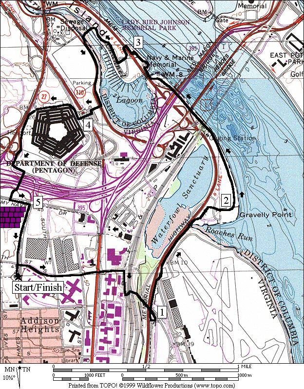
2 Area outes Around Aurora Hills (7.15 or 7.55 miles, VI) This circumnavigation of the Crystal City and Pentagon City takes advantage of several trails including the Mt. Vernon Trail and the Four Mile un Trail. Begin by going through the park. The short trail ends after less than a quarter mile. Start the loop using Army Navy Dr. to go around Arlington idge (a hill). Army Navy Dr. is not very aesthetically pleasing. It parallels I-395, passes an entrance to Army Navy Country Club, but then connects with another short trail that parallels ong Branch (a creek). After the trail, you must cross S. Glebe d. at a traffic light, but shortly after reaching the Four Mile un Trail, you have an option to cross into Alexandria and use the Wayne F. Anderson Trail, on the other side of Four Mile un. Both trails parallel Four Mile un and join near Jefferson Davis Hwy, te 1. The Wayne F. Anderson Trail passes a small wetland area and some ball fields. The Four Mile un Trail stays closer to the water, but passes a water treatment plant. After both routes are joined, cross under the bridges for the highway, the railroads, the metro, and the George Washington Parkway before reaching the Mt. Vernon Trail. People often fish under the bridges and foot or bicycle traffic is frequent on weekends, but you may feel the need to go under the bridges with others for safety reasons. On the Mt. Vernon Trail, you can see some of the jets in the airport at first but as you head north, paralleling the George Washington Parkway, the airport terminal and a hill obstruct the view. Carefully cross a few exit ramps before turning off on a side trail to return to Crystal City. In the year 2000, new bridges were added over the worst of the airport exit/entrance ramps. On the side trail, a short tunnel takes you from the airport under the roads and railroad, putting you on Crystal Dr., near the Virginia ailway Express commuter railway station. Follow along Crystal Dr. through Crystal City, passing the water park, and complete the loop on Army Navy Dr. Pentagon (5.4 miles, IV) A lot of Washington area runners work in the Department of Defense. The Marine Corps Marathon and the Army Ten-Miler (open to all) are two of the areas most popular races. Small crowds can be seen filling the trails before, during, and after work hours around the Pentagon. On weekends, the Pentagon s North Parking ot is an informal gathering place for runners cyclists and in-line skaters. This route takes the Mt. Vernon Trail past Gravelly Point where commercial jets roar only feet overhead as they land or take-off at National Airport. Passing under the 14 th Street Bridges along the Potomac iver, follow the Mt. Vernon Trail over another bridge onto Columbia Island (actually part of the District of Columbia) to the Navy Merchant Marine Memorial in ady Bird Johnson Park. Cross the George Washington Parkway (difficult during commuting hours) to the yndon B. Johnson Memorial Grove. Pine trees and azaleas grace the grounds before a bridge allows you to cross back over the Boundary Channel into Virginia at the Pentagon North Parking ot. Go up to the iver Entrance of the Pentagon, then counterclockwise around it. Upon reaching the South Parking lot, circle around the lot, similar to the route of the Marine Corp Marathon, but turn right to go through the tunnel (no cycling in the tunnel) under Shirley Highway, te. I-395. eturn on Hayes St. to the parking at Aurora Hills.
3 Nearby and Connecting Zones Iwo Jima Memorial Thomas Jefferson Community Center Daingerfield Island Cameron un egional Park East Potomac Park & The Mall What to do Afterward Food and Drink Portofino s Café Italia Top Thai estaurant Cha Cha s Seafood Bistro Entertainment and Edification Arlington Historical Society S Arlington idge d Gunston Theatres One and Two Birchmere - live folk music just over the Alexandria border Washington Shakespeare Company Gravelly Point - view the airplanes take-off and land at the airport
4 Around Aurora Hills Distance: ating: 7.15 or 7.55 miles VI; paved trails and street sidewalks 7.15 Mile oute C take the trail through the park Joyce St B 0.35 at 15 th St X; to stay on Joyce St 0.65 Army Navy Dr (before I-395 underpass) 0.8 ynn St on C 1.9 / 2.1 unmarked road before Fraser Park; becomes 28 th St on 26 th St; into parking for pool after crossing creek; trail at Troy St 2.3 trail X to wooden bridge on 2.5 S Glebe d; cross creek on bridge U 2.55 cross S Glebe d at T for Meade St; again after crossing U 2.6 >* onto the Four Mile un Trail B 2.95 trail X (triangle); after underpass B 3.1 at split in trail; is to S Glebe d 3.55 Eads d on 3.65 at T; go under bridges along water >* B 4.0 Mt Vernon Trail 5.05 trail X on to Crystal City after bridge for trail over entrance ramp 5.35 Crystal Dr; Crystal Water Park 5.4 VE commuter station on th St on 5.65 road bends and becomes 12 th St C 5.85 Dale St; becomes Army Navy Dr 6.3 Hayes St; shopping mall 6.4 trail to tunnel to Pentagon on 6.5 Joyce St B 6.85 at 15 th St to stay on Joyce St 7.0 trail head on into park 7.15 parking *7.55 Mile oute 3.75 Commonwealth Ave on 2.95 trail X (triangle); after underpass 3.95 Jeff Davis Hwy, te Mt Vernon Ave; bridge over creek 4.0 trail on after bridge 3.05 Wayne F Anderson Trail head 3.25 trail X on 3.6 bridge; wildlife sanctuary on U 4.05 Four Mile un Trail (pickup cues at mile 4.0 on 7.15 mile route)

5 Around Aurora Hills
6 Pentagon Distance: ating: 5.4 miles IV; paved trails and sidewalks and Pentagon parking lots 0.0 head north through the parking lot toward 15 th St 3.55 after bridge to Pentagon N Parking; bear at parking (water); use grass th St 0.55 underpass Jeff Davis Hwy, te 1 C 0.7 Crystal Dr 0.75 VE commuter station on 0.85 connector trail (tunnel) to the Mt Vernon Trail; Crystal Water Park B 1.1 Mt Vernon Trail 1.35 Mile Marker 14 on bridge over airport exit ramp 1.85 entrance driveway for Gravelly Point 2.45 Mile Marker trail X on to 14 th St Bridge 2.85 bridge over Boundary Channel; trail X on (cuts short 0.06 miles) 3.05 Navy Merch Marine Mem parking / 3.05 along GW Parkway to xwalk / 3.1 cross GW Parkway (!) into yndon B Johnson Memorial Grove Park 3.2 through parking lot to trail head 3.35 at T (unmarked)(water at 3.45) 3.5 begin bridge over Boundary Channel 3.9 cross road before the flag pole to the stairs; sign Pentagon iver Entrance / 3.95 up the stairs and across the courtyard 4.05 Pentagon iver Entrance; begin counter clockwise around the Pentagon B 4.35 gate; continue around the Pentagon along te cross the exit ramp to the sidewalk; go counter-clockwise around the Pentagon South parking lot 4.6 Columbia Pike on 4.75 tunnel under I-395; no cycling B 4.85 after the tunnel to the xwalk & T C 4.9 Army Navy Dr; shopping mall 5.0 Hayes St 5.2 Pentagon City metro station 5.35 cross 15 th St into parking lot 5.4 parking lot trail head on
7 Pentagon
Jackson Miles Abbott Wetlands Refuge/Fort Belvoir
 Jackson Miles Abbott Wetlands efuge/fort Belvoir Over the course of millions of years the Potomac iver has gradually shifted its course and sediments have filled-in its old river bed. The main river once
Eakin Community Park. Getting There
 Eakin Community Park Quiet woods along the Accotink Creek are the hallmark of Eakin Community Park. Actually a string of smaller parks, Eakin is made-up of Mantua Park, Kern Drive Park, Eakin Park, Woodburn
Vienna. Getting There
 Vienna Like its famous and older German namesake, but on a smaller scale, Vienna, Virginia has a charm to it. Becoming increasingly more cosmopolitan, foreign restaurants, bagle and coffee shops line Maple
BG Peter D. Hidalgo (Retired) Internment at Arlington National Cemetery, Virginia
 Internment at Arlington National Cemetery, Virginia") BG Peter D. Hidalgo (Retired) Internment at Arlington National Cemetery, Virginia SERVICE Date: Tuesday, February 17, 2009 Time: 1100 Please arrive at Arlington National Cemetery by 10:30 and proceed to
BG Peter D. Hidalgo (Retired) Internment at Arlington National Cemetery, Virginia SERVICE Date: Tuesday, February 17, 2009 Time: 1100 Please arrive at Arlington National Cemetery by 10:30 and proceed to
Trailside Park, Herndon
 Trailside Park, Herndon Herndon is not the little rail stop it used to be. Like many of the smaller towns around Washington, D.C. Herndon has grown and changed. It even installed it s own little beltway,
Columbia, Maryland - Village of Owen Brown
 Columbia, Maryland - Village of Owen Brown From the Village of Owen Brown, good trails stretch to other neighboring Columbia villages. Mostly following stream valleys, the trails go to and from schools
Trailside Park, Ashburn
 Trailside Park, Ashburn For an outsider, Ashburn might seem like a follow-up act to eston. It s a large planned community built at the time, outside the known limits of civilization... Vast farm fields
Lake Artemesia. Getting There
 Lake Artemesia Lake Artemesia is a man-made lake and park located near the confluence of the Indian un, and Paint Branch creeks. A flat 1.3 mile paved path around the lake is popular with walkers, runners
Rock Creek Park, MD - Lake Needwood
 ock Creek Park, MD - Lake Needwood Lake Needwood, is a reservoir located at the end of the north end of the ock Creek hiker-biker trail. At the other end, ock Creek empties into the Potomac iver near Thompson
Foxhill Park, Bowie, Maryland
 Foxhill Park, Bowie, Maryland The approximately 50,000 residents of the city of Bowie, Maryland are proud of the trails that link the city. Many trails exist and many are planned. Bowie is a changing city.
TETRA TECH AMT 1515 Wilson Blvd. Suite 1100 Arlington, VA USA (703)
") DIRECTIONS TO HEADQUARTERS Included in this Guide: Directions to Tetra Tech 1 AMT Headquarters Parking Information 1 FAA National 2 Headquarter Locations Shuttle Schedule 2 Service to FAA Buildings Closest
DIRECTIONS TO HEADQUARTERS Included in this Guide: Directions to Tetra Tech 1 AMT Headquarters Parking Information 1 FAA National 2 Headquarter Locations Shuttle Schedule 2 Service to FAA Buildings Closest
A retrospective look at work program counting activities since 2001 is found in Table 8, on the last page of this document. Hours of Operation
 Page 2 of 20 Background TPB staff has been managing data collection along the region s HOV facilities since the late 1990's, and documenting the results, which include counts of auto occupants, vehicles
2014 PERFORMANCE OF HIGH-OCCUPANCY VEHICLE FACILITIES ON FREEWAYS IN THE WASHINGTON REGION
 2014 PERFORMANCE OF HIGH-OCCUPANCY VEHICLE FACILITIES ON FREEWAYS IN THE WASHINGTON REGION Travel Forecasting Subcommittee Friday, May 22, 2015 C. Patrick Zilliacus Figure 1 HOV System Overview Montgomery
Difficult Run Stream Valley Park
 Difficult Run Stream Valley Park The more intense mountain bikers have known about for Difficult Run for some time. Equestrians have known it longer. Eight miles of unpaved trail, the Rails to River Trail
U.S. Environmental Protection Agency CERCLA Education Center Superfund 101 October 3 through 7, 2011
 U.S. Environmental Protection Agency CERCLA Education Center Superfund 101 October 3 through 7, 2011 General Information The Superfund 101 training course will be held Monday through Friday, October 3-7,
Leesburg. Getting There
 eesburg eesburg embodies the historic nature of oudoun County better than does Ashburn. As of 1999, it is on the boundary line of suburbia and the country. It s not only the largest town in oudoun County,
Black Hill Regional Park, Little Seneca Lake
 Black Hill Regional Park, ittle Seneca ake ittle Seneca ake, in Black Hill Regional Park, is a reservoir created after a previous drought struck the Washington area. The park is under Maryland-National
Probable location, Constellation Centre, 6009 Oxon Hill Road, Oxon Hill, MD 20745
 Probable location, Constellation Centre, 6009 Oxon Hill Road, Oxon Hill, MD 20745 1 The key point from the Don Chauncey witness testimony is that he observed it from a distance. He saw the plane and did
Understanding Your I-66 Trip
 Understanding Your I-66 Trip DETERMINING YOUR TRIP Identify the location of your most convenient entrance and then follow the map to your exit. Pricing is tracked by four gantries along the corridor. Traffic
Great Falls National Park, Virginia
 Great Falls National Park, Virginia Despite having grown-up in the area, I had not seen Great Falls until I was near an adult. I used to think places like Great Falls only existed someplace else that you
Appendix 1: Phase I Strategies
 Washington Metropolitan Area Transit Authority RTSP Presentation to the Technical Advisory Group January 19, 2012 Appendix 1: Phase I Strategies Base Case Definition MWCOG 2009 Adopted CLRP (2009-2030
Welcome Brochure. Coggins International Washington, D.C. Training Center
 Welcome Brochure Coggins International Washington, D.C. Training Center 44 Canal Center Plaza 4 th Floor Suite 401 Alexandria, VA 22314 +1 (703) 496-5000 2 Table of Contents Introduction... 3 Coggins International
FOOTHILL HIGH SCHOOL BANDS
 FOOTHILL HIGH SCHOOL BANDS Efrain Hinojosa & Erik Nishimori WASHINGTON, D.C. PERFORMANCE TOUR NATIONAL CHERRY BLOSSOM FESTIVAL APRIL 3 9, 2017 Tour Produced By: World Projects Corporation Deborah Gibbs,
Metro s Transit Police Crime Statistics and Upcoming Events Information
 Customer Services, Operations, and Safety Committee Board Information Item IV-A September 11, 28 Metro s Transit Police Crime Statistics and Upcoming Events Information Washington Metropolitan Area Transit
Southwest LRT Alignment Video Narration
 Southwest LRT Alignment Video Narration September 2015 Southwest Light Rail Transit, a proposed extension of the METRO Green Line, will serve Minneapolis, St. Louis Park, Hopkins, Minnetonka and Eden Prairie.
1st Special Forces Group (A) 2015 Reunion June 05-10, 2015 Hosted by Chapter XI, SFA
 2015 Reunion June 05-10, 2015 Hosted by Chapter XI, SFA") To: Past and Present 1 st Special Forces Group Personnel From: Organizing Committee, 1 st SFG(A) 2015 Reunion Subject: 1 st Special Forces Group Reunion, June 5-10, 2015, Washington, DC Please accept this
To: Past and Present 1 st Special Forces Group Personnel From: Organizing Committee, 1 st SFG(A) 2015 Reunion Subject: 1 st Special Forces Group Reunion, June 5-10, 2015, Washington, DC Please accept this
Airport Terminal Services Inc 1 Aviation Cir, DC 20001
 Airport Terminal Services Inc 1 Aviation Cir, DC 20001 Continue to George Washington Memorial Pkwy 1. Head southwest 2. Turn right toward George Washington Memorial Pkwy 3. Turn right toward George Washington
INTERSTATE 395 EXPRESS LANES NORTHERN EXTENSION TRAFFIC & TRANSPORTATION TECHNICAL REPORT SEPTEMBER 2016
 INTERSTATE 395 EXPRESS LANES NORTHERN EXTENSION TRAFFIC & TRANSPORTATION TECHNICAL REPORT SEPTEMBER 2016 INTERSTATE 395 EXPRESS LANES NORTHERN EXTENSION Traffic and Transportation Technical Report City
Roadway Closures / Limited Access Crystal City Twilighter 5K Race Saturday, July 27th th, 2013
 Roadway Closures / Limited Access City Twilighter 5K Race Saturday, July 27th th, 2013 Multiple s in City lease be aware that numerous road closures will be in place on Saturday evening, July 27th between
Directions to Frequently Visited C & O Canal Locations
 Directions to Frequently Visited C & O Canal Locations Seneca Creek Montgomery County, Maryland Pass town of Potomac and Falls Road and continue west to Seneca Rd. Turn left on Seneca Rd. and continue
ATL. Advanced Technology Laboratories. Maps and Locations
 ATL Maps and Locations TABLE OF CONTENTS Lockheed Martin is headquartered in Cherry Hill, NJ with offices in Arlington, VA Eagan, MN Kennesaw, GA 3 Cherry Hill 4 Driving Directions To 5 Driving Directions
CONTACT: Michelle T. Holland
 FOR IMMEDIATE RELEASE Thursday, December 7, 2017 CONTACT: Michelle T. Holland 703-586-0487 (C) Michelle.Holland@vdot.virginia.gov Jennifer McCord 571-230-2926 Jennifer.McCord@vdot.virginia.gov 66 EXPRESS
Evaluation of Significant Transportation Projects in Northern Virginia Transportation District
 Evaluation of Significant Transportation Projects in Northern Virginia Transportation District Fact Sheet #3 Winter 2015 Virginia Department of Transportation Update - Project Evaluation And Rating Since
General Information for Camp George Washington University:
 General Information for Camp George Washington University: Thank you for choosing Lavner Camps! We are very excited for an amazing summer! Below is some need-to-know information for our summer camps at
Public Meeting: Metropolitan Washington Airports Authority (MWAA) Transportation Network Company (TNC) Lot on S. Eads Street
 Transportation Network Company (TNC) Lot on S. Eads Street") Public Meeting: Metropolitan Washington Airports Authority (MWAA) Transportation Network Company (TNC) Lot on S. Eads Street Arlington County Department of Environmental Services Transportation Division
Public Meeting: Metropolitan Washington Airports Authority (MWAA) Transportation Network Company (TNC) Lot on S. Eads Street Arlington County Department of Environmental Services Transportation Division
NOW LEASING. A striking first impression. Fully renovated. Abundant amenities. Easy commute.
 A striking first impression The fully renovated 12-story, Class A property in vibrant Crystal City offers flexible, efficient 31,500-square foot floorplates, well-suited for both open and office intensive
A New Era of Transportation Solutions
 A New Era of Transportation Solutions Committee for Dulles Economic Development & Transportation Committee Monica Backmon, Executive Director October 6, 2016 What does the NVTA do? Working collaboratively
WAGS Tournament Field Directions (October 8-10, 2016)
") WAGS Tournament Field Directions (October 8-10, 2016) Arrowbrook Park (Herndon) 2330 Centreville Rd, Herndon, VA 20171 From the Dulles Toll Road: Take the Herndon/Chantilly exit onto Centreville Road and
WAGS Tournament Field Directions (October 8-10, 2016) Arrowbrook Park (Herndon) 2330 Centreville Rd, Herndon, VA 20171 From the Dulles Toll Road: Take the Herndon/Chantilly exit onto Centreville Road and
SOUTHEAST BOULEVARD Planning Study Washington, DC. Progress Drawings October 6, 2014
 Existing Conditions Site Plan CONGRESSIONAL CEMETERY SOUTHEAST BOULEVARD Planning Study Concept A (formerly A-1) Site Plan Concept A (formerly A-1) Concept A proposes an expansion of the Capitol Hill neighborhood
Arlington County Board Meeting Project Briefing. October 20, 2015
 Arlington County Board Meeting Project Briefing October 20, 2015 Project Map 2 Project Context Only Interstate in the Country limited to HOV only traffic during rush hours Stoplight at the end of I-66
4401 North Fairfax Drive / Arlington / Virginia
 440 North Fairfax Drive / Arlington / Virginia Range of opportunities with suites ranging from 3,000 SF to 95,555 SF Completely renovated, Class A office building with striking two-story lobby 9,500 SF
I-66 Inside the Beltway Feasibility Study
 I-66 Inside the Beltway Feasibility Study Feasibility Study Study Process Context Sensitive Dialogues Corridor Assessments / Data Collection Problem Statement Refinement Concept Development Concept Evaluation
Zone Airport Hotel Name Hotel Address City Zip Code
 Zone Airport Hotel Name Hotel Address City Zip Code EMBASSY SUITES CONVENTION CENT 900 10TH ST NW WASHINGTON 20001 EMBASSY SUITES CONVENTION CENT 900 10TH ST NW WASHINGTON 20001 Grand Hyatt 1000 H ST NW
Tom's Run 2018 Course Map. Fairfield Inn and Suites 21 N Wineow Street Cumberland, MD Phone:
 Tom's Run 2018 Course Map Fairfield Inn and Suites 21 N Wineow Street Cumberland, MD 21502 Phone: 1-301-722-0340 Useful Information National Park Service C & O Canal Web site: http://www.nps.gov/choh/index.htm
Discovering the Trails of Prince George s County
 Discovering the Trails of Prince George s County Happy Trails! Since 2005, Wegmans has been partnering with town and city recreation programs and park conservancy groups to encourage folks to get moving
Frequently Asked Questions on the Route 29 Solutions Improvements Projects
 Frequently Asked Questions on the Route 29 Solutions Improvements Projects Background What are the Route 29 Solutions improvement projects? These projects include the Route 29/250 Interchange ( Best Buy
Washington-Baltimore Regional Airport System Plan Ground Access Element Update
 Washington-Baltimore Regional Airport System Plan Ground Access Element Update March 2007 Metropolitan Washington Council of Governments National Capital Region Transportation Planning Board ABSTRACT
Arlington Overview. October 6, Courtney Cacatian, Marketing Manager Arlington Convention and Visitors Service
 Arlington Overview October 6, 2014 Courtney Cacatian, Marketing Manager Arlington Convention and Visitors Service Why Arlington? History: Home to historical sites such as Arlington National Cemetery, the
STEVENSON AVENUE 31,000 SF OF RENOVATED OFFICE SPACE AVAILABLE IN HEART OF ALEXANDRIA 2 FULL FLOORS AVAILABLE 62 SEAT CONFERENCING FACILITY
 STEVENSON AVENUE 2 FULL FLOORS AVAILABLE 62 SEAT CONFERENCING FACILITY STRUCTURED PARKING 31,000 SF OF RENOVATED OFFICE SPACE AVAILABLE IN HEART OF ALEXANDRIA PROPERTY HIGHLIGHTS PROPERTY HIGHLIGHTS Overview
I. Course venue: Preston Auditorium, 1818 H Street, N.W. Washington DC, 20433
 2017 OVERVIEW COURSE OF FINANCIAL SECTOR ISSUES Finance and Risk in a Global Environment June 19-23, 2017 World Bank Group, - Main Complex - Preston Auditorium 1818 H. Street, N.W. Washington, D.C. 20433
Directions to the MITRE Facility in McLean, Virginia:
 Directions to the MITRE Facility in McLean, Virginia: Take the Beltway, I-495 to Virginia. Take Exit 46B (McLean, Route 123). Take Route 123 North, (also called Dolley Madison Blvd.) and go to the second
We are only 3.6 miles from the Portland Bridge. You cannot see our house from the street.
 We are only 3.6 miles from the Portland Bridge. You cannot see our house from the street. FROM: RT. 80 - EXIT 4B FROM EXIT 4B, NJ, NY, Points East of exit 4B (Columbia/Portland) traveling Westbound on
ZONE Hotel Name Hotel Address HOTEL TH ST NW 1 ADAMS INN 1746 LANIER PI NW 1 ALEXANDRIA HOTEL 4641 KEMNORE AVE 1 ALLEN LEE HOTEL 2224 F
 ZONE Hotel Name Hotel Address 1 925 HOTEL 925 25TH ST NW 1 ADAMS INN 1746 LANIER PI NW 1 ALEXANDRIA HOTEL 4641 KEMNORE AVE 1 ALLEN LEE HOTEL 2224 F ST NW 1 AMERICAN GUEST HOUSE 2005 COLUMBIA RD NW 1 ARLINGTON
Arlington County Board Work Session Eastbound Widening January 17, Amanda Baxter, VDOT Special Projects Development Manager
 Arlington County Board Work Session Eastbound Widening January 17, 2017 Amanda Baxter, VDOT Special Projects Development Manager Program Area Map 2 Program Scope Tolling during weekdays, peak hours, peak
SCVAS & MROSD Summer Camp
 SCVAS & MROSD Summer Camp Driving Directions to: Picchetti Ranch Preserve 13100 Montebello Rd, Cupertino (Map provided below) Monday, July 20th ( Nature Explorations ) ONLY If coming from 280: 1. Take
Exhibitor/Sponsor General Information
 Exhibitor/Sponsor General Information Exhibit Space Your Booth Number is in your Confirmation E-mail. A copy of the floor plan is on Page 13 of this Exhibitor Packet. Please use it to locate your space
Performance Measure Summary
 Performance Measure Summary Congestion Duration = reduction in the number of hours of the day auto and transit passengers experience heavily congested travel conditions. of Delay = reduction in the number
Road Construction Ahead January-April 2015 NORTHWEST REGION
 NORTHWEST REGION 1 Interstate 64 Augusta, Nelson, Albemarle counties: Installing communications conduit in median for active traffic management system on Afton Mountain. Periodic left-shoulder closures,
Important Lane Closures, April 3 9, 2011
 March 31, 2011 CONTACT: Marcia McAllister T: 703 572 0506 C: 571 730 9117 marcia.mcallister@dullesmetro.com Important Lane Closures, April 3 9, 2011 RESCHEDULED: Lane Shifts of Westbound Route 7 at Route
Lake Erie Commerce Center Traffic Analysis
 LOCATION: East of NYS Route 5 at Bayview Road Town of Hamburg Erie County, New York PREPARED BY: Wendel Companies 140 John James Audubon Parkway Suite 200 Amherst, New York 14228 January 2012 i ii Table
Public Information Meetings. October 5, 6, 7, and 15, 2015
 Public Information Meetings October 5, 6, 7, and 15, 2015 Project Map 2 Project Context Only Interstate in the Country limited to HOV only traffic during rush hours Stoplight at the end of I-66 eastbound
Elected Officials and Media Briefing I-395 Express Lanes Northern Extension
 Elected Officials and Media Briefing I-395 Express Lanes Northern Extension Updates on: I-95 Express Lanes Southern Extension Transform 66: Inside and Outside the Beltway March 31, 2016 Today s Agenda
Transform66 Transportation Management Plan: Transit & TDM Strategies
 Transform66 Transportation Management Plan: Transit & TDM Strategies Commuter Connections Committee November 15, 2016 1 Transforming I-66 A short introduction. http://outside.transform66.org/meetings/video_recordings.asp
Figure 2: Public Transit Systems Operating in Northern Virginia Operating Statistics and Performance Indicators, FY 2004
 Figure 2: Public Transit Systems Operating in Northern Virginia Operating Statistics and Performance Indicators, FY 24 Potomac and Rappahannock Transportation Commission Fairfax Connector Omni Ride Omni
McLean Citizens Association Transportation Committee Project Briefing
 McLean Citizens Association Transportation Committee Project Briefing November 10, 2015 Project Map 2 Project Context Only Interstate in the Country limited to HOV only traffic during rush hours Stoplight
2. Proceed 3 and 3/4 miles on Fort Eustis Blvd to traffic light. Turn left on to Route 17 North (George Washington Memorial Highway).
.") Directions This page includes directions and key information that should be useful for first-time travelers planning a trip to Training Center Yorktown, Virginia. It includes specific directions you'll
Directions This page includes directions and key information that should be useful for first-time travelers planning a trip to Training Center Yorktown, Virginia. It includes specific directions you'll
* Short term resurfacing projects are not included in this listing. 4T39.07 Project: Annual Rural County Sign Improvements, Genesee/Orleans Counties
 New York State Department of Transportation 2008 Highway/Bridge Construction Projects * Short term resurfacing projects are not included in this listing. Genesee 4T39.07 Project: Annual Rural County Sign
Boldly Going Where Few Have Gone Before SCAMPI C Appraisal Using the CMMI for Acquisition
 American Society for Quality (ASQ) Washington, DC & Maryland Metro Section (509), Software Special Interest Group (SSIG) IEEE Computer Society Washington, DC & Northern Virginia Chapters Society for Software
Website Performance Testing Strategies to use in Emergency Situation
 American Society for Quality (ASQ) Washington, DC & Maryland Metro Section (509), Software Special Interest Group (SSIG) IEEE Computer Society Washington, DC & Northern Virginia Chapters Society for Software
Fairfax County Transportation Advisory Commission (TAC)
") Fairfax County Transportation Advisory Commission (TAC) January 17, 2017 Susan Shaw, P.E., Megaprojects Director Virginia Department of Transportation Amanda Baxter, Special Projects Development Manager
Fairfax County Transportation Advisory Commission (TAC) January 17, 2017 Susan Shaw, P.E., Megaprojects Director Virginia Department of Transportation Amanda Baxter, Special Projects Development Manager
RELEASE: IMMEDIATE Oct. 6, 2017 CONTACT: Darragh Copley Frye (office) (cell)
 (cell)") RELEASE: IMMEDIATE Oct. 6, 2017 CONTACT: Darragh Copley Frye 540-899-4019 (office) 540-907-8409 (cell) Darragh.Frye@VDOT.Virginia.Gov VDOT HOT SPOTS IN THE FREDERICKSBURG DISTRICT October 8 October 14,
RELEASE: IMMEDIATE Oct. 6, 2017 CONTACT: Darragh Copley Frye 540-899-4019 (office) 540-907-8409 (cell) Darragh.Frye@VDOT.Virginia.Gov VDOT HOT SPOTS IN THE FREDERICKSBURG DISTRICT October 8 October 14,
Public Informational Meeting
 Public Informational Meeting April 17, 2007 Bow-Concord I-93 I Transportation Planning Study Bow-Concord Interstate 93 Transportation Planning Study Context Sensitive Solutions Planning Steps Screen Alternatives
Directions. IBM Recovery Center One Evertrust Plaza Jersey City, NJ From World Trade Center site (Downtown New York City):
:") Directions IBM Recovery Center One Evertrust Plaza Jersey City, NJ 07302 1. Path Train From World Trade Center site (Downtown New York City): - Path Train service from World Trade Center site to Exchange
Directions IBM Recovery Center One Evertrust Plaza Jersey City, NJ 07302 1. Path Train From World Trade Center site (Downtown New York City): - Path Train service from World Trade Center site to Exchange
BRR Leg 1 (3.9 miles, Easy)
") BRR Leg 1 (3.9 miles, Easy) Min 3901 Max 4919 Ascent +21 Descent -1031 0.0 Start (Grayson Highlands State Park Visitor Center) 3.9 Grayson Highlands State Park Office & Gate, on R (EZ 1) Leg Notes: Minimal
BRR Leg 1 (3.9 miles, Easy) Min 3901 Max 4919 Ascent +21 Descent -1031 0.0 Start (Grayson Highlands State Park Visitor Center) 3.9 Grayson Highlands State Park Office & Gate, on R (EZ 1) Leg Notes: Minimal
Weekly East Tennessee Construction Report for May 31-June 6, 2018
 Weekly East Tennessee Construction Report for May 31-June 6, 2018 Thursday, May 31, 2018 01:30pm ANDERSON COUNTY, SR 62 between Union Valley Road and SR 162: Motorists should be alert for possible lane
DoD Enterprise Ontology Support
 American Society for Quality (ASQ) Washington, DC & Maryland Metro Section (509), Software Special Interest Group (SSIG) IEEE Computer Society Washington, DC & Northern Virginia Chapters Society for Software
Crystal City Station Improvements. Project Overview. Table 2: North Entrance. Table 1: South Entrance. 20th St. S 18th St. S.
 Table 1: South Entrance Table 2: North Entrance 20th St. S 18th St. S Proposed Second Entrance Crystal Drive Existing Station Location Platform Future 4 th Track Future New Airport Connection (by others)
Manassas National Battlefield Park U.S National Park On July,, two armies clashed for the first time on the fields overlooking Bull Run Heavy
 Manassas National Battlefield Park U.S National Park On July,, two armies clashed for the first time on the fields overlooking Bull Run Heavy fighting swept away any notion of a quick war In August, Union
DAY 1: Circular Quay to Greenwich Wharf
 DAY 1: Circular Quay to Greenwich Wharf Total Distance: 14km Time: Approximately 5 hours Walk Notes in Six Sections Section Name Length Time 1:1 Circular Quay to Milsons Point Station 2.5km 50mins 1:2
Apartments in Washington, DC
 in Washington, DC Apartment Building Address Phone Size Rent/Month Range Website Columbia Plaza 2400 Virginia Avenue, 202.293.2000 Efficiency, $1,900-$4,000 www.columbiaplaza.net The President Condominiums
Important Lane Closures March 1 5, 2010
 February 26, 2010 CONTACT: Marcia McAllister 703 572 0506 marcia.mcallister@dullesmetro.com Important Lane Closures March 1 5, 2010 C aisson Load Test Scheduled for Mar. 3 Crews will perform another load
Directions to Anorad. From Area Airports. 100 Precision Drive Shirley, New York Tel
 Directions to Anorad 100 Precision Drive Shirley, New York 11967-4710 Tel. 631-344-6600 www.anorad.com General Directions Take Long Island Expressway (I-495) East to EXIT 68 William Floyd Parkway. Follow
VALUE IS KEY. Views are great.
 Views are great. VALUE IS KEY. In the real estate market of any city, views are highly prized. Expansive views impress clients and guests. Great views inspire big ideas, feeding the soul and fueling success.
= Stops. = Restrooms
 = Stops = Restrooms Restrooms are located near the Lake Elkhorn pavilion Safety Tips 1.Be courteous. 2.Travel at a safe speed. 3.Use your bell or announce: passing on your left. 4.Remember there are people
Greenbush Town Hall / Fire Station
 Page 1 of 18 Course Description Greenbush Town Hall / Fire Station Both races start in front of the Greenbush Town Hall / Fire Station, just south of Highway 23 on Sugarbush Road. Parking will be in the
Appendix 4.1 L. No-Build Project Descriptions
 Appendix 4.1 L No-Build Project Descriptions No-Build Projects New Bedford A new traffic signal system was installed and activated in early 2009 at the intersection of King s Highway and Mount Pleasant
AGENDA. Discussion/Information. Adjournment. Next Meeting: May 18, :00pm NVTA Office
 TECHNICAL ADVISORY COMMITTEE Wednesday, April 20, 2016, 7:00pm NVTA Office 3040 Williams Drive, Suite 200 Fairfax, Virginia 22031 AGENDA I. Call to Order/Welcome Chairman Boice II. Meeting Summary of March
EMBASSY SUITES WMSBURG COURTYARD MARRIOTT ALEX 3006 MOORETOWN ROAD 4641 Kenmore Avenue TRANSFER BUS TO AIRPORT
 #6125 Grantsville Junior #6126 Tooele Junior High Jolene Jensen Annaka Nay Grantsville, UT Tooele, UT 4/23 STA 2/18 STA Master : D540 04/11 20:03:33 EMBASSY SUITES WMSBURG COURTYARD MARRIOTT ALEX 3006
Distance to Convention Center. High Speed Internet / Day LESS THAN 1 BLOCK $303/$318
 ame / Day Marriott Marquis Washington, DC (Co-Headquarter ) $303/$38 LESS THA BLOCK $.95 4 90 Massachusetts Avenue Renaissance Washington, DC Downtown (Co-Headquarter ) $95/$30 BLOCK $.95 6:00 AM - :00
SOL VS.2a, 2b, 2c, 10b
 What are the characteristics of the Coastal Plain? 1. Also known as Tidewater 2. Located near the Atlantic Ocean and the Chesapeake Bay 3. Includes the Eastern Shore, a peninsula between the Atlantic Ocean
Site Location and Setting
 Memorandum Date: To: From: Subject: Kristy Le, Gary Black Steve Orem Santa Teresa County Park Historic Area Traffic and Parking Study Hexagon Transportation Consultants, Inc. has completed a traffic and
MANASSAS. From Manassas To Pentagon and Downtown Washington. Potomac River E ST. EXPWY I-66. Theodore Roosevelt Memorial Bridge I-66.
 Trips from to Washington Trips from to DC Bus Stop (Bus also stops at the numbered timepoints) Transfer Center Point of Interest Metrorail Station VRE Train Station 207, Potomac Rappahannock Transportation
Gardner: overview. Santa Fe, Oregon, and California National Historic Trails UNINCORPORATED JOHNSON COUNTY OLATHE UNINCORPORATED JOHNSON COUNTY
 Santa Fe, Oregon, and California ational Historic Trails : overview 99: p.134 100: p.135 GARDER JUCTIO 102: p.137 56: p.126 EDGERTO Burlington orthern Intermodal and Logistics 98: p.133 101: p.136 S Waverly
National Society of Professional Engineers. Charles S. Carnaggio, PE Project Director July 2, 2014
 National Society of Professional Engineers Charles S. Carnaggio, PE Project Director July 2, 2014 Phase 1 Opening Date: July 26, 2014 Dulles Corridor Metrorail Project At-a-Glance Seamless integration
BUILDING FEATURES BUILDING AMENITIES
 4075 WILSON BUILDING FEATURES ROOFTOP TERRACE BUILDING AMENITIES 8,5 sf trophy office space available Maximum efficiency - column-less, rectangular floor plate and 9% single-tenant core factor Located
2 Construction Program
 2018 C P 2018 Districtonstruction 2 Construction Program rogram district 2 Governor John Kasich ODOT Director Jerry Wray District Deputy Director Pat McColley, PE, SI 2018 Construction Program Thank you
13 th REUNION Of the USMC 3 rd 8in Howitzer Battery (SP) FMF Pac (Any FMF Pac Artillery personnel are invited to come and join in)
 FMF Pac (Any FMF Pac Artillery personnel are invited to come and join in)") . 13 th REUNION Of the USMC 3 rd 8in Howitzer Battery (SP) FMF Pac (Any FMF Pac Artillery personnel are invited to come and join in) September 14,15,16,17, 2017 (Thursday, Friday, Saturday, Sunday) Location
. 13 th REUNION Of the USMC 3 rd 8in Howitzer Battery (SP) FMF Pac (Any FMF Pac Artillery personnel are invited to come and join in) September 14,15,16,17, 2017 (Thursday, Friday, Saturday, Sunday) Location
Segment 2: La Crescent to Miller s Corner
 goal of the USFWS refuges is to conserve, protect and enhance fish, wildlife and plants and their habitats for the continuing benefit of the American people. Refuge lands are used largely for fishing,
Today s Risks Facing Software Development Efforts in Your Company
 American Society for Quality (ASQ) Washington, DC & Maryland Metro Section (509), Software Special Interest Group (SSIG) IEEE Computer Society Washington, DC & Northern Virginia Chapters Society for Software
3 ASSESSMENT OF THE CORRIDOR
 3 ASSESSMENT OF THE CORRIDOR 3.1 PHYSICAL CHARACTERISTICS OF THE CORRIDOR The 9-mile segment of I-66 from the Capital Beltway to the Theodore Roosevelt Memorial Bridge was opened to vehicular traffic in